Admiralty Sailing Directions - Tyneside
Admiralty Sailing Directions - Tyneside
Admiralty Sailing Directions - Tyneside

Create successful ePaper yourself
Turn your PDF publications into a flip-book with our unique Google optimized e-Paper software.
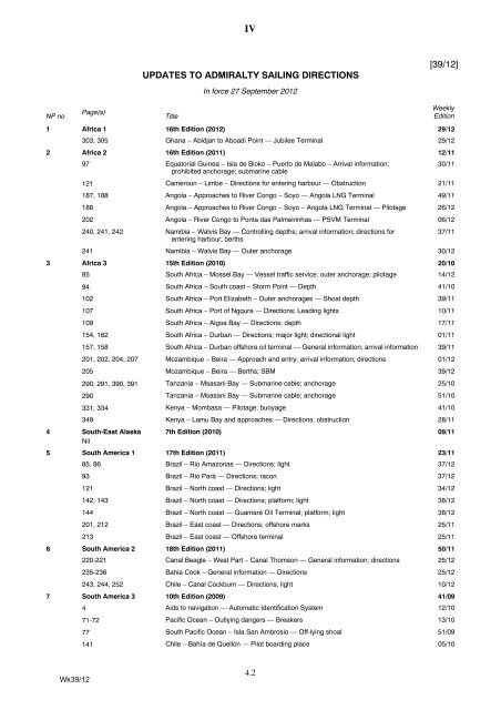
NP no<br />
Page(s)<br />
IV<br />
UPDATES TO ADMIRALTY SAILING DIRECTIONS<br />
Title<br />
In force 27 September 2012<br />
4.2<br />
[39/12]<br />
Weekly<br />
Edition<br />
1 Africa 1 16th Edition (2012) 29/12<br />
303, 305 Ghana – Abidjan to Aboadi Point — Jubilee Terminal 29/12<br />
2 Africa 2 16th Edition (2011) 12/11<br />
97 Equatorial Guinea – Isla de Bioko – Puerto de Malabo – Arrival information;<br />
prohibited anchorage; submarine cable<br />
121 Cameroun – Limbe – <strong>Directions</strong> for entering harbour — Obstruction 21/11<br />
187, 188 Angola – Approaches to River Congo – Soyo — Angola LNG Terminal 49/11<br />
188 Angola – Approaches to River Congo – Soyo – Angola LNG Terminal — Pilotage 26/12<br />
202 Angola – River Congo to Ponta das Palmeirinhas — PSVM Terminal 06/12<br />
240, 241, 242 Namibia – Walvis Bay — Controlling depths; arrival information; directions for<br />
entering harbour; berths<br />
241 Namibia – Walvis Bay — Outer anchorage 30/12<br />
3 Africa 3 15th Edition (2010) 20/10<br />
85 South Africa – Mossel Bay — Vessel traffic service; outer anchorage; pilotage 14/12<br />
94 South Africa – South coast – Storm Point — Depth 41/10<br />
102 South Africa – Port Elizabeth – Outer anchorages — Shoal depth 39/11<br />
107 South Africa – Port of Ngqura — <strong>Directions</strong>; Leading lights 10/11<br />
109 South Africa – Algoa Bay — <strong>Directions</strong>; depth 17/11<br />
154, 162 South Africa – Durban — <strong>Directions</strong>; major light; directional light 01/11<br />
157, 158 South Africa – Durban offshore oil terminal — General information; arrival information 39/11<br />
201, 202, 204, 207 Mozambique – Beira — Approach and entry; arrival information; directions 01/12<br />
205 Mozambique – Beira — Berths; SBM 39/12<br />
290, 291, 390, 391 Tanzania – Msasani Bay — Submarine cable; anchorage 25/10<br />
290 Tanzania – Msasani Bay — Submarine cable; anchorage 51/10<br />
331, 334 Kenya – Mombasa — Pilotage; buoyage 41/10<br />
349 Kenya – Lamu Bay and approaches — <strong>Directions</strong>; obstruction 28/11<br />
4 South-East Alaska 7th Edition (2010) 09/11<br />
Nil<br />
5 South America 1 17th Edition (2011) 23/11<br />
85, 86 Brazil – Rio Amazonas — <strong>Directions</strong>; light 37/12<br />
93 Brazil – Rio Pará — <strong>Directions</strong>; racon 37/12<br />
121 Brazil – North coast — <strong>Directions</strong>; light 34/12<br />
142, 143 Brazil – North coast — <strong>Directions</strong>; platform; light 38/12<br />
144 Brazil – North coast — Guamaré Oil Terminal; platform; light 38/12<br />
201, 212 Brazil – East coast — <strong>Directions</strong>; offshore marks 25/11<br />
213 Brazil – East coast — Offshore terminal 25/11<br />
6 South America 2 18th Edition (2011) 50/11<br />
220-221 Canal Beagle – West Part – Canal Thomson — General information; directions 25/12<br />
235-236 Bahia Cook – General information — <strong>Directions</strong> 25/12<br />
243, 244, 252 Chile – Canal Cockburn — <strong>Directions</strong>; light 10/12<br />
7 South America 3 10th Edition (2009) 41/09<br />
Wk39/12<br />
4 Aids to navigation — Automatic Identification System 12/10<br />
71-72 Pacific Ocean – Outlying dangers — Breakers 13/10<br />
77 South Pacific Ocean – Isla San Ambrosio — Off-lying shoal 51/09<br />
141 Chile – Bahía de Quellón — Pilot boarding place 05/10<br />
30/11<br />
37/11
NP no<br />
Page(s)<br />
Title<br />
IV<br />
4.3<br />
Weekly<br />
Edition<br />
186 Chile – Bahía Ancud — Pilot boarding place 05/10<br />
205 Chile – Bahía Coronel — Arrival information; pilotage 35/12<br />
223 Chile – Punta Peña Blanca to Punta Concón — <strong>Directions</strong>; buoy 05/10<br />
226 Chile – Valparaíso — Arrival information; anchorage 35/12<br />
233 Chile – Quintero — Anchorages 25/12<br />
250 Chile – Puerto Huasco — Pilotage; anchorages 27/10<br />
270 Chile – Puerto Antofagasta — Wreck 41/09<br />
275, 276 Chile – Mejillones del Sur — Port limit; pilotage; anchorages; terminal 14/10<br />
315 Peru–IslaAsiatoIslaSanLorenzo — <strong>Directions</strong>; wreck 41/09<br />
316 Peru – Cerro Azul — Light 41/09<br />
339 Peru – Punta Pacasmayo to Isla Lobos de Tierra — <strong>Directions</strong>; wreck 41/09<br />
346 Peru – Paita to Punta Cabo Blanco — <strong>Directions</strong>; platform 41/09<br />
373 Ecuador – Manta — Harbour regulation 47/11<br />
385, 387 Colombia – Buenaventura — Anchorages; light 41/09<br />
388 Colombia – Bahía de Málaga — <strong>Directions</strong>; light buoy 41/09<br />
7A South America 4 5th Edition (2010) 18/10<br />
3 Navigation and Regulations – Charts — Foreign charts 18/10<br />
4 Navigation and Regulations – Radio facilities — DGPS 18/10<br />
73 Guyane Française – Îles du Salut to Fleuve Maroni — <strong>Directions</strong> 18/10<br />
73 Guyane Française – Fleuve Mana — Charts; description; directions 18/10<br />
73, 74<br />
Guyane Française – Fleuve Maroni — Charts; general information; depth; directions;<br />
landmarks; useful marks; anchorage<br />
74 Guyane Française – Fleuve Maroni — General information; directions 20/10<br />
75<br />
Surinam – Fleuve Maroni to the approaches to Suriname Rivier — General<br />
information; directions<br />
80, 81 Surinam – Nickerie Rivier — Pilotage; directions; buoyage 40/10<br />
83 Guyana – Corentyn River — General information; directions 40/10<br />
86 Guyana – New Amsterdam to Georgetown — <strong>Directions</strong>; wreck 18/10<br />
119 Trinidad – East coast — <strong>Directions</strong>; light 23/10<br />
160, 162, 165, 167 Venezuela – Isla Coche — Major light 23/10<br />
173, 174, 175<br />
Venezuela – Puerto La Cruz — Port authorities; anchorage; harbours; hazards;<br />
directions; berths<br />
173 Venezuela – Puerto La Cruz — Pilot boarding position 18/10<br />
176, 178 Venezuela – Puerto Jose — Pilot boarding position 18/10<br />
187, 190 Venezuela – Puerto La Guaira and Catia La Mar — Anchorages; pilotage 37/10<br />
205, 209 Venezuela – Archipielago Las Aves — <strong>Directions</strong>; light 33/10<br />
211-212 Nederlandse Antillen – Klein Curaçao — Light 23/10<br />
228 Aruba – South coast — <strong>Directions</strong> 18/10<br />
229, 230 Aruba – Sint Nicolaas — Pilot boarding position 18/10<br />
280 Colombia – Punta de la Garita — <strong>Directions</strong>; light 20/10<br />
283, 284<br />
Colombia – Bahía de Cartagena – <strong>Directions</strong> – Bocachica — Leading lights; useful<br />
mark<br />
284 Colombia – Bahía de Cartagena – Bocachica — <strong>Directions</strong>; deep-water channel 18/10<br />
292 Colombia – Golfo de Urabá — <strong>Directions</strong>; buoy 18/10<br />
292, 293, 294<br />
Colombia – Golfo de Urabá — General information; depths; directions; landmark;<br />
lights; description; anchorages; pilotage; berths<br />
Wk39/12<br />
18/10<br />
18/10<br />
23/10<br />
35/10<br />
20/10
NP no<br />
Page(s)<br />
Title<br />
IV<br />
4.4<br />
Weekly<br />
Edition<br />
8 Pacific coasts of<br />
Central America and<br />
United States<br />
12th Edition (2010) 29/10<br />
83 Pacific Ocean – Guardian Bank north-westwards — Depths 29/10<br />
192,193 Mexico – Golfo de California – Guaymas — <strong>Directions</strong>; lights 23/11<br />
199-200<br />
Mexico – Bahía de la Paz – Bahía Pichilingue and approaches — Depth; leading<br />
lights<br />
37/10<br />
250, 260 United States of America – California – Approaches to San Diego — <strong>Directions</strong>;<br />
dangerous wreck<br />
47/11<br />
261<br />
United States of America – California – Entrance to San Diego Bay — <strong>Directions</strong>;<br />
rock<br />
29/10<br />
263, 453 United States of America – California – San Clemente Island — Safety Zone 39/10<br />
266 United States of America – Pacific coast – Begg Rock — Buoyage 49/11<br />
275 United States of America – California – Approaches to Long Beach and Los Angeles<br />
— VTS; precautionary area<br />
30/11<br />
275<br />
United States of America – San Pedro Bay and approaches — Regulations<br />
concerning entry; tankers<br />
49/10<br />
335<br />
United States of America – California – San Francisco Bay – Alcatraz Island —<br />
<strong>Directions</strong>; fog signal<br />
29/10<br />
338, 339<br />
United States of America – Port of San Francisco – San Francisco-Oakland Bay<br />
Bridge — <strong>Directions</strong>; passage<br />
50/10<br />
338 United States of America – Pacific Coast – San Francisco — Limiting conditions;<br />
Vertical clearances; San Francisco - Oakland Bay Bridge<br />
51/11<br />
348<br />
United States of America – California – San Francisco Bay – Port of Richmond —<br />
Project depth<br />
39/10<br />
351, 454 United States of America – California – San Pablo Bay — Safety Zone 30/11<br />
390 United States of America Pacific Coast – Oregon – Chetco River — Entrance depths 30/11<br />
400, 401 United States of America Pacific Coast – Oregon – Yaquina Bay — <strong>Directions</strong>;<br />
depths<br />
30/11<br />
410, 455<br />
United States of America – West coast – Columbia River — Safety and Security<br />
Zone Regulations<br />
39/10<br />
418, 458 United States of America – Willamette River – Portland — Traffic Regulation 42/11<br />
431 United States of America – Oregon – Grays Harbor — <strong>Directions</strong>; breakers 29/10<br />
449 United States of America Pacific Coast — Navigation Safety Regulations; electronic<br />
position fixing devices<br />
30/11<br />
454 United States of America – Pacific Coast — Regulated Navigation Areas; Security<br />
Zones<br />
11/12<br />
458<br />
United States of America – Oregon – Columbia River – Port of Portland — Regulated<br />
Navigation Area<br />
29/10<br />
458 United States of America Pacific Coast – Columbia River — Safety and Security<br />
Zone Regulations<br />
30/11<br />
458 United States of America – Willamette River – Portland — Traffic Regulation 22/12<br />
461 United States of America – California – San Diego Bay — Naval Danger Zone 29/10<br />
480, 482, 486, 488 United States of America – Pacific Coast — National Marine Sanctuary Program<br />
Regulations<br />
11/12<br />
487-488, 488 United States of America – Pacific Coast — National Marine Sanctuary Program<br />
Regulations<br />
10/12<br />
9 Antarctic 7th Edition (2009) 31/09<br />
169 South Georgia and Approaches – Cumberland Bay – King Edward Cove —<br />
<strong>Directions</strong>; light beacons<br />
10/12<br />
173 South Georgia and Approaches – Cumberland Bay to Cape Charlotte – Ocean<br />
Harbour — <strong>Directions</strong><br />
10/12<br />
207 South Orkney Islands – Washington Strait — <strong>Directions</strong>; AIS 27/12<br />
299 Gerlache Strait – South Part – Port Lockroy — <strong>Directions</strong>; isolated shoal 51/11<br />
368, 369, 372 James Ross Island Group – Cape Purvis to Cape Longing through Prince Gustav<br />
Channel — Route; directions<br />
04/12<br />
Wk39/12<br />
372 James Ross Island Group – Cape Purvis to Cape Longing through Prince Gustav<br />
Channel — <strong>Directions</strong><br />
04/12
NP no<br />
Page(s)<br />
Title<br />
IV<br />
4.5<br />
Weekly<br />
Edition<br />
10 Arctic 1 8th Edition (2010) 10/11<br />
463 Russia – Laptev Sea – Reka Lena Delta — Wreck 30/11<br />
11 Arctic 2 10th Edition (2010) 39/10<br />
4 Radio Navigational Warnings 41/10<br />
95, 109, 112, 114 Iceland – West coast – Faxaflói — Racons 27/12<br />
106 Iceland – Reykjavík – ViÉeyjarsund — Spoil ground 27/12<br />
201 Svalbard – Wedel Jarlsberg Land — Underwater rock 48/10<br />
215 Svalbard – Billefjorden – Pyramiden — Leading lights 27/12<br />
235 Svalbard – Hinlopenstretet — Anchorages 43/11<br />
251 Svalbard – Freemansundet — Rock awash 42/10<br />
12 Arctic 3 9th Edition (2012) 34/12<br />
132 Greenland – Nuup Kangerlua — <strong>Directions</strong> 36/12<br />
431 Coronation Gulf – Off-lying islands — Depth 36/12<br />
491 Canada – Eureka Sound — Depth 36/12<br />
13 Australia 1 3rd Edition (2011) 40/11<br />
2 Navigation and Regulations – Traffic and Operations — Fishing; marine farms 01/12<br />
130, 131 Northern Territory – Bowen Strait — Offshore dangers 18/12<br />
142 Western Australia – Ashmore Reef — Harbour 20/12<br />
231 Western Australia – Port Walcott — Controlling depths 09/12<br />
234 Western Australia – John’s Creek — Approach; buoy 45/11<br />
235 Western Australia – Dampier — <strong>Directions</strong>; depths 07/12<br />
249 Western Australia – Barrow Island Oil Terminal — Controlling depth 48/11<br />
251 Western Australia – Griffin Marine Terminal — Operational status 44/11<br />
256 Western Australia – Saladin Marine Terminal — Under-keel clearance 48/11<br />
280 Western Australia – Geraldton — Outer anchorages 18/12<br />
318, 319-320, 321 Western Australia – Oyster Harbour — <strong>Directions</strong> 40/11<br />
331 Western Australia – Esperance — Anchorages 08/12<br />
345 South Australia – Smoky Bay — <strong>Directions</strong>; marine farms 02/12<br />
346 South Australia – Warburton Channel — <strong>Directions</strong>; depth 09/12<br />
346 South Australia – Streaky Bay — <strong>Directions</strong>; depth 09/12<br />
356 South Australia – Spencer Gulf — <strong>Directions</strong>; caution 04/12<br />
361 South Australia – Point Boston — <strong>Directions</strong>; marine farms 01/12<br />
364 South Australia – Franklin Harbor — <strong>Directions</strong> 47/11<br />
367 South Australia – Point Turton — <strong>Directions</strong>; marine farms 01/12<br />
380 South Australia – Port Augusta — <strong>Directions</strong>; marine farms 01/12<br />
381 South Australia – Port Augusta — <strong>Directions</strong>; buoy 45/11<br />
14 Australia 2 11th Edition (2010) 21/10<br />
2 Navigation and Regulations – Traffic and Operations — Fishing; marine farms 01/12<br />
103, 104 Victoria – Port Phillip — Pilotage; depths 35/11<br />
104 Victoria – Port Phillip – South Channel — Controlling Depths 11/12<br />
104 Victoria – Port Phillip — transit restictions 35/11<br />
106, 108 Victoria – Port Phillip Heads — <strong>Directions</strong>; sector light; depth 43/11<br />
114 Victoria – Port Phillip – Swan Island docks — <strong>Directions</strong> 43/11<br />
115 Victoria – Port Phillip – Approaches to Geelong — <strong>Directions</strong>; channel 11/12<br />
126 Victoria – Port Phillip – Approaches to Melbourne — <strong>Directions</strong>; channel 11/12<br />
126 Victoria – Port Phillip – Approaches to Melbourne – West Channel — <strong>Directions</strong> 43/11<br />
Wk39/12
NP no<br />
Page(s)<br />
Title<br />
IV<br />
4.6<br />
Weekly<br />
Edition<br />
134 Victoria – Melbourne — Depths 35/11<br />
146 Victoria – Hastings — Arrival Information; regulations concerning entry 49/11<br />
175 Victoria – Lakes Entrance — <strong>Directions</strong>; buoy 03/12<br />
189 Tasmania – Robbins Passage — <strong>Directions</strong>; buoyage 08/12<br />
203, 207 Tasmania – Port Dalrymple — Pilotage; anchorages 02/11<br />
228 Tasmania – Cape Sorell — <strong>Directions</strong>; rock 01/12<br />
259 Tasmania – Hobart — <strong>Directions</strong> 43/11<br />
274 Tasmania – Spring Bay and approaches — Port limits 36/11<br />
293 New South Wales – Batemans Bay — <strong>Directions</strong>; fish aggregation device 43/11<br />
301 New South Wales – Jervis Bay — <strong>Directions</strong>; buoy 43/11<br />
312 New South Wales – Port Kembla — Anchorages 29/11<br />
324 New South Wales – Cape Banks — Fishing; fish aggregation devices 43/11<br />
327 New South Wales – Sydney Harbour — Vertical clearance 45/11<br />
328 New South Wales – Port Jackson — Anchorages 17/12<br />
15 Australia 3 11th Edition (2009) 31/09<br />
2 Navigation and Regulations – Traffic and Operations — Fishing; marine farms 01/12<br />
13 Australia – Queensland – Ship reporting systems — Torres Strait and Great Barrier<br />
Reef ship reporting system<br />
28/11<br />
92 Australia – New South Wales – Port Jackson to Broken Bay — <strong>Directions</strong>; fish<br />
aggregation device<br />
45/11<br />
102 Australia – New South Wales – Newcastle — Outer Anchorages 29/11<br />
116, 117 Australia – New South Wales – Sugarloaf Point to Smoky Cape — <strong>Directions</strong>; fish<br />
aggregation devices<br />
45/11<br />
116 Australia – New South Wales – Mermaid Reef — <strong>Directions</strong> 06/11<br />
119, 120 New South Wales – Port Macquarie — <strong>Directions</strong>; leading lights 39/10<br />
129 Australia – New South Wales – Point Danger — <strong>Directions</strong> 06/11<br />
140, 141 Australia – Queensland – Gneering Shoals — <strong>Directions</strong>; depths 01/11<br />
142 Queensland – Approaches to Moreton Bay — <strong>Directions</strong> 37/09<br />
142 Australia – Queensland – Moreton Bay – North part of Main Channel — <strong>Directions</strong> 15/11<br />
143 Australia – Queensland – Moreton Bay — Side Channels; directions 51/11<br />
143 Queensland – Moreton Bay – North East Channel — <strong>Directions</strong>; buoyage 07/10<br />
146 Queensland – Mooloolaba Harbour — <strong>Directions</strong>; depth 09/12<br />
147, 148 Australia – Queensland – Brisbane — Depths; under-keel clearance 14/12<br />
156 Australia – Queensland – Brisbane River – Hamilton Reach — Berths; depths 16/11<br />
168 Australia – Queensland – Double Island Point — <strong>Directions</strong>; Wolf Rock 06/12<br />
168 Queensland – Cape Moreton to Breaksea Spit — <strong>Directions</strong>; wreck 47/10<br />
171 Australia – Queensland – Capricorn Channel — <strong>Directions</strong> 44/11<br />
175 Queensland – Hervey Bay — <strong>Directions</strong>; shoal 09/12<br />
184 Australia – Queensland – Kolan River — <strong>Directions</strong> 11/12<br />
184 Australia – Queensland – Colosseum Inlet — Approach; obstruction 11/12<br />
206 Australia – Queensland – Rockhampton — <strong>Directions</strong>; wreck 14/12<br />
218, 219, 221, 222, 231, Queensland – Hay Point Port and Mackay approaches — <strong>Directions</strong>; depths;<br />
22/10<br />
234, 235, 238, 239 anchorage<br />
237 Queensland – Mackay — Pilotage 20/12<br />
Wk39/12<br />
266 Australia – Queensland – Abbot Point — Under-keel clearance 17/12<br />
267 Australia – Queensland – Abbot Point — <strong>Directions</strong>; leading lights ; berths 51/10<br />
268 Australia – Queensland – Cape Upstart — <strong>Directions</strong>; wreck 04/12<br />
272 Australia – Queensland – Magnetic Passage — <strong>Directions</strong> 44/11
NP no<br />
Page(s)<br />
Title<br />
IV<br />
4.7<br />
Weekly<br />
Edition<br />
279 Australia – Queensland – Goold Island — <strong>Directions</strong>; wreck 04/12<br />
286 Australia – Queensland – Townsville — <strong>Directions</strong>; channels 17/12<br />
303 Australia – Queensland – Cairns — Anchorage 04/12<br />
303 Australia – Queensland – Cairns — Pilotage 38/11<br />
310 Queensland – Port Douglas — Pilot boarding position 17/10<br />
312 Queensland – Cape Tribulation — <strong>Directions</strong>; wreck 09/12<br />
318 Queensland – Cooktown — Pilot boarding position 17/10<br />
338 Australia – Queensland – Owen Channel — <strong>Directions</strong>; depth 44/11<br />
341 Australia – Queensland – Bow Reef — <strong>Directions</strong>; light 44/11<br />
364 Australia – Queensland – Adolphus Channel — <strong>Directions</strong>; Automatic Identification<br />
System<br />
365 Australia – Queensland – Adolphus Channel — <strong>Directions</strong>; light buoy 17/12<br />
380 Papua New Guinea – Dedele Point — <strong>Directions</strong> 18/12<br />
395 Papua New Guinea – Port Moresby to Yule Island — <strong>Directions</strong>; depth 01/11<br />
416 Queensland – Torres Strait – Great North East Channel — <strong>Directions</strong>; depth 09/12<br />
425 Australia – Torres Strait – Prince of Wales Channel — <strong>Directions</strong>; approach from<br />
inner route<br />
427 Australia – Torres Strait – Alert Patches — <strong>Directions</strong>; light buoy 50/11<br />
428 Australia – Queensland – Prince of Wales Channel — <strong>Directions</strong> 44/11<br />
428 Australia – Torres Strait – Varzin Passage — <strong>Directions</strong>; depth 05/12<br />
432 Queensland – Torres Strait – Thursday Island — Pilotage 41/10<br />
440 Australia – Torres Strait – Red Island Point — Anchorage 02/12<br />
18 Baltic 1 15th Edition (2009) 02/10<br />
3, 198 Denmark/Sweden – The Sound — SOUNDREP ship reporting system 35/11<br />
8, 72, 74, 127, 128,<br />
128-129, 140, 146, 165,<br />
166, 167, 168, 169, 170,<br />
186, 192, 198, 199<br />
Denmark – Kattegat – <strong>Directions</strong> — Routes 40/10<br />
11, 12, 80, 101, 103 Sweden – Kattegat – Northern part – Göteborg and approaches — Restricted area 12/12<br />
11, 12 Sweden – Kattegat – Northern part – Göteborg and approaches — Restricted area 13/12<br />
128 Denmark – Kattegat – Læsø SE – Groves Flak – Route T — Buoys and shoal 09/12<br />
141 Denmark – Kattegat E – Halmstad — Approach channel; depth; draught 27/12<br />
147 Denmark – Kattegat S – Isefjord — General Information; pilot boarding; controlling<br />
depths<br />
25/12<br />
148 Denmark – Isefjord – Hundested Havn — <strong>Directions</strong> 25/12<br />
149 Denmark – Isefjord – Hundested Havn — Anchorages and harbours 25/12<br />
170 Demmark – Kattegat S – Svitringen Rende to Fornæs — General information;<br />
prohibited area<br />
26/12<br />
172 Denmark – Kattegat west – Fornæs to Samsø Bælt — <strong>Directions</strong>; track; depth 51/11<br />
173 Denmark – Kattegat South – Grenaa Havn — Approach channel; leading lights 30/12<br />
210 Denmark – The Sound – Helsingborg to Lous Flak — TSS; buoyage 14/12<br />
210, 215, 220 Denmark – The Sound – Københavns Havn — Trekroner Light sector 02/12<br />
215, 220, 221 Denmark – The Sound – Københavns Havn — Trekroner and Prøvesten Light<br />
sectors<br />
49/11<br />
217 Denmark – The Sound – Københavns — Arrival information; restricted area 49/11<br />
220 Denmark – The Sound – Københavns Havn — Trekroner Light sector 06/12<br />
220 Denmark – The Sound – Københavns Havn — Kronløbet directional lights 06/12<br />
223 Denmark – København — Basins and berths; depths 13/11<br />
225 Sweden – The Sound – Lundåkrabukten — Lous Flak to Malmö Redd 10/12<br />
Wk39/12<br />
17/12<br />
50/11
NP no<br />
Page(s)<br />
254, 255, 257, 259, 260,<br />
286, 288<br />
Title<br />
IV<br />
4.8<br />
Weekly<br />
Edition<br />
Denmark – Storebælt— <strong>Directions</strong>; lights 43/10<br />
271, 272 Denmark – Århus Bugt – Hov Havn — Lights 34/10<br />
277, 278, 278-279, 279 Denmark – Odense Fjord — <strong>Directions</strong>; buoyage; beacons; dredged channel 46/11<br />
287 Denmark – Storebælt Link – West section — Vertical and horizontal clearances 06/10<br />
287 Denmark – Storebælt Link; — Vertical clearance 22/10<br />
288, 289 Denmark – Storebælt – Østerrenden N — Light replaced by buoy 11/12<br />
424, 427 Germany – Flensburg – Outer Approaches — <strong>Directions</strong>; anchorage 02/10<br />
442, 445, 446 Germany – Travemünde — <strong>Directions</strong>; route; leading lights 02/10<br />
19 Baltic 2 15th Edition (2011) 26/11<br />
15, 113, 114, 115, 145,<br />
235, 268, 269, 272, 276,<br />
278, 284, 307<br />
Sweden – East coast — Restricted areas 12/12<br />
15, 113, 115, 145, 268,<br />
269, 272, 284, 307<br />
Sweden – East coast — Restricted areas 13/12<br />
86, 87 Sweden – SE Baltic – Södra Midsjöbanken — <strong>Directions</strong>; light platform 20/12<br />
121, 141, 145, 146, 147 Sweden – Karlskrona approaches — <strong>Directions</strong>; buoyage 37/12<br />
127, 128 Southern Baltic – Sweden – Åhus — Draughts 34/12<br />
196, 197, 197-198 Sweden – Västervik approaches — <strong>Directions</strong>; tracks; lights; buoyage; depth 43/11<br />
215, 221-222, 222 Sweden – Norrköping – Pampushamnen — <strong>Directions</strong>; lights; buoys; dredged<br />
channel; depths<br />
31/11<br />
20 Baltic 3 11th Edition (2010) 24/10<br />
10 Navigation and regulations – Traffic and operations – Traffic — Recommended<br />
tracks<br />
51/11<br />
19, 360, 417, 418, 422,<br />
450, 489<br />
Sweden – Gulf of Bothnia — Special regulations; restricted area 12/12<br />
89, 91<br />
Gulf of Finland – Russia – Off Rodsher and Off Hogland TSS — Deep-water route<br />
discontinued<br />
34/12<br />
Wk39/12<br />
90 Gulf of Finland – Porkkala to Kalbådagrund — <strong>Directions</strong>; traffic separation schemes 43/10<br />
91, 117, 119 Russia – Luzhskaya Guba — <strong>Directions</strong> 06/11<br />
109 Gulf of Finland – Estonia – Muuga sadam and approaches – Approach east of Aksi<br />
— Recommended track<br />
117 Gulf of Finland – Russia – Luzhskaya Guba — <strong>Directions</strong> 34/12<br />
142 Finland – Koppnäs — <strong>Directions</strong>; lights 49/10<br />
162 Finland – Helsinki approaches – Björköfjärden — <strong>Directions</strong>; leading beacons;<br />
authorised draught<br />
29/11<br />
167 Finland – Helsinki — <strong>Directions</strong>; authorised draught 43/10<br />
169 Finland – Helsinki — <strong>Directions</strong>; authorised draught 40/10<br />
188, 192, 193, 194, 195,<br />
196, 204<br />
Gulf of Finland – North shore – Orrengrund to Kotka channel — <strong>Directions</strong> 30/12<br />
195, 197, 203, 204, 205, Finland – Approaches to Hamina — <strong>Directions</strong>; routes; buoys, lights; depths;<br />
29/11<br />
207, 208<br />
anchorages<br />
210 Finland – Hamina to Vyborg — <strong>Directions</strong>; leading lights 24/10<br />
212, 214, 215 Russian Federation – Vyborg and approaches – Gavan Vysotsk — <strong>Directions</strong>;<br />
depths; lights; beacons; buoys<br />
24/11<br />
214 Gulf of Finland – Russia – Approaches to Vysotsk — Leading Lights 17/12<br />
233 Finland – Förby — <strong>Directions</strong>; lights 49/10<br />
235 Finland – Utö to Hanko channel — <strong>Directions</strong>; lights 02/11<br />
235, 238, 239, 240, 244,<br />
245, 246, 248, 253, 254,<br />
255, 256, 260, 261, 264,<br />
265<br />
Finland – Naantali — <strong>Directions</strong>; lights; depths 24/10<br />
290, 291 Finland – Rauma and approaches — <strong>Directions</strong>; leading beacons 24/10<br />
08/12
NP no<br />
Page(s)<br />
Title<br />
314, 315, 316 Finland – Gulf of Bothnia – North-west approaches to Vaasa — Other aids to<br />
navigation; track guide<br />
IV<br />
4.9<br />
Weekly<br />
Edition<br />
314, 315, 316 Finland – North-west approaches to Vaasa — <strong>Directions</strong>; beacons; buoys 43/11<br />
336, 337 Finland – Raahe — Approach; limiting conditions; turning basin; directions 26/10<br />
378, 379 Sweden – Skutskär-Harnäs — <strong>Directions</strong>; depths 48/10<br />
379, 381 Sweden – Sea of Bothnia – Gävle – Fredrikskanhamnen — Controlling depths 02/12<br />
406 Sweden – Gulf of Bothnia – Stocka — <strong>Directions</strong>; buoyage; lights 37/12<br />
442 Sweden – Efesgrundet to Väktaren — <strong>Directions</strong>; light 26/10<br />
442 Sweden – Hörnefors — Authorised draught 26/10<br />
463 Sweden – Skelleftehamn — Authorised draught 26/10<br />
468 Sweden – Kågehamn — Authorised draught 26/10<br />
489 Sweden – Törehamn — Authorised draught 26/10<br />
489, 490 Sweden – Törehamn — <strong>Directions</strong>; lights 43/10<br />
21 Bay of Bengal 11th Edition (2010) 44/10<br />
99 India – Kºkinºda Bay to Vamsadhºra River — Gangavaram Port 21/11<br />
109 India – East Coast – Gopºlpur Port to Puri — <strong>Directions</strong>; light 37/12<br />
117 India – East Coast — Dhºmra Port 10/12<br />
173, 175, 179 Burma – Yangon River and approaches — <strong>Directions</strong>; light float 35/12<br />
200 Bay of Bengal – South-Eastern part – Taung Kyun Su — Depths 09/11<br />
22 Bay of Biscay 11th Edition (2010) 34/10<br />
66 France – West Coast – Benodet — <strong>Directions</strong>; light 05/11<br />
132 France – La Loire Approaches — Prohibited area 34/11<br />
190 France – West Coast – La Seudre — Light 45/11<br />
280 Spain – North coast – Aviles — <strong>Directions</strong>; light 06/12<br />
23 Bering Sea and Strait 7th Edition (2009) 33/09<br />
7-8 Maritime safety information 41/10<br />
196 United States of America – Krenitzin Islands – Akutan Harbor — Berth 27/12<br />
207 United States of America – Unalaska Island – Dutch Harbor — Anchorage 18/10<br />
266 United States of America – Attu Island — Loran tower 49/10<br />
312 United States of America – Alaska – Port Clarence — Loran tower 20/10<br />
318 United States of America – Bering Strait to Cape Krusenstern – Kotzebue — Light 20/12<br />
321 United States of America – Alaska – Red Dog — <strong>Directions</strong>; racon 33/09<br />
390 Russia – Pacific coast – Port Beringovskiy — Anchorage 35/10<br />
24 Black Sea and Sea of<br />
Azov<br />
3rd Edition (2010) 30/10<br />
100 Turkey – zmit Körfezi — Traffic separation scheme 01/12<br />
117 Turkey – North approaches to stanbul BoÔazÝ — Anchorages 17/12<br />
123 Turkey – Kerpe LimanÝ — Anchorage 18/12<br />
124 Turkey – EreÔli — Anchorages 17/12<br />
141 Turkey – Trabzon — Pipeline 11/11<br />
144 Turkey – Kizkalesi to ÇamlÝ Burnu – Pazar — Marine farm 30/10<br />
161 Bulgaria – Varna — Wreck 15/12<br />
191 Ukraine – Dnistrovs’kyi Lyman — Approach and entry 04/11<br />
192 Ukraine – Bilhorod-Dnistrovs’kyi — Wreck 47/11<br />
194 Ukraine – Illichivs’k — Obstruction 01/11<br />
195 Ukraine – Illichivs’k — <strong>Directions</strong>; shoal patch 32/11<br />
249 Russia – Novorossiysk — Outer anchorages 21/12<br />
255 Russia – Sochi — Obstruction 04/11<br />
257, 258 Russia – North-east part of the Black Sea – Sochi to Mys Pitsunda — Imeretinskiy<br />
Port<br />
31/12<br />
284 Sea of Azov – East part – Mys Kamennyy to Mys Achuyevskiy — <strong>Directions</strong>; area to<br />
be avoided<br />
25/12<br />
Wk39/12<br />
47/11
NP no<br />
Page(s)<br />
Title<br />
IV<br />
4.10<br />
Weekly<br />
Edition<br />
25 British Columbia 1 14th Edition (2010) 47/10<br />
93 United States of America – Puget Sound – Ports and Inlets West of Puget Sound —<br />
Restricted areas; hazard lights<br />
119 Canada – Hood Canal – Hood Canal Bridge — Vertical clearance 18/12<br />
131 United States of America – Rosario Strait – Belle Rock — Light 49/11<br />
208 Canada – Vancouver – Burrard Inlet — <strong>Directions</strong>; lights 12/12<br />
209 Canada – Port Moody — <strong>Directions</strong>; leading lights 40/11<br />
26 British Columbia 2 10th Edition (2011) 12/12<br />
Nil<br />
27 Channel 9th Edition (2011) 17/12<br />
111-112 England – Plymouth — Pilot boarding position 17/12<br />
145 England – Brixham Harbour — <strong>Directions</strong>; direction light 26/12<br />
174, 176, 177, 178 England – Poole Harbour — Bridges; navigable width; traffic signals 17/12<br />
267 France – L’Élorn – Saint-Nicolas — Prohibited areas 17/12<br />
416, 420 France – Dives-Sur-Mer — <strong>Directions</strong>; light; buoyage 17/12<br />
28 Dover Strait 9th Edition (2011) 01/12<br />
63, 161, 168, 169 Belgium – Westhinder and West Approaches To Westerschelde — Buoys 38/12<br />
73 England – Littlehampton to Shoreham — <strong>Directions</strong>; meteorological mast 22/12<br />
100, 102, 103 England – Pegwell Bay — <strong>Directions</strong>; landmarks 16/12<br />
162 Belgium – Westerschelde and Approaches — Pilotage 31/12<br />
267, 268, 271 United Kingdom – Thames estuary – Margate to The Nore — <strong>Directions</strong>; depths;<br />
buoyage; channels<br />
268 England – Thames Estuary – Overland Passage — Buoy 39/12<br />
283 England – East coast – Harwich Haven — Pilotage draught limit 21/12<br />
283, 285 United Kingdom – Harwich Haven approaches — <strong>Directions</strong>; buoyage 13/12<br />
30 China Sea 1 8th Edition (2010) 43/10<br />
247 China – South coast – Chang Jiang – Zhanjiang — Vertical clearance 27/12<br />
266 China – South Coast – Zhujiang Kou – Macao outer anchorage — Wreck 27/12<br />
31 China Sea 2 10th Edition (2012) 25/12<br />
185 Philippines – Luzon – Mariveles — Total Bataan Terminal 30/12<br />
32 China Sea 3 8th Edition (2011) 48/11<br />
Wk39/12<br />
65 Taiwan – Taiwan Strait — Direct Cross-strait Shipping Links 50/11<br />
107 Philippines – North coast of Luzon – Aparri — Dangerous wreck 27/12<br />
117 Taiwan – East coast — Direct Cross-strait Shipping Links 50/11<br />
125 Taiwan – East coast – Su-ao Kang — Anchorage 03/12<br />
146 China – East coast – Xiamen Gang — Approach and entry 48/11<br />
311, 313, 315, 317 China – Yellow Sea – Lianyungang — <strong>Directions</strong>; buoyage 09/12<br />
350 China – Yellow Sea – Penglai — Anchorages 27/12<br />
381, 382 China – Bo Hai – Huanghua Gang — <strong>Directions</strong> 15/12<br />
384 China – Bohai – Tianjin Gang – Dagukou South Anchorage — Dangerous wreck 03/12<br />
391 China – Bohai – Jingtang — <strong>Directions</strong>; racon 51/11<br />
404 China – Boi Hai – Jinzhou Gang — <strong>Directions</strong> 06/12<br />
405, 407 China – Bo Hai – Yingkou — Vertical clearance; racon 48/11<br />
438 Korea – West coast – Mokp’o Hang — Berths; inner anchorages; depths 29/12<br />
463, 468, 470 Korea - West coast - Inch’än — <strong>Directions</strong>; anchorages; berths 36/12<br />
08/12<br />
14/12
NP no<br />
Page(s)<br />
Title<br />
IV<br />
4.11<br />
Weekly<br />
Edition<br />
33 Philippine Islands 4th Edition (2011) 41/11<br />
127 Philippines – Sibutu Passage — Reporting system 35/12<br />
145 Malaysia – Sungai Merotai Kecil — <strong>Directions</strong> 18/12<br />
269 Philippines – Panay – Juraojurao Island — <strong>Directions</strong> 20/12<br />
285 Luzon — Pagbilao Power Station 51/11<br />
367, 373, 381 Philippine Islands – Negros – Siquijor Island — Light 33/12<br />
398 Philippine Islands – Mindanao — Container Terminal 03/12<br />
457 Philippines – Leyte – Abuyog — Major Light 21/12<br />
34 Indonesia 2 5th Edition (2009) 47/09<br />
61 Indonesia – South coast of Jawa – Tanjung Intan — Limiting conditions 34/10<br />
65, 102, 103<br />
Jawa – South coast – Semenanjung Blambangan – Tanjung Slokah — <strong>Directions</strong>;<br />
light<br />
72 Indonesia – North coast of Jawa – Pulau Bawean — <strong>Directions</strong>; major light 17/10<br />
76, 77 Java Sea East-West through routes – Pulau Bawean to Gosong Sakunci —<br />
<strong>Directions</strong>; moored storage tanker<br />
81 Indonesia – North coast of Jawa – Selat Surabaya and approaches — Depths 05/12<br />
81<br />
81, 84<br />
Indonesia – North coast of Jawa – Selat Surabaya – Gresik – Poleng Oilfield —<br />
Submarine gas pipeline<br />
Indonesia – North coast of Jawa – Selat Surabaya and approaches — <strong>Directions</strong>;<br />
vertical clearance; buoyage<br />
85 Indonesia – North coast of Jawa – Selat Surabaya – Gresik — Berths 47/09<br />
87 Indonesia – North coast of Jawa – Selat Surabaya – Port of Tanjungperak — Wreck 47/09<br />
88, 89 Indonesia – North coast of Madura — <strong>Directions</strong>; major light 17/10<br />
91, 92<br />
Jawa – Selat Madura – Approaches to Probolinggo – Pulau Ketapang and Karang<br />
Katon — <strong>Directions</strong>; light beacon; light buoy<br />
122 Indonesia – Nusa Tenggara – Lombok – Teluk Ayang Southwards — Rock 47/09<br />
167 Indonesia – Pulau Sumba – South-east coast — <strong>Directions</strong>; major light 17/10<br />
192, 193, 194 Indonesia – Selat Flores — <strong>Directions</strong>; lights 04/10<br />
220, 221, 222 Kalimantab – Sangai Burito — <strong>Directions</strong> 49/11<br />
245 Indonesia – East coast of Kalimantan – Teluk Balikpapan — Private Terminal 33/11<br />
268 Approaches to Makassar – North-west Approach Channel — Shoal 41/11<br />
350 Sulawesi – Kepulauan Banggai – Karang Vesuvius — <strong>Directions</strong>; light 20/12<br />
423 Indonesia – Sulawesi – Selat Bangka – Pulau Talisei – Tanjung Arus — Racon 47/09<br />
35 Indonesia 3 5th Edition (2011) 28/11<br />
188, 189 Indonesia – East coast of Halmahera – Teluk Buli – <strong>Directions</strong>; shoal; lights 32/11<br />
36 Indonesia 1 7th Edition (2012) 19/12<br />
Nil<br />
37 West Coasts of<br />
England and Wales<br />
18th Edition (2011) 39/11<br />
65, 66, 67, 76, 79, 80, 83,<br />
84, 87, 93<br />
England – West coast – Bristol Channel — Light 08/12<br />
66, 67 England – Isles of Scilly — <strong>Directions</strong>; racon 42/11<br />
67 England – South–west coast – Offshore routes — <strong>Directions</strong>; light buoys 21/12<br />
132 Wales – South-east coast – River Usk — Berths 30/12<br />
162 Wales – South-west coast – Turbot Bank — <strong>Directions</strong>; buoy 10/12<br />
163 Wales – Milford Haven — Depths 14/12<br />
188 Wales – West coast – Fishguard — Depth 20/12<br />
203 Wales – West coast – Barmouth Bay — Beacon 19/12<br />
Wk39/12<br />
33/12<br />
35/12<br />
47/09<br />
16/10<br />
33/12
NP no<br />
Page(s)<br />
Title<br />
IV<br />
4.12<br />
Weekly<br />
Edition<br />
218 Wales – North-west coast – Anglesey — Penrhyn Mawr 06/12<br />
235, 237 Wales – West coast – Menai Strait — <strong>Directions</strong> 39/11<br />
245 England – Liverpool Bay — <strong>Directions</strong>; buoy 04/12<br />
248, 249 Wales – River Dee Estuary — <strong>Directions</strong> 15/12<br />
249, 250, 251 Wales – River Dee Estuary — <strong>Directions</strong> 14/12<br />
251-252 Wales – River Dee Estuary — Berths 11/12<br />
255 England – River Mersey — Arrival information; Vessel traffic service 04/12<br />
279, 282, 296, 297, 298 England – West coast — <strong>Directions</strong>; buoy 48/11<br />
282 North-west coast of England – Fleetwood — Anchorage; depth 17/12<br />
289 England – West coast – Heysham — Buoy 09/12<br />
290, 292 England – North–west coast – Barrow–in–Furness — Port radio 25/12<br />
292 England – North–west coast – Barrow–in–Furness — Traffic Signals 34/12<br />
313 England – Solway Firth – Silloth Harbour — Maximum draught 14/12<br />
313 England – Solway Firth – Silloth approach — Buoys 30/12<br />
38 West Coast of India 16th Edition (2010) 25/10<br />
141 Sri Lanka East coast – Trincomalee to Pulmoddai Roads — <strong>Directions</strong>; wreck 44/11<br />
161, 162, 163, 164<br />
Sri Lanka – West coast – Colombo harbour — Limiting conditions; arrival information;<br />
directions; berths<br />
25/10<br />
185 India – West coast – Quilon – Port authority; pilotage 25/10<br />
187 India – West coast – Quilon to Kochi — <strong>Directions</strong>; obstruction 25/10<br />
190, 191 India – Kochi — Arrival information; anchorages; pilotage 37/12<br />
191 India – West coast – Kochi Harbour — Spoil ground 25/10<br />
194 India – Kochi — Cochin Oil Terminal 37/12<br />
196 India – Kochi to Beypore — <strong>Directions</strong>; wreck 37/12<br />
203 India – Badagara to Mount Dilli — Azhikkal; storm signals; useful marks 37/12<br />
209, 210 India – New Mangalore — Arrival information; SPM 37/12<br />
223 India – West coast – Kºrwºr to Mormugao Head — <strong>Directions</strong>; dangerous wreck 25/10<br />
228 India – West coast – Mandºvi River — Pilotage 25/10<br />
248 India – Murud – Janjira Harbour; General information; anchorages; berths 37/12<br />
252<br />
Approaches to Mumbai and Jawaharlal Nehru Port – Bravo (West) anchorage —<br />
Wreck<br />
40/11<br />
261 India – Gulf of Khambhºt —VTS 37/12<br />
268 South approach to Gulf of Khambhºt –Hºzira (Sørat) Port — Pilotage 49/11<br />
276, 277 PØpºvºv Port — Approach and entry; pilotage; directions; recommended track 30/11<br />
281 India – West coast – Dahej — Port authority; pilotage; tidal stream; berths 25/10<br />
281 Gulf of Khambhºt – Dahej — Arrival information; berth 49/11<br />
289 India – West coast – Verºval to Porbandar — <strong>Directions</strong>; wreck 25/10<br />
290, 291<br />
India – West coast – Porbandar to Kachchigadh — <strong>Directions</strong>; safety fairways;<br />
wrecks<br />
25/10<br />
291 Porbandar to Kachchigadh – Ghughadwa Creek — SPM 37/11<br />
293 India – Gulf of Kachchh — VTS 37/12<br />
295, 304, 306 West part of Gulf of Kachchh — Major Light 12/12<br />
302, 303 West part of Gulf of Kachchh – Salºya Harbour — Anchorages 37/11<br />
304 India – West coast – Karod Nadi to NavØnºl Point — <strong>Directions</strong>; buoyage 25/10<br />
305 India – Mundra — Port information 38/10<br />
308 India – West coast – VºdØnºr Offshore Oil Terminal — Function; maximum size 25/10<br />
309<br />
India – West coast – Essar VºdØnºr Terminal — Port authority; limiting conditions;<br />
berths<br />
25/10<br />
314, 315, 316<br />
India – West coast – Kandla – Harbour and approaches — Pilotage; spoil grounds;<br />
berths<br />
25/10<br />
337 Pakistan – Sonmiani Bay — SPM 37/12<br />
Wk39/12
NP no<br />
Page(s)<br />
Title<br />
IV<br />
4.13<br />
Weekly<br />
Edition<br />
39 South Indian Ocean 13th Edition (2011) 36/11<br />
Nil<br />
40 Irish Coast 18th Edition (2010) 01/11<br />
58 Ireland – South coast – Cork Harbour to Tuskar Rock — <strong>Directions</strong>: light buoy 12/12<br />
70, 78, 80 Ireland – South-west coast – Bantry Bay — <strong>Directions</strong> 11/12<br />
77 South coast – Castletownbere – <strong>Directions</strong> — Leading lights 01/11<br />
77 South–west coast – Castletown Bearhaven — Directional light 13/11<br />
82, 83, 84, 85 South-west coast – Dunmanus Bay — <strong>Directions</strong> 29/11<br />
116 South coast – Cork — Submarine cables 42/11<br />
116 South coast – Cork — Pilot boarding 06/12<br />
118 South coast – Cork Harbour — <strong>Directions</strong>; buoy 01/11<br />
156 West coast – Approaches to Rosslare Europort – South Shear — Buoyage 12/11<br />
161 Ireland – East Coast – Codling Bank — <strong>Directions</strong>; buoy 17/12<br />
163 East coast – Glassgorman Banks — <strong>Directions</strong>; buoyage 12/11<br />
167 East coast — <strong>Directions</strong>; buoyage 22/11<br />
171, 176, 177, 178 Ireland – East coast – Dublin — Vessel traffic service 07/12<br />
186, 196, 197, 198 East coast – Dundalk — <strong>Directions</strong>; principal marks 30/11<br />
186, 196, 199, 200, 201,<br />
205<br />
East coast – Carlingford Lough — Haulbowline Light 33/11<br />
217, 218 Northern Ireland – Strangford Lough — <strong>Directions</strong> 17/11<br />
227 Northern Ireland – East coast – Donaghadee Sound — <strong>Directions</strong>; buoy 04/12<br />
231, 232 Northern Ireland – North–east coast – Bangor Bay — <strong>Directions</strong> 23/12<br />
234 East coast of Ireland – Port of Belfast – Pilotage 33/12<br />
234 East coast of Ireland – Port of Belfast – Pilotage 34/12<br />
239, 241 Northern Ireland – Approaches to Larne Lough — <strong>Directions</strong> 08/12<br />
265 West coast – Valentia Harbour — <strong>Directions</strong>; directional light 12/11<br />
267 West coast – Valentia River — <strong>Directions</strong>; leading lights 26/11<br />
272, 282, 284 West coast – Kilcredaun Head — Principal mark 14/11<br />
278, 284 Ireland – South-west coast – River Shannon — Pilot boarding positions; anchorages 05/12<br />
283 West coast – River Shannon — <strong>Directions</strong>; buoyage 32/11<br />
283 Ireland – South-west coast – Shannon Estuary — <strong>Directions</strong>; buoyage 12/12<br />
284 Ireland – South-west coast – River Shannon — Anchorages 14/12<br />
319 West coast – Kiggaul Bay — Approach; light 13/11<br />
337 Ireland – West coast – Inishbofin — Bofin Harbour 31/12<br />
370 West coast – Sligo Harbour — <strong>Directions</strong>; beacon 01/11<br />
372 West coast – Donegal Bay — <strong>Directions</strong> 35/11<br />
382 West coast – Ballyshannon – Entrance — Leading lights 01/11<br />
382 West coast – Inver Bay — Useful marks 35/11<br />
396 West coast – Bunbeg — <strong>Directions</strong>; aids to navigation 22/11<br />
402 West coast – Sheep Haven – Breaghy Head — Light 22/11<br />
420, 427 Northern Ireland – North coast – River Foyle — General information; vertical<br />
clearance<br />
422, 425 Northern Ireland – North coast – River Foyle — <strong>Directions</strong> 05/12<br />
426 Northern Ireland – North coast – River Foyle — Leading lights 05/12<br />
428, 431 Northern Ireland – North coast – The Skerries — <strong>Directions</strong> 42/11<br />
41 Japan 1 10th Edition (2012) 32/12<br />
63 SEVERO-KURIL’SK climate station diagram 33/12<br />
Wk39/12<br />
05/12
NP no<br />
Page(s)<br />
Title<br />
IV<br />
4.14<br />
Weekly<br />
Edition<br />
42A Japan 2 3rd Edition (2011) 25/11<br />
Nil<br />
42B Japan 3 9th Edition (2011) 11/12<br />
185 Seto Naikai – Aki Nada – Kudako Suido to Kure Ko – East Part — <strong>Directions</strong> 26/12<br />
42C Japan 4 3rd Edition (2011) 15/11<br />
Nil<br />
43 South and East Coasts<br />
of Korea, East Coast of<br />
Siberia and Sea of<br />
Okhotsk<br />
9th Edition (2011) 33/11<br />
81 Cheju Do – North coast – Aewologot to Cheju Hang — Cheju Hang; pilot station 03/12<br />
81, 82 South Korea - South coast - Cheju Do – Cheju Hang — Harbour; development 49/11<br />
89 South Coast – Offshore Route – Ch’uja Hang — Position and function; directions 11/12<br />
99 South Korea – South coast – Inshore Route – Haenamgak to Somodo — <strong>Directions</strong>;<br />
wreck<br />
03/12<br />
104 Korea – South coast – Inshore route — <strong>Directions</strong>; depth; obstruction; wreck 37/12<br />
106 South Korea – South coast – Chungdo Sudo – East entrance — Light beacon 49/11<br />
109 Inshore Route – Chima Do to Sori Do - Approaches to Yãja Man and Kamak Yang —<br />
<strong>Directions</strong>; depth<br />
06/12<br />
120 Outer Approaches to Yãsu Hang and Kwangyang Hang – Yokchi Do and Chwasari<br />
Chedo — Vertical clearance<br />
05/12<br />
122 South Korea – Approaches to Yãsu Hang and Kwangyang Hang — <strong>Directions</strong>;<br />
depths<br />
23/12<br />
124,125 South Korea – Yãsu Hang — Limiting Conditions; bridge 29/12<br />
125 South Korea – Yãsu Hang – Sin Hang — <strong>Directions</strong>; lights 23/12<br />
129 South Korea – Kwangyang Hang — Anchorages 03/12<br />
131 Inshore Route – Paek Sã to Tumi Do – Mijo Hang — Vertical clearance 05/12<br />
134 Chinju Man and approaches — Vertical clearances 10/12<br />
138 Samch’ãnp’o Hang to Nam Man – Kosãng Man — Vertical clearance 05/12<br />
140 Inshore Route – Tumi Do to Pbujido – Offshore Islands – Yãnhwa Yãlto — Vertical<br />
clearance<br />
05/12<br />
140 Tongyãng Haeman and Kyãnnaeryang and Haehyãp — Vertical clearance 05/12<br />
147, 149 South coast of Korea – Okpo Hang — <strong>Directions</strong>; lights 34/12<br />
159 South Korea - South coast - Chinhae Man — Vertical clearance 12/12<br />
169 South Korea – Pusan Hang — <strong>Directions</strong>; light 28/12<br />
184 S Korea – East coast – Mip’o Hang — Anchorage areas 12/12<br />
204 Chumunjin Dan to Pisãn Jang — <strong>Directions</strong>; light 09/12<br />
205 Sokch’o Hang — <strong>Directions</strong> for entering harbour; light 09/12<br />
206 Pisãn Jang to Suwãn Dan — <strong>Directions</strong>; light 09/12<br />
44 Malacca Strait and<br />
West Coast of<br />
Sumatera<br />
Nil<br />
10th Edition (2011) 09/12<br />
45 Mediterranean 1 14th Edition (2011) 02/12<br />
198 Spain – Isla de Formentera – Cala Pujols — Light 29/12<br />
266 Algeria – Port of Arzew – Arzew-el Djédid — <strong>Directions</strong>; berths 29/12<br />
398, 399, 400 Sicilia – Porto di Pozzallo — Traffic Separation Scheme 08/12<br />
459 Sicily – Porto di Messina — Outer anchorage 36/12<br />
46 Mediterranean 2 13th Edition (2011) 18/11<br />
71 France – Le Barcarès, Port-Saint-Ange — Obstruction 18/11<br />
Wk39/12<br />
85 France – Port de Fos — Depths; dredged areas 04/12<br />
96 France – Port de Méjean – Entrance — Underwater rock 18/11
NP no<br />
Page(s)<br />
Title<br />
IV<br />
4.15<br />
Weekly<br />
Edition<br />
97 France – Marseille-Nord – Anchorage — Obstruction 18/11<br />
119 France – South coast – Port de Cavalaire — Anchorage 48/11<br />
125 France – South coast – Saint-Raphaël — Light 28/12<br />
129 France – Cannes – Golfe Juan — Beacon tower 35/11<br />
148 Italy – North-west coast – San Remo — Wreck 28/11<br />
156 Italy – West coast – Savona — Anchor berths; legends 31/11<br />
161 Italy – Genova – Outer anchorages — Caution 18/11<br />
193 Italy – West coast – Livorno — Anchorage 31/11<br />
298 Italy – Sardegna – La Maddelena — Prohibited areas 33/12<br />
300 Italy – Sardegna – Punta Marmorata — Beacons 41/11<br />
304 Italy – Sardegna – Isola Caprera – Cala Garibaldi — Anchorage 33/12<br />
310 Italy – Sardegna – Approaches to Porto di Olbia — Pilotage 33/11<br />
311 Italy – Sardegna – Approaches to Porto di Olbia — Racon 33/11<br />
319 Italy – Sardegna – Capo Sferracavallo — Prohibited area 06/12<br />
320 Italy – Sardegna – Capo San Lorenzo — Prohibited area 06/12<br />
340 Italy – South-east of Capo d’Anzio – Torre Astura — Obstruction 18/11<br />
368 Italy – West coast – Bagnoli – Isolotto di Nisida — Explosive dumping ground 31/11<br />
369 Italy – West coast – Torre del Greco — Obstruction 04/12<br />
388 Italy – W coast – Agropoli — Anchorage area 43/11<br />
47 Mediterranean 3 14th Edition (2011) 46/11<br />
104, 105 Western Greek Islands – Nisída Kastós — shoal depth 46/11<br />
126, 127 Greece – Pelopónnisos – Pátrai — New harbour 46/11<br />
357 Croatia – Zadarski Kanal – Luka Zadar — Pilot boarding place 17/12<br />
472 Italy – Trieste approaches — Racon 27/12<br />
487 Italy – Brindisi approaches — Shoal depths 46/11<br />
513 Italy – Porto di Vasto — Anchorage 14/12<br />
516 Italy – Adriatic Sea – Pescara — Depths 10/12<br />
523 Italy – Ancona – Falconara Marittima — Wreck 46/11<br />
538 Italy – Rimini — Wreck 49/11<br />
48 Mediterranean 4 14th Edition (2009) 41/09<br />
156 Greece – Saronikós Kólpos – Órmos Keratsiníou — <strong>Directions</strong>; dangerous wreck 20/10<br />
203 South Aegean – Stenó Antipárou — Dangerous wreck 49/10<br />
213 Nísos Páros – Órmos Plastíra — Obstruction 41/10<br />
297 Turkey – Güllük — Anchorage; pilotage 46/11<br />
365 North Aegean – Thessaloníki — Light 41/09<br />
417 Greece – Chíos — Arrival information 28/11<br />
432, 434 Turkey – zmir — Buoyage 41/09<br />
460 Greece – Kavála — Anchorage 03/12<br />
473 Greece – Alexandroúpoli — Anchorage 32/11<br />
49 Mediterranean 5<br />
Nil<br />
11th Edition (2011) 15/12<br />
50 Newfoundland and<br />
Labrador<br />
13th Edition (2011) 36/11<br />
272 Newfoundland – Stevensons Islets — Light 15/12<br />
346 Newfoundland – Sops Arm — Rock 42/11<br />
Wk39/12
NP no<br />
Page(s)<br />
Title<br />
IV<br />
4.16<br />
Weekly<br />
Edition<br />
51 New Zealand 18th Edition (2010) 51/10<br />
114, 115, 116 Queen Charlotte Sound – Tory Channel — <strong>Directions</strong>; pilot boarding positions 36/12<br />
119 South Island – North coast – Queen Charlotte Sound — <strong>Directions</strong>; light buoy 49/11<br />
147 New Zealand – North Island – Doubtful Sound — <strong>Directions</strong>; buoyage 51/10<br />
149 New Zealand – North Island – Breaksea Sound — <strong>Directions</strong>; buoyage 51/10<br />
151 New Zealand – North Island – Dusky Sound — <strong>Directions</strong>; beacon 51/10<br />
152 New Zealand – North Island – Cascade Cove — Beacon 51/10<br />
160 New Zealand – Islands South of South Island – Snares Islands — Anchorage 03/11<br />
180, 181 Paterson Inlet and approaches — <strong>Directions</strong>; depths 23/11<br />
183 North Island – North Cape to Hauraki Gulf — Reporting 27/12<br />
186 North Island – North Cape to Cape Brett – Doubtless Bay — Anchorage 27/12<br />
189 North Island – North Cape to Cape Brett – Whangaroa Harbour — Restrictions;<br />
anchorages<br />
193 New Zealand – North Island – East coast – Kerikeri Inlet — <strong>Directions</strong>; buoy 01/11<br />
193 North Island – Bay of Islands – Kent Passage — Vertical clearance 27/12<br />
199 Cape Brett to Tutukaka Harbour — <strong>Directions</strong>; depth 10/12<br />
201 North Island – Tutukaka Head to Bream Tail – Hen and Chicken Islands — Depths 29/12<br />
204 New Zealand – North Island – Whangarei Harbour — Anchorages 51/10<br />
212 Great Barrier Island – East coast — <strong>Directions</strong>; beacons 06/12<br />
219 New Zealand – Great Barrier Island – Approach to Man of War Passage —<br />
<strong>Directions</strong>; depth<br />
220 North Island – East coast – Hauraki Gulf – Mairangi Bay — Prohibited anchorage 34/11<br />
226 Auckland — Vertical clearance 06/12<br />
255 East coast of North Island – Tauranga — Prohibited Anchorages 08/12<br />
256 East coast of North Island – Tauranga — Pilotage 08/12<br />
262 East coast of North Island – Tauranga to East Cape — Route 08/12<br />
263-264 Tauranga to East Cape — <strong>Directions</strong>; coastal routes 08/12<br />
289, 290, 293, 296 South Island – Haumuri Bluffs to Lyttleton Harbour — <strong>Directions</strong>; light 30/12<br />
52 North Coast of<br />
Scotland<br />
Nil<br />
27/12<br />
01/11<br />
8th Edition (2012) 35/12<br />
54 North Sea (West) 8th Edition (2009) 01/10<br />
59 Scotland – East coast – Peterhead — Anchorage 38/11<br />
Wk39/12<br />
83 Scotland – East coast – Approaches to Isle of May — <strong>Directions</strong> 45/11<br />
89, 91 Scotland – East coast – Methil — Landmark 26/11<br />
105 Scotland – East Coast – Rosyth — Controlling depth 36/12<br />
106, 108 Scotland – East coast – Firth of Forth — <strong>Directions</strong>; light 47/11<br />
107 Scotland – East coast – Firth of Forth — Development 45/11<br />
136 England – East coast – Blyth — Pilotage 12/10<br />
136 England – East coast – Blyth — <strong>Directions</strong>; buoy 24/11<br />
141 England – East coast – River Tyne — Millenium Bridge 07/12<br />
154 England – East coast – River Tees — Breakwaters 25/10<br />
155 England – East coast – Teesport — Outer anchorage; pipelines 15/10<br />
169, 170 England – East coast – Humber Approaches — Pilotage; anchorages 12/10<br />
171, 196 England – East coast – Approaches to River Humber — Outer Rosse Reach Light<br />
Buoy<br />
07/12<br />
174 River Humber – Grimsby — Development 21/12<br />
193, 194, 199 England – East coast — Wind farms; firing practice area 12/10
NP no<br />
Page(s)<br />
Title<br />
IV<br />
4.17<br />
Weekly<br />
Edition<br />
193 England – East coast — Wind farms 09/11<br />
194, 212, 219, 225, 227,<br />
229<br />
England – East coast — Aids to navigation 01/11<br />
201, 202 England – East coast – The Wash – Boston — Anchorage; directions; buoy 42/11<br />
204 England – East coast – Wisbech — Pilotage 06/12<br />
213, 215, 217 England – East coast – Winterton-on-Sea — Racon 39/10<br />
216, 218, 219 England – East coast – Approaches to Great Yarmouth — <strong>Directions</strong>; buoyage 44/10<br />
220, 221 England – East coast – Great Yarmouth – Outer Harbour — <strong>Directions</strong> 11/10<br />
221 England – East coast – Great Yarmouth — Traffic signals 38/10<br />
221 England – East coast – Great Yarmouth — Traffic signals 01/11<br />
223 England – East coast – Lowestoft — Bridge 34/11<br />
224 England – East coast – Lowestoft — Pilotage 06/12<br />
226 England – East coast – Lowestoft — <strong>Directions</strong>; Kirkley Light 01/10<br />
55 North Sea (East) 7th Edition (2010) 45/10<br />
67, 71, 123 Germany – Borkum-Riffgrund NE — Wind farm 04/11<br />
91 The Netherlands – IJmuiden to Zeegat van Texel — <strong>Directions</strong>; platforms 25/12<br />
97 The Netherlands – Zeegat Van Texel — Pilotage 48/10<br />
97 Netherlands – Waddenzee – Zeegat van Texel — Pilotage 23/12<br />
120-121 The Netherlands – Friesche Zeegat – Plaatgat — <strong>Directions</strong> 13/11<br />
148 The Netherlands – Eemshaven — Limiting conditions; depth 31/11<br />
173, 174, 175, 178 Germany – The Inner Jade – Oldoog to Wilhelmshaven — <strong>Directions</strong>; leading lights;<br />
buoyage; fairway<br />
183, 186 Germany – The Outer Weser — Depths 10/12<br />
214, 219 Germany – Sea to Cuxhaven — <strong>Directions</strong>; leading lights 28/11<br />
220, 221 Germany – Cuxhaven to Brunsbüttel – Otterndorf — Buoyage 25/11<br />
277 Germany – The Hever – Rütergat – Norderaue — <strong>Directions</strong> 48/11<br />
288 Denmark – Lister Tief to Grådyb — <strong>Directions</strong>; buoyage 07/11<br />
297 Denmark – Passage South of and channels through Horns Rev — <strong>Directions</strong>;<br />
buoyage<br />
56 Norway 1 15th Edition (2012) 21/12<br />
16-17, 278 Sweden – Älgöfjorden — Restricted area 21/12<br />
67 Norway – South-west coast – Hellvik i Marrenbukta — Leading lights 27/12<br />
118 Norway – Kristiansand – Kongsgårdbukta — Berths 23/12<br />
151 Norway – Brevikfjorden – Brevikstrømmen — <strong>Directions</strong>; lights 21/12<br />
165 Norway – Sandefjordsfjorden – Sandefjord Havn — <strong>Directions</strong>; depth; buoy 26/12<br />
194 Norway – Oslofjorden – Drøbaksundet — Prohibited activities 21/12<br />
285 Sweden – Askeröfjorden – Stenungsund — Swept depth 21/12<br />
57A Norway 2A 10th Edition (2011) 30/11<br />
i, xvii, xviii, 1, 73-113 Norway – South-west coast — Lindesnes to Jærens Rev including Farsund and<br />
Egersund<br />
21/12<br />
86 Norway – Færøysundet and Prestøysundet — Anchorages 41/11<br />
88-89 Norway – Farsund and approaches — Anchorages 35/11<br />
128, 136 Stavanger – Dusavika — Light; depths 05/12<br />
147, 148 Gandsfjorden – Sandnes — Depths 06/12<br />
170 Finnøyfjorden – Fjellberg — Overhead cable 08/12<br />
193 Karmsundet – Austdjupet — Light 47/11<br />
210 Karmsundet – Storasundflu — Light 23/12<br />
239 Husnesfjorden – Laukhammarsundet — Lights 51/11<br />
Wk39/12<br />
27/12<br />
07/11
NP no<br />
Page(s)<br />
Title<br />
IV<br />
4.18<br />
Weekly<br />
Edition<br />
282 Stokksundet – Koløyosen — Anchorage 49/11<br />
312 Lysefjorden – Eidsvågen — Anchorage 21/12<br />
326 Raunefjorden to Hjelteneset – Vatlestraumen — <strong>Directions</strong>; light 29/12<br />
329, 333, 335, 336 Bergen – Skoltegrunnskaien — Light 07/12<br />
348 Fedjeosen – Hernar – Hernesundet — Overhead cable 04/12<br />
353 Hauglandsosen – Horsøy — Lights 06/12<br />
402 Masfjorden – Duesundet — Vertical clearance 04/12<br />
403 Matresfjorden – Tersundet — Vertical clearance 04/12<br />
415 Brandangersundet – Slovågen — Depths 06/12<br />
489 Askrova – Valvikevågen — Light 06/12<br />
493 Svanøya – Stavfjorden — Depth 14/12<br />
521 Skorpa – Vassøya — Depth 06/12<br />
537 Frøya – Oldersundet — Depth 06/12<br />
545, 546, 561, 562, 563,<br />
564<br />
Norway – Måløy — Lights; directions 38/11<br />
547 Nordfjord – Bryggja — Anchorage 22/12<br />
561, 562 Måloy – Måloystraumen — Lights; directions 51/11<br />
565 Sildegapet – Vågsøy — <strong>Directions</strong>; depth 25/12<br />
571 Furenes to Stadtlandet – Fureneset — <strong>Directions</strong>; depth 29/12<br />
57B Norway 2B 9th Edition (2012) 22/12<br />
74, 75, 77 Haugsfjorden - Åramsundet — Route; depths; directions 33/12<br />
107 Norddalsfjorden - Linge – Anchorage 33/12<br />
261, 262 Trondheimsleia – Slåttavika — Anchorage 22/12<br />
266 Trondheimsleia – Nordleksa – Heradsvika — Anchorage 22/12<br />
266 Trondheimsleia – Kongsvoll — Anchorage 22/12<br />
310 Frøya – Inntian — Anchorage 22/12<br />
336 Hopsfjorden — Depths 22/12<br />
58A Norway 3A 7th Edition (2010) 16/10<br />
Wk39/12<br />
9 NOR VTS 16/10<br />
9 Radio navigational warnings 41/10<br />
77 Kvingra – Svinstein — wreck 04/12<br />
110 Torgværet – north-east of Tverrtaren — Depth 13/12<br />
184 Ranfjorden – Finneidfjorden, Forneset and Skjånes — Anchorages 32/12<br />
193 Lovundvika – Lovund — Anchorages 40/11<br />
194, 195 Tomma – Finnvika — Anchorage 40/11<br />
210 Nesøya – Jovika — <strong>Directions</strong>; leading lights 21/10<br />
217 Stigfjorden – Innerkvarøya Harbour — Anchorage 47/11<br />
235 Meløyfjorden – Kjerkholmen — Light 50/10<br />
238 Meløyvær – Kubakkflua — Light 50/10<br />
240 Eiet and Mesøyfjorden — Lights 50/10<br />
325, 328, 330, 344 Ofotfjorden – Barøya — Barøya Light 04/11<br />
328 Kanstadfjorden – Straumen — Vertical clearance 13/12<br />
334 Tysfjorden – Skrovkjosen – Skarberget — Buoyage 51/10<br />
336 Tysfjorden – Haukøygrunnen and Storlysbotn — Buoyage 51/10<br />
349 Ofotfjorden – Bogen — <strong>Directions</strong>; light 18/10<br />
350 Ofotfjorden – Ballangen — <strong>Directions</strong> 04/11<br />
367, 368, 369, 370, 371 Sørlandsvågen – Røssnesvågen — Lights; directions 19/10
NP no<br />
Page(s)<br />
Title<br />
IV<br />
4.19<br />
Weekly<br />
Edition<br />
379 Lofoten – South-east coast of Moskenesøya – Å — Anchorage 08/11<br />
380 Lofoten south-east side – Sørvagen — Anchorage 47/10<br />
400, 401 Stamsund – Rokkvika — <strong>Directions</strong>; leading lights 11/12<br />
401 Lofoten – South coast of Vestvågøya – Stamsund — Anchorage 08/11<br />
422, 424 North side of Vestfjorden – Svolvær — <strong>Directions</strong> 45/10<br />
424 North side of Vestfjorden – Svolvær — <strong>Directions</strong> 47/10<br />
429 North side of Vestfjorden – Molldøra – Kjepsøyhamn and Litlmolla — anchorages 10/11<br />
447 Lofoten west side – Ramberg — Anchorage 47/10<br />
492 Vesterålen – Langøya Northwestwards — Jennegga 16/10<br />
506, 507 Andøya – Nordmela — Depth; directions 16/10<br />
58B Norway 3B 6th Edition (1984) Supplement No 9 48/04<br />
2 Norway – North coast – Vardø to Røst — Routeing system 20/07<br />
3, 4 Norwegian charts — Accuracy 33/06<br />
5 Pilotage – General regulations — Baseline 44/08<br />
6, 47 Radio navigational warnings; firing areas 41/10<br />
6 NOR VTS 14/10<br />
6 Military prohibited areas 45/05<br />
6, 327 Reporting requirements for vessels carrying dangerous or polluting goods 30/05<br />
6, 209, 220, 226, 228 Vardø vessel traffic service 04/07<br />
51 Andfjorden – Andenes — <strong>Directions</strong>; light 18/10<br />
52, 53 Andefjorden – Saurabogen — Leading lights; directions 40/05<br />
53 Andfjorden – Risøyrenna — Depth 35/11<br />
60 Sandsøya — Military prohibited area 41/05<br />
63, 64 Andfjorden – Nergårdsvika — Anchorage 51/10<br />
74 Tjeldsundet – Balstadstraumen — <strong>Directions</strong> 47/07<br />
76 Tjeldsundet – Sandtorgstraumen — <strong>Directions</strong> 47/07<br />
85 Vågsfjorden – South-eastern part – Tovikskjeret — Light buoy 45/08<br />
98 Mefjorden – Mefjordbotn — Anchorage 51/10<br />
99 Senja – Baltsfjord — light 04/12<br />
106 Kattfjorden – Nordre Angstaursundet – Lysgrunnen — <strong>Directions</strong>; buoyage 03/10<br />
107 Kvaløya – Ersfjorden — <strong>Directions</strong>; marine farm 38/08<br />
119 Tranøyfjorden and Solbergfjorden — Marine farms 36/09<br />
119 Solbergfjorden – Indreleia — Dyrøya Light 11/05<br />
126 Gisundet – Gibostadsundet — Controlling depth 47/11<br />
126 Gibostad — Military prohibited area 41/05<br />
142 Tromsø – Tromsøysundet — Anchorage 50/04<br />
146 Southern part of Sandøyfjorden – Approaches to Skagøysundet — Depth 01/07<br />
158 Vannøya – Torsvåg — Marine farm 04/10<br />
168 Fugløysveet – Burøya — Marine farm 10/05<br />
171 East side of Vannøya – Valavågen — Valabotn anchorage 36/07<br />
177 South side of Arnøya – Akkarvik — Anchorage 36/07<br />
177 Kvænangenfjorden – Lauksundet — Marine farm 32/09<br />
181 Søndre Bergsfjorden (Sandlandsfjorden) – Sandland — Depth 30/11<br />
191 Maursundet – Litle Kobbepollen — Marine farm 34/09<br />
191 Maursundet – Jekthamna — Anchorage removed 07/07<br />
203 Breivik — Jetty 42/05<br />
Wk39/12
NP no<br />
Page(s)<br />
Title<br />
IV<br />
4.20<br />
Weekly<br />
Edition<br />
207 Sandøyfjorden – Hønsebyfjorden — Spar buoy 02/05<br />
210, 224, 226, 228, 229<br />
Sørøysundet – Approaches to Hammerfest and Melkøya — <strong>Directions</strong>; LNG<br />
Terminal<br />
212 Trollsundet – South-east of Ingøya — Depths 40/06<br />
214 North-east of Ingøya — Depths 33/06<br />
218 Gjesvær – Entrance channel and anchorage — Submarine cable 49/08<br />
219 North-west side of Magerøya – Gjesvær — Depths 36/06<br />
228 Sørøysundet – Approaches to Hammerfest — Obstruction 13/05<br />
231 Myrfjorden — Anchorage removed 15/07<br />
232 Havøysundet — Havøysund Light deleted 15/07<br />
237 South side of Magerøya – Kobbholet — Bridge 36/06<br />
259 Kvaløya – Forsøl – Sandbukta — Anchorages 49/08<br />
260 Revsbotn – Litlefjorden – Rottnes — Leading lights 45/09<br />
265 North side of Magerøya – Lille Skarsvåg — Depth 36/06<br />
265 Kamøyfjorden – South-west and west of Stora Kamøy — Light sectors and depths 49/06<br />
265 Kamøyfjorden – Kamøyvær eastwards — Anchorage; submarine cable 40/08<br />
273 The head of Porsangen – Kolvik — Anchorage 30/11<br />
275, 276 North-east side of Laksefjorden – Kifjorden and Eidsfjorden — Anchorages 19/08<br />
285 Northern part of Tanafjorden – Finnkongkeila — Anchorage 19/08<br />
286 Northern part of Tanafjorden – Hopsfjorden – Hopseidet — Anchorage 19/08<br />
293 Båtsfjorden – Båtsfjord — Anchorage 04/12<br />
295 Makkaur to Vardø – Hamningberg — Anchorage 19/08<br />
302 Varangerfjorden – Vadsøya — Light 31/09<br />
313 Kirkenes – Small craft anchorages 41/09<br />
59 Nova Scotia and Bay of<br />
Fundy<br />
29/08<br />
14th Edition (2008) 11/09<br />
58,59 Canada – Sable Island — <strong>Directions</strong>; light 29/12<br />
67 Larrys River — Light 44/09<br />
70 Isaacs Harbour — <strong>Directions</strong>; light 44/09<br />
93, 94 Sambro Harbour — <strong>Directions</strong> to Anchorage Area; buoyage 50/11<br />
173<br />
Saint John Harbour and approaches – Limiting conditions; deepest and longest<br />
berths<br />
174 Saint John Harbour and approaches – Arrival information; anchorages 44/09<br />
174 Saint John Harbour and approaches – Arrival information; pilots and tugs 44/09<br />
174, 177 Saint John Harbour and approaches – Harbour; canaport LNG facility 44/09<br />
180 Saint John Harbour and approaches – Berths; canaport LNG facility 44/09<br />
229 Cape Spencer to Martin Head — <strong>Directions</strong>; buoy 38/10<br />
60 Pacific Islands 1 11th Edition (2007) 06/08<br />
125<br />
Solomon Islands – Manning Strait – Malaghara Island Shoal — <strong>Directions</strong>; light<br />
beacon<br />
04/10<br />
158, 159 Solomon Islands – New Georgia Island – Hathorn Sound — Lights 12/10<br />
209 Papua New Guinea – Bonvouloir Islands – East Island — Charts; position 50/10<br />
211, 211-212, 212 Papua New Guinea – Louisade Archipelago – Deboyne Lagoon — <strong>Directions</strong> 51/10<br />
235 Papua New Guinea – Nuakata Passage — <strong>Directions</strong>; depth 50/10<br />
324 Papua New Guinea – North coast – Manam Island — <strong>Directions</strong>; rock 03/11<br />
334<br />
Wk39/12<br />
Papua New Guinea – North-East coast – Lapar Point to Cape Concordia —<br />
<strong>Directions</strong>; light<br />
351 Bismarck Archipelago – New Britain – Kimbe – Kulungi Roadstead — Wreck 06/09<br />
44/09<br />
29/10
NP no<br />
Page(s)<br />
354, 355<br />
Title<br />
IV<br />
Papua New Guinea – Bismark Archipelago – New Britain – Vitu Islands — Charts;<br />
position<br />
4.21<br />
Weekly<br />
Edition<br />
358, 359, 368, 393 Papua New Guinea – Bismark Archipelago – Islands — Positions 44/10<br />
368, 369, 370, 371 Papua New Guinea – Bismark Archipelago – Sae Islands – Kaniet Islands and Manu<br />
Island — Charts; position<br />
418 Federated States of Micronesia – Caroline Islands – Pingelap and Mokil Atolls —<br />
Positions; reference charts<br />
419, 420 Micronesia – Caroline Islands – Senyavin Islands – Pohnpei Island — Marine farms 31/09<br />
424, 432 Micronesia – Caroline Islands – Nukuoro Atoll, Ngatik Atoll, Wat Island and Satawal<br />
Island — Charts; positions<br />
440 Republic of Palau – Tobi Island — Charts; position 51/10<br />
61 Pacific Islands 2 12th Edition (2011) 13/12<br />
177 Vanuatu – Anatom – Anelghowhat Bay — Beacons; leading lines 30/12<br />
367, 369, 370 Îles Wallis - Approaches to Halalo and Mata Utu — <strong>Directions</strong>; buoyage; depths;<br />
place name changes<br />
62 Pacific Islands 3 12th Edition (2010) 32/10<br />
17 Pitcairn Islands – National limits 33/10<br />
122 Îles Gambier – Port de Rikitea — <strong>Directions</strong> 03/12<br />
163, 164 Tahiti – Passe de Taapuna — <strong>Directions</strong> 20/12<br />
184 Polynésie Française – Moorea – Baie de Cook — Charts; directions; leading lights 13/11<br />
238 Republic of Kiribati – Southern Line Group – Vostock Island — Charts; position 50/10<br />
63 Persian Gulf 15th Edition (2010) 08/11<br />
2 Navigational dangers and hazards — Terrorism 09/11<br />
87, 88, 89, 90 United Arab Emirates – Fujairah — Pilotage; prohibited area; directions; Vopak<br />
ENOC Tanker Terminal<br />
124 Western approaches to Khørºn Strait – <strong>Directions</strong> — Light buoy 09/11<br />
148 Iran–Bøshehr to Ra’s-e Barkan–Bahregan Oil Terminal — wreck 21/11<br />
168, 174 Dubai and Jebel Ali – Arrival information — Outer anchorages 47/11<br />
171, 176 Dubai to Abu Dhabi — <strong>Directions</strong>; Khalifa Port 21/11<br />
183 JazØrat Dºs Terminals – Arrival information — Anchorage 13/11<br />
183 Abu Dhabi to Jabal Aþ ¹annah including offshore oilfields and terminals – JazØrat<br />
Dºs Terminals — Pilotage<br />
207, 208 Al Shaheen Oil Terminal — FSO’s 09/11<br />
208 Al Rayyan Oil Terminal — FSU 09/11<br />
209 Qatar – Ra’s Laffºn — Pilotage 23/11<br />
221 Bahrain – MØnº’ Salmºn — Tidal streams 44/11<br />
225 Approaches to Ra’s Tannørah and Ra’s al Ju‘aymah — Hazard; pipe 09/11<br />
241 Saudi Arabia – Jubail to Ra’s as SaffºnØyah — Ra’s al Khair Port 51/11<br />
274 Iraq – Khawr al Kafka and Al Baîrah (Al Bakr) Oil Terminal — <strong>Directions</strong>; depth 16/11<br />
64 Red Sea and Gulf of<br />
Aden<br />
45/10<br />
02/11<br />
09/12<br />
01/11<br />
35/12<br />
31/11<br />
21/11<br />
16th Edition (2009) 36/09<br />
237 ‹ubº Bulk Plant Terminal — General information; limiting conditions; pilotage; berths 44/11<br />
259, 261, 264 Saudi Arabia – Jeddah — <strong>Directions</strong>; Red Sea Gateway Terminal 31/10<br />
317, 319 Yemen — BalÖºf LNG Terminal 51/09<br />
356, 357, 358, 360, 361 Djibouti – Passe Ouest, Port du Héron, Doraleh Container Terminal — <strong>Directions</strong>;<br />
leading lights; berth<br />
Wk39/12<br />
37/11
NP no<br />
Page(s)<br />
Title<br />
IV<br />
4.22<br />
Weekly<br />
Edition<br />
65 St Lawrence 17th Edition (2012) 38/12<br />
120 Îles de la Madeleine – La Passe — depth 38/12<br />
178 Trois-Rivières — vertical clearance 38/12<br />
228 Approach to Chedabucto Bay — <strong>Directions</strong>; Light 38/12<br />
229 Outer Pilot Position to Eddy Point — <strong>Directions</strong>; Light 38/12<br />
295 Baie de Chaleurs — <strong>Directions</strong>; Light 38/12<br />
66 West Coast of Scotland 17th Edition (2011) 03/12<br />
77 Firth of Clyde – Upper Part — Pilotage 35/12<br />
87 Firth of Clyde – Dunoon — Berth 38/12<br />
140 Islay – Port Ellen — <strong>Directions</strong> 35/12<br />
152, 154, 158, 160 Sound of Jura – North Part – Rèisa an t-Sruith — Position 31/12<br />
163 Sound of Luing and North Approach — <strong>Directions</strong>; buoy 33/12<br />
184, 185 Scotland – West coast – Kerrera Sound — <strong>Directions</strong>; light 04/12<br />
193 Scotland – West coast – Lynn of Lorn — <strong>Directions</strong>; light beacon 20/12<br />
208 Loch Linnhe – Northern part — <strong>Directions</strong>; buoy 38/12<br />
336 The Little Minch – Loch Maddy — <strong>Directions</strong>; light 13/12<br />
67 West Coasts of Spain<br />
and Portugal<br />
11th Edition (2011) 08/12<br />
135 Portugal – Vila do Conde — Bar 08/12<br />
151 Portugal – Foz do Arelho — Buoy 08/12<br />
213, 214, 215 Spain – South West coast – Puerto de Cádiz — Berth 33/12<br />
214 Spain – Puerto de Cádiz — <strong>Directions</strong>; light 27/12<br />
228 Morocco – Baie de Tanger — Light buoy 20/12<br />
255 Portugal – Arquipélago dos Açores – Princesse Alice Bank — Depth 11/12<br />
68 East Coast of the<br />
United States 1<br />
13th Edition (2009) 10/10<br />
99, 103 Casco Bay and Portland Harbor — Recommended routes 37/10<br />
103, 106 Portland Harbor — Pilotage 37/10<br />
122 Massachusetts Bay – Gloucester Harbor — Pilotage 27/12<br />
125 Salem Sound and adjacent waters — <strong>Directions</strong>; light buoy 10/10<br />
145 Seaward approach to Nantucket Shoals — <strong>Directions</strong>; ODAS buoy 35/10<br />
155 Vineyard Sound – South-west approaches — <strong>Directions</strong>; wreck 10/10<br />
157 Nantucket Sound – Woods Hole – Great Harbor — <strong>Directions</strong>; light 44/11<br />
157 Vineyard Sound and South-west approaches – Woods Hole — <strong>Directions</strong>; buoy 10/10<br />
165, 252 New Bedford — Regulated navigation area 41/11<br />
168 Narragansett Bay – Old Harbor – Limiting conditions — Depths 10/10<br />
182 Great Salt Pond – Limiting conditions — Depths 10/10<br />
187 Long Island Sound – Plum Gut — Dangerous wreck 12/10<br />
194 Bridgeport Harbor — Vertical clearance 35/11<br />
202 Port Chester Harbor — Depths 10/10<br />
210 East Approach to New York Harbor — <strong>Directions</strong> 32/12<br />
210 East Approach to New York Harbor — <strong>Directions</strong>; buoy 31/12<br />
216<br />
New York Harbor and adjacent waters – Entrance channels and Lower Bay —<br />
Racons<br />
226 Kill Van Kull — Depths 10/10<br />
231 South Brother Island Channel — Depths 10/10<br />
252<br />
Wk39/12<br />
Approaches to Boston Harbor — Regulated Navigation Areas; safety and security<br />
zones; deepwater ports<br />
10/10<br />
39/10
NP no<br />
Page(s)<br />
Title<br />
IV<br />
4.23<br />
Weekly<br />
Edition<br />
69 East Coast of the<br />
United States 2<br />
12th Edition (2011) 49/11<br />
78 Delaware – Wilmington – Christina River — Depths 51/11<br />
134 Chesapeake Bay – Great Wicomico River — <strong>Directions</strong>; obstruction; dangerous<br />
wreck<br />
51/11<br />
144 Potomac River – Hallowing Point — <strong>Directions</strong>; beacon 51/11<br />
150 Chesapeake Bay – Choptank River — <strong>Directions</strong>; fish haven 51/11<br />
236 Georgia – St Marys Entrance — Anchorages and harbours; anchorage 51/11<br />
69A East Coast of Central<br />
America and Gulf of<br />
Mexico<br />
6th Edition (2012) 23/12<br />
127, 129, 131 Mexico –Gulf of Campeche – Dos Bocas — <strong>Directions</strong>; light buoy; AIS 27/12<br />
192, 196, 209 United States of America – Calcasieu Pass to Southwest Pass — <strong>Directions</strong>; light;<br />
AIS<br />
70 West Indies 1 5th Edition (2011) 18/12<br />
130, 287 United States of America – Straits of Florida – Miami — Traffic Regulation; restricted<br />
area<br />
37/12<br />
71 West Indies 2 16th Edition (2008) 06/09<br />
103 US Virgin Islands – Pillsbury Sound — <strong>Directions</strong>; buoyage 29/09<br />
120 U.S. Virgin Islands – St. Croix – Frederiksted — Anchorages 06/09<br />
167, 168, 175 Puerto Rico — Pilotage 34/11<br />
190 Sint Maarten – Simson Baai — Anchorage; mooring buoys 44/09<br />
201, 205 Sint Eustatius — Marine nature reserve; anchorages 32/09<br />
272 Martinique – Cul-de-Sac du Marin — Pilotage 07/09<br />
273 Martinique – Cul-de-Sac du Marin — <strong>Directions</strong>; buoyage 43/11<br />
275 Martinique – Havre de la Trinité — <strong>Directions</strong> 42/09<br />
284 Saint Lucia – Grand Cul de Sac Bay — Pilotage 47/09<br />
72 Southern Barents Sea<br />
and Beloye More<br />
2nd Edition (2010) 31/10<br />
6 Radio Navigation Warnings 41/10<br />
67 Barents Sea – NE of Kol’skiy Zaliv — submerged mooring buoys 06/12<br />
186 Barents Sea – Otmel ’ Pakhtusova — Drilling Platform 01/12<br />
Wk39/12<br />
27/12
NP3 Africa Pilot Volume 3 (2010 Edition)<br />
IV<br />
UPDATES TO ADMIRALTY SAILING DIRECTIONS<br />
Mozambique – Beira — Berths; SBM<br />
205<br />
After Paragraph 5.182 1 Insert:<br />
Single Buoy Mooring. An SBM has been established in<br />
position 19°56′⋅63S 35°16′⋅08E. It is to be used for<br />
mooring bulk carriers engaged in coal transhipments. A<br />
1 mile exclusion zone exists around the buoy.<br />
SMIT Amandla Marine (Pty) Ltd<br />
(SDD 2012000 161943) [39/12]<br />
4.1<br />
NP28 Dover Strait Pilot (2011 Edition)<br />
England – Thames Estuary –<br />
Overland Passage — Buoy<br />
268<br />
[39/12]<br />
Existing Section IV Notice Week 14/12 Paragraph 11.30 5<br />
lines 13-17 Replace by:<br />
...1 mile NNE from the coast. East Spaniard (51°26′⋅58N<br />
1°03′⋅40E), a small shoal, lies N of Overland Passage.<br />
Trinity House<br />
(SDD 2012000 183274) [39/12]<br />
Wk39/12
IV<br />
UPDATES TO ADMIRALTY SAILING DIRECTIONS<br />
NP5 South America Pilot Volume 1 (2011 Edition)<br />
Brazil – North coast — <strong>Directions</strong>; platform; light<br />
142<br />
Paragraph 4.227 1 line 3 Replace by:<br />
Production Platform PAG II (4°52′⋅45S 36°16′⋅22W).<br />
143<br />
Paragraph 4.229 1 line 3 Replace by:<br />
...positions from Production Platform PAG II (4°52′⋅45S<br />
36°16′⋅22W)):<br />
Paragraph 4.229 2 lines 7-10 Replace by:<br />
NNE of the designated oilfield area (centred 3 miles<br />
SW) (4.178) in which lies Guamaré Oil Terminal<br />
(4.241), thence:<br />
Paragraph 4.229 3 line 2 For Agulha Light Read Production<br />
Platform PAG II<br />
Captain F Carvalho, Petrobras<br />
(SDD 2012000 176359) [38/12]<br />
Brazil – North coast —<br />
Guamaré Oil Terminal; platform; light<br />
144<br />
Paragraph 4.241 1 lines 1-2 For 4°52′⋅00S 36°21′⋅00W<br />
Read 4°52′⋅42S 36°22′⋅45W<br />
Paragraph 4.245 1 line 2 For WNW of Agulha Light<br />
(4°52′⋅8S 36°16′⋅3W) (4.229) Read W of Production<br />
Platform PAG II (4.227)<br />
Captain F Carvalho, Petrobras<br />
(SDD 2012000 176359) [38/12]<br />
NP28 Dover Strait Pilot (2011 Edition)<br />
Belgium – Westhinder and West Approaches To<br />
Westerschelde — Buoys<br />
Paragraph 2.51 3 line 3 For WH Zuid Read WH S<br />
63<br />
161<br />
Paragraph 7.6 1 lines 7-8 Delete Track Ferry To the N end.<br />
168<br />
Paragraph 7.42 3 line 7 For VG7 Read SVG<br />
Wk38/12<br />
4.1<br />
169<br />
Paragraph 7.47 3 line 1 For SWW Read AW2<br />
Paragraph 7.47 3 line 3 For WBN Read AW1<br />
Paragraph 7.47 4 line 8 For A2 Read AW<br />
[38/12]<br />
Belgian Notices Weeks 16 and 17/2012<br />
(SDD 2012000 156593 and 166151) [38/12]<br />
NP65 St Lawrence Pilot (2012 Edition)<br />
Îles de la Madeleine – La Passe — depth<br />
120<br />
Paragraph 6.48 1 line 2 For 4⋅7 Read 2⋅0<br />
Canada Eastern Notice 4950/08/12<br />
(SDD 2012000 172164) [38/12]<br />
Trois-Rivières — vertical clearance<br />
178<br />
Paragraph 9.138 2 line 2 For 50 Read 48<br />
Canada Eastern Notice 1313/08/12<br />
(SDD 2012000 172164) [38/12]<br />
Approach to Chedabucto Bay —<br />
<strong>Directions</strong>; Light<br />
228<br />
Paragraph 12.14 1 line 1 For Useful Marks Read Useful<br />
Mark<br />
Paragraph 12.14 1 lines 2-5 Delete<br />
Paragraph 12.18 1 line 5 For Useful Marks Read Useful<br />
Mark<br />
Paragraph 12.18 1 lines 6-7 Delete<br />
Canada Eastern Notice *612/06/12<br />
(SDD 2012000 128379) [38/12]<br />
Outer Pilot Position to Eddy Point —<br />
<strong>Directions</strong>; Light<br />
229<br />
Paragraph 12.24 1 lines 2-3 Delete<br />
Canada Eastern Notice *612/06/12<br />
(SDD 2012000 128379) [38/12]<br />
Baie de Chaleurs — <strong>Directions</strong>; Light<br />
295<br />
Paragraph 14.104 3 lines 2-4 Delete<br />
Canada Eastern Notice *612/06/12<br />
(SDD 2012000 128379) [38/12]
NP66 West Coast of Scotland Pilot (2011 Edition)<br />
Firth of Clyde – Dunoon — Berth<br />
87<br />
Paragraph 2.217 4 line 4 After berth, Insert Dunoon Pier,<br />
Maritime and Coastguard Agency<br />
(SDD 2012000 176068) [38/12]<br />
Loch Linnhe – Northern part — <strong>Directions</strong>; buoy<br />
208<br />
Paragraph 4.237 1 lines 4-5 Replace by:<br />
WNW of a Light Buoy (starboard hand) (56°49′⋅23N<br />
5°07′⋅14W) which marks a commercial dive site<br />
situated close WNW of Underwater Centre Ltd<br />
pierhead (56°49′⋅22N 5°06′⋅86W) (4.241),<br />
thence:<br />
Northern Lighthouse Board<br />
(SDD 2012000 174686) [38/12]<br />
IV<br />
4.2<br />
Wk38/12
IV<br />
UPDATES TO ADMIRALTY SAILING DIRECTIONS<br />
NP5 South America Pilot Volume 1 (2011 Edition)<br />
Brazil – Rio Amazonas — <strong>Directions</strong>; light<br />
85<br />
Paragraph 3.53 2 lines 1-3 Delete<br />
86<br />
Paragraph 3.57 5 lines 4-5 Replace by:<br />
...covered in mangroves. Banks,...<br />
Brazil Notice 15/79/12<br />
(SDD 2012000 166404) [37/12]<br />
Brazil – Rio Pará — <strong>Directions</strong>; racon<br />
93<br />
Paragraph 3.125 1 line 5 Delete<br />
Brazil Notice 15/80/12<br />
(SDD 2012000 166404) [37/12]<br />
NP19 Baltic Pilot Volume 2 (2011 Edition)<br />
Sweden – Karlskrona approaches —<br />
<strong>Directions</strong>; buoyage<br />
121<br />
Paragraph 3.7 3 lines 5-6 For near Karlskrona Angöring<br />
Light Buoy (56°03′⋅2N 15°33′⋅4E) Read in position<br />
56°02′⋅8N 15°33′⋅3E.<br />
141<br />
Paragraph 3.168 1 lines 3-4 For the vicinity of Karlskrona<br />
Angöring light buoy (56°03′⋅2N 15°33′⋅4E) Read<br />
Karlskrona pilot boarding position (56°02′⋅8N 15°33′⋅3E)<br />
145<br />
Paragraph 3.193 1 lines 3-4 For close to Karlskrona<br />
Angöring Light Buoy (56°03′⋅2N 15°33′⋅3E). Read in<br />
position 56°02′⋅8N 15°33′⋅3E.<br />
146<br />
Paragraph 3.208 5 lines 1-3 Replace by:<br />
5 Thence the track leads 6 miles WNW, clear of any<br />
charted dangers, to a position 4 miles SSW of Västra<br />
Försänkningen Light (56°06′⋅5N 15°34′⋅5E).<br />
Wk37/12<br />
4.1<br />
[37/12]<br />
Paragraph 3.209 2-4 & 5 lines 1-2 Replace by:<br />
2 From a position SSW of Västra Försänkningen<br />
Light, the alignment (012⋅5°) of these lights leads<br />
4 miles NNE to the entrance, through a channel<br />
marked by light buoys (lateral) and in the white sector<br />
(001⋅7°–014⋅1°) of Västra Försänkningen Light,<br />
3<br />
passing (with positions from the light):<br />
E of Farstugrund (2½ miles SSW), thence:<br />
WNW of Esten (2¼ miles S), thence:<br />
ESE of Saltknölen (1¾ miles SSW), thence:<br />
WNW of Sundsbåden (1½ miles S), thence:ESE of<br />
Ällebåden (1 mile SSW), thence:<br />
W of Yttre Hjortgrundet (1 mile S).<br />
Paragraph 3.210 1 lines 1-2 Replace by:<br />
1 Alternative channel. From a position close E of<br />
Anchor Berth A (3.213) the ....<br />
147<br />
Paragraph 3.213 1 lines 1-2 Replace by:<br />
1 Anchorage may be obtained at Anchor Berth A<br />
(56°03′⋅5N 15°31′⋅5E).<br />
Swedish Notice 414/8126/12<br />
(SDD 2012000 170261) [37/12]<br />
NP20 Baltic Pilot Volume 3 (2010 Edition)<br />
Sweden – Gulf of Bothnia – Stocka —<br />
<strong>Directions</strong>; buoyage; lights<br />
Paragraph 10.27 Replace by:<br />
406<br />
1 From a position about 3 miles ESE of Britas Klack<br />
(61°53′⋅5N 17°28′⋅0E) head WNW for 5 miles, passing<br />
close S of Britas Klack and Södra Gullgrund, both marked<br />
by buoys (S cardinal). When 1 mile from Ingaskär the track<br />
leads W on the following alignment.<br />
2 Stocka Inlopp Beacons (61°53′⋅6N 17°21′⋅0E). The<br />
alignment (270°) of these beacons (red triangles) leads<br />
through a channel, passing S of Ingaskärsrev, partly awash,<br />
which lies 3 cables E of Ingaskär and N of the foul ground<br />
which extends NNE from Skrakharet, an islet close inshore<br />
lying 4 cables S of the entrance. Pass between the shoal<br />
extending S from Ingaskär marked by a spar buoy<br />
(starboard hand) and the bank extending from the S shore.<br />
3 The track then alters NW to pass through a narrow<br />
channel, into the harbour. The sides of the channel are<br />
indicated by two pairs of beacons (white circles with black<br />
stripes) bearing 324°.<br />
4 Caution. The water immediately NE of the alignment of<br />
the E pair of beacons is very shallow.<br />
Useful mark:<br />
Strömsbruk Chimney (61°52′⋅4N 17°19′⋅3E) (10.16).<br />
Four wind turbines (red obstruction lights) centred on<br />
position 61°52′⋅6N 17°20′⋅9E.<br />
Radio mast (red obstruction light) (61°52′⋅9N 17°20′⋅9E).<br />
Swedish Notice 414/8091/12<br />
(SDD 2012000 170261) [37/12]
NP21 Bay of Bengal Pilot (2010 Edition)<br />
India – East Coast – Gopºlpur Port to Puri —<br />
<strong>Directions</strong>; light<br />
109<br />
After Paragraph 3.18 1 line 5 Insert:<br />
Proyºgi Light (white circular tower, 32 m in height)<br />
(19°28′⋅00N 85°10′⋅00E).<br />
2 Major light:<br />
Proyºgi Light (above) (19°28′⋅00N 85°10′⋅00E).<br />
Paragraph 3.19 1 line 13 Replace by:<br />
...extremity of hills surrounding Ganjºm; Proyºgi<br />
Light (3.18) (19°28′⋅00N 85°10′⋅00E) lies 2½ miles<br />
ENE. Thence:<br />
Indian Notice 14/176/12<br />
(SDD 2012000 145256) [37/12]<br />
NP38 West Coast of India Pilot (2010 Edition)<br />
India – Kochi — Arrival information;<br />
anchorages; pilotage<br />
Paragraph 5.80 Replace by:<br />
190<br />
5.80<br />
1 Anchorage is available as follows;<br />
(a) For vessels with a draught over 12 m, in an area<br />
bounded by:<br />
9°56′⋅60N 76°03′⋅50E<br />
9°56′⋅60N 76°05′⋅10E<br />
9°54′⋅10N 76°05′⋅10E<br />
9°54′⋅10N 76°03′⋅50E<br />
(b) For vessels with a draught below 12 m, in an area<br />
bounded by:<br />
9°56′⋅60N 76°06′⋅80E<br />
9°56′⋅60N 76°10′⋅60E<br />
9°54′⋅10N 76°10′⋅60E<br />
9°54′⋅10N 76°06′⋅80E<br />
Tankers waiting to discharge at the SPM should anchor<br />
2½ miles S of the SPM.<br />
2 Lightering area. An area where STS operations are<br />
carried out, radius 5 cables, lies centred on 10°03′⋅50N<br />
76°04′⋅50E.<br />
IV<br />
4.2<br />
After Paragraph 5.80 Insert:<br />
Traffic regulations<br />
5.80a<br />
1 Restricted area. The SPM (5.100) lies in a restricted<br />
area with a radius of 7 cables.<br />
Prohibited anchorage. Anchoring is prohibited, in an<br />
area bounded by:<br />
9°58′⋅60N 76°03′⋅50E<br />
9°58′⋅60N 76°05′⋅50E<br />
9°56′⋅60N 76°05′⋅50E<br />
9°56′⋅60N 76°03′⋅50E<br />
191<br />
Paragraph 5.82 Replace by:<br />
5.82<br />
1 Pilotage is compulsory for all merchant vessels<br />
exceeding 100 gt, is advisable for smaller vessels, and<br />
available 24 hours. Pilots board vessels bound for the port<br />
in the following positions:<br />
Boarding ground Position<br />
North 9°58′⋅30N 76°08′⋅70E<br />
South 9°57′⋅30N 76°08′⋅70E<br />
West 9°57′⋅50N 76°05′⋅50E<br />
2 Pilot for the SPM boards from a tug about 2½ miles<br />
from the SPM, between 0600 and 1600 local time, to<br />
complete mooring during daylight. Boarding position<br />
should be confirmed with port control over VHF radio<br />
prior to arrival. Tankers may depart from SPM at any time.<br />
For details see <strong>Admiralty</strong> List of Signals Volume 6(4).<br />
3 Tugs are available; generally two tugs are used for each<br />
shipping movement. At the SPM a tug remains secured to<br />
the offloading tanker for pull back operations.<br />
Port of Kochi; Indian Notice VI/15/12<br />
(SDD 2012000 151521; 156592) [37/12]<br />
India – Kochi — Cochin Oil Terminal<br />
194<br />
After Paragraph 5.103 1 line 8 Insert:<br />
Depths less than charted were reported (July 2012)<br />
alongside the terminal; the Port Authority should be<br />
consulted for the latest depths.<br />
MV Challenge Polaris<br />
(SDD 2012000 144593) [37/12]<br />
India – Kochi to Beypore — <strong>Directions</strong>; wreck<br />
196<br />
After Paragraph 5.117 1 line 6 Insert:<br />
Clear of a dangerous wreck marked by a light buoy<br />
(isolated danger) (10°08′⋅11N 76°02′⋅95E), position<br />
approximate, thence:<br />
Indian Notice 15/188/12<br />
(SDD 2012000 144669; 156592) [37/12]<br />
Wk37/12
India – Badagara to Mount Dilli — Azhikkal;<br />
storm signals; useful marks<br />
203<br />
Paragraph 5.168 2 lines 7-8 Delete<br />
Paragraph 5.168 4 lines 4-6 Replace by:<br />
Useful marks. Two breakwaters mark the entrance to<br />
Valapattanam River.<br />
Indian Notice VI/15/12<br />
(SDD 2012000 156592) [37/12]<br />
India – New Mangalore — Arrival information; SPM<br />
After Paragraph 6.49 Insert:<br />
209<br />
Submarine pipeline<br />
6.49a<br />
1 A submarine pipeline is laid between 12°54′⋅56N<br />
74°48′⋅60E and the SPM (6.59a).<br />
After Paragraph 6.50 Insert:<br />
Traffic regulations<br />
6.50a<br />
1 Restricted area. The SPM (6.59a) and oil pipeline lie<br />
within restricted areas.<br />
Prohibited anchorage. Anchoring is prohibited within<br />
500 m of the SPM and 250 m either side of the charted<br />
pipeline.<br />
After Paragraph 6.59 Insert:<br />
210<br />
Single Point Mooring<br />
SPM<br />
6.59a<br />
1 A SPM (lit) is moored in position 12°54′⋅00N<br />
74°39′⋅00E, in a depth of about 31 m.<br />
Indian Notice VI/14/12<br />
(SDD 2012000 144669) [37/12]<br />
Wk37/12<br />
IV<br />
4.3<br />
India – Murud – Janjira Harbour; General<br />
information; anchorages; berths<br />
248<br />
Paragraphs 7.154 to 7.158 including heading Replace by:<br />
Charts 1508, 1487<br />
Dighi Harbour (Murud – Janjira)<br />
General information<br />
7.154<br />
1 Position and function. Dighi Harbour (Murud – JanjØra)<br />
(18°16′⋅70N 72°58′⋅63E) lies at the entrance to Rºjpuri<br />
Creek. The port being developed on both banks of the<br />
creek entrance, will, when completed, be able to handle a<br />
wide variety of cargoes. The harbour also affords good<br />
shelter to vessels of moderate size from all winds except<br />
those from W to NW, during which small craft may shelter<br />
in Rºjpuri Creek. Fishing is a major activity of the port.<br />
2 Topography. Murud, a town lying on the N shore of<br />
Rºjpuri Creek, 2½ miles NNE of Nºnwell Point Lighthouse<br />
(18°16′⋅84N 72°56′⋅17E), is surrounded by a large grove of<br />
palm trees. Dighi, a village 2 miles ESE of the same<br />
lighthouse, situated on the S shore of Rºjpuri Creek, has a<br />
bight SE of it which is fringed with mangroves; a drying<br />
mud-flat fills the bight.<br />
Traffic. Local vessels use the harbour daily.<br />
Port authority. Head of Marine/Operations, AT and<br />
P.O: Dighi, Teh: Srivardhan, District: Raigad, Maharashtra -<br />
402 402.<br />
Internet: www.dighiport.in<br />
Limiting conditions<br />
7.155<br />
1 Controlling depths. The port authority should be<br />
contacted for the latest information on depths in the<br />
channel and alongside berths.<br />
Tidal levels. Maximum range about 4⋅1 m; minimum<br />
range about 0⋅8 m. See information in <strong>Admiralty</strong> Tide<br />
Tables Volume 3.<br />
Arrival information<br />
7.156<br />
1 Notice of ETA required. At least 24 hours prior to<br />
arrival.<br />
Outer anchorages. There are two designated anchorages<br />
as follows:<br />
Anchorage Limits<br />
Alpha 18°18′⋅30N 72°48′⋅90E<br />
18°18′⋅30N 72°50′⋅90E<br />
18°19′⋅30N 72°50′⋅90E<br />
18°19′⋅30N 72°48′⋅90E<br />
Bravo 18°18′⋅60N 72°47′⋅25E<br />
18°18′⋅60N 72°48′⋅25E<br />
18°19′⋅60N 72°48′⋅25E<br />
18°19′⋅60N 72°47′⋅25E<br />
2 Smaller vessels may also obtain anchorage about 5 miles<br />
W of JanjØra Fort, in depths of 10 m, mud, as shown on<br />
the chart.<br />
Pilotage and tugs. Pilotage is mandatory for all vessels.<br />
Pilot boards in position 18°17′⋅40N 72°49′⋅00E, close W of<br />
the fairway light buoy. Two tugs are available.
Harbour<br />
7.157<br />
1 General layout. The harbour comprises a quay, 650 m<br />
in length, on the S bank 2 miles E of Nºnwell Point. There<br />
is a jetty situated 2 cables SE of Dighi; this jetty is<br />
surrounded by drying mud at LW. There are three jetties<br />
on the N shore of Rºjpuri Creek. One lies close SE of<br />
Bandar Hill, another on the point S of the village of<br />
Rºjpuri, 1 mile SE of Bandar Hill and a third jetty lies<br />
close E of Sandy Point (18°16′⋅41N 72°59′⋅61E).<br />
A ferry plies between these jetties during the fine<br />
weather season.<br />
2 Development. Under Phase 1 of the development plan,<br />
three berths, totalling 1100 m in length, are under<br />
construction on the N bank with completion expected in<br />
2013. These berths are to be used for handling containers<br />
and other clean cargo.<br />
Storm signals are displayed from Nºnwell Point<br />
Lighthouse, the brief system is used. See 1.54.<br />
Tidal streams have a rate from 1 to 1½ kn during flood<br />
and ½ to 1 kn during ebb.<br />
<strong>Directions</strong><br />
7.158<br />
1 Major light:<br />
Nºnwell Point Light (white 8-sided masonry tower, red<br />
bands, 19 m in height) (18°16′⋅84N 72°56′⋅17E).<br />
Caution. Fishing stakes may be encountered within the<br />
harbour. These usually consist of large poles or stripped<br />
palm trees, however, they generally show well above HW.<br />
Approach. Vessels approaching the harbour from S<br />
should keep in depths of more than 15 m until JanjØra Fort<br />
(7.149) standing 2 miles NE of Nºnwell Point Light is<br />
identified.<br />
2 Entry. From a position about 7 miles W of Nºnwell<br />
Point Light the track leads generally E and SE for about<br />
9½ miles through a buoyed channel marked by 10 pairs of<br />
light buoys (lateral) to a turning circle situated between the<br />
N and S berths, noting that the limits of the dredged area<br />
are marked by light buoys (special).<br />
Useful marks:<br />
Sandy Point (18°16′⋅41N 72°59′⋅61E).<br />
Dighi Hill (251 m high) (18°16′⋅03N 72°57′⋅35E), the<br />
highest point on the peninsula.<br />
Conical Hill (232 m high) (18°15′⋅13N 72°57′⋅25E),<br />
bare.<br />
Berths<br />
7.158a<br />
1 Two multi-purpose berths, each 325 m in length, lie on<br />
the S bank; cargoes handled include containers, bulk,<br />
break-bulk, liquid and LNG.<br />
Port services<br />
7.158b<br />
1 Other facilities. Medical; garbage collection; waste oil<br />
reception.<br />
Supplies. Fuel; fresh water; provisions.<br />
Indian Notice VI/14/12; www.dighiport.in<br />
(SDD 2012000 144669) [37/12]<br />
IV<br />
4.4<br />
India – Gulf of Khambhºt —VTS<br />
After Paragraph 8.2 2 Insert:<br />
261<br />
Vessel traffic service<br />
8.2a<br />
1 A vessel traffic service (VTS) for the control of shipping<br />
is in operation in Gulf of Khambhºt. Participation is<br />
mandatory for all vessels navigating in or intending to enter<br />
Gulf of Khambhºt. For further details see <strong>Admiralty</strong> List of<br />
Radio Signals Volume 6(4).<br />
Indian Notice VIII/14/12<br />
(SDD 2012000 144669) [37/12]<br />
India – Gulf of Kachchh — VTS<br />
After Paragraph 9.3 1 Insert:<br />
293<br />
Vessel traffic service<br />
9.3a<br />
1 A vessel traffic service (VTS) for the control of shipping<br />
is in operation in Gulf of Kachchh. Participation is<br />
mandatory for all vessels navigating in or intending to enter<br />
Gulf of Kachchh. For further details see <strong>Admiralty</strong> List of<br />
Radio Signals Volume 6(4).<br />
Indian Notice VIII/14/12<br />
(SDD 2012000 144669) [37/12]<br />
Pakistan – Sonmiani Bay — SPM<br />
337<br />
After Paragraph 10.143 1 Insert:<br />
Single Point Mooring<br />
10.143a<br />
1 A SPM buoy (lit) is moored in position 24°56′⋅91N<br />
66°34′⋅89E, about 3 miles NNW of Churna Island. It is<br />
connected to the shore by a submarine pipeline which lands<br />
about 8 cables S of Khalifa Point (10.141).<br />
Pakistan Notice 65/23/12<br />
(SDD 2012000 117449) [37/12]<br />
NP43 South and East Coasts of Korea, East<br />
Coast of Siberia and Sea of Okhotsk Pilot (2011<br />
Edition)<br />
Korea – South coast – Inshore route —<br />
<strong>Directions</strong>; depth; obstruction; wreck<br />
104<br />
Paragraph 2.180 1 line 5 For 5⋅4 m Read 5⋅1 m<br />
After Paragraph 2.180 1 Insert:<br />
NW of a shoal (34°16′⋅54N 127°09′⋅08E) with a depth<br />
of 7⋅5 m, thence:<br />
After Paragraph 2.180 3 line 4 Insert:<br />
NW of an obstruction (34°18′⋅21N 127°11′⋅14E) with<br />
a depth of 15⋅4 m, thence:<br />
Wk37/12
After Paragraph 2.180 3 line 6 Insert:<br />
NW of a wreck (34°18′⋅86N 127°13′⋅11E) with a<br />
depth of 15⋅2 m, thence:<br />
South Korean Notice 30/429/12<br />
(SDD 2012000 150499) [37/12]<br />
NP65 St Lawrence Pilot (2009 Edition)<br />
Îles de la Madeleine – La Passe — depth<br />
133<br />
Paragraph 6.53 1 line 2 For 4⋅7 Read 2⋅0<br />
Canada East Notice 4950/08/12<br />
(SDD 2012000 172164) [37/12]<br />
Trois-Rivières — vertical clearance<br />
198<br />
Paragraph 9.156 2 line 6 For 50 Read 48<br />
Canada East Notice 1313/08/12<br />
(SDD 2012000 172164) [37/12]<br />
Wk37/12<br />
IV<br />
4.5<br />
NP70 West Indies Pilot Volume 1 (2011 Edition)<br />
United States of America – Straits of Florida –<br />
Miami — Traffic Regulation; restricted area<br />
130<br />
After Paragraph 5.132 5 line 5 Insert:<br />
For information on regulations covering danger<br />
zones and restricted areas see Appendix VI.<br />
287<br />
After Paragraph §334.600 Insert:<br />
§334.605 Meloy Channel, U.S. Coast Guard<br />
Base Miami Beach, FL; restricted area.<br />
United States Coast Pilot 4 2011 Edition Change 12<br />
(SDD 2012000 165951) [37/12]
NP12 Arctic Pilot Volume 3 (2012 Edition)<br />
IV<br />
UPDATES TO ADMIRALTY SAILING DIRECTIONS<br />
Greenland – Nuup Kangerlua — <strong>Directions</strong><br />
132<br />
Paragraph 2.346 1 lines 1-3 Replace by:<br />
1 Attention is drawn to the note on the chart<br />
regarding two-way routes in Nuup Kangerlua. Mariners<br />
should note that the directions in this volume make<br />
the assumption that electronic navigation aids may not<br />
be available, and should be guided accordingly.<br />
A vessel making for Nuuk from seaward is<br />
recommended to approach from 7 to 10 miles W of<br />
Kitsissut, steering for position 64°00′N 52°20′W.<br />
Danish Chart 1331<br />
(SDD 2012000 097541) [36/12]<br />
Coronation Gulf – Off-lying islands — Depth<br />
431<br />
Paragraph 14.180 1 line 9 Add:<br />
A shoal, least depth 2⋅3 m lies in position<br />
67°58′⋅27N 112°40′⋅34W.<br />
Canadian Notice<br />
(SDD 2010000 179285) [36/12]<br />
Canada – Eureka Sound — Depth<br />
491<br />
Paragraph 17.115 3 lines 7-10 Replace by:<br />
The W part of Slidre Fiord appears to be deep; in<br />
the E part the depths are irregular. A depth of 14⋅8 m<br />
lies about 3 miles SE of Eureka Station.<br />
Canada East Notice 7920/05/12<br />
(SDD 2012000 103960) [36/12]<br />
NP32 China Sea Pilot Volume 3 (2011 Edition)<br />
Korea - West coast - Inch’än —<br />
<strong>Directions</strong>; anchorages; berths<br />
463<br />
After Paragraph 12.124 1 line 12 Insert:<br />
The pilot boarding point for the Container Terminal<br />
(12.160) is in position 37°30′⋅57N 126°35′⋅88E, W of<br />
Yulto.<br />
468<br />
After Paragraph 12.158 4 line 6 Insert:<br />
Anchorages W16 and W17 lie W of the buoyed<br />
channel off Yulto (12.160).<br />
Wk36/12<br />
4.1<br />
470<br />
[36/12]<br />
6<br />
After Paragraph 12.160 5 Insert:<br />
Container Terminal (37°33′⋅65N 126°35′⋅87E), N of<br />
Yulto.<br />
Paragraph 12.164 3 lines 1-4 Replace by:<br />
3 Navigational aids. A buoyed channel, with a<br />
minimum depth of 5⋅6 m, extends from Yulto to the<br />
Container Terminal (12.160) NE of the Yängjongdo<br />
Bridge. The channel in Yäm Ha is marked by buoys<br />
and beacons from March to November, but they are<br />
liable to<br />
causes.<br />
drag or be destroyed by floods or other<br />
Korean Notice 25/347/12<br />
(SDD 2012000 123633) [36/12]<br />
NP45 Mediterranean Pilot Volume 1<br />
(2011 Edition)<br />
Sicily – Porto di Messina — Outer anchorage<br />
459<br />
Paragraph 12.56 including heading Replace by:<br />
Spare<br />
12.56<br />
Italian Notice 16.33/12<br />
(SDD 2012000 166566) [36/12]<br />
NP51 New Zealand Pilot (2010 Edition)<br />
Queen Charlotte Sound – Troy Channel —<br />
<strong>Directions</strong>; pilot boarding positions<br />
114<br />
Paragraph 4.155 1 lines 5-9 Replace by:<br />
Pilotage is compulsory for all vessels of more than<br />
500 gt within the entire Queen Charlotte Sound, subject to<br />
exemption by law. Pilot normally boards at Alpha pilot<br />
boarding position (41°04′⋅62S 174°18′⋅92E), but in heavy<br />
weather pilot boards at Bravo pilot boarding position<br />
(41°03′⋅65S 174°19′⋅85E).<br />
115<br />
Paragraph 4.162 2 lines 4-7 Replace by:<br />
Thence to a position 2 miles NE of Motuara Island Light<br />
(white metal framework tower, 5 m in height) (41°06′⋅0S<br />
174°16′⋅6E), in the vicinity of Alpha pilot boarding position<br />
(41°04′⋅62S 174°18′⋅92E).<br />
Paragraph 4.163 2 lines 1-4 Replace by:<br />
Thence the track continues SW to Alpha pilot boarding<br />
position (41°04′⋅62S 174°18′⋅92E) 2 miles NE of Motuara<br />
Island. A dangerous rock marked by a beacon (N cardinal)<br />
lies about ½ mile N of the island.<br />
Paragraph 4.164 1 lines 1-2 Replace by:<br />
From the vicinity of Alpha pilot boarding position<br />
(41°04′⋅62S 174°18′⋅92E), the track...
116<br />
Paragraph 4.175 2 lines 1-3 Replace by:<br />
2 Pilot boarding place. By special arrangement with the<br />
Harbour Authority pilots board in position 41°15′⋅26S<br />
174°22′⋅16E. In view of the heavy ferry traffic...<br />
New Zealand Notice 17/145/12<br />
(SDD 2012000 165047) [36/12]<br />
NP54 North Sea (West) Pilot (2009 Edition)<br />
Scotland – East Coast – Rosyth — Controlling depth<br />
105<br />
Paragraph 4.155 1 line 2 For 8⋅8 mRead 8⋅3 m<br />
BA Chart 728 [36/12]<br />
IV<br />
4.2<br />
Wk36/12
IV<br />
UPDATES TO ADMIRALTY SAILING DIRECTIONS<br />
NP7 South America Pilot Volume 3 (2009 Edition)<br />
Chile – Bahía Coronel —<br />
Arrival information; pilotage<br />
205<br />
Paragraph 6.270 1 line 3 For 1 mile ESE Read 1¼ miles S<br />
Chilean Notice 7/93/12<br />
(SDD 2012000 159653) [35/12]<br />
Chile – Valparaíso — Arrival information; anchorage<br />
226<br />
Paragraph 6.498 1 Replace by:<br />
1 Anchorage may be obtained at 22 alphabetically listed<br />
anchor berths.<br />
Chilean Notice 7/91/12<br />
(SDD 2012000 159653) [35/12]<br />
NP21 Bay of Bengal Pilot (2010 Edition)<br />
Burma – Yangon River and approaches —<br />
<strong>Directions</strong>; light float<br />
173<br />
Paragraph 6.39 1 lines 10-13 Replace by:<br />
...until SE of the N part of the shoal. From Krishna Shoal, the<br />
track remains in charted depths from 10 to 18 m until the<br />
approach to Yangon River is made.<br />
Paragraph 6.42 1 line 5 Delete<br />
Paragraph 6.43 2 lines 6-7 Replace by:<br />
SE and E of the dangerous wreck (15°59′⋅78N<br />
96°14′⋅51E) of an earlier light vessel.<br />
Paragraph 6.43 3 lines 1-3 Replace by:<br />
3 From a position approximately 4¾ miles E of the<br />
dangerous wreck (15°59′⋅78N 96°14′⋅51E), the track leads<br />
N, passing:<br />
175<br />
Paragraph 6.57 1 lines 3-4 Replace by:<br />
...should not attempt to enter the Western Channel unless they<br />
are confident of their position.<br />
4.1<br />
179<br />
Paragraph 6.97 1 lines 1-2 Replace by:<br />
[35/12]<br />
1 This offshore route leads, from a position in the S<br />
approaches to Yangon River, 70 miles E across the...<br />
Paragraph 6.100 1 lines 1-2 Delete<br />
Paragraph 6.102 1 line 2 Replace by:<br />
...passage from the S approaches to Yangon River to W of Kyun<br />
Nyi...<br />
Indian Notice 6/86/12<br />
(SDD 2012000 060144) [35/12]<br />
NP33 Philippine Islands Pilot (2011 Edition)<br />
Philippines – Sibutu Passage —<br />
Reporting system<br />
127<br />
After Paragraph 5.14 Insert:<br />
Reporting system<br />
5.14a<br />
1 A reporting system is in operation for the Sibutu<br />
Passage area and applies to all vessels in transit. For<br />
details see <strong>Admiralty</strong> List of Radio Signals<br />
Volume6(4).<br />
MV British Trader<br />
(SDD 2012000 151563) [35/12]<br />
NP34 Indonesia Pilot Volume 2 (2009 Edition)<br />
Java Sea East-West through routes –<br />
Pulau Bawean to Gosong Sakunci —<br />
<strong>Directions</strong>; moored storage tanker<br />
76<br />
After Paragraph 4.40 2 line 11 Insert:<br />
Clear of the FPSO Joko Tole (7°15′⋅13S 114°55′⋅07E),<br />
moored at the S extremity of the main channel,<br />
11½ miles SE of Pulau Kamudi. For further details on<br />
restrictions see 1.21. Thence:<br />
77<br />
After Paragraph 4.43 2 line 5 Insert:<br />
Clear of the FPSO Joko Tole (7°15′⋅13S 114°55′⋅07E)<br />
(4.40) 11½ miles SE of Pulau Kamudi. For further<br />
details on restrictions see 1.21.<br />
Indonesian Notice 17/137/12<br />
(SDD 2012000 116293) [35/12]<br />
Wk35/12
NP61 Pacific Islands Pilot Volume 2 (2011<br />
Edition)<br />
Îles Wallis - Approaches to Halalo and Mata Utu<br />
— <strong>Directions</strong>; buoyage; depths;<br />
place name changes<br />
367<br />
Paragraph 11.46 1 line 7 For Nukuaeta Read Nukuatea<br />
369<br />
Paragraph 11.49 1 line 4 For Île Fenua Fou Read Île<br />
Fenuafo’ou<br />
Paragraph 11.51 1 line 4 For Nukuaeta Read Nukuatea<br />
Paragraph 11.51 1 lines 7-8 Replace by:<br />
The alignment (032⋅3°) of these lights leads through<br />
Passe Honikulu, in a least depth of 12⋅2 m,<br />
passing:<br />
Paragraph 11.51 2-3 Replace by:<br />
2 ESE of beacons (port hand) (13°23′⋅34S<br />
176°13′⋅07W and 13°23′⋅20S 176°12′⋅99W)<br />
marking the reef on the NW side, and:<br />
WNW of beacons (starboard hand) (13°23′⋅36S<br />
176°12′⋅94W and 13°23′⋅20S 176°12′⋅86W)<br />
3<br />
marking the reef on the SE side, and on W end of<br />
which lies Île Fenuafo’ou.<br />
This alignment leads very close to the beacon NW<br />
of Île Fenuafo’ou and, when passing through the<br />
narrows, an adjustment of course may be needed to<br />
keep in mid-channel.<br />
Paragraph 11.52 1 lines 6-7 Delete:<br />
...The recommended track is shown on the chart.<br />
Paragraph 11.53 1-3 Replace by:<br />
1 Leading beacons<br />
Front light beacon (starboard hand, 4 m in height)<br />
(13°22′⋅08S 176°10′⋅70W).<br />
Rear beacon (red and yellow, can topmark,<br />
non-IALA) (7 ¾ cables from front light beacon).<br />
The alignment (064⋅8°) of these beacons leads from<br />
the inner end of Passe Honikulu, across Baie de Mua,<br />
to Passe Faïoa, passing:<br />
2 SSE of Pointe Ha’ofa (13°22′⋅81S 176°12′⋅66W),<br />
the SE extremity of Nukuatea (11.46), thence:<br />
NNW of a drying reef (13°23′⋅02S 176°12′⋅49W),<br />
thence:<br />
SSE of a 2⋅5 m patch (13°22′⋅80S 176°12′⋅54W)<br />
which can be distinguished by the green colour of<br />
the water, thence:<br />
3 SSE of a 3⋅9 m patch (13°22′⋅63S 176°12′⋅31W),<br />
thence:<br />
NNW of a drying reef (13°22′⋅74S 176°12′⋅03W).<br />
Mariners may wish to consider giving a bias to the<br />
N of the track into safer water until this reef is<br />
passed.<br />
Wk35/12<br />
IV<br />
4.2<br />
SSE of Nuku Ta’aki Moa (13°22′⋅17S 176°11′⋅93W),<br />
which has the appearance of a boat under sail.<br />
NNW of a 4⋅2 m shoal (13°22′⋅63S 176°10′⋅82W). A<br />
dangerous rock lies close N.<br />
Paragraph 11.54 1-3 Replace by:<br />
1 The track then leads NE through Passe Faïoa,<br />
passing:<br />
SE of a light beacon (port hand) (13°22′⋅07S<br />
176°10′⋅90W) marking the edge of the reef on the<br />
NW side of the channel, and:<br />
NW of a light beacon (starboard hand) (13°22′⋅08S<br />
176°10′⋅70W) marking the edge of the reef<br />
extending W from Pointe Faka’afu at the N end of<br />
Île Faïoa (11.53).<br />
2 From a position close SE of a light beacon (port<br />
hand) (13°21′⋅75S 176°10′⋅52W), the track continues<br />
NE, passing:<br />
NW a light beacon (starboard hand) (13°21′⋅26S<br />
176°09′⋅88W) marking the inner edge of the<br />
barrier reef on the SE side of the channel. Thence:<br />
3 SE of a light beacon (E cardinal) (13°20′⋅76S<br />
176°09′⋅70W) marking a drying reef.<br />
NW of a beacon (starboard hand) (13°20′⋅91S<br />
176°09′⋅47W) marking the inner edge of the<br />
barrier reef on the SE side of the channel.<br />
370<br />
Paragraph 11.55 Replace by:<br />
1 From a position about 1¼ miles E of Pointe<br />
Matalaa (13°20′⋅50S 176°10′⋅53W), the line of bearing<br />
(340⋅5°) of Mata Utu Cathedral, leads towards<br />
Mouillage de Mata Utu, passing:<br />
ENE of a light beacon (port hand) (13°19′⋅96S<br />
176°09′⋅75W), thence:<br />
2 Between a light beacon (port hand) (13°18′⋅95S<br />
176°09′⋅75W) and a Light Beacon (starboard<br />
hand) (13°18′⋅80S 176°09′⋅64W).<br />
Useful mark:<br />
White monument standing on the coast, 2 cables<br />
SSW of Pointe Tepako (13°16′⋅02S<br />
176°09′⋅76W).<br />
Paragraph 11.56 1 Replace by:<br />
1 Anchorage may be obtained in Baie de Mua<br />
(13°22′⋅70S 176°11′⋅44W) in 40 m, sand and coral,<br />
with Nuku Ta’aki Moa (11.53) bearing 342°. However<br />
this anchorage is inconveniently far from the shore.<br />
Paragraph 11.57 Replace by:<br />
Spare<br />
11.57<br />
Paragraph 11.60 2 Replace by:<br />
2 <strong>Directions</strong>. The channel from Passe Honikulu to<br />
Halalo leads through Canal du Nord Ouest<br />
(13°23′⋅00S 176°13′⋅00W) rounding Pointe Pa’agogo,<br />
the SW extremity of Nukuatea. The reefs on each<br />
side of the passage are marked by beacons, are<br />
steep-to and easily seen. From the N end of Canal du<br />
Nord-Ouest, the track leads NW for 2 miles, passing:
SW of Pointe Puko (13°22′⋅27S 176°13′⋅22W),<br />
thence:<br />
NE of a 4⋅9 m patch (13°22′⋅47S 176°13′⋅64W),<br />
thence:<br />
NE of a reef (13°22′⋅21S 176°13′⋅84W), which dries<br />
at 0⋅3 m, thence:<br />
SW of Nukutapu (13°21′⋅82S 176°13′⋅47W), thence:<br />
SW of a beacon (starboard hand) (13⋅21′⋅76S<br />
176°13′⋅73W) which marks a 0⋅6 m drying reef.<br />
NE of a 4⋅2 m patch (13°21′⋅82S 176°14′⋅16W).<br />
SW of a beacon (starboard hand) (13⋅21′⋅00S<br />
176°14′⋅00W).<br />
The track then continues NW until the alignment of<br />
the leading marks is reached.<br />
Paragraph 11.60 3 line 2 For (018°) Read (018⋅1°)<br />
Paragraph 11.60 4 line 1 For (103¼°) Read (103⋅3°)<br />
Paragraph 11.60 5 line 3 For statue Read church<br />
Paragraph 11.60 5 lines 5-6 Delete<br />
French Chart 6876-12<br />
(SDD 2012000 098561) [35/12]<br />
IV<br />
4.3<br />
NP66 West Coast of Scotland Pilot (2011 Edition)<br />
Firth of Clyde – Upper Part — Pilotage<br />
77<br />
Paragraph 2.173 1 lines 7-8 Replace by:<br />
A pilot boarding area and a military pilot boarding<br />
area are positioned 3½ and 7 cables NW of Kempock<br />
Point (55°57′⋅78N 4°49′⋅06W) respectively.<br />
HMNB Clyde<br />
(SDD 2012000 145310) [35/12]<br />
Islay – Port Ellen — <strong>Directions</strong><br />
140<br />
Paragraph 3.63 1 lines 7-8 Delete<br />
Paragraph 3.64 7 lines 9-10 Replace by:<br />
Thence as required for berthing. Vessels should<br />
refrain from anchoring in the approaches to the ferry<br />
terminal and maintain a clear approach for RoRo<br />
ferries and other large vessels.<br />
Harbour Master, Caledonian Maritime Assets Limited<br />
Notice 44/12<br />
(SDD 2012000 162083) [35/12]<br />
Wk35/12
IV<br />
UPDATES TO ADMIRALTY SAILING DIRECTIONS<br />
NP5 South America Pilot Volume 1 (2011 Edition)<br />
Brazil - North coast — <strong>Directions</strong>; light<br />
121<br />
Paragraph 4.28 1 line 7 Including existing Section IV Notice<br />
Week 17/12 For (1°10′⋅10S 45°38′⋅20W) Read (1°10′⋅00S<br />
45°38′⋅10W)<br />
Brazil Notice 14/68/12<br />
(SDD 2012000 154512) [34/12]<br />
NP19 Baltic Pilot Volume 2 (2011 Edition)<br />
Southern Baltic - Sweden - Åhus — Draughts<br />
127<br />
Paragraph 3.62 1 line 3 For 7⋅1 m Read 6⋅9 m<br />
128<br />
Paragraph 3.62 2 lines 2-4 Delete<br />
Paragraph 3.66 2 lines 1-5 Replace by:<br />
2 The dredged outer harbour is about 70 m wide with<br />
a turning basin at each end. The outer turning basin<br />
is for vessels of length up to 120 m with a maximum<br />
recommended draught of 5⋅9 m. The inner turning<br />
basin is for vessels of length up to 110 m with a<br />
maximum recommended draught of 6⋅3 m.<br />
Swedish Notice 411/7963/12<br />
(SDD 2012000 155959) [34/12]<br />
NP20 Baltic Pilot Volume 3 (2010 Edition)<br />
The following notice is to be implemented at 0000<br />
UTC on 1st September 2012<br />
Gulf of Finland – Russia – Off Rodsher and Off<br />
Hogland TSS — Deep-water route discontinued<br />
89<br />
Paragraph 2.34 5 line 1-3 Delete<br />
Paragraph 2.43 Replace by:<br />
2.43<br />
1 Spare.<br />
91<br />
Russian Notice 8/1043(P)/12<br />
(SDD 2012000 035349) [34/12]<br />
4.1<br />
Gulf of Finland – Russia – Luzhskaya Guba —<br />
<strong>Directions</strong><br />
117<br />
[34/12]<br />
Existing Section IV Notice Week 06/11 Paragraph 3.156 1 lines<br />
1-3 Replace by:<br />
1 From a position in the vicinity of No 5 Light Buoy (safe<br />
water) (60°09′⋅10N 28°05′⋅14E), in the Off Ostrov<br />
Sommers TSS, within the area declared by...<br />
Russian Notice 32/4686/12<br />
(SDD 2012000 156311) [34/12]<br />
NP37 West Coasts of England and Wales Pilot<br />
(2011 Edition)<br />
England – North–west coast –<br />
Barrow-in-Furness — Traffic signals<br />
292<br />
Paragraph 9.77 1 lines 1-5 Replace by:<br />
1 Spare.<br />
Harbour Master ABP Barrow & Fleetwood Notice 17/12<br />
(SDD 2012000 154359) [34/12]<br />
NP40 Irish Coast Pilot (2010 Edition)<br />
East coast of Ireland – Port of Belfast — Pilotage<br />
234<br />
Paragraph 7.100 2 Including existing Section IV Notice Week<br />
12/11 Replace by:<br />
2 Pilot station and boarding. The pilots are stationed at<br />
Belfast and board vessels at one of three positions:<br />
Vessels with a draught greater than 10⋅2 m<br />
(deep-draught) in position 54°42′⋅90N 5°41′⋅40W.<br />
Vessels of over 100 m LOA off the entrance to the<br />
Victoria Channel in position 54°41′⋅91N 5°44′⋅50W<br />
Vessels over 75 m but less than 100 m in length in<br />
position 54°40′⋅90N 5°48′⋅50W close W of No 3 and<br />
No 4 Light Buoys.<br />
Pilot launches are painted black with orange<br />
superstructure and the word PILOT in white letters on each<br />
side.<br />
A vessel may be led into calmer water before boarding.<br />
Belfast Harbour Master Notice 17/12<br />
(SDD 2012000 150383) [34/12]<br />
Wk34/12
NP43 South and East Coasts of Korea, East<br />
Coast of Siberia and Sea of Okhotsk Pilot (2011<br />
Edition)<br />
South coast of Korea – Okpo Hang —<br />
<strong>Directions</strong>; lights<br />
147<br />
After Paragraph 3.219 1 line 9 Insert:<br />
2 Okpo Hang N Breakwater Light (red round<br />
concrete tower, 11 m in height) (34°53′⋅82N<br />
128°43′⋅05E).<br />
Okpo Hang S Breakwater Light (white round<br />
concrete structure, 13 m in height) (34°53′⋅69N<br />
128°43′⋅17E).<br />
Wk34/12<br />
IV<br />
4.2<br />
149<br />
After Paragraph 3.228 1 line 8 Insert:<br />
Okpo Hang N Breakwater Light (red round concrete<br />
tower, 11 m in height) (34°53′⋅82N 128°43′⋅05E).<br />
Okpo Hang S Breakwater Light (white round<br />
concrete structure, 13 m in height) (34°53′⋅69N<br />
128°43′⋅17E).<br />
Paragraph 3.228 2 line 4 and 3.228 3 lines 1-6 Delete<br />
South Korean Notice 30/426/12<br />
(SDD2012000 150499) [34/12]
NP33 Philippine Islands Pilot (2011 Edition)<br />
IV<br />
UPDATES TO ADMIRALTY SAILING DIRECTIONS<br />
Philippine Islands - Negros - Siquijor Island<br />
— Light<br />
367<br />
After Paragraph 10.173 1 line 5 Insert:<br />
Minarcahan Point Light (GRP tower, 4⋅6 m in height)<br />
(9°18′⋅08N 123°37′⋅25E).<br />
373<br />
After Paragraph 10.222 1 line 3 Insert:<br />
Minarcahan Point Light (GRP tower, 4⋅6 m in height)<br />
(9°18′⋅08N 123°37′⋅25E).<br />
381<br />
After Paragraph 10.274 2 line 10 Insert:<br />
Minarcahan Point Light (9°18′⋅08N 123°37′⋅25E)<br />
(10.173).<br />
Philippine Notice 06/104/12<br />
(SDD 2012000 135323) [33/12]<br />
NP34 Indonesia Pilot Volume 2 (2009 Edition)<br />
Jawa – South Coast – Semenanjung Blambangan –<br />
Tanjung Slokah — <strong>Directions</strong>; light<br />
65<br />
Paragraph 3.84 6 lines 8-10 Replace by:<br />
...weather. A stranded wreck may be visible at Tanjung<br />
Slokah from which a light (white beacon, 30 m in<br />
height) (8°43′⋅00S 114°36′⋅32E) is exhibited.<br />
102<br />
After Paragraph 5.16 2 line 1 Insert:<br />
Tanjung Slokah Light (white beacon, 30 m in height)<br />
(8°43′⋅00S 114°36′⋅32E).<br />
103<br />
Paragraph 5.17 1 line 3 Replace by:<br />
...114°36′E) from which a light (5.16) is exhibited, on account of<br />
a fringing reef and heavy...<br />
Indonesian Notice 25/211/12<br />
(SDD 2012000 134846) [33/12]<br />
Wk33/12<br />
4.1<br />
[33/12]<br />
Jawa – Selat Madura – Approaches to Probolinggo –<br />
Pulau Ketapang and Karang Katon — <strong>Directions</strong>;<br />
light beacon; light buoy<br />
91<br />
Paragraph 4.177 1 lines 8-9 Replace by:<br />
N of Pulau Ketapang; a light (white post, 10 m in height)<br />
(7°40′⋅50S 113°15′⋅70E) is exhibited from the E of the<br />
island. Thence:<br />
92<br />
Paragraph 4.186 1 line 9 Replace by:<br />
... to the anchorage, is reef-fringed. A light (7°40′⋅50S<br />
113°15′⋅70E) (4.177) is exhibited from the E extremity of the<br />
island.<br />
Paragraph 4.188 1 line 3 Replace by:<br />
...shells and stones marked by a light buoy (isolated danger)<br />
(7°41′⋅50S 113°12′⋅70E), thence to the anchorage (4.190) N of<br />
the...<br />
After Paragraph 4.189 1 line 7 Insert:<br />
Pulau Ketapang Light (7°40′⋅45S 113°15′⋅70E) (4.177).<br />
DG Sea Comm<br />
(SDD 2012000 134194) [33/12]<br />
NP40 Irish Coast Pilot (2010 Edition)<br />
Port of Belfast – Pilotage<br />
234<br />
Paragraph 7.100 1 lines 3-4 Replace by:<br />
Vessels over 75 m but less than 100 m in length, from a<br />
position close W of No 3 and No 4 Light Buoys.<br />
Belfast Harbour Notice 17/12<br />
(SDD 2012000 150383) [33/12]<br />
NP41 Japan Pilot Volume 1 (2012 Edition)<br />
SEVERO-KURIL’SK climate station diagram<br />
63<br />
Page 63 Replace by: Block diagram for NP41 which is<br />
printed with the chart block amendments at the end of<br />
Section II.<br />
UKHO [33/12]
NP46 Mediterranean Pilot Volume 2<br />
(2011 Edition)<br />
Italy – Sardegna – La Maddelena —<br />
Prohibited areas<br />
298<br />
Paragraph 10.7 1 line 3 Replace by:<br />
... is prohibited. The transit of merchant vessels<br />
over 500 t, used to transport goods and passengers,<br />
is prohibited within 2 miles of the boundaries of these<br />
protected areas; the areas are shown on the chart.<br />
Italian Notice 14/2/12<br />
(SDD 2012000 144271) [33/12]<br />
Italy – Sardegna – Isola Caprera –<br />
Cala Garibaldi — Anchorage<br />
304<br />
Paragraph 10.46 2 lines 5-7 Replace by:<br />
...resort.<br />
Italian Notice 13/16/12<br />
(SDD 2012000 139453) [33/12]<br />
NP57B Norway Pilot Volume 2B (2012 Edition)<br />
Haugsfjorden - Åramsundet —<br />
Route; depths; directions<br />
Paragraph 3.55 4 Delete<br />
74<br />
Paragraph 3.57 1 Replace by:<br />
1 Haugsfjorden is deep, but Åramsundet has a least<br />
depth of 11⋅2 m in the fairway.<br />
Paragraph 3.58 2 Replace by:<br />
2 The track then leads NNE, at night through an area<br />
covered by a white sector (211½°-344½°) of<br />
Terneskjerflu Light (62°10′⋅74N 5°24′⋅03E) (3.32),<br />
passing:<br />
NNW of a rock (62°11′⋅65N 5°27′⋅27E) with a depth<br />
of 7⋅7 m close W of an iron perch marking<br />
Ytstefluda, both of which are covered by a green<br />
sector (047°-060°) of Åramsund Light (post 5 m in<br />
height) (62°12′⋅17N 5°29′⋅05E).<br />
3 The track then leads NE passing:<br />
Clear of a rock (62°12′⋅28N 5°28′⋅11E) with a depth<br />
of 11⋅3 m.<br />
The track then continues NE to a position S of<br />
Kyrholmskjeret Light (lantern) (62°12′⋅51N 5°28′⋅18E).<br />
Clearing marks:<br />
The alignment (053°) of the gap between the two<br />
Langholmane (62°12′⋅60N 5°29′⋅30E) islets with<br />
Hollenupen 1¾ miles ENE, passes NNW of<br />
Ytstefluda; Hollenupen has a steep drop on its NW<br />
side.<br />
IV<br />
4.2<br />
Paragraphs 3.59 and 3.60, including headings, Replace<br />
by:<br />
Spare<br />
3.59<br />
Spare<br />
3.60<br />
Paragraph 3.61, including heading, Replace by:<br />
Åramsundet<br />
3.61<br />
1 From a position S of Kyrholmskjeret Light<br />
2<br />
(62°12′⋅51N 5°28′⋅18E) the track leads ESE through<br />
Åramsundet, passing:<br />
Clear of a rock (62°12′⋅36N 5°29′⋅19E) with a depth<br />
of 11⋅2 m, thence:<br />
SSW of foul ground (62°12′⋅40N 5°29′⋅43E) fronting<br />
Langholmane, thence:<br />
NNE of a rock (62°12′⋅18N 5°29′⋅40E) with a<br />
depth of 5⋅9 m, marked on its E side by a<br />
light buoy (N cardinal), and:<br />
SSW of Rædene (62°12′⋅40N 5°29′⋅80E), a foul<br />
area, where the W-most part is marked by an iron<br />
perch.<br />
The track then leads E into the open waters of<br />
Hallefjorden.<br />
(<strong>Directions</strong> continue for Hallefjorden at 3.83)<br />
Paragraph 3.62, including heading Replace by:<br />
Spare<br />
3.62<br />
75<br />
Paragraph 3.63, including heading Replace by:<br />
Spare<br />
3.63<br />
Paragraph 3.69 1 lines 4-5 For ...Stabbane Light<br />
(62°12′⋅24N 5°29′⋅78E)... Read ...Åramsund Light<br />
(62°12′⋅17N 5°29′⋅05E)...<br />
Paragraph 3.70 3 lines 2-9 Replace by:<br />
...position E of Åramsund Light (62°12′⋅17N<br />
5°29′⋅05E) (3.58).<br />
(<strong>Directions</strong> continue for Hallefjorden at 3.83)<br />
Paragraph 3.81 1 lines<br />
77<br />
1-2 For ...Stabbane Light<br />
(62°12′⋅24N 5°29′⋅78E)... Read ...Åramsund Light<br />
(62°12′⋅17N 5°29′⋅05E)...<br />
Paragraph 3.83 1 lines 1-2 For ...Stabbane Light<br />
(62°12′⋅24N 5°29′⋅78E)... Read ...Åramsund Light<br />
(62°12′⋅17N 5°29′⋅05E)...<br />
Paragraph 3.83 2 lines 1-2 Delete<br />
...at night in a white sector (293° - 313°), astern, of<br />
Stabbane Light...<br />
Paragraph 3.83 2 lines 8-10 Delete<br />
...which lies close within the white sector of Stabbane<br />
Light<br />
Norwegian Notice 12/44264/12<br />
(SDD 2012000 128544) [33/12]<br />
Wk33/12
107<br />
Norddalsfjorden - Linge – Anchorage<br />
Paragraph 3.332, including heading, Replace by:<br />
Spare<br />
3.332<br />
Norwegian Notice 12/44137/12<br />
(SDD 2012000 128544) [33/12]<br />
NP66 West Coast of Scotland Pilot (2011 Edition)<br />
Sound of Luing and North Approach —<br />
<strong>Directions</strong>; buoy<br />
163<br />
Paragraph 3.211 3 line 3 For (port hand) Read (E cardinal)<br />
Northern Lighthouse Board Notice 15/12<br />
(SDD 2012000 149891) [33/12]<br />
Wk33/12<br />
IV<br />
4.3<br />
NP67 West Coasts of Spain and Portugal Pilot<br />
(2011 Edition)<br />
Spain – South West Coast –<br />
Puerto de Cádiz — Berth<br />
213<br />
Paragraph 6.205 1 lines 9-10 Replace by:<br />
...de Levante. Cádiz...<br />
214<br />
Paragraph 6.213 1 lines 8-11 including existing Section IV<br />
Notice Week 27/12 Delete<br />
215<br />
Paragraph 6.218 including heading Replace by:<br />
Spare<br />
6.218<br />
Spanish Notice 26/173/2012<br />
(SDD 2012000 134548) [33/12]
NP58A Norway Pilot Volume 3A (2010 Edition)<br />
IV<br />
UPDATES TO ADMIRALTY SAILING DIRECTIONS<br />
Ranfjorden – Finneidfjorden, Forneset and<br />
Skjånes — Anchorages<br />
184<br />
Paragraph 4.405 4 lines 1-2 Replace by:<br />
4 Anchorage may be obtained S of Kalabukta (66°12′⋅54N<br />
13°46′⋅74E) and at the head of the fjord, WSW of Neset<br />
(66°11′⋅80N 13°46′⋅98E), in depths from 30 to 45 m, as<br />
shown on the chart. Care is needed to avoid the submarine<br />
cable laid across the fjord from Granmoen and another<br />
submarine cable laid along the E side of the fjord in the<br />
vicinity of Neset.<br />
Wk32/12<br />
4.1<br />
Paragraph 4.407 1 lines 4-5 Delete<br />
Paragraph 4.408 and heading Replace by:<br />
Spare<br />
4.408<br />
[32/12]<br />
Norwegian Notice 13/44438/12<br />
(SDD 2012000 139130) [32/12]<br />
NP68 East Coast of the United States Pilot Volume 1<br />
(2009 Edition)<br />
East Approach to New York Harbor — <strong>Directions</strong><br />
210<br />
Paragraph 7.15 1 line 6 Delete<br />
Paragraph 7.16 4 lines 3-5 Delete , passing To TSS<br />
US Notice 30/12326/12<br />
(SDD 2012000 144702) [32/12]
IV<br />
UPDATES TO ADMIRALTY SAILING DIRECTIONS<br />
NP24 Black Sea and Sea of Azov Pilot (2010 Edition)<br />
Russia – North-east part of the Black Sea –<br />
Sochi to Mys Pitsunda — Imeretinskiy Port<br />
257<br />
After Paragraph 7.206 2 line 7 Insert:<br />
SW of ImeretinskiyPort (4 miles WNW) (7.207), thence:<br />
After Paragraph 7.206 3 Insert:<br />
Imeretinskiy Port<br />
General information<br />
7.206a<br />
1 Position. Imeretinskiy Port (43°24′⋅6N 39°55′⋅9E) is<br />
situated 1 mile SE of Adler (7.211). The port is a<br />
subsidiary of Sochi (7.182).<br />
2 Function. The port has been constructed to serve the<br />
logistics requirements for the 2014 Sochi Winter Olympic<br />
Games. The port will deliver cargo and construction<br />
materials to the Imeretinskaya Valley, where the main<br />
construction site for the games is based. After the games,<br />
part of the port area will be changed into a yacht marina.<br />
Limiting conditions<br />
7.206b<br />
1 Maximum size of vessel. Vessels up to 10 000 tonnes<br />
dwt can be accommodated.<br />
Arrival information<br />
7.206c<br />
1 Outer anchorage. Adler Roads anchorage is centred<br />
8 cables W of Adler. Cautions. Submarine cables extend<br />
through the centre and to the SE of the anchorage area. A<br />
submarine pipeline extending 2½ cables SW, with an<br />
obstruction at its seaward end, lies in the NE part of the<br />
anchorage area.<br />
2 Pilots. Pilots board in position 43°23′⋅9N 39°54′⋅3E,<br />
1½ miles SSW of Adler.<br />
Harbour<br />
7.206d<br />
1 The NW part of the harbour is protected by a short<br />
breakwater extending 240 m SE. The SE part of the<br />
harbour consists of a short breakwater extending 130 m SW<br />
and an angled breakwater extending 530 m NW, the two<br />
breakwaters are connected by a road bridge 210 m long.<br />
The entrance which opens SW is 135 m wide.<br />
Berths<br />
7.206e<br />
1 1300 m of quay space consisting of eight berths with<br />
depths alongside of 9⋅2 m. Bulk cargoes, cement, containers<br />
and general cargoes.<br />
258<br />
Paragraph 7.211 2 lines 5-7 Delete<br />
Lloyds List July 2012 [31/12]<br />
4.1<br />
NP28 Dover Strait Pilot (2011 Edition)<br />
[31/12]<br />
Belgium – Westerschelde and Approaches —<br />
Pilotage<br />
162<br />
Paragraph 7.14 3 lines 1-3 Delete<br />
Paragraph 7.16 1 line 7 Delete<br />
Belgian Notice 14/214/12<br />
(SDD 2012000 134902) [31/12]<br />
NP40 Irish Coast Pilot (2010 Edition)<br />
Ireland – West coast – Inishbofin — Bofin Harbour<br />
337<br />
Paragraph 11.67 2 lines 1-3 Replace by:<br />
2 Line of bearing. By day the line of bearing 021° and<br />
by night the white sector (020⋅7°- 021⋅2°) of Inishbofin<br />
Directional Light (53°36′⋅78N 10°13′⋅16W) on the N side<br />
of the harbour,...<br />
Commissioners of Irish Lights<br />
(SDD 2012000 128796 and 135611) [31/12]<br />
NP66 West Coast of Scotland Pilot (2011 Edition)<br />
Sound of Jura – North Part – Rèisa an t-Sruith —<br />
Position<br />
152<br />
Paragraph 3.148 1 line 4 For (56°07′⋅92N 5°39′⋅70W) Read<br />
(56°07′⋅90N 5°38′⋅70W)<br />
154<br />
Paragraph 3.159 1 line 2 For (56°07′⋅92N 5°39′⋅70W) Read<br />
(56°07′⋅90N 5°38′⋅70W)<br />
158<br />
Paragraph 3.184 3 line 3 For (56°07′⋅92N 5°39′⋅70W) Read<br />
(56°07′⋅90N 5°38′⋅70W)<br />
Paragraph 3.185 1 line 2 For (56°07′⋅92N 5°39′⋅70W) Read<br />
(56°07′⋅90N 5°38′⋅70W)<br />
160<br />
Paragraph 3.194 1 line 2 For (56°07′⋅92N 5°39′⋅70W) Read<br />
(56°07′⋅90N 5°38′⋅70W)<br />
Paragraph 3.198 1 line 2 For (56°07′⋅92N 5°39′⋅70W) Read<br />
(56°07′⋅90N 5°38′⋅70W)<br />
UKHO<br />
(Chart 2343) [31/12]<br />
Wk31/12
NP68 East Coast of the United States Pilot Volume 1<br />
(2009 Edition)<br />
East Approach to New York Harbor —<br />
<strong>Directions</strong>; buoy<br />
210<br />
Paragraph 7.16 3 line 7 Delete<br />
US Notice 29/12326/12<br />
(SDD 2012000 140213) [31/12]<br />
Wk31/12<br />
IV<br />
4.2
NP2 Africa Pilot Volume 2 (2011 Edition)<br />
IV<br />
UPDATES TO ADMIRALTY SAILING DIRECTIONS<br />
Namibia – Walvis Bay — Outer anchorage<br />
241<br />
Paragraph 8.60 1 lines 1-4 Replace by:<br />
1 There are 3 designated anchorages, the limits of<br />
which are shown on the chart. Vessels may anchor as<br />
advised and directed by Port Control. The holding is<br />
generally good on a mud bottom.<br />
South African Notice 5/60/2012<br />
(SDD 2012000 111977) [30/12]<br />
NP18 Baltic Pilot Volume 1 (2009 Edition)<br />
Denmark – Kattegat South – Grenaa Havn —<br />
Approach channel; leading lights<br />
Paragraph 5.81 Replace by:<br />
173<br />
<strong>Directions</strong> for entering harbour<br />
5.81<br />
1 Grenaa leading line. From a position about 2½ miles E<br />
of Fornæs Light (56°26′⋅61N 10°57′⋅44E) (5.57), on the<br />
alignment of Grenaa Havn Leading Lights (241⋅5°) the<br />
main channel, 100 m wide and dredged to 12 m, leads<br />
3½ miles WSW, passing (with positions from Grenaa Front<br />
Leading Light (56°24′⋅84N 10°55′⋅57E)):<br />
2 NNW of a light buoy (port hand) (1½ mile ENE)<br />
marking the entrance to the dredged channel,<br />
thence:<br />
SSE of a 4⋅2 m shoal (1½ mile NE) marked by a buoy<br />
(starboard hand), thence:<br />
3 SSE of Lillerev (9 cables NNE), a shoal extending a<br />
short distance SE from the narrow coastal bank,<br />
and between a pair of light buoys (lateral), and:<br />
NNW of Kalkgrund (7 cables E), a rocky shoal with a<br />
least depth of 1⋅3 m at the E extremity, lying close E of<br />
the E mole head. The shoal is marked by a light buoy<br />
(N cardinal) at its NE extremity, and by a buoy (S<br />
cardinal) at its SE extremity.<br />
4 The track then leads, from a position within the mole<br />
heads about 1 cable WNW of the E mole head light, SW in<br />
the white sector (216°-219°) of Grenaa Havn Directional<br />
light (grey framework tower, 18 m in height) (56°24′⋅53N<br />
10°55′⋅45E) to the ferry harbour.<br />
Danish notice 26/687/2012<br />
(SDD 2012000 129311) [30/12]<br />
4.1<br />
NP20 Baltic Pilot Volume 3 (2010 Edition)<br />
[30/12]<br />
Gulf of Finland – North shore – Orrengrund to Kotka<br />
channel — <strong>Directions</strong><br />
Paragraph 5.17 3 Delete<br />
188<br />
192<br />
Paragraph 5.45 1 line 6 Delete<br />
193<br />
Paragraph 5.49 1 line 4 Delete<br />
194<br />
Paragraph 5.66 2 line 3 Delete<br />
195<br />
Paragraph 5.70 1 line 7 Delete<br />
Paragraph 5.71 1-7 Replace by:<br />
5.71<br />
1 From a position E of Tiiskeri (60°09′⋅75N 26°15′⋅52E)<br />
the entrance, marked by light buoys and buoys, and<br />
authorised for a draught of 10⋅0 m, initially uses the<br />
alignment (023⋅1°) of Orrengrund Leading Lights, as<br />
described at 5.46, to a position 2¼ miles SSW of the front<br />
leading light.<br />
2 From this position, 4¾ miles SW of Lålätta Light<br />
(60°17′⋅20N 26°33′⋅07E), the recommended track leads<br />
049⋅6° keeping within the white sector (052°-062⋅5°) of<br />
Lålätta Light, passing:<br />
NW of Helsinggrund shoal, marked by light buoys (W<br />
and N cardinal), thence:<br />
3 SE of Orrengrund (60°16′⋅40N 26°26′⋅17E) (5.47)<br />
and Båksören, an islet lying on the foul ground<br />
extending 5 cables SE from Orrengrund, thence:<br />
NW of an area of rocks and shoals, of which the closest to<br />
the track are Nygrund (60°15′⋅05N 26°28′⋅50E) and<br />
Korjusgrund (1 mile NE), marked by a light buoy (N<br />
cardinal).<br />
4 From a position 1¾ miles WSW of Lålätta Light the<br />
recommended track leads 044⋅2° keeping within the white<br />
sector (044°-045°) of Klubbholm Light (60°22′⋅95N<br />
26°42′⋅86E) (5.131), passing:<br />
SE of Ljusasten shoal marked by a light buoy (E cardinal,<br />
thence:<br />
NW of Lålätta Light and shoal, the N end marked by a<br />
light buoy (N cardinal), thence:<br />
5 Between Lålätta Mutka Light Beacon (S cardinal)<br />
(60°18′⋅15N 26°33′⋅12E), standing 6 cables SSE of<br />
Vinbergshäll and a 6⋅2 m patch, marked by a light buoy (N<br />
cardinal) (60°17′⋅91N 26°33′⋅51E).<br />
Wk30/12
196<br />
Paragraph 5.72 1-3 Replace by:<br />
1 From a position 1¼ miles NNE of Lålätta, the Winter<br />
Channel, mostly marked by light buoys and buoys, and<br />
authorised throughout this section for a draught of 10⋅0 m<br />
continues on a recommended track of 044⋅2° within the<br />
white sector (044°-045°) of Klubbholm Light (5.131),<br />
passing:<br />
1 NW of Pitkäviiri, an island on whose SW point<br />
stands a fishing light (red hut, occasional)<br />
(60°17′⋅32N 26°37′⋅94E). Viragrund is the closest<br />
of several shoals extending NW, to within 7 cables<br />
of the track, from Pitkäviiri, thence:<br />
SE of Bisagrund Beacon Light (white metal post, red<br />
band) (60°19′⋅14N 26°34′⋅77E).<br />
Paragraph 5.74 5 line 5 Replace by:<br />
...Österhällen, on the recommended track leading 044⋅2° within<br />
the Klubbholm Light white sector (044°-045°) (5.72).<br />
204<br />
Paragraph 5.131 1 line 2 to 6 Replace by:<br />
Front light (red rectangle, yellow stripe) (60°22′⋅95N<br />
26°42′⋅86E) and is the same structure for the sector<br />
light (5.71 and 5.72).<br />
Rear light (similar structure) (1 mile W of front light)<br />
stands on a rock.<br />
Finnish Notice 15/138(P)/2012<br />
(SDD 2012000 111999) [30/12]<br />
NP31 China Sea Pilot Volume 2 (2012 Edition)<br />
Philippines – Luzon – Mariveles —<br />
Total Bataan Terminal<br />
185<br />
After Paragraph 8.120 Insert:<br />
Total Bataan Terminal<br />
8.120a<br />
1 General Information. Total Bataan Terminal<br />
(14°25′⋅60N 120°33′⋅80E), part of the port of Mariveles<br />
(8.95), is located at Alasasin Point and consists of a<br />
T-head jetty 530 m in length leading SSE from the<br />
shore.<br />
2 Berth. The berth at the head of the jetty has two<br />
berthing and four mooring dolphins and can<br />
accommodate vessels up to 50 000 dwt at a depth of<br />
9⋅5 m.<br />
Bataan Terminal Marine Handbook<br />
(SDD 2012000 128445) [30/12]<br />
Wk30/12<br />
IV<br />
4.2<br />
NP37 West Coasts of England and Wales Pilot<br />
(2011 Edition)<br />
Wales – South–east coast – River Usk — Berths<br />
132<br />
Paragraph 4.116 1 lines 1-9 Replace by:<br />
1 General information. Birdport (51°33′⋅70N<br />
2°58′⋅09W) is situated on the E side of the river<br />
4 cables N of Saint Julian’s Pill. It is equipped to<br />
handle processed steel, metals, timber and loose bulk<br />
cargoes using a gantry crane (vertical clearance<br />
21⋅5 m) spanning the dock.<br />
The dock is 225 m long, 19⋅8 m wide with depths of<br />
8⋅5 m at MHWS, 5⋅2 m at MHWN and is entered<br />
between two short jetties. Formerly a dry dock, it has<br />
a flat concrete bottom with a covering of silt. Half-tide<br />
gates at the dock entrance are normally kept closed<br />
and depths up to 6⋅2 m can be maintained. Vessels<br />
up to 8000 dwt and capable of taking the ground can<br />
be accommodated.<br />
Cargo Services (UK) Limited<br />
(SDD 2012000 129749) [30/12]<br />
Paragraph 4.117 1 lines 1-5 Replace by:<br />
1 MIR Steel Wharf, with a jetty close N lies on the E<br />
side of the river about 3 cables SSE of Birdport. The<br />
berth, which dries at low water, can accommodate<br />
vessels capable of taking the ground up to 150 m<br />
LOA and 26 m maximum beam. Vessels of 150 m to<br />
155 m LOA are only accepted after consultation with<br />
the Harbour Master.<br />
ABP South Wales<br />
(SDD 2012000 135037) [30/12]<br />
England – Solway Firth – Silloth approach —<br />
Buoys<br />
313<br />
Paragraph 10.57 3 line 2 For (54°47′⋅30N 3°29′⋅60W) Read<br />
(54°47′⋅50N 3°30′⋅00W)<br />
Paragraph 10.57 3 line 4 For (54°48′⋅65N 3°29′⋅90W) Read<br />
(54°48′⋅90N 3°30′⋅00W)<br />
Paragraph 10.57 4 line 2 For (54°50′⋅30N 3°27′⋅10W) Read<br />
(54°50′⋅30N 3°27′⋅30W)<br />
Associated British Ports Silloth<br />
(SDD 2012000 134511 & 135340) [30/12]<br />
NP51 New Zealand Pilot (2010 Edition)<br />
South Island – Haumuri Bluffs to Lyttelton Harbour<br />
— <strong>Directions</strong>; Light<br />
289<br />
Paragraph 10.31 and heading Replace by:<br />
Spare<br />
10.31
290<br />
Paragraph 10.33 3 line 6 Delete<br />
..., from where a light (10.31) is exhibited<br />
293<br />
Paragraph 10.68 3 lines 2-4 Delete<br />
296<br />
Paragraph 10.88 1 line 2 Delete<br />
New Zealand Notice 14/123(P)/12<br />
(SDD 2012000 134542) [30/12]<br />
IV<br />
4.3<br />
NP61 Pacific Islands Pilot Volume 2 (2011<br />
Edition)<br />
Vanuatu - Anatom - Anelghowhat Bay —<br />
Beacons; leading lines<br />
177<br />
Paragraph 6.41 1 line 2-5 Replace by:<br />
Front beacon (white triangular topmark, point up)<br />
(20°14′⋅46S 169°46′⋅93E).<br />
Rear beacon (similar construction) (30 m from front<br />
beacon).<br />
Paragraph 6.42 Replace by:<br />
Spare<br />
6.42<br />
Paragraph 6.43 2 line 2-3 Delete<br />
..., on the alignment (060°) with the front beacon<br />
(6.42) 4 cables distant<br />
New Zealand Hydrographic Office<br />
(SDD 2012000 106271) [30/12]<br />
Wk30/12
NP1 Africa Pilot Volume 1 (2012 Edition)<br />
IV<br />
UPDATES TO ADMIRALTY SAILING DIRECTIONS<br />
Ghana – Abidjan to Aboadi Point —<br />
Jubilee Terminal<br />
303<br />
Paragraph 10.19 and heading Replace by:<br />
Spare<br />
10.19<br />
Paragraph 10.22 4 line 6 For (10.19) Read (10.27a)<br />
305<br />
After Paragraph 10.27 3 Insert:<br />
Jubilee Terminal<br />
General information<br />
10.27a<br />
1 Position and function. The Jubilee Terminal<br />
consists of a turret-moored FPSO in position<br />
4°36′⋅00N 2°53′⋅40W. Its function is to extract,<br />
process, store and export crude oil from the Jubilee<br />
Field.<br />
Terminal Authority: Tullow Oil Ghana Ltd.<br />
E-mail: gh_fpsomooringmaster@tullowoil.com<br />
Limiting conditions<br />
10.27b<br />
1 Maximum size of vessel handled: 350 000 dwt;<br />
Length 366⋅5 m.<br />
Minimum size of vessel handled: 70 000 dwt;<br />
length 270 m.<br />
Arrival information<br />
10.27c<br />
1 Notice of ETA: Vessels should send ETA 7 days,<br />
72, 48, 24 and 12 hours before arrival.<br />
Pilotage is compulsory; the Mooring Master boards<br />
vessels in the anchorage area.<br />
Tugs are available; a tug is employed as a<br />
holdback vessel secured to the vessels stern during<br />
the loading operation.<br />
Anchorage. An anchorage area with a radius of<br />
3 miles, centred on 4°40′⋅00N 2°40′⋅00W, exists for<br />
vessels awaiting berthing.<br />
Restricted area. A designated Area To Be<br />
Avoided, radius 5 miles, centred on 4°32′⋅10N<br />
2°54′⋅60W has been established.<br />
Regulations. Berthing of export tankers will only<br />
take place during daylight hours, between 0700 and<br />
1800. Berthing must be completed by 1800.<br />
<strong>Directions</strong><br />
10.27d<br />
1 The chart is sufficient guide.<br />
4.1<br />
[29/12]<br />
Berths<br />
10.27e<br />
1 Export tankers moor in tandem with the FPSO, with<br />
the export tanker’s bow to the stern of the FPSO, and<br />
a floating hose arrangement between the two.<br />
Services<br />
10.27f<br />
1 None available. Limited medical facilities may be<br />
available in an emergency.<br />
Tullow Oil Ghana Ltd<br />
(SDD 2012000 122777) [29/12]<br />
NP32 China Sea Pilot Volume 3 (2011 Edition)<br />
Korea – West coast – Mokp’o Hang —<br />
Berths; inner anchorages; depths<br />
438<br />
Paragraph 11.127 2 line 5 For 1⋅54 m Read 15⋅4 m<br />
Paragraph 11.127 2 line 7 For 1⋅69 m Read 16⋅9 m<br />
BA Chart 1558 [29/12]<br />
NP43 South and East Coasts of Korea, East<br />
Coast of Siberia and Sea of Okhotsk Pilot (2011<br />
Edition)<br />
South Korea – Yãsu Hang —<br />
Limiting Conditions; bridge<br />
124<br />
Paragraph 3.57 1 lines 5-8 Replace by:<br />
Bridges. The SW end of Yãsu Haehyãp, at its<br />
narrowest point, is spanned by a bridge with a vertical<br />
clearance of 20 m. The bridge links the NW end of<br />
Dolsando with the city of Yeosu.<br />
The E end of Yãsu Haehyãp, is spanned by a<br />
bridge with a vertical clearance of 22 m between<br />
positions 34°44′⋅16N 127°44′⋅95E and 34°44′⋅02N<br />
127°44′⋅91E.<br />
Paragraph 3.64 3 Delete<br />
125<br />
South Korean Notice 25/352/12<br />
(SDD 2012000 123633) [29/12]<br />
Wk29/12
NP45 Mediterranean Pilot Volume 1<br />
(2011 Edition)<br />
Spain – Isla de Formentera – Cala Pujols — Light<br />
198<br />
Paragraph 4.73 3 line 1 For (214½°-216½°) Read<br />
(208⋅5°-210⋅5°)<br />
Spanish Notice SD 24.12<br />
(SDD 2012000 129294) [29/12]<br />
Algeria – Port of Arzew – Arzew-el Djédid —<br />
<strong>Directions</strong>; berths<br />
266<br />
Paragraph 6.93 3 line 6 Add:<br />
...A detached breakwater, aligned approximately E/W and<br />
4 cables long, is centred 5 cables ESE of the E end of the<br />
detached mole.<br />
Paragraph 6.96 1 lines 1-3 Replace by:<br />
1 From the vicinity of the pilot boarding ground<br />
(35°49′⋅85N 0°13′⋅65W) (6.87), the track leads<br />
generally SW for about 8 cables, passing:<br />
Paragraph 6.96 2 lines 1-3 Replace by:<br />
2 Between the E end of the detached mole<br />
(35°49′⋅43N 0°15′⋅00W), and the W end of the<br />
detached breakwater.<br />
Paragraph 6.97 3 lines 5-8 Delete<br />
MV British Osprey<br />
(SDD 2012000 129321) [29/12]<br />
NP51 New Zealand Pilot (2010 Edition)<br />
North Island – Tutukaka Head to Bream Tail –<br />
Hen and Chicken Islands — Depths<br />
201<br />
Paragraph 7.113 2 line 2 For 2⋅7 mRead 5⋅9 m<br />
Paragraph 7.113 2 line 3 For 7⋅9 mRead 8⋅0 m<br />
New Zealand Notice 12/98/12<br />
(SDD 2012000 111738) [29/12]<br />
NP57A Norway Pilot Volume 2A (2011 Edition)<br />
Raunefjorden to Hjelteneset –<br />
Vatlestraumen — <strong>Directions</strong>; light<br />
326<br />
Paragraph 9.146 7 lines 6-9 Replace by:<br />
NE of Revskoltgrunnen Light Buoy (port hand)<br />
(5½ cables NW), marking the edge of the 10⋅0 m<br />
depth contour. Thence:<br />
Norwegian Notice 12/44277/12<br />
(SDD 2012000 128544) [29/12]<br />
Wk29/12<br />
IV<br />
4.2<br />
Furenes to Stadtlandet – Fureneset —<br />
<strong>Directions</strong>; depth<br />
571<br />
Paragraph 13.333 3 line 2 For 2⋅0 m Read 1⋅6 m<br />
Norwegian Notice 8/43657/12<br />
(SDD 2012000 084608) [29/12]<br />
NP59 Nova Scotia and Bay of Fundy Pilot<br />
(2008 Edition)<br />
Canada – Sable Island — <strong>Directions</strong>; light<br />
58<br />
Paragraph 2.19 1 line 3 For East End Light Read East End Light<br />
tower<br />
59<br />
Paragraph 2.24 including heading Replace by:<br />
Spare<br />
2.24<br />
Canadian Eastern Notice 607/06/12<br />
(SDD 2012000 128379) [29/12]<br />
NP65 St Lawrence Pilot (2009 Edition)<br />
Approach to Chedabucto Bay — <strong>Directions</strong>; Light<br />
258<br />
Paragraph 12.14 1 line 1 For Useful Marks Read Useful Mark<br />
Paragraph 12.14 1 lines 2-4 Delete<br />
Paragraph 12.18 1 line 4 For Useful Marks Read Useful Mark<br />
Paragraph 12.18 1 line 5 Delete<br />
263<br />
Paragraph 12.57 1 line 2 Delete<br />
Canadian Eastern Notice 612/06/12<br />
(SDD 2012000 128379) [29/12]<br />
Baie de Chaleurs — <strong>Directions</strong>; Light<br />
348<br />
Paragraph 14.146 2 lines 4-6 Delete<br />
Canadian Eastern Notice 615/06/12<br />
(SDD 2012000 128379) [29/12]
IV<br />
AMENDMENTS TO ADMIRALTY SAILING DIRECTIONS<br />
NP43 South and East Coasts of Korea, East<br />
Coast of Siberia and Sea of Okhotsk Pilot (2011<br />
Edition)<br />
South Korea – Pusan Hang — <strong>Directions</strong>; light<br />
169<br />
After Paragraph 3.371 2 line 8 Insert:<br />
Yongdu San Light (on top of Pusan Tower)<br />
(35°06′⋅07N 129°01′⋅94E).<br />
South Korean Notice 24/334/12<br />
(SDD 2012000 118381) [28/12]<br />
Wk28/12<br />
4.1<br />
[28/12]<br />
NP46 Mediterranean Pilot Volume 2<br />
(2011 Edition)<br />
France – South coast – Saint-Raphaël — Light<br />
125<br />
Paragraph 3.85 1 lines 5-7 Replace by:<br />
...½ cable S from the coast. The W-facing entrance is 60 m<br />
wide and...<br />
French Notice 12/22/52<br />
(SDD 2012000 108296) [28/12]
NP9 Antarctic Pilot (2009 Edition)<br />
IV<br />
AMENDMENTS TO ADMIRALTY SAILING DIRECTIONS<br />
South Orkney Islands – Washington Strait —<br />
<strong>Directions</strong>; AIS<br />
After Paragraph 4.64 2 Insert:<br />
207<br />
Other aid to navigation<br />
4.64a<br />
1 AIS:<br />
An AIS transmitter has been established at the Orcadas<br />
Base in Wilton Bay on Laurie Island in position<br />
60°44′⋅29S 44°44′⋅25W.<br />
Agentinian Notice 06/68/12<br />
(SDD 2012000 112915) [27/12]<br />
NP11 Arctic Pilot Volume 2 (2010 Edition)<br />
Iceland – West coast – Faxaflói — Racons<br />
95<br />
After Paragraph 3.41 1 line 2 Insert:<br />
Grótta Light (64°10′N 22°01′W).<br />
109<br />
Paragraph 3.131 1 line 2 Replace by:<br />
Grótta Light (64°10′N 22°01′W) (3.40).<br />
Paragraph 3.146 1 Delete<br />
112<br />
114<br />
Paragraph 3.154 1 lines 1-2 Delete<br />
Icelandic Notices 2/8/12; 2/9/12<br />
(SDD 2012000 112913) [27/12]<br />
Iceland – Reykjavík – ViÉeyjarsund — Spoil ground<br />
106<br />
After Paragraph 3.113 4 line 8 Insert:<br />
NE of an area of spoil ground with a least depth of 4⋅1 m<br />
which extends 3½ cables E from the S tip of Engey,<br />
thence:<br />
Icelandic Notice 2/7/12<br />
(SDD 2012000 112913) [27/12]<br />
Wk27/12<br />
4.1<br />
Svalbard – Billefjorden –<br />
Pyramiden — Leading lights<br />
215<br />
Paragraph 9.80 1 line 6 For lights Read beacons<br />
[27/12]<br />
Norwegian Notice 11/44102/12<br />
(SDD 2012000 117171) [27/12]<br />
NP18 Baltic Pilot Volume 1 (2009 Edition)<br />
Denmark – Kattegat E – Halmstad —<br />
Approach channel; depth; draught<br />
141<br />
Paragraph 4.132 1 line 2 Replace by:<br />
...9⋅5 m.<br />
Paragraph 4.134 1 line 2 For 11⋅5 mRead 10⋅3 m<br />
Swedish Notice 404/7472/2012<br />
(SDD 2012000 117440) [27/12]<br />
NP23 Bering Sea and Strait Pilot (2009 Edition)<br />
United States of America – Krenitzin Islands –<br />
Akutan Harbor — Berth<br />
196<br />
Paragraph 6.63 5 lines 5-7 Replace by:<br />
...use, at the former whaling station.<br />
US Notice 25/16531/12<br />
(SDD 2012000 117897) [27/12]<br />
NP30 China Sea Pilot Volume 1 (2010 Edition)<br />
China–Southcoast–ChangJiang–Zhanjiang—<br />
Vertical clearance<br />
247<br />
Paragraph 7.167 1 line 2 For 59 Read 48<br />
Chinese Chart 15732/10<br />
(SDD 2010000103814) [27/12]<br />
China – South Coast – Zhujiang Kou –<br />
Macao outer anchorage — Wreck<br />
266<br />
After Paragraph 8.16 1 line 9 Insert:<br />
A dangerous wreck lies close S of this anchorage,<br />
marked by a buoy (isolated danger).<br />
Chinese Notice 33/1196/11<br />
(SDD 2012000 151046) [27/12]
NP32 China Sea Pilot Volume 3 (2011 Edition)<br />
Philippines – North coast of Luzon – Aparri —<br />
Dangerous wreck<br />
107<br />
After Paragraph 3.17 2 line 2 Insert:<br />
A dangerous wreck, with about 2 m of water over it,<br />
lies N of the port entrance in position 18°23′⋅35N<br />
121°38′⋅19E.<br />
Philippine Notice 086/05/12<br />
(SDD 2012000 112353) [27/12]<br />
China – Yellow Sea – Penglai — Anchorages<br />
350<br />
Paragraph 9.129 1 line 4 Delete<br />
Paragraph 9.129 2 Including existing Section IV Notice<br />
Week 48/11 Replace by:<br />
2 Outer anchorages:<br />
A quarantine anchorage lies N of Penglai, depth 15<br />
to 17 m, bounded by the following coordinates:<br />
37°57′⋅00N 120°53′⋅00E<br />
37°56′⋅45N 120°56′⋅83E<br />
37°54′⋅47N 120°56′⋅83E<br />
37°52′⋅87N 120°53′⋅00E<br />
No 5 quarantine anchorage, depth 17 to 19 m,<br />
bounded by the following coordinates:<br />
37°51′⋅00N 121°20′⋅00E<br />
37°48′⋅00N 121°20′⋅00E<br />
37°48′⋅00N 121°15′⋅00E<br />
37°51′⋅00N 121°15′⋅00E<br />
No 6 quarantine and dangerous goods anchorage,<br />
depth 18 m, bounded by the following coordinates:<br />
37°51′⋅00N 121°09′⋅20E<br />
37°49′⋅50N 121°09′⋅20E<br />
37°49′⋅50N 121°06′⋅00E<br />
37°51′⋅00N 121°06′⋅00E<br />
Paragraph 9.129 5 line 3 For anchorage Read anchorages<br />
Chinese Notice 20/598/12<br />
(SDD 2012000 098907) [27/12]<br />
NP47 Mediterranean Pilot Volume 3<br />
(2011 Edition)<br />
Italy – Trieste approaches — Racon<br />
472<br />
Paragraph 10.172 including heading Replace by:<br />
Spare<br />
10.172<br />
Italian Notice 9.11/12<br />
(SDD 2012000 098936) [27/12]<br />
IV<br />
4.2<br />
NP51 New Zealand Pilot (2010 Edition)<br />
North Island – North Cape to Hauraki Gulf —<br />
Reporting<br />
After Paragraph 7.5 1 Insert:<br />
183<br />
Reporting<br />
7.5a<br />
1 Any vessel over 100 gt should contact the Regional<br />
Harbour Master before anchoring on the coast or entering<br />
any harbours.<br />
Regional Harbour Master, Northland Regional Council<br />
(SDD 2012000 118506) [27/12]<br />
North Island – North Cape to Cape Brett –<br />
Doubtless Bay — Anchorage<br />
186<br />
Paragraph 7.19 3 lines 4-6 Delete<br />
Regional Harbour Master, Northland Regional Council<br />
(SDD 2012000 118506) [27/12]<br />
North Island – North Cape to Cape Brett –<br />
Whangaroa Harbour — Restrictions; anchorages<br />
189<br />
After Paragraph 7.35 3 line 4 Insert:<br />
Regulations concerning entry. Whangaroa Harbour is<br />
limited to vessels under 100 m LOA, and all vessels over<br />
100 gt must file a passage plan with the Regional Harbour<br />
Master (7.124).<br />
After Paragraph 7.40 2 line 6 Insert:<br />
In summer Pekapeka Bay is frequented by yachts, so<br />
larger vessels are recommended to anchor 3⋅2 cables SSE<br />
of Puketamoi Point in position 35°01′⋅80S 173°45′⋅00E.<br />
Regional Harbour Master, Northland Regional Council<br />
(SDD 2012000 118506) [27/12]<br />
North Island – Bay of Islands –<br />
Kent Passage — Vertical clearance<br />
193<br />
Paragraph 7.65 2 lines 3-4 Delete where To 23 m,<br />
Regional Harbour Master, Northland Regional Council<br />
(SDD 2012000 118506) [27/12]<br />
NP55 North Sea (East) Pilot (2010 Edition)<br />
Germany – The Inner Jade – Oldoog to<br />
Wilhelmshaven — <strong>Directions</strong>; leading lights;<br />
buoyage; fairway<br />
173<br />
Paragraph 6.54 4 lines 4-5 Replace by:<br />
Eckwarden Direction Light (red round tower, two white<br />
bands, 18 m in height) (53°32′⋅40N 8°13′⋅02E).<br />
Wk27/12
174<br />
Paragraph 6.55 1 lines 8-9 Replace by:<br />
Eckwarden Direction Light (53°32′⋅40N 8°13′⋅02E)<br />
(6.54).<br />
Jappensand Leading Lights (front light 53°31′⋅13N<br />
8°11′⋅48E) (6.59).<br />
Paragraph 6.58 2 line 4 For 3½ Read 4¼<br />
Paragraph 6.58 3 line 7 Replace by:<br />
...restricted area (6.48), thence:<br />
After Paragraph 6.58 3 line 7 Insert:<br />
4 ENE of the detached outer jetty (53°37′⋅38N<br />
8°08′⋅45E) of the WRG Refinery Tanker Terminal<br />
(6.100) which stands on the NE edge of<br />
Geniusbank (53°37′⋅00N 8°07′⋅30E) and is<br />
surrounded by a restricted area (6.48). Vessels<br />
should pass at a distance of at least 150 m from<br />
the jetty from which leading lights (occasional)<br />
and traffic signals (1.117) to regulate the speed of<br />
passing vessels are exhibited.<br />
Paragraph 6.59 Replace by:<br />
1 Jappensand Leading Lights:<br />
Front light (white tower, two red bands) (53°31′⋅13N<br />
8°11′⋅48E).<br />
Rear light (white tower, three red bands) (53°30′⋅36N<br />
8°11′⋅79E).<br />
From the vicinity of No 42 Light Buoy (53°37′⋅55N<br />
8°09′⋅22E) the alignment (166¾°) of these lights leads SSE<br />
in the narrow maintained channel for 3¾ miles, passing:<br />
2 WSW of Voslapp Reede (53°37′⋅00N 8°10′⋅00E)<br />
(6.63), thence:<br />
ENE of JadeWeserPort (53°35′⋅60N 8°09′⋅00E), under<br />
construction (6.91).<br />
ENE of Niedersachsenbrücke (53°35′⋅00N 8°09′⋅37E)<br />
(6.101), a deep-water terminal surrounded by a<br />
restricted area (6.48).<br />
Useful marks:<br />
Beacon (isolated danger) (53°36′⋅54N 8°11′⋅05E).<br />
Beacon (53°35′⋅89N 8°12′⋅17E).<br />
Paragraph 6.60 1 lines 1-3 Replace by:<br />
1 From the vicinity of No 50 Light Buoy (53°33′⋅89N<br />
8°10′⋅67E), the white sector (176⋅4°–177⋅4°) of...<br />
Paragraph 6.60 1 lines 6-8 Delete<br />
175<br />
Paragraph 6.63 2 line 7 For Front Leading Read Direction<br />
178<br />
Paragraph 6.96 1 lines 5-6 Replace by:<br />
Eckwarden Direction Light (53°32′⋅40N 8°13′⋅02E)<br />
(6.54).<br />
Paragraph 6.96 3 lines 5-6 Replace by:<br />
Eckwarden Direction Light (53°32′⋅40N 8°13′⋅02E)<br />
(6.54).<br />
Wk27/12<br />
IV<br />
4.3<br />
Jappensand Leading Lights (front light 53°31′⋅13N<br />
8°11′⋅48E) (6.59).<br />
Paragraph 6.98 2 line 2 For Front Leading Read Direction<br />
German Notice 24/(21) 7/12<br />
(SDD 2012000 117288) [27/12]<br />
NP56 Norway Pilot Volume 1 (2012 Edition)<br />
Norway – South-west coast –<br />
Hellvik i Marrenbukta — Leading lights<br />
67<br />
Paragraph 2.17 3 lines 2-5 Replace by:<br />
Front light (58°28′⋅53N 5°51′⋅35E).<br />
Rear light (109 m from front light).<br />
Paragraph 2.17 4 line 1 For (013°) Read (016⋅5°)<br />
Norwegian Notice 11/44106/12<br />
(SDD 2012000 117171) [27/12]<br />
NP67 West Coasts of Spain and Portugal Pilot<br />
(2011 Edition)<br />
Spain – Puerto de Cádiz — <strong>Directions</strong>; light<br />
214<br />
Paragraph 6.213 1 lines 9-11 Replace by:<br />
...(7½ cables NW); thence:<br />
Spanish Notice 23/148/2012<br />
(SDD 2012000 117737) [27/12]<br />
NP68 East Coast of the United States Pilot Volume 1<br />
(2009 Edition)<br />
Massachusetts Bay – Gloucester Harbor — Pilotage<br />
122<br />
Paragraph 4.16 1 lines 8-9 Replace by:<br />
...board 2 miles SSE of the harbour entrance.<br />
US Coast Pilot 1 42nd Edition 2012<br />
(SDD 2012000 060707) [27/12]<br />
NP69A East Coasts of Central America and<br />
Gulf of Mexico Pilot (2012 Edition)<br />
Mexico –Gulf of Campeche – Dos Bocas —<br />
<strong>Directions</strong>; light buoy; AIS<br />
127<br />
After Paragraph 6.77 1 Insert:<br />
2 AIS:<br />
Dos Bocas Fairway Light Buoy (18°27′⋅74N<br />
93°12′⋅83W).<br />
For information see The Mariner’s Handbook and<br />
<strong>Admiralty</strong> List of Radio Signals Volume 2.
129<br />
After Paragraph 6.100 1 line 4 Insert:<br />
2 AIS:<br />
Dos Bocas Fairway Light Buoy (18°27′⋅74N<br />
93°12′⋅83W).<br />
For information see The Mariner’s Handbook and<br />
<strong>Admiralty</strong> List of Radio Signals Volume 2.<br />
131<br />
After Paragraph 6.117 1 Insert:<br />
2 AIS:<br />
Dos Bocas Fairway Light Buoy (18°27′⋅74N<br />
93°12′⋅83W).<br />
For information see The Mariner’s Handbook and<br />
<strong>Admiralty</strong> List of Radio Signals Volume 2.<br />
<strong>Admiralty</strong> List of Radio Signals Volume 2<br />
(HH. 69A/200/02) [27/12]<br />
IV<br />
4.4<br />
United States of America – Calcasieu Pass to<br />
Southwest Pass — <strong>Directions</strong>; light; AIS<br />
2<br />
192<br />
After Paragraph 8.12 1 Insert:<br />
AIS:<br />
Southwest Pass Entrance Light (28°54′⋅36N<br />
89°25′⋅72W).<br />
For information see The Mariner’s Handbook and<br />
<strong>Admiralty</strong> List of Radio Signals Volume 2.<br />
2<br />
196<br />
After Paragraph 8.56 1 Insert:<br />
AIS:<br />
Southwest Pass Entrance Light (28°54′⋅36N<br />
89°25′⋅72W).<br />
For information see The Mariner’s Handbook and<br />
<strong>Admiralty</strong> List of Radio Signals Volume 2.<br />
2<br />
209<br />
After Paragraph 8.153 1 Insert:<br />
AIS:<br />
Southwest Pass Entrance Light (28°54′⋅36N<br />
89°25′⋅72W).<br />
For information see The Mariner’s Handbook and<br />
<strong>Admiralty</strong> List of Radio Signals Volume 2.<br />
<strong>Admiralty</strong> List of Radio Signals Volume 2<br />
(SDD 2012000 074965) [27/12]<br />
Wk27/12
NP2 Africa Pilot Volume 2 (2011 Edition)<br />
IV<br />
AMENDMENTS TO ADMIRALTY SAILING DIRECTIONS<br />
Angola – Approaches to River Congo – Soyo –<br />
Angola LNG Terminal — Pilotage<br />
188<br />
Existing Section IV Notice Week 49/11 Paragraph 6.120a 2<br />
lines 1-3 Replace by:<br />
2 Pilotage. Pilot boarding positions for vessels<br />
destined for Angola LNG terminals are:<br />
For vessels of length 120 m or more in position<br />
06°03′⋅00S 12°12′⋅00E.<br />
For vessels less than 120 m in position 06°03′⋅00S<br />
12°17′⋅00E.<br />
Angola LNG Marine Department<br />
(SDD 2012000 106089) [26/12]<br />
NP18 Baltic Pilot Volume 1 (2009 Edition)<br />
Denmark – Kattegat South – Svitringen Rende to<br />
Fornæs — General information; prohibited area<br />
After Paragraph 5.55 2 Insert:<br />
170<br />
Prohibited area<br />
5.55a<br />
1 An area to which entry is prohibited, marked by lighted<br />
buoys (special), is centred 13¼ miles NE of Fornæs<br />
Lighthouse. The area incorporates a wind farm under<br />
construction (2011). A lighted transformer platform<br />
(56°35′⋅75N 11°09′⋅17E) marks the seaward end of a<br />
submarine cable to Grenaa.<br />
Existing Section IV Notice Week 40/10 Paragraph 5.58 2 after<br />
line 6 Add:<br />
3 Anholt wind farm transformer platform (56°35′⋅75N<br />
11°09′⋅17E).<br />
Chart 2108; Danish Notice 23/608/2012<br />
(SDD 2012000 112393) [26/12]<br />
4.1<br />
NP27 Channel Pilot (2011 Edition)<br />
England – Brixham Harbour — <strong>Directions</strong>;<br />
direction light<br />
145<br />
Paragraph 5.72 1 Replace by:<br />
[26/12]<br />
1 Main Fairway is approached from a position NW of<br />
Victoria Breakwater head. It leads SSE through Outer<br />
Harbour and is marked by numbered light buoys<br />
(lateral).<br />
Tor Bay Harbour Authority Notice 14/12<br />
(SDD 2012000 111695) [26/12]<br />
NP42B Japan Pilot Volume 3 (2011 Edition)<br />
Seto Naikai – Aki Nada – Kudako Suido to Kure<br />
Ko – East Part — <strong>Directions</strong><br />
185<br />
Paragraph 7.168 Replace by:<br />
7.168<br />
1 From a position NW of Uta Saki (34°01′⋅08N<br />
132°38′⋅72E) the track leads N, passing:<br />
E of Suzuki Iwa (34°02′⋅23N 132°36′⋅43E), a<br />
detached rocky shoal close E of Ko-Tachiba<br />
Shima (34°02′⋅19N 132°36′⋅03E), a small island<br />
joined by a shallow bank to O-Tachiba Shima<br />
(7.224), 3 cables SW, thence:<br />
2 W of Ai Shima (34°04′⋅25N 132°42′⋅44E). Itsuki<br />
Dashi (34°04′⋅07N 132°41′⋅90E), a rocky<br />
shoal, lies close off the W side of Ai Shima.<br />
Ai Shima Light (7.167) is exhibited from the<br />
SE part of the island. A light buoy (safe<br />
water), marking the recommended track<br />
through the N part of Aki Nada, is moored<br />
1 mile NW of Ai Shima. Thence:<br />
3 E of Sengai Iwai (34°04′⋅35N 132°33′⋅77E), two<br />
drying rocks lying 2 cables E of the E<br />
extremity of Karoto Shima (7.71); a light<br />
beacon (E cardinal, 12 m in height) stands on<br />
the W rock. Hiyama Dashi (7.71) lies 6 cables<br />
S. Thence:<br />
E of Kame-ga-Kubi (34°06′⋅89N 132°35′⋅58E), a<br />
point at the NE end of a small but prominent<br />
peninsula forming the E extremity of Kurahashi<br />
Shima (7.66), thence:<br />
4 W of Shimo-Guro Shima (34°09′⋅17N<br />
132°39′⋅26E); Kami-Guro Shima (34°09′⋅29N<br />
132°40′⋅24E), a similar islet, lies close E.<br />
Depths in the vicinity of theses islets are<br />
uneven and they should be avoided. Thence:<br />
E of Nasake Shima (34°09′⋅65N 132°34′⋅41E),<br />
thence:<br />
Wk26/12
5 W of the SW extremity of Shimo-Kamagari<br />
Shima (34°10′⋅27N 132°38′⋅67E), an island<br />
which forms the S side of Naka Seto (7.195);<br />
a light buoy (starboard hand) is moored close<br />
off the point. Thence:<br />
E of the shoal area (34°10′⋅89N 132°36′⋅26E), with<br />
depths of less than 10 m, extending E from<br />
Ondo-no-Seto (7.169).<br />
The track then continues a short distance N to a<br />
position SW of Shimoneko Saki (34°12′⋅13N<br />
132°38′⋅13E).<br />
6 Useful marks:<br />
Shira Ishi Light (34°10′⋅65N 132°20′⋅86E) (7.64).<br />
Manaita Iwai Light (34°02′⋅35N 132°31′⋅98E) (7.64).<br />
(<strong>Directions</strong> continue at 7.194)<br />
UKHO<br />
(HH. 42B/200/01) [26/12]<br />
Wk26/12<br />
IV<br />
4.2<br />
NP56 Norway Pilot Volume 1 (2012 Edition)<br />
Norway – Sandefjordsfjorden – Sandefjord Havn<br />
— <strong>Directions</strong>; depth; buoy<br />
165<br />
Paragraph 5.71 1 lines 9-12 Replace by:<br />
...NNW, passing:<br />
2 ENE of a 5⋅7 m patch (59°06′·12N 10°13′·84E),<br />
marked at its NE extent by a spar buoy (N<br />
cardinal), thence:<br />
WSW of Langestrandsbåen (59°06′·70N<br />
10°13′·76E) which, with a depth of 6⋅6 m, extends<br />
up to 1 cable from the E side of the fjord to a<br />
position near the centre line.<br />
Norwegian Notice 10/44009/12<br />
(SDD 2012000 107597) [26/12]
IV<br />
AMENDMENTS TO ADMIRALTY SAILING DIRECTIONS<br />
NP6 South America Pilot Volume 2<br />
(2011 Edition)<br />
Canal Beagle – West Part – Canal Thomson —<br />
General information; directions<br />
220-221<br />
Paragraph 5.276 to 5.280 including heading Replace by:<br />
CANAL THOMSON<br />
General information<br />
Chart 1373 (undetermined datum), Chilean Chart 12750<br />
(WGS84 datum), 12720 (yendegaia datum) (see 1.10)<br />
Route<br />
5.276<br />
1 From the head of Bahía Cook (55°10′⋅00S<br />
70°10′⋅00W) (5.371) the route leads NNW, NNE, then<br />
N, for about 17 miles, to a position ENE of Isla Timbal<br />
Chico (54°54′⋅20S 70°14′⋅60W) in the W entrance to<br />
Paso Darwin (5.264) and the junction of Canal<br />
Thomson with Brazo Noroeste del Canal Beagle<br />
(5.257) and Canal O’Brien (5.283).<br />
Depths<br />
5.277<br />
1 The fairway has depths of more than 100 m over a<br />
least width of 1 mile.<br />
Pilotage<br />
5.278<br />
1 See <strong>Admiralty</strong> List of Radio Signals Volume 6 (7)<br />
and 5.54.<br />
Traffic regulations<br />
5.279<br />
1 See 5.285.<br />
<strong>Directions</strong><br />
(continued from 5.375)<br />
Track<br />
5.280<br />
1 From a position ESE of Islotes Salientes<br />
(55°08′⋅03S 70°15′⋅16W) the track leads NNW,<br />
passing:<br />
ENE of Islotes Salientes; Islotes Salientes Light<br />
(white GRP tower, red band; 3 m in height)<br />
(55°08′⋅03S 70°15′⋅16W) is exhibited from the E<br />
islet of the group. Thence:<br />
Wk25/12<br />
4.1<br />
[25/12]<br />
2 ENE of Islotes Miño (55°07′⋅25S 70°14′⋅20W),<br />
thence:<br />
WSW of Islote Goddard (55°06′⋅00S 70°09′⋅80W),<br />
thence:<br />
ENE of the islets lying off the E side of Isla Herrera<br />
(55°06′⋅30S 70°15′⋅80W), thence:<br />
WSW of Islote Redondo (55°05′⋅20S 70°11′⋅00W),<br />
thence:<br />
3 WSW of Islotes Pollera (55°04′⋅35S 70°12′⋅90W);<br />
Islotes Pollera Light (red GRP tower, lateral;<br />
3 m in height), is exhibited from the W islet.<br />
Thence:<br />
ENE of the dangers (55°04′⋅10S 70°17′⋅20W) lying<br />
E, and NE, of Punta Mariana, thence:<br />
ENE of the dangers (55°03′⋅20S 70°17′⋅60W) lying N<br />
of Punta González, and:<br />
4 WSW of Bajo Ana Maria (55°02′⋅34S<br />
70°14′⋅00W), a shoal, covered by kelp, lying<br />
W of the W end of Isla Dos Cumbres; a light<br />
buoy (lateral) marks the shoal.<br />
The track then leads NNE, passing:<br />
ESE of the rocks, islets and other dangers<br />
(55°01′⋅00S 70°16′⋅00W) fronting Isla Kelvin<br />
(55°00′⋅40S 70°17′⋅80W), thence:<br />
5 WNW of a dangerous rock (55°00′⋅90S<br />
70°12′⋅60W) lying close off the SW side of<br />
Isla Thomson, thence:<br />
WNW of Islote Uribe (54°59′⋅10S 70°11′⋅80W ) the<br />
largest of the islets and rocks lying off the NW<br />
corner of Isla Thomson, thence:<br />
ESE of the E extremity of Isla Cook (54°57′⋅80S<br />
70°13′⋅80W).<br />
6 The track then leads N, passing:<br />
W of Punta Howard (54°56′⋅45S 70°12′⋅20W), a<br />
point of sheer cliffs, thence:<br />
E of Isla Maruja Light (white GRP tower, red band,<br />
4 m in height) (54°56′⋅03S 70°14′⋅10W) exhibited<br />
from the E extremity of Isla Maruja (54°56′⋅10S<br />
70°14′⋅60W) the largest island of the Islas Ferrer.<br />
Thence:<br />
E of Isla Timbal Chico (54°54′⋅20S 70°14′⋅60W) the<br />
E islet of the Grupo Timbales (5.283).<br />
7 The track continues a short distance N to a position<br />
ENE of Isla Timbal Chico.<br />
Useful mark:<br />
Pico Huemul (54°55′⋅60S 70°80′⋅80W) (5.263).<br />
(<strong>Directions</strong> for Canal O’Brien continue at 5.287,<br />
<strong>Directions</strong> for Brazo Noroeste del Canal Beagle<br />
are given at 5.263,<br />
and for Canal Pomar at 5.292)<br />
Chilean Chart 12750<br />
(SDD 2012000 045357) [25/12]
Bahia Cook – General information — <strong>Directions</strong><br />
235-236<br />
Paragraph 5.371 to 5.375 including heading and existing<br />
section IV Notice Week 10/12 Replace by:<br />
BAHÍA COOK<br />
General information<br />
Charts 1373, 554 (undetermined datums), Chilean Chart<br />
12750 (WGS84 datum) (see 1.10)<br />
Description<br />
5.371<br />
1 Bahía Cook (55°10′⋅00S 70°10′⋅00W), bounded SE<br />
by Islas Christmas and Isla Hoste, and NW by Isla<br />
Londonderry, is an extensive arm of the sea forming<br />
probably the best approach from SW to the W part of<br />
Canal Beagle (5.243) and Canal O’Brien (5.283).<br />
Though the bay has not been fully surveyed it is free<br />
of dangers in the fairway.<br />
2 From a position SW of Islotes (Rocas)<br />
Cabrestantes (55°23′⋅80S 70°13′⋅00W) the route leads<br />
NNE for about 25 miles to a position at the junction of<br />
the route with Brazo Sudoeste del Canal Beagle<br />
(5.245) and Canal Thomson (5.276), ESE of Islotes<br />
Salientes (55°08′⋅03S 70°15′⋅16W).<br />
Depths<br />
5.372<br />
1 There is a least depth (55°15′⋅80S 70°18′⋅52W) of<br />
29 m close to track.<br />
Pilotage<br />
5.373<br />
1 A pilot boarding area for vessels entering Chilean<br />
channels from S is situated, as shown on the chart,<br />
about about 2½ miles SE of Islotes Salientes Light<br />
(55°08′⋅03S 70°15′⋅16W). See 5.54.<br />
<strong>Directions</strong><br />
Other aids to navigation<br />
5.374<br />
1 Racon:<br />
Rocas Sandwich Light (55°12′⋅55S 70°25′⋅80W).<br />
See <strong>Admiralty</strong> List of Radio Signals Volume 2.<br />
Automatic Identification System:<br />
Rocas Sandwich Light (55°12′⋅55S 70°25′⋅80W).<br />
See Mariner’s Handbook and <strong>Admiralty</strong> List of<br />
Radio Signals Volume 2.<br />
Track<br />
5.375<br />
1 From a position SW of Islotes (Rocas)<br />
Cabrestantes (55°23′⋅80S 70°13′⋅00W) the track leads<br />
NNE, passing:<br />
WNW of Islotes (Rocas) Cabrestantes (5.355),<br />
thence:<br />
WNW of Islotes Ripita (55°20′⋅20S 70°12′⋅40W), a<br />
group of islets and rocks, thence:<br />
WNW of Cabo Carfort (55°16′⋅70S 70°12′⋅80W) the<br />
W extremity of Isla Hamond; see 5.372. Thence:<br />
IV<br />
4.2<br />
2 WNW of a shoal (55°15′⋅30S 70°16′⋅70W) with a<br />
depth of 26m, thence:<br />
ESE of Islotes Sandwich (55°12′⋅55S 70°25′⋅80W), a<br />
large group of islets and rocks; Islotes Sandwich<br />
Light is exhibited from the group. Thence:<br />
ESE of a shoal (55°12′⋅60S 70°18′⋅80W) with a depth<br />
of 16 m lying ESE of the Islotes Exterior, thence:<br />
3 WNW of Islote Niño (55°11′⋅40S 70°09′⋅10W),<br />
thence:<br />
ESE of Islotes Salientes (55°08′⋅03S 70°15′⋅16W)<br />
(5.280); Islotes Salientes Light is exhibited from<br />
the E islet of the group.<br />
Useful marks:<br />
Islote Redondo (55°05′⋅20S 70°11′⋅00W).<br />
Islotes Pollera Light (55°04′⋅35S 70°12′⋅90W)<br />
(5.280).<br />
(<strong>Directions</strong> continue for Canal Thomson at 5.280;<br />
directions for Brazo Sudoeste del Canal Beagle are<br />
given at 5.250)<br />
Chilean Chart 12750<br />
(SDD 2012000 045357) [25/12]<br />
NP7 South America Pilot Volume 3 (2009 Edition)<br />
Chile – Quintero — Anchorages<br />
233<br />
Paragraph 7.42 2 and 3 Replace by:<br />
Anchorage may be obtained at 17 alphabetically listed<br />
anchor berths.<br />
Chilean Notice 4/38/2012<br />
(SDD 2012000 099496) [25/12]<br />
NP12 Arctic Pilot Volume 3 (2007 Edition)<br />
Canada – Eureka Sound — Depth<br />
491<br />
Paragraph 17.115 3 lines 7-10 Replace by:<br />
The W part of Slidre Fiord appears to be deep; in the E<br />
part the depths are irregular. A depth of 14⋅8 m lies about<br />
3 miles SE of Eureka Station.<br />
Canada East Notice 7920/05/12<br />
(SDD 2012000 103960) [25/12]<br />
NP18 Baltic Pilot Volume 1 (2009 Edition)<br />
Denmark – Kattegat S – Isefjord — General<br />
Information; pilot boarding; controlling depths<br />
147<br />
Paragraph 4.191 1 lines 1–3 Replace by:<br />
1 Pilots can be obtained from Hundested (4.210) in the<br />
entrance to the fjord. Pilots board 1½ cables N of the light<br />
buoy (safe water) (55°59′⋅65N 11°51′⋅01E). For details...<br />
Paragraph 4.194 1 lines 4–5 Replace by:<br />
...channel, 4 miles in length, is entered through a position<br />
7 cables NW of Spodsbjerg Light...<br />
Wk25/12
Paragraph 4.194 2 line 1 Replace by:<br />
2 On the E side of the entrance are the two...<br />
Paragraph 4.196 1 lines 1–2 Replace by:<br />
1 Main channel, N of Sætteriet has depth 8⋅2 m; S over<br />
Lynæs Sand has depth 6 m, but is subject to silting.<br />
Danish Chart 117, Danish Notice 20/533/2012<br />
(SDD 2012000 099278) [25/12]<br />
Denmark – Isefjord – Hundested Havn — <strong>Directions</strong><br />
148<br />
Paragraph 4.203 1 lines 3–4 Replace by:<br />
...about 2½ miles, passing close to the light buoy (safe water)<br />
(1 mile N) (4.191), and then S for 6 cables as far...<br />
Paragraph 4.203 3 line 6 Replace by:<br />
...the W mole of Yderhavn (4.204), marked by a...<br />
Paragraph 4.204 1 lines 2–5 Replace by:<br />
West mole head (55°57′⋅91N 11°50′⋅53E) (4.210),<br />
Yderhavn, Hundested Havn.<br />
N entrance light (55°57′⋅59N 11°50′⋅47E) (4.211),<br />
Trafikhavn, Hundested Havn.<br />
Danish Chart 117, Danish Notice 20/533/2012<br />
(SDD 2012000 099278) [25/12]<br />
Denmark – Isefjord – Hundested Havn — Anchorages<br />
and harbours<br />
149<br />
Paragraph 4.210 1 lines 3–4 Replace by:<br />
...Isefjord, is a commercial port with ferries to Rørvig; RoRo,<br />
bulk and cruise ship berths and a fishing harbour.<br />
Paragraph 4.210 2 lines 1–3 Replace by:<br />
2 Controlling depths: 8⋅2 m in the approach channel.<br />
5⋅5 m in the entrance to Yderhavn, the old harbour, subject<br />
to silting, particularly in the area SW and W of the W<br />
mole. From 8⋅2 m to 7 m in Trafikhavn.<br />
Paragraph 4.210 3 line 3 Replace by:<br />
Harbour. Yderhavn, the old harbour, protected by two<br />
moles,...<br />
Paragraph 4.210 3 line 7–8 Replace by:<br />
Trafikhavn, the commercial harbour is protected by a S<br />
mole with an entrance, 150 m in width, facing SW.<br />
Paragraph 4.211 Replace by:<br />
1 <strong>Directions</strong> for entering harbour. From a position about<br />
5 cables SSW of Yderhavn, the approach channel leads<br />
NNE, passing (positioned from the W mole head light<br />
(55°57′⋅91N 11°50′⋅53E)):<br />
2 WNW of the N end of the cruise pier (2 cables S),<br />
thence:<br />
ESE of a 5 m shoal (½ cable SW), thence:<br />
ESE of a spit (¼ cable SSW) (4.203), and:<br />
3 Between the mole heads (1 cable S), each marked by<br />
a light (aluminium lantern and grey pedestal, 2 m<br />
in height).<br />
Wk25/12<br />
IV<br />
4.3<br />
4 To enter Trafikhavn, the track leads NE between the S<br />
mole head and the new berth, marked by lights:<br />
New berth SW corner (grey pedestal, 2 m in height).<br />
South mole head (grey lantern on pile structure, 4 m in<br />
height).<br />
Paragraph 4.212 1 Replace by:<br />
1 Alongside berths:<br />
Yderhavn, the old harbour, depths of 3⋅0 to4⋅5 m.<br />
Trafikhavn, depth 8⋅2 m on the 300 m new berth; 7⋅0 m<br />
on the 320 m RoRo general cargo berth.<br />
Cruise pier, facing the entrance channel, 260 m with a<br />
depth 8⋅2 m.<br />
Danish Chart 117, Danish Notice 20/533/2012<br />
(SDD 2012000 099278) [25/12]<br />
NP24 Black Sea and Sea of Azov Pilot (2010 Edition)<br />
SeaofAzov–Eastpart–MysKamennyytoMys<br />
Achuyevskiy — <strong>Directions</strong>; area to be avoided<br />
284<br />
After Paragraph 8.168 4 line 3 Insert:<br />
Clear of an area to be avoided (4¾ miles E), 2⋅7 cables<br />
radius, centred on 45°20′⋅50N 37°20′⋅45E, thence:<br />
Russian NM 3343/22/2012<br />
(SDD 2012000 104253) [25/12]<br />
NP37 West Coasts of England and Wales Pilot<br />
(2011 Edition)<br />
England – North–west coast –<br />
Barrow–in–Furness — Port radio<br />
290<br />
Paragraph 9.70 2 line 7 For Control Read Radio<br />
Paragraph 9.71 1 line 5 and line 8 For Control Read Radio<br />
292<br />
Paragraph 9.73 1 line 8 and line 12 For Control Read Radio<br />
Paragraph 9.74 1 line 7 and line 10 For Control Read Radio<br />
Associated British Ports, Barrow<br />
(SDD 2012000 105671) [25/12]<br />
NP55 North Sea (East) Pilot (2010 Edition)<br />
The Netherlands – IJmuiden to Zeegat van Texel —<br />
<strong>Directions</strong>; platforms<br />
91<br />
Paragraph 3.156 2 lines 4-5 Delete<br />
Netherlands Notice 22/267/12<br />
(SDD 2012000 107990) [25/12]
NP57A Norway Pilot Volume 2A (2011 Edition)<br />
Sildegapet – Vågsøy — <strong>Directions</strong>; depth<br />
565<br />
Paragraph 13.290 7 line 6 For 12⋅0 m Read 10⋅5 m<br />
Norwegian Notice 10/44007/12<br />
(SDD 2012000 107597) [25/12]<br />
IV<br />
4.4<br />
Wk25/12
IV<br />
AMENDMENTS TO ADMIRALTY SAILING DIRECTIONS<br />
There are no amendments to <strong>Admiralty</strong> <strong>Sailing</strong> <strong>Directions</strong> this week<br />
4.1<br />
[24/12]<br />
Wk24/12
NP40 Irish Coast Pilot (2010 Edition)<br />
IV<br />
AMENDMENTS TO ADMIRALTY SAILING DIRECTIONS<br />
Northern Ireland – North–east coast –<br />
Bangor Bay — <strong>Directions</strong><br />
231<br />
Paragraph 7.72 1 line 1 For North Breakwater Read<br />
Eisenhower (North) Pier<br />
232<br />
After Paragraph 7.73 1 line 3 Insert:<br />
2 Caution. Vessels exceeding 2⋅0 metres draught are<br />
advised to keep a safe distance, over 45 metres, from<br />
Eisenhower (North) Pier Light Beacon to avoid rock<br />
armour extending from the pier head.<br />
Vessels constrained by their draught should contact<br />
Bangor Harbour in advance.<br />
Paragraph 7.74 1 line 3 For North Breakwater: Read Eisenhower<br />
(North) Pier:<br />
Assistant Harbour Manager, Bangor<br />
(SDD 2012000 102148) [23/12]<br />
NP41 Japan Pilot Volume 1 (2009 Edition)<br />
Hokkaido – SE Coast – Daikoku Shima — Light<br />
294<br />
Paragraph 9.197 2 lines 3-4 Delete<br />
295<br />
Paragraph 9.198 2 lines 7-10 Replace by:<br />
S of Daikoku Shima (42°57′⋅31N 144°52′⋅32E), a rocky<br />
island. A light (white round concrete tower, 8 m in<br />
height) is exhibited from the island. Thence:<br />
Japan Notice 21/409/12<br />
(SDD 2012000 098850) [23/12]<br />
NP43 South and East Coasts of Korea, East<br />
Coast of Siberia and Sea of Okhotsk Pilot (2011<br />
Edition)<br />
South Korea – Approaches to Yãsu Hang and<br />
Kwangyang Hang — <strong>Directions</strong>; depths<br />
122<br />
Paragraph 3.43 2 line 7 For 17⋅1 Read 16⋅6<br />
Paragraph 3.43 2 line 9 For 15⋅2 Read 16⋅6<br />
Wk23/12<br />
4.1<br />
South Korea – Yãsu Hang – Sin Hang —<br />
<strong>Directions</strong>; lights<br />
125<br />
Paragraph 3.67 3 lines 8-12 Delete<br />
[23/12]<br />
BA Chart 3391; Korean Notice 18/251/12<br />
(SDD 2012000 00089546) [23/12]<br />
NP55 North Sea (East) Pilot (2010 Edition)<br />
Netherlands – Waddenzee –<br />
Zeegat van Texel — Pilotage<br />
97<br />
Paragraph 4.26 2 line 4 For 90 m Read 95 m<br />
Paragraph 4.26 2 line 5 For 90 m Read 95 m<br />
Paragraph 4.26 2 line 7 For 60 m Read 65 m<br />
Paragraph 4.26 3 lines 1-2 Replace by:<br />
3 The pilot boards in position 52°57′⋅00N 4°41′⋅40E.<br />
Netherlands Notice 20/247/2012<br />
(SDD 2012000 098643) [23/12]<br />
NP56 Norway Pilot Volume 1 (2012 Edition)<br />
Norway – Kristiansand –<br />
Kongsgårdbukta — Berths<br />
118<br />
After Paragraph 3.129 1 line 3 Insert:<br />
Kongsgårdbukta (58°09′⋅44N 8°02′⋅20E), on the W<br />
side of Topdalsfjorden, 7 cables WSW of the<br />
Varodden Bridges (3.120), has two berths with lengths<br />
of 140 m and 160 m. For depths alongside consult the<br />
harbour authorities.<br />
Norwegian Notice 09/43818/12<br />
(SDD 2012000 095033) [23/12]<br />
NP57A Norway Pilot Volume 2A (2011 Edition)<br />
Karmsundet – Storasundflu — Light<br />
210<br />
Paragraph 6.140 6 Replace by:<br />
6 The track then leads to a position close SW of<br />
Vestre Storasundflu (7 cables NW).<br />
Norwegian Notice 09/43929/12<br />
(SDD 2012000095033) [23/12]
IV<br />
AMENDMENTS TO ADMIRALTY SAILING DIRECTIONS<br />
NP8 Pacific Coasts of Central America and United<br />
States Pilot (2010 Edition)<br />
United States of America – Willamette River –<br />
Portland — Traffic Regulation<br />
458<br />
After existing Section IV Notice 30/11 (§165.1335 and detail)<br />
Insert:<br />
§165.1337 Regulated Navigation Area, Zidell<br />
Waterfront Property, Willamette River, OR.<br />
United States Coast Pilot 7 2012 Edition Change 11<br />
(SDD 2012000 093938) [22/12]<br />
NP28 Dover Strait Pilot (2011 Edition)<br />
England – Littlehampton to Shoreham —<br />
<strong>Directions</strong>; meteorological mast<br />
73<br />
After Paragraph 3.31 1 line 5 Insert:<br />
Clear of a meteorological mast (50°41′⋅29N<br />
0°20′⋅59W), thence:<br />
Fugro Seacore<br />
(SDD 2012000 098547) [22/12]<br />
NP57A Norway Pilot Volume 2A (2011 Edition)<br />
Nordfjord – Bryggja — Anchorage<br />
547<br />
Paragraph 13.185 1 lines 8-10 Delete<br />
Norwegian Notice 08/43633/12<br />
(SDD 2012000084608) [22/12]<br />
NP57B Norway Pilot Volume 2B (2012 Edition)<br />
261-262<br />
Trondheimsleia – Slåttavika — Anchorage<br />
Paragraph 6.192 including heading Replace by:<br />
Spare<br />
6.192<br />
Norwegian Notice 3/41914/12<br />
(SDD 2012000 032731) [22/12]<br />
Wk22/12<br />
4.1<br />
266<br />
Trondheimsleia – Nordleksa – Heradsvika —<br />
Anchorage<br />
Paragraph 6.235 including heading Replace by:<br />
Spare<br />
6.235<br />
Trondheimsleia – Kongsvoll — Anchorage<br />
Paragraph 6.237 3-5 Replace by:<br />
[22/12]<br />
3 Anchorage.<br />
At the head of Innervågen, close S of the isthmus, in<br />
depths of 13 m, sand and shell; mooring rings are<br />
available.<br />
Berths:<br />
Ytterhamna, concrete quay; length 16 m, depths<br />
from 2⋅8 to4⋅8 m.<br />
Innervågen. Outside a breakwater, within which lies<br />
a marina; a bunkering pontoon, length 40 m,<br />
depths from 4⋅9 to9⋅1 m.<br />
Norwegian Notices 3/41937/12; 3/41941/12<br />
(SDD 2012000 032731) [22/12]<br />
310<br />
Frøya – Inntian — Anchorage<br />
Paragraph 7.178 1 line 5 For is clear Read is encumbered<br />
by a large marine farm;<br />
Norwegian Notice 2/41876/12<br />
(SDD 2012000 022567) [22/12]<br />
336<br />
Hopsfjorden — Depths<br />
Paragraph 8.57 1 line 5 For controlling depth of 12.5 m<br />
Read least depth 11.5 m<br />
Paragraph 8.58 2 line 1 For 4.0 m Read 3.0 m<br />
Norwegian Notice 06/43439/12<br />
(SDD 2012000 064895) [22/12]
IV<br />
AMENDMENTS TO ADMIRALTY SAILING DIRECTIONS<br />
NP24 Black Sea and Sea of Azov Pilot (2010 Edition)<br />
Russia – Novorossiysk — Outer anchorages<br />
249<br />
Paragraph 7.127 after table Insert:<br />
2 Caution. An explosive dumping ground area consisting<br />
of a mine (not charted), centred on position 44°36′⋅30N<br />
37°55′⋅35E (WGS84) with radius 2 cables, lies in the NE<br />
section of anchorage area No 416. Three charted foul areas,<br />
consisting of the remains of wrecks, lie to the S and SW of<br />
the explosive dumping ground area.<br />
Chart 3316 and Russian ENC RU4MDLMO [21/12]<br />
NP28 Dover Strait Pilot (2011 Edition)<br />
England – East coast – Harwich Haven —<br />
Pilotage draught limit<br />
283<br />
Paragraph 12.58 4 line 5 Delete or under 8 m draught<br />
Harwich Haven Authority<br />
(SDD 2012000 084978) [21/12]<br />
NP33 Philippine Islands Pilot (2011 Edition)<br />
Philippines – Leyte – Abuyog — Major Light<br />
457<br />
After Paragraph 12.104 1 line 8 Insert:<br />
2 Major Light:<br />
Abuyog Light (white metal tower, 20 m in height)<br />
(10°44′⋅62N 125°00′⋅89E).<br />
Philippines Chart 1518<br />
(SDD 2012000 040106) [21/12]<br />
NP37 West Coasts of England and Wales Pilot<br />
(2011 Edition)<br />
England – South–west coast – Offshore routes<br />
— <strong>Directions</strong>; light buoys<br />
67<br />
After Paragraph 2.25 1 Insert:<br />
2 Automatic Identification System:<br />
Wave Hub NW Light Buoy (50°23′⋅06N 5°38′⋅24W).<br />
For details see The Mariner’s Handbook and<br />
<strong>Admiralty</strong> List of Radio Signals Volume 2.<br />
Wk21/12<br />
4.1<br />
Paragraph 2.26 2 lines 1-4 Replace by:<br />
[21/12]<br />
1 NW of Renewable Energy Development Area<br />
(50°21′⋅84N 5°36′⋅71W) marked by Wave Hub<br />
NW Light Buoy (N cardinal) (50°23′⋅06N<br />
5°38′⋅24W), Wave Hub SE Light Buoy (S<br />
cardinal) (50°20′⋅64N 5°35′⋅01W), a wave<br />
recorder light buoy and six light buoys<br />
(special), thence:<br />
Wave Hub, Hayle<br />
(SDD 2012000 076096) [21/12]<br />
NP54 North Sea (West) Pilot (2009 Edition)<br />
River Humber – Grimsby — Development<br />
After Paragraph 7.46 Insert:<br />
174<br />
Development<br />
7.46a<br />
1 Grimsby Riverside Terminal is under construction (2012)<br />
NE of West Jetty (53°35′⋅16N 0°04′⋅13W). The<br />
construction area is centred on 53°35′⋅16N 0°04′⋅00W.<br />
Mariners should navigate with caution in the vicinity of the<br />
works.<br />
ABP Humber Harbour Master<br />
(SDD 2012000 088487) [21/12]<br />
NP56 Norway Pilot Volume 1 (2012 Edition)<br />
Sweden – Älgöfjorden — Restricted area<br />
16-17<br />
Paragraph 1.105 including heading Replace by:<br />
Spare<br />
1.105<br />
278<br />
Paragraph 9.148 including heading Replace by:<br />
Customs<br />
9.148<br />
1 Vessels arriving from abroad are boarded by<br />
Customs officers at Hättan (57°55′·80N 11°39′·37E).<br />
The customs house is in Uddevalla.<br />
Swedish Notice 390/7682/12<br />
(SDD 2012000 035695) [21/12]<br />
Norway – Brevikfjorden – Brevikstrømmen —<br />
<strong>Directions</strong>; lights<br />
151<br />
Paragraph 4.194 3 lines 12-16 Replace by:<br />
...from which Omborg Leading Lights are exhibited.
Paragraph 4.194 4 lines 4-7 Replace by:<br />
The alignment (148⋅6°) (astern) of these lights then<br />
leads NW for 7 cables to a position in the vicinity of<br />
59°03′·84N 9°38′·98E at the S end of Frierfjorden.<br />
Norwegian Notice 06/43459/12<br />
(SDD 2012000 064895) [21/12]<br />
Norway – Oslofjorden – Drøbaksundet —<br />
Prohibited activities<br />
Paragraph 6.118 3 Delete<br />
194<br />
Norwegian Notice 06/43459/12<br />
(SDD 2012000 064895) [21/12]<br />
Sweden – Askeröfjorden – Stenungsund —<br />
Swept depth<br />
285<br />
Paragraph 9.203 2 line 4 For 14 m Read 13⋅6 m<br />
Swedish Notice 395/7724/12<br />
(SDD 2012000 060169) [21/12]<br />
NP57A Norway Pilot Volume 2A (2011 Edition)<br />
Norway – South-west coast — Lindesnes to<br />
Jærens Rev including Farsund and Egersund<br />
Title page lines 5-6 Replace by:<br />
i<br />
West coast of Norway<br />
from Jærens Rev to Stadlandet<br />
xvii<br />
Book limit diagram Replace by:<br />
Block A for NP57A which is printed with the chart<br />
block amendments at the end of Section II.<br />
IV<br />
4.2<br />
xviii<br />
Chapter index diagram Replace by:<br />
Block B for NP57A which is printed with the chart<br />
block amendments at the end of Section II.<br />
1<br />
Paragraph 1.1 1 line 3 For Lindesnes (57°58′⋅83N<br />
7°03′⋅22E) Read Jærens Rev (58°45′⋅15N 5°29′⋅40E)<br />
Paragraph 1.1 2 Replace by:<br />
2 From Jærens Rev: 58°45′⋅15 5°29′⋅40<br />
Thence WSW to the<br />
United Kingdom/Norway<br />
Continental Shelf<br />
Boundary:<br />
57°37′⋅00 2°06′⋅00<br />
76 – 113<br />
Chapter 3 and diagrams Replace by:<br />
CHAPTER 3<br />
Delete entire chapter.<br />
Note: The information formerly contained<br />
in this chapter is now published as<br />
Chapter 2 of NP56 Norway Pilot Volume 1,<br />
Fifteenth Edition (2012).<br />
Transfer of Chapter 3 from NP57A to Chapter 2 of NP56<br />
15th Edition - May 2012<br />
(HH. 056/200/01) [21/12]<br />
Lysefjorden – Eidsvågen — Anchorage<br />
312<br />
Paragraph 9.80 1 lines 1-2 Replace by:<br />
1 Description. Eidsvågen...<br />
Norwegian Notice 08/43640/12<br />
(SDD 2012000 084608) [21/12]<br />
Wk21/12
IV<br />
AMENDMENTS TO ADMIRALTY SAILING DIRECTIONS<br />
NP13 Australia Pilot Volume 1 (2011 Edition)<br />
Western Australia – Ashmore Reef — Harbour<br />
142<br />
Paragraph 4.13 1 Replace by:<br />
1 Landmarks: West Island has two prominent trees,<br />
visible from 5 miles and the remains of a weather<br />
station, charted as poles, visible from 3 miles (see<br />
1.21).<br />
Approach: A passage to the W lagoon lies 2 miles<br />
NE of West Island (12°14′⋅50S 122°58′⋅00E) and leads<br />
into a lagoon where there are numerous detached<br />
reefs and coral heads with depths of less than 2 m<br />
(charted as dangerous rocks) over them. A marked<br />
channel leads to visitor moorings, however the<br />
channel is not fully surveyed.<br />
Paragraph 4.13 2 line 5 Add:<br />
Securing to a mooring is recommended and<br />
preferable to anchoring.<br />
AA589034 [20/12]<br />
NP15 Australia Pilot Volume 3 (2009 Edition)<br />
Queensland – Mackay — Pilotage<br />
237<br />
Paragraph 6.194 1 lines 2-3 For 2 miles ESE of the harbour<br />
entrance as shown on the chart. Read in position 21°07′⋅03S<br />
149°17′⋅14E.<br />
Australian Notice 08/382/12<br />
(SDD 2012000 080233) [20/12]<br />
NP19 Baltic Pilot Volume 2 (2011 Edition)<br />
Sweden – SE Baltic – Södra Midsjöbanken —<br />
<strong>Directions</strong>; light platform<br />
86<br />
Paragraph 2.10 1 line 2 Replace by:<br />
...of 11 to 18 m. A lighted platform (2.18) has been<br />
established at the N end of the bank. A wreck with a depth<br />
of 15 m lies...<br />
After Paragraph 2.15 2 line 2 Insert:<br />
Södra Midsjöbanken, lighted platform (55°43′⋅20N<br />
17°19′⋅98E) (2.18).<br />
Wk20/12<br />
4.1<br />
After Paragraph 2.16 1 Insert:<br />
[20/12]<br />
2 AIS:<br />
Södra Midsjöbanken platform (55°43′⋅20N<br />
17°19′⋅98E).<br />
For information, see The Mariner’s Handbook and<br />
<strong>Admiralty</strong> List of Radio Signals Volume 2.<br />
87<br />
After Paragraph 2.18 1 line 11 Insert:<br />
Södra Midsjöbanken, lighted meteorological<br />
platform (mast on yellow platform, 100 m in<br />
height) (55°43′⋅20N 17°19′⋅98E).<br />
After Paragraph 2.18 3 line 4 Insert:<br />
Södra Midsjöbanken platform (55°43′⋅20N<br />
17°19′⋅98E).<br />
For information, see The Mariner’s Handbook and<br />
<strong>Admiralty</strong> List of Radio Signals Volume 2.<br />
Paragraph 2.19 1 line 10-11 Replace by:<br />
NNW of Södra Midsjöbanken platform (30 miles<br />
SSE) (2.18); thence:<br />
Swedish Notice 396/7793/2012<br />
(SDD 2012000 064614) [20/12]<br />
NP23 Bering Sea and Strait Pilot (2009 Edition)<br />
United States of America –<br />
Bering Strait to Cape Krusenstern<br />
– Kotzebue — Light<br />
318<br />
Paragraph 9.110 2 line 8 to 3 line 4 Replace by:<br />
Landmark:<br />
Dish aerial (66°50′⋅97N 162°36′⋅44W).<br />
3 Anchorage. Sea-going vessels anchor as close as...<br />
US Notice 18/16005/12<br />
(SDD 2012000 084967) [20/12]<br />
NP33 Philippine Islands Pilot (2011 Edition)<br />
Philippines – Panay – Juraojurao Island —<br />
<strong>Directions</strong><br />
269<br />
After Paragraph 8.361 1 line 5 Insert:<br />
Clear of a 34 m shoal (10°22′⋅90N 121°58′⋅06E),<br />
thence:<br />
Philippine Chart 4706<br />
(SDD 2012000 039810) [20/12]
NP34 Indonesia Pilot Volume 2 (2009 Edition)<br />
Sulawesi – Kepulauan Banggai – Karang Vesuvius —<br />
<strong>Directions</strong>; light<br />
350<br />
Paragraph 14.13 2 lines 5-7 Replace by:<br />
...a light (white metal framework tower 10 m in height)<br />
is exhibited (2°09′⋅67S 122°56′⋅00E) from the SW side<br />
of the SE reef. A conspicuous hut lies 8 cables N of the<br />
light. All three reefs are marked by discoloration when<br />
covered. Thence:<br />
UKHO<br />
(SDD 2012000 45408) [20/12]<br />
NP37 West Coasts of England and Wales Pilot<br />
(2011 Edition)<br />
Wales – West coast – Fishguard — Depth<br />
188<br />
Paragraph 5.176 3 line 1 For 3m Read 5m<br />
Harbourmaster, Stena Ports Limited<br />
(SDD 2012000 085588) [20/12]<br />
NP62 Pacific Islands Pilot Volume 3 (2010 Edition)<br />
Tahiti – Passe de Taapuna — <strong>Directions</strong><br />
Paragraph 6.93 2 Replace by:<br />
163-164<br />
2 Passe de Taapuna to Lagon de Punaauia. From a<br />
position W of Passe de Taapuna (17°36′⋅10S 149°37′⋅60W)<br />
the track leads E, through the entrance, following a buoyed<br />
channel, passing:<br />
164<br />
Paragraph 6.93 3-5 Replace by:<br />
3 Close N of patches, depths 4⋅6 m (17°36′⋅14S<br />
149°37′⋅38W) and 1⋅6 m (17°36′⋅12S<br />
149°37′⋅24W), over which a moderate swell may<br />
cause even boats to ground.<br />
The track then leads NE to a position SE of a light<br />
beacon (E cardinal) (17°35′⋅80S 149°36′⋅85W) which marks<br />
the E extremity of Récif Tepuahono at the entrance to<br />
Lagon de Punaauia.<br />
IV<br />
4.2<br />
Paragraph 6.94 1-5 Replace by:<br />
1 Lagon de Punaauia to Chenal de Faaa. Mariners using<br />
this channel must be aware of the possibility of confusing<br />
the lighted beacons and buoys with those of the adjacent<br />
airport and navigate with caution.<br />
2 From a position at the entrance to Lagon de Punaauia,<br />
the track leads NNW following the buoyed channel,<br />
passing:<br />
ENE of the inner edge of Récif Tepuahono, marked by a<br />
light beacon (17°35′⋅71S 149°36′⋅85W), thence:<br />
SSW of a light beacon (17°35′⋅29S 149°37′⋅00W),<br />
marking a detached reef.<br />
Thence the track leads generally N for 1½ miles to a<br />
position 2 cables W of Toa Mao (17°34′⋅00S 149°37′⋅30W),<br />
a reef island which divides the channel into two. The use<br />
of the E channel is prohibited (6.92).<br />
3 Useful mark:<br />
Tower (17°34′⋅15S 149°37′⋅66W). Charted as an aero<br />
light beacon on chart 1382.<br />
French NM 09/25-P-03; ENC FR674601<br />
(SDD 2009000 049391) [20/12]<br />
NP66 West Coast of Scotland Pilot (2011 Edition)<br />
Scotland – West coast – Lynn of Lorn —<br />
<strong>Directions</strong>; light beacon<br />
193<br />
Paragraph 4.136 5 lines 3-4 For black metal framework<br />
tower, red band, Read metal framework structure on white<br />
column,<br />
Northern Lighthouse Board<br />
(SDD 2012000 085533) [20/12]<br />
NP67 West Coasts of Spain and Portugal Pilot<br />
(2011 Edition)<br />
Morocco – Baie de Tanger — Light buoy<br />
228<br />
Paragraph 7.56 4 lines 5-7 Replace by:<br />
... lying 5½ cables N of Pointe Malabata. Pointe ...<br />
Spanish Notice 16/99/2012<br />
(SDD 2012000 084426) [20/12]<br />
Wk20/12
IV<br />
AMENDMENTS TO ADMIRALTY SAILING DIRECTIONS<br />
NP37 West Coasts of England and Wales Pilot<br />
(2011 Edition)<br />
Wales – West coast – Barmouth Bay — Beacon<br />
203<br />
Paragraph 6.82 2 lines 7-8 For (red tripod tower) Read<br />
(S cardinal)<br />
Harbwr Feistr Abermaw Harbourmaster<br />
(SDD 2012000 079668) [19/12]<br />
4.1<br />
Wk19/12<br />
[19/12]
IV<br />
AMENDMENTS TO ADMIRALTY SAILING DIRECTIONS<br />
NP13 Australia Pilot Volume 1 (2011 Edition)<br />
Northern Territory – Bowen Strait —<br />
Offshore dangers<br />
130<br />
Paragraph 3.58 4 lines 1-5 Replace by:<br />
4 Offshore dangers. A shoal (11°04′⋅04S<br />
132°20′⋅45E), with a depth of 7⋅4 m and Campbell<br />
Reef (11°10′⋅27S 132°23′⋅84E).<br />
131<br />
Paragraph 3.61 3 line 4 Add:<br />
A shoal (11°04′⋅23S 132°11′⋅93E), with a depth of<br />
9⋅9 m. A patch (11°04′⋅62S 132°17′⋅29E), with a depth<br />
of 7⋅7 m.<br />
Australian Notice 07/324/12 [18/12]<br />
Western Australia – Geraldton —<br />
Outer anchorages<br />
280<br />
Paragraph 7.191 1 line 1 For Ten Read Fourteen<br />
Australian Notice 07/328/12 [18/12]<br />
NP15 Australia Pilot Volume 3 (2009 Edition)<br />
Papua New Guinea – Dedele Point — <strong>Directions</strong><br />
380<br />
Paragraph 12.64 3 lines 1-3 Delete<br />
Paragraph 12.64 3 lines 4-5 Replace by:<br />
The line of bearing 098°, astern, of the Cloudy Reef<br />
beacon (port hand) (10°14′⋅30S 148°40′⋅27E), then leads W<br />
to a position...<br />
Paragraph 12.64 4 lines 5-6 Delete A beacon to rocks<br />
Paragraph 12.66 1 lines 6-8 Replace by:<br />
The line of bearing 100°, astern, of Whitish Reef NW<br />
Beacon leads W to a position about 2½ cables N of Twelve<br />
Mile Sandbank...<br />
4.1<br />
[18/12]<br />
Paragraph 12.66 2 lines 6-7 Delete its beacon to 4½ miles.<br />
Paragraph 12.66 3 Replace by:<br />
3 The track then continues W, adjusted as required to lead<br />
to a position about 5 cables N of Galovi (Howard) Reef<br />
(10°11′⋅00S 148°08′⋅60E), passing:<br />
Between a patch (10°10′⋅91S 148°09′⋅31E), with a depth<br />
of 2⋅2 m, and a patch (10°10′⋅52S 148°09′⋅43E), with<br />
adepthof2⋅5 m. A 1⋅9 m patch lies close NW.<br />
This part of the passage is narrow and bordered by<br />
numerous reefs and shoals. The passage should be made in<br />
favourable light conditions when the shoalest patches can<br />
usually be seen. Muddy water flowing out from Marshall<br />
Lagoon (10°02′⋅24S 148°12′⋅59E) sometimes renders these<br />
patches invisible.<br />
Paragraph 12.66 4 lines 1-3 Replace by:<br />
From Galovi Reef the track leads W to Toveli Entrance<br />
(12.75). The same track...<br />
Australian Notice 07/320/12; Chart Aus 623 [18/12]<br />
NP24 Black Sea and Sea of Azov Pilot (2010 Edition)<br />
Turkey – Kerpe LimanÝ — Anchorage<br />
123<br />
Paragraph 3.28 1 lines 3-5 Delete Anchorage, to (3.23).<br />
Turkish Notice 73/13/12<br />
(SDD 2012000 071145) [18/12]<br />
NP25 British Columbia Pilot Volume 1 (2010 Edition)<br />
Canada – Hood Canal – Hood Canal Bridge —<br />
Vertical clearance<br />
119<br />
Paragraph 3.293 1 line 6 For 16⋅8 m(55ft)Read 15⋅2 m(50ft)<br />
US Notice 15/18477/12<br />
(SDD 2012000 071214) [18/12]<br />
NP33 Philippine Islands Pilot (2011 Edition)<br />
Malaysia – Sungai Merotai Kecil — <strong>Directions</strong><br />
145<br />
Paragraph 5.153 2 lines1to10Delete<br />
BA Chart 2099<br />
(SDD 2011000 105818) [18/12]<br />
Wk18/12
IV<br />
AMENDMENTS TO ADMIRALTY SAILING DIRECTIONS<br />
NP5 South America Pilot Volume 1 (2011 Edition)<br />
Brazil – N coast — <strong>Directions</strong>; light<br />
121<br />
Paragraph 4.28 1 line 7 For (1°10′⋅10S 45°38′⋅20W ) Read<br />
(1°07′⋅49S 45°37′⋅72W)<br />
Brazilian Chart 21500<br />
(SDD 2011000 239361) [17/12]<br />
NP14 Australia Pilot Volume 2 (2010 Edition)<br />
New South Wales – Port Jackson — Anchorages<br />
328<br />
Paragraph 12.144 1 lines 4-5 Replace by:<br />
Merchant vessels. Designated anchorages are positioned,<br />
as charted, at:<br />
B1 33°50′⋅81S 151°15′⋅65E<br />
B2 33°50′⋅73S 151°15′⋅57E<br />
T1 33°50′⋅66S 151°15′⋅93E<br />
W1 33°50′⋅68S 151°16′⋅47E<br />
Australian Notice 07/317/12 [17/12]<br />
NP15 Australia Pilot Volume 3 (2009 Edition)<br />
Australia – Queensland – Abbot Point — Under-keel<br />
clearance<br />
266<br />
Paragraph 7.163 1 lines 4-5 Replace by:<br />
Under-keel clearance. A clearance of 6% of the<br />
maximum draught plus 1⋅0 m is required.<br />
AA585591 [17/12]<br />
Australia – Queensland – Townsville —<br />
<strong>Directions</strong>; channels<br />
286<br />
Paragraph 8.113 3 lines 1-7 Replace by:<br />
3 Sea Channel. Pairs of S-numbered light beacons (lateral)<br />
stand each side of the Sea Channel, which is 92 m wide.<br />
Paragraph 8.114 2 Delete<br />
Wk17/12<br />
4.1<br />
[17/12]<br />
Paragraph 8.114 3 lines 1-5 Replace by:<br />
3 Platypus Channel. Pairs of P-numbered light beacons<br />
(lateral) mark the channel, which is 90 m wide.<br />
AA585589 [17/12]<br />
Australia – Queensland – Adolphus Channel —<br />
<strong>Directions</strong>; Automatic Identification System<br />
364<br />
After Paragraph 11.130 2 line 7 Insert:<br />
Other aids to navigation<br />
11.130a<br />
1 Automatic Identification System:<br />
Quetta Rock Light Buoy (10°40′⋅25S 142°37′⋅50E).<br />
For information see The Mariner’s Handbook and<br />
<strong>Admiralty</strong> List of Radio Signals Volume 2.<br />
AA589140 [17/12]<br />
Australia – Queensland – Adolphus Channel —<br />
<strong>Directions</strong>; light buoy<br />
365<br />
Paragraph 11.134 1 lines 4-6 Replace by:<br />
SW of Quetta Rock (10°40′⋅21S 142°37′⋅78E), marked by<br />
a light buoy (west cardinal), a small and dangerous<br />
patch marked on the N side by overfalls. An historic<br />
wreck (1.80), Quetta, lies...<br />
AA589140 [17/12]<br />
NP20 Baltic Pilot Volume 3 (2010 Edition)<br />
Gulf of Finland – Russia – Approaches to Vysotsk —<br />
Leading Lights<br />
214<br />
Existing Section IV Notice Week 24/11 Paragraph 5.202<br />
Replace by:<br />
1 Vysotskiy Vkhodnoy Leading Lights<br />
Front light (white panel with red stripe, fixed to tower,<br />
15 m in height) (60°36′⋅92N 28°33′⋅93E) on the W<br />
shore of Ostrov Vysotskiy.<br />
Rear light (white panel with red stripe, fixed to tower,<br />
17 m in height) (2 cables ENE of front light).<br />
2 From Banka Yalkamatala, the alignment (062⋅2°) of<br />
these lights leads 1⋅25 miles ENE, to a position 4 cables<br />
WSW of the front light, passing SSE of Banka Hallikivi,<br />
and the light buoy marking its SSE extent, and NNW of<br />
the shoal water, marked by two light buoys, extending<br />
5 cables NW towards the fairway from Ostrov Vysotskiy<br />
(60°36′N 28°35′E). The outbound track is indicated by<br />
Igrivyy E Light (white rectangle, red stripe, on red<br />
framework tower, 10 m in height) (60°35′⋅40N 28°27′⋅66E),<br />
a directional light standing on the E side of Ostrov Igrivyy,<br />
bearing 244⋅9°.
3 Thence the route, dredged to a depth of 12⋅7 m (2010),<br />
leads ENE through the entrance marked by lights and light<br />
buoys (lateral).<br />
Russian NM 1983/14/2012<br />
(SDD 2012000 065379) [17/12]<br />
NP24 Black Sea and Sea of Azov Pilot (2010 Edition)<br />
Turkey – North approaches to stanbul BoÔazÝ —<br />
Anchorages<br />
117<br />
Paragraph 2.417, including heading Replace by:<br />
Spare<br />
2.417<br />
Turkish Notice 66/12/2012<br />
(SDD 2012000 065447) [17/12]<br />
Turkey – EreÔli — Anchorages<br />
124<br />
Paragraph 3.47 1-2 Replace by:<br />
1 Anchorage Areas No 1 and 2 are centred 1½ and<br />
2¾ miles SSW of the head of Kuzey Mendirek breakwater;<br />
Area No 3 lies 3 miles SW. Area No 1 is for cargo vessels<br />
of 1600 gt and over, Area No 2 is for vessels carrying<br />
dangerous goods and vessels in quarantine, Area No 3 is<br />
for military vessels.<br />
2 Within the harbour, Area No 4 has been established for<br />
vessels under 1600 gt; E from the head of the steel works<br />
mole in the E basin, NW to the head of Kuzey Mendirek,<br />
then 6 cables NE to the shore.<br />
Caution. A dangerous wreck lies 2¼ miles SSW of<br />
Kuzey Mendirek breakwater, between anchorage Areas<br />
Nos 1 and 2.<br />
Turkish Notices 2/5/12 and 8/43/12<br />
(SDD 2012000 013065; 046599) [17/12]<br />
NP27 Channel Pilot (2011 Edition)<br />
England – Plymouth — Pilot boarding position<br />
111-112<br />
Paragraph 4.150 5 Replace by:<br />
5 Boarding position. Pilots board in the vicinity of<br />
50°18′⋅50N 4°10′⋅50W having first established direct<br />
communication with the vessel requiring pilotage.<br />
Cattewater Harbour Commissioners<br />
(SDD 2012000 060493) [17/12]<br />
IV<br />
4.2<br />
England – Poole Harbour —<br />
Bridges; navigable width; traffic signals<br />
174<br />
After Paragraph 6.102 2 Insert:<br />
Navigable width<br />
6.102a<br />
1 Poole Bridge: 18⋅4 m.<br />
Twin Sails Bridge: 19⋅0m.<br />
176<br />
Paragraph 6.112 including heading Replace by:<br />
Spare<br />
6.112<br />
Paragraph 6.115 including heading Replace by:<br />
Bridges<br />
6.115<br />
1 Two bascule bridges, Poole Bridge (50°42′⋅76N<br />
1°59′⋅56W) and Twin Sails Bridge (50°42′⋅92N<br />
2<br />
1°59′⋅59W), cross Backwater Channel (6.131) between<br />
Old Town and Lower Hamworthy. Both bridges are<br />
equipped with traffic signal lights (Diagram 6.115) and<br />
LED screens indicating the vertical distance between<br />
the water level and the underside of the lifting spans.<br />
These lights and screens are displayed on either side<br />
of the channel at both bridges and are visible both<br />
upstream and downstream.<br />
To minimise disruption to mariners while keeping<br />
one bridge available to road traffic, the two bridges<br />
are opened sequentially at specified times between<br />
0530 and 2345. Temporary berths are available on the<br />
Hamworthy side of the channel for vessels awaiting<br />
the opening of the second bridge. Full details of the<br />
summer and winter schedules of opening times are<br />
available on the Port Authority website (6.101) and at<br />
www.boroughofpoole.com. Poole Harbour Control and<br />
Poole Bridge may be directly contacted by VHF.<br />
177<br />
Paragraph 6.117 5 line 2 For the bridge Read Poole Bridge<br />
178<br />
Paragraph 6.122 2 lines 6-7 For the bridge Read Poole<br />
Bridge<br />
Poole Harbour Commissioners<br />
(SDDs 2012000 043365; 050763) [17/12]<br />
France – L’Élorn – Saint-Nicolas —<br />
Prohibited areas<br />
267<br />
Paragraph 8.133 5 lines 4-8 Replace by:<br />
Anchoring is prohibited within 50 m above and<br />
below the bridges, as shown on the chart.<br />
Anchoring, stopping, fishing and diving are<br />
prohibited in a ½ mile stretch of the river in the vicinity<br />
of the pyrotechnical works at Saint-Nicolas. In<br />
addition, unauthorised vessels are prohibited from<br />
entering an area which extends up to 1 cable from the<br />
berth.<br />
French Notice 07/34/12<br />
(SDD 2012000 035973) [17/12]<br />
Wk17/12
France – Dives-Sur-Mer —<br />
<strong>Directions</strong>; light; buoyage<br />
416<br />
Paragraph 13.69 5 lines 1-2 Replace by:<br />
5 E limit, the meridian passing through<br />
Dives-sur-Mer Lighthouse (disused)<br />
0°05′⋅22W.<br />
420<br />
Paragraph 13.92 1 Replace by:<br />
1 From a position WSW of DI Light Buoy (safe water)<br />
(49°19′⋅17N 0°05′⋅84W) the bearing 159½° of<br />
Dives-sur-Mer Lighthouse (disused) (red hut, 5 m in<br />
height) (49°17′⋅80N 0°05′⋅22W) leads in the entrance<br />
channel passing between No 1 Light Buoy (starboard<br />
hand) (49°18′⋅49N 0°05′⋅67W) and No 2 Light Buoy<br />
(port hand) (49°18′⋅50N 0°05′⋅56W). The channel is<br />
marked by buoys and beacons, some of which are lit.<br />
The channel frequently alters and the bearing of the<br />
lighthouse and the channel markings are adjusted<br />
accordingly.<br />
French Notice 9/29/12<br />
(SDD 2012000 046167) [17/12]<br />
NP37 West Coasts of England and Wales Pilot<br />
(2011 Edition)<br />
North-west coast of England – Fleetwood —<br />
Anchorage; depth<br />
282<br />
Paragraph 9.43 1 lines 1-4 Replace by:<br />
1 Vessels can find open anchorage 2¾ cables NW of<br />
No 2 Light Buoy (53°58′⋅56N 3°01′⋅84W) in about<br />
18 m, clear of submarine cables. An area of foul<br />
ground lies 1 mile NW of Wyre Lighthouse (disused)<br />
(53°57′⋅16N 3°01′⋅79W) (9.48).<br />
Paragraph 9.45 1 lines 1-3 Replace by:<br />
1 Controlling depths. The controlling depth is 1⋅2 m<br />
(2012) in the channel and is to be found close N of<br />
No 7 Light Buoy. The turning area off the...<br />
Associated British Ports Fleetwood and Navigation Safety<br />
Branch MCGA<br />
(SDD 2012000 064689 and 067028) [17/12]<br />
Wk17/12<br />
IV<br />
4.3<br />
NP40 Irish Coast Pilot (2010 Edition)<br />
Ireland – East Coast – Codling Bank —<br />
<strong>Directions</strong>; buoy<br />
161<br />
Paragraph 5.84 1 line 5 For (53°08′⋅51N 5°47′⋅10W) Read<br />
(51°08′⋅56N 9°46′⋅13W)<br />
Commissioners of Irish Lights<br />
(SDD 2012000 031056) [17/12]<br />
NP47 Mediterranean Pilot Volume 3<br />
(2011 Edition)<br />
Croatia – Zadarski Kanal – Luka Zadar —<br />
Pilot boarding place<br />
357<br />
Paragraph 8.603 1 line 3 For 6 cables S Read 1¼ miles<br />
WSW<br />
Croatian Notice 1/2/12<br />
(SDD 2012000 046600) [17/12]<br />
NP56 Norway Pilot Volume 1 (2008 Edition)<br />
Norway – Brevikfjorden – Brevikstrømmen —<br />
<strong>Directions</strong>, light<br />
109<br />
Paragraph 3.206 Including existing Section IV Notice Week<br />
52/09 Replace by:<br />
Brevikstrømmen<br />
3.206<br />
1 From the vicinity of 59°02′⋅8N 9°43′⋅3E, the track<br />
towards Porsgrunn leads WNW for about 1 mile towards<br />
and under Brevik Bridge where the centre of the 100 m<br />
wide navigable channel is marked by a green light on the<br />
bridge and the edges by red lights on both sides. This track<br />
passes (with positions relative to the centre of the bridge):<br />
SSW of Blokkhusbåen (4½ cables E) (3.196), and:<br />
NNE of the bank extending 1 cable N from<br />
Gjermesholmen Light (4½ cables ESE) (3.196).<br />
NNE of Mølletangen Light (1 cable SE), marking the N<br />
extremity of the bank that extends N from<br />
Mølletangen, thence:<br />
Under Brevik Bridge.<br />
2 Having passed under the bridge, the track leads WNW<br />
for 5 cables, passing:<br />
SSW of Strømtangen Light (post, floodlit) (59°03′·02N<br />
9°41′·51E), thence:<br />
NNE of Krabberødbåen Light (concrete column, floodlit)<br />
(59°03′·04N 9°41′·06E) which marks the E extent of a<br />
shoal with a least depth of 7⋅6 m, to a position 1 cable E<br />
of Grenland Bridge (59°03′·18N 9°40′·54E).<br />
3 From a position 1 cable E of Grenland Bridge, the track<br />
leads W in the white sector (274½°-276°) of<br />
Midtfjordskjær Light (column, 13 m in height) (59°03′·24N<br />
9°39′·34E), exhibited from the N extent of a group of<br />
islets, rocks and shoals, passing:<br />
N of Steinholmen (59°03′·10N 9°40′·61E), an islet on the<br />
S side of the narrows, marked at its N extent by<br />
Steinholmen Light, thence:<br />
Under Grenland Bridge, thence:<br />
N of Omborsnesholmane (59°02′·98N 9°39′·94E), a<br />
shoal area with four islets on the W fringe, from which<br />
Omborg Leading Lights are exhibited.
4 Omborg Leading Lights:<br />
Front light (red lantern) (59°03′·00N 9°39′·92E).<br />
Rear light (red lantern (59°02′·95N 9°39′·97E).<br />
The alignment (148⋅6°) (astern)oftheselightsleadsNW<br />
for 7 cables to a position in the vicinity of 59°03′·84N<br />
9°38′·98E at the S end of Frierfjorden.<br />
Norwegian Notice 06/43459/12<br />
(SDD 2012000 064895) [17/12]<br />
Norway – Oslofjorden – Drøbaksundet —<br />
Restricted area<br />
153<br />
Paragraph 5.131 3 lines 1-8 Delete<br />
Norwegian Notice 06/43459/12<br />
(SDD 2012000 064895) [17/12]<br />
IV<br />
4.4<br />
Sweden – Askeröfjorden – Stenungsund — Pier<br />
242<br />
After Paragraph 8.217 3 line 4 Insert:<br />
Development<br />
8.217a<br />
1 A new pier is under construction at Kraftverkshamnen<br />
(8.220) between positions:<br />
58°05′⋅40N 11°49′⋅20E, and<br />
58°05′⋅42N 11°48′⋅98E.<br />
It is expected to become fully operational by late 2012.<br />
243<br />
Paragraph 8.220 3 line 8 Replace by:<br />
...buoy obstructs passage to the S side of the jetty. See also<br />
8.217a.<br />
Swedish Notice 396/7782/12<br />
(SDD 2012000 064614) [17/12]<br />
Wk17/12
NP28 Dover Strait Pilot (2011 Edition)<br />
IV<br />
AMENDMENTS TO ADMIRALTY SAILING DIRECTIONS<br />
England – Pegwell Bay — <strong>Directions</strong>; landmarks<br />
100<br />
Paragraph 4.66 3 lines 1-2 Replace by:<br />
3 For marks at Ramsgate see 4.98.<br />
Wk16/12<br />
4.1<br />
102<br />
Paragraph 4.82 Replace by:<br />
4.82<br />
1 Spare.<br />
103<br />
Paragraph 4.98 1 line 2 Delete<br />
[16/12]<br />
(SDD 2012000 053405) [16/12]
V<br />
AMENDMENTS TO ADMIRALTY LIST OF LIGHTS AND FOG SIGNALS<br />
Vol A Edition 2012/13. Weekly Edition No. 15, Dated 12 April 2012.<br />
Last Amendment: Weekly Edition No. 14, dated 05 April 2012.<br />
TRESCO<br />
A0012 - Hulman. Bryher Channel 49 56·29 N<br />
6 20·30 W<br />
A0012·2 - Little Rag Ledge 49 56·44 N<br />
6 20·43 W<br />
SOUTH COAST<br />
A0220 - Salcombe Harbour.<br />
Sandhill Point. Dir Lt 000°<br />
SOUTH COAST<br />
A0896·5 - Folkestone Harbour. Outer<br />
Harbour. S Quay. Head<br />
50 13·77 N<br />
3 46·67 W<br />
51 04·74 N<br />
1 11·39 E<br />
Fl G 4s . . . . % on beacon TE 2012<br />
Fl(2)R 5s . . . . Red & on red beacon TE 2012<br />
Dir Fl WRG 2s 27 W8Red<br />
and white , on<br />
R8white<br />
mast<br />
G812<br />
Q R . . 3<br />
*<br />
fl 0·5.<br />
Fl G337·5°-357·5°(20°).<br />
Fl W357·5°-002·5°(5°).<br />
Fl R002·5°-012·5°(10°)<br />
* *<br />
A2309·7<br />
EAST COAST<br />
- Great Yarmouth. Haven. 52 35·85 N F R . . . . Yellow Tower<br />
Trinity Wharf<br />
1 43·65 E<br />
7<br />
* * * * * * * *<br />
WEST COAST. FIRTH OF CLYDE. FIRTH OF CLYDE CHANNEL<br />
A4414·5 - Gourock. Station Light 55 57·69 N<br />
4 48·91 W<br />
Fl G 3s . . 3 Pole<br />
* * * * * * * *<br />
WEST COAST. BANTRY BAY<br />
A6439 - Castletown Bearhaven. Ldg<br />
Lts 008°. Front<br />
A6439·1 - Castletown Bearhaven. Ldg<br />
Lts 008°. Rear. 80m from<br />
front<br />
51 39·17 N<br />
9 54·40 W<br />
Oc Bu 6s 4 6 White concrete<br />
column, red stripe<br />
3<br />
ec 2.<br />
Vis 005°-013°(8°)<br />
* *<br />
51 39·20 N<br />
9 54·39 W<br />
Oc Bu 6s 7 6 White U, red stripe<br />
4<br />
ec 2.<br />
Vis 005°-013°(8°)<br />
* * *<br />
Vol C Edition 2011/12. Weekly Edition No. 15, Dated 12 April 2012.<br />
Last Amendment: Weekly Edition No. 14, dated 05 April 2012.<br />
C0603 Remove from list; deleted<br />
C0603·001 Remove from list; deleted<br />
C0604 Oxhagen. Ldg Lts 205°.<br />
Front<br />
57 51·19 N<br />
12 00·42 E<br />
C0604·001 Oxhagen. Ldg Lts 205°. Rear 57 51·07 N<br />
12 00·32 E<br />
Q R 5 6 Dolphin<br />
*<br />
Iso R 2s 9 6 Black framework<br />
tower<br />
*<br />
5.1<br />
*<br />
*<br />
Wk15/12
Vol C Edition 2011/12 continued.<br />
C0612 Smörkullen. Ldg Lts 168°.<br />
Front<br />
C0612·001 Smörkullen. Ldg Lts 168°.<br />
Rear<br />
C1440·5<br />
DE, 2, 16030<br />
C1718·3<br />
DK, , 3834B<br />
C1718·31<br />
DK, , 3834A<br />
58 08·77 N<br />
12 07·91 E<br />
58 08·70 N<br />
12 07·94 E<br />
KADETRENDEN<br />
- Darsser Ort. Dir Lt 256° 54 28·30 N<br />
12 31·20 E<br />
LOLLAND ISLAND. NAKSKOV FJORD<br />
- Enehøje. S Ldg Lts 095·5°.<br />
Front<br />
- Enehøje. S Ldg Lts 095·5°.<br />
Rear. 191m from front<br />
54 50·01 N<br />
11 00·99 E<br />
54 50·00 N<br />
11 01·16 E<br />
SJÆLLAND ISLAND. HELSINGØR<br />
C1915 Remove from list; deleted<br />
LANDSKRONA<br />
C2332 - Ldg Lts 125°. Common<br />
front<br />
C5234<br />
FI, , 11587<br />
55 52·05 N<br />
12 48·97 E<br />
V<br />
Oc G 4s 5 7 Black dolphin<br />
*<br />
Oc G 4s . . 7 Black framework<br />
tower<br />
*<br />
Dir Oc WRG<br />
4s<br />
8 W9White<br />
mast on<br />
R6pedestal<br />
G6 5<br />
Iso G 2s 8 4 Red % on pile<br />
4<br />
Iso G 4s 11 4 Red + on framework<br />
tower<br />
9<br />
Oc WRG 4s 6 W11 White %, orange<br />
R9border,<br />
on white hut,<br />
G7red<br />
top, on dolphin<br />
ec 1.<br />
Oc G253·2°-255·5°(2·3°).<br />
Oc W255·5°-256·5°(1°).<br />
Oc R256·5°-259·2°(2·7°).<br />
TE 2012<br />
*<br />
G096·5°-122·2°(25·7°),<br />
W122·2°-125·8°(3·6°),<br />
R125·8°-096·5°(330·7°).<br />
Synchronised with rear C2331·9<br />
- . . By day . . . . . . Shown by day 1/11 to 31/3<br />
- N Lts in line 094°.<br />
Common front<br />
. . Oc WRG 4s 6 W11<br />
R9<br />
G7<br />
. . G096·5°-122·2°(25·7°),<br />
W122·2°-125·8°(3·6°),<br />
R125·8°-096·5°(330·7°).<br />
Marks N edge of channel.<br />
Synchronised with rear C2332·1. Also<br />
synchronised with S Lts in line C2328<br />
& C2328·1<br />
- . . By day . . . . . . Shown by day 1/11 to 31/3<br />
* *<br />
PORVO AND APPROACHES<br />
- Ytter Tjärhällan. Ldg Lts<br />
119·5°. Common front<br />
- - Ldg Lt 001·9°. Common<br />
front<br />
60 08·24 N<br />
25 18·68 E<br />
Q W 1s 9 9 Red U, yellow stripe<br />
6<br />
*<br />
*<br />
fl 0·3.<br />
Vis 115·5°-123·5°(8°).<br />
Rear C5234·1<br />
. . Q W 1s . . . . . . fl 0·3.<br />
Rear daymark approximately 1250m<br />
from front<br />
- - . . Racon . . . . . . ALRS Vol 2 Station 58850<br />
* * * * * * * *<br />
EAST COAST<br />
C6717·85 - Slagsta Marina. Entrance.<br />
N Breakwater<br />
59 15·71 N<br />
17 51·65 E<br />
Q G 3 1 Green post Shown 1/4 to 30/11<br />
* *<br />
5.2<br />
Wk15/12
Vol D Edition 2011/12. Weekly Edition No. 15, Dated 12 April 2012.<br />
Last Amendment: Weekly Edition No. 14, dated 05 April 2012.<br />
D2704·1<br />
ILHA DAS FLORES<br />
- Porto das Lajes. Mole 39 22·79 N<br />
31 10·16 W<br />
Fl R 5s . . . . Pile (T) 2012<br />
* * * * * * * *<br />
D2704·2 - Porto das Lajes. Quay 39 22·77 N<br />
31 10·18 W<br />
Fl G 5s . . . . Pile (T) 2012<br />
* * * * * * * *<br />
D2726<br />
PT, I, 624<br />
D2748·2<br />
PT, I, 652·51<br />
D2803·2<br />
ES, I, 12330<br />
ILHA DA MADEIRA<br />
- Ilha de Fora. E end. São<br />
Lourenço<br />
32 43·82 N<br />
16 39·41 W<br />
- Calheta. W. Pier. Head 32 42·99 N<br />
17 10·30 W<br />
ISLA DE GRAN CANARIA<br />
- Puerto de la Luz (Las<br />
Palmas). Puerto Interior.<br />
Muelle Grande. SW corner<br />
28 08·50 N<br />
15 25·27 W<br />
RA'S TANNŪRAH<br />
D7429·2 - S Pier. S arm 26 38·17 N<br />
50 10·23 E<br />
D7429·3 - S Pier. N arm 26 38·30 N<br />
50 10·20 E<br />
V<br />
Fl W 10s 102 20 White tower with red<br />
cupola and white<br />
building<br />
10<br />
Fl R 5s 9 6 Red and white tower<br />
4<br />
Fl G 3s 8 2 Green round tower<br />
6<br />
Fl Y 10s<br />
*<br />
Fl Y 10s<br />
*<br />
Reduced range (T) 2012<br />
fl 0·5.<br />
TE 2012<br />
D8581·8<br />
TULJA OIL TERMINAL<br />
- FPSO Tulja 5 01·28 N<br />
5 07·39 E<br />
Lit . . . . Storage tanker PA<br />
* * * * * * * *<br />
D9162·53<br />
KARAN OILFIELD<br />
- 27 43·10 N<br />
50 00·40 E<br />
Lit . . . . Platform<br />
* * * * * * * *<br />
D9162·55 - 27 40·00 N<br />
50 02·10 E<br />
Lit . . . . Platform<br />
* * * * * * * *<br />
Vol E Edition 2011/12. Weekly Edition No. 15, Dated 12 April 2012.<br />
Last Amendment: Weekly Edition No. 14, dated 05 April 2012.<br />
E0069·4<br />
ES, II, 21688<br />
PUERTO DE MÁLAGA<br />
- Muelle Cánovas del<br />
Castillo. Head<br />
36 42·88 N<br />
4 25·07 W<br />
Fl(2+1)G 12s 6 2 Truncated conical<br />
tower, green top<br />
4<br />
5.3<br />
fl 0·5<br />
fl 0·5, ec 1·5, (fl 0·5, ec 4·5) x 2<br />
*<br />
*<br />
*<br />
*<br />
Wk15/12
Vol E Edition 2011/12 continued.<br />
E0092·4<br />
ES, II, 22310<br />
E0300·5<br />
ES, II, 32990<br />
E0308·3<br />
ES, II, 33410<br />
E0455<br />
ES, II, 30950<br />
E2050·5<br />
IT, , 3324·5<br />
Roquetas de Mar. N<br />
Breakwater. Head<br />
36 45·42 N<br />
2 36·22 W<br />
V<br />
Fl(3)G 9s 5 3 Green round tower on<br />
green square base<br />
3<br />
(fl 0·5, ec 1·5) x 2, fl 0·5, ec 4·5.<br />
TE 2012<br />
ISLA DE MALLORCA. BAHÍA DE POLLENÇA<br />
- Puerto de Pollença. Inner 39 54·30 N Fl(3)G 12s 5 1 Green post (fl 0·5, ec 1·5) x 2, fl 0·5, ec 7·5.<br />
Mole. Head<br />
3 05·10 E<br />
4<br />
TE 2012<br />
* *<br />
ISLA DE MALLORCA<br />
- Cala Ratjada. Muelle<br />
Transversal. Head<br />
Puerto de San Feliú de<br />
Guíxols. Dique de refuerzo.<br />
W Head<br />
39 42·61 N<br />
3 27·81 E<br />
41 46·61 N<br />
3 02·06 E<br />
GHAWDEX (GOZO)<br />
- Xlendi Bay 36 01·74 N<br />
14 12·81 E<br />
Fl(2)G 6s 6 1 Green column<br />
5<br />
*<br />
fl 0·3, ec 1, fl 0·3, ec 4·4<br />
Fl(3)G 9s . . 3 Green lantern (fl 1, ec 1·5) x 2, fl 1, ec 3<br />
Q(6)+LFl W<br />
15s<br />
. . 1 " on black beacon,<br />
yellow top<br />
TE 2012<br />
E5847·5 Kaş. Bucak Denizi. Mole. 36 12·30 N Fl Y 10s . . 3<br />
Head<br />
29 37·46 E<br />
* * * * * * * *<br />
E6364·211<br />
TN, , 4370<br />
E6364·212<br />
TN, , 4380<br />
E6364·213<br />
TN, , 4390<br />
E6387·3<br />
TN, , 2510<br />
E6460<br />
TN, , 200<br />
E6717<br />
DZ, , 1201<br />
LOUZA-LOUATA<br />
- Fishing Harbour. No 3 35 02·45 N<br />
11 03·06 E<br />
- Fishing Harbour. No 4 35 02·45 N<br />
11 03·08 E<br />
- Fishing Harbour. No 5 35 02·44 N<br />
11 03·03 E<br />
GULF OF HAMMAMET<br />
- El Kantaoui. Pleasure<br />
Harbour. S Breakwater. Head<br />
35 53·50 N<br />
10 36·00 E<br />
Tabarka. Ile de Tabarka 36 57·96 N<br />
8 45·66 E<br />
Port de Béni Saf. E Jetty.<br />
Head<br />
35 18·41 N<br />
1 23·39 W<br />
Fl G 4s 4 4 Beacon fl 1.<br />
TE 2012<br />
Fl R 5s 4 4 Beacon fl 1.<br />
TE 2012<br />
Fl G 4s 4 4 Beacon fl 1.<br />
TE 2012<br />
Fl R 6s 9 6 Red tower<br />
6<br />
fl 1.<br />
TE 2012<br />
Fl W 5s 72 17 White tower fl 1.<br />
Unreliable (T) 2012<br />
*<br />
Oc(2)R 6s 9 8 Red round metal<br />
column<br />
7<br />
5.4<br />
ec 1, lt 1, ec 1, lt 3.<br />
TE 2012<br />
*<br />
*<br />
*<br />
*<br />
*<br />
*<br />
*<br />
*<br />
Wk15/12
Vol F Edition 2011/12. Weekly Edition No. 15, Dated 12 April 2012.<br />
Last Amendment: Weekly Edition No. 14, dated 05 April 2012.<br />
KĀKINĀDA BAY<br />
F0963·1 Remove from list; deleted<br />
F0963·2 Remove from list; deleted<br />
F1904·2<br />
MY, , 7504·2<br />
SUNGAI SARAWAK<br />
- Horseshoe Reach. No 5 1 34·52 N<br />
110 22·32 E<br />
V<br />
Q G . . 10 Concrete structure<br />
* * *<br />
F2105·5<br />
HALMAHERA. TERNATE<br />
-<br />
0 45·50 N Q(4)W 8s 10 . . White beacon TE 2012<br />
(ID)<br />
127 18·80 E<br />
* * *<br />
F2251 Remove from list; deleted<br />
BOHOL SEA. MINDANAO<br />
F2253·85 Remove from list; deleted<br />
F2346<br />
PH, , 0232<br />
BOHOL SEA. NEGROS ISLAND<br />
- Dumaguete. Wharf. Root<br />
(PH:CG)<br />
9 18·81 N<br />
123 18·67 E<br />
BOHOL SEA. SOGOD BAY. LEYTE<br />
F2429·25 Remove from list; deleted<br />
SIBUYAN SEA. SIBUYAN ISLAND<br />
F2511·8 Remove from list; deleted<br />
Fl G 5s 12 8 White concrete tower<br />
10<br />
Vis 198°-359°(161°)<br />
*<br />
F3907·48<br />
BOHAI WAN<br />
- Dagang Power Plant. No 1 38 46·37 N F Y . . . . Yellow x on yellow<br />
CN, G101, 1377<br />
117 35·47 E<br />
beacon<br />
* * * * * * * *<br />
F3907·49<br />
CN, G101, 1377·1<br />
- Dagang Power Plant. No 2 38 46·27 N<br />
117 35·56 E<br />
Mo(C)Y . . . . Yellow x on yellow<br />
frame on concrete<br />
base<br />
* * * * * * * *<br />
F9515·4 BELUM 3 24·87 N<br />
112 39·48 E<br />
Lit . . . . Platform<br />
* * * * * * * *<br />
F9515·5 MEPA 3 28·46 N<br />
112 35·43 E<br />
Lit . . . . Platform<br />
* * * * * * * *<br />
F9515·6 PEMANIS 3 28·25 N<br />
112 30·43 E<br />
Lit . . . . Platform<br />
* * * * * * * *<br />
F9516·385<br />
WEST PATRICIA OILFIELD<br />
- PLEM 3 32·36 N Lit . . . . Platform<br />
* *<br />
112 48·12 E<br />
* * * * * *<br />
F9516·8 GOPB 3 20·46 N<br />
112 47·22 E<br />
Lit . . . . Platform<br />
* * * * * * * *<br />
5.5<br />
Wk15/12
Vol F Edition 2011/12 continued.<br />
F9516·81 GORA 3 21·46 N<br />
112 49·22 E<br />
Lit . . . . Platform<br />
* * * * * * * *<br />
Vol G Edition 2011/12. Weekly Edition No. 15, Dated 12 April 2012.<br />
Last Amendment: Weekly Edition No. 14, dated 05 April 2012.<br />
G1333·19<br />
CL, , 1028C<br />
G3469<br />
MX, , 16-020<br />
G3470·67<br />
MX, , 16-115·7<br />
G3470·68<br />
MX, , 16-115·8<br />
CANAL THOMSON<br />
- Islote Salientes 55 08·03 S Fl W 5s 11 9 White GRP tower,<br />
70 15·16 W<br />
red band<br />
3<br />
* *<br />
PUERTO LAZARO CARDENAS<br />
- Lazaro Cardenas (Punta<br />
Mangrove)<br />
17 55·34 N<br />
102 10·13 W<br />
V<br />
Fl W 7s 35 19 White round concrete<br />
tower, black bands<br />
36<br />
5.6<br />
fl 1.<br />
Vis 177°-007°(190°).<br />
Vis 019°-051°(32°)<br />
* * * * * * * *<br />
- E Channel. Ldg Lts 073°.<br />
Front<br />
17 57·08 N<br />
102 09·04 W<br />
Fl W 3s 27 12 Metal pyramidal<br />
tower<br />
10<br />
* * * * * * * *<br />
- E Channel. Ldg Lts 073°.<br />
Rear<br />
17 57·11 N<br />
102 08·96 W<br />
GULF OF FARALLONES. SAN FRANCISCO BAY. SOUTH CHANNEL<br />
G4191 Remove from list; deleted<br />
G4191·1 Remove from list; deleted<br />
G4191·6 Remove from list; deleted<br />
Vol J Edition 2011/12. Weekly Edition No. 15, Dated 12 April 2012.<br />
Last Amendment: Weekly Edition No. 14, dated 05 April 2012.<br />
Fl W 2s 30 12 Metal pyramidal<br />
tower<br />
10<br />
* *<br />
J3404<br />
PENSACOLA BAY<br />
- Navy Ldg Lts 273·5°. Front 30 20·08 N Fl G 2·5s 10 . . Red U, white stripe, Intens 1·5° each side of rangeline<br />
US, IV, 4850<br />
87 18·95 W<br />
on framework tower<br />
US, IV, 33060<br />
on piles<br />
- - - . . Fl W 4s 5 3<br />
* * * * * * * *<br />
fl 1<br />
Wk15/12
Vol K Edition 2012/13. Weekly Edition No. 15, Dated 12 April 2012.<br />
Last Amendment: Weekly Edition No. 14, dated 05 April 2012.<br />
GEELVINK CHANNEL. HOUTMAN ABROLHOS. EASTER GROUP<br />
K1739·84 - Eastern Passage 28 41·27 S<br />
113 50·18 E<br />
Fl G 3s . . 5 % on green beacon<br />
* *<br />
GULF SAINT VINCENT. YORKE PENINSULA<br />
K2036 - Port Vincent. Surveyor 34 46·63 S F Bu 5 6<br />
Point. Ldg Lts 206°. Front 137 51·68 E<br />
*<br />
K2036·1 - Port Vincent. Surveyor<br />
Point. Ldg Lts 206°. Rear.<br />
53m from front<br />
34 46·66 S<br />
137 51·66 E<br />
*<br />
V<br />
F Bu 7 . . Wooden mast<br />
K2036·4 - Port Vincent. S Breakwater. 34 45·98 S Fl R 3s<br />
Head<br />
137 51·85 E<br />
* * * * * * * *<br />
PORT BUNDABERG<br />
K2958·421 Remove from list; deleted<br />
GREAT BARRIER REEF (COASTAL WATERS). PORT OF GLADSTONE (PORT CURTIS)<br />
K2974·26 - South Channel. Boyne 23 55·91 S Fl R 4s . . . . Red & on beacon<br />
Island Cutting. S14 151 27·42 E<br />
GREAT BARRIER REEF (COASTAL WATERS). GLOUCESTER ISLAND. GLOUCESTER PASSAGE<br />
K3067·52 - No 3 20 03·49 S<br />
148 26·54 E<br />
TORRES STRAIT. THURSDAY ISLAND<br />
K3268·3 Remove from list; deleted<br />
TORRES STRAIT. NORMANBY SOUND<br />
K3271 Remove from list; deleted<br />
Q(9)W 15s . . . . $ on yellow beacon,<br />
black band<br />
MERCURY PASSAGE. SPRING BAY PORT<br />
K3610·21 - No 1 42 31·21 S<br />
147 54·86 E<br />
Fl G 2s . . 2 % on green beacon<br />
* * * * * * * *<br />
K3610·22 - No 2 42 31·21 S<br />
147 54·82 E<br />
Fl R 2s . . 2 & on red beacon<br />
* * * * * * * *<br />
K3610·23 - No 3 42 30·97 S<br />
147 54·81 E<br />
Fl G 4s . . 1 % on green beacon<br />
* * * * * * * *<br />
K3610·24 - No 6 42 30·97 S<br />
147 54·79 E<br />
Fl R 4s . . 1 & on red beacon<br />
* * * * * * * *<br />
K3610·26 - No 8 42 30·76 S<br />
147 54·85 E<br />
Fl R 6s . . 1 & on red beacon<br />
* * * * * * * *<br />
K3610·28 - No 10 42 30·73 S<br />
147 54·89 E<br />
Fl R 8s . . 1 & on red beacon<br />
* * * * * * * *<br />
5.7<br />
*<br />
*<br />
Wk15/12
Vol K Edition 2012/13 continued.<br />
K3610·29 - No 5 42 30·68 S<br />
147 54·89 E<br />
Fl G 8s . . 1 % on green beacon<br />
* * * * * * * *<br />
K4661<br />
FJ, F201, 4661<br />
K4666<br />
FJ, F201, 4666<br />
K4714<br />
FJ, F201, 4714<br />
K4759<br />
FJ, F201, 4759<br />
V<br />
VITI LEVU ISLAND. SOUTH COAST. VATULELE ISLAND<br />
- NW Side 18 30·48 S<br />
177 36·46 E<br />
Fl W 10s 41 17 White concrete tower Vis 051°-304°(253°).<br />
Partially obscured 304°-317°(13°).<br />
Partially obscured 355°-007°(12°) and<br />
obscured elsewhere.<br />
TE 2012<br />
* * *<br />
VITI LEVU ISLAND. SOUTH COAST. KADAVU ISLAND<br />
- North Astrolabe Reef. Solo 18 38·13 S<br />
178 31·64 E<br />
VITI LEVU ISLAND. NORTH-WEST COAST. YASAWA ISLANDS<br />
- Viwa 17 07·18 S<br />
176 55·67 E<br />
SOUTHERN LAU GROUP. VATOA (TURTLE) ISLAND<br />
- Vatoa Island 19 48·44 S<br />
178 14·45 W<br />
LFl W 30s 29 10 Red metal tower,<br />
white bands<br />
32<br />
Fl(3)W 15s 17 12 White metal<br />
framework tower<br />
15<br />
fl 3<br />
TE 2012<br />
* *<br />
Fl W 5s 70 21 Framework tower<br />
30<br />
5.8<br />
Vis 300°-325°(25°).<br />
Vis 340°-005°(25°).<br />
Partly obscured by trees<br />
*<br />
*<br />
Wk15/12
NP3 Africa Pilot Volume 3 (2010 Edition)<br />
IV<br />
AMENDMENTS TO ADMIRALTY SAILING DIRECTIONS<br />
South Africa – Mossel Bay —<br />
Vessel traffic service; outer anchorage; pilotage<br />
85<br />
After Paragraph 2.64 1 line 4 Insert:<br />
Vessel traffic service<br />
2.64a<br />
1 Vessel traffic service is in operation for the control of<br />
shipping. See <strong>Admiralty</strong> List of Radio Signals 6 (3).<br />
Reporting points are shown on the chart.<br />
Paragraph 2.66 1 lines 1-4 Replace by:<br />
1 Anchorage may be obtained as indicated on the chart<br />
3½ miles NNE of Cape Saint Blaize Light (34°11′⋅17S<br />
22°09′⋅38E).<br />
Paragraph 2.67 1 lines 1-5 Replace by:<br />
1 Pilotage is compulsory. Pilots board 1½ miles ENE of<br />
Cape Saint Blaize in position 34°10′⋅52S 22°11′⋅23E. See<br />
<strong>Admiralty</strong> List of Radio Signals Volume 6 (3).<br />
South African Notice 82/2011, South African Chart 1020<br />
(SDD 2011000 229900, 2012000 036208/050082) [14/12]<br />
NP15 Australia Pilot Volume 3 (2009 Edition)<br />
Australia – Queensland – Brisbane —<br />
Depths; under-keel clearance<br />
147<br />
Paragraph 4.66 2 lines 5-8 Delete<br />
148<br />
Paragraph 4.67 1 lines 7-10 Replace by:<br />
North West Channel: 2⋅3 m between NW Fairway Light<br />
Beacon and NW12 Light Beacon.<br />
AA587233 [14/12]<br />
Australia – Queensland –<br />
Rockhampton — <strong>Directions</strong>; wreck<br />
206<br />
After Paragraph 5.232 6 line 5 Insert:<br />
Clear of a wreck (23°30′⋅93S 150°56′⋅89E), thence:<br />
Chart Aus 265 [14/12]<br />
4.1<br />
NP18 Baltic Pilot Volume 1 (2009 Edition)<br />
Denmark – The Sound –<br />
Helsingborg to Lous Flak — TSS; buoyage<br />
210<br />
Paragraph 6.90 1 line 5 For W5 Read W5A<br />
Paragraph 6.90 1 line 10 Replace by:<br />
[14/12]<br />
... patch with a depth of 10⋅7 m lies 2 cables NNE of W5A...<br />
Paragraph 6.93 1 line 4 For W5 Read W5A<br />
Paragraph 6.93 1 line 5 For W5A Read W5B<br />
BA Chart 2594<br />
Danish Notice 7/247/2012<br />
(SDD 2012000 040115) [14/12]<br />
NP28 Dover Strait Pilot (2011 Edition)<br />
United Kingdom – Thames estuary – Margate to<br />
The Nore — <strong>Directions</strong>; depths; buoyage;<br />
channels<br />
267<br />
Paragraph 11.21 1 line 2 For 12 Read 15<br />
Paragraph 11.23 1 Replace by:<br />
1 Depths vary in the channels. There is a least depth<br />
of 4⋅1m at the W end of South Channel and a least<br />
depth in Copperas Channel of 0⋅9 m in position<br />
51°23′⋅75N 1°12′⋅97E. Near the E end of Overland<br />
Passage there is a least depth of 0⋅9 m in position<br />
51°25′⋅23N 1°06′⋅03E over the submarine cable<br />
between Kentish Flats Wind Farm (10.88) and Herne<br />
Bay.<br />
Paragraph 11.30 1 line 2 For 12 Read 15<br />
268<br />
Paragraph 11.30 3-5 Replace by:<br />
3 Through Gore Channel (51°23′⋅80N 1°15′⋅00E)<br />
which lies between Margate Hook, a drying<br />
shoal (51°24′⋅24N 1°15′⋅02E) and the shoals<br />
bordering the coast. A stranded wreck<br />
(51°22′⋅88N 1°15′⋅63E), marked by Plum<br />
Pudding Buoy (port hand) (51°22′⋅97N<br />
1°15′⋅62E), lies to the S of the channel on the<br />
drying line of the coastal shoals. There are<br />
also drying patches close N and E of the<br />
buoy. Margate Hook, on the N side of the<br />
channel, dries and is marked on its S side by<br />
Margate Hook Beacon (S cardinal)<br />
(51°24′⋅18N 1°14′⋅28E). Thence:<br />
Wk14/12
4 Through Copperas Channel (51°23′⋅75N<br />
1°11′⋅80E) which lies between the W end of<br />
Margate Hook, marked by Copperas Light<br />
Buoy (starboard hand) (51°23′⋅81N 1°11′⋅18E),<br />
and Reculver Sand (51°23′⋅30N 1°12′⋅00E),<br />
marked by Reculver Light Buoy (port hand)<br />
(51°23′⋅63N 1°12′⋅56E). There are rocky<br />
ledges on Reculver Sand including Black<br />
Rock (51°23′⋅20N 1°11′⋅20E) and a drying<br />
patch 1 mile WNW of The Reculvers. Thence:<br />
Through Horse Channel (51°24′⋅50N 1°10′⋅50E),<br />
which is unmarked and the continuation W of<br />
Copperas Channel, thence:<br />
5 To a position at the W end of Overland Passage<br />
(51°25′⋅40N 1°04′⋅00E) to the N of Whitstable<br />
(11.33). Overland Passage is unmarked and<br />
runs 6 miles WNW from Horse Channel to<br />
Four Fathoms Channel (11.44). Pudding Pan<br />
(51°25′⋅60N 1°07′⋅20E) lies on the N side of<br />
Overland Passage and Studhill (51°23′⋅90N<br />
1°06′⋅00E) and Clite Hole Bank (51°23′⋅60N<br />
1°03′⋅60E) to the S. Concrete boulders lie on<br />
the bottom of these patches. An outfall,<br />
marked at its seaward end by a buoy<br />
(special) (51°23′⋅08N 1°04′⋅57E) extends<br />
1 mile NNE from the coast. East Spaniard<br />
(51°26′⋅58N 1°03′⋅40E), a small shoal N of<br />
Overland Passage, is marked on its SE side<br />
by Spaniard Light Buoy (E cardinal)<br />
(51°26′⋅24N 1°04′⋅00E).<br />
Caution. There are no good leading marks on this<br />
route.<br />
271<br />
Paragraph 11.48 1-3 Replace by:<br />
1 From a position N of Whitstable (51°21′⋅85N<br />
1°01′⋅50E) (11.33) the route initially leads 3 miles W<br />
through Four Fathoms Channel (51°26′⋅20N 0°57′⋅20E)<br />
passing:<br />
S of Middle Sand (51°26′⋅80N 1°01′⋅00E) which dries<br />
and extends E into East Middle Sand, which also<br />
dries. Middle Sand Beacon (safe water)<br />
(51°26′⋅98N 1°00′⋅03E) lies to the N of Middle<br />
Sand. Several charted wrecks and obstructions<br />
lie off the S side of Middle Sand. Thence:<br />
2 S of Spile (51°26′⋅55N 0°57′⋅20E), a drying patch<br />
lying on the S side of the W end of Red<br />
Sand (51°27′⋅00N 0°59′⋅00E). Spile Light Buoy<br />
(starboard hand) (51°26′⋅40N 0°55′⋅70E) is<br />
moored 9 cables W of Spile.<br />
3 From the W end of Four Fathoms Channel the<br />
route leads 3½ miles NW across The Cant<br />
(51°27′⋅80N 0°51′⋅00E), passing:<br />
SW of East Cant (51°28′⋅00N 0°56′⋅00E), on which<br />
stands the ruin of Cant Beacon (51°27′⋅77N<br />
0°55′⋅36E), thence:<br />
Trinity House<br />
(SDDs 2011000 240248; 2012000 030216) [14/12]<br />
Wk14/12<br />
IV<br />
4.2<br />
NP37 West Coasts of England and Wales Pilot<br />
(2011 Edition)<br />
Wales – Milford Haven — Depths<br />
163<br />
Paragraph 5.53 1 lines 1-2 Replace by:<br />
Depth in West Channel is 16⋅3 m and Main<br />
Channel 16⋅5 m (2012).<br />
Milford Haven Port Authority<br />
(SDD 2011000 223683; 2012000 037766) [14/12]<br />
Wales – River Dee Estuary — <strong>Directions</strong><br />
249<br />
Paragraph 8.36 2 lines 7-9 Replace by:<br />
SW of Dee Light Buoy (S cardinal) (53°21′⋅95N<br />
3°18′⋅36W), into Wild Road (8.49) and Mostyn<br />
inner pilot boarding position.<br />
250<br />
Paragraph 8.37 4 lines 1-2 For (53°21′⋅99N 3°18′⋅68W)<br />
Read (53°21′⋅95N 3°18′⋅36W)<br />
251<br />
Paragraph 8.42 3 line 2 For (53°21′⋅99N 3°18′⋅68W) Read<br />
(53°21′⋅95N 3°18′⋅36W)<br />
Paragraph 8.44 1 line 1 For (53°21′⋅99N 3°18′⋅68W) Read<br />
(53°21′⋅95N 3°18′⋅36W)<br />
Mostyn Harbour Master<br />
(SDD 2012000 054544) [14/12]<br />
England – Solway Firth – Silloth Harbour —<br />
Maximum draught<br />
313<br />
Existing Section IV Notice Week 06/12 Paragraph 10.59 1<br />
lines 8-9 Replace by:<br />
...of 7⋅4 m at MHWS and 5⋅1 m at MHWN. A figure of 1⋅0 m<br />
should be subtracted from the height of HW (above the sill)<br />
to obtain the maximum permissible draught. The quay<br />
height is approximately 9⋅9 m above sill level.<br />
Associated British Ports Silloth<br />
(SDD 2012000 054775) [14/12]<br />
NP40 Irish Coast Pilot (2010 Edition)<br />
Ireland – South-west coast –<br />
River Shannon — Anchorages<br />
284<br />
Existing Section IV Notice Week 5/12 Paragraph 9.82 2 lines 7-8<br />
Delete<br />
Shannon Foynes Port Company<br />
(SDD 2012000 046551) [14/12]
NP47 Mediterranean Pilot Volume 3<br />
(2011 Edition)<br />
Italy – Porto di Vasto — Anchorage<br />
513<br />
Paragraph 11.284 1 lines 5-6 For (1¾ miles E) Read<br />
(2¾ miles NE)<br />
Italian NM 4.28/12<br />
(SDD 2012000 049910) [14/12]<br />
IV<br />
4.3<br />
NP57A Norway Pilot Volume 2A (2011 Edition)<br />
Svanøya – Stavfjorden — Depth<br />
493<br />
Paragraph 12.269 4 line 3 For 13⋅0 m Read 9⋅7 m<br />
Norwegian Notice 5/43098/12<br />
(SDD 2012000 051194) [14/12]<br />
Wk14/12
NP18 Baltic Pilot Volume 1 (2009 Edition)<br />
IV<br />
AMENDMENTS TO ADMIRALTY SAILING DIRECTIONS<br />
Sweden – Kattegat – Northern part –<br />
Göteborg and approaches — Restricted area<br />
11<br />
Existing Section IV Notice Week 12/12 Paragraph 1.67<br />
including heading Replace by:<br />
Spare<br />
1.67<br />
12<br />
Existing Section IV Notice Week 12/12 Paragraph 1.68 Replace<br />
by:<br />
1.68<br />
1 Spare.<br />
Swedish Notice 390/7682/2012<br />
(SDD 2012000 035205) [13/12]<br />
NP19 Baltic Pilot Volume 2 (2011 Edition)<br />
Sweden – East coast — Restricted areas<br />
15<br />
Existing Section IV Notice Week 12/12 Paragraph 1.89<br />
including heading Replace by:<br />
Spare<br />
1.89<br />
Existing Section IV Notice Week 12/12 Paragraph 1.90<br />
including heading Replace by:<br />
Spare<br />
1.90<br />
113<br />
Existing Section IV Notice Week 12/12 Paragraph 2.201<br />
including heading Replace by:<br />
Spare<br />
2.201<br />
4.1<br />
115<br />
[13/12]<br />
Existing Section IV Notice Week 12/12 Paragraph 2.223<br />
including heading Replace by:<br />
Spare<br />
2.223<br />
145<br />
Existing Section IV Notice Week 12/12 Paragraph 3.197<br />
including heading Replace by:<br />
Spare<br />
3.197<br />
268<br />
Existing Section IV Notice Week 12/12 Paragraph 7.8<br />
Replace by:<br />
7.8<br />
1 Spare.<br />
269<br />
Existing Section IV Notice Week 12/12 Paragraph 7.17<br />
including heading Replace by:<br />
Spare<br />
7.17<br />
272<br />
Existing Section IV Notice Week 12/12 Paragraph 7.38<br />
including heading Replace by:<br />
Spare<br />
7.38<br />
284<br />
Existing Section IV Notice Week 12/12 Paragraph 7.128<br />
Replace by:<br />
7.128<br />
1 Spare.<br />
307<br />
Existing Section IV Notice Week 12/12 Paragraph 7.280<br />
including heading Replace by:<br />
Spare<br />
7.280<br />
Swedish Notice 390/7686; 391/7684 and 7687;<br />
392/7689/2012<br />
(SDD 2012000 035205; 040056; 045644) [13/12]<br />
Wk13/12
NP28 Dover Strait Pilot (2011 Edition)<br />
United Kingdom – Harwich Haven approaches —<br />
<strong>Directions</strong>; buoyage<br />
283<br />
Paragraph 12.62 1 line 4 For port hand Read W cardinal<br />
285<br />
Paragraph 12.74 4 line 3 For port hand Read W cardinal<br />
Paragraph 12.74 5 line 4 For W cardinal Read special<br />
Trinity House Notice 13/12<br />
(SDD 2012000 030438) [13/12]<br />
NP52 North Coast of Scotland Pilot (2009 Edition)<br />
Scotland – North coast – Strathy Point — Light<br />
60<br />
Paragraph 3.17 3 lines 4-5 Delete<br />
61<br />
Paragraph 3.23 4 line 5 For light (3.17) Read lighthouse<br />
(disused)<br />
69<br />
Paragraph 3.75 4 line 2 Delete<br />
Northern Lighthouse Board<br />
(SDD 2012000 030827) [13/12]<br />
Scotland – North-east coast – Covesea Skerries —<br />
Light<br />
96<br />
Paragraph 4.51 4 line 6 Delete<br />
106<br />
Paragraph 4.87 2 lines 1-2 For Covesea Skerries Light Read<br />
Covesea Skerries Lighthouse (disused)<br />
119<br />
Paragraph 4.144 1 line 2 For Covesea Skerries Lighthouse Read<br />
Covesea Skerries Lighthouse (disused)<br />
Paragraph 4.144 3 line 4 Delete<br />
Wk13/12<br />
IV<br />
4.2<br />
120<br />
Paragraph 4.147 2 line 2 For Covesea Skerries Light Read<br />
Covesea Skerries Lighthouse (disused)<br />
123<br />
Paragraph 4.159 1 line 3 For Covesea Skerries Light Read<br />
Covesea Skerries Lighthouse (disused)<br />
128<br />
Paragraph 4.178 1 line 3 For Covesea Skerries Lighthouse Read<br />
Covesea Skerries Lighthouse (disused)<br />
Paragraph 4.178 2 line 3 Delete<br />
Northern Lighthouse Board<br />
(SDD 2012000 030829) [13/12]<br />
NP58A Norway Pilot Volume 3A (2010 Edition)<br />
Torgværet – north-east of Tverrtaren — Depth<br />
110<br />
Paragraph 3.290 1 line 7 For 9⋅4 mRead 8⋅2 m<br />
Norwegian Notice 05/43181/12<br />
(SDD 2012000 051194) [13/12]<br />
Kanstadfjorden – Straumen — Vertical clearance<br />
328<br />
Paragraph 9.33 1 line 2 For 10 m Read 5m<br />
Norwegian Notice 05/43137/12<br />
(SDD 2012000 051194) [13/12]<br />
NP66 West Coast of Scotland Pilot (2011 Edition)<br />
The Little Minch – Loch Maddy —<br />
<strong>Directions</strong>; light<br />
336<br />
Paragraph 6.226 7 line 4 Delete reported in 2011 as<br />
unreliable,<br />
Northern Lighthouse Board<br />
(SDD 2012000 045711) [13/12]
NP no<br />
Page(s)<br />
IV<br />
AMENDMENTS TO ADMIRALTY SAILING DIRECTIONS<br />
Title<br />
In force 31 March 2012<br />
4.3<br />
[13/12]<br />
Weekly<br />
Edition<br />
1 Africa 1 15th Edition (2009) 26/09<br />
93, 95 Islas Canarias – Isla de Gran Canaria — <strong>Directions</strong>; depth; buoy 17/10<br />
99 Islas Canarias – Isla de Gran Canaria – Puerto de La Luz — <strong>Directions</strong> 11/11<br />
117 Arquipélago de Cabo Verde – Northern Group – Ilha do Sal – Porto da Palmeira —<br />
<strong>Directions</strong><br />
44/11<br />
145<br />
Morocco – Mohammedia – Approaches — <strong>Directions</strong>; buoyage; depth; dangerous<br />
wrecks<br />
37/10<br />
156 Morocco – Safi — <strong>Directions</strong>; Light 07/10<br />
195 Mauritania – Port de Nouakchott South-westward — Restricted areas; offshore<br />
installation; mooring buoy<br />
01/11<br />
270 Sierra Leone – Freetown — Pepel 45/11<br />
301 Ivory Coast – San-Pédro approaches — <strong>Directions</strong>; depth 17/10<br />
313, 324, 325, 334, 337,<br />
340<br />
West African Gas Pipeline — Buoyage 48/09<br />
315 Ghana – Jubilee Oil Field — Restricted area 02/10<br />
325 Ghana – Tema – Approaches — Dangerous wreck 35/10<br />
344 Nigeria – Lagos – Approaches — Dangerous wreck 32/10<br />
344 Nigeria – Lagos — <strong>Directions</strong>; buoyage 10/10<br />
344 Nigeria – Lagos – Approaches and Entrance Channel — Depths 34/09<br />
362 Nigeria – Forcados River to Brass River — <strong>Directions</strong>; dangerous wreck 30/11<br />
367<br />
Nigeria – Forcados River to Brass River – Offshore terminals — Pennington Oil<br />
Terminal<br />
02/10<br />
382 Nigeria – Offshore terminals — Bonny Offshore Oil Terminal 10/10<br />
2 Africa 2 16th Edition (2011) 12/11<br />
Title error correction 38/11<br />
97 Equatorial Guinea – Isla de Bioko – Puerto de Malabo – Arrival information;<br />
Prohibited anchorage; Submarine cable<br />
30/11<br />
121 Cameroun – Limbe – <strong>Directions</strong> for entering harbour — Obstruction 21/11<br />
187, 188 Angola – Approaches to River Congo – Soyo — Angola LNG Terminal 49/11<br />
201, 202, 204, 207 Mozambique – Beira — Approach and entry; arrival information; directions 01/12<br />
202 Angola – River Congo to Ponta das Palmeirinhas — PSVM Terminal 06/12<br />
240, 241, 242 Namibia – Walvis Bay — Controlling depths; Arrival information; <strong>Directions</strong> for<br />
entering harbour; Berths<br />
3 Africa 3 15th Edition (2010) 20/10<br />
94 South Africa – South coast – Storm Point — Depth 41/10<br />
102 South Africa – Port Elizabeth – Outer anchorages — Shoal depth 39/11<br />
107 South Africa – Port of Ngqura — <strong>Directions</strong>; Leading lights 10/11<br />
109 South Africa – Algoa Bay — <strong>Directions</strong>; depth 17/11<br />
154, 162 South Africa – Durban – <strong>Directions</strong> — Major light; directional light 01/11<br />
157, 158 South Africa – Durban offshore oil terminal — General information; arrival information 39/11<br />
201, 202, 204, 207 Mozambique – Beira — Approach and entry; arrival information; directions 01/12<br />
290, 291, 390, 391 Tanzania – Msasani Bay — Submarine cable; anchorage 25/10<br />
290 Tanzania – Msasani Bay — Submarine cable; anchorage 51/10<br />
331, 334 Kenya – Mombasa — Pilotage; buoyage 41/10<br />
349 Kenya – Lamu Bay and approaches — <strong>Directions</strong>; obstruction 28/11<br />
4 South-East Alaska<br />
Nil<br />
7th Edition (2010) 09/11<br />
5 South America 1 17th Edition (2011) 23/11<br />
201, 212 Brazil – E coast — <strong>Directions</strong>; Offshore marks 25/11<br />
213 Brazil – E coast — Offshore terminal 25/11<br />
Wk13/12<br />
37/11
NP no<br />
Page(s)<br />
Title<br />
IV<br />
4.4<br />
Weekly<br />
Edition<br />
6 South America 2 18th Edition (2011) 50/11<br />
235 Chile – Bahía Cook — Pilot boarding position 10/12<br />
235 Chile – Bahía Cook — <strong>Directions</strong>; racon; Automatic Identification System; light 10/12<br />
243, 244, 252 Chile – Canal Cockburn — <strong>Directions</strong>; light 10/12<br />
7 South America 3 10th Edition (2009) 41/09<br />
4 Aids to navigation — Automatic Identification System 12/10<br />
71-72 Pacific Ocean – Outlying dangers — Breakers 13/10<br />
77 South Pacific Ocean – Isla San Ambrosio — Off-lying shoal 51/09<br />
141 Chile – Bahía de Quellón — Pilot boarding place 05/10<br />
186 Chile – Bahía Ancud — Pilot boarding place 05/10<br />
223 Chile – Punta Peña Blanca to Punta Concón — <strong>Directions</strong>; buoy 05/10<br />
250 Chile – Puerto Huasco — Pilotage; anchorages 27/10<br />
270 Chile – Puerto Antofagasta — Wreck 41/09<br />
275-276 Chile – Mejillones del Sur — Port limit; pilotage; anchorages; terminal 14/10<br />
315 Peru–IslaAsiatoIslaSanLorenzo — <strong>Directions</strong>; wreck 41/09<br />
316 Peru – Cerro Azul — Light 41/09<br />
339 Peru – Punta Pacasmayo to Isla Lobos de Tierra — <strong>Directions</strong>; wreck 41/09<br />
346 Peru – Paita to Punta Cabo Blanco — <strong>Directions</strong>; platform 41/09<br />
373 Ecuador – Manta — Harbour regulation 47/11<br />
385, 387 Colombia – Buenaventura — Anchorages; light 41/09<br />
388 Colombia – Bahía de Málaga — <strong>Directions</strong>; light buoy 41/09<br />
7A South America 4 5th Edition (2010) 18/10<br />
3 Navigation and Regulations – Charts — Foreign charts 18/10<br />
4 Navigation and Regulations – Radio facilities — DGPS 18/10<br />
73 Guyane Française – Îles du Salut to Fleuve Maroni — <strong>Directions</strong> 18/10<br />
73 Guyane Française – Fleuve Mana — Charts; description; directions 18/10<br />
73-74<br />
Guyane Française – Fleuve Maroni — Charts; general information; depth; directions;<br />
landmarks; useful marks; anchorage<br />
18/10<br />
74 Guyane Française – Fleuve Maroni — General information; directions 20/10<br />
75<br />
Surinam – Fleuve Maroni to the approaches to Suriname Rivier — General<br />
information; directions<br />
18/10<br />
80-81 Surinam – Nickerie Rivier — Pilotage; directions; buoyage 40/10<br />
83 Guyana – Corentyn River — General information; directions 40/10<br />
86 Guyana – New Amsterdam to Georgetown — <strong>Directions</strong>; wreck 18/10<br />
119 Trinidad – East coast — <strong>Directions</strong>; light 23/10<br />
160, 162, 165, 167 Venezuela – Isla Coche — Major light 23/10<br />
173-175<br />
Venezuela – Puerto La Cruz — Port authorities; anchorage; harbours; hazards;<br />
directions; berths<br />
23/10<br />
173 Venezuela – Puerto La Cruz — Pilot boarding position 18/10<br />
176, 178 Venezuela – Puerto Jose — Pilot boarding position 18/10<br />
187, 190 Venezuela – Puerto La Guaira and Catia La Mar — Anchorages; pilotage 37/10<br />
205, 209 Venezuela – Archipielago Las Aves — <strong>Directions</strong>; light 33/10<br />
211-212 Nederlandse Antillen – Klein Curaçao — Light 23/10<br />
228 Aruba – South coast — <strong>Directions</strong> 18/10<br />
229-230 Aruba – Sint Nicolaas — Pilot boarding position 18/10<br />
280 Colombia – Punta de la Garita – <strong>Directions</strong> — Light 20/10<br />
283-284<br />
Colombia – Bahía de Cartagena – <strong>Directions</strong> – Bocachica — Leading lights; useful<br />
mark<br />
35/10<br />
284 Colombia – Bahía de Cartagena – Bocachica — <strong>Directions</strong>; deep-water channel 18/10<br />
292 Colombia – Golfo de Urabá — <strong>Directions</strong>; buoy 18/10<br />
292-294<br />
Colombia – Golfo de Urabá — General information; depths; directions; landmark;<br />
lights; description; anchorages; pilotage; berths<br />
20/10<br />
8 Pacific coasts of<br />
Central America and<br />
United States<br />
12th Edition (2010) 29/10<br />
83 Pacific Ocean – Guardian Bank north-westwards — Depths 29/10<br />
192,193 Mexico – Golfo de California – Guaymas — <strong>Directions</strong>; lights 23/11<br />
Wk13/12
NP no<br />
Page(s)<br />
199-200<br />
Title<br />
IV<br />
Mexico – Bahía de la Paz – Bahía Pichilingue and approaches — Depth; leading<br />
lights<br />
4.5<br />
Weekly<br />
Edition<br />
250, 260 United States of America – California – Approaches to San Diego — <strong>Directions</strong>;<br />
dangerous wreck<br />
47/11<br />
261<br />
United States of America – California – Entrance to San Diego Bay — <strong>Directions</strong>;<br />
rock<br />
29/10<br />
263, 453 United States of America – California – San Clemente Island — Safety Zone 39/10<br />
266 United States of America – Pacific coast – Begg Rock — Buoyage 49/11<br />
275 United States of America – California – Approaches to Long Beach and Los Angeles<br />
—VTS;area<br />
30/11<br />
275<br />
United States of America – San Pedro Bay and approaches — Regulations<br />
concerning entry; tankers<br />
49/10<br />
335<br />
United States of America – California – San Francisco Bay – Alcatraz Island —<br />
<strong>Directions</strong>; fog signal<br />
29/10<br />
338-339<br />
United States of America – Port of San Francisco – San Francisco-Oakland Bay<br />
Bridge — <strong>Directions</strong>; passage<br />
50/10<br />
338 United States of America – Pacific Coast – San Francisco — Limiting conditions;<br />
Vertical clearances; San Francisco - Oakland Bay Bridge<br />
51/11<br />
348<br />
United States of America – California – San Francisco Bay – Port of Richmond —<br />
Project depth<br />
39/10<br />
351, 454 United States of America – California – San Pablo Bay — Safety Zone 30/11<br />
390 United States of America Pacific Coast – Oregon – Chetco River — Entrance depths 30/11<br />
400, 401 United States of America Pacific Coast – Oregon – Yaquina Bay — <strong>Directions</strong>;<br />
depths<br />
30/11<br />
410, 455<br />
United States of America – West coast – Columbia River — Safety and Security<br />
Zone Regulations<br />
39/10<br />
418, 458 United States of America – Willamette River – Portland — Traffic Regulation 42/11<br />
431 United States of America – Oregon – Grays Harbor — <strong>Directions</strong>; breakers 29/10<br />
449 United States of America Pacific Coast — Navigation Safety Regulations; electronic<br />
position fixing devices<br />
30/11<br />
454 United States of America – Pacific Coast — Regulated Navigation Areas; Security<br />
Zones<br />
11/12<br />
458<br />
United States of America – Oregon – Columbia River – Port of Portland — Regulated<br />
Navigation Area<br />
29/10<br />
458 United States of America Pacific Coast – Columbia River — Safety and Security<br />
Zone Regulations<br />
30/11<br />
461 United States of America – California – San Diego Bay — Naval Danger Zone 29/10<br />
480, 482, 486, 488 United States of America – Pacific Coast — National Marine Sanctuary Program<br />
Regulations<br />
11/12<br />
487-488, 488 United States of America – Pacific Coast — National Marine Sanctuary Program<br />
Regulations<br />
10/12<br />
9 Antarctic 7th Edition (2009) 31/09<br />
169 South Georgia and Approaches – Cumberland Bay – King Edward Cove —<br />
<strong>Directions</strong>; light beacons<br />
10/12<br />
173 South Georgia and Approaches – Cumberland Bay to Cape Charlotte – Ocean<br />
Harbour — <strong>Directions</strong><br />
10/12<br />
299 Gerlache Strait - South Part - Port Lockroy — <strong>Directions</strong>; Isolated Shoal 51/11<br />
368, 369, 372 James Ross Island Group – Cape Purvis to Cape Longing through Prince Gustav<br />
Channel — Route; directions<br />
04/12<br />
372 James Ross Island Group – Cape Purvis to Cape Longing through Prince Gustav<br />
Channel — <strong>Directions</strong><br />
04/12<br />
10 Arctic 1 8th Edition (2010) 10/11<br />
463 Russia – Laptev Sea – Reka Lena Delta — Wreck 30/11<br />
11 Arctic 2 10th Edition (2010) 39/10<br />
4 Radio Navigational Warnings 41/10<br />
201 Svalbard – Spitsbergen – West coast – Hornsundbanken — Underwater rock 39/10<br />
201 Svalbard – Wedel Jarlsberg Land — Underwater rock 48/10<br />
235 Svalbard – Hinlopenstretet — Anchorages 43/11<br />
251 Svalbard – Freemansundet — Rock awash 42/10<br />
Wk13/12<br />
37/10
NP no<br />
Page(s)<br />
Title<br />
IV<br />
4.6<br />
Weekly<br />
Edition<br />
12 Arctic 3 8th Edition (2007) 41/07<br />
3 Canada – Traffic Reporting Systems — NORDREG 33/10<br />
6 Radio Navigational Warnings 41/10<br />
155 Greenland – W coast – Kangerdluarssuk tugdleq — Power cable 48/09<br />
170 Greenland – W coast – Grønne Ejland — Marine reserve 44/09<br />
173 Greenland – West coast – Jakobshavns Isfjord — Description; protected area 18/09<br />
180 Greenland – Vaigat – East coast – Atâ Sund — Depth 40/11<br />
199 Greenland – Torqussârssuk — Rock 40/11<br />
208 Greenland – West coast – Wolstenholme Fjord — Island; rock 42/10<br />
219-220 Canada – Hudson Strait — Grenfell Sound 05/10<br />
280-281 Canada – Hudson Bay – Churchill — Pilot boarding position 51/09<br />
536 Appendix III 41/07<br />
13 Australia 1 3rd Edition (2011) 40/11<br />
2 Navigation and Regulations – Traffic and Operations — Fishing; marine farms 01/12<br />
231 Western Australia – Port Walcott — Controlling depths 09/12<br />
234 Western Australia – John’s Creek — Approach; buoy 45/11<br />
235 Western Australia – Dampier — <strong>Directions</strong>; depths 07/12<br />
249 Western Australia – Barrow Island Oil Terminal — Controlling depth 48/11<br />
251 Western Australia – Griffin Marine Terminal — Operational status 44/11<br />
256 Western Australia – Saladin Marine Terminal — Under-keel clearance 48/11<br />
318, 319-320, 321 Western Australia – Oyster Harbour — <strong>Directions</strong> 40/11<br />
331 Western Australia – Esperance — Anchorages 08/12<br />
345 South Australia – Smoky Bay — <strong>Directions</strong>; marine farms 02/12<br />
346 South Australia – Warburton Channel — <strong>Directions</strong>; depth 09/12<br />
346 South Australia – Streaky Bay — <strong>Directions</strong>; depth 09/12<br />
356 South Australia – Spencer Gulf — <strong>Directions</strong>; Caution 04/12<br />
361 South Australia – Point Boston — <strong>Directions</strong>; marine farms 01/12<br />
364 South Australia – Franklin Harbor — <strong>Directions</strong> 47/11<br />
367 South Australia – Point Turton — <strong>Directions</strong>; marine farms 01/12<br />
380 South Australia – Port Augusta — <strong>Directions</strong>; marine farms 01/12<br />
381 South Australia – Port Augusta — <strong>Directions</strong>; buoy 45/11<br />
14 Australia 2 11th Edition (2010) 21/10<br />
Wk13/12<br />
2 Navigation and Regulations – Traffic and Operations — Fishing; marine farms 01/12<br />
103, 104 Victoria – Port Phillip — Pilotage: depths 35/11<br />
104 Victoria – Port Phillip – South Channel — Controlling Depths 11/12<br />
104 Victoria – Port Phillip — transit restictions 35/11<br />
106, 108 Victoria – Port Phillip Heads — <strong>Directions</strong>; sector light; depth 43/11<br />
114 Victoria – Port Phillip – Swan Island docks — <strong>Directions</strong> 43/11<br />
115 Victoria – Port Phillip – Approaches to Geelong — <strong>Directions</strong>; channel 11/12<br />
126 Victoria – Port Phillip – Approaches to Melbourne — <strong>Directions</strong>; channel 11/12<br />
126 Victoria – Port Phillip – Approaches to Melbourne – West Channel — <strong>Directions</strong> 43/11<br />
134 Victoria – Melbourne — Depths 35/11<br />
146 Victoria – Hastings — Arrival Information; regulations concerning entry 49/11<br />
175 Victoria – Lakes Entrance — <strong>Directions</strong>; buoy 03/12<br />
189 Tasmania – Robbins Passage — <strong>Directions</strong>; buoyage 08/12<br />
203,207 Tasmania - Port Dalrymple — Pilotage; anchorages 02/11<br />
228 Tasmania – Cape Sorell — <strong>Directions</strong>; rock 01/12<br />
259 Tasmania – Hobart — <strong>Directions</strong> 43/11<br />
274 Tasmania – Spring Bay and approaches — Port limits 36/11
NP no<br />
Page(s)<br />
Title<br />
IV<br />
4.7<br />
Weekly<br />
Edition<br />
293 New South Wales – Batemans Bay — <strong>Directions</strong>; fish aggregation device 43/11<br />
301 New South Wales – Jervis Bay — <strong>Directions</strong>; buoy 43/11<br />
312 New South Wales - Port Kembla — Anchorages 29/11<br />
324 New South Wales – Cape Banks — Fishing; fish aggregation devices 43/11<br />
327 New South Wales – Sydney Harbour — Vertical clearance 45/11<br />
15 Australia 3 11th Edition (2009) 31/09<br />
2 Navigation and Regulations – Traffic and Operations — Fishing; marine farms 01/12<br />
13 Australia – Queensland – Ship reporting systems — Torres Strait and Great Barrier<br />
Reef ship reporting system<br />
28/11<br />
92 Australia – New South Wales – Port Jackson to Broken Bay — <strong>Directions</strong>; fish<br />
aggregation device<br />
45/11<br />
102 Australia – New South Wales – Newcastle — Outer Anchorages 29/11<br />
116, 117 Australia – New South Wales – Sugarloaf Point to Smoky Cape — <strong>Directions</strong>; fish<br />
aggregation devices<br />
45/11<br />
116 Australia – New South Wales – Mermaid Reef — <strong>Directions</strong> 06/11<br />
119-120 New South Wales – Port Macquarie — <strong>Directions</strong>; leading lights 39/10<br />
129 Australia – New South Wales – Point Danger — <strong>Directions</strong> 06/11<br />
140, 141 Australia – Queensland – Gneering Shoals — <strong>Directions</strong>; depths 01/11<br />
142 Queensland – Approaches to Moreton Bay — <strong>Directions</strong> 37/09<br />
142 Australia – Queensland – Moreton Bay – North part of Main Channel — <strong>Directions</strong> 15/11<br />
143 Australia – Queensland – Moreton Bay — Side Channels; directions 51/11<br />
143 Queensland – Moreton Bay – North East Channel — <strong>Directions</strong>; buoyage 07/10<br />
146 Queensland – Mooloolaba Harbour — <strong>Directions</strong>; depth 09/12<br />
156 Australia – Queensland – Brisbane River – Hamilton Reach — Berths; depths 16/11<br />
168 Australia – Queensland – Double Island Point — <strong>Directions</strong>; Wolf Rock 06/12<br />
168 Queensland – Cape Moreton to Breaksea Spit — <strong>Directions</strong>; wreck 47/10<br />
171 Australia – Queensland – Capricorn Channel — <strong>Directions</strong> 44/11<br />
175 Queensland – Hervey Bay — <strong>Directions</strong>; shoal 09/12<br />
184 Australia – Queensland – Kolan River — <strong>Directions</strong> 11/12<br />
184 Australia – Queensland – Colosseum Inlet — Approach; obstruction 11/12<br />
218, 219, 221, 222, 231, Queensland – Hay Point Port and Mackay approaches — <strong>Directions</strong>; depths;<br />
22/10<br />
234, 235, 238, 239 anchorage<br />
267 Australia – Queensland – Abbot Point — <strong>Directions</strong>; leading lights ; berths 51/10<br />
268 Australia – Queensland – Cape Upstart — <strong>Directions</strong>; wreck 04/12<br />
272 Australia – Queensland – Magnetic Passage — <strong>Directions</strong> 44/11<br />
279 Australia – Queensland – Goold Island — <strong>Directions</strong>; wreck 04/12<br />
303 Australia – Queensland – Cairns — Anchorage 04/12<br />
303 Australia – Queensland – Cairns — Pilotage 38/11<br />
310 Queensland – Port Douglas — Pilot boarding position 17/10<br />
312 Queensland – Cape Tribulation — <strong>Directions</strong>; wreck 09/12<br />
318 Queensland – Cooktown — Pilot boarding position 17/10<br />
338 Australia – Queensland – Owen Channel — <strong>Directions</strong>; depth 44/11<br />
341 Australia – Queensland – Bow Reef — <strong>Directions</strong>; light 44/11<br />
395 Papua New Guinea – Port Moresby to Yule Island — <strong>Directions</strong>; depth 01/11<br />
416 Queensland – Torres Strait – Great North East Channel — <strong>Directions</strong>; depth 09/12<br />
425 Australia – Torres Strait – Prince of Wales Channel — <strong>Directions</strong>; approach from<br />
inner route<br />
427 Australia – Torres Strait – Alert Patches — <strong>Directions</strong>; light buoy 50/11<br />
428 Australia – Queensland – Prince of Wales Channel — <strong>Directions</strong> 44/11<br />
428 Australia – Torres Strait – Varzin Passage — <strong>Directions</strong>; depth 05/12<br />
Wk13/12<br />
50/11
NP no<br />
Page(s)<br />
Title<br />
IV<br />
4.8<br />
Weekly<br />
Edition<br />
432 Queensland – Torres Strait – Thursday Island — Pilotage 41/10<br />
440 Australia – Torres Strait – Red Island Point — Anchorage 02/12<br />
18 Baltic 1 15th Edition (2009) 02/10<br />
3, 198 Denmark/Sweden – The Sound — SOUNDREP ship reporting system 35/11<br />
8, 72, 74, 127, 128,<br />
128-129, 140, 146, 165,<br />
166, 167, 168, 169, 170,<br />
186, 192, 198, 199<br />
Denmark – Kattegat – <strong>Directions</strong> — Routes 40/10<br />
11, 12, 80, 101, 103 Sweden – Kattegat – Northern part – Göteborg and approaches — Restricted area 12/12<br />
11, 12 Sweden – Kattegat – Northern part – Göteborg and approaches — Restricted area 13/12<br />
128 Denmark – Kattegat – Læsø SE – Groves Flak – Route T — Buoys and shoal 09/12<br />
172 Denmark – Kattegat west – Fornæs to Samsø Bælt — <strong>Directions</strong>; track; depth 51/11<br />
210, 215, 220 Denmark – The Sound – Københavns Havn — Trekroner Light sector 02/12<br />
215, 220, 221 Denmark – The Sound – Københavns Havn — Trekroner and Prøvesten Light<br />
sectors<br />
49/11<br />
217 Denmark – The Sound – Københavns — Arrival information; Restricted area 49/11<br />
220 Denmark – The Sound – Københavns Havn — Trekroner Light sector 06/12<br />
220 Denmark – The Sound – Københavns Havn — Kronløbet directional lights 06/12<br />
223 Denmark – København — Basins and berths; Depths 13/11<br />
225 Sweden – The Sound – Lundåkrabukten — Lous Flak to Malmö Redd 10/12<br />
254, 255, 257, 259, 260,<br />
286, 288<br />
Denmark – Storebælt— <strong>Directions</strong>; lights 43/10<br />
271, 272 Denmark – Århus Bugt – Hov Havn — Lights 34/10<br />
277, 278, 278-279, 279 Denmark – Odense Fjord — <strong>Directions</strong>; buoyage; beacons; dredged channel 46/11<br />
287 Denmark – Storebælt Link – West section — Vertical and horizontal clearances 06/10<br />
287 Denmark – Storebælt Link; — Vertical clearance 22/10<br />
288, 289 Denmark – Storebælt – Østerrenden N — Light replaced by buoy 11/12<br />
424, 427 Germany – Flensburg – Outer Approaches — <strong>Directions</strong>; anchorage 02/10<br />
442, 445, 446 Germany – Travemünde — <strong>Directions</strong>; route; leading lights 02/10<br />
19 Baltic 2 15th Edition (2011) 26/11<br />
15, 113, 114, 115, 145,<br />
235, 268, 269, 272, 276,<br />
278, 284, 307<br />
Sweden – East coast — Restricted areas 12/12<br />
15, 113, 115, 145, 268,<br />
269, 272, 284, 307<br />
Sweden – East coast — Restricted areas 13/12<br />
196, 197, 197-198 Sweden – Västervik approaches — <strong>Directions</strong>; tracks; lights; buoyage; depth 43/11<br />
215, 221-222, 222 Sweden – Norrköping – Pampushamnen — <strong>Directions</strong>; lights; buoys; dredged<br />
channel; depths<br />
20 Baltic 3 11th Edition (2010) 24/10<br />
10 Navigation and regulations – Traffic and operations – Traffic — Recommended<br />
tracks<br />
51/11<br />
Wk13/12<br />
19, 360, 417, 418, 422,<br />
450, 489<br />
Sweden – Gulf of Bothnia — Special regulations; restricted area 12/12<br />
90 Gulf of Finland – Porkkala to Kalbådagrund — <strong>Directions</strong>; traffic separation schemes 43/10<br />
91, 117, 119 Russia – Luzhskaya Guba — <strong>Directions</strong> 06/11<br />
109 Gulf of Finland – Estonia – Muuga sadam and approaches – Approach east of Aksi<br />
— Recommended track<br />
08/12<br />
142 Finland – Koppnäs — <strong>Directions</strong>; Lights 49/10<br />
162 Finland – Helsinki approaches – Björköfjärden — <strong>Directions</strong>; leading beacons;<br />
authorised draught<br />
29/11<br />
167 Finland – Helsinki — <strong>Directions</strong>; authorised draught 43/10<br />
169 Finland – Helsinki — <strong>Directions</strong>; authorised draught 40/10<br />
195, 197, 203, 204, 205,<br />
207, 208<br />
Finland – Approaches to Hamina — <strong>Directions</strong>; routes; buoys, lights; depths;<br />
anchorages<br />
210 Finland – Hamina to Vyborg — <strong>Directions</strong>; leading lights 24/10<br />
31/11<br />
29/11
NP no<br />
Page(s)<br />
Title<br />
IV<br />
4.9<br />
Weekly<br />
Edition<br />
212, 214, 215 Russian Federation – Vyborg and approaches – Gavan Vysotsk — <strong>Directions</strong>;<br />
depths; lights; beacons; buoys<br />
24/11<br />
233 Finland – Förby — <strong>Directions</strong>; lights 49/10<br />
235 Finland – Utö to Hanko channel — <strong>Directions</strong>; Lights 02/11<br />
235, 238, 239, 240, 244,<br />
245, 246, 248, 253, 254,<br />
255, 256, 260, 261, 264,<br />
265<br />
Finland – Naantali — <strong>Directions</strong>; lights; depths 24/10<br />
290, 291 Finland – Rauma and approaches — <strong>Directions</strong>: leading beacons 24/10<br />
314, 315, 316 Finland – Gulf of Bothnia – North-west approaches to Vaasa — Other aids to<br />
navigation; Track guide<br />
47/11<br />
314, 315, 316 Finland – North-west approaches to Vaasa — <strong>Directions</strong>; beacons; buoys 43/11<br />
336, 337 Finland – Raahe — Approach; limiting conditions; turning basin; directions 26/10<br />
378, 379 Sweden – Skutskär-Harnäs — <strong>Directions</strong>; depths 48/10<br />
379, 381 Sweden – Sea of Bothnia – Gävle – Fredrikskanhamnen — Controlling depths 02/12<br />
442 Sweden – Efesgrundet to Väktaren — <strong>Directions</strong>; light 26/10<br />
442 Sweden – Hörnefors — Authorised draught 26/10<br />
463 Sweden – Skelleftehamn — Authorised draught 26/10<br />
468 Sweden – Kågehamn — Authorised draught 26/10<br />
489 Sweden – Törehamn — Authorised draught 26/10<br />
489, 490 Sweden – Törehamn — <strong>Directions</strong>; lights 43/10<br />
21 Bay of Bengal 11th Edition (2010) 44/10<br />
99 India – Kºkinºda Bay to Vamsadhºra River — Gangavaram Port 21/11<br />
117 India – East Coast — Dhºmra Port 10/12<br />
200 Bay of Bengal – south-eastern part – Taung Kyun Su — Depths 09/11<br />
22 Bay of Biscay 11th Edition (2010) 34/10<br />
66 France – West Coast – Benodet — <strong>Directions</strong>; light 05/11<br />
132 France – La Loire Approaches — Prohibited area 34/11<br />
190 France – West Coast – La Seudre — Light 45/11<br />
280 Spain – North coast – Aviles — <strong>Directions</strong>; light 06/12<br />
23 Bering Sea and Strait 7th Edition (2009) 33/09<br />
7-8 Maritime safety information 41/10<br />
207 United States of America – Unalaska Island – Dutch Harbor — Anchorage 18/10<br />
266 United States of America – Attu Island — Loran tower 49/10<br />
312 United States of America – Alaska – Port Clarence — Loran tower 20/10<br />
321 United States of America – Alaska – Red Dog — <strong>Directions</strong>; racon 33/09<br />
390 Russia – Pacific coast – Port Beringovskiy — Anchorage 35/10<br />
24 Black Sea and Sea of<br />
Azov<br />
3rd Edition (2010) 30/10<br />
100 Turkey – zmit Körfezi — Traffic separation scheme 01/12<br />
141 Turkey – Trabzon — Pipeline 11/11<br />
144 Turkey – Kizkalesi to ÇamlÝ Burnu – Pazar — Marine farm 30/10<br />
191 Ukraine – Dnistrovs’kyi Lyman — Approach and entry 04/11<br />
192 Ukraine – Bilhorod-Dnistrovs’kyi — Wreck 47/11<br />
194 Ukraine – Illichivs’k — Obstruction 01/11<br />
195 Ukraine – Illichivs’k — <strong>Directions</strong>; shoal patch 32/11<br />
255 Russia – Sochi — Obstruction 04/11<br />
25 British Columbia 1 14th Edition (2010) 47/10<br />
93 United States of America – Puget Sound – Ports and Inlets West of Puget Sound —<br />
Restricted areas; hazard lights<br />
08/12<br />
131 United States of America – Rosario Strait – Belle Rock — Light 49/11<br />
208 Canada – Vancouver – Burrard Inlet — <strong>Directions</strong>; lights 12/12<br />
209 Canada – Port Moody — <strong>Directions</strong>; leading lights 40/11<br />
Wk13/12
NP no<br />
Page(s)<br />
Title<br />
IV<br />
4.10<br />
Weekly<br />
Edition<br />
26 British Columbia 2 10th Edition (2011) 12/12<br />
Nil<br />
27 Channel 8th Edition (2009) 12/10<br />
14 United Kingdom – HM Coastguard — Emergency Towing Vessels 40/11<br />
68, 75, 78 England – South coast – Isles of Scilly – Round Island — <strong>Directions</strong>; other aids to<br />
navigation; racon<br />
42/11<br />
69, 70, 71, 374, 390, 393 England – English Channel — Aids to navigation 01/11<br />
71, 374, 392 Channel Islands – Alderney — <strong>Directions</strong>; light 14/11<br />
80 England – South coast – Isles of Scilly — Pilotage 33/10<br />
92 England – South coast – Penzance Harbour — Limiting conditions 31/10<br />
145 England – South Coast – Salcombe — Limiting conditions; controlling depth 20/11<br />
212, 258 England – The Solent – Port of Southampton — Small Ships Anchorage 24/11<br />
226, 228 England – South coast – Chichester Harbour — Limiting conditions; directions 15/10<br />
259 England – South coast – Port of Southampton — Traffic regulations 13/10<br />
283, 287, 289 France – Approaches to Brest — Buoyage 13/10<br />
284, 298 France – L’Iroise with Brest and Baie de Douarnenez — Pilotage 26/10<br />
295 France – L’Élorn – Saint-Nicolas — Prohibited areas 11/12<br />
372, 399 Channel Islands – Sark — General information; controlled zones 34/11<br />
405, 406, 407 Channel Islands – Approaches to Saint Helier — <strong>Directions</strong>; light beacon 40/11<br />
432, 433, 434 France – Cherbourg and approaches — Arrival information 12/10<br />
432, 436, 438 France – Cherbourg — Offshore coal terminal 06/11<br />
451, 456 France – Dives-Sur-Mer — <strong>Directions</strong>; light; buoyage 12/12<br />
485 France – Port du Havre – Antifer and approaches — Outer anchorages; wreck 06/11<br />
28 Dover Strait 9th Edition (2011) 01/12<br />
283, 285 United Kingdom – Harwich Haven approaches — <strong>Directions</strong>; buoyage 13/12<br />
30 China Sea 1<br />
Nil<br />
8th Edition (2010) 43/10<br />
31 China Sea 2 9th Edition (2010) 22/10<br />
68 Dangerous Ground – Nares Bank and Reed Tablemount — Depths 29/11<br />
71 South China Sea – Dangerous Ground – Fiery Cross Reef — Major Light 34/10<br />
100 Sarawak – Pulau Burong — Light 01/12<br />
116 Sarawak – Kuala Bintulu — <strong>Directions</strong> 42/11<br />
118 Borneo – North-west coast – Kuala Niah — <strong>Directions</strong> 29/11<br />
155 Borneo – North-west coast – Emerald Shoal — Depth 24/11<br />
196 Philippine Islands – Luzon – West coast – Manila harbour — Dredged area 38/10<br />
32 China Sea 3 8th Edition (2011) 48/11<br />
65 Taiwan – Taiwan Strait — Direct Cross-strait Shipping Links 50/11<br />
117 Taiwan – East Coast — Direct Cross-strait Shipping Links 50/11<br />
125 Taiwan – East coast – Su-ao Kang — Anchorage 03/12<br />
146 China – East Coast – Xiamen Gang — Approach and entry 48/11<br />
311, 313, 315, 317 China – Yellow Sea – Lianyungang — <strong>Directions</strong>; buoyage 09/12<br />
350 China – Yellow Sea – Penglai — Anchorage 48/11<br />
384 China – Bohai – Tianjin Gang – Dagukou South Anchorage — Dangerous wreck 03/12<br />
391 China – Bohai – Jingtang — <strong>Directions</strong>; racon 51/11<br />
404 China – Boi Hai – Jinzhou Gang — <strong>Directions</strong> 06/12<br />
405, 407 China – Bo Hai – Yingkou — Vertical clearance; racon 48/11<br />
33 Philippine Islands 4th Edition (2011) 41/11<br />
285 Luzon — Pagbilao Power Station 51/11<br />
398 Philippine Islands – Mindanao — Container Terminal 03/12<br />
Wk13/12
NP no<br />
Page(s)<br />
Title<br />
IV<br />
4.11<br />
Weekly<br />
Edition<br />
34 Indonesia 2 5th Edition (2009) 47/09<br />
61 Indonesia – South coast of Jawa – Tanjung Intan — Limiting conditions 34/10<br />
72 Indonesia – North coast of Jawa – Pulau Bawean — <strong>Directions</strong>; major light 17/10<br />
81 Indonesia – North Coast of Jawa – Selat Surabaya and approaches — Depths 05/12<br />
81<br />
Indonesia – North Coast of Jawa – Selat Surabaya – Gresik – Poleng Oilfield —<br />
Submarine gas pipeline<br />
47/09<br />
81, 84<br />
Indonesia – North coast of Jawa – Selat Surabaya and approaches — <strong>Directions</strong>;<br />
vertical clearance; buoyage<br />
16/10<br />
85 Indonesia – North Coast of Jawa – Selat Surabaya – Gresik — Berths 47/09<br />
87 Indonesia – North Coast of Jawa – Selat Surabaya – Port of Tanjungperak — Wreck 47/09<br />
88, 89 Indonesia – North coast of Madura — <strong>Directions</strong>; major light 17/10<br />
122 Indonesia – Nusa Tenggara – Lombok – Teluk Ayang Southwards — Rock 47/09<br />
167 Indonesia – Pulau Sumba – South-east coast — <strong>Directions</strong>; major light 17/10<br />
192, 193, 194 Indonesia – Selat Flores — <strong>Directions</strong>; lights 04/10<br />
220, 221, 222 Kalimantab – Sangai Burito — <strong>Directions</strong> 49/11<br />
245 Indonesia – East Coast of Kalimantan – Teluk Balikpapan — Private Terminal 33/11<br />
268 Approaches to Makassar – North-west Approach Channel — Shoal 41/11<br />
423 Indonesia – Sulawesi – Selat Bangka – Pulau Talisei – Tanjung Arus — Racon 47/09<br />
35 Indonesia 3 5th Edition (2011) 28/11<br />
188, 189 Indonesia – East Coast of Halmahera – Teluk Buli – <strong>Directions</strong>; shoal; lights 32/11<br />
36 Indonesia 1 6th Edition (2009) 18/09<br />
85, 86, 159 Java Sea – Gosong Mampango — Light; racon 12/10<br />
108 Indonesia – Pulau-pulau Karimunjawa — Unexploded Ordnance 03/11<br />
119 N coast of Java – Tanjung Leran — Power station and pier 29/11<br />
126 Sumatera – East coast – Tanjung Selokan — Dangerous wreck 31/09<br />
143 Indonesia – Selat Baur – Pulau Kasenga — Racon 06/11<br />
143 Selat Gelasa – Selat Baur — <strong>Directions</strong> 27/09<br />
164, 165 Tanjung Pandan — Major lights; directions 32/09<br />
37 West Coasts of<br />
England and Wales<br />
18th Edition (2011) 39/11<br />
65, 66, 67, 76, 79, 80, 83,<br />
84, 87, 93<br />
England – West Coast – Bristol Channel — Light 08/12<br />
66, 67 England – Isles of Scilly — <strong>Directions</strong>; racon 42/11<br />
162 Wales – South-west coast – Turbot Bank — <strong>Directions</strong>; buoy 10/12<br />
218 Wales – North-west coast – Anglesey — Penrhyn Mawr 06/12<br />
235, 237 Wales – West coast – Menai Strait — <strong>Directions</strong> 39/11<br />
245 England – Liverpool Bay — <strong>Directions</strong>; buoy 04/12<br />
251-252 Wales – River Dee Estuary — Berths 11/12<br />
255 England – River Mersey — Arrival information; Vessel traffic service 04/12<br />
279, 282, 296, 297, 298 England – West Coast – <strong>Directions</strong> — Buoy 48/11<br />
289 England – West coast – Heysham — Buoy 09/12<br />
313 England – Solway Firth – Silloth Harbour — Maximum draught 06/12<br />
38 West Coast of India 16th Edition (2010) 25/10<br />
141 Sri Lanka East Coast – Trincomalee to Pulmoddai Roads — <strong>Directions</strong>; wreck 44/11<br />
161, 162, 163, 164<br />
Sri Lanka – West coast – Colombo harbour — Limiting conditions; arrival information;<br />
directions; berths<br />
25/10<br />
185 India – West coast – Quilon – Port authority; pilotage 25/10<br />
187 India – West coast – Quilon to Kochi — <strong>Directions</strong>; obstruction 25/10<br />
191 India – West coast – Kochi Harbour — Spoil ground 25/10<br />
223 India – West coast – Kºrwºr to Mormugao Head — <strong>Directions</strong>; dangerous wreck 25/10<br />
228 India – West coast – Mandºvi River — Pilotage 25/10<br />
252<br />
Approaches to Mumbai and Jawaharlal Nehru Port – Bravo (West) anchorage —<br />
Wreck<br />
40/11<br />
Wk13/12
NP no<br />
Page(s)<br />
Title<br />
IV<br />
4.12<br />
Weekly<br />
Edition<br />
268 South approach to Gulf of Khambhºt –Hºzira (Sørat) Port — Pilotage 49/11<br />
276, 277 PØpºvºv Port – Approach and entry, Pilotage, <strong>Directions</strong> — recommended track 30/11<br />
281 India – West coast – Dahej — Port authority; pilotage; tidal stream; berths 25/10<br />
281 Gulf of Khambhºt – Dahej — Arrival information; berth 49/11<br />
289 India – West coast – Verºval to Porbandar — <strong>Directions</strong>; wreck 25/10<br />
290, 291<br />
India – West coast – Porbandar to Kachchigadh — <strong>Directions</strong>; safety fairways;<br />
wrecks<br />
25/10<br />
291 Porbandar to Kachchigadh – Ghughadwa Creek — SPM 37/11<br />
295, 304, 306 West part of Gulf of Kachchh — Major Light 12/12<br />
302, 303 West part of Gulf of Kachchh – Salºya Harbour — Anchorages 37/11<br />
304 India – West coast – Karod Nadi to NavØnºl Point — <strong>Directions</strong>; buoyage 25/10<br />
305 India – Mundra — Port information 38/10<br />
308 India – West coast – VºdØnºr Offshore Oil Terminal — Function; maximum size 25/10<br />
309<br />
India – West coast – Essar VºdØnºr Terminal — Port authority; limiting conditions;<br />
berths<br />
25/10<br />
314, 315, 316<br />
India – West coast – Kandla – Harbour and approaches — Pilotage; spoil grounds;<br />
berths<br />
25/10<br />
39 South Indian Ocean 13th Edition (2011) 36/11<br />
Nil<br />
40 Irish Coast 18th Edition (2010) 01/11<br />
Wk13/12<br />
58 Ireland – South coast – Cork Harbour to Tuskar Rock — <strong>Directions</strong>: light buoy 12/12<br />
70, 78, 80 Ireland – South-west coast – Bantry Bay — <strong>Directions</strong> 11/12<br />
77 South coast – Castletownbere – <strong>Directions</strong> — Leading lights 01/11<br />
77 South–west coast – Castletown Bearhaven — Directional light 13/11<br />
82, 83, 84, 85 South-west coast – Dunmanus Bay — <strong>Directions</strong> 29/11<br />
116 South coast – Cork — Submarine cables 42/11<br />
116 South coast – Cork — Pilot boarding 06/12<br />
118 South coast – Cork Harbour — <strong>Directions</strong>; buoy 01/11<br />
156 West coast – Approaches to Rosslare Europort – South Shear — Buoyage 12/11<br />
163 East coast – Glassgorman Banks — <strong>Directions</strong>; buoyage 12/11<br />
167 East coast — <strong>Directions</strong>; buoyage 22/11<br />
171, 176, 177, 178 Ireland – East Coast – Dublin — Vessel traffic service 07/12<br />
186, 196, 197, 198 East coast – Dundalk — <strong>Directions</strong>; principal marks 30/11<br />
186, 196, 199, 200, 201,<br />
205<br />
East coast – Carlingford Lough — Haulbowline Light 33/11<br />
217, 218 Northern Ireland – Strangford Lough — <strong>Directions</strong> 17/11<br />
227 Northern Ireland – East Coast – Donaghadee Sound — <strong>Directions</strong>; buoy 04/12<br />
234-235 Northern Ireland – East coast – Belfast — Pilotage 12/11<br />
239, 241 Northern Ireland – Approaches to Larne Lough — <strong>Directions</strong> 08/12<br />
265 West coast – Valentia Harbour — <strong>Directions</strong>; directional light 12/11<br />
267 West coast – Valentia River — <strong>Directions</strong>; leading lights 26/11<br />
272, 282, 284 West coast – Kilcredaun Head — Principal mark 14/11<br />
278, 284 Ireland – South-west coast – River Shannon — Pilot boarding positions; anchorages 05/12<br />
283 West coast – River Shannon — <strong>Directions</strong>; buoyage 32/11<br />
283 Ireland – South-west coast – Shannon Estuary — <strong>Directions</strong>; buoyage 12/12<br />
319 West coast – Kiggaul Bay — Approach; light 13/11<br />
370 West coast – Sligo Harbour — <strong>Directions</strong>; beacon 01/11<br />
372 West coast – Donegal Bay — <strong>Directions</strong> 35/11<br />
382 West coast – Ballyshannon – Entrance — Leading lights 01/11<br />
382 West coast – Inver Bay — Useful marks 35/11<br />
396 West coast – Bunbeg — <strong>Directions</strong>; aids to navigation 22/11
NP no<br />
Page(s)<br />
Title<br />
IV<br />
4.13<br />
Weekly<br />
Edition<br />
402 West coast – Sheep Haven – Breaghy Head — Light 22/11<br />
420, 427 Northern Ireland – North coast – River Foyle — General information; vertical<br />
clearance<br />
05/12<br />
422, 425 Northern Ireland – North coast – River Foyle — <strong>Directions</strong> 05/12<br />
426 Northern Ireland – North coast – River Foyle — Leading lights 05/12<br />
428, 431 Northern Ireland – North coast – The Skerries — <strong>Directions</strong> 42/11<br />
41 Japan 1 9th Edition (2009) 44/09<br />
76 Honshu – Northwest coast – Hagi Ko – Ai Shima — Light 04/10<br />
88 Honshu – Northwest coast – Misumi Ko — Towers 27/10<br />
89 Honshu – Northwest coast – Tako Hana — Wreck 08/10<br />
176, 184, 191, 192 Honshu – Northwest coast — Light 05/10<br />
275, 357, 360 Russia – Pacific Coast – Zaliv Aniva — Prigorodnoye 49/10<br />
284 Hokkaido – South coast – Tomakomai Ko — Prohibited anchorage 11/10<br />
42A Japan 2<br />
Nil<br />
3rd Edition (2011) 25/11<br />
42B Japan 3<br />
Nil<br />
9th Edition (2011) 11/12<br />
42C Japan 4<br />
Nil<br />
3rd Edition (2011) 15/11<br />
43 South and East Coasts<br />
of Korea, East Coast of<br />
Siberia and Sea of<br />
Okhotsk<br />
9th Edition (2011) 33/11<br />
81 Cheju Do – North Coast – Aewologot to Cheju Hang — Cheju Hang; Pilot Station 03/12<br />
81, 82 South Korea - South coast - Cheju Do – Cheju Hang — Harbour; Development 49/11<br />
89 South Coast – Offshore Route – Ch’uja Hang — Position and function; directions 11/12<br />
99 South Korea – South Coast – Inshore Route - Haenamgak to Somodo — <strong>Directions</strong>;<br />
wreck<br />
106 South Korea - South coast – Chungdo Sudo – East entrance — Light beacon 49/11<br />
109 Inshore Route - Chima Do to Sori Do - Approaches to Yãja Man and Kamak Yang —<br />
<strong>Directions</strong>; depth<br />
120 Outer Approaches to Yãsu Hang and Kwangyang Hang – Yokchi Do and Chwasari<br />
Chedo — Vertical clearance<br />
129 South Korea – Kwangyang Hang — Anchorages 03/12<br />
131 Inshore Route – Paek Sã to Tumi Do – Mijo Hang — Vertical clearance 05/12<br />
134 Chinju Man and approaches — Vertical clearances 10/12<br />
138 Samch’ãnp’o Hang to Nam Man – Kosãng Man — Vertical clearance 05/12<br />
140 Inshore Route – Tumi Do to Pbujido – Offshore Islands – Yãnhwa Yãlto — Vertical<br />
clearance<br />
140 Tongyãng Haeman and Kyãnnaeryang and Haehyãp — Vertical clearance 05/12<br />
159 South Korea - South Coast - Chinhae Man — Vertical clearance 12/12<br />
184 S Korea - East Coast - Mip’o Hang — Anchorage areas 12/12<br />
204 Chumunjin Dan to Pisãn Jang — <strong>Directions</strong>; light 09/12<br />
205 Sokch’o Hang — <strong>Directions</strong> for entering harbour; light 09/12<br />
206 Pisãn Jang to Suwãn Dan — <strong>Directions</strong>; light 09/12<br />
44 Malacca Strait and<br />
West Coast of<br />
Sumatera<br />
Nil<br />
03/12<br />
06/12<br />
05/12<br />
05/12<br />
10th Edition (2011) 09/12<br />
45 Mediterranean 1 14th Edition (2011) 02/12<br />
398, 399, 400 Sicilia – Porto di Pozzallo — Traffic Separation Scheme 08/12<br />
Wk13/12
NP no<br />
Page(s)<br />
Title<br />
IV<br />
4.14<br />
Weekly<br />
Edition<br />
46 Mediterranean 2 13th Edition (2011) 18/11<br />
71 France – Le Barcarès, Port-Saint-Ange — Obstruction 18/11<br />
85 France – Port de Fos — Depths; dredged areas 04/12<br />
96 France – Port de Méjean – Entrance — Underwater rock 18/11<br />
97 France – Marseille-Nord – Anchorage — Obstruction 18/11<br />
119 France – South coast – Port de Cavalaire — Anchorage 48/11<br />
129 France – Cannes – Golfe Juan — Beacon tower 35/11<br />
148 Italy – North-west Coast – San Remo — Wreck 28/11<br />
156 Italy – West coast – Savona — Anchor berths; legends 31/11<br />
161 Italy – Genova – Outer anchorages — Caution 18/11<br />
193 Italy – W coast – Livorno — Anchorage 31/11<br />
300 Italy – Sardegna – Punta Marmorata — Beacons 41/11<br />
310 Italy – Sardegna – Approaches to Porto di Olbia — Pilotage 33/11<br />
311 Italy – Sardegna – Approaches to Porto di Olbia — Racon 33/11<br />
319 Italy – Sardegna – Capo Sferracavallo — Prohibited area 06/12<br />
320 Italy – Sardegna – Capo San Lorenzo — Prohibited area 06/12<br />
340 Italy – South-east of Capo d’Anzio – Torre Astura — Obstruction 18/11<br />
362 Italy – West coast – Bagnoli – Isolotto di Nisida — Explosive dumping ground 31/11<br />
369 Italy – West coast – Torre del Greco — Obstruction 04/12<br />
388 Italy – W coast – Agropoli — Anchorage area 43/11<br />
47 Mediterranean 3 14th Edition (2011) 46/11<br />
104, 105 Western Greek Islands – Nisída Kastós — shoal depth 46/11<br />
126, 127 Greece – Pelopónnisos – Pátrai — New harbour 46/11<br />
487 Italy – Brindisi approaches — Shoal depths 46/11<br />
516 Italy – Adriatic Sea – Pescara — Depths 10/12<br />
523 Italy – Ancona – Falconara Marittima — Wreck 46/11<br />
538 Italy – Rimini — Wreck 49/11<br />
48 Mediterranean 4 14th Edition (2009) 41/09<br />
156 Greece – Saronikós Kólpos – Órmos Keratsiníou — <strong>Directions</strong>; dangerous wreck 20/10<br />
203 South Aegean – Stenó Antipárou — Dangerous wreck 49/10<br />
213 Nísos Páros – Órmos Plastíra — Obstruction 41/10<br />
297 Turkey – Güllük — Anchorage; pilotage 46/11<br />
365 North Aegean – Thessaloníki — Light 41/09<br />
417 Greece – Chíos — Arrival information 28/11<br />
432, 434 Turkey – zmir — Buoyage 41/09<br />
460 Greece – Kavála — Anchorage 03/12<br />
473 Greece – Alexandroúpoli — Anchorage 32/11<br />
49 Mediterranean 5 10th Edition (2008) 17/09<br />
69 Libya – Al Khums 39/10<br />
74 Libya – Surt 41/10<br />
78 Libya – Ra’s Lºnøf to Marsá al Burayqah — Depth 42/11<br />
122 Egypt – MØnº’ Dumyºò — Waiting area 03/11<br />
158 Turkey – Fethiye — Dangerous wreck 48/10<br />
228 Lebanon – Trâblous — Approach and entry 05/12<br />
233 Lebanon – Beyrouth (Beirut) — Approach 05/12<br />
244 Israel – •adera — Regulations 42/09<br />
Wk13/12
NP no<br />
Page(s)<br />
Title<br />
IV<br />
4.15<br />
Weekly<br />
Edition<br />
50 Newfoundland and<br />
Labrador<br />
13th Edition (2011) 36/11<br />
346 Newfoundland – Sops Arm — Rock 42/11<br />
51 New Zealand 18th Edition (2010) 51/10<br />
119 South Island – North Coast – Queen Charlotte Sound — <strong>Directions</strong>; light buoy 49/11<br />
147 New Zealand – North Island – Doubtful Sound — <strong>Directions</strong>; buoyage 51/10<br />
149 New Zealand – North Island – Breaksea Sound — <strong>Directions</strong>; buoyage 51/10<br />
151 New Zealand – North Island – Dusky Sound — <strong>Directions</strong>; beacon 51/10<br />
152 New Zealand – North Island – Cascade Cove — Beacon 51/10<br />
160 New Zealand – Islands South of South Island – Snares Islands — Anchorage 03/11<br />
180, 181 Paterson Inlet and approaches — <strong>Directions</strong>; depths 23/11<br />
193 New Zealand – North Island – East Coast – Kerikeri Inlet — <strong>Directions</strong>; buoy 01/11<br />
199 Cape Brett to Tutukaka Harbour — <strong>Directions</strong>; depth 10/12<br />
204 New Zealand – North Island – Whangarei Harbour — Anchorages 51/10<br />
212 Great Barrier Island – East coast — <strong>Directions</strong>; beacons 06/12<br />
219 New Zealand – Great Barrier Island – Approach to Man of War Passage —<br />
<strong>Directions</strong>; depth<br />
01/11<br />
220 North Island – East Coast – Hauraki Gulf – Mairangi Bay — Prohibited anchorage 34/11<br />
226 Auckland — Vertical clearance 06/12<br />
255 East Coast of North Island – Tauranga — Prohibited Anchorages 08/12<br />
256 East Coast of North Island – Tauranga — Pilotage 08/12<br />
262 East Coast of North Island – Tauranga to East Cape — Route 08/12<br />
263-264 Tauranga to East Cape — <strong>Directions</strong>; coastal routes 08/12<br />
52 North Coast of<br />
Scotland<br />
7th Edition (2009) 22/09<br />
11 United Kingdom – HM Coastguard — Emergency Towing Vessels 40/11<br />
60, 61, 69 Scotland – North coast – Strathy Point — Light 13/12<br />
64, 65 Scotland – North coast – Loch Eriboll — <strong>Directions</strong>; mooring buoy 26/09<br />
92, 93 Wick – Harbour and approaches — Depths 08/10<br />
93 Scotland – East Coast – Wick Harbour and approaches — <strong>Directions</strong> 48/11<br />
96, 106, 119, 120, 123,<br />
128<br />
Scotland – North-east coast – Covesea Skerries — Light 13/12<br />
116 Moray Firth – Portsoy — <strong>Directions</strong>; leading lights 22/09<br />
119, 120 Scotland – North-east coast – Moray Firth – Lossiemouth to Burghead — <strong>Directions</strong>;<br />
light buoy<br />
11/12<br />
139 Scotland – North-east coast – Cromarty Firth — Invergordon; berth 22/09<br />
142<br />
Scotland – East coast – Moray Firth – Approaches to Inverness Firth – Riff Bank —<br />
<strong>Directions</strong>; buoyage<br />
29/10<br />
162<br />
Orkney Islands – Scapa Flow – Anchorages; designated berths and prohibited<br />
anchorage areas<br />
22/09<br />
162, 177, 231 Orkney Islands – Pilotage 33/10<br />
169 Orkney Islands – Saint Margaret’s Hope — General information; directions; berths 26/11<br />
254, 256 Shetland Islands – North Channel and Whiteness Voe — Depths 11/10<br />
345 Føroyar – KollafjørÉur — Berths 03/10<br />
54 North Sea (West) 8th Edition (2009) 01/10<br />
59 Scotland – East Coast – Peterhead — Anchorage 38/11<br />
83 Scotland – East Coast – Approaches to Isle of May — <strong>Directions</strong> 45/11<br />
89, 91 Scotland – East Coast – Methil — Landmark 26/11<br />
106, 108 Scotland – East Coast – Firth of Forth — <strong>Directions</strong>; light 47/11<br />
107 Scotland – East Coast – Firth of Forth — Development 45/11<br />
136 England – East coast – Blyth — Pilotage 12/10<br />
136 England – East Coast – Blyth — <strong>Directions</strong>; buoy 24/11<br />
141 England – East coast – River Tyne — Millenium Bridge 07/12<br />
Wk13/12
NP no<br />
Page(s)<br />
Title<br />
IV<br />
4.16<br />
Weekly<br />
Edition<br />
154 England – East coast – River Tees — Breakwaters 25/10<br />
155 England – East coast – Teesport — Outer anchorage; pipelines 15/10<br />
169, 170 England – East coast – Humber Approaches — Pilotage; anchorages 12/10<br />
171, 196 England – East coast – Approaches to River Humber — Outer Rosse Reach Light<br />
Buoy<br />
07/12<br />
193, 194, 199 England – East coast — Wind farms; firing practice area 12/10<br />
193 England – East Coast — Wind farms 09/11<br />
194, 212, 219, 225, 227,<br />
229<br />
England – East Coast — Aids to navigation 01/11<br />
201, 202 England – East Coast – The Wash – Boston — Anchorage; directions; buoy 42/11<br />
204 England – East coast – Wisbech — Pilotage 06/12<br />
213, 215, 217 England – East coast – Winterton-on-Sea — Racon 39/10<br />
216, 218, 219 England – East Coast – Approaches to Great Yarmouth — <strong>Directions</strong>; buoyage 44/10<br />
220, 221 England – East coast – Great Yarmouth – Outer Harbour — <strong>Directions</strong> 11/10<br />
221 England – East coast – Great Yarmouth — Traffic signals 38/10<br />
221 England – East coast – Great Yarmouth — Traffic signals 01/11<br />
223 England – East Coast – Lowestoft — Bridge 34/11<br />
224 England – East coast – Lowestoft — Pilotage 06/12<br />
226 England – East coast – Lowestoft — <strong>Directions</strong>; Kirkley Light 01/10<br />
55 North Sea (East) 7th Edition (2010) 45/10<br />
67, 71, 123 Germany – Borkum-Riffgrund NE — Wind farm 04/11<br />
97 The Netherlands – Zeegat Van Texel — Pilotage 48/10<br />
120-121 The Netherlands – Friesche Zeegat – Plaatgat — <strong>Directions</strong> 13/11<br />
148 The Netherlands – Eemshaven — Limiting conditions; depth 31/11<br />
183, 186 Germany – The Outer Weser — Depths 10/12<br />
214, 219 Germany – Sea to Cuxhaven — <strong>Directions</strong>; leading lights 28/11<br />
220, 221 Germany – Cuxhaven to Brunsbüttel – Otterndorf — Buoyage 25/11<br />
277 Germany – The Hever – Rütergat – Norderaue — <strong>Directions</strong> 48/11<br />
288 Denmark – Lister Tief to Grådyb — <strong>Directions</strong>; buoyage 07/11<br />
297 Denmark – Passage South of and channels through Horns Rev — <strong>Directions</strong>;<br />
buoyage<br />
56 Norway 1 14th Edition (2008) 12/09<br />
3, 197, 199, 204 Sweden – West coast – Strømstad — Vessel reporting 14/09<br />
11 Norway — NOR VTS 14/10<br />
14, 59, 60, 67, 73, 81, 92,<br />
96, 102,115, 116, 138,<br />
178<br />
Norway – Skagerrak — Traffic Separation Schemes 22/11<br />
Wk13/12<br />
15, 236 Sweden – Älgöfjorden — Restricted area 12/12<br />
69 Norway – Tregde — Leading Lights 28/11<br />
70 Norway – Tregde — Lights 22/11<br />
84 Norway – Lillesand to Grimstad – Inner Passage — Lights 36/09<br />
84 Norway – Hesnes — Lights 22/11<br />
109 Norway – Brevikstrømmen — <strong>Directions</strong>; leading lights 52/09<br />
130 Norway – Approach to Tønsberg – Sandøsundsleia — Light 36/09<br />
134 Norway – Husøysundet — Channel 41/11<br />
153, 162 Norway – Oslofjorden — Lights 12/09<br />
154 Norway – Oslofjorden — Light 14/09<br />
154, 156 Norway – Oslofjorden — Lights 26/09<br />
156 Norway – Oslofjorden – Søndre Kaholmen — Depth 32/09<br />
160 Norway – Oslofjorden — Depths 09/10<br />
169 Norway – Svelvikstrømmen — <strong>Directions</strong>; Lights 07/11<br />
187 Norway – Oslofjorden – Fredrikstad — Lights 44/11<br />
233 Sweden – North Channel to Uddevalla – Björnsundskanalen — Speed limit 44/11<br />
07/11
NP no<br />
Page(s)<br />
Title<br />
IV<br />
4.17<br />
Weekly<br />
Edition<br />
57A Norway 2A 10th Edition (2011) 30/11<br />
86 Norway – Færøysundet and Prestøysundet — Anchorages 41/11<br />
88-89 Norway – Farsund and approaches — Anchorages 35/11<br />
128, 136 Stavanger – Dusavika — Light; depths 05/12<br />
147, 148 Gandsfjorden – Sandnes — Depths 06/12<br />
170 Finnøyfjorden – Fjellberg — Overhead cable 08/12<br />
193 Karmsundet – Austdjupet — Light 47/11<br />
239 Husnesfjorden – Laukhammarsundet — Lights 51/11<br />
282 Stokksundet – Koløyosen — Anchorage 49/11<br />
329 Bergen – Skoltegrunnskaien — Light 07/12<br />
348 Fedjeosen – Hernar – Hernesundet — Overhead cable 04/12<br />
353 Hauglandsosen – Horsøy — Lights 06/12<br />
402 Masfjorden – Duesundet — Vertical clearance 04/12<br />
403 Matresfjorden – Tersundet — Vertical clearance 04/12<br />
415 Brandangersundet – Slovågen — Depths 06/12<br />
489 Askrova – Valvikevågen — Light 06/12<br />
521 Skorpa – Vassøya — Depth 06/12<br />
537 Frøya – Oldersundet — Depth 06/12<br />
545, 546, 561, 562, 563,<br />
564<br />
Norway – Måløy — Lights; directions 38/11<br />
561, 562 Måloy – Måloystraumen — Lights; directions 51/11<br />
57B Norway 2B 8th Edition (1979) Supplement No 11 14/04<br />
2 Charts 44/04<br />
3 Norwegian charts — Accuracy 33/06<br />
3 NOR VTS 14/10<br />
4 Pilotage 22/04<br />
4 Pilotage – General regulations — Baseline 44/08<br />
5 Reporting requirements for vessels carrying dangerous or polluting goods 30/05<br />
5 Off Runde — Traffic separation scheme 22/11<br />
26, 208 Vardø vessel traffic service 04/07<br />
31, 57, 82, 245<br />
Norway – Approach to Nyhamma — Vessels carrying hazardous and/or pollutant<br />
liquid cargo in bulk<br />
49/07<br />
36 Eiksundet — Vertical clearance 52/05<br />
37 Ulsteinfjorden — Buoyage 29/09<br />
40 Runde – Rundehavn — Spar buoy 10/05<br />
89 Romsdalfsfjorden – Tresfjorden — Light 29/05<br />
89 Romsdalfsfjorden – Tresfjorden — Light 23/08<br />
134 Trondheimsleia – Ramsøygalten — Light 44/04<br />
141 Trondheimsleia – Magerøysundet — Fish haven; anchorage 16/04<br />
145 Hemnskjeldet Bridge — Light 14/04<br />
169 Smøla – Dyrnesvågen — Light 01/05<br />
169 Smøla – Dyrnesvågen — Light 11/05<br />
172 Ramsøyfjorden – Breiflua — Light 44/04<br />
58A Norway 3A 7th Edition (2010) 16/10<br />
9 NOR VTS 16/10<br />
9 Radio navigational warnings 41/10<br />
77 Kvingra – Svinstein — wreck 04/12<br />
110 Torgværet – north-east of Tverrtaren — Depth 13/12<br />
193 Lovundvika – Lovund — anchorages 40/11<br />
194-195 Tomma – Finnvika — anchorage 40/11<br />
210 Nesøya – Jovika — <strong>Directions</strong>; leading lights 21/10<br />
217 Stigfjorden – Innerkvarøya Harbour — Anchorage 47/11<br />
Wk13/12
NP no<br />
Page(s)<br />
Title<br />
IV<br />
4.18<br />
Weekly<br />
Edition<br />
235 Meløyfjorden – Kjerkholmen — Light 50/10<br />
238 Meløyvær – Kubakkflua — Light 50/10<br />
240 Eiet and Mesøyfjorden — Lights 50/10<br />
325, 328, 330, 344 Ofotfjorden – Barøya — Barøya Light 04/11<br />
328 Kanstadfjorden – Straumen — Vertical clearance 13/12<br />
334 Tysfjorden – Skrovkjosen – Skarberget — Buoyage 51/10<br />
336 Tysfjorden – Haukøygrunnen and Storlysbotn — Buoyage 51/10<br />
349 Ofotfjorden – Bogen — <strong>Directions</strong>; light 18/10<br />
350 Ofotfjorden – Ballangen — <strong>Directions</strong> 04/11<br />
367, 368, 369, 370, 371 Sørlandsvågen – Røssnesvågen — Lights; <strong>Directions</strong> 19/10<br />
379 Lofoten – South-east coast of Moskenesøya – Å — Anchorage 08/11<br />
380 Lofoten south-east side – Sørvagen — Anchorage 47/10<br />
400-401 Stamsund – Rokkvika — <strong>Directions</strong>; leading lights 11/12<br />
401 Lofoten – South coast of Vestvågøya – Stamsund — Anchorage 08/11<br />
422, 424 North side of Vestfjorden – Svolvær — <strong>Directions</strong> 45/10<br />
424 North side of Vestfjorden – Svolvær — <strong>Directions</strong> 47/10<br />
429 North side of Vestfjorden – Molldøra – Kjepsøyhamn and Litlmolla — anchorages 10/11<br />
447 Lofoten west side – Ramberg — Anchorage 47/10<br />
492 Vesterålen – Langøya Northwestwards — Jennegga 16/10<br />
506, 507 Andøya – Nordmela — Depth; <strong>Directions</strong> 16/10<br />
58B Norway 3B 6th Edition (1984) Supplement No 9 48/04<br />
2 Norway, north coast – Vardø to Røst — Routeing system 20/07<br />
3, 4 Norwegian charts — Accuracy 33/06<br />
5 Pilotage – General regulations — Baseline 44/08<br />
6, 47 Radio navigational warnings; Firing areas 41/10<br />
6 NOR VTS 14/10<br />
6 Military prohibited areas 45/05<br />
6, 327 Reporting requirements for vessels carrying dangerous or polluting goods 30/05<br />
6, 209, 220, 226, 228 Vardø vessel traffic service 04/07<br />
51 Andfjorden – Andenes — <strong>Directions</strong>; light 18/10<br />
52, 53 Andefjorden – Saurabogen — Leading lights; directions 40/05<br />
Wk13/12<br />
53 Andfjorden – Risøyrenna — Depth 35/11<br />
60 Sandsøya — Military prohibited area 41/05<br />
63-64 Andfjorden – Nergårdsvika — Anchorage 51/10<br />
74 Tjeldsundet – Balstadstraumen — <strong>Directions</strong> 47/07<br />
76 Tjeldsundet – Sandtorgstraumen — <strong>Directions</strong> 47/07<br />
85 Vågsfjorden – South-eastern part – Tovikskjeret — Light buoy 45/08<br />
98 Mefjorden – Mefjordbotn — Anchorage 51/10<br />
99 Senja – Baltsfjord — light 04/12<br />
106 Kattfjorden – Nordre Angstaursundet – Lysgrunnen — <strong>Directions</strong>; buoyage 03/10<br />
107 Kvaløya – Ersfjorden — <strong>Directions</strong>; marine farm 38/08<br />
119 Tranøyfjorden and Solbergfjorden — Marine farms 36/09<br />
119 Solbergfjorden – Indreleia — Dyrøya Light 11/05<br />
126 Gisundet – Gibostadsundet — Controlling depth 47/11<br />
126 Gibostad — Military prohibited area 41/05<br />
142 Tromsø – Tromsøysundet — Anchorage 50/04<br />
146 Southern part of Sandøyfjorden – Approaches to Skagøysundet — Depth 01/07<br />
158 Vannøya – Torsvåg — Marine farm 04/10<br />
168 Fugløysveet – Burøya — Marine farm 10/05<br />
171 East side of Vannøya – Valavågen — Valabotn anchorage 36/07<br />
177 South side of Arnøya – Akkarvik — Anchorage 36/07<br />
177 Kvænangenfjorden – Lauksundet — Marine farm 32/09<br />
181 Søndre Bergsfjorden (Sandlandsfjorden) – Sandland — Depth 30/11<br />
191 Maursundet – Litle Kobbepollen — Marine farm 34/09<br />
191 Maursundet – Jekthamna — Anchorage removed 07/07
NP no<br />
Page(s)<br />
Title<br />
IV<br />
4.19<br />
Weekly<br />
Edition<br />
203 Breivik — Jetty 42/05<br />
207 Sandøyfjorden – Hønsebyfjorden — Spar buoy 02/05<br />
210, 224, 226, 228-229<br />
Sørøysundet – Approaches to Hammerfest and Melkøya — <strong>Directions</strong>; LNG<br />
Terminal<br />
29/08<br />
212 Trollsundet – south-east of Ingøya — Depths 40/06<br />
214 North-east of Ingøya — Depths 33/06<br />
218 Gjesvær – Entrance channel and anchorage — Submarine cable 49/08<br />
219 North-west side of Magerøya – Gjesvær — Depths 36/06<br />
228 Sørøysundet – Approaches to Hammerfest — Obstruction 13/05<br />
231 Myrfjorden — Anchorage removed 15/07<br />
232 Havøysundet — Havøysund Light deleted 15/07<br />
237 South side of Magerøya – Kobbholet — Bridge 36/06<br />
259 Kvaløya – Forsøl – Sandbukta — Anchorages 49/08<br />
260 Revsbotn – Litlefjorden – Rottnes — Leading lights 45/09<br />
265 North side of Magerøya – Lille Skarsvåg — Depth 36/06<br />
265 Kamøyfjorden – South-west and west of Stora Kamøy — Light sectors and depths 49/06<br />
265 Kamøyfjorden – Kamøyvær eastwards — Anchorage; submarine cable 40/08<br />
273 The head of Porsangen – Kolvik — Anchorage 30/11<br />
275, 276 North-east side of Laksefjorden – Kifjorden and Eidsfjorden — Anchorages 19/08<br />
285 Northern part of Tanafjorden – Finnkongkeila — Anchorage 19/08<br />
286 Northern part of Tanafjorden – Hopsfjorden – Hopseidet — Anchorage 19/08<br />
293 Båtsfjorden – Båtsfjord — Anchorage 04/12<br />
295 Makkaur to Vardø – Hamningberg — Anchorage 19/08<br />
302 Varangerfjorden – Vadsøya — Light 31/09<br />
313 Kirkenes – Small craft anchorages 41/09<br />
59 Nova Scotia and Bay of<br />
Fundy<br />
14th Edition (2008) 11/09<br />
67 Larrys River — Light 44/09<br />
70 Isaacs Harbour — <strong>Directions</strong>; light 44/09<br />
93, 94 Sambro Harbour — <strong>Directions</strong> to Anchorage Area; buoyage 50/11<br />
173<br />
Saint John Harbour and approaches – Limiting conditions — Deepest and longest<br />
berths<br />
44/09<br />
174 Saint John Harbour and approaches – Arrival information — Anchorages 44/09<br />
174 Saint John Harbour and approaches – Arrival information — Pilots and tugs 44/09<br />
174, 177 Saint John Harbour and approaches – Harbour — Canaport LNG facility 44/09<br />
180 Saint John Harbour and approaches – Berths — Canaport LNG facility 44/09<br />
229 Cape Spencer to Martin Head — <strong>Directions</strong>; buoy 38/10<br />
60 Pacific Islands 1 11th Edition (2007) 06/08<br />
125<br />
Solomon Islands – Manning Strait – Malaghara Island Shoal — <strong>Directions</strong>; light<br />
beacon<br />
04/10<br />
158, 159 Solomon Islands – New Georgia Island – Hathorn Sound — Lights 12/10<br />
209 Papua New Guinea – Bonvouloir Islands – East Island — Charts; position 50/10<br />
211, 211-212, 212 Papua New Guinea – Louisade Archipelago – Deboyne Lagoon — <strong>Directions</strong> 51/10<br />
235 Papua New Guinea – Nuakata Passage — <strong>Directions</strong>; depth 50/10<br />
324 Papua New Guinea – North Coast – Manam Island — <strong>Directions</strong>; rock 03/11<br />
334<br />
Papua New Guinea – North-East coast – Lapar Point to Cape Concordia —<br />
<strong>Directions</strong>; light<br />
29/10<br />
351 Bismarck Archipelago – New Britain – Kimbe – Kulungi Roadstead — Wreck 06/09<br />
354, 355<br />
Papua New Guinea – Bismark Archipelago – New Britain – Vitu Islands — Charts;<br />
position<br />
45/10<br />
358, 359, 368, 393 Papua New Guinea – Bismark Archipelago – Islands — Positions 44/10<br />
368, 369, 370, 371 Papua New Guinea – Bismark Archipelago – Sae Islands – Kaniet Islands and Manu<br />
Island — Charts; position<br />
02/11<br />
418 Federated States of Micronesia – Caroline Islands – Pingelap and Mokil Atolls —<br />
Positions; reference charts<br />
09/12<br />
419, 420 Micronesia – Caroline Islands – Senyavin Islands – Pohnpei Island — Marine farms 31/09<br />
424, 432 Micronesia – Caroline Islands – Nukuoro Atoll, Ngatik Atoll, Wat Island and Satawal<br />
Island — Charts; positions<br />
01/11<br />
440 Republic of Palau – Tobi Island — Charts; position 51/10<br />
Wk13/12
NP no<br />
Page(s)<br />
Title<br />
IV<br />
4.20<br />
Weekly<br />
Edition<br />
61 Pacific Islands 2 12th Edition (2011) 13/12<br />
Nil<br />
62 Pacific Islands 3 12th Edition (2010) 32/10<br />
17 Pitcairn Islands – National limits 33/10<br />
122 Îles Gambier – Port de Rikitea — <strong>Directions</strong> 03/12<br />
184 Polynésie Française – Moorea – Baie de Cook — Charts; directions; leading lights 13/11<br />
238 Republic of Kiribati – Southern Line Group – Vostock Island — Charts; position 50/10<br />
63 Persian Gulf 15th Edition (2010) 08/11<br />
2 Navigational dangers and hazards — Terrorism 09/11<br />
87, 88, 89, 90 United Arab Emirates – Fujairah — Pilotage; prohibited area; directions; Vopak<br />
ENOC Tanker Terminal<br />
31/11<br />
124 Western approaches to Khørºn Strait – <strong>Directions</strong> — Light buoy 09/11<br />
148 Iran–Bøshehr to Ra’s-e Barkan–Bahregan Oil Terminal — wreck 21/11<br />
168 Dubai and Jebel Ali – Arrival information — Outer anchorages 47/11<br />
171, 176 Dubai to Abu Dhabi — <strong>Directions</strong>; Khalifa Port 21/11<br />
183 JazØrat Dºs Terminals – Arrival information — Anchorage 13/11<br />
183 Abu Dhabi to Jabal Aþ ¹annah including offshore oilfields and terminals – JazØrat<br />
Dºs Terminals — Pilotage<br />
21/11<br />
207-208 Al Shaheen Oil Terminal — FSO’s 09/11<br />
208 Al Rayyan Oil Terminal — FSU 09/11<br />
209 Qatar – Ra’s Laffºn — Pilotage 23/11<br />
221 Bahrain – MØnº’ Salmºn — Tidal streams 44/11<br />
225 Approaches to Ra’s Tannørah and Ra’s al Ju‘aymah – Hazard — Pipe 09/11<br />
241 Saudi Arabia – Jubail to Ra’s as SaffºnØyah — Ra’s al Khair Port 51/11<br />
274 Iraq – Khawr al Kafka and Al Baîrah (Al Bakr) Oil Terminal — <strong>Directions</strong>; depth 16/11<br />
64 Red Sea and Gulf of<br />
Aden<br />
16th Edition (2009) 36/09<br />
237 ‹ubº Bulk Plant Terminal — General information; limiting conditions; pilotage; berths 44/11<br />
259, 261, 264 Saudi Arabia – Jeddah — <strong>Directions</strong>; Red Sea Gateway Terminal 31/10<br />
317, 319 Yemen — BalÖºf LNG Terminal 51/09<br />
356, 357, 358, 360, 361 Djibouti – Passe Ouest, Port du Héron, Doraleh Container Terminal — <strong>Directions</strong>;<br />
Leading lights; Berth<br />
37/11<br />
65 St Lawrence 16th Edition (2009) 46/09<br />
92 Havre de Mingan — Limiting conditions; depths 38/10<br />
109 Pointe des Ponts to Pointe à Michel — <strong>Directions</strong>; beacons 47/09<br />
130 Pointe de L’Est to Île d’Entrée — Wreck 07/10<br />
198 Trois-Rivières — Limiting conditions; vertical clearances 07/11<br />
208 Port of Sorel and Rivière Richelieu — Basins and berths; anchorage 47/09<br />
331 Miramichi Bay – Portage Island Channel — <strong>Directions</strong>; leading line 07/11<br />
66 West Coast of Scotland 17th Edition (2011) 03/12<br />
184, 185 Scotland – West Coast – Kerrera Sound — <strong>Directions</strong>; light 04/12<br />
336 The Little Minch – Loch Maddy — <strong>Directions</strong>; light 13/12<br />
67 West Coasts of Spain<br />
and Portugal<br />
11th Edition (2011) 08/12<br />
135 Portugal – Vila do Conde — Bar 08/12<br />
151 Portugal – Foz do Arelho — Buoy 08/12<br />
255 Portugal – Arquipélago dos Açores – Princesse Alice Bank — Depth 11/12<br />
68 East Coast of the<br />
United States 1<br />
13th Edition (2009) 10/10<br />
99, 103 Casco Bay and Portland Harbor — Recommended routes 37/10<br />
103, 106 Portland Harbor — Pilotage 37/10<br />
Wk13/12
NP no<br />
Page(s)<br />
Title<br />
IV<br />
4.21<br />
Weekly<br />
Edition<br />
125 Salem Sound and adjacent waters — <strong>Directions</strong>; light buoy 10/10<br />
145 Seaward approach to Nantucket Shoals — <strong>Directions</strong>; ODAS buoy 35/10<br />
155 Vineyard Sound – South-west approaches — <strong>Directions</strong>; wreck 10/10<br />
157 Nantucket Sound – Woods Hole – Great Harbor — <strong>Directions</strong>; light 44/10<br />
157 Vineyard Sound and South-west approaches – Woods Hole — <strong>Directions</strong>; buoy 10/10<br />
165 New Bedford — Regulated navigation area 41/11<br />
168 Narragansett Bay – Old Harbor – Limiting conditions — Depths 10/10<br />
182 Great Salt Pond – Limiting conditions — Depths 10/10<br />
187 Long Island Sound – Plum Gut — Dangerous wreck 12/10<br />
194 Bridgeport Harbor — Vertical clearance 35/11<br />
202 Port Chester Harbor — Depths 10/10<br />
216<br />
New York Harbor and adjacent waters – Entrance channels and Lower Bay —<br />
Racons<br />
10/10<br />
226 Kill Van Kull — Depths 10/10<br />
231 South Brother Island Channel — Depths 10/10<br />
252<br />
Approaches to Boston Harbor — Regulated Navigation Areas, Safety and Security<br />
Zones; Deepwater Ports<br />
39/10<br />
69 East Coast of the<br />
United States 2<br />
12th Edition (2011) 49/11<br />
78 Delaware – Wilmington – Christina River — Depths 51/11<br />
134 Chesapeake Bay – Great Wicomico River — <strong>Directions</strong>; obstruction; dangerous<br />
wreck<br />
144 Potomac River – Hallowing Point — <strong>Directions</strong>; beacon 51/11<br />
150 Chesapeake Bay – Choptank River — <strong>Directions</strong>; fish haven 51/11<br />
236 Georgia – St Marys Entrance — Anchorages and harbours; anchorage 51/11<br />
69A East Coast of Central<br />
America and Gulf of<br />
Mexico<br />
5th Edition (2009) 23/09<br />
96, 97-98 Honduras — Puerto La Ceiba 11/11<br />
106 Honduras — Punta de Omoa 11/11<br />
133, 134 Mexico – Progreso — Chart; Port Authority; Maximum size of vessel handled; Outer<br />
anchorage; Pilotage; Racon; Leading Lights<br />
17/11<br />
153 Mexico – Puerto de Veracruz — Pilotage; tugs 47/09<br />
158 Mexico – Tuxpan — <strong>Directions</strong>; racon 31/10<br />
166 Mexico – La Pesca to Rio Grande — <strong>Directions</strong>; light 40/10<br />
173 United States of America – Port Mansfield — <strong>Directions</strong>; buoyage 23/10<br />
175<br />
United States of America – Corpus Christi Harbor – Viola Channel — Vertical<br />
clearance<br />
33/10<br />
185, 202, 300 United States of America – Freeport and Port Arthur — Security zones 46/11<br />
230 United States of America – Mississippi River – South Pass — Depths 30/11<br />
273, 300 Gulf of Mexico – Pascagoula — Security zone 38/09<br />
70 West Indies 1 4th Edition (2008) 46/08<br />
66, 67, 68, 70, 72, 73 Bermuda — Berths; landmarks; depths 33/10<br />
70 Bermuda – North Channel — <strong>Directions</strong> 49/08<br />
72 Bermuda – Freeport — Obstructions; berths 49/08<br />
105 Bahamas – Nassau — Pilotage 09/09<br />
115 Bahamas – Freeport — <strong>Directions</strong>; lights 25/11<br />
147, 148 United States of America – Florida Keys — <strong>Directions</strong>; buoyage; dangerous wreck 48/11<br />
156, 157 Dominican Republic – Puerto Plata — Pilotage; <strong>Directions</strong>; track 15/11<br />
157 Dominican Republic – Puerto Plata — <strong>Directions</strong>; track 18/11<br />
168, 217, 218, 225, 231 Cuba — <strong>Directions</strong>; aids to navigation 29/11<br />
212, 213, 213-214, 214 Haiti — Port-Au-Prince 10/10<br />
221 Cuba – Puerto de Santiago de Cuba — Vertical clearance 10/11<br />
246, 247 Jamaica – Ocho Rios Bay — Depths 49/08<br />
249 Jamaica – Falmouth Harbour — Infrastructure; <strong>Directions</strong> 01/11<br />
Wk13/12<br />
51/11
NP no<br />
Page(s)<br />
Title<br />
IV<br />
4.22<br />
Weekly<br />
Edition<br />
252 Jamaica – Montego Bay — Depths 49/08<br />
256 Jamaica – Approaches to Kingston Harbour – Wreck Reef — <strong>Directions</strong>; light 49/08<br />
268, 269, 270 Cayman Islands – Grand Cayman – Sand Cay — <strong>Directions</strong>; light 29/10<br />
71 West Indies 2 16th Edition (2008) 06/09<br />
103 US Virgin Islands – Pillsbury Sound — <strong>Directions</strong>; buoyage 29/09<br />
120 U.S. Virgin Islands – St. Croix – Frederiksted — Anchorages 06/09<br />
167, 168, 175 Puerto Rico — Pilotage 34/11<br />
190 Sint Maarten – Simson Baai — Anchorage; mooring buoys 44/09<br />
201, 205 Sint Eustatius — Marine nature reserve; anchorages 32/09<br />
272 Martinique – Cul-de-Sac du Marin — Pilotage 07/09<br />
273 Martinique – Cul-de-Sac du Marin — <strong>Directions</strong>; buoyage 43/11<br />
275 Martinique – Havre de la Trinité — <strong>Directions</strong> 42/09<br />
284 Saint Lucia – Grand Cul de Sac Bay — Pilotage 47/09<br />
72 Southern Barents Sea<br />
and Beloye More<br />
2nd Edition (2010) 31/10<br />
6 Radio Navigation Warnings 41/10<br />
67 Barents Sea – NE of Kol’skiy Zaliv — submerged mooring buoys 06/12<br />
186 Barents Sea – Otmel ’ Pakhtusova — Drilling Platform 01/12<br />
100 The Mariner’s<br />
Handbook<br />
9th Edition (2009) 50/09<br />
39 ECDIS 51/11<br />
60 Navigational Warnings — Different types 10/10<br />
60-62, 61, 63 NAVAREAS/METAREAS 41/10<br />
65 <strong>Admiralty</strong> Notices to Mariners – Structure of Weekly Edition — Section III – Reprints<br />
of Navigational Warnings<br />
25/11<br />
209 MARPOL 73/78 — Special Areas 50/10<br />
209 MARPOL – Environmental Control Areas (ECAs) — North American and US<br />
Caribbean Areas<br />
08/12<br />
210 MARPOL 73/78 – Annex II — Categorisation of Noxious Liquid Substances 03/10<br />
220 Loran-C — Discontinuation of US and Canadian signals 07/10<br />
224 NAVSTAR Global Positioning System (GPS) — Gaps in coverage 08/10<br />
315<br />
IALA Maritime Buoyage System – Lateral Marks – Region B – Preferred channels —<br />
characteristics of buoys<br />
07/10<br />
315<br />
IALA Maritime Buoyage System – Lateral Marks – Region B – Preferred channels —<br />
characteristics of buoys<br />
10/10<br />
136 Ocean Passages for the<br />
World<br />
5th Edition (2004) 24/04<br />
168 Singapore ⇒ Hong Kong – Routes — Low-powered vessels; distance 26/04<br />
Wk13/12
NP18 Baltic Pilot Volume 1 (2009 Edition)<br />
IV<br />
AMENDMENTS TO ADMIRALTY SAILING DIRECTIONS<br />
Sweden – Kattegat – Northern part –<br />
Göteborg and approaches — Restricted area<br />
11<br />
Paragraph 1.67 including heading Delete<br />
Paragraph 1.68 Delete<br />
12<br />
80<br />
Paragraph 3.24 1 lines 1-3 Delete<br />
101<br />
Paragraph 3.223 4 lines 5-6 Replace by:<br />
thence:<br />
Paragraph 3.229 1 lines 4-5 Replace by:<br />
SE of a 1⋅8 mpatch(2½ cables NE), thence:<br />
103<br />
Paragraph 3.239 1 lines 2-3 Delete It is to Area (3.24).<br />
Swedish Notice 390/7682/2012<br />
(SDD 2012000 035205) [12/12]<br />
NP19 Baltic Pilot Volume 2 (2011 Edition)<br />
Sweden – East coast — Restricted Areas<br />
15<br />
Paragraph 1.89 including heading Delete<br />
Paragraph 1.90 including heading Delete<br />
113<br />
Paragraph 2.201 including heading Delete<br />
114<br />
Paragraph 2.210 1 lines 6-7 Delete<br />
Paragraph 2.210 2 line 1 Replace by:<br />
2 Restricted area. The entrance to Slite Hamn lies<br />
within a Restricted...<br />
Wk12/12<br />
4.1<br />
115<br />
Paragraph 2.218 1 lines 7-8 Delete<br />
[12/12]<br />
Paragraph 2.219 1 lines 5-6 Delete It lies within to<br />
Restricted Area.<br />
Paragraph 2.223 including heading Delete<br />
145<br />
Paragraph 3.197 including heading Delete<br />
235<br />
Paragraph 6.6 1 lines 5-8 Delete<br />
Paragraph 6.6 2 Delete<br />
Paragraph 7.8 Delete<br />
268<br />
269<br />
Paragraph 7.17 including heading Delete<br />
272<br />
After Paragraph 7.32 Insert:<br />
Depths<br />
7.32a<br />
1 The greater part of the waters lying NW of<br />
Mysingen, as shown on the chart, are incompletely<br />
surveyed. Uncharted dangers may exist. Similar areas<br />
exist W of Nåttarö and between Råno and Alö.<br />
Paragraph 7.38 including heading Delete<br />
276<br />
Paragraph 7.68 1 lines 1-2 Delete The port to See 7.17.<br />
278<br />
Paragraph 7.90 1 line 1 Delete<br />
Paragraph 7.128 Delete<br />
284<br />
307<br />
Paragraph 7.280 including heading Delete<br />
Swedish Notice 390/7686; 391/7684 and 7687;<br />
392/7689/2012<br />
(SDD 2012000 035205; 040056; 045644) [12/12]
NP20 Baltic Pilot Volume 3 (2010 Edition)<br />
Sweden – Gulf of Bothnia —<br />
Special regulations; restricted area<br />
19<br />
Paragraph 1.75 including heading Delete<br />
Paragraph 9.37 1-4 Delete<br />
360<br />
417<br />
Paragraph 10.119 including heading Delete<br />
418<br />
Paragraph 10.133 including heading Delete<br />
422<br />
Paragraph 10.174 including heading Delete<br />
450<br />
Paragraph 10.378 including heading Delete<br />
489<br />
Paragraph 11.237 including heading Delete<br />
Swedish Notice 391/7690-7691-7692; 392/7689/2012<br />
(SDD 2012000 040056; 045644) [12/12]<br />
NP25 British Columbia Pilot Volume 1 (2010 Edition)<br />
Canada – Vancouver – Burrard Inlet —<br />
<strong>Directions</strong>; lights<br />
208<br />
Paragraph 6.167 2-3 Replace by:<br />
2 N of Second Narrows Directional Light (white square<br />
framework tower on 3-pile dolphin) (49°17′⋅62N<br />
123°02′⋅76W), principally intended for outbound<br />
traffic. The line of bearing (266°), astern, of this<br />
light leads through Second Narrows. Thence:<br />
Under Second Narrows Highway Bridge (6.164). A light<br />
is exhibited from the bridge over the centre line of the<br />
main shipping channel. Four other lights are sited N<br />
and S of the centre line light, two on the W side and two<br />
on the E side. Thence:<br />
IV<br />
4.2<br />
3 Under Second Narrows Railway Bridge (6.164), close<br />
E of the highway bridge. Lights on the piers<br />
supporting the lift span mark the limits of the<br />
channel. A directional light in the centre of the<br />
bridge, with a line of bearing (266°), is intended<br />
for traffic leaving Port Moody. Lights facing E<br />
and W indicate if the bridge is open (green),<br />
opening (isophase green), closing (isophase red) or<br />
closed (red). Thence:<br />
S of two lights (white tower, green band at top, on<br />
dolphin) 2 and 5 cables E of the railway bridge,<br />
marking the limits of a dredged holding area, and S of a<br />
further light beacon (multi-pile dolphin) (49°17′⋅94N<br />
122°59′⋅80W), marking the S edge of an extensive<br />
drying sandbank. Thence:<br />
BA Chart 4964 [12/12]<br />
NP27 Channel Pilot (2009 Edition)<br />
France – Dives-Sur-Mer — <strong>Directions</strong>; light; buoyage<br />
451<br />
Paragraph 13.74 6 lines 1-2 Replace by:<br />
6 E limit, the meridian passing through Dives-Sur-Mer<br />
Lighthouse (disused) 0°05′⋅22W.<br />
456<br />
Paragraph 13.97 1 Replace by:<br />
1 From a position WSW of DI Light Buoy (safe water)<br />
(49°19′⋅17N 0°05′⋅84W) the bearing 159½° of<br />
Dives-Sur-Mer Lighthouse (disused) (red hut, 5 m in<br />
height) (49°17′⋅80N 0°05′⋅22W) leads in the entrance<br />
channel passing between No 1 Light Buoy (starboard hand)<br />
(49°18′⋅49N 0°05′⋅67W) and No 2 Light Buoy (port hand)<br />
(49°18′⋅50N 0°05′⋅56W). The channel is marked by buoys<br />
and beacons, some of which are lit. The channel frequently<br />
alters and the bearing of the lighthouse and the channel<br />
markings are adjusted accordingly.<br />
French Notice 9/29/12<br />
(SDD 2012000 046167) [12/12]<br />
NP38 West Coast of India Pilot (2010 Edition)<br />
West part of Gulf of Kachchh — Major Light<br />
295<br />
After Paragraph 9.14 3 line 6 Insert:<br />
Bhadreswar Light (22°54′⋅49N 69°54′⋅84E) (9.75).<br />
304<br />
After Paragraph 9.75 4 line 3 Insert:<br />
Bhadreswar Light (white masonry tower, 60 m in height)<br />
(22°54′⋅49N 69°54′⋅84E).<br />
306<br />
After Paragraph 9.101 2 line 8 Insert:<br />
Bhadreswar Light (22°54′⋅49N 69°54′⋅84E) (9.75).<br />
Indian Notice 3/62/12<br />
(SDD 2012000 029984) [12/12]<br />
Wk12/12
NP40 Irish Coast Pilot (2010 Edition)<br />
Ireland – South coast – Cork Harbour to Tuskar Rock<br />
— <strong>Directions</strong>: light buoy<br />
58<br />
Paragraph 2.26 3 lines 1-2 Delete<br />
Commissioners of Irish Lights<br />
(SDD 2012000 046487) [12/12]<br />
Ireland – South-west coast – Shannon Estuary —<br />
<strong>Directions</strong>; buoyage<br />
Paragraph 9.74 3 Replace by:<br />
283<br />
NW of Beal Bar Light Buoy (starboard hand)<br />
(51°35′⋅18N 9°39′⋅05W) marking the outer edge of<br />
Beal Bar which is steep-to, thence course is altered to<br />
pass:<br />
S of Doonaha Light Buoy (port hand) (51°35′⋅55N<br />
9°39′⋅01W) which marks a shoal depth of 14⋅9 mand<br />
the S edge of Doonaha Shoal.<br />
Commissioners of Irish Lights<br />
(SDD 2012000 043247) [12/12]<br />
NP43 South and East Coasts of Korea, East<br />
Coast of Siberia and Sea of Okhotsk Pilot (2011<br />
Edition)<br />
South Korea - South Coast - Chinhae Man —<br />
Vertical clearance<br />
159<br />
After Paragraph 3.309 1 line 8 Insert:<br />
A bridge with a veritcal clearance of 20m spans,<br />
Kajodo Sudo (34°55′⋅52N 128°31′⋅63E) between the S<br />
of Kajodo and Kãje Do.<br />
South Korean Notice 9/126/12<br />
(SDD 2012000 0444478) [12/12]<br />
Wk12/12<br />
IV<br />
4.3<br />
S Korea - East Coast - Mip’o Hang —<br />
Anchorage areas<br />
184<br />
Paragraph 4.78 1 lines 4-7 Replace by:<br />
Outer Anchorages. The following designated<br />
anchorage areas are situated E of Mip’o Hang:<br />
T-1 (35°30′⋅62N 129°27′⋅30E), radius 300m for<br />
vessels less than 5000gt.<br />
T-2 (35°30′⋅95N 129°27′⋅30E), radius 300m for<br />
vessels less than 5000gt.<br />
T-3 (35°31′⋅67N 129°27′⋅57E), radius 250m for<br />
vessels less than 2000gt.<br />
Pilotage is compulsory and available from Ulsan<br />
Hang. For details of Ulsan Hang pilotage see 4.44<br />
and <strong>Admiralty</strong> List of Radio Signals Volume 6 (6).<br />
South Korean Notice 9/124/12<br />
(SDD 2012000 044478) [12/12]<br />
NP56 Norway Pilot Volume 1 (2008 Edition)<br />
Sweden – Älgöfjorden — Restricted area<br />
15<br />
Paragraph 1.102 including heading Replace by:<br />
Spare<br />
1.102<br />
236<br />
Paragraph 8.156 including heading Replace by:<br />
Customs<br />
8.156<br />
1 Vessels arriving from abroad are boarded by Customs<br />
officers at Hättan (57°56′N 11°40′E). The Customs House<br />
is in Uddevalla.<br />
Swedish Notice 390/7682/2012<br />
(SDD 2012000 035695) [12/12]
IV<br />
AMENDMENTS TO ADMIRALTY SAILING DIRECTIONS<br />
NP8 Pacific Coasts of Central America and United<br />
States Pilot (2010 Edition)<br />
United States of America – Pacific Coast —<br />
Regulated Navigation Areas; Security Zones<br />
454<br />
Paragraph §165.1154 lines 1-2 Replace by:<br />
§165.1154 Security Zones; Moored Cruise Ships, San<br />
Pedro Bay, California.<br />
US Coast Pilot 7 Change 4; US Notice 8/12<br />
(SDD 2012000 040193) [11/12]<br />
United States of America – Pacific Coast —<br />
National Marine Sanctuary Program Regulations<br />
480<br />
Paragraph §922.72 (a)(7) lines 1-7 Replace by:<br />
(7) Disturbing marine mammals or seabirds by flying<br />
motorized aircraft at less than 1,000 feet over the<br />
waters within one nautical mile of any Island,<br />
except to engage in kelp bed surveys or to<br />
transport persons or supplies to or from an Island.<br />
Failure to maintain a minimum altitude of 1,000<br />
feet above ground level over such waters is<br />
presumed to disturb marine mammals or seabirds.<br />
482<br />
Paragraph §922.82 (a)(8) lines 1-6 Replace by:<br />
(8) Disturbing marine mammals or seabirds by flying<br />
motorized aircraft at less than 1,000 feet over the<br />
waters within one nautical mile of the Farallon<br />
Islands, Bolinas Lagoon, or any ASBS, except to<br />
transport persons or supplies to or from the<br />
Islands or for enforcement purposes. Failure to<br />
maintain a minimum altitude of 1,000 feet above<br />
ground level over such waters is presumed to<br />
disturb marine mammals or seabirds.<br />
486<br />
Paragraph §922.132 (a)(6) lines 1-5 Replace by:<br />
(6) Disturbing marine mammals or seabirds by flying<br />
motorized aircraft, except as necessary for valid<br />
law enforcement purposes, at less than 1,000 feet<br />
above any of the four zones within the Sanctuary<br />
described in Appendix B to this subpart. (Not<br />
included in this volume.) Failure to maintain a<br />
minimum altitude of 1,000 feet above ground<br />
level above any such zone is presumed to disturb<br />
marine mammals or seabirds.<br />
Wk11/12<br />
4.1<br />
488<br />
[11/12]<br />
Existing Section IV Notice Week 10/12 Paragraph §922.152<br />
(a)(7) lines 1-10 Replace by:<br />
(7) Disturbing marine mammals or seabirds by flying<br />
motorized aircraft at less than 2,000 feet over the<br />
waters within one nautical mile of the Flattery<br />
Rocks, Quillayute Needles, or Copalis National<br />
Wildlife Refuges or within one nautical mile<br />
seaward from the coastal boundary of the<br />
Sanctuary, except for activities related to tribal<br />
timber operations conducted on reservation lands,<br />
or to transport persons or supplies to or from<br />
reservation lands as authorized by a governing<br />
body of an Indian tribe. Failure to maintain a<br />
minimum altitude of 2,000 feet above ground<br />
level over any such waters is presumed to disturb<br />
marine mammals or seabirds.<br />
US Coast Pilot 7 Change 5; US Notice 8/12<br />
(SDD 2012000 040193) [11/12]<br />
NP14 Australia Pilot Volume 2 (2010 Edition)<br />
Victoria – Port Phillip – South Channel —<br />
Controlling Depths<br />
104<br />
After Paragraph 4.12 2 line 1 Including existing Section IV<br />
Notice Week 35/11 Insert:<br />
South Channel E entrance maintained depth 16⋅0 m<br />
within deepwater channel and 13⋅1 m in the adjacent<br />
secondary channel.<br />
AA571850 [11/12]<br />
Victoria – Port Phillip – Approaches to Geelong —<br />
<strong>Directions</strong>; channel<br />
115<br />
Paragraph 4.75 1 lines 1-3 Replace by:<br />
1 On rounding Middle Ground Bank, vessels with a<br />
draught of greater than 11⋅6 m must use the defined deep<br />
water channel (16 m); vessels with a draught of less than<br />
11.6 m may use the 400m wide secondary channel as<br />
shown on chart AUS 158.<br />
Caution. The alignment (182°), astern, of No 19 Light<br />
Beacon and Rosebud Jetty Light does not serve as a<br />
leading line for either the deep water channel or the<br />
secondary channel.<br />
From a position close E of No.22 Light Buoy (port<br />
hand) (38°19′⋅64S 144°54′⋅20E) the track leads NNW,<br />
passing (with positions from Hovell Pile Light):<br />
Australian Notice 1/44/12<br />
(HH 014/200/02; AA571850) [11/12]
Victoria – Port Phillip – Approaches to Melbourne —<br />
<strong>Directions</strong>; channel<br />
126<br />
Paragraph 4.122 1 lines 1-8 Replace by:<br />
1 On rounding Middle Ground Bank, vessels with a<br />
draught of greater than 11⋅6 m must use the defined deep<br />
water channel (16 m); vessels with a draught of less than<br />
11.6 m may use the 400m wide secondary channel as<br />
shown on chart AUS 158.<br />
Caution. The alignment (182°), astern, of No 19 Light<br />
Beacon and Rosebud Jetty Light does not serve as a<br />
leading line for either the deep water channel or the<br />
secondary channel.<br />
From a position close E of No.22 Light Buoy (port<br />
hand) (38°19′⋅64S 144°54′⋅20E) the track leads N into the<br />
Shipping Fairway as shown on the chart, passing (with<br />
positions from Hovell Pile Light):<br />
Australian Notice 1/44/12<br />
(HH 014/200/02; AA571850) [11/12]<br />
NP15 Australia Pilot Volume 3 (2009 Edition)<br />
Australia – Queensland – Kolan River — <strong>Directions</strong><br />
184<br />
Paragraph 5.146 2 lines 1-6 Delete<br />
Chart Aus 818 [11/12]<br />
Australia – Queensland – Colosseum Inlet —<br />
Approach; obstruction<br />
184<br />
Paragraph 5.147 2 line 4 Add:<br />
...A dangerous obstruction lies in position 23°57′⋅55S<br />
151°26′⋅24E.<br />
Australian Notice 04/181/12 [11/12]<br />
NP18 Baltic Pilot Volume 1 (2009 Edition)<br />
Denmark – Storebælt – Østerrenden N —<br />
Light replaced by buoy<br />
288<br />
Paragraph 8.27 1 line 3 Replace by:<br />
Østerrenden N Light Buoy (55°21′⋅81N 11°01′⋅35E).<br />
Paragraph 8.27 3 line 2 Delete<br />
289<br />
Paragraph 8.29 1 lines 5-6 Replace by:<br />
...Light Buoy (starboard hand) (55°21′⋅81N 11°01′⋅35E). The<br />
light buoy, which marks the N end of the...<br />
IV<br />
4.2<br />
Paragraph 8.30 1 line 1 Replace by:<br />
1 From<br />
(8.29)...<br />
a position NE of Østerrenden N Light Buoy<br />
Paragraph 8.30 1 line 4 Replace by:<br />
...from Østerrenden N Light Buoy):<br />
Danish Notice 5/192/2012<br />
(SDD 2012000 029966) [11/12]<br />
NP27 Channel Pilot (2009 Edition)<br />
France – L’Élorn – Saint-Nicolas — Prohibited areas<br />
295<br />
Paragraph 8.151 5 lines 4-7 Replace by:<br />
Anchoring is prohibited within 50 m above and below<br />
the bridges, as shown on the chart.<br />
Anchoring, stopping, fishing and diving are prohibited in<br />
a ½ mile stretch of the river in the vicinity of the<br />
pyrotechnical works at Saint-Nicolas. In addition,<br />
unauthorised vessels are prohibited from entering an area<br />
which extends up to 1 cable from the berth.<br />
French Notice 07/34/12<br />
(SDD 2012000 035973) [11/12]<br />
NP37 West Coasts of England and Wales Pilot<br />
(2011 Edition)<br />
Wales – River Dee Estuary — Berths<br />
251-252<br />
Paragraph 8.45 1 lines 4-7 Replace by:<br />
Berths 1, 2 and 3 are 100 m sections of the river<br />
wharf piled quay starting from upriver. Berth 1<br />
dredged to 6⋅0 m (2010).<br />
Berth 4 is the Dee River Craft berth.<br />
Berth 5 is the RoRo terminal.<br />
Mostyn Harbour Master<br />
(SDD 2012000 036212) [11/12]<br />
NP40 Irish Coast Pilot (2010 Edition)<br />
Ireland – South-west coast – Bantry Bay — <strong>Directions</strong><br />
70<br />
Paragraph 3.24 3 line 5 For (51°39′⋅16N 9°44′⋅88W) Read<br />
(51°39′⋅18N 9°44′⋅84W)<br />
78<br />
Paragraph 3.85 4 line 7 For 010° Read 008°<br />
Paragraph 3.86 1 lines 2-6 Replace by:<br />
Roancarrigmore Light (stainless steel tower, 7 m in<br />
height) (51°39′⋅18N 9°44′⋅84W) and a disused<br />
lighthouse (white round tower, black band, 18 m in<br />
elevation) stand on Roancarrigmore. The lighthouse<br />
buildings and both towers are enclosed by a white wall.<br />
Wk11/12
80<br />
Paragraph 3.95 1 line 2 For depth of 3⋅7 mRead dredged depth of<br />
6⋅0 m (2012)<br />
Paragraph 3.96 2 line 1 For 010° Read 008°<br />
Commissioners of Irish Lights<br />
(SDD 2012000 039993; 040194; 040935) [11/12]<br />
NP43 South and East Coasts of Korea, East<br />
Coast of Siberia and Sea of Okhotsk Pilot (2011<br />
Edition)<br />
South Coast – Offshore Route – Ch’uja Hang —<br />
Position and function; directions<br />
89<br />
Paragraph 2.81 1 line 5 For ½ Read ¾ to 1<br />
Paragraph 2.81 3 line 2 For (33°57′⋅68N 126°18′⋅35E)<br />
Read (33°57′⋅64N 126°18′⋅37E)<br />
South Korean Notice 8/111/12<br />
(SDD 2012000 039776) [11/12]<br />
NP52 North Coast of Scotland Pilot (2009 Edition)<br />
Scotland – North-east coast – Moray Firth –<br />
Lossiemouth to Burghead — <strong>Directions</strong>; light buoy<br />
119<br />
After Paragraph 4.144 3 line 5 Insert:<br />
Other aid to navigation<br />
4.144a<br />
1 Racon:<br />
Halliman Light Buoy (N cardinal) (57°44′⋅33N<br />
3°18′⋅57W).<br />
For further details see <strong>Admiralty</strong> List of Radio Signals<br />
Volume 2.<br />
120<br />
After Paragraph 4.147 1 line 3 Insert:<br />
NNW of Halliman Light Buoy (N cardinal) (1¼ miles<br />
NW), thence:<br />
Northern Lighthouse Board<br />
(SDD 2012000 026784) [11/12]<br />
Wk11/12<br />
IV<br />
4.3<br />
NP58A Norway Pilot Volume 3A (2010 Edition)<br />
Stamsund – Rokkvika — <strong>Directions</strong>; leading lights<br />
Paragraph 11.129 Replace by:<br />
400-401<br />
11.129<br />
1 Rokkivika (continued from 11.127). From the position<br />
SSW of Skarvsteinan (68°06′⋅89N 13°50′⋅98E) the track<br />
leads WNW for a short distance, passing SSW of Søre<br />
Joøyskjersnaget (68°06′⋅81N 13°50′⋅11E), a rock with a<br />
depth of 0⋅9 m, marked by an iron perch, lying off the SW<br />
side of Joøyskjæran, to the beginning of the alignment of<br />
Rokkvika Leading Lights:<br />
2 Front light (68°07′⋅42N 13°50′⋅11E) exhibited from<br />
the head of Rokkivika.<br />
Rear light (68°07′⋅38N 13°50′⋅09E).<br />
Thence the track leads N on the alignment (006⋅6°) of<br />
these lights, passing:<br />
W of Søre Joøyskjersnaget (68°06′⋅81N 13°50′⋅11E),<br />
thence:<br />
3 W of Joøyskjæran (68°06′⋅85N 13°50′⋅22E), from the<br />
S part of which Østre Joøyskjeret Light (white<br />
lantern on cairn) (68°06′⋅84N13°50′⋅22E) is<br />
exhibited, and:<br />
E of Vestre Joøyskjeret (68°06′⋅90N 13°49′⋅70E), on<br />
which stands a beacon (black tower, white band),<br />
thence:<br />
4 E of an above-water rock from which a light<br />
(floodlit) (68°06′⋅98N 13°49′⋅82E) is exhibited,<br />
thence:<br />
E of a drying rock, from which Stamsund Havn Light<br />
(post, 6 m in height) (68°07′⋅01N 13°49′⋅80E) is<br />
exhibited, thence:<br />
W of Stamsund Mole (68°07′⋅03N 13°50′⋅16E) from<br />
which a light (floodlit) is exhibited.<br />
5 Thence course may be shaped to approach the district<br />
boat quay (11.131) on the W side of Stamneset<br />
(68°07′⋅24N 13°50′⋅49E), or the W entrance to the inner<br />
harbour, S of Stamneset.<br />
Useful marks:<br />
Drangelholmen Light (68°06′⋅92N 13°49′⋅21E).<br />
Joøyskjæran Vestre Light (68°06′⋅91N 13°49′⋅63E).<br />
6 Joøy Vestre Light (68°07′⋅10N 13°50′⋅42E).<br />
Tankholmen Vestre Light (68°07′⋅16N 13°50′⋅45E).<br />
Norwegian Notices 21/39696, 39677, 39714, 39740, 39754,<br />
39774/11; 03/42574/12<br />
(SDD 2011000 211493; 2012000 032731) [11/12]<br />
NP67 West Coasts of Spain and Portugal Pilot<br />
(2011 Edition)<br />
Portugal – Arquipélago dos Açores –<br />
Princesse Alice Bank — Depth<br />
255<br />
Paragraph 8.6 4 line 10 Add:<br />
...A shoal depth 54 m has been reported (2011) at<br />
37°37′⋅70N 31°51′⋅20W.<br />
Portuguese chart 43101<br />
(SDD2011000199976) [11/12]
IV<br />
AMENDMENTS TO ADMIRALTY SAILING DIRECTIONS<br />
NP6 South America Pilot Volume 2<br />
(2011 Edition)<br />
Chile – Bahía Cook —<br />
Pilot boarding position<br />
235<br />
After Paragraph 5.372 1 line 2 Insert:<br />
Pilotage<br />
5.372a<br />
1 A pilot boarding area for vessels entering Chilean<br />
channels from S is shown on the chart, about<br />
1¾ miles SE of Islotes Salientes Light (55°07′⋅6S<br />
70°13′⋅6W). See 5.54.<br />
Chilean Notices 101/09/11; 145/11/11<br />
(SDD 2011000 192402; 234905) [10/12]<br />
Chile – Bahía Cook — <strong>Directions</strong>; racon;<br />
Automatic Identification System; light<br />
235<br />
Paragraph 5.373 including heading Replace by:<br />
1<br />
Aids to navigation<br />
5.373<br />
Racon:<br />
Rocas Sandwich Light (55°12′⋅5S 70°24′⋅8W).<br />
See <strong>Admiralty</strong> List of Radio Signals Volume 2.<br />
Automatic Identification System:<br />
Rocas Sandwich Light (55°12′⋅5S 70°24′⋅8W).<br />
See Mariners Handbook and <strong>Admiralty</strong> List of Radio<br />
Signals Volume 2.<br />
Track<br />
5.373a<br />
1 From a position SW of Rocas Cabrestante<br />
2<br />
(55°24′⋅2S 70°11′⋅4W) the track leads NNE, passing<br />
(with positions relative to Rocas Cabrestante):<br />
WNW of Rocas Cabrestante (3.355), thence:<br />
WNW of Islotes Ripita (3½ miles N), a group of islets<br />
and rocks, thence:<br />
WNW of Cabo Carfort (6½ miles N), and:<br />
ESE of Islotes Sandwich (12 miles NW), a large<br />
group of islets and rocks, from where Rocas<br />
Sandwich Light (no description) is exhibited,<br />
thence:<br />
ESE of Islote Exterior (12 miles NNW), thence:<br />
WNW of Islote Niño (11¾ miles NNE), an islet,<br />
thence:<br />
ESE of Islotes Salientes (15 miles NNW) (5.280),<br />
from where Islotes Salientes Light (5.280) is<br />
exhibited.<br />
3 Useful mark:<br />
Islote Redondo (55°04′⋅0S 70°10′⋅5W).<br />
(<strong>Directions</strong> for Brazo Sudoeste del Canal Beagle are<br />
given at 5.250, and for Canal Thomson at 5.280)<br />
Chilean Notices 101/09/11; 145/11/11<br />
(SDD 2011000 192402; 234905) [10/12]<br />
Wk10/12<br />
4.1<br />
Chile – Canal Cockburn —<br />
<strong>Directions</strong>; light<br />
243<br />
Paragraph 6.24 1 lines 1-3 Replace by:<br />
[10/12]<br />
1 From a position NW of Islote Negro (54°31′⋅2S<br />
72°02′⋅8W) the track leads NE, passing (with positions<br />
relative to the SE islet (54°25′⋅3S 71°59′⋅2W) of Islas<br />
Clavel):<br />
Paragraph 6.24 2 lines 3-6 Replace by:<br />
SE of Islas Clavel, a small group of islets, thence:<br />
244<br />
Paragraph 6.28 1 lines 6-7 Delete<br />
252<br />
Paragraph 6.92 1 line 1-6 Replace by:<br />
1 From a position in Canal Cockburn, SSW of Islas<br />
Clavel (6.24), Paso Sur (54°25′⋅0S 72°03′⋅0W) leads<br />
N, between Isla Henry and Islas Clavel, to a position<br />
NE of Isla Ballena (54°20′⋅7S 72°07′⋅3W), passing<br />
(with positions relative to the SE islet (54°25′⋅3S<br />
71°59′⋅2W) of Islas Clavel):<br />
Paragraph 6.93 1 line 1-7 Replace by:<br />
1 From a position in Canal Cockburn, ENE of Islas<br />
Clavel (6.24), Paso Aguila (54°24′⋅0S 71°59′⋅0W)<br />
leads NW, between Islas Clavel and Isla Vidal<br />
Gormáz, to a position NE of Isla Ballena (54°20′⋅7S<br />
72°07′⋅3W), passing (with positions relative to the SE<br />
islet (54°25′⋅3S 71°59′⋅2W) of Islas Clavel):<br />
NE of Islas Clavel, thence:<br />
Chilean Notice 141/11/11<br />
(SDD 2011000 192402; 234905) [10/12]
NP8 Pacific Coasts of Central America and United<br />
States Pilot (2010 Edition)<br />
United States of America – Pacific Coast — National<br />
Marine Sanctuary Program Regulations<br />
487-488<br />
Paragraph §922.152 and detail Replace by:<br />
§922.152 Prohibited or otherwise regulated activities.<br />
(a) Except as specified in paragraphs (b) through (g) of this<br />
section, the following activities are prohibited and<br />
thus are unlawful for any person to conduct or to<br />
cause to be conducted:<br />
(1) Exploring for, developing or producing oil, gas or<br />
minerals within the Sanctuary.<br />
(2)(i) Discharging or depositing, from within or into the<br />
Sanctuary, other than from a cruise ship, any<br />
material or other matter except:<br />
(A) Fish, fish parts, chumming materials or bait<br />
used in or resulting from lawful fishing<br />
operations in the Sanctuary;<br />
(B) Biodegradable effluent incidental to vessel use<br />
and generated by marine sanitation devices<br />
approved in accordance with section 312 of<br />
the Federal Water Pollution Control Act, as<br />
amended, (FWPCA), 33 U.S.C. 1322 et seq.;<br />
(C) Water generated by routine vessel operations<br />
(e.g., cooling water, deck wash down, and<br />
graywater as defined by section 312 of the<br />
FWPCA) excluding oily wastes from bilge<br />
pumping;<br />
(D) Engine exhaust; or<br />
(E) Dredge spoil in connection with beach<br />
nourishment projects related to the Quillayute<br />
River Navigation Project.<br />
(ii) Discharging or depositing, from beyond the<br />
boundary of the Sanctuary, any material or<br />
other matter, except those listed in paragraphs<br />
(a)(2)(i)(A) through (E) of this section, that<br />
subsequently enters the Sanctuary and injures a<br />
Sanctuary resource or quality.<br />
(3) Discharging or depositing, from within or into the<br />
Sanctuary, any materials or other matter from a<br />
cruise ship except clean vessel engine cooling<br />
water, clean vessel generator cooling water, clean<br />
bilge water, engine exhaust, or anchor wash.<br />
(4) Moving, removing or injuring, or attempting to<br />
move, remove or injure, a Sanctuary historical<br />
resource. This prohibition does not apply to<br />
moving, removing or injury resulting incidentally<br />
from lawful fishing operations.<br />
IV<br />
4.2<br />
(5) Drilling into, dredging or otherwise altering the<br />
submerged lands of the Sanctuary; or constructing,<br />
placing or abandoning any structure, material or<br />
other matter on the submerged lands of the<br />
Sanctuary, except as an incidental result of:<br />
(i) Anchoring vessels;<br />
(ii) Lawful fishing operations;<br />
(iii) Installation of navigation aids;<br />
(iv) Harbor maintenance in the areas necessarily<br />
associated with the Quillayute River Navigation<br />
Project, including dredging of entrance channels<br />
and repair, replacement or rehabilitation of<br />
breakwaters and jetties, and related beach<br />
nourishment;<br />
(v) Construction, repair, replacement or rehabilitation<br />
of boat launches, docks or piers, and associated<br />
breakwaters and jetties; or<br />
(vi) Beach nourishment projects related to harbor<br />
maintenance activities.<br />
(6) Taking any marine mammal, sea turtle or seabird in<br />
or above the Sanctuary, except as authorized by<br />
the Marine Mammal Protection Act, as amended,<br />
(MMPA), 16 U.S.C. 1361 et seq., the Endangered<br />
Species Act, as amended, (ESA), 16 U.S.C. 1531<br />
et seq., and the Migratory Bird Treaty Act, as<br />
amended, (MBTA), 16 U.S.C. 703 et seq., or<br />
pursuant to any Indian treaty with an Indian tribe<br />
to which the United States is a party, provided<br />
that the Indian treaty right is exercised in<br />
accordance with the MMPA, ESA, and MBTA, to<br />
the extent that they apply.<br />
(7) Flying motorized aircraft at less than 2,000 feet both<br />
above the Sanctuary within one NM of the<br />
Flattery Rocks, Quillayute Needles, or Copalis<br />
National Wildlife Refuge, or within one nmi<br />
seaward from the coastal boundary of the<br />
Sanctuary, except for activities related to tribal<br />
timber operations conducted on reservation lands,<br />
or to transport persons or supplies to or from<br />
reservation lands as authorized by a governing<br />
body of an Indian tribe.<br />
(8) Possessing within the Sanctuary (regardless of where<br />
taken, moved or removed from) any historical<br />
resource, or any marine mammal, sea turtle, or<br />
seabird taken in violation of the MMPA, ESA, or<br />
MBTA, to the extent that they apply.<br />
(9) Interfering with, obstructing, delaying or preventing<br />
an investigation, search, seizure or disposition of<br />
seized property in connection with enforcement of<br />
the Act or any regulation or permit issued under<br />
the Act.<br />
(b) The prohibitions in paragraph (a)(2) through (5), (7),<br />
and (8) of this section do not apply to activities<br />
necessary to respond to emergencies threatening life,<br />
property, or the environment.<br />
(c) The prohibitions in paragraphs (a)(2) through (5), (7),<br />
and (8) of this section do not apply to activities<br />
necessary for valid law enforcement purposes.<br />
(d) (relates to Department of Defense activities - omitted<br />
from this volume).<br />
Wk10/12
(e) The prohibitions in paragraphs (a)(2) through (8) of this<br />
section do not apply to any activity executed in<br />
accordance with the scope, purpose, terms and<br />
conditions of a National Marine Sanctuary permit<br />
issued pursuant to §§922.48 and 922.153 or a Special<br />
Use permit issued pursuant to section 310 of the Act.<br />
(f) (relates to Indian tribe rights - omitted from this<br />
volume).<br />
(g) The prohibitions in paragraphs (a)(2) through (8) of this<br />
section do not apply to any activity authorized by any<br />
lease, permit, license, or other authorization issued<br />
after July 22, 1994, and issued by any Federal, State<br />
or local authority of competent jurisdiction, provided<br />
that the applicant complies with §922.49, the Director<br />
notifies the applicant and authorizing agency that he<br />
or she does not object to issuance of the<br />
authorization, and the applicant complies with any<br />
terms and conditions the Director deems necessary to<br />
protect Sanctuary resources and qualities.<br />
Amendments, renewals and extensions of<br />
authorizations in existence on the effective date of<br />
designation constitute authorizations issued after the<br />
effective date.<br />
(h) Notwithstanding paragraphs (e) and (g) of this section,<br />
in no event may the Director issue a National Marine<br />
Sanctuary permit under §§922.48 and 922.153 or a<br />
Special Use permit under section 310 of the Act<br />
authorizing, or otherwise approve: The exploration<br />
for, development or production of oil, gas or minerals<br />
within the Sanctuary; the discharge of primary-treated<br />
sewage within the Sanctuary; the disposal of dredged<br />
material within the Sanctuary other than in connection<br />
with beach nourishment projects related to the<br />
Quillayute River Navigation Project; or bombing<br />
activities within the Sanctuary. Any purported<br />
authorizations issued by other authorities after July<br />
22, 1994 for any of these activities within the<br />
Sanctuary shall be invalid.<br />
488<br />
Paragraph §922.153 and detail Replace by:<br />
§922.153 Permit procedures and criteria.<br />
(a) A person may conduct an activity prohibited by<br />
§922.152(a)(2) through (8) if conducted in accordance<br />
with the scope, purpose, terms and conditions of a<br />
permit issued under this section and §922.48.<br />
(b) Applications for such permits should be addressed to<br />
the Director, Office of National Marine Sanctuaries;<br />
Attn: Superintendent, Olympic Coast National Marine<br />
Sanctuary, 115 East Railroad Avenue, Suite 301, Port<br />
Angeles, WA 98362–2925.<br />
US Coast Pilot 7 Changes 2 and 3; US Notice 7/12<br />
(SDD 2012000 030808) [10/12]<br />
Wk10/12<br />
IV<br />
4.3<br />
NP9 Antarctic Pilot (2009 Edition)<br />
South Georgia and Approaches – Cumberland Bay –<br />
King Edward Cove — <strong>Directions</strong>; light beacons<br />
Paragraph 3.73 1 Replace by:<br />
169<br />
1 Outer leading light beacons:<br />
Front beacon (orange triangular topmark, point<br />
uppermost on white metal post with orange bands,<br />
8.5m in height) (54°17′⋅06S 36°30′⋅44W).<br />
Rear beacon (orange triangular topmark, point uppermost<br />
on white metal post with orange bands, 12.5m in<br />
height) (54°17′⋅04S 36°30′⋅59W).<br />
Paragraph 3.73 4 lines 5-8 Replace by:<br />
Inner leading light beacons:<br />
Front beacon (orange triangular topmark, point down on<br />
white metal post with orange bands, 6m in height)<br />
(54°16′⋅86S 36°30′⋅46W).<br />
Paragraph 3.73 5 lines 1-2 Replace by:<br />
5 Rear beacon (orange triangular topmark, point down<br />
on white metal post) (54°16′⋅81S 36°30′⋅57W).<br />
The spire of Grytviken Church (elevation 27m) is in line<br />
with these light beacons .<br />
ADLL G1365, G1365⋅1; G1367, G1367⋅1<br />
(SDD 2012000 022492) [10/12]<br />
South Georgia and Approaches – Cumberland Bay to<br />
Cape Charlotte – Ocean Harbour — <strong>Directions</strong><br />
173<br />
Paragraph 3.94 2 line 5 For E Read W<br />
MV Pharos SG<br />
(SDD 2012000 022483) [10/12]<br />
NP18 Baltic Pilot Volume 1 (2009 Edition)<br />
Sweden – The Sound – Lundåkrabukten —<br />
Lous Flak to Malmö Redd<br />
225<br />
Paragraph 6.186 1-2 Replace by:<br />
1 Passage east of Pinhättan. From a position 9 cables W<br />
of Valgrundet Light Buoy (S cardinal) (55°49′⋅14N<br />
12°47′⋅57E), marking a 2⋅2 m shoal at the SW extremity of<br />
Valgrundet (6.102), the track leads SE in the deeper trench<br />
close SW of the charted anchorages.<br />
2 From a postion 1½ miles N of Pinhättan Light<br />
(55°45′⋅25N 12°51′⋅93E) (6.184) the track leads S into the<br />
SW part of Lundåkrabukten (6.190) to pass E of the light<br />
buoy (starboard hand) (55°46′⋅35N 12°51′⋅75E), N of<br />
Pinhättan Light.<br />
Swedish Notice 390/7709/2012<br />
(SDD 2012000 035205) [10/12]
NP21 Bay of Bengal Pilot (2010 Edition)<br />
India – East Coast — Dhºmra Port<br />
After Paragraph 3.72 Insert:<br />
117<br />
Dhºmra Port<br />
Chart 814, Indian Chart 3037<br />
General information<br />
3.72a<br />
1 Position and function. The Port of Dhºmra (20°49′⋅15N<br />
86°58′⋅21E) is a joint venture between L&T and Tata Steel.<br />
It is located 3 miles N of the mouth of the Dhºmra River<br />
and W of Kanika Sand Island. It is one of the deepest<br />
ports in India and deals with the import and export of coal,<br />
iron ore and limestone.<br />
2 Port authority. Harbour Master, Dhºmra Port Company<br />
Ltd, Dosinga, Dhºmra, Bansada, Bhadrak 756171, Orissa,<br />
India.<br />
Website: www.dhamraport.com<br />
Arrival information<br />
3.72b<br />
1 Port operations. The port operates 24 hours a day.<br />
Anchorage may be obtained 2 to 3 miles NE of the<br />
Fairway Light Buoy (safe water) (20°55′⋅46N 87°07′⋅12E)<br />
in depths no less than 18 m with good holding ground.<br />
Pilotage is compulsory for all vessels above 200 gt. The<br />
pilot boards 1 mile E of the Fairway Light Buoy.<br />
Harbour<br />
3.72c<br />
1 General layout. The berths are approached through a<br />
9¾ mile long buoyed channel leading to an L-shaped jetty<br />
lying in a NNE/SSW orientation. A 600 m wide turning<br />
circle with a minimum depth of 17 m lies at the S end of<br />
the jetty. The limits of the turning circle are marked by<br />
Light Buoys No 23 (W cardinal) and 24 (N cardinal).<br />
2 Tidal levels. The mean spring range is 4⋅0 m. For<br />
further details see <strong>Admiralty</strong> Tide Tables.<br />
<strong>Directions</strong><br />
3.72d<br />
1 Other aid to navigation.<br />
Racon:<br />
Fairway Light Buoy (20°55′⋅46N 87°07′⋅12E) (3.72b)<br />
2 Approach and entry. From S. After passing E of<br />
Palmyras Shoals (3.72) and remaining outside the 30 m<br />
contour, the approach can be made from the E, passing<br />
close N of the Fairway Light Buoy (safe water) then<br />
proceeding via the buoyed channel marked by paired light<br />
buoys (port and starboard laterals) numbered 1 to 20. The<br />
channel’s depth is maintained by dredging as indicated on<br />
the chart; it is between 170 and 240 m wide.<br />
Berths<br />
3.72e<br />
1 There are two 350 m long berths with depths alongside<br />
of 19 m which can handle vessels up to 290 m LOA.<br />
IV<br />
4.4<br />
Port services<br />
3.72f<br />
1 Repairs. Minor.<br />
Other facilities. Medical facilities are available.<br />
Supplies. Fuel, fresh water and provisions are available.<br />
Paragraph 3.73 including heading Replace by:<br />
Spare<br />
3.73<br />
Dhamra Port Company Limited<br />
(HH. 021/200/01) [10/12]<br />
NP37 West Coasts of England and Wales Pilot<br />
(2011 Edition)<br />
Wales – South-west coast – Turbot Bank —<br />
<strong>Directions</strong>; buoy<br />
162<br />
Paragraph 5.45 2 lines 7-8 Delete<br />
Trinity House<br />
(SDD 2012000 030857) [10/12]<br />
NP43 South and East Coasts of Korea, East<br />
Coast of Siberia and Sea of Okhotsk Pilot (2011<br />
Edition)<br />
Chinju Man and approaches —<br />
Vertical clearances<br />
134<br />
After Paragraph 3.136 6 line 5 Insert:<br />
Channel NW of N÷kto. A power cable with a vertical<br />
clearance of 18m spans the channel between the<br />
NW of N÷kto and NE of Sindo (34°55′⋅70N<br />
128°01′⋅80E).<br />
South Korean Notice 6/98/12<br />
(SDD 2012000 034861) [10/12]<br />
NP47 Mediterranean Pilot Volume 3<br />
(2011 Edition)<br />
Italy - Adriatic Sea - Pescara — Depths<br />
516<br />
Paragraph 11.309 1 lines 1-5 Replace by:<br />
1 Depths. As a result of the gradual and irregular<br />
silting of Porto Canale (2012) the depths on the charts<br />
may not reflect the actual situation. Mariners are to<br />
contact the Maritime Authorities before entering the<br />
port.<br />
Italian Notice 2.10/12<br />
(SDD 2012000 026977) [10/12]<br />
Wk10/12
NP51 New Zealand Pilot (2010 Edition)<br />
Cape Brett to Tutukaka Harbour — <strong>Directions</strong>; depth<br />
199<br />
Paragraph 7.96 4 line 3 For 4.3m Read 1.5m<br />
New Zealand Notice 04/36/12<br />
(SDD 2012000 033723) [10/12]<br />
NP55 North Sea (East) Pilot (2010 Edition)<br />
Germany – The Outer Weser — Depths<br />
183<br />
Paragraph 6.150 1 lines 6-7 Replace by:<br />
Alte Weser is not dredged and has a least charted depth<br />
over the bar of 7⋅8 m in position 53°49′⋅94N 8°07′⋅40E.<br />
Wk10/12<br />
IV<br />
4.5<br />
186<br />
Paragraph 6.159 2 lines 3-5 Replace by:<br />
Upon passing between A7 and A8 Buoys, the boundary<br />
(123°) of the white and red sectors of Alte Weser Light<br />
clears the NE extremity of Roter Grund, where a depth of<br />
7⋅2 m extends into the white sector close NW of A9 Light<br />
Buoy (starboard hand).<br />
German Chart 2<br />
(SDD 2011000 240106) [10/12]
IV<br />
AMENDMENTS TO ADMIRALTY SAILING DIRECTIONS<br />
NP13 Australia Pilot Volume 1 (2011 Edition)<br />
Western Australia - Port Walcott —<br />
Controlling depths<br />
231<br />
Paragraph 6.80 1 line 4 For 16⋅0 m Read 15⋅6 m<br />
Chart Aus 55 [09/12]<br />
South Australia - Warburton Channel —<br />
<strong>Directions</strong>; depth<br />
346<br />
Paragraph 10.86 3 line 5 For 8⋅5 m Read 7⋅3 m<br />
Chart Aus 121 [09/12]<br />
South Australia - Streaky Bay —<br />
<strong>Directions</strong>; depth<br />
346<br />
Paragraph 10.87 1 line 4 For 4⋅6 m Read 3⋅6 m<br />
Chart Aus 121 [09/12]<br />
NP15 Australia Pilot Volume 3 (2009 Edition)<br />
Queensland – Mooloolaba Harbour —<br />
<strong>Directions</strong>; depth<br />
146<br />
Paragraph 4.55 2 line 10 For 3mRead 2⋅5 m<br />
AA577312 [09/12]<br />
Queensland – Hervey Bay — <strong>Directions</strong>; shoal<br />
175<br />
Paragraph 5.90 4 lines 5-10 Replace by:<br />
WNW of Ferguson Spit (24°46′⋅31S 153°05′⋅58E),<br />
thence:<br />
WNW of Rooney Point (24°48′⋅91S 153°07′⋅25E), low<br />
and sandy, backed by sand hills.<br />
Chart Aus 817 [09/12]<br />
Queensland – Cape Tribulation — <strong>Directions</strong>; wreck<br />
312<br />
Paragraph 9.105 1 line 9 Delete<br />
Australian Notice 03/136/12 [09/12]<br />
Wk09/12<br />
4.1<br />
Queensland – Torres Strait – Great North East<br />
Channel — <strong>Directions</strong>; depth<br />
416<br />
Paragraph 13.31 1 line 2 For 19 Read 18<br />
[09/12]<br />
Chart Aus 839 [09/12]<br />
NP18 Baltic Pilot Volume 1 (2009 Edition)<br />
Denmark - Kattegat - Læsø SE - Groves Flak -<br />
Route T — Buoys and shoal<br />
128<br />
Paragraph 4.19 2 line 5-11 Replace by:<br />
...depths of up to 95 m separates the two banks. An<br />
isolated 19⋅1 m shoal (57°06′⋅4N 11°37′⋅3E) lies near<br />
the E edge of Groves Flak; a 12⋅4 m shoal lies 2 miles<br />
farther SSW. And:<br />
Danish Notice 4/171/2012; BA Chart 2107<br />
(SDDs 2012000 023743; 2009000 044316) [09/12]<br />
NP32 China Sea Pilot Volume 3 (2011 Edition)<br />
China - Yellow Sea - Lianyungang —<br />
<strong>Directions</strong>; buoyage<br />
311<br />
Paragraph 8.19 3 lines 8-9 Replace by:<br />
Lianyunganggangkoumen Light Buoy (superbuoy)<br />
(34°55′⋅58N 119°57′⋅53E).<br />
Paragraph 8.19 4 lines 2-3 Replace by:<br />
Lianyunganggangkoumen Light Buoy (superbuoy)<br />
(34°55′⋅58N 119°57′⋅53E).<br />
313<br />
Paragraph 8.41 1 lines 4-5 Replace by:<br />
Lianyunganggangkoumen Light Buoy (superbuoy)<br />
(34°55′⋅58N 119°57′⋅53E).<br />
Paragraph 8.41 2 lines 6-7 Replace by:<br />
Lianyunganggangkoumen Light Buoy (superbuoy)<br />
(34°55′⋅58N 119°57′⋅53E).<br />
After Paragraph 8.42 2 line 7 Insert:<br />
Clear of Lianyunganggangkoumen Light Buoy<br />
(superbuoy) (34°55′⋅58N 119°57′⋅53E), thence:<br />
Paragraph 8.42 4 lines 1-4 Replace by:<br />
The track then continues WSW to the vicinity of<br />
No 11 Light Buoy (34°52′⋅26N 119°49′⋅34E);<br />
anchorages (8.32) may be approached directly, or<br />
from the buoyed entrance channel (below).<br />
315<br />
Paragraph 8.60 2 lines 1-2 Replace by:<br />
Lianyunganggangkoumen Light Buoy (superbuoy)<br />
(34°55′⋅58N 119°57′⋅53E).<br />
Paragraph 8.60 4 lines 2-3 Replace by:<br />
Lianyunganggangkoumen Light Buoy (superbuoy)<br />
(34°55′⋅58N 119°57′⋅53E).
317<br />
Paragraph 8.68 2 lines 4-5 Replace by:<br />
Lianyunganggangkoumen Light Buoy (superbuoy)<br />
(34°55′⋅58N 119°57′⋅53E).<br />
Paragraph 8.68 3 lines 2-3 Replace by:<br />
Lianyunganggangkoumen Light Buoy (superbuoy)<br />
(34°55′⋅58N 119°57′⋅53E).<br />
IV<br />
Chinese Notice 5/135/12<br />
(SDD 2012000 025972) [09/12]<br />
NP37 West Coasts of England and Wales Pilot<br />
(2011 Edition)<br />
England – West coast – Heysham — Buoy<br />
289<br />
Paragraph 9.65 4 lines 1-3 Replace by:<br />
4 SE of No 6 Light Buoy (port hand) (54°00′⋅63N<br />
2°58′⋅18W) which marks the edge of shoal<br />
water with depths of less than 5 m and rock<br />
armour protecting submarine cables, thence:<br />
Heysham Port Limited<br />
(SDD 2012000 030391) [09/12]<br />
NP43 South and East Coasts of Korea, East<br />
Coast of Siberia and Sea of Okhotsk Pilot (2011<br />
Edition)<br />
Chumunjin Dan to Pisãn Jang —<br />
<strong>Directions</strong>; light<br />
204<br />
After Paragraph 4.204 1 line 3 Insert:<br />
Daepo Hang Light (white round concrete tower, 18m<br />
in height) (38°10′⋅20N 128°36′⋅70E).<br />
South Korean Notice 3/49/12<br />
(SDD 2012000 0004534) [09/12]<br />
4.2<br />
Sokch’o Hang — <strong>Directions</strong> for entering<br />
harbour; light<br />
205<br />
Paragraph 4.212 1 lines 6-7 Replace by:<br />
Major lights:<br />
Sokch’o Light (38°12′⋅82N 128°36′⋅01E) (4.204).<br />
Daepo Hang Light (38°10′⋅20N 128°36′⋅70E)<br />
(4.204).<br />
South Korean Notice 3/49/12<br />
(SDD 2012000 0004534) [09/12]<br />
Pisãn JangtoSuwãn Dan — <strong>Directions</strong>; light<br />
206<br />
After Paragraph 4.220 1 line 1 Insert:<br />
Daepo Hang Light (38°10′⋅20N 128°36′⋅70E) (4.204)<br />
South Korean Notice 3/49/12<br />
(SDD 2012000 0004534) [09/12]<br />
NP60 Pacific Islands Pilot Volume 1 (2007 Edition)<br />
Federated States of Micronesia - Caroline Islands -<br />
Pingelap and Mokil Atolls — Positions;<br />
reference charts<br />
418<br />
Paragraph 11.32 1 line 4 For (6°40′N 159°47′E) Read<br />
(6°41′⋅00N 159°45′⋅00E).<br />
Paragraph 11.33 Delete:<br />
Charts 761, 978 Plan of Pingelap Atoll<br />
Paragraph 11.36 Delete:<br />
Charts 761, 978 Plan of Mokil Atoll<br />
Paragraph 11.36 1 line 1 For (6°40′N 159°47′E) Read<br />
(6°41′⋅00N 159°45′⋅00E).<br />
<strong>Admiralty</strong> Notice 07/646/12<br />
(HH. 060/200/01) [09/12]<br />
Wk09/12
IV<br />
AMENDMENTS TO ADMIRALTY SAILING DIRECTIONS<br />
NP13 Australia Pilot Volume 1 (2011 Edition)<br />
Western Australia – Esperance — Anchorages<br />
331<br />
Paragraph 9.142 1 line 1 For E Read H<br />
AA579345 [08/12]<br />
NP14 Australia Pilot Volume 2 (2010 Edition)<br />
Tasmania – Robbins Passage — <strong>Directions</strong>; buoyage<br />
189<br />
After Paragraph 7.27 2 line 4 Insert:<br />
W of a light buoy (port hand) (40°39′⋅28S 144°50′⋅50E),<br />
thence:<br />
Australian Notice 02/108/12 [08/12]<br />
NP20 Baltic Pilot Volume 3 (2010 Edition)<br />
Gulf of Finland – Estonia – Muuga sadam and<br />
approaches - Approach east of Aksi —<br />
Recommended track<br />
109<br />
Paragraph 3.93 1-3 Replace by:<br />
1 Recommended track. From a position W of Rammu<br />
saar, the recommended track leads W in the white sector<br />
(257⋅5°-262⋅5°) of Muuga (Karbimadal) Light (white round<br />
metal tower, red base, with 2 balconies, 15 m in height)<br />
(59°33′⋅00N 24°58′⋅36E), towards the entrance leading<br />
lights (3.97), passing (with positions from Aksi Light<br />
(59°35′⋅74N 25°05′⋅90E) (3.92)):<br />
Estonian Notice 2/12/2012<br />
(SDD 2012000 026191) [08/12]<br />
4.1<br />
[08/12]<br />
NP25 British Columbia Pilot Volume 1 (2010 Edition)<br />
United States of America – Puget Sound – Ports and<br />
Inlets West of Puget Sound — Restricted areas;<br />
hazard lights<br />
93<br />
Paragraph 3.73 1 lines 3-4 Replace by:<br />
...122°37′⋅20W), to Brownsville (47°39′⋅20N 122°37′⋅00W).<br />
Flashing red lights on Navy range vessels and on buildings at<br />
Keyport indicate that torpedo firings, tests or other operations<br />
hazardous to mariners are in progress.<br />
US Notice 05/18446/12<br />
(SDD 2012000 022303) [08/12]<br />
NP37 West Coasts of England and Wales Pilot<br />
(2011 Edition)<br />
England – West Coast – Bristol Channel — Light<br />
65<br />
Paragraph 2.1 1 line 4 For (51°01′⋅30N 4°31′⋅55W) Read<br />
(51°01′⋅33N 4°31′⋅53W)<br />
66<br />
Paragraph 2.9 3 line 3 For (51°01′⋅30N 4°31′⋅55W) Read<br />
(51°01′⋅33N 4°31′⋅53W)<br />
Paragraph 2.19 1 line 8 For (51°01′⋅30N 4°31′⋅56W) Read<br />
(51°01′⋅33N 4°31′⋅53W)<br />
67<br />
Paragraph 2.24 4 line 1 For (51°01′⋅30N 4°31′⋅55W) Read<br />
(51°01′⋅33N 4°31′⋅53W)<br />
Paragraph 2.26 3 lines 5-6 For (51°01′⋅30N 4°31′⋅55W)<br />
Read (51°01′⋅33N 4°31′⋅53W)<br />
76<br />
Paragraph 2.67 2 line 10 For (51°01′⋅30N 4°31′⋅55W) Read<br />
(51°01′⋅33N 4°31′⋅53W)<br />
79<br />
Paragraph 2.80 1 lines 2-3 For (51°01′⋅30N 4°31′⋅55W)<br />
Read (51°01′⋅33N 4°31′⋅53W)<br />
Paragraph 2.84 1 lines 7-8 Replace by:<br />
Hartland Point (51°01′⋅33N 4°31′⋅53W), with a<br />
lighted beacon (1⋅5 m in height) and disused<br />
lighthouse (white round tower, 18 m in height), ...<br />
Wk08/12
80<br />
Paragraph 2.84 2 lines 5-6 Replace by:<br />
Hartland Point Light — as above.<br />
Paragraph 2.85 4 line 1 For (51°01′⋅30N 4°31′⋅55W) Read<br />
(51°01′⋅33N 4°31′⋅53W)<br />
83<br />
Paragraph 3.1 1 line 2 For (51°01′⋅30N 4°31′⋅55W) Read<br />
(51°01′⋅33N 4°31′⋅53W)<br />
84<br />
Paragraph 3.10 1 lines 1-2 For (51°01′⋅30N 4°31′⋅55W)<br />
Read (51°01′⋅33N 4°31′⋅53W)<br />
Paragraph 3.11 1 lines 1-2 For (51°01′⋅30N 4°31′⋅55W)<br />
Read (51°01′⋅33N 4°31′⋅53W)<br />
Paragraph 3.16 1 lines 2-3 Replace by:<br />
Hartland Point (51°01′⋅33N 4°31′⋅53W), with a<br />
lighted beacon and disused lighthouse (2.84).<br />
Paragraph 3.16 2 line 7 For (51°01′⋅30N 4°31′⋅55W) Read<br />
(51°01′⋅33N 4°31′⋅53W)<br />
Paragraph 3.17 1 line 2 For (51°01′⋅30N 4°31′⋅55W) Read<br />
(51°01′⋅33N 4°31′⋅53W)<br />
87<br />
Paragraph 3.27 1 lines 2-3 For (51°01′⋅30N 4°31′⋅55W)<br />
Read (51°01′⋅33N 4°31′⋅53W)<br />
93<br />
Paragraph 3.46 2 line 4 For (51°01′⋅30N 4°31′⋅55W) Read<br />
(51°01′⋅33N 4°31′⋅53W)<br />
Trinity House<br />
(SDD 2012000 004546; 029723) [08/12]<br />
NP40 Irish Coast Pilot (2010 Edition)<br />
Northern Ireland – Approaches to Larne Lough —<br />
<strong>Directions</strong><br />
239<br />
Paragraph 7.127 2 line 2 Delete Rock<br />
Wk08/12<br />
IV<br />
4.2<br />
241<br />
Paragraph 7.143 1 line 6 Delete Rock<br />
Paragraph 7.144 1 line 9 Delete Rock<br />
Commissioners of Irish Lights<br />
(SDD 2012000 029508) [08/12]<br />
NP45 Mediterranean Pilot Volume 1<br />
(2011 Edition)<br />
Sicilia - Porto di Pozzallo —<br />
Traffic Separation Scheme<br />
398<br />
Paragraph 9.147 1 lines 1-4 Delete<br />
399<br />
Paragraph 9.156 2 lines 5-7 Replace by:<br />
Approach and entry. The port is approached<br />
through a traffic separation scheme and entered E of<br />
the head of Molo di Sopraflutto.<br />
400<br />
After Paragraph 9.158 3 line 2 Insert:<br />
Traffic Separation Scheme. A TSS has been<br />
established in the approaches to the port. It comprises<br />
inward and outward traffic lanes and a semi-circular<br />
precautionary area, radius 1⋅2 miles, centred on<br />
36°43′⋅47N 14°50′⋅63E.<br />
Restricted areas. Two restricted areas, where<br />
anchoring is prohibited, surround submarine pipelines<br />
which extend 1½ miles and 2¼ miles SSW, from<br />
positions on the shore 1 mile WNW and 3¼ miles<br />
1<br />
ENE of the head of Molo di Sopraflutto, respectively.<br />
Light buoys (special) are located at the seaward ends<br />
of the pipelines.<br />
Paragraph 9.160 1 lines 1-9 Replace by:<br />
From a position 1⋅3 miles SSE of the head of Molo<br />
di Sopraflutto, the track leads 1⋅4 miles NNE in the<br />
inbound<br />
position.<br />
lane of the TSS, to the pilot boarding<br />
Italian Notice 1.16.12<br />
(SDD 2012000 022399) [08/12]<br />
NP51 New Zealand Pilot (2010 Edition)<br />
East Coast of North Island – Tauranga —<br />
Prohibited Anchorages<br />
255<br />
Paragraph 9.60 1 lines 6-8 Replace by:<br />
A prohibited anchorage exists within 50 metres of the<br />
commerical wharves. The channels leading from the<br />
harbour entrance to Tauranga and off the berths are<br />
restricted anchorages, except in emergency.<br />
Harbour Master, Western Bay of Plenty<br />
(SDD 2012000 026524) [08/12]
East Coast of North Island – Tauranga — Pilotage<br />
256<br />
Paragraph 9.62 1 line 2 For 5 miles Read 3 miles<br />
Paragraph 9.62 1 line 5 For 100gt Read 250gt<br />
Paragraph 9.62 2 lines 6-9 Replace by:<br />
There are two pilot launches. One is 16.3m long, painted<br />
yellow and named Arataki. The other is 12.6m long and<br />
painted orange, with the words Survey/Pilot on its side.<br />
Harbour Master, Western Bay of Plenty<br />
(SDD 2012000 026524) [08/12]<br />
East Coast of North Island – Tauranga to East Cape<br />
—Route<br />
Paragraph 9.87 1 Replace by:<br />
262<br />
1 The coastal route between Tauranga Harbour Entrance<br />
(37°38′S 176°10′E) and East Cape (37°41′S 178°33′E),<br />
about 114 miles E, passes about 3 miles N of Astrolabe<br />
Reef (37°32′⋅5S 176°25′⋅5E), at least 5 miles N of Volkner<br />
Rocks (37°28′⋅6S 177°07′⋅8E) and at least 5 miles N of<br />
Cape Runaway (37°32′S 177°59′E); see 9.3. Thence the<br />
coastal route leads E to Matakaoa Point (37°34′S 178°19′E)<br />
and thence ESE, passing seaward of numerous charted<br />
dangers off East Cape.<br />
Harbour Master, Western Bay of Plenty<br />
(SDD 2012000 026524) [08/12]<br />
Tauranga to East Cape — <strong>Directions</strong>; coastal routes<br />
263-264<br />
Paragraph 9.95 1-2 including heading Replace by:<br />
Coastal routes<br />
9.95<br />
1 Main shipping route. From a position ENE of A Light<br />
Beacon (E cardinal) (37°36′⋅07S 176°10′⋅71E), at the<br />
seaward end of No 1 Reach to Tauranga Harbour, the track<br />
leads initially ENE passing clear of Pudney Rock<br />
(37°31′⋅24S 176°19′⋅05E), depending on draught, and NW<br />
of Astrolabe Reef (37°32′⋅50S 176°25′⋅50E). The track<br />
continues ENE to pass N of Volkner Rocks (37°28′⋅60S<br />
177°07′⋅80E). The track then leads E passing N of Cape<br />
Runaway (37°32′⋅32S 177°59′⋅10E), to a position N of<br />
Matakaoa Point (37°33′⋅41S 178°18′⋅82E). The track then<br />
leads ESE, passing NNE of Horoera Point, to a position<br />
between East Island (37°41′⋅5S 178°34′⋅5E) and Ranfurly<br />
Bank (37°36′⋅50S 178°52′⋅00E).<br />
IV<br />
4.3<br />
2 Small vessels. From a position NW of Astrolabe Reef, a<br />
track, which is not recommended by NZ Authorities, but is<br />
suitable for small vessels leads E passing (with positions<br />
from Motiti Island Light (white metal column 4 m in<br />
height) (37°36′⋅43S 176°25′⋅13E)):<br />
North of Astrolabe Reef (above), which breaks in all swell<br />
conditions and in fair weather appears like a boat,<br />
thence:<br />
Harbour Master, Western Bay of Plenty<br />
(SDD 2012000 026524) [08/12]<br />
NP57A Norway Pilot Volume 2A (2011 Edition)<br />
Finnøyfjorden – Fjellberg — Overhead cable<br />
170<br />
Paragraph 5.139 2 lines 1-3 Delete<br />
Norwegian Notice 2/41715/12<br />
(SDD 2012000 022567) [08/12]<br />
NP67 West Coasts of Spain and Portugal Pilot<br />
(2011 Edition)<br />
Portugal – Vila do Conde — Bar<br />
135<br />
Paragraph 5.33 2 lines 5-6 Replace by:<br />
2 Depths in the river are about 2 m but are subject<br />
to frequent change. The bar is restricted for navigation<br />
as it is silted up; all vessels using this bar are<br />
requested to do so only in the period three hours<br />
either side of high water.<br />
Portuguese Notice 351/11<br />
(SDD 2011000 226083) [08/12]<br />
Portugal – Foz do Arelho — Buoy<br />
151<br />
Paragraph 5.140 2 lines 5-8 Delete<br />
Portuguese Notice 348/11<br />
(SDD 2011000 226083) [08/12]<br />
Wk08/12
NP100 The Mariner’s Handbook (2009 Edition)<br />
MARPOL - Environmental Control Areas (ECAs)<br />
— North American and US Caribbean Areas<br />
209<br />
After Paragraph 10.7 Table row 14 Insert:<br />
The North American Environmental Control Area (ECA) includes waters adjacent to the Pacific coast,<br />
the Atlantic/Gulf coast and the eight main Hawaiian islands (Hawaii, Maui, Oahu, Molokai, Niihau, Kauai,<br />
Lanai and Kahoolawe). It extends up to 200 miles from the coasts of the United States of America, Canada<br />
and the French territory of Saint-Pierre et Miquelon, except that it does not extend into marine areas subject<br />
to the sovereignty or jurisdiction of other States. The precise coordinates of the ECA are given in IMO<br />
document MEPC.1/Circ.723 dated 13 May 2010.<br />
The United States Caribbean ECA includes the sea area located off the Atlantic and Caribbean coasts of<br />
the Commonwealth of Puerto Rico and the United States Virgin Islands. The precise coordinates of the ECA<br />
are given in IMO document MEPC 62/6/2 dated 17 November 2010.<br />
Paragraph 10.7 Table Note Replace by:<br />
IV<br />
Notes.<br />
1. * The Special Area requirements for these areas have not yet taken effect because of a lack of notifications from<br />
MARPOL. Parties whose coastlines border the relevant Special Areas on the existence of adequate reception<br />
facilities (Regulations 38.6 of MARPOL Annex I and 5(4) of MARPOL Annex V).<br />
2. The North American ECA came into force on 1 August 2011 and will become effective from 1 August 2012.<br />
3. The US Caribbean ECA comes into force on 1 January 2013 and will become effective from 1 January 2014.<br />
211<br />
Paragraph 10.21 1 lines 9-10 Replace by:<br />
The Baltic Sea, North Sea, North American waters<br />
and US Caribbean waters as defined in the table at<br />
10.7 are designated as SOx Emission Control Areas<br />
in the Protocol. North American and US Caribbean<br />
waters will also enforce restrictions on the emissions<br />
of NOx and Fine Particulate Matter (PM2.5) on<br />
becoming effective on 1 August 2012 and 1 January<br />
2014 respectively.<br />
IMO MEPC.1/Circ.723 dated 13 May 2010; IMO MEPC<br />
62/6/2 dated 17 November 2010<br />
(HH. 073/200/6) [08/12]<br />
Wk08/12<br />
4.4<br />
VI<br />
VI
IV<br />
AMENDMENTS TO ADMIRALTY SAILING DIRECTIONS<br />
NP13 Australia Pilot Volume 1 (2011 Edition)<br />
Western Australia – Dampier —<br />
<strong>Directions</strong>; depths<br />
235<br />
After Paragraph 6.117 2 line 1 Insert:<br />
Clear of a 12⋅4 m shoal (20°23′⋅05S 117°04′⋅60E),<br />
thence:<br />
Australian Notice 02/99/12 [07/12]<br />
NP40 Irish Coast Pilot (2010 Edition)<br />
Ireland – East Coast – Dublin — Vessel traffic service<br />
171<br />
Paragraph 5.186 1 Replace by:<br />
1 VTS Dublin is in operation for the control of shipping.<br />
Situated at the head of Eastern Breakwater (53°20′⋅69N<br />
6°12′⋅19W) it maintains a 24-hour watch on VHF. All<br />
traffic is monitored by radar. Positions of reporting points<br />
are shown on the chart. See <strong>Admiralty</strong> List of Radio<br />
Signals Volume 6(1) for further details.<br />
176<br />
Paragraph 5.228 1 lines 3-4 Replace by:<br />
...the allocation of berths are controlled through VTS Dublin<br />
(5.186). The...<br />
Paragraph 5.229 1 line 1 Replace by:<br />
1 VTS Dublin: see 5.186<br />
177<br />
Paragraph 5.230 including heading Replace by:<br />
Spare<br />
5.230<br />
Paragraph 5.232 1 line 8 For the Port Radio Read VTS Dublin<br />
Paragraph 5.234 3 Replace by:<br />
3 A vessel intending to navigate stern foremost within the<br />
port should indicate such intention on VHF Channel 12,<br />
through VTS Dublin (5.186). When it is practicable to do<br />
so, radio contact should be established with any other<br />
vessel known to be navigating in the vicinity.<br />
178<br />
Paragraph 5.239 3 line 3 For Dublin Port Radio Read VTS<br />
Dublin<br />
Dublin Port Company<br />
(SDD 2012000 017254) [07/12]<br />
Wk07/12<br />
4.1<br />
NP54 North Sea (West) Pilot (2009 Edition)<br />
England – East coast – River Tyne —<br />
Millenium Bridge<br />
141<br />
Paragraph 5.181 2 lines 6-13 Replace by:<br />
[07/12]<br />
...and when open a vertical clearance of 24 m. At all<br />
times the following lights are shown from the bridge:<br />
An occulting white light is shown from the centre line.<br />
A flashing green light is exhibited from the N side.<br />
A flashing red light is exhibited from the S side.<br />
A flashing white light is exhibited from the support span<br />
when the bridge is open to indicate the centre of the<br />
bridge and the best point of passage.<br />
Harbour Master, Port of Tyne<br />
(SDD 2012000 020795) [07/12]<br />
England – East coast – Approaches to River Humber<br />
— Outer Rosse Reach Light Buoy<br />
171<br />
Paragraph 7.15 4 line 6 For (54°30′N0°21′E) Read (53°29′⋅89N<br />
0°20′⋅79E)<br />
196<br />
Paragraph 8.20 1 line 2 For (52°29′⋅9N 0°20′⋅8E) Read<br />
(53°29′⋅89N 0°20′⋅79E)<br />
BA Chart 109 [07/12]<br />
NP57A Norway Pilot Volume 2A (2011 Edition)<br />
Bergen – Skoltegrunnskaien — Light<br />
329<br />
Paragraph 9.166 1 lines 9-11 Replace by:<br />
...Light towards Bergen Havn.<br />
333<br />
Paragraph 9.200 1 lines 1-2 Delete<br />
335<br />
Paragraph 9.202 1 lines 2-4 Replace by:<br />
...the largest of which are as follows:<br />
Paragraph 9.202 1 line 5 For (close ESE) Read<br />
(60°24′⋅09N 5°18′⋅70E)<br />
Paragraph 9.202 2 line 1 For (2 cables SE) Read<br />
(60°23′⋅95N 5°19′⋅00E)<br />
Paragraph 9.202 3 line 1 For (1½ cables SSE) Read<br />
(60°23′⋅99N 5°18′⋅68E)
336<br />
Diagram Bergen Plan B Replace by:<br />
IV<br />
Diagram Bergen Plan B which is printed with the<br />
chart block ammendments at the end of Section II.<br />
Norwegian Notice 01/41494/12<br />
(SDD 2012000 011429) [07/12]<br />
4.2<br />
Wk07/12
NP2 Africa Pilot Volume 2 (2011 Edition)<br />
IV<br />
AMENDMENTS TO ADMIRALTY SAILING DIRECTIONS<br />
Angola – River Congo to Ponta das Palmeirinhas<br />
— PSVM Terminal<br />
202<br />
After Paragraph 7.13 Insert:<br />
PSVM Terminal<br />
General information<br />
7.13a<br />
1 Position and function. The PVSM development is<br />
situated 92 miles W of the River Congo entrance.<br />
The FPSO PSVM (6°14′⋅60S 10°43′⋅90E) serves as<br />
an offloading platform.<br />
Terminal Authority. BP Exploration (Angola)<br />
Limited.<br />
E-mail: AngolaB31PSVMTerm@bp.com<br />
Limiting conditions<br />
7.13b<br />
1 Local weather and sea state. See 7.10.<br />
Arrival information<br />
7.13c<br />
1 Terminal opertions. Mooring operations are<br />
normally conducted during daylight hours only,<br />
between 0600 and 1500.<br />
Notice of ETA required. Notice is to be given on<br />
commencement of passage to terminal and 96, 72,<br />
48, 24 and 4 hours prior to arrival.<br />
Waiting area. A designated waiting area lies N of<br />
the FPSO. This is a circular area of diameter 10 miles<br />
centred on 6°07′⋅50S 10°36′⋅70E.<br />
2 Pilotage is compulsory. Pilots board at position<br />
6°10′⋅90S 10°40′⋅30E.<br />
Tugs. A tug will normally be connected prior to the<br />
export tankers final approach to the FPSO, and will<br />
remain connected to the vessels stern throughout the<br />
loading operation.<br />
Restricted area. It is prohibited to approach within<br />
5 miles of the FPSO without a pilot or Terminal<br />
representative on board.<br />
Due to continuing exploration and construction<br />
activities within the vicinity of the Terminal, vessels<br />
due to offload will be advised in pre-arrival<br />
communications of any temporary restricted areas or<br />
areas of high vessel activity.<br />
Terminal<br />
7.13d<br />
1 The FPSO PSVM is situated in a depth of<br />
approximately 2000 m. It is a mounted turret moored<br />
FPSO used as a hub for subsea wells and as an<br />
offloading platform.<br />
4.1<br />
Services<br />
7.13e<br />
1 See 7.13.<br />
[06/12]<br />
BP Exploration (Angola) Ltd<br />
(SDD 2012000 012504) [06/12]<br />
NP15 Australia Pilot Volume 3 (2009 Edition)<br />
Australia – Queensland – Double Island Point —<br />
<strong>Directions</strong>; Wolf Rock<br />
168<br />
After Paragraph 5.40 3 line 8 Insert:<br />
E of Wolf Rock (25°54′⋅61S 153°11′⋅84E).<br />
Chart Aus 815 [06/12]<br />
NP18 Baltic Pilot Volume 1 (2009 Edition)<br />
Denmark – The Sound – Københavns Havn —<br />
Trekroner Light sector<br />
220<br />
Paragraph 6.149 2-3 Including existing Section IV Notice Week<br />
2/12 Delete<br />
Danish Chart 134<br />
(SDD 2011000 238311) [06/12]<br />
Denmark – The Sound – Københavns Havn —<br />
Kronløbet directional lights<br />
220<br />
Paragraph 6.150 1-2 Replace by:<br />
1 Kronløbet Directional Lights. Two lights (lattice<br />
beacons, 146 m apart) are displayed from Frihavnen<br />
(6.165), between Nordbassinet and Mellembassinet. The<br />
white sectors of these lights (N light 243°-246°, S light<br />
240°-243°) are visible together in a lane 60 m width on a<br />
line of bearing (242⋅8°) leading through the centre of<br />
Kronløbet. To the N of the track the N light displays a<br />
green sector (241°-243°), while S of the track a red sector<br />
(243°-245°) is displayed from the S light.<br />
North light (framework tower, 23 m in height)<br />
(55°42′⋅31N 12°36′⋅01E).<br />
South light (framework tower, 23 m in height) (146 m<br />
farther SW).<br />
2 The track leads from Renden, the N part of Kongedybet<br />
(6.155) which lies between Stubben reclamation work and<br />
N end of Middelgrund, and thence into Kronløbet (6.119),<br />
least width 150 m, passing (positioned from Trekroner<br />
Light):<br />
Danish Notice 2/119/12<br />
(SDD 2012000 012566) [06/12]<br />
Wk06/12
NP22 Bay of Biscay Pilot (2010 Edition)<br />
Spain – North coast – Aviles — <strong>Directions</strong>; light<br />
Paragraph 11.42 Replace by:<br />
280<br />
IV<br />
1 Entering Canal de Pedro Menéndez (43°34′⋅62N<br />
5°55′⋅28W) the white sector (174⋅9°-175⋅1°) of the direction<br />
light (43°33′⋅51N 5°55′⋅15W) on Muelle Sur leads through<br />
the channel, marked by light buoys (lateral) and a light<br />
beacon (red round tower, 3 m in height) (43°34′⋅29N<br />
5°55′⋅19W) to Dársena de San Agustín.<br />
Spanish Notice 2/7/12<br />
(SDD 2012000 016511) [06/12]<br />
NP32 China Sea Pilot Volume 3 (2011 Edition)<br />
China - Boi Hai - Jinzhou Gang — <strong>Directions</strong><br />
404<br />
Paragraph 10.237 3-10 Replace by:<br />
3 Tankers of 50 000 dwt or less should follow the<br />
temporary tanker channel (10.233) from the vicinity of<br />
No 3 Anchorage (40°14′⋅96N 121°22′⋅04E) (10.227),<br />
passing SW of the oilfields (40°30′⋅00N 121°21′⋅00E),<br />
and E of Dajiulou Jiao (40°43′⋅10N 121°02′⋅00E)<br />
(10.193).<br />
4 Leading Lights:<br />
Front light (white diamond on white metal framework<br />
tower with red stripes, 33 m in height)<br />
(40°44′⋅30N 121°03′⋅06E).<br />
Rear light (white diamond on white metal framework<br />
tower with red stripes, 55 m in height) (9¾ cables<br />
from front).<br />
5 From a position E of Juhua Dao (40°29′⋅41N<br />
120°49′⋅24E) the alignment (352°) of these lights leads<br />
to a position between Jinzhougang Nos 1 and 2 Light<br />
Buoys (lateral) (40°43′⋅54N 121°03′⋅20E).<br />
6 Other vessels continue N passing:<br />
E of a platform (lit) (40°22′⋅62N 121°23′⋅76E); a well,<br />
depth 12 m, lies about 1½ miles N, marked by a<br />
light buoy (special), thence:<br />
E of the oilfields with lit production platforms and<br />
submerged wells, least depth 4⋅8 m,(40°30′⋅31N<br />
121°23′⋅35E).<br />
The track the continues N to the vicinity of<br />
No 2 Anchorage (40°32′⋅96N 121°26′⋅59N) (10.231).<br />
7 The track then leads WNW through the fairway of<br />
the preferred channel to either anchorage No 1<br />
(10.227) or a position about 5 miles E of Huludao<br />
Gaojiao Light (40°42′⋅87N 121°01′⋅32E) (10.190).<br />
The track then continues WNW to Jinzhougang Nos<br />
1 and 2 Light Buoys (lateral).<br />
8 Jinzhou Gang Leading Lights:<br />
Front light (circle on white pile) (40°48′⋅73N<br />
121°03′⋅88E),<br />
Rear light (similar construction) 9¾ cables from<br />
front.<br />
Wk06/12<br />
4.2<br />
9 From a position between Jinzhougang Nos 1 and 2<br />
Light Buoys (lateral) (40°43′⋅54N 121°03′⋅20E), the<br />
alignment (005¾°) of these lights leads through<br />
Jinzhougang Hangdao, a channel marked by light<br />
buoys and light beacons (lateral) towards the harbour<br />
and into the basins, Nos 1 and 2 Basins being<br />
approached directly from the channel.<br />
10 Tanker Jetty Leading Lights:<br />
Front light (white diamond on white metal framework<br />
tower with red stripes, 32 m in height)<br />
(40°48′⋅64N 121°02′⋅27E).<br />
Rear light (white diamond on white metal framework<br />
tower with red stripes, 42 m in height) (2¾ cables<br />
from front).<br />
11 From a position about 2½ cables NNE of No 7 Light<br />
Beacon (40°46′⋅37N 121°03′⋅46E), the alingnment<br />
(335°) of these lights leads NNW for about 1 mile to a<br />
tanker jetty marked at S end and N end, by lights (red<br />
and white GRP towers, 10 m in height).<br />
12 No 5 Basin:<br />
From a position about 1½ cables SSE of No 9 Light<br />
Beacon (port hand) (40°47′⋅66N 121°03′⋅65E), the<br />
alignment (060°) of leading lights leads about 7 cables<br />
into the basin:<br />
Front light (white metal pipe) (40°47′⋅92N<br />
121°04′⋅65E),<br />
Rear light (similar structure) (½ cable from front).<br />
13 A new buoyed channel has been established from<br />
the vicinity of Jinzhougang Nos 1 and 2 Light Buoys<br />
(lateral) (40°43′⋅54N 121°03′⋅20E), leading generally<br />
NW to a position N of the construction work off<br />
Huludao.<br />
Chinese Notices 52/1966-1967/11; ALLFS F3965.61,<br />
F3965.601, F3965.668, F3965.6681<br />
(SDD 2011000 240256) [06/12]<br />
NP37 West Coasts of England and Wales Pilot<br />
(2011 Edition)<br />
Wales – North-west coast – Anglesey —<br />
Penrhyn Mawr<br />
218<br />
Paragraph 7.60 1 line 6 For (53°18′⋅41N 4°41′⋅98W) Read<br />
(53°17′⋅04N 4°41′⋅19W)<br />
Paragraph 7.61 3 lines 2-3 For (53°18′⋅41N 4°41′⋅98W)<br />
Read (53°17′⋅04N 4°41′⋅19W)<br />
BA Chart 1413 [06/12]<br />
England – Solway Firth – Silloth Harbour —<br />
Maximum draught<br />
313<br />
Paragraph 10.59 1 lines 8-9 Replace by:<br />
...of 7⋅4 m at MHWS and 5⋅1 m at MHWN. A figure of 0⋅8 m<br />
should be subtracted from the height of HW (above the sill)<br />
to obtain the maximum permissible draught. The quay<br />
height is approximately 9⋅9 m above sill level.<br />
Associated British Ports Silloth<br />
(SDD 2012000 016644) [06/12]
NP40 Irish Coast Pilot (2010 Edition)<br />
Ireland – South coast – Cork — Pilot boarding<br />
116<br />
Paragraph 3.352 2 lines 3-8 Replace by:<br />
IV<br />
Pilot boarding. Pilots are available throughout 24 hours,<br />
and should be ordered through Port Operations (3.347)<br />
when reporting ETA. There are three numbered pilot<br />
boarding areas:<br />
No 1 (51°43′⋅50N 8°15′⋅00W), 4 miles S of Roches Point,<br />
for all tankers loaded with crude oil.<br />
No 2 (51°45′⋅10N 8°15′⋅17W), 2½ miles S of Roches<br />
Point, for all vessels over 130 m LOA, excluding<br />
tankers loaded with crude oil.<br />
No 3 (51°50′⋅83N 8°17′⋅29W), Buoy No 20, Cobh, for<br />
vessels less than 130 m LOA.<br />
Cork Harbour Master<br />
(SDD 2012000 015823) [06/12]<br />
NP43 South and East Coasts of Korea, East<br />
Coast of Siberia and Sea of Okhotsk Pilot (2011<br />
Edition)<br />
Inshore Route - Chima Do to Sori Do -<br />
Approaches to YãjaManandKamakYang—<br />
<strong>Directions</strong>; depth<br />
109<br />
Paragraph 2.222 3 line 2 For 6.4 Read 5.7<br />
South Korean Chart 240 [06/12]<br />
NP46 Mediterranean Pilot Volume 2<br />
(2011 Edition)<br />
Italy – Sardegna – Capo Sferracavallo —<br />
Prohibited area<br />
319<br />
Paragraph 10.146 including heading Replace by:<br />
Restricted areas<br />
10.146<br />
1 Entry is prohibited 3½ miles E Capo Sferracavallo<br />
within a radius of 600 m centred on 39°42′⋅50N<br />
9°45′⋅40E. The area contains unexploded ordnance.<br />
2 Anchoring and fishing are prohibited in an area<br />
enclosing Isola di Quirra (39°31′⋅50N 9°39′⋅50E) which<br />
extends SE and up to 5 miles offshore. The area<br />
contains unexploded ordnance.<br />
Italian Notice 23.24/11<br />
(SDD 2011000 240239) [06/12]<br />
4.3<br />
Italy – Sardegna – Capo San Lorenzo —<br />
Prohibited area<br />
320<br />
Paragraph 10.153 1 Replace by:<br />
1 Entry is prohibited 6¼ miles NE Capo San Lorenzo<br />
within a radius of 400 m centred on 39°33′⋅78N<br />
9°44′⋅50E. The area contains unexploded ordnance.<br />
2 Vessels are prohibited from entering an area<br />
extending 100 m from the shore of Costa su<br />
Franzesu, in the vicinity of the mouth of Fiume<br />
Flumendosa (36°25′⋅7N 9°37′⋅7E), within the<br />
jurisdiction of the town of Villaputzu, 2½ miles WNW<br />
of the river mouth, because of the danger of rock<br />
falls.<br />
Italian Notice 23.25/11<br />
(SDD 2011000 240239) [06/12]<br />
NP51 New Zealand Pilot (2010 Edition)<br />
Great Barrier Island – East coast —<br />
<strong>Directions</strong>; beacons<br />
212<br />
Paragraph 8.13 1 lines 5-10 Replace by:<br />
ENE of Rakitu Island (Arid Island) (36°07′S 175°30′E),<br />
thence:<br />
ENE of Whakatautuna Point (36°11′S 175°30′E), which<br />
is surrounded by cliffs and rises to Whakatautuna, a<br />
hill, thence (with positions from Whakatautuna Point):<br />
Paragraph 8.13 2 lines 6-7 Replace by:<br />
ENE of Oruawharo, a hill, thence:<br />
New Zealand Notice 02/21/12<br />
(SDD 2012000 015949) [06/12]<br />
Auckland — Vertical clearance<br />
Paragraph 8.82 1 Replace by:<br />
226<br />
1 Auckland Harbour Bridge is a fixed road bridge<br />
consisting of seven spans on six concrete piers numbered 1<br />
to 6 from Stokes Point. The Bridge has a vertical clearance<br />
of 39m. A daymark (green triangle, white border) is<br />
painted on the E and W faces of No 1 Pier. No craft<br />
should pass between No 1 Pier and Stokes Point.<br />
New Zealand Notice 02/22/12<br />
(SDD 2012000 015949) [06/12]<br />
Wk06/12
NP54 North Sea (West) Pilot (2009 Edition)<br />
England – East coast – Wisbech — Pilotage<br />
Paragraph 8.93 1 Replace by:<br />
204<br />
IV<br />
1 Pilotage is compulsory for all commercial vessels. The<br />
pilot boards in position 52°54′⋅43N 0°14′⋅79E; in bad<br />
weather, the pilot boards S of Holbeach RAF No 4 Light<br />
Buoy (52°52′⋅58N 0°13′⋅08E). See <strong>Admiralty</strong> List of Radio<br />
Signals Volume 6 (1).<br />
Port of Wisbech Authority<br />
(SDD 2012000 012068) [06/12]<br />
England – East coast – Lowestoft — Pilotage<br />
224<br />
Paragraph 9.106 1 Replace by:<br />
1 Pilotage is compulsory for the following vessels:<br />
All vessels or tows of 60 m LOA or over.<br />
All vessels or tows over 20 m LOA carrying dangerous or<br />
noxious liquid substances in bulk.<br />
All vessels or tows over 20 m LOA carrying explosives.<br />
All vessels or tows over 30 m LOA carrying more than 12<br />
passengers.<br />
All vessels of less than 60 m in length, deemed to be a<br />
potential hazard to navigation.<br />
ABP Harbourmaster Lowestoft<br />
(SDD 2012000 014080) [06/12]<br />
NP57A Norway Pilot Volume 2A (2011 Edition)<br />
Gandsfjorden – Sandnes — Depths<br />
147<br />
Paragraph 4.193 Chart heading Replace by:<br />
Chart 3003<br />
148<br />
Paragraph 4.210 Replace by:<br />
1 The main berthing areas are as follows:<br />
Lurahammaren (58°52′⋅64N 5°44′⋅78E) with two<br />
concrete quays operated by Statoil AS; the largest<br />
is the NE-most quay with a berthing length of 26 m<br />
and depths from 11⋅6 to13⋅1 m alongside.<br />
2 Somanset public industrial quay (58°52′⋅25N<br />
5°44′⋅80E). Consists of a main quay 265 m long with<br />
two dolphins 50 and 100 m S of the quay. There are<br />
depths from 8⋅0 to 10⋅0 m alongside the main quay.<br />
The quay and dolphins form a line giving a total<br />
berthing length of 375 m for large vessels and other<br />
floating structures.<br />
3 Rappaneset (58°51′⋅64N 5°44′⋅85E). There are<br />
three quays in the vicinity of Rappaneset; the deepest<br />
and longest is the S-most with an E face 64 m long<br />
and depths from 5⋅0 to 7⋅8 m alongside.<br />
Wk06/12<br />
4.4<br />
4 Public quays (58°51′⋅30N 5°44′⋅63E) are situated on<br />
the W side of Vågen, this berthing area consists of a<br />
pier, at its N end, and two concrete quays. The SE<br />
side of the pier is 148 m long, with depths from 6⋅0 to<br />
6⋅8 m alongside. South of the pier the largest quay is<br />
314 m long, with depths from 5⋅9 to 8⋅0 m alongside.<br />
149<br />
Delete (Sandnes 4.210) port plan<br />
Norwegian Notice 10/35679/11 and ENC NO6D0711<br />
(SDD 2011000 101160) [06/12]<br />
Hauglandsosen – Horsøy — Lights<br />
353<br />
Paragraph 10.87 4 lines 6-8 Delete<br />
Paragraph 10.87 5 lines 1-2 Delete<br />
Norwegian Notice 01/41514/12<br />
(SDD 2012000 011429) [06/12]<br />
Brandangersundet – Slovågen — Depths<br />
415<br />
Paragraph 11.68 2 line 6 For 4⋅9 to5⋅7 Read 2⋅7 to5⋅5<br />
Paragraph 11.68 2 line 9 Replace by:<br />
...with a depth of 6⋅1 m alongside.<br />
Norwegian Notice 08/35014/11<br />
(SDD 2011000 082181) [06/12]<br />
Askrova – Valvikevågen — Light<br />
489<br />
Paragraph 12.243 2 line 2 Replace by:<br />
Nesodden...<br />
Norwegian Notice 01/41517/12<br />
(SDD 2012000 011429) [06/12]
Skorpa – Vassøya — Depth<br />
521<br />
Paragraph 13.33 6 line 8 For 5⋅4 Read 4⋅6<br />
IV<br />
Norwegian Notice 08/35116/11<br />
(SDD 2011000 082181) [06/12]<br />
Frøya – Oldersundet — Depth<br />
537<br />
After Paragraph 13.129 7 line 3 Insert:<br />
W of a rock (61°46′⋅23N 4°54′⋅03E), with a depth of<br />
4⋅2 m, thence;<br />
Norwegian Notice 09/35256/11<br />
(SDD 2011000 103081) [06/12]<br />
4.5<br />
NP72 Southern Barents Sea and Beloye More Pilot<br />
(2010 Edition)<br />
Barents Sea – NE of Kol’skiy Zaliv — submerged<br />
mooring buoys<br />
67<br />
Paragraph 2.7 1 lines 4-5 Replace by:<br />
Across Skolpen Bank (70°50′N 36°00′E) (1.86), passing<br />
clear of two submerged mooring buoys above a wreck,<br />
depth more than 20 m, in position 69°54′N 35°11′E,<br />
thence:<br />
Russian Notice 218/3/2012<br />
(SDD 2012000 015298) [06/12]<br />
Wk06/12
NP15 Australia Pilot Volume 3 (2009 Edition)<br />
IV<br />
AMENDMENTS TO ADMIRALTY SAILING DIRECTIONS<br />
Australia – Torres Strait – Varzin Passage —<br />
<strong>Directions</strong>; depth<br />
428<br />
Paragraph 13.87 1 line 4 For 9⋅7 Read 8⋅8<br />
Chart Aus 296 [05/12]<br />
NP34 Indonesia Pilot Volume 2 (2009 Edition)<br />
Indonesia – North Coast of Jawa –<br />
Selat Surabaya and approaches — Depths<br />
81<br />
Paragraph 4.80 1 line 3 For 8⋅4 mRead 3⋅8 m<br />
United Kingdom Hydrographic Office<br />
(HH. 034/200/01) [05/12]<br />
NP40 Irish Coast Pilot (2010 Edition)<br />
Ireland – South-west coast – River Shannon —<br />
Pilot boarding positions; anchorages<br />
278<br />
Paragraph 9.48 2 line 5 For positions: Read areas:<br />
Paragraph 9.48 2 line 6 For 4 Read 3¾<br />
Paragraph 9.48 2 line 8 For 1½ miles SSW Read 2 miles SW<br />
Paragraph 9.48 3 line 2 For E Read ESE<br />
284<br />
Paragraph 9.81 including heading and existing Section IV<br />
Notice Week 14/11 Replace by:<br />
Spare<br />
9.81<br />
Paragraph 9.82 including heading Replace by:<br />
Anchorages A to L<br />
9.82<br />
1 Eleven designated anchorages lettered A to L (excluding<br />
I) with depths of 23 m to 5 m lie E of a line from Corlis<br />
Point (52°37′⋅09N 9°36′⋅36W) to Beal Point (52°34′⋅83N<br />
9°37′⋅10W), and W of Scattery Island. Anchorage H is for<br />
tankers.<br />
Wk05/12<br />
4.1<br />
[05/12]<br />
2<br />
Clearing marks:<br />
The line of bearing 246° of Kilcredaun Head disused<br />
lighthouse (52°34′⋅80N 9°42′⋅61W) (9.62) just<br />
open SW of the battery on Kilcredaun Point<br />
(5½ cables ENE), passes S of Five Fathom Rock<br />
(1½ miles N of Beal Point) and of Doonaha Shoal<br />
(1 mile W of the rock).<br />
Caution. A foul anchorage lies between anchorages B,<br />
C and D.<br />
Paragraph 9.83 including heading Replace by:<br />
Scattery Roads - Anchorages M to R<br />
9.83<br />
1 Scattery Roads, E of Scattery Island (52°36′⋅76N<br />
9°31′⋅18W), are sheltered from the prevailing W winds and<br />
afford excellent anchorage with good holding of blue mud<br />
with a thin covering of sand. Five designated anchorages<br />
lettered M to R (excluding O) with depths of 6 to 17 m lie<br />
between Scattery Island and Moyne Point (52°36′⋅75N<br />
9°27′⋅80W). Anchorage P is for tankers.<br />
Shannon Foynes Port Company<br />
(SDD 2011000 216202) [05/12]<br />
Northern Ireland – North coast – River Foyle —<br />
General information; vertical clearance<br />
420<br />
After Paragraph 13.82 1 line 5 Insert:<br />
2 Peace Bridge (54°59′⋅88N 7°18′⋅97W), vertical clearance<br />
3⋅7 m, crosses the river 1 cable S of Queen’s Quay.<br />
427<br />
Paragraph 13.117 2 lines 3-4 Replace by:<br />
Peace Bridge (13.82) crosses the river 1 cable S of<br />
Queen’s Quay.<br />
Londonderry Port and Harbour Commissioners<br />
(SDD 2011000 120886) [05/12]<br />
Northern Ireland – North coast – River Foyle —<br />
<strong>Directions</strong><br />
422<br />
Paragraph 13.100 10 line 1 For Bay Light Read Point<br />
425<br />
After Paragraph 13.106 5 line 5 Insert:<br />
SE of Black Point Light Beacon (starboard hand)<br />
(55°08′⋅85N 7°07′·29W) which lies close SSE of a<br />
drying bank.<br />
Paragraph 13.107 1 line 8 For (55°02′⋅78N 7°15′⋅24W) Read<br />
(55°02′⋅77N 7°15′⋅22W)<br />
Londonderry Port and Harbour Commissioners<br />
(SDD 2012000 011131) [05/12]
Northern Ireland – North coast – River Foyle —<br />
Leading lights<br />
426<br />
Paragraph 13.110 2 lines 3-6 Replace by:<br />
Leading lights:<br />
Front. Rosses Bay Light Beacon (topmark white triangle<br />
apex up) (55°00′⋅72N 7°17′⋅50W).<br />
Rear. Gransha Light Beacon (topmark white triangle apex<br />
down) (55°00′⋅73N 7°17′⋅41W).<br />
The alignment (085° astern) of the above lights indicates<br />
the centre of the maintained channel S of Madams Bank,<br />
passing:<br />
Paragraph 13.110 3 lines 5-6 Delete<br />
Commissioners of Irish Lights<br />
(SDD 2011000 206799) [05/12]<br />
NP43 South and East Coasts of Korea, East<br />
Coast of Siberia and Sea of Okhotsk Pilot (2011<br />
Edition)<br />
Outer Approaches to Yãsu Hang and<br />
Kwangyang Hang – Yokchi Do and Chwasari<br />
Chedo — Vertical clearance<br />
120<br />
Paragraph 3.28 5 line 2 For 35m Read 26m<br />
South Korean Notice 01/12/12<br />
(SDD 2012000 004534) [05/12]<br />
Inshore Route – Paek Sã to Tumi Do – Mijo Hang<br />
— Vertical clearance<br />
131<br />
Paragraph 3.119 4 line 2 For 29m Read 27m<br />
Paragraph 3.119 4 line 6 For 41m Read 19m<br />
South Korean Notice 01/16/12<br />
(SDD 2012000 004534) [05/12]<br />
Samch’ãnp’oHangtoNamMan–Kosãng Man<br />
— Vertical clearance<br />
138<br />
Paragraph 3.159 4 line 2 For 30m Read 26m<br />
South Korean Notice 01/11/12<br />
(SDD 2012000 004534) [05/12]<br />
IV<br />
4.2<br />
Inshore Route – Tumi Do to Pbujido –<br />
Offshore Islands – Yãnhwa Yãlto —<br />
Vertical clearance<br />
140<br />
After Paragraph 3.168 1 line 9 Insert:<br />
Vertical Clearance. A power cable with a vertical<br />
clearance of 20m spans the channel between the S of<br />
U do and the N of Yãnhwa Do.<br />
South Korean Notice 01/12/12<br />
(SDD 2012000 004534) [05/12]<br />
Tongyãng Haeman and Kyãnnaeryang and<br />
Haehyãp — Vertical clearance<br />
140<br />
Paragraph 3.170 3 line 4 For 28m Read 25m<br />
South Korean Notice 01/10/12<br />
(SDD 2012000 004534) [05/12]<br />
NP49 Mediterranean Pilot Volume 5 (2008 Edition)<br />
Lebanon – Trâblous — Approach and entry<br />
1<br />
228<br />
Paragraph 7.113 Replace by:<br />
From a position about 8 miles WNW of JazØrat RamkØn<br />
(34°30′N 35°46′E) (7.95), the track leads E passing N of<br />
JazØrat RamkØn, to a position about 1 mile N of JazØrat an<br />
Nakhl (34°29′⋅7N 35°46′⋅4E). The track then leads SE to<br />
the pilot boarding position, passing (with positions from the<br />
head of Jetée du Large (34°28′⋅32N 35°49′⋅95E)):<br />
NE of JazØrat an Nakhl (3 miles WNW) and JazØrat Sanâni<br />
(2¾ miles WNW), thence:<br />
2 Clear of a dangerous wreck (1¾ miles NNW), the<br />
position of which is approximate. The masts of<br />
the wreck are visible. Thence:<br />
Clear of two wrecks with a minimum unsurveyed<br />
clearance depth of 20 m (2 miles N and 1¾ miles<br />
NNE, respectively).<br />
3 The track then leads to the pilot station (1 mile NNW).<br />
For vessels bound for the oil terminal the track leads a<br />
further 1½ miles E to the oil terminal pilot boarding<br />
1<br />
position, and thence as required to the berths.<br />
Paragraph 7.114 Replace by:<br />
From the pilot boarding position, the track leads SE to<br />
the entrance channel, passing (with positions from the head<br />
of Jetée du Large):<br />
Clear of a wreck (9 cables NNW), with a depth of 6⋅7 m,<br />
thence:<br />
ENE of a line of islets situated on a bank extending<br />
1½ miles NNW of Al Baqar (1½ miles SW), and:<br />
2 Clear of a series of obstructions (4¾ cables to<br />
3<br />
1¼ miles NNE), thence:<br />
W of a disused oil pipeline (7 cables ENE), to a position<br />
close N of the entrance to the harbour.<br />
The track then leads SW through a channel, 1 cable<br />
wide, marked at its outer end by a buoy (starboard hand)<br />
and dredged to a depth of 12⋅7m (2001), passing:<br />
SE of the head of Jetée du Large, thence:<br />
NW of a second disused pipeline (5½ cables ESE),<br />
thence:<br />
NW of the head of the angled jetty (3 cables S), thence<br />
into the harbour.<br />
Wk05/12
4 An area dredged to a depth of 9⋅7 m lies NW of the<br />
main quay, as shown on the plan. The remainder of the<br />
harbour has depths of 6 m and less.<br />
A dangerous wreck lies close inside the SW end of Jetée<br />
du Large, and another lies near the S shore of the harbour.<br />
French Notice 12/01/79<br />
(SDD 2012000 004725; French ENC 57514A) [05/12]<br />
Lebanon – Beyrouth (Beirut) — Approach<br />
233<br />
Paragraph 7.171 1 line 9 Add:<br />
...Three wrecks with a minimum unsurveyed clearance depth of<br />
20 m, lie 3¼ cables N, 2 cables NNE and 2 cables E of the head<br />
of the breakwater, respectively. Two wrecks, with a minimum<br />
unsurveyed clearance depth of 20 m, lie 7½ cables ENE of the<br />
head of the main breakwater.<br />
French Notice 12/01/80<br />
(SDD 2012000 004725; French ENC 511010) [05/12]<br />
Wk05/12<br />
IV<br />
4.3<br />
NP57A Norway Pilot Volume 2A (2011 Edition)<br />
Stavanger – Dusavika — Light; depths<br />
128<br />
Paragraph 4.82 1 lines 3-4 For (59°00′⋅0N 5°40′⋅9E) Read<br />
(58°59′⋅98N 5°40′⋅79E)<br />
136<br />
Paragraph 4.130 2 lines 3-5 Replace by:<br />
...3¾ cables W of Dusavika Light (58°59′⋅98N 5°40′⋅79E),<br />
being the deepest and longest; length 188 m with depths<br />
from 8⋅6 to9⋅8 m alongside.<br />
Norwegian Notice 01/41495/12 and ENC NO5G071<br />
(SDD 2012000 011429) [05/12]
NP9 Antarctic Pilot (2009 Edition)<br />
IV<br />
AMENDMENTS TO ADMIRALTY SAILING DIRECTIONS<br />
James Ross Island Group – Cape Purvis to Cape<br />
Longing through Prince Gustav Channel —<br />
Route; directions<br />
368<br />
Paragraph 7.10 1 line 5 For SE Read SW<br />
Paragraph 7.10 1 line 7 For SSE Read SSW<br />
369<br />
Paragraph 7.15 1 line 5 For (63°48′⋅6S 57°53′⋅0W) Read<br />
(63°43′⋅6S 57°53′⋅0W)<br />
372<br />
Paragraph 7.16 7 line 2 For (63°48′⋅5S 57°53′⋅0W) Read<br />
(63°43′⋅5S 57°53′⋅0W)<br />
Paragraph 7.17 1 line 1 For (63°48′⋅5S 57°53′⋅0W) Read<br />
(63°43′⋅5S 57°53′⋅0W)<br />
BA Chart 227 [04/12]<br />
James Ross Island Group – Cape Purvis to Cape<br />
Longing through Prince Gustav Channel —<br />
<strong>Directions</strong><br />
372<br />
Paragraph 7.19 1 lines 10-11 Delete<br />
(SDD 2009000 021841) [04/12]<br />
NP13 Australia Pilot Volume 1 (2011 Edition)<br />
South Australia – Spencer Gulf —<br />
<strong>Directions</strong>; Caution<br />
356<br />
After Paragraph 11.13 1 line 4 Insert:<br />
Caution. A number of marine farms lie in the<br />
vicinity of Buffalo Reef (34°43′⋅11S 136°27′⋅71E); see<br />
1.8<br />
AA573902 & AA573903 [04/12]<br />
4.1<br />
NP15 Australia Pilot Volume 3 (2009 Edition)<br />
[04/12]<br />
Australia – Queensland – Cape Upstart —<br />
<strong>Directions</strong>; wreck<br />
268<br />
After Paragraph 7.181 2 line 5 Insert:<br />
NE of a wreck (19°26′⋅84S 147°46′⋅33E), thence:<br />
Australian Notice 24/1238/11 [04/12]<br />
Australia – Queensland – Goold Island —<br />
<strong>Directions</strong>; wreck<br />
279<br />
After Paragraph 8.58 6 line 4 Insert:<br />
Clear of a dangerous wreck (18°10′⋅31S 146°04′⋅91E),<br />
thence:<br />
Australian Notice 24/1240/11 [04/12]<br />
Australia – Queensland – Cairns — Anchorage<br />
303<br />
Paragraph 9.60 including heading Replace by:<br />
Outer anchorages<br />
9.60<br />
1 Trinity Harbour. Designated anchorages are as follows:<br />
CA1 16°46′⋅60S 145°50′⋅40E<br />
CA2 16°48′⋅60S 145°52′⋅70E<br />
CA3 16°48′⋅90S 145°54′⋅20E<br />
CA4 16°49′⋅60S 145°48′⋅00E<br />
CA5 16°51′⋅00S 145°50′⋅00E<br />
CPS1 16°46′⋅40S 145°44′⋅70E<br />
CPS2 16°49′⋅80S 145°51′⋅10E<br />
South west of Fitzroy Island.<br />
CA6 16°57′⋅70S 145°58′⋅00E<br />
2 Mission Bay lies between Cape Grafton (16°51′⋅95S<br />
145°55′⋅0E) (8.141) and False Cape, (16°52′⋅44S<br />
145°51′⋅00E). The latter is rock-fringed, high and wooded,<br />
with ruins on its summit. The bay is shallow as shown on<br />
the chart, and fronted by mainly sandy beaches. At the W<br />
end of its S side, there is a small jetty and a settlement.<br />
Two stranded wrecks lie between the settlement and<br />
Gribble Point (16°53′⋅80S 145°51′⋅78E). Rocky Island,<br />
standing near the middle of the bay, is 42 m in height and<br />
connected at LW to the mainland by a drying flat of mud<br />
and sand.<br />
3 Anchorage, with shelter from SE winds, may be<br />
obtained by vessels of suitable size and draught 5½ cables<br />
N of Rocky Island in a charted depth of 3 m.<br />
Local knowledge is required for entry to Mission Bay.<br />
AA571772 [04/12]<br />
Wk04/12
NP37 West Coasts of England and Wales Pilot<br />
(2011 Edition)<br />
England – Liverpool Bay — <strong>Directions</strong>; buoy<br />
245<br />
Paragraph 8.18 4 lines 5-6 Replace by:<br />
...5 cables and 1¼ cables W of Bar Light Float.<br />
IV<br />
Cefas<br />
(SDD 2012000 000206) [04/12]<br />
England – River Mersey — Arrival information;<br />
Vessel traffic service<br />
255<br />
Paragraph 8.68 2 lines 4-7 Replace by:<br />
...Marine Operations Control Centre, call sign: MERSEY<br />
VTS, preferably when rounding The Skerries (53°25′⋅27N<br />
4°36′⋅50W) and not later than the vicinity of Bar Light Float<br />
inward-bound or before sailing. A continuous listening<br />
watch must be maintained when under way or at anchor<br />
within the port.<br />
Mersey Docks and Harbour Company<br />
(SDD 2011000 231833) [04/12]<br />
NP40 Irish Coast Pilot (2010 Edition)<br />
Northern Ireland – East Coast – Donaghadee Sound<br />
— <strong>Directions</strong>; buoy<br />
227<br />
Paragraph 7.42 3 lines 7-9 Replace by:<br />
SSW of the light buoy (starboard hand) marking the N<br />
limit of navigable water in the sound and a stony bank<br />
with a depth of 2⋅7 m(54°40′⋅00N 5°32′⋅26W).<br />
Commissioners of Irish Lights<br />
(SDD 2011000 235511) [04/12]<br />
Wk04/12<br />
4.2<br />
NP46 Mediterranean Pilot Volume 2<br />
(2011 Edition)<br />
France – Port de Fos — Depths; dredged areas<br />
85<br />
Paragraph 2.161 5 line 2 For 14 m Read 18 m<br />
Paragraph 2.161 5 lines4to5Replace by:<br />
... occupies the SW part of the basin. The basin depths are<br />
no longer maintained by dredging and the Port Authority<br />
should be consulted. A ...<br />
French Notice 11/45/31<br />
(SDD 2011000 211227) [04/12]<br />
Italy – West coast – Torre del Greco —<br />
Obstruction<br />
369<br />
Paragraph 12.167 3 line 1 Replace by:<br />
3 Obstruction. An unmarked obstruction reducing<br />
depth to 10 m exists ...<br />
Italian Notice 24.15/08<br />
(SDD 2011000 240328) [04/12]<br />
NP57A Norway Pilot Volume 2A (2011 Edition)<br />
Fedjeosen – Hernar – Hernesundet —<br />
Overhead cable<br />
348<br />
After Paragraph 10.48 2 line 2 Insert:<br />
Vertical clearance. An overhead cable with a<br />
vertical clearance of 14 m spans Hernesundet S of<br />
Hernar village.<br />
Norwegian Notice 23/40695/11<br />
(SDD 2011000 240191) [04/12]<br />
Masfjorden – Duesundet — Vertical clearance<br />
402<br />
Paragraph 10.414 1 line 7 For 21 m. Read 19 m.<br />
Norwegian Notice 24/41156/11<br />
(SDD 2011000 240192) [04/12]<br />
Matresfjorden – Tersundet — Vertical clearance<br />
403<br />
Paragraph 10.418 2 line 3 For 87 m. Read 60 m.<br />
Norwegian Notice 23/41020/11<br />
(SDD 2011000 240191) [04/12]
NP58A Norway Pilot Volume 3A (2010 Edition)<br />
Kvingra – Svinstein — wreck<br />
77<br />
After Paragraph 3.55 2 line 2 Insert:<br />
NW of a wreck (1¼ cables WSW), thence:<br />
IV<br />
Norwegian Notice 23/40994<br />
(SDD 2011000 240191) [04/12]<br />
NP58B Norway Pilot Volume 3B (1984 Edition) —<br />
Supplement 9-2004<br />
Senja – Baltsfjord — light<br />
99<br />
R 49-55 Replace by:<br />
From the position S of Husfallet (69°36′⋅1N 17°42′⋅7E)<br />
the track leads SSE through Baltsfjorden, passing (with<br />
positions relative to Nøringa Light (69°35′⋅9N 17°41′⋅3E)):<br />
ENE of Renneneset (1 mile SSE), a rounded point,<br />
thence:<br />
WSW of Pussegrunnen (2¾ miles SE), an isolated<br />
unmarked rock, thence:<br />
WSW of the shore bank extending S from<br />
Opplandshaugen (3½ miles SE) to the head of the<br />
fjord, and:<br />
ENE of Selvågneset (3½ miles SSE).<br />
The track then leads to the head of the fjord where there<br />
is an anchorage.<br />
Norwegian Notice 23/40734/11<br />
(SDD 2011000 240191) [04/12]<br />
4.3<br />
R 51-53 Delete<br />
Båtsfjorden – Båtsfjord -— Anchorage<br />
293<br />
Norwegian Notice 24/41236/11<br />
(SDD 2011000 240192) [04/12]<br />
NP66 West Coast of Scotland Pilot (2011 Edition)<br />
Scotland – West Coast – Kerrera Sound —<br />
<strong>Directions</strong>; light<br />
184<br />
Paragraph 4.80 3 line 3 Replace by:<br />
...extending SW of Heather Island (56°24′⋅47N 5°30′⋅19W)<br />
from which a light is exhibited.<br />
185<br />
After Paragraph 4.82 6 line 14 Insert:<br />
Heather Island Light (56°24′⋅41N 5°30′⋅24W).<br />
Northern Lighthouse Board<br />
(SDD 2011000 213023) [04/12]<br />
Wk04/12
NP14 Australia Pilot Volume 2 (2010 Edition)<br />
IV<br />
AMENDMENTS TO ADMIRALTY SAILING DIRECTIONS<br />
Victoria – Lakes Entrance — <strong>Directions</strong>; buoy<br />
175<br />
After Paragraph 6.92 3 line 5 Insert:<br />
SE of a light buoy (37°54′⋅91S 147°57′⋅94E) (special),<br />
thence:<br />
Australian (Victoria) Notice 124/11 [03/12]<br />
NP32 China Sea Pilot Volume 3 (2011 Edition)<br />
Taiwan – East coast – Su-ao Kang — Anchorage<br />
125<br />
Paragraph 3.113 2 lines 6-8 Replace by:<br />
...a foul area lies 2 cables N. A second anchorage area lies<br />
between co-ordinates:<br />
24°34′⋅38N 121°53′⋅33E<br />
24°34′⋅37N 121°53′⋅62E<br />
24°34′⋅10N 121°53′⋅62E<br />
24°34′⋅10N 121°53′⋅35E<br />
The recognised quarantine anchorage is within the<br />
outer harbour, clear of the main fairway, in 19 to<br />
21 m, sand.<br />
Taiwainese Notice 208/2011<br />
(SDD 2011000 240184) [03/12]<br />
Wk03/12<br />
4.1<br />
[03/12]<br />
China – Bohai – Tianjin Gang – Dagukou South<br />
Anchorage — Dangerous wreck<br />
384<br />
Paragraph 10.105 2 Replace by:<br />
Name Position Designation Remarks<br />
2 Dagukou<br />
North<br />
Anchorage<br />
Dagukou<br />
South<br />
Anchorage<br />
38°57′⋅43N<br />
118°02′⋅22E<br />
38°54′⋅01N<br />
118°03′⋅55E<br />
All vessels<br />
(except those<br />
below) with<br />
draught less<br />
than 10⋅5 m,<br />
quarantine<br />
anchorage.<br />
Vessels with<br />
dangerous<br />
cargo,<br />
draught over<br />
8 m; other<br />
vessels over<br />
10 m draught,<br />
quarantine<br />
anchorage.<br />
Depths<br />
6to14m.<br />
Entry is<br />
prohibited to<br />
an area<br />
within the<br />
anchorage<br />
containing a<br />
dangerous<br />
wreck<br />
marked to N<br />
by light buoy<br />
(isolated<br />
danger). A<br />
further<br />
dangerous<br />
wreck lies in<br />
position<br />
38°53′⋅53N<br />
118°02′⋅86E<br />
Chinese Notice 48/1802/11<br />
(SDD 2011000 225155) [03/12]<br />
NP33 Philippine Islands Pilot (2011 Edition)<br />
Philippine Islands - Mindanao —<br />
Container Terminal<br />
398<br />
After Paragraph 10.403 4 line 7 Insert:<br />
Mindanao Container Terminal<br />
10.403a<br />
1 Mindanao Container Terminal (8°31′⋅20N<br />
124°45′⋅00E) has a 300 m berth face on a NW/SE<br />
axis, 13 m alongside depth and two gantry cranes.<br />
Port Authority. Mindanao International Container<br />
Terminal Services Inc, Phivdec Industrial Estate,<br />
Tagaloan 9001, Misamis Oriental.<br />
Website: www.ictsi.com/operations<br />
Mindanao International Container Terminal Services<br />
(HH. 033/200/02) [03/12]
NP43 South and East Coasts of Korea, East<br />
Coast of Siberia and Sea of Okhotsk Pilot (2011<br />
Edition)<br />
Cheju Do – North Coast – Aewologot to Cheju<br />
Hang — Cheju Hang; Pilot Station<br />
81<br />
Paragraph 2.32 3 line 3 For 33°31′⋅95N 126°32′⋅55E Read<br />
33°33′⋅50N 126°33′⋅00E<br />
South Korean Notice 51/875/11<br />
(SDD 2011000 239652) [03/12]<br />
South Korea – South Coast – Inshore Route -<br />
Haenamgak to Somodo — <strong>Directions</strong>; wreck<br />
99<br />
After Paragraph 2.144 6 line 5 Insert:<br />
S of a dangerous wreck (34°16′⋅01N 126°41′⋅09E),<br />
thence;<br />
South Korean Notice 51/872/11<br />
(SDD 2011000 239652) [03/12]<br />
South Korea – Kwangyang Hang — Anchorages<br />
129<br />
Paragraph 3.103 3 lines 1-8 Replace by:<br />
3 North-west of Myodo. Anchorage may be obtained<br />
within the following areas:<br />
34° 53′⋅63 N 127° 41′⋅80 E<br />
34° 53′⋅25 N 127° 41′⋅18 E<br />
34° 53′⋅57 N 127° 40′⋅65 E<br />
34° 53′⋅97 N 127° 40′⋅65 E<br />
34° 53′⋅88 N 127° 42′⋅18 E<br />
34° 53′⋅63 N 127° 41′⋅80 E<br />
34° 53′⋅97 N 127° 41′⋅50 E<br />
34° 54′⋅17 N 127° 41′⋅87 E<br />
South Korean Notice 50/852/11<br />
(SDD 2011000 234881) [03/12]<br />
IV<br />
4.2<br />
NP48 Mediterranean Pilot Volume 4 (2009 Edition)<br />
Greece – Kavála — Anchorage<br />
460<br />
Paragraph 13.80 1 lines 1-2 Replace by:<br />
1 Outer anchorage: in depths from 30 to 40 m, sand and<br />
mud, S of Ákra Kará Ormán, noting an area where<br />
anchoring and fishing are prohibited, from 1 mile S of the<br />
head of Liménas Ichthyoskalas Kaválas breakwater (13.83),<br />
thence 1 mile E, thence 1¼ miles N, to a position close NE<br />
of the cape.<br />
Greek Notices 220 and 225.2011<br />
(SDD 2011000 235944) [03/12]<br />
NP62 Pacific Islands Pilot Volume 3 (2010 Edition)<br />
Îles Gambier – Port de Rikitea — <strong>Directions</strong><br />
122<br />
Paragraph 5.36 4-6 Replace by:<br />
4 The track then alters NW into the inner bay area of Port<br />
de Rikitea passing:<br />
Between the beacons (port and starboard hand)<br />
(23°07′⋅14S 134°57′⋅78W), thence:<br />
SW of the beacon (starboard hand) standing on a detached<br />
reef (23°074′⋅4S 134°57′⋅80W), thence:<br />
NW of a beacon (port hand) (23°07′⋅09S 134°57′⋅95W),<br />
thence;<br />
SW of the beacon (S cardinal) standing on an unnamed<br />
detached reef (23°06′⋅93S 134°57′⋅88W).<br />
French Chart 6418 [03/12]<br />
Wk03/12
IV<br />
AMENDMENTS TO ADMIRALTY SAILING DIRECTIONS<br />
NP13 Australia Pilot Volume 1 (2011 Edition)<br />
South Australia – Smoky Bay — <strong>Directions</strong>;<br />
marine farms<br />
345<br />
After Paragraph 10.82 4 line 8 Insert:<br />
Caution. Marine farms may be encountered in<br />
this passage (see 1.8).<br />
Australian Notice 25/1310/11 [02/12]<br />
NP15 Australia Pilot Volume 3 (2009 Edition)<br />
Australia – Torres Strait – Red Island Point —<br />
Anchorage<br />
440<br />
After Paragraph 13.163 1 line 7 Insert:<br />
Prohibited anchorage. Anchoring is prohibited<br />
within Red Island Point approach, as shown on chart<br />
Aus 294.<br />
Australian Notice 25/1304/11 [02/12]<br />
NP18 Baltic Pilot Volume 1 (2009 Edition)<br />
Denmark – The Sound – Københavns Havn —<br />
Trekroner Light sector<br />
210<br />
Paragraph 6.95 1 line 4 For (207°-210°) Read (207°-211°)<br />
215<br />
Paragraph 6.122 1 line 4 For (207°-210°) Read (207°-211°)<br />
220<br />
Paragraph 6.149 2 line 3 For (207°-210°) Read (207°-211°)<br />
Danish Notice 49/1287/11<br />
(SDD 2011000 231073) [02/12]<br />
Wk02/12<br />
4.1<br />
NP20 Baltic Pilot Volume 3 (2010 Edition)<br />
Sweden – Sea of Bothnia – Gävle –<br />
Fredrikskanhamnen — Controlling depths<br />
379<br />
[02/12]<br />
Paragraph 9.194 1 and 2 including heading Replace by:<br />
Controlling depths<br />
9.194<br />
1 Channels. The main N entrance of<br />
Holmuddsrännan has a least depth of 10⋅6 m (2010).<br />
The least depths (2010) for the channels to the<br />
areas of the port listed below are as follows:<br />
2 Fredriksskanshamnen new oil quay and<br />
Granudden terminal 10⋅8 m.<br />
Granudden terminal RoRo 9⋅3 m.<br />
Container terminal basin 10⋅5 m.<br />
Basin off berths 12-14, 8⋅9 m.<br />
Basin off berths 4-8, 9⋅3 m.<br />
Fredriksskanshamnen to Gavleån 4⋅2 m (2011),<br />
maintenance dredging no longer takes place W of<br />
Fredriksskans.<br />
381<br />
Paragraph 9.211 Replace by:<br />
1 New oil quay, berth 21, (60°41′⋅56N 17°13′⋅73E)<br />
at the entrance to Fredriksskanshamnen is 200 m long<br />
with a least depth of 10⋅8 m (2010).<br />
2 East basin (60°41′⋅55N 17°13′⋅25E) has ten berths.<br />
Berths 17-19 on the E side of the basin form the<br />
container terminal and have a least depth of 10⋅5 m<br />
(2010). Berths 11-16, with a least depth of 8⋅9 m<br />
(2010) lie in the NW corner of the basin. Berths 9-12<br />
lie on the W side of the basin with a least depth of<br />
10⋅5 m (2010).<br />
3 South and south-west quays (60°41′⋅37N<br />
17°12′⋅90E) have berths totalling 465 m in length,<br />
berths 4-8 have a least depth of 9⋅3 m (2010). At the<br />
W end of the SW quay, berth 3, the fixed RoRo ramp,<br />
with a 20 m width, has a least depth of 7⋅5 m (2010).<br />
4 Old oil quay, berth 1, (60°41′⋅33N 17°12′⋅74E) is<br />
190m long with a least depth of 9⋅3 m (2010).<br />
Paragraph 9.212 1 line 4-5 Replace by:<br />
There are two berths; the W berth has a least depth of 9⋅3 m<br />
(2010) and the E berth 10⋅9 m (2010).<br />
Swedish Notices 348/6823 and 383/7515/11<br />
(SDDs 2011000 061658; 234536) [02/12]
IV<br />
AMENDMENTS TO ADMIRALTY SAILING DIRECTIONS<br />
NP3 Africa Pilot Volume 3 (2010 Edition)<br />
Mozambique – Beira — Approach and entry;<br />
arrival information; directions<br />
201<br />
Paragraph 5.158 1 line 2 For 13 miles Read 9 miles<br />
Paragraph 5.158 1 line 3 For 20 miles Read 24 miles<br />
202<br />
Paragraph 5.167 1 line 3 For (19°56′⋅03S 35°02′⋅46E) Read<br />
(19°53′⋅78S 34°59′⋅21E)<br />
Paragraph 5.168 1 line 3 For (19°56′⋅03S 35°02′⋅46E) Read<br />
(19°53′⋅78S 34°59′⋅21E)<br />
204<br />
Paragraph 5.175 1 line 4 For (19°56′⋅03S 35°02′⋅46E) Read<br />
(19°53′⋅78S 34°59′⋅21E)<br />
Paragraph 5.177 2 lines 3 and 4 For (19°56′⋅03S<br />
35°02′⋅46E) Read (19°53′⋅78S 34°59′⋅21E)<br />
Paragraph 5.178 1 lines 6 and 7 Replace by:<br />
...9 m should make to a position 4 miles ESE of Light Buoy<br />
A, thence follow a WNW course to the vicinity of Light<br />
Buoy A.<br />
Paragraph 5.179 1 line 2 For (19°56′⋅03S 35°02′⋅46E)<br />
Read. (19°53′⋅78S 34°59′⋅21E)<br />
207<br />
Paragraph 5.196 1 line 4 For (19°56′⋅03S 35°02′⋅46E) Read<br />
(19°53′⋅78S 34°59′⋅21E)<br />
Mozambique NM 59/2011<br />
(SDD 2011000 185047) [01/12]<br />
Wk01/12<br />
4.1<br />
[01/12]<br />
NP13 Australia Pilot Volume 1 (2011 Edition)<br />
Navigation and Regulations –<br />
Traffic and Operations —<br />
Fishing; marine farms<br />
2<br />
Paragraph 1.8 including heading Replace by:<br />
Marine Farms<br />
1.8<br />
1 Marine farms, which may be floating or fixed<br />
structures, and their associated moorings should<br />
be avoided. The farms and beds are generally<br />
marked by buoys or beacons, which may be lit.<br />
Their charted positions are approximate.<br />
Australian Notice 24/1253/11 [01/12]<br />
South Australia – Point Boston —<br />
<strong>Directions</strong>; marine farms<br />
361<br />
Paragraph 11.63 1 line 1 Replace by:<br />
1 Caution. Marine farms may be encountered in<br />
this passage (see 1.8).<br />
From a position SE of Point Boston the track<br />
leads...<br />
Australian Notice 24/1253/11 [01/12]<br />
South Australia – Point Turton —<br />
<strong>Directions</strong>; marine farms<br />
367<br />
After Paragraph 11.91 1 line 10 Insert:<br />
2 A marine farm exists in the vicinity of<br />
34°51′⋅54S 137°21′⋅75E, (see 1.8).<br />
Australian Notice 24/1253/11 [01/12]<br />
South Australia – Port Augusta —<br />
<strong>Directions</strong>; marine farms<br />
380<br />
Paragraph 11.229 1 line 1 Replace by:<br />
1 Caution. Marine farms may be encountered in<br />
this passage (see 1.8).<br />
From a position SE of Point Lowly (33°00′S...<br />
Australian Notice 24/1253/11 [01/12]<br />
NP14 Australia Pilot Volume 2 (2010 Edition)<br />
Navigation and Regulations –<br />
Traffic and Operations — Fishing; marine farms<br />
2<br />
After Paragraph 1.5 1 line 6 Insert:<br />
Marine Farms<br />
1.5a<br />
1 Marine farms, which may be floating or fixed<br />
structures, and their associated moorings should be<br />
avoided. The farms and beds are generally marked by<br />
buoys or beacons, which may be lit. Their charted<br />
positions are approximate.<br />
Australian Notice 24/1253/11 [01/12]
Tasmania – Cape Sorell — <strong>Directions</strong>; rock<br />
228<br />
After Paragraph 8.51 2 line 2 Insert:<br />
WSW of a rock (42°23′⋅65S 145°12′⋅80E) which<br />
dries, thence:<br />
Australian Notice 24/1255/11 [01/12]<br />
NP15 Australia Pilot Volume 3 (2009 Edition)<br />
Navigation and Regulations –<br />
Traffic and Operations — Fishing; marine farms<br />
After Paragraph 1.8 Insert:<br />
Marine Farms<br />
1.8a<br />
1 Marine farms, which may be floating or fixed<br />
structures, and their associated moorings should be<br />
avoided. The farms and beds are generally marked by<br />
buoys or beacons, which may be lit. Their charted<br />
positions are approximate.<br />
2<br />
Australian Notice 24/1253/11 [01/12]<br />
NP24 Black Sea and Sea of Azov Pilot<br />
(2010 Edition)<br />
Turkey – zmit Körfezi —<br />
Traffic separation scheme<br />
100<br />
Paragraph 2.272 1 Replace by:<br />
1 The Turkish government has advised that zmit<br />
Traffic Separation Scheme, consisting of four TSSs,<br />
two precautionary areas, two two-way routes and<br />
inshore traffic zones, leads into zmit Körfezi from the<br />
vicinity of 40°44′N 29°22′E to the head of the gulf,<br />
26 miles E.<br />
After Paragraph 2.274 1 Insert:<br />
Vessel traffic service<br />
2.274a<br />
1 A VTS is established for the regulation of traffic<br />
within the boundaries of the traffic separation scheme.<br />
Paragraph 2.276 1 lines 1-3 Replace by:<br />
1 Pilotage in zmit Körfezi is compulsory for all<br />
Turkish vessels over 1000 gt, and all foreign vessels<br />
over 500 gt. Pilots board 2 miles S of Yelkenkaya<br />
Burnu Light (40°45′N 29°21′E) (2.267).<br />
IV<br />
4.2<br />
After Paragraph 2.277 1 line 1 Insert:<br />
Inshore traffic zones are established for vessels<br />
that are not required to take a pilot.<br />
IMO Sub-Committee on Safety of Navigation, 57th<br />
session, Agenda item 3, 8th April 2011<br />
(Turkish ENC TR400291) [01/12]<br />
NP31 China Sea Pilot Volume 2 (2010 Edition)<br />
Sarawak–PulauBurong—Light<br />
100<br />
Paragraph 4.90 1 line 6 Replace by:<br />
...wooded islet, 71 m high, from which a light<br />
(lattice mast, 27⋅5 m in height) is exhibited, and:<br />
Sarawak Marine Department Notice 72/11<br />
(SDD 2011000 211254) [01/12]<br />
NP67 West Coasts of Spain and Portugal Pilot<br />
(2008 Edition)<br />
Portugal – Foz do Arelho — Buoy<br />
152<br />
Paragraph 5.170 4 lines 1-3 Delete<br />
Portuguese Notice 348/11<br />
(SDD 2011000 226083) [01/12]<br />
NP72 Southern BarentsSea and Beloye More Pilot<br />
(2010 Edition)<br />
Barents Sea – Otmel ’ Pakhtusova —<br />
Drilling Platform<br />
186<br />
After Paragraph 6.98 1 line 5 Insert:<br />
2 The drilling platform Prirazlomnaya situated in<br />
position 69°15′⋅95N 57°17′⋅29E (2011) has a safety<br />
zone of 3 miles radius centred on that position.<br />
Vessels should not enter the safety zone of the marine<br />
ice-stable platform without permission of the operator<br />
of the platform.<br />
Russian NM 6623/51/11<br />
(SDD 2011000 225619) [01/12]<br />
Wk01/12
IV<br />
AMENDMENTS TO ADMIRALTY SAILING DIRECTIONS<br />
NP8 Pacific Coasts of Central America and<br />
United States Pilot (2010 Edition)<br />
United States of America – Pacific Coast –<br />
San Francisco — Limiting conditions; Vertical<br />
clearances; San Francisco - Oakland Bay Bridge<br />
338<br />
Paragraph 10.70 3 lines 1-9 Replace by:<br />
3 A second bridge, with a design clearance of 34⋅1 m<br />
(112 ft), is under construction (2010) E of Yerba<br />
Buena Island and to the N of the present bridge. The<br />
Coast Guard requests mariners use the temporary main<br />
channel between piers I and J on the existing bridge,<br />
and piers E-3 and E-4 on the bridge under<br />
construction, where the approximate mid-span vertical<br />
clearance is 34⋅1 m (112 ft).<br />
Paragraph 10.70 4 lines 8-10 Delete Vessels to bridge.<br />
Paragraph 10.70 5 lines 4-8 Replace by:<br />
Fixed red light from each side of the bridge at the foot<br />
of towers of Piers I, J and K<br />
Fixed red light from each corner of Pier C and red<br />
axis lights along the channel axis on each side.<br />
US Coast Pilot 7 Change 18; US Notice 49/18649/11<br />
(SDD 2011000 178551; 2011000 221205) [51/11]<br />
NP9 Antarctic Pilot (2009 Edition)<br />
Gerlache Strait - South Part - Port Lockroy —<br />
<strong>Directions</strong>; Isolated Shoal<br />
299<br />
After Paragraph 5.168 2 line 1 Insert:<br />
Clear of an isolated shoal 17⋅8m (64°49′⋅50S<br />
63°32′⋅50W), position approximate, thence:<br />
Chilean Notice 10/126/11<br />
(SDD 2011000 215405) [51/11]<br />
NP15 Australia Pilot Volume 3 (2009 Edition)<br />
Australia – Queensland – Moreton Bay —<br />
Side Channels; directions<br />
143<br />
Paragraph 4.33 1 line 3 For 300° Read 292°<br />
Chart Aus 235 [51/11]<br />
4.1<br />
NP18 Baltic Pilot Volume 1 (2009 Edition)<br />
Denmark – Kattegat west – Fornæs to<br />
Samsø Bælt — <strong>Directions</strong>; track; depth<br />
172<br />
After Paragraph 5.75 1 line 5 Insert:<br />
[51/11]<br />
W of a 17⋅3 m shoal (56°19′⋅43N 11°06′⋅38E),<br />
thence:<br />
Danish chart 128<br />
(SDD 2011000 215075) [51/11]<br />
NP20 Baltic Pilot Volume 3 (2010 Edition)<br />
Navigation and regulations – Traffic and<br />
operations – Traffic — Recommended tracks<br />
10<br />
Paragraph 1.9 2 lines 5-12 Replace by:<br />
...measured. In 2011 the Finnish authorities<br />
promulgated procedures revising its channel depth<br />
practice. The channel depth is referred to as the<br />
authorised draught. The authorised draught of a<br />
channel refers to the maximum design draught at<br />
3<br />
which a ship can use the channel. The user of the<br />
channel may, on a case by case basis and after careful<br />
consideration of all relevant factors, exercise discretion<br />
to exceed the authorised draught. On...<br />
Paragraph 1.9 3 Replace by:<br />
The channels affected by the channel depth practice<br />
are distinguished by grey shading on national charts<br />
and are announced in the Finnish Notice to Mariners.<br />
Details of ‘The channel depth practice in Finland -<br />
principles and implementation’ (FTA Instruction<br />
4955/1021/2011) may be obtained from the Finnish<br />
Transport Agency website www.fta.fi.<br />
Finnish Notice 33/633/2011<br />
(SDD 2011000 221059) [51/11]<br />
NP32 China Sea Pilot Volume 3<br />
(2011 Edition)<br />
China – Bohai – Jingtang —<br />
<strong>Directions</strong>; racon<br />
391<br />
Paragraph 10.141 1 lines 5-6 Replace by:<br />
Jingtang No 2 Light Buoy (39°05′⋅25N<br />
119°09′⋅27E).<br />
Paragraph 10.143 5 line 6 For (39°08′⋅53N<br />
119°04′⋅95E) Read (39°05′⋅25N 119°09′⋅27E).<br />
Chinese Notices 43/1567-1569/11<br />
(SDD 2011000 199946) [51/11]<br />
Wk51/11
NP33 Philippine Islands Pilot (2011 Edition)<br />
Luzon — Pagbilao Power Station<br />
285<br />
After Paragraph 9.18 Insert:<br />
Pagbilao Power Station<br />
9.18a<br />
1 Description. Pagbilao Power Station<br />
(13°53′⋅47N 121°44′⋅63E) lies on the SW coast of<br />
Pagbilao Grande Island. Anchorage may be<br />
obtained at the pilot station 1 mile S of Pagbilao<br />
Grande Island.<br />
2 Berth, aligned NNW/SSE, comprises two coal<br />
unloading gantries and is suitable for vessels of<br />
300 m in length, draught 13⋅75 m. A conspicuous<br />
chimney lies close E of the berth.<br />
Southwest Ships Agencies Inc<br />
(SDD 2011000 220765) [51/11]<br />
NP57A Norway Pilot Volume 2A<br />
(2011 Edition)<br />
Husnesfjorden –<br />
Laukhammarsundet — Lights<br />
239<br />
Paragraph 7.136 3 lines 4-5 Replace by:<br />
Between the N end of Huglo (1¼ miles NNW),<br />
marked by Seldalsneset Light (floodlit)<br />
(59°52′⋅22N 5°36′⋅41E) and<br />
Laukhammarsundet Vestre Light (floodlit)<br />
(59°52′⋅57N 5°35′⋅72E), and the SW side of<br />
Skorpo. Thence:<br />
Paragraph 7.136 4 lines 1-3 Replace by:<br />
4 SW of Paddeborgsneset Light (floodlit)<br />
(2 miles NW), thence:<br />
NE of Store Storsøya (2¼ miles NW), with Litle<br />
Storsøya close NW.<br />
Norwegian Notices 22/40176/11; 22/40194/11:<br />
22/40214/11<br />
(SDD 2011000 221029) [51/11]<br />
Måloy – Måloystraumen — Lights; directions<br />
561<br />
Paragraph 13.254 1 Replace by:<br />
1 The port is approached from the S through<br />
Måløystraumen (61°55′⋅73N 5°07′⋅36E), the stretch<br />
of water 1¼ cables wide which lies between the E<br />
side of Måløyna (61°55′⋅73N 5°07′⋅10E) and the<br />
Kulen peninsula on the mainland; a causeway<br />
joins Måløyna to Sæterneset (61°55′⋅65N<br />
5°06′⋅69E), the SE point of Vågsøy.<br />
Wk51/11<br />
IV<br />
4.2<br />
2 An islet lies in the centre of Måløystraumen,<br />
dividing the fairway into an E and a W passage,<br />
and a bridge (13.259 and 13.260) spans the<br />
fairway, the central pillar of which stands on this<br />
islet. Both E and W passages are well marked by<br />
lights and leading lines (see diagram 13.272b).<br />
3 From the N the port is approached and entered<br />
through Ulvesundet (61°57′⋅40N 5°08′⋅90E).<br />
Existing Section IV Notice Week 38/11 Paragraph<br />
13.257 1 Replace by:<br />
1 In the W passage (13.254), there is a least<br />
depth of 10⋅5 m; the E passage has a least depth<br />
of 7⋅0 m.<br />
561-562<br />
Paragraph 13.270 and 13.270a Including all Existing<br />
Section IV Notices Week 38/11 replace by:<br />
<strong>Directions</strong><br />
(continued from 13.171 and 13.172)<br />
East passage<br />
13.270<br />
1 From the vicinity of 61°54′⋅81N 5°06′⋅65E the<br />
track leads NNE for 8 cables and at night initially<br />
within the white sector (004°-062½°) of<br />
Måløysundet W passage SW Light (61°55′⋅66N<br />
5°07′⋅22E), passing:<br />
WNW of Kariskjeret Light (61°55′⋅21N<br />
5°07′⋅24E) (13.171), thence:<br />
ESE of Måløysundet W passage SW Light,<br />
thence:<br />
2 To the vicinity of 61°55′·57N 5°07′·37E,<br />
1¾ cables S of the bridge (13.259 and 13.260).<br />
Leading lights. From the vicinity of 61°55′·57N<br />
5°07′·37E, the alignment of leading lights (010¾°)<br />
leads through the centre of E passage, with light<br />
beacons marking the edges of the channel, and<br />
under the centre of the E span of the bridge.<br />
Front light: Måloysundet East passage No 1<br />
(61°55′⋅738N 5°07′⋅439E) .<br />
Rear light: Måloysundet East passage No 2<br />
(61°55′⋅748N 5°07′⋅443E) .<br />
3 Once clear of the bridge, in the vicinity of<br />
61°55′⋅78N 5°07′⋅47E, the track continues N into<br />
the centre of the port of Måløy, from where the<br />
harbour berths can be approached directly. Lights<br />
are exhibited from the corners of some of the<br />
berths on the W side of the harbour.<br />
(<strong>Directions</strong> continue for Ulvesundet at 13.280)<br />
West passage<br />
13.270a<br />
1 From a position in the centre of Måløy harbour,<br />
in the vicinity of 61°56′·10N 5°07′·44E, the track<br />
leads SSW for 3 cables to the entrance to W<br />
passage.<br />
Leading lights. The alignment of leading lights<br />
(190°) leads through the centre of W passage,<br />
with light beacons marking the edges of the<br />
channel, and under the centre of the W span of<br />
the bridge (13.259 and 13.260).
2 Front light: Måloysundet West passage No 1<br />
(61°55′⋅756N 5°07′⋅309E) .<br />
Rear Light: Måloysundet West passage No 2<br />
(61°55′⋅747N 5°07′⋅306E) .<br />
Once clear of the bridge, the track leads SSW<br />
for 8 cables, and at night within the white sector<br />
(004°-062½°), astern, of Måløysundet W passage<br />
SW Light (61°55′⋅66N 5°07′⋅22E), passing:<br />
ESE of Måløysundet W passage SW Light<br />
(61°55′⋅66N 5°07′⋅22E), thence:<br />
3 WNW of Kariskjeret Light (61°55′⋅21N<br />
5°07′⋅24E) (13.171), thence:<br />
To a position in the vicinity of 61°54′⋅81N<br />
5°06′⋅65E.<br />
(<strong>Directions</strong> continue for Vågsfjorden at 13.168)<br />
Existing Section IV Notice Week 38/11 Diagram<br />
13.272b Replace by:<br />
New diagram 13.272b which is printed with the<br />
chart block amendments at the end of Section II.<br />
Norwegian Chart 490; Norwegian Notices<br />
21/39856/11; 21/39915/11<br />
(SDDs 2008000 006311; 2011 211403) [51/11]<br />
NP63 Persian Gulf Pilot (2010 Edition)<br />
Saudi Arabia – Jubail to Ra’s as SaffºnØyah<br />
—Ra’salKhairPort<br />
241<br />
After Paragraph 8.277 1 Insert:<br />
1<br />
Ra’s al Khair Port<br />
Chart 3775 and plan of Ra’s al Khair Port<br />
General information<br />
8.277a<br />
Position and function. Port of Ra’s al Khair<br />
(27°33′⋅35N 49°11′⋅73E) serves more than eighty<br />
industrial projects in the region. The principal<br />
exports are refined products and minerals<br />
including phosphate, low density bauxite,<br />
2<br />
magnesium and carbonate.<br />
Topography. See 8.278.<br />
Approach and entry. The port is approached<br />
from E and entered through a 13 mile long<br />
1<br />
buoyed channel with a navigable width of 175 m.<br />
Port authority. Saudi Seaports Authority.<br />
Website. www.ports.gov.sa<br />
Limiting conditions<br />
8.277b<br />
Controlling depth. The approach channel and<br />
outer<br />
(2010).<br />
harbour have been dredged to 16⋅2 m<br />
Deepest<br />
(8.277f).<br />
and longest berth. Berth No 3<br />
Tidal<br />
Volume 3.<br />
levels. See <strong>Admiralty</strong> Tide Tables<br />
Maximum size of vessel handled. The port<br />
can handle vessels with a maximum draught of<br />
13⋅50 m at any time or vessels with a maximum<br />
draught of 14⋅25 m during HW.<br />
IV<br />
4.3<br />
Arrival information<br />
8.277c<br />
1 Outer anchorage. Four designated berths,<br />
each with a radius of 1000 m; SA1 (27°42′⋅06N<br />
49°26′⋅58E) with a depth of 25 m is the W-most.<br />
The outer extent of the anchorage is marked by<br />
four light buoys (special).<br />
Unsurveyed area. Fasht Al Kashsh<br />
(27°30′⋅00N 49°30′⋅00E), a large unsurveyed area<br />
with numerous reefs and drying banks, marked by<br />
a light beacon (27°32′⋅28N 49°33′⋅45E) lies S of<br />
the anchorage.<br />
2 Pilotage is compulsory. Pilot boards in<br />
27°43′⋅38N 49°24′⋅45E. See <strong>Admiralty</strong> List of<br />
Radio Signals Volume 6 (4).<br />
Regulations concerning entry. Deep draught<br />
vessels must remain in the centre of the channel.<br />
Spoil ground. A spoil ground lies centred in<br />
27°34′⋅94N 49°19′⋅78E.<br />
Harbour<br />
8.277d<br />
1 General layout. The harbour, open E, contains<br />
a basin, the NE part of which has been dredged<br />
(2010) to 16⋅2 m. The SE part, dredged (2010) to<br />
15⋅0 m, contains three berths. A service jetty<br />
extends 121 m N from the S part of the E half of<br />
the basin.<br />
Development. Works are in progress (2011), in<br />
the W part of the basin, to construct additional<br />
berths; reclamation is also under way (2011), in<br />
both sides of the basin, as shown on the plan.<br />
<strong>Directions</strong><br />
8.277e<br />
1 Landmark:<br />
Refinery (27°32′⋅14N 49°11′⋅62E), situated<br />
about 1 mile S of the basin.<br />
Major lights:<br />
Al FºrisØyah Light (27°59′⋅53N 50°10′⋅37E)<br />
(2.22).<br />
Racons:<br />
Al FºrisØyah (27°59′⋅53N 50°10′⋅37E).<br />
TE 1 Light Beacon (27°45′⋅25N 49°24′⋅35E).<br />
See <strong>Admiralty</strong> List of Radio Signals Volume 2.<br />
2 Approach. From a position S of Al FºrisØyah<br />
(27°59′⋅53N 50°10′⋅37E) (2.26) the track leads<br />
WSW for about 45 miles to the entrance of the<br />
dredged channel, passing:<br />
NNW of Al ‘ArabØyah (27°46′⋅63N 50°10′⋅47E)<br />
from which a light is exhibited (2.22), thence:<br />
NNW of Middle Shoal (27°49′⋅50N 49°56′⋅50E);<br />
a light buoy (isolated danger) is moored close<br />
E of the shoal; further shoal soundings have<br />
been reported (1982) to lie SW. Thence:<br />
3 NNW of JazØrat Karºn (27°43′⋅18N<br />
49°49′⋅56E), a low islet covered in<br />
brushwood; a light (metal tripod) is<br />
exhibited from the islet. JazØrat Kurayn, a<br />
low sandy islet (27°38′⋅95N 49°49′⋅26E),<br />
lies 4 miles S; a light (metal tripod) is<br />
also exhibited from the islet. Thence:<br />
SSE of JazØrat –arqøî (27°56′⋅15N 49°40′⋅86E)<br />
(8.291), thence:<br />
SSE of a detached shoal area (27°50′⋅03N<br />
49°36′⋅47E), least depth 4⋅9 m, thence:<br />
Wk51/11
4 Between RAZ 1 (27°43′⋅32N 49°25′⋅10E) and<br />
RAZ 2 Light Buoys (lateral), thence:<br />
SSE of TE 1 Light Beacon (27°45′⋅25N<br />
49°24′⋅35E) and clear of a shoal, least depth<br />
6⋅6 m, lying 2½ miles S of the beacon,<br />
thence:<br />
Between RAZ 3 (27°42′⋅68N 49°24′⋅19E) and<br />
RAZ 4 Light Buoys, thence:<br />
Between RAZ 5 (27°42′⋅68N 49°24′⋅19E) and<br />
RAZ 6 Light Buoys which mark the entrance<br />
to the dredged channel.<br />
5 Leading lights.<br />
Front light (15 m in height) (27°33′⋅24N<br />
49°11′⋅16E).<br />
Rear light (29 m in height) (450 m from front).<br />
The alignment (231°) of the above lights leads<br />
for about 13 miles through the centre of the<br />
dredged channel to the turning circle.<br />
Useful marks.<br />
Light Beacon (27°42′⋅93N 49°21′⋅34E),<br />
standing on a drying patch about 2 miles NW<br />
of the entrance to the channel.<br />
Berths<br />
8.277f<br />
1 There are three berths in-line with a total<br />
length of 783 m, on the E side of the basin; Berth<br />
No 3 is the longest with an assigned length of<br />
274 m and depth alongside of 14⋅0 m. Berth No4<br />
is a service jetty with a depth alongside of 6⋅0 m.<br />
Saudi Ports Authority<br />
(SDDs 2011000 034116/155564) [51/11]<br />
NP69 East Coast of the United States Pilot<br />
Volume 2 (2011 Edition)<br />
Delaware – Wilmington –<br />
Christina River — Depths<br />
78<br />
Paragraph 3.156 2 lines 1-4 Replace by:<br />
2 Above Lobdell Canal the project depth to the<br />
Market Street bascule bridge, about 3 miles above<br />
the entrance, is 6⋅4 m (21 ft) with a minimum<br />
channel width of 60 m.<br />
US Notice 34/12311/11<br />
(SDD 2011000 150146) [51/11]<br />
Chesapeake Bay – Great Wicomico River —<br />
<strong>Directions</strong>; obstruction; dangerous wreck<br />
134<br />
Paragraph 5.22 2 lines 1-5 Delete.<br />
US Chart 12235 New Edition<br />
(SDD 2011000 179449) [51/11]<br />
Wk51/11<br />
IV<br />
4.4<br />
Potomac River – Hallowing Point —<br />
<strong>Directions</strong>; beacon<br />
144<br />
Paragraph 5.114 4 lines 5-7 Replace by:<br />
E of Hallowing Point (38°38′⋅12N 77°07′⋅84W),<br />
thence:<br />
US Notice (OCS) 43/12289/11<br />
(SDD 2011000 192820) [51/11]<br />
Chesapeake Bay – Choptank River —<br />
<strong>Directions</strong>; fish haven<br />
150<br />
After Paragraph 5.183 4 line 1 Insert:<br />
Clear of a fish haven (38°39′⋅27N 76°16′⋅97W)<br />
with a minimum depth of 2⋅4 m (8 ft), thence:<br />
US Notice 48/12266/11<br />
(SDD 2011000 215357) [51/11]<br />
Georgia – St Marys Entrance —<br />
Anchorages and harbours; anchorage<br />
236<br />
Paragraph 9.57 1 lines 3-4 Replace by:<br />
One mile N of the entrance channel in depths of<br />
about 12⋅8 to14⋅0 m (42 to 46 ft), sand and<br />
shingle.<br />
US Coast Pilot 4/2010 Change 12<br />
(SDD 2011000 144218) [51/11]<br />
NP100 The Mariner’s Handbook<br />
(2009 Edition)<br />
ECDIS<br />
39<br />
Paragraph 2.82 2 lines 10-12 Replace by:<br />
...implications.<br />
3 IMO Safety of Navigation Circular 266 (SN<br />
Circ266) warns that ECDIS that is not updated for<br />
the latest versions of IHO Standards may not<br />
meet the chart carriage requirements set out in<br />
SOLAS regulation V/19.2.1.4.<br />
It also advises that any ECDIS which is not<br />
upgraded to be compatible with the latest version<br />
of the Product Specification or the S-52<br />
Presentation Library may be unable to correctly<br />
display the latest charted features.<br />
4 Additionally, in some cases, the appropriate<br />
alarms and indications may not be activated even<br />
though the features have been included in the<br />
ENC.<br />
An up-to-date list of all the relevant IHO<br />
standards relating to ECDIS equipment is<br />
maintained within the “About ENCs” section of the<br />
IHO website: www.iho.int
After Paragraph 2.82 Insert:<br />
Software anomalies and feedback from users<br />
2.82a<br />
1 Since 2010, warnings have been issued to alert<br />
mariners to anomalies in the operation of some<br />
ECDIS systems. To date, these have related to<br />
display and alarm behaviour in particular system<br />
configurations, in that equipment may not display<br />
certain combinations of chart features and<br />
attributes correctly, and on rare occasions may<br />
fail to display a navigationally significant feature.<br />
This appears to be caused by anomalous<br />
behaviour in some ECDIS software, especially<br />
early versions.<br />
2 The existence of such anomalies is not<br />
surprising given that ECDIS is the first complex,<br />
safety-related computer-based navigational<br />
system, and it is quite possible that further<br />
anomalies remain to be discovered. In the first<br />
instance, mariners are recommended to make<br />
appropriate checks with the equipment<br />
manufacturer. This is of particular importance<br />
where ECDIS is the only source of chart<br />
information available to the mariner.<br />
3 As ECDIS is now in widespread use, and its<br />
carriage about to become mandatory (2.84), it is<br />
important that any anomalies identified by<br />
mariners are reported to flag-state Administrations<br />
so that the appropriate authorities can investigate<br />
them. Mariners are therefore encouraged to make<br />
reports in sufficient detail to permit analysis, and,<br />
when appropriate, to issue alerts when such<br />
anomalies affect the safety of navigation.<br />
4 For UK-flagged vessels, MCA MIN 406 (M+F)<br />
has requested that reports be made to the MCA<br />
by e-mail to ECDISreport@mca.gov.uk with the<br />
following information:<br />
ECDIS: Manufacturer, model name/type, serial<br />
number (if available), software version.<br />
ENC: Issuer (eg UKHO), cell name (eg<br />
GB40282A), edition number, and the latest<br />
update number applied.<br />
Date time group.<br />
5 Description of anomaly, including location (in<br />
lat/long or otherwise), and screen-shots (if<br />
possible).<br />
IV<br />
4.5<br />
Details of system settings at the time of<br />
occurrence, including display mode and<br />
display scale, ideally shown as screen-shots.<br />
Rectifying action (if any).<br />
Additionally, for vessels irrespective of<br />
nationality, it is requested that reports are copied<br />
to UKHO via the Customer Service Desk at<br />
customerservices@ukho.gov.uk<br />
6 Further information will be made available<br />
through Notices to Mariners and within the UK<br />
element of the README.TXT file included on<br />
ENC service media.<br />
40<br />
After Paragraph 2.86 2 line 10 Insert:<br />
3 Particular issues. Mariners using ECDIS are<br />
reminded not to rely solely on automated voyage<br />
planning and monitoring checks and alarms.<br />
Some ECDIS appear only to undertake route<br />
check functions on larger scale ENCs and<br />
therefore alarms might not activate. This may not<br />
be clearly indicated on the ECDIS display.<br />
Mariners should always undertake careful visual<br />
inspection of the entire planned route using the<br />
“other/all” display mode to confirm that it, and any<br />
deviations from it, is clear of dangers.<br />
4 Some ECDIS may not display certain<br />
combinations of chart features and attributes<br />
correctly and on rare occasions may fail to<br />
display a navigationally significant feature. This<br />
appears to be caused by anomalous behaviour in<br />
some ECDIS software, especially early versions. It<br />
is recommended that appropriate checks are<br />
made with the equipment manufacturer. This is of<br />
particular importance where ECDIS is the only<br />
source of chart information available to the<br />
mariner.<br />
5 Further information will be made available<br />
through Notices to Mariners and within the UK<br />
element of the README.TXT file included on<br />
ENC service media.<br />
UKHO<br />
(HH. 073/200/06) [51/11]<br />
Wk51/11
IV<br />
AMENDMENTS TO ADMIRALTY SAILING DIRECTIONS<br />
NP15 Australia Pilot Volume 3 (2009 Edition)<br />
Australia – Torres Strait – Prince of Wales<br />
Channel — <strong>Directions</strong>; approach from inner<br />
route<br />
425<br />
After Paragraph 13.80 4 line 3 Insert:<br />
5 Alternative track passing S of Herald Patches.<br />
For shallow draught vessels within the charted<br />
two-way route NE of Strait Rock (10°33′⋅30S<br />
142°22′⋅48E), the track leads WNW for 5 miles and<br />
joins Prince of Wales Channel between Ince Point<br />
(10°30′⋅42S 142°18′⋅78E) and Herald Patches<br />
(10°30′⋅15S 142°20′⋅65E) (13.81) passing:<br />
NNE of Bourne Rock (10°32′⋅89S 142°22′⋅56E)<br />
(13.80), thence:<br />
NNE of an isolated shoal (10°31′⋅52S 142°20′⋅66E)<br />
with a depth of 9⋅4 m, thence:<br />
Across a shoal (10°30′⋅84S 142°19′⋅75E) with a<br />
least depth of 8⋅3 m lying close to the SW<br />
boundary.<br />
Australian Notice 23/1180/11 [50/11]<br />
Australia – Torres Strait – Alert Patches —<br />
<strong>Directions</strong>; light buoy<br />
427<br />
After Paragraph 13.82 2 line 5 Insert:<br />
N of a light buoy (N cardinal) (10°28′⋅43S<br />
142°22′⋅61E), thence:<br />
Paragraph 13.82 2 lines 6-9 Replace by:<br />
N of Alert Patches (10°29′⋅38S 142°21′⋅42E)<br />
(13.81), and:<br />
Chart Aus 293 & ALL K3267 [50/11]<br />
NP32 China Sea Pilot Volume 3 (2011<br />
Edition)<br />
Taiwan - Taiwan Strait —<br />
Direct Cross-strait Shipping Links<br />
65<br />
Paragraph 2.7 1 lines 3-10 Replace by:<br />
Taiwan/Mainland Direct Cross-strait Shipping<br />
Links for vessels trading between Taiwan and the<br />
mainland have been established providing<br />
specified pass points and channels leading into<br />
the main Taiwanese ports. Details of these routes<br />
are shown on chart 1760. Vessels bound for ports<br />
in Taiwan should use the charted fairways. The<br />
fairways should be entered via the appropriate<br />
pass point. For further information the Taiwanese<br />
Authorities should be consulted.<br />
BA Chart 1760<br />
(HH. 032/209-02) [50/11]<br />
4.1<br />
Taiwan - East Coast —<br />
Direct Cross-strait Shipping Links<br />
117<br />
Paragraph 3.74 1 lines 3-10 Replace by:<br />
[50/11]<br />
Taiwan/Mainland Direct Cross-strait Shipping<br />
Links for vessels trading between Taiwan and the<br />
mainland have been established providing<br />
specified pass points and channels leading into<br />
the main Taiwanese ports. Details of these routes<br />
are shown on chart 3236. Vessels bound for ports<br />
in Taiwan should use the charted fairways. The<br />
fairways should be entered via the appropriate<br />
pass point. For further information the Taiwanese<br />
Authorities should be consulted.<br />
BA Chart 3236<br />
(HH. 032/209-02) [50/11]<br />
NP59 Nova Scotia and Bay of Fundy Pilot<br />
(2008 Edition)<br />
Sambro Harbour —<br />
<strong>Directions</strong> to Anchorage Area; buoyage<br />
93<br />
Paragraph 4.23 2 lines 1-4 Replace by:<br />
2 WSW of Pennel Shoal (8 cables S), the most S<br />
danger on the bank surrounding Sambro<br />
Island. HS2 Light Buoy (starboard hand) is<br />
moored 2 cables SSW. Thence:<br />
WSW of Shag Rock (4 cables SW), marked<br />
2¾ cables SSW by HS2/2 Light Buoy (starboard<br />
hand), thence:<br />
94<br />
Paragraph 4.23 3 lines 1-5 Replace by:<br />
3 WSW of rocky patches (6 cables WSW) and<br />
(9 cables WNW), marked respectively by HS4<br />
and HS4/2 Light Buoys (starboard hand).<br />
Thence:<br />
Paragraph 4.23 4 lines 1-3 Replace by:<br />
4 ENE of Fairweather Rock (1¾ miles WNW) and<br />
a bank extending 1½ cables SSE from the<br />
rock. HSE Light Buoy (E cardinal) is moored<br />
2 cables SE of Fairweather Rock. And:<br />
Canadian Eastern Notice 4385/11/2011<br />
(SDD 2011000 216118) [50/11]<br />
Wk50/11
IV<br />
AMENDMENTS TO ADMIRALTY SAILING DIRECTIONS<br />
NP 2 Africa Pilot Volume 2 (2011 Edition)<br />
Angola - Approaches to River Congo - Soyo<br />
— Angola LNG Terminal<br />
187<br />
Paragraph 6.108 1 line 4 Add:<br />
Vessels should anchor clear of drilling rigs which<br />
may operate off this area and note the<br />
possible existence of underwater pipelines.<br />
188<br />
After Paragraph 6.117 2 line 2-3 Replace by:<br />
...(7.58), noting the pilot boarding position for<br />
the Port of Soyo (Angola LNG) (3¼ miles<br />
WNW). Thence:<br />
N of Ponta Padrão (6.9).<br />
(<strong>Directions</strong> for the Port of Soyo are at 6.120c)<br />
Paragraphs 6.119 and 6.120, including headings<br />
Replace by:<br />
Port of Soyo<br />
Chart 659<br />
General information<br />
6.119<br />
1 Position and function. The Port of Soyo<br />
(6°06′⋅95S 12°19′⋅90E), comprises a newly<br />
constructed Angola LNG exporting terminal and<br />
the port of Kwanda Base. It lies at the head of<br />
Baía de Diogo Câo.<br />
As well as being a major LNG exporting<br />
terminal, it is also used as a supply base for the<br />
offshore oil industry.<br />
2 Approach and entry. The port is entered via<br />
Pululu Channel, close E of Ponta Padrão to a<br />
basin area N of the town of Kwanda.<br />
3 Port Authority. Capitania do Porto Soyo.<br />
Limiting conditions<br />
6.120<br />
1 Controlling depths. The approach channel is<br />
dredged to 14⋅0 m. Depth in the Basin and<br />
alongside the LNG terminal is 14⋅0 m.<br />
Depths in the approaches to, and at the berths<br />
of Kwanda Base are maintained at 7⋅5 m.<br />
Arrival information<br />
6.120a<br />
1 Outer anchorages. See 6.108.<br />
2 Pilotage. Pilot boarding position for vessels<br />
destined for the LNG terminals is 3¼ miles WNW<br />
of Ponta Padrão.<br />
Pilots for vessels bound for Kwanda Base<br />
board at the entrance to the Pululu Channel.<br />
Tugs are available.<br />
Wk49/11<br />
4.1<br />
[49/11]<br />
Harbour<br />
6.120b<br />
1 General layout. The port consists of Kwanda<br />
Base which lies on the W side at the head of<br />
Baía de Diogo Câo, and the Angola LNG terminal<br />
built on reclaimed land formerly known as Praia<br />
Quanda.<br />
<strong>Directions</strong><br />
6.120c<br />
1 Caution. Due to strong surface currents at the<br />
entrance to the approach channel, 2-6 kts<br />
depending on season, vessels transit speed will<br />
be in the region of 8-10 kts to maintain the<br />
required track. Careful attention is to be paid to<br />
the steering of the vessel at this time.<br />
Approach. From the pilot boarding position the<br />
track leads ESE for 3½ miles to a position N of<br />
Ponta Padrão.<br />
2 Port of Soyo. Directional lights.<br />
Entrance Channel Directional Light (6°07′⋅05S<br />
12°20′⋅28E).<br />
Remaining in the white sector (179⋅2°-180⋅2°)<br />
of this light leads into the Pululu Channel marked<br />
by light buoys (lateral) passing:<br />
E of Ponta Padrão<br />
Entrance Channel Directional Light (6°06′⋅79S<br />
12°19′⋅07E).<br />
Remaining in the white sector (199⋅3°-200⋅1°)<br />
of this light continues passage through the Pululu<br />
Channel to the turning basin N of the LNG<br />
terminal.<br />
Thence to required berth.<br />
Berths<br />
6.120d<br />
1 Kwanda Base:<br />
Main Quay - Can accomodate vessels of 150 m<br />
and is used by offshore support vessels, bulk<br />
and container traffic.<br />
Commercial Quay - Can accomodate vessels of<br />
140 m and is used by oil tankers and<br />
passenger vessels.<br />
Texaco Quay - Can accomodate vessels of<br />
100 m and is used by oil tankers<br />
ALNG Quay - Can accomodate vessels of<br />
170 m and is used by container, bulk and<br />
RoRo vessels<br />
2 Angola LNG Terminal:<br />
LNG Jetty - Can accomodate vessels between<br />
125 000m 3 and 215 000m 3 .<br />
LPG Jetty - Can accomodate vessels between<br />
35 000m 3 and 120 000m 3 .<br />
Pressurized Butane Jetty - Can accomodate<br />
vessels between 3 500m 3 and 5 000m 3 .<br />
Minor and river ports<br />
Canal de Soyo<br />
6.120e<br />
1 Canal de Soyo is entered between Ponta<br />
Quengue (6°07′⋅14S 12°21′⋅70E) and Ponta da<br />
Ilha, 1½ cables NE. It is occasionally used by<br />
fishing vessels and small naval craft.<br />
Sociedade Operacional Angola LNG SA<br />
(SDD 2011000 127131,131587,147980.) [49/11]
NP8 Pacific Coasts of Central America and<br />
United States Pilot (2010 Edition)<br />
United States of America - Pacific coast -<br />
Begg Rock — Buoyage<br />
266<br />
Paragraph 8.73 2 lines 7-9 Delete<br />
4BR Light Buoy (starboard hand) is moored about 2½<br />
cables NNW of the rock.<br />
US Notice 48/18020/11<br />
(SDD 2011000 215357) [49/11]<br />
NP14 Australia Pilot Volume 2 (2010 Edition)<br />
Victoria - Hastings — Arrival Information;<br />
regulations concerning entry<br />
146<br />
After Paragraph 5.37 4 line 4 Insert:<br />
5 Regulations concerning entry. Harbour Master<br />
approval is required for vessels with a draught over<br />
13.0 m or a displacement over 100 000 tonnes.<br />
AA566558; AA566557 [49/11]<br />
NP18 Baltic Pilot Volume 1 (2009 Edition)<br />
Denmark - The Sound - Københavns Havn —<br />
Trekroner and Prøvesten Light sectors<br />
215<br />
Paragraph 6.122 1 line 2 For (220°-223°) Read (221°-224°)<br />
220<br />
Paragraph 6.149 1 line 3 For (220°-223°) Read (221°-224°)<br />
221<br />
Paragraph 6.155 3 line 3 For (178°-180½°) Read<br />
(178⋅2°-180⋅3°)<br />
Paragraph 6.155 6 Delete<br />
Danish Notice 45/1199-1200/11<br />
(SDD 2011000 211598) [49/11]<br />
IV<br />
4.2<br />
Denmark - The Sound - Københavns —<br />
Arrival information; Restricted area<br />
5<br />
217<br />
After Paragraph 6.137 4 line 6 Add:<br />
A restricted area for construction work, marked by<br />
buoys, lies W and SW of a lighted buoy (spar,<br />
starboard) (55°43′⋅35N 12°38′⋅56E).<br />
Danish Notice 46/1226/11<br />
(SDD 2011000 215698) [49/11]<br />
NP25 British Columbia Pilot Volume 1<br />
(2010 Edition)<br />
United States of America - Rosario Strait -<br />
Belle Rock — Light<br />
131<br />
Paragraph 4.22 5 lines 1-3 Replace by:<br />
5 E of Belle Rock (48°29′⋅58N 122°45′⋅16W),<br />
marked by BR Light Buoy (isolated danger).<br />
Bird...<br />
US NGA Notice 47/18429/11<br />
(SDD 2011000 214049) [49/11]<br />
NP34 Indonesia Pilot Volume 2 (2009 Edition)<br />
Kalimantab - Sangai Burito — <strong>Directions</strong><br />
220<br />
After Paragraph 9.76 1 line 9 Insert:<br />
Other aid to navigation<br />
9.76a<br />
1 Racon:<br />
Tanjung Pedadatua (3°29′⋅96S 114°27′⋅95E).<br />
See <strong>Admiralty</strong> List of Radio Signals Volume 2.<br />
Paragraph 9.78 1 lines 5-6 Replace by:<br />
...position, S of the Fairway Light Buoy (safe water)<br />
(3°40′⋅80S 114°28′⋅40E) (9.90), initially leads E then<br />
NE keeping in depths of not less than 11 m, passing:<br />
221<br />
Paragraph 9.84 Replace by:<br />
1 Approach and entry. Sungai Barito may be<br />
approached from S and entered through a dredged<br />
channel marked by light buoys.<br />
Paragraph 9.86 1 line 4 For www.banjarmasin.pp3.co.id<br />
Read http://www.banjarmasinport.co.id/<br />
1<br />
Paragraph 9.89 Replace by:<br />
Outer Anchorage. Temporary anchorage may be<br />
obtained S or SW of the Fairway Light Buoy<br />
(3°40′⋅80S 114°28′⋅40E) (9.95) in depths between 10<br />
and 20 m, mud and sand.<br />
Paragraph 9.90 Replace by:<br />
1 Pilotage is compulsory for Sungai Barito and<br />
Sungai Martapura for all vessels over 150 gt. The pilot<br />
boards S of the Fairway Light Buoy (3°40′⋅80S<br />
114°28′⋅40E) (9.95). A pilot look-out station stands<br />
close NE of Tanjung Pedadatua, at the W entrance<br />
point to Sungai Barito.<br />
Wk49/11
2 Requests for pilotage should be given to local<br />
agents at least 12 hours before arrival and 6 hours<br />
before departure. See <strong>Admiralty</strong> List of Radio Signals<br />
Volume 6 (4).<br />
Tugs. Several tugs are available at Trisakti Wharf.<br />
Paragraph 9.95 Replace by:<br />
222<br />
1 From the vicinity of the Fairway Light Buoy<br />
(3°40′⋅80S 114°28′⋅40E), the track leads N through the<br />
dredged channel, marked by light buoys (lateral),<br />
passing:<br />
W of Tanjung Burung Light Beacon (3°32′⋅19S<br />
114°29′⋅67E), thence:<br />
E of Tanjung Pedadatua (3°30′⋅32S 114°28′⋅87E)<br />
(9.76).<br />
BA Chart 3015 Edition 3<br />
(SDD 2011000 171464) [49/11]<br />
NP38 West Coast of India Pilot (2010 Edition)<br />
South approach to Gulf of Khambhºt –<br />
Hºzira (Sørat) Port — Pilotage<br />
268<br />
Paragraph 8.53 3 lines 14-15 Replace by:<br />
Pilotage. Pilot boards LNG vessels in position<br />
20°54′⋅00N 72°35′⋅00E, close S of Magdalla Port<br />
Limit. For further details see...<br />
Capt. Ankur Basu, Pilot and Berthing Master, Hazira Port<br />
Pvt. Ltd.<br />
(SDD 2011000 210624) [49/11]<br />
Gulf of Khambhºt –Dahej—<br />
Arrival information; berth<br />
281<br />
Paragraph 8.137 3 line 6, including existing Section IV<br />
Notice Week 25/10 Replace by:<br />
...pilots for GCPTCL and APPPL jetties board<br />
1 mile W of the respective jetties. Pilotage for Petronet<br />
LNG Jetty is compulsory; vessel’s speed to be less<br />
than 5 kn when embarking pilot. Berthing during<br />
daylight slack water. See...<br />
After Paragraph 8.139 1 line 4 Insert:<br />
APPPL (Adani Petronet Port Private Limited) jetty<br />
is a T-headed jetty, consisting of a North Berth with a<br />
length of 206 m and a South Berth with a length of<br />
221 m. The berths can accommodate dry/break bulk<br />
cargo vessels with a maximum LOA of 260 m and<br />
draught of 14⋅5 m.<br />
Mahesh Pillai, Marine<br />
(SDD 2011000 189472) [49/11]<br />
Wk49/11<br />
IV<br />
4.3<br />
NP43 South and East Coasts of Korea, East<br />
Coast of Siberia and Sea of Okhotsk Pilot<br />
(2011 Edition)<br />
South Korea - South coast - Cheju Do -<br />
Cheju Hang — Harbour; Development<br />
81<br />
After Paragraph 2.33 2 line 4 Insert:<br />
Major work on a new international passenger<br />
terminal has been completed east of the E<br />
breakwater (33°31′⋅62N 126°32′⋅65E). See<br />
<strong>Admiralty</strong> Notice 5366(P)/11 for details.<br />
82<br />
After Paragraph 2.34 4 line 6 Insert:<br />
Passenger terminal SE breakwater light (17 m<br />
in height) (33°31′⋅77N 126°33′⋅39E).<br />
Korean Notice 43/664/11<br />
(SDD 2011000 200770) [49/11]<br />
South Korea - South coast - Chungdo Sudo -<br />
East entrance — Light beacon<br />
106<br />
Paragraph 2.193 4 line 1-2 Replace by:<br />
4 East entrance. Yeotdoam (34°21′⋅94N<br />
127°04′⋅70E) a rocky patch, marked by a light<br />
beacon (isolated danger).<br />
Korean Notice 43/671/11<br />
(SDD 2011000 200770) [49/11]<br />
NP47 Mediterranean Pilot Volume 3 (2011 Edition)<br />
Italy - Rimini — Wreck<br />
538<br />
Paragraph 12.149 2 line 9 Add:<br />
...A wreck, depth unknown but considered potentially<br />
dangerous to surface navigation, lies 1 cable N of the<br />
outer breakwater light in position 44°05′⋅00N<br />
12°34′⋅60E.<br />
Italian Notice 21.16/11<br />
(SDD 2011000 214683) [49/11]<br />
NP51 New Zealand Pilot (2010 Edition)<br />
SouthIsland–NorthCoast-<br />
Queen Charlotte Sound — <strong>Directions</strong>; light buoy<br />
119<br />
Paragraph 4.193 2 line 1 Replace by:<br />
2 SSE of Perano Shoal (2¾ miles ENE), marked by a<br />
light buoy (isolated danger), thence:<br />
New Zealand Notice 23/238/11<br />
(SDD 2011000 210868) [49/11]
NP57A Norway Pilot Volume 2A (2011<br />
Edition)<br />
Stokksundet - Koløyosen — Anchorage<br />
282<br />
Paragraph 8.102 1 lines 2-4 Replace by:<br />
...inlet with Koløystø at its head, lies E of Koløy.<br />
A reef, on the W end of which...<br />
Norwegian Notice 21/40076/11<br />
(SDD 2011000 211493) [49/11]<br />
IV<br />
4.4<br />
Wk49/11
IV<br />
AMENDMENTS TO ADMIRALTY SAILING DIRECTIONS<br />
NP13 Australia Pilot Volume 1 (2011 Edition)<br />
Western Australia – Barrow Island Oil<br />
Terminal — Controlling depth<br />
249<br />
Paragraph 6.224 1 line 1 Replace by:<br />
1 Controlling depth. 12⋅0 m in the berth and<br />
approach channel.<br />
AA561793 [48/11]<br />
Western Australia – Saladin Marine Terminal<br />
— Under-keel clearance<br />
256<br />
Paragraph 6.292 1 lines 5-6 Replace by:<br />
...operator and shall be a minimum of 2⋅8 m<br />
dependent on the swell conditions.<br />
AA561794 [48/11]<br />
NP32 China Sea Pilot Volume 3 (2011<br />
Edition)<br />
China - East Coast – Xiamen Gang —<br />
Approach and entry<br />
146<br />
After Paragraph 4.106 1 line 8 Insert:<br />
2 Extensive changes to fairways, buoyage,<br />
depths, anchorage areas, wrecks, piers and AIS<br />
are currently taking place in Xiamen Gang. Details<br />
are promulgated in <strong>Admiralty</strong> Notice to Mariners<br />
5167(P)/11.<br />
(NM 5167(P)/11) [48/11]<br />
China - Yellow Sea – Penglai — Anchorage<br />
350<br />
Paragraph 9.129 2 lines 1-5 Replace by:<br />
2 The quarantine anchorage, with depths from<br />
15⋅8 to 16⋅8 m, is bounded by the following<br />
coordinates:<br />
37°57′⋅00N 120°53′⋅00E<br />
37°56′⋅45N 120°56′⋅83E<br />
37°54′⋅47N 120°56′⋅83E<br />
37°52′⋅87N 120°53′⋅00E<br />
Chinese Notices 23/769-770/11<br />
(SDD 2011000 109697) [48/11]<br />
Wk48/11<br />
4.1<br />
China - Bo Hai – Yingkou —<br />
Vertical clearance; racon<br />
405<br />
After Paragraph 10.245 1 line 6 Insert:<br />
[48/11]<br />
Vertical clearance<br />
10.245a<br />
1 The Liao He Ultra Large Bridge (40°41′⋅66N<br />
122°10′⋅91E) crosses the river between Yinkou<br />
and Liaobin. Vertical clearance is unkown.<br />
407<br />
After Paragraph 10.261 1 line 8 Add:<br />
Liao He Ultra Large Bridge (40°41′⋅66N<br />
122°10′⋅91E).<br />
Chinese Notices 33/1180-1182/11<br />
(SDD 2011000 151046) [48/11]<br />
NP37 West Coasts of England and Wales<br />
Pilot (2011 Edition)<br />
England – West Coast – <strong>Directions</strong> — Buoy<br />
279<br />
Paragraph 9.19 3 line 2 For 3°24′⋅10W Read<br />
3°22′⋅00W<br />
282<br />
Paragraph 9.39 1 line 2 For 3°24′⋅10W Read<br />
3°22′⋅00W<br />
Paragraph 9.39 1 line 9 For 3°24′⋅10W Read<br />
3°22′⋅00W<br />
Paragraph 9.41 1 line 2 For 3°24′⋅10W Read<br />
3°22′⋅00W<br />
296<br />
Paragraph 9.93 1 line 3 For 3°24′⋅10W Read<br />
3°22′⋅00W<br />
297<br />
Paragraph 9.99 1 line 2 For 3°24′⋅10W Read<br />
3°22′⋅00W<br />
Paragraph 9.100 1 line 2 For 3°24′⋅10W Read<br />
3°22′⋅00W<br />
298<br />
Paragraph 9.108 1 line 2 For 3°24′⋅10W Read<br />
3°22′⋅00W<br />
Trinity House<br />
(SDD 2011000 207314) [48/11]
NP46 Mediterranean Pilot Volume 2<br />
(2011 Edition)<br />
France – South coast – Port de Cavalaire —<br />
Anchorage<br />
119<br />
Paragraph 3.36 3 lines 1-7 Replace by:<br />
3 Anchorage for vessels less than 24 m in<br />
length can be obtained within Baie de Cavalaire<br />
in a depths of 15 to 20 m, sand; the usual<br />
anchorages are 3 cables NW of Port de Cavalaire<br />
and Jova anchorage, 3 cables NE of Point du<br />
Brouis. Anchoring is prohibited N of a line joining<br />
Cap Cavalaire and Cap Lardier, 2½ miles E, for<br />
cruise ships in depths of less than 40 m and for<br />
ships over 24 m in length in depths of less than<br />
30 m. The bay is sheltered from the Mistral but<br />
untenable in winds from E through S to SW.<br />
Holding ...<br />
French Notice 11/45/33<br />
(SDD 2011000 211300) [48/11]<br />
NP52 North Coast of Scotland Pilot (2009 Edition)<br />
Scotland – East Coast – Wick Harbour and<br />
approaches — <strong>Directions</strong><br />
93<br />
Paragraph 4.33 3 Replace by:<br />
3 NNE of the extremity of a shallow spit, parts of<br />
which dry, extending 1½ cables NE from the S shore<br />
of the bay and marked by a buoy (N cardinal)<br />
(58°26′⋅28N 3°04′⋅33W). The ruins of a breakwater<br />
extend along the spit. The alignment (285°) of South<br />
Pier Light with the disused light tower (58°26′⋅37N<br />
3°04′⋅91W) (4.31), passes clear NNE of this spit.<br />
Thence:<br />
Wick Harbour Master<br />
(SDD 2011000 210356) [48/11]<br />
IV<br />
4.2<br />
NP55 North Sea (East) Pilot (2010 Edition)<br />
Germany – The Hever – Rütergat – Norderaue<br />
— <strong>Directions</strong><br />
277<br />
Paragraph 8.196 2 Replace by:<br />
1 Caution. In 2011 a shoal had encroached on the<br />
fairway between No 23 Light Buoy and No 25 Buoy<br />
(both starboard hand). In this stretch deeper water is<br />
located with Nebel Light bearing between 255½° and<br />
258½°, astern, which at night mark the limits of the<br />
red sector of the light.<br />
German Notice 45/107/11<br />
(SDD 2011000 210759) [48/11]<br />
NP70 West Indies Pilot Volume 1 (2008 Edition)<br />
United States of America – Florida Keys —<br />
<strong>Directions</strong>; buoyage; dangerous wreck<br />
147<br />
Paragraph 5.264 1 line 3 For Light Read No 2 Light Buoy<br />
148<br />
Paragraph 5.266 1 lines 5-8 Replace by:<br />
S of Twenty-Eight Foot Shoal No 2 Light Buoy<br />
(starboard hand) (12½ miles SE); positioned at<br />
the W extremity of Florida Reefs on an 8⋅5 m<br />
(28 ft) patch, on which is a dangerous wreck<br />
(mast visible, reported 2011) (24°25′⋅83N<br />
82°25′⋅35W). Thence:<br />
US Notices 49/11439/09; 47/11439/11<br />
(SDD 2009000 175610; 2011000 211241) [48/11]<br />
Wk48/11
IV<br />
AMENDMENTS TO ADMIRALTY SAILING DIRECTIONS<br />
NP7 South America Pilot Volume 3 (2009 Edition)<br />
Ecuador – Manta — Harbour regulation<br />
373<br />
After Paragraph 11.241 Insert:<br />
Harbour regulation<br />
11.241a<br />
1 No 1 Light Buoy (special) (0°55′⋅97S 80°42′⋅86W)<br />
is for the exclusive use of submarines.<br />
Ecuadorian Chart 10401<br />
(SDD 2011000 082131) [47/11]<br />
NP8 Pacific Coasts of Central America and United<br />
States Pilot (2010 Edition)<br />
United States of America – California –<br />
Approaches to San Diego — <strong>Directions</strong>;<br />
dangerous wreck<br />
250<br />
After Paragraph 7.159 3 line 13 Insert:<br />
Clear of a dangerous wreck (32°29′⋅60N<br />
117°13′⋅70W), thence:<br />
260<br />
Paragraph 8.39 3 line 6 For wreck Read wrecks<br />
USNGA Notice 45/18740/11<br />
(SDD 2011000 206156) [47/11]<br />
NP13 Australia Pilot Volume 1 (2011 Edition)<br />
South Australia – Franklin Harbor —<br />
<strong>Directions</strong><br />
364<br />
After Paragraph 11.77 5 line 3 Insert:<br />
N of a beacon (port hand) (33°44′⋅00S<br />
136°57′⋅48E), thence:<br />
Australian Notice 22/1134/11 [47/11]<br />
Wk47/11<br />
4.1<br />
NP20 Baltic Pilot Volume 3 (2010 Edition)<br />
[47/11]<br />
Finland – Gulf of Bothnia – North-west<br />
approaches to Vaasa — Other aids to navigation;<br />
Track guide<br />
Paragraph 7.247 1 Delete<br />
314<br />
Paragraph 7.247 2 lines 1-2 Delete<br />
Paragraph 7.253 1 Delete<br />
315<br />
Paragraph 7.253 2 lines 1-2 Delete<br />
Paragraph 7.256 1 Delete<br />
316<br />
Paragraph 7.256 2 lines 1-2 Delete<br />
Finnish Notice 29-30/586/2011<br />
(SDD 2011000 200888) [47/11]<br />
NP24 Black Sea and Sea of Azov Pilot<br />
(2010 Edition)<br />
Ukraine – Bilhorod-Dnistrovs’kyi — Wreck<br />
192<br />
After Paragraph 6.29 1 line 10 Insert:<br />
Caution. A wreck, depth of in 9⋅7 m, lies in the<br />
NE corner of the anchorage area.<br />
Ukrainian Notice<br />
(SDD 2011000 207077) [47/11]<br />
NP54 North Sea (West) Pilot (2009 Edition)<br />
Scotland – East Coast – Firth of Forth —<br />
<strong>Directions</strong>; light<br />
106<br />
Paragraph 4.165 1 lines 4-5 Delete<br />
108<br />
Paragraph 4.180 1 lines 6-7 Replace by:<br />
...is marked by light beacons (white metal posts)<br />
on its E and W sides, and:<br />
Forth Ports PLC<br />
(SDD 2011000 202136) [47/11]
NP57A Norway Pilot Volume 2A (2011<br />
Edition)<br />
Karmsundet – Austdjupet — Light<br />
193<br />
Paragraph 6.36 title For Austdupet Read Austdjupet<br />
Paragraph 6.36 1 lines 6-7 Replace by:<br />
...5°21′⋅7E) (6.22). Thence the track leads N, and<br />
at night in the white sector (009°-016°) of<br />
Austdjupholmane Light (metal column, 11⋅5 m in<br />
height, floodlit) (59°16′⋅30N 5°23′⋅06E), passing<br />
(with positions relative to Boknahovud Light):<br />
Paragraph 6.36 4 lines 4-8 Replace by:<br />
...off the E side of Sauøy.<br />
The track then continues N, passing:<br />
Between Guleskjeret (1½ miles NNW) and<br />
Austdjupholmane; the light is exhibited from<br />
the SW extremity of the NW islet. A light (post,<br />
8 m in height, floodlit) is exhibited from Dyna,<br />
a rock 1 cable NNW of Guleskjeret.<br />
Paragraph 6.36 5 line 1 Replace by:<br />
5 Once N of Austdjupholmane, the track<br />
continues N, at night in the white sector<br />
(183°-186°), astern, of Austdjupholmane Light,<br />
passing (with positions relative to Boknahovud<br />
Light):<br />
Between the W side of Høvring (1¾ milesN)<br />
and...<br />
Norwegian Notice 20/39574/11<br />
(SDDs 2011000 201126, 205199) [47/11]<br />
NP58A Norway Pilot Volume 3A (2010 Edition)<br />
Stigfjorden – Innerkvarøya Harbour —<br />
Anchorage<br />
217<br />
Paragraph 5.83 3 lines 1-3 Delete<br />
Norwegian Notice 20/39336/11<br />
(SDD 2011000 200655) [47/11]<br />
IV<br />
4.2<br />
NP58B Norway Pilot Volume 3B (1984 Edition) —<br />
Supplement 9-2004<br />
Gisundet – Gibostadsundet — Controlling depth<br />
126<br />
Paragraph 6.85 L 39-40 Replace by:<br />
Controlling depths. For the depth in the channel<br />
(69°18′⋅0N, 17°59′⋅0E) off Leiknesodden see 6.93. In<br />
Gibostadsundet (69°21′⋅4N 18°05′⋅6E) (6.96) there is a<br />
least charted depth of 10⋅0 m.<br />
Norwegian Notice 20/39314/11<br />
(SDD 2011000 200655) [47/11]<br />
NP63 Persian Gulf Pilot (2010 Edition)<br />
Dubai and Jebel Ali – Arrival information —<br />
Outer anchorages<br />
168<br />
Paragraph 7.130 1 Replace by:<br />
1 The approved anchorages off Dubai are<br />
bounded by the following coordinates:<br />
Coordinates Description<br />
A 25°19′⋅00N 55°01′⋅00E<br />
25°19′⋅00N 55°05′⋅00E<br />
25°22′⋅00N 55°01′⋅00E<br />
25°22′⋅00N 54°05′⋅00E<br />
B 25°22′⋅00N 55°01′⋅00E<br />
25°22′⋅00N 54°05′⋅00E<br />
25°25′⋅00N 55°01′⋅00E<br />
25°25′⋅00N 55°05′⋅00E<br />
C 25°25′⋅00N 55°01′⋅00E<br />
25°25′⋅00N 55°05′⋅00E<br />
25°27′⋅00N 55°01′⋅00E<br />
25°27′⋅00N 55°05′⋅00E<br />
D 25°30′⋅00N 54°53′⋅00E<br />
25°30′⋅00N 54°58′⋅00E<br />
25°33′⋅00N 54°53′⋅00E<br />
25°33′⋅00N 55°58′⋅00E<br />
Port Rashid cargo<br />
berth, Dry Dock<br />
and short term anchorage.<br />
Long term anchorage.<br />
Anchorage for vessels<br />
awaiting STS<br />
and bunkering operations.<br />
Anchorage for vessels<br />
engaged in<br />
STS and bunkering<br />
operations.<br />
There is no protection from the shamºl in this area<br />
which usually blows from WNW with little warning.<br />
2 Anchorages ‘A’ and off Jebel Ali (7.196) may<br />
be used for a maximum period of five days with<br />
prior permission from the respective Harbour<br />
Masters. The use of anchorages ‘B’, ‘C’ and ‘D’ is<br />
subject to authorization from DMCA (Dubai<br />
Maritime City Authority).<br />
Any vessel anchoring outside these anchorages<br />
within Dubai’s EEZ without authorization from DMCA<br />
will be liable to prosecution.<br />
174<br />
Paragraph 7.196 1 line 5 Add:<br />
See 7.130.<br />
Dubai Maritime City Authority<br />
(SDD 2011000 201119) [47/11]<br />
Wk47/11
NP66 West Coast of Scotland Pilot (2008 Edition)<br />
Kerrera Sound – Heather Island — Light<br />
227<br />
After Paragraph 8.156 1 line 3 Insert:<br />
Heather Island Light (metal pole) (56°24′⋅41N<br />
5°30′⋅24W)<br />
Northern Lighthouse Board<br />
(SDD 2011000 201826) [47/11]<br />
Wk47/11<br />
IV<br />
4.3
IV<br />
AMENDMENTS TO ADMIRALTY SAILING DIRECTIONS<br />
NP18 Baltic Pilot Volume 1 (2009 Edition)<br />
Denmark – Odense Fjord — <strong>Directions</strong>;<br />
buoyage; beacons; dredged channel<br />
277<br />
Paragraph 7.195 1 Replace by:<br />
1 Controlling depth. The natural winding channel<br />
through the fjord from the entrance to Lindøterminalen<br />
is maintained at a depth of 11⋅0 m. A number of<br />
sections dredged to 7⋅0 m lie immediately adjacent to<br />
the 11⋅0 m channel; their positions are shown on the<br />
chart. From Lindøterminalen to Odense at the head of<br />
the fjord, the channel is maintained at a depth of<br />
7⋅5 m, subject to silting, with a maximum permitted<br />
draught of 7 m.<br />
278<br />
Paragraph 7.203 3 lines 5-6 Replace by:<br />
NW of a 3⋅1 mpatch(5½ cables NE) lying on the<br />
narrow coastal bank off Skoven and marked by a<br />
buoy (port hand), thence:<br />
NW of No 2 Light Buoy (port hand) (2½ cables<br />
ENE) marking the NW extremity of the coastal<br />
bank.<br />
Paragraph 7.203 4-5 Replace by:<br />
4 From a position about 2 cables from the front light,<br />
the track leads S in the white sector (164°-173½°) of<br />
Enebærodde Light (55°31′⋅0N 10°33′⋅7E) (7.190) for<br />
about 2½ cables, passing W of the W extremity of the<br />
coastal bank off Skoven (2¾ cables ESE).<br />
5 From a position about 2 cables N of Enebærodde<br />
Light, the track leads SSE in the dredged channel<br />
through Gabet (7.186) passing between Nos 1 and<br />
4 Light Buoys (lateral). The E side of the channel is<br />
dredged to 7⋅0 m in this stretch and the boundary<br />
between it and the main channel, which is dredged to<br />
11⋅0 m, is marked by the alignment (152°) of leading<br />
beacons (white with cross topmarks) (55°30′⋅8N<br />
10°34′⋅1E and 3 cables SSE).<br />
Paragraph 7.204 1 lines 1-4 Replace by:<br />
1 From a position about 1 cable ESE of Enebærodde<br />
Light, the track leads SSW for about 4 cables, passing<br />
(with positions from Enebærodde Light):<br />
WNW of No 6 Light Buoy (port hand) (2 cables SE)<br />
marking the SE extremity of the 7⋅0 m dredged<br />
channel, thence:<br />
WNW of a 3⋅7 m shoal (4 cables SSE) marked by<br />
No 8 Light Buoy (port hand).<br />
4.1<br />
[46/11]<br />
1<br />
278-279<br />
Paragraph 7.205 1 Replace by:<br />
From a position about 2 cables NE of Lammesø<br />
Hage Front Leading Light (55°30′⋅0N 10°32′⋅3E)<br />
(7.204), the track trends SE for about 4 cables in the<br />
centre of the channel to a position between No 14<br />
Light Beacon (port hand) and No 5B Light Buoy<br />
(starboard hand).<br />
279<br />
After Paragraph 7.205 3 line 4 Insert:<br />
The SW side of the channel is dredged to 7⋅0 m<br />
along this stretch and its SW extremity is marked by<br />
Nos 5B and 7 Light Buoys (starboard hand).<br />
Paragraph 7.205 5 line 6 For 2 cables N Read 2 cables NE<br />
After Paragraph 7.205 5 line 7 Insert:<br />
The SE side of the channel is dredged to 7⋅0 m<br />
along this stretch and its SE extremity is marked by<br />
Nos 20 and 22 Light Buoys (starboard hand).<br />
Danish Notice 42/1144/11 and BA chart 931<br />
(SDD 2011000 196669) [46/11]<br />
NP47 Mediterranean Pilot Volume 3<br />
(2011 Edition)<br />
Western Greek Islands – Nisída Kastós —<br />
shoal depth<br />
104<br />
Paragraph 3.198 1 line 8 Replace by:<br />
20°54′E), steep to, noting a rock awash in<br />
position 38°32′⋅32N 20°53′⋅50E, thence:<br />
105<br />
Paragraph 3.200 2 line 4 Replace by:<br />
E of Ákra Pothóni (7 miles SSW), noting a rock<br />
awash in position 38°32′⋅32N 20°53′⋅50E,<br />
thence:<br />
Greek NM 9/174/11<br />
(SDD 2011000 195657) [46/11]<br />
Greece – Pelopónnisos – Pátrai —<br />
New harbour<br />
126<br />
Paragraph 4.44 1 lines 1-2 Replace by:<br />
1 The harbours are approached directly from<br />
1<br />
Patraïkós Kólpos and entered N or S of their<br />
respective detached breakwaters.<br />
Paragraph 4.47 1 lines 1-2 Replace by:<br />
Old harbour<br />
North entrance (4.59) about 11 m.<br />
South entrance (4.60) about 7 m.<br />
2 New harbour<br />
North and South entrances limited by depths at<br />
berths of 9⋅3 to10⋅0 m.<br />
Wk46/11
Paragraph 4.52 2 line 4 Replace by:<br />
...of the N head of the old harbour breakwater.<br />
127<br />
Paragraph 4.56 heading For Harbour Read<br />
Harbours<br />
Paragraph 4.56 1 line 1 For The harbour Read The old<br />
harbour<br />
Paragraph 4.56 2 lines 5-6 Delete<br />
After Paragraph 4.56 3 line 3 Insert:<br />
4 The new harbour (2011), 1 mile SSW of the old<br />
harbour S entrance, also has a detached<br />
breakwater, approximately 1220 m long, and<br />
orientated NNE/SSW. Lights are exhibited at the<br />
ends (metal framework towers with a green band<br />
at the N head and a red band at the S head).<br />
There are bollards on the breakwater and depths<br />
along the inner side of between approximately 9⋅5<br />
to 10⋅8 m.<br />
5 A wreck with a clearance depth of 11⋅8 m lies<br />
approximately 270 m S of the N head of the<br />
breakwater, and close to the inward side.<br />
Paragraph 4.59 heading For North entrance Read<br />
Old harbour North entrance<br />
Paragraph 4.60 heading For South entrance Read<br />
Old harbour South entrance<br />
After Paragraph 4.60 1 line 14 Insert:<br />
New harbour<br />
4.60a<br />
1 The N and S sections of the breakwater and<br />
the shore opposite form two entrances to the new<br />
port of Pátrai. The N entrance is 360 m wide and<br />
the S entrance is 450 m wide.<br />
Paragraph 4.62 heading For Basins Read Old<br />
harbour<br />
After Paragraph 4.62 6 line 5 Insert:<br />
4.62a<br />
1 New harbour. The shore inside the breakwater<br />
is quayed in steps in four sections running almost<br />
due N/S. The first section facing the N entrance<br />
is approximately 170 m long and has two ramps.<br />
Depths alongside range from 9⋅5 to 9⋅7 m. The<br />
quay then runs west for 30 m with one ramp and<br />
depths alongside of 9⋅5 to 9⋅9 m.<br />
The second section is 190 m long, including<br />
three ramps and depths alongside of 9⋅6 to9⋅8 m.<br />
It then runs west for 40 m, with one ramp and<br />
depths alongside of 9⋅6 to 9⋅8 m.<br />
2 The third section is 220 m long and has three<br />
ramps and depths alongside of 9⋅6 to 9⋅8 m. It<br />
Wk46/11<br />
IV<br />
4.2<br />
then runs west for 40 m with one ramp and<br />
depths alongside of 9⋅6 to 9⋅8 m.<br />
The fourth and final section facing the S<br />
entrance is 220 m long and has three ramps and<br />
depths alongside of 9⋅6 to 10⋅0 m. It then runs<br />
west for 40 m with one ramp and depths<br />
alongside of 9⋅5 to 10⋅0 m.<br />
Greek NMs 134 and 141/7/11<br />
(SDD 2011000 150452) [46/11]<br />
Italy – Brindisi approaches — Shoal depths<br />
487<br />
Paragraph 11.58 1 and 2 Replace by:<br />
1 Shoal depths and numerous wrecks exist in the<br />
approaches to Brindisi and within the harbour. Off<br />
Capo di Torre Cavallo several shoal depths and<br />
rocks awash exist close inshore within the<br />
10 metre contour. A stranded wreck is situated<br />
1 cable N in position 40°38′⋅64N 18°01′⋅28E. A<br />
dangerous wreck exists 1¼ miles NE of the cape<br />
and 6 cables N of the NW corner of waiting area<br />
BR1.<br />
Italian NMs 11.11/10, 14.9/11 and 16.15/11<br />
(SDDs 2010000 094665,<br />
2011000 148570 & 171794) [46/11]<br />
Italy – Ancona – Falconara Marittima —<br />
Wreck<br />
523<br />
After Paragraph 12.45 1 line 13 Insert:<br />
A prohibited area is centred on a dangerous<br />
wreck in position 43°40′⋅41N 13°21′⋅50E, radius<br />
1 mile.<br />
Italian NM 14.12/11<br />
(SDD 2011000 148570) [46/11]<br />
NP48 Mediterranean Pilot Volume 4<br />
(2009 Edition)<br />
Turkey – Güllük — Anchorage; pilotage<br />
297<br />
Paragraph 8.540 2 lines 5-6 Replace by:<br />
Anchorage can be obtained in an area centred<br />
1½ miles NW of the port; an explosives anchorage lies<br />
in an area centred 2¾ miles W.<br />
Paragraph 8.540 3 lines 3-4 Replace by:<br />
Pilot and tugs. Pilotage is compulsory for berthing<br />
and unberthing; the pilot boards in position 37°15′⋅1N<br />
27°35′⋅4E. Tugs are not available.<br />
Turkish Notice 197.40.2011<br />
(SDD 2011000 200386) [46/11]
NP69A East Coasts of Central America and<br />
Gulf of Mexico Pilot (2009 Edition)<br />
United States of America – Freeport and<br />
Port Arthur — Security zones<br />
185<br />
After Paragraph 7.148 1 line 6 Insert:<br />
2 Security zones. A moving security zone extending<br />
1000 yards ahead and astern, and 500 yards on each<br />
side is established around certain designated vessels<br />
bound for Freeport as determined by the COTP. The<br />
zone starts at the limit of US territorial waters and<br />
continues through the entrance channels and into the<br />
port.<br />
3 Security zones have been established surrounding<br />
Brazos Harbor, Dow Chemical plant (7.158), Seaway<br />
Teppco berths, Conoco Phillips berths, the LNG Basin,<br />
and in the Dow Barge Canal.<br />
Entry into or movement within these moving and<br />
fixed security zones is prohibited unless previously<br />
authorized by the COTP.<br />
See Appendix V for further information.<br />
202<br />
After Paragraph 7.314 2 line 6 Insert:<br />
Security zones. A moving security zone extending<br />
2 miles ahead and 1 mile astern is established around<br />
certain designated vessels in the Sabine Bank Channel,<br />
Sabine Pass Channel and Sabine-Neches Waterway.<br />
The zone starts at the limit of US territorial waters<br />
and continues through the entrance channels and into<br />
the port.<br />
Fixed security zones have been established<br />
surrounding the Golden Pass LNG (29°54′⋅78N<br />
93°55′⋅48W) and Sabine Pass LNG (29°44′⋅56N<br />
93°52′⋅26W) basins whenever LNG carriers are<br />
moored within them. Entry into or movement within<br />
these moving and fixed security zones is prohibited<br />
unless previously authorized by the COTP.<br />
See Appendix V for further information.<br />
300<br />
After §165.814 line 2 Insert:<br />
§165.818. Freeport Entrance Channel, Freeport,<br />
Texas - Moving Security Zones for Certain<br />
Vessels.<br />
§165.819. Sabine Bank Channel, Sabine Pass<br />
Channel and Sabine-Neches Waterway, Texas<br />
- Security Zone.<br />
US Coast Pilot 5 39th Ed. 2011 & 33 CFR §165.818/9<br />
(SDD 2011000 109131) [46/11]<br />
IV<br />
4.3<br />
Wk46/11
IV<br />
AMENDMENTS TO ADMIRALTY SAILING DIRECTIONS<br />
NP1 Africa Pilot Volume 1 (2009 Edition)<br />
Sierra Leone – Freetown — Pepel<br />
270<br />
Paragraph 8.123 including title Replace by:<br />
Pepel<br />
Chart 623<br />
General information<br />
8.123<br />
1 Position and function. Pepel (8°34′⋅21N<br />
13°03′⋅65W) is an ore exporting terminal situated<br />
12 miles from Freetown up the Sierra Leone River.<br />
2 Approach and entry. Pepel is approached via a<br />
dredged channel which runs from the confluence of<br />
the Sierra Leone and Bunce rivers to the Milton<br />
Margai Pier off Pepel.<br />
Port Authority. See 8.92.<br />
Limiting conditions<br />
8.123a<br />
1 Controlling depths. The channel has a maintained<br />
depth of 10⋅7 m.<br />
Under-keel clearance. 1⋅6 m.<br />
Density of water. Density of water 1.018-1.020<br />
g/m3<br />
Maximumsizeofvesselhandled.51 000dwt, LOA<br />
200 m, Beam 32⋅2 m. Maximum draught on sailing<br />
10⋅6 m.<br />
Arrival information<br />
8.123b<br />
1 Outer anchorage. See 8.94.<br />
Pilotage. See 8.96.<br />
Tugs. Pepel has 3 designated tugs.<br />
Harbour<br />
8.123c<br />
1 General layout. Milton Margai Pier extends in a<br />
SSW direction for 2½ cables from the S of Pepel<br />
Island.<br />
Tidal streams. Strong tidal streams reaching rates<br />
of 5-6 kn may be encountered at MHWS.<br />
<strong>Directions</strong><br />
8.123d<br />
1 From a position 6 cables NE off Kissy Oil Fuel<br />
Jetty (8.111) the track leads ESE thence ENE through<br />
a channel marked by light buoys (lateral), (with<br />
positions relative to Robene Point (8°29′⋅13N<br />
13°06′⋅37W)):<br />
NNE of Texaco Oil Barge Jetty (4½ miles W),<br />
thence:<br />
NNE of two stranded wrecks (3¾ miles WSW),<br />
which lie in the entrance to Bunce River, thence:<br />
SSE of Tagrin Point (3 miles NW).<br />
Wk45/11<br />
4.1<br />
[45/11]<br />
2 The track then leads NE, passing:<br />
NE of Robene Point, thence:<br />
SE of Rocky Ledge (2 miles NNW).<br />
The track then leads N, passing:<br />
E of Kakim Island (3½ miles NNW). Hodson Island<br />
lies 5 cables W, thence:<br />
E of Yeliwor Island (4½ miles N)<br />
3 The track then leads E, passing:<br />
N of Peters Point (5¼ miles NNE), the northern<br />
point of Tasso Island, thence:<br />
S of Mayagba Island (5½ miles NNE).<br />
The track then leads to the turning area and the<br />
berth at Milton Margai Pier.<br />
Berth<br />
8.123e<br />
1 The berth is situated at the end of Milton Margai<br />
Pier which forms a L-shaped jetty. Maintained depth<br />
alongside is 11⋅5 m.<br />
Anthony D Bates Partnership LLP<br />
(SDD 2011000 110076, 138162, 195667) [45/11]<br />
NP13 Australia Pilot Volume 1 (2011 Edition)<br />
Western Australia – John’s Creek —<br />
Approach; buoy<br />
234<br />
After Paragraph 6.107 1 line 6 Insert:<br />
A lit mooring buoy is moored at 20°38′⋅36S<br />
117°12′⋅40E.<br />
Australian Notice 21/1070/11 [45/11]<br />
South Australia – Port Augusta —<br />
<strong>Directions</strong>; buoy<br />
381<br />
Paragraph 11.229 6 line 2 For starboard hand Read W<br />
cardinal<br />
Australian Notice 21/1073/11 [45/11]<br />
NP14 Australia Pilot Volume 2 (2010 Edition)<br />
New South Wales – Sydney Harbour — Vertical<br />
clearance<br />
327<br />
Paragraph 12.135 2 line 2 For 2⋅5 m Read 3⋅24 m<br />
(AA559932) [45/11]
NP15 Australia Pilot Volume 3 (2009 Edition)<br />
Australia – New South Wales – Port Jackson to<br />
Broken Bay — <strong>Directions</strong>; fish aggregation<br />
device<br />
92<br />
After Paragraph 3.18 1 line 6 Insert:<br />
Clear of a fish aggregating device (33°47′⋅00S<br />
151°22′⋅70E), (September to June), marked by a<br />
light buoy (special), thence:<br />
Australian Chart 197 [45/11]<br />
Australia – New South Wales – Sugarloaf Point<br />
to Smoky Cape — <strong>Directions</strong>; fish aggregation<br />
devices<br />
116<br />
Paragraph 3.163 4 line 6 Add:<br />
...And:<br />
After Paragraph 3.163 4 line 6 Insert:<br />
Clear of a fish aggregating device (32°13′⋅22S<br />
152°40′⋅67E), (September to June), marked by a<br />
light buoy (special).<br />
After Paragraph 3.164 5 line 7 Insert:<br />
Clear of a fish aggregating device (31°39′⋅60S<br />
152°56′⋅24E), (September to June), marked by a<br />
light buoy (special), thence:<br />
117<br />
After Paragraph 3.165 1 line 2 Insert:<br />
Clear of a fish aggregating device (31°24′⋅57S<br />
153°04′⋅73E), (September to June), marked by a<br />
light buoy (special), thence:<br />
Australian Charts 810, 811 [45/11]<br />
NP22 Bay of Biscay Pilot (2010 Edition)<br />
France – West Coast – La Seudre — Light<br />
190<br />
Paragraph 7.307 2 lines 1-4 Delete<br />
French Notice 11/42/16<br />
(SDD 2011000 196440) [45/11]<br />
IV<br />
4.2<br />
NP54 North Sea (West) Pilot (2009 Edition)<br />
Scotland – East Coast – Approaches to Isle of<br />
May — <strong>Directions</strong><br />
83<br />
After Paragraph 3.221 5 line 3 Insert:<br />
Caution. Extensive static creel pot fishing is<br />
undertaken to the N and W of Isle of May between<br />
Fife Ness and Pittenweem. Mariners navigating in this<br />
area should avoid fouling the pots, which are marked<br />
by unlit orange floats.<br />
Forth Ports Ltd<br />
(SDD 2011000 196226) [45/11]<br />
Scotland – East Coast – Firth of Forth —<br />
Development<br />
107<br />
After Paragraph 4.174 1 line 7 Insert:<br />
Development<br />
4.174a<br />
1 A new bridge, The Forth Replacement Crossing, is<br />
being constructed (2011). The construction, including<br />
preparatory work and surveys, will take five years.<br />
The bridge is being built west of the Forth Road<br />
Bridge from position 56°00′⋅75N 3°24′⋅45W to<br />
55°59′⋅60N 3°25′⋅17W along a bearing of 019°/199°<br />
through Beamer Rock.<br />
Exclusion zones marked by light buoys (special)<br />
will be placed at the foot of each column prior to<br />
commencement of construction. Additional exclusion<br />
zones will be in place throughout the construction<br />
period.<br />
Forth Navigation Service will broadcast information<br />
regarding any special river operation, but all river<br />
users should maintain a close listening watch on VHF<br />
Channel 71 and navigate with caution within the area.<br />
Forth Ports Ltd<br />
(SDD 2011000 196346) [45/11]<br />
NP67 West Coasts of Spain and Portugal Pilot<br />
(2008 Edition)<br />
Spain – North-west coast – Corcubión — Light<br />
96<br />
Paragraph 4.28 3 line 3 For the N side Read the S side<br />
Spanish Notice 42/307/2011<br />
(SDD 2011000 195560) [45/11]<br />
Spain – North-west coast – Ensenada de Cangas<br />
— Anchorage<br />
125<br />
Paragraph 4.205 5 lines 1-2 Delete<br />
Spanish Notice 42/309/2011<br />
(SDD 2011000 195560) [45/11]<br />
Wk45/11
IV<br />
AMENDMENTS TO ADMIRALTY SAILING DIRECTIONS<br />
NP1 Africa Pilot Volume 1 (2009 Edition)<br />
Arquipélago de Cabo Verde – Northern Group –<br />
Ilha do Sal – Porto da Palmeira — <strong>Directions</strong><br />
117<br />
Paragraph 4.14 1 lines 3-8 Delete<br />
Paragraph 4.14 2 line 1 Replace by:<br />
2 Entry. Alignment marks:<br />
Paragraph 4.14 4 lines 1-6 Replace by:<br />
4 A distance of 4 cables from Ponta da Pambaiã on<br />
this alignment indicates the anchorage at the entrance<br />
to the bay.<br />
Instituto Hidrográfico Portugal (IHPT)<br />
(SDD 2011000 184889) [44/11]<br />
NP13 Australia Pilot Volume 1 (2011 Edition)<br />
Western Australia – Griffin Marine Terminal<br />
— Operational status<br />
251<br />
Paragraph 6.240 1 lines 1-9 Replace by:<br />
1 Position and function. Griffin Marine Terminal<br />
(21°13′⋅30S 114°38′⋅73E) is the outlet for the<br />
Griffin Oilfield. It is presently non operational, and<br />
is marked by a light buoy, surrounded by a safety<br />
zone (1.11).<br />
Paragraph 6.241 and heading Replace by:<br />
Spare<br />
6.241<br />
Paragraph 6.242 and heading Replace by:<br />
Spare<br />
6.242<br />
Paragraph 6.243 and heading Replace by:<br />
Spare<br />
6.243<br />
(AA558419) [44/11]<br />
Wk44/11<br />
4.1<br />
[44/11]<br />
NP15 Australia Pilot Volume 3 (2009 Edition)<br />
Australia – Queensland – Capricorn Channel —<br />
<strong>Directions</strong><br />
171<br />
After Paragraph 5.64 4 line 10 Insert:<br />
W of an ODAS buoy (22°24′⋅49S 151°59′⋅60E)<br />
moored at a depth of 10 m. Thence:<br />
Australian Notice 17/845/11 [44/11]<br />
Australia – Queensland – Magnetic Passage —<br />
<strong>Directions</strong><br />
272<br />
After Paragraph 8.17 1 line 4 Insert:<br />
Clear of an ODAS buoy (18°13′⋅18S 147°20′⋅62E)<br />
moored at a depth of 10 m. Thence:<br />
(AA546309) [44/11]<br />
Australia – Queensland – Cape Melville —<br />
<strong>Directions</strong><br />
323<br />
Paragraph 9.154 8 line 1 Replace by:<br />
8 NNE of Channel Rocks (9¾ miles NW), marked<br />
by a light buoy (starboard hand), the...<br />
(AA553617) [44/11]<br />
Australia – Queensland – Owen Channel —<br />
<strong>Directions</strong>; depth<br />
338<br />
Paragraph 10.83 2 line 1 For 4⋅0 m Read 3⋅6 m<br />
Australian Notice 20/1004/11 [44/11]<br />
Australia – Queensland – Bow Reef —<br />
<strong>Directions</strong>; light<br />
341<br />
Paragraph 10.113 5 lines 1-4 Replace by:<br />
WSW of Bow Reef; a concrete column stands at the<br />
N end of the reef where there is also a drying sand<br />
cay. Thence:<br />
(AA558353) [44/11]<br />
Australia – Queensland – Prince of Wales<br />
Channel — <strong>Directions</strong><br />
428<br />
After Paragraph 13.86 2 line 4 Insert:<br />
N of a shoal (10°34′⋅59S 142°05′⋅10E) with a least<br />
depth of 9.2 m, thence:<br />
(AA552922) [44/11]
NP38 West Coast of India Pilot (2010 Edition)<br />
Sri Lanka East Coast – Trincomalee to<br />
Pulmoddai Roads — <strong>Directions</strong>; wreck<br />
141<br />
Paragraph 3.146 2 lines 2-3 Replace by:<br />
...headland fringed by a reef with a dangerous<br />
wreck...<br />
Harbour Master, SLPA<br />
(SDD 2011000 192205) [44/11]<br />
NP56 Norway Pilot Volume 1 (2008 Edition)<br />
Norway - Oslofjorden - Fredrikstad — Lights<br />
187<br />
Paragraph 6.85 1 lines 2-4 Delete It is marked to about<br />
60 m.<br />
Norwegian Notice 19/39000/11<br />
(SDD 2011000 192263) [44/11]<br />
Sweden – North Channel to Uddevalla –<br />
Björnsundskanalen — Speed limit<br />
233<br />
Paragraph 8.129 1 line 8 Replace by:<br />
...Malö Strömmar (58°11′⋅7N 11°29′⋅2E). A seasonal<br />
limit of 5 kn is in force in Björnsundskanalen<br />
(58°12′⋅5N 11°30′⋅3E) (8.139) from 1 June to 31<br />
August.<br />
Swedish Notice 7468/11<br />
(SDD 2011000 192056) [44/11]<br />
NP63 Persian Gulf Pilot (2010 Edition)<br />
Bahrain – MØnº’ Salmºn — Tidal streams<br />
221<br />
After Paragraph 8.72 1 line 4 Insert:<br />
In 2011 HMS Echo reported that continuous<br />
development and reclamation have affected tidal<br />
streams in the entrance to Khawr al Qulay’ah and<br />
made the current predictions inaccurate. Local<br />
authorities should be consulted for the latest<br />
information.<br />
HMS Echo<br />
(SDD 2011000 192210) [44/11]<br />
IV<br />
4.2<br />
NP64 Red Sea and Gulf of Aden Pilot<br />
(2009 Edition)<br />
‹ubº Bulk Plant Terminal — General<br />
information; limiting conditions; pilotage;<br />
berths<br />
237<br />
Paragraph 9.58 1 lines 5-8 Replace by:<br />
1<br />
...terminal consists of a 40 m long platform connected by a<br />
trestle to a causeway which leads to a bulk tank farm. The<br />
berth is used by loaded tankers mainly out of Yanbu‘ al<br />
BaÖr or Jeddah to discharge diesel oil, gasoline and<br />
kerosene.<br />
Paragraph 9.59 1 lines 3-4 Replace by:<br />
Maximum size of vessel handled: up to 200 m<br />
LOA; 50 000 dwt; 13⋅5 m maximum draught.<br />
Paragraph 9.61 1 line 4 Replace by:<br />
...unberthing is undertaken on a 24 hour basis.<br />
Paragraph 9.63 Replace by:<br />
The berthing platform lies about 5 cables SSE of<br />
the tank farm. An observation tower and control room<br />
stand on the berthing platform which is equipped with<br />
multiple product unloading arms, crane, hydraulic<br />
gangway and water pumps for fire-fighting. Berthing<br />
facilities include breasting and mooring dolphins<br />
2<br />
connected by walkways.<br />
Another berthing platform, about 100 m E of the<br />
former, is used by service craft. There are several<br />
mooring buoys, best seen on the chart, in the vicinity<br />
of the berths.<br />
The former practice of securing loaded tankers to<br />
multiple mooring buoys is discontinued.<br />
Saudi Aramco ports and terminals<br />
(SDD 2011000 184884) [44/11]<br />
NP68 East Coast of the United States Pilot<br />
Volume 1 (2009 Edition)<br />
Nantucket Sound – Woods Hole – Great Harbor<br />
— <strong>Directions</strong>; light<br />
157<br />
Paragraph 5.115 1 lines 6-9 Delete.<br />
Paragraph 5.115 2 line 3 Replace by:<br />
...hand), the line of bearing (344°) of Great Harbor<br />
Directional Light (41°31′⋅65N 70°40′⋅55W) leads NNW ...<br />
US Notice 43/13235/11<br />
(SDD 2011000 192820) [44/11]<br />
Wk44/11
IV<br />
AMENDMENTS TO ADMIRALTY SAILING DIRECTIONS<br />
NP11 Arctic Pilot Volume 2 (2010 Edition)<br />
Svalbard – Hinlopenstretet — Anchorages<br />
235<br />
Paragraphs 10.53, 10.56 and 10.57 Including headings<br />
Replace by:<br />
Spare<br />
10.53<br />
Spare<br />
10.56<br />
Spare<br />
10.57<br />
Norwegian Chart 537<br />
(SDD 2011000 162370) [43/11]<br />
NP14 Australia Pilot Volume 2 (2010 Edition)<br />
Victoria – Port Phillip Heads —<br />
<strong>Directions</strong>; sector light; depth<br />
106<br />
Paragraph 4.26 3 line 8 For 324¾° Read 342¾°<br />
ALL K2194 [43/11]<br />
108<br />
Paragraph 4.29 4 line 3 For 5⋅0 m Read 1⋅8 m<br />
Aus Chart 144 [43/11]<br />
Victoria – Port Phillip – Swan Island docks —<br />
<strong>Directions</strong><br />
114<br />
Paragraph 4.62 1 line 4 For 2⋅4 m Read less than 2 m<br />
ENC AU439144 [43/11]<br />
Victoria – Port Phillip – Approaches to<br />
Melbourne – West Channel — <strong>Directions</strong><br />
126<br />
After Paragraph 4.123 1 line 6 Insert:<br />
Clear of unexploded ordnance (38°08′⋅81S<br />
144°50′⋅66E).<br />
Australian Notice 12/600/11 [43/11]<br />
4.1<br />
Tasmania – Hobart — <strong>Directions</strong><br />
259<br />
Paragraph 9.129 4 lines 1-2 Delete<br />
[43/11]<br />
(AA552475) [43/11]<br />
New South Wales – Batemans Bay —<br />
<strong>Directions</strong>; fish aggregation device<br />
293<br />
Paragraph 11.73 1 line 5 Add:<br />
...A fish aggregation device marked by a light buoy<br />
(special) (35°50′⋅03S 150°22′⋅65E) is seasonally deployed<br />
as charted.<br />
Australian Notice 14/675/11 [43/11]<br />
New South Wales – Jervis Bay —<br />
<strong>Directions</strong>; buoy<br />
301<br />
Paragraph 11.122 1 lines 5-7 Delete and To headland<br />
Australian Notice 24/1295/10 [43/11]<br />
New South Wales – Cape Banks —<br />
Fishing; fish aggregation devices<br />
324<br />
After Paragraph 12.116 1 Insert:<br />
Fishing<br />
12.116a<br />
1 Fish aggregation devices marked by light buoys<br />
(special), are deployed from September to June in the<br />
following positions:<br />
33°47′⋅00S 151°22′⋅70E<br />
33°59′⋅70S 151°26′⋅70E<br />
33°59′⋅30S 151°20′⋅90E<br />
Australian Notice 14/675/11 [43/11]<br />
Wk43/11
NP19 Baltic Pilot Volume 2 (2011 Edition)<br />
Sweden – Västervik approaches —<br />
<strong>Directions</strong>; tracks; lights; buoyage; depth<br />
196<br />
Paragraph 5.72 2 Replace by:<br />
2 From a position close N of Västerviks Angöring<br />
Light Buoy (N cardinal) (57°44′⋅9N 16°55′⋅0E), the<br />
track leads 5½ miles W through the fairway,<br />
marked by buoys and light buoys (lateral), in the<br />
white sector (268°–269½°) of Västerbådan Light<br />
(red tower, black base, 15 m in height, floodlit)<br />
(57°44′⋅84N 16°44′⋅50E), to a position 1½ cables<br />
E of the light, passing (with positions from<br />
Västerbådan Light):<br />
Paragraph 5.72 4-8 Replace by:<br />
4 N of Norra Per-Mattsbåden (1 mile ESE),<br />
5<br />
thence:<br />
Nofa4⋅8m shoal (7 cables ESE), marked by<br />
No 4 Light Buoy (port hand) which also marks<br />
the junction where the inshore channel briefly<br />
joins the main channel to lead E for 6 cables.<br />
Tallskärshålet Leading Lights:<br />
Front light (green tower, white band) (57°43′⋅5N<br />
16°43′⋅5E).<br />
Rear light (similar structure) (5¾ cables SSW of<br />
front light).<br />
From a position 1½ cables E of Västerbådan<br />
Light the alignment (207°) of the above lights<br />
leads 1¼ miles SSW through Tallskärshålet, a<br />
narrow, straight channel marked by light buoys<br />
(lateral), between Lilla Tallskär on the W side and<br />
Stångskär, on which stands a beacon (white<br />
cairn, red band, 4 m in height) (57°44′⋅0N<br />
6<br />
16°44′⋅3E), on the E side.<br />
Useful mark:<br />
Light (yellow post) (57°44′⋅1N 16°43′⋅3E)<br />
standing close off the SE point of Gränsö.<br />
197<br />
Paragraph 5.78 2-6 Replace by:<br />
2 From a position close NE of Marsholmen<br />
(57°43′⋅6N 16°43′⋅2E) the alignment (279°) of<br />
these lights leads 1 mile W to a position<br />
2½ cables from the front light, passing (with<br />
positions from the front light):<br />
S of a rocky shelf which extends 1½ cables ESE<br />
from the SE extremity of Gränsö, and is<br />
marked by a light buoy (starboard hand),<br />
thence:<br />
3 Sofanislet(3¾ cables E) which is marked<br />
by a beacon on its S side and a light<br />
buoy (starboard hand) close off its W<br />
extremity, thence:<br />
N of Borgö Light (3 cables ESE) (white lantern)<br />
displayed from the NW side of Borgö.<br />
4 Thence the track leads 1½ miles NNW through<br />
the fairway, marked by buoys and light buoys<br />
(lateral), initially in the white sector (154°–158°),<br />
astern, of Borgö Light to a position E of<br />
Källarmästaren Beacon (57°44′⋅6N 16°40′⋅5E), and<br />
Wk43/11<br />
IV<br />
thence in the white sector (347°-350°) of Vitudden<br />
Light (white lantern) (57°45′⋅7N 16°40′⋅5E) to<br />
5<br />
Djuphamnen.<br />
From a position S of Ekholmsgrundet Beacon<br />
(57°45′⋅4N 16°40′⋅6E) the channel leads 2 cables<br />
NW to Blockholmssundet entrance, in the white<br />
sector (301°–307°) of No 1 Light (green tower,<br />
grey base, 6 m in height), exhibited on the N side<br />
of the channel.<br />
After Paragraph 5.79 3 line 4 Insert:<br />
Alternative channel<br />
5.79a<br />
1 From a position N of Borgö Light an alternative<br />
channel leads 1 mile N through Lusärnafjärden in<br />
the white sector (176°-182°), astern, of Borgö<br />
Light to a position between Tärnskär (57°45′⋅0N<br />
16°41′⋅8E) and Tärnskärgrund, 2 cables WSW,<br />
both of which are marked by light buoys (lateral).<br />
Thence the channel leads 6 cables NW in the<br />
white sector (301°–307°) of No 1 Light (5.78) to<br />
rejoin the main channel S of Ekholmsgrundet<br />
Beacon, passing N of Lilla Lusärnagrund<br />
(57°45′⋅1N 16°41′⋅0E), marked on its N side by a<br />
light buoy (port hand).<br />
4.2<br />
197-198<br />
Paragraph 5.80 2-4 Replace by:<br />
2 From a position in the main channel 4½ cables<br />
E of Borgö Light (57°43′⋅8N 16°41′⋅6E) the track<br />
leads 5 cables NNW into Lusärnafjärden through<br />
either of two channels marked by buoys (lateral<br />
and isolated danger) and a beacon standing on a<br />
rock in the centre of the fairway. Thence the track<br />
continues NNW to join the alternative channel<br />
(5.79a) and thence the main channel S of<br />
Ekholmsgrundet Beacon.<br />
3 A branch channel continues NNW to pass N of<br />
Stora Ringholm and enter the inner harbour close<br />
W of the inner end of Blockholmssundet.<br />
Useful mark:<br />
Watch tower (57°45′⋅9N 16°38′⋅7E).<br />
Swedish Notice 372/7297/2011<br />
(SDD 2011000 179661) [43/11]<br />
NP20 Baltic Pilot Volume 3 (2010 Edition)<br />
Finland – North-west approaches to Vaasa —<br />
<strong>Directions</strong>; beacons; buoys<br />
314<br />
Paragraph 7.248 2 line 2 For (S cardinal) Read (port hand)<br />
Paragraph 7.248 3 lines 3-4 For (N cardinal) Read<br />
(starboard hand) (4¼ miles SE)<br />
Paragraph 7.248 3 line 6 For (N cardinal) Read (starboard<br />
hand)<br />
Paragraph 7.248 5 line 4 For (N and S cardinal) Read<br />
(starboard and port hand)
315<br />
Paragraph 7.249 3 line 6 For (E cardinal) Read (starboard<br />
hand)<br />
Paragraph 7.249 4 line 4 For (E cardinal) Read (starboard<br />
hand)<br />
Paragraph 7.249 4 line 9 For (W cardinal) Read (port hand)<br />
Paragraph 7.249 5 line 2 For (E cardinal) Read (starboard<br />
hand)<br />
Paragraph 7.249 5 line 5 For (W cardinal) Read (port hand)<br />
Paragraph 7.249 5 line 6 For (W cardinal) Read (port hand)<br />
Paragraph 7.250 5 line 5 For (S cardinal) Read (port hand)<br />
Paragraph 7.250 6 line 3 For (N cardinal) Read (starboard<br />
hand)<br />
Paragraph 7.250 6 line 5 For (S cardinal) Read (port hand)<br />
316<br />
Paragraph 7.254 2 line 2 For (N cardinal) Read (starboard<br />
hand)<br />
Paragraph 7.254 5 lines 5-6 For (N cardinal) Read<br />
(starboard hand)<br />
Paragraph 7.254 6 line 6 For (W cardinal) Read (port hand)<br />
Finnish notice 28/563/2011<br />
(SDD 2011000 184683) [43/11]<br />
IV<br />
4.3<br />
NP28 Dover Strait Pilot (2008 Edition)<br />
The Netherlands – West approach to<br />
Westerschelde — <strong>Directions</strong>; light<br />
162<br />
Paragraph 7.40 1 line 2 For Nieuwe Sluis Lighthouse Read<br />
Nieuwe Sluis Tower (disused lighthouse)<br />
163<br />
Paragraph 7.45 2 lines 7-8 Replace by:<br />
Nieuwe Sluis Tower (7.40), thence:<br />
Netherlands Notice 40/430/11<br />
(SDD 2011000 183899) [43/11]<br />
NP46 Mediterranean Pilot Volume 2<br />
(2011 Edition)<br />
Italy - W coast - Agropoli — Anchorage area<br />
388<br />
Paragraph 13.58 3 line 2 For 6 cables Read 8 cables<br />
Italian Notice 18.10/11<br />
(SDD 2011000 183876) [43/11]<br />
NP71 West Indies Pilot Volume 2 (2008 Edition)<br />
Martinique – Cul-de-Sac du Marin —<br />
<strong>Directions</strong>; buoyage<br />
273<br />
Paragraph 7.86 4 line 1 Replace by:<br />
4 SE of MA6 Light Buoy (port hand)...<br />
Paragraph 7.87 1 lines 5 - 6 Replace by:<br />
...around its SW extremity by MA5 Light Buoy (starboard<br />
hand).<br />
Paragraph 7.87 2 line 5 For buoy Read Light Buoy<br />
Paragraph 7.87 3 line 1 For Beacon Read Buoy<br />
French Notice 11/40/96<br />
(SDD 2011000 184721) [43/11]<br />
Wk43/11
IV<br />
AMENDMENTS TO ADMIRALTY SAILING DIRECTIONS<br />
NP8 Pacific Coasts of Central America and<br />
United States Pilot (2010 Edition)<br />
United States of America – Willamette River –<br />
Portland — Traffic Regulation<br />
418<br />
Paragraph 13.78 1 lines 7-8 Replace by:<br />
Traffic regulation. Regulated Navigation Areas and<br />
a Safety Zone are established on parts of the<br />
Willamette River at Portland; see Appendix V.<br />
458<br />
After existing Section IV Notice 30/11 (§165.1335 and<br />
detail) Insert:<br />
§165.1338 Safety Zone; TriMet Bridge Project,<br />
Willamette River; Portland, OR.<br />
United States Coast Pilot 7 2011 Edition Change 18<br />
(SDD 2011000 178551) [42/11]<br />
NP27 Channel Pilot (2009 Edition)<br />
England – South coast – Isles of Scilly –<br />
Round Island — <strong>Directions</strong>;<br />
other aids to navigation; racon<br />
68<br />
Paragraph 2.20 1 line 3 Delete<br />
75<br />
Paragraph 3.17 1 line 3 Delete<br />
78<br />
Paragraph 3.31 1 line 3 Delete<br />
Trinity House<br />
(SDD 2011000 167076) [42/11]<br />
NP31 China Sea Pilot Volume 2 (2010 Edition)<br />
Sarawak – Kuala Bintulu — <strong>Directions</strong><br />
Paragraph 4.228 2 Delete<br />
116<br />
Paragraph 4.228 3 lines1to4Delete<br />
Sarawak Notice 59/11<br />
(SDD 2011000 170975) [42/11]<br />
Wk42/11<br />
4.1<br />
[42/11]<br />
NP32 China Sea Pilot Volume 3 (2009 Edition)<br />
China–BoHai–Yingkou—<br />
Vertical clearance, racon<br />
417<br />
After Paragraph 10.243 Add:<br />
Vertical clearance<br />
10.243a<br />
1 The Liao He Ultra Large Bridge (40°41′⋅70N<br />
122°11′⋅00E) crosses the river between Yinkou and<br />
Liaobin. Vertical clearance is unknown.<br />
419<br />
After Paragraph 10.262 1 line 4 Add:<br />
Liao He Ultra Large Bridge (40°41′⋅66N<br />
122°10′⋅91E).<br />
Chinese Notices 33/1180-1182/11<br />
(SDD 2011000 151046) [42/11]<br />
NP37 West Coasts of England and Wales<br />
Pilot (2011 Edition)<br />
England – Isles of Scilly —<br />
<strong>Directions</strong>; Racon<br />
66<br />
Paragraph 2.16 1 lines 3-4 Delete<br />
67<br />
Paragraph 2.25 1 lines 4-5 Delete<br />
Trinity House<br />
(SDD 2011000 167076) [42/11]<br />
NP40 Irish Coast Pilot (2010 Edition)<br />
South coast – Cork — Submarine cables<br />
116<br />
Paragraph 3.351 1 line 7 Add:<br />
...Another submarine power cable area runs across the main<br />
channel, from close S of Corkbeg Island (51°49′⋅69N<br />
8°15′⋅00W) to close S of Paddy’s Point (51°50′⋅12N<br />
8°17′⋅92W), passing between No 5 and 8 Light Buoys.<br />
Port of Cork Company<br />
(SDD 2011000 154128) [42/11]<br />
Northern Ireland – North coast – The Skerries —<br />
<strong>Directions</strong><br />
428<br />
After Paragraph 13.127 2 Insert:<br />
Other aids to navigation<br />
13.127a<br />
1 Automatic Identification System:<br />
Skerries Light Buoy (55°13′⋅90N 6°36′⋅90W).<br />
Paragraph 13.128 2 line 8 Replace by:<br />
N of The Skerries (13.139) marked close NE by<br />
Skerries Light Buoy (port hand) (55°13′⋅90N<br />
6°36′⋅90W), thence:
431<br />
After Paragraph 13.139 3 line 8 Insert:<br />
SE of Skerries Light Buoy (port hand) (55°13′⋅90N<br />
6°36′⋅90W), and:<br />
Commissioners of Irish Lights<br />
(SDD 2011000 159195) [42/11]<br />
NP49 Mediterranean Pilot Volume 5<br />
(2008 Edition)<br />
Libya – Ra’s Lºnøf to Marsá al Burayqah —<br />
Depth<br />
78<br />
After Paragraph 2.203 2 line 5 Insert:<br />
Clear of a depth of 20 m (reported 2011), in position<br />
30°35′⋅00N 19°00′⋅00E, thence:<br />
FNS Chevalier Paul<br />
(SDD 2011000 159831) [42/11]<br />
IV<br />
4.2<br />
NP50 Newfoundland and Labrador Pilot<br />
(2011 Edition)<br />
Newfoundland – Sops Arm — Rock<br />
346<br />
Paragraph 10.42 1 line 9 Add:<br />
...A dangerous rock is reported (2011) in position<br />
49°46′⋅17N 56°52′⋅33W.<br />
Canada Eastern Notice 4584/09/2011<br />
(SDD 2011000 176215) [42/11]<br />
NP54 North Sea (West) Pilot (2009 Edition)<br />
England – East Coast – The Wash – Boston —<br />
Anchorage; directions; buoy<br />
201<br />
Paragraph 8.65 1 lines 2-3 Replace by:<br />
A triangular anchorage area centred on 52°58′⋅10N<br />
0°18′⋅00E, as shown on the chart.<br />
202<br />
Paragraph 8.70 2 lines 2-3 For Boston No 1 Light Buoy<br />
Read No 1 Light Buoy<br />
Port of Boston Ltd<br />
(SDD 2011000 162294, 180987) [42/11]<br />
Wk42/11
IV<br />
AMENDMENTS TO ADMIRALTY SAILING DIRECTIONS<br />
NP34 Indonesia Pilot Volume 2 (2009 Edition)<br />
Approaches to Makassar – North-west Approach<br />
Channel — Shoal<br />
268<br />
Paragraph 11.90 2 line 5 Replace by:<br />
Cautions. In September 2010 a vessel with a<br />
draught of 9⋅7 m reported grounding close S of the<br />
recommended track, 2¼ miles SW of Pulau<br />
Kapoposang Light, in approximate position 4°43′⋅40S<br />
118°55′⋅20E.<br />
This channel is rarely navigated at night.<br />
Hudson Shipping Lines<br />
(SDD 2011000 171563) [41/11]<br />
NP45 Mediterranean Pilot Volume 1<br />
(2008 Edition)<br />
Sicilia - Trapani — Anchorage<br />
367<br />
Paragraph 9.62 2 line 6 Replace by:<br />
A5 (3 miles ENE). Caution. A wreck swept to a<br />
depth of 13⋅9 m lies 3 cables W of Molo della<br />
Colombaia Light (6.93).<br />
Italian Notice 17.12.11<br />
(SDD 2011000175695) [41/11]<br />
NP46 Mediterranean Pilot Volume 2<br />
(2011 Edition)<br />
Italy - Sardegna - Punta Marmorata —<br />
Beacons<br />
300<br />
Paragraph 10.15 2 line 12 Replace by:<br />
... the N islet and are marked by a light beacon<br />
(N cardinal). A dangerous wreck with a...<br />
Paragraph 10.15 3 line 6 For buoy (spar) Read beacon<br />
tower (N cardinal)<br />
Italian Notice 17.7/11<br />
(SDD 2011000 175695) [41/11]<br />
4.1<br />
[41/11]<br />
NP47 Mediterranean Pilot Volume 3<br />
(2008 Edition)<br />
Italy - Brindisi approaches — Shoal depths<br />
483<br />
Paragraph 11.57 1 lines 1 to 2 Including existing Section IV<br />
Notice Week 35/11 Replace by:<br />
1 Shoal depths and numerous wrecks exist in the<br />
approaches to Brindisi and within the harbour. Off<br />
Capo di Torre Cavallo several shoal depths and rocks<br />
awash exist close inshore within the 10 m contour. A<br />
stranded wreck is situated 1 cable N in position<br />
40°38′⋅64N 18°01′⋅28E. A dangerous wreck exists<br />
1¼ miles NE of the cape and 6 cables N of the NW<br />
corner of waiting area BR1.<br />
Italian NM 16.15/11<br />
(SDD 2011000 171794) [41/11]<br />
NP56 Norway Pilot Volume 1 (2008 Edition)<br />
Norway – Husøysundet — Channel<br />
134<br />
Paragraph 4.166 2 Replace by:<br />
2 The track leads WNW with the dividing line of the<br />
green and red sectors of Jersøy Light (59°14′⋅50N<br />
10°26′⋅52E), bearing 104°, astern.<br />
When Jersøy Light is 5 cables distant astern, the<br />
course alters W with the dividing line of the green and<br />
red sectors of Kalvetangen Light (white lantern,<br />
concrete base) (59°14′⋅70N 10°26′⋅77E), bearing 281°,<br />
ahead, leading through the fairway.<br />
When Kalvetangen Light is 1 cable distant the<br />
course alters NW for 2 cables to stay in the deep<br />
water.<br />
Norwegian Notice 17/38476/11<br />
(SDD 2011000 171248) [41/11]<br />
NP57A Norway Pilot Volume 2A (2011<br />
Edition)<br />
Norway – Færøysundet and Prestøysundet<br />
— Anchorages<br />
86<br />
Paragraph 3.57 and heading Replace by:<br />
Spare<br />
3.57<br />
Paragraph 3.58 2 Delete<br />
Norwegian Notice 17/38494/11<br />
(SDD 2011000 171248) [41/11]<br />
Wk41/11
NP67 West Coasts of Spain and Portugal Pilot<br />
(2008 Edition)<br />
Spain - Puerto de Sevilla — New entrance lock<br />
209<br />
Paragraph 6.165 1 lines 4-6 Delete<br />
Paragraph 6.168 1 line 3 For entrance lock (37°20′⋅0N<br />
6°59′⋅7W) Read new entrance lock (37°19′⋅15N<br />
6°00′⋅33W)<br />
Paragraph 6.168 2 lines 1-8 Replace by:<br />
The dimensions of the new lock, and the vertical<br />
clearance underneath the overhead power cables that<br />
span the old lock and S approaches to Canal de<br />
Alfonso XIII in the vicinity of Marina Yachting<br />
Sevilla SA, are reported to be:<br />
Length between caisson gates 290 m<br />
Width40m<br />
Vertical clearance 44⋅5 m<br />
Paragraph 6.168 3-5 Delete<br />
Wk41/11<br />
209-210<br />
IV<br />
4.2<br />
210<br />
Paragraph 6.169 1 line 4 For (1⋅4 miles N) Read<br />
(2 miles NNE)<br />
Paragraph 6.169 2 line 1 For (1⋅8 miles N) Read (2½ miles<br />
NNE)<br />
Paragraph 6.169 2 line 4 For (2⋅0 miles N) Read (2¾ miles<br />
NNE)<br />
Paragraph 6.169 2 line 7 For (2⋅5 miles N) Read (3¼ miles<br />
NNE)<br />
Spanish Notice 27/11<br />
(SDD 2011000 126670) [41/11]<br />
NP68 East Coast of the United States Pilot<br />
Volume 1 (2009 Edition)<br />
New Bedford — Regulated navigation area<br />
165<br />
After Paragraph 5.194 1 line 1 Insert:<br />
Regulated navigation area. A regulated navigation<br />
area has been established close S of the hurricane<br />
barrier (5.187).<br />
For definition and general regulations concerning<br />
regulated navigation areas see Appendix V.<br />
252<br />
After Paragraph §165.122 line 2 Insert:<br />
§165.125 Regulated navigation area; EPA Superfund<br />
Site, New Bedford Harbor, Massachusetts.<br />
US Notice 38/13232/11<br />
(SDD 2011000 170299) [41/11]
IV<br />
AMENDMENTS TO ADMIRALTY SAILING DIRECTIONS<br />
NP12 Arctic Pilot Volume 3 (2007 Edition)<br />
Greenland – Vaigat – East coast -<br />
Atâ Sund — Depth<br />
180<br />
Paragraph 4.142 3 Replace by:<br />
3 The channels which connect Atâ Sund and<br />
Torssukatak are navigable and marked by beacons, but<br />
passage through them can be seriously inconvenienced<br />
by ice from the glaciers just mentioned. The depths in<br />
the channels are not known, but as the current which<br />
carries the ice N is strong, they may not be very great.<br />
A depth of 8 m has been reported (2011) in position<br />
69°46′⋅91N 50°42′⋅05W (Qornoq 1927 datum).<br />
Danish Notice 935/1500/33/2011<br />
(SDD 2011000 156196) [40/11]<br />
Greenland – Torqussârssuk — Rock<br />
199<br />
After Paragraph 5.116 2 line 4 Insert:<br />
A rock, over which the depth is estimated to be<br />
1 m, has been observed in approximate position<br />
73°33′⋅4N 57°01′⋅5W (Qornoq 1927 datum), about<br />
4½ miles S of Horse Head.<br />
Danish Notice 936/1700/33/2011<br />
(SDD 2011000 156196) [40/11]<br />
NP13 Australia Pilot Volume 1 (2011 Edition)<br />
Western Australia –<br />
Oyster Harbour — <strong>Directions</strong><br />
318<br />
Paragraph 9.52 2 lines 4-5 Delete<br />
319-320<br />
Paragraph 9.72 1 lines 1-6 Replace by:<br />
1 From the vicinity of the pilot boarding position<br />
(35°03′⋅2S 117°58′⋅4E), the initial approach to<br />
Ataturk Entrance leads NNW passing (with<br />
positions relative to King Point Light (35°02′⋅10S<br />
117°55′⋅10E)):<br />
321<br />
Paragraph 9.80 1 lines 4-8 Replace by:<br />
From a position about 2 miles SSE of Emu<br />
Point (34°59′⋅91S 117°56′⋅85E), the track leads<br />
NNW pasing (with positions relative to Emu<br />
Point):<br />
Wk40/11<br />
4.1<br />
Paragraph 9.80 3 line 5 Replace by:<br />
ESE of Emu Point; an historic...<br />
[40/11]<br />
Paragraph 9.80 5 line 6 Delete Direction To Light<br />
Paragraph 9.81 1 lines 1-2 Replace by:<br />
1 Useful marks. (Positions are relative to Emu<br />
Point (34°59′⋅91S 117°56′⋅85E)):<br />
Australian Notice 14/689/11 [40/11]<br />
NP25 British Columbia Pilot Volume 1<br />
(2010 Edition)<br />
Canada – Port Moody —<br />
<strong>Directions</strong>; leading lights<br />
209<br />
Paragraph 6.173 2 lines 5-11 Replace by:<br />
Front light (white trapezium, red stripe, on white<br />
mast) (49°17′⋅73N 122°53′⋅94W).<br />
Rear light (similar structure) (218 m E of the front<br />
light).<br />
The alignment (277°), astern, of these lights leads<br />
through the deep-water channel to a position N of<br />
Pacific Coast Bulk Terminals (6.175), passing:<br />
Canadian Western Notice 05/3311/2011<br />
(SDD 2011000 100863) [40/11]<br />
NP27 Channel Pilot (2009 Edition)<br />
United Kingdom – HM Coastguard —<br />
Emergency Towing Vessels<br />
14<br />
Paragraph 1.110 including heading Replace by:<br />
Spare<br />
1.110<br />
Maritime and Coastguard Agency<br />
(SDD 2011000 164177) [40/11]<br />
Channel Islands – Approaches to Saint Helier —<br />
<strong>Directions</strong>; light beacon<br />
405<br />
Paragraph 11.226 4 lines 1-5 Replace by:<br />
4 The alignment (082°) of these lights with Dog’s<br />
Nest Rock Light Beacon (special, yellow concrete<br />
pillar, yellow X topmark; 5 m in height) (49°10′N<br />
2°07′W), standing on Dog’s Nest Rock, leads in the<br />
inner part of the fairway passing:<br />
Paragraph 11.228 1 line 4 For Dog’s Nest Rock Beacon<br />
Read Dog’s Nest Rock Light Beacon
406<br />
Paragraph 11.231 1 line 5 For Dog’s Nest Rock Beacon<br />
Read Dog’s Nest Rock Light Beacon<br />
407<br />
Paragraph 11.235 3 line 3 For Dog’s Nest Rock Beacon<br />
Read Dog’s Nest Rock Light Beacon<br />
Jersey Harbours<br />
(SDDs 2011000 162694, 167282) [40/11]<br />
NP28 Dover Strait Pilot (2008 Edition)<br />
United Kingdom – HM Coastguard —<br />
Emergency Towing Vessels<br />
13<br />
Paragraph 1.109 Replace by:<br />
1.109<br />
1 Spare<br />
Maritime and Coastguard Agency<br />
(SDD 2011000 164177) [40/11]<br />
NP38 West Coast of India Pilot (2010 Edition)<br />
Approaches to Mumbai and Jawaharlal Nehru<br />
Port – Bravo (West) anchorage — Wreck<br />
252<br />
Paragraph 7.186 1 including existing Section IV Notice<br />
Week 38/10 Replace by:<br />
1 An anchorage area centred on 19°06′N 72°32′E lies<br />
21 miles NW of Prongs Reef Light, its limits are<br />
shown on the chart.<br />
Bravo (West) anchorage, centred on 18°45′N<br />
72°29′E, lies between the safety fairways and Neelam<br />
Heera and Ratna Oilfield. Large vessels may anchor in<br />
depths commensurate with draught keeping clear of<br />
the charted disused cables and foul ground.<br />
A dangerous wreck (18°46′⋅22N 72°29′⋅15E) with<br />
exposed masts, lies in the N part of this anchorage. It<br />
is marked by a light buoy (isolated danger) moored<br />
about 7½ cables N.<br />
Bravo (East) anchorage, for use by smaller vessels,<br />
centred on 18°46′N 72°37′E, lies 12 miles WSW of<br />
Prongs Reef Light; its limits are shown on the chart.<br />
Indian Notices 15/202/10, 17/208/11<br />
(SDD 2010000 124269, 2011000 163685) [40/11]<br />
NP52 North Coast of Scotland Pilot (2009 Edition)<br />
United Kingdom – HM Coastguard —<br />
Emergency Towing Vessels<br />
11<br />
Paragraph 1.84 including heading Replace by:<br />
Spare<br />
1.84<br />
Maritime and Coastguard Agency<br />
(SDD 2011000 164177) [40/11]<br />
IV<br />
4.2<br />
NP58A Norway Pilot Volume 3A (2010 Edition)<br />
Lovundvika – Lovund — anchorages<br />
193<br />
Paragraph 4.474 7 lines 3-5 Delete<br />
Paragraph 4.474 8 lines 1-5 Delete<br />
Norwegian Notice 17/38354/11<br />
(SDD 2011000 171248) [40/11]<br />
Tomma – Finnvika — anchorage<br />
194-195<br />
Paragraph 4.484 including headings Replace by:<br />
Spare<br />
4.484<br />
Norwegian Notice 17/38380/11<br />
(SDD 2011000 171248 ) [40/11]<br />
NP66 West Coast of Scotland Pilot (2008 Edition)<br />
United Kingdom – HM Coastguard —<br />
Emergency Towing Vessels<br />
Paragraph 1.84 Replace by:<br />
1.84<br />
1 Spare<br />
11<br />
Maritime and Coastguard Agency<br />
(SDD 2011000 164177) [40/11]<br />
NP67 West Coasts of Spain and Portugal Pilot<br />
(2008 Edition)<br />
Spain – Ría de Arousa – Isla Rua westwards —<br />
Data buoy<br />
104<br />
Paragraph 4.76 8 line 7 Replace by:<br />
...extending over 1 cable NW from the island. Attention is<br />
drawn to the ODAS light buoy moored in position<br />
42°32′⋅85N 8°57′⋅12W. And:<br />
Spanish Notice 35/266/11<br />
(SDD 2011000 162581) [40/11]<br />
Wk40/11
IV<br />
AMENDMENTS TO ADMIRALTY SAILING DIRECTIONS<br />
NP3 Africa Pilot Volume 3 (2010 Edition)<br />
South Africa – Port Elizabeth –<br />
Outer anchorages — Shoal depth<br />
102<br />
After Paragraph 2.166 1 line 4 Insert:<br />
Caution. A shoal with a depth of 10⋅5 m (Reported<br />
2011) lies in the SE corner of No 2 anchorage in<br />
position 33°52′⋅37S 25°47′⋅33E.<br />
South African Notice 66/2011<br />
(SDD 2011000 162972) [39/11]<br />
South Africa – Durban offshore oil terminal —<br />
General information; arrival information<br />
157<br />
Paragraph 4.40 1 Replace by:<br />
1 Position and function. Durban offshore oil terminal<br />
(30°00′⋅47S 30°58′⋅41E), is situated 9 miles SW of the<br />
entrance to Durban.<br />
It is used for the discharge of crude oil via a SBM<br />
and subsea pipeline to shore tank farms.<br />
After Paragraph 4.42 1 line 2 Insert:<br />
The SBM is operated independently of Durban port,<br />
and only the vessel’s agent can give advice concerning<br />
operations at the terminal.<br />
157-158<br />
Paragraph 4.42 1 lines 3-6 Replace by:<br />
Notice of ETA required. ETA messages should be<br />
sent at least 10 days prior to the first day of the<br />
allocated SBM berthing date range, with updates every<br />
24 hours. Any changes of ETA in excess of one hour<br />
within the the final 24 hours must be advised<br />
immediately. See also 1.39.<br />
4.1<br />
158<br />
Paragraph 4.42 2 Replace by:<br />
[39/11]<br />
2 Anchorages. The primary anchorage for vessels<br />
waiting to berth at the SBM is at least 6 miles NE of<br />
the Durban Fairway Light Buoy (29°50′⋅02S<br />
31°05′⋅58E) (4.32). Vessels must keep 6 miles to<br />
seaward of the 20 m depth contour.<br />
A secondary anchorage, to be used only if<br />
instructed by the authorities, lies 2½ miles SSW of the<br />
SBM. Vessels must keep 3 miles to seaward of the<br />
20 m depth contour.<br />
Pilotage is compulsory for vessels securing to the<br />
SBM. The pilot will normally board the vessel by<br />
helicopter approximately 2 miles E of SBM, see<br />
<strong>Admiralty</strong> List of Radio Signals Volume 6 (3).<br />
Tugs. A tug is available and is compulsory for all<br />
vessels while moored to the SBM.<br />
SMIT Amandla Marine (Pty) Ltd<br />
(SDD 2011000 165117) [39/11]<br />
NP37 West Coasts of England and Wales<br />
Pilot (2011 Edition)<br />
Wales – West Coast – Menai Strait —<br />
<strong>Directions</strong><br />
235<br />
Paragraph 7.158 1 line 2 For S Read SSW<br />
After Paragraph 7.158 1 line 6 Insert:<br />
Either side of Caernarfon Bar Fairway Light<br />
Buoy (safe water), thence:<br />
237<br />
Paragraph 7.163 3 line 1 For S Read SSW<br />
Paragraph 7.163 3 line 2 For 57°07′⋅37N 4°25′⋅14W<br />
Read 53°06′⋅40N 4°26′⋅01W<br />
Caernarfon Harbour Trust<br />
(SDD 2011000 149390, 155116) [39/11]<br />
Wk39/11
NP no<br />
Page(s)<br />
IV<br />
AMENDMENTS TO ADMIRALTY SAILING DIRECTIONS<br />
Title<br />
In force 15 September 2011<br />
4.2<br />
[39/11]<br />
Weekly<br />
Edition<br />
1 Africa 1 15th Edition (2009) 26/09<br />
93, 95 Islas Canarias - Isla de Gran Canaria — <strong>Directions</strong>; depth; buoy 17/10<br />
99 Islas Canarias – Isla de Gran Canaria - Puerto de La Luz — <strong>Directions</strong> 11/11<br />
145<br />
Morocco - Mohammedia - Approaches — <strong>Directions</strong>; buoyage; depth;<br />
dangerous wrecks<br />
37/10<br />
156 Morocco - Safi — <strong>Directions</strong>; Light 07/10<br />
195 Mauritania - Port de Nouakchott South-westward — Restricted areas;<br />
offshore installation; mooring buoy<br />
01/11<br />
301 Ivory Coast - San-Pédro approaches — <strong>Directions</strong>; depth 17/10<br />
313, 324, 325, 334, 337,<br />
340<br />
West African Gas Pipeline — Buoyage 48/09<br />
315 Ghana - Jubilee Oil Field — Restricted area 02/10<br />
325 Ghana - Tema - Approaches — Dangerous wreck 35/10<br />
344 Nigeria - Lagos - Approaches — Dangerous wreck 32/10<br />
344 Nigeria - Lagos — <strong>Directions</strong>; buoyage 10/10<br />
344 Nigeria - Lagos - Approaches and Entrance Channel — Depths 34/09<br />
362 Nigeria – Forcados River to Brass River — <strong>Directions</strong>; dangerous wreck 30/11<br />
367<br />
Nigeria - Forcados River to Brass River - Offshore terminals —<br />
Pennington Oil Terminal<br />
02/10<br />
382 Nigeria - Offshore terminals — Bonny Offshore Oil Terminal 10/10<br />
2 Africa 2 16th Edition (2011) 12/11<br />
Title error correction 38/11<br />
97 Equatorial Guinea – Isla de Bioko – Puerto de Malabo – Arrival<br />
information; Prohibited anchorage; Submarine cable<br />
30/11<br />
121 Cameroun – Limbe – <strong>Directions</strong> for entering harbour — Obstruction 21/11<br />
240, 241, 242 Namibia - Walvis Bay — Controlling depths; Arrival information;<br />
<strong>Directions</strong> for entering harbour; Berths<br />
37/11<br />
3 Africa 3 15th Edition (2010) 20/10<br />
94 South Africa - South coast - Storm Point — Depth 41/10<br />
102 South Africa – Port Elizabeth - Outer anchorages — Shoal depth 39/11<br />
107 South Africa - Port of Ngqura — <strong>Directions</strong>; Leading lights 10/11<br />
109 South Africa – Algoa Bay — <strong>Directions</strong>; depth 17/11<br />
154, 162 South Africa - Durban - <strong>Directions</strong> — Major light; directional light 01/11<br />
157, 158 South Africa - Durban offshore oil terminal — General information; Arrival<br />
information<br />
39/11<br />
290, 291, 390, 391 Tanzania - Msasani Bay — Submarine cable; anchorage 25/10<br />
290 Tanzania - Msasani Bay — Submarine cable; anchorage 51/10<br />
331, 334 Kenya - Mombasa — Pilotage; buoyage 41/10<br />
349 Kenya – Lamu Bay and approaches — <strong>Directions</strong>; obstruction 28/11<br />
4 South-East Alaska<br />
Nil<br />
7th Edition (2010) 09/11<br />
5 South America 1 17th Edition (2011) 23/11<br />
201, 212 Brazil – E coast — <strong>Directions</strong>; Offshore marks 25/11<br />
213 Brazil - E coast — Offshore terminal 25/11<br />
6 South America 2 17th Edition (2008) 17/09<br />
223-224 Argentina - Estrecho de Magallanes — <strong>Directions</strong>; AIS; Useful marks 33/09<br />
226-228 Chile - Estrecho de Magallanes — <strong>Directions</strong>; Light 19/09<br />
229 Chile - Puerto Sara — <strong>Directions</strong>; lights 22/09<br />
229 Chile - Puerto Sara — <strong>Directions</strong>; light 32/09<br />
236-237 Chile - Caleta Percy Gas Terminal — <strong>Directions</strong>; lights 22/09<br />
251 Chile - Canal Gabriel — <strong>Directions</strong>; light 17/09<br />
255 Chile - Estrecho de Magallanes — <strong>Directions</strong>; Shoal 19/09<br />
Wk39/11
NP no<br />
Page(s)<br />
Title<br />
IV<br />
4.3<br />
Weekly<br />
Edition<br />
261, 263 Chile - Estrecho de Magallanes — <strong>Directions</strong>; Racon; AIS 29/09<br />
261, 263 Chile - Estrecho de Magallanes — <strong>Directions</strong>; shoals 22/09<br />
267 Chile - Paso Largo — <strong>Directions</strong> 17/09<br />
376 Chile - Patagonian Channels - Angostura Inglesa — Depth 03/10<br />
404 Chile - Golfo Trinidad - Canal Trinidad — Route; depths 02/10<br />
7 South America 3 10th Edition (2009) 41/09<br />
4 Aids to navigation — Automatic Identification System 12/10<br />
71-72 Pacific Ocean - Outlying dangers — Breakers 13/10<br />
77 South Pacific Ocean - Isla San Ambrosio — Off-lying shoal 51/09<br />
141 Chile - Bahía de Quellón — Pilot boarding place 05/10<br />
186 Chile - Bahía Ancud — Pilot boarding place 05/10<br />
223 Chile - Punta Peña Blanca to Punta Concón — <strong>Directions</strong>; buoy 05/10<br />
250 Chile - Puerto Huasco — Pilotage; anchorages 27/10<br />
270 Chile - Puerto Antofagasta — Wreck 41/09<br />
275-276 Chile - Mejillones del Sur — Port limit; pilotage; anchorages; terminal 14/10<br />
315 Peru-IslaAsiatoIslaSanLorenzo — <strong>Directions</strong>; wreck 41/09<br />
316 Peru - Cerro Azul — Light 41/09<br />
339 Peru - Punta Pacasmayo to Isla Lobos de Tierra — <strong>Directions</strong>; wreck 41/09<br />
346 Peru - Paita to Punta Cabo Blanco — <strong>Directions</strong>; platform 41/09<br />
385, 387 Colombia - Buenaventura — Anchorages; light 41/09<br />
388 Colombia - Bahía de Málaga — <strong>Directions</strong>; light buoy 41/09<br />
7A South America 4 5th Edition (2010) 18/10<br />
3 Navigation and Regulations - Charts — Foreign charts 18/10<br />
4 Navigation and Regulations - Radio facilities — DGPS 18/10<br />
73 Guyane Française - Îles du Salut to Fleuve Maroni — <strong>Directions</strong> 18/10<br />
73 Guyane Française - Fleuve Mana — Charts; description; directions 18/10<br />
73-74<br />
Guyane Française - Fleuve Maroni — Charts; general information; depth;<br />
directions; landmarks; useful marks; anchorage<br />
18/10<br />
74 Guyane Française - Fleuve Maroni — General information; directions 20/10<br />
75<br />
Surinam - Fleuve Maroni to the approaches to Suriname Rivier —<br />
General information; directions<br />
18/10<br />
80-81 Surinam - Nickerie Rivier — Pilotage; directions; buoyage 40/10<br />
83 Guyana - Corentyn River — General information; directions 40/10<br />
86 Guyana - New Amsterdam to Georgetown — <strong>Directions</strong>; wreck 18/10<br />
119 Trinidad - East coast — <strong>Directions</strong>; light 23/10<br />
160, 162, 165, 167 Venezuela - Isla Coche — Major light 23/10<br />
173-175<br />
Venezuela - Puerto La Cruz — Port authorities; anchorage; harbours;<br />
hazards; directions; berths<br />
23/10<br />
173 Venezuela - Puerto La Cruz — Pilot boarding position 18/10<br />
176, 178 Venezuela - Puerto Jose — Pilot boarding position 18/10<br />
187, 190 Venezuela - Puerto La Guaira and Catia La Mar — Anchorages; pilotage 37/10<br />
205, 209 Venezuela - Archipielago Las Aves — <strong>Directions</strong>; light 33/10<br />
211-212 Nederlandse Antillen - Klein Curaçao — Light 23/10<br />
228 Aruba - South coast — <strong>Directions</strong> 18/10<br />
229-230 Aruba - Sint Nicolaas — Pilot boarding position 18/10<br />
280 Colombia - Punta de la Garita - <strong>Directions</strong> — Light 20/10<br />
283-284<br />
Colombia - Bahía de Cartagena - <strong>Directions</strong> - Bocachica — Leading<br />
lights; useful mark<br />
35/10<br />
284<br />
Colombia - Bahía de Cartagena - Bocachica — <strong>Directions</strong>; deep-water<br />
channel<br />
18/10<br />
292 Colombia - Golfo de Urabá — <strong>Directions</strong>; buoy 18/10<br />
292-294<br />
Colombia - Golfo de Urabá — General information; depths; directions;<br />
landmark; lights; description; anchorages; pilotage; berths<br />
20/10<br />
8 Pacific coasts of<br />
Central America and<br />
United States<br />
12th Edition (2010) 29/10<br />
83 Pacific Ocean - Guardian Bank north-westwards — Depths 29/10<br />
192,193 Mexico – Golfo de California – Guaymas — <strong>Directions</strong>; lights 23/11<br />
Wk39/11
NP no<br />
Page(s)<br />
199-200<br />
261<br />
263, 453<br />
Title<br />
IV<br />
Mexico - Bahía de la Paz - Bahía Pichilingue and approaches — Depth;<br />
leading lights<br />
United States of America - California - Entrance to San Diego Bay —<br />
<strong>Directions</strong>; rock<br />
United States of America - California - San Clemente Island — Safety<br />
Zone<br />
275 United States of America – California – Approaches to Long Beach and<br />
Los Angeles — VTS; area<br />
275<br />
United States of America - San Pedro Bay and approaches —<br />
Regulations concerning entry - tankers<br />
335<br />
United States of America - California - San Francisco Bay - Alcatraz<br />
Island — <strong>Directions</strong>; fog signal<br />
338-339<br />
United States of America - Port of San Francisco - San<br />
Francisco-Oakland Bay Bridge — <strong>Directions</strong>; passage<br />
348<br />
United States of America - California - San Francisco Bay - Port of<br />
Richmond — Project depth<br />
4.4<br />
Weekly<br />
Edition<br />
351, 454 United States of America – California – San Pablo Bay — Safety Zone 30/11<br />
390 United States of America Pacific Coast – Oregon – Chetco River —<br />
Entrance depths<br />
30/11<br />
400, 401 United States of America Pacific Coast – Oregon – Yaquina Bay —<br />
<strong>Directions</strong>; depths<br />
30/11<br />
410, 455<br />
United States of America - West coast - Columbia River — Safety and<br />
Security Zone Regulations<br />
39/10<br />
431<br />
United States of America - Oregon - Grays Harbor — <strong>Directions</strong>;<br />
breakers<br />
29/10<br />
449 United States of America Pacific Coast — Navigation Safety Regulations;<br />
electronic position fixing devices<br />
30/11<br />
458<br />
United States of America - Oregon - Columbia River - Port of Portland —<br />
Regulated Navigation Area<br />
29/10<br />
458 United States of America Pacific Coast – Columbia River — Safety and<br />
Security Zone Regulations<br />
30/11<br />
461<br />
United States of America - California - San Diego Bay — Naval Danger<br />
Zone<br />
29/10<br />
9 Antarctic<br />
Nil<br />
7th Edition (2009) 31/09<br />
10 Arctic 1 8th Edition (2010) 10/11<br />
463 Russia – Laptev Sea – Reka Lena Delta — Wreck 30/11<br />
11 Arctic 2 10th Edition (2010) 39/10<br />
4 Radio Navigational Warnings 41/10<br />
201<br />
Svalbard - Spitsbergen - West coast - Hornsundbanken — Underwater<br />
rock<br />
39/10<br />
201 Svalbard - Wedel Jarlsberg Land — Underwater rock 48/10<br />
251 Svalbard – Freemansundet — Rock awash 42/10<br />
12 Arctic 3 8th Edition (2007) 41/07<br />
3 Canada - Traffic Reporting Systems — NORDREG 33/10<br />
6 Radio Navigational Warnings 41/10<br />
155 Greenland - W coast - Kangerdluarssuk tugdleq — Power cable 48/09<br />
170 Greenland - W coast - Grønne Ejland — Marine reserve 44/09<br />
173<br />
Greenland - West coast - Jakobshavns Isfjord — Description; protected<br />
area<br />
18/09<br />
208 Greenland - West coast - Wolstenholme Fjord — Island; rock 42/10<br />
219-220 Canada - Hudson Strait — Grenfell Sound 05/10<br />
280-281 Canada - Hudson Bay - Churchill — Pilot boarding position 51/09<br />
536 Appendix III 41/07<br />
13 Australia 1 2nd Edition (2008) 39/08<br />
92 Queensland - Weipa — Pilotage 50/10<br />
129, 130, 131 Northern Territory - Cape Stewart to Smith Point — Depths; position 03/11<br />
154-156 North coast - Approaches to Port Darwin — <strong>Directions</strong>; buoyage 49/09<br />
158 Northern Territory - Darwin — <strong>Directions</strong>; wreck 51/10<br />
234, 235, 237, 238, 240 Western Australia - Dampier — <strong>Directions</strong>; anchorage, berth 03/11<br />
Wk39/11<br />
37/10<br />
29/10<br />
39/10<br />
30/11<br />
49/10<br />
29/10<br />
50/10<br />
39/10
NP no<br />
Page(s)<br />
255-256<br />
269<br />
Title<br />
IV<br />
Western Australia - North-east approaches to Exmouth Gulf —<br />
<strong>Directions</strong>; depths<br />
Western Australia - Shark Bay - Gascoyne Road and Carnarvon — High<br />
speeed craft<br />
4.5<br />
Weekly<br />
Edition<br />
320, 322, 323 Western Australia – Oyster Harbour — <strong>Directions</strong> 31/11<br />
404 Southern Australia - Adelaide approaches — <strong>Directions</strong>; approach routes 23/10<br />
14 Australia 2 11th Edition (2010) 21/10<br />
103, 104 Victoria – Port Phillip — Pilotage: depths 35/11<br />
104 Victoria – Port Phillip — transit restictions 35/11<br />
134 Victoria – Melbourne — Depths 35/11<br />
203,207 Tasmania - Port Dalrymple — Pilotage; anchorages 02/11<br />
274 Tasmania – Spring Bay and approaches — Port limits 36/11<br />
312 New South Wales - Port Kembla — Anchorages 29/11<br />
15 Australia 3 11th Edition (2009) 31/09<br />
13 Australia - Queensland - Ship reporting systems — Torres Strait and<br />
Great Barrier Reef ship reporting system<br />
28/11<br />
102 Australia – New South Wales – Newcastle — Outer Anchorages 29/11<br />
116 Australia - New South Wales - Mermaid Reef — <strong>Directions</strong> 06/11<br />
119-120 New South Wales - Port Macquarie — <strong>Directions</strong>; leading lights 39/10<br />
129 Australia - New South Wales - Point Danger — <strong>Directions</strong> 06/11<br />
140, 141 Australia - Queensland - Gneering Shoals — <strong>Directions</strong>; depths 01/11<br />
142 Queensland - Approaches to Moreton Bay — <strong>Directions</strong> 37/09<br />
142 Australia – Queensland – Moreton Bay – North part of Main Channel —<br />
<strong>Directions</strong><br />
15/11<br />
143 Queensland - Moreton Bay - North East Channel — <strong>Directions</strong>; buoyage 07/10<br />
156 Australia - Queensland - Brisbane River - Hamilton Reach — Berths;<br />
depths<br />
16/11<br />
168 Queensland - Cape Moreton to Breaksea Spit — <strong>Directions</strong>; wreck 47/10<br />
218, 219, 221, 222, 231,<br />
234, 235, 238, 239<br />
Queensland - Hay Point Port and Mackay approaches — <strong>Directions</strong>;<br />
depths; anchorage<br />
267 Australia - Queensland - Abbot Point — <strong>Directions</strong>; leading lights ; berths 51/10<br />
303 Australia – Queensland – Cairns — Pilotage 38/11<br />
310 Queensland - Port Douglas — Pilot boarding position 17/10<br />
318 Queensland - Cooktown — Pilot boarding position 17/10<br />
395 Papua New Guinea - Port Moresby to Yule Island — <strong>Directions</strong>; depth 01/11<br />
432 Queensland - Torres Strait - Thursday Island — Pilotage 41/10<br />
18 Baltic 1 15th Edition (2009) 02/10<br />
3, 198 Denmark/Sweden – The Sound — SOUNDREP ship reporting system 35/11<br />
8, 72, 74, 127, 128,<br />
128-129, 140, 146, 165,<br />
166, 167, 168, 169, 170,<br />
186, 192, 198, 199<br />
Denmark - Kattegat - <strong>Directions</strong> — Routes 40/10<br />
223 Denmark - København — Basins and berths; Depths 13/11<br />
254, 255, 257, 259, 260,<br />
286, 288<br />
Denmark - Storebælt— <strong>Directions</strong>; lights 43/10<br />
271, 272 Denmark - Århus Bugt - Hov Havn — Lights 34/10<br />
287<br />
Denmark - Storebælt Link - West section — Vertical and horizontal<br />
clearances<br />
06/10<br />
287 Denmark - Storebælt Link; — Vertical clearance 22/10<br />
424, 427 Germany - Flensburg - Outer Approaches — <strong>Directions</strong>; anchorage 02/10<br />
442, 445, 446 Germany - Travemünde — <strong>Directions</strong>; route; leading lights 02/10<br />
19 Baltic 2 15th Edition (2011) 26/11<br />
215, 221-222, 222 Sweden - Norrköping - Pampushamnen — <strong>Directions</strong>; lights; buoys;<br />
dredged channel; depths<br />
31/11<br />
14/09<br />
27/10<br />
22/10<br />
Wk39/11
NP no<br />
Page(s)<br />
Title<br />
IV<br />
4.6<br />
Weekly<br />
Edition<br />
20 Baltic 3 11th Edition (2010) 24/10<br />
90<br />
Gulf of Finland - Porkkala to Kalbådagrund — <strong>Directions</strong>; traffic<br />
separation schemes<br />
43/10<br />
91, 117, 119 Russia - Luzhskaya Guba — <strong>Directions</strong> 06/11<br />
142 Finland - Koppnäs — <strong>Directions</strong>; Lights 49/10<br />
162 Finland - Helsinki approaches - Björköfjärden — <strong>Directions</strong>; leading<br />
beacons; authorised draught<br />
29/11<br />
167 Finland - Helsinki — <strong>Directions</strong>; authorised draught 43/10<br />
169 Finland - Helsinki — <strong>Directions</strong>; authorised draught 40/10<br />
195, 197, 203, 204, 205,<br />
207, 208<br />
Finland - Approaches to Hamina — <strong>Directions</strong>; routes; buoys, lights;<br />
depths; anchorages<br />
210 Finland - Hamina to Vyborg — <strong>Directions</strong>; leading lights 24/10<br />
212, 214, 215 Russian Federation - Vyborg and approaches - Gavan Vysotsk —<br />
<strong>Directions</strong>; depths; lights; beacons; buoys<br />
24/11<br />
233 Finland - Förby — <strong>Directions</strong>; lights 49/10<br />
235 Finland - Utö to Hanko channel — <strong>Directions</strong>; Lights 02/11<br />
235, 238, 239, 240, 244,<br />
245, 246, 248, 253, 254,<br />
255, 256, 260, 261, 264,<br />
265<br />
Finland - Naantali — <strong>Directions</strong>; lights; depths 24/10<br />
290, 291 Finland - Rauma and approaches — <strong>Directions</strong>: leading beacons 24/10<br />
336, 337 Finland - Raahe — Approach; limiting conditions; turning basin; directions 26/10<br />
378, 379 Sweden - Skutskär-Harnäs — <strong>Directions</strong>; depths 48/10<br />
442 Sweden - Efesgrundet to Väktaren — <strong>Directions</strong>; light 26/10<br />
442 Sweden - Hörnefors — Authorised draught 26/10<br />
463 Sweden - Skelleftehamn — Authorised draught 26/10<br />
468 Sweden - Kågehamn — Authorised draught 26/10<br />
489 Sweden - Törehamn — Authorised draught 26/10<br />
489, 490 Sweden - Törehamn — <strong>Directions</strong>; lights 43/10<br />
21 Bay of Bengal 11th Edition (2010) 44/10<br />
99 India - Kºkinºda Bay to Vamsadhºra River — Gangavaram Port 21/11<br />
200 Bay of Bengal - south-eastern part - Taung Kyun Su — Depths 09/11<br />
22 Bay of Biscay 11th Edition (2010) 34/10<br />
66 France – West Coast – Benodet — <strong>Directions</strong>; light 05/11<br />
132 France – La Loire Approaches — Prohibited area 34/11<br />
23 Bering Sea and Strait 7th Edition (2009) 33/09<br />
7-8 Maritime safety information 41/10<br />
207 United States of America - Unalaska Island - Dutch Harbor — Anchorage 18/10<br />
266 United States of America - Attu Island — Loran tower 49/10<br />
312 United States of America - Alaska - Port Clarence — Loran tower 20/10<br />
321 United States of America - Alaska - Red Dog — <strong>Directions</strong>; racon 33/09<br />
390 Russia - Pacific coast - Port Beringovskiy — Anchorage 35/10<br />
24 Black Sea and Sea of<br />
Azov<br />
3rd Edition (2010) 30/10<br />
141 Turkey – Trabzon — Pipeline 11/11<br />
144 Turkey - Kizkalesi to ÇamlÝ Burnu - Pazar — Marine farm 30/10<br />
191 Ukraine - Dnistrovs’kyi Lyman — Approach and entry 04/11<br />
194 Ukraine - Illichivs’k — Obstruction 01/11<br />
195 Ukraine - Illichivs’k — <strong>Directions</strong>; shoal patch 32/11<br />
255 Russia - Sochi — Obstruction 04/11<br />
25 British Columbia 1<br />
Nil<br />
14th Edition (2010) 47/10<br />
26 British Columbia 2 9th Edition (2005) 29/05<br />
66-67 Inner Passage Route — Cousins Inlet; Ocean Falls 29/05<br />
99 Verney Passage — Beacon 44/06<br />
100 Gardner Canal - Kemano Bay — Buoy removed 29/06<br />
Wk39/11<br />
29/11
NP no<br />
Page(s)<br />
Title<br />
IV<br />
4.7<br />
Weekly<br />
Edition<br />
109 Grenville Channel to Chatham Sound — <strong>Directions</strong> 31/06<br />
111 Skeena River and approaches — <strong>Directions</strong> 31/06<br />
120 Duncan Bay — Light; buoyage 31/06<br />
168 Hecate Strait - Inshore route — <strong>Directions</strong> 50/08<br />
169 Borrowman Bay — Caution; depths 21/08<br />
172 Gillen Harbour — Caution; depths 21/08<br />
174 Surf Inlet — Beacon 44/06<br />
184 Hecate Strait - Beaver Passage — Depth 21/07<br />
213-214 Skidegate Inlet — Lawn Point Leading Lights; buoys 22/06<br />
215 Maude Channel to Skidegate Channel — Buoy 44/06<br />
218 Graham Island - E side — <strong>Directions</strong> 01/08<br />
233 Skidegate Channel - East Narrows — Leading beacons 42/05<br />
243 Henslung and Beal Coves — Anchorage 44/06<br />
245 Graham Island - Virago Sound and Alexandra Narrows — Depths 11/06<br />
264 Appendix III — Canadian Quarantine Reporting Requirement 39/07<br />
27 Channel 8th Edition (2009) 12/10<br />
69, 70, 71, 374, 390, 393 England - English Channel — Aids to navigation 01/11<br />
71, 374, 392 Channel Islands - Alderney — <strong>Directions</strong>; light 14/11<br />
80 England - South coast - Isles of Scilly — Pilotage 33/10<br />
92 England - South coast - Penzance Harbour — Limiting conditions 31/10<br />
145 England - South Coast - Salcombe — Limiting conditions; controlling<br />
depth<br />
20/11<br />
212, 258 England – The Solent – Port of Southampton — Small Ships Anchorage 24/11<br />
226, 228<br />
England - South coast - Chichester Harbour — Limiting conditions;<br />
directions<br />
15/10<br />
259 England - South coast - Port of Southampton — Traffic regulations 13/10<br />
283, 287, 289 France - Approaches to Brest — Buoyage 13/10<br />
284, 298 France - L’Iroise with Brest and Baie de Douarnenez — Pilotage 26/10<br />
372, 399 Channel Islands – Sark — General information; controlled zones 34/11<br />
432, 433, 434 France - Cherbourg and approaches — Arrival information 12/10<br />
432, 436, 438 France - Cherbourg — Offshore coal terminal 06/11<br />
485 France - Port du Havre - Antifer and approaches — Outer anchorages;<br />
wreck<br />
06/11<br />
28 Dover Strait 8th Edition (2008) 13/09<br />
58, 61, 62, 65 England - English Channel to Southern North Sea — Routes;<br />
North-east–going route<br />
22/11<br />
61, 63, 64, 250, 253, 255,<br />
272, 280<br />
England - Dover Strait and Thames Estuary — Aids to navigation 01/11<br />
64, 83, 84, 85 England - Bognor Regis to Dungeness — <strong>Directions</strong>; light 10/11<br />
70, 70-71<br />
England - South coast - Littlehampton — Limiting conditions; arrival<br />
information<br />
20/10<br />
70 England - Littlehampton — Limiting conditions; arrival information 29/11<br />
92-93, 93 England - South coast - Folkestone — Pilotage; directions; leading lights 39/10<br />
94 England - Dover — Limiting conditions; tidal streams 22/11<br />
102 England – Ramsgate — Anchorage 11/11<br />
126 France - North-west coast - Boulogne-sur-Mer — Pilotage 38/10<br />
135 France - North-west coast - Calais — Pilotage 38/10<br />
136 France - Calais — Regulations concerning entry 32/11<br />
152 Belgium - Nieuwpoort — Traffic signals 48/10<br />
158 Belgium - Approaches to Westerschelde — Wind farm 12/11<br />
158, 160-161<br />
Belgium - West approach to Westerschelde - Zeebrugge and Brugge —<br />
Traffic regulations for LNG tankers<br />
32/09<br />
158-159 Belgium - Westerschelde and approaches — Shore-based pilotage 45/10<br />
159 Belgium - Westerschelde — Regulations 08/11<br />
160, 161 Belgium - West approach to Westerschelde — Buoyage 13/10<br />
177, 178, 189 The Netherlands - Westerschelde — <strong>Directions</strong>; buoyage 19/09<br />
Wk39/11
NP no<br />
Page(s)<br />
Title<br />
IV<br />
4.8<br />
Weekly<br />
Edition<br />
177-178 The Netherlands - Westerschelde - Honte — <strong>Directions</strong>; lights 15/09<br />
181, 183 Belgium - Gent - Terneuzen Canal — Traffic regulations 13/11<br />
187, 187-188 Belgium - Terneuzen to Antwerp — <strong>Directions</strong> 45/10<br />
187, 189, 190<br />
The Netherlands - Terneuzen to Antwerp - Schaar van Waarde —<br />
<strong>Directions</strong>; buoyage<br />
27/10<br />
189 The Netherlands - Westerschelde - Middelgat — controlling depth 13/09<br />
217, 219, 221, 223 The Netherlands - Maas Centre Precautionary Area — Buoyage 24/09<br />
221<br />
The Netherlands - Approaches to Hoek van Holland — <strong>Directions</strong>;<br />
buoyage<br />
15/09<br />
221<br />
The Netherlands - Approaches to Hoek van Holland — <strong>Directions</strong>;<br />
buoyage<br />
11/10<br />
223<br />
The Netherlands - Approaches to Hoek van Holland — Outer<br />
anchorages<br />
39/09<br />
246, 247, 250, 256, 257, England - Thames Estuary — Pilot boarding positions; anchorages;<br />
13/09<br />
258, 259<br />
buoyage; wind farm; emergency procedures<br />
246 England - Thames Estuary — Pilotage 09/10<br />
249 England - Approaches to The Thames Estuary — Sunk VTS 25/09<br />
250, 257<br />
England - South-east approaches to Thames Estuary — Pilotage;<br />
prohibited anchorage area; Thanet Offshore Wind Farm<br />
26/09<br />
250 England - Approaches to the Thames Estuary — Offshore Wind Farms 10/11<br />
251<br />
England - East coast - Approaches to the Thames Estuary — <strong>Directions</strong>;<br />
buoyage<br />
02/11<br />
253, 255, 256, 294, 295 England - Thames Estuary — Wind farm 34/10<br />
258, 259 England - Thames Estuary - Knob Channel — Buoyage 48/10<br />
269 England - Thames Estuary – Queens Channel — Anchorages 07/11<br />
278 England - Harwich Haven — Pilotage; VTS 13/09<br />
300, 301, 302, England - River Crouch — <strong>Directions</strong>; buoyage 30/11<br />
305, 306, 310<br />
England - River Thames — Emergency procedures; traffic regulations;<br />
depths<br />
13/09<br />
315, 319 England - Thames Tidal Barrier — Racons 13/11<br />
328, 329, 333 England - River Medway — LNG regulations; berths 44/10<br />
30 China Sea 1<br />
Nil<br />
8th Edition (2010) 43/10<br />
31 China Sea 2 9th Edition (2010) 22/10<br />
68 Dangerous Ground - Nares Bank and Reed Tablemount — Depths 29/11<br />
71 South China Sea - Dangerous Ground - Fiery Cross Reef — Major Light 34/10<br />
118 Borneo North west coast - Kuala Niah — <strong>Directions</strong> 29/11<br />
155 Borneo - North west coast - Emerald Shoal — Depth 24/11<br />
196 Philippine Islands - Luzon - West coast - Manila harbour — Dredged area 38/10<br />
32 China Sea 3 7th Edition (2009) 04/10<br />
18, 301, 302<br />
China - East coast - Chang Jiang - Taizhou — Port information;<br />
anchorages<br />
12/10<br />
19, 391 China - Bo Hai - Laizhou Wan - Weifang Gang — New port 05/10<br />
98, 99, 100<br />
Taiwan - West coast - T’aipei Kang — Vessel traffic service; racon;<br />
pilotage<br />
21/10<br />
100<br />
Taiwan - North coast - T’aipei Kang — <strong>Directions</strong>; traffic separation<br />
scheme<br />
39/10<br />
132 Taiwan - East coast - Ho-p’ing Kang — Lights; directions 04/10<br />
141, 142 China - South-east coast - Approaches to Shantou — Pilotage 25/10<br />
148 China - Taiwan Strait - Dongshan Wan — Pilotage 10/10<br />
152, 153, 154, 155, 156,<br />
156-157, 157, 159, 163<br />
China - Taiwan Strait - Xiamen Gang — Pilotage; depths; wreck 04/10<br />
154, 157 China - Xiamen Gang — <strong>Directions</strong>; wreck; buoyage; racon 03/11<br />
157-158 China - Taiwan Strait - Xiamen Gang — Wreck; directions 13/10<br />
159<br />
China - East coast - Taiwan Strait - Xiamen Gang — <strong>Directions</strong>; leading<br />
lights<br />
35/10<br />
Wk39/11
NP no<br />
IV<br />
Page(s)<br />
Title<br />
Weekly<br />
Edition<br />
176 China - East coast - Xinghua Wan — Pilotage 25/10<br />
China - East coast - Wenzhou Wan and Wenzhou Gang and approaches 18/10<br />
207, 208, 211, 212, 213 — <strong>Directions</strong>; buoyage; vertical clearances; depths; tidal streams;<br />
berths<br />
221 China - East coast - Yushan Liedao south-eastwards — Wrecks 19/10<br />
231, 264<br />
China - East coast - Zhoushan Qundao east and southeastwards —<br />
Wrecks<br />
05/10<br />
232, 235, 244, 245, 246,<br />
247, 248, 249, 253, 254<br />
China - East coast - Zhoushan Qundao - Ningbo, Zhoushan and Cezi<br />
Shuidao — Vessel traffic services; pilotage; directions; vertical<br />
clearances<br />
23/10<br />
238, 239, 240, 241, 242, China, East Coast - Zhoushan Qundao - Ningbo and Zhoushan —<br />
43/10<br />
245, 246, 247, 250 <strong>Directions</strong>; traffic separation scheme<br />
240, 254 China - East coast - Ao Shan — Anchorage 04/10<br />
242, 247, 250, 251<br />
China - East coast - Zhoushan Qundao - Ningbo Gang approaches —<br />
Wrecks; depths<br />
23/10<br />
245, 246, 261, 270, 271,<br />
272<br />
China - East coast - Zhoushan Qundao — Wrecks 04/10<br />
263, 268<br />
China - East coast - Yangshan east-southeastwards — Pilotage;<br />
anchorage<br />
04/10<br />
267 China - East coast - Hangzhou Wan - Donghai Bridge — Regulations 13/10<br />
273<br />
China - East coast - Hangkou Wan - Jinshan - Cao Jing — <strong>Directions</strong>;<br />
wharf<br />
20/10<br />
281, 282, 285, 286, 287<br />
China - East coast - Changjiang Kou - Nancao Shuidao and approaches<br />
— <strong>Directions</strong>; depths; wrecks; precautionary area<br />
19/10<br />
282, 284, 286<br />
China - East coast - Changjiang Kou - Nancao Shuidao — Depths; light<br />
float; buoyage; directions<br />
12/10<br />
283, 295, 305 China - East coast - Chang Jiang - Wuhu — Vessel traffic service 04/10<br />
322, 323<br />
China - Yellow Sea - Lianyun Gang — Approaches; anchorages;<br />
pilotage; regulations; directions<br />
11/10<br />
322<br />
China - Yellow Sea - Lianyun Gang approaches — Anchorage;<br />
obstruction<br />
19/10<br />
330 China - Yellow Sea coast - Qingdao Gang - Wai Gang — Anchorages 31/10<br />
348 China - Yellow Sea - Bohai Haixia approaches — Wreck 04/10<br />
361 China - Yellow Sea - Penglai — Anchorage 31/11<br />
362 China - Yellow Sea - Miaodao Haixia - Penglai Donggang — <strong>Directions</strong> 06/10<br />
374 China - Yellow Sea - Dalian - Dayao Wan — <strong>Directions</strong>; light 04/10<br />
386, 388, 400, 401, 402,<br />
403-404<br />
China - Bo Hai - Bohai Wan - Caofeidian — Vessel traffic services; traffic<br />
separation schemes; directions; depths; anchorages; pilotage; port<br />
information<br />
14/10<br />
386, 387, 387-388,<br />
388,393-394<br />
China - Bo Hai - Offshore routes — <strong>Directions</strong> 04/11<br />
387<br />
China - Bo Hai - Bohai Haixia eastwards - Bo Hai Oilfield — Obstruction;<br />
platforms<br />
13/10<br />
389, 390, 391<br />
China - Bo Hai - Laizhou Wan - Longkou — Depths; berths; anchorage;<br />
pilotage; fairways; directions; buoyage; lights<br />
24/10<br />
396,400 China - Bo Hai - Tianjin Gang — Vertical clearance 03/11<br />
397 China - Bo Hai - Tianjin - Outer anchorages — Wrecks 10/10<br />
399-400 China - Bo Hai - Tianjin Gang - Dagusha Hangdao — <strong>Directions</strong> 32/10<br />
401, 402 China - Yellow Sea - Dalian - Dayao Wan — <strong>Directions</strong>; light 04/10<br />
402, 402-403 China - Bo Hai - Jingtang — Depths; anchorages; lights; directions 24/10<br />
403-404 China – Bo Hai - Bohai Wan - Caofeidian — Anchorages; Pilotage 12/11<br />
408 China - Qinhuangdo - Shiwandunji Hangdao — Dangerous wreck 32/10<br />
416<br />
China - Bo Hai - Liadong Wan - Jinzhou approaches - Taiping Jiao north<br />
westwards — Obstruction; platform<br />
15/10<br />
419, 420<br />
China - Bo Hai - Liadong Wan - Taiping Jiao north westwards —<br />
<strong>Directions</strong>; obstructions<br />
13/10<br />
420, 421<br />
China - Bo Hai - Liadong Wan - Yingkou - Bayuquan and Xianren — Port;<br />
depths; pilotage; aids to navigation; lights; directions; channels<br />
23/10<br />
423, 425 Korea - West coast - Yellow Sea — Gageocho Ocean Research Station 04/10<br />
424, 425, 426, 427, 428,<br />
437, 448, 449, 450, 451,<br />
452, 454, 456, 459, 461,<br />
462<br />
Korea - West coast — Lights; directions 06/10<br />
4.9<br />
Wk39/11
IV<br />
NP no<br />
Page(s)<br />
Title<br />
Weekly<br />
Edition<br />
435, 440<br />
Korea - West coast - Taiwan Strait - Approaches to Mokp’o -<br />
Myãngnyang Sudo — <strong>Directions</strong>; wreck<br />
35/10<br />
448, 449, 451, 454, 455, Korea - West coast - Kunsan Hang — Lights; wrecks; depths;<br />
11/10<br />
456<br />
anchorages; directions; berths<br />
452 Korea - West Coast - Songido to Wido — <strong>Directions</strong>; ODAS light beacon 49/10<br />
459 Korea - West Coast - Boryeong — <strong>Directions</strong>; wreck 01/11<br />
464, 465, 466, 466-467 Korea - West coast - Approaches to Taesan and T’aean Hang —<br />
25/10<br />
467<br />
<strong>Directions</strong>; depths; fairways; anchorages; buoyage<br />
472<br />
Korea - West coast - P’yãngt’aek Hang and approaches — Depths;<br />
vertical clearances; anchorages; restricted area<br />
25/10<br />
472 Korea - West coast - P’yãngt’aek Hang approaches — Anchorage 04/10<br />
472 Korea - West Coast - P’almi — Pilot Station 48/10<br />
Korea - West coast - Inch’ãn Hang - Southwest approaches — Fairway; 08/10<br />
474, 475, 476, 477, 479 directions; vertical clearances; bridges; anchorages; regulations;<br />
developments; aids to navigation<br />
476, 477 Korea - West coast - Inch’ãn Hang - Chagyakto — Light 05/10<br />
33 Philippine Islands 3rd Edition (2008) 22/08<br />
151 Malaysia - Sabah - Teluk Sibuko — Heel Reef Light 35/09<br />
238, 243-244<br />
Philippine Islands - Verde Island Passage — Vessel traffic management<br />
system<br />
04/09<br />
241, 242 Philippine Islands - Bantangas Bay — Traffic separation scheme 23/10<br />
300<br />
Philippine Islands - Marinduque southwestwards - Tres Reyes Islands —<br />
Shoal depths<br />
03/10<br />
355 Philippine Islands - Pacijan Island — Light 06/10<br />
34 Indonesia 2 5th Edition (2009) 47/09<br />
61 Indonesia - South coast of Jawa - Tanjung Intan — Limiting conditions 34/10<br />
72<br />
Indonesia - North coast of Jawa - Pulau Bawean — <strong>Directions</strong>; major<br />
light<br />
17/10<br />
81<br />
Indonesia - North Coast of Jawa - Selat Surabaya - Gresik - Poleng<br />
Oilfield — Submarine gas pipeline<br />
47/09<br />
81, 84<br />
Indonesia - North coast of Jawa - Selat Surabaya and approaches —<br />
<strong>Directions</strong>; vertical clearance; buoyage<br />
16/10<br />
85 Indonesia - North Coast of Jawa - Selat Surabaya - Gresik — Berths 47/09<br />
87<br />
Indonesia - North Coast of Jawa - Selat Surabaya - Port of Tanjungperak<br />
—Wreck<br />
47/09<br />
88, 89 Indonesia - North coast of Madura — <strong>Directions</strong>; major light 17/10<br />
122 Indonesia - Nusa Tenggara - Lombok - Teluk Ayang Southwards — Rock 47/09<br />
167 Indonesia - Pulau Sumba - South-east coast — <strong>Directions</strong>; major light 17/10<br />
192, 193, 194 Indonesia - Selat Flores — <strong>Directions</strong>; lights 04/10<br />
245 Indonesia - East Coast of Kalimantan - Teluk Balikpapan — Private<br />
Terminal<br />
33/11<br />
423<br />
Indonesia - Sulawesi - Selat Bangka - Pulau Talisei - Tanjung Arus —<br />
Racon<br />
47/09<br />
35 Indonesia 3 5th Edition (2011) 28/11<br />
188, 189 Indonesia – East Coast of Halmahera – Teluk Buli - <strong>Directions</strong>; shoal;<br />
lights<br />
32/11<br />
36 Indonesia 1 6th Edition (2009) 18/09<br />
85, 86, 159 Java Sea - Gosong Mampango — Light; racon 12/10<br />
108 Indonesia - Pulau-pulau Karimunjawa — Unexploded Ordnance 03/11<br />
119 N coast of Java - Tanjung Leran — Power station and pier 29/11<br />
126 Sumatera - East coast - Tanjung Selokan — Dangerous wreck 31/09<br />
143 Indonesia - Selat Baur - Pulau Kasenga — Racon 06/11<br />
143 Selat Gelasa - Selat Baur — <strong>Directions</strong> 27/09<br />
164, 165 Tanjung Pandan — Major lights; directions 32/09<br />
37 West Coasts of<br />
England and Wales<br />
18th Edition (2011) 39/11<br />
Wk39/11<br />
235, 237 Wales – West coast – Menai Strait — <strong>Directions</strong> 39/11<br />
4.10
NP no<br />
Page(s)<br />
Title<br />
IV<br />
4.11<br />
Weekly<br />
Edition<br />
38 West Coast of India 16th Edition (2010) 25/10<br />
161, 162, 163, 164<br />
Sri Lanka - West coast - Colombo harbour — Limiting conditions; arrival<br />
information; directions; berths<br />
25/10<br />
185 India - West coast - Quilon - Port authority; pilotage 25/10<br />
187 India - West coast - Quilon to Kochi — <strong>Directions</strong>; obstruction 25/10<br />
191 India - West coast - Kochi Harbour — Spoil ground 25/10<br />
223<br />
India - West coast - Kºrwºr to Mormugao Head - <strong>Directions</strong> —<br />
Dangerous wreck<br />
25/10<br />
228 India - West coast - Mandºvi River — Pilotage 25/10<br />
252 India - Approaches to Mumbai and Jawaharlal Nehru Port — Anchorages 38/10<br />
276, 277 PØpºvºv Port – Approach and entry, Pilotage, <strong>Directions</strong> — recommended<br />
track<br />
30/11<br />
281 India - West coast - Dahej — Port authority; pilotage; tidal stream; berths 25/10<br />
289 India - West coast - Verºval to Porbandar — <strong>Directions</strong>; wreck 25/10<br />
290, 291<br />
India - West coast - Porbandar to Kachchigadh — <strong>Directions</strong>; safety<br />
fairways; wrecks<br />
25/10<br />
291 Porbandar to Kachchigadh – Ghughadwa Creek — SPM 37/11<br />
302, 303 West part of Gulf of Kachchh – Salºya Harbour — Anchorages 37/11<br />
304 India - West coast - Karod Nadi to NavØnºl Point — <strong>Directions</strong>; buoyage 25/10<br />
305 India - Mundra — Port information 38/10<br />
308<br />
India - West coast - VºdØnºr Offshore Oil Terminal — Function; maximum<br />
size<br />
25/10<br />
309<br />
India - West coast - Essar VºdØnºr Terminal — Port authority; limiting<br />
conditions; berths<br />
25/10<br />
314, 315, 316<br />
India - West coast - Kandla - Harbour and approaches — Pilotage; spoil<br />
grounds; berths<br />
25/10<br />
39 South Indian Ocean 13th Edition (2011) 36/11<br />
Nil<br />
40 Irish Coast 18th Edition (2010) 01/11<br />
77 South coast – Castletownbere – <strong>Directions</strong> — Leading lights 01/11<br />
77 South–west coast – Castletown Bearhaven — Directional light 13/11<br />
82, 83, 84, 85 South-west coast – Dunmanus Bay — <strong>Directions</strong> 29/11<br />
118 South coast – Cork Harbour — <strong>Directions</strong>; buoy 01/11<br />
156 West coast – Approaches to Rosslare Europort – South Shear —<br />
Buoyage<br />
12/11<br />
163 East coast – Glassgorman Banks — <strong>Directions</strong>; buoyage 12/11<br />
167 East coast — <strong>Directions</strong>; buoyage 22/11<br />
186, 196, 197, 198 East coast – Dundalk — <strong>Directions</strong>; principal marks 30/11<br />
186, 196, 199, 200, 201,<br />
205<br />
East coast – Carlingford Lough — Haulbowline Light 33/11<br />
217, 218 Northern Ireland – Strangford Lough — <strong>Directions</strong> 17/11<br />
234-235 Northern Ireland – East coast – Belfast — Pilotage 12/11<br />
265 West coast – Valentia Harbour — <strong>Directions</strong>; directional light 12/11<br />
267 West coast – Valentia River — <strong>Directions</strong>; leading lights 26/11<br />
272, 282, 284 West coast – Kilcredaun Head — Principal mark 14/11<br />
283 West coast – River Shannon — <strong>Directions</strong>; buoyage 32/11<br />
319 West coast – Kiggaul Bay — Approach; light 13/11<br />
370 West coast – Sligo Harbour — <strong>Directions</strong>; beacon 01/11<br />
372 West coast – Donegal Bay — <strong>Directions</strong> 35/11<br />
382 West coast – Ballyshannon – Entrance — Leading lights 01/11<br />
382 West coast – Inver Bay — Useful marks 35/11<br />
396 West coast – Bunbeg — <strong>Directions</strong>; aids to navigation 22/11<br />
402 West coast – Sheep Haven – Breaghy Head — Light 22/11<br />
Wk39/11
NP no<br />
Page(s)<br />
Title<br />
IV<br />
4.12<br />
Weekly<br />
Edition<br />
41 Japan 1 9th Edition (2009) 44/09<br />
76 Honshu - Northwest coast - Hagi Ko - Ai Shima — Light 04/10<br />
88 Honshu - Northwest coast - Misumi Ko — Towers 27/10<br />
89 Honshu - Northwest coast - Tako Hana — Wreck 08/10<br />
176, 184, 191, 192 Honshu - Northwest coast — Light 05/10<br />
275, 357, 360 Russia - Pacific Coast - Zaliv Aniva — Prigorodnoye 49/10<br />
284 Hokkaido - South coast - Tomakomai Ko — Prohibited anchorage 11/10<br />
42A Japan 2 3rd Edition (2011) 25/11<br />
Nil<br />
42B Japan 3 8th Edition (2009) 34/09<br />
56, 57, 69, 72 Kanmon Kaikyo — <strong>Directions</strong>; light 06/10<br />
156 Seto Naikai - Iyo Nada - Ao Shima — <strong>Directions</strong>: wreck 34/10<br />
42C Japan 4 3rd Edition (2011) 15/11<br />
Nil<br />
43 South and East Coasts<br />
of Korea, East Coast of<br />
Siberia and Sea of<br />
Okhotsk<br />
Nil<br />
44 Malacca Strait and<br />
West Coast of<br />
Sumatera<br />
Wk39/11<br />
8<br />
69, 71<br />
70<br />
9th Edition (2011) 33/11<br />
9th Edition (2008) 05/09<br />
Indonesia - Sumatera - Nanggroe Aceh Province - North-west, north and<br />
north-east coasts — Restricted area<br />
Malacca Strait - North-western part - Permatang Sedepa (One Fathom<br />
Bank) — <strong>Directions</strong>; light<br />
Malacca Strait - Pasir Selatan - Gosong Pasir Selatan — <strong>Directions</strong>; light<br />
buoy<br />
72 Malacca Strait - South-east going traffic lane - Pasir Selatan to Gosong<br />
Raleigh — Light<br />
03/11<br />
76 Malacca Strait - Tanjung Laboh — Light 09/10<br />
76 Malacca Strait — <strong>Directions</strong>; buoyage 11/10<br />
87 Indonesia - Sumatera - North coast - Pulau Bunta — Light 37/10<br />
107, 108<br />
Indonesia - Sumatera - East coast - Teluk Aru - Kambuna Gas Field —<br />
Prohibited and restricted areas; directions<br />
04/10<br />
110 East coast of Sumatera – Belawan — Offshore oil terminal 05/11<br />
115 Indonesia - Sumatera - East coast - Sungai Asahan — <strong>Directions</strong>; light 21/10<br />
123, 124 Indonesia - Sumatera - east coast - Approaches to Selat Bengkalis and<br />
Selat Rupat — light; racon; directions<br />
03/11<br />
124, 125, 126<br />
125, 126<br />
Indonesia - Sumatera - East coast - Selat Rupat - Dumai — Oil Terminal 28/10<br />
126 Indonesia - Sumatera - East coast - Selat Rupat — <strong>Directions</strong>; jetties 08/10<br />
149<br />
Thailand - Ao Krabi - Khlong Si Bo Ya — <strong>Directions</strong>; buoyed channel;<br />
leading lights; marine farms<br />
09/10<br />
149 Thailand - Ko Muk and Ko Talibong — Submarine cables 10/10<br />
157 Malaysia - Pulau Langkawi - North coast - Teluk Ewa — Depth 13/10<br />
183 Peninsular Malaysia - West coast - Alur Utara — <strong>Directions</strong>; wreck 25/10<br />
183<br />
Peninsular Malaysia - West coast - Alur Barat Laut — <strong>Directions</strong>;<br />
buoyage; obstruction<br />
25/10<br />
184<br />
Peninsular Malaysia - West coast - Selat Manjung and Sungai Manjung<br />
— <strong>Directions</strong>; buoyage<br />
25/10<br />
189, 193, 195, 198<br />
Malaysia - Approaches to Pelabuhan Klang - Permatang Angsa — Major<br />
light<br />
05/09<br />
200<br />
Peninsular Malaysia - Selangor - Approaches to Pelabuhan Klang - Selat<br />
Klang Selatan — Tanjung Mahang Leading Lights<br />
19/10<br />
200<br />
Peninsular Malaysia - West coast - Pelabuhan Klang - Selat Klang<br />
Selatan — <strong>Directions</strong>; buoyage; light beacon<br />
40/10<br />
200<br />
Peninsular Malaysia - West coast - Pelabuhan Klang - Selat Klang<br />
Selatan — <strong>Directions</strong>; light beacon<br />
50/10<br />
25/10<br />
07/10<br />
30/10
NP no<br />
Page(s)<br />
Title<br />
IV<br />
4.13<br />
Weekly<br />
Edition<br />
203, 204<br />
Peninsular Malaysia - West coast - Kuala Langat — <strong>Directions</strong>; buoyage;<br />
light beacon<br />
40/10<br />
204<br />
Peninsular Malaysia - West coast - Selat Klang Selatan to Port Dickson -<br />
Beting Sepang (Bambek Shoal) — Light beacon<br />
40/10<br />
204<br />
Peninsular Malaysia - West coast - Kuala Langat — <strong>Directions</strong>; buoyage;<br />
light beacon<br />
50/10<br />
207<br />
Peninsular Malaysia - West coast - Approaches to Port Dickson —<br />
<strong>Directions</strong>; wreck<br />
34/10<br />
223 Singapore Strait and Approaches — Submarine cables 27/09<br />
226 Singapore Strait — Recommendations for vessels crossing the TSS and<br />
precautionary areas during hours of darkness<br />
25/11<br />
235, 238, 274, 282, 283,<br />
284, 285<br />
Singapore Strait and Port of Singapore — <strong>Directions</strong>; light 08/10<br />
242 Singapore Strait – west-going traffic lane – Horsburgh Light to south of<br />
Johor Shoal — Wreck<br />
05/11<br />
242 Singapore Strait – west-going traffic lane – Horsburgh Light to south of<br />
Johor Shoal — Wreck<br />
07/11<br />
240, 244 Singapore Strait - Karang Selatin — <strong>Directions</strong>; dangerous wreck 25/10<br />
265 Singapore - West Jurong Channel — <strong>Directions</strong>; container berth 30/10<br />
272, 292 Singapore — West Coast Ferry Terminal 19/10<br />
280, 281<br />
Singapore - Pasir Panjang Fairway — General information; harbour for<br />
lighters<br />
31/09<br />
283 Singapore - Tanjong Pagar Terminal — Marina Wharves 22/10<br />
285 Singapore — Marina Reservoir; Marina South 31/09<br />
288 Singapore - Tanjong Pagar Terminal — Marina Wharves 17/10<br />
288 Singapore - Tuas Power Station — Jetty 33/10<br />
289<br />
Singapore - East Jurong Channel - Vopak (Tanjong Penjuru) Terminal —<br />
Berths<br />
25/10<br />
298 Johor Strait - Western part - Pulau Merambong — Light 26/10<br />
298 Johor Strait - Western part - West Reach — <strong>Directions</strong>; buoyage 39/10<br />
313 Pulau Tekong - Pelabuhan Calder leading to Sungai Johor — Controlling<br />
depths<br />
03/11<br />
314<br />
Malaysia - Johor Strait - South-eastern part - Tanjung Pengelih<br />
southward - Malang Berendam — Light beacon<br />
12/10<br />
317 Malaysia - Sungai Johor — Buoyage 37/10<br />
355 Indonesia - Pulau Nias North Channel — <strong>Directions</strong>; major light 04/10<br />
355, 360, 361 Indonesia - Sumatera - West coast - Pulau Nias — Major lights 16/10<br />
404 Indonesia - Sumatera - West coast - Karang Sipakal — Buoy 07/10<br />
408 Indonesia - Sumatera - West coast - Gosong Bintanggor — Buoy 07/10<br />
413 Sumatera - West coast - Pulaubaai — Depths; directions 33/11<br />
45 Mediterranean 1 13th Edition (2008) 50/08<br />
6, 77, 241<br />
Western Mediterranean Sea - Baie de Camerata, Algeria to Almeria,<br />
Spain — Gas pipeline<br />
37/09<br />
78 Gibraltar — Off-port operations 27/10<br />
145 Spain - Tarragona — Anchorage 22/09<br />
145 Spain - Tarragona — Pilotage 12/09<br />
208 Isla de Mallorca - Puerto de Cala Ratjada — Anchorage 25/09<br />
260 Algeria - Baie d’Alger — wreck 21/09<br />
318, 319 Tunisia - Gulf of Gabès — <strong>Directions</strong>; dangerous wreck 50/08<br />
351 Malta - Marsaxlokk — Pilotage, directions 47/10<br />
367, 368<br />
Italy - Sicilia - Trapani — VTS; regulations; Safety zones; speed limit;<br />
fishing<br />
51/08<br />
367 Italy - Sicilia - Trapani — Arrival information; anchorage 09/10<br />
368 Sicilia – Trapani — Pilotage 30/11<br />
377 Sicilia - Gela — Wrecks 22/09<br />
421, 423, 424, 428, 431,<br />
432<br />
Italy - Stretto di Messina — Traffic Separation Scheme; Vessel Traffic<br />
Service<br />
448, 449 Italy - Sicilia - Catania — Traffic Separation Scheme 06/10<br />
450 Italy - Sicilia - Porto di Giardini-Naxos — Pilotage 22/10<br />
45/09<br />
Wk39/11
NP no<br />
Page(s)<br />
Title<br />
IV<br />
4.14<br />
Weekly<br />
Edition<br />
456 Italy - Sicily - Porto di Augusta — Restricted area 37/10<br />
508 Italy - Golfo di Taranto - Gallipoli — <strong>Directions</strong> 19/09<br />
46 Mediterranean 2 13th Edition (2011) 18/11<br />
71 France – Le Barcarès, Port-Saint-Ange — Obstruction 18/11<br />
96 France – Port de Méjean – Entrance — Underwater rock 18/11<br />
97 France – Marseille-Nord – Anchorage — Obstruction 18/11<br />
129 France – Cannes – Golfe Juan — Beacon tower 35/11<br />
148 Italy – North-west Coast - San Remo — Wreck 28/11<br />
156 Italy - West coast - Savona — Anchor berths; legends 31/11<br />
161 Italy – Genova – Outer anchorages — Caution 18/11<br />
193 Italy - W coast - Livorno — Anchorage 31/11<br />
310 Italy - Sardegna - Approaches to Porto di Olbia — Pilotage 33/11<br />
311 Italy - Sardegna - Approaches to Porto di Olbia — Racon 33/11<br />
340 Italy – South-east of Capo d’Anzio – Torre Astura — Obstruction 18/11<br />
362 Italy - West coast - Bagnoli - Isolotto di Nisida — Explosive dumping<br />
ground<br />
47 Mediterranean 3 13th Edition (2008) 01/09<br />
68, 69 Adriatic Sea - Brindisi north-eastwards — FPSO; restricted area 01/09<br />
70 Approaches to Gulf of Venice — Production platforms 50/10<br />
81 Greece - Órmos Navarínou - Pülos — Seaplane operations area 07/09<br />
85 Greece - Zákinthos — Seaplane operations areas 07/09<br />
100, 105 Ionian Sea - Greece - S approaches to Stenó Kastóu — Anchorage 28/09<br />
104 Greece - Nísos Kálamos — Shoal 01/09<br />
112 Greece - Nísos Kefallinía — Rock 01/09<br />
126,127 Greece - Pelopónnisos - Pátrai — New harbour 37/11<br />
178, 180 Albania - Durres — <strong>Directions</strong>; light 21/10<br />
182 Albania - Shëngjin — Wreck 01/09<br />
191, 194, 206 Montenegro - Rt Oítra — Light 25/10<br />
191, 194, 206 Croatia - Rt Oítra — Light 33/10<br />
465, 470 Italy - East coast - Golfo di Trieste — Seaplane operations areas 07/09<br />
467 Adriatic Sea - Italy - Approaches to Trieste — Wreck 16/09<br />
483, 485 Italy – Brindisi - Capo di Torre Cavallo — Wrecks 35/11<br />
497 Italy - Adriatic Sea - Barletta — Dangerous wreck 34/09<br />
499 Italy - Golfo di Manfredonia — Obstructions 01/09<br />
500 Italy - Adriatic Sea - Manfredonia — Anchorages; pilot boarding position 39/09<br />
509 Italy - East coast - Ortona — Prohibited area 07/09<br />
509 Italy - Ortona — Restricted area; fish havens; wellhead 01/09<br />
519 Italy - Ancona - Falconara Marittima — Wreck 35/11<br />
526 Italy - Ancona — Wreck 01/09<br />
536 Italy - Adriatic Sea - Cervia — Wreck 01/11<br />
539 Italy - Ravenna approaches — Dangerous wreck 25/11<br />
545-546 Adriatic Sea - Italy - Approaches to Porto Levante — <strong>Directions</strong> 28/09<br />
556 Italy - Venezia - Porto di Lido — Dangerous wreck 08/11<br />
48 Mediterranean 4 14th Edition (2009) 41/09<br />
156<br />
Greece - Saronikós Kólpos - Órmos Keratsiníou — <strong>Directions</strong>; dangerous<br />
wreck<br />
20/10<br />
203 South Aegean - Stenó Antipárou — Dangerous wreck 49/10<br />
213 Nísos Páros - Órmos Plastíra — Obstruction 41/10<br />
365 North Aegean - Thessaloníki — Light 41/09<br />
417 Greece – Chíos — Arrival information 28/11<br />
432, 434 Turkey - zmir — Buoyage 41/09<br />
473 Greece - Alexandroúpoli — Anchorage 32/11<br />
Wk39/11<br />
31/11
NP no<br />
Page(s)<br />
Title<br />
IV<br />
4.15<br />
Weekly<br />
Edition<br />
49 Mediterranean 5 10th Edition (2008) 17/09<br />
69 Libya — Al Khums 39/10<br />
74 Libya - Surt 41/10<br />
122 Egypt - MØnº’ Dumyº — Waiting area 03/11<br />
158 Turkey - Fethiye — Dangerous wreck 48/10<br />
244 Israel - •adera — Regulations 42/09<br />
50 Newfoundland and<br />
Labrador<br />
13th Edition (2011) 36/11<br />
51<br />
Nil<br />
New Zealand 18th Edition (2010) 51/10<br />
147 New Zealand - North Island - Doubtful Sound — <strong>Directions</strong>; buoyage 51/10<br />
149 New Zealand - North Island - Breaksea Sound — <strong>Directions</strong>; buoyage 51/10<br />
151 New Zealand - North Island - Dusky Sound — <strong>Directions</strong>; beacon 51/10<br />
152 New Zealand - North Island - Cascade Cove — Beacon 51/10<br />
160 New Zealand - Islands South of South Island - Snares Islands —<br />
Anchorage<br />
03/11<br />
180, 181 Paterson Inlet and approaches — <strong>Directions</strong>; depths 23/11<br />
193 New Zealand - North Island - East Coast -Kerikeri Inlet — <strong>Directions</strong>;<br />
buoy<br />
01/11<br />
204 New Zealand - North Island - Whangarei Harbour — Anchorages 51/10<br />
219 New Zealand -Great Barrier Island - Approach to Man of War Passage —<br />
<strong>Directions</strong>; depth<br />
01/11<br />
220 North Island – East Coast - Hauraki Gulf - Mairangi Bay — Prohibited<br />
anchorage<br />
34/11<br />
52 North Coast of<br />
Scotland<br />
7th Edition (2009) 22/09<br />
64, 65 Scotland - North coast - Loch Eriboll — <strong>Directions</strong>; mooring buoy 26/09<br />
92, 93 Wick - Harbour and approaches — Depths 08/10<br />
116 Moray Firth - Portsoy — <strong>Directions</strong>; leading lights 22/09<br />
139 Scotland - North-east coast - Cromarty Firth — Invergordon; berth 22/09<br />
142<br />
Scotland - East coast - Moray Firth - Approaches to Inverness Firth - Riff<br />
Bank — <strong>Directions</strong>; buoyage<br />
29/10<br />
162<br />
Orkney Islands - Scapa Flow - Anchorages; designated berths and<br />
prohibited anchorage areas<br />
22/09<br />
162, 177, 231 Orkney Islands - Pilotage 33/10<br />
169 Orkney Islands – Saint Margaret’s Hope — General information;<br />
directions; berths<br />
26/11<br />
254, 256 Shetland Islands - North Channel and Whiteness Voe — Depths 11/10<br />
345 Føroyar - KollafjørÉur — Berths 03/10<br />
54 North Sea (West) 8th Edition (2009) 01/10<br />
59 Scotland – East Coast – Peterhead — Anchorage 38/11<br />
89, 91 Scotland – East Coast – Methil — Landmark 26/11<br />
136 England - East coast - Blyth — Pilotage 12/10<br />
136 England – East Coast – Blyth — <strong>Directions</strong>; buoy 24/11<br />
154 England - East coast - River Tees — Breakwaters 25/10<br />
155 England - East coast - Teesport — Outer anchorage; pipelines 15/10<br />
169, 170 England - East coast - Humber Approaches — Pilotage; anchorages 12/10<br />
193, 194, 199 England - East coast — Wind farms; firing practice area 12/10<br />
193 England – East Coast — Wind farms 09/11<br />
194, 212, 219, 225, 227,<br />
229<br />
England - East Coast — Aids to navigation 01/11<br />
213, 215, 217 England - East coast - Winterton-on-Sea — Racon 39/10<br />
216, 218, 219<br />
England - East Coast - Approaches to Great Yarmouth — <strong>Directions</strong>;<br />
buoyage<br />
44/10<br />
220, 221 England - East coast - Great Yarmouth - Outer Harbour — <strong>Directions</strong> 11/10<br />
221 England - East coast - Great Yarmouth — Traffic signals 38/10<br />
221 England - East coast - Great Yarmouth — Traffic signals 01/11<br />
Wk39/11
NP no<br />
Page(s)<br />
Title<br />
IV<br />
4.16<br />
Weekly<br />
Edition<br />
223 England – East Coast – Lowestoft — Bridge 34/11<br />
226 England - East coast - Lowestoft — <strong>Directions</strong>; Kirkley Light 01/10<br />
55 North Sea (East) 7th Edition (2010) 45/10<br />
67, 71, 123 Germany - Borkum-Riffgrund NE — Wind farm 04/11<br />
97 The Netherlands - Zeegat Van Texel — Pilotage 48/10<br />
120-121 The Netherlands - Friesche Zeegat - Plaatgat — <strong>Directions</strong> 13/11<br />
148 The Netherlands – Eemshaven — Limiting conditions; depth 31/11<br />
214, 219 Germany – Sea to Cuxhaven — <strong>Directions</strong>; leading lights 28/11<br />
220, 221 Germany - Cuxhaven to Brunsbüttel - Otterndorf — Buoyage 25/11<br />
288 Denmark – Lister Tief to Grådyb — <strong>Directions</strong>; buoyage 07/11<br />
297 Denmark – Passage South of and channels through Horns Rev —<br />
<strong>Directions</strong>; buoyage<br />
07/11<br />
56 Norway 1 14th Edition (2008) 12/09<br />
3, 197, 199, 204 Sweden - West coast - Strømstad — Vessel reporting 14/09<br />
11 Norway — NOR VTS 14/10<br />
14, 59, 60, 67, 73, 81, 92,<br />
96, 102,115, 116, 138,<br />
178<br />
Norway – Skagerrak — Traffic Separation Schemes 22/11<br />
69 Norway–Tregde—LeadingLights 28/11<br />
70 Norway–Tregde—Lights 22/11<br />
84 Norway - Lillesand to Grimstad - Inner Passage — Lights 36/09<br />
84 Norway – Hesnes — Lights 22/11<br />
109 Norway - Brevikstrømmen — <strong>Directions</strong>; leading lights 52/09<br />
130 Norway - Approach to Tønsberg - Sandøsundsleia — Light 36/09<br />
153, 162 Norway - Oslofjorden — Lights 12/09<br />
154 Norway - Oslofjorden — Light 14/09<br />
154, 156 Norway - Oslofjorden — Lights 26/09<br />
156 Norway - Oslofjorden - Søndre Kaholmen — Depth 32/09<br />
160 Norway - Oslofjorden — Depths 09/10<br />
169 Norway – Svelvikstrømmen — <strong>Directions</strong>; Lights 07/11<br />
57A Norway 2A 10th Edition (2011) 30/11<br />
88-89 Norway - Farsund and approaches — Anchorages 35/11<br />
545, 546, 561, 562, 563,<br />
564<br />
Norway – Måløy — Lights; directions 38/11<br />
57B Norway 2B 8th Edition (1979) Supplement No 11 14/04<br />
2 Charts 44/04<br />
3 Norwegian charts — Accuracy 33/06<br />
3 NOR VTS 14/10<br />
4 Pilotage 22/04<br />
4 Pilotage - General regulations — Baseline 44/08<br />
5 Reporting requirements for vessels carrying dangerous or polluting goods 30/05<br />
5 Off Runde — Traffic separation scheme 22/11<br />
26, 208 Vardø vessel traffic service 04/07<br />
31, 57, 82, 245<br />
Norway - Approach to Nyhamma — Vessels carrying hazardous and/or<br />
pollutant liquid cargo in bulk<br />
49/07<br />
36 Eiksundet — Vertical clearance 52/05<br />
37 Ulsteinfjorden — Buoyage 29/09<br />
40 Runde - Rundehavn — Spar buoy 10/05<br />
89 Romsdalfsfjorden - Tresfjorden — Light 29/05<br />
89 Romsdalfsfjorden - Tresfjorden — Light 23/08<br />
134 Trondheimsleia - Ramsøygalten — Light 44/04<br />
141 Trondheimsleia - Magerøysundet — Fish haven; anchorage 16/04<br />
145 Hemnskjeldet Bridge — Light 14/04<br />
169 Smøla - Dyrnesvågen — Light 01/05<br />
Wk39/11
NP no<br />
Page(s)<br />
Title<br />
IV<br />
4.17<br />
Weekly<br />
Edition<br />
169 Smøla - Dyrnesvågen — Light 11/05<br />
172 Ramsøyfjorden - Breiflua — Light 44/04<br />
58A Norway 3A 7th Edition (2010) 16/10<br />
9 NOR VTS 16/10<br />
9 Radio navigational warnings 41/10<br />
210 Nesøya - Jovika — <strong>Directions</strong>; leading lights 21/10<br />
235 Meløyfjorden - Kjerkholmen — Light 50/10<br />
238 Meløyvær - Kubakkflua — Light 50/10<br />
240 Eiet and Mesøyfjorden — Lights 50/10<br />
325, 328, 330, 344 Ofotfjorden - Barøya — Barøya Light 04/11<br />
334 Tysfjorden - Skrovkjosen - Skarberget — Buoyage 51/10<br />
336 Tysfjorden - Haukøygrunnen and Storlysbotn — Buoyage 51/10<br />
349 Ofotfjorden - Bogen — <strong>Directions</strong>; light 18/10<br />
350 Ofotfjorden - Ballangen — <strong>Directions</strong> 04/11<br />
367, 368, 369, 370, 371 Sørlandsvågen - Røssnesvågen — Lights; <strong>Directions</strong> 19/10<br />
379 Lofoten - South-east coast of Moskenesøya - Å — Anchorage 08/11<br />
380 Lofoten south-east side - Sørvagen — Anchorage 47/10<br />
401 Lofoten - South coast of Vestvågøya - Stamsund — Anchorage 08/11<br />
422, 424 North side of Vestfjorden - Svolvær — <strong>Directions</strong> 45/10<br />
424 North side of Vestfjorden - Svolvær — <strong>Directions</strong> 47/10<br />
429 North side of Vestfjorden - Molldøra - Kjepsøyhamn and Litlmolla —<br />
anchorages<br />
10/11<br />
447 Lofoten west side - Ramberg — Anchorage 47/10<br />
492 Vesterålen - Langøya Northwestwards — Jennegga 16/10<br />
506, 507 Andøya - Nordmela — Depth; <strong>Directions</strong> 16/10<br />
58B Norway 3B 6th Edition (1984) Supplement No 9 48/04<br />
2 Norway, north coast - Vardø to Røst — Routeing system 20/07<br />
3, 4 Norwegian charts — Accuracy 33/06<br />
5 Pilotage - General regulations — Baseline 44/08<br />
6, 47 Radio navigational warnings; Firing areas 41/10<br />
6 NOR VTS 14/10<br />
6 Military prohibited areas 45/05<br />
6, 327 Reporting requirements for vessels carrying dangerous or polluting goods 30/05<br />
6, 209, 220, 226, 228 Vardø vessel traffic service 04/07<br />
51 Andfjorden - Andenes — <strong>Directions</strong>; light 18/10<br />
52, 53 Andefjorden - Saurabogen — Leading lights; directions 40/05<br />
53 Andfjorden - Risøyrenna — Depth 35/11<br />
60 Sandsøya — Military prohibited area 41/05<br />
63-64 Andfjorden - Nergårdsvika — Anchorage 51/10<br />
74 Tjeldsundet - Balstadstraumen — <strong>Directions</strong> 47/07<br />
76 Tjeldsundet - Sandtorgstraumen — <strong>Directions</strong> 47/07<br />
85 Vågsfjorden - South-eastern part - Tovikskjeret — Light buoy 45/08<br />
98 Mefjorden - Mefjordbotn — Anchorage 51/10<br />
106<br />
Kattfjorden - Nordre Angstaursundet - Lysgrunnen — <strong>Directions</strong>;<br />
buoyage<br />
03/10<br />
107 Kvaløya - Ersfjorden — <strong>Directions</strong>; marine farm 38/08<br />
119 Tranøyfjorden and Solbergfjorden — Marine farms 36/09<br />
119 Solbergfjorden - Indreleia — Dyrøya Light 11/05<br />
126 Gibostad — Military prohibited area 41/05<br />
142 Tromsø - Tromsøysundet — Anchorage 50/04<br />
146 Southern part of Sandøyfjorden - Approaches to Skagøysundet — Depth 01/07<br />
158 Vannøya - Torsvåg — Marine farm 04/10<br />
168 Fugløysveet - Burøya — Marine farm 10/05<br />
171 East side of Vannøya - Valavågen — Valabotn anchorage 36/07<br />
177 South side of Arnøya - Akkarvik — Anchorage 36/07<br />
177 Kvænangenfjorden - Lauksundet — Marine farm 32/09<br />
Wk39/11
NP no<br />
Page(s)<br />
Title<br />
IV<br />
4.18<br />
Weekly<br />
Edition<br />
181 Søndre Bergsfjorden (Sandlandsfjorden) – Sandland — Depth 30/11<br />
191 Maursundet - Litle Kobbepollen — Marine farm 34/09<br />
191 Maursundet - Jekthamna — Anchorage removed 07/07<br />
203 Breivik — Jetty 42/05<br />
207 Sandøyfjorden - Hønsebyfjorden — Spar buoy 02/05<br />
210, 224, 226, 228-229<br />
Sørøysundet - Approaches to Hammerfest and Melkøya — <strong>Directions</strong>;<br />
LNG Terminal<br />
29/08<br />
212 Trollsundet - south-east of Ingøya — Depths 40/06<br />
214 North-east of Ingøya — Depths 33/06<br />
218 Gjesvær - Entrance channel and anchorage — Submarine cable 49/08<br />
219 North-west side of Magerøya - Gjesvær — Depths 36/06<br />
228 Sørøysundet - Approaches to Hammerfest — Obstruction 13/05<br />
231 Myrfjorden — Anchorage removed 15/07<br />
232 Havøysundet — Havøysund Light deleted 15/07<br />
237 South side of Magerøya - Kobbholet — Bridge 36/06<br />
259 Kvaløya - Forsøl - Sandbukta — Anchorages 49/08<br />
260 Revsbotn - Litlefjorden - Rottnes — Leading lights 45/09<br />
265 North side of Magerøya - Lille Skarsvåg — Depth 36/06<br />
265<br />
Kamøyfjorden - South-west and west of Stora Kamøy — Light sectors<br />
and depths<br />
49/06<br />
265 Kamøyfjorden - Kamøyvær eastwards — Anchorage; submarine cable 40/08<br />
273 The head of Porsangen – Kolvik — Anchorage 30/11<br />
275, 276<br />
North-east side of Laksefjorden - Kifjorden and Eidsfjorden —<br />
Anchorages<br />
19/08<br />
285 Northern part of Tanafjorden - Finnkongkeila — Anchorage 19/08<br />
286 Northern part of Tanafjorden - Hopsfjorden - Hopseidet — Anchorage 19/08<br />
295 Makkaur to Vardø - Hamningberg — Anchorage 19/08<br />
302 Varangerfjorden - Vadsøya — Light 31/09<br />
313 Kirkenes - Small craft anchorages 41/09<br />
59 Nova Scotia and Bay of<br />
Fundy<br />
14th Edition (2008) 11/09<br />
67 Larrys River — Light 44/09<br />
70 Isaacs Harbour — <strong>Directions</strong>; light 44/09<br />
173<br />
Saint John Harbour and approaches - Limiting conditions — Deepest and<br />
longest berths<br />
44/09<br />
174 Saint John Harbour and approaches - Arrival information — Anchorages 44/09<br />
174<br />
Saint John Harbour and approaches - Arrival information — Pilots and<br />
tugs<br />
44/09<br />
174, 177 Saint John Harbour and approaches - Harbour — Canaport LNG facility 44/09<br />
180 Saint John Harbour and approaches - Berths — Canaport LNG facility 44/09<br />
229 Cape Spencer to Martin Head — <strong>Directions</strong>; buoy 38/10<br />
60 Pacific Islands 1 11th Edition (2007) 06/08<br />
125<br />
Solomon Islands - Manning Strait - Malaghara Island Shoal — <strong>Directions</strong>;<br />
light beacon<br />
04/10<br />
158, 159 Solomon Islands - New Georgia Island - Hathorn Sound — Lights 12/10<br />
209 Papua New Guinea - Bonvouloir Islands - East Island — Charts; position 50/10<br />
211, 211-212, 212<br />
Papua New Guinea - Louisade Archipelago - Deboyne Lagoon —<br />
<strong>Directions</strong><br />
51/10<br />
235 Papua New Guinea - Nuakata Passage — <strong>Directions</strong>; depth 50/10<br />
324 Papua New Guinea - North Coast - Manam Island — <strong>Directions</strong>; rock 03/11<br />
334<br />
Papua New Guinea - North-East coast - Lapar Point to Cape Concordia<br />
— <strong>Directions</strong>; light<br />
29/10<br />
351<br />
Bismarck Archipelago - New Britain - Kimbe - Kulungi Roadstead —<br />
Wreck<br />
06/09<br />
354, 355<br />
Papua New Guinea - Bismark Archipelago - New Britain - Vitu Islands —<br />
Charts; position<br />
45/10<br />
358, 359, 368, 393 Papua New Guinea - Bismark Archipelago - Islands — Positions 44/10<br />
368, 369, 370, 371 Papua New Guinea - Bismark Archipelago - Sae Islands - Kaniet Islands<br />
and Manu Island — Charts; position<br />
02/11<br />
Wk39/11
NP no<br />
Page(s)<br />
Title<br />
IV<br />
4.19<br />
Weekly<br />
Edition<br />
419, 420<br />
Micronesia - Caroline Islands - Senyavin Islands - Pohnpei Island —<br />
Marine farms<br />
31/09<br />
424, 432 Micronesia - Caroline Islands - Nukuoro Atoll, Ngatik Atoll, Wat Island<br />
and Satawal Island — Charts; positions<br />
01/11<br />
440 Republic of Palau - Tobi Island — Charts; position 51/10<br />
61 Pacific Islands 2 11th Edition (2006) 10/07<br />
7, 80-81, 137, 161, 164<br />
Nouvelle-Calédonie and Îles Loyauté — Restricted areas around<br />
submarine cables<br />
02/09<br />
75 Nouvelle-Calédonie - Port Boisé — <strong>Directions</strong> 13/08<br />
76 Nouvelle-Calédonie - Baie du Prony — Mooring buoys 01/09<br />
82 Nouvelle Calédonie - Passe de Dumbéa — Racon 05/08<br />
82 Nouvelle-Calédonie - Passe de Dumbéa — Leading lights 31/07<br />
86 Nouvelle Calédonie – Nouméa – Grande Rade — <strong>Directions</strong>; principal<br />
marks; leading lights<br />
17/11<br />
86 Nouvelle Calédonie - Nouméa - Grande Rade — Wreck 05/08<br />
86<br />
Nouvelle-Calédonie - Nouméa - Petite Passe and Petite Rade —<br />
Wrecks; obstructions<br />
03/09<br />
100 Nouvelle-Calédonie - Passe du Duroc — Wreck 36/08<br />
102<br />
Nouvelle Calédonie - Passe de la Gazelle - Grand Récif de Poum —<br />
Wrecks<br />
31/08<br />
106 Nouvelle Calédonie - Passe du Baron — <strong>Directions</strong>, buoyage 49/07<br />
111 Nouvelle-Calédonie — Grand Passage 42/07<br />
129 Nouvelle Calédonie - Baie de Canala — Leading lights 49/07<br />
137 Nouvelle Calédonie - Anse de Poindimié — Submarine cable 51/07<br />
161<br />
Nouvelle Calédonie, Île Lifou - Baie de Chépénéhé — Submarine cable;<br />
anchorage<br />
46/07<br />
162 Nouvelle Calédonie - Île Lifou — <strong>Directions</strong>; leading lights 10/08<br />
164<br />
Nouvelle Calédonie, Atoll d’Ouvéa - Passe du Coëtlogon — Submarine<br />
cable<br />
46/07<br />
262<br />
Fiji Islands - Viti Levu - South-eastern part - Suva Harbour — <strong>Directions</strong>;<br />
light<br />
40/08<br />
263 Fiji - Viti Levu south-eastern part - Suva Harbour — Wrecks 33/08<br />
419 American Samoa - Tutuila south-eastwards — buoy 34/08<br />
436 South Pacific Ocean - Tuvalu - Niulakita — Depth 17/08<br />
451 Tarawa - Betio northwards — Wreck 10/07<br />
62 Pacific Islands 3 12th Edition (2010) 32/10<br />
17 Pitcairn Islands - National limits 33/10<br />
184 Polynésie Française - Moorea - Baie de Cook — Charts; directions;<br />
leading lights<br />
238<br />
Republic of Kiribati - Southern Line Group - Vostock Island — Charts;<br />
position<br />
63 Persian Gulf 15th Edition (2010) 08/11<br />
2 Navigational dangers and hazards — Terrorism 09/11<br />
87, 88, 89, 90 United Arab Emirates – Fujairah — Pilotage; prohibited area; directions;<br />
Vopak ENOC Tanker Terminal<br />
124 Western approaches to Khørºn Strait - <strong>Directions</strong> — Light buoy 09/11<br />
148 Iran–Bøshehr to Ra’s-e Barkan–Bahregan Oil Terminal—wreck 21/11<br />
171, 176 Dubai to Abu Dhabi—<strong>Directions</strong>; Khalifa Port 21/11<br />
183 JazØrat Dºs Terminals - Arrival information — Anchorage 13/11<br />
183 Abu Dhabi to Jabal Aþ ¹annah including offshore oilfields and<br />
terminals–JazØrat Dºs Terminals—Pilotage<br />
207-208 Al Shaheen Oil Terminal — FSO’s 09/11<br />
208 Al Rayyan Oil Terminal — FSU 09/11<br />
209 Qatar – Ra’s Laffºn — Pilotage 23/11<br />
225 Approaches to Ra’s Tannørah and Ra’s al Ju‘aymah - Hazard — Pipe 09/11<br />
274 Iraq;Khawr al Kafka and Al Baîrah (Al Bakr) Oil Terminal — <strong>Directions</strong>;<br />
depth<br />
13/11<br />
50/10<br />
31/11<br />
21/11<br />
16/11<br />
Wk39/11
NP no<br />
Page(s)<br />
Title<br />
IV<br />
4.20<br />
Weekly<br />
Edition<br />
64 Red Sea and Gulf of<br />
Aden<br />
16th Edition (2009) 36/09<br />
259, 261, 264 Saudi Arabia - Jeddah — <strong>Directions</strong>; Red Sea Gateway Terminal 31/10<br />
317, 319 Yemen — BalÖºf LNG Terminal 51/09<br />
356, 357, 358, 360, 361 Djibouti – Passe Ouest, Port du Héron, Doraleh Container Terminal —<br />
<strong>Directions</strong>; Leading lights; Berth<br />
37/11<br />
65 St Lawrence 16th Edition (2009) 46/09<br />
92 Havre de Mingan — Limiting conditions; depths 38/10<br />
109 Pointe des Ponts to Pointe à Michel — <strong>Directions</strong>; beacons 47/09<br />
130 Pointe de L’Est to Île d’Entrée — Wreck 07/10<br />
198 Trois-Rivières — Limiting conditions; vertical clearances 07/11<br />
208 Port of Sorel and Rivière Richelieu — Basins and berths; anchorage 47/09<br />
331 Miramichi Bay – Portage Island Channel — <strong>Directions</strong>; leading line 07/11<br />
66 West Coast of Scotland 16th Edition (2008) 11/09<br />
52, 86 Firth of Clyde - Loch Striven — Anchorages 34/09<br />
92 Firth of Clyde - Helensburgh — Prohibited activities 11/10<br />
110, 111 Campbeltown Loch — Pilotage; depths 21/10<br />
115, 117, 118 Firth of Clyde - Skipness — <strong>Directions</strong>; useful mark 51/09<br />
165 Hebrides - Loch Barraglom and East Loch Roag — Vertical clearances 14/09<br />
217 Firth of Lorn — Buoyage 16/09<br />
284 The Small Isles — Sea state 08/10<br />
285 Point of Ardnamurchan northeastwards — Depth 33/09<br />
366 Outer Hebrides - South Uist - Loch Boisdale — Light beacon 36/09<br />
398 Hebrides - Sound of Harris — Passage 11/09<br />
285, 286, 295, 296,297,<br />
299, 310<br />
The Small Isles — <strong>Directions</strong>; depths 48/09<br />
67 West Coasts of Spain<br />
and Portugal<br />
10th Edition (2008) 03/09<br />
8, 155, 156 Portugal - Ilha da Berlenga and Os Farilhôes — Marine nature reserve 21/09<br />
61, 62, 63, 129, 186 Portugal - Vessel traffic service — Mandatory reporting system 23/09<br />
105<br />
Spain - North-west coast - Ría de Arousa - Ensenada de Vilagarcia —<br />
<strong>Directions</strong>; major light; buoyage<br />
20/10<br />
136, 139 Portugal - Leixôes - Outer approaches — Depth 07/10<br />
138, 139 Portugal - Leixôes — Outer anchorage 21/10<br />
142 Portugal - Porto do Douro - <strong>Directions</strong> — Leading lights 13/10<br />
147 Portugal - Aveiro - Canal Principal — <strong>Directions</strong>: light 33/09<br />
149 Portugal - Porto da Figueira da Foz — <strong>Directions</strong>; leading lights 30/10<br />
162 Portugal - Porto de Lisboa — Vessel traffic service 48/09<br />
180, 181 Portugal - West Coast - Sines — Terminal Breakwater Light 29/11<br />
205 Spain - Río Guadalquivir — Pilot boarding positions 11/10<br />
215 Spain - Puerto de Cádiz — Vessel traffic service 03/09<br />
217 Spain - Puerto de Cádiz - <strong>Directions</strong> — Leading lights 14/11<br />
Wk39/11<br />
232, 233 Morocco - North Coast - Tanger — Depths 29/11<br />
235, 247 Gibraltar — Off-port operations 27/10<br />
236, 248 Gibraltar — <strong>Directions</strong>; exclusion zone 04/10<br />
237 Morocco — Tanger-Méditerranée 35/10<br />
241 Spain - Puerto de Algeciras-La Línea — Anchorages 26/10<br />
241-242 Spain - Puerto de Algeciras-La Línea — Pilot boarding positions 04/10<br />
245 Spain – Bahía de Algeciras — Light 36/11<br />
245 Spain - Mediterranean Sea Coast - Algeciras — CEPSA Oil Terminal -<br />
Buoyage<br />
29/11<br />
247, 248 Gibraltar — Vessel traffic service; anchorage areas; prohibited areas 21/09<br />
248 Gibraltar — Anchorage east of the Rock 24/09<br />
274 Arquipélago dos Açores - Terceira - Praia da Vitória — Light 16/10
NP no<br />
Page(s)<br />
Title<br />
IV<br />
4.21<br />
Weekly<br />
Edition<br />
68 East Coast of the<br />
United States 1<br />
13th Edition (2009) 10/10<br />
99, 103 Casco Bay and Portland Harbor — Recommended routes 37/10<br />
103, 106 Portland Harbor — Pilotage 37/10<br />
125 Salem Sound and adjacent waters — <strong>Directions</strong>; light buoy 10/10<br />
145 Seaward approach to Nantucket Shoals — <strong>Directions</strong>; ODAS buoy 35/10<br />
155 Vineyard Sound - South-west approaches — <strong>Directions</strong>; wreck 10/10<br />
157<br />
Vineyard Sound and South-west approaches - Woods Hole — <strong>Directions</strong>;<br />
buoy<br />
10/10<br />
168 Narragansett Bay - Old Harbor - Limiting conditions — Depths 10/10<br />
182 Great Salt Pond - Limiting conditions — Depths 10/10<br />
187 Long Island Sound - Plum Gut — Dangerous wreck 12/10<br />
202 Port Chester Harbor — Depths 10/10<br />
216<br />
New York Harbor and adjacent waters - Entrance channels and Lower<br />
Bay — Racons<br />
10/10<br />
226 Kill Van Kull — Depths 10/10<br />
231 South Brother Island Channel — Depths 10/10<br />
252<br />
Approaches to Boston Harbor — Regulated Navigation Areas, Safety<br />
and Security Zones; Deepwater Ports<br />
39/10<br />
69 East Coast of the<br />
United States 2<br />
11th Edition (2008) 42/08<br />
7, 65, 66, 101, 104, 185,<br />
189, 192, 195, 197, 201,<br />
203, 209, 210, 215, 221,<br />
224, 226, 231, 234, 240,<br />
241, 244, 248, 254<br />
North Atlantic right whale — US Seasonal Management Areas;<br />
mandatory speed restrictions<br />
89-90 Philadelphia — <strong>Directions</strong>; lights 27/09<br />
97 Ocean City Inlet to Fishing Point — <strong>Directions</strong>; wrecks 51/09<br />
106 Approaches and entrance to Chesapeake Bay — <strong>Directions</strong>; wreck 49/08<br />
121 James River - Upper part — <strong>Directions</strong> 14/09<br />
131 Mattaponi River — Vertical clearances 25/09<br />
134<br />
Chesapeake Bay - Rappahannock Shoal Channel to Point No Point —<br />
<strong>Directions</strong>; buoyage; wrecks; obstructions; shoal; fish haven<br />
01/10<br />
134<br />
Chesapeake Bay - Rappahannock Shoal Channel to Point No Point —<br />
<strong>Directions</strong>; obstruction<br />
50/09<br />
134-135<br />
Chesapeake Bay - Rappahannock Shoal Channel to Point No Point —<br />
<strong>Directions</strong>; obstruction<br />
51/09<br />
152 Choptank River — Light 38/09<br />
183 Rudee Inlet to Oregon Inlet — <strong>Directions</strong>; tower 49/08<br />
183 Oregon Inlet to Cape Hatteras — <strong>Directions</strong>; tower 49/08<br />
194 Bridgeport Harbor — Vertical clearance 35/11<br />
197 Cape Fear River — Vertical clearance 14/09<br />
211, 214, 215, 216 Charleston - Fort Sumter Range — <strong>Directions</strong> 44/09<br />
216 Charleston Harbor — <strong>Directions</strong>; tower 49/08<br />
217 Charleston Harbor - South Channel — <strong>Directions</strong>; dangerous wreck 48/09<br />
222 Port Royal Sound — Approach and entry 24/10<br />
229 Savannah — <strong>Directions</strong>; leading lights 31/10<br />
229 Savannah — <strong>Directions</strong>; lights 14/09<br />
233 Brunswick Harbor — Project depths 49/09<br />
234 Brunswick — Regulations concerning entry 38/09<br />
241 Saint Marys Entrance — <strong>Directions</strong>; lights 14/09<br />
69A East Coast of Central<br />
America and Gulf of<br />
Mexico<br />
5th Edition (2009) 23/09<br />
96, 97-98 Honduras — Puerto La Ceiba 11/11<br />
106 Honduras — Punta de Omoa 11/11<br />
133, 134 Mexico – Progreso — Chart; Port Authority; Maximum size of vessel<br />
handled; Outer anchorage; Pilotage; Racon; Leading Lights<br />
17/11<br />
153 Mexico - Puerto de Veracruz — Pilotage; tugs 47/09<br />
158 Mexico - Tuxpan — <strong>Directions</strong>; racon 31/10<br />
01/09<br />
Wk39/11
NP no<br />
Page(s)<br />
Title<br />
IV<br />
4.22<br />
Weekly<br />
Edition<br />
166 Mexico - La Pesca to Rio Grande — <strong>Directions</strong>; light 40/10<br />
173 United States of America - Port Mansfield — <strong>Directions</strong>; buoyage 23/10<br />
175<br />
United States of America - Corpus Christi Harbor - Viola Channel —<br />
Vertical clearance<br />
33/10<br />
230 United States of America – Mississippi River – South Pass — Depths 30/11<br />
273, 300 Gulf of Mexico - Pascagoula — Security zone 38/09<br />
70 West Indies 1 4th Edition (2008) 46/08<br />
66, 67, 68, 70, 72, 73 Bermuda — Berths; landmarks; depths 33/10<br />
70 Bermuda - North Channel — <strong>Directions</strong> 49/08<br />
72 Bermuda - Freeport — Obstructions; berths 49/08<br />
105 Bahamas - Nassau — Pilotage 09/09<br />
115 Bahamas - Freeport — <strong>Directions</strong>; lights 25/11<br />
156, 157 Dominican Republic – Puerto Plata — Pilotage; <strong>Directions</strong>; track 15/11<br />
157 Dominican Republic – Puerto Plata — <strong>Directions</strong>; track 18/11<br />
168, 217, 218, 225, 231 Cuba — <strong>Directions</strong>; aids to navigation 29/11<br />
212, 213, 213-214, 214 Haiti — Port-Au-Prince 10/10<br />
221 Cuba - Puerto de Santiago de Cuba — Vertical clearance 10/11<br />
246, 247 Jamaica - Ocho Rios Bay — Depths 49/08<br />
249 Jamaica - Falmouth Harbour — Infrastructure; <strong>Directions</strong> 01/11<br />
252 Jamaica - Montego Bay — Depths 49/08<br />
256<br />
Jamaica - Approaches to Kingston Harbour - Wreck Reef — <strong>Directions</strong>;<br />
light<br />
49/08<br />
268, 269, 270 Cayman Islands - Grand Cayman - Sand Cay — <strong>Directions</strong>; light 29/10<br />
71 West Indies 2 16th Edition (2008) 06/09<br />
103 US Virgin Islands - Pillsbury Sound — <strong>Directions</strong>; buoyage 29/09<br />
120 U.S. Virgin Islands - St. Croix - Frederiksted — Anchorages 06/09<br />
167, 168, 175 Puerto Rico — Pilotage 34/11<br />
190 Sint Maarten - Simson Baai — Anchorage; mooring buoys 44/09<br />
201, 205 Sint Eustatius — Marine nature reserve; anchorages 32/09<br />
272 Martinique - Cul-de-Sac du Marin — Pilotage 07/09<br />
275 Martinique - Havre de la Trinité — <strong>Directions</strong> 42/09<br />
284 Saint Lucia - Grand Cul de Sac Bay — Pilotage 47/09<br />
72 Southern Barents Sea<br />
and Beloye More<br />
2nd Edition (2010) 31/10<br />
6 Radio Navigation Warnings 41/10<br />
100 The Mariner’s<br />
Handbook<br />
9th Edition (2009) 50/09<br />
60 Navigational Warnings — Different types 10/10<br />
60-62, 61, 63 NAVAREAS/METAREAS 41/10<br />
65 <strong>Admiralty</strong> Notices to Mariners - Structure of Weekly Edition — Section III<br />
- Reprints of Navigational Warnings<br />
25/11<br />
209 MARPOL 73/78 — Special Areas 50/10<br />
210<br />
MARPOL 73/78 - Annex II — Categorisation of Noxious Liquid<br />
Substances<br />
03/10<br />
220 Loran-C — Discontinuation of US and Canadian signals 07/10<br />
224 NAVSTAR Global Positioning System (GPS) — Gaps in coverage 08/10<br />
315<br />
IALA Maritime Buoyage System - Lateral Marks - Region B - Preferred<br />
channels — characteristics of buoys<br />
07/10<br />
315<br />
IALA Maritime Buoyage System - Lateral Marks - Region B - Preferred<br />
channels — characteristics of buoys<br />
10/10<br />
136 Ocean Passages for the<br />
World<br />
5th Edition (2004) 24/04<br />
168 Singapore ⇒ Hong Kong - Routes — Low-powered vessels; distance 26/04<br />
Wk39/11
IV<br />
AMENDMENTS TO ADMIRALTY SAILING DIRECTIONS<br />
NP2 Africa Pilot Volume 2 (2011 Edition)<br />
Existing Section IV Notice Week 37/11 Title NP2<br />
Africa Pilot Volume 2 (2010 Edition) Replace by:<br />
NP2 Africa Pilot Volume 2 (2011 Edition)<br />
UKHO [38/11]<br />
NP15 Australia Pilot Volume 3 (2009 Edition)<br />
Australia – Queensland – Cairns — Pilotage<br />
303<br />
Paragraph 9.61 1 lines 5-9 Replace by:<br />
...specific areas of the port. Cairns Pilot boarding ground<br />
Alpha (16°47′⋅50S 145°53′⋅50E), is for vessels over 180 m<br />
LOA. Pilot boarding ground Bravo (16°48′⋅60S<br />
145°50′⋅60E), is for vessels less than 180 m LOA. Pilot<br />
boarding ground Charlie (16°50′⋅26S 145°49′⋅04E), is for<br />
vessels 100 m or less LOA in adverse weather. The<br />
boarding places are shown on...<br />
Queensland Notice 786/2011<br />
(AA552124) [38/11]<br />
NP37 West Coasts of England and Wales Pilot<br />
(2008 Edition)<br />
Wales – North coast – Liverpool Bay —<br />
<strong>Directions</strong><br />
235<br />
Paragraph 8.18 2 lines 3-6 Including existing Section IV<br />
Notice Week 23/09 Replace by:<br />
N of Gwynt y Mor Wind Farm (under construction)<br />
(53°26′⋅96N 3°35′⋅10W), marked by light buoys,<br />
thence:<br />
239<br />
Paragraph 8.37 3 line 6 For Thence: Read And:<br />
After Paragraph 8.37 3 line 6 Insert:<br />
SSW of Gwynt y Mor Wind Farm (under<br />
construction) (53°26′⋅96N 3°35′⋅10W), marked<br />
by light buoys, thence:<br />
Trinity House<br />
(SDD 2011000 155958) [38/11]<br />
Wk38/11<br />
4.1<br />
NP54 North Sea (West) Pilot (2009 Edition)<br />
[38/11]<br />
Scotland – East Coast – Peterhead — Anchorage<br />
59<br />
After Paragraph 3.37 1 line 8 Insert:<br />
Vessels are advised not to anchor in the area<br />
centred 1 mile E of Keith Inch (57°30′⋅15N<br />
1°46′⋅20W) due to the risk of a fouled anchor from<br />
discarded wires on the seabed.<br />
Peterhead Harbour Master<br />
(SDD 2011000 162692) [38/11]<br />
NP57A Norway Pilot Volume 2A (2011<br />
Edition)<br />
Norway – Måløy — Lights; directions<br />
545<br />
Paragraph 13.171 4 lines 9-10 Replace by:<br />
...(004°-062½°) of Måløysundet W passage SW Light<br />
(floodlit) (61°55′⋅66N 5°07′⋅22E) (13.270).<br />
546<br />
Paragraph 13.172 4 lines 10-11 Replace by:<br />
...also into the white sector (004°-062½°) of<br />
Måløysundet W passage SW Light (floodlit)<br />
(61°55′⋅66N 5°07′⋅22E).<br />
561<br />
Paragraph 13.257 1 Replace by:<br />
1 Måløystraumen (13.254) is divided into two<br />
passages by a small islet on which stands the<br />
central pillar of a bridge. In the W passage, there<br />
is a least depth of 10⋅0 m; the E passage has a<br />
least depth of 12⋅0 m.<br />
Paragraph 13.267 2 Replace by:<br />
2 Prohibited anchorage. Vessels are not<br />
allowed to anchor in the fairway E of a line drawn<br />
between Måløysundet W passage NW Light<br />
(floodlit) (61°55′⋅79N 5°07′⋅26E) and the light<br />
exhibited from the E point of Goteberghammaren<br />
(61°56′⋅55N 5°07′⋅69E). The fairway must be open<br />
to coastal through-traffic. Anchorage is also<br />
prohibited near the quays.<br />
Paragraph 13.270 Heading Replace by:<br />
<strong>Directions</strong> for east passage<br />
1<br />
Paragraph 13.270 1 lines 1-5 Replace by:<br />
From the vicinity of 61°54′⋅81N 5°06′⋅65E the<br />
track leads initially NNE for 8 cables and at night<br />
within the white sector (004°-062½°) of<br />
Måløysundet W passage SW Light (61°55′⋅66N<br />
5°07′⋅22E), passing:
561-562<br />
Paragraph 13.270 2 lines 1-7 Replace by:<br />
2 ESE of Måløysundet W passage SW Light<br />
(61°55′⋅66N 5°07′⋅22E), thence:<br />
From the vicinity of 61°55′⋅57N 5°07′⋅31E the<br />
track continues NNE for 2 cables through the E<br />
passage of Måløystraumen, the sides of which<br />
are marked by lights (lateral), thence:<br />
562<br />
Paragraph 13.270 3 Replace by:<br />
3 Under the bridge (61°55′⋅75N 5°07′⋅31E)<br />
(13.259), from which lights are exhibited<br />
to indicate the centre. Thence:<br />
From the vicinity of 61°55′⋅78N 5°07′⋅47E the<br />
track then leads N for 3 cables to the vicinity of<br />
61°56′⋅10N 5°07′⋅47E, in the middle of the port of<br />
Måløy, from which the harbour berths can be<br />
directly accessed. Lights are exhibited from some<br />
of the corners of the berths on the Vågsøy side<br />
of the harbour.<br />
Paragraph 13.270 4-5 Replace by:<br />
<strong>Directions</strong> for west passage<br />
1<br />
13.270a<br />
From the vicinity of 61°56′⋅10N 5°07′⋅47E the<br />
track leads SSW for 3 cables through the W<br />
2<br />
passage of Måløystraumen, the sides of which<br />
are marked by lights (lateral), thence:<br />
From the vicinity of 61°55′⋅80N 5°07′⋅35E the<br />
track leads S for 2 cables under the bridge<br />
3<br />
(61°55′⋅75N 5°07′⋅39E) (13.259), from which lights<br />
are exhibited to indicate the centre, thence:<br />
From the vicinity of 61°55′⋅57N 5°07′⋅31E the<br />
track leads SSW for 8 cables and at night within<br />
the white sector (004°-062½°), astern of<br />
Måløysundet W passage SW Light (61°55′⋅66N<br />
5°07′⋅22E), passing:<br />
ESE of Måløysundet W passage SW Light<br />
(61°55′⋅66N 5°07′⋅22E), thence:<br />
WNW of Kariskjeret Light (61°55′⋅21N<br />
5°07′⋅24E) (13.171), thence:<br />
4 To a position in the vicinity of 61°54′⋅81N<br />
5°06′⋅65E where the directions for Vågsfjorden<br />
(13.168) can be reversed.<br />
Paragraph 13.271 1 lines 7-8 Replace by:<br />
...4¼ cables N and 4½ cables NNE of Måløysundet W<br />
passage NW Light (61°55′⋅79N 5°07′⋅26E), and to a<br />
submarine...<br />
IV<br />
4.2<br />
562-563<br />
Paragraph 13.277 1 Replace by:<br />
1 From the vicinity of 61°56′⋅10N 5°07′⋅47E, in<br />
the middle of the port of Måløy, the route leads<br />
generally NNE for about 3½ miles through<br />
Ulvesundet (61°57′⋅40N 5°08′⋅90E), the channel<br />
between Vågsøy and the mainland, to a position<br />
about 2 cables NNW of Ulvesundet Front Leading<br />
Light (61°59′⋅10N 5°10′⋅12E). The channel has<br />
few dangers.<br />
563<br />
Diagram 13.272 Replace by:<br />
Diagram 13.272a which is printed with the<br />
accompanying chart correcting block.<br />
After diagram 13.272a Insert:<br />
Diagram 13.272b which is printed with the<br />
accompanying chart correcting block.<br />
563-564<br />
Paragraph 13.280 1 lines 1-7 Replace by:<br />
1 From the vicinity of 61°56′⋅10N 5°07′⋅47E, the<br />
track leads NNE, passing:<br />
Clear of, depending on draught, a shoal<br />
(61°56′⋅60N 5°08′⋅24E) which has been<br />
dredged to a least depth of 12 m, thence:<br />
564<br />
Paragraph 13.281 1 Replace by:<br />
1 At night the track leads NE, from the N end of<br />
Måløystraumen (13.254), passing close NW of<br />
Havnevesnet ISPS Terminal (61°56′⋅23N<br />
5°08′⋅06E) and Trollebø Industriområde.<br />
Norwegian Notices 14/ 37115, 37134, 37135, 37136,<br />
37194, 37195, 37196, 37197 & 37198 /11, Norwegian<br />
Hydrographic Office e-mail<br />
(SDD 2011000 142009, 155970) [38/11]<br />
Wk38/11
IV<br />
AMENDMENTS TO ADMIRALTY SAILING DIRECTIONS<br />
NP2 Africa Pilot Volume 2 (2010 Edition)<br />
Namibia - Walvis Bay — Controlling<br />
depths; Arrival information; <strong>Directions</strong> for<br />
entering harbour; Berths<br />
240<br />
Paragraph 8.49 1 line 1 For 12⋅8 m Read 14⋅0 m<br />
241<br />
Paragraph 8.60 1 line 6 For 6 cables Read 7 cables<br />
Paragraph 8.61 1 line 3 For (22°52′⋅84S 14°30′⋅00E)<br />
Read (22°51′⋅82S 14°30′⋅05E)<br />
242<br />
Paragraph 8.69 2 lines2to4Replace by:<br />
...Buoy (22°51′⋅62S 14°26′⋅87E), the track leads ESE<br />
for about 4¼ miles to the vicinity of the Fairway Buoy<br />
(safe water) (22°51′⋅82S 14°30′⋅05E) and the pilot...<br />
Paragraph 8.70 1 line 2 For (22°52′⋅84S 14°30′⋅00E)<br />
Read (22°51′⋅82S 14°30′⋅05E)<br />
Paragraph 8.70 1 line 5 For 4 miles Read 5 miles<br />
Paragraph 8.74 1 line 3 For 12⋅8 m Read 14⋅0 m<br />
South African Notices 7/58/2011; 7/61/2011<br />
(SDD 2011000 149087) [37/11]<br />
NP38 West Coast of India Pilot (2010 Edition)<br />
Porbandar to Kachchigadh –<br />
Ghughadwa Creek — SPM<br />
291<br />
After Paragraph 8.221 1 Insert:<br />
Ghughadwa Creek<br />
8.221a<br />
1 Ghughadwa Creek lies 3 miles NW of Nºvadra<br />
Light (8.217).<br />
A SPM (lit) moored in position 21°55′⋅94N<br />
69°09′⋅91E, is connected to the shore by a submerged<br />
oil pipeline which leads NE to land about 2½ miles<br />
SW of the village of Bhogºt (21°59′⋅50N 69°14′⋅44E).<br />
Anchoring is prohibited within 1000 m of the SPM<br />
and within 500 m of the pipeline.<br />
Indian Notice 187 (14/11)<br />
(SDD 2011000 137740) [37/11]<br />
Wk37/11<br />
4.1<br />
West part of Gulf of Kachchh –<br />
Salºya Harbour — Anchorages<br />
302<br />
Paragraph 9.64 1 lines 5-8 Replace by:<br />
[37/11]<br />
Outer anchorage. The designated anchorage,<br />
2 miles square, lies centred on 22°31′⋅00N 69°33′⋅00E,<br />
with depths ranging from 18 m to 42 m, mud.<br />
303<br />
Paragraph 9.69 1 lines 1-3 Replace by:<br />
1 Anchorages. A large vessel may anchor in Salºya<br />
Harbour about 1½ miles WSW or 2 miles S of<br />
Kºlubhºr Tºpu Lighthouse in a depth of 14 m, mud.<br />
Indian Notice 188 (14/11)<br />
(SDD 2011000 137740) [37/11]<br />
NP47 Mediterranean Pilot Volume 3<br />
(2008 Edition)<br />
Greece - Pelopónnisos - Pátrai — New harbour<br />
126<br />
Paragraph 4.45 1 lines 1-2 Replace by:<br />
1 The harbours are approached directly from Patraïkós<br />
Kólpos and entered N or S of their respective detached<br />
breakwaters.<br />
Paragraph 4.48 1 lines 1-2 Replace by:<br />
1 Old harbour<br />
North entrance (4.60) about 11 m.<br />
South entrance (4.61) about 7 m.<br />
2 New harbour<br />
North and South entrances limited by depths at<br />
berths of 9⋅3 to10⋅0 m.<br />
Paragraph 4.53 2 line 4 Replace by:<br />
...head of the old harbour breakwater.<br />
127<br />
Paragraph 4.57 heading For Harbour Read Harbours<br />
Paragraph 4.57 1 line 1 For The harbour Read The old<br />
harbour<br />
Paragraph 4.57 2 lines 4-5 Delete<br />
4<br />
After Paragraph 4.57 3 line 3 Insert:<br />
The new harbour (2011), 1 mile SSW of the old<br />
harbour S entrance, also has a detached breakwater,<br />
approximately 1220 m long, and orientated NNE/SSW.<br />
Lights are exhibited at the ends (metal framework<br />
towers with a green band at the N head and a red<br />
band at the S head). There are bollards on the<br />
breakwater and depths along the inner side of between<br />
approximately 9⋅5 to 10⋅8 m.
5 A wreck with a clearance depth of 11⋅8 m lies<br />
approximately 270 m S of the N head of the<br />
breakwater, and close to the inward side.<br />
Paragraph 4.60 heading For North entrance Read Old<br />
harbour North entrance<br />
Paragraph 4.61 heading For South entrance Read Old<br />
harbour South entrance<br />
After Paragraph 4.61 1 line 13 Insert:<br />
New harbour<br />
4.61a<br />
1 The N and S sections of the breakwater and the<br />
shore opposite form two entrances to the new port of<br />
Pátrai. The N entrance is 360 m wide and the S<br />
entrance is 450 m wide.<br />
Paragraph 4.63 heading Replace Basins by: Old harbour<br />
After Paragraph 4.63 6 line 4 Insert:<br />
4.63a<br />
1 New harbour. The shore inside the breakwater is<br />
quayed in steps in four sections running almost due<br />
N/S. The first section facing the N entrance is<br />
approximately 170 m long and has two ramps. Depths<br />
alongside range from 9⋅5 to9⋅7 m. The quay then runs<br />
west for 30 m with one ramp and depths alongside of<br />
9⋅5 to 9⋅9 m.<br />
The second section is 190 m long, including three<br />
ramps and depths alongside of 9⋅6 to 9⋅8 m. It then<br />
runs west for 40 m, with one ramp and depths<br />
alongside of 9⋅6 to 9⋅8 m.<br />
2 The third section is 220 m long and has three ramps<br />
and depths alongside of 9⋅6 to9⋅8 m. It then runs west<br />
for 40 m with one ramp and depths alongside of 9⋅6 to<br />
9⋅8 m.<br />
The fourth section facing the S entrance is 220 m<br />
long and has three ramps and depths alongside of 9⋅6<br />
to 10⋅0 m. It then runs west for 40 m with one ramp<br />
and depths alongside of 9⋅5 to 10⋅0 m.<br />
Greek NMs 134 and 141/7/11<br />
(SDD 2011000 150452) [37/11]<br />
NP64 Red Sea and Gulf of Aden Pilot<br />
(2009 Edition)<br />
Djibouti – Passe Ouest, Port du Héron, Doraleh<br />
Container Terminal — <strong>Directions</strong>;<br />
Leading lights; Berth<br />
356<br />
Paragraph 14.60 1 line 3 Replace by:<br />
...Tadjoura (14.17). Doraleh Container (14.95a) and Oil<br />
(14.96) Terminals lie 1½ and 3 miles W, respectively,<br />
of the...<br />
Paragraph 14.63 1 line 4 For Doraleh Port Read Doraleh<br />
Container and Oil Terminals<br />
IV<br />
4.2<br />
357<br />
Paragraph 14.72 1 line 5 For Doraleh Oil Terminal Read<br />
Doraleh Container (14.95a) and Oil (14.96) Terminals<br />
Paragraph 14.73 1 line 6 For Small Read Leisure<br />
Paragraph 14.75 2 line 6 Replace by:<br />
3 Doraleh Container Terminal, situated 1½ miles W<br />
of Djibouti, stands on the coastal reef and is connected<br />
to the shore by a causeway about 2 km in length.<br />
Doraleh Oil Terminal is situated 3 miles W of<br />
Djibouti.<br />
358<br />
Paragraph 14.76 1 Replace by:<br />
1 Reclamation was in progress (2010) close SE of the<br />
fishing harbour.<br />
360<br />
Paragraph 14.88 Replace by:<br />
1 Leading marks:<br />
Front mark: Tower (metal framework, 14 m in<br />
height) (11°36′⋅15N 43°08′⋅20E) on Jetée du<br />
Gouvernement.<br />
Rear mark: Cathedral belfry (11°36′⋅01N<br />
43°09′⋅10E), surmounted by white cross, which<br />
stands about 8½ cables E of the tower. This mark<br />
should not be confused with a prominent minaret<br />
about 2¼ cables WNW.<br />
2 The alignment (099°) of these marks leads through<br />
Passe Ouest to the entrance to the main basin (14.90),<br />
passing (with positions given from Môle du<br />
Fontainebleau Light (11°36′⋅38N 43°07′⋅83E)):<br />
3 S of Banc de l’Étoile (2¾ miles WNW), marked<br />
by Etoile Light Buoy (S cardinal), thence:<br />
S of Récif d’Ambouli (1 mile WNW) (14.85),<br />
marked by Nos 8 and 6 Light Buoys (port hand<br />
and S cardinal). A bank, with depths of less than<br />
5 m, extends S from the S side of Récif<br />
d’Ambouli. And:<br />
4 N of Banc des Salines (1 mile WSW), a drying<br />
bank which lies about 3 cables S of Récif<br />
d’Ambouli. This bank is marked at its W end<br />
by BFI-1 Light Beacon (W cardinal), with<br />
No 7 Light Buoy (starboard hand) moored<br />
about 1 cable NE of the beacon, thence:<br />
N of a detached bank (7 cables WSW), depth 5⋅2 m,<br />
marked by No 5 Light Buoy (starboard hand); a<br />
shoal with a least depth of 5⋅0 m, lies 1 cable<br />
farther E. Thence:<br />
5 N of Banc des Salines Light (green and white<br />
square beacon, name on side) (3½ cables<br />
SW); several other shoals and drying reefs lie<br />
between the light and the bank. Two mooring<br />
buoys are laid 1 cable W and 2 cables E of<br />
the light. Several wrecks and mooring buoys<br />
lie between the light and the shore.<br />
Thence to the main basin entrance or berths on the<br />
Jetée du Gouvernement.<br />
Wk37/11
Paragraph 14.89 Replace by:<br />
1 Port du Héron Leading Lights:<br />
Front light (black metal framework tower, 9 m in<br />
height) (11°36′⋅90N 43°08′⋅70E).<br />
Rear light (similar structure, 12 m in height) (142 m<br />
from front light).<br />
The alignment (073⋅9°) of these lights indicates the<br />
approach to Berths Nos 13 to 15 (14.95), passing<br />
NNW of an obstruction with a depth of 10⋅4 m (1 mile<br />
WSW of front light).<br />
2 Doraleh Container Terminal Leading Lights:<br />
Front light (lattice beacon) (11°35′⋅99N<br />
43°06′⋅76E).<br />
Rear light (lattice beacon) (390 m from front light).<br />
The alignment (116½°) of these lights leads to the<br />
vicinity of the container terminal noting that the<br />
dredged area between Banc des Salines and the<br />
container terminal is marked by light beacons<br />
(cardinal). Several obstructions, best seen on the chart,<br />
lie in the vicinity of the terminal.<br />
Wk37/11<br />
IV<br />
4.3<br />
After Paragraph 14.90 1 line 14 Insert:<br />
2 Caution. Numerous obstructions, best seen on the<br />
chart, lie off the berths within the basin.<br />
Paragraph 14.91 1 line 4 For 9⋅9 mRead 8⋅6 m<br />
After Paragraph 14.92 1 line 7 Insert:<br />
Two finger piers extending about 85 m W from the<br />
head of the jetty serve leisure craft. The harbour,<br />
called Port des Boutres, between the ferry wharf and<br />
the head is used by dhows.<br />
361<br />
After Paragraph 14.95 1 line 10 Insert:<br />
1<br />
Doraleh Container Terminal<br />
14.95a<br />
The terminal, with a 1050 m long quay, can handle<br />
two post-Panamax container vessels simultaneously.<br />
The corners of the terminal are marked by pylons<br />
from which obstruction lights are displayed.<br />
BA Chart 263 Edition 1 dated 1 Sep 2011 [37/11]
IV<br />
AMENDMENTS TO ADMIRALTY SAILING DIRECTIONS<br />
NP14 Australia Pilot Volume 2 (2010 Edition)<br />
Tasmania – Spring Bay and approaches —<br />
Port limits<br />
274<br />
Paragraph 10.29 1 lines 7-11 Delete<br />
Australian Notice 16/806/2011<br />
(DHDB 1439923) [36/11]<br />
NP37 West Coasts of England and Wales Pilot<br />
(2008 Edition)<br />
Wales – West coast – Menai Strait — <strong>Directions</strong><br />
225<br />
Paragraph 7.169 1 line 1 For S Read SSW<br />
Paragraph 7.169 1 line 5 For North Read Middle<br />
After Paragraph 7.169 1 line 6 Insert:<br />
Either side of Caernarfon Bar Fairway Light Buoy<br />
(safe water), thence:<br />
227<br />
Paragraph 7.174 2 line 6 For S Read SSW<br />
Paragraph 7.174 2 line 7 For 53°07′N 4°25′W Read<br />
53°06′N 4°26′W<br />
Caernarfon Harbour Trust<br />
(SDD 2011000 149390; 155116) [36/11]<br />
NP67 West Coasts of Spain and Portugal Pilot<br />
(2008 Edition)<br />
Spain – Bahía de Algeciras — Light<br />
245<br />
Paragraph 7.119 1 lines 9-10 Delete the centre of the T-head<br />
and<br />
Spanish Notice 31/241/2011<br />
(SDD 2011000 149386) [36/11]<br />
Wk36/11<br />
4.1<br />
[36/11]
IV<br />
AMENDMENTS TO ADMIRALTY SAILING DIRECTIONS<br />
NP14 Australia Pilot Volume 2 (2010 Edition)<br />
Victoria – Port Phillip — Pilotage: depths<br />
103<br />
Paragraph 4.4 1 lines 3-4 For 3 to 5 miles Read 5 miles<br />
104<br />
Paragraph 4.12 1 lines 2-5 Delete<br />
Paragraph 4.12 2 line 2 Delete<br />
Port of Melbourne Corporation<br />
(AA548331; AA550227) [35/11]<br />
Victoria – Port Phillip — transit restictions<br />
104<br />
After Paragraph 4.14 1 Insert:<br />
Transit restrictions<br />
4.14a<br />
1 The transit of tankers of 11⋅6 m draught and more<br />
is restricted through Port Phillip Heads when flood and<br />
ebb tidal streams excede 3 kn.<br />
For vessels, other than tankers, exceeding 12⋅1 m<br />
draught: Inbound vessel transit is restricted when the<br />
flood and ebb are 5 kn and greater. Outbound vessel<br />
transit is restricted when the flood is 5 kn and greater,<br />
or the ebb is 4 kn and greater.<br />
Australian (Victorian) Notice 95/2011<br />
(AA545697) [35/11]<br />
Victoria – Melbourne — Depths<br />
134<br />
Paragraph 4.164 1 line 2 For 14⋅5 m Read 13⋅1 m<br />
Port of Melbourne Corporation<br />
(AA548331; AA550227) [35/11]<br />
Wk35/11<br />
4.1<br />
NP18 Baltic Pilot Volume 1 (2009 Edition)<br />
The following notice is to be implemented at<br />
0000 UTC on 1st September 2011<br />
Denmark/Sweden – The Sound —<br />
SOUNDREP ship reporting system<br />
3<br />
Paragraph 1.11 1-4 Replace by:<br />
[35/11]<br />
1 SOUNDREP. With the object of improving safety<br />
and efficiency of navigation and to increase the<br />
protection of the marine environment a mandatory ship<br />
reporting system (SOUNDREP) has been established<br />
in The Sound between Denmark and Sweden. The<br />
system<br />
Sweden.<br />
is operated by Sound VTS from Malmö,<br />
2<br />
All vessels of 300 gt or greater are required to<br />
participate when navigating within the operational area<br />
of SOUNDREP. The limits of the area, which are<br />
shown on the relevant charts, are as follows:<br />
N limit.<br />
A line joining the following points:<br />
56°06′⋅58N 12°11′⋅00E Rågeleje<br />
56°14′⋅00N 12°11′⋅00E At sea N of Rågeleje<br />
56°18′⋅08N 12°17′⋅39E At sea W of Kullen<br />
56°18′⋅08N<br />
S limit.<br />
12°26′⋅88E Kullen Lighthouse<br />
A line joining the following points:<br />
55°17′⋅44N 12°27′⋅28E Stevns Lighthouse<br />
55°10′⋅00N 12°27′⋅28E At sea S of Stevns<br />
55°10′⋅00N 12°54′⋅50E At sea S of Falsterbo<br />
3 E limit.<br />
A line joining the following points:<br />
55°10′⋅00N 12°54′⋅50E At sea S of Falsterbo<br />
55°22′⋅89N<br />
W limit.<br />
13°01′⋅93E Fredshög<br />
A line joining the following points:<br />
55°19′⋅81N 12°27′⋅30E Mandehoved<br />
55°33′⋅28N 12°35′⋅53E Aflandshage<br />
4 The SOUNDREP area is divided into two sectors at<br />
latitude 55°50′⋅00N; sector 1 lies to the N and sector 2<br />
lies to the S and each sector has been assigned a<br />
separate VHF channel.<br />
Details of the reports required and the positions of<br />
the reporting points are given in <strong>Admiralty</strong> List of<br />
Radio Signals Volume 6(2).<br />
198<br />
Paragraph 6.9 1 lines 5-7 Replace by:<br />
For details of SOUNDREP, a mandatory ship<br />
reporting system for vessels navigating through The<br />
Sound, see 1.11 and <strong>Admiralty</strong> List of Radio Signals<br />
Volume 6(2).<br />
Danish Notice 26/767/11<br />
(SDD 2011000 125854) [35/11]
NP40 Irish Coast Pilot (2010 Edition)<br />
West coast – Donegal Bay — <strong>Directions</strong><br />
372<br />
Paragraph 12.93 Including heading Replace by:<br />
Spare<br />
12.93<br />
UKHO<br />
BA Chart 2702 [35/11]<br />
West coast – Inver Bay — Useful marks<br />
382<br />
Paragraph 12.173 1 line 3 Delete are conspicuous<br />
Paragraph 12.173 1 lines 6-8 Delete<br />
UKHO<br />
BA Chart 2702 [35/11]<br />
NP46 Mediterranean Pilot Volume 2<br />
(2011 Edition)<br />
France – Cannes – Golfe Juan —<br />
Beacon tower<br />
129<br />
Paragraph 3.102 3 lines 5-6 For light (green truncated<br />
tower, Read light beacon (black truncated conical<br />
tower, red bands,<br />
ALLFS E0806 [35/11]<br />
NP47 Mediterranean Pilot Volume 3<br />
(2008 Edition)<br />
Italy – Brindisi - Capo di Torre Cavallo —<br />
Wrecks<br />
483<br />
Paragraph 11.57 1 lines 1-2 Replace by:<br />
1 Shoal depths and numerous wrecks exist in the<br />
approaches to Brindisi and within the harbour. Off<br />
Capo di Torre Cavallo a stranded wreck is situated<br />
1 cable N in position 40°38′⋅64N 18°01′⋅28E. A<br />
dangerous wreck exists 1¼ miles NE of the cape and<br />
6 cables N of the NW corner of waiting area BR1.<br />
485<br />
Paragraph 11.74 2 lines 3-4 Replace by:<br />
...of the cape, respectively. A wreck lies close<br />
NW...<br />
Italian Notices 11.11/10 and 14.9/11<br />
(SDDs 2010000 094665 and 2011000 148570) [35/11]<br />
IV<br />
4.2<br />
Italy - Ancona - Falconara Marittima — Wreck<br />
519<br />
After Paragraph 12.43 1 line 11 Insert:<br />
A prohibited area is centred on a dangerous wreck<br />
in position 43°40′⋅41N 13°21′⋅50E, radius 1 mile.<br />
Italian Notice 14.12/11<br />
(SDD 2011000 148570) [35/11]<br />
NP57A Norway Pilot Volume 2A<br />
(2011 Edition)<br />
Norway - Farsund and approaches —<br />
Anchorages<br />
88 - 89<br />
Paragraph 3.66 4 lines 1-8 Delete<br />
Norwegian 15/37615/11<br />
(SDD 2011000 149308) [35/11]<br />
NP58B Norway Pilot Volume 3B (1984 Edition) —<br />
Supplement 9-2004<br />
L60-62 Replace by:<br />
Andfjorden - Risøyrenna — Depth<br />
53<br />
Depth. There is a least charted depth (68°58′⋅69N<br />
15°45′⋅44E) of 5⋅4 m in Risøyrenna, between U Light<br />
Beacon and V Light Beacon, at the E end of the<br />
channel.<br />
Norwegian Notice 15/37474/11<br />
(SDD 2011000 149308) [35/11]<br />
NP68 East Coast of the United States Pilot<br />
Volume 1 (2009 Edition)<br />
Bridgeport Harbor — Vertical clearance<br />
194<br />
Paragraph 6.166 1 line 2 For 19⋅8 m(65ft)Read 18⋅3 m<br />
(60 ft)<br />
US Notice 32/12369/11<br />
(SDD 2011000 143892) [35/11]<br />
Wk35/11
IV<br />
AMENDMENTS TO ADMIRALTY SAILING DIRECTIONS<br />
NP22 Bay of Biscay Pilot (2010 Edition)<br />
France – La Loire Approaches —<br />
Prohibited area<br />
132<br />
After Paragraph 6.14 1 line 5 Insert:<br />
Prohibited area<br />
6.14a<br />
1 A prohibited area, marked by light buoys (special),<br />
exists 3 miles WSW of Ouest Basse Capella Light<br />
Buoy (W cardinal) (47°15′⋅66N 2°42′⋅79W).<br />
Anchoring, navigating and fishing are prohibited.<br />
French Notice 11/31/24<br />
(SDD 2011000 147387) [34/11]<br />
NP27 Channel Pilot (2009 Edition)<br />
Channel Islands – Sark — General information;<br />
controlled zones<br />
372<br />
After Paragraph 11.24 2 line 7 Insert:<br />
3 Controlled zones have been established around the<br />
coast of Sark within which a number of restrictions<br />
apply including restrictions affecting berthing, mooring<br />
and anchoring of vessels. A maximum speed limit of<br />
6 kn applies to vessels within one of the controlled<br />
zones.<br />
Full details may be obtained from the Ordinance of<br />
the Chief Pleas entitled The Harbours (Sark)<br />
Ordinance, 2011 and The Safety in Sark Waters<br />
Ordinance, 2008. The documents may be downloaded<br />
from the following website:<br />
www.gov.sark.gg/Downloads/Agendas_and_Minutes/<br />
110504_Agenda.pdf<br />
399<br />
After Paragraph 11.194 2 line 5 Insert:<br />
For details of controlled zones around Sark see<br />
11.24.<br />
Chief Pleas of Sark<br />
(SDD 2011000 137456) [34/11]<br />
4.1<br />
NP51 New Zealand Pilot (2010 Edition)<br />
North Island – East Coast - Hauraki Gulf -<br />
Mairangi Bay — Prohibited anchorage<br />
220<br />
After Paragraph 8.54 6 line 4 Insert:<br />
[34/11]<br />
7 Within an area bounded by the following<br />
coordinates:<br />
36° 43′⋅72S 174° 47′⋅10E.<br />
36° 43′⋅82S 174° 47′⋅15E.<br />
36° 43′⋅93S 174° 46′⋅81E.<br />
36° 43′⋅83S 174° 46′⋅76E.<br />
New Zealand Notice 16/184/11<br />
(SDD 2011000 146253) [34/11]<br />
NP54 North Sea (West) Pilot (2009 Edition)<br />
England – East Coast – Lowestoft — Bridge<br />
223<br />
After Paragraph 9.103 2 line 1 Insert:<br />
Caution. The bascule bridge structure imposes<br />
restraints upon vessels transiting the Bridge Channel.<br />
In the fully raised position parts of the bridge structure<br />
are within a few centimetres horizontally of the coping<br />
edge. Contact with the bridge leaves could damage a<br />
vessel, the bridge structure or its control systems. If it<br />
is not certain whether a risk exists the Harbour Master<br />
should be consulted.<br />
Harbour Master Lowestoft<br />
(SDD 2011000 142241) [34/11]<br />
NP71 West Indies Pilot Volume 2 (2008 Edition)<br />
Puerto Rico — Pilotage<br />
167<br />
Paragraph 4.364 1 lines 5-6 Replace by:<br />
...1½ miles S of Las Mareas Light Buoy LM (17°53′⋅95N<br />
66°10′⋅59W).<br />
168<br />
Paragraph 4.380 1 lines 1-3 Replace by:<br />
1 Pilots, provided from Bahía de Ponce, board vessels<br />
about 3 miles SW of Bahía de Jobos light (17°56′⋅03N<br />
66°16′⋅97W). Vessels are taken in and out by day and<br />
by night.<br />
175<br />
Paragraph 4.444 2 lines 1-6 Replace by:<br />
2 Pilots board about 3 miles S of Bahía de Guayanilla<br />
Entrance Light Buoy 1 (17°57′⋅78N 66°45′⋅93W).<br />
United States Coast Pilot 5 2011 Edition Change 1<br />
(SDD 2011000 125910) [34/11]<br />
Wk34/11
IV<br />
AMENDMENTS TO ADMIRALTY SAILING DIRECTIONS<br />
NP34 Indonesia Pilot Volume 2 (2009 Edition)<br />
Indonesia - East Coast of Kalimantan -<br />
Teluk Balikpapan — Private Terminal<br />
245<br />
After Paragraph 10.162 1 line 11 Insert:<br />
Palm oil, chemical Terminal<br />
10.162a<br />
1 Wilmar Private Terminal (1°08′⋅10S 116°46′⋅10E),<br />
which lies 5 miles NNW of Tanjung Makasar, consists<br />
of a two berth T-head jetty. The outer berth, Alpha,<br />
can accommodate vessels up to 50 000 dwt with a<br />
maximum permitted draught of 11⋅5 m. There is a<br />
minimum alongside depth of 13⋅5 m. The inner berth,<br />
Bravo, has a minimum depth alongside of 10⋅0 m.<br />
Terminal operator: Mekar Bumi Andalas (MBA)<br />
Wilmar Private Terminal.<br />
MSI Ship Management Pte Ltd<br />
(SDD 2011000 138082) [33/11]<br />
NP40 Irish Coast Pilot (2010 Edition)<br />
East coast – Carlingford Lough —<br />
Haulbowline Light<br />
186<br />
Paragraph 6.13 2 line 5 Delete<br />
196<br />
Paragraph 6.70 1 line 8 Delete<br />
199<br />
Paragraph 6.93 1 line 4 For lights Read light<br />
Paragraph 6.93 1 line 5-9 Delete<br />
200<br />
Photograph Haulbowline Light (6.93) For (6.93) Read<br />
(6.97)<br />
Paragraph 6.97 1 line 8-9 Replace by:<br />
On passing Haulbowline Light (grey granite tower,<br />
34 m in height) (54°01′⋅20N 6°04′⋅74W) standing on<br />
the E rock of Haulbowline Rocks, the track turns<br />
WNW and leads into the lough, passing:<br />
201<br />
Paragraph 6.98 4 line 3 For NE Read E<br />
Wk33/11<br />
4.1<br />
205<br />
Paragraph 6.134 2 line 1 For lights Read light<br />
Paragraph 6.134 2 line 2 Delete<br />
[33/11]<br />
Commissioners of Irish Lights<br />
(SDD 2011000 137282) [33/11]<br />
NP44 Malacca Strait and West coast of Sumatera<br />
Pilot (2008 Edition)<br />
Sumatera - West coast - Pulaubaai —<br />
Depths; directions<br />
413<br />
Paragraph 12.300 1 lines 1-5 Replace by:<br />
1 Controlling depths. There is a least depth of 4⋅3 m<br />
in the entrance channel.<br />
Paragraph 12.300 2 lines 1-3 Delete<br />
414<br />
Paragraph 12.308 2 line 1 For 8⋅9 mRead 7⋅8 m<br />
2<br />
Paragraph 12.310 2 lines 1-5 Replace by:<br />
Caution. The above leading line is reported to be<br />
unreliable due to the build-up of sediment in the<br />
entrance<br />
entry.<br />
channel. Local knowledge is required for<br />
The track leads SSE, passing (with positions<br />
1<br />
relative to the head of the E breakwater (3°53′⋅9S<br />
102°16′⋅6E)):<br />
ENE of an 8⋅4 m shoal (1 mile NNW), thence:<br />
ENE of a 1⋅7 m shoal (1¾ cables NW), thence:<br />
Over the entrance bar (1 cable N), with a depth of<br />
4⋅3 m, thence:<br />
ENE of the head of the W breakwater from the head<br />
of which a light (green triangular topmark on<br />
green beacon, 9 m in height) (1½ cables W) is<br />
exhibited, thence:<br />
Close WSW of the head of the E breakwater from the<br />
head of which a light (red beacon, 9 m in height)<br />
is exhibited, thence:<br />
ENE of a 1⋅1 mpatch(2cablesSSE).<br />
The track then leads into Pulaubaai, passing WSW<br />
of a buoy (port hand) (7 cables SSE), marking the S<br />
end of shoal water.<br />
Paragraph 12.312 1 lines 1-7 Replace by:<br />
Ocean Wharf on the SW side of the harbour, is<br />
165 m long with depths up to 9⋅6 m alongside.<br />
An Oil Jetty, on the NW side of the harbour, has a<br />
depth of 8⋅6 m at its head; two sets of dolphins lie<br />
each side of the head.<br />
A local wharf on the SE side of the harbour, has<br />
depths from 6⋅5 to 6⋅7m alongside.<br />
BA Chart 2965 (NE 18.08.11) [33/11]
NP46 Mediterranean Pilot Volume 2<br />
(2011 Edition)<br />
Italy - Sardegna -<br />
Approaches to Porto di Olbia — Pilotage<br />
310<br />
Paragraph 10.84 3 line 3 For about 1 mile Read<br />
3 miles<br />
Italian Notice 11.9/22<br />
(SDD 2011000 118417) [33/11]<br />
Italy - Sardegna -<br />
Approaches to Porto di Olbia — Racon<br />
311<br />
Paragraph 10.86 3 Delete<br />
Italian Notice 11.9/11<br />
(SDD 2011000 118417) [33/11]<br />
IV<br />
4.2<br />
Wk33/11
IV<br />
AMENDMENTS TO ADMIRALTY SAILING DIRECTIONS<br />
NP24 Black Sea and Sea of Azov Pilot (2010<br />
Edition)<br />
Ukraine - Illichivs’k — <strong>Directions</strong>; shoal patch<br />
195<br />
Paragraph 6.56 1 line 5 Add:<br />
Caution. A shoal patch with a depth of 12⋅4 m lies<br />
1 cable ENE of the pilot boarding position.<br />
Ukrainian Notice 167.26.11<br />
(SDD 2011000 134245) [32/11]<br />
NP28 Dover Strait Pilot (2008 Edition)<br />
France - Calais — Regulations concerning entry<br />
136<br />
Paragraph 6.31 1 line 4 For CA4, CA2 and Calais Approche<br />
Light Buoys. Read CA4 and CA2 Light Buoys.<br />
French Notice 26/10/11<br />
(SDD 2011000 122423) [32/11]<br />
NP35 Indonesia Pilot Volume 3 (2011 Edition)<br />
Indonesia – East Coast of Halmahera –<br />
Teluk Buli - <strong>Directions</strong>; shoal; lights<br />
188<br />
After Paragraph 6.250 3 line 5 Insert:<br />
ENE of a shoal (0°44′⋅03N 128°23′⋅54E)<br />
(6.247), thence;<br />
Paragraph 6.250 3 lines 9-10 Replace by:<br />
ENE of Pulau Gee (Gei) (0°49′⋅80N<br />
128°19′⋅25E), an islet, from where a light<br />
beacon (0°50′⋅71N 128°19′⋅09E) is<br />
exhibited, 2 miles NNW of Pulau Pakal.<br />
Paragraph 6.251 1 Replace by:<br />
1 From E, the track leads W passing:<br />
N of Pulau Leleve (0°43′⋅87N 128°33′⋅21E), a<br />
reef-fringed islet, from where a light (6.249) is<br />
exhibited. Thence:<br />
S of Pulau Parapara (Para Para) from where a<br />
light beacon (0°47′⋅94N 128°30′⋅46E) is<br />
exhibited, thence;<br />
4.1<br />
[32/11]<br />
N of a dangerous rock lying 6 cables E of Pulau<br />
Sain, an islet from where a light beacon<br />
(0°45′⋅68N 128°30′⋅02E) is exhibited, thence<br />
N of this islet.<br />
The track then passes S of Karang Bulat<br />
(Ronde Reef) from where a light beacon<br />
(0°47′⋅70N 128°25′⋅74E) is exhibited, thence NW<br />
direct to the roadstead passing between Pulau<br />
Gee (6.250) and Karang Litin (6.252).<br />
189<br />
Paragraph 6.252 2 lines 9-12 Replace by:<br />
The track then leads WSW as required to pass<br />
S of Karang Litin, a drying reef, from where a<br />
light beacon (0°51′⋅84N 128°22′⋅32E) is exhibited,<br />
thence W to the roadstead. A 2 m (6 ft) shoal<br />
patch lies 2½ miles ESE of Karang Litin.<br />
Indonesian Notices 20/182/11; 20/183/11; 20/184/11;<br />
21/189/11; 21/194/11<br />
(SDD 2011000 117572; 117577) [32/11]<br />
NP40 Irish Coast Pilot (2010 Edition)<br />
West coast – River Shannon —<br />
<strong>Directions</strong>; buoyage<br />
283<br />
Paragraph 9.74 2 line 1-2 For preferred channel to<br />
starboard Read port hand<br />
Paragraph 9.74 2 line 3 For W cardinal Read starboard hand<br />
Paragraph 9.74 2 line 9 For W cardinal Read starboard hand<br />
Commissioners of Irish Lights<br />
(SDD 2011000 117467) [32/11]<br />
NP48 Mediterranean Pilot Volume 4 (2009<br />
Edition)<br />
Greece - Alexandroúpoli — Anchorage<br />
473<br />
After Paragraph 13.218 4 line 4 Insert:<br />
Anchorage may be obtained for a few days in a<br />
position centred 2¼ miles SW of the harbour entrance.<br />
Caution. A dangerous wreck is charted in the SE<br />
corner of the area.<br />
Greek Notice 126.2011<br />
(SDD 2011000 137061) [32/11]<br />
Wk32/11
IV<br />
AMENDMENTS TO ADMIRALTY SAILING DIRECTIONS<br />
NP13 Australia Pilot Volume 1 (2008 Edition)<br />
Western Australia – Oyster Harbour —<br />
<strong>Directions</strong><br />
320<br />
Paragraph 9.51 2 lines 4-5 Delete<br />
322<br />
Paragraph 9.71 1 lines 1-5 Replace by:<br />
1 From the vicinity of the pilot boarding position<br />
(35°03′⋅2S 117°58′⋅4E), the initial approach to Ataturk<br />
Entrance leads NNW passing (with positions relative<br />
to King Point Light (35°02′⋅10S 117°55′⋅10E)):<br />
323<br />
Paragraph 9.79 1 lines 4-8 Replace by:<br />
From a position about 2 miles SSE of Emu Point<br />
(34°59′⋅91S 117°56′⋅85E), the track leads NNW<br />
1<br />
passing (with positions relative to Emu Point):<br />
Paragraph 9.79 3 line 5 Replace by:<br />
ESE of Emu Point; an historic wreck...<br />
Paragraph 9.79 5 line 6 Delete<br />
Paragraph 9.80 1 lines 1-2 Replace by:<br />
Useful marks. (Positions are relative to Emu Point<br />
(34°59′⋅91S 117°56′⋅85E)):<br />
Australian Notice 14/689/11 [31/11]<br />
NP19 Baltic Pilot Volume 2 (2011 Edition)<br />
Sweden - Norrköping - Pampushamnen —<br />
<strong>Directions</strong>; lights; buoys; dredged channel;<br />
depths<br />
215<br />
Paragraph 5.198 8 line 5 For (251°-254°) Read<br />
(251⋅1°-253⋅3°)<br />
221-222<br />
Paragraph 5.251 Replace by:<br />
1 Lindökanalen Leading Lights:<br />
Front light (58°37′⋅0N 16°14′⋅9E).<br />
Rear light (4¼ cables WSW of front light).<br />
From a position NE of Stora Juten Light<br />
(58°38′⋅1N 16°19′⋅7E) the track leads 2½ miles<br />
WSW to Pampushamnen entrance passing NNW<br />
of Stora Juten to join the alignment (247°) ofthe<br />
above lights which lead in a 100 m wide channel,<br />
dredged to 14⋅9 m (2011) and marked by light<br />
buoys (lateral). At night the channel leads in the<br />
white sector (066⋅8°-067⋅5°), astern, of Stora<br />
Juten Västra Light (58°38′⋅1N 16°19′⋅7E).<br />
Wk31/11<br />
4.1<br />
[31/11]<br />
2 The Pampushamnen turning basin, with a<br />
diameter of about 400 m, and the dredged area<br />
are marked at their limits by buoys and light<br />
buoys (lateral). The centre of the short channel<br />
through Pampushamnen is indicated by the<br />
alignment (295°) of Pampushamnen Leading<br />
Lights:<br />
Front light (red triangle on red post) (58°37′⋅7N<br />
16°14′⋅3E), displayed from the NE corner of<br />
Händelön.<br />
Rear light (similar structure) (80 m NW of front<br />
light).<br />
3 Caution. In winter an ice-bridge, crossing the<br />
entrance channels, is established from Getå<br />
(58°40′N 16°18′E), on the N side, to Marby,<br />
4 miles S and close E of Lindöhamnen.<br />
222<br />
Paragraph 5.252 1 lines 1-3 Replace by:<br />
1 Lindökanalen is entered from Pampushamnen<br />
turning basin from the alignment of Lindökanalen<br />
Leading Lights (5.251).<br />
Paragraph 5.256 Replace by:<br />
1 Pampushamnen. The oil harbour has three<br />
berths with depths of 9⋅0 m, 11⋅9 m and 14⋅2 m.<br />
The multi-purpose terminal has a total length of<br />
610 m with a dredged depth of 14⋅2 m; the NW<br />
end of the quay is a RoRo berth with a dredged<br />
depth of 10⋅4 m. A second RoRo berth, 80 m in<br />
length, lies close S of the main quay and has a<br />
depth of 8⋅8 m.<br />
Swedish Notice 360/7282/11<br />
(SDD 2011000 127250) [31/11]<br />
NP32 China Sea Pilot Volume 3 (2009 Edition)<br />
China - Yellow Sea - Penglai — Anchorage<br />
361<br />
Paragraph 9.134 2 lines 1-4 Replace by:<br />
2 The quarantine anchorage, with depths from 16⋅1 to<br />
17⋅2 m, is bounded by the following coordinates:<br />
37°57′⋅00N 120°53′⋅00E<br />
37°56′⋅45N 120°56′⋅83E<br />
37°54′⋅47N 120°56′⋅83E<br />
37°52′⋅86N 120°53′⋅00E<br />
Chinese Notices 23/769-770/11<br />
(SDD 2011000 109697) [31/11]
NP46 Mediterranean Pilot Volume 2<br />
(2011 Edition)<br />
Italy - West coast - Savona — Anchor<br />
berths; legends<br />
156<br />
Paragraph 4.87 2 line 4 For Anchorage Area No 2<br />
Read Anchorage Area A<br />
Paragraph 4.87 3 line 3 For Anchorage Area No 2<br />
Read Anchorage Area A<br />
Paragraph 4.87 4 lines 1-2 For Two deep-water<br />
anchorage berths Read Deep-water anchorage<br />
berths C, D and E<br />
UKHO; IT500053 [31/11]<br />
Italy - W coast - Livorno — Anchorage<br />
193<br />
Paragraph 5.61 2 lines 5-6 Delete<br />
Italian Notice 11.5/11<br />
(SDD 2011000 118417) [31/11]<br />
Italy - West coast - Bagnoli - Isolotto di<br />
Nisida — Explosive dumping ground<br />
368<br />
After Paragraph 12.164 2 line 3 Insert:<br />
In position 40°47′⋅71N 14°09′⋅33E, 2 cables W<br />
of Isolotto di Nisida, lies suspected unexploded<br />
ordnance at a depth of approximately 28 m.<br />
Italian Notice 10.226/11<br />
(SDD 2011000 112886) [31/11]<br />
NP55 North Sea (East) Pilot (2010 Edition)<br />
The Netherlands – Eemshaven — Limiting<br />
conditions; depth<br />
148<br />
Paragraph 5.99 1 line 1 For 9⋅6 mRead 8⋅7 m<br />
Netherlands Chart 1460<br />
(SDD 2011000 108760) [31/11]<br />
IV<br />
4.2<br />
NP63 Persian Gulf Pilot (2010 Edition)<br />
United Arab Emirates – Fujairah — Pilotage;<br />
prohibited area; directions; Vopak ENOC<br />
Tanker Terminal<br />
87<br />
Paragraph 3.176 1 lines 1-4 Replace by:<br />
1 Pilotage is compulsory and is available<br />
24 hours. The pilot boards in position 25°08′⋅80N<br />
56°24′⋅00E, for all Port of Fujairah Berths, Oil<br />
Terminals 1 and 2, VHFL Terminal and SPMs.<br />
After Paragraph 3.177 1 Insert:<br />
Prohibited area. An area, marked by light<br />
buoys (special) in which navigation is prohibited,<br />
lies centred in approximately 25°13′⋅78N<br />
56°24′⋅36E where works are in progress (2011) to<br />
lay submarine pipelines and three SPMs.<br />
88<br />
Paragraph 3.181 1 lines 11-15 Delete<br />
Paragraph 3.183 1 Replace by:<br />
1 See 3.177. From the vicinity of 25°08′⋅50N<br />
56°30′⋅00E the track leads 5½ miles W in the<br />
designated approach channel to the pilot boarding<br />
position, 2½ miles SE of the port entrance. The<br />
harbour is entered between the heads of the N<br />
and S breakwaters from where lights (lateral)<br />
(white bands, 4 m high) are exhibited.<br />
Paragraph 3.190 section heading Replace by:<br />
VOPAK HORIZON FUJAIRAH LIMITED<br />
(VHFL) TERMINAL<br />
Paragraph 3.190 1 line 1 including Title For Vopak<br />
ENOC Tanker Terminal Read Vopak Horizon Fujairah<br />
Limited (VHFL) Terminal<br />
Paragraph 3.193 1 line 1 For Vopak ENOC Read<br />
VHFL<br />
89<br />
Paragraph 3.197 1 lines 2-3 For Vopak ENOC Tanker<br />
Read VHFL<br />
Paragraph 3.197 1 line 6 For Vopak ENOC Read<br />
VHFL<br />
Paragraph 3.198 1 line 8 For Vopak ENOC Read<br />
VHFL<br />
Paragraph 3.199 1 line 3 For Vopak ENOC Read<br />
VHFL<br />
Paragraph 3.203 1 line 10 For Vopak ENOC Read<br />
VHFL<br />
90<br />
Paragraph 3.210 1 line 3 For Vopak ENOC Read<br />
VHFL<br />
Paragraph 3.210 2 line 9 Delete ;seeNOTAG<br />
Fujairah Notices to Mariners 145, 147 and 148<br />
(SDDs 2011000 104901; 110084;<br />
112207; 112220) [31/11]<br />
Wk31/11
IV<br />
AMENDMENTS TO ADMIRALTY SAILING DIRECTIONS<br />
NP 1 Africa Pilot Volume 1 (2009 Edition)<br />
Nigeria – Forcados River to Brass River —<br />
<strong>Directions</strong>; dangerous wreck<br />
362<br />
Paragraph 12.17 3 line 8 Replace by:<br />
...(1971), thence:<br />
SW of dangerous wreck (position approximate)<br />
(18½ miles S).<br />
French Notice 26/34/2011<br />
(SDD 2011000 122423) [30/11]<br />
NP 2 Africa Pilot Volume 2 (2011 Edition)<br />
EquatorialGuinea–IsladeBioko–<br />
Puerto de Malabo – Arrival information;<br />
Prohibited anchorage; Submarine cable<br />
97<br />
Paragraph 3.52 Replace by:<br />
1 Anchorage may be obtained in Ensenada de<br />
Gravina (3°45′⋅40N 8°45′⋅80E), clear of a<br />
submarine cable (3.52a). Anchoring further<br />
offshore where it is cooler, will enable a vessel to<br />
be free of mosquitos. Also, during the tornado<br />
season, it gives more sea room as winds<br />
frequently blow directly towards the land.<br />
Prohibited anchorages exist in the following<br />
areas:<br />
Within 3 cables of the submarine cable (3.52a).<br />
Anchoring and fishing are prohibited in Bahia de<br />
Malabo.<br />
After Paragraph 3.52 Insert:<br />
Submarine cable<br />
3.52a<br />
1 A submarine cable runs NE from the W side of<br />
Ensenada de Gravina, as shown on the chart.<br />
French Notice 26/35/2011<br />
(SDD 2011000 122423) [30/11]<br />
NP8 Pacific Coasts of Central America and<br />
United States Pilot (2010 Edition)<br />
United States of America – California –<br />
Approaches to Long Beach and Los Angeles —<br />
VTS; area<br />
275<br />
Paragraph 8.120 1 line 4 For excluding Read including<br />
United States Coast Pilot 7 2011<br />
(SDD 2011000 003853) [30/11]<br />
4.1<br />
United States of America – California –<br />
San Pablo Bay — Safety Zone<br />
351<br />
Paragraph 10.186 1 line 3 Add:<br />
[30/11]<br />
...A safety zone is established in San Pablo Bay N of the<br />
Pinole Shoal Channel (See Appendix V).<br />
454<br />
After §165.1183 and detail Insert:<br />
§165.1184 Safety Zone; Coast Guard Use of<br />
Force Training Exercises, San Pablo Bay, CA.<br />
United States Coast Pilot 7 2011 Edition Change 12<br />
(SDD 2011000 125910) [30/11]<br />
United States of America Pacific Coast – Oregon<br />
– Chetco River — Entrance depths<br />
390<br />
Paragraph 12.18 1 lines 1-4 Replace by:<br />
1 Controlling depths. The project depth for the<br />
entrance channel and turning basin is 4⋅2 m (14ft).<br />
US Notice 27/18602/11<br />
(SDD 2011000 125920) [30/11]<br />
United States of America Pacific Coast – Oregon<br />
– Yaquina Bay — <strong>Directions</strong>; depths<br />
400<br />
Paragraph 12.106 1 line 6 Replace by:<br />
...depths of from 1⋅2 to 7⋅6 m (4 to 25 ft) extending<br />
12 miles...<br />
401<br />
Paragraph 12.106 2 line 2 For charted depth of 1⋅5 m (5 ft)<br />
Read depth of 2⋅4 m (8 ft)<br />
Paragraph 12.107 1 lines 11-13 Replace by:<br />
...Light Buoy (port hand). Between the jetties, numerous<br />
submerged rocks lie along the outside of the charted<br />
entrance channel limits.<br />
United States Coast Pilot 7 2011 Edition Change 14<br />
(SDD 2011000 125910) [30/11]<br />
Wk30/11
United States of America Pacific Coast —<br />
Navigation Safety Regulations;<br />
electronic position fixing devices<br />
449<br />
Paragraph §164.41 and detail Replace by:<br />
§164.41 Electronic position fixing devices.<br />
(a) Each vessel calling at a port in the continental<br />
United States, including Alaska south of Cape<br />
Prince of Wales, except each vessel owned or<br />
bareboat chartered and operated by the United<br />
States, or by a state or its political subdivision,<br />
or by a foreign nation, and not engaged in<br />
commerce, must have a satellite navigation<br />
receiver with:<br />
(1) Automatic acquisition of satellite signals after<br />
initial operator settings have been entered; and<br />
(2) Position updates derived from satellite<br />
information during each usable satellite pass.<br />
(b) A system that is found by the Commandant to<br />
meet the intent of the statements of availability,<br />
coverage, and accuracy for the U.S. Coastal<br />
Confluence Zone (CCZ) contained in the U.S.<br />
“Federal Radionavigation Plan” (Report No.<br />
DOD–NO 4650.4–P, I or No.<br />
DOT–TSC–RSPA–80–16, I). A person desiring a<br />
finding by the Commandant under this<br />
subparagraph must submit a written application<br />
describing the device to the Coast Guard Deputy<br />
Commander for Operations (CG–DCO), 2100<br />
2nd St. SW., Stop 7471, Washington, DC<br />
20593–7471. After reviewing the application, the<br />
Commandant may request additional information<br />
to establish whether or not the device meets the<br />
intent of the Federal Radionavigation Plan.<br />
Note: The Federal Radionavigation Plan is available<br />
from the National Technical Information Service,<br />
Springfield, Va. 22161, with the following<br />
Government Accession Numbers:<br />
Vol 1, ADA 116468<br />
Vol 2, ADA 116469<br />
Vol 3, ADA 116470<br />
Vol 4, ADA 116471<br />
United States Coast Pilot 7 2011 Edition Change 14<br />
(SDD 2011000 125910) [30/11]<br />
United States of America Pacific Coast –<br />
Columbia River —<br />
Safety and Security Zone Regulations<br />
458<br />
After existing Section IV Notice 29/2010 (§165.1326 and<br />
detail) Insert:<br />
§165.1335 Security Zone; Vessels Carrying<br />
Hazardous Cargo, Sector Columbia River<br />
Captain of the Port Zone.<br />
United States Coast Pilot 7 2011 Edition Change 14<br />
(SDD 2011000 125910) [30/11]<br />
Wk30/11<br />
IV<br />
4.2<br />
NP10 Arctic Pilot Volume 1 (2010 Edition)<br />
Russia–LaptevSea–RekaLenaDelta—<br />
Wreck<br />
463<br />
Paragraph 16.135 2 line 13 Replace by:<br />
Lena. Caution. A wreck with a clearance depth of<br />
14 m lies in position 73°01′⋅53N 130°39′⋅81E,<br />
20 miles E of Ostrova Grigoriy. Thence:<br />
Russian Notice 29/3547/2011<br />
(SDD 2011000 122708) [30/11]<br />
NP28 Dover Strait Pilot (2008 Edition)<br />
England - River Crouch — <strong>Directions</strong>; buoyage<br />
300<br />
Paragraph 14.63 1-6 Replace by:<br />
1 From the vicinity of Whitaker Light Buoy (E<br />
cardinal) (51°41′⋅4N 1°10′⋅5E), Whitaker Channel,<br />
marked by light buoys (lateral and cardinal), leads<br />
9 miles in a WSW direction to the entrance to the<br />
River Crouch, passing (with positions from Buxey<br />
Beacon (51°41′N 1°01′E) (14.65)):<br />
2 Over a bar (4½ miles E) formed by the<br />
extension NE of Whitaker Spit which joins<br />
with a similar extension from Buxey Sand.<br />
3 NNW of Whitaker Spit (4¼ miles ESE), which<br />
extends NE from Foulness Sand. Whitaker<br />
Beacon (isolated danger) (3½ miles ESE)<br />
stands at the SW end of the spit close NE of<br />
the drying line which marks the NE limit of<br />
Foulness Sand. The remains of an older<br />
beacon, awash at LW, are 150 m NE of<br />
Whitaker Beacon. Thence:<br />
4 SSE of Buxey Sand (7 cables SE), which dries<br />
and extends 5½ miles ENE from its junction<br />
with Ray Sand (14.65). The bank is<br />
continually changing off its NE end. A drying<br />
patch (2¼ miles ESE), 1 miles in length, lies<br />
ESE of Buxey Sand. And:<br />
5 NNW of Foulness Sand (2½ miles SSE), which<br />
dries and extends 5½ miles ENE from<br />
Foulness Point. Thence:<br />
6 SSE of Sunken Buxey (2 miles SSW), a shoal<br />
with a least charted depth of 0⋅5 m, thence:<br />
SSE of Ray Sand (3 miles SW) (14.65). Thence:<br />
Paragraph 14.63 7 lines 1-2 For Crouch Light Buoy (port<br />
hand) (51°37′⋅6N 0°56′⋅4E) Read Crouch Light Buoy (N<br />
cardinal) (51°37′⋅7N 0°56′⋅6E)<br />
301<br />
Paragraph 14.76 1 line 2 For Crouch Light Buoy (port<br />
hand) (51°37′⋅6N 0°56′⋅4E) Read Crouch Light Buoy (N<br />
cardinal) (51°37′⋅7N 0°56′⋅6E)<br />
302<br />
Paragraph 14.76 1 lines 6-7 Replace by:<br />
S of Holliwell Point Light Buoy (starboard hand)<br />
(4 miles E), thence:<br />
Clear of Inner Crouch Light Buoy (safe water)<br />
(3½ miles E), thence:<br />
N of Pinto Light Buoy (port hand) (2 miles E),<br />
marking a dangerous wreck, thence:
Paragraph 14.76 2 lines 3-4 For Branklet Buoy (special)<br />
Read Branklet Light Buoy (lateral; preferred channel to<br />
starboard)<br />
Paragraph 14.76 3 Replace by:<br />
3 Over Horse Shoal (1 mile ESE). Thence:<br />
The Crouch Harbour Authority<br />
(SDD 2011000 109390) [30/11]<br />
NP38 West Coast of India Pilot (2010 Edition)<br />
PØpºvºv Port – Approach and entry,<br />
Pilotage, <strong>Directions</strong> — recommended track<br />
276<br />
Paragraph 8.104 3 lines 12-14 Replace by:<br />
Approach and entry. The port is approached from<br />
S on the charted recommended track which passes E<br />
of the Fairway Light Buoy (20°53′⋅13N 71°29′⋅74E)<br />
(safe water), and entered through the buoyed West<br />
Channel, dredged (2009) to 14⋅5 m.<br />
Paragraph 8.106 2 lines 15-16 Replace by:<br />
...board in position 20°52′⋅60N 71°30′⋅11E, on the<br />
inbound recommended track. Vessels with LOA under<br />
100 m and draught under...<br />
Paragraph 8.106 2 line 18 For UCL Read Ultra Tech<br />
277<br />
Paragraph 8.107 1 lines 4-7 Delete<br />
Paragraphs 8.108 1 line 9 For UCL Read Ultra Tech<br />
Paragraph 8.108 1 lines 12-18 Delete from<br />
The Fairway Light...to...GPPL Jetty.<br />
Paragraphs 8.108 2 and 3 Replace by:<br />
2 Caution — arrival. Due to the current setting<br />
strongly across the channel entrance and to facilitate<br />
safe navigation between inbound and outbound vessels<br />
in the vicinity of the pilot boarding ground, the port<br />
authority have established two one-way recommended<br />
tracks.<br />
Inbound vessels are advised to proceed along the<br />
charted track to embark their pilot. The approach<br />
speed over ground should be restricted to about 4 kn<br />
at the charted pilot embarkation position to allow<br />
vessels to abort the approach by taking all way off<br />
and/or turn about using bold engines and helm if the<br />
pilot is delayed in boarding and reaching the conning<br />
position. If aborting the approach by turning about, it<br />
is recommended that vessels entering on the flood turn<br />
to port and vessels entering on the ebb turn to<br />
starboard.<br />
3 To make good the recommended track, vessels may<br />
have to steer up to 40° across the current depending<br />
on the strength of the stream and engine speed of the<br />
vessel. Vessels should closely monitor their course and<br />
speed over ground so as to proceed along the<br />
recommended track.<br />
Inbound vessels shall allow outbound vessels to<br />
pass well clear of the Fairway Light Buoy prior to<br />
closing in on the pilot boarding position.<br />
IV<br />
4.3<br />
Departure. Outbound vessels should follow the<br />
charted recommended track after passing close E of<br />
the Fairway Light Buoy.<br />
Paragraph 8.108 4 line 4 For UCL Read Ultra Tech<br />
Paragraph 8.109 2 line 8ForUCL Read Ultra Tech<br />
Indian Notices 150/9/11, 157/10/11 and SDO 10/11<br />
(SDD 2011000 082409;093386) [30/11]<br />
NP40 Irish Coast Pilot (2010 Edition)<br />
East coast – Dundalk — <strong>Directions</strong>;<br />
principal marks<br />
186<br />
Paragraph 6.13 2 line 4 Delete<br />
196<br />
Paragraph 6.70 1 line 7 Delete<br />
197<br />
Paragraph 6.77 3 line 1 For (6.79) Read (6.80)<br />
198<br />
Paragraph 6.79 1 lines 2-7 Delete<br />
Paragraph 6.80 5 lines 1-3 Replace by:<br />
5 The channel is marked by Pile Light (white house<br />
on green piles, 10 m in height) (53°58′⋅56N<br />
6°17′⋅71W) and No 2 Light Beacon (port hand),<br />
thereafter by light beacons and light buoys.<br />
MRCC Dublin<br />
(SDD 2011000 121834) [30/11]<br />
NP45 Mediterranean Pilot Volume 1<br />
(2008 Edition)<br />
Sicilia – Trapani — Pilotage<br />
368<br />
Paragraph 9.62 6 line 1-4 Replace by:<br />
Pilotage is compulsory for vessels over 500 gt and<br />
is available from 0700 to sunset. See also 1.22.<br />
ENC IT300017<br />
(SDD 2011000 090065) [30/11]<br />
NP58B Norway Pilot Volume 3B (1984 Edition) —<br />
Supplement 9-2004<br />
Søndre Bergsfjorden (Sandlandsfjorden) –<br />
Sandland — Depth<br />
181<br />
L62-63 Replace by:<br />
Depth. A rock, with a depth of 2⋅3 m, lies in the<br />
middle of the entrance to the harbour, immediately<br />
inside the moles.<br />
Norwegian Notice 11/35916/11<br />
(SDD 2011000 112779) [30/11]<br />
Wk30/11
The head of Porsangen – Kolvik — Anchorage<br />
R22-36 Replace by:<br />
Spare<br />
13.121<br />
273<br />
Norwegian Notice 12/36499/11<br />
(SDD 2011000 121570) [30/11]<br />
Wk30/11<br />
IV<br />
4.4<br />
NP 69A East Coasts of Central America and Gulf<br />
of Mexico Pilot (2009 Edition)<br />
United States of America – Mississippi River –<br />
South Pass — Depths<br />
2<br />
230<br />
Paragraph 8.162 2 lines 1-2 Replace by:<br />
Depths. The project depth for South Pass has been<br />
significantly reduced due to severe shoaling. The<br />
District Office,...<br />
NGA Notice 27/11361/11<br />
(SDD 2011000 125910) [30/11]
IV<br />
AMENDMENTS TO ADMIRALTY SAILING DIRECTIONS<br />
NP14 Australia Pilot Volume 2 (2010 Edition)<br />
New South Wales - Port Kembla — Anchorages<br />
312<br />
Paragraph 12.35 1 lines 1-4 Replace by:<br />
1 There are no recommended anchorages. Vessels<br />
have reported the loss of anchors and cables whilst<br />
anchoring off Port Kembla and the adjacent coastline,<br />
particularly within the area bounded by the following<br />
coordinates:<br />
34°22′⋅00S 150°57′⋅00E<br />
34°22′⋅00S 150°59′⋅40E<br />
34°25′⋅70S 150°55′⋅20E<br />
34°25′⋅70S 150°59′⋅40E<br />
Masters are advised to exercise extreme caution<br />
when anchoring in these waters. However at the<br />
Master’s discretion vessels may anchor more than<br />
3 miles off the coast, outside Port Kembla port limits<br />
and not on or near entry leading lines.<br />
Paragraph Paragraph 12.35 3 4 Replace by:<br />
...weigh anchor and proceed to sea without waiting to<br />
receive instructions from Port Kembla Vessel Traffic<br />
Information Centre.<br />
Australian Notice 17/918(T)/2010<br />
(AA540714) [29/11]<br />
NP15 Australia Pilot Volume 3 (2009 Edition)<br />
Australia – New South Wales – Newcastle —<br />
Outer Anchorages<br />
102<br />
Paragraph 3.92 3 lines 1-3 Replace by:<br />
3 Caution. Lost anchors and cables exist in the area<br />
bounded by:<br />
32°56′⋅50S 151°48′⋅00E<br />
32°56′⋅50S 151°56′⋅50E<br />
33°15′⋅00S 151°47′⋅00E<br />
33°15′⋅00S 151°38′⋅00E<br />
Vessels are advised to take appropriate precautions<br />
when anchoring.<br />
Australian Notice 17/919(T)/10<br />
(AA354885) [29/11]<br />
Wk29/11<br />
4.1<br />
NP20 Baltic Pilot Volume 3 (2010 Edition)<br />
[29/11]<br />
Finland - Helsinki approaches - Björköfjärden —<br />
<strong>Directions</strong>; leading beacons; authorised draught<br />
162<br />
Paragraph 4.186 Replace by:<br />
1 From a position NW of Kytö (60°04′N 24°43′E) on<br />
the Gåsgrundet leading line (4.183), the track leads<br />
1¾ miles NNW in a channel, authorised for a draught<br />
of 4⋅3 m, towards the entrance to Björköfjärden.<br />
Thence the track passes between Storaisarn (60°06′⋅1N<br />
24°41′⋅4E) and Torraisarn, 1½ cables SW, and<br />
continues NNW, the track being marked by buoys<br />
(cardinal). It passes between Pentala (60°06′N<br />
24°40′E) and the mainland; thence, marked by buoys<br />
(lateral), 3½ miles NW to Kivenlahti (60°09′N<br />
24°38′E). A bridge crosses the inlet ½ mile above<br />
Kivenlahti.<br />
Finnish Notice 15/296/11<br />
(SDD 2011000 102000) [29/11]<br />
Finland - Approaches to Hamina — <strong>Directions</strong>;<br />
routes; buoys, lights; depths; anchorages<br />
195<br />
Paragraph 5.68 2 lines 8-10 Replace by:<br />
E of Ristisaari (5 miles SW), an islet with foul<br />
ground extending 1 mile SSE; a beacon stands on<br />
Kakonelli, a rock 3 cables SSE.<br />
(<strong>Directions</strong> continue for Hamina at 5.128a)<br />
Thence the track continues N, passing:<br />
197<br />
Paragraph 5.80 Replace by:<br />
1 From a position in Mussalo Channel N of<br />
Haapasaari (5.90), the line of bearing 139¼°, astern,<br />
of Kivikari Light (60°17′⋅5N 27°12′⋅5E) (5.78) leads<br />
2¾ miles NW, in a channel authorised for a draught of<br />
8⋅0 m to Merikari, passing NE of Katajakari<br />
(60°18′⋅4N 27°10′⋅2E), SW of Hangonmatala, 6 cables<br />
NE, a rock awash, and between Länsi Hallinkari,<br />
1 mile farther N, an islet on which stands a beacon,<br />
and Piritova, a shoal 8 cables farther W. This section<br />
is covered by the white sector (135°–143°) of Kivikari<br />
Light; buoys and light buoys mark the hazards nearest<br />
the track.<br />
2 Thence the route leads 2¼ miles WNW in the white<br />
sector (290°–295°) of Rankki Light (5.131), passing<br />
between Merikari Light (60°21′⋅1N 27°05′⋅6E) (5.131)<br />
and Vahakari (5.128c), 1¾ miles SSW.<br />
The route then leads about 1¾ miles WNW to a<br />
position SSW of Retonpaasi Light (5.131).<br />
An alternative route is obtained by keeping within<br />
the white sector of Rankki Light until the white sector<br />
(331°–336°) of Lelleri Light (yellow round tower,<br />
black top) (60°24′⋅0N 26°58′⋅5E) is entered; this also<br />
leads SSW of Retonpaasi.
3 Useful marks:<br />
Keskihallinkari Light (60°19′⋅9N 27°11′⋅3E)<br />
(5.131).<br />
Rankin Kivikari Light (60°21′⋅2N 26°57′⋅2E)<br />
(5.128c).<br />
203<br />
Paragraph 5.122 1 Replace by:<br />
1 The deepest route, authorised for a draught of<br />
12⋅0 m, leads E from NE of Ristisaari (60°18′⋅7N<br />
26°48′⋅7E) to briefly join the South Finland Winter<br />
Channel SE of Kirkonmaa (60°23′N 27°03′E) until<br />
SW of Vatinki (60°24′⋅4N 27°18′⋅4E). It then leads N<br />
between Saukko (5.128e) and Rakin Kotka and thence<br />
NW to Hamina.<br />
The W approach to Hamina (60°34′N 27°12′E) is<br />
the continuation of the South Finland Winter Channel<br />
from Kaunissaari (5.72), with an authorised draught of<br />
10⋅0 m. It leads S of Kirkonmaa, then passes E of<br />
Vieskeri (9 miles ENE) before joining the 12⋅0 m route<br />
SE of Uolio (5.128f).<br />
After Paragraph 5.128 Insert:<br />
1<br />
<strong>Directions</strong> for approach from Ristisaari<br />
(continued from 5.67)<br />
Principal mark<br />
5.128a<br />
Major light:<br />
Ostrov Gogland Light (60°05′⋅6N 26°57′⋅0E)<br />
1<br />
(2.36).<br />
Other aids to navigation<br />
5.128b<br />
Racons:<br />
Rankin Kivikari Light (60°21′⋅2N 26°57′⋅2E).<br />
Veitkari Light (60°16′⋅0N 27°14′⋅4E).<br />
For details see <strong>Admiralty</strong> List of Radio Signals<br />
Volume 2.<br />
Ristisaari to Vatinki<br />
5.128c<br />
1 From a position NE of Ristisaari (60°18′⋅7N<br />
2<br />
26°48′⋅7E) the track leads 7 miles E in a two-way<br />
route, authorised for a draught of 12⋅0 m and marked<br />
by buoys and light buoys (cardinal), to a position SSE<br />
of Ahvenkari, passing (with positions from Vahakari<br />
(60°19′⋅4N 27°04′⋅3E)):<br />
S of Patricia (5 miles WNW) (5.68), thence:<br />
S of Rankin Kivikari (3¾ miles WNW), a shoal<br />
with above-water rocks, from which is<br />
3<br />
exhibited a light (white metal post, red band)<br />
(8 cables SW), thence:<br />
Nofa4⋅8 mpatch(5½cables NW) lying near the<br />
extremity of shoal ground extending NW from<br />
Vahakari, thence:<br />
Sofa4⋅1 m patch (1½miles NNE) lying at the<br />
extremity of shoal ground extending S from<br />
Merikari (5.131) and marked by H5 Light<br />
Buoy (S cardinal), thence:<br />
S of Ahvenkari (2½ miles NE) (5.132).<br />
IV<br />
4.2<br />
5.128d<br />
1 Vatinki Leading Lights:<br />
Front light (red rectangle, yellow stripe) (60°24′⋅4N<br />
27°18′⋅4E).<br />
Rear light (similar structure) (7½ cables from front<br />
light, on Aarholma).<br />
From a position SSE of Ahvenkari the alignment<br />
(052°) of these lights leads 4½ miles NE to a position<br />
1¾ miles SW of the front light, passing:<br />
2 NW of a 5⋅1 m patch (2¾ miles E), thence:<br />
NW of an 8⋅8 mpatch(3¼ miles ENE), thence:<br />
SE of a 10⋅9 mpatch(4¾ miles NE), thence:<br />
NW of at 11⋅8 mpatch(5¼ miles ENE) marked by<br />
H8 Buoy (N cardinal), thence:<br />
3 SW of a 9⋅9 m patch (5½ miles NE), the<br />
SE-most of a series of shoals with depth less<br />
than 10 m extending 8 cables farther NNW.<br />
Vatinki to Hamina entrance<br />
5.128e<br />
1 From a position 1¾ miles SW of Vatinki Front<br />
Leading Light the route leads 5 miles N in a two-way<br />
route marked by light buoys (lateral), passing (with<br />
positions from Saukko (60°27′⋅2N 27°16′⋅3E)):<br />
Eofan11⋅2 mpatch(1¾ miles SSW), thence:<br />
Wofa6⋅3 mpatch(1¾ miles S).<br />
2 The route then enters a short section dredged to<br />
13⋅8 m between Jallunmatala (8 cables S), a shoal with<br />
a least depth of 0⋅4 m, and a 3⋅7 m patch, 3 cables<br />
farther E, thence:<br />
W of a rock awash (6 cables SSE) lying on shoal<br />
ground extending 7 cables W from Kaiji, an islet.<br />
3 The route then enters a 5½ cables long section<br />
dredged to 13⋅5 m, through shoal ground lying<br />
between Saukko and the W extremity of Rakin Kotka<br />
(5 cables SE), thence:<br />
Wofan8⋅3 mpatch(2½ cables ENE).<br />
5.128f<br />
1 Ravaholma Leading Lights:<br />
Front light (red rectangle, yellow stripe on metal<br />
mast) (60°30′⋅3N 27°11′⋅0E) exhibited from the<br />
NE point of the islet.<br />
Rear light (similar structure) (3 cables NW of front<br />
light, on Pieni-Musta).<br />
From a position NNE of Saukko the alignment<br />
(308½°) of these lights leads 2 miles NW in a channel<br />
marked by light buoys (lateral) to a position 1½ miles<br />
SE of the front light, passing:<br />
2 Through a 4 cables long section dredged to<br />
13⋅5 m (8 cables N), thence:<br />
SW of an 8⋅6 mpatch(1½ miles NNW); an 8⋅9 m<br />
patch lies 1¾ cables farther SE.<br />
The route then enters an 8 cables long section<br />
dredged to 13⋅5 m between Uolio (1½ miles NNW)<br />
and Uoliomatala, a shoal on which stands an islet,<br />
5 cables farther NNE.<br />
3 Uolio Leading Lights:<br />
Front light (red rectangles, yellow stripe on metal<br />
mast) (60°28′⋅7N 27°14′⋅3E).<br />
Rear light (similar structure) (1 cable SE of front<br />
light; both lights on Uolio).<br />
Wk29/11
From a position 1½ miles SE of Ravaholma Front<br />
Leading Light, the alignment (145°), astern, of the<br />
above lights leads 2 miles NW in the channel marked<br />
by light buoys (lateral) to a position in the harbour<br />
entrance NE of Pieni Musta.<br />
(<strong>Directions</strong> continue at 5.155)<br />
204<br />
Paragraph 5.131 2-3 Replace by:<br />
2 From a position N of Kaunissaari (60°22′N<br />
26°46′E), the South Finland Winter Channel leads<br />
6 miles ESE in a two-way route on the alignment<br />
(281½°), astern, of Klubbholm Leading Lights. The<br />
track, marked by light buoys and buoys (cardinal) and<br />
authorised for a draught of 10⋅0 m, passes N of<br />
Patricia (5.68). Thence it leads between Rankki Light<br />
(black round concrete tower, 6 m in height) (60°21′⋅9N<br />
26°58′⋅3E) exhibited from Rankinmatala, the buoyed<br />
shoal area extending up to 4 cables S and SW of<br />
Rankki islet, and Rankin Kivikari, 8 cables SW<br />
(5.128c).<br />
3 The fairway continues 4½ miles ESE to a position<br />
7 cables SSE of Merikari Light (red mast) (60°21′⋅1N<br />
27°05′⋅6E), within the white sector (101°-105°) of<br />
Keskihallinkari Light (white metal tower, red band)<br />
(60°19′⋅9N 27°11′⋅3E), exhibited from the SE end of<br />
the shoal. The track passes SSW of Retonpaasi<br />
(60°21′⋅9N 27°01′⋅1E), a rock from which is exhibited<br />
a light (grey round tower), Pauhakari (8 cables ESE) a<br />
shoal, on which there are rocks awash and marked by<br />
a buoy (S cardinal), and Merikari (1½ miles farther<br />
ESE), the islet from which is exhibited Merikari Light,<br />
and NNE of Vahakari (60°19′⋅4N 27°04′⋅3E) (5.128c).<br />
Paragraph 5.132 Replace by:<br />
1 The track then joins the 12⋅0 m route and leads<br />
1 mile E to a position SSE of Ahvenkari (5.128c)<br />
whence it turns NE onto the alignment (052°) of<br />
Vatinki Leading Lights (5.128d), and leads for<br />
3¼ miles to a position 3 miles SW of the front light,<br />
passing NW of 8⋅8 m and 8⋅0 m patches (5.128d).<br />
2 Tammio Leading Lights:<br />
Front light (red rectangle, yellow stripe) (60°24′⋅3N<br />
27°24′⋅0E) on S part of Västäri.<br />
Rear light (similar structure) (3 cables ENE of front<br />
light, in W part of Tammio).<br />
3 The track then leaves the 12⋅0 m route and follows<br />
the alignment (070¾°) of these lights which leads<br />
3¼ miles ENE, passing NNW of Velperkari<br />
(60°22′⋅3N 27°16′⋅7E), an islet from which is<br />
exhibited a light (white lantern, concrete base), and a<br />
4⋅2 m shoal, marked by a light buoy (N cardinal),<br />
4 cables NNE, to a position ESE of Enskeri Light<br />
Beacon (port hand, metal structure) (60°23′⋅6N<br />
27°19′⋅2E).<br />
4 Useful mark:<br />
Länsi Hallinkari Beacon (60°19′⋅6N 27°10′⋅1E).<br />
After Paragraph 5.134 4 line 5 Insert:<br />
From a position NNE of Saukko the route then<br />
re-joins the 12⋅0 m route for the final approach to<br />
Hamina entrance.<br />
Wk29/11<br />
IV<br />
4.3<br />
204-205<br />
Paragraph 5.135 including heading Replace by:<br />
Spare<br />
5.135<br />
205<br />
Paragraph 5.136 1 Replace by:<br />
1 12⋅0 m channel north of Kiviletto. From a position<br />
in Mussalo Channel SE of Kaakkoniemi Light Beacon<br />
(60°16′⋅6N 26°52′⋅3E) (5.67) an alternative route,<br />
marked by light buoys (cardinal) and authorised for a<br />
draught of 12⋅0 m, leads 2½ miles NE to a position<br />
NNW of Kiviletto, and thence 3½ miles NE to join the<br />
main 12⋅0 m route NNW of Vahakari.<br />
10⋅0 m channel south of Rankin Kivikari. From a<br />
position 1 mile E of Kaunissaari (60°22′N 26°46′E), an<br />
alternative route, authorised for a draught of 10⋅0 m,<br />
leads 3¾ miles SE to join the main 12⋅0 m route SW<br />
of Patricia (5.68).<br />
Paragraph 5.139 4 line 6 For 10⋅0 mRead 12⋅0 m<br />
207<br />
Paragraph 5.152 3 lines 1-4 Replace by:<br />
3 Anchorage may be obtained in two areas, marked<br />
by light buoys (cardinal and lateral), adjacent to the<br />
12⋅0 m route. The first area, swept to 13⋅8 m, is<br />
centred 1½ miles S of Saukko (5.128e), and the<br />
second area, swept to 13⋅5 m, is centred 3 cables NE<br />
of Uolio (5.128f).<br />
After Paragraph 5.154 continuity legend For 5.135 Read<br />
5.128f<br />
Paragraph 5.155 Replace by:<br />
1 From a position NE of Pieni-Musta (60°30′⋅5N<br />
27°10′⋅7E) the recommended track, authorised for a<br />
draught of 12⋅0 m, leads 6 cables WNW in a channel<br />
swept to 13⋅2 m, passing NNE of Kaurakari, from<br />
which is exhibited a light (white post) (60°30′⋅8N<br />
27°10′⋅5E), to the alignment (344°) of Palokangas<br />
Harbour Leading Lights (red triangles on white square<br />
boards), which lead into the harbour.<br />
2 From a position on the above track N of<br />
Pieni-Musta a branch, authorised for a draught of<br />
12⋅0 m, leads 5 cables W, and thence NW, to No 3<br />
berth of the oil port (5.158), in a channel swept to<br />
13⋅2 m. The W part of this track can be continued<br />
further W into an area swept to 10⋅0 m to access the<br />
LPG jetty in the W part of the oil port. The limits of<br />
the swept areas are marked by buoys (cardinal and<br />
lateral).<br />
208<br />
Paragraph 5.158 Replace by:<br />
1 Situated in the S part of Hillonniemi, the oil port<br />
(60°31′N 27°10′E) is operated by several oil<br />
companies and consists of an LPG jetty, 170 m in<br />
length with a swept depth of 10⋅0 m, and three oil<br />
berths, with the largest, No 3, having a swept depth of<br />
13⋅2 m and handling ships with maximum length<br />
250 m. Swept depths at berths No 1 and 2 are 10⋅0 m<br />
and 11⋅2 m, respectively.
Paragraph 5.159 Replace by:<br />
1 Situated NNE of the oil port, Palokangas has, on<br />
the W side of the basin, three berths each 200 m in<br />
length; the inner berth has a RoRo ramp. The E side<br />
fronts a container terminal and has four berths with a<br />
combined length of 630 m; the inner berth has a RoRo<br />
ramp. The head of the basin provides a fourth berth<br />
for the terminal.<br />
2 The swept depths in Palokangas are 13⋅2 m in the<br />
outer part, 12⋅7 m in the mid part and 11⋅2 m at its<br />
head. The outer two berths on the W side are swept to<br />
the lesser depth of 12⋅3 m for a distance of about 7 m<br />
from the quay.<br />
Finnish Notices 17/351, 352/2011<br />
(SDD 2011000 113474) [29/11]<br />
NP28 Dover Strait Pilot (2008 Edition)<br />
England - Littlehampton — Limiting conditions;<br />
arrival information<br />
70<br />
After Paragraph 3.18 3 line 6 Insert:<br />
4 The maximum wind speed for vessels subject to<br />
compulsory pilotage, whether arriving or departing, is<br />
force 5. Vessels with unusual design features and/or<br />
handling characteristics will be assessed by the<br />
Harbour Manager and the pilot on a case by case<br />
basis, and a more stringent (lower) weather limit may<br />
be applied. Any such restriction will be advised to the<br />
vessel and her operator without delay.<br />
Paragraph 3.19 1 line 3 Replace by:<br />
Notice of ETA required is 24 hours. Message to<br />
include arrival and also proposed sailing draughts<br />
(forward and aft).<br />
Draught and trim. Loaded vessels will normally<br />
arrive or depart close to even-keel. Vessels arriving or<br />
departing without cargo must be adequately ballasted<br />
to ensure that the propeller is fully immersed, and that<br />
the stern trim is minimised. For the size of vessel<br />
normally calling at Littlehampton a forward draught of<br />
around 1⋅5 m to2⋅0m will normally ensure the vessel<br />
can manoeuvre safely.<br />
Littlehampton Harbour Board<br />
(SDD 2011000 117604) [29/11]<br />
NP31 China Sea Pilot Volume 2 (2010 Edition)<br />
Dangerous Ground - Nares Bank and Reed<br />
Tablemount — Depths<br />
68<br />
Paragraph 2.79 1 line 3 Replace by:<br />
...(11°22′⋅34N 116°13′⋅28E) has a depth of 17⋅8 m(58ft).<br />
A14⋅6m (48ft) patch lies at 11°30′⋅84N 116°31′⋅56E.<br />
Paragraph 2.80 2 lines6to7Replace by:<br />
...near the N extremity of Reed Tablemount has a least<br />
depthof18m(59ft).<br />
Chinese Chart 104<br />
(SDD 2011000 073341) [29/11]<br />
IV<br />
4.4<br />
Borneo North west coast - Kuala Niah —<br />
<strong>Directions</strong><br />
118<br />
Paragraph 4.247 3 lines1to7Delete<br />
Paragraph 4.247 4 lines1to5Replace by:<br />
3 <strong>Directions</strong>. Local knowledge is recommended for<br />
entry. A sand spit, covered at HW, extends from the S<br />
bank of the entrance; its extremity is marked by a<br />
stake. A stranded wreck lies off Kuala Niah, a light is<br />
exhibited close S of the wreck.<br />
Sarawak Marine Department Notice 35/11<br />
(SDD 2011000 106156) [29/11]<br />
NP 36 Indonesia Pilot Volume 1 (2009 Edition)<br />
N coast of Java - Tanjung Leran — Power station<br />
and pier<br />
119<br />
After Paragraph 5.102 3 line 11 Insert:<br />
Leran power station<br />
5.102a<br />
1 Leran power station (6°38′⋅31S 111°28′⋅30E) has<br />
been established 5 cables NE of Tanjung Leran. A<br />
pier extends 7 cables NW from the shore terminating<br />
in a coal unloading berth oriented NE/SW, served by<br />
an unloading gantry. A light buoy (safe water)<br />
(6°34′⋅20S 111°26′⋅40E) marks the approach with light<br />
buoys (lateral) marking the channel. The station<br />
features a conspicuous chimney.<br />
Useful marks:<br />
Tanjung Bendoh Light (6°37′⋅41S 111°29′⋅44E)<br />
(5.100).<br />
Light beacons on the unloading berth (6°37′⋅53S<br />
111°27′⋅79E).<br />
BA Chart 3731<br />
(HH. 036/200/01) [29/11]<br />
NP40 Irish Coast Pilot (2010 Edition)<br />
South-west coast – Dunmanus Bay — <strong>Directions</strong><br />
82<br />
Paragraph 3.106 3 line 1 For (51°33′⋅00N 9°43′⋅00W) Read<br />
(51°28′⋅28N 9°49′⋅37W)<br />
83<br />
Paragraph 3.114 1 lines 5-7 Delete<br />
Paragraph 3.116 2 line 3 For Lord Bandon’s Tower Read<br />
Bandon’s Tower<br />
84<br />
Paragraph 3.121 2 line 5 Delete noting the marine farm N of<br />
Furze Island,<br />
85<br />
Paragraph 3.125 2 line 5 For 6⋅7 mpatchRead 5⋅9 m shoal<br />
bank<br />
BA Chart 2552 [29/11]<br />
Wk29/11
NP67 West Coasts of Spain and Portugal Pilot<br />
(2008 Edition)<br />
Portugal - West Coast - Sines — Terminal<br />
Breakwater Light<br />
180<br />
Paragraph 5.358 3 lines 5-7 Replace by:<br />
... chart. A light is exhibited at the NW head of the<br />
breakwater (green column, white bands 7 m in height).<br />
181<br />
Paragraph 5.365 1 lines 6-7 Delete<br />
Paragraph 5.373 1 lines 4-5 Delete , at the head to exhibited,<br />
Portuguese Notice 5/235/11<br />
(SDD 2011000 108372) [29/11]<br />
Morocco - North Coast - Tanger — Depths<br />
232<br />
Paragraph 7.60 3 lines 9-10 Delete ,marked on to (special)<br />
233<br />
Paragraph 7.62 1 line 5 For 5⋅8 Read 5⋅2<br />
Paragraph 7.62 1 line 9 Replace by:<br />
...of 5⋅7 m on its S side and a least depth of 1⋅3 m<br />
on the N side.<br />
French Notice 17/29/11<br />
(SDD 2011000 087144) [29/11]<br />
Spain - Mediterranean Sea Coast - Algeciras —<br />
CEPSA Oil Terminal - Buoyage<br />
245<br />
Paragraph 7.119 1 line 11 For (conical red) Read (can red)<br />
Spanish Notice 23/178/11<br />
(SDD 2011000 087693) [29/11]<br />
Wk29/11<br />
IV<br />
4.5<br />
NP70 West Indies Pilot Volume 1 (2008 Edition)<br />
Cuba — <strong>Directions</strong>; aids to navigation<br />
168<br />
Paragraph 7.13 including heading Replace by:<br />
Spare<br />
7.13<br />
217<br />
Paragraph 9.8 including heading Replace by:<br />
Spare<br />
9.8<br />
218<br />
Paragraph 9.16 including heading Replace by:<br />
Spare<br />
9.16<br />
225<br />
Paragraph 9.70 including heading Replace by:<br />
Spare<br />
9.70<br />
231<br />
Paragraph 9.119 including heading Replace by:<br />
Spare<br />
9.119<br />
Cuban Notices 05/46-48/11<br />
(SDD 2011000 117847) [29/11]
IV<br />
AMENDMENTS TO ADMIRALTY SAILING DIRECTIONS<br />
NP 3 Africa Pilot Volume 3 (2010 Edition)<br />
Kenya – Lamu Bay and approaches —<br />
<strong>Directions</strong>; obstruction<br />
349<br />
After Paragraph 10.117 2 line 7 Insert:<br />
WNW of shoal patch (3¼ miles S), on which the sea<br />
breaks, thence:<br />
(SDD 2011000 062177) [28/11]<br />
NP15 Australia Pilot Volume 3 (2009 Edition)<br />
Australia - Queensland - Ship reporting systems<br />
— Torres Strait and Great Barrier Reef ship<br />
reporting system<br />
13<br />
Paragraph 1.94 2 line 3 For 22°00′S Read 24°30′⋅00S.<br />
Australian Notice 12/608(P)/11<br />
(AA539200) [28/11]<br />
NP46 Mediterranean Pilot Volume 2<br />
(2011 Edition)<br />
Italy – North-west Coast - San Remo —<br />
Wreck<br />
148<br />
Paragraph 4.34 6 lines 7-9 Delete<br />
Italian Notice 2.10/2011<br />
(SDD 2011000 112886) [28/11]<br />
NP48 Mediterranean Pilot Volume 4<br />
(2009 Edition)<br />
Greece – Chíos — Arrival information<br />
1<br />
417<br />
Paragraph 12.82 1 lines 1-3 Replace by:<br />
Pilotage is compulsory for foreign vessels. Pilot<br />
boards 1 mile NE of the harbour entrance.<br />
After Paragraph 12.83 1 line 11 Insert:<br />
Anchorage can be obtained 4 cables E of the<br />
harbour entrance.<br />
Greek Chart 334<br />
(SDD 2011000 082120) [28/11]<br />
Wk28/11<br />
4.1<br />
NP55 North Sea (East) Pilot (2010 Edition)<br />
Germany – Sea to Cuxhaven —<br />
<strong>Directions</strong>; leading lights<br />
[28/11]<br />
1<br />
214<br />
Paragraph 7.48 1 Replace by:<br />
Gelbsand Leading Lights:<br />
Front light (white round tower, black bands)<br />
(53°58′⋅3N 8°37′⋅5E).<br />
Rear light (white round tower, black bands)<br />
(53°59′⋅1N 8°36′⋅8E).<br />
Photograph (7.48) caption For Baumrönne Lt. Read<br />
Baumrönne Tower<br />
Photograph (7.48) caption For Leading Lights (151¼_)<br />
(7.48) Read Baumrönne Tower and Altenbruch Light<br />
(7.48)<br />
Paragraph 7.48 2 line 2 For (151¼°), ahead, Read (331¼°),<br />
astern.<br />
219<br />
Paragraph 7.90 2 lines 1-2 Replace by:<br />
2 From a position abreast Cuxhaven, on the 331¼°<br />
alignment, astern, (7.48) of these lights...<br />
German Notice 21/44/11<br />
(SDD 2011000 038544; 103563) [28/11]<br />
NP56 Norway Pilot Volume 1 (2008 Edition)<br />
Norway – Tregde — Leading lights<br />
69<br />
Paragraph 2.89 2 lines 1-4 Replace by:<br />
2 NNE through Buøysundet (58°00′⋅0N 7°33′⋅5E),<br />
the fairway is marked by buoys and a light<br />
buoy (lateral), with a least depth of 9 m and<br />
a width of 30 m, thence:<br />
Norwegian Notice 8/35074/11<br />
(SDD 2011000 082181) [28/11]
NP40 Irish Coast Pilot (2010 Edition)<br />
IV<br />
AMENDMENTS TO ADMIRALTY SAILING DIRECTIONS<br />
West coast – Valentia River —<br />
<strong>Directions</strong>; leading lights<br />
267<br />
Paragraph 8.127 1 line 2 Delete indicated by pairs of<br />
leading lights and<br />
Commissioners of Irish Lights<br />
(SDD 2011000 105891) [26/11]<br />
NP52 North Coast of Scotland Pilot (2009 Edition)<br />
Orkney Islands – Saint Margaret’s Hope —<br />
General information; directions; berths<br />
169<br />
Paragraph 5.58 1 lines 1-8 Replace by:<br />
1 General information. Saint Margaret’s Hope, a bay<br />
opening off the S shore of Water Sound, is entered<br />
between Needle Point (58°50′⋅12N 2°57′⋅65W) and<br />
Knockhall Point (58°49′⋅99N 2°56′⋅88W). A narrow<br />
channel, least depth 1⋅9 m, leads into the bay which<br />
affords shelter to small coasters. The port is a busy<br />
ferry terminal with frequent services to Gills Bay<br />
(3.149). The village of Saint Margaret’s Hope, in<br />
which there is a church with a belfry (58°49′⋅45N<br />
2°57′⋅32W), skirts the head of the bay. Tidal streams<br />
in the bay are negligible.<br />
Paragraph 5.58 5 line 1 Delete diamond topmark<br />
Paragraph 5.58 6 lines 4-7 Replace by:<br />
Berths. Good anchorage can be found for small<br />
craft near the centre of the bay in depths of 6 to 7 m,<br />
as indicated on the chart; permission must be obtained<br />
from the Harbour Master.<br />
Harbour Master, Saint Margaret’s Hope<br />
(SDD 2011000 109864) [26/11]<br />
NP54 North Sea (West) Pilot (2009 Edition)<br />
Scotland – East Coast – Methil — Landmark<br />
89<br />
Paragraph 4.16 3 line 3 Delete<br />
91<br />
Paragraph 4.34 1 lines 4-6 Replace by:<br />
...population about 8000, can be identified by tall chimneys<br />
and three church spires.<br />
Paragraph 4.34 2 lines 5-7 Replace by:<br />
...on both sides. A beacon marking a cooling water intake<br />
stands in position 56°11′⋅25N 2°59′⋅71W. Within the bar<br />
there is a depth of 1⋅5 m in the...<br />
Forth Ports Ltd<br />
(SDD 2011000 105922) [26/11]<br />
Wk26/11<br />
4.1<br />
[26/11]
NP no<br />
Page(s)<br />
IV<br />
AMENDMENTS TO ADMIRALTY SAILING DIRECTIONS<br />
Title<br />
In force 16 June 2011<br />
4.2<br />
[26/11]<br />
Weekly<br />
Edition<br />
1 Africa 1 15th Edition (2009) 26/09<br />
93, 95 Islas Canarias - Isla de Gran Canaria — <strong>Directions</strong>; depth; buoy 17/10<br />
99 Islas Canarias – Isla de Gran Canaria - Puerto de La Luz — <strong>Directions</strong> 11/11<br />
145<br />
Morocco - Mohammedia - Approaches — <strong>Directions</strong>; buoyage; depth;<br />
dangerous wrecks<br />
37/10<br />
156 Morocco - Safi — <strong>Directions</strong>; Light 07/10<br />
195 Mauritania - Port de Nouakchott South-westward — Restricted areas;<br />
offshore installation; mooring buoy<br />
01/11<br />
301 Ivory Coast - San-Pédro approaches — <strong>Directions</strong>; depth 17/10<br />
313, 324, 325, 334, 337,<br />
340<br />
West African Gas Pipeline — Buoyage 48/09<br />
315 Ghana - Jubilee Oil Field — Restricted area 02/10<br />
325 Ghana - Tema - Approaches — Dangerous wreck 35/10<br />
344 Nigeria - Lagos - Approaches — Dangerous wreck 32/10<br />
344 Nigeria - Lagos — <strong>Directions</strong>; buoyage 10/10<br />
344 Nigeria - Lagos - Approaches and Entrance Channel — Depths 34/09<br />
367<br />
Nigeria - Forcados River to Brass River - Offshore terminals —<br />
Pennington Oil Terminal<br />
02/10<br />
382 Nigeria - Offshore terminals — Bonny Offshore Oil Terminal 10/10<br />
2 Africa 2 16th Edition (2010) 12/11<br />
121 Cameroun – Limbe – <strong>Directions</strong> for entering harbour — Obstruction 21/11<br />
3 Africa 3 15th Edition (2010) 20/10<br />
94 South Africa - South coast - Storm Point — Depth 41/10<br />
107 South Africa - Port of Ngqura — <strong>Directions</strong>; Leading lights 10/11<br />
109 South Africa – Algoa Bay — <strong>Directions</strong>; depth 17/11<br />
154, 162 South Africa - Durban - <strong>Directions</strong> — Major light; directional light 01/11<br />
290, 291, 390, 391 Tanzania - Msasani Bay — Submarine cable; anchorage 25/10<br />
290 Tanzania - Msasani Bay — Submarine cable; anchorage 51/10<br />
331, 334 Kenya - Mombasa — Pilotage; buoyage 41/10<br />
4 South-East Alaska<br />
Nil<br />
7th Edition (2010) 09/11<br />
5 South America 1 16th Edition (2011) 23/11<br />
201, 212 Brazil – E coast — <strong>Directions</strong>; Offshore marks 25/11<br />
213 Brazil - E coast — Offshore terminal 25/11<br />
6 South America 2 17th Edition (2008) 17/09<br />
223-224 Argentina - Estrecho de Magallanes — <strong>Directions</strong>; AIS; Useful marks 33/09<br />
226-228 Chile - Estrecho de Magallanes — <strong>Directions</strong>; Light 19/09<br />
229 Chile - Puerto Sara — <strong>Directions</strong>; lights 22/09<br />
229 Chile - Puerto Sara — <strong>Directions</strong>; light 32/09<br />
236-237 Chile - Caleta Percy Gas Terminal — <strong>Directions</strong>; lights 22/09<br />
251 Chile - Canal Gabriel — <strong>Directions</strong>; light 17/09<br />
255 Chile - Estrecho de Magallanes — <strong>Directions</strong>; Shoal 19/09<br />
261, 263 Chile - Estrecho de Magallanes — <strong>Directions</strong>; Racon; AIS 29/09<br />
261, 263 Chile - Estrecho de Magallanes — <strong>Directions</strong>; shoals 22/09<br />
267 Chile - Paso Largo — <strong>Directions</strong> 17/09<br />
376 Chile - Patagonian Channels - Angostura Inglesa — Depth 03/10<br />
404 Chile - Golfo Trinidad - Canal Trinidad — Route; depths 02/10<br />
7 South America 3 10th Edition (2009) 41/09<br />
4 Aids to navigation — Automatic Identification System 12/10<br />
71-72 Pacific Ocean - Outlying dangers — Breakers 13/10<br />
77 South Pacific Ocean - Isla San Ambrosio — Off-lying shoal 51/09<br />
141 Chile - Bahía de Quellón — Pilot boarding place 05/10<br />
Wk26/11
NP no<br />
Page(s)<br />
Title<br />
IV<br />
4.3<br />
Weekly<br />
Edition<br />
186 Chile - Bahía Ancud — Pilot boarding place 05/10<br />
223 Chile - Punta Peña Blanca to Punta Concón — <strong>Directions</strong>; buoy 05/10<br />
250 Chile - Puerto Huasco — Pilotage; anchorages 27/10<br />
270 Chile - Puerto Antofagasta — Wreck 41/09<br />
275-276 Chile - Mejillones del Sur — Port limit; pilotage; anchorages; terminal 14/10<br />
315 Peru-IslaAsiatoIslaSanLorenzo — <strong>Directions</strong>; wreck 41/09<br />
316 Peru - Cerro Azul — Light 41/09<br />
339 Peru - Punta Pacasmayo to Isla Lobos de Tierra — <strong>Directions</strong>; wreck 41/09<br />
346 Peru - Paita to Punta Cabo Blanco — <strong>Directions</strong>; platform 41/09<br />
385, 387 Colombia - Buenaventura — Anchorages; light 41/09<br />
388 Colombia - Bahía de Málaga — <strong>Directions</strong>; light buoy 41/09<br />
7A South America 4 5th Edition (2010) 18/10<br />
3 Navigation and Regulations - Charts — Foreign charts 18/10<br />
4 Navigation and Regulations - Radio facilities — DGPS 18/10<br />
73 Guyane Française - Îles du Salut to Fleuve Maroni — <strong>Directions</strong> 18/10<br />
73 Guyane Française - Fleuve Mana — Charts; description; directions 18/10<br />
73-74<br />
Guyane Française - Fleuve Maroni — Charts; general information; depth;<br />
directions; landmarks; useful marks; anchorage<br />
18/10<br />
74 Guyane Française - Fleuve Maroni — General information; directions 20/10<br />
75<br />
Surinam - Fleuve Maroni to the approaches to Suriname Rivier —<br />
General information; directions<br />
18/10<br />
80-81 Surinam - Nickerie Rivier — Pilotage; directions; buoyage 40/10<br />
83 Guyana - Corentyn River — General information; directions 40/10<br />
86 Guyana - New Amsterdam to Georgetown — <strong>Directions</strong>; wreck 18/10<br />
119 Trinidad - East coast — <strong>Directions</strong>; light 23/10<br />
160, 162, 165, 167 Venezuela - Isla Coche — Major light 23/10<br />
173-175<br />
Venezuela - Puerto La Cruz — Port authorities; anchorage; harbours;<br />
hazards; directions; berths<br />
23/10<br />
173 Venezuela - Puerto La Cruz — Pilot boarding position 18/10<br />
176, 178 Venezuela - Puerto Jose — Pilot boarding position 18/10<br />
187, 190 Venezuela - Puerto La Guaira and Catia La Mar — Anchorages; pilotage 37/10<br />
205, 209 Venezuela - Archipielago Las Aves — <strong>Directions</strong>; light 33/10<br />
211-212 Nederlandse Antillen - Klein Curaçao — Light 23/10<br />
228 Aruba - South coast — <strong>Directions</strong> 18/10<br />
229-230 Aruba - Sint Nicolaas — Pilot boarding position 18/10<br />
280 Colombia - Punta de la Garita - <strong>Directions</strong> — Light 20/10<br />
283-284<br />
Colombia - Bahía de Cartagena - <strong>Directions</strong> - Bocachica — Leading<br />
lights; useful mark<br />
35/10<br />
284<br />
Colombia - Bahía de Cartagena - Bocachica — <strong>Directions</strong>; deep-water<br />
channel<br />
18/10<br />
292 Colombia - Golfo de Urabá — <strong>Directions</strong>; buoy 18/10<br />
292-294<br />
Colombia - Golfo de Urabá — General information; depths; directions;<br />
landmark; lights; description; anchorages; pilotage; berths<br />
20/10<br />
8 Pacific coasts of<br />
Central America and<br />
United States<br />
12th Edition (2010) 29/10<br />
83 Pacific Ocean - Guardian Bank north-westwards — Depths 29/10<br />
192,193 Mexico – Golfo de California – Guaymas — <strong>Directions</strong>; lights 23/11<br />
199-200<br />
Mexico - Bahía de la Paz - Bahía Pichilingue and approaches — Depth;<br />
leading lights<br />
37/10<br />
261<br />
United States of America - California - Entrance to San Diego Bay —<br />
<strong>Directions</strong>; rock<br />
29/10<br />
263, 453<br />
United States of America - California - San Clemente Island — Safety<br />
Zone<br />
39/10<br />
275<br />
United States of America - San Pedro Bay and approaches —<br />
Regulations concerning entry - tankers<br />
49/10<br />
335<br />
United States of America - California - San Francisco Bay - Alcatraz<br />
Island — <strong>Directions</strong>; fog signal<br />
29/10<br />
338-339<br />
United States of America - Port of San Francisco - San<br />
Francisco-Oakland Bay Bridge — <strong>Directions</strong>; passage<br />
50/10<br />
Wk26/11
NP no<br />
Page(s)<br />
348<br />
410, 455<br />
431<br />
458<br />
461<br />
Title<br />
IV<br />
United States of America - California - San Francisco Bay - Port of<br />
Richmond — Project depth<br />
United States of America - West coast - Columbia River — Safety and<br />
Security Zone Regulations<br />
United States of America - Oregon - Grays Harbor — <strong>Directions</strong>;<br />
breakers<br />
United States of America - Oregon - Columbia River - Port of Portland —<br />
Regulated Navigation Area<br />
United States of America - California - San Diego Bay — Naval Danger<br />
Zone<br />
4.4<br />
Weekly<br />
Edition<br />
9 Antarctic 7th Edition (2009) 31/09<br />
Nil<br />
10 Arctic 1 8th Edition (2010) 10/11<br />
Nil<br />
11 Arctic 2 10th Edition (2010) 39/10<br />
4 Radio Navigational Warnings 41/10<br />
201<br />
Svalbard - Spitsbergen - West coast - Hornsundbanken — Underwater<br />
rock<br />
39/10<br />
201 Svalbard - Wedel Jarlsberg Land — Underwater rock 48/10<br />
251 Svalbard – Freemansundet — Rock awash 42/10<br />
12 Arctic 3 8th Edition (2007) 41/07<br />
3 Canada - Traffic Reporting Systems — NORDREG 33/10<br />
6 Radio Navigational Warnings 41/10<br />
155 Greenland - W coast - Kangerdluarssuk tugdleq — Power cable 48/09<br />
170 Greenland - W coast - Grønne Ejland — Marine reserve 44/09<br />
173<br />
Greenland - West coast - Jakobshavns Isfjord — Description; protected<br />
area<br />
18/09<br />
208 Greenland - West coast - Wolstenholme Fjord — Island; rock 42/10<br />
219-220 Canada - Hudson Strait — Grenfell Sound 05/10<br />
280-281 Canada - Hudson Bay - Churchill — Pilot boarding position 51/09<br />
536 Appendix III 41/07<br />
13 Australia 1 2nd Edition (2008) 39/08<br />
92 Queensland - Weipa — Pilotage 50/10<br />
129, 130, 131 Northern Territory - Cape Stewart to Smith Point — Depths; position 03/11<br />
154-156 North coast - Approaches to Port Darwin — <strong>Directions</strong>; buoyage 49/09<br />
158 Northern Territory - Darwin — <strong>Directions</strong>; wreck 51/10<br />
234, 235, 237, 238, 240 Western Australia - Dampier — <strong>Directions</strong>; anchorage, berth 03/11<br />
255-256<br />
Western Australia - North-east approaches to Exmouth Gulf —<br />
<strong>Directions</strong>; depths<br />
14/09<br />
269<br />
Western Australia - Shark Bay - Gascoyne Road and Carnarvon — High<br />
speeed craft<br />
27/10<br />
404 Southern Australia - Adelaide approaches — <strong>Directions</strong>; approach routes 23/10<br />
14 Australia 2 11th Edition (2010) 21/10<br />
203,207 Tasmania - Port Dalrymple — Pilotage; anchorages 02/11<br />
15 Australia 3 11th Edition (2009) 31/09<br />
116 Australia - New South Wales - Mermaid Reef — <strong>Directions</strong> 06/11<br />
119-120 New South Wales - Port Macquarie — <strong>Directions</strong>; leading lights 39/10<br />
129 Australia - New South Wales - Point Danger — <strong>Directions</strong> 06/11<br />
140, 141 Australia - Queensland - Gneering Shoals — <strong>Directions</strong>; depths 01/11<br />
142 Queensland - Approaches to Moreton Bay — <strong>Directions</strong> 37/09<br />
142 Australia – Queensland – Moreton Bay – North part of Main Channel —<br />
<strong>Directions</strong><br />
15/11<br />
143 Queensland - Moreton Bay - North East Channel — <strong>Directions</strong>; buoyage 07/10<br />
156 Australia - Queensland - Brisbane River - Hamilton Reach — Berths;<br />
depths<br />
16/11<br />
168 Queensland - Cape Moreton to Breaksea Spit — <strong>Directions</strong>; wreck 47/10<br />
218, 219, 221, 222, 231,<br />
234, 235, 238, 239<br />
Queensland - Hay Point Port and Mackay approaches — <strong>Directions</strong>;<br />
depths; anchorage<br />
39/10<br />
39/10<br />
29/10<br />
29/10<br />
29/10<br />
22/10<br />
Wk26/11
NP no<br />
Page(s)<br />
Title<br />
IV<br />
4.5<br />
Weekly<br />
Edition<br />
267 Australia - Queensland - Abbot Point — <strong>Directions</strong>; leading lights ; berths 51/10<br />
310 Queensland - Port Douglas — Pilot boarding position 17/10<br />
318 Queensland - Cooktown — Pilot boarding position 17/10<br />
395 Papua New Guinea - Port Moresby to Yule Island — <strong>Directions</strong>; depth 01/11<br />
432 Queensland - Torres Strait - Thursday Island — Pilotage 41/10<br />
18 Baltic 1 15th Edition (2009) 02/10<br />
8, 72, 74, 127, 128,<br />
128-129, 140, 146, 165,<br />
166, 167, 168, 169, 170,<br />
186, 192, 198, 199<br />
Denmark - Kattegat - <strong>Directions</strong> — Routes 40/10<br />
223 Denmark - København — Basins and berths; Depths 13/11<br />
254, 255, 257, 259, 260,<br />
286, 288<br />
Denmark - Storebælt— <strong>Directions</strong>; lights 43/10<br />
271, 272 Denmark - Århus Bugt - Hov Havn — Lights 34/10<br />
287<br />
Denmark - Storebælt Link - West section — Vertical and horizontal<br />
clearances<br />
06/10<br />
287 Denmark - Storebælt Link; — Vertical clearance 22/10<br />
424, 427 Germany - Flensburg - Outer Approaches — <strong>Directions</strong>; anchorage 02/10<br />
442, 445, 446 Germany - Travemünde — <strong>Directions</strong>; route; leading lights 02/10<br />
19 Baltic 2<br />
Nil<br />
15th Edition (2011) 26/11<br />
20 Baltic 3 11th Edition (2010) 24/10<br />
90<br />
Gulf of Finland - Porkkala to Kalbådagrund — <strong>Directions</strong>; traffic<br />
separation schemes<br />
43/10<br />
91, 117, 119 Russia - Luzhskaya Guba — <strong>Directions</strong> 06/11<br />
142 Finland - Koppnäs — <strong>Directions</strong>; Lights 49/10<br />
167 Finland - Helsinki — <strong>Directions</strong>; authorised draught 43/10<br />
169 Finland - Helsinki — <strong>Directions</strong>; authorised draught 40/10<br />
210 Finland - Hamina to Vyborg — <strong>Directions</strong>; leading lights 24/10<br />
212, 214, 215 Russian Federation - Vyborg and approaches - Gavan Vysotsk —<br />
<strong>Directions</strong>; depths; lights; beacons; buoys<br />
24/11<br />
233 Finland - Förby — <strong>Directions</strong>; lights 49/10<br />
235 Finland - Utö to Hanko channel — <strong>Directions</strong>; Lights 02/11<br />
235, 238, 239, 240, 244,<br />
245, 246, 248, 253, 254,<br />
255, 256, 260, 261, 264,<br />
265<br />
Finland - Naantali — <strong>Directions</strong>; lights; depths 24/10<br />
290, 291 Finland - Rauma and approaches — <strong>Directions</strong>: leading beacons 24/10<br />
336, 337 Finland - Raahe — Approach; limiting conditions; turning basin; directions 26/10<br />
378, 379 Sweden - Skutskär-Harnäs — <strong>Directions</strong>; depths 48/10<br />
442 Sweden - Efesgrundet to Väktaren — <strong>Directions</strong>; light 26/10<br />
442 Sweden - Hörnefors — Authorised draught 26/10<br />
463 Sweden - Skelleftehamn — Authorised draught 26/10<br />
468 Sweden - Kågehamn — Authorised draught 26/10<br />
489 Sweden - Törehamn — Authorised draught 26/10<br />
489, 490 Sweden - Törehamn — <strong>Directions</strong>; lights 43/10<br />
21 Bay of Bengal 11th Edition (2010) 44/10<br />
99 India - Kºkinºda Bay to Vamsadhºra River — Gangavaram Port 21/11<br />
200 Bay of Bengal - south-eastern part - Taung Kyun Su — Depths 09/11<br />
22 Bay of Biscay 11th Edition (2010) 34/10<br />
66 France – West Coast – Benodet — <strong>Directions</strong>; light 05/11<br />
23 Bering Sea and Strait 7th Edition (2009) 33/09<br />
7-8 Maritime safety information 41/10<br />
207 United States of America - Unalaska Island - Dutch Harbor — Anchorage 18/10<br />
266 United States of America - Attu Island — Loran tower 49/10<br />
312 United States of America - Alaska - Port Clarence — Loran tower 20/10<br />
321 United States of America - Alaska - Red Dog — <strong>Directions</strong>; racon 33/09<br />
390 Russia - Pacific coast - Port Beringovskiy — Anchorage 35/10<br />
Wk26/11
NP no<br />
Page(s)<br />
24 Black Sea and Sea of<br />
Azov<br />
Title<br />
IV<br />
4.6<br />
Weekly<br />
Edition<br />
3rd Edition (2010) 30/10<br />
141 Turkey – Trabzon — Pipeline 11/11<br />
144 Turkey - Kizkalesi to ÇamlÝ Burnu - Pazar — Marine farm 30/10<br />
191 Ukraine - Dnistrovs’kyi Lyman — Approach and entry 04/11<br />
194 Ukraine - Illichivs’k — Obstruction 01/11<br />
255 Russia - Sochi — Obstruction 04/11<br />
25 British Columbia 1<br />
Nil<br />
14th Edition (2010) 47/10<br />
26 British Columbia 2 9th Edition (2005) 29/05<br />
66-67 Inner Passage Route — Cousins Inlet; Ocean Falls 29/05<br />
99 Verney Passage — Beacon 44/06<br />
100 Gardner Canal - Kemano Bay — Buoy removed 29/06<br />
109 Grenville Channel to Chatham Sound — <strong>Directions</strong> 31/06<br />
111 Skeena River and approaches — <strong>Directions</strong> 31/06<br />
120 Duncan Bay — Light; buoyage 31/06<br />
168 Hecate Strait - Inshore route — <strong>Directions</strong> 50/08<br />
169 Borrowman Bay — Caution; depths 21/08<br />
172 Gillen Harbour — Caution; depths 21/08<br />
174 Surf Inlet — Beacon 44/06<br />
184 Hecate Strait - Beaver Passage — Depth 21/07<br />
213-214 Skidegate Inlet — Lawn Point Leading Lights; buoys 22/06<br />
215 Maude Channel to Skidegate Channel — Buoy 44/06<br />
218 Graham Island - E side — <strong>Directions</strong> 01/08<br />
233 Skidegate Channel - East Narrows — Leading beacons 42/05<br />
243 Henslung and Beal Coves — Anchorage 44/06<br />
245 Graham Island - Virago Sound and Alexandra Narrows — Depths 11/06<br />
264 Appendix III — Canadian Quarantine Reporting Requirement 39/07<br />
27 Channel 8th Edition (2009) 12/10<br />
69, 70, 71, 374, 390, 393 England - English Channel — Aids to navigation 01/11<br />
71, 374, 392 Channel Islands - Alderney — <strong>Directions</strong>; light 14/11<br />
80 England - South coast - Isles of Scilly — Pilotage 33/10<br />
92 England - South coast - Penzance Harbour — Limiting conditions 31/10<br />
145 England - South Coast - Salcombe — Limiting conditions; controlling<br />
depth<br />
20/11<br />
212, 258 England – The Solent – Port of Southampton — Small Ships Anchorage 24/11<br />
226, 228<br />
England - South coast - Chichester Harbour — Limiting conditions;<br />
directions<br />
15/10<br />
259 England - South coast - Port of Southampton — Traffic regulations 13/10<br />
283, 287, 289 France - Approaches to Brest — Buoyage 13/10<br />
284, 298 France - L’Iroise with Brest and Baie de Douarnenez — Pilotage 26/10<br />
432, 433, 434 France - Cherbourg and approaches — Arrival information 12/10<br />
432, 436, 438 France - Cherbourg — Offshore coal terminal 06/11<br />
485 France - Port du Havre - Antifer and approaches — Outer anchorages;<br />
wreck<br />
06/11<br />
28 Dover Strait 8th Edition (2008) 13/09<br />
58, 61, 62, 65 England - English Channel to Southern North Sea — Routes;<br />
North-east–going route<br />
22/11<br />
61, 63, 64, 250, 253, 255,<br />
272, 280<br />
England - Dover Strait and Thames Estuary — Aids to navigation 01/11<br />
64, 83, 84, 85 England - Bognor Regis to Dungeness — <strong>Directions</strong>; light 10/11<br />
70, 70-71<br />
England - South coast - Littlehampton — Limiting conditions; arrival<br />
information<br />
20/10<br />
92-93, 93 England - South coast - Folkestone — Pilotage; directions; leading lights 39/10<br />
94 England - Dover — Limiting conditions; tidal streams 22/11<br />
102 England – Ramsgate — Anchorage 11/11<br />
Wk26/11
NP no<br />
Page(s)<br />
Title<br />
IV<br />
4.7<br />
Weekly<br />
Edition<br />
126 France - North-west coast - Boulogne-sur-Mer — Pilotage 38/10<br />
135 France - North-west coast - Calais — Pilotage 38/10<br />
152 Belgium - Nieuwpoort — Traffic signals 48/10<br />
158 Belgium - Approaches to Westerschelde — Wind farm 12/11<br />
158, 160-161<br />
Belgium - West approach to Westerschelde - Zeebrugge and Brugge —<br />
Traffic regulations for LNG tankers<br />
32/09<br />
158-159 Belgium - Westerschelde and approaches — Shore-based pilotage 45/10<br />
159 Belgium - Westerschelde — Regulations 08/11<br />
160, 161 Belgium - West approach to Westerschelde — Buoyage 13/10<br />
177, 178, 189 The Netherlands - Westerschelde — <strong>Directions</strong>; buoyage 19/09<br />
177-178 The Netherlands - Westerschelde - Honte — <strong>Directions</strong>; lights 15/09<br />
181, 183 Belgium - Gent - Terneuzen Canal — Traffic regulations 13/11<br />
187, 187-188 Belgium - Terneuzen to Antwerp — <strong>Directions</strong> 45/10<br />
187, 189, 190<br />
The Netherlands - Terneuzen to Antwerp - Schaar van Waarde —<br />
<strong>Directions</strong>; buoyage<br />
27/10<br />
189 The Netherlands - Westerschelde - Middelgat — controlling depth 13/09<br />
217, 219, 221, 223 The Netherlands - Maas Centre Precautionary Area — Buoyage 24/09<br />
221<br />
The Netherlands - Approaches to Hoek van Holland — <strong>Directions</strong>;<br />
buoyage<br />
15/09<br />
221<br />
The Netherlands - Approaches to Hoek van Holland — <strong>Directions</strong>;<br />
buoyage<br />
11/10<br />
223<br />
The Netherlands - Approaches to Hoek van Holland — Outer<br />
anchorages<br />
39/09<br />
246, 247, 250, 256, 257, England - Thames Estuary — Pilot boarding positions; anchorages;<br />
13/09<br />
258, 259<br />
buoyage; wind farm; emergency procedures<br />
246 England - Thames Estuary — Pilotage 09/10<br />
249 England - Approaches to The Thames Estuary — Sunk VTS 25/09<br />
250, 257<br />
England - South-east approaches to Thames Estuary — Pilotage;<br />
prohibited anchorage area; Thanet Offshore Wind Farm<br />
26/09<br />
250 England - Approaches to the Thames Estuary — Offshore Wind Farms 10/11<br />
251<br />
England - East coast - Approaches to the Thames Estuary — <strong>Directions</strong>;<br />
buoyage<br />
02/11<br />
253, 255, 256, 294, 295 England - Thames Estuary — Wind farm 34/10<br />
258, 259 England - Thames Estuary - Knob Channel — Buoyage 48/10<br />
269 England - Thames Estuary – Queens Channel — Anchorages 07/11<br />
278 England - Harwich Haven — Pilotage; VTS 13/09<br />
305, 306, 310<br />
England - River Thames — Emergency procedures; traffic regulations;<br />
depths<br />
13/09<br />
315, 319 England - Thames Tidal Barrier — Racons 13/11<br />
328, 329, 333 England - River Medway — LNG regulations; berths 44/10<br />
30 China Sea 1<br />
Nil<br />
8th Edition (2010) 43/10<br />
31 China Sea 2 9th Edition (2010) 22/10<br />
71 South China Sea - Dangerous Ground - Fiery Cross Reef — Major Light 34/10<br />
155 Borneo - North west coast - Emerald Shoal — Depth 24/11<br />
196 Philippine Islands - Luzon - West coast - Manila harbour — Dredged area 38/10<br />
32 China Sea 3 7th Edition (2009) 04/10<br />
18, 301, 302<br />
China - East coast - Chang Jiang - Taizhou — Port information;<br />
anchorages<br />
12/10<br />
19, 391 China - Bo Hai - Laizhou Wan - Weifang Gang — New port 05/10<br />
98, 99, 100<br />
Taiwan - West coast - T’aipei Kang — Vessel traffic service; racon;<br />
pilotage<br />
21/10<br />
100<br />
Taiwan - North coast - T’aipei Kang — <strong>Directions</strong>; traffic separation<br />
scheme<br />
39/10<br />
132 Taiwan - East coast - Ho-p’ing Kang — Lights; directions 04/10<br />
141, 142 China - South-east coast - Approaches to Shantou — Pilotage 25/10<br />
148 China - Taiwan Strait - Dongshan Wan — Pilotage 10/10<br />
152, 153, 154, 155, 156,<br />
156-157, 157, 159, 163<br />
China - Taiwan Strait - Xiamen Gang — Pilotage; depths; wreck 04/10<br />
Wk26/11
NP no<br />
Page(s)<br />
Title<br />
IV<br />
4.8<br />
Weekly<br />
Edition<br />
154, 157 China - Xiamen Gang — <strong>Directions</strong>; wreck; buoyage; racon 03/11<br />
157-158 China - Taiwan Strait - Xiamen Gang — Wreck; directions 13/10<br />
159<br />
China - East coast - Taiwan Strait - Xiamen Gang — <strong>Directions</strong>; leading<br />
lights<br />
35/10<br />
176 China - East coast - Xinghua Wan — Pilotage 25/10<br />
China - East coast - Wenzhou Wan and Wenzhou Gang and approaches 18/10<br />
207, 208, 211, 212, 213 — <strong>Directions</strong>; buoyage; vertical clearances; depths; tidal streams;<br />
berths<br />
221 China - East coast - Yushan Liedao south-eastwards — Wrecks 19/10<br />
231, 264<br />
China - East coast - Zhoushan Qundao east and southeastwards —<br />
Wrecks<br />
05/10<br />
232, 235, 244, 245, 246,<br />
247, 248, 249, 253, 254<br />
China - East coast - Zhoushan Qundao - Ningbo, Zhoushan and Cezi<br />
Shuidao — Vessel traffic services; pilotage; directions; vertical<br />
clearances<br />
23/10<br />
238, 239, 240, 241, 242, China, East Coast - Zhoushan Qundao - Ningbo and Zhoushan —<br />
43/10<br />
245, 246, 247, 250 <strong>Directions</strong>; traffic separation scheme<br />
240, 254 China - East coast - Ao Shan — Anchorage 04/10<br />
242, 247, 250, 251<br />
China - East coast - Zhoushan Qundao - Ningbo Gang approaches —<br />
Wrecks; depths<br />
23/10<br />
245, 246, 261, 270, 271,<br />
272<br />
China - East coast - Zhoushan Qundao — Wrecks 04/10<br />
263, 268<br />
China - East coast - Yangshan east-southeastwards — Pilotage;<br />
anchorage<br />
04/10<br />
267 China - East coast - Hangzhou Wan - Donghai Bridge — Regulations 13/10<br />
273<br />
China - East coast - Hangkou Wan - Jinshan - Cao Jing — <strong>Directions</strong>;<br />
wharf<br />
20/10<br />
281, 282, 285, 286, 287<br />
China - East coast - Changjiang Kou - Nancao Shuidao and approaches<br />
— <strong>Directions</strong>; depths; wrecks; precautionary area<br />
19/10<br />
282, 284, 286<br />
China - East coast - Changjiang Kou - Nancao Shuidao — Depths; light<br />
float; buoyage; directions<br />
12/10<br />
283, 295, 305 China - East coast - Chang Jiang - Wuhu — Vessel traffic service 04/10<br />
322, 323<br />
China - Yellow Sea - Lianyun Gang — Approaches; anchorages;<br />
pilotage; regulations; directions<br />
11/10<br />
322<br />
China - Yellow Sea - Lianyun Gang approaches — Anchorage;<br />
obstruction<br />
19/10<br />
330 China - Yellow Sea coast - Qingdao Gang - Wai Gang — Anchorages 31/10<br />
348 China - Yellow Sea - Bohai Haixia approaches — Wreck 04/10<br />
362 China - Yellow Sea - Miaodao Haixia - Penglai Donggang — <strong>Directions</strong> 06/10<br />
374 China - Yellow Sea - Dalian - Dayao Wan — <strong>Directions</strong>; light 04/10<br />
386, 388, 400, 401, 402,<br />
403-404<br />
China - Bo Hai - Bohai Wan - Caofeidian — Vessel traffic services; traffic<br />
separation schemes; directions; depths; anchorages; pilotage; port<br />
information<br />
14/10<br />
386, 387, 387-388,<br />
388,393-394<br />
China - Bo Hai - Offshore routes — <strong>Directions</strong> 04/11<br />
387<br />
China - Bo Hai - Bohai Haixia eastwards - Bo Hai Oilfield — Obstruction;<br />
platforms<br />
13/10<br />
389, 390, 391<br />
China - Bo Hai - Laizhou Wan - Longkou — Depths; berths; anchorage;<br />
pilotage; fairways; directions; buoyage; lights<br />
24/10<br />
396,400 China - Bo Hai - Tianjin Gang — Vertical clearance 03/11<br />
397 China - Bo Hai - Tianjin - Outer anchorages — Wrecks 10/10<br />
399-400 China - Bo Hai - Tianjin Gang - Dagusha Hangdao — <strong>Directions</strong> 32/10<br />
401, 402 China - Yellow Sea - Dalian - Dayao Wan — <strong>Directions</strong>; light 04/10<br />
402, 402-403 China - Bo Hai - Jingtang — Depths; anchorages; lights; directions 24/10<br />
403-404 China – Bo Hai - Bohai Wan - Caofeidian — Anchorages; Pilotage 12/11<br />
408 China - Qinhuangdo - Shiwandunji Hangdao — Dangerous wreck 32/10<br />
416<br />
China - Bo Hai - Liadong Wan - Jinzhou approaches - Taiping Jiao north<br />
westwards — Obstruction; platform<br />
15/10<br />
419, 420<br />
China - Bo Hai - Liadong Wan - Taiping Jiao north westwards —<br />
<strong>Directions</strong>; obstructions<br />
13/10<br />
420, 421<br />
China - Bo Hai - Liadong Wan - Yingkou - Bayuquan and Xianren — Port;<br />
depths; pilotage; aids to navigation; lights; directions; channels<br />
23/10<br />
423, 425 Korea - West coast - Yellow Sea — Gageocho Ocean Research Station 04/10<br />
Wk26/11
NP no<br />
Page(s)<br />
424, 425, 426, 427, 428,<br />
437, 448, 449, 450, 451,<br />
452, 454, 456, 459, 461,<br />
462<br />
IV<br />
Title<br />
Weekly<br />
Edition<br />
Korea - West coast — Lights; directions 06/10<br />
435, 440<br />
Korea - West coast - Taiwan Strait - Approaches to Mokp’o -<br />
Myãngnyang Sudo — <strong>Directions</strong>; wreck<br />
35/10<br />
448, 449, 451, 454, 455, Korea - West coast - Kunsan Hang — Lights; wrecks; depths;<br />
11/10<br />
456<br />
anchorages; directions; berths<br />
452 Korea - West Coast - Songido to Wido — <strong>Directions</strong>; ODAS light beacon 49/10<br />
459 Korea - West Coast - Boryeong — <strong>Directions</strong>; wreck 01/11<br />
464, 465, 466, 466-467 Korea - West coast - Approaches to Taesan and T’aean Hang —<br />
25/10<br />
467<br />
<strong>Directions</strong>; depths; fairways; anchorages; buoyage<br />
472<br />
Korea - West coast - P’yãngt’aek Hang and approaches — Depths;<br />
vertical clearances; anchorages; restricted area<br />
25/10<br />
472 Korea - West coast - P’yãngt’aek Hang approaches — Anchorage 04/10<br />
472 Korea - West Coast - P’almi — Pilot Station 48/10<br />
Korea - West coast - Inch’ãn Hang - Southwest approaches — Fairway; 08/10<br />
474, 475, 476, 477, 479 directions; vertical clearances; bridges; anchorages; regulations;<br />
developments; aids to navigation<br />
476, 477 Korea - West coast - Inch’ãn Hang - Chagyakto — Light 05/10<br />
33 Philippine Islands 3rd Edition (2008) 22/08<br />
151 Malaysia - Sabah - Teluk Sibuko — Heel Reef Light 35/09<br />
238, 243-244<br />
Philippine Islands - Verde Island Passage — Vessel traffic management<br />
system<br />
04/09<br />
241, 242 Philippine Islands - Bantangas Bay — Traffic separation scheme 23/10<br />
300<br />
Philippine Islands - Marinduque southwestwards - Tres Reyes Islands —<br />
Shoal depths<br />
03/10<br />
355 Philippine Islands - Pacijan Island — Light 06/10<br />
34 Indonesia 2 5th Edition (2009) 47/09<br />
61 Indonesia - South coast of Jawa - Tanjung Intan — Limiting conditions 34/10<br />
72<br />
Indonesia - North coast of Jawa - Pulau Bawean — <strong>Directions</strong>; major<br />
light<br />
17/10<br />
81<br />
Indonesia - North Coast of Jawa - Selat Surabaya - Gresik - Poleng<br />
Oilfield — Submarine gas pipeline<br />
47/09<br />
81, 84<br />
Indonesia - North coast of Jawa - Selat Surabaya and approaches —<br />
<strong>Directions</strong>; vertical clearance; buoyage<br />
16/10<br />
85 Indonesia - North Coast of Jawa - Selat Surabaya - Gresik — Berths 47/09<br />
87<br />
Indonesia - North Coast of Jawa - Selat Surabaya - Port of Tanjungperak<br />
—Wreck<br />
47/09<br />
88, 89 Indonesia - North coast of Madura — <strong>Directions</strong>; major light 17/10<br />
122 Indonesia - Nusa Tenggara - Lombok - Teluk Ayang Southwards — Rock 47/09<br />
167 Indonesia - Pulau Sumba - South-east coast — <strong>Directions</strong>; major light 17/10<br />
192, 193, 194 Indonesia - Selat Flores — <strong>Directions</strong>; lights 04/10<br />
423<br />
Indonesia - Sulawesi - Selat Bangka - Pulau Talisei - Tanjung Arus —<br />
Racon<br />
47/09<br />
35 Indonesia 3 4th Edition (2008) 29/08<br />
168, 169 Pulau Halmahera - Selat Patientie — <strong>Directions</strong>; dangerous rock 33/08<br />
184 East coast of Halmahera - Teluk Buli — Depths 06/11<br />
36 Indonesia 1 6th Edition (2009) 18/09<br />
85, 86, 159 Java Sea - Gosong Mampango — Light; racon 12/10<br />
108 Indonesia - Pulau-pulau Karimunjawa — Unexploded Ordnance 03/11<br />
126 Sumatera - East coast - Tanjung Selokan — Dangerous wreck 31/09<br />
143 Indonesia - Selat Baur - Pulau Kasenga — Racon 06/11<br />
143 Selat Gelasa - Selat Baur — <strong>Directions</strong> 27/09<br />
164, 165 Tanjung Pandan — Major lights; directions 32/09<br />
37 West Coasts of<br />
England and Wales<br />
17th Edition (2008) 44/08<br />
58, 59, 60, 61 England - South-west coast — Offshore routes; directions 23/09<br />
60 South-west coast — General information; restricted area 05/11<br />
Wk26/11<br />
4.9
NP no<br />
Page(s)<br />
Title<br />
IV<br />
4.10<br />
Weekly<br />
Edition<br />
61<br />
England - South-west coast - Cape Cornwall to Saint Agnes Head —<br />
<strong>Directions</strong>; buoyage<br />
49/09<br />
61, 62 England – South-west coast – Saint Ives Bay — <strong>Directions</strong>; buoyage 39/10<br />
74, 85 Bristol Channel — <strong>Directions</strong>; wind farm 24/10<br />
75 England - Bristol Channel - Barnstaple Bay — Buoy 28/09<br />
75, 81 England - Bristol Channel - Bull Point to Hurlstone Point — Light buoys 31/09<br />
82<br />
Bristol Channel - Bull Point to Hurlstone Point — <strong>Directions</strong>; isolated<br />
danger<br />
30/10<br />
84, 89, 93, 95, 98, 101 Wales - South coast - Bristol Channel — Vessel traffic service 52/09<br />
105, 107, 109, 111, 119,<br />
121, 122<br />
Bristol Channel — Vessel traffic service 24/10<br />
107, 123<br />
Bristol Channel - Nash Point to Barry — <strong>Directions</strong>; racon; wreck;<br />
buoyage<br />
28/10<br />
109 Wales - South coast - Barry — <strong>Directions</strong>; light 51/09<br />
117, 120, 129, 130 Bristol Channel – Nash Point to King Road — <strong>Directions</strong>; light 39/10<br />
119 Wales - South coast - Newport — Vertical clearance 31/09<br />
140 England - West coast - River Severn — Landmarks; tower 06/09<br />
152 Bristol Channel - Routes south of the Smalls — <strong>Directions</strong>; buoyage 30/10<br />
155, 166<br />
Wales - South-west coast - Milford Haven — Controlling depth; depths at<br />
berths<br />
51/08<br />
155, 158 Wales - South-west coast - Milford Haven — Limiting conditions 09/09<br />
155, 157, 158, 162, 164,<br />
165, 166<br />
157<br />
Wales - South-west coast - Milford Haven — Controlling depth; depths at<br />
berths<br />
Wales - South-west coast - Milford Haven — Regulations concerning<br />
entry<br />
157, 165 Wales – South-west coast – Milford Haven — Principal marks; landmarks 05/11<br />
160 Wales - South-west coast - Milford Haven — Buoyage 11/10<br />
162<br />
Wales - South-west coast - Milford Haven - Approach to Semlogistics<br />
and Dragon Gas LNG Terminals — Depth<br />
07/09<br />
165 Wales – South-west coast – Milford Haven — Depths at berths 05/11<br />
169<br />
Wales - South-west coast - Milford Haven - River Cleddau above<br />
Pembroke Dock — Vertical clearance<br />
15/09<br />
179 Wales - Fishguard — <strong>Directions</strong>; useful mark 30/10<br />
222 Wales - North coast - Conwy — <strong>Directions</strong>; buoyage 33/10<br />
222 Wales - North-west coast - Bangor — Light buoy 12/09<br />
233-235, 244-246, 260 England - West coast - Liverpool Bay — Bar Light Buoy 51/08<br />
234, 235 England - West coast - Liverpool Bay — Traffic separation scheme 23/09<br />
240 England - West coast - Hilbre Swash — Buoyage 44/09<br />
240 England - West coast - River Dee estuary - Hilbre Swash — Buoyage 31/10<br />
243, 245, 246, 247, 254 England – West coast – River Mersey — Buoyage 11/11<br />
247, 271 England - West coast - Liverpool Bay — Buoyage 42/09<br />
270, 271, 317, 318 England - West coast - Liverpool Bay — Bar Light Buoy 18/09<br />
271 England - West coast - Morecambe Bay — Racon 44/09<br />
271, 272 England - West coast - River Ribble estuary — <strong>Directions</strong> 31/10<br />
286<br />
England - West coast - Barrow-in-Furness - Piel Channel — <strong>Directions</strong>;<br />
dangerous wreck<br />
03/10<br />
289-290<br />
England - West coast - Morecambe Bay to Saint Bees Head —<br />
<strong>Directions</strong>; depth<br />
51/09<br />
289, 290, 290-291<br />
England - West coast - Morecambe Bay to Saint Bees Head —<br />
<strong>Directions</strong>; wind farms<br />
10/10<br />
290<br />
England - West coast - Morecambe Bay to Saint Bees Head —<br />
<strong>Directions</strong>; buoyage<br />
51/09<br />
301 England – West coast – Workington — Limiting conditions; depths 12/11<br />
305 Solway Firth - <strong>Directions</strong>; buoyage 32/10<br />
38 West Coast of India 16th Edition (2010) 25/10<br />
161, 162, 163, 164<br />
Sri Lanka - West coast - Colombo harbour — Limiting conditions; arrival<br />
information; directions; berths<br />
25/10<br />
185 India - West coast - Quilon - Port authority; pilotage 25/10<br />
187 India - West coast - Quilon to Kochi — <strong>Directions</strong>; obstruction 25/10<br />
191 India - West coast - Kochi Harbour — Spoil ground 25/10<br />
30/10<br />
07/09<br />
Wk26/11
NP no<br />
Page(s)<br />
Title<br />
IV<br />
4.11<br />
Weekly<br />
Edition<br />
223<br />
India - West coast - Kºrwºr to Mormugao Head - <strong>Directions</strong> —<br />
Dangerous wreck<br />
25/10<br />
228 India - West coast - Mandºvi River — Pilotage 25/10<br />
252 India - Approaches to Mumbai and Jawaharlal Nehru Port — Anchorages 38/10<br />
281 India - West coast - Dahej — Port authority; pilotage; tidal stream; berths 25/10<br />
289 India - West coast - Verºval to Porbandar — <strong>Directions</strong>; wreck 25/10<br />
290, 291<br />
India - West coast - Porbandar to Kachchigadh — <strong>Directions</strong>; safety<br />
fairways; wrecks<br />
25/10<br />
304 India - West coast - Karod Nadi to NavØnºl Point — <strong>Directions</strong>; buoyage 25/10<br />
305 India - Mundra — Port information 38/10<br />
308<br />
India - West coast - VºdØnºr Offshore Oil Terminal — Function; maximum<br />
size<br />
25/10<br />
309<br />
India - West coast - Essar VºdØnºr Terminal — Port authority; limiting<br />
conditions; berths<br />
25/10<br />
314, 315, 316<br />
India - West coast - Kandla - Harbour and approaches — Pilotage; spoil<br />
grounds; berths<br />
25/10<br />
39 South Indian Ocean 12th Edition (2008) 21/08<br />
236, 239 Seychelles Group - Mahé - Victoria — Anchorages; disused cables 05/09<br />
246, 247 La Réunion - Port Réunion — Outer anchorages 38/08<br />
289 Île Saint-Paul and Île Amsterdam — Seamount 32/08<br />
40 Irish Coast 18th Edition (2010) 01/11<br />
77 South coast – Castletownbere – <strong>Directions</strong> — Leading lights 01/11<br />
77 South–west coast – Castletown Bearhaven — Directional light 13/11<br />
118 South coast – Cork Harbour — <strong>Directions</strong>; buoy 01/11<br />
156 West coast – Approaches to Rosslare Europort – South Shear —<br />
Buoyage<br />
12/11<br />
163 East coast – Glassgorman Banks — <strong>Directions</strong>; buoyage 12/11<br />
167 East coast — <strong>Directions</strong>; buoyage 22/11<br />
217, 218 Northern Ireland – Strangford Lough — <strong>Directions</strong> 17/11<br />
234-235 Northern Ireland – East coast – Belfast — Pilotage 12/11<br />
265 West coast – Valentia Harbour — <strong>Directions</strong>; directional light 12/11<br />
267 West coast – Valentia River — <strong>Directions</strong>; leading lights 26/11<br />
272, 282, 284 West coast – Kilcredaun Head — Principal mark 14/11<br />
319 West coast – Kiggaul Bay — Approach; light 13/11<br />
370 West coast – Sligo Harbour — <strong>Directions</strong>; beacon 01/11<br />
382 West coast – Ballyshannon – Entrance — Leading lights 01/11<br />
396 West coast – Bunbeg — <strong>Directions</strong>; aids to navigation 22/11<br />
402 West coast – Sheep Haven – Breaghy Head — Light 22/11<br />
41 Japan 1 9th Edition (2009) 44/09<br />
76 Honshu - Northwest coast - Hagi Ko - Ai Shima — Light 04/10<br />
88 Honshu - Northwest coast - Misumi Ko — Towers 27/10<br />
89 Honshu - Northwest coast - Tako Hana — Wreck 08/10<br />
176, 184, 191, 192 Honshu - Northwest coast — Light 05/10<br />
275, 357, 360 Russia - Pacific Coast - Zaliv Aniva — Prigorodnoye 49/10<br />
284 Hokkaido - South coast - Tomakomai Ko — Prohibited anchorage 11/10<br />
42A Japan 2<br />
Nil<br />
3rd Edition (2011) 25/11<br />
42B Japan 3 8th Edition (2009) 34/09<br />
56, 57, 69, 72 Kanmon Kaikyo — <strong>Directions</strong>; light 06/10<br />
156 Seto Naikai - Iyo Nada - Ao Shima — <strong>Directions</strong>: wreck 34/10<br />
42C Japan 4<br />
Nil<br />
3rd Edition (2011) 15/11<br />
Wk26/11
NP no<br />
Page(s)<br />
Title<br />
IV<br />
4.12<br />
Weekly<br />
Edition<br />
43 South and East Coasts<br />
of Korea, East Coast of<br />
Siberia and Sea of<br />
Okhotsk<br />
8th Edition (2008) 30/08<br />
81 Korea - Cheju Do - Cheju Hang — Anchorages 08/10<br />
86, 87 Korea - Cheju Do - Seogwipo Hang — <strong>Directions</strong>; light 06/10<br />
122 Korea - East coast - Yeosu Haeman — Racons 32/09<br />
131, 132 Korea - South coast - Samch’ãnp’o Sudo — <strong>Directions</strong>; light 05/10<br />
155, 156 Korea - South coast - Masan Hang — Light 11/10<br />
157 Korea - South coast — Chinhae Man — <strong>Directions</strong>; light 05/10<br />
165 Korea - East Coast - Pusan — Vertical clearance 35/08<br />
165 Korea - East Coast - Pusan — Outer Anchorages 35/08<br />
174, 175 Korea - East Coast - Ulsan Hang Approaches - Nasa — Major light 05/09<br />
178, 179 Korea - East Coast - Ulsan Man — Major light 05/09<br />
185 Korea - East coast — P’ohang Hang — New fairway 36/09<br />
190, 191 Korea - East Coast - Chinmimal — Major light 05/09<br />
200, 201 Korea - East coast - Chumunjin Hang — <strong>Directions</strong>; racon 29/10<br />
266<br />
Russia - Pacific coast - Kozmino — <strong>Directions</strong>; fairways; oil loading<br />
terminal<br />
18/10<br />
267<br />
Russia - Pacific coast - Zaliv Nakhodka - Vostochnyy Port — Leading<br />
lights<br />
11/10<br />
44 Malacca Strait and<br />
West Coast of<br />
Sumatera<br />
9th Edition (2008) 05/09<br />
8<br />
Indonesia - Sumatera - Nanggroe Aceh Province - North-west, north and<br />
north-east coasts — Restricted area<br />
25/10<br />
69, 71<br />
Malacca Strait - North-western part - Permatang Sedepa (One Fathom<br />
Bank) — <strong>Directions</strong>; light<br />
07/10<br />
70<br />
Malacca Strait - Pasir Selatan - Gosong Pasir Selatan — <strong>Directions</strong>; light<br />
buoy<br />
30/10<br />
72 Malacca Strait - South-east going traffic lane - Pasir Selatan to Gosong<br />
Raleigh — Light<br />
03/11<br />
76 Malacca Strait - Tanjung Laboh — Light 09/10<br />
76 Malacca Strait — <strong>Directions</strong>; buoyage 11/10<br />
87 Indonesia - Sumatera - North coast - Pulau Bunta — Light 37/10<br />
107, 108<br />
Indonesia - Sumatera - East coast - Teluk Aru - Kambuna Gas Field —<br />
Prohibited and restricted areas; directions<br />
04/10<br />
110 East coast of Sumatera – Belawan — Offshore oil terminal 05/11<br />
115 Indonesia - Sumatera - East coast - Sungai Asahan — <strong>Directions</strong>; light 21/10<br />
123, 124 Indonesia - Sumatera - east coast - Approaches to Selat Bengkalis and<br />
Selat Rupat — light; racon; directions<br />
03/11<br />
124, 125, 126<br />
125, 126<br />
Indonesia - Sumatera - East coast - Selat Rupat - Dumai — Oil Terminal 28/10<br />
126 Indonesia - Sumatera - East coast - Selat Rupat — <strong>Directions</strong>; jetties 08/10<br />
149<br />
Thailand - Ao Krabi - Khlong Si Bo Ya — <strong>Directions</strong>; buoyed channel;<br />
leading lights; marine farms<br />
09/10<br />
149 Thailand - Ko Muk and Ko Talibong — Submarine cables 10/10<br />
157 Malaysia - Pulau Langkawi - North coast - Teluk Ewa — Depth 13/10<br />
183 Peninsular Malaysia - West coast - Alur Utara — <strong>Directions</strong>; wreck 25/10<br />
183<br />
Peninsular Malaysia - West coast - Alur Barat Laut — <strong>Directions</strong>;<br />
buoyage; obstruction<br />
25/10<br />
184<br />
Peninsular Malaysia - West coast - Selat Manjung and Sungai Manjung<br />
— <strong>Directions</strong>; buoyage<br />
25/10<br />
189, 193, 195, 198<br />
Malaysia - Approaches to Pelabuhan Klang - Permatang Angsa — Major<br />
light<br />
05/09<br />
200<br />
Peninsular Malaysia - Selangor - Approaches to Pelabuhan Klang - Selat<br />
Klang Selatan — Tanjung Mahang Leading Lights<br />
19/10<br />
200<br />
Peninsular Malaysia - West coast - Pelabuhan Klang - Selat Klang<br />
Selatan — <strong>Directions</strong>; buoyage; light beacon<br />
40/10<br />
200<br />
Peninsular Malaysia - West coast - Pelabuhan Klang - Selat Klang<br />
Selatan — <strong>Directions</strong>; light beacon<br />
50/10<br />
Wk26/11
NP no<br />
Page(s)<br />
203, 204<br />
204<br />
204<br />
207<br />
Title<br />
IV<br />
Peninsular Malaysia - West coast - Kuala Langat — <strong>Directions</strong>; buoyage;<br />
light beacon<br />
Peninsular Malaysia - West coast - Selat Klang Selatan to Port Dickson -<br />
Beting Sepang (Bambek Shoal) — Light beacon<br />
Peninsular Malaysia - West coast - Kuala Langat — <strong>Directions</strong>; buoyage;<br />
light beacon<br />
Peninsular Malaysia - West coast - Approaches to Port Dickson —<br />
<strong>Directions</strong>; wreck<br />
4.13<br />
Weekly<br />
Edition<br />
223 Singapore Strait and Approaches — Submarine cables 27/09<br />
226 Singapore Strait — Recommendations for vessels crossing the TSS and<br />
precautionary areas during hours of darkness<br />
235, 238, 274, 282, 283,<br />
284, 285<br />
Singapore Strait and Port of Singapore — <strong>Directions</strong>; light 08/10<br />
242 Singapore Strait – west-going traffic lane – Horsburgh Light to south of<br />
Johor Shoal — Wreck<br />
05/11<br />
242 Singapore Strait – west-going traffic lane – Horsburgh Light to south of<br />
Johor Shoal — Wreck<br />
07/11<br />
240, 244 Singapore Strait - Karang Selatin — <strong>Directions</strong>; dangerous wreck 25/10<br />
265 Singapore - West Jurong Channel — <strong>Directions</strong>; container berth 30/10<br />
272, 292 Singapore — West Coast Ferry Terminal 19/10<br />
280, 281<br />
Singapore - Pasir Panjang Fairway — General information; harbour for<br />
lighters<br />
31/09<br />
283 Singapore - Tanjong Pagar Terminal — Marina Wharves 22/10<br />
285 Singapore — Marina Reservoir; Marina South 31/09<br />
288 Singapore - Tanjong Pagar Terminal — Marina Wharves 17/10<br />
288 Singapore - Tuas Power Station — Jetty 33/10<br />
289<br />
Singapore - East Jurong Channel - Vopak (Tanjong Penjuru) Terminal —<br />
Berths<br />
25/10<br />
298 Johor Strait - Western part - Pulau Merambong — Light 26/10<br />
298 Johor Strait - Western part - West Reach — <strong>Directions</strong>; buoyage 39/10<br />
313 Pulau Tekong - Pelabuhan Calder leading to Sungai Johor — Controlling<br />
depths<br />
03/11<br />
314<br />
Malaysia - Johor Strait - South-eastern part - Tanjung Pengelih<br />
southward - Malang Berendam — Light beacon<br />
12/10<br />
317 Malaysia - Sungai Johor — Buoyage 37/10<br />
355 Indonesia - Pulau Nias North Channel — <strong>Directions</strong>; major light 04/10<br />
355, 360, 361 Indonesia - Sumatera - West coast - Pulau Nias — Major lights 16/10<br />
404 Indonesia - Sumatera - West coast - Karang Sipakal — Buoy 07/10<br />
408 Indonesia - Sumatera - West coast - Gosong Bintanggor — Buoy 07/10<br />
45 Mediterranean 1 13th Edition (2008) 50/08<br />
6, 77, 241<br />
Western Mediterranean Sea - Baie de Camerata, Algeria to Almeria,<br />
Spain — Gas pipeline<br />
37/09<br />
78 Gibraltar — Off-port operations 27/10<br />
145 Spain - Tarragona — Anchorage 22/09<br />
145 Spain - Tarragona — Pilotage 12/09<br />
208 Isla de Mallorca - Puerto de Cala Ratjada — Anchorage 25/09<br />
260 Algeria - Baie d’Alger — wreck 21/09<br />
318, 319 Tunisia - Gulf of Gabès — <strong>Directions</strong>; dangerous wreck 50/08<br />
351 Malta - Marsaxlokk — Pilotage, directions 47/10<br />
367, 368<br />
Italy - Sicilia - Trapani — VTS; regulations; Safety zones; speed limit;<br />
fishing<br />
51/08<br />
367 Italy - Sicilia - Trapani — Arrival information; anchorage 09/10<br />
377 Sicilia - Gela — Wrecks 22/09<br />
Wk26/11<br />
421, 423, 424, 428, 431,<br />
432<br />
Italy - Stretto di Messina — Traffic Separation Scheme; Vessel Traffic<br />
Service<br />
448, 449 Italy - Sicilia - Catania — Traffic Separation Scheme 06/10<br />
450 Italy - Sicilia - Porto di Giardini-Naxos — Pilotage 22/10<br />
456 Italy - Sicily - Porto di Augusta — Restricted area 37/10<br />
508 Italy - Golfo di Taranto - Gallipoli — <strong>Directions</strong> 19/09<br />
40/10<br />
40/10<br />
50/10<br />
34/10<br />
25/11<br />
45/09
NP no<br />
Page(s)<br />
Title<br />
IV<br />
4.14<br />
Weekly<br />
Edition<br />
46 Mediterranean 2 13th Edition (2011) 18/11<br />
71 France – Le Barcarès, Port-Saint-Ange — Obstruction 18/11<br />
96 France – Port de Méjean – Entrance — Underwater rock 18/11<br />
97 France – Marseille-Nord – Anchorage — Obstruction 18/11<br />
161 Italy – Genova – Outer anchorages — Caution 18/11<br />
340 Italy – South-east of Capo d’Anzio – Torre Astura — Obstruction 18/11<br />
47 Mediterranean 3 13th Edition (2008) 01/09<br />
68, 69 Adriatic Sea - Brindisi north-eastwards — FPSO; restricted area 01/09<br />
70 Approaches to Gulf of Venice — Production platforms 50/10<br />
81 Greece - Órmos Navarínou - Pülos — Seaplane operations area 07/09<br />
85 Greece - Zákinthos — Seaplane operations areas 07/09<br />
100, 105 Ionian Sea - Greece - S approaches to Stenó Kastóu — Anchorage 28/09<br />
104 Greece - Nísos Kálamos — Shoal 01/09<br />
112 Greece - Nísos Kefallinía — Rock 01/09<br />
178, 180 Albania - Durres — <strong>Directions</strong>; light 21/10<br />
182 Albania - Shëngjin — Wreck 01/09<br />
191, 194, 206 Montenegro - Rt Oítra — Light 25/10<br />
191, 194, 206 Croatia - Rt Oítra — Light 33/10<br />
465, 470 Italy - East coast - Golfo di Trieste — Seaplane operations areas 07/09<br />
467 Adriatic Sea - Italy - Approaches to Trieste — Wreck 16/09<br />
497 Italy - Adriatic Sea - Barletta — Dangerous wreck 34/09<br />
499 Italy - Golfo di Manfredonia — Obstructions 01/09<br />
500 Italy - Adriatic Sea - Manfredonia — Anchorages; pilot boarding position 39/09<br />
509 Italy - East coast - Ortona — Prohibited area 07/09<br />
509 Italy - Ortona — Restricted area; fish havens; wellhead 01/09<br />
526 Italy - Ancona — Wreck 01/09<br />
536 Italy - Adriatic Sea - Cervia — Wreck 01/11<br />
539 Italy - Ravenna approaches — Dangerous wreck 25/11<br />
545-546 Adriatic Sea - Italy - Approaches to Porto Levante — <strong>Directions</strong> 28/09<br />
556 Italy - Venezia - Porto di Lido — Dangerous wreck 08/11<br />
48 Mediterranean 4 14th Edition (2009) 41/09<br />
156<br />
Greece - Saronikós Kólpos - Órmos Keratsiníou — <strong>Directions</strong>; dangerous<br />
wreck<br />
20/10<br />
203 South Aegean - Stenó Antipárou — Dangerous wreck 49/10<br />
213 Nísos Páros - Órmos Plastíra — Obstruction 41/10<br />
365 North Aegean - Thessaloníki — Light 41/09<br />
432, 434 Turkey - zmir — Buoyage 41/09<br />
49 Mediterranean 5 10th Edition (2008) 17/09<br />
69 Libya — Al Khums 39/10<br />
74 Libya - Surt 41/10<br />
122 Egypt - MØnº’ Dumyº — Waiting area 03/11<br />
158 Turkey - Fethiye — Dangerous wreck 48/10<br />
244 Israel - •adera — Regulations 42/09<br />
50 Newfoundland and<br />
Labrador<br />
12th Edition (2006) 37/06<br />
114 Newfoundland - Placentia Bay - Long Harbour — Pilotage 44/09<br />
115 Newfoundland - Placentia Bay - Long Harbour — Wreck 15/10<br />
160 Newfoundland - Grand Bank Harbour — <strong>Directions</strong>; sector light 49/08<br />
198 Newfoundland - Burnt Island — Anchorage deleted 37/06<br />
260 Newfoundland - Clarenville — Submarine pipeline 50/06<br />
271 Newfoundland - Bonavista Harbour — Buoyage 43/06<br />
273 Newfoundland - Bonavista Bay — Buoy removed 38/06<br />
300 Newfoundland - Bacalhao Island — Leading lights replaced 07/07<br />
300 Newfoundland — Bacalhao Island - <strong>Directions</strong>; sector light 49/08<br />
304 Newfoundland – Rogers Point to Hare Bay Head — <strong>Directions</strong>; depths 38/10<br />
308 Newfoundland – Fogo Harbour — Limiting conditions 38/10<br />
Wk26/11
NP no<br />
Page(s)<br />
Title<br />
IV<br />
4.15<br />
Weekly<br />
Edition<br />
309 Newfoundland – Fogo Harbour — <strong>Directions</strong>; depth 38/10<br />
323, 324<br />
Newfoundland - Bay of Exploits - South part of East Arm — Buoyage<br />
changed<br />
38/06<br />
331 Newfoundland - Bay of Exploits - Govers Point — Light 50/06<br />
382 Newfoundland - Brehat Shoal — Buoy 05/07<br />
403 Labrador - Hamilton Inlet - Camp Islands to Spear Point — Buoyage 43/06<br />
406 Labrador - Camp Islands to North Wolf Rock — Buoyage changed 38/06<br />
409 Labrador - Spear Point to Cape St. Michaels — Buoyage 43/06<br />
411, 414 Labrador - Hawke Bay and approaches — Buoyage 46/06<br />
412, 415 Labrador - Cape St. Michaels to Cox Head — Buoyage changed 43/06<br />
412, 414 Labrador — St Michaels Bay and Hawke Bay — Buoyage 16/07<br />
415 Labrador - Cox Head to Bed Head — Buoyage 43/06<br />
422 Labrador - Bed Head to North Wolf Rock — Buoyage 43/06<br />
430<br />
Labrador - Approaches to Hamilton Inlet - Inner part of Sandwich Bay —<br />
Buoyage changed<br />
38/06<br />
438<br />
Labrador - Hamilton Inlet - South-west of George Island — Buoyage<br />
changed<br />
39/06<br />
451, 452, 453, 459 Labrador - Cape Harrison to Cape Makkovik — Buoyage 43/06<br />
460 Labrador - Cape Makkovik to Hopedale Harbour — Buoyage 43/06<br />
462 Labrador - Winter Tickle — Buoyage 43/06<br />
466, 467 Labrador - Cape Harrigan to Cape Kiglapait — Buoyage 43/06<br />
468 Labrador - Inshore Route - Uyagaksuak to Nain — Buoyage changed 39/06<br />
473, 474<br />
Labrador - East Approach to Nain through Strathcona Run — Buoyage<br />
changed<br />
39/06<br />
492 Labrador - Murphy Head to Cape Kikkiviak - Helga River — Wreck 44/09<br />
507 Appendix III — Canadian Quarantine Reporting Requirement 39/07<br />
51 New Zealand 18th Edition (2010) 51/10<br />
147 New Zealand - North Island - Doubtful Sound — <strong>Directions</strong>; buoyage 51/10<br />
149 New Zealand - North Island - Breaksea Sound — <strong>Directions</strong>; buoyage 51/10<br />
151 New Zealand - North Island - Dusky Sound — <strong>Directions</strong>; beacon 51/10<br />
152 New Zealand - North Island - Cascade Cove — Beacon 51/10<br />
160 New Zealand - Islands South of South Island - Snares Islands —<br />
Anchorage<br />
180, 181 Paterson Inlet and approaches — <strong>Directions</strong>; depths 23/11<br />
193 New Zealand - North Island - East Coast -Kerikeri Inlet — <strong>Directions</strong>;<br />
buoy<br />
01/11<br />
204 New Zealand - North Island - Whangarei Harbour — Anchorages 51/10<br />
219 New Zealand -Great Barrier Island - Approach to Man of War Passage —<br />
<strong>Directions</strong>; depth<br />
01/11<br />
52 North Coast of<br />
Scotland<br />
7th Edition (2009) 22/09<br />
64, 65 Scotland - North coast - Loch Eriboll — <strong>Directions</strong>; mooring buoy 26/09<br />
92, 93 Wick - Harbour and approaches — Depths 08/10<br />
116 Moray Firth - Portsoy — <strong>Directions</strong>; leading lights 22/09<br />
139 Scotland - North-east coast - Cromarty Firth — Invergordon; berth 22/09<br />
142<br />
Scotland - East coast - Moray Firth - Approaches to Inverness Firth - Riff<br />
Bank — <strong>Directions</strong>; buoyage<br />
29/10<br />
162<br />
Orkney Islands - Scapa Flow - Anchorages; designated berths and<br />
prohibited anchorage areas<br />
22/09<br />
162, 177, 231 Orkney Islands - Pilotage 33/10<br />
169 Orkney Islands – Saint Margaret’s Hope — General information;<br />
directions; berths<br />
26/11<br />
254, 256 Shetland Islands - North Channel and Whiteness Voe — Depths 11/10<br />
345 Føroyar - KollafjørÉur — Berths 03/10<br />
54 North Sea (West) 8th Edition (2009) 01/10<br />
89, 91 Scotland – East Coast – Methil — Landmark 26/11<br />
136 England - East coast - Blyth — Pilotage 12/10<br />
136 England – East Coast – Blyth — <strong>Directions</strong>; buoy 24/11<br />
154 England - East coast - River Tees — Breakwaters 25/10<br />
Wk26/11<br />
03/11
NP no<br />
Page(s)<br />
Title<br />
IV<br />
4.16<br />
Weekly<br />
Edition<br />
155 England - East coast - Teesport — Outer anchorage; pipelines 15/10<br />
169, 170 England - East coast - Humber Approaches — Pilotage; anchorages 12/10<br />
193, 194, 199 England - East coast — Wind farms; firing practice area 12/10<br />
193 England – East Coast — Wind farms 09/11<br />
194, 212, 219, 225, 227,<br />
229<br />
England - East Coast — Aids to navigation 01/11<br />
213, 215, 217 England - East coast - Winterton-on-Sea — Racon 39/10<br />
216, 218, 219<br />
England - East Coast - Approaches to Great Yarmouth — <strong>Directions</strong>;<br />
buoyage<br />
44/10<br />
220, 221 England - East coast - Great Yarmouth - Outer Harbour — <strong>Directions</strong> 11/10<br />
221 England - East coast - Great Yarmouth — Traffic signals 38/10<br />
221 England - East coast - Great Yarmouth — Traffic signals 01/11<br />
226 England - East coast - Lowestoft — <strong>Directions</strong>; Kirkley Light 01/10<br />
55 North Sea (East) 7th Edition (2010) 45/10<br />
67, 71, 123 Germany - Borkum-Riffgrund NE — Wind farm 04/11<br />
97 The Netherlands - Zeegat Van Texel — Pilotage 48/10<br />
120 The Netherlands - Friesche Zeegat - Plaatgat — <strong>Directions</strong> 13/11<br />
220, 221 Germany - Cuxhaven to Brunsbüttel - Otterndorf — Buoyage 25/11<br />
288 Denmark – Lister Tief to Grådyb — <strong>Directions</strong>; buoyage 07/11<br />
297 Denmark – Passage South of and channels through Horns Rev —<br />
<strong>Directions</strong>; buoyage<br />
07/11<br />
56 Norway 1 14th Edition (2008) 12/09<br />
3, 197, 199, 204 Sweden - West coast - Strømstad — Vessel reporting 14/09<br />
11 Norway — NOR VTS 14/10<br />
14, 59, 60, 67, 73, 81, 92,<br />
96, 102,115, 116, 138,<br />
178<br />
Norway – Skagerrak — Traffic Separation Schemes 22/11<br />
70 Norway–Tregde—Lights 22/11<br />
84 Norway - Lillesand to Grimstad - Inner Passage — Lights 36/09<br />
84 Norway – Hesnes — Lights 22/11<br />
109 Norway - Brevikstrømmen — <strong>Directions</strong>; leading lights 52/09<br />
130 Norway - Approach to Tønsberg - Sandøsundsleia — Light 36/09<br />
153, 162 Norway - Oslofjorden — Lights 12/09<br />
154 Norway - Oslofjorden — Light 14/09<br />
154, 156 Norway - Oslofjorden — Lights 26/09<br />
156 Norway - Oslofjorden - Søndre Kaholmen — Depth 32/09<br />
160 Norway - Oslofjorden — Depths 09/10<br />
169 Norway – Svelvikstrømmen — <strong>Directions</strong>; Lights 07/11<br />
57A Norway 2A 9th Edition (2008) 27/08<br />
6 Pilotage regulations — Baseline 44/08<br />
7 NOR VTS 14/10<br />
85 Rosfjorden approaches - Ullerøysundet — Lights 36/09<br />
107, 108<br />
Halsodden to Jærens Rev - Jøssingfjord — Pipelines and cables;<br />
anchorage<br />
03/10<br />
124, 132, 135, 204 Skudenesfjorden - Geitungane — Geitungen Light 03/10<br />
142 Stavanger - <strong>Directions</strong> — Ulsnesgrunnen 04/09<br />
181 Talgjefjorden - Kingestad — anchorage 22/10<br />
204, 213 Utsira — Racon 27/08<br />
235 Bømlafjorden - South-east coast of Moster — Anchorages 29/08<br />
255 Ytre Hardangerfjord - Lokksund — Light; shoal 14/09<br />
281, 282<br />
Western coast of Bømlo - West approaches to Kuleseidkanalen —<br />
Anchorages<br />
29/08<br />
282 Bømlo - Melingsvågen — Anchorage 02/09<br />
288, 289 Bømlo - Stokksundet — Anchorages 29/08<br />
308 Fusafjorden - Vinnessundet — Vertical clearance 40/08<br />
334 Rongesundet - Kjøpmannsvågen — Anchorage 04/09<br />
Wk26/11
NP no<br />
Page(s)<br />
Title<br />
IV<br />
4.17<br />
Weekly<br />
Edition<br />
353-354, 417 Fedje - Fedjefjorden — pilot boarding points 22/10<br />
353-354, 417 Fedje - Fedjeforden — pilot boarding points 25/10<br />
397 Straumane - South part — Vertical clearances 43/08<br />
424<br />
Nordhordlandsfjordene - Hille South-eastwards - Ålenappflua and<br />
Iverholmane — <strong>Directions</strong>; lights<br />
32/09<br />
424<br />
Nordhordlandsfjordene - Mjømnesundet to Sognejøen - Horsholmsundet<br />
and Bårøyosen — <strong>Directions</strong>; lights<br />
32/09<br />
427 West coast - Bradangersundet — Underwater rock 21/09<br />
428 Bjorøyosen — Rock 18/09<br />
428 Vassøyna East — Lights 28/09<br />
444 Sæleneset to Vangsnes - Esefjorden — Submarine pipeline 29/08<br />
459, 513, 516, 521, 525,<br />
535,538, 567<br />
Approaches to Kvannhovden — Florø pilot station 27/08<br />
459 Fedje - Fedjefjorden and Kavnnhovden — pilot boarding points 22/10<br />
459 Fedje - Fedjefjorden and Kavnnhovden — pilot boarding points 25/10<br />
473-474 Buefjorden — Bulandet 21/10<br />
513 Florø - Kylleren - Måsholmsundet — <strong>Directions</strong> 22/09<br />
514 Florø - Kylleren — <strong>Directions</strong> 14/09<br />
514 Florø - Kylleren — Depths 06/09<br />
517 Approaches to Fløro - Rotasundet — Lights 17/09<br />
527, 528, 530, 531, 535 Hellefjorden - Aralden — <strong>Directions</strong>; racon; light 48/09<br />
536 Frøysjøen - Gulenfjordene — Depths 41/09<br />
559 Nordfjord - Hyen — Anchorage 35/08<br />
564 West side of Vågsøy - Stavsdjupet — <strong>Directions</strong>; Nord Vågsøy Light 12/09<br />
57B Norway 2B 8th Edition (1979) Supplement No 11 14/04<br />
2 Charts 44/04<br />
3 Norwegian charts — Accuracy 33/06<br />
3 NOR VTS 14/10<br />
4 Pilotage 22/04<br />
4 Pilotage - General regulations — Baseline 44/08<br />
5 Reporting requirements for vessels carrying dangerous or polluting goods 30/05<br />
5 Off Runde — Traffic separation scheme 22/11<br />
26, 208 Vardø vessel traffic service 04/07<br />
31, 57, 82, 245<br />
Norway - Approach to Nyhamma — Vessels carrying hazardous and/or<br />
pollutant liquid cargo in bulk<br />
49/07<br />
36 Eiksundet — Vertical clearance 52/05<br />
37 Ulsteinfjorden — Buoyage 29/09<br />
40 Runde - Rundehavn — Spar buoy 10/05<br />
89 Romsdalfsfjorden - Tresfjorden — Light 29/05<br />
89 Romsdalfsfjorden - Tresfjorden — Light 23/08<br />
134 Trondheimsleia - Ramsøygalten — Light 44/04<br />
141 Trondheimsleia - Magerøysundet — Fish haven; anchorage 16/04<br />
145 Hemnskjeldet Bridge — Light 14/04<br />
169 Smøla - Dyrnesvågen — Light 01/05<br />
169 Smøla - Dyrnesvågen — Light 11/05<br />
172 Ramsøyfjorden - Breiflua — Light 44/04<br />
58A Norway 3A 7th Edition (2010) 16/10<br />
9 NOR VTS 16/10<br />
9 Radio navigational warnings 41/10<br />
210 Nesøya - Jovika — <strong>Directions</strong>; leading lights 21/10<br />
235 Meløyfjorden - Kjerkholmen — Light 50/10<br />
238 Meløyvær - Kubakkflua — Light 50/10<br />
240 Eiet and Mesøyfjorden — Lights 50/10<br />
325, 328, 330, 344 Ofotfjorden - Barøya — Barøya Light 04/11<br />
334 Tysfjorden - Skrovkjosen - Skarberget — Buoyage 51/10<br />
336 Tysfjorden - Haukøygrunnen and Storlysbotn — Buoyage 51/10<br />
349 Ofotfjorden - Bogen — <strong>Directions</strong>; light 18/10<br />
350 Ofotfjorden - Ballangen — <strong>Directions</strong> 04/11<br />
Wk26/11
NP no<br />
Page(s)<br />
Title<br />
IV<br />
4.18<br />
Weekly<br />
Edition<br />
367, 368, 369, 370, 371 Sørlandsvågen - Røssnesvågen — Lights; <strong>Directions</strong> 19/10<br />
379 Lofoten - South-east coast of Moskenesøya - Å — Anchorage 08/11<br />
380 Lofoten south-east side - Sørvagen — Anchorage 47/10<br />
401 Lofoten - South coast of Vestvågøya - Stamsund — Anchorage 08/11<br />
422, 424 North side of Vestfjorden - Svolvær — <strong>Directions</strong> 45/10<br />
424 North side of Vestfjorden - Svolvær — <strong>Directions</strong> 47/10<br />
429 North side of Vestfjorden - Molldøra - Kjepsøyhamn and Litlmolla —<br />
anchorages<br />
10/11<br />
447 Lofoten west side - Ramberg — Anchorage 47/10<br />
492 Vesterålen - Langøya Northwestwards — Jennegga 16/10<br />
506, 507 Andøya - Nordmela — Depth; <strong>Directions</strong> 16/10<br />
58B Norway 3B 6th Edition (1984) Supplement No 9 48/04<br />
2 Norway, north coast - Vardø to Røst — Routeing system 20/07<br />
3, 4 Norwegian charts — Accuracy 33/06<br />
5 Pilotage - General regulations — Baseline 44/08<br />
6, 47 Radio navigational warnings; Firing areas 41/10<br />
6 NOR VTS 14/10<br />
6 Military prohibited areas 45/05<br />
6, 327 Reporting requirements for vessels carrying dangerous or polluting goods 30/05<br />
6, 209, 220, 226, 228 Vardø vessel traffic service 04/07<br />
51 Andfjorden - Andenes — <strong>Directions</strong>; light 18/10<br />
52, 53 Andefjorden - Saurabogen — Leading lights; directions 40/05<br />
60 Sandsøya — Military prohibited area 41/05<br />
63-64 Andfjorden - Nergårdsvika — Anchorage 51/10<br />
74 Tjeldsundet - Balstadstraumen — <strong>Directions</strong> 47/07<br />
76 Tjeldsundet - Sandtorgstraumen — <strong>Directions</strong> 47/07<br />
85 Vågsfjorden - South-eastern part - Tovikskjeret — Light buoy 45/08<br />
98 Mefjorden - Mefjordbotn — Anchorage 51/10<br />
106<br />
Kattfjorden - Nordre Angstaursundet - Lysgrunnen — <strong>Directions</strong>;<br />
buoyage<br />
03/10<br />
107 Kvaløya - Ersfjorden — <strong>Directions</strong>; marine farm 38/08<br />
119 Tranøyfjorden and Solbergfjorden — Marine farms 36/09<br />
119 Solbergfjorden - Indreleia — Dyrøya Light 11/05<br />
126 Gibostad — Military prohibited area 41/05<br />
142 Tromsø - Tromsøysundet — Anchorage 50/04<br />
146 Southern part of Sandøyfjorden - Approaches to Skagøysundet — Depth 01/07<br />
158 Vannøya - Torsvåg — Marine farm 04/10<br />
168 Fugløysveet - Burøya — Marine farm 10/05<br />
171 East side of Vannøya - Valavågen — Valabotn anchorage 36/07<br />
177 South side of Arnøya - Akkarvik — Anchorage 36/07<br />
177 Kvænangenfjorden - Lauksundet — Marine farm 32/09<br />
191 Maursundet - Litle Kobbepollen — Marine farm 34/09<br />
191 Maursundet - Jekthamna — Anchorage removed 07/07<br />
203 Breivik — Jetty 42/05<br />
207 Sandøyfjorden - Hønsebyfjorden — Spar buoy 02/05<br />
210, 224, 226, 228-229<br />
Sørøysundet - Approaches to Hammerfest and Melkøya — <strong>Directions</strong>;<br />
LNG Terminal<br />
29/08<br />
212 Trollsundet - south-east of Ingøya — Depths 40/06<br />
214 North-east of Ingøya — Depths 33/06<br />
218 Gjesvær - Entrance channel and anchorage — Submarine cable 49/08<br />
219 North-west side of Magerøya - Gjesvær — Depths 36/06<br />
228 Sørøysundet - Approaches to Hammerfest — Obstruction 13/05<br />
231 Myrfjorden — Anchorage removed 15/07<br />
232 Havøysundet — Havøysund Light deleted 15/07<br />
237 South side of Magerøya - Kobbholet — Bridge 36/06<br />
259 Kvaløya - Forsøl - Sandbukta — Anchorages 49/08<br />
260 Revsbotn - Litlefjorden - Rottnes — Leading lights 45/09<br />
265 North side of Magerøya - Lille Skarsvåg — Depth 36/06<br />
Wk26/11
NP no<br />
Page(s)<br />
Title<br />
IV<br />
4.19<br />
Weekly<br />
Edition<br />
265<br />
Kamøyfjorden - South-west and west of Stora Kamøy — Light sectors<br />
and depths<br />
49/06<br />
265 Kamøyfjorden - Kamøyvær eastwards — Anchorage; submarine cable 40/08<br />
275, 276<br />
North-east side of Laksefjorden - Kifjorden and Eidsfjorden —<br />
Anchorages<br />
19/08<br />
285 Northern part of Tanafjorden - Finnkongkeila — Anchorage 19/08<br />
286 Northern part of Tanafjorden - Hopsfjorden - Hopseidet — Anchorage 19/08<br />
295 Makkaur to Vardø - Hamningberg — Anchorage 19/08<br />
302 Varangerfjorden - Vadsøya — Light 31/09<br />
313 Kirkenes - Small craft anchorages 41/09<br />
59 Nova Scotia and Bay of<br />
Fundy<br />
14th Edition (2008) 11/09<br />
67 Larrys River — Light 44/09<br />
70 Isaacs Harbour — <strong>Directions</strong>; light 44/09<br />
173<br />
Saint John Harbour and approaches - Limiting conditions — Deepest and<br />
longest berths<br />
44/09<br />
174 Saint John Harbour and approaches - Arrival information — Anchorages 44/09<br />
174<br />
Saint John Harbour and approaches - Arrival information — Pilots and<br />
tugs<br />
44/09<br />
174, 177 Saint John Harbour and approaches - Harbour — Canaport LNG facility 44/09<br />
180 Saint John Harbour and approaches - Berths — Canaport LNG facility 44/09<br />
229 Cape Spencer to Martin Head — <strong>Directions</strong>; buoy 38/10<br />
60 Pacific Islands 1 11th Edition (2007) 06/08<br />
125<br />
Solomon Islands - Manning Strait - Malaghara Island Shoal — <strong>Directions</strong>;<br />
light beacon<br />
04/10<br />
158, 159 Solomon Islands - New Georgia Island - Hathorn Sound — Lights 12/10<br />
209 Papua New Guinea - Bonvouloir Islands - East Island — Charts; position 50/10<br />
211, 211-212, 212<br />
Papua New Guinea - Louisade Archipelago - Deboyne Lagoon —<br />
<strong>Directions</strong><br />
51/10<br />
235 Papua New Guinea - Nuakata Passage — <strong>Directions</strong>; depth 50/10<br />
324 Papua New Guinea - North Coast - Manam Island — <strong>Directions</strong>; rock 03/11<br />
334<br />
Papua New Guinea - North-East coast - Lapar Point to Cape Concordia<br />
— <strong>Directions</strong>; light<br />
29/10<br />
351<br />
Bismarck Archipelago - New Britain - Kimbe - Kulungi Roadstead —<br />
Wreck<br />
06/09<br />
354, 355<br />
Papua New Guinea - Bismark Archipelago - New Britain - Vitu Islands —<br />
Charts; position<br />
45/10<br />
358, 359, 368, 393 Papua New Guinea - Bismark Archipelago - Islands — Positions 44/10<br />
368, 369, 370, 371 Papua New Guinea - Bismark Archipelago - Sae Islands - Kaniet Islands<br />
and Manu Island — Charts; position<br />
02/11<br />
419, 420<br />
Micronesia - Caroline Islands - Senyavin Islands - Pohnpei Island —<br />
Marine farms<br />
31/09<br />
424, 432 Micronesia - Caroline Islands - Nukuoro Atoll, Ngatik Atoll, Wat Island<br />
and Satawal Island — Charts; positions<br />
01/11<br />
440 Republic of Palau - Tobi Island — Charts; position 51/10<br />
61 Pacific Islands 2 11th Edition (2006) 10/07<br />
7, 80-81, 137, 161, 164<br />
Nouvelle-Calédonie and Îles Loyauté — Restricted areas around<br />
submarine cables<br />
02/09<br />
75 Nouvelle-Calédonie - Port Boisé — <strong>Directions</strong> 13/08<br />
76 Nouvelle-Calédonie - Baie du Prony — Mooring buoys 01/09<br />
82 Nouvelle Calédonie - Passe de Dumbéa — Racon 05/08<br />
82 Nouvelle-Calédonie - Passe de Dumbéa — Leading lights 31/07<br />
86 Nouvelle Calédonie – Nouméa – Grande Rade — <strong>Directions</strong>; principal<br />
marks; leading lights<br />
17/11<br />
86 Nouvelle Calédonie - Nouméa - Grande Rade — Wreck 05/08<br />
86<br />
Nouvelle-Calédonie - Nouméa - Petite Passe and Petite Rade —<br />
Wrecks; obstructions<br />
03/09<br />
100 Nouvelle-Calédonie - Passe du Duroc — Wreck 36/08<br />
102<br />
Nouvelle Calédonie - Passe de la Gazelle - Grand Récif de Poum —<br />
Wrecks<br />
31/08<br />
106 Nouvelle Calédonie - Passe du Baron — <strong>Directions</strong>, buoyage 49/07<br />
Wk26/11
NP no<br />
Page(s)<br />
Title<br />
IV<br />
4.20<br />
Weekly<br />
Edition<br />
111 Nouvelle-Calédonie — Grand Passage 42/07<br />
129 Nouvelle Calédonie - Baie de Canala — Leading lights 49/07<br />
137 Nouvelle Calédonie - Anse de Poindimié — Submarine cable 51/07<br />
161<br />
Nouvelle Calédonie, Île Lifou - Baie de Chépénéhé — Submarine cable;<br />
anchorage<br />
46/07<br />
162 Nouvelle Calédonie - Île Lifou — <strong>Directions</strong>; leading lights 10/08<br />
164<br />
Nouvelle Calédonie, Atoll d’Ouvéa - Passe du Coëtlogon — Submarine<br />
cable<br />
46/07<br />
262<br />
Fiji Islands - Viti Levu - South-eastern part - Suva Harbour — <strong>Directions</strong>;<br />
light<br />
40/08<br />
263 Fiji - Viti Levu south-eastern part - Suva Harbour — Wrecks 33/08<br />
419 American Samoa - Tutuila south-eastwards — buoy 34/08<br />
436 South Pacific Ocean - Tuvalu - Niulakita — Depth 17/08<br />
451 Tarawa - Betio northwards — Wreck 10/07<br />
62 Pacific Islands 3 12th Edition (2010) 32/10<br />
17 Pitcairn Islands - National limits 33/10<br />
184 Polynésie Française - Moorea - Baie de Cook — Charts; directions;<br />
leading lights<br />
13/11<br />
238<br />
Republic of Kiribati - Southern Line Group - Vostock Island — Charts;<br />
position<br />
50/10<br />
63 Persian Gulf 15th Edition (2010) 08/11<br />
2 Navigational dangers and hazards — Terrorism 09/11<br />
124 Western approaches to Khørºn Strait - <strong>Directions</strong> — Light buoy 09/11<br />
148 Iran–Bøshehr to Ra’s-e Barkan–Bahregan Oil Terminal—wreck 21/11<br />
171, 176 Dubai to Abu Dhabi—<strong>Directions</strong>; Khalifa Port 21/11<br />
183 JazØrat Dºs Terminals - Arrival information — Anchorage 13/11<br />
183 Abu Dhabi to Jabal Aþ ¹annah including offshore oilfields and<br />
terminals–JazØrat Dºs Terminals—Pilotage<br />
21/11<br />
207-208 Al Shaheen Oil Terminal — FSO’s 09/11<br />
208 Al Rayyan Oil Terminal — FSU 09/11<br />
209 Qatar – Ra’s Laffºn — Pilotage 23/11<br />
225 Approaches to Ra’s Tannørah and Ra’s al Ju‘aymah - Hazard — Pipe 09/11<br />
274 Iraq;Khawr al Kafka and Al Baîrah (Al Bakr) Oil Terminal — <strong>Directions</strong>;<br />
depth<br />
16/11<br />
64 Red Sea and Gulf of<br />
Aden<br />
16th Edition (2009) 36/09<br />
259, 261, 264 Saudi Arabia - Jeddah — <strong>Directions</strong>; Red Sea Gateway Terminal 31/10<br />
317, 319 Yemen — BalÖºf LNG Terminal 51/09<br />
65 St Lawrence 16th Edition (2009) 46/09<br />
92 Havre de Mingan — Limiting conditions; depths 38/10<br />
109 Pointe des Ponts to Pointe à Michel — <strong>Directions</strong>; beacons 47/09<br />
130 Pointe de L’Est to Île d’Entrée — Wreck 07/10<br />
198 Trois-Rivières — Limiting conditions; vertical clearances 07/11<br />
208 Port of Sorel and Rivière Richelieu — Basins and berths; anchorage 47/09<br />
331 Miramichi Bay – Portage Island Channel — <strong>Directions</strong>; leading line 07/11<br />
66 West Coast of Scotland 16th Edition (2008) 11/09<br />
52, 86 Firth of Clyde - Loch Striven — Anchorages 34/09<br />
92 Firth of Clyde - Helensburgh — Prohibited activities 11/10<br />
110, 111 Campbeltown Loch — Pilotage; depths 21/10<br />
115, 117, 118 Firth of Clyde - Skipness — <strong>Directions</strong>; useful mark 51/09<br />
165 Hebrides - Loch Barraglom and East Loch Roag — Vertical clearances 14/09<br />
217 Firth of Lorn — Buoyage 16/09<br />
284 The Small Isles — Sea state 08/10<br />
285 Point of Ardnamurchan northeastwards — Depth 33/09<br />
366 Outer Hebrides - South Uist - Loch Boisdale — Light beacon 36/09<br />
398 Hebrides - Sound of Harris — Passage 11/09<br />
285, 286, 295, 296,297,<br />
299, 310<br />
The Small Isles — <strong>Directions</strong>; depths 48/09<br />
Wk26/11
NP no<br />
Page(s)<br />
Title<br />
IV<br />
4.21<br />
Weekly<br />
Edition<br />
67 West Coasts of Spain<br />
and Portugal<br />
10th Edition (2008) 03/09<br />
8, 155, 156 Portugal - Ilha da Berlenga and Os Farilhôes — Marine nature reserve 21/09<br />
61, 62, 63, 129, 186 Portugal - Vessel traffic service — Mandatory reporting system 23/09<br />
105<br />
Spain - North-west coast - Ría de Arousa - Ensenada de Vilagarcia —<br />
<strong>Directions</strong>; major light; buoyage<br />
20/10<br />
136, 139 Portugal - Leixôes - Outer approaches — Depth 07/10<br />
138, 139 Portugal - Leixôes — Outer anchorage 21/10<br />
142 Portugal - Porto do Douro - <strong>Directions</strong> — Leading lights 13/10<br />
147 Portugal - Aveiro - Canal Principal — <strong>Directions</strong>: light 33/09<br />
149 Portugal - Porto da Figueira da Foz — <strong>Directions</strong>; leading lights 30/10<br />
162 Portugal - Porto de Lisboa — Vessel traffic service 48/09<br />
205 Spain - Río Guadalquivir — Pilot boarding positions 11/10<br />
215 Spain - Puerto de Cádiz — Vessel traffic service 03/09<br />
217 Spain - Puerto de Cádiz - <strong>Directions</strong> — Leading lights 14/11<br />
235, 247 Gibraltar — Off-port operations 27/10<br />
236, 248 Gibraltar — <strong>Directions</strong>; exclusion zone 04/10<br />
237 Morocco — Tanger-Méditerranée 35/10<br />
241 Spain - Puerto de Algeciras-La Línea — Anchorages 26/10<br />
241-242 Spain - Puerto de Algeciras-La Línea — Pilot boarding positions 04/10<br />
247, 248 Gibraltar — Vessel traffic service; anchorage areas; prohibited areas 21/09<br />
248 Gibraltar — Anchorage east of the Rock 24/09<br />
274 Arquipélago dos Açores - Terceira - Praia da Vitória — Light 16/10<br />
68 East Coast of the<br />
United States 1<br />
13th Edition (2009) 10/10<br />
99, 103 Casco Bay and Portland Harbor — Recommended routes 37/10<br />
103, 106 Portland Harbor — Pilotage 37/10<br />
125 Salem Sound and adjacent waters — <strong>Directions</strong>; light buoy 10/10<br />
145 Seaward approach to Nantucket Shoals — <strong>Directions</strong>; ODAS buoy 35/10<br />
155 Vineyard Sound - South-west approaches — <strong>Directions</strong>; wreck 10/10<br />
157<br />
Vineyard Sound and South-west approaches - Woods Hole — <strong>Directions</strong>;<br />
buoy<br />
10/10<br />
168 Narragansett Bay - Old Harbor - Limiting conditions — Depths 10/10<br />
182 Great Salt Pond - Limiting conditions — Depths 10/10<br />
187 Long Island Sound - Plum Gut — Dangerous wreck 12/10<br />
202 Port Chester Harbor — Depths 10/10<br />
216<br />
New York Harbor and adjacent waters - Entrance channels and Lower<br />
Bay — Racons<br />
10/10<br />
226 Kill Van Kull — Depths 10/10<br />
231 South Brother Island Channel — Depths 10/10<br />
252<br />
Approaches to Boston Harbor — Regulated Navigation Areas, Safety<br />
and Security Zones; Deepwater Ports<br />
39/10<br />
69 East Coast of the<br />
United States 2<br />
11th Edition (2008) 42/08<br />
Wk26/11<br />
7, 65, 66, 101, 104, 185,<br />
189, 192, 195, 197, 201,<br />
203, 209, 210, 215, 221,<br />
224, 226, 231, 234, 240,<br />
241, 244, 248, 254<br />
North Atlantic right whale — US Seasonal Management Areas;<br />
mandatory speed restrictions<br />
89-90 Philadelphia — <strong>Directions</strong>; lights 27/09<br />
97 Ocean City Inlet to Fishing Point — <strong>Directions</strong>; wrecks 51/09<br />
106 Approaches and entrance to Chesapeake Bay — <strong>Directions</strong>; wreck 49/08<br />
121 James River - Upper part — <strong>Directions</strong> 14/09<br />
131 Mattaponi River — Vertical clearances 25/09<br />
134<br />
Chesapeake Bay - Rappahannock Shoal Channel to Point No Point —<br />
<strong>Directions</strong>; buoyage; wrecks; obstructions; shoal; fish haven<br />
01/10<br />
134<br />
Chesapeake Bay - Rappahannock Shoal Channel to Point No Point —<br />
<strong>Directions</strong>; obstruction<br />
50/09<br />
134-135<br />
Chesapeake Bay - Rappahannock Shoal Channel to Point No Point —<br />
<strong>Directions</strong>; obstruction<br />
51/09<br />
01/09
NP no<br />
Page(s)<br />
Title<br />
IV<br />
4.22<br />
Weekly<br />
Edition<br />
152 Choptank River — Light 38/09<br />
183 Rudee Inlet to Oregon Inlet — <strong>Directions</strong>; tower 49/08<br />
183 Oregon Inlet to Cape Hatteras — <strong>Directions</strong>; tower 49/08<br />
197 Cape Fear River — Vertical clearance 14/09<br />
211, 214, 215, 216 Charleston - Fort Sumter Range — <strong>Directions</strong> 44/09<br />
216 Charleston Harbor — <strong>Directions</strong>; tower 49/08<br />
217 Charleston Harbor - South Channel — <strong>Directions</strong>; dangerous wreck 48/09<br />
222 Port Royal Sound — Approach and entry 24/10<br />
229 Savannah — <strong>Directions</strong>; leading lights 31/10<br />
229 Savannah — <strong>Directions</strong>; lights 14/09<br />
233 Brunswick Harbor — Project depths 49/09<br />
234 Brunswick — Regulations concerning entry 38/09<br />
241 Saint Marys Entrance — <strong>Directions</strong>; lights 14/09<br />
69A East Coast of Central<br />
America and Gulf of<br />
Mexico<br />
5th Edition (2009) 23/09<br />
96, 97-98 Honduras — Puerto La Ceiba 11/11<br />
106 Honduras — Punta de Omoa 11/11<br />
133, 134 Mexico – Progreso — Chart; Port Authority; Maximum size of vessel<br />
handled; Outer anchorage; Pilotage; Racon; Leading Lights<br />
17/11<br />
153 Mexico - Puerto de Veracruz — Pilotage; tugs 47/09<br />
158 Mexico - Tuxpan — <strong>Directions</strong>; racon 31/10<br />
166 Mexico - La Pesca to Rio Grande — <strong>Directions</strong>; light 40/10<br />
173 United States of America - Port Mansfield — <strong>Directions</strong>; buoyage 23/10<br />
175<br />
United States of America - Corpus Christi Harbor - Viola Channel —<br />
Vertical clearance<br />
33/10<br />
273, 300 Gulf of Mexico - Pascagoula — Security zone 38/09<br />
70 West Indies 1 4th Edition (2008) 46/08<br />
66, 67, 68, 70, 72, 73 Bermuda — Berths; landmarks; depths 33/10<br />
70 Bermuda - North Channel — <strong>Directions</strong> 49/08<br />
72 Bermuda - Freeport — Obstructions; berths 49/08<br />
105 Bahamas - Nassau — Pilotage 09/09<br />
115 Bahamas - Freeport — <strong>Directions</strong>; lights 25/11<br />
156, 157 Dominican Republic – Puerto Plata — Pilotage; <strong>Directions</strong>; track 15/11<br />
157 Dominican Republic – Puerto Plata — <strong>Directions</strong>; track 18/11<br />
212, 213, 213-214, 214 Haiti — Port-Au-Prince 10/10<br />
221 Cuba - Puerto de Santiago de Cuba — Vertical clearance 10/11<br />
246, 247 Jamaica - Ocho Rios Bay — Depths 49/08<br />
249 Jamaica - Falmouth Harbour — Infrastructure; <strong>Directions</strong> 01/11<br />
252 Jamaica - Montego Bay — Depths 49/08<br />
256<br />
Jamaica - Approaches to Kingston Harbour - Wreck Reef — <strong>Directions</strong>;<br />
light<br />
49/08<br />
268, 269, 270 Cayman Islands - Grand Cayman - Sand Cay — <strong>Directions</strong>; light 29/10<br />
71 West Indies 2 16th Edition (2008) 06/09<br />
103 US Virgin Islands - Pillsbury Sound — <strong>Directions</strong>; buoyage 29/09<br />
120 U.S. Virgin Islands - St. Croix - Frederiksted — Anchorages 06/09<br />
190 Sint Maarten - Simson Baai — Anchorage; mooring buoys 44/09<br />
201, 205 Sint Eustatius — Marine nature reserve; anchorages 32/09<br />
272 Martinique - Cul-de-Sac du Marin — Pilotage 07/09<br />
275 Martinique - Havre de la Trinité — <strong>Directions</strong> 42/09<br />
284 Saint Lucia - Grand Cul de Sac Bay — Pilotage 47/09<br />
Wk26/11
NP no<br />
Page(s)<br />
Title<br />
IV<br />
4.23<br />
Weekly<br />
Edition<br />
72 Southern Barents Sea<br />
and Beloye More<br />
2nd Edition (2010) 31/10<br />
6 Radio Navigation Warnings 41/10<br />
100 The Mariner’s<br />
Handbook<br />
9th Edition (2009) 50/09<br />
60 Navigational Warnings — Different types 10/10<br />
60-62, 61, 63 NAVAREAS/METAREAS 41/10<br />
65 <strong>Admiralty</strong> Notices to Mariners - Structure of Weekly Edition — Section III<br />
- Reprints of Navigational Warnings<br />
25/11<br />
209 MARPOL 73/78 — Special Areas 50/10<br />
210<br />
MARPOL 73/78 - Annex II — Categorisation of Noxious Liquid<br />
Substances<br />
03/10<br />
220 Loran-C — Discontinuation of US and Canadian signals 07/10<br />
224 NAVSTAR Global Positioning System (GPS) — Gaps in coverage 08/10<br />
315<br />
IALA Maritime Buoyage System - Lateral Marks - Region B - Preferred<br />
channels — characteristics of buoys<br />
07/10<br />
315<br />
IALA Maritime Buoyage System - Lateral Marks - Region B - Preferred<br />
channels — characteristics of buoys<br />
10/10<br />
136 Ocean Passages for the<br />
World<br />
5th Edition (2004) 24/04<br />
168 Singapore ⇒ Hong Kong - Routes — Low-powered vessels; distance 26/04<br />
Wk26/11
IV<br />
AMENDMENTS TO ADMIRALTY SAILING DIRECTIONS<br />
NP5 South America Pilot Volume 1 (2011<br />
Edition)<br />
Brazil – E coast — <strong>Directions</strong>; Offshore<br />
marks<br />
201<br />
Paragraph 6.106 2 line 8 Delete<br />
3<br />
212<br />
After Paragraph 6.182 2 line 12 Insert:<br />
Offshore marks:<br />
FPSO Espirito Santo (lit) (21°12′⋅41S<br />
39°44′⋅64W) (6.187a).<br />
FPSO Capixaba (lit) (21°14′⋅05S 39°57′⋅50W).<br />
Marine Superintendent FPSO Espirito Santo<br />
(SDDs 2011000 088571; 100562) [25/11]<br />
Brazil - E coast — Offshore terminal<br />
213<br />
After Paragraph 6.187 1 line 6 Insert:<br />
Offshore terminal<br />
Espirito Santo<br />
6.187a<br />
1 General information. FPSO Espirito Santo<br />
(21°12′⋅41S 39°44′⋅64W) is moored within the<br />
BC-10 oilfield.<br />
Approach to FPSO and berthing during daylight<br />
only; unberthing may occur at anytime.<br />
Pilotage from Brazilian mainland ports see<br />
<strong>Admiralty</strong> List of Radio Signals Volume 6(5).<br />
Tugs available. Compulsory for berthing, one<br />
remains secured during loading operations.<br />
2 Tankers loading at Espirito Santo are not<br />
permitted to approach closer than 2 miles without<br />
a pilot.<br />
Berth. In tandem; moored astern of FPSO.<br />
Repairs. None.<br />
Other facilities. None. No garbage is to be<br />
thrown overboard in the vicinity of the terminal.<br />
FPSO Espirito Santo Terminal Regulations<br />
(SDDs 2011000 088571; 092909) [25/11]<br />
Wk25/11<br />
4.1<br />
[25/11]<br />
NP44 Malacca Strait and West coast of Sumatera<br />
Pilot (2008 Edition)<br />
Singapore Strait — Recommendations for vessels<br />
crossing the TSS and precautionary areas during<br />
hours of darkness<br />
1<br />
226<br />
After Paragraph 7.22 Insert:<br />
Recommendations for vessels crossing the traffic<br />
separation scheme and precautionary areas in the<br />
Singapore Strait during hours of darkness<br />
7.22a<br />
1. Vessels are recommended to display the night<br />
signals consisting of 3 all-round green lights1 vertical line in the following situations:<br />
in a<br />
a) Vessels departing from ports or anchorages when<br />
crossing the westbound or eastbound lane of the<br />
TSS or precautionary areas in the Singapore Strait<br />
to join the eastbound or westbound lane<br />
2<br />
respectively; and<br />
b) Eastbound or westbound vessels in the TSS<br />
or precautionary areas in the Singapore Strait<br />
crossing to proceed to ports or anchorages in<br />
the Singapore Strait.<br />
2. The night signals should be displayed by:<br />
a) Vessels of 300 gt and above.<br />
b) Vessels of 50 m or more in length; and<br />
3 c) Vessels engaged in towing or pushing with a<br />
combined 300 gt and above, or with a<br />
combined length of 50 m or more.<br />
3. Vessels crossing the TSS and precautionary areas<br />
in the Singapore Strait to proceed to or from ports or<br />
anchorages are recommended to comply with the<br />
4<br />
following procedures:<br />
a) A vessel in the Singapore Strait which intends<br />
to cross the eastbound or westbound traffic<br />
lanes in the TSS or precautionary areas<br />
respectively, is recommended to comply with<br />
the following:<br />
i. Report to the VTIS to indicate its intention<br />
in advance.<br />
ii. Display the signals consisting of 3<br />
all-round green lights in a vertical line. VTIS<br />
would alert ships in the vicinity to keep a<br />
good look out for the crossing vessel.<br />
iii. When traffic condition is favourable, alter<br />
course boldly if necessary, (to be readily<br />
apparent to other vessels in the vicinity<br />
observing by sight or radar) and cross the<br />
traffic lane on a heading as nearly as<br />
practicable at right angles to the general<br />
direction of traffic flow.<br />
iv. Report to VTIS and switch off the night<br />
signals when it has safely left/crossed or<br />
5<br />
joined the appropriate traffic lane.<br />
b) Displaying the night signals shall not exempt<br />
the crossing vessel of its obligation to give<br />
way to other vessels in a crossing situation or<br />
any other rules under the International<br />
Regulations for Preventing Collisions at Sea,<br />
1972.
6 1 The specifications of the lights used in<br />
configuring the “3 green lights” signal are to comply<br />
with positioning and technical details of lights in<br />
Annex I of the International Regulations for<br />
Preventing Collisions at Sea, 1972.<br />
Singapore Port Marine Circular No 02 of 2011<br />
(SDD 2011000 101370) [25/11]<br />
NP47 Mediterranean Pilot Volume 3<br />
(2008 Edition)<br />
Italy - Ravenna approaches — Dangerous wreck<br />
539<br />
Paragraph 12.199 3 line 6 Delete Thence:<br />
After Paragraph 12.199 3 line 6 Insert:<br />
Caution. A dangerous wreck lies 2 miles E of the S<br />
outer breakwater light in position 44°29′⋅65N<br />
12°21′⋅58E. It is in the vicinity of a light buoy<br />
(special) positioned just to the S of the entrance<br />
channel.<br />
Thence the route continues W, passing (with<br />
positions from Ravenna Light (44°29′N 12°17′E)):<br />
Paragraph 12.199 4 line 1 For S Read Clear<br />
Italian Notice 9.22/2011<br />
(SDD 2011000105635) [25/11]<br />
NP55 North Sea (East) Pilot (2010 Edition)<br />
Germany - Cuxhaven to Brunsbüttel - Otterndorf<br />
— Buoyage<br />
220<br />
Paragraph 7.92 3 lines 2-3 Delete<br />
IV<br />
4.2<br />
221<br />
Paragraph 7.103 2 lines 1-6 Replace by:<br />
2 <strong>Directions</strong>. Light Buoys 45/Otterndorf 1 (53°50′⋅4N<br />
8°54′⋅2E) and Otterndorf 3 (53°50′⋅2N 8°54′⋅0E), (both<br />
starboard hand), mark the approach to the entrance of<br />
the River Medem. The entrance channel, depth 0⋅8 m,<br />
is narrow and marked by stakes, and leads S through<br />
the drying bank bordering the S shore of the Elbe.<br />
Within the shore line the channel divides into two<br />
branches which lead to the respective locks.<br />
German Notice 18/44/11<br />
(SDD 2011000 089679) [25/11]<br />
NP70 West Indies Pilot Volume 1 (2008 Edition)<br />
Bahamas - Freeport — <strong>Directions</strong>; lights<br />
115<br />
Paragraph 4.266 1 lines 2-5 Replace by:<br />
Front light (two in-line vertical red rectangles each<br />
with central white vertical line, on top red and<br />
white banded metal framework tower)<br />
(26°31′⋅91N 78°46′⋅24W).<br />
Rear Light (similar structure) (6 cables from front<br />
light).<br />
Paragraph 4.266 1 line 7 For 021¾° Read 022°<br />
Freeport Port Director e-mail 25.5.2011<br />
(SDDs 2011000 052827; 101041) [25/11]<br />
NP100 Mariner’s Handbook (2009 Edition)<br />
<strong>Admiralty</strong> Notices to Mariners - Structure of<br />
Weekly Edition — Section III - Reprints of<br />
Navigational Warnings<br />
65<br />
Paragraph 4.33 1 lines 3-6 Delete Edited reprints to<br />
this Section.<br />
UKHO<br />
(HH. 073/004/02) [25/11]<br />
Wk25/11
IV<br />
AMENDMENTS TO ADMIRALTY SAILING DIRECTIONS<br />
NP20 Baltic Pilot Volume 3 (2010 Edition)<br />
Russian Federation - Vyborg and approaches -<br />
Gavan Vysotsk — <strong>Directions</strong>; depths; lights;<br />
beacons; buoys<br />
212<br />
Paragraph 5.189 2 Replace by:<br />
2 The NE-most part of Fairway No 6 leading to<br />
Vnutrenniy Vysotskiy Reyd is dredged to 8⋅0 m<br />
(2010). An alternative deep-water route passing N of<br />
Hallikivi (5.205) is dredged to 12⋅7 m (2010) as is<br />
Vnutrenniy Vysotskiy Reyd. The channel from<br />
Vysotsk to Vyborg is dredged to various depths as<br />
shown on the chart.<br />
214<br />
Paragraph 5.202 Replace by:<br />
1 From Banka Yalkamatala, the line of bearing<br />
244⋅9°, astern, of Igrivyy E Light (white rectangle, red<br />
stripe, on red 4-sided framework tower, 10 m in<br />
height) (60°35′⋅4N 28°27′⋅7E) leads 1 mile ENE to the<br />
vicinity of the harbour entrance, passing SSE of Banka<br />
Hallikivi and the light buoy (port hand) marking its<br />
SSE extent, and NNW of the shoal water, marked by<br />
two light buoys (starboard hand), extending 5 cables<br />
NW towards the fairway from Ostrov Vysotskiy<br />
(60°36′N 28°35′E).<br />
2 By night, the track leads in the white sector<br />
(060°-070°) of Pikhtovyy Light (white truncated<br />
conical structure, red stripe, on white round tower,<br />
16 m in height) (60°37′⋅0N 28°34′⋅4E).<br />
Thence the route, dredged to a depth of 12⋅7 m<br />
(2010), leads ENE through the entrance marked by<br />
lights and light buoys (lateral).<br />
Paragraph 5.204 Delete<br />
215<br />
Paragraph 5.205 Replace by:<br />
1 From a position 1¼ miles SW of Hallikivi Front<br />
Leading Light (60°36′⋅5N 28°31′⋅6E), the deep-water<br />
route, dredged to 12⋅7 m (2010) and marked by light<br />
buoys (lateral), leads 1 mile NNE, passing WNW of<br />
Banka Syvämatala; thence 6 cables ENE, passing<br />
NNW of Hallikivi Front Leading Light and Banka<br />
Karniemen (1¾ cables farther NE), marked by a light<br />
buoy (starboard hand); thence 5 cables ESE to the<br />
vicinity of the harbour entrance.<br />
Wk24/11<br />
4.1<br />
[24/11]<br />
Paragraph 5.208 2 lines 4-5 Replace by:<br />
...of Vnutrenniy Vysotskiy Reyd, dredged to 12⋅7 m<br />
(2010).<br />
Paragraph 5.209 1 lines 6-7 Replace by:<br />
Berths. The oil pier has two main berths, dredged<br />
to 14⋅5 m (2004).<br />
Paragraph 5.210 1 lines 4-5 Delete<br />
Russian Notice 26/10 and 19/11<br />
(SDD 2010000 103553; 2011000 073882) [24/11]<br />
NP27 Channel Pilot (2009 Edition)<br />
England – The Solent – Port of Southampton —<br />
Small Ships Anchorage<br />
212<br />
Paragraph 7.22 3 lines 3-6 Delete<br />
Paragraph 7.22 4-5 Replace by:<br />
4 No vessel may anchor closer to a gas tanker than a<br />
distance equal to twice their combined length and at<br />
no time will more than three gas tankers be permitted<br />
to anchor within the Small Ships Anchorage (7.239)<br />
area between the Hamble Point Light Buoy and the<br />
Coronation Light Buoy in Southampton Water.<br />
5 Further details of the regulations applicable to gas<br />
tankers may be found in the Notice to Mariners on the<br />
Southampton VTS website:<br />
www.southamptonvts.co.uk.<br />
1<br />
258<br />
After Paragraph 7.236 and sub-section heading (Arrival<br />
information) Insert:<br />
Port operations<br />
7.236a<br />
Information regarding port operations including the<br />
latest Notices to Mariners and the Port Users<br />
Navigation Guidelines may be found in the<br />
Southampton VTS website:<br />
www.southamptonvts.co.uk<br />
See 7.6 for further information.<br />
Paragraph 7.239 1 Lines 1-7 Replace by:<br />
1 Small Ships Anchorage. The Small Ships<br />
Anchorage lies between Hamble Point Light Buoy (S<br />
cardinal) and Coronation Light Buoy (special) centred<br />
on 50°49′⋅8N 1°18′⋅2W and is designated for vessels<br />
of less than 91⋅4 m in length. Vessels may only anchor<br />
within the Small Ships Anchorage with prior<br />
permission from the Harbour Master, which may be<br />
obtained through Southampton VTS.<br />
Further details may be found in the Southampton<br />
Port Users Navigation Guidelines. See 7.236a.<br />
Inbound vessels are required to contact<br />
Southampton VTS for permission to anchor in the<br />
Small Ships Anchorage area prior to entering the<br />
Precautionary<br />
Channel.<br />
Area (Thorn Channel) or the North<br />
ABP Southampton<br />
(HH. 027/200/02; SDD 2011000 011825; 011827;<br />
082116; 097163) [24/11]
NP31 China Sea Pilot Volume 2 (2010 Edition)<br />
Borneo - North west coast - Emerald Shoal —<br />
Depth<br />
155<br />
Paragraph6.90line4For 7⋅9 Read 1⋅2<br />
Malaysian Chart 872<br />
(SDD 2011000 061734) [24/11]<br />
NP54 North Sea (West) Pilot (2009 Edition)<br />
England – East Coast – Blyth — <strong>Directions</strong>; buoy<br />
136<br />
Paragraph 5.142 2 line 5 Delete (with positions from the<br />
entrance)<br />
Paragraph 5.142 2 lines 6-7 Delete<br />
Port of Blyth Notice 2/2011<br />
(SDD 2011000 099374) [24/11]<br />
IV<br />
4.2<br />
Wk24/11
IV<br />
AMENDMENTS TO ADMIRALTY SAILING DIRECTIONS<br />
NP8 Pacific Coasts of Central America and United<br />
States Pilot (2010 Edition)<br />
Mexico – Golfo de California – Guaymas —<br />
<strong>Directions</strong>; lights<br />
192<br />
Paragraph 6.59 including heading Replace by:<br />
Spare<br />
6.59<br />
1<br />
193<br />
Paragraph 6.60 1 Replace by:<br />
Leading lights:<br />
Front light (red diamond on white concrete<br />
rectangle, 8 m in height), (27°54′⋅79N<br />
110°51′⋅21W) on Isla Morrito (6.56).<br />
Rear light (similar structure) (27°56′⋅10N<br />
110°51′⋅28W) on Isla Tío Ramón.<br />
Paragraph 6.60 2 line 2 For 355° Read 357°<br />
BA Chart 42 [23/11]<br />
NP51 New Zealand Pilot (2010 Edition)<br />
Paterson Inlet and approaches —<br />
<strong>Directions</strong>; depths<br />
180<br />
Paragraph 6.144 1 line 6 For 7⋅5 mRead 7⋅1 m<br />
Paragraph 6.144 2 line 3 For 9⋅4 mRead 8⋅9 m<br />
Paragraph 6.144 2 line 5 For 8⋅5 mRead 7⋅9 m<br />
Paragraph 6.151 1 line 5 For 8⋅0 mRead 6⋅5 m<br />
Paragraph 6.151 1 line 6 For 5⋅2 mRead 5⋅4 m<br />
Paragraph 6.151 2 line 2 For SSE of a breakwater Read SSE<br />
of the ruins of a breakwater<br />
181<br />
Paragraph 6.152 2 line 2 For 6⋅4 mRead 3⋅4<br />
Paragraph 6.152 3 line 3 Replace by:<br />
...and noting a 4⋅4 m shoal ¾ cable WNW,<br />
thence:<br />
NZ 6825 [23/11]<br />
NP63 Persian Gulf Pilot (2010 Edition)<br />
Qatar – Ra’s Laffºn — Pilotage<br />
209<br />
Paragraph 7.493 1 line 7 Replace by:<br />
...in position 25°56′⋅00N 51°43′⋅00E for the North<br />
Channel and in position 25°54′⋅00N 51°43′⋅00E for the<br />
South Channel. The...<br />
Harbour Master, Ra’s Laffºn<br />
(SDD 2010000 186068) [23/11]<br />
4.1<br />
[23/11]<br />
Wk23/11
IV<br />
AMENDMENTS TO ADMIRALTY SAILING DIRECTIONS<br />
NP28 Dover Strait Pilot (2008 Edition)<br />
England - English Channel to Southern<br />
North Sea — Routes; North-east–going route<br />
Paragraph 2.13 2 Replace by:<br />
2 Also encountered in this gap are vessels leaving the<br />
SW-bound lane of Dover Strait TSS in order to join<br />
the ITZ along the French coast and vessels leaving the<br />
NE-bound lane of the TSS to proceed towards the<br />
Thames Estuary and the E coast of the United<br />
Kingdom.<br />
Mariners leaving the NE-bound lane and planning<br />
to cross the SW-bound lane, between the Varne Light<br />
Buoy (51°01′⋅3N 1°23′⋅9E) and F1 Light Buoy<br />
(51°11′⋅2N 1°45′⋅0E) should be aware of heavy traffic<br />
in the SW-bound lane, as well as ferry traffic, and<br />
alter course and/or speed at an appropriate point.<br />
58<br />
61<br />
After Paragraph 2.38 2 Insert:<br />
Overtaking in the Deep-water Route north-west of<br />
Sandettié Bank<br />
2.38a<br />
1 Vessels using the DW route NW of Sandettié Bank<br />
should avoid overtaking where traffic and navigation<br />
do not allow sufficient sea room and passing distance.<br />
If a vessel does overtake then a safe distance must be<br />
maintained and Rule 13 of The International<br />
Regulations for Preventing Collisions at Sea (1972)<br />
observed.<br />
62<br />
Paragraph 2.44 3 line 10 Add: For information concerning<br />
overtaking in the DW route see 2.38a.<br />
65<br />
After Paragraph 2.66 3 Insert:<br />
Overtaking in the Deep-water Route north-west of<br />
Sandettié Bank<br />
2.66a<br />
1 For information concerning overtaking in the<br />
NE-going traffic lane NW of Sandettié Bank see<br />
2.38a.<br />
International Maritime Organization<br />
(SDD 2011000 010587) [22/11]<br />
Wk22/11<br />
4.1<br />
[22/11]<br />
England - Dover — Limiting conditions;<br />
tidal streams<br />
94<br />
Paragraph 4.36 1 lines 3-6 Replace by:<br />
Tidal Streams: Entry restrictions apply to cruise<br />
vessels exceeding 125 m LOA due to adverse tidal<br />
streams in both entrances. Further information may be<br />
obtained from the Duty Harbour Master. See also 4.50.<br />
Dover Harbour Master<br />
(HH. 028/200/01) [22/11]<br />
NP40 Irish Coast Pilot (2010 Edition)<br />
East coast — <strong>Directions</strong>; buoyage<br />
167<br />
Paragraph 5.144 2 line 2-3 Replace by:<br />
...(52°56′⋅84N 5°58′⋅47W) which is moored 1¼ miles<br />
offshore marking the E side of Horseshoe, a bank...<br />
Commissioners of Irish Lights<br />
(SDD 2011000 086426; 082354) [22/11]<br />
West coast – Bunbeg — <strong>Directions</strong>;<br />
aids to navigation<br />
396<br />
Paragraph 12.278 2 lines 3-7 Replace by:<br />
The channel is marked by light beacons and light<br />
buoys. The positions of these aids to navigation can<br />
best be seen on the chart.<br />
Commissioners of Irish Lights<br />
(SDD 2011000 087695) [22/11]<br />
West coast – Sheep Haven –<br />
Breaghy Head — Light<br />
402<br />
After Paragraph 12.324 4 line 6 Insert:<br />
Useful mark:<br />
Breaghy Head Light (white beacon) (55°11′⋅47N<br />
7°54′⋅81W).<br />
Commissioners of Irish Lights<br />
(SDD 2011000 087700) [22/11]<br />
NP56 Norway Pilot Volume 1 (2008 Edition)<br />
The following notice is to be implemented at<br />
0000 UTC on 1st June 2011<br />
Norway – Skagerrak —<br />
Traffic Separation Schemes<br />
14<br />
Paragraph 1.94 including heading Replace by:<br />
Ships’ routeing scheme<br />
1.94<br />
1 An offshore ships’ routeing scheme has been<br />
established, comprising a series of TSSs at salient<br />
points off the coast, linked by recommended routes, as<br />
shown on the charts. Within the limits of this volume<br />
the following TSSs of the routeing scheme are<br />
IMO-adopted and regulations for navigating in them<br />
are contained in Rule 10 of International Regulations<br />
for Preventing Collisions at Sea (1972):
2 TSS (57°44′⋅00N 7°50′⋅00E) off Ryvingen.<br />
TSS (58°00′⋅00N 8°50′⋅00E) off Lillesand.<br />
TSS (58°29′⋅00N 9°38′⋅00E) off Risør.<br />
The routeing scheme applies to the following<br />
categories of ships:<br />
3 (a) Tankers as defined under Annex I to the<br />
International Convention for the Prevention of<br />
Pollution from Ships, 1973, as modified by<br />
the Protocol of 1978 relating thereto<br />
(MARPOL 73/78).<br />
(b) Chemical tankers carrying noxious liquid<br />
substances in bulk assessed or provisionally<br />
assessed as Category X or Y of Annex II to the<br />
International Convention for the Prevention of<br />
Pollution from Ships, 1973, as modified by the<br />
Protocol of 1978 relating thereto (MARPOL<br />
73/78).<br />
4 (c) Ships of 5000 gt and upwards, in transit or<br />
on international voyages to or from<br />
Norwegian ports.<br />
(d) The routeing schemes do not apply to any size or<br />
category of ship in domestic traffic with<br />
passengers and/or goods between Norwegian<br />
ports.<br />
5 Ships of the above categories on international<br />
voyages, to or from ports in Norway, should follow<br />
the routeing scheme until a course to port can be<br />
clearly set. This also applies to ships calling at<br />
Norwegian ports for supplies or service.<br />
59<br />
Paragraph 2.2 1 lines 4-7 Replace by:<br />
Offshore route. See ships’ routeing scheme (1.94).<br />
Paragraph 2.6 1 line 5 For in tankers (2.2) Read using the<br />
ships’ routeing scheme at 1.94<br />
Paragraph 2.7 1 line 2 For tankers at 1.94 Read ships’<br />
routeing scheme at 1.94.<br />
60<br />
Paragraph 2.12 1 line 6 Replace by:<br />
Offshore route. See ships’ routeing scheme (1.94).<br />
67<br />
Paragraph 2.76 1 line 6 Replace by:<br />
Offshore route. See ships’ routeing scheme (1.94).<br />
73<br />
Paragraph 2.120 1 line 2 For tankers at 1.94 Read ships’<br />
routeing scheme at 1.94.<br />
81<br />
Paragraph 3.2 1 lines 4-7 Replace by:<br />
Offshore route. See ships’ routeing scheme (1.94).<br />
Paragraph 3.7 1 line 7 Replace by:<br />
Offshore route. See ships’ routeing scheme (1.94).<br />
92<br />
Paragraph 3.89 1 line 6 Replace by:<br />
Offshore route. See ships’ routeing scheme (1.94).<br />
96<br />
Paragraph 3.111 1 line 6 Replace by:<br />
Offshore route. See ships’ routeing scheme (1.94).<br />
IV<br />
4.2<br />
102<br />
Paragraph 3.155 1 line 2 For tankers at 1.94 Read ships’<br />
routeing scheme at 1.94.<br />
115<br />
Paragraph 4.5 1 line 2 For tankers at 1.94 Read ships’<br />
routeing scheme at 1.94.<br />
116<br />
Paragraph 4.10 2 Replace by:<br />
Offshore route. See ships’ routeing scheme (1.94).<br />
138<br />
Paragraph 5.10 1 lines 2-3 For tankers at 1.94 Read ships’<br />
routeing scheme at 1.94.<br />
178<br />
Paragraph 6.8 1 line 2 For tankers at 1.94 Read ships’<br />
routeing scheme at 1.94.<br />
IMO Sub-committee on Safety of Navigation 56th Session<br />
(SDD 2011000 080412) [22/11]<br />
Norway–Tregde—Lights<br />
70<br />
Paragraph 2.99 1 line 5 Replace by:<br />
... track leads NNE<br />
Norwegian Notice 8/35074/11<br />
(SDD 2011000 082181) [22/11]<br />
Norway – Hesnes — Lights<br />
1<br />
84<br />
Paragraph 3.26 1 line 6-7 Replace by:<br />
...of Kvaløya (58°20′⋅50N 8°39′⋅40E), into the white sector<br />
(226⋅5°–228⋅5°), astern, of Hesnes Light (white lantern,<br />
elevation 4 m) (58°20′⋅62N 8°39′⋅87E).<br />
Paragraph 3.26 2 Delete<br />
Paragraph 3.27 1 line 7 Delete Front Leading<br />
Paragraph 3.28 1 Replace by:<br />
Combined route. The track leads NE for 2½ miles<br />
in the white sector, astern, of Hesnes Light (3.26);<br />
passing close SE of Vestre Midtgrunnen, marked by<br />
an iron perch with light (58°21′⋅06N 8°40′⋅45E) and<br />
Østre Midtgrunnen, marked by a buoy (port hand)<br />
(58°21′⋅27N 8°41′⋅12E), thence over a least depth of<br />
8m (58°21′⋅8N 8°42′⋅2E) and into a white sector<br />
(045°–046°) of Spærrholmene Light (white lantern)<br />
(58°23′⋅00N 8°45′⋅54E).<br />
Norwegian Notice 8/34135/11<br />
(SDD 2011000 054440) [22/11]<br />
Wk22/11
NP57B Norway Pilot Volume 2B (1979 Edition) —<br />
Supplement 11-2004<br />
The following notice is to be implemented at<br />
0000 UTC on 1st June 2011<br />
R38 Insert:<br />
Off Runde — Traffic separation scheme<br />
Traffic separation scheme<br />
1.49a<br />
1 A TSS exists in the vicinity of 62°55′N 4°06′E,<br />
about 50 miles NW of Runde.<br />
The TSS applies to the following categories of<br />
vessels:<br />
Tankers as defined under Annex I to the<br />
International Convention for the Prevention of<br />
Pollution from Ships, 1973, as modified by the<br />
protocol of 1978 (MARPOL 73/78).<br />
2 Chemical tankers carrying noxious liquid<br />
substances in bulk assessed or provisionally<br />
assessed as Category X or Y in Annex II to<br />
MARPOL 73/78.<br />
Vessels of 5000 gt or more, in transit or on<br />
international voyages to or from Norwegian<br />
ports.<br />
The TSS does not apply to vessels of any size or<br />
category on passage between Norwegian ports.<br />
5<br />
Norwegian Notice 7/34996 (P)/11<br />
(SDD 2011000 073752) [22/11]<br />
Wk22/11<br />
IV<br />
4.3
IV<br />
AMENDMENTS TO ADMIRALTY SAILING DIRECTIONS<br />
NP 2 Africa Pilot Volume 2 (2011 Edition)<br />
Cameroun – Limbe –<br />
<strong>Directions</strong> for entering harbour —<br />
Obstruction<br />
121<br />
Paragraph 4.63 5 lines7to8Replace by:<br />
Thence the track leads to anchorage D (4.66),<br />
or the required destination, noting an obstruction<br />
with a depth of 7⋅1m (3¼miles NNW).<br />
French Notice 17/30/2011<br />
(SDD 2011000 087144) [21/11]<br />
NP 21 Bay of Bengal Pilot (2010 Edition)<br />
India - KºkinºdaBaytoVamsadhºra River —<br />
Gangavaram Port<br />
99<br />
After Paragraph 2.164 1 line 5 Insert:<br />
Chart 234<br />
GANGAVARAM PORT<br />
General Information<br />
Position<br />
2.164a<br />
1 Gangavaram Port (17°37′⋅60N 83°14′⋅80E), in the<br />
state of Andhra Pradesh, lies 4½ miles SSW<br />
ofVishºkhapatnam.<br />
Function<br />
2.164b<br />
1 Gangavaram Port has been developed as an all<br />
weather deep water multi-purpose port. The port<br />
handles a variety of bulk cargoes including coal, iron<br />
ore, fertiliser, limestone, food grains, steel products<br />
and petrochemicals.<br />
Port Limits<br />
2.164c<br />
1 The port limits are shown on the chart.<br />
Approach and entry<br />
2.164d<br />
1 Gangavaram Port is approached from the E and<br />
entered through the dredged channel leading between<br />
the N and S breakwaters.<br />
Traffic<br />
2.164e<br />
1 Approximately 8 000 000 tonnes of cargo handled<br />
annually.<br />
Wk21/11<br />
4.1<br />
[21/11]<br />
Port Authority<br />
2.164f<br />
1 Gangavaram Port Limited., Hyderadad 500 033,<br />
Andhra Pradesh.<br />
Internet. www.gangavaram.com<br />
e-mail. port@gangavaram.com<br />
Limiting conditions<br />
Controlling depths<br />
2.164g<br />
1 The following depths are maintained by dredging:<br />
Outer channel, 20⋅2 m<br />
Inner harbour and turning circle, 19⋅5 m.<br />
2 Due to siltation and strong currents, the depths in<br />
the outer channel are liable to change.<br />
The mariner should contact the port authorities for<br />
depths maintained in the channel and inner harbour.<br />
Deepest and longest berth<br />
2.164h<br />
1 Deepest, Iron ore berth 4 and Coal berth 5.<br />
Longest, Iron ore berth 4.<br />
Tidal levels<br />
2.164i<br />
1 Mean spring range about 1⋅4 m, mean neap range<br />
about 0⋅6 m. For further information see <strong>Admiralty</strong><br />
Tide Tables Volume 3.<br />
Maximum size of vessel handled<br />
2.164j<br />
1 A Capesize bulk coal vessel of 180 199 dwt was<br />
discharged in 2011. The port is capable of handling<br />
vessels up to 200 000 dwt.<br />
Local weather and sea state<br />
2.164k<br />
1 Wind. FromMarchtoMaythewindshiftsSWand<br />
is the precursor to the SW Monsoon, which normally<br />
lasts from mid May until mid October. The SW<br />
Monsoon is usually accompanied by cloudy weather<br />
and includes the wet season. The wind and weather<br />
become more variable after the SW Monsoon but NE<br />
winds prevail between October and December. A NW<br />
wind is usually fresh during the day but at night<br />
become light and W. In October and November<br />
squalls and rain are common. The greatest rainfall<br />
occurs between June and November.<br />
2 Cyclonic storms in the Bay of Bengal normally<br />
occur 4 to 5 times a year. They are most likely in<br />
November but can also occur in May.<br />
Fog. There is a small likelihood of fog between<br />
December and May.<br />
Sea state. There is always a considerable swell<br />
here. The highest sea state is normally between April<br />
and September.<br />
Arrival information<br />
Port operations<br />
2.164l<br />
1 The port operates 24 hours a day.
Port radio<br />
2.164m<br />
1 There is a port radio station, see <strong>Admiralty</strong> List of<br />
Radio Signals Volume 6 (4).<br />
Notice of ETA required<br />
2.164n<br />
1 Notice of ETA required at least 48 hrs in advance.<br />
Outer Anchorages<br />
2.164o<br />
1 Within the port limits there are 10 designated<br />
anchorages marked on the charts. Each anchorage is<br />
about 1¼ miles in diameter. There is also an<br />
examination anchorage.<br />
Spoil ground<br />
2.164p<br />
1 A spoil ground (17°36′⋅20N 83°16′⋅80E), within the<br />
outer anchorage, is charted 1 mile SW of the pilot<br />
boarding position.<br />
Pilotage<br />
2.164q<br />
1 Pilotage is compulsory for all vessels. The pilot<br />
boards in position 17°37′⋅08N 83°17′⋅53E. In bad<br />
weather the pilot will guide the vessel until boarding<br />
becomes possible.<br />
Tugs<br />
1 Tugs are available.<br />
Harbour<br />
General layout<br />
2.164r<br />
1 The main harbour area is enclosed by two<br />
breakwaters to the N and S of the dredged entrance<br />
channel. Berths 1, 2 and 3, W and SW of the turning<br />
circle, are for general and dry cargo; berths 4 and 5 to<br />
the S are for bulk iron ore and coal.<br />
Development<br />
2.164s<br />
1 Further development within the breakwaters<br />
proposes an additional 9 berths. Additional plans are<br />
for ship building with repair facilities and a marine oil<br />
terminal with SPM and an onshore tank farm.<br />
Currents<br />
2.164t<br />
1 Currents of monsoonal origin exist, tending to<br />
follow the coast line. From September to December,<br />
SW current setting with rates from 0⋅5 to 2 kts are<br />
experienced, maximum being September. During the<br />
rest of the year, NE current with rates from 0⋅5 to<br />
1⋅5 kts are experienced with maximum being in May.<br />
IV<br />
4.2<br />
<strong>Directions</strong> for entering harbour<br />
Principal marks<br />
2.164u<br />
1 Landmarks:<br />
Gangavaram Signal station (17°37′⋅05N<br />
83°13′⋅93E).<br />
Pigeon Island (17°37′⋅19N 83°14′⋅42E).<br />
Water tower (17°37′⋅52N 83°13′⋅61E).<br />
Approaches<br />
2.164v<br />
1 From a position SE of Dolphin’s Nose Light<br />
(17°40′⋅59N 83°17′⋅57E) the track leads WNW into<br />
the roadstead toward the pilot boarding position and<br />
onto the alignment of Gangavaram Port Leading<br />
Lights.<br />
Entrance channel to turning circle<br />
2.164w<br />
1 Gangavaram Leading Lights:<br />
Front transit mark (white 4-sided framework tower,<br />
red bands, 14 m in height) (17°37′⋅48N<br />
83°13′⋅76E).<br />
Rear transit mark (white 4-sided framework tower,<br />
red bands, 29 m in height) (500 m from front<br />
mark).<br />
2 From a position 1¼ miles W of the breakwater<br />
entrance the track, on the alignment (265°), leads<br />
through the buoyed entrance channel to the turning<br />
circle.<br />
Basin and berths<br />
Basin<br />
2.164x<br />
1 The inner harbour enclosed by N and S breakwaters<br />
consists of a turning circle and 5 berths.<br />
Alongside berths<br />
2.164y<br />
1 There are 5 alongside berths; the largest berth, the<br />
iron ore berth, has a length of 340 m and a depth of<br />
19⋅5 m.<br />
Port services<br />
Repairs<br />
2.164z<br />
1 Local workshops can carry out hull and machinery<br />
repairs. Divers are available.<br />
Other facilities<br />
2.164aa<br />
1 Medical facitities are available in Vishºkhapatnam.<br />
Garbage and waste oil disposal can be arranged.<br />
Compass adjustment can be arranged through the<br />
ship agent.<br />
Supplies<br />
2.164ab<br />
1 Marine diesel and fuel oil is available by road<br />
tanker or fuel barge.<br />
Fresh water, provisions and stores are available.<br />
Wk21/11
Communications<br />
2.164ac<br />
1 ThenearestairportisatVishºkhapatnam, 13 km N<br />
of the port.<br />
BA Chart 234; INP 2 Bay of Bengal Pilot (Edition 1 2007)<br />
Amendment 06/2010<br />
(SDD 2010000 045338) [21/11]<br />
NP63 Persian Gulf Pilot (2010 Edition)<br />
Iran–Bøshehr to Ra’s-e Barkan–<br />
Bahregan Oil Terminal—wreck<br />
148<br />
After Paragraph 6.118 1 line 7 Insert:<br />
2 Dangerous wreck. A dangerous wreck<br />
(reported 2011), marked by two unlit buoys<br />
(non - IALA), lies about 1 mile SW of Berth No 2<br />
in position 29°42′⋅50N 50°09′⋅30E.<br />
Master, MT Grand Sea<br />
(SDD 2011000 081944) [21/11]<br />
Dubai to Abu Dhabi—<br />
<strong>Directions</strong>; Khalifa Port<br />
171<br />
After Paragraph 7.163 3 line 4 Insert:<br />
NW of Khalifa Port Fairway Light Buoy (safe<br />
water) (24°55′⋅20N 54°35′⋅60E), thence;<br />
176<br />
After Paragraph 7.212 1 line 10 Insert:<br />
KHALIFA PORT<br />
General information<br />
Chart 3752, Khalifa Port and Approaches<br />
Position<br />
7.212a<br />
1 Khalifa Port (MØnº’ KhalØfa) (24°49′⋅00N<br />
54°40′⋅00E) is an island port connected to the<br />
coast between Khawr GhurabØ (24°48′⋅91N<br />
54°42′⋅50E) and Ra’s –anjørah (24°44′⋅40N<br />
54°38′⋅50E) by a causeway and trestle bridge.<br />
The port lies about 24 miles WSW of Jebel Ali<br />
(7.182).<br />
Function<br />
7.212b<br />
1 The function of the port is to accommodate<br />
traffic bound for MØnº’ Zºyid, when it closes in<br />
2012 as well as facilitate exports from and<br />
imports for Khalifa Industrial Zone (KIZAD) which<br />
is being developed along the adjacent coast and<br />
hinterland.<br />
Wk21/11<br />
IV<br />
1<br />
Topography<br />
7.212c<br />
See 7.215.<br />
Port limits<br />
7.212d<br />
1 The port limits are shown on the chart and<br />
include all the waters up to the anchorage area.<br />
Approach and entry<br />
7.212e<br />
1 The Khalifa Port Fairway Light Buoy (safe<br />
water) (24°55′⋅20N 54°35′⋅60E) may be<br />
1<br />
approached from WNW through N to NNE. The<br />
port is entered through a buoyed channel.<br />
Port Authority<br />
7.212f<br />
Abu Dhabi Terminals, PO Box 422, Abu Dhabi,<br />
United Arab Emirates.<br />
Internet: www.adpc.ae<br />
1<br />
Limiting conditions<br />
Controlling depth<br />
7.212g<br />
The entrance channel, width 250 m, has been<br />
dredged to 16⋅3 m (2010) and the harbour basin<br />
to 15⋅8 m (2010). Vessels approaching from the<br />
outer pilot boarding station, positioned in the<br />
anchorage area, should note depths shoaler than<br />
15 m exist between the outer and inner pilot<br />
1<br />
boarding stations.<br />
Tidal levels<br />
7.212h<br />
Mean spring range about 1⋅3 m; mean neap<br />
range<br />
Vol 3.<br />
about 0⋅4 m; see <strong>Admiralty</strong> Tide Tables<br />
Arrival information<br />
1<br />
Port radio<br />
7.212i<br />
Khalifa Port Control Station controls operations<br />
for the port.<br />
See <strong>Admiralty</strong> List of Radio Signals<br />
1<br />
Volume6(4).<br />
Notice of ETA required<br />
7.212j<br />
Vessels requiring a pilot should send ETA and<br />
maximum draught at least 12 hours prior to arrival<br />
to Khalifa Port Control Station and a confirmation<br />
no later than 4 hours prior to arrival.<br />
See <strong>Admiralty</strong> List of Radio Signals<br />
1<br />
Volume6(4).<br />
Outer anchorage<br />
7.212k<br />
The anchorage area, centred about 25°01′⋅70N<br />
54°37′⋅20E with a minimum depth of 16⋅1 m, lies<br />
adjacent to the N boundary of Khalifa Port Limit.<br />
Submarine cables<br />
7.212l<br />
1 Submarine cables are laid N and S of the<br />
anchorage area; a submarine cable traverses the<br />
approach channel close NW of the breakwater<br />
head.<br />
4.3
Pilotage<br />
7.212m<br />
1 Pilotage is compulsory for vessels of LOA<br />
100 m and above, vessels of LOA 60 m and<br />
above carrying hazardous cargo in bulk and<br />
passenger vessels of LOA 24 m and above<br />
carrying more than 12 passengers.<br />
Pilot boards in the following positions:<br />
Outer: 25°02′⋅00N 54°39′⋅00E<br />
Inner: 24°56′⋅20N 54°35′⋅61E<br />
Pilot boarding arrangements will be confirmed<br />
by Khalifa Port Control. See <strong>Admiralty</strong> List of<br />
Radio Signals Volume 6 (4).<br />
Regulations concerning entry<br />
7.212n<br />
1 Due to works in progress at Khalifa Port main<br />
berth, entry into Khalifa Port limits and anchorage<br />
areas is prohibited except for vessels calling at<br />
EMAL berth (7.212s) and those vessels used by<br />
construction companies subject to the Harbour<br />
Master’s approval.<br />
Harbour<br />
General layout<br />
7.212o<br />
1 The harbour consists of a large basin, 800 m in<br />
width, protected by breakwaters. Quayage,<br />
3200 m in length, fronts the N breakwater, joined<br />
on its SW side to the shore by a causeway. The<br />
EMAL (Emirates Aluminium) Jetty, connected to<br />
the shore by a trestle bridge, lies on the S<br />
breakwater.<br />
Future development<br />
7.212p<br />
1 Reclamation works, marked by light buoys<br />
(lateral), are in progress (2011) within the<br />
harbour, as shown on the chart. Khalifa Port is to<br />
develop further offshore in five phases to 2030, to<br />
become one of the largest ports in the world. The<br />
first phase is expected to complete by September<br />
2012.<br />
IV<br />
<strong>Directions</strong> for entering harbour<br />
Other aid to navigation<br />
7.212q<br />
1 Racon:<br />
Khalifa Port Fairway Light Buoy (24°55′⋅20N<br />
54°35′⋅60E).<br />
See <strong>Admiralty</strong> List of Radio Signals Volume 2.<br />
4.4<br />
Entry<br />
7.212r<br />
1 From the outer pilot boarding station<br />
(25°02′⋅00N 54°39′⋅00E) the track leads SSW for<br />
about 6 miles to the inner pilot boarding station<br />
thence S for 1 mile to the fairway light buoy.<br />
From the fairway light buoy the track leads SE for<br />
7 miles through a buoyed (lateral) and dredged<br />
channel to the harbour.<br />
1 Useful marks:<br />
Tower (24°48′⋅19N 54°42′⋅43E)<br />
Numerous chimneys (24°46′⋅11N 54°41′⋅30E)<br />
Basin and berth<br />
1<br />
7.212s<br />
EMAL berth. Emirates Aluminium (EMAL) has<br />
a dedicated berth on the S side of the basin for<br />
reception of alumina, which is transported by<br />
conveyor to the silos adjacent to the smelter. The<br />
berth, 800 m in length, can accommodate two<br />
60,000 dwt vessels.<br />
Abu Dhabi Ports Company<br />
(SDD 2011000 044257) [21/11]<br />
Abu Dhabi to Jabal Aþ ¹annah including<br />
offshore oilfields and terminals–<br />
JazØrat Dºs Terminals—Pilotage<br />
183<br />
Paragraph 7.275 3 lines 1-7 Replace by:<br />
1 Pilotage is compulsory for all vessels; vessels<br />
arriving from N using the JazØrat Dºs Deep Water<br />
Channel (7.270) or from S using Zaqqøm Channel<br />
TSS (7.286) are boarded in position 25°10′⋅00N<br />
52°56′⋅00E. See <strong>Admiralty</strong> List of Radio Signals<br />
Volume6(4).<br />
Das Harbour Master<br />
(SDD 2011000 074230) [21/11]<br />
Wk21/11
NP27 Channel Pilot (2009 Edition)<br />
IV<br />
AMENDMENTS TO ADMIRALTY SAILING DIRECTIONS<br />
England - South Coast - Salcombe —<br />
Limiting conditions; controlling depth<br />
145<br />
Paragraph 4.263 1 line 2 For 1⋅0 mRead 0⋅5 m<br />
Salcombe Harbour Master<br />
(SDD 2011000 073909) [20/11]<br />
4.1<br />
[20/11]<br />
Wk20/11
IV<br />
AMENDMENTS TO ADMIRALTY SAILING DIRECTIONS<br />
NP46 Mediterranean Pilot Volume 2<br />
(2011 Edition)<br />
France – Le Barcarès, Port-Saint-Ange —<br />
Obstruction<br />
71<br />
After Paragraph 2.35 2 line 12 Insert:<br />
An obstruction exists, at an unknown depth, on<br />
the 10 m contour, approximately 4 cables offshore<br />
in position 42°48′⋅52N 3°03′⋅01E.<br />
French Notice 11/13/31<br />
(SDD 2011000 062307) [18/11]<br />
France–PortdeMéjean–Entrance—<br />
Underwater rock<br />
96<br />
After Paragraph 2.258 1 line 8 Insert:<br />
An underwater rock, depth unknown, lies in<br />
position 43°19′⋅70N 5°13′⋅09E, approximately<br />
1 cable west of Cape Méjean.<br />
French Notice 11/11/31<br />
(SDD 2011000 052211) [18/11]<br />
France – Marseille-Nord – Anchorage —<br />
Obstruction<br />
97<br />
After Paragraph 2.275 2 line 7 Insert:<br />
An obstruction exists at a depth of 25⋅5 m in<br />
the SW corner of the Marseille-Nord anchorage,<br />
1 cable S of Niolon, in position 43°20′⋅17N<br />
5°15′⋅39E.<br />
French Notice 11/08/29<br />
(SDD 2011000 038301) [18/11]<br />
Wk18/11<br />
4.1<br />
Italy – Genova – Outer anchorages —<br />
Caution<br />
[18/11]<br />
161<br />
After Paragraph 4.117 2 line 6 Insert:<br />
Caution. A submarine pipeline extends<br />
3 cables SSW from the E section of Diga di<br />
Cornigliano (4.123). The pipeline extends<br />
1¼ cables into the anchorage area and the<br />
seaward end is marked by a light buoy (special).<br />
A restricted area surrounds the pipeline to a<br />
distance of 100 m.<br />
Italian Notice 1.5/11<br />
(SDD 2011000 023508) [18/11]<br />
Italy – South-east of Capo d’Anzio –<br />
Torre Astura — Obstruction<br />
340<br />
After Paragraph 12.12 2 line 10 Insert:<br />
SSW of an obstruction (8¼ miles ESE),thence:<br />
Italian Notice 3.6/11<br />
(SDD 2011000 034254) [18/11]<br />
NP70 West Indies Pilot Volume 1 (2008 Edition)<br />
Dominican Republic – Puerto Plata —<br />
<strong>Directions</strong>; track<br />
157<br />
Existing Section IV Notice Week 15/11 Paragraph 6.28 5<br />
Replace by:<br />
5 Track. From the vicinity of the fairway buoy<br />
(19°48′⋅78N 70°41′⋅54W), the track leads on the<br />
bearing 218° in the white sector of a direction light<br />
(19°47′⋅90N 70°42′⋅25W) through the fairway, marked<br />
by light buoys (lateral), to the inner anchorage and<br />
alongside berths.<br />
dickson.rivas@remoldom.com<br />
(SDD 2011000 069479) [18/11]
IV<br />
AMENDMENTS TO ADMIRALTY SAILING DIRECTIONS<br />
NP 3 Africa Pilot Volume 3 (2010 Edition)<br />
South Africa – Algoa Bay — <strong>Directions</strong>; depth<br />
109<br />
Paragraph 2.203 5 line 1 For 15⋅8 mRead 13⋅2 m<br />
South African Notice 41/2011<br />
(SDD 2011000 061289) [17/11]<br />
NP40 Irish Coast Pilot (2010 Edition)<br />
Northern Ireland – Strangford Lough —<br />
<strong>Directions</strong><br />
1<br />
217<br />
Paragraph 6.215 1 lines 3-5 Replace by:<br />
WNW of Craigyouran Light Beacon (W cardinal)<br />
marking the SW end of Craigyouran, thence:<br />
ESE of Long Sheelah Light Beacon (E cardinal)<br />
marking the E side of Long Sheelah.<br />
When past Long Sheelah Light Beacon the route<br />
turns to NNW on to Track H, or NE on to Track G.<br />
Paragraph 6.216 Replace by:<br />
From a position 2¾ cables ENE of Long Sheelah<br />
Light Beacon (54°26′⋅93N 5°35′⋅34W), the line of<br />
bearing 339° of Mahee Point Light Beacon<br />
(54°30′⋅41N<br />
passing:<br />
5°37′⋅09W) leads NNW on Track H,<br />
WSW of Tip Reef Light Buoy (S cardinal)<br />
2<br />
(54°27′⋅45N 5°34′⋅50W) which marks the S end<br />
of Tip Reef, and:<br />
ENE of Hadd (54°27′⋅39N 5°35′⋅81W), thence:<br />
WSW of Slave Rock (54°27′⋅82N 5°34′⋅81W),<br />
which is marked by a pole, thence:<br />
Between Drummond Island (54°28′⋅37N<br />
5°36′⋅46W) and Bird Island (54°28′⋅77N<br />
5°34′⋅79W), thence:<br />
Between Dead Man’s Rock on which stands a light<br />
beacon (E cardinal) (54°28′⋅80N 5°36′⋅41W) and<br />
Michaels Rock (54°28′⋅96N 5°35′⋅46W), which<br />
is marked by a perch.<br />
(<strong>Directions</strong> for the anchorage in Mahee Roads<br />
are given at 6.218)<br />
Paragraph 6.218 3 lines 1-6 Replace by:<br />
3 Killyleagh Reefs (5 cables E of Town Rock<br />
Light Beacon) (54°23′⋅61N 5°38′⋅47W). The<br />
recommended berth, in 7 to 10 m, mud, is<br />
with Town Rock Light Beacon bearing 264°<br />
and the perch on Barrel Rock (54°23′⋅93N<br />
5°37′⋅65W) bearing 002°.<br />
Wk17/11<br />
4.1<br />
[17/11]<br />
Paragraph 6.219 1 lines 2-3 Replace by:<br />
...3 cables S of Town Rock Light Beacon (54°23′⋅61N<br />
5°38′⋅47W), is navigable as far as the tidal barrier at Hare<br />
Island...<br />
Paragraph 6.220 2 line 3 For Town Rock Beacon Read<br />
Town Rock Light Beacon<br />
218<br />
Paragraph 6.220 4 line 1 For Town Rock Beacon Read<br />
Town Rock Light Beacon<br />
Paragraph 6.222 2-3 Replace by:<br />
2 Caution. When entering Kircubbin Bay, care must<br />
be taken to avoid foul ground extending 2 cables N<br />
from Monaghan Bank, which forms the S side of the<br />
bay.<br />
<strong>Directions</strong>. From a position in the fairway of the<br />
lough, 3 cables E of Long Sheelah Light Beacon<br />
(54°26′⋅93N 5°35′⋅34W), the channel to Kircubbin<br />
Roads leads NE along Track G between Gransha Point<br />
(54°27′⋅51N 5°33′⋅39W) on the E side, and Slave<br />
Rock Pladdies, on the W, passing:<br />
SE of Tip Reef (54°27′⋅62N 5°34′⋅62W) which is<br />
marked on the S end by Tip Reef Light Buoy (S<br />
cardinal), thence:<br />
3 SE of a depth of 0⋅3 m (54°27′⋅80N 5°33′⋅94W),<br />
thence:<br />
NW of Hoskyns Shoal (54°27′⋅75N 5°33′⋅56W),<br />
marked on the NW side by Hoskyns Shoal Light<br />
Buoy (starboard hand), thence:<br />
SE of Sand Rock Pladdy (54°28′⋅06N 5°33′⋅52W),<br />
marked on the SE side by Sand Rock Pladdy<br />
Light Buoy (port hand).<br />
The route turns N round Sand Rock Pladdy on<br />
Track G, whence the line of bearing 185°, astern, of<br />
the trigonometrical station on Gransha Point leads for<br />
a distance of 1½ miles to the anchorage in Kircubbin<br />
Roads, passing:<br />
Between Kircubbin Roads Light Buoys (lateral),<br />
thence:<br />
Commissioners of Irish Lights<br />
(SDD 2011000 057496) [17/11]<br />
NP46 Mediterranean Pilot Volume 2<br />
(2007 Edition)<br />
France – Port-Barcarès — Obstruction<br />
62<br />
After Paragraph 2.35 2 line 11 Insert:<br />
An obstruction exists, at an unknown depth, on the<br />
10 metre contour, approximately 4 cables offshore in<br />
position 42°48′⋅52N 3°03′⋅01E.<br />
French Notice 11/13/31<br />
(SDD 2011000 062307) [17/11]
NP61 Pacific Islands Pilot Volume 2 (2006<br />
Edition)<br />
Nouvelle Calédonie – Nouméa– Grande Rade —<br />
<strong>Directions</strong>; principal marks; leading lights<br />
1<br />
86<br />
After Paragraph 2.161 1 line 5 Insert:<br />
Mont Montravel mast (red lights) (22°15′⋅37S<br />
166°27′⋅22E).<br />
Paragraph 2.161 3 lines 2-3 Replace by:<br />
Grande Rade Front Leading Light (22°15′⋅90S<br />
166°26′⋅49E).<br />
Grande Rade Rear Leading Light (22°16′⋅02S<br />
166°26′⋅74E).<br />
Paragraph 2.162 Including existing Section IV Notice<br />
Week 05/08 Replace by:<br />
Grande Rade Leading Lights:<br />
Front light (white column, 12 m in height)<br />
2<br />
(22°15′⋅90S 166°26′⋅49E) exhibited from the<br />
public works building.<br />
Rear light (white tower, 8 m in height) (430 m from<br />
front light).<br />
From a position 3½ cables NW of Pointe Kongou<br />
(22°14′⋅83S 166°23′⋅52E) the recommended track leads<br />
102⋅9° on Mont Montravel mast (2.161). When<br />
3½ cables ENE of Pointe Kongou, the recommended<br />
track leads 117° on the Grande Rade Leading Lights,<br />
passing:<br />
SSW of a dangerous wreck (22°14′⋅74S<br />
3<br />
166°24′⋅12E), position approximate, thence<br />
SSW of an obsruction (22°14′⋅81S 166°24′⋅36E)<br />
with a depth of 10⋅2 m, thence:<br />
SSW of Pointe Kuauri, the E entrance point to Baie<br />
Numbo (2.167). A beacon (elevation 21 m) and<br />
prominent silos lie ¾ and 1 cable NNE of the<br />
point respectively. Thence:<br />
NNE of Banc des Japonais (22°15′⋅50S<br />
4<br />
166°25′⋅00E), the S part of which is foul with<br />
obstructions, thence:<br />
SSW of Pointe Nda (22°14′⋅93N 166°25′⋅46E).<br />
A reef extends 1½ cables SSW from the<br />
point.<br />
Thence to the various berthing areas as required.<br />
Note. The channel is 600 m wide, 300 m on each<br />
side of the leading line.<br />
French Notice 4/38/11<br />
(SDD 2011000 019696) [17/11]<br />
IV<br />
4.2<br />
NP 69A East Coasts of Central America and Gulf<br />
of Mexico Pilot (2009 Edition)<br />
Mexico – Progreso — Chart; Port Authority;<br />
Maximumsizeofvesselhandled;Outer<br />
anchorage; Pilotage; Racon; Leading Lights<br />
133<br />
Chart above Paragraph 6.32 Replace by:<br />
Charts 1220, 1225, 372 plan of Progreso (Terminal<br />
Remota), Mexican Chart 912.4 (see 1.19)<br />
134<br />
Paragraph 6.36 1 lines 1-4 Replace by:<br />
1 Address. Administración Portuaria Integral de<br />
1<br />
Progreso, s.a. de c.v.<br />
Viaducto al muelle fiscal, Km 2.<br />
Edificio s/n. C.P. 97320.<br />
Progreso, Yucatán, México.<br />
Website. www.puertosyucatan.com<br />
Paragraph 6.41 1 lines 1-3 Replace by:<br />
Commercial vessels 210 m LOA, 9⋅75 m draught;<br />
cruise ships 310 m LOA, 9⋅0 m draught. Larger vessels<br />
with enhanced manoeuvrability may be handled.<br />
Paragraph 6.44 1 Replace by:<br />
1 Designated<br />
follows:<br />
anchorage areas are established as<br />
2<br />
Anchorage A (centred 21°26′⋅50N 89°40′⋅00W),<br />
with depths of 12 to 14 m, is for vessels greater<br />
than 7 m draught.<br />
Anchorage B (centred 21°26′⋅50N 89°42′⋅75W),<br />
with depths of 12 to 15 m, is for vessels<br />
carrying dangerous cargo.<br />
Anchorage C (centred 21°22′⋅50N 89°43′⋅00W),<br />
with depths of 8⋅9 to 10 m, is for vessels less than<br />
7 m draught.<br />
Paragraph 6.45 1 line 6 For 3 Read 1½<br />
After Paragraph 6.51 line 2 Insert:<br />
Progreso Light (21°17′⋅14N 89°39′⋅82W).<br />
135<br />
Paragraph 6.52 2 line 5 For 2½ miles Read 5½ cables<br />
www.puertosyucatan.com, BA Chart 372, Mexican Chart<br />
912.4<br />
(HH. 69A/200/02) [17/11]<br />
Wk17/11
IV<br />
AMENDMENTS TO ADMIRALTY SAILING DIRECTIONS<br />
NP15 Australia Pilot Volume 3 (2009 Edition)<br />
Australia - Queensland - Brisbane River -<br />
Hamilton Reach — Berths; depths<br />
156<br />
Paragraph 4.120 1 line 6 For 10⋅0 Read 8⋅8.<br />
Australian Notice 06/289/11<br />
(AA521436) [16/11]<br />
NP63 Persian Gulf Pilot (2010 Edition)<br />
Iraq;Khawr al Kafka and Al Baîrah (Al Bakr)<br />
Oil Terminal — <strong>Directions</strong>; depth<br />
274<br />
After Paragraph 9.87.4 line 7 Insert:<br />
5 WSW of an obstruction (29°40′⋅53N<br />
48°49′⋅92E), depth 11⋅0 m, thence:<br />
Offshore Superintendent, MUSC<br />
(SDD 2011000 052973) [16/11]<br />
Wk16/11<br />
4.1<br />
[16/11]
IV<br />
AMENDMENTS TO ADMIRALTY SAILING DIRECTIONS<br />
NP15 Australia Pilot Volume 3 (2009 Edition)<br />
Australia – Queensland – Moreton Bay –<br />
North part of Main Channel — <strong>Directions</strong><br />
142<br />
Paragraph 4.26 1 line 1 For E Read W.<br />
Australian Chart 236 [15/11]<br />
NP46 Mediterranean Pilot Volume 2<br />
(2007 Edition)<br />
France – Port de Méjean – Entrance —<br />
Underwater rock<br />
87<br />
After Paragraph 2.258 1 line 7 Insert:<br />
An underwater rock, depth unknown, lies in<br />
position 43°19′⋅70N 5°13′⋅09E, approximately 1 cable<br />
west of Cape Méjean.<br />
French Notice 11/11/31<br />
(SDD 2011000 052211) [15/11]<br />
NP70 West Indies Pilot Volume 1 (2008 Edition)<br />
Dominican Republic – Puerto Plata —<br />
Pilotage; <strong>Directions</strong>; track<br />
156<br />
Paragraph 6.26 2 line 4 For 5 cables to 1 mile N Read about<br />
4 cables NNE<br />
157<br />
Paragraph 6.28 5 and 6 Replace by:<br />
5 Track. From the vicinity of the fairway buoy<br />
(19°48′⋅73N 70°41′⋅57W), the track leads SW through<br />
the fairway, marked by light buoys (lateral), to the<br />
inner anchorage and alongside berths.<br />
US Chart 25803 and dickson.rivas@remoldom.com<br />
(SDDs 2010000 131611; 2011000 052683) [15/11]<br />
Wk15/11<br />
4.1<br />
[15/11]
NP27 Channel Pilot (2009 Edition)<br />
IV<br />
AMENDMENTS TO ADMIRALTY SAILING DIRECTIONS<br />
Channel Islands - Alderney — <strong>Directions</strong>; light<br />
71<br />
Paragraph 2.39 2 line 2 Delete<br />
374<br />
Paragraph 11.36 2 line 2 Delete<br />
392<br />
After Paragraph 11.151 2 line 5 Insert:<br />
Alderney Light (white round tower black band, 32 m<br />
in height) (49°44′N 2°10′W).<br />
Paragraph 11.151 3 lines 6-7 Delete<br />
423<br />
Paragraph 11.327 3 line 3 Delete<br />
Trinity House<br />
(SDD 2011000 048968) [14/11]<br />
NP40 Irish Coast Pilot (2010 Edition)<br />
West coast – Kilcredaun Head — Principal mark<br />
272<br />
Paragraph 9.8 3 line 5-6 Delete<br />
282<br />
Paragraph 9.62 2 line 4 For light Read disused lighthouse<br />
Paragraph 9.62 3 line 1 For lights Read light<br />
Paragraph 9.62 3 line 3 Delete<br />
284<br />
Paragraph 9.81 2 line 1 For Light Read disused lighthouse<br />
Commissioners of Irish Lights<br />
(SDD 2011000 048353) [14/11]<br />
4.1<br />
[14/11]<br />
NP 67 West Coasts of Spain and Portugal Pilot<br />
(2008 Edition)<br />
Spain - Puerto de Cádiz - <strong>Directions</strong> —<br />
Leading lights<br />
1<br />
217<br />
Paragraph 6.237 Replace by:<br />
Canal Principal (36°33′⋅50N 6°18′⋅00W), the main<br />
entrance channel to the port, leads between the<br />
dangers fringing the N coast of Cádiz up to a distance<br />
of about 8 cables, and the area of shoals centred<br />
2<br />
1¾ miles N of Punta Candelaria at the N extremity of<br />
the city.<br />
Leading lights.<br />
Front light (white and red 4-sided tower on a<br />
concrete post, 6 m in height) (36°32′⋅96N<br />
3<br />
6°14′⋅96W).<br />
Rear light (red square,white bands, on white round<br />
tower on a concrete post, 16 m in height) (379 m<br />
ESE of front light).<br />
From the vicinity of the light buoy (safe water)<br />
(36°33′⋅84N 6°19′⋅90W), the alignment (102°) of the<br />
above lights leads through Canal Principal marked by<br />
light buoys (lateral) to a position S of No 6 light buoy<br />
(port hand), passing (with positions from Punta<br />
Candelaria (36°32′⋅25N 6°18′⋅03W)):<br />
SSW of Bajo El Diamante (1¼ miles<br />
dangerous rocky bank; thence:<br />
N), a<br />
4<br />
NNE of Bajo las Puercas (6½ cables NNW), two<br />
large black drying rocks on which stands a<br />
beacon (black, 10 m in height); thence:<br />
NNE of shoal water extending 7 cables N from the<br />
shore.<br />
The track then leads SE for 9 cables to the entrance<br />
to the commercial harbour, passing:<br />
SW of light buoy (preferred channel to starboard)<br />
(1½ miles ENE), moored on the E side of the<br />
fairway as a reference point for vessels entering<br />
the commercial harbour or continuing into the<br />
lower harbour; and:<br />
NE of the head of Dique de San Felipe (1 mile ENE),<br />
from where a light (green tower, 4 m in height) is<br />
exhibited. From a position 2 cables W of the light,<br />
a breakwater extends 320 m NE from the N side<br />
of Dique de San Felipe; its seaward end is marked<br />
by a light.<br />
Spanish Notice 9/64/2011<br />
(SDD 2011000 042114) [14/11]<br />
Wk14/11
IV<br />
AMENDMENTS TO ADMIRALTY SAILING DIRECTIONS<br />
NP18 Baltic Pilot Volume 1 (2009 Edition)<br />
Denmark – København — Basins and berths;<br />
Depths<br />
223<br />
Paragraph 6.165 2 lines 2-3 For 9⋅5to10mRead 8⋅5 mto<br />
9⋅5 m<br />
Paragraph 6.165 3 line 5 For 8⋅5 mRead 7⋅5 m<br />
Danish Notice 9/319/2011<br />
(SDD 2011000 046115) [13/11]<br />
NP28 Dover Strait Pilot (2008 Edition)<br />
Belgium – Gent – Terneuzen Canal —<br />
Traffic regulations<br />
181<br />
Paragraph 7.217 Replace by:<br />
1 The maximum size of vessel handled is limited by<br />
the dimensions of the locks. The largest lock,<br />
Westsluis (7.222), can handle inbound vessels up to<br />
265 m in length, beam 37 m and draught in fresh<br />
water of 12⋅50 m; maximum draught outbound is<br />
12⋅30 m.<br />
Paragraph 7.220 1 line 8 For 245 Read 230<br />
Paragraph 7.220 1 line 9 For 33 Read 34<br />
Paragraph 7.220 2 line 3 For 500 Read 1000<br />
Paragraph 7.222 1 line 3 For 34 Read 37<br />
Paragraph 7.222 1 line 4 For 12⋅5 Read 12⋅50<br />
Paragraph 7.222 1 line 5 For 12⋅3 Read 12⋅30<br />
183<br />
Paragraph 7.240 1 line 2 For 7.214 Read 7.222<br />
Paragraph 7.241 Replace by:<br />
1 The Dutch and Belgian authorities have established<br />
regulations governing allowable dimensions for<br />
seagoing vessels transiting the Gent-Terneuzen Canal.<br />
Two categories of vessel have been defined:<br />
Seagoing vessels with a beam not exceeding 34 m<br />
and a length not exceeding 265 m.<br />
Article 1. Seagoing vessels navigating the canal,<br />
inbound. Seagoing vessels with a draught between<br />
12⋅25 m and a maximum of 12⋅50 m and with a UKC<br />
of at least 1 m, may navigate the canal if the<br />
following conditions are met:<br />
2 Both the draught and UKC being determined for<br />
fresh water and with the vessel stationary<br />
prior to the vessel entering the canal.<br />
The measurments being carried out by an authorized<br />
company in the Put van Terneuzen (7.199) or at<br />
the latest in the West Buitenhaven of the<br />
Terneuzen Lock complex.<br />
A qualified helmsman is used.<br />
Tugs to be utilized as required by the regulations.<br />
Wk13/11<br />
4.1<br />
[13/11]<br />
3 Article 2. Seagoing vessels navigating the canal,<br />
outbound. Seagoing vessels with a draught between<br />
12⋅25 m and a maximum of 12⋅30 m may navigate the<br />
canal if the following conditions are met:<br />
The draught is measured for fresh water and with the<br />
vessel stationary by an authorized company at the<br />
place of departure.<br />
A qualified helmsman is used.<br />
Tugs to be utilized as required by the regulations.<br />
4 Seagoing vessels with a beam from 34 m up to a<br />
maximum of 37 m and a length not exceeding<br />
230 m.<br />
Article 4. Seagoing vessels navigating the canal,<br />
inbound. Seagoing vessels with a draught not<br />
exceeding 12⋅50 m and with a UKC of at least 1 m,<br />
may navigate the canal if the following conditions are<br />
met:<br />
Both the draught and UKC being determined for<br />
fresh water and with the vessel stationary prior to<br />
the vessel entering the canal.<br />
5 If the vessels draught exceeds 12⋅25 m the<br />
draught is measured by an authorized<br />
company in the Put van Terneuzen or at the<br />
latest in the West Buitenhaven of the<br />
Terneuzen Lock complex.<br />
Two qualified pilots are used.<br />
A qualified helmsman is used.<br />
Tugs to be utilized as required by the regulations.<br />
6 Article 5. Seagoing vessels navigating the canal,<br />
outbound. Seagoing vessels with a draught not<br />
exceeding 12⋅30 m may navigate the canal, with the<br />
draught determined for fresh water and the vessel<br />
stationary, if the following conditions are met:<br />
If the vessels draught exceeds 12⋅25 m the draught is<br />
measured at the place of departure by an<br />
authorized company.<br />
Two qualified pilots are used.<br />
A qualified helmsman is used.<br />
A vessel carrying no cargo is fully ballasted.<br />
Tugs to be utilized as required by the regulations.<br />
7 Article 7. Visibility. When a vessel navigates the<br />
canal, visibility should be 1000 m in all directions.<br />
8 Article 8. Wind force. The following parameters<br />
apply:<br />
A loaded vessel is only allowed to navigate the canal<br />
if the wind does not exceed Force 6 on the<br />
Beaufort Scale.<br />
A vessel in ballast is only allowed to navigate the<br />
canal if the wind does not exceed Force 5 on the<br />
Beaufort Scale.<br />
The wind force and direction are measured at the<br />
Westluis in Terneuzen.<br />
9 Caution. The extracts above are for reference<br />
purposes only and are not to be regarded as a<br />
statement of the applicable regulations. The full text of<br />
the regulations is the sole authoritative statement and it<br />
is recommended that it is consulted. Details of the<br />
regulations above, may be found at the following<br />
website:<br />
www.vlaamsehydrografie.be
10 Passage through the bridges is prohibited to all<br />
vessels if visibility is less than 100 m. If visibility is<br />
less than 250 m, only vessels not exceeding the<br />
following dimensions may pass the bridges: LOA<br />
200 m, beam 28 m, draught 8 m, displacement 16 000<br />
tonnes. Such vessels must be equipped with bow<br />
thruster, turn rate indicator, two radars and two VHF<br />
transceivers.<br />
11 A number of reporting points are established along<br />
the length of the canal. For further details see<br />
<strong>Admiralty</strong> List of Radio Signals Volume 6(1).<br />
A small anchorage marked by light buoys (special)<br />
in position 51°11′⋅0N 3°48′⋅0E is reserved for<br />
tugs.<br />
Belgian Notice 04/068/2011<br />
(SDD 2011000 033866) [13/11]<br />
England – Thames Tidal Barrier — Racons<br />
315<br />
Paragraph 15.72 including heading Replace by:<br />
Spare<br />
15.72<br />
319<br />
Paragraph 15.86 including heading Replace by:<br />
Spare<br />
15.86<br />
Port of London Authority<br />
(SDD 2011000 043944) [13/11]<br />
NP40 Irish Coast Pilot (2010 Edition)<br />
South–west coast – Castletown Bearhaven —<br />
Directional light<br />
77<br />
Paragraph 3.84 1 line 7 Including existing section IV Notice<br />
Week 01/11 For (024°-024½°) Read (023°-023½°)<br />
Commissioners of Irish Lights<br />
(SDD 2011000 043945) [13/11]<br />
West coast – Kiggaul Bay — Approach; light<br />
319<br />
Paragraph 10.115 2 line 1 For metal column on stone<br />
beacon Read white concrete blockhouse on concrete base<br />
Paragraph 10.115 2 line 3 For 359° Read 349°<br />
Commissioners of Irish Lights<br />
(SDD 2011000 039276) [13/11]<br />
IV<br />
4.2<br />
NP55 North Sea (East) Pilot (2010 Edition)<br />
The Netherlands – Friesche Zeegat – Plaatgat —<br />
<strong>Directions</strong><br />
120-121<br />
Paragraph 4.249 Replace by:<br />
1 Plaatgat (53°30′⋅3N 6°08′⋅0E), an unmarked channel<br />
off the NW coast of Schiermonnikoog, leads generally<br />
SW into Westgat. Due to reduction in the depth and<br />
width of the fairway safe navigation is not possible<br />
and directions for it are not given.<br />
Netherlands Notices 03/59/11 and 10/110/11<br />
(SDD 2011000 014448; 048086) [13/11]<br />
NP62 Pacific Islands Pilot Volume 3<br />
(2010 Edition)<br />
Polynésie Française – Moorea – Baie de Cook —<br />
Charts; directions; leading lights<br />
184<br />
Paragraph 6.249 Chart heading Replace by:<br />
Chart 1436 Baie de Cook and Baie d’Opunohu<br />
(Undetermined), ENC FR566570 (See 1.22)<br />
Paragraph 6.250 2 lines 6-9 Replace by:<br />
Front light (white pylon, 8 m in height) (17°29′⋅36S<br />
149°49′⋅06W).<br />
Rear light (similar construction, 10 m in height)<br />
(190 m from front light).<br />
Paragraph 6.250 3-5 Replace by:<br />
3 From a position about 3 miles NNW of Passe<br />
Avaroa, the alignment (149⋅7°) of these lights which<br />
are synchronised, leads SSE through the pass, passing:<br />
Between the light buoys (lateral) (17°28′⋅58S<br />
149°49′⋅49W and 17°28′⋅63S 149°49′⋅57W)<br />
which mark the entrance, thence:<br />
4 WSW of No 4 Light Buoy (17°28′⋅65S<br />
149°49′⋅46W) which marks the NW edge of a<br />
2⋅6 m shoal, lying close to the reef on the E<br />
side of the pass, thence:<br />
5 ENE of No 3 Light Buoy (17°28′⋅94S<br />
149°49′⋅40W) marking the inner end of the<br />
pass on the W side; two beacons standing<br />
close W mark the edges of the reef awash,<br />
and Toatane, a group of remarkable looking<br />
stones lie on the barrier reef 2¼ cables<br />
WNW. Thence:<br />
WSW of a beacon (port hand) (17°28′⋅89S<br />
149°49′⋅10W) marking the inner end of the pass<br />
on the E side and the N side of the entrance to a<br />
boat passage (6.246).<br />
French Notice 7/52/11 and French Notice 6/KB2008/11<br />
(SDD 2011000 033391, SDD 2011000 031533) [13/11]<br />
NP63 Persian Gulf Pilot (2010 Edition)<br />
JazØrat Dºs Terminals – Arrival information<br />
— Anchorage<br />
183<br />
Paragraph 7.275 1 lines 8-9 Delete:<br />
An optional to the island.<br />
Capt M. Elharidy, PPA, Abu Dhabi<br />
(SDD 2011000 044382) [13/11]<br />
Wk13/11
NP no<br />
Page(s)<br />
IV<br />
AMENDMENTS TO ADMIRALTY SAILING DIRECTIONS<br />
Title<br />
In force 17 March 2011<br />
4.3<br />
[13/11]<br />
Weekly<br />
Edition<br />
1 Africa 1 15th Edition (2009) 26/09<br />
93, 95 Islas Canarias - Isla de Gran Canaria — <strong>Directions</strong>; depth; buoy 17/10<br />
99 Islas Canarias – Isla de Gran Canaria - Puerto de La Luz — <strong>Directions</strong> 11/11<br />
145<br />
Morocco - Mohammedia - Approaches — <strong>Directions</strong>; buoyage; depth;<br />
dangerous wrecks<br />
37/10<br />
156 Morocco - Safi — <strong>Directions</strong>; Light 07/10<br />
195 Mauritania - Port de Nouakchott South-westward — Restricted areas;<br />
offshore installation; mooring buoy<br />
01/11<br />
301 Ivory Coast - San-Pédro approaches — <strong>Directions</strong>; depth 17/10<br />
313, 324, 325, 334, 337,<br />
340<br />
West African Gas Pipeline — Buoyage 48/09<br />
315 Ghana - Jubilee Oil Field — Restricted area 02/10<br />
325 Ghana - Tema - Approaches — Dangerous wreck 35/10<br />
344 Nigeria - Lagos - Approaches — Dangerous wreck 32/10<br />
344 Nigeria - Lagos — <strong>Directions</strong>; buoyage 10/10<br />
344 Nigeria - Lagos - Approaches and Entrance Channel — Depths 34/09<br />
367<br />
Nigeria - Forcados River to Brass River - Offshore terminals —<br />
Pennington Oil Terminal<br />
02/10<br />
382 Nigeria - Offshore terminals — Bonny Offshore Oil Terminal 10/10<br />
2 Africa 2<br />
Nil<br />
16th Edition (2010) 12/11<br />
3 Africa 3 15th Edition (2010) 20/10<br />
94 South Africa - South coast - Storm Point — Depth 41/10<br />
107 South Africa - Port of Ngqura — <strong>Directions</strong>; Leading lights 10/11<br />
154, 162 South Africa - Durban - <strong>Directions</strong> — Major light; directional light 01/11<br />
290, 291, 390, 391 Tanzania - Msasani Bay — Submarine cable; anchorage 25/10<br />
290 Tanzania - Msasani Bay — Submarine cable; anchorage 51/10<br />
331, 334 Kenya - Mombasa — Pilotage; buoyage 41/10<br />
4 South-East Alaska<br />
Nil<br />
7th Edition (2010) 09/11<br />
5 South America 1 16th Edition (2008) 25/08<br />
4 Radio facilities — Automatic Identification System 12/10<br />
5 Regulations - Brazil — Ballast water management 25/08<br />
87 Brazil - Canal do Norte — Pilot boarding place 05/10<br />
88 Brazil – Canal do Norte — <strong>Directions</strong>; shoal 40/10<br />
100 Brazil - Ilha Cotejuba — <strong>Directions</strong>; wreck 26/09<br />
123 Brazil - North coast - Ponta da Praia Grande — <strong>Directions</strong>; light 35/08<br />
137 Brazil - Pecém Terminal — Outer anchorage; submarine cable 32/08<br />
137<br />
Brazil - Ponta da Itapagé to Ponta de Mucuripe - Pecém Terminal —<br />
<strong>Directions</strong>; buoy<br />
34/09<br />
138 Brazil – Porto de Mucuripe — Outer anchorages; wreck 42/10<br />
139 Brazil, N coast - Mucuripe — <strong>Directions</strong>; wreck 01/09<br />
144-145<br />
Brazil - North coast - Ponta do Mel to Cabo Calcanhar — <strong>Directions</strong>;<br />
light; racon<br />
31/09<br />
164 Brazil - Porto de Recife to Porto de Pedras — <strong>Directions</strong>; wreck 30/09<br />
196 Brazil, E coast - Ponta Itaquena — <strong>Directions</strong>; wreck 08/09<br />
201<br />
Brazil - E coast - Rio Doce south-eastwards — <strong>Directions</strong>; offshore<br />
marks<br />
16/09<br />
202 Brazil - Rio Doce to Ponta do Tubarão — <strong>Directions</strong>; current meter 34/09<br />
210 Brazil - Terminal da Ponta do Ubu — Anchorages 28/08<br />
212 Brazil - E coast - Ponta do Cacurucaia eastwards — <strong>Directions</strong>; platform 49/08<br />
212, 214 Brazil - E coast - Cabo de São Tomé eastwards — <strong>Directions</strong>; platform 06/09<br />
222 Brazil – Baía de Guanabara — Pilotage 42/10<br />
253 Brazil - Ilha de Santo Amaro — Wreck 25/08<br />
Wk13/11
NP no<br />
Page(s)<br />
Title<br />
IV<br />
4.4<br />
Weekly<br />
Edition<br />
264 Brazil - Porto de São Francisco do Sul — Arrival information; pilotage 33/08<br />
268 Brazil - South coast - Itajaí — <strong>Directions</strong>; buoyage 22/09<br />
290 Uruguay - Approaches to Rio de La Plata — <strong>Directions</strong> 25/08<br />
298 Uruguay - Montevideo — Limiting conditions; local weather 33/08<br />
299 Uruguay - Montevideo — Arrival information; pilotage 33/08<br />
313 Uruguay - Punta Pavón — <strong>Directions</strong>; wreck 25/09<br />
349 Argentina - Villa Gesell — <strong>Directions</strong>; wreck 25/09<br />
362, 364 Argentina - Golfo San Matías — <strong>Directions</strong>; light 19/09<br />
377, 380, 383 Argentina – Golfo San Jorge — Restricted area 41/10<br />
6 South America 2 17th Edition (2008) 17/09<br />
223-224 Argentina - Estrecho de Magallanes — <strong>Directions</strong>; AIS; Useful marks 33/09<br />
226-228 Chile - Estrecho de Magallanes — <strong>Directions</strong>; Light 19/09<br />
229 Chile - Puerto Sara — <strong>Directions</strong>; lights 22/09<br />
229 Chile - Puerto Sara — <strong>Directions</strong>; light 32/09<br />
236-237 Chile - Caleta Percy Gas Terminal — <strong>Directions</strong>; lights 22/09<br />
251 Chile - Canal Gabriel — <strong>Directions</strong>; light 17/09<br />
255 Chile - Estrecho de Magallanes — <strong>Directions</strong>; Shoal 19/09<br />
261, 263 Chile - Estrecho de Magallanes — <strong>Directions</strong>; Racon; AIS 29/09<br />
261, 263 Chile - Estrecho de Magallanes — <strong>Directions</strong>; shoals 22/09<br />
267 Chile - Paso Largo — <strong>Directions</strong> 17/09<br />
376 Chile - Patagonian Channels - Angostura Inglesa — Depth 03/10<br />
404 Chile - Golfo Trinidad - Canal Trinidad — Route; depths 02/10<br />
7 South America 3 10th Edition (2009) 41/09<br />
4 Aids to navigation — Automatic Identification System 12/10<br />
71-72 Pacific Ocean - Outlying dangers — Breakers 13/10<br />
77 South Pacific Ocean - Isla San Ambrosio — Off-lying shoal 51/09<br />
141 Chile - Bahía de Quellón — Pilot boarding place 05/10<br />
186 Chile - Bahía Ancud — Pilot boarding place 05/10<br />
223 Chile - Punta Peña Blanca to Punta Concón — <strong>Directions</strong>; buoy 05/10<br />
250 Chile - Puerto Huasco — Pilotage; anchorages 27/10<br />
270 Chile - Puerto Antofagasta — Wreck 41/09<br />
275-276 Chile - Mejillones del Sur — Port limit; pilotage; anchorages; terminal 14/10<br />
315 Peru-IslaAsiatoIslaSanLorenzo — <strong>Directions</strong>; wreck 41/09<br />
316 Peru - Cerro Azul — Light 41/09<br />
339 Peru - Punta Pacasmayo to Isla Lobos de Tierra — <strong>Directions</strong>; wreck 41/09<br />
346 Peru - Paita to Punta Cabo Blanco — <strong>Directions</strong>; platform 41/09<br />
385, 387 Colombia - Buenaventura — Anchorages; light 41/09<br />
388 Colombia - Bahía de Málaga — <strong>Directions</strong>; light buoy 41/09<br />
7A South America 4 5th Edition (2010) 18/10<br />
3 Navigation and Regulations - Charts — Foreign charts 18/10<br />
4 Navigation and Regulations - Radio facilities — DGPS 18/10<br />
73 Guyane Française - Îles du Salut to Fleuve Maroni — <strong>Directions</strong> 18/10<br />
73 Guyane Française - Fleuve Mana — Charts; description; directions 18/10<br />
73-74<br />
Guyane Française - Fleuve Maroni — Charts; general information; depth;<br />
directions; landmarks; useful marks; anchorage<br />
18/10<br />
74 Guyane Française - Fleuve Maroni — General information; directions 20/10<br />
75<br />
Surinam - Fleuve Maroni to the approaches to Suriname Rivier —<br />
General information; directions<br />
18/10<br />
80-81 Surinam - Nickerie Rivier — Pilotage; directions; buoyage 40/10<br />
83 Guyana - Corentyn River — General information; directions 40/10<br />
86 Guyana - New Amsterdam to Georgetown — <strong>Directions</strong>; wreck 18/10<br />
119 Trinidad - East coast — <strong>Directions</strong>; light 23/10<br />
160, 162, 165, 167 Venezuela - Isla Coche — Major light 23/10<br />
173-175<br />
Venezuela - Puerto La Cruz — Port authorities; anchorage; harbours;<br />
hazards; directions; berths<br />
23/10<br />
173 Venezuela - Puerto La Cruz — Pilot boarding position 18/10<br />
176, 178 Venezuela - Puerto Jose — Pilot boarding position 18/10<br />
187, 190 Venezuela - Puerto La Guaira and Catia La Mar — Anchorages; pilotage 37/10<br />
Wk13/11
NP no<br />
Page(s)<br />
Title<br />
IV<br />
4.5<br />
Weekly<br />
Edition<br />
205, 209 Venezuela - Archipielago Las Aves — <strong>Directions</strong>; light 33/10<br />
211-212 Nederlandse Antillen - Klein Curaçao — Light 23/10<br />
228 Aruba - South coast — <strong>Directions</strong> 18/10<br />
229-230 Aruba - Sint Nicolaas — Pilot boarding position 18/10<br />
280 Colombia - Punta de la Garita - <strong>Directions</strong> — Light 20/10<br />
283-284<br />
Colombia - Bahía de Cartagena - <strong>Directions</strong> - Bocachica — Leading<br />
lights; useful mark<br />
35/10<br />
284<br />
Colombia - Bahía de Cartagena - Bocachica — <strong>Directions</strong>; deep-water<br />
channel<br />
18/10<br />
292 Colombia - Golfo de Urabá — <strong>Directions</strong>; buoy 18/10<br />
292-294<br />
Colombia - Golfo de Urabá — General information; depths; directions;<br />
landmark; lights; description; anchorages; pilotage; berths<br />
20/10<br />
8 Pacific coasts of<br />
Central America and<br />
United States<br />
12th Edition (2010) 29/10<br />
83 Pacific Ocean - Guardian Bank north-westwards — Depths 29/10<br />
199-200<br />
Mexico - Bahía de la Paz - Bahía Pichilingue and approaches — Depth;<br />
leading lights<br />
37/10<br />
261<br />
United States of America - California - Entrance to San Diego Bay —<br />
<strong>Directions</strong>; rock<br />
29/10<br />
263, 453<br />
United States of America - California - San Clemente Island — Safety<br />
Zone<br />
39/10<br />
275<br />
United States of America - San Pedro Bay and approaches —<br />
Regulations concerning entry - tankers<br />
49/10<br />
335<br />
United States of America - California - San Francisco Bay - Alcatraz<br />
Island — <strong>Directions</strong>; fog signal<br />
29/10<br />
338-339<br />
United States of America - Port of San Francisco - San<br />
Francisco-Oakland Bay Bridge — <strong>Directions</strong>; passage<br />
50/10<br />
348<br />
United States of America - California - San Francisco Bay - Port of<br />
Richmond — Project depth<br />
39/10<br />
410, 455<br />
United States of America - West coast - Columbia River — Safety and<br />
Security Zone Regulations<br />
39/10<br />
431<br />
United States of America - Oregon - Grays Harbor — <strong>Directions</strong>;<br />
breakers<br />
29/10<br />
458<br />
United States of America - Oregon - Columbia River - Port of Portland —<br />
Regulated Navigation Area<br />
29/10<br />
461<br />
United States of America - California - San Diego Bay — Naval Danger<br />
Zone<br />
29/10<br />
9 Antarctic<br />
Nil<br />
7th Edition (2009) 31/09<br />
10 Arctic 1<br />
Nil<br />
8th Edition (2010) 10/11<br />
11 Arctic 2 10th Edition (2010) 39/10<br />
4 Radio Navigational Warnings 41/10<br />
201<br />
Svalbard - Spitsbergen - West coast - Hornsundbanken — Underwater<br />
rock<br />
39/10<br />
201 Svalbard - Wedel Jarlsberg Land — Underwater rock 48/10<br />
251 Svalbard – Freemansundet — Rock awash 42/10<br />
12 Arctic 3 8th Edition (2007) 41/07<br />
3 Canada - Traffic Reporting Systems — NORDREG 33/10<br />
6 Radio Navigational Warnings 41/10<br />
155 Greenland - W coast - Kangerdluarssuk tugdleq — Power cable 48/09<br />
170 Greenland - W coast - Grønne Ejland — Marine reserve 44/09<br />
Wk13/11<br />
173<br />
Greenland - West coast - Jakobshavns Isfjord — Description; protected<br />
area<br />
18/09<br />
208 Greenland - West coast - Wolstenholme Fjord — Island; rock 42/10<br />
219-220 Canada - Hudson Strait — Grenfell Sound 05/10<br />
280-281 Canada - Hudson Bay - Churchill — Pilot boarding position 51/09<br />
536 Appendix III 41/07
NP no<br />
Page(s)<br />
Title<br />
IV<br />
4.6<br />
Weekly<br />
Edition<br />
13 Australia 1 2nd Edition (2008) 39/08<br />
92 Queensland - Weipa — Pilotage 50/10<br />
129, 130, 131 Northern Territory - Cape Stewart to Smith Point — Depths; position 03/11<br />
154-156 North coast - Approaches to Port Darwin — <strong>Directions</strong>; buoyage 49/09<br />
158 Northern Territory - Darwin — <strong>Directions</strong>; wreck 51/10<br />
234, 235, 237, 238, 240 Western Australia - Dampier — <strong>Directions</strong>; anchorage, berth 03/11<br />
255-256<br />
Western Australia - North-east approaches to Exmouth Gulf —<br />
<strong>Directions</strong>; depths<br />
14/09<br />
269<br />
Western Australia - Shark Bay - Gascoyne Road and Carnarvon — High<br />
speeed craft<br />
27/10<br />
404 Southern Australia - Adelaide approaches — <strong>Directions</strong>; approach routes 23/10<br />
14 Australia 2 11th Edition (2010) 21/10<br />
203,207 Tasmania - Port Dalrymple — Pilotage; anchorages 02/11<br />
15 Australia 3 11th Edition (2009) 31/09<br />
116 Australia - New South Wales - Mermaid Reef — <strong>Directions</strong> 06/11<br />
119-120 New South Wales - Port Macquarie — <strong>Directions</strong>; leading lights 39/10<br />
129 Australia - New South Wales - Point Danger — <strong>Directions</strong> 06/11<br />
140, 141 Australia - Queensland - Gneering Shoals — <strong>Directions</strong>; depths 01/11<br />
142 Queensland - Approaches to Moreton Bay — <strong>Directions</strong> 37/09<br />
143 Queensland - Moreton Bay - North East Channel — <strong>Directions</strong>; buoyage 07/10<br />
168 Queensland - Cape Moreton to Breaksea Spit — <strong>Directions</strong>; wreck 47/10<br />
218, 219, 221, 222, 231,<br />
234, 235, 238, 239<br />
Queensland - Hay Point Port and Mackay approaches — <strong>Directions</strong>;<br />
depths; anchorage<br />
267 Australia - Queensland - Abbot Point — <strong>Directions</strong>; leading lights ; berths 51/10<br />
310 Queensland - Port Douglas — Pilot boarding position 17/10<br />
318 Queensland - Cooktown — Pilot boarding position 17/10<br />
395 Papua New Guinea - Port Moresby to Yule Island — <strong>Directions</strong>; depth 01/11<br />
432 Queensland - Torres Strait - Thursday Island — Pilotage 41/10<br />
18 Baltic 1 15th Edition (2009) 02/10<br />
8, 72, 74, 127, 128,<br />
128-129, 140, 146, 165,<br />
166, 167, 168, 169, 170,<br />
186, 192, 198, 199<br />
Denmark - Kattegat - <strong>Directions</strong> — Routes 40/10<br />
223 Denmark - København — Basins and berths; Depths 13/11<br />
254, 255, 257, 259, 260,<br />
286, 288<br />
Denmark - Storebælt— <strong>Directions</strong>; lights 43/10<br />
271, 272 Denmark - Århus Bugt - Hov Havn — Lights 34/10<br />
287<br />
Denmark - Storebælt Link - West section — Vertical and horizontal<br />
clearances<br />
06/10<br />
287 Denmark - Storebælt Link; — Vertical clearance 22/10<br />
424, 427 Germany - Flensburg - Outer Approaches — <strong>Directions</strong>; anchorage 02/10<br />
442, 445, 446 Germany - Travemünde — <strong>Directions</strong>; route; leading lights 02/10<br />
19 Baltic 2 14th Edition (2008) 27/08<br />
3, 14, 85, 88, 295, 296 Sweden - Ålands Hav — Traffic separation scheme 52/09<br />
10, 91 Denmark — Pilotage 49/08<br />
13, 17 Germany — Internal Waters (Entering Requirements) Ordinance 50/08<br />
14, 85, 86, 87, 88, 103,<br />
105, 116<br />
Central Baltic - Gotland — Traffic separation schemes 51/10<br />
15, 313, 314<br />
Southern Baltic - awica SÞupska & Adlergrund — <strong>Directions</strong>; traffic<br />
separation schemes<br />
43/10<br />
87, 108, 109 Sweden - Gotland — Faludden Light 19/09<br />
114 Sweden - Gotland - Fårösund — <strong>Directions</strong>; Depth 31/09<br />
149, 150 Sweden - Karlskrona — <strong>Directions</strong>; Authorised draught 46/10<br />
167 Sweden - Kalmarsund — Anchorage 37/09<br />
234 Sweden - Stora Vika — Arrival information 23/09<br />
263, 267, 268 Sweden - Nynäshamn - Danziger Gatt — <strong>Directions</strong>; buoyage 31/10<br />
295, 296 Finland - Sandhamn to Simpnäsklubb — <strong>Directions</strong>; Armbågen Light 15/09<br />
296 Finland - Svenska Björn — <strong>Directions</strong>; light beacon 29/08<br />
22/10<br />
Wk13/11
NP no<br />
Page(s)<br />
Title<br />
IV<br />
4.7<br />
Weekly<br />
Edition<br />
357 Poland - Kuznica — <strong>Directions</strong>; wreck 39/09<br />
379 Lithuania - KlaipÌda — Arrival information; anchorages 48/08<br />
385 Lithuania - BøtingÍ Oil Terminal — Anchorage; wreck 27/08<br />
394, 395, 413, 414 Latvia - Irbe Strait — <strong>Directions</strong>; buoyage 35/10<br />
394-395 , 413-414 Latvia - Irbe Strait — Routes 08/09<br />
394, 395 Latvia - Irbe Strait — Routes 13/09<br />
394 Latvia - Irbe Strait — <strong>Directions</strong>; racon 23/09<br />
20 Baltic 3 11th Edition (2010) 24/10<br />
90<br />
Gulf of Finland - Porkkala to Kalbådagrund — <strong>Directions</strong>; traffic<br />
separation schemes<br />
43/10<br />
91, 117, 119 Russia - Luzhskaya Guba — <strong>Directions</strong> 06/11<br />
142 Finland - Koppnäs — <strong>Directions</strong>; Lights 49/10<br />
167 Finland - Helsinki — <strong>Directions</strong>; authorised draught 43/10<br />
169 Finland - Helsinki — <strong>Directions</strong>; authorised draught 40/10<br />
210 Finland - Hamina to Vyborg — <strong>Directions</strong>; leading lights 24/10<br />
233 Finland - Förby — <strong>Directions</strong>; lights 49/10<br />
235 Finland - Utö to Hanko channel — <strong>Directions</strong>; Lights 02/11<br />
235, 238, 239, 240, 244,<br />
245, 246, 248, 253, 254,<br />
255, 256, 260, 261, 264,<br />
265<br />
Finland - Naantali — <strong>Directions</strong>; lights; depths 24/10<br />
290, 291 Finland - Rauma and approaches — <strong>Directions</strong>: leading beacons 24/10<br />
336, 337 Finland - Raahe — Approach; limiting conditions; turning basin; directions 26/10<br />
378, 379 Sweden - Skutskär-Harnäs — <strong>Directions</strong>; depths 48/10<br />
442 Sweden - Efesgrundet to Väktaren — <strong>Directions</strong>; light 26/10<br />
442 Sweden - Hörnefors — Authorised draught 26/10<br />
463 Sweden - Skelleftehamn — Authorised draught 26/10<br />
468 Sweden - Kågehamn — Authorised draught 26/10<br />
489 Sweden - Törehamn — Authorised draught 26/10<br />
489, 490 Sweden - Törehamn — <strong>Directions</strong>; lights 43/10<br />
21 Bay of Bengal 11th Edition (2010) 44/10<br />
200 Bay of Bengal - south-eastern part - Taung Kyun Su — Depths 09/11<br />
22 Bay of Biscay 11th Edition (2010) 34/10<br />
66 France – West Coast – Benodet — <strong>Directions</strong>; light 05/11<br />
23 Bering Sea and Strait 7th Edition (2009) 33/09<br />
7-8 Maritime safety information 41/10<br />
207 United States of America - Unalaska Island - Dutch Harbor — Anchorage 18/10<br />
266 United States of America - Attu Island — Loran tower 49/10<br />
312 United States of America - Alaska - Port Clarence — Loran tower 20/10<br />
321 United States of America - Alaska - Red Dog — <strong>Directions</strong>; racon 33/09<br />
390 Russia - Pacific coast - Port Beringovskiy — Anchorage 35/10<br />
24 Black Sea and Sea of<br />
Azov<br />
3rd Edition (2010) 30/10<br />
141 Turkey – Trabzon — Pipeline 11/11<br />
144 Turkey - Kizkalesi to ÇamlÝ Burnu - Pazar — Marine farm 30/10<br />
191 Ukraine - Dnistrovs’kyi Lyman — Approach and entry 04/11<br />
194 Ukraine - Illichivs’k — Obstruction 01/11<br />
255 Russia - Sochi — Obstruction 04/11<br />
25 British Columbia 1<br />
Nil<br />
14th Edition (2010) 47/10<br />
26 British Columbia 2 9th Edition (2005) 29/05<br />
66-67 Inner Passage Route — Cousins Inlet; Ocean Falls 29/05<br />
99 Verney Passage — Beacon 44/06<br />
100 Gardner Canal - Kemano Bay — Buoy removed 29/06<br />
109 Grenville Channel to Chatham Sound — <strong>Directions</strong> 31/06<br />
111 Skeena River and approaches — <strong>Directions</strong> 31/06<br />
120 Duncan Bay — Light; buoyage 31/06<br />
Wk13/11
NP no<br />
Page(s)<br />
Title<br />
IV<br />
4.8<br />
Weekly<br />
Edition<br />
168 Hecate Strait - Inshore route — <strong>Directions</strong> 50/08<br />
169 Borrowman Bay — Caution; depths 21/08<br />
172 Gillen Harbour — Caution; depths 21/08<br />
174 Surf Inlet — Beacon 44/06<br />
184 Hecate Strait - Beaver Passage — Depth 21/07<br />
213-214 Skidegate Inlet — Lawn Point Leading Lights; buoys 22/06<br />
215 Maude Channel to Skidegate Channel — Buoy 44/06<br />
218 Graham Island - E side — <strong>Directions</strong> 01/08<br />
233 Skidegate Channel - East Narrows — Leading beacons 42/05<br />
243 Henslung and Beal Coves — Anchorage 44/06<br />
245 Graham Island - Virago Sound and Alexandra Narrows — Depths 11/06<br />
264 Appendix III — Canadian Quarantine Reporting Requirement 39/07<br />
27 Channel 8th Edition (2009) 12/10<br />
69, 70, 71, 374, 390, 393 England - English Channel — Aids to navigation 01/11<br />
80 England - South coast - Isles of Scilly — Pilotage 33/10<br />
92 England - South coast - Penzance Harbour — Limiting conditions 31/10<br />
226, 228<br />
England - South coast - Chichester Harbour — Limiting conditions;<br />
directions<br />
15/10<br />
259 England - South coast - Port of Southampton — Traffic regulations 13/10<br />
283, 287, 289 France - Approaches to Brest — Buoyage 13/10<br />
284, 298 France - L’Iroise with Brest and Baie de Douarnenez — Pilotage 26/10<br />
432, 433, 434 France - Cherbourg and approaches — Arrival information 12/10<br />
432, 436, 438 France - Cherbourg — Offshore coal terminal 06/11<br />
485 France - Port du Havre - Antifer and approaches — Outer anchorages;<br />
wreck<br />
06/11<br />
28 Dover Strait 8th Edition (2008) 13/09<br />
61, 63, 64, 250, 253, 255,<br />
272, 280<br />
England - Dover Strait and Thames Estuary — Aids to navigation 01/11<br />
64, 83, 84, 85 England - Bognor Regis to Dungeness — <strong>Directions</strong>; light 10/11<br />
70, 70-71<br />
England - South coast - Littlehampton — Limiting conditions; arrival<br />
information<br />
20/10<br />
92-93, 93 England - South coast - Folkestone — Pilotage; directions; leading lights 39/10<br />
102 England – Ramsgate — Anchorage 11/11<br />
126 France - North-west coast - Boulogne-sur-Mer — Pilotage 38/10<br />
135 France - North-west coast - Calais — Pilotage 38/10<br />
152 Belgium - Nieuwpoort — Traffic signals 48/10<br />
158 Belgium - Approaches to Westerschelde — Wind farm 12/11<br />
158, 160-161<br />
Belgium - West approach to Westerschelde - Zeebrugge and Brugge —<br />
Traffic regulations for LNG tankers<br />
32/09<br />
158-159 Belgium - Westerschelde and approaches — Shore-based pilotage 45/10<br />
159 Belgium - Westerschelde — Regulations 08/11<br />
160, 161 Belgium - West approach to Westerschelde — Buoyage 13/10<br />
177, 178, 189 The Netherlands - Westerschelde — <strong>Directions</strong>; buoyage 19/09<br />
177-178 The Netherlands - Westerschelde - Honte — <strong>Directions</strong>; lights 15/09<br />
181, 183 Belgium - Gent - Terneuzen Canal — Traffic regulations 13/11<br />
187, 187-188 Belgium - Terneuzen to Antwerp — <strong>Directions</strong> 45/10<br />
187, 189, 190<br />
The Netherlands - Terneuzen to Antwerp - Schaar van Waarde —<br />
<strong>Directions</strong>; buoyage<br />
27/10<br />
189 The Netherlands - Westerschelde - Middelgat — controlling depth 13/09<br />
217, 219, 221, 223 The Netherlands - Maas Centre Precautionary Area — Buoyage 24/09<br />
221<br />
The Netherlands - Approaches to Hoek van Holland — <strong>Directions</strong>;<br />
buoyage<br />
15/09<br />
221<br />
The Netherlands - Approaches to Hoek van Holland — <strong>Directions</strong>;<br />
buoyage<br />
11/10<br />
223<br />
The Netherlands - Approaches to Hoek van Holland — Outer<br />
anchorages<br />
39/09<br />
246, 247, 250, 256, 257,<br />
258, 259<br />
England - Thames Estuary — Pilot boarding positions; anchorages;<br />
buoyage; wind farm; emergency procedures<br />
246 England - Thames Estuary — Pilotage 09/10<br />
13/09<br />
Wk13/11
NP no<br />
Page(s)<br />
Title<br />
IV<br />
4.9<br />
Weekly<br />
Edition<br />
249 England - Approaches to The Thames Estuary — Sunk VTS 25/09<br />
250, 257<br />
England - South-east approaches to Thames Estuary — Pilotage;<br />
prohibited anchorage area; Thanet Offshore Wind Farm<br />
26/09<br />
250 England - Approaches to the Thames Estuary — Offshore Wind Farms 10/11<br />
251<br />
England - East coast - Approaches to the Thames Estuary — <strong>Directions</strong>;<br />
buoyage<br />
02/11<br />
253, 255, 256, 294, 295 England - Thames Estuary — Wind farm 34/10<br />
258, 259 England - Thames Estuary - Knob Channel — Buoyage 48/10<br />
269 England - Thames Estuary – Queens Channel — Anchorages 07/11<br />
278 England - Harwich Haven — Pilotage; VTS 13/09<br />
305, 306, 310<br />
England - River Thames — Emergency procedures; traffic regulations;<br />
depths<br />
13/09<br />
315, 319 England - Thames Tidal Barrier — Racons 13/11<br />
328, 329, 333 England - River Medway — LNG regulations; berths 44/10<br />
30 China Sea 1<br />
Nil<br />
8th Edition (2010) 43/10<br />
31 China Sea 2 9th Edition (2010) 22/10<br />
71 South China Sea - Dangerous Ground - Fiery Cross Reef — Major Light 34/10<br />
196 Philippine Islands - Luzon - West coast - Manila harbour — Dredged area 38/10<br />
32 China Sea 3 7th Edition (2009) 04/10<br />
18, 301, 302<br />
China - East coast - Chang Jiang - Taizhou — Port information;<br />
anchorages<br />
12/10<br />
19, 391 China - Bo Hai - Laizhou Wan - Weifang Gang — New port 05/10<br />
98, 99, 100<br />
Taiwan - West coast - T’aipei Kang — Vessel traffic service; racon;<br />
pilotage<br />
21/10<br />
100<br />
Taiwan - North coast - T’aipei Kang — <strong>Directions</strong>; traffic separation<br />
scheme<br />
39/10<br />
132 Taiwan - East coast - Ho-p’ing Kang — Lights; directions 04/10<br />
141, 142 China - South-east coast - Approaches to Shantou — Pilotage 25/10<br />
148 China - Taiwan Strait - Dongshan Wan — Pilotage 10/10<br />
152, 153, 154, 155, 156,<br />
156-157, 157, 159, 163<br />
China - Taiwan Strait - Xiamen Gang — Pilotage; depths; wreck 04/10<br />
154, 157 China - Xiamen Gang — <strong>Directions</strong>; wreck; buoyage; racon 03/11<br />
157-158 China - Taiwan Strait - Xiamen Gang — Wreck; directions 13/10<br />
159<br />
China - East coast - Taiwan Strait - Xiamen Gang — <strong>Directions</strong>; leading<br />
lights<br />
35/10<br />
176 China - East coast - Xinghua Wan — Pilotage 25/10<br />
China - East coast - Wenzhou Wan and Wenzhou Gang and approaches 18/10<br />
207, 208, 211, 212, 213 — <strong>Directions</strong>; buoyage; vertical clearances; depths; tidal streams;<br />
berths<br />
221 China - East coast - Yushan Liedao south-eastwards — Wrecks 19/10<br />
231, 264<br />
China - East coast - Zhoushan Qundao east and southeastwards —<br />
Wrecks<br />
05/10<br />
232, 235, 244, 245, 246,<br />
247, 248, 249, 253, 254<br />
China - East coast - Zhoushan Qundao - Ningbo, Zhoushan and Cezi<br />
Shuidao — Vessel traffic services; pilotage; directions; vertical<br />
clearances<br />
23/10<br />
238, 239, 240, 241, 242, China, East Coast - Zhoushan Qundao - Ningbo and Zhoushan —<br />
43/10<br />
245, 246, 247, 250 <strong>Directions</strong>; traffic separation scheme<br />
240, 254 China - East coast - Ao Shan — Anchorage 04/10<br />
242, 247, 250, 251<br />
China - East coast - Zhoushan Qundao - Ningbo Gang approaches —<br />
Wrecks; depths<br />
23/10<br />
245, 246, 261, 270, 271,<br />
272<br />
China - East coast - Zhoushan Qundao — Wrecks 04/10<br />
263, 268<br />
China - East coast - Yangshan east-southeastwards — Pilotage;<br />
anchorage<br />
04/10<br />
267 China - East coast - Hangzhou Wan - Donghai Bridge — Regulations 13/10<br />
273<br />
China - East coast - Hangkou Wan - Jinshan - Cao Jing — <strong>Directions</strong>;<br />
wharf<br />
20/10<br />
281, 282, 285, 286, 287<br />
China - East coast - Changjiang Kou - Nancao Shuidao and approaches<br />
— <strong>Directions</strong>; depths; wrecks; precautionary area<br />
19/10<br />
Wk13/11
NP no<br />
Page(s)<br />
Title<br />
IV<br />
4.10<br />
Weekly<br />
Edition<br />
282, 284, 286<br />
China - East coast - Changjiang Kou - Nancao Shuidao — Depths; light<br />
float; buoyage; directions<br />
12/10<br />
283, 295, 305 China - East coast - Chang Jiang - Wuhu — Vessel traffic service 04/10<br />
322, 323<br />
China - Yellow Sea - Lianyun Gang — Approaches; anchorages;<br />
pilotage; regulations; directions<br />
11/10<br />
322<br />
China - Yellow Sea - Lianyun Gang approaches — Anchorage;<br />
obstruction<br />
19/10<br />
330 China - Yellow Sea coast - Qingdao Gang - Wai Gang — Anchorages 31/10<br />
348 China - Yellow Sea - Bohai Haixia approaches — Wreck 04/10<br />
362 China - Yellow Sea - Miaodao Haixia - Penglai Donggang — <strong>Directions</strong> 06/10<br />
374 China - Yellow Sea - Dalian - Dayao Wan — <strong>Directions</strong>; light 04/10<br />
386, 388, 400, 401, 402,<br />
403-404<br />
386, 387, 387-388,<br />
388,393-394<br />
387<br />
389, 390, 391<br />
China - Bo Hai - Bohai Wan - Caofeidian — Vessel traffic services; traffic 14/10<br />
separation schemes; directions; depths; anchorages; pilotage; port<br />
information<br />
China - Bo Hai - Offshore routes — <strong>Directions</strong> 04/11<br />
China - Bo Hai - Bohai Haixia eastwards - Bo Hai Oilfield — Obstruction;<br />
platforms<br />
China - Bo Hai - Laizhou Wan - Longkou — Depths; berths; anchorage;<br />
pilotage; fairways; directions; buoyage; lights<br />
396,400 China - Bo Hai - Tianjin Gang — Vertical clearance 03/11<br />
397 China - Bo Hai - Tianjin - Outer anchorages — Wrecks 10/10<br />
399-400 China - Bo Hai - Tianjin Gang - Dagusha Hangdao — <strong>Directions</strong> 32/10<br />
401, 402 China - Yellow Sea - Dalian - Dayao Wan — <strong>Directions</strong>; light 04/10<br />
402, 402-403 China - Bo Hai - Jingtang — Depths; anchorages; lights; directions 24/10<br />
403-404 China – Bo Hai - Bohai Wan - Caofeidian — Anchorages; Pilotage 12/11<br />
408 China - Qinhuangdo - Shiwandunji Hangdao — Dangerous wreck 32/10<br />
416<br />
China - Bo Hai - Liadong Wan - Jinzhou approaches - Taiping Jiao north<br />
westwards — Obstruction; platform<br />
15/10<br />
419, 420<br />
China - Bo Hai - Liadong Wan - Taiping Jiao north westwards —<br />
<strong>Directions</strong>; obstructions<br />
13/10<br />
420, 421<br />
China - Bo Hai - Liadong Wan - Yingkou - Bayuquan and Xianren — Port;<br />
depths; pilotage; aids to navigation; lights; directions; channels<br />
23/10<br />
423, 425 Korea - West coast - Yellow Sea — Gageocho Ocean Research Station 04/10<br />
424, 425, 426, 427, 428,<br />
437, 448, 449, 450, 451,<br />
452, 454, 456, 459, 461,<br />
462<br />
Korea - West coast — Lights; directions 06/10<br />
435, 440<br />
Korea - West coast - Taiwan Strait - Approaches to Mokp’o -<br />
Myãngnyang Sudo — <strong>Directions</strong>; wreck<br />
35/10<br />
448, 449, 451, 454, 455,<br />
456<br />
Korea - West coast - Kunsan Hang — Lights; wrecks; depths;<br />
anchorages; directions; berths<br />
452 Korea - West Coast - Songido to Wido — <strong>Directions</strong>; ODAS light beacon 49/10<br />
459 Korea - West Coast - Boryeong — <strong>Directions</strong>; wreck 01/11<br />
464, 465, 466, 466-467<br />
467<br />
472<br />
Korea - West coast - Approaches to Taesan and T’aean Hang —<br />
<strong>Directions</strong>; depths; fairways; anchorages; buoyage<br />
Korea - West coast - P’yãngt’aek Hang and approaches — Depths;<br />
vertical clearances; anchorages; restricted area<br />
472 Korea - West coast - P’yãngt’aek Hang approaches — Anchorage 04/10<br />
472 Korea - West Coast - P’almi — Pilot Station 48/10<br />
Korea - West coast - Inch’ãn Hang - Southwest approaches — Fairway; 08/10<br />
474, 475, 476, 477, 479 directions; vertical clearances; bridges; anchorages; regulations;<br />
developments; aids to navigation<br />
476, 477 Korea - West coast - Inch’ãn Hang - Chagyakto — Light 05/10<br />
33 Philippine Islands 3rd Edition (2008) 22/08<br />
151 Malaysia - Sabah - Teluk Sibuko — Heel Reef Light 35/09<br />
238, 243-244<br />
Philippine Islands - Verde Island Passage — Vessel traffic management<br />
system<br />
04/09<br />
241, 242 Philippine Islands - Bantangas Bay — Traffic separation scheme 23/10<br />
300<br />
Philippine Islands - Marinduque southwestwards - Tres Reyes Islands —<br />
Shoal depths<br />
03/10<br />
355 Philippine Islands - Pacijan Island — Light 06/10<br />
13/10<br />
24/10<br />
11/10<br />
25/10<br />
25/10<br />
Wk13/11
NP no<br />
Page(s)<br />
Title<br />
IV<br />
4.11<br />
Weekly<br />
Edition<br />
34 Indonesia 2 5th Edition (2009) 47/09<br />
61 Indonesia - South coast of Jawa - Tanjung Intan — Limiting conditions 34/10<br />
72<br />
Indonesia - North coast of Jawa - Pulau Bawean — <strong>Directions</strong>; major<br />
light<br />
17/10<br />
81<br />
Indonesia - North Coast of Jawa - Selat Surabaya - Gresik - Poleng<br />
Oilfield — Submarine gas pipeline<br />
47/09<br />
81, 84<br />
Indonesia - North coast of Jawa - Selat Surabaya and approaches —<br />
<strong>Directions</strong>; vertical clearance; buoyage<br />
16/10<br />
85 Indonesia - North Coast of Jawa - Selat Surabaya - Gresik — Berths 47/09<br />
87<br />
Indonesia - North Coast of Jawa - Selat Surabaya - Port of Tanjungperak<br />
—Wreck<br />
47/09<br />
88, 89 Indonesia - North coast of Madura — <strong>Directions</strong>; major light 17/10<br />
122 Indonesia - Nusa Tenggara - Lombok - Teluk Ayang Southwards — Rock 47/09<br />
167 Indonesia - Pulau Sumba - South-east coast — <strong>Directions</strong>; major light 17/10<br />
192, 193, 194 Indonesia - Selat Flores — <strong>Directions</strong>; lights 04/10<br />
423<br />
Indonesia - Sulawesi - Selat Bangka - Pulau Talisei - Tanjung Arus —<br />
Racon<br />
47/09<br />
35 Indonesia 3 4th Edition (2008) 29/08<br />
168, 169 Pulau Halmahera - Selat Patientie — <strong>Directions</strong>; dangerous rock 33/08<br />
184 East coast of Halmahera - Teluk Buli — Depths 06/11<br />
36 Indonesia 1 6th Edition (2009) 18/09<br />
85, 86, 159 Java Sea - Gosong Mampango — Light; racon 12/10<br />
108 Indonesia - Pulau-pulau Karimunjawa — Unexploded Ordnance 03/11<br />
126 Sumatera - East coast - Tanjung Selokan — Dangerous wreck 31/09<br />
143 Indonesia - Selat Baur - Pulau Kasenga — Racon 06/11<br />
143 Selat Gelasa - Selat Baur — <strong>Directions</strong> 27/09<br />
164, 165 Tanjung Pandan — Major lights; directions 32/09<br />
37 West Coasts of<br />
England and Wales<br />
17th Edition (2008) 44/08<br />
58, 59, 60, 61 England - South-west coast — Offshore routes; directions 23/09<br />
60 South-west coast — General information; restricted area 05/11<br />
61<br />
England - South-west coast - Cape Cornwall to Saint Agnes Head —<br />
<strong>Directions</strong>; buoyage<br />
49/09<br />
61, 62 England – South-west coast – Saint Ives Bay — <strong>Directions</strong>; buoyage 39/10<br />
74, 85 Bristol Channel — <strong>Directions</strong>; wind farm 24/10<br />
75 England - Bristol Channel - Barnstaple Bay — Buoy 28/09<br />
75, 81 England - Bristol Channel - Bull Point to Hurlstone Point — Light buoys 31/09<br />
82<br />
Bristol Channel - Bull Point to Hurlstone Point — <strong>Directions</strong>; isolated<br />
danger<br />
30/10<br />
84, 89, 93, 95, 98, 101 Wales - South coast - Bristol Channel — Vessel traffic service 52/09<br />
105, 107, 109, 111, 119,<br />
121, 122<br />
Bristol Channel — Vessel traffic service 24/10<br />
107, 123<br />
Bristol Channel - Nash Point to Barry — <strong>Directions</strong>; racon; wreck;<br />
buoyage<br />
28/10<br />
109 Wales - South coast - Barry — <strong>Directions</strong>; light 51/09<br />
117, 120, 129, 130 Bristol Channel – Nash Point to King Road — <strong>Directions</strong>; light 39/10<br />
119 Wales - South coast - Newport — Vertical clearance 31/09<br />
140 England - West coast - River Severn — Landmarks; tower 06/09<br />
152 Bristol Channel - Routes south of the Smalls — <strong>Directions</strong>; buoyage 30/10<br />
155, 166<br />
Wales - South-west coast - Milford Haven — Controlling depth; depths at<br />
berths<br />
51/08<br />
155, 158 Wales - South-west coast - Milford Haven — Limiting conditions 09/09<br />
Wk13/11<br />
155, 157, 158, 162, 164,<br />
165, 166<br />
157<br />
Wales - South-west coast - Milford Haven — Controlling depth; depths at<br />
berths<br />
Wales - South-west coast - Milford Haven — Regulations concerning<br />
entry<br />
157, 165 Wales – South-west coast – Milford Haven — Principal marks; landmarks 05/11<br />
160 Wales - South-west coast - Milford Haven — Buoyage 11/10<br />
30/10<br />
07/09
NP no<br />
Page(s)<br />
162<br />
Title<br />
IV<br />
Wales - South-west coast - Milford Haven - Approach to Semlogistics<br />
and Dragon Gas LNG Terminals — Depth<br />
4.12<br />
Weekly<br />
Edition<br />
165 Wales – South-west coast – Milford Haven — Depths at berths 05/11<br />
169<br />
Wales - South-west coast - Milford Haven - River Cleddau above<br />
Pembroke Dock — Vertical clearance<br />
15/09<br />
179 Wales - Fishguard — <strong>Directions</strong>; useful mark 30/10<br />
222 Wales - North coast - Conwy — <strong>Directions</strong>; buoyage 33/10<br />
222 Wales - North-west coast - Bangor — Light buoy 12/09<br />
233-235, 244-246, 260 England - West coast - Liverpool Bay — Bar Light Buoy 51/08<br />
234, 235 England - West coast - Liverpool Bay — Traffic separation scheme 23/09<br />
240 England - West coast - Hilbre Swash — Buoyage 44/09<br />
240 England - West coast - River Dee estuary - Hilbre Swash — Buoyage 31/10<br />
243, 245, 246, 247, 254 England – West coast – River Mersey — Buoyage 11/11<br />
247, 271 England - West coast - Liverpool Bay — Buoyage 42/09<br />
270, 271, 317, 318 England - West coast - Liverpool Bay — Bar Light Buoy 18/09<br />
271 England - West coast - Morecambe Bay — Racon 44/09<br />
271, 272 England - West coast - River Ribble estuary — <strong>Directions</strong> 31/10<br />
286<br />
England - West coast - Barrow-in-Furness - Piel Channel — <strong>Directions</strong>;<br />
dangerous wreck<br />
03/10<br />
289-290<br />
England - West coast - Morecambe Bay to Saint Bees Head —<br />
<strong>Directions</strong>; depth<br />
51/09<br />
289, 290, 290-291<br />
England - West coast - Morecambe Bay to Saint Bees Head —<br />
<strong>Directions</strong>; wind farms<br />
10/10<br />
290<br />
England - West coast - Morecambe Bay to Saint Bees Head —<br />
<strong>Directions</strong>; buoyage<br />
51/09<br />
301 England – West coast – Workington — Limiting conditions; depths 12/11<br />
305 Solway Firth - <strong>Directions</strong>; buoyage 32/10<br />
38 West Coast of India 16th Edition (2010) 25/10<br />
161, 162, 163, 164<br />
Sri Lanka - West coast - Colombo harbour — Limiting conditions; arrival<br />
information; directions; berths<br />
25/10<br />
185 India - West coast - Quilon - Port authority; pilotage 25/10<br />
187 India - West coast - Quilon to Kochi — <strong>Directions</strong>; obstruction 25/10<br />
191 India - West coast - Kochi Harbour — Spoil ground 25/10<br />
223<br />
India - West coast - Kºrwºr to Mormugao Head - <strong>Directions</strong> —<br />
Dangerous wreck<br />
25/10<br />
228 India - West coast - Mandºvi River — Pilotage 25/10<br />
252 India - Approaches to Mumbai and Jawaharlal Nehru Port — Anchorages 38/10<br />
281 India - West coast - Dahej — Port authority; pilotage; tidal stream; berths 25/10<br />
289 India - West coast - Verºval to Porbandar — <strong>Directions</strong>; wreck 25/10<br />
290, 291<br />
India - West coast - Porbandar to Kachchigadh — <strong>Directions</strong>; safety<br />
fairways; wrecks<br />
25/10<br />
304 India - West coast - Karod Nadi to NavØnºl Point — <strong>Directions</strong>; buoyage 25/10<br />
305 India - Mundra — Port information 38/10<br />
308<br />
India - West coast - VºdØnºr Offshore Oil Terminal — Function; maximum<br />
size<br />
25/10<br />
309<br />
India - West coast - Essar VºdØnºr Terminal — Port authority; limiting<br />
conditions; berths<br />
25/10<br />
314, 315, 316<br />
India - West coast - Kandla - Harbour and approaches — Pilotage; spoil<br />
grounds; berths<br />
25/10<br />
39 South Indian Ocean 12th Edition (2008) 21/08<br />
236, 239 Seychelles Group - Mahé - Victoria — Anchorages; disused cables 05/09<br />
246, 247 La Réunion - Port Réunion — Outer anchorages 38/08<br />
289 Île Saint-Paul and Île Amsterdam — Seamount 32/08<br />
40 Irish Coast 18th Edition (2010) 01/11<br />
77 South coast – Castletownbere – <strong>Directions</strong> — Leading lights 01/11<br />
77 South–west coast – Castletown Bearhaven — Directional light 13/11<br />
118 South coast – Cork Harbour — <strong>Directions</strong>; buoy 01/11<br />
156 West coast – Approaches to Rosslare Europort – South Shear —<br />
Buoyage<br />
12/11<br />
07/09<br />
Wk13/11
NP no<br />
Page(s)<br />
Title<br />
IV<br />
4.13<br />
Weekly<br />
Edition<br />
163 East coast – Glassgorman Banks — <strong>Directions</strong>; buoyage 12/11<br />
234-235 Northern Ireland – East coast – Belfast — Pilotage 12/11<br />
265 West coast – Valentia Harbour — <strong>Directions</strong>; directional light 12/11<br />
319 West coast – Kiggaul Bay — Approach; light 13/11<br />
370 West coast – Sligo Harbour — <strong>Directions</strong>; beacon 01/11<br />
382 West coast – Ballyshannon – Entrance — Leading lights 01/11<br />
41 Japan 1 9th Edition (2009) 44/09<br />
76 Honshu - Northwest coast - Hagi Ko - Ai Shima — Light 04/10<br />
88 Honshu - Northwest coast - Misumi Ko — Towers 27/10<br />
89 Honshu - Northwest coast - Tako Hana — Wreck 08/10<br />
176, 184, 191, 192 Honshu - Northwest coast — Light 05/10<br />
275, 357, 360 Russia - Pacific Coast - Zaliv Aniva — Prigorodnoye 49/10<br />
284 Hokkaido - South coast - Tomakomai Ko — Prohibited anchorage 11/10<br />
42A Japan 2 2nd Edition (2009) 35/09<br />
99, 143, 159, 163 Honshu - South coast — <strong>Directions</strong>; ramarks; buoyage 37/09<br />
134 Honshu - South coast - Nakayama Suido — <strong>Directions</strong> 50/10<br />
42B Japan 3 8th Edition (2009) 34/09<br />
56, 57, 69, 72 Kanmon Kaikyo — <strong>Directions</strong>; light 06/10<br />
156 Seto Naikai - Iyo Nada - Ao Shima — <strong>Directions</strong>: wreck 34/10<br />
42C Japan 4 2nd Edition (2008) 18/09<br />
60, 62, 63, 64, 66<br />
Nansei Shoto - Sakishima Gunto - Yaeyama Retto - Ishigaki Shima —<br />
Light<br />
10/10<br />
385, 386, 388 Tsushima — <strong>Directions</strong>; light 06/10<br />
43 South and East Coasts<br />
of Korea, East Coast of<br />
Siberia and Sea of<br />
Okhotsk<br />
8th Edition (2008) 30/08<br />
81 Korea - Cheju Do - Cheju Hang — Anchorages 08/10<br />
86, 87 Korea - Cheju Do - Seogwipo Hang — <strong>Directions</strong>; light 06/10<br />
122 Korea - East coast - Yeosu Haeman — Racons 32/09<br />
131, 132 Korea - South coast - Samch’ãnp’o Sudo — <strong>Directions</strong>; light 05/10<br />
155, 156 Korea - South coast - Masan Hang — Light 11/10<br />
157 Korea - South coast — Chinhae Man — <strong>Directions</strong>; light 05/10<br />
165 Korea - East Coast - Pusan — Vertical clearance 35/08<br />
165 Korea - East Coast - Pusan — Outer Anchorages 35/08<br />
174, 175 Korea - East Coast - Ulsan Hang Approaches - Nasa — Major light 05/09<br />
178, 179 Korea - East Coast - Ulsan Man — Major light 05/09<br />
185 Korea - East coast — P’ohang Hang — New fairway 36/09<br />
190, 191 Korea - East Coast - Chinmimal — Major light 05/09<br />
200, 201 Korea - East coast - Chumunjin Hang — <strong>Directions</strong>; racon 29/10<br />
266<br />
Russia - Pacific coast - Kozmino — <strong>Directions</strong>; fairways; oil loading<br />
terminal<br />
18/10<br />
267<br />
Russia - Pacific coast - Zaliv Nakhodka - Vostochnyy Port — Leading<br />
lights<br />
11/10<br />
44 Malacca Strait and<br />
West Coast of<br />
Sumatera<br />
9th Edition (2008) 05/09<br />
8<br />
Indonesia - Sumatera - Nanggroe Aceh Province - North-west, north and<br />
north-east coasts — Restricted area<br />
25/10<br />
69, 71<br />
Malacca Strait - North-western part - Permatang Sedepa (One Fathom<br />
Bank) — <strong>Directions</strong>; light<br />
07/10<br />
70<br />
Malacca Strait - Pasir Selatan - Gosong Pasir Selatan — <strong>Directions</strong>; light<br />
buoy<br />
30/10<br />
Wk13/11<br />
72 Malacca Strait - South-east going traffic lane - Pasir Selatan to Gosong<br />
Raleigh — Light<br />
03/11<br />
76 Malacca Strait - Tanjung Laboh — Light 09/10<br />
76 Malacca Strait — <strong>Directions</strong>; buoyage 11/10<br />
87 Indonesia - Sumatera - North coast - Pulau Bunta — Light 37/10
NP no<br />
Page(s)<br />
107, 108<br />
Title<br />
IV<br />
Indonesia - Sumatera - East coast - Teluk Aru - Kambuna Gas Field —<br />
Prohibited and restricted areas; directions<br />
4.14<br />
Weekly<br />
Edition<br />
110 East coast of Sumatera – Belawan — Offshore oil terminal 05/11<br />
115 Indonesia - Sumatera - East coast - Sungai Asahan — <strong>Directions</strong>; light 21/10<br />
123, 124 Indonesia - Sumatera - east coast - Approaches to Selat Bengkalis and<br />
Selat Rupat — light; racon; directions<br />
03/11<br />
124, 125, 126 Indonesia - Sumatera - East coast - Selat Rupat - Dumai — Oil Terminal 28/10<br />
125, 126<br />
126 Indonesia - Sumatera - East coast - Selat Rupat — <strong>Directions</strong>; jetties 08/10<br />
149<br />
Thailand - Ao Krabi - Khlong Si Bo Ya — <strong>Directions</strong>; buoyed channel;<br />
leading lights; marine farms<br />
09/10<br />
149 Thailand - Ko Muk and Ko Talibong — Submarine cables 10/10<br />
157 Malaysia - Pulau Langkawi - North coast - Teluk Ewa — Depth 13/10<br />
183 Peninsular Malaysia - West coast - Alur Utara — <strong>Directions</strong>; wreck 25/10<br />
183<br />
Peninsular Malaysia - West coast - Alur Barat Laut — <strong>Directions</strong>;<br />
buoyage; obstruction<br />
25/10<br />
184<br />
Peninsular Malaysia - West coast - Selat Manjung and Sungai Manjung<br />
— <strong>Directions</strong>; buoyage<br />
25/10<br />
189, 193, 195, 198<br />
Malaysia - Approaches to Pelabuhan Klang - Permatang Angsa — Major<br />
light<br />
05/09<br />
200<br />
Peninsular Malaysia - Selangor - Approaches to Pelabuhan Klang - Selat<br />
Klang Selatan — Tanjung Mahang Leading Lights<br />
19/10<br />
200<br />
Peninsular Malaysia - West coast - Pelabuhan Klang - Selat Klang<br />
Selatan — <strong>Directions</strong>; buoyage; light beacon<br />
40/10<br />
200<br />
Peninsular Malaysia - West coast - Pelabuhan Klang - Selat Klang<br />
Selatan — <strong>Directions</strong>; light beacon<br />
50/10<br />
203, 204<br />
Peninsular Malaysia - West coast - Kuala Langat — <strong>Directions</strong>; buoyage;<br />
light beacon<br />
40/10<br />
204<br />
Peninsular Malaysia - West coast - Selat Klang Selatan to Port Dickson -<br />
Beting Sepang (Bambek Shoal) — Light beacon<br />
40/10<br />
204<br />
Peninsular Malaysia - West coast - Kuala Langat — <strong>Directions</strong>; buoyage;<br />
light beacon<br />
50/10<br />
207<br />
Peninsular Malaysia - West coast - Approaches to Port Dickson —<br />
<strong>Directions</strong>; wreck<br />
34/10<br />
223 Singapore Strait and Approaches — Submarine cables 27/09<br />
235, 238, 274, 282, 283,<br />
284, 285<br />
Singapore Strait and Port of Singapore — <strong>Directions</strong>; light 08/10<br />
242 Singapore Strait – west-going traffic lane – Horsburgh Light to south of<br />
Johor Shoal — Wreck<br />
05/11<br />
242 Singapore Strait – west-going traffic lane – Horsburgh Light to south of<br />
Johor Shoal — Wreck<br />
07/11<br />
240, 244 Singapore Strait - Karang Selatin — <strong>Directions</strong>; dangerous wreck 25/10<br />
265 Singapore - West Jurong Channel — <strong>Directions</strong>; container berth 30/10<br />
272, 292 Singapore — West Coast Ferry Terminal 19/10<br />
280, 281<br />
Singapore - Pasir Panjang Fairway — General information; harbour for<br />
lighters<br />
31/09<br />
283 Singapore - Tanjong Pagar Terminal — Marina Wharves 22/10<br />
285 Singapore — Marina Reservoir; Marina South 31/09<br />
288 Singapore - Tanjong Pagar Terminal — Marina Wharves 17/10<br />
288 Singapore - Tuas Power Station — Jetty 33/10<br />
289<br />
Singapore - East Jurong Channel - Vopak (Tanjong Penjuru) Terminal —<br />
Berths<br />
25/10<br />
298 Johor Strait - Western part - Pulau Merambong — Light 26/10<br />
298 Johor Strait - Western part - West Reach — <strong>Directions</strong>; buoyage 39/10<br />
313 Pulau Tekong - Pelabuhan Calder leading to Sungai Johor — Controlling<br />
depths<br />
03/11<br />
314<br />
Malaysia - Johor Strait - South-eastern part - Tanjung Pengelih<br />
southward - Malang Berendam — Light beacon<br />
12/10<br />
317 Malaysia - Sungai Johor — Buoyage 37/10<br />
355 Indonesia - Pulau Nias North Channel — <strong>Directions</strong>; major light 04/10<br />
355, 360, 361 Indonesia - Sumatera - West coast - Pulau Nias — Major lights 16/10<br />
04/10<br />
Wk13/11
NP no<br />
Page(s)<br />
Title<br />
IV<br />
4.15<br />
Weekly<br />
Edition<br />
404 Indonesia - Sumatera - West coast - Karang Sipakal — Buoy 07/10<br />
408 Indonesia - Sumatera - West coast - Gosong Bintanggor — Buoy 07/10<br />
45 Mediterranean 1 13th Edition (2008) 50/08<br />
6, 77, 241<br />
Western Mediterranean Sea - Baie de Camerata, Algeria to Almeria,<br />
Spain — Gas pipeline<br />
37/09<br />
78 Gibraltar — Off-port operations 27/10<br />
145 Spain - Tarragona — Anchorage 22/09<br />
145 Spain - Tarragona — Pilotage 12/09<br />
208 Isla de Mallorca - Puerto de Cala Ratjada — Anchorage 25/09<br />
260 Algeria - Baie d’Alger — wreck 21/09<br />
318, 319 Tunisia - Gulf of Gabès — <strong>Directions</strong>; dangerous wreck 50/08<br />
351 Malta - Marsaxlokk — Pilotage, directions 47/10<br />
367, 368<br />
Italy - Sicilia - Trapani — VTS; regulations; Safety zones; speed limit;<br />
fishing<br />
51/08<br />
367 Italy - Sicilia - Trapani — Arrival information; anchorage 09/10<br />
377 Sicilia - Gela — Wrecks 22/09<br />
421, 423, 424, 428, 431, Italy - Stretto di Messina — Traffic Separation Scheme; Vessel Traffic 45/09<br />
432<br />
Service<br />
448, 449 Italy - Sicilia - Catania — Traffic Separation Scheme 06/10<br />
450 Italy - Sicilia - Porto di Giardini-Naxos — Pilotage 22/10<br />
456 Italy - Sicily - Porto di Augusta — Restricted area 37/10<br />
508 Italy - Golfo di Taranto - Gallipoli — <strong>Directions</strong> 19/09<br />
46 Mediterranean 2 12th Edition (2007) 36/07<br />
58 France - Gulf of Lions - Canet-Plage — Restricted area 07/09<br />
71 France - Palavas-les-Flots — Dangerous wreck 10/10<br />
76<br />
France - Port de Fos and approaches - Entrance channel — Leading<br />
lights<br />
35/10<br />
Wk13/11<br />
88 France – Marseille-Nord - Anchorage — Obstruction 12/11<br />
88, 89<br />
France - Approaches to Marseille - Rade d’Endoume — Submerged<br />
artificial reefs<br />
50/07<br />
90 France - Golfe de Marseille - Cap Croisette - Île Tiboulen — Wreck 32/09<br />
133, 172 Italy - Gulf of Genoa — Vessel traffic service; radio reporting 42/09<br />
138 Italy - San Remo — Wreck 36/07<br />
139 Italy - Capo Mele to Capo di Vado — Prohibited areas 17/08<br />
139<br />
Italy - W coast - Bergeggi — Protected marine area; submarine cables;<br />
outfall<br />
33/08<br />
146 Italy - Arenzano — Obstructions 49/07<br />
148 Italy - Genova-Outer anchorages — Caution 08/11<br />
148, 149, 151<br />
Italy - Approaches to Genova — Routeing measures; recognition zones;<br />
prohibited area<br />
10/08<br />
151 Italy - W coast - Genova - Punta Vagno — Submarine pipelines 22/08<br />
158 Italy - W coast - Isola Palmaria — Marine nature reserve 44/08<br />
172 Italy - La Spezia — Wreck 01/09<br />
198 Corse - Port d’Ajaccio — Dangerous wreck 01/10<br />
228 Italy - Isola del Giglio — Restricted area 39/09<br />
231 Italy - Rada di Portoferraio — Unexploded ordnance 36/07<br />
240 Italy - Piombino — Restricted areas 08/08<br />
240<br />
Italy - Follonica, Pontile Montecatini-Edison — Anchorage; obstructions;<br />
prohibited area<br />
49/07<br />
276 Sardegna - Approaches to Cagliari — Prohibited area; anchorages 50/07<br />
276 Sardegna - Approaches to Cagliari — Buoyed fairway 08/08<br />
294 Sardegna - Approaches to Olbia — Unexploded ordnance 31/08<br />
322 Italy – South-east of Capo d’Anzio – Torre Astura — Obstruction 11/11<br />
324 Italy - W coast - Anzio — Submarine power cable 31/08<br />
324 Italy - W coast - Approaches to Anzio — Prohibited areas; wreck 14/09<br />
329 Italy - Golfo di Gaeta — Restricted area 39/09<br />
329 Italy - Porto Badino; Terracina — <strong>Directions</strong>; obstructions 49/07<br />
338 Italy - West coast - Isole Flegree — Protected Marine Area 35/08<br />
346 Italy - West coast - Golfo di Pozzuoli — Marine parks and reserves 35/08
NP no<br />
Page(s)<br />
Title<br />
IV<br />
4.16<br />
Weekly<br />
Edition<br />
348 Italy - Pozzuoli — Anchorages 08/08<br />
348 Italy - West coast - Pozzuoli — Anchorages 29/08<br />
348 Italy - W coast - Pozzuoli — Prohibited area 22/08<br />
349 Italy - Isolotto di Nisida — Marine reserve 09/08<br />
349 Italy - Torre del Greco — Sewage outfall 08/08<br />
353 Italy - Vico Equense — Coastal erosion 08/08<br />
355 Italy - Rada di Napoli — Anchorages; wreck 28/08<br />
362, 367 Italy - W coast - Positano to Fiume Sele — Prohibited areas 19/08<br />
367 Italy - W coast - Rada di Salerno — Prohibited area 24/08<br />
47 Mediterranean 3 13th Edition (2008) 01/09<br />
68, 69 Adriatic Sea - Brindisi north-eastwards — FPSO; restricted area 01/09<br />
70 Approaches to Gulf of Venice — Production platforms 50/10<br />
81 Greece - Órmos Navarínou - Pülos — Seaplane operations area 07/09<br />
85 Greece - Zákinthos — Seaplane operations areas 07/09<br />
100, 105 Ionian Sea - Greece - S approaches to Stenó Kastóu — Anchorage 28/09<br />
104 Greece - Nísos Kálamos — Shoal 01/09<br />
112 Greece - Nísos Kefallinía — Rock 01/09<br />
178, 180 Albania - Durres — <strong>Directions</strong>; light 21/10<br />
182 Albania - Shëngjin — Wreck 01/09<br />
191, 194, 206 Montenegro - Rt Oítra — Light 25/10<br />
191, 194, 206 Croatia - Rt Oítra — Light 33/10<br />
465, 470 Italy - East coast - Golfo di Trieste — Seaplane operations areas 07/09<br />
467 Adriatic Sea - Italy - Approaches to Trieste — Wreck 16/09<br />
497 Italy - Adriatic Sea - Barletta — Dangerous wreck 34/09<br />
499 Italy - Golfo di Manfredonia — Obstructions 01/09<br />
500 Italy - Adriatic Sea - Manfredonia — Anchorages; pilot boarding position 39/09<br />
509 Italy - East coast - Ortona — Prohibited area 07/09<br />
509 Italy - Ortona — Restricted area; fish havens; wellhead 01/09<br />
526 Italy - Ancona — Wreck 01/09<br />
536 Italy - Adriatic Sea - Cervia — Wreck 01/11<br />
545-546 Adriatic Sea - Italy - Approaches to Porto Levante — <strong>Directions</strong> 28/09<br />
556 Italy - Venezia - Porto di Lido — Dangerous wreck 08/11<br />
48 Mediterranean 4 14th Edition (2009) 41/09<br />
156<br />
Greece - Saronikós Kólpos - Órmos Keratsiníou — <strong>Directions</strong>; dangerous<br />
wreck<br />
20/10<br />
203 South Aegean - Stenó Antipárou — Dangerous wreck 49/10<br />
213 Nísos Páros - Órmos Plastíra — Obstruction 41/10<br />
365 North Aegean - Thessaloníki — Light 41/09<br />
432, 434 Turkey - zmir — Buoyage 41/09<br />
49 Mediterranean 5 10th Edition (2008) 17/09<br />
69 Libya — Al Khums 39/10<br />
74 Libya - Surt 41/10<br />
122 Egypt - MØnº’ Dumyº — Waiting area 03/11<br />
158 Turkey - Fethiye — Dangerous wreck 48/10<br />
244 Israel - •adera — Regulations 42/09<br />
50 Newfoundland and<br />
Labrador<br />
12th Edition (2006) 37/06<br />
114 Newfoundland - Placentia Bay - Long Harbour — Pilotage 44/09<br />
115 Newfoundland - Placentia Bay - Long Harbour — Wreck 15/10<br />
160 Newfoundland - Grand Bank Harbour — <strong>Directions</strong>; sector light 49/08<br />
198 Newfoundland - Burnt Island — Anchorage deleted 37/06<br />
260 Newfoundland - Clarenville — Submarine pipeline 50/06<br />
271 Newfoundland - Bonavista Harbour — Buoyage 43/06<br />
273 Newfoundland - Bonavista Bay — Buoy removed 38/06<br />
300 Newfoundland - Bacalhao Island — Leading lights replaced 07/07<br />
300 Newfoundland — Bacalhao Island - <strong>Directions</strong>; sector light 49/08<br />
304 Newfoundland – Rogers Point to Hare Bay Head — <strong>Directions</strong>; depths 38/10<br />
Wk13/11
NP no<br />
Page(s)<br />
Title<br />
IV<br />
4.17<br />
Weekly<br />
Edition<br />
308 Newfoundland – Fogo Harbour — Limiting conditions 38/10<br />
309 Newfoundland – Fogo Harbour — <strong>Directions</strong>; depth 38/10<br />
323, 324<br />
Newfoundland - Bay of Exploits - South part of East Arm — Buoyage<br />
changed<br />
38/06<br />
331 Newfoundland - Bay of Exploits - Govers Point — Light 50/06<br />
382 Newfoundland - Brehat Shoal — Buoy 05/07<br />
403 Labrador - Hamilton Inlet - Camp Islands to Spear Point — Buoyage 43/06<br />
406 Labrador - Camp Islands to North Wolf Rock — Buoyage changed 38/06<br />
409 Labrador - Spear Point to Cape St. Michaels — Buoyage 43/06<br />
411, 414 Labrador - Hawke Bay and approaches — Buoyage 46/06<br />
412, 415 Labrador - Cape St. Michaels to Cox Head — Buoyage changed 43/06<br />
412, 414 Labrador — St Michaels Bay and Hawke Bay — Buoyage 16/07<br />
415 Labrador - Cox Head to Bed Head — Buoyage 43/06<br />
422 Labrador - Bed Head to North Wolf Rock — Buoyage 43/06<br />
430<br />
Labrador - Approaches to Hamilton Inlet - Inner part of Sandwich Bay —<br />
Buoyage changed<br />
38/06<br />
438<br />
Labrador - Hamilton Inlet - South-west of George Island — Buoyage<br />
changed<br />
39/06<br />
451, 452, 453, 459 Labrador - Cape Harrison to Cape Makkovik — Buoyage 43/06<br />
460 Labrador - Cape Makkovik to Hopedale Harbour — Buoyage 43/06<br />
462 Labrador - Winter Tickle — Buoyage 43/06<br />
466, 467 Labrador - Cape Harrigan to Cape Kiglapait — Buoyage 43/06<br />
468 Labrador - Inshore Route - Uyagaksuak to Nain — Buoyage changed 39/06<br />
473, 474<br />
Labrador - East Approach to Nain through Strathcona Run — Buoyage<br />
changed<br />
39/06<br />
492 Labrador - Murphy Head to Cape Kikkiviak - Helga River — Wreck 44/09<br />
507 Appendix III — Canadian Quarantine Reporting Requirement 39/07<br />
51 New Zealand 18th Edition (2010) 51/10<br />
147 New Zealand - North Island - Doubtful Sound — <strong>Directions</strong>; buoyage 51/10<br />
149 New Zealand - North Island - Breaksea Sound — <strong>Directions</strong>; buoyage 51/10<br />
151 New Zealand - North Island - Dusky Sound — <strong>Directions</strong>; beacon 51/10<br />
152 New Zealand - North Island - Cascade Cove — Beacon 51/10<br />
160 New Zealand - Islands South of South Island - Snares Islands —<br />
Anchorage<br />
03/11<br />
193 New Zealand - North Island - East Coast -Kerikeri Inlet — <strong>Directions</strong>;<br />
buoy<br />
01/11<br />
204 New Zealand - North Island - Whangarei Harbour — Anchorages 51/10<br />
219 New Zealand -Great Barrier Island - Approach to Man of War Passage —<br />
<strong>Directions</strong>; depth<br />
01/11<br />
52 North Coast of<br />
Scotland<br />
7th Edition (2009) 22/09<br />
64, 65 Scotland - North coast - Loch Eriboll — <strong>Directions</strong>; mooring buoy 26/09<br />
92, 93 Wick - Harbour and approaches — Depths 08/10<br />
116 Moray Firth - Portsoy — <strong>Directions</strong>; leading lights 22/09<br />
139 Scotland - North-east coast - Cromarty Firth — Invergordon; berth 22/09<br />
142<br />
Scotland - East coast - Moray Firth - Approaches to Inverness Firth - Riff<br />
Bank — <strong>Directions</strong>; buoyage<br />
29/10<br />
162<br />
Orkney Islands - Scapa Flow - Anchorages; designated berths and<br />
prohibited anchorage areas<br />
22/09<br />
162, 177, 231 Orkney Islands - Pilotage 33/10<br />
254, 256 Shetland Islands - North Channel and Whiteness Voe — Depths 11/10<br />
345 Føroyar - KollafjørÉur — Berths 03/10<br />
54 North Sea (West) 8th Edition (2009) 01/10<br />
136 England - East coast - Blyth — Pilotage 12/10<br />
154 England - East coast - River Tees — Breakwaters 25/10<br />
155 England - East coast - Teesport — Outer anchorage; pipelines 15/10<br />
169, 170 England - East coast - Humber Approaches — Pilotage; anchorages 12/10<br />
193, 194, 199 England - East coast — Wind farms; firing practice area 12/10<br />
193 England – East Coast — Wind farms 09/11<br />
Wk13/11
NP no<br />
Page(s)<br />
194, 212, 219, 225, 227,<br />
229<br />
IV<br />
Title<br />
Weekly<br />
Edition<br />
England - East Coast — Aids to navigation 01/11<br />
213, 215, 217 England - East coast - Winterton-on-Sea — Racon 39/10<br />
216, 218, 219<br />
England - East Coast - Approaches to Great Yarmouth — <strong>Directions</strong>;<br />
buoyage<br />
44/10<br />
220, 221 England - East coast - Great Yarmouth - Outer Harbour — <strong>Directions</strong> 11/10<br />
221 England - East coast - Great Yarmouth — Traffic signals 38/10<br />
221 England - East coast - Great Yarmouth — Traffic signals 01/11<br />
226 England - East coast - Lowestoft — <strong>Directions</strong>; Kirkley Light 01/10<br />
55 North Sea (East) 7th Edition (2010) 45/10<br />
67, 71, 123 Germany - Borkum-Riffgrund NE — Wind farm 04/11<br />
97 The Netherlands - Zeegat Van Texel — Pilotage 48/10<br />
120-121 The Netherlands - Friesche Zeegat - Plaatgat — <strong>Directions</strong> 13/11<br />
288 Denmark – Lister Tief to Grådyb — <strong>Directions</strong>; buoyage 07/11<br />
297 Denmark – Passage South of and channels through Horns Rev —<br />
<strong>Directions</strong>; buoyage<br />
07/11<br />
56 Norway 1 14th Edition (2008) 12/09<br />
3, 197, 199, 204 Sweden - West coast - Strømstad — Vessel reporting 14/09<br />
11 Norway — NOR VTS 14/10<br />
84 Norway - Lillesand to Grimstad - Inner Passage — Lights 36/09<br />
109 Norway - Brevikstrømmen — <strong>Directions</strong>; leading lights 52/09<br />
130 Norway - Approach to Tønsberg - Sandøsundsleia — Light 36/09<br />
153, 162 Norway - Oslofjorden — Lights 12/09<br />
154 Norway - Oslofjorden — Light 14/09<br />
154, 156 Norway - Oslofjorden — Lights 26/09<br />
156 Norway - Oslofjorden - Søndre Kaholmen — Depth 32/09<br />
160 Norway - Oslofjorden — Depths 09/10<br />
169 Norway – Svelvikstrømmen — <strong>Directions</strong>; Lights 07/11<br />
57A Norway 2A 9th Edition (2008) 27/08<br />
6 Pilotage regulations — Baseline 44/08<br />
7 NOR VTS 14/10<br />
85 Rosfjorden approaches - Ullerøysundet — Lights 36/09<br />
107, 108<br />
Halsodden to Jærens Rev - Jøssingfjord — Pipelines and cables;<br />
anchorage<br />
03/10<br />
124, 132, 135, 204 Skudenesfjorden - Geitungane — Geitungen Light 03/10<br />
142 Stavanger - <strong>Directions</strong> — Ulsnesgrunnen 04/09<br />
181 Talgjefjorden - Kingestad — anchorage 22/10<br />
204, 213 Utsira — Racon 27/08<br />
235 Bømlafjorden - South-east coast of Moster — Anchorages 29/08<br />
255 Ytre Hardangerfjord - Lokksund — Light; shoal 14/09<br />
281, 282<br />
Western coast of Bømlo - West approaches to Kuleseidkanalen —<br />
Anchorages<br />
29/08<br />
282 Bømlo - Melingsvågen — Anchorage 02/09<br />
288, 289 Bømlo - Stokksundet — Anchorages 29/08<br />
308 Fusafjorden - Vinnessundet — Vertical clearance 40/08<br />
334 Rongesundet - Kjøpmannsvågen — Anchorage 04/09<br />
353-354, 417 Fedje - Fedjefjorden — pilot boarding points 22/10<br />
353-354, 417 Fedje - Fedjeforden — pilot boarding points 25/10<br />
397 Straumane - South part — Vertical clearances 43/08<br />
424<br />
Nordhordlandsfjordene - Hille South-eastwards - Ålenappflua and<br />
Iverholmane — <strong>Directions</strong>; lights<br />
32/09<br />
424<br />
Nordhordlandsfjordene - Mjømnesundet to Sognejøen - Horsholmsundet<br />
and Bårøyosen — <strong>Directions</strong>; lights<br />
32/09<br />
427 West coast - Bradangersundet — Underwater rock 21/09<br />
428 Bjorøyosen — Rock 18/09<br />
428 Vassøyna East — Lights 28/09<br />
444 Sæleneset to Vangsnes - Esefjorden — Submarine pipeline 29/08<br />
4.18<br />
Wk13/11
NP no<br />
Page(s)<br />
459, 513, 516, 521, 525,<br />
535,538, 567<br />
IV<br />
Title<br />
Weekly<br />
Edition<br />
Approaches to Kvannhovden — Florø pilot station 27/08<br />
459 Fedje - Fedjefjorden and Kavnnhovden — pilot boarding points 22/10<br />
459 Fedje - Fedjefjorden and Kavnnhovden — pilot boarding points 25/10<br />
473-474 Buefjorden — Bulandet 21/10<br />
513 Florø - Kylleren - Måsholmsundet — <strong>Directions</strong> 22/09<br />
514 Florø - Kylleren — <strong>Directions</strong> 14/09<br />
514 Florø - Kylleren — Depths 06/09<br />
517 Approaches to Fløro - Rotasundet — Lights 17/09<br />
527, 528, 530, 531, 535 Hellefjorden - Aralden — <strong>Directions</strong>; racon; light 48/09<br />
536 Frøysjøen - Gulenfjordene — Depths 41/09<br />
559 Nordfjord - Hyen — Anchorage 35/08<br />
564 West side of Vågsøy - Stavsdjupet — <strong>Directions</strong>; Nord Vågsøy Light 12/09<br />
57B Norway 2B 8th Edition (1979) Supplement No 11 14/04<br />
2 Charts 44/04<br />
3 Norwegian charts — Accuracy 33/06<br />
3 NOR VTS 14/10<br />
4 Pilotage 22/04<br />
4 Pilotage - General regulations — Baseline 44/08<br />
5 Reporting requirements for vessels carrying dangerous or polluting goods 30/05<br />
26, 208 Vardø vessel traffic service 04/07<br />
31, 57, 82, 245<br />
Norway - Approach to Nyhamma — Vessels carrying hazardous and/or<br />
pollutant liquid cargo in bulk<br />
49/07<br />
36 Eiksundet — Vertical clearance 52/05<br />
37 Ulsteinfjorden — Buoyage 29/09<br />
40 Runde - Rundehavn — Spar buoy 10/05<br />
89 Romsdalfsfjorden - Tresfjorden — Light 29/05<br />
89 Romsdalfsfjorden - Tresfjorden — Light 23/08<br />
134 Trondheimsleia - Ramsøygalten — Light 44/04<br />
141 Trondheimsleia - Magerøysundet — Fish haven; anchorage 16/04<br />
145 Hemnskjeldet Bridge — Light 14/04<br />
169 Smøla - Dyrnesvågen — Light 01/05<br />
169 Smøla - Dyrnesvågen — Light 11/05<br />
172 Ramsøyfjorden - Breiflua — Light 44/04<br />
58A Norway 3A 7th Edition (2010) 16/10<br />
9 NOR VTS 16/10<br />
9 Radio navigational warnings 41/10<br />
210 Nesøya - Jovika — <strong>Directions</strong>; leading lights 21/10<br />
235 Meløyfjorden - Kjerkholmen — Light 50/10<br />
238 Meløyvær - Kubakkflua — Light 50/10<br />
240 Eiet and Mesøyfjorden — Lights 50/10<br />
325, 328, 330, 344 Ofotfjorden - Barøya — Barøya Light 04/11<br />
334 Tysfjorden - Skrovkjosen - Skarberget — Buoyage 51/10<br />
336 Tysfjorden - Haukøygrunnen and Storlysbotn — Buoyage 51/10<br />
349 Ofotfjorden - Bogen — <strong>Directions</strong>; light 18/10<br />
350 Ofotfjorden - Ballangen — <strong>Directions</strong> 04/11<br />
367, 368, 369, 370, 371 Sørlandsvågen - Røssnesvågen — Lights; <strong>Directions</strong> 19/10<br />
379 Lofoten - South-east coast of Moskenesøya - Å — Anchorage 08/11<br />
380 Lofoten south-east side - Sørvagen — Anchorage 47/10<br />
401 Lofoten - South coast of Vestvågøya - Stamsund — Anchorage 08/11<br />
422, 424 North side of Vestfjorden - Svolvær — <strong>Directions</strong> 45/10<br />
424 North side of Vestfjorden - Svolvær — <strong>Directions</strong> 47/10<br />
429 North side of Vestfjorden - Molldøra - Kjepsøyhamn and Litlmolla —<br />
anchorages<br />
10/11<br />
447 Lofoten west side - Ramberg — Anchorage 47/10<br />
492 Vesterålen - Langøya Northwestwards — Jennegga 16/10<br />
506, 507 Andøya - Nordmela — Depth; <strong>Directions</strong> 16/10<br />
Wk13/11<br />
4.19
NP no<br />
Page(s)<br />
Title<br />
IV<br />
4.20<br />
Weekly<br />
Edition<br />
58B Norway 3B 6th Edition (1984) Supplement No 9 50/04<br />
2 Norway, north coast - Vardø to Røst — Routeing system 20/07<br />
3, 4 Norwegian charts — Accuracy 33/06<br />
5 Pilotage - General regulations — Baseline 44/08<br />
6, 47 Radio navigational warnings; Firing areas 41/10<br />
6 NOR VTS 14/10<br />
6 Military prohibited areas 45/05<br />
6, 327 Reporting requirements for vessels carrying dangerous or polluting goods 30/05<br />
6, 209, 220, 226, 228 Vardø vessel traffic service 04/07<br />
51 Andfjorden - Andenes — <strong>Directions</strong>; light 18/10<br />
52, 53 Andefjorden - Saurabogen — Leading lights; directions 40/05<br />
60 Sandsøya — Military prohibited area 41/05<br />
63-64 Andfjorden - Nergårdsvika — Anchorage 51/10<br />
74 Tjeldsundet - Balstadstraumen — <strong>Directions</strong> 47/07<br />
76 Tjeldsundet - Sandtorgstraumen — <strong>Directions</strong> 47/07<br />
85 Vågsfjorden - South-eastern part - Tovikskjeret — Light buoy 45/08<br />
98 Mefjorden - Mefjordbotn — Anchorage 51/10<br />
106<br />
Kattfjorden - Nordre Angstaursundet - Lysgrunnen — <strong>Directions</strong>;<br />
buoyage<br />
03/10<br />
107 Kvaløya - Ersfjorden — <strong>Directions</strong>; marine farm 38/08<br />
119 Tranøyfjorden and Solbergfjorden — Marine farms 36/09<br />
119 Solbergfjorden - Indreleia — Dyrøya Light 11/05<br />
126 Gibostad — Military prohibited area 41/05<br />
142 Tromsø - Tromsøysundet — Anchorage 50/04<br />
146 Southern part of Sandøyfjorden - Approaches to Skagøysundet — Depth 01/07<br />
158 Vannøya - Torsvåg — Marine farm 04/10<br />
168 Fugløysveet - Burøya — Marine farm 10/05<br />
171 East side of Vannøya - Valavågen — Valabotn anchorage 36/07<br />
177 South side of Arnøya - Akkarvik — Anchorage 36/07<br />
177 Kvænangenfjorden - Lauksundet — Marine farm 32/09<br />
191 Maursundet - Litle Kobbepollen — Marine farm 34/09<br />
191 Maursundet - Jekthamna — Anchorage removed 07/07<br />
203 Breivik — Jetty 42/05<br />
207 Sandøyfjorden - Hønsebyfjorden — Spar buoy 02/05<br />
210, 224, 226, 228-229<br />
Sørøysundet - Approaches to Hammerfest and Melkøya — <strong>Directions</strong>;<br />
LNG Terminal<br />
29/08<br />
212 Trollsundet - south-east of Ingøya — Depths 40/06<br />
214 North-east of Ingøya — Depths 33/06<br />
218 Gjesvær - Entrance channel and anchorage — Submarine cable 49/08<br />
219 North-west side of Magerøya - Gjesvær — Depths 36/06<br />
228 Sørøysundet - Approaches to Hammerfest — Obstruction 13/05<br />
231 Myrfjorden — Anchorage removed 15/07<br />
232 Havøysundet — Havøysund Light deleted 15/07<br />
237 South side of Magerøya - Kobbholet — Bridge 36/06<br />
259 Kvaløya - Forsøl - Sandbukta — Anchorages 49/08<br />
260 Revsbotn - Litlefjorden - Rottnes — Leading lights 45/09<br />
265 North side of Magerøya - Lille Skarsvåg — Depth 36/06<br />
265<br />
Kamøyfjorden - South-west and west of Stora Kamøy — Light sectors<br />
and depths<br />
49/06<br />
265 Kamøyfjorden - Kamøyvær eastwards — Anchorage; submarine cable 40/08<br />
275, 276<br />
North-east side of Laksefjorden - Kifjorden and Eidsfjorden —<br />
Anchorages<br />
19/08<br />
285 Northern part of Tanafjorden - Finnkongkeila — Anchorage 19/08<br />
286 Northern part of Tanafjorden - Hopsfjorden - Hopseidet — Anchorage 19/08<br />
295 Makkaur to Vardø - Hamningberg — Anchorage 19/08<br />
302 Varangerfjorden - Vadsøya — Light 31/09<br />
313 Kirkenes - Small craft anchorages 41/09<br />
Wk13/11
NP no<br />
Page(s)<br />
Title<br />
IV<br />
4.21<br />
Weekly<br />
Edition<br />
59 Nova Scotia and Bay of<br />
Fundy<br />
14th Edition (2008) 11/09<br />
67 Larrys River — Light 44/09<br />
70 Isaacs Harbour — <strong>Directions</strong>; light 44/09<br />
173<br />
Saint John Harbour and approaches - Limiting conditions — Deepest and<br />
longest berths<br />
44/09<br />
174 Saint John Harbour and approaches - Arrival information — Anchorages 44/09<br />
174<br />
Saint John Harbour and approaches - Arrival information — Pilots and<br />
tugs<br />
44/09<br />
174, 177 Saint John Harbour and approaches - Harbour — Canaport LNG facility 44/09<br />
180 Saint John Harbour and approaches - Berths — Canaport LNG facility 44/09<br />
229 Cape Spencer to Martin Head — <strong>Directions</strong>; buoy 38/10<br />
60 Pacific Islands 1 11th Edition (2007) 06/08<br />
125<br />
Solomon Islands - Manning Strait - Malaghara Island Shoal — <strong>Directions</strong>;<br />
light beacon<br />
04/10<br />
158, 159 Solomon Islands - New Georgia Island - Hathorn Sound — Lights 12/10<br />
209 Papua New Guinea - Bonvouloir Islands - East Island — Charts; position 50/10<br />
211, 211-212, 212<br />
Papua New Guinea - Louisade Archipelago - Deboyne Lagoon —<br />
<strong>Directions</strong><br />
51/10<br />
235 Papua New Guinea - Nuakata Passage — <strong>Directions</strong>; depth 50/10<br />
324 Papua New Guinea - North Coast - Manam Island — <strong>Directions</strong>; rock 03/11<br />
334<br />
Papua New Guinea - North-East coast - Lapar Point to Cape Concordia<br />
— <strong>Directions</strong>; light<br />
29/10<br />
351<br />
Bismarck Archipelago - New Britain - Kimbe - Kulungi Roadstead —<br />
Wreck<br />
06/09<br />
354, 355<br />
Papua New Guinea - Bismark Archipelago - New Britain - Vitu Islands —<br />
Charts; position<br />
45/10<br />
358, 359, 368, 393 Papua New Guinea - Bismark Archipelago - Islands — Positions 44/10<br />
368, 369, 370, 371 Papua New Guinea - Bismark Archipelago - Sae Islands - Kaniet Islands<br />
and Manu Island — Charts; position<br />
02/11<br />
419, 420<br />
Micronesia - Caroline Islands - Senyavin Islands - Pohnpei Island —<br />
Marine farms<br />
31/09<br />
424, 432 Micronesia - Caroline Islands - Nukuoro Atoll, Ngatik Atoll, Wat Island<br />
and Satawal Island — Charts; positions<br />
01/11<br />
440 Republic of Palau - Tobi Island — Charts; position 51/10<br />
61 Pacific Islands 2 11th Edition (2006) 10/07<br />
7, 80-81, 137, 161, 164<br />
Nouvelle-Calédonie and Îles Loyauté — Restricted areas around<br />
submarine cables<br />
02/09<br />
75 Nouvelle-Calédonie - Port Boisé — <strong>Directions</strong> 13/08<br />
76 Nouvelle-Calédonie - Baie du Prony — Mooring buoys 01/09<br />
82 Nouvelle Calédonie - Passe de Dumbéa — Racon 05/08<br />
82 Nouvelle-Calédonie - Passe de Dumbéa — Leading lights 31/07<br />
86 Nouvelle Calédonie - Nouméa - Grande Rade — Wreck 05/08<br />
86<br />
Nouvelle-Calédonie - Nouméa - Petite Passe and Petite Rade —<br />
Wrecks; obstructions<br />
03/09<br />
100 Nouvelle-Calédonie - Passe du Duroc — Wreck 36/08<br />
102<br />
Nouvelle Calédonie - Passe de la Gazelle - Grand Récif de Poum —<br />
Wrecks<br />
31/08<br />
106 Nouvelle Calédonie - Passe du Baron — <strong>Directions</strong>, buoyage 49/07<br />
111 Nouvelle-Calédonie — Grand Passage 42/07<br />
129 Nouvelle Calédonie - Baie de Canala — Leading lights 49/07<br />
137 Nouvelle Calédonie - Anse de Poindimié — Submarine cable 51/07<br />
161<br />
Nouvelle Calédonie, Île Lifou - Baie de Chépénéhé — Submarine cable;<br />
anchorage<br />
46/07<br />
162 Nouvelle Calédonie - Île Lifou — <strong>Directions</strong>; leading lights 10/08<br />
164<br />
Nouvelle Calédonie, Atoll d’Ouvéa - Passe du Coëtlogon — Submarine<br />
cable<br />
46/07<br />
262<br />
Fiji Islands - Viti Levu - South-eastern part - Suva Harbour — <strong>Directions</strong>;<br />
light<br />
40/08<br />
263 Fiji - Viti Levu south-eastern part - Suva Harbour — Wrecks 33/08<br />
419 American Samoa - Tutuila south-eastwards — buoy 34/08<br />
Wk13/11
NP no<br />
Page(s)<br />
Title<br />
IV<br />
4.22<br />
Weekly<br />
Edition<br />
436 South Pacific Ocean - Tuvalu - Niulakita — Depth 17/08<br />
451 Tarawa - Betio northwards — Wreck 10/07<br />
62 Pacific Islands 3 12th Edition (2010) 32/10<br />
17 Pitcairn Islands - National limits 33/10<br />
184 Polynésie Française - Moorea - Baie de Cook — Charts; directions;<br />
leading lights<br />
238<br />
Republic of Kiribati - Southern Line Group - Vostock Island — Charts;<br />
position<br />
63 Persian Gulf 15th Edition (2010) 08/11<br />
2 Navigational dangers and hazards — Terrorism 09/11<br />
124 Western approaches to Khørºn Strait - <strong>Directions</strong> — Light buoy 09/11<br />
183 JazØrat Dºs Terminals - Arrival information — Anchorage 13/11<br />
207-208 Al Shaheen Oil Terminal — FSO’s 09/11<br />
208 Al Rayyan Oil Terminal — FSU 09/11<br />
225 Approaches to Ra’s Tannørah and Ra’s al Ju‘aymah - Hazard — Pipe 09/11<br />
64 Red Sea and Gulf of<br />
Aden<br />
16th Edition (2009) 36/09<br />
259, 261, 264 Saudi Arabia - Jeddah — <strong>Directions</strong>; Red Sea Gateway Terminal 31/10<br />
317, 319 Yemen — BalÖºf LNG Terminal 51/09<br />
65 St Lawrence 16th Edition (2009) 46/09<br />
92 Havre de Mingan — Limiting conditions; depths 38/10<br />
109 Pointe des Ponts to Pointe à Michel — <strong>Directions</strong>; beacons 47/09<br />
130 Pointe de L’Est to Île d’Entrée — Wreck 07/10<br />
198 Trois-Rivières — Limiting conditions; vertical clearances 07/11<br />
208 Port of Sorel and Rivière Richelieu — Basins and berths; anchorage 47/09<br />
331 Miramichi Bay – Portage Island Channel — <strong>Directions</strong>; leading line 07/11<br />
66 West Coast of Scotland 16th Edition (2008) 11/09<br />
52, 86 Firth of Clyde - Loch Striven — Anchorages 34/09<br />
92 Firth of Clyde - Helensburgh — Prohibited activities 11/10<br />
110, 111 Campbeltown Loch — Pilotage; depths 21/10<br />
115, 117, 118 Firth of Clyde - Skipness — <strong>Directions</strong>; useful mark 51/09<br />
165 Hebrides - Loch Barraglom and East Loch Roag — Vertical clearances 14/09<br />
217 Firth of Lorn — Buoyage 16/09<br />
284 The Small Isles — Sea state 08/10<br />
285 Point of Ardnamurchan northeastwards — Depth 33/09<br />
366 Outer Hebrides - South Uist - Loch Boisdale — Light beacon 36/09<br />
398 Hebrides - Sound of Harris — Passage 11/09<br />
285, 286, 295, 296,297,<br />
299, 310<br />
The Small Isles — <strong>Directions</strong>; depths 48/09<br />
67 West Coasts of Spain<br />
and Portugal<br />
10th Edition (2008) 03/09<br />
8, 155, 156 Portugal - Ilha da Berlenga and Os Farilhôes — Marine nature reserve 21/09<br />
61, 62, 63, 129, 186 Portugal - Vessel traffic service — Mandatory reporting system 23/09<br />
105<br />
Spain - North-west coast - Ría de Arousa - Ensenada de Vilagarcia —<br />
<strong>Directions</strong>; major light; buoyage<br />
20/10<br />
136, 139 Portugal - Leixôes - Outer approaches — Depth 07/10<br />
138, 139 Portugal - Leixôes — Outer anchorage 21/10<br />
142 Portugal - Porto do Douro - <strong>Directions</strong> — Leading lights 13/10<br />
147 Portugal - Aveiro - Canal Principal — <strong>Directions</strong>: light 33/09<br />
149 Portugal - Porto da Figueira da Foz — <strong>Directions</strong>; leading lights 30/10<br />
162 Portugal - Porto de Lisboa — Vessel traffic service 48/09<br />
205 Spain - Río Guadalquivir — Pilot boarding positions 11/10<br />
215 Spain - Puerto de Cádiz — Vessel traffic service 03/09<br />
235, 247 Gibraltar — Off-port operations 27/10<br />
236, 248 Gibraltar — <strong>Directions</strong>; exclusion zone 04/10<br />
237 Morocco — Tanger-Méditerranée 35/10<br />
13/11<br />
50/10<br />
Wk13/11
NP no<br />
Page(s)<br />
Title<br />
IV<br />
4.23<br />
Weekly<br />
Edition<br />
241 Spain - Puerto de Algeciras-La Línea — Anchorages 26/10<br />
241-242 Spain - Puerto de Algeciras-La Línea — Pilot boarding positions 04/10<br />
247, 248 Gibraltar — Vessel traffic service; anchorage areas; prohibited areas 21/09<br />
248 Gibraltar — Anchorage east of the Rock 24/09<br />
274 Arquipélago dos Açores - Terceira - Praia da Vitória — Light 16/10<br />
68 East Coast of the<br />
United States 1<br />
13th Edition (2009) 10/10<br />
99, 103 Casco Bay and Portland Harbor — Recommended routes 37/10<br />
103, 106 Portland Harbor — Pilotage 37/10<br />
125 Salem Sound and adjacent waters — <strong>Directions</strong>; light buoy 10/10<br />
145 Seaward approach to Nantucket Shoals — <strong>Directions</strong>; ODAS buoy 35/10<br />
155 Vineyard Sound - South-west approaches — <strong>Directions</strong>; wreck 10/10<br />
157<br />
Vineyard Sound and South-west approaches - Woods Hole — <strong>Directions</strong>;<br />
buoy<br />
10/10<br />
168 Narragansett Bay - Old Harbor - Limiting conditions — Depths 10/10<br />
182 Great Salt Pond - Limiting conditions — Depths 10/10<br />
187 Long Island Sound - Plum Gut — Dangerous wreck 12/10<br />
202 Port Chester Harbor — Depths 10/10<br />
216<br />
New York Harbor and adjacent waters - Entrance channels and Lower<br />
Bay — Racons<br />
10/10<br />
226 Kill Van Kull — Depths 10/10<br />
231 South Brother Island Channel — Depths 10/10<br />
252<br />
Approaches to Boston Harbor — Regulated Navigation Areas, Safety<br />
and Security Zones; Deepwater Ports<br />
39/10<br />
69 East Coast of the<br />
United States 2<br />
11th Edition (2008) 42/08<br />
7, 65, 66, 101, 104, 185,<br />
189, 192, 195, 197, 201,<br />
203, 209, 210, 215, 221,<br />
224, 226, 231, 234, 240,<br />
241, 244, 248, 254<br />
North Atlantic right whale — US Seasonal Management Areas;<br />
mandatory speed restrictions<br />
89-90 Philadelphia — <strong>Directions</strong>; lights 27/09<br />
97 Ocean City Inlet to Fishing Point — <strong>Directions</strong>; wrecks 51/09<br />
106 Approaches and entrance to Chesapeake Bay — <strong>Directions</strong>; wreck 49/08<br />
121 James River - Upper part — <strong>Directions</strong> 14/09<br />
131 Mattaponi River — Vertical clearances 25/09<br />
134<br />
Chesapeake Bay - Rappahannock Shoal Channel to Point No Point —<br />
<strong>Directions</strong>; buoyage; wrecks; obstructions; shoal; fish haven<br />
01/10<br />
134<br />
Chesapeake Bay - Rappahannock Shoal Channel to Point No Point —<br />
<strong>Directions</strong>; obstruction<br />
50/09<br />
134-135<br />
Chesapeake Bay - Rappahannock Shoal Channel to Point No Point —<br />
<strong>Directions</strong>; obstruction<br />
51/09<br />
152 Choptank River — Light 38/09<br />
183 Rudee Inlet to Oregon Inlet — <strong>Directions</strong>; tower 49/08<br />
183 Oregon Inlet to Cape Hatteras — <strong>Directions</strong>; tower 49/08<br />
197 Cape Fear River — Vertical clearance 14/09<br />
211, 214, 215, 216 Charleston - Fort Sumter Range — <strong>Directions</strong> 44/09<br />
216 Charleston Harbor — <strong>Directions</strong>; tower 49/08<br />
217 Charleston Harbor - South Channel — <strong>Directions</strong>; dangerous wreck 48/09<br />
222 Port Royal Sound — Approach and entry 24/10<br />
229 Savannah — <strong>Directions</strong>; leading lights 31/10<br />
229 Savannah — <strong>Directions</strong>; lights 14/09<br />
233 Brunswick Harbor — Project depths 49/09<br />
234 Brunswick — Regulations concerning entry 38/09<br />
241 Saint Marys Entrance — <strong>Directions</strong>; lights 14/09<br />
69A East Coast of Central<br />
America and Gulf of<br />
Mexico<br />
5th Edition (2009) 23/09<br />
96, 97-98 Honduras — Puerto La Ceiba 11/11<br />
Wk13/11<br />
106 Honduras — Punta de Omoa 11/11<br />
01/09
NP no<br />
Page(s)<br />
Title<br />
IV<br />
4.24<br />
Weekly<br />
Edition<br />
153 Mexico - Puerto de Veracruz — Pilotage; tugs 47/09<br />
158 Mexico - Tuxpan — <strong>Directions</strong>; racon 31/10<br />
166 Mexico - La Pesca to Rio Grande — <strong>Directions</strong>; light 40/10<br />
173 United States of America - Port Mansfield — <strong>Directions</strong>; buoyage 23/10<br />
175<br />
United States of America - Corpus Christi Harbor - Viola Channel —<br />
Vertical clearance<br />
33/10<br />
273, 300 Gulf of Mexico - Pascagoula — Security zone 38/09<br />
70 West Indies 1 4th Edition (2008) 46/08<br />
66, 67, 68, 70, 72, 73 Bermuda — Berths; landmarks; depths 33/10<br />
70 Bermuda - North Channel — <strong>Directions</strong> 49/08<br />
72 Bermuda - Freeport — Obstructions; berths 49/08<br />
105 Bahamas - Nassau — Pilotage 09/09<br />
212, 213, 213-214, 214 Haiti — Port-Au-Prince 10/10<br />
221 Cuba - Puerto de Santiago de Cuba — Vertical clearance 10/11<br />
246, 247 Jamaica - Ocho Rios Bay — Depths 49/08<br />
249 Jamaica - Falmouth Harbour — Infrastructure; <strong>Directions</strong> 01/11<br />
252 Jamaica - Montego Bay — Depths 49/08<br />
256<br />
Jamaica - Approaches to Kingston Harbour - Wreck Reef — <strong>Directions</strong>;<br />
light<br />
49/08<br />
268, 269, 270 Cayman Islands - Grand Cayman - Sand Cay — <strong>Directions</strong>; light 29/10<br />
71 West Indies 2 16th Edition (2008) 06/09<br />
103 US Virgin Islands - Pillsbury Sound — <strong>Directions</strong>; buoyage 29/09<br />
120 U.S. Virgin Islands - St. Croix - Frederiksted — Anchorages 06/09<br />
190 Sint Maarten - Simson Baai — Anchorage; mooring buoys 44/09<br />
201, 205 Sint Eustatius — Marine nature reserve; anchorages 32/09<br />
272 Martinique - Cul-de-Sac du Marin — Pilotage 07/09<br />
275 Martinique - Havre de la Trinité — <strong>Directions</strong> 42/09<br />
284 Saint Lucia - Grand Cul de Sac Bay — Pilotage 47/09<br />
72 Southern Barents Sea<br />
and Beloye More<br />
2nd Edition (2010) 31/10<br />
6 Radio Navigation Warnings 41/10<br />
100 The Mariner’s<br />
Handbook<br />
9th Edition (2009) 50/09<br />
60 Navigational Warnings — Different types 10/10<br />
60-62, 61, 63 NAVAREAS/METAREAS 41/10<br />
209 MARPOL 73/78 — Special Areas 50/10<br />
210<br />
MARPOL 73/78 - Annex II — Categorisation of Noxious Liquid<br />
Substances<br />
03/10<br />
220 Loran-C — Discontinuation of US and Canadian signals 07/10<br />
224 NAVSTAR Global Positioning System (GPS) — Gaps in coverage 08/10<br />
315<br />
IALA Maritime Buoyage System - Lateral Marks - Region B - Preferred<br />
channels — characteristics of buoys<br />
07/10<br />
315<br />
IALA Maritime Buoyage System - Lateral Marks - Region B - Preferred<br />
channels — characteristics of buoys<br />
10/10<br />
136 Ocean Passages for the<br />
World<br />
5th Edition (2004) 24/04<br />
168 Singapore ⇒ Hong Kong - Routes — Low-powered vessels; distance 26/04<br />
Wk13/11
IV<br />
AMENDMENTS TO ADMIRALTY SAILING DIRECTIONS<br />
NP28 Dover Strait Pilot (2008 Edition)<br />
Belgium – Westerschelde and approaches —<br />
Wind farm<br />
158<br />
Paragraph 7.12 2 including existing Section IV Notice<br />
Week 42/09 Replace by:<br />
2 Bligh Bank Offshore Wind Farm located on the<br />
N part of Bligh Bank (7.8), comprises 55 wind<br />
turbines centred on position 51°40′⋅3N 2°48′⋅0E. A<br />
submarine cable leads generally SSE from the wind<br />
farm to a position close W of Zeebrugge (7.65). A<br />
500 m safety area is established around the wind farm<br />
installations, in which navigation is prohibited. On the<br />
perimeter, designated wind turbines exhibit flashing<br />
lights.<br />
Belgian Notices 03/062/11 and 04/071/11<br />
(SDD 2011000 024414; 033866) [12/11]<br />
NP32 China Sea Pilot Volume 3 (2009 Edition)<br />
China – Bo Hai - Bohai Wan - Caofeidian —<br />
Anchorages; Pilotage<br />
403-404<br />
Paragraph 10.139a 4-5including existing Section IV Notice<br />
Week 14/10 Replace by:<br />
4 The inner port is entered between the E Breakwater<br />
Head Light (green round GRP tower, 12 m in height)<br />
(38°55′⋅90N 118°28′⋅26E) and the , which marks the<br />
end of a bank extending SE from an area under<br />
reclamation.<br />
5 Anchorage. The designated anchorage for large oil<br />
tankers is bounded by the following coordinates:<br />
38°53′⋅62N 118°24′⋅67E<br />
38°53′⋅43N 118°26′⋅45E<br />
38°52′⋅01N 118°27′⋅39E<br />
38°52′⋅31N 118°23′⋅81E<br />
Depths in the anchorage are 24 to 29 m.<br />
6 Pilotage is compulsory for foreign vessels and<br />
available during daylight hours. Pilots board in the<br />
following positions:<br />
No1-38°52′⋅85N 118°29′⋅80E<br />
No2-38°54′⋅13N 118°25′⋅08E<br />
Tugs are available.<br />
Chinese Chart 11761<br />
(SDD 2011000 166598) [12/11]<br />
Wk12/11<br />
4.1<br />
[12/11]<br />
NP37 West Coasts of England and Wales Pilot<br />
(2008 Edition)<br />
England – West coast – Workington —<br />
Limiting conditions; depths<br />
301<br />
Paragraph 10.51 1 line 1 For 1⋅8 mRead 1⋅2 m<br />
Port of Workington<br />
(SDD 2011000 029323) [12/11]<br />
NP40 Irish Coast Pilot (2010 Edition)<br />
West coast – Approaches to Rosslare Europort –<br />
South Shear — Buoyage<br />
156<br />
Paragraph 5.35 2 lines 1-5 Replace by:<br />
2 These bearings lead into the channel, passing:<br />
SSW of South Long Light Buoy (starboard hand)<br />
(52°14′⋅74N 6°15′⋅80W), thence:<br />
NNE of Splaugh Light Buoy (port hand)<br />
(52°14′⋅36N 6°16′⋅77W).<br />
The lights on the buoys are synchronized.<br />
MRCC Dublin<br />
(SDD 2011000 033654) [12/11]<br />
East coast – Glassgorman Banks —<br />
<strong>Directions</strong>; buoyage<br />
163<br />
Paragraph 5.103 1 line 5 Replace by:<br />
...(52°37′⋅69N 6°07′⋅46W) which is moored on<br />
the SE...<br />
Paragraph 5.103 2 line 2 For (52°44′⋅51N 6°05′⋅33W) Read<br />
(52°45′⋅35N 6°05′⋅34W)<br />
Commissioners of Irish Lights<br />
(SDD 2011000 027766; 029773; 029774) [12/11]<br />
Northern Ireland – East coast –<br />
Belfast — Pilotage<br />
234-235<br />
Paragraph 7.100 2 lines 1-7 Replace by:<br />
2 Pilot station and boarding. Pilots are stationed at<br />
Belfast and board vessels at one of three positions:<br />
Vessels with a draught greater than 10⋅2 m<br />
(deep-draught) in position 54°42′⋅90N<br />
5°41′⋅40W.<br />
Vessels of over 100 m LOA off the entrance to the<br />
Victoria Channel in position 54°41′⋅91N<br />
5°44′⋅50W.<br />
Vessels over 75 m LOA off No 12 Light Beacon<br />
(54°38′⋅97N 5°51′⋅42W).<br />
Pilot launches are painted black with orange<br />
superstructure and the word PILOT in white letters on<br />
each side.<br />
Belfast Harbour Commissioners<br />
(SDD 2011000 018868; 025250) [12/11]
West coast – Valentia Harbour —<br />
<strong>Directions</strong>; directional light<br />
265<br />
Paragraph 8.114 1 lines 1-8 Replace by:<br />
1 Directional light (white conical tower, red stripe) is<br />
situated on the N side of Valentia Island, 7½ cables<br />
SE of Fort Point.<br />
The light is shown throughout 24 hours and the<br />
white sector (140°-142°) leads through the entrance,<br />
passing:<br />
Paragraph 8.114 4 line 1 For line Read route<br />
Paragraph 8.114 5 line 1 For line Read route<br />
Paragraph 8.116 2 lines 1-2 Replace by:<br />
2 In the W part of the harbour in position 51°55′⋅70N<br />
10°18′⋅68W, in 12 m, sand and shingle.<br />
Commissioners of Irish Lights<br />
(SDD 2011000 039470; 2010000 186778) [12/11]<br />
NP46 Mediterranean Pilot Volume 2<br />
(2007 Edition)<br />
France – Marseille-Nord - Anchorage —<br />
Obstruction<br />
88<br />
After Paragraph 2.275 2 line 6 Insert:<br />
An obstruction exists at a depth of 25⋅5 metres in<br />
the SW corner of the Marseille-Nord anchorage,<br />
1 cable S of Niolon, in position 43°20′⋅17N 5°15′⋅39E.<br />
French Notice 11 08029<br />
(SDD 2011000 038301) [12/11]<br />
IV<br />
4.2<br />
Wk12/11
IV<br />
AMENDMENTS TO ADMIRALTY SAILING DIRECTIONS<br />
NP 1 Africa Pilot Volume 1 (2009 Edition)<br />
Islas Canarias – Isla de Gran Canaria -<br />
Puerto de La Luz — <strong>Directions</strong><br />
99<br />
Paragraph 3.106 1 line 8 Replace by:<br />
Puerto Interior. Directional light.<br />
Paragraph 3.106 2 lines 1–9 Replace by:<br />
Puerto Interior directional light (white post on<br />
building, 19 m in height) (28°08′⋅82N<br />
15°25′⋅13W).<br />
Remaining in the white sector (359°-002°) of this<br />
light leads into the inner harbour.<br />
Spanish Notice 49/2011<br />
(SDD 2011000 029836) [11/11]<br />
NP24 Black Sea and Sea of Azov Pilot<br />
(2010 Edition)<br />
Turkey – Trabzon — Pipeline<br />
141<br />
After Paragraph 3.250 2 line 3 Insert:<br />
A submarine pipeline extends 4 cables N into the<br />
anchorage area, from a position on the shore<br />
8¼ cables W of Güzelhisar Burnu Light.<br />
Turkish Notice 3/15/11<br />
(SDD 2011000 024499) [11/11]<br />
NP28 Dover Strait Pilot (2008 Edition)<br />
England – Ramsgate — Anchorage<br />
102<br />
Paragraph 4.109 including heading Replace by:<br />
Spare<br />
4.109<br />
Ramsgate Harbour Master<br />
(SDD 2011000 038308) [11/11]<br />
NP37 West Coasts of England and Wales Pilot<br />
(2008 Edition)<br />
England – West coast – River Mersey — Buoyage<br />
243<br />
Paragraph 8.63 1 line 6 For Floats Read Buoys<br />
Paragraph 8.63 1 line 7 For Floats Read Buoys (safe water)<br />
245<br />
Paragraph 8.83 1 line 4 For Floats Read Buoys<br />
4.1<br />
246<br />
[11/11]<br />
Paragraph 8.89 2 line 4 For Floats Read Buoys (safe water)<br />
Paragraph 8.93 1 line 7 For Float Read Buoy<br />
247<br />
Paragraph 8.93 2 line 1 For Float Read Buoy<br />
Paragraph 8.93 3 line 1 For Float Read Buoy<br />
Paragraph 8.93 4 line 3 For Float Read Buoy<br />
Paragraph 8.93 4 line 6 For Float Read Buoy<br />
Paragraph 8.93 5 line 5 For Float Read Buoy<br />
Paragraph 8.94 1 line 1 For Float Read Buoy<br />
Paragraph 8.95 1 line 1 For Float Read Buoy<br />
Paragraph 8.96 1 line 1 For Float Read Buoy<br />
254<br />
Paragraph 8.114 4 line 6 For Float Read Buoy<br />
Mersey Docks and Harbour Company Ltd<br />
(SDD 2010000 054574; 2011000 033433) [11/11]<br />
NP46 Mediterranean Pilot Volume 2<br />
(2007 Edition)<br />
Italy – South-east of Capo d’Anzio –<br />
Torre Astura — Obstruction<br />
322<br />
After Paragraph 12.11 2 line 9 Insert:<br />
SSW of an obstruction (8¼ miles ESE), thence:<br />
Italian Notice 3.6/11<br />
(SDD 2011000 034254) [11/11]<br />
NP 69A East Coasts of Central America and<br />
Gulf of Mexico Pilot (2009 Edition)<br />
Honduras — Puerto La Ceiba<br />
96<br />
After Paragraph 4.34 1 line 4 Insert:<br />
Puerto La Ceiba<br />
Chart 513, US Chart 28144 (see 1.19)<br />
General information<br />
4.34a<br />
1 Puerto La Ceiba (15°47′⋅66N 86°45′⋅62W) lies<br />
1½ miles E of La Ceiba, the administrative centre of<br />
Atlantida Department. The town, with a population of<br />
159 895 in 2008, stands close W of a low, sandy point<br />
at the foot of a mountain range which rises to Cerro<br />
Congrejal (4.27).<br />
Wk11/11
<strong>Directions</strong><br />
4.34b<br />
(continued from 4.28)<br />
1 From a position NE of Isla de Utila (16°56′⋅00N<br />
86°56′⋅00W) (4.115) the track leads S for about<br />
24 miles to Puerto La Ceiba, passing:<br />
W of a 11 m shoal depth (15°58′⋅58N 86°44′⋅84W),<br />
the most W of charted dangers to the E of the<br />
track, and:<br />
Clear of a 12⋅5 m isolated shoal depth (15°58′⋅74N<br />
86°49′⋅12W).<br />
Berth<br />
4.34c<br />
1 Quay 300 m in length handles vessels with a<br />
maximum draught of 4 m.<br />
Port services<br />
4.34d<br />
1 Facility. Hospital.<br />
Supplies: fuel; fresh water and stores.<br />
Communications. Ferries to Islas de la Bahía<br />
(4.78). Airport, 10 km distant, with international<br />
connections.<br />
97 - 98<br />
Paragraphs 4.56 to 4.77 including headings Delete<br />
Javier Diaz, Departamento Hidrografia y Ayudas a la<br />
Navegacion, Empresa Nacional Portuaria, Honduras and<br />
Google Earth<br />
(SDD 2011000 028360) [11/11]<br />
Honduras — Punta de Omoa<br />
106<br />
After Paragraph 4.180 1 line 5 Insert:<br />
Punta de Omoa<br />
4.180a<br />
1 General information. A CBM for handling LPG<br />
lies 5 cables N of Punta de Omoa (15°46′⋅90N<br />
88°02′⋅90W).<br />
<strong>Directions</strong>. From a position 2 miles N of Punta de<br />
Omoa the track leads 1½ miles S to the berth.<br />
Port operations. Berthing and cargo operations are<br />
only carried out in daylight hours and good weather.<br />
2 Pilotage and tugs. Pilots board 1½ miles N of the<br />
berth. Tugs are available.<br />
Berth. CBM, handling LPG, with a least depth of<br />
9m.<br />
Facilities. None available.<br />
Javier Diaz, Departamento Hidrografia y Ayudas a la<br />
Navegacion, Empresa Nacional Portuaria, Honduras<br />
(SDD 2011000 038165) [11/11]<br />
Wk11/11<br />
IV<br />
4.2
V<br />
AMENDMENTS TO ADMIRALTY LIST OF LIGHTS AND FOG SIGNALS<br />
Vol A Edition 2010/11. Weekly Edition No. 11, Dated 17 March 2011.<br />
Last Amendment: Weekly Edition No. 10, dated 10 March 2011.<br />
SOUTH COAST<br />
A0840 - Beachy Head<br />
(GB:TH)<br />
50 44·04 N<br />
0 14·47 E<br />
Fl(2)W 20s 31 8 White round tower,<br />
red band and lantern<br />
43<br />
fl 1, ec 3, fl 1, ec 15.<br />
Vis 248°-101°(213°)<br />
* *<br />
EAST COAST. THAMES ESTUARY. SOUTH SHORE. RIVER MEDWAY. SHEERNESS HARBOUR. ISLE OF GRAIN<br />
A2009·7 - 51 26·69 N Q W 20 13 Red and white , on Ra refl<br />
0 43·39 E<br />
red tower<br />
20<br />
* * *<br />
EAST COAST. THAMES ESTUARY. NORTH SHORE<br />
A2185·1 - Brightlingsea. Jetty. W 51 48·27 N<br />
1 01·39 E<br />
Fl R 3s<br />
* * * * * * * *<br />
A5962·6 Ardglass Harbour. Ardtole<br />
beacon<br />
54 15·67 N<br />
5 36·03 W<br />
Vol B Edition 2010/11. Weekly Edition No. 11, Dated 17 March 2011.<br />
Last Amendment: Weekly Edition No. 10, dated 10 March 2011.<br />
B1780·2<br />
DK, , 44<br />
GRÅDYB<br />
- Fovrfelt N 55 29·29 N<br />
8 23·79 E<br />
Vol C Edition 2010/11. Weekly Edition No. 11, Dated 17 March 2011.<br />
Last Amendment: Weekly Edition No. 10, dated 10 March 2011.<br />
C0209·2<br />
DK, , 1881<br />
GRENÅ HAVN<br />
- N Mole. Head 56 25·07 N<br />
10 56·12 E<br />
Fl G 5s . . 2 Concrete pyramid<br />
with green and white<br />
reflective plate<br />
5.1<br />
Fl(2)G 6s (T) 2011<br />
Oc(2)WRG 6s 7 W6Yellow<br />
tower ec 1, lt 1, ec 1, lt 3.<br />
R4<br />
G066·5°-073°(6·5°), W073°-077°(4°),<br />
G4<br />
R077°-085·5°(8·5°), G327°-331°(4°),<br />
W331°-333·5°(2·5°),<br />
R333·5°-342°(8·5°).<br />
Sectors are unreliable (T) 2011<br />
*<br />
Fl G 3s 10 5 Green mast<br />
5<br />
* *<br />
SMAALANDSFARVANDET. STORSTRØM. SJÆLLAND ISLAND<br />
C1799 Remove from list; deleted<br />
C1799·1 Remove from list; deleted<br />
SMAALANDSFARVANDET. STORSTRØM. FALSTER ISLAND<br />
C1801·13 Remove from list; deleted<br />
fl 0·75<br />
*<br />
Wk11/11
Vol C Edition 2010/11 continued.<br />
V<br />
SMAALANDSFARVANDET. SORTSØ GAB<br />
C1850·4 - Farø-Falster Bridge. Centre 54 56·61 N F W 30 7 . . On upstream and downstream sides<br />
DK, , 5439 Span<br />
- - Fog Det Lt<br />
11 58·48 E<br />
* * * * * * * *<br />
C2080<br />
DK, , 3125<br />
C2080·4<br />
DK, , 3130<br />
C2093·2<br />
DK, , 3192<br />
SJÆLLAND ISLAND<br />
- Vallensbæk. Marina. N<br />
Mole<br />
55 36·60 N<br />
12 24·01 E<br />
- Ishøj. Marina. S Mole 55 36·57 N<br />
12 24·06 E<br />
SJÆLLAND ISLAND. KØGE HAVN<br />
- Marina. N Mole. Head 55 28·26 N<br />
12 11·94 E<br />
C2905·4 Remove from list; deleted<br />
Fl G 3s 4 4 Green post<br />
4<br />
Fl R 3s 4 4 Red post<br />
4<br />
Fl G 3s 5 3 Green pedestal<br />
2<br />
fl 0·75.<br />
Floodlit. TE 2011<br />
*<br />
fl 0·75.<br />
Vis 060°-338°(278°).<br />
Floodlit. TE 2011<br />
*<br />
fl 0·75.<br />
Shown 24 hours<br />
SOUTH COAST. BORNHOLMSGAT<br />
C7588 - Brantevik. Ldg Lts 253°. 55 30·70 N F R 7 . . Post Fishing<br />
Front<br />
14 21·00 E<br />
* * * * * * * *<br />
C7592 - Skillinge. Ldg Lts 290°. W 55 28·40 N Fl(2)WRG 6s 5 W9Red<br />
% on post G247°-288°(41°), W288°-293°(5°),<br />
Breakwater. Head. Front 14 17·40 E<br />
R6<br />
G5<br />
R293°-347°(54°)<br />
* * * * * * * *<br />
Vol D Edition 2010/11. Weekly Edition No. 11, Dated 17 March 2011.<br />
Last Amendment: Weekly Edition No. 10, dated 10 March 2011.<br />
D1484<br />
ES, I, 00250<br />
D1484·1<br />
ES, I, 00251<br />
NORTH COAST. SAN SEBASTIÁN<br />
- Ldg Lts 158°. Front 43 18·89 N Q R 10 7 Grey post<br />
1 59·46 W<br />
5<br />
* *<br />
- Ldg Lts 158°. Rear. 25m<br />
from front<br />
NORTH COAST. PUERTO DE ORIO<br />
D1488 Remove from list; deleted<br />
43 18·85 N Oc R 4s 16 7 Grey post<br />
ec 1<br />
1 59·45 W<br />
9<br />
* *<br />
D1536<br />
NORTH COAST<br />
- Puerto de Castro 43 23·07 N Fl(4)W 24s 47 20 Truncated conical (fl 0·6, ec 3·4) x 3, fl 0·6, ec 11·4<br />
ES, I, 00970 Urdiales. Castillo de Santa 3 12·88 W<br />
tower<br />
Ana. SE Turret<br />
16<br />
* * * * * * * *<br />
D1561<br />
ES, I, 01140<br />
NORTH COAST. BAJO SANTOÑUCA<br />
- Cabo Mayor 43 29·42 N<br />
3 47·45 W<br />
Fl(2)W 10s 89 21 White round tower on<br />
base<br />
30<br />
5.2<br />
fl 0·4, ec 2·1, fl 0·4, ec 7·1<br />
* * * * * * * *<br />
*<br />
Wk11/11
Vol D Edition 2010/11 continued.<br />
D1563<br />
ES, I, 01495<br />
D1598<br />
ES, I, 01810<br />
D1598·1<br />
ES, 1, 01809<br />
D1641<br />
ES, 1, 02510<br />
D1660<br />
ES, I, 02725<br />
D1686<br />
ES, I, 03100<br />
ES, I, 03110<br />
D1736<br />
ES, 1, 03800<br />
NORTH COAST. RÍA DE SUANCES<br />
- Ldg Lts 149·5°. Front. E<br />
Breakwater<br />
43 26·20 N<br />
4 02·08 W<br />
NORTH COAST. PUERTO DE GIJÓN<br />
- El Musel. Contradique de<br />
Levante. NW Head<br />
- El Musel. Dique de La Osa.<br />
N Corner<br />
43 33·63 N<br />
5 41·18 W<br />
43 33·63 N<br />
5 41·06 W<br />
NORTH COAST<br />
- Cabo Vidio 43 35·61 N<br />
6 14·61 W<br />
V<br />
Fl W 2s<br />
*<br />
8 5 White truncated<br />
conical tower<br />
6<br />
fl 0·3<br />
Fl(2)R 6s 14 5 Red 4-sided column fl 0·5, ec 1, fl 0·5, ec 4.<br />
5<br />
Sync with D1598·1<br />
* *<br />
Fl(2)R 6s 11 5 Red round column fl 0·5, ec 1, fl 0·5, ec 4.<br />
Sync with D1598<br />
* *<br />
Fl W 5s 99 25 Round masonry<br />
tower and building<br />
9<br />
* * * * * * * *<br />
NORTH COAST. GOLFO DE FOZ. RÍA DE RIBADEO<br />
- Isla Pancha 43 33·39 N<br />
7 02·52 W<br />
Fl(3+1)W 20s 26 21 White round tower,<br />
black bands<br />
13<br />
fl 0·3<br />
(fl 0·5, ec 2) x 2, (fl 0·5, ec 7) x 2<br />
* * * * * * * *<br />
NORTH COAST<br />
- Punta Estaca de Bares 43 47·17 N<br />
7 41·06 W<br />
- - 150m 345° . . Siren Mo(B)<br />
60s<br />
NORTH-WEST COAST<br />
- Cabo Villano 43 09·63 N<br />
9 12·69 W<br />
Fl(2)W 7·5s 99 25 8-sided stone tower<br />
and white dwelling<br />
with red roof<br />
10<br />
fl 0·2, ec 1·5, fl 0·2, ec 5·6.<br />
Vis 000°-291°(291°)<br />
. . . . . . bl 6, (si 3, bl 2) x 3, si 39.<br />
TD 2008<br />
* *<br />
Fl(2)W 15s 102 28 8-sided tower, grey<br />
cupola<br />
25<br />
fl 0·5, ec 3·5, fl 0·5, ec 10·5.<br />
Vis 031·5°-228·5°(197°)<br />
- - . . Racon . . . . . . ALRS Vol 2 Station 67760<br />
* * * * * * * *<br />
SOUTH-WEST COAST. BAHIA DE CADIZ. PUERTO DE CÁDIZ<br />
D2362 - Castillo de San Sebastián 36 31·70 N Fl(2)W 10s 37 25 Round metal tower fl 0·3, ec 2·2, fl 0·3, ec 7·2<br />
ES, I, 10250<br />
6 18·96 W<br />
37<br />
* * * * * * * *<br />
D2380<br />
ES, 1, 10267<br />
D2380·1<br />
ES, 1, 10267·1<br />
D2404·5<br />
ES, I, 10653<br />
- Ldg Lts 102°. Front 36 33·00 N<br />
6 15·00 W<br />
Q G 1s 8 7 White and red<br />
4-sided tower on a<br />
concrete post<br />
6<br />
* * * * * * * *<br />
- Ldg Lts 102°. Rear. 379m<br />
from front<br />
36 33·00 N<br />
6 15·00 W<br />
Oc G 3s 19 7 Red &, white<br />
bands,on white round<br />
tower on a concrete<br />
post<br />
16<br />
* * * * * * * *<br />
SOUTH-WEST COAST. BARRA DE SANCTI PETRI<br />
- Piedra Larga 36 23·00 N<br />
6 12·70 W<br />
ec 1<br />
Fl G 5s 7 2 Green round post fl 0·3.<br />
TE 2011<br />
5.3<br />
*<br />
Wk11/11
Vol D Edition 2010/11 continued.<br />
D2775<br />
ES, I, 12020<br />
ISLA LANZAROTE<br />
- Puerto de Los Mármoles.<br />
Wharf. Breakwater. SE Head<br />
ISLA DE TENERIFE<br />
D2821·5 Remove from list; deleted<br />
D3093<br />
FR, CB, 52040<br />
D6410·5<br />
ZA, , Z6148·1<br />
D6410·51<br />
ZA, , Z6148·2<br />
D6410·6<br />
ZA, , Z6148<br />
D6410·61<br />
ZA, , Z6147<br />
28 57·85 N<br />
13 31·69 W<br />
CONAKRY<br />
- Boulbinet 9 30·19 N<br />
13 43·18 W<br />
ALGOA BAY<br />
- Ngqura Harbour. Ldg Lts<br />
342·4°. Front<br />
33 48·35 S<br />
25 40·66 E<br />
- - - - . . By day Oc W<br />
V<br />
Fl G 5s 12 5 Green round tower<br />
3<br />
Oc(2)WR 12s 13 W13 White tower, red<br />
R10 lantern<br />
12<br />
fl 0·5<br />
Oc W 3s 71 7 Orange U, white<br />
stripe on white<br />
framework tower, red<br />
bands<br />
51<br />
. . . . . . ec 1<br />
3s<br />
*<br />
R015°-108°(93°), W108°-112°(4°),<br />
R112°-315°(203°), W315°-015°(60°).<br />
TE 2011<br />
*<br />
* * * * * * * *<br />
- Ngqura Harbour. Ldg Lts<br />
342·4°. Rear. 1011m from<br />
front<br />
33 47·83 S<br />
25 40·47 E<br />
- - - - - . . By day Oc W<br />
Oc W 6s 104 8 Orange U, white<br />
stripe on white<br />
framework tower, red<br />
bands<br />
60<br />
. . . . . . ec 2<br />
6s<br />
* * * * * * * *<br />
Renumbered; was previously D6411.6<br />
- Ngqura Harbour. Ldg Lts<br />
009·5°. Front<br />
33 47·59 S<br />
25 41·75 E<br />
Oc R 4s 37 4 White framework<br />
tower, red bands<br />
18<br />
* * * * * * * *<br />
Renumbered; was previously D6411.61<br />
- Ngqura Harbour. Ldg Lts<br />
009·5°. Rear<br />
33 47·30 S<br />
25 41·81 E<br />
Oc W 4s 57 6 White framework<br />
tower, red bands<br />
7<br />
* * * * * * * *<br />
D6411·6 Remove from list; renumbered to D6410.6<br />
D6411·61 Remove from list; renumbered to D6410.61<br />
FUJAIRAH. PORT OF FUJAIRAH<br />
D7329·5 - Oil Terminal 2 25 11·13 N<br />
56 22·56 E<br />
Fl R 4s 12 3 White metal column,<br />
red bands<br />
10<br />
* * * * * * * *<br />
D8533·335<br />
EBOK TERMINAL<br />
- West Fault Block platform 4 06·54 N<br />
8 10·00 E<br />
Lit . . . . Platform Other structures exist within the Ebok<br />
Terminal<br />
* * * * * * * *<br />
D8533·336 - Virini Prem 4 06·11 N<br />
8 10·45 E<br />
Lit . . . . FSO<br />
* * * * * * * *<br />
5.4<br />
Wk11/11
Vol E Edition 2010/11. Weekly Edition No. 11, Dated 17 March 2011.<br />
Last Amendment: Weekly Edition No. 10, dated 10 March 2011.<br />
E0067·5<br />
ES, II, 21630<br />
E0140·7<br />
ES, II, 23960·4<br />
E0140·72<br />
ES, II, 23960·6<br />
E0219<br />
ES, II, 26550<br />
E0222<br />
ES, II, 26620<br />
E0239·4<br />
ES, II, 27260<br />
E0345<br />
ES, II, 36490<br />
E0439·3<br />
ES, II, 30550<br />
PUERTO DE MÁLAGA<br />
- Fishing Harbour. N Pier.<br />
Head<br />
MAR MENOR<br />
- La Isleta. Yacht Club.<br />
Breakwater. Head<br />
36 42·58 N<br />
4 25·24 W<br />
37 38·90 N<br />
0 43·35 W<br />
- La Isleta. Yacht Club 37 38·85 N<br />
0 43·32 W<br />
Puerto de Burriana. E<br />
Breakwater. Head<br />
Islotes Columbretes.<br />
Columbrete Grande. Monte<br />
Colibre<br />
39 51·46 N<br />
0 04·04 W<br />
39 53·99 N<br />
0 41·16 E<br />
V<br />
Q G 5 2 Truncated conical<br />
tower<br />
4<br />
TE 2011<br />
Fl(3)R 9s 5 1 Red mast (fl 0·5, ec 1·5) x 2, fl 0·5, ec 4·5<br />
* * *<br />
Fl(3)G 9s . . 1 Green mast (fl 0·5, ec 1·5) x 2, fl 0·5, ec 4·5<br />
* * *<br />
Fl(2)G 8s 12 5 Green tower<br />
8<br />
Fl(3+1)W 22s 85 21 White round tower on<br />
2-storey white<br />
building<br />
20<br />
*<br />
fl 1, ec 1·5, fl 1, ec 4·5<br />
(fl 0·2, ec 2·5) x 2, (fl 0·2, ec 8·1) x 2.<br />
Reduced range 14M (T) 2011<br />
- - - . . Racon . . . . . . ALRS Vol 2 Station 68500<br />
*<br />
Benicarló. Pier. Head 40 24·90 N<br />
0 26·00 E<br />
ISLA DE MENORCA<br />
- Puerto de Ciutadella.<br />
Entrance. N side. Punta El<br />
Bancal<br />
Puerto de Masnou. E<br />
Breakwater. Head<br />
39 59·82 N<br />
3 49·48 E<br />
41 28·42 N<br />
2 18·67 E<br />
Fl(2+1)G 15s 7 3 Green round tower<br />
3<br />
Fl(3)R 9s 10 5 Red & on red 3-sided<br />
column<br />
4<br />
Fl(2)G 12s 10 5 Green round tower<br />
7<br />
fl 1, ec 2, fl 1, ec 4, fl 1, ec 6<br />
(fl 0·5, ec 1·5) x 2, fl 0·5, ec 4·5<br />
fl 1, ec 2, fl 1, ec 8<br />
GULF OF VENICE. PORTO DI MALAMOCCO<br />
E2462·51 - Approaches 45 20·13 N Fl Y 3s . . 6 Yellow × on yellow<br />
12 27·27 E<br />
beacon<br />
* * * * * * * *<br />
E2520<br />
IT, , 4293<br />
E3118<br />
HR, , 388·3<br />
GULF OF VENICE. LAGUNA MARANO<br />
- Lignano Sabbiadoro.<br />
Entrance. E side<br />
45 41·84 N<br />
13 09·61 E<br />
Otočić Žižanj. E Side 43 52·83 N<br />
15 26·30 E<br />
Fl G 5s 5 4 Green column<br />
3<br />
Q(3) 10s 6 3 * on a black sphere,<br />
yellow band,<br />
5<br />
*<br />
*<br />
*<br />
*<br />
fl 0·5.<br />
Vis 343°-142°(159°)<br />
*<br />
(fl 0·3, ec 0·7) x 2, fl 0·3, ec 7·7<br />
* * * * * * * *<br />
KAŠTELANSKI ZALJEV<br />
E3315 Remove from list; deleted<br />
E3330·8 Remove from list; deleted<br />
5.5<br />
Wk11/11
Vol E Edition 2010/11 continued.<br />
E3601·5<br />
HR, , 726·2<br />
E3602<br />
HR, , 725<br />
E5425·3<br />
RU, 2217, 3806<br />
DUBROVNIK. LUKA GRUŽ<br />
- Rijeka Dubrovačka.<br />
Entrance<br />
42 40·03 N<br />
18 04·83 E<br />
- Harbour. Rt Kantafig 42 39·98 N<br />
18 04·73 E<br />
KERCH'-YENIKAL'SKIY KANAL<br />
- Port Kavkaz. Railway<br />
Ferry. Pier. No 6<br />
(RU)<br />
45 20·44 N<br />
36 40·39 E<br />
V<br />
Fl(2)G 5s 6 4 Green tower, column<br />
and gallery<br />
5<br />
fl 0·5, ec 1, fl 0·5, ec 3.<br />
TE 2011<br />
* *<br />
Fl W 2s 7 5 White tower, column<br />
and gallery<br />
5<br />
fl 0·3.<br />
Vis 325°-247°(282°).<br />
TE 2011<br />
* *<br />
F R 8 2 Red 4-sided metal<br />
framework tower<br />
5<br />
* * * * * *<br />
Vol F Edition 2010/11. Weekly Edition No. 11, Dated 17 March 2011.<br />
Last Amendment: Weekly Edition No. 10, dated 10 March 2011.<br />
GULF OF KACHCHH. PORT OF MUNDRA<br />
F0361·62 - Mundra Port. HMEL 22 40·91 N Mo(U) 15s . . 10<br />
SPM-1<br />
69 37·79 E<br />
* * * * * * * *<br />
F0655 Maple. Saint Mary Isles.<br />
North Island<br />
13 20·65 N<br />
74 41·09 E<br />
F0686 Calicut 11 15·51 N<br />
75 46·15 E<br />
PERMATANG SEDEPA (ONE FATHOM BANK) TSS<br />
F1616 - Northbound Route. N 2 53·31 N<br />
side. Permatang Sedepa (One 100 59·72 E<br />
Fathom Bank)<br />
Fl W 3s 28 16 White square<br />
masonry tower<br />
Fl(2)W 6s 17 10 White masonry tower<br />
15<br />
Fl(4)W 20s 43 23 White round metal<br />
tower, red bands on<br />
concrete piles. Dome<br />
shaped roof at base of<br />
tower<br />
5.6<br />
TE 2011<br />
fl 0·3, ec 1·4, fl 0·3, ec 4.<br />
Storm Signals<br />
*<br />
- - - - . . Racon . . . . . . ALRS Vol 2 Station 79880.<br />
TD 2011<br />
*<br />
F1625 Tg Tuan. Northward. Cape<br />
Rachado (Melaka)<br />
(MY)<br />
2 27·79 N<br />
101 50·69 E<br />
Fl(4) 15s 8 5 White single column<br />
* * * * * * * *<br />
SELAT MALAWALI<br />
F1979·7 - Pole Reef 6 45·63 N<br />
117 39·49 E<br />
Fl R 10s . . 5 Beacon<br />
10<br />
F1988·3 Tg Labian 5 08·53 N Fl W 10s 36 15 White metal tower,<br />
119 13·05 E<br />
red bands<br />
- . . AIS . . . . . . MMSI No 005331908<br />
* *<br />
F4605·4 Hai-k'ou Wan. Hai-k'ou. N 22 08·14 N<br />
120 42·03 E<br />
F W<br />
* * * * * * * *<br />
*<br />
*<br />
Wk11/11
Vol F Edition 2010/11 continued.<br />
F4605·5 Hai-k'ou Wan. Hai-k'ou. N 22 08·21 N<br />
120 41·98 E<br />
F W<br />
* * * * * * * *<br />
F4606 Fang-liao. Fishing Harbour.<br />
Jetty. Head<br />
22 21·78 N<br />
120 35·48 E<br />
F4606·1 Fang-liao. Fishing Harbour 22 21·73 N<br />
120 35·68 E<br />
LIU-CHIU YÜ<br />
F4611·65 - SE Coast. S Jetty. Head 22 20·05 N<br />
120 22·62 E<br />
F4611·66 - SE Coast. N Jetty. Head 22 20·10 N<br />
120 22·56 E<br />
F4611·6 Remove from list; deleted<br />
F4611·62 Remove from list; deleted<br />
F4611·67 Remove from list; deleted<br />
F4614 Remove from list; replaced by light buoy<br />
F4672·21 Chi-Lung Tao 25 11·40 N<br />
121 47·15 E<br />
F W<br />
F W<br />
*<br />
V<br />
* *<br />
Fl G 4s . . . . . . Fishing<br />
*<br />
Fl(3)R 10s . . . . . . Fishing<br />
Fl R 4s<br />
Vol G Edition 2010/11. Weekly Edition No. 11, Dated 17 March 2011.<br />
Last Amendment: Weekly Edition No. 10, dated 10 March 2011.<br />
EAST FALKLAND. CHOISEUL SOUND. MARE HARBOUR<br />
G1355 - East Cove. Providence<br />
Head. Beacon L<br />
(GB)<br />
51 54·64 S<br />
58 26·45 W<br />
BAJA CALIFORNIA. BAÍA DE LA PAZ. PUERTO DE LA PAZ<br />
G3571 Remove from list; deleted<br />
G3571·5 Remove from list; deleted<br />
*<br />
* *<br />
Fl WR 2s 8 6 White and orange +<br />
3<br />
5.7<br />
fl 0·4.<br />
R098·3°-105°(6·7°) Shore,<br />
W105°-109°(4°), R109°-310°(201°)<br />
Shore.<br />
Sectors unreliable (T) 2011<br />
*<br />
Wk11/11
Vol J Edition 2010/11. Weekly Edition No. 11, Dated 17 March 2011.<br />
Last Amendment: Weekly Edition No. 10, dated 10 March 2011.<br />
J3574·05<br />
MISSISSIPPI SOUND<br />
- Chevron Pipeline. L 30 17·17 N<br />
88 35·73 W<br />
Fl Y 2·5s 6 . . . . Private<br />
* * * * * * * *<br />
J3574·16 - Chevron Pipeline. K 30 16·50 N<br />
88 44·08 W<br />
Fl Y 2·5s 6 . . . . Private<br />
* * * * * * * *<br />
J3574·2 - Chevron Pipeline. J 30 15·95 N<br />
88 52·44 W<br />
Fl Y 2·5s 6 . . On piles Private<br />
* * * * * * * *<br />
MISSISSIPPI SOUND. GULFPORT<br />
J3609·6 - Gulfport Channel. Chevron 30 13·74 N Fl Y 2·5s 6 . . . . Private<br />
Pipeline. I<br />
89 00·64 W<br />
* * * * * * * *<br />
BAHÍA DE BANES<br />
J4960·3 - No 7 20 52·70 N<br />
75 40·10 W<br />
J4960·7<br />
CU, P2101, 469<br />
J4960·8<br />
CU, P2101, 474<br />
J5174<br />
CU, P2101, 1170<br />
- No 16 20 53·40 N<br />
75 41·40 W<br />
- No 23 20 54·60 N<br />
75 42·50 W<br />
V<br />
Fl G 5s 3 2 Green & on column<br />
on platform on piles<br />
* *<br />
Fl R 4s 4 2 Red % on concrete<br />
tower on piles<br />
Fl G 5s 4 2 Green & on concrete<br />
tower on piles<br />
GOLFO DE BATABANO. ENSENADA DE LA BROA<br />
- CANAL DEL HACHA. 22 29·10 N Fl G 3s 4 3 Green & on green Destroyed (T) 2011<br />
Cayo Carabela. S side 82 28·70 W<br />
tower on pile<br />
* *<br />
PUERTO LA CEIBA<br />
J6005 Remove from list; deleted<br />
ARCHIPIELAGO SAN ANDRES Y PROVIDENCIA. COURTOWN CAYS. CAYO BOLÍVAR. MIDDLE CAY<br />
J6044 - Middle Cay 12 23·96 N Fl W 15s 35 16 Red tower, white fl 1<br />
CO, , 280<br />
81 28·46 W<br />
bands<br />
* * * * * * * *<br />
Vol K Edition 2011/12. Weekly Edition No. 11, Dated 17 March 2011.<br />
Last Amendment: Weekly Edition No. 10, dated 10 March 2011.<br />
K1091·2<br />
CIREBON<br />
- Kejawanan Cirebon 6 45·27 S Fl W 6s 27 12 White post fl 1<br />
ID, , 3006 (ID)<br />
108 37·15 E<br />
25<br />
* * * * * * * *<br />
K1091·22 - Kejawanan Cirebon 6 45·00 S Fl Y 5s 7 5 Yellow post fl 1<br />
ID, , 3006·1 (ID)<br />
108 37·21 E<br />
5<br />
* * * * * * * *<br />
5.8<br />
*<br />
*<br />
Wk11/11
Vol K Edition 2011/12 continued.<br />
K1091·23 - Kejawanan Cirebon 6 44·94 S Fl Y 4s 7 5 Yellow post fl 1<br />
ID, , 3006·2 (ID)<br />
108 37·13 E<br />
5<br />
* * * * * * * *<br />
DENIAL BAY. THEVENARD<br />
K1838·15 - Bosanquet Bay 32 09·28 S<br />
133 39·17 E<br />
Fl G 2s . . . . Beacon<br />
* * * * * * * *<br />
K2574·3 Bermagui River. Entrance.<br />
Ldg Lts 176·7°. Front<br />
36 25·48 S<br />
150 04·40 E<br />
V<br />
F Bu 4 4 Orange %, white<br />
stripe, on white<br />
structure<br />
* * * * * * * *<br />
K2574·31 Bermagui River. Entrance.<br />
Ldg Lts 176·7°. Rear. 101m<br />
from front<br />
36 25·56 S<br />
150 04·41 E<br />
F Bu 9 4 Orange +, white<br />
stripe, on white<br />
structure<br />
* * * * * * * *<br />
K2585 Ulladulla Harbour. Ldg Lts 35 21·35 S F Bu 4 3 Blue %<br />
Neon<br />
269·1°. Front<br />
150 28·48 E<br />
4<br />
* * * * * * * *<br />
K2585·1 Ulladulla Harbour. Ldg Lts 35 21·35 S F Bu 7 3 Blue +<br />
Neon<br />
269·1°. Rear. 30m from front 150 28·46 E<br />
7<br />
* * * * * * * *<br />
MORETON BAY. BRAMBLE BAY<br />
K2866·9 - 27 16·57 S<br />
153 04·29 E<br />
Fl G 3s . . . . Green % on beacon<br />
* * * * * * * *<br />
K2866·91 - 27 16·67 S<br />
153 03·80 E<br />
Fl R 3s . . . . Red & on beacon<br />
* * * * * * * *<br />
GREAT BARRIER REEF (COASTAL WATERS)<br />
K3188·85 Remove from list; deleted<br />
K3188·9 Remove from list; deleted<br />
GULF OF CARPENTARIA. ALBATROSS BAY. PORT OF WEIPA<br />
K3298 - South Channel. Ldg Lts 12 40·02 S F G 14 . . White metal tower<br />
078°. Front<br />
141 50·46 E<br />
- - - - . . By day F W<br />
*<br />
K3298·1 - South Channel. Ldg Lts 12 39·68 S F G 44 . . White metal tower<br />
078°. Rear. 1·7M from front 141 52·08 E<br />
- - - - - . . By day F W<br />
*<br />
K3338<br />
ID, , 6000<br />
K4677<br />
FJ, F201, 4677<br />
SUNGAI MERAUKE<br />
- S side<br />
(ID)<br />
8 30·18 S<br />
140 22·46 E<br />
Fl(4)W 20s 44 27 White metal<br />
framework tower<br />
40<br />
* *<br />
VITI LEVU ISLAND. SOUTH COAST. SUVA HARBOUR<br />
- W Reef. NE end 18 08·04 S<br />
178 23·73 E<br />
Fl R 6s 2 3 Beacon TE 2011<br />
5.9<br />
(fl 1, ec 3) x 3, fl 1, ec 7<br />
*<br />
Wk11/11
Vol K Edition 2011/12 continued.<br />
K4760<br />
FR, KB, 83700<br />
K4965·96<br />
FR, KB, 75440<br />
K4968<br />
FR, KB, 76530<br />
K4968·1<br />
FR, KB, 76531<br />
K5000·12<br />
FR, KB, 71300<br />
K5000·13<br />
FR, KB, 71315<br />
ÎLE UVÉA<br />
- Passe Honikulu. Ldg Lts<br />
032·3°. Front. Île Nukuaeta<br />
ÎLES DU VENT. ÎLE DE TAHITI<br />
- Passe Rautirare<br />
(FR)<br />
13 22·86 S<br />
176 12·67 W<br />
17 46·69 S<br />
149 24·00 W<br />
ÎLES DU VENT. ÎLE DE MOOREA<br />
- Baie de Cook (Paopao).<br />
Passe Avaroa Ldg Lts<br />
149·7°. Front<br />
(FR)<br />
- Baie de Cook (Paopao).<br />
Passe Avaroa Ldg Lts<br />
149·7°. Rear. 190m from<br />
front<br />
(FR)<br />
ATOLL DE ARATIKA<br />
- Passe Tamaketa<br />
(FR)<br />
- Passe Tamaketa. Eastward<br />
(FR)<br />
17 29·27 S<br />
149 49·12 W<br />
V<br />
F Bu 8 3 White column<br />
8<br />
* *<br />
Fl(3)G 6s 6 5 Green % on green<br />
beacon<br />
7<br />
Iso R 4s 8 4 White pylon<br />
8<br />
TE 2011<br />
* * * * * * *<br />
17 29·36 S<br />
149 49·07 W<br />
Iso R 4s 12 4 White pylon<br />
10<br />
*<br />
Synchronized with front<br />
* * * * * * *<br />
15 29·10 S<br />
145 34·80 W<br />
15 29·20 S<br />
145 34·20 W<br />
Vol L Edition 2011/12. NEW EDITION Weekly Edition No. 11, Dated 17 March 2011.<br />
NOTE: These are the first amendments issued for the New Edition.<br />
Oc R 4s 6 5 Red & on red beacon ec 1.<br />
TE 2011<br />
Iso G 4s 5 3 Red and white<br />
beacon<br />
Cut out the above and paste it in the NEW EDITION First Amendments box immediately below the<br />
RECORD OF AMENDMENTS title on the inside front cover of Vol L Edition 2011/12 New Edition.<br />
5.10<br />
TE 2011<br />
L0273 Trefotskjær. Tansøyosen 61 29·83 N Iso G 4s . . . . . . Floodlit<br />
NO, , 247051 (NO)<br />
4 59·58 E<br />
* * * * * * * *<br />
L0273·5<br />
NO, , 247053<br />
L0298<br />
NO, , 251500<br />
L0321<br />
NO, , 257115<br />
Askrova. Off E Point.<br />
Leieskjera<br />
(NO)<br />
61 30·41 N<br />
5 00·03 E<br />
Iso G 4s . . . . . . Floodlit<br />
* * * * * * * *<br />
KINN<br />
- Ytterøyane 61 34·25 N<br />
4 40·80 E<br />
Nordnes. Mole 61 36·10 N<br />
5 00·67 E<br />
FFl(3)W 30s<br />
*<br />
58 11 Red metal tower,<br />
white band<br />
20<br />
Iso G 2s 7 1 Post<br />
6<br />
(fl 2, ec 2) x 2, fl 2, ec 20.<br />
Shown 9/7 to 28/5<br />
Floodlit<br />
*<br />
*<br />
*<br />
Wk11/11
Vol L Edition 2011/12 continued.<br />
L0439<br />
NO, , 275000<br />
L0673<br />
NO, , 312400<br />
FRØYSJØEN<br />
- Berlepollen. Entrance.<br />
Channel W side. S<br />
61 49·49 N<br />
5 07·18 E<br />
FLÅVÆRLEIA<br />
- Penningflu 62 18·82 N<br />
5 33·21 E<br />
V<br />
Q R 4 3 Post<br />
12<br />
Shown 9/7 to 28/5<br />
* *<br />
Fl R 3s 11 4 Tripod<br />
fl 0·3.<br />
15<br />
Shown 16/7 to 21/5<br />
* *<br />
L2403·2<br />
TJONGSFJORDEN<br />
- Brattholmflu 66 42·59 N Q R . . . . Post Floodlit<br />
NO, , 675204<br />
13 14·60 E<br />
* * * * * * * *<br />
L2403·3 - Storosholmen. SW 66 42·72 N Fl(2)W 5s . . . . Post Floodlit<br />
NO, , 675210<br />
13 13·92 E<br />
* * * * * * * *<br />
L2403·4 - Kringleskjæran. W 66 42·69 N Iso R 2s . . . . . . Floodlit<br />
NO, , 675212<br />
13 13·13 E<br />
* * * * * * * *<br />
L3124<br />
NO, , 794600<br />
SORTLANDSUNDET<br />
- Stamnes 68 48·79 N<br />
15 27·54 E<br />
Oc WRG 6s 10 W11 White lantern on base<br />
R8<br />
G8<br />
6<br />
R354°-010°(16°), W010°-021°(11°),<br />
G021°-026°(5°), W026°-039°(13°),<br />
G039°-043°(4°), R043°-159°(116°),<br />
W159°-168°(9°), G168°-199°(31°),<br />
W199°-207°(8°), R207°-227°(20°).<br />
Shown 7/8 to 29/4. TE: To be<br />
replaced (P) 2011<br />
*<br />
L3163<br />
LANGØY - W SIDE<br />
- Monsflua 68 42·52 N Iso G 2s . . . . Metal post<br />
NO, , 803103<br />
14 25·08 E<br />
* * * * * * * *<br />
L3350·6<br />
NO, , 832100<br />
L3350·8<br />
NO, , 832300<br />
L3411·2<br />
NO, , 841800<br />
L4452<br />
DK, , 6940<br />
GULLESFJORDEN<br />
- Våtvollneset 68 33·98 N<br />
15 48·18 E<br />
Iso G 4s 6 3 Post<br />
4<br />
To be removed (P) 2011<br />
- Hundnes 68 33·41 N Iso R 4s 7 3 Post<br />
To be removed (P) 2011<br />
15 47·20 E<br />
4<br />
* *<br />
GISUNDET<br />
- Vestre Leiknesøyra 69 17·89 N<br />
17 58·34 E<br />
VÁGAR (VÅGØ)<br />
- Miđvágur<br />
(DK)<br />
KOL'SKIY ZALIV<br />
L6311 - Mys Retinskiy. Lts in line<br />
009°36′. Front. Centre<br />
beacon<br />
62 02·59 N<br />
7 10·42 W<br />
Iso R 2s 9 1 Column<br />
19<br />
TE; Replaced by green light-buoy<br />
Fl G 3s close E (T) 2011<br />
*<br />
Oc WRG 5s 8 W8Post<br />
ec 1.<br />
R5<br />
G282°-287°(5°), W287°-292°(5°),<br />
G5<br />
R292°-297°(5°).<br />
Shown 15/7 to 1/6<br />
* * * * *<br />
69 06·95 N<br />
33 23·49 E<br />
Oc R 3s 22 3 Black , on red (,<br />
white stripe<br />
12<br />
ec 1.<br />
On request. Common rear L6311·4<br />
* *<br />
5.11<br />
*<br />
Wk11/11
Vol M Edition 2010/11. Weekly Edition No. 11, Dated 17 March 2011.<br />
Last Amendment: Weekly Edition No. 10, dated 10 March 2011.<br />
M4158·92<br />
KR, 410, 3491<br />
INCH'ŎN HANG. APPROACHES. P'YǑNGT'AEK HANG<br />
- W Docks. W Breakwater 36 59·54 N<br />
126 47·91 E<br />
V<br />
Fl(2)G 6s 8 7 White round concrete<br />
tower<br />
7<br />
- - - . . Horn 20s . . . . . . bl 2<br />
M5577·1<br />
MUROTO NADA<br />
- Yuki Ko 33 47·30 N Fl(2)R 6s 13 3 Red tower<br />
JP, 411, 3000·7<br />
134 38·53 E<br />
9<br />
- - . . F R . . 1<br />
* * * * * * * *<br />
M5578·8 - Hiwasa Ko. N Breakwater. 33 43·84 N Fl(2)R 10s 10 3 Red tower<br />
JP, 411, 3006 Head<br />
134 32·56 E<br />
8<br />
- - - - . . F R . . 1<br />
* * * * * * * *<br />
M5581·6 - Shishikui Ko. S<br />
33 33·73 N Fl G 5s 11 3 White tower<br />
JP, 411, 3016 Breakwater. Head 134 18·75 E<br />
8<br />
- - - - . . F G . . 1<br />
* * * * * * * *<br />
M5587<br />
TOSA WAN<br />
- Murotozaki Ko. W 33 15·74 N Fl G 4s 13 7 White tower<br />
JP, 411, 3030 Breakwater<br />
134 09·81 E<br />
11<br />
- - - . . F G . . 3<br />
* * * * * * * *<br />
M5587·2<br />
JP, 411, 3028<br />
M5757·6<br />
JP, 411, 3928<br />
- Murotozaki Ko. W<br />
Breakwater. Head<br />
33 15·74 N<br />
134 09·81 E<br />
Fl R 4s 16 3 Red round concrete<br />
tower<br />
13<br />
- - - - . . F R . . 1<br />
* * * * * * * *<br />
HARIMA NADA. IESHIMA GUNTO. LE SHIMA<br />
- Ozaki Hana 34 41·09 N<br />
134 32·16 E<br />
Iso W 6s 70 8 White tower<br />
9<br />
* *<br />
M5781<br />
HARIMA NADA<br />
- Eigashima Ko. W 34 40·39 N Fl G 7s 12 5 White tower<br />
JP, 411, 3830 Breakwater. Head 134 54·64 E<br />
10<br />
- - - - . . F G . . 2<br />
* * * * * * * *<br />
M5964<br />
JP, 411, 3345<br />
WAKAYAMA-SHIMOTSU KO<br />
- Wakayama Ku. N<br />
Breakwater. Head<br />
34 13·02 N<br />
135 07·66 E<br />
Fl(2)G 7s 15 5 White tower<br />
14<br />
*<br />
5.12<br />
*<br />
Wk11/11
IV<br />
AMENDMENTS TO ADMIRALTY SAILING DIRECTIONS<br />
NP3 Africa Pilot Volume 3 (2010 Edition)<br />
South Africa - Port of Ngqura —<br />
<strong>Directions</strong>; Leading lights<br />
107<br />
Paragraph 2.192 3 and 4 Replace by:<br />
3 Entry leading lights:<br />
Front (fluorescent orange rectangle with white<br />
vertical stripe on lattice tower, red and white<br />
bands, 51 m in height) (33°48′⋅35S 25°40′⋅66E).<br />
Rear (similar structure, 60 m in height) (5½ cables<br />
NNW of front light).<br />
4 From the vicinity of the pilot boarding position<br />
(33°52′⋅90S 25°42′⋅80E), the alignment (342⋅4°) of<br />
these lights leads through the entrance channel for<br />
2½ miles, passing with positions from the front light:<br />
Clear of fairway buoy (safe water) (3½ miles SSE),<br />
thence:<br />
E of a light buoy (E cardinal) (2½ miles SSE).<br />
South African NM 32/2011<br />
(SDD 2011000 027288) [10/11]<br />
NP28 Dover Strait Pilot (2008 Edition)<br />
England - Bognor Regis to Dungeness —<br />
<strong>Directions</strong>; light<br />
64<br />
After Paragraph 2.60 2 line 8 Insert:<br />
Beachy Head Light (50°44′⋅0N 0°14′⋅5E) (3.107).<br />
Paragraph 2.60 4 line 7 Delete<br />
2<br />
83<br />
After Paragraph 3.107 1 line 7 Insert:<br />
Beachy Head Lighthouse (white round tower,<br />
red band, 43 m in height) (50°44′⋅0N<br />
0°14′⋅5E). The lighthouse stands on drying<br />
rocks, which extend from the foot of the cliff<br />
below the head. Power cables, marked by red<br />
spheres, run from the lighthouse gallery to<br />
the cliff top close N.<br />
Paragraph 3.107 2 Delete<br />
84<br />
After Paragraph 3.117 1 line 1 Insert:<br />
Beachy Head Lighthouse (50°44′⋅0N 0°14′⋅5E)<br />
(3.107).<br />
85<br />
Paragraph 3.117 6 line 2 Delete<br />
Trinity House<br />
(SDD 2011000 033805) [10/11]<br />
4.1<br />
[10/11]<br />
England - Approaches to the Thames Estuary<br />
— Offshore Wind Farms<br />
250<br />
Paragraph 11.34 1 and 2 Replace by:<br />
1 Greater Gabbard Offshore Wind Farm, a project<br />
comprising 140 wind turbines, is under construction in<br />
the area of The Galloper (51°47′N 1°58′E) (11.38) and<br />
Inner Gabbard (51°55′N 1°56′E) (11.38) shoals. The<br />
project, which is in two parts, straddles Sunk TSS East<br />
(11.27) and interconnecting submarine cables will be<br />
laid on the seabed beneath the TSS.<br />
The following buoys have been laid to mark the<br />
construction area:<br />
GG North West Light Buoy (N cardinal) (51°47′⋅3N<br />
1°55′⋅6E).<br />
GG East Light Buoy (E cardinal) (51°45′⋅3N<br />
2°00′⋅6E).<br />
OG North Light Buoy (N cardinal) (51°58′⋅9N<br />
1°59′⋅7E).<br />
OG East Light Buoy (E cardinal) (51°53′⋅3N<br />
2°00′⋅3E).<br />
OG West Light Buoy (W cardinal) (51°57′⋅6N<br />
1°52′⋅3E).<br />
Limits of the construction areas can best be seen on<br />
the chart. A submarine export cable will be laid<br />
between Inner Gabbard shoal and Sizewell (52°13′N<br />
1°37′E) on the Suffolk coast.<br />
2 London Array Offshore Wind Farm. The project,<br />
comprising 341 wind turbines, will be constructed in<br />
two phases located over a large area and encompasses<br />
the N part of Long Sand (51°40′N 1°30′E), Kentish<br />
Knock (51°38′N 1°36′E) and Knock Deep (51°38′N<br />
1°33′E). Fisherman’s Gat Channel (11.98) will fall<br />
outside the S limit of the wind farm; Foulger’s Gat<br />
(11.101) will be within the limits of the wind farm but<br />
will remain open for the passage of small craft except<br />
during the construction phase of the wind farm.<br />
The first phase, comprising 175 wind turbines and<br />
two offshore sub-stations, is under construction (2011)<br />
and lies in an area between the Black Deep Channel<br />
and Kentish Knock centred on position 51°37′⋅0N<br />
1°31′⋅0E. The boundary of the construction area is<br />
defined by the following positions:<br />
51°42′⋅3N 1°30′⋅0E<br />
51°40′⋅6N 1°33′⋅2E<br />
51°37′⋅5N 1°34′⋅8E<br />
51°34′⋅2N 1°34′⋅6E<br />
51°34′⋅4N 1°27′⋅3E<br />
51°35′⋅7N 1°25′⋅0E<br />
51°38′⋅1N 1°24′⋅1E<br />
Submarine power cables will run SW from the<br />
wind farm to the shore N of Cleve Marshes<br />
(51°20′⋅5N 0°56′⋅3E) (Chart 2482), close SE of The<br />
Swale.<br />
Trinity House and London Array Ltd<br />
(SDD 2009000 038468;<br />
2011000 014403; 033865) [10/11]<br />
Wk10/11
NP58A Norway Pilot Volume 3A (2010 Edition)<br />
North side of Vestfjorden - Molldøra -<br />
Kjepsøyhamn and Litlmolla — anchorages<br />
429<br />
Paragraph 12.131 including heading Replace by:<br />
Spare<br />
12.131<br />
Paragraph 12.132 including heading Replace by:<br />
Spare<br />
12.132<br />
Norwegian Notice 3/33376/11<br />
(SDD 2011000 029653) [10/11]<br />
NP70 West Indies Pilot Volume 1 (2008 Edition)<br />
Cuba - Puerto de Santiago de Cuba — Vertical<br />
clearance<br />
221<br />
Paragraph 9.39 1 line 2 For 57 m (187 ft) Read 51 m<br />
(167 ft)<br />
c/s Ile de Batz<br />
(SDD 2011000 029234) [10/11]<br />
Wk10/11<br />
IV<br />
4.2
IV<br />
AMENDMENTS TO ADMIRALTY SAILING DIRECTIONS<br />
NP 21 Bay of Bengal Pilot (2010 Edition)<br />
Bay of Bengal - south-eastern part -<br />
Taung Kyun Su — Depths<br />
200<br />
After Paragraph 7.46 1 line 11 Insert:<br />
Depths<br />
7.46a<br />
1 An uncharted 5 m shoal has been reported (2011) in<br />
position 9°56′⋅77N 97°51′⋅77E. Mariners are advised to<br />
exercise caution when navigating in this area.<br />
MY Andiamo<br />
(SDD 2011000 019782) [09/11]<br />
NP54 North Sea (West) Pilot (2009 Edition)<br />
England – East Coast — Wind farms<br />
1<br />
193<br />
Paragraph 8.8 including existing Section IV Notice Week<br />
12/10 Replace by:<br />
Wind farms exist and are being developed in the<br />
approaches to the Wash.<br />
Inner Dowsing Offshore Wind Farm comprising<br />
27 wind turbines is centred on 53°11′⋅5N 0°26′⋅8E<br />
within a submarine cable area that extends about<br />
3 miles N/S and 1½ miles E/W. Seven wind turbines<br />
marking the outer limits of the wind farm are lit, as<br />
shown on the chart. This area lies within the Lincs<br />
Offshore Windfarm development site.<br />
Lynn Offshore Wind Farm. An area marked by<br />
light buoys (cardinal and special) is centred on<br />
53°08′⋅2N 0°27′⋅6E and extends about 2 miles N/S and<br />
2¾ miles E/W. This area lies within the Lincs<br />
2<br />
Offshore Windfarm development site.<br />
Sites under development:<br />
Wind farm Meteorological mast site<br />
Lynn 53°08′⋅1N 0°27′⋅0E<br />
Race Bank 53°18′⋅8N 0°44′⋅9E<br />
Docking Shoal 53°09′⋅5N 0°38′⋅9E<br />
Wind farm Centred on<br />
Lincs Offshore 53°11′⋅0N 0°28′⋅5E<br />
Sheringham Shoal 53°08′⋅1N 1°08′⋅7E<br />
3 Lincs Offshore Wind farm is being developed in an<br />
area centred on 53°11′⋅0N 0°28′⋅5E. This area includes<br />
the already constructed Inner Dowsing and Lynn<br />
Offshore Wind Farms. The limits of the area are<br />
marked by light buoys (cardinal and special).<br />
Sheringham Shoal Offshore Wind Farm. A<br />
development area marked by light buoys (cardinal and<br />
special) is centred on 53°08′⋅1N 1°08′⋅7E and extends<br />
about 3¼ miles N/S and 3½ miles E/W.<br />
4.1<br />
[09/11]<br />
4 Caution. While these wind farms are being<br />
constructed, partially built structures may exist within<br />
the area marked by light buoys. The structures may be<br />
submerged or partially submerged and will not be<br />
individually marked.<br />
Centrica Energy, Trinity House<br />
(SDD 2011000 017580; 024908) [09/11]<br />
NP63 Persian Gulf Pilot (2010 Edition)<br />
Navigational dangers and hazards —<br />
Terrorism<br />
2<br />
After Paragraph 1.10 1 line 8 Insert:<br />
Terrorism<br />
1<br />
1.10a<br />
In a Maritime Advisory (MARAD) issued by the<br />
US Maritime Administration in November 2010,<br />
Government and industry sources have confirmed<br />
that the claim by a terrorist group of an attack on<br />
a tanker transiting Strait of Hormuz in July 2010,<br />
is valid. The group remains active and can<br />
conduct further attacks on vessels in areas in the<br />
Strait of Hormuz, southern Persian Gulf and<br />
2<br />
western Gulf of Oman.<br />
It is recommended that all vessels transiting<br />
the above waters exercise increased vigilance and<br />
caution, particularly during night, with increased<br />
monitoring of small craft activity.<br />
MARLO, Bahrain<br />
(SDD 2010000 195794) [09/11]<br />
Western approaches to Khørºn Strait-<br />
<strong>Directions</strong> — Light buoy<br />
124<br />
Paragraph 5.90 4 line 3 Replace by:<br />
...N end, marked by a light buoy (W Cardinal),<br />
thence:<br />
Iranian Notice No 5/2010<br />
(SDD 2010000 217505) [09/11]<br />
Al Shaheen Oil Terminal — FSO’s<br />
207<br />
Paragraph 7.473 1 line 5 For Knock Nevis Read Asia.<br />
Paragraph 7.473 1 line 7 For Astro Canopus Read<br />
Maran Canopus.<br />
Paragraph 7.473 2 lines 1-4 Replace by:<br />
2 Port Authority. Maersk Oil Qatar AS, Al Jazi<br />
Tower, Asia Street 950, Zone 60, West Bay, PO<br />
Box 22050, Doha, Qatar.<br />
Email: DOH-Shaheen@maerskoil.com<br />
Wk09/11
208<br />
Paragraph 7.473 3 line 4 For Knock Nevis Read Asia.<br />
Paragraph 7.473 3 line 8 For Knock Nevis Read Asia.<br />
Maersk Oil, Qatar<br />
(SDD 2010000 204902) [09/11]<br />
Al Rayyan Oil Terminal — FSU<br />
208<br />
Paragraph 7.474 1 line 3 For Pacific Jewel Read<br />
Falcon Spirit.<br />
(SDD 2010000 219380) [09/11]<br />
Approaches to Ra’s Tannørah and<br />
Ra’s al Ju‘aymah - Hazard — Pipe<br />
225<br />
Paragraph 8.100 heading Replace by: Hazards<br />
Wk09/11<br />
IV<br />
1<br />
Paragraph 8.100 1 line 1 Replace by:<br />
Crossing traffic. All mariners should be aware<br />
that when using Main...<br />
After Paragraph 8.100 1 line 12 Insert:<br />
2 Pipe. A conductor pipe (lit), 15 m in height,<br />
stabilized by 8 anchors, stands in the approaches<br />
to Ra’s Tannørah and Ra’s al Ju‘aymah in<br />
position 27°16′⋅80N 51°02′°⋅95E. Mariners are<br />
rquested to give it a wide berth of at least<br />
1½ miles and avoid anchoring in the vicinity. The<br />
pipe is reported (2010) to be radar conspicuous<br />
at a range of 5 miles.<br />
After Paragraph 8.107 1 line 8 Insert:<br />
Clear of a lit platform (27°15′⋅91N 51°23′⋅07E)<br />
position approximate, reported 2008, and<br />
clear of a pipe (lit) (27°16′⋅80N 51°02′⋅95E).<br />
Thence:<br />
4.2<br />
MV SP5 Eric.G.Gibson; Iranian Notice No 4/2010<br />
(SDD 2010000 199595; 208452) [09/11]
IV<br />
AMENDMENTS TO ADMIRALTY SAILING DIRECTIONS<br />
NP28 Dover Strait Pilot (2008 Edition)<br />
Belgium - Westerschelde — Regulations<br />
159<br />
Paragraph 7.20 including heading, including existing<br />
Section IV week 10/10 Replace by:<br />
Regulation for vessels with a marginal draught or<br />
whose length exceeds 300 m, proceeding to or<br />
from Antwerp, and Kallosluis.<br />
7.20<br />
1 The Dutch and Belgian authorities have established<br />
procedures for vessels exceeding 300 m LOA<br />
proceeding to and from Antwerp and Kallosluis. Three<br />
categories of vessel have been defined:<br />
2 Category I. Vessels with marginal draught.<br />
I.1. Arriving vessels heading towards the locks on<br />
the right bank, the Schelde terminals and the<br />
Deurganckdok with a draught of 12⋅0 muptoa<br />
draught consistent with a minimum tidal window<br />
of 60 minutes.<br />
I.2. Departing vessels with a draught of 12⋅0 mupto<br />
a draught consistent with a minimum tidal<br />
window of 60 minutes.<br />
3 Category II. Vessels with marginal dimensions in<br />
length and/or width.<br />
II.1. Vessels with a length of 300 m to 340 m<br />
proceeding upstream or downstream.<br />
II.2. Container vessels with a length of 340 m to<br />
360 m and/or a beam of 51 m or greater.<br />
Container vessels exceeding 360 m and/or a beam<br />
of 51 m or greater with which trial runs were carried<br />
out, namely:<br />
Vessels with LOA 366⋅07 m and beam 51⋅20 m.<br />
Vessels with LOA 363⋅57 m and beam 45⋅60 m.<br />
4 Category III. Vessels proceeding to and from<br />
Kallosluis with a draught exceeding 10 m.<br />
Paragraph 7.21 including existing Section IV week 10/10<br />
Replace by:<br />
7.21<br />
1 General remarks. The following general remarks<br />
apply:<br />
Access to the Schelde area by the aforementioned<br />
vessels shall be subject to an authorisation for<br />
arrival/departure, issued by the<br />
Gemeenschappelijke Nautische Autoriteit<br />
(GNA). As far as the Kallosluis is concerned, this<br />
obligation shall apply to vessels with a draught of<br />
10⋅0 m or greater.<br />
All draughts refer to the deepest/maximum draught<br />
and shall apply in fresh water.<br />
All vessel lengths relate to length overall expressed<br />
in metres.<br />
4.1<br />
[08/11]<br />
2 From the Zandvliet-Berendrecht complex,<br />
container vessels may sail on a rising tide<br />
having an under-keel clearance of 1⋅0 m in<br />
the lock. To this end, the Berendrechtsluis<br />
and Zandvlietsluis will be sounded at least<br />
four times annually, the soundings being<br />
made available in digital form for the benefit<br />
of SNMS (Schelde Navigator Marginal Ships)<br />
through ENC charts. This is subject to trial<br />
runs.<br />
With the exception of vessels proceeding to and<br />
departing from the Kallosluis, the use of a<br />
helmsman experienced with the river passage is<br />
recommended.<br />
3 General rules apply for all marginal vessels<br />
(Categories I, II and III) as follows:<br />
Vessels must be equipped with two properly<br />
functioning radars and at least two independent<br />
VHF transceivers that are easily accessible to the<br />
pilot.<br />
When visibility is less than 1000 m on the sea<br />
passage and/or 2000 m on the river passage, the<br />
GNA will decide (after consultation with the pilot<br />
on board), whether the passage can commence or<br />
should be delayed.<br />
4 Prior to arrival at the pilot station or departure<br />
from the berth, written permission must be<br />
requested from GNA. Requests must be<br />
submitted at least 6 hours prior to the arrival<br />
of the vessel at Wandelar or Steenbank pilot<br />
station or 6 hours before departure from the<br />
berth.<br />
5 When issuing authorisation for a vessel’s arrival<br />
or departure, a manoeuvring speed of 12 kn is<br />
assumed. If this condition cannot be met then<br />
additional conditions may be imposed.<br />
6 A departure passage to be completed in two<br />
tides is not permitted.<br />
The minimum tidal window is 60 minutes.<br />
Paragraph 7.22 including existing Section IV week 10/10<br />
Replace by:<br />
7.22<br />
1 Category I Vessels. The following special rules<br />
apply:<br />
I.1 The maximum draught for the locks on the right<br />
bank is limited to 15⋅56 m.<br />
The arriving vessel must commence her passage at<br />
the start of her tidal window. This means that the<br />
vesselmusthaveleftthepilotstationatleastone<br />
hour before the end of the tidal window.<br />
2 I.2 Preferably the vessel should be first to leave<br />
the lock.<br />
Before the tidal window begins a vessel must be<br />
underway, with course set, on the river.<br />
3 The maximum draught permitted is 14⋅5 m. For<br />
container vessels up to 340 m length, deeper<br />
draughts are allowed provided that:<br />
1. The vessel has a tidal window of at least 60<br />
minutes.<br />
2. The draught of 15⋅2 m is not exceeded.<br />
Wk08/11
3. The vessel permitted to make the passage must<br />
submit, on each occasion, a declaration of the<br />
actual guaranteed manoeuvring speed through<br />
the water on the river and sea passage.<br />
4 After submitting their application, vessels with a<br />
draught of between 12⋅0 m and 13⋅5 m will<br />
receive an indicative tidal window from the<br />
GNA as soon as possible.<br />
5 The GNA will take a decision in relation to the<br />
tidal window for a departing vessel with a<br />
draught of 13⋅5 m or more between 12 hours<br />
and 6 hours before the departure of the vessel<br />
from the berth. The GNA will however, issue<br />
an indicative tidal window earlier if requested<br />
by the vessel.<br />
Preferably, the vessel shall commence her passage at<br />
the beginning of her tidal window.<br />
Paragraph 7.23 including existing Section IV week 10/10<br />
Replace by:<br />
7.23<br />
1 Category II Vessels. The following special<br />
conditions apply:<br />
II.1. The rules that apply to Category I.1 and I.2.<br />
vessels apply in full. In addition the following special<br />
rules apply:<br />
A second river pilot is compulsory for arriving at or<br />
departing from locks.<br />
2 For bulk carriers, tankers and vessels with<br />
similar manoeuvring characteristics with a<br />
length of at least 300 m, a reduction of the<br />
allowable draught is applied to the maximum<br />
advised draught of 2⋅5 cm per metre of LOA.<br />
On departure, the maximum draught of this<br />
type of vessel is 14⋅0 m.<br />
3 II.2. The rules that apply under II.1 above apply in<br />
full. In addition the following special rules apply:<br />
Permission to proceed upstream or downstream will<br />
not be granted when the wind strength exceeds<br />
Force 7 on the Beaufort Scale at the Noordzee<br />
Container Terminal and Europaterminal, the<br />
locks in Antwerp, or Deurganckdok.<br />
On the river passage, two pilots are mandatory, one<br />
of whom at least must be of the highest category.<br />
4 Instructions which apply for meeting vessels:<br />
On the seaward section; no restrictions apply in<br />
relation to approaching or crossing when<br />
proceeding upstream or downstream.<br />
On the river section; due to the dimensions of the<br />
vessel in relation to the dimensions of the<br />
shipping channel, vessels proceeding upstream or<br />
downstream must avoid any encounter with the<br />
following type of vessel in the Pas van Borssele<br />
and in the Nauw van Bath:<br />
– Large gas vessels.<br />
– Vessels carrying special cargoes.<br />
– Large vessels.<br />
5 For the vessels with which trial runs were carried<br />
out in addition to the special rules above additional<br />
clauses C.1 and C.2 are applicable. See 7.25.<br />
Paragraph 7.24 including existing Section IV week 10/10<br />
Replace by:<br />
7.24<br />
1 Category III Vessels. In addition to the General<br />
rules the following special rule is applicable:<br />
The maximum dimensions for vessels using<br />
Kallosluis are LOA 275 m and beam 37⋅65 m.<br />
Wk08/11<br />
IV<br />
4.2<br />
Paragraph 7.25 including existing Section IV week 10/10<br />
Replace by:<br />
7.25<br />
1 Additional conditions apply to the container<br />
vessels referred to in these regulations, for which test<br />
runs have been carried out.<br />
2 Clause C.1. The following additional conditions<br />
shallapplyinrelationtothesetypesofvesselswhen<br />
proceeding upstream or downstream:<br />
Minimum visibility for the sea passage at least<br />
1000 m and for the river passage at least 2000 m.<br />
Maximum wind strength Beaufort force 5 at the<br />
Berendrechtsluis when arriving at or departing<br />
from the lock complex.<br />
Maximum draught: Vessels proceeding upstream or<br />
downstream 14⋅5 m.<br />
3 A minimum distance of 3 miles should be<br />
maintained between vessels longer than<br />
300 m and any vessel of the types referred to<br />
in these rules (when sailing in the same<br />
direction).<br />
4 Clause C.2. Certain conditions must be in place<br />
within the Antwerp Port Service (GHA) as contained<br />
in Appendix 1.<br />
Appendix 1.1. (Antwerp Port Service GHA):<br />
The berth in the Port of Antwerp is clear at the time of<br />
a vessels arrival; if not, a waiting quay must be<br />
immediately available.<br />
When proceeding to the docks of the right bank, the<br />
Berendrechtsluis must be empty and available as<br />
from Saeftinghe.<br />
GHA tugs must be available and be deployed on the<br />
binding advice of the pilot.<br />
In case the lock is not ready, an alternative facility<br />
must be available at the Noordzee Container<br />
Terminal, Europaterminal, Deurganckdok or<br />
inside the docks on the right bank.<br />
5 Appendix 1.2. Tug service on the river passage:<br />
For arriving vessels:<br />
Four tugs must be available initially and be fully<br />
deployable on binding advice of the pilot.<br />
For departing vessels:<br />
A minimum of two tugs must be used on binding<br />
advice of the pilot.<br />
Additional tugs will be available if required.<br />
6 Appendix 1.3. Pilotage services:<br />
For both arriving and departing vessels of the class<br />
referred to above, two pilots of the highest category<br />
are compulsory on the river passage.<br />
7.25a<br />
1 Caution. These extracts are for reference purposes<br />
only and are not to be regarded as a statement of the<br />
applicable regulations. The full text of the regulations<br />
(Belgium Notice to Mariners 02/042/2011) is the sole<br />
authoratitative statement and it is recommended that it<br />
be consulted. Full details of the regulations may be<br />
found at the following website:<br />
www.vlaamsehydrografie.be.<br />
Belgian Notice 02/042/11<br />
(SDD 2011000 018877) [08/11]
NP46 Mediterranean Pilot Volume 2<br />
(2007 Edition)<br />
Italy - Genova-Outer anchorages — Caution<br />
148<br />
After Paragraph 4.115 2 line 6 Insert:<br />
A submarine pipeline extends 3 cables SSW from<br />
the E section of Diga di Cornigliano (4.123). The<br />
pipeline extends 1¼ cables into the anchorage area and<br />
the seaward end is marked by a light buoy (special).<br />
A restricted area surrounds the pipeline to a distance<br />
of 100 m.<br />
Italian Notice 1.5/11<br />
(SDD 2011000 023508) [08/11]<br />
NP47 Mediterranean Pilot Volume 3<br />
(2008 Edition)<br />
Italy-Venezia-PortodiLido—<br />
Dangerous wreck<br />
556<br />
After Paragraph 12.336 8 line 8 Insert:<br />
Caution. A dangerous wreck lies close E of a light<br />
beacon, positioned 7¼ cables NW of the SW<br />
breakwater head.<br />
Italian Notice 1.27/11<br />
(SDD 2011000 023508) [08/11]<br />
IV<br />
4.3<br />
NP58A Norway Pilot Volume 3A (2010 Edition)<br />
Lofoten - South-east coast of Moskenesøya - Å —<br />
Anchorage<br />
379<br />
Paragraph 11.18 lines 1-5 Delete<br />
Norwegian Notices 2/33274/11<br />
(SDD 2011000019417) [08/11]<br />
Lofoten - South coast of Vestvågøya - Stamsund<br />
— Anchorage<br />
401<br />
Paragraph 11.131 1 lines 5-7 Delete<br />
Norwegian Notices 2/33314/11<br />
(SDD 2011000 019417) [08/11]<br />
Wk08/11
IV<br />
AMENDMENTS TO ADMIRALTY SAILING DIRECTIONS<br />
NP28 Dover Strait Pilot (2008 Edition)<br />
England - Thames Estuary –<br />
Queens Channel — Anchorages<br />
269<br />
Paragraph 12.72 Replace by:<br />
1 Pan Sand Hole anchorage. There is good<br />
anchorage in Pan Sand Hole in depths of about 5 m, S<br />
of Pan Sand Beacon (S cardinal) (51°28′N 1°10′E).<br />
Caution. An obstruction (51°27′⋅8N 1°10′⋅0E) depth<br />
2⋅5 m, lies 1½ cables S of the beacon.<br />
2 Queens Channel Bunkering Anchorages<br />
established in the Queens Channel comprise three<br />
designated anchorage berths as follows:<br />
Q1 (51°27′⋅3N 1°15′⋅9E)<br />
Q2 (51°27′⋅5N 1°17′⋅7E)<br />
Q3 (51°27′⋅7N 1°19′⋅7E)<br />
3 The following limitations apply to the berths:<br />
When a vessel over 180 m LOA is anchored in Q3<br />
the maximum size of vessel using Q1 must not<br />
exceed 180 m LOA and a draught of 9 m. In this<br />
case Q2 is not used for anchoring as this allows<br />
room if a vessel drags her anchor. A maximum<br />
draught of 14 m is allowed in Q3.<br />
4 If all three berths are occupied simultaneously<br />
the following maximum limitations apply to<br />
vessel size:<br />
Q1 - 180 m LOA, draught 9 m.<br />
Q2 and Q3 - 180 m LOA, draught 10 m.<br />
5 The anchorage berths above are provided for the<br />
exclusive use of vessels engaged in bunkering<br />
operations, with the permission of London VTS.<br />
Anchorage on the N side of Margate Sand (51°26′N<br />
1°20′E) is sheltered from S winds.<br />
Port of London Authority<br />
(SDD 2011000 000113; 013967) [07/11]<br />
NP44 Malacca Strait and West coast of Sumatera<br />
Pilot (2008 Edition)<br />
Singapore Strait – west-going traffic lane –<br />
Horsburgh Light to south of Johor Shoal —<br />
Wreck<br />
242<br />
Paragraph 7.148 3 line 6 including existing Section IV<br />
Notice Week 05/11 Replace by:<br />
...(1°18′N 104°16′E) lying in the fairway, thence:<br />
Clear of a light buoy (isolated danger (1°17′⋅7N<br />
104°11′⋅1E), thence:<br />
Clear of a dangerous wreck (1°17′⋅7N 104°10′⋅7E),<br />
the position of which is approximate.<br />
Malaysian Notice 99/2010, 95(T)/2010<br />
(SDD 2011000 001628; 001588) [07/11]<br />
Wk07/11<br />
4.1<br />
NP55 North Sea (East) Pilot (2010 Edition)<br />
Denmark – Lister Tief to Grådyb —<br />
<strong>Directions</strong>; buoyage<br />
[07/11]<br />
288<br />
Paragraph 8.308 1 lines 9-10 Replace by:<br />
...the N end of Rømø; the SW side of the bank is...<br />
Danish Notices 3/205/11<br />
(SDD 2011000 015695) [07/11]<br />
Denmark – Passage South of and channels<br />
through Horns Rev — <strong>Directions</strong>; buoyage<br />
297<br />
Paragraph 8.404 1 line 3 Replace by:<br />
...of Horns Rev passes:<br />
Paragraph 8.404 2 lines 1-3 Replace by:<br />
2 SSW of Vovov (55°33′N 7°35′E), a shoal area,<br />
thence:<br />
Paragraph 8.405 3 lines 6-7 Replace by:<br />
3 NNE of Tuxen (12½ miles W).<br />
Paragraph 8.408 1 lines 3-5 Replace by:<br />
...(55°32′N7°58′E) (8.393). Soundings within the channel<br />
give little warning of danger and care is necessary in the N<br />
entrance which is...<br />
Danish Notices 3/204/11<br />
(SDD 2011000 015695) [07/11]<br />
NP56 Norway Pilot Volume 1 (2008 Edition)<br />
Norway – Svelvikstrømmen — <strong>Directions</strong>; Lights<br />
169<br />
Paragraph 5.240 including heading Replace by:<br />
Spare<br />
5.240<br />
Paragraph 5.243 2 lines 8-9 Replace by:<br />
...relative<br />
10°24′⋅5E):<br />
to Svelvik Nedre Light (59°36′⋅7N<br />
4<br />
Paragraph 5.243 3 line 1 For (3½ cables SSW) Read<br />
(1¼ miles SSE)<br />
Paragraph 5.243 4 lines 1-2 Replace by:<br />
Between Svelvikrenna SV and Svelvikrenna SØ<br />
light beacons (floodlit) (1 mile SSE), which<br />
mark the channel entrance, thence:<br />
Paragraph 5.243 4 line 3 For (2 cables NNW) Read<br />
(8 cables SSE)<br />
Paragraph 5.243 4 line 6 For (4½ cablesN)Read (5 cables<br />
SSE)<br />
Paragraph 5.243 4 line 7 For (4 cables N) Read (6 cables<br />
SE)<br />
Paragraph 5.243 5 line 2 For (6½ cables NNW) Read<br />
(3 cables SE)
171<br />
Paragraph 5.247 1 lines 2-3 Replace by:<br />
...available to the S of the harbour, 2 cables WSW<br />
of Svelvikrenna SV light beacon (5.243), in depths<br />
from 7⋅5 m to...<br />
Norwegian Notices 23/1305/08; 2/33315/11<br />
(SDD 2008000 099246; 2011000 019417) [07/11]<br />
NP65 St Lawrence Pilot (2009 Edition)<br />
Trois-Rivières —<br />
Limiting conditions; vertical clearances<br />
198<br />
Paragraph 9.156 1 line 2 For 45morof37mRead 38 m or<br />
of 26 m.<br />
Canadian Eastern Notice 01/1313/11<br />
(SDD 2011000 018894) [07/11]<br />
Miramichi Bay – Portage Island Channel —<br />
<strong>Directions</strong>; leading line<br />
331<br />
Paragraph 14.17 1 line 7 For 242½_ Read 243½_<br />
Canadian Eastern Notice 01/4911/11<br />
(SDD 2011000 018894) [07/11]<br />
IV<br />
4.2<br />
Wk07/11
IV<br />
AMENDMENTS TO ADMIRALTY SAILING DIRECTIONS<br />
NP15 Australia Pilot Volume 3 (2009 Edition)<br />
Australia - New South Wales -<br />
Mermaid Reef — <strong>Directions</strong><br />
116<br />
After Paragraph 3.164 4 line 7 Insert:<br />
Clear of a fish aggregating device (31°47′⋅00S<br />
152′55′⋅20E), (December to April), marked by a<br />
light buoy (special), thence:<br />
Australian Notice 1/34/11<br />
(SDD 2011000 011410) [06/11]<br />
Australia - New South Wales -<br />
Point Danger — <strong>Directions</strong><br />
129<br />
After Paragraph 3.228 3 line 8 Insert:<br />
Clear of a fish aggregating device (28°09′⋅73S<br />
153′41′⋅00E), (December to April), marked by a<br />
light buoy (special), thence:<br />
Australian Notice 1/35/11<br />
(SDD 2011000 011410) [06/11]<br />
NP20 Baltic Pilot Volume 3 (2010 Edition)<br />
Russia - Luzhskaya Guba — <strong>Directions</strong><br />
91<br />
Paragraph 2.45 4 lines 1-2 Replace by:<br />
4 SSW of Banka Ryabinina (14¾ miles NW) and<br />
the deeper shoals surrounding it; and through<br />
an area 13 miles ESE of Ostrov Sommers,<br />
declared by the Russian authorities as a<br />
Precautionary Area, at the junction with the<br />
fairway leading to Luzhskaya Guiba (3.156).<br />
Thence:<br />
117<br />
Paragraph 3.156 1 lines 1-4 Replace by:<br />
1 From a position 2 miles E of the Off Ostrov<br />
Sommers TSS No 5 Light Buoy (safe water)<br />
(60°09′⋅56N 28°01′⋅17E), within the area declared by<br />
the Russian authorities as a Precautionary Area, the<br />
track, marked by light buoys (safe water) leads SSE<br />
for 12 miles to a position E of Rif Ostrovnoy Light<br />
(59°56′⋅43N 27°58′⋅76E) (3.133). The track then leads<br />
a further 17 miles SSE to Reka Luga, passing (with<br />
positions from Gorki Light (59°47′⋅99N 28°29′⋅79E)):<br />
119<br />
Paragraph 3.170 1 lines 1-2 Replace by:<br />
1 Three anchorage areas are established in the<br />
Luzhskaya Guba region, as follows:<br />
Area 10A. NE of Mys Kolganpya (3.157).<br />
Russian Notices 49/6372/2010; 49/6373/2010<br />
(SDD 2010000 195559) [06/11]<br />
4.1<br />
NP27 Channel Pilot (2009 Edition)<br />
[06/11]<br />
France - Cherbourg — Offshore coal terminal<br />
432<br />
After Paragraph 12.33 1 Including existing Section IV<br />
Notice Week 12/10 Insert:<br />
2 For vessels bound for the Cherbourg Offshore Coal<br />
Terminal (12.63a) the pilot boards in position<br />
49°46′⋅0N 1°45′⋅0W.<br />
436<br />
After Paragraph 12.63 Insert:<br />
Cherbourg Offshore Coal Terminal<br />
12.63a<br />
1 General information. The terminal (49°41′N<br />
1°32′W), capable of accommodating large bulk carriers<br />
of more than 80 000 dwt, is situated 2¼ miles ENE of<br />
Passe de l’Est (12.50). Discharge of cargo is by means<br />
of a floating crane into barges. The barges are then<br />
towed to the N part of Les Flamands area of<br />
Cherbourg.<br />
The terminal comprises two mooring buoys, moored<br />
within a circular manoeuvring area centred on position<br />
49°41′⋅2N 1°32′⋅4W with a diameter of 6 cables.<br />
2 Pilotage. See 12.33.<br />
Regulations. The following regulations apply:<br />
Anchoring is prohibited within the area during<br />
mooring operations.<br />
Vessels are to maintain a safety distance of 150 m for<br />
all activities being carried out on the working side<br />
of the moored vessel and a safety distance of 50 m<br />
on the unworked side.<br />
Fishing is prohibited between and around the<br />
mooring buoys (radius of 300 m for trawled gear<br />
and 100 m for static gear).<br />
438<br />
After Paragraph 12.78 3 line 3 Insert:<br />
Caution. The Cherbourg Offshore Coal Terminal<br />
(12.63a) lies 2 miles N of the entrance, and is centred<br />
close E of the leading line.<br />
French Notice 51/23/10<br />
(SDD 2010000 219097) [06/11]<br />
France - Port du Havre - Antifer and approaches<br />
— Outer anchorages; wreck<br />
485<br />
Paragraph 13.220 1 lines 5-8 Replace by:<br />
An area centred about 20 miles WNW of Cap<br />
d’Antifer for vessels over 25 m draught.<br />
Caution. A wreck with a safe clearance depth of<br />
16 m lies in position 49°46′⋅9N 0°19′⋅0W in the NE<br />
part of this anchorage.<br />
French Notice 03/26/11<br />
(SDD 2011000 014903) [06/11]<br />
Wk06/11
NP 35 Indonesia Pilot Volume III (2008 Edition)<br />
EastcoastofHalmahera -TelukBuli— Depths<br />
184<br />
After Paragraph 5.246 2 Insert:<br />
Depths<br />
5.246a<br />
1 Uncharted shoal depths within Teluk Buli are<br />
known to exist. In 2010 a vessel on passage outbound<br />
from Pulau Mabuli (0°48′N 128°15′E), with a draught<br />
of 12⋅5 m, grounded on an uncharted 5 m shoal in<br />
position 0°44′⋅03N 128°23′⋅54E. Mariners are advised<br />
to exercise caution when navigating in this area.<br />
United Kingdom Hydrographic Office<br />
(SDD 2011000015242 ) [06/11]<br />
NP36 Indonesia Pilot Volume 1 (2009 Edition)<br />
Indonesia - Selat Baur - Pulau Kasenga — Racon<br />
143<br />
Paragraph 7.19 Including Heading Replace by:<br />
Spare<br />
7.19<br />
Indonesian Hydrographic Office<br />
(SDD 2011000 000056) [06/11]<br />
Wk06/11<br />
IV<br />
4.2
IV<br />
AMENDMENTS TO ADMIRALTY SAILING DIRECTIONS<br />
NP22 Bay of Biscay Pilot (2010 Edition)<br />
France–WestCoast–Benodet—<br />
<strong>Directions</strong>; light<br />
66<br />
Paragraph 3.82 1 lines 5-6 Delete<br />
French Notice 11/02/15<br />
(SDD 2011000 011316) [05/11]<br />
NP37 West Coasts of England and Wales Pilot<br />
(2008 Edition)<br />
South-west coast — General information;<br />
restricted area<br />
60<br />
After Paragraph 2.32 2 line 6 Insert:<br />
Restricted area<br />
2.32a<br />
1 A safety zone of 500 m radius is established around<br />
position 50°20′⋅8N 5°37′⋅1W, which is the site of a<br />
cable hub, and is marked by a light buoy (special).<br />
South West RDA<br />
(SDD 2010000 141317; 213496) [05/11]<br />
Wales – South-west coast – Milford Haven —<br />
Principal marks; landmarks<br />
157<br />
Paragraph 5.74 2 lines 1-2 Replace by:<br />
2 Chimney (51°42′⋅6N 4°59′⋅4W), standing within the<br />
Semlogistics Refinery.<br />
165<br />
Paragraph 5.97 2 line 3-5 Replace by:<br />
A large tank farm is situated onshore abreast the<br />
terminal; within this complex there is a prominent<br />
chimney (5.74), 6 cables NNE of the jetties.<br />
Milford Haven Port Authority<br />
(SDD 2010000 217757) [05/11]<br />
Wales – South-west coast – Milford Haven —<br />
Depths at berths<br />
165<br />
Paragraph 5.96 3 line 7 Including existing Section IV<br />
Notice Week 30/10 For 5⋅6 mand 5⋅7 mRead 6⋅2 m<br />
Paragraph 5.96 4 line 2 Including existing Section IV<br />
Notice Week 30/10 For 5⋅5 m (2009) Read 6⋅0 m (2010)<br />
Milford Haven Port Authority<br />
(SDD 2010000 208594) [05/11]<br />
4.1<br />
[05/11]<br />
NP44 Malacca Strait and West coast of Sumatera<br />
Pilot (2008 Edition)<br />
East coast of Sumatera – Belawan —<br />
Offshore oil terminal<br />
110<br />
Paragraph 4.128 1 lines 1-6 Replace by:<br />
1 An offshore oil discharging terminal, comprising<br />
four mooring buoys and two SBMs (3°51′N 98°47′E),<br />
is connected to the coast 3¼ miles SSE of<br />
Nipahlarrangan Light (4.100) by submarine pipelines<br />
which are laid across Belawan Channel. Another<br />
pipeline is laid from the SW-most SBM across the<br />
shoal water to the E of Belawan Channel, in a general<br />
SW direction, into Kuala Deli (3°47′N 98°43′E).<br />
Vessels of between 17 000 dwt and...<br />
Indonesian Notice 52/494/2010<br />
(SDD 2011000 002796) [05/11]<br />
Singapore Strait – west-going traffic lane –<br />
Horsburgh Light to south of Johor Shoal —<br />
Wreck<br />
242<br />
Paragraph 7.148 3 line 6 Replace by:<br />
...(1°18′N 104°16′E) lying in the fairway, thence:<br />
Clear of a dangerous wreck (1°17′⋅7N 104°11′⋅1E)<br />
marked by a light buoy (isolated danger).<br />
Paragraph 7.148 4 line 1-2 Replace by:<br />
4 Thence the track leads between W and WSW as...<br />
Malaysian Notice 99/2010<br />
(SDD 2011000 001628) [05/11]<br />
Wk05/11
IV<br />
AMENDMENTS TO ADMIRALTY SAILING DIRECTIONS<br />
NP 24 Black Sea and Sea of Azov Pilot (2010<br />
Edition)<br />
Ukraine - Dnistrovs’kyi Lyman —<br />
Approach and entry<br />
191<br />
Paragraph 6.23 3 lines 1-2 Delete<br />
After Paragraph 6.23 3 line 5 Insert:<br />
Owing to shoaling, the approach to<br />
Dnestrovsko-Tsaregradskoye Hyrlo has been altered to<br />
the N of the leading lights, via two pairs of light<br />
buoys and an unlit buoy; least depth in the fairway is<br />
2⋅6 m (2010).<br />
Ukrainian Notice 374.48.10<br />
(SDD 2011000 002623) [04/11]<br />
Russia - Sochi — Obstruction<br />
255<br />
Paragraph 7.191 2 line 4 Add:<br />
...An obstruction lies in the SE corner of the anchorage<br />
area, 3½ cables SW of Severnyy (North) Mole head.<br />
Russian Notice 233.3.11<br />
(SDD 2011000 00089) [04/11]<br />
NP32 China Sea Pilot Volume 3 (2009 Edition)<br />
China - Bo Hai - Offshore routes — <strong>Directions</strong><br />
386<br />
Paragraph 10.14 and heading Replace by:<br />
Routes passing south of Bohai Wan Oilfield<br />
10.14<br />
1 From Miaodao Haixia and Changshan Shuidao.<br />
From a position WSW of Daheishan Dao (37°58′⋅00N<br />
120°36′⋅70E), or in Changshan Shuidao Precautionary<br />
Area 10 miles W of Houji Dao (38°03′⋅52N<br />
120°38′⋅52E), the routes lead NW for about 55 miles<br />
to the vicinity of 38°30′⋅00N 119°30′⋅00E, thence W<br />
for about 40 miles to the vicinity of 38°30′⋅00N<br />
118°40′⋅00E, from where it either alters NW for about<br />
32 miles to the entrance channel for Tianjin or NNW<br />
for about 22 miles to the approaches to Caofeidian.<br />
2 From Longkou and Laizhou. From a position off<br />
the entrance to either harbour the route leads generally<br />
NW for about 35 miles to the vicinity of 37°50′⋅50N<br />
119°27′⋅20E, thence N for about 33 miles, passing<br />
between oilfields, before altering WNW for about<br />
4.1<br />
[04/11]<br />
3<br />
35 miles to the vicinity of 38°30′⋅00N 118°40′⋅00E<br />
where it divides for Tianjin or Caofeidian as above.<br />
From Laotieshan Shuidao. From a position in the<br />
precautionary area (9.158) NNW of Beihuangcheng<br />
Dao (38°23′⋅65N 120°54′⋅60E), and N of the<br />
prohibited area (9.123) centred on Beihuangcheng Dao,<br />
the route leads generally W for about 95 miles to the<br />
vicinity of 38°30′⋅00N 118°40′⋅00E where it divides<br />
for Tianjin or Caofeidian as above.<br />
4 Dongying Gang and Huanghua Gang<br />
approached from these routes.<br />
Paragraph 10.15 and heading Replace by:<br />
may be<br />
Route passing north of Bohai Wan Oilfield<br />
10.15<br />
1 From a position in the precautionary area (9.158)<br />
NNW of Beihuangcheng Dao (38°23′⋅65N<br />
120°54′⋅60E), the route leads generally WNW for<br />
about 95 miles to the W end of the Caofeidian TSS.<br />
Jingtang Gang and QHD 32-6 Terminal may be<br />
approached from the SSE.<br />
387<br />
Paragraphs 10.23 and 10.24 Including existing Section IV<br />
Notice Week 13/10 and heading Replace by:<br />
Miaodao Haixia and Changshan Shuidao to south<br />
of Bohai Wan Oilfield<br />
10.23<br />
1 From a position WSW of Daheishan Dao<br />
(37°58′⋅00N 120°36′⋅70E) and S of No 5 Light Buoy<br />
(starboard hand) (37°54′⋅90N 120°22′⋅60E), or in<br />
Changshan Shuidao Precautionary Area 10 miles W of<br />
Houji Dao (38°03′⋅52N 120°38′⋅52E), the route leads<br />
NW, passing:<br />
NE of Haiyang (2) Light Buoy (special) (37°57′⋅00N<br />
120°11′⋅00E), thence:<br />
SW of PL19-3F Platform (38°19′⋅05N 120°08′⋅44E)<br />
in Bo Hai Oilfield. Thence:<br />
NE of a light buoy (isolated danger (38°16′⋅73N<br />
119°43′⋅29E); the platforms of BZ29-4 and<br />
BZ28-1 oilfields lie SW of the light buoy.<br />
Thence:<br />
2 The track continues NW to the vicinity of<br />
38°30′⋅00N 119°30′⋅00E when it alters W passing:<br />
S of a dangerous wreck (38°37′⋅12N 119°29′⋅74E),<br />
position approximate, marked by a light buoy<br />
(isolated danger).<br />
10.24<br />
1 For vessels proceeding to BZ25-1 Terminal (10.89)<br />
at Dongying Gang, the track leads SW to the pilot<br />
boarding area centred on 38°20′⋅20N 119°07′⋅00E. For<br />
vessels proceeding to Huanghua Gang (10.83), Tianjin<br />
Gang (10.91) or Caofeidian (10.139), the track<br />
continues W passing:<br />
S of WHPB Platform (lit) (38°33′⋅04N 119°03′⋅92E)<br />
in BZ13-1 oilfield. Thence:<br />
Wk04/11
2 N of a dangerous wreck (38°29′⋅27N<br />
118°51′⋅31E), position approximate, marked<br />
by a light buoy (isolated danger), thence:<br />
The track continues W to the vicinity of 38°30′⋅00N<br />
118°40′⋅00E, where it joins the routes from Laotieshan<br />
Shuidao (10.25) and Longkou (10.82).<br />
(<strong>Directions</strong> for Tianjin Gang continue at 10.26,<br />
for Huanghua Gang at 10.83,<br />
and for Caofeidian at 10.27. <strong>Directions</strong> for<br />
Dongying Gang are given at 10.85)<br />
387-388<br />
Paragraph 10.25 and heading Replace by:<br />
Laotieshan Shuidao to south of Bohai Wan<br />
Oilfield<br />
10.25<br />
1 From a position in the precautionary area (9.158)<br />
NNW of Beihuangcheng Dao (38°23′⋅65N<br />
120°54′⋅60E), the route leads generally W, passing:<br />
S of a dangerous wreck (38°42′⋅31N 120°41′⋅04E),<br />
marked by a light buoy (isolated danger), thence:<br />
N of PL19-3E Platform (38°24′⋅21N 120°06′⋅13E),<br />
the N platform of Bo Hai Oilfield. Thence:<br />
S of a dangerous wreck (38°35′⋅80N 119°54′⋅60E),<br />
marked by a light buoy (isolated danger), thence:<br />
2 N of an obstruction (38°23′⋅70N 119°43′⋅15E),<br />
thence:<br />
S of an unmarked dangerous wreck (38°33′⋅45N<br />
119°40′⋅24E), thence:<br />
S of a dangerous wreck (38°37′⋅12N 119°29′⋅74E)<br />
(10.23).<br />
The track continues W to the vicinity of 38°30′⋅00N<br />
119°30′⋅00E.<br />
(<strong>Directions</strong> continue at 10.24)<br />
388<br />
Paragraph 10.26 and heading Replace by:<br />
South of Bohai Wan Oilfield to Tianjin Gang<br />
10.26<br />
1 From the vicinity of 38°30′⋅00N 118°40′⋅00E, the<br />
track leads NW passing:<br />
NE of Huanghua No 3 Anchorage (38° 30′⋅20N<br />
118°26′⋅80E), thence:<br />
SW of an obstruction (38°42′⋅17N 118°34′⋅70E),<br />
thence:<br />
NE of a light buoy (safe water) (38°34′⋅74N<br />
118°21′′35E), thence:<br />
2 Clear of a 13⋅8 m shoal patch (38°43′⋅78N<br />
118°20′⋅13E), noting an obstruction 3 miles<br />
SW; thence:<br />
NE of a dangerous wreck (38°46′⋅32N<br />
118°13′⋅14E), position approximate, marked by a<br />
light buoy (isolated danger).<br />
The track continues NW to the Pilot boarding<br />
position for vessels over 100 000 dwt (38°49′⋅90N<br />
118°11′⋅30E), within the quarantine anchorage area.<br />
(<strong>Directions</strong> continue for entering<br />
Tianjin Gang at 10.112<br />
and for coastal passage to<br />
Qinhuangdao at 10.125)<br />
Wk04/11<br />
IV<br />
4.2<br />
Paragraph 10.27 Including existing Section IV Notice<br />
Week 14/10 and heading Replace by:<br />
South of Bohai Wan Oilfield to Caofeidian<br />
10.27<br />
1 From the vicinity of 38°30′⋅00N 118°40′⋅00E, the<br />
track leads NNW passing:<br />
WSW of a dangerous wreck (38°35′⋅45N<br />
118°44′⋅06E), thence:<br />
Clear of an obstruction (38°42′⋅17N 118°34′⋅70E),<br />
thence:<br />
WSW of WHP-A Platform (38°42′⋅01N<br />
118°41′⋅10E), thence:<br />
Clear of an obstruction (38°45′⋅80N 118°33′⋅31E).<br />
2 The track then continues NNW to a position in the<br />
precautionary area 5½ miles S of Caofeidian Light<br />
(square on black metal framework structure, 23 m in<br />
height) (38°55′⋅12N 118°30′⋅42E). The precautionary<br />
area is part of the TSS (10.123b) which runs E/W and<br />
lies S of Caofeidian anchorage areas (10.139a). A<br />
wreck, position approximate, lies in the centre of the<br />
area, and two further wrecks lie close S of the<br />
precautionary area.<br />
(<strong>Directions</strong> for entering Caofeidian continue at<br />
10.130; for passage W towards Tianjin Gang at<br />
10.125 (in reverse), and for passage E towards<br />
Jingtang at 10.128)<br />
Paragraph 10.28 and heading Replace by:<br />
Laotieshan Shuidau to Tianjin Gang passing<br />
north of Bohai Wan Oilfield<br />
10.28<br />
1 From a position in the precautionary area (9.158)<br />
NNW of Beihuangcheng Dao (38°23′⋅65N<br />
120°54′⋅60E), the route leads generally WNW, passing:<br />
S of a dangerous wreck (38°42′⋅31N 120°41′⋅04E),<br />
(10.25), thence:<br />
NNE of a dangerous wreck (38°35′⋅80N<br />
119°54′⋅60E) (10.25), thence:<br />
3 NNE of a dangerous wreck (38°37′⋅12N<br />
119°29′⋅74E), position approximate, (10.25).<br />
Thence:<br />
SSW of a dangerous wreck (38°46′⋅12N<br />
119°10′⋅35E), marked by a light buoy (isolated<br />
danger), thence:<br />
NNE of WHP-E Platform (38°44′⋅61N<br />
118°53′⋅52E) in the Bohai Wan Oilfield.<br />
The track continues WNW through the westbound<br />
lane of the TSS and its associated precautionary area,<br />
passing NNE of an SPM (38°46′⋅34N 118°42′⋅30E),<br />
and S of the anchorage areas off Caofeidian (10.130),<br />
to the Pilot boarding position for vessels over<br />
100 000 dwt (38°49′⋅90N 118°11′⋅30E), within the<br />
quarantine anchorage area.<br />
(<strong>Directions</strong> continue for entering<br />
Tianjin Gang at 10.112<br />
and for coastal passage to<br />
Qinhuangdao at 10.125)<br />
1<br />
393 - 394<br />
Paragraph 10.76 Replace by:<br />
From Laizhou. From a position N of Laizhou<br />
Gang (37°25′⋅10N 119°56′⋅60E), the route leads<br />
30 miles NW to join the route from Longkou.
From Longkou. From a position W of Longkou<br />
(37°39′⋅40N 120°17′⋅00E), the route leads WNW for<br />
about 35 miles to the vicinity of 37°50′⋅60N<br />
119°27′⋅00E; it then leads N for about 30 miles to a<br />
position NE of BZ26-2 Platform (38°17′⋅55N<br />
119°15′⋅79E), thence alters WNW for about 35 miles<br />
to the vicinity of 38°30′⋅00N 118°40′⋅00E.<br />
Paragraph 10.82 Replace by:<br />
1 From Laizhou. From a position in the vicinity of<br />
either Laizhou No 2 Pilot Boarding Position (37°31′⋅5N<br />
119°59′⋅4E), or Nos 1 and 2 Light Buoys (lateral)<br />
(37°33′⋅6N 119°52′⋅5E), marking the entrance to<br />
Laizhougang Hangdao (10.73), the route leads<br />
generally NW for about 30 miles to the vicinity of<br />
37°50′⋅60N 119°27′⋅00E.<br />
2 From Longkou. From a position in the vicinity of<br />
No 0 Light Buoy (port hand) (37°38′⋅23N 120°09′⋅88E)<br />
or at the entrance of the NW Channel (37°40′⋅88N<br />
120°12′⋅54E), the route leads WNW, passing:<br />
Clear of a light buoy (isolated danger) (37°39′⋅26N<br />
120°06′⋅98E), moored close ESE of an area of<br />
less water, reported (2007).<br />
The track continues to the vicinity of 37°50′⋅60N<br />
119°27′⋅00E.<br />
3 The combined route then leads N passing:<br />
E of a stranded wreck (37°48′⋅02N 119°17′⋅04E),<br />
lying on the edge of a coastal bank. There are no<br />
navigation features on the shore, and depths are<br />
liable to change and vessels should give the<br />
coastal bank and shore a wide berth. Thence:<br />
E of No 2 Platform (lit) (37°53′⋅85N 119°16′⋅25E),<br />
thence:<br />
Wofawell(37°59′⋅74N 119°33′⋅40E), marked by a<br />
light beacon (isolated danger), thence:<br />
4 W of a well (38°05′⋅51N 119°30′⋅55E), marked<br />
by a light beacon (special), at the SW end of<br />
BZ34 Oilfield. Thence:<br />
E of BZ26-3 WHPB Platform (lit) (38°14′⋅11N<br />
119°16′⋅06E) and:<br />
W of CEP Platform (38°12′⋅81N 119°33′⋅27E),<br />
within BZ28-2 Oilfield. Thence:<br />
5 E of BZ26-2 Platform (38°17′⋅55N 119°15′⋅79E),<br />
and:<br />
W of the BZ28-1NW Platform (38°19′⋅66N<br />
119°37′⋅03E), noting an obstruction 6 miles NW.<br />
6 The track then alters WNW passing:<br />
NNE of BZ26-2 Platform (38°17′⋅55N<br />
119°15′⋅79E), thence:<br />
NNE of WHPB Platform (38°22′⋅49N 119°05′⋅64E)<br />
in BZ19-4 oilfield, thence:<br />
Between a dangerous wreck (38°24′⋅86N<br />
118°48′⋅84E), marked by a light buoy ( isolated<br />
danger) with an unmarked wreck 2½ miles ESE,<br />
position approximate, and a dangerous wreck<br />
(38°29′⋅27N 118°51′⋅31E) (10.24).<br />
IV<br />
4.3<br />
7 The track continues W to the vicinity of 38°30′⋅00N<br />
118°40′⋅00E, where it joins the routes from Laotieshan<br />
Shuidao (10.25), Changshan Shuidao and Miaodao<br />
Haixia (10.23).<br />
(<strong>Directions</strong> for Tianjin Gang continue at 10.26,<br />
for Huanghua Gang at 10.83,<br />
and for Caofeidian at 10.27, <strong>Directions</strong> for<br />
Dongying Gang are given at 10.85)<br />
Chinese Notice 51/2242/10; BA chart 1250; <strong>Admiralty</strong><br />
Notices 33/3991/10 and 35/4299/10<br />
(SDD2010000 218196) [04/11]<br />
NP55 North Sea (East) Pilot (2010 Edition)<br />
Germany - Borkum-Riffgrund NE — Wind farm<br />
67<br />
Paragraph 2.10 1 lines 1-3 Replace by:<br />
1 The Alpha Ventus Wind Farm lies 24 miles N of<br />
Borkum. The wind farm is centred on position<br />
54°00′⋅6N 6°36′⋅4E and comprises 12 wind turbines.<br />
The area is enclosed within a prohibited area as shown<br />
on the chart. A submarine cable leads generally SE<br />
from the wind farm via Norderney and thence to the<br />
mainland.<br />
71<br />
Paragraph 2.41 3 lines 5-6 Replace by:<br />
Fino 1 platform (54°00′⋅9N 6°35′⋅2E). The Alpha<br />
Ventus Wind Farm (2.10) lies close E.<br />
123<br />
Paragraph 4.270 1 lines 2-3 Replace by:<br />
The Alpha Ventus Wind Farm (2.10) lies close E.<br />
German Notices 44/87/10; 45/50/10<br />
(SDD 2010000 186067; 190292) [04/11]<br />
NP 58A Norway Pilot Volume 3A (2010 Edition)<br />
Ofotfjorden - Barøya — Barøya Light<br />
325<br />
Paragraph 9.11 1 lines 1-4 Replace by:<br />
1 Major light:<br />
Tranøy Light (68°11⋅0N 15°35′⋅9E) (6.13).<br />
Paragraph 9.12 4 line 6 Replace by:<br />
...Barøya Light (white round metal tower, red top, 7 m in<br />
height) (3 miles E).<br />
Paragraph 9.12 5 line 3 For (046°-056°) Read<br />
(046½°-055½°)<br />
Wk04/11
328<br />
Paragraph 9.35 1 Replace by:<br />
Principal mark<br />
9.35<br />
1 Major light:<br />
Tranøy Light (68°11⋅0N 15°35′⋅9E) (6.13).<br />
330<br />
Paragraph 9.46 2 lines 1-2 Delete<br />
Paragraph 9.47 3 line 7 For (160°-174°) Read<br />
(160½°-174°)<br />
344<br />
Paragraph 9.130 2 lines 3-4 Delete<br />
Paragraph 9.132 2 lines 2-3 Replace by:<br />
...of Barøya Light (9.12), the track continues to lead ENE<br />
within the white sector (241½°-248½°), astern, of Barøya<br />
Light...<br />
Norwegian Notice 23/32334/10<br />
(SDD 2010000214711) [04/11]<br />
Wk04/11<br />
IV<br />
4.4<br />
Ofotfjorden - Ballangen — <strong>Directions</strong><br />
350<br />
Paragraph 9.169 5-8 Replace by:<br />
5 Thence the track leads SW through Ballangsfjorden,<br />
passing (with positions relative to Kårholmen Light):<br />
NW of a rock (1 mile ESE) with a depth of 8⋅3 m,<br />
thence:<br />
NW of Arnesgrunnen (1 mile SE), marked by an iron<br />
perch, thence:<br />
6 SE of Steingrunnen (5½ cables SSW), marked<br />
by a buoy (starboard hand); a rock with a<br />
depth of 5⋅8 m, lies 1½ cables S of the buoy.<br />
And:<br />
NW of Hattholmgrunnen (9 cables S), consisting of<br />
several dangerous below-water rocks, thence:<br />
NW of Fornesskjeran (1⋅2 miles SSW), marked by<br />
an iron perch, thence:<br />
7 NW of a quay at Fornes (1⋅4 miles SSW)<br />
(9.171), thence:<br />
SE of a rock (1⋅6 miles SSW) with a depth of 8⋅0 m,<br />
thence:<br />
NW of a rock (1⋅9 miles SSW) with a depth of 4⋅0 m.<br />
The track then leads directly to the anchorage and<br />
berth at Ballangen (9.172).<br />
Norwegian Notice 24/32818/10<br />
(SDD 2010000 218916) [04/11]
IV<br />
AMENDMENTS TO ADMIRALTY SAILING DIRECTIONS<br />
NP13 Australia Pilot Volume 1 (2008 Edition)<br />
Northern Territory - Cape Stewart to Smith<br />
Point — Depths; position<br />
129<br />
Paragraph 3.33 6 line 2 For 10⋅4 m (34ft) Read 9⋅6 m<br />
(31 ft)<br />
130<br />
Paragraph 3.36 3 line 1 For 10⋅7 m (35ft) Read 9⋅6 m<br />
(31 ft)<br />
Paragraph 3.38 2 line 4 For 7⋅3 m(24ft)Read 5⋅7 m(19ft)<br />
Paragraph 3.39 1 line 3 For 3⋅7 m(12ft)Read 3m(10ft)<br />
131<br />
Paragraph 3.48 2 lines 3-4 Replace by:<br />
...(13 miles E). The N and larger of the two...<br />
Charts Aus 714 and Aus 719: Australian Notice<br />
22/1154/10 [03/11]<br />
Western Australia - Dampier — <strong>Directions</strong>;<br />
anchorage, berth<br />
234<br />
After Paragraph 6.98 1 line 7 Insert:<br />
Pluto Channel (20°29′⋅45S 116°43′⋅60E), to Pluto<br />
LNG Jetty (6.138a); 12⋅5 m maintained depth..<br />
235<br />
After Paragraph 6.113 3 line 6 Insert:<br />
Pluto LNG Jetty (20°36′⋅30S 116°45′⋅22E), with a<br />
turning basin, 11⋅5 m maintained depth lying W of the<br />
jetty.<br />
237<br />
After Paragraph 6.128 4 Insert:<br />
Pluto Channel<br />
6.128a<br />
1 From a position within Woodside Channel, the<br />
track leads S and SE through the approach channel<br />
marked by light beacons in a maintained depth of<br />
12⋅5 m to the LNG jetty S of Holden Point.<br />
Leading lights:<br />
Front light No P5 Light Beacon (triangle point up on<br />
beacon) (20°32′⋅91S 116°42′⋅65E).<br />
Rear Light No PR1 Light Beacon (triangle point<br />
down on beacon) (20°33′⋅23S 116°42′⋅56E).<br />
4.1<br />
[03/11]<br />
2 From a position abeam of No 4 Light Beacon<br />
(20°28′⋅59S 116°43′⋅95E) the alignment (195°) of the<br />
above light beacons, leads S for about 4 miles, clear of<br />
dangers, passing between Hamersley Channel and<br />
Woodside Channel.<br />
When abeam No P6 Light Beacon (port hand)<br />
(20°32′⋅68S 116°42′⋅87E), the track alters gradually<br />
SE.<br />
3 Leading lights:<br />
Front light No P21 Light Beacon (triangle point up)<br />
(20°36′⋅40S 116°45′⋅30E).<br />
Rear Light No P22 Light Beacon (triangle point<br />
down) (20°36′⋅52S 116°45′⋅41E).<br />
The alignment (140¾°) of the above light beacons<br />
leads SE for 3 miles to the berth.<br />
238<br />
Paragraph 6.133 3 line 1 Delete about To square<br />
240<br />
Paragraph 6.138 1 line 1 For 16° Read 20°<br />
After Paragraph 6.138 2 Insert:<br />
6.138a<br />
1 Pluto LNG Jetty (20°36′⋅30S 116°45′⋅22E), has a<br />
berthing box length 400 m, width 60 m and depth<br />
13⋅5 m alongside the berth.<br />
Charts Aus 57, Aus 58, and Aus 59<br />
(SDD 2010000 211185; 212588) [03/11]<br />
NP 32 China Sea Pilot Volume 3 (2009 Edition)<br />
China - Xiamen Gang — <strong>Directions</strong>; wreck;<br />
buoyage; racon<br />
154<br />
Paragraph 4.122 1 line 4 Delete<br />
157<br />
Paragraph 4.133 3 lines 1-10 Including existing Section IV<br />
Notice 13/10 Replace by:<br />
3 NNE of Xiaoqing Jiao (1½ miles SSW), a shoal;<br />
Zhaoyin Matou No 1 Light (white metal pole, red<br />
bands, 5 m in height) is exhibited from the W end of<br />
a jetty, 3 cables farther SSW, Thence<br />
Chinese Notices 14/747/10; 49/2175/10<br />
(SDD 2010000 064818; 208154) [03/11]<br />
China - Bo Hai - Tianjin Gang — Vertical<br />
clearance<br />
396<br />
Paragraph 10.97 1 line 4 For 39 m Read 34 m<br />
400<br />
Paragraph 10.119 2 line 9 For 39 m Read 34 m<br />
BA Chart 2654 [03/11]<br />
Wk03/11
NP36 Indonesia Pilot Volume1 (2009 Edition)<br />
Indonesia - Pulau-pulau Karimunjawa —<br />
Unexploded Ordnance<br />
108<br />
Paragraph 5.24 2 line 1 Replace by:<br />
2 Unexploded Ordnance is charted in the following<br />
locations:<br />
5°36′⋅00S 110°49′⋅20E.<br />
5°06′⋅00S 110°52′⋅00E.<br />
5°43′⋅25S 110°32′⋅00E.<br />
5°39′⋅60S 110°37′⋅00E.<br />
5°49′⋅00S 110°54′⋅85E.<br />
Unexploded devices are reported...<br />
ENCs ID 3083R1 and ID100066<br />
(SDD 2011000 199962) [03/11]<br />
NP44 Malacca Strait and West coast of Sumatera<br />
Pilot (2008 Edition)<br />
Malacca Strait - South-east going traffic lane -<br />
Pasir Selatan to Gosong Raleigh — Light<br />
72<br />
After Paragraph 2.86 2 line 8 Insert:<br />
Morong Light (1°55′⋅17N 101°46′⋅42E) (4.266).<br />
BA Chart 3933 [03/11]<br />
Sumatera - east coast - Approaches to Selat<br />
Bengkalis and Selat Rupat — light; racon;<br />
directions<br />
123<br />
After Paragraph 4.253 1 line 7 Insert:<br />
Morong Light (1°55′⋅17N 101°46′⋅42E) (4.266).<br />
Paragraph 4.256 1 line 2 Delete<br />
124<br />
After Paragraph 4.266 1 line 4 Insert:<br />
Morong Light (beacon, 25 m in height) (1°55′⋅17N<br />
101°46′⋅42E).<br />
After Paragraph 4.267 1 line 3 Insert:<br />
Selat Rupat Light Beacon (1°39′⋅5N 101°50′⋅5E).<br />
Paragraph 4.268 1 lines 4-5 Replace by:<br />
Through the pilot boarding position (1°56′⋅5N<br />
101°51′⋅2E) (4.261), and:<br />
Paragraph 4.268 2 lines 1-4 Replace by:<br />
E of the conspicuous house (3½ miles SSE) (4.253)<br />
at the entrance to to Selat Morong, thence:<br />
E of Morong Light (4½ miles S) (4.266).<br />
Paragraph 4.270 including heading Replace by:<br />
Spare<br />
4.270<br />
BA Chart 3933 [03/11]<br />
Wk03/11<br />
IV<br />
Sumatera - east coast - Selat Rupat and Dumai —<br />
racon; landmark; directions; depth; anchorages<br />
125<br />
After heading <strong>Directions</strong> for entering Selat Rupat Insert:<br />
Aid to navigation<br />
4.287a<br />
1 Racon:<br />
Selat Rupat Light Beacon (1°39′⋅5N 101°50′⋅5E).<br />
126<br />
After heading <strong>Directions</strong> for Selat Rupat and entering<br />
Dumai Insert:<br />
Principal mark<br />
4.293a<br />
1 Landmark:<br />
Three silos (1°40′⋅9N 101°28′⋅8E) at Dumai.<br />
Other aid to navigation<br />
4.293b<br />
1 Racon:<br />
Selat Rupat Light Beacon (1°39′⋅5N 101°50′⋅5E).<br />
Paragraph 4.296 1 lines 4-5 Replace by:<br />
SW of Selat Rupat Light Beacon (white metal<br />
framework tower, 13 m in height) (2¼ miles SE),<br />
thence:<br />
Paragraph 4.298 2 line 3 For 19⋅8 Read 19⋅3<br />
Paragraph 4.300 1 lines 4-6 Including exisiting Section IV<br />
Notice Week 8/10 Replace by:<br />
N of two jetties, projecting up to 650 m N and NW<br />
from the S shore (2 miles SE). The head of the<br />
E-most jetty is marked by two light beacons<br />
(yellow pipes). On the shore close SSE and E of<br />
the afore-mentioned jetty there is another light<br />
beacon (white) and an unlit beacon (white).<br />
Thence:<br />
Paragraph 4.302 1 lines 1-7 Replace by:<br />
1 Anchorages. There are designated anchorages for<br />
quarantine, tankers, deep draught vessels and for other<br />
vessels, on the N side of the channel off Dumai; the<br />
holding ground is clay. On the S side of the channel,<br />
adjacent to the alongside berths, there are two cargo<br />
transhipment areas. The limits of the anchorages and<br />
cargo transhipment areas are shown on the chart.<br />
Paragraph 4.302 2 lines 1-3 Delete<br />
4.2<br />
BA Chart 3933 [03/11]<br />
Pulau Tekong - Pelabuhan Calder leading to<br />
Sungai Johor — Controlling depths<br />
1<br />
313<br />
Paragraph 9.177 1 lines 1-7 Replace by:<br />
In the fairway of the channel leading E of Pulau<br />
Tekong from seawards to Tanjung Belungkor (1°27′N<br />
104°04′E) there is a least charted depth of 5⋅0 m. The<br />
maximum permissible draught for this passage, which<br />
leads to the ferry terminal at Tanjung Belungkor<br />
2<br />
(9.208) is 4⋅5 m.<br />
In the continuation of this channel from Tanjung<br />
Belungkor to Sungai Johor there is a least charted<br />
depth of 2⋅8 m, 1½ cables WSW of BC5 Light Buoy<br />
(1°26′⋅4N 104°01′⋅5E).<br />
BA Chart 4043 [03/11]
NP 49 Mediterranean Pilot Volume 5 (2008<br />
Edition)<br />
Egypt - MØnº’ Dumyºò — Waiting area<br />
122<br />
Existing Section IV Notice Week 46/10 Paragraph 3.192 1<br />
line 4 For 31°40′⋅0N 31°54′⋅4E Read 31°42′⋅2N<br />
31°38′⋅1E.<br />
Egyptian Notice 311/2010<br />
(SD D 2010000 217463) [03/11]<br />
NP51 New Zealand Pilot (2010 Edition)<br />
Islands South of South Island - Snares Islands —<br />
Anchorage<br />
160<br />
After Paragraph 6.13 2 line 8 Add:<br />
Caution. It is reported (2010) that anchors have<br />
been lost or become fast on obstructions when<br />
anchoring off Seal Point and Ho Ho Bay.<br />
MV Orion<br />
(SDD 2010000 217996) [03/11]<br />
IV<br />
4.3<br />
NP60 Pacific Islands Pilot Volume 1<br />
(2007 Edition)<br />
Papua New Guinea - North Coast - Manam<br />
Island — <strong>Directions</strong>; rock<br />
324<br />
After Paragraph 8.147 1 line 5 Including existing Section IV<br />
Notice Week 06/09 Delete:<br />
SW of a rock (4°07′⋅7S 145°16′⋅2E) which covers<br />
and uncovers, thence:<br />
Australian Notice 9/539/09<br />
(HH. 532/535/02) [03/11]<br />
Wk03/11
IV<br />
AMENDMENTS TO ADMIRALTY SAILING DIRECTIONS<br />
NP14 Australia Pilot Volume 2 (2010 Edition)<br />
Tasmania - Port Dalrymple —<br />
Pilotage; anchorages<br />
203<br />
Paragraph 7.117 2 line 2 For 41°01′S Read 41°00′S<br />
Paragraph 7.117 2 lines 4-5 For 41°00′⋅7S 146°44′⋅3Ε<br />
Read 40°59′⋅75S 146°43′⋅90E<br />
207<br />
Paragraph 7.137 1 Replace by:<br />
1 Anchorage may be obtained in position 40°59′⋅50S<br />
146°46′⋅00E.<br />
Australian Notice 25/1372/10<br />
(AA508139) [02/11]<br />
NP20 Baltic Pilot Volume 3 (2010 Edition)<br />
Finland - Utö to Hanko channel —<br />
<strong>Directions</strong>; Lights<br />
235<br />
Paragraph 6.71 14 line 3 Delete Turmharu/<br />
Paragraph 6.71 15 lines 1-6 Replace by:<br />
15 Korpskär leading line. The alignment (081½°),<br />
astern of Korpskär Leading Lights, and the narrow<br />
white sector (261°-262½°) ahead, of Turmharu Light<br />
(red rectangle, yellow stripe, on metal framework<br />
tower) (59°50′⋅5N 21°22′⋅4E), leads 6 miles W to a<br />
position ESE of Bokullankivi Light. The track then<br />
leads WSW, in the white sector (247°-252°) of<br />
Eglonskär Light (6.112), for 1 mile to the Stenharun<br />
leading line (6.112).<br />
Paragraph 6.71 16 lines 1-4 Delete<br />
Finnish Notice 35-36/579/2010<br />
(SDD 2010000 214628) [02/11]<br />
NP28 — Dover Strait Pilot (2008 Edition)<br />
England - Approaches to the Thames Estuary —<br />
<strong>Directions</strong>; buoyage<br />
251<br />
Paragraph 11.38 6 lines 6-8 including existing Section IV<br />
Notice Week 40/10 Replace by:<br />
W of Sunk S 2 Light Buoy (safe water) (51°42′⋅4N<br />
1°46′⋅7E) moored at the inner end of Sunk TSS<br />
South (11.27), thence:<br />
London Array Ltd Stakeholders notice No 4<br />
(SDD 2010000 214357) [02/11]<br />
4.1<br />
[02/11]<br />
NP60 Pacific Islands Pilot Volume 1<br />
(2007 Edition)<br />
Papua New Guinea - Bismark Archipelago -<br />
Sae Islands - Kaniet Islands and Manu Island —<br />
Charts; position<br />
368<br />
Paragraph 9.214 Chart heading Replace by:<br />
Chart 4622, Aus Charts 390, 462<br />
369<br />
Paragraph 9.218 4 lines 3-4 Replace by:<br />
SSW of Sae Islands (0°45′⋅46S 145°18′⋅25E),<br />
reported, in 1992, to lie 1⋅8 miles NE of their<br />
charted position, as shown on chart Aus 462, but<br />
shown in the correct position on chart Aus 390, ...<br />
Paragraph 9.219 Chart heading Replace by:<br />
Aus Charts 390, 462<br />
Paragraph 9.219 1 lines 1-2 Replace by:<br />
1 Kaniet Islands (0°53′⋅57S 145°32′⋅41E), reported, in<br />
1999, to lie 3 miles NE of their charted position, as<br />
shown on chart Aus 462, but shown in the correct<br />
position on chart Aus 390, consist of five low, flat...<br />
370<br />
Paragraph 9.228 Chart heading Replace by:<br />
Aus Charts 390, 462<br />
371<br />
Paragraph 9.232 1 Replace by:<br />
1 Manu Island (1°18′⋅80S 143°34′⋅80E), reported, in<br />
1985, to lie 1½ miles NW of its charted position, as<br />
shown on chart Aus 462, but shown in the correct<br />
position on chart Aus 390, is wooded and fringed by a<br />
reef.<br />
Charts Aus 390, 462 [02/11]<br />
NP63 Persian Gulf Pilot (2008 Edition)<br />
Approaches to Ra’s Tannørah and<br />
Ra’s al Ju‘aymah - Hazard — Pipe<br />
211<br />
Paragraph 8.101 heading Replace by: Hazards<br />
For Paragraph 8.101 1 line 1 Read:<br />
1 Crossing traffic. All mariners should be aware that<br />
when using Main...<br />
After Paragraph 8.101 1 Add:<br />
2 Pipe. A conductor pipe (lit), 15 m in height,<br />
stabilised by eight anchors, stands in the approaches to<br />
Ra’s Tannørah and Ra’s al Ju‘aymah in position<br />
27°16′⋅80N 51°02′⋅95E. Mariners should pass with<br />
caution, remaining at least 1⋅5 miles clear. The pipe is<br />
reported (2010) to be radar conspicuous at a range of<br />
about 5 miles.<br />
Wk02/11
212<br />
After Paragraph 8.108 1 line 7 Insert:<br />
Clear of a lit platform (27°15′⋅91N 51°23′⋅07E)<br />
position approximate, reported 2008, and a lit<br />
pipe (27°16′⋅80N 51°02′⋅95E) (8.101). Thence:<br />
MV SP5 Eric.G.Gibson; Iranian Notice No 4/2010<br />
(SDDs 2010000 199595; 208452) [02/11]<br />
Wk02/11<br />
IV<br />
4.2
IV<br />
AMENDMENTS TO ADMIRALTY SAILING DIRECTIONS<br />
NP 1 Africa Pilot Volume 1 (2009 Edition)<br />
Mauritania - Port de Nouakchott<br />
South-westward — Restricted areas;<br />
offshore installation; mooring buoy<br />
195<br />
After Paragraph 6.168 Insert:<br />
Restricted areas<br />
6.168a<br />
1 Two safety zones have been established for the<br />
Chinguetti Oilfield.<br />
Area 1 lies between 40 and 48 miles SW of Port de<br />
l’Amitié. A FPSO (17°42′⋅4N 16°44′⋅5W),<br />
position approximate, is situated within this area.<br />
Area 2 is centred on 17°46′⋅3N 16°35′⋅1W with a<br />
radius of 500 m.<br />
A mooring buoy has been established in position<br />
17°39′⋅6N 16°43′⋅0W, approximately 3 miles SSE of<br />
the FPSO.<br />
2 These zones are to protect construction activities<br />
and the installation of underwater equipment for a<br />
petroleum production facility and submarine gas<br />
pipeline.<br />
Unauthorized navigation, fishing and anchoring are<br />
prohibited within the safety zones.<br />
After Paragraph 6.170 1 line 5 Add:<br />
Clear of safety zones established for the Chinguetti<br />
Oilfield (100 miles NNW) (6.168a).<br />
UKHO NM 6002/2010<br />
(SDD 2010000 179141) [01/11]<br />
NP 3 Africa Pilot Volume 3 (2010 Edition)<br />
South Africa - Durban - <strong>Directions</strong> —<br />
Major light; directional light<br />
154<br />
After Paragraph 4.31 1 line 12 Add:<br />
Durban North Breakwater Light (round metal tower<br />
green platform, 10 m in height) (29°52′⋅0S<br />
31°03′⋅5E).<br />
162<br />
After Paragraph 4.69 1 line 10 Add:<br />
Durban North Breakwater Light (29°52′⋅0S<br />
31°03′⋅5E) (4.31).<br />
Paragraph 4.71 3-5 Replace by:<br />
3 From the boarding position the track leads SW<br />
within the white sector (217⋅6°-217⋅8°) of the Port<br />
entry light (grey metal lattice tower with platform,<br />
41 m in height) (29°53′⋅1S 31°02′⋅6E), passing (with<br />
positions from the Port entry light).<br />
4.1<br />
[01/11]<br />
4 NW of the head of South Breakwater (pier)<br />
(1½ miles NE) from which a light (4.31) is<br />
exhibited, thence:<br />
SE of the head of the North Breakwater (1¼ miles<br />
NE), from which a light (4.31) is exhibited,<br />
thence:<br />
5 Through a channel marked by light buoys<br />
(lateral) marking the narrowest part of the<br />
entrance, thence:<br />
Into the harbour and as required for berthing.<br />
South African NM 10/2010 (Lights and Fog Signals)<br />
(SDD 2010000 190238) [01/11]<br />
NP15 Australia Pilot Volume 3 (2009 Edition)<br />
Australia - Queensland - Gneering Shoals —<br />
<strong>Directions</strong>; depths<br />
140<br />
Paragraph 4.19 2 line 2 For 13⋅7 Read 12⋅7<br />
141<br />
Paragraph 4.19 2 line 6 For 6⋅7 Read 5⋅6<br />
Papua New Guinea - Port Moresby to<br />
Yule Island — <strong>Directions</strong>; depth<br />
395<br />
Paragraph 12.162 3 line 4 Replace by:<br />
SW of a 10⋅4 m patch (13¼ miles WSW), thence:<br />
Australian Notices 24/1298, 1299/10<br />
(SDD 2010000 205143) [01/11]<br />
NP 24 Black Sea and Sea of Azov Pilot (2010<br />
Edition)<br />
Ukraine - Illichivs’k — Obstruction<br />
194<br />
After Paragraph 6.49 1 line 3 Insert:<br />
Caution. An obstruction lies 5¼ miles SSE of the<br />
Traffic Control post (6.47), in the S central area of the<br />
anchorage.<br />
Ukrainian Notice 347.45.10<br />
(SDD 2010000 205525) [01/11]<br />
NP 27 Channel Pilot (2009 Edition)<br />
England - English Channel — Aids to navigation<br />
69<br />
Paragraph 2.28 2 lines 1-4 Delete<br />
70<br />
Paragraph 2.34 2 line 4 Delete<br />
71<br />
Paragraph 2.40 2 lines 1-4 Delete<br />
Wk01/11
374<br />
Paragraph 11.37 2 lines 1-4 Delete<br />
390<br />
Paragraph 11.136 2 lines 1-4 Delete<br />
393<br />
Paragraph 11.152 2 lines 1-4 Delete<br />
Trinity House<br />
(SDD 2010000 190271) [01/11]<br />
NP 28 Dover Strait Pilot (2008 Edition)<br />
England - Dover Strait and Thames Estuary —<br />
Aids to navigation<br />
61<br />
Paragraph 2.40 2 lines 1-3 Delete<br />
63<br />
Paragraph 2.55 2 lines 1-2 Delete<br />
64<br />
Paragraph 2.61 2 lines 1-5 Delete<br />
250<br />
Paragraph 11.37 3 lines 2-4 Delete<br />
253<br />
Paragraph 11.57 1 lines 8-10 Delete<br />
255<br />
Paragraph 11.68 1 lines 8-10 Delete<br />
272<br />
Paragraph 13.14 1 line 4 Delete<br />
280<br />
Paragraph 13.76 1 lines 4-5 Delete<br />
Trinity House<br />
(SDD 2010000 190271) [01/11]<br />
NP32 China Sea Pilot Volume 3 (2009 Edition)<br />
Korea - West Coast - Boryeong —<br />
<strong>Directions</strong>; wreck<br />
459<br />
Paragraph 12.9 2 line 3 Replace by:<br />
...Hang No 1 pilot position, and noting the dangerous<br />
wreck close E.<br />
461<br />
Paragraph 12.26 1 lines 3-4 Replace by:<br />
...position, noting the dangerous wreck close E, the track<br />
leads E, NNE and N through a channel marked by buoys<br />
(lateral), passing:<br />
Korean Notice 47/733/10<br />
(SDD 2010000 199997) [01/11]<br />
Wk01/11<br />
IV<br />
4.2<br />
NP40 Irish Coast Pilot (2010 Edition)<br />
South coast – Castletownbere – <strong>Directions</strong> —<br />
Leading lights<br />
77<br />
Paragraph 3.84 1 lines 3-8 Replace by:<br />
Directional light. A directional light beacon (white<br />
hut, red stripe, 6 m in height) (51°38′⋅78N 7°54′⋅32W)<br />
stands on the SW end of Dinish Island. The light is<br />
exhibited by day and night with the white sector<br />
(024°-024½°) leading through West Entrance.<br />
Paragraph 3.84 2 lines 1-3 Delete<br />
Castletownbere Harbour Master<br />
(SDD 2010000 109939; 194625; 205498) [01/11]<br />
South coast – Cork Harbour — <strong>Directions</strong>; buoy<br />
118<br />
After Paragraph 3.361 2 line 1 Add:<br />
E of a wave monitoring light buoy (special)<br />
(51°46′⋅50N 8°15′⋅80W), thence:<br />
Cork Harbour Master<br />
(SDD 2010000 195727; 204375) [01/11]<br />
West coast – Sligo Harbour — <strong>Directions</strong>; beacon<br />
370<br />
Paragraph 12.81 2 lines 9-10 Replace by:<br />
SW of Yacht Club No2 Light Buoy (port hand)<br />
(54°18′⋅29N 8°34′⋅58W)<br />
Commissioners of Irish Lights<br />
(SDD 2010000 204547) [01/11]<br />
West coast – Ballyshannon – Entrance —<br />
Leading lights<br />
382<br />
Paragraph 12.169 2 line 1-10 Replace by:<br />
2 Entrance to the river Erne. The entrance is<br />
confined to a narrow passage between North Rock<br />
(54°30′⋅90N 8°15′⋅95W), composed of a heap of<br />
stones, and South Rock (54°30′⋅81N 8°15′⋅95W), a<br />
similar heap of stones which dries.<br />
The alignment of leading lights (092½°) leads over<br />
the bar and between North and South Rock:<br />
Front light (red rectangle, yellow stripe, on pole)<br />
(54°30′⋅85N 8°15′⋅27W).<br />
Rear light (red rectangle, yellow stripe, on pole)<br />
(42 m from front light).<br />
Passage over the bar, depth 0⋅2 m, between the two<br />
rocks, is dangerous to small craft, and the channel,<br />
which is liable to frequent changes and is only<br />
partially marked, meanders between the wide expanse<br />
of Tullan Strand (off Finner Point) and Wardtown<br />
Strand on the N side inside the entrance.<br />
Commissioners of Irish Lights<br />
(SDD 2010000 178130; 208152) [01/11]
NP 47 Mediterranean Pilot Volume 3<br />
(2008 Edition)<br />
Italy - Adriatic Sea - Cervia — Wreck<br />
536<br />
After Paragraph 12.167 1 line 6 Add:<br />
Caution. A dangerous wreck lies in position<br />
44°20′⋅32N 12°23′⋅05E close NW of the obstruction<br />
area shown on the chart.<br />
Italian Notice 22.13/10<br />
(SDD 2010000 202774) [01/11]<br />
NP51 New Zealand Pilot (2010 Edition)<br />
New Zealand - North Island - East Coast -<br />
Kerikeri Inlet — <strong>Directions</strong>; buoy<br />
193<br />
Paragraph 7.64 3 lines 9-13 Replace by:<br />
...which breaks occasionally. Vessels passing S should<br />
remain clear of the shallow spit, marked by a light buoy<br />
(starboard hand), extending SW from The Brothers.<br />
Thence:<br />
New Zealand Notice 25/211/10<br />
(SDD2010000 208217) [01/11]<br />
New Zealand -Great Barrier Island - Approach<br />
to Man of War Passage — <strong>Directions</strong>; depth<br />
219<br />
Paragraph 8.47 3 line 8 For buoy Read light beacon<br />
Paragraph 8.47 3 line 9 For 8⋅2 mRead 5m<br />
Chart NZ 5223<br />
(SDD2010000 209052) [01/11]<br />
NP 54 North Sea (West) Pilot (2009 Edition)<br />
England - East Coast — Aids to navigation<br />
194<br />
Paragraph 8.13 2 line 2 Delete<br />
212<br />
Paragraph 9.13 2 lines 3-4 Delete<br />
219<br />
Paragraph 9.55 1 lines 4-5 Delete<br />
225<br />
Paragraph 9.115 Replace by:<br />
Spare<br />
9.115<br />
227<br />
Paragraph 9.132 Replace by:<br />
Spare<br />
9.132<br />
IV<br />
4.3<br />
229<br />
Paragraph 9.138 2 lines 1-2 Delete<br />
Trinity House<br />
(SDD 2010000 190271) [01/11]<br />
England - East coast - Great Yarmouth —<br />
Traffic signals<br />
221<br />
Existing Section IV Notice Week 38/10 Paragraph 9.79 1<br />
line 6 For Gorleston Pier Read the North Wall (52°34′⋅38N<br />
1°44′⋅35E)<br />
Great Yarmouth Port Company Ltd<br />
(SDD 2010000 209988) [01/11]<br />
NP60 Pacific Islands Pilot Volume 1<br />
(2007 Edition)<br />
Federated States of Micronesia - Caroline Islands<br />
- Nukuoro Atoll, Ngatik Atoll, Wat Island and<br />
Satawal Island — Charts; positions<br />
424<br />
Paragraph 11.74 Chart heading Replace by:<br />
Chart 762<br />
Paragraph 11.74 1 lines 4-7 Replace by:<br />
...(5°47′⋅45N 157°09′⋅70E) being the largest island situated<br />
at the W end. The islands are inhabited.<br />
Paragraph 11.75 1 line 4 Replace by:<br />
...(5°47′⋅40N 157°20′⋅50E), and Ngatik Island 10¾ miles<br />
W and...<br />
Paragraph 11.77 Chart heading Delete 909 plan of<br />
Nukuoro Islands<br />
Paragraph 11.77 1 lines 1-3 Replace by:<br />
1 Description. Nukuoro Atoll (3°51′⋅00N<br />
154°56′⋅35E), consists of more than 40 islands situated<br />
for the...<br />
432<br />
Paragraph 11.136 Chart heading Replace by:<br />
Chart 762<br />
Paragraph 11.136 1 lines 1-2 Replace by:<br />
1 Description. Satawal Island (7°23′⋅20N<br />
147°00′⋅75E), is a...<br />
(<strong>Admiralty</strong> Notices 49/10 Withdrawn Charts and BA Chart<br />
762) [01/11]<br />
NP70 West Indies Pilot Volume 1 (2008 Edition)<br />
Jamaica - Falmouth Harbour —<br />
Infrastructure; <strong>Directions</strong><br />
249<br />
Paragraph 10.83 including headings Replace by:<br />
Falmouth Harbour<br />
Charts 256, 459 plan of Falmouth Harbour<br />
General information<br />
10.83<br />
1 Position and function. Falmouth, the chief town of<br />
the parish of Trelawny in the county of Cornwall, is a<br />
holiday resort. Falmouth Harbour (18°29′⋅74N<br />
77°38′⋅79′W) extends NE from the town and contains<br />
a cruise ship terminal.<br />
Port Authority. Port Authority of Jamaica see<br />
10.15.<br />
Wk01/11
Limiting conditions<br />
10.83a<br />
1 Controlling depth. The entrance channel has been<br />
dredged (2009) to a depth of 12⋅6 m.<br />
Navigable width. The entrance channel has a least<br />
navigable width of 200 m.<br />
Deepest and longest berth. North berth (10.83e).<br />
Maximumsizeofvesselhandled.Cruise liners of<br />
360 m in length, 9⋅2 m draught.<br />
Local weather and sea state. Prevailing wind is<br />
NE but strong N to NW winds in the winter months<br />
send a heavy sea into the bay.<br />
Arrival information<br />
10.83b<br />
1 Notice of ETA required is 96, 48 and 24 hours.<br />
Pilotage is compulsory and arranged through the<br />
harbour master at Kingston (10.15). Pilots are<br />
available day and night and board 1 mile NE of the<br />
harbour entrance.<br />
Tugs are available, with sufficient notice, from<br />
Montego Bay.<br />
Quarantine available at the port.<br />
Harbour<br />
10.83c<br />
1 General layout. Falmouth Harbour is a small deep<br />
basin within a break in the reef. The cruise ship<br />
terminal fronts the town of Falmouth and a small craft<br />
jetty lies close NW.<br />
Current. A W set up to 3 kn may be experienced<br />
at the entrance but occasionally an E set has been<br />
observed.<br />
Wk01/11<br />
IV<br />
4.4<br />
<strong>Directions</strong><br />
10.83d<br />
1 Leading lights:<br />
Front light (white stripe on orange rectangle)<br />
(18°29′⋅70N 77°38′⋅84W).<br />
Rear light (white stripe on orange rectangle) (77 m<br />
from front light).<br />
From the vicinity of (18°32′⋅10N 77°36′⋅60W) the<br />
alignment (221¼°) of these lights leads through the<br />
dredged channel, marked by light buoys and light<br />
beacons, to the berth.<br />
Basins and berths<br />
10.83e<br />
1 Anchorage (10.101) may be obtained in Montego<br />
Bay. There is no suitable anchorage in or around<br />
Falmouth Bay.<br />
Alongside berths. Two berths 315 m in length with<br />
depths alongside of 11⋅6 m on the N berth and 10⋅6 m<br />
on the S berth. Two mooring dolphins lie NE of the<br />
terminal on the leading line. Vessels normally berth<br />
starboard side alongside on the N berth and port side<br />
alongside on the S berth.<br />
Port services<br />
10.83f<br />
1 Repairs. Minor repairs available.<br />
Other facility. Hospital.<br />
Supplies. Fuel oil; fresh water; provisions.<br />
Communications. Airport.<br />
Anchorage<br />
Port Authority of Jamaica<br />
(SDD 2010000 189203) [01/11]
NP no<br />
Page(s)<br />
IV<br />
AMENDMENTS TO ADMIRALTY SAILING DIRECTIONS<br />
Title<br />
In force 31December 2010<br />
4.1<br />
[52/10]<br />
Weekly<br />
Edition<br />
1 Africa 1 15th Edition (2009) 26/09<br />
93, 95 Islas Canarias - Isla de Gran Canaria — <strong>Directions</strong>; depth; buoy 17/10<br />
145<br />
Morocco - Mohammedia - Approaches — <strong>Directions</strong>; buoyage;<br />
depth; dangerous wrecks<br />
37/10<br />
156 Morocco - Safi — <strong>Directions</strong>; Light 07/10<br />
301 Ivory Coast - San-Pédro approaches — <strong>Directions</strong>; depth 17/10<br />
313, 324, 325, 334,<br />
337, 340<br />
West African Gas Pipeline — Buoyage 48/09<br />
315 Ghana - Jubilee Oil Field — Restricted area 02/10<br />
325 Ghana - Tema - Approaches — Dangerous wreck 35/10<br />
344 Nigeria - Lagos - Approaches — Dangerous wreck 32/10<br />
344 Nigeria - Lagos — <strong>Directions</strong>; buoyage 10/10<br />
344 Nigeria - Lagos - Approaches and Entrance Channel — Depths 34/09<br />
367<br />
Nigeria - Forcados River to Brass River - Offshore terminals —<br />
Pennington Oil Terminal<br />
02/10<br />
382 Nigeria - Offshore terminals — Bonny Offshore Oil Terminal 10/10<br />
2 Africa 2 15th Edition (2007) 11/08<br />
67 South Atlantic Ocean - Walvis Ridge - Wüst Seamount — Shoals 38/08<br />
138-139 Equatorial Guinea - Cogo — Light 25/10<br />
141, 142, 143, 144,<br />
145, 146, 147, 148<br />
Gabon - Estuaire du Gabon and approaches — <strong>Directions</strong> 17/08<br />
141, 142, 143, 144,<br />
145, 147<br />
Gabon - Estuaire du Gabon and approaches — <strong>Directions</strong> 27/09<br />
156-157 Gabon — Tchatamba Terminal 13/08<br />
163 Congo - Pointe Indienne — <strong>Directions</strong>; wreck 17/08<br />
171,172 Republic of Congo - Offshore terminals — Azurite Terminal 08/10<br />
172 Angola - Cabinda - Kuito Terminal — Anchorage 18/10<br />
179 Congo — Moanda Terminal 14/08<br />
195 Angola - Offshore terminals — Kizomba C Terminal 36/08<br />
195 Angola - Offshore terminals — Girassol Terminal 12/09<br />
195 Angola - Offshore terminals - Girassol Terminal — Waiting area 18/10<br />
196<br />
Angola - Offshore terminals — Gimboa and Greater Plutonio<br />
Terminals<br />
38/08<br />
203 Angola - Porto de Luanda — Anchorage; wreck 23/08<br />
204, 206 Angola - Porto de Luanda — <strong>Directions</strong> 14/08<br />
223 Namibia - Fria Cove — Racon 14/08<br />
294 South Africa - Simon’s Town — <strong>Directions</strong> for entering harbour 30/08<br />
3 Africa 3 15th Edition (2010) 20/10<br />
94 South Africa - South coast - Storm Point — Depth 41/10<br />
290, 291, 390, 391 Tanzania - Msasani Bay — Submarine cable; anchorage 25/10<br />
290 Tanzania - Msasani Bay — Submarine cable; anchorage 51/10<br />
331, 334 Kenya - Mombasa — Pilotage; buoyage 41/10<br />
Wk52/10
NP no<br />
Page(s)<br />
Title<br />
IV<br />
4.2<br />
Weekly<br />
Edition<br />
4 South-East Alaska 6th Edition (1993) Supplement No 4 15/06<br />
2, 5 Gulf of Alaska — Oceanographic buoyage 23/08<br />
9 Homeland Security Advisory System 44/07<br />
63 Felice Strait - Sealed Passage — <strong>Directions</strong>; wreck 32/08<br />
78 Behm Canal - Neets Bay — Shoal depth 09/07<br />
84-85<br />
Prince of Wales Island - Kasaan Bay - Coal Bay and Twelvemile<br />
Arm — Shoal depths<br />
40/06<br />
95 Wrangell Narrows — Depths 36/07<br />
98 Wrangell Narrows - Scow Bay — Wreck 32/08<br />
107 Eastern Passage - Channel Island — Depth 30/06<br />
108 Wrangell Island - Madan Bay — Anchorage 20/07<br />
179 <strong>Admiralty</strong> Island - Surprise Harbor — <strong>Directions</strong>; depth 29/08<br />
212 Chatham Strait - Baranof Island - Warm Spring Bay — Rock 26/08<br />
232 Alaska - North Cape to Biorka Island — <strong>Directions</strong>; depth 21/09<br />
234 Baranof Island - Necker Bay — Depth 24/08<br />
261 Chichagof Island - Ford Arm — Rock 24/08<br />
305<br />
Prince William Sound - Hinchinbrook Entrance — Submerged<br />
buoy<br />
16/07<br />
305 Valdez Arm — <strong>Directions</strong> 37/07<br />
314 Prince William Sound - Orca Bay - Port Gravina — Depth 18/08<br />
360 Cook Inlet - Kenai Peninsula - Port Chatham — Mooring buoy 22/08<br />
377 Cook Inlet - Point Possession — Light 15/07<br />
389<br />
US Code of Federal Regulations — Naval Vessel Protection<br />
Zones<br />
44/06<br />
5 South America 1 16th Edition (2008) 25/08<br />
4 Radio facilities — Automatic Identification System 12/10<br />
5 Regulations - Brazil — Ballast water management 25/08<br />
87 Brazil - Canal do Norte — Pilot boarding place 05/10<br />
88 Brazil – Canal do Norte — <strong>Directions</strong>; shoal 40/10<br />
100 Brazil - Ilha Cotejuba — <strong>Directions</strong>; wreck 26/09<br />
123 Brazil - North coast - Ponta da Praia Grande — <strong>Directions</strong>; light 35/08<br />
137 Brazil - Pecém Terminal — Outer anchorage; submarine cable 32/08<br />
137<br />
Brazil - Ponta da Itapagé to Ponta de Mucuripe - Pecém<br />
Terminal — <strong>Directions</strong>; buoy<br />
34/09<br />
138 Brazil – Porto de Mucuripe — Outer anchorages; wreck 42/10<br />
139 Brazil, N coast - Mucuripe — <strong>Directions</strong>; wreck 01/09<br />
144-145<br />
Brazil - North coast - Ponta do Mel to Cabo Calcanhar —<br />
<strong>Directions</strong>; light; racon<br />
31/09<br />
164 Brazil - Porto de Recife to Porto de Pedras — <strong>Directions</strong>; wreck 30/09<br />
196 Brazil, E coast - Ponta Itaquena — <strong>Directions</strong>; wreck 08/09<br />
201<br />
Brazil - E coast - Rio Doce south-eastwards — <strong>Directions</strong>;<br />
offshore marks<br />
16/09<br />
202<br />
Brazil - Rio Doce to Ponta do Tubarão — <strong>Directions</strong>; current<br />
meter<br />
34/09<br />
210 Brazil - Terminal da Ponta do Ubu — Anchorages 28/08<br />
212<br />
Brazil - E coast - Ponta do Cacurucaia eastwards — <strong>Directions</strong>;<br />
platform<br />
49/08<br />
Wk52/10
NP no<br />
Page(s)<br />
212, 214<br />
Title<br />
IV<br />
Brazil - E coast - Cabo de São Tomé eastwards — <strong>Directions</strong>;<br />
platform<br />
4.3<br />
Weekly<br />
Edition<br />
06/09<br />
222 Brazil – Baía de Guanabara — Pilotage 42/10<br />
253 Brazil - Ilha de Santo Amaro — Wreck 25/08<br />
264<br />
Brazil - Porto de São Francisco do Sul — Arrival information;<br />
pilotage<br />
33/08<br />
268 Brazil - South coast - Itajaí — <strong>Directions</strong>; buoyage 22/09<br />
290 Uruguay - Approaches to Rio de La Plata — <strong>Directions</strong> 25/08<br />
298 Uruguay - Montevideo — Limiting conditions; local weather 33/08<br />
299 Uruguay - Montevideo — Arrival information; pilotage 33/08<br />
313 Uruguay - Punta Pavón — <strong>Directions</strong>; wreck 25/09<br />
349 Argentina - Villa Gesell — <strong>Directions</strong>; wreck 25/09<br />
362, 364 Argentina - Golfo San Matías — <strong>Directions</strong>; light 19/09<br />
377, 380, 383 Argentina – Golfo San Jorge — Restricted area 41/10<br />
6 South America 2 17th Edition (2008) 17/09<br />
223-224<br />
Argentina - Estrecho de Magallanes — <strong>Directions</strong>; AIS; Useful<br />
marks<br />
33/09<br />
226-228 Chile - Estrecho de Magallanes — <strong>Directions</strong>; Light 19/09<br />
229 Chile - Puerto Sara — <strong>Directions</strong>; lights 22/09<br />
229 Chile - Puerto Sara — <strong>Directions</strong>; light 32/09<br />
236-237 Chile - Caleta Percy Gas Terminal — <strong>Directions</strong>; lights 22/09<br />
251 Chile - Canal Gabriel — <strong>Directions</strong>; light 17/09<br />
255 Chile - Estrecho de Magallanes — <strong>Directions</strong>; Shoal 19/09<br />
261, 263 Chile - Estrecho de Magallanes — <strong>Directions</strong>; Racon; AIS 29/09<br />
261, 263 Chile - Estrecho de Magallanes — <strong>Directions</strong>; shoals 22/09<br />
267 Chile - Paso Largo — <strong>Directions</strong> 17/09<br />
376 Chile - Patagonian Channels - Angostura Inglesa — Depth 03/10<br />
404 Chile - Golfo Trinidad - Canal Trinidad — Route; depths 02/10<br />
7 South America 3 10th Edition (2009) 41/09<br />
4 Aids to navigation — Automatic Identification System 12/10<br />
71-72 Pacific Ocean - Outlying dangers — Breakers 13/10<br />
77 South Pacific Ocean - Isla San Ambrosio — Off-lying shoal 51/09<br />
141 Chile - Bahía de Quellón — Pilot boarding place 05/10<br />
186 Chile - Bahía Ancud — Pilot boarding place 05/10<br />
223 Chile - Punta Peña Blanca to Punta Concón — <strong>Directions</strong>; buoy 05/10<br />
250 Chile - Puerto Huasco — Pilotage; anchorages 27/10<br />
270 Chile - Puerto Antofagasta — Wreck 41/09<br />
275-276<br />
Chile - Mejillones del Sur — Port limit; pilotage; anchorages;<br />
terminal<br />
14/10<br />
315 Peru - Isla Asia to Isla San Lorenzo — <strong>Directions</strong>; wreck 41/09<br />
316 Peru - Cerro Azul — Light 41/09<br />
339<br />
Peru - Punta Pacasmayo to Isla Lobos de Tierra — <strong>Directions</strong>;<br />
wreck<br />
41/09<br />
346 Peru - Paita to Punta Cabo Blanco — <strong>Directions</strong>; platform 41/09<br />
385, 387 Colombia - Buenaventura — Anchorages; light 41/09<br />
388 Colombia - Bahía de Málaga — <strong>Directions</strong>; light buoy 41/09<br />
Wk52/10
NP no<br />
Page(s)<br />
Title<br />
IV<br />
4.4<br />
Weekly<br />
Edition<br />
7A South America 4 5th Edition (2010) 18/10<br />
3 Navigation and Regulations - Charts — Foreign charts 18/10<br />
4 Navigation and Regulations - Radio facilities — DGPS 18/10<br />
73 Guyane Française - Îles du Salut to Fleuve Maroni — <strong>Directions</strong> 18/10<br />
73<br />
Guyane Française - Fleuve Mana — Charts; description;<br />
directions<br />
18/10<br />
Guyane Française - Fleuve Maroni — Charts; general<br />
18/10<br />
73-74<br />
information; depth; directions; landmarks; useful marks;<br />
anchorage<br />
74<br />
Guyane Française - Fleuve Maroni — General information;<br />
directions<br />
20/10<br />
75<br />
Surinam - Fleuve Maroni to the approaches to Suriname Rivier<br />
— General information; directions<br />
18/10<br />
80-81 Surinam - Nickerie Rivier — Pilotage; directions; buoyage 40/10<br />
83 Guyana - Corentyn River — General information; directions 40/10<br />
86 Guyana - New Amsterdam to Georgetown — <strong>Directions</strong>; wreck 18/10<br />
119 Trinidad - East coast — <strong>Directions</strong>; light 23/10<br />
160, 162, 165, 167 Venezuela - Isla Coche — Major light 23/10<br />
173-175<br />
Venezuela - Puerto La Cruz — Port authorities; anchorage;<br />
harbours; hazards; directions; berths<br />
23/10<br />
173 Venezuela - Puerto La Cruz — Pilot boarding position 18/10<br />
176, 178 Venezuela - Puerto Jose — Pilot boarding position 18/10<br />
187, 190<br />
Venezuela - Puerto La Guaira and Catia La Mar — Anchorages;<br />
pilotage<br />
37/10<br />
205, 209 Venezuela - Archipielago Las Aves — <strong>Directions</strong>; light 33/10<br />
211-212 Nederlandse Antillen - Klein Curaçao — Light 23/10<br />
228 Aruba - South coast — <strong>Directions</strong> 18/10<br />
229-230 Aruba - Sint Nicolaas — Pilot boarding position 18/10<br />
280 Colombia - Punta de la Garita - <strong>Directions</strong> — Light 20/10<br />
283-284<br />
Colombia - Bahía de Cartagena - <strong>Directions</strong> - Bocachica —<br />
Leading lights; useful mark<br />
35/10<br />
284<br />
Colombia - Bahía de Cartagena - Bocachica — <strong>Directions</strong>;<br />
deep-water channel<br />
18/10<br />
292 Colombia - Golfo de Urabá — <strong>Directions</strong>; buoy 18/10<br />
Colombia - Golfo de Urabá — General information; depths; 20/10<br />
292-294<br />
directions; landmark; lights; description; anchorages; pilotage;<br />
berths<br />
8 Pacific coasts of<br />
Central America and<br />
United States<br />
12th Edition (2010) 29/10<br />
83 Pacific Ocean - Guardian Bank north-westwards — Depths 29/10<br />
199-200<br />
Mexico - Bahía de la Paz - Bahía Pichilingue and approaches —<br />
Depth; leading lights<br />
37/10<br />
261<br />
United States of America - California - Entrance to San Diego<br />
Bay — <strong>Directions</strong>; rock<br />
29/10<br />
263, 453<br />
United States of America - California - San Clemente Island —<br />
Safety Zone<br />
39/10<br />
275<br />
United States of America - San Pedro Bay and approaches —<br />
Regulations concerning entry - tankers<br />
49/10<br />
Wk52/10
NP no<br />
Page(s)<br />
335<br />
338-339<br />
348<br />
410, 455<br />
431<br />
458<br />
461<br />
Title<br />
IV<br />
United States of America - California - San Francisco Bay -<br />
Alcatraz Island — <strong>Directions</strong>; fog signal<br />
United States of America - Port of San Francisco - San<br />
Francisco-Oakland Bay Bridge — <strong>Directions</strong>; passage<br />
United States of America - California - San Francisco Bay - Port<br />
of Richmond — Project depth<br />
United States of America - West coast - Columbia River —<br />
Safety and Security Zone Regulations<br />
United States of America - Oregon - Grays Harbor — <strong>Directions</strong>;<br />
breakers<br />
United States of America - Oregon - Columbia River - Port of<br />
Portland — Regulated Navigation Area<br />
United States of America - California - San Diego Bay — Naval<br />
Danger Zone<br />
4.5<br />
Weekly<br />
Edition<br />
29/10<br />
50/10<br />
39/10<br />
39/10<br />
29/10<br />
29/10<br />
29/10<br />
9 Antarctic 7th Edition (2009) 31/09<br />
Nil<br />
10 Arctic 1 7th Edition (1985) Supplement No 8 31/05<br />
6 Navigation Warnings 41/10<br />
11 Arctic 2 10th Edition (2010) 39/10<br />
4 Radio Navigational Warnings 41/10<br />
201<br />
Svalbard - Spitsbergen - West coast - Hornsundbanken —<br />
Underwater rock<br />
39/10<br />
201 Svalbard - Wedel Jarlsberg Land — Underwater rock 48/10<br />
251 Svalbard – Freemansundet — Rock awash 42/10<br />
12 Arctic 3 8th Edition (2007) 41/07<br />
3 Canada - Traffic Reporting Systems — NORDREG 33/10<br />
6 Radio Navigational Warnings 41/10<br />
155 Greenland - W coast - Kangerdluarssuk tugdleq — Power cable 48/09<br />
170 Greenland - W coast - Grønne Ejland — Marine reserve 44/09<br />
173<br />
Greenland - West coast - Jakobshavns Isfjord — Description;<br />
protected area<br />
18/09<br />
208 Greenland - West coast - Wolstenholme Fjord — Island; rock 42/10<br />
219-220 Canada - Hudson Strait — Grenfell Sound 05/10<br />
280-281 Canada - Hudson Bay - Churchill — Pilot boarding position 51/09<br />
536 Appendix III 41/07<br />
13 Australia 1 2nd Edition (2008) 39/08<br />
92 Queensland - Weipa — Pilotage 50/10<br />
154-156 North coast - Approaches to Port Darwin — <strong>Directions</strong>; buoyage 49/09<br />
158 Northern Territory - Darwin — <strong>Directions</strong>; wreck 51/10<br />
255-256<br />
Western Australia - North-east approaches to Exmouth Gulf —<br />
<strong>Directions</strong>; depths<br />
14/09<br />
269<br />
Western Australia - Shark Bay - Gascoyne Road and Carnarvon<br />
— High speeed craft<br />
27/10<br />
404<br />
Southern Australia - Adelaide approaches — <strong>Directions</strong>;<br />
approach routes<br />
23/10<br />
Wk52/10
NP no<br />
Page(s)<br />
Title<br />
IV<br />
4.6<br />
Weekly<br />
Edition<br />
14 Australia 2 11th Edition (2010) 21/10<br />
Nil<br />
15 Australia 3 11th Edition (2009) 31/09<br />
119-120 New South Wales - Port Macquarie — <strong>Directions</strong>; leading lights 39/10<br />
142 Queensland - Approaches to Moreton Bay — <strong>Directions</strong> 37/09<br />
143<br />
Queensland - Moreton Bay - North East Channel — <strong>Directions</strong>;<br />
buoyage<br />
07/10<br />
168<br />
Queensland - Cape Moreton to Breaksea Spit — <strong>Directions</strong>;<br />
wreck<br />
47/10<br />
218, 219, 221, 222, Queensland - Hay Point Port and Mackay approaches —<br />
22/10<br />
231, 234, 235, 238,<br />
239<br />
<strong>Directions</strong>; depths; anchorage<br />
267<br />
Australia - Queensland - Abbot Point — <strong>Directions</strong>; leading lights<br />
; berths<br />
51/10<br />
310 Queensland - Port Douglas — Pilot boarding position 17/10<br />
318 Queensland - Cooktown — Pilot boarding position 17/10<br />
432 Queensland - Torres Strait - Thursday Island — Pilotage 41/10<br />
18 Baltic 1 15th Edition (2009) 02/10<br />
8, 72, 74, 127, 128,<br />
128-129, 140, 146,<br />
165, 166, 167, 168,<br />
169, 170, 186, 192,<br />
198, 199<br />
Denmark - Kattegat - <strong>Directions</strong> — Routes 40/10<br />
254, 255, 257, 259,<br />
260, 286, 288<br />
Denmark - Storebælt— <strong>Directions</strong>; lights 43/10<br />
271, 272 Denmark - Århus Bugt - Hov Havn — Lights 34/10<br />
287<br />
Denmark - Storebælt Link - West section — Vertical and<br />
horizontal clearances<br />
06/10<br />
287 Denmark - Storebælt Link; — Vertical clearance 22/10<br />
424, 427<br />
Germany - Flensburg - Outer Approaches — <strong>Directions</strong>;<br />
anchorage<br />
02/10<br />
442, 445, 446 Germany - Travemünde — <strong>Directions</strong>; route; leading lights 02/10<br />
19 Baltic 2 14th Edition (2008) 27/08<br />
3, 14, 85, 88, 295, 296 Sweden - Ålands Hav — Traffic separation scheme 52/09<br />
10, 91 Denmark — Pilotage 49/08<br />
13, 17 Germany — Internal Waters (Entering Requirements) Ordinance 50/08<br />
14, 85, 86, 87, 88,<br />
103, 105, 116<br />
Central Baltic - Gotland — Traffic separation schemes 51/10<br />
15, 313, 314<br />
Southern Baltic - awica SÞupska & Adlergrund — <strong>Directions</strong>;<br />
traffic separation schemes<br />
43/10<br />
87, 108, 109 Sweden - Gotland — Faludden Light 19/09<br />
114 Sweden - Gotland - Fårösund — <strong>Directions</strong>; Depth 31/09<br />
149, 150 Sweden - Karlskrona — <strong>Directions</strong>; Authorised draught 46/10<br />
167 Sweden - Kalmarsund — Anchorage 37/09<br />
234 Sweden - Stora Vika — Arrival information 23/09<br />
263, 267, 268 Sweden - Nynäshamn - Danziger Gatt — <strong>Directions</strong>; buoyage 31/10<br />
295, 296<br />
Finland - Sandhamn to Simpnäsklubb — <strong>Directions</strong>; Armbågen<br />
Light<br />
15/09<br />
Wk52/10
NP no<br />
Page(s)<br />
Title<br />
IV<br />
4.7<br />
Weekly<br />
Edition<br />
296 Finland - Svenska Björn — <strong>Directions</strong>; light beacon 29/08<br />
357 Poland - Kuznica — <strong>Directions</strong>; wreck 39/09<br />
379 Lithuania - KlaipÌda — Arrival information; anchorages 48/08<br />
385 Lithuania - BøtingÍ Oil Terminal — Anchorage; wreck 27/08<br />
394, 395, 413, 414 Latvia - Irbe Strait — <strong>Directions</strong>; buoyage 35/10<br />
394-395 , 413-414 Latvia - Irbe Strait — Routes 08/09<br />
394, 395 Latvia - Irbe Strait — Routes 13/09<br />
394 Latvia - Irbe Strait — <strong>Directions</strong>; racon 23/09<br />
20 Baltic 3 11th Edition (2010) 24/10<br />
90<br />
Gulf of Finland - Porkkala to Kalbådagrund — <strong>Directions</strong>; traffic<br />
separation schemes<br />
43/10<br />
142 Finland - Koppnäs — <strong>Directions</strong>; Lights 49/10<br />
167 Finland - Helsinki — <strong>Directions</strong>; authorised draught 43/10<br />
169 Finland - Helsinki — <strong>Directions</strong>; authorised draught 40/10<br />
210 Finland - Hamina to Vyborg — <strong>Directions</strong>; leading lights 24/10<br />
233 Finland - Förby — <strong>Directions</strong>; lights 49/10<br />
235, 238, 239, 240,<br />
244, 245, 246, 248,<br />
253, 254, 255, 256,<br />
260, 261, 264, 265<br />
Finland - Naantali — <strong>Directions</strong>; lights; depths 24/10<br />
290, 291 Finland - Rauma and approaches — <strong>Directions</strong>: leading beacons 24/10<br />
336, 337<br />
Finland - Raahe — Approach; limiting conditions; turning basin;<br />
directions<br />
26/10<br />
378, 379 Sweden - Skutskär-Harnäs — <strong>Directions</strong>; depths 48/10<br />
442 Sweden - Efesgrundet to Väktaren — <strong>Directions</strong>; light 26/10<br />
442 Sweden - Hörnefors — Authorised draught 26/10<br />
463 Sweden - Skelleftehamn — Authorised draught 26/10<br />
468 Sweden - Kågehamn — Authorised draught 26/10<br />
489 Sweden - Törehamn — Authorised draught 26/10<br />
489, 490 Sweden - Törehamn — <strong>Directions</strong>; lights 43/10<br />
21 Bay of Bengal<br />
Nil<br />
11th Edition (2010) 44/10<br />
22 Bay of Biscay<br />
Nil<br />
11th Edition (2010) 34/10<br />
23 Bering Sea and Strait 7th Edition (2009) 33/09<br />
7-8 Maritime safety information 41/10<br />
207<br />
United States of America - Unalaska Island - Dutch Harbor —<br />
Anchorage<br />
18/10<br />
266 United States of America - Attu Island — Loran tower 49/10<br />
312 United States of America - Alaska - Port Clarence — Loran tower 20/10<br />
321<br />
United States of America - Alaska - Red Dog — <strong>Directions</strong>;<br />
racon<br />
33/09<br />
390 Russia - Pacific coast - Port Beringovskiy — Anchorage 35/10<br />
Wk52/10
NP no<br />
Page(s)<br />
24 Black Sea and Sea of<br />
Azov<br />
Title<br />
IV<br />
4.8<br />
Weekly<br />
Edition<br />
3rd Edition (2010) 30/10<br />
144 Turkey - Kizkalesi to ÇamlÝ Burnu - Pazar — Marine farm 30/10<br />
25 British Columbia 1 14th Edition (2010) 47/10<br />
Nil<br />
26 British Columbia 2 9th Edition (2005) 29/05<br />
66-67 Inner Passage Route — Cousins Inlet; Ocean Falls 29/05<br />
99 Verney Passage — Beacon 44/06<br />
100 Gardner Canal - Kemano Bay — Buoy removed 29/06<br />
109 Grenville Channel to Chatham Sound — <strong>Directions</strong> 31/06<br />
111 Skeena River and approaches — <strong>Directions</strong> 31/06<br />
120 Duncan Bay — Light; buoyage 31/06<br />
168 Hecate Strait - Inshore route — <strong>Directions</strong> 50/08<br />
169 Borrowman Bay — Caution; depths 21/08<br />
172 Gillen Harbour — Caution; depths 21/08<br />
174 Surf Inlet — Beacon 44/06<br />
184 Hecate Strait - Beaver Passage — Depth 21/07<br />
213-214 Skidegate Inlet — Lawn Point Leading Lights; buoys 22/06<br />
215 Maude Channel to Skidegate Channel — Buoy 44/06<br />
218 Graham Island - E side — <strong>Directions</strong> 01/08<br />
233 Skidegate Channel - East Narrows — Leading beacons 42/05<br />
243 Henslung and Beal Coves — Anchorage 44/06<br />
245<br />
Graham Island - Virago Sound and Alexandra Narrows —<br />
Depths<br />
11/06<br />
264 Appendix III — Canadian Quarantine Reporting Requirement 39/07<br />
27 Channel 8th Edition (2009) 12/10<br />
80 England - South coast - Isles of Scilly — Pilotage 33/10<br />
92<br />
England - South coast - Penzance Harbour — Limiting<br />
conditions<br />
31/10<br />
226, 228<br />
England - South coast - Chichester Harbour — Limiting<br />
conditions; directions<br />
15/10<br />
259<br />
England - South coast - Port of Southampton — Traffic<br />
regulations<br />
13/10<br />
283, 287, 289 France - Approaches to Brest — Buoyage 13/10<br />
284, 298 France - L’Iroise with Brest and Baie de Douarnenez — Pilotage 26/10<br />
432, 433, 434 France - Cherbourg and approaches — Arrival information 12/10<br />
28 Dover Strait 8th Edition (2008) 13/09<br />
70, 70-71<br />
England - South coast - Littlehampton — Limiting conditions;<br />
arrival information<br />
20/10<br />
92-93, 93<br />
England - South coast - Folkestone — Pilotage; directions;<br />
leading lights<br />
39/10<br />
126 France - North-west coast - Boulogne-sur-Mer — Pilotage 38/10<br />
135 France - North-west coast - Calais — Pilotage 38/10<br />
152 Belgium - Nieuwpoort — Traffic signals 48/10<br />
Wk52/10
NP no<br />
IV<br />
Page(s)<br />
Title<br />
Weekly<br />
Edition<br />
158<br />
Belgium - Outer banks in the Approaches to Westerschelde —<br />
Wind farm<br />
42/09<br />
158, 160-161<br />
Belgium - West approach to Westerschelde - Zeebrugge and<br />
Brugge — Traffic regulations for LNG tankers<br />
32/09<br />
158-159<br />
Belgium - Westerschelde and approaches — Shore-based<br />
pilotage<br />
45/10<br />
159 The Netherlands - Westerschelde — Regulations 10/10<br />
160, 161 Belgium - West approach to Westerschelde — Buoyage 13/10<br />
177, 178, 189 The Netherlands - Westerschelde — <strong>Directions</strong>; buoyage 19/09<br />
177-178 The Netherlands - Westerschelde - Honte — <strong>Directions</strong>; lights 15/09<br />
187, 187-188 Belgium - Terneuzen to Antwerp — <strong>Directions</strong> 45/10<br />
187, 189, 190<br />
The Netherlands - Terneuzen to Antwerp - Schaar van Waarde<br />
— <strong>Directions</strong>; buoyage<br />
27/10<br />
189<br />
The Netherlands - Westerschelde - Middelgat — controlling<br />
depth<br />
13/09<br />
217, 219, 221, 223 The Netherlands - Maas Centre Precautionary Area — Buoyage 24/09<br />
221<br />
The Netherlands - Approaches to Hoek van Holland —<br />
<strong>Directions</strong>; buoyage<br />
15/09<br />
221<br />
The Netherlands - Approaches to Hoek van Holland —<br />
<strong>Directions</strong>; buoyage<br />
11/10<br />
223<br />
The Netherlands - Approaches to Hoek van Holland — Outer<br />
anchorages<br />
39/09<br />
246, 247, 250, 256, England - Thames Estuary — Pilot boarding positions;<br />
13/09<br />
257, 258, 259<br />
anchorages; buoyage; wind farm; emergency procedures<br />
246 England - Thames Estuary — Pilotage 09/10<br />
249 England - Approaches to The Thames Estuary — Sunk VTS 25/09<br />
England - South-east approaches to Thames Estuary —<br />
26/09<br />
250, 257<br />
Pilotage; prohibited anchorage area; Thanet Offshore Wind<br />
Farm<br />
251<br />
England - East coast - Approaches to the Thames Estuary —<br />
<strong>Directions</strong>; buoyage<br />
40/10<br />
253, 255, 256, 294,<br />
295<br />
England - Thames Estuary — Wind farm 34/10<br />
258, 259 England - Thames Estuary - Knob Channel — Buoyage 48/10<br />
278 England - Harwich Haven — Pilotage; VTS 13/09<br />
305, 306, 310<br />
England - River Thames — Emergency procedures; traffic<br />
regulations; depths<br />
13/09<br />
328, 329, 333 England - River Medway — LNG regulations; berths 44/10<br />
30 China Sea 1<br />
Nil<br />
8th Edition (2010) 43/10<br />
31 China Sea 2 9th Edition (2010) 22/10<br />
71<br />
South China Sea - Dangerous Ground - Fiery Cross Reef —<br />
Major Light<br />
34/10<br />
196<br />
Philippine Islands - Luzon - West coast - Manila harbour —<br />
Dredged area<br />
38/10<br />
32 China Sea 3 7th Edition (2009) 04/10<br />
18, 301, 302<br />
China - East coast - Chang Jiang - Taizhou — Port information;<br />
anchorages<br />
12/10<br />
19, 391 China - Bo Hai - Laizhou Wan - Weifang Gang — New port 05/10<br />
4.9<br />
Wk52/10
NP no<br />
Wk52/10<br />
Page(s)<br />
Title<br />
IV<br />
4.10<br />
Weekly<br />
Edition<br />
98, 99, 100<br />
Taiwan - West coast - T’aipei Kang — Vessel traffic service;<br />
racon; pilotage<br />
21/10<br />
100<br />
Taiwan - North coast - T’aipei Kang — <strong>Directions</strong>; traffic<br />
separation scheme<br />
39/10<br />
132 Taiwan - East coast - Ho-p’ing Kang — Lights; directions 04/10<br />
141, 142 China - South-east coast - Approaches to Shantou — Pilotage 25/10<br />
148 China - Taiwan Strait - Dongshan Wan — Pilotage 10/10<br />
152, 153, 154, 155,<br />
156, 156-157, 157,<br />
159, 163<br />
China - Taiwan Strait - Xiamen Gang — Pilotage; depths; wreck 04/10<br />
157-158 China - Taiwan Strait - Xiamen Gang — Wreck; directions 13/10<br />
159<br />
China - East coast - Taiwan Strait - Xiamen Gang — <strong>Directions</strong>;<br />
leading lights<br />
35/10<br />
176 China - East coast - Xinghua Wan — Pilotage 25/10<br />
207, 208, 211, 212,<br />
213<br />
China - East coast - Wenzhou Wan and Wenzhou Gang and<br />
approaches — <strong>Directions</strong>; buoyage; vertical clearances;<br />
depths; tidal streams; berths<br />
18/10<br />
221 China - East coast - Yushan Liedao south-eastwards — Wrecks 19/10<br />
231, 264<br />
China - East coast - Zhoushan Qundao east and southeastwards<br />
— Wrecks<br />
05/10<br />
232, 235, 244, 245, China - East coast - Zhoushan Qundao - Ningbo, Zhoushan and 23/10<br />
246, 247, 248, 249, Cezi Shuidao — Vessel traffic services; pilotage; directions;<br />
253, 254<br />
vertical clearances<br />
238, 239, 240, 241, China, East Coast - Zhoushan Qundao - Ningbo and Zhoushan 43/10<br />
242, 245, 246, 247,<br />
250<br />
— <strong>Directions</strong>; traffic separation scheme<br />
240, 254 China - East coast - Ao Shan — Anchorage 04/10<br />
242, 247, 250, 251<br />
China - East coast - Zhoushan Qundao - Ningbo Gang<br />
approaches — Wrecks; depths<br />
23/10<br />
245, 246, 261, 270,<br />
271, 272<br />
China - East coast - Zhoushan Qundao — Wrecks 04/10<br />
263, 268<br />
China - East coast - Yangshan east-southeastwards — Pilotage;<br />
anchorage<br />
04/10<br />
267<br />
China - East coast - Hangzhou Wan - Donghai Bridge —<br />
Regulations<br />
13/10<br />
273<br />
China - East coast - Hangkou Wan - Jinshan - Cao Jing —<br />
<strong>Directions</strong>; wharf<br />
20/10<br />
281, 282, 285, 286, China - East coast - Changjiang Kou - Nancao Shuidao and 19/10<br />
287<br />
approaches — <strong>Directions</strong>; depths; wrecks; precautionary area<br />
282, 284, 286<br />
China - East coast - Changjiang Kou - Nancao Shuidao —<br />
Depths; light float; buoyage; directions<br />
12/10<br />
283, 295, 305<br />
China - East coast - Chang Jiang - Wuhu — Vessel traffic<br />
service<br />
04/10<br />
322, 323<br />
China - Yellow Sea - Lianyun Gang — Approaches; anchorages;<br />
pilotage; regulations; directions<br />
11/10<br />
322<br />
China - Yellow Sea - Lianyun Gang approaches — Anchorage;<br />
obstruction<br />
19/10<br />
330<br />
China - Yellow Sea coast - Qingdao Gang - Wai Gang —<br />
Anchorages<br />
31/10<br />
348 China - Yellow Sea - Bohai Haixia approaches — Wreck 04/10<br />
362<br />
China - Yellow Sea - Miaodao Haixia - Penglai Donggang —<br />
<strong>Directions</strong><br />
06/10<br />
374 China - Yellow Sea - Dalian - Dayao Wan — <strong>Directions</strong>; light 04/10
NP no<br />
Page(s)<br />
386, 388, 400, 401,<br />
402, 403-404<br />
387<br />
389, 390, 391<br />
Title<br />
IV<br />
China - Bo Hai - Bohai Wan - Caofeidian — Vessel traffic<br />
services; traffic separation schemes; directions; depths;<br />
anchorages; pilotage; port information<br />
China - Bo Hai - Bohai Haixia eastwards - Bo Hai Oilfield —<br />
Obstruction; platforms<br />
China - Bo Hai - Laizhou Wan - Longkou — Depths; berths;<br />
anchorage; pilotage; fairways; directions; buoyage; lights<br />
4.11<br />
Weekly<br />
Edition<br />
14/10<br />
13/10<br />
24/10<br />
397 China - Bo Hai - Tianjin - Outer anchorages — Wrecks 10/10<br />
399-400 China - Bo Hai - Tianjin Gang - Dagusha Hangdao — <strong>Directions</strong> 32/10<br />
401, 402 China - Yellow Sea - Dalian - Dayao Wan — <strong>Directions</strong>; light 04/10<br />
402, 402-403<br />
China - Bo Hai - Jingtang — Depths; anchorages; lights;<br />
directions<br />
24/10<br />
408<br />
China - Qinhuangdo - Shiwandunji Hangdao — Dangerous<br />
wreck<br />
32/10<br />
416<br />
China - Bo Hai - Liadong Wan - Jinzhou approaches - Taiping<br />
Jiao north westwards — Obstruction; platform<br />
15/10<br />
419, 420<br />
China - Bo Hai - Liadong Wan - Taiping Jiao north westwards —<br />
<strong>Directions</strong>; obstructions<br />
13/10<br />
China - Bo Hai - Liadong Wan - Yingkou - Bayuquan and<br />
23/10<br />
420, 421<br />
Xianren — Port; depths; pilotage; aids to navigation; lights;<br />
directions; channels<br />
423, 425<br />
Korea - West coast - Yellow Sea — Gageocho Ocean Research<br />
Station<br />
04/10<br />
424, 425, 426, 427,<br />
428, 437, 448, 449,<br />
450, 451, 452, 454,<br />
456, 459, 461, 462<br />
Korea - West coast — Lights; directions 06/10<br />
435, 440<br />
Korea - West coast - Taiwan Strait - Approaches to Mokp’o -<br />
Myãngnyang Sudo — <strong>Directions</strong>; wreck<br />
35/10<br />
448, 449, 451, 454, Korea - West coast - Kunsan Hang — Lights; wrecks; depths; 11/10<br />
455, 456<br />
anchorages; directions; berths<br />
452<br />
Korea - West Coast - Songido to Wido — <strong>Directions</strong>; ODAS light<br />
beacon<br />
49/10<br />
464, 465, 466, Korea - West coast - Approaches to Taesan and T’aean Hang — 25/10<br />
466-467 467<br />
<strong>Directions</strong>; depths; fairways; anchorages; buoyage<br />
472<br />
Korea - West coast - P’yãngt’aek Hang and approaches —<br />
Depths; vertical clearances; anchorages; restricted area<br />
25/10<br />
472<br />
Korea - West coast - P’yãngt’aek Hang approaches —<br />
Anchorage<br />
04/10<br />
472 Korea - West Coast - P’almi — Pilot Station 48/10<br />
474, 475, 476, 477,<br />
479<br />
Korea - West coast - Inch’ãn Hang - Southwest approaches —<br />
Fairway; directions; vertical clearances; bridges; anchorages;<br />
regulations; developments; aids to navigation<br />
08/10<br />
476, 477 Korea - West coast - Inch’ãn Hang - Chagyakto — Light 05/10<br />
33 Philippine Islands 3rd Edition (2008) 22/08<br />
151 Malaysia - Sabah - Teluk Sibuko — Heel Reef Light 35/09<br />
238, 243-244<br />
Philippine Islands - Verde Island Passage — Vessel traffic<br />
management system<br />
04/09<br />
241, 242 Philippine Islands - Bantangas Bay — Traffic separation scheme 23/10<br />
300<br />
Philippine Islands - Marinduque southwestwards - Tres Reyes<br />
Islands — Shoal depths<br />
03/10<br />
355 Philippine Islands - Pacijan Island — Light 06/10<br />
Wk52/10
NP no<br />
Page(s)<br />
Title<br />
IV<br />
4.12<br />
Weekly<br />
Edition<br />
34 Indonesia 2 5th Edition (2009) 47/09<br />
61<br />
72<br />
81<br />
81, 84<br />
85<br />
87<br />
Indonesia - South coast of Jawa - Tanjung Intan — Limiting<br />
conditions<br />
Indonesia - North coast of Jawa - Pulau Bawean — <strong>Directions</strong>;<br />
major light<br />
Indonesia - North Coast of Jawa - Selat Surabaya - Gresik -<br />
Poleng Oilfield — Submarine gas pipeline<br />
Indonesia - North coast of Jawa - Selat Surabaya and<br />
approaches — <strong>Directions</strong>; vertical clearance; buoyage<br />
Indonesia - North Coast of Jawa - Selat Surabaya - Gresik —<br />
Berths<br />
Indonesia - North Coast of Jawa - Selat Surabaya - Port of<br />
Tanjungperak — Wreck<br />
34/10<br />
17/10<br />
47/09<br />
16/10<br />
47/09<br />
47/09<br />
88, 89 Indonesia - North coast of Madura — <strong>Directions</strong>; major light 17/10<br />
122<br />
167<br />
Indonesia - Nusa Tenggara - Lombok - Teluk Ayang Southwards<br />
—Rock<br />
Indonesia - Pulau Sumba - South-east coast — <strong>Directions</strong>; major<br />
light<br />
47/09<br />
17/10<br />
192, 193, 194 Indonesia - Selat Flores — <strong>Directions</strong>; lights 04/10<br />
423<br />
Indonesia - Sulawesi - Selat Bangka - Pulau Talisei - Tanjung<br />
Arus — Racon<br />
47/09<br />
35 Indonesia 3 4th Edition (2008) 29/08<br />
168, 169 Pulau Halmahera - Selat Patientie — <strong>Directions</strong>; dangerous rock 33/08<br />
36 Indonesia 1 6th Edition (2009) 18/09<br />
85, 86, 159 Java Sea - Gosong Mampango — Light; racon 12/10<br />
126 Sumatera - East coast - Tanjung Selokan — Dangerous wreck 31/09<br />
143 Selat Gelasa - Selat Baur — <strong>Directions</strong> 27/09<br />
164, 165 Tanjung Pandan — Major lights; directions 32/09<br />
37 West Coasts of<br />
England and Wales<br />
Wk52/10<br />
17th Edition (2008) 44/08<br />
58, 59, 60, 61 England - South-west coast — Offshore routes; directions 23/09<br />
61<br />
61, 62<br />
England - South-west coast - Cape Cornwall to Saint Agnes<br />
Head — <strong>Directions</strong>; buoyage<br />
England – South-west coast – Saint Ives Bay — <strong>Directions</strong>;<br />
buoyage<br />
49/09<br />
39/10<br />
74, 85 Bristol Channel — <strong>Directions</strong>; wind farm 24/10<br />
75 England - Bristol Channel - Barnstaple Bay — Buoy 28/09<br />
75, 81<br />
82<br />
England - Bristol Channel - Bull Point to Hurlstone Point — Light<br />
buoys<br />
Bristol Channel - Bull Point to Hurlstone Point — <strong>Directions</strong>;<br />
isolated danger<br />
31/09<br />
30/10<br />
84, 89, 93, 95, 98, 101 Wales - South coast - Bristol Channel — Vessel traffic service 52/09<br />
105, 107, 109, 111,<br />
119, 121, 122<br />
Bristol Channel — Vessel traffic service 24/10<br />
107, 123<br />
Bristol Channel - Nash Point to Barry — <strong>Directions</strong>; racon;<br />
wreck; buoyage<br />
28/10<br />
109 Wales - South coast - Barry — <strong>Directions</strong>; light 51/09<br />
117, 120, 129, 130 Bristol Channel – Nash Point to King Road — <strong>Directions</strong>; light 39/10
NP no<br />
Page(s)<br />
Title<br />
IV<br />
4.13<br />
Weekly<br />
Edition<br />
119 Wales - South coast - Newport — Vertical clearance 31/09<br />
140 England - West coast - River Severn — Landmarks; tower 06/09<br />
152<br />
Bristol Channel - Routes south of the Smalls — <strong>Directions</strong>;<br />
buoyage<br />
30/10<br />
155, 166<br />
Wales - South-west coast - Milford Haven — Controlling depth;<br />
depths at berths<br />
51/08<br />
155, 158 Wales - South-west coast - Milford Haven — Limiting conditions 09/09<br />
155, 157, 158, 162, Wales - South-west coast - Milford Haven — Controlling depth; 30/10<br />
164, 165, 166<br />
depths at berths<br />
157<br />
Wales - South-west coast - Milford Haven — Regulations<br />
concerning entry<br />
07/09<br />
160 Wales - South-west coast - Milford Haven — Buoyage 11/10<br />
162<br />
Wales - South-west coast - Milford Haven - Approach to<br />
Semlogistics and Dragon Gas LNG Terminals — Depth<br />
07/09<br />
169<br />
Wales - South-west coast - Milford Haven - River Cleddau above<br />
Pembroke Dock — Vertical clearance<br />
15/09<br />
179 Wales - Fishguard — <strong>Directions</strong>; useful mark 30/10<br />
222 Wales - North coast - Conwy — <strong>Directions</strong>; buoyage 33/10<br />
222 Wales - North-west coast - Bangor — Light buoy 12/09<br />
233-235, 244-246, 260 England - West coast - Liverpool Bay — Bar Light Buoy 51/08<br />
234, 235<br />
England - West coast - Liverpool Bay — Traffic separation<br />
scheme<br />
23/09<br />
240 England - West coast - Hilbre Swash — Buoyage 44/09<br />
240<br />
England - West coast - River Dee estuary - Hilbre Swash —<br />
Buoyage<br />
31/10<br />
247, 271 England - West coast - Liverpool Bay — Buoyage 42/09<br />
270, 271, 317, 318 England - West coast - Liverpool Bay — Bar Light Buoy 18/09<br />
271 England - West coast - Morecambe Bay — Racon 44/09<br />
271, 272 England - West coast - River Ribble estuary — <strong>Directions</strong> 31/10<br />
286<br />
England - West coast - Barrow-in-Furness - Piel Channel —<br />
<strong>Directions</strong>; dangerous wreck<br />
03/10<br />
289-290<br />
England - West coast - Morecambe Bay to Saint Bees Head —<br />
<strong>Directions</strong>; depth<br />
51/09<br />
289, 290, 290-291<br />
England - West coast - Morecambe Bay to Saint Bees Head —<br />
<strong>Directions</strong>; wind farms<br />
10/10<br />
290<br />
England - West coast - Morecambe Bay to Saint Bees Head —<br />
<strong>Directions</strong>; buoyage<br />
51/09<br />
305 Solway Firth - <strong>Directions</strong>; buoyage 32/10<br />
38 West Coast of India 16th Edition (2010) 25/10<br />
161, 162, 163, 164<br />
Sri Lanka - West coast - Colombo harbour — Limiting conditions;<br />
arrival information; directions; berths<br />
25/10<br />
185 India - West coast - Quilon - Port authority; pilotage 25/10<br />
187 India - West coast - Quilon to Kochi — <strong>Directions</strong>; obstruction 25/10<br />
191 India - West coast - Kochi Harbour — Spoil ground 25/10<br />
223<br />
India - West coast - Kºrwºr to Mormugao Head - <strong>Directions</strong> —<br />
Dangerous wreck<br />
25/10<br />
228 India - West coast - Mandºvi River — Pilotage 25/10<br />
252<br />
India - Approaches to Mumbai and Jawaharlal Nehru Port —<br />
Anchorages<br />
38/10<br />
Wk52/10
NP no<br />
Page(s)<br />
281<br />
Title<br />
IV<br />
India - West coast - Dahej — Port authority; pilotage; tidal<br />
stream; berths<br />
4.14<br />
Weekly<br />
Edition<br />
25/10<br />
289 India - West coast - Verºval to Porbandar — <strong>Directions</strong>; wreck 25/10<br />
290, 291<br />
304<br />
India - West coast - Porbandar to Kachchigadh — <strong>Directions</strong>;<br />
safety fairways; wrecks<br />
India - West coast - Karod Nadi to NavØnºl Point — <strong>Directions</strong>;<br />
buoyage<br />
25/10<br />
25/10<br />
305 India - Mundra — Port information 38/10<br />
308<br />
India - West coast - VºdØnºr Offshore Oil Terminal — Function;<br />
maximum size<br />
25/10<br />
309<br />
India - West coast - Essar VºdØnºr Terminal — Port authority;<br />
limiting conditions; berths<br />
25/10<br />
314, 315, 316<br />
India - West coast - Kandla - Harbour and approaches —<br />
Pilotage; spoil grounds; berths<br />
25/10<br />
39 South Indian Ocean 12th Edition (2008) 21/08<br />
236, 239<br />
Seychelles Group - Mahé - Victoria — Anchorages; disused<br />
cables<br />
05/09<br />
246, 247 La Réunion - Port Réunion — Outer anchorages 38/08<br />
289 Île Saint-Paul and Île Amsterdam — Seamount 32/08<br />
40 Irish Coast 17th Edition (2006) 50/06<br />
50 Celtic Sea - Fastnet Rock South-south-westwards — Depth 11/07<br />
53, 150, 151, 153, 156 Ireland - East coast — Buoyage; clearing mark 39/09<br />
53-54, 150-151, 156,<br />
159<br />
East coast - Saint George’s Channel — Codling Lanby 33/10<br />
53, 150, 151, 153 Ireland - East coast - Blackwater Bank — Buoyage; racon 28/09<br />
54, 57, 58, 174, 195,<br />
208, 211<br />
Ireland - East coast - South Rock — Buoyage 12/09<br />
65, 69, 72 South-west coast - Bantry Bay — Firing practice area 11/09<br />
70, 73 Bantry Bay - Castletownbere — Perch Rock 01/07<br />
71<br />
South-west coast - Bearhaven and Castletownbere - West<br />
entrance — Light beacon<br />
44/09<br />
81 South coast - Black Horse Rock — Light beacon 31/09<br />
135 South coast - River Barrow — Buoyage 01/07<br />
136-137, 139 South-east coast - Saltee Islands — Buoyage 12/07<br />
137 South-east coast - Hook Head — Dangerous wreck 13/07<br />
138-141 South-east coast - Little Saltee — Beacon 27/07<br />
139-140 South coast - Saint Patrick’s Bridge; Kilmore Quay — Light Buoy 19/07<br />
141 South-east coast - Black Rock — Buoyage 49/09<br />
185 East coast - Dundalk — <strong>Directions</strong> 13/09<br />
185 East coast - Port Oriel — Light 03/07<br />
186<br />
Entrance to Carlingford Lough - <strong>Directions</strong>; Haulbowline turning<br />
light<br />
32/08<br />
186<br />
Northern Ireland - East coast - Carlingford Lough — <strong>Directions</strong>;<br />
buoy<br />
18/09<br />
191, 192 East coast - Kilkeel — Approach and entry; limiting conditions 08/10<br />
198, 200 East coast - Strangford Narrows — Underwater turbine 23/08<br />
218 Port of Belfast — Traffic Organisation Service 01/07<br />
224 Northern Ireland - East coast - Larne — Pilotage 10/09<br />
Wk52/10
NP no<br />
Page(s)<br />
Title<br />
IV<br />
4.15<br />
Weekly<br />
Edition<br />
281 West coast - River Shannon — <strong>Directions</strong>; buoyage 10/10<br />
281 West coast - River Shannon — <strong>Directions</strong>; buoyage 03/10<br />
281 River Shannon - South Channel — Buoyage 36/09<br />
307<br />
Galway Bay - Galway Docks and Harbour — <strong>Directions</strong>; Light<br />
buoy<br />
39/08<br />
312, 330 West coast - Annagh Head — Buoyage 10/10<br />
321 West coast - Killary Harbour — Buoyage 48/09<br />
330 West coast - Annagh Head — Buoyage 49/09<br />
332 West coast - Blacksod Bay — Leading lights; light-beacon 01/07<br />
336 West coast - Broad Haven Bay — Submarine pipeline 49/09<br />
368 Sound of Aran - Burtonport — Dredged channel; rocks 38/07<br />
379, 381 North coast - Mulroy Bay — Vertical clearance; directions 49/09<br />
381 North coast - Mulroy Bay — Water quality monitoring buoys 49/07<br />
398 Northern Ireland - North coast - Londonderry — Landmarks 42/09<br />
41 Japan 1 9th Edition (2009) 44/09<br />
76 Honshu - Northwest coast - Hagi Ko - Ai Shima — Light 04/10<br />
88 Honshu - Northwest coast - Misumi Ko — Towers 27/10<br />
89 Honshu - Northwest coast - Tako Hana — Wreck 08/10<br />
176, 184, 191, 192 Honshu - Northwest coast — Light 05/10<br />
275, 357, 360 Russia - Pacific Coast - Zaliv Aniva — Prigorodnoye 49/10<br />
284<br />
Hokkaido - South coast - Tomakomai Ko — Prohibited<br />
anchorage<br />
11/10<br />
42A Japan 2 2nd Edition (2009) 35/09<br />
99, 143, 159, 163 Honshu - South coast — <strong>Directions</strong>; ramarks; buoyage 37/09<br />
134 Honshu - South coast - Nakayama Suido — <strong>Directions</strong> 50/10<br />
42B Japan 3 8th Edition (2009) 34/09<br />
56, 57, 69, 72 Kanmon Kaikyo — <strong>Directions</strong>; light 06/10<br />
156 Seto Naikai - Iyo Nada - Ao Shima — <strong>Directions</strong>: wreck 34/10<br />
42C Japan 4 2nd Edition (2008) 18/09<br />
60, 62, 63, 64, 66<br />
Nansei Shoto - Sakishima Gunto - Yaeyama Retto - Ishigaki<br />
Shima — Light<br />
10/10<br />
385, 386, 388 Tsushima — <strong>Directions</strong>; light 06/10<br />
43 South and East<br />
Coasts of Korea,<br />
East Coast of Siberia<br />
and Sea of Okhotsk<br />
8th Edition (2008) 30/08<br />
81 Korea - Cheju Do - Cheju Hang — Anchorages 08/10<br />
86, 87 Korea - Cheju Do - Seogwipo Hang — <strong>Directions</strong>; light 06/10<br />
122 Korea - East coast - Yeosu Haeman — Racons 32/09<br />
131, 132 Korea - South coast - Samch’ãnp’o Sudo — <strong>Directions</strong>; light 05/10<br />
155, 156 Korea - South coast - Masan Hang — Light 11/10<br />
157 Korea - South coast — Chinhae Man — <strong>Directions</strong>; light 05/10<br />
165 Korea - East Coast - Pusan — Vertical clearance 35/08<br />
165 Korea - East Coast - Pusan — Outer Anchorages 35/08<br />
Wk52/10
NP no<br />
Page(s)<br />
174, 175<br />
Title<br />
IV<br />
Korea - East Coast - Ulsan Hang Approaches - Nasa — Major<br />
light<br />
4.16<br />
Weekly<br />
Edition<br />
05/09<br />
178, 179 Korea - East Coast - Ulsan Man — Major light 05/09<br />
185 Korea - East coast — P’ohang Hang — New fairway 36/09<br />
190, 191 Korea - East Coast - Chinmimal — Major light 05/09<br />
200, 201 Korea - East coast - Chumunjin Hang — <strong>Directions</strong>; racon 29/10<br />
266<br />
Russia - Pacific coast - Kozmino — <strong>Directions</strong>; fairways; oil<br />
loading terminal<br />
18/10<br />
267<br />
Russia - Pacific coast - Zaliv Nakhodka - Vostochnyy Port —<br />
Leading lights<br />
11/10<br />
44 Malacca Strait and<br />
West Coast of<br />
Sumatera<br />
9th Edition (2008) 05/09<br />
8<br />
Indonesia - Sumatera - Nanggroe Aceh Province - North-west,<br />
north and north-east coasts — Restricted area<br />
25/10<br />
69, 71<br />
Malacca Strait - North-western part - Permatang Sedepa (One<br />
Fathom Bank) — <strong>Directions</strong>; light<br />
07/10<br />
70<br />
Malacca Strait - Pasir Selatan - Gosong Pasir Selatan —<br />
<strong>Directions</strong>; light buoy<br />
30/10<br />
76 Malacca Strait - Tanjung Laboh — Light 09/10<br />
76 Malacca Strait — <strong>Directions</strong>; buoyage 11/10<br />
87 Indonesia - Sumatera - North coast - Pulau Bunta — Light 37/10<br />
107, 108<br />
Indonesia - Sumatera - East coast - Teluk Aru - Kambuna Gas<br />
Field — Prohibited and restricted areas; directions<br />
04/10<br />
115<br />
Indonesia - Sumatera - East coast - Sungai Asahan —<br />
<strong>Directions</strong>; light<br />
21/10<br />
124, 125, 126<br />
Indonesia - Sumatera - East coast - Selat Rupat - Dumai — Oil<br />
Terminal<br />
28/10<br />
126<br />
Indonesia - Sumatera - East coast - Selat Rupat — <strong>Directions</strong>;<br />
jetties<br />
08/10<br />
149<br />
Thailand - Ao Krabi - Khlong Si Bo Ya — <strong>Directions</strong>; buoyed<br />
channel; leading lights; marine farms<br />
09/10<br />
149 Thailand - Ko Muk and Ko Talibong — Submarine cables 10/10<br />
157 Malaysia - Pulau Langkawi - North coast - Teluk Ewa — Depth 13/10<br />
183<br />
Peninsular Malaysia - West coast - Alur Utara — <strong>Directions</strong>;<br />
wreck<br />
25/10<br />
183<br />
Peninsular Malaysia - West coast - Alur Barat Laut — <strong>Directions</strong>;<br />
buoyage; obstruction<br />
25/10<br />
184<br />
Peninsular Malaysia - West coast - Selat Manjung and Sungai<br />
Manjung — <strong>Directions</strong>; buoyage<br />
25/10<br />
189, 193, 195, 198<br />
Malaysia - Approaches to Pelabuhan Klang - Permatang Angsa<br />
— Major light<br />
05/09<br />
200<br />
Peninsular Malaysia - Selangor - Approaches to Pelabuhan<br />
Klang - Selat Klang Selatan — Tanjung Mahang Leading Lights<br />
19/10<br />
200<br />
Peninsular Malaysia - West coast - Pelabuhan Klang - Selat<br />
Klang Selatan — <strong>Directions</strong>; buoyage; light beacon<br />
40/10<br />
200<br />
Peninsular Malaysia - West coast - Pelabuhan Klang - Selat<br />
Klang Selatan — <strong>Directions</strong>; light beacon<br />
50/10<br />
203, 204<br />
Peninsular Malaysia - West coast - Kuala Langat — <strong>Directions</strong>;<br />
buoyage; light beacon<br />
40/10<br />
204<br />
Peninsular Malaysia - West coast - Selat Klang Selatan to Port<br />
Dickson - Beting Sepang (Bambek Shoal) — Light beacon<br />
40/10<br />
Wk52/10
NP no<br />
Page(s)<br />
204<br />
207<br />
Title<br />
IV<br />
Peninsular Malaysia - West coast - Kuala Langat — <strong>Directions</strong>;<br />
buoyage; light beacon<br />
Peninsular Malaysia - West coast - Approaches to Port Dickson<br />
— <strong>Directions</strong>; wreck<br />
4.17<br />
Weekly<br />
Edition<br />
50/10<br />
34/10<br />
223 Singapore Strait and Approaches — Submarine cables 27/09<br />
235, 238, 274, 282,<br />
283, 284, 285<br />
Singapore Strait and Port of Singapore — <strong>Directions</strong>; light 08/10<br />
240, 244 Singapore Strait - Karang Selatin — <strong>Directions</strong>; dangerous wreck 25/10<br />
265 Singapore - West Jurong Channel — <strong>Directions</strong>; container berth 30/10<br />
272, 292 Singapore — West Coast Ferry Terminal 19/10<br />
280, 281<br />
Singapore - Pasir Panjang Fairway — General information;<br />
harbour for lighters<br />
31/09<br />
283 Singapore - Tanjong Pagar Terminal — Marina Wharves 22/10<br />
285 Singapore — Marina Reservoir; Marina South 31/09<br />
288 Singapore - Tanjong Pagar Terminal — Marina Wharves 17/10<br />
288 Singapore - Tuas Power Station — Jetty 33/10<br />
289<br />
Singapore - East Jurong Channel - Vopak (Tanjong Penjuru)<br />
Terminal — Berths<br />
25/10<br />
298 Johor Strait - Western part - Pulau Merambong — Light 26/10<br />
298 Johor Strait - Western part - West Reach — <strong>Directions</strong>; buoyage 39/10<br />
314<br />
Malaysia - Johor Strait - South-eastern part - Tanjung Pengelih<br />
southward - Malang Berendam — Light beacon<br />
12/10<br />
317 Malaysia - Sungai Johor — Buoyage 37/10<br />
355 Indonesia - Pulau Nias North Channel — <strong>Directions</strong>; major light 04/10<br />
355, 360, 361 Indonesia - Sumatera - West coast - Pulau Nias — Major lights 16/10<br />
404 Indonesia - Sumatera - West coast - Karang Sipakal — Buoy 07/10<br />
408 Indonesia - Sumatera - West coast - Gosong Bintanggor — Buoy 07/10<br />
45 Mediterranean 1 13th Edition (2008) 50/08<br />
6, 77, 241<br />
Western Mediterranean Sea - Baie de Camerata, Algeria to<br />
Almeria, Spain — Gas pipeline<br />
37/09<br />
78 Gibraltar — Off-port operations 27/10<br />
145 Spain - Tarragona — Anchorage 22/09<br />
145 Spain - Tarragona — Pilotage 12/09<br />
208 Isla de Mallorca - Puerto de Cala Ratjada — Anchorage 25/09<br />
260 Algeria - Baie d’Alger — wreck 21/09<br />
318, 319 Tunisia - Gulf of Gabès — <strong>Directions</strong>; dangerous wreck 50/08<br />
351 Malta - Marsaxlokk — Pilotage, directions 47/10<br />
367, 368<br />
Italy - Sicilia - Trapani — VTS; regulations; Safety zones; speed<br />
limit; fishing<br />
51/08<br />
367 Italy - Sicilia - Trapani — Arrival information; anchorage 09/10<br />
377 Sicilia - Gela — Wrecks 22/09<br />
421, 423, 424, 428, Italy - Stretto di Messina — Traffic Separation Scheme; Vessel 45/09<br />
431, 432<br />
Traffic Service<br />
448, 449 Italy - Sicilia - Catania — Traffic Separation Scheme 06/10<br />
450 Italy - Sicilia - Porto di Giardini-Naxos — Pilotage 22/10<br />
456 Italy - Sicily - Porto di Augusta — Restricted area 37/10<br />
508 Italy - Golfo di Taranto - Gallipoli — <strong>Directions</strong> 19/09<br />
Wk52/10
NP no<br />
Page(s)<br />
Title<br />
IV<br />
4.18<br />
Weekly<br />
Edition<br />
46 Mediterranean 2 12th Edition (2007) 36/07<br />
Wk52/10<br />
58 France - Gulf of Lions - Canet-Plage — Restricted area 07/09<br />
71 France - Palavas-les-Flots — Dangerous wreck 10/10<br />
76<br />
France - Port de Fos and approaches - Entrance channel —<br />
Leading lights<br />
35/10<br />
88, 89<br />
France - Approaches to Marseille - Rade d’Endoume —<br />
Submerged artificial reefs<br />
50/07<br />
90<br />
France - Golfe de Marseille - Cap Croisette - Île Tiboulen —<br />
Wreck<br />
32/09<br />
133, 172 Italy - Gulf of Genoa — Vessel traffic service; radio reporting 42/09<br />
138 Italy - San Remo — Wreck 36/07<br />
139 Italy - Capo Mele to Capo di Vado — Prohibited areas 17/08<br />
139<br />
Italy - W coast - Bergeggi — Protected marine area; submarine<br />
cables; outfall<br />
33/08<br />
146 Italy - Arenzano — Obstructions 49/07<br />
148, 149, 151<br />
Italy - Approaches to Genova — Routeing measures; recognition<br />
zones; prohibited area<br />
10/08<br />
151 Italy - W coast - Genova - Punta Vagno — Submarine pipelines 22/08<br />
158 Italy - W coast - Isola Palmaria — Marine nature reserve 44/08<br />
172 Italy - La Spezia — Wreck 01/09<br />
198 Corse - Port d’Ajaccio — Dangerous wreck 01/10<br />
228 Italy - Isola del Giglio — Restricted area 39/09<br />
231 Italy - Rada di Portoferraio — Unexploded ordnance 36/07<br />
240 Italy - Piombino — Restricted areas 08/08<br />
240<br />
Italy - Follonica, Pontile Montecatini-Edison — Anchorage;<br />
obstructions; prohibited area<br />
49/07<br />
276<br />
Sardegna - Approaches to Cagliari — Prohibited area;<br />
anchorages<br />
50/07<br />
276 Sardegna - Approaches to Cagliari — Buoyed fairway 08/08<br />
294 Sardegna - Approaches to Olbia — Unexploded ordnance 31/08<br />
324 Italy - W coast - Anzio — Submarine power cable 31/08<br />
324 Italy - W coast - Approaches to Anzio — Prohibited areas; wreck 14/09<br />
329 Italy - Golfo di Gaeta — Restricted area 39/09<br />
329 Italy - Porto Badino; Terracina — <strong>Directions</strong>; obstructions 49/07<br />
338 Italy - West coast - Isole Flegree — Protected Marine Area 35/08<br />
346<br />
Italy - West coast - Golfo di Pozzuoli — Marine parks and<br />
reserves<br />
35/08<br />
348 Italy - Pozzuoli — Anchorages 08/08<br />
348 Italy - West coast - Pozzuoli — Anchorages 29/08<br />
348 Italy - W coast - Pozzuoli — Prohibited area 22/08<br />
349 Italy - Isolotto di Nisida — Marine reserve 09/08<br />
349 Italy - Torre del Greco — Sewage outfall 08/08<br />
353 Italy - Vico Equense — Coastal erosion 08/08<br />
355 Italy - Rada di Napoli — Anchorages; wreck 28/08<br />
362, 367 Italy - W coast - Positano to Fiume Sele — Prohibited areas 19/08<br />
367 Italy - W coast - Rada di Salerno — Prohibited area 24/08
NP no<br />
Page(s)<br />
Title<br />
IV<br />
4.19<br />
Weekly<br />
Edition<br />
47 Mediterranean 3 13th Edition (2008) 01/09<br />
68, 69 Adriatic Sea - Brindisi north-eastwards — FPSO; restricted area 01/09<br />
70 Approaches to Gulf of Venice — Production platforms 50/10<br />
81 Greece - Órmos Navarínou - Pülos — Seaplane operations area 07/09<br />
85 Greece - Zákinthos — Seaplane operations areas 07/09<br />
100, 105<br />
Ionian Sea - Greece - S approaches to Stenó Kastóu —<br />
Anchorage<br />
28/09<br />
104 Greece - Nísos Kálamos — Shoal 01/09<br />
112 Greece - Nísos Kefallinía — Rock 01/09<br />
178, 180 Albania - Durres — <strong>Directions</strong>; light 21/10<br />
182 Albania - Shëngjin — Wreck 01/09<br />
191, 194, 206 Montenegro - Rt Oítra — Light 25/10<br />
191, 194, 206 Croatia - Rt Oítra — Light 33/10<br />
465, 470 Italy - East coast - Golfo di Trieste — Seaplane operations areas 07/09<br />
467 Adriatic Sea - Italy - Approaches to Trieste — Wreck 16/09<br />
497 Italy - Adriatic Sea - Barletta — Dangerous wreck 34/09<br />
499 Italy - Golfo di Manfredonia — Obstructions 01/09<br />
500<br />
Italy - Adriatic Sea - Manfredonia — Anchorages; pilot boarding<br />
position<br />
39/09<br />
509 Italy - East coast - Ortona — Prohibited area 07/09<br />
509 Italy - Ortona — Restricted area; fish havens; wellhead 01/09<br />
526 Italy - Ancona — Wreck 01/09<br />
545-546 Adriatic Sea - Italy - Approaches to Porto Levante — <strong>Directions</strong> 28/09<br />
48 Mediterranean 4 14th Edition (2009) 41/09<br />
156<br />
Greece - Saronikós Kólpos - Órmos Keratsiníou — <strong>Directions</strong>;<br />
dangerous wreck<br />
20/10<br />
203 South Aegean - Stenó Antipárou — Dangerous wreck 49/10<br />
213 Nísos Páros - Órmos Plastíra — Obstruction 41/10<br />
365 North Aegean - Thessaloníki — Light 41/09<br />
432, 434 Turkey - zmir — Buoyage 41/09<br />
49 Mediterranean 5 10th Edition (2008) 17/09<br />
69 Libya — Al Khums 39/10<br />
74 Libya - Surt 41/10<br />
122 Egypt - MØnº’ Dumyº — Waiting area 46/10<br />
158 Turkey - Fethiye — Dangerous wreck 48/10<br />
244 Israel - •adera — Regulations 42/09<br />
50 Newfoundland and<br />
Labrador<br />
12th Edition (2006) 37/06<br />
114 Newfoundland - Placentia Bay - Long Harbour — Pilotage 44/09<br />
115 Newfoundland - Placentia Bay - Long Harbour — Wreck 15/10<br />
160 Newfoundland - Grand Bank Harbour — <strong>Directions</strong>; sector light 49/08<br />
198 Newfoundland - Burnt Island — Anchorage deleted 37/06<br />
260 Newfoundland - Clarenville — Submarine pipeline 50/06<br />
271 Newfoundland - Bonavista Harbour — Buoyage 43/06<br />
273 Newfoundland - Bonavista Bay — Buoy removed 38/06<br />
Wk52/10
NP no<br />
Page(s)<br />
Title<br />
IV<br />
4.20<br />
Weekly<br />
Edition<br />
300 Newfoundland - Bacalhao Island — Leading lights replaced 07/07<br />
300 Newfoundland — Bacalhao Island - <strong>Directions</strong>; sector light 49/08<br />
304<br />
Newfoundland – Rogers Point to Hare Bay Head — <strong>Directions</strong>;<br />
depths<br />
38/10<br />
308 Newfoundland – Fogo Harbour — Limiting conditions 38/10<br />
309 Newfoundland – Fogo Harbour — <strong>Directions</strong>; depth 38/10<br />
323, 324<br />
Newfoundland - Bay of Exploits - South part of East Arm —<br />
Buoyage changed<br />
38/06<br />
331 Newfoundland - Bay of Exploits - Govers Point — Light 50/06<br />
382 Newfoundland - Brehat Shoal — Buoy 05/07<br />
403<br />
Labrador - Hamilton Inlet - Camp Islands to Spear Point —<br />
Buoyage<br />
43/06<br />
406<br />
Labrador - Camp Islands to North Wolf Rock — Buoyage<br />
changed<br />
38/06<br />
409 Labrador - Spear Point to Cape St. Michaels — Buoyage 43/06<br />
411, 414 Labrador - Hawke Bay and approaches — Buoyage 46/06<br />
412, 415 Labrador - Cape St. Michaels to Cox Head — Buoyage changed 43/06<br />
412, 414 Labrador — St Michaels Bay and Hawke Bay — Buoyage 16/07<br />
415 Labrador - Cox Head to Bed Head — Buoyage 43/06<br />
422 Labrador - Bed Head to North Wolf Rock — Buoyage 43/06<br />
430<br />
Labrador - Approaches to Hamilton Inlet - Inner part of Sandwich<br />
Bay — Buoyage changed<br />
38/06<br />
438<br />
Labrador - Hamilton Inlet - South-west of George Island —<br />
Buoyage changed<br />
39/06<br />
451, 452, 453, 459 Labrador - Cape Harrison to Cape Makkovik — Buoyage 43/06<br />
460 Labrador - Cape Makkovik to Hopedale Harbour — Buoyage 43/06<br />
462 Labrador - Winter Tickle — Buoyage 43/06<br />
466, 467 Labrador - Cape Harrigan to Cape Kiglapait — Buoyage 43/06<br />
468<br />
Labrador - Inshore Route - Uyagaksuak to Nain — Buoyage<br />
changed<br />
39/06<br />
473, 474<br />
Labrador - East Approach to Nain through Strathcona Run —<br />
Buoyage changed<br />
39/06<br />
492<br />
Labrador - Murphy Head to Cape Kikkiviak - Helga River —<br />
Wreck<br />
44/09<br />
507 Appendix III — Canadian Quarantine Reporting Requirement 39/07<br />
51 New Zealand 18th Edition (2010) 51/10<br />
147<br />
New Zealand - North Island - Doubtful Sound — <strong>Directions</strong>;<br />
buoyage<br />
51/10<br />
149<br />
New Zealand - North Island - Breaksea Sound — <strong>Directions</strong>;<br />
buoyage<br />
51/10<br />
151<br />
New Zealand - North Island - Dusky Sound — <strong>Directions</strong>;<br />
beacon<br />
51/10<br />
152 New Zealand - North Island - Cascade Cove — Beacon 51/10<br />
204 New Zealand - North Island - Whangarei Harbour — Anchorages 51/10<br />
52 North Coast of<br />
Scotland<br />
7th Edition (2009) 22/09<br />
64, 65 Scotland - North coast - Loch Eriboll — <strong>Directions</strong>; mooring buoy 26/09<br />
92, 93 Wick - Harbour and approaches — Depths 08/10<br />
116 Moray Firth - Portsoy — <strong>Directions</strong>; leading lights 22/09<br />
Wk52/10
NP no<br />
Page(s)<br />
139<br />
142<br />
162<br />
Title<br />
IV<br />
Scotland - North-east coast - Cromarty Firth — Invergordon;<br />
berth<br />
Scotland - East coast - Moray Firth - Approaches to Inverness<br />
Firth - Riff Bank — <strong>Directions</strong>; buoyage<br />
Orkney Islands - Scapa Flow - Anchorages; designated berths<br />
and prohibited anchorage areas<br />
4.21<br />
Weekly<br />
Edition<br />
22/09<br />
29/10<br />
22/09<br />
162, 177, 231 Orkney Islands - Pilotage 33/10<br />
254, 256 Shetland Islands - North Channel and Whiteness Voe — Depths 11/10<br />
345 Føroyar - KollafjørÉur — Berths 03/10<br />
54 North Sea (West) 8th Edition (2009) 01/10<br />
136 England - East coast - Blyth — Pilotage 12/10<br />
154 England - East coast - River Tees — Breakwaters 25/10<br />
155 England - East coast - Teesport — Outer anchorage; pipelines 15/10<br />
169, 170<br />
England - East coast - Humber Approaches — Pilotage;<br />
anchorages<br />
12/10<br />
193, 194, 199 England - East coast — Wind farms; firing practice area 12/10<br />
213, 215, 217 England - East coast - Winterton-on-Sea — Racon 39/10<br />
216, 218, 219<br />
England - East Coast - Approaches to Great Yarmouth —<br />
<strong>Directions</strong>; buoyage<br />
44/10<br />
220, 221<br />
England - East coast - Great Yarmouth - Outer Harbour —<br />
<strong>Directions</strong><br />
11/10<br />
221 England - East coast - Great Yarmouth — Traffic signals 38/10<br />
226 England - East coast - Lowestoft — <strong>Directions</strong>; Kirkley Light 01/10<br />
55 North Sea (East) 7th Edition (2010) 45/10<br />
97 The Netherlands - Zeegat Van Texel — Pilotage 48/10<br />
56 Norway 1 14th Edition (2008) 12/09<br />
3, 197, 199, 204 Sweden - West coast - Strømstad — Vessel reporting 14/09<br />
11 Norway — NOR VTS 14/10<br />
84 Norway - Lillesand to Grimstad - Inner Passage — Lights 36/09<br />
109 Norway - Brevikstrømmen — <strong>Directions</strong>; leading lights 52/09<br />
130 Norway - Approach to Tønsberg - Sandøsundsleia — Light 36/09<br />
153, 162 Norway - Oslofjorden — Lights 12/09<br />
154 Norway - Oslofjorden — Light 14/09<br />
154, 156 Norway - Oslofjorden — Lights 26/09<br />
156 Norway - Oslofjorden - Søndre Kaholmen — Depth 32/09<br />
160 Norway - Oslofjorden — Depths 09/10<br />
57A Norway 2A 9th Edition (2008) 27/08<br />
6 Pilotage regulations — Baseline 44/08<br />
7 NOR VTS 14/10<br />
85 Rosfjorden approaches - Ullerøysundet — Lights 36/09<br />
107, 108<br />
Halsodden to Jærens Rev - Jøssingfjord — Pipelines and<br />
cables; anchorage<br />
03/10<br />
124, 132, 135, 204 Skudenesfjorden - Geitungane — Geitungen Light 03/10<br />
142 Stavanger - <strong>Directions</strong> — Ulsnesgrunnen 04/09<br />
181 Talgjefjorden - Kingestad — anchorage 22/10<br />
204, 213 Utsira — Racon 27/08<br />
Wk52/10
NP no<br />
Page(s)<br />
Title<br />
IV<br />
4.22<br />
Weekly<br />
Edition<br />
235 Bømlafjorden - South-east coast of Moster — Anchorages 29/08<br />
255 Ytre Hardangerfjord - Lokksund — Light; shoal 14/09<br />
281, 282<br />
Western coast of Bømlo - West approaches to Kuleseidkanalen<br />
— Anchorages<br />
29/08<br />
282 Bømlo - Melingsvågen — Anchorage 02/09<br />
288, 289 Bømlo - Stokksundet — Anchorages 29/08<br />
308 Fusafjorden - Vinnessundet — Vertical clearance 40/08<br />
334 Rongesundet - Kjøpmannsvågen — Anchorage 04/09<br />
353-354, 417 Fedje - Fedjefjorden — pilot boarding points 22/10<br />
353-354, 417 Fedje - Fedjeforden — pilot boarding points 25/10<br />
397 Straumane - South part — Vertical clearances 43/08<br />
424<br />
Nordhordlandsfjordene - Hille South-eastwards - Ålenappflua<br />
and Iverholmane — <strong>Directions</strong>; lights<br />
32/09<br />
424<br />
Nordhordlandsfjordene - Mjømnesundet to Sognejøen -<br />
Horsholmsundet and Bårøyosen — <strong>Directions</strong>; lights<br />
32/09<br />
427 West coast - Bradangersundet — Underwater rock 21/09<br />
428 Bjorøyosen — Rock 18/09<br />
428 Vassøyna East — Lights 28/09<br />
444 Sæleneset to Vangsnes - Esefjorden — Submarine pipeline 29/08<br />
459, 513, 516, 521,<br />
525, 535,538, 567<br />
Approaches to Kvannhovden — Florø pilot station 27/08<br />
459 Fedje - Fedjefjorden and Kavnnhovden — pilot boarding points 22/10<br />
459 Fedje - Fedjefjorden and Kavnnhovden — pilot boarding points 25/10<br />
473-474 Buefjorden — Bulandet 21/10<br />
513 Florø - Kylleren - Måsholmsundet — <strong>Directions</strong> 22/09<br />
514 Florø - Kylleren — <strong>Directions</strong> 14/09<br />
514 Florø - Kylleren — Depths 06/09<br />
517 Approaches to Fløro - Rotasundet — Lights 17/09<br />
527, 528, 530, 531,<br />
535<br />
Hellefjorden - Aralden — <strong>Directions</strong>; racon; light 48/09<br />
536 Frøysjøen - Gulenfjordene — Depths 41/09<br />
559 Nordfjord - Hyen — Anchorage 35/08<br />
564<br />
West side of Vågsøy - Stavsdjupet — <strong>Directions</strong>;<br />
Nord Vågsøy Light<br />
12/09<br />
57B Norway 2B 8th Edition (1979) Supplement No 11 14/04<br />
2 Charts 44/04<br />
3 Norwegian charts — Accuracy 33/06<br />
3 NOR VTS 14/10<br />
4 Pilotage 22/04<br />
4 Pilotage - General regulations — Baseline 44/08<br />
5<br />
Reporting requirements for vessels carrying dangerous or<br />
polluting goods<br />
30/05<br />
26, 208 Vardø vessel traffic service 04/07<br />
31, 57, 82, 245<br />
Norway - Approach to Nyhamma — Vessels carrying hazardous<br />
and/or pollutant liquid cargo in bulk<br />
49/07<br />
36 Eiksundet — Vertical clearance 52/05<br />
37 Ulsteinfjorden — Buoyage 29/09<br />
40 Runde - Rundehavn — Spar buoy 10/05<br />
Wk52/10
NP no<br />
Page(s)<br />
Title<br />
IV<br />
4.23<br />
Weekly<br />
Edition<br />
89 Romsdalfsfjorden - Tresfjorden — Light 29/05<br />
89 Romsdalfsfjorden - Tresfjorden — Light 23/08<br />
134 Trondheimsleia - Ramsøygalten — Light 44/04<br />
141 Trondheimsleia - Magerøysundet — Fish haven; anchorage 16/04<br />
145 Hemnskjeldet Bridge — Light 14/04<br />
169 Smøla - Dyrnesvågen — Light 01/05<br />
169 Smøla - Dyrnesvågen — Light 11/05<br />
172 Ramsøyfjorden - Breiflua — Light 44/04<br />
58A Norway 3A 7th Edition (2010) 16/10<br />
9 NOR VTS 16/10<br />
9 Radio navigational warnings 41/10<br />
210 Nesøya - Jovika — <strong>Directions</strong>; leading lights 21/10<br />
235 Meløyfjorden - Kjerkholmen — Light 50/10<br />
238 Meløyvær - Kubakkflua — Light 50/10<br />
240 Eiet and Mesøyfjorden — Lights 50/10<br />
334 Tysfjorden - Skrovkjosen - Skarberget — Buoyage 51/10<br />
336 Tysfjorden - Haukøygrunnen and Storlysbotn — Buoyage 51/10<br />
349 Ofotfjorden - Bogen — <strong>Directions</strong>; light 18/10<br />
367, 368, 369, 370,<br />
371<br />
Sørlandsvågen - Røssnesvågen — Lights; <strong>Directions</strong> 19/10<br />
380 Lofoten south-east side - Sørvagen — Anchorage 47/10<br />
422, 424 North side of Vestfjorden - Svolvær — <strong>Directions</strong> 45/10<br />
424 North side of Vestfjorden - Svolvær — <strong>Directions</strong> 47/10<br />
447 Lofoten west side - Ramberg — Anchorage 47/10<br />
492 Vesterålen - Langøya Northwestwards — Jennegga 16/10<br />
506, 507 Andøya - Nordmela — Depth; <strong>Directions</strong> 16/10<br />
58B Norway 3B 6th Edition (1984) Supplement No 9 50/04<br />
2 Norway, north coast - Vardø to Røst — Routeing system 20/07<br />
3, 4 Norwegian charts — Accuracy 33/06<br />
5 Pilotage - General regulations — Baseline 44/08<br />
6, 47 Radio navigational warnings; Firing areas 41/10<br />
6 NOR VTS 14/10<br />
6 Military prohibited areas 45/05<br />
6, 327<br />
Reporting requirements for vessels carrying dangerous or<br />
polluting goods<br />
30/05<br />
6, 209, 220, 226, 228 Vardø vessel traffic service 04/07<br />
51 Andfjorden - Andenes — <strong>Directions</strong>; light 18/10<br />
52, 53 Andefjorden - Saurabogen — Leading lights; directions 40/05<br />
60 Sandsøya — Military prohibited area 41/05<br />
63-64 Andfjorden - Nergårdsvika — Anchorage 51/10<br />
74 Tjeldsundet - Balstadstraumen — <strong>Directions</strong> 47/07<br />
76 Tjeldsundet - Sandtorgstraumen — <strong>Directions</strong> 47/07<br />
85 Vågsfjorden - South-eastern part - Tovikskjeret — Light buoy 45/08<br />
98 Mefjorden - Mefjordbotn — Anchorage 51/10<br />
106<br />
Kattfjorden - Nordre Angstaursundet - Lysgrunnen — <strong>Directions</strong>;<br />
buoyage<br />
03/10<br />
Wk52/10
NP no<br />
Page(s)<br />
Title<br />
IV<br />
4.24<br />
Weekly<br />
Edition<br />
107 Kvaløya - Ersfjorden — <strong>Directions</strong>; marine farm 38/08<br />
119 Tranøyfjorden and Solbergfjorden — Marine farms 36/09<br />
119 Solbergfjorden - Indreleia — Dyrøya Light 11/05<br />
126 Gibostad — Military prohibited area 41/05<br />
142 Tromsø - Tromsøysundet — Anchorage 50/04<br />
146<br />
Southern part of Sandøyfjorden - Approaches to Skagøysundet<br />
— Depth<br />
01/07<br />
158 Vannøya - Torsvåg — Marine farm 04/10<br />
168 Fugløysveet - Burøya — Marine farm 10/05<br />
171 East side of Vannøya - Valavågen — Valabotn anchorage 36/07<br />
177 South side of Arnøya - Akkarvik — Anchorage 36/07<br />
177 Kvænangenfjorden - Lauksundet — Marine farm 32/09<br />
191 Maursundet - Litle Kobbepollen — Marine farm 34/09<br />
191 Maursundet - Jekthamna — Anchorage removed 07/07<br />
203 Breivik — Jetty 42/05<br />
207 Sandøyfjorden - Hønsebyfjorden — Spar buoy 02/05<br />
210, 224, 226, Sørøysundet - Approaches to Hammerfest and Melkøya — 29/08<br />
228-229<br />
<strong>Directions</strong>; LNG Terminal<br />
212 Trollsundet - south-east of Ingøya — Depths 40/06<br />
214 North-east of Ingøya — Depths 33/06<br />
218 Gjesvær - Entrance channel and anchorage — Submarine cable 49/08<br />
219 North-west side of Magerøya - Gjesvær — Depths 36/06<br />
228 Sørøysundet - Approaches to Hammerfest — Obstruction 13/05<br />
231 Myrfjorden — Anchorage removed 15/07<br />
232 Havøysundet — Havøysund Light deleted 15/07<br />
237 South side of Magerøya - Kobbholet — Bridge 36/06<br />
259 Kvaløya - Forsøl - Sandbukta — Anchorages 49/08<br />
260 Revsbotn - Litlefjorden - Rottnes — Leading lights 45/09<br />
265 North side of Magerøya - Lille Skarsvåg — Depth 36/06<br />
265<br />
Kamøyfjorden - South-west and west of Stora Kamøy — Light<br />
sectors and depths<br />
49/06<br />
265<br />
Kamøyfjorden - Kamøyvær eastwards — Anchorage; submarine<br />
cable<br />
40/08<br />
275, 276<br />
North-east side of Laksefjorden - Kifjorden and Eidsfjorden —<br />
Anchorages<br />
19/08<br />
285 Northern part of Tanafjorden - Finnkongkeila — Anchorage 19/08<br />
286<br />
Northern part of Tanafjorden - Hopsfjorden - Hopseidet —<br />
Anchorage<br />
19/08<br />
295 Makkaur to Vardø - Hamningberg — Anchorage 19/08<br />
302 Varangerfjorden - Vadsøya — Light 31/09<br />
313 Kirkenes - Small craft anchorages 41/09<br />
59 Nova Scotia and Bay<br />
of Fundy<br />
14th Edition (2008) 11/09<br />
67 Larrys River — Light 44/09<br />
70 Isaacs Harbour — <strong>Directions</strong>; light 44/09<br />
173<br />
Saint John Harbour and approaches - Limiting conditions —<br />
Deepest and longest berths<br />
44/09<br />
Wk52/10
NP no<br />
Page(s)<br />
174<br />
174<br />
174, 177<br />
180<br />
Title<br />
IV<br />
Saint John Harbour and approaches - Arrival information —<br />
Anchorages<br />
Saint John Harbour and approaches - Arrival information —<br />
Pilots and tugs<br />
Saint John Harbour and approaches - Harbour — Canaport LNG<br />
facility<br />
Saint John Harbour and approaches - Berths — Canaport LNG<br />
facility<br />
4.25<br />
Weekly<br />
Edition<br />
44/09<br />
44/09<br />
44/09<br />
44/09<br />
229 Cape Spencer to Martin Head — <strong>Directions</strong>; buoy 38/10<br />
60 Pacific Islands 1 11th Edition (2007) 06/08<br />
125<br />
158, 159<br />
209<br />
211, 211-212, 212<br />
Solomon Islands - Manning Strait - Malaghara Island Shoal —<br />
<strong>Directions</strong>; light beacon<br />
Solomon Islands - New Georgia Island - Hathorn Sound —<br />
Lights<br />
Papua New Guinea - Bonvouloir Islands - East Island — Charts;<br />
position<br />
Papua New Guinea - Louisade Archipelago - Deboyne Lagoon<br />
— <strong>Directions</strong><br />
04/10<br />
12/10<br />
50/10<br />
51/10<br />
235 Papua New Guinea - Nuakata Passage — <strong>Directions</strong>; depth 50/10<br />
324 Papua New Guinea - North Coast - Manam Island — Rock 06/09<br />
334<br />
351<br />
354, 355<br />
Papua New Guinea - North-East coast - Lapar Point to Cape<br />
Concordia — <strong>Directions</strong>; light<br />
Bismarck Archipelago - New Britain - Kimbe - Kulungi Roadstead<br />
—Wreck<br />
Papua New Guinea - Bismark Archipelago - New Britain - Vitu<br />
Islands — Charts; position<br />
29/10<br />
06/09<br />
45/10<br />
358, 359, 368, 393 Papua New Guinea - Bismark Archipelago - Islands — Positions 44/10<br />
419, 420<br />
Micronesia - Caroline Islands - Senyavin Islands - Pohnpei<br />
Island — Marine farms<br />
31/09<br />
440 Republic of Palau - Tobi Island — Charts; position 51/10<br />
61 Pacific Islands 2 11th Edition (2006) 10/07<br />
7, 80-81, 137, 161, Nouvelle-Calédonie and Îles Loyauté — Restricted areas around 02/09<br />
164<br />
submarine cables<br />
75 Nouvelle-Calédonie - Port Boisé — <strong>Directions</strong> 13/08<br />
76 Nouvelle-Calédonie - Baie du Prony — Mooring buoys 01/09<br />
82 Nouvelle Calédonie - Passe de Dumbéa — Racon 05/08<br />
82 Nouvelle-Calédonie - Passe de Dumbéa — Leading lights 31/07<br />
86 Nouvelle Calédonie - Nouméa - Grande Rade — Wreck 05/08<br />
86<br />
Nouvelle-Calédonie - Nouméa - Petite Passe and Petite Rade —<br />
Wrecks; obstructions<br />
03/09<br />
100 Nouvelle-Calédonie - Passe du Duroc — Wreck 36/08<br />
102<br />
Nouvelle Calédonie - Passe de la Gazelle - Grand Récif de<br />
Poum — Wrecks<br />
31/08<br />
106 Nouvelle Calédonie - Passe du Baron — <strong>Directions</strong>, buoyage 49/07<br />
111 Nouvelle-Calédonie — Grand Passage 42/07<br />
129 Nouvelle Calédonie - Baie de Canala — Leading lights 49/07<br />
137 Nouvelle Calédonie - Anse de Poindimié — Submarine cable 51/07<br />
161<br />
Nouvelle Calédonie, Île Lifou - Baie de Chépénéhé — Submarine<br />
cable; anchorage<br />
46/07<br />
Wk52/10
NP no<br />
Page(s)<br />
Title<br />
IV<br />
4.26<br />
Weekly<br />
Edition<br />
162 Nouvelle Calédonie - Île Lifou — <strong>Directions</strong>; leading lights 10/08<br />
164<br />
Nouvelle Calédonie, Atoll d’Ouvéa - Passe du Coëtlogon —<br />
Submarine cable<br />
46/07<br />
262<br />
Fiji Islands - Viti Levu - South-eastern part - Suva Harbour —<br />
<strong>Directions</strong>; light<br />
40/08<br />
263 Fiji - Viti Levu south-eastern part - Suva Harbour — Wrecks 33/08<br />
419 American Samoa - Tutuila south-eastwards — buoy 34/08<br />
436 South Pacific Ocean - Tuvalu - Niulakita — Depth 17/08<br />
451 Tarawa - Betio northwards — Wreck 10/07<br />
62 Pacific Islands 3 12th Edition (2010) 32/10<br />
17 Pitcairn Islands - National limits 33/10<br />
238<br />
Republic of Kiribati - Southern Line Group - Vostock Island —<br />
Charts; position<br />
50/10<br />
63 Persian Gulf 14th Edition (2008) 02/09<br />
2<br />
Navigation and regulations - Navigational dangers and hazards<br />
— Terrorism<br />
50/10<br />
54 Iran - JazØreh-ye Lºrak — Major light 05/09<br />
54 Strait of Hormuz - West Bukha Oil Platform — Racon 05/09<br />
58<br />
Ra’s ol Moòºf Light Float to Soroosh Oil Terminal and Khawr al<br />
Kafka — <strong>Directions</strong>; dangerous wreck<br />
05/09<br />
111<br />
Bandar-e ShahØd Bºhonar; Bandar-e ShahØd RajºØ -<br />
South-eastern approach - <strong>Directions</strong>; major light; racon<br />
05/09<br />
163 Fateh Oil Terminals - Arrival information — Outer anchorage 31/10<br />
168<br />
Abu Dhabi - Arrival information — Outer anchorages; submarine<br />
cables<br />
27/09<br />
168 United Arab Emirates - Abu Dhabi — Outer anchorages 17/10<br />
184, 194, 195 Shah Allum Shoal — Light beacon 05/09<br />
185 Shah Allum Shoal to Doha — <strong>Directions</strong>; wreck 05/09<br />
194, 195 Cable Bank to Ra’s Laffºn — <strong>Directions</strong>; AIS 07/10<br />
Qatar - Ra’s Laffºn — Limiting conditions; arrival information; 07/10<br />
196, 197<br />
anchorages; harbour; directions; AIS; leading lights; basins and<br />
berths; port facilities<br />
196, 197 Ra’s Laffºn — Arrival information; SPMs 17/09<br />
202, 203, 204, 205, Bahrain - MØnº’ Salmºnand the Port of Sitrah — <strong>Directions</strong>; 14/09<br />
206, 207, 208<br />
Sitrah Light Buoy<br />
203-204<br />
Bahrain — <strong>Directions</strong>; recommended route for deep-draught<br />
vessels; route for other vessels<br />
43/10<br />
64 Red Sea and Gulf of<br />
Aden<br />
16th Edition (2009) 36/09<br />
259, 261, 264 Saudi Arabia - Jeddah — <strong>Directions</strong>; Red Sea Gateway Terminal 31/10<br />
317, 319 Yemen — BalÖºf LNG Terminal 51/09<br />
65 St Lawrence 16th Edition (2009) 46/09<br />
92 Havre de Mingan — Limiting conditions; depths 38/10<br />
109 Pointe des Ponts to Pointe à Michel — <strong>Directions</strong>; beacons 47/09<br />
130 Pointe de L’Est to Île d’Entrée — Wreck 07/10<br />
208<br />
Port of Sorel and Rivière Richelieu — Basins and berths;<br />
anchorage<br />
47/09<br />
Wk52/10
NP no<br />
Page(s)<br />
66 West Coast of<br />
Scotland<br />
Title<br />
IV<br />
4.27<br />
Weekly<br />
Edition<br />
16th Edition (2008) 11/09<br />
52, 86 Firth of Clyde - Loch Striven — Anchorages 34/09<br />
92 Firth of Clyde - Helensburgh — Prohibited activities 11/10<br />
110, 111 Campbeltown Loch — Pilotage; depths 21/10<br />
115, 117, 118 Firth of Clyde - Skipness — <strong>Directions</strong>; useful mark 51/09<br />
165<br />
Hebrides - Loch Barraglom and East Loch Roag — Vertical<br />
clearances<br />
14/09<br />
217 Firth of Lorn — Buoyage 16/09<br />
284 The Small Isles — Sea state 08/10<br />
285 Point of Ardnamurchan northeastwards — Depth 33/09<br />
366 Outer Hebrides - South Uist - Loch Boisdale — Light beacon 36/09<br />
398 Hebrides - Sound of Harris — Passage 11/09<br />
285, 286, 295,<br />
296,297, 299, 310<br />
The Small Isles — <strong>Directions</strong>; depths 48/09<br />
67 West Coasts of<br />
Spain and Portugal<br />
10th Edition (2008) 03/09<br />
8, 155, 156<br />
Portugal - Ilha da Berlenga and Os Farilhôes — Marine nature<br />
reserve<br />
21/09<br />
61, 62, 63, 129, 186 Portugal - Vessel traffic service — Mandatory reporting system 23/09<br />
105<br />
Spain - North-west coast - Ría de Arousa - Ensenada de<br />
Vilagarcia — <strong>Directions</strong>; major light; buoyage<br />
20/10<br />
136, 139 Portugal - Leixôes - Outer approaches — Depth 07/10<br />
138, 139 Portugal - Leixôes — Outer anchorage 21/10<br />
142 Portugal - Porto do Douro - <strong>Directions</strong> — Leading lights 13/10<br />
147 Portugal - Aveiro - Canal Principal — <strong>Directions</strong>: light 33/09<br />
149 Portugal - Porto da Figueira da Foz — <strong>Directions</strong>; leading lights 30/10<br />
162 Portugal - Porto de Lisboa — Vessel traffic service 48/09<br />
205 Spain - Río Guadalquivir — Pilot boarding positions 11/10<br />
215 Spain - Puerto de Cádiz — Vessel traffic service 03/09<br />
235, 247 Gibraltar — Off-port operations 27/10<br />
236, 248 Gibraltar — <strong>Directions</strong>; exclusion zone 04/10<br />
237 Morocco — Tanger-Méditerranée 35/10<br />
241 Spain - Puerto de Algeciras-La Línea — Anchorages 26/10<br />
241-242 Spain - Puerto de Algeciras-La Línea — Pilot boarding positions 04/10<br />
247, 248<br />
Gibraltar — Vessel traffic service; anchorage areas; prohibited<br />
areas<br />
21/09<br />
248 Gibraltar — Anchorage east of the Rock 24/09<br />
274 Arquipélago dos Açores - Terceira - Praia da Vitória — Light 16/10<br />
68 East Coast of the<br />
United States 1<br />
13th Edition (2009) 10/10<br />
99, 103 Casco Bay and Portland Harbor — Recommended routes 37/10<br />
103, 106 Portland Harbor — Pilotage 37/10<br />
125 Salem Sound and adjacent waters — <strong>Directions</strong>; light buoy 10/10<br />
145<br />
Seaward approach to Nantucket Shoals — <strong>Directions</strong>; ODAS<br />
buoy<br />
35/10<br />
155 Vineyard Sound - South-west approaches — <strong>Directions</strong>; wreck 10/10<br />
Wk52/10
NP no<br />
Page(s)<br />
157<br />
Title<br />
IV<br />
Vineyard Sound and South-west approaches - Woods Hole —<br />
<strong>Directions</strong>; buoy<br />
4.28<br />
Weekly<br />
Edition<br />
10/10<br />
168 Narragansett Bay - Old Harbor - Limiting conditions — Depths 10/10<br />
182 Great Salt Pond - Limiting conditions — Depths 10/10<br />
187 Long Island Sound - Plum Gut — Dangerous wreck 12/10<br />
202 Port Chester Harbor — Depths 10/10<br />
216<br />
New York Harbor and adjacent waters - Entrance channels and<br />
Lower Bay — Racons<br />
10/10<br />
226 Kill Van Kull — Depths 10/10<br />
231 South Brother Island Channel — Depths 10/10<br />
252<br />
Approaches to Boston Harbor — Regulated Navigation Areas,<br />
Safety and Security Zones; Deepwater Ports<br />
39/10<br />
69 East Coast of the<br />
United States 2<br />
7, 65, 66, 101, 104,<br />
185, 189, 192, 195,<br />
197, 201, 203, 209,<br />
210, 215, 221, 224,<br />
226, 231, 234, 240,<br />
241, 244, 248, 254<br />
Wk52/10<br />
11th Edition (2008) 42/08<br />
North Atlantic right whale — US Seasonal Management Areas;<br />
mandatory speed restrictions<br />
01/09<br />
89-90 Philadelphia — <strong>Directions</strong>; lights 27/09<br />
97 Ocean City Inlet to Fishing Point — <strong>Directions</strong>; wrecks 51/09<br />
106<br />
Approaches and entrance to Chesapeake Bay — <strong>Directions</strong>;<br />
wreck<br />
49/08<br />
121 James River - Upper part — <strong>Directions</strong> 14/09<br />
131 Mattaponi River — Vertical clearances 25/09<br />
Chesapeake Bay - Rappahannock Shoal Channel to Point No 01/10<br />
134<br />
Point — <strong>Directions</strong>; buoyage; wrecks; obstructions; shoal; fish<br />
haven<br />
134<br />
Chesapeake Bay - Rappahannock Shoal Channel to Point No<br />
Point — <strong>Directions</strong>; obstruction<br />
50/09<br />
134-135<br />
Chesapeake Bay - Rappahannock Shoal Channel to Point No<br />
Point — <strong>Directions</strong>; obstruction<br />
51/09<br />
152 Choptank River — Light 38/09<br />
183 Rudee Inlet to Oregon Inlet — <strong>Directions</strong>; tower 49/08<br />
183 Oregon Inlet to Cape Hatteras — <strong>Directions</strong>; tower 49/08<br />
197 Cape Fear River — Vertical clearance 14/09<br />
211, 214, 215, 216 Charleston - Fort Sumter Range — <strong>Directions</strong> 44/09<br />
216 Charleston Harbor — <strong>Directions</strong>; tower 49/08<br />
217<br />
Charleston Harbor - South Channel — <strong>Directions</strong>; dangerous<br />
wreck<br />
48/09<br />
222 Port Royal Sound — Approach and entry 24/10<br />
229 Savannah — <strong>Directions</strong>; leading lights 31/10<br />
229 Savannah — <strong>Directions</strong>; lights 14/09<br />
233 Brunswick Harbor — Project depths 49/09<br />
234 Brunswick — Regulations concerning entry 38/09<br />
241 Saint Marys Entrance — <strong>Directions</strong>; lights 14/09
NP no<br />
Page(s)<br />
Title<br />
IV<br />
4.29<br />
Weekly<br />
Edition<br />
69A East Coast of Central<br />
America and Gulf of<br />
Mexico<br />
5th Edition (2009) 23/09<br />
153 Mexico - Puerto de Veracruz — Pilotage; tugs 47/09<br />
158 Mexico - Tuxpan — <strong>Directions</strong>; racon 31/10<br />
166 Mexico - La Pesca to Rio Grande — <strong>Directions</strong>; light 40/10<br />
173 United States of America - Port Mansfield — <strong>Directions</strong>; buoyage 23/10<br />
175<br />
United States of America - Corpus Christi Harbor - Viola Channel<br />
— Vertical clearance<br />
33/10<br />
273, 300 Gulf of Mexico - Pascagoula — Security zone 38/09<br />
70 West Indies 1 4th Edition (2008) 46/08<br />
66, 67, 68, 70, 72, 73 Bermuda — Berths; landmarks; depths 33/10<br />
70 Bermuda - North Channel — <strong>Directions</strong> 49/08<br />
72 Bermuda - Freeport — Obstructions; berths 49/08<br />
105 Bahamas - Nassau — Pilotage 09/09<br />
212, 213, 213-214,<br />
214<br />
Haiti — Port-Au-Prince 10/10<br />
246, 247 Jamaica - Ocho Rios Bay — Depths 49/08<br />
252 Jamaica - Montego Bay — Depths 49/08<br />
256<br />
Jamaica - Approaches to Kingston Harbour - Wreck Reef —<br />
<strong>Directions</strong>; light<br />
49/08<br />
268, 269, 270 Cayman Islands - Grand Cayman - Sand Cay — <strong>Directions</strong>; light 29/10<br />
71 West Indies 2 16th Edition (2008) 06/09<br />
103 US Virgin Islands - Pillsbury Sound — <strong>Directions</strong>; buoyage 29/09<br />
120 U.S. Virgin Islands - St. Croix - Frederiksted — Anchorages 06/09<br />
190 Sint Maarten - Simson Baai — Anchorage; mooring buoys 44/09<br />
201, 205 Sint Eustatius — Marine nature reserve; anchorages 32/09<br />
272 Martinique - Cul-de-Sac du Marin — Pilotage 07/09<br />
275 Martinique - Havre de la Trinité — <strong>Directions</strong> 42/09<br />
284 Saint Lucia - Grand Cul de Sac Bay — Pilotage 47/09<br />
72 Southern Barents<br />
Sea and Beloye More<br />
2nd Edition (2010) 31/10<br />
6 Radio Navigation Warnings 41/10<br />
100 The Mariner’s<br />
Handbook<br />
9th Edition (2009) 50/09<br />
60 Navigational Warnings — Different types 10/10<br />
60-62, 61, 63 NAVAREAS/METAREAS 41/10<br />
209 MARPOL 73/78 — Special Areas 50/10<br />
210<br />
MARPOL 73/78 - Annex II — Categorisation of Noxious Liquid<br />
Substances<br />
03/10<br />
220 Loran-C — Discontinuation of US and Canadian signals 07/10<br />
224<br />
NAVSTAR Global Positioning System (GPS) — Gaps in<br />
coverage<br />
08/10<br />
Wk52/10
NP no<br />
Page(s)<br />
315<br />
315<br />
136 Ocean Passages for<br />
the World<br />
Wk52/10<br />
168<br />
Title<br />
IV<br />
IALA Maritime Buoyage System - Lateral Marks - Region B -<br />
Preferred channels — characteristics of buoys<br />
IALA Maritime Buoyage System - Lateral Marks - Region B -<br />
Preferred channels — characteristics of buoys<br />
4.30<br />
Weekly<br />
Edition<br />
07/10<br />
10/10<br />
5th Edition (2004) 24/04<br />
Singapore ⇒ Hong Kong - Routes — Low-powered vessels;<br />
distance<br />
26/04
IV<br />
AMENDMENTS TO ADMIRALTY SAILING DIRECTIONS<br />
NP3 Africa Pilot Volume 3 (2010 Edition)<br />
Tanzania - Msasani Bay —<br />
Submarine cable; anchorage<br />
290<br />
Existing Section IV Week 25/10 Paragraph 8.92 1 line 2<br />
For N Read S<br />
UKHO [51/10]<br />
NP13 Australia Pilot Volume 1 (2008 Edition)<br />
Northern Territory - Darwin —<br />
<strong>Directions</strong>; wreck<br />
158<br />
After Paragraph 4.132 2 line 3 Add:<br />
Caution. A dangerous wreck lies in position<br />
12°28′⋅14S 130°50′⋅09E, on an extension of the above<br />
leading line.<br />
Australian Notice 1234/23/10<br />
(SDD 2010000 195485) [51/10]<br />
NP15 Australia Pilot Volume 3 (2009 Edition)<br />
Australia - Queensland - Abbot Point —<br />
<strong>Directions</strong>; leading lights ; berths<br />
267<br />
Paragraph 7.172 3 Replace by:<br />
3 Front Light (19°51′⋅45S 148°05′⋅10E)<br />
Rear Light (19°51′⋅45S 148°05′⋅06E)<br />
The alignment (273°) of the above lights (also<br />
displayed by day) leads to Wharf No 1.<br />
Front Light (19°51′⋅54S 148°05′⋅34E)<br />
Rear Light (19°51′⋅53S 148°05′⋅29E)<br />
The alignment (273½°) of the above lights (also<br />
displayed by day) leads to Wharf No 2.<br />
Paragraph 7.173 3 lines 2-7 Replace by:<br />
Front Light (19°51′⋅54S 148°05′⋅34E)<br />
Rear Light (19°51′⋅56S 148°05′⋅39E)<br />
The alignment (123½°) of the above lights (also<br />
displayed by day) leads to Wharf No 2.<br />
Front Light (19°51′⋅45S 148°05′⋅10E)<br />
Rear Light (19°51′⋅47S 148°05′⋅13E)<br />
The alignment (124°) of the above lights (also<br />
displayed by day) leads to Wharf No 1.<br />
Paragraph 7.174 Replace by:<br />
1 The berth is T shaped, the wharves lying at the end<br />
of a conveyor extending 1½ miles NNE from Abbot<br />
Point. Wharf No 1 is 268 m in length with mooring<br />
dolphins at the W end; Wharf No 2 is 268 m in length<br />
with mooring dolphins at the E end. Depth in the<br />
mooring pocket is 19⋅1 m.<br />
Australian Notice 23/1227/10<br />
(SDD 2010000 195485) [51/10]<br />
4.1<br />
NP 19 Baltic Pilot Volume 2 (2008 Edition)<br />
[51/10]<br />
The following notice is to be implemented at 0000<br />
UTC on 1st January 2011<br />
Central Baltic - Gotland —<br />
Traffic separation schemes<br />
14<br />
Paragraph 1.87 1 line 9 Replace by:<br />
Midsjöbankarna (55°56′⋅0N 17°37′⋅0E)<br />
South Hoburgs Bank (56°20′⋅0N 18°47′⋅0E)<br />
North Hoburgs Bank (56°48′⋅0N 18°24′⋅0E)<br />
West Klintehamn (57°27′⋅0N 17°44′⋅0E)<br />
85<br />
Paragraph 2.6 1 including existing Section IV Notice Week<br />
52/09 Replace by:<br />
1 Traffic separation schemes, shown on the chart,<br />
have been established in the approaches to, and in,<br />
Bornholmsgat (55°20′N 14°25′E). Schemes are also<br />
established S of Öland (56°04′N 16°41′E); SE of<br />
Norra Midsjöbanken (55°56′N 17°37′E); SE of<br />
Hoburgs Bank (56°20′N 18°47′E); NW of Hoburgs<br />
Bank (56°48′N 18°24′E); W of Gotland (57°27′N<br />
17°44′E); off Kõpu Peninsula (59°08′N 21°43′E); and<br />
in S Åland Sea (59°44′N 19°48′E). The schemes are<br />
IMO-adopted and Rule 10 of International Regulations<br />
for Preventing Collisions at Sea (1972) applies.<br />
Paragraph 2.6 2 Replace by:<br />
2 Inshore traffic zones, shown on the chart, have<br />
been established between the Swedish coastline and<br />
NW boundary of Bornholmsgat TSS; between the<br />
Bornholm coastline and SE boundary of Bornholmsgat<br />
TSS; between the Öland coastline and the Off Öland<br />
TSS; between the Gotland coastline and the North<br />
Hoburgs Bank TSS; and between the Gotland coastline<br />
and the West Klintehamn TSS. The zones are<br />
IMO-adopted and Rule 10 of International Regulations<br />
for Preventing Collisions at Sea (1972) applies.<br />
86<br />
Paragraph 2.11 2 lines 3-4 Replace by:<br />
...ENE for about 105 miles to a position about 35 miles<br />
ESE of Ölands Södra Grund (56°04′⋅2N 16°40′⋅9E).<br />
Paragraph 2.17 1 lines 4-5 Replace by:<br />
...105 miles to a position about 30 miles ESE of Ölands<br />
Södra Grund Lighthouse (56°04′⋅2N 16°40′⋅9E) (2.13) at<br />
the W end of the Midsjöbankarna TSS,...<br />
87<br />
Paragraph 2.18 1 line 4 Replace by:<br />
...NW of Hoburgs Bank (2.8), and NW of Ristna...<br />
Paragraph 2.18 2 line 1 For 45 Read 35<br />
Paragraph 2.19 1 line 1 For Off Gotland TSS Read North<br />
Hoburgs Bank TSS<br />
Paragraph 2.22 1 line 3 Replace by:<br />
...the TSS, the track leads NE for 70 miles to the NE-bound<br />
lane of the TSS close SE of...<br />
Wk51/10
Paragraph 2.26 1 lines 1-5 Replace by:<br />
1 From a position about 13 miles SSE of Norra<br />
Midsjöbanken (56°11′N 17°20′E) (2.8) (an area to be<br />
avoided (2.6)), at the E end of Midsjöbankarna TSS,<br />
the DW route leads ENE for 39 miles to the<br />
NE-bound lane of the South Hoburgs Bank TSS,<br />
passing (with positions from Hoburg Light<br />
(56°55′⋅31N 18°09′⋅06E) (2.13)):<br />
88<br />
Paragraph 2.26 2 lines 1-4 Replace by:<br />
2 From a position about 44 miles SSE of Hoburg<br />
Light the DW route leads 10 miles through the<br />
NE-bound lane of South Hoburgs Bank TSS and then<br />
NNE for about 215 miles, passing (with positions from<br />
Fårö (57°57′N 19°10′E) (2.230)):<br />
Paragraph 2.27 1 lines 1-11 including existing Section IV<br />
Notice Week 52/09 Replace by:<br />
1 From a position in the NE-bound lane of the TSS,<br />
SE of Ölands Södra Grund (56°04′⋅18N 16°40′⋅84E)<br />
(2.15), the track leads NNE for about 175 miles,<br />
through the West Klintehamn TSS, to a position ESE<br />
of Landsort (58°44′N 17°52′E), thence about 72 miles<br />
NE to a position SE of Svenska Björn (59°32′⋅9N<br />
20°01′⋅4E) and the start of the S Åland Sea TSS with<br />
its embedded Deep Water Route (swept to 17⋅9 m).<br />
The route, directions for which are given at 7.255<br />
leads about 20 miles N and NW to Ålands Hav (Baltic<br />
Pilot Volume 3). The route is divided as follows:<br />
Paragraph 2.30 1 line 5 Replace by:<br />
Through the NE-bound lane of the West Klintehamn<br />
TSS (see 2.135a). The track then leads:<br />
103<br />
After Paragraph 2.135 Add:<br />
Traffic regulations<br />
2.135a<br />
1 A TSS is established 15 miles ENE of Klintehamn<br />
(2.149). The area between the landward boundary of<br />
the NE-bound lane and the coast of Gotland is<br />
designated as an Inshore Traffic Zone. The scheme is<br />
IMO-adopted and Rule 10 of International Regulations<br />
for Preventing Collisions at Sea (1972) applies.<br />
Paragraph 2.140 1 lines 1-3 Replace by:<br />
1 From the vicinity of 56°50′N 18°00′E, the track<br />
leads generally N for about 48 miles to Nyrevsudden,<br />
passing (with positions from Stora Karlsö (57°17′N<br />
17°58′E)):<br />
Paragraph 2.140 3-6 Replace by:<br />
3 W of Lillbriten, Söderpall and Norderpall (9, 8<br />
and 7½ miles SSE) respectively, all shoal<br />
patches, with depths of 8 m to 9 m, lying<br />
within the red sector of Näsrevet Light.<br />
Thence:<br />
W of Nygrund (3½ miles SSE), a 12 m shoal patch,<br />
thence:<br />
4 W of Stora Karlsö, from where a light is<br />
displayed. The island has precipitous<br />
light-coloured sides. It is a nature reserve and<br />
permission must be obtained to land or to<br />
navigate close inshore. Thence:<br />
NNW to the short NE-bound lane of West<br />
Klintehamn TSS (2.135a).<br />
Wk51/10<br />
IV<br />
4.2<br />
5 Once clear of the TSS, the track then leads 9 miles<br />
NE, passing:<br />
NW of Gnisvärdsgrund (12½ miles NNE), a shoal<br />
with a least depth of 5⋅4 m.<br />
Thence, to a position NW of Nyrevsudden (57°32′N<br />
18°07′E), a light-coloured headland.<br />
105<br />
Paragraph 2.151 1 Replace by:<br />
1 From a position NW of Nyrevsudden (57°32′N<br />
18°07′E) (2.140), the route leads NE and then ENE<br />
through the Salvorev recommended two-way route to<br />
the approaches to Fårösund.<br />
Paragraph 2.157 Replace by:<br />
1 From a position NW of Nyrevsudden the route<br />
leads NE for about 25 miles, then ENE for about<br />
20 miles to a position N of Svingrund Lighthouse,<br />
passing (with positions from Stenkyrkehuk Lighthouse<br />
(57°49′⋅2N 18°27′⋅8E)):<br />
NW of the entrance to Visby (12½ miles SW),<br />
thence:<br />
NW of Stenkyrkehuk Light (white round metal<br />
tower, 15 m in height), exhibited from a point of<br />
land, to the Salvorev recommended two-way<br />
route. The scheme has been adopted by the IMO.<br />
2 The track then leads ENE within the two-way route,<br />
passing:<br />
N of Hallshuk Light (white building) (11 miles NE).<br />
N of the approaches to Kappelshamnsviken<br />
(12½ miles NE), thence:<br />
116<br />
Paragraph 2.240 2 line 1 Replace by:<br />
2 W of Salvorev (22 miles SSE) (2.239) and<br />
across the Salvorev recommended two-way<br />
route, thence:<br />
IMO COLREG.2/Circ 61; IMO SN.1/Circ 286<br />
Swedish Notice 309/6449/10<br />
(SDD 2010000 101217) [51/10]<br />
NP 51 New Zealand Pilot (2010 Edition)<br />
New Zealand - North Island - Doubtful Sound —<br />
<strong>Directions</strong>; buoyage<br />
147<br />
Paragraph 5.158 2 line 2 Replace by:<br />
NE of Tarapunga Rock (1 mile ESE), marked by a<br />
light buoy (isolated danger), whence the...<br />
New Zealand Notice 21/181(P)/10<br />
(SDD 2010000 170547) [51/10]<br />
New Zealand - North Island - Breaksea Sound —<br />
<strong>Directions</strong>; buoyage<br />
149<br />
Paragraph 5.171 2 lines 1-2 Replace by:<br />
2 SW of a rock (3¾ cables SSE) with a depth of<br />
5⋅1 m, marked by Rocky Point Buoy (isolated danger),<br />
thence:<br />
New Zealand Notice 23/202(P)/10<br />
(SDD 2010000 189600) [51/10]
New Zealand - North Island - Dusky Sound —<br />
<strong>Directions</strong>; beacon<br />
151<br />
Paragraph 5.181 3 lines 7-8 Replace by:<br />
...WSW of East Point; a rock, drying 0⋅7 m and marked by<br />
Paget Passage Beacon (W cardinal), 3¼ cables ENE of the<br />
same point.<br />
New Zealand Notice 23/202(P)/10<br />
(SDD 2010000 189600) [51/10]<br />
New Zealand - North Island - Cascade Cove —<br />
Beacon<br />
152<br />
Paragraph 5.191 1 lines 9-11 Replace by:<br />
...9⋅3 m bank on which is a rock drying 1⋅5 mmarkedby<br />
Cascade Cove Beacon (isolated danger); shallow patches<br />
extend ½ cable, both NE and SSE, from Heron Island.<br />
New Zealand Notice 23/202(P)/10<br />
(SDD 2010000 189600) [51/10]<br />
New Zealand - North Island -<br />
Whangarei Harbour — Anchorages<br />
204<br />
Paragraph 7.135 1 lines 1-3 Replace by:<br />
1 Outer anchorage. The following anchorages have<br />
been esablished:<br />
Anchorage area Position<br />
35°52′⋅40S 174°34′⋅50E<br />
35°52′⋅40S 174°36′⋅10E<br />
Area A<br />
35°53′⋅40S 174°36′⋅10E.<br />
35°53′⋅40S 174°34′⋅50E.<br />
Area B<br />
35°55′⋅80S 174°32′⋅30E<br />
35°55′⋅80S 174°33′⋅90E.<br />
35°57′⋅80S 174°33′⋅90E<br />
New Zealand Notice 24/206(P)/10<br />
(SDD 2010000 197929) [51/10]<br />
NP 58A Norway Pilot Volume 3A (2010 Edition)<br />
Tysfjorden - Skrovkjosen - Skarberget —<br />
Buoyage<br />
334<br />
Paragraph 9.64 2 lines 4-8 Replace by:<br />
ESE of Skarberget Indre Light (starboard hand,<br />
floodlit) (½ cable N).<br />
Norwegian Notice 22/31918/10<br />
(SDD 2010000 199675) [51/10]<br />
IV<br />
4.3<br />
Tysfjorden - Haukøygrunnen and Storlysbotn —<br />
Buoyage<br />
336<br />
Paragraph 9.73 1 Replace by:<br />
General remarks. There are no specific directions<br />
for Haukøyfjorden, the chart being sufficient guide.<br />
However, attention is drawn to Haukøygrunnen<br />
(68°10′⋅3N 16°15′⋅7E), consisting of a group of<br />
dangerous below-water rocks lying in the middle of<br />
the entrance to the fjord.<br />
Paragraph 9.79 2 lines 3-4 Replace by:<br />
Storlysbotn (5½ cables W), which is unmarked.<br />
Norwegian Notice 22/31918/10<br />
(SDD 2010000 199675) [51/10]<br />
NP58B Norway Pilot Volume IIB (1984 Edition)<br />
— Supplement 9 2004<br />
Andfjorden - Nergårdsvika — Anchorage<br />
63-64<br />
R69-70, L1-5 Replace by:<br />
Anchorage. Small vessels may anchor SW of<br />
Svinøya and secure to the shore; the anchorage is<br />
especially suitable when NE winds raise a sea in<br />
Nergårdsvika. A mooring buoy is available, moored<br />
between Kleppholmen and the shore W.<br />
Norwegian Notices 22/31876/10<br />
(SDD 2010000 199675) [51/10]<br />
Mefjorden - Mefjordbotn — Anchorage<br />
R22-27 Replace by:<br />
Spare<br />
5.61<br />
98<br />
Norwegian Notices 22/31834/10<br />
(SDD 2010000 199675) [51/10]<br />
NP60 Pacific Islands Pilot Volume 1<br />
(2007 Edition)<br />
Papua New Guinea - Louisade Archipelago -<br />
Deboyne Lagoon — <strong>Directions</strong><br />
211<br />
Paragraph 5.181 1 line 6 Delete<br />
211 - 212<br />
Paragraph 5.181 2 Replace by:<br />
2 From a position 10°51′⋅00S 152°31′⋅00E the track<br />
leads NW passing:<br />
Clear of a patch (10°50′⋅86S 152°30′⋅55E) lying in<br />
the middle of the channel, with a depth of 9⋅6 m<br />
(31½ ft).<br />
212<br />
Paragraph 5.181 3 lines 5-6 Replace by:<br />
...is easily navigable with care.<br />
Paragraph 5.181 4 lines 5-6 Replace by:<br />
..the NW extremity of Rara Island.<br />
Wk51/10
Paragraph 5.181 5 lines 5-10 Replace by:<br />
North-east side passage is 2 cables wide, passing<br />
N of Passage Island (10°47′⋅55S 152°29′⋅28E), 12 m<br />
(40 ft) high; the edges of the reefs on either side are<br />
irregular and the tidal streams strong.<br />
Paragraph 5.181 6 lines 4-5 Replace by:<br />
...Nibub Islet 9 m (30 ft) high.<br />
Paragraph 5.181 6 line 7 For 6⋅4 m (21ft) Read 2⋅7 m<br />
(8¾ ft)<br />
Australian Notice 1229/23/10; Aus Chart 512<br />
(SDD 2010000 195485) [51/10]<br />
Wk51/10<br />
IV<br />
4.4<br />
Republic of Palau - Tobi Island —<br />
Charts; position<br />
440<br />
Paragraph 11.206 1 line 1 For (3°00′N 131′11E) Read<br />
(3°00′⋅13N 131°07′⋅02E)<br />
Paragraph 11.207 Chart heading For Chart 977 Plan of<br />
Tobi or Kodgubi Island Read Chart 763<br />
Paragraph 11.207 lines 1-4 Replace by:<br />
1 Description. Tobi Island (3°00′⋅13N 131°07′⋅02E),<br />
is covered with coconut palms and is fringed by...<br />
BA Chart 763 [51/10]
IV<br />
AMENDMENTS TO ADMIRALTY SAILING DIRECTIONS<br />
NP8 Pacific Coasts of Central America and<br />
United States Pilot (2010 Edition)<br />
United States of America - Port of San Francisco<br />
- San Francisco-Oakland Bay Bridge —<br />
<strong>Directions</strong>; passage<br />
338<br />
Paragraph 10.70 2 lines 6-8 Delete<br />
339<br />
Paragraph 10.79 2 lines 1-4 Replace by:<br />
2 Under the San Francisco-Oakland Bay Bridge<br />
(10.70), thence:<br />
Captain W. Lemke - San Francisco Bar Pilots<br />
(HH.008/200/03) [50/10]<br />
NP13 Australia Pilot Volume 1 (2008 Edition)<br />
Queensland - Weipa — Pilotage<br />
92<br />
Paragraph 2.42 2 Replace by:<br />
2 Boarding places:<br />
Vessels greater than 100 m LOA in position<br />
12°43′⋅90S 141°36′⋅00E.<br />
Vessels of 100 m or less LOA in position 12°40′⋅45S<br />
141°43′⋅33E.<br />
See <strong>Admiralty</strong> List of Radio Signals Volume 6 (4).<br />
Tugs. Most ship movements require the use of two<br />
tugs and four tugs are available.<br />
Maritime Safety Queensland<br />
(AA504208:AA460546) [50/10]<br />
NP42A Japan Pilot Volume 2 (2009 edition)<br />
Honshu - South coast - Nakayama Suido —<br />
<strong>Directions</strong><br />
134<br />
Paragraph 5.227 4 line 1 For SSE Read NNW<br />
Chart JP1052; UKHO<br />
(SDD 2010000 146685) [50/10]<br />
4.1<br />
[50/10]<br />
NP44 Malacca Strait and West coast of Sumatera<br />
Pilot (2008 Edition)<br />
Peninsular Malaysia - West coast -<br />
Pelabuhan Klang - Selat Klang Selatan —<br />
<strong>Directions</strong>; light beacon<br />
200<br />
Paragraph 6.207 1 lines 1-4 including existing Section IV<br />
Notice Week 40/10 Replace by:<br />
1 The track continues NE, passing (with positions<br />
from SW end of Star Cruise Terminal jetty (2°59′⋅1N<br />
101°20′⋅0E)):<br />
SE of No 25 Light Beacon (red square topmark on<br />
single pile (1⋅6 miles WSW), thence:<br />
Marine Department Peninsular Malaysian Notice 76/10<br />
and Royal Malaysian Navy<br />
(SDD 2010000 166567) [50/10]<br />
Peninsular Malaysia - West coast - Kuala Langat<br />
— <strong>Directions</strong>; buoyage; light beacon<br />
204<br />
Existing Section IV Notice Week 40/10 Paragraph 6.233 2<br />
lines 1-5 Replace by:<br />
2 The heading should then be adjusted gradually back<br />
to E, passing N of Kuala Langat Light Beacon (green<br />
square on a single pile) (2°48′⋅07N 101°24′⋅10E) and<br />
Tanjung Tonkah (close E), across the bar and into the<br />
entrance to Sungai Langat.<br />
Marine Department Peninsular Malaysian Notice 70/10<br />
(SDD 2010000163644) [50/10]<br />
NP47 Mediterranean Pilot Volume 3<br />
(2008 Edition)<br />
Approaches to Gulf of Venice —<br />
Production platforms<br />
70<br />
After Paragraph 2.55 4 line 7 Add:<br />
Isabela South production platform (44°57′⋅5N<br />
13°08′⋅8E) from which a light is exhibited.<br />
Isabela North production platform (44°58′⋅8N<br />
13°07′⋅5E) from which a light is exhibited.<br />
BA NM 5846/10<br />
(SDD 2010000181262)<br />
Paragraph 2.59 1 line 8 For NE Read SW<br />
Paragraph 2.59 1 line 12 For NE Read SW<br />
Paragraph 2.59 2 line 1 For NE Read SW<br />
Paragraph 2.59 2 line 3 For NE Read SW<br />
[50/10]<br />
BA Charts 220 and 204 [50/10]<br />
NP58A Norway Pilot Volume 3A (2010 Edition)<br />
Meløyfjorden - Kjerkholmen — Light<br />
235<br />
Paragraph 5.181 3 line 7 Replace by:<br />
...from which a light is exhibited, lying W of<br />
Laksbuneset, thence:<br />
Norwegian Notice 06/26709/10<br />
(SDD 2010000063005) [50/10]<br />
Wk50/10
Meløyvær - Kubakkflua — Light<br />
238<br />
Paragraph 5.211 2 lines 1-2 Replace by:<br />
2 W of Kubakkflua (2 miles SSE), marked by an<br />
iron perch and from which a light (S<br />
cardinal) is exhibited. Kubakkflua is the<br />
SW-most danger of several lying off...<br />
Norwegian Notice 20/31296/10<br />
(SDD 2010000189949) [50/10]<br />
Eiet and Mesøyfjorden — Lights<br />
240<br />
Paragraph 5.224 3 lines 1-6 Replace by:<br />
3 E of a point (1¼ miles N) on the E side of<br />
Mesøya, fronted by a rock awash.<br />
Raudsetodden Light is exhibited from the<br />
rock and there are depths of 10 m, 1 cable<br />
SE and 2 cables NNE of the point. And:<br />
W of Skjåholmen (1½ miles NNE), an islet lying<br />
close off the mainland coast, from the W side of<br />
which a light is exhibited. A rock with a depth of<br />
3⋅7 m, fronts the NW side of Skjåholmen.<br />
Thence:<br />
Norwegian Notices 21/31294/10, 20/30779/10<br />
(SDD 2010000189948 and 2010000179949) [50/10]<br />
Paragraph 5.225 2 lines 1-2 Replace by:<br />
2 SE of Grytøya (1½ miles NE) and Risøya<br />
(2 miles NE). A light is exhibited from the E<br />
point of Risøya. Thence:<br />
Norwegian Notice 20/30779/10<br />
(SDD 2010000179948) [50/10]<br />
NP60 Pacific Islands Pilot Volume 1<br />
(2007 Edition)<br />
Papua New Guinea - Bonvouloir Islands -<br />
East Island — Charts; position<br />
209<br />
Paragraph 5.162 Chart heading For Aus Charts 382, 381<br />
Read Aus Charts 509, 510, 512<br />
Paragraph 5.165 2 lines 1-2 Delete reported To position<br />
Australian Chart 512<br />
(SDD 2009000 031590) [50/10]<br />
Papua New Guinea - Nuakata Passage —<br />
<strong>Directions</strong>; depth<br />
235<br />
Paragraph 5.330 2 line 8 For 5⋅5 m (18ft) Read 4⋅7 m<br />
(14½ ft)<br />
Australian Chart 628<br />
(SDD2010000 199568) [50/10]<br />
Wk50/10<br />
IV<br />
4.2<br />
NP62 Pacific Islands Pilot Volume 3<br />
(2010 Edition)<br />
Republic of Kiribati - Southern Line Group -<br />
Vostock Island — Charts; position<br />
238<br />
Paragraph 9.16 Chart heading Add:4653, 4654<br />
After Paragraph 9.16 1 Insert:<br />
Caution. Vostock Island was reported (1985) to lie<br />
4¾ miles ENE from its charted position.<br />
BA Chart 979 [50/10]<br />
NP63 Persian Gulf Pilot (2008 Edition)<br />
Navigation and regulations -<br />
Navigational dangers and hazards — Terrorism<br />
2<br />
After Paragraph 1.10 Add:<br />
Terrorism<br />
1.10a<br />
1 In a Maritime Advisory (MARAD) issued by the<br />
US Maritime Administration in November 2010,<br />
Government and industry sources have confirmed that<br />
the claim by a terrorist group of an attack on a tanker<br />
transiting Strait of Hormuz in July 2010, is valid. The<br />
group remains active and can conduct further attacks<br />
on vessels in areas in the Strait of Hormuz, southern<br />
Persian Gulf and western Gulf of Oman.<br />
2 It is recommended that all vessels transiting the<br />
above waters exercise increased vigilance and caution,<br />
particularly during night, with increased monitoring of<br />
small craft activity.<br />
MARLO, Bahrain<br />
(SDD 2010000 195794) [50/10]<br />
NP100 The Mariner’s Handbook (2009<br />
Edition)<br />
MARPOL 73/78 — Special Areas<br />
209<br />
Existing Section IV Week 41/10 Paragraph 10.7 Table<br />
Column 1 The Wider Caribbean Region Replace by:<br />
The Wider Caribbean Region, as defined in<br />
article 2, paragraph 1 of the Convention for the<br />
Protection and Development of the Marine<br />
Environment of the Wider Caribbean Region<br />
(Cartagena de Indias, 1983), means the Gulf of<br />
Mexico and Caribbean Sea proper including the<br />
bays and seas therein and that portion of the<br />
Atlantic Ocean within the boundary constituted by<br />
the 30°N parallel from Florida eastward to<br />
77°30’W meridian, thence a rhumb line to the<br />
intersection of 20°N parallel and 59°W meridian,<br />
thence a rhumb line to the intersection of 7°20′N<br />
parallel and 50°W meridian, thence a rhumb line<br />
drawn south-westerly to the eastern boundary of<br />
French Guiana.<br />
MARPOL 73/78 Annex V Regulation 5(1)h;<br />
Roman Dumala<br />
(SDD 2010000 151016, 200597) [50/10]
IV<br />
AMENDMENTS TO ADMIRALTY SAILING DIRECTIONS<br />
NP8 Pacific Coasts of Central America and United<br />
States Pilot (2010 Edition)<br />
United States of America - San Pedro Bay and<br />
approaches — Regulations concerning entry -<br />
tankers<br />
275<br />
Paragraph 8.123 1 Replace by:<br />
1 State of California regulations have established<br />
escort regulations for tankers, carrying 5000 tonnes or<br />
more of oil, underway in the Los Angeles/Long Beach<br />
harbours and approaches. Escort tugs should be in<br />
position in the S boundary of the pilot boarding area<br />
prior to an inbound vessel arriving within 2 miles of<br />
the breakwaters. Masters are to ensure anchors are<br />
ready for letting go prior to entering pilot boarding<br />
areas. A pre-escort conference will:<br />
2 1. Confirm the number and position of escort<br />
tugs.<br />
2. Establish radio frequencies to be used.<br />
3. Confirm destination.<br />
4. Discuss any other pertinent information.<br />
3 Adverse weather, unusual port/traffic congestion or<br />
other conditions/circumstances may require additional<br />
tugs. Outbound laden tankers are not required to use<br />
tugs once they have cleared the breakwaters but all<br />
tankers shifting within the harbours must comply with<br />
the escort requirements. Full details of the regulations<br />
can be found at www.dfg.ca.gov/Ospr/<br />
US Coast Pilot 7 42nd Edition 2010<br />
(HH.008/200/003) [49/10]<br />
NP20 Baltic Pilot Volume 3 (2010 Edition)<br />
Finland - Koppnäs — <strong>Directions</strong>; Lights<br />
142<br />
Paragraph 4.30 1 lines 5-7 Replace by:<br />
...by buoys (cardinal), and leads ESE in the white<br />
sector (099⋅3°-101⋅2°) of Koppnäs Light (59°51′⋅0N<br />
22°58′⋅0E) ahead, to the harbour.<br />
Finnish Notice 31/507/2010<br />
(SDD 2010000 190245) [49/10]<br />
Finland - Förby — <strong>Directions</strong>; Lights<br />
233<br />
Paragraph 6.57 8 lines 3-6 Replace by:<br />
This alignment leads 1 mile NE, and thence<br />
1¾ miles NNE in the white sector (216⋅5°-218⋅5°) of<br />
Västergrundet Light (60°04′⋅6N 22°49′⋅0E) astern,<br />
through a fairway marked by buoys, to Karaholm at<br />
Förby (6.62).<br />
Finnish Notice 31/506/2010<br />
(SDD 2010000 190245) [49/10]<br />
4.1<br />
[49/10]<br />
NP23 Bering Sea and Strait Pilot (2009 Edition)<br />
United States of America - Attu Island — Loran<br />
tower<br />
266<br />
Paragraph 7.218 6 lines 3-7 Delete<br />
US Notice 45/16431/10<br />
(SDD 2010000 183675) [49/10]<br />
NP32 China Sea Pilot Volume 3 (2009 Edition)<br />
Korea-WestCoast-SongidotoWido—<br />
<strong>Directions</strong>; ODAS light beacon<br />
452<br />
After Paragraph 11.164 2 line 5 Including existing Section<br />
IV Notice Week 06/10 Insert:<br />
Clear of an ODAS light beacon (35°27′⋅92N<br />
126°07′⋅77E), thence:<br />
Korean Notice 693/45/10<br />
(SDD 2010000 190275) [49/10]<br />
NP 41 Japan Pilot Volume 1 (2009 Edition)<br />
Russia - Pacific Coast - Zaliv Aniva —<br />
Prigorodnoye<br />
275<br />
Paragraph 8.211 Replace by:<br />
General information<br />
8.211<br />
1 The port of Prigorodnoye (46°37′⋅72N 142°53′⋅69E)<br />
has been built specifically to handle the export of<br />
LNG and oil from the fields off the NE coast of<br />
Sakhalin. To this end the port is connected directly by<br />
a pipeline which runs the length of the island to the<br />
new purpose built SPM storage and export terminal in<br />
position 46°34′⋅70N 142°55′⋅59E.<br />
Limiting conditions<br />
8.211a<br />
1 LNG Berth:<br />
Maximum departure draught is 12 m, maximum<br />
displacement 105 000 dwt.<br />
Crude Oil SPM:<br />
Maximum departure draught is approximately<br />
17⋅5 m, maximum displacement 150 000 dwt.<br />
2 Ice operations: Ice conditions sufficient to require<br />
icebreaker assistance may occur between January and<br />
April. In such circumstances, icebreaker assistance will<br />
be provided by Sakhalin Energy, and ice pilots will be<br />
available to assist Masters as required. Ice conditions<br />
will be monitored by Sakhalin Energy, and advice will<br />
be given on optimum routes for vessels approaching<br />
the terminal.<br />
Wk49/10
Arrival information<br />
8.211b<br />
1 Vessel traffic service. A VTS is in operation for<br />
the control of shipping. For more detail, see <strong>Admiralty</strong><br />
List of Radio Signals Volume 6(6).<br />
Notice of ETA required: 72, 48 and 24 hours<br />
before arrival. See ALRS Volume 6(6) for further<br />
details.<br />
Outer Anchorages:<br />
Oil tanker anchorage (Area 170A) lies in an area<br />
bounded by the following:<br />
Latitudes 46°31′⋅50N to 46°32′⋅50N.<br />
Longitudes 142°55′⋅67N to 142°58′⋅50N.<br />
Designated anchorages 3 and 4 are also sited as<br />
follows:<br />
Anchorage No 3: 46°32′⋅00N 142°56′⋅40E<br />
Anchorage No 4: 46°32′⋅00N 142°57′⋅77E<br />
2 LNG tanker anchorage (Area 170) lies in an<br />
area bounded by the following:<br />
Latitudes 46°32′⋅50N to 46°34′⋅50N.<br />
Longitudes 142°50′⋅50N to 142°52′⋅00N.<br />
Designated anchorages 1 and 2 are also sited as<br />
follows:<br />
Anchorage No 1: 46°34′⋅02N 142°51′⋅25E<br />
Anchorage No 2: 46°33′⋅03N 142°51′⋅25E<br />
Pilotage and Tugs: Pilotage is compulsory; tugs<br />
are available. See ALRS Volume 6(6) for further<br />
details.<br />
Restricted area No 24A lies about 13 miles S of<br />
Prigorodnoye; see Appendix I page 359.<br />
3 Offshore Security Zone has been established<br />
around Prigorodnoye terminal, bounded by the line<br />
joining the following positions:<br />
46°37′⋅20N 142°56′⋅00E<br />
46°35′⋅20N 142°58′⋅00E<br />
46°33′⋅30N 142°58′⋅00E<br />
46°33′⋅30N 142°52′⋅80E<br />
46°36′⋅60N 142°52′⋅80E<br />
46°37′⋅60N 142°53′⋅50E.<br />
357<br />
After Zaliv Aniva - S of Mys Tomari-Aniva 1 line 9<br />
Insert:<br />
Chart 4511, Russian Chart 63102<br />
Zaliv Aniva - S of Prigorodnoye<br />
1 Area No 24A. An area of radius 1½ miles centred<br />
on position 46°24′⋅50N 142°51′⋅10E.<br />
Wk49/10<br />
IV<br />
4.2<br />
360<br />
After Zaliv Aniva - Port Korsakov 1 line 8 Insert:<br />
Zaliv Aniva - Prigorodnoye<br />
1 Oil tanker Anchorage (Area 170A) lies in an<br />
area bounded by the following:<br />
Latitudes 46°31′⋅50N to 46°32′⋅50N.<br />
Longitudes 142°55′⋅67N to 142°58′⋅50N.<br />
Designated anchorages 3 and 4 are also sited as<br />
follows:<br />
Anchorage No 3: 46°32′⋅00N 142°56′⋅40E.<br />
Anchorage No 4: 46°32′⋅00N 142°57′⋅77E.<br />
Zaliv Aniva - Prigorodnoye<br />
1 LNG tanker Anchorage (Area 170) lies in an<br />
area bounded by the following:<br />
Latitudes 46°32′⋅50N to 46°34′⋅50N.<br />
Longitudes 142°50′⋅50N to 142°52′⋅00N.<br />
Designated anchorages 1 and 2 are also sited as<br />
follows:<br />
Anchorage No 1: 46°34′⋅02N 142°51′⋅25E.<br />
Anchorage No 2: 46°33′⋅03N 142°51′⋅25E.<br />
Russian Notices to Mariners Week 48/10<br />
(SDD 2009000 125393/2009000 123347/<br />
2010000 190294) [49/10]<br />
NP 48 Mediterranean Pilot Volume 4<br />
(2009 Edition)<br />
South Aegean - Stenó Antipárou — Dangerous<br />
wreck<br />
203<br />
Paragraph 7.221 2 line 6 Replace by:<br />
...of Nisída Remmatonísi) (7.220); noting a dangerous<br />
wreck 1 cable SW.<br />
Greek Notice 240/10/10<br />
(SDD2010000196293) [49/10]
IV<br />
AMENDMENTS TO ADMIRALTY SAILING DIRECTIONS<br />
NP 11 Arctic Pilot Volume 2 (2010 Edition)<br />
Svalbard - Wedel Jarlsberg Land —<br />
Underwater rock<br />
201<br />
After Paragraph 9.23 1 Line 6 Including existing Section IV<br />
Insert:<br />
An underwater rock with a depth of 3m has been<br />
reported off Middagsskjæra in position 77°24′⋅6N<br />
13°47′⋅7E.<br />
Norwegian notice 14/28198/10<br />
(SDD 2010000 123628) [48/10]<br />
NP20 Baltic Pilot Volume 3 (2010 Edition)<br />
Sweden - Skutskär-Harnäs — <strong>Directions</strong>; Depths<br />
378<br />
Paragraph 9.180 1 lines 1-2 Delete<br />
Paragraph 9.183 3 line 2 Replace by:<br />
...with a least depth of 7⋅7 m, continues on the<br />
alignment of...<br />
Paragraph 9.183 4 including existing Section IV Notice<br />
Week 26/10 Replace by:<br />
4 To reach the berths at Harnäshamnen, the track<br />
leads SW through an area with a least depth of 5⋅8 m,<br />
marked by buoys and light buoys, passing NW of<br />
Sjukantsgrundet.<br />
Paragraph 9.184 2 Replace by:<br />
2 Massakajen (Pulp Quay), is a concrete pier on<br />
the S side of Harnäshamnen with a least<br />
depth of 5⋅7 m. The W side is 245 m long<br />
and the E side is 90 m long. The maximum<br />
authorised draught for Massakajen is 5⋅2 m.<br />
379<br />
Paragraph 9.184 3 line 4 Replace by:<br />
...of 7⋅6 m. The maximum authorised draught for<br />
these berths is 7⋅1 m.<br />
Swedish Notice 329/6797/2010<br />
(SDD 2010000 185898) [48/10]<br />
NP 28 Dover Strait Pilot (2008 Edition)<br />
Belgium - Nieuwpoort — Traffic signals<br />
152<br />
Paragraph 6.169 1 lines 6-10 Delete<br />
Paragraph 6.169 2 lines 1-4 Delete<br />
Belgian Notice 22/271/10<br />
(SDD 2010000 181109) [48/10]<br />
Wk48/10<br />
4.1<br />
[48/10]<br />
England - Thames Estuary - Knob Channel —<br />
Buoyage<br />
258<br />
Paragraph 11.102 1 lines 4-5 For in the vicinity of Shingles<br />
Patch Light Buoy (N cardinal) (51°33′⋅0N 1°15′⋅4E) Read<br />
N of Shingles Patch<br />
Paragraph 11.103 1 line 4 Replace by:<br />
...to the SW of Shingles Patch. The...<br />
258-259<br />
Paragraph 11.104 1-2 Replace by:<br />
1 From a position off the SW extremity (51°34′N<br />
1°16′E) of Long Sand, Knob Channel, unmarked, leads<br />
8 miles WSW to Oaze Deep (11.64), passing (with<br />
positions from Knock John Tower (51°33′⋅8N<br />
1°09′⋅7E) (11.56)):<br />
NNW of Shingles Patch (4 miles ESE), thence:<br />
2 SSE of Tizard Bank (2 miles ESE), thence<br />
NNW of Shingles (3¼ miles SSE), a shoal, thence:<br />
SSE of Knob Shoal (1¼ miles S), thence:<br />
Trinity House Notice to Mariners 34/10 C17<br />
(SDD 2010000 171738, 190653) [48/10]<br />
NP32 China Sea Pilot Volume 3 (2009 Edition)<br />
Korea-WestCoast-P’almi—PilotStation<br />
472<br />
Paragraph 12.123 1 lines 9-11 Replace by:<br />
...vicinity of P’almido at P’almi pilot station (37°20′⋅37N<br />
126°28′⋅30E), or P’almi (bad weather) station, 4 miles<br />
farther NE.<br />
Korean Notice 666/44/10<br />
(SDD 2010000 186755) [48/10]<br />
NP 49 Mediterranean Pilot Volume 5<br />
(2008 Edition)<br />
Turkey - Fethiye — Dangerous wreck<br />
158<br />
After Paragraph 5.64 3 line 4 Insert:<br />
Clear of a dangerous wreck (8½ cables E), thence:<br />
Turkish Notice 45.270.2010<br />
(SDD 2010000 189939) [48/10]<br />
NP 55 North Sea (East) Pilot (2010 Edition)<br />
The Netherlands - Zeegat Van Texel — Pilotage<br />
97<br />
Paragraph 4.26 1 lines 5-7 Delete Vessels To 4°30′E.<br />
Netherlands Notice 41/488/2010<br />
(SDD 2010000 171335) [48/10]
IV<br />
AMENDMENTS TO ADMIRALTY SAILING DIRECTIONS<br />
NP15 Australia Pilot Volume 3 (2009 Edition)<br />
Queensland - Cape Moreton to Breaksea Spit —<br />
<strong>Directions</strong>; wreck<br />
168<br />
Paragraph 5.40 7 line 8 Replace by:<br />
...cases of necessity. A dangerous wreck lies 7 miles NNW.<br />
And:<br />
ANTM 1160/2010<br />
(AA501416, AA499392) [47/10]<br />
NP 45 Mediterranean Pilot Volume 1 (2008<br />
Edition)<br />
Malta - Marsaxlokk — Pilotage, directions<br />
351<br />
After Paragraph 8.137 2 line 8 Add:<br />
Caution. An oil rig is laid up close SE of<br />
Station 3. See 8.148.<br />
353<br />
Paragraph 8.148 10 line 6 Replace by:<br />
...Oil rigs are laid up 2 miles ESE, and 2 miles SSE from<br />
this area; a prohibited area of radius 500 m is centred on the<br />
lay up positions. Thence:<br />
Maltese Notice No 104.2010<br />
(SDD2010000 185896) [47/10]<br />
4.1<br />
[47/10]<br />
NP 58A Norway Pilot Volume 3A (2010 Edition)<br />
Lofoten south-east side - Sørvagen — Anchorage<br />
380<br />
Paragraph 11.26 1 lines 1-7 Replace by:<br />
1 Anchorage. Vessels may anchor in the harbour of<br />
Moskenes in depths of about 10 m, sand. Mooring<br />
rings are available.<br />
Norwegian Notice 20/31154/10<br />
(SDD 2010000 179948) [47/10]<br />
North side of Vestfjorden - Svolvær — <strong>Directions</strong><br />
424<br />
Paragraph 12.96 1 line 3 to 3 line 3 Replace by:<br />
...SW of Rødholmskallen (68°12′⋅8N 14°33′⋅1E), which is<br />
covered by the red sector (319°-341°) of Stretarneset Light<br />
(68°13′⋅2N 14°32′⋅3E). Thence the track leads NNW,<br />
passing (with positions relative to Stretarneset Light):<br />
ENE of Tennholman (68°12′⋅9N 14°32′⋅0E)<br />
(3 cables SSW), and:<br />
2 WSW of an islet (68°13′⋅1N 14°32′⋅8E)<br />
(2¼ cables SE), lying off the W side of<br />
Rødholman, from which Rødholmen Light<br />
(12.60) is exhibited, thence:<br />
ENE of a rock (68°13′⋅1N 14°32′⋅2E) (1½ cables<br />
SSW), with a depth of 9⋅3 m, lying close off the S<br />
side of Stretarneset.<br />
Norwegian Notice 20/31099/10<br />
(SDD 2010000 179948) [47/10]<br />
Lofoten west side - Ramberg — Anchorage<br />
447<br />
Paragraph 13.32 5 lines 1-5 Delete<br />
Norwegian Notice 20/31100/10<br />
(SDD 2010000 179948) [47/10]<br />
Wk47/10
IV<br />
AMENDMENTS TO ADMIRALTY SAILING DIRECTIONS<br />
NP 19 Baltic Pilot Volume 2 (2008 Edition)<br />
Sweden - Karlskrona —<br />
<strong>Directions</strong>; Authorised draught<br />
149<br />
Paragraph 3.250 1 line 4 For 9⋅4 mRead 8⋅9 m<br />
150<br />
Paragraph 3.260 1 line 1 For 9⋅4 mRead 8⋅9 m<br />
Swedish Notice 328/6732/10<br />
(SDD 2010000 181110) [46/10]<br />
4.1<br />
[46/10]<br />
NP 49 Mediterranean Pilot Volume 5 (2008<br />
Edition)<br />
Egypt - MØnº’ Dumyºò — Waiting area<br />
122<br />
Paragraph 3.192 1 line 4 For 31°42′⋅2N 31°38′⋅1E Read<br />
31°40′⋅0N 31°54′⋅4E.<br />
Egyptian Notice 271/2010<br />
(SDD 2010000 179488) [46/10]<br />
Wk46/10
IV<br />
AMENDMENTS TO ADMIRALTY SAILING DIRECTIONS<br />
NP 28 Dover Strait Pilot (2008 Edition)<br />
Belgium - Westerschelde and approaches —<br />
Shore-based pilotage<br />
Paragraph 7.16 Replace by:<br />
158-159<br />
1 If, on account of bad weather or other cause,<br />
pilotage is suspended at Wandelaar and Steenbank<br />
Pilot Stations, the Master of a vessel subject to<br />
compulsory pilotage will be notified of the options<br />
available before entering the area in order to choose<br />
from the following possible courses of action:<br />
Pilot transfer by helicopter.<br />
Pilotage with an alternative pilot vessel, a SWATH<br />
vessel.<br />
Shore-based pilotage.<br />
Waiting or anchoring offshore.<br />
2 Shore-based pilotage is a radar-controlled pilotage<br />
service and is conducted in English or Dutch on VHF<br />
radio for vessels bound for Dutch or Belgian ports.<br />
When pilotage is suspended at Wandelaar Pilot<br />
Station, shore-based pilotage is available from a<br />
position between AN and AZ Light Buoys (51°22′N<br />
2°37′E) or from the Akkaert NE Light Buoy<br />
(51°27′⋅3N 2°59′⋅3E), using the Scheur and Wielingen<br />
fairways to Rede van Vlissingen (7.45).<br />
3 The service is limited to vessels with a LOA not<br />
exceeding 175 m and a draught not exceeding 8⋅0 m<br />
but excluding vessels which are carrying dangerous or<br />
polluting cargoes or which are empty and not gas-free.<br />
However, certain tankers with a LOA not exceeding<br />
125 m and a draught not exceeding 6⋅0 m carrying<br />
non-dangerous cargoes may be eligible.<br />
There is no shore-based pilotage for Zeebrugge.<br />
4 When pilotage is suspended at Steenbank Pilot<br />
Station, shore-based pilotage is available from the<br />
Schouwenbank Light Buoy (7.107) to the entrance of<br />
Oostgat off Westkapelle (51°31′⋅8N 3°26′⋅8E). The<br />
pilot vessel will be in the immediate vicinity of the<br />
vessel to be piloted before the vessel to be piloted<br />
passes the OG9 Light Buoy (51°31′⋅1N 3°25′⋅5E).<br />
5 The service is limited to vessels with a LOA not<br />
exceeding 115 m in length and a draught not<br />
exceeding 6⋅4 m but excluding vessels carrying<br />
dangerous or polluting cargoes or which are empty<br />
and not gas-free. However, certain tankers with a LOA<br />
not exceeding 85 m in length and a draught not<br />
exceeding 4⋅5 m carrying non-dangerous cargoes may<br />
be eligible.<br />
6 Vessels which exceed the parameters for Steenbank<br />
Pilot Station but comply with the criteria for<br />
Wandelaar shore-based pilotage can obtain shore-based<br />
pilotage from the Akkaert NE Light Buoy using the<br />
Scheur and Wielingen fairways to Rede van<br />
Vlissingen.<br />
4.1<br />
[45/10]<br />
Shore-based pilotage is available for outbound<br />
vessels using the Scheur and Wielingen fairways in the<br />
event of a suspended roads service or if the pilot<br />
cannot be changed and the pilot is not qualified for<br />
the sea passage to Wandelaar. In this case shore-based<br />
pilotage will commence from a position between W6<br />
and W7 Light Buoys (51°24′⋅9N 3°27′⋅2E). No<br />
shore-based pilotage is available outbound via Oostgat.<br />
7 The Master must acknowledge the receipt of each<br />
message and repeat the courses and speeds given and,<br />
on request, repeat any other messages sent. If the<br />
Master deviates from any advice given by the pilot, he<br />
must immediately inform the pilot this is the case and<br />
of the action he is taking.<br />
For further details see <strong>Admiralty</strong> List of Radio<br />
Signals Volume 6(1).<br />
Belgian Notice 20/245/10<br />
(SDD 2010000 164705) [45/10]<br />
Belgium - Terneuzen to Antwerp — <strong>Directions</strong><br />
187<br />
Paragraph 7.276 1 lines 8-10 Replace by:<br />
...inbound and outbound shallow–draught vessels. The<br />
track passes (with positions from Oude hoofd Walsoorden<br />
Light (51°23′⋅6N 4°01′⋅9E)):<br />
187-188<br />
Paragraph 7.276 2-6 Including existing Section IV Notice<br />
Week 27/10 Replace by:<br />
2 SW of Ferry harbour Kruiningen (7.295)<br />
(2¼ miles N). An embankment between the E<br />
mole of Hansweert and the W mole of<br />
Kruiningen<br />
And:<br />
is marked by buoys (special).<br />
3<br />
NE of the E section of Platen van Ossenisse (2 miles<br />
NW), a drying bank on which there are two islets.<br />
Having entered the white sector (173½°-270°) of<br />
Oude Hoofd Walsoorden Light, course is adjusted S,<br />
passing:<br />
W of the entrance to Schaar van Waarde (7.284)<br />
(2 miles N) marked by No 42A Light Buoy (W<br />
cardinal), thence:<br />
E of the entrance to Schaar van Ossenisse (7.283)<br />
(7 cables NNW), thence:<br />
4 E of Haven Perkpolder (7.295) (6 cables NW),<br />
thence:<br />
E of Oude Hoofd Walsoorden, a mole projecting into<br />
the river and off which there are eddies. Oude<br />
Hoofd Walsoorden Light (green and white<br />
beacon on tetrapod; 12 m in height) stands at the<br />
head of the mole. Thence:<br />
5 W of an obstruction, position approximate, depth<br />
less than 5 m (3 cables SE) close N of 48A<br />
Light Buoy (port hand), thence:<br />
E of Walsoorden (7.296) (7 cables S), where speed<br />
should be reduced to avoid suction and wash, and:<br />
Wk45/10
6 W of Plaat van Walsoorden (1½ miles ESE), a<br />
drying bank in the middle of the river.<br />
Thence in Bocht van Walsoorden the course is<br />
adjusted gradually ESE. The channel here becomes<br />
narrower and is reported to be difficult for long<br />
deep-draught vessels.<br />
Belgian Notice 21/267/10<br />
(SDD 2010000 172149) [45/10]<br />
NP 58A Norway Pilot Volume 3A (2010 Edition)<br />
North side of Vestfjorden - Svolvær — <strong>Directions</strong><br />
422<br />
Paragraph 12.80 1 line 3 Including existing Section IV<br />
Notice Week 18/10 For Osan Light Read Kleppfiskholmen<br />
Light<br />
424<br />
3<br />
Paragraph 12.96 3 line 4 to 6 line 6 Including existing<br />
Section IV Notice Week 18/10 Replace by:<br />
The track then leads generally N, and at night<br />
within the white sector (008°-013°) of<br />
Kleppfiskholmen Light (68°13′⋅6N 14°32′⋅6E), passing<br />
(with positions relative to Stretarneset Light<br />
(68°13′⋅2N 14°32′⋅3E)):<br />
E of the point from which Stretarneset Light is<br />
exhibited, thence:<br />
4 W of Stretarholmen (68°13′⋅2N 14°32′⋅6E)<br />
(¾ cableENE),fromtheWsideofwhicha<br />
light (metal column, floodlit) is exhibited,<br />
thence:<br />
Between the mainland shore and Nedre<br />
Steinvikholmen (68°13′⋅3N 14°32′⋅6E)<br />
(1½ cables NE), thence:<br />
Wk45/10<br />
IV<br />
4.2<br />
5 W of Øvre Steinvikholmen Light (68°13′⋅48N<br />
14°32′⋅69E) (2⋅9 cables NNE) exhibited from<br />
a small islet, thence:<br />
W of Salttønna (68°13′⋅5N 14°32′⋅7E) (3 cables<br />
NNE), thence:<br />
E of Kleppfiskholmen Light (68°13′⋅6N 14°32′⋅6E)<br />
(3½ cables NNE) (3¾ cables NNE).<br />
6 The track then leads into Osanpollen, passing W of<br />
Osan Havn Light (68°13′⋅70N 14°32′⋅89E) (5 cables<br />
NNE), marking a rock. Attention is drawn to a sunken<br />
wreck (68°13′⋅9N 14°32′⋅5E) (7 cables N) lying on the<br />
NW side of Osanpollen, with a depth of 1⋅0 m, which<br />
is marked by a buoy (S cardinal).<br />
Norwegian Notices 19/30494/10; 19/30496/10;<br />
19/30487/10; 19/30636/10<br />
(SDDs 2010000 171528) [45/10]<br />
NP 60 — Pacific Islands Pilot Volume 1 (11th<br />
Edition 2007)<br />
Papua New Guinea - Bismark Archipelago -<br />
New Britain - Vitu Islands — Charts; position<br />
354<br />
Paragraph 9.119 Chart heading For Aus Charts 395, 386,<br />
387 Read Aus Charts 386, 387, 678<br />
355<br />
Paragraph 9.122 1 lines 3-4 Delete reported To position<br />
Australian chart 678<br />
(SDD 2010000 175837) [45/10]
IV<br />
AMENDMENTS TO ADMIRALTY SAILING DIRECTIONS<br />
NP28 Dover Strait Pilot (2008 Edition)<br />
United Kingdom - River Medway —<br />
LNG regulations; berths<br />
328<br />
Paragraph 16.11 Replace by:<br />
1 The following regulations, relating to the navigation<br />
of vessels resulting from the operation of the Grain<br />
LNG Terminals (16.46), are applicable when:<br />
A vessel carrying LNG in bulk (LNG Vessel) is<br />
underway inbound or outbound between the<br />
Medway Buoy and the Grain LNG Terminals<br />
situated at Jetties No 8 and 10 (the LNG<br />
Terminals).<br />
No LNG Vessel is berthed alongside the LNG<br />
Terminals.<br />
An LNG Vessel is berthed alongside the LNG<br />
Terminals.<br />
Paragraph 16.12 Replace by:<br />
1 Berth Exclusion Zone. When an LNG Vessel is<br />
not berthed at the LNG Terminals a vessel shall not<br />
navigate within an arc of radius 150 m in any<br />
direction from the cargo transfer arms of the LNG<br />
Terminals. The cargo transfer arms are located as<br />
follows:<br />
Jetty No 10 — 51°25′⋅94N 0°42′⋅54E.<br />
Jetty No 8 — 51°25′⋅93N 0°42′⋅18E.<br />
2 When an LNG Vessel is berthed at the LNG<br />
Terminals no vessel over 50 m LOA, other than<br />
service craft authorised by the Harbour Master or the<br />
operator of the LNG Terminals, shall enter any part of<br />
the River Medway within an arc of radius 250 m in<br />
any direction from the cargo transfer arms of the LNG<br />
Terminals.<br />
In all cases, vessels passing the Berth Exclusion<br />
Zone must not exceed a speed of 7⋅5 kn through the<br />
water.<br />
3 Vessels of less than 50 m LOA may, if considered<br />
necessary by the Master or Pilot for safe navigation,<br />
pass within the Berth Exclusion Zone provided that a<br />
distance of at least 100 m is maintained from any<br />
LNG Vessel berthed at the LNG Terminals. When<br />
within the Berth Exclusion Zone such vessels must not<br />
exceed a speed of 7⋅5 kn through the water.<br />
4.1<br />
[44/10]<br />
329<br />
Paragraph 16.13 4 Replace by:<br />
4 (e) When an inbound LNG Vessel is<br />
manoeuvring in Saltpan Reach to the W of<br />
the Kent Buoys (51°26′⋅1N 0°43′⋅5E), no<br />
inbound vessel of more than 50 m LOA shall<br />
pass the Kent Buoys, and no outbound vessel<br />
of more than 50 m LOA shall pass No 12<br />
Channel Light Buoy (51°25′⋅7N 0°40′⋅3E),<br />
until Medway VTS advises that it is safe to<br />
do so.<br />
333<br />
Paragraph 16.46 1 Replace by:<br />
1 Grain LNG Terminals. Jetty No 10 has a<br />
maintained depth of 12⋅5 m and can accept vessels up<br />
to 318 m LOA and 216 000 m3 . It is connected to<br />
Jetty No 9 for emergency access.<br />
Jetty No 8 is capable of accepting vessels up to<br />
345 m LOA and 58⋅5 m beam.<br />
Peel Ports, Medway Notice 26/2010<br />
(SDDs 2010000 166779; 169848) [44/10]<br />
NP54 North Sea (West) Pilot (2009 Edition)<br />
England - East Coast - Approaches to Great<br />
Yarmouth — <strong>Directions</strong>; buoyage<br />
216<br />
Paragraph 9.36 7 lines 1-2 Replace by:<br />
1 W of the W extremity of Corton Sand.<br />
218<br />
Paragraph 9.47 8 line 6 For Corton Read Holm Approach<br />
Paragraph 9.50 1 lines 1-6 Replace by:<br />
1 Depths are subject to change and the Port Authority<br />
should be consulted for the latest information.<br />
1<br />
219<br />
Paragraph 9.56 1 lines 1-2 Replace by:<br />
From the vicinity of Holm Approach Light Buoy (E<br />
cardinal) (52°30′⋅9N 1°50′⋅2E), the route leads<br />
4¾ miles NW through...<br />
Trinity House Notice 30/10<br />
(SDDs 2010000 150483; 171440) [44/10]<br />
NP60 Pacific Islands Pilot Volume 1<br />
(2007 Edition)<br />
Papua New Guinea - Bismark Archipelago -<br />
Islands — Positions<br />
358<br />
Paragraph 9.136 Chart heading For Aus Charts 395, 386<br />
Read Aus Chart 386<br />
Wk44/10
Paragraph 9.136 1 lines 1-3 Replace by:<br />
1 Narage Island (4°32′⋅73S 149°06′⋅69E) is a<br />
conical-shaped island surrounded by a reef. The..<br />
359<br />
Paragraph 9.148 Chart heading For Aus Chart 576 (see<br />
1.24) Read Aus Chart 391<br />
Paragraph 9.148 1-2 Replace by:<br />
1 Purdy Islands (2°53′⋅00S 146°20′⋅00E) consisting of<br />
Bat, Rat, Mouse and Mole Islands and Lalent Reef are<br />
not permanently inhabited but are occasionally visited.<br />
Bat Islands the W-most, consist of two flat islands and<br />
an islet, covered with coconut palms and encircled by<br />
reef.<br />
368<br />
Paragraph 9.210 Chart heading For Aus Chart 462 Read<br />
Aus Chart 392<br />
Paragraph 9.210 1 lines 1-5 Replace by:<br />
1 Description. Tingwon Group (2°37′⋅00S<br />
149°40′⋅00E) consists of Tingwon, Kolenusa and<br />
Beligila, three wooded islands extending in a NE/SW<br />
direction.<br />
393<br />
Paragraph 10.50 Chart heading For Aus Charts 461, 462<br />
Read Aus Chart 392, 393, 462, 4622<br />
Wk44/10<br />
IV<br />
4.2<br />
Paragraph 10.53 1 lines 5-13 Replace by:<br />
NNE of Tench (Enus) Island (1°38′⋅85S<br />
150°40′⋅43E), the E-most of the Saint Matthias<br />
group. Tench Island is wooded on its W side, with<br />
reefs extending about 1½ cables from its coasts<br />
except at one place on the SW side where landing<br />
may be effected near the village of Tench.<br />
Thence:<br />
Paragraph 10.54 Chart heading For Aus Chart 462 Read<br />
Aus Chart 392<br />
Paragraph 10.57 1 lines 1-8 Replace by:<br />
1 Description. Emirau Island (1°39′⋅60S 149°57′⋅40E)<br />
is undulating and densely wooded; from NW it<br />
appears saddle-shaped towards its N end and flattened<br />
towards the S end. There are several disused air strips,<br />
one of which is maintained for domestic use, on the N<br />
side of the island, and a coconut plantation on the SW<br />
end.<br />
Paragraph 10.58 1 Replace by:<br />
1 Description. Mussau Island (1°25′⋅00S<br />
149°37′⋅00E) is the largest of Saint Matthias Group<br />
and lies within an unsurveyed area. From W it appears<br />
wedge-shaped, the steepest side of the wedge being to<br />
the S.<br />
Australian charts 386, 391 and 392<br />
(HH. 060/200/01) [44/10]
IV<br />
AMENDMENTS TO ADMIRALTY SAILING DIRECTIONS<br />
NP18 Baltic Pilot Volume 1 (2009 Edition)<br />
Denmark - Storebælt— <strong>Directions</strong>; lights<br />
254<br />
Paragraph 7.12 2 lines 1-2 Replace by:<br />
2 Røsnæs Lighthouse (disused) (white square<br />
tower, 15 m in height) (55°44′⋅62N<br />
10°52′⋅15E).<br />
Paragraph 7.12 2 line 5 Delete<br />
255<br />
Paragraph 7.22 1 lines 3-4 Delete<br />
257<br />
Paragraph 7.32 1 line 3 Replace by:<br />
...2½ miles E of Røsnæs Lighthouse (disused) (7.12),<br />
consists of an...<br />
Paragraph 7.39 1 line 1 Delete<br />
259<br />
Paragraph 7.53 3 line 3 Delete<br />
260<br />
Paragraph 7.60 1 lines 1-2 Delete<br />
286<br />
Paragraph 8.12 1 line 4 Replace by:<br />
...SSW of Røsnæs Puller Light (55°44′⋅99N 10°50′⋅60E)<br />
(7.17) and...<br />
288<br />
Paragraph 8.26 3 line 2 Delete<br />
Paragraph 8.28 1 lines 1-3 Replace by:<br />
1 From a position about 3 miles SW of Røsnæs Puller<br />
Light (55°44′⋅99N 10°50′⋅60E) (7.17), the track leads<br />
S for about 2½ miles, passing (positioned from<br />
Røsnæs Puller Light):<br />
Danish Notice 35/864/10<br />
(SDDs 2010000 146026; 166075) [43/10]<br />
Wk43/10<br />
4.1<br />
NP19 Baltic Pilot Volume 2 (2008 Edition)<br />
The following notice is to be implemented at<br />
0000 UTC on 1st December 2010<br />
[43/10]<br />
Southern Baltic - awica SÞupska & Adlergrund<br />
— <strong>Directions</strong>; traffic separation schemes<br />
4<br />
Paragraph 1.87 3 lines 3-4 Including existing Section IV<br />
Notice Week 52/09 Replace by:<br />
S Baltic:<br />
Adlergrund (54°37′⋅0N 14°22′⋅0E).<br />
Slupska Bank ( awica SÞupska) (54°51′⋅0N<br />
17°01′⋅0E).<br />
Approaches to the Polish ports in the Gulf of Gdamsk<br />
(54°32′⋅0N 18°48′⋅0E).<br />
15<br />
313<br />
1<br />
After Paragraph 8.11 Add:<br />
Traffic separation schemes<br />
8.11a<br />
Traffic separation schemes have been established<br />
between Adlergrund (8.13) and Oder Bank (8.176) and<br />
S of awica SÞupska (8.296). The schemes are<br />
IMO-adopted and Rule 10 of International Regulations<br />
for Preventing Collisions at Sea (1972) applies.<br />
314<br />
Paragraph 8.13 2 lines 1-6 Replace by:<br />
2 Through the TSS S of Adlergrund (54°47′N<br />
14°24′E), an extensive rocky shoal lying on<br />
the SW end of Rønnebanke, an extensive<br />
shoal bank extending 30 miles SW from<br />
Bornholm, thence:<br />
Paragraph 8.13 3 lines 4-6 Replace by:<br />
Sof awica SÞupska (54°55′N16°39′E) (8.296) via<br />
the TSS, and thence:<br />
IMO COLREG.2/Circ 61; Polish Notice 30/591/10;<br />
German Notice 33/10<br />
(SDDs 2010000 122653; 134619) [43/10]<br />
NP20 Baltic Pilot Volume 3 (2010 Edition)<br />
The following notice is to be implemented at<br />
0000 UTC on 1st December 2010<br />
Gulf of Finland - Porkkala to Kalbådagrund —<br />
<strong>Directions</strong>; traffic separation schemes<br />
90<br />
Paragraph 2.39 1 line 1 After route Insert (via the<br />
Precautionary Area)<br />
Paragraph 2.41 1 lines 6-7 Replace by:<br />
NNW of Keri saar Lighthouse (59°42′⋅0N<br />
25°01′⋅3E) (3.92) and through the E section of<br />
the Off Porkkala Lighthouse TSS, thence:
Paragraph 2.41 2 line 4 For the E end Read the W end<br />
Paragraph 2.42 1 line 2 For the E end Read the W end<br />
IMO COLREG.2/Circ 61; Finnish Notice 17/263/2010<br />
(SDD 2010000 101433) [43/10]<br />
Finland - Helsinki — <strong>Directions</strong>; authorised<br />
draught<br />
167<br />
Paragraph 4.209 1 line 2 For 7⋅9 mRead 7⋅3 m<br />
Paragraph 4.209 4 lines 6-8 Delete<br />
Finnish Notice 28/453/2010<br />
(SDD 2010000 165405) [43/10]<br />
Sweden - Törehamn — <strong>Directions</strong>; lights<br />
489<br />
Paragraph 11.240 8 line 2 For Light Read Beacon<br />
Paragraph 11.240 9 lines 4-6 Delete<br />
490<br />
Paragraph 11.241 1 line 1 For Light Read Beacon<br />
Paragraph 11.241 1 line 3 For Light Read Beacon<br />
Paragraph 11.241 1 line 7 For Light Read Beacon<br />
Paragraph 11.241 2 line 1 For Light Read Beacon<br />
Paragraph 11.241 2 line 3 For light-structure Read beacon<br />
Paragraph 11.241 2 line 7 For Light Read Beacon<br />
Paragraph 11.241 3 line 1 For Light Read Beacon<br />
Paragraph 11.241 3 line 6 For lights Read beacons<br />
Paragraph 11.241 4 line 1 For Lights Read Beacons<br />
Paragraph 11.241 4 line 2 For light Read beacon<br />
Paragraph 11.241 4 line 4 For light Read beacon<br />
Paragraph 11.241 4 line 5 For light Read beacon<br />
Paragraph 11.241 4 line 7 For lights Read beacons<br />
Paragraph 11.241 5 line 1 For Lights Read Beacons<br />
Paragraph 11.241 5 line 2 For light Read beacon<br />
Paragraph 11.241 5 line 4 For light Read beacon<br />
Paragraph 11.241 5 line 5 For light Read beacon<br />
Paragraph 11.241 5 line 5 For lights Read beacons<br />
Paragraph 11.241 6 line 2 For Light Read Beacon<br />
Paragraph 11.241 6 line 4 For Light Read Beacon<br />
Paragraph 11.241 7 line 1 For Light Read Beacon<br />
Paragraph 11.241 7 line 2 For Light Read Beacon<br />
Paragraph 11.241 7 line 4 For Light Read Beacon<br />
Paragraph 11.241 8 line 1 For Light Read Beacon<br />
Paragraph 11.241 8 line 2 For Light Read Beacon<br />
Paragraph 11.241 8 line 3 For Light Read Beacon<br />
IV<br />
4.2<br />
Paragraph 11.241 8 line 4 For Light Read Beacon<br />
Paragraph 11.241 9 line 3 For lights in line Read beacons<br />
Paragraph 11.241 10 Delete<br />
Swedish Notice 325/6735/2010<br />
(SDD 2010000 166886) [43/10]<br />
NP32 China Sea Pilot Volume 3 (2009 Edition)<br />
China, East Coast - Zhoushan Qundao - Ningbo<br />
and Zhoushan — <strong>Directions</strong>; traffic separation<br />
scheme<br />
Paragraph 6.53 Replace by:<br />
238<br />
1 Main route through Xiazhi Men. From a position<br />
about 3 miles SE of Xiazhi Men LANBY (red, super<br />
buoy) (29°40′⋅98N 122°32′⋅46E) the route leads<br />
2<br />
generally WNW for about 13 miles to Xiazhi Men<br />
Northern Anchorage (29°45′⋅50N 122°21′⋅50E) (6.56)<br />
and the pilot boarding position, the track passing either<br />
through or N of Xiazhimen Kou deep-water channel<br />
marked by light buoys (lateral).<br />
The route then follows the TSS (6.59) through<br />
Xiazhi Men and Zhitou Yang (29°52′⋅00N<br />
122°11′⋅00E) to a position NNE of Yanyxiaomao Dao<br />
(29°53′⋅91N 122°09′⋅07E). The route continues W,<br />
within the TSS, to a position S of Damao Dao<br />
(29°57′⋅00N 122°02′⋅00E), thence NW to a roundabout<br />
(counter clockwise) (29°58′⋅32N 121°58′⋅40E). The<br />
3<br />
roundabout forms a junction between a TSS leading<br />
NNW through Cezi Shuiado (6.96) and a WSW route<br />
through Jintang Shuidao (6.123).<br />
Alternative route through Tiaozhou Men. Froma<br />
position ESE of Wai Jiao (29°41′⋅32N 122°17′⋅41E),<br />
the track leads WNW to a position in Xiazhi Men<br />
Southern Anchorage (29°42′⋅30N 122°21′⋅20E) (6.56)<br />
S of the pilot boarding position (6.57). The track then<br />
leads generally WNW through Tiaozhou Men to a<br />
position WNW of Daqianmen Dao (29°48′⋅39N<br />
122°09′⋅13E). The track then leads ENE through<br />
4<br />
Zhitou Yang to a position N of Shangliuwangchong<br />
Dao Light (29°50′⋅07N 122°13′⋅15E), where vessels<br />
may join the TSS (6.59), in the vicinity of No 1<br />
precautionary area.<br />
Inshore route. From a position SW of Wenzhou<br />
Zhi (29°42′⋅70N 122°00′⋅34E) the route leads NNE for<br />
about 3 miles, thence generally NE through Qinglong<br />
Men, Fodu Shuidao and Zhitou Yang to a position N<br />
of Shangliuwangchong Dao Light (29°50′⋅07N<br />
2<br />
122°13′⋅15E), where vessels may join the TSS (6.59),<br />
in the vicinity of No 1 precautionary area.<br />
Paragraph 6.55 2 lines 1-2 Replace by:<br />
From SE through Xiazhi Men: The TSS has a<br />
least depth of 20⋅8 m.<br />
Paragraph 6.56 2 lines 3-7 Replace by:<br />
Xiazhi Men Northern Anchorage (29°45′⋅50N<br />
122°21′⋅50E), 16 to 25 m, mud; the pilot<br />
boarding position is in the anchorage. An<br />
obstruction (29°45′⋅50N 122°20′⋅01E), position<br />
approximate, lies W of this anchorage.<br />
Wk43/10
Paragraph 6.58 Replace by:<br />
1 Ningbo and Zhoushan VTS centres control traffic in<br />
this area. The use of VTS is compulsory for vessels<br />
using the deep-water channel and TSS; for details,<br />
including the limits, see <strong>Admiralty</strong> List of Radio<br />
Signals Volume 6(6).<br />
After Paragraph 6.59 3 line 8 Insert:<br />
4 Traffic separation scheme. A TSS has been<br />
established for the deep-water route to Ningbo and<br />
Zhoushan ports. The scheme is not IMO adopted, but<br />
the Chinese authorities advise that the principles for<br />
the use of the routeing system defined in Rule 10 of<br />
International Regulations for Preventing Collisions at<br />
Sea (1972) apply. See also <strong>Admiralty</strong> List of Radio<br />
Signals Volume 6(6).<br />
239<br />
After Paragraph 6.62 2 line 2 Insert:<br />
Diandeng Shan (29°52′⋅55N 122°13′⋅84E).<br />
After Paragraph 6.62 2 line 8 Insert:<br />
3 Automatic Identification System:<br />
Xiazhi Men LANBY (29°40′⋅98N 122°32′⋅46E).<br />
Dongtiao Zui Light (29°44′⋅75N 122°18′⋅23E).<br />
For information see the Mariner’s Handbook and<br />
<strong>Admiralty</strong> List of Radio Signals Volume 2.<br />
240<br />
Paragraph 6.66 1-2 Replace by:<br />
1 Xiazhi Men. The track follows the TSS through<br />
Xiazhi Men, a strait leading NW for 7 miles between<br />
Taohua Dao to NE, and a chain of islands from<br />
Xiazhi Dao to Shangliuwangchong Dao to SW.<br />
2 From the vicinity of the pilot boarding position<br />
(29°45′⋅50N 122°21′⋅50E) in Xiazhi Men Northern<br />
Anchorage the track enters the TSS from No 0<br />
precautionary area and leads generally NW, passing<br />
(with positions from Xiaoshuang Shan Light<br />
(29°47′⋅80N 122°14′⋅45E)):<br />
Clear of an obstruction (5½ milesESE), position<br />
approximate, thence:<br />
Paragraph 6.66 7 lines 7-8 Replace by:<br />
The track then follows the TSS NNW to No 1<br />
precautionary area, passing (with positions from<br />
Yanyxiaomao Dao Light (29°53′⋅91N 122°09′⋅07E)):<br />
Paragraph 6.66 9 Replace by:<br />
9 The track then continues NNW to No 2<br />
precautionary area NW of Yanyxiaomao Dao (6.61),<br />
from where a light is exhibited.<br />
The Mazhi anchorages and nearby anchorages<br />
(29°55′⋅00N 122°14′⋅00E) (6.147) may be approached<br />
from No 1 precautionary area heading generally N and<br />
passing close W of the Mazi Inspection and Pilotage<br />
Anchorage (29°51′·58N 122°12′·95E) and keeping E of<br />
two dangerous wrecks (6.69). Pilotage details are at<br />
6.149.<br />
(<strong>Directions</strong> for route to Ningbo continues at 6.67,<br />
and for Aoshan Oil Pier are given at 6.156)<br />
Wk43/10<br />
IV<br />
4.3<br />
241<br />
Paragraph 6.68 2 Replace by:<br />
2 SW of Damao Dao (29°57′⋅00N 122°02′⋅00E)<br />
and through No 3 precautionary area. A light<br />
(white six sided concrete structure, 8 m in<br />
height) (29°55′⋅96N 122°02′⋅06E) is exhibited<br />
from Luotou Jiao, the S point of Damao Dao.<br />
Thence:<br />
Paragraph 6.68 4 Replace by:<br />
4 The TSS then leads to a position NE of Tunimen<br />
Dao (29°57′⋅42N 121°57′⋅90E), a drying bank<br />
extending 2 cables NNE from the N point of Daxie<br />
Dao, from the edge of which a light (white concrete<br />
cone, 8 m in height) is exhibited. The TSS then enters<br />
a roundabout (counter clockwise) (29°58′⋅32N<br />
121°58′⋅40E) with a NNW route through Cezi Shuiado<br />
(6.96) (in reverse) and a WSW route through Jintang<br />
Shuidao (6.123).<br />
242<br />
Paragraph 6.69 9 Replace by:<br />
9 The track then leads ENE to a position N of<br />
Shangliuwangchong Dao Light (29°50′⋅07N<br />
122°13′⋅15E), where vessels may join the TSS (6.59),<br />
in the vicinity of No 1 precautionary area.<br />
The track then follows the TSS NNW (6.66)<br />
passing E of Yanyxiaomao Dao (6.61).<br />
For the approaches to Mazhi anchorages (6.147) see<br />
6.66.<br />
Paragraph 6.70 6-8 Including existing Section IV Notice<br />
Week 23/10 Replace by:<br />
6 The track then continues ENE through Fodu<br />
Shuidao, passing:<br />
SSE of two dangerous wrecks (29°47′⋅99N<br />
122°03′⋅56E and 29°48′⋅04N 122°04′⋅13E),<br />
thence:<br />
NNW of the NE coast of Liuheng Dao (29°44′⋅00N<br />
122°07′⋅00E) (6.50) and clear of a dangerous<br />
wreck (29°47′⋅17N 122°05′⋅05E), position<br />
approximate, thence:<br />
7 NNW of Daqianmen Dao (29°48′⋅39N<br />
122°09′⋅13E), thence:<br />
SE of two dangerous wrecks (29°52′⋅17N<br />
122°07′⋅46E and 29°52′⋅07N 122°07′⋅60E),<br />
positions approximate, thence:<br />
The track then continues ENE to a position N of<br />
Shangliuwangchong Dao Light (29°50′⋅07N<br />
122°13′⋅15E), where vessels may join the TSS<br />
(6.59), in the vicinity of No 1 precautionary area.<br />
8 The track then follows the TSS NNW (6.66)<br />
passing E of Yanyxiaomao Dao (6.61). The passage<br />
inshore of the island is deep but has heavy overfalls<br />
and strong eddies and should not be attempted by<br />
vessels unable to maintain a speed of 10 kn when<br />
there is a strong tidal stream against them, see 6.52.<br />
For the approaches to Mazhi anchorages (6.147) see<br />
6.66.<br />
Caution. Vessels may be encountered adjusting<br />
compasses in Fodu Shuidao SE of Qinglong Shan<br />
making use of nearby leading mark beacons.<br />
(<strong>Directions</strong> continue for Ningbo at 6.67)
245<br />
After Paragraph 6.90 3 line 4 Insert:<br />
4 Automatic Identification System:<br />
Xihou Men Bridge (30°03′⋅85N 121°55′⋅12E).<br />
Yandun No 1 Buoy (30°11′⋅60N 121°52′⋅92E).<br />
No2Buoy(30°09′⋅96N 121°54′⋅71E).<br />
Jintangdaqiaobeikou Buoy (30°07′⋅10N<br />
121°48′⋅15E).<br />
For information see the Mariner’s Handbook and<br />
<strong>Admiralty</strong> List of Radio Signals Volume 2.<br />
245-246<br />
Paragraph 6.93 Including existing Section IV Notice Week<br />
23/10 Replace by:<br />
1 From the position W of Dawu Zhi (30°13′⋅01N<br />
121°53′⋅30E) the track leads S, passing:<br />
W of Gualian Shan (30°11′⋅70N 121°56′⋅25E), from<br />
where lights are exhibited (6.168), thence:<br />
W of Yandun No 1 Buoy (30°11′⋅60N 121°52′⋅92E),<br />
thence:<br />
W of No 2 buoy (30°09′⋅96N 121°54′⋅71E), thence:<br />
W of the NW point of Zhoushan Dao (6.98), from<br />
where Guci Light (6.98) is exhibited, thence:<br />
2 W of a dangerous wreck (30°08′⋅95N<br />
121°49′⋅25E), position approximate, and a<br />
second dangerous wreck (30°08′⋅20N<br />
121°49′⋅63E), thence:<br />
Clear of Jintangdaqiaobeikou Buoy (safe water)<br />
(30°07′⋅10N 121°48′⋅15E), thence:<br />
3 W of Daccaihua Shan (Dacaihuashan)<br />
(30°07′⋅01N 121°51′⋅86E), the N of a group<br />
of small islands lying N of Jintang Dao, and<br />
from where a light (6.89) is exhibited, thence:<br />
W of Datiaoguo Shan (30°06′⋅00N 121°50′⋅00E).<br />
The track then follows the TSS, marked by light<br />
buoys (lateral) (AIS fitted), passing:<br />
4 W of Dapeng Shan Light (6.89), exhibited from<br />
NW point of a Dapeng Shan, a hilly island,<br />
lying close off the NW side of Jintang Dao.<br />
The island is mainly surrounded by a drying<br />
bank. An islet, lies 4 cables NNW with a<br />
bank, depth less than 5 m, extending<br />
3½ cables N. A spit, with depths of less than<br />
2 m, extends 1 mile S of Dapeng Shan and<br />
on its extremity lies an islet marked at its<br />
S end by Daochu Light (red and white metal<br />
column, 7 m in height). Thence:<br />
5 Beneath Jintang Great Bridge (6.110), under<br />
construction (2008). The navigation spans are<br />
each marked by lights (two green arrows on a<br />
white square). The depths in the TSS are not<br />
less than 10 m.<br />
6 The TSS passes between Jintang and Qili Zhi<br />
Dangerous Goods Anchorages (6.117). Vessels<br />
proceeding to Yong Jiang should clear the TSS to W<br />
to the pilot boarding position (30°01′⋅50N<br />
121°46′⋅40E) (6.119) in the Qili Zhi anchorage.<br />
The TSS continues S to a position N of<br />
Dahuangmang Dao (29°58′⋅53N 121°48′⋅54E), from<br />
where a light is exhibited (6.126).<br />
(<strong>Directions</strong> for Jintang Shuidao are given at 6.123<br />
(in reverse) and for Yong Jiang at 6.128)<br />
IV<br />
4.4<br />
246<br />
Paragraph 6.96 1 Replace by:<br />
1 Cezi Shuidao (30°02′⋅00N 121°56′⋅5E) is the strait,<br />
least width 2 miles, between Zhoushan Dao on the E<br />
side and Jintang Dao (6.50) on the W. A TSS operates<br />
through Xihou Men and Cezi Shuidao passing W of<br />
Cezi Dao (30°06′⋅70N 121°56′⋅00E). A secondary<br />
channel, Guci Hangmen, passes E of Cezi Dao and is<br />
further divided by Fuchi Dao (38°05′⋅80N<br />
121°58′⋅30E).<br />
247<br />
Paragraph 6.98 4 Replace by:<br />
4 WSW of Cezi Dao Light Beacon (green triangle<br />
on green beacon, 9 m in height) (30°05′⋅42N<br />
121°54′⋅40E), thence:<br />
ENE of a light buoy (isolated danger) (30°04′⋅81N<br />
121°53′⋅64E), moored close E of Wanzhan Jiao, a<br />
dangerous shoal, which should be given a wide<br />
berth owing to the strength of the tidal streams<br />
and eddies.<br />
Paragraph 6.99 1 lines 1-7 Replace by:<br />
1 The track then follows the TSS SE, passing (with<br />
positions from Diao Jiao Light (30°02′⋅86EN<br />
121°57′⋅82E)):<br />
250<br />
Paragraph 6.125 1 Replace by:<br />
1 From a position NE of Tunimen Dao (29°57′⋅42N<br />
121°57′⋅90E) the track leaves the TSS roundabout<br />
(29°58′⋅32N 121°58′⋅40E) leading WSW then generally<br />
WNW through Jintang Shuidao, passing (with<br />
positions from Huangniu Jiao Light (29°57′⋅91N<br />
121°54′⋅03E)):<br />
Chinese chart 13519<br />
(SDD 2010000 142180) [43/10]<br />
NP63 Persian Gulf Pilot (2008 Edition)<br />
Bahrain — <strong>Directions</strong>; recommended route for<br />
deep-draught vessels; route for other vessels<br />
203-204<br />
Paragraph 8.38 Including existing Section IV Notice Week<br />
14/09 Replace by:<br />
1 The recommended track is intended for use by<br />
deep-draught vessels. A channel with a width of<br />
260 m is dredged along the track. In the bends the<br />
dredging is extended, especially around Bahrain<br />
Approach Light Buoy (26°21′⋅75N 50°46′⋅63E). It<br />
should not be used by vessels with a draught of less<br />
than 9⋅1 m; such vessels should use the NE approach<br />
(8.37) instead.<br />
2 From the vicinity of Bahrain Light Buoy<br />
(26°33′⋅00N 51°03′⋅58E) the recommended track,<br />
marked by light buoys (lateral), leads initially SW,<br />
then generally S, for about 32 miles, passing:<br />
Wk43/10
SE of PIN Light Buoy (S cardinal) (26°28′⋅31N<br />
50°57′⋅40E), moored S of dangerous<br />
obstructions, thence:<br />
NW of Caisson Wreck Light Buoy (S cardinal)<br />
(26°24′⋅37N 50°52′⋅48E) and SE of the<br />
obstruction, 1½ miles NNW, least depth 12⋅8 m,<br />
lying close NE of No 11 Light Buoy. Thence:<br />
3 NW of Bahrain Approach Light Buoy<br />
(W cardinal) (26°21′⋅75N 50°46′⋅63E), thence:<br />
E of No 21 Light Buoy (starboard hand)<br />
(26°21′⋅39N 50°46′⋅26E), thence:<br />
W of Sitrah Inward Light Buoy (W cardinal)<br />
(26°21′⋅15N 50°49′⋅72E), moored about 1 mile<br />
Wofa9⋅8 m shoal patch, thence:<br />
4 E of No 27 Light Buoy (starboard hand)<br />
(26°17′⋅07N 50°46′⋅25E), marking the E limit<br />
of the coastal bank, thence:<br />
E of No 29 Light Buoy (starboard hand)<br />
(26°16′⋅00N 50°46′⋅10E), moored close SE of a<br />
9⋅3 m shoal, thence:<br />
W of Vidal Light Buoy (port hand) (26°14′⋅19N<br />
50°47′⋅23E) (8.40), thence:<br />
5 E then S of No 37 Light Buoy (S cardinal)<br />
(26°10′⋅75N 50°45′⋅49E), thence:<br />
To the pilot boarding position (26°10′⋅40N<br />
50°44′⋅44E).<br />
Wk43/10<br />
IV<br />
4.5<br />
Paragraph 8.40 including existing section IV Replace by:<br />
1 The route for vessels not authorised to use the<br />
recommended route (8.38) leads from the vicinity of<br />
Bahrain Light Buoy (safe water) (26°33′⋅00N<br />
51°03′⋅58E) for about 30 miles keeping SE and E of<br />
the deep-draught recommended track, passing:<br />
SE of No 2 Light Buoy (port hand) (26°29′⋅62N<br />
50°59′⋅60E), thence:<br />
2 NW of a dangerous wreck (position<br />
approximate) (reported 1977) (26°24′⋅73N<br />
50°56′⋅86E), thence:<br />
SE of Caisson Wreck Light Buoy (S cardinal)<br />
(26°24′⋅37N 50°52′⋅48E), thence:<br />
NW of a dangerous wreck (26°22′⋅40N 50°53′⋅50E),<br />
thence:<br />
3 N then W of Sitrah Inward Light Buoy<br />
(26°21′⋅15N 50°49′⋅72E) (8.38), thence:<br />
W of Vidal Light Buoy (port hand) (26°14′⋅19N<br />
50°47′⋅23E), moored W of numerous shoal<br />
patches, thence:<br />
E then S of No 37 Light Buoy (S cardinal)<br />
(26°10′⋅75N 50°45′⋅49E), thence:<br />
To the pilot boarding position (26°10′⋅40N<br />
50°44′⋅44E).<br />
Useful marks:<br />
See 8.39.<br />
(<strong>Directions</strong> continue at 8.74)<br />
Bahrain Marine Notice 1/2010; BA Charts 3734, 3737,<br />
3738<br />
(SDD 2010000 064762) [43/10]
IV<br />
AMENDMENTS TO ADMIRALTY SAILING DIRECTIONS<br />
NP5 South America Pilot Volume 1 (2008 Edition)<br />
Brazil – Porto de Mucuripe —<br />
Outer anchorages; wreck<br />
138<br />
Paragraph 4.169 1 lines 4-5 Replace by:<br />
No 1. For vessels with a draught more than 7 m,<br />
(1¼ miles W). A dangerous wreck lies 6 cables<br />
WSW.<br />
Brazilian Notice 17/98/10<br />
(SDD 2010000 151063) [42/10]<br />
Brazil – Baía de Guanabara — Pilotage<br />
222<br />
Paragraph 7.28 1 line 5 Replace by:<br />
...(22°58′S 43°09′W) and, for vessels with a draught less<br />
than 12⋅5 m, in position 22°56′⋅50S 43°08′⋅40E.<br />
Brazilian Notice 17/93/10<br />
(SDD 2010000 151063) [42/10]<br />
Wk42/10<br />
4.1<br />
NP11 Arctic Pilot Volume 2 (2010 Edition)<br />
Svalbard – Freemansundet — Rock awash<br />
251<br />
[42/10]<br />
Paragraph 11.39 2 line 5 After Freemanbreen. Add: Arock<br />
awash lies off the S coast of Barentsøya in position<br />
78°15′⋅38N 21°41′⋅59E.<br />
Norwegian Notice 17/29576/10<br />
(SDD 2010000 146843) [42/10]<br />
NP12 Arctic Pilot Volume 3 (2007 Edition)<br />
Greenland - West coast - Wolstenholme Fjord —<br />
Island; rock<br />
208<br />
Paragraph 5.174 2 lines 4-9 Replace by:<br />
Manson Øer (76°39′N 69°10′W), three small<br />
islands, lie close off Kap Abernathy (76°41′N<br />
69°15′W), in an extensive area of water not yet<br />
surveyed, which must be navigated with extreme<br />
caution. A rock, about 5 m high, exists about 1 mile S<br />
of the W island, and a drying rock lies about 5 cables<br />
SW of the S extremity of the W island of Manson<br />
Øer.<br />
Danish Notice 36/293/10<br />
(SDD 2010000 150491) [42/10]
IV<br />
AMENDMENTS TO ADMIRALTY SAILING DIRECTIONS<br />
NP3 Africa Pilot Volume 3 (2010 Edition)<br />
South Africa - South coast - Storm Point —<br />
Depth<br />
94<br />
After Paragraph 2.116 1 Insert:<br />
2 S of shoal patch (3½ miles ESE) with a least<br />
depth of 4 m (reported 2010), 5 cables offshore,<br />
over which the sea breaks in heavy weather.<br />
Thence:<br />
South African Notice 77/2010<br />
(SDD 2010000 144921) [41/10]<br />
Kenya - Mombasa — Pilotage; buoyage<br />
331<br />
Paragraph 10.30 1 lines1to5Replace by:<br />
1 Pilotage is compulsory for all vessels unless<br />
exempted by the port authorities, and is available<br />
24 hours. The pilot boards 4 miles SE of Ras Serani<br />
(10.26), as shown on the chart.<br />
334<br />
Paragraph 10.37 2 lines6to7Delete<br />
Marine Safety Information Kenya<br />
(SDD 2010000 082530) [41/10]<br />
NP5 South America Pilot Volume 1 (2008 Edition)<br />
Argentina – Golfo San Jorge — Restricted area<br />
377<br />
After Paragraph 12.52 Insert:<br />
Restricted area<br />
12.52a<br />
1 An irregular shaped restricted area, in which<br />
navigation and anchoring are prohibited, has been<br />
established off Cabo San Jorge (45°47′⋅27S<br />
67°21′⋅96W). It is defined by lines joining the<br />
following positions:<br />
a) 45°44′⋅20S 67°22′⋅60W<br />
b) 45°44′⋅80S 67°21′⋅30W<br />
c) 45°43′⋅40S 67°13′⋅40W<br />
d) 45°51′⋅00S 67°19′⋅50W<br />
e) 45°51′⋅00S 67°25′⋅20W<br />
f) 45°49′⋅20S 67°26′⋅00W<br />
g) 45°48′⋅93S 67°26′⋅09W.<br />
Wk41/10<br />
4.1<br />
380<br />
Paragraph 12.71 1 lines 3-5 Replace by:<br />
[41/10]<br />
Restricted areas:<br />
A circular area of 2 miles radius around an SBM<br />
(12.78) off Punta Pando (12.69), as shown on the<br />
chart, is restricted for tanker operations only.<br />
An irregular shaped area in which navigation and<br />
anchoring are prohibited, see 12.52a.<br />
Paragraph 12.76 1 lines 5-7 Replace by:<br />
Restricted area in which navigation and anchoring<br />
are prohibited, see 12.52a.<br />
383<br />
Paragraph 12.95 1 line 5 Delete 1½ miles NE,<br />
Paragraph 12.95 2 lines 1-3 Replace by:<br />
Restricted areas:<br />
Anchorage is prohibited in an area, shown on the<br />
chart, extending 1¼ miles ESE from the head of<br />
Muelle General Mosconi (45°51′·1S 67°27′·3W)<br />
(12.100).<br />
An irregular shaped area in which navigation and<br />
anchoring are prohibited, see 12.52a.<br />
Argentine Notice 9/101/10<br />
(SDD 2010000 146767) [41/10]<br />
NP10 Arctic Pilot Volume 1 (1985 Edition) —<br />
Supplement 8-2005<br />
Navigation Warnings<br />
6<br />
Existing Supplement amendment R4-47 Paragraph 1.63<br />
including heading Replace by:<br />
Navigation warnings<br />
1.63<br />
1 The area covered by this volume lies in<br />
NAVAREA XX and XXI of the World-Wide<br />
Navigational Warning Service. NAVAREA warnings<br />
and METAREAs XX and XXI are available via the<br />
international SafetyNET service. The service is<br />
currently on trial, and is scheduled to become fully<br />
operational on 1st June 2011. See <strong>Admiralty</strong> List of<br />
Radio Signals Volume 3 (1) and Volume 5, and the<br />
Mariner’s Handbook for details.<br />
2 Feedback concerning the reception on broadcasts<br />
above 76°N is encouraged and may be sent to:<br />
Mr Sergey Brestkin<br />
Telephone. +7 812 352 1901<br />
Facsimile. +7 812 352 2688<br />
e-mail: gmdss@aari.ru<br />
United States of America Notice 24/10 Section III<br />
(SDD 2010000 092655) [41/10]
NP11 Arctic Pilot Volume 2 (2010 Edition)<br />
Radio Navigational Warnings<br />
4<br />
Paragraph 1.18 1 line 3 After Service. Add: The service in<br />
NAVAREA XIX is currently on trial, and is scheduled to<br />
become fully operational on 1st June 2011.<br />
United States of America Notice 24/10 Section III<br />
(SDD 2010000 092655) [41/10]<br />
NP12 Arctic Pilot Volume 3 (2007 Edition)<br />
Radio Navigational Warnings<br />
Paragraph 1.33 including heading Replace by:<br />
World-Wide Navigational Warning Service<br />
(WWNWS)<br />
1.33<br />
1 Coastal navigational warnings and meteorological<br />
warnings asnd forecasts for the area covered by this<br />
volume are available via the international NAVTEX<br />
service from Kook Islands and Iqaluit Coast Radio<br />
Stations. NAVAREA and METAREA warnings for<br />
NAVAREAs and METAREAs IV, XVII AND XVIII<br />
are also available via the international SafetyNET<br />
service. The service for NAVAREAs and METAREAs<br />
XVII and XVIII is currently on trial and is scheduled<br />
to become fully operational on 1st June 2011.<br />
2 See <strong>Admiralty</strong> List of Radio Signals Volumes 3 (1)<br />
and 5 and The Mariner’s Handbook for details.<br />
Paragraph 1.34 Replace by:<br />
Spare<br />
1.34<br />
Paragraph 1.35 Replace by:<br />
Spare<br />
1.35<br />
6<br />
United States of America Notice 24/10 Section III<br />
(SDD 2010000 092655) [41/10]<br />
NP15 Australia Pilot Volume 3 (2009 Edition)<br />
Queensland - Torres Strait - Thursday Island —<br />
Pilotage<br />
432<br />
Paragraph 13.108.1 lines 1-12 Replace by:<br />
1 Pilotage is compulsory for all vessels of 50 m LOA<br />
or more throughout the pilotage area, except vessels<br />
exempted by law, and additionally for foreign vessels<br />
of 35 m LOA or more crossing Hovell Bar (13.127).<br />
Pilotage is available 24 hours for vessels less than<br />
85 m LOA, and during daylight hours only for vessels<br />
of 85 m LOA or more.<br />
IV<br />
4.2<br />
2 For vessels entering from W, of 90 m LOA or<br />
more, the Goods Island pilot boarding position<br />
(10°33′⋅9S 142°04′⋅4E) is to be used; for vessels less<br />
than 90 m LOA the Normanby Sound pilot boarding<br />
position (10°34′⋅7S 142°08′⋅7E) is to be used.<br />
3 The pilot launch has a white hull and orange<br />
superstructure. For further details see <strong>Admiralty</strong> List of<br />
Radio Signals Volume 6(4).<br />
Queensland Notices 746/09; 631/10<br />
AA 438069; SDD 2010000 124116) [41/10]<br />
NP23 Bering Sea and Strait Pilot (2009 Edition)<br />
Maritime safety information<br />
7-8<br />
Paragraph 1.38 Replace by:<br />
World-Wide Navigational Warning Service<br />
1.38<br />
1 West side of Bering Strait and W part of Bering<br />
Sea are within NAVAREAS XIII and XXI of the<br />
World-Wide Navigational Warning Service. Coastal<br />
navigational warnings and meteorological warnings and<br />
forecasts are available via the international NAVTEX<br />
service from Petropavlovsk-Kamchatskiy Coast Radio<br />
Station.<br />
2 East side of Bering Strait and E part of Bering<br />
Sea are within NAVAREAs XII and XVII of the<br />
World-Wide Navigational Warning Service. Local<br />
navigational warnings for the coasts and harbours of<br />
Alaska are broadcast by NAVTEX and the appropriate<br />
US Coast Guard radio station.<br />
3 NAVAREA and METAREA warnings for<br />
NAVAREAs and METAREAs XII, XIII, XVII and<br />
XXI are also available via the international SafetyNET<br />
service. The service is currently on trial in<br />
NAVAREAs XVII and XXI, and is scheduled to<br />
become fully operational on 1st June 2011.<br />
See <strong>Admiralty</strong> List of Radio Signals Volume 3<br />
(parts 1 and 2) and Volume 5, and The Mariner’s<br />
Handbook for details.<br />
Paragraphs 1.39-1.43 Replace by:<br />
Spare<br />
1.39 - 1.43<br />
United States of America Notice 24/10 Section III<br />
(SDD 2010000 092655) [41/10]<br />
NP48 Mediterranean Pilot Volume 4<br />
(2009 Edition)<br />
Nísos Páros - Órmos Plastíra — Obstruction<br />
213<br />
After Paragraph 7.294 1 line 7 Insert:<br />
Caution. An obstruction with a depth 1 m lies close<br />
SW.<br />
Greek ENC GR5MAS03<br />
(SDD 2010000 110463) [41/10]<br />
Wk41/10
NP49 Mediterranean Pilot Volume 5<br />
(2008 Edition)<br />
Libya - Surt<br />
Paragraph 2.155 1-4 including heading Replace by:<br />
74<br />
SURT<br />
General information<br />
Position<br />
2.155<br />
1 Surt (Sirt or Sirte) (31°13′⋅0N 16°35′⋅0E), which<br />
lies in the SW part of the Gulf of Sirte, was probably<br />
the ancient port of Aspis.<br />
Function<br />
2.155a<br />
1 The modern harbour, which part opened in 2010,<br />
will accommodate container, general and RoRo<br />
cargoes; and will be connected to the new railway<br />
system which is currently under construction (2010).<br />
Arrival information<br />
Anchorage<br />
2.155b<br />
1 A designated anchorage to serve the new port is<br />
within 1 mile radius of 31°15′⋅8N 16°40′⋅9E (see also<br />
1.41).<br />
Harbour<br />
General layout<br />
2.155c<br />
1 The harbour, which opens ENE, is protected from<br />
the N by a main breakwater 880 m long and a<br />
secondary breakwater extending 200 m N, from a<br />
position on the shore 500 m SSW from the head of<br />
the main breakwater. The harbour basin, dredged to<br />
9⋅5 m, is almost square with a jetty 150 m long<br />
extending E from the NW corner. A small craft basin<br />
and berths for marine service vessels are located close<br />
W and S of the jetty, respectively. A turning circle of<br />
radius 140 m, is centred 200 m W from the head of<br />
the secondary breakwater.<br />
Development<br />
2.155d<br />
1 Works are in progress (2010) on future berths on<br />
the E (general cargo), S (containers) and W (RoRo)<br />
shores of the harbour basin.<br />
Climate information<br />
2.155e<br />
1 See 1.184 and 1.187.<br />
Wk41/10<br />
IV<br />
4.3<br />
<strong>Directions</strong><br />
1<br />
Principal marks<br />
2.155f<br />
Landmarks (positioned from Surt Light (31°12′⋅5N<br />
16°35′⋅6E)):<br />
Minaret (2¾ miles W).<br />
El-Camusk (35 m in height) (2 miles SSW).<br />
Radio tower (2¾ miles S).<br />
Tuila (45 m in height) (2 miles SSE).<br />
2 Major light:<br />
Surt Light (31°12′⋅5N 16°35′⋅6E) (2.144).<br />
Approach and entry<br />
2.155g<br />
1 A channel 150 m wide and dredged to 10⋅5 m runs<br />
SW from the open sea, then WSW between the<br />
breakwater heads.<br />
Berths<br />
Harbour<br />
2.155h<br />
1 Two berths either side of the jetty dredged to 8 m.<br />
Libyan Ports and Maritime Transport Authority<br />
(SDD 2010000 150317) [41/10]<br />
NP58A Norway Pilot Volume 3A (2010 Edition)<br />
1<br />
Radio navigational warnings<br />
9<br />
Paragraph 1.49 1 lines 1-8 Replace by:<br />
Coastal navigational warnings and meteorological<br />
warnings and forecasts for the area covered by this<br />
volume are available via the international NAVTEX<br />
service from Bodø and Vardø Coast Radio Stations.<br />
NAVAREA warnings and METAREA warnings for<br />
NAVAREA/METAREA XIX are also available via the<br />
international SafetyNET service. The service is<br />
currently on trial, and is scheduled to become fully<br />
operational on 1st June 2011.<br />
See <strong>Admiralty</strong> List of Radio Signals Volume 3 (1)<br />
and Volume 5, and the Mariner’s Handbook for<br />
details.<br />
United States of America Notice 24/10 Section III<br />
(SDD 2010000 092655) [41/10]<br />
NP58B Norway Pilot Volume 3B (1984 Edition) —<br />
Supplement 9-2004<br />
1<br />
Radio navigational warnings; Firing areas<br />
6<br />
L47-64 Paragraph 1.55 Replace by:<br />
World-Wide Navigational Warning Service<br />
1.55<br />
Coastal navigational warnings and meteorological<br />
warnings and forecasts for the area covered by this<br />
volume are available via the international NAVTEX<br />
service from Bodø, Vardø and Murmansk Coast Radio<br />
Stations. NAVAREA warnings and METAREA<br />
warnings for NAVAREA/METAREA XIX are also<br />
available via the international SafetyNET service. The<br />
service is currently on trial, and is scheduled to<br />
become fully operational on 1st June 2011.
See <strong>Admiralty</strong> List of Radio Signals Volume 3 (1)<br />
and Volume 5, and the Mariner’s Handbook for<br />
details.<br />
47<br />
R68-70 Replace by:<br />
Rocket firings take place occasionally from<br />
Andøya rocket range (69°17′⋅6N 16°01′⋅3E), as<br />
announced through NAVTEX and the World-Wide<br />
Navigational Warning Service for<br />
NAVAREA/METAREA XIX. See also 1.55.<br />
United States of America Notice 24/10 Section III<br />
(SDD 2010000 092655) [41/10]<br />
NP72 Southern BarentsSea and Beloye More Pilot<br />
(2010 Edition)<br />
Paragraph 1.31 Replace by:<br />
Radio Navigation Warnings<br />
Radio navigational warnings and weather<br />
messages<br />
1.31<br />
1 Navigational warnings and weather bulletins for<br />
Barents Sea and Beloye More are issued by<br />
NAVAREA/METAREA XX. They are broadcast in<br />
English on the NAVTEX service by Murmansk and<br />
Arkhangel’sk Coast Radio Stations, and on the<br />
SafetyNET service. The latter is currently on trial, and<br />
enters full operational capability on 1st June 2011.<br />
See <strong>Admiralty</strong> List of Radio Signals Volumes 3 (1)<br />
and 5 and The Mariner’s Handbook for details.<br />
Paragraph 1.32 Replace by:<br />
Spare<br />
1.32<br />
6<br />
United States of America Notice 24/10 Section III<br />
(SDD 2010000 092655) [41/10]<br />
IV<br />
4.4<br />
NP100 The Mariner’s Handbook (2009 Edition)<br />
NAVAREAS/METAREAS<br />
60 - 62<br />
Paragraph 4.7 Replace by:<br />
1 For the purposes of WWNWS, the world is<br />
divided into 21 geographical sea areas, termed<br />
NAVAREAs, each identified by the roman<br />
numerals I - XXI, and one sub-area (the Baltic<br />
Sea). The authority charged with coordinating and<br />
promulgating long range navigational warnings<br />
within a NAVAREA is called the NAVAREA (or<br />
Sub-Area) Coordinator. The Coordinators are<br />
listed in <strong>Admiralty</strong> List of Radio Signals Volumes<br />
3 and 5 and are shown in diagram 4.7.<br />
2 The service in NAVAREAs XVII - XXI is<br />
currently on trial and is expected to become fully<br />
operational in 2011.<br />
61<br />
Diagram 4.7 Caption line 3 Replace by:<br />
The service in NAVAREAS XVII - XXI is<br />
currently on trial and is expected to become<br />
fully operational in 2011<br />
63<br />
Paragraph 4.17 lines 6-7 Replace by:<br />
...almost identical to the 21 NAVAREAs (4.7)<br />
within the World-Wide Navigational Warning<br />
Service (WWNWS). The service in METAREAs<br />
XVII - XXI is currently on trial and is expected to<br />
become fully operational in 2011. Each...<br />
United States of America Notice 24/10 Section III<br />
(SDD 2010000 092655) [41/10]<br />
MARPOL 73/78 — Special Areas<br />
209<br />
Paragraph 10.7 Table Column 1 The Wider Caribbean<br />
Region Replace by:<br />
The Wider Caribbean Region, as defined in<br />
article 2, paragraph 1 of the Convention for the<br />
Protection and Development of the Marine<br />
Environment of the Wider Caribbean Region<br />
(Cartagena de Indias, 1983), means the Gulf of<br />
Mexico and Caribbean Sea proper including the<br />
bays and seas thererin and that portion of the<br />
Atlantic Ocean within the boundary constituted by<br />
the 30°N parallel from Florida eastward to the<br />
77°30’W meridian, thence a rhumb line to the<br />
intersection of 7°20’N parallel and 59°W meridian,<br />
thence a rhumb line to the intersection of 7°20′N<br />
parallel and 50°W meridian, thence a rhumb line<br />
drawn southwesterly to the eastern boundary of<br />
French Guiana.<br />
MARPOL 73/78 Annex V Regulation 5(1)h; MV Nanuk<br />
(SDD 2010000 151017) [41/10]<br />
Wk41/10
IV<br />
AMENDMENTS TO ADMIRALTY SAILING DIRECTIONS<br />
NP5 South America Pilot Volume 1 (2008 Edition)<br />
Brazil – Canal do Norte — <strong>Directions</strong>; shoal<br />
88<br />
Paragraph 3.56 7 lines 1-4 Replace by:<br />
NW of a light buoy (port hand) marking the NW<br />
extremity of a range of banks, large areas of<br />
which dry, extending 7 miles N of Ilha do Cará<br />
(23 miles SSW), thence:<br />
Clear of an uncharted 11 m shoal (0°05′⋅30N<br />
50°58′⋅00W), reported 2010.<br />
UKHO<br />
(SDD 2010000 151114) [40/10]<br />
NP7A South America Pilot Volume 4<br />
(2010 Edition)<br />
Surinam - Nickerie Rivier — Pilotage;<br />
directions; buoyage<br />
80<br />
Paragraph 2.133 3 lines 5-6 Replace by:<br />
...the vicinity of V-COR/N Light Buoy (6°02′⋅06N<br />
57°00′⋅52W). For further details see <strong>Admiralty</strong> List of...<br />
81<br />
Paragraph 2.134 1 lines 9-10 Replace by:<br />
...position is reached close to V-COR/N Light Buoy (safe<br />
water) (6°02′⋅06N 57°00′⋅52W).<br />
Paragraph 2.134 2 line 3 Replace by:<br />
...by a light buoy and light beacons (port hand). To<br />
the E of the...<br />
Paragraph 2.134 2 line 8 For close SE Read 4 cables ENE<br />
Paragraph 2.134 3 line 3 For Buoy Read Beacon<br />
Netherlands Notice 36/440/10<br />
(SDD 2010000 146226) [40/10]<br />
Guyana - Corentyn River —<br />
General information; directions<br />
83<br />
Paragraph 2.143 3 lines 4-5 Replace by:<br />
...the vicinity of V-COR/N Light Buoy (6°02′⋅06N<br />
57°00′⋅52W).<br />
Paragraph 2.144 2 line 7 Replace by:<br />
...V-COR/N Light Buoy (safe water) (6°02′⋅06N<br />
57°00′⋅52W).<br />
4.1<br />
Paragraph 2.144 3 lines 4-5 Replace by:<br />
[40/10]<br />
Clear of V-COR/N Light Buoy (6°02′⋅06N<br />
57°00′⋅52W), thence:<br />
SE of CM 1 Light Buoy (6°00′⋅88N 57°02′⋅20W),<br />
thence:<br />
SE of CM 3 Light Buoy (5°59′⋅00N 57°03′⋅84W),<br />
thence:<br />
Netherlands Notice 36/440/10<br />
(SDD 2010000 146226) [40/10]<br />
NP18 Baltic Pilot Volume 1 (2009 Edition)<br />
Denmark - Kattegat - <strong>Directions</strong> — Routes<br />
Paragraph 1.39 2 line 13 Delete<br />
Paragraph 1.39 2 line 14 For (d) Read (c)<br />
Paragraph 1.39 2 line 16 For (e) Read (d)<br />
8<br />
72<br />
Paragraph 2.12 2 lines 6-8 Replace by:<br />
From E of Anholt, Route D leads SSE to a position<br />
about 13 miles W of Kullen (56°18′N 12°27′E) for<br />
onward passage to The Sound. <strong>Directions</strong> are given at<br />
4.23.<br />
Paragraph 2.13 2 lines 1-9 Replace by:<br />
From the close vicinity of 56°51′N 10°48′E,<br />
Route B continues SE and then S to join Route A at<br />
Light Buoy No 4 (56°23′⋅8N 11°06′⋅0E). Route A<br />
continues S to join Route T at the N end of Samsø<br />
Bælt. <strong>Directions</strong> are given at 5.58 and 5.73.<br />
Paragraph 2.30 1 line 2 For Route B Read Route D<br />
74<br />
127<br />
Paragraph 4.2 1 lines 4-5 Delete<br />
Paragraph 4.2 1 line 10 Delete<br />
Paragraph 4.10 1 lines 3-6 Replace by:<br />
...through the E side of Kattegat leads SSE to No 6 Light<br />
Buoy (56°45′N 11°53′E), and thence SSW to a position<br />
12 miles S of Anholt. It is marked on the centreline by light<br />
buoys (safe water).<br />
Paragraph 4.10 2 lines 1-3 Delete<br />
128<br />
Paragraph 4.10 2 lines 4-6 Replace by:<br />
Route A. From No 6 Light Buoy (56°45′N 11°53′E)<br />
at the junction with Routes T and D, the route leads<br />
SW to a position 5 miles S of Anholt.<br />
Wk40/10
Paragraph 4.10 3 lines 1-4 Delete<br />
128-129<br />
Paragraphs 4.20 to 4.26 Replace by:<br />
4.20<br />
1 Thence, the track continues SSE for a further<br />
6 miles to No 6 Light Buoy (safe water), passing ENE<br />
of Fyrbanken (7 miles ENE of Anholt Light (56°44′N<br />
11°39′E)), a small bank lying close NE of Anholt<br />
Østerrev, a narrow spit of sand and large boulders,<br />
extending 4½ miles from the E end of the island,<br />
marked by a light buoy (E cardinal). The middle part<br />
of the spit is called Kobbergrund; the outer end is<br />
called Knoben. The N side and the E end are steep-to.<br />
4.21<br />
1 From the vicinity of No 6 Light Buoy (safe water)<br />
(56°45′N 11°53′E), the track leads SSW for 18 miles<br />
in clear water, between Routes A (4.22) and D (4.23)<br />
to a position 12 miles S of Anholt.<br />
(<strong>Directions</strong> continue at 5.12)<br />
Route A<br />
(continued from 4.20)<br />
4.22<br />
1 From the vicinity of No 6 Light Buoy (safe water)<br />
(56°45′N 11°53′E), the track leads SW, passing SE of<br />
Anholt Østerrev (5 miles W) (4.20) to a position<br />
5 miles S of Anholt.<br />
Route D<br />
(continued from 4.20)<br />
4.23<br />
1 From the vicinity of No 6 Light Buoy (safe water)<br />
(56°45′N 11°53′E), the track leads SSE for 28 miles,<br />
passing:<br />
WSW of Rødebanke (56°42′N 12°06′E), a small<br />
bank, reddish brown and yellow sand and coral,<br />
thence:<br />
WSW of Store Middelgrund (56°33′N 12°05′E), a<br />
bank consisting of rock, shingle, shell, and brown<br />
sand with several rocky patches in the S part; in<br />
greater depths surrounding the bank, the bottom<br />
is mud. A mast (56°33′⋅7N 12°06′⋅3E), 120 m in<br />
height, stands on the bank. The mast is equipped<br />
with a racon and navigational light. An air<br />
obstruction light is located at the top of the mast.<br />
A dangerous wreck of unknown depth (position<br />
approximate), lies 3 miles SSW and closer to the<br />
track.<br />
2 In this vicinity, the centreline of Route D is marked<br />
by No 2 Light Buoy (safe water) (56°32′N 11°59′E),<br />
whence the track continues SSE as far as No 10 Light<br />
Buoy (safe water) (14 miles farther SSE) at the<br />
junction with the routes from Halmstad (4.139) and<br />
Spodsbjerg (4.184). A wreck, with a depth of 23⋅3 m,<br />
lies 8 cables W of No 2 Light Buoy.<br />
(<strong>Directions</strong> continue at 6.23<br />
and for Spodsbjerg at 4.184)<br />
Wk40/10<br />
IV<br />
4.2<br />
Other routes<br />
4.24<br />
1 North-west of Anholt to south-west of Lille<br />
Middelgrund (continued from 5.46a). From a position<br />
13 miles NW of Anholt, the track leads E for about<br />
20 miles, passing (positioned from Anholt Light<br />
(56°44′N 11°39′E) (4.17)):<br />
N of a dangerous wreck of unknown depth<br />
(12½ miles WNW), thence:<br />
N of Nordvestrev (5 miles WNW), a narrow reef<br />
stretching 4½ miles NW from the NW end of the<br />
island, marked by a buoy (W cardinal) moored<br />
1½ miles NW of its NW extremity, thence:<br />
2 N of Anholt Østerrev (4 miles E) (4.20), whence<br />
it joins Route T SW of Lille Middelgrund.<br />
4.25<br />
1 Useful marks:<br />
Nordbjerg (56°43′N 11°31′E), highest sandhill at<br />
NW extremity of Anholt.<br />
Anholt Havn Light (56°43′N 11°30′E) (5.23).<br />
4.26<br />
1 South of Anholt to The Sound (continued from<br />
5.63). From a position 12 miles S of Anholt, the track<br />
leads SE for 19 miles, passing NE of Lysegrund<br />
(56°17′N 11°46′E), a sandy and rocky shoal marked at<br />
its NW and SW extremities by N and S cardinal<br />
buoys, respectively. Lysegrund Light (black hut, red<br />
band, on concrete base, 9 m in height) stands on the N<br />
part of the shoal. The discolouration of the water over<br />
the shoal can usually be seen at a short distance. The<br />
N and E sides of Lysegrund should not be approached<br />
within a depth of 20 m, nor its S and W sides within a<br />
depth of 13 m.<br />
2 The track continues as far as No 10 Light Buoy<br />
(safe water) (56°18′N 12°04′E) at the junction with<br />
Route D (4.23) and the routes leading from Halmstad<br />
(4.139) and Spodsbjerg (4.184).<br />
(<strong>Directions</strong> continue at 6.23<br />
and for Spodsbjerg at 4.184)<br />
140<br />
Paragraph 4.123 2 lines 1-5 Replace by:<br />
2 The route SW from Halmstad to No 10 Light<br />
Buoy (56°18′N 12°04′E) in the approach to<br />
The Sound.<br />
146<br />
Paragraph 4.180 1 lines 7-8 Replace by:<br />
The route (4.26) from W side of Kattegat leading to<br />
The Sound.<br />
Paragraph 5.2 Replace by:<br />
165<br />
1 Offshore routes, as shown on the chart:<br />
Route T from 12 miles S of Anholt to Samsø Bælt.<br />
Route A from 5 miles S of Anholt to Fornæs.<br />
2 Coastal routes, as shown on the chart:<br />
Route B from Læsø Rende to Fornæs.<br />
Route A from Fornæs to Samsø Bælt.<br />
3 Other routes:<br />
Route from Ålborg Bugt to 12 miles S of Anholt.<br />
Route from Ålborg Bugt to Fornæs.<br />
Route from Ålborg Bugt to 13 miles NW of Anholt.
Paragraph 5.8 1 line 5 For 9 miles Read 11 miles<br />
Paragraph 5.8 2 lines 1-5 Replace by:<br />
2 Route A. From a position about 5 miles S of<br />
Anholt (56°42′N 11°34′E), the route leads SW for<br />
20 miles to join Route B.<br />
166<br />
Paragraph 5.16 1 Replace by:<br />
1 From a position about 5 miles S of Anholt (56°42′N<br />
11°34′E), the track leads SW for about 20 miles, as far<br />
as No 4 Light Buoy (safe water) (56°24′N 11°06′E), at<br />
the junction with Route B (5.58).<br />
Paragraph 5.23 1 lines 1-5 Replace by:<br />
1 From a position approximately 13 miles NW of<br />
Anholt, the track over the coastal bank, least depth<br />
4⋅3 m, leads SE for about 13 miles in the white sector<br />
(112°-130°) of Anholt Havn Light (red round metal<br />
tower) (56°42′⋅9N 11°30′⋅5E), which...<br />
167<br />
Paragraph 5.24 1 Replace by:<br />
1 An alternative channel, depth 3⋅2 m, leads NE to<br />
the harbour entrance from a position approximately<br />
8 miles SW of Anholt, passing NW of Stensøre<br />
(56°41′N 11°31′E), a rock which lies on the coastal<br />
bank with irregular depths extending from the SW side<br />
of the island, marked by a light buoy (S cardinal) at<br />
its SW extremity.<br />
Paragraph 5.32 Replace by:<br />
1 Route B. The W channel through Kattegat follows<br />
Route B from Læsø Rende (3.381) to Ålborg Bugt,<br />
No 7 Light Buoy (56°51′N 10°48′E) and thence, to<br />
Fornæs, No 4 Light Buoy (56°23′⋅8N 11°06′⋅0E).<br />
2 Coastal route. A coastal route leads SSW from<br />
Ålborg Bugt to the approaches to Mariager and<br />
Randers Fjords (5.59) and thence SE and SSE to<br />
Fornæs No 4 Light Buoy.<br />
3 From Fornæs, the route leads S for 20 miles to join<br />
Route T at the entrance to Samsø Bælt.<br />
168<br />
Paragraph 5.42 Title For Coastal route Read Route B<br />
Paragraph 5.42 6 Replace by:<br />
6 From No 6 Light Buoy, the track leads SSW for<br />
7½ miles as far as No 7 Light Buoy (safe water) at the<br />
junction with the seaward end of the approach channel<br />
to Limfjorden (5.94).<br />
Paragraph 5.43 1 line 4 Replace by:<br />
(<strong>Directions</strong> continue at 5.58<br />
and for Limfjorden at 5.107)<br />
IV<br />
4.3<br />
169<br />
After Paragraph 5.46 Insert:<br />
Other routes<br />
5.46a<br />
1 Svitringen Rende to NW of Anholt. From No 7<br />
Light Buoy (56°50′⋅9N 10°48′⋅0E), the track leads E,<br />
in clear water, for 13 miles to a position 13 miles NW<br />
of Anholt.<br />
2 Useful marks:<br />
Anholt Light (56°44′N 11°39′E) (4.17).<br />
Anholt Havn Light (56°42′⋅8N 11°30′⋅5E) (5.23)<br />
(<strong>Directions</strong> continue at 4.24)<br />
Paragraph 5.52 Replace by:<br />
1 The principal route follows Route B (5.58). The<br />
coastal route leads SW to the approaches to Mariager<br />
and Randers Fjords (5.59) and then SE to Fornæs.<br />
Alternative routes from Svitringen Rende lead E<br />
(5.46a) and SE (5.63) across Kattegat.<br />
170<br />
Paragraphs 5.58 to 5.63 including headings Replace by:<br />
Route B<br />
(continued from 5.43)<br />
5.58<br />
1 From No 7 Light Buoy (safe water) (56°50′⋅9N<br />
10°48′⋅0E), the route leads 10 miles SE to a position<br />
approximately 16 miles W of Anholt, and then<br />
20 miles SSE to Fornæs and No 4 Light Buoy<br />
(56°24′N 11°06′E), at the junction with Route A.<br />
2 Useful marks:<br />
Gjerrild Light (56°31′⋅7N 10°49′⋅8E) (5.60).<br />
Hammelev Church (56°26′⋅7N 10°53′⋅7E).<br />
Bavnehøj Windmill (56°25′⋅3N 10°51′⋅9E),<br />
standing on high ground.<br />
Grenaa Church (56°24′⋅7N 10°52′⋅5E).<br />
(<strong>Directions</strong> continue at 5.73)<br />
Svitringen Rende to Mariager and Randers Fjord<br />
approaches<br />
5.59<br />
1 From a position about 6½ miles E of Svitringen<br />
Rende S Lighthouse (56°51′⋅0N 10°36′⋅3E) at No 7<br />
Light Buoy (safe water), the track leads SSW in clear<br />
water for 11 miles, to a position approximately 4 miles<br />
E of the approaches to Mariager Fjord (5.165) and<br />
Randers Fjord (5.203).<br />
2 Useful marks:<br />
Als Odde Leading Lights (56°42′⋅7N 10°20′⋅8E)<br />
(5.181).<br />
(<strong>Directions</strong> continue at 5.180 and 5.214)<br />
Wk40/10
Mariager and Randers Fjord approaches to<br />
Fornæs<br />
5.60<br />
1 From a position 4 miles E of the approaches to<br />
Mariager and Randers Fjords, the track leads SE for<br />
13 miles, passing (positioned from Gjerrild Light<br />
(white tower, 11 m in height) (56°31′⋅7N 10°49′⋅8E),<br />
on Knudshoved):<br />
2 NE of a 4⋅3 m rocky patch (8½ miles NW),<br />
lying about 1½ miles NE of the W part of<br />
Tangen, a large shoal area subject to<br />
considerable and sudden changes, as shoals of<br />
mixed sand and weed may form and become<br />
almost awash. In 1985, Tangen was reported<br />
to be extending N. Thence:<br />
3 Between a 4 m patch (5½ miles N), the N-most<br />
of the numerous small shoals forming the E<br />
part of Tangen, the majority of which lie SW<br />
of the track, and a wreck (3¾ miles N) with<br />
a depth of 5⋅1 m. Thence:<br />
NE of a 5 m shoal (2¾ miles NNE) and an isolated<br />
patch of 5⋅3 m 1 mile ESE lying closer to the<br />
track.<br />
Clear of a 4 m shoal (3½ miles NE), and:<br />
4 NE of Gjerrild Flak (1½ miles E), extending<br />
about 1 mile NE from the coast at Gjerrild<br />
Klint (5.53), with irregular depths up to<br />
2 miles ESE of this shoal.<br />
5.61<br />
1 From a position about 4 miles E of Gjerrild Light,<br />
the track leads SSE for 10 miles to seaward of Gjerrild<br />
Bugt, a bay with numerous wrecks, passing ENE of<br />
Fornæs (6½ miles SE), the E extremity of Jylland, a<br />
wide projecting point, on which stands Fornæs<br />
Lighthouse (5.57), as far as No 4 Light Buoy (safe<br />
water) at the junction with Route B (5.58) and<br />
Route A (5.16).<br />
5.62<br />
1 Useful marks:<br />
Mejlgård Manor House (spire) (56°30′⋅2N<br />
10°39′⋅5E), white, red roof.<br />
Treå Windmill (56°31′⋅8N 10°42′⋅1E), without sails.<br />
Glesborg Church (56°28′⋅6N 10°43′⋅7E), white.<br />
2 Rimsø Church (56°28′⋅7N 10°47′⋅7E), white.<br />
Sostrup Manor House (tower) (56°29′⋅9N<br />
10°49′⋅4E), red building.<br />
Stensmark Manor House (56°26′⋅7N 10°56′⋅7E), red<br />
building with tower, not charted.<br />
Hammelev Church (56°26′⋅7N 10°53′⋅7E), white.<br />
3 Bavnehøj Windmill (56°25′⋅3N 10°51′⋅9E),<br />
standing on high ground.<br />
Grenaa Church (56°24′⋅7N 10°52′⋅5E).<br />
(<strong>Directions</strong> continue at 5.73)<br />
Other routes<br />
5.63<br />
1 Svitringen Rende to South of Anholt. From No 7<br />
Light Buoy (56°50′⋅9N 10°48′⋅0E), the track leads SE<br />
in clear water for 35 miles, to a position, on Route T,<br />
12 miles S of Anholt.<br />
2 Useful marks:<br />
Anholt Light (56°44′N 11°39′E) (4.17).<br />
Anholt Havn Light (56°42′⋅8N 11°30′⋅5E) (5.23).<br />
Sønderbjerg (56°41′⋅5N 11°32′⋅4E) (4.32).<br />
(<strong>Directions</strong> continue at 4.26)<br />
Wk40/10<br />
IV<br />
4.4<br />
186<br />
Paragraph 5.180 1 lines 1-4 Replace by:<br />
1 From a position approximately 4 miles E of the<br />
approaches to Mariager and Randers Fjords, the track<br />
leads W for about 4 miles to Mariager Fjord Light<br />
Buoy (starboard hand), which marks the seaward end<br />
of the approach to the dredged channel.<br />
192<br />
Paragraph 5.215 2 lines 1-3 Replace by:<br />
2 North-east approaches. From a position<br />
approximately 3 miles N of Tangen (5.60), the track<br />
leads W for 4 miles to the Mariager Fjord Light Buoy.<br />
Paragraph 5.215 4 lines 1-7 Replace by:<br />
4 East approach. From a position approximately<br />
3 miles N of Tangen (5.60), the track leads SW for<br />
5 miles, passing NW of Tangen. The track then leads<br />
W in the green sector (254°-276°) of Udbyhøj Light<br />
(5.214) for about 2 miles, passing S of Boels Plade,<br />
and then WNW for Randers Fjord Light Buoy (safe<br />
water).<br />
198<br />
Paragraph 6.16 1 line 3 For Route B Read Route D<br />
Paragraph 6.19 1 line 1 For Route B Read Route D<br />
199<br />
Paragraph 6.25 1 line 3 For Route B Read Route D<br />
Danish Notices 29/742/10; 35/866/10<br />
(SDD 2010000 122790; 146026) [40/10]<br />
NP20 Baltic Pilot Volume 3 (2010 Edition)<br />
Finland - Helsinki — <strong>Directions</strong>;<br />
authorised draught<br />
169<br />
Paragraph 4.219 6 line 1 For 6⋅9 mRead 4⋅0 m<br />
Finnish Notice 25/394/2010<br />
(SDD 2010000 144550) [40/10]<br />
NP28 Dover Strait Pilot (2008 Edition)<br />
England - East coast - Approaches to the<br />
Thames Estuary — <strong>Directions</strong>; buoyage<br />
251<br />
Paragraph 11.38 6 lines 6-8 Replace by:<br />
W of Sunk S 2 Light Buoy (safe water) (51°42′⋅4N<br />
1°46′⋅7E) moored at the inner end of Sunk TSS<br />
South (11.27), noting a group of five light buoys<br />
(special) lying 2¾ miles farther E. Thence:<br />
Emu Ltd<br />
(SDDs 2010000 139333; 148257) [40/10]
NP44 Malacca Strait and West coast of Sumatera<br />
Pilot (2008 Edition)<br />
Peninsular Malaysia - West coast -<br />
Pelabuhan Klang - Selat Klang Selatan —<br />
<strong>Directions</strong>; buoyage; light beacon<br />
200<br />
Paragraph 6.207 1 lines 1-4 Replace by:<br />
1 The track continues NE, passing (with positions<br />
from SW end of Star Cruise Terminal jetty (2°59′⋅1N<br />
101°20′⋅0E)):<br />
SE of No 25 Light Buoy (port hand) (1½ miles<br />
WSW). No 25 Light Beacon (red square topmark<br />
on single pile) lies 2 cables NW of the buoy and<br />
the ruined remains of the former No 25 beacon<br />
(red disc on white column) lies 1½ cables W of<br />
the buoy. Thence:<br />
Paragraph 6.207 2 line 5 For 7 cables Read 8½ cables<br />
BA Chart 2152; Marine Department Peninsular Malaysian<br />
Notice 70/2010<br />
(SDD 2010000 145452) [40/10]<br />
Peninsular Malaysia - West coast - Kuala Langat<br />
— <strong>Directions</strong>; buoyage; light beacon<br />
203<br />
Paragraph 6.228 1 lines 3-5 Replace by:<br />
Conspicuous tree (2° 46′·36N 101°25′·80E).<br />
204<br />
Paragraph 6.233 Replace by:<br />
1 <strong>Directions</strong>. The recommended time of entry is<br />
1 hour before HW. From a position SW of the river<br />
estuary, the track leads ENE, passing clear of a light<br />
buoy (special) (2°47′·55N 101°20′·00E) and thence<br />
NNW of Kuala Langat Light Buoy (starboard hand)<br />
(2°48′·04N 101°21′·02E). A light buoy (isolated<br />
danger) (2°47′·15N 101°21′·82E) marks the position of<br />
a dangerous wreck in the estuary approach. When SE<br />
of the E bank of the entrance to Bukit Ayer Hitam<br />
(6.232), the heading should be altered gradually to E<br />
and then ESE to follow the deepest water.<br />
IV<br />
4.5<br />
2 The heading should then be adjusted gradually back<br />
to E, passing N of Kuala Langat Light Beacon (green<br />
square on a single pile) (2°48′⋅09N 101°24′·08E) and<br />
Tanjung Tonkah Light (close E), across the bar, and<br />
into the entrance to Sungai Langat.<br />
Sungai Langat then leads N for 2 miles to Bukit<br />
Jugra (6.232).<br />
3 If approaching Kuala Langat from SE, the coastal<br />
bank off the prominent village of Kampung Morib<br />
(2°45′⋅1N 101°26′⋅8E), which extends 2 miles offshore<br />
and is difficult to see, should be given a wide berth.<br />
Anchorage may be obtained in Sangai Langat, off<br />
Bukit Jugra, but the river bed may be foul.<br />
BA Charts 2139, 3946; Marine Department Peninsular<br />
Malaysian Notice 70/2010<br />
(SDD 2010000 145452) [40/10]<br />
Peninsular Malaysia - West coast - Selat Klang<br />
Selatan to Port Dickson - Beting Sepang<br />
(Bambek Shoal) — Light beacon<br />
204<br />
Paragraph 6.230 3 line 4 For Beting Sepang Read Beting<br />
Sepang (Bambek Shoal)<br />
Paragraph 6.230 3 line 6 Replace by:<br />
SW of Beting Sepang (6.257), marked at its SE end<br />
by Bambek Light Beacon (2°32′·60N<br />
101°40′·70E) (white platform on single pile),<br />
thence:<br />
Marine Department Peninsular Malaysian Notice 70/2010<br />
(SDD 2010000 145452) [40/10]<br />
NP69A East Coasts of Central America and<br />
Gulf of Mexico Pilot (2009 Edition)<br />
Mexico-LaPescatoRioGrande—<br />
<strong>Directions</strong>; light<br />
166<br />
Paragraph 6.360 2 lines 8-9 Replace by:<br />
...round concrete tower, 16 m in height) (25°44′⋅00N<br />
97°10′⋅02W).<br />
Mexican ENC MX300711<br />
(SDD 2010000 147716) [40/10]<br />
Wk40/10
IV<br />
AMENDMENTS TO ADMIRALTY SAILING DIRECTIONS<br />
NP8 Pacific Coasts of Central America and United<br />
States Pilot (2010 Edition)<br />
United States of America - California -<br />
San Clemente Island — Safety Zone<br />
263<br />
Paragraph 8.55 1 line 5 Replace by:<br />
...including gunfire, rocket fire and bombing. A Safety<br />
Zone extends out to 3 miles around the island and<br />
Security Zones...<br />
453<br />
After §165.1131 and detail Insert:<br />
§165.1141 Safety Zone; San Clemente 3 NM<br />
Safety Zone, San Clemente Island, CA.<br />
(a) Location. The following area is a safety zone:<br />
All waters of the Pacific Ocean surrounding San<br />
Clemente Island, from surface to bottom,<br />
extending from the high tide line on the island<br />
seaward 3 NM. The zone consists of the<br />
following sections (see Figure 1):<br />
G<br />
Wilson<br />
Cove<br />
S a n C l e m e n t e I s l a n d<br />
Figure 1:<br />
San Clemente Island Safety Zone Configuration<br />
Wk39/10<br />
F<br />
A<br />
E<br />
B<br />
D<br />
C<br />
4.1<br />
[39/10]<br />
(1) Section A<br />
Beginning at<br />
3302030N 11835510W; thence to<br />
3304558N 11837042W; thence running<br />
parallel to the shore at a distance of<br />
approximately 3 NM from the high tide line to<br />
3302492N 11830390W; thence<br />
3301174N 11833528W; thence along the<br />
shoreline returning to<br />
3302030N 11835510W.<br />
(2) Section B<br />
Beginning at<br />
3257180N 11830528W; thence to<br />
3259360N 11828198W; thence running<br />
parallel to the shore at a distance of<br />
approximately 3 NM from the high tide line to<br />
3255498N 11824132W; thence to<br />
3253318N 11826312W; thence along the<br />
shoreline returning to<br />
3257180N 11830528W.<br />
(3) Section C<br />
Beginning at<br />
3253318N 11826312W; thence to<br />
3255498N 11824132W; thence running<br />
parallel to the shore at a distance of<br />
approximately 3 NM from the high tide line to<br />
3247162N 11818138W; thence to<br />
3249060N 11821030W; thence along the<br />
shoreline returning to<br />
3253318N 11826312W.<br />
(4) Section D<br />
Beginning at<br />
3249060N 11821030W; thence to<br />
3247162N 11818138W; thence running<br />
parallel to the shore at a distance of<br />
approximately 3 NM from the high tide line to<br />
3248228N 11831414W; thence to<br />
3250420N 11829222W; thence along the<br />
shoreline returning to<br />
3249060N 11821030W.<br />
(5) Section E<br />
Beginning at<br />
3250420N 11829222W; thence to<br />
3248030N 11831408W; thence running<br />
parallel to the shore at a distance of<br />
approximately 3 NM from the high tide line to<br />
3253372N 11835558W; thence to<br />
3256078N 11832570W; thence along the<br />
shoreline returning to<br />
3250420N 11829222W.<br />
(6) Section F<br />
Beginning at<br />
3256078N 11832570W; thence to<br />
3253372N 11835558W; thence running<br />
parallel to the shore at a distance of<br />
approximately 3 NM from the high tide line to<br />
3259570N 11839462W; thence to<br />
3301048N 11836198W; thence along the<br />
shoreline returning to<br />
3256078N 11832570W.
(7) Section G<br />
Beginning at<br />
33°01′04⋅8″N 118°36′19⋅8″W; thence to<br />
32°59′57⋅0″N 118°39′46⋅2″W; thence running<br />
parallel to the shore at a distance of<br />
approximately 3 NM from the high tide line to<br />
33°04′55⋅8″N 118°37′04⋅2″W; thence to<br />
33°02′03⋅0″N 118°35′51⋅0″W; thence along the<br />
shoreline returning to<br />
33°01′04⋅8″N 118°36′19⋅8″W.<br />
(8) Wilson Cove<br />
Beginning at<br />
33°01′16⋅8″N 118°33′52⋅8″W; thence to<br />
33°02′49⋅2″N 118°30′39⋅0″W; thence running<br />
parallel to the shore at a distance of<br />
approximately 3 NM from the high tide line to<br />
32°59′36⋅0″N 118°28′19⋅8″W; thence to<br />
32°57′18⋅0″N 118°30′52⋅8″W; thence along the<br />
shoreline returning to<br />
33°01′16⋅8″N 118°33′52⋅8″W.<br />
(b) Definitions. The following definition applies to this<br />
section: designated representative, means any<br />
commissioned, warrant and petty officers of the<br />
Coast Guard on board Coast Guard, Coast Guard<br />
Auxiliary, and local, state, and Federal law<br />
enforcement vessels who have been authorized to<br />
act on behalf of the Captain of the Port (COTP).<br />
(c) Enforcement.<br />
(1) This regulation will be enforced at all times in<br />
Section G and the Wilson Cove section of the<br />
safety zone described in paragraph (a) of this<br />
section. Mariners must obtain permission in<br />
accordance with the procedure described in<br />
paragraph (d)(2) of this section before<br />
entering either of those sections (paragraphs<br />
(a)(7) and (8)).<br />
(2) This regulation will be enforced in Sections A<br />
through F of the safety zone described in<br />
paragraphs (a)(1) through (6) of this section<br />
except when the Coast Guard notifies the<br />
public that enforcement of the zone in<br />
specified sections is temporarily suspended. At<br />
all other times, mariners must obtain<br />
permission in accordance with the procedure<br />
described in paragraph (d)(2) of this section<br />
before entering either of those sections.<br />
(3) The COTP will provide notice of suspended<br />
enforcement by means appropriate to affect<br />
the widest publicity, including broadcast<br />
notice to mariners, publication in local notice<br />
to mariners, and posting the schedule of<br />
restricted access periods by date, location and<br />
duration at http://www.scisland.org.<br />
(d) Regulations.<br />
(1) The general regulations governing safety zones<br />
found in 33CFR165.23 apply to the safety<br />
zone described in paragraph (a) of this<br />
section.<br />
(2) Mariners requesting permission to transit<br />
through any section of the zone may request<br />
authorization to do so from Fleet Area<br />
Control and Surveillance Facility (FACSFAC)<br />
San Diego by either calling 619-545-4742 or<br />
IV<br />
4.2<br />
establishing a VHF bridge to bridge radio<br />
connection on Channel 16. Immediately upon<br />
completing transit, the vessel operator must<br />
promptly notify FACSFAC of safe passage<br />
through the safety zone. Failure to<br />
expeditiously notify FACSFAC of passage<br />
through the safety zone will result in a<br />
determination by the Navy that the vessel is<br />
still in the safety zone, thereby restricting the<br />
use of the area for naval operations. If the<br />
Navy determines that facilitating safe transit<br />
through the zone negatively impacts range<br />
operations, the Navy will cease this practice<br />
and enforce the safety zones in these two<br />
areas without exception.<br />
(3) All persons and vessels must comply with the<br />
instructions of the U.S. Navy, Coast Guard<br />
Captain of the Port or the designated<br />
representative.<br />
(4)UponbeinghailedbyU.S.NavyorU.S.Coast<br />
Guard patrol personnel by siren, radio,<br />
flashing light, or other means, the operator of<br />
the vessel must proceed as directed.<br />
(5) The U.S. Coast Guard may be assisted in the<br />
patrol and enforcement of the safety zone<br />
described in paragraph (a) of this section by<br />
the U.S. Navy and local law enforcement<br />
agencies.<br />
United States Coast Pilot 7 2010 Edn Change 17<br />
(HA. 369/001/003-01) [39/10]<br />
United States of America - California -<br />
San Francisco Bay - Port of Richmond —<br />
Project depth<br />
348<br />
Paragraph 10.160 1 line 3 For 10⋅7 m(35ft)Read 11⋅6 m<br />
(38 ft)<br />
United States Coast Pilot 7 2010 Edition Change 24<br />
(HA.369/001/003-01) [39/10]<br />
United States of America - West coast -<br />
Columbia River — Safety and<br />
Security Zone Regulations<br />
410<br />
After Paragraph 13.13 1 line 5 Insert:<br />
Security and Safety Zone regulations for large<br />
passenger vessels may be in force in Columbia River.<br />
See Appendix V for further details.<br />
455<br />
After §165.1310 and detail Insert:<br />
§165.1318 Security and Safety Zone Regulations,<br />
Large Passenger Vessel Protection, Captain of the<br />
Port Columbia River Zone.<br />
United States Coast Pilot 7 2010 Edition Change 24<br />
(HA.369/001/003-01) [39/10]<br />
Wk39/10
NP11 Arctic Pilot Volume 2 (2010 Edition)<br />
Svalbard - Spitsbergen - West coast -<br />
Hornsundbanken — Underwater rock<br />
201<br />
After Paragraph 9.23 1 line 6 Add:<br />
2 An underwater rock with a depth of 6⋅4m lies off<br />
Dunöyane in position 77°02′⋅69N 14°32′⋅79E.<br />
Norwegian Notice 15/28714/10<br />
(SDD 2010000 131056) [39/10]<br />
NP15 Australia Pilot Volume 3 (2009 Edition)<br />
New South Wales - Port Macquarie —<br />
<strong>Directions</strong>; leading lights<br />
119<br />
Paragraph 3.175.1 lines 1-4 Replace by:<br />
1 <strong>Directions</strong>. From a position ENE of the entrance,<br />
the approximate bearing 250° of Bar Crossing Light<br />
(red triangle point up on beacon) (31°25′⋅6S<br />
152°54′⋅9E) leads across the bar to the harbour<br />
entrance; this approach may need adjusting depending<br />
on the prevailing swell and tide. The track passes,<br />
(with positions from Bird Rock (31°26′S 152°56′E):<br />
Paragraph 3.175.1 line 8 Replace by:<br />
...½ cable N of the rock. Thence:<br />
119-120<br />
Paragraph 3.175.2 line 1 to paragraph 3.175.3 line 2 Delete<br />
Australian Notice 16/825/10<br />
(AA483333; AA493971) [39/10]<br />
NP28 Dover Strait Pilot (2008 Edition)<br />
England - South coast - Folkestone —<br />
Pilotage; directions; leading lights<br />
92-93<br />
Paragraph 4.17 3 lines 1-6 Replace by:<br />
3 Pilotage. There are no pilotage services at<br />
Folkestone.<br />
Paragraph 4.20 Replace by:<br />
1 Approach to harbour mole:<br />
From a position 7 cables ESE from Folkestone<br />
Breakwater Light the track leads WNW, passing (with<br />
positions from the breakwater light):<br />
2 SSW of Copt Rocks (5½ cables NE), a drying<br />
ledge composed of sandstone rocks extending<br />
3 cables E from Copt Point. An unmarked<br />
wreck with a depth of 6⋅6 m lies 4 cables<br />
ESE of Copt Point. Thence:<br />
Wk39/10<br />
93<br />
IV<br />
4.3<br />
3 SSW of a light buoy (port hand) (2¾ cables NE)<br />
marking the end of a submarine outfall. Mole<br />
Head Rocks, which fringe much of the bight<br />
between Copt Point and the harbour mole, lie<br />
about 1 cable inshore of the buoy.<br />
4 SSW of a light buoy (port hand) (2¾ cables NE)<br />
marking the end of a submarine outfall. Mole<br />
Head Rocks, which fringe much of the bight<br />
between Copt Point and the harbour mole, lie<br />
about 1 cable inshore of the buoy.<br />
Folkestone Harbour Notices 4/2010 and 5/2010<br />
(SDDs 2010000 139305, 139307) [39/10]<br />
NP32 China Sea Pilot Volume 3 (2009 Edition)<br />
Taiwan - North coast - T’aipei Kang —<br />
<strong>Directions</strong>; traffic separation scheme<br />
100<br />
After Paragraph 2.212 3 Insert:<br />
4 Traffic separation scheme is in operation for entry<br />
and departure from T’aipei Kang. The entrance<br />
channel, 5 cables wide, leads 140° through position<br />
25°15′⋅00N 121°15′⋅00E. The scheme is not<br />
1<br />
IMO-adopted, but the Port Authorities advise that the<br />
principles for the use of the routeing system defined in<br />
Rule 10 of International Regulations for Preventing<br />
Collisions at Sea (1972) apply.<br />
Paragraph 2.216 Replace by:<br />
T’aipei Kang. From a position NW of N Outer<br />
Breakwater Head Light (25°09′⋅31N 121°21′⋅51E), the<br />
track leads SE, through the TSS (2.212), passing (with<br />
positions from N Outer Breakwater Head Light):<br />
Across an explosives dumping ground (4½ miles<br />
NW), thence:<br />
SW of prohibited anchorage area (2.204) enclosing<br />
an outfall pipe (3 miles N).<br />
2 The track continues SE to the vicinity of the pilot<br />
boarding position (1½ miles WNW) (2.212); the edge<br />
of the outer anchorage (2.212) lies 3 cables E.<br />
The track then continues SE for about 8½ cables to<br />
a position WSW of N Outer Breakwater Head Light<br />
(green round concrete tower, 16 m in height).<br />
3 The track leads E into the harbour through a<br />
channel marked by light buoys (lateral), passing<br />
between N Outer Breakwater Head Light and a<br />
breakwater under construction (2008) extending NNW<br />
from the S shore.<br />
Taiwanese Notice 132/10<br />
(SDD 2010000 112530) [39/10]<br />
NP37 West Coasts of England and Wales Pilot<br />
(2008 Edition)<br />
England – South-west coast – Saint Ives Bay —<br />
<strong>Directions</strong>; buoyage<br />
Paragraph 2.37 4 lines 1-2 Replace by:<br />
4 Outfall.<br />
extends...<br />
An outfall, terminated by diffusers,<br />
61
62<br />
Paragraph 2.46 3 lines 3-4 For a light buoy (port hand) Read<br />
light buoys (lateral)<br />
Saint Ives and Hayle Harbour Masters<br />
(SDDs 2010000 129833; 135394) [39/10]<br />
Bristol Channel – Nash Point to King Road —<br />
<strong>Directions</strong>; light<br />
117<br />
Paragraph 4.104 2 line 8 Delete<br />
120<br />
Paragraph 4.129 2 line 5 Delete<br />
129<br />
Paragraph 4.188 3 lines 2-3 Delete<br />
130<br />
Paragraph 4.190 2 lines 5-6 Delete ...on which stands a light<br />
(4.188),...<br />
Trinity House Notice 28/10<br />
(SDD 2010000 139300) [39/10]<br />
NP44 Malacca Strait and West coast of Sumatera<br />
Pilot (2008 Edition)<br />
Johor Strait - Western part - West Reach —<br />
<strong>Directions</strong>; buoyage<br />
298<br />
After Paragraph 9.30 1 line 12 Insert:<br />
NW of PL1 Light Buoy (special), thence:<br />
SE of Puteri Harbour Light Buoy (port hand),<br />
thence:<br />
NW of Gedong Light Buoy (starboard hand), thence:<br />
Marine Department Peninsular Malaysian Notice 68/2010<br />
(SDD 2010000 137919) [39/09]<br />
IV<br />
4.4<br />
NP49 Mediterranean Pilot Volume 5<br />
(2008 Edition)<br />
Libya — Al Khums<br />
69<br />
Paragraphs 2.102 to 2.108 including headings Replace by:<br />
AL KHUMS<br />
General information<br />
Chart 3347<br />
Position<br />
2.102<br />
1 The port of Al Khums (also known as Homs or<br />
Khoms) (32°41′N 14°15′E), an artificial harbour, is<br />
situated 1 mile NE of Ra’s al Misann Light. The town<br />
of Al Khums lies 1½ miles SE, close within Ra’s al<br />
WazØf.<br />
Function<br />
2.102a<br />
1 The port handles motor vehicles, containers and<br />
cruise liners. The port is also a naval base.<br />
Port limits<br />
2.102b<br />
1 The port limits comprise the waters from the<br />
headland 5 cables NW of Ra’s al Misann Light, E for<br />
4½ miles, then S for 2¾ miles, to a position on the<br />
coast 5 cables SSE of Ra’s al WazØf Light (2.106).<br />
Traffic<br />
2.102c<br />
1 In 2007 there were 65 ship calls with a total of<br />
585 482 dwt.<br />
Port Authority<br />
2.102d<br />
1 Socialist Ports Co., Al Khums.<br />
Limiting conditions<br />
Depths<br />
2.103<br />
1 Least charted depth in the approach is 13⋅9 m.<br />
Maximum size of vessel handled<br />
2.103a<br />
1 14 500 dwt, draught 12 m.<br />
Arrival information<br />
Notice of ETA required<br />
2.104<br />
1 Vessels should advise ETA on departure from<br />
previous port and 24 hours prior to arrival, confirming<br />
when 12 miles from the port.<br />
For further information see <strong>Admiralty</strong> List of Radio<br />
Signals Volume 6 (3).<br />
Outer anchorage<br />
2.104a<br />
1 The designated anchorage is within a 1 mile radius<br />
of 32°42′⋅2N 14°19′⋅1E, clear of the submarine cables.<br />
Wk39/10
Pilots<br />
2.104b<br />
1 Pilotage, which is based in the port, is compulsory<br />
and is available until midnight. The pilot boards in the<br />
vicinity of 32°41′⋅2N 14°18′⋅0E.<br />
Tugs<br />
2.104c<br />
1 Three tugs are available; one is compulsory.<br />
Regulations<br />
2.104d<br />
1 Movement of vessels is restricted to daylight hours.<br />
Harbour<br />
General layout<br />
2.105<br />
1 The harbour consists of a W and E basin separated<br />
by a T-shaped jetty, enclosed on its NE side by a<br />
breakwater and on its SE side by a mole. A spur<br />
extends SW from the breakwater opposite the head of<br />
the mole. The harbour entrance, between the mole and<br />
the spur, is 150 m wide. A naval base is located in the<br />
NW part of the harbour.<br />
Development<br />
2.105a<br />
1 Works are in progress throughout the harbour<br />
(2009) and the port authority should be consulted for<br />
the latest information. Three drydocks are to be<br />
constructed outside the harbour and to seaward of the<br />
direction light.<br />
Climate information<br />
2.105b<br />
1 See 1.184 and 1.186.<br />
<strong>Directions</strong><br />
Principal mark<br />
2.106<br />
1 Major light:<br />
Ra’s al Misann Light (32°41′⋅40N 14°13′⋅50E).<br />
Approaches<br />
2.106a<br />
1 From the pilot boarding position (2.104b) the track<br />
leads SW in the white sector of a direction light, then<br />
NW towards the harbour entrance, passing:<br />
SE of a light buoy (starboard hand), thence:<br />
2 SW of the breakwater head, and through the<br />
harbour entrance between the head of the<br />
mole and the spur.<br />
Caution. It is reported that the direction light is<br />
obscured by buildings (2009).<br />
3 Useful marks:<br />
Breakwater light (32°40′⋅90N 14°15′⋅78E).<br />
Ra’s al WazØf Light (32°39′N 14°16′E) (2.100).<br />
Minaret (2½ miles SE of the light).<br />
Wk39/10<br />
IV<br />
4.5<br />
Berths<br />
East basin<br />
2.107<br />
1 There are eight berths with alongside depths of<br />
between 9⋅5 and 11⋅7 m. Total berthing length 1795 m.<br />
Port services<br />
Repairs<br />
2.108<br />
1 Small repairs can be effected.<br />
Other facilities<br />
2.108a<br />
1 Garbage disposal via road vehicle, arranged by<br />
agent; oily water disposal not available.<br />
Supplies<br />
2.108b<br />
1 Fuel and fresh water by road vehicle, arranged by<br />
agent.<br />
BA Chart 3347<br />
(HH. 049/209/01) [39/10]<br />
NP54 North Sea (West) Pilot (2009 Edition)<br />
England - East coast -<br />
Winterton-on-Sea — Racon<br />
213<br />
Paragraph 9.22 1 line 3 Delete<br />
215<br />
Paragraph 9.34 1 line 2 Delete<br />
217<br />
Paragraph 9.46 1 line 2 Delete<br />
Trinity House Notice 28/10<br />
(SDD 2010000 139300) [39/10]<br />
NP68 East Coast of the United States Pilot<br />
Volume 1 (2009 Edition)<br />
Approaches to Boston Harbor —<br />
Regulated Navigation Areas, Safety and<br />
Security Zones; Deepwater Ports<br />
252<br />
Paragraph §165.117 including heading Replace by:<br />
§165.117 Regulated Navigation Areas, Safety<br />
and Security Zones; Deepwater Ports, First<br />
Coast Guard District.<br />
(a) Location.<br />
(1) Regulated navigation areas. All waters within a<br />
1000 meter radius of the geographical positions<br />
set forth in paragraph (a)(3) of this section are<br />
designated as regulated navigation areas.
(2) Safety and security zones. All waters within a<br />
500 meter radius of the geographic positions set<br />
forth in paragraph (a)(3) of this section are<br />
designated as safety and security zones.<br />
(3) Coordinates.<br />
(i) The geographic coordinates forming the loci<br />
for the regulated navigation areas, safety and<br />
security zones for the Northeast Gateway<br />
Deepwater Port are: 42°23′38′′N.,<br />
070°35′31′′W.; and 42°23′56′′N.,<br />
070°37′00′′W. (NAD 83).<br />
(ii) The geographic coordinates forming the loci<br />
for the regulated navigation areas, safety and<br />
security zones for the Neptune Deepwater Port<br />
are: 42°29′12⋅3′′N., 070°36′29⋅7′′W.; and<br />
42°27′20⋅5′′N., 070°36′07⋅3′′W.<br />
(b) Definitions. As used in this section–<br />
Authorized representative means a Coast Guard<br />
commissioned, warrant, or petty officer or a<br />
Federal, State, or local law enforcement officer<br />
assisting the Captain of the Port (COTP) Boston.<br />
Deepwater port means any facility or structure<br />
meeting the definition of deepwater port 33 CFR<br />
148.5.<br />
Dredge means fishing gear consisting of a mouth<br />
frame attached to a holding bag constructed of<br />
metal rings or mesh.<br />
Support vessel means any vessel meeting the<br />
definition of support vessel in 33 CFR 148.5.<br />
Trap means a portable, enclosed device with one or<br />
more gates or entrances and one or more lines<br />
attached to surface floats used for fishing. Also<br />
called a pot.<br />
(c) Applicability. This section applies to all vessels<br />
operating in the regulated navigation areas set forth in<br />
paragraph (a) of this section, except–<br />
IV<br />
4.6<br />
(1) Those vessels conducting cargo transfer<br />
operations with the deepwater ports whose<br />
coordinates are provided in paragraph (a)(3) of<br />
this section.<br />
(2) Support vessels operating in conjunction<br />
therewith, and<br />
(3) Coast Guard vessels or other law enforcement<br />
vessels operated by or under the direction of an<br />
authorized representative of the COTP Boston.<br />
(d) Regulations.<br />
(1) No vessel may anchor, engage in diving<br />
operations, or commercial fishing using nets,<br />
dredges, traps (pots), or use of remotely operated<br />
vehicles (ROVs) in the regulated navigation<br />
areas set forth in paragraph (a)(1) of this section.<br />
(2) In accordance with the general regulations in<br />
§§165.23 and 165.33 of this part, entry into or<br />
movement within the safety and security zones<br />
designated in paragraph (a)(2) of this section is<br />
prohibited unless authorized by the COTP<br />
Boston, or his/her authorized representative.<br />
(3) Notwithstanding paragraph (d)(2) of this section,<br />
tankers and support vessels, as defined in 33<br />
CFR 148.5, operating in the vicinity of<br />
NEGDWP are authorized to enter and move<br />
within such zones in the normal course of their<br />
operations following the requirements set forth in<br />
33 CFR 150.340 and 150.345, respectively.<br />
(4) All vessels operating within the safety and<br />
security zones described in paragraph (a)(2) of<br />
this section must comply with the instructions of<br />
the COTP or his/her authorized representative.<br />
US Coast Pilot 1 40th Edition 2010 Change No 8<br />
(HH 078/550/11) [39/10]<br />
Wk39/10
IV<br />
AMENDMENTS TO ADMIRALTY SAILING DIRECTIONS<br />
NP no Page(s) Title<br />
In force 30 September 2010<br />
4.7<br />
[39/10]<br />
Weekly<br />
Edition<br />
1 Africa 1 15th Edition (2009) 26/09<br />
93, 95 Islas Canarias - Isla de Gran Canaria — <strong>Directions</strong>; depth; buoy 17/10<br />
145 Morocco - Mohammedia - Approaches — <strong>Directions</strong>; buoyage; depth;<br />
dangerous wrecks<br />
37/10<br />
156 Morocco - Safi — <strong>Directions</strong>; Light 07/10<br />
301 Ivory Coast - San-Pédro approaches — <strong>Directions</strong>; depth 17/10<br />
313, 324, 325, 334, 337,<br />
340<br />
West African Gas Pipeline — Buoyage 48/09<br />
315 Ghana - Jubilee Oil Field — Restricted area 02/10<br />
325 Ghana - Tema - Approaches — Dangerous wreck 35/10<br />
344 Nigeria - Lagos - Approaches — Dangerous wreck 32/10<br />
344 Nigeria - Lagos — <strong>Directions</strong>; buoyage 10/10<br />
344 Nigeria - Lagos - Approaches and Entrance Channel — Depths 34/09<br />
367 Nigeria - Forcados River to Brass River - Offshore terminals —<br />
Pennington Oil Terminal<br />
02/10<br />
382 Nigeria - Offshore terminals — Bonny Offshore Oil Terminal 10/10<br />
2 Africa 2 15th Edition (2007) 11/08<br />
67 South Atlantic Ocean - Walvis Ridge - Wüst Seamount — Shoals 38/08<br />
138-139 Equatorial Guinea - Cogo — Light 25/10<br />
141-148 Gabon - Estuaire du Gabon and approaches — <strong>Directions</strong> 17/08<br />
141, 142, 143, 144, 145,<br />
147<br />
Gabon - Estuaire du Gabon and approaches — <strong>Directions</strong> 27/09<br />
156-157 Gabon — Tchatamba Terminal 13/08<br />
163 Congo - Pointe Indienne — <strong>Directions</strong>; wreck 17/08<br />
171,172 Republic of Congo - Offshore terminals — Azurite Terminal 08/10<br />
172 Angola - Cabinda - Kuito Terminal — Anchorage 18/10<br />
179 Congo — Moanda Terminal 14/08<br />
195 Angola - Offshore terminals — Kizomba C Terminal 36/08<br />
195 Angola - Offshore terminals — Girassol Terminal 12/09<br />
195 Angola - Offshore terminals - Girassol Terminal — Waiting area 18/10<br />
196 Angola - Offshore terminals — Gimboa and Greater Plutonio<br />
Terminals<br />
38/08<br />
203 Angola - Porto de Luanda — Anchorage; wreck 23/08<br />
204, 206 Angola - Porto de Luanda — <strong>Directions</strong> 14/08<br />
223 Namibia - Fria Cove — Racon 14/08<br />
294 South Africa - Simon’s Town — <strong>Directions</strong> for entering harbour 30/08<br />
3 Africa 3 15th Edition (2010) 20/10<br />
290, 291, 390, 391 Tanzania - Msasani Bay — Submarine cable; anchorage 25/10<br />
4 South-East Alaska 6th Edition (1993) Supplement No 4 15/06<br />
2, 5 Gulf of Alaska — Oceanographic buoyage 23/08<br />
9 Homeland Security Advisory System 44/07<br />
63 Felice Strait - Sealed Passage — <strong>Directions</strong>; wreck 32/08<br />
78 Behm Canal - Neets Bay — Shoal depth 09/07<br />
84-85 Prince of Wales Island - Kasaan Bay - Coal Bay and Twelvemile Arm<br />
— Shoal depths<br />
40/06<br />
95 Wrangell Narrows — Depths 36/07<br />
98 Wrangell Narrows - Scow Bay — Wreck 32/08<br />
107 Eastern Passage - Channel Island — Depth 30/06<br />
108 Wrangell Island - Madan Bay — Anchorage 20/07<br />
179 <strong>Admiralty</strong> Island - Surprise Harbor — <strong>Directions</strong>; depth 29/08<br />
Wk39/10
NP no<br />
Page(s)<br />
Title<br />
IV<br />
4.8<br />
Weekly<br />
Edition<br />
212 Chatham Strait - Baranof Island - Warm Spring Bay — Rock 26/08<br />
232 Alaska - North Cape to Biorka Island — <strong>Directions</strong>; depth 21/09<br />
234 Baranof Island - Necker Bay — Depth 24/08<br />
261 Chichagof Island - Ford Arm — Rock 24/08<br />
305 Prince William Sound - Hinchinbrook Entrance — Submerged buoy 16/07<br />
305 Valdez Arm — <strong>Directions</strong> 37/07<br />
314 Prince William Sound - Orca Bay - Port Gravina — Depth 18/08<br />
360 Cook Inlet - Kenai Peninsula - Port Chatham — Mooring buoy 22/08<br />
377 Cook Inlet - Point Possession — Light 15/07<br />
389 US Code of Federal Regulations — Naval Vessel Protection Zones 44/06<br />
5 South America 1 16th Edition (2008) 25/08<br />
4 Radio facilities — Automatic Identification System 12/10<br />
5 Regulations - Brazil — Ballast water management 25/08<br />
87 Brazil - Canal do Norte — Pilot boarding place 05/10<br />
100 Brazil - Ilha Cotejuba — <strong>Directions</strong>; wreck 26/09<br />
123 Brazil - North coast - Ponta da Praia Grande — <strong>Directions</strong>; light 35/08<br />
137 Brazil - Pecém Terminal — Outer anchorage; submarine cable 32/08<br />
137 Brazil - Ponta da Itapagé to Ponta de Mucuripe - Pecém Terminal —<br />
<strong>Directions</strong>; buoy<br />
34/09<br />
139 Brazil, N coast - Mucuripe — <strong>Directions</strong>; wreck 01/09<br />
144, 145 Brazil - North coast - Ponta do Mel to Cabo Calcanhar — <strong>Directions</strong>;<br />
light; racon<br />
31/09<br />
164 Brazil - Porto de Recife to Porto de Pedras — <strong>Directions</strong>; wreck 30/09<br />
196 Brazil, E coast - Ponta Itaquena — <strong>Directions</strong>; wreck 08/09<br />
201 Brazil - E coast - Rio Doce south-eastwards — <strong>Directions</strong>; offshore<br />
marks<br />
16/09<br />
202 Brazil - Rio Doce to Ponta do Tubarão — <strong>Directions</strong>; current meter 34/09<br />
210 Brazil - Terminal da Ponta do Ubu — Anchorages 28/08<br />
212 Brazil - E coast - Ponta do Cacurucaia eastwards — <strong>Directions</strong>;<br />
platform<br />
49/08<br />
212, 214 Brazil - E coast - Cabo de São Tomé eastwards — <strong>Directions</strong>; platform 06/09<br />
253 Brazil - Ilha de Santo Amaro — Wreck 25/08<br />
264 Brazil - Porto de São Francisco do Sul — Arrival information; pilotage 33/08<br />
268 Brazil - South coast - Itajaí — <strong>Directions</strong>; buoyage 22/09<br />
290 Uruguay - Approaches to Rio de La Plata — <strong>Directions</strong> 25/08<br />
298 Uruguay - Montevideo — Limiting conditions; local weather 33/08<br />
299 Uruguay - Montevideo — Arrival information; pilotage 33/08<br />
313 Uruguay - Punta Pavón — <strong>Directions</strong>; wreck 25/09<br />
349 Argentina - Villa Gesell — <strong>Directions</strong>; wreck 25/09<br />
362, 364 Argentina - Golfo San Matías — <strong>Directions</strong>; light 19/09<br />
6 South America 2 17th Edition (2008) 17/09<br />
223, 224 Argentina - Estrecho de Magallanes — <strong>Directions</strong>; AIS; Useful marks 33/09<br />
226, 227, 228 Chile - Estrecho de Magallanes — <strong>Directions</strong>; Light 19/09<br />
229 Chile - Puerto Sara — <strong>Directions</strong>; lights 22/09<br />
229 Chile - Puerto Sara — <strong>Directions</strong>; light 32/09<br />
236-237 Chile - Caleta Percy Gas Terminal — <strong>Directions</strong>; lights 22/09<br />
251 Chile - Canal Gabriel — <strong>Directions</strong>; light 17/09<br />
255 Chile - Estrecho de Magallanes — <strong>Directions</strong>; Shoal 19/09<br />
261, 263 Chile - Estrecho de Magallanes — <strong>Directions</strong>; Racon; AIS 29/09<br />
261, 263 Chile - Estrecho de Magallanes — <strong>Directions</strong>; shoals 22/09<br />
267 Chile - Paso Largo — <strong>Directions</strong> 17/09<br />
376 Chile - Patagonian Channels - Angostura Inglesa — Depth 03/10<br />
404 Chile - Golfo Trinidad - Canal Trinidad — Route; depths 02/10<br />
Wk39/10
NP no Page(s) Title<br />
IV<br />
4.9<br />
Weekly<br />
Edition<br />
7 South America 3 10th Edition (2009) 41/09<br />
4 Aids to navigation — Automatic Identification System 12/10<br />
71, 72 Pacific Ocean - Outlying dangers — Breakers 13/10<br />
77 South Pacific Ocean - Isla San Ambrosio — Off-lying shoal 51/09<br />
141 Chile - Bahía de Quellón — Pilot boarding place 05/10<br />
186 Chile - Bahía Ancud — Pilot boarding place 05/10<br />
223 Chile - Punta Peña Blanca to Punta Concón — <strong>Directions</strong>; buoy 05/10<br />
250 Chile - Puerto Huasco — Pilotage; anchorages 27/10<br />
270 Chile - Puerto Antofagasta — Wreck 41/09<br />
275, 276 Chile - Mejillones del Sur — Port limit; pilotage; anchorages; terminal 14/10<br />
315 Peru - Isla Asia to Isla San Lorenzo — <strong>Directions</strong>; wreck 41/09<br />
316 Peru - Cerro Azul — Light 41/09<br />
339 Peru - Punta Pacasmayo to Isla Lobos de Tierra — <strong>Directions</strong>; wreck 41/09<br />
346 Peru - Paita to Punta Cabo Blanco — <strong>Directions</strong>; platform 41/09<br />
385, 387 Colombia - Buenaventura — Anchorages; light 41/09<br />
388 Colombia - Bahía de Málaga — <strong>Directions</strong>; light buoy 41/09<br />
7A South America 4 5th Edition (2010) 18/10<br />
3 Navigation and Regulations - Charts — Foreign charts 18/10<br />
4 Navigation and Regulations - Radio facilities — DGPS 18/10<br />
73 Guyane Française - Îles du Salut to Fleuve Maroni — <strong>Directions</strong> 18/10<br />
73 Guyane Française - Fleuve Mana — Charts; description; directions 18/10<br />
73, 74 Guyane Française - Fleuve Maroni — Charts; general information;<br />
depth; directions; landmarks; useful marks; anchorage<br />
18/10<br />
74 Guyane Française - Fleuve Maroni — General information; directions 20/10<br />
75 Surinam - Fleuve Maroni to the approaches to Suriname Rivier —<br />
General information; directions<br />
18/10<br />
86 Guyana - New Amsterdam to Georgetown — <strong>Directions</strong>; wreck 18/10<br />
119 Trinidad - East coast — <strong>Directions</strong>; light 23/10<br />
160, 162, 165, 167 Venezuela - Isla Coche — Major light 23/10<br />
173, 174, 175 Venezuela - Puerto La Cruz — Port authorities; anchorage; harbours;<br />
hazards; directions; berths<br />
23/10<br />
173 Venezuela - Puerto La Cruz — Pilot boarding position 18/10<br />
176, 178 Venezuela - Puerto Jose — Pilot boarding position 18/10<br />
187, 190 Venezuela - Puerto La Guaira and Catia La Mar — Anchorages;<br />
pilotage<br />
37/10<br />
205, 209 Venezuela - Archipielago Las Aves — <strong>Directions</strong>; light 33/10<br />
211, 212 Nederlandse Antillen - Klein Curaçao — Light 23/10<br />
228 Aruba - South coast — <strong>Directions</strong> 18/10<br />
229, 230 Aruba - Sint Nicolaas — Pilot boarding position 18/10<br />
280 Colombia - Punta de la Garita - <strong>Directions</strong> — Light 20/10<br />
283, 284 Colombia - Bahía de Cartagena - <strong>Directions</strong> - Bocachica — Leading<br />
lights; useful mark<br />
35/10<br />
284 Colombia - Bahía de Cartagena - Bocachica — <strong>Directions</strong>; deep-water<br />
channel<br />
18/10<br />
292 Colombia - Golfo de Urabá — <strong>Directions</strong>; buoy 18/10<br />
292, 293, 294 Colombia - Golfo de Urabá — General information; depths; directions;<br />
landmark; lights; description; anchorages; pilotage; berths<br />
20/10<br />
8 Pacific coasts of<br />
Central America and<br />
United States<br />
12th Edition (2010) 29/10<br />
83 Pacific Ocean - Guardian Bank north-westwards — Depths 29/10<br />
199, 200 Mexico - Bahía de la Paz - Bahía Pichilingue and approaches —<br />
Depth; leading lights<br />
37/10<br />
261 United States of America - California - Entrance to San Diego Bay —<br />
<strong>Directions</strong>; rock<br />
29/10<br />
Wk39/10
NP no<br />
Page(s)<br />
Title<br />
IV<br />
4.10<br />
Weekly<br />
Edition<br />
263, 453 United States of America - California - San Clemente Island — Safety<br />
Zone<br />
39/10<br />
335 United States of America - California - San Francisco Bay - Alcatraz<br />
Island — <strong>Directions</strong>; fog signal<br />
29/10<br />
348 United States of America - California - San Francisco Bay - Port of<br />
Richmond — Project depth<br />
39/10<br />
410, 455 United States of America - West coast - Columbia River — Safety and<br />
Security Zone Regulations<br />
39/10<br />
431 United States of America - Oregon - Grays Harbor — <strong>Directions</strong>;<br />
breakers<br />
29/10<br />
458 United States of America - Oregon - Columbia River - Port of Portland<br />
— Regulated Navigation Area<br />
29/10<br />
461 United States of America - California - San Diego Bay — Naval<br />
Danger Zone<br />
29/10<br />
9 Antarctic<br />
Nil<br />
7th Edition (2009) 31/09<br />
10 Arctic 1<br />
Nil<br />
7th Edition (1985) Supplement No 8 31/05<br />
11 Arctic 2 10th Edition (2010) 39/10<br />
201 Svalbard - Spitsbergen - West coast - Hornsundbanken — Underwater<br />
rock<br />
39/10<br />
12 Arctic 3 8th Edition (2007) 41/07<br />
3 Canada - Traffic Reporting Systems — NORDREG 33/10<br />
155 Greenland - W coast - Kangerdluarssuk tugdleq — Power cable 48/09<br />
170 Greenland - W coast - Grønne Ejland — Marine reserve 44/09<br />
173 Greenland - West coast - Jakobshavns Isfjord — Description; protected<br />
area<br />
18/09<br />
219-220, 220 Canada - Hudson Strait — Grenfell Sound 05/10<br />
280, 281 Canada - Hudson Bay - Churchill — Pilot boarding position 51/09<br />
536 Appendix III 41/07<br />
13 Australia 1 2nd Edition (2008) 39/08<br />
154, 155, 156 North coast - Approaches to Port Darwin — <strong>Directions</strong>; buoyage 49/09<br />
255-256 Western Australia - North-east approaches to Exmouth Gulf —<br />
<strong>Directions</strong>; depths<br />
14/09<br />
269 Western Australia - Shark Bay - Gascoyne Road and Carnarvon —<br />
High speeed craft<br />
27/10<br />
404 Southern Australia - Adelaide approaches — <strong>Directions</strong>; approach<br />
routes<br />
23/10<br />
14 Australia 2<br />
Nil<br />
11th Edition (2010) 21/10<br />
15 Australia 3 11th Edition (2009) 31/09<br />
119, 119-120 New South Wales - Port Macquarie — <strong>Directions</strong>; leading lights 39/10<br />
142 Queensland - Approaches to Moreton Bay — <strong>Directions</strong> 37/09<br />
143 Queensland - Moreton Bay - North East Channel — <strong>Directions</strong>;<br />
buoyage<br />
07/10<br />
218, 219, 221, 222, 231, Queensland - Hay Point Port and Mackay approaches — <strong>Directions</strong>; 22/10<br />
234, 235, 238, 239 depths; anchorage<br />
310 Queensland - Port Douglas — Pilot boarding position 17/10<br />
318 Queensland - Cooktown — Pilot boarding position 17/10<br />
Wk39/10
NP no Page(s) Title<br />
IV<br />
4.11<br />
Weekly<br />
Edition<br />
18 Baltic 1 15th Edition (2009) 02/10<br />
271, 272 Denmark - Århus Bugt - Hov Havn — Lights 34/10<br />
287 Denmark - Storebælt Link - West section — Vertical and horizontal<br />
clearances<br />
06/10<br />
287 Denmark - Storebælt Link; — Vertical clearance 22/10<br />
424, 427 Germany - Flensburg - Outer Approaches — <strong>Directions</strong>; anchorage 02/10<br />
442, 445, 446 Germany - Travemünde — <strong>Directions</strong>; route; leading lights 02/10<br />
19 Baltic 2 14th Edition (2008) 27/08<br />
3, 14, 85, 88, 295, 296 Sweden - Ålands Hav — Traffic separation scheme 52/09<br />
10, 91 Denmark — Pilotage 49/08<br />
13, 17 Germany — Internal Waters (Entering Requirements) Ordinance 50/08<br />
87, 108, 109 Sweden - Gotland — Faludden Light 19/09<br />
114 Sweden - Gotland - Fårösund — <strong>Directions</strong>; Depth 31/09<br />
167 Sweden - Kalmarsund — Anchorage 37/09<br />
234 Sweden - Stora Vika — Arrival information 23/09<br />
263, 267, 268 Sweden - Nynäshamn - Danziger Gatt — <strong>Directions</strong>; buoyage 31/10<br />
295, 296 Finland - Sandhamn to Simpnäsklubb — <strong>Directions</strong>; Armbågen Light 15/09<br />
296 Finland - Svenska Björn — <strong>Directions</strong>; light beacon 29/08<br />
357 Poland - Kuznica — <strong>Directions</strong>; wreck 39/09<br />
379 Lithuania - KlaipÌda — Arrival information; anchorages 48/08<br />
385 Lithuania - BøtingÍ Oil Terminal — Anchorage; wreck 27/08<br />
394, 395, 413, 414 Latvia - Irbe Strait — <strong>Directions</strong>; buoyage 35/10<br />
394-395 , 413-414 Latvia - Irbe Strait — Routes 08/09<br />
394, 395 Latvia - Irbe Strait — Routes 13/09<br />
394 Latvia - Irbe Strait — <strong>Directions</strong>; racon 23/09<br />
20 Baltic 3 11th Edition (2010) 24/10<br />
210 Finland - Hamina to Vyborg — <strong>Directions</strong>; leading lights 24/10<br />
235, 238, 239, 240, 244,<br />
245, 246, 248, 253, 254,<br />
255, 256, 260, 261, 264,<br />
265<br />
Finland - Naantali — <strong>Directions</strong>; lights; depths 24/10<br />
290, 291 Finland - Rauma and approaches — <strong>Directions</strong>: leading beacons 24/10<br />
336, 337 Finland - Raahe — Approach; limiting conditions; turning basin;<br />
directions<br />
26/10<br />
378 Sweden - Skutskär-Harnäs — <strong>Directions</strong>; leading beacons 26/10<br />
442 Sweden - Efesgrundet to Väktaren — <strong>Directions</strong>; Light 26/10<br />
442 Sweden - Hörnefors — Authorised draught 26/10<br />
463 Sweden - Skelleftehamn — Authorised draught 26/10<br />
468 Sweden - Kågehamn — Authorised draught 26/10<br />
489 Sweden - Törehamn — Authorised draught 26/10<br />
21 Bay of Bengal 10th Edition (1978) Supplement No 12 24/04<br />
1 East coast of India — Unexploded ordnance 25/07<br />
2 Tsunami 03/05<br />
4, 143 Thailand — Firing Practice Areas 05/07<br />
53 India - Coromandel coast - Kºverippattinam — Dangerous wreck 45/04<br />
56 India - Chennai — Submarine cables 08/07<br />
56 India - Coromandel coast - Chennai Light — Racon 13/05<br />
59 India - Coromandel coast — Rºmºypatnam Light 06/05<br />
60 India - Coromandel coast - Nizampatnam — Light 33/04<br />
61 India - Coromandel coast - Approaches to Kºkinºda - Vºkalapødi<br />
Light — Racon<br />
06/06<br />
63 India, East coast - Approaches to Vishºkhapatnam - Dolphin’s Nose<br />
Light — Racon<br />
05/06<br />
63 Approaches to Vishºkhapatnam - Gangavaran Port — Development 17/07<br />
Wk39/10
NP no<br />
Page(s)<br />
Title<br />
IV<br />
4.12<br />
Weekly<br />
Edition<br />
64 India, East coast - Vishºkhapatnam Inner Harbour — Development 39/04<br />
64 India, East coast - Vishºkhapatnam Outer Harbour — Development 35/04<br />
67 India - Orissa coast - Bºruva — Light 43/05<br />
67 India - Orissa coast - Bºruva — Depth 45/06<br />
70 India - East coast - Paradip — VLCC Anchorage 22/06<br />
80 India - Swatch of No-Ground — Depths 39/06<br />
83 Approaches to Karnaphuli River — Stranded wreck 26/04<br />
83 Approaches to Karnaphuli River — Stranded wreck 31/04<br />
83-85 Bangla Desh - Chittagong — Wrecks; pilot boarding position 44/06<br />
87 Bangladesh - Chittagong coast - Cox’s Bluff — Submarine cable;<br />
anchorage<br />
25/05<br />
87 Bangladesh - Cox’s Bazar South-westwards — Submarine cable 03/07<br />
105 Burma (Myanmar) — Yadana Gasfield 29/05<br />
144 Thailand, West coast - Mu Ko Similan - Ko Similan Eastwards —<br />
Rock<br />
03/07<br />
160 Andaman Islands - Port Blair - Hood Point — Dangerous wreck 45/05<br />
162 Andaman Sea - The Sisters — Dangerous Wreck 15/07<br />
162 Andaman Islands - South Brother Island — Rock 11/05<br />
22 Bay of Biscay 11th Edition (2010) 34/10<br />
Nil<br />
23 Bering Sea and Strait 7th Edition (2009) 33/09<br />
207 United States of America - Unalaska Island - Dutch Harbor —<br />
Anchorage<br />
18/10<br />
312 United States of America - Alaska - Port Clarence — Loran tower 20/10<br />
321 United States of America - Alaska - Red Dog — <strong>Directions</strong>; racon 33/09<br />
390 Russia - Pacific coast - Port Beringovskiy — Anchorage 35/10<br />
24 Black Sea and Sea of<br />
Azov<br />
3rd Edition (2010) 30/10<br />
144 Turkey - Kizkalesi to ÇamlÝ Burnu - Pazar — Marine farm 30/10<br />
25 British Columbia 1 13th Edition (2007) 13/08<br />
79 Canada - Oak Bay - Robson Reef — Beacon 16/09<br />
81 Juan de Fuca Strait - Buoyage — Racons 20/09<br />
82 United States of America - Juan de Fuca Strait - Protection Island —<br />
Buoy<br />
25/09<br />
120 United States of America - Puget Sound - Port Gamble — Leading<br />
lights<br />
16/10<br />
169 Saanich Inlet - Patricia Bay — Platform; anchorage 47/09<br />
202 Port of Vancouver — Ballast water exchange 15/08<br />
385, 386 Vancouver Island - Gillam Channel — <strong>Directions</strong>; buoyage 39/08<br />
26 British Columbia 2 9th Edition (2005) 29/05<br />
66-67 Inner Passage Route — Cousins Inlet; Ocean Falls 29/05<br />
99 Verney Passage — Beacon 44/06<br />
100 Gardner Canal - Kemano Bay — Buoy removed 29/06<br />
109 Grenville Channel to Chatham Sound — <strong>Directions</strong> 31/06<br />
111 Skeena River and approaches — <strong>Directions</strong> 31/06<br />
120 Duncan Bay — Light; buoyage 31/06<br />
168 Hecate Strait - Inshore route — <strong>Directions</strong> 50/08<br />
169 Borrowman Bay — Caution; depths 21/08<br />
172 Gillen Harbour — Caution; depths 21/08<br />
174 Surf Inlet — Beacon 44/06<br />
184 Hecate Strait - Beaver Passage — Depth 21/07<br />
213-214 Skidegate Inlet — Lawn Point Leading Lights; buoys 22/06<br />
215 Maude Channel to Skidegate Channel — Buoy 44/06<br />
Wk39/10
NP no<br />
Page(s)<br />
Title<br />
IV<br />
4.13<br />
Weekly<br />
Edition<br />
218 Graham Island - E side — <strong>Directions</strong> 01/08<br />
233 Skidegate Channel - East Narrows — Leading beacons 42/05<br />
243 Henslung and Beal Coves — Anchorage 44/06<br />
245 Graham Island - Virago Sound and Alexandra Narrows — Depths 11/06<br />
264 Appendix III — Canadian Quarantine Reporting Requirement 39/07<br />
27 Channel 8th Edition (2009) 12/10<br />
80 England - South coast - Isles of Scilly — Pilotage 33/10<br />
92 England - South coast - Penzance Harbour — Limiting conditions 31/10<br />
226, 228 England - South coast - Chichester Harbour — Limiting conditions;<br />
directions<br />
15/10<br />
259 England - South coast - Port of Southampton — Traffic regulations 13/10<br />
283, 287, 289 France - Approaches to Brest — Buoyage 13/10<br />
284, 298 France - L’Iroise with Brest and Baie de Douarnenez — Pilotage 26/10<br />
432, 433, 434 France - Cherbourg and approaches — Arrival information 12/10<br />
28 Dover Strait 8th Edition (2008) 13/09<br />
70, 70-71 England - South coast - Littlehampton — Limiting conditions; arrival<br />
information<br />
20/10<br />
92-93, 93 England - South coast - Folkestone — Pilotage; directions; leading<br />
lights<br />
39/10<br />
126 France - North-west coast - Boulogne-sur-Mer — Pilotage 38/10<br />
135 France - North-west coast - Calais — Pilotage 38/10<br />
158 Belgium - Outer banks in the Approaches to Westerschelde — Wind<br />
farm<br />
42/09<br />
158, 160-161 Belgium - West approach to Westerschelde - Zeebrugge and Brugge —<br />
Traffic regulations for LNG tankers<br />
32/09<br />
159 The Netherlands - Westerschelde — Regulations 10/10<br />
160, 161 Belgium - West approach to Westerschelde — Buoyage 13/10<br />
177, 178, 189 The Netherlands - Westerschelde — <strong>Directions</strong>; buoyage 19/09<br />
177-178 The Netherlands - Westerschelde - Honte — <strong>Directions</strong>; lights 15/09<br />
187, 189, 190 The Netherlands - Terneuzen to Antwerp - Schaar van Waarde —<br />
<strong>Directions</strong>; buoyage<br />
27/10<br />
189 The Netherlands - Westerschelde - Middelgat — controlling depth 13/09<br />
217, 219, 221, 223 The Netherlands - Maas Centre Precautionary Area — Buoyage 24/09<br />
221 The Netherlands - Approaches to Hoek van Holland — <strong>Directions</strong>;<br />
buoyage<br />
15/09<br />
221 The Netherlands - Approaches to Hoek van Holland — <strong>Directions</strong>;<br />
buoyage<br />
11/10<br />
223 The Netherlands - Approaches to Hoek van Holland — Outer<br />
anchorages<br />
39/09<br />
246, 247, 250, 256, 257, England - Thames Estuary — Pilot boarding positions; anchorages; 13/09<br />
258, 259<br />
buoyage; wind farm; emergency procedures<br />
246 England - Thames Estuary — Pilotage 09/10<br />
249 England - Approaches to The Thames Estuary — Sunk VTS 25/09<br />
250, 257 England - South-east approaches to Thames Estuary — Pilotage;<br />
prohibited anchorage area; Thanet Offshore Wind Farm<br />
26/09<br />
253, 255, 256, 294, 295 England - Thames Estuary — Wind farm 34/10<br />
278 England - Harwich Haven — Pilotage; VTS 13/09<br />
305, 306, 310 England - River Thames — Emergency procedures; traffic regulations;<br />
depths<br />
13/09<br />
30 China Sea 1 7th Edition (2007) 47/07<br />
70 Indonesia - Pulau-Pulau Anambas — <strong>Directions</strong>; major lights 32/08<br />
84 Vietnam - Gulf of Thailand — Song Doc Marine Terminal 34/09<br />
84 China - Hainan Dao - East coast — Wenchang Terminal 27/08<br />
102 Peninsular Malaysia - East Coast - Approaches to Pelabuhan Kuantan<br />
— Light buoy<br />
27/08<br />
128-129 Thailand - Bangkok Bar anchorage — Wreck 35/08<br />
Wk39/10
NP no<br />
Page(s)<br />
Title<br />
IV<br />
4.14<br />
Weekly<br />
Edition<br />
142 Thailand - Ko Chang — Major light 45/08<br />
149, 154 Cambodia - West Coast — Major lights 51/09<br />
155 Vietnam - West Coast — Major lights 51/09<br />
164, 172 Vietnam - Mui Bai Bung to Mekong River — Major lights 51/09<br />
182, 192 Vietnam - Mui Dinh to Vung Da Nang — Major lights 51/09<br />
189, 190 Vietnam - Nha Trang — <strong>Directions</strong>; vertical clearance 21/09<br />
233, 234 China - Fangcheng — Outer anchorages; pilot boarding positions 14/09<br />
233 China - Gulf of Tongking - Baisungong — Major light; racon 23/09<br />
233-234 China - Hainan Dao - Fangcheng Gang — <strong>Directions</strong>; berths 14/08<br />
244 China - Hainan Dao - Haikou — <strong>Directions</strong>; buoyage 26/08<br />
246 China - Shuangyu Zui — Racon 23/09<br />
246 China - South-west approaches to Zhujiang Kou — <strong>Directions</strong> 30/08<br />
251 China - South Coast - Dajin Island — Wreck 36/08<br />
253 China - South coast - Zhanjiang — <strong>Directions</strong>; leading lights 06/08<br />
260 Gulf of Tonkin - Hainan Dao westwards — Gas pipeline; safety zone 18/08<br />
274 China - Guangzhou and Huangpu — Pilot station 47/08<br />
275 China - South Coast - Approaches to Zhuhai - Dabaipai Dao — Racon 27/08<br />
276 China - South Coast - Lantau Island — <strong>Directions</strong>; obstruction 15/09<br />
276 China - South Coast - Lantau Channel TSS — <strong>Directions</strong>; wreck 27/08<br />
277 China - Lantau Island northwards — Tonggu Channel 11/09<br />
279 China - South Coast - Approaches to Macao — Racon; dangerous<br />
wreck<br />
27/08<br />
281 China - South Coast - Approaches to Zhuhai — <strong>Directions</strong>; wreck 26/08<br />
284, 286 China - Zhujiang — Huangpu Bridge 09/09<br />
286 China - South Coast - Zhujiang - Approaches to Huangpu - Dahaozhou<br />
Shuidao — Obstruction<br />
27/08<br />
300 Hong Kong - South-east approaches — <strong>Directions</strong>; wreck 18/10<br />
314, 317, 320 China - Hong Kong - Stonecutters Bridge — Vertical clearance 27/09<br />
336, 346 China - South coast - Qing Zhou — <strong>Directions</strong>; caution 37/08<br />
346 China - South Coast - Daxingshan Jiao — Wreck 18/08<br />
350 China - Huizhou Gang — Racon 06/09<br />
351 China south coast - Huizhou - Mabianzhou Hangdao — <strong>Directions</strong>;<br />
leading lights<br />
49/08<br />
31 China Sea 2 9th Edition (2010) 22/10<br />
71 South China Sea - Dangerous Ground - Fiery Cross Reef — Major<br />
Light<br />
34/10<br />
196 Philippine Islands - Luzon - West coast - Manila harbour — Dredged<br />
area<br />
38/10<br />
32 China Sea 3 7th Edition (2009) 04/10<br />
18, 301, 302 China - East coast - Chang Jiang - Taizhou — Port information;<br />
anchorages<br />
12/10<br />
19, 391 China - Bo Hai - Laizhou Wan - Weifang Gang — New port 05/10<br />
98, 99, 100 Taiwan - West coast - T’aipei Kang — Vessel traffic service; racon;<br />
pilotage<br />
21/10<br />
100 Taiwan - North coast - T’aipei Kang — <strong>Directions</strong>; traffic separation<br />
scheme<br />
39/10<br />
132 Taiwan - East coast - Ho-p’ing Kang — Lights; directions 04/10<br />
141, 142 China - South-east coast - Approaches to Shantou — Pilotage 25/10<br />
148 China - Taiwan Strait - Dongshan Wan — Pilotage 10/10<br />
152, 153, 154, 155, 156,<br />
156-157, 157, 159, 163<br />
China - Taiwan Strait - Xiamen Gang — Pilotage; depths; wreck 04/10<br />
157-158 China - Taiwan Strait - Xiamen Gang — Wreck; directions 13/10<br />
159 China - East coast - Taiwan Strait - Xiamen Gang — <strong>Directions</strong>;<br />
leading lights<br />
35/10<br />
176 China - East coast - Xinghua Wan — Pilotage 25/10<br />
Wk39/10
NP no<br />
Wk39/10<br />
Page(s)<br />
Title<br />
IV<br />
207, 208, 211, 212, 213 China - East coast - Wenzhou Wan and Wenzhou Gang and<br />
approaches — <strong>Directions</strong>; buoyage; vertical clearances; depths; tidal<br />
streams; berths<br />
4.15<br />
Weekly<br />
Edition<br />
18/10<br />
221 China - East coast - Yushan Liedao south-eastwards — Wrecks 19/10<br />
231, 264 China - East coast - Zhoushan Qundao east and southeastwards —<br />
Wrecks<br />
05/10<br />
232, 235, 244, 245, 246, China - East coast - Zhoushan Qundao - Ningbo, Zhoushan and Cezi 23/10<br />
247, 248, 249, 253, 254 Shuidao — Vessel traffic services; pilotage; directions; vertical<br />
clearances<br />
240, 254 China - East coast - Ao Shan — Anchorage 04/10<br />
242, 247, 250, 251 China - East coast - Zhoushan Qundao - Ningbo Gang approaches —<br />
Wrecks; depths<br />
23/10<br />
245, 246, 261, 270, 271,<br />
272<br />
China - East coast - Zhoushan Qundao — Wrecks 04/10<br />
263, 268 China - East coast - Yangshan east-southeastwards — Pilotage;<br />
anchorage<br />
04/10<br />
267 China - East coast - Hangzhou Wan - Donghai Bridge — Regulations 13/10<br />
273 China - East coast - Hangkou Wan - Jinshan - Cao Jing — <strong>Directions</strong>;<br />
wharf<br />
20/10<br />
281, 282, 285, 286, 287 China - East coast - Changjiang Kou - Nancao Shuidao and approaches<br />
— <strong>Directions</strong>; depths; wrecks; precautionary area<br />
19/10<br />
282, 284, 286 China - East coast - Changjiang Kou - Nancao Shuidao — Depths;<br />
light float; buoyage; directions<br />
12/10<br />
283, 295, 305 China - East coast - Chang Jiang - Wuhu — Vessel traffic service 04/10<br />
322, 323 China - Yellow Sea - Lianyun Gang — Approaches; anchorages;<br />
pilotage; regulations; directions<br />
11/10<br />
322 China - Yellow Sea - Lianyun Gang approaches — Anchorage;<br />
obstruction<br />
19/10<br />
330 China - Yellow Sea coast - Qingdao Gang - Wai Gang — Anchorages 31/10<br />
348 China - Yellow Sea - Bohai Haixia approaches — Wreck 04/10<br />
362 China - Yellow Sea - Miaodao Haixia - Penglai Donggang —<br />
<strong>Directions</strong><br />
06/10<br />
374 China - Yellow Sea - Dalian - Dayao Wan — <strong>Directions</strong>; light 04/10<br />
386, 388, 400, 401, 402, China - Bo Hai - Bohai Wan - Caofeidian — Vessel traffic services; 14/10<br />
403-404<br />
traffic separation schemes; directions; depths; anchorages; pilotage;<br />
port information<br />
387 China - Bo Hai - Bohai Haixia eastwards - Bo Hai Oilfield —<br />
Obstruction; platforms<br />
13/10<br />
389, 390, 391 China - Bo Hai - Laizhou Wan - Longkou — Depths; berths;<br />
anchorage; pilotage; fairways; directions; buoyage; lights<br />
24/10<br />
397 China - Bo Hai - Tianjin - Outer anchorages — Wrecks 10/10<br />
399-400 China - Bo Hai - Tianjin Gang - Dagusha Hangdao — <strong>Directions</strong> 32/10<br />
401, 402 China - Yellow Sea - Dalian - Dayao Wan — <strong>Directions</strong>; light 04/10<br />
402, 402-403 China - Bo Hai - Jingtang — Depths; anchorages; lights; directions 24/10<br />
408 China - Qinhuangdo - Shiwandunji Hangdao — Dangerous wreck 32/10<br />
416 China - Bo Hai - Liadong Wan - Jinzhou approaches - Taiping Jiao<br />
north westwards — Obstruction; platform<br />
15/10<br />
419, 420 China - Bo Hai - Liadong Wan - Taiping Jiao north westwards —<br />
<strong>Directions</strong>; obstructions<br />
13/10<br />
420, 421 China - Bo Hai - Liadong Wan - Yingkou - Bayuquan and Xianren —<br />
Port; depths; pilotage; aids to navigation; lights; directions; channels<br />
23/10<br />
423, 425 Korea - West coast - Yellow Sea — Gageocho Ocean Research Station 04/10<br />
424, 425, 426, 427, 428,<br />
437, 448, 449, 450, 451,<br />
452, 454, 456, 459, 461,<br />
462<br />
Korea - West coast — Lights; directions 06/10<br />
435, 440 Korea - West coast - Taiwan Strait - Approaches to Mokp’o -<br />
Myängnyang Sudo — <strong>Directions</strong>; wreck<br />
35/10<br />
448, 449, 451, 454, 455, Korea - West coast - Kunsan Hang — Lights; wrecks; depths;<br />
11/10<br />
456<br />
anchorages; directions; berths
NP no<br />
Page(s)<br />
464, 465, 466, 466-467<br />
467<br />
Title<br />
IV<br />
Korea - West coast - Approaches to Taesan and T’aean Hang —<br />
<strong>Directions</strong>; depths; fairways; anchorages; buoyage<br />
4.16<br />
Weekly<br />
Edition<br />
472 Korea - West coast - P’yängt’aek Hang and approaches — Depths;<br />
vertical clearances; anchorages; restricted area<br />
25/10<br />
472 Korea - West coast - P’yängt’aek Hang approaches — Anchorage 04/10<br />
474, 475, 476, 477, 479 Korea - West coast - Inch’än Hang - Southwest approaches —<br />
Fairway; directions; vertical clearances; bridges; anchorages;<br />
regulations; developments; aids to navigation<br />
08/10<br />
476, 477 Korea - West coast - Inch’än Hang - Chagyakto — Light 05/10<br />
33 Philippine Islands 3rd Edition (2008) 22/08<br />
151 Malaysia - Sabah - Teluk Sibuko — Heel Reef Light 35/09<br />
238, 243-244 Philippine Islands - Verde Island Passage — Vessel traffic<br />
management system<br />
04/09<br />
241, 242 Philippine Islands - Bantangas Bay — Traffic separation scheme 23/10<br />
300 Philippine Islands - Marinduque southwestwards - Tres Reyes Islands<br />
— Shoal depths<br />
03/10<br />
355 Philippine Islands - Pacijan Island — Light 06/10<br />
34 Indonesia 2 5th Edition (2009) 47/09<br />
61 Indonesia - South coast of Jawa - Tanjung Intan — Limiting<br />
conditions<br />
34/10<br />
72 Indonesia - North coast of Jawa - Pulau Bawean — <strong>Directions</strong>; major<br />
light<br />
17/10<br />
81 Indonesia - North Coast of Jawa - Selat Surabaya - Gresik - Poleng<br />
Oilfield — Submarine gas pipeline<br />
47/09<br />
81, 84 Indonesia - North coast of Jawa - Selat Surabaya and approaches —<br />
<strong>Directions</strong>; vertical clearance; buoyage<br />
16/10<br />
85 Indonesia - North Coast of Jawa - Selat Surabaya - Gresik — Berths 47/09<br />
87 Indonesia - North Coast of Jawa - Selat Surabaya - Port of<br />
Tanjungperak — Wreck<br />
47/09<br />
88, 89 Indonesia - North coast of Madura — <strong>Directions</strong>; major light 17/10<br />
122 Indonesia - Nusa Tenggara - Lombok - Teluk Ayang Southwards —<br />
Rock<br />
47/09<br />
167 Indonesia - Pulau Sumba - South-east coast — <strong>Directions</strong>; major light 17/10<br />
192, 193, 194 Indonesia - Selat Flores — <strong>Directions</strong>; lights 04/10<br />
423 Indonesia - Sulawesi - Selat Bangka - Pulau Talisei - Tanjung Arus —<br />
Racon<br />
47/09<br />
35 Indonesia 3 4th Edition (2008) 29/08<br />
168, 169 Pulau Halmahera - Selat Patientie — <strong>Directions</strong>; dangerous rock 33/08<br />
36 Indonesia 1 6th Edition (2009) 18/09<br />
85, 86, 159 Java Sea - Gosong Mampango — Light; racon 12/10<br />
126 Sumatera - East coast - Tanjung Selokan — Dangerous wreck 31/09<br />
143 Selat Gelasa - Selat Baur — <strong>Directions</strong> 27/09<br />
164, 165 Tanjung Pandan — Major lights; directions 32/09<br />
37 West Coasts of<br />
England and Wales<br />
17th Edition (2008) 44/08<br />
58, 59, 60, 61 England - South-west coast — Offshore routes; directions 23/09<br />
61 England - South-west coast - Cape Cornwall to Saint Agnes Head —<br />
<strong>Directions</strong>; buoyage<br />
49/09<br />
61, 62 England – South-west coast – Saint Ives Bay — <strong>Directions</strong>; buoyage 39/10<br />
74, 85 Bristol Channel — <strong>Directions</strong>; wind farm 24/10<br />
75 England - Bristol Channel - Barnstaple Bay — Buoy 28/09<br />
75, 81 England - Bristol Channel - Bull Point to Hurlstone Point — Light<br />
buoys<br />
31/09<br />
25/10<br />
Wk39/10
NP no<br />
Page(s)<br />
Title<br />
IV<br />
4.17<br />
Weekly<br />
Edition<br />
82 Bristol Channel - Bull Point to Hurlstone Point — <strong>Directions</strong>; isolated<br />
danger<br />
30/10<br />
84, 89, 93, 95, 98, 101 Wales - South coast - Bristol Channel — Vessel traffic service 52/09<br />
105, 107, 109, 111, 119,<br />
121, 122<br />
Bristol Channel — Vessel traffic service 24/10<br />
107, 123 Bristol Channel - Nash Point to Barry — <strong>Directions</strong>; racon; wreck;<br />
buoyage<br />
28/10<br />
109 Wales - South coast - Barry — <strong>Directions</strong>; light 51/09<br />
117, 120, 129, 130 Bristol Channel – Nash Point to King Road — <strong>Directions</strong>; light 39/10<br />
119 Wales - South coast - Newport — Vertical clearance 31/09<br />
140 England - West coast - River Severn — Landmarks; tower 06/09<br />
152 Bristol Channel - Routes south of the Smalls — <strong>Directions</strong>; buoyage 30/10<br />
155, 166 Wales - South-west coast - Milford Haven — Controlling depth;<br />
depths at berths<br />
51/08<br />
155, 158 Wales - South-west coast - Milford Haven — Limiting conditions 09/09<br />
155, 157, 158, 162, 164, Wales - South-west coast - Milford Haven — Controlling depth; depths 30/10<br />
165, 166<br />
at berths<br />
157 Wales - South-west coast - Milford Haven — Regulations concerning<br />
entry<br />
07/09<br />
160 Wales - South-west coast - Milford Haven — Buoyage 11/10<br />
162 Wales - South-west coast - Milford Haven - Approach to Semlogistics<br />
and Dragon Gas LNG Terminals — Depth<br />
07/09<br />
169 Wales - South-west coast - Milford Haven - River Cleddau above<br />
Pembroke Dock — Vertical clearance<br />
15/09<br />
179 Wales - Fishguard — <strong>Directions</strong>; useful mark 30/10<br />
222 Wales - North coast - Conwy — <strong>Directions</strong>; buoyage 33/10<br />
222 Wales - North-west coast - Bangor — Light buoy 12/09<br />
233-235, 244-246, 260 England - West coast - Liverpool Bay — Bar Light Buoy 51/08<br />
234, 235 England - West coast - Liverpool Bay — Traffic separation scheme 23/09<br />
240 England - West coast - Hilbre Swash — Buoyage 44/09<br />
240 England - West coast - River Dee estuary - Hilbre Swash — Buoyage 31/10<br />
247, 271 England - West coast - Liverpool Bay — Buoyage 42/09<br />
270, 271, 317, 318 England - West coast - Liverpool Bay — Bar Light Buoy 18/09<br />
271 England - West coast - Morecambe Bay — Racon 44/09<br />
271, 272 England - West coast - River Ribble estuary — <strong>Directions</strong> 31/10<br />
286 England - West coast - Barrow-in-Furness - Piel Channel —<br />
<strong>Directions</strong>; dangerous wreck<br />
03/10<br />
289-290 England - West coast - Morecambe Bay to Saint Bees Head —<br />
<strong>Directions</strong>; depth<br />
51/09<br />
289, 290, 290-291 England - West coast - Morecambe Bay to Saint Bees Head —<br />
<strong>Directions</strong>; wind farms<br />
10/10<br />
290 England - West coast - Morecambe Bay to Saint Bees Head —<br />
<strong>Directions</strong>; buoyage<br />
51/09<br />
305 Solway Firth - <strong>Directions</strong>; buoyage 32/10<br />
38 West Coast of India 16th Edition (2010) 25/10<br />
161, 162, 163, 164 Sri Lanka - West coast - Colombo harbour — Limiting conditions;<br />
arrival information; directions; berths<br />
25/10<br />
185 India - West coast - Quilon - Port authority; pilotage 25/10<br />
187 India - West coast - Quilon to Kochi — <strong>Directions</strong>; obstruction 25/10<br />
191 India - West coast - Kochi Harbour — Spoil ground 25/10<br />
223 India - West coast - Kºrwºr to Mormugao Head - <strong>Directions</strong> —<br />
Dangerous wreck<br />
25/10<br />
228 India - West coast - Mandºvi River — Pilotage 25/10<br />
252 India - Approaches to Mumbai and Jawaharlal Nehru Port —<br />
Anchorages<br />
38/10<br />
281 India - West coast - Dahej — Port authority; pilotage; tidal stream;<br />
berths<br />
25/10<br />
289 India - West coast - Verºval to Porbandar — <strong>Directions</strong>; wreck 25/10<br />
Wk39/10
NP no<br />
Page(s)<br />
Title<br />
IV<br />
4.18<br />
Weekly<br />
Edition<br />
290, 291 India - West coast - Porbandar to Kachchigadh — <strong>Directions</strong>; safety<br />
fairways; wrecks<br />
25/10<br />
304 India - West coast - Karod Nadi to NavØnºl Point — <strong>Directions</strong>;<br />
buoyage<br />
25/10<br />
305 India - Mundra — Port information 38/10<br />
308 India - West coast - VºdØnºr Offshore Oil Terminal — Function;<br />
maximum size<br />
25/10<br />
309 India - West coast - Essar VºdØnºr Terminal — Port authority; limiting<br />
conditions; berths<br />
25/10<br />
314, 315, 316 India - West coast - Kandla - Harbour and approaches — Pilotage;<br />
spoil grounds; berths<br />
25/10<br />
39 South Indian Ocean 12th Edition (2008) 21/08<br />
236, 239 Seychelles Group - Mahé - Victoria — Anchorages; disused cables 05/09<br />
246, 247 La Réunion - Port Réunion — Outer anchorages 38/08<br />
289 Île Saint-Paul and Île Amsterdam — Seamount 32/08<br />
40 Irish Coast 17th Edition (2006) 50/06<br />
50 Celtic Sea - Fastnet Rock South-south-westwards — Depth 11/07<br />
53, 150, 151, 153, 156 Ireland - East coast — Buoyage; clearing mark 39/09<br />
53-54, 150-151, 156,<br />
159<br />
East coast - Saint George’s Channel — Codling Lanby 33/10<br />
53, 150, 151, 153 Ireland - East coast - Blackwater Bank — Buoyage; racon 28/09<br />
54, 57, 58, 174, 195,<br />
208, 211<br />
Ireland - East coast - South Rock — Buoyage 12/09<br />
65, 69, 72 South-west coast - Bantry Bay — Firing practice area 11/09<br />
70, 73 Bantry Bay - Castletownbere — Perch Rock 01/07<br />
71 South-west coast - Bearhaven and Castletownbere - West entrance —<br />
Light beacon<br />
44/09<br />
81 South coast - Black Horse Rock — Light beacon 31/09<br />
135 South coast - River Barrow — Buoyage 01/07<br />
136-137, 139 South-east coast - Saltee Islands — Buoyage 12/07<br />
137 South-east coast - Hook Head — Dangerous wreck 13/07<br />
138-141 South-east coast - Little Saltee — Beacon 27/07<br />
139-140 South coast - Saint Patrick’s Bridge; Kilmore Quay — Light Buoy 19/07<br />
141 South-east coast - Black Rock — Buoyage 49/09<br />
185 East coast - Dundalk — <strong>Directions</strong> 13/09<br />
185 East coast - Port Oriel — Light 03/07<br />
186 Entrance to Carlingford Lough - <strong>Directions</strong>; Haulbowline turning light 32/08<br />
186 Northern Ireland - East coast - Carlingford Lough — <strong>Directions</strong>; buoy 18/09<br />
191, 192 East coast - Kilkeel — Approach and entry; limiting conditions 08/10<br />
198, 200 East coast - Strangford Narrows — Underwater turbine 23/08<br />
218 Port of Belfast — Traffic Organisation Service 01/07<br />
224 Northern Ireland - East coast - Larne — Pilotage 10/09<br />
281 West coast - River Shannon — <strong>Directions</strong>; buoyage 10/10<br />
281 West coast - River Shannon — <strong>Directions</strong>; buoyage 03/10<br />
281 River Shannon - South Channel — Buoyage 36/09<br />
307 Galway Bay - Galway Docks and Harbour — <strong>Directions</strong>; Light buoy 39/08<br />
312, 330 West coast - Annagh Head — Buoyage 10/10<br />
321 West coast - Killary Harbour — Buoyage 48/09<br />
330 West coast - Annagh Head — Buoyage 49/09<br />
332 West coast - Blacksod Bay — Leading lights; light-beacon 01/07<br />
336 West coast - Broad Haven Bay — Submarine pipeline 49/09<br />
368 Sound of Aran - Burtonport — Dredged channel; rocks 38/07<br />
379, 381 North coast - Mulroy Bay — Vertical clearance; directions 49/09<br />
381 North coast - Mulroy Bay — Water quality monitoring buoys 49/07<br />
398 Northern Ireland - North coast - Londonderry — Landmarks 42/09<br />
Wk39/10
NP no Page(s) Title<br />
IV<br />
4.19<br />
Weekly<br />
Edition<br />
41 Japan 1 9th Edition (2009) 44/09<br />
76 Honshu - Northwest coast - Hagi Ko - Ai Shima — Light 04/10<br />
88 Honshu - Northwest coast - Misumi Ko — Towers 27/10<br />
89 Honshu - Northwest coast - Tako Hana — Wreck 08/10<br />
176, 184, 191, 192 Honshu - Northwest coast — Light 05/10<br />
284 Hokkaido - South coast - Tomakomai Ko — Prohibited anchorage 11/10<br />
42A Japan 2 2nd Edition (2009) 35/09<br />
99, 143, 159, 163 Honshu - South coast — <strong>Directions</strong>; ramarks; buoyage 37/09<br />
42B Japan 3 8th Edition (2009) 34/09<br />
56, 57, 69, 72 Kanmon Kaikyo — <strong>Directions</strong>; light 06/10<br />
156 Seto Naikai - Iyo Nada - Ao Shima — <strong>Directions</strong>: wreck 34/10<br />
42C Japan 4 2nd Edition (2008) 18/09<br />
60, 62, 63, 64, 66 Nansei Shoto - Sakishima Gunto - Yaeyama Retto - Ishigaki Shima —<br />
Light<br />
10/10<br />
385, 386, 388 Tsushima — <strong>Directions</strong>; light 06/10<br />
43 South and East Coasts<br />
of Korea, East Coast of<br />
Siberia and Sea of<br />
Okhotsk<br />
8th Edition (2008) 30/08<br />
81 Korea - Cheju Do - Cheju Hang — Anchorages 08/10<br />
86, 87 Korea - Cheju Do - Seogwipo Hang — <strong>Directions</strong>; light 06/10<br />
122 Korea - East coast - Yeosu Haeman — Racons 32/09<br />
131, 132 Korea - South coast - Samch’ãnp’o Sudo — <strong>Directions</strong>; light 05/10<br />
155, 156 Korea - South coast - Masan Hang — Light 11/10<br />
157 Korea - South coast — Chinhae Man — <strong>Directions</strong>; light 05/10<br />
165 Korea - East Coast - Pusan — Vertical clearance 35/08<br />
165 Korea - East Coast - Pusan — Outer Anchorages 35/08<br />
174, 175 Korea - East Coast - Ulsan Hang Approaches - Nasa — Major light 05/09<br />
178, 179 Korea - East Coast - Ulsan Man — Major light 05/09<br />
185 Korea - East coast — P’ohang Hang — New fairway 36/09<br />
190, 191 Korea - East Coast - Chinmimal — Major light 05/09<br />
200, 201 Korea - East coast - Chumunjin Hang — <strong>Directions</strong>; racon 29/10<br />
266 Russia - Pacific coast - Kozmino — <strong>Directions</strong>; fairways; oil loading<br />
terminal<br />
18/10<br />
267 Russia - Pacific coast - Zaliv Nakhodka - Vostochnyy Port — Leading<br />
lights<br />
11/10<br />
44 Malacca Strait and<br />
West Coast of<br />
Sumatera<br />
9th Edition (2008) 05/09<br />
8 Indonesia - Sumatera - Nanggroe Aceh Province - North-west, north<br />
and north-east coasts — Restricted area<br />
25/10<br />
69, 71 Malacca Strait - North-western part - Permatang Sedepa (One Fathom<br />
Bank) — <strong>Directions</strong>; light<br />
07/10<br />
70 Malacca Strait - Pasir Selatan - Gosong Pasir Selatan — <strong>Directions</strong>;<br />
light buoy<br />
30/10<br />
76 Malacca Strait - Tanjung Laboh — Light 09/10<br />
76 Malacca Strait — <strong>Directions</strong>; buoyage 11/10<br />
87 Indonesia - Sumatera - North coast - Pulau Bunta — Light 37/10<br />
107, 108 Indonesia - Sumatera - East coast - Teluk Aru - Kambuna Gas Field —<br />
Prohibited and restricted areas; directions<br />
04/10<br />
115 Indonesia - Sumatera - East coast - Sungai Asahan — <strong>Directions</strong>; light 21/10<br />
124, 125, 126 Indonesia - Sumatera - East coast - Selat Rupat - Dumai — Oil<br />
Terminal<br />
28/10<br />
Wk39/10
NP no<br />
Page(s)<br />
Title<br />
IV<br />
4.20<br />
Weekly<br />
Edition<br />
126 Indonesia - Sumatera - East coast - Selat Rupat — <strong>Directions</strong>; jetties 08/10<br />
149 Thailand - Ao Krabi - Khlong Si Bo Ya — <strong>Directions</strong>; buoyed<br />
channel; leading lights; marine farms<br />
09/10<br />
149 Thailand - Ko Muk and Ko Talibong — Submarine cables 10/10<br />
157 Malaysia - Pulau Langkawi - North coast - Teluk Ewa — Depth 13/10<br />
183 Peninsular Malaysia - West coast - Alur Utara — <strong>Directions</strong>; wreck 25/10<br />
183 Peninsular Malaysia - West coast - Alur Barat Laut — <strong>Directions</strong>;<br />
buoyage; obstruction<br />
25/10<br />
184 Peninsular Malaysia - West coast - Selat Manjung and Sungai Manjung<br />
— <strong>Directions</strong>; buoyage<br />
25/10<br />
189, 193, 195, 198 Malaysia - Approaches to Pelabuhan Klang - Permatang Angsa —<br />
Major light<br />
05/09<br />
200 Peninsular Malaysia - Selangor - Approaches to Pelabuhan Klang -<br />
Selat Klang Selatan — Tanjung Mahang Leading Lights<br />
19/10<br />
207 Peninsular Malaysia - West coast - Approaches to Port Dickson —<br />
<strong>Directions</strong>; wreck<br />
34/10<br />
223 Singapore Strait and Approaches — Submarine cables 27/09<br />
235, 238, 274, 282, 283,<br />
284, 285<br />
Singapore Strait and Port of Singapore — <strong>Directions</strong>; light 08/10<br />
240, 244 Singapore Strait - Karang Selatin — <strong>Directions</strong>; dangerous wreck 25/10<br />
265 Singapore - West Jurong Channel — <strong>Directions</strong>; container berth 30/10<br />
272, 292 Singapore — West Coast Ferry Terminal 19/10<br />
280, 281 Singapore - Pasir Panjang Fairway — General information; harbour for<br />
lighters<br />
31/09<br />
283 Singapore - Tanjong Pagar Terminal — Marina Wharves 22/10<br />
285 Singapore — Marina Reservoir; Marina South 31/09<br />
288 Singapore - Tanjong Pagar Terminal — Marina Wharves 17/10<br />
288 Singapore - Tuas Power Station — Jetty 33/10<br />
289 Singapore - East Jurong Channel - Vopak (Tanjong Penjuru) Terminal<br />
—Berths<br />
25/10<br />
298 Johor Strait - Western part - Pulau Merambong — Light 26/10<br />
298 Johor Strait - Western part - West Reach — <strong>Directions</strong>; buoyage 39/10<br />
314 Malaysia - Johor Strait - South-eastern part - Tanjung Pengelih<br />
southward - Malang Berendam — Light beacon<br />
12/10<br />
317 Malaysia - Sungai Johor — Buoyage 37/10<br />
355 Indonesia - Pulau Nias North Channel — <strong>Directions</strong>; major light 04/10<br />
355, 360, 361 Indonesia - Sumatera - West coast - Pulau Nias — Major lights 16/10<br />
404 Indonesia - Sumatera - West coast - Karang Sipakal — Buoy 07/10<br />
408 Indonesia - Sumatera - West coast - Gosong Bintanggor — Buoy 07/10<br />
45 Mediterranean 1 13th Edition (2008) 50/08<br />
6, 77, 241 Western Mediterranean Sea - Baie de Camerata, Algeria to Almeria,<br />
Spain — Gas pipeline<br />
37/09<br />
78 Gibraltar — Off-port operations 27/10<br />
145 Spain - Tarragona — Anchorage 22/09<br />
145 Spain - Tarragona — Pilotage 12/09<br />
208 Isla de Mallorca - Puerto de Cala Ratjada — Anchorage 25/09<br />
260 Algeria - Baie d’Alger — wreck 21/09<br />
318, 319 Tunisia - Gulf of Gabès — <strong>Directions</strong>; dangerous wreck 50/08<br />
367, 368 Italy - Sicilia - Trapani — VTS; regulations; Safety zones; speed limit;<br />
fishing<br />
51/08<br />
367 Italy - Sicilia - Trapani — Arrival information; anchorage 09/10<br />
377 Sicilia - Gela — Wrecks 22/09<br />
421, 423, 424, 428, 431, Italy - Stretto di Messina — Traffic Separation Scheme; Vessel Traffic 45/09<br />
432<br />
Service<br />
448, 449 Italy - Sicilia - Catania — Traffic Separation Scheme 06/10<br />
450 Italy - Sicilia - Porto di Giardini-Naxos — Pilotage 22/10<br />
456 Italy - Sicily - Porto di Augusta — Restricted area 37/10<br />
508 Italy - Golfo di Taranto - Gallipoli — <strong>Directions</strong> 19/09<br />
Wk39/10
NP no<br />
Page(s)<br />
Title<br />
IV<br />
4.21<br />
Weekly<br />
Edition<br />
46 Mediterranean 2 12th Edition (2007) 36/07<br />
58 France - Gulf of Lions - Canet-Plage — Restricted area 07/09<br />
71 France - Palavas-les-Flots — Dangerous wreck 10/10<br />
76 France - Port de Fos and approaches - Entrance channel — Leading<br />
lights<br />
35/10<br />
88-89 France - Approaches to Marseille - Rade d’Endoume — Submerged<br />
artificial reefs<br />
50/07<br />
90 France - Golfe de Marseille - Cap Croisette - Île Tiboulen — Wreck 32/09<br />
133, 172 Italy - Gulf of Genoa — Vessel traffic service; radio reporting 42/09<br />
138 Italy - San Remo — Wreck 36/07<br />
139 Italy - Capo Mele to Capo di Vado — Prohibited areas 17/08<br />
139 Italy - W coast - Bergeggi — Protected marine area; submarine cables;<br />
outfall<br />
33/08<br />
146 Italy - Arenzano — Obstructions 49/07<br />
148-149, 151 Italy - Approaches to Genova — Routeing measures; recognition<br />
zones; prohibited area<br />
10/08<br />
151 Italy - W coast - Genova - Punta Vagno — Submarine pipelines 22/08<br />
158 Italy - W coast - Isola Palmaria — Marine nature reserve 44/08<br />
172 Italy - La Spezia — Wreck 01/09<br />
198 Corse - Port d’Ajaccio — Dangerous wreck 01/10<br />
228 Italy - Isola del Giglio — Restricted area 39/09<br />
231 Italy - Rada di Portoferraio — Unexploded ordnance 36/07<br />
240 Italy - Piombino — Restricted areas 08/08<br />
240 Italy - Follonica, Pontile Montecatini-Edison — Anchorage;<br />
obstructions; prohibited area<br />
49/07<br />
276 Sardegna - Approaches to Cagliari — Prohibited area; anchorages 50/07<br />
276 Sardegna - Approaches to Cagliari — Buoyed fairway 08/08<br />
294 Sardegna - Approaches to Olbia — Unexploded ordnance 31/08<br />
324 Italy - W coast - Anzio — Submarine power cable 31/08<br />
324 Italy - W coast - Approaches to Anzio — Prohibited areas; wreck 14/09<br />
329 Italy - Golfo di Gaeta — Restricted area 39/09<br />
329 Italy - Porto Badino; Terracina — <strong>Directions</strong>; obstructions 49/07<br />
338 Italy - West coast - Isole Flegree — Protected Marine Area 35/08<br />
346 Italy - West coast - Golfo di Pozzuoli — Marine parks and reserves 35/08<br />
348 Italy - Pozzuoli — Anchorages 08/08<br />
348 Italy - West coast - Pozzuoli — Anchorages 29/08<br />
348 Italy - W coast - Pozzuoli — Prohibited area 22/08<br />
349 Italy - Isolotto di Nisida — Marine reserve 09/08<br />
349 Italy - Torre del Greco — Sewage outfall 08/08<br />
353 Italy - Vico Equense — Coastal erosion 08/08<br />
355 Italy - Rada di Napoli — Anchorages; wreck 28/08<br />
362, 367 Italy - W coast - Positano to Fiume Sele — Prohibited areas 19/08<br />
367 Italy - W coast - Rada di Salerno — Prohibited area 24/08<br />
47 Mediterranean 3 13th Edition (2008) 01/09<br />
68, 69 Adriatic Sea - Brindisi north-eastwards — FPSO; restricted area 01/09<br />
81 Greece - Órmos Navarínou - Pülos — Seaplane operations area 07/09<br />
85 Greece - Zákinthos — Seaplane operations areas 07/09<br />
100, 105 Ionian Sea - Greece - S approaches to Stenó Kastóu — Anchorage 28/09<br />
104 Greece - Nísos Kálamos — Shoal 01/09<br />
112 Greece - Nísos Kefallinía — Rock 01/09<br />
178, 180 Albania - Durres — <strong>Directions</strong>; light 21/10<br />
182 Albania - Shëngjin — Wreck 01/09<br />
191, 194, 206 Montenegro - Rt Oðtra — Light 25/10<br />
191, 194, 206 Croatia - Rt Oðtra — Light 33/10<br />
465, 470 Italy - East coast - Golfo di Trieste — Seaplane operations areas 07/09<br />
467 Adriatic Sea - Italy - Approaches to Trieste — Wreck 16/09<br />
Wk39/10
NP no<br />
Page(s)<br />
Title<br />
IV<br />
4.22<br />
Weekly<br />
Edition<br />
497 Italy - Adriatic Sea - Barletta — Dangerous wreck 34/09<br />
499 Italy - Golfo di Manfredonia — Obstructions 01/09<br />
500 Italy - Adriatic Sea - Manfredonia — Anchorages; pilot boarding<br />
position<br />
39/09<br />
509 Italy - East coast - Ortona — Prohibited area 07/09<br />
509 Italy - Ortona — Restricted area; fish havens; wellhead 01/09<br />
526 Italy - Ancona — Wreck 01/09<br />
545-546 Adriatic Sea - Italy - Approaches to Porto Levante — <strong>Directions</strong> 28/09<br />
48 Mediterranean 4 14th Edition (2009) 41/09<br />
156 Greece - Saronikós Kólpos - Órmos Keratsiníou — <strong>Directions</strong>;<br />
dangerous wreck<br />
20/10<br />
365 North Aegean - Thessaloníki — Light 41/09<br />
432, 434 Turkey - zmir — Buoyage 41/09<br />
49 Mediterranean 5 10th Edition (2008) 17/09<br />
69 Libya — Al Khums 39/10<br />
244 Israel - •adera — Regulations 42/09<br />
50 Newfoundland and<br />
Labrador<br />
12th Edition (2006) 37/06<br />
114 Newfoundland - Placentia Bay - Long Harbour — Pilotage 44/09<br />
115 Newfoundland - Placentia Bay - Long Harbour — Wreck 15/10<br />
160 Newfoundland - Grand Bank Harbour — <strong>Directions</strong>; sector light 49/08<br />
198 Newfoundland - Burnt Island — Anchorage deleted 37/06<br />
260 Newfoundland - Clarenville — Submarine pipeline 50/06<br />
271 Newfoundland - Bonavista Harbour — Buoyage 43/06<br />
273 Newfoundland - Bonavista Bay — Buoy removed 38/06<br />
300 Newfoundland - Bacalhao Island — Leading lights replaced 07/07<br />
300 Newfoundland — Bacalhao Island - <strong>Directions</strong>; sector light 49/08<br />
304 Newfoundland – Rogers Point to Hare Bay Head — <strong>Directions</strong>; depths 38/10<br />
308 Newfoundland – Fogo Harbour — Limiting conditions 38/10<br />
309 Newfoundland – Fogo Harbour — <strong>Directions</strong>; depth 38/10<br />
323-324 Newfoundland - Bay of Exploits - South part of East Arm — Buoyage<br />
changed<br />
38/06<br />
331 Newfoundland - Bay of Exploits - Govers Point — Light 50/06<br />
382 Newfoundland - Brehat Shoal — Buoy 05/07<br />
403 Labrador - Hamilton Inlet - Camp Islands to Spear Point — Buoyage 43/06<br />
406 Labrador - Camp Islands to North Wolf Rock — Buoyage changed 38/06<br />
409 Labrador - Spear Point to Cape St. Michaels — Buoyage 43/06<br />
411, 414 Labrador - Hawke Bay and approaches — Buoyage 46/06<br />
412, 415 Labrador - Cape St. Michaels to Cox Head — Buoyage changed 43/06<br />
412, 414 Labrador — St Michaels Bay and Hawke Bay — Buoyage 16/07<br />
415 Labrador - Cox Head to Bed Head — Buoyage 43/06<br />
422 Labrador - Bed Head to North Wolf Rock — Buoyage 43/06<br />
430 Labrador - Approaches to Hamilton Inlet - Inner part of Sandwich Bay<br />
— Buoyage changed<br />
38/06<br />
438 Labrador - Hamilton Inlet - South-west of George Island — Buoyage<br />
changed<br />
39/06<br />
451-453, 459 Labrador - Cape Harrison to Cape Makkovik — Buoyage 43/06<br />
460 Labrador - Cape Makkovik to Hopedale Harbour — Buoyage 43/06<br />
462 Labrador - Winter Tickle — Buoyage 43/06<br />
466-467 Labrador - Cape Harrigan to Cape Kiglapait — Buoyage 43/06<br />
468 Labrador - Inshore Route - Uyagaksuak to Nain — Buoyage changed 39/06<br />
473-474 Labrador - East Approach to Nain through Strathcona Run —<br />
Buoyage changed<br />
39/06<br />
492 Labrador - Murphy Head to Cape Kikkiviak - Helga River — Wreck 44/09<br />
507 Appendix III — Canadian Quarantine Reporting Requirement 39/07<br />
Wk39/10
NP no<br />
Page(s)<br />
Title<br />
IV<br />
4.23<br />
Weekly<br />
Edition<br />
51 New Zealand 17th Edition (2007) 04/08<br />
184 North Island - Rangaunu Harbour — <strong>Directions</strong>; leading lights;<br />
buoyage<br />
22/10<br />
203, 204 North Island - Whangarei Harbour — <strong>Directions</strong>; beacon 17/10<br />
203, 204 North Island - Whangarei Harbour — <strong>Directions</strong>; leading lights 48/09<br />
210 North Island - Hauraki Gulf — Depth 48/09<br />
222 North Island - Auckland — Pilot boarding position 04/08<br />
269, 271-272 North Island - East coast - Napier — <strong>Directions</strong> 12/08<br />
307 Kermadec Islands — National Nature Reserves and Marine Reserve 43/08<br />
52 North Coast of<br />
Scotland<br />
7th Edition (2009) 22/09<br />
64, 65 Scotland - North coast - Loch Eriboll — <strong>Directions</strong>; mooring buoy 26/09<br />
92, 93 Wick - Harbour and approaches — Depths 08/10<br />
116 Moray Firth - Portsoy — <strong>Directions</strong>; leading lights 22/09<br />
139 Scotland - North-east coast - Cromarty Firth — Invergordon; berth 22/09<br />
142 Scotland - Moray Firth - Approaches to Inverness Firth — <strong>Directions</strong>;<br />
depth<br />
14/10<br />
142 Scotland - East coast - Moray Firth - Approaches to Inverness Firth -<br />
Riff Bank — <strong>Directions</strong>; buoyage<br />
29/10<br />
162 Orkney Islands - Scapa Flow - Anchorages; designated berths and<br />
prohibited anchorage areas<br />
22/09<br />
162, 177, 231 Orkney Islands - Pilotage 33/10<br />
254, 256 Shetland Islands - North Channel and Whiteness Voe — Depths 11/10<br />
345 Føroyar - KollafjørÉur — Berths 03/10<br />
54 North Sea (West) 8th Edition (2009) 01/10<br />
136 England - East coast - Blyth — Pilotage 12/10<br />
154 England - East coast - River Tees — Breakwaters 25/10<br />
155 England - East coast - Teesport — Outer anchorage; pipelines 15/10<br />
169, 170 England - East coast - Humber Approaches — Pilotage; anchorages 12/10<br />
193, 194, 199 England - East coast — Wind farms; firing practice area 12/10<br />
213, 215, 217 England - East coast - Winterton-on-Sea — Racon 39/10<br />
220, 221 England - East coast - Great Yarmouth - Outer Harbour — <strong>Directions</strong> 11/10<br />
221 England - East coast - Great Yarmouth — Traffic signals 38/10<br />
226 England - East coast - Lowestoft — <strong>Directions</strong>; Kirkley Light 01/10<br />
55 North Sea (East) 6th Edition (2007) 13/08<br />
8, 71, 161 German Bight - Western Approach TSS — Buoyage 49/08<br />
9 Denmark — Pilotage 50/08<br />
16 Germany — Internal Waters (Entering Requirements) Ordinance 50/08<br />
75, 77, 91 IJmuiden WNW — Wind farm 13/08<br />
75, 79 Off Texel TSS to IJmuiden — Wind farm 43/08<br />
77, 79 Approaches to IJmuiden and Noordzeekanaal — Maas North TSS 21/08<br />
78 The Netherlands - IJ-Geul Approach Area — <strong>Directions</strong>; wreck 19/09<br />
95, 97 The Netherlands - Zeegat van Texel — Directional light 51/08<br />
126 East Frisian Islands - Accumer Ee — Buoyage 37/08<br />
127 Germany - Accumer Ee — <strong>Directions</strong>; buoyage 26/09<br />
129 East Frisian Islands - Harle — <strong>Directions</strong> 13/08<br />
139, 143 Die Ems - Alte Ems — <strong>Directions</strong>; buoyage 20/09<br />
140 Die Ems - Osterems — <strong>Directions</strong> 13/08<br />
140 Germany - Osterems — <strong>Directions</strong>; buoyage; depths 22/09<br />
141 Germany - Greetsieler Legde — Buoyage 49/09<br />
144, 145 Netherlands - Eemshaven — Limiting conditions; controlling depth;<br />
<strong>Directions</strong>; lights; submarine cable; beacon<br />
11/09<br />
153 Die Ems - Oterdum Reede — Depths 34/08<br />
175, 176 Germany - Die Weser — Traffic regulations 51/08<br />
Wk39/10
NP no<br />
Page(s)<br />
Title<br />
IV<br />
4.24<br />
Weekly<br />
Edition<br />
175, 189, 198 Germany - Die Unterweser —Traffic regulations 04/09<br />
212 Die Elbe - VTS Brunsbüttel Elbe Traffic 13/08<br />
221, 222 Germany - Die Elbe - Krautsand to Hamburg — <strong>Directions</strong>; light 06/10<br />
227 Germany - Die Elbe - Stade-Bützfleth — Controlling depth 46/08<br />
255, 256 Germany - Süderpiep and Norderpiep — <strong>Directions</strong>; buoyage 43/09<br />
260 Germany - Die Eider — <strong>Directions</strong> 46/09<br />
266, 267, 268 Germany - North Frisian Islands - Schmaltief and Rütergat —<br />
<strong>Directions</strong>; depths<br />
02/09<br />
279 Denmark - Juvre Dyb — Buoyage withdrawn 42/09<br />
287 Horns Rev — Wind farm 13/08<br />
301, 303 Denmark - Thyborøn Kanal and Havn — Depths; maximum size of<br />
vessel handled<br />
22/09<br />
305 Limfjorden - Sælhundeholm Løb — Buoyage 23/08<br />
309 Limfjorden - Venø Sund Snævring — Buoyage 24/08<br />
56 Norway 1 14th Edition (2008) 12/09<br />
3, 197, 199, 204 Sweden - West coast - Strømstad — Vessel reporting 14/09<br />
11 Norway — NOR VTS 14/10<br />
84 Norway - Lillesand to Grimstad - Inner Passage — Lights 36/09<br />
109 Norway - Brevikstrømmen — <strong>Directions</strong>; leading lights 52/09<br />
130 Norway - Approach to Tønsberg - Sandøsundsleia — Light 36/09<br />
153, 162 Norway - Oslofjorden — Lights 12/09<br />
154 Norway - Oslofjorden — Light 14/09<br />
154, 156 Norway - Oslofjorden — Lights 26/09<br />
156 Norway - Oslofjorden - Søndre Kaholmen — Depth 32/09<br />
160 Norway - Oslofjorden — Depths 09/10<br />
57A Norway 2A 9th Edition (2008) 27/08<br />
6 Pilotage regulations — Baseline 44/08<br />
7 NOR VTS 14/10<br />
85 Rosfjorden approaches - Ullerøysundet — Lights 36/09<br />
107, 108 Halsodden to Jærens Rev - Jøssingfjord — Pipeline; anchorage 10/09<br />
107, 108 Halsodden to Jærens Rev - Jøssingfjord — Pipelines and cables;<br />
anchorage<br />
03/10<br />
124, 132, 135, 204 Skudenesfjorden - Geitungane — Geitungen Light 03/10<br />
142 Stavanger - <strong>Directions</strong> — Ulsnesgrunnen 04/09<br />
181 Talgjefjorden - Kingestad — anchorage 22/10<br />
204, 213 Utsira — Racon 27/08<br />
235 Bømlafjorden - South-east coast of Moster — Anchorages 29/08<br />
255 Ytre Hardangerfjord - Lokksund — Light; shoal 14/09<br />
281, 282 Western coast of Bømlo - West approaches to Kuleseidkanalen —<br />
Anchorages<br />
29/08<br />
282 Bømlo - Melingsvågen — Anchorage 02/09<br />
288, 289 Bømlo - Stokksundet — Anchorages 29/08<br />
308 Fusafjorden - Vinnessundet — Vertical clearance 40/08<br />
334 Rongesundet - Kjøpmannsvågen — Anchorage 04/09<br />
353-354, 417 Fedje - Fedjefjorden — pilot boarding points 22/10<br />
353-354, 417 Fedje - Fedjeforden — pilot boarding points 25/10<br />
397 Straumane - South part — Vertical clearances 43/08<br />
424 Nordhordlandsfjordene - Hille South-eastwards - Ålenappflua and<br />
Iverholmane — <strong>Directions</strong>; lights<br />
32/09<br />
424 Nordhordlandsfjordene - Mjømnesundet to Sognejøen -<br />
Horsholmsundet and Bårøyosen — <strong>Directions</strong>; lights<br />
32/09<br />
427 West coast - Bradangersundet — Underwater rock 21/09<br />
428 Bjorøyosen — Rock 18/09<br />
428 Vassøyna East — Lights 28/09<br />
444 Sæleneset to Vangsnes - Esefjorden — Submarine pipeline 29/08<br />
Wk39/10
NP no<br />
IV<br />
Page(s)<br />
Title<br />
Weekly<br />
Edition<br />
459, 513, 516, 521, 525,<br />
535,538, 567<br />
Approaches to Kvannhovden — Florø pilot station 27/08<br />
459 Fedje - Fedjefjorden and Kavnnhovden — pilot boarding points 22/10<br />
459 Fedje - Fedjefjorden and Kavnnhovden — pilot boarding points 25/10<br />
473-474 Buefjorden — Bulandet 21/10<br />
513 Florø - Kylleren - Måsholmsundet — <strong>Directions</strong> 22/09<br />
514 Florø - Kylleren — <strong>Directions</strong> 14/09<br />
514 Florø - Kylleren — Depths 06/09<br />
517 Approaches to Fløro - Rotasundet — Lights 17/09<br />
527, 528, 530, 531, 535 Hellefjorden - Aralden — <strong>Directions</strong>; racon; light 48/09<br />
536 Frøysjøen - Gulenfjordene — Depths 41/09<br />
559 Nordfjord - Hyen — Anchorage 35/08<br />
564 West side of Vågsøy - Stavsdjupet — <strong>Directions</strong>; Nord Vågsøy Light 12/09<br />
57B Norway 2B 8th Edition (1979) Supplement No 11 14/04<br />
2 Charts 44/04<br />
3 Norwegian charts — Accuracy 33/06<br />
3 NOR VTS 14/10<br />
4 Pilotage 22/04<br />
4 Pilotage - General regulations — Baseline 44/08<br />
5 Reporting requirements for vessels carrying dangerous or polluting<br />
goods<br />
30/05<br />
26, 208 Vardø vessel traffic service 04/07<br />
31, 57, 82, 245 Norway - Approach to Nyhamma — Vessels carrying hazardous<br />
and/or pollutant liquid cargo in bulk<br />
49/07<br />
36 Eiksundet — Vertical clearance 52/05<br />
37 Ulsteinfjorden — Buoyage 29/09<br />
40 Runde - Rundehavn — Spar buoy 10/05<br />
89 Romsdalfsfjorden - Tresfjorden — Light 29/05<br />
89 Romsdalfsfjorden - Tresfjorden — Light 23/08<br />
134 Trondheimsleia - Ramsøygalten — Light 44/04<br />
141 Trondheimsleia - Magerøysundet — Fish haven; anchorage 16/04<br />
145 Hemnskjeldet Bridge — Light 14/04<br />
169 Smøla - Dyrnesvågen — Light 01/05<br />
169 Smøla - Dyrnesvågen — Light 11/05<br />
172 Ramsøyfjorden - Breiflua — Light 44/04<br />
58A Norway 3A 7th Edition (2010) 16/10<br />
9 NOR VTS 16/10<br />
210 Nesøya - Jovika — <strong>Directions</strong>; leading lights 21/10<br />
349 Ofotfjorden - Bogen — <strong>Directions</strong>; light 18/10<br />
367, 368, 369, 370, 371 Sørlandsvågen - Røssnesvågen — Lights; <strong>Directions</strong> 19/10<br />
422, 424 North side of Vestfjorden - Svolvær — Lights; directions 18/10<br />
492 Vesterålen - Langøya Northwestwards — Jennegga 16/10<br />
506, 507 Andøya - Nordmela — Depth; <strong>Directions</strong> 16/10<br />
58B Norway 3B 6th Edition (1984) Supplement No 9 50/04<br />
2 Norway, north coast - Vardø to Røst — Routeing system 20/07<br />
3, 4 Norwegian charts — Accuracy 33/06<br />
5 Pilotage - General regulations — Baseline 44/08<br />
6 NOR VTS 14/10<br />
6 Military prohibited areas 45/05<br />
6, 327 Reporting requirements for vessels carrying dangerous or polluting<br />
goods<br />
30/05<br />
6, 209, 220, 226, 228 Vardø vessel traffic service 04/07<br />
51 Andfjorden - Andenes — <strong>Directions</strong>; light 18/10<br />
52-53 Andefjorden - Saurabogen — Leading lights; directions 40/05<br />
60 Sandsøya — Military prohibited area 41/05<br />
Wk39/10<br />
4.25
NP no<br />
Page(s)<br />
Title<br />
IV<br />
4.26<br />
Weekly<br />
Edition<br />
74 Tjeldsundet - Balstadstraumen — <strong>Directions</strong> 47/07<br />
76 Tjeldsundet - Sandtorgstraumen — <strong>Directions</strong> 47/07<br />
85 Vågsfjorden - South-eastern part - Tovikskjeret — Light buoy 45/08<br />
106 Kattfjorden - Nordre Angstaursundet - Lysgrunnen — <strong>Directions</strong>;<br />
buoyage<br />
03/10<br />
107 Kvaløya - Ersfjorden — <strong>Directions</strong>; marine farm 38/08<br />
119 Tranøyfjorden and Solbergfjorden — Marine farms 36/09<br />
119 Solbergfjorden - Indreleia — Dyrøya Light 11/05<br />
126 Gibostad — Military prohibited area 41/05<br />
142 Tromsø - Tromsøysundet — Anchorage 50/04<br />
146 Southern part of Sandøyfjorden - Approaches to Skagøysundet —<br />
Depth<br />
01/07<br />
158 Vannøya - Torsvåg — Marine farm 04/10<br />
168 Fugløysveet - Burøya — Marine farm 10/05<br />
171 East side of Vannøya - Valavågen — Valabotn anchorage 36/07<br />
177 South side of Arnøya - Akkarvik — Anchorage 36/07<br />
177 Kvænangenfjorden - Lauksundet — Marine farm 32/09<br />
191 Maursundet - Litle Kobbepollen — Marine farm 34/09<br />
191 Maursundet - Jekthamna — Anchorage removed 07/07<br />
203 Breivik — Jetty 42/05<br />
207 Sandøyfjorden - Hønsebyfjorden — Spar buoy 02/05<br />
210, 224, 226, 228-229 Sørøysundet - Approaches to Hammerfest and Melkøya — <strong>Directions</strong>;<br />
LNG Terminal<br />
29/08<br />
212 Trollsundet - south-east of Ingøya — Depths 40/06<br />
214 North-east of Ingøya — Depths 33/06<br />
218 Gjesvær - Entrance channel and anchorage — Submarine cable 49/08<br />
219 North-west side of Magerøya - Gjesvær — Depths 36/06<br />
228 Sørøysundet - Approaches to Hammerfest — Obstruction 13/05<br />
231 Myrfjorden — Anchorage removed 15/07<br />
232 Havøysundet — Havøysund Light deleted 15/07<br />
237 South side of Magerøya - Kobbholet — Bridge 36/06<br />
259 Kvaløya - Forsøl - Sandbukta — Anchorages 49/08<br />
260 Revsbotn - Litlefjorden - Rottnes — Leading lights 45/09<br />
265 North side of Magerøya - Lille Skarsvåg — Depth 36/06<br />
265 Kamøyfjorden - South-west and west of Stora Kamøy — Light sectors<br />
and depths<br />
49/06<br />
265 Kamøyfjorden - Kamøyvær eastwards — Anchorage; submarine cable 40/08<br />
275-276 North-east side of Laksefjorden - Kifjorden and Eidsfjorden —<br />
Anchorages<br />
19/08<br />
285 Northern part of Tanafjorden - Finnkongkeila — Anchorage 19/08<br />
286 Northern part of Tanafjorden - Hopsfjorden - Hopseidet — Anchorage 19/08<br />
295 Makkaur to Vardø - Hamningberg — Anchorage 19/08<br />
302 Varangerfjorden - Vadsøya — Light 31/09<br />
313 Kirkenes - Small craft anchorages 41/09<br />
59 Nova Scotia and Bay of<br />
Fundy<br />
14th Edition (2008) 11/09<br />
67 Larrys River — Light 44/09<br />
70 Isaacs Harbour — <strong>Directions</strong>; light 44/09<br />
173 Saint John Harbour and approaches - Limiting conditions — Deepest<br />
and longest berths<br />
44/09<br />
174 Saint John Harbour and approaches - Arrival information —<br />
Anchorages<br />
44/09<br />
174 Saint John Harbour and approaches - Arrival information — Pilots and<br />
tugs<br />
44/09<br />
174, 177 Saint John Harbour and approaches - Harbour — Canaport LNG<br />
facility<br />
44/09<br />
180 Saint John Harbour and approaches - Berths — Canaport LNG facility 44/09<br />
229 Cape Spencer to Martin Head — <strong>Directions</strong>; buoy 38/10<br />
Wk39/10
NP no<br />
Page(s)<br />
Title<br />
IV<br />
4.27<br />
Weekly<br />
Edition<br />
60 Pacific Islands 1 11th Edition (2007) 06/08<br />
125 Solomon Islands - Manning Strait - Malaghara Island Shoal —<br />
<strong>Directions</strong>; light beacon<br />
04/10<br />
158, 159 Solomon Islands - New Georgia Island - Hathorn Sound — Lights 12/10<br />
324 Papua New Guinea - North Coast - Manam Island — Rock 06/09<br />
334 Papua New Guinea - North-East coast - Lapar Point to Cape Concordia<br />
— <strong>Directions</strong>; light<br />
29/10<br />
351 Bismarck Archipelago - New Britain - Kimbe - Kulungi Roadstead —<br />
Wreck<br />
06/09<br />
419, 420 Micronesia - Caroline Islands - Senyavin Islands - Pohnpei Island —<br />
Marine farms<br />
31/09<br />
61 Pacific Islands 2 11th Edition (2006) 10/07<br />
7, 80-81, 137, 161, 164 Nouvelle-Calédonie and Îles Loyauté — Restricted areas around<br />
submarine cables<br />
02/09<br />
75 Nouvelle-Calédonie - Port Boisé — <strong>Directions</strong> 13/08<br />
76 Nouvelle-Calédonie - Baie du Prony — Mooring buoys 01/09<br />
82 Nouvelle Calédonie - Passe de Dumbéa — Racon 05/08<br />
82 Nouvelle-Calédonie - Passe de Dumbéa — Leading lights 31/07<br />
86 Nouvelle Calédonie - Nouméa - Grande Rade — Wreck 05/08<br />
86 Nouvelle-Calédonie - Nouméa - Petite Passe and Petite Rade —<br />
Wrecks; obstructions<br />
03/09<br />
100 Nouvelle-Calédonie - Passe du Duroc — Wreck 36/08<br />
102 Nouvelle Calédonie - Passe de la Gazelle - Grand Récif de Poum —<br />
Wrecks<br />
31/08<br />
106 Nouvelle Calédonie - Passe du Baron — <strong>Directions</strong>, buoyage 49/07<br />
111 Nouvelle-Calédonie — Grand Passage 42/07<br />
129 Nouvelle Calédonie - Baie de Canala — Leading lights 49/07<br />
137 Nouvelle Calédonie - Anse de Poindimié — Submarine cable 51/07<br />
161 Nouvelle Calédonie, Île Lifou - Baie de Chépénéhé — Submarine<br />
cable; anchorage<br />
46/07<br />
162 Nouvelle Calédonie - Île Lifou — <strong>Directions</strong>; leading lights 10/08<br />
164 Nouvelle Calédonie, Atoll d’Ouvéa - Passe du Coëtlogon —<br />
Submarine cable<br />
46/07<br />
262 Fiji Islands - Viti Levu - South-eastern part - Suva Harbour —<br />
<strong>Directions</strong>; light<br />
40/08<br />
263 Fiji - Viti Levu south-eastern part - Suva Harbour — Wrecks 33/08<br />
419 American Samoa - Tutuila south-eastwards — buoy 34/08<br />
436 South Pacific Ocean - Tuvalu - Niulakita — Depth 17/08<br />
451 Tarawa - Betio northwards — Wreck 10/07<br />
62 Pacific Islands 3 12th Edition (2010) 32/10<br />
17 Pitcairn Islands - National limits 33/10<br />
63 Persian Gulf 14th Edition (2008) 02/09<br />
54 Iran - JazØreh-ye Lºrak — Major light 05/09<br />
54 Strait of Hormuz - West Bukha Oil Platform — Racon 05/09<br />
58 Ra’s ol Moòºf Light Float to Soroosh Oil Terminal and Khawr al Kafka<br />
— <strong>Directions</strong>; dangerous wreck<br />
05/09<br />
111 Bandar-e ShahØd Bºhonar; Bandar-e ShahØd RajºØ - South-eastern<br />
approach - <strong>Directions</strong>; major light; racon<br />
05/09<br />
163 Fateh Oil Terminals - Arrival information — Outer anchorage 31/10<br />
168 Abu Dhabi - Arrival information — Outer anchorages; submarine<br />
cables<br />
27/09<br />
168 United Arab Emirates - Abu Dhabi — Outer anchorages 17/10<br />
184, 194, 195 Shah Allum Shoal — Light beacon 05/09<br />
185 Shah Allum Shoal to Doha — <strong>Directions</strong>; wreck 05/09<br />
194, 195 Cable Bank to Ra’s Laffºn — <strong>Directions</strong>; AIS 07/10<br />
Wk39/10
NP no<br />
Page(s)<br />
Title<br />
IV<br />
4.28<br />
Weekly<br />
Edition<br />
196, 197 Qatar - Ra’s Laffºn — Limiting conditions; arrival information;<br />
anchorages; harbour; directions; AIS; leading lights; basins and<br />
berths; port facilities<br />
07/10<br />
196, 197 Ra’s Laffºn — Arrival information; SPMs 17/09<br />
202-208 Bahrain - MØnº’ Salmºnand the Port of Sitrah — <strong>Directions</strong>; Sitrah<br />
Light Buoy<br />
14/09<br />
64 Red Sea and Gulf of<br />
Aden<br />
16th Edition (2009) 36/09<br />
259, 261, 264 Saudi Arabia - Jeddah — <strong>Directions</strong>; Red Sea Gateway Terminal 31/10<br />
317, 319 Yemen — BalÖºf LNG Terminal 51/09<br />
65 St Lawrence 16th Edition (2009) 46/09<br />
92 Havre de Mingan — Limiting conditions; depths 38/10<br />
109 Pointe des Ponts to Pointe à Michel — <strong>Directions</strong>; beacons 47/09<br />
130 Pointe de L’Est to Île d’Entrée — Wreck 07/10<br />
208 Port of Sorel and Rivière Richelieu — Basins and berths; anchorage 47/09<br />
66 West Coast of Scotland 16th Edition (2008) 11/09<br />
52, 86 Firth of Clyde - Loch Striven — Anchorages 34/09<br />
92 Firth of Clyde - Helensburgh — Prohibited activities 11/10<br />
110, 111 Campbeltown Loch — Pilotage; depths 21/10<br />
115, 117, 118 Firth of Clyde - Skipness — <strong>Directions</strong>; useful mark 51/09<br />
165 Hebrides - Loch Barraglom and East Loch Roag — Vertical clearances 14/09<br />
217 Firth of Lorn — Buoyage 16/09<br />
284 The Small Isles — Sea state 08/10<br />
285 Point of Ardnamurchan northeastwards — Depth 33/09<br />
366 Outer Hebrides - South Uist - Loch Boisdale — Light beacon 36/09<br />
398 Hebrides - Sound of Harris — Passage 11/09<br />
285, 286, 295, 296,297,<br />
299, 310<br />
The Small Isles — <strong>Directions</strong>; depths 48/09<br />
67 West Coasts of Spain<br />
and Portugal<br />
10th Edition (2008) 03/09<br />
8, 155, 156 Portugal - Ilha da Berlenga and Os Farilhôes — Marine nature reserve 21/09<br />
61, 62, 63, 129, 186 Portugal - Vessel traffic service — Mandatory reporting system 23/09<br />
105 Spain - North-west coast - Ría de Arousa - Ensenada de Vilagarcia —<br />
<strong>Directions</strong>; major light; buoyage<br />
20/10<br />
136, 139 Portugal - Leixôes - Outer approaches — Depth 07/10<br />
138, 139 Portugal - Leixôes — Outer anchorage 21/10<br />
142 Portugal - Porto do Douro - <strong>Directions</strong> — Leading lights 13/10<br />
147 Portugal - Aveiro - Canal Principal — <strong>Directions</strong>: light 33/09<br />
149 Portugal - Porto da Figueira da Foz — <strong>Directions</strong>; leading lights 30/10<br />
162 Portugal - Porto de Lisboa — Vessel traffic service 48/09<br />
205 Spain - Río Guadalquivir — Pilot boarding positions 11/10<br />
215 Spain - Puerto de Cádiz — Vessel traffic service 03/09<br />
235, 247 Gibraltar — Off-port operations 27/10<br />
236, 248 Gibraltar — <strong>Directions</strong>; exclusion zone 04/10<br />
237 Morocco — Tanger-Méditerranée 35/10<br />
237 Morocco - Tanger-Méditerranée — Anchorages 25/10<br />
241 Spain - Puerto de Algeciras-La Línea — Anchorages 26/10<br />
241-242 Spain - Puerto de Algeciras-La Línea — Pilot boarding positions 04/10<br />
247, 248 Gibraltar — Vessel traffic service; anchorage areas; prohibited areas 21/09<br />
248 Gibraltar — Anchorage east of the Rock 24/09<br />
274 Arquipélago dos Açores - Terceira - Praia da Vitória — Light 16/10<br />
Wk39/10
NP no Page(s) Title<br />
IV<br />
4.29<br />
Weekly<br />
Edition<br />
68 East Coast of the<br />
United States 1<br />
13th Edition (2009) 10/10<br />
99, 103 Casco Bay and Portland Harbor — Recommended routes 37/10<br />
103, 106 Portland Harbor — Pilotage 37/10<br />
125 Salem Sound and adjacent waters — <strong>Directions</strong>; light buoy 10/10<br />
145 Seaward approach to Nantucket Shoals — <strong>Directions</strong>; ODAS buoy 35/10<br />
155 Vineyard Sound - South-west approaches — <strong>Directions</strong>; wreck 10/10<br />
157 Vineyard Sound and South-west approaches - Woods Hole —<br />
<strong>Directions</strong>; buoy<br />
10/10<br />
168 Narragansett Bay - Old Harbor - Limiting conditions — Depths 10/10<br />
182 Great Salt Pond - Limiting conditions — Depths 10/10<br />
187 Long Island Sound - Plum Gut — Dangerous wreck 12/10<br />
202 Port Chester Harbor — Depths 10/10<br />
216 New York Harbor and adjacent waters - Entrance channels and Lower<br />
Bay — Racons<br />
10/10<br />
226 Kill Van Kull — Depths 10/10<br />
231 South Brother Island Channel — Depths 10/10<br />
252 Approaches to Boston Harbor — Regulated Navigation Areas, Safety<br />
and Security Zones; Deepwater Ports<br />
39/10<br />
69 East Coast of the<br />
United States 2<br />
11th Edition (2008) 42/08<br />
7, 65, 66, 101, 104, 185, North Atlantic right whale — US Seasonal Management Areas;<br />
01/09<br />
189, 192, 195, 197, 201,<br />
203, 209, 210, 215, 221,<br />
224, 226, 231, 234, 240,<br />
241, 244, 248, 254<br />
mandatory speed restrictions<br />
89-90 Philadelphia — <strong>Directions</strong>; lights 27/09<br />
97 Ocean City Inlet to Fishing Point — <strong>Directions</strong>; wrecks 51/09<br />
106 Approaches and entrance to Chesapeake Bay — <strong>Directions</strong>; wreck 49/08<br />
121 James River - Upper part — <strong>Directions</strong> 14/09<br />
131 Mattaponi River — Vertical clearances 25/09<br />
134 Chesapeake Bay - Rappahannock Shoal Channel to Point No Point —<br />
<strong>Directions</strong>; buoyage; wrecks; obstructions; shoal; fish haven<br />
01/10<br />
134 Chesapeake Bay - Rappahannock Shoal Channel to Point No Point —<br />
<strong>Directions</strong>; obstruction<br />
50/09<br />
134-135 Chesapeake Bay - Rappahannock Shoal Channel to Point No Point —<br />
<strong>Directions</strong>; obstruction<br />
51/09<br />
152 Choptank River — Light 38/09<br />
183 Rudee Inlet to Oregon Inlet — <strong>Directions</strong>; tower 49/08<br />
183 Oregon Inlet to Cape Hatteras — <strong>Directions</strong>; tower 49/08<br />
197 Cape Fear River — Vertical clearance 14/09<br />
211, 214, 215, 216 Charleston - Fort Sumter Range — <strong>Directions</strong> 44/09<br />
216 Charleston Harbor — <strong>Directions</strong>; tower 49/08<br />
217 Charleston Harbor - South Channel — <strong>Directions</strong>; dangerous wreck 48/09<br />
222 Port Royal Sound — Approach and entry 24/10<br />
229 Savannah — <strong>Directions</strong>; leading lights 31/10<br />
229 Savannah — <strong>Directions</strong>; lights 14/09<br />
233 Brunswick Harbor — Project depths 49/09<br />
234 Brunswick — Regulations concerning entry 38/09<br />
241 Saint Marys Entrance — <strong>Directions</strong>; lights 14/09<br />
69A East Coast of Central<br />
America and Gulf of<br />
Mexico<br />
5th Edition (2009) 23/09<br />
153 Mexico - Puerto de Veracruz — Pilotage; tugs 47/09<br />
158 Mexico - Tuxpan — <strong>Directions</strong>; racon 31/10<br />
173 United States of America - Port Mansfield — <strong>Directions</strong>; buoyage 23/10<br />
Wk39/10
NP no<br />
Page(s)<br />
Title<br />
IV<br />
4.30<br />
Weekly<br />
Edition<br />
175 United States of America - Corpus Christi Harbor - Viola Channel —<br />
Vertical clearance<br />
48/09<br />
175 United States of America - Corpus Christi Harbor - Viola Channel —<br />
Vertical clearance<br />
33/10<br />
273, 300 Gulf of Mexico - Pascagoula — Security zone 38/09<br />
70 West Indies 1 4th Edition (2008) 46/08<br />
66, 67, 68, 70, 72, 73 Bermuda — Berths; landmarks; depths 33/10<br />
70 Bermuda - North Channel — <strong>Directions</strong> 49/08<br />
72 Bermuda - Freeport — Obstructions; berths 49/08<br />
105 Bahamas - Nassau — Pilotage 09/09<br />
212, 213, 213-214, 214 Haiti — Port-Au-Prince 10/10<br />
246, 247 Jamaica - Ocho Rios Bay — Depths 49/08<br />
252 Jamaica - Montego Bay — Depths 49/08<br />
256 Jamaica - Approaches to Kingston Harbour - Wreck Reef —<br />
<strong>Directions</strong>; light<br />
49/08<br />
268, 269, 270 Cayman Islands - Grand Cayman - Sand Cay — <strong>Directions</strong>; light 29/10<br />
71 West Indies 2 16th Edition (2008) 06/09<br />
103 US Virgin Islands - Pillsbury Sound — <strong>Directions</strong>; buoyage 29/09<br />
120 U.S. Virgin Islands - St. Croix - Frederiksted — Anchorages 06/09<br />
190 Sint Maarten - Simson Baai — Anchorage; mooring buoys 44/09<br />
201, 205 Sint Eustatius — Marine nature reserve; anchorages 32/09<br />
272 Martinique - Cul-de-Sac du Marin — Pilotage 07/09<br />
275 Martinique - Havre de la Trinité — <strong>Directions</strong> 42/09<br />
284 Saint Lucia - Grand Cul de Sac Bay — Pilotage 47/09<br />
72 Southern Barents Sea<br />
and Beloye More<br />
Nil<br />
2nd Edition (2010) 31/10<br />
100 The Mariner’s<br />
Handbook<br />
9th Edition (2009) 50/09<br />
60 Navigational Warnings — Different types 10/10<br />
210 MARPOL 73/78 - Annex II — Categorisation of Noxious Liquid<br />
Substances<br />
03/10<br />
220 Loran-C — Discontinuation of US and Canadian signals 07/10<br />
224 NAVSTAR Global Positioning System (GPS) — Gaps in coverage 08/10<br />
315 IALA Maritime Buoyage System - Lateral Marks - Region B -<br />
Preferred channels — characteristics of buoys<br />
07/10<br />
315 IALA Maritime Buoyage System - Lateral Marks - Region B -<br />
Preferred channels — characteristics of buoys<br />
10/10<br />
136 Ocean Passages for the<br />
World<br />
5th Edition (2004) 24/04<br />
168 Singapore ⇒ Hong Kong - Routes — Low-powered vessels; distance 26/04<br />
Wk39/10
IV<br />
AMENDMENTS TO ADMIRALTY SAILING DIRECTIONS<br />
NP28 Dover Strait Pilot (2008 Edition)<br />
France - North-west coast - Boulogne-sur-Mer —<br />
Pilotage<br />
126<br />
Paragraph 5.171 1 lines 1-3 Replace by:<br />
1 Pilotage is compulsory for all inbound and<br />
outbound vessels of 60 m in length or over. The ....<br />
Pilotage Boulogne-Calais<br />
(SDD 2010 000058526) [38/10]<br />
France - North-west coast - Calais — Pilotage<br />
135<br />
Paragraph 6.30 1 lines 1-3 Replace by:<br />
1 Pilotage is compulsory for all inbound and<br />
outbound vessels of 60 m in length or over within the<br />
pilotage area which extends 3½ miles from the harbour<br />
entrance.<br />
Pilotage Boulogne-Calais<br />
(SDD 2010 000058526) [38/10]<br />
NP31 China Sea Pilot Volume 2 (2010 Edition)<br />
Philippine Islands - Luzon - West coast -<br />
Manila harbour — Dredged area<br />
196<br />
Paragraph 8.141 1 lines 6-7 Replace by:<br />
International Port Basin approach channel has<br />
been dredged to 12 m (2010). For depths at berths see<br />
8.170.<br />
Philippine Notice 5/100/10<br />
(SDD 2010000 103052) [38/10]<br />
Wk38/10<br />
4.1<br />
[38/10]<br />
NP38 West Coast of India Pilot (2010 Edition)<br />
India - Approaches to Mumbai and Jawaharlal<br />
Nehru Port — Anchorages<br />
252<br />
Paragraph 7.186 Heading Replace by: Anchorages<br />
After Paragraph 7.186 1 line 3 Insert:<br />
Bravo (West) anchorage, centred on 18°45′N<br />
72°29′E, lies between the safety fairways and Neelam<br />
Heera and Ratna Oilfield. Large vessels may anchor in<br />
depths commensurate with draught keeping clear of<br />
the charted disused cables and foul ground.<br />
Bravo (East) anchorage, for use by smaller vessels,<br />
centred on 18°46′N 72°37′E, lies 12 miles WSW of<br />
Prongs Reef Light; its limits are shown on the chart.<br />
Indian Notice 15/202/10<br />
(SDD 2010000 124269) [38/10]<br />
India - Mundra — Port information<br />
305<br />
Paragraph 9.85 1 lines 2-5 Replace by:<br />
...consists of two container terminals and a<br />
multi-purpose jetty on NavØnºl Island, the<br />
multi-purpose T-headed jetty extending 7 cables SSW<br />
from the coast and a SPM.<br />
Paragraph 9.85 1 line 9 For 6 miles W Read 10 miles W<br />
Paragraph 9.85 2 lines 6-7 Replace by:<br />
Port Authority. Mundra Port and Special<br />
Economic Zone Ltd, Post Bag No 1, Mundra,<br />
1<br />
Kachchh, Gujarat 370 421.<br />
After Paragraph 9.87 2 line 5 Insert:<br />
Pilot for the SPM boards 1¾ miles S of the SPM.<br />
Paragraph 9.89 1 line 1 Replace By:<br />
Major light:<br />
Mundra Marine Control Tower Light (22°43′⋅8N<br />
69°42′⋅4E) (9.75).<br />
Other aid to navigation - racons:<br />
Mundra Marine Control Tower Light (22°43′⋅8N<br />
69°42′⋅4E).<br />
Mundra SPM (22°40′⋅7N 69°39′⋅3E).<br />
For details see <strong>Admiralty</strong> List of Radio Signals<br />
Volume 2.<br />
Approaches. The anchorage or pilot station (9.87)<br />
may...<br />
After Paragraph 9.89 2 line 4 Add:<br />
EntrytobasinSWofMulti-purpose Terminal 2.<br />
Leading Lights:<br />
Front light (height 12⋅0 m)(22°44′⋅4N 69°42′⋅9E),<br />
Rear light (height 15⋅5 m) (50 m from front light).<br />
The alignment of the above lights leads to the SW<br />
berths of Multi-purpose Terminal 2.
Paragraph 9.90 2 Replace by:<br />
2 Container Terminals 1 and 2 lie, along a single<br />
wharf 1264 m in length, close N of NavØnºl Point<br />
(22°44′⋅2N 62°42′⋅7E). Both terminals are allocated<br />
two berths, each 316 m in length.<br />
Multi - purpose Terminal 2, consists of a 575 m<br />
long jetty extension of the container terminals. The<br />
SW face of the jetty lies alongside a basin with a<br />
maintained depth of 14⋅5 m. The terminal has 4 berths,<br />
two on each side of the jetty, with facilities to accept<br />
vessels upto 300 m in length and draught ranging from<br />
10⋅5 to 15⋅5 m.<br />
Mundra Port<br />
(SDDs 2010000 134005; 134665) [38/10]<br />
NP50 Newfoundland and Labrador Pilot<br />
(2006 Edition)<br />
Newfoundland – Rogers Point to<br />
Hare Bay Head — <strong>Directions</strong>; depths<br />
304<br />
Paragraph 8.208 4 line 8 For 5⋅3 m (17ft) Read 4⋅9 m<br />
(16 ft)<br />
Paragraph 8.208 5 lines 1-2 For 4⋅2 m(14ft)Read 3⋅8 m<br />
(12 ft)<br />
Canadian Eastern Notice 4820/08/2010<br />
(SDD 2010000 140044) [38/10]<br />
Newfoundland – Fogo Harbour —<br />
Limiting conditions<br />
308<br />
Paragraph 8.224 1 line 3 For 7⋅0 m (23ft) Read 6⋅4 m<br />
(21 ft)<br />
Paragraph 8.224 2 line 1 For 6⋅1 m (20ft) Read 4⋅6 m<br />
(15 ft)<br />
Canadian Eastern Notice 4529/08/2010<br />
(SDD 2010000 140044) [38/10]<br />
Newfoundland – Fogo Harbour —<br />
<strong>Directions</strong>; depth<br />
309<br />
Paragraph 8.227 1 line 5 For 7⋅0 m (23ft) Read 6⋅4 m<br />
(21 ft)<br />
Canadian Eastern Notice 4529/08/2010<br />
(SDD 2010000 140044) [38/10]<br />
IV<br />
4.2<br />
NP54 North Sea (West) Pilot (2009 Edition)<br />
England - East coast - Great Yarmouth —<br />
Traffic signals<br />
Paragraph 9.79 Replace by:<br />
221<br />
1 Outer Harbour. Signals Nos 1, 2 and 5 of the<br />
International Port Traffic Signals are exhibited from<br />
the root of the north breakwater.<br />
River Port. Signals Nos 1, 2, 3 and 5 of the<br />
International Port Traffic Signals are exhibited from<br />
the E end of Gorleston Pier. Signals Nos 1, 2, 3 and 5<br />
are also exhibited on the S side of Brush Bend for<br />
vessels proceeding down river. When signal No 2 is<br />
exhibited vessels should not approach Brush Bend.<br />
For further details see The Mariners’ Handbook.<br />
Great Yarmouth Port Company Ltd<br />
(SDD 2010000 139267) [38/10]<br />
NP59 Nova Scotia and Bay of Fundy Pilot<br />
(2008 Edition)<br />
Cape Spencer to Martin Head —<br />
<strong>Directions</strong>; buoy<br />
229<br />
Paragraph 9.77 4 line 4 For Q Read KW<br />
Canadian Eastern Notice 4010/08/2010<br />
(SDD 2010000 140044) [38/10]<br />
NP65 St Lawrence Pilot (2009 Edition)<br />
Havre de Mingan — Limiting conditions; depths<br />
92<br />
Paragraph 4.101 1 line 3 For 7⋅6 mRead 6⋅9 m<br />
Canadian Eastern Notice 4432/08/2010<br />
(SDD 2010000 140044) [38/10]<br />
Wk38/10
IV<br />
AMENDMENTS TO ADMIRALTY SAILING DIRECTIONS<br />
NP1 Africa Pilot Volume 1 (2009 Edition)<br />
Morocco - Mohammedia - Approaches —<br />
<strong>Directions</strong>; buoyage; depth; dangerous wrecks<br />
145<br />
Paragraph 5.83 1 lines 1-3 Replace by:<br />
1 From the outer pilot embarkation point (33°46′⋅2N<br />
7°23′⋅0W), the track leads SE then generally SW,<br />
towards the oil terminal or the harbour basin, noting<br />
the entry prohibited area (5.78).<br />
Paragraph 5.83 3 line 1 Replace by:<br />
NE of buoy (special) (2½ miles NW), thence:<br />
SW of a shoal with a depth of 12 m (2 miles NW),<br />
thence:<br />
Paragraph 5.83 3 lines 4-5 Replace by:<br />
Clear of three dangerous wrecks (1¾ miles NW),<br />
thence:<br />
French Notice 10-33-29<br />
(SDD 2010000 134747) [37/10]<br />
NP7A South America Pilot Volume 4<br />
(2010 Edition)<br />
Venezuela-PuertoLaGuairaandCatiaLaMar<br />
— Anchorages; pilotage<br />
187<br />
Paragraph 6.23 1 lines 1-3 Replace by:<br />
1 General anchorage. The main anchorage area off<br />
Puerto La Guaira is centred about 1½ miles NE of the<br />
head of the North Mole (6.30), as shown on the chart.<br />
The...<br />
Paragraph 6.23 2 lines 6-8 Replace by:<br />
Dangerous cargoes. Vessels carrying dangerous<br />
cargoes are required to anchor in an area, E and N of<br />
the main anchorage, centred about 1¼ miles NNW of<br />
Punta Mulatos (6.29).<br />
3 Quarantine anchorage lies E of the main<br />
anchorage, centred about 2 miles NNW of Punta<br />
1<br />
Mulatos (6.29).<br />
Paragraph 6.24 1 Replace by:<br />
Pilotage is compulsory and available from 0600 to<br />
2400 local time. The pilot boards about 1 mile NW of<br />
the head (6.30) of North Mole, W of the main<br />
anchorage.<br />
4.1<br />
190<br />
Paragraph 6.45 1 lines 1-3 Replace by:<br />
[37/10]<br />
1 Outer anchorage. Vessels awaiting a berth should<br />
anchor N of the outer mooring buoys in depths from<br />
13 to 18 m.<br />
Prohibited anchorages. Two areas have been<br />
established (2010), centred 2 miles ENE and 5 cables<br />
NW from Punta Arrecife (6.43).<br />
Venezuelan Notice 36/10<br />
(SDD 2010000 122652) [37/10]<br />
NP8 Pacific Coasts of Central America and United<br />
States Pilot (2010 Edition)<br />
Mexico - Bahía de la Paz - Bahía Pichilingue and<br />
approaches — Depth; leading lights<br />
199<br />
Paragraph 6.96 5 line 5 For 9⋅4 m(31feet)Read 4⋅9 m<br />
(16 ft)<br />
200<br />
Paragraph 6.101 2 Replace by:<br />
2 The alignment (339½°) of Bahía Pichilinque leading<br />
lights, standing on the E shore of Isla San Juan<br />
Nepomuceno, leads to the charted anchorage position<br />
about 1 cable E of Muelle SCT (6.102):<br />
Front Light (white concrete tubular tower, 7 m in<br />
height) (24°16′⋅1N 110°19′⋅9W).<br />
Rear Light (similar structure, 3 m in height) (about<br />
40 m from front light).<br />
Mexican Cuaderno de Faros 2009; Mexican ENC<br />
MX503232<br />
(SDDs 2009000 124251; 2010000 101785) [37/10]<br />
NP11 Arctic Pilot Volume 2 (2004 Edition)<br />
Svalbard - Spitsbergen - West coast -<br />
Hornsundbanken — Underwater rock<br />
213<br />
Paragraph 9.22 1 line 6 Add:<br />
2 An underwater rock with a depth of 6⋅4m lies off<br />
Dunöyane in position 77°02′⋅69N 14°32′⋅79E.<br />
Norwegian Notice 15/28714/10<br />
(SDD 2010000 131056) [37/10]<br />
Wk37/10
NP44 Malacca Strait and West coast of Sumatera<br />
Pilot (2008 Edition)<br />
Indonesia - Sumatera - North coast<br />
- Pulau Bunta — Light<br />
87<br />
Paragraph 3.92 1 lines 5-7 Delete<br />
Paragraph 3.93 1 line 3 Replace by:<br />
...positions from Pulau Bunta Light (white pole, 10 m<br />
in height) (5°33′⋅3N 95°09′⋅0E):<br />
Paragraph 3.93 1 lines 8-9 Replace by:<br />
...Pulau Bunta.<br />
Paragraph 3.94 1 lines 4-5 Replace by:<br />
NW of Pulau Bunta, thence:<br />
Indonesian Notice 38/10<br />
(SDD 2010000 131662) [37/10]<br />
Malaysia - Sungai Johor — Buoyage<br />
317<br />
Paragraph 9.205 2 lines 4-6 Replace by:<br />
S of Neville Rock (1¼ miles SSE), with a least depth<br />
of 2⋅8 m, marked by a light buoy (port hand) , and<br />
where the best water lies, thence:<br />
Singapore Notice DB 16/41/2010<br />
(SDD 2010000 134503) [37/10]<br />
NP45 Mediterranean Pilot Volume 1<br />
(2008 Edition)<br />
Italy - Sicily - Porto di Augusta<br />
— Restricted area<br />
456<br />
After Paragraph 13.62 1 Line 5 Add:<br />
2 An area approximately 1 mile square, used by<br />
seaplanes engaged in fire-fighting operations, is<br />
centred approximately 8 cables SE of Diga Centrale<br />
(13.68).<br />
Italian Notice 10/15.20<br />
(SDD 2010000 132412 ) [37/10]<br />
Wk37/10<br />
IV<br />
4.2<br />
NP68 East Coast of the United States Pilot<br />
Volume 1 (2009 Edition)<br />
Casco Bay and Portland Harbor<br />
— Recommended routes<br />
99<br />
After Paragraph 3.131 Insert:<br />
Recommended routes<br />
3.131a<br />
1 Recommended two-way routes have been<br />
established through Hussey Sound (3.162) to Cousins<br />
Island (3.166), Broad Sound (3.137) to the berth<br />
(3.143) at Harpswell Neck, and the approaches to<br />
Portland Harbor. Deep-draught vessels, tugs and barges<br />
are requested to follow the designated routes.<br />
2 The routes were designed to reduce the potential for<br />
conflict with pleasure craft, fishing gear and other<br />
small craft, and to reduce the potential for grounding<br />
or collision. Vessels are responsible for their own<br />
safety and are not required to remain inside the routes<br />
nor are fishermen required to keep fishing gear outside<br />
the routes. Other vessels, while not excluded from<br />
these routes, should exercise caution in and around<br />
these areas and should monitor VHF channels for<br />
information concerning deep-draught commercial<br />
vessels, tugs and barges transiting these routes.<br />
103<br />
After Paragraph 3.173 Insert:<br />
Recommended route<br />
3.173a<br />
1 See 3.131a.<br />
US Coast Pilot 1 40th Edition 2010 Change No 3<br />
(HH 078/550/11) [37/10]<br />
Portland Harbor — Pilotage<br />
103<br />
Paragraph 3.174 1 lines 1-2 Replace by:<br />
1 See 3.201.<br />
106<br />
Paragraph 3.201 1 line 4 Replace by:<br />
Pilots embark within a 2 mile radius of P Light<br />
Buoy (43°32′N...<br />
US Coast Pilot 1 40th Edition 2010 Change No 3<br />
(HH 078/550/11) [37/10]
IV<br />
AMENDMENTS TO ADMIRALTY SAILING DIRECTIONS<br />
NP1 Africa Pilot Volume 1 (2009 Edition)<br />
Ghana - Tema - Approaches — Dangerous wreck<br />
325<br />
Paragraph 10.89 3 including Section IV Notice Week 48/09<br />
Replace by:<br />
3 SE of Nungua Point (9 miles ENE), the SW of<br />
two points of land, 7 cables apart, and fringed<br />
with rocky ledges, thence:<br />
SE of Greenwich Rock (12¾ miles ENE), lying<br />
1½ cables offshore, 2 m high and easily<br />
identifiable against the white background of the<br />
beach, thence:<br />
SE of a dangerous wreck, (13¾ miles ENE)<br />
(position approximate), thence:<br />
Clear of light buoys (special) (18 miles E), marking<br />
the West African Gas Pipeline (10.4), thence:<br />
SSE of Tema Main Breakwater Head Light<br />
(15 miles ENE) (10.123).<br />
Tema Port Control<br />
(SDD 2010000 116724) [35/10]<br />
NP7A South America Pilot Volume 4 (2010<br />
Edition)<br />
Colombia - Bahía de Cartagena - <strong>Directions</strong> -<br />
Bocachica — Leading lights; useful mark<br />
Paragraph 9.178 2 Delete<br />
283<br />
Paragraph 9.178 3 lines 1-3 Replace by:<br />
3 From the vicinity of the Fairway Light Buoy<br />
(10°18′⋅98N 75°35′⋅92W), the track leads E through a<br />
channel, marked by light buoys...<br />
284<br />
After Paragraph 9.178 4 line 7 Add:<br />
Useful mark:<br />
No 2 Light Beacon (red and white framework tower)<br />
(10°19′⋅27N 75°30′⋅53W).<br />
Colombian Notice 95/10<br />
(SDD 2010000 123448) [35/10]<br />
4.1<br />
NP19 Baltic Pilot Volume 2 (2008 Edition)<br />
Latvia - Irbe Strait — <strong>Directions</strong>; buoyage<br />
394<br />
[35/10]<br />
Paragraph 11.9 including existing Section IV Notices<br />
Weeks 08/09 and 13/09 Replace by:<br />
1 Irbe Strait (Irbenskiy Strait) (57°43′N 22°00′E), the<br />
main entrance to Gulf of RØga, is partially obstructed<br />
by numerous shoal patches, through which three<br />
fairways lead, as shown on the charts. Mariners should<br />
follow the recommended tracks when navigating in the<br />
strait.<br />
2 Main fairway. From a position approximately<br />
6½ miles NNW of Irbe Lighthouse (11.15), the<br />
recommended route leads generally SE, passing<br />
through a two-way route, for 15 miles to a position N<br />
of Mifeq Lighthouse (11.15). The route then leads<br />
ENE for about 24 miles to a position N of Kolka<br />
Lighthouse (57°48′⋅1N 22°38′⋅0E).<br />
3 Approach from west. From the vicinity of No 5<br />
Light Buoy (57°39′⋅8N 21°32′⋅9E), the recommended<br />
route leads E for 13½ miles to a position N of Mifeq<br />
Lighthouse, whence it merges with the main fairway<br />
to enter Gulf of RØga.<br />
4 Vessels with a draught of 10 m or more,<br />
approaching from S, are advised to keep W of<br />
Bezimjannaja sÏklis (57°42′N 21°00′E) (11.11), thence<br />
adjust course ENE to a position 6½ miles NNW of<br />
Irbe Lighthouse (11.15).<br />
5 Caution. In clear weather navigation through Irbe<br />
Strait via the marked fairways presents few difficulties,<br />
however, in low visibility, continual sounding is<br />
recommended in view of the current which is variable<br />
according to conditions, see 11.8.<br />
395<br />
Paragraph 11.17 1 including existing Section IV Notice<br />
Week 08/09 Replace by:<br />
1 From a position W of OvØðu rags (57°34′N<br />
21°43′E) (11.10) the track leads NNE for about<br />
18 miles to a position approximately 6½ miles NNW<br />
of Irbe Lighthouse (11.15), passing (with positions<br />
from OvØðu Lighthouse (57°34′⋅1N 21°43′⋅0E)):<br />
Existing Section IV Notice Week 08/09 Paragraph 11.18 1<br />
lines 1-9 Replace by:<br />
1 From a position approximately 6½ miles NNW of<br />
Irbe Lighthouse (11.15) the recommended track leads<br />
3½ miles SSE to a two-way route, marked by light<br />
buoys (lateral). The S-bound section of the two-way<br />
route, leads initially SSE then SE for 5¾ miles. The<br />
track then continues SE for 2½ miles and then ESE<br />
for 3¾ miles to a position N of Mifeq Lighthouse<br />
(11.15), passing (with positions from Irbe Lighthouse<br />
(57°45′⋅1N 21°43′⋅4E)):<br />
Wk35/10
413<br />
Paragraph 12.7 1 including existing Section IV Notice<br />
Week 08/09 Replace by:<br />
1 From a position approximately 6½ miles NNW of<br />
Irbe Lighthouse (11.15), at the NW end of the Irbe<br />
Strait TSS, the track leads NNW for about 30 miles<br />
until clear of the shoals off Vilsandi, thence NNE for<br />
about 45 miles to a position NW of Põhja Ristnanina<br />
(58°56′⋅5N 22°03′⋅0E), at the extremity of Kõpu<br />
poolsaar.<br />
414<br />
Paragraph 12.14 1 lines 1-6 including existing Section IV<br />
Notice Week 08/09 Replace by:<br />
1 From a position approximately 6½ miles NNW of<br />
Irbe Lighthouse (11.15), at the NW end of the Irbe<br />
Strait TSS, the track leads NNW for about 30 miles<br />
until clear of the shoals off Elda poolsaar (58°18′N<br />
21°50′E), thence NNE for about 45 miles to a position<br />
NW of Kõpu poolsaar (58°55′N 22°15′E), passing<br />
(with positions from Vilsandi Light (58°23′⋅0N<br />
21°48′⋅8E)):<br />
Latvian Notice 7/64/10<br />
(SDD 2010000 116384) [35/10]<br />
NP23 Bering Sea and Strait Pilot (2009 Edition)<br />
Russia - Pacific coast - Port Beringovskiy —<br />
Anchorage<br />
390<br />
Paragraph 12.43 1 line 8 For 10 Read 7<br />
Russian Notice 52/7187/09<br />
(SDD 2009000 194589) [35/10]<br />
NP32 China Sea Pilot Volume 3 (2009 Edition)<br />
China - East coast - Taiwan Strait -<br />
Xiamen Gang — <strong>Directions</strong>; leading lights<br />
159<br />
Paragraph 4.136 5 lines 8-11 Delete Luyong to channel<br />
Paragraph 4.136 6 lines 1-4 Delete<br />
Chinese ENC 1514291<br />
(SDD 2010000 120582) [35/10]<br />
Wk35/10<br />
IV<br />
4.2<br />
Korea-Westcoast-TaiwanStrait-Approaches<br />
to Mokp’o - Myängnyang Sudo —<br />
<strong>Directions</strong>; wreck<br />
435<br />
Paragraph 11.75 6 line 13 Replace by:<br />
...concrete tower, 6 m in height) is exhibited, thence:<br />
Clear of a wreck, 9⋅7 m(34°36′⋅89N 126°14′⋅06E),<br />
lying in the centre of the channel and on the E<br />
edge of the SW route through Chongdung Hae<br />
(11.97).<br />
440<br />
After Paragraph 11.98 7 line 7 Add:<br />
A wreck, 9⋅7 m (34°36′⋅89N 126°14′⋅06E), lies on<br />
the E edge of the channel, in the centre of the TSS<br />
joining from Myongyang Sudo (11.75).<br />
Korean Notice 30/431/10<br />
(SDD 2010000 122806) [35/10]<br />
NP46 Mediterranean Pilot Volume 2<br />
(2007 Edition)<br />
France - Port de Fos and approaches -<br />
Entrance channel — Leading lights<br />
76<br />
After Paragraph 2.161 2 line 4 Add:<br />
3 For entry into Darse 2 and Darse 3, the alignment<br />
(275°) of the leading lights situated on the SE corner<br />
of Môle Graveleau leads through the dredged channel<br />
marked by light buoys (lateral) to the entrance of each<br />
basin.<br />
Front leading light (two horizontal orange squares<br />
on white pylon) (43°24′⋅1N 4°51′⋅5E).<br />
Rear leading light (orange square on blue and white<br />
pylon) (340 m from front light).<br />
French Notice 10/31/37<br />
(SDD 2010000 128821) [35/10]<br />
NP67 West Coasts of Spain and Portugal Pilot<br />
(2008 Edition)<br />
Morocco — Tanger-Méditerranée<br />
237<br />
Paragraphs 7.77 to 7.80 Including headings and existing<br />
Section IV Notice Week 25/10 Replace by:<br />
TANGER-MÉDITERRANÉE<br />
General information<br />
Chart 1912<br />
Position and function<br />
7.77<br />
1 Tanger-Méditerranée (35°54′⋅0N 5°29′⋅5W) (also<br />
known as Tanger-Med) is a modern deepwater port,<br />
recently opened (2007), on the N coast of Morocco.<br />
The port has facilities for container traffic; RoRo;<br />
passenger; bulk cargo, particularly grain; and<br />
hydrocarbons.<br />
Port Authority<br />
7.78<br />
E-mail: info.ptm@tmsa.ma<br />
Website: www.tmsa.ma
Arrival information<br />
Vessel traffic service<br />
7.79<br />
1 Vessel traffic service, GIBREP, is in operation for<br />
the regulation of shipping. See <strong>Admiralty</strong> List of Radio<br />
Signals Volume 6 (2).<br />
Notice of ETA required<br />
7.80<br />
1 Vessels should advise ETA directly or via agent<br />
24 hours prior to arrival, or upon departure last port if<br />
less than 24 hours distant.<br />
Anchorages<br />
7.80a<br />
1 Two anchorage areas have been established in the<br />
Strait of Gibraltar to the west of Tanger-Méditerranée<br />
and are shown on the chart.<br />
Anse Grande anchorage is situated 1 mile NE of<br />
Hejar Lesfar. This anchorage only has the<br />
capacity to accommodate one large vessel.<br />
A larger anchorage area is situated 1½ miles NNW<br />
of Ksar es Srhir.<br />
Both the above anchorages are defined as temporary<br />
holding areas, due to poor holding ground and severe<br />
weather conditions that may prevail. Vessels use these<br />
anchorages for stays less than 24 hours.<br />
2 An additional anchorage area for large vessels to<br />
the S of the Ceuta peninsula centred on 35°49′⋅0N<br />
5°19′⋅4W is shown on the chart.<br />
Prohibited area<br />
7.80b<br />
1 An area where entry is prohibited is established<br />
around the construction of Tanger-Méditerranée 2<br />
(7.80d).<br />
Pilotage<br />
7.80c<br />
1 For entry into Tanger-Méditerranée port, two pilot<br />
boarding positions have been established:<br />
Tanger-Méditerranée 1: The pilot boards in<br />
position 35°56′⋅2N 5°27′⋅5W.<br />
Tanger-Méditerranée (Passenger and RoRo<br />
Port): The pilot boards at 35°54′⋅8N 5°32′⋅2W.<br />
Harbour<br />
General layout<br />
7.80d<br />
1 Tanger-Méditerranée deep water port is a<br />
multipurpose port consisting of three large basins.<br />
Tanger-Méditerranée 1: the eastern basin used by<br />
container, bulk and RoRo vessels.<br />
Tanger-Méditerranée (Passenger and RoRo<br />
Port): located 1¾ miles SW of<br />
Tanger-Méditerranée 1.<br />
2 Tanger-Méditerranée 2: under construction<br />
(2010); immediately SW of the Passenger and<br />
RoRo Port. It will be used by container<br />
vessels.<br />
IV<br />
4.3<br />
<strong>Directions</strong> for entering harbour<br />
Principal marks<br />
7.80e<br />
1 Major lights<br />
Pointe Ciris Light (35°54′⋅4N 5°28′⋅9W) (7.74).<br />
Other aids to navigation<br />
7.80f<br />
1 Racon:<br />
Beacon (N cardinal) (35°54′⋅8N 5°28′⋅9W) situated<br />
2 cables N of Ras Ciress. For details see<br />
<strong>Admiralty</strong> List of Radio Signals Volume 2.<br />
2 AIS:<br />
TM1 Light Buoy (35°54′⋅3N 5°29′⋅2W). For<br />
information see The Mariner’s Handbook and<br />
<strong>Admiralty</strong> List of Radio Signals Volume 2.<br />
Entry into Tanger-Méditerranée 1<br />
7.80g<br />
1 From the pilot boarding position (7.80b) the track<br />
leads SW for approximately 2 miles until within the<br />
white sector (152°-188°) of the Inner Breakwater Root<br />
light (35°53′⋅9N 5°29′⋅2W).<br />
Approach to the basin is made in the white sector,<br />
as far as the alignment (210°) of the following leading<br />
lights, which gives passage between the breakwaters;<br />
lights (lateral) are exhibited from the heads of the<br />
breakwaters.<br />
Front light (column, 5 m in height) (35°52′⋅2N<br />
5°30′⋅8W).<br />
Rear light (similar construction) (140 m further<br />
SW).<br />
Entry into Tanger-Méditerranée (Passenger and<br />
RoRo Port)<br />
7.80h<br />
1 From the pilot boarding position (7.80b) the track<br />
leads SSE for 1¾ miles to the entrance of the basin.<br />
The chart is then sufficient guide.<br />
2 Useful marks<br />
Main jetty head light (green pylon, 6 m in height)<br />
(35°53′⋅1N 5°31′⋅3W).<br />
Secondary jetty head light (red pylon, 6 m in height)<br />
(35°52′⋅9N 5°31′⋅1W).<br />
Basins and berths<br />
Tanger-Méditerranée 1<br />
7.80i<br />
1 The port comprises a basin protected from the NW<br />
by a breakwater extending 1 mile NE, the end of<br />
which is marked by a light (7.80f).<br />
An inner breakwater, marked by a light, extends<br />
from the NE corner in a SW direction and an entrance<br />
between the breakwaters facing NE is 300 m in width.<br />
2 There are 1600 m of quays and the maximum depth<br />
is 16 m.<br />
Wk35/10
Tanger-Méditerranée (Passenger and RoRo Port)<br />
7.80j<br />
1 The port is protected from the W by a 1250 m<br />
breakwater extending NW then N. An inner<br />
breakwater extends W from the NE corner of the port,<br />
leaving an entrance of 250 m. The depth in the<br />
entrance is 15⋅3 m.<br />
There are 5 piers extending perpendicularly from<br />
the shoreline varying in length from 160 m to 200 m.<br />
These provide 8 berths.<br />
Spanish Notice 30/SD/2010<br />
(SDD 2010000 122420) [35/10]<br />
Wk35/10<br />
IV<br />
4.4<br />
NP68 East Coast of the United States Pilot<br />
Volume 1 (2009 Edition)<br />
Seaward approach to Nantucket Shoals —<br />
<strong>Directions</strong>; ODAS buoy<br />
145<br />
Paragraph 5.8 2 line 1 Delete<br />
US Notice 32/13203/10<br />
(SDD 2010000 124632) [35/10]
IV<br />
AMENDMENTS TO ADMIRALTY SAILING DIRECTIONS<br />
NP11 Arctic Pilot Volume 2 (2004 Edition)<br />
Svalbard - Spitsbergen - Wedel Jarlsberg Land -<br />
West coast — Rock<br />
214<br />
After Paragraph 9.24 3 Line 6 Insert:<br />
An underwater rock with a depth of 3m has been<br />
reported (2010) off Middagsskjera, in position<br />
77°24′⋅6N 13°47′⋅7E.<br />
Norwegian Notice 14/28198/10<br />
(SDD 2010000 123628) [34/10]<br />
NP18 Baltic Pilot Volume 1 (2009 Edition)<br />
Denmark - Århus Bugt - Hov Havn — Lights<br />
271<br />
Paragraph 7.151 1 lines 2-3 Replace by:<br />
...protected by moles to the S and NE.<br />
272<br />
Paragraph 7.152 1 lines 3-4 Replace by:<br />
SSW for 4 miles,<br />
Danish Notice 30/762/10<br />
(SDD 2010000 125848) [34/10]<br />
NP28 Dover Strait Pilot (2008 Edition)<br />
England - Thames Estuary — Wind farm<br />
253<br />
Paragraph 11.52 Replace by:<br />
1 Gunfleet Sands Wind Farm, located on Gunfleet<br />
Sand (11.69), comprises 48 wind turbines centred on<br />
position 51°44′N 1°13′E. A submarine cable leads N<br />
from the wind farm to the vicinity of Holland-on-Sea<br />
(51°48′N 1°11′E). On the perimeter, designated wind<br />
turbines exhibit red obstruction lights and flashing<br />
yellow lights.<br />
255<br />
Paragraph 11.70 1 lines 4-5 Delete<br />
Wk34/10<br />
4.1<br />
256<br />
Paragraph 11.75 2 lines 1-3 Replace by:<br />
[34/10]<br />
2 Between GFS-WF5 Light Buoy (starboard hand)<br />
(5½ miles NNE), marking the SW corner of<br />
the Gunfleet Sands Wind Farm (11.52) and N<br />
Middle Buoy (N cardinal) (5 miles NNE),<br />
thence:<br />
SE of Whitaker Light-buoy (E cardinal) (4½ miles<br />
NNE), thence:<br />
294<br />
Paragraph 14.11 5 lines 1-2 Replace by:<br />
5 SE of Tripod (6 miles WNW) a shingle patch on<br />
the edge of the coastal bank, and:<br />
NW of Gunfleet Sands Wind Farm (5 miles WSW)<br />
(11.52), thence:<br />
295<br />
Paragraph 14.23 1 lines 5-6 Delete<br />
Dong Energy<br />
(SDDs 2010000 085011; 112607; 126755) [34/10]<br />
NP31 China Sea Pilot Volume 2 (2010 Edition)<br />
South China Sea - Dangerous Ground - Fiery<br />
Cross Reef — Major Light<br />
71<br />
After Paragraph 2.110 1 line 9 Add:<br />
2 Major light:<br />
Fiery Cross Reef Light (white octagonal concrete<br />
tower, 32 m in height) (9°33′⋅30N 112°54′⋅15E).<br />
Chinese Notice 23/1110/10<br />
(SDD 2010000 096120) [34/10]<br />
NP34 Indonesia Pilot Volume 2 (2009 Edition)<br />
Indonesia - South coast of Jawa - Tanjung Intan<br />
— Limiting conditions<br />
61<br />
After Paragraph 3.42 1 Insert:<br />
2 Less water than charted has been reported (2010) to<br />
E and N of No 1 Light Buoy (starboard hand)<br />
(7°45′⋅2S 109°03′⋅3E).<br />
Fleet Management Ltd, Hong Kong<br />
(SDD 2010000 102609) [34/10]
NP42B Japan Pilot Volume 3 (2009 Edition)<br />
Seto Naikai - Iyo Nada - Ao Shima — <strong>Directions</strong>:<br />
wreck<br />
156<br />
Paragraph 6⋅109 2 line 5 Replace by:<br />
...4 cables WNW of the light. A dangerous wreck lies<br />
in position 33°46′⋅2N 132°27′⋅1E. Thence:<br />
Japanese Notice 29/1139/10<br />
(SDD 2010000 116361) [34/10]<br />
IV<br />
4.2<br />
NP44 Malacca Strait and West coast of Sumatera<br />
Pilot (2008 Edition)<br />
Peninsular Malaysia - West coast - Approaches to<br />
Port Dickson — <strong>Directions</strong>; wreck<br />
207<br />
Paragraph 6.260 2 lines 1-4 Replace by:<br />
2 SSE of a wreck, depth unknown (reported 2010)<br />
(1⋅6 miles WSW), thence:<br />
SSE of a 4⋅6 m (15ft) shoal (1⋅5 miles WSW),<br />
thence:<br />
SSE of No 3 Light Buoy (starboard hand) (1⋅2 miles<br />
WSW), thence:<br />
Marine Department Peninsular Malaysian Notice 57/10<br />
(SDD 2010000 127697) [34/10]<br />
Wk34/10
IV<br />
AMENDMENTS TO ADMIRALTY SAILING DIRECTIONS<br />
NP7A South America Pilot Volume 4<br />
(2010 Edition)<br />
Venezuela - Archipielago Las Aves — <strong>Directions</strong>;<br />
light<br />
205<br />
Paragraph 7.7 1 lines 12 -13 Delete<br />
Paragraph 7.8 1 line 3 Replace by:<br />
Aves de Sotavento Light (12°03′⋅49N 67°40′⋅64W).<br />
209<br />
Paragraph 7.20 1 lines 1 -4 Delete<br />
Paragraph 7.20 1 line 6 Replace by:<br />
Aves de Sotavento Light (12°03′⋅49N 67°40′⋅64W).<br />
After Paragraph 7.20 2 line 6 Insert:<br />
Aves de Sotavento Light (orange and white GRP<br />
tower, 12 m in height) (12°03′⋅49N 67°40′⋅64W).<br />
Venezuelan Notice 30/10<br />
(SDD 2010000 111033) [33/10]<br />
NP12 Arctic Pilot Volume 3 (2007 Edition)<br />
Canada - Traffic Reporting Systems —<br />
NORDREG<br />
3<br />
Paragraph 1.14 4 Lines 9 -10 For Arctic Canada Traffic<br />
System (NORDREG Canada) Read: Northern Canada<br />
VTS (NORDREG) Zone<br />
Paragraph 1.17 1-3 Replace by:<br />
1 The Northern Canada VTS (NORDREG) Zone, is a<br />
mandatory reporting system operated by the Canadian<br />
Coast Guard.<br />
It applies to ships of 300 grt and over, ships<br />
carrying or towing a vessel carrying pollutants or<br />
dangerous cargo, and ships and tows with a combined<br />
grt of 500 or more.<br />
2 Its object is to assist the mariner in the safe and<br />
expeditious conduct of his vessel by promulgating<br />
information on ice conditions, giving advice on routes,<br />
and providing ice -breaker support where available and<br />
considered necessary.<br />
4.1<br />
[33/10]<br />
3 The system applies in the shipping safety control<br />
zones prescribed by the Shipping Safety Control Zones<br />
Order, and the waters of Ungava Bay, Hudson Bay,<br />
Kugmallit Bay that are not in a shipping safety control<br />
zone. The waters of James Bay; the waters of<br />
Koksoak River from Ungava Bay to Kuujjuaq; the<br />
waters of Feulles Bay from Ungava Bay to Tasiujaq;<br />
the waters of Chesterfield Inlet that are not within a<br />
shipping safety control zone and the waters of Baker<br />
Lake; and the waters of Moose River from James Bay<br />
to Moosonee.<br />
4 The Shipping Safety Control Zones cover Canada’s<br />
coastal northern waters within the area enclosed by the<br />
60th parallel of north latitude, the 141st meridian of<br />
west longitude and the outer limit of the exclusive<br />
economic zone; however, where the international<br />
boundary between Canada and Greenland is less than<br />
200 nautical miles from the baselines of the territorial<br />
sea of Canada, the international boundary shall be<br />
substituted for that outer limit.<br />
Canadian Notices to Mariners July 2010<br />
(SDD 2010000 121732) [33/10]<br />
NP27 Channel Pilot (2009 Edition)<br />
England - South coast - Isles of Scilly — Pilotage<br />
80<br />
Paragraph 3.50 1 line 8 Replace by:<br />
Vessels under 32 m in length.<br />
Paragraph 3.50 2 lines 6 -8 Replace by:<br />
3 Boarding places. Pilots board at the following<br />
positions:<br />
Saint Mary’s Sound: 49°53′⋅0N 6°17′⋅0W.<br />
Crow Sound: 49°55′⋅5N 6°14′⋅0W.<br />
NorthWestPassage:49°56′⋅0N 6°26′⋅0W.<br />
Harbour Master, Saint Mary’s, Isles of Scilly<br />
(SDD 2010000 120553) [33/10]<br />
NP37 West Coasts of England and Wales Pilot<br />
(2008 Edition)<br />
Wales – North coast – Conwy — <strong>Directions</strong>;<br />
buoyage<br />
222<br />
Paragraph 7.148 2 line 7 -8 Replace by:<br />
N of Llys Elisap Clynnog (2¾ miles WSW), a rocky<br />
patch. Close NE of this patch is a light buoy<br />
(special) marking the outer end of an outfall<br />
which extends NW from the shore, thence:<br />
Between C1 and C2 Light Buoys (starboard and port<br />
hand) (2¼ miles W), which mark the outer end of<br />
the channel, thence:<br />
Wk33/10
After Paragraph 7.148 3 line 1 Add:<br />
S of C2A Light Buoy (port hand) (1½ miles WSW),<br />
thence:<br />
Conwy Harbour and Maritime Officer<br />
(SDD 2010000 109753) [33/10]<br />
NP40 Irish Coast Pilot (2006 Edition)<br />
East coast – Saint George’s Channel —<br />
Codling Lanby<br />
53 -54<br />
Paragraph 2.37 2 line 7 Including existing Section IV<br />
Notice Week 39/09 Delete<br />
Paragraph 2.38 1 line 5 Including existing Section IV<br />
Notice Weeks 28/09 and 39/09 Delete<br />
Paragraph 2.39 1 line 2 For Lanby Read Light Buoy (E<br />
cardinal)<br />
Paragraph 2.40 heading For Lanby Read Light Buoy<br />
Paragraph 2.40 1 line 3 For Lanby Read Light Buoy (E<br />
cardinal)<br />
Paragraph 2.41 heading For Lanby Read Light Buoy<br />
Paragraph 2.41 1 line 1 For Lanby Read Light Buoy (E<br />
cardinal)<br />
Paragraph 2.42 heading For Lanby Read Light Buoy<br />
Paragraph 2.42 1 line 3 For Lanby Read Light Buoy (E<br />
cardinal)<br />
Paragraph 2.43 heading For Lanby Read Light Buoy<br />
Paragraph 2.43 1 line 1 For Lanby Read Light Buoy (E<br />
cardinal)<br />
150 -151<br />
Paragraph 5.84 1 line 2 For Lanby Read Light Buoy (E<br />
cardinal)<br />
Paragraph 5.84 1 line 5 For Lanby Read Light Buoy (E<br />
cardinal)<br />
Paragraph 5.84 1 line 7 For Lanby Read Light Buoy (E<br />
cardinal)<br />
Paragraph 5.86 2 line 5 Including existing Section IV<br />
Notice Week 39/09 Delete<br />
Paragraph 5.87 1 line 7 Including existing Section IV<br />
Notice Weeks 28/09 and 39/09 For Lanby Read Light Buoy<br />
(E cardinal)<br />
Paragraph 5.89 heading For Lanby Read Light Buoy<br />
Paragraph 5.89 1 line 3 For Lanby Read Light Buoy (E<br />
cardinal)<br />
Paragraph 5.89 2 line 9 For Lanby Read Light Buoy (E<br />
cardinal)<br />
Paragraph 5.90 heading For Lanby Read Light Buoy<br />
Paragraph 5.90 1 line 1 For Lanby Read Light Buoy (E<br />
cardinal)<br />
Wk33/10<br />
IV<br />
4.2<br />
156<br />
Paragraph 5.143 1 line 6 Including existing Section IV<br />
Notice Week 39/09 Delete<br />
Paragraph 5.144 1 Including existing Section IV Notice<br />
Week 39/09 Replace by:<br />
1 Racons:<br />
South Arklow Light Buoy (52°40′⋅2N 5°58′⋅9W)<br />
(5.89).<br />
Codling Light Buoy (E cardinal) (53°03′N5°41′W).<br />
159<br />
Paragraph 5.170 1 line 7 Delete<br />
Paragraph 5.171 1 line 2 For Lanby Read Light Buoy (E<br />
cardinal)<br />
Commissioners of Irish Lights<br />
(SDDs 2010000 069517; 120909) [33/10]<br />
NP44 Malacca Strait and West coast of Sumatera<br />
Pilot (2008 Edition)<br />
Singapore - Tuas Power Station — Jetty<br />
288<br />
Paragraph 8.313 1 lines 5 -7 Replace by:<br />
...able to handle the largest product tankers. Feedstock<br />
Jetty lies close E of the E end of the fuel oil<br />
unloading jetty, with a depth alongside of 10⋅3 m<br />
(2010). TS -01 Light Buoy (special) lies 1¾ cables SE,<br />
marking a 10⋅3 m shoal depth close N.<br />
Maritime and Port Authority of Singapore Notice DB<br />
15/2010<br />
(SDD 2010000 121472) [33/10]<br />
NP47 Mediterranean Pilot Volume 3<br />
(2008 Edition)<br />
Croatia - Rt Oðtra—Light<br />
191<br />
After Paragraph 6.148 1 line 7 Add:<br />
2 Major light:<br />
Rt Oðtra Light (red tower on house, 2 m in<br />
height) situated on a signal station (black and<br />
white bands with flagstaff) on Rt Oðtra<br />
(42°24′N 18°32′E) (6.149).<br />
Paragraph 6.149 3 line 5 after ...a fort,Insert ...a light<br />
(6.148)...<br />
194<br />
After Paragraph 6.171 1 line 6 Add:<br />
2 Major light:<br />
Rt Oðtra Light (42°24′N 18°32′E) (6.148).<br />
206<br />
After Paragraph 7.18 4 line 1 Add:<br />
Rt Oðtra Light (42°24′N 18°32′E) (6.148).<br />
Hrvatski Hidrografski Institut of Croatia<br />
(SDD 2010000 111448) [33/10]
NP52 North Coast of Scotland Pilot (2009 Edition)<br />
Orkney Islands - Pilotage<br />
162<br />
Paragraph 5.18 1 lines 1 -7 Replace by:<br />
1 Pilotage is compulsory within the Orkney Harbour<br />
Authority Area described at 5.12 for the following<br />
types of vessel:<br />
Passenger vessels over 65 m LOA.<br />
Other vessels over 80 m LOA.<br />
Vessels under tow where the combined overall<br />
length of the towing vessel and the vessel being<br />
towedisover65m.<br />
Vessels over 300 gt carrying persistent oils in bulk.<br />
Pilot boarding positions are indicated on the chart;<br />
additional details are given in descriptions of<br />
individual entry channels. The pilot launch is on<br />
station only when a ship is expected.<br />
Pilots board in the following positions:<br />
Scapa Flow West (58°45′⋅7N 3°07′⋅8W).<br />
Scapa Flow East (58°45′⋅8N 3°01′⋅7W).<br />
Pilots disembark in the following positions:<br />
Scapa Flow West (58°45′⋅7N 3°07′⋅8W) and<br />
(58°50′⋅0N 3°03′⋅3W).<br />
Scapa Flow East (58°45′⋅8N 3°01′⋅7W) and<br />
(58°50′⋅0N 3°03′⋅3W).<br />
177<br />
Paragraph 5.91 1 lines 1 -3 Replace by:<br />
1 See 5.18. The pilot boards in position 58°56′⋅6N<br />
3°21′⋅8W.<br />
231<br />
Paragraph 5.331 1 lines 1 -4 Replace by:<br />
1 Pilotage is compulsory within the Orkney Harbour<br />
Authority Area (5.12) for the following types of<br />
vessel:<br />
Passenger vessels over 65 m LOA.<br />
Other vessels over 80 m LOA.<br />
Vessels under tow where the combined overall<br />
length of the towing vessel and the vessel being<br />
towedisover65m.<br />
Vessels over 300 gt carrying persistent oils in bulk.<br />
Paragraph 5.331 2 lines 1 -2 Replace by:<br />
2 Pilots board in position 57°00′⋅4N 2°48′⋅8W. Pilots<br />
disembark in positions 59°00′⋅8N 2°53′⋅2W or<br />
57°00′⋅4N 2°48′⋅8W.<br />
Orkney Islands Council Marine Services Department<br />
(SDD 2010000 121413) [33/10]<br />
NP62 Pacific Islands Pilot Volume 3<br />
(2010 Edition)<br />
Pitcairn Islands - National limits<br />
Paragraph 1.120 1 line 1 For 12 mile Read 3 mile.<br />
17<br />
NP247(1) Annual Notice 12/10<br />
(HH. 062/200/01) [33/10]<br />
IV<br />
4.3<br />
NP69A East Coasts of Central America and<br />
Gulf of Mexico Pilot (2009 Edition)<br />
United States of America - Corpus Christi<br />
Harbor - Viola Channel — Vertical clearance<br />
175<br />
Paragraph 7.74 1 line 9 Including existing Section IV<br />
Notice Week 48/09 Replace by:<br />
...a safe vertical clearance of 59⋅4 m (195 ft).<br />
US Notice 31/11311/10<br />
(SDD 2010000 121317) [33/10]<br />
NP70 West Indies Pilot Volume 1 (2008 Edition)<br />
Bermuda — Berths; landmarks; depths<br />
66<br />
Paragraph 2.40 1 Replace by:<br />
1 Hayward’s Wharf (2.58).<br />
67<br />
Paragraph 2.54 1 lines 2 -3 Replace by:<br />
Radio mast (obstruction lights) on Fort George,<br />
(Pilot station) (32°22⋅8′N 64°40′⋅9W).<br />
Paragraph 2.58 1 line 3 For 8⋅8 Read 8⋅1<br />
68<br />
Paragraph 2.66 1 line 1 Replace by:<br />
1 Least depth is 8⋅1 m (2008). The channel is...<br />
Paragraph 2.68 1 lines 2 -3 Replace by:<br />
Radio mast (obstruction lights) on Fort George,<br />
(Pilot station) (32°22⋅8′N 64°40′⋅9W).<br />
70<br />
Paragraph 2.85 1 Replace by:<br />
1 Heritage Wharf Cruise Ship Berth, Grassy Bay<br />
(2.100).<br />
72<br />
Paragraph 2.100 1 Including Section IV Notice Week 49/08<br />
Replace by:<br />
1 Grassy Bay. Heritage Wharf Cruise Ship Berth<br />
extends 120 m NNE from the North Breakwater of the<br />
North Basin with linked mooring dolphins extending a<br />
further 120 m NNE. Least depth alongside 10⋅1 m.<br />
King’s Wharf Heritage Cruise Ship Berth is on the<br />
ESE side of the North Breakwater of North Basin.<br />
Length of berth 90 m with linked mooring dolphins at<br />
30 m from the NNE and SSW ends of the berth. Least<br />
depth alongside 9⋅8 m.<br />
South Basin. <strong>Admiralty</strong> Berthing Area is situated at<br />
the SW end of the NW wall, about 305 m long, with<br />
3berths.<br />
73<br />
Paragraph 2.122 1 line 2 Delete<br />
BA Charts 322, 1315 and 1073<br />
(HH. 070/209/01) [33/10]<br />
Wk33/10
IV<br />
AMENDMENTS TO ADMIRALTY SAILING DIRECTIONS<br />
NP1 Africa Pilot Volume 1 (2009 Edition)<br />
Nigeria - Lagos - Approaches —<br />
Dangerous wreck<br />
344<br />
Paragraph 11.140 1 lines 6 -10 including Section IV Notice<br />
Week 10/10 Replace by:<br />
ESE of a dangerous wreck (2¾ miles S) (position<br />
approximate), thence:<br />
ESE of dangerous wreck, part of which is visible,<br />
(2¾ miles SSE) (position approximate).<br />
Thence, the track continues NE to the pilot<br />
boarding position in the vicinity of Lagos Fairway<br />
Light Buoy (safe water) (2¾ miles SE).<br />
Captain Isele Ogorye<br />
(SDD 2010000 098891) [32/10]<br />
NP32 China Sea Pilot Volume 3 (2009 Edition)<br />
China - Bo Hai - Tianjin Gang -<br />
Dagusha Hangdao — <strong>Directions</strong><br />
399 -400<br />
Paragraph 10.116 Replace by:<br />
1 From a position about 1 mile N of a light buoy<br />
(isolated danger) (38°46′⋅42N 118°12′⋅84E), marking a<br />
dangerous wreck (position approximate), the track<br />
leads W for 5 miles, passing:<br />
S of the anchorage and pilot boarding position for<br />
vessels of over 100 000 dwt (10.106).<br />
The track continues W to a position S of a platform<br />
(lit) (38°48′⋅85N 118°05′⋅53E), with a similar platform<br />
8 cables NE; a restricted area surrounds the platforms.<br />
2 The track then leads NW, passing:<br />
NE of No 6 Anchorage (10⋅106), thence:<br />
Close to Dagusha Hangdao Light Buoy (safe water)<br />
(38°49′⋅80N 48°02′⋅16E).<br />
Dagusha Hangdao, marked by light buoys (lateral),<br />
continues initially NW for 7 miles, passing clear of the<br />
following dangers:<br />
3 9⋅9 m shoal (38°51′⋅48N 117°59′⋅35E).<br />
9⋅4 m shoal (38°51′⋅69N 117°59′⋅51E), thence:<br />
NW to a position between Nos 229 and 230 Light<br />
Buoys (lateral), and in the vicinity of the pilot<br />
embarkation and disembarkation position (10.107). A<br />
shoal patch, depth 4⋅6 m (38°54′⋅98N 117°53′⋅02E),<br />
lies close SW of the channel.<br />
4 Dangerous wrecks, marked by light buoys (isolated<br />
danger), lie to NNE and SSW of the channel.<br />
The channel continues WNW passing extensive<br />
reclamation work (2009) on the SSW side of the<br />
channel. Numerous charted shoal patches lie on either<br />
side of the channel limits.<br />
4.1<br />
[32/10]<br />
5 The channel continues WNW to the berths at<br />
Tianjin Lingang Industrial Zone, noting the two SALM<br />
buoys within the channel. The following dangers lie<br />
off the berths:<br />
5⋅0 m shoal (38°57′⋅17N 117°44′⋅85E).<br />
4⋅6 m shoal (38°57′⋅20N 117°44′⋅77E).<br />
Obstruction (38°57′⋅70N 117°43′⋅71E).<br />
Chinese Charts 11773; 11775<br />
(SDDs 2010000 054892; 058240) [32/10]<br />
China - Qinhuangdo - Shiwandunji Hangdao —<br />
Dangerous wreck<br />
408<br />
Paragraph 10.173 2 lines 8-10 Replace by:<br />
Caution. A dangerous wreck (39°54′⋅42N<br />
119°40′⋅70E) (2010), position approximate, lies in the<br />
centre of the buoyed channel NW of No 420 buoy<br />
(starboard hand).<br />
Chinese Notice 27/1243/10<br />
(SDD 2010000 112122) [32/10]<br />
NP37 West Coasts of England and Wales Pilot<br />
(2008 Edition)<br />
Solway Firth – <strong>Directions</strong>; buoyage<br />
305<br />
Paragraph 10.77 1 line 8 -10 Replace by:<br />
...to seaward of Two Feet Bank and Robin Rigg Offshore<br />
Wind Farm.<br />
Northern Lighthouse Board<br />
(SDD 2010000 118339) [32/10]<br />
Wk32/10
IV<br />
AMENDMENTS TO ADMIRALTY SAILING DIRECTIONS<br />
NP19 Baltic Pilot Volume 2 (2008 Edition)<br />
Sweden - Nynäshamn - Danziger Gatt —<br />
<strong>Directions</strong>; buoyage<br />
263<br />
Paragraph 7.26 1 lines 7 -8 Delete<br />
267<br />
Paragraph 7.59 1 lines 1 -2 Replace by:<br />
1 North entrance. From a position 9 miles E of<br />
Landsort Light (58°44′N 17°52′E), the main...<br />
268<br />
Paragraph 7.71 1 lines 1 -2 Replace by:<br />
1 From a position 9 miles E of Landsort Light<br />
(58°44′N 17°52′E), in the vicinity of the VLCC pilot<br />
boarding area, the...<br />
Paragraph 7.72 3 lines 1 -2 Replace by:<br />
3 Clear of a 9⋅8 m shoal patch (1¼ miles E), marked<br />
by a light buoy (W cardinal), thence:<br />
Swedish Notice 313/6534/10<br />
(SDD 2010000 117079) [31/10]<br />
NP27 Channel Pilot (2009 Edition)<br />
England - South coast - Penzance Harbour —<br />
Limiting conditions<br />
92<br />
Paragraph 3.124 1 lines 1 -7 Replace by:<br />
1 Controlling depth. The entrance to the outer<br />
harbour dries. The Harbour Master should be consulted<br />
for the latest information.<br />
Tidal levels. Mean spring range about 4⋅8 m; mean<br />
neap range about 2⋅4 m. For further information see<br />
<strong>Admiralty</strong> Tide Tables.<br />
2 Maximum size of vessel handled. The harbour can<br />
accommodate vessels of up to 92 m in length with a<br />
maximum draught of 4⋅5 m at MHWS, and of 3⋅5 m at<br />
MHWN.<br />
Penzance Harbour Master<br />
(SDD 2010000 104179) [31/10]<br />
4.1<br />
[31/10]<br />
NP32 China Sea Pilot Volume 3 (2009 Edition)<br />
China - Yellow Sea coast - Qingdao Gang -<br />
Wai Gang — Anchorages<br />
330<br />
Paragraph 8.98 1 - 3 Replace by:<br />
1 The designated outer anchorage areas are as<br />
follows; the limits as shown on the chart:<br />
No 1, centred on 36°02′⋅80N 120°19′⋅80E, depths 7<br />
to 13 m. An ammunition dumping ground lies on<br />
the W boundary.<br />
No 2, centred on 36°02′⋅70N 120°18′⋅60E, depths<br />
15 to 18 m.<br />
2 No 1 Qianhai, centred on 36°00′⋅40N<br />
120°21′⋅35E, quarantine anchorage, depths 31<br />
to 36 m, mud; a hazardous substance area<br />
(8.113) lies 1½ cables ESE.<br />
No 2 Qianhai, centred on 35°58′⋅40N 120°22′⋅40E,<br />
depths 13 to 20 m, mud and sand; an area in which<br />
anchoring and fishing are prohibited borders SE<br />
side, and Nan Sha (8.113), a bank, lies<br />
3½ cables N.<br />
Prohibited anchorages. See 8.100.<br />
Chinese Chart 12351<br />
(SDD 2010000 080538) [31/10]<br />
NP37 West Coasts of England and Wales Pilot<br />
(2008 Edition)<br />
England – West coast – River Dee estuary -<br />
Hilbre Swash — Buoyage<br />
240<br />
Paragraph 8.41 3 line 1 -3 Replace by:<br />
3 W of Hilbre Island Light (white metal<br />
framework...<br />
Dee Conservancy Notice 10 -2010<br />
(SDD 2010000 096409) [31/10]<br />
England – West coast – River Ribble estuary —<br />
<strong>Directions</strong><br />
271<br />
Paragraph 9.24 1 lines 1 -2 Delete<br />
272<br />
Paragraph 9.26 2 lines 1 -8 Replace by:<br />
2 The N training wall is marked near its outer end by<br />
13 mile Light Perch (red solid steel mast, 12 m in<br />
height, supported by a tripod).<br />
Gut Light Buoy (safe water) (53°41′⋅7N 3°09′⋅0W)<br />
is moored WSW of the Gut Channel.<br />
Paragraph 9.26 3 line 1 -6 Replace by:<br />
3 South Gut, an unmarked channel, was developed<br />
(1989) through a gap in the S training wall at 12 mile<br />
Perch, however, owing to siltation (2010) the channel<br />
is no longer navigable. The wreck of the Zealandia<br />
(53°39′⋅9N 3°05′⋅6W), which dries, lies at the seaward<br />
end of South Gut and is marked on its W side by a<br />
light buoy (W cardinal).<br />
Wk31/10
Paragraph 9.29 1 line 1 -4 Replace by:<br />
1 Local knowledge is needed to navigate Gut<br />
Channel and the river Ribble.<br />
Paragraph 9.29 1 line 5 -8 Delete<br />
Preston City Council<br />
(SDDs 2010000 098209; 099683; 110485) [31/10]<br />
NP63 Persian Gulf Pilot (2008 Edition)<br />
Fateh Oil Terminals - Arrival information —<br />
Outer anchorage<br />
163<br />
Paragraph 7.173 1 lines 7 -8 Replace by:<br />
...the tanker waiting anchorage, centred on 25°36′⋅50N<br />
54°31′⋅50E in a depth of about 48 m; the...<br />
Port Captain, Fateh<br />
(SDD 2010000 098424) [31/10]<br />
NP64 Red Sea and Gulf of Aden Pilot<br />
(2009 Edition)<br />
Saudi Arabia - Jeddah —<br />
<strong>Directions</strong>; Red Sea Gateway Terminal<br />
259<br />
Paragraph 9.246 1 line 2 Replace by:<br />
...coastal reefs. Red Sea Gateway Terminal (21°29′⋅2N<br />
39°09′⋅1E) and the main commercial sector of the port<br />
form...<br />
Paragraph 9.247 including heading Replace by:<br />
Spare<br />
9.247<br />
261<br />
Paragraph 9.257 including heading Replace by:<br />
Northern entrance to Red Sea Gateway Terminal<br />
and main commercial port<br />
9.257<br />
1 General remarks. Al –arØq (21°28′N 39°07′E),<br />
BawºbatalMamarralWusòá (Middle Gateway) (1 mile<br />
E) and Bawºbat al Mamarr ad DºkhilØyah (Inner<br />
Gateway) (2 miles E) form the principal channel<br />
through the off -lying reefs for entry into the main<br />
commercial port of Jeddah. A channel dredged to<br />
16⋅5 m (2009) leads from Al –arØq to Red Sea<br />
Gateway Terminal (2 miles NE).<br />
Paragraph 9.258 1 lines 1 - 2 Replace by:<br />
Northern entrance to Al –arØq<br />
9.258<br />
1 <strong>Directions</strong> (continued from 9.253 and 9.255). The<br />
channel leads about 1 mile E, passing (with positions...<br />
Wk31/10<br />
IV<br />
Paragraph 9.258 3 Replace by:<br />
3 S of ‘A’ Light Buoy (port hand) (7 cables<br />
WNW) which marks the W extremity of the<br />
entrance to the channel leading to Red Sea<br />
Gateway Terminal.<br />
(<strong>Directions</strong> for the commercial port continue at<br />
9.259)<br />
After Paragraph 9.258 Insert:<br />
Al –arØq to Red Sea Gateway Terminal<br />
9.258a<br />
1 <strong>Directions</strong>. (continued from 9.258) The channel<br />
leads generally NE for about 2 miles, passing (with<br />
positions from Shi‘b Jahºn Light (21°28′⋅5N<br />
2<br />
39°07′⋅2E) (9.250)):<br />
Between ‘A’ Light Buoy (port hand) (3 cables S) and<br />
‘B’ Light Buoy (E cardinal) (5½ cables SE),<br />
thence;<br />
SE of Shi‘b Jahºn Light (9.250), standing on the<br />
S part of the W side of Shi‘b Jahºn, a<br />
partially drying reef which extends about<br />
3<br />
8 cables in a N/S direction, thence:<br />
NW of North Gateway (7 cables ESE) (9.260),<br />
thence:<br />
The track continues NE between paired lightbuoys<br />
(lateral) to a turning circle, radius 300 m, charted close<br />
off the berths.<br />
Paragraph 9.259 1 line 1 including heading Replace by:<br />
Al –arØq to main commercial port<br />
9.259<br />
1 <strong>Directions</strong>. (continued from 9.258) The channel<br />
continues E, passing (with positions from Bawºbat al<br />
Mamarral Wusòá (Middle Gateway) North Light<br />
Beacon (21°28′⋅0N 39°07′⋅9E)):<br />
S of ‘B’ Light Buoy (W cardinal) (3½ cables W),<br />
which marks the E extremity of the entrance to the<br />
channel leading to Red Sea Gateway Terminal.<br />
Thence:<br />
4.2<br />
After Berths Insert:<br />
264<br />
Red Sea Gateway Terminal<br />
9.272a<br />
1 The terminal (21°29′⋅3N 39°09′⋅2E) is the N cargo<br />
handling facility of the port. It consists of three<br />
numbered berths, R1 to R3, length 735 m with depths<br />
alongside of 16⋅5 m, used for cargo operations. Berth<br />
R4, length 300 m with a depth alongside of 15 m, is<br />
used by service craft.<br />
Red Sea Gateway Terminal; BA2577<br />
(SDD 2010000 070893) [31/10]<br />
NP69 East Coast of the United States Pilot<br />
Volume 2 (2008 Edition)<br />
Savannah — <strong>Directions</strong>; leading lights<br />
229<br />
Paragraph 8.158 4 lines 1 -3 Delete<br />
US Coastguard Local Notice 48/09 District 7 Section VIII<br />
(SDD 2009000 179447) [31/10]
NP69A East Coasts of Central America and<br />
Gulf of Mexico Pilot (2009 Edition)<br />
Mexico - Tuxpan — <strong>Directions</strong>; racon<br />
158<br />
Paragraph 6.272 1 lines 1 -3 Replace by:<br />
1 Racon:<br />
Mexican Ministry of Communications and Transportation<br />
(SDD 2010000 111452) [31/10]<br />
IV<br />
4.3<br />
Wk31/10
IV<br />
AMENDMENTS TO ADMIRALTY SAILING DIRECTIONS<br />
NP24 Black Sea and Sea of Azov Pilot<br />
(2010 Edition)<br />
Turkey - Kizkalesi to ÇamlÝ Burnu - Pazar —<br />
Marine farm<br />
144<br />
After Paragraph 3.277 3 line 2 Insert:<br />
Caution. A marine farm is located in the centre of<br />
the anchorage area.<br />
Turkish Notice 27.163.10<br />
(SDD 2010000 111084) [30/10]<br />
NP37 West Coasts of England and Wales Pilot<br />
(2008 Edition)<br />
Bristol Channel - Bull Point to Hurlstone Point<br />
— <strong>Directions</strong>; isolated danger<br />
82<br />
Paragraph 3.48 4 line 7 -9 Delete An To Ledge.<br />
Marine Current Turbines Ltd<br />
(SDD 2010000 096127; 105925) [30/10]<br />
Bristol Channel - Routes south of the Smalls —<br />
<strong>Directions</strong>; buoyage<br />
152<br />
Paragraph 5.26 1 line 8 For (5.45). Read (5.45), thence:<br />
After Paragraph 5.26 1 line 8 Add:<br />
NNE of a light buoy (special) (51°20′⋅4N 5°07′⋅2W),<br />
thence:<br />
RWE npower renewables<br />
(SDD 2010000 106470) [30/10]<br />
Wales – South -west coast – Milford Haven —<br />
Controlling depth; depths at berths<br />
155<br />
Paragraph 5.57 1 lines 1 -2 Including existing Section IV<br />
Notices Weeks 51/08 and 09/09 Replace by:<br />
1 Depth in the West Channel is 15⋅6 m (2009) and<br />
in the Main Channel it is 15⋅4 m (2009).<br />
157<br />
Paragraph 5.73 2 line 5 For 9⋅8 m Read 9⋅5 m (2009)<br />
4.1<br />
158<br />
[30/10]<br />
Paragraph 5.78 1 line 1 Including existing Section IV<br />
Notice Week 09/09 For 15⋅9 m (2006) Read 15⋅6 m (2009)<br />
162<br />
Paragraph 5.85 2 line 1 Including existing Section IV<br />
Notice Week 07/09 For 12⋅8 m Read 12⋅7 m<br />
164<br />
Paragraph 5.95 1 lines 7 -8 For 15⋅3 m (2006) and 11⋅4 m<br />
(2006) Read 15⋅7 m (2009) and 11⋅2 m (2009)<br />
Paragraph 5.95 2 line 2 For 7⋅5 m (2006) Read 6⋅8 m (2009)<br />
Paragraph 5.96 1 lines 8 -10 Replace by:<br />
...depth of 18⋅4 m (2009) and can accommodate<br />
vessels up to 275 000 dwt. Nos 7 and 8 Berths have<br />
depths of 14⋅0 m and14⋅8malongside. Fenders allow<br />
limited use of No 8 Berth.<br />
165<br />
Paragraph 5.96 3 lines 1 -8 Replace by:<br />
3 The deepest berth at this jetty, No 1 Berth, has a<br />
dredged depth of 18⋅1 m (2009), and can accommodate<br />
vessels up to 275 000 dwt. There are depths of 13⋅8 m<br />
alongside No 2 Berth and 11⋅0 m alongside No 3 Berth.<br />
Nos 4 and 5 Berths situated on the S side of the<br />
T -head, abreast No 3 Berth, have depths alongside of<br />
5⋅6 m and5⋅7m, and can accommodate smaller<br />
vessels of up to 2 500 and 6 000 dwt respectively.<br />
Paragraph 5.96 4 line 2 For 6⋅0 m (2006) Read 5⋅5 m (2009)<br />
Paragraph 5.97 1 lines 1 -10 Replace by:<br />
1 Semlogistics and Dragon Gas LNG Terminals<br />
consists of three T -headed jetties extending from the<br />
N shore, close W of Wear Point (51°42′N 4°59′W).<br />
The controlling depth in the approach to the berths is<br />
12⋅7 m. The berths are:<br />
Dragon LNG (No 1).<br />
Semlogistics No 2; length of face 121 m; depth<br />
16⋅3 m; maximum size of vessel 165 000 dwt,<br />
LOA 283 m.<br />
Semlogistics No 3; length of face 63 m; depth 9⋅4 m;<br />
maximum size of vessel 20 000 dwt, LOA<br />
153 m.<br />
166<br />
Paragraph 5.99 1 line 6 For 6⋅85 m (2008) Read 6⋅0 m<br />
(2009)<br />
Paragraph 5.100 1 line 4 Including existing Section IV<br />
Notice Week 51/08 For 6⋅1 m Read 5⋅4 m<br />
Paragraph 5.100 2 line 3 For 4⋅3 m Read 4⋅2 m<br />
Paragraph 5.103 1 line 9 Including existing Section IV<br />
Notice Week 51/08 For 8⋅3 mand4⋅2 mRead 8⋅0 mand<br />
4⋅6 m<br />
Milford Haven Port Authority Notice 23/2010<br />
(SDDs 2010000 014191; 094678) [30/10]<br />
Wk30/10
Wales - Fishguard — <strong>Directions</strong>; useful mark<br />
179<br />
Paragraph 5.187 2 line 3 Replace by:<br />
Castell Farm (52°00′⋅1N 4°56′⋅7W).<br />
HMS Echo<br />
(SDD 2010000 109544) [30/10]<br />
NP44 Malacca Strait and West coast of Sumatera<br />
Pilot (2008 Edition)<br />
Malacca Strait - Pasir Selatan - Gosong Pasir<br />
Selatan — <strong>Directions</strong>; light buoy<br />
70<br />
Paragraph 2.64 3 lines 1 -3 Replace by:<br />
3 NNE of Gosong Selatan Light Buoy (N cardinal)<br />
(2°40′⋅37N 101°06′⋅53E).<br />
Indonesian Notice 25/242/2010<br />
(SDD 2010000 110725) [30/10]<br />
Wk30/10<br />
IV<br />
4.2<br />
Singapore - West Jurong Channel — <strong>Directions</strong>;<br />
container berth<br />
265<br />
After Paragraph 8.110 2 line 7 Insert:<br />
NW of a container berth under construction<br />
(7¼ cables ESE). The seaward limit of the<br />
construction is marked by two light buoys<br />
(special). Thence:<br />
Maritime and Port Authority of Singapore Port Marine<br />
Notice 79/2010<br />
(SDD 2010000 112092) [30/10]<br />
NP67 West Coasts of Spain and Portugal Pilot<br />
(2008 Edition)<br />
Portugal -PortodaFigueiradaFoz—<br />
<strong>Directions</strong>; leading lights<br />
149<br />
Paragraph 5.156 2 lines 1 -4 Replace by:<br />
2 Entry. From the vicinity of 40°07′⋅5N 8°54′⋅0W,<br />
the alignment (046½°) of leading lights, positioned<br />
3 cables NNE of Molhe S head, leads between...<br />
Portuguese Notice 259/10<br />
(SDD 2010000 110964) [30/10]
IV<br />
AMENDMENTS TO ADMIRALTY SAILING DIRECTIONS<br />
NP8 Pacific Coasts of Central America and United<br />
States Pilot (2010 Edition)<br />
Pacific Ocean - Guardian Bank north -westwards<br />
—Depths<br />
83<br />
After Paragraph 2.49 3 line 4 Insert:<br />
In 2010, a vessel on passage between these depths<br />
and Guardian Bank reported soundings between 20⋅5 m<br />
and 32 m between positions 10°20′⋅6N 088°19′⋅0W<br />
and 10°18′⋅3N 088°14′⋅3W.<br />
MV Apostolos 2<br />
(SDD 2010000 061387) [29/10]<br />
United States of America - California -<br />
Entrance to San Diego Bay — <strong>Directions</strong>; rock<br />
261<br />
Paragraph 8.40 5 lines1to5Replace by:<br />
5 W of a DG platform, 2½ cables E of Ballast Point.<br />
A submerged jetty, marked by lights (white diamonds,<br />
orange border on piles), extends to the shore from<br />
close S of the platform.<br />
United States Coast Pilot 7 2010 Edition Change 8<br />
(HA. 369/001/003/01) [29/10]<br />
United States of America - California -<br />
San Fancisco Bay - Alcatraz Island —<br />
<strong>Directions</strong>; fog signal<br />
335<br />
Paragraph 10.53 2 lines 8 and 9 Replace by:<br />
...vicinity of the island.<br />
USOCS 27/18650/10<br />
(SDD 2010000 103735) [29/10]<br />
United States of America - Oregon -<br />
Grays Harbor — <strong>Directions</strong>; breakers<br />
431<br />
After Paragraph 14.43 1 line 6 Insert:<br />
In rough weather, hazardous breakers are found on<br />
North and South Jetties. Both should be given a wide<br />
berth.<br />
United States Coast Pilot 7 2010 Edition Change 11<br />
(HA 369/001/003/01) [29/10]<br />
Wk29/10<br />
4.1<br />
United States of America - Oregon -<br />
Columbia River - Port of Portland —<br />
Regulated Navigation Area<br />
458<br />
After §165.1325 (c) (5) line 2 Insert:<br />
[29/10]<br />
§165.1326 Regulated Navigation Area: Port of<br />
Portland Terminal 4, Willamette River,<br />
Portland, Oregon.<br />
United States Coast Pilot 7 2010 Edition Change 9<br />
(HA 369/001/003/01) [29/10]<br />
United States of America - California -<br />
San Diego Bay — Naval Danger Zone<br />
After §334.865 Insert:<br />
461<br />
§334.866 Pacific Ocean at Naval Base<br />
Coronado, in the City of Coronado, San Diego<br />
County, California; Naval Danger Zone.<br />
United States Coast Pilot 7 2010 Edition Change 11<br />
(HA 369/001/003/01) [29/10]<br />
NP43 South and East Coasts of Korea, East Coast<br />
of Siberia and Sea of Okhotsk Pilot (2008 Edition)<br />
Korea - East coast - Chumunjin Hang —<br />
<strong>Directions</strong>; racon<br />
200<br />
Paragraph 4.195 and heading Replace by:<br />
Spare<br />
4.195<br />
Paragraph 4.197 3 lines 3 -5 Delete<br />
201<br />
Paragraph 4.202 1 lines 2 -3 Delete<br />
Korean Notice 23/310/10<br />
(SDD 2010000 095421) [29/10]
NP52 North Coast of Scotland Pilot (2009 Edition)<br />
Scotland - East coast - Moray Firth -<br />
Approaches to Inverness Firth - Riff Bank —<br />
<strong>Directions</strong>; buoyage<br />
142<br />
Paragraph 4.250 3 line 4 to 4 line 3 including Section IV<br />
Notice Week 14/10 Replace by:<br />
Close NW of Riff Bank North Light Buoy (port<br />
hand) (2½ miles NNE of W extremity of Fort<br />
George), noting that to do so it is necessary to<br />
deviate slightly to the NW of the leading bearing,<br />
thence:<br />
NW of an isolated shoal patch with a depth of 0⋅5 m,<br />
reported 2010, (1¾ miles NNE of W extremity of<br />
Fort George), thence:<br />
4 NW of Riff Bank Northwest Light Buoy (port<br />
hand) (1¾ miles NNE of W extremity of Fort<br />
George), thence:<br />
Paragraph 4.250 4 lines 4 -5 For 9 cables NNE Read<br />
7¼ cables N<br />
Northern Lighthouse Board Notices 17 and 18/2010<br />
(SDDs 2010000 101070; 102544; 104510) [29/10]<br />
IV<br />
4.2<br />
NP60 Pacific Islands Pilot Volume 1<br />
(2007 Edition)<br />
Papua New Guinea - North -East coast -<br />
Lapar Point to Cape Concordia —<br />
<strong>Directions</strong>; light<br />
334<br />
2<br />
After Paragraph 8.248 1 line 5 Add:<br />
Major light:<br />
Oinake Light (white structure) (2°36′⋅4S<br />
141°00′⋅1E).<br />
Indonesian Notice 19/187/2010<br />
(SDDs 2010000 100663; 106523) [29/10]<br />
NP70 West Indies Pilot Volume 1 (2008 Edition)<br />
Cayman Islands - Grand Cayman - Sand Cay —<br />
<strong>Directions</strong>; light<br />
268<br />
Paragraph 10.254 1 lines 6 and 7 Delete<br />
269<br />
Paragraph 10.255 2 line 2 Replace by:<br />
...and Hastings Rock, off South West Point...<br />
270<br />
Paragraph 10.262 3 line 4 Delete<br />
Senior Harbour Patrol Officer Cayman Islands<br />
(SDD 2010000 102664) [29/10]<br />
Wk29/10
IV<br />
AMENDMENTS TO ADMIRALTY SAILING DIRECTIONS<br />
NP37 West Coasts of England and Wales Pilot<br />
(2008 Edition)<br />
Bristol Channel - Nash Point to Barry —<br />
<strong>Directions</strong>; racon; wreck; buoyage<br />
107<br />
After Paragraph 4.22 1 line 2 Add:<br />
N Cardinal light buoy (51°19′⋅7N 3°29′⋅9W).<br />
After Paragraph 4.23 1 line 3 Add:<br />
Either side of a wreck (51°19′⋅6N 3°29′⋅9W) with a<br />
least depth of 10⋅4 m, marked by four light buoys<br />
(cardinal), thence:<br />
123<br />
After Paragraph 4.153 1 line 2 Add:<br />
N Cardinal light buoy (51°19′⋅7N 3°29′⋅9W).<br />
Trinity House Notice 16/10 F6<br />
(SDD 2010000 099666) [28/10]<br />
Wk28/10<br />
4.1<br />
[28/10]<br />
NP44 Malacca Strait and West coast of Sumatera<br />
Pilot (2008 Edition)<br />
Indonesia - Sumatera - East coast - Selat Rupat<br />
- Dumai — Oil Terminal<br />
124<br />
Paragraph 4.278 1 line 1 For Caltex Read Chevron<br />
125<br />
Paragraph 4.280 1 line 1 For Caltex Read Chevron<br />
Paragraph 4.281 1 line 4 For Caltex Read Chevron<br />
126<br />
Paragraph 4.303 1 line 6 Replace by:<br />
Chevron Oil Terminal (four berths):<br />
Paragraph 4.303 2 line 3 For Caltex Read Chevron<br />
Indonesian Notice 20/190/2010<br />
(SDD 2010000 100669) [28/10]
IV<br />
AMENDMENTS TO ADMIRALTY SAILING DIRECTIONS<br />
NP7 South America Pilot Volume 3 (2009 Edition)<br />
Chile–PuertoHuasco—Pilotage;anchorages<br />
250<br />
Paragraph 7.223 Including heading Replace by:<br />
Spare<br />
7.223<br />
Paragraph 7.225 1 Replace by:<br />
1 Compulsory. The pilot boards about 5½ cables NE<br />
of Península Guacolda Light. See <strong>Admiralty</strong> List of<br />
Radio Signals Volume 6(7).<br />
Paragraph 7.236 2 Replace by:<br />
2 Anchorage may be obtained in an irregular shaped<br />
area centred 4½ cables NW of Islote Cayo (28°27′·39S<br />
71°13′·63W), in depths from 21 to 77 m.<br />
Chilean Notice 5/48/10<br />
(SDD 2010000 097025) [27/10]<br />
NP13 Australia Pilot Volume 1 (2008 Edition)<br />
Western Australia - Shark Bay -<br />
Gascoyne Road and Carnarvon —<br />
High speeed craft<br />
269<br />
After Paragraph 7.66 2 line 2 Add:<br />
High speed craft. Recreational vessels frequently<br />
transit Gascoyne Road in substantial numbers,<br />
particularly at dawn and dusk. These craft often travel<br />
at high speed to fishing grounds W of Carnarvon.<br />
Government of Western Australia, Department of<br />
Transport<br />
(AA 475637) [27/10]<br />
NP28 Dover Strait Pilot (2008 Edition)<br />
The Netherlands - Terneuzen to Antwerp -<br />
Schaar van Waarde — <strong>Directions</strong>; buoyage<br />
187<br />
Paragraph 7.276 3 line 5 For ZG -SvW Read No 42A<br />
189<br />
Paragraph 7.284 1 line 2 Replace by:<br />
...N end of Zuidergat (7.276). Shallows Sper I and<br />
Shallows Sper II Buoys (special) lie across the S end of the<br />
channel. The channel is only used by...<br />
Wk27/10<br />
4.1<br />
190<br />
[27/10]<br />
Paragraph 7.287 1 line 8 For ZG -SvW Read No 42A<br />
Netherland Notice 23/308/10<br />
(SDD 2010000 095737) [27/10]<br />
NP41 Japan Pilot Volume 1 (2009 Edition)<br />
Honshu - NW Coast - Misumi Ko — Towers<br />
88<br />
Paragraph 3.61 4 Delete lines 3 and 4<br />
Japan Notice 25/1003/10<br />
(SDD 2010000 097171) [27/10]<br />
NP45 Mediterranean Pilot Volume 1<br />
(2008 Edition)<br />
Gibraltar — Off -port operations<br />
78<br />
After Paragraph 2.16 1 Insert:<br />
Off-port operations<br />
2.16a<br />
1 Off -port operations occur within the following areas<br />
in the vicinity of Gibraltar:<br />
Area 1: Centred on 36°07′⋅0N 5°15′⋅5W with a<br />
radius of 1 mile.<br />
Area 2: Centred on 36°02′⋅0N 5°15′⋅0W with a<br />
radius of 2½ miles.<br />
2 Within the above areas vessels may be taking on<br />
stores whilst transiting at low speed.<br />
For further details contact Gibraltar Port Authority.<br />
Gibraltar Port Authority<br />
(SDD 2010000 077241) [27/10]<br />
NP67 West Coasts of Spain and Portugal Pilot<br />
(2008 Edition)<br />
Gibraltar — Off -port operations<br />
235<br />
After Paragraph 7.68 1 Insert:<br />
Off-port operations<br />
7.68a<br />
1 Off -port operations may be carried out in<br />
designated areas to the E and SE of Europa Point. See<br />
7.133a.
247<br />
After Paragraph 7.133 2 Insert:<br />
Off-port operations<br />
7.133a<br />
1 Off -port operations occur within the following<br />
areas:<br />
Area 1: Centred on 36°07′⋅0N 5°15′⋅5W with a<br />
radius of 1 mile.<br />
Area 2: Centred on 36°02′⋅0N 5°15′⋅0W with a<br />
radius of 2½ miles.<br />
2 Within the above areas vessels may be taking on<br />
stores whilst transiting at low speed.<br />
For further details contact Gibraltar Port Authority.<br />
Gibraltar Port Authority<br />
(SDD 2010000 077241) [27/10]<br />
IV<br />
4.2<br />
Wk27/10
IV<br />
AMENDMENTS TO ADMIRALTY SAILING DIRECTIONS<br />
NP20 Baltic Pilot Volume 3 (2010 Edition)<br />
Finland - Raahe — Approach; limiting<br />
conditions; turning basin; directions<br />
336<br />
Paragraph 8.70 1 line 4 For 8⋅0 m Read 10⋅0 m<br />
Paragraph 8.73 1 line 3 For 8⋅0 m Read 10⋅0 m<br />
Paragraph 8.75 1 lines 4 -5 Delete ...Between the two areas<br />
is a turning basin, 300 m in diameter.<br />
Paragraph 8.75 2 lines 1 -3 Replace by:<br />
2 The berths are protected by a large area of<br />
reclaimed land close W of the quays.<br />
Paragraph 8.77 3 lines 2 -4 Replace by:<br />
Heikinkari Rear Leading Light (red rectangle,<br />
yellow stripe) (64°39′⋅2N 24°24′⋅0E) standing on<br />
Iso Elkko, an area of reclaimed land.<br />
Paragraph 8.79 Replace by:<br />
337<br />
Main channel<br />
8.79<br />
1 From a position about 3½ miles N of Nahkiainen<br />
Lighthouse (64°36′⋅7N 23°53′⋅8E) (8.52) the approach<br />
leads ESE to a position 1½ miles WSW of Raahe<br />
Lighthouse (64°39′⋅1N 24°13′⋅4E) (8.77), passing NNE<br />
of the detached shoal patches (8.54), marked by buoys<br />
(cardinal), to the NW and NE of Nahkiainen<br />
Lighthouse.<br />
Thence the recommended track leads through a<br />
channel marked by light buoys, beacons, and in turn<br />
by the following leading lights:<br />
2 Heikinkari Leading Lights:<br />
Front light (red rectangle with yellow stripe on white<br />
tower) (64°39′⋅2N 24°20′⋅9E).<br />
Rear light (1½ miles E of front light) (8.77).<br />
The alignment (085½°) of these lights leads<br />
2¾ miles E through a buoyed channel, to the Virpiperä<br />
leading line.<br />
3 Virpiperä Leading Lights:<br />
Front light (red rectangle, yellow stripe, on metal<br />
framework tower) (64°40′⋅0N 24°24′⋅6E),<br />
standing on the foreshore close N of Helmi Pier<br />
(8.80).<br />
Rear light (red rectangle, yellow stripe) (4 cables<br />
ENE of front light).<br />
Thence the alignment (062¼°) of these lights leads<br />
1 mile ENE through a buoyed channel, to a position<br />
5 cables W of the entrance to the commercial harbour.<br />
4 The track then leads 7 cables E, in the narrow<br />
white sector (085° -086°) of Odotuslaituri Light (grey<br />
tower, 25 m high) (64°39′⋅6N 24°24′⋅3E) through a<br />
buoyed channel to the turning area. The track then<br />
leads SSE to the main berthing area.<br />
4.1<br />
[26/10]<br />
8 m channel<br />
8.79a<br />
1 From a position on the 10 m track 5 cables W of<br />
the commercial harbour entrance, an alternative track,<br />
authorised for a maximum draught of 8⋅0 m, leads a<br />
further 5 cables ENE on the alignment (062¼°) of<br />
Virpiperä Leading Lights to a position 5 cables SW of<br />
the front leading light. The track, marked by buoys<br />
(cardinal), then trends E and SE to the Rojuniemi<br />
Leading Line.<br />
2 Rojuniemi Leading Lights:<br />
Front light (yellow mast) (64°39′⋅4N 24°25′⋅0E).<br />
Rear light (red rectangle, yellow stripe) (1½ cables<br />
SE of front light).<br />
Thence the alignment (126¼°) of these lights leads<br />
SE to the berths at the Oil and Export Quays.<br />
Finnish Notice 14/209/2010<br />
(SDD 2010000 083797) [26/10]<br />
Sweden - Skutskär -Harnäs —<br />
<strong>Directions</strong>; leading beacons<br />
378<br />
Paragraph 9.183 4 lines 1 -4 Replace by:<br />
4 To reach the berths at Harnäshamnen, the track<br />
leads SW through an area swept to a depth of 6⋅5 m,<br />
marked by buoys and light buoys, passing NW of<br />
Sjukantsgrundet.<br />
Swedish Notice 307/6382/2010<br />
(SDD 2010000 093844) [26/10]<br />
Sweden - Efesgrundet to Väktaren<br />
— <strong>Directions</strong>; light<br />
442<br />
Paragraph 10.322 8 lines 1 -6 Delete<br />
Swedish Notice 307/6388/2010<br />
(SDD 2010000 093844) [26/10]<br />
Sweden - Hörnefors — Authorised draught<br />
442<br />
Paragraph 10.324 1 line 2 For 6⋅3 m Read 3⋅0 m<br />
Swedish Notice 307/6413/2010<br />
(SDD 2010000 093844) [26/10]<br />
Sweden - Skelleftehamn — Authorised draught<br />
463<br />
Paragraph 11.59 3 lines 1 -2 Replace by:<br />
3 The approach from SE, for vessels drawing not<br />
more than 5⋅0 m, passes between the...<br />
Swedish Notice 307/6415/2010<br />
(SDD 2010000 093844) [26/10]<br />
Wk26/10
Sweden - Kågehamn — Authorised draught<br />
468<br />
Paragraph 11.93 1 line 1 For 6⋅7 m Read 3⋅0 m<br />
Swedish Notice 307/6414/2010<br />
(SDD 2010000 093844) [26/10]<br />
Sweden - Törehamn — Authorised draught<br />
489<br />
Paragraph 11.233 2 Replace by:<br />
2 The channel, which is well marked and buoyed, is<br />
authorised for a draught of 8⋅0 m to the anchorage<br />
(11.246) in Storöfjärden; 5⋅6 m from Storöfjärden to<br />
Lägenön (11.240); and 3⋅0 m from Lägenön to<br />
Törehamn.<br />
Swedish Notice 307/6412/2010<br />
(SDD 2010000 093844) [26/10]<br />
NP27 Channel Pilot (2009 Edition)<br />
France - L’Iroise with Brest and<br />
Baie de Douarnenez — Pilotage<br />
284<br />
Paragraph 8.68 1 lines 4 -7 Replace by:<br />
Vessels with LOA of 50 m or more when E of a line<br />
connecting the Charles Martel Light Buoy<br />
(48°18′⋅9N 4°41′⋅9W) and Point du Toulinguet<br />
(48°17′N 4°38′W).<br />
Vessels with LOA of 40 m or more in L’Elorn and<br />
L’Aulne rivers up to Landerneau and Châteaulin.<br />
298<br />
After Paragraph 8.183 2 line 6 Add:<br />
Pilotage is provided by the Brest station and is<br />
compulsory for vessels with LOA of 50 m or more.<br />
The pilot boards 1 mile N of Île Tristan or at the<br />
anchorage.<br />
French Weekly Notice 20/2010<br />
(SDD 2010000 084184) [26/10]<br />
Wk26/10<br />
IV<br />
4.2<br />
NP44 Malacca Strait and West coast of Sumatera<br />
Pilot (2008 Edition)<br />
Johor Strait - Western part - Pulau Merambong<br />
—Light<br />
298<br />
Paragraph 9.29 1 line 4 Replace by:<br />
...circular tower, 12 m in height) is exhibited, the...<br />
Peninsular Malaysian Notice 33/2010; BA Chart 4038<br />
(SDD 2010000 090301) [26/10]<br />
NP67 West Coasts of Spain and Portugal Pilot<br />
(2008 Edition)<br />
Spain - Puerto de Algeciras -La Línea<br />
— Anchorages<br />
241<br />
Paragraph 7.110 2-5 Replace by:<br />
2 Four anchorage areas have been established, and are<br />
shown on the chart as follows:<br />
Area A, situated in the N part of Gibraltar Bay,<br />
extending 5 cables S of CEPSA Oil Terminal<br />
refinery pier (36°10′⋅7N 5°23′⋅8W) and 5 cables<br />
SW of Crinavis Shipyard (36°10′⋅7N 5°22′⋅8W)<br />
in depths of between 22 m and 100 m.<br />
Area B, situated between the prohibited anchorage<br />
(7.111) around the SBM and the NE entrance to<br />
Puerto de Algeciras, in depths of between 10 m<br />
and 100 m.<br />
3 Area C, situated E of detached mole under<br />
construction (2006), which lies 8 cables E of<br />
Isla Verde, in depths of between 39 m and<br />
137 m.<br />
Area D, situated NE of Punta Carnero in depths of<br />
between 25 m and 74 m.<br />
Caution. Depths decrease rapidly as the shores are<br />
approached and regular soundings should be made<br />
before dropping anchor.<br />
Spanish Notice 20/SD/2010<br />
(SDD 20100000 080514) [26/10]
IV<br />
AMENDMENTS TO ADMIRALTY SAILING DIRECTIONS<br />
NP no Page(s) Title<br />
In force 1 July 2010<br />
4.3<br />
[26/10]<br />
Weekly<br />
Edition<br />
1 Africa 1 15th Edition (2009) 26/09<br />
93, 95 Islas Canarias - Isla de Gran Canaria — <strong>Directions</strong>; depth; buoy 17/10<br />
156 Morocco - Safi — <strong>Directions</strong>; Light 07/10<br />
301 Ivory Coast - San -Pédro approaches — <strong>Directions</strong>; depth 17/10<br />
313, 324, 325, 334, 337,<br />
340<br />
West African Gas Pipeline — Buoyage 48/09<br />
315 Ghana - Jubilee Oil Field — Restricted area 02/10<br />
344 Nigeria - Lagos — <strong>Directions</strong>; buoyage 10/10<br />
344 Nigeria - Lagos - Approaches and Entrance Channel — Depths 34/09<br />
367 Nigeria - Forcados River to Brass River - Offshore terminals —<br />
Pennington Oil Terminal<br />
02/10<br />
382 Nigeria - Offshore terminals — Bonny Offshore Oil Terminal 10/10<br />
2 Africa 2 15th Edition (2007) 11/08<br />
67 South Atlantic Ocean - Walvis Ridge - Wüst Seamount — Shoals 38/08<br />
138 -139 Equatorial Guinea - Cogo — Light 25/10<br />
141 -148 Gabon - Estuaire du Gabon and approaches — <strong>Directions</strong> 17/08<br />
141, 142, 143, 144, 145,<br />
147<br />
Gabon - Estuaire du Gabon and approaches — <strong>Directions</strong> 27/09<br />
156 -157 Gabon — Tchatamba Terminal 13/08<br />
163 Congo - Pointe Indienne — <strong>Directions</strong>; wreck 17/08<br />
171,172 Republic of Congo - Offshore terminals — Azurite Terminal 08/10<br />
172 Angola - Cabinda - Kuito Terminal — Anchorage 18/10<br />
179 Congo — Moanda Terminal 14/08<br />
195 Angola - Offshore terminals — Kizomba C Terminal 36/08<br />
195 Angola - Offshore terminals — Girassol Terminal 12/09<br />
195 Angola - Offshore terminals - Girassol Terminal — Waiting area 18/10<br />
196 Angola - Offshore terminals — Gimboa and Greater Plutonio<br />
Terminals<br />
38/08<br />
203 Angola - Porto de Luanda — Anchorage; wreck 23/08<br />
204, 206 Angola - Porto de Luanda — <strong>Directions</strong> 14/08<br />
223 Namibia - Fria Cove — Racon 14/08<br />
294 South Africa - Simon’s Town — <strong>Directions</strong> for entering harbour 30/08<br />
3 Africa 3 15th Edition (2010) 20/10<br />
290, 291, 390, 391 Tanzania - Msasani Bay — Submarine cable; anchorage 25/10<br />
4 South -East Alaska 6th Edition (1993) Supplement No 4 15/06<br />
2, 5 Gulf of Alaska — Oceanographic buoyage 23/08<br />
9 Homeland Security Advisory System 44/07<br />
63 Felice Strait - Sealed Passage — <strong>Directions</strong>; wreck 32/08<br />
78 Behm Canal - Neets Bay — Shoal depth 09/07<br />
84 -85 Prince of Wales Island - Kasaan Bay - Coal Bay and Twelvemile Arm<br />
— Shoal depths<br />
40/06<br />
95 Wrangell Narrows — Depths 36/07<br />
Wk26/10
NP no<br />
Page(s)<br />
Title<br />
IV<br />
4.4<br />
Weekly<br />
Edition<br />
98 Wrangell Narrows - Scow Bay — Wreck 32/08<br />
107 Eastern Passage - Channel Island — Depth 30/06<br />
108 Wrangell Island - Madan Bay — Anchorage 20/07<br />
179 <strong>Admiralty</strong> Island - Surprise Harbor — <strong>Directions</strong>; depth 29/08<br />
212 Chatham Strait - Baranof Island - Warm Spring Bay — Rock 26/08<br />
232 Alaska - North Cape to Biorka Island — <strong>Directions</strong>; depth 21/09<br />
234 Baranof Island - Necker Bay — Depth 24/08<br />
261 Chichagof Island - Ford Arm — Rock 24/08<br />
305 Prince William Sound - Hinchinbrook Entrance — Submerged buoy 16/07<br />
305 Valdez Arm — <strong>Directions</strong> 37/07<br />
314 Prince William Sound - Orca Bay - Port Gravina — Depth 18/08<br />
360 Cook Inlet - Kenai Peninsula - Port Chatham — Mooring buoy 22/08<br />
377 Cook Inlet - Point Possession — Light 15/07<br />
389 US Code of Federal Regulations — Naval Vessel Protection Zones 44/06<br />
5 South America 1 16th Edition (2008) 25/08<br />
4 Radio facilities — Automatic Identification System 12/10<br />
5 Regulations - Brazil — Ballast water management 25/08<br />
87 Brazil – Canal do Norte — Pilot boarding place 05/10<br />
100 Brazil – Ilha Cotejuba — <strong>Directions</strong>; wreck 26/09<br />
123 Brazil - North coast – Ponta da Praia Grande — <strong>Directions</strong>; light 35/08<br />
137 Brazil – Pecém Terminal — Outer anchorage; submarine cable 32/08<br />
137 Brazil – Ponta da Itapagé to Ponta de Mucuripe - Pecém Terminal —<br />
<strong>Directions</strong>; buoy<br />
34/09<br />
139 Brazil, N coast – Mucuripe — <strong>Directions</strong>; wreck 01/09<br />
144, 145 Brazil – North coast - Ponta do Mel to Cabo Calcanhar — <strong>Directions</strong>;<br />
light; racon<br />
31/09<br />
164 Brazil – Porto de Recife to Porto de Pedras — <strong>Directions</strong>; wreck 30/09<br />
196 Brazil, E coast – Ponta Itaquena — <strong>Directions</strong>; wreck 08/09<br />
201 Brazil - E coast – Rio Doce south -eastwards — <strong>Directions</strong>; offshore<br />
marks<br />
16/09<br />
202 Brazil – Rio Doce to Ponta do Tubarão — <strong>Directions</strong>; current meter 34/09<br />
210 Brazil – Terminal da Ponta do Ubu — Anchorages 28/08<br />
212 Brazil - E coast – Ponta do Cacurucaia eastwards — <strong>Directions</strong>;<br />
platform<br />
212, 214 Brazil - E coast – Cabo de São Tomé eastwards — <strong>Directions</strong>;<br />
platform<br />
49/08<br />
06/09<br />
253 Brazil – Ilha de Santo Amaro — Wreck 25/08<br />
264 Brazil – Porto de São Francisco do Sul — Arrival information; pilotage 33/08<br />
268 Brazil - South coast – Itajaí — <strong>Directions</strong>; buoyage 22/09<br />
290 Uruguay - Approaches to Rio de La Plata — <strong>Directions</strong> 25/08<br />
298 Uruguay – Montevideo — Limiting conditions; local weather 33/08<br />
299 Uruguay – Montevideo — Arrival information; pilotage 33/08<br />
313 Uruguay – Punta Pavón — <strong>Directions</strong>; wreck 25/09<br />
349 Argentina – Villa Gesell — <strong>Directions</strong>; wreck 25/09<br />
362, 364 Argentina – Golfo San Matías — <strong>Directions</strong>; light 19/09<br />
6 South America 2 17th Edition (2008) 17/09<br />
Wk26/10<br />
223, 224 Argentina - Estrecho de Magallanes — <strong>Directions</strong>; AIS; Useful marks 33/09
NP no<br />
Page(s)<br />
Title<br />
IV<br />
4.5<br />
Weekly<br />
Edition<br />
226, 227, 228 Chile - Estrecho de Magallanes — <strong>Directions</strong>; Light 19/09<br />
229 Chile - Puerto Sara — <strong>Directions</strong>; lights 22/09<br />
229 Chile - Puerto Sara — <strong>Directions</strong>; light 32/09<br />
236 -237 Chile - Caleta Percy Gas Terminal — <strong>Directions</strong>; lights 22/09<br />
251 Chile - Canal Gabriel — <strong>Directions</strong>; light 17/09<br />
255 Chile - Estrecho de Magallanes — <strong>Directions</strong>; Shoal 19/09<br />
261, 263 Chile - Estrecho de Magallanes — <strong>Directions</strong>; Racon; AIS 29/09<br />
261, 263 Chile - Estrecho de Magallanes — <strong>Directions</strong>; shoals 22/09<br />
267 Chile - Paso Largo — <strong>Directions</strong> 17/09<br />
376 Chile - Patagonian Channels - Angostura Inglesa — Depth 03/10<br />
404 Chile - Golfo Trinidad - Canal Trinidad — Route; depths 02/10<br />
7 South America 3 10th Edition (2009) 41/09<br />
4 Aids to navigation — Automatic Identification System 12/10<br />
71, 72 Pacific Ocean – Outlying dangers — Breakers 13/10<br />
77 South Pacific Ocean – Isla San Ambrosio — Off -lying shoal 51/09<br />
141 Chile – Bahía de Quellón — Pilot boarding place 05/10<br />
186 Chile – Bahía Ancud — Pilot boarding place 05/10<br />
223 Chile – Punta Peña Blanca to Punta Concón — <strong>Directions</strong>; buoy 05/10<br />
270 Chile – Puerto Antofagasta — Wreck 41/09<br />
275, 276 Chile – Mejillones del Sur — Port limit; pilotage; anchorages; terminal 14/10<br />
315 Peru–IslaAsiatoIslaSanLorenzo—<strong>Directions</strong>;wreck 41/09<br />
316 Peru–CerroAzul—Light 41/09<br />
339 Peru – Punta Pacasmayo to Isla Lobos de Tierra — <strong>Directions</strong>; wreck 41/09<br />
346 Peru – Paita to Punta Cabo Blanco — <strong>Directions</strong>; platform 41/09<br />
385, 387 Colombia – Buenaventura — Anchorages; light 41/09<br />
388 Colombia – Bahía de Málaga — <strong>Directions</strong>; light buoy 41/09<br />
7A South America 4 5th Edition (2010) 18/10<br />
3 Navigation and Regulations - Charts — Foreign charts 18/10<br />
4 Navigation and Regulations - Radio facilities — DGPS 18/10<br />
73 Guyane Française - Îles du Salut to Fleuve Maroni — <strong>Directions</strong> 18/10<br />
73 Guyane Française - Fleuve Mana — Charts; description; directions 18/10<br />
73, 74 Guyane Française - Fleuve Maroni — Charts; general information;<br />
depth; directions; landmarks; useful marks; anchorage<br />
18/10<br />
74 Guyane Française - Fleuve Maroni — General information; directions 20/10<br />
75 Surinam - Fleuve Maroni to the approaches to Suriname Rivier —<br />
General information; directions<br />
18/10<br />
86 Guyana - New Amsterdam to Georgetown — <strong>Directions</strong>; wreck 18/10<br />
119 Trinidad - East coast — <strong>Directions</strong>; light 23/10<br />
160, 162, 165, 167 Venezuela - Isla Coche — Major light 23/10<br />
173, 174, 175 Venezuela - Puerto La Cruz — Port authorities; anchorage; harbours;<br />
hazards; directions; berths<br />
23/10<br />
173 Venezuela - Puerto La Cruz — Pilot boarding position 18/10<br />
176, 178 Venezuela - Puerto Jose — Pilot boarding position 18/10<br />
211, 212 Nederlandse Antillen - Klein Curaçao — Light 23/10<br />
228 Aruba - South coast — <strong>Directions</strong> 18/10<br />
229, 230 Aruba - Sint Nicolaas — Pilot boarding position 18/10<br />
Wk26/10
NP no<br />
Page(s)<br />
Title<br />
IV<br />
4.6<br />
Weekly<br />
Edition<br />
280 Colombia - Punta de la Garita - <strong>Directions</strong> — Light 20/10<br />
284 Colombia - Bahía de Cartagena - Bocachica — <strong>Directions</strong>;<br />
deep -water channel<br />
18/10<br />
292 Colombia - Golfo de Urabá — <strong>Directions</strong>; buoy 18/10<br />
292, 293, 294 Colombia - Golfo de Urabá — General information; depths;<br />
directions; landmark; lights; description; anchorages; pilotage; berths<br />
8 Pacific coasts of<br />
Central America and<br />
United States<br />
11th Edition (2007) 34/07<br />
8 Homeland Security Advisory System 44/07<br />
101 Costa Rica - Puerto Golfito — <strong>Directions</strong>; buoyage 31/09<br />
175 Mexico - Puerto Vallarta — Anchorages 12/09<br />
247 Mexico - Ensenada — Racon 34/07<br />
249 Mexico - Ensenada — <strong>Directions</strong> 41/07<br />
250 Mexico - Pacific coast — Energia Costa Azul LNG Terminal 16/09<br />
253 United States of America - San Diego to Point Arguello — Pacific<br />
Missile Range<br />
49/09<br />
270 United States of America - Pacific coast - Anaheim Bay —<br />
Controlling depths<br />
25/09<br />
323 United States of America - Pacific coast - Gulf of Farallones —<br />
<strong>Directions</strong>; buoy<br />
17/09<br />
328 United States of America - San Francisco Bay — <strong>Directions</strong>; depth 16/09<br />
397 Columbia River — Advanced Notice of Entry 44/07<br />
414 United States - Cape Disappointment to Grays Harbor — <strong>Directions</strong> 42/09<br />
417 -420 United States of America – Washington — <strong>Directions</strong> 22/08<br />
420 Washington - Umatilla Reef — <strong>Directions</strong> 51/07<br />
420 United States of America - Juan de Fuca Strait - Cape Flattery<br />
southwards - Umatilla Reef — Buoy<br />
34/09<br />
455 -456 United States — Code of Federal Regulations Title 15 Part 922 13/09<br />
9 Antarctic<br />
Nil<br />
7th Edition (2009) 31/09<br />
10 Arctic 1<br />
Nil<br />
7th Edition (1985) Supplement No 8 31/05<br />
11 Arctic 2 9th Edition (2004) 12/05<br />
3 Svalbard — Navigation warning 26/07<br />
3 Norway — NOR VTS 14/10<br />
4 Regulations - Iceland — Pollution prevention reporting scheme 13/08<br />
4 Regulations - Iceland — Ship reporting 27/08<br />
4, 75, 78 -79, 85 -87, 90, Iceland, south -west coast — Traffic Separation Scheme; Areas to be 17/08<br />
94 -97<br />
Avoided; reporting area<br />
4 Norway - Svalbard — Position reporting regulations 35/08<br />
17 Greenland — Ice reconnaissance 33/05<br />
101 Iceland - Hafnarfjördhur — <strong>Directions</strong> 21/05<br />
101 Iceland - Hafnarfjördhur — <strong>Directions</strong> 18/07<br />
103 Iceland - Skerjafjördhur — Buoy; leading beacons 21/05<br />
133 Iceland - Súgandafjördhur - Sudhureyri — Approach 46/06<br />
149 Iceland - Berufjörður — Approaches 08/06<br />
Wk26/10<br />
20/10
NP no<br />
Page(s)<br />
Title<br />
IV<br />
4.7<br />
Weekly<br />
Edition<br />
214 Svalbard - Bellsund and Van Mijenfjorden — Traffic regulations 38/08<br />
226 -227 Svalbard – Ny-Ålesund — Restricted area; anchorage 12/05<br />
236 Svalbard - Spitsbergen - North coast - Barentsgattet — anchorage 10/10<br />
253 Svalbard - Ginevrabotnen — Depths 08/08<br />
290 Greenland - Hochstetterbugten - Shannon Ø - Freeden Bugt — Depth 48/09<br />
291 Greenland - Hochstetterbugten - Ardencaple Fjord - Depth 37/09<br />
12 Arctic 3 8th Edition (2007) 41/07<br />
155 Greenland - W coast - Kangerdluarssuk tugdleq — Power cable 48/09<br />
170 Greenland - W coast - Grønne Ejland — Marine reserve 44/09<br />
173 Greenland - West coast - Jakobshavns Isfjord — Description;<br />
protected area<br />
18/09<br />
219 -220, 220 Canada - Hudson Strait — Grenfell Sound 05/10<br />
280, 281 Canada - Hudson Bay - Churchill — Pilot boarding position 51/09<br />
536 Appendix III 41/07<br />
13 Australia 1 2nd Edition (2008) 39/08<br />
154, 155, 156 North coast – Approaches to Port Darwin — <strong>Directions</strong>; buoyage 49/09<br />
255 -256 Western Australia - North -east approaches to Exmouth Gulf —<br />
<strong>Directions</strong>; depths<br />
404 Southern Australia – Adelaide approaches — <strong>Directions</strong>; approach<br />
routes<br />
14 Australia 2 11th Edition (2010) 21/10<br />
Nil<br />
15 Australia 3 11th Edition (2009) 31/09<br />
14/09<br />
23/10<br />
142 Queensland - Approaches to Moreton Bay — <strong>Directions</strong> 37/09<br />
143 Queensland - Moreton Bay - North East Channel — <strong>Directions</strong>;<br />
buoyage<br />
218, 219, 221, 222, 231,<br />
234, 235, 238, 239<br />
Queensland - Hay Point Port and Mackay approaches — <strong>Directions</strong>;<br />
depths; anchorage<br />
07/10<br />
22/10<br />
310 Queensland - Port Douglas — Pilot boarding position 17/10<br />
318 Queensland - Cooktown — Pilot boarding position 17/10<br />
18 Baltic 1 15th Edition (2009) 02/10<br />
287 Denmark - Storebælt Link - West section — Vertical and horizontal<br />
clearances<br />
06/10<br />
287 Denmark - Storebælt Link; — Vertical clearance 22/10<br />
424, 427 Germany - Flensburg - Outer Approaches — <strong>Directions</strong>; anchorage 02/10<br />
442, 445, 446 Germany - Travemünde — <strong>Directions</strong>; route; leading lights 02/10<br />
19 Baltic 2 14th Edition (2008) 27/08<br />
3, 14, 85, 88, 295, 296 Sweden - Ålands Hav — Traffic separation scheme 52/09<br />
10, 91 Denmark — Pilotage 49/08<br />
13, 17 Germany — Internal Waters (Entering Requirements) Ordinance 50/08<br />
87, 108, 109 Sweden - Gotland — Faludden Light 19/09<br />
114 Sweden - Gotland - Fårösund — <strong>Directions</strong>; Depth 31/09<br />
167 Sweden - Kalmarsund — Anchorage 37/09<br />
234 Sweden - Stora Vika — Arrival information 23/09<br />
295, 296 Finland - Sandhamn to Simpnäsklubb — <strong>Directions</strong>; Armbågen Light 15/09<br />
Wk26/10
NP no<br />
Page(s)<br />
Title<br />
IV<br />
4.8<br />
Weekly<br />
Edition<br />
296 Finland - Svenska Björn — <strong>Directions</strong>; light beacon 29/08<br />
357 Poland - Kuznica — <strong>Directions</strong>; wreck 39/09<br />
379 Lithuania - KlaipÌda — Arrival information; anchorages 48/08<br />
385 Lithuania - BøtingÍ Oil Terminal — Anchorage; wreck 27/08<br />
394 -395 , 413 -414 Latvia - Irbe Strait — Routes 08/09<br />
394, 395 Latvia - Irbe Strait — Routes 13/09<br />
394 Latvia - Irbe Strait — <strong>Directions</strong>; racon 23/09<br />
20 Baltic 3 11th Edition (2010) 24/10<br />
210 Finland - Hamina to Vyborg — <strong>Directions</strong>; leading lights 24/10<br />
235, 238, 239, 240, 244,<br />
245, 246, 248, 253, 254,<br />
255, 256, 260, 261, 264,<br />
265<br />
Finland - Naantali — <strong>Directions</strong>; lights; depths 24/10<br />
290, 291 Finland - Rauma and approaches — <strong>Directions</strong>: leading beacons 24/10<br />
336, 337 Finland - Raahe — Approach; limiting conditions; turning basin;<br />
directions<br />
26/10<br />
378 Sweden - Skutskär -Harnäs — <strong>Directions</strong>; leading beacons 26/10<br />
442 Sweden - Efesgrundet to Väktaren — <strong>Directions</strong>; light 26/10<br />
442 Sweden - Hörnefors — Authorised draught 26/10<br />
463 Sweden - Skelleftehamn — Authorised draught 26/10<br />
468 Sweden - Kågehamn — Authorised draught 26/10<br />
489 Sweden - Törehamn — Authorised draught 26/10<br />
21 Bay of Bengal 10th Edition (1978) Supplement No 12 24/04<br />
1 East coast of India — Unexploded ordnance 25/07<br />
2 Tsunami 03/05<br />
4, 143 Thailand — Firing Practice Areas 05/07<br />
53 India - Coromandel coast - Kºverippattinam — Dangerous wreck 45/04<br />
56 India - Chennai — Submarine cables 08/07<br />
56 India - Coromandel coast - Chennai Light — Racon 13/05<br />
59 India - Coromandel coast — Rºmºypatnam Light 06/05<br />
60 India - Coromandel coast - Nizampatnam — Light 33/04<br />
61 India - Coromandel coast - Approaches to Kºkinºda - Vºkalapødi<br />
Light — Racon<br />
06/06<br />
63 India, East coast - Approaches to Vishºkhapatnam - Dolphin’s Nose<br />
Light — Racon<br />
05/06<br />
63 Approaches to Vishºkhapatnam - Gangavaran Port — Development 17/07<br />
64 India, East coast - Vishºkhapatnam Inner Harbour — Development 39/04<br />
64 India, East coast - Vishºkhapatnam Outer Harbour — Development 35/04<br />
67 India - Orissa coast - Bºruva — Light 43/05<br />
67 India - Orissa coast - Bºruva — Depth 45/06<br />
70 India - East coast - Paradip — VLCC Anchorage 22/06<br />
80 India - Swatch of No -Ground — Depths 39/06<br />
83 Approaches to Karnaphuli River — Stranded wreck 26/04<br />
83 Approaches to Karnaphuli River — Stranded wreck 31/04<br />
83 -85 Bangla Desh - Chittagong — Wrecks; pilot boarding position 44/06<br />
87 Bangladesh - Chittagong coast - Cox’s Bluff — Submarine cable;<br />
anchorage<br />
25/05<br />
Wk26/10
NP no<br />
Page(s)<br />
Title<br />
IV<br />
4.9<br />
Weekly<br />
Edition<br />
87 Bangladesh - Cox’s Bazar South -westwards — Submarine cable 03/07<br />
105 Burma (Myanmar) — Yadana Gasfield 29/05<br />
144 Thailand, West coast - Mu Ko Similan - Ko Similan Eastwards —<br />
Rock<br />
03/07<br />
160 Andaman Islands - Port Blair - Hood Point — Dangerous wreck 45/05<br />
162 Andaman Sea - The Sisters — Dangerous Wreck 15/07<br />
162 Andaman Islands - South Brother Island — Rock 11/05<br />
22 Bay of Biscay 10th Edition (2007) 35/07<br />
53 Bretagne - Pointe de Penmarc’h — <strong>Directions</strong> 11/08<br />
55 France - Saint -Guénole — <strong>Directions</strong>; lights 10/09<br />
58 Loctudy - Chenal de l’Ouest — <strong>Directions</strong> 36/07<br />
59 France - West coast - Rivière de Pont -l’Abbé - Approaches to<br />
Loctudy — <strong>Directions</strong>; buoy; beacon<br />
36/09<br />
87 Approaches to Lorient - Passe du Sud — <strong>Directions</strong> 17/08<br />
87 Lorient - Passe du Sud — <strong>Directions</strong> 35/07<br />
87 Lorient - Passe du Sud — <strong>Directions</strong> 13/08<br />
89 France - West Coast - Lorient - Le Scorff — <strong>Directions</strong>; direction<br />
light<br />
22/09<br />
111 Île Hoëdic - Port de l’Argol — <strong>Directions</strong> 15/08<br />
113 Baie de Quiberon — <strong>Directions</strong> 42/07<br />
122 -123 Rade de Pénerf — <strong>Directions</strong> 50/07<br />
135, 137 France - La Loire Approaches - Chenal du Sud — <strong>Directions</strong> 26/08<br />
138 France - La Loire — <strong>Directions</strong>; secondary channel; buoyage 45/08<br />
162 Baie de Bourgneuf - Eastern Part - Le Fain — <strong>Directions</strong> 35/07<br />
178 France - West coast - Pertuis Breton — <strong>Directions</strong>; obstruction 50/08<br />
181 Pertuis de Maumusson — <strong>Directions</strong> 52/07<br />
181 France - West coast – Pertuis de Maumusson — <strong>Directions</strong> 29/09<br />
186 France - West coast - La Pallice — <strong>Directions</strong>; light 08/10<br />
199 France - Coureau d’Oléron — <strong>Directions</strong> 32/08<br />
199 France - Coureau d’Oléron — <strong>Directions</strong>; wrecks 26/09<br />
199 France - West Coast - Coureau d’Oléron — <strong>Directions</strong>; buoyage 35/08<br />
199 Coureau D’Oléron — <strong>Directions</strong> 50/07<br />
201 France - West Coast - Coureau d’Oléron — <strong>Directions</strong>; buoy 14/09<br />
208 France - La Gironde Entrance — <strong>Directions</strong>; buoyage 35/08<br />
208 France - La Gironde Entrance — <strong>Directions</strong> 26/08<br />
215 France - West coast - La Gironde — <strong>Directions</strong>; light buoy 29/09<br />
215 La Gironde - Secondary Channel — <strong>Directions</strong> 35/07<br />
224 Bassind’Arcachon—<strong>Directions</strong> 36/07<br />
231 France - West coast - Bayonne — <strong>Directions</strong>; leading lights 37/08<br />
233 Approaches to Baie de Saint -Jean -De -Luz — <strong>Directions</strong> 06/08<br />
245 Pasaia to Punta Mariantón — <strong>Directions</strong> 35/07<br />
258 Spain - North coast - Bilbao — <strong>Directions</strong>; bridge 18/09<br />
269 Spain - North coast - Santander — VTS; pilot boarding arrangements 37/09<br />
272 Spain - Santander — <strong>Directions</strong>; light beacon; dolphins 09/09<br />
275, 276 Spain - North coast - Ría de Suances — <strong>Directions</strong>; beacons 45/08<br />
282, 284 CaboLastrestoCaboSanLorenzoandGijon—<strong>Directions</strong> 41/07<br />
293 Spain - North coast - Ría de Avilés — Waiting anchorage 05/10<br />
Wk26/10
NP no<br />
Page(s)<br />
Title<br />
IV<br />
4.10<br />
Weekly<br />
Edition<br />
301 Spain - North coast - Ribadeo — <strong>Directions</strong>; light beacon 44/08<br />
305 Spain - North -west coast - San Ciprián — <strong>Directions</strong>; light buoy 32/09<br />
23 Bering Sea and Strait 7th Edition (2009) 33/09<br />
207 United States of America - Unalaska Island - Dutch Harbor —<br />
Anchorage<br />
18/10<br />
312 United States of America - Alaska - Port Clarence — Loran tower 20/10<br />
321 United States of America - Alaska - Red Dog — <strong>Directions</strong>; racon 33/09<br />
24 Black Sea and Sea of<br />
Azov<br />
2nd Edition (2006) 07/07<br />
78 Turkey - Ince Burnu — Natural gas pipeline 23/07<br />
83 Turkey - Erdek — anchorage 19/09<br />
86 Turkey - BandÝrma — Dangerous wreck 46/08<br />
88 Marmara Denizi - Mudanya LimanÝ - Anchorage — Caution 11/07<br />
97 Turkey - zmit Körfezi — Autoport Terminal 41/08<br />
101 Turkey - Adalar passage — Isolated danger buoy 34/07<br />
103 Turkey - Port of stanbul — <strong>Directions</strong> 49/08<br />
109 Turkey - North approaches to stanbul BoÔazÝ — Dangerous wrecks 45/09<br />
113, 135 -136, 138 -140,<br />
238 -240<br />
Georgia - TSS; approaches; restricted areas 45/07<br />
115 Turkey - North coast - Kefken Adasi to EreÔli — Akçakoca Gas Field 45/08<br />
116 Turkey - EreÔli — Anchorages 15/07<br />
117 Turkey - EreÔli — Spoil ground light buoy 30/07<br />
129 Turkey - Tirebolu — Karadeniz LPG Terminal 20/07<br />
129 Turkey - Tirebolu — Espiye Petroleum Terminal 42/07<br />
155 Romania - Mangalia anchorage — Dangerous wreck 33/07<br />
159 Romania - Midia — Anchorage 04/09<br />
181 Ukraine - Illichivs’k — Anchorage 05/08<br />
189 Ukraine - Yuzhnyy — Obstruction 05/08<br />
203 Ukraine - Rika Rvach to Rika Ol’khovyy Dnipro — obstruction 11/10<br />
206, 207, 211, 212, 215,<br />
219, 220, 221<br />
Ukraine - Mys Tarkhankut to Mys Mehanom — Recommended routes;<br />
TSS<br />
43/08<br />
213 Ukraine - Sevastopol’ outer anchorages — explosives area 41/09<br />
222 Ukraine - Yalta — Anchorage 19/07<br />
230 Russia - Novorossiyskaya Bukhta — Danger area 30/07<br />
234 Russia - Tuapse — Controlling depth 18/08<br />
236 Russia - Sochi — Controlling depth 48/07<br />
241, 242 Georgia - Mys Kodori to Reyd Redut -Kale — Routes 35/08<br />
242 Georgia - Reka Khobi — Kulevi Terminal 17/08<br />
253 Sea of Azov — Wreck 09/08<br />
257 Ukraine - Port Azovstal’ — Channel depth 45/07<br />
263 Sea of Azov - Kosa Yelenina — Wreck 50/07<br />
265 Gulf of Taganrog - Yeysk — <strong>Directions</strong>; leading lights 02/10<br />
25 British Columbia 1 13th Edition (2007) 13/08<br />
79 Canada - Oak Bay - Robson Reef — Beacon 16/09<br />
81 Juan de Fuca Strait - Buoyage — Racons 20/09<br />
Wk26/10
NP no<br />
Page(s)<br />
Title<br />
IV<br />
82 United States of America - Juan de Fuca Strait - Protection Island —<br />
Buoy<br />
120 United States of America - Puget Sound - Port Gamble — Leading<br />
lights<br />
4.11<br />
Weekly<br />
Edition<br />
25/09<br />
16/10<br />
169 Saanich Inlet - Patricia Bay — Platform; anchorage 47/09<br />
202 Port of Vancouver — Ballast water exchange 15/08<br />
385, 386 Vancouver Island - Gillam Channel — <strong>Directions</strong>; buoyage 39/08<br />
26 British Columbia 2 9th Edition (2005) 29/05<br />
66 -67 Inner Passage Route — Cousins Inlet; Ocean Falls 29/05<br />
99 Verney Passage — Beacon 44/06<br />
100 Gardner Canal - Kemano Bay — Buoy removed 29/06<br />
109 Grenville Channel to Chatham Sound — <strong>Directions</strong> 31/06<br />
111 Skeena River and approaches — <strong>Directions</strong> 31/06<br />
120 Duncan Bay — Light; buoyage 31/06<br />
168 Hecate Strait - Inshore route — <strong>Directions</strong> 50/08<br />
169 Borrowman Bay — Caution; depths 21/08<br />
172 Gillen Harbour — Caution; depths 21/08<br />
174 Surf Inlet — Beacon 44/06<br />
184 Hecate Strait - Beaver Passage — Depth 21/07<br />
213 -214 Skidegate Inlet — Lawn Point Leading Lights; buoys 22/06<br />
215 Maude Channel to Skidegate Channel — Buoy 44/06<br />
218 Graham Island - E side — <strong>Directions</strong> 01/08<br />
233 Skidegate Channel - East Narrows — Leading beacons 42/05<br />
243 Henslung and Beal Coves — Anchorage 44/06<br />
245 Graham Island - Virago Sound and Alexandra Narrows — Depths 11/06<br />
264 Appendix III — Canadian Quarantine Reporting Requirement 39/07<br />
27 Channel 8th Edition (2009) 12/10<br />
226, 228 England - South coast - Chichester Harbour — Limiting conditions;<br />
directions<br />
15/10<br />
259 England - South coast - Port of Southampton — Traffic regulations 13/10<br />
283, 287, 289 France - Approaches to Brest — Buoyage 13/10<br />
284, 298 France - L’Iroise with Brest and Baie de Douarnenez — Pilotage 26/10<br />
432, 433, 434 France - Cherbourg and approaches — Arrival information 12/10<br />
28 Dover Strait 8th Edition (2008) 13/09<br />
70, 70 -71 England - South coast - Littlehampton — Limiting conditions; arrival<br />
information<br />
158 Belgium - Outer banks in the Approaches to Westerschelde — Wind<br />
farm<br />
158, 160 -161 Belgium - West approach to Westerschelde - Zeebrugge and Brugge<br />
— Traffic regulations for LNG tankers<br />
20/10<br />
42/09<br />
32/09<br />
159 The Netherlands - Westerschelde — Regulations 10/10<br />
160, 161 Belgium - West approach to Westerschelde — Buoyage 13/10<br />
177, 178, 189 The Netherlands - Westerschelde — <strong>Directions</strong>; buoyage 19/09<br />
177 -178 The Netherlands - Westerschelde - Honte — <strong>Directions</strong>; lights 15/09<br />
189 The Netherlands - Westerschelde - Middelgat — controlling depth 13/09<br />
217, 219, 221, 223 The Netherlands - Maas Centre Precautionary Area — Buoyage 24/09<br />
Wk26/10
NP no<br />
Page(s)<br />
Title<br />
IV<br />
221 The Netherlands - Approaches to Hoek van Holland — <strong>Directions</strong>;<br />
buoyage<br />
221 The Netherlands - Approaches to Hoek van Holland — <strong>Directions</strong>;<br />
buoyage<br />
223 The Netherlands - Approaches to Hoek van Holland — Outer<br />
anchorages<br />
246, 247, 250, 256, 257,<br />
258, 259<br />
England - Thames Estuary — Pilot boarding positions; anchorages;<br />
buoyage; wind farm; emergency procedures<br />
4.12<br />
Weekly<br />
Edition<br />
15/09<br />
11/10<br />
39/09<br />
13/09<br />
246 England - Thames Estuary — Pilotage 09/10<br />
249 England - Approaches to The Thames Estuary — Sunk VTS 25/09<br />
250, 257 England - South -east approaches to Thames Estuary — Pilotage;<br />
prohibited anchorage area; Thanet Offshore Wind Farm<br />
26/09<br />
278 England - Harwich Haven — Pilotage; VTS 13/09<br />
305, 306, 310 England - River Thames — Emergency procedures; traffic regulations;<br />
depths<br />
13/09<br />
30 China Sea 1 7th Edition (2007) 47/07<br />
70 Indonesia - Pulau -Pulau Anambas — <strong>Directions</strong>; major lights 32/08<br />
84 Vietnam - Gulf of Thailand — Song Doc Marine Terminal 34/09<br />
84 China - Hainan Dao - East coast — Wenchang Terminal 27/08<br />
102 Peninsular Malaysia - East Coast - Approaches to Pelabuhan Kuantan<br />
— Light buoy<br />
27/08<br />
128 -129 Thailand - Bangkok Bar anchorage — Wreck 35/08<br />
142 Thailand - Ko Chang — Major light 45/08<br />
149, 154 Cambodia - West Coast — Major lights 51/09<br />
155 Vietnam - West Coast — Major lights 51/09<br />
164, 172 Vietnam - Mui Bai Bung to Mekong River — Major lights 51/09<br />
182, 192 Vietnam - Mui Dinh to Vung Da Nang — Major lights 51/09<br />
189, 190 Vietnam - Nha Trang — <strong>Directions</strong>; vertical clearance 21/09<br />
233, 234 China - Fangcheng — Outer anchorages; pilot boarding positions 14/09<br />
233 China - Gulf of Tongking - Baisungong — Major light; racon 23/09<br />
233 -234 China - Hainan Dao - Fangcheng Gang — <strong>Directions</strong>; berths 14/08<br />
244 China - Hainan Dao - Haikou — <strong>Directions</strong>; buoyage 26/08<br />
246 China - Shuangyu Zui — Racon 23/09<br />
246 China – South -west approaches to Zhujiang Kou — <strong>Directions</strong> 30/08<br />
251 China - South Coast - Dajin Island — Wreck 36/08<br />
253 China - South coast - Zhanjiang — <strong>Directions</strong>; leading lights 06/08<br />
260 Gulf of Tonkin - Hainan Dao westwards — Gas pipeline; safety zone 18/08<br />
274 China - Guangzhou and Huangpu — Pilot station 47/08<br />
275 China - South Coast - Approaches to Zhuhai - Dabaipai Dao —<br />
Racon<br />
27/08<br />
276 China - South Coast - Lantau Island — <strong>Directions</strong>; obstruction 15/09<br />
276 China - South Coast - Lantau Channel TSS — <strong>Directions</strong>; wreck 27/08<br />
277 China - Lantau Island northwards — Tonggu Channel 11/09<br />
279 China - South Coast - Approaches to Macao — Racon; dangerous<br />
wreck<br />
27/08<br />
281 China - South Coast - Approaches to Zhuhai — <strong>Directions</strong>; wreck 26/08<br />
284, 286 China - Zhujiang — Huangpu Bridge 09/09<br />
286 China - South Coast - Zhujiang - Approaches to Huangpu -<br />
Dahaozhou Shuidao — Obstruction<br />
27/08<br />
Wk26/10
NP no<br />
Page(s)<br />
Title<br />
IV<br />
4.13<br />
Weekly<br />
Edition<br />
300 Hong Kong - South -east approaches — <strong>Directions</strong>; wreck 18/10<br />
314, 317, 320 China - Hong Kong - Stonecutters Bridge — Vertical clearance 27/09<br />
336, 346 China - South coast - Qing Zhou — <strong>Directions</strong>; caution 37/08<br />
346 China - South Coast - Daxingshan Jiao — Wreck 18/08<br />
350 China - Huizhou Gang — Racon 06/09<br />
351 China south coast - Huizhou - Mabianzhou Hangdao — <strong>Directions</strong>;<br />
leading lights<br />
31 China Sea 2 9th Edition (2010) 22/10<br />
Nil<br />
32 China Sea 3 7th Edition (2009) 04/10<br />
18, 301, 302 China - East coast - Chang Jiang - Taizhou — Port information;<br />
anchorages<br />
12/10<br />
19, 391 China - Bo Hai - Laizhou Wan - Weifang Gang — New port 05/10<br />
98, 99, 100 Taiwan - West coast - T’aipei Kang — Vessel traffic service; racon;<br />
pilotage<br />
21/10<br />
132 Taiwan - East coast - Ho -p’ing Kang — Lights; directions 04/10<br />
141, 142 China - South -east coast - Approaches to Shantou — Pilotage 25/10<br />
148 China - Taiwan Strait - Dongshan Wan — Pilotage 10/10<br />
152, 153, 154, 155, 156,<br />
156 -157, 157, 159, 163<br />
China - Taiwan Strait - Xiamen Gang — Pilotage; depths; wreck 04/10<br />
157 -158 China - Taiwan Strait - Xiamen Gang — Wreck; directions 13/10<br />
176 China - East coast - Xinghua Wan — Pilotage 25/10<br />
207, 208, 211, 212, 213 China - East coast - Wenzhou Wan and Wenzhou Gang and<br />
approaches — <strong>Directions</strong>; buoyage; vertical clearances; depths; tidal<br />
streams; berths<br />
18/10<br />
221 China - East coast - Yushan Liedao south -eastwards — Wrecks 19/10<br />
231, 264 China - East coast - Zhoushan Qundao east and southeastwards —<br />
Wrecks<br />
05/10<br />
232, 235, 244, 245, 246, China - East coast - Zhoushan Qundao - Ningbo, Zhoushan and Cezi 23/10<br />
247, 248, 249, 253, 254 Shuidao — Vessel traffic services; pilotage; directions; vertical<br />
clearances<br />
240, 254 China - East coast - Ao Shan — Anchorage 04/10<br />
242, 247, 250, 251 China - East coast - Zhoushan Qundao - Ningbo Gang approaches —<br />
Wrecks; depths<br />
23/10<br />
245, 246, 261, 270, 271,<br />
272<br />
China - East coast - Zhoushan Qundao — Wrecks 04/10<br />
263, 268 China - East coast - Yangshan east -southeastwards — Pilotage;<br />
anchorage<br />
04/10<br />
267 China - East coast - Hangzhou Wan - Donghai Bridge — Regulations 13/10<br />
273 China - East coast - Hangkou Wan - Jinshan - Cao Jing — <strong>Directions</strong>;<br />
wharf<br />
20/10<br />
281, 282, 285, 286, 287 China - East coast - Changjiang Kou - Nancao Shuidao and<br />
approaches — <strong>Directions</strong>; depths; wrecks; precautionary area<br />
19/10<br />
282, 284, 286 China - East coast - Changjiang Kou - Nancao Shuidao — Depths;<br />
light float; buoyage; directions<br />
12/10<br />
283, 295, 305 China - East coast - Chang Jiang - Wuhu — Vessel traffic service 04/10<br />
322, 323 China - Yellow Sea - Lianyun Gang — Approaches; anchorages;<br />
pilotage; regulations; directions<br />
11/10<br />
322 China - Yellow Sea - Lianyun Gang approaches — Anchorage;<br />
obstruction<br />
19/10<br />
348 China - Yellow Sea - Bohai Haixia approaches — Wreck 04/10<br />
49/08<br />
Wk26/10
NP no<br />
Page(s)<br />
Title<br />
IV<br />
4.14<br />
Weekly<br />
Edition<br />
362 China - Yellow Sea - Miaodao Haixia - Penglai Donggang —<br />
<strong>Directions</strong><br />
06/10<br />
374 China - Yellow Sea - Dalian - Dayao Wan — <strong>Directions</strong>; light 04/10<br />
386, 388, 400, 401, 402, China - Bo Hai - Bohai Wan - Caofeidian — Vessel traffic services; 14/10<br />
403 -404<br />
traffic separation schemes; directions; depths; anchorages; pilotage;<br />
port information<br />
387 China - Bo Hai - Bohai Haixia eastwards - Bo Hai Oilfield —<br />
Obstruction; platforms<br />
13/10<br />
389, 390, 391 China - Bo Hai - Laizhou Wan - Longkou — Depths; berths;<br />
anchorage; pilotage; fairways; directions; buoyage; lights<br />
24/10<br />
397 China - Bo Hai - Tianjin - Outer anchorages — Wrecks 10/10<br />
401, 402 China - Yellow Sea - Dalian - Dayao Wan — <strong>Directions</strong>; light 04/10<br />
402, 402 -403 China - Bo Hai - Jingtang — Depths; anchorages; lights; directions 24/10<br />
416 China - Bo Hai - Liadong Wan - Jinzhou approaches - Taiping Jiao<br />
north westwards — Obstruction; platform<br />
15/10<br />
419, 420 China - Bo Hai - Liadong Wan - Taiping Jiao north westwards —<br />
<strong>Directions</strong>; obstructions<br />
13/10<br />
420, 421 China - Bo Hai - Liadong Wan - Yingkou - Bayuquan and Xianren —<br />
Port; depths; pilotage; aids to navigation; lights; directions; channels<br />
23/10<br />
423, 425 Korea - West coast - Yellow Sea — Gageocho Ocean Research Station 04/10<br />
424, 425, 426, 427, 428,<br />
437, 448, 449, 450, 451,<br />
452, 454, 456, 459, 461,<br />
462<br />
Korea - West coast — Lights; directions 06/10<br />
448, 449, 451, 454, 455, Korea - West coast - Kunsan Hang — Lights; wrecks; depths;<br />
11/10<br />
456<br />
anchorages; directions; berths<br />
464, 465, 466, 466 -467 Korea - West coast - Approaches to Taesan and T’aean Hang —<br />
25/10<br />
467<br />
<strong>Directions</strong>; depths; fairways; anchorages; buoyage<br />
472 Korea - West coast - P’yängt’aek Hang and approaches — Depths;<br />
vertical clearances; anchorages; restricted area<br />
25/10<br />
472 Korea - West coast - P’yängt’aek Hang approaches — Anchorage 04/10<br />
474, 475, 476, 477, 479 Korea - West coast - Inch’än Hang - Southwest approaches —<br />
Fairway; directions; vertical clearances; bridges; anchorages;<br />
regulations; developments; aids to navigation<br />
08/10<br />
476, 477 Korea - West coast - Inch’än Hang - Chagyakto — Light 05/10<br />
33 Philippine Islands 3rd Edition (2008) 22/08<br />
151 Malaysia - Sabah - Teluk Sibuko — Heel Reef Light 35/09<br />
238, 243 -244 Philippine Islands - Verde Island Passage — Vessel traffic<br />
management system<br />
04/09<br />
241, 242 Philippine Islands - Bantangas Bay — Traffic separation scheme 23/10<br />
300 Philippine Islands - Marinduque southwestwards - Tres Reyes Islands<br />
— Shoal depths<br />
03/10<br />
355 Philippine Islands - Pacijan Island — Light 06/10<br />
34 Indonesia 2 5th Edition (2009) 47/09<br />
72 Indonesia - North coast of Jawa - Pulau Bawean — <strong>Directions</strong>; major<br />
light<br />
17/10<br />
81 Indonesia - North Coast of Jawa - Selat Surabaya - Gresik - Poleng<br />
Oilfield — Submarine gas pipeline<br />
47/09<br />
81, 84 Indonesia - North coast of Jawa - Selat Surabaya and approaches —<br />
<strong>Directions</strong>; vertical clearance; buoyage<br />
16/10<br />
85 Indonesia - North Coast of Jawa - Selat Surabaya - Gresik — Berths 47/09<br />
Wk26/10
NP no<br />
Page(s)<br />
Title<br />
IV<br />
87 Indonesia - North Coast of Jawa - Selat Surabaya - Port of<br />
Tanjungperak — Wreck<br />
4.15<br />
Weekly<br />
Edition<br />
47/09<br />
88, 89 Indonesia - North coast of Madura — <strong>Directions</strong>; major light 17/10<br />
122 Indonesia - Nusa Tenggara - Lombok - Teluk Ayang Southwards —<br />
Rock<br />
47/09<br />
167 Indonesia - Pulau Sumba - South -east coast — <strong>Directions</strong>; major light 17/10<br />
192, 193, 194 Indonesia - Selat Flores — <strong>Directions</strong>; lights 04/10<br />
423 Indonesia - Sulawesi - Selat Bangka - Pulau Talisei - Tanjung Arus<br />
— Racon<br />
35 Indonesia 3 4th Edition (2008) 29/08<br />
47/09<br />
168, 169 Pulau Halmahera - Selat Patientie — <strong>Directions</strong>; dangerous rock 33/08<br />
36 Indonesia 1 6th Edition (2009) 18/09<br />
85, 86, 159 Java Sea - Gosong Mampango — Light; racon 12/10<br />
126 Sumatera - East coast - Tanjung Selokan — Dangerous wreck 31/09<br />
143 Selat Gelasa - Selat Baur — <strong>Directions</strong> 27/09<br />
164, 165 Tanjung Pandan — Major lights; directions 32/09<br />
37 West Coasts of<br />
England and Wales<br />
17th Edition (2008) 44/08<br />
58, 59, 60, 61 England – South–west coast — Offshore routes; directions 23/09<br />
61 England – South -west coast - Cape Cornwall to Saint Agnes Head —<br />
<strong>Directions</strong>; buoyage<br />
49/09<br />
74, 85 Bristol Channel — <strong>Directions</strong>; wind farm 24/10<br />
75 England – Bristol Channel - Barnstaple Bay — Buoy 28/09<br />
75, 81 England – Bristol Channel – Bull Point to Hurlstone Point — Light<br />
buoys<br />
31/09<br />
84, 89, 93, 95, 98, 101 Wales – South coast – Bristol Channel — Vessel traffic service 52/09<br />
105, 107, 109, 111, 119,<br />
121, 122<br />
Bristol Channel — Vessel traffic service 24/10<br />
109 Wales – South coast – Barry — <strong>Directions</strong>; light 51/09<br />
119 Wales – South coast – Newport — Vertical clearance 31/09<br />
140 England – West coast - River Severn — Landmarks; tower 06/09<br />
155, 166 Wales - South -west coast - Milford Haven — Controlling depth;<br />
depths at berths<br />
51/08<br />
155, 158 Wales – South–west coast – Milford Haven — Limiting conditions 09/09<br />
157 Wales - South -west coast - Milford Haven — Regulations concerning<br />
entry<br />
07/09<br />
160 Wales – South -west coast – Milford Haven — Buoyage 11/10<br />
162 Wales – South–west coast – Milford Haven - Approach to<br />
Semlogistics and Dragon Gas LNG Terminals — Depth<br />
07/09<br />
169 Wales – South -west coast – Milford Haven - River Cleddau above<br />
Pembroke Dock — Vertical clearance<br />
15/09<br />
222 Wales – North–west coast – Bangor — Light buoy 12/09<br />
233 -235, 244 -246, 260 England - West coast - Liverpool Bay — Bar Light Buoy 51/08<br />
234, 235 England - West coast - Liverpool Bay — Traffic separation scheme 23/09<br />
240 England – West coast – Hilbre Swash — Buoyage 44/09<br />
247, 271 England – West coast – Liverpool Bay — Buoyage 42/09<br />
270, 271, 317, 318 England – West coast – Liverpool Bay — Bar Light Buoy 18/09<br />
271 England – West coast – Morecambe Bay — Racon 44/09<br />
Wk26/10
NP no<br />
Page(s)<br />
Title<br />
IV<br />
286 England – West coast – Barrow -in -Furness - Piel Channel —<br />
<strong>Directions</strong>; dangerous wreck<br />
289 -290 England – West coast – Morecambe Bay to Saint Bees Head —<br />
<strong>Directions</strong>; depth<br />
289, 290, 290 -291 England – West coast – Morecambe Bay to Saint Bees Head —<br />
<strong>Directions</strong>; wind farms<br />
290 England – West coast – Morecambe Bay to Saint Bees Head —<br />
<strong>Directions</strong>; buoyage<br />
4.16<br />
Weekly<br />
Edition<br />
38 West Coast of India 16th Edition (2010) 25/10<br />
161, 162, 163, 164 Sri Lanka - West coast - Colombo harbour — Limiting conditions;<br />
arrival information; directions; berths<br />
03/10<br />
51/09<br />
10/10<br />
51/09<br />
25/10<br />
185 India - West coast - Quilon - Port authority; pilotage 25/10<br />
187 India - West coast - Quilon to Kochi — <strong>Directions</strong>; obstruction 25/10<br />
191 India - West coast - Kochi Harbour — Spoil ground 25/10<br />
223 India - West coast - Kºrwºr to Mormugao Head - <strong>Directions</strong> —<br />
Dangerous wreck<br />
25/10<br />
228 India - West coast - Mandºvi River — Pilotage 25/10<br />
281 India - West coast - Dahej — Port authority; pilotage; tidal stream;<br />
berths<br />
25/10<br />
289 India - West coast - Verºval to Porbandar — <strong>Directions</strong>; wreck 25/10<br />
290, 291 India - West coast - Porbandar to Kachchigadh — <strong>Directions</strong>; safety<br />
fairways; wrecks<br />
304 India - West coast - Karod Nadi to NavØnºl Point — <strong>Directions</strong>;<br />
buoyage<br />
308 India - West coast - VºdØnºr Offshore Oil Terminal — Function;<br />
maximum size<br />
309 India - West coast - Essar VºdØnºr Terminal — Port authority; limiting<br />
conditions; berths<br />
314, 315, 316 India - West coast - Kandla - Harbour and approaches — Pilotage;<br />
spoil grounds; berths<br />
39 South Indian Ocean 12th Edition (2008) 21/08<br />
25/10<br />
25/10<br />
25/10<br />
25/10<br />
25/10<br />
236, 239 Seychelles Group - Mahé - Victoria — Anchorages; disused cables 05/09<br />
246, 247 La Réunion - Port Réunion — Outer anchorages 38/08<br />
289 Île Saint -Paul and Île Amsterdam — Seamount 32/08<br />
40 Irish Coast 17th Edition (2006) 50/06<br />
Wk26/10<br />
50 Celtic Sea - Fastnet Rock South -south -westwards — Depth 11/07<br />
53, 150, 151, 153, 156 Ireland – East coast — Buoyage; clearing mark 39/09<br />
53, 150, 151, 153 Ireland – East coast – Blackwater Bank — Buoyage; racon 28/09<br />
54, 57, 58, 174, 195,<br />
208, 211<br />
Ireland – East coast – South Rock — Buoyage 12/09<br />
65, 69, 72 South–westcoast–BantryBay—Firingpracticearea 11/09<br />
70, 73 Bantry Bay - Castletownbere — Perch Rock 01/07<br />
71 South–west coast – Bearhaven and Castletownbere - West entrance —<br />
Light beacon<br />
44/09<br />
81 South coast – Black Horse Rock — Light beacon 31/09<br />
135 South coast - River Barrow — Buoyage 01/07<br />
136 -137, 139 South -east coast - Saltee Islands — Buoyage 12/07<br />
137 South -east coast - Hook Head — Dangerous wreck 13/07<br />
138 -141 South -east coast - Little Saltee — Beacon 27/07
NP no<br />
Page(s)<br />
Title<br />
IV<br />
4.17<br />
Weekly<br />
Edition<br />
139 -140 South coast - Saint Patrick’s Bridge; Kilmore Quay — Light Buoy 19/07<br />
141 South -east coast – Black Rock — Buoyage 49/09<br />
185 East coast – Dundalk — <strong>Directions</strong> 13/09<br />
185 East coast - Port Oriel — Light 03/07<br />
186 Entrance to Carlingford Lough - <strong>Directions</strong>; Haulbowline turning light 32/08<br />
186 Northern Ireland – East coast – Carlingford Lough — <strong>Directions</strong>; buoy 18/09<br />
191, 192 East coast – Kilkeel — Approach and entry; limiting conditions 08/10<br />
198, 200 East coast - Strangford Narrows — Underwater turbine 23/08<br />
218 Port of Belfast — Traffic Organisation Service 01/07<br />
224 Northern Ireland – East coast – Larne — Pilotage 10/09<br />
281 West coast – River Shannon — <strong>Directions</strong>; buoyage 10/10<br />
281 West coast – River Shannon — <strong>Directions</strong>; buoyage 03/10<br />
281 River Shannon – South Channel — Buoyage 36/09<br />
307 Galway Bay - Galway Docks and Harbour — <strong>Directions</strong>; Light buoy 39/08<br />
312, 330 West coast – Annagh Head — Buoyage 10/10<br />
321 West coast – Killary Harbour — Buoyage 48/09<br />
330 West coast – Annagh Head — Buoyage 49/09<br />
332 West coast - Blacksod Bay — Leading lights; light -beacon 01/07<br />
336 West coast – Broad Haven Bay — Submarine pipeline 49/09<br />
368 Sound of Aran - Burtonport — Dredged channel; rocks 38/07<br />
379, 381 North coast – Mulroy Bay — Vertical clearance; directions 49/09<br />
381 North coast - Mulroy Bay — Water quality monitoring buoys 49/07<br />
398 Northern Ireland – North coast – Londonderry — Landmarks 42/09<br />
41 Japan 1 9th Edition (2009) 44/09<br />
76 Honshu - Northwest coast - Hagi Ko - Ai Shima — Light 04/10<br />
89 Honshu - Northwest coast - Tako Hana — Wreck 08/10<br />
176, 184, 191, 192 Honshu - Northwest coast — Light 05/10<br />
284 Hokkaido - South coast - Tomakomai Ko — Prohibited anchorage 11/10<br />
42A Japan 2 2nd Edition (2009) 35/09<br />
99, 143, 159, 163 Honshu - South coast — <strong>Directions</strong>; ramarks; buoyage 37/09<br />
42B Japan 3 8th Edition (2009) 34/09<br />
56, 57, 69, 72 Kanmon Kaikyo — <strong>Directions</strong>; light 06/10<br />
42C Japan 4 2nd Edition (2008) 18/09<br />
60, 62, 63, 64, 66 Nansei Shoto - Sakishima Gunto - Yaeyama Retto - Ishigaki Shima —<br />
Light<br />
10/10<br />
385, 386, 388 Tsushima — <strong>Directions</strong>; light 06/10<br />
43 South and East Coasts<br />
of Korea, East Coast of<br />
Siberia and Sea of<br />
Okhotsk<br />
8th Edition (2008) 30/08<br />
81 Korea - Cheju Do - Cheju Hang — Anchorages 08/10<br />
86, 87 Korea - Cheju Do - Seogwipo Hang — <strong>Directions</strong>; light 06/10<br />
122 Korea - East coast - Yeosu Haeman — Racons 32/09<br />
131, 132 Korea - South coast - Samch’ãnp’o Sudo — <strong>Directions</strong>; light 05/10<br />
Wk26/10
NP no<br />
Page(s)<br />
Title<br />
IV<br />
4.18<br />
Weekly<br />
Edition<br />
155, 156 Korea - South coast - Masan Hang — Light 11/10<br />
157 Korea - South coast — Chinhae Man — <strong>Directions</strong>; light 05/10<br />
165 Korea - East Coast - Pusan — Vertical clearance 35/08<br />
165 Korea - East Coast - Pusan — Outer Anchorages 35/08<br />
174, 175 Korea - East Coast - Ulsan Hang Approaches - Nasa — Major light 05/09<br />
178, 179 Korea - East Coast - Ulsan Man — Major light 05/09<br />
185 Korea - East coast — P’ohang Hang — New fairway 36/09<br />
190, 191 Korea - East Coast - Chinmimal — Major light 05/09<br />
266 Russia - Pacific coast - Kozmino — <strong>Directions</strong>; fairways; oil loading<br />
terminal<br />
267 Russia - Pacific coast - Zaliv Nakhodka - Vostochnyy Port — Leading<br />
lights<br />
44 Malacca Strait and<br />
West Coast of<br />
Sumatera<br />
9th Edition (2008) 05/09<br />
8 Indonesia - Sumatera - Nanggroe Aceh Province - North -west, north<br />
and north -east coasts — Restricted area<br />
25/10<br />
69, 71 Malacca Strait - North -western part - Permatang Sedepa (One Fathom<br />
Bank) — <strong>Directions</strong>; light<br />
07/10<br />
76 Malacca Strait - Tanjung Laboh — Light 09/10<br />
76 Malacca Strait — <strong>Directions</strong>; buoyage 11/10<br />
107, 108 Indonesia - Sumatera - East coast - Teluk Aru - Kambuna Gas Field<br />
— Prohibited and restricted areas; directions<br />
04/10<br />
115 Indonesia - Sumatera - East coast - Sungai Asahan — <strong>Directions</strong>;<br />
light<br />
21/10<br />
126 Indonesia - Sumatera - East coast - Selat Rupat — <strong>Directions</strong>; jetties 08/10<br />
149 Thailand - Ao Krabi - Khlong Si Bo Ya — <strong>Directions</strong>; buoyed<br />
channel; leading lights; marine farms<br />
09/10<br />
149 Thailand - Ko Muk and Ko Talibong — Submarine cables 10/10<br />
157 Malaysia - Pulau Langkawi - North coast - Teluk Ewa — Depth 13/10<br />
183 Peninsular Malaysia - West coast - Alur Utara — <strong>Directions</strong>; wreck 25/10<br />
183 Peninsular Malaysia - West coast - Alur Barat Laut — <strong>Directions</strong>;<br />
buoyage; obstruction<br />
25/10<br />
184 Peninsular Malaysia - West coast - Selat Manjung and Sungai<br />
Manjung — <strong>Directions</strong>; buoyage<br />
25/10<br />
189, 193, 195, 198 Malaysia - Approaches to Pelabuhan Klang - Permatang Angsa —<br />
Major light<br />
05/09<br />
200 Peninsular Malaysia - Selangor - Approaches to Pelabuhan Klang -<br />
Selat Klang Selatan — Tanjung Mahang Leading Lights<br />
19/10<br />
223 Singapore Strait and Approaches — Submarine cables 27/09<br />
235, 238, 274, 282, 283,<br />
284, 285<br />
Singapore Strait and Port of Singapore — <strong>Directions</strong>; light 08/10<br />
240, 244 Singapore Strait - Karang Selatin — <strong>Directions</strong>; dangerous wreck 25/10<br />
272, 292 Singapore— West Coast Ferry Terminal 19/10<br />
280, 281 Singapore - Pasir Panjang Fairway — General information; harbour<br />
for lighters<br />
31/09<br />
283 Singapore - Tanjong Pagar Terminal — Marina Wharves 22/10<br />
285 Singapore — Marina Reservoir; Marina South 31/09<br />
288 Singapore - Tanjong Pagar Terminal — Marina Wharves 17/10<br />
289 Singapore - East Jurong Channel - Vopak (Tanjong Penjuru) Terminal<br />
—Berths<br />
25/10<br />
Wk26/10<br />
18/10<br />
11/10
NP no<br />
Page(s)<br />
Title<br />
IV<br />
4.19<br />
Weekly<br />
Edition<br />
298 Johor Strait - Western part - Pulau Merambong — Light 26/10<br />
314 Malaysia - Johor Strait - South -eastern part - Tanjung Pengelih<br />
southward - Malang Berendam — Light beacon<br />
12/10<br />
355 Indonesia - Pulau Nias North Channel — <strong>Directions</strong>; major light 04/10<br />
355, 360, 361 Indonesia - Sumatera - West coast - Pulau Nias — Major lights 16/10<br />
404 Indonesia - Sumatera - West coast - Karang Sipakal — Buoy 07/10<br />
408 Indonesia - Sumatera - West coast - Gosong Bintanggor — Buoy 07/10<br />
45 Mediterranean 1 13th Edition (2008) 50/08<br />
6, 77, 241 Western Mediterranean Sea - Baie de Camerata, Algeria to Almeria,<br />
Spain — Gas pipeline<br />
37/09<br />
145 Spain - Tarragona — Anchorage 22/09<br />
145 Spain - Tarragona — Pilotage 12/09<br />
208 Isla de Mallorca - Puerto de Cala Ratjada — Anchorage 25/09<br />
260 Algeria - Baie d’Alger — wreck 21/09<br />
318, 319 Tunisia - Gulf of Gabès — <strong>Directions</strong>; dangerous wreck 50/08<br />
367, 368 Italy - Sicilia - Trapani — VTS; regulations; Safety zones; speed limit;<br />
fishing<br />
51/08<br />
367 Italy - Sicilia - Trapani — Arrival information; anchorage 09/10<br />
377 Sicilia - Gela — Wrecks 22/09<br />
421, 423, 424, 428, 431, Italy - Stretto di Messina — Traffic Separation Scheme; Vessel Traffic 45/09<br />
432<br />
Service<br />
448, 449 Italy - Sicilia - Catania — Traffic Separation Scheme 06/10<br />
450 Italy - Sicilia - Porto di Giardini -Naxos — Pilotage 22/10<br />
508 Italy - Golfo di Taranto - Gallipoli — <strong>Directions</strong> 19/09<br />
46 Mediterranean 2 12th Edition (2007) 36/07<br />
58 France - Gulf of Lions - Canet -Plage — Restricted area 07/09<br />
71 France - Palavas -les -Flots — Dangerous wreck 10/10<br />
88 -89 France - Approaches to Marseille - Rade d’Endoume — Submerged<br />
artificial reefs<br />
50/07<br />
90 France - Golfe de Marseille - Cap Croisette - Île Tiboulen — Wreck 32/09<br />
133, 172 Italy - Gulf of Genoa — Vessel traffic service; radio reporting 42/09<br />
138 Italy - San Remo — Wreck 36/07<br />
139 Italy - Capo Mele to Capo di Vado — Prohibited areas 17/08<br />
139 Italy - W coast - Bergeggi — Protected marine area; submarine<br />
cables; outfall<br />
33/08<br />
146 Italy - Arenzano — Obstructions 49/07<br />
148 -149, 151 Italy - Approaches to Genova — Routeing measures; recognition<br />
zones; prohibited area<br />
10/08<br />
151 Italy - W coast - Genova - Punta Vagno — Submarine pipelines 22/08<br />
158 Italy - W coast - Isola Palmaria — Marine nature reserve 44/08<br />
172 Italy - La Spezia — Wreck 01/09<br />
198 Corse - Port d’Ajaccio — Dangerous wreck 01/10<br />
228 Italy - Isola del Giglio — Restricted area 39/09<br />
231 Italy - Rada di Portoferraio — Unexploded ordnance 36/07<br />
240 Italy - Piombino — Restricted areas 08/08<br />
240 Italy - Follonica, Pontile Montecatini -Edison — Anchorage;<br />
obstructions; prohibited area<br />
49/07<br />
276 Sardegna - Approaches to Cagliari — Prohibited area; anchorages 50/07<br />
Wk26/10
NP no<br />
Page(s)<br />
Title<br />
IV<br />
4.20<br />
Weekly<br />
Edition<br />
276 Sardegna - Approaches to Cagliari — Buoyed fairway 08/08<br />
294 Sardegna - Approaches to Olbia — Unexploded ordnance 31/08<br />
324 Italy - W coast - Anzio — Submarine power cable 31/08<br />
324 Italy - W coast - Approaches to Anzio — Prohibited areas; wreck 14/09<br />
329 Italy - Golfo di Gaeta — Restricted area 39/09<br />
329 Italy - Porto Badino; Terracina — <strong>Directions</strong>; obstructions 49/07<br />
338 Italy - West coast - Isole Flegree — Protected Marine Area 35/08<br />
346 Italy - West coast - Golfo di Pozzuoli — Marine parks and reserves 35/08<br />
348 Italy - Pozzuoli — Anchorages 08/08<br />
348 Italy - West coast - Pozzuoli — Anchorages 29/08<br />
348 Italy - W coast - Pozzuoli — Prohibited area 22/08<br />
349 Italy - Isolotto di Nisida — Marine reserve 09/08<br />
349 Italy - Torre del Greco — Sewage outfall 08/08<br />
353 Italy - Vico Equense — Coastal erosion 08/08<br />
355 Italy - Rada di Napoli — Anchorages; wreck 28/08<br />
362, 367 Italy - W coast - Positano to Fiume Sele — Prohibited areas 19/08<br />
367 Italy - W coast - Rada di Salerno — Prohibited area 24/08<br />
47 Mediterranean 3 13th Edition (2008) 01/09<br />
68, 69 Adriatic Sea - Brindisi north -eastwards — FPSO; restricted area 01/09<br />
81 Greece - Órmos Navarínou - Pülos — Seaplane operations area 07/09<br />
85 Greece - Zákinthos — Seaplane operations areas 07/09<br />
100, 105 Ionian Sea - Greece - S approaches to Stenó Kastóu — Anchorage 28/09<br />
104 Greece - Nísos Kálamos — Shoal 01/09<br />
112 Greece - Nísos Kefallinía — Rock 01/09<br />
178, 180 Albania - Durres — <strong>Directions</strong>; light 21/10<br />
182 Albania - Shëngjin — Wreck 01/09<br />
191, 194, 206 Montenegro - Rt Oðtra — Light 25/10<br />
465, 470 Italy - East coast - Golfo di Trieste — Seaplane operations areas 07/09<br />
467 Adriatic Sea - Italy - Approaches to Trieste — Wreck 16/09<br />
497 Italy - Adriatic Sea - Barletta — Dangerous wreck 34/09<br />
499 Italy - Golfo di Manfredonia — Obstructions 01/09<br />
500 Italy - Adriatic Sea - Manfredonia — Anchorages; pilot boarding<br />
position<br />
39/09<br />
509 Italy - East coast - Ortona — Prohibited area 07/09<br />
509 Italy - Ortona — Restricted area; fish havens; wellhead 01/09<br />
526 Italy - Ancona — Wreck 01/09<br />
545 -546 Adriatic Sea - Italy - Approaches to Porto Levante — <strong>Directions</strong> 28/09<br />
48 Mediterranean 4 14th Edition (2009) 41/09<br />
156 Greece - Saronikós Kólpos - Órmos Keratsiníou — <strong>Directions</strong>;<br />
dangerous wreck<br />
20/10<br />
365 North Aegean - Thessaloníki — Light 41/09<br />
432, 434 Turkey - zmir — Buoyage 41/09<br />
49 Mediterranean 5 10th Edition (2008) 17/09<br />
Wk26/10<br />
244 Israel - •adera — Regulations 42/09
NP no<br />
Page(s)<br />
Title<br />
IV<br />
4.21<br />
Weekly<br />
Edition<br />
50 Newfoundland and<br />
Labrador<br />
12th Edition (2006) 37/06<br />
114 Newfoundland – Placentia Bay – Long Harbour — Pilotage 44/09<br />
115 Newfoundland - Placentia Bay - Long Harbour — Wreck 15/10<br />
160 Newfoundland – Grand Bank Harbour — <strong>Directions</strong>; sector light 49/08<br />
198 Newfoundland - Burnt Island — Anchorage deleted 37/06<br />
260 Newfoundland - Clarenville — Submarine pipeline 50/06<br />
271 Newfoundland - Bonavista Harbour — Buoyage 43/06<br />
273 Newfoundland - Bonavista Bay — Buoy removed 38/06<br />
300 Newfoundland - Bacalhao Island — Leading lights replaced 07/07<br />
300 Newfoundland — Bacalhao Island – <strong>Directions</strong>; sector light 49/08<br />
323 -324 Newfoundland - Bay of Exploits - South part of East Arm — Buoyage<br />
changed<br />
38/06<br />
331 Newfoundland - Bay of Exploits - Govers Point — Light 50/06<br />
382 Newfoundland - Brehat Shoal — Buoy 05/07<br />
403 Labrador - Hamilton Inlet - Camp Islands to Spear Point — Buoyage 43/06<br />
406 Labrador - Camp Islands to North Wolf Rock — Buoyage changed 38/06<br />
409 Labrador - Spear Point to Cape St. Michaels — Buoyage 43/06<br />
411, 414 Labrador - Hawke Bay and approaches — Buoyage 46/06<br />
412, 415 Labrador - Cape St. Michaels to Cox Head — Buoyage changed 43/06<br />
412, 414 Labrador — St Michaels Bay and Hawke Bay — Buoyage 16/07<br />
415 Labrador - Cox Head to Bed Head — Buoyage 43/06<br />
422 Labrador - Bed Head to North Wolf Rock — Buoyage 43/06<br />
430 Labrador - Approaches to Hamilton Inlet - Inner part of Sandwich Bay<br />
— Buoyage changed<br />
38/06<br />
438 Labrador - Hamilton Inlet - South -west of George Island — Buoyage<br />
changed<br />
39/06<br />
451 -453, 459 Labrador - Cape Harrison to Cape Makkovik — Buoyage 43/06<br />
460 Labrador - Cape Makkovik to Hopedale Harbour — Buoyage 43/06<br />
462 Labrador - Winter Tickle — Buoyage 43/06<br />
466 -467 Labrador - Cape Harrigan to Cape Kiglapait — Buoyage 43/06<br />
468 Labrador - Inshore Route - Uyagaksuak to Nain — Buoyage changed 39/06<br />
473 -474 Labrador - East Approach to Nain through Strathcona Run —<br />
Buoyage changed<br />
39/06<br />
492 Labrador – Murphy Head to Cape Kikkiviak – Helga River — Wreck 44/09<br />
507 Appendix III — Canadian Quarantine Reporting Requirement 39/07<br />
51 New Zealand 17th Edition (2007) 04/08<br />
184 North Island - Rangaunu Harbour — <strong>Directions</strong>; leading lights;<br />
buoyage<br />
22/10<br />
203, 204 North Island - Whangarei Harbour — <strong>Directions</strong>; beacon 17/10<br />
203, 204 North Island - Whangarei Harbour — <strong>Directions</strong>; leading lights 48/09<br />
210 North Island - Hauraki Gulf — Depth 48/09<br />
222 North Island - Auckland — Pilot boarding position 04/08<br />
269, 271 -272 North Island - East coast - Napier — <strong>Directions</strong> 12/08<br />
307 Kermadec Islands — National Nature Reserves and Marine Reserve 43/08<br />
Wk26/10
NP no<br />
Page(s)<br />
Title<br />
IV<br />
4.22<br />
Weekly<br />
Edition<br />
52 North Coast of<br />
Scotland<br />
7th Edition (2009) 22/09<br />
64, 65 Scotland - North coast - Loch Eriboll — <strong>Directions</strong>; mooring buoy 26/09<br />
92, 93 Wick - Harbour and approaches — Depths 08/10<br />
116 Moray Firth - Portsoy — <strong>Directions</strong>; leading lights 22/09<br />
139 Scotland - North -east coast - Cromarty Firth — Invergordon; berth 22/09<br />
142 Scotland - Moray Firth - Approaches to Inverness Firth — <strong>Directions</strong>;<br />
depth<br />
14/10<br />
162 Orkney Islands - Scapa Flow - Anchorages; designated berths and<br />
prohibited anchorage areas<br />
22/09<br />
254, 256 Shetland Islands - North Channel and Whiteness Voe — Depths 11/10<br />
345 Føroyar - KollafjørÉur — Berths 03/10<br />
54 North Sea (West) 8th Edition (2009) 01/10<br />
136 England - East coast - Blyth — Pilotage 12/10<br />
154 England - East coast - River Tees — Breakwaters 25/10<br />
155 England - East coast - Teesport — Outer anchorage; pipelines 15/10<br />
169, 170 England - East coast - Humber Approaches — Pilotage; anchorages 12/10<br />
193, 194, 199 England - East coast — Wind farms; firing practice area 12/10<br />
220, 221 England - East coast - Great Yarmouth - Outer Harbour — <strong>Directions</strong> 11/10<br />
226 England - East coast - Lowestoft — <strong>Directions</strong>; Kirkley Light 01/10<br />
55 North Sea (East) 6th Edition (2007) 13/08<br />
8, 71, 161 German Bight - Western Approach TSS — Buoyage 49/08<br />
9 Denmark — Pilotage 50/08<br />
16 Germany — Internal Waters (Entering Requirements) Ordinance 50/08<br />
75, 77, 91 IJmuiden WNW — Wind farm 13/08<br />
75, 79 OffTexelTSStoIJmuiden—Windfarm 43/08<br />
77, 79 Approaches to IJmuiden and Noordzeekanaal — Maas North TSS 21/08<br />
78 The Netherlands - IJ -Geul Approach Area — <strong>Directions</strong>; wreck 19/09<br />
95, 97 The Netherlands - Zeegat van Texel — Directional light 51/08<br />
126 East Frisian Islands - Accumer Ee — Buoyage 37/08<br />
127 Germany - Accumer Ee — <strong>Directions</strong>; buoyage 26/09<br />
129 East Frisian Islands - Harle — <strong>Directions</strong> 13/08<br />
139, 143 Die Ems - Alte Ems — <strong>Directions</strong>; buoyage 20/09<br />
140 Die Ems - Osterems — <strong>Directions</strong> 13/08<br />
140 Germany - Osterems — <strong>Directions</strong>; buoyage; depths 22/09<br />
141 Germany - Greetsieler Legde — Buoyage 49/09<br />
144, 145 Netherlands - Eemshaven — Limiting conditions; controlling depth;<br />
<strong>Directions</strong>; lights; submarine cable; beacon<br />
11/09<br />
153 Die Ems - Oterdum Reede — Depths 34/08<br />
175, 176 Germany - Die Weser — Traffic regulations 51/08<br />
175, 189, 198 Germany - Die Unterweser —Traffic regulations 04/09<br />
212 Die Elbe - VTS Brunsbüttel Elbe Traffic 13/08<br />
221, 222 Germany - Die Elbe – Krautsand to Hamburg — <strong>Directions</strong>; light 06/10<br />
227 Germany - Die Elbe - Stade -Bützfleth — Controlling depth 46/08<br />
255, 256 Germany - Süderpiep and Norderpiep — <strong>Directions</strong>; buoyage 43/09<br />
260 Germany - Die Eider — <strong>Directions</strong> 46/09<br />
Wk26/10
NP no<br />
Page(s)<br />
Title<br />
266, 267, 268 Germany - North Frisian Islands - Schmaltief and Rütergat —<br />
<strong>Directions</strong>; depths<br />
IV<br />
4.23<br />
Weekly<br />
Edition<br />
02/09<br />
279 Denmark - Juvre Dyb — Buoyage withdrawn 42/09<br />
287 HornsRev—Windfarm 13/08<br />
301, 303 Denmark - Thyborøn Kanal and Havn — Depths; maximum size of<br />
vessel handled<br />
22/09<br />
305 Limfjorden - Sælhundeholm Løb — Buoyage 23/08<br />
309 Limfjorden - Venø Sund Snævring — Buoyage 24/08<br />
56 Norway 1 14th Edition (2008) 12/09<br />
3, 197, 199, 204 Sweden - West coast - Strømstad — Vessel reporting 14/09<br />
11 Norway — NOR VTS 14/10<br />
84 Norway - Lillesand to Grimstad - Inner Passage — Lights 36/09<br />
109 Norway - Brevikstrømmen — <strong>Directions</strong>; leading lights 52/09<br />
130 Norway - Approach to Tønsberg - Sandøsundsleia — Light 36/09<br />
153, 162 Norway - Oslofjorden — Lights 12/09<br />
154 Norway - Oslofjorden — Light 14/09<br />
154, 156 Norway - Oslofjorden — Lights 26/09<br />
156 Norway - Oslofjorden - Søndre Kaholmen — Depth 32/09<br />
160 Norway - Oslofjorden — Depths 09/10<br />
57A Norway 2A 9th Edition (2008) 27/08<br />
6 Pilotage regulations — Baseline 44/08<br />
7 NOR VTS 14/10<br />
85 Rosfjorden approaches - Ullerøysundet — Lights 36/09<br />
107, 108 Halsodden to Jærens Rev - Jøssingfjord — Pipeline; anchorage 10/09<br />
107, 108 Halsodden to Jærens Rev - Jøssingfjord — Pipelines and cables;<br />
anchorage<br />
03/10<br />
124, 132, 135, 204 Skudenesfjorden - Geitungane — Geitungen Light 03/10<br />
142 Stavanger - <strong>Directions</strong> — Ulsnesgrunnen 04/09<br />
181 Talgjefjorden - Kingestad — anchorage 22/10<br />
204, 213 Utsira — Racon 27/08<br />
235 Bømlafjorden - South -east coast of Moster — Anchorages 29/08<br />
255 Ytre Hardangerfjord - Lokksund — Light; shoal 14/09<br />
281, 282 Western coast of Bømlo - West approaches to Kuleseidkanalen —<br />
Anchorages<br />
29/08<br />
282 Bømlo - Melingsvågen — Anchorage 02/09<br />
288, 289 Bømlo - Stokksundet — Anchorages 29/08<br />
308 Fusafjorden - Vinnessundet — Vertical clearance 40/08<br />
334 Rongesundet - Kjøpmannsvågen — Anchorage 04/09<br />
353 -354, 417 Fedje - Fedjefjorden — pilot boarding points 22/10<br />
353 -354, 417 Fedje - Fedjeforden — pilot boarding points 25/10<br />
397 Straumane - South part — Vertical clearances 43/08<br />
424 Nordhordlandsfjordene - Hille South -eastwards - Ålenappflua and<br />
Iverholmane — <strong>Directions</strong>; lights<br />
424 Nordhordlandsfjordene - Mjømnesundet to Sognejøen -<br />
Horsholmsundet and Bårøyosen — <strong>Directions</strong>; lights<br />
32/09<br />
32/09<br />
427 West coast - Bradangersundet — Underwater rock 21/09<br />
428 Bjorøyosen — Rock 18/09<br />
Wk26/10
NP no<br />
Page(s)<br />
Title<br />
IV<br />
4.24<br />
Weekly<br />
Edition<br />
428 Vassøyna East — Lights 28/09<br />
444 Sæleneset to Vangsnes - Esefjorden — Submarine pipeline 29/08<br />
459, 513, 516, 521, 525,<br />
535,538, 567<br />
Approaches to Kvannhovden — Florø pilot station 27/08<br />
459 Fedje - Fedjefjorden and Kavnnhovden — pilot boarding points 22/10<br />
459 Fedje - Fedjefjorden and Kavnnhovden — pilot boarding points 25/10<br />
473 -474 Buefjorden — Bulandet 21/10<br />
513 Florø - Kylleren - Måsholmsundet — <strong>Directions</strong> 22/09<br />
514 Florø - Kylleren — <strong>Directions</strong> 14/09<br />
514 Florø - Kylleren — Depths 06/09<br />
517 Approaches to Fløro - Rotasundet — Lights 17/09<br />
527, 528, 530, 531, 535 Hellefjorden - Aralden — <strong>Directions</strong>; racon; light 48/09<br />
536 Frøysjøen - Gulenfjordene — Depths 41/09<br />
559 Nordfjord - Hyen — Anchorage 35/08<br />
564 West side of Vågsøy - Stavsdjupet — <strong>Directions</strong>; Nord Vågsøy Light 12/09<br />
57B Norway 2B 8th Edition (1979) Supplement No 11 14/04<br />
2 Charts 44/04<br />
3 Norwegian charts — Accuracy 33/06<br />
3 NOR VTS 14/10<br />
4 Pilotage 22/04<br />
4 Pilotage - General regulations — Baseline 44/08<br />
5 Reporting requirements for vessels carrying dangerous or polluting<br />
goods<br />
30/05<br />
26, 208 Vardø vessel traffic service 04/07<br />
31, 57, 82, 245 Norway - Approach to Nyhamma — Vessels carrying hazardous<br />
and/or pollutant liquid cargo in bulk<br />
49/07<br />
36 Eiksundet — Vertical clearance 52/05<br />
37 Ulsteinfjorden — Buoyage 29/09<br />
40 Runde - Rundehavn — Spar buoy 10/05<br />
89 Romsdalfsfjorden - Tresfjorden — Light 29/05<br />
89 Romsdalfsfjorden - Tresfjorden — Light 23/08<br />
134 Trondheimsleia - Ramsøygalten — Light 44/04<br />
141 Trondheimsleia - Magerøysundet — Fish haven; anchorage 16/04<br />
145 Hemnskjeldet Bridge — Light 14/04<br />
169 Smøla - Dyrnesvågen — Light 01/05<br />
169 Smøla - Dyrnesvågen — Light 11/05<br />
172 Ramsøyfjorden - Breiflua — Light 44/04<br />
58A Norway 3A 7th Edition (2010) 16/10<br />
9 NOR VTS 16/10<br />
210 Nesøya - Jovika — <strong>Directions</strong>; leading lights 21/10<br />
349 Ofotfjorden - Bogen — <strong>Directions</strong>; light 18/10<br />
367, 368, 369, 370, 371 Sørlandsvågen - Røssnesvågen — Lights; <strong>Directions</strong> 19/10<br />
422, 424 North side of Vestfjorden - Svolvær — Lights; directions 18/10<br />
492 Vesterålen - Langøya Northwestwards — Jennegga 16/10<br />
506, 507 Andøya - Nordmela — Depth; <strong>Directions</strong> 16/10<br />
Wk26/10
NP no<br />
Page(s)<br />
Title<br />
IV<br />
4.25<br />
Weekly<br />
Edition<br />
58B Norway 3B 6th Edition (1984) Supplement No 9 50/04<br />
2 Norway, north coast - Vardø to Røst — Routeing system 20/07<br />
3, 4 Norwegian charts — Accuracy 33/06<br />
5 Pilotage - General regulations — Baseline 44/08<br />
6 NOR VTS 14/10<br />
6 Military prohibited areas 45/05<br />
6, 327 Reporting requirements for vessels carrying dangerous or polluting<br />
goods<br />
30/05<br />
6, 209, 220, 226, 228 Vardø vessel traffic service 04/07<br />
51 Andfjorden - Andenes — <strong>Directions</strong>; light 18/10<br />
52 -53 Andefjorden - Saurabogen — Leading lights; directions 40/05<br />
60 Sandsøya — Military prohibited area 41/05<br />
74 Tjeldsundet - Balstadstraumen — <strong>Directions</strong> 47/07<br />
76 Tjeldsundet - Sandtorgstraumen — <strong>Directions</strong> 47/07<br />
85 Vågsfjorden - South -eastern part - Tovikskjeret — Light buoy 45/08<br />
106 Kattfjorden - Nordre Angstaursundet - Lysgrunnen — <strong>Directions</strong>;<br />
buoyage<br />
03/10<br />
107 Kvaløya - Ersfjorden — <strong>Directions</strong>; marine farm 38/08<br />
119 Tranøyfjorden and Solbergfjorden — Marine farms 36/09<br />
119 Solbergfjorden - Indreleia — Dyrøya Light 11/05<br />
126 Gibostad — Military prohibited area 41/05<br />
142 Tromsø - Tromsøysundet — Anchorage 50/04<br />
146 Southern part of Sandøyfjorden - Approaches to Skagøysundet —<br />
Depth<br />
01/07<br />
158 Vannøya - Torsvåg — Marine farm 04/10<br />
168 Fugløysveet - Burøya — Marine farm 10/05<br />
171 East side of Vannøya - Valavågen — Valabotn anchorage 36/07<br />
177 South side of Arnøya - Akkarvik — Anchorage 36/07<br />
177 Kvænangenfjorden - Lauksundet — Marine farm 32/09<br />
191 Maursundet - Litle Kobbepollen — Marine farm 34/09<br />
191 Maursundet - Jekthamna — Anchorage removed 07/07<br />
203 Breivik—Jetty 42/05<br />
207 Sandøyfjorden - Hønsebyfjorden — Spar buoy 02/05<br />
210, 224, 226, 228 -229 Sørøysundet - Approaches to Hammerfest and Melkøya — <strong>Directions</strong>;<br />
LNG Terminal<br />
29/08<br />
212 Trollsundet - south -east of Ingøya — Depths 40/06<br />
214 North -east of Ingøya — Depths 33/06<br />
218 Gjesvær - Entrance channel and anchorage — Submarine cable 49/08<br />
219 North -west side of Magerøya - Gjesvær — Depths 36/06<br />
228 Sørøysundet - Approaches to Hammerfest — Obstruction 13/05<br />
231 Myrfjorden — Anchorage removed 15/07<br />
232 Havøysundet — Havøysund Light deleted 15/07<br />
237 South side of Magerøya - Kobbholet — Bridge 36/06<br />
259 Kvaløya - Forsøl - Sandbukta — Anchorages 49/08<br />
260 Revsbotn - Litlefjorden - Rottnes — Leading lights 45/09<br />
265 North side of Magerøya - Lille Skarsvåg — Depth 36/06<br />
Wk26/10
NP no<br />
Page(s)<br />
Title<br />
IV<br />
265 Kamøyfjorden - South -west and west of Stora Kamøy — Light sectors<br />
and depths<br />
4.26<br />
Weekly<br />
Edition<br />
49/06<br />
265 Kamøyfjorden - Kamøyvær eastwards — Anchorage; submarine cable 40/08<br />
275 -276 North -east side of Laksefjorden - Kifjorden and Eidsfjorden —<br />
Anchorages<br />
19/08<br />
285 Northern part of Tanafjorden - Finnkongkeila — Anchorage 19/08<br />
286 Northern part of Tanafjorden - Hopsfjorden - Hopseidet — Anchorage 19/08<br />
295 Makkaur to Vardø - Hamningberg — Anchorage 19/08<br />
302 Varangerfjorden - Vadsøya — Light 31/09<br />
313 Kirkenes - Small craft anchorages 41/09<br />
59 Nova Scotia and Bay of<br />
Fundy<br />
14th Edition (2008) 11/09<br />
67 Larrys River — Light 44/09<br />
70 Isaacs Harbour — <strong>Directions</strong>; light 44/09<br />
173 Saint John Harbour and approaches - Limiting conditions — Deepest<br />
and longest berths<br />
44/09<br />
174 Saint John Harbour and approaches - Arrival information —<br />
Anchorages<br />
44/09<br />
174 Saint John Harbour and approaches - Arrival information — Pilots and<br />
tugs<br />
44/09<br />
174, 177 Saint John Harbour and approaches - Harbour — Canaport LNG<br />
facility<br />
44/09<br />
180 Saint John Harbour and approaches - Berths — Canaport LNG facility 44/09<br />
60 Pacific Islands 1 11th Edition (2007) 06/08<br />
125 Solomon Islands - Manning Strait - Malaghara Island Shoal —<br />
<strong>Directions</strong>; light beacon<br />
04/10<br />
158, 159 Solomon Islands - New Georgia Island - Hathorn Sound — Lights 12/10<br />
324 Papua New Guinea - North Coast - Manam Island — Rock 06/09<br />
351 Bismarck Archipelago - New Britain - Kimbe - Kulungi Roadstead —<br />
Wreck<br />
06/09<br />
419, 420 Micronesia - Caroline Islands - Senyavin Islands – Pohnpei Island —<br />
Marine farms<br />
31/09<br />
61 Pacific Islands 2 11th Edition (2006) 10/07<br />
7, 80 -81, 137, 161, 164 Nouvelle -Calédonie and Îles Loyauté — Restricted areas around<br />
submarine cables<br />
02/09<br />
75 Nouvelle -Calédonie - Port Boisé — <strong>Directions</strong> 13/08<br />
76 Nouvelle -Calédonie - Baie du Prony — Mooring buoys 01/09<br />
82 Nouvelle Calédonie - Passe de Dumbéa — Racon 05/08<br />
82 Nouvelle -Calédonie - Passe de Dumbéa — Leading lights 31/07<br />
86 Nouvelle Calédonie - Nouméa - Grande Rade — Wreck 05/08<br />
86 Nouvelle -Calédonie - Nouméa - Petite Passe and Petite Rade —<br />
Wrecks; obstructions<br />
03/09<br />
100 Nouvelle -Calédonie - Passe du Duroc — Wreck 36/08<br />
102 Nouvelle Calédonie - Passe de la Gazelle - Grand Récif de Poum —<br />
Wrecks<br />
31/08<br />
106 Nouvelle Calédonie - Passe du Baron — <strong>Directions</strong>, buoyage 49/07<br />
111 Nouvelle -Calédonie — Grand Passage 42/07<br />
129 Nouvelle Calédonie - Baie de Canala — Leading lights 49/07<br />
137 Nouvelle Calédonie - Anse de Poindimié — Submarine cable 51/07<br />
Wk26/10
NP no<br />
Page(s)<br />
Title<br />
161 Nouvelle Calédonie, Île Lifou - Baie de Chépénéhé — Submarine<br />
cable; anchorage<br />
IV<br />
4.27<br />
Weekly<br />
Edition<br />
46/07<br />
162 Nouvelle Calédonie - Île Lifou — <strong>Directions</strong>; leading lights 10/08<br />
164 Nouvelle Calédonie, Atoll d’Ouvéa - Passe du Coëtlogon —<br />
Submarine cable<br />
262 Fiji Islands - Viti Levu - South -eastern part - Suva Harbour —<br />
<strong>Directions</strong>; light<br />
46/07<br />
40/08<br />
263 Fiji - Viti Levu south -eastern part - Suva Harbour — Wrecks 33/08<br />
419 American Samoa - Tutuila south -eastwards — buoy 34/08<br />
436 South Pacific Ocean - Tuvalu - Niulakita — Depth 17/08<br />
451 Tarawa - Betio northwards — Wreck 10/07<br />
62 Pacific Islands 3 11th Edition (2006) 28/06<br />
9, 331 NW Hawaiian Islands — PSSA; ATBA; reporting system 14/08<br />
11 Homeland Security Advisory System 44/07<br />
95 Île de Rapa - Baie d’Ahurei — Depth 04/07<br />
100 Îles Australes - Île Rurutu - Hauti Village — Temple 31/08<br />
134 Archipel des Tuamotu - Rangiroa - Tiputa — Anchorages; depth 40/07<br />
152 Polynésie Française - Tahiti - Passe de Taapuna — Submarine pipeline 10/07<br />
167 Polynésie Française - Tahiti - Port de Papeete - Rade de Papeete —<br />
Mooring buoy<br />
48/08<br />
171 Îles de la Société - Île de Moorea — Regulations 01/07<br />
197 Îles Sous -le -Vent - Raiatea - Port d’Uturoa — Depth 32/06<br />
223 Cook Islands Group - Rarotonga — Anchorage leading marks 42/07<br />
261, 268, 280, 282, 298,<br />
301, 310, 322, 324,<br />
357 -358, 358<br />
Hawaiian Islands — Security zones 18/07<br />
268 Hawaiian Islands, Hawaii - Keauhou Bay — <strong>Directions</strong> 12/07<br />
271 Hawaiian Islands - Hawaii - Kawaihae Harbor — Depth 48/08<br />
305 Hawaiian Islands, Oahu - Pearl Harbor — Outfall 46/07<br />
306 Hawaiian Islands, Oahu - Pearl Harbor — Pipe 28/07<br />
316 Hawaiian Islands, Oahu - Waimanalo Bay — Depths 09/07<br />
331, 371 North -west Hawaiian Islands — Restricted area 26/07<br />
356 US Code of Federal Regulations — Naval Vessel Protection Zones 44/06<br />
63 Persian Gulf 14th Edition (2008) 02/09<br />
54 Iran - JazØreh-ye Lºrak — Major light 05/09<br />
54 Strait of Hormuz - West Bukha Oil Platform — Racon 05/09<br />
58 Ra’s ol Moòºf Light Float to Soroosh Oil Terminal and Khawr al Kafka<br />
— <strong>Directions</strong>; dangerous wreck<br />
05/09<br />
111 Bandar-e ShahØd Bºhonar; Bandar-e ShahØd RajºØ - South -eastern<br />
approach - <strong>Directions</strong>; major light; racon<br />
05/09<br />
168 Abu Dhabi - Arrival information — Outer anchorages; submarine<br />
cables<br />
27/09<br />
168 United Arab Emirates - Abu Dhabi — Outer anchorages 17/10<br />
184, 194, 195 Shah Allum Shoal — Light beacon 05/09<br />
185 Shah Allum Shoal to Doha — <strong>Directions</strong>; wreck 05/09<br />
194, 195 Cable Bank to Ra’s Laffºn — <strong>Directions</strong>; AIS 07/10<br />
Wk26/10
NP no<br />
Page(s)<br />
Title<br />
IV<br />
4.28<br />
Weekly<br />
Edition<br />
196, 197 Qatar - Ra’s Laffºn — Limiting conditions; arrival information;<br />
anchorages; harbour; directions; AIS; leading lights; basins and<br />
berths; port facilities<br />
07/10<br />
196, 197 Ra’s Laffºn — Arrival information; SPMs 17/09<br />
202 -208 Bahrain - MØnº’ Salmºnand the Port of Sitrah — <strong>Directions</strong>; Sitrah<br />
Light Buoy<br />
14/09<br />
64 RedSeaandGulfof<br />
Aden<br />
16th Edition (2009) 36/09<br />
317, 319 Yemen—BalÖºf LNG Terminal 51/09<br />
65 St Lawrence 16th Edition (2009) 46/09<br />
109 Pointe des Ponts to Pointe à Michel — <strong>Directions</strong>; beacons 47/09<br />
130 Pointe de L’Est to Île d’Entrée — Wreck 07/10<br />
208 Port of Sorel and Rivière Richelieu — Basins and berths; anchorage 47/09<br />
66 West Coast of Scotland 16th Edition (2008) 11/09<br />
52, 86 Firth of Clyde – Loch Striven — Anchorages 34/09<br />
92 Firth of Clyde – Helensburgh — Prohibited activities 11/10<br />
110, 111 Campbeltown Loch — Pilotage; depths 21/10<br />
115, 117, 118 Firth of Clyde – Skipness — <strong>Directions</strong>; useful mark 51/09<br />
165 Hebrides – Loch Barraglom and East Loch Roag — Vertical clearances 14/09<br />
217 Firth of Lorn — Buoyage 16/09<br />
284 The Small Isles — Sea state 08/10<br />
285 Point of Ardnamurchan northeastwards — Depth 33/09<br />
366 Outer Hebrides – South Uist - Loch Boisdale — Light beacon 36/09<br />
398 Hebrides – Sound of Harris — Passage 11/09<br />
285, 286, 295, 296,297,<br />
299, 310<br />
The Small Isles — <strong>Directions</strong>; depths 48/09<br />
67 West Coasts of Spain<br />
and Portugal<br />
10th Edition (2008) 03/09<br />
8, 155, 156 Portugal - Ilha da Berlenga and Os Farilhôes — Marine nature reserve 21/09<br />
61, 62, 63, 129, 186 Portugal - Vessel traffic service — Mandatory reporting system 23/09<br />
105 Spain - North -west coast - Ría de Arousa - Ensenada de Vilagarcia —<br />
<strong>Directions</strong>; major light; buoyage<br />
20/10<br />
136, 139 Portugal - Leixôes - Outer approaches — Depth 07/10<br />
138, 139 Portugal - Leixôes — Outer anchorage 21/10<br />
142 Portugal - Porto do Douro - <strong>Directions</strong> — Leading lights 13/10<br />
147 Portugal - Aveiro - Canal Principal — <strong>Directions</strong>: light 33/09<br />
162 Portugal - Porto de Lisboa — Vessel traffic service 48/09<br />
205 Spain - Río Guadalquivir — Pilot boarding positions 11/10<br />
215 Spain - Puerto de Cádiz — Vessel traffic service 03/09<br />
236, 248 Gibraltar — <strong>Directions</strong>; exclusion zone 04/10<br />
237 Morocco - Tanger -Méditerranée — Anchorages 25/10<br />
241 Spain - Puerto de Algeciras -La Línea — Anchorages 26/10<br />
241 -242 Spain - Puerto de Algeciras -La Línea — Pilot boarding positions 04/10<br />
247, 248 Gibraltar — Vessel traffic service; anchorage areas; prohibited areas 21/09<br />
248 Gibraltar — Anchorage east of the Rock 24/09<br />
274 Arquipélago dos Açores - Terceira - Praia da Vitória — Light 16/10<br />
Wk26/10
NP no<br />
Page(s)<br />
Title<br />
IV<br />
4.29<br />
Weekly<br />
Edition<br />
68 EastCoastofthe<br />
United States 1<br />
13th Edition (2009) 10/10<br />
125 Salem Sound and adjacent waters — <strong>Directions</strong>; light buoy 10/10<br />
155 Vineyard Sound - South -west approaches — <strong>Directions</strong>; wreck 10/10<br />
157 Vineyard Sound and South -west approaches - Woods Hole —<br />
<strong>Directions</strong>; buoy<br />
10/10<br />
168 Narragansett Bay - Old Harbor - Limiting conditions — Depths 10/10<br />
182 Great Salt Pond - Limiting conditions — Depths 10/10<br />
187 Long Island Sound - Plum Gut — Dangerous wreck 12/10<br />
202 Port Chester Harbor — Depths 10/10<br />
216 New York Harbor and adjacent waters - Entrance channels and Lower<br />
Bay—Racons<br />
10/10<br />
226 Kill Van Kull — Depths 10/10<br />
231 South Brother Island Channel — Depths 10/10<br />
69 EastCoastofthe<br />
United States 2<br />
7, 65, 66, 101, 104, 185,<br />
189, 192, 195, 197, 201,<br />
203, 209, 210, 215, 221,<br />
224, 226, 231, 234, 240,<br />
241, 244, 248, 254<br />
11th Edition (2008) 42/08<br />
North Atlantic right whale — US Seasonal Management Areas;<br />
mandatory speed restrictions<br />
01/09<br />
89 -90 Philadelphia — <strong>Directions</strong>; lights 27/09<br />
97 Ocean City Inlet to Fishing Point — <strong>Directions</strong>; wrecks 51/09<br />
106 Approaches and entrance to Chesapeake Bay — <strong>Directions</strong>; wreck 49/08<br />
121 James River - Upper part — <strong>Directions</strong> 14/09<br />
131 Mattaponi River — Vertical clearances 25/09<br />
134 Chesapeake Bay - Rappahannock Shoal Channel to Point No Point —<br />
<strong>Directions</strong>; buoyage; wrecks; obstructions; shoal; fish haven<br />
01/10<br />
134 Chesapeake Bay - Rappahannock Shoal Channel to Point No Point —<br />
<strong>Directions</strong>; obstruction<br />
50/09<br />
134 -135 Chesapeake Bay - Rappahannock Shoal Channel to Point No Point —<br />
<strong>Directions</strong>; obstruction<br />
51/09<br />
152 Choptank River — Light 38/09<br />
183 Rudee Inlet to Oregon Inlet — <strong>Directions</strong>; tower 49/08<br />
183 Oregon Inlet to Cape Hatteras — <strong>Directions</strong>; tower 49/08<br />
197 Cape Fear River — Vertical clearance 14/09<br />
211, 214, 215, 216 Charleston - Fort Sumter Range — <strong>Directions</strong> 44/09<br />
216 Charleston Harbor — <strong>Directions</strong>; tower 49/08<br />
217 Charleston Harbor - South Channel — <strong>Directions</strong>; dangerous wreck 48/09<br />
222 Port Royal Sound — Approach and entry 24/10<br />
229 Savannah — <strong>Directions</strong>; lights 14/09<br />
233 Brunswick Harbor — Project depths 49/09<br />
234 Brunswick — Regulations concerning entry 38/09<br />
241 Saint Marys Entrance — <strong>Directions</strong>; lights 14/09<br />
69A East Coast of Central<br />
America and Gulf of<br />
Mexico<br />
5th Edition (2009) 23/09<br />
153 Mexico - Puerto de Veracruz — Pilotage; tugs 47/09<br />
Wk26/10
NP no<br />
Page(s)<br />
Title<br />
IV<br />
4.30<br />
Weekly<br />
Edition<br />
173 United States of America - Port Mansfield — <strong>Directions</strong>; buoyage 23/10<br />
175 United States of America - Corpus Christi Harbor - Viola Channel —<br />
Vertical clearance<br />
48/09<br />
273, 300 Gulf of Mexico - Pascagoula — Security zone 38/09<br />
70 West Indies 1 4th Edition (2008) 46/08<br />
70 Bermuda - North Channel — <strong>Directions</strong> 49/08<br />
72 Bermuda - Freeport — Obstructions; berths 49/08<br />
105 Bahamas - Nassau — Pilotage 09/09<br />
212, 213, 213 -214, 214 Haiti — Port -Au -Prince 10/10<br />
246, 247 Jamaica - Ocho Rios Bay — Depths 49/08<br />
252 Jamaica - Montego Bay — Depths 49/08<br />
256 Jamaica - Approaches to Kingston Harbour - Wreck Reef —<br />
<strong>Directions</strong>; light<br />
71 West Indies 2 16th Edition (2008) 06/09<br />
49/08<br />
103 US Virgin Islands - Pillsbury Sound — <strong>Directions</strong>; buoyage 29/09<br />
120 U.S. Virgin Islands - St. Croix - Frederiksted — Anchorages 06/09<br />
190 Sint Maarten - Simson Baai — Anchorage; mooring buoys 44/09<br />
201, 205 Sint Eustatius — Marine nature reserve; anchorages 32/09<br />
272 Martinique - Cul -de -Sac du Marin — Pilotage 07/09<br />
275 Martinique - Havre de la Trinité — <strong>Directions</strong> 42/09<br />
284 Saint Lucia - Grand Cul de Sac Bay — Pilotage 47/09<br />
72 Southern Barents Sea<br />
and Beloye More<br />
1st Edition (1996) Supplement No 3 39/05<br />
44 Norway, north coast - Vardø to Røst — Routeing system 20/07<br />
69 Russia, North coast - Murmansk — <strong>Directions</strong>; wreck 39/05<br />
152 Russia, Arctic coast - Bol’shezemel’skaya Tundra — Varandey Oil<br />
Terminal<br />
09/08<br />
100 The Mariner’s<br />
Handbook<br />
9th Edition (2009) 50/09<br />
60 Navigational Warnings — Different types 10/10<br />
210 MARPOL 73/78 - Annex II — Categorisation of Noxious Liquid<br />
Substances<br />
03/10<br />
220 Loran -C — Discontinuation of US and Canadian signals 07/10<br />
224 NAVSTAR Global Positioning System (GPS) — Gaps in coverage 08/10<br />
315 IALA Maritime Buoyage System - Lateral Marks - Region B -<br />
Preferred channels — characteristics of buoys<br />
07/10<br />
315 IALA Maritime Buoyage System - Lateral Marks - Region B -<br />
Preferred channels — characteristics of buoys<br />
10/10<br />
136 Ocean Passages for the<br />
World<br />
5th Edition (2004) 24/04<br />
168 Singapore ⇒ Hong Kong – Routes — Low -powered vessels; distance 26/04<br />
Wk26/10
IV<br />
AMENDMENTS TO ADMIRALTY SAILING DIRECTIONS<br />
NP2 Africa Pilot Volume 2 (2007 Edition)<br />
Equatorial Guinea - Cogo — Light<br />
138 -139<br />
Paragraph 4.255 1 lines5to8Replace by:<br />
The track continues ENE for 6 miles to an<br />
anchorage...<br />
French Notice 10.21.47<br />
(SDD 2010000 087637) [25/10]<br />
NP3 Africa Pilot Volume 3 (2010 Edition)<br />
Tanzania - Msasani Bay —<br />
Submarine cable; anchorage<br />
290<br />
Paragraph 8.92 1 Replace by:<br />
1 General information. Msasani Bay lies between<br />
Ras Kankadya (6°44′N 39°17′E) and Kunduchi (8.93),<br />
5 miles NW. The bay is sheltered from the swell by<br />
Byongoyo, 1¼ miles N of Ras Kankadya, and offers<br />
good anchorage during either monsoon.<br />
Caution. A submarine cable has been laid from<br />
Msasani, in the S part of the bay, leading N and then<br />
E through the entrance channel between Bongoyo and<br />
Ras Kankadya.<br />
291<br />
Paragraph 8.92 5 lines 3 -8 Replace by:<br />
...about 15 m.<br />
Index Left column Delete:<br />
390<br />
Masasani Bay..............................................................8.92<br />
391<br />
Index Centre column After Msangazi, Mto Add:<br />
Msasani Bay................................................................8.92<br />
Tanzania Port Authority<br />
(SDD 2010000 087338) [25/10]<br />
NP32 China Sea Pilot Volume 3 (2009 Edition)<br />
China - South -east coast - Approaches to<br />
Shantou — Pilotage<br />
141<br />
Paragraph 4.43 1 line 1 Replace by<br />
1 The pilot boarding positions are E of the entrance to<br />
the fairway at 23°15′·27N 116°50′·92E, in No 1...<br />
4.1<br />
142<br />
Paragraph 4.51 2 lines 7 -8 Replace by<br />
[25/10]<br />
The track then leads NW to a position between<br />
Nos 1 and 2 Light Buoys (1¼ miles NNE); the outer<br />
pilot boarding position (4.43) lies 1¾ miles farther E.<br />
Chinese Chart 15111<br />
(SDD 2010000 024836) [25/10]<br />
China - East coast - Xinghua Wan — Pilotage<br />
176<br />
Paragraph 4.237 6 lines 12 -13 Replace by:<br />
Pilotage is compulsory and pilots board in Xinghua<br />
Shuidao Outer Anchorages (above), and at the Reserve<br />
Pilot Boarding Position at 25°18′⋅79N 119°32′⋅19E.<br />
Chinese Chart 14161<br />
(SDD 2010000 026059) [25/10]<br />
Korea - West coast - Approaches to Taesan and<br />
T’aean Hang — <strong>Directions</strong>; depths; fairways;<br />
anchorages; buoyage<br />
464<br />
Paragraph 12.44 1 line 3 Replace by:<br />
...Hang (37°01′N 126°20′E), the latter 10 miles<br />
through Sindo Fairway, a two -way channel marked by<br />
light buoys (lateral); the fairway is not shown on<br />
Chart 1270.<br />
Paragraph 12.45 Replace by:<br />
1 The least depth in Sindo Fairway (12.44) is 22 m.<br />
For depths in Taesan Hang Fairways I - III (12.80);<br />
see 12.67.<br />
In the fairway to T’aean Hang (12.55) there is a<br />
least depth of 19⋅1 m, however depths greater than<br />
20 m may be achieved in N part of the two -way<br />
channel.<br />
465<br />
Paragraph 12.51 2 lines 1 -2 Replace by:<br />
1 Between Nos 1 and 2 Light Buoys (lateral)<br />
(36°52′⋅83N 126°09′⋅15E) and entering Sindo<br />
Fairway (12.44), thence:<br />
Wk25/10
Paragraph 12.51 5 Replace by:<br />
5 The fairway then continues NE to a position NW of<br />
No 8 Light Buoy (starboard hand) (36°59′⋅51N<br />
126°17′⋅31E) marking the entrance to Fairway I;<br />
Suinyeo Light Beacon (starboard hand, 16 m in<br />
height), not named on the chart and marking a drying<br />
reef and dangers which extend 1½ cables NW, lies<br />
8 cables SE of the light buoy.<br />
466<br />
Paragraph 12.64 Replace by:<br />
1 Taesan is approached from SW via Sindo Fairway<br />
(12.44), or from NW, depending upon which pilot<br />
station is used, see 12.73.<br />
Paragraph 12.67 1 Replace by:<br />
1 Controlling depths:<br />
Fairway I to anchorages, and to No 14 Light Buoy<br />
(starboard hand) (37°01′⋅95N 126°22′⋅18E), has 21⋅5 m<br />
in mid channel, but a track with a minimum depth of<br />
25 m may be achieved on N side of the fairway;<br />
Fairway I to E of No 14 Light Buoy there is a least<br />
depth of 12⋅8 m on S side of the fairway;<br />
Fairway II has a least depth of 12⋅2 m, however a<br />
least depth of 17⋅5 m can be achieved using a N<br />
approach and then the SSE branch.<br />
Fairway III is approached over a bank with depths of<br />
about 10 m.<br />
Paragraph 12.71 Replace by:<br />
466 - 467<br />
1 Anchorage may be obtained as follows, in<br />
designated anchorages, the limits of which, or the<br />
position, are shown on the chart, (positions from Kain<br />
Sä Light (37°00′⋅17N 126°18′⋅95E)):<br />
Name Position Remarks<br />
A12<br />
Anchorage<br />
A11<br />
Anchorage<br />
A10<br />
Anchorage<br />
Quarantine<br />
and A9<br />
Anchorage<br />
3¼ miles<br />
WSW<br />
2½ miles<br />
WSW<br />
Depths about<br />
30 m; vessels<br />
over 65 000 dwt;<br />
outside harbour<br />
limits<br />
Depths about 28<br />
to 35 m; vessels<br />
over 65 000 dwt;<br />
outside harbour<br />
limits<br />
1¾miles WNW Depths about<br />
31 m; vessels<br />
under 65 000 dwt<br />
1½ miles<br />
WNW<br />
Depths 24 to<br />
35 m; vessels<br />
under 65 000 dwt<br />
A8 Anchorage 1¼ miles NW Depth about<br />
31 m; vessels<br />
under 20 000 dwt<br />
A7 Anchorage 1¼ miles NNW Depth about<br />
33 m; vessels<br />
under 6000 dwt<br />
A6 Anchorage 1½ miles N Depth about<br />
35m; vessels<br />
under 6000 dwt<br />
Wk25/10<br />
IV<br />
4.2<br />
2 Positions<br />
126°23′⋅23E):<br />
from H÷gã Do Light (37°01′⋅60N<br />
Name Position Remarks<br />
A5 Anchorage 1½ miles NW Depth about<br />
29 m; vessels<br />
under 20 000 dwt<br />
A4 Anchorage 1½ miles NNW Depth about<br />
29 m; vessels<br />
under 6000 dwt<br />
A3 Anchorage 1¼ miles NNE Depth about<br />
19 m; vessels<br />
under 12 000 dwt<br />
A2 Anchorage 1¾ miles NNE Depth about<br />
14 m; vessels<br />
under 6000 dwt<br />
A1 Anchorage 1¼ miles NE Depth about 7 m;<br />
vessels under<br />
6000 dwt<br />
3 A continuation of Chang -ant’oe (12.51), with<br />
extensive areas of shallow water, extends ENE close N<br />
of the anchorage areas, and marked on S and E edges<br />
by light buoys (S and E cardinal respectively).<br />
Caution: see 12.77 for tidal streams.<br />
467<br />
Paragraph 12.80 Heading For South -west approach<br />
Read South -west approach through Fairway I<br />
Paragraph 12.80 2 lines 1 -2 For No 8 Light Buoy Read<br />
No 14 Light Buoy<br />
Paragraph 12.81, including title, Replace by:<br />
North -west approach through Fairway II<br />
12.81<br />
1 From the vicinity of Chang -an—Taesan pilot<br />
boarding position (37°03′·52N 126°18′·68E), the track<br />
leads SE for about 1¾ miles, then ESE or SSE<br />
through Fairway II, passing (with positions from Kain<br />
Sä Light (37°00′⋅17N 126°18′⋅95E)):<br />
2 NE of No 2 Light Buoy (E cardinal) (2¼ miles<br />
N), marking the E edge of a NE/SW aligned<br />
shallow bank with a least depth of 0⋅9 m.<br />
The track continues SE to a posiiton SW of ‘E’<br />
Light Buoy (W cardinal) marking the W of bank, least<br />
depth 2 m, extending 1 mile ENE.<br />
3 Fairway II then divides, leading either ESE for<br />
1¼ miles, or SSE for 8 cables, and passing NNE or<br />
WSW, respectively, of the restricted area around the<br />
SBM (2¼ miles NE) (12.83). The ESE branch passes<br />
SW of No 3 Light Buoy (port hand) (2½ miles NNE).<br />
The two fairway branches then enter Fairway I,<br />
from where the directions continue, see 12.80.
1<br />
North -west approach through Fairway III<br />
12.81a<br />
Fairway III, marked by light buoys (lateral), is<br />
entered between Nos 1 and 2 Light Buoys (37°03′⋅17N<br />
126°22′⋅91E) and leads SSE for 6 cables to a position<br />
N of No 6 Light Buoy (starboard hand), 8¼ cables S<br />
of No 1 Light Buoy to enter Fairway I, see 12.82.<br />
Paragraph 12.82 1 to 2 line 5 Replace by:<br />
2 Positions are given from H÷gã Do Light<br />
(37°01′⋅60N 126°23′⋅23E), exhibited from the N end<br />
of the island.<br />
From a position N of No 14 Light Buoy (starboard<br />
hand) (9 cables WNW), Fairway I divides into two<br />
branches passing N or S of a shoal area (6¼ cables N),<br />
least depth 6⋅4 m.<br />
Anchorages A1 to A5 (12.71) (1¼ miles N) may be<br />
approached directly via the N branch.<br />
3 From the position N of No 14 Light Buoy<br />
(starboard hand), the track leads E through the<br />
S branch of Fairway I, passing N of No 16 Light Buoy<br />
(starboard hand) (5½ cables NW), marking the NE of<br />
a bank, depths less than 10 m, extending NE from the<br />
shore, thence:<br />
UKHO; ENCs KR5F2011 and KR5F2010<br />
(SDD 2010000 082627) [25/10]<br />
Korea-Westcoast-P’yängt’aek Hang and<br />
approaches — Depths; vertical clearances;<br />
anchorages; restricted area<br />
472<br />
Paragraph 12.110 1 line 5 For 13⋅1 m Read 13⋅3 m<br />
Paragraph 12.110 1 lines 7 -9 Replace by:<br />
Vertical clearances. Sohae Bridge (36°57′⋅10N<br />
126°50′⋅45E) with a vertical clearance of 62 m spans<br />
the SE end of the fairway, and with 45 m clearance<br />
farther W over the S end of Asan Man.<br />
Paragraph 12.113 2 Including existing Section IV Notice<br />
Week 4/10 Replace by:<br />
2 Temporary Anchorage (2¼ miles SE), depths<br />
from less than 5 m on W edge to 12 m, and<br />
with a rocky 9⋅2 m patch, on the N edge;<br />
Dorido Waiting Anchorage (5¾ miles ESE),<br />
formerly No 3 Anchorage, depths 13 to 17 m.<br />
Bangdo Anchorage (37°00′⋅00N 126°45′⋅00E), mud<br />
and sand, depths 11 to 14 m.<br />
Dorito and Bangdo Anchorages abut the fairway,<br />
and the corners are marked by light buoys, (port hand)<br />
on the fairway side, and (special) on the inshore side.<br />
After 12.115 Insert:<br />
Restricted area<br />
12.115a<br />
1 Entry is not permitted into the restricted area<br />
(36°59′⋅90N 126°46′⋅80E) except for vessels berthing<br />
at the oil and gas tanker terminals on the N side of the<br />
harbour entrance.<br />
UKHO<br />
(SDD 2010000 082629) [25/10]<br />
IV<br />
4.3<br />
NP38 West Coast of India Pilot (2010 Edition)<br />
Sri Lanka - West coast - Colombo harbour —<br />
Limiting conditions; arrival information;<br />
directions; berths<br />
161<br />
Paragraph 4.78 1 Replace by:<br />
1 South Asia Gateway Terminal (4.102).<br />
162<br />
Paragraph 4.86 3 lines 5 -8 Delete.<br />
163<br />
Paragraph 4.98 3 lines 10 -11 Delete.<br />
164<br />
Paragraph 4.102 1 Replace by:<br />
1 South Asia Gateway Terminal (SAGT) occupies<br />
940 m of the SW jetty in the Harbour Basin. It has<br />
three berths with depths of 15 m alongside and is used<br />
by container vessels. The S part of the jetty, about<br />
200 m in length, is used by passenger and general<br />
cargo vessels.<br />
Harbour Master, Sri Lanka Ports Authority<br />
(SDD 2010000 079813) [25/10]<br />
India-Westcoast-Quilon-<br />
Port authority; pilotage<br />
185<br />
Paragraph 5.37 3 line 2 Replace by:<br />
Port Authority. Port Officer, Neendkara, Asramam,<br />
Kollam, Kerala -02.<br />
Email: portkollam@yahoo.co.in<br />
After Paragraph 5.38 1 Insert:<br />
Pilotage<br />
5.38a<br />
1 Pilotage is compulsory and is provided by Port<br />
Officer, Neendkara. Pilot boards 5 cables SE of the<br />
main breakwater head.<br />
Indian Notice 7/10<br />
(SDD 2010000 056540) [25/10]<br />
India - West coast - Quilon to Kochi —<br />
<strong>Directions</strong>; obstruction<br />
187<br />
Paragraph 5.50 2 lines 1 -2 Replace by:<br />
2 WSW of an obstruction in a depth of 14⋅5 m<br />
(14½ miles S), lying in the approaches to NØndakara<br />
(5.52). Thence:<br />
Indian Notice 09/10<br />
(SDD 2010000 075927) [25/10]<br />
Wk25/10
India - West coast - Kochi Harbour —<br />
Spoil ground<br />
191<br />
After Paragraph 5.87 1 Insert:<br />
Spoil ground<br />
5.87a<br />
1 Two spoil grounds, circular in area, each with a<br />
radius of 1500 m, have been established in the<br />
approaches to Kochi as follows:<br />
North Spoil Ground centred on 10°00′⋅0N<br />
76°05′⋅0E;<br />
South Spoil Ground centred on 9°55′⋅0N 76°06′⋅0E.<br />
Indian Notice 07/10<br />
(SDD 2010000 056540) [25/10]<br />
India-Westcoast-Kºrwºr to Mormugao Head<br />
- <strong>Directions</strong> — Dangerous wreck<br />
223<br />
After Paragraph 6.172 5 line 11 Add:<br />
A dangerous wreck lies about 11½ miles W of<br />
Mormugao Head.<br />
Indian Notice 07/10<br />
(SDD 2010000 056540) [25/10]<br />
India - West coast - Mandºvi River — Pilotage<br />
228<br />
Paragraph 6.223 1 lines 3 -5 Replace by:<br />
Pilotage is compulsory in the river; a local pilot<br />
may be engaged by contacting the Captain of the Port,<br />
Panaji. See <strong>Admiralty</strong> List of Radio Signals<br />
Volume 6 (4) for further details.<br />
Deputy Captain of the Port, Panaji<br />
(SDD 2010000 067680) [25/10]<br />
India - West coast - Dahej —<br />
Port authority; pilotage; tidal stream; berths<br />
281<br />
After Paragraph 8.135 3 line 9 Add:<br />
Petronet LNG Jetty;<br />
Internet: www.petronetlng.com<br />
Paragraph 8.137 3 line 6 Replace by:<br />
...pilot for GCPTCL jetty boards 1 mile W of the jetty.<br />
Pilotage for Petronet LNG Jetty is compulsory;<br />
vessel’s speed to be less than 5 kts when embarking<br />
pilot. Berthing during daylight slack water. See...<br />
After Paragraph 8.137 4 line 3 Add:<br />
Direction of the stream in the vicinity of Petronet<br />
LNG Jetty is 160° -340°.<br />
Wk25/10<br />
IV<br />
4.4<br />
After Paragraph 8.139 2 line 3 Add:<br />
The jetty can accept vessels up to 220 000 m 3<br />
(Q -Flex) with a maximum draught of 12⋅7 m.<br />
Indian Notice 10/10<br />
(SDD 2010000 081224) [25/10]<br />
India-Westcoast-Verºval to Porbandar —<br />
<strong>Directions</strong>; wreck<br />
289<br />
Paragraph 8.200 2 line 4 For 33½ miles Read 32½ miles<br />
Indian Notice 09/10<br />
(SDD 2010000 075927) [25/10]<br />
India - West coast - Porbandar to Kachchigadh<br />
— <strong>Directions</strong>; safety fairways; wrecks<br />
290<br />
After Paragraph 8.213 1 Insert:<br />
Safety Fairways<br />
8.213a<br />
1 Three safety fairways converge at a point 11 miles<br />
W of Kachchigarh Light (8.217), as shown on the<br />
chart. They are mandatory for Indian registered vessels<br />
and recommended for all other vessels. One fairway<br />
leads NNW for 42 miles from a position 34 miles W<br />
of Porbandar Light (8.197). The other two fairways<br />
lead ENE and ESE from seaward.<br />
2 To minimise risk of head -on encounters, mariners<br />
are advised to keep their vessels as near to the outer<br />
limit of the fairway which lies on their starboard side<br />
as is safe and practicable, while approaching or<br />
leaving the area, consistent with International<br />
Regulations for Preventing Collisions at Sea (1972).<br />
291<br />
Paragraph 8.219 2 lines 5 -6 Replace by:<br />
Clear of two dangerous wrecks (19 miles WNW<br />
and 21 miles NW), thence:<br />
Indian Notice 09/10<br />
(SDDs 2010000 065010; 075927) [25/10]<br />
India - West coast -<br />
Karod Nadi to NavØnºl Point —<br />
<strong>Directions</strong>; buoyage<br />
304<br />
Paragraph 9.77 2 lines 6 -7 Replace by:<br />
...on its S side, and SSW of Sonar Light Buoy<br />
(port hand) moored about 1½ miles S of this<br />
danger. Thence:<br />
Indian Notice 10/10<br />
(SDD 2010000 081224) [25/10]
India-Westcoast-VºdØnºr Offshore<br />
Oil Terminal — Function; maximum size<br />
308<br />
After Paragraph 9.105 1 line 6 Insert:<br />
Function. Consisting of SBMs I and II owned by<br />
Indian Oil Corporation and SBM III owned by<br />
ESSAR, the terminal imports crude oil for refining at<br />
their respective facilities ashore.<br />
Paragraph 9.106 1 Replace by:<br />
1 The SBMs can accommodate crude oil tankers from<br />
87 000 to 325 000 dwt.<br />
Indian Notice 02/10<br />
(SDD 2010000 010955) [25/10]<br />
India-Westcoast-EssarVºdØnºr Terminal —<br />
Port authority; limiting conditions; berths<br />
309<br />
Paragraph 9.113 2 Replace by:<br />
2 Terminal authority:<br />
Head Marine<br />
Vadinar Oil Terminal Ltd<br />
Essar Refinery Site, Vadinar<br />
Jamnagar, Gujarat -361010<br />
Website: www.essar.com<br />
Limiting conditions<br />
9.113a<br />
1 Density of water: 1·025 g/cm 3 .<br />
Maximum size of vessel handled. LOA 245 m,<br />
draught 13⋅5 m (reported December 2009),<br />
100 000 dwt.<br />
Paragraph 9.117 1 Replace by:<br />
1 There are two berths each of length 309⋅5 m with a<br />
depth of 20 m alongside. Each berth has eight mooring<br />
dolphins with quick release hooks and capstan.<br />
Indian Notice 02/10<br />
(SDD 2010000 010955) [25/10]<br />
India - West coast - Kandla - Harbour and<br />
approaches — Pilotage; spoil grounds; berths<br />
314<br />
Paragraph 9.162 1 line 2 Delete<br />
...1 mile WSW of Outer Tuna Buoy and...<br />
315<br />
Paragraph 9.167 1 Replace by:<br />
1 Two spoil grounds, radius 1000 m, have been<br />
established centred on 22°54′⋅0N 70°09′⋅0E and<br />
22°51′⋅0N 70°10′⋅0E. An alternative spoil ground,<br />
marked by a light buoy (special), is established in<br />
vicinity of 20°56′⋅7N 70°15′⋅0E.<br />
IV<br />
316<br />
Paragraph 9.176 1 lines 1-3 Replace by:<br />
1 Cargo Jetty, 2533 m in length, is located about<br />
2 miles within the creek on the W side, and has<br />
twelve berths. Two berths are reserved for container...<br />
Paragraph 9.176 2 Replace by:<br />
2 Passenger Jetties No 1 and No 2 are T -shaped and<br />
lie close N of Cargo Jetty. Flotilla Jetty, 130 m in<br />
length and aligned 356°/176° has been constructed N<br />
of Passenger Jetty No 1.<br />
Tanker berths. There are six oil jetties on the W<br />
bank, which can accommodate vessels between 40 000<br />
to 56 000 dwt. Oil Jetty No 1, also known as Nehru<br />
Jetty, lies 12 cables N from N end of Cargo Jetty, and<br />
the remaining jetties are within about 11 cables N from<br />
it.<br />
Paragraph 9.177 including heading Replace by:<br />
Spare<br />
9.177<br />
4.5<br />
Indian Notices 07/10 and 09/10<br />
(SDDs 2010000 056540; 065010; 075927) [25/10]<br />
NP44 Malacca Strait and West coast of Sumatera<br />
Pilot (2008 Edition)<br />
Indonesia - Sumatera - Nanggroe Aceh Province<br />
- North -west, north and north -east coasts —<br />
Restricted area<br />
8<br />
After Paragraph 1.61 Insert:<br />
Restricted area<br />
1.61a<br />
1 A restricted area, in which fishing and other<br />
activities not connected with innocent passage are<br />
forbidden, is established around the NW, N and NE<br />
coasts of Sumatera, within a line through the following<br />
positions:<br />
Pulau Babi (2°05′⋅55N 96°38′⋅01E)<br />
1°55′⋅00N 96°29′⋅00E<br />
2°51′⋅00N 95°13′⋅91E<br />
2°57′⋅00N 95°11′⋅00E<br />
4°48′⋅00N 95°10′⋅00E<br />
5°43′⋅17N 94°46′⋅50E<br />
2 5°51′⋅00N 94°46′⋅67E<br />
6°13′⋅50N 94°59′⋅50E<br />
6°16′⋅00N 95°10′⋅08E<br />
5°40′⋅42N 96°00′⋅50E<br />
5°29′⋅00N 96°49′⋅42E<br />
5°29′⋅17N 97°33′⋅50E<br />
5°01′⋅00N 98°03′⋅25E<br />
Ujung Tamiang (4°33′⋅83N 98°25′⋅92E)<br />
3 These restrictions do not apply to vessels supporting<br />
various offshore facilities and other terminals; for<br />
further information, mariners should consult local<br />
authorities.<br />
Indonesian Notice 24/175/03<br />
(HH. 524/055/01) [25/10]<br />
Wk25/10
Peninsular Malaysia - West coast - Alur Utara<br />
— <strong>Directions</strong>; wreck<br />
183<br />
After Paragraph 6.68 2 line 5 Insert:<br />
ENE of a stranded wreck (1 mile ENE), thence:<br />
Malaysian Notice 60/03/2010<br />
(SDD 2010000 086205) [25/10]<br />
Peninsular Malaysia - West coast - Alur Barat<br />
Laut — <strong>Directions</strong>; buoyage; obstruction<br />
183<br />
Paragraph 6.71 2 lines 1 -8 Replace by:<br />
2 SW of an obstruction (2½ cables NNE). A light<br />
buoy (port hand) is laid close ESE, marking<br />
the port side of the channel. Thence:<br />
NE of Batu Mindi, a reef -fringed rock, from where a<br />
light (framework tower, 7 m in height) is<br />
exhibited; a dangerous rock lies 1 cable farther<br />
ESE. Thence:<br />
SW of an obstruction with a depth of 3⋅3 m<br />
(7¾ cables ESE); A light buoy (port hand) lies<br />
close W. Thence:<br />
Malaysian Charts 5419; 5425; Malaysian Notice<br />
60/03/2010<br />
(SDD 2010000 086205) [25/10]<br />
Peninsular Malaysia - West coast - Selat<br />
Manjung and Sungai Manjung —<br />
<strong>Directions</strong>; buoyage<br />
184<br />
Paragraph 6.73 5 lines 2 -4 Replace by:<br />
...and leads into Sungai Manjung, passing between<br />
Selat 2G Light Buoy (preferred channel to port)<br />
(4°15′⋅02N 100°34′⋅75E) and Selat Light Buoy.<br />
Selat 2R Light Buoy has been laid 1 cable NNW of<br />
Selat 2G Light Buoy.<br />
Peninsular Malaysia Marine Department Notices 15 and<br />
16/2010; Malaysian Notices 57 and 58/03/2010<br />
(SDDs 2010000 056078; 056083; 086205) [25/10]<br />
Singapore Strait - Karang Selatin — <strong>Directions</strong>;<br />
dangerous wreck<br />
240<br />
Paragraph 7.132 2 lines 5 -6 Replace by:<br />
NW of Karang Selatin (South Ledge) (1°18′N<br />
104°24′E); a dangerous wreck lies at the N end of<br />
the ledge. Thence:<br />
244<br />
Paragraph 7.172 2 lines 1 -3 Replace by:<br />
Clear of Karang Selatin (7.132). A dangerous wreck<br />
lies at the N end of the ledge. Thence:<br />
Malaysian Notice 71/04/2010<br />
(SDD 2010000 086207) [25/10]<br />
Wk25/10<br />
IV<br />
4.6<br />
Singapore - East Jurong Channel -<br />
Vopak (Tanjong Penjuru) Terminal — Berths<br />
289<br />
Paragraph 8.321 1 lines 6 -7 Replace by:<br />
Longest and deepest berth. No 1 at 183 m with an<br />
alongside depth of 14⋅5 m (1999).<br />
Singapore Notices to Mariners 6/10; Singapore Port<br />
Information 2010/11<br />
(SDD 2010000 089788) [25/10]<br />
NP47 Mediterranean Pilot Volume 3<br />
(2008 Edition)<br />
Montenegro - Rt Oðtra—Light<br />
191<br />
Paragraph 6.148 2 lines1to5Delete<br />
Paragraph 6.149 3 line 5 Delete ...a light (6.148)...<br />
194<br />
Paragraph 6 171 2 lines 1 -2 Delete<br />
206<br />
Paragraph 7.18 4 line 2 Delete<br />
Montenegrin Notice 1 -1/10<br />
(SDD 2010000 088941) [25/10]<br />
NP54 North Sea (West) Pilot (2009 Edition)<br />
England - East Coast - River Tees —<br />
Breakwaters<br />
154<br />
Photograph (6.93) caption Replace by:<br />
South Gare Breakwater North Gare Breakwater<br />
Entrance to River Tees from NE (6.93)<br />
(Original dated 2000)<br />
(Photograph - Air Images)<br />
MV Oriana<br />
(SDD 2010 000092633) [25/10]<br />
NP57A Norway Pilot Volume 2A (2008 Edition)<br />
Fedje - Fedjefjorden — pilot boarding points<br />
353 - 354<br />
Existing Section IV Notice Week 22/10 paragraph 10.6 3<br />
line 4 Replace by:<br />
Holmengrå No 2. In position 60°51′⋅4N 04°39′⋅0E,
417<br />
Existing Section IV Notice Week 22/10 paragraph 11.3 2<br />
line 1 Replace by:<br />
Holmengrå No 2. In position 60°51′⋅4N<br />
Norwegian Notice 9/27365/10<br />
(SDD 2010000 079493) [25/10]<br />
Fedje - Fedjefjorden and Kavnnhovden — pilot<br />
boarding points<br />
459<br />
Existing Section IV Notice Week 22/10 paragraph 12.3 2<br />
line 1 Replace by:<br />
Holmengrå No 2. In position 60°51′⋅4N<br />
Norwegian Notice 9/27365/10<br />
(SDD 2010000 079493) [25/10]<br />
NP67 West Coasts of Spain and Portugal Pilot<br />
(2008 Edition)<br />
Morocco - Tanger -Méditerranée — Anchorages<br />
237<br />
Paragraph 7.78 1 lines1to5Replace by:<br />
1 Anchorages. There are two anchorage areas centred<br />
on:<br />
35°52′⋅6N 5°34′⋅8W, 2 miles NNW of Ksar es Srhir<br />
(7.74).<br />
Anse Grande (35°51′⋅1N 5°40′⋅4W).<br />
French Notice 10.19.28<br />
(SDD 2010000 090985) [25/10]<br />
IV<br />
4.7<br />
Wk25/10
IV<br />
AMENDMENTS TO ADMIRALTY SAILING DIRECTIONS<br />
NP20 Baltic Pilot Volume 3 (2010 Edition)<br />
Finland - Hamina to Vyborg —<br />
<strong>Directions</strong>; leading lights<br />
210<br />
Paragraph 5.175 1 lines 1 -5 Replace by:<br />
1 From a position close SE of Mustamaa (60°26′⋅0N<br />
27°32′⋅7E), the track, marked by buoys (cardinal),<br />
leads 2½ miles NE in the white sector (031⋅5° -035⋅5°)<br />
of Siikasaari Light (white rectangle) (60°28′⋅1N<br />
27°37′⋅0E) and passes NW of Länsikivi Beacon<br />
(60°27′⋅0N 27°36′⋅3E).<br />
Paragraph 5.175 2 lines 1 -3 Replace by:<br />
2 The track leads to the following alignment:<br />
Finnish Notices 9 -10/118/2010<br />
(SDD 2010000 058600) [24/10]<br />
Finland - Naantali — <strong>Directions</strong>; lights; depths<br />
235<br />
Paragraph 6.71 17 line 5 For 13 m Read 15⋅3 m<br />
238<br />
Paragraph 6.89 1 line 3 For 13 m Read 15⋅3 m<br />
Paragraph 6.89 3 line 2 For 13 m Read 15⋅3 m<br />
Paragraph 6.89 3 line 7 For 13 m Read 15⋅3 m<br />
239<br />
Paragraph 6.99 4 line 6 For 13 m Read 15⋅3 m<br />
240<br />
Paragraph 6.103 1 line 1 For 13 m Read 15⋅3 m<br />
After Paragraph 6.104 2 line 4 Heading Replace by:<br />
<strong>Directions</strong> for the 15⋅3 mroute<br />
244<br />
Paragraph 6.123 1 line 2 For 13 m Read 15⋅3 m<br />
Paragraph 6.123 2 line 3 For 13 m Read 15⋅3 m<br />
Paragraph 6.123 3 line 4 For 13 m Read 15⋅3 m<br />
After Paragraph 6.123 3 line 4 Heading Replace by:<br />
<strong>Directions</strong> for the 15⋅3 mroute<br />
245<br />
Paragraph 6.128 3 line 4 For 13 m Read 15⋅3 m<br />
Paragraph 6.128 5 line 3 For 13 m Read 15⋅3 m<br />
Paragraph 6.131 1 line 1 For 13 m Read 15⋅3 m<br />
Paragraph 6.131 4 line 5 For 13 m Read 15⋅3 m<br />
4.1<br />
246<br />
Paragraph 6.134 1 line 5 For 13 m Read 15⋅3 m<br />
Paragraph 6.141 1 line 1 For 13 m Read 15⋅3 m<br />
Paragraph 6.142 1 line 1 For 13 m Read 15⋅3 m<br />
248<br />
Paragraph 6.151 3 line 1 For 13 m Read 15⋅3 m<br />
Paragraph 6.151 3 line 3 For 13 m Read 15⋅3 m<br />
253<br />
Paragraph 6.183 2 line 3 For 13 m Read 15⋅3 m<br />
254<br />
Paragraph 6.189 1 line 4 For 13 m Read 15⋅3 m<br />
Paragraph 6.194 1 line 6 For 13 m Read 15⋅3 m<br />
255<br />
Paragraph 6.195 1 line 1 For 13 m Read 15⋅3 m<br />
Paragraph 6.195 2 line 2 For 13 m Read 15⋅3 m<br />
Paragraph 6.196 2 line 2 For 13 m Read 15⋅3 m<br />
256<br />
Paragraph 6.200 5 line 4 For 13 m Read 15⋅3 m<br />
260<br />
Paragraph 6.229 4 line 2 For 13 m Read 15⋅3 m<br />
261<br />
Paragraph 6.231 1 line 6 For 13 m Read 15⋅3 m<br />
Paragraph 6.237 1 line 2 For 13 m Read 15⋅3 m<br />
264<br />
Paragraph 6.257 2 line 4 For 13 m Read 15⋅3 m<br />
265<br />
Paragraph 6.264 1 line 2 For 13 m Read 15⋅3 m<br />
Paragraph 6.269 Replace by:<br />
[24/10]<br />
1 With positions from Tupavuori Front Light<br />
2<br />
(60°26′⋅5N 22°04′⋅4E):<br />
From the N extremity of the Viheriäinen leading<br />
line (2½ cables ESE) the 15⋅3 m fairway leads 7 cables<br />
NNW to a position 1½ cables S of the Oil Harbour.<br />
From this position, the fairway, now authorised for<br />
a draught of 9⋅0 m, leads to a position S of the grain<br />
berth, thence 8⋅0 m to the head of the harbour.<br />
A second fairway, authorised for a draught of 7⋅7 m<br />
and marked by light buoys and buoys, leads 7 cables<br />
W to a shipyard.<br />
Paragraph 6.270 1 line 1 For 13 m Read 15⋅3 m<br />
Paragraph 6.270 4 line 3 For 13 m Read 15⋅3 m<br />
Wk24/10
Paragraph 6.271 1 lines 1 -3 Replace by:<br />
1 Anchorage may be obtained off Tupavuori Oil<br />
Harbour in an area centred about 6 cables WSW of<br />
Viheriäinen Front Light (60°27′⋅0N 22°04′⋅9E) (6.257).<br />
Finnish Notices 6 -7/76/2010; 6 -7/77/2010;<br />
9 -10/120/2010<br />
(SDDs 2010000 040998; 040999; 058600) [24/10]<br />
Finland - Rauma and approaches —<br />
<strong>Directions</strong>: leading beacons<br />
290<br />
Paragraph 7.91 1 lines 1 -2 Replace by:<br />
1 From a position 6 cables W of Saukko (61°08′⋅4N<br />
21°26′⋅0E), a short branch channel, authorised...<br />
Paragraph 7.92 Replace by:<br />
291<br />
1 From a position 6 cables W of Saukko Front<br />
Beacon (61°08′⋅4N 21°25′⋅9E), a short branch channel,<br />
authorised for a draught of 5⋅5 m, leads WSW from<br />
the Valkeakari 7⋅5 m channel (7.87) for about 1 mile,<br />
marked in turn by the following leading marks:<br />
2 Kuuskajaskari Leading Beacons (white triangles,<br />
yellow stripe) (61°08′⋅3N 21°22′⋅2E) in line<br />
bearing 265½°.<br />
3 Rounakari Leading Beacons (red rectangles,<br />
white stripe), in line bearing 241°; the front<br />
beacon is on the N extremity of Rounakari<br />
islet whilst the rear is on a rock 3 cables SW.<br />
4 These leading marks lead to a position close SSE<br />
of an L -shaped jetty on the S point of Kuuskajaskari.<br />
A landing jetty on the E side of Kuuskajaskari is<br />
approached from the SE via a 1⋅8 m channel marked<br />
by leading lights (white triangles, red stripe), in line<br />
bearing 307½°, with the front beacon common to<br />
Kuuskajaskari Leading Beacons.<br />
Finnish Notices 9 -10/122/2010; 12/171/2010<br />
Finnish ENC FI59S41A<br />
(SDDs 2010000 058600; 070288) [24/10]<br />
NP32 China Sea Pilot Volume 3 (2009 Edition)<br />
China - Bo Hai - Laizhou Wan -<br />
Longkou — Depths; berths; anchorage; pilotage;<br />
fairways; directions; buoyage; lights<br />
389<br />
Paragraph 10.41 1 lines 1 -5 Replace by:<br />
1 Controlling depths. On the alignment of leading<br />
lights, the least depths in the fairways are:<br />
From the W - 12⋅2 m,<br />
From the NW - 12⋅8 m, although 12⋅2 m close to the<br />
alignment,<br />
Outer and Inner Fairways from where the above<br />
channels converge - 14⋅2 m,<br />
Shengli Matou Fairway - 6⋅4 m.<br />
Wk24/10<br />
IV<br />
4.2<br />
Deepest berth. Berth No 1, and No 21 for tankers<br />
(10.53).<br />
Longest berth. Berth No 11, and No 21 for tankers.<br />
390<br />
Paragraph 10.43 1 lines 4 -9 Replace by:<br />
No 1 Anchorage (37°39′⋅50N 120°12′⋅00E), depths<br />
7 to 13 m; reportedly used by vessels up to<br />
50 000 dwt, and for lightening. A channel<br />
marked by light buoys (lateral) (10.50) leads<br />
NW/SE across the E of the anchorage area;<br />
Paragraph 10.44 Replace by:<br />
1 Pilotage is compulsory and available 24 hours;<br />
pilots board in the following locations:<br />
No 1 pilot boarding position (37°38′⋅22N<br />
120°10′⋅45E) in the vicinity of No 1 Light Buoy<br />
(starboard hand), inside the entrance channel<br />
from W.<br />
No 2 pilot boarding position (37°40′⋅53N<br />
2<br />
120°11′⋅59E) in the N approaches,<br />
For details see <strong>Admiralty</strong> List of Radio Signals<br />
Volume 6(6).<br />
Tugs are available.<br />
Paragraph 10.49 2 lines 6 -9 Replace by:<br />
The alignment (086½°) of these lights leads through<br />
Outer Fairway for about 6 miles and enters the inner<br />
harbour between piers. A shoal, least depth 2⋅8 m, lies<br />
close S of the channel, 1 cable E of No 111 Light<br />
Buoy (starboard hand) (37°38′⋅37N 120°15′⋅55E).<br />
Paragraph 10.50 2 lines 1 -9 Replace by:<br />
2 The channel is entered close SW of No 100 Light<br />
Buoy (port hand), 6¾ cables WSW of Qimu Jiao, and<br />
passes through E part of No 1 Anchorage (10.43)<br />
continuing to a position between Nos 107 and 108<br />
Light Buoys (lateral), 1¾ miles NNW of front light. A<br />
shoal patch, depth 4⋅9 m, lies 1 cable SSE of No 108<br />
Light Buoy on the edge of the channel.<br />
The track then curves to the SE to a position close<br />
S of No 112 Light Buoy (port hand), 1¼ miles NNW<br />
of the front light, and then joins Outer Fairway (10.49)<br />
leading towards the inner harbour.<br />
Paragraph 10.51 1 lines 7 -13 Replace by:<br />
From a position 1½ cables SSW of No 110 Light<br />
Buoy (port hand) (37°38⋅55N 120°14′⋅97E), in the area<br />
where the channels from the W and NW converge<br />
(10.50), the alignment (030¼°) of these lights leads<br />
towards Shengli Matou (not named on the chart),<br />
passing (with positions from the front light):<br />
Between Nos 1 and 2 Light Buoys (lateral)<br />
(1½ miles SSW), and:<br />
Paragraph 10.52 Replace by:<br />
391<br />
1 Haixing Basin (37°39′⋅20E 120°19′⋅00E). From a<br />
position in the inner harbour entrance between piers to<br />
W and S of the harbour, Inner Fairway, marked by<br />
light buoys (lateral and W cardinal) curves to NE to<br />
join the alignment (037½°) of leading lights towards<br />
the berths.
Leading lights.<br />
Front light (black diamond, on black metal<br />
framework tower) (37°39′⋅36N 120°19′⋅13E),<br />
Rear light (similar structure) (1¾ cables from front).<br />
2 Coal Basin. From a position within Inner Fairway<br />
approaching Haixing Basin the alignment (327½°) of<br />
leading lights leads through Coal Fairway passing<br />
No 125 Light Buoy (preferred channel to port) and a<br />
retaining wall ¾ cable NE, and into the basin.<br />
Leading lights.<br />
Front light (black diamond on black structure)<br />
(37°39′⋅88N 120°18′⋅22E).<br />
Rear light (similar structure) (9½ cables from front).<br />
UKHO<br />
(SDD 2010000 009170) [24/10]<br />
China - Bo Hai - Jingtang —<br />
Depths; anchorages; lights; directions<br />
402<br />
Paragraph 10.131 1 lines 1 -2 Replace by:<br />
1 Controlling depth. A least charted depth of 15⋅1 m<br />
on the entrance channel centreline to No 4 Basin, and<br />
thence to the approaches to Nos 2 and 3 Basins, with<br />
lesser depths in some of the basins.<br />
Paragraph 10.132 2 lines 3 -6 Replace by:<br />
Outer anchorages. Three anchorages, the limits of<br />
which are shown on the chart, centred as follows:<br />
General Bulk Cargo Anchorage (39°09′⋅00N<br />
119°09′⋅00E), a large anchorage, depths 15 to<br />
19 m, mud and sand;<br />
Quarantine Anchorage (39°10′⋅00N 119°07′⋅00E);<br />
Paragraph 10.132 2 lines 14 -18 Replace by:<br />
Pilotage is compulsory for foreign vessels and for<br />
Chinese vessels as required. Pilots board in the<br />
following positions:<br />
No1—39°07′⋅85N 119°05′⋅90E.<br />
No2—39°10′⋅14N 119°03′⋅87E.<br />
No3—39°09′⋅35N 119°02′⋅90E.<br />
In the General Bulk Cargo Anchorage — 39°8′⋅64N<br />
119°08′⋅92E.<br />
For details see <strong>Admiralty</strong> List of Radio Signals<br />
Volume 6(6).<br />
Tugs are available.<br />
402 -403<br />
Paragraph 10.136 1-3 Replace by:<br />
1 The entrance channel is marked by five sets of<br />
lights in line (315°), namely:<br />
Jingtang Gang Centreline Leading Lights:<br />
Front Light (diamond on red and white metal lattice<br />
beacon, 36 m in height) (29°12′⋅85N<br />
118°59′⋅45E),<br />
Rear Light (similar construction, 54 m in height)<br />
(6½ cables from front).<br />
IV<br />
4.3<br />
The following pairs of lights in line mark the edges<br />
of the dredged channel:<br />
Jingtang Gang E Limits Lights:<br />
Front light (triangle on white metal framework<br />
tower, 33 m in height) (½ cable NNE of Middle<br />
Front Light),<br />
2 Rear light (similar construction, 50 m in height)<br />
(6½ cables from front).<br />
Jingtang Gang W Limit Lights:<br />
Front light (inverted triangle on white metal<br />
framework tower, 33 m in height) (½ cable WSW<br />
of Middle Front Light),<br />
Rear light (similar construction, 50 m in height)<br />
(6½ cables from front).<br />
Middle Lights. Between the Centreline Lights and<br />
the E Limit Lights there is a further set of lights in<br />
line, and similarly between the Centreline Lights and<br />
the W Limit Lights:<br />
Front lights, each (black triangle, red stripe on white<br />
metal framework tower, 29 m in height),<br />
3 Rear lights, each (similar construction, 47 m in<br />
height, 6¼ cables from front).<br />
Note: The middle lights are not shown on the chart.<br />
From a position SE of the port in the vicinity of<br />
No 1 boarding position (39°07′⋅85N 119°05′⋅90E)<br />
(10.133), the alignment (315°) of the centreline lights<br />
leads into a channel marked by light buoys and light<br />
beacons (lateral), entering between Nos 1 and 2 Light<br />
Buoys (39°08′⋅53N 119°04′⋅95E), and into the harbour,<br />
passing (with positions from Jingtang Light<br />
(39°12′⋅78N 119°00′⋅80E)):<br />
UKHO<br />
(SDD 2010000 034023) [24/10]<br />
NP37 West Coasts of England and Wales Pilot<br />
(2008 Edition)<br />
Bristol Channel — <strong>Directions</strong>; wind farm<br />
74<br />
After Paragraph 3.18 1 line 7 Add:<br />
SE of six light buoys (special) marking the limits of<br />
the site of the proposed Atlantic Array wind farm<br />
(51°21⋅4N 4°33⋅0W).<br />
85<br />
Paragraph 3.66 1 line 7 Replace by:<br />
...detached, thence:<br />
N of six light buoys (special) marking the limits of<br />
the site of the proposed Atlantic Array wind farm<br />
(51°21⋅4N 4°33⋅0W).<br />
RWE Npower Renewables Limited<br />
(SDDs 2010000 041600; 068348) [24/10]<br />
The following notice is to be implemented at<br />
0000 GMT on 1st July 2010<br />
BristolChannel—Vesseltrafficservice<br />
105<br />
Paragraph 4.5 1 line 3 For Bristol Channel Read Port of<br />
Bristol Area<br />
Wk24/10
107<br />
Paragraph 4.18 Including heading Replace by:<br />
Spare<br />
4.18<br />
109<br />
Paragraph 4.38 1 line 2 -3 Delete<br />
Paragraph 4.40 3 line 8 Delete to Severn VTS<br />
111<br />
Paragraph 4.55 Including heading Replace by:<br />
Spare<br />
4.55<br />
119<br />
Paragraph 4.125 Including heading Replace by:<br />
Spare<br />
4.125<br />
121<br />
Paragraph 4.139 2 lines 5–6 Delete Mariners wishing to<br />
pass the transporter Bridge should inform Severn VTS by<br />
radio.<br />
122<br />
Paragraph 4.140 1 line 1 Delete VTS,<br />
ABP South Wales<br />
(SDD 2010000 080397) [24/10]<br />
NP69 East Coast of theUnitedStatesPilot Volume<br />
2 (2008 Edition)<br />
Port Royal Sound — Approach and entry<br />
222<br />
Paragraph 8.107 3 lines 1 -5 Replace by:<br />
3 Approach and entry. Port Royal Sound is<br />
approached through a dredged channel across a bar,<br />
marked by light buoys (lateral), and entered between<br />
Bay Point (32°15′⋅41N 80°38′⋅16W), and Hilton Head,<br />
the E extremity of Hilton Head Island, 2½ miles SSW.<br />
US Notice 22/11516/10<br />
(SDD 2010000 084722) [24/10]<br />
Wk24/10<br />
IV<br />
4.4
IV<br />
AMENDMENTS TO ADMIRALTY SAILING DIRECTIONS<br />
NP7A South America Pilot Volume 4<br />
(2010 Edition)<br />
Trinidad - East coast — <strong>Directions</strong>; light<br />
119<br />
Paragraph 4.36 1 lines 7 -9 Replace by:<br />
Galera Point Light (red lattice mast, white bands, on<br />
white round tower) (10°49′⋅93N 60°54′⋅66W).<br />
Photograph (4.36) caption Replace by:<br />
Klein Curaçao Light (7.35)<br />
(Original dated 2009)<br />
MV UBC Sacramento<br />
(HH. 07A/200/02) [23/10]<br />
Venezuela - Isla Coche — Major light<br />
160<br />
After Paragraph 5.29 3 line 8 Insert:<br />
Isla Coche Light (10°47′⋅30N 63°59′⋅20W) (5.70).<br />
162<br />
Paragraph 5.53 1 Replace by:<br />
1 Major lights:<br />
Punta Ballena Light (orange stone tower, 30 m in<br />
height) (10°59′⋅84N 63°46′⋅66W).<br />
Isla Coche Light (10°47′⋅30N 63°59′⋅20W) (5.70).<br />
165<br />
Paragraph 5.70 1 lines 4 -5 Replace by:<br />
Major lights:<br />
Punta Ballena Light (10°59′⋅84N 63°46′⋅66W)<br />
(5.53).<br />
Isla Coche Light (orange truncated conical GRP<br />
tower, white band, 12 m in height) (10°47′⋅30N<br />
63°59′⋅20W).<br />
167<br />
After Paragraph 5.92 1 line 5 Insert:<br />
Major light:<br />
Isla Coche Light (10°47′⋅30N 63°59′⋅20W) (5.70).<br />
Venezuelan Notice 008/10<br />
(SDD 2010000 084237) [23/10]<br />
Venezuela - Puerto La Cruz —<br />
Port authorities; anchorage; harbours; hazards;<br />
directions; berths<br />
173<br />
Paragraph 5.139 1 lines 9 -10 Delete<br />
Wk23/10<br />
4.1<br />
Paragraph 5.144 1 lines 6 -8 Replace by:<br />
[23/10]<br />
A designated anchorage area for vessels bound for<br />
Bahía Guanta and Bahía de Pertigalete has been<br />
established 1 mile NE of Isla Redonda (10°15′⋅41N<br />
64°35′⋅55W), as shown on the chart.<br />
174<br />
Paragraph 5.149 3 Replace by:<br />
3 Bahía de Pertigalete. Situated 1¾ miles E of Bahía<br />
Bergantín, this bay contains a cement terminal on its E<br />
side.<br />
After Paragraph 5.149 3 Insert:<br />
Hazards<br />
5.149a<br />
1 Ferry (see 5.159) passes N of the entrances to<br />
Bahía Bergantín, Bahía de Guanta and Bahía de<br />
Pertigalete.<br />
Small craft may be encountered in the approaches<br />
to the harbours, as yacht harbours are situated in<br />
Bahía de Guanta, Bahía de Pozuelos and Bahía de<br />
Barcelona.<br />
Paragraph 5.154 1 lines 2 -3 Replace by:<br />
...Borracha (10°17′⋅82N 64°44′⋅42W) the track leads<br />
generally SSE for 11 miles to the pilot station in Bahía de<br />
Pozuelos, passing:<br />
Paragraph 5.154 3 Replace by:<br />
WSW of an unnamed islet (10°16′⋅98N<br />
3<br />
64°40′⋅14W).<br />
The track then leads SE to the pilot boarding place<br />
(5.146), 6¾ cables SW of Punta Baregán (10°15′⋅34N<br />
64°38′⋅47W) (5.133).<br />
175<br />
Paragraph 5.161 2 lines 1 -6 Delete<br />
BA Chart 1498<br />
(HH. 07A/200/02) [23/10]<br />
Nederlandse Antillen - Klein Curaçao — Light<br />
211<br />
Paragraph 7.35 1 line 4 Replace by:<br />
Klein Curaçao Light (square brick building with<br />
white concrete tower, 23 m in height)<br />
(11°59′⋅39N 68°38′⋅58W).<br />
212<br />
Photograph (7.35) caption Replace by:<br />
Galera Point Light (4.36)<br />
(Original dated 2009)<br />
MV UBC Sacramento<br />
(HH. 07A/200/02) [23/10]
NP13 Australia Pilot Volume 1 (2008 Edition)<br />
Southern Australia – Adelaide approaches —<br />
<strong>Directions</strong>; approach routes<br />
404<br />
After Paragraph 12.137 5 Insert:<br />
Alternative approach/departure routes<br />
12.137a<br />
1 The following recommended routes, oriented<br />
090° -270°, for shallower draught vessels joining or<br />
leaving the Outer Harbour entrance channel, exist on<br />
the S side of the channel as shown on the chart:<br />
For vessels with a maximum draught of 12⋅2 m,a<br />
route joins the channel between Nos 3 and 5 Light<br />
Beacons.<br />
2 For vessels with a maximum draught of 10⋅0 m,<br />
a route joins the channel between Nos 9 and<br />
11 Light Beacons. Charted depths of less than<br />
10⋅0 m lie close S of this route.<br />
Australian Notice 10/550/10<br />
(AA 469337) [23/10]<br />
NP32 China Sea Pilot Volume 3 (2009 Edition)<br />
China - East coast - Zhoushan Qundao -<br />
Ningbo, Zhoushan and Cezi Shuidao — Vessel<br />
traffic services; pilotage; directions; vertical<br />
clearances<br />
Paragraph 6.32 Replace by:<br />
232<br />
1 Maji Shan VTS Service Area is in operation, and<br />
other routes in this sub section cross the VTS area, see<br />
6.41.<br />
235<br />
Paragraph 6.41 2 lines 3 -6 Replace by:<br />
Vessel traffic service. Maji Shan VTS Service Area<br />
is part of Zhoushan VTS (6.145) and is in operation;<br />
for details see <strong>Admiralty</strong> List of Radio Signals<br />
Volume 6(6).<br />
244<br />
Paragraph 6.88 including heading Replace by:<br />
Vessel traffic services<br />
6.88<br />
1 Yangshan VTS controls traffic in its area, and its<br />
use is mandatory for all vessels.<br />
Cezi VTS Service Area, part of Zhoushan VTS<br />
(6.145), operates in the approaches to Zhoushan<br />
through Cezi Shuidao.<br />
2 Ningbo VTS area covers the N approach to Ningbo,<br />
see 6.58.<br />
For details see <strong>Admiralty</strong> List of Radio<br />
Signals Volume 6(6).<br />
IV<br />
4.2<br />
Cezi Shuidao Pilotage<br />
6.88a<br />
1 Pilotage through Cezi Shuidao is compulsory for all<br />
foreign vessels and is available 24 hours, and is part<br />
of Zhoushan pilotage service.<br />
Southbound vessels are boarded in vicinity of<br />
30°12′·84N 121°51′·00E<br />
Notice of ETA should be sent 72, 48 and 24 hours<br />
before arrival.<br />
245<br />
Paragraph 6.93 3 line 5 Replace by:<br />
...Light (6.98) stands 2¼ cables ENE.<br />
The track then continues to the vicinity of<br />
No 101 Light Buoy (safe water) (2 miles NNW).<br />
The track then leads S through a channel marked<br />
by light buoys (lateral), passing:<br />
246<br />
Paragraph 6.93 5 lines 1 -12 Replace by:<br />
5 Through the main channel beneath Jintang Great<br />
Bridge (3 miles WSW) (6.110), under construction<br />
(2008); the latest navigational information should be<br />
obtained before transiting this section. The W channel,<br />
leading SSE/NNW, and marked by light buoys<br />
(lateral), lies 5¼ miles WSW, and the E channel lies<br />
close inshore (not shown on the chart). The navigation<br />
spans are each marked by lights (two green arrows on<br />
a white square). The depths in the main channel are<br />
not less than 10 m, in W channel about 4 m across a<br />
bank, and in E Channel less than 2 m.<br />
After Paragraph 6.96 3 line 13 Insert:<br />
Vessel traffic service: see 6.88.<br />
Pilotage: see 6.88a<br />
Vertical clearances: see 6.110.<br />
247<br />
After Paragraph 6.98 1 line 9 Insert:<br />
The Pilot Boarding Position for Cezu Shuidao<br />
(6.88a) (5¾ miles NNW), thence:<br />
248<br />
Paragraph 6.110 1 lines 4 -6 Replace by:<br />
...the second longest in the world, vertical clearance<br />
47 m. For the vertical clearances under the bridges in<br />
Guci Hangmen see 6.96.<br />
Paragraph 6.110 5 Replace by:<br />
5 Bridges under construction:<br />
Jintang Great Bridge is under construction (2008)<br />
across the N approaches to the port between the<br />
W coast of Jintang Dao at 30°03′⋅55N<br />
12°50′⋅63E) and the mainland 10 miles WSW.<br />
Over the main channel the vertical clearance is<br />
51 m, and over the W and E channels the vertical<br />
clearances are 17 and 24 m respectively.<br />
Wk23/10
6 A bridge is under construction (2010) across<br />
Chuanshangang Xikou (6.193) between Daxie<br />
Dao in the vicinity of 29°54′⋅70N<br />
121°55′⋅70E and the mainland to WSW.<br />
Another bridge and power cables span the<br />
channel farther E, least vertical clearance<br />
21 m.<br />
249<br />
Paragraph 6.119 1 Replace by:<br />
1 Pilotage is compulsory and available 24 hours.<br />
Vessels from SE are boarded at Xiazhi Men Northern<br />
Anchorage (29°45′⋅5N 122°21′⋅7E) (6.56). Pilots also<br />
board in Mazi Inspection and Pilotage Anchorage<br />
(6.147) (29°51′·58N 122°12′·95E).<br />
For vessels from N and for berthing, pilots board in<br />
Qili Zhi anchorage area (6.117). The Non -Dangerous<br />
Goods Anchorage is the designated pilot boarding<br />
anchorage, and vessels too deep for this anchorage<br />
should contact the pilots for information.<br />
2 Jintang Great Bridge passage: foreign vessels, and<br />
all vessels over 1000 dwt, must use a pilot for their<br />
first transit, thereafter vessels less than 10 000 dwt<br />
need not use a pilot for the bridge transit.<br />
Paragraph 6.145 Replace by:<br />
253<br />
1 Zhoushan VTS has two widely separated service<br />
areas, namely:<br />
Maji Shan VTS Service Area (6.41),<br />
Cezi VTS Service Area (6.88).<br />
For details see <strong>Admiralty</strong> List of Radio<br />
Signals Volume 6(6).<br />
254<br />
Paragraph 6.147 4 lines 7 -9 Replace by:<br />
Inspection and<br />
Pilotage<br />
Anchorage<br />
1¼ miles SW. Depths 25 to<br />
61 m, mud and<br />
sand. Pilots for<br />
Zhoushan (6.149)<br />
and Ningbo<br />
(6.119).<br />
Chinese Chart 13381; Chinese Notices 7/430T/10,<br />
15/781/10; Zhoushan VTS Guide; BA Chart 1124<br />
(SDDs 2010000 010991; 028252; 070379) [23/10]<br />
China - East coast - Zhoushan Qundao - Ningbo<br />
Gang approaches — Wrecks; depths<br />
242<br />
Paragraph 6.70 7 line 4 Replace by:<br />
Wk23/10<br />
Clear of a number of wrecks, depths 23 to 32 m, the<br />
existence of some of which are doubtful, and an<br />
area in which anchoring and fishing are<br />
prohibited, all lying between 1 and 2¾ miles S<br />
and SSE of Yanyxiaomao Dao Light, and:<br />
ESE of Zhitou Jiao (6.81) (1¼ miles SW), thence:<br />
IV<br />
4.3<br />
247<br />
Paragraph 6.99 4 lines 10 -13 Replace by:<br />
ENE of a dangerous rock, 3½ miles SSW, reported<br />
2007, lying 2 cables ESE of Daxiao Huanggan<br />
Light (white concrete column, 12 m in height)<br />
standing on a drying reef close off the SE point of<br />
Jintang Dao, and a rock, depth 2⋅1 m,1¾ cables<br />
farther SSW.<br />
250<br />
After Paragraph 6.125 2 line 2 Insert:<br />
SSE of a rock, depth 2⋅1 m(2½ miles NE), lying<br />
3 cables SSE of Daxiao Huanggan Light (6.99),<br />
close off the SE point of Jintang Dao (6.50); other<br />
dangerous rocks lie between, thence:<br />
251<br />
Paragraph 6.127 3 lines 4 -7 Replace by:<br />
The track then leads WNW towards Yongjiang Kou,<br />
passing N of two jetties lying 3½ cables WSW and<br />
7 cables W of Zhongmenzhu Dao; wrecks, depths<br />
5<br />
18⋅9 m and19.9m lie2½cables to N of the W jetty,<br />
see 6.128.<br />
Paragraph 6.128 5 lines 1 -2 Replace by:<br />
NNW of a wreck, depth 19⋅9 m (9 cables ENE),<br />
thence:<br />
NNW of a wreck, depth 18⋅9 m,2¼cables WNW,<br />
thence:<br />
NNW of an isolated rock, depth 2⋅4 m(4½cables ENE), lying 1¾ cables N of Waizhi Shan, thence:<br />
NNW of a wreck (2½ cables NE) (see note on the<br />
chart), thence:<br />
Chinese Notices 15/783/10; 15/784/10; 15/785/10;<br />
15/792/10; 15/793/10; UKHO<br />
(SDDs 2010000 070382; 070383; 070384; 070393;<br />
070394) [23/10]<br />
China - Bo Hai - Liadong Wan - Yingkou -<br />
Bayuquan and Xianren — Port; depths; pilotage;<br />
aids to navigation; lights; directions; channels<br />
420<br />
Paragraph 10.267 Replace by:<br />
General information<br />
10.267<br />
1 Bayuquan (40°18′N 122°06′E), part of the port of<br />
Yingkou (10.236), and also referred to as Yingkou<br />
Gang, now handles the majority of foreign trade for<br />
the combined port. The port has five numbered basins<br />
and Basin A to the N. Angang Bayuquan (10.278) is a<br />
new port development for steel works to the ENE, and<br />
to the S is Xianren Dao (10.280), another new<br />
development for large tankers.<br />
Port limits are shown on the chart.<br />
2 Approach and entry. Bayuquan is approached from<br />
W and entered through a fairway marked by light<br />
buoys (lateral) and leading lights. There are branches<br />
from the fairway to Basin A and No 1 Basin.
3 Angang Bayuquan is approached from NW through<br />
a channel marked by leading lights and light buoys<br />
(lateral).<br />
Xianren Dao is approached from WSW through a<br />
channel, marked by light buoys (lateral) leading NE<br />
thence E.<br />
Traffic: see 10.241.<br />
Port Authority: see 10.242.<br />
Paragraph 10.268 1 lines 1 -4 Replace by:<br />
1 Controlling depths. The least depth in the fairway,<br />
and on the alignment of leading lights where<br />
appropriate, is 16⋅6 m to a position close NNE of<br />
No 23 Light Buoy (starboard hand) (40°17′⋅28N<br />
122°03′⋅95E) and thereafter 13⋅5 m to a position<br />
between the heads of North and West Breakwaters at<br />
the entrance of the S part of the harbour. On the<br />
alignment of leading lights approaching Basin A there<br />
is an avoidable depth of 15⋅9 m at the beginning of<br />
the alignment, and thereafter a least depth of 16⋅2 m,<br />
but less depths on approaching some berths. On the<br />
alignment of leading lights entering No 1 Basin the<br />
least depth is 16⋅0 m.<br />
2 In Angang Hangdo (10.277) the least depth in the<br />
channel on the alignment of leading lights is 8⋅1 m,<br />
but depths of 5 m lie close to this alignment.<br />
Paragraph 10.269 2 lines 1 -6 Replace by:<br />
2 Large Vessels Anchorage, marked at its centre<br />
by a light buoy (special) (40°21′⋅7N<br />
121°52′⋅9E), with depths from 12 to 15 m,<br />
mud and sand. An obstruction, depth 14⋅1 m,<br />
lies in the NW part. Dangerous wrecks lie<br />
close N, and 4 cables W of NW corner,<br />
position approximate. Two obstructions, least<br />
depths 11⋅6 and 11⋅7 m, lie close S and<br />
6½ cables S of the anchorage respectively.<br />
Paragraph 10.269 3 Replace by:<br />
3 Pilotage is compulsory. The pilot boarding positions<br />
are:<br />
40°15′⋅30N 121°48′⋅55E in outer approaches.<br />
40°18′·42N 121°54′·05E.<br />
40°17′·82N 121°58′·05E, both positions adjacent to<br />
Bayuquan Gangqu Fairway.<br />
40°21′·12N 122°00′·09E, within the small vessels<br />
and quarantine anchorage.<br />
4 For details see <strong>Admiralty</strong> List of Radio Signals<br />
Volume 6(6).<br />
Vessels bound for Angang Bayuquan (10.278) or<br />
Xianren Dao (10.280) should contact Yingkou VTS<br />
(10.251) for pilot boarding location.<br />
Tugs are available.<br />
After Paragraph 10.272 Insert:<br />
Other aids to navigation<br />
10.272a<br />
1 Racons:<br />
Xianren Dao S Breakwater Head Light (40°12′⋅8N<br />
121°56′⋅9E).<br />
Bayuquan No 4 Light Buoy (40°23′⋅40N<br />
122°01′⋅90E).<br />
Bayuquan N Breakwater W Head Light<br />
(40°20′⋅30N 122°07′⋅64E).<br />
Yingkou Light Float (40°31′⋅1N 121°59′⋅0E).<br />
IV<br />
4.4<br />
Paragraph 10.273 1 line 5 to 2 line 10, including existing<br />
Section IV Notice Week 13/10 Replace by:<br />
SE of a well, depth 19⋅6 m, (34 miles WSW); a buoy<br />
(port hand) lies close N, thence;<br />
Clear of an obstruction (25¼ miles WSW), thence:<br />
2 NW of a light buoy (isolated danger) (23 miles<br />
WSW), moored close W of a dangerous<br />
wreck, thence:<br />
NW of No 1 Light Buoy (starboard hand)<br />
(22½ miles WSW), marking the entrance<br />
channel marked by light buoys (lateral) to<br />
Xianren Dao, see 10.280, keeping to NW of the<br />
channel, thence:<br />
NW of two light buoys (W cardinal) (20 miles and<br />
16½ miles WSW) marking the 10 m depth<br />
contour of the coastal bank which extends to<br />
10 miles offshore, thence:<br />
NW of an obstruction (19½ miles WSW), thence:<br />
Clear of 9⋅4 m shoal (16½ miles W), sounding<br />
doubtful.<br />
After Paragraph 10.273 3 line 8 Insert:<br />
For entry to Angang Bayuquan see 10.277.<br />
421<br />
Paragraph 10.275 Replace by:<br />
1 Leading lights:<br />
Basin A Front Light (red and white square on metal<br />
structure, 29 m in height) (40°18′⋅51N<br />
2<br />
122°04′⋅83E),<br />
Rear Light (similar structure, 35 m in height) (250 m<br />
from front).<br />
From a position on the above 097½° alignment<br />
3½ cables WSW of No 20 Light Buoy (W cardinal)<br />
(2 miles W) and N of a rock, depth 8⋅1 m, the<br />
channel, marked by light buoys (W cardinal and<br />
1<br />
lateral), leads on the alignment (067½°) for 2 miles<br />
into Basin A, in which works are in progress (2008)<br />
in N part.<br />
Paragraph 10.276 1 and 2 Replace by:<br />
Leading lights:<br />
No 1 Basin Front Light (red square, white stripes on<br />
black metal framework tower, 28 m in height)<br />
(40°17′⋅75N 122°05′⋅48E);<br />
Rear Light (red and white vertical rectangle on black<br />
metal framework tower, 34 m in height) (1 cable<br />
from front).<br />
2 From the above position N of No 23 Light Buoy<br />
(starboard hand) the alignment (072½°) of leading<br />
lights leads into the basin, passing NNW of No 25<br />
Light Buoy (W cardinal). The N side of the channel is<br />
marked by light buoys (preferred channel to starboard).<br />
Paragraph 10.277 Replace by:<br />
1 From a position W of the entrance to the main<br />
fairway (40°17′N 121°50′E) to Bayuquan and clear of<br />
a dangerous wreck (40°16′⋅7N 121°48′⋅6E) marked by<br />
a light buoy (isolated danger), the track leads N for a<br />
7 miles then E for 9 miles passing to seaward of the<br />
anchorage areas (10.269) and clear of the following<br />
dangers:<br />
Dangerous wreck (40°19′⋅83N 121°49′⋅15E),<br />
position approximate;<br />
Wk23/10
2 Spoil Ground, diameter 1⋅8 miles, centred on a<br />
light buoy (special) (40°20′⋅00N<br />
121°47′⋅20E);<br />
Dangerous wreck (40°22′⋅89N 121°50′⋅15E),<br />
position approximate;<br />
Dangerous wreck (40°22′⋅98N 121°53′⋅90E);<br />
Spoil Ground A (40°22′⋅64N 121°59′⋅30E)<br />
(10.269).<br />
3 From a position close NE of No 1 Light Buoy<br />
(starboard hand) (40°23′⋅6N 122°00′⋅9E) the main<br />
channel, marked by light buoys (lateral), leads for<br />
about 7 miles towards Angang Bayuquan (10.278)<br />
(40°20′⋅00N 122°08′⋅00E) on the alignment (126°) of<br />
leading lights and passing SW of No 4 Light Buoy<br />
(racon) (40°23′⋅40N 122°01′⋅90E), (neither buoy is<br />
shown on the chart).<br />
4 Leading Lights:<br />
Middle Front Light (white diamond with red stripe,<br />
on black metal framework tower, 34 m in height)<br />
(40°19′⋅85N 122°08′⋅24E),<br />
Middle Rear Light (similar construction, 15 m in<br />
height) (8 cables from front).<br />
Two further pairs of lights mark the sides of the<br />
channel:<br />
5 East Front Light (white inverted triangle with<br />
red stripe, on red and white metal framework<br />
tower, 34 m in height) (40°19′⋅85N<br />
122°08′⋅29E),<br />
East Rear Light (similar construction, 15 m in<br />
height) (8 cables from front);<br />
West Front Light (white triangle with red stripe, on<br />
green and white metal framework tower, 34 m in<br />
height) (40°19′⋅83N 122°08′⋅21E),<br />
6 West Rear Light (similar construction, 15 m in<br />
height) (8 cables from front).<br />
The basin is entered between N Breakwater W Head<br />
Light (red and white concrete column, 8 m in height)<br />
(40°20′⋅30N 122°07′⋅64E), and W Breakwater E Head<br />
Light (green and white concrete column, 8 m in<br />
height), 2¼ cables WSW. W Breakwater is a detached<br />
breakwater, marked at SW end by W Head Light<br />
(white concrete column, 8 m in height).<br />
Paragraph 10.280 Replace by:<br />
1 Xianren Dao (40°12′⋅60N 121°57′⋅10E), not named<br />
on the chart, lies 3½ miles NW of Xianrendao Jiao<br />
and 8 miles SW of Bayuquan, and is similarly part of<br />
Yingkou Gang. South Breakwater, extends 4¼ miles<br />
WNW and NW from the shore, its head marked by a<br />
light (white concrete column, green bands, 14 m in<br />
height). The crude oil pier lies on E side of head of<br />
the breakwater and is marked at N and S ends by<br />
lights (white concrete columns, blue stripes, 14 m in<br />
height), and reportedly (2009) can accommodate<br />
tankers up to 300 000 dwt and draught of 25 m.<br />
2 <strong>Directions</strong>. The approach channel, marked by light<br />
buoys (lateral) is entered passing close NW of<br />
No 1 Light Buoy (starboard hand) (40°09′⋅32N<br />
121°38′⋅98E) and leading 051¼°/231¼° for 8¼ miles<br />
to a position between No 14 Light Buoy (port hand)<br />
(40°12′⋅44N 121°43′⋅57E) and No 17 Light Buoy<br />
(starboard hand), 2 miles ENE.<br />
Wk23/10<br />
IV<br />
4.5<br />
3 The channel then leads 089¼°/269¼° for 14 miles<br />
to the turning basin E of the South Breakwater head.<br />
The least charted depth in the channel is 15⋅2 m,<br />
and in the turning basin is 11⋅8 m; it is reported that<br />
channel width is 300 m.<br />
No other details are available and further<br />
information, including details of pilotage, should be<br />
obtained from Yingkou VTS (10.251) or the local<br />
authorities.<br />
Chinese Charts11519; 11521; Chinese Notices 50/1585;<br />
1838/09<br />
(SDDs 2009000 144277; 148510; 194276;<br />
2010000 021567) [23/10]<br />
NP33 Philippine Islands Pilot (2008 Edition)<br />
Philippine Islands - Bantangas Bay — Traffic<br />
separation scheme<br />
241<br />
After Paragraph 8.82 1 Insert:<br />
Traffic separation scheme<br />
8.82a<br />
1 The Batangas Bay TSS is not IMO adopted.<br />
The Philippine Authorities advise that the principles<br />
for the use of the routeing system defined in Rule 10<br />
of International Regulations for Preventing Collision<br />
at Sea (1972) apply.<br />
See also 8.56a.<br />
242<br />
Paragraph 8.87 1 line 5 For Batangas Bay Read Bantagas<br />
Bay TSS (8.82a)<br />
Paragraph 8.87 3 line 9 -10 Replace by:<br />
On exiting the Bantangas Bay TSS the track then<br />
leads NNE towards the pilot boarding positions, or the<br />
anchorages, off Batangas.<br />
Philippine Notice 5/69/09<br />
(SDD 2009000 046273) [23/10]<br />
NP69A East Coasts of Central America and<br />
Gulf of Mexico Pilot (2009 Edition)<br />
United States of America - Port Mansfield —<br />
<strong>Directions</strong>; buoyage<br />
173<br />
Paragraph 7.65 1 lines 4 -6 Replace by:<br />
...keeping clear of charted dangerous wrecks. Thence:<br />
US Notice 19/11301/10<br />
(SDD 2010000 072526) [23/10]
IV<br />
AMENDMENTS TO ADMIRALTY SAILING DIRECTIONS<br />
NP15 Australia Pilot Volume 3 (2009 Edition)<br />
Queensland - Hay Point Port and Mackay<br />
approaches — <strong>Directions</strong>; depths; anchorage<br />
218<br />
Paragraph 6.43 2 line 6 For 215° Read 213°<br />
Paragraph 6.43 3 lines 3 -6 Replace by:<br />
SE of Bailey Islet distant 3½ miles.<br />
For vessels bound for Hay Point Port the<br />
recommended track shown on the chart continues SW<br />
to a position 11 miles SSW of Bailey Islet Light.<br />
For vessels bound for Mackay the track leads WSW<br />
to join the alignment (288°) of Outer Harbour Leading<br />
Light Beacons (6.200) in the vicinity of 21°08′S<br />
149°22′E.<br />
219<br />
Paragraph 6.48 2 line 3 Replace by:<br />
...Isles before leading between the offshore<br />
anchorage of Hay Point Port (6.163) and Cumberland<br />
Islands (7.4), thence to a position 3½ miles NE of<br />
Bailey...<br />
Paragraph 6.48 3 lines 1 -8 Replace by:<br />
3 A third track from a position 4 miles SW of<br />
Cheviot Island (22°05′S 150°40′E) also leads generally<br />
NW but passes inshore of Percy Isles, and between the<br />
offshore anchorage of Hay Point Port and Cumberland<br />
Islands, before leading to a position 3½ miles NE of<br />
Bailey Islet (21°02′S 149°33′E). The least depth<br />
adjacent to this track is 16⋅4 m (21°25′S 149°57′E).<br />
221<br />
Paragraph 6.56 7 lines 1 -7 Replace by:<br />
7 NE of the offshore anchorage (6.163), extending<br />
33 miles ENE of Hay Point Port, thence:<br />
SW of Snare Peak and Penrith Islands (27½ and<br />
32½ miles NNW, respectively) (6.55).<br />
Thence the track leads WNW, passing:<br />
SSW of Derwent Island (37¼ miles NNW) (6.55),<br />
thence:<br />
SSW of Three Rocks (41 miles NW) (6.43), thence:<br />
Paragraph 6.57 2 line 11 For 17⋅4 m Read 16⋅6 m<br />
Paragraph 6.57 4 line 6 For 11⋅6 m Read 10⋅8 m<br />
Paragraph 6.58 1 lines 1 -2 Replace by:<br />
1 Thence the track leads NNW, passing<br />
222<br />
After Paragraph 6.58 1 lines 9 Insert:<br />
WSW of Sphinx Islet (6.56), thence:<br />
Paragraph 6.58 2 line 1 For NE Read ENE<br />
Wk22/10<br />
4.1<br />
Paragraph 6.58 3 lines 3 -6 Replace by:<br />
[22/10]<br />
ENE of the offshore anchorage (6.163), extending<br />
33 miles ENE of Hay Point Port, thence:<br />
WSW of Snare Peak and Penrith Islands (27½ and<br />
32½ miles NNW, respectively) (6.55).<br />
4 Thence the track leads WNW, passing:<br />
SSW of Derwent Island (37¼ miles NNW) (6.55),<br />
thence:<br />
SSW of Three Rocks (41 miles NW) (6.43), thence:<br />
Paragraph 6.59 1 line 7 Replace by: ...1½ miles.<br />
231<br />
Paragraph 6.134 1 lines 5 -6 Replace by: ...entrance to<br />
Broad Sound.<br />
234<br />
Paragraph 6.163 Replace by:<br />
1 Designated anchor berths are situated N and S of<br />
the approach track from ENE; the positions of berths<br />
and depths available can be seen on the chart. Berths<br />
are allocated by VTS.<br />
Designated anchor berths, as shown on the chart,<br />
are also situated within an offshore anchorage area<br />
centred on position 21°10′S 149°45′E and extending<br />
up to 33 miles ENE of the port.<br />
2 Vessels of more than 50 m LOA transiting the area<br />
are to remain outside the offshore anchorage, except as<br />
directed by the Regional Harbour Master, Mackay.<br />
Smaller vessels may transit the anchorages, see 6.166<br />
for further details.<br />
235<br />
Paragraph 6.173 1 lines 2 -9 Replace by:<br />
Entry. From a position 13¼ miles ENE of Hay<br />
Point Light the recommended track leads 253° towards<br />
Hay Point Port. Course may then be adjusted as<br />
required to the assigned anchorage or pilot boarding<br />
place.<br />
Departure. From a position close off the berths, the<br />
track initially leads SSE for 1 mile, thence ENE for<br />
about 6 miles through the dredged departure channel,<br />
which is marked by light beacons (lateral). Thence the<br />
recommended track leads 063° to a position 13¼ miles<br />
ENE of Hay Point Light.<br />
238<br />
Paragraph 6.200 2 line 1 For 10 miles E Read 7 miles ENE<br />
239<br />
Paragraph 6.201 1 lines 1 -4 Replace by:<br />
1 From a position W of Bailey Islet (21°02′S<br />
149°33′E) the track leads SW as required, passing<br />
(with positions from Flat Top Island Lighthouse<br />
(21°09′⋅7S 149°14′⋅8E)):<br />
Australian Charts 249, 823<br />
(AA470558; AA447784) [22/10]
NP18 Baltic Pilot Volume 1 (2009 Edition)<br />
Denmark - Storebælt Link; — Vertical clearance<br />
287<br />
Existing Section IV Notice Week 06/10 Paragraph 8.19 1<br />
line 4 For 16⋅9 m Read 18 m<br />
Danish Chart 141<br />
(SDD 2010000 052332) [22/10]<br />
NP44 Malacca Strait and West coast of Sumatera<br />
Pilot (2008 Edition)<br />
Singapore - Tanjong Pagar Terminal —<br />
Marina Wharves<br />
283<br />
Paragraph 8.278 1 lines 4 -5 Replace by:<br />
...yards, and a short open basin on the SW side. It is a<br />
major container handling...<br />
Paragraph 8.279 2 Delete<br />
Maritime and Port Authority of Singapore<br />
(SDD 2010000 051571) [22/10]<br />
NP45 Mediterranean Pilot Volume 1<br />
(2008 Edition)<br />
Italy - Sicilia - Porto di Giardini -Naxos —<br />
Pilotage<br />
450<br />
Paragraph 13.28 2 line 1 Replace by:<br />
1 Pilotage. Pilotage is compulsory for vessels over<br />
500 gt; this requirement is periodically reviewed.<br />
Military, fishing and local vessels are exempt.<br />
See <strong>Admiralty</strong> List of Radio Signals Volume 6(3).<br />
Giardini -Naxos Pilot<br />
(SDD 2010000 076564) [22/10]<br />
NP51 New Zealand Pilot (2007 Edition)<br />
North Island - Rangaunu Harbour —<br />
<strong>Directions</strong>; leading lights; buoyage<br />
184<br />
Paragraph 7.22 2 lines 1 -7 Replace by:<br />
2 Thence the track leads SE through the narrows,<br />
passing (with positions from Wairakia Point Light<br />
Beacon (34°54′⋅1S 173°18′⋅1E)):<br />
Paragraph 7.22 3 lines 1 -2 Delete<br />
Paragraph 7.22 3 line 3 For 3⋅5 m Read 3⋅0 m<br />
Paragraph 7.22 4 line 1 For beacon Read light beacon<br />
IV<br />
4.2<br />
After Paragraph 7.22 4 line 4 Add:<br />
E of Walker Island Light Buoy (starboard hand)<br />
(6½ cables SSW), thence:<br />
New Zealand Notice 10/90(P)10; Chart NZ5113<br />
(SDD 2010000 078288) [22/10]<br />
NP57A Norway Pilot Volume 2A (2008 Edition)<br />
Talgjefjorden - Kingestad — anchorage<br />
181<br />
Paragraph 5.135 2 Delete<br />
Norwegian Notice 09/27342/10<br />
(SDD 2010000 079493) [22/10]<br />
Fedje - Fedjefjorden — pilot boarding points<br />
353 - 354<br />
Paragraph 10.6 Replace by:<br />
1 Pilotage is arranged through Safe Sea Net, or<br />
alternatively through the Kvitsøy Pilot Booking Centre,<br />
and is available throughout 24 hours. The pilot<br />
2<br />
boarding points for the area covered by this chapter<br />
are as follows:<br />
Korsfjorden (Korskfjorden on Chart 288). In the<br />
entrance to Korsfjorden (60°08′⋅6N 5°01′⋅0E),<br />
7 cables N of Store Marstein.<br />
West Fedje. In position 60°46′⋅0N 4°27′⋅9E for<br />
vessels over 30 000 gt carrying hazardous or<br />
polluting cargo.<br />
Fedjeosen No 2. In position 60°44′⋅1N 4°44′⋅0E,<br />
1⋅2 miles SSE of Hellisøy Light.<br />
Fedjefjorden No 3, by appointment only. In position<br />
60°45′⋅7N 04°46′⋅1E, 1⋅1 miles SE of Fedje<br />
Light.<br />
3 West Holmengrå. In position 60°51′⋅0N 4°25′⋅9E<br />
for vessels over 30 000 gt carrying hazardous<br />
or polluting cargo.<br />
Holmengrå No 2. In position 60°54′⋅1N 04°39′⋅0E,<br />
8 cables N of Holmengrå Light.<br />
Fensfjorden No 3, by appointment only. In position<br />
60°51′⋅4N 4°45′⋅2E, 5 cables N of Grimeskjeret<br />
Light.<br />
4 For categories of vessels for which pilotage is<br />
compulsory and for other details see <strong>Admiralty</strong> Radio<br />
Signals Volume 6 (2) and 1.33.<br />
417<br />
Paragraph 11.3 Replace by:<br />
1 Pilotage is arranged through Safe Sea Net, or<br />
alternatively through the Kvitsøy Pilot Booking Centre,<br />
and is available throughout 24 hours. The pilot<br />
boarding points for the area covered by this chapter<br />
are as follows:<br />
West Holmengrå. In position 60°51′⋅0N 4°25′⋅9E for<br />
vessels over 30 000 gt carrying hazardous or<br />
polluting cargo.<br />
2 Holmengrå No 2. In position 60°54′⋅1N<br />
04°39′⋅0E, 8 cables N of Holmengrå Light.<br />
Fensfjorden No 3, by appointment only. In position<br />
60°51′⋅4N 4°45′⋅2E, 5 cables N of Grimeskjeret<br />
Light.<br />
Norwegian Notice 9/27365/10<br />
(SDD 2010000 079493) [22/10]<br />
Wk22/10
Fedje - Fedjeforden and Kavnnhovden —<br />
pilot boarding points<br />
459<br />
Paragraph 12.3 Including existing Section IV Notice Week<br />
27/08 Replace by:<br />
1 Pilotage is arranged through Safe Sea Net, or<br />
alternatively through the Kvitsøy Pilot Booking Centre,<br />
and is available throughout 24 hours. The pilot<br />
boarding points for the area covered by this chapter<br />
are as follows:<br />
West Holmengrå. In position 60°51′⋅0N 4°25′⋅9E for<br />
vessels over 30 000 gt carrying hazardous or<br />
polluting cargo.<br />
2 Holmengrå No 2. In position 60°54′⋅1N<br />
04°39′⋅0E, 8 cables N of Holmengrå Light.<br />
Fensfjorden No 3, by appointment only. In position<br />
60°51′⋅4N 4°45′⋅2E, 5 cables N of Grimeskjeret<br />
Light.<br />
Kvannhovden. In position 61°42′⋅0N 4°45′⋅6E,<br />
2 miles W of Kvannhovden Light.<br />
3 Kvannhovden West. In position 61°43′⋅0N<br />
4°23′⋅5E; to be used by vessels more than<br />
30 000 gt or with a freeboard greater than<br />
8 m. Pilots may board by helicopter.<br />
Hellefjorden. In position 61°39′⋅1N 4°51′⋅2E, for<br />
use in adverse weather.<br />
4 For categories of vessels for which pilotage is<br />
compulsory and for other details see <strong>Admiralty</strong> Radio<br />
Signals Volume 6 (2) and 1.33.<br />
Norwegian Notices 4/292/08; 9/27365/10<br />
(SDDs 2008000 021679; 2010000 079493) [22/10]<br />
Wk22/10<br />
IV<br />
4.3
IV<br />
AMENDMENTS TO ADMIRALTY SAILING DIRECTIONS<br />
NP32 China Sea Pilot Volume 3 (2009 Edition)<br />
Taiwan - West coast - T’aipei Kang — Vessel<br />
traffic service; racon; pilotage<br />
98<br />
Paragraph 2.202 1 Replace by:<br />
1 T’aipei VTS operates within 20 miles of T’aipei and<br />
vessels should make contact when entering its area,<br />
see 2.212.<br />
Chi -lung VTS. Its use is mandatory for most<br />
vessels operating within 20 miles of Chi -lung, see<br />
2.237.<br />
99<br />
Paragraph 2.208 1 line 1 Replace by:<br />
1 Racons:<br />
T’aipei Kang LT7 Light Buoy (starboard hand)<br />
(25°08′⋅83N 121°19′⋅40E).<br />
100<br />
Paragraph 2.212 1 line 1 Replace by:<br />
1 Vessel traffic service. T’aipei VTS provides<br />
information for safe navigation of vessels within<br />
3<br />
20 miles of the port and vessels should make contact<br />
when entering the area; for details see <strong>Admiralty</strong> List<br />
of Radio Signals Volume 6(6).<br />
Notice of ETA is required 7, 5, 3 and 2 days, also<br />
24...<br />
Paragraph 2.212 3 lines 1 -5 Replace by:<br />
Pilotage is compulsory for foreign vessels over<br />
500 gt, and Taiwanese vessels over 1000 gt. Pilots<br />
1<br />
board 1½ miles WNW of N Outer Breakwater Head<br />
Light.<br />
For details see <strong>Admiralty</strong> List of Radio Signals<br />
Volume 6(6).<br />
Paragraph 2.215 1 line 1 Replace by:<br />
Racons:<br />
T’aipei Kang LT7 Light Buoy (starboard hand)<br />
(25°08′⋅83N 121°19′⋅40E).<br />
T’aipei Port VTS Procedures<br />
(SDD 2010000 056144) [21/10]<br />
NP44 Malacca Strait and West coast of Sumatera<br />
Pilot (2008 Edition)<br />
Indonesia - Sumatera - East coast - Sungai<br />
Asahan — <strong>Directions</strong>; light<br />
115<br />
Paragraph 4.180 2 line 5 For 8½ cables Read 4½ cables<br />
Paragraph 4.181 2 lines 5 -8 Replace by:<br />
The track then leads SSW, passing:<br />
4.1<br />
[21/10]<br />
Paragraph 4.181 3 line 3 For , 1 cable SSE. Read<br />
(3°01′⋅49N 99°51′⋅63E).<br />
Paragraph 4.181 3 lines 4 -8 Replace by:<br />
The track then leads S passing W of the Rear Light<br />
(3°00′⋅90N 99°51′⋅61E) (4.180) into Sungai Asahan.<br />
Indonesian Notice 16/10<br />
(SDD 2010000 072249) [21/09]<br />
NP47 Mediterranean Pilot Volume 3<br />
(2008 Edition)<br />
Albania - Durres — <strong>Directions</strong>; light<br />
178<br />
Paragraph 6.36 1 lines 2 -3 Delete<br />
180<br />
Paragraph 6.39 1 line 6 Delete Light<br />
Paragraph 6.39 3 line 3 For 4¼ Read 4<br />
Paragraph 6.39 3 line 6 For 1¼ miles Read 9 cables<br />
Paragraph 6.40 1 line 1 Delete Light<br />
Paragraph 6.40 1 line 3 For 1¼ miles SE Read 1 mile ESE<br />
Paragraph 6.40 2 line 1 For 1¼ Read 1<br />
Paragraph 6.40 2 line 4 For 6½ cables ESE Read 6 cables E<br />
Paragraph 6.40 2 line 5 For 4 Read 6½<br />
Paragraph 6.49 1 line 2 Delete<br />
Italian Notice 8.21 - 21 -IV -2010<br />
(SDD 2010000 071971) [21/10]<br />
NP57A Norway Pilot Volume 2A (2008 Edition)<br />
Paragraph 12.90 Replace by:<br />
Buefjorden — Bulandet<br />
473 -474<br />
Bulandet<br />
12.90<br />
1 Description. The principal harbour and settlement<br />
in the Bulandet group is called Bulandet and is<br />
situated on Nikkjøyna (61°17′⋅1N 4°37′⋅9E) and its<br />
surrounding islets. There is a church, a shop and a fish<br />
depot at the settlement. The harbour is best<br />
approached from the S through channels which lead<br />
either side of Steinsøy (61°16′⋅9N 4°38′⋅4E).<br />
2 <strong>Directions</strong>. The channel lying W of Steinsøy is<br />
approached from Buefjorden on the alignment (008°)<br />
of Sæingskjærålen Leading Lights (posts) (61°17′⋅0N<br />
4°38′⋅1E). The track leads N and NNE, passing (with<br />
positions relative to the front leading light):<br />
Wk21/10
E of Storebåen (9 cables SSW) (12.81), thence:<br />
3 Between Sæingsskjeret (4 cables S) and<br />
Skaldreskjeret (4½ cables SSW), thence:<br />
WNW of Sæingskjærene (2½ cables S), from which<br />
a light (post, 8 m in height) is exhibited, thence:<br />
ESE of a drying patch (2 cables SSW), marked by an<br />
iron perch, thence:<br />
ESE of Årebrotet (1½ cables SSW), from which a<br />
light (post, 4 m in height) is exhibited, thence:<br />
4 ESEofanironperch(1½ cables S), marking the<br />
S end of drying ground.<br />
The track then leads N between the islets fronting<br />
the E side of Nikkjøyna to which they are joined by a<br />
causeway and the W side of Steinsøy. Myrebærskjeret,<br />
a rock, with a depth of 0⋅7 m, lies close off the NW<br />
side of Steinsøy; it is marked by an iron perch.<br />
5 The channel E of Steinsøy is entered close WSW of<br />
Hovden Light (61°16′⋅9N 4°38′⋅7E) (12.88). A light<br />
(post, 6 m in height) is exhibited from the edge of<br />
drying ground off the NE side of Steinsøy at the N<br />
end of this channel.<br />
Anchorage. It is not advisable to anchor in the area<br />
around Nikkjøyna as there are several unmarked<br />
overhead cables along with submarine pipelines and<br />
cables.<br />
6 Berths. The harbour of Bulandet contains several<br />
quays arranged along the E side of Nikkjøyna, N of<br />
the causeway, and on the islet, joined to Nikkjøyna by<br />
the causeway, to the E. The largest quay is situated on<br />
the E side of the latter islet, with a length of 64 m and<br />
depths from 8⋅6 to 19⋅6 m alongside.<br />
Supplies. Fresh water and fuel are obtainable.<br />
7 Communications. A ferry service connects<br />
Bulandet with Nybø, on the E side of Værøy, with<br />
Fure (12.179) in Dalsfjorden, and with Askvoll<br />
(61°20′⋅9N 5°04′⋅2E) (12.211). Calls are also made by<br />
a district boat.<br />
Norwegian Chart 25<br />
(HH. 57A/200/02) [21/10]<br />
NP58A Norway Pilot Volume 3A (2010 Edition)<br />
Nesøya - Jovika — <strong>Directions</strong>; leading lights<br />
210<br />
Paragraph 5⋅40 2 line 1 to 3 line 7 Replace by:<br />
2 <strong>Directions</strong>. From a position about 3 cables S of<br />
Lille Svenningen Light (66°34′⋅2N 12°35′⋅7E), the<br />
track leads ENE into Jovika, passing (with positions<br />
relative to Lille Svenningen Light):<br />
SSE of a rock (2 cables SE) with a depth of 4⋅0 m,<br />
thence:<br />
3 SSE of a rock (2½ cables ESE) with a depth of<br />
4⋅9 m, thence:<br />
Between the shore of Nesøya, to the S, marked by<br />
Jovikgrunnen Light (floodlit) (3¾ cables ESE),<br />
and a line of rocks and drying patches (2¾ cables<br />
Eto6¼ cables ENE), to the N, marked by lights<br />
and iron perches.<br />
Norwegian Notice 8/27235/10<br />
(SDD 2010000 070894) [21/10]<br />
Wk21/10<br />
IV<br />
4.2<br />
NP66 West Coast of Scotland Pilot (2008 Edition)<br />
Campbeltown Loch — Pilotage; depths<br />
Paragraph 4.41 Replace by:<br />
110<br />
1 Licensed pilots are available at Campbeltown.<br />
Pilotage is compulsory for all vessels within the<br />
harbour limits. Exempted are vessels of less than 80m<br />
in length and fishing vessels which are carrying<br />
marine harvests that they have caught themselves,<br />
unless the vessel is carrying dangerous or polluting<br />
substances in bulk (as defined in the Dangerous<br />
Substances in Harbour Area Regulations 1987) and<br />
excepting all vessels which are not gas free. Masters<br />
and First Mates of vessels holding a current PEC will<br />
be exempt from pilotage.<br />
2 Pilot boards 5 cables NE of Island Davaar Light<br />
(55°26′N 5°32′W), but vessels classed as large, LOA<br />
125 m or over and/or a draught of 8 m, may be<br />
boarded 1¾ miles ENE of Island Davaar Light.<br />
For further information see <strong>Admiralty</strong> List of Radio<br />
Signals Volume 6 (1).<br />
111<br />
Paragraph 4.44 1 line 5 -6 For has dredged depths (1983) of<br />
4 m in the entrance. Read has dredged depths (2010) of 7 m<br />
in the entrance.<br />
Campbeltown Pilots<br />
(RSDRA 2010000 073137) [21/10]<br />
NP67 West Coasts of Spain and Portugal Pilot<br />
(2008 Edition)<br />
Portugal - Leixôes — Outer anchorage<br />
138<br />
Paragraph 5.61 1 lines1to4Replace by:<br />
1 Outer anchorage. An anchorage area with depths<br />
between 27 and 39 m has been established bounded by<br />
the following positions:<br />
41°06′N 8°49′W<br />
41°06′N 8°45′W<br />
41°11′N 8°45′W<br />
41°11′N 8°49′W.<br />
However strong W winds may make this anchorage<br />
impractible.<br />
139<br />
Existing Section IV Notice Week 07/10 Paragraph 5.71 1<br />
lines7to9Replace by:<br />
...(41°09′N 8°41′W) (5.97) passes through the outer<br />
anchorage (5.61), S of an 18⋅6 m depth (5.45), and then<br />
leads to a position S of Canal Exterior.<br />
Portuguese Notice 201/10<br />
(SDD 2010000 071964) [21/10]
IV<br />
AMENDMENTS TO ADMIRALTY SAILING DIRECTIONS<br />
NP7A South America Pilot Volume 4<br />
(2010 Edition)<br />
Guyane Française - Fleuve Maroni —<br />
General information; directions<br />
74<br />
Paragraph 2.70 4 line 6 Replace by:<br />
...SL Light Buoy (5°51′⋅80N 53°51′⋅76W) where the<br />
pilot...<br />
Paragraph 2.72 1 line 7 Replace by:<br />
...Buoy (safe water) (5°51′⋅80N 53°51′⋅76W).<br />
Existing Section IV Notice Week 18/10 Paragraph 2.72 3<br />
Replace by:<br />
3 ESE of a stranded wreck (5°48′⋅07N<br />
53°57′⋅00W), position doubtful; a dangerous<br />
wreck, position approximate, lies 8 cables<br />
WNW. Tijger Bank (Banc Hollandaise),<br />
which dries, lies 1¾ miles WNW of the<br />
stranded wreck. Another stranded wreck<br />
(5°46′⋅59N 53°57′⋅92W), lies off the SE side<br />
of the bank. Thence:<br />
WNW of a drying bank (5°45′⋅66N 53°56′⋅87W),<br />
extending NNE from Pointe Française, thence:<br />
WNW of Pointe Française (5°44′⋅57N 53°57′⋅09W).<br />
Paragraph 2.72 4 line 3 For Arouba Read Arouaba<br />
French Chart 7376<br />
(SDD 2010000 063631) [20/10]<br />
Colombia - Punta de la Garita - <strong>Directions</strong> —<br />
Light<br />
280<br />
Paragraph 9.144 1 lines 4 -5 Delete<br />
Paragraph 9.147 1 line 7 For 9.144 Read red and<br />
white tower<br />
Colombian Notice 50/10<br />
(SDD 2010000 049964) [20/10]<br />
Colombia - Golfo de Urabá — General<br />
information; depths; directions; landmark;<br />
lights; description; anchorages; pilotage; berths<br />
292<br />
Paragraph 9.245 Including heading Replace by:<br />
Spare<br />
9.245<br />
293<br />
Paragraph 9.248 1 line 1 Replace by:<br />
1 Landmark:<br />
Tank (8°05′⋅72N 76°43′⋅70W).<br />
Major lights:<br />
Wk20/10<br />
4.1<br />
Paragraph 9.249 2 lines 8 -14 Replace by:<br />
[20/10]<br />
ENE of Isla Los Muertos Light (8°07′⋅97N<br />
76°49′⋅04W) (red tower, white bands), thence:<br />
WSW of Punta Yarumal (Yarumul) (8°06′⋅08N<br />
76°44′⋅61W), from which a light (9.248) is<br />
exhibited 5¾ cables NNW, thence:<br />
ENE of the shoal water extending 2½ miles SE of<br />
Boca Coco Grande (Boco del Coco) (8°05′⋅43N<br />
76°49′⋅76W).<br />
Paragraph 9.249 3 lines 1 -2 Replace by:<br />
3 The track then leads to a position 1½ miles W of<br />
Punta Las Vacas (8°03′⋅82N 76°44′⋅58W), the W<br />
entrance point...<br />
Paragraph 9.249 3 line 4 For 1½ cables NW Read<br />
1¾ cables NNE<br />
Paragraph 9.251 2 lines 3 -6 Replace by:<br />
...deepest mouth, Bocas Roto (9.249), Boca Matuntugo,<br />
Boca Coco Grande (Boco del Coco) (9.249), Boca Urabá,<br />
Boca del Leoncito (8°01′⋅38N 76°50′⋅18W) and Boca<br />
Pichindicito (8°01′⋅23N 76°51′⋅82W). These mouths,<br />
except the latter, are navigable by canoes and...<br />
Paragraph 9.252 2 lines 1 and 3 For Cocogrande Read<br />
Coco Grande<br />
294<br />
Paragraph 9.254 2 lines 1 -5 Delete<br />
Paragraph 9.255 1 line 5 For 1½ Read 1<br />
Paragraph 9.255 1 lines 7 -8 For 3 miles SSE Read<br />
2 miles SW<br />
Paragraph 9.255 2 line 1 For 1¾ miles Read 1½ miles<br />
Paragraph 9.257 1 line 1 For 1¾ miles Read 1½ miles<br />
Paragraph 9.257 1 line 7 Replace by:<br />
...(7°56′⋅32N 76°44′⋅98W) exhibited from the...<br />
Paragraph 9.258 Replace by:<br />
1 Río León Anchorage. This anchorage off the<br />
mouth of Río León (7°56′⋅30N 76°45′⋅08W), in the SE<br />
corner of Bahía Colombia, is used between May and<br />
December for loading bananas and lumber from<br />
2<br />
barges. The reported anchorage is, in a depth of 18 m,<br />
about 2½ miles WNW of the river mouth.<br />
Pichindi Anchorage, on the S side of the delta of<br />
Río Atrato, lies between Boca del Leoncito (9.251)<br />
and Boc1a Pichindicito, 1 mile W. It is used between<br />
December and May, when the anchorage affords some<br />
shelter from the prevailing N and NE winds; vessels<br />
load bananas and lumber as off Río León.
3 Anchorage may be obtained about 1 mile SSE of a<br />
buoy (special) (8°01′⋅14N 76°51′⋅22W), in a depth of<br />
22 m. By day, the light buoy is reported to be difficult<br />
to distinguish against the land, but the mooring buoys<br />
about 2 and 4 cables E of the light buoy are more<br />
easily seen. The coastline in the vicinity of the<br />
anchorage does not show up well on radar; shoaling<br />
has also been reported off Boca Pichindi.<br />
4 Alongside berths. There are two berths at Punta<br />
Las Vacas which are used by tankers, of 800 gt or<br />
less, to discharge refined petroleum products loaded at<br />
Bahía Cartagena (9.151); maximum allowed draught<br />
3⋅0 m. There are also several small wharfs situated in<br />
Bahía Turbo used by local vessels.<br />
BA Chart 2262<br />
(HH. 07A/200/02) [20/10]<br />
NP23 Bering Sea and Strait Pilot (2009 Edition)<br />
United States of America - Alaska -<br />
Port Clarence — Loran tower<br />
312<br />
Paragraph 9.78 1 line 9 to 2 line 10 Replace by:<br />
2 Useful mark:<br />
Point Spencer Light (framework tower, red and<br />
white chequered diamond daymark) (65°16′⋅6N<br />
166°50′⋅9W), seasonal. On the spit S of the light<br />
is a US Coast Guard airstrip. Some green fuel<br />
tanks on the spit are only visible from E.<br />
United States Coast Guard<br />
(HH. 023/200/01) [20/10]<br />
NP28 Dover Strait Pilot (2008 Edition)<br />
England - South coast - Littlehampton —<br />
Limiting conditions; arrival information<br />
70<br />
Paragraph 3.18 2 lines 10 -11 For draught 4⋅6 m (HW<br />
Springs), 3⋅8 m (HW Neaps); Read minimum UKC 0⋅5 m;<br />
70–71<br />
Paragraph 3.19 2 lines 3 -7 Replace by:<br />
Pilotage is compulsory for all merchant vessels.<br />
Pilots board about one mile S of the harbour entrance<br />
as shown on the chart.<br />
Vessels should not approach closer than one mile<br />
from the entrance until the pilot is onboard.<br />
Littlehampton Harbour Board<br />
(SDD 2010000 062433) [20/10]<br />
IV<br />
4.2<br />
NP32 China Sea Pilot Volume 3 (2009 Edition)<br />
China - East coast - Hangkou Wan - Jinshan -<br />
Cao Jing — <strong>Directions</strong>; wharf<br />
Paragraph 6.285 Replace by:<br />
273<br />
1 From a position about 5 cables SSW of K23 Light<br />
Buoy (starboard hand) (30°43′⋅04N 121°35′⋅42E), and<br />
at the intersection of routes, the berths at Cao Jing<br />
are approached through a channel marked by light<br />
buoys (lateral), leading WNW for about 5 miles to a<br />
position N of K28 Light Buoy (30°44′⋅09N<br />
121°29′⋅26E).<br />
2 For SCA Hua Sheng and Vokpor Chemical<br />
Terminals the routes then continues NW for 2 miles<br />
towards the jetties.<br />
Shanghai Caojing Power Plant Wharf is approached<br />
through a channel, width 500 m, leading W for<br />
2½ miles and entered passing N of a light buoy<br />
(preferred channel to starboard) (30°44′⋅47N<br />
121°26′⋅78E). A light buoy (special) lies 2½ cables S<br />
of the head of the wharf.<br />
After Paragraph 6.288 1 line 7 Insert:<br />
Shanghai Caojing Power Plant Wharf, 2½ miles<br />
WSW of SCA Hua Sheng and Vokpor Chemical<br />
Terminals, is an F--shaped jetty extending 1 mile SSE<br />
from the shore, and at its head the Coal Wharf, length<br />
270 m, depth 12 m, maximum size 35 000 dwt,<br />
although designed for 50 000 dwt; the Multi -purpose<br />
Wharf lies further inshore, maximum size 2000 dwt,<br />
depth 7⋅4 m.<br />
Chinese Notices 41/Sect1/09; 14/739/10<br />
(SDDs 2009000 148528; 2010000 064810) [20/10]<br />
NP48 Mediterranean Pilot Volume 4<br />
(2009 Edition)<br />
Greece - Saronikós Kólpos - Órmos Keratsiníou<br />
— <strong>Directions</strong>; dangerous wreck<br />
156<br />
Paragraph 6.162 2 lines 3 -4 Replace by:<br />
SSW of two dangerous wrecks, lying close S and<br />
2 cables E of Pier No 2; the former is marked by a<br />
buoy (isolated danger), and:<br />
Greek Notice 73/10<br />
(SDD2010000062676) [20/10]<br />
Wk20/10
NP67 West Coasts of Spain and Portugal Pilot<br />
(2008 Edition)<br />
Spain - North -west coast - Ría de Arousa -<br />
Ensenada de Vilagarcia — <strong>Directions</strong>;<br />
major light; buoyage<br />
105<br />
Paragraph 4.84 1 lines1to5Replace by:<br />
1 Major Light:<br />
Vilagarcia de Arousa Light (42°36′⋅41N 8°46′⋅07W)<br />
(round tower, 9 m in height).<br />
From the vicinity of 42°35′⋅2N 8°50′⋅8W, a position<br />
in the main channel between Bajo Fanequeira (4.76)<br />
and Bajo El Seijo (4.76), the track leads ENE in the<br />
white sector (070° -071°) of Vilagarcia de Arousa<br />
Light, to the entrance to the bay passing (with<br />
positions from Islote Gorma (42°35′⋅1N 8°48′⋅4W)):<br />
After Paragraph 4.84 3 line 5 Add:<br />
NNW of a light buoy (starboard hand) (9½ cables<br />
NNE), 6½ cables WSW of the head of Dique de<br />
Ferrazo (42°36′⋅03N 8°47′⋅14W). The buoy<br />
marks the W extremity of the 9 m dredged<br />
channel (2000). Thence:<br />
Paragraph 4.84 4 lines1to3Replace by:<br />
4 NNW of Dique de Ferrazo to the allocated<br />
berth.<br />
Spanish Notice 16/124/10<br />
(SDD 2010000 067322) [20/10]<br />
Wk20/10<br />
IV<br />
4.3
IV<br />
AMENDMENTS TO ADMIRALTY SAILING DIRECTIONS<br />
NP32 China Sea Pilot Volume 3 (2009 Edition)<br />
China - East coast - Yushan Liedao<br />
south -eastwards — Wrecks<br />
221<br />
After Paragraph 5.169 1 line 8 Insert:<br />
Clear of a dangerous wreck (7¾ miles SE), position<br />
approximate (reported 2010); another dangerous<br />
wreck, position approximate, lies 9¾ miles<br />
farther SE, thence:<br />
Chinese Notice 13/704/10<br />
(SDD 2010000 061979) [19/10]<br />
China - East coast - Changjiang Kou - Nancao<br />
Shuidao and approaches — <strong>Directions</strong>; depths;<br />
wrecks; precautionary area<br />
281<br />
Paragraph 7.18 2 lines 4 -6 Replace by:<br />
...leads generally NW for about 12 miles to join the<br />
channel through Nancao Hangdao for a further<br />
20 miles.<br />
282<br />
Paragraphs 7.21 2 and 3 including existing Section IV<br />
Notice Week 12/10 Replace by:<br />
2 Nancao Shuidao through Nancao Hangdao<br />
(7.42), Auxiliary Channel has a least charted<br />
depth in the buoyed channel of 5⋅0 m,<br />
although lesser depths, some swept, exist near<br />
the channel edges. Above Jiuduansha<br />
Precautionary Area (7.42) a number of<br />
wrecks and obstructions, least swept depth<br />
7⋅6 m, lie in mid -channel, with lesser depths,<br />
some swept, near the channel edges.<br />
3 Nancao Shuidao through Nanzhi Hangdao<br />
(7.44). There is a least depth of 3⋅9 m in the<br />
in -going buoyed channel, and 3⋅6 m in the<br />
out -going channel, however the channel is<br />
obstructed by a number of wrecks, least<br />
swept depth 4⋅3 m, dangerous wrecks and an<br />
obstruction. It is reported (2007) that the<br />
channel is no longer maintained and only<br />
available for vessels less than 200 dwt.<br />
Paragraph 7.26 3 lines 9 -10 Replace by:<br />
A wreck, depth 8⋅3 m, lies<br />
close S of No 2 Anchorage.<br />
285<br />
Paragraph7375 line 3 Replace by:<br />
...areas.<br />
Paragraph7381 lines 8 -9 Replace by:<br />
...Light Vessel on Tongsha Shazui (7.44), and a wreck,<br />
depth 8⋅3 m, 10 miles ESE.<br />
4.1<br />
286<br />
Paragraphs 7.42 2 lines 5 -9 Replace by:<br />
[19/10]<br />
Between No 3 Pilot Boarding Positions (11¾ miles<br />
WNW) (7.27).<br />
Paragraphs 7.42 4 and 5 including existing Section IV<br />
Notice Week 12/10 Replace by:<br />
4 The track then continues generally WNW through<br />
Downstream Section of Nancao Channel passing (with<br />
positions from Hengsha Dao Light (31°18′⋅0N<br />
5<br />
121°50′⋅8E)):<br />
NNE of Jiuduan Light Float (14½ miles SSE) (7.34),<br />
and close SSW of A25A Light Buoy (starboard<br />
hand), 7¼ cables NNE.<br />
The track then continues to a position in Jiuduansha<br />
Precautionary Area (11½ miles SSE), the limits of<br />
which are marked by light buoys (lateral), and where<br />
the channel is joined by Nanzhi Hangdao (7.44). A<br />
wreck, swept depth 4⋅3 m, lies in W part of the<br />
6<br />
precautionary area.<br />
Caution. A25A Light Buoy (starboard hand) lies in<br />
middle of the in -going lane of the TSS, and the<br />
separation area lies close SSW of the light buoy. If the<br />
light buoy is passed to NNE, this section of the<br />
in -going lane crosses the tail of a bank, depth 4⋅8 m<br />
(13½ miles SSE); this bank dries to NW. Mariners,<br />
both in -bound and out -bound, should exercise<br />
2<br />
particular caution in this area.<br />
Paragraph7431 line 3 For 16 miles Read 20 miles.<br />
Paragraph7432 lines 1 -2 Replace by:<br />
From a position in Jiuduansha Precautionary Area<br />
(31°05′⋅90N 121°59′⋅00E) (7.42), the track leads<br />
generally NW through...<br />
Paragraph7434 lines 3 -6 Delete<br />
After Paragraph7435 line 4 Insert:<br />
Caution. A number of charted anchorage areas (see<br />
7.47) lie adjacent to both the in -going and out -going<br />
lanes of the TSS.<br />
Paragraphs 7.44 4 line 4 to 5 line 4 including existing<br />
Section IV Notice Week 12/10 Replace by:<br />
Close SSW of a wreck, swept depth 4⋅3 m(3¾ miles<br />
ESE) lying on N side of the channel.<br />
5 The track then continues to a position in Jiuduansha<br />
Precautionary Area (4 miles ESE) (7.42) where the<br />
channel is joined by Nancao Hangdao (7.42).<br />
287<br />
Paragraph 7.47 4 lines 9 -11 Replace by:<br />
...Buoys (starboard hand), depths 7 to 12 m.<br />
Chinese Chart 13170; Chinese Notices 7/353/10;<br />
12/619/10<br />
(SDDs 2009000 043952; 2010000 028234; 058048)<br />
[19/10]<br />
Wk19/10
China - Yellow Sea - Lianyun Gang approaches<br />
— Anchorage; obstruction<br />
322<br />
Existing Section IV Notice Week 11/10 Paragraph 8.36 1<br />
lines 19 -20 Replace by:<br />
No 4 34°54′⋅70N<br />
119°50′⋅00E<br />
Depths about 19 m; an<br />
obstruction, position<br />
approximate, lies within<br />
S corner.<br />
Chinese Notice 13/703/10<br />
(SDD 2010000 061978) [19/10]<br />
NP44 Malacca Strait and West coast of Sumatera<br />
Pilot (2008 Edition)<br />
Peninsular Malaysia - Selangor - Approaches to<br />
Pelabuhan Klang - Selat Klang Selatan —<br />
Tanjung Mahang Leading Lights<br />
200<br />
Paragraph 6.205 1 line 8 Replace by:<br />
...base, 18 m in height) (2°54′⋅91N 101°16′⋅02E).<br />
Paragraph 6.205 1 line 10 Replace by:<br />
...white framework tower, concrete base, 25 m in<br />
height) (200 m NNE...<br />
Photograph after Paragraph 6.205 1 line 11 Delete<br />
Marine Department Peninsular Malaysia Notice 19/2010<br />
(SDD 2010000 056086) [19/10]<br />
Singapore — West Coast Ferry Terminal<br />
272<br />
Paragraph 8.181 1 lines 6 -8 Delete<br />
Paragraph 8.182 including heading Replace by:<br />
Spare<br />
8.182<br />
292<br />
Paragraph 8.352 1 lines 4 -7 Delete<br />
Maritime and Port Authority of Singapore<br />
(SDD 2010000 062011) [19/10]<br />
NP58A Norway Pilot Volume 3A (2010 Edition)<br />
Sørlandsvågen - Røssnesvågen — Lights;<br />
<strong>Directions</strong><br />
367<br />
Paragraph 10.57 2 line 1 Delete<br />
Wk19/10<br />
IV<br />
4.2<br />
368<br />
Paragraph 10.62 4 lines 3 -10 Replace by:<br />
ESE of the entrances to Sørlandsvågen (67°39′⋅4N<br />
12°42′⋅6E) (3 miles SSW) (10.67) and<br />
Røssnesvågen, which are marked by several<br />
lights, thence:<br />
369<br />
Paragraph 10.71 5 lines 3 -6 Replace by:<br />
W of a reef, marked by an iron perch, fringing the W<br />
side of the head of Værøy Molo (67°39′⋅0N<br />
12°43′⋅2N) (1¾ miles N).<br />
Paragraph 10.72 Replace by:<br />
370<br />
1 Røssnesvågen. Værøy Molo Leading Lights:<br />
Front light (post, floodlit) (67°39′⋅0N 12°43′⋅2E).<br />
Rear light (post) (¼ cable NW).<br />
From a position about 5 cables SE of Værøy Molo<br />
Front Light the track initially leads NW on the<br />
alignment (320¼°) of these lights, passing (with<br />
positions relative to Ytre Seiklakken Light (67°38′⋅8N<br />
12°43′⋅3E)):<br />
3 Close NE of a patch (67°38′⋅9N 12°43′⋅4E)<br />
(¾ cable ENE), with a depth of 4⋅9 m, thence:<br />
SW of a rock (67°38′⋅9N 12°43′⋅5E) (1½ cables<br />
NE), with a depth of 3⋅7 m,markedbyaniron<br />
perch, thence:<br />
NE of a rock (67°38′⋅9N 12°43′⋅3N) (½ cable NNE),<br />
with a depth of 3⋅2 m, thence:<br />
3 NE of an above -water rock (67°38′⋅9N<br />
12°43′⋅2E) (¾ cable N) surrounded by drying<br />
ground, thence:<br />
SW of Røstnesvågen S Light (floodlit) (67°39′⋅0N<br />
12°43′⋅4E) (1½ cables NNE); a rock, with a depth<br />
of 1⋅9 m, lies close NW of the light.<br />
4 The track then leads NNW, passing close ENE of<br />
the head of the mole from which Værøy Molo<br />
Leading Lights (67°39′⋅0N 12°43′⋅2N) are exhibited,<br />
and thence through a channel, marked on both sides<br />
by lights and iron perches, into Røstnesvågen.<br />
371<br />
Port plan for Sørlandsvågen (10.73) Replace by:<br />
New port plan accompanying chart c orrection blocks<br />
in Section II.<br />
Norwegian Notices 3/26326/10; 3/26329/10; 6/26855/10;<br />
6/26893/10; 6/26895/10<br />
(SDDs 2010000 025063; 026160; 059101) [19/10]
IV<br />
AMENDMENTS TO ADMIRALTY SAILING DIRECTIONS<br />
NP2 Africa Pilot Volume 2 (2007 Edition)<br />
Angola - Cabinda - Kuito Terminal —<br />
Anchorage<br />
172<br />
Paragraph 6.11 2 lines 1 -3 Replace by:<br />
Waiting anchorage. Vessels bound for Kuito<br />
Terminal, if not able to berth on arrival, are to wait at<br />
the designated anchorage for Malongo Terminals<br />
(6.45).<br />
CABOC - Malongo<br />
(SDD 2010000 059964) [18/10]<br />
Angola - Offshore terminals - Girassol Terminal<br />
— Waiting area<br />
195<br />
After Paragraph 7.27 1 line 6 including existing Section IV<br />
Notice Week 12/09 Insert:<br />
Waiting area. Vessels bound for Girassol Terminal,<br />
if not able to berth on arrival, are to wait at the<br />
designated waiting area for Girassol and Dalia<br />
Terminals (7.34).<br />
TOTAL E&P ANGOLA<br />
(SDD 2010000 051291) [18/10]<br />
NP7A South America Pilot Volume 4<br />
(2010 Edition)<br />
Navigation and Regulations - Charts —<br />
Foreign charts<br />
Paragraph 1.14 2 line 3 Delete<br />
Paragraph 1.14 2 line 5 For 6058 Read 7376<br />
3<br />
Instructions nautiques H5<br />
(SDD 2010000 029291) [18/10]<br />
Navigation and Regulations -<br />
Radio facilities — DGPS<br />
After Paragraph 1.26 1 line 5 Insert:<br />
4<br />
Within the area covered by this volume DGPS data<br />
is broadcast from:<br />
Cayenne (Montabo) (4°56′⋅00N 52°18′⋅00W).<br />
UKHO<br />
(HH. 07A/200/02) [18/10]<br />
4.1<br />
Guyane Française - Îles du Salut to<br />
Fleuve Maroni — <strong>Directions</strong><br />
[18/10]<br />
73<br />
Paragraph 2.67 3 line 6 For 5°43′⋅62N 53°57′⋅42W Read<br />
5°44′⋅57N 53°57′⋅09W<br />
French Chart 7376<br />
(SDD 2010000 021155) [18/10]<br />
Guyane Française - Fleuve Mana — Charts;<br />
description; directions<br />
73<br />
Paragraph 2.69 Chart heading Replace by:<br />
Chart 517 (datum undetermined)<br />
Paragraph 2.69 1 line 2 For 5°43′⋅62N 53°57′⋅42W Read<br />
5°44′⋅57N 53°57′⋅09W<br />
Paragraph 2.69 1 line 3 For 5°45′⋅00N 53°52′⋅62W Read<br />
5°44′⋅76N 53°54′⋅26W<br />
Paragraph 2.69 2 line 4 For 5°48′⋅50N 53°56′⋅30W Read<br />
5°48′⋅38N 53°55′⋅98W<br />
French Chart 7376; Instructions nautiques H5<br />
(SDD 2010000 021155; 029291) [18/10]<br />
Guyane Française - Fleuve Maroni — Charts;<br />
general information; depth; directions;<br />
landmarks; useful marks; anchorage<br />
73<br />
Paragraph 2.70 Chart heading For French Charts 5883,<br />
6058 Read French Chart 7376<br />
74<br />
Paragraph 2.70 1 lines 4 -5 Replace by:<br />
...entered between Pointe Française (5°44′⋅57N<br />
1<br />
53°57′⋅09W) and Hoek Galibi (Pointe Hollandaise on<br />
French Chart 7376),...<br />
Paragraph 2.70 2 line 2 For 1⋅5 m Read 1⋅2 m<br />
Paragraph 2.70 3 line 2 For 5°43′⋅62N 53°57′⋅42W Read<br />
5°44′⋅57N 53°57′⋅09W<br />
Paragraph 2.70 5 line 9 For 2mNERead 3½ miles NNE<br />
Paragraph 2.70 6 line 6 For 5°48′⋅50N 53°56′⋅30W Read<br />
5°48′⋅38N 53°55′⋅98W<br />
Paragraph 2.71 Replace by:<br />
Landmark:<br />
Radio tower (5°44′⋅74N 53°59′⋅38W), situated on<br />
Hoek Galibi (2.70).<br />
Paragraph 2.72 1 line 4 For 5°43′⋅62N 53°57′⋅42W Read<br />
5°44′⋅57N 53°57′⋅09W<br />
Paragraph 2.72 2 lines 3 -4 For 5°48′⋅50N 53°56′⋅30W<br />
Read 5°48′⋅38N 53°55′⋅98W<br />
Wk18/10
Paragraph 2.72 3 Replace by:<br />
3 ESE of a stranded wreck (5°48′⋅38N<br />
53°55′⋅98W); a dangerous wreck lies 8 cables<br />
WNW and Tijger Bank, which dries, lies<br />
9 cables farther WNW. Another stranded<br />
wreck (5°46′⋅59N 53°57′⋅92W) lies off the SE<br />
side of the bank. Thence:<br />
WNW of a drying bank (5°45′⋅66N 53°56′⋅87W)<br />
extending NNE from Pointe Française, thence:<br />
WNW of Pointe Française (5°44′⋅57N 53°57′⋅09W).<br />
Paragraph 2.72 4 lines 2 -3 For 5°42′⋅83N 53°58′⋅23W<br />
Read 5°43′⋅02N 53°57′⋅92W<br />
Paragraph 2.72 5 Replace by:<br />
5 Useful marks:<br />
House (5°44′⋅75N 53°56′⋅74W) standing in Les<br />
Hattes.<br />
Pylône (5°44′⋅82N 53°59′⋅09W) standing on Hoek<br />
Galibi (2.70).<br />
Radio mast (5°30′⋅33N 54°01′⋅69W).<br />
Light (5°30′⋅41N 54°02′⋅13W) exhibited from the<br />
wreck of the Edith Cavell, lying close NW of<br />
Saint -Laurent du Maroni.<br />
Paragraph 2.73 1 Replace by:<br />
1 Good anchorage may be obtained in Fleuve Maroni<br />
4¾ cables N of Pointe Panato (5°43′⋅02N 53°57′⋅92W)<br />
in 7 m.<br />
French Chart 7376; Instructions nautiques H5<br />
(SDD 2010000 021155; 029291) [18/10]<br />
Surinam - Fleuve Maroni to the approaches to<br />
Suriname Rivier — General information;<br />
directions<br />
75<br />
Paragraph 2.78 1 line 2 For 5°43′⋅62N 53°57′⋅42W Read<br />
5°44′⋅57N 53°57′⋅09W<br />
Paragraph 2.79 1 line 1 For 5°44′⋅82N 54°00′⋅72W Read<br />
5°45′⋅06N 53°59′⋅12W<br />
Paragraph 2.80 1 line 2 For 5°43′⋅62N 53°57′⋅42W Read<br />
5°44′⋅57N 53°57′⋅09W<br />
Paragraph 2.80 1 line 4 Replace by:<br />
...depth of 2⋅7 m. Kaaimanshoofd (Cape des Caïmans)<br />
(5°49′⋅98N 54°01′⋅65W), should be...<br />
French Chart 7376<br />
(SDD 2010000 021155) [18/10]<br />
Guyana - New Amsterdam to Georgetown —<br />
<strong>Directions</strong>; wreck<br />
86<br />
Paragraph 2.177 2 Replace by:<br />
2 NE of a dangerous wreck (6°52′⋅95N<br />
57°49′⋅95W), position approximate. Another<br />
dangerous wreck, postion approximate, lies<br />
5¼ miles W.<br />
Maritime Administration Department, Guyana<br />
(SDD 2010000 021053) [18/10]<br />
Wk18/10<br />
IV<br />
4.2<br />
Venezuela - Puerto La Cruz —<br />
Pilot boarding position<br />
173<br />
Paragraph 5.146 1 lines 2 -3 Replace by:<br />
...pilot boards in Bahía de Pozuelos in position 10°14′⋅90N<br />
64°38′⋅97W, 9½ cables W of Isla Burro (5.155). For...<br />
Venezuela - Puerto Jose —<br />
Pilot boarding position<br />
176<br />
Paragraph 5.174 5 lines 8 -9 Replace by:<br />
...speeds of less than force 7. Pilot boards in position<br />
10°08′⋅80N 64°51′⋅48W, 3¼ miles E of Isla Píritu Adentro<br />
Light (5.176).<br />
178<br />
Paragraph 5.174 6 lines 1 -6 Delete<br />
UKHO<br />
(HH. 07A/200/02) [18/10]<br />
Aruba - South coast — <strong>Directions</strong><br />
228<br />
Paragraph 7.166 2 lines 1 -5 Replace by:<br />
2 S of the entrance (12°25′⋅23N 69°54′⋅08W) to<br />
the SE part of Sint Nicolaasbaai, marked by a<br />
light buoy and light beacons (7.188), thence:<br />
S of a light buoy (special, position approximate)<br />
(12°24′⋅06N 69°54′⋅90W), thence:<br />
UKHO<br />
(HH. 07A/200/02) [18/10]<br />
Aruba - Sint Nicolaas —<br />
Pilot boarding position<br />
229<br />
Paragraph 7.180 1 lines 4 -5 Replace by:<br />
Reef berths. About 1½ miles WSW of the berths<br />
(7.189).<br />
Paragraph 7.180 2 line 2 For WSW Read W<br />
Paragraph 7.180 2 line 3 For 1½ miles SW Read 5 cables<br />
WSW<br />
Paragraph 7.186 1 line 6 For WSW Read W<br />
230<br />
Paragraph 7.187 1 lines 2 -3 Replace by:<br />
...track leads NNW to the pilot boarding position (7.180),<br />
on the following leading line:<br />
Valero Aruba Refinery & UKHO<br />
(SDD 2010000 017758) [18/10]
Colombia - Bahía de Cartagena - Bocachica —<br />
<strong>Directions</strong> - deep -water channel<br />
Paragraph 9.178 5 Delete<br />
284<br />
Colombian Notice 007/2010<br />
(SDD 2010000 021053) [18/10]<br />
Colombia - Golfo de Urabá — <strong>Directions</strong>; buoy<br />
292<br />
Paragraph 9.238 1 lines 1 -3 Replace by:<br />
1 From a position about 10 miles NE of Cabo<br />
Tiburón (9.232), from which a light (9.235) is<br />
exhibited, the track leads SE, passing:<br />
SW of a wave recorder buoy (special) (8°49′⋅98N<br />
77°11′⋅04W), thence:<br />
Colombian Notice 53/10<br />
(SDD 2010000 062694) [18/10]<br />
NP23 Bering Sea and Strait Pilot (2009 Edition)<br />
United States of America - Unalaska Island -<br />
Dutch Harbor — Anchorage<br />
207<br />
After Paragraph 6.135 1 line 6 Insert:<br />
In severe weather, restrictions apply to anchoring in<br />
Iliuliuk Bay and vessels are recommended to contact<br />
the Port Authority and consult the United States Coast<br />
Guard Severe Weather Guidelines which may be found<br />
at http://homeport.uscg.mil/anchorage<br />
US Coast Pilot No 9 2009 Edition Change 5<br />
(HH. 078/557/12) [18/10]<br />
NP30 China Sea Pilot Volume 1 (2007 Edition)<br />
Hong Kong - South -east approaches —<br />
<strong>Directions</strong>; wreck<br />
300<br />
Paragraph 9.52 2 line 4 For 12⋅8 m Read 22⋅5 m<br />
Hong Kong Notice 7/8/2010<br />
(SDD 2010000 060622) [18/10]<br />
IV<br />
4.3<br />
NP32 China Sea Pilot Volume 3 (2009 Edition)<br />
China - East coast - Wenzhou Wan and<br />
Wenzhou Gang and approaches — <strong>Directions</strong>;<br />
buoyage; vertical clearances; depths;<br />
tidal streams; berths<br />
207<br />
Paragraph 5.74 3 lines 11 -12 Delete<br />
After Paragraph 5.74 5 line 4 Insert:<br />
Clear of Z1 Light Buoy (safe water) (6¼ miles<br />
NNW), and:<br />
208<br />
Paragraph 5.75 1 lines 3 -5 Replace by:<br />
Between Z3 Light Buoy (preferred channel to<br />
port) (6¼ cables WNW) and Z4 Light Buoy<br />
(port hand), thence:<br />
Paragraph 5.76 1 lines 8 -11 Replace by:<br />
Vertical clearances. A cable, vertical clearance<br />
39 m, and a bridge, vertical clearance not known and<br />
marked by light beacons (isolated danger), span<br />
Sanpan Men (27°52′N 121°09′E).<br />
Paragraph 5.77 1 lines 5 -8 Replace by:<br />
Vertical clearances. A bridge, vertical clearance<br />
not known, and cables with a least vertical clearance<br />
of 31 m, span the channel.<br />
211<br />
Paragraph 5.99 1 lines 1 -6 Replace by:<br />
1 The least charted depth in the buoyed channel<br />
through Oujiang Beikou is 4⋅1 m across a bar<br />
7½ cables NE of Longwan Tou (27°58′⋅3N<br />
120°48′⋅2E). In the river above Longwan Tou there are<br />
a number of bars with charted depths between 3 and<br />
4 m in the fairways.<br />
212<br />
After Paragraph 5.112 1 line 8 Insert:<br />
In Oujiang Beikou near Huanghua (27°59′⋅5N<br />
120°55′⋅8E) the in -going stream has a maximum rate<br />
of about 3½ kn and the out -going stream 5½ kn;<br />
between Longwan Tou (27°58′⋅3N 120°48′⋅2E) and<br />
Wenzhou Gang the tidal stream rates are up to 3¾ kn<br />
as noted on the chart.<br />
After Paragraph 5.112 3 line 2 Insert:<br />
Caution. A number of training walls, breakwaters,<br />
submerged dykes and causeways have been<br />
constructed on both sides of the river and its estuary,<br />
and may be expected to have a significant effect on<br />
the strength of the tidal streams and river current.<br />
Wk18/10
213<br />
Paragraph 5.115 1-4 Replace by:<br />
1 Caution. The navigable channel, both in the estuary<br />
of Ou Jiang above the waiting anchorage, and within<br />
the river itself, is subject to frequent, and at times<br />
very rapid, change. Light buoys (lateral) and light<br />
beacons (special) mark the navigable channel and may<br />
be moved without warning to mark these changes, see<br />
note on chart.<br />
2 Entry. From the vicinity of the the pilot and<br />
quarantine anchorage (5.105) N of Qingshan Dao<br />
(27°55′⋅0N 121°06′⋅7E) (5.75), the track initially leads<br />
W through the fairway, marked by light buoys<br />
(lateral), passing:<br />
S of Damen Dao (27°58′⋅0N 121°05′⋅0E) (5.91),<br />
and:<br />
Between Damen Dao and the drying banks that<br />
extend W for 4½ miles from Qingshan Dao,<br />
thence:<br />
3 S of Qingling Yu (27°56′⋅6N 121°04′⋅8E), an<br />
islet off the S side of Damen Dao with a<br />
pointed summit, from where a light (white<br />
metal pole, 8 m in height) is exhibited.<br />
The track then leads W to a position S of<br />
Xiawuxian Zuitou, a point 4 cables SE of the SW<br />
extremity of Damen Dao, and from where a light<br />
(white concrete tower, 12 m in height) is exhibited.<br />
4 The track then continues W for 2 miles, through a<br />
section, ½ cable in width between the 5 m depth<br />
contours, and entered close S of No 11 Light Buoy<br />
(starboard hand) (27°56′⋅5N 121°02′⋅4E). An area of<br />
wrecks lies S of the fairway, see note on chart.<br />
From a position close N of No 14 Light Buoy (port<br />
hand) (27°56′⋅4N 121°00′⋅3E), the channel continues<br />
WNW, passing:<br />
NNE of Wenzhou Qiantan (27°56′⋅0N 120°57′⋅0E),<br />
an extensive drying bank, with a causeway on NE<br />
side, which extends SE from Lingkun Dao, and:<br />
SSW of Sanjiao Sha, 1½ miles NNE, the drying<br />
bank lying between the NW part of Damen Dao<br />
and Wenzhou Jiao, 4¼ miles WNW. A<br />
breakwater, marked by four lights (yellow x on<br />
yellow beacons, 10 m in height), extends 2 miles<br />
WNW across the S side of the bank.<br />
Paragraph 5.116 1 lines 1 -9 Replace by:<br />
1 From the above position SW of Wenzhou Jiao<br />
Light, the track leads generally W, passing:<br />
S of Huanghua Wharf (57°59′⋅3N 120°55′⋅7E), with<br />
the town of Huanghua, close N; this shore along<br />
this section of the river is low, and marked by<br />
several light beacons on the N bank; see 5.118.<br />
Thence:<br />
S of Qili Container Terminal (5.120), 2½ miles<br />
WNW, comprising a jetty connected to the shore<br />
by four piers, thence:<br />
BA Chart 1763 Edition No 3 26/11/2009<br />
(SDD 2010000 013059) [18/10]<br />
Wk18/10<br />
IV<br />
4.4<br />
NP43 South and East Coasts of Korea, East Coast<br />
of Siberia and Sea of Okhotsk Pilot (2008 Edition)<br />
Russia - Pacific coast - Kozmino — <strong>Directions</strong>;<br />
fairways; oil loading terminal<br />
266<br />
After Paragraph 7.73 1 line 12 Insert:<br />
FairwayNo2A<br />
7.73a<br />
1 Fairway No 2A leads to the port of Kozmino<br />
(7.74a). The following light beacons mark the<br />
boundary lines of this fairway.<br />
Bukhta Koz’mina (Fairway 2A) Lights in line:<br />
West pair: Front light (green round metal tower,<br />
white rectangular panels, 15 m in height)<br />
(42°42′⋅75N 133°00′⋅66E).<br />
Rear light (similar structure, 7 m in height) (278 m<br />
from front light).<br />
The alignment (133½°) of the above lights marks<br />
the S boundary of Fairway No 2A.<br />
2 East pair: Front light (red round metal tower,<br />
white rectangular panels, 15 m in height)<br />
(42°42′⋅77N 133°01′⋅27E).<br />
Rear light (similar structure, 7 m in height) (180 m<br />
from front light).<br />
The alignment (133½°) of the above lights marks<br />
the N boundary of Fairway No 2A.<br />
FairwayNo2B<br />
7.73b<br />
1 Fairway No 2B leads out of the port of Kozmino.<br />
Bukhta Koz’mina (Fairway 2B) Leading Lights:<br />
Front light (black round metal tower, white<br />
rectangular panels, 5 m in height) (42°43′⋅32N<br />
133°00′⋅98E).<br />
Rear light (similar structure, 7 m in height) (180 m<br />
from front light).<br />
The alignment (095½°), astern, of the above lights<br />
leads through Fairway No 2B.<br />
After Paragraph 7.74 2 line 8 Insert:<br />
Kozmino<br />
General information<br />
7.74a<br />
1 Position and function. Kozmino (42°43′⋅07N<br />
133°00′⋅50E) is situated on the S side of Bukhta<br />
Koz’mina. It is an oil loading terminal.<br />
Topography. The bay has high shores. Some trees<br />
stand on the S shore; the N shore is overgrown with<br />
bushes.<br />
Russian Regulated Area No 367 (Appendix II page<br />
400), where navigation is prohibited, lies to the N of<br />
Mys Koz’mina.
2 Approach and entry. Fairways 2A and 2B (7.73a<br />
and 7.73b) lead, respectively, into and away from an<br />
oil pier which is situated on the SW side of the<br />
entrance to Bukhta Koz’mina in position 42°43′⋅07N<br />
133°00′⋅50E. A traffic roundabout area 300 m radius,<br />
centred on position 42°43′⋅39N 133°00′⋅08E, lies at the<br />
junction of the two fairways.<br />
Koz’mino Light Beacon (white round metal tower<br />
on dolphin, 5 m in height) lies close NW of the oil<br />
pier in position 42°43′⋅18N 133°00′⋅38E.<br />
BA Chart 3041<br />
(SDD 2010000 038846) [18/10]<br />
NP58A Norway Pilot Volume 3A (2010 Edition)<br />
Ofotfjorden - Bogen — <strong>Directions</strong>; light<br />
349<br />
Paragraph 9.162 4 lines 4 -5 Delete<br />
Paragraph 9.163 4 lines 1 -4 Replace by:<br />
4 The track then leads NW, passing (with positions<br />
relative to Østervik Light):<br />
Norwegian Notice 6/26909/10<br />
(SDD 2010000 059101) [18/10]<br />
North side of Vestfjorden - Svolvær —<br />
Lights; directions<br />
422<br />
Paragraph 12.80 1 line 3 For Osan Light Read<br />
Kleppfiskholmen<br />
424<br />
Paragraph 12.96 3 line 4 to 6 line 6 Replace by:<br />
The track then leads generally N, passing (with<br />
positions relative to Stretarneset Light):<br />
E of the point from which Stretarneset Light<br />
(68°13′⋅2N 14°32′⋅3E) is exhibited, thence:<br />
4 W of Stretarholmen (68°13′⋅2N 14°32′⋅6E)<br />
(¾ cableENE),fromtheWsideofwhicha<br />
light (metal column) is exhibited, thence:<br />
Between the mainland shore and Nedre<br />
Steinvikholmen (68°13′⋅3N 14°32′⋅6E)<br />
(1½ cables NE), thence:<br />
W of Salttønna (68°13′⋅5N 14°32′⋅7E) (3 cables<br />
NNE), thence:<br />
5 E of Kleppfiskholmen (3½ cables NNE)<br />
(3¾ cables NNE).<br />
The track then leads into Osanpollen, passing W of<br />
a rock (68°13′⋅7N 14°32′⋅9E) (5 cables NNE) marked<br />
by a buoy (starboard hand), with a depth of 4⋅6 m. A<br />
sunken wreck (68°13′⋅9N 14°32′⋅5E) (7 cables N) lying<br />
on the NW side of Osanpollen, with a depth of 1 m, is<br />
marked by a buoy (S cardinal).<br />
Norwegian Notices 6/26729/10; 6/26896/10<br />
(SDD 2010000 059101) [18/10]<br />
IV<br />
4.5<br />
NP58B Norway Pilot Volume 3B (1984 Edition) —<br />
Supplement 9 -2004<br />
Andfjorden - Andenes — <strong>Directions</strong>; light<br />
51<br />
Paragraph3.39R46Replace by:<br />
NNE of the head (floodlit) (1⋅6 cables W) of the E<br />
mole of the inner harbour.<br />
The track then leads W for a short distance into the<br />
inner harbour, passing S of a drying patch (2⋅1 cables<br />
WNW), marked by iron perches.<br />
Norwegian Notice 6/26870/10<br />
(SDD 2010000 059101) [18/10]<br />
Wk18/10
IV<br />
AMENDMENTS TO ADMIRALTY SAILING DIRECTIONS<br />
NP1 Africa Pilot Volume 1 (2009 Edition)<br />
Islas Canarias - Isla de Gran Canaria —<br />
<strong>Directions</strong>; depth; buoy<br />
93<br />
Paragraph 3.57 1 lines 1 -4 Replace by:<br />
1 From a postion NE of La Isleta Light (3.56), the<br />
track leads S, passing (with positions relative to Punta<br />
Melenara Light (27°59′⋅46N 15°22′⋅04W)):<br />
EofLasBajas(11½ miles NNW) (3.59), and a depth<br />
of 13⋅9 m lying 6 cables N, thence:<br />
95<br />
After Paragraph 3.59 8 line 13 Add:<br />
A depth of 13⋅9 m lies 6 cables N of Las Bajas.<br />
Paragraph 3.59 9 lines 1 -2 Replace by:<br />
9 Thence the track leads E to a position NE of La<br />
Isleta Light (28°10′⋅44N 15°25′⋅14W).<br />
Spanish NM 13/100/2010<br />
(SDD 2010000 049685) [17/10]<br />
Ivory Coast - San -Pédro approaches —<br />
<strong>Directions</strong>; depth<br />
301<br />
After Paragraph 9.63 3 line 2 Add:<br />
Clear of (according to draught) a shoal depth of 17 m<br />
(5¼ miles E) lying 1¾ miles SE of Pointe Pata,<br />
thence:<br />
French NM 12/39/10<br />
(SDD 2010000 053907) [17/10]<br />
NP15 Australia Pilot Volume 3 (2009 Edition)<br />
Queensland - Port Douglas —<br />
Pilot boarding position<br />
310<br />
Paragraph 9.90 2 line 9 For 16°28′⋅3S 145°27′⋅9E, 3 cables<br />
NE Read 16°28′⋅2S 145°29′⋅0E, 1¼ miles ENE<br />
Australian Notice 7/356/10<br />
(AA 462497) [17/10]<br />
4.1<br />
Queensland - Cooktown —<br />
Pilot boarding position<br />
318<br />
Paragraph 9.127 4 lines 9 -10 Replace by:<br />
[17/10]<br />
...15°27′⋅0S 145°18′⋅0E, 2¾ miles ENE of Grassy Hill<br />
Light (15°28′S 145°15′E).<br />
Australian Notice 7/357/10<br />
(AA 462496) [17/10]<br />
NP34 Indonesia Pilot Volume 2 (2009 Edition)<br />
Indonesia - North coast of Jawa - Pulau Bawean<br />
— <strong>Directions</strong>; major light<br />
72<br />
Paragraph 4.14 2 lines 5 -6 Replace by:<br />
3 Major lights. Tanjung Mantegi Light (white<br />
beacon) (5°43′⋅1S 112°41′⋅1E).<br />
Sangkapura Light (white metal framework tower,<br />
20 m in height) (5°51′⋅3S 112°39′⋅2E).<br />
Paragraph 4.16 2 line 5 For (white metal framework tower,<br />
20 m in height) Read (4.14)<br />
Dishidros<br />
(SDD 2010000 018377) [17/10]<br />
Indonesia - North coast of Madura —<br />
<strong>Directions</strong>; major light<br />
88<br />
Paragraph 4⋅151 3 lines 7 -8 Replace by:<br />
4 Major lights:<br />
Pulau Karangjamuang Light (6°56′S 112°44′E)<br />
(4.92).<br />
Batuputih Light (white metal framework tower,<br />
40 m in height) (6°52′⋅2S 113°56′⋅3E).<br />
89<br />
Paragraph 4⋅154 1 lines 4 -5 Delete<br />
Dishidros<br />
(SDD 2010000 018377) [17/10]<br />
Indonesia - Pulau Sumba - South -east coast —<br />
<strong>Directions</strong>; major light<br />
167<br />
Paragraph 7⋅46 2 lines 1 -2 Replace by:<br />
2 Major lights:<br />
Tanjung Ngaru Mangigit Light (white beacon)<br />
(10°14′⋅9S 120°39′⋅6E).<br />
Tanjung Undu Light (10°05′⋅3S 120°50′⋅7E) (7⋅13).<br />
Dishidros<br />
(SDD 2010000 018377) [17/10]<br />
Wk17/10
NP44 Malacca Strait and West coast of Sumatera<br />
Pilot (2008 Edition)<br />
Singapore - Tanjong Pagar Terminal —<br />
Marina Wharves<br />
288<br />
Paragraph 8.308 including heading Replace by:<br />
Spare<br />
8.308<br />
Maritime and Port Authority of Singapore<br />
(SDD 2010000 051571) [17/10]<br />
NP51 New Zealand Pilot (2007 Edition)<br />
North Island - Whangarei Harbour —<br />
<strong>Directions</strong>; beacon<br />
203<br />
Paragraph 7.157 2 line 5 For E Read SSW<br />
Paragraph 7.158 Replace by:<br />
1 From a position SSW of Snake Bank Light Beacon<br />
(35°49′⋅7S 174°29′⋅1E) the track leads NW for about<br />
1¼ miles between the coastal bank, on the SW side,<br />
and Snake Bank, on the NE side. The coastal bank<br />
fronts a line of clay cliffs extending for about 5 cables<br />
either side of Sinclair Point (not named) (35°49′⋅5S<br />
174°27′⋅6E), which is low and flat. The cliffs rise to<br />
9 m at One Tree Point, 4½ cables NW of Sinclair<br />
Point, which is also flat. The track passes (with<br />
positions from Sinclair Point Light Beacon (35°49′⋅5S<br />
174°27′⋅9E)):<br />
2 SW of Shell Cut Reach East Front Leading<br />
Light (5 cables NE) (7.167), which stands on<br />
the SW side of Snake Bank, thence:<br />
NE of a light beacon (port hand) (4½ cables NNW),<br />
marking the NE edge of the coastal bank.<br />
Paragraph 7.159 1 lines 5 -11 Replace by:<br />
From a position E of One Tree Point the alignment<br />
(295¼°) of these lights leads through Shell Cut Reach,<br />
a dredged channel marked by light beacons (lateral), to<br />
a position close SSW of Tamaterau Light Beacon<br />
(starboard hand) (35°47′⋅8S 174°25′⋅0E) at the junction<br />
of Shell Cut Reach and Tamaterau Reach.<br />
204<br />
Paragraph 7.167 3 lines 7 -8 Replace by:<br />
...lights leads through Shell Cut Reach to a position E of<br />
One Tree Point. Thence the track...<br />
New Zealand Notice 7/70P/10<br />
(SDD 2010000 051218) [17/10]<br />
Wk17/10<br />
IV<br />
4.2<br />
NP63 Persian Gulf Pilot (2008 Edition)<br />
United Arab Emirates - Abu Dhabi —<br />
Outer anchorages<br />
168<br />
Existing Section IV Notice Week 27/09 Paragraph 7.229 1<br />
lines 3 -4 For for deep -draught vessels, Read anchorages,<br />
used exclusively for STS cargo operations,<br />
Abu Dhabi Terminals<br />
(SDD 2010000 046408) [17/10]
IV<br />
AMENDMENTS TO ADMIRALTY SAILING DIRECTIONS<br />
NP25 British Columbia Pilot Volume 1<br />
(2007 Edition)<br />
United States of America - Puget Sound -<br />
Port Gamble — Leading lights<br />
120<br />
Paragraph 3.349 3 Replace by:<br />
3 Port Gamble Leading Beacons:<br />
Front beacon (red rectangle, black stripe, on<br />
framework tower) (47°52′⋅8N 122°34′⋅6W),<br />
closeofftheEshore1½ miles N of the canal<br />
entrance.<br />
Rear beacon (similar structure) (1½ cables N of the<br />
front beacon)<br />
Paragraph 3.349 4 lines 1 -4 Replace by:<br />
4 The alignment (001°), astern, of these beacons leads<br />
through the entrance channel, which is marked by<br />
lighted dolphins on its E side.<br />
US Notice 13/18477/10<br />
(SDD 2010000 045057) [16/10]<br />
NP34 Indonesia Pilot Volume 2 (2009 Edition)<br />
Indonesia - North coast of Jawa - Selat Surabaya<br />
and approaches — <strong>Directions</strong>; vertical clearance;<br />
buoyage<br />
81<br />
After Paragraph 4.87 2 Insert:<br />
Vertical clearance<br />
4.87a<br />
4 A fixed bridge, with a vertical clearance of 34 m,<br />
spans the SE entrance between Sekarbungu, 1 mile E<br />
of Kesek (4.87), and Tambakwedi 2¾ miles S.<br />
84<br />
Paragraph 4⋅101 4 lines 1 -5 Replace by:<br />
4 From No 8 Buoy (port hand) (7°12′S 112°48′E) the<br />
track leads W to Tanjungperak, through a buoyed<br />
channel, under the bridge (4.87a). A dangerous wreck<br />
(7°11′⋅3S 112°46′⋅0E), lies 1 cable S of a buoy<br />
(starboard hand).<br />
Caution. The direction of buoyage changes 5 cables<br />
W of the bridge.<br />
Indonesian ENCs ID400096; ID500084<br />
(SDDs 2010000 013826; 030044) [16/10]<br />
4.1<br />
[16/10]<br />
NP44 Malacca Strait and West coast of Sumatera<br />
Pilot (2008 Edition)<br />
Indonesia - Sumatera - West coast - Pulau Nias<br />
— Major lights<br />
355<br />
Paragraph 11.27 including Section IV Notice Week 04/10<br />
Replace by:<br />
1 Landmarks:<br />
Maziaya (1°23′N97°24′E) at the S end of the range<br />
of hills (11.25), is the most prominent peak in the<br />
N part of Pulau Nias; it resembles a coffin.<br />
Simalay, 202 m high, only visible from N, stands<br />
2½ miles NW of Maziaya.<br />
2 Major lights:<br />
Pulau Goso Baohi (Gosobaohi) Light (white beacon,<br />
30 m in height) (1°26′⋅13N 97°10′⋅10E).<br />
Tanjung Mbaa Light (white metal framework tower,<br />
21 m in height) (1°18′⋅67N 97°35′⋅80E).<br />
Paragraph 11.29 including Section IV Notice Week 04/10<br />
Delete<br />
Paragraph 11.32 1 lines 5 -6 including Section IV Notice<br />
Week 04/10 Replace by:<br />
W of Pulau Goso Baohi Light (1°26′⋅13N<br />
97°10′⋅10E) (11.27), exhibited from the N<br />
extremity of Pulau...<br />
360<br />
Paragraph 11.72 1 line 6 Replace by:<br />
Tanjung Mbaa Light (1°18′⋅67N 97°35′⋅80E)<br />
(11.27).<br />
Paragraph 11.79 1 lines 6 -7 Replace by:<br />
Tanjung Mbaa Light (1°18′⋅67N 97°35′⋅80E)<br />
(11.27).<br />
361<br />
Paragraph 11.81 1 line 6 For (11.79) Read (11.27)<br />
Indonesian Notice 06/047/10<br />
(SDD 2010000 050362) [16/10]<br />
Wk16/10
NP58A Norway Pilot Volume 3A (2010 Edition)<br />
Paragraph 1.46 Replace by:<br />
NOR VTS<br />
1 The area covered by this volume lies within the<br />
NOR VTS area of operation, which comprises the<br />
waters of the Norwegian EEZ. All tankers, vessels<br />
over 5000 gt and ocean towages in transit are<br />
requested to report. For details see <strong>Admiralty</strong> List of<br />
Radio Signals Volume 6 (2).<br />
9<br />
Kystverket Norway<br />
(SDD 2010000 036503) [16/10]<br />
Vesterålen - Langøya Northwestwards —<br />
Jennegga<br />
492<br />
Paragraph 14.175 and heading Replace by:<br />
Spare<br />
14.175<br />
Norwegian Notice 2/26132/10<br />
(SDD 2010000 017977) [16/10]<br />
Andøya - Nordmela — Depth; <strong>Directions</strong><br />
506<br />
Paragraph 14.255 2 lines 1 -3 Replace by:<br />
2 Controlling depth. There is a least charted depth<br />
of 5⋅0 m in the entrance to the harbour, ¾ cable SSE<br />
of Nordmela Mole Head Light (69°08′⋅6N 15°40′⋅5E).<br />
Paragraph 14.255 7 lines 5 -6 Delete<br />
507<br />
Paragraph 14.255 9 lines 1 -2 Replace by:<br />
9 N of Leisteinen Light (iron pole) (69°08′⋅6N<br />
15°39′⋅9E) (3 cables NNW), thence:<br />
Norwegian Notices 24/1190/09; 4/26414/10<br />
(SDDs 2010000 000150; 034428) [16/10]<br />
NP67 West Coasts of Spain and Portugal Pilot<br />
(2008 Edition)<br />
Arquipélago dos Açores - Terceira -<br />
PraiadaVitória—Light<br />
274<br />
Paragraph 8.106 1 lines1to2Replace by:<br />
1 Entrance directional light. The harbour is entered<br />
in the white sector (260° -270°) of Praia da Victória<br />
Entrance Light (post, 7 m in height) (38°43′⋅36N<br />
27°03′⋅84W).<br />
Portuguese Notice 2/143/10<br />
(SDD 2010000 036908) [16/10]<br />
Wk16/10<br />
IV<br />
4.2
NP27 Channel Pilot (2009 Edition)<br />
IV<br />
AMENDMENTS TO ADMIRALTY SAILING DIRECTIONS<br />
England - South coast - Chichester Harbour —<br />
Limiting conditions; directions<br />
226<br />
Paragraph 7.108 1 lines 5 -6 Delete Shoaling to Light<br />
Beacon.<br />
228<br />
Paragraph 7.117 4 lines 1 -4 Replace by:<br />
4 E of Eastoke Light Buoy (port hand) (1 cable<br />
ENE); thence:<br />
W of W Winner Light Beacon (starboard hand)<br />
(3 cables NE); thence:<br />
Chichester Harbour Master<br />
(SDD 20100000 036564) [15/10]<br />
NP32 China Sea Pilot Volume 3 (2009 Edition)<br />
China - Bo Hai - Liadong Wan - Jinzhou<br />
approaches - Taiping Jiao north westwards —<br />
Obstruction; platform<br />
416<br />
Paragraph 10.233 1 lines 4 -5 Replace by:<br />
W of an obstruction (40°09′⋅2N 121°35′⋅0E), light<br />
buoys (starboard hand and isolated danger) and<br />
various dangers lying farther E (see 10.263),<br />
thence:<br />
Clear of a well, depth 19⋅6 m(40°11′N 121°22′E),<br />
marked on its N side by a buoy (port hand),<br />
thence:<br />
Paragraph 10.233 3 line 2 Replace by:<br />
E of a platform (lit) (40°22′⋅6N 121°23′⋅8E); a well,<br />
depth 13⋅9 m, lies about 1½ miles N, thence:<br />
Chinese Notices 33/1222/09; 9/513/10<br />
(SDDs 2009000 114911; 2010000 037955) [15/10]<br />
NP50 Newfoundland and Labrador Pilot<br />
(2006 Edition)<br />
Newfoundland - Placentia Bay - Long Harbour<br />
— Wreck<br />
115<br />
Paragraph 3.50 1 lines 6 -7 Delete:<br />
Canada East Notices 2/10 ATL102<br />
(SDD 2010000 029169) [15/10]<br />
4.1<br />
NP54 North Sea (West) Pilot (2009 Edition)<br />
England - East coast - Teesport — Outer<br />
anchorage; pipelines<br />
155<br />
Paragraph 6.103 1 lines 1 -3 Replace by:<br />
[15/10]<br />
1 Vessels may anchor to E or SE of Tees Fairway<br />
Light Buoy (54°40′⋅9N 1°06′⋅5W). Vessels are likely to<br />
drag anchor in wind speeds above Force 8 from any<br />
direction, in wind speeds above Force 6 from NNW<br />
through N to SE, and where the swell exceeds 4 m. In<br />
such conditions vessels are advised not to anchor. If<br />
conditions dictate, Masters of anchored vessels will be<br />
advised to weigh by Tees VTS or HM Coastguard if<br />
serious risk of damage to submarine pipelines exists.<br />
Teesport Harbour Master<br />
(SDD 2010000 045051) [15/10]<br />
Wk15/10
IV<br />
AMENDMENTS TO ADMIRALTY SAILING DIRECTIONS<br />
NP7 South America Pilot Volume 3 (2009 Edition)<br />
Chile – Mejillones del Sur —<br />
Port limit; pilotage; anchorages; terminal<br />
275<br />
Paragraph 8.111 1 Replace by:<br />
1 E from Punta Angamos Light (23°01′⋅58S<br />
70°31′⋅03W) to shore (23°01′⋅58S 70°20′⋅80W) on<br />
opposite side of Bahía Mejillones del Sur.<br />
Paragraph 8.120 1 line 2 For Volume 6(5) Read Volume 6(7)<br />
276<br />
Paragraph 8.121 1 line 3 Replace by:<br />
...Terminals, 2½ miles ENE for Interacid Terminal and<br />
4¾ miles NNE for the LNG Terminal....<br />
Paragraph 8.121 1 line 5 For Volume 6(5) Read Volume 6(7)<br />
Paragraph 8.128 1 lines 12 -13 Replace by:<br />
E. 297° distant 1⋅5 miles, 1¼ miles WSW of Puerto<br />
Angamos pierhead.<br />
GNL1. 014° distant 2⋅9 miles, 9½ cables N of<br />
Muelle GNL.<br />
GNL2. 019° distant 3⋅6 miles, 1½ miles NNE of<br />
Muelle GNL.<br />
After Paragraph 8.129 5 Insert:<br />
Muelle GNL (LNG Terminal) (5¼ miles ENE)<br />
consists of jetty extending 740 m NW from the shore,<br />
from which a light is exhibited.<br />
Chilean Notice 2/10/2010<br />
(SDD 2010000 042035) [14/10]<br />
NP11 Arctic Pilot Volume 2 (2004 Edition)<br />
Norway — NOR VTS<br />
After Paragraph 1.18 2 Insert:<br />
Vessel Traffic Service<br />
1.18a<br />
1 The Norwegian Arctic Territories of Svalbard and<br />
Jan Mayen lie within the NOR VTS area of operation,<br />
which comprises the waters of the Norwegian EEZ.<br />
All tankers, vessels over 5000 gt and ocean -going tugs<br />
are requested to report. For details see <strong>Admiralty</strong> List<br />
of Radio Signals Volume 6 (2).<br />
3<br />
Kystverket Norway<br />
(SDD 2010000 036503) [14/10]<br />
Wk14/10<br />
4.1<br />
[14/10]<br />
NP32 China Sea Pilot Volume 3 (2009 Edition)<br />
China - Bo Hai - Bohai Wan - Caofeidian —<br />
Vessel traffic services; traffic separation schemes;<br />
directions; depths; anchorages; pilotage; port<br />
information<br />
Paragraph 10.17 Replace by:<br />
386<br />
1 VTSs are in operation in Changshan Shuidao<br />
(9.143), Laotieshan Shuidao (9.157), Huanghua Gang<br />
(10.83), Tianjin Gang (10.104), Jingtang (10.123a) and<br />
Caofeidian (10.123a).<br />
Paragraph 10.18 1 lines 1 -3 Replace by:<br />
1 Traffic separation schemes are in operation in<br />
Changshan Shuidao (9.144), Laotieshan Shuidao<br />
(9.158) and Caofeidian approaches (10.123b).<br />
388<br />
Paragraph 10.27 1 line 3 Replace by:<br />
...about 20 miles, passing:<br />
Paragraph 10.27 3 including continuity legend Replace by:<br />
3 The track then continues NNW to a position in the<br />
precautionary area 5½ miles S of Caofeidian Light<br />
(square on black metal framework structure, 23 m in<br />
height) (38°55′⋅1N 118°30′⋅4E). The precautionary area<br />
is part of the TSS (10.123b) which runs E/W and lies<br />
S of Caofeidian anchorage areas (10.139a). A wreck,<br />
depth 23⋅2 m, position approximate, lies in the centre<br />
of the area, and two further wrecks, depths 23⋅6 m and<br />
24⋅5 m, lie close S of the precautionary area.<br />
(<strong>Directions</strong> for entering Caofeidian continue at<br />
10.139, for passage W towards Tianjin Gang<br />
at 10.125 (in reverse),<br />
and for passage E towards Jingtang at 10.128)<br />
400<br />
Paragraph 10.123 including heading and legend Replace<br />
by:<br />
Charts 1250, 1249, 1256, 2657<br />
Route<br />
10.123<br />
1 From a position ESE of Dagu Light (38°56′⋅3N<br />
117°58′⋅8E), the route leads generally ESE for about<br />
20 miles through the Caofeidian TSS passing S of<br />
Caofeidian (38°55′N 118°30′E), thence generally ENE<br />
for about 40 miles to a position E of Jingtang Light<br />
(39°12′⋅8N 119°00′⋅8E), and thence generally NE for<br />
about 48 miles to a position 20 miles SE of Nanshan<br />
Tou Main Light (39°54′⋅7N 119°37′⋅0E).
Vessel Traffic Service<br />
10.123a<br />
1 VTSs are in operation for Caofeidian (10.139) and<br />
Jingtang (10.130) and participation is compulsory for<br />
most vessels. For Caofeidian the limits are shown on<br />
the chart, noting that virtually the entire area of chart<br />
2657 is included. For Jingtang the area extends<br />
18½ miles from Jingtang Light (39°12′⋅8N 119°00′⋅8E)<br />
and vessels should report 2 miles before entering the<br />
area.<br />
For details see <strong>Admiralty</strong> List of Radio Signals<br />
Volume 6(6).<br />
Traffic regulations<br />
10.123b<br />
1 Traffic separation scheme. A TSS has been<br />
established S of Caofeidian with a branch from a<br />
midway precautionary area leading towards the port.<br />
The scheme is not IMO adopted, but the Chinese<br />
authorities advise that the principles for the use of the<br />
routeing system defined in Rule 10 of International<br />
Regulations for Preventing Collisions at Sea (1972)<br />
apply.<br />
See also <strong>Admiralty</strong> List of Radio Signals<br />
Volume 6(6).<br />
401<br />
After Paragraph 10.124 heading and continuity legend<br />
Replace by:<br />
<strong>Directions</strong><br />
(continued from 10.26, and from 10.27 (in<br />
reverse))<br />
Paragraph 10.127 Replace by:<br />
1 Caution. The W -going lane of the TSS is only<br />
6 cables SSW of the anchorage areas off Caofeidian.<br />
From a position about 15 miles ESE of Dagu Light<br />
(38°56′⋅3N 117°58′⋅8E), and NE of a light buoy<br />
(isolated danger) (38°46′⋅6N 118°12′⋅7E) the track<br />
leads generally ESE through Caofeidian VTS area<br />
(10.23a), the use of which is compulsory for most<br />
vessels navigating within its area, passing (with<br />
positions from Caofeidian Light (38°55′⋅1N<br />
118°30′⋅4E)):<br />
2 Through the E -going lane of a TSS (10.123b)<br />
(9 miles SW), and:<br />
SSW of Caofeidan Synthetics Products and Large<br />
Oil Tankers anchorage areas (5 miles WSW)<br />
(10.139a). An obstruction and three oil platforms<br />
(lit) lie 2 to 4 miles N.<br />
3 The track then continues ESE to a position in the<br />
Precautionary Area 5½ miles S of Caofeidian Light<br />
(10.27). A wreck, depth 23⋅2 m, position approximate,<br />
lies in the centre of the area. Caofeidian port (10.139)<br />
lies N of the light.<br />
Paragraph 10.128 1-3 Replace by:<br />
1 (continued from 10.27) Caution. The W -going lane<br />
of the TSS is only 6¾ cables SSW of the anchorage<br />
area, and the E -going lane 1½ cables NNE of the<br />
safety zone surrounding Bohai Wan Oilfield and SPM.<br />
IV<br />
4.2<br />
The track passes through both Caofeidian VTS area<br />
(10.139) and Jingtang VTS area (10.132), the use of<br />
both of which are compulsory for most vessels<br />
navigating within their areas.<br />
From a position in the Precautionary Area 5½ miles<br />
S of Caofeidian Light (38°55′⋅1N 118°30′⋅4E)<br />
(10.127), the track leads E, passing (with positions<br />
from Caofeidian Light):<br />
2 Through the E -going lane of the TSS (10.123b)<br />
(6½ miles SSE), thence:<br />
S of Caofeidian Large Oil Tankers and General<br />
Cargo anchorage area (6 miles ESE) (10.139a),<br />
and:<br />
S of Caofeidian Tan (7 miles NNE), the extensive<br />
area of drying banks with several small islets lies<br />
NE of the port area and should be approached<br />
with caution as it is fringed with irregular<br />
steep -to shoal patches and numerous fishing<br />
nets.<br />
3 The track then continues E to the end of the TSS to<br />
a position 2¼ miles ENE of Bohai Wan SPM platform<br />
(lit) (12¾ miles SE), the NE of four platforms (lit) in<br />
Bohai Wan Oilfield and three further platforms (lit)<br />
lying 7 to 10 miles ESE and all within a safety zone;<br />
the platforms are connected by restricted area corridors<br />
in which anchoring and fishing are prohibited.<br />
402<br />
Paragraph 10.132 1 Replace by:<br />
1 Vessel traffic service. Participation in Jingtang VTS<br />
is compulsory within its area, see 10.123a.<br />
403 -404<br />
Paragraph 10.139 Replace by:<br />
1 General information. Caofeidian (38°55′N<br />
118°30′E), part of port of Jingtang (10.130), lies on a<br />
reclaimed island and is under continuing development<br />
(2009). It is projected to provide over 20 deep -water<br />
berths for ore and coal carriers, oil and LNG tankers<br />
between 10 000 and 300 000 dwt. In 2009 three berths<br />
are in operation. The port is connected to the mainland<br />
N by a bridge about 9 miles long.<br />
2 A mineral wharf lies in deep water to S of the port,<br />
with an oil wharf 8 cables E.<br />
An inner port area and basin is under development<br />
(2009) on the W side of the port, with further land<br />
being reclaimed (2007) to W of the basin; the entrance<br />
is protected by an L--shaped breakwater extending<br />
8 cables SW and WNW from the shore, and a<br />
breakwater extending 6 cables ESE from the reclaimed<br />
land to the W. A general cargo quay lies on the E side<br />
inside the basin entrance,<br />
3 Approach and entry. The port is approached from<br />
E or W through a TSS, or from SSE, to a<br />
precautionary area S of the port, and then entered via a<br />
NNW -going branch of the TSS through Caofeidian<br />
Gangqu. The deeper approach is from E passing N of<br />
the oil field and through the W -going lane of the TSS.<br />
4 The mineral and oil wharves may be approached<br />
directly from the precautionary area, passing E of the<br />
TSS branch.<br />
The anchorage areas (10.139a) may be approached<br />
directly from the precautionary area.<br />
Wk14/10
Traffic. In 2008, 39 vessels totalling 6 108 952 dwt<br />
used the port.<br />
5 Port Authority. SDIC Caofeidian Port Co. Ltd,<br />
26 Ken Fang Road, Tang Hai District, Tangshan City,<br />
Hebei Province, 063200, China.<br />
E -mail: sdic@scfdport.com<br />
Website: www.scfdport.com<br />
6 Depths. In the outer approaches from the E the<br />
least depth is 24 m but less than 20 m from S, and<br />
27 m through the TSS branch. In the S approaches to<br />
the mineral and oil wharves from the precautionary<br />
area the least depth is 24 m, but a track with a least<br />
depth of 29 m is achievable.<br />
In the entrance to the basin the least depth is<br />
11⋅5 m.<br />
7 Vessel traffic service is in operation, and its use is<br />
compulsory for most vessels in its area, see 10.123a.<br />
Fishing nets exist off approaches to the harbour<br />
entrance, see note on chart.<br />
10.139a<br />
1 Other aids to navigation<br />
Racons:<br />
Caofeidian Light (38°55′⋅1N 118°30′⋅4E).<br />
Bohai Wan Platform SPM (38°46′⋅3N 118°42′⋅2E).<br />
2 <strong>Directions</strong> (continued from 10.27, 10.127 and<br />
10.128 (in reverse)). From a position in the TSS<br />
Precautionary Area 5½ miles S of Caofeidian Light<br />
(38°55′⋅1N 118°30′⋅4E) (10.127) the track leads NNW<br />
for about 7 miles towards the inner port entrance<br />
passing through the NNW -going lane of the TSS<br />
(10.123a), passing (with positions from Caofeidian<br />
Light (38°55′⋅1N 118°30′⋅4E)):<br />
3 WSW of a light buoy (special) (4¼ miles SSE),<br />
marking SW corner of Large Oil Tankers and<br />
General Cargo Anchorage (below) thence:<br />
WSW of Mineral Wharf (4½ miles SW), marked at<br />
ends by lights (below).<br />
The track continues NNW to the entrance of the<br />
inner port.<br />
4 The inner port is entered between the E Breakwater<br />
Head Light (green round GRP tower, 12 m in height)<br />
(38°55′⋅90N 118°28′⋅26E) and the W Breakwater Head<br />
Light (red round GRP tower, 12 m in height), 3 cables<br />
NW, and which marks the end of a bank extending SE<br />
from an area under reclamation.<br />
5 Anchorages. Pilot and quarantine anchorages, the<br />
limits of which are shown on the chart, are (with<br />
positions from Caofeidian Light (38°55′⋅1N<br />
118°30′⋅4E)):<br />
Name Position Designation Remarks<br />
Large oil<br />
tankers and<br />
general cargo<br />
Synthetic<br />
Products<br />
Large oil<br />
tankers<br />
6 miles<br />
ESE<br />
5½ miles<br />
WSW<br />
4½ miles<br />
SW<br />
Vessels with<br />
draught of<br />
15 m and<br />
over.<br />
Vessels with<br />
draught less<br />
than 15 m.<br />
Depths<br />
22 to 31 m<br />
Depths<br />
12 to 24 m<br />
Depths 24<br />
to 28 m<br />
6 Pilotage is compulsory for foreign vessels and<br />
available during daylight hours. Pilot boards in the<br />
anchorages above as shown on the chart.<br />
Tugs are available.<br />
Wk14/10<br />
IV<br />
4.3<br />
10.139b<br />
1 Berths:<br />
Mineral Wharf, L--shaped, marked at E end by a<br />
light (yellow GRP column, black bands, 10 m in<br />
height), and at W by a light (yellow GRP column,<br />
green bands, 10 m in height), providing two<br />
berths for iron ore, maximum size LOA 370 m,<br />
depth 25⋅0 m, 250 000 dwt.<br />
2 Oil Wharf, T--shaped, about 520 m in length,<br />
marked at E end by a light (white GRP tower,<br />
blue bands, 18 m in height), and at W end by<br />
a light (red GRP tower, green bands, 18 m in<br />
height), for crude oil tankers.<br />
General cargo quay, about 530 m in length, depths<br />
about 13 m, to be further extended to about<br />
1000 m.<br />
3 Developments. Works are in progress (2009) to<br />
provide a major coal terminal with 16 berths handling<br />
up to 200 million tonnes annually, four mineral berths,<br />
crude oil berths to 300 000 dwt, and an LNG terminal<br />
of 100 000 dwt and to extend the general cargo quay<br />
area.<br />
UKHO; Chinese Notice 50/1845/05<br />
(SDDs 2009000 194283; 2010000 032492) [14/10]<br />
NP52 North Coast of Scotland Pilot (2009 Edition)<br />
Scotland - Moray Firth -<br />
Approaches to Inverness Firth —<br />
<strong>Directions</strong>; depth<br />
142<br />
After Paragraph 4.250 3 line 8 Insert:<br />
NW of an isolated shoal patch with a depth of 0⋅5 m,<br />
reported 2010, (1¾ miles NNE of W extremity of<br />
Fort George), thence:<br />
Inverness Harbour Master<br />
(SDD 2010000 043048) [14/10]<br />
NP56 Norway Pilot Volume 1 (2008 Edition)<br />
Norway — NOR VTS<br />
11<br />
After Paragraph 1.69 1 Insert:<br />
Vessel traffic service<br />
1<br />
1.69a<br />
The area covered by this volume from Lindesnes<br />
(57°58′⋅8N 7°03′⋅3E) to the Swedish border lies within<br />
the NOR VTS area of operation, which comprises the<br />
waters of the Norwegian EEZ. All tankers, vessels<br />
over 5000 gt and ocean towages in transit are<br />
requested to report. For details see <strong>Admiralty</strong> List of<br />
Radio Signals Volume 6 (2).<br />
Kystverket Norway<br />
(SDD 2010000 036503) [14/10]
NP57A Norway Pilot Volume 2A (2008 Edition)<br />
NOR VTS<br />
After Paragraph 1.45 1 Insert:<br />
Vessel traffic service<br />
1<br />
1.45a<br />
The area covered by this volume lies within the<br />
NOR VTS area of operation, which comprises the<br />
waters of the Norwegian EEZ. All tankers, vessels<br />
over 5000 gt and ocean towages in transit are<br />
requested to report. For details see <strong>Admiralty</strong> List of<br />
Radio Signals Volume 6 (2).<br />
Kystverket Norway<br />
(SDD 2010000 036503) [14/10]<br />
7<br />
NP57B Norway Pilot Volume 2B (1979 Edition) —<br />
Supplement 11 -2004<br />
NOR VTS<br />
3<br />
1<br />
R50Insert:<br />
NOR Vessel Traffic Service<br />
1.26a<br />
The area covered by this volume lies within the<br />
NOR VTS area of operation, which comprises the<br />
waters of the Norwegian EEZ. All tankers, vessels<br />
over 5000 gt and ocean towages in transit are<br />
requested to report. For details see <strong>Admiralty</strong> List of<br />
Radio Signals Volume 6 (2).<br />
Kystverket Norway<br />
(SDD 2010000 036503) [14/10]<br />
IV<br />
4.4<br />
NP58B Norway Pilot Volume 3B (1984 Edition) —<br />
Supplement 9 -2004<br />
NOR VTS<br />
6<br />
Existing Section IV Notice Week 04/07 L64 Paragraph<br />
1.55a Replace by:<br />
NOR Vessel Traffic Service<br />
1.55a<br />
1 The area covered by this volume lies within the<br />
NOR VTS area of operation, which comprises the<br />
waters of the Norwegian EEZ. All tankers, vessels<br />
over 5000 gt and ocean towages in transit are<br />
requested to report. In addition NOR VTS covers the<br />
the approaches to Melkøya (70°41′N 23°36′E) and<br />
Hammerfest (70°40′N 23°36′E).<br />
2 For details see <strong>Admiralty</strong> List of Radio Signals<br />
Volume 6 (2).<br />
Kystverket Norway<br />
(SDD 2010000 036503) [14/10]<br />
Wk14/10
IV<br />
AMENDMENTS TO ADMIRALTY SAILING DIRECTIONS<br />
NP7 South America Pilot Volume 3 (2009 Edition)<br />
Pacific Ocean – Outlying dangers — Breakers<br />
71<br />
After Paragraph 2.5 6 line 8 Add:<br />
Breakers<br />
(6°06′⋅49N 82°06′⋅88W)<br />
72<br />
After Paragraph 2.6 8 line 6 Insert:<br />
Panamá to Papeete<br />
Breakers (6°06′⋅49N 82°06′⋅88W) reported (2010).<br />
SY Black Arrow<br />
(SDD 2010000 037291) [13/10]<br />
NP27 Channel Pilot (2009 Edition)<br />
England - South coast - Port of Southampton —<br />
Traffic regulations<br />
259<br />
Paragraph 7.242 3 lines 1 -6 Replace by:<br />
3 Tanker Safety - Escort towage requirements.<br />
Tankers of 60 000 dwt or more, arriving or departing<br />
from Southampton Water oil terminals in a loaded or<br />
part -loaded condition, and tankers of 50 000 dwt in a<br />
loaded condition, bound for the Hamble Oil Terminal,<br />
are to be accompanied by an escort tug between a<br />
position S of Nab Tower and the berth. Under normal<br />
conditions a tow wire will be attached to the stern of<br />
the tanker.<br />
ABP Southampton<br />
(SDD 2010000 009276) [13/10]<br />
France - Approaches to Brest — Buoyage<br />
283<br />
Paragraph 8.66 4 line 5 For 4°42′⋅2W Read 4°41′⋅9W)<br />
287<br />
Paragraph 8.89 2 lines 5 -8 Replace by:<br />
Close SSE of Charles Martel Light Buoy (port hand)<br />
(3½ miles NW) which marks the S side of Roche<br />
du Charles Martel and Basse Beuzec.<br />
4.1<br />
289<br />
Paragraph 8.104 3 lines 3 -5 Replace by:<br />
[13/10]<br />
... respectively, of Pointe de Créac’h Meur. A 13⋅1 m<br />
wreck lies in the centre of the entrance about 2 miles<br />
E of the same point.<br />
French Notice 5/26/10<br />
(SDD 2010000 023708) [13/10]<br />
NP28 Dover Strait Pilot (2008 Edition)<br />
Belgium - West approach to Westerschelde —<br />
Buoyage<br />
160<br />
Paragraph 7.29 1 lines 2 -3 For (51°23′⋅7N 3°07⋅6E) Read<br />
(51°23′⋅3N 3°08⋅6E)<br />
161<br />
Existing Section IV Notice Week 32/09 Paragraph 7.32<br />
4 line 9 For (51°23′⋅7N 3°05′⋅9E) Read (51°23′⋅7N<br />
3°06′⋅3E)<br />
Existing Section IV Notice Week 32/09 Paragraph 7.32<br />
8 line 3 For (51°23′⋅7N 3°07′⋅6E) Read (51°23′⋅3N<br />
3°08′⋅6E)<br />
Belgian Notices 05/95/10; 05/96/10<br />
(SDDs 2010000 041897; 041898) [13/10]<br />
NP32 China Sea Pilot Volume 3 (2009 Edition)<br />
China - Taiwan Strait - Xiamen Gang —<br />
Wreck; directions<br />
157 -158<br />
Paragraph 4.133 3 line 1 to 4 line 1 Replace by:<br />
3 SSW of a dangerous wreck (7 cables SSE)<br />
marked by a buoy (special); No 25 Light<br />
Buoy (starboard hand) lies 1¼ cables farther<br />
SSE, thence:<br />
NNE of Xiaoqing Jiao (1½ miles SSW), a shoal,<br />
depth 2 m, and marked by a light (isolated danger,<br />
18 m in height); Zhaoyin Matou No 1 Light<br />
(white metal pole, red bands, 5 m in height) is<br />
exhibited from the W end of a jetty, 3 cables<br />
farther SSW, thence:<br />
SSW of Qizi Wei Light (white metal column, green<br />
bands, 5 m in height), standing on a drying bank<br />
on S coast of Gulang Yu; a fort stands on point<br />
close NNW, and:<br />
4 SSW of Riguang Yan (2½ cables NNE), the<br />
prominent...<br />
Chinese Notice 8/449/10<br />
(SDD 2010000 036885) [13/10]<br />
Wk13/10
China - East coast - Hangzhou Wan -<br />
Donghai Bridge — Regulations<br />
267<br />
Paragraph 6.232 2 lines 5 -7 Replace by:<br />
Regulations: vessels carrying dangerous cargoes<br />
may not pass under the bridge at night; all towing<br />
vessels are required to use the main channel and those<br />
with tows greater than 120 m in length or 22 m in<br />
breadth are prohibited from using any channel.<br />
No vessels, except bridge maintenance vessels, may<br />
enter the prohibited area.<br />
UKHO; Chinese Notice 46/Sect1/06<br />
(SDD 2006000 399274) [13/10]<br />
China - Bo Hai - Bohai Haixia eastwards -<br />
Bo Hai Oilfield — Obstruction; platforms<br />
387<br />
Paragraph 10.23 3 Replace by:<br />
3 Clear of an obstruction (38°03′⋅30N<br />
120°03′⋅00E), position approximate (reported<br />
2010), thence:<br />
SSW of WHP -C Platform (lit) (38°22′⋅10N<br />
120°06′⋅95E) in Bo Hai Oilfield; CPC Platform<br />
and other platforms (lit), and connected by<br />
submarine pipelines, stand within 2¼ miles<br />
between W and N, and 3¼ miles SSE. Safety<br />
zones enclose the platforms; an obstruction,<br />
depth 21⋅2 m, position approximate, lies<br />
2½ miles ENE. Other structures and storage<br />
vessels may be present in this area, thence:<br />
Chinese Notices 09/516/10; 09/517/10; 09/518/10<br />
(SDDs 2010000 037958; 037959; 037960) [13/10]<br />
China - Bo Hai - Liadong Wan - Taiping Jiao<br />
north westwards — <strong>Directions</strong>; obstructions<br />
419<br />
After Paragraph 10.263 2 line 5 Insert:<br />
Clear of an obstruction (25¼ miles WSW); another<br />
obstruction lies 6 miles ENE, thence:<br />
420<br />
After Paragraph 10.273 1 line 6 Insert:<br />
Clear of an obstruction (25¼ miles WSW), thence:<br />
Chinese Notice 9/513/10<br />
(SDD 2010000 037955) [13/10]<br />
Wk13/10<br />
IV<br />
4.2<br />
NP44 Malacca Strait and West coast of Sumatera<br />
Pilot (2008 Edition)<br />
Malaysia - Pulau Langkawi - North coast -<br />
TelukEwa—Depth<br />
157<br />
Paragraph 5.189 1 lines 5 -6 Delete A2⋅5 m patch to the<br />
main jetty.<br />
Malaysian Notice 2/43/2010<br />
(SDD 2010000 041880) [13/10]<br />
NP67 West Coasts of Spain and Portugal Pilot<br />
(2008 Edition)<br />
Portugal - Porto do Douro - <strong>Directions</strong> —<br />
Leading lights<br />
142<br />
Paragraph 5.99 3 lines1to4Replace by:<br />
3 Entry leading lights.<br />
Front light (red column, white stripes on wall, 6 m in<br />
height) (41°08′⋅85N 8°40′⋅30W), situated on the<br />
wall near the river.<br />
Rear light (red structure, white stripes on church<br />
tower, 1 m in height) (about 1½ cables NE of<br />
front light).<br />
The alignment (059¼°) of these lights leads NE<br />
between the breakwaters, Molhe Norte and Molhe Sul,<br />
from which lights (white columns, lateral markings)<br />
are exhibited.<br />
Portuguese Notice 142/10<br />
(SDD 2010000 036907) [13/10]
IV<br />
AMENDMENTS TO ADMIRALTY SAILING DIRECTIONS<br />
NP5 South America Pilot Volume 1 (2008 Edition)<br />
Radio facilities —<br />
Automatic Identification System<br />
Paragraph 1.35 1 Replace by:<br />
1 On some of the fixed and floating navigational<br />
marks within the areas covered by this volume, AIS<br />
has been fitted. It will provide information to the<br />
mariner on position, status, tidal and current data and<br />
weather conditions. For details see The Mariner’s<br />
Handbook and <strong>Admiralty</strong> List of Radio Signals<br />
Volume 2.<br />
4<br />
UKHO<br />
(HH. 005/200/02) [12/10]<br />
NP7 South America Pilot Volume 3 (2009 Edition)<br />
Aids to navigation —<br />
Automatic Identification System<br />
Paragraph 1.24 1 line 5 Replace by:<br />
4<br />
...conditions. For details see The Mariner’s Handbook and<br />
<strong>Admiralty</strong> List of Radio Signals Volume 2. The...<br />
UKHO<br />
(HH. 007/200/02) [12/10]<br />
NP27 Channel Pilot (2009 Edition)<br />
France - Cherbourg and approaches —<br />
Arrival information<br />
432<br />
Paragraph 12.29 including heading Replace by:<br />
Spare<br />
12.29<br />
Paragraph 12.33 1 line 3 Delete<br />
Paragraph 12.35 including heading Replace by:<br />
Waiting areas<br />
12.35<br />
1 Waiting areas, the limits of which are shown on the<br />
charts, have been established as follows:<br />
North Waiting Area, centred 3 miles N of Fort de<br />
l’Ouest, is reserved for vessels with a draught of<br />
10 m or more, or vessels with a gross tonnage of<br />
3000 or more and for vessels that are not bound to<br />
or from the port of Cherbourg.<br />
Wk12/10<br />
4.1<br />
[12/10]<br />
2 South Waiting Area, centred 1¾ miles NNE of<br />
Fort de l’Ouest, is reserved for vessels with a<br />
draught of less than 10 m or a gross tonnage<br />
of less than 3000 (600 for oil tankers), bound<br />
to or from the port of Cherbourg.<br />
Paragraph 12.36 including heading Replace by:<br />
Spare<br />
12.36<br />
Paragraph 12.37 including heading Replace by:<br />
Spare<br />
12.37<br />
433<br />
Paragraph 12.42 2 lines 1 -3 Replace by:<br />
2 Channels. Passe de l’Ouest (12.49) between the<br />
head of Digue de Querqueville and Fort de l’Ouest is<br />
the deepest and most frequently used entrance. Its<br />
swept depth within the limits of the leading lines is<br />
the controlling depth for the port (12.28).<br />
Passe de l’Est (12.50), between Fort de l’Est and<br />
Fort de l’Île Pelée, is not recommended at night.<br />
Paragraph 12.42 3 lines 1 -8 Delete<br />
434<br />
Paragraph 12.47 Heading Replace by:<br />
Waiting area approach<br />
Paragraph 12.47 1 lines 5 -8 Delete<br />
French Notices 1/28/10; 2/8/10<br />
(SDDs 2010000 005360; 010248; 014173) [12/10]<br />
NP32 China Sea Pilot Volume 3 (2009 Edition)<br />
China - East coast - Chang Jiang - Taizhou —<br />
Port information; anchorages<br />
18<br />
After Paragraph 1.115 16 line 6 Insert:<br />
Taizhou (32°17′⋅00N<br />
119°52′⋅00E) (7.138)<br />
Commercial port<br />
301<br />
Paragraph 7.138 heading For Gaogang Read Taizhou<br />
(Gaogang)
302<br />
Paragraph 7.138 5 lines 4 -7 Replace by:<br />
The track then leads to a position in Kou’anzhi<br />
Shuidao off Taizhou (32°17′N 119°52′E), formerly<br />
known as Gaogang, a port on the N bank of the river.<br />
Anchorage may be obtained 1 mile S of the port,<br />
depths up to 12⋅7 m, but shallow on the inshore side,<br />
the limits marked by light buoys (special) (shown as<br />
light beacons on chart), and reportedly in<br />
Luochengzhou Anchorage off No 2 Light Buoy<br />
(32°18′⋅17N 119°49′⋅21E), in 10 m of water. Holding<br />
in both anchorages is reportedly good in sand and<br />
mud.<br />
Paragraph 7.138 5 line 9 For Gaogang Read Taizhou<br />
Paragraph 7.139 heading For Gaogang Read Taizhou<br />
(Gaogang)<br />
Paragraph 7.139 1 line 1 For Gaogang Read Taizhou<br />
UKHO; Chinese ENC C1513131<br />
(HH. 032/200/01) [12/10]<br />
China - East coast - Changjiang Kou -<br />
Nancao Shuidao — Depths; light float;<br />
buoyage; directions<br />
282<br />
Paragraph 7.21 2 Replace by:<br />
3 Nancao Shuidao through Nancao Hangdao<br />
(7.42), Auxiliary Channel has a least charted<br />
depth in the buoyed channel of 4⋅8 m in the<br />
in -going lane, and 5⋅0 m in the out -going<br />
lane, although lesser depths, some swept,<br />
exist near the channel edges. Above<br />
Jiuduansha Precautionary Area (7.42) a<br />
number of wrecks and obstructions, least<br />
swept depth 7⋅6 m, lie in mid -channel, with<br />
lesser depths, some swept, near the channel<br />
edges.<br />
284<br />
Paragraph 7.34 2 line 8 Replace by:<br />
... name on both sides) (31°05′⋅47N 121°59′⋅68E).<br />
Paragraph 7.35 2 line 3 Replace by:<br />
Jiuduan Light Float (31°05′⋅47N 121°59′⋅68E).<br />
286<br />
Paragraph 7.42 1 line 5 Replace by:<br />
...Section is marked by centreline light buoys (safe<br />
water) to S16 Light Buoy (31°05′⋅00N 122°02′⋅17E),<br />
and then by light buoys (lateral).<br />
IV<br />
4.2<br />
Paragraph 7.42 4 lines 4 -10 Replace by:<br />
NNE of Jiuduan Light Float (7.34) (14½ miles SSE),<br />
and close SSW of A25A Light Buoy (starboard<br />
hand), 7¼ cables NNE, thence:<br />
Across the tail of a bank, depth 4⋅8 m(13½ miles<br />
SSE), lying in the inbound lane; the bank dries to<br />
NW. A31A Light Buoy (starboard hand) lies<br />
8 cables WNW with a 3⋅9 m depth on the bank<br />
close NE; the separation area of the TSS lies close<br />
SSW of the light buoy and mariners, both<br />
in -bound and out -bound, should exercise<br />
particular caution in this area.<br />
Paragraph 7.44 4 lines 4 -5 Replace by:<br />
Close SSW of Jiuduan Light Float (4¾ miles ESE)<br />
(7.34) thence:<br />
Close SSW of a wreck, swept depth 4⋅3 m(3¾ miles<br />
ESE) lying on N side of the channel.<br />
Chinese Notices 2/67/10; 2/68/10; 2/69/10; 2/70/10<br />
(SDDs 2010000 009684; 009685; 009686; 009687)<br />
[12/10]<br />
NP36 Indonesia Pilot Volume 1 (2009 Edition)<br />
Java Sea - Gosong Mampango — Light; racon<br />
Paragraph 4.45 2 lines 3 -4 Delete from to displayed<br />
85<br />
86<br />
Paragraph 4.54 1 line 8 Delete from to displayed<br />
159<br />
Paragraph 8.20 1 line 2 Delete<br />
Paragraph 8.21 1 lines 6 -7 Delete from to exhibited,<br />
Hydro -Oceanographic Office, Indonesian Navy<br />
(SDD 2010000 029434) [12/10]<br />
NP44 Malacca Strait and West coast of Sumatera<br />
Pilot (2008 Edition)<br />
Malaysia - Johor Strait - South -eastern part -<br />
Tanjung Pengelih southward -<br />
Malang Berendam — Light beacon<br />
314<br />
Paragraph 9.188 1 line 8 Replace by:<br />
...a small drying reef, marked by a light beacon<br />
(white column on platform) (1°21′⋅48N<br />
104° 05′⋅35E).<br />
Peninsular Malaysian Notice 12/2010<br />
(SDD 2010000 036488) [12/10]<br />
Wk12/10
NP54 North Sea (West) Pilot (2009 Edition)<br />
England - East coast - Blyth — Pilotage<br />
136<br />
Paragraph 5.138 1 lines 1 -11 Replace by:<br />
1 Pilotage is compulsory for vessels over 50 m in<br />
length, and for vessels towing other vessels or objects<br />
when the combined length of tow exceeds 50 m. For<br />
further details see <strong>Admiralty</strong> List of Radio Signals<br />
Volume 6(1).<br />
Harbour Master, Port of Blyth<br />
(SDD 2010000 034195) [12/10]<br />
The following notice is to be implemented at<br />
0000 UTC on 1st April 2010<br />
England - East coast - Humber Approaches —<br />
Pilotage; anchorages<br />
169<br />
Paragraph 7.3 1 line 8 Replace by:<br />
...bulk when proceeding to and from the inner anchorages<br />
(7.10a, 7.66 and 7.109) for the purpose of anchoring.<br />
Vessels which are exempt from compulsory pilotage,...<br />
170<br />
After Paragraph 7.10 2 line 11 Insert:<br />
Inner anchorages<br />
7.10a<br />
Paragraph 7.10 3 line 1 Replace by:<br />
1 Bull Anchorage. 1½ miles SW of Spurn Head<br />
(53°34′N...<br />
Paragraph 7.10 4 line 1 Replace by:<br />
2 Haile Anchorage, inset within the SW limit of<br />
Bull...<br />
Paragraph 7.10 5 line 1 Replace by:<br />
3 Hawke Anchorage, 3 miles WNW of Spurn Head<br />
is a...<br />
Harbour Master, Humber<br />
(SDD 2009000 190382) [12/10]<br />
England - East coast — Wind farms;<br />
firing practice area<br />
Paragraph 8.8 Replace by:<br />
193<br />
1 Inner Dowsing Offshore Wind Farm, comprising<br />
27 wind turbines, is centred on 53°11′⋅5N 0°26′⋅8E<br />
within a submarine cable area that extends about<br />
3 miles N/S and 1½ miles E/W. Seven wind turbines<br />
marking the outer limits of the wind farm are lit, as<br />
shown on the chart.<br />
Wk12/10<br />
IV<br />
4.3<br />
2 Sites under development. Several offshore wind<br />
farms are being developed in the approaches to The<br />
Wash. These include:<br />
Wind farm Meteorological mast site<br />
Lynn 53°08′⋅1N 0°27′⋅0E<br />
Race Bank 53°18′⋅8N 0°44′⋅9E<br />
Docking Shoal 53°09′⋅5N 0°38′⋅9E<br />
Wind farm Centred on<br />
Sheringham Shoal 53°08′⋅1N 1°08′⋅7E<br />
3 Lynn Offshore Wind Farm. An area marked by<br />
light buoys (cardinal and special) is centred on<br />
53°08′⋅2N 0°27′⋅6E and extends about 2 miles N/S and<br />
2¾ miles E/W.<br />
Sheringham Shoal Offshore Wind Farm. A<br />
development area marked by light buoys (cardinal and<br />
special) is centred on 53°08′⋅1N 1°08′⋅7E and extends<br />
about 3¼ miles N/S and 3½ miles E/W.<br />
4 While these wind farms are being constructed,<br />
partially built structures may exist within the area<br />
marked by light buoys. The structures may be<br />
submerged or partially submerged and will not be<br />
individually marked.<br />
194<br />
Paragraph 8.14 4 line 9 Replace by:<br />
...extremity of the shoal, thence:<br />
ENE of Sheringham Shoal Offshore Wind Farm<br />
(53°08′⋅1N 1°08′⋅7E) (8.8).<br />
199<br />
Paragraph 8.40 1 lines 1 -7 Delete<br />
Paragraph 8.40 2 lines 1 -9 Delete<br />
Paragraph 8.40 3 line 1 Replace by:<br />
1 Holbeach Firing Practice Area fronts the SW<br />
coast...<br />
MT Højgaard a/s; WAF -OC; Centrica<br />
(SDDs 2009000 154764; 2010000 026348; 029077)<br />
[12/10]<br />
NP60 Pacific Islands Pilot Volume 1<br />
(2007 Edition)<br />
Solomon Islands - New Georgia Island -<br />
Hathorn Sound — Lights<br />
158<br />
Paragraph 4.80 3 lines 4 -8 Replace by:<br />
The track then continues SW to a position 2 miles<br />
NNW of Tunguivili Point (21 miles SW), from where<br />
a light (white column, 11 m in height) (8°11′⋅4S<br />
157°12′⋅9E) (see Chart 1735) is exhibited, on the<br />
alignment (190°) of the leading lights for Hathorn<br />
Sound (4.92).
159<br />
Paragraph 4.92 1 lines 2 -5 Replace by:<br />
Front light (white column, 9 m in height) (8°15′⋅3S<br />
157°11′⋅4E).<br />
Rear light (similar structure, 11 m in height) (200 m<br />
from front light).<br />
Nawae Construction Ltd<br />
(SDD 2010000 000144) [12/10]<br />
IV<br />
4.4<br />
NP68 East Coast of the United States Pilot<br />
Volume 1 (2009 Edition)<br />
Long Island Sound - Plum Gut —<br />
Dangerous wreck<br />
187<br />
Paragraph 6.87 1 lines 9 -10 Delete<br />
US Notice 10/12358/10<br />
(SDD 2010000 035239) [12/10]<br />
Wk12/10
IV<br />
AMENDMENTS TO ADMIRALTY SAILING DIRECTIONS<br />
NP24 Black Sea and Sea of Azov Pilot<br />
(2006 Edition)<br />
Ukraine - Rika Rvach to Rika Ol’khovyy Dnipro<br />
— obstruction<br />
203<br />
Paragraph 6.271 5 line 1 After No 10 Leading Lights Add:<br />
, avoiding an obstruction with a depth of 2⋅4 m in position<br />
46°32′⋅8N 32°22′⋅3E<br />
Ukrainian Chart 3507<br />
(SDD 2010000 030554) [11/10]<br />
NP28 Dover Strait Pilot (2008 Edition)<br />
The Netherlands - Approaches to<br />
Hoek van Holland — <strong>Directions</strong>; buoyage<br />
221<br />
Paragraph 9.30 3 lines 6–8 Including existing Section IV<br />
Notices Weeks 15/09 and 24/09 Replace by:<br />
MNW3–MW6 Light Buoy (52°04′⋅8N 3°41′⋅0E).<br />
Maas Centre Light Buoy (52°00′⋅9N 3°48′⋅8E).<br />
SB -M Light Buoy (52°00′⋅1N 3°53′⋅2E).<br />
Goeree Light—see above.<br />
Existing Section IV Notice Week 15/09 Paragraph 9.33 3<br />
line 6 For SB Light Buoy (special) (51°59′⋅8N 3°54′⋅6E)<br />
Read SB -M Light Buoy (special) (52°00′⋅1N 3°53′⋅2E)<br />
Netherlands Notice 08/123/10<br />
(SDD 2010000 033901) [11/10]<br />
NP32 China Sea Pilot Volume 3 (2009 Edition)<br />
China - Yellow Sea - Lianyun Gang —<br />
Approaches; anchorages; pilotage;<br />
regulations; directions<br />
Paragraph 8.36 Replace by:<br />
322<br />
1 There are seven outer anchorages which are<br />
exposed and dragging may occur in winds over<br />
force 7. None of them are suitable in a typhoon and<br />
more sheltered anchorage should be sought in<br />
Qingdao Gang 90 miles NNE. Anchorage may be<br />
obtained as follows in designated anchorages, the<br />
limits of which are shown on the chart and centred on<br />
the following positions:<br />
Wk11/10<br />
4.1<br />
Name Position Remarks<br />
Tankers 34°59′⋅00N<br />
119°51′⋅50E<br />
No 5 34°53′⋅70N<br />
119°57′⋅80E<br />
No 4 34°54′⋅70N<br />
119°50′⋅00E<br />
No 3 34°53′⋅40N<br />
119°46′⋅80E<br />
No 2 34°51′⋅50N<br />
119°42′⋅50E<br />
No 1 34°49′⋅50N<br />
119°38′⋅00E<br />
Dangerous<br />
Goods<br />
34°49′⋅20N<br />
119°47′⋅00E<br />
[11/10]<br />
Depths 19 to 20 m;<br />
Dashan Dao (8.47)<br />
is at N corner, and<br />
Cheniushan Dao (8.20)<br />
at NW corner with area<br />
of rocks extending<br />
SW into the anchorage.<br />
Depth22m.<br />
Depths about 19 m.<br />
Depths about 17 m.<br />
Depths about 15 m;<br />
a dangerous wreck,<br />
reported 2006, lies on<br />
NW corner.<br />
Depths 9 to13 m,<br />
a dangerous wreck,<br />
reported 2006, lies on N<br />
corner and obstructions,<br />
positions approximate,<br />
lie to S and SW.<br />
Depth about 16 m, mud<br />
and sand.<br />
2 The NW and SE boundaries of the anchorage areas<br />
complex, with the exception of the two anchorages to<br />
the E, are marked by light buoys (special).<br />
Paragraph 8.38 Replace by:<br />
1 Pilotage is compulsory for all foreign vessels.<br />
Pilots board in the following positions:<br />
34°48′·45N 119°37′·55E in No 1 Anchorage area<br />
(8.36),<br />
34°46′·45N 119°38′·80E.<br />
For details see <strong>Admiralty</strong> List of Radio Signals<br />
Volume 6 (6).<br />
Tugs are available.<br />
Paragraph 8.39 1 line 1 Replace by:<br />
1 Vessel size. The main fairway channel is designated<br />
for vessels up to 150 000 dwt, up to the turning area<br />
off the coal wharf (24°45′⋅05N 119°25′⋅15E).<br />
Two -way traffic is permitted in the main fairway<br />
for oil, gas and chemical tankers and RoRo vessels up<br />
to 150 m LOA, and for other vessels up to 200 m<br />
LOA, however for vessels passing in the channel there<br />
is a restriction of combined beams of 47 m or 57 m<br />
respectively. For larger vessels one -way traffic<br />
operation is in force.<br />
Vessels should avoid meeeting in the fairway in<br />
conditions of less than 2 miles visibility or wind<br />
force 6 or higher.<br />
Full details of traffic regulations should be obtained<br />
from the local authorities.<br />
Restricted area. Anchoring and fishing are<br />
prohibited...
Paragraph 8.47 Replace by:<br />
323<br />
1 From a position 10 miles ESE of Cheniushan Dao<br />
(34°59′⋅8N 119°49′⋅2E), the Tankers Anchorage and<br />
Nos 4 and 5 Anchorages (8.36) can be approached<br />
directly, otherwise the track leads WSW, passing (with<br />
positions from Cheniushan Dao):<br />
2 NNW of No 5 Anchorage (9¼ miles SE),<br />
thence:<br />
SSE of Dashan Dao (Danianshan) (3½ miles<br />
ENE), an islet higher towards its<br />
extremities, and from where a light (8.17) is<br />
exhibited. A small rocky islet lies close SE.<br />
Thence:<br />
3 SSE of the Tankers Anchorage (2 miles ESE),<br />
thence:<br />
SSE of Cheniushan Dao (8.20), from where a<br />
light (8.17) is exhibited, thence:<br />
Close SE of No 4 Anchorage (5½ miles S).<br />
4 The track then continues WSW to the vicinity of<br />
No 1 Light Buoy (superbuoy) (8 miles S); anchorages<br />
(8.36) may be approached directly, or from the buoyed<br />
entrance channel (below).<br />
The track then continues onto the alignment (243°)<br />
of leading lights (8.48) and enters Zhuhangdao<br />
Jiaduan, the entrance channel marked by light buoys<br />
(lateral), 3 miles WSW.<br />
After Paragraph 8.48 4 line 4 Insert:<br />
SSE of an obstruction (9¾ miles ENE), position<br />
approximate, lying 1 cable NNW of the channel.<br />
Chinese Notices 51/09/1884; 5/Sect 1 Notice/10; 6/10/252<br />
(SDDs 2009000 194871; 2010000 024505; 028132)<br />
[11/10]<br />
Korea - West coast - Kunsan Hang — Lights;<br />
wrecks; depths; anchorages; directions; berths<br />
448<br />
Paragraph 11.141 including existing Section IV Notice<br />
Week 6/10 Replace by:<br />
1 Landmarks:<br />
Wido (35°36′N 126°18′E) (11.160).<br />
Tus÷ngsan (35°36′N 126°48′E), a rugged summit.<br />
Major lights:<br />
Samt’ae Do Light, Hat’aedo (34°23′⋅7N<br />
125°18′⋅0E) (11.13).<br />
Maemulto Light (34°31′N 125°41′E) (11.33).<br />
Taeh÷ksando Light, Yängsando (34°39′⋅2N<br />
125°28′⋅7E) (11.33).<br />
2 Ch’ilbalto Light (34°47′N 125°47′E) (11.58).<br />
Amnado Light (white concrete column, 5 m in<br />
height) (35°20′N 125°59′E).<br />
Sangwangd÷ngdo Light (white round concrete<br />
tower, 6 m in height) (35°40′N 126°07′E).<br />
Malto Light (white eight -sided concrete tower, 18 m<br />
in height) (35°51′N 126°19′E).<br />
Gunjang Sinhang Man (Kunsan Hang) S Breakwater<br />
Head Light (red round concrete tower, 19 m in<br />
height) (35°58′⋅48N 126°30′⋅78E)<br />
IV<br />
4.2<br />
449<br />
Paragraph 11.146 3 Replace by:<br />
3 The track then leads to the vicinity of Kunsan Hang<br />
No 1 pilotage boarding position (11¼ miles ESE)<br />
(11.193), W of Pi÷ng Do (35°57′N 126°32′E), a<br />
prominent brown -coloured islet. A light (white<br />
six -sided concrete tower, 13 m in height) is exhibited<br />
from the island, and S Breakwater Head Light<br />
(11.141) lies 1½ miles NNW. Anchorage areas<br />
(11.192) extend N and S of the pilot boarding<br />
position.<br />
451<br />
Paragraph 11.160 5 including existing Section IV Notice<br />
Week 6/10 Replace by:<br />
5 Major lights:<br />
Taenorok To (35°06′N 125°59′E) (11.91).<br />
Amnado Light (35°20′N 125°59′E) (11.141).<br />
Päpsängp’o Light (white concrete column, 5 m in<br />
height) (35°22′⋅6N 126°24′⋅7E).<br />
Sangwangd÷ngdo Light (35°40′N 126°07′E)<br />
(11.141).<br />
Malto Light (35°51′N 126°19′E) (11.141).<br />
Gunjang Sinhang Man (Kunsan Hang) S Breakwater<br />
Head Light (35°58′⋅48N 126°30′⋅78E) (11.141).<br />
454<br />
Paragraph 11.186 1 line 1 Replace by:<br />
1 In the outer harbour fairway to Kunsan Hang<br />
(Outer Port) the least mid -channel depth is 5⋅2 m, with<br />
lesser depths near the fairway edges. In the entrance to<br />
Kunsan Hang the least depth is 4⋅8 m.<br />
Ships with a draught of 5⋅5 to8⋅2 m can enter the<br />
inner...<br />
455<br />
Paragraph 11.192 Replace by:<br />
1 Anchorage may be obtained in the following areas,<br />
the limits of which are shown on the chart, centred<br />
on:<br />
A1 (35°59′⋅4N 126°26′⋅8E), depths 10 to 11 m, a<br />
6⋅3 m shoal lies close NNW of the area.<br />
Quarantine anchorage (35°57′⋅4N 126°26′⋅8E),<br />
depths 9 to 10 m.<br />
2 A2 (35°56′⋅7N 126°26′⋅8E), depths 8 to 10 m<br />
with an obstruction, depth 8⋅4 m, in S part;<br />
No 1 pilotage position lies on W edge;<br />
A3 (35°55′⋅5N 126°26′⋅8E), depths 8 to 10 m.<br />
A-4 (35°59′⋅0N 126°33′⋅0E)), depths 5 to 8 m, and a<br />
rock, depth 3⋅4 m close N of E part.<br />
The maximum draught for vessels anchoring is<br />
about 9⋅1 m.<br />
456<br />
Paragraph 11.199 2 lines 7 -9 including existing Section IV<br />
Notice Week 6/10 Replace by:<br />
Major lights:<br />
Malto Light (35°51′N 126°19′E) (11.141).<br />
Gunjang Sinhang Man (Kunsan Hang) S Breakwater<br />
Head Light (35°58′⋅48N 126°30′⋅78E) (11.141).<br />
Wk11/10
Paragraph 11.201 1 line 1 to 4 line 6 Replace by:<br />
1 From the vicinity of Kunsan Hang No 1 pilotage<br />
position (35°57′N 126°26′E), the track leads generally<br />
ENE passing:<br />
Through or N of quarantine anchorage<br />
(35°57′⋅4N 126°26′⋅8E) (11.192) thence:<br />
2 SE of the SW extremity of N Detached<br />
Breakwater (35°58′⋅72N 126°29′⋅48E), from<br />
where a light (white round concrete tower,<br />
20 m in height), is exhibited and enter the<br />
fairway, marked by light buoys (lateral); an<br />
obstruction, depth 7⋅8 m, lies 5 cables SW of<br />
the light. A light (yellow round concrete<br />
tower, 20 m in height, is exhibited from NE<br />
end of the breakwater).<br />
The fairway then continues ENE to a position<br />
between S Breakwater Head Light (11.141)<br />
(35°58′⋅48N 126°30′⋅78E), marking the end of a<br />
breakwater, extending 4 cables W and WNW from the<br />
extensive reclaimed area (11.197) on S side of the<br />
fairway, and No 1 Light Buoy, 6¼ cables NNW.<br />
3 The track then leads E through the fairway, to the S<br />
of which lie marginal wharves, including areas of<br />
works in progess (2007 and 2009) marked by light<br />
buoys (special), and piers, and to the N generally<br />
shallow water and drying banks lying to the N of the<br />
line of light buoys (port hand), and passing:<br />
4 S of light beacon (isolated danger, 25 m in<br />
height), 7¾ cables N of S Breakwater Head<br />
Light, and marking an isolated patch, depth<br />
0⋅7 m, thence:<br />
SofMyäng -am Light (port hand, 18 m in height),<br />
9¾ cables NNE of S Breakwater Head Light,<br />
marking a drying reef extending 2½ cables<br />
WNW from the head of Kunsan Hang N<br />
breakwater, thence:<br />
S of Anchorage A -4 (11.192) lying N of No 5 Light<br />
Buoy (port hand) (35°59′⋅0N 126°33′⋅0E),<br />
thence:<br />
N of No 6 Wharf (35°58′⋅50N 126°33′⋅50E), marked<br />
at each end by a light (yellow column, 6 m in<br />
height), thence:<br />
Korean Notices 31/771/09; 6/103/10; Korean Charts 336,<br />
505<br />
(SDDs 2009000 053158; 191721; 2010000 027102)<br />
[11/10]<br />
NP37 West Coasts of England and Wales Pilot<br />
(2008 Edition)<br />
Wales – South -west coast – Milford Haven —<br />
Buoyage<br />
160<br />
Paragraph 5.79 1 line 4 -5 Delete<br />
Milford Haven Port Authority<br />
(SDD 2010000 029173) [11/10]<br />
Wk11/10<br />
IV<br />
4.3<br />
NP41 Japan Pilot Volume 1 (2009 Edition)<br />
Hokkaido - South coast - Tomakomai Ko —<br />
Prohibited anchorage<br />
284<br />
After Paragraph 9.90 1 line 10 Insert:<br />
2 Anchoring is prohibited in the vicinity of<br />
Tomakomai Ko port entrance in an area enclosed by<br />
lines joining the following positions:<br />
42°37′⋅0N 141°36′⋅9E<br />
42°36′⋅9N 141°37′⋅4E<br />
42°35′⋅6N 141°36′⋅6E<br />
42°35′⋅8N 141°36′⋅2E.<br />
After Paragraph 9.93 1 line 6 Insert:<br />
Prohibited anchorage. See 9.90.<br />
Japanese Notice 9/343/10<br />
(SDD 2010000 031821) [11/10]<br />
NP43 South and East Coasts of Korea, East Coast<br />
of Siberia and Sea of Okhotsk Pilot (2008 Edition)<br />
Korea - South coast - Masan Hang — Light<br />
155<br />
Paragraph 3.291 including heading Replace by:<br />
Principal marks<br />
3.291<br />
1 Landmark:<br />
Muhak San (35°12′⋅7N 128°32′⋅2E), a mountain<br />
762 m high, backing the city of Masan to the NW.<br />
Major Light:<br />
Makkae Do Light (white round concrete tower, 10 m<br />
in height) (35°08′⋅3N 128°36′⋅0E).<br />
156<br />
Paragraph 3.292 4 lines 4 -5 For (white round concrete<br />
tower, 10 m in height) Read (3.291)<br />
Republic of Korea Notice 8/126/2010<br />
(SDD 2010000 033485) [11/10]<br />
Russia - Pacific coast - Zaliv Nakhodka -<br />
Vostochnyy Port — Leading lights<br />
267<br />
Paragraph 7.84 2 line 1 Replace by:<br />
2 Fairway No 2<br />
Mys Krasnyy Leading Lights:<br />
Front light (white rectangle on red round metal<br />
tower, 10 m in height) (42°46′⋅7N 133°01′⋅8E).<br />
Rear light (similar structure, 15 m in height) (370 m<br />
from front light).<br />
The alignment (050°) of the lights leads NE<br />
through Fairway No 2.<br />
Fairway No 3<br />
Russian Notice 7/756/2010<br />
(SDD 2010000 026060) [11/10]
NP44 Malacca Strait and West coast of Sumatera<br />
Pilot (2008 Edition)<br />
Malacca Strait — <strong>Directions</strong>; buoyage<br />
76<br />
Paragraph 2.125 5 lines 4 -5 Delete marked To (isolated<br />
danger),<br />
Peninsular Malaysian Notice 09/2010<br />
(SDD 2010000 035122) [11/10]<br />
NP52 North Coast of Scotland Pilot (2009 Edition)<br />
Shetland Islands - North Channel and<br />
Whiteness Voe — Depths<br />
254<br />
Paragraph 6.44 2 line 4 Replace by:<br />
...it of 5⋅0 m, thence:<br />
256<br />
Paragraph 6.48 2 lines 6–7 For an isolated 8⋅5 m shoal<br />
(2½ cables SE) Read a6⋅7 m shoal (3 cables SSE); a 6⋅8 m<br />
shoal lies 1 cable N. Thence:<br />
SV Triad<br />
(SDD 2010000 032006) [11/10]<br />
NP54 North Sea (West) Pilot (2009 Edition)<br />
England - East coast - Great Yarmouth -<br />
Outer Harbour — <strong>Directions</strong><br />
220<br />
Paragraph 9.74 1 lines 1 -6 Including heading Replace by:<br />
Spare<br />
9.74<br />
221<br />
After Paragraph 9.82 1 line 6 Insert:<br />
Outer Harbour<br />
9.82a<br />
1 The Outer Harbour (9.78) is entered between two<br />
breakwaters with lights at the breakwater heads. The<br />
chart is sufficient guide.<br />
Great Yarmouth Harbour Master<br />
(SDDs 2010000 028917; 030682) [11/10]<br />
IV<br />
4.4<br />
NP66 West Coast of Scotland Pilot (2008 Edition)<br />
Firth of Clyde – Helensburgh —<br />
Prohibited activities<br />
92<br />
After Paragraph 3.366 1 line 10 Add:<br />
2 An area in which fishing and anchoring are<br />
prohibited fronts Helensburgh Pier (3.382) and extends<br />
1¾ cables SSW from the pier.<br />
HMNB Clyde<br />
(SDD 2010000 029112) [11/10]<br />
NP67 West Coasts of Spain and Portugal Pilot<br />
(2008 Edition)<br />
Spain - Río Guadalquivir —<br />
Pilot boarding positions<br />
205<br />
Paragraph 6.134 2 lines1to3Replace by:<br />
2 Pilot stations are located at Chipiona (36°44′⋅91N<br />
6°25′⋅73W) and Sevilla (37°20′⋅07N 5°59′⋅65W).<br />
The Chipiona pilot boards 1¾ miles NNW of Punta<br />
del Perro (36°44′⋅27N 6°26′⋅54W) in the vicinity of<br />
No 1 Light Buoy (safe water).<br />
Spanish Notice 7/39/2010<br />
(SDDs 2010000 029181; 029187) [11/10]<br />
Wk11/10
IV<br />
AMENDMENTS TO ADMIRALTY SAILING DIRECTIONS<br />
NP1 Africa Pilot Volume 1 (2009 Edition)<br />
Nigeria - Lagos — <strong>Directions</strong>; buoyage<br />
344<br />
Paragraph 11.140 1 lines 8 -10 Replace by:<br />
Thence the track continues NE to the pilot boarding<br />
position in the vicinity of Lagos Fairway Light Buoy<br />
(safe water) (2¾ miles SE).<br />
After Paragraph 11.141 4 line 6 Add:<br />
A foul area on the W side of the channel is marked<br />
by a light buoy (isolated danger), 3 cables WSW of<br />
Wilmot Point.<br />
Mark Dent, Port Captain<br />
(SDD 2010000 000067) [10/10]<br />
Nigeria - Offshore terminals — Bonny Offshore<br />
Oil Terminal<br />
382<br />
After Paragraph 12.222 1 line 6 Add:<br />
A third SBM (4°06′⋅60N 7°07′⋅60E) lies 8 miles<br />
SW of the Bonny Offshore Oil Terminal platform.<br />
After Paragraph 12.224 1 line 6 Add:<br />
The designated anchorage position for SBM 3 is<br />
3½ miles SW of the SBM.<br />
After Paragraph 12.224 1 line 8 Add:<br />
The pilot boarding position for SBM 3 is 3¼ miles<br />
SW of the SBM.<br />
After Paragraph 12.224 2 line 6 Add:<br />
A restricted area, radius 3 miles, is centred on<br />
SBM 3.<br />
Shell International Trading & Shipping Co Ltd<br />
(SDD 2010000 008775) [10/10]<br />
NP11 Arctic Pilot Volume 2 (2004 Edition)<br />
Svalbard - Spitsbergen - North coast -<br />
Barentsgattet — anchorage<br />
Paragraph 10.8 5 Delete<br />
236<br />
Norwegian Chart 521<br />
(SDD 2007000 012543) [10/10]<br />
4.1<br />
NP28 Dover Strait Pilot (2008 Edition)<br />
[10/10]<br />
The Netherlands - Westerschelde — Regulations<br />
159<br />
Paragraph 7.20 including heading Replace by:<br />
1<br />
Regulation for vessels with a marginal draught or<br />
whose length exceeds 300 m, proceeding to or from<br />
Antwerp and Kallosluis<br />
7.20<br />
The Dutch and Belgian authorities have established<br />
procedures for vessels with a marginal draught or<br />
vessels exceeding 300 m LOA proceeding to and from<br />
Antwerp and Kallosluis. Three categories of vessel<br />
have been defined:<br />
2 Category I. Vessels with marginal draught.<br />
I.1. Vessels proceeding upstream and heading<br />
towards the locks on the right bank, the Schelde<br />
terminals and the Deurganckdok with a draught<br />
of 12⋅0 m up to a draught consistent with a<br />
minimum tidal window of 60 minutes.<br />
I.2. Vessels proceeding downstream with a draught<br />
of 12⋅0 m up to a draught consistent with a<br />
minimum tidal window of 60 minutes.<br />
3 Category<br />
Kallosluis.<br />
II. Vessels proceeding to or from<br />
4 Category III. Vessels with marginal dimensions<br />
in terms of length and/or width.<br />
III.1. Vessels with a length of 300 to 340 m<br />
proceeding upstream or downstream.<br />
III.2. Container vessels with a length of 340 m to<br />
355 m.<br />
III.3. Container vessels with a length of 355 m or<br />
greater and/or a beam of 51 m or greater.<br />
Paragraph 7.21 Replace by:<br />
7.21<br />
1 The following general observations apply:<br />
Access to the Schelde area by the aforementioned<br />
vessels shall be subject to the ‘Admission for<br />
upstream or downstream travel’ issued by the<br />
Gemeenschappelijke Nautische Autoriteit<br />
(GNA). As far as the Kallosluis is concerned, this<br />
obligation shall apply to vessels with a draught of<br />
9⋅0 m or greater.<br />
2 All draughts refer to the deepest/maximum<br />
draught and shall apply in fresh water.<br />
All vessels lengths shall relate to length overall<br />
expressed in metres.<br />
The predicted maximum draughts for vessels<br />
proceeding upstream on one or two tides are<br />
calculated in relation to the predicted HW at<br />
Prosperpolder.<br />
3 For vessels proceeding downstream the tidal<br />
windows are calculated in relation to the<br />
water levels at Vlissingen and Zeebrugge,<br />
amongst other factors.<br />
With the exception of vessels proceeding to and<br />
departing from the Kallosluis, the use of a<br />
helmsman who is familiar with local conditions<br />
on that section of the river is recommended.<br />
Wk10/10
4 The following general regulations apply to the three<br />
categories above:<br />
Prior to arrival at the pilot station or departure from<br />
the berth, written premission must be requested<br />
from GNA. Requests must be submitted at least 6<br />
hours prior to the arrival of the vessel at<br />
Wandelaar or Steenbank pilot station or 6 hours<br />
prior to departure from the berth.<br />
5 When issuing permission for a passage upstream<br />
or downstream, a manoeuvring speed of<br />
12 kn is assumed. If this condition cannot be<br />
met then additional conditions may be<br />
imposed.<br />
6 A downstream passage to be completed in two<br />
tides is not permitted.<br />
The minimum tidal window is 60 minutes.<br />
7 If visibility is less than 2000 m, the GNA, after<br />
consultation with the pilot, will decide<br />
whether a vessel may commence her passage.<br />
Every vessel must be equipped with two properly<br />
functioning radars and at least two independent<br />
VHF transceivers that are easily accessible to the<br />
pilot.<br />
Paragraph 7.22 Replace by:<br />
7.22<br />
1 Category I Vessels:<br />
I.1 The maximum draught for the locks on the right<br />
bank is limited to 15⋅56 m.<br />
A vessel proceeding upstream should commence her<br />
passage at the start of the tidal window. This<br />
means that the the vessel must have left the pilot<br />
station at least one hour before the end of the tidal<br />
window.<br />
2 A vessel which, according to her schedule,<br />
proceeds upstream in two tides, will anchor<br />
in the Wielingen -Zuid anchorage area (7.48).<br />
Vessels with a draught exceeding 13⋅0 m or a<br />
gross tonnage in excess of 60 000 must have<br />
a pilot on board for the entire period the<br />
vessel is at anchor and must be secured to at<br />
least one tug.<br />
3 I.2 Before the tidal window begins a vessel<br />
must be underway, with course set, on the<br />
river.<br />
The maximum draught is 14⋅0 m. In the case of<br />
container vessels up to 340 m in length, deeper<br />
draughts are permitted on condition that:<br />
The vessel has a tidal window of at least 60 minutes.<br />
The draught of 14⋅8 m is not exceeded.<br />
4 A vessel permitted to make the passage must<br />
submit a declaration of its actual guaranteed<br />
manoeuvring speed for the river and seaward<br />
stretches.<br />
After submitting their application, vessels with a<br />
draught of between 12⋅0 m and 13⋅5 m will<br />
receive an indicative sailing window from the<br />
GNA as soon as possible.<br />
Wk10/10<br />
IV<br />
4.2<br />
5 The GNA will not take a decision in relation to<br />
the tidal window for a vessel proceeding<br />
downstream with a draught of 13⋅5 m or<br />
more until 12 hours prior to departure of the<br />
vessel from the berth and no later than 6<br />
hours before the departure of the vessel from<br />
the berth. The GNA will however, approve an<br />
indicative tidal window if requested by the<br />
vessel.<br />
6 A vessel with a draught of 13⋅5 m or more must<br />
commence her outward passage at the start of<br />
her tidal window. This means that the vessel<br />
must have departed her berth and be<br />
underway, with course set, on the river at<br />
least one hour before her tidal window closes.<br />
Paragraph 7.23 Replace by:<br />
7.23<br />
1 Category II Vessels. The maximum dimensions for<br />
vessels using Kallosluis are LOA 275 m and beam<br />
37⋅65 m.<br />
Paragraph 7.24 Replace by:<br />
7.24<br />
1 Category III Vessels:<br />
III.1. The conditions that apply to vessels with<br />
marginal draught (Category vessels I1) apply in<br />
full.<br />
A second river pilot is obligatory for vessels<br />
proceeding to or departing from the locks.<br />
2 A reduction of 2⋅5 cm per metre of excess<br />
length shall be applied to the recommended<br />
permitted draught in the case of bulk carriers,<br />
tankers and vessels of similar manoeuvrability<br />
with a vessel LOA of 300 m or more.<br />
3 III.2. The conditions that apply under III.1<br />
above apply in full.<br />
The GNA will only provide permission to proceed<br />
upstream or downstream if it has been ascertained<br />
in good time that there are no hinderances in the<br />
fairway, that pilots and tugs are available, and that<br />
the berth will be clear and available.<br />
4 Permission will not be granted for passage<br />
upstream or downstream, if visibility in part<br />
of the passage still to be undertaken is less<br />
than 2000 m and/or if the wind strength at<br />
the Noordzeeterminal, the Europaterminal, the<br />
locks in Antwerp or the Deurganckdok is<br />
Force 7 on the Beaufort scale or greater.<br />
5 Vessels proceeding upstream or downstream are<br />
required to have two pilots on board on the<br />
river section, one of whom at least must be<br />
of the highest category.<br />
6 Instructions which apply for meeting vessels:<br />
On the seaward section; no restrictions apply in<br />
relation to approaching or crossing when<br />
proceeding upstream or downstream.
7 On the river section; due to the dimensions of<br />
the vessel in relation to the dimensions of the<br />
shipping channel, vessels proceeding upstream<br />
or downstream must avoid any encounter<br />
with the following type of vessel in the Pas<br />
van Borssele and the stretch of shipping<br />
channel between the NvB/MA buoy and buoy<br />
81:<br />
8 Large gas vessels.<br />
Vessels carrying special cargoes.<br />
Large vessels.<br />
Paragraph 7.25 Replace by:<br />
7.25<br />
1 III.3. Article 1. The conditions that apply to<br />
vessels with marginal draught (Category I vessels) and<br />
the conditions that apply to vessels referred to in III.1<br />
and 111.2 shall apply in full.<br />
In the event that that permission to proceed upstream<br />
or downstream is not granted, the vessel must<br />
anchor at sea or remain at her berth until such time<br />
permission is granted.<br />
Three hours before the ship actually departs from her<br />
berth, notification is provided to the GNA.<br />
2 Article 2. The container vessels referred to in these<br />
regulations, for which test runs have been carried out,<br />
have the following dimensions:<br />
A vessel with LOA 366⋅07 m and a beam of 51⋅20 m.<br />
A vessel with LOA 363⋅57 m and a beam of 45⋅60 m.<br />
3 Article 2.1. The following additional limiting<br />
conditions shall apply in relation to these types of<br />
vessels when proceeding upstream or downstream:<br />
Minimum visibility at least 2000 metres.<br />
Maximum wind strength: Force 5 on the Beaufort<br />
scale at Berendrechtsluis, for vessels proceeding<br />
either upstream or downstream.<br />
Maximum draught: Vessels proceeding upstream or<br />
downstream 14⋅0 m.<br />
4 A minimum distance of 3 miles should be<br />
maintained between vessels longer than<br />
300 m and any vessel of the types referred to<br />
in these rules (when sailing in the same<br />
direction).<br />
5 Article 2.2. The services of tugs are required for<br />
the following:<br />
For vessels proceeding upstream: Four tugs must be<br />
available initially and in the final stage, in<br />
accordance with the binding recommendation of<br />
the pilot.<br />
6 For vessels proceeding downstream: A minimum<br />
of two tugs, depending upon the weather,<br />
wind and current.<br />
7 Article 2.3a. Pilotage services:<br />
For vessels proceeding upstream or downstream,<br />
vessels of the class referred to above are required<br />
to have two pilots of the highest category on<br />
board for the river section of the passage.<br />
IV<br />
4.3<br />
8 Caution. These extracts are for reference purposes<br />
only and are not to be regarded as a statement of the<br />
applicable regulations. The full text of the regulations<br />
(Belgium Notice to Mariners 02/43/2010) is the sole<br />
authoritative statement and it is recommended that it is<br />
consulted. Full details of the regulations above, may<br />
be found at the following website:<br />
www.vlaamsehydrografie.be.<br />
Belgian Notice 02/43/10<br />
(SDDs 2010000 017284; 026134) [10/10]<br />
NP32 China Sea Pilot Volume 3 (2009 Edition)<br />
China - Taiwan Strait - Dongshan Wan —<br />
Pilotage<br />
148<br />
Paragraph 4.81 3 lines 1 -2 Replace by:<br />
3 Pilotage is compulsory for foreign vessels. Pilots<br />
board inside the entrance of the bay at 23°43′·83N<br />
117°34′⋅37E.<br />
Chinese Chart 14310<br />
(SDD 2009000 119195) [10/10]<br />
China - Bo Hai - Tianjin - Outer anchorages —<br />
Wrecks<br />
397<br />
Paragraph 10.106 1 lines 15 -21 Replace by:<br />
Dagukou<br />
South<br />
Anchorage<br />
4 miles<br />
ESE<br />
Vessels<br />
with<br />
dangerous<br />
cargo,<br />
draught<br />
over 8 m;<br />
other<br />
vessels<br />
over 10 m<br />
draught.<br />
Depths 11 to 16 m.<br />
Dangerous wrecks,<br />
each marked to N<br />
by a light buoy<br />
(isolated danger),<br />
lie in middle and<br />
on SW edge of the<br />
area.<br />
Chinese Notice 5/10/185<br />
(SDD 2010000 024457) [10/10]<br />
NP37 West Coasts of England and Wales Pilot<br />
(2008 Edition)<br />
England – West coast – Morcambe Bay to Saint<br />
Bees Head — <strong>Directions</strong>; wind farms<br />
289<br />
Paragraph 9.110 3 lines 1 -6 Replace by:<br />
3 ENE of North Morcambe Gas Field (53°58′N<br />
3°40′W) (9.4), and:<br />
Wk10/10
Close WSW of Walney Wind Farm (54°02′N<br />
3°30′W), under construction (2010), marked on<br />
each corner by light buoys (cardinal), thence:<br />
ENE of Millom Gas Field (54°02′N 3°52′W) (9.4),<br />
thence:<br />
WSW of Selker Point (54°17′N 3°25′W) (9.119).<br />
Paragraph 9.111 1 line 4 For 40 miles NNW. Read 13 miles<br />
N to the E corner of Ormonde Wind Farm, under<br />
construction (2010), marked by a light buoy (E cardinal)<br />
and thence NNW for a farther 29 miles.<br />
290<br />
Paragraph 9.119 1 line 1 -9 Including existing Section IV<br />
Notice Week 51/09 Replace by:<br />
1 From a position W of Morecambe Light Buoy<br />
(53°52′N 3°24′W) to a position W of Saint Bees Head<br />
(54°31′N 3°38′W), the route leads approximately<br />
13 miles N to the E corner of Ormonde Wind Farm,<br />
marked by a light buoy (E cardinal) and thence NNW<br />
for a further 29 miles, passing:<br />
Clear of a well head (53°52′⋅5N 3°28′⋅1W), with a<br />
depth of 10⋅3 m and marked by a light buoy<br />
(special), thence:<br />
Between a waverider buoy and guard buoy (both<br />
special) (54°00′⋅0N3°24′⋅0W) and Barrow Wind<br />
Farm, thence:<br />
290 -291<br />
Paragraph 9.119 2 line 1 -9 Including existing Section IV<br />
Notice Week 51/09 Replace by:<br />
2 ESE of Walney Wind Farm (54°02′N 3°30′W)<br />
and Ormonde Wind Farm (54°05′N 3°26′W),<br />
both under construction (2010), and marked<br />
on each corner by light buoys (cardinal), and:<br />
WNW of an 8⋅6 m patch (54°03′⋅6N 3°20′⋅2W) on<br />
the coastal shelf.<br />
When E of the E cardinal buoy marking Ormonde<br />
Wind Farm the route leads NNW, passing:<br />
Between the E Ormonde Wind Farm light buoy (E<br />
cardinal) and a dangerous wreck, position<br />
approximate, lying 1¾ miles W of Cockspec<br />
(54°05′⋅9N 3°18′⋅1W), rocky ground with<br />
detached seaweed -covered drying patches close<br />
SW and 1 mile SE extending 1¼ miles from the<br />
coast abreast Vickerstown (54°06′N3°15′W), the<br />
highest part of the Isle of Walney. Thence:<br />
Trinity House<br />
(SDDs 2010000 017802; 026010) [10/10]<br />
NP40 Irish Coast Pilot (2006 Edition)<br />
West coast – River Shannon — <strong>Directions</strong>;<br />
buoyage<br />
281<br />
Paragraph 9.185 4 line 1 -4 Replace by:<br />
4 ENE of Cock Rock Light Buoy (starboard hand)<br />
(9 cables S), marking Cock Rock which is a<br />
mass of rock on a gravel bed, lying on the<br />
outside of the commencement of the bend<br />
rounding Coonagh Point.<br />
Wk10/10<br />
IV<br />
4.4<br />
Paragraph 9.185 5 Including existing Section IV Notice<br />
Week 03/10 Replace by:<br />
5 SW of Tervoe Light Buoy (port hand)<br />
(1½ cables NNW) marking the W extremity<br />
of the Saltings, thence:<br />
NNE of Braemar Point Light Beacon, thence:<br />
S of Coonagh Point (2 cables ENE), thence:<br />
SSE of Courtbrack Light Buoy (3 cables E), thence:<br />
NNW of a light beacon (starboard hand) (6¾ cables<br />
ENE), thence:<br />
Shannon Foynes Port Company<br />
(SDD 2010000 025638) [10/10]<br />
West coast – Annagh Head — Buoyage<br />
312<br />
After Paragraph 11.10 2 line 3 Add:<br />
Clear of a meteorological light buoy (special),<br />
(54°17′N 10°17′W), thence:<br />
330<br />
Paragraph 11.155 3 lines 1–7 Including existing Section IV<br />
Notice Week 49/09 Replace by:<br />
1 WNW of Inishglora (1¼ miles WNW) and of an<br />
8⋅5 m rocky patch lying 4 cables N of it,<br />
thence:<br />
WNW of a wave test light buoy (special) (2¾ miles<br />
NW), thence:<br />
ESE of a meteorological light buoy (special),<br />
(8¼ miles NW), and:<br />
WNW of Edye Rock (2½ miles NW), thence:<br />
WNW of Annagh Head (2¾ miles N).<br />
At night the white sector (276°–212°) of Black<br />
Rock Light, bearing less than 212°, leads outside all<br />
the islands and dangers off this coast.<br />
Oceanographic Services<br />
(SDD 2010000 022215) [10/10]<br />
NP42C Japan Pilot Volume 4 (2008 Edition)<br />
Nansei Shoto - Sakishima Gunto - Yaeyama<br />
Retto - Ishigaki Shima — Light<br />
60<br />
Paragraph 2.11 3 line 4 Delete<br />
After Paragraph 2.13 1 line 4 Add:<br />
Ogan Saki Light (24°27′⋅2N 124°04′⋅7E) (2.37).<br />
62<br />
Paragraph 2.29 2 line 6 Delete<br />
After Paragraph 2⋅31 1 line 2 Add:<br />
Ogan Saki Light (24°27′⋅2N 124°04′⋅7E) (2.37).<br />
Paragraph 2.32 1 line 9 Delete<br />
After Paragraph 2.34 1 line 5 Add:<br />
Ogan Saki Light (24°27′⋅2N 124°04′⋅7E) (2.37).<br />
Paragraph 2.35 1 lines 8 -11 Delete<br />
Paragraph 2.36 1 line 9 For (2.35) Read (2.37)
63<br />
After Paragraph 2.37 1 line 7 Add:<br />
Ogan Saki Light (white round concrete tower, 17 m<br />
in height) (24°27′⋅2N 124°04′⋅7E) standing on<br />
Ogan Saki (2.36) about 1 mile NW of Yarabu<br />
Take (2.35).<br />
64<br />
Paragraph 2.45 1 line 8 Delete<br />
After Paragraph 2.47 1 line 6 Add:<br />
Ogan Saki Light (24°27′⋅2N 124°04′⋅7E) (2.37).<br />
Paragraph 2.48 1 line 3 Delete<br />
After Paragraph 2.50 1 line 8 Add:<br />
Ogan Saki Light (24°27′⋅2N 124°04′⋅7E) (2.37).<br />
66<br />
Paragraph 2.55 1 lines 3 -4 Delete<br />
After Paragraph 2.55 2 line 13 Add:<br />
3 Useful mark:<br />
Ogan Saki Light (24°27′⋅2N 124°04′⋅7E) (2.37).<br />
Japanese Hydrographic Office<br />
(SDD 2010000 018736) [10/10]<br />
NP44 Malacca Strait and West coast of Sumatera<br />
Pilot (2008 Edition)<br />
Thailand - Ko Muk and Ko Talibong —<br />
Submarine cables<br />
149<br />
Paragraph 5.125 1 lines 4 -5 Replace by:<br />
...beach on its SE side. A submarine power cable is<br />
laid across the channel from SE coast of Ko Muk ESE<br />
to the mainland. It is buoyed at each end. Hin Khai<br />
Muk, a rocky shoal, lies 1½ miles S of the island.<br />
After Paragraph 5.125 1 line 11 Insert:<br />
A submarine power cable is laid from the N point of<br />
Ko Talibong NE to the mainland shore. It is buoyed at<br />
each end.<br />
Thai Notice 25/2533<br />
(SDD 2010000 029150) [10/10]<br />
IV<br />
4.5<br />
NP46 Mediterranean Pilot Volume 2<br />
(2007 Edition)<br />
France - Palavas -les -Flots — Dangerous wreck<br />
71<br />
After paragraph 2.107 1 Line 3 Add:<br />
Caution. A wreck with an estimated least depth of<br />
6 m lies approximately 1⋅2 miles SSE of the seaward<br />
end of the outfall.<br />
French Notice 10/06/30<br />
(SDD 20100000 27843) [10/10]<br />
NP68 East Coast of the United States Pilot<br />
Volume 1 (2009 Edition)<br />
Salem Sound and adjacent waters — <strong>Directions</strong>;<br />
light buoy<br />
125<br />
Paragraph 4.35 2 lines 2 -3 Delete<br />
US Notice 51/13267/09<br />
(SDD 2009000 189337) [10/10]<br />
Vineyard Sound - South -west approaches —<br />
<strong>Directions</strong>; wreck<br />
155<br />
Paragraph 5.109 2 lines 6 -7 Replace by:<br />
(5.102).<br />
US Chart 13218<br />
(SDD 2009000 179678) [10/10]<br />
Vineyard Sound and South -west approaches -<br />
Woods Hole — <strong>Directions</strong>; buoy<br />
157<br />
Paragraph 5.115 3 lines 1 -2 Replace by:<br />
WSW of Great Ledge (3 cables S), marked by No 4<br />
Buoy (starboard hand), thence:<br />
US Notice 50/13235/09<br />
(SDD 2009000 185313) [10/10]<br />
Narragansett Bay - Old Harbor - Limiting<br />
conditions — Depths<br />
168<br />
Paragraph 5.225 1 Replace by:<br />
1 Project depths in the entrance channel, basin and<br />
inner harbour anchorage area are 4⋅6 m (15ft).<br />
US Coast Pilot 2 39th Edition 2010 Change No 6<br />
(SDD 2010000 021096) [10/10]<br />
Great Salt Pond - Limiting conditions — Depths<br />
182<br />
Paragraph 6.24 1 lines 1 -2 Replace by:<br />
1 Project depth in the entrance channel is 5⋅5 m<br />
(18 ft).<br />
US Coast Pilot 2 39th Edition 2010 Change No 6<br />
(SDD 2010000 021096) [10/10]<br />
Wk10/10
Port Chester Harbor — Depths<br />
202<br />
Paragraph 6.243 2 lines 6 -7 Replace by:<br />
1 Project depths are 3⋅7 m (12 ft) in the anchorage<br />
area and entrance channel, thence 3⋅0 m (10 ft) to the<br />
turning basin, thence 0⋅9 m (3 ft) to the head of the<br />
project.<br />
US Coast Pilot 2 39th Edition 2010 Change No 2<br />
(SDD 2009000 175372) [10/10]<br />
New York Harbor and adjacent waters -<br />
Entrance channels and Lower Bay — Racons<br />
216<br />
Paragraph 7.73 1 line 2 Replace by:<br />
‘A’ Light Buoy (40°27′N 73°50′W).<br />
‘S’ Light Buoy (40°27′N 73°55′W).<br />
US Light List Corrections Week 46/09<br />
(SDD 2009000 164502) [10/10]<br />
Kill Van Kull — Depths<br />
226<br />
Paragraph 7.129 1 line 3 For 12⋅5 m(41ft)Read 10⋅7 m<br />
(35 ft)<br />
US Coast Pilot 2 39th Edition 2010 Change No 2<br />
(SDD 2009000 175372) [10/10]<br />
South Brother Island Channel — Depths<br />
231<br />
Paragraph 7.165 1 and 7.165 2 lines 1 -2 Replace by:<br />
1 South Brother Island Channel, project depth<br />
10⋅7 m (35 ft), leads from deep water E of North<br />
Brother Island (40°48′N 73°54′W), and along the W<br />
side of Rikers Island to a turning basin on the W side<br />
of Bowery Bay. The channel is marked by buoys and<br />
light buoys.<br />
2 Vessel Mast Heights. Vessels using South Brother<br />
Island Channel and the turning basin at its S end<br />
should ballast...<br />
US Coast Pilot 2 39th Edition 2010 Change No 4<br />
(SDD 2009000 194556) [10/10]<br />
NP70 West Indies Pilot Volume 1 (2008 Edition)<br />
Haiti — Port -Au -Prince<br />
212<br />
Paragraph 8.224 1 line 1 For (18°33′N 72°20′W) Read<br />
(18°33′⋅36N 72°21′⋅20W)<br />
Wk10/10<br />
IV<br />
4.6<br />
Paragraph 8.225 1 Replace by:<br />
1 Port - au - Prince is the capital and principal port of<br />
Republic of Haïti and in 2007 had a population of<br />
about 762 000. Much of the port infrastructure was<br />
seriously damaged and the city devastated by the 2010<br />
earthquake which caused a death toll of 230 000. The<br />
port handles dry bulk, RoRo, POL, container and<br />
cruise vessels but in 2010 it is concentrating on the<br />
delivery of emergency relief supplies. Principal exports<br />
are coffee and fruit whilst imports are mainly grain,<br />
soya and building materials.<br />
Paragraph 8.228 1 Replace by:<br />
1 Least charted depth on the recommended approach<br />
is 12⋅5 m.<br />
Paragraph 8.229 1 line 1 For Container Read Varreux<br />
213<br />
Paragraph 8.233 1 line 3 For 6(5) Read 6(7)<br />
Paragraph 8.234 1 line 5 Replace by:<br />
...the cathedral (ruin) (18°32⋅95′N 72°20′⋅33W). Vessels<br />
must wait in the...<br />
Paragraph 8.235 1 line 2 For 1 mile Read 1½ miles<br />
Paragraph 8.238 1 Replace by:<br />
1 Extensive reclamation had taken place in<br />
Port -au -Prince but much of the port is now seriously<br />
damaged. Mariners should navigate with caution and<br />
consult the port authority for the latest information.<br />
Paragraph 8.241 1 lines 2 -3 Replace by:<br />
Cathedral (18°32⋅95′N 72°20′⋅33W), white stone<br />
ruin.<br />
1<br />
213 -214<br />
Paragraphs 8.242 to 8.246 including headings Replace by:<br />
Approach and entry<br />
8.242<br />
Leading mark:<br />
Monument (cream, blue and red, 27 m in height)<br />
(18°33′N 72°21′W ) (position approximate).<br />
Recommended approach:<br />
Due to the 2010 earthquake and results of<br />
2<br />
subsequent survey, the recommended approach,<br />
as shown on the chart, leads generally E for 2½<br />
miles from a position 8½ cables NNE of Pointe<br />
Lamentin Light (8.241).<br />
Alternative approach:<br />
From a position about 9 cables NNW of Pointe<br />
Lamentin Light (8.241) with the Monument<br />
bearing 104°, the track leads through a channel,<br />
marked by buoys and light buoys (lateral), into<br />
the harbour, passing (with positions relative to the<br />
cathedral (ruin) (18°32⋅95′N 72°20′⋅33W)):<br />
3 SSW of Récif Bolivar (4¾ miles NW),<br />
marked by No 1 Beacon, thence:<br />
NNE of No 2 Light Beacon (4½ miles W), off<br />
Pointe Lamentin, thence:<br />
NNE of No 4 Beacon (3½ miles W) off Pointe<br />
Tor, thence:<br />
4 SSW of Banc de l’Îlet de Sable (3½ miles<br />
NW), a drying reef, marked by<br />
beacons, and into the quarantine<br />
anchorage (8.234) thence:
Between No 5 Light Buoy and No 6 Light<br />
Buoy (port and starboard hand,<br />
respectively) (2 miles WNW), thence:<br />
Between No 9 Light Buoy and No 10 Buoy<br />
(port and starboard hand, respectively)<br />
(1¼ miles WNW).<br />
Useful marks<br />
8.243<br />
1 Positions are relative to the cathedral (ruin)<br />
(18°32′⋅95N 72°20′⋅33W):<br />
Chimney (1 mile NNE). Large,<br />
buff -coloured, with black top, occasional<br />
obstruction light.<br />
Radio station (obstruction lights) (4 cables<br />
ENE). Two masts.<br />
Palace (ruin) (about 3½ cables S). Large,<br />
white, with a collapsed dome.<br />
2 Fort National (ruin) (4½ cables ESE), also<br />
known as Fort Alexander, identified by<br />
its white walls and the zig -zag road<br />
that leads to it.<br />
Conspicuous cross (1¼ miles SSE). White,<br />
6 m high.<br />
Fort Bizoton (ruin) (2¾ miles WSW),<br />
reported to make a good landmark, with a<br />
power house nearby.<br />
8.244<br />
1 Caution. The best time for picking up landmarks is<br />
2 to 3 hours after sunrise, or after midday. In the early<br />
morning, owing to smoke and mist, landmarks are<br />
difficult to distinguish at times. In 1984, although the<br />
cathedral was easily seen from 5 miles distant, Fort<br />
National could not be seen at all.<br />
2 Owing to the difficulty in distinguishing<br />
navigational lights from the many red airport lights<br />
near and N of Fort National, mariners may find<br />
difficulty in entering after dark. Aids to navigation are<br />
reported to be unreliable and may be missing, unlit or<br />
out of position.<br />
Basins and berths<br />
1<br />
Anchorages<br />
8.245<br />
Quarantine anchorage. See 8.234.<br />
Designated anchorages lie N of and near the<br />
recommended approach, as shown on the chart. The<br />
port authority should be contacted for further details.<br />
IV<br />
1<br />
Berths<br />
8.246<br />
Jetty with berths on both sides, (close S of Fort Ilet<br />
(18°33′⋅32N 72°21′⋅09W). The dolphin extension jetty<br />
is destroyed but the trot of four partially<br />
interconnected dolphins is serviceable.<br />
Container terminal quayside (1½ cables ENE of<br />
Fort Ilet), 425 m in length is destroyed and has foul<br />
ground alongside. Two RoRo berths situated close E<br />
and SE of the container terminal ruin are<br />
2<br />
unserviceable.<br />
Caution. It is reported (2005) that depths less than<br />
those charted, exist in the area between Fort Ilet and<br />
the shore.<br />
Varreux Terminal, off Hasco, (1½ miles NNW of<br />
the cathedral (ruin) (18°32⋅95′N 72°20′⋅33W)), with a<br />
depth alongside of 9 m, handling petroleum products<br />
and general cargo.<br />
3 Shell (Thor) terminal (2½ miles W of the cathedral<br />
(ruin)), with depths of 10 to 18 m, handling petroleum<br />
products. Vessels secure to head and stern mooring<br />
buoys, with starboard anchor in the water, heading<br />
NNW about 35 m off the jetty.<br />
Cement terminal (2¾ miles W of the cathedral<br />
(ruin)), 120 m in length with a depth alongside of<br />
12 m, handling bulk cargoes.<br />
Caution. See 8.238.<br />
214<br />
Photograph caption For Varreaux Read Varreux<br />
BA Chart 466 Edition No3 11/03/2010 and GIC Analysis<br />
of post earthquake Satellite Imagery 21/01/2010<br />
(SDD 2010000 026158) [10/10]<br />
4.7<br />
NP100 The Mariner’s Handbook (2009 Edition)<br />
Navigational Warnings — Different types<br />
60<br />
Paragraph 4.6 5 lines 4 -6 Delete Navigational to local<br />
warnings.<br />
UKHO<br />
(HH. 073/200/06) [10/10]<br />
IALA Maritime Buoyage System - Lateral<br />
Marks - Region B - Preferred channels —<br />
characteristics of buoys<br />
315<br />
Existing Section IV Notice Week 07/10 Diagram C.16.2<br />
Lateral Marks - Region B PREFERRED<br />
CHANNELS Left column Preferred channel to<br />
starboard line 2 Replace by:<br />
Shape: Can, pillar or spar.<br />
UKHO; MY Queen K<br />
(HH. 073/200/06) [10/10]<br />
Wk10/10
IV<br />
AMENDMENTS TO ADMIRALTY SAILING DIRECTIONS<br />
NP28 Dover Strait Pilot (2008 Edition)<br />
England - Thames Estuary — Pilotage<br />
246<br />
Existing Section IV Notice Week 13/09 Paragraph 11.11 1<br />
line 8 Replace by:<br />
DW Boarding Area - 51°29′⋅0N 1°34′⋅0E.<br />
UKHO<br />
(SDD 2010000 020725) [09/10]<br />
NP44 Malacca Strait and West coast of Sumatera<br />
Pilot (2008 Edition)<br />
Malacca Strait - Tanjung Laboh — Light<br />
76<br />
Paragraph 2.125 2 lines 3 -5 Replace by:<br />
SW of Tanjung Laboh (24 miles NW), from where<br />
Kuala Sungai Ayam Light (red square on white<br />
column, pile platform, 12 m in height) (1°44′⋅76N<br />
102°55′⋅67E) is exhibited, and where the routes either<br />
side of Permatang Alur Mudah combine into one.<br />
Malaysian Notice 04/2010<br />
(SDD 2010000 020391) [09/10]<br />
Thailand -AoKrabi -KhlongSiBoYa—<br />
<strong>Directions</strong>; buoyed channel; leading lights;<br />
marine farms<br />
149<br />
Paragraph 5.114 1 lines 3 -5 Delete<br />
Paragraph 5.115 including heading Replace by:<br />
Chart 3941, Thai Charts 308, 340 (see 1.18)<br />
Khlong Si Bo Ya<br />
5.115<br />
1 Description. Khlong Si Bo Ya passes between<br />
Laem Hin (7°55′⋅8N 98°55′⋅3E) and Ko Si Bo Ya<br />
(4 cables S), continues E and SE passing N of Ko Si<br />
Bo Ya, and NE and E Ko Nok Khuam (7°54′⋅8N<br />
99°00′⋅3E). Thence it continues SW, passing between<br />
Ko Nok Khuam and Ko Hang (1 mile S), and S,<br />
passing between the S part of Ko Si Bo Ya and Ko<br />
Hang, thence between Ko To Lang (7°49′⋅7N<br />
98°59′⋅8E) and Ko Klang (1½ miles ESE), and returns<br />
to the open sea S of Ko Pu (7°47′⋅3N 98°59′⋅0E).<br />
2 <strong>Directions</strong>. Khlong Si Bo Ya is best approached<br />
from W from seaward through a channel with a least<br />
depth of 2⋅3 m, marked by lateral buoys, the outer end<br />
of which is marked by a buoy (safe water), 5 miles<br />
WSW of Laem Hin.<br />
Wk09/10<br />
4.1<br />
[09/10]<br />
3 The alignment (075½°) of leading lights on Ko To<br />
Lam leads through the buoyed channel:<br />
Front light (white beacon) (7°56′⋅02N 98°59′⋅62E).<br />
Rear light (white beacon) (6½ cables from front<br />
light).<br />
4 At the inward end of the buoyed channel, S of<br />
Laem Hin, the S limit of the channel is marked by<br />
buoys (N cardinal). Thence it continues E, passing S<br />
of Ko To Lam and off the leading line between two<br />
pairs of buoys (special).<br />
The channel continues SE, passing NE of Ko Nok<br />
Khuam, where the deepest water lies in mid -channel,<br />
and then S, remaining clear of a rock awash which<br />
lies 1¾ cables NE of the SW shore, and a 2 m patch<br />
2 cables off the E shore.<br />
5 S of Ko Nok Khuam, the channel, which is<br />
unmarked, continues SW and S, with a least depth of<br />
2⋅8 m. It is considerably constrained by drying banks<br />
on both sides, passing between the S part of Ko Si Bo<br />
Ya and Ko Hang, between Ko To Lang, Ko Cham<br />
(7°47′⋅9N 99°00′⋅0E) and other islands E of Ko Pu to<br />
W and Ko Klang to E, and thence to the open sea S<br />
of Ko Pu, passing, with positions relative to Ko Lola<br />
(7°46′⋅6N 98°58′⋅9E):<br />
6 Clear of a 1⋅2 m patch (1¼ miles E), thence:<br />
Clear of Hin Lola (1¼ miles SW), a rock awash,<br />
thence:<br />
Clear of Hin Ba Seng (2½ miles SE) (5.109).<br />
Note. Mariners are advised that marine farms exist<br />
in the vicinity of the S exit to Khlong Si Bo Ya the<br />
exact positions of which are not charted and whose<br />
positions may change frequently. They may or may<br />
not be marked.<br />
BA Chart 3941; Thai Charts 308; 340; Thai Notice 23/2553<br />
(SDD 2010000 025887) [09/10]<br />
NP45 Mediterranean Pilot Volume 1<br />
(2008 Edition)<br />
Italy - Sicilia - Trapani — Arrival information;<br />
anchorage<br />
367<br />
Paragraph 9.62 2 lines 1 -4 Replace by:<br />
2 A1 (4¾ miles NE).<br />
A2 (4¼ miles NE).<br />
A3 (1¾ miles SSE) - vessels carrying dangerous<br />
goods.<br />
Paragraph 9.62 3 lines 1 -3 Replace by:<br />
3 A1 lies close W of the site of an historic wreck.<br />
An outfall extends W from the shore for 1¾ miles E<br />
of A3; its outer end is marked by a light buoy<br />
(special).<br />
Italian Notices 2.5.2010; 2.30.2010<br />
(SDD 2010000 024325) [09/10]
NP56 Norway Pilot Volume 1 (2008 Edition)<br />
Norway - Oslofjorden — Depths<br />
160<br />
Paragraph 5.174 1 lines 3 -5 Replace by:<br />
Southern channel (5.171) has a least depth of<br />
14 m in Bleikøysundet, close NE of Bleikøya and<br />
10 m in Springeren, mid -channel between Lindøya and<br />
Hovedøya.<br />
Norwegian Notice 03/26324/10<br />
(SDD 2010000 026324) [09/10]<br />
IV<br />
4.2<br />
Wk09/10
IV<br />
AMENDMENTS TO ADMIRALTY SAILING DIRECTIONS<br />
NP2 Africa Pilot Volume 2 (2007 Edition)<br />
Republic of Congo - Offshore terminals —<br />
Azurite Terminal<br />
Paragraph 6.8 1 line 5 Add:<br />
171<br />
Clear of Azurite Oil Terminal (71½ miles W)<br />
(6.14a), thence;<br />
172<br />
After Paragraph 6.14 1 Insert:<br />
Azurite Terminal<br />
General information<br />
6.14a<br />
1 Position and function. Azurite Oil Terminal,<br />
(5°38′⋅10S 10°59′⋅40E) consists of a Floating, Drilling,<br />
Production, Storage and Off -loading facility (FDPSO)<br />
connected to subsea drill centre. The position of the<br />
FDPSO may vary slightly as a result of ongoing<br />
drilling activities.<br />
Terminal Authority: Murphy West Africa Ltd.<br />
E -mail: oim.azurite@prosafeproduction.com<br />
Limiting conditions<br />
6.14b<br />
1 Maximum size of vessel handled. The FDPSO is<br />
designed to accept export tankers up to 330 000 dwt.<br />
Local weather and sea state. Normal wind<br />
conditions are dominated by tradewinds blowing from<br />
the SE to SW sectors. Winds are generally moderate<br />
and constant, but extreme wind conditions can occur<br />
in squalls during the wet season (December to April).<br />
Arrival information<br />
6.14c<br />
1 Notice of ETA. Initial ETA should be sent 7 days<br />
before arrival; thence 72, 48, 24, 12 and 4 hours prior<br />
to arrival. See <strong>Admiralty</strong> List of Radio Signals Volume<br />
6(3).<br />
Waiting area. The waiting area is 10 miles W of<br />
the FDPSO.<br />
2 Pilotage is compulsory within 2 miles of the<br />
FDPSO. Pilots will board 2 miles N of the FDPSO.<br />
Tugs are available.<br />
3 Restricted area. A zone, radius 2 miles, where<br />
navigation and fishing is prohibited is centred on the<br />
FDPSO.<br />
Harbour<br />
6.14d<br />
1 Current. Attains rates of up to 3 knots, mainly<br />
influenced by the outflow from the Congo River.<br />
Changes in current strength and direction can occur at<br />
any time.<br />
Wk08/10<br />
4.1<br />
<strong>Directions</strong><br />
6.14e<br />
1 The chart is sufficient guide.<br />
[08/10]<br />
Berths<br />
6.14f<br />
1 Export tankers moor in tandem with the FDPSO.<br />
Services<br />
6.14g<br />
1 Medical. Paramedic on board FDPSO.<br />
Supplies. Fuel oils and provisions.<br />
Murphy West Africa<br />
(SDD 2010000 003262) [08/10]<br />
NP7A South America Pilot Volume 4<br />
(2007 Edition)<br />
Colombia - Bahía de Cartagena - <strong>Directions</strong> -<br />
Bocachica — Deep draught channel<br />
268<br />
Paragraph 9.178 5 and 6 Delete<br />
Colombian Notice 007/2010<br />
(SDD 2010000 021053) [08/10]<br />
NP22 Bay of Biscay Pilot (2007 Edition)<br />
France - West coast - La Pallice — <strong>Directions</strong>;<br />
light<br />
186<br />
Paragraph 7.169 1 lines 1 -11 Replace by:<br />
1 By day the line of bearing 014° of Môle d’Escale<br />
Direction Light (grey 4 -sided metal tower, 23 m in<br />
height) (46°09′⋅5N 1°14′⋅5W) and by night the white<br />
sector (012¾°–015¼°) of the direction light, leads<br />
NNE through Coureau de la Pallice, passing (positions<br />
given from the direction light):<br />
Paragraph 7.169 2 line 5 For 1½ milesRead 1¼ miles<br />
Paragraph 7.169 2 line 6 For 2½ milesRead 1¾ miles<br />
Paragraph 7.169 3 line 1 For 7¾ cables Read 4¾ cables<br />
Paragraph 7.169 3 line 4 For 8 cables Read 5½ cables<br />
Paragraph 7.169 4 lines 1 -6 Delete<br />
Paragraph 7.170 1 line 4 For 4 cables Read 1 cable<br />
Paragraph 7.170 1 line 7 For 2 cables S Read 1¼ cables NE<br />
Paragraph 7.170 1 line 8 For 1 cable WNW Read 3¼<br />
cables N<br />
French Notice 10/02/10<br />
(SDD 2010000 010250) [08/10]
NP32 China Sea Pilot Volume 3 (2009 Edition)<br />
Korea-Westcoast-Inch’än Hang - Southwest<br />
approaches — Fairway; directions; vertical<br />
clearances; bridges; anchorages; regulations;<br />
developments; aids to navigation<br />
474<br />
Paragraph 12.134 Replace by:<br />
1 The port of Inch’än is approached from SW and<br />
entered through a fairway marked by light buoys<br />
(lateral and special). A fairway from SW for coastal<br />
passenger ships joins the main fairway just below<br />
Inch’än Grand Bridge (12.156).<br />
475<br />
After Paragraph 12.137 line 11 Insert:<br />
Vertical clearances<br />
12.137a<br />
1 Inch’än Grand Bridge: centre span (37°24′⋅8N<br />
126°34′⋅0E) 66 m; E and W spans 59 m.<br />
Yängjongdo Bridge (37°32′⋅7N 126°34′⋅9E): 35 m.<br />
Several bridges span the river N of Yängjongdo<br />
Bridge, the vertical clearances of which are not<br />
known; see 12.164.<br />
An overhead power cable, safe vertical clearance<br />
70 m, spans the N tidal basin at 37°29′⋅75N<br />
126°37′⋅75E.<br />
Paragraph 12.145 1 lines 2 -4 Delete<br />
Paragraph 12.148 1 lines 1 -5 Replace by:<br />
1 For approaches see 12.125.<br />
Speed limits: From 1 mile S of Inch’on Grand<br />
Bridge to Yängjongdo Bridge (12.137a), 8 miles NNE,<br />
the general speed limit is 12 kn, with following<br />
exceptions:<br />
In the approaches to Inch’on Grand Bridge, less than<br />
10 kn for vessels less than 50 000 gt, and less<br />
than 7 kn for vessels over 100 000 gt,<br />
Less than 8 kn off some berth areas and approaches<br />
to docks.<br />
Paragraph 12.151 1 lines 6 -7 Delete<br />
476<br />
Paragraph 12.155 2 lines 1 -3 Replace by:<br />
Inch’on Grand Bridge, S column between centre and<br />
E spans (37°24′⋅68N 126°34′⋅18E).<br />
Inch’on Grand Bridge N column between centre and<br />
W spans (37°24′⋅97N 126°33′⋅78E).<br />
Yängjongdo Bridge Centre Light (37°32′⋅67N<br />
126°34′⋅86E).<br />
IV<br />
Paragraph 12.156 1 line 7 to 3 line 2 Replace by:<br />
The track then enters a two -way fairway, passing<br />
between anchorage areas (12.145) and mud banks<br />
marked by light buoys (lateral), to In’chon Grand<br />
Bridge (37°24′⋅8N 126°34′⋅0E). Coastal Passenger Ship<br />
Fairway, 6 miles long, leads from SW, from a position<br />
5 cables SE of Haerido Light (12.173) (37°22′N<br />
2<br />
126°26′E), and joins the main fairway just below the<br />
bridge. Anchorages W4 and W5 (12.160) lie partly<br />
within the NE end of the fairway.<br />
Three navigation channels for two -way traffic, each<br />
marked by light buoys (special or lateral), pass under<br />
the bridge which is marked by lights; for vertical<br />
clearances see 12.137a. The main channel has a width<br />
of 3¼ cables, and the side channels to NW and SE a<br />
width of about 1 cable each.<br />
3 The track then leads NNE through Fairway I, which<br />
is marked by light buoys (special), not shown on chart<br />
and liable to change; to the...<br />
4.2<br />
477<br />
Paragraph 12.160 Replace by:<br />
1 The outer harbour has 18 numbered anchorages, the<br />
limits of some of which are shown on the chart, lying<br />
to E and W of the main approach fairway and E of<br />
Fairway I as follows:<br />
2 Anchorages W3 to W5 to the W of the main<br />
fairway below In’chon Grand Bridge and W9<br />
to W15 above the bridge, with depths from 7<br />
to 18 m, capable of accommodating vessels<br />
up to 50 000 tonnes. A wreck, depth 13⋅3 m<br />
lies in W of Anchorage W14, and an<br />
explosives anchorage lies NNE of Anchorage<br />
W15.<br />
3 Anchorages E1 to E6 to the E of the main<br />
fairway below the bridge, with depths from 4<br />
to 16 m, capable of accommodating vessels<br />
up to 50 000 tonnes. Anchorage E5 and E8 is<br />
only for transit vessels to provision or bunker.<br />
4 Anchorages A1 to A8 to E of anchorages E,<br />
with depths from 4 to 6 m, capable of<br />
accommodating vessels up to 5000 tonnes.<br />
Anchorages W19 and E6 are designated as<br />
Emergency Reserved Anchorages.<br />
Anchorage W5 has reportedly been removed.<br />
479<br />
Paragraph 12.164 4 lines 6 -10 Replace by:<br />
Vertical clearances.Yängjongdo Bridge (37°32′⋅7N<br />
126°34′⋅9E), vertical clearance 35 m, spans Yäm Ha;<br />
another bridge (37°37′⋅96N 126°32′⋅43E), spans Yäm<br />
Ha from Kanghwa Do and several bridges span Han<br />
Gang at Seoul; see also 12.137a.<br />
Korean Notices 44/680/09; 44/681/09; 49/736/09;<br />
49/738/09; 49/739/09; 49/740/09; 49/741/09; 51/774/09;<br />
51/775/09; 51/776/09; 51/Part3/125/09; Korean ENC<br />
KR5F2K41<br />
(SDDs 2009000 157604; 157605; 183896; 183897;<br />
183898; 183900; 183901; 191728; 191729; 191730;<br />
191742) [08/10]<br />
Wk08/10
NP40 Irish Coast Pilot (2006 Edition)<br />
East coast – Kilkeel — Approach and entry;<br />
limiting conditions<br />
191<br />
Paragraph 6.137 1 line 6 For South Pier and a breakwater.<br />
Read South Pier and a breakwater. See 6.138.<br />
192<br />
After Paragraph 6.138 1 line 3 Insert:<br />
Local weather and sea state. With winds of<br />
force 5 and above from E through S to SW hazardous<br />
conditions can be encountered whilst entering or<br />
leaving the harbour. Extreme caution should be<br />
exercised as these conditions could result in a vessel<br />
broaching.<br />
Paragraph 6.141 1 line 6 For accordingly. Read<br />
accordingly. See 6.138.<br />
Northern Ireland Fishery Harbour Authority<br />
(SDD 2010000 017815) [08/10]<br />
NP41 Japan Pilot Volume 1 (2009 Edition)<br />
Honshu - Northwest coast - Tako Hana —<br />
Wreck<br />
89<br />
Paragraph 3.73 2 lines 8 -9 Replace by:<br />
NNW of Tako Hana (35°36′⋅02N 133°05′⋅19E). A<br />
rock with a depth of 9⋅2 m lies 8 cables N of the<br />
point, and a dangerous wreck lies 1 cable N of the<br />
rock.<br />
Japanese Notice 6/220/10<br />
(SDD 2010000 020414) [08/10]<br />
NP43 South and East Coasts of Korea, East Coast<br />
of Siberia and Sea of Okhotsk Pilot (2008 Edition)<br />
Korea - Cheju Do - Cheju Hang — Anchorages<br />
81<br />
Paragraph 2.31 2 Replace by:<br />
2 Outer anchorages, which are exposed to all winds<br />
except from the S and where the holding ground is<br />
bad, may be obtained (with positions from Sanji Light<br />
(33°31′⋅3N 126°32′⋅7E)) as follows:<br />
Anchor berth A -1 (Quarantine) (1¾ miles NW) in<br />
40 m.<br />
Anchor berth A -2 (1¼ miles NW) in 40 m.<br />
Anchor berth A -3 (Quarantine) (1½ miles WNW) in<br />
30 m.<br />
Anchor berth A -4 (1¼ miles WNW) in 20 m.<br />
Anchor berth A -5 (1 mile NW) in 20 m, gravel and<br />
sand.<br />
Korean Chart 244<br />
(SDD 2008000 057780) [08/10]<br />
Wk08/10<br />
IV<br />
4.3<br />
NP44 Malacca Strait and West coast of Sumatera<br />
Pilot (2008 Edition)<br />
Indonesia - Sumatera - East coast - Selat Rupat<br />
— <strong>Directions</strong>; jetties<br />
126<br />
Paragraph 4.300 1 line 6 Replace by:<br />
...3½ cables S. Two jetties are reported (2010) to<br />
have been constructed, projecting up to 650 m N<br />
and NW from the S shore, 2 miles SE of Tanjung<br />
Tegoh. Thence:<br />
MV Castor Voyager<br />
(SDD 2010 017684) [08/10]<br />
Singapore Strait and Port of Singapore —<br />
<strong>Directions</strong>; light<br />
235<br />
Paragraph 7.90 4 line 1 Delete<br />
After Paragraph 7.92 4 line 5 Insert:<br />
Amber Light (1°18′N 103°54′E) (7.115)<br />
238<br />
Paragraph 7.111 4 lines 5 -6 Delete<br />
After Paragraph 7.115 1 line 6 Insert:<br />
Amber Light (round yellow concrete tower) (1°18′N<br />
103°54′E).<br />
274<br />
Paragraph 8.207 2 line4 Delete<br />
After Paragraph 8.210 1 line 5 Insert:<br />
Useful mark<br />
8.210a<br />
1 Amber Light (1°18′N 103°54′E) (7.115).<br />
282<br />
Paragraph 8.271 3 line 1 For Major lights: Read Major<br />
light:<br />
Paragraph 8.271 3 line 5 Delete<br />
283<br />
After Paragraph 8.273 3 line 8 Insert:<br />
Useful mark<br />
8.273a<br />
1 Amber Light (1°18′N 103°54′E) (7.115).<br />
284<br />
Paragraph 8.287 2 line 5 Delete
285<br />
After Paragraph 8.288 2 line 3 Insert:<br />
Useful mark:<br />
Amber Light (1°18′N 103°54′E) (7.115).<br />
Paragraph 8.295 2 line 3 Delete<br />
After Paragraph 8.296 1 line 8 Insert:<br />
2 Useful mark:<br />
Amber Light (1°18′N 103°54′E) (7.115).<br />
Maritime and Port Authority of Singapore<br />
(SDD 2010000 014648) [08/10]<br />
NP52 North Coast of Scotland Pilot (2009 Edition)<br />
Wick - Harbour and approaches — Depths<br />
92<br />
Paragraph 4.23 1 lines 1 -8 Replace by:<br />
1 Controlling depths: The approach channel is<br />
dredged to 4⋅0 m (2008) but is subject to silting; see<br />
also caution at 4.34. Depths within River Harbour vary<br />
from 0⋅3 m to 4⋅8 m. Inner Harbour is dredged to<br />
2⋅0 m (2008) and depths in Outer Harbour vary from<br />
1⋅8 m to 2⋅3 m. The Harbour Authority should always<br />
be consulted prior to arrival for the latest information<br />
concerning depths and permissible draughts.<br />
IV<br />
4.4<br />
93<br />
Paragraph 4.34 2 lines 1 -2 Replace by:<br />
2 Caution. A shoal with a depth of 2⋅6 m was<br />
reported (2010) to lie ¾ cable E of South River Pier<br />
head.<br />
Wick Harbour Master<br />
(SDDs 2009000 103763. 2010000 018375) [08/10]<br />
NP66 West Coast of Scotland Pilot (2008 Edition)<br />
The Small Isles — Sea state<br />
284<br />
Paragraph 9.128 1 line 1 -3 Replace by:<br />
1 In areas of shallow water, wind combined with<br />
strong tidal streams can cause very heavy seas. It has<br />
been reported that exceptionally large waves can<br />
sometimes form in relatively calm seas in the vicinity<br />
of Maxwell Bank (56°51′N 6°06′W) and Bo Faskadale<br />
(56°48′N 6°06′W).<br />
Marine Accident Investigation Branch<br />
(SDD 2010000 016235) [08/10]<br />
NP100 The Mariner’s Handbook (2009 Edition)<br />
NAVSTAR Global Positioning System (GPS) —<br />
Gaps in coverage<br />
224<br />
After Paragraph 11.39 2 line 10 Insert:<br />
Persian Gulf (Bahrain) -- Approaches to MØnº'<br />
Salmºn.<br />
HMS Pembroke<br />
(SDD 2010000 020481) [08/10]<br />
Wk08/10
IV<br />
AMENDMENTS TO ADMIRALTY SAILING DIRECTIONS<br />
NP 1 Africa Pilot Volume 1 (2009 Edition)<br />
Morocco - Safi — <strong>Directions</strong>; Light<br />
156<br />
Paragraph 5.197 1 lines6to10Replace by:<br />
Harbour directional light. The harbour is entered<br />
in the white sector (150°) of the light on Môle<br />
Oblique (white pylon, 9 m in height) (32°18′⋅37N<br />
9°14′⋅90W).<br />
Paragraph 5.197 2 line 1 For The alignment (150°) Read<br />
The track<br />
French Notice 50/37/09<br />
(SDD 2009000 186455) [07/10]<br />
NP 7A South America Pilot Volume 4<br />
(2007 Edition)<br />
Aruba - Sint Nicolaas — Pilotage<br />
213<br />
Paragraph 7.180 1 lines 4 -5 Replace by:<br />
Reef berths. 1½ miles WSW of the reef berths<br />
(7.189).<br />
Paragraph 7.180 2 lines 1 -2 For 1¼ miles WSW Read<br />
1¼ miles W<br />
Paragraph 7.180 2 lines 3 -4 Replace by:<br />
HDS and petroleum coke berths (7.192). 5 cables<br />
WSW of the HDS harbour entrance.<br />
Paragraph 7.180 3 line 2 For Volume 6 (5). Read<br />
Volume 6(7).<br />
Paragraph 7.186 1 line 5 For WSW Read W<br />
Paragraph 7.187 1 lines 2 -3 Replace by:<br />
...SE of Sint Nicolaasbaai, having embarked a pilot about<br />
5 cables WSW of Janet Light Beacon...<br />
Valero Aruba Refinery<br />
(SDD 2010000 017758) [07/10]<br />
NP 15 Australia Pilot Volume 3 (2009 Edition)<br />
Queensland - Moreton Bay - North East<br />
Channel — <strong>Directions</strong>; buoyage<br />
143<br />
Paragraph 4.37 1 line 5 to Paragraph 4.37 3 line 3<br />
Replace by:<br />
Thence the track leads WSW and S to pass close<br />
NNW and W of NE2 Light Buoy (port hand)<br />
(26°57′⋅5S 153°20′⋅5E) marking the entrance to the<br />
channel.<br />
4.1<br />
[07/10]<br />
2 The track then leads generally S requiring strict<br />
attention to the tidal stream likely to set across the<br />
channel (see Caution at 4.14), passing (with positions<br />
from Comboyuro Point (27°04′S 153°22′E)):<br />
E of NE1 Light Buoy (starboard hand) (4 miles<br />
NNW) marking the N end of Hixson Banks,<br />
thence:<br />
W of NE4 Light Buoy (port hand) (1½ miles NNW)<br />
marking the SW extremity of Venus Banks,<br />
thence:<br />
3 W of Comboyuro Point, low and sandy but<br />
steep -to on its W side, thence:<br />
E of NE3 Light Buoy (E cardinal) (1 mile SSW)<br />
marking the E extremity of Yule Banks.<br />
Australian Notice 104/2010<br />
(AA449986; AA450254) [07/10]<br />
NP 27 Channel Pilot (2008 Edition)<br />
France - North coast - Cherbourg and<br />
approaches — Arrival information<br />
416<br />
Paragraph 12.29 including heading Replace by:<br />
Spare<br />
12.29<br />
Existing Section IV Notice Week 24/09 Paragraph 12.33 1<br />
lines 1 -4 Replace by:<br />
1 Pilotage is compulsory for:<br />
Vessels with an LOA of over 50 m.<br />
Vessels towing where the overall length of the tow is<br />
greater than 50 m.<br />
Compulsory pilotage applies within 7 miles of Fort<br />
de l’Ouest (49°41′N 1°39′W).<br />
Paragraph 12.35 1 lines 1 -5 Replace by:<br />
Spare<br />
12.35<br />
Paragraph 12.36 1 lines 1 -10 including Section IV Notice<br />
Week 37/08 Replace by:<br />
1 Waiting areas, the limits of which are shown on<br />
the charts, have been established as follows:<br />
North Waiting Area, centred 3 miles N of Fort de<br />
l’Ouest, is reserved for vessels with a draught of<br />
10 m or more, or vessels with a gross tonnage of<br />
3000 or more and for vessels that are not bound to<br />
or from the port of Cherbourg.<br />
2 South Waiting Area, centred 1¾ miles NNE of<br />
Fort de l’Ouest, is reserved for vessels with a<br />
draught of less than 10 m or a gross tonnage<br />
of less than 3000 (600 for oil tankers), bound<br />
to or from the port of Cherbourg.<br />
Paragraph 12.37 Delete<br />
Wk07/10
417<br />
Paragraph 12.42 2 lines 1 -3 Replace by:<br />
2 Channels. Passe de l’Ouest (12.49) between the<br />
head of Digue de Querqueville and Fort de l’Ouest is<br />
the deepest and most frequently used entrance. Its<br />
swept depth within the limits of the leading lines is<br />
the controlling depth for the port (12.28).<br />
Passe de l’Est (12.50), between Fort de l’Est and<br />
Fort de l’Île Pelée, is not recommended at night.<br />
Paragraph 12.42 3 lines 1 -8 Delete<br />
418<br />
Paragraph 12.47 heading Replace by:<br />
1<br />
Waiting area approach<br />
Paragraph 12.47 1 lines 1 -9 Replace by:<br />
From a position NW of Cherbourg CH1 Light Buoy<br />
(safe water) (49°43′N 1°42′W) the route leads<br />
generally SE passing clear of the light buoy to the<br />
waiting areas (12.36).<br />
Clearing bearing, see 12.16.<br />
French Notices 19/23/09; 1/28/10; 2/8/10<br />
(SDDs 2009000 038301. 2010000 005360; 010248;<br />
014173) [07/10]<br />
NP 44 Malacca Strait and West coast of<br />
Sumatera Pilot (2008 Edition)<br />
Malacca Strait - North -western part -<br />
Permatang Sedepa (One Fathom Bank) —<br />
<strong>Directions</strong>; light<br />
69<br />
After Paragraph 2.58 3 line 2 Insert:<br />
Permatang Sedepa (One Fathom Bank) North Light<br />
(White round tower on piles, 30 m in height)<br />
(3°00′⋅91N 100°51′⋅89E).<br />
After Paragraph 2.59 1 line 1 Insert:<br />
Permatang Sedepa (One Fathom Bank) North Light<br />
(3°00′⋅91N 100°51′⋅89E) (2.58).<br />
Paragraph 2.63 2 lines 3 -4 Replace by:<br />
SSW of Permatang Sedepa (One Fathom Bank)<br />
North Light (3°00′⋅91N 100°51′⋅89E) (2.58),<br />
thence:<br />
71<br />
After Paragraph 2.76 2 line 5 Insert:<br />
Permatang Sedepa (One Fathom Bank) North Light<br />
(3°00′⋅91N 100°51′⋅89E) (2.58).<br />
After Paragraph 2.77 1 line 5 Insert:<br />
Permatang Sedepa (One Fathom Bank) North Light<br />
(3°00′⋅91N 100°51′⋅89E) (2.58).<br />
Paragraph 2.78 6 lines 5 -6 For marked by a light buoy<br />
(S cardinal) Read from the N end of which Permatang<br />
Sedepa (One Fathom Bank) North Light (2.58) is exhibited<br />
Malaysian Notice 192/2009<br />
(SDD 2010000 003840) [07/10]<br />
Wk07/10<br />
IV<br />
4.2<br />
Indonesia - Sumatera - West coast -<br />
Karang Sipakal — Buoy<br />
404<br />
Paragraph 12.198 1 line 4 Replace by:<br />
...reef, marked on its NW side by a buoy (isolated<br />
danger), thence...<br />
Indonesian Notice 03/20/10<br />
(SDD 2010000 017932) [07/09]<br />
Indonesia - Sumatera - West coast -<br />
Gosong Bintanggor — Buoy<br />
408<br />
Paragraph 12.251 2 line 7 Replace by:<br />
...Bintanggor) on which the sea breaks, and which<br />
is marked on its E side by a buoy (isolated<br />
danger). Gonsong Laut...<br />
Indonesian Notice 03/19/10<br />
(SDD 2010000 017931) [07/09]<br />
NP 63 Persian Gulf Pilot (2008 Edition)<br />
Cable Bank to Ra’s Laffºn — <strong>Directions</strong>; AIS<br />
194<br />
Paragraph 7.468 1 line 4 For 25°55′⋅0N Read 25°54′⋅9N<br />
Paragraph 7.468 1 line 6 Replace by:<br />
AIS:<br />
Ra’s Laffºn Fairway Light Buoy (25°54′⋅9N<br />
51°42′⋅0E).<br />
For further information see the Mariner’s Handbook<br />
and <strong>Admiralty</strong> List of Radio Signals Volume 2.<br />
Paragraph 7.469 5<br />
Replace by:<br />
195<br />
line 4 - Paragraph 469 6 line 5<br />
SE of WH -8 production platform (26°14′⋅6N<br />
52°01′⋅0E) (lit), thence:<br />
SE of WH -9 production platform (26°13′⋅6N<br />
51°56′⋅3E) (lit) noting a 13⋅1 m shoal and a<br />
wellhead, depth 15⋅2 m, lying 3 miles further W.<br />
Thence:<br />
Between two wells (26°10′⋅2N 52°01′⋅1E and<br />
26°09′⋅7N 51°56′⋅6E), thence:<br />
6 NW of Pearl -2 platform (26°04′⋅3N 51°59′⋅5E)<br />
(lit), noting CALM -1 and CALM -2 SPMs<br />
moored 5¼ miles and 6 miles SE. Thence:<br />
Paragraph 7.469 7 lines 7 -9 Replace by:<br />
SE of an obstruction (25°58′⋅6N 51°44′⋅1E) with a<br />
safe clearance of 17⋅9 m, thence:<br />
Through to the Ra’s Laffºn pilot boarding position<br />
and the vicinity of Fairway Light Buoy (25°54′⋅9N<br />
51°42′⋅0E).<br />
BA Chart 2523<br />
(SDD 2010000 000423) [07/10]
Qatar - Ra’s Laffºn — Limiting conditions;<br />
arrival information; anchorages; harbour;<br />
directions; AIS; leading lights; basins and berths;<br />
port facilities<br />
196<br />
Paragraph 7.481 1 Replace by:<br />
1 The entrance channels are dredged to 15 m; the E<br />
part of the four docks within the harbour is dredged to<br />
13⋅5 m.<br />
Paragraph 7.482 1 Replace by:<br />
1 All operational berths in the outer harbour of Al<br />
Khor Dock are dredged to 13⋅5 m. The Container<br />
Terminal between Wakra and Rayyan Docks is about<br />
1 km in length.<br />
After Paragraph 7.485 1 line 3 Add:<br />
SPMs can handle tankers up to 320 000 dwt.<br />
Paragraph 7.488 1 including Section IV Notice Week 17/09<br />
Replace by:<br />
1 Anchorage may be obtained in depths from 10 to<br />
20 m in an area defined by:<br />
25°55′N 51°45′E<br />
25°55′N 51°48′E<br />
25°48′N 51°45′E<br />
25°48′N 51°48′E.<br />
The anchorage area is sub -divided into 21 anchor<br />
berths for allocation by the port authority.<br />
A waiting area for vessels loading at the SPMs<br />
(7.498) lies about 7 miles E of CALM -2 (26°00′⋅7N<br />
52°04′⋅9E).<br />
197<br />
1<br />
Paragraph 7.492 including heading Replace by:<br />
Spare<br />
7.492<br />
Paragraph 7.493 1 lines 1 -5 Replace by:<br />
Ra’s Laffºn Harbour lies within two large outer<br />
breakwaters, extending 5 miles ENE from the coast,<br />
and a shorter detached breakwater about 4½ cables<br />
long which separates the N and S entrance channels.<br />
The harbour has berths for handling LNG, liquid<br />
products, containers, general cargo, aggregates and<br />
1<br />
RoRo traffic.<br />
Paragraph 7.494 1 Replace by:<br />
Works in progress (2010) include construction of<br />
additional LNG and liquid products berths, container<br />
terminal, dry dock, reclamation and development of<br />
inner harbour areas. The port authority should be<br />
contacted for the latest information.<br />
Paragraph 7.496 1 line 4 Replace by:<br />
AIS:<br />
Ra’s Laffºn Fairway Light Buoy (25°54′⋅9N<br />
51°42′⋅0E).<br />
RLN1 Light Buoy (25°55′⋅3N 51°40′⋅6E).<br />
RLN2 Light Buoy (25°55′⋅1N 51°40′⋅5E).<br />
IHDY1 Light Buoy (25°55′⋅7 N51°38′⋅8E).<br />
RLS1 Light Buoy (25°54′⋅5N 51°41′⋅4E).<br />
RLS2 Light Buoy (25°54′⋅3N 51°41′⋅3E).<br />
IV<br />
4.3<br />
2 For further information see The Mariner’s<br />
Handbook and <strong>Admiralty</strong> List of Radio Signals<br />
Volume 2.<br />
Paragraph 7.497 Replace by:<br />
1 Caution. Areas within the port where development<br />
of facilities is in progress have depths shoaler than<br />
13⋅5 m. These areas, shown on the chart, are enclosed<br />
within dashed lines and are generally marked by light<br />
buoys fitted with AIS.<br />
Ra’s Laffºn North Channel outer leading lights:<br />
Front Light FL1 (25°55′⋅9N 51°35′⋅8E) standing<br />
close WSW of LNG Berth No 1.<br />
Rear Light RL1 (870 m from front light) standing on<br />
Main Breakwater.<br />
2 From the vicinity of Ra’s Laffºn Fairway Light<br />
Buoy (safe water) (25°54′⋅9N 51°42′⋅0E) the alignment<br />
(279°) of the above lights leads about 4 miles W<br />
through North Channel, marked by light buoys<br />
(lateral), and between the outer breakwater heads from<br />
which lights (lateral) are exhibited.<br />
Ra’s Laffºn North Channel inner leading lights:<br />
Front Light FLE (orange triangle apex up on white<br />
beacon, 11 m in height) (25°55′⋅8N 51°36′⋅0E).<br />
3 Rear Light RLE (orange triangle apex down on<br />
white beacon, 22 m in height) (900 m from<br />
front light).<br />
From a position N of Ra’s Laffºn Detached<br />
Breakwater Light RB2 (25°55′⋅3N 51°39′⋅2E) the<br />
alignment (278°) of these lights leads about 2 miles W<br />
to Al Khor Dock.<br />
4 Ra’s Laffºn South Channel leading line:<br />
Front Light FL2 (25°55′⋅0N 51°36′⋅9E).<br />
Rear Light RL2 (735 m from front light).<br />
From a position about 6 cables SSW of Ra’s Laffºn<br />
Fairway Light Buoy (safe water) (25°54′⋅9N<br />
51°42′⋅0E) the alignment (279°) of these lights leads<br />
about 3½ miles W through South Channel, marked by<br />
light buoys (lateral), and between the outer breakwater<br />
heads from which lights (lateral) are exhibited, to<br />
Wakra Dock.<br />
5 Useful marks:<br />
SB2 Light (25°55′⋅8N 51°38′⋅4E) exhibited from a<br />
short spur breakwater extending SSW from N<br />
Breakwater.<br />
The port control tower (25°55′⋅7N 51°36′⋅1E)<br />
standing on the N corner of the central quay<br />
in Al Khor Dock.<br />
RB6 Light (25°54′⋅0N 51°39′⋅6E) exhibited from<br />
the elbow of S Breakwater.<br />
Paragraph 7.498 including headings and Section IV Notice<br />
Week 17/09 Replace by:<br />
SPMs, basins and berths<br />
SPMs<br />
7.498<br />
1 CALM -1 (26°00′⋅7N 52°03′⋅7E).<br />
CALM -2 (1 mile further E).<br />
Tankers of up to 320 000 dwt can moor to these<br />
SPMs to load condensate.<br />
Wk07/10
1<br />
Basins and berths<br />
7.498a<br />
Doha Dock. The N basin has LNG Berth No 5 with<br />
LNG Berth No 6 under construction (2010) further<br />
NW. Coastguard mooring buoys lie either side of N<br />
Breakwater’s inner spur.<br />
2 Al Khor Dock lies WSW of Doha Dock within<br />
inner breakwaters. Four LNG berths lie off the N inner<br />
breakwater and six liquid products berths are either<br />
side of three piers which extend NNW from S inner<br />
breakwater. Three cargo berths are situated on the NE<br />
side of the central quay. Four cargo berths are situated<br />
on the inner side of the central quay; Berth Nos 104<br />
and 107 are used for RoRo cargo. Laffan 1 Aggregate<br />
Berth lies 5 cables SW of Berth No 105 and is used<br />
for importing aggregate.<br />
3 Service Berths 206 to 212 lie on an extension of<br />
the main central quay which extends SE into the inner<br />
basin; Service Berths 218 to 221 and a slip are<br />
4<br />
situated in the NW part of the basin; Service Berths<br />
200 to 205 are close SW.<br />
Wakra Dock, consisting of inner and outer basins<br />
separated by breakwaters, is situated SE of Al Khor<br />
Dock and has a number of Liquid Products berths<br />
under construction (2010) in its outer basin.<br />
Rayyan Dock the S most basin has a container<br />
terminal and dry dock where works are in progress<br />
(2010).<br />
Paragraph 7.499 1 Replace by:<br />
1 There is a slipway. A dry dock is under<br />
construction (2010).<br />
BA Chart 3781; Ra’s Laffºn Port Authority<br />
(SDDs 2010000 005488; 017753) [07/10]<br />
NP 65 St Lawrence Pilot (2009 Edition)<br />
Pointe de L’Est to Île d’Entrée — Wreck<br />
130<br />
Paragraph 6.32 2 lines 3 -5 Delete<br />
Canada Eastern Notice 01/10<br />
(SDD 2010000 017603) [07/10]<br />
NP 67 West Coasts of Spain and Portugal Pilot<br />
(2008 Edition)<br />
Portugal - Leixôes - Outer approaches — Depth<br />
136<br />
After Paragraph 5.45 4 Insert:<br />
5 Clear of (according to draught) a depth of 18⋅6 m<br />
(3¼ miles SW), which lies 8 cables NW of the charted<br />
pilot boarding position for Leixôes.<br />
Wk07/10<br />
IV<br />
4.4<br />
139<br />
Paragraph 5.71 1 lines7to8Replace by:<br />
...(41°09′N 8°41′W (5.97) passes S of an 18⋅6 m depth<br />
(5.45) and leads to a position S of Canal Exterior and<br />
generally S of vessels anchored off the port.<br />
Portuguese Notice 344/09<br />
(SDD 2010000 009505) [07/10]<br />
NP 100 The Mariner’s Handbook (2009 Edition)<br />
Loran -C — Discontinuation of US and<br />
Canadian signals<br />
220<br />
After Paragraph 11.20 1 line 5 Insert:<br />
Note. The transmission of the US Loran--C<br />
signal ceased with effect from 8 February 2010<br />
and is permanently discontinued. This does not<br />
affect US participation in the Russian--American or<br />
Canadian chains. It has also been announced that<br />
the Canadian signal is to be discontinued from<br />
1 October 2010. This should be considered when<br />
using volumes of <strong>Sailing</strong> <strong>Directions</strong> which cover<br />
the withdrawn chains.<br />
Paragraph 11.20 4 lines 5 -7 Delete However, on US<br />
Charts to this effect is shown.<br />
NAVAREA IV 40/10<br />
(SDD 2010000 013752) [07/10]<br />
IALA Maritime Buoyage System - Lateral<br />
Marks - Region B - Preferred channels —<br />
characteristics of buoys<br />
315<br />
Diagram C.16.2 Lateral Marks - Region B<br />
PREFERRED CHANNELS After...a preferred channel<br />
is indicated by:<br />
Left Column Replace by:<br />
Preferred channel to starboard<br />
Colour: Green with one broad red band.<br />
Shape: Conical, pillar or spar.<br />
Topmark (when fitted): Single green can.<br />
Retroflector: Green band or triangle.<br />
Right Column Replace by:<br />
Preferred channel to port<br />
Colour: Red with one broad green band.<br />
Shape: Conical, pillar or spar.<br />
Topmark (when fitted): Single red cone point<br />
upward.<br />
Retroflector: Red band or square.<br />
UKHO<br />
(HH. 073/200/06) [07/10]
IV<br />
AMENDMENTS TO ADMIRALTY SAILING DIRECTIONS<br />
NP 18 Baltic Pilot Volume 1 (2009 Edition)<br />
Denmark - Storebælt Link - West section —<br />
Vertical and horizontal clearances<br />
287<br />
Paragraph 8.19 1 line 4 For 18 m Read 16⋅9 m<br />
Paragraph 8.19 1 line 8 For 104 m Read 70 m<br />
Danish ENC DK4STOBS<br />
(SDD 2009000 160145) [06/10]<br />
NP 32 China Sea Pilot Volume 3 (2009 Edition)<br />
China - Yellow Sea - Miaodao Haixia -<br />
Penglai Donggang — <strong>Directions</strong><br />
362<br />
Paragraph 9.137 1-2 Replace by:<br />
1 Penglai Donggang. From a position 2 miles N of<br />
Penglai Donggang Breakwater Head Light (black and<br />
white metal tube, 6 m in height) (37°49′⋅4N<br />
120°50′⋅2E), the track leads SSW for about 1¾ miles<br />
through Penglai Donggang Waihangdao, an unmarked<br />
channel, 5 cables wide, to a position between Nos 1<br />
and 2 Light Buoys (lateral), 1¼ miles NW of the light,<br />
and keeping clear of the adjacent anchorage (9.134) to<br />
the W.<br />
2 The track then continues SSE for about 1¼ miles<br />
through a channel marked by light buoys (lateral),<br />
thence E to enter the harbour passing S of the<br />
breakwater.<br />
Chinese Notice 2/10/66<br />
(SDD 2010000 009683) [06/10]<br />
Korea -Westcoast—Lights;directions<br />
424<br />
After Paragraph 11.13 2 line 2 Add:<br />
Samt’ae Do Light, Hat’aedo (white round concrete<br />
tower, 4 m in height) (34°23′⋅7N 125°18′⋅0E).<br />
425<br />
Paragraph 11.15 5 lines 1 -2 Replace by:<br />
2 W of Hat’aedo (34°23′N 125°18′E) (11.25),<br />
from where Samt’ae Do Light (11.13) is<br />
exhibited on the extremity...<br />
Wk06/10<br />
4.1<br />
426<br />
Paragraph 11.22 4 Replace by:<br />
[06/10]<br />
4 Major Lights:<br />
Hojangdo Light (34°43′N 125°24′E) (11.13).<br />
Taeh÷ksando Light, Yängsando (34°39′⋅2N<br />
125°28′⋅7E) (11.33).<br />
Paragraph 11.25 2 lines 1 -3 Replace by:<br />
2 Major Light. Samt’ae Do Light (34°23′⋅7N<br />
125°18′⋅0E) (11.13).<br />
427<br />
After Paragraph 11.33 2 line 2 Insert:<br />
Samt’ae Do Light, Hat’aedo (34°23′⋅7N<br />
125°18′⋅0E) (11.13).<br />
Taeh÷ksando Light, Yängsando (white round<br />
concrete tower, 11 m in height) (34°39′⋅2N<br />
125°28′⋅7E).<br />
428<br />
After Paragraph 11.36 2 line 9 Add:<br />
E of Hat’aedo (34°23′N 125°18′E) (11.25), from<br />
where Samt’ae Do Light (11.13) is exhibited,<br />
thence:<br />
437<br />
After Paragraph 11.91 1 line 1 Add:<br />
Samt’ae Do Light, Hat’aedo (34°23′⋅7N<br />
125°18′⋅0E) (11.13).<br />
448<br />
After Paragraph 11.141 1 line 4 Add:<br />
Samt’ae Do Light, Hat’aedo (34°23′⋅7N<br />
125°18′⋅0E) (11.13).<br />
Taeh÷ksando Light, Yängsando (34°39′⋅2N<br />
125°28′⋅7E) (11.33).<br />
Paragraph 11.141 1 line 13 Delete<br />
449<br />
Paragraph 11.143 1 lines 7 -9 Replace by:<br />
...larger island. Taeh÷ksando Light (11.33) is exhibited<br />
from the island. Thence:<br />
Paragraph 11.146 1 line 4 Replace by:<br />
S of Shibidongp’ado, from where a light (white<br />
round concrete tower, 8 m in height) is...
450<br />
After Paragraph 11.151 1 line 1 Insert:<br />
Samt’ae Do Light, Hat’aedo (34°23′⋅7N<br />
125°18′⋅0E) (11.13).<br />
Taeh÷ksando Light, Yängsando (34°39′⋅2N<br />
125°28′⋅7E) (11.33).<br />
451<br />
After Paragraph 11.160 5 line 3 Insert:<br />
Päpsängp’o Light (white concrete column, 5 m in<br />
height) (35°22′⋅6N 126°24′⋅7E).<br />
Paragraph 11.160 5 line 6 Delete<br />
452<br />
Paragraph 11.164 2 line 5 Replace by:<br />
...Yä. Thence:<br />
WNW of Päpsängp’o Light (35°22′⋅6N 126°24′⋅7E)<br />
(11.160) in the entrance to Päpsängp’o Hang<br />
(11.177).<br />
454<br />
After Paragraph 11.177 2 line 8 Insert:<br />
Major Light:<br />
Päpsängp’o Light (35°22′⋅6N 126°24′⋅7E) (11.160).<br />
456<br />
Paragraph 11.199 2 line 9 Delete<br />
459<br />
Paragraph 12.7 1 lines 3 -4 Delete<br />
Paragraph 12.9 1 line 4 For (12.7) Read (11.146)<br />
461<br />
Paragraph 12.24 1 line 4 Delete<br />
462<br />
Paragraph 12.35 1 line 2 Delete<br />
Paragraph 12.35 1 lines 8 -9 Replace by:<br />
Ongdo Light (white round concrete tower, 25 m in<br />
height) (36°39′N 126°00′E).<br />
Korean Notices 35/542/09; 46/701/09; 53/818/09;<br />
53/819/09, 53/821/09<br />
(SDDs 2009000 127978; 166551. 2010000 001864,<br />
001865; 001867) [06/10]<br />
IV<br />
4.2<br />
NP 33 Philippine Islands Pilot (2008 Edition)<br />
Philippine Islands - Pacijan Island — Light<br />
355<br />
Paragraph 9.414 1 lines 7 -9 Replace by:<br />
...channel 1½ cables wide. Pacijan Light and Tulang<br />
Light are exhibited from the SE part of the island,<br />
1 mile N and 2¾ miles ENE of Pagtudian Point<br />
(10°35′⋅43N 124°16′⋅49E) respectively.<br />
Philippines Notice 12/238/09<br />
(SDD 2010000 012822) [06/10]<br />
NP 42B Japan Pilot Volume 3 (2009 Edition)<br />
Kanmon Kaikyo — <strong>Directions</strong>; light<br />
56<br />
Paragraph 3.14 2 lines 1 -3 Delete<br />
After Paragraph 3.15 5 line 4 Add:<br />
Useful mark:<br />
Mutsure Shima Light (white round stone tower,<br />
11 m in height) (33°58′⋅68N 130°52′⋅07E)<br />
exhibited from the E extremity of Mutsure Shima<br />
(3.68).<br />
57<br />
Paragraph 3.23 1 line 5 Delete<br />
After Paragraph 3.24 3 line 8 Add:<br />
Useful mark:<br />
Mutsure Shima Light (33°58′⋅68N 130°52′⋅07E)<br />
(3.15).<br />
69<br />
Paragraph 3.62 3 line 3 Delete<br />
72<br />
Paragraph 3.72 2 line 3 Delete<br />
Japanese Notice 4/139/10<br />
(SDD 2010000 011397) [06/10]<br />
NP 42C Japan Pilot Volume 4 (2008 Edition)<br />
Tsushima — <strong>Directions</strong>; light<br />
385<br />
Paragraph 14.10 1 lines 6 -8 Delete<br />
386<br />
After Paragraph 14.12 1 line 4 Add:<br />
Ko Saki Light (white 8 -sided concrete tower, 11 m<br />
in height) (34°05′⋅1N 129°12′⋅8E).<br />
Wk06/10
388<br />
Paragraph 14.18 2 line 2 Delete<br />
After Paragraph 14.19 1 line 14 Add:<br />
Useful mark:<br />
Ko Saki Light (34°05′⋅1N 129°12′⋅8E) (14.12).<br />
Japanese Notice 04/143/10<br />
(SDD 2010000 011408) [06/10]<br />
NP 43 South and East Coasts of Korea, East Coast<br />
of Siberia and Sea of Okhotsk Pilot (2008 Edition)<br />
Korea - Cheju Do - Seogwipo Hang —<br />
<strong>Directions</strong>; light<br />
86<br />
After Paragraph 2.60 2 line 2 Add:<br />
Seowipo Hang Oehang Breakwater Light (red round<br />
concrete tower, 15 m in height) (33°14′⋅0N<br />
126°34′⋅0E).<br />
87<br />
After Paragraph 2.67 1 line 7 Add:<br />
Seogwipo Hang Oehang Breakwater Light<br />
(33°14′⋅0N 126°34′⋅0E) (2.60).<br />
Korean Notice 53/816/09<br />
(SDD 2010000 001861) [06/10]<br />
NP 45 Mediterranean Pilot Volume 1<br />
(2008 Edition)<br />
Italy - Sicilia - Catania — Traffic Separation<br />
Scheme<br />
448<br />
Paragraph 13.19 1 line 1 Replace by:<br />
1 Traffic Separation Scheme. A TSS has been<br />
established in the approaches to the port. It comprises<br />
inward and outward traffic lanes and a semi -circular<br />
precautionary area, radius 1 mile, centred on 37°28′⋅7N<br />
15°05′⋅7E.<br />
All vessels over 300 gt and fishing vessels of 24 m<br />
or more, are advised to approach the port on a W<br />
heading and at a speed of no more than 15 kn.<br />
2 Vessels must keep at least 8 cables from the vessel<br />
ahead.<br />
Maximum speed in the precautionary area is 9 kn.<br />
The scheme is not IMO -adopted. The Italian<br />
authorities advise that the principles for the use of the<br />
scheme, as defined in Rule 10 of the International<br />
Regulations for Preventing Collisions at Sea (1972),<br />
apply.<br />
3 Notice of ETA required: 72 hours. See <strong>Admiralty</strong><br />
List ...<br />
Wk06/10<br />
IV<br />
4.3<br />
Paragraph 13.19 1 line 5 Replace by:<br />
...Levante, clear of the TSS precautionary area.<br />
Paragraph 13.19 2 line 1 Replace by:<br />
4 Submarine<br />
SSW of ...<br />
cables come ashore about 1½ miles<br />
Paragraph 13.19 3 lines 1 -5 Replace by:<br />
5 Pilotage is compulsory for vessels of more than<br />
500 gt. The pilot boards 1¼ miles SE of the head of<br />
Molo di Levante, at the junction of the precautionary<br />
area and the separation zone. See 1.22 and <strong>Admiralty</strong><br />
List of Radio Signals Volume 6(3).<br />
449<br />
Paragraph 13.21 3 line 1 Replace by:<br />
3 The port is approached via the inbound lane of the<br />
TSS, and thence to the pilot boarding area (13.19).<br />
Italian Notices 24.10/09; 24.19/09<br />
(SDD 2010000 014567) [06/10]<br />
NP 55 North Sea (East) Pilot (2007 Edition)<br />
Germany - Die Elbe – Krautsand to Hamburg —<br />
<strong>Directions</strong>; light<br />
221<br />
Paragraph 7.126 3 lines 6 -8 Delete<br />
222<br />
Paragraph 7.127 3 lines 1 -2 Delete<br />
German Notice 2/(21)47/10<br />
(SDD 2010000 012942) [06/10]
IV<br />
AMENDMENTS TO ADMIRALTY SAILING DIRECTIONS<br />
NP 5 South America Pilot Volume 1 (2008 Edition)<br />
Brazil – Canal do Norte — Pilot boarding place<br />
87<br />
Paragraph 3.50 2 line 8 For 2¾ miles E Read 3½ miles NE<br />
Brazilian Notice 24/182/09<br />
(SDD 2010000 009887) [05/10]<br />
NP 7 South America Pilot Volume 3 (2009 Edition)<br />
Chile – Bahía de Quellón — Pilot boarding place<br />
141<br />
Paragraph 4.60 2 lines 3 -4 Replace by:<br />
...vessels under 12 m in draught, 2¾ miles W of the light.<br />
These pilot boarding places are...<br />
Chilean Notice 12/121/2009<br />
(SDD 2010000 006410) [05/10]<br />
Chile – Bahía Ancud — Pilot boarding place<br />
186<br />
Paragraph 6.58 1 line 2 For 1½ miles Read 2¼ miles<br />
Chilean Notice 12/120/2009<br />
(SDD 2010000 006409) [05/10]<br />
Chile–PuntaPeñaBlancatoPuntaConcón—<br />
<strong>Directions</strong>; buoy<br />
223<br />
Paragraph 6.480 3 line 1 Replace by:<br />
3 Clear of an ODAS light buoy (special)<br />
(32°59′⋅80S 71°49′⋅20W), thence:<br />
WNW of Punta Angeles (33°01′S 71°38′W), high<br />
and...<br />
Chilean Notice 12/122/2009<br />
(SDD 2010000 006411) [05/10]<br />
NP 12 Arctic Pilot Volume 3 (2007 Edition)<br />
Canada - Hudson Strait — Grenfell Sound<br />
219 -220<br />
Paragraph 6.24 Replace by:<br />
Canadian Chart 5064 (see 1.19)<br />
Grenfell Sound<br />
6.24<br />
1 Grenfell Sound, entered close N of Swaine Point<br />
(60°15′N 64°23′W) at the SE end of Cape Labrador,<br />
4.1<br />
[05/10]<br />
forms the E entrance to McLelan Strait (6.25), which<br />
separates Killinek Island (6.32) from the N end of the<br />
Labrador mainland.<br />
From its entrance, Grenfell Sound extends 3½ miles<br />
NW between irregular shores, to a narrows connecting<br />
it to McLelan Strait, which leads through two more<br />
narrows into Forbes Sound (6.127) in Ungava Bay.<br />
The steep sides of this strait are composed of dark,<br />
bare rock.<br />
2 Close off the N side of the entrance there is a<br />
group of islands of which the closest and largest is<br />
Parmenter Island, 122 m high, with a dome -shaped<br />
summit. Austin Island, low and flat, situated 6 cables<br />
SE, is the outermost of the group. A drying reef lies<br />
on the S side of the entrance, 1 mile WNW of Swaine<br />
Point and shoals with depths less than 7⋅0 m lie<br />
respectively 1¼ miles N and 2¼ miles NW of Swaine<br />
Point. Another shoal, least depth 2⋅3 m, lies at the<br />
junction of Grenfell Sound and McLelan Strait in<br />
position 60°17′⋅95N 64°30′⋅03W.<br />
3 Recent corridor surveys (2005 -2007) in this region<br />
have enabled more accurate and complete charting in<br />
some areas. These corridors are marked on the charts<br />
and are shown on the relevant source diagrams.<br />
Caution is advised when navigating outside these<br />
corridors.<br />
220<br />
Paragraph 6.30 1 Replace by:<br />
1 The chart is the best guide.<br />
Canadian Chart 5064<br />
(SDD 2009000 191046) [05/10]<br />
NP 20 Baltic Pilot Volume 3 (2006 Edition)<br />
Russia - Sankt Peterburg and approaches —<br />
Depths; directions; leading lights<br />
121<br />
Paragraph 3.186 1 lines 1 -5 Replace by:<br />
1 Kronshtadtskiy Korabel’nyy Farvater (3.197) has a<br />
swept depth of 14 m (2008).<br />
122<br />
Paragraph 3.197 1 lines 1 -5 Replace by:<br />
1 From the vicinity of the Sankt Peterburgskiy Light<br />
Buoy (60°01′⋅6N 29°26′⋅0E) the track continues E for<br />
2 miles to Kronshtadtskiy Korabel’nyy Farvater<br />
mid -channel Buoy (60°01′⋅5N 29°29′⋅8E) which marks<br />
the entrance to the Kronshtadtskiy Korabel’nyy<br />
Farvater. The fairway, 150 m in width and swept to a<br />
depth of 14⋅0 m (2008), leads about 10 miles ESE past<br />
the naval port of Kronshtadt, to Sankt Peterburgskiy<br />
Morskoy Kanal (3.221). It is marked by numbered<br />
light buoys (lateral), and uses a series of leading<br />
lights.<br />
Wk05/10
122 -123<br />
Paragraph 3.198 including Section IV Notice Week 17/08<br />
Replace by:<br />
Spare<br />
3.198<br />
123<br />
Paragraph 3.199 Replace by:<br />
1<br />
Spare<br />
3.199<br />
Paragraph 3.200 Replace by:<br />
3.200<br />
Srednyaya Gavan’ Leading Lights:<br />
Front light (white rectangle, red stripe on tower,<br />
12 m in height) (59°58′⋅6N 29°46′⋅8E), stands in<br />
the SE corner of the harbour.<br />
Central light (white rectangle, red stripe on tower,<br />
25 m in height) (59°58′⋅5N 29°47′⋅5E).<br />
Rear light (white rectangle, red stripe on tower),<br />
(59°57′⋅8N 29°51′⋅5E).<br />
2 The alignment (108¾°) of these lights leads ESE<br />
for 8¾ miles from the vicinity of Kronshtadtskiy<br />
3<br />
Korabel’nyy Farvater mid -channel Buoy (3.197) into<br />
Bol’shoy Kronshtadskiy Reyd, passing (with positions<br />
from Tolbukhin Light (60°02′⋅5N 29°32′⋅7E)):<br />
NNE of Krasnaya Gorka Light (6¾ miles SW)<br />
(3.196), thence:<br />
SSW of Tolbukhin Lighthouse (3.196), surrounded<br />
by foul ground. Yuzhnaya Tolbukhinskaya Banka<br />
(1¼ miles SE), marked by a buoy (W cardinal), is<br />
the S danger. And:<br />
NNE of Londonskaya Otmel’ (4 miles SSW), a<br />
shoal area extending 1¾ miles N from the coast,<br />
thence:<br />
4 SSW of a rocky patch (centred 1¾ miles E)<br />
consisting of above and below -water rocks<br />
which forms part of the extensive shoal area<br />
lying between Ostrov Kotlin (2¾ miles E)<br />
and Tolbukhin Lighthouse (3.196), thence:<br />
5 SSW of Ostrov Kotlin through the flood<br />
prevention barrier (5¼ miles ESE). The<br />
channel entrance each side of the flood<br />
6<br />
prevention barrier is marked by light beacons.<br />
The channel continues on the alignment (108¾°) of<br />
the above lights for a farther 2 miles through Bol’shoy<br />
Kronshtadskiy Reyd, passing (with positions from<br />
Ostrov Kronshlot Lighthouse (red round structure on<br />
base, 3 m in height) (59°58′⋅8N 29°45′⋅1E)):<br />
7 NNE of Lomonosovskaya Otmel’, a bank<br />
extending 3¼ miles N from the coast in the<br />
vicinity of Lomonosov (59°55′N 29°46′E)<br />
(3.210), on which stand several islets,<br />
including Ostrov Kronshlot (3.200). The N<br />
extremity of this bank as far as Ostrov<br />
Kronshlot is marked by buoys (N cardinal).<br />
Thence:<br />
SSW of the entrance to Kabotazhnaya Gavan’<br />
(6 cables N) (3.207), thence:<br />
Wk05/10<br />
IV<br />
4.2<br />
8 NNE of Ostrov Kronshlot, a fortified island<br />
which surrounds a harbour. Ostrov Kronshlot<br />
Light is exhibited from the N extremity of<br />
the island, close S of the fairway. Thence:<br />
9 SSW of the W end of Kronshtadt harbour wall<br />
(3½ cables NE), forming the E side of the<br />
entrance to Kupecheskaya Gavan’ (3.207),<br />
thence:<br />
SSW of a shoal (3 cables NE), with a depth of 1⋅8 m,<br />
which lies close N of the fairway in the vicinity of<br />
Fort Men’shikov (59°58′⋅9N 29°45′⋅6E).<br />
126<br />
Paragraph 3.226 1 lines 1 -5 Replace by:<br />
1 This channel, dredged to 10⋅9 m (2008), and<br />
marked by buoys (lateral), leads ENE from<br />
Petrodvorets on the alignment (240¼°), astern,ofthe<br />
leading lights (3.228) for 5 miles, where it joins the<br />
Petrovskiy Kanal (3.226a).<br />
After Paragraph 3.226 1 Insert:<br />
Petrovskiy Kanal<br />
3.226a<br />
1 Petrovskiy Kanal Leading Lights:<br />
Front light (white tower, red stripe, 10 m in height)<br />
(59°55′⋅0N 29°59′⋅1E).<br />
Rear light (white tower, red stripe, 25 m in height<br />
(59°54′⋅5N 29°57′⋅1E).<br />
2 Ostrov Krestovskiy Leading Lights:<br />
Front light (white round tower, red stripe, 12 m in<br />
height) (59°58′⋅2N 30°13′⋅2E).<br />
Rear light (similar structure, 17 m in height)<br />
(2 cables ENE of front light).<br />
3 From a position in the Morskoy Kanal, close ESE<br />
of Light Buoys No 33 and 34, the Petrovskiy Kanal<br />
leads ENE for 6¾ miles on the alignment (245½°),<br />
astern, of Petrovskiy Kanal Leading Lights and the<br />
alignment (065½°), ahead, of Ostrov Krestovskiy<br />
Leading Lights to a position 4 miles WSW of Ostrov<br />
Krestovskiy Leading Lights indicating the entrance to<br />
Malaya Nevka and Malaya Neva (3.233). The channel<br />
is well marked by light buoys (lateral).<br />
4 The Petrovskiy Kanal has been dredged to a depth<br />
of 10⋅9 m (2008) from position 59°55′⋅2N 30°00′⋅4E to<br />
59°57′⋅2N 30°09′⋅0E.<br />
Petrovskiy Kanal to Vasil’yevskiy Ostrov<br />
3.226b<br />
1 Podkhodnogo Kanala Leading Lights:<br />
Front light (59°57′⋅2N 30°07′⋅7E).<br />
Rear light (59°57′⋅3N 30°07′⋅1E).<br />
2 From a position 59°57′⋅2N 30°09′⋅0E in the<br />
Petrovskiy Kanal, the alignment (281¼°), astern, of<br />
the above lights leads E for 1 mile through a channel<br />
140 m wide, dredged to 10⋅9 m (2008) and marked by<br />
buoys (lateral), to a terminal (under construction)<br />
(3.256).
130<br />
After Paragraph 3.256 2 line 6 Insert:<br />
3 On the W coast of Vasil’yevskiy Ostrov a marine<br />
passenger terminal is under construction in position<br />
59°56′⋅8N 30°11′⋅6E. The dredged approach channel<br />
(3.226b) leads to an area within the harbour dredged<br />
to a depth of 10⋅6 m (2009).<br />
Russian Notices 33/4531/08; 43/6037/08; 8/762/09;<br />
8/845/09; 10/1074/09; 20/2461/09; 27/3440/09<br />
(SDDs 2008000 068511; 086406; 2009000 014041;<br />
014046; 017212; 037998; 059999) [05/10]<br />
NP 22 Bay of Biscay Pilot (2007 Edition)<br />
Spain - North coast - Ría de Avilés —<br />
Waiting anchorage<br />
293<br />
Paragraph 11.23 1 line 3 For 5 cables and 1 mile Read 1and<br />
1½ miles<br />
Spanish Notice 10/02/06<br />
(SDD 2010000 006893) [05/10]<br />
NP 32 China Sea Pilot Volume 3 (2009 Edition)<br />
China - Bo Hai - Laizhou Wan -<br />
WeifangGang—Newport<br />
19<br />
After Paragraph 1.115 19 line 10 Insert:<br />
Weifang Gang (37°14′⋅90N<br />
119°11′⋅60E) (10.59)<br />
391<br />
After Paragraph 10.59 Insert:<br />
Small commercial port<br />
1<br />
Weifang Gang<br />
Chart 1256, Chinese Chart 11840 (see 1.18)<br />
10.59a<br />
General information. Weifang Gang (37°14′⋅90N<br />
119°11′⋅60E) lies on SW side of Laizhou Wan, and<br />
was opened to foreign trade in 2009. The port consists<br />
of a jetty extending 5½ miles N from the coast, which<br />
provides seven berths on its W side and handles<br />
2<br />
general cargo, maximum size 3000 dwt, length 130 m,<br />
depth 7 m. Breakwaters, marked by lights, are under<br />
construction, to NW and SE of the buoyed entrance<br />
channel.<br />
Anchorages: Two anchorages lie N of the approach<br />
channel, with depths of about 7 m.<br />
No 3 Anchorage with the following limits:<br />
37°23′⋅96N 119°16′⋅54E;<br />
37°22′⋅95N 119°18′⋅37E;<br />
37°21′⋅49N 119°17′⋅11E;<br />
37°22′⋅48N 119°15′⋅30E.<br />
No 2 Anchorage, a small anchorage area, is centred<br />
at 37°24′⋅30N 119°15′⋅00E.<br />
IV<br />
4.3<br />
3 Approach and entry. The port is approached from<br />
the NE through a channel marked by light buoys<br />
(lateral).<br />
The channel is entered in the vicinity of No 1 Light<br />
Buoy (starboard hand) (37°19′⋅26N 119°16⋅′65E) and<br />
leads 238½°/058½° for 1¾ miles, thence 227½°/047½°<br />
for 3½ miles to the vicinity of No 13 Light Buoy<br />
(starboard hand), 6½ cables N of the breakwater head<br />
(37°15⋅′18N 119°11′⋅40E), and marked by a light (red<br />
and white metal framework tower, 6 m in height).<br />
4 The channel then leads 194¾°/014¾° to pass W of<br />
the breakwater head from where the berths can be<br />
approached.<br />
The fairway width in the two outer sections is<br />
150 m, and depth 4⋅0 m, and in the inner section the<br />
width and depth are 100 m and 5 m respectively.<br />
A shoal patch, depth 3⋅8 m, marked by a light buoy<br />
(isolated danger) lies 7 cables SE of mid -part of the<br />
channel.<br />
5 Useful marks:<br />
W Breakwater No 1 Light (white metal post, red<br />
bands, 6 m in height) (37°18′⋅00N 119°13′⋅77E),<br />
W Breakwater No 2 Light (similar construction)<br />
(37°16′⋅82N 119°12′⋅18E),<br />
E Breakwater No 1 Light (similar construction)<br />
(37°17′⋅09N 119°14′⋅83E),<br />
E Breakwater No 1 Light (similar construction)<br />
(37°15′⋅92N 119°13′⋅24E).<br />
Chinese Notices 34/09/1270 & Part 1, 51/09/1880<br />
(SDDs 2009000 121721; 121775; 194867) [05/10]<br />
China - East coast - Zhoushan Qundao east and<br />
southeastwards — Wrecks<br />
231<br />
Paragraph 6.25 5 lines 2 -3 Replace by:<br />
Clear of a dangerous wreck (25 miles SE) (Chart<br />
2412), and another dangerous wreck 12½ miles<br />
farther E, thence:<br />
After Paragraph 6.26 5 line 1 Insert:<br />
E of a dangerous wreck (30°40′⋅2N 122°54′⋅2E),<br />
thence:<br />
264<br />
After Paragraph 6.213 1 line 2 Add:<br />
SSW of a dangerous wreck (30°40′⋅2N 122°54′⋅2E),<br />
thence:<br />
Chinese Notice 52/1923/09<br />
(SDD 2010000 004251) [05/10]<br />
Korea-Westcoast-Inch’än Hang -<br />
Chagyakto — Light<br />
476<br />
After Paragraph 12.154 1 line 11 Insert:<br />
Chagyakto Light (white eight sided concrete tower,<br />
20 m in height) (37°29′⋅84N 126°35′⋅40E).<br />
Wk05/10
477<br />
Paragraph 12.156 4 lines 7 -8 Replace by:<br />
...the vicinity. A light (12.154) is exhibited from the<br />
island.<br />
Korean Notice 1/17/10<br />
(SDD 2010000 008465) [05/10]<br />
NP 41 Japan Pilot Volume 1 (2009 Edition)<br />
Honshu - Northwest coast — Light<br />
176<br />
Paragraph 6.8 3 lines 4 -5 Delete<br />
After Paragraph 6.10 1 line 4 Add:<br />
Benten Shima Light (black tower, white band, 25 m<br />
in height) (41°33′⋅28N 140°54′⋅69E).<br />
184<br />
Paragraph 6.76 1 line 7 Delete<br />
After Paragraph 6.77 6 line 4 Add:<br />
Useful mark:<br />
Benten Shima Light (41°33′⋅28N 140°54′⋅69E)<br />
(6.10).<br />
191<br />
Paragraph 6.135 1 line 11 Delete<br />
192<br />
After Paragraph 6.136 3 line 12 Add:<br />
Useful mark:<br />
Benten Shima Light (41°33′⋅28N 140°54′⋅69E)<br />
(6.10).<br />
Japanese Notice 03/107/10<br />
(SDD 2010000 007710) [05/10]<br />
Wk05/10<br />
IV<br />
4.4<br />
NP 43 South and East Coasts of Korea, East Coast<br />
of Siberia and Sea of Okhotsk Pilot (2008 Edition)<br />
Korea - South coast - Samch’ãnp’o Sudo —<br />
<strong>Directions</strong>; light<br />
131<br />
After Paragraph 3.121 1 Insert:<br />
2 Major Light:<br />
Yulpomal Light (white round concrete tower, 5 m in<br />
height) (34°53′⋅4N 128°08′⋅0E).<br />
132<br />
Paragraph 3.122 6 lines 6 -7 Replace by:<br />
...precipitous point from where a light (3.121) is<br />
exhibited. Ponghwasan, 170 m high...<br />
Korean Notice 52/800/09<br />
(SDD 2009000 194756) [05/10]<br />
Korea - South coast — Chinhae Man —<br />
<strong>Directions</strong>; light<br />
157<br />
Paragraph 3.306 Heading and 3.306 1 line 1 Replace by:<br />
Principal Marks<br />
3.306<br />
1 Major Light:<br />
Hwangdeok Do Light (white round concrete tower,<br />
7 m in height) (35°00′⋅7N 128°37′⋅3E).<br />
Aids to Navigation:<br />
Racons:<br />
Paragraph 3.307 4 lines 2 -3 Replace by:<br />
...Hwangdeok Do (5 miles WSW); a light (3.306) is<br />
exhibited from the N...<br />
Korean Notice 52/799/09<br />
(SDD 2009000 194755) [05/10]
IV<br />
AMENDMENTS TO ADMIRALTY SAILING DIRECTIONS<br />
NP 32 China Sea Pilot Volume 3 (2009 Edition)<br />
Taiwan - East coast - Ho -p’ing Kang —<br />
Lights; directions<br />
132<br />
Paragraph 3.120 3 and 4 lines 1 -6 Replace by:<br />
3 Major lights:<br />
Ho -p’ing Kang Main Channel Directional Front<br />
Light (red and white beacon, 14 m in height)<br />
(24°18′⋅4N 121°45′⋅7E).<br />
Rear Light (red and white metal tower) (1420 m<br />
from front).<br />
4 Leading lights:<br />
The alignment (010°) of the above lights leads in the<br />
middle (green) sector (009½°/010½°) of the front<br />
directional light and into the main fairway<br />
through the harbour entrance.<br />
Caution. A 4⋅6 m shoal lies close off South<br />
Breakwater Head and very close W of the main<br />
fairway. Otherwise the approach is clear of dangers.<br />
Lights are exhibited from the heads of the outer<br />
breakwaters and from each side of the inner entrance.<br />
Taiwanese Notice 138/09<br />
(SDD 2009000 129025) [04/10]<br />
China - Taiwan Strait - Xiamen Gang —<br />
Pilotage; depths; wreck<br />
152<br />
Paragraph 4.100 2 Replace by:<br />
2 Zhangzhou Gang is a separate port to Xiamen and<br />
handles containers and general cargo. The approaches<br />
and anchorages details are as Xiamen; for pilotage<br />
see 4.113, and for berths 4.141.<br />
153<br />
Paragraph 4.106 4 lines 5 -6 Replace by:<br />
In Zhangzhougang Jingang Hangdao (24°24′⋅50N<br />
1<br />
118°05′⋅00E) the least charted depth over a bank is<br />
7⋅4 m, but a least depth of 8⋅9 m can be found on<br />
S side of fairway; depths greater than 10 m lie to N of<br />
the fairway.<br />
Paragraph 4.112 2 line 1 After area Add (4.113)<br />
Paragraph 4.113 1 lines 1 -5 Replace by:<br />
Xiamen. Pilotage is compulsory for foreign vessels,<br />
and for Chinese vessels of 230 m LOA and greater.<br />
The pilot boarding positions are in the vicinity of<br />
No 17 Light Buoy (starboard hand) (24°23′⋅10N<br />
118°07⋅′41E), No 19 Light Buoy (starboard hand),<br />
1½ miles NW, and No 4 quarantine anchorage (4.112)<br />
to NE; hereafter these are referred to as the pilot<br />
boarding area.<br />
Zhangzhou. Pilotage is compulsory and pilots<br />
board in the vicinity of No 103 Light Buoy (preferred<br />
channel to starboard) (24°17⋅′68N 118°10⋅′28E).<br />
For further details see <strong>Admiralty</strong> List of Radio<br />
Signals Volume 6(6).<br />
Wk04/10<br />
4.1<br />
154<br />
Paragraph 4.123 1 line 9 Replace by:<br />
[04/10]<br />
...ESE). A dangerous wreck, existence doubtful,<br />
lies 1½ miles NNE.<br />
155<br />
Paragraph 4.124 8 lines 3 -5 Replace by:<br />
...No 19 Light Buoy (starboard hand) 5½ cables farther<br />
NNW and the pilot boarding area (4.113).<br />
156<br />
Paragraph 4.126 7 lines 1 -2 Replace by:<br />
7 Vessels requiring a pilot may head NE to<br />
No 19 Light Buoy (port hand) (24°24′⋅22N<br />
1<br />
118°06′⋅26E) and the pilot boarding area (4.113); for<br />
other...<br />
Paragraph 4.130 1 lines 1 -4 Replace by:<br />
From the vicinity of No 19 Light Buoy (starboard<br />
hand) (24°24′⋅22N 118°06′⋅26E) and the pilot boarding<br />
area (4.113), there are numbers of routes to the<br />
different areas of the port.<br />
156 -157<br />
Paragraph 4.131 1 lines 1 -3 Replace by:<br />
1 From the vicinity of No 19 Light Buoy (starboard<br />
hand) (24°24′⋅22N 118°06′⋅26E) and the pilot boarding<br />
area (4.113), the channel, marked by light...<br />
157<br />
Paragraph 4.133 1 lines 1 -3 Replace by:<br />
1 From the vicinity of No 19 Light Buoy (starboard<br />
hand) (24°24′⋅22N 118°06′⋅26E) and the pilot boarding<br />
area (4.113), the channel, marked by light...<br />
159<br />
Paragraph 4.138 1 lines 1 -3 Replace by:<br />
1 From the vicinity of No 19 Light Buoy (starboard<br />
hand) (24°24′⋅22N 118°06′⋅26E) and the pilot boarding<br />
area (4.111), the channel, marked by light...<br />
Paragraph 4.138 2 line 6 Replace by:<br />
...depth 7⋅4 m on N side of fairway and 8⋅9 mtoS,<br />
leads over this bank. Depths greater than 10 m lie<br />
N of No 402 Light Buoy. Thence:<br />
163<br />
After Paragraph 4.152 3 line 5 Add:<br />
NNW of a dangerous wreck (10 miles SSW),<br />
existence doubtful, thence:<br />
Chinese Chart 14240<br />
(SDD 2009000 043944) [04/10]
China - East coast - Ao Shan — Anchorage<br />
240<br />
After Paragraph 6.67 1 line 6 Insert:<br />
SW of Ao Shan East No 1 Anchorage (6.147),<br />
2¼ miles NNE, thence:<br />
254<br />
Paragraph 6.147 5 line 1 Replace by:<br />
5 Ao Shan East No 1 Anchorage (29°56′⋅19N<br />
122°10′⋅10E), radius 600 m.<br />
Yeyashan Inspection Anchorage (30°00′⋅5N...<br />
Chinese Chart 13386<br />
(SDD 2009000 118581) [04/10]<br />
China - East coast - Zhoushan Qundao —<br />
Wrecks<br />
245<br />
Paragraph 6.91 8 Replace by:<br />
8 The track then continues to a position WNW of<br />
Yuxingnao Dao; a dangerous wreck lies 3¼ miles W,<br />
and a wreck, swept depth 8⋅8 m, 2 miles farther NW.<br />
Paragraph 6.92 3 lines 3 -4 Replace by:<br />
Clear of a wreck, swept depth 7⋅7 m, (4½ miles<br />
SSW), thence:<br />
246<br />
Paragraph 6.95 3 line 13 to 6 line 8 Replace by:<br />
4 The track continues SSW, passing:<br />
WNW of a wreck, depth 7⋅5 m (3½ miles NW),<br />
thence:<br />
WNW of a wreck, swept depth 6⋅6 m (3½ miles<br />
WNW); another wreck, swept depth 6⋅4 m, lies<br />
6 cables farther SSE, thence:<br />
WNW of Tangnao Shan (6.265), from where a<br />
light (6.262) is exhibited, thence:<br />
5 Across Caojing Donghangdao (4 miles W)<br />
(6.265), a channel marked by light buoys<br />
(lateral), thence:<br />
ESE of a dangerous wreck (8 miles WSW),<br />
position approximate, thence:<br />
ESE of Duikou Shan (13¾ miles WSW) (6.265),<br />
from where a light (6.94) is exhibited, thence:<br />
6 WNW of a light buoy (isolated danger), marking<br />
a wreck, swept depth 6⋅4 m, (6 miles SSW),<br />
and:<br />
Across Jinshan Hangdao (6.266), thence:<br />
Clear of a wreck, swept depth 7⋅6 m (10¾ miles<br />
SW); a dangerous wreck (mast), lies 3½ miles<br />
farther ESE, position approximate, thence:<br />
Clearofafishtraparea(12½ miles SW) and a<br />
dangerous wreck, position approximate, close<br />
SW, thence:<br />
7 Clear of an obstruction, depth 11 m, (14½ miles<br />
SSW), thence:<br />
Clear of a wreck, swept depth 8⋅8 m, (17 miles SW),<br />
thence:<br />
IV<br />
4.2<br />
WNW of Huang Jiao (14 miles S) (6.186); a<br />
dangerous wreck, position approximate<br />
(reported 2008), lies 5 cables W.<br />
8 The track then continues to a position WNW of<br />
Yuxingnao Dao (16 miles SSW) (6.91); a dangerous<br />
wreck lies 3¼ miles W, and a wreck, swept depth<br />
8⋅8 m, 2 miles farther NW.<br />
261<br />
Paragraph 6.186 12 line 3 Replace by:<br />
...(6.89) is exhibited; a dangerous wreck lies<br />
3¼ miles W, and a wreck, swept depth 8⋅8 m, 2 miles<br />
farther NW.<br />
270<br />
Paragraph 6.256 1 lines 1 -6 Replace by:<br />
1 Jinshan Hangdao (6.266) has a least charted depth<br />
of 7⋅4 m in the channel, excepting a wreck, depth<br />
6⋅4 m, on S side of channel.<br />
Caojing Donghangdao (6.256) has a least charted<br />
depth of 7⋅3 m in the channel.<br />
271<br />
Paragraph 6.265 3 lines 3 -6 Delete<br />
Paragraph 6.265 4 lines 4 -5 Replace by:<br />
Between Nos K5 and K6 Light Buoys (lateral)<br />
(3 miles W); a wreck, swept depth 6⋅4 m, lies<br />
4 cables NNW of No K5 Light Buoy, with further<br />
wrecks within 1¼ miles to N (see 6.95), thence:<br />
Paragraph 6.266 2 lines 3 -7 Replace by:<br />
NNW of a light buoy (isolated danger) (11 miles<br />
ESE), marking a wreck, swept depth 6⋅4 m,<br />
which lies in the E -going traffic lane, thence:<br />
SSE of a dangerous wreck (6 miles E), position<br />
approximate, and:<br />
NNW of a wreck, swept depth 7⋅6 m (9 miles SE),<br />
thence:<br />
Paragraph 6.270 2 lines 1 -2 Replace by:<br />
2 Clear of a wreck (4½ miles SSW), swept depth<br />
7⋅7 m, thence:<br />
Paragraph 6.270 3 lines 8 -9 Replace by:<br />
SW of a dangerous wreck (3¼ miles W), thence:<br />
SW of a wreck, swept depth 8⋅8 m (5¼ miles<br />
WNW), thence:<br />
After 6.270 5 line 7 Add:<br />
272<br />
NE of a dangerous wreck (8 miles SE), thence:<br />
Chinese Chart 13339;<br />
Chinese Notices 38/1471;1472; 1473; 1476; 1477/09<br />
(SDDs 2009000 119234; 136351; 136353; 136355;<br />
136358) [04/10]<br />
Wk04/10
China - East coast - Yangshan<br />
east -southeastwards — Pilotage; anchorage<br />
263<br />
Paragraph 6.205 1 line 4 For W Read ESE<br />
After Paragraph 6.205 3 line 4 Insert:<br />
S of No 2 Pilot Boarding Position (1¾ miles NE) for<br />
Yangshan (6.243), thence:<br />
268<br />
Paragraph 6.242 2 line 2 For 12 m Read 10 m<br />
After Paragraph 6.243 1 line 4 Add:<br />
No 2 Pilot Boarding Position (30°33′⋅00N<br />
122°22′⋅00E), ENE of Nos Y1 and Y2 Light<br />
Buoys (lateral).<br />
Chinese Chart 13431<br />
(SDD 2009000 119426) [04/10]<br />
China - East coast - Chang Jiang - Wuhu —<br />
Vessel traffic service<br />
283<br />
Paragraph 7.28 1 Replace by:<br />
1 Mandatory VTSs are in operation, covering<br />
Changjiang Kou, Chang Jiang to Shanghai Harbour<br />
upper limits, Huangpu Jiang, and in Chang Jiang up to<br />
Wuhu (7.166), and at Yangshan (6.235); except above<br />
Shanghai Harbour upper limits at Baoshan, reporting<br />
positions are shown on the chart, For full details see<br />
<strong>Admiralty</strong> List of Radio Signals Volume 6(6).<br />
295<br />
Paragraph 7.93 1 Replace by:<br />
1 Mandatory VTSs are in operation in Chang Jiang<br />
up to Wuhu (7.166). For details, including reporting<br />
positions, see <strong>Admiralty</strong> List of Radio Signals<br />
Volume 6(6).<br />
305<br />
After Paragraph 7.166 1 line 7 Add:<br />
Vessel traffic service. Wuhu VTS is in operation<br />
and its use is mandatory for all foreign vessels and<br />
many Chinese vessels; for details see <strong>Admiralty</strong> List of<br />
Radio Signals Volume 6(6).<br />
Wuhu VTS Guide for User<br />
(SDD 2009000 135292) [04/10]<br />
China - Yellow Sea - Bohai Haixia approaches —<br />
Wreck<br />
348<br />
After Paragraph 9.11 5 line 4 Add:<br />
SSW of a dangerous wreck (25 miles NNW),<br />
thence:<br />
Chinese Notice 38/1468/09<br />
(SDD 2009000 136348) [04/10]<br />
Wk04/10<br />
IV<br />
4.3<br />
China - Yellow Sea - Dalian - Dayao Wan —<br />
<strong>Directions</strong>; light<br />
374<br />
Paragraph 9.238 1 line 4 Replace by:<br />
...detached breakwater through the N entrance.<br />
Paragraph 9.239 1 lines 11 -13 Replace by:<br />
Between Dayao Wan N Entrance S Light (white<br />
concrete column, 20 m in height) (4½ miles<br />
NW), and N Entrance N Light (white concrete<br />
column, black bands, 20 m in height), 2¼ cables<br />
farther NNE.<br />
Chinese Notice 46/1723/09<br />
(SDD 2009000 174668) [04/10]<br />
China - Bo Hai - Liadong Wan - Qinhuangdao<br />
southwards — <strong>Directions</strong><br />
401<br />
Paragraph 10.129 heading Replace by:<br />
Jingtang to Qinhuangdao<br />
402<br />
Paragraph 10.129 5 lines 4 -8 Delete<br />
Chinese Notices 45/1681/09; 47/1768/09<br />
(SDDs 2009000 173101; 179809) [04/10]<br />
Korea - West coast - Yellow Sea — Gageocho<br />
Ocean Research Station<br />
423<br />
Paragraph 11.3 1 lines 5 -6 Replace by:<br />
Gageocho Ocean Research Station (33°56′⋅52N<br />
124°35′⋅57E), standing on Ilhyang Ch’o (11.15) and<br />
from where a light (yellow round tower, 7 m in<br />
height) is exhibited.<br />
2 Racons:<br />
Ieodo Ocean Research Station (above).<br />
Gageocho Ocean Research Station (above).<br />
425<br />
Paragraph 11.15 3 lines 2 -5 Replace by:<br />
Clear of Ilhyang Ch’o (33°56′N 124°35′E) (Chart<br />
3480), a pinnacle rock with a depth of 7 m,<br />
on which stands Gageocho Ocean Research<br />
Station (11.3), marked by a light. There are<br />
depths over 20 m at a distance of 70 m all<br />
round the rock. Thence:<br />
Korean Notice 48/722/09<br />
(SDD 2009000 178629) [04/10]
Korea-Westcoast-P’yängt’aek Hang<br />
approaches — Anchorage<br />
472<br />
Paragraph 12.113 2 lines 1 -3 Replace by:<br />
2 Temporary Anchorage (2¼ miles SE), depths<br />
from less than 5 m on W edge to 12 m, and<br />
with a rocky patch on the N edge;<br />
Korean Notice 48/726/09<br />
(SDD 2009000 178633) [04/10]<br />
NP 34 Indonesia Pilot Volume 2 (2009 Edition)<br />
Indonesia - Selat Flores — <strong>Directions</strong>; lights<br />
192<br />
After Paragraph 8.29 3 line 5 Add:<br />
Pulau Serbete lighthouse (8°09′⋅0S 123°01′⋅1E)<br />
(White metal framework tower, 15 m in height).<br />
193<br />
Paragraph 8.34 1 line 5 For (8°19′⋅1S 123°01′⋅1E) (8.37)<br />
Read (8°19′⋅2S 123°00′⋅7E) (white metal framework<br />
structure, 30 m in height).<br />
Paragraph 8.37 2 lines 11 -12 Replace by:<br />
...light (8.29) is exhibited from the islet. The<br />
channel...<br />
194<br />
Paragraph 8.40 1 line 7 Replace by:<br />
Tanjung Serbete Light (8.34).<br />
United Kingdom Hydrographic Office<br />
(HH. 034/200/01) [04/10]<br />
NP 41 Japan Pilot Volume 1 (2009 Edition)<br />
Honshu - Northwest coast - Hagi Ko -<br />
Ai Shima — Light<br />
76<br />
Paragraph 3.10 2 lines 4 -5 Delete<br />
After Paragraph 3.11 6 line 7 Add:<br />
Ai Shima Light (white round concrete tower, 11 m in<br />
height) (34°31′⋅00N 131°16′⋅57E).<br />
Japanese Hydrographic Office<br />
(SDD 2009000 182126) [04/10]<br />
IV<br />
4.4<br />
NP 44 Malacca Strait and West coast of Sumatera<br />
Pilot (2008 Edition)<br />
Indonesia - Sumatera - East coast - Teluk Aru -<br />
Kambuna Gas Field — Prohibited and<br />
restricted areas; directions<br />
After Paragraph 4.99 Add:<br />
107<br />
Traffic regulations<br />
4.99a<br />
1 Prohibited area. A prohibited area is established<br />
with a radius of 500 m around the production platform<br />
of the Kambuna Gas Field, centred on 4°15′⋅9N<br />
98°40′⋅5E.<br />
Restricted areas. A restricted area is established<br />
with a radius of 1750 m around the production<br />
platform of the Kambuna Gas Field, centred on<br />
4°15′⋅9N 98°40′⋅5E. A further restricted area exists<br />
1259 m either side of the gas pipeline which has been<br />
laid from the production platform in a WSW direction<br />
to shore in position 4°04′⋅5N 98°21′⋅0E.<br />
108<br />
Paragraph 4.102 2 line 5 Replace by:<br />
Clear of gas production platform WHS -A<br />
(21½ miles N), at the centre of the Kambuna Gas<br />
Field. The field consists of the platform,<br />
2 wellheads and a pipeline laid WSW to shore.<br />
Prohibited and restricted areas have been<br />
established around the facility (see 4.99a).<br />
Thence:<br />
Indonesian Navwarn 02/10<br />
(SDD 2010000 003517) [04/10]<br />
Indonesia - Pulau Nias North Channel —<br />
<strong>Directions</strong>; major light<br />
355<br />
Paragraph 11.27 1 line 1 Replace by:<br />
1 Major light<br />
Pulau Gosobaohi (Goso Baohi) Light (white metal<br />
framework tower, 12 m in height) (1°26′⋅1N<br />
97°10′⋅1E).<br />
2 Landmarks<br />
Paragraph 11.29 1 lines 2 -4 Delete<br />
Paragraph 11.32 1 lines 5 -6 Replace by:<br />
W of Gosobaohi Light (11.27), exhibited from the N<br />
extremity of Pulau...<br />
Indonesian Navwarn 01/10<br />
(SDD 2010000 003517) [04/10]<br />
Wk04/10
NP 58B Norway Pilot Volume 3B (1984 Edition) —<br />
Supplement 9 -2004<br />
Vannøya - Torsvåg — Marine farm<br />
158<br />
R16After SW mole. Insert: A marine farm and associated<br />
ground tackle lies inside the harbour, 100 m NNW of<br />
the light.<br />
Norwegian Notice 23/1155/09<br />
(SDD 2009000 190035) [04/10]<br />
NP 60 Pacific Islands Pilot Volume 1<br />
(2007 Edition)<br />
Solomon Islands - Manning Strait - Malaghara<br />
Island Shoal — <strong>Directions</strong>; light beacon<br />
125<br />
After Paragraph 2.496 5 Insert:<br />
6 Useful mark:<br />
Malaghara Island Shoal Light Beacon (white<br />
column, 10 m in height) (7°20′⋅8S 158°01′⋅2E).<br />
EU MIP Project, Solomon Islands<br />
(SDD 2010000 000144) [04/10]<br />
NP 67 West Coasts of Spain and Portugal Pilot<br />
(2008 Edition)<br />
Gibraltar — <strong>Directions</strong>; exclusion zone<br />
236<br />
Paragraph 7.74 11 Replace by:<br />
11 SSE of the exclusion zone (7.146) surrounding<br />
Europa Point Light (7.71). Los Picos Light<br />
Buoy (S cardinal) lies 7½ cables SE of the<br />
point and is fitted with a racon.<br />
Thence the route leads E into the Mediterranean<br />
Sea.<br />
Wk04/10<br />
IV<br />
4.5<br />
248<br />
Paragraph 7.146 1 Existing Section IV Notice Week 21/09<br />
Replace by:<br />
1 Prohibited areas. The Gibraltar Port Authority has<br />
declared an exclusion zone (EZ) of 1 mile radius<br />
centred on Europa Point Light (7.71) within the white<br />
sector (197° -042°) of the light.<br />
Entry into the EZ is limited to vessels of less than<br />
24 m in length.<br />
An EZ also exists on the eastern side of Gibraltar<br />
for a distance of 2½ cables to seaward of the end of<br />
the airport runway.<br />
Gibraltar Notice 12/2009<br />
(SDD 2009000 186734) [04/10]<br />
Spain - Puerto de Algeciras -La Línea —<br />
Pilot boarding positions<br />
241 -242<br />
Paragraph 7.112 1 Replace by:<br />
Pilotage and tugs<br />
7.112<br />
1 Pilotage is compulsory for vessels over 500 tonnes<br />
in the Algeciras -La Línea port area and is available<br />
24 hours.<br />
There are two pilot boarding positions:<br />
2¼ miles E of Punta de San García (7.97), for vessels<br />
bound for Puerto Algeciras and Isla Verde.<br />
1½ miles ESE of the head of Dique de Abrigo<br />
(Ingeniero Castor R. del Valle) (36°08′⋅5N<br />
5°25′⋅7W), for vessels bound for Puerto Acerinox<br />
and other terminals in the N of Gibraltar Bay.<br />
The pilot launch is white with the letter P in black<br />
on each bow. In E gales the pilot launch awaits<br />
vessels under the lee of the head of Dique de Abrigo<br />
(Ingeniero Castor R. del Valle).<br />
2 Tugs are available.<br />
Spanish Notice 49/337/2009<br />
(SDDs 2009000 184995; 188486) [04/10]
IV<br />
AMENDMENTS TO ADMIRALTY SAILING DIRECTIONS<br />
NP 6 South America Pilot Volume 2<br />
(2008 Edition)<br />
Chile - Patagonian Channels - Angostura Inglesa<br />
—Depth<br />
376<br />
Paragraph 8.562 1 lines 12 -14 Replace by:<br />
... Islote Patagonia, may be passed on either side. The<br />
E route fairway lies to the W side of the channel, has<br />
a least depth of 10⋅1 m(33ft)andisconstrainedbya<br />
3⋅4 m (11 ft) patch in mid -channel (8.572). The W<br />
channel, though less direct, is ...<br />
Chilean Chart 9510<br />
(HH. 006/200/01) [03/10]<br />
NP 33 Philippine Islands Pilot (2008 Edition)<br />
Philippine Islands - Marinduque southwestwards<br />
- Tres Reyes Islands — Shoal depths<br />
300<br />
Paragraph 9.42 1 lines 4 -5 Replace by:<br />
...channel between Gaspar and Marinduque there are<br />
shoals of 7⋅3 m and 8⋅7 m lying 1 mile NW and<br />
1 mile N of Gaspar Island respectively.<br />
US Notice 51/91340/2009<br />
(SDD 2009000 190314) [03/10]<br />
NP 37 West Coasts of England and Wales Pilot<br />
(2008 Edition)<br />
England – West coast – Barrow -in -Furness -<br />
Piel Channel — <strong>Directions</strong>; dangerous wreck<br />
286<br />
After Paragraph 9.87 2 line 4 Add:<br />
NNE of a dangerous wreck with a depth of 1⋅5 m<br />
(1½ cables N), thence:<br />
UKHO<br />
(SDD 2009000 174475) [03/10]<br />
NP 40 Irish Coast Pilot (2006 Edition)<br />
West coast – River Shannon —<br />
<strong>Directions</strong>; buoyage<br />
281<br />
After Paragraph 9.185 5 line 3 Add:<br />
NE of Cock Rock Light Buoy (starboard hand)<br />
(1 cable NW), thence:<br />
Paragraph 9.185 5 line 5 -6 Delete<br />
Shannon Foynes Port Company<br />
(SDD 2009000 190513) [03/10]<br />
4.1<br />
[03/10]<br />
NP 52 North Coast of ScotlandPilot (2009 Edition)<br />
Føroyar - KollafjørÉur — Berths<br />
345<br />
Paragraph 7.203 2 lines 1 -5 Replace by:<br />
2 Alongside berths. At Langasandur there is a quay,<br />
total length 560 m, with four berths, and depths from<br />
5⋅8 to 11⋅8 m. On the S side of the fjord oppposite<br />
Langasandur there is a quay with RoRo facilities,<br />
depth 11⋅8 m length 150 m.<br />
MV Ark Forwarder<br />
(SDD 2009000 184918) [03/10]<br />
NP 57A Norway Pilot Volume 2A (2008 Edition)<br />
Halsodden to Jærens Rev - Jøssingfjord —<br />
Pipelines and cables; anchorage<br />
107<br />
Paragraph 3.138 3 lines 2 -5 including existing Section IV<br />
Notice Week 10/09 Replace by:<br />
Submarine cables and pipelines. Two submarine<br />
cables are laid out into the fjord from the vicinity of<br />
Holmen (58°19′⋅1N 6°20′⋅7E). Submarine pipelines are<br />
also laid along the E side of the fjord from the Titania<br />
AS quay (3.141), near the head of the fjord, to<br />
Holmen and thence out to sea.<br />
108<br />
Paragraph 3.140 2 line 1 -2 including existing Section IV<br />
Notice Week 10/09 Replace by:<br />
2 Vessels are allocated an anchorage in the middle of<br />
the fjord, clear of the submarine cables and pipelines<br />
(3.138), by a pilot, or by...<br />
Norwegian Hydrographic Service<br />
(SDD 2009000 183415) [03/10]<br />
Skudenesfjorden - Geitungane —<br />
Geitungen Light<br />
124<br />
Paragraph 4.10 1 line 1 Replace by:<br />
1 Major light:<br />
Paragraph 4.10 2 lines 1 -2 Delete<br />
132<br />
Paragraph 4.50 2 line 5 Replace by:<br />
Major light:<br />
Paragraph 4.50 3 line 2 Delete<br />
Wk03/10
Paragraph 4.54 2 lines 2 -3 Replace by:<br />
...rocks; Geitungen Light (tower, 11 m in<br />
height) is exhibited from the S islet.<br />
Kryssgrunnen, a patch, lies 5 cables ESE of...<br />
135<br />
Paragraph 4.67 1 lines 1 -3 Replace by:<br />
1 Main channel. From a position about 1 mile SSE<br />
of...<br />
204<br />
Paragraph 6.11 2 lines 1 -2 Delete<br />
Norwegian Hydrographic Service<br />
(SDD 2009000 185325) [03/10]<br />
NP 58B Norway Pilot Volume 3B (1984 Edition) —<br />
Supplement 9 -2004<br />
Kattfjorden - Nordre Angstaursundet -<br />
Lysgrunnen — <strong>Directions</strong>; buoyage<br />
106<br />
R 32 After NNW) Insert: marked by a spar buoy<br />
(E cardinal)<br />
Norwegian Notice 24/1193/09<br />
(SDD 2010000 000153) [03/10]<br />
Wk03/10<br />
IV<br />
4.2<br />
NP 100 The Mariner’s Handbook (2009 Edition)<br />
MARPOL 73/78 - Annex II — Categorisation of<br />
Noxious Liquid Substances<br />
210<br />
Paragraph 10.15 2-6 Replace by:<br />
2 Category X. Noxious Liquid Substances which,<br />
if discharged into the sea from tank cleaning or<br />
deballasting operations, are deemed to present a<br />
major hazard to either marine resources or human<br />
health and, therefore, justify the prohibition of the<br />
discharge into the marine environment.<br />
3 Category Y. Noxious Liquid Substances which,<br />
if discharged into the sea from tank cleaning or<br />
deballasting operations, are deemed to present a<br />
hazard to either marine resources or human<br />
health or cause harm to amenities or other<br />
legitimate uses of the sea and therefore justify a<br />
limitation on the quality and quantity of the<br />
discharge into the marine environment.<br />
4 Category Z. Noxious Liquid Substances which,<br />
if discharged into the sea from tank cleaning or<br />
deballasting operations, are deemed to present a<br />
minor hazard to either marine resources or human<br />
health and therefore justify less stringent<br />
restrictions on the quality and quantity of the<br />
discharge into the marine environment.<br />
5 Other Substances. Substances which have<br />
been evaluated and found to fall outside Category<br />
X, Y or Z because they are considered to present<br />
no harm to marine resources, human health,<br />
amenities or other legitimate uses of the sea<br />
when discharged into the sea from tank cleaning<br />
or deballasting operations. The discharge of bilge<br />
or ballast water or other residues or mixtures<br />
containing these substances are not subject to<br />
any requirements of MARPOL Annex II.<br />
MARPOL 73/78 Annex II as amended; MT Magda<br />
(HH. 073/200/06) [03/10]
IV<br />
AMENDMENTS TO ADMIRALTY SAILING DIRECTIONS<br />
NP 1 Africa Pilot Volume 1 (2009 Edition)<br />
Ghana - Jubilee Oil Field — Restricted area<br />
315<br />
After Paragraph 10.18 Insert:<br />
Restricted area<br />
10.18a<br />
1 An area to which entry is restricted is centred on<br />
4°32′⋅1N 2°54′⋅6W, and vessels should maintain a<br />
distance of 5 miles from this point.<br />
This marks a development area within the Jubilee<br />
Oil Field.<br />
Paragraph 10.21 4 lines 3 -4 Replace by:<br />
Clear of an area of offshore oil and gas activity<br />
(10.17) and the restricted area within the Jubilee Oil<br />
Field (10.18a), thence:<br />
Ghana Maritime Authority<br />
(SDD 2009000 158552) [02/10]<br />
Nigeria - Forcados River to Brass River -<br />
Offshore terminals — Pennington Oil Terminal<br />
367<br />
Paragraph 12.55 1 lines 5 -6 Delete The terminal to SBM B.<br />
Paragraph 12.55 2 lines 3 -4 Replace by:<br />
Terminal Authority. Chevron Nigeria Ltd.<br />
E -mail: L9ESC15@chevron.com<br />
Paragraph 12.56 Replace by:<br />
1 Controlling depth. The minimum depth at both<br />
SPM A and SPM B is approximately 26⋅8 m.<br />
Maximum size of vessel handled: 250 000 dwt on<br />
SPM A and 160 000 dwt on SPM B.<br />
Tidal levels. The mean range in the vicinity of the<br />
SPM berths is about 1⋅5 m. See information in<br />
<strong>Admiralty</strong> Tide Tables.<br />
Local weather. Wind and swell are predominantly<br />
from the SW. The weather is generally good between<br />
November and May, the dry season, but deteriorates<br />
during the wet season, May to November. During the<br />
periods of change of season, severe squalls and<br />
thunderstorms occur and winds of up to 70 knots have<br />
been recorded.<br />
Paragraph 12.57 1 lines 4 -6 Replace by:<br />
Pilotage is compulsory. Berthing and unberthing is<br />
carried out 24 hours a day, weather permitting. The<br />
pilot boards 2½ miles W of SPM A.<br />
Wk02/10<br />
4.1<br />
Paragraph 12.57 2 lines 1 -4 Replace by:<br />
[02/10]<br />
2 Tugs. Two tugs are available and used to assist in<br />
berthing. A tug will remain secured to the vessels<br />
stern throughout time at the berth to help maintain<br />
vessel at a constant distance from the SPM.<br />
Anchorage. The charted anchorage position lies<br />
2½ miles SW of SPM A. Due to the existence of<br />
numerous submarine pipelines in the area, vessels may<br />
only anchor in the designated anchorage position or as<br />
otherwise directed by the Mooring Master.<br />
After paragraph 12.57 Insert:<br />
Harbour<br />
12.57a<br />
1 Current. The current sets NNW for approximately<br />
75% of the year and SSE for the remainder. Rates<br />
vary between ½ to 2 knots, and can change direction<br />
very quickly, which may cause a vessel to yaw.<br />
Paragraph 12.58 Replace by:<br />
1 Incoming tankers should make their approach from<br />
the W to a position not less than 2 miles W of<br />
SPM B. The chart is then sufficient guide.<br />
An unlit mooring buoy is positioned about 1½ miles<br />
S of SPM A.<br />
Paragraph 12.59 including heading Replace by:<br />
Berths<br />
12.59<br />
1 The terminal consists of 2 berths, SPM A and<br />
SPM B, with a connected pipeline system.<br />
Chevron Nigeria Ltd<br />
(SDDs 2009000 164069; 183945) [02/10]<br />
NP 6 South America Pilot Volume 2<br />
(2008 Edition)<br />
Chile - Golfo Trinidad - Canal Trinidad —<br />
Route; depths<br />
404<br />
Paragraph 9.67 2 lines 1 -5 Replace by:<br />
2 S of Cabo Primo (12¾ miles NW), a long low<br />
shelving point at the S extremity of Peninsula<br />
Corso. A light (white GRP tower, red band,<br />
4 m in height) is exhibited from the SW<br />
extremity of Cabo Primo. And:<br />
Clear of a depth of 10⋅5 m in position 49°57′⋅21S<br />
75°29′⋅78W and a depth of 24 m in position<br />
49°56′⋅48S 75°32′⋅00W (reported 2009).<br />
Thence:<br />
Chilean Notice 11/109 -2009<br />
(SDD 2009000 188730) [02/10]
NP 18 Baltic Pilot Volume 1 (2009 Edition)<br />
Germany - Flensburg - Outer Approaches —<br />
<strong>Directions</strong>; anchorage<br />
424<br />
After Paragraph 12.228 3 line 4 Add:<br />
NNW of the Geltinger Bucht container ship lay -up<br />
anchorage (1¾ miles SW) (12.252), and:<br />
427<br />
After Paragraph 12.252 2 line 3 Add:<br />
Geltinger Bucht anchorage has been designated<br />
(2009) as a container ship lay -up anchorage until<br />
further notice and is marked by buoys (special).<br />
German Notice 47(16)26(T)/09<br />
(SDDs 2009000 172794; 177707) [02/10]<br />
Germany - Travemünde — <strong>Directions</strong>;<br />
route; leading lights<br />
442<br />
Paragraph 13.67 2 line 4 For (13.69) Read (13.96a)<br />
Paragraph 13.68 1 lines 4 -5 Replace by:<br />
...Wismarbucht (13.27), the track leads SW for<br />
15 miles following the Lübeck -Gedser Route to<br />
Travemünde Light Buoy (safe water), passing SE of...<br />
Paragraph 13.69 Replace by:<br />
Spare<br />
13.69<br />
445<br />
Paragraph 13.85 1 line 5 For 10°56′⋅3E Read 10°56′⋅8E<br />
IV<br />
4.2<br />
1<br />
446<br />
Paragraph 13.96 1 lines 1 -6 Replace by:<br />
From a position in the vicinity of Travemünde<br />
Light Buoy (safe water), moored 3 miles NE of the<br />
breakwater, the track leads SW for 1½ miles to the<br />
dredged channel.<br />
least...<br />
The track passes SE of a rock,<br />
1<br />
After Paragraph 13.96 1 Add:<br />
13.96a<br />
Priwall Leading Lights:<br />
Front light (white triangle, red border, point up on<br />
white mast, 13 m in height) (53°57′⋅5N<br />
2<br />
10°53′⋅0E).<br />
Rear light (white triangle, red border, point down, on<br />
white framework tower, 21 m in height) (380 m<br />
farther SW).<br />
The alignment (216°) of these synchronised lights<br />
leads SW for 1 mile through the dredged channel<br />
(100 m in width), marked by two pairs of light buoys<br />
(lateral).<br />
German Notice 47/(16)37/09<br />
(SDD 2009000 172798) [02/10]<br />
NP 24 Black Sea and Sea of Azov Pilot<br />
(2006 Edition)<br />
Gulf of Taganrog - Yeysk — <strong>Directions</strong>;<br />
leading lights<br />
265<br />
Paragraph 8.194 2 lines 7 -9 Replace by:<br />
...water) (47°00′N 38°22′E) the track leads 12½ miles S<br />
through a channel...<br />
Russian Notice 51/7078/09<br />
(SDD 2009000 190354) [02/10]<br />
Wk02/10
IV<br />
AMENDMENTS TO ADMIRALTY SAILING DIRECTIONS<br />
NP 46 Mediterranean Pilot Volume 2<br />
(2007 Edition)<br />
Corse - Port d’Ajaccio — Dangerous wreck<br />
198<br />
After paragraph 6.114 3 Line 5 Add:<br />
Caution. A buoyed wreck with a minimum<br />
unsurveyed clearance depth of 6 m lies approximately<br />
2⋅5 cables NNE of Jetée des Capucins.<br />
French Notice 09/49/51<br />
(SDD 2009000 181098) [01/10]<br />
NP 54 North Sea (West) Pilot (2009 Edition)<br />
England - East coast - Lowestoft — <strong>Directions</strong>;<br />
Kirkley Light<br />
226<br />
Paragraph 9.118 1 lines 2 -3 Replace by:<br />
....the line of bearing (227°) of Kirkley Light<br />
(column, 4 m in height) (52°27′⋅7N 1°44′⋅5E), or at<br />
night the narrow white sector (225° - 229°) of the<br />
light, leads to a position....<br />
ABP Lowestoft Local Notice 16/2009<br />
(SDDs 2009000 040439; 155106) [01/10]<br />
4.1<br />
[01/10]<br />
NP 69 East Coast of the United States Pilot<br />
Volume 2 (2008 Edition)<br />
Chesapeake Bay - Rappahannock Shoal Channel<br />
to Point No Point — <strong>Directions</strong>; buoyage;<br />
wrecks; obstructions; shoal; fish haven<br />
134<br />
Paragraph 5.19 2-3 Including Section IV Notice Week<br />
50/09 Replace by:<br />
2 Clear of RP Light Buoy (safe water) (11½ miles<br />
SSE), thence:<br />
WSW of a 10⋅9 m (36ft) shoal (11¼ miles SSE,<br />
thence:<br />
Clear of a wreck (reported) with 22⋅8 m(75ft)over<br />
it (10¾ miles SSE), thence:<br />
Clear of a wreck with 14⋅9 m (49ft) over it<br />
(10½ miles SSE), thence:<br />
WSW of an obstruction with 4⋅5 m(15ft)overit<br />
(9¾ miles SSE), thence:<br />
Clear of a wreck with 24.9 m (82 ft) over it<br />
(8½ miles SSE), thence:<br />
To a position W of No 62 Light Buoy (starboard<br />
hand) (7½ miles SSE) and two obstructions which lie<br />
3 and 8 cables NE of it with least depths of 12⋅1 m<br />
(40 ft) and 7⋅3 m (24 ft) respectively.<br />
3 The track then leads NNE for 5 miles to Smith<br />
Point TSS (5.14), passing (with postions relative to<br />
Smith Point):<br />
Clear of a wreck with 20⋅7 m (68 ft) over it (7 miles<br />
SSE), thence:<br />
ESE of IGW Light Buoy (port hand) (6¾ miles<br />
SSE), thence:<br />
ESE of an obstruction (position approximate)<br />
(reported 1977) (5½ miles SSE), thence:<br />
WNW of a fish haven (7 miles SE), thence:<br />
ESE of an obstruction with 10 m (33 ft) over it<br />
(3¼ miles SE), thence:<br />
ESE of No 63A Buoy (port hand) (3½ miles SE),<br />
thence:<br />
To a position at the beginning of the Smith Point<br />
TSS. Thence the track continues NNE through the<br />
TSS, passing (with positions relative to Smith Point):<br />
US Notice 49/12228/09<br />
(SDD 2009000 180131) [01/10]<br />
Wk01/10
IV<br />
AMENDMENTS TO ADMIRALTY SAILING DIRECTIONS<br />
NP no Page(s) Title<br />
In force 31 December 2009<br />
4.1<br />
[53/09]<br />
Weekly<br />
Edition<br />
1 Africa 1 15th Edition (2009) 26/09<br />
313, 324, 325, 334, 337,<br />
340<br />
West African Gas Pipeline — Buoyage 48/09<br />
344 Nigeria - Lagos - Approaches and Entrance Channel — Depths 34/09<br />
2 Africa 2 15th Edition (2007) 11/08<br />
67 South Atlantic Ocean - Walvis Ridge - Wüst Seamount — Shoals 38/08<br />
141 -148 Gabon - Estuaire du Gabon and approaches — <strong>Directions</strong> 17/08<br />
141, 142, 143, 144, 145,<br />
147<br />
Gabon - Estuaire du Gabon and approaches — <strong>Directions</strong> 27/09<br />
156 -157 Gabon — Tchatamba Terminal 13/08<br />
163 Congo - Pointe Indienne — <strong>Directions</strong>; wreck 17/08<br />
179 Congo — Moanda Terminal 14/08<br />
195 Angola - Offshore terminals — Kizomba C Terminal 36/08<br />
195 Angola - Offshore terminals — Girassol Terminal 12/09<br />
196 Angola - Offshore terminals — Gimboa and Greater Plutonio Terminals 38/08<br />
203 Angola - Porto de Luanda — Anchorage; wreck 23/08<br />
204, 206 Angola - Porto de Luanda — <strong>Directions</strong> 14/08<br />
223 Namibia - Fria Cove — Racon 14/08<br />
294 South Africa - Simon’s Town — <strong>Directions</strong> for entering harbour 30/08<br />
3 Africa 3 14th Edition (2006) 34/06<br />
87 South Africa - Mossel Bay — Wreck 30/07<br />
152, 154, 156 South Africa - Port Shepstone to Durban — Aliwal Shoal 22/09<br />
270 Tanzania — Songo Songo Island 49/06<br />
4 South -East Alaska 6th Edition (1993) Supplement No 4 15/06<br />
2, 5 Gulf of Alaska — Oceanographic buoyage 23/08<br />
9 Homeland Security Advisory System 44/07<br />
63 Felice Strait - Sealed Passage — <strong>Directions</strong>; wreck 32/08<br />
78 Behm Canal - Neets Bay — Shoal depth 09/07<br />
84 -85 Prince of Wales Island - Kasaan Bay - Coal Bay and Twelvemile Arm<br />
— Shoal depths<br />
40/06<br />
95 Wrangell Narrows — Depths 36/07<br />
98 Wrangell Narrows - Scow Bay — Wreck 32/08<br />
107 Eastern Passage - Channel Island — Depth 30/06<br />
108 Wrangell Island - Madan Bay — Anchorage 20/07<br />
179 <strong>Admiralty</strong> Island - Surprise Harbor — <strong>Directions</strong>; depth 29/08<br />
212 Chatham Strait - Baranof Island - Warm Spring Bay — Rock 26/08<br />
232 Alaska - North Cape to Biorka Island — <strong>Directions</strong>; depth 21/09<br />
234 Baranof Island - Necker Bay — Depth 24/08<br />
261 Chichagof Island - Ford Arm — Rock 24/08<br />
305 Prince William Sound - Hinchinbrook Entrance — Submerged buoy 16/07<br />
305 Valdez Arm — <strong>Directions</strong> 37/07<br />
314 Prince William Sound - Orca Bay - Port Gravina — Depth 18/08<br />
360 Cook Inlet - Kenai Peninsula - Port Chatham — Mooring buoy 22/08<br />
377 Cook Inlet - Point Possession — Light 15/07<br />
389 US Code of Federal Regulations — Naval Vessel Protection Zones 44/06<br />
Wk53/09
NP no<br />
Page(s)<br />
Title<br />
IV<br />
4.2<br />
Weekly<br />
Edition<br />
5 South America 1 16th Edition (2008) 25/08<br />
5 Regulations - Brazil — Ballast water management 25/08<br />
100 Brazil – Ilha Cotejuba — <strong>Directions</strong>; wreck 26/09<br />
123 Brazil - North coast – Ponta da Praia Grande — <strong>Directions</strong>; light 35/08<br />
137 Brazil – Pecém Terminal — Outer anchorage; submarine cable 32/08<br />
137 Brazil – Ponta da Itapagé to Ponta de Mucuripe - Pecém Terminal —<br />
<strong>Directions</strong>; buoy<br />
34/09<br />
139 Brazil, N coast – Mucuripe — <strong>Directions</strong>; wreck 01/09<br />
144, 145 Brazil – North coast - Ponta do Mel to Cabo Calcanhar — <strong>Directions</strong>;<br />
light; racon<br />
31/09<br />
164 Brazil – Porto de Recife to Porto de Pedras — <strong>Directions</strong>; wreck 30/09<br />
196 Brazil, E coast – Ponta Itaquena — <strong>Directions</strong>; wreck 08/09<br />
201 Brazil - E coast – Rio Doce south -eastwards — <strong>Directions</strong>;<br />
offshore marks<br />
16/09<br />
202 Brazil – Rio Doce to Ponta do Tubarão — <strong>Directions</strong>; current meter 34/09<br />
210 Brazil – Terminal da Ponta do Ubu — Anchorages 28/08<br />
212 Brazil - E coast – Ponta do Cacurucaia eastwards — <strong>Directions</strong>;<br />
platform<br />
49/08<br />
212, 214 Brazil - E coast – Cabo de São Tomé eastwards — <strong>Directions</strong>; platform 06/09<br />
253 Brazil – Ilha de Santo Amaro — Wreck 25/08<br />
264 Brazil – Porto de São Francisco do Sul — Arrival information; pilotage 33/08<br />
268 Brazil - South coast – Itajaí — <strong>Directions</strong>; buoyage 22/09<br />
290 Uruguay - Approaches to Rio de La Plata — <strong>Directions</strong> 25/08<br />
298 Uruguay – Montevideo — Limiting conditions; local weather 33/08<br />
299 Uruguay – Montevideo — Arrival information; pilotage 33/08<br />
313 Uruguay – Punta Pavón — <strong>Directions</strong>; wreck 25/09<br />
349 Argentina – Villa Gesell — <strong>Directions</strong>; wreck 25/09<br />
362, 364 Argentina – Golfo San Matías — <strong>Directions</strong>; light 19/09<br />
6 South America 2 17th Edition (2008) 17/09<br />
223, 224 Argentina - Estrecho de Magallanes — <strong>Directions</strong>; AIS; Useful marks 33/09<br />
226, 227, 228 Chile - Estrecho de Magallanes — <strong>Directions</strong>; Light 19/09<br />
229 Chile - Puerto Sara — <strong>Directions</strong>; lights 22/09<br />
229 Chile - Puerto Sara — <strong>Directions</strong>; light 32/09<br />
236 -237 Chile - Caleta Percy Gas Terminal — <strong>Directions</strong>; lights 22/09<br />
251 Chile - Canal Gabriel — <strong>Directions</strong>; light 17/09<br />
255 Chile - Estrecho de Magallanes — <strong>Directions</strong>; Shoal 19/09<br />
261, 263 Chile - Estrecho de Magallanes — <strong>Directions</strong>; Racon; AIS 29/09<br />
261, 263 Chile - Estrecho de Magallanes — <strong>Directions</strong>; shoals 22/09<br />
267 Chile - Paso Largo — <strong>Directions</strong> 17/09<br />
7 South America 3 10th Edition (2009) 41/09<br />
77 South Pacific Ocean – Isla San Ambrosio — Off -lying shoal 51/09<br />
270 Chile – Puerto Antofagasta — Wreck 41/09<br />
315 Peru – Isla Asia to Isla San Lorenzo — <strong>Directions</strong>; wreck 41/09<br />
316 Peru – Cerro Azul — Light 41/09<br />
339 Peru – Punta Pacasmayo to Isla Lobos de Tierra — <strong>Directions</strong>; wreck 41/09<br />
346 Peru – Paita to Punta Cabo Blanco — <strong>Directions</strong>; platform 41/09<br />
385, 387 Colombia – Buenaventura — Anchorages; light 41/09<br />
388 Colombia – Bahía de Málaga — <strong>Directions</strong>; light buoy 41/09<br />
Wk53/09
NP no<br />
Page(s)<br />
Title<br />
IV<br />
4.3<br />
Weekly<br />
Edition<br />
7A South America 4 4th Edition (2007) 29/07<br />
54 Guyane Française - Dégrad des Cannes — <strong>Directions</strong>; leading line 47/07<br />
56 Guyane Française - Cayenne — <strong>Directions</strong>; rock awash; wreck;<br />
light buoy<br />
40/08<br />
61 Guyane Française - Fleuve Maroni — Buoy 33/07<br />
72 Guyana - New Amsterdam — Anchorage; pilots 22/08<br />
107 Trinidad - Radix Point to Galera Point — Mud volcano 34/07<br />
141 Tobago - Scarborough — <strong>Directions</strong>; wreck 09/09<br />
152 Venezuela - Isla La Sola — <strong>Directions</strong>; light 06/08<br />
158 -161 Venezuela - Cumaná — Light 51/07<br />
169 Venezuela - Islas de Píritu — <strong>Directions</strong> 29/07<br />
218 Aruba - Oranjestad — Pilotage 11/08<br />
232 Colombia - Punta Gallinas — <strong>Directions</strong>; wrecks 19/08<br />
250 Colombia - Puerto Bolivar — Outer anchorages 32/09<br />
258 Colombia - Puerto Zúñiga — General information; anchorage areas 29/07<br />
267 Colombia - Cartagena - Bocachica — <strong>Directions</strong>; leading lights 31/08<br />
300 Panama - Panama Canal — Pilotage 21/09<br />
8 Pacific coasts of<br />
Central America and<br />
United States<br />
11th Edition (2007) 34/07<br />
8 Homeland Security Advisory System 44/07<br />
101 Costa Rica - Puerto Golfito — <strong>Directions</strong>; buoyage 31/09<br />
175 Mexico - Puerto Vallarta — Anchorages 12/09<br />
247 Mexico - Ensenada — Racon 34/07<br />
249 Mexico - Ensenada — <strong>Directions</strong> 41/07<br />
250 Mexico - Pacific coast — Energia Costa Azul LNG Terminal 16/09<br />
253 United States of America - San Diego to Point Arguello —<br />
Pacific Missile Range<br />
49/09<br />
270 United States of America - Pacific coast - Anaheim Bay —<br />
Controlling depths<br />
25/09<br />
323 United States of America - Pacific coast - Gulf of Farallones —<br />
<strong>Directions</strong>; buoy<br />
17/09<br />
328 United States of America - San Francisco Bay — <strong>Directions</strong>; depth 16/09<br />
397 Columbia River — Advanced Notice of Entry 44/07<br />
414 United States - Cape Disappointment to Grays Harbor — <strong>Directions</strong> 42/09<br />
417 -420 United States of America – Washington — <strong>Directions</strong> 22/08<br />
420 Washington - Umatilla Reef — <strong>Directions</strong> 51/07<br />
420 United States of America - Juan de Fuca Strait -<br />
Cape Flattery southwards - Umatilla Reef — Buoy<br />
34/09<br />
455 -456 United States — Code of Federal Regulations Title 15 Part 922 13/09<br />
9 Antarctic<br />
Nil<br />
7th Edition (2009) 31/09<br />
10 Arctic 1<br />
Nil<br />
7th Edition (1985) Supplement No 8 31/05<br />
Wk53/09
NP no Page(s) Title<br />
IV<br />
4.4<br />
Weekly<br />
Edition<br />
11 Arctic 2 9th Edition (2004) 12/05<br />
3 Svalbard — Navigation warning 26/07<br />
4 Regulations - Iceland — Pollution prevention reporting scheme 13/08<br />
4 Regulations - Iceland — Ship reporting 27/08<br />
4, 75, 78 -79, 85 -87, 90,<br />
94 -97<br />
Iceland, south -west coast — Traffic Separation Scheme;<br />
Areas to be Avoided; reporting area<br />
17/08<br />
4 Norway - Svalbard — Position reporting regulations 35/08<br />
17 Greenland — Ice reconnaissance 33/05<br />
101 Iceland - Hafnarfjördhur — <strong>Directions</strong> 21/05<br />
101 Iceland - Hafnarfjördhur — <strong>Directions</strong> 18/07<br />
103 Iceland - Skerjafjördhur — Buoy; leading beacons 21/05<br />
133 Iceland - Súgandafjördhur - Sudhureyri — Approach 46/06<br />
149 Iceland - Berufjörður — Approaches 08/06<br />
214 Svalbard - Bellsund and Van Mijenfjorden — Traffic regulations 38/08<br />
226 -227 Svalbard – Ny-Ålesund — Restricted area; anchorage 12/05<br />
253 Svalbard - Ginevrabotnen — Depths 08/08<br />
290 Greenland - Hochstetterbugten - Shannon Ø - Freeden Bugt — Depth 48/09<br />
291 Greenland - Hochstetterbugten - Ardencaple Fjord - Depth 37/09<br />
12 Arctic 3 8th Edition (2007) 41/07<br />
155 Greenland - W coast - Kangerdluarssuk tugdleq — Power cable 48/09<br />
170 Greenland - W coast - Grønne Ejland — Marine reserve 44/09<br />
173 Greenland - West coast - Jakobshavns Isfjord — Description;<br />
protected area<br />
18/09<br />
281, 281 Canada - Hudson Bay - Churchill — Pilot boarding position 51/09<br />
536 Appendix III 41/07<br />
13 Australia 1 2nd Edition (2008) 39/08<br />
154, 155, 156 North coast – Approaches to Port Darwin — <strong>Directions</strong>; buoyage 49/09<br />
255 -256 Western Australia - North -east approaches to Exmouth Gulf —<br />
<strong>Directions</strong>; depths<br />
14 Australia 2 10th Edition (2007) 49/07<br />
14/09<br />
102, 120 Victoria - Port Phillip — Depths; under -keel clearance; draughts 52/09<br />
104, 105, 105 -106, 106 Victoria - Port Phillip entrance channels — <strong>Directions</strong>; lights; route 31/09<br />
118, 122, 122 -123 Victoria - Port Phillip — <strong>Directions</strong>; light beacons; routes 52/09<br />
183 North coast of Tasmania - Ulverstone — <strong>Directions</strong>; light 49/09<br />
259 Tasmania - Great Oyster Bay — Marine farm 49/07<br />
278 New South Wales - Batemans Bay — Leading lights 49/07<br />
290, 292 -293 New South Wales - Port Kembla — VTS reporting points 21/08<br />
293 New South Wales - Port Kembla — Boarding grounds 49/07<br />
304 New South Wales — Submarine cable protection zone 49/07<br />
15 Australia 3 11th Edition (2009) 31/09<br />
142 Queensland - Approaches to Moreton Bay — <strong>Directions</strong> 37/09<br />
Wk53/09
NP no Page(s) Title<br />
IV<br />
4.5<br />
Weekly<br />
Edition<br />
18 Baltic 1 14th Edition (2006) 05/07<br />
3 Denmark and Sweden - ship reporting systems — SOUNDREP;<br />
BELTREP; discontinuation of SHIPPOS<br />
18/08<br />
4 Denmark - Traffic and operations — Ship movement reporting 29/07<br />
8, 166, 176, 188, 190,<br />
206, 213, 224, 229, 265,<br />
360<br />
Denmark — Pilotage 49/08<br />
10, 13 Germany — Internal Waters (Entering Requirements) Ordinance 50/08<br />
61, 187 General information - entrance to Baltic Sea — IMO recommendations 19/08<br />
62 Through Routes North Sea to Baltic Sea — IMO Maritime Safety<br />
Committee<br />
38/07<br />
112 Denmark - Læsø north -eastwards — Prohibited areas 36/08<br />
132 Sweden - Halmstad — <strong>Directions</strong> 10/07<br />
139 Denmark — Hundested Havn — Leading lights 32/08<br />
199 The Sound - Helsingborg to Lous Flak — Traffic Separation Scheme 17/08<br />
204, 209 Denmark - København — Bryggebroen swing bridge 05/07<br />
219 Sweden - Drogden and Flintrännan — Hazards; sailing race area 33/08<br />
241 Denmark - Samsø Bælt — General information; Traffic separation<br />
scheme<br />
23/09<br />
251, 251 -252, 252, 255 Denmark - Approaches to Århus Havn — <strong>Directions</strong>; approach lights 29/09<br />
337 Denmark - Svendborg Sund — <strong>Directions</strong>; leading lights 13/09<br />
344 Denmark - Ristinge and approaches — Rock 32/08<br />
375 Denmark - Orehoved Havn — Controlling depth 33/09<br />
409 Germany - Hafen Olpenitz — <strong>Directions</strong> 14/07<br />
436 Germany - Lübeck — <strong>Directions</strong> 14/07<br />
444 Germany - Gedser to Baltic Sea — Controlling depth 38/07<br />
448 Germany - Stralsund North approaches — Draughts 14/07<br />
448 Germany - Stralsund North approaches — Draughts 22/07<br />
450 Germany - Stralsund approaches — Darßer Ort 48/07<br />
19 Baltic 2 14th Edition (2008) 27/08<br />
3, 14, 85, 88 Sweden - Ålands Hav — Traffic separation scheme 52/09<br />
10, 91 Denmark — Pilotage 49/08<br />
13, 17 Germany — Internal Waters (Entering Requirements) Ordinance 50/08<br />
87, 108, 109, 295, 296 Sweden - Gotland — Faludden Light 19/09<br />
114 Sweden - Gotland - Fårösund — <strong>Directions</strong>; Depth 31/09<br />
167 Sweden - Kalmarsund — Anchorage 37/09<br />
234 Sweden - Stora Vika — Arrival information 23/09<br />
295, 296 Finland - Sandhamn to Simpnäsklubb — <strong>Directions</strong>; Armbågen Light 15/09<br />
296 Finland - Svenska Björn — <strong>Directions</strong>; light beacon 29/08<br />
357 Poland - Kuznica — <strong>Directions</strong>; wreck 39/09<br />
379 Lithuania - KlaipÌda — Arrival information; anchorages 48/08<br />
385 Lithuania - BøtingÍ Oil Terminal — Anchorage; wreck 27/08<br />
394 -395, 413 -414 Latvia - Irbe Strait — Routes 08/09<br />
394, 395 Latvia - Irbe Strait — Routes 13/09<br />
394 Latvia - Irbe Strait — <strong>Directions</strong>; racon 23/09<br />
Wk53/09
NP no Page(s) Title<br />
IV<br />
4.6<br />
Weekly<br />
Edition<br />
20 Baltic 3 10th Edition (2006) 45/06<br />
2, 17, 18, 87, 88, 89,<br />
222, 223<br />
Sweden - Ålands Hav — Traffic separation scheme 52/09<br />
10 Finland - Traffic and operations — Recommended tracks 22/07<br />
90, 444 -445, 452 Sweden - Norra Kvarken - Stora Fjäderägg — Light 34/08<br />
101 Estonia - Paldiski — Anchorages 08/09<br />
103 Estonia - Tallinn — Anchorage 25/07<br />
109 Estonia - Muuga — Pilotage 47/06<br />
120 Russia - Sankt Peterburg and approaches — Anchorage 37/08<br />
123 Russia - Kronshtadskiy Korabel’nyy Farvater — <strong>Directions</strong>; wreck 17/08<br />
155 Finland - Approach to Inkoo — <strong>Directions</strong> 45/06<br />
161 Finland - Björköfjärden — Anchorage 05/07<br />
162 Finland - Helsinki and approaches — Firing practice area<br />
warning lights<br />
29/09<br />
163, 168 Finland - Helsinki — <strong>Directions</strong> 35/08<br />
172 Finland - Vuosaari and approaches — General information; directions 12/09<br />
172 Finland - Vuosaari and approaches — Draught 03/08<br />
186 Finland - Kejvsalö Östra Fjärd — Authorised draught 07/07<br />
194 -195, 195 Finland - Abborfjärden — Anchorage; authorised draughts 35/09<br />
197 Finland - Kotka — Authorised draught 36/09<br />
200 Finland - Approaches to Hamina — Einonkarinmatala Light 25/07<br />
207 Finland - Maringinlahti — <strong>Directions</strong> 34/08<br />
212 -213 Russia - Vyborg — <strong>Directions</strong> 40/07<br />
223 Finland - Utö to Flötjan — <strong>Directions</strong> 45/06<br />
226 Finland - Fläckgrund to Högholmen — <strong>Directions</strong>; authorised draught 30/09<br />
228 Finland - Channel via Paraistenportti — <strong>Directions</strong> 45/06<br />
231 Finland - Hanko to Utö — Anchorage; authorised draught 44/08<br />
241, 242 Finland - Lövskär to Rajakari — <strong>Directions</strong>; authorised draughts 44/08<br />
246 Finland - Ledskär — Authorised draught 43/09<br />
251 Finland - Saaristomeri — Routes from Kökar; draught 09/09<br />
261 -263 Finland - Maarianhamina — Approach; directions 45/06<br />
263 Finland - Maarianhamina and approaches — Shoaling 34/07<br />
279 -280 Finland - Hylkkari to Kloppi — <strong>Directions</strong> 45/06<br />
282 Finland - Uusikaupunki — <strong>Directions</strong> 20/07<br />
284, 285, 288, 289 Finland - Rauma and approaches — Nurmes Light 24/09<br />
287 Finland - Kuuskajaskari — <strong>Directions</strong> 04/07<br />
290 Finland - Pori and approaches — Authorised draughts 27/09<br />
318 Finland - Vaasa — Leading lights 04/09<br />
329 Finland - Himanka — Authorised draught 07/07<br />
375 Approaches to Karskär and Långharen — <strong>Directions</strong> 14/08<br />
383, 384 Sweden - Söderhamn and approaches — Authorised draught 50/09<br />
384 -386 Sweden - Söderhamn and approaches — Authorised draughts; directions 35/08<br />
384 Sweden - Söderhamn and approaches — Draughts 46/07<br />
385 Sweden - Söderhamn — Anchorage 12/08<br />
402 Sweden - Galtström — <strong>Directions</strong> 45/06<br />
412 Sweden - Älandsfjärden — Vertical clearance 46/09<br />
421 Sweden - Storön to Södra Ulvön - Inshore passage — <strong>Directions</strong>; light 34/08<br />
435, 444 Sweden - Norra Kvarken — Holmögadd Light 23/09<br />
439 -442 Sweden - Umeå and approaches — <strong>Directions</strong> 50/07<br />
485 -486 Sweden - Malören to Repskärsfjärden — Authorised draughts 10/08<br />
Wk53/09
NP no Page(s) Title<br />
IV<br />
4.7<br />
Weekly<br />
Edition<br />
21 Bay of Bengal 10th Edition (1978) Supplement No 12 24/04<br />
1 East coast of India — Unexploded ordnance 25/07<br />
2 Tsunami 03/05<br />
4, 143 Thailand — Firing Practice Areas 05/07<br />
53 India - Coromandel coast - Kºverippattinam — Dangerous wreck 45/04<br />
56 India - Chennai — Submarine cables 08/07<br />
56 India - Coromandel coast - Chennai Light — Racon 13/05<br />
59 India - Coromandel coast — Rºmºypatnam Light 06/05<br />
60 India - Coromandel coast - Nizampatnam — Light 33/04<br />
61 India - Coromandel coast - Approaches to Kºkinºda - Vºkalapødi Light<br />
— Racon<br />
63 India, East coast - Approaches to Vishºkhapatnam -<br />
Dolphin’s Nose Light — Racon<br />
06/06<br />
05/06<br />
63 Approaches to Vishºkhapatnam - Gangavaran Port — Development 17/07<br />
64 India, East coast - Vishºkhapatnam Inner Harbour — Development 39/04<br />
64 India, East coast - Vishºkhapatnam Outer Harbour — Development 35/04<br />
67 India - Orissa coast - Bºruva — Light 43/05<br />
67 India - Orissa coast - Bºruva — Depth 45/06<br />
70 India - East coast - Paradip — VLCC Anchorage 22/06<br />
80 India - Swatch of No -Ground — Depths 39/06<br />
83 Approaches to Karnaphuli River — Stranded wreck 26/04<br />
83 Approaches to Karnaphuli River — Stranded wreck 31/04<br />
83 -85 Bangla Desh - Chittagong — Wrecks; pilot boarding position 44/06<br />
87 Bangladesh - Chittagong coast - Cox’s Bluff — Submarine cable;<br />
anchorage<br />
25/05<br />
87 Bangladesh - Cox’s Bazar South -westwards — Submarine cable 03/07<br />
105 Burma (Myanmar) — Yadana Gasfield 29/05<br />
144 Thailand, West coast - Mu Ko Similan - Ko Similan Eastwards — Rock 03/07<br />
160 Andaman Islands - Port Blair - Hood Point — Dangerous wreck 45/05<br />
162 Andaman Sea - The Sisters — Dangerous Wreck 15/07<br />
162 Andaman Islands - South Brother Island — Rock 11/05<br />
22 Bay of Biscay 10th Edition (2007) 35/07<br />
Wk53/09<br />
53 Bretagne - Pointe de Penmarc’h — <strong>Directions</strong> 11/08<br />
55 France - Saint -Guénole — <strong>Directions</strong>; lights 10/09<br />
58 Loctudy - Chenal de l’Ouest — <strong>Directions</strong> 36/07<br />
59 France - West coast - Rivière de Pont -l’Abbé - Approaches to Loctudy<br />
— <strong>Directions</strong>; buoy; beacon<br />
36/09<br />
87 Approaches to Lorient - Passe du Sud — <strong>Directions</strong> 17/08<br />
87 Lorient - Passe du Sud — <strong>Directions</strong> 35/07<br />
87 Lorient - Passe du Sud — <strong>Directions</strong> 13/08<br />
89 France - West Coast - Lorient - Le Scorff — <strong>Directions</strong>; direction light 22/09<br />
111 Île Hoëdic - Port de l’Argol — <strong>Directions</strong> 15/08<br />
113 Baie de Quiberon — <strong>Directions</strong> 42/07<br />
122 -123 Rade de Pénerf — <strong>Directions</strong> 50/07<br />
135, 137 France - La Loire Approaches - Chenal du Sud — <strong>Directions</strong> 26/08
NP no Page(s) Title<br />
IV<br />
4.8<br />
Weekly<br />
Edition<br />
138 France - La Loire — <strong>Directions</strong>; secondary channel; buoyage 45/08<br />
162 Baie de Bourgneuf - Eastern Part - Le Fain — <strong>Directions</strong> 35/07<br />
178 France - West coast - Pertuis Breton — <strong>Directions</strong>; obstruction 50/08<br />
181 Pertuis de Maumusson — <strong>Directions</strong> 52/07<br />
181 France - West coast – Pertuis de Maumusson — <strong>Directions</strong> 29/09<br />
199 France - Coureau d’Oléron — <strong>Directions</strong> 32/08<br />
199 France - Coureau d’Oléron — <strong>Directions</strong>; wrecks 26/09<br />
199 France - West Coast - Coureau d’Oléron — <strong>Directions</strong>; buoyage 35/08<br />
199 Coureau D’Oléron — <strong>Directions</strong> 50/07<br />
201 France - West Coast - Coureau d’Oléron — <strong>Directions</strong>; buoy 14/09<br />
208 France - La Gironde Entrance — <strong>Directions</strong>; buoyage 35/08<br />
208 France - La Gironde Entrance — <strong>Directions</strong> 26/08<br />
215 France - West coast - La Gironde — <strong>Directions</strong>; light buoy 29/09<br />
215 La Gironde - Secondary Channel — <strong>Directions</strong> 35/07<br />
224 Bassin d’Arcachon — <strong>Directions</strong> 36/07<br />
231 France - West coast - Bayonne — <strong>Directions</strong>; leading lights 37/08<br />
233 Approaches to Baie de Saint -Jean -De -Luz — <strong>Directions</strong> 06/08<br />
245 Pasaia to Punta Mariantón — <strong>Directions</strong> 35/07<br />
258 Spain - North coast - Bilbao — <strong>Directions</strong>; bridge 18/09<br />
269 Spain - North coast - Santander — VTS; pilot boarding arrangements 37/09<br />
272 Spain - Santander — <strong>Directions</strong>; light beacon; dolphins 09/09<br />
275, 276 Spain - North coast - Ría de Suances — <strong>Directions</strong>; beacons 45/08<br />
282, 284 Cabo Lastres to Cabo San Lorenzo and Gijon — <strong>Directions</strong> 41/07<br />
301 Spain - North coast - Ribadeo — <strong>Directions</strong>; light beacon 44/08<br />
305 Spain - North -west coast - San Ciprián — <strong>Directions</strong>; light buoy 32/09<br />
23 Bering Sea and Strait 7th Edition (2009) 33/09<br />
321 United States of America - Alaska - Red Dog — <strong>Directions</strong>; racon 33/09<br />
24 Black Sea and Sea of<br />
Azov<br />
2nd Edition (2006) 07/07<br />
78 Turkey - Ince Burnu — Natural gas pipeline 23/07<br />
83 Turkey - Erdek — anchorage 19/09<br />
86 Turkey - BandÝrma — Dangerous wreck 46/08<br />
88 Marmara Denizi - Mudanya LimanÝ - Anchorage — Caution 11/07<br />
97 Turkey - zmit Körfezi — Autoport Terminal 41/08<br />
101 Turkey - Adalar passage — Isolated danger buoy 34/07<br />
103 Turkey - Port of stanbul — <strong>Directions</strong> 49/08<br />
109 Turkey - North approaches to stanbul BoÔazÝ — Dangerous wrecks 45/09<br />
113, 135 -136, 138 -140,<br />
238 -240<br />
Georgia - TSS; approaches; restricted areas 45/07<br />
115 Turkey - North coast - Kefken Adasi to EreÔli — Akçakoca Gas Field 45/08<br />
116 Turkey - EreÔli — Anchorages 15/07<br />
117 Turkey - EreÔli — Spoil ground light buoy 30/07<br />
129 Turkey - Tirebolu — Karadeniz LPG Terminal 20/07<br />
129 Turkey - Tirebolu — Espiye Petroleum Terminal 42/07<br />
155 Romania - Mangalia anchorage — Dangerous wreck 33/07<br />
Wk53/09
NP no Page(s) Title<br />
IV<br />
4.9<br />
Weekly<br />
Edition<br />
159 Romania - Midia — Anchorage 04/09<br />
181 Ukraine - Illichivs’k — Anchorage 05/08<br />
189 Ukraine - Yuzhnyy — Obstruction 05/08<br />
206, 207, 211, 212, 215,<br />
219, 220, 221<br />
Ukraine - Mys Tarkhankut to Mys Mehanom — Recommended routes;<br />
TSS<br />
43/08<br />
213 Ukraine - Sevastopol’ outer anchorages — explosives area 41/09<br />
222 Ukraine - Yalta — Anchorage 19/07<br />
230 Russia - Novorossiyskaya Bukhta — Danger area 30/07<br />
234 Russia - Tuapse — Controlling depth 18/08<br />
236 Russia - Sochi — Controlling depth 48/07<br />
241, 242 Georgia - Mys Kodori to Reyd Redut -Kale — Routes 35/08<br />
242 Georgia - Reka Khobi — Kulevi Terminal 17/08<br />
253 Sea of Azov — Wreck 09/08<br />
257 Ukraine - Port Azovstal’ — Channel depth 45/07<br />
263 Sea of Azov - Kosa Yelenina — Wreck 50/07<br />
25 British Columbia 1 13th Edition (2007) 13/08<br />
79 Canada - Oak Bay - Robson Reef — Beacon 16/09<br />
81 Juan de Fuca Strait - Buoyage — Racons 20/09<br />
82 United States of America - Juan de Fuca Strait - Protection Island —<br />
Buoy<br />
25/09<br />
169 Saanich Inlet - Patricia Bay — Platform; anchorage 47/09<br />
202 Port of Vancouver — Ballast water exchange 15/08<br />
385, 386 Vancouver Island - Gillam Channel — <strong>Directions</strong>; buoyage 39/08<br />
26 British Columbia 2 9th Edition (2005) 29/05<br />
Wk53/09<br />
66 -67 Inner Passage Route — Cousins Inlet; Ocean Falls 29/05<br />
99 Verney Passage — Beacon 44/06<br />
100 Gardner Canal - Kemano Bay — Buoy removed 29/06<br />
109 Grenville Channel to Chatham Sound — <strong>Directions</strong> 31/06<br />
111 Skeena River and approaches — <strong>Directions</strong> 31/06<br />
120 Duncan Bay — Light; buoyage 31/06<br />
168 Hecate Strait - Inshore route — <strong>Directions</strong> 50/08<br />
169 Borrowman Bay — Caution; depths 21/08<br />
172 Gillen Harbour — Caution; depths 21/08<br />
174 Surf Inlet — Beacon 44/06<br />
184 Hecate Strait - Beaver Passage — Depth 21/07<br />
213 -214 Skidegate Inlet — Lawn Point Leading Lights; buoys 22/06<br />
215 Maude Channel to Skidegate Channel — Buoy 44/06<br />
218 Graham Island - E side — <strong>Directions</strong> 01/08<br />
233 Skidegate Channel - East Narrows — Leading beacons 42/05<br />
243 Henslung and Beal Coves — Anchorage 44/06<br />
245 Graham Island - Virago Sound and Alexandra Narrows — Depths 11/06<br />
264 Appendix III — Canadian Quarantine Reporting Requirement 39/07
NP no Page(s) Title<br />
IV<br />
4.10<br />
Weekly<br />
Edition<br />
27 Channel 7th Edition (2008) 34/08<br />
65 England – South -west coast — Routeing; Off Land’s End<br />
Traffic Separation Scheme<br />
101, 105 England - South coast - Falmouth — Regulations concerning entry;<br />
harbour regulations<br />
23/09<br />
34/08<br />
103 England – South coast - Falmouth — <strong>Directions</strong>; light buoy 13/09<br />
104 England – South coast - Falmouth — <strong>Directions</strong>; direction light 06/09<br />
110 England – South Coast - Par — Pilotage; port radio; boarding position 08/09<br />
127 England – South coast - Plymouth approaches — <strong>Directions</strong>; buoy 15/09<br />
132 England – South coast - Plymouth - Hamoaze — <strong>Directions</strong>; shoal 17/09<br />
158, 161 Approaches to Exmouth — Depths; buoyage; light; pilotage; directions 41/08<br />
159, 160 England - South coast - Teignmouth — Approach channel buoyage;<br />
directions<br />
172, 172 -173, 175, 176 England - South coast - Portland Harbour — <strong>Directions</strong>; fairway;<br />
buoyage; marina<br />
37/08<br />
17/09<br />
184 England - South coast – Studland Bay — Marine nature reserve 44/09<br />
186 England - South coast - Poole — Traffic Regulations 34/08<br />
202 England - South coast -The Solent - Approaches - Nab Anchorages —<br />
Hazard<br />
212 England - South coast - Isle of Wight - Approaches to Yarmouth<br />
Harbour — <strong>Directions</strong>; light buoy<br />
36/08<br />
51/08<br />
219, 220 England - South coast - Chichester — <strong>Directions</strong> for entering harbour 34/08<br />
219, 220 England - South Coast - Approaches to Chichester Harbour —<br />
<strong>Directions</strong>; landmark<br />
41/08<br />
221 England - South coast - Langstone Harbour — Pilotage 34/08<br />
233 England – South coast - Portsmouth – Swashway — <strong>Directions</strong>; depth 21/09<br />
240 England - South coast - Isle of Wight - Cowes — Chain ferry 34/08<br />
252 England – South Coast - Southampton — Berths; depths 08/09<br />
269 France - West coast - Île Molène — <strong>Directions</strong> 34/08<br />
269 France - West coast - Île Molène — <strong>Directions</strong>; Light buoy 45/08<br />
272, 273 France - Approaches to Brest — <strong>Directions</strong>; light 36/08<br />
273 France - Approaches to Brest - Sea to waiting area — <strong>Directions</strong> 34/08<br />
280 France - North -west coast - Rade de Brest — <strong>Directions</strong>; leading lights 07/09<br />
311 France – North -west coast – Baie de Lannion — <strong>Directions</strong>; buoyage;<br />
marine farm; anchorage; landing<br />
315 France - North coast - Approaches to Perros -Guirec — <strong>Directions</strong>;<br />
wreck<br />
36/09<br />
45/08<br />
318 France - North -west coast – Port Blanc — <strong>Directions</strong> 36/09<br />
343 France - North coast - Approaches to Baie de la Fresnaye — Wreck 51/08<br />
359, 368 Channel Islands - Guernsey - Saint Peter Port — Anchorages 34/08<br />
388, 395 Channel Islands – Jersey - Saint Helier — Pilotage regulations; vessel<br />
traffic service<br />
398 Channel Islands - Jersey - East coast — Violet Channel; <strong>Directions</strong>;<br />
light beacon<br />
10/09<br />
36/09<br />
402 Channel Islands - Jersey - East coast - Gorey — <strong>Directions</strong> 34/08<br />
410 -411 France – North coast - Diélette — Pilotage 24/09<br />
416 France - North coast - Cherbourg — Pilotage 24/09<br />
416 France - Cherbourg and approaches — Arrival information; pilotage 31/09<br />
416 France - Cherbourg — Traffic regulations; waiting areas 37/08<br />
419 France - North Coast - Cherbourg — <strong>Directions</strong>; leading marks 28/09<br />
Wk53/09
NP no<br />
Page(s)<br />
Title<br />
IV<br />
4.11<br />
Weekly<br />
Edition<br />
28 Dover Strait 8th Edition (2008) 13/09<br />
158 Belgium - Outer banks in the Approaches to Westerschelde —<br />
Wind farm<br />
158, 160 -161 Belgium - West approach to Westerschelde - Zeebrugge and Brugge —<br />
Traffic regulations for LNG tankers<br />
42/09<br />
32/09<br />
177, 178, 189 The Netherlands - Westerschelde — <strong>Directions</strong>; buoyage 19/09<br />
177 -178 The Netherlands - Westerschelde - Honte — <strong>Directions</strong>; lights 15/09<br />
189 The Netherlands - Westerschelde - Middelgat — controlling depth 13/09<br />
217, 219, 221, 223 The Netherlands - Maas Centre Precautionary Area — Buoyage 24/09<br />
221 The Netherlands - Approaches to Hoek van Holland — <strong>Directions</strong>;<br />
buoyage<br />
223 The Netherlands - Approaches to Hoek van Holland —<br />
Outer anchorages<br />
246, 247, 250, 256, 257,<br />
258, 259<br />
England - Thames Estuary — Pilot boarding positions; anchorages;<br />
buoyage; wind farm; emergency procedures<br />
249 England - Approaches to The Thames Estuary — Sunk VTS 25/09<br />
250, 257 England - South -east approaches to Thames Estuary — Pilotage;<br />
prohibited anchorage area; Thanet Offshore Wind Farm<br />
26/09<br />
278 England - Harwich Haven — Pilotage; VTS 13/09<br />
305, 306, 310 England - River Thames — Emergency procedures; traffic regulations;<br />
depths<br />
13/09<br />
30 China Sea 1 7th Edition (2007) 47/07<br />
70 Indonesia - Pulau -Pulau Anambas — <strong>Directions</strong>; major lights 32/08<br />
84 Vietnam - Gulf of Thailand — Song Doc Marine Terminal 34/09<br />
84 China - Hainan Dao - East coast — Wenchang Terminal 27/08<br />
102 Peninsular Malaysia - East Coast - Approaches to Pelabuhan Kuantan<br />
— Light buoy<br />
27/08<br />
128 -129 Thailand - Bangkok Bar anchorage — Wreck 35/08<br />
142 Thailand - Ko Chang — Major light 45/08<br />
149, 154 Cambodia - West Coast — Major lights 51/09<br />
155 Vietnam - West Coast — Major lights 51/09<br />
164, 172 Vietnam - Mui Bai Bung to Mekong River — Major lights 51/09<br />
182, 192 Vietnam - Mui Dinh to Vung Da Nang — Major lights 51/09<br />
189, 190 Vietnam - Nha Trang — <strong>Directions</strong>; vertical clearance 21/09<br />
233, 234 China - Fangcheng — Outer anchorages; pilot boarding positions 14/09<br />
233 China - Gulf of Tongking - Baisungong — Major light; racon 23/09<br />
233 -234 China - Hainan Dao - Fangcheng Gang — <strong>Directions</strong>; berths 14/08<br />
244 China - Hainan Dao - Haikou — <strong>Directions</strong>; buoyage 26/08<br />
246 China - Shuangyu Zui — Racon 23/09<br />
246 China – South -west approaches to Zhujiang Kou — <strong>Directions</strong> 30/08<br />
251 China - South Coast - Dajin Island — Wreck 36/08<br />
253 China - South coast - Zhanjiang — <strong>Directions</strong>; leading lights 06/08<br />
260 Gulf of Tonkin - Hainan Dao westwards — Gas pipeline; safety zone 18/08<br />
274 China - Guangzhou and Huangpu — Pilot station 47/08<br />
275 China - South Coast - Approaches to Zhuhai - Dabaipai Dao — Racon 27/08<br />
276 China - South Coast - Lantau Island — <strong>Directions</strong>; obstruction 15/09<br />
276 China - South Coast - Lantau Channel TSS — <strong>Directions</strong>; wreck 27/08<br />
277 China - Lantau Island northwards — Tonggu Channel 11/09<br />
Wk53/09<br />
15/09<br />
39/09<br />
13/09
NP no<br />
Page(s)<br />
Title<br />
IV<br />
279 China - South Coast - Approaches to Macao — Racon;<br />
dangerous wreck<br />
4.12<br />
Weekly<br />
Edition<br />
27/08<br />
281 China - South Coast - Approaches to Zhuhai — <strong>Directions</strong>; wreck 26/08<br />
284, 286 China - Zhujiang — Huangpu Bridge 09/09<br />
286 China - South Coast - Zhujiang - Approaches to Huangpu -<br />
Dahaozhou Shuidao — Obstruction<br />
27/08<br />
314, 317, 320 China - Hong Kong - Stonecutters Bridge — Vertical clearance 27/09<br />
336, 346 China - South coast - Qing Zhou — <strong>Directions</strong>; caution 37/08<br />
346 China - South Coast - Daxingshan Jiao — Wreck 18/08<br />
350 China - Huizhou Gang — Racon 06/09<br />
351 China south coast - Huizhou - Mabianzhou Hangdao — <strong>Directions</strong>;<br />
leading lights<br />
31 China Sea 2 8th Edition (2006) 11/07<br />
49/08<br />
65 South China Sea - Dangerous Ground — Major light 51/09<br />
69 South China Sea - Union Reefs — Light float 31/08<br />
71 South China Sea - Subi Reef — Light float 31/08<br />
78 Singapore Strait eastwards – Pulau Pengibu — Rock 11/07<br />
80 Indonesia - Pulau -Pulau Natuna Utara - Pulau Sebetul — Major light 32/08<br />
80 Indonesia - Pulau Laut — Dangerous rocks 32/09<br />
81, 85 Indonesia – Kepulauan Natuna — Major lights 27/08<br />
84 Indonesia – Kalimantan – Alur Pelayaran Serasan — Obstruction 08/08<br />
111 -112 Malaysia – Sarawak – Pelabuhan Bintulu — Harbour 17/08<br />
117 Sarawak – Approaches to Miri — Anchorage; pipeline 26/07<br />
118 Malaysia – Sarawak– Tanjung Baram north -westwards — Wreck 22/07<br />
140 Malaysia – Sarawak – Approaches to Batang Lawas — Shoal 07/08<br />
186, 188 -189, 192 -193, Philippine Islands – Luzon - Manila — <strong>Directions</strong>; VTMS; TSS; 08/08<br />
195 -198, 201<br />
anchorages; depths; wrecks<br />
202 Philippines – Subic Bay — Depths 17/08<br />
32 China Sea 3 6th Edition (2007) 11/08<br />
15, 69, 82, 114 T’ai -wan — Routeing; mainland trade links 23/09<br />
69, 114 T’ai -wan — Routeing; mainland trade links 38/09<br />
69, 125 China - South Coast - Taiwan Strait — Wrecks 07/09<br />
69 China - South Coast - Taiwan Strait — Wrecks 09/09<br />
74 T’ai -wan - West coast - Kao -hsiung — Outer anchorages 11/08<br />
87 T’ai -wan - West Coast - Mai -Liao approaches — <strong>Directions</strong>; wreck 21/08<br />
94 -95 T’ai -wan, North coast - Tan -Shui N; Sha Lung Oil Terminal SW —<br />
Prohibited anchorages<br />
11/08<br />
120 T’ai -wan, E coast - Hua -lien N and E — <strong>Directions</strong>; prohibited areas 11/08<br />
121 T’ai -wan, East coast - Su -ao — Anchorage; pilot boarding position 12/08<br />
126 China - South Coast - Zhelang Yan - southeastwards — Wreck 42/09<br />
126, 133 China - South Coast - Haimen Jiao west -southwestwards — Wrecks 24/09<br />
126, 133 China - Zhelang Yan to Xiamen Gang — <strong>Directions</strong>; wrecks 30/08<br />
129, 131 China - South -east coast - Shantou Gang — <strong>Directions</strong>; depths;<br />
vertical clearances; lights<br />
38/08<br />
131 China - South East Coast - Approaches to Shantou — Wreck 27/08<br />
131 China - South -east Coast - Approaches to Shantou — Wreck 24/09<br />
133 China - Taiwan Strait - Xiongdi Yu SE — <strong>Directions</strong>; wreck 11/08<br />
Wk53/09
NP no Page(s) Title<br />
Wk53/09<br />
IV<br />
134 China - South coast - Taiwan Strait - Shi Yu South south -westwards —<br />
Wreck<br />
4.13<br />
Weekly<br />
Edition<br />
27/09<br />
134, 137 China - Taiwan Strait - Gulei Tou South -eastwards — Wreck; shoals 12/09<br />
134, 136, 137 China - South coast - Taiwan Strait - Gulei Tou Southwards —<br />
<strong>Directions</strong>; buoys; channel<br />
140, 141, 143, 144, 145,<br />
147<br />
China - Taiwan Strait - Xiamen Gang — Pilotage; directions; depths;<br />
buoyage; wreck<br />
36/09<br />
50/09<br />
140, 145, 147 China - Taiwan Strait - Xiamen Gang — Depths; vertical clearances;<br />
names<br />
35/08<br />
140, 145, 146, 147 China - Taiwan Strait - Xiamen Gang — Depths; vertical clearances;<br />
shoal bank<br />
01/09<br />
144 -145, 147 Taiwan Strait - Xiamen Gang — <strong>Directions</strong> 14/08<br />
151, 152, 153, 154 China - Taiwan Strait - Quanzhou Wan — Anchorage; pilotage;<br />
directions; buoyage<br />
39/09<br />
155, 155 -157 China - Taiwan Strait - Meizhou Wan 27/09<br />
155 China - South Coast - Quanzhou Wan eastwards — <strong>Directions</strong>; wreck 29/08<br />
155, 156 China - Taiwan Strait - Meizhou Wan — Pilotage; anchorages 36/08<br />
159, 160, 161, 166, 169,<br />
179<br />
China - East coast - Xinghua Wan; Fuzhou Jiangyin; Haitan Haxia;<br />
Songxia; Fuzhou and Luoyuan Wan — Vessel traffic service;<br />
anchorage<br />
51/08<br />
159 China - East Coast - Nanri Shuidao — <strong>Directions</strong>; wreck 16/08<br />
162 China - South Coast - Haitan Haixia — <strong>Directions</strong>; wrecks 36/08<br />
166 China - East Coast - Songxia Gang approaches - Niu Jiao —<br />
Approach channel; anchorages<br />
25/08<br />
173 China - East Coast - Mazu Ao — Wreck 08/09<br />
183 China - East Coast - Jiaobei Dao — <strong>Directions</strong>; lights; wrecks 42/08<br />
183 China - East coast - Pinyang Zui south -eastwards — Wreck 31/09<br />
183 China - East Coast - Pinyang Zui south -eastwards — <strong>Directions</strong>; wreck 25/08<br />
186, 189, 190, 191 China - East Coast - Wenzhou Wan and Leqing Wan and approaches —<br />
<strong>Directions</strong>; wreck; buoyage; anchorages; pilotage<br />
50/08<br />
188 China - East coast - Wenzhou Wan — <strong>Directions</strong>; wreck 11/08<br />
190 China - East coast - Wenzhou Wan - Huangda Xia — <strong>Directions</strong> 12/08<br />
190 China - East coast - Wenzhou Wan - Xibei Men — Submarine cable 12/08<br />
207, 213, 214, 221 China - East Coast - Approaches to Xiazhi Men — <strong>Directions</strong>; depths;<br />
traffic regulations; buoyed channel<br />
10/09<br />
208, 236 -238, 252 -256 China - East coast - Changjiang Kou — Routeing measures;<br />
anchorages; pilotage; lights<br />
23/08<br />
208, 236 - 239, 251 - China - East coast - Changjiang Kou — Routeing measures; TSS; 40/08<br />
256<br />
directions; anchorages; pilotage; lights; racons<br />
209 China - East coast - Zhoushan Qundao - Waiyangang Dao<br />
north -northeastwards — Obstructions<br />
42/08<br />
209, 211 China - East coast - Zhoushan Qundao - Maji Shan Gang — VTS;<br />
anchorages; pilotage<br />
26/08<br />
210, 229 China - East coast - Zhoushan Qundao - Waiyangang Dao north<br />
northwestwards — <strong>Directions</strong>; wreck<br />
16/09<br />
211, 236 China - East coast - Zhoushan Qundao - Dahuanglong Dao eastwards<br />
— Wreck<br />
42/08<br />
213, 214 China - East Coast - Approaches to Xiazhi Men — <strong>Directions</strong>; depths;<br />
buoyed channel<br />
16/09<br />
213, 215, 227 China - Zhitou Yang and Luotou Shuidao — Pilot boarding position;<br />
wreck<br />
47/08<br />
214 China - East Coast - Approaches to Xiazhi Men — Buoyed channel 27/08
NP no<br />
IV<br />
Page(s)<br />
Title<br />
Weekly<br />
Edition<br />
219, 220, 243 China - East coast - Hangzhou Wan - Huoshan Liedao northwards —<br />
Wrecks, buoy<br />
42/08<br />
221 China - East coast - Zhoushan Qundao - Jintang Shuidao northwards —<br />
Depth<br />
42/08<br />
222, 224 China - East Coast - Ningbo Gang — Wrecks 11/09<br />
223,224 China - East Coast - Ningbo Gang — <strong>Directions</strong>; wreck 05/09<br />
231 China - East Coast - Zhoushan Qundao - Daishan Shuidao S approach<br />
— Rock; light<br />
11/09<br />
231 China - East coast - Zhoushan Qundao - Daishan Shuidao —<br />
<strong>Directions</strong>; wreck<br />
11/08<br />
239, 240 China - East Coast - Qiqu Liedao eastwards — Buoys; pilotage 39/08<br />
240 China - East Coast - Qiqu Liedao eastwards — Pilotage 48/09<br />
245, 246 China - East coast - Hangzhou Wan - Hangzou Wan Kuhai Bridge —<br />
Fairways; vertical clearances; traffic; lights; racons; directions<br />
39/08<br />
251 - 257 China - East coast - Changjiang Kou including outer and inner<br />
approaches — <strong>Directions</strong>; anchorages; regulations; buoyage<br />
49/08<br />
263 China - East coast - Chang Jiang — Depths 11/08<br />
264 -265, 267 China - Chang Jiang - Baoshan — Anchorages; regulations; directions;<br />
buoyage<br />
04/09<br />
290, 293, 295, 297 China - Yellow Sea - Lianyun Gang — Buoy; directions 30/09<br />
291, 293, 294 China - Yellow Sea - Lianyun Gang — Depths; obstructions; anchorage 31/08<br />
295, 297 -298 China - Yellow Sea coast - Approaches to Rizhao Gang — <strong>Directions</strong>;<br />
anchorage areas<br />
11/08<br />
296, 299, 301, 302 Yellow Sea - Qingdao Gang — <strong>Directions</strong>; pilot boarding positions 49/08<br />
305 China - Yellow Sea - Qianli Yan east -northeastwards — <strong>Directions</strong>;<br />
shoal<br />
42/08<br />
305, 307 China - Yellow Sea - Sushan Dao south eastwards — Wreck 08/09<br />
305, 307 China - Yellow Sea - Sushan Dao south eastwards — Wreck; light buoy 24/09<br />
306, 307 China - Yellow Sea - Fengcheng - Haiyang Gangqu — <strong>Directions</strong>;<br />
buoyage; anchorages<br />
08/09<br />
309 China - Yellow Sea - Moye Dao east -south -eastwards — <strong>Directions</strong>;<br />
wreck<br />
22/09<br />
313, 323, 325, 326, 331, China - Yellow Sea - Bohai Haixia - Changshan Shuidao and<br />
14/09<br />
332, 350<br />
Laotieshan Shuidao — Routes; directions; vessel traffic services;<br />
regulations and traffic separation schemes<br />
313 China - Yellow Sea - Bohai Haixia approaches — <strong>Directions</strong>; wreck 32/09<br />
313, 326 China - Yellow Sea - Bohai Haixia and approaches including<br />
Changshan Shuidao — <strong>Directions</strong>; wrecks<br />
05/09<br />
319 China - Yellow Sea - Approaches to Yantai — <strong>Directions</strong>; wreck 11/08<br />
319 China - Yellow Sea - Approaches to Yantai — Depths 01/09<br />
324 China - Yellow Sea - Miaodao Haixia - Penglai Donggang<br />
north north eastwards — Wreck; buoy<br />
31/08<br />
325 China - Yellow Sea - Miaodao Haixia - Penglai — Pilotage 39/09<br />
325 China - Yellow Sea - Miaodao Haixia - Penglai Donggang and<br />
Luanjiakou — <strong>Directions</strong>; light<br />
44/08<br />
327, 362 -363 China - Yellow Sea - Dalian — VTS; limiting conditions; anchorages;<br />
regulations<br />
21/08<br />
331, 342, 343 China - Bo Hai - Jingtang — Vessel traffic service 43/09<br />
332, 336, 339, 341, 342 China - Bo Hai - Caofeidan and Tianjin Xingang —<br />
Vessel traffic service; directions; anchorages; pilotage<br />
06/09<br />
333, 334 China - Bo Hai - Approaches to Longkou — Shoal; buoy 25/09<br />
334 China - Bo Hai - Approaches to Longkou — <strong>Directions</strong> 13/08<br />
4.14<br />
Wk53/09
NP no<br />
Wk53/09<br />
Page(s)<br />
Title<br />
IV<br />
4.15<br />
Weekly<br />
Edition<br />
334, 336 China - Bo Hai - Laizhou Wan — <strong>Directions</strong>; wrecks 06/09<br />
334 - 336 China - Bo Hai - Laizhou Wan — <strong>Directions</strong>; anchorage; pilotage;<br />
channels; buoyage<br />
41/09<br />
336, 337 China - Bo Hai - Huanghua Gang approaches — <strong>Directions</strong>; lights;<br />
wrecks; buoyage<br />
44/08<br />
337 China - Bo Hai - Huanghua Gang approaches — light; wrecks; buoyage 18/08<br />
337 China - Bo Hai - Dongying Gang — Breakwater; directions;<br />
anchorages; lights; racon; buoyage; berths<br />
38/09<br />
339, 340 China - Bo Hai - Tianjin Xingang — Wrecks; pilotage; buoyage 32/09<br />
339, 341, 343 China - Bo Hai - Tianjin Xingang and Caofeidian — Anchorage;<br />
pilotage<br />
18/08<br />
339 China - Bo Hai - Tianjin Xingang — Obstruction; wreck; buoy;<br />
anchorage<br />
34/08<br />
342 China - Bo Hai - Liaodong Wan - Qinhuangdao south south eastwards<br />
— Wreck; buoy<br />
01/09<br />
342 China - Bo Hai - Liaodong Wan - Qinhuangdao southwards —<br />
<strong>Directions</strong><br />
25/09<br />
349 China - Bo Hai - Liaodong Wan - Huludao Gang — New port area;<br />
lights; directions<br />
04/09<br />
354, 357, 359 China - Bo Hai - Liaodong Wan - Xianren Dao — New port 31/09<br />
355, 357 China - Liaodong Wan - Yingkou — <strong>Directions</strong>; depth; buoyage;<br />
leading lights<br />
47/08<br />
357 -358 China - Bo Hai - Liaodong Wan - Taiping Jiao north -westwards —<br />
wreck; buoyage<br />
18/08<br />
358 China - Bo Hai - Bayuquan — Controlling depths; directions;<br />
leading lights<br />
20/08<br />
358 China - Bo Hai - Bayuquan — Depths; anchorages; channels; lights;<br />
basins<br />
17/09<br />
358 China - Bo Hai - Bayuquan — Wreck; buoy 06/09<br />
366 - 368 China - Yellow Sea - Korea Bay - Haiyang Dao — Prohibited area 42/09<br />
367, 370, 438 China - Yellow Sea - Korea Bay - Dadong approaches — Wreck 35/08<br />
368 China - Yellow Sea - Korea Bay - Huangquan Pier 11/08<br />
375 China - East China Sea — Wrecks 12/08<br />
381, 387, 389 -390,<br />
393 -395<br />
Korea, West Coast - Mokp’o and approaches — <strong>Directions</strong>; berths 11/08<br />
391, 399 Korea – West coast - Imja Do southwards — Wreck 30/09<br />
395 Korea - West coast - Mokp’o — Anchorages 36/09<br />
398 Korea, West Coast - Punam Kundo to Kogunsan Kundo — Depths;<br />
wrecks; fish havens<br />
13/09<br />
402 Korea, West Coast - Kunsan and approaches — Anchorage; regulations 20/08<br />
408, 412, 414, 418 Korea, West Coast - Boryeong, Taesan, T’aean Hang and<br />
Tangjin Hwaryok Seaberth — Vessel traffic service; port operations<br />
40/08<br />
408 Korea - West coast - Boryeong — Anchorages 36/09<br />
411, 413, 416 Korea, West coast - Taesan approaches — <strong>Directions</strong> 11/08<br />
416 Korea - West Coast - Taesan approaches — Shoals; wrecks 43/08<br />
417 Korea - West coast - P’yängt’aek approaches — Pilotage 25/09<br />
417 Korea - West coast - P’yängt’aek approaches - P’ungdo<br />
north -westwards — Recommended track<br />
39/09<br />
420 Korea, West Coast - Inch’än Hang - South west approaches —<br />
Anchorages<br />
22/09<br />
420 Korea, West Coast - Inch’än Hang - South -west approaches—<br />
Anchorages<br />
26/09<br />
421, 423 Korea, West Coast - Inch’än Hang - south west approaches —<br />
Anchorages<br />
48/09
NP no<br />
Page(s)<br />
Title<br />
IV<br />
4.16<br />
Weekly<br />
Edition<br />
33 Philippine Islands 3rd Edition (2008) 22/08<br />
151 Malaysia - Sabah - Teluk Sibuko — Heel Reef Light 35/09<br />
238, 243 -244 Philippine Islands - Verde Island Passage —<br />
Vessel traffic management system<br />
34 Indonesia 2 5th Edition (2009) 47/09<br />
81 Indonesia - North Coast of Jawa - Selat Surabaya - Gresik -<br />
Poleng Oilfield — Submarine gas pipeline<br />
04/09<br />
47/09<br />
85 Indonesia - North Coast of Jawa - Selat Surabaya - Gresik — Berths 47/09<br />
87 Indonesia - North Coast of Jawa - Selat Surabaya -<br />
Port of Tanjungperak — Wreck<br />
122 Indonesia - Nusa Tenggara - Lombok - Teluk Ayang Southwards —<br />
Rock<br />
423 Indonesia - Sulawesi - Selat Bangka - Pulau Talisei - Tanjung Arus —<br />
Racon<br />
35 Indonesia 3 4th Edition (2008) 29/08<br />
47/09<br />
47/09<br />
47/09<br />
168, 169 Pulau Halmahera - Selat Patientie — <strong>Directions</strong>; dangerous rock 33/08<br />
36 Indonesia 1 6th Edition (2009) 18/09<br />
126 Sumatera - East coast - Tanjung Selokan — Dangerous wreck 31/09<br />
143 Selat Gelasa - Selat Baur — <strong>Directions</strong> 27/09<br />
164, 165 Tanjung Pandan — Major lights; directions 32/09<br />
37 West Coasts of<br />
England and Wales<br />
17th Edition (2008) 44/08<br />
58, 59, 60, 61 England – South–west coast — Offshore routes; directions 23/09<br />
61 England – South -west coast - Cape Cornwall to Saint Agnes Head —<br />
<strong>Directions</strong>; buoyage<br />
49/09<br />
75 England – Bristol Channel - Barnstaple Bay — Buoy 28/09<br />
75, 81 England – Bristol Channel – Bull Point to Hurlstone Point —<br />
Light buoys<br />
31/09<br />
84, 89, 93, 95, 98, 101 Wales – South coast – Bristol Channel — Vessel traffic service 52/09<br />
109 Wales – South coast – Barry — <strong>Directions</strong>; light 51/09<br />
119 Wales – South coast – Newport — Vertical clearance 31/09<br />
140 England – West coast - River Severn — Landmarks; tower 06/09<br />
155, 166 Wales - South -west coast - Milford Haven — Controlling depth;<br />
depths at berths<br />
51/08<br />
155, 158 Wales – South–west coast – Milford Haven — Limiting conditions 09/09<br />
157 Wales - South -west coast - Milford Haven —<br />
Regulations concerning entry<br />
162 Wales – South–west coast – Milford Haven - Approach to Semlogistics<br />
and Dragon Gas LNG Terminals — Depth<br />
169 Wales – South -west coast – Milford Haven - River Cleddau above<br />
Pembroke Dock — Vertical clearance<br />
07/09<br />
07/09<br />
15/09<br />
222 Wales – North–west coast – Bangor — Light buoy 12/09<br />
233 -235, 244 -246, 260 England - West coast - Liverpool Bay — Bar Light Buoy 51/08<br />
234, 235 England - West coast - Liverpool Bay — Traffic separation scheme 23/09<br />
240 England – West coast – Hilbre Swash — Buoyage 44/09<br />
Wk53/09
NP no Page(s) Title<br />
IV<br />
4.17<br />
Weekly<br />
Edition<br />
247, 271 England – West coast – Liverpool Bay — Buoyage 42/09<br />
270, 271, 317, 318 England – West coast – Liverpool Bay — Bar Light Buoy 18/09<br />
271 England – West coast – Morecambe Bay — Racon 44/09<br />
289 -290 England – West coast – Morecambe Bay to Saint Bees Head —<br />
<strong>Directions</strong>; depth<br />
290 England – West coast – Morecambe Bay to Saint Bees Head —<br />
<strong>Directions</strong>; buoyage<br />
51/09<br />
38 West Coast of India 15th Edition (2007) 24/07<br />
2 West coast of India; Lakshadweep — Unexploded ordnance 25/07<br />
159 Sri Lanka - Colombo harbour and approaches — Pilotage 32/09<br />
181 Quilon — General information; directions; anchorage 28/09<br />
203, 204, 205, 207 Ports of Mangalore and New Mangalore — <strong>Directions</strong>; wrecks; racon 44/08<br />
213, 215 Kºrwºr — Traffic regulations; naval harbour 24/07<br />
217 Kºrwºr — Anchorage; foul ground 24/07<br />
228, 242, 244, 245, 246, Mumbai (Bombay) harbour and approaches — <strong>Directions</strong>;<br />
50/08<br />
247, 248<br />
Safety Fairways; TSS; anchorage; traffic regulations<br />
236 Maharastra - Pavas Bay — Ranpar Port 04/08<br />
242 Konkan coast - Mumbai approaches — Offshore route 32/07<br />
269 Gulf of Khambhºt —SØmar 24/07<br />
271 - 273 PØpºvºv Port and PØpºvºv Bandar 49/08<br />
272 Jºfarºbºd toGopnºth Point - PØpºvºv Port — <strong>Directions</strong> 16/08<br />
274, 275 Gulf of Khambhºt - <strong>Directions</strong> — Cautions; wreck 30/09<br />
276, 277 Gulf of Khambhºt - Dahej — Arrival information; berths 34/09<br />
283, 285 -286 Verºval to Kachchigadh — <strong>Directions</strong>; depths; wrecks 32/08<br />
285, 286 Porbandar to Kachchigadh — Depths; directions; wreck 28/09<br />
310 Gulf of Kachchh - Kandla Harbour — Tidal stream 48/07<br />
322 Port Muhammad Bin Qasim - Ahsan Channel — Dangerous wreck 43/08<br />
327 Pakistan - Karachi Harbour — <strong>Directions</strong>: buoyage 51/08<br />
330 Pakistan - Ras Muari to Astola Island - <strong>Directions</strong>; dangerous wreck 16/09<br />
336 -337 Pakistan - Astola Island to Gwatar Bay — Gwadar 11/09<br />
39 South Indian Ocean 12th Edition (2008) 21/08<br />
236, 239 Seychelles Group - Mahé - Victoria — Anchorages; disused cables 05/09<br />
246, 247 La Réunion - Port Réunion — Outer anchorages 38/08<br />
289 Île Saint -Paul and Île Amsterdam — Seamount 32/08<br />
40 Irish Coast 17th Edition (2006) 50/06<br />
50 Celtic Sea - Fastnet Rock South -south -westwards — Depth 11/07<br />
53, 150, 151, 153, 156 Ireland – East coast — Buoyage; clearing mark 39/09<br />
53, 150, 151, 153 Ireland – East coast – Blackwater Bank — Buoyage; racon 28/09<br />
54, 57, 58, 174, 195,<br />
208, 211<br />
Ireland – East coast – South Rock — Buoyage 12/09<br />
65, 69, 72 South–west coast – Bantry Bay — Firing practice area 11/09<br />
70, 73 Bantry Bay - Castletownbere — Perch Rock 01/07<br />
71 South–west coast – Bearhaven and Castletownbere - West entrance —<br />
Light beacon<br />
44/09<br />
81 South coast – Black Horse Rock — Light beacon 31/09<br />
135 South coast - River Barrow — Buoyage 01/07<br />
136 -137, 139 South -east coast - Saltee Islands — Buoyage 12/07<br />
137 South -east coast - Hook Head — Dangerous wreck 13/07<br />
138 -141 South -east coast - Little Saltee — Beacon 27/07<br />
139 -140 South coast - Saint Patrick’s Bridge; Kilmore Quay — Light Buoy 19/07<br />
Wk53/09<br />
51/09
NP no<br />
Page(s)<br />
Title<br />
IV<br />
4.18<br />
Weekly<br />
Edition<br />
141 South -east coast – Black Rock — Buoyage 49/09<br />
185 East coast – Dundalk — <strong>Directions</strong> 13/09<br />
185 East coast - Port Oriel — Light 03/07<br />
186 Entrance to Carlingford Lough - <strong>Directions</strong>; Haulbowline turning light 32/08<br />
186 Northern Ireland – East coast – Carlingford Lough — <strong>Directions</strong>; buoy 18/09<br />
198, 200 East coast - Strangford Narrows — Underwater turbine 23/08<br />
218 Port of Belfast — Traffic Organisation Service 01/07<br />
224 Northern Ireland – East coast – Larne — Pilotage 10/09<br />
281 River Shannon – South Channel — Buoyage 36/09<br />
307 Galway Bay - Galway Docks and Harbour — <strong>Directions</strong>; Light buoy 39/08<br />
321 West coast – Killary Harbour — Buoyage 48/09<br />
330 West coast – Annagh Head — Buoyage 49/09<br />
332 West coast - Blacksod Bay — Leading lights; light -beacon 01/07<br />
336 West coast – Broad Haven Bay — Submarine pipeline 49/09<br />
368 Sound of Aran - Burtonport — Dredged channel; rocks 38/07<br />
379, 381 North coast – Mulroy Bay — Vertical clearance; directions 49/09<br />
381 North coast - Mulroy Bay — Water quality monitoring buoys 49/07<br />
398 Northern Ireland – North coast – Londonderry — Landmarks 42/09<br />
41 Japan 1 9th Edition (2009) 44/09<br />
Nil<br />
42A Japan 2 2nd Edition (2009) 35/09<br />
99, 143, 159, 163 Honshu - South coast — <strong>Directions</strong>; ramarks; buoyage 37/09<br />
42B Japan 3 8th Edition (2009) 34/09<br />
Nil<br />
42C Japan 4 2nd Edition (2008) 18/09<br />
Nil<br />
43 South and East Coasts<br />
of Korea, East Coast of<br />
Siberia and Sea of<br />
Okhotsk<br />
8th Edition (2008) 30/08<br />
122 Korea - East coast - Yeosu Haeman — Racons 32/09<br />
165 Korea - East Coast - Pusan — Vertical clearance 35/08<br />
165 Korea - East Coast - Pusan — Outer Anchorages 35/08<br />
174, 175 Korea - East Coast - Ulsan Hang Approaches - Nasa — Major light 05/09<br />
178, 179 Korea - East Coast - Ulsan Man — Major light 05/09<br />
185 Korea - East coast — P’ohang Hang — New fairway 36/09<br />
190, 191 Korea - East Coast - Chinmimal — Major light 05/09<br />
44 Malacca Strait and<br />
West Coast of<br />
Sumatera<br />
9th Edition (2008) 05/09<br />
189, 193, 195, 198 Malaysia - Approaches to Pelabuhan Klang - Permatang Angsa —<br />
Major light<br />
05/09<br />
223 Singapore Strait and Approaches — Submarine cables 27/09<br />
280, 281 Singapore - Pasir Panjang Fairway — General information;<br />
harbour for lighters<br />
31/09<br />
285 Singapore — Marina Reservoir; Marina South 31/09<br />
Wk53/09
NP no Page(s) Title<br />
IV<br />
4.19<br />
Weekly<br />
Edition<br />
45 Mediterranean 1 13th Edition (2008) 50/08<br />
6, 77, 241 Western Mediterranean Sea - Baie de Camerata, Algeria to Almeria,<br />
Spain — Gas pipeline<br />
37/09<br />
145 Spain - Tarragona — Anchorage 22/09<br />
145 Spain - Tarragona — Pilotage 12/09<br />
208 Isla de Mallorca - Puerto de Cala Ratjada — Anchorage 25/09<br />
260 Algeria - Baie d’Alger — wreck 21/09<br />
318, 319 Tunisia - Gulf of Gabès — <strong>Directions</strong>; dangerous wreck 50/08<br />
367, 368 Italy - Sicilia - Trapani — VTS; regulations; Safety zones; speed limit;<br />
fishing<br />
377 Sicilia - Gela — Wrecks 22/09<br />
421, 423, 424, 428, 431, Italy - Stretto di Messina — Traffic Separation Scheme;<br />
45/09<br />
432<br />
Vessel Traffic Service<br />
508 Italy - Golfo di Taranto - Gallipoli — <strong>Directions</strong> 19/09<br />
46 Mediterranean 2 12th Edition (2007) 36/07<br />
58 France - Gulf of Lions - Canet -Plage — Restricted area 07/09<br />
88 -89 France - Approaches to Marseille - Rade d’Endoume —<br />
Submerged artificial reefs<br />
50/07<br />
90 France - Golfe de Marseille - Cap Croisette - Île Tiboulen — Wreck 32/09<br />
133, 172 Italy - Gulf of Genoa — Vessel traffic service; radio reporting 42/09<br />
138 Italy - San Remo — Wreck 36/07<br />
139 Italy - Capo Mele to Capo di Vado — Prohibited areas 17/08<br />
139 Italy - W coast - Bergeggi — Protected marine area;<br />
submarine cables; outfall<br />
33/08<br />
146 Italy - Arenzano — Obstructions 49/07<br />
148 -149, 151 Italy - Approaches to Genova — Routeing measures;<br />
recognition zones; prohibited area<br />
10/08<br />
151 Italy - W coast - Genova - Punta Vagno — Submarine pipelines 22/08<br />
158 Italy - W coast - Isola Palmaria — Marine nature reserve 44/08<br />
172 Italy - La Spezia — Wreck 01/09<br />
Wk53/09<br />
51/08<br />
228 Italy - Isola del Giglio — Restricted area 39/09<br />
231 Italy - Rada di Portoferraio — Unexploded ordnance 36/07<br />
240 Italy - Piombino — Restricted areas 08/08<br />
240 Italy - Follonica, Pontile Montecatini -Edison — Anchorage;<br />
obstructions; prohibited area<br />
49/07<br />
276 Sardegna - Approaches to Cagliari — Prohibited area; anchorages 50/07<br />
276 Sardegna - Approaches to Cagliari — Buoyed fairway 08/08<br />
294 Sardegna - Approaches to Olbia — Unexploded ordnance 31/08<br />
324 Italy - W coast - Anzio — Submarine power cable 31/08<br />
324 Italy - W coast - Approaches to Anzio — Prohibited areas; wreck 14/09<br />
329 Italy - Golfo di Gaeta — Restricted area 39/09<br />
329 Italy - Porto Badino; Terracina — <strong>Directions</strong>; obstructions 49/07<br />
338 Italy - West coast - Isole Flegree — Protected Marine Area 35/08<br />
346 Italy - West coast - Golfo di Pozzuoli — Marine parks and reserves 35/08<br />
348 Italy - Pozzuoli — Anchorages 08/08<br />
348 Italy - West coast - Pozzuoli — Anchorages 29/08<br />
348 Italy - W coast - Pozzuoli — Prohibited area 22/08
NP no Page(s) Title<br />
IV<br />
4.20<br />
Weekly<br />
Edition<br />
349 Italy - Isolotto di Nisida — Marine reserve 09/08<br />
349 Italy - Torre del Greco — Sewage outfall 08/08<br />
353 Italy - Vico Equense — Coastal erosion 08/08<br />
355 Italy - Rada di Napoli — Anchorages; wreck 28/08<br />
362, 367 Italy - W coast - Positano to Fiume Sele — Prohibited areas 19/08<br />
367 Italy - W coast - Rada di Salerno — Prohibited area 24/08<br />
47 Mediterranean 3 13th Edition (2008) 01/09<br />
68, 69 Adriatic Sea - Brindisi north -eastwards — FPSO; restricted area 01/09<br />
81 Greece - Órmos Navarínou - Pülos — Seaplane operations area 07/09<br />
85 Greece - Zákinthos — Seaplane operations areas 07/09<br />
100, 105 Ionian Sea - Greece - S approaches to Stenó Kastóu — Anchorage 28/09<br />
104 Greece - Nísos Kálamos — Shoal 01/09<br />
112 Greece - Nísos Kefallinía — Rock 01/09<br />
182 Albania - Shëngjin — Wreck 01/09<br />
465, 470 Italy - East coast - Golfo di Trieste — Seaplane operations areas 07/09<br />
467 Adriatic Sea - Italy - Approaches to Trieste — Wreck 16/09<br />
497 Italy - Adriatic Sea - Barletta — Dangerous wreck 34/09<br />
499 Italy - Golfo di Manfredonia — Obstructions 01/09<br />
500 Italy - Adriatic Sea - Manfredonia — Anchorages;<br />
pilot boarding position<br />
39/09<br />
509 Italy - East coast - Ortona — Prohibited area 07/09<br />
509 Italy - Ortona — Restricted area; fish havens; wellhead 01/09<br />
526 Italy - Ancona — Wreck 01/09<br />
545 -546 Adriatic Sea - Italy - Approaches to Porto Levante — <strong>Directions</strong> 28/09<br />
48 Mediterranean 4 14th Edition (2009) 41/09<br />
365 North Aegean - Thessaloníki — Light 41/09<br />
432, 434 Turkey - zmir — Buoyage 41/09<br />
49 Mediterranean 5 10th Edition (2008) 17/09<br />
244 Israel - •adera — Regulations 42/09<br />
50 Newfoundland and<br />
Labrador<br />
12th Edition (2006) 37/06<br />
114 Newfoundland – Placentia Bay – Long Harbour — Pilotage 44/09<br />
160 Newfoundland – Grand Bank Harbour — <strong>Directions</strong>; sector light 49/08<br />
198 Newfoundland - Burnt Island — Anchorage deleted 37/06<br />
260 Newfoundland - Clarenville — Submarine pipeline 50/06<br />
271 Newfoundland - Bonavista Harbour — Buoyage 43/06<br />
273 Newfoundland - Bonavista Bay — Buoy removed 38/06<br />
300 Newfoundland - Bacalhao Island — Leading lights replaced 07/07<br />
300 Newfoundland — Bacalhao Island – <strong>Directions</strong>; sector light 49/08<br />
323 -324 Newfoundland - Bay of Exploits - South part of East Arm —<br />
Buoyage changed<br />
38/06<br />
331 Newfoundland - Bay of Exploits - Govers Point — Light 50/06<br />
382 Newfoundland - Brehat Shoal — Buoy 05/07<br />
403 Labrador - Hamilton Inlet - Camp Islands to Spear Point — Buoyage 43/06<br />
Wk53/09
NP no<br />
Page(s)<br />
Title<br />
IV<br />
4.21<br />
Weekly<br />
Edition<br />
406 Labrador - Camp Islands to North Wolf Rock — Buoyage changed 38/06<br />
409 Labrador - Spear Point to Cape St. Michaels — Buoyage 43/06<br />
411, 414 Labrador - Hawke Bay and approaches — Buoyage 46/06<br />
412, 415 Labrador - Cape St. Michaels to Cox Head — Buoyage changed 43/06<br />
412, 414 Labrador — St Michaels Bay and Hawke Bay — Buoyage 16/07<br />
415 Labrador - Cox Head to Bed Head — Buoyage 43/06<br />
422 Labrador - Bed Head to North Wolf Rock — Buoyage 43/06<br />
430 Labrador - Approaches to Hamilton Inlet - Inner part of Sandwich Bay<br />
— Buoyage changed<br />
438 Labrador - Hamilton Inlet - South -west of George Island —<br />
Buoyage changed<br />
38/06<br />
39/06<br />
451 -453, 459 Labrador - Cape Harrison to Cape Makkovik — Buoyage 43/06<br />
460 Labrador - Cape Makkovik to Hopedale Harbour — Buoyage 43/06<br />
462 Labrador - Winter Tickle — Buoyage 43/06<br />
466 -467 Labrador - Cape Harrigan to Cape Kiglapait — Buoyage 43/06<br />
468 Labrador - Inshore Route - Uyagaksuak to Nain — Buoyage changed 39/06<br />
473 -474 Labrador - East Approach to Nain through Strathcona Run —<br />
Buoyage changed<br />
39/06<br />
492 Labrador – Murphy Head to Cape Kikkiviak – Helga River — Wreck 44/09<br />
507 Appendix III — Canadian Quarantine Reporting Requirement 39/07<br />
51 New Zealand 17th Edition (2007) 04/08<br />
203, 204 North Island - Whangarei Harbour — <strong>Directions</strong>; leading lights 48/09<br />
210 North Island - Hauraki Gulf — Depth 48/09<br />
222 North Island - Auckland — Pilot boarding position 04/08<br />
269, 271 -272 North Island - East coast - Napier — <strong>Directions</strong> 12/08<br />
307 Kermadec Islands — National Nature Reserves and Marine Reserve 43/08<br />
52 North Coast of<br />
Scotland<br />
7th Edition (2009) 22/09<br />
64, 65 Scotland - North coast - Loch Eriboll — <strong>Directions</strong>; mooring buoy 26/09<br />
116 Moray Firth - Portsoy — <strong>Directions</strong>; leading lights 22/09<br />
139 Scotland - North -east coast - Cromarty Firth — Invergordon; berth 22/09<br />
162 Orkney Islands - Scapa Flow - Anchorages; designated berths and<br />
prohibited anchorage areas<br />
54 North Sea (West) 7th Edition (2006) 11/07<br />
Wk53/09<br />
22/09<br />
63, 65 -66 Scotland, East coast - Todhead Point Light 26/07<br />
68 Montrose - Annat Shoal — Outer Buoy 19/07<br />
85, 87 Scotland - Firth of Forth — Pilot boarding positions; waiting anchorage 06/09<br />
85, 87, 90, 94, 99, 106 Scotland - Firth of Forth and River Forth — Anchorages; tide guage;<br />
vertical clearances<br />
44/08<br />
91 -92 Scotland - East coast - Firth of Forth - Leith — <strong>Directions</strong>; light 26/09<br />
94, 98 -99 Scotland - River Forth - Braefoot Marine Terminal — <strong>Directions</strong>;<br />
leading lights<br />
41/08<br />
99 -100, 105 Firth of Forth — <strong>Directions</strong>; track 02/08<br />
104 Scotland - River Forth - Rosyth — <strong>Directions</strong>; light beacon 41/08<br />
125 Holy Island Harbour — <strong>Directions</strong> 12/08<br />
132 Port of Blyth — Notice of ETA required; pilotage 44/07<br />
132 Blyth — Natural conditions 19/07<br />
135, 137 -138 Port of Tyne — Vessel traffic service 29/07<br />
137 Port of Tyne - Tyne Commission Quay — Depth 16/07
NP no<br />
Page(s)<br />
Title<br />
IV<br />
4.22<br />
Weekly<br />
Edition<br />
148 -149 Hartlepool — Traffic signals 41/07<br />
161, 165, 166, 167, 168, England - East coast - Approaches to River Humber - New Sand Hole 23/09<br />
189, 190<br />
north -eastwards — Anchorage; TSS; buoyage; DW anchorage<br />
161 England - East coast - Flamborough Head to Humber Light -float —<br />
<strong>Directions</strong>; meteorological mast<br />
35/09<br />
165 River Humber — Pilotage 16/08<br />
173 River Humber — Killingholme Direction Light 16/07<br />
174 River Humber - Immingham Dock — <strong>Directions</strong>; lights in line 21/09<br />
177 River Humber — Skitter Channel 02/08<br />
177, 178 River Humber—Humber Sea Terminal and North Killingholme Oil Jetty 33/08<br />
189, 192 Approaches to The Wash - Wind farm development areas 11/07<br />
190 River Humber to Cromer - Outer Dowsing Channel —<br />
Aids to navigation<br />
19/09<br />
192, 193 Wells Harbour — <strong>Directions</strong>; buoyage 43/07<br />
194 England - Blakeney Harbour — <strong>Directions</strong>; light beacon 44/08<br />
201 River Nene - Navigation marks 44/07<br />
210 Great Yarmouth approaches - Cockle Shoal — Depth 11/07<br />
212 Great Yarmouth — Power Station Light 32/07<br />
216, 218 Great Yarmouth — Prohibited area; Brush Sector Light 32/07<br />
216 Great Yarmouth — Prohibited area; pilotage 22/09<br />
222 Lowestoft - Kirkley Light — <strong>Directions</strong> 48/09<br />
55 North Sea (East) 6th Edition (2007) 13/08<br />
8, 71, 161 German Bight - Western Approach TSS — Buoyage 49/08<br />
9 Denmark — Pilotage 50/08<br />
16 Germany — Internal Waters (Entering Requirements) Ordinance 50/08<br />
75, 77, 91 IJmuiden WNW — Wind farm 13/08<br />
75, 79 Off Texel TSS to IJmuiden — Wind farm 43/08<br />
77, 79 Approaches to IJmuiden and Noordzeekanaal — Maas North TSS 21/08<br />
78 The Netherlands - IJ -Geul Approach Area — <strong>Directions</strong>; wreck 19/09<br />
95, 97 The Netherlands - Zeegat van Texel — Directional light 51/08<br />
126 East Frisian Islands - Accumer Ee — Buoyage 37/08<br />
127 Germany - Accumer Ee — <strong>Directions</strong>; buoyage 26/09<br />
129 East Frisian Islands - Harle — <strong>Directions</strong> 13/08<br />
139, 143 Die Ems - Alte Ems — <strong>Directions</strong>; buoyage 20/09<br />
140 Die Ems - Osterems — <strong>Directions</strong> 13/08<br />
140 Germany - Osterems — <strong>Directions</strong>; buoyage; depths 22/09<br />
141 Germany - Greetsieler Legde — Buoyage 49/09<br />
144, 145 Netherlands - Eemshaven — Limiting conditions; controlling depth;<br />
<strong>Directions</strong>; lights; submarine cable; beacon<br />
11/09<br />
153 Die Ems - Oterdum Reede — Depths 34/08<br />
175, 176 Germany - Die Weser — Traffic regulations 51/08<br />
175, 189, 198 Germany - Die Unterweser —Traffic regulations 04/09<br />
212 Die Elbe - VTS Brunsbüttel Elbe Traffic 13/08<br />
227 Germany - Die Elbe - Stade -Bützfleth — Controlling depth 46/08<br />
255, 256 Germany - Süderpiep and Norderpiep — <strong>Directions</strong>; buoyage 43/09<br />
260 Germany - Die Eider — <strong>Directions</strong> 46/09<br />
266, 267, 268 Germany - North Frisian Islands - Schmaltief and Rütergat —<br />
<strong>Directions</strong>; depths<br />
02/09<br />
Wk53/09
NP no<br />
Page(s)<br />
Title<br />
IV<br />
4.23<br />
Weekly<br />
Edition<br />
279 Denmark - Juvre Dyb — Buoyage withdrawn 42/09<br />
287 Horns Rev — Wind farm 13/08<br />
301, 303 Denmark - Thyborøn Kanal and Havn — Depths; maximum size of<br />
vessel handled<br />
22/09<br />
305 Limfjorden - Sælhundeholm Løb — Buoyage 23/08<br />
309 Limfjorden - Venø Sund Snævring — Buoyage 24/08<br />
56 Norway 1 14th Edition (2008) 12/09<br />
3, 197, 199, 204 Sweden - West coast - Strømstad — Vessel reporting 14/09<br />
84 Norway - Lillesand to Grimstad - Inner Passage — Lights 36/09<br />
109 Norway - Brevikstrømmen — <strong>Directions</strong>; leading lights 52/09<br />
130 Norway - Approach to Tønsberg - Sandøsundsleia — Light 36/09<br />
153, 162 Norway - Oslofjorden — Lights 12/09<br />
154 Norway - Oslofjorden — Light 14/09<br />
154, 156 Norway - Oslofjorden — Lights 26/09<br />
156 Norway - Oslofjorden - Søndre Kaholmen — Depth 32/09<br />
57A Norway 2A 9th Edition (2008) 27/08<br />
Wk53/09<br />
6 Pilotage regulations — Baseline 44/08<br />
85 Rosfjorden approaches - Ullerøysundet — Lights 36/09<br />
107, 108 Halsodden to Jærens Rev - Jøssingfjord — Pipeline; anchorage 10/09<br />
142 Stavanger - <strong>Directions</strong> — Ulsnesgrunnen 04/09<br />
204, 213 Utsira — Racon 27/08<br />
235 Bømlafjorden - South -east coast of Moster — Anchorages 29/08<br />
255 Ytre Hardangerfjord - Lokksund — Light; shoal 14/09<br />
281, 282 Western coast of Bømlo - West approaches to Kuleseidkanalen —<br />
Anchorages<br />
29/08<br />
282 Bømlo - Melingsvågen — Anchorage 02/09<br />
288, 289 Bømlo - Stokksundet — Anchorages 29/08<br />
308 Fusafjorden - Vinnessundet — Vertical clearance 40/08<br />
334 Rongesundet - Kjøpmannsvågen — Anchorage 04/09<br />
397 Straumane - South part — Vertical clearances 43/08<br />
424 Nordhordlandsfjordene - Hille South -eastwards - Ålenappflua and<br />
Iverholmane — <strong>Directions</strong>; lights<br />
424 Nordhordlandsfjordene - Mjømnesundet to Sognejøen -<br />
Horsholmsundet and Bårøyosen — <strong>Directions</strong>; lights<br />
32/09<br />
32/09<br />
427 West coast - Bradangersundet — Underwater rock 21/09<br />
428 Bjorøyosen — Rock 18/09<br />
428 Vassøyna East — Lights 28/09<br />
444 Sæleneset to Vangsnes - Esefjorden — Submarine pipeline 29/08<br />
459, 513, 516, 521, 525,<br />
535,538, 567<br />
Approaches to Kvannhovden — Florø pilot station 27/08<br />
513 Florø - Kylleren - Måsholmsundet — <strong>Directions</strong> 22/09<br />
514 Florø - Kylleren — <strong>Directions</strong> 14/09<br />
514 Florø - Kylleren — Depths 06/09<br />
517 Approaches to Fløro - Rotasundet — Lights 17/09<br />
527, 528, 530, 531, 535 Hellefjorden - Aralden — <strong>Directions</strong>; racon; light 48/09<br />
536 Frøysjøen - Gulenfjordene — Depths 41/09<br />
559 Nordfjord - Hyen — Anchorage 35/08<br />
564 West side of Vågsøy - Stavsdjupet — <strong>Directions</strong>; Nord Vågsøy Light 12/09
NP no<br />
Page(s)<br />
Title<br />
IV<br />
4.24<br />
Weekly<br />
Edition<br />
57B Norway 2B 8th Edition (1979) Supplement No 11 14/04<br />
2 Charts 44/04<br />
3 Norwegian charts — Accuracy 33/06<br />
4 Pilotage 22/04<br />
4 Pilotage - General regulations — Baseline 44/08<br />
5 Reporting requirements for vessels carrying dangerous or<br />
polluting goods<br />
30/05<br />
26, 208 Vardø vessel traffic service 04/07<br />
31, 57, 82, 245 Norway - Approach to Nyhamma — Vessels carrying hazardous and/or<br />
pollutant liquid cargo in bulk<br />
49/07<br />
36 Eiksundet — Vertical clearance 52/05<br />
37 Ulsteinfjorden — Buoyage 29/09<br />
40 Runde - Rundehavn — Spar buoy 10/05<br />
89 Romsdalfsfjorden - Tresfjorden — Light 29/05<br />
89 Romsdalfsfjorden - Tresfjorden — Light 23/08<br />
134 Trondheimsleia - Ramsøygalten — Light 44/04<br />
141 Trondheimsleia - Magerøysundet — Fish haven; anchorage 16/04<br />
145 Hemnskjeldet Bridge — Light 14/04<br />
169 Smøla - Dyrnesvågen — Light 01/05<br />
169 Smøla - Dyrnesvågen — Light 11/05<br />
172 Ramsøyfjorden - Breiflua — Light 44/04<br />
58A Norway 3A 6th Edition (1982) Supplement No 10 12/06<br />
2 Norway, north coast - Vardø to Røst — Routeing system 20/07<br />
4 Norwegian charts — Accuracy 33/06<br />
4 Vardø vessel traffic service 04/07<br />
5 Pilotage - General regulations — Baseline 44/08<br />
64 Indreleia - Melsteinen Light — Sectors 14/07<br />
65 Lekafjorden - Skeishamn — <strong>Directions</strong>; leading lights 52/07<br />
95 Velfjorden - Nevernes — Light 12/06<br />
98 Vefsnfjorden - Holandsvik — Leading lights 32/07<br />
169 Nordfjorden - Saurvika — Anchorage 19/07<br />
210 Tysfjorden - Skrovkjosen - Skarberget — Buoyage; berths 12/06<br />
241, 242 Lofoten Islands - Approaches to Ure - Notskjeret Light — Sectors 19/06<br />
270 Lofoten - Moskenesøya - Stovika approaches — Depths 42/06<br />
58B Norway 3B 6th Edition (1984) Supplement No 9 48/04<br />
2 Norway, north coast - Vardø to Røst — Routeing system 20/07<br />
3, 4 Norwegian charts — Accuracy 33/06<br />
5 Pilotage - General regulations — Baseline 44/08<br />
6 Military prohibited areas 45/05<br />
6, 327 Reporting requirements for vessels carrying dangerous or<br />
polluting goods<br />
30/05<br />
6, 209, 220, 226, 228 Vardø vessel traffic service 04/07<br />
52 -53 Andefjorden - Saurabogen — Leading lights; directions 40/05<br />
60 Sandsøya — Military prohibited area 41/05<br />
74 Tjeldsundet - Balstadstraumen — <strong>Directions</strong> 47/07<br />
76 Tjeldsundet - Sandtorgstraumen — <strong>Directions</strong> 47/07<br />
85 Vågsfjorden - South -eastern part - Tovikskjeret — Light buoy 45/08<br />
Wk53/09
NP no<br />
Page(s)<br />
Title<br />
IV<br />
4.25<br />
Weekly<br />
Edition<br />
107 Kvaløya - Ersfjorden — <strong>Directions</strong>; marine farm 38/08<br />
119 Tranøyfjorden and Solbergfjorden — Marine farms 36/09<br />
119 Solbergfjorden - Indreleia — Dyrøya Light 11/05<br />
126 Gibostad — Military prohibited area 41/05<br />
142 Tromsø - Tromsøysundet — Anchorage 50/04<br />
146 Southern part of Sandøyfjorden - Approaches to Skagøysundet — Depth 01/07<br />
168 Fugløysveet - Burøya — Marine farm 10/05<br />
171 East side of Vannøya - Valavågen — Valabotn anchorage 36/07<br />
177 South side of Arnøya - Akkarvik — Anchorage 36/07<br />
177 Kvænangenfjorden - Lauksundet — Marine farm 32/09<br />
191 Maursundet - Litle Kobbepollen — Marine farm 34/09<br />
191 Maursundet - Jekthamna — Anchorage removed 07/07<br />
203 Breivik — Jetty 42/05<br />
207 Sandøyfjorden - Hønsebyfjorden — Spar buoy 02/05<br />
210, 224, 226, 228 -229 Sørøysundet - Approaches to Hammerfest and Melkøya — <strong>Directions</strong>;<br />
LNG Terminal<br />
29/08<br />
212 Trollsundet - south -east of Ingøya — Depths 40/06<br />
214 North -east of Ingøya — Depths 33/06<br />
218 Gjesvær - Entrance channel and anchorage — Submarine cable 49/08<br />
219 North -west side of Magerøya - Gjesvær — Depths 36/06<br />
228 Sørøysundet - Approaches to Hammerfest — Obstruction 13/05<br />
231 Myrfjorden — Anchorage removed 15/07<br />
232 Havøysundet — Havøysund Light deleted 15/07<br />
237 South side of Magerøya - Kobbholet — Bridge 36/06<br />
259 Kvaløya - Forsøl - Sandbukta — Anchorages 49/08<br />
260 Revsbotn - Litlefjorden - Rottnes — Leading lights 45/09<br />
265 North side of Magerøya - Lille Skarsvåg — Depth 36/06<br />
265 Kamøyfjorden - South -west and west of Stora Kamøy — Light sectors<br />
and depths<br />
49/06<br />
265 Kamøyfjorden - Kamøyvær eastwards — Anchorage; submarine cable 40/08<br />
275 -276 North -east side of Laksefjorden - Kifjorden and Eidsfjorden —<br />
Anchorages<br />
19/08<br />
285 Northern part of Tanafjorden - Finnkongkeila — Anchorage 19/08<br />
286 Northern part of Tanafjorden - Hopsfjorden - Hopseidet — Anchorage 19/08<br />
295 Makkaur to Vardø - Hamningberg — Anchorage 19/08<br />
302 Varangerfjorden - Vadsøya — Light 31/09<br />
313 Kirkenes - Small craft anchorages 41/09<br />
59 Nova Scotia and Bay of<br />
Fundy<br />
Wk53/09<br />
14th Edition (2008) 11/09<br />
67 Larrys River — Light 44/09<br />
70 Isaacs Harbour — <strong>Directions</strong>; light 44/09<br />
173 Saint John Harbour and approaches - Limiting conditions —<br />
Deepest and longest berths<br />
174 Saint John Harbour and approaches - Arrival information —<br />
Anchorages<br />
174 Saint John Harbour and approaches - Arrival information —<br />
Pilots and tugs<br />
44/09<br />
44/09<br />
44/09<br />
174, 177 Saint John Harbour and approaches - Harbour — Canaport LNG facility 44/09<br />
180 Saint John Harbour and approaches - Berths — Canaport LNG facility 44/09
NP no<br />
Page(s)<br />
Title<br />
IV<br />
4.26<br />
Weekly<br />
Edition<br />
60 Pacific Islands 1 11th Edition (2007) 06/08<br />
324 Papua New Guinea - North Coast - Manam Island — Rock 06/09<br />
351 Bismarck Archipelago - New Britain - Kimbe - Kulungi Roadstead —<br />
Wreck<br />
419, 420 Micronesia - Caroline Islands - Senyavin Islands – Pohnpei Island —<br />
Marine farms<br />
61 Pacific Islands 2 11th Edition (2006) 10/07<br />
7, 80 -81, 137, 161, 164 Nouvelle -Calédonie and Îles Loyauté — Restricted areas around<br />
submarine cables<br />
75 Nouvelle -Calédonie - Port Boisé — <strong>Directions</strong> 13/08<br />
76 Nouvelle -Calédonie - Baie du Prony — Mooring buoys 01/09<br />
82 Nouvelle Calédonie - Passe de Dumbéa — Racon 05/08<br />
82 Nouvelle -Calédonie - Passe de Dumbéa — Leading lights 31/07<br />
86 Nouvelle Calédonie - Nouméa - Grande Rade — Wreck 05/08<br />
86 Nouvelle -Calédonie - Nouméa - Petite Passe and Petite Rade —<br />
Wrecks; obstructions<br />
03/09<br />
100 Nouvelle -Calédonie - Passe du Duroc — Wreck 36/08<br />
102 Nouvelle Calédonie - Passe de la Gazelle - Grand Récif de Poum —<br />
Wrecks<br />
31/08<br />
106 Nouvelle Calédonie - Passe du Baron — <strong>Directions</strong>, buoyage 49/07<br />
111 Nouvelle -Calédonie — Grand Passage 42/07<br />
129 Nouvelle Calédonie - Baie de Canala — Leading lights 49/07<br />
137 Nouvelle Calédonie - Anse de Poindimié — Submarine cable 51/07<br />
161 Nouvelle Calédonie, Île Lifou - Baie de Chépénéhé — Submarine cable;<br />
anchorage<br />
46/07<br />
162 Nouvelle Calédonie - Île Lifou — <strong>Directions</strong>; leading lights 10/08<br />
164 Nouvelle Calédonie, Atoll d’Ouvéa - Passe du Coëtlogon —<br />
Submarine cable<br />
46/07<br />
262 Fiji Islands - Viti Levu - South -eastern part - Suva Harbour —<br />
<strong>Directions</strong>; light<br />
40/08<br />
263 Fiji - Viti Levu south -eastern part - Suva Harbour — Wrecks 33/08<br />
419 American Samoa - Tutuila south -eastwards — buoy 34/08<br />
436 South Pacific Ocean - Tuvalu - Niulakita — Depth 17/08<br />
451 Tarawa - Betio northwards — Wreck 10/07<br />
62 Pacific Islands 3 11th Edition (2006) 28/06<br />
9, 331 NW Hawaiian Islands — PSSA; ATBA; reporting system 14/08<br />
11 Homeland Security Advisory System 44/07<br />
95 Île de Rapa - Baie d’Ahurei — Depth 04/07<br />
100 Îles Australes - Île Rurutu - Hauti Village — Temple 31/08<br />
134 Archipel des Tuamotu - Rangiroa - Tiputa — Anchorages; depth 40/07<br />
152 Polynésie Française - Tahiti - Passe de Taapuna — Submarine pipeline 10/07<br />
167 Polynésie Française - Tahiti - Port de Papeete - Rade de Papeete —<br />
Mooring buoy<br />
48/08<br />
171 Îles de la Société - Île de Moorea — Regulations 01/07<br />
197 Îles Sous -le -Vent - Raiatea - Port d’Uturoa — Depth 32/06<br />
223 Cook Islands Group - Rarotonga — Anchorage leading marks 42/07<br />
261, 268, 280, 282, 298,<br />
301, 310, 322, 324,<br />
357 -358, 358<br />
Hawaiian Islands — Security zones 18/07<br />
268 Hawaiian Islands, Hawaii - Keauhou Bay — <strong>Directions</strong> 12/07<br />
06/09<br />
31/09<br />
02/09<br />
Wk53/09
IV<br />
NP no Page(s)<br />
Title<br />
Weekly<br />
Edition<br />
271 Hawaiian Islands - Hawaii - Kawaihae Harbor — Depth 48/08<br />
305 Hawaiian Islands, Oahu - Pearl Harbor — Outfall 46/07<br />
306 Hawaiian Islands, Oahu - Pearl Harbor — Pipe 28/07<br />
316 Hawaiian Islands, Oahu - Waimanalo Bay — Depths 09/07<br />
331, 371 North -west Hawaiian Islands — Restricted area 26/07<br />
356 US Code of Federal Regulations — Naval Vessel Protection Zones 44/06<br />
63 Persian Gulf 14th Edition (2008) 02/09<br />
54 Iran - JazØreh-ye Lºrak — Major light 05/09<br />
54 Strait of Hormuz - West Bukha Oil Platform — Racon 05/09<br />
58 Ra’s ol Moòºf Light Float to Soroosh Oil Terminal and Khawr al Kafka<br />
— <strong>Directions</strong>; dangerous wreck<br />
05/09<br />
111 Bandar-e ShahØd Bºhonar; Bandar-e ShahØd RajºØ - South -eastern<br />
approach - <strong>Directions</strong>; major light; racon<br />
05/09<br />
168 Abu Dhabi - Arrival information — Outer anchorages; submarine cables 27/09<br />
184, 194, 195 Shah Allum Shoal — Light beacon 05/09<br />
185 Shah Allum Shoal to Doha — <strong>Directions</strong>; wreck 05/09<br />
196, 197 Ra’s Laffºn — Arrival information; SPMs 17/09<br />
202 -208 Bahrain - MØnº’ Salmºnand the Port of Sitrah — <strong>Directions</strong>;<br />
Sitrah Light Buoy<br />
14/09<br />
64 Red Sea and Gulf of<br />
Aden<br />
16th Edition (2009) 36/09<br />
317, 319 Yemen—BalÖºf LNG Terminal 51/09<br />
65 St Lawrence 16th Edition (2009) 46/09<br />
109 Pointe des Ponts to Pointe à Michel — <strong>Directions</strong>; beacons 47/09<br />
208 Port of Sorel and Rivière Richelieu — Basins and berths; anchorage 47/09<br />
66 West Coast of Scotland 16th Edition (2008) 11/09<br />
52, 86 Firth of Clyde – Loch Striven — Anchorages 34/09<br />
115, 117, 118 Firth of Clyde – Skipness — <strong>Directions</strong>; useful mark 51/09<br />
165 Hebrides – Loch Barraglom and East Loch Roag — Vertical clearances 14/09<br />
217 Firth of Lorn — Buoyage 16/09<br />
285 Point of Ardnamurchan northeastwards — Depth 33/09<br />
366 Outer Hebrides – South Uist - Loch Boisdale — Light beacon 36/09<br />
398 Hebrides – Sound of Harris — Passage 11/09<br />
285, 286, 295, 296,297,<br />
299, 310<br />
The Small Isles — <strong>Directions</strong>; depths 48/09<br />
67 West Coasts of Spain<br />
and Portugal<br />
10th Edition (2008) 03/09<br />
8, 155, 156 Portugal - Ilha da Berlenga and Os Farilhôes — Marine nature reserve 21/09<br />
61, 62, 63, 129, 186 Portugal - Vessel traffic service — Mandatory reporting system 23/09<br />
147 Portugal - Aveiro - Canal Principal — <strong>Directions</strong>: light 33/09<br />
162 Portugal - Porto de Lisboa — Vessel traffic service 48/09<br />
215 Spain - Puerto de Cádiz — Vessel traffic service 03/09<br />
247, 248 Gibraltar — Vessel traffic service; anchorage areas; prohibited areas 21/09<br />
248 Gibraltar — Anchorage east of the Rock 24/09<br />
68 East Coast of the<br />
United States 1<br />
12th Edition (2006) 06/07<br />
6, 105, 114, 122, 130, Northern right whale — US Seasonal Management Areas;<br />
01/09<br />
131, 139, 150, 151, 164,<br />
193, 194, 196, 202, 204<br />
mandatory speed restrictions<br />
7 Homeland Security Advisory System 44/07<br />
Wk53/09<br />
4.27
NP no<br />
Page(s)<br />
Title<br />
IV<br />
4.28<br />
Weekly<br />
Edition<br />
12, 107 -108 Gloucester Harbor — Measured distance 18/07<br />
54 Penobscot Bay — Pilotage 39/07<br />
54 Penobscot Bay — Pilotage 36/07<br />
77 Boothbay Harbor — Pilotage 12/09<br />
78 Sheepscot River — Pilotage 12/09<br />
85 Broad Sound — Buoy 37/07<br />
88 Hussey Sound — Obstruction; wreck 28/07<br />
90 Approaches to Portland — <strong>Directions</strong>; wreck 36/08<br />
93 Portland Harbor — <strong>Directions</strong> 07/07<br />
93 Portland Harbor — Anchorages; obstruction 18/07<br />
101 -102 Portsmouth Harbor to Cape Ann — Isles of Shoals Light 12/08<br />
114 -115 Approaches to Boston Harbor — Routeing 25/07<br />
114 Approaches to Boston Harbor — Area To Be Avoided 18/09<br />
115 Boston Harbor and approaches — Northeast Gateway Deep Water Port 22/08<br />
122 -123, 125 South part of Massachusetts Bay — Whale avoidance routes 07/07<br />
125 Cape Cod Bay — Wreck 34/09<br />
126 East and south side of Cape Cod Bay — Whale avoidance track 07/07<br />
127 Provincetown — Shoal 22/07<br />
129 Seaward approach to Nantucket Shoals — <strong>Directions</strong> 01/09<br />
133 Martha’s Vineyard — Nantucket Sound - <strong>Directions</strong>; buoyage 17/09<br />
142 Buzzards Bay and approaches — Pilotage 36/08<br />
143, 149 Buzzards Bay, Cape Cod Canal and New Bedford Harbor — Landmark 49/08<br />
146 Cape Cod Canal — Pilotage 36/08<br />
152, 156 Narragansett Bay — Restricted areas; explosives anchorage 33/09<br />
153 Narrangsett Bay - Bridge — Racon 05/08<br />
156 Narragansett Bay - Melville — Depths 36/08<br />
163, 174, 176, 178 Block Island Sound and Long Island Sound — Pilotage 38/09<br />
171 Long Island Sound - Plum Gut — Buoy 36/07<br />
173 Long Island Sound — <strong>Directions</strong>; stranded wreck 07/07<br />
176 New Haven Harbor — Depths 49/08<br />
193 -196, 202, 204 Approaches to New York Harbor — Ambrose Light 08/08<br />
193, 194, 196, 202, 204 Approaches to New York Harbor — <strong>Directions</strong>; ATBA; pilotage;<br />
recommended track<br />
49/08<br />
194 Approaches to New York Harbor - Ambrose Light — Racon 05/08<br />
204 New York Harbor - Entrance channels and Lower Bay — Racons 51/09<br />
204 Approaches to New York Harbor — Ambrose Channel - <strong>Directions</strong>;<br />
buoyage<br />
17/09<br />
205 New York Harbor — Sandy Hook Channel 21/08<br />
206 -207, 211 New York Harbor — Anchorage areas 18/07<br />
207 New York Harbor — Anchorage areas; shoaling 07/07<br />
212 New York Harbor - Arthur Kill — Racon 12/07<br />
213 -215 New York Harbor — Project depths 17/08<br />
213, 214, 215 New York Harbor — Project depths 36/09<br />
214 Passaic River — Bridges 22/07<br />
215 Hudson River — Vertical clearance 05/08<br />
Wk53/09
NP no Page(s) Title<br />
69 East Coast of the<br />
United States 2<br />
7, 65, 66, 101, 104, 185,<br />
189, 192, 195, 197, 201,<br />
203, 209, 210, 215, 221,<br />
224, 226, 231, 234, 240,<br />
241, 244, 248, 254<br />
IV<br />
4.29<br />
Weekly<br />
Edition<br />
11th Edition (2008) 42/08<br />
North Atlantic right whale — US Seasonal Management Areas;<br />
mandatory speed restrictions<br />
89 -90 Philadelphia — <strong>Directions</strong>; lights 27/09<br />
97 Ocean City Inlet to Fishing Point — <strong>Directions</strong>; wrecks 51/09<br />
106 Approaches and entrance to Chesapeake Bay — <strong>Directions</strong>; wreck 49/08<br />
121 James River - Upper part — <strong>Directions</strong> 14/09<br />
131 Mattaponi River — Vertical clearances 25/09<br />
134 Chesapeake Bay - Rappahannock Shoal Channel to Point No Point —<br />
<strong>Directions</strong>; obstruction<br />
50/09<br />
134 -135 Chesapeake Bay - Rappahannock Shoal Channel to Point No Point —<br />
<strong>Directions</strong>; obstruction<br />
51/09<br />
152 Choptank River — Light 38/09<br />
183 Rudee Inlet to Oregon Inlet — <strong>Directions</strong>; tower 49/08<br />
183 Oregon Inlet to Cape Hatteras — <strong>Directions</strong>; tower 49/08<br />
197 Cape Fear River — Vertical clearance 14/09<br />
211, 214, 215, 216 Charleston - Fort Sumter Range — <strong>Directions</strong> 44/09<br />
216 Charleston Harbor — <strong>Directions</strong>; tower 49/08<br />
217 Charleston Harbor - South Channel — <strong>Directions</strong>; dangerous wreck 48/09<br />
229 Savannah — <strong>Directions</strong>; lights 14/09<br />
233 Brunswick Harbor — Project depths 49/09<br />
234 Brunswick — Regulations concerning entry 38/09<br />
241 Saint Marys Entrance — <strong>Directions</strong>; lights 14/09<br />
69A East Coast of Central<br />
America and Gulf of<br />
Mexico<br />
5th Edition (2009) 23/09<br />
153 Mexico - Puerto de Veracruz — Pilotage; tugs 47/09<br />
175 United States of America - Corpus Christi Harbor - Viola Channel —<br />
Vertical clearance<br />
48/09<br />
273, 300 Gulf of Mexico - Pascagoula — Security zone 38/09<br />
70 West Indies 1 4th Edition (2008) 46/08<br />
70 Bermuda - North Channel — <strong>Directions</strong> 49/08<br />
72 Bermuda - Freeport — Obstructions; berths 49/08<br />
105 Bahamas - Nassau — Pilotage 09/09<br />
246, 247 Jamaica - Ocho Rios Bay — Depths 49/08<br />
252 Jamaica - Montego Bay — Depths 49/08<br />
256 Jamaica - Approaches to Kingston Harbour - Wreck Reef — <strong>Directions</strong>;<br />
light<br />
49/08<br />
71 West Indies 2 16th Edition (2008) 06/09<br />
103 US Virgin Islands - Pillsbury Sound — <strong>Directions</strong>; buoyage 29/09<br />
120 US Virgin Islands - St. Croix - Frederiksted — Anchorages 06/09<br />
190 Sint Maarten - Simson Baai — Anchorage; mooring buoys 44/09<br />
201, 205 Sint Eustatius — Marine nature reserve; anchorages 32/09<br />
272 Martinique - Cul -de -Sac du Marin — Pilotage 07/09<br />
275 Martinique - Havre de la Trinité — <strong>Directions</strong> 42/09<br />
284 Saint Lucia - Grand Cul de Sac Bay — Pilotage 47/09<br />
Wk53/09<br />
01/09
NP no<br />
Page(s)<br />
72 Southern Barents Sea<br />
and Beloye More<br />
Title<br />
IV<br />
4.30<br />
Weekly<br />
Edition<br />
1st Edition (1996) Supplement No 3 39/05<br />
44 Norway, north coast - Vardø to Røst — Routeing system 20/07<br />
69 Russia, North coast - Murmansk — <strong>Directions</strong>; wreck 39/05<br />
152 Russia, Arctic coast - Bol’shezemel’skaya Tundra —<br />
Varandey Oil Terminal<br />
100 The Mariner’s<br />
Handbook<br />
Nil<br />
136 Ocean Passages for the<br />
World<br />
09/08<br />
9th Edition (2009) 50/09<br />
5th Edition (2004) 24/04<br />
168 Singapore ⇒ Hong Kong – Routes — Low -powered vessels; distance 26/04<br />
Wk53/09
IV<br />
AMENDMENTS TO ADMIRALTY SAILING DIRECTIONS<br />
NP 14 Australia Pilot Volume II (2007 Edition)<br />
Victoria - Port Phillip — Depths;<br />
under -keel clearance; draughts<br />
102<br />
After Paragraph 4.10 Add:<br />
Controlling depths<br />
4.10a<br />
1 Great Ship Channel - maintained depth 17⋅0 m.<br />
Port Phillip Heads Entrance W part - maintained<br />
depth 17⋅0 m.<br />
Port Phillip Heads Entrance E part - maintained<br />
depth 16⋅5 m.<br />
South Channel - maintained depth 15⋅5 m.<br />
South Channel E entrance - maintained depth<br />
16⋅0 m.<br />
Under -keel clearance<br />
4.10b<br />
1 A Dynamic Under -Keel Clearance System is in<br />
operation throughout the waters of Port Phillip. Its use<br />
is mandatory for vessels with a draught of 11⋅6 m or<br />
more. For further details see Port of Melbourne<br />
Operations Handbook available from the Port of<br />
Melbourne Corporation website (4.3) and <strong>Admiralty</strong><br />
List of Radio Signals Volume 6 (4).<br />
Paragraph 4.11 1 lines 1 -4 Replace by:<br />
1 The maximum permissible draught of vessels<br />
transiting Port Phillip Heads and South Channel is<br />
14⋅0 m.<br />
In the main channels of Port Phillip there is no<br />
restriction on vessels with a draught less than 11⋅6 m.<br />
Vessels with a draught of 11⋅6 m or more are<br />
subject to the limits of the Dynamic Under -Keel<br />
Clearance System. See 4.10b.<br />
Paragraph 4.12 1 lines 1 -2 Delete<br />
Paragraph 4.16 1 line 7 For 14 m Read 17⋅0 m<br />
120<br />
Paragraph 4.127 1 Replace by:<br />
1 Port of Melbourne Channel maintained depth<br />
15⋅5 m.<br />
Williamsontown Channel maintained depth 15⋅5 m.<br />
River Yarra maintained depth 15⋅2 m.<br />
River Yarra above River Maribyrnong maintained<br />
depth 14⋅6 m.<br />
Wk52/09<br />
4.1<br />
[52/09]<br />
After Paragraph 4.127 Add:<br />
Draught<br />
4.127a<br />
1 The maximum draught of vessels using the port is<br />
controlled by the maximum permissible draught limits<br />
(4.11) at Port Phillip entrance and in South Channel,<br />
and by the depth alongside the berths. Vessels drawing<br />
up to 14⋅0 m may navigate these waters when the tidal<br />
rise is sufficient to provide the necessary under -keel<br />
clearance and when the weather conditions permit. For<br />
further details see Port of Melbourne Operations<br />
Handbook, available from the Port of Melbourne<br />
Corporation website (4.126).<br />
Victorian Notices 161/162/163/164/09 and Port of<br />
Melbourne Operations Handbook<br />
(AAs 441173; 441174; 441175; 441176) [52/09]<br />
Victoria - Port Phillip — <strong>Directions</strong>;<br />
light beacons; routes<br />
118<br />
Paragraph 4.112 heading Replace by:<br />
South Channel to Port Melbourne Channel<br />
Paragraph 4.112 5 lines 1 -3 Replace by:<br />
5 Between numbered light buoys (special) for<br />
2 miles to the vicinity of E1 and E2 Light<br />
Beacons which stand 3½ miles W of Picnic<br />
Point (37°56′⋅8S 144°59′⋅8E). Picnic...<br />
Paragraph 4.113 heading Replace by:<br />
West Channel to Port Melbourne Channel<br />
Paragraph 4.113 2 lines 7 -8 Replace by:<br />
The track then leads N to the vicinity of E1 and E2<br />
Light Beacons (16 miles NNE).<br />
Paragraph 4.114 heading Replace by:<br />
Point Richards Channel to Port Melbourne<br />
Channel<br />
Paragraph 4.114 3 line 11 Replace by:<br />
...a spoil ground.<br />
Paragraph 4.114 4 lines 1 -2 Replace by:<br />
4 The track then leads E to the vicinity of E1 and E2<br />
Light Beacons (14 miles ENE).
122<br />
Paragraph 4.142 1 line 6 Replace by:<br />
...channel N of Nos 1 and 2 Light Beacons is<br />
marked by a directional light (37°50′⋅2S...<br />
After Paragraph 4.142 2 line 3 Add:<br />
From the vicinity of E1 and E2 Light Beacons<br />
(37°57′⋅8S 144°55′⋅4E) Port Melbourne Channel<br />
initially leads 003¼° for 2¼ miles, passing (with<br />
positions from Gellibrand Shoal Light Beacon<br />
(37°52′⋅6S 144°54′⋅9E)):<br />
W of Fawkner Light Beacon (4¼ miles S) (4.110),<br />
thence:<br />
W of an obstruction (3½ miles S) with a depth of<br />
13⋅0 m, lying close to the E edge of the dredged<br />
channel.<br />
122 -123<br />
Paragraph 4.142 2 lines 8 -12 Replace by:<br />
From a position between Nos 1 and 2 Light<br />
Beacons (3 miles S), Port Melbourne Channel<br />
continues N for 5½ miles, on the alignment (001½°)<br />
of the above leading lights, passing:<br />
Australian Notice 1318/23/09<br />
(AA 423968) [52/09]<br />
NP 19 Baltic Pilot Volume II (2008 Edition)<br />
The following notice is to be implemented at<br />
0000 UTC on 1st January 2010<br />
Sweden - Ålands Hav —<br />
Traffic separation scheme<br />
Paragraph 1.10 2 lines 5 -7 Replace by:<br />
3<br />
...Gotland (57°30′N 18°30′E) and thence N and NW<br />
through the S Åland Sea TSS into Ålands Hav, E of<br />
Svenska Björn (59°33′N 20°01′E).<br />
14<br />
After Paragraph 1.87 2 line 6 Add:<br />
3 Approaches to Ålands Hav:<br />
S Åland Sea (59°44′⋅5N 19°48′⋅5E).<br />
85<br />
Paragraph 2.6 1 lines 1 -7 Replace by:<br />
1 Traffic separation schemes, shown on the chart,<br />
have been established in the approaches to, and in,<br />
Bornholmsgat (55°20′N 14°25′E). Schemes are also<br />
established S of Öland (56°04′N 16°41′E), SE of<br />
Hoburg (56°47′N 18°22′E), off Kõpu Peninsula<br />
(59°08′N 21°43′E) and in S Åland Sea (59°44′⋅5N<br />
19°48′⋅5E). The schemes are IMO -adopted and<br />
Rule 10 of International Regulations for Preventing<br />
Collisions at Sea (1972) applies.<br />
IV<br />
4.2<br />
88<br />
Paragraph 2.27 1 lines 1 -11 Replace by:<br />
1 From a position in the NE -bound lane of the TSS,<br />
SE of Ölands Södra Grund (56°04′⋅2N 16°40′⋅9E)<br />
(2.15), the track leads initially NNE for about<br />
175 miles to a position ESE of Landsort (58°44′N<br />
17°52′E), thence about 72 miles NE to a position SE<br />
of Svenska Björn (59°32′⋅9N 20°01′⋅4E) and the start<br />
of the S Åland Sea TSS with its embedded Deep<br />
Water Route (swept to 17⋅9 m). The route, directions<br />
for which are given at 7.255 leads about 20 miles N<br />
and NW to Ålands Hav (Baltic Pilot Volume III). The<br />
route is divided as follows:<br />
1<br />
Paragraph 2.31 1 lines 1 -5 Replace by:<br />
From a position ESE of Landsort the track leads<br />
NE for about 85 miles, passing NW of Kopparstenarna<br />
(7.28) and SE of Almagrundet (7.24), to a position SE<br />
of Svenska Björn at the commencement of the<br />
N -bound lane and Deep Water Route of the S Åland<br />
Sea TSS, which leads to Ålands Hav and Gulf of<br />
Bothnia.<br />
Paragraph 2.32 1 line 1 Replace by:<br />
1 <strong>Directions</strong> for the S Åland Sea TSS...<br />
295<br />
After Paragraph 7.245 1 line 5 Add:<br />
Traffic separation scheme<br />
7.245a<br />
1 A TSS has been established in the S approaches to<br />
Ålands Hav in the vicinity of Svenska Björn (59°33′N<br />
20°01′E). The scheme principally consists of a N/S<br />
TSS leading (from the N Baltic) and an E/W TSS<br />
(from the Gulf of Finland) that merge into a small<br />
Precautionary Area before leading NW, via a short<br />
TSS SW of Flötjan, into a larger Precautionary Area<br />
within Ålands Hav. The main N/S TSS has a Deep<br />
Water Route embedded within it. An additional<br />
W -bound lane, from the Gulf of Finland, merges into<br />
the NW -bound sector of the main N/S TSS. The<br />
scheme is IMO -adopted and Rule 10 of International<br />
Regulations for Preventing Collisions at Sea (1972)<br />
applies.<br />
1<br />
Paragraph 7.253 1 lines 1 -5 Replace by:<br />
From a position E of Almagrundet Light (59°09′N<br />
19°08′E) the track leads NE for about 33 miles<br />
through open water to a position SE of Svenska Björn<br />
(59°33′N 20°01′E) and the start of the N -bound lane<br />
of the S Åland Sea TSS, passing (with positions from<br />
Svenska Högarna Light (59°26′⋅7N 19°30′⋅3E)):<br />
Wk52/09
296<br />
Paragraph 7.255 2 lines 1 -6 Replace by:<br />
2 From a position SE of Svenska Björn the track<br />
leads N and then NW for about 25 miles, via the<br />
N -bound lane of the S Åland Sea TSS, to Flötjan<br />
(59°49′N 19°47′E), thence 18 miles WNW, through the<br />
Precautionary Area, to a position NNW of<br />
Simpnäsklubb in the approaches to Arholma Entrance,<br />
passing (with positions from Söderarm Tower<br />
(59°45′⋅2N 19°24′⋅4E) (7.250), unless stated):<br />
IMO COLREG.2/Circ.60<br />
(SDD 2009000 003669) [52/09]<br />
NP 20 Baltic Pilot Volume III (2006 Edition)<br />
The following notice is to be implemented at<br />
0000 UTC on 1st January 2010<br />
Sweden - Ålands Hav —<br />
Traffic separation scheme<br />
Paragraph 1.9 1 lines 1 -5 Replace by:<br />
1 Gulf of Bothnia. The main route from the N Baltic<br />
passes NW through the S Åland Sea TSS into Ålands<br />
Hav and thence N through Södra Kvarken, via the N<br />
Åland Sea TSS, until NE of Grundkallen (60°30′N<br />
18°51′E), from which direct courses may be steered<br />
for most ports in the S part of the Gulf of Bothnia.<br />
2<br />
17<br />
Paragraph 1.62 1 line 3 Replace by:<br />
...Gulf of Bothnia and Gulf of Finland are<br />
IMO -adopted and regulations for..<br />
18<br />
After Paragraph 1.62 1 line 6 Add:<br />
2 Gulf of Bothnia:<br />
S Åland Sea (59°44′⋅5N 19°48′⋅5E)<br />
N Åland Sea (60°22′⋅5N 19°00′⋅5E)<br />
Gulf of Finland:<br />
87<br />
Paragraph 2.7 1 Replace by:<br />
1 From a position WNW of Flötjan Light (59°49′N<br />
19°47′E), the through route passes from the S Åland<br />
Sea TSS, through the Precautionary Area and thence<br />
the remainder of Ålands Hav. It then passes through<br />
the N Åland Sea TSS within Södra Kvarken (60°18′N<br />
19°00′E) into Bottenhavet. Thence the route continues<br />
NNE to pass through Norra Kvarken (63°24′N<br />
20°47′E), via Östra Kvarken, into Bottenviken.<br />
Wk52/09<br />
IV<br />
4.3<br />
88<br />
Paragraph 2.16 1 lines 1 -3 Replace by:<br />
1 From a position SW of Flötjan Light (59°49′N<br />
19°47′E) (6.17) the through route leads NW for a<br />
distance of about 32 miles passing through the Åland<br />
Sea Precautionary Area, passing (with positions from<br />
Flötjan Light):<br />
89<br />
Paragraph 2.16 3 line 1 For W Read SW<br />
Paragraph 2.17 1 lines 1 -5 Replace by:<br />
1 Main passage. From a position SW of Solovjeva<br />
Light Beacon (60°11′⋅2N 19°10′⋅2E) the route leads<br />
NW and then N for about 21 miles through Södra<br />
Kvarken, via the N Åland Sea TSS (swept to a depth<br />
of 18⋅2 m), passing (with positions from Understen<br />
Light (60°16′⋅6N 18°55′⋅2E)):<br />
222<br />
After Paragraph 6.16 1 line 5 Add:<br />
Traffic separation scheme<br />
6.16a<br />
1 A TSS has been established in the S approaches to<br />
Ålands Hav from Svenska Björn (59°33′N 20°01′E) to<br />
Flötjan (59°49′N 19°47′E) and from SE of Fästorna<br />
(59°51′N 20°21′E)) to Flötjan. The scheme consists<br />
principally of a N/S TSS leading (from the N Baltic)<br />
and an E/W TSS (from the Gulf of Finland) that<br />
merge into a small Precautionary Area before leading<br />
NW, via a short TSS SW of Flötjan, into a larger<br />
Precautionary Area within Ålands Hav. The main N/S<br />
TSS has a Deep Water Route embedded within it. An<br />
additional W -bound lane, from the Gulf of Finland,<br />
merges into the NW -bound sector of the main N/S<br />
TSS.<br />
2 From Ålands Hav, a short TSS leads NW into the<br />
Södra Kvarken Deep Water Route and thence, into a<br />
final TSS close E of Grundkallen (60°29′⋅8N<br />
18°51′⋅0E) that leads N into the Gulf of Bothnia.<br />
The scheme is IMO -adopted and Rule 10 of<br />
International Regulations for Preventing Collisions at<br />
Sea (1972) applies.<br />
223<br />
Paragraph 6.19 3 lines 1 -9 Replace by:<br />
3 Depending on draught, via the S Åland Sea<br />
TSS, either N or S of Bogskär (59°30′N<br />
20°21′E), a group of rocks. A light (6.17)<br />
stands on the W rock; Bogskär Beacon<br />
(hexagonal truncated granite pyramid, iron<br />
roof, weather vane, 8 m in height) stands on<br />
the E and highest of the rocks, 2½ miles ENE<br />
of the lighthouse. Thence:<br />
After Paragraph 6.19 4 line 2 Add:<br />
The 17⋅9 m depth swept channel for deep -draught<br />
vessels entered 5 miles W of Bogskär is described in<br />
Baltic Pilot Volume II.
Paragraph 6.23 3 line 1 Replace by:<br />
3<br />
NNE of Bogskär (21 miles S) (6.19).<br />
The track then leads NW through the S Åland Sea<br />
TSS, passing:<br />
Paragraph 6.23 8 lines 5 -6 Replace by:<br />
...from Lågskär (a light (6.17) is displayed from<br />
Lågskär), into the Precautionary Area. Thence:<br />
IMO COLREG.2/Circ.60<br />
(SDD 2009000 003669) [52/09]<br />
NP 37 West Coasts of England and Wales Pilot<br />
(2008 Edition)<br />
The following notice is to be implemented at<br />
0000 UTC on 1st January 2010<br />
Wales – South coast – Bristol Channel —<br />
Vessel traffic service<br />
84<br />
Paragraph 3.61 Including heading Replace by:<br />
Spare<br />
3.61<br />
89<br />
Paragraph 3.95 Including heading Replace by:<br />
Spare<br />
3.95<br />
93<br />
Paragraph 3.121 Including heading Replace by:<br />
Spare<br />
3.121<br />
IV<br />
4.4<br />
95<br />
Paragraph 3.151 Including heading Replace by:<br />
Spare<br />
3.151<br />
98<br />
Paragraph 3.175 Including heading Replace by:<br />
Spare<br />
3.175<br />
101<br />
Paragraph 3.194 Including heading Replace by:<br />
Spare<br />
3.194<br />
ABP South Wales<br />
(SDD 2009000 165135) [52/09]<br />
NP 56 Norway Pilot Volume I (2008 Edition)<br />
Norway - Brevikstrømmen — <strong>Directions</strong>;<br />
leading lights<br />
109<br />
Paragraph 3.206 5 Replace by:<br />
5 S of a rock awash (3 cables ENE) which lies<br />
close SW of Flauodden Light and is marked<br />
by an iron perch<br />
Omborg Leading Lights:<br />
Front light (red lantern) (59°03′⋅0N 09°39′⋅9E).<br />
Rear light (red lantern) (½ cable SSE).<br />
From a position 1½ cables E of Midtfjordskjær<br />
Light, the alignment (148⋅6°) (astern) of these lights<br />
leads NW for 6 cables, passing (with positions relative<br />
to Midtfjordskær Light):<br />
Norwegian Notice 22/1067/09<br />
(SDD 2009000 177314) [52/09]<br />
Wk52/09
IV<br />
AMENDMENTS TO ADMIRALTY SAILING DIRECTIONS<br />
NP 7 South America Pilot Volume III<br />
(2009 Edition)<br />
South Pacific Ocean – Isla San Ambrosio —<br />
Off -lying shoal<br />
77<br />
After Paragraph 2.49 Add:<br />
Off -lying shoal<br />
2.49a<br />
1 A shoal reported (2009) lies in position 26°28′S<br />
79°50′W.<br />
US Notice 48/608/09<br />
(SDD 2009000 174333) [51/09]<br />
NP 12 Arctic Pilot Volume III (2007 Edition)<br />
Canada - Hudson Bay - Churchill —<br />
Pilot boarding position<br />
280<br />
Paragraph 7.256 1 lines 1 -6 Replace by:<br />
1 Anchorage is available to seaward of the pilot<br />
boarding position, 4 miles NE of Cape Merry, at the<br />
outer end of the fairway to the harbour entrance.<br />
The recommended area extends from 1 to 3 miles<br />
between NE and NW from the pilot boarding position,<br />
and has depths of 20 to 26 m (60 ft to 14 fm), sand<br />
and mud bottom.<br />
Paragraph 7.257 1 line 3 For the fairway light buoy Read<br />
58°49′⋅67N 94°06′⋅28W<br />
281<br />
Paragraph 7.262 2 lines 8 -9 For fairway light buoy (red and<br />
white pillar, marked C) Read pilot boarding position<br />
Canadian Western Notice 11/5400/09<br />
(SDD 2009000 174388) [51/09]<br />
NP 30 China Sea Pilot Volume I (2007 Edition)<br />
Cambodia - West Coast — Major lights<br />
149<br />
After Paragraph 4.245 1 line 3 Add:<br />
Duong Dong Light (10°13′N 103°57′E) (4.265).<br />
Mui Hanh Light (10°01′N 104°01′E) (4.266).<br />
154<br />
Paragraph 4.265 2 line 5 For A light Read Duong Dong<br />
Light<br />
4.1<br />
[51/09]<br />
Paragraph 4.266 2 line 10 For A light Read Mui Hanh Light<br />
VMSA II Book of Lighthouses<br />
(SDD 2009000 130167) [51/09]<br />
Vietnam - West Coast — Major lights<br />
155<br />
Paragraph 4.278 1 line 1 Replace by:<br />
1 Major lights:<br />
Mui Nai Light (grey tower on yellow building,<br />
16 m in height) (10°22′N 104°26′E).<br />
Hon Chong Light (white round concrete tower<br />
with gallery) (10°09′N 104°36′E).<br />
Hon Nam Du Light (grey tower on yellow<br />
building, 12 m in height) (9°41′N 104°21′E).<br />
Hon Kho Light (black round tower red bands, on<br />
square concrete base) (9°18′N 103°27′E).<br />
Hon Chuoi Light (yellow building, 11 m in<br />
height) (8°57′N 104°31′E).<br />
VMSA II Book of Lighthouses<br />
(SDD 2009000 130167) [51/09]<br />
Vietnam - Mui Bai Bung to Mekong River —<br />
Major lights<br />
164<br />
Paragraph 5.14 1 lines2to7Replace by:<br />
Hon Bai Canh Light (white square tower on<br />
building, 16 m in height) (8°40′N 106°42′E).<br />
Ba Dong Light (grey concrete tower, 23 m in<br />
height) (9°41′N 106°35′E).<br />
Mui Vung Tau Light (white masonry tower, 18 m<br />
in height) (10°20′N 107°05′E), exhibited from<br />
Nui Nho.<br />
172<br />
Paragraph 5.62 1 line 5 Replace by:<br />
Major lights:<br />
Ba Dong Light (9°41′N 106°35′E) (5.14).<br />
VMSA II Book of Lighthouses<br />
(SDD 2009000 130167) [51/09]<br />
Vietnam - Mui Dinh to Vung Da Nang —<br />
Major lights<br />
182<br />
Paragraph 5.154 3 lines 5 -6 Replace by:<br />
Hon Do Light (grey round concrete tower, 11 m<br />
in height) (12°29′N 109°21′E).<br />
Cap Varella Light (grey masonry tower, 26 m in<br />
height) (12°54′N 109°28′E).<br />
Wk51/09
192<br />
Paragraph 5.219 1 lines 8 -10 Replace by:<br />
Mui Ganh Den Light (white 6 -sided tower, red<br />
bands, 10 m in height) (13°22′N 109°17′E).<br />
Cu Lao Xanh (Pulau Gambir) Light (white<br />
concrete tower black band with two galleries,<br />
16 m in height) (13°36′⋅8N 109°21′⋅2E).<br />
Phuoc Mai Light (white round concrete tower,<br />
18 m in height) (13°46′N 109°15′E).<br />
Hon Nuoc Light (white concrete tower, yellow<br />
top, 16 m in height) (14°16′N 109°10′E).<br />
VMSA II Book of Lighthouses<br />
(SDD 2009000 130167) [51/09]<br />
NP 31 China Sea Pilot Volume II (2006 Edition)<br />
South China Sea - Dangerous Ground —<br />
Major light<br />
65<br />
After Paragraph 2.53 1 line 3 Insert:<br />
Tennent Reef Light (white 8 -sided tower on<br />
building, 22 m in height) (8°52′⋅00N<br />
114°39′⋅00E).<br />
VMSA II Book of Lighthouses<br />
(SDD 2009000 130167) [51/09]<br />
NP 37 West Coasts of England and Wales Pilot<br />
(2008 Edition)<br />
Wales – South coast – Barry — <strong>Directions</strong>; light<br />
109<br />
Paragraph 4.45 1 line 5 -6 Delete<br />
ABP South Wales<br />
(SDD 2009000 159135) [51/09]<br />
England – West coast – Morecambe Bay to<br />
Saint Bees Head — <strong>Directions</strong>; depth<br />
289 -290<br />
Paragraph 9.110 1 line 5 For 12⋅3 m Read 10⋅3 m<br />
Paragraph 9.119 1 line 6 For 12⋅3 m Read 10⋅3 m<br />
BA Chart 2010<br />
(HH 037/200/01) [51/09]<br />
England – West coast – Morecambe Bay to<br />
Saint Bees Head — <strong>Directions</strong>; buoyage<br />
290<br />
After Paragraph 9.119 2 line 2 Add:<br />
Wk51/09<br />
WSW of a waverider buoy and a guard buoy (both<br />
special), (54°00′⋅0N 3°26′⋅0W), thence:<br />
IV<br />
4.2<br />
Paragraph 9⋅119 2 line 4 For 1¾ cables Read 1¾ miles<br />
Scottish Power Renewables; BA Chart 1320<br />
(SDD 2009000 118410) [51/09]<br />
NP 64 Red Sea and Gulf of Aden Pilot<br />
(2009 Edition)<br />
Yemen — BalÖºf LNG Terminal<br />
317<br />
Paragraph 12.83 1 line 10 For Ra’s al ‘Uîaydah Read<br />
BalÖºf<br />
Paragraph 12.83 1 line 12 For Ra’s al ‘Uîaydah Read<br />
BalÖºf Light<br />
319<br />
Paragraph 12.89 including heading Replace by:<br />
BalÖºf LNG Terminal<br />
Chart 6, plan BalÖºf LNG Terminal<br />
General information<br />
12.89<br />
1 Position and function. BalÖºf LNG Terminal<br />
(13°58′⋅8N 48°10′⋅1E) lies on the E side of Ghubbat al<br />
‘Ayn (12.113), close W of BalÖºf Light (12.83). The<br />
terminal exports LNG.<br />
2 Port authority. Yemen LNG Company Ltd,<br />
PO Box 15347, Sana’a, Republic of Yemen.<br />
Website: www.yemenlng.com<br />
Limiting conditions<br />
12.89a<br />
1 Limiting depth - LNG Jetty. Four light buoys<br />
(cardinal), moored in a SE/NW line mark the 12 m<br />
isobath passing close NE off the T-head and turning<br />
circle.<br />
Tidal levels. Mean maximum range at BalÖºf about<br />
1⋅5 m; mean minimum range about 0⋅4 m. See<br />
information in <strong>Admiralty</strong> Tide Tables Volume 3.<br />
2 Maximum size of vessel handled: LNG jetty;<br />
vessels up to 205 000 m 3 .<br />
Local weather and sea state. The LNG Jetty is<br />
fully exposed to sea and swell during the SW<br />
monsoon (June to September). Wave heights may<br />
increase at a rate of 0⋅5 m per hour, with maximum<br />
wave height experienced during the afternoon.<br />
3 The SW monsoon wind tends to push vessels<br />
moored alongside the MOF Wharf off the berth. Due<br />
to the presence of a sensitive coral area in the vicinity,<br />
the port requires vessels to ensure they remain moored<br />
safely alongside.<br />
In the above circumstances, it is recommended that<br />
moorings are closely monitored.<br />
Arrival information<br />
12.89b<br />
1 Notice of ETA should be sent on departure from<br />
previous port with updates 48, 24 and 6 hours prior to<br />
arrival. See <strong>Admiralty</strong> List of Radio Signals<br />
Volume 6 (3) for further information.
Anchoring is not allowed within terminal limits<br />
except in an emergency.<br />
2 Emergency anchorage, radius 500 m, charted as<br />
DW (deep water) anchorage, lies 1½ miles NW of<br />
LNG Jetty.<br />
Submarine pipeline. A sea water intake pipe for<br />
the LNG plant, charted as an outfall, lies between<br />
MOF Wharf breakwater head and the trestle; buoys<br />
(special) mark its seaward end.<br />
3 Pilotage and tugs. Compulsory. Pilot boards<br />
seaward of the Fairway Light Buoy (safe water)<br />
(13°59′⋅0N 48°08′⋅8E). LNG vessels generally berth<br />
during daylight hours. Vessels using MOF Wharf are<br />
generally berthed one hour either side of LW. See<br />
<strong>Admiralty</strong> List of Radio Signals Volume 6 (3) for<br />
further information.<br />
4 Restricted area. Restrictions apply in the<br />
approaches to the Marine Exclusion Zone (see below);<br />
see charted note.<br />
Marine Exclusion Zone. The terminal and DW<br />
anchorage lie within an exclusion zone, the limits of<br />
which are marked by light buoys (special); only<br />
vessels bound for the LNG Jetty or MOF Wharf with<br />
pilot on board and tugs secured are permitted to enter.<br />
5 Fish aggregating devices (FADs). See 12.113.<br />
Fishing. Extensive fishing is carried out in the<br />
vicinity mainly from poorly lit wooden craft which are<br />
difficult to detect by radar. It is recommended that<br />
vessels using the terminal keep a sharp lookout and<br />
give them a wide berth.<br />
Harbour<br />
12.89c<br />
1 Layout. The harbour consists of a T-headed (lit)<br />
LNG jetty and, about 4½ cables SE, a marine<br />
offloading (MOF) wharf on the lee side of a short<br />
breakwater extending NW from the shore. The<br />
breakwater head lies about 300 m S of the trestle.<br />
2 Currents in the vicinity of BalÖºf are influenced by<br />
the monsoons but are generally weak in nature with<br />
rates of less than 0⋅5 kn. Generally, currents run<br />
parallel to the coastline but can have a wind generated<br />
component following prolonged periods of wind from<br />
the same direction.<br />
<strong>Directions</strong><br />
12.89d<br />
1 Principal marks:<br />
Landmarks: Radio Tower (red and white bands)<br />
(13°58′⋅5N 48°10′⋅8E).<br />
White tank (S) (13°58′⋅8N 48°10′⋅7E).<br />
Major light: BalÖºf Light (13°58′⋅9N 48°11′⋅2E).<br />
Other aid to navigation:<br />
Racon: BalÖºf Light - as above.<br />
See <strong>Admiralty</strong> List of Radio Signals Volume 2 for<br />
details.<br />
2 Berthing:<br />
LNG Jetty. From the vicinity of the fairway light<br />
buoy (13°59′⋅0N 48°08′⋅8E) the track leads E to<br />
the turning circle, diameter 750 m, situated close<br />
NW of the T-head. Vessels berth port side<br />
alongside LNG Jetty, bows SW.<br />
3 MOF Wharf leading lights:<br />
Front light (13°58′⋅6N 48°10′⋅7E);<br />
Rear light (160 m from front).<br />
IV<br />
4.3<br />
From the vicinity of the fairway light buoy the<br />
alignment (093⋅8°) of these lights leads to the<br />
turning circle, diameter 300 m, close W of the<br />
breakwater.<br />
Caution. The above lead clears the SW mooring<br />
dolphin (lit) of the LNG Jetty by less than 100 m.<br />
Berths<br />
12.89e<br />
1 LNG Jetty consists of a SW/NE orientated T-head,<br />
flanked on either side by mooring dolphins, connected<br />
to the shore by a 600 m trestle.<br />
The MOF Wharf is used by cargo vessels of up to<br />
5000 dwt to offload supplies for the gas pipeline and<br />
plant.<br />
Port services<br />
12.89f<br />
1 Services. None available except general medical<br />
facilities at the plant clinic.<br />
Yemen LNG Company<br />
(SDD 2009000 150611) [51/09]<br />
NP 66 West Coast of Scotland Pilot (2008 Edition)<br />
Firth of Clyde – Skipness — <strong>Directions</strong>;<br />
useful mark<br />
115<br />
Paragraph 4.74 1 line 2 -5 Replace by:<br />
Radio masts, 1¼ miles NNE of Skipness Point.<br />
117<br />
Paragraph 4.102 1 line 2 -3 Replace by:<br />
Radio masts, 1¼ miles NNE of Skipness Point.<br />
118<br />
Paragraph 4.117 3 line 4 Delete<br />
Northern Lighthouse Board<br />
(SDD 2009000 169654) [51/09]<br />
NP 68 East Coast of the United States Pilot<br />
Volume I (2006 Edition)<br />
New York Harbor - Entrance channels and<br />
Lower Bay — Racons<br />
204<br />
After Paragraph 7.107 3 line 8 Insert:<br />
Other aids to navigation<br />
7.107a<br />
6 Racons:<br />
‘A’ Light Buoy (40°27′N 73°50′W).<br />
‘S’ Light Buoy (40°27′N 73°55′W).<br />
Sandy Hook Channel Common Front Light<br />
(40°29′N 74°00′W).<br />
See <strong>Admiralty</strong> List of Radio Signals Volume 2.<br />
US Corrections to Light List 46/09<br />
(SDD 2009000 164502) [51/09]<br />
Wk51/09
NP 69 East Coast of the United States Pilot<br />
Volume II (2008 Edition)<br />
Ocean City Inlet to Fishing Point —<br />
<strong>Directions</strong>; wrecks<br />
97<br />
Paragraph 3.353 2 lines 1 -3 Replace by:<br />
2 ESE of Isle of Wight Shoal (9 miles ENE),<br />
thence:<br />
Paragraph 3.353 5 lines 1 -2 Replace by:<br />
5 Clear of a wreck (24½ miles SSE), with a depth<br />
of 16⋅7 m (55 ft) over it, thence:<br />
US Notice 48/12211/09<br />
(SDD 2009000 174349) [51/09]<br />
Wk51/09<br />
IV<br />
4.4<br />
Chesapeake Bay - Rappahannock Shoal Channel<br />
to Point No Point — <strong>Directions</strong>; obstruction<br />
134 -135<br />
Paragraph 5.19 4 lines 3 -5 Replace by:<br />
... off Smith Point. An obstruction with 17 m<br />
(56 ft) over it lies 1¼ miles SE of SP Light Buoy.<br />
A further obstruction (reported, position<br />
approximate), with 19⋅2 m (63 ft) over it, lies<br />
8½ cables SE of the light buoy. Three wrecks lie<br />
between 1 and...<br />
US Notice 48/12228/09<br />
(SDD 2009000 174817) [51/09]
IV<br />
AMENDMENTS TO ADMIRALTY SAILING DIRECTIONS<br />
NP 20 Baltic Pilot Volume III (2006 Edition)<br />
Sweden - Söderhamn and approaches —<br />
Authorised draught<br />
383<br />
Paragraph 9.284 1 line 4 For 8⋅9 m Read 7⋅5 m<br />
384<br />
Paragraph 9.286 1 line 4 For 8⋅9 m Read 7⋅5 m<br />
Swedish ENC SE5DIN5W<br />
(SDD 2009000 136899) [50/09]<br />
NP 32 China Sea Pilot Volume III (2007 Edition)<br />
China - Taiwan Strait - Xiamen Gang —<br />
Pilotage; directions; depths; buoyage; wreck<br />
140<br />
Paragraph 4.98 2 lines 3 -4 Replace by:<br />
...and anchorage details are as for Xiamen; for pilotage<br />
see 4.111 and for berths 4.139.<br />
Paragraph 4.104 3 lines 7 -8 Replace by:<br />
In Zhangzhougang Jingang Hangdao (24°24′⋅50N<br />
118°05′⋅00E) the least charted depth over a bank is<br />
7⋅4 m, but a least depth of 8⋅9 m can be found on<br />
S side of fairway; depths greater than 10 m lie to N of<br />
the fairway.<br />
141<br />
Paragraph 4.111 1 Replace by:<br />
1 Xiamen. Pilotage is compulsory for foreign vessels,<br />
and for Chinese vessels of 230 m LOA and greater.<br />
The pilot boarding positions are in the vicinity of<br />
No 17 Light Buoy (starboard hand) (24°23′⋅10N<br />
118°07⋅′41E), No 19 Light Buoy (starboard hand),<br />
1½ miles NW, and No 4 quarantine anchorage (4.110)<br />
to NE; hereafter these are referred to as the pilot<br />
boarding area.<br />
Zhangzhou. Pilotage is compulsory and pilots<br />
board in the vicinity of No 103 Light Buoy (preferred<br />
channel to starboard) (24°17′⋅68N 118°10′⋅28E).<br />
For further details see <strong>Admiralty</strong> List of Radio<br />
Signals Volume 6(6).<br />
143<br />
Paragraph 4.122 8 Replace by:<br />
8 The track then continues to a position between<br />
No 20 Light Buoy (port hand) (2 miles NNW), and<br />
No 19 Light Buoy (starboard hand) 5½ cables farther<br />
NNW and the pilot boarding area (4.111).<br />
Paragraph 4.124 7 lines 1 -2 Replace by:<br />
7 Vessels requiring a pilot may head NE to<br />
No 19 Light Buoy (port hand) (24°24′⋅22N<br />
118°06′⋅26E) and the pilot boarding area (4.111); for<br />
other...<br />
Wk50/09<br />
4.1<br />
144<br />
[50/09]<br />
Paragraph 4.128 1 lines 2 -3 For 5 cables ENE Read (4.111)<br />
Paragraph 4.129 1 lines 1 -3 Replace by:<br />
1 From the vicinity of No 19 Light Buoy (starboard<br />
hand) (24°24′⋅22N 118°06′⋅26E) and the pilot boarding<br />
area (4.111), the channel, marked by light...<br />
145<br />
Paragraph 4.131 1 lines 1 -3 Replace by:<br />
1 From the vicinity of No 19 Light Buoy (starboard<br />
hand) (24°24′⋅22N 118°06′⋅26E) and the pilot boarding<br />
area (4.111), the channel, marked by light...<br />
147<br />
Paragraph 4.136 1 lines 1 -3 Replace by:<br />
1 From the vicinity of No 19 Light Buoy (starboard<br />
hand) (24°24′⋅22N 118°06′⋅26E) and the pilot boarding<br />
area (4.111), the channel, marked by light...<br />
Paragraph 4.136 2 lines 1 -3 Replace by:<br />
2 SSW of No 402 Light Buoy (N cardinal)<br />
(7¼ cables ENE) moored N of the coastal<br />
bank extending N from Dapan Qiantan<br />
(4.124); the channel, least depth 7⋅4 m on N<br />
side of fairway and 8⋅9 m to S, leads over<br />
this bank. Depths greater than 10 m lie N of<br />
No 402 Light Buoy. Thence:<br />
149<br />
After Paragraph 4.150 3 line 5 Insert:<br />
NNW of a dangerous wreck (10 miles SSW),<br />
existence doubtful, thence:<br />
Chinese Chart 14240<br />
(SDD 2009000 043944) [50/09]<br />
NP 69 East Coast of the United States Pilot<br />
Volume II (2008 Edition)<br />
Chesapeake Bay - Rappahannock Shoal Channel<br />
to Point No Point — <strong>Directions</strong>; obstruction<br />
134<br />
After Paragraph 5.19 2 line 5 Insert:<br />
WSW of an obstruction (9¾ miles SSE), with a<br />
depth of 4⋅5 m (15 ft) over it, thence:<br />
US Notice 47/12228/09<br />
(SDD 2009000 169813) [50/09]
IV<br />
AMENDMENTS TO ADMIRALTY SAILING DIRECTIONS<br />
NP 8 Pacific Coasts of Central America and<br />
United States Pilot (2007 Edition)<br />
United States of America - San Diego to<br />
Point Arguello — Pacific Missile Range<br />
253<br />
Paragraph 8.2 1 line 3 For 170 Read 180 and For 100 Read<br />
210<br />
US Coast Pilot 7 2009 Edition Change 34<br />
(SDD 2009000 164391) [49/09]<br />
NP 13 Australia Pilot Volume I (2008 Edition)<br />
North coast – Approaches to Port Darwin —<br />
<strong>Directions</strong>; buoyage<br />
154<br />
Paragraph 4.105 1 Replace by:<br />
1 Controlling depth. The DW route passes between<br />
LNG1 and LNG2 Light Buoys and has a declared<br />
depth of 10⋅8 m (2009).<br />
155<br />
Paragraph 4.113 1 lines 5 -7 Replace by:<br />
Vessels that do not have to use the DW route<br />
between LNG1 and LNG2 Light Buoys should,<br />
provided UKC permits (4.105), pass outside the buoys.<br />
156<br />
Paragraph 4.122 3-5 Replace by:<br />
3 Between LNG1 Light Buoy (starboard hand) and<br />
LNG2 Light Buoy (port hand) (8¼ miles<br />
NW).<br />
Caution. The tidal stream sets directly across<br />
Middle Pass at up to 4 kn at springs.<br />
Darwin Port Corporation<br />
(AAs 436150; 436701) [49/09]<br />
NP 14 Australia Pilot Volume II (2007 Edition)<br />
North coast of Tasmania - Ulverstone —<br />
<strong>Directions</strong>; light<br />
183<br />
Paragraph 7.75 2 lines 6 -10 Delete<br />
Wk49/09<br />
4.1<br />
Paragraph 7.75 3 lines 1 -3 Replace by:<br />
[49/09]<br />
3 <strong>Directions</strong>. From a position about 1 mile N of the<br />
E breakwater the white sector (186½° -189½°) of<br />
Ulverstone Direction Light (orange triangle) (41°09′⋅2S<br />
146°10′⋅0E), lit day and night, leads to the harbour<br />
entrance, passing (with positions from the light):<br />
Marine and Safety Tasmania Notice M163 -09<br />
(AA 439250) [49/09]<br />
NP 37 West Coasts of England and Wales Pilot<br />
(2008 Edition)<br />
England – South -west coast - Cape Cornwall to<br />
Saint Agnes Head — <strong>Directions</strong>; buoyage<br />
61<br />
After Paragraph 2.36 2 line 4 Add:<br />
SE of a group of four wave recorder buoys (8¾ miles<br />
N), thence:<br />
University of Exeter<br />
(SDD 2009000 144241) [49/09]<br />
NP 40 Irish Coast Pilot (2006 Edition)<br />
South -east coast – Black Rock — Buoyage<br />
141<br />
Paragraph 4.150 1 line 6 Delete<br />
Commissioners of Irish Lights<br />
(SDD 2009000 159318) [49/09]<br />
West coast – Annagh Head — Buoyage<br />
330<br />
After Paragraph 11.155 3 line 2 Add:<br />
WNW of a wave test light buoy (special), (2¾ miles<br />
NW), thence:<br />
Commissioners of Irish Lights<br />
(SDDs 2009000 155487; 159318) [49/09]
West coast – Broad Haven Bay —<br />
Submarine pipeline<br />
336<br />
After Paragraph 11.205 2 line 9 Add:<br />
Submarine pipeline<br />
11.205a<br />
1 A charted gas submarine pipeline lies across Broad<br />
Haven Bay from 1¼ miles SE of Rinroe Point<br />
(54°17′⋅8N 9°50′⋅8W) to Corrib Field (54°20′N<br />
11°04′W). See 1.5.<br />
Shell E&P Ireland Limited<br />
(SDD 2009000 143818) [49/09]<br />
North coast – Mulroy Bay — Vertical clearance;<br />
directions<br />
379<br />
After Paragraph 12.352 1 line 9 Add:<br />
Vertical clearance<br />
12.352a<br />
1 The Second Narrows (55°11⋅37N 7°45⋅88W) is<br />
spanned by Mulroy Bridge with a vertical clearance of<br />
19 m.<br />
381<br />
Paragraph 12.365 2 line 6 including existing Section IV<br />
Notice Week 49/07 Replace by:<br />
Point) and Paddy’s Point on the N shore opposite, passing S<br />
of Rawros Light Buoy (port hand) (1¼ cables W of Mulroy<br />
Bridge).<br />
Paragraph 12.366 1 line 3 For a little S of the centre of the<br />
channel Read between the bridge central supports<br />
Commissioners of Irish Lights<br />
(SDDs 2009000 040153; 153732; 159806) [49/09]<br />
NP 55 North Sea (East) Pilot (2007 Edition)<br />
Germany - Greetsieler Legde — Buoyage<br />
141<br />
Paragraph 5.76 3 Replace by:<br />
3 Greetsieler Legde (53°34′N 7°01′E) branches S<br />
from Bantsbalje at Bb 5/L 17 Buoy to connect with<br />
Leysiel (5.74). The channel, marked by buoys<br />
(starboard hand; numbers prefixed L), is about 1 mile<br />
long and dries at its S end.<br />
The direction of buoyage in this channel is from<br />
SSE to NNW.<br />
German Notice 46/89/2009<br />
(SDD 2009000 166109) [49/09]<br />
IV<br />
4.2<br />
NP 69 East Coast of the United States Pilot<br />
Volume II (2008 Edition)<br />
Brunswick Harbor — Project depths<br />
233<br />
Paragraph 8.200 1 line 5 For 9⋅1 m(30ft)Read 10⋅9 m<br />
(35 ft)<br />
Paragraph 8.200 1 lines 6 -7 For 9⋅1 m(30ft)Read 11⋅2 m<br />
(37 ft)<br />
US Notice 46/11506/09<br />
(SDD 2009000 164402) [49/09]<br />
Wk49/09
IV<br />
AMENDMENTS TO ADMIRALTY SAILING DIRECTIONS<br />
NP 1 Africa Pilot Volume I (2009 Edition)<br />
West African Gas Pipeline — Buoyage<br />
313<br />
Paragraph 10.4 1 line 8 Replace by:<br />
...of the pipeline, which is marked at various points by light<br />
buoys (special). The buoys are fitted with AIS. See 1.42.<br />
324<br />
After Paragraph 10.85 3 line 2 Add:<br />
Clear of light buoys (special) (17 and 19 miles SW),<br />
marking the West African Gas Pipeline (10.4),<br />
thence:<br />
325<br />
After Paragraph 10.89 3 line 7 Add:<br />
Clear of light buoys (special) (18 miles E), marking<br />
the West African Gas Pipeline (10.4), thence:<br />
334<br />
After Paragraph 11.23 5 line 2 Add:<br />
Clear of light buoys (special) (24½ miles ENE),<br />
marking the West African Gas Pipeline (10.4),<br />
thence:<br />
337<br />
Paragraph 11.61 1 line 4 Replace by:<br />
...encloses Sémé Oil Terminal (11.105), and S of<br />
light buoys (special), marking the West African<br />
Gas Pipeline (10.4), which lie 2 miles S of the<br />
entry prohibited area.<br />
340<br />
After Paragraph 11.97 1 line 3 Add:<br />
E of light buoys (special) (9 miles SSW), marking<br />
the West African Gas Pipeline (10.4), thence:<br />
WAGPO<br />
(SDD 2009000 139248) [48/09]<br />
NP 11 Arctic Pilot Volume II (2004 Edition)<br />
Greenland - Hochstetterbugten - Shannon Ø -<br />
Freeden Bugt — Depth<br />
290<br />
Paragraph 13.63 1 lines 5 -9 Replace by:<br />
Caution should be exercised when entering the bay.<br />
N of a line joining the entrance points, depths<br />
decrease rapidly and the bottom is very irregular. A<br />
reef with depths of 2 m (2009) is known to exist<br />
3 miles W of Kap Philip Broke. A number of streams<br />
flow into the bay.<br />
Danish Notice 44/952/09<br />
(SDD 2009000 158954) [48/09]<br />
Wk48/09<br />
4.1<br />
NP 12 Arctic Pilot Volume III (2007 Edition)<br />
[48/09]<br />
Greenland - W coast - Kangerdluarssuk tugdleq<br />
— Power cable<br />
155<br />
After Paragraph 3.101 4 Add:<br />
5 A power cable has been established across<br />
Kangerdluarssuk tugdleq at about 66°59′⋅50N<br />
53°36′⋅00W. The vertical clearance is 11 m S of the<br />
island of Qeqertarssuaq, 24 m on the sounding line N<br />
of the island of Qeqertarssuaq, 24 m in the channel N<br />
of the un -named island that lies NE of Qeqertarssuaq,<br />
and 6⋅8 m in the channel that leads to Tarajornitsoq<br />
Fjord.<br />
Danish Notice 43/09<br />
(SDD 2009000 159115) [48/09]<br />
NP 32 China Sea Pilot Volume III (2007 Edition)<br />
China - East Coast - Qiqu Liedao eastwards —<br />
Pilotage<br />
240<br />
After Paragraph 6.228 1 line 4 Insert:<br />
No 2 Pilot Boarding Position (30°33′⋅00N<br />
122°22′⋅00E), ENE of Nos Y1 and Y2 Light<br />
Buoys (lateral).<br />
Chinese Chart 13431<br />
(SDD 2009000 119426) [48/09]<br />
Korea, West Coast - Inch’än Hang -<br />
south west approaches — Anchorages<br />
421<br />
Paragraph 12.139 1 lines 2 and 3 Delete<br />
423<br />
After 12.154 2 line 5 Insert:<br />
Anchorages W19 and E6 are designated as<br />
Emergency Reserved Anchorages.<br />
Korean Notice 44/680/09<br />
(SDD 2009000 157604) [48/09]<br />
NP 40 Irish Coast Pilot (2006 Edition)<br />
West coast – Killary Harbour — Buoyage<br />
321<br />
Paragraph 11.80 1 line 3 -4 Replace by:<br />
Between Donee Islet and Blackrock Light Buoy<br />
(port hand) (2½ cables N), which lies on the S<br />
side of Black Rocks, thence:<br />
Commissioners of Irish Lights<br />
(SDD 2009000 152769) [48/09]
NP 51 New Zealand Pilot (2007 Edition)<br />
North Island - Whangarei Harbour —<br />
<strong>Directions</strong>; leading lights<br />
203<br />
Paragraph 7.161 1 Replace by:<br />
1 From W of Kaiwaka Point the route leads<br />
through the N part of Kiorerora Reach and<br />
the swinging basin to the berths at Port<br />
Whangarei, and thence into Hatea River.<br />
Paragraph 7.167 1 Delete<br />
204<br />
Paragraph 7.167 2 lines 1 -3 Replace by:<br />
2 From departure Port Whangarei the inward<br />
directions should be followed in reverse, but<br />
using leading lights aligned for the outward<br />
passage. Initially the route leads S through<br />
Kiorerora Reach as far as Kaiwaka Point<br />
(35°46′⋅3S 174°21′⋅3E) thence E through<br />
Wellington Reach to Ross Light Beacon.<br />
Land Information New Zealand Notice 198/09<br />
(HH. 580/465/07) [48/09]<br />
North Island - Hauraki Gulf — Depth<br />
210<br />
Paragraph 8.25 4 line 2 For 15⋅8 m Read 15⋅1 m<br />
Land Information New Zealand Notice 199/09<br />
(HH. 580/475/08) [48/09]<br />
NP 54 North Sea (West) Pilot (2006 Edition)<br />
Lowestoft - Kirkley Light — <strong>Directions</strong><br />
222<br />
Paragraph 9.115 1 lines 1 -3 Replace by:<br />
1 From a position about 1 mile NE of the harbour<br />
entrance the line of bearing 227° of Kirkley Light<br />
(column, 4 m in height) (52°27′⋅7N 1°44′⋅5E), or at<br />
night the narrow white sector (224° - 229°) of the<br />
light, leads to a position...<br />
ABP Lowestoft Local Notice 16/2009<br />
(SDDs 2009000 040439; 155106) [48/09]<br />
NP 57A Norway Pilot Volume IIA (2008 Edition)<br />
Hellefjorden - Aralden —<br />
<strong>Directions</strong>; racon; light<br />
527<br />
After Paragraph 13.18 Insert:<br />
Other aid to navigation<br />
13.18a<br />
1 Racon:<br />
Aralden Light (61°40′⋅6N 4°46′⋅4E).<br />
IV<br />
4.2<br />
528<br />
Paragraph 13.23 2 line 6 Replace by:<br />
...surrounding the islet of Aralden; Aralden<br />
Light is exhibited from the islet. Thence:<br />
530<br />
After Paragraph 13.40 Insert:<br />
Other aid to navigation<br />
13.40a<br />
1 Racon:<br />
Aralden Light (61°40′⋅6N 4°46′⋅4E).<br />
531<br />
Paragraph 13.42 5 line 5 Replace by:<br />
...Aralden, a small islet; Aralden Light is<br />
exhibited from the islet.<br />
535<br />
After Paragraph 13.66 Insert:<br />
Other aid to navigation<br />
13.66a<br />
1 Racon:<br />
Aralden Light (61°40′⋅6N 4°46′⋅4E).<br />
After Paragraph 13.67 4 line 3 Insert:<br />
Useful mark:<br />
Aralden Light (61°40′⋅6N 4°46′⋅4E).<br />
Norwegian Notice 20/983/09<br />
(SDD 2009000 158475) [48/09]<br />
NP 66 West Coast of Scotland Pilot (2008 Edition)<br />
The Small Isles — <strong>Directions</strong>; depths<br />
285<br />
Paragraph 9.130 7 line 1 For 17⋅8 m Read 17⋅9 m<br />
286<br />
Paragraph 9.130 8 line 2 For 14⋅7 m Read 12⋅8 m<br />
Paragraph 9.131 3 line 1 For 17⋅8 m Read 17⋅5 m<br />
Paragraph 9.133 4 line 1 For 15⋅2 m Read 11⋅3 m<br />
Paragraph 9.133 4 line 4 -5 Delete These To charted.<br />
Paragraph 9.133 5 line 1 For 14⋅3 m Read 12⋅2 m<br />
295<br />
Paragraph 9.186 4 line 2 For 18 m Read 14⋅2 m<br />
Paragraph 9.186 5 line 8 Replace by:<br />
...Promontory (9.179), thence:<br />
After Paragraph 9.186 5 line 8 Add:<br />
SW of a detached shoal with a least depth of 14⋅4 m<br />
(6¾ miles NW).<br />
296<br />
Paragraph 9.192 2 line 2 For 17⋅8 m Read 13⋅6 m<br />
Paragraph 9.192 5 line 1 For 13⋅5 m Read 11⋅5 m<br />
Wk48/09
297<br />
After Paragraph 9.197 2 line 2 Add:<br />
SE of a detached shoal with a depth of 17⋅6 m<br />
(4½ miles SW), thence:<br />
Paragraph 9.197 3 line 1 For 17⋅8 m Read 17⋅0 m<br />
299<br />
Paragraph 9.214 1 line 1 For 57°09′⋅2N 6°00′⋅6W Read<br />
57°09′⋅0N 6°01′⋅0W<br />
After Paragraph 9.214 1 line 5 Add:<br />
SSE of a detached shoal of 18⋅0 m(2½ miles WSW),<br />
thence:<br />
Paragraph 9.215 1 line 1 For 57°09′⋅2N 6°00′⋅6W Read<br />
57°09′⋅0N 6°01′⋅0W<br />
After Paragraph 9.215 1 line 3 Add:<br />
W of a detached shoal of 18⋅0 m(2½ miles WSW),<br />
thence:<br />
310<br />
After Paragraph 10.66 1 line 7 Add:<br />
SW of a detached shoal with two heads of 19⋅6 m<br />
(3½ miles SSW), thence:<br />
BA Charts 1796; 2207; 2208<br />
(HH. 066/200/03) [48/09]<br />
NP 67 West Coasts of Spain and Portugal Pilot<br />
(2008 Edition)<br />
Portugal - Porto de Lisboa —<br />
Vessel traffic service<br />
162<br />
Paragraph 5.230 Replace by:<br />
1 A mandatory VTS system is in operation for the<br />
control of navigation within the port limits. It provides<br />
information and advice to vessels navigating inside the<br />
Tagus river estuary and the seaward approaches up to<br />
a line joining Cabo Espichel Light (38°24′⋅9N<br />
9°13′⋅0W) (5.207) and Cabo Raso Light, 21½ miles<br />
NW. For details see <strong>Admiralty</strong> List of Radio Signals<br />
Volume 6 (2).<br />
Lisbon Port Authority<br />
(SDD 2009000 151106) [48/09]<br />
Wk48/09<br />
IV<br />
4.3<br />
NP 69 East Coast of the United States Pilot<br />
Volume II (2008 Edition)<br />
Charleston Harbor - South Channel —<br />
<strong>Directions</strong>; dangerous wreck<br />
217<br />
Paragraph 8.66 3 lines 1 -2 Delete<br />
US Notice 45/11518/09<br />
(SDD 2009000 158992) [48/09]<br />
NP 69A East Coasts of Central America and<br />
Gulf of Mexico Pilot (2009 Edition)<br />
United States of America - Corpus Christi<br />
Harbor - Viola Channel — Vertical clearance<br />
175<br />
Paragraph 7.74 1 line 9 Replace by:<br />
...a safe vertical clearance of 13⋅1 m(43ft).<br />
US Notice 45/11311/09<br />
(SDD 2009000 159061) [48/09]
IV<br />
AMENDMENTS TO ADMIRALTY SAILING DIRECTIONS<br />
NP 25 British Columbia Pilot Volume I<br />
(2007 Edition)<br />
Saanich Inlet - Patricia Bay — Platform;<br />
anchorage<br />
169<br />
After paragraph 5.190 2 Insert:<br />
3 Platform. A platform has been established in the<br />
SW part of Patricia Bay. The platform is lit and the<br />
area is marked by three buoys (special). Submarine<br />
cables are connected to the platform.<br />
Paragraph 5.192 1 lines 1 -3 Replace by:<br />
1 Anchorage is not recommended due to the<br />
establishment of submarine cables and scientific<br />
instruments within the bay.<br />
Canada Western Notice 10/09<br />
(SDD 2009000 155217) [47/09]<br />
NP 34 Indonesia Pilot Volume II (2009 Edition)<br />
Indonesia - North Coast of Jawa - Selat<br />
Surabaya - Gresik - Poleng Oilfield —<br />
Submarine gas pipeline<br />
81<br />
After Paragraph 4.86 1 Insert:<br />
2 A submarine gas pipeline links Gresik (4.103) with<br />
Poleng Oilfield (4.156). The pipeline crosses to E side<br />
of the N entrance channel at Gresik and then follows<br />
close W to the recommended track between No 6 and<br />
No 7 Light Buoys (lateral) then passing S and E of N<br />
entrance outer anchorage (4.84).<br />
Rubicon Maverick<br />
(SDD 2009000 137629) [47/09]<br />
Indonesia - North Coast of Jawa - Selat<br />
Surabaya - Gresik — Berths<br />
85<br />
Paragraph 4.111 4 Replace by:<br />
4 Siam Maspion Terminal, (7°06′⋅69S<br />
112°39′⋅15E), with platform and dolphins, lies<br />
2 miles N of Petrochemical Wharf. A<br />
causeway and trestle extend 1⋅9 miles from<br />
the shore. Vessels of up to 100 000 dwt,<br />
maximum length of 240 m and maximum<br />
draught alongside of 10⋅5 m can be<br />
accommodated. Lights are exhibited from<br />
beacons (special) at the head of the terminal.<br />
PT Siam Maspion Terminal<br />
(SDD 2009000 146783) [47/09]<br />
Wk47/09<br />
4.1<br />
Indonesia - North Coast of Jawa - Selat<br />
Surabaya - Port of Tanjungperak — Wreck<br />
87<br />
After Paragraph 4.136 1 Insert:<br />
[47/09]<br />
2 A stranded wreck, marked by a light buoy<br />
(starboard hand), lies 1½ cables ENE of the Container<br />
Terminal elbow.<br />
Indonesian Notices 34/297/09; 34/298/09<br />
(SDD 2009000 122716) [47/09]<br />
Indonesia - Nusa Tenggara - Lombok - Teluk<br />
Ayang Southwards — Rock<br />
122<br />
Paragraph 5.176 2 lines 5 -6 Delete<br />
Indonesian Chart 291<br />
(SDD 2009000 019005) [47/09]<br />
Indonesia - Sulawesi - Selat Bangka - Pulau<br />
Talisei - Tanjung Arus — Racon<br />
423<br />
Paragraph 16.180 including heading Replace by:<br />
Spare<br />
16.180<br />
Indonesian Chart 344<br />
(SDD 2009000 140657) [47/09]<br />
NP 65 St Lawrence Pilot (2009 Edition)<br />
Pointe des Ponts to Pointe à Michel — <strong>Directions</strong>;<br />
beacons<br />
109<br />
Paragraph 5.109 Replace by:<br />
5.109<br />
Useful mark<br />
1 Godbout Wharf Light (square framework tower, 8 m<br />
in height) (49°19′⋅3N 67°35′⋅5W).<br />
(<strong>Directions</strong> continue for Baie des Anglais at<br />
5.131, and for coastal passage at 5.143)<br />
Canada Eastern Notice 10/09<br />
(SDD2009000 155185) [47/09]
Port of Sorel and Rivière Richelieu — Basins and<br />
berths; anchorage<br />
208<br />
Paragraph 10.51 Replace by:<br />
1 There are a number of designated anchorage berths<br />
located off the Route Île de Grâce in the vicinity of<br />
the entrance to Rivière Richelieu, in 9 to 10 m. These<br />
anchor berths are indicated on the plan of Port de<br />
Sorel.<br />
Canada Eastern Notice 10/09<br />
(SDD 2009000 155188) [47/09]<br />
NP 69A East Coasts of Central America and<br />
Gulf of Mexico Pilot (2009 Edition)<br />
Mexico - Puerto de Veracruz — Pilotage; tugs<br />
153<br />
Paragraph 6.236 Replace by:<br />
1 Pilotage is compulsory and available 24 hours. The<br />
pilot boards from a boat marked with the pilot flag on<br />
the bows. The embarkation place is reported (2009) to<br />
be in the vicinity of the fairway light buoy SSE of<br />
Isla Verde (19°12′N 96°04′W), or farther out on<br />
request. Anchoring within the reefs and inside the<br />
harbour must be carried out with the assistance of a<br />
pilot. See <strong>Admiralty</strong> List of Radio Signals Volume 6(7).<br />
Paragraph 6.237 Replace by:<br />
1 Tugs are available and their use is compulsory for<br />
berthing and unberthing.<br />
MV Vossborg<br />
(SDD 2009000 155099) [47/09]<br />
NP 71 West Indies Pilot Volume II (2008 Edition)<br />
Saint Lucia - Grand Cul de Sac Bay — Pilotage<br />
284<br />
Paragraph 7.178 2 lines 5 -6 Replace by:<br />
Pilots board 3 miles NW of Bananes Point (the S<br />
entrance point).<br />
It is reported that, after boarding the pilot, the<br />
recommended track for approach and entry to the<br />
bay is 118°.<br />
SLASPA<br />
(SDD 2009000 114413) [47/09]<br />
IV<br />
4.2<br />
Wk47/09
IV<br />
AMENDMENTS TO ADMIRALTY SAILING DIRECTIONS<br />
NP 20 Baltic Pilot Volume III (2006 Edition)<br />
Sweden - Älandsfjärden — Vertical clearance<br />
412<br />
After Paragraph 10.133 1 line 2 Add:<br />
A railway bridge with a vertical clearance of 18 m<br />
crosses the W part of Älandsfjärden in position<br />
62°39′⋅9N 17°53′⋅3E.<br />
Swedish Notice 279/5918/09<br />
(SDD 2009000 151688) [46/09]<br />
NP 55 North Sea (East) Pilot (2007 Edition)<br />
Germany - Die Eider — <strong>Directions</strong><br />
260<br />
Paragraph 8.116 1 line 5 Delete<br />
Paragraph 8.116 1 line 6 Replace by:<br />
W and N of Fiegenplate (3 miles S), and:<br />
After Paragraph 8.116 1 line 6 Add:<br />
2 S and E of Hochsichtsand (1½ miles S), thence:<br />
Paragraph 8.116 2 lines 1 -2 Delete<br />
German Notice 42/105/09<br />
(SDD 2009000 145090) [46/09]<br />
4.1<br />
[46/09]<br />
Wk46/09
IV<br />
AMENDMENTS TO ADMIRALTY SAILING DIRECTIONS<br />
NP 24 Black Sea and Sea of Azov Pilot<br />
(2006 Edition)<br />
Turkey - North approaches to stanbul BoÔazÝ —<br />
Dangerous wrecks<br />
109<br />
Paragraph 2.390 2 lines 1 -3 Replace by:<br />
2 Caution. Two dangerous wrecks lie 1½ miles ENE<br />
and ¾ mile WNW of Dalyan Burnu Light respectively<br />
(4.14).<br />
Turkish Notice 222.41.09<br />
(SDD 2009000 043805) [45/09]<br />
NP 45 Mediterranean Pilot Volume I<br />
(2008 Edition)<br />
The Traffic Separation Scheme described in this<br />
notice will be implemented at 0000 UTC on 1st<br />
December 2009<br />
Italy - Stretto di Messina — Traffic Separation<br />
Scheme; Vessel Traffic Service<br />
421<br />
Paragraph 11.28 1 lines 5 -8 Replace by:<br />
...Gioia (11.29) to a position ENE of Capo Peloro<br />
(10.120).<br />
Paragraph 11.28 3 lines 1 -5 Replace by:<br />
1 From Porto di Gioia Tauro the inshore route<br />
continues SW for 13 miles to a position ENE of Capo<br />
Peloro (10.120), to the precautionary area at the N<br />
entrance to the Stretto di Messina TSS (12.14).<br />
423<br />
Paragraph 11.37 1 lines 4 -6 and 2 lines 1 -5 Replace by:<br />
NE of Cabo Peloro (10.120).<br />
To the vicinity of 38°17′⋅5N 15°40′⋅6E where it<br />
joins the precautionary area of the Stretto di Messina<br />
TSS (12.14).<br />
(<strong>Directions</strong> continue for Stretto di Messina at<br />
12.17)<br />
Paragraph 11.40 1 lines 1 -2 Replace by:<br />
1 From Porto di Gioia Tauro the inshore route<br />
continues SW for 13 miles to the precautionary area of<br />
the Stretto di Messina TSS, passing (with positions<br />
from Capo...<br />
424<br />
Paragraph 11.40 8 line 6 For 15°43′⋅2E Read 15°40′⋅7E<br />
4.1<br />
428<br />
Delete Chapter 12 Index Diagram<br />
Replace by: new diagram on page 4.2.<br />
431<br />
Paragraph 12.12 1 lines 1 -3 Replace by:<br />
[45/09]<br />
1 A VTS reporting system is in operation and<br />
participation is mandatory for the following vessels:<br />
All passenger vessels.<br />
All merchant vessels over 300 gt.<br />
All fishing and recreational vessels over 45 m LOA.<br />
1 The following vessels are exempt:<br />
Naval and naval auxiliary vessels.<br />
Other state vessels operating a non -commercial<br />
public service.<br />
For further information see <strong>Admiralty</strong> List of Radio<br />
Signals Volume 6(3).<br />
432<br />
Paragraph 12.19 1 lines 1 -3 Replace by:<br />
1 From the vicinity of 38°17′⋅0N 15°40′⋅7E, the track<br />
leads SSW for 1 mile then WSW for 4 miles, passing<br />
(with positions relative to Capo Peloro (38°16′⋅1N<br />
15°39′⋅2E)):<br />
Paragraph 12.19 8 line 12 For 38°14′⋅0N Read 38°14′⋅3N<br />
IMO 12th June 2009 and Stretto di Messina VTS Manual<br />
(SDDs 2009000 052728; 130157) [45/09]<br />
NP 58B Norway Pilot Volume IIIB (1984 Edition)<br />
— Supplement 9 -2004<br />
Revsbotn - Litlefjorden - Rottnes — Leading<br />
lights<br />
260<br />
R32For 124⋅5° Read 126°<br />
Norwegian Notice 19/952/09<br />
(SDD 2009000 144325) [45/09]<br />
Wk45/09
Chapter 12 - Italy and Sicilia - Stretto di Messina<br />
20´ 15°30´<br />
40´ 50´<br />
20´<br />
20´<br />
Chapter 11<br />
Wk45/09<br />
Chapter 10<br />
C Peloro<br />
12.14<br />
Scilla<br />
12.40<br />
Inshore Traffic Zone D<br />
Punta Pezzo<br />
Inshore Traffic Zone A<br />
Porto Villa di Giovanni<br />
12.26<br />
992<br />
Inshore Traffic Zone C<br />
P San<br />
Raineri<br />
992<br />
Porto di Messina<br />
12.48<br />
IV<br />
10´<br />
Inshore Traffic<br />
Zone B<br />
10´<br />
4.2<br />
992<br />
Reggio di Calabria<br />
12.33<br />
Punta Calamizzi<br />
12.14<br />
917<br />
Capo Scaletta<br />
Punta di Péllaro<br />
Chapter 14<br />
Chapter 13<br />
38° 38°<br />
20´ Longitude 15°30´ East from Greenwich<br />
40´<br />
50´<br />
310708
IV<br />
AMENDMENTS TO ADMIRALTY SAILING DIRECTIONS<br />
NP 12 Arctic Pilot Volume III (2007 Edition)<br />
Greenland - W coast - Grønne Ejland —<br />
Marine reserve<br />
170<br />
After Paragraph 4.63 1 line 8 Add:<br />
The islands are contained within a designated<br />
marine reserve area, landing is prohibited.<br />
Danish Notices 153/14/09; 153/15/09<br />
(SDD 2009000 030907) [44/09]<br />
NP 27 Channel Pilot (2008 Edition)<br />
England - South coast – Studland Bay — Marine<br />
nature reserve<br />
184<br />
After Paragraph 6.108 2 line 2 Add:<br />
Marine nature reserve. A marine nature reserve is<br />
centred on position 50°38′⋅64N 1°56′⋅30W and marked<br />
by buoys (special) at the corners and centre. The<br />
reserve is designated as a voluntary prohibited<br />
anchorage area and mariners are requested not to<br />
anchor within the buoyed limits.<br />
Poole Harbour Master and Sea Star Survey<br />
(SDDs 2009000 113877; 140110 ) [44/09]<br />
NP 37 West Coasts of England and Wales Pilot<br />
(2008 Edition)<br />
England – West coast – Hilbre Swash — Buoyage<br />
240<br />
Paragraph 8.41 2 line 1 For (E cardinal) (2 miles Read<br />
(starboard hand) (1¾ miles<br />
Paragraph 8.41 2 line 4 For (1¾ miles Read (1½ miles<br />
Trinity House<br />
(SDD 2009000 129120) [44/09]<br />
England – West coast – Morecambe Bay —<br />
Racon<br />
271<br />
Paragraph 9.21 1 line 4 Delete<br />
UKHO<br />
(SDD 2009000 120160) [44/09]<br />
4.1<br />
NP 40 Irish Coast Pilot (2006 Edition)<br />
[44/09]<br />
South–west coast – Bearhaven and<br />
Castletownbere - West entrance — Light beacon<br />
71<br />
Paragraph 3.85 3 line 2 For beacon Read light beacon<br />
Commissioners of Irish Lights<br />
(SDDs 2009000 134725; 139898) [44/09]<br />
NP 50 Newfoundland and Labrador Pilot<br />
(2006 Edition)<br />
Newfoundland – Placentia Bay – Long Harbour<br />
— Pilotage<br />
114<br />
Paragraph 3.47 3 line 1 Replace by:<br />
Pilotage. Compulsory for foreign registered vessels<br />
and Canadian vessels over 1500 gt. For details see<br />
<strong>Admiralty</strong> List of Radio Signals Volume 6 (5). Pilot...<br />
Atlantic Pilotage Authority<br />
(SDD 2009000 000375) [44/09]<br />
Labrador – Murphy Head to Cape Kikkiviak –<br />
Helga River — Wreck<br />
492<br />
Paragraph 13.243 1 lines 7 -10 Replace by:<br />
...Miriam Lake a short distance inland. Thence:<br />
Canadian Eastern Notice 4771/04/09<br />
(SDD 2009000 031563) [44/09]<br />
NP 59 Nova Scotia and Bay of Fundy Pilot<br />
(2008 Edition)<br />
Larrys River — Light<br />
67<br />
Paragraph 3.50 1 lines 4 -6 Replace by:<br />
...and covers at HW, and by Ram Island. The small<br />
settlement of Larrys...<br />
Canadian Eastern Notice 4233/04/09<br />
(SDD 2009000 031547) [44/09]<br />
Wk44/09
Isaacs Harbour — <strong>Directions</strong>; light<br />
70<br />
Paragraph 3.70 1 lines 1 -5 Replace by:<br />
1 From a position abeam Country Harbour Head, the<br />
track leads NNW to the harbour entrance passing,<br />
(positioned from Bear Trap Head (45°10′N 61°40′W)):<br />
Paragraph 3.70 3 line 9 Delete<br />
Canadian Eastern Notice 4227/04/09<br />
(SDD 2009000 031546) [44/09]<br />
Saint John Harbour and approaches - Limiting<br />
conditions — Deepest and longest berths<br />
173<br />
Paragraph 8.32 1 line 1 Replace by:<br />
1 Tankers. Canaport Deep Water Oil Terminal (8.62);<br />
Canaport LNG facility (8.62a).<br />
Canadian Eastern Notice 06/09<br />
(SDD 2009000 047015) [44/09]<br />
Saint John Harbour and approaches - Arrival<br />
information — Anchorages<br />
174<br />
Paragraph 8.41 Replace by:<br />
1 Designated anchorage areas A, B and D are<br />
established within the port limits in the approach to<br />
the harbour, as shown on the chart.<br />
Anchorage A, in the SW approaches, centred on<br />
45°12′⋅5N 66°04′⋅7W.<br />
Anchorage B, adjoining the S boundary of A,<br />
centred on 45°10′⋅0N 66°07′⋅0W. An obstruction<br />
has been reported (1997) in approximate position<br />
45°10′⋅5N 66°05′⋅6W.<br />
Anchorage D, centred on 45°09′⋅1N 66°01′⋅7W.<br />
2 Pilotage is compulsory in Anchorage A, and in the<br />
N parts of Anchorages B and D.<br />
Ships at anchor should remain in a state of<br />
readiness to proceed or manoeuvre at short notice and<br />
maintain continuous listening watch on VHF Radio.<br />
Caution. Herring purse seine fishing is carried out<br />
in area A between 1st November and 1st of April<br />
annually; care is necessary to avoid fouling nets.<br />
Canadian Eastern Notice 06/09<br />
(SDD 2009000 047015) [44/09]<br />
Saint John Harbour and approaches - Arrival<br />
information — Pilots and tugs<br />
174<br />
Paragraph 8.43 1 line 5 Replace by:<br />
...chart. A pilot boarding position for tankers and<br />
LNG carriers is located on a line bearing 295° from<br />
position 45°08′⋅80N 66°03′⋅65W to position<br />
45°09′⋅50N 66°05′⋅80W. The pilot vessel (black hull<br />
with white band and...<br />
Atlantic Pilotage Authority<br />
(SDD 2009000 000375) [44/09]<br />
Wk44/09<br />
IV<br />
4.2<br />
Saint John Harbour and approaches - Harbour<br />
— Canaport LNG facility<br />
174<br />
Paragraph 8.48 3 lines 3 -5 Replace by:<br />
Canaport LNG jetty is located 6 cables NNE of<br />
Canaport Deep Water Oil Terminal SBM. For details<br />
see 8.62a.<br />
Canadian Eastern Notice 06/09<br />
(SDD 2009000 047015) [44/09]<br />
177<br />
Paragraph 8.55 2 line 3 Replace by:<br />
...conspicuous white oil and LNG storage tanks is...<br />
Canadian Eastern Notice 06/09<br />
(SDD 2009000 047015) [44/09]<br />
Saint John Harbour and approaches - Berths —<br />
Canaport LNG facility<br />
180<br />
After Paragraph 8.62 Add:<br />
Canaport LNG facility<br />
8.62a<br />
1 Canaport LNG facility is located at the end of a<br />
trestle which extends 300 m from the shore 2 cables<br />
ENE of Mispec Point. The facility consists of an<br />
unloading platform with four mooring dolphins on<br />
each side. Three conspicuous LNG tanks have been<br />
constructed to the NE of the unloading platform. A<br />
flare tower is situated adjacent to the E most tank,<br />
close to the shoreline.<br />
2 The unloading platform and dolphins, linked by<br />
catwalks, is 425 m in length overall. The unloading<br />
platform itself has a length of 65 m, with a depth<br />
alongside of 29 m. The mooring dolphins adjacent to<br />
the platform are in line with it, giving an effective<br />
berth length of 115 m. Lights (round masts 7⋅5 m in<br />
height) are exhibited from these and the outermost<br />
dolphins. Lesser depths of between 23⋅8 and 25⋅6 m<br />
are reported to be in the vicinity of the mooring<br />
dolphins.<br />
3 Sector lights have been established on Mispec<br />
Point, Connoly Head and in the vicinity of Cape<br />
Spencer for the sole purpose of aiding pilotage to and<br />
from the facility. They are operated when needed for<br />
berthing and unberthing.<br />
Adverse weather may cause vessels to be required<br />
to leave the berth and go to anchor.<br />
Canadian Eastern Notice 06/09<br />
(SDD 2009000 047015) [44/09]<br />
NP 69 East Coast of the United States Pilot<br />
Volume II (2008 Edition)<br />
Charleston - Fort Sumter Range — <strong>Directions</strong><br />
211<br />
Paragraph 8.29 1 line 2 For Fort Sumter Range Read<br />
Entrance Channel
Paragraph 8.33 1 line 2 For Fort Sumter Range Read<br />
Entrance Channel<br />
214<br />
Paragraph 8.44 1 line 2 For Fort Sumter Range Read<br />
Entrance Channel<br />
215<br />
Paragraph 8.48 3 line 4 For Fort Sumter Range Read<br />
Entrance Channel<br />
Paragraph 8.48 3 lines 5 -6 For Fort Sumter Range Read<br />
Entrance Channel<br />
Paragraph 8.54 2 lines 3 -4 For Fort Sumter Range Read<br />
Entrance Channel<br />
216<br />
Paragraph 8.56 1 lines 1 -2 For Fort Sumter Range Read<br />
Entrance Channel<br />
IV<br />
4.3<br />
Paragraph 8.57 2 line 4 For Fort Sumter Range Read<br />
Entrance Channel<br />
US Notice 39/11523/09<br />
(SDD 2009000 139171) [44/09]<br />
NP 71 West Indies Pilot Volume II (2008 Edition)<br />
Sint Maarten - Simson Baai — Anchorage;<br />
mooring buoys<br />
190<br />
Paragraph 5.66 3 lines 2 -3 Delete ... clear of two mooring<br />
buoys, ...<br />
Netherlands Chart NL2716E<br />
(SDD 2009000 138815) [44/09]<br />
Wk44/09
IV<br />
AMENDMENTS TO ADMIRALTY SAILING DIRECTIONS<br />
NP 20 Baltic Pilot Volume III (2006 Edition)<br />
Finland - Ledskär — Authorised draught<br />
246<br />
Paragraph 6.165 3 line 2 For 6⋅1 m Read 5⋅0 m<br />
Finnish Notice 27/491/09<br />
(SDD 2009000 135505) [43/09]<br />
NP 32 China Sea Pilot Volume III (2007 Edition)<br />
China - Bo Hai - Jingtang —<br />
Vessel traffic service<br />
331<br />
Existing Section IV Notice Week 14/09 Paragraph 10.11a 1<br />
lines 2 -3 Replace by:<br />
...(9.126), Laotieshan Shuidao (9.136a), Tianjin (10.86),<br />
Jingtang (10.111) and Caofeidian (10.115).<br />
342<br />
Paragraph 10.108 1 lines 1 -3 Replace by:<br />
1 The track continues ENE to a position E of<br />
1<br />
Jingtang Gang Light (39°13′N 119°01′E) (10.105); the<br />
route passes through Jingtang VTS area (10.111), the<br />
use of which is compulsory. The track then leads<br />
generally NE passing:<br />
Paragraph 10.111 1 line 1 Replace by:<br />
Vessel traffic service. Participation in Jingtang VTS<br />
is compulsory within its area, which extends<br />
18⋅5 miles from Jingtang Light (39°12′⋅8N<br />
119°00′⋅8E); vessels should report 2 miles before<br />
entering the area. For details see <strong>Admiralty</strong> List of<br />
Radio Signals Volume 6(6).<br />
Notice of ETA required is 72, 48 and 24 hours.<br />
343<br />
After Paragraph 10.116 1 line 10 Insert:<br />
Vessel traffic service. The terminal is within the<br />
area of Jingtang VTS, the use of which is compulsory<br />
(10.111).<br />
Jingtang VTS Guide<br />
(SDD 2009000 135582 ) [43/09]<br />
Wk43/09<br />
4.1<br />
NP 55 North Sea (East) Pilot (2007 Edition)<br />
Germany - Süderpiep and Norderpiep —<br />
<strong>Directions</strong>; buoyage<br />
255<br />
Paragraph 8.76 2 line 5 Replace by:<br />
...the coast at Dieksand.<br />
Paragraph 8.76 2 lines 6 -8 Delete<br />
256<br />
Paragraph 8.76 3 line 1 Replace by:<br />
[43/09]<br />
3 The channel continues 6 miles E to Hafen von<br />
Büsum...<br />
Paragraph 8.77 1 lines 9 -10 Replace by:<br />
...SP22 Buoy (port hand) (54°07′⋅94N 8°43′⋅80E).<br />
German Notice 40/105/2009<br />
(SDD 2009000 138052) [43/09]
IV<br />
AMENDMENTS TO ADMIRALTY SAILING DIRECTIONS<br />
NP 8 Pacific Coasts of Central America and<br />
United States Pilot (2007 Edition)<br />
United States - Cape Disappointment to Grays<br />
Harbor — <strong>Directions</strong><br />
414<br />
Paragraph 14.12 1 line 7 Replace by:<br />
W of a dangerous wreck (9 miles NNW), thence:<br />
US Notice 39/18500/09<br />
(SDD 2009000 131848) [42/09]<br />
NP 28 Dover Strait Pilot (2008 Edition)<br />
Belgium - Outer banks in the Approaches to<br />
Westerschelde — Wind farm<br />
158<br />
After Paragraph 7.12 1 Insert:<br />
2 A wind farm comprising 55 turbines is under<br />
construction (2009) on Bligh Bank. The limits of the<br />
wind farm are defined by the following co -ordinates:<br />
51427N 2480E.<br />
51403N 2520E.<br />
51372N 2481E.<br />
51382N 2475E.<br />
51390N 2458E.<br />
Belgian Notice 19/183/2009<br />
(SDD 2009000 131793) [42/09]<br />
NP 32 China Sea Pilot Volume III (2007 Edition)<br />
China - South Coast - Zhelang Yan -<br />
southeastwards — Wreck<br />
126<br />
Paragraph 4.17 2 lines 4 -5 Replace by:<br />
...exhibited from the point. A wreck with a depth<br />
of 16 m lies 14¼ miles SSE from Tianwei Jiao,<br />
and a dangerous wreck, position approximate<br />
(reported 2009), 8¾ miles farther S. Xijie...<br />
Chinese Notices 36/1361/09<br />
(SDD 2009000 131319) [42/09]<br />
China - Yellow Sea - Korea Bay - Haiyang Dao<br />
— Prohibited area<br />
366<br />
After Paragraph 10.301 1 line 7 Insert:<br />
Prohibited area. An area closed to foreign shipping<br />
has been established at Haiyang Dao, within 8 miles<br />
radius of Badouyinzi Light (39042N 123090E).<br />
Wk42/09<br />
4.1<br />
[42/09]<br />
367<br />
Paragraph 10.305 7 line 10 Replace by:<br />
...and clear of the prohibited area (10.301)<br />
extending to 8 miles from Badouyinzi Light, thence:<br />
368<br />
After Paragraph 10.316 1 line 8 Insert:<br />
Prohibited area. A prohibited area surrounds the<br />
island, see 10.301.<br />
Chinese Notice 25/875/08<br />
(HH. 556/410/05 ) [42/09]<br />
NP 37 West Coasts of England and Wales Pilot<br />
(2008 Edition)<br />
England – West coast – Liverpool Bay —<br />
Buoyage<br />
247<br />
Paragraph 8.93 2 lines 8 -9 Delete and To hand)<br />
271<br />
Paragraph 9.22 2 lines 8 -9 Delete and To cardinal)<br />
Mersey Docks and Harbour Company<br />
(SDD 2009000 119693) [42/09]<br />
NP 40 Irish Coast Pilot (2006 Edition)<br />
Northern Ireland – North coast – Londonderry<br />
— Landmarks<br />
398<br />
Paragraph 13.100 2 line 11 -12 Replace by:<br />
Coolkeeragh Power Station chimney (550263N<br />
71487W).<br />
Coolkeeragh ESB<br />
(SDD 2009000 113565) [42/09]<br />
NP 46 Mediterranean Pilot Volume II<br />
(2007 Edition)<br />
Italy - Gulf of Genoa — Vessel traffic service;<br />
radio reporting<br />
133<br />
After paragraph 4.6 Insert:<br />
Vessel traffic service<br />
4.6a<br />
1 A mandatory vessel traffic service is in operation<br />
for the control of shipping within two areas of Gulf of<br />
Genoa, based upon Savona (including Vado Ligure)<br />
and La Spezia, as shown on the chart. For details, list<br />
of reporting points and procedures to be followed, see<br />
<strong>Admiralty</strong> List of Radio Signals Volume 6 (3).
172<br />
After paragraph 5.10 Insert:<br />
Vessel traffic service<br />
5.10a<br />
1 The SE limit of the area covered by Gulf of Genoa<br />
VTS (4.6a), based upon La Spezia, extends 20 miles in<br />
a SSW direction from a position on the coast 1¾ miles<br />
ENE of Capo Corvo (5.9), as shown on the chart.<br />
Italian Notices 14.1 - 14.22<br />
(SDDs 2009000 100848; 100870) [42/09]<br />
NP 49 Mediterranean Pilot Volume V<br />
(2008 Edition)<br />
Israel - •adera — Regulations<br />
244<br />
Paragraph 7.265 3 line 2 For Anchoring Read Entry<br />
Israeli Notice 3/09<br />
(SDD 2009000 011698) [42/09]<br />
IV<br />
4.2<br />
NP 55 North Sea (East) Pilot (2007 Edition)<br />
Denmark - Juvre Dyb — Buoyage withdrawn<br />
279<br />
Paragraph 8.310 1 lines 7 -8 Replace by:<br />
...unmarked channels, one branch leading SE around the<br />
NE part of Rømø and the other leading NE through<br />
Østerdyb to Mandø.<br />
Danish Notice 38/798/2009<br />
(SDD 2009000 131917) [42/09]<br />
NP 71 West Indies Pilot Volume II (2008 Edition)<br />
Martinique - Havre de la Trinité — <strong>Directions</strong><br />
275<br />
Paragraph 7.101 4 lines 1 -4 Replace by:<br />
4 WSW of a bank (1¼ miles N) with least charted<br />
depth of 6·2 m; a depth of 9·4 m lies about 2¼ cables<br />
SSW.<br />
French Notice 09/37/99<br />
(SDD 2009000 129471) [42/09]<br />
Wk42/09
IV<br />
AMENDMENTS TO ADMIRALTY SAILING DIRECTIONS<br />
NP 7 South America Pilot Volume III<br />
(2009 Edition)<br />
Chile – Puerto Antofagasta — Wreck<br />
270<br />
Paragraph 8.67 2 line 6 Add: A dangerous wreck lies<br />
½ cable S of the root of Molo Este.<br />
ENC CL5AN015<br />
(SDD 2009000 067167) [41/09]<br />
Peru–IslaAsiatoIslaSanLorenzo—<br />
<strong>Directions</strong>; wreck<br />
315<br />
Paragraph 9.229 3 lines 2 -3 Replace by:<br />
WSW of a dangerous wreck (48 miles NW), thence:<br />
WSW of Isla Callao (Isla Frontón) (52½ miles<br />
NNW) (9.291), thence:<br />
Peru 7/33/09<br />
(SDD 2009000 100991) [41/09]<br />
Peru – Cerro Azul — Light<br />
316<br />
Paragraph 9.246 2 line 4 Replace by:<br />
...promontory from which a light (black GRP tower,<br />
white band, 11 m in height) is exhibited, lies...<br />
Light List Volume G (2008/09) No 2044<br />
(SDD 2008000 085271) [41/09]<br />
Peru – Punta Pacasmayo to Isla Lobos de Tierra<br />
— <strong>Directions</strong>; wreck<br />
339<br />
Paragraph 10.180 3 lines 1 -2 Replace by:<br />
SW of Production platform SM -1 (48 miles NW).<br />
A dangerous wreck lies 7¼ miles NE. Thence:<br />
ENC PE300124<br />
(SDD 2009000 052992) [41/09]<br />
Peru–PaitatoPuntaCaboBlanco—<br />
<strong>Directions</strong>; platform<br />
346<br />
Paragraph 10.265 1 line 4 For an obstruction Read<br />
a platform (disused)<br />
ENC PE300113<br />
(SDD 2009000 048914) [41/09]<br />
4.1<br />
[41/09]<br />
Colombia – Buenaventura — Anchorages; light<br />
385<br />
Paragraph 12.70 1 line 8 Replace by:<br />
No 3A 6½ miles NE Least charted depth 6⋅3 m<br />
No 5 1½ miles ENE Least charted depth 8⋅9 m<br />
387<br />
After Paragraph 12.85 1 line 5 Insert:<br />
Aguacate Light Beacon (green tower, red band)<br />
(3°53′⋅7N 77°03′⋅8W).<br />
Paragraph 12.86 1 line 4 Delete<br />
Colombian Chart 760<br />
(SDD 2009000 017369) [41/09]<br />
Colombia – Bahía de Málaga — <strong>Directions</strong>;<br />
light buoy<br />
388<br />
Paragraph 12.100 2 line 5 For starboard hand Read<br />
W cardinal<br />
Paragraph 12.104 3 line 2 For starboard hand Read<br />
W cardinal<br />
Colombian Chart 150<br />
(SDD 2009000 017480) [41/09]<br />
NP 24 Black Sea and Sea of Azov Pilot (2006<br />
Edition)<br />
Ukraine - Sevastopol’ outer anchorages —<br />
explosives area<br />
213<br />
After Paragraph 6.379 1 line 5 Add:<br />
Caution. An explosives area, shown on the chart, is<br />
located in the NE corner of the anchorage area.<br />
Russian Chart 38120<br />
(SDD2009000110771) [41/09]<br />
NP 32 China Sea Pilot Volume III (2007 Edition)<br />
China - Bo Hai - Laizhou Wan — <strong>Directions</strong>;<br />
anchorage; pilotage; channels; buoyage<br />
334<br />
Paragraph 10.38 Replace by:<br />
1 From the vicinity of No 0 Light Buoy (37°38′⋅2N<br />
120°09′⋅9E) off Longkou the route leads SW for about<br />
10 miles to No 2 Pilot Boarding Position, 7½ miles<br />
NNE of Sanshan Light (37°24′N 119°56′E), or<br />
alternatively WSW for 15 miles to No 1 Outer<br />
Anchorage area, 10 miles NNW of the light.<br />
Wk41/09
Paragraph 10.42, including existing Section IV Notices<br />
Weeks 6/09 and 25/09 Replace by:<br />
1 For No 2 Pilot Boarding Position: From the<br />
vicinity of No 0 Light Buoy (37°38′⋅2N 120°09′⋅9E)<br />
off Longkou, the track leads SW, passing (with<br />
positions from Qimu Jiao Light (37°41′⋅1N<br />
120°13′⋅5E)):<br />
SE of a light buoy (isolated danger) (5½ miles<br />
WSW), moored close ESE of an area of less<br />
water, reported 2007, thence:<br />
SE of a dangerous wreck (11 miles SW).<br />
The track then continues SW to No 2 Pilot Boarding<br />
Position (14½ miles SW), lying 7½ miles NNE of<br />
Sanshan Dao Light (square masonry tower, 8 m in<br />
height).<br />
2 For No 1 Outer Anchorage: From the vicinity of<br />
No 0 Light Buoy, the track leads WSW, passing:<br />
SSE of the above light buoy (isolated danger)<br />
(5½ miles WSW), thence:<br />
NNW of a dangerous wreck (11 miles SW), thence:<br />
NNW of Nos 1 and 2 Light Buoys (lateral) (18 miles<br />
WSW), marking the entrance to Laizhougang<br />
Hangdao (10.55), and 10 miles NNW of Sanshan<br />
Dao Light.<br />
3 No 1 Outer Anchorage (10.51), close WSW of<br />
No 1 Light Buoy (port hand), can then be approached<br />
directly, noting the wrecks in and to N of the<br />
anchorage area.<br />
Paragraph 10.46 Replace by:<br />
335<br />
1 The port can be approached from E or N and is<br />
entered through channels from NNE or NNW marked<br />
by light buoys (lateral), and leading lights to enter the<br />
harbour. The NNE channel leads from No 2 Pilot<br />
Boarding Position and is the deepest channel.<br />
Paragraph 10.49 1 lines 1 -2 Replace by:<br />
1 Controlling depth. The least depth in the NNE<br />
approach channel is 12⋅4 m, and in Laizhougang<br />
Hangdao from NNW is 8⋅3 m.<br />
After Paragraph 10.51 2 line 5 Insert:<br />
This anchorage is reportedly for use by foreign<br />
vessels, depths 10 to 12 m mud and sand; a wreck,<br />
depth 4⋅6 m, lies at 37′32′⋅90N 119°49′⋅00E; a<br />
dangerous wreck lies 9 cables WNW of N point of<br />
anchorage.<br />
Paragraph 10.52 1 lines 1 -3 Replace by:<br />
1 Pilotage is compulsory for foreign vessels, boarding<br />
in the following positions:<br />
No 2 position (37°31′⋅50N 119°59′⋅45E) in the<br />
approaches to the channel from NNE,<br />
No 1 position (37°26′⋅21N 119°56′⋅11E) outside the<br />
harbour entrance.<br />
For details see <strong>Admiralty</strong> List of Radio Signals<br />
Volume 6(6).<br />
Wk41/09<br />
IV<br />
Paragraph 10.55 Replace by:<br />
1 From north -northeast. From the vicinity of<br />
2<br />
No 2 Pilot Boarding Position (37°31′⋅50N 119°59′⋅45E)<br />
(10.52), the track leads SSW, passing (with positions<br />
from Sanshan Dao Light (37°24′⋅41N 119°56′⋅38E)):<br />
WNW of No 20 Light Buoy (port hand) (6¼ miles<br />
NNE), to enter the channel marked by light buoys<br />
(lateral).<br />
The channel leads SSW to a position close WNW<br />
of No 30 Light Buoy (port hand) (1 mile NNE),<br />
3<br />
moored ¾ cable NW of Liquefied Pier N Jetty Light<br />
(black and white column, 9 m in height), the E of the<br />
two outer breakwater heads.<br />
The track continues to a position between the above<br />
light and W Breakwater Light (black and white square<br />
metal framework tower, 8 m in height), 2¾ cables W,<br />
and onto the alignment (159½°) of leading lights<br />
4<br />
(below).<br />
Laizhougang Hangdao (from NNW). From a<br />
position 1½ miles NNW of Nos 1 and 2 Light Buoys<br />
(lateral)<br />
passing:<br />
(9¾ miles NNW), the channel leads SSE,<br />
5<br />
Between Nos 1 and 2 Light Buoys (lateral), thence:<br />
ENE of No 1 Outer Anchorage (10 miles NNW)<br />
(10.51).<br />
The track continues onto the alignment (159½°) of<br />
leading lights (below), passing:<br />
ENE of Laizhou Qiantan, a bank which extends<br />
9 miles NW from Diaolong Zui (5¼ miles<br />
WSW), with drying areas up to 3 miles offshore.<br />
Fuyung Tao, a wedge -shaped islet 61 m high, lies<br />
2¾ miles SW of the point. Tidal streams set<br />
across Laizhou Qiantan. The coast from here S<br />
and SW is bordered by a drying mudbank; along it<br />
depths of less than 5 m extend as much as<br />
11 miles offshore and in places there are fishing<br />
stakes. Thence:<br />
6 Past No 1 Pilot Boarding Position (1¾ miles N)<br />
(10.52), thence:<br />
Across a bank, least depth 8⋅3 m.<br />
7 Sanshan Dao Leading Lights:<br />
Front light (red triangle, point up, on white metal<br />
pillar, red bands) (37°24′⋅67N 119°56′⋅82E).<br />
Rear light (red triangle, point down, on white metal<br />
pillar, red bands) (¾ cable from front light).<br />
8 The alignment (159½°) of these lights leads:<br />
Between Nos 3 and 4 Light Buoys (lateral)<br />
(1¼ miles N), and through the entrance channel<br />
3½ cables long, depth 9⋅3 m.<br />
9 The harbour is then entered between the<br />
W Breakwater and Liquefied Pier N jetty (above).<br />
Caution. Numerous marine farms exist in vicinity<br />
of the entrance channels.<br />
4.2<br />
336<br />
Paragraph 10.58 Replace by:<br />
7 From the vicinity of either Laizhou No 2 Pilot<br />
Boarding Position (37°31′⋅5N 119°59′⋅4E), or Nos 1<br />
and 2 Light Buoys (lateral) (37°33′⋅6N 119°52′⋅5E),<br />
the route leads generally NW for 100 miles to a<br />
position S of Caofeidian Light (38°55′N 118°30′E),<br />
thence NW to a position SE of Dagu Light (38°56′⋅3N<br />
117°58′⋅8E).
IV<br />
AMENDMENTS TO ADMIRALTY SAILING DIRECTIONS<br />
NP 19 Baltic Pilot Volume II (2008 Edition)<br />
Poland - Kuznica — <strong>Directions</strong>; wreck<br />
357<br />
Paragraph 9.42 2 line 7 Replace by:<br />
...(safe water) (54°43′⋅0N 18°35′⋅5E), keeping clear<br />
of the dangerous wreck 1 mile SSE of the buoy.<br />
Polish ENC PL4P3030<br />
(SDD 2009000 118252) [39/09]<br />
NP 28 Dover Strait Pilot (2008 Edition)<br />
The Netherlands - Approaches to<br />
Hoek van Holland — Outer anchorages<br />
223<br />
After Paragraph 9.41 3 Insert:<br />
4 6 (52°11′N 4°04′E). Anchorage lies on the E<br />
side of Maas North TSS, the W boundary of<br />
the anchorage being adjacent to the N traffic<br />
lane of the TSS. The anchorage has a least<br />
depth of 18⋅6 m. A foul lies in the E part of<br />
the anchorage. The recommended dimensions<br />
for vessels using No 6 anchorage, together<br />
with the recommended under -keel clearance<br />
to be used during NW gales when the worst<br />
swell conditions are experienced, are as<br />
follows:<br />
5 Bulk carriers: length 190 m, beam 23 m, draught<br />
10 m; UKC 4⋅7 m.<br />
Container vessels: length 180 m, beam 25 m,<br />
draught 10 m; UKC 5⋅9 m.<br />
Container vessels: length 350 m, beam 43 m,<br />
draught 14⋅5 m; UKC 4⋅4 m.<br />
Tankers: length 250 m, beam 43 m, draught 14⋅5 m;<br />
UKC 3⋅6 m.<br />
Netherlands Notice 35/420/09<br />
(SDD 2009000 117495) [39/09]<br />
NP 32 China Sea Pilot Volume III (2007 Edition)<br />
China - Taiwan Strait - Quanzhou Wan —<br />
Anchorage; pilotage; directions; buoyage<br />
151<br />
Above Paragraph 4.157, Reference charts, Replace by:<br />
Charts 1786, 1760, Chinese Chart 14181 (see 1.17)<br />
152<br />
Paragraph 4.168 1 lines 1 -4 Replace by:<br />
1 Outer Anchorage, the limits of which are shown<br />
on the chart, lies 2¾ miles ESE of Xiangzhi Jiao Light<br />
(24°46′N 118°47′E), depth about 18 m. No 1 Light<br />
Buoy (special) lies 3½ cables N of the area.<br />
4.1<br />
Paragraph 4.169 1 lines 1 -4 Replace by:<br />
[39/09]<br />
1 Pilotage is compulsory for foreign vessels and is<br />
only available during daylight hours. Details of the<br />
pilot boarding position for Quanzhou Gang are not<br />
known, and information should be obtained from the<br />
local authorities; see <strong>Admiralty</strong> List of Radio Signals<br />
Volume 6(6).<br />
Pilotage for Weitou Wan see 4.155, for Shenhu Wan<br />
see 4.156, and for Xiaocuo, including Fujian, see<br />
4.196.<br />
Paragraph 4.176 1 lines 1 -4 including heading Replace by:<br />
Seaward to No 2 Light Buoy via outer anchorage<br />
area<br />
4.176<br />
1 From a position on the coastal route, ESE of<br />
Xiangzhi Jiao (24°46′N 118°47′E), the track leads<br />
WNW towards outer anchorage and thence to No 2<br />
Light Buoy, passing (with positions from Dazuo Light<br />
(24°53′N 118°59′E)):<br />
153<br />
Paragraph 4.176 3 lines 1 -2 Replace by:<br />
3 The track then continues WNW to the anchorage<br />
area (11½ miles SW) (4.168); No 1 Light Buoy<br />
(special) lies 3½ cables N.<br />
The track continues WNW to the vicinity of<br />
No 2 Light Buoy (port hand) (24°47′⋅9N 118°47′⋅1E),<br />
1½ miles NNE of Xiangzhi Jiao Light (4.147).<br />
Paragraph 4.177 1 line 1 including heading Replace by:<br />
No 2 Light Buoy to Houzha Gang via Dazhui Men<br />
4.177<br />
1 No 2 Light Buoy to No 6 Light Buoy<br />
Paragraph 4.177 2 lines 1 -2 Replace by:<br />
From a position close NE of No 2 Light Buoy (port<br />
hand) (24°47′⋅9N 118°47′⋅1E), the...<br />
Paragraph 4.177 3 line 9 Replace by:<br />
NNW of No 6 Light Buoy (safe water) (24°49′⋅0N<br />
118°45′⋅1E).<br />
Paragraph 4.178 1 line 1 Replace by:<br />
1 No 6 Light Buoy to Shihu headland (continued<br />
from 4.182)<br />
Paragraph 4.178 2 line 1 Replace by:<br />
2 From a position NNW of No 6 Light Buoy (safe<br />
water) (24°49′⋅0N 118°45′⋅1E), mariners should...<br />
154<br />
Paragraph 4.181 heading Replace by:<br />
No 2 Light Buoy to No 6 Light Buoy via Dazhui<br />
Men<br />
Wk39/09
Paragraph 4.181 2 lines 1 -2 Replace by:<br />
2 From a position close NE of No 2 Light Buoy (port<br />
hand) (24°47′⋅9N 118°47′⋅1E), the...<br />
Paragraph 4.181 5 lines 6 -7 Replace by:<br />
The track then continues WNW to the vicinity of<br />
No 6 Light Buoy (safe water) (24°49′⋅0N 118°45′⋅1E)<br />
and onto the alignment (102¼° astern) of leading<br />
lights (4.178). A shoal patch, depth 5⋅6 m, lies 1 cable<br />
SE of the light buoy.<br />
Chinese Notice 955/09; Chinese Chart 14181<br />
( SDD 2009000 102333) [39/09]<br />
China - Yellow Sea - Miaodao Haixia - Penglai<br />
— Pilotage<br />
325<br />
Paragraph 9.117 2 line 2 For 129° Read 120°<br />
Paragraph 9.117 3 lines 1 -3 Replace by:<br />
3 Pilotage is compulsory for all foreign vessels and<br />
reportedly available in daylight only. Pilots board in<br />
the quarantine anchorage (above).<br />
Chinese Chart 11941<br />
(SDD 2009000 103937) [39/09]<br />
Korea-Westcoast-P’yängt’aek approaches -<br />
P’ungdo north -westwards —<br />
Recommended track<br />
417<br />
After Paragraph 12.90 1 Insert:<br />
2 Recommended track. From position 37°07′⋅6N<br />
126°22′⋅1E, in the vicinity of Chang -an—P’yängt’aek<br />
(Bad weather) pilot boarding position (12.88), a<br />
separation line between recommended tracks leads<br />
040°/220° for 8 cables, thence 090°/270°. In -bound<br />
vessels are recommended to keep to S of the<br />
separation line, and out -bound vessels to N.<br />
Paragraph 12.94 2 lines 1 - 5 Replace by:<br />
2 Having passed Chang -an—P’yängt’aek (Bad<br />
weather) pilot boarding position (12.88), 9 cables<br />
NNW of P’ungdo, the recommended track (12.90)<br />
leads NE to a position ESE of Pudo (37°09′N<br />
126°21′E), from where a light (12.92) is exhibited.<br />
Dangers extend ½ mile ESE from Pudo, the outer<br />
drying rock marked by a light beacon (S cardinal,<br />
19 m in height).<br />
The recommended track then leads E, passing:<br />
Korean Notice 511/09<br />
(SDD 2009000 115460) [39/09]<br />
NP 40 Irish Coast Pilot (2006 Edition)<br />
Ireland – East coast — Buoyage; clearing mark<br />
53<br />
Paragraph 2.37 2 line 6 Delete<br />
Wk39/09<br />
IV<br />
4.2<br />
Paragraph 2.38 1 lines 2 -6 including existing Section IV<br />
Notice Week 28/09 Replace by:<br />
Tuskar Rock Lighthouse (4.126).<br />
SE Blackwater Light Buoy (5.87).<br />
South Arklow Light Buoy (5.89).<br />
Codling Lanby (5.89).<br />
Kish Bank Light (5.86).<br />
Hellyhunter Light Buoy (6.93).<br />
150<br />
Paragraph 5.86 2 line 3 Delete<br />
Paragraph 5.87 1 lines 2 -5 including existing Section IV<br />
Notice Week 28/09 Replace by:<br />
Tuskar Rock Lighthouse (52°12′N6°12′W) (4.126).<br />
SE Blackwater Light Buoy (52°25′⋅6N 6°08′⋅4W)<br />
(5.87).<br />
South Arklow Light Buoy (52°40′⋅2N 5°58′⋅9W)<br />
(5.89).<br />
Codling Lanby (53°03′N 5°41′W) (5.89).<br />
Kish Bank Light (53°19′N 5°55′W) (5.86).<br />
151<br />
Paragraph 5.89 1 lines 11 -12 Replace by:<br />
ESE of South Arklow Light Buoy (S cardinal)<br />
(52°40′⋅2N 5°58′⋅9W), moored 2 miles S of<br />
Arklow Bank, thence:<br />
Paragraph 5.93 1 lines 1 -9 Replace by:<br />
1 The channel S of Arklow Bank leads W passing S<br />
of South Arklow Light Buoy (52°40′⋅2N 5°58′⋅9W).<br />
153<br />
Paragraph 5.109 1 line 7 Replace by:<br />
WNW of South Arklow Light Buoy (52°40′⋅2N<br />
5°58′⋅9W),<br />
Paragraph 5.109 2 lines 1 -3 Delete<br />
156<br />
Paragraph 5.143 1 line 5 Delete<br />
Paragraph 5.144 1 line 2 Replace by:<br />
South Arklow Light Buoy (52°40′⋅2N 5°58′⋅9W)<br />
(5.89).<br />
Commissioners of Irish Lights<br />
(SDDs 2009000 036926; 114324) [39/09]<br />
NP 46 Mediterranean Pilot Volume II<br />
(2007 Edition)<br />
Italy - Isola del Giglio — Restricted area<br />
228<br />
After Paragraph 8.38 1 Add:<br />
Restricted area. A restricted area lies 4 miles W of<br />
Isola del Giglio as shown on the chart. Mariners<br />
should consult local authorities before entering the<br />
area.<br />
Italian Notice 6.5/09<br />
(SDD 2009000 027134) [39/09]
Italy - Golfo di Gaeta — Restricted area<br />
329<br />
After Paragraph 12.44 2 Insert:<br />
3 Restricted area. A restricted area, centred 8¾ miles<br />
SSW of Monte Orlando Light (12.48), extends<br />
8½ miles in a WNW/ESE direction and 3¾ miles in a<br />
NNE/SSW direction, as shown on the chart. Mariners<br />
should consult local authorities before entering the<br />
area.<br />
Italian Notice 6.6/09<br />
(SDD 2009000 027136) [39/09]<br />
IV<br />
4.3<br />
NP 47 Mediterranean Pilot Volume III<br />
(2008 Edition)<br />
Italy - Adriatic Sea - Manfredonia —<br />
Anchorages; pilot boarding position<br />
500<br />
Paragraph 11.223 1 lines 8 -9 Replace by:<br />
A4 (2¾ miles SE)<br />
A5 (4½ miles SE)<br />
Paragraph 11.224 1 Line 5 Replace by:<br />
Pilots board 2¼ miles SE of Molo di Levante Head.<br />
Italian Notice 16.11/09<br />
(SDD 2009000 110494) [39/09]<br />
Wk39/09
IV<br />
AMENDMENTS TO ADMIRALTY SAILING DIRECTIONS<br />
NP no Page(s) Title<br />
In force 26 September 2009<br />
4.4<br />
[39/09]<br />
Weekly<br />
Edition<br />
1 Africa I 15th Edition (2009) 26/09<br />
344 Nigeria - Lagos - Approaches and Entrance Channel — Depths 34/09<br />
2 Africa II 15th Edition (2007) 11/08<br />
67 South Atlantic Ocean - Walvis Ridge - Wüst Seamount — Shoals 38/08<br />
141 -148 Gabon - Estuaire du Gabon and approaches — <strong>Directions</strong> 17/08<br />
141, 142, 143, 144, 145,<br />
147<br />
Gabon - Estuaire du Gabon and approaches — <strong>Directions</strong> 27/09<br />
156 -157 Gabon — Tchatamba Terminal 13/08<br />
163 Congo - Pointe Indienne — <strong>Directions</strong>; wreck 17/08<br />
179 Congo — Moanda Terminal 14/08<br />
195 Angola - Offshore terminals — Kizomba C Terminal 36/08<br />
195 Angola - Offshore terminals — Girassol Terminal 12/09<br />
196 Angola - Offshore terminals — Gimboa and Greater Plutonio<br />
Terminals<br />
38/08<br />
203 Angola - Porto de Luanda — Anchorage; wreck 23/08<br />
204, 206 Angola - Porto de Luanda — <strong>Directions</strong> 14/08<br />
223 Namibia - Fria Cove — Racon 14/08<br />
294 South Africa - Simon’s Town — <strong>Directions</strong> for entering harbour 30/08<br />
3 Africa III 14th Edition (2006) 34/06<br />
87 South Africa - Mossel Bay — Wreck 30/07<br />
152, 154, 156 South Africa - Port Shepstone to Durban — Aliwal Shoal 22/09<br />
270 Tanzania — Songo Songo Island 49/06<br />
4 South -East Alaska 6th Edition (1993) Supplement No 4 15/06<br />
2, 5 Gulf of Alaska — Oceanographic buoyage 23/08<br />
9 Homeland Security Advisory System 44/07<br />
63 Felice Strait - Sealed Passage — <strong>Directions</strong>; wreck 32/08<br />
78 Behm Canal - Neets Bay — Shoal depth 09/07<br />
84 -85 Prince of Wales Island - Kasaan Bay - Coal Bay and Twelvemile Arm<br />
— Shoal depths<br />
40/06<br />
95 Wrangell Narrows — Depths 36/07<br />
98 Wrangell Narrows - Scow Bay — Wreck 32/08<br />
107 Eastern Passage - Channel Island — Depth 30/06<br />
108 Wrangell Island - Madan Bay — Anchorage 20/07<br />
179 <strong>Admiralty</strong> Island - Surprise Harbor — <strong>Directions</strong>; depth 29/08<br />
212 Chatham Strait - Baranof Island - Warm Spring Bay — Rock 26/08<br />
232 Alaska - North Cape to Biorka Island — <strong>Directions</strong>; depth 21/09<br />
234 Baranof Island - Necker Bay — Depth 24/08<br />
261 Chichagof Island - Ford Arm — Rock 24/08<br />
305 Prince William Sound - Hinchinbrook Entrance — Submerged buoy 16/07<br />
305 Valdez Arm — <strong>Directions</strong> 37/07<br />
314 Prince William Sound - Orca Bay - Port Gravina — Depth 18/08<br />
360 Cook Inlet - Kenai Peninsula - Port Chatham — Mooring buoy 22/08<br />
377 Cook Inlet - Point Possession — Light 15/07<br />
389 US Code of Federal Regulations — Naval Vessel Protection Zones 44/06<br />
5 South America I 16th Edition (2008) 25/08<br />
5 Regulations - Brazil — Ballast water management 25/08<br />
100 Brazil – Ilha Cotejuba — <strong>Directions</strong>; wreck 26/09<br />
123 Brazil - North coast – Ponta da Praia Grande — <strong>Directions</strong>; light 35/08<br />
Wk39/09
NP no<br />
Page(s)<br />
Title<br />
IV<br />
4.5<br />
Weekly<br />
Edition<br />
137 Brazil – Pecém Terminal — Outer anchorage; submarine cable 32/08<br />
137 Brazil – Ponta da Itapagé to Ponta de Mucuripe - Pecém Terminal —<br />
<strong>Directions</strong>; buoy<br />
34/09<br />
139 Brazil, N coast – Mucuripe — <strong>Directions</strong>; wreck 01/09<br />
144, 145 Brazil – North coast - Ponta do Mel to Cabo Calcanhar — <strong>Directions</strong>;<br />
light; racon<br />
31/09<br />
164 Brazil – Porto de Recife to Porto de Pedras — <strong>Directions</strong>; wreck 30/09<br />
196 Brazil, E coast – Ponta Itaquena — <strong>Directions</strong>; wreck 08/09<br />
201 Brazil - E coast – Rio Doce south -eastwards — <strong>Directions</strong>; offshore<br />
marks<br />
16/09<br />
202 Brazil – Rio Doce to Ponta do Tubarão — <strong>Directions</strong>; current meter 34/09<br />
210 Brazil – Terminal da Ponta do Ubu — Anchorages 28/08<br />
212 Brazil - E coast – Ponta do Cacurucaia eastwards — <strong>Directions</strong>;<br />
platform<br />
49/08<br />
212, 214 Brazil - E coast – Cabo de São Tomé eastwards — <strong>Directions</strong>;<br />
platform<br />
06/09<br />
253 Brazil – Ilha de Santo Amaro — Wreck 25/08<br />
264 Brazil – Porto de São Francisco do Sul — Arrival information; pilotage 33/08<br />
268 Brazil - South coast – Itajaí — <strong>Directions</strong>; buoyage 22/09<br />
290 Uruguay - Approaches to Rio de La Plata — <strong>Directions</strong> 25/08<br />
298 Uruguay – Montevideo — Limiting conditions; local weather 33/08<br />
299 Uruguay – Montevideo — Arrival information; pilotage 33/08<br />
313 Uruguay – Punta Pavón — <strong>Directions</strong>; wreck 25/09<br />
349 Argentina – Villa Gesell — <strong>Directions</strong>; wreck 25/09<br />
362, 364 Argentina – Golfo San Matías — <strong>Directions</strong>; light 19/09<br />
6 South America II 17th Edition (2008) 17/09<br />
223, 224 Argentina - Estrecho de Magallanes — <strong>Directions</strong>; AIS; Useful marks 33/09<br />
226, 227, 228 Chile - Estrecho de Magallanes — <strong>Directions</strong>; Light 19/09<br />
229 Chile - Puerto Sara — <strong>Directions</strong>; lights 22/09<br />
229 Chile - Puerto Sara — <strong>Directions</strong>; light 32/09<br />
236 -237 Chile - Caleta Percy Gas Terminal — <strong>Directions</strong>; lights 22/09<br />
251 Chile - Canal Gabriel — <strong>Directions</strong>; light 17/09<br />
255 Chile - Estrecho de Magallanes — <strong>Directions</strong>; Shoal 19/09<br />
261, 263 Chile - Estrecho de Magallanes — <strong>Directions</strong>; Racon; AIS 29/09<br />
261, 263 Chile - Estrecho de Magallanes — <strong>Directions</strong>; shoals 22/09<br />
267 Chile - Paso Largo — <strong>Directions</strong> 17/09<br />
7 South America III 9th Edition (2006) 03/07<br />
71, 72 South Pacific Ocean – Sala y Gómez Ridge — Shoals 23/08<br />
71 -72 Colombia - Coiba Ridge — Depth 28/07<br />
78, 82, 86, 88, 90, 92 -94 Ecuador – Archipiélago de Colón — Recommended tracks 17/08<br />
79 Ecuador - Archipiélago de Colón — Traffic regulations 24/07<br />
111 Chile - Canal Darwin — <strong>Directions</strong> 44/07<br />
115 Chile – Patagonian Channels – Canal King — <strong>Directions</strong> 21/07<br />
119 Chile – Canal Moraleda — <strong>Directions</strong>; depth 30/08<br />
129 Chile – Paso Galvarino — <strong>Directions</strong>; depth 25/09<br />
136, 137, 138, 144, 150 Chile – Golfo Corcovado — <strong>Directions</strong>; Light 19/09<br />
191 -192 Chile - Puerto de Corral — Pilotage 14/07<br />
200 Chile – Boca Chica — <strong>Directions</strong>; depth 48/08<br />
203 Chile – Bahía Coronel — <strong>Directions</strong>; wreck 23/08<br />
205 Chile - Puerto San Vicente — Harbour; berth 16/07<br />
211 -212 Chile - Puerto Lirquén — Anchorages 30/07<br />
230 Chile – Bahía Quintero — <strong>Directions</strong>; leading lights 25/09<br />
233 Chile – Paso Horcón — <strong>Directions</strong>; Shoals 19/09<br />
310 Peru – Bahía de Paracas — Wrecks 06/09<br />
316 Peru – Callao — Outer anchorage; wreck 31/08<br />
337 Peru – Pimentel — <strong>Directions</strong>; production platform 31/08<br />
343 Peru - Paita — Wreck 12/07<br />
Wk39/09
NP no<br />
Page(s)<br />
Title<br />
IV<br />
4.6<br />
Weekly<br />
Edition<br />
344 Peru – Paita to Cabo Blanco — <strong>Directions</strong>; disused platform 32/09<br />
354, 355 Ecuador – Canal de Jambelí — <strong>Directions</strong>; buoyage 22/08<br />
361 -362 Ecuador - Guayaquil — <strong>Directions</strong> 14/07<br />
364 Ecuador - Puerto Marítimo de Guayaquil — <strong>Directions</strong> 14/07<br />
378 Colombia – Tumaco — Anchorage 22/09<br />
382, 383 Colombia – Buenaventura — Anchorages; lights 30/09<br />
384 Colombia – Bahía de Málaga — <strong>Directions</strong>; light buoy 30/09<br />
402 Panama – Balboa — Pilotage 21/09<br />
7A South America IV 4th Edition (2007) 29/07<br />
54 Guyane Française - Dégrad des Cannes — <strong>Directions</strong>; leading line 47/07<br />
56 Guyane Française - Cayenne — <strong>Directions</strong>; rock awash; wreck; light<br />
buoy<br />
40/08<br />
61 Guyane Française - Fleuve Maroni — Buoy 33/07<br />
72 Guyana - New Amsterdam — Anchorage; pilots 22/08<br />
107 Trinidad - Radix Point to Galera Point — Mud volcano 34/07<br />
141 Tobago - Scarborough — <strong>Directions</strong>; wreck 09/09<br />
152 Venezuela - Isla La Sola — <strong>Directions</strong>; light 06/08<br />
158 -161 Venezuela - Cumaná — Light 51/07<br />
169 Venezuela - Islas de Píritu — <strong>Directions</strong> 29/07<br />
218 Aruba - Oranjestad — Pilotage 11/08<br />
232 Colombia - Punta Gallinas — <strong>Directions</strong>; wrecks 19/08<br />
250 Colombia - Puerto Bolivar — Outer anchorages 32/09<br />
258 Colombia - Puerto Zúñiga — General information; anchorage areas 29/07<br />
267 Colombia - Cartagena - Bocachica — <strong>Directions</strong>; leading lights 31/08<br />
300 Panama - Panama Canal — Pilotage 21/09<br />
8 Pacific coasts of<br />
Central America and<br />
United States<br />
11th Edition (2007) 34/07<br />
8 Homeland Security Advisory System 44/07<br />
101 Costa Rica - Puerto Golfito — <strong>Directions</strong>; buoyage 31/09<br />
175 Mexico - Puerto Vallarta — Anchorages 12/09<br />
247 Mexico - Ensenada — Racon 34/07<br />
249 Mexico - Ensenada — <strong>Directions</strong> 41/07<br />
250 Mexico - Pacific coast — Energia Costa Azul LNG Terminal 16/09<br />
270 United States of America - Pacific coast - Anaheim Bay —<br />
Controlling depths<br />
25/09<br />
323 United States of America - Pacific coast - Gulf of Farallones —<br />
<strong>Directions</strong>; buoy<br />
17/09<br />
328 United States of America - San Francisco Bay — <strong>Directions</strong>; depth 16/09<br />
397 Columbia River — Advanced Notice of Entry 44/07<br />
417 -420 United States of America – Washington — <strong>Directions</strong> 22/08<br />
420 Washington - Umatilla Reef — <strong>Directions</strong> 51/07<br />
420 United States of America - Juan de Fuca Strait - Cape Flattery<br />
southwards - Umatilla Reef — Buoy<br />
34/09<br />
455 -456 United States — Code of Federal Regulations Title 15 Part 922 13/09<br />
9 Antarctic 7th Edition (2009) 31/09<br />
Nil<br />
10 Arctic I 7th Edition (1985) Supplement No 8 31/05<br />
Nil<br />
11 Arctic II 9th Edition (2004) 12/05<br />
3 Svalbard — Navigation warning 26/07<br />
4 Regulations - Iceland — Pollution prevention reporting scheme 13/08<br />
4 Regulations - Iceland — Ship reporting 27/08<br />
Wk39/09
NP no<br />
IV<br />
Page(s)<br />
Title<br />
Weekly<br />
Edition<br />
4, 75, 78 -79, 85 -87, 90, Iceland, south -west coast — Traffic Separation Scheme; Areas to be 17/08<br />
94 -97<br />
Avoided; reporting area<br />
4 Norway - Svalbard — Position reporting regulations 35/08<br />
17 Greenland — Ice reconnaissance 33/05<br />
101 Iceland - Hafnarfjördhur — <strong>Directions</strong> 21/05<br />
101 Iceland - Hafnarfjördhur — <strong>Directions</strong> 18/07<br />
103 Iceland - Skerjafjördhur — Buoy; leading beacons 21/05<br />
133 Iceland - Súgandafjördhur - Sudhureyri — Approach 46/06<br />
149 Iceland - BerufjörÉur — Approaches 08/06<br />
214 Svalbard - Bellsund and Van Mijenfjorden — Traffic regulations 38/08<br />
226 -227 Svalbard – Ny -Ålesund — Restricted area; anchorage 12/05<br />
253 Svalbard - Ginevrabotnen — Depths 08/08<br />
291 Greenland - Hochstetterbugten - Ardencaple Fjord - Depth 37/09<br />
12 Arctic III 8th Edition (2007) 41/07<br />
173 Greenland - West coast - Jakobshavns Isfjord — Description;<br />
protected area<br />
18/09<br />
536 Appendix III 41/07<br />
13 Australia I 2nd Edition (2008) 39/08<br />
255 -256 Western Australia - North -east approaches to Exmouth Gulf —<br />
<strong>Directions</strong>; depths<br />
14/09<br />
14 Australia II 10th Edition (2007) 49/07<br />
104, 105, 105 -106, 106 Victoria - Port Phillip entrance channels — <strong>Directions</strong>; lights; route 31/09<br />
259 Tasmania - Great Oyster Bay — Marine farm 49/07<br />
278 New South Wales - Batemans Bay — Leading lights 49/07<br />
290, 292 -293 New South Wales - Port Kembla — VTS reporting points 21/08<br />
293 New South Wales - Port Kembla — Boarding grounds 49/07<br />
304 New South Wales — Submarine cable protection zone 49/07<br />
15 Australia III 11th Edition (2009) 31/09<br />
142 Queensland - Approaches to Moreton Bay — <strong>Directions</strong> 37/09<br />
18 Baltic I 14th Edition (2006) 05/07<br />
3 Denmark and Sweden - ship reporting systems — SOUNDREP;<br />
BELTREP; discontinuation of SHIPPOS<br />
18/08<br />
4 Denmark - Traffic and operations — Ship movement reporting 29/07<br />
8, 166, 176, 188, 190,<br />
206, 213, 224, 229, 265,<br />
360<br />
Denmark — Pilotage 49/08<br />
10, 13 Germany — Internal Waters (Entering Requirements) Ordinance 50/08<br />
61, 187 General information - entrance to Baltic Sea — IMO<br />
recommendations<br />
19/08<br />
62 Through Routes North Sea to Baltic Sea — IMO Maritime Safety<br />
Committee<br />
38/07<br />
112 Denmark - Læsø north -eastwards — Prohibited areas 36/08<br />
132 Sweden - Halmstad — <strong>Directions</strong> 10/07<br />
139 Denmark — Hundested Havn — Leading lights 32/08<br />
199 The Sound - Helsingborg to Lous Flak — Traffic Separation Scheme 17/08<br />
204, 209 Denmark - København — Bryggebroen swing bridge 05/07<br />
219 Sweden - Drogden and Flintrännan — Hazards; sailing race area 33/08<br />
241 Denmark - Samsø Bælt — General information; Traffic separation<br />
scheme<br />
23/09<br />
251, 251 -252, 252, 255 Denmark - Approaches to Århus Havn — <strong>Directions</strong>; approach lights 29/09<br />
337 Denmark - Svendborg Sund — <strong>Directions</strong>; leading lights 13/09<br />
344 Denmark - Ristinge and approaches — Rock 32/08<br />
375 Denmark - Orehoved Havn — Controlling depth 33/09<br />
409 Germany - Hafen Olpenitz — <strong>Directions</strong> 14/07<br />
4.7<br />
Wk39/09
NP no<br />
Page(s)<br />
Title<br />
IV<br />
4.8<br />
Weekly<br />
Edition<br />
436 Germany - Lübeck — <strong>Directions</strong> 14/07<br />
444 Germany - Gedser to Baltic Sea — Controlling depth 38/07<br />
448 Germany - Stralsund North approaches — Draughts 14/07<br />
448 Germany - Stralsund North approaches — Draughts 22/07<br />
450 Germany - Stralsund approaches — Darßer Ort 48/07<br />
19 Baltic II 14th Edition (2008) 27/08<br />
10, 91 Denmark — Pilotage 49/08<br />
13, 17 Germany — Internal Waters (Entering Requirements) Ordinance 50/08<br />
87, 108, 109 Sweden - Gotland — Faludden Light 19/09<br />
114 Sweden - Gotland - Fårösund — <strong>Directions</strong>; Depth 31/09<br />
167 Sweden - Kalmarsund — Anchorage 37/09<br />
234 Sweden - Stora Vika — Arrival information 23/09<br />
295, 296 Finland - Sandhamn to Simpnäsklubb — <strong>Directions</strong>; Armbågen Light 15/09<br />
296 Finland - Svenska Björn — <strong>Directions</strong>; light beacon 29/08<br />
357 Poland - Kuznica — <strong>Directions</strong>; wreck 39/09<br />
379 Lithuania - KlaipÌda — Arrival information; anchorages 48/08<br />
385 Lithuania - BøtingÍ Oil Terminal — Anchorage; wreck 27/08<br />
394 -395, 413 -414 Latvia - Irbe Strait — Routes 08/09<br />
394, 395 Latvia - Irbe Strait — Routes 13/09<br />
394 Latvia - Irbe Strait — <strong>Directions</strong>; racon 23/09<br />
20 Baltic III 10th Edition (2006) 45/06<br />
10 Finland - Traffic and operations — Recommended tracks 22/07<br />
90, 444 -445, 452 Sweden - Norra Kvarken - Stora Fjäderägg — Light 34/08<br />
101 Estonia - Paldiski — Anchorages 08/09<br />
103 Estonia - Tallinn — Anchorage 25/07<br />
109 Estonia - Muuga — Pilotage 47/06<br />
120 Russia - Sankt Peterburg and approaches — Anchorage 37/08<br />
123 Russia - Kronshtadskiy Korabel’nyy Farvater — <strong>Directions</strong>; wreck 17/08<br />
155 Finland - Approach to Inkoo — <strong>Directions</strong> 45/06<br />
161 Finland - Björköfjärden — Anchorage 05/07<br />
162 Finland - Helsinki and approaches — Firing practice area warning<br />
lights<br />
29/09<br />
163, 168 Finland - Helsinki — <strong>Directions</strong> 35/08<br />
172 Finland - Vuosaari and approaches — General information; directions 12/09<br />
172 Finland - Vuosaari and approaches — Draught 03/08<br />
186 Finland - Kejvsalö Östra Fjärd — Authorised draught 07/07<br />
194 -195, 195 Finland - Abborfjärden — Anchorage; authorised draughts 35/09<br />
197 Finland - Kotka — Authorised draught 36/09<br />
200 Finland - Approaches to Hamina — Einonkarinmatala Light 25/07<br />
207 Finland - Maringinlahti — <strong>Directions</strong> 34/08<br />
212 -213 Russia - Vyborg — <strong>Directions</strong> 40/07<br />
223 Finland - Utö to Flötjan — <strong>Directions</strong> 45/06<br />
226 Finland - Fläckgrund to Högholmen — <strong>Directions</strong>; authorised draught 30/09<br />
228 Finland - Channel via Paraistenportti — <strong>Directions</strong> 45/06<br />
231 Finland - Hanko to Utö — Anchorage; authorised draught 44/08<br />
241, 242 Finland - Lövskär to Rajakari — <strong>Directions</strong>; authorised draughts 44/08<br />
251 Finland - Saaristomeri — Routes from Kökar; draught 09/09<br />
261 -263 Finland - Maarianhamina — Approach; directions 45/06<br />
263 Finland - Maarianhamina and approaches — Shoaling 34/07<br />
279 -280 Finland - Hylkkari to Kloppi — <strong>Directions</strong> 45/06<br />
282 Finland - Uusikaupunki — <strong>Directions</strong> 20/07<br />
284, 285, 288, 289 Finland - Rauma and approaches — Nurmes Light 24/09<br />
287 Finland - Kuuskajaskari — <strong>Directions</strong> 04/07<br />
290 Finland - Pori and approaches — Authorised draughts 27/09<br />
318 Finland - Vaasa — Leading lights 04/09<br />
329 Finland - Himanka — Authorised draught 07/07<br />
Wk39/09
NP no<br />
Page(s)<br />
Title<br />
IV<br />
4.9<br />
Weekly<br />
Edition<br />
375 Approaches to Karskär and Långharen — <strong>Directions</strong> 14/08<br />
384 -386 Sweden - Söderhamn and approaches — Authorised draughts;<br />
directions<br />
35/08<br />
384 Sweden - Söderhamn and approaches — Draughts 46/07<br />
385 Sweden - Söderhamn — Anchorage 12/08<br />
402 Sweden - Galtström — <strong>Directions</strong> 45/06<br />
421 Sweden - Storön to Södra Ulvön - Inshore passage — <strong>Directions</strong>; light 34/08<br />
435, 444 Sweden - Norra Kvarken — Holmögadd Light 23/09<br />
439 -442 Sweden - Umeå and approaches — <strong>Directions</strong> 50/07<br />
485 -486 Sweden - Malören to Repskärsfjärden — Authorised draughts 10/08<br />
21 Bay of Bengal 10th Edition (1978) Supplement No 12 24/04<br />
1 East coast of India — Unexploded ordnance 25/07<br />
2 Tsunami 03/05<br />
4, 143 Thailand — Firing Practice Areas 05/07<br />
53 India - Coromandel coast - Kºverippattinam — Dangerous wreck 45/04<br />
56 India - Chennai — Submarine cables 08/07<br />
56 India - Coromandel coast - Chennai Light — Racon 13/05<br />
59 India - Coromandel coast — Rºmºypatnam Light 06/05<br />
60 India - Coromandel coast - Nizampatnam — Light 33/04<br />
61 India - Coromandel coast - Approaches to Kºkinºda - Vºkalapødi<br />
Light — Racon<br />
06/06<br />
63 India, East coast - Approaches to Vishºkhapatnam - Dolphin’s Nose<br />
Light — Racon<br />
05/06<br />
63 Approaches to Vishºkhapatnam - Gangavaran Port — Development 17/07<br />
64 India, East coast - Vishºkhapatnam Inner Harbour — Development 39/04<br />
64 India, East coast - Vishºkhapatnam Outer Harbour — Development 35/04<br />
67 India - Orissa coast - Bºruva — Light 43/05<br />
67 India - Orissa coast - Bºruva — Depth 45/06<br />
70 India - East coast - Paradip — VLCC Anchorage 22/06<br />
80 India - Swatch of No -Ground — Depths 39/06<br />
83 Approaches to Karnaphuli River — Stranded wreck 26/04<br />
83 Approaches to Karnaphuli River — Stranded wreck 31/04<br />
83 -85 Bangla Desh - Chittagong — Wrecks; pilot boarding position 44/06<br />
87 Bangladesh - Chittagong coast - Cox’s Bluff — Submarine cable;<br />
anchorage<br />
25/05<br />
87 Bangladesh - Cox’s Bazar South -westwards — Submarine cable 03/07<br />
105 Burma (Myanmar) — Yadana Gasfield 29/05<br />
144 Thailand, West coast - Mu Ko Similan - Ko Similan Eastwards —<br />
Rock<br />
03/07<br />
160 Andaman Islands - Port Blair - Hood Point — Dangerous wreck 45/05<br />
162 Andaman Sea - The Sisters — Dangerous Wreck 15/07<br />
162 Andaman Islands - South Brother Island — Rock 11/05<br />
22 Bay of Biscay 10th Edition (2007) 35/07<br />
53 Bretagne - Pointe de Penmarc’h — <strong>Directions</strong> 11/08<br />
55 France - Saint -Guénole — <strong>Directions</strong>; lights 10/09<br />
58 Loctudy - Chenal de l’Ouest — <strong>Directions</strong> 36/07<br />
59 France - West coast - Rivière de Pont -l’Abbé - Approaches to<br />
Loctudy — <strong>Directions</strong>; buoy; beacon<br />
36/09<br />
87 Approaches to Lorient - Passe du Sud — <strong>Directions</strong> 17/08<br />
87 Lorient - Passe du Sud — <strong>Directions</strong> 35/07<br />
87 Lorient - Passe du Sud — <strong>Directions</strong> 13/08<br />
89 France - West Coast - Lorient - Le Scorff — <strong>Directions</strong>; direction<br />
light<br />
22/09<br />
111 Île Hoëdic - Port de l’Argol — <strong>Directions</strong> 15/08<br />
113 Baie de Quiberon — <strong>Directions</strong> 42/07<br />
122 -123 Rade de Pénerf — <strong>Directions</strong> 50/07<br />
135, 137 France - La Loire Approaches - Chenal du Sud — <strong>Directions</strong> 26/08<br />
Wk39/09
NP no<br />
Page(s)<br />
Title<br />
IV<br />
4.10<br />
Weekly<br />
Edition<br />
138 France - La Loire — <strong>Directions</strong>; secondary channel; buoyage 45/08<br />
162 Baie de Bourgneuf - Eastern Part - Le Fain — <strong>Directions</strong> 35/07<br />
178 France - West coast - Pertuis Breton — <strong>Directions</strong>; obstruction 50/08<br />
181 Pertuis de Maumusson — <strong>Directions</strong> 52/07<br />
181 France - West coast – Pertuis de Maumusson — <strong>Directions</strong> 29/09<br />
199 France - Coureau d’Oléron — <strong>Directions</strong> 32/08<br />
199 France - Coureau d’Oléron — <strong>Directions</strong>; wrecks 26/09<br />
199 France - West Coast - Coureau d’Oléron — <strong>Directions</strong>; buoyage 35/08<br />
199 Coureau D’Oléron — <strong>Directions</strong> 50/07<br />
201 France - West Coast - Coureau d’Oléron — <strong>Directions</strong>; buoy 14/09<br />
208 France - La Gironde Entrance — <strong>Directions</strong>; buoyage 35/08<br />
208 France - La Gironde Entrance — <strong>Directions</strong> 26/08<br />
215 France - West coast - La Gironde — <strong>Directions</strong>; light buoy 29/09<br />
215 La Gironde - Secondary Channel — <strong>Directions</strong> 35/07<br />
224 Bassin d’Arcachon — <strong>Directions</strong> 36/07<br />
231 France - West coast - Bayonne — <strong>Directions</strong>; leading lights 37/08<br />
233 Approaches to Baie de Saint -Jean -De -Luz — <strong>Directions</strong> 06/08<br />
245 Pasaia to Punta Mariantón — <strong>Directions</strong> 35/07<br />
258 Spain - North coast - Bilbao — <strong>Directions</strong>; bridge 18/09<br />
269 Spain - North coast - Santander — VTS; pilot boarding arrangements 37/09<br />
272 Spain - Santander — <strong>Directions</strong>; light beacon; dolphins 09/09<br />
275, 276 Spain - North coast - Ría de Suances — <strong>Directions</strong>; beacons 45/08<br />
282, 284 Cabo Lastres to Cabo San Lorenzo and Gijon — <strong>Directions</strong> 41/07<br />
301 Spain - North coast - Ribadeo — <strong>Directions</strong>; light beacon 44/08<br />
305 Spain - North -west coast - San Ciprián — <strong>Directions</strong>; light buoy 32/09<br />
23 Bering Sea and Strait 7th Edition (2009) 33/09<br />
321 United States of America - Alaska - Red Dog — <strong>Directions</strong>; racon 33/09<br />
24 Black Sea and Sea of<br />
Azov<br />
2nd Edition (2006) 07/07<br />
78 Turkey - Ince Burnu — Natural gas pipeline 23/07<br />
83 Turkey - Erdek — anchorage 19/09<br />
86 Turkey - BandÝrma — Dangerous wreck 46/08<br />
88 Marmara Denizi - Mudanya LimanÝ - Anchorage — Caution 11/07<br />
97 Turkey - zmit Körfezi — Autoport Terminal 41/08<br />
101 Turkey - Adalar passage — Isolated danger buoy 34/07<br />
103 Turkey - Port of stanbul — <strong>Directions</strong> 49/08<br />
113, 135 -136, 138 -140,<br />
238 -240<br />
Georgia - TSS; approaches; restricted areas 45/07<br />
115 Turkey - North coast - Kefken Adasi to EreÔli — Akçakoca Gas Field 45/08<br />
116 Turkey - EreÔli — Anchorages 15/07<br />
117 Turkey - EreÔli — Spoil ground light buoy 30/07<br />
129 Turkey - Tirebolu — Karadeniz LPG Terminal 20/07<br />
129 Turkey - Tirebolu — Espiye Petroleum Terminal 42/07<br />
155 Romania - Mangalia anchorage — Dangerous wreck 33/07<br />
159 Romania - Midia — Anchorage 04/09<br />
181 Ukraine - Illichivs’k — Anchorage 05/08<br />
189 Ukraine - Yuzhnyy — Obstruction 05/08<br />
206, 207, 211, 212, 215, Ukraine - Mys Tarkhankut to Mys Mehanom — Recommended routes; 43/08<br />
219, 220, 221<br />
TSS<br />
222 Ukraine - Yalta — Anchorage 19/07<br />
230 Russia - Novorossiyskaya Bukhta — Danger area 30/07<br />
234 Russia - Tuapse — Controlling depth 18/08<br />
236 Russia - Sochi — Controlling depth 48/07<br />
241, 242 Georgia - Mys Kodori to Reyd Redut -Kale — Routes 35/08<br />
242 Georgia - Reka Khobi — Kulevi Terminal 17/08<br />
253 Sea of Azov — Wreck 09/08<br />
Wk39/09
NP no<br />
Page(s)<br />
Title<br />
IV<br />
4.11<br />
Weekly<br />
Edition<br />
257 Ukraine - Port Azovstal’ — Channel depth 45/07<br />
263 Sea of Azov - Kosa Yelenina — Wreck 50/07<br />
25 British Columbia I 13th Edition (2007) 13/08<br />
79 Canada - Oak Bay - Robson Reef — Beacon 16/09<br />
81 Juan de Fuca Strait - Buoyage — Racons 20/09<br />
82 United States of America - Juan de Fuca Strait - Protection Island —<br />
Buoy<br />
25/09<br />
202 Port of Vancouver — Ballast water exchange 15/08<br />
385, 386 Vancouver Island - Gillam Channel — <strong>Directions</strong>; buoyage 39/08<br />
26 British Columbia II 9th Edition (2005) 29/05<br />
66 -67 Inner Passage Route — Cousins Inlet; Ocean Falls 29/05<br />
99 Verney Passage — Beacon 44/06<br />
100 Gardner Canal - Kemano Bay — Buoy removed 29/06<br />
109 Grenville Channel to Chatham Sound — <strong>Directions</strong> 31/06<br />
111 Skeena River and approaches — <strong>Directions</strong> 31/06<br />
120 Duncan Bay — Light; buoyage 31/06<br />
168 Hecate Strait - Inshore route — <strong>Directions</strong> 50/08<br />
169 Borrowman Bay — Caution; depths 21/08<br />
172 Gillen Harbour — Caution; depths 21/08<br />
174 Surf Inlet — Beacon 44/06<br />
184 Hecate Strait - Beaver Passage — Depth 21/07<br />
213 -214 Skidegate Inlet — Lawn Point Leading Lights; buoys 22/06<br />
215 Maude Channel to Skidegate Channel — Buoy 44/06<br />
218 Graham Island - E side — <strong>Directions</strong> 01/08<br />
233 Skidegate Channel - East Narrows — Leading beacons 42/05<br />
243 Henslung and Beal Coves — Anchorage 44/06<br />
245 Graham Island - Virago Sound and Alexandra Narrows — Depths 11/06<br />
264 Appendix III — Canadian Quarantine Reporting Requirement 39/07<br />
27 Channel 7th Edition (2008) 34/08<br />
65 England – South -west coast — Routeing; Off Land’s End Traffic<br />
Separation Scheme<br />
23/09<br />
101, 105 England - South coast - Falmouth — Regulations concerning entry;<br />
harbour regulations<br />
34/08<br />
103 England – South coast - Falmouth — <strong>Directions</strong>; light buoy 13/09<br />
104 England – South coast - Falmouth — <strong>Directions</strong>; direction light 06/09<br />
110 England – South Coast - Par — Pilotage; port radio; boarding position 08/09<br />
127 England – South coast - Plymouth approaches — <strong>Directions</strong>; buoy 15/09<br />
132 England – South coast - Plymouth - Hamoaze — <strong>Directions</strong>; shoal 17/09<br />
158, 161 Approaches to Exmouth — Depths; buoyage; light; pilotage; directions 41/08<br />
159, 160 England - South coast - Teignmouth — Approach channel buoyage;<br />
directions<br />
37/08<br />
172, 172 -173, 175, 176 England - South coast - Portland Harbour — <strong>Directions</strong>; fairway;<br />
buoyage; marina<br />
17/09<br />
186 England - South coast - Poole — Traffic Regulations 34/08<br />
202 England - South coast -The Solent - Approaches - Nab Anchorages<br />
— Hazard<br />
36/08<br />
212 England - South coast - Isle of Wight - Approaches to Yarmouth<br />
Harbour — <strong>Directions</strong>; light buoy<br />
51/08<br />
219, 220 England - South coast - Chichester — <strong>Directions</strong> for entering harbour 34/08<br />
219, 220 England - South Coast - Approaches to Chichester Harbour —<br />
<strong>Directions</strong>; landmark<br />
41/08<br />
221 England - South coast - Langstone Harbour — Pilotage 34/08<br />
233 England – South coast - Portsmouth – Swashway — <strong>Directions</strong>; depth 21/09<br />
240 England - South coast - Isle of Wight - Cowes — Chain ferry 34/08<br />
252 England – South Coast - Southampton — Berths; depths 08/09<br />
269 France - West coast - Île Molène — <strong>Directions</strong> 34/08<br />
Wk39/09
NP no<br />
Page(s)<br />
Title<br />
IV<br />
4.12<br />
Weekly<br />
Edition<br />
269 France - West coast - Île Molène — <strong>Directions</strong>; Light buoy 45/08<br />
272, 273 France - Approaches to Brest — <strong>Directions</strong>; light 36/08<br />
273 France - Approaches to Brest - Sea to waiting area — <strong>Directions</strong> 34/08<br />
280 France - North -west coast - Rade de Brest — <strong>Directions</strong>; leading<br />
lights<br />
07/09<br />
311 France – North -west coast – Baie de Lannion — <strong>Directions</strong>; buoyage;<br />
marine farm; anchorage; landing<br />
36/09<br />
315 France - North coast - Approaches to Perros -Guirec — <strong>Directions</strong>;<br />
wreck<br />
45/08<br />
318 France - North -west coast – Port Blanc — <strong>Directions</strong> 36/09<br />
343 France - North coast - Approaches to Baie de la Fresnaye — Wreck 51/08<br />
359, 368 Channel Islands - Guernsey - Saint Peter Port — Anchorages 34/08<br />
388, 395 Channel Islands – Jersey - Saint Helier — Pilotage regulations; vessel<br />
traffic service<br />
10/09<br />
398 Channel Islands - Jersey - East coast — Violet Channel; <strong>Directions</strong>;<br />
light beacon<br />
36/09<br />
402 Channel Islands - Jersey - East coast - Gorey — <strong>Directions</strong> 34/08<br />
410 -411 France – North coast - Diélette — Pilotage 24/09<br />
416 France - North coast - Cherbourg — Pilotage 24/09<br />
416 France - Cherbourg and approaches — Arrival information; pilotage 31/09<br />
416 France - Cherbourg — Traffic regulations; waiting areas 37/08<br />
419 France - North Coast - Cherbourg — <strong>Directions</strong>; leading marks 28/09<br />
28 Dover Strait 8th Edition (2008) 13/09<br />
158, 160 -161 Belgium - West approach to Westerschelde - Zeebrugge and Brugge<br />
— Traffic regulations for LNG tankers<br />
32/09<br />
177, 178, 189 The Netherlands - Westerschelde — <strong>Directions</strong>; buoyage 19/09<br />
177 -178 The Netherlands - Westerschelde - Honte — <strong>Directions</strong>; lights 15/09<br />
189 The Netherlands - Westerschelde - Middelgat — controlling depth 13/09<br />
217, 219, 221, 223 The Netherlands - Maas Centre Precautionary Area — Buoyage 24/09<br />
221 The Netherlands - Approaches to Hoek van Holland — <strong>Directions</strong>;<br />
buoyage<br />
15/09<br />
223 The Netherlands - Approaches to Hoek van Holland — Outer<br />
anchorages<br />
39/09<br />
246, 247, 250, 256, 257, England - Thames Estuary — Pilot boarding positions; anchorages; 13/09<br />
258, 259<br />
buoyage; wind farm; emergency procedures<br />
249 England - Approaches to The Thames Estuary — Sunk VTS 25/09<br />
250, 257 England - South -east approaches to Thames Estuary — Pilotage;<br />
prohibited anchorage area; Thanet Offshore Wind Farm<br />
26/09<br />
278 England - Harwich Haven — Pilotage; VTS 13/09<br />
305, 306, 310 England - River Thames — Emergency procedures; traffic regulations;<br />
depths<br />
13/09<br />
30 China Sea I 7th Edition (2007) 47/07<br />
70 Indonesia - Pulau -Pulau Anambas — <strong>Directions</strong>; major lights 32/08<br />
84 Vietnam - Gulf of Thailand — Song Doc Marine Terminal 34/09<br />
84 China - Hainan Dao - East coast — Wenchang Terminal 27/08<br />
102 Peninsular Malaysia - East Coast - Approaches to Pelabuhan Kuantan<br />
— Light buoy<br />
27/08<br />
128 -129 Thailand - Bangkok Bar anchorage — Wreck 35/08<br />
142 Thailand - Ko Chang — Major light 45/08<br />
189, 190 Vietnam - Nha Trang — <strong>Directions</strong>; vertical clearance 21/09<br />
233, 234 China - Fangcheng — Outer anchorages; pilot boarding positions 14/09<br />
233 China - Gulf of Tongking - Baisungong — Major light; racon 23/09<br />
233 -234 China - Hainan Dao - Fangcheng Gang — <strong>Directions</strong>; berths 14/08<br />
244 China - Hainan Dao - Haikou — <strong>Directions</strong>; buoyage 26/08<br />
246 China - Shuangyu Zui — Racon 23/09<br />
246 China – South -west approaches to Zhujiang Kou — <strong>Directions</strong> 30/08<br />
251 China - South Coast - Dajin Island — Wreck 36/08<br />
253 China - South coast - Zhanjiang — <strong>Directions</strong>; leading lights 06/08<br />
Wk39/09
NP no<br />
Page(s)<br />
Title<br />
IV<br />
4.13<br />
Weekly<br />
Edition<br />
260 Gulf of Tonkin - Hainan Dao westwards — Gas pipeline; safety zone 18/08<br />
274 China - Guangzhou and Huangpu — Pilot station 47/08<br />
275 China - South Coast - Approaches to Zhuhai - Dabaipai Dao —<br />
Racon<br />
27/08<br />
276 China - South Coast - Lantau Island — <strong>Directions</strong>; obstruction 15/09<br />
276 China - South Coast - Lantau Channel TSS — <strong>Directions</strong>; wreck 27/08<br />
277 China - Lantau Island northwards — Tonggu Channel 11/09<br />
279 China - South Coast - Approaches to Macao — Racon; dangerous<br />
wreck<br />
27/08<br />
281 China - South Coast - Approaches to Zhuhai — <strong>Directions</strong>; wreck 26/08<br />
284, 286 China - Zhujiang — Huangpu Bridge 09/09<br />
286 China - South Coast - Zhujiang - Approaches to Huangpu -<br />
Dahaozhou Shuidao — Obstruction<br />
27/08<br />
314, 317, 320 China - Hong Kong - Stonecutters Bridge — Vertical clearance 27/09<br />
336, 346 China - South coast - Qing Zhou — <strong>Directions</strong>; caution 37/08<br />
346 China - South Coast - Daxingshan Jiao — Wreck 18/08<br />
350 China - Huizhou Gang — Racon 06/09<br />
351 China south coast - Huizhou - Mabianzhou Hangdao — <strong>Directions</strong>;<br />
leading lights<br />
49/08<br />
31 China Sea II 8th Edition (2006) 11/07<br />
69 South China Sea - Union Reefs — Light float 31/08<br />
71 South China Sea - Subi Reef — Light float 31/08<br />
78 Singapore Strait eastwards – Pulau Pengibu — Rock 11/07<br />
80 Indonesia - Pulau -Pulau Natuna Utara - Pulau Sebetul — Major light 32/08<br />
80 Indonesia - Pulau Laut — Dangerous rocks 32/09<br />
81, 85 Indonesia – Kepulauan Natuna — Major lights 27/08<br />
84 Indonesia – Kalimantan – Alur Pelayaran Serasan — Obstruction 08/08<br />
111 -112 Malaysia – Sarawak – Pelabuhan Bintulu — Harbour 17/08<br />
117 Sarawak – Approaches to Miri — Anchorage; pipeline 26/07<br />
118 Malaysia – Sarawak– Tanjung Baram north -westwards — Wreck 22/07<br />
140 Malaysia – Sarawak – Approaches to Batang Lawas — Shoal 07/08<br />
186, 188 -189, 192 -193, Philippine Islands – Luzon - Manila — <strong>Directions</strong>; VTMS; TSS; 08/08<br />
195 -198, 201<br />
anchorages; depths; wrecks<br />
202 Philippines – Subic Bay — Depths 17/08<br />
32 China Sea III 6th Edition (2007) 11/08<br />
15, 69, 82, 114 T’ai -wan — Routeing; mainland trade links 23/09<br />
69, 114 T’ai -wan — Routeing; mainland trade links 38/09<br />
69, 125 China - South Coast - Taiwan Strait — Wrecks 07/09<br />
69 China - South Coast - Taiwan Strait — Wrecks 09/09<br />
74 T’ai -wan - West coast - Kao -hsiung — Outer anchorages 11/08<br />
87 T’ai -wan - West Coast - Mai -Liao approaches — <strong>Directions</strong>; wreck 21/08<br />
94 -95 T’ai -wan, North coast - Tan -Shui N; Sha Lung Oil Terminal SW —<br />
Prohibited anchorages<br />
11/08<br />
120 T’ai -wan, E coast - Hua -lien N and E — <strong>Directions</strong>; prohibited areas 11/08<br />
121 T’ai -wan, East coast - Su -ao — Anchorage; pilot boarding position 12/08<br />
126, 133 China - South Coast - Haimen Jiao west -southwestwards — Wrecks 24/09<br />
126, 133 China - Zhelang Yan to Xiamen Gang — <strong>Directions</strong>; wrecks 30/08<br />
129, 131 China - South -east coast - Shantou Gang — <strong>Directions</strong>; depths;<br />
vertical clearances; lights<br />
38/08<br />
131 China - South East Coast - Approaches to Shantou — Wreck 27/08<br />
131 China - South -east Coast - Approaches to Shantou — Wreck 24/09<br />
133 China - Taiwan Strait - Xiongdi Yu SE — <strong>Directions</strong>; wreck 11/08<br />
134 China - South coast - Taiwan Strait - Shi Yu South south -westwards<br />
— Wreck<br />
27/09<br />
134, 137 China - Taiwan Strait - Gulei Tou South -eastwards — Wreck; shoals 12/09<br />
134, 136, 137 China - South coast - Taiwan Strait - Gulei Tou Southwards —<br />
<strong>Directions</strong>; buoys; channel<br />
36/09<br />
Wk39/09
NP no<br />
Wk39/09<br />
Page(s)<br />
Title<br />
IV<br />
4.14<br />
Weekly<br />
Edition<br />
140, 145, 147 China - Taiwan Strait - Xiamen Gang — Depths; vertical clearances;<br />
names<br />
35/08<br />
140, 145, 146, 147 China - Taiwan Strait - Xiamen Gang — Depths; vertical clearances;<br />
shoal bank<br />
01/09<br />
144 -145, 147 Taiwan Strait - Xiamen Gang — <strong>Directions</strong> 14/08<br />
151, 152, 153, 154 China - Taiwan Strait - Quanzhou Wan — Anchorage; pilotage;<br />
directions; buoyage<br />
39/09<br />
155, 155 -157 China - Taiwan Strait - Meizhou Wan 27/09<br />
155 China - South Coast - Quanzhou Wan eastwards — <strong>Directions</strong>; wreck 29/08<br />
155, 156 China - Taiwan Strait - Meizhou Wan — Pilotage; anchorages 36/08<br />
159, 160, 161, 166, 169, China - East coast - Xinghua Wan; Fuzhou Jiangyin; Haitan Haxia; 51/08<br />
179<br />
Songxia; Fuzhou and Luoyuan Wan — Vessel traffic service;<br />
anchorage<br />
159 China - East Coast - Nanri Shuidao — <strong>Directions</strong>; wreck 16/08<br />
162 China - South Coast - Haitan Haixia — <strong>Directions</strong>; wrecks 36/08<br />
166 China - East Coast - Songxia Gang approaches - Niu Jiao —<br />
Approach channel; anchorages<br />
25/08<br />
173 China - East Coast - Mazu Ao — Wreck 08/09<br />
183 China - East Coast - Jiaobei Dao — <strong>Directions</strong>; lights; wrecks 42/08<br />
183 China - East coast - Pinyang Zui south -eastwards — Wreck 31/09<br />
183 China - East Coast - Pinyang Zui south -eastwards — <strong>Directions</strong>;<br />
wreck<br />
25/08<br />
186, 189, 190, 191 China - East Coast - Wenzhou Wan and Leqing Wan and approaches<br />
— <strong>Directions</strong>; wreck; buoyage; anchorages; pilotage<br />
50/08<br />
188 China - East coast - Wenzhou Wan — <strong>Directions</strong>; wreck 11/08<br />
190 China - East coast - Wenzhou Wan - Huangda Xia — <strong>Directions</strong> 12/08<br />
190 China - East coast - Wenzhou Wan - Xibei Men — Submarine cable 12/08<br />
207, 213, 214, 221 China - East Coast - Approaches to Xiazhi Men — <strong>Directions</strong>; depths;<br />
traffic regulations; buoyed channel<br />
10/09<br />
208, 236 -238, 252 -256 China - East coast - Changjiang Kou — Routeing measures;<br />
anchorages; pilotage; lights<br />
23/08<br />
208, 236 - 239, 251 - China - East coast - Changjiang Kou — Routeing measures; TSS; 40/08<br />
256<br />
directions; anchorages; pilotage; lights; racons<br />
209 China - East coast - Zhoushan Qundao - Waiyangang Dao<br />
north -northeastwards — Obstructions<br />
42/08<br />
209, 211 China - East coast - Zhoushan Qundao - Maji Shan Gang — VTS;<br />
anchorages; pilotage<br />
26/08<br />
210, 229 China - East coast - Zhoushan Qundao - Waiyangang Dao north<br />
northwestwards — <strong>Directions</strong>; wreck<br />
16/09<br />
211, 236 China - East coast - Zhoushan Qundao - Dahuanglong Dao eastwards<br />
— Wreck<br />
42/08<br />
213, 214 China - East Coast - Approaches to Xiazhi Men — <strong>Directions</strong>; depths;<br />
buoyed channel<br />
16/09<br />
213, 215, 227 China - Zhitou Yang and Luotou Shuidao — Pilot boarding position;<br />
wreck<br />
47/08<br />
214 China - East Coast - Approaches to Xiazhi Men — Buoyed channel 27/08<br />
219, 220, 243 China - East coast - Hangzhou Wan - Huoshan Liedao northwards —<br />
Wrecks, buoy<br />
42/08<br />
221 China - East coast - Zhoushan Qundao - Jintang Shuidao northwards<br />
—Depth<br />
42/08<br />
222, 224 China - East Coast - Ningbo Gang — Wrecks 11/09<br />
223,224 China - East Coast - Ningbo Gang — <strong>Directions</strong>; wreck 05/09<br />
231 China - East Coast - Zhoushan Qundao - Daishan Shuidao S approach<br />
— Rock; light<br />
11/09<br />
231 China - East coast - Zhoushan Qundao - Daishan Shuidao —<br />
<strong>Directions</strong>; wreck<br />
11/08<br />
239, 240 China - East Coast - Qiqu Liedao eastwards — Buoys; pilotage 39/08<br />
245, 246 China - East coast - Hangzhou Wan - Hangzou Wan Kuhai Bridge —<br />
Fairways; vertical clearances; traffic; lights; racons; directions<br />
39/08<br />
251 - 257 China - East coast - Changjiang Kou including outer and inner<br />
approaches — <strong>Directions</strong>; anchorages; regulations; buoyage<br />
49/08<br />
263 China - East coast - Chang Jiang — Depths 11/08
NP no<br />
IV<br />
Page(s)<br />
Title<br />
Weekly<br />
Edition<br />
264 -265, 267 China - Chang Jiang - Baoshan — Anchorages; regulations;<br />
directions; buoyage<br />
04/09<br />
290, 293, 295, 297 China - Yellow Sea - Lianyun Gang — Buoy; directions 30/09<br />
291, 293, 294 China - Yellow Sea - Lianyun Gang — Depths; obstructions;<br />
anchorage<br />
31/08<br />
295, 297 -298 China - Yellow Sea coast - Approaches to Rizhao Gang — <strong>Directions</strong>;<br />
anchorage areas<br />
11/08<br />
296, 299, 301, 302 Yellow Sea - Qingdao Gang — <strong>Directions</strong>; pilot boarding positions 49/08<br />
305 China - Yellow Sea - Qianli Yan east -northeastwards — <strong>Directions</strong>;<br />
shoal<br />
42/08<br />
305, 307 China - Yellow Sea - Sushan Dao south eastwards — Wreck 08/09<br />
305, 307 China - Yellow Sea - Sushan Dao south eastwards — Wreck; light<br />
buoy<br />
24/09<br />
306, 307 China - Yellow Sea - Fengcheng - Haiyang Gangqu — <strong>Directions</strong>;<br />
buoyage; anchorages<br />
08/09<br />
309 China - Yellow Sea - Moye Dao east -south -eastwards — <strong>Directions</strong>;<br />
wreck<br />
22/09<br />
313, 323, 325, 326, 331, China - Yellow Sea - Bohai Haixia - Changshan Shuidao and<br />
14/09<br />
332, 350<br />
Laotieshan Shuidao — Routes; directions; vessel traffic services;<br />
regulations and traffic separation schemes<br />
313 China - Yellow Sea - Bohai Haixia approaches — <strong>Directions</strong>; wreck 32/09<br />
313, 326 China - Yellow Sea - Bohai Haixia and approaches including<br />
Changshan Shuidao — <strong>Directions</strong>; wrecks<br />
05/09<br />
319 China - Yellow Sea - Approaches to Yantai — <strong>Directions</strong>; wreck 11/08<br />
319 China - Yellow Sea - Approaches to Yantai — Depths 01/09<br />
324 China - Yellow Sea - Miaodao Haixia - Penglai Donggang north north<br />
eastwards — Wreck; buoy<br />
31/08<br />
325 China - Yellow Sea - Miaodao Haixia - Penglai — Pilotage 39/09<br />
325 China - Yellow Sea - Miaodao Haixia - Penglai Donggang and<br />
Luanjiakou — <strong>Directions</strong>; light<br />
44/08<br />
327, 362 -363 China - Yellow Sea - Dalian — VTS; limiting conditions; anchorages;<br />
regulations<br />
21/08<br />
332, 336, 339, 341, 342 China - Bo Hai - Caofeidan and Tianjin Xingang — Vessel traffic<br />
service; directions; anchorages; pilotage<br />
06/09<br />
333, 334 China - Bo Hai - Approaches to Longkou — Shoal; buoy 25/09<br />
334 China - Bo Hai - Approaches to Longkou — <strong>Directions</strong> 13/08<br />
334, 336 China - Bo Hai - Laizhou Wan — <strong>Directions</strong>; wrecks 06/09<br />
336, 337 China - Bo Hai - Huanghua Gang approaches — <strong>Directions</strong>; lights;<br />
wrecks; buoyage<br />
44/08<br />
337 China - Bo Hai - Huanghua Gang approaches — light; wrecks;<br />
buoyage<br />
18/08<br />
337 China - Bo Hai - Dongying Gang — Breakwater; directions;<br />
anchorages; lights; racon; buoyage; berths<br />
38/09<br />
339, 340 China - Bo Hai - Tianjin Xingang — Wrecks; pilotage; buoyage 32/09<br />
339, 341, 343 China - Bo Hai - Tianjin Xingang and Caofeidian — Anchorage;<br />
pilotage<br />
18/08<br />
339 China - Bo Hai - Tianjin Xingang — Obstruction; wreck; buoy;<br />
anchorage<br />
34/08<br />
342 China - Bo Hai - Liaodong Wan - Qinhuangdao south south eastwards<br />
— Wreck; buoy<br />
01/09<br />
342 China - Bo Hai - Liaodong Wan - Qinhuangdao southwards —<br />
<strong>Directions</strong><br />
25/09<br />
349 China - Bo Hai - Liaodong Wan - Huludao Gang — New port area;<br />
lights; directions<br />
04/09<br />
354, 357, 359 China - Bo Hai - Liaodong Wan - Xianren Dao — New port 31/09<br />
355, 357 China - Liaodong Wan - Yingkou — <strong>Directions</strong>; depth; buoyage;<br />
leading lights<br />
47/08<br />
357 -358 China - Bo Hai - Liaodong Wan - Taiping Jiao north -westwards —<br />
wreck; buoyage<br />
18/08<br />
358 China - Bo Hai - Bayuquan — Controlling depths; directions; leading<br />
lights<br />
20/08<br />
4.15<br />
Wk39/09
NP no<br />
Page(s)<br />
Title<br />
IV<br />
4.16<br />
Weekly<br />
Edition<br />
358 China - Bo Hai - Bayuquan — Depths; anchorages; channels; lights;<br />
basins<br />
17/09<br />
358 China - Bo Hai - Bayuquan — Wreck; buoy 06/09<br />
367, 370, 438 China - Yellow Sea - Korea Bay - Dadong approaches — Wreck 35/08<br />
368 China - Yellow Sea - Korea Bay - Huangquan Pier 11/08<br />
375 China - East China Sea — Wrecks 12/08<br />
381, 387, 389 -390,<br />
393 -395<br />
Korea, West Coast - Mokp’o and approaches — <strong>Directions</strong>; berths 11/08<br />
391, 399 Korea – West coast - Imja Do southwards — Wreck 30/09<br />
395 Korea - West coast - Mokp’o — Anchorages 36/09<br />
398 Korea, West Coast - Punam Kundo to Kogunsan Kundo — Depths;<br />
wrecks; fish havens<br />
13/09<br />
402 Korea, West Coast - Kunsan and approaches — Anchorage;<br />
regulations<br />
20/08<br />
408, 412, 414, 418 Korea, West Coast - Boryeong, Taesan, T’aean Hang and Tangjin<br />
Hwaryok Seaberth — Vessel traffic service; port operations<br />
40/08<br />
408 Korea - West coast - Boryeong — Anchorages 36/09<br />
411, 413, 416 Korea, West coast - Taesan approaches — <strong>Directions</strong> 11/08<br />
416 Korea - West Coast - Taesan approaches — Shoals; wrecks 43/08<br />
417 Korea - West coast - P’yängt’aek approaches — Pilotage 25/09<br />
417 Korea - West coast - P’yängt’aek approaches - P’ungdo<br />
north -westwards — Recommended track<br />
39/09<br />
420 Korea, West Coast - Inch’än Hang - South west approaches —<br />
Anchorages<br />
22/09<br />
420 Korea, West Coast - Inch’än Hang - South -west approaches—<br />
Anchorages<br />
26/09<br />
33 Philippine Islands 3rd Edition (2008) 22/08<br />
151 Malaysia - Sabah - Teluk Sibuko — Heel Reef Light 35/09<br />
238, 243 -244 Philippine Islands - Verde Island Passage — Vessel traffic<br />
management system<br />
04/09<br />
34 Indonesia II 4th Edition (2006) 13/07<br />
78 Jawa - Tanjung Awarawar — Terminal 13/07<br />
82, 87, 93 Madura — Wrecks 13/07<br />
107, 117 Bali - Giliselang Light — Racon removed 14/07<br />
107, 114 Selat Lombok - Tanjung Pandanan — Major Light 10/09<br />
215 Kalimantan - Sungai Sampit - Tanjung Bandaran — Light 13/07<br />
218 Sungai Barito Lombok - Tanjung Pedadatua — Major light 12/09<br />
233 Kalimantan — South Pulau Laut Coal Terminal 32/08<br />
254 Kalimantan - Tanjung Bara Coal Terminal — Depth 25/07<br />
265, 268, 270 -271 Sulawesi - Approaches to Makassar — Light withdrawn 13/07<br />
360 Indonesia - Sulawesi - Teluk Tomori - Marine Terminal 07/08<br />
35 Indonesia III 4th Edition (2008) 29/08<br />
168, 169 Pulau Halmahera - Selat Patientie — <strong>Directions</strong>; dangerous rock 33/08<br />
36 Indonesia I 6th Edition (2009) 18/09<br />
126 Sumatera - East coast - Tanjung Selokan — Dangerous wreck 31/09<br />
143 Selat Gelasa - Selat Baur — <strong>Directions</strong> 27/09<br />
164, 165 Tanjung Pandan — Major lights; directions 32/09<br />
37 West Coasts of<br />
England and Wales<br />
17th Edition (2008) 44/08<br />
58, 59, 60, 61 England – South–west coast — Offshore routes; directions 23/09<br />
75 England – Bristol Channel - Barnstaple Bay — Buoy 28/09<br />
75, 81 England – Bristol Channel – Bull Point to Hurlstone Point — Light<br />
buoys<br />
31/09<br />
119 Wales – South coast – Newport — Vertical clearance 31/09<br />
Wk39/09
NP no<br />
Page(s)<br />
Title<br />
IV<br />
4.17<br />
Weekly<br />
Edition<br />
140 England – West coast - River Severn — Landmarks; tower 06/09<br />
155, 166 Wales - South -west coast - Milford Haven — Controlling depth;<br />
depths at berths<br />
51/08<br />
155, 158 Wales – South–west coast – Milford Haven — Limiting conditions 09/09<br />
157 Wales - South -west coast - Milford Haven — Regulations concerning<br />
entry<br />
07/09<br />
162 Wales – South–west coast – Milford Haven - Approach to<br />
Semlogistics and Dragon Gas LNG Terminals — Depth<br />
07/09<br />
169 Wales – South -west coast – Milford Haven - River Cleddau above<br />
Pembroke Dock — Vertical clearance<br />
15/09<br />
222 Wales – North–west coast – Bangor — Light buoy 12/09<br />
233 -235, 244 -246, 260 England - West coast - Liverpool Bay — Bar Light Buoy 51/08<br />
234, 235 England - West coast - Liverpool Bay — Traffic separation scheme 23/09<br />
270, 271, 317, 318 England – West coast – Liverpool Bay — Bar Light Buoy 18/09<br />
38 West Coast of India 15th Edition (2007) 24/07<br />
2 West coast of India; Lakshadweep — Unexploded ordnance 25/07<br />
159 Sri Lanka - Colombo harbour and approaches — Pilotage 32/09<br />
181 Quilon — General information; directions; anchorage 28/09<br />
203, 204, 205, 207 Ports of Mangalore and New Mangalore — <strong>Directions</strong>; wrecks; racon 44/08<br />
213, 215 Kºrwºr — Traffic regulations; naval harbour 24/07<br />
217 Kºrwºr — Anchorage; foul ground 24/07<br />
228, 242, 244 245, 246, Mumbai (Bombay) harbour and approaches — <strong>Directions</strong>; Safety 50/08<br />
247, 248<br />
Fairways; TSS; anchorage; traffic regulations<br />
236 Maharastra - Pavas Bay — Ranpar Port 04/08<br />
242 Konkan coast - Mumbai approaches — Offshore route 32/07<br />
269 Gulf of Khambhºt —SØmar 24/07<br />
271 - 273 PØpºvºv Port and PØpºvºv Bandar 49/08<br />
272 Jºfarºbºd toGopnºth Point - PØpºvºv Port — <strong>Directions</strong> 16/08<br />
274, 275 Gulf of Khambhºt - <strong>Directions</strong> — Cautions; wreck 30/09<br />
276, 277 Gulf of Khambhºt - Dahej — Arrival information; berths 34/09<br />
283, 285 -286 Verºval to Kachchigadh — <strong>Directions</strong>; depths; wrecks 32/08<br />
285, 286 Porbandar to Kachchigadh — Depths; directions; wreck 28/09<br />
310 Gulf of Kachchh - Kandla Harbour — Tidal stream 48/07<br />
322 Port Muhammad Bin Qasim - Ahsan Channel — Dangerous wreck 43/08<br />
327 Pakistan - Karachi Harbour — <strong>Directions</strong>: buoyage 51/08<br />
330 Pakistan - Ras Muari to Astola Island - <strong>Directions</strong>; dangerous wreck 16/09<br />
336 -337 Pakistan - Astola Island to Gwatar Bay — Gwadar 11/09<br />
39 South Indian Ocean 12th Edition (2008) 21/08<br />
236, 239 Seychelles Group - Mahé - Victoria — Anchorages; disused cables 05/09<br />
246, 247 La Réunion - Port Réunion — Outer anchorages 38/08<br />
289 Île Saint -Paul and Île Amsterdam — Seamount 32/08<br />
40 Irish Coast 17th Edition (2006) 50/06<br />
50 Celtic Sea - Fastnet Rock South -south -westwards — Depth 11/07<br />
53, 150, 151, 153, 156 Ireland – East coast — Buoyage; clearing mark 39/09<br />
53, 150, 151, 153 Ireland – East coast – Blackwater Bank — Buoyage; racon 28/09<br />
54, 57, 58, 174, 195,<br />
208, 211<br />
Ireland – East coast – South Rock — Buoyage 12/09<br />
65, 69, 72 South–west coast – Bantry Bay — Firing practice area 11/09<br />
70, 73 Bantry Bay - Castletownbere — Perch Rock 01/07<br />
81 South coast – Black Horse Rock — Light beacon 31/09<br />
135 South coast - River Barrow — Buoyage 01/07<br />
136 -137, 139 South -east coast - Saltee Islands — Buoyage 12/07<br />
137 South -east coast - Hook Head — Dangerous wreck 13/07<br />
138 -141 South -east coast - Little Saltee — Beacon 27/07<br />
139 -140 South coast - Saint Patrick’s Bridge; Kilmore Quay — Light Buoy 19/07<br />
185 East coast – Dundalk — <strong>Directions</strong> 13/09<br />
Wk39/09
NP no<br />
Page(s)<br />
Title<br />
IV<br />
4.18<br />
Weekly<br />
Edition<br />
185 East coast - Port Oriel — Light 03/07<br />
186 Entrance to Carlingford Lough - <strong>Directions</strong>; Haulbowline turning light 32/08<br />
186 Northern Ireland – East coast – Carlingford Lough — <strong>Directions</strong>; buoy 18/09<br />
198, 200 East coast - Strangford Narrows — Underwater turbine 23/08<br />
218 Port of Belfast — Traffic Organisation Service 01/07<br />
224 Northern Ireland – East coast – Larne — Pilotage 10/09<br />
281 River Shannon – South Channel — Buoyage 36/09<br />
307 Galway Bay - Galway Docks and Harbour — <strong>Directions</strong>; Light buoy 39/08<br />
332 West coast - Blacksod Bay — Leading lights; light -beacon 01/07<br />
368 Sound of Aran - Burtonport — Dredged channel; rocks 38/07<br />
381 North coast - Mulroy Bay — Water quality monitoring buoys 49/07<br />
41 Japan I 8th Edition (2006) 17/06<br />
97 Honshu -North -west Coast -Sakaiminato — Bridge; locks 37/08<br />
224, 226 Hokkaido - Shakotan Misaki — Ramark 51/08<br />
255 Hokkaido - South coast - Tomakomai Higashi Ko — <strong>Directions</strong>;<br />
leading line<br />
37/08<br />
329 -338 Index 36/06<br />
42A Japan II 2nd Edition (2009) 35/09<br />
99, 143, 159, 163 Honshu - South coast — <strong>Directions</strong>; ramarks; buoyage 37/09<br />
42B Japan III 8th Edition (2009) 34/09<br />
Nil<br />
42C Japan IV 2nd Edition (2008) 18/09<br />
Nil<br />
43 South and East Coasts<br />
of Korea, East Coast of<br />
Siberia and Sea of<br />
Okhotsk<br />
8th Edition (2008) 30/08<br />
122 Korea - East coast - Yeosu Haeman — Racons 32/09<br />
165 Korea - East Coast - Pusan — Vertical clearance 35/08<br />
165 Korea - East Coast - Pusan — Outer Anchorages 35/08<br />
174, 175 Korea - East Coast - Ulsan Hang Approaches - Nasa — Major light 05/09<br />
178, 179 Korea - East Coast - Ulsan Man — Major light 05/09<br />
185 Korea - East coast — P’ohang Hang — New fairway 36/09<br />
190, 191 Korea - East Coast - Chinmimal — Major light 05/09<br />
44 Malacca Strait and<br />
West Coast of<br />
Sumatera<br />
9th Edition (2008) 05/09<br />
189, 193, 195, 198 Malaysia - Approaches to Pelabuhan Klang - Permatang Angsa —<br />
Major light<br />
05/09<br />
223 Singapore Strait and Approaches — Submarine cables 27/09<br />
280, 281 Singapore - Pasir Panjang Fairway — General information; harbour<br />
for lighters<br />
31/09<br />
285 Singapore — Marina Reservoir; Marina South 31/09<br />
45 Mediterranean I 13th Edition (2008) 50/08<br />
6, 77, 241 Western Mediterranean Sea - Baie de Camerata, Algeria to Almeria,<br />
Spain — Gas pipeline<br />
37/09<br />
145 Spain - Tarragona — Anchorage 22/09<br />
145 Spain - Tarragona — Pilotage 12/09<br />
208 Isla de Mallorca - Puerto de Cala Ratjada — Anchorage 25/09<br />
260 Algeria - Baie d’Alger — wreck 21/09<br />
318, 319 Tunisia - Gulf of Gabès — <strong>Directions</strong>; dangerous wreck 50/08<br />
Wk39/09
NP no<br />
Page(s)<br />
Title<br />
IV<br />
4.19<br />
Weekly<br />
Edition<br />
367, 368 Italy - Sicilia - Trapani — VTS; regulations; Safety zones; speed limit;<br />
fishing<br />
51/08<br />
377 Sicilia - Gela — Wrecks 22/09<br />
508 Italy - Golfo di Taranto - Gallipoli — <strong>Directions</strong> 19/09<br />
46 Mediterranean II 12th Edition (2007) 36/07<br />
58 France - Gulf of Lions - Canet -Plage — Restricted area 07/09<br />
88 -89 France - Approaches to Marseille - Rade d’Endoume — Submerged<br />
artificial reefs<br />
50/07<br />
90 France - Golfe de Marseille - Cap Croisette - Île Tiboulen — Wreck 32/09<br />
138 Italy - San Remo — Wreck 36/07<br />
139 Italy - Capo Mele to Capo di Vado — Prohibited areas 17/08<br />
139 Italy - W coast - Bergeggi — Protected marine area; submarine<br />
cables; outfall<br />
33/08<br />
146 Italy - Arenzano — Obstructions 49/07<br />
148 -149, 151 Italy - Approaches to Genova — Routeing measures; recognition<br />
zones; prohibited area<br />
10/08<br />
151 Italy - W coast - Genova - Punta Vagno — Submarine pipelines 22/08<br />
158 Italy - W coast - Isola Palmaria — Marine nature reserve 44/08<br />
172 Italy - La Spezia — Wreck 01/09<br />
228 Italy - Isola del Giglio — Restricted area 39/09<br />
231 Italy - Rada di Portoferraio — Unexploded ordnance 36/07<br />
240 Italy - Piombino — Restricted areas 08/08<br />
240 Italy - Follonica, Pontile Montecatini -Edison — Anchorage;<br />
obstructions; prohibited area<br />
49/07<br />
276 Sardegna - Approaches to Cagliari — Prohibited area; anchorages 50/07<br />
276 Sardegna - Approaches to Cagliari — Buoyed fairway 08/08<br />
294 Sardegna - Approaches to Olbia — Unexploded ordnance 31/08<br />
324 Italy - W coast - Anzio — Submarine power cable 31/08<br />
324 Italy - W coast - Approaches to Anzio — Prohibited areas; wreck 14/09<br />
329 Italy - Golfo di Gaeta — Restricted area 39/09<br />
329 Italy - Porto Badino; Terracina — <strong>Directions</strong>; obstructions 49/07<br />
338 Italy - West coast - Isole Flegree — Protected Marine Area 35/08<br />
346 Italy - West coast - Golfo di Pozzuoli — Marine parks and reserves 35/08<br />
348 Italy - Pozzuoli — Anchorages 08/08<br />
348 Italy - West coast - Pozzuoli — Anchorages 29/08<br />
348 Italy - W coast - Pozzuoli — Prohibited area 22/08<br />
349 Italy - Isolotto di Nisida — Marine reserve 09/08<br />
349 Italy - Torre del Greco — Sewage outfall 08/08<br />
353 Italy - Vico Equense — Coastal erosion 08/08<br />
355 Italy - Rada di Napoli — Anchorages; wreck 28/08<br />
362, 367 Italy - W coast - Positano to Fiume Sele — Prohibited areas 19/08<br />
367 Italy - W coast - Rada di Salerno — Prohibited area 24/08<br />
47 Mediterranean III 13th Edition (2008) 01/09<br />
68, 69 Adriatic Sea - Brindisi north -eastwards — FPSO; restricted area 01/09<br />
81 Greece - Órmos Navarínou - Pülos — Seaplane operations area 07/09<br />
85 Greece - Zákinthos — Seaplane operations areas 07/09<br />
100, 105 Ionian Sea - Greece - S approaches to Stenó Kastóu — Anchorage 28/09<br />
104 Greece - Nísos Kálamos — Shoal 01/09<br />
112 Greece - Nísos Kefallinía — Rock 01/09<br />
182 Albania - Shëngjin — Wreck 01/09<br />
465, 470 Italy - East coast - Golfo di Trieste — Seaplane operations areas 07/09<br />
467 Adriatic Sea - Italy - Approaches to Trieste — Wreck 16/09<br />
497 Italy - Adriatic Sea - Barletta — Dangerous wreck 34/09<br />
499 Italy - Golfo di Manfredonia — Obstructions 01/09<br />
500 Italy - Adriatic Sea - Manfredonia — Anchorages; pilot boarding<br />
position<br />
39/09<br />
Wk39/09
NP no Page(s) Title<br />
IV<br />
4.20<br />
Weekly<br />
Edition<br />
509 Italy - East coast - Ortona — Prohibited area 07/09<br />
509 Italy - Ortona — Restricted area; fish havens; wellhead 01/09<br />
526 Italy - Ancona — Wreck 01/09<br />
545 -546 Adriatic Sea - Italy - Approaches to Porto Levante — <strong>Directions</strong> 28/09<br />
48 Mediterranean IV 13th Edition (2006) 43/06<br />
85 Kríti - Réthymno — Anchorages 21/08<br />
160 -161 Greece - SW approach to Póros Megáron — Revithoúsa LNG terminal 43/06<br />
190 Greece - Órmos Íou — Restricted area 43/06<br />
245 South Aegean - Órmos Livádia — Wreck 30/07<br />
273 South Aegean - Órmos Lakkí — Wreck 18/08<br />
352 -355 North Aegean - Thessaloníki — TSS 22/09<br />
355 Greece - Thessaloníki — Dangerous wreck 27/08<br />
429 Turkey—AliaÔa LNG Terminal 20/07<br />
49 Mediterranean V 10th Edition (2008) 17/09<br />
Nil<br />
50 Newfoundland and<br />
Labrador<br />
12th Edition (2006) 37/06<br />
160 Newfoundland – Grand Bank Harbour — <strong>Directions</strong>; sector light 49/08<br />
198 Newfoundland - Burnt Island — Anchorage deleted 37/06<br />
260 Newfoundland - Clarenville — Submarine pipeline 50/06<br />
271 Newfoundland - Bonavista Harbour — Buoyage 43/06<br />
273 Newfoundland - Bonavista Bay — Buoy removed 38/06<br />
300 Newfoundland - Bacalhao Island — Leading lights replaced 07/07<br />
300 Newfoundland — Bacalhao Island – <strong>Directions</strong>; sector light 49/08<br />
323 -324 Newfoundland - Bay of Exploits - South part of East Arm — Buoyage<br />
changed<br />
38/06<br />
331 Newfoundland - Bay of Exploits - Govers Point — Light 50/06<br />
382 Newfoundland - Brehat Shoal — Buoy 05/07<br />
403 Labrador - Hamilton Inlet - Camp Islands to Spear Point — Buoyage 43/06<br />
406 Labrador - Camp Islands to North Wolf Rock — Buoyage changed 38/06<br />
409 Labrador - Spear Point to Cape St. Michaels — Buoyage 43/06<br />
411, 414 Labrador - Hawke Bay and approaches — Buoyage 46/06<br />
412, 415 Labrador - Cape St. Michaels to Cox Head — Buoyage changed 43/06<br />
412, 414 Labrador — St Michaels Bay and Hawke Bay — Buoyage 16/07<br />
415 Labrador - Cox Head to Bed Head — Buoyage 43/06<br />
422 Labrador - Bed Head to North Wolf Rock — Buoyage 43/06<br />
430 Labrador - Approaches to Hamilton Inlet - Inner part of Sandwich Bay<br />
— Buoyage changed<br />
38/06<br />
438 Labrador - Hamilton Inlet - South -west of George Island — Buoyage<br />
changed<br />
39/06<br />
451 -453, 459 Labrador - Cape Harrison to Cape Makkovik — Buoyage 43/06<br />
460 Labrador - Cape Makkovik to Hopedale Harbour — Buoyage 43/06<br />
462 Labrador - Winter Tickle — Buoyage 43/06<br />
466 -467 Labrador - Cape Harrigan to Cape Kiglapait — Buoyage 43/06<br />
468 Labrador - Inshore Route - Uyagaksuak to Nain — Buoyage changed 39/06<br />
473 -474 Labrador - East Approach to Nain through Strathcona Run —<br />
Buoyage changed<br />
39/06<br />
507 Appendix III — Canadian Quarantine Reporting Requirement 39/07<br />
51 New Zealand 17th Edition (2007) 04/08<br />
222 North Island - Auckland — Pilot boarding position 04/08<br />
269, 271 -272 North Island - East coast - Napier — <strong>Directions</strong> 12/08<br />
307 Kermadec Islands — National Nature Reserves and Marine Reserve 43/08<br />
Wk39/09
NP no<br />
Page(s)<br />
Title<br />
IV<br />
4.21<br />
Weekly<br />
Edition<br />
52 North Coast of<br />
Scotland<br />
7th Edition (2009) 22/09<br />
64, 65 Scotland - North coast - Loch Eriboll — <strong>Directions</strong>; mooring buoy 26/09<br />
116 Moray Firth - Portsoy — <strong>Directions</strong>; leading lights 22/09<br />
139 Scotland - North -east coast - Cromarty Firth — Invergordon; berth 22/09<br />
162 Orkney Islands - Scapa Flow - Anchorages; designated berths and<br />
prohibited anchorage areas<br />
22/09<br />
54 North Sea (West) 7th Edition (2006) 11/07<br />
63, 65 -66 Scotland, East coast - Todhead Point Light 26/07<br />
68 Montrose - Annat Shoal — Outer Buoy 19/07<br />
85, 87 Scotland - Firth of Forth — Pilot boarding positions; waiting<br />
anchorage<br />
06/09<br />
85, 87, 90, 94, 99, 106 Scotland - Firth of Forth and River Forth — Anchorages; tide guage;<br />
vertical clearances<br />
44/08<br />
91 -92 Scotland - East coast - Firth of Forth - Leith — <strong>Directions</strong>; light 26/09<br />
94, 98 -99 Scotland - River Forth - Braefoot Marine Terminal — <strong>Directions</strong>;<br />
leading lights<br />
41/08<br />
99 -100, 105 Firth of Forth — <strong>Directions</strong>; track 02/08<br />
104 Scotland - River Forth - Rosyth — <strong>Directions</strong>; light beacon 41/08<br />
125 Holy Island Harbour — <strong>Directions</strong> 12/08<br />
132 Port of Blyth — Notice of ETA required; pilotage 44/07<br />
132 Blyth — Natural conditions 19/07<br />
135, 137 -138 Port of Tyne — Vessel traffic service 29/07<br />
137 Port of Tyne - Tyne Commission Quay — Depth 16/07<br />
148 -149 Hartlepool — Traffic signals 41/07<br />
161, 165, 166, 167, 168, England - East coast - Approaches to River Humber - New Sand Hole 23/09<br />
189, 190<br />
north -eastwards — Anchorage; TSS; buoyage; DW anchorage<br />
England - East coast - Flamborough Head to Humber Light -float —<br />
<strong>Directions</strong>; meteorological mast<br />
35/09<br />
165 River Humber — Pilotage 16/08<br />
173 River Humber — Killingholme Direction Light 16/07<br />
174 River Humber - Immingham Dock — <strong>Directions</strong>; lights in line 21/09<br />
177 River Humber — Skitter Channel 02/08<br />
177, 178 River Humber—Humber Sea Terminal and North Killingholme Oil<br />
Jetty<br />
33/08<br />
189, 192 Approaches to The Wash - Wind farm development areas 11/07<br />
190 River Humber to Cromer - Outer Dowsing Channel — Aids to<br />
navigation<br />
19/09<br />
192, 193 Wells Harbour — <strong>Directions</strong>; buoyage 43/07<br />
194 England - Blakeney Harbour — <strong>Directions</strong>; light beacon 44/08<br />
201 River Nene - Navigation marks 44/07<br />
210 Great Yarmouth approaches - Cockle Shoal — Depth 11/07<br />
212 Great Yarmouth — Power Station Light 32/07<br />
216, 218 Great Yarmouth — Prohibited area; Brush Sector Light 32/07<br />
216 Great Yarmouth — Prohibited area; pilotage 22/09<br />
55 North Sea (East) 6th Edition (2007) 13/08<br />
8, 71, 161 German Bight - Western Approach TSS — Buoyage 49/08<br />
9 Denmark — Pilotage 50/08<br />
16 Germany — Internal Waters (Entering Requirements) Ordinance 50/08<br />
75, 77, 91 Ijmuiden WNW — Wind farm 13/08<br />
75, 79 Off Texel TSS to IJmuiden — Wind farm 43/08<br />
77, 79 Approaches to IJmuiden and Noordzeekanaal — Maas North TSS 21/08<br />
78 The Netherlands - IJ -Geul Approach Area — <strong>Directions</strong>; wreck 19/09<br />
95, 97 The Netherlands - Zeegat van Texel — Directional light 51/08<br />
126 East Frisian Islands - Accumer Ee — Buoyage 37/08<br />
127 Germany - Accumer Ee — <strong>Directions</strong>; buoyage 26/09<br />
Wk39/09
NP no<br />
Page(s)<br />
Title<br />
IV<br />
4.22<br />
Weekly<br />
Edition<br />
129 East Frisian Islands - Harle — <strong>Directions</strong> 13/08<br />
139, 143 Die Ems - Alte Ems — <strong>Directions</strong>; buoyage 20/09<br />
140 Die Ems - Osterems — <strong>Directions</strong> 13/08<br />
140 Germany - Osterems — <strong>Directions</strong>; buoyage; depths 22/09<br />
144, 145 Netherlands - Eemshaven — Limiting conditions; controlling depth;<br />
<strong>Directions</strong>; lights; submarine cable; beacon<br />
11/09<br />
153 Die Ems - Oterdum Reede — Depths 34/08<br />
175, 176 Germany - Die Weser — Traffic regulations 51/08<br />
175, 189, 198 Germany - Die Unterweser —Traffic regulations 04/09<br />
212 Die Elbe - VTS Brunsbüttel Elbe Traffic 13/08<br />
227 Germany - Die Elbe - Stade -Bützfleth — Controlling depth 46/08<br />
266, 267, 268 Germany - North Frisian Islands - Schmaltief and Rütergat —<br />
<strong>Directions</strong>; depths<br />
02/09<br />
287 Horns Rev — Wind farm 13/08<br />
301, 303 Denmark - Thyborøn Kanal and Havn — Depths; maximum size of<br />
vessel handled<br />
22/09<br />
305 Limfjorden - Sælhundeholm Løb — Buoyage 23/08<br />
309 Limfjorden - Venø Sund Snævring — Buoyage 24/08<br />
56 Norway I 14th Edition (2008) 12/09<br />
3, 197, 199, 204 Sweden - West coast - Strømstad — Vessel reporting 14/09<br />
84 Norway - Lillesand to Grimstad - Inner Passage — Lights 36/09<br />
130 Norway - Approach to Tønsberg - Sandøsundsleia — Light 36/09<br />
153, 162 Norway - Oslofjorden — Lights 12/09<br />
154 Norway - Oslofjorden — Light 14/09<br />
154, 156 Norway - Oslofjorden — Lights 26/09<br />
156 Norway - Oslofjorden - Søndre Kaholmen — Depth 32/09<br />
57A Norway IIA 9th Edition (2008) 27/08<br />
6 Pilotage regulations — Baseline 44/08<br />
85 Rosfjorden approaches - Ullerøysundet — Lights 36/09<br />
107, 108 Halsodden to Jærens Rev - Jøssingfjord — Pipeline; anchorage 10/09<br />
142 Stavanger - <strong>Directions</strong> — Ulsnesgrunnen 04/09<br />
204, 213 Utsira — Racon 27/08<br />
235 Bømlafjorden - South -east coast of Moster — Anchorages 29/08<br />
255 Ytre Hardangerfjord - Lokksund — Light; shoal 14/09<br />
281, 282 Western coast of Bømlo - West approaches to Kuleseidkanalen —<br />
Anchorages<br />
29/08<br />
282 Bømlo - Melingsvågen — Anchorage 02/09<br />
288, 289 Bømlo - Stokksundet — Anchorages 29/08<br />
308 Fusafjorden - Vinnessundet — Vertical clearance 40/08<br />
334 Rongesundet - Kjøpmannsvågen — Anchorage 04/09<br />
397 Straumane - South part — Vertical clearances 43/08<br />
424 Nordhordlandsfjordene - Hille South -eastwards - Ålenappflua and<br />
Iverholmane — <strong>Directions</strong>; lights<br />
32/09<br />
424 Nordhordlandsfjordene - Mjømnesundet to Sognejøen -<br />
Horsholmsundet and Bårøyosen — <strong>Directions</strong>; lights<br />
32/09<br />
427 West coast - Bradangersundet — Underwater rock 21/09<br />
428 Bjorøyosen — Rock 18/09<br />
428 Vassøyna East — Lights 28/09<br />
444 Sæleneset to Vangsnes - Esefjorden — Submarine pipeline 29/08<br />
459, 513, 516, 521, 525,<br />
535,538, 567<br />
Approaches to Kvannhovden — Florø pilot station 27/08<br />
513 Florø - Kylleren - Måsholmsundet — <strong>Directions</strong> 22/09<br />
514 Florø - Kylleren — <strong>Directions</strong> 14/09<br />
514 Florø - Kylleren — Depths 06/09<br />
517 Approaches to Fløro - Rotasundet — Lights 17/09<br />
536 Frøysjøen - Gulenfjordene — Depths 36/09<br />
Wk39/09
NP no<br />
Page(s)<br />
Title<br />
IV<br />
4.23<br />
Weekly<br />
Edition<br />
559 Nordfjord - Hyen — Anchorage 35/08<br />
564 West side of Vågsøy - Stavsdjupet — <strong>Directions</strong>; Nord Vågsøy Light 12/09<br />
57B Norway IIB 8th Edition (1979) Supplement No 11 14/04<br />
2 Charts 44/04<br />
3 Norwegian charts — Accuracy 33/06<br />
4 Pilotage 22/04<br />
4 Pilotage - General regulations — Baseline 44/08<br />
5 Reporting requirements for vessels carrying dangerous or polluting<br />
goods<br />
30/05<br />
26, 208 Vardø vessel traffic service 04/07<br />
31, 57, 82, 245 Norway - Approach to Nyhamma — Vessels carrying hazardous<br />
and/or pollutant liquid cargo in bulk<br />
49/07<br />
36 Eiksundet — Vertical clearance 52/05<br />
37 Ulsteinfjorden — Buoyage 29/09<br />
40 Runde - Rundehavn — Spar buoy 10/05<br />
89 Romsdalfsfjorden - Tresfjorden — Light 29/05<br />
89 Romsdalfsfjorden - Tresfjorden — Light 23/08<br />
134 Trondheimsleia - Ramsøygalten — Light 44/04<br />
141 Trondheimsleia - Magerøysundet — Fish haven; anchorage 16/04<br />
145 Hemnskjeldet Bridge — Light 14/04<br />
169 Smøla - Dyrnesvågen — Light 01/05<br />
169 Smøla - Dyrnesvågen — Light 11/05<br />
172 Ramsøyfjorden - Breiflua — Light 44/04<br />
58A Norway IIIA 6th Edition (1982) Supplement No 10 12/06<br />
2 Norway, north coast - Vardø to Røst — Routeing system 20/07<br />
4 Norwegian charts — Accuracy 33/06<br />
4 Vardø vessel traffic service 04/07<br />
5 Pilotage - General regulations — Baseline 44/08<br />
64 Indreleia - Melsteinen Light — Sectors 14/07<br />
65 Lekafjorden - Skeishamn — <strong>Directions</strong>; leading lights 52/07<br />
95 Velfjorden - Nevernes — Light 12/06<br />
98 Vefsnfjorden - Holandsvik — Leading lights 32/07<br />
169 Nordfjorden - Saurvika — Anchorage 19/07<br />
210 Tysfjorden - Skrovkjosen - Skarberget — Buoyage; berths 12/06<br />
241, 242 Lofoten Islands - Approaches to Ure - Notskjeret Light — Sectors 19/06<br />
270 Lofoten - Moskenesøya - Stovika approaches — Depths 42/06<br />
58B Norway IIIB 6th Edition (1984) Supplement No 9 48/04<br />
2 Norway, north coast - Vardø to Røst — Routeing system 20/07<br />
3, 4 Norwegian charts — Accuracy 33/06<br />
5 Pilotage - General regulations — Baseline 44/08<br />
6 Military prohibited areas 45/05<br />
6, 327 Reporting requirements for vessels carrying dangerous or polluting<br />
goods<br />
30/05<br />
6, 209, 220, 226, 228 Vardø vessel traffic service 04/07<br />
52 -53 Andefjorden - Saurabogen — Leading lights; directions 40/05<br />
60 Sandsøya — Military prohibited area 41/05<br />
74 Tjeldsundet - Balstadstraumen — <strong>Directions</strong> 47/07<br />
76 Tjeldsundet - Sandtorgstraumen — <strong>Directions</strong> 47/07<br />
85 Vågsfjorden - South -eastern part - Tovikskjeret — Light buoy 45/08<br />
107 Kvaløya - Ersfjorden — <strong>Directions</strong>; marine farm 38/08<br />
119 Tranøyfjorden and Solbergfjorden — Marine farms 36/09<br />
119 Solbergfjorden - Indreleia — Dyrøya Light 11/05<br />
126 Gibostad — Military prohibited area 41/05<br />
142 Tromsø - Tromsøysundet — Anchorage 50/04<br />
146 Southern part of Sandøyfjorden - Approaches to Skagøysundet —<br />
Depth<br />
01/07<br />
Wk39/09
NP no<br />
Page(s)<br />
Title<br />
IV<br />
4.24<br />
Weekly<br />
Edition<br />
168 Fugløysveet - Burøya — Marine farm 10/05<br />
171 East side of Vannøya - Valavågen — Valabotn anchorage 36/07<br />
177 South side of Arnøya - Akkarvik — Anchorage 36/07<br />
177 Kvænangenfjorden - Lauksundet — Marine farm 32/09<br />
191 Maursundet - Litle Kobbepollen — Marine farm 34/09<br />
191 Maursundet - Jekthamna — Anchorage removed 07/07<br />
203 Breivik — Jetty 42/05<br />
207 Sandøyfjorden - Hønsebyfjorden — Spar buoy 02/05<br />
210, 224, 226, 228 -229 Sørøysundet - Approaches to Hammerfest and Melkøya — <strong>Directions</strong>;<br />
LNG Terminal<br />
29/08<br />
212 Trollsundet - south -east of Ingøya — Depths 40/06<br />
214 North -east of Ingøya — Depths 33/06<br />
218 Gjesvær - Entrance channel and anchorage — Submarine cable 49/08<br />
219 North -west side of Magerøya - Gjesvær — Depths 36/06<br />
228 Sørøysundet - Approaches to Hammerfest — Obstruction 13/05<br />
231 Myrfjorden — Anchorage removed 15/07<br />
232 Havøysundet — Havøysund Light deleted 15/07<br />
237 South side of Magerøya - Kobbholet — Bridge 36/06<br />
259 Kvaløya - Forsøl - Sandbukta — Anchorages 49/08<br />
265 North side of Magerøya - Lille Skarsvåg — Depth 36/06<br />
265 Kamøyfjorden - South -west and west of Stora Kamøy — Light sectors<br />
and depths<br />
49/06<br />
265 Kamøyfjorden - Kamøyvær eastwards — Anchorage; submarine cable 40/08<br />
275 -276 North -east side of Laksefjorden - Kifjorden and Eidsfjorden —<br />
Anchorages<br />
19/08<br />
285 Northern part of Tanafjorden - Finnkongkeila — Anchorage 19/08<br />
286 Northern part of Tanafjorden - Hopsfjorden - Hopseidet — Anchorage 19/08<br />
295 Makkaur to Vardø - Hamningberg — Anchorage 19/08<br />
302 Varangerfjorden - Vadsøya — Light 31/09<br />
59 Nova Scotia and Bay of<br />
Fundy<br />
Nil<br />
14th Edition (2008) 11/09<br />
60 Pacific Islands I 11th Edition (2007) 06/08<br />
324 Papua New Guinea - North Coast - Manam Island — Rock 06/09<br />
351 Bismarck Archipelago - New Britain - Kimbe - Kulungi Roadstead —<br />
Wreck<br />
06/09<br />
419, 420 Micronesia - Caroline Islands - Senyavin Islands – Pohnpei Island —<br />
Marine farms<br />
31/09<br />
61 Pacific Islands II 11th Edition (2006) 10/07<br />
7, 80 -81, 137, 161, 164 Nouvelle -Calédonie and Îles Loyauté — Restricted areas around<br />
submarine cables<br />
02/09<br />
75 Nouvelle -Calédonie - Port Boisé — <strong>Directions</strong> 13/08<br />
76 Nouvelle -Calédonie - Baie du Prony — Mooring buoys 01/09<br />
82 Nouvelle Calédonie - Passe de Dumbéa — Racon 05/08<br />
82 Nouvelle -Calédonie - Passe de Dumbéa — Leading lights 31/07<br />
86 Nouvelle Calédonie - Nouméa - Grande Rade — Wreck 05/08<br />
86 Nouvelle -Calédonie - Nouméa - Petite Passe and Petite Rade —<br />
Wrecks; obstructions<br />
03/09<br />
100 Nouvelle -Calédonie - Passe du Duroc — Wreck 36/08<br />
102 Nouvelle Calédonie - Passe de la Gazelle - Grand Récif de Poum —<br />
Wrecks<br />
31/08<br />
106 Nouvelle Calédonie - Passe du Baron — <strong>Directions</strong>, buoyage 49/07<br />
111 Nouvelle -Calédonie — Grand Passage 42/07<br />
129 Nouvelle Calédonie - Baie de Canala — Leading lights 49/07<br />
137 Nouvelle Calédonie - Anse de Poindimié — Submarine cable 51/07<br />
Wk39/09
NP no<br />
Page(s)<br />
Title<br />
IV<br />
4.25<br />
Weekly<br />
Edition<br />
161 Nouvelle Calédonie, Île Lifou - Baie de Chépénéhé — Submarine<br />
cable; anchorage<br />
46/07<br />
162 Nouvelle Calédonie - Île Lifou — <strong>Directions</strong>; leading lights 10/08<br />
164 Nouvelle Calédonie, Atoll d’Ouvéa - Passe du Coëtlogon —<br />
Submarine cable<br />
46/07<br />
262 Fiji Islands - Viti Levu - South -eastern part - Suva Harbour —<br />
<strong>Directions</strong>; light<br />
40/08<br />
263 Fiji - Viti Levu south -eastern part - Suva Harbour — Wrecks 33/08<br />
419 American Samoa - Tutuila south -eastwards — buoy 34/08<br />
436 South Pacific Ocean - Tuvalu - Niulakita — Depth 17/08<br />
451 Tarawa - Betio northwards — Wreck 10/07<br />
62 Pacific Islands III 11th Edition (2006) 28/06<br />
9, 331 NW Hawaiian Islands — PSSA; ATBA; reporting system 14/08<br />
11 Homeland Security Advisory System 44/07<br />
95 Île de Rapa - Baie d’Ahurei — Depth 04/07<br />
100 Îles Australes - Île Rurutu - Hauti Village — Temple 31/08<br />
134 Archipel des Tuamotu - Rangiroa - Tiputa — Anchorages; depth 40/07<br />
152 Polynésie Française - Tahiti - Passe de Taapuna — Submarine pipeline 10/07<br />
167 Polynésie Française - Tahiti - Port de Papeete - Rade de Papeete —<br />
Mooring buoy<br />
48/08<br />
171 Îles de la Société - Île de Moorea — Regulations 01/07<br />
197 Îles Sous -le -Vent - Raiatea - Port d’Uturoa — Depth 32/06<br />
223 Cook Islands Group - Rarotonga — Anchorage leading marks 42/07<br />
261, 268, 280, 282, 298,<br />
301, 310, 322, 324,<br />
357 -358, 358<br />
Hawaiian Islands — Security zones 18/07<br />
268 Hawaiian Islands, Hawaii - Keauhou Bay — <strong>Directions</strong> 12/07<br />
271 Hawaiian Islands - Hawaii - Kawaihae Harbor — Depth 48/08<br />
305 Hawaiian Islands, Oahu - Pearl Harbor — Outfall 46/07<br />
306 Hawaiian Islands, Oahu - Pearl Harbor — Pipe 28/07<br />
316 Hawaiian Islands, Oahu - Waimanalo Bay — Depths 09/07<br />
331, 371 North -west Hawaiian Islands — Restricted area 26/07<br />
356 US Code of Federal Regulations — Naval Vessel Protection Zones 44/06<br />
63 Persian Gulf 14th Edition (2008) 02/09<br />
54 Iran - JazØreh -ye Lºrak — Major light 05/09<br />
54 Strait of Hormuz - West Bukha Oil Platform — Racon 05/09<br />
58 Ra’s ol Moòºf Light Float to Soroosh Oil Terminal and Khawr al Kafka<br />
— <strong>Directions</strong>; dangerous wreck<br />
05/09<br />
111 Bandar -e ShahØd Bºhonar; Bandar -e ShahØd RajºØ - South -eastern<br />
approach - <strong>Directions</strong>; major light; racon<br />
05/09<br />
168 Abu Dhabi - Arrival information — Outer anchorages; submarine<br />
cables<br />
27/09<br />
184, 194, 195 Shah Allum Shoal — Light beacon 05/09<br />
185 Shah Allum Shoal to Doha — <strong>Directions</strong>; wreck 05/09<br />
196, 197 Ra’s Laffºn — Arrival information; SPMs 17/09<br />
202 -208 Bahrain - MØnº’ Salmºnand the Port of Sitrah — <strong>Directions</strong>; Sitrah<br />
Light Buoy<br />
14/09<br />
64 Red Sea and Gulf of<br />
Aden<br />
Nil<br />
16th Edition (2009) 36/09<br />
65 St Lawrence 15th Edition (2006) 49/06<br />
68 Baie de Bonne - Espérance and Baie au Saumon — Beacon removed 01/07<br />
76 Havre de Harrington – Anchorage — Depth 04/07<br />
80 Cap Whittle to Pointe Curlew – Île du Large — Beacon 04/07<br />
82 -83 Pointe Curlew to Baie Washtawouka — Light removed 01/07<br />
Wk39/09
NP no<br />
Page(s)<br />
Title<br />
IV<br />
4.26<br />
Weekly<br />
Edition<br />
125 Rivière Saguenay – <strong>Directions</strong> for entering Chicoutimi — Monument<br />
Price direction light<br />
29/08<br />
130 -131, 137 Îles de la Madeleine - Pointe de l’Est — Light; other aid to navigation;<br />
wreck<br />
28/07<br />
148 St Lawrence River - Cap Chat — Light discontinued 13/07<br />
183 Chenal des Grands Voiliers — Vertical clearance reduced 07/07<br />
257 -259, 262, 262 -263,<br />
263<br />
Chedabucto Bay and approaches - Traffic separation scheme 13/08<br />
265 Inner part of Chedabucto Bay - <strong>Directions</strong> 13/08<br />
277 Saint Georges Bay – Port Hood — Leading lights 05/07<br />
311 Hillsborough Bay to Confederation Bridge - Pugwash Harbour —<br />
Depth<br />
49/06<br />
338 Baie des Challeurs - Bathurst — Silting 12/07<br />
343 Rivière Restigouche – Miguasha -Ouest — Light; beacon 01/07<br />
349 Baie de Gaspé - Douglastown — Marine farm 04/07<br />
363 Appendix III — Canadian Quarantine Reporting Requirement 39/07<br />
66 West Coast of Scotland 16th Edition (2008) 11/09<br />
52, 86 Firth of Clyde – Loch Striven — Anchorages 34/09<br />
165 Hebrides – Loch Barraglom and East Loch Roag — Vertical clearances 14/09<br />
217 Firth of Lorn — Buoyage 16/09<br />
285 Point of Ardnamurchan northeastwards — Depth 33/09<br />
366 Outer Hebrides – South Uist - Loch Boisdale — Light beacon 36/09<br />
398 Hebrides – Sound of Harris — Passage 11/09<br />
67 West Coasts of Spain<br />
and Portugal<br />
10th Edition (2008) 03/09<br />
8, 155, 156 Portugal - Ilha da Berlenga and Os Farilhôes — Marine nature reserve 21/09<br />
61, 62, 63, 129, 186 Portugal - Vessel traffic service — Mandatory reporting system 23/09<br />
147 Portugal - Aveiro - Canal Principal — <strong>Directions</strong>: light 33/09<br />
215 Spain - Puerto de Cádiz — Vessel traffic service 03/09<br />
247, 248 Gibraltar — Vessel traffic service; anchorage areas; prohibited areas 21/09<br />
248 Gibraltar — Anchorage east of the Rock 24/09<br />
68 East Coast of the<br />
United States I<br />
12th Edition (2006) 06/07<br />
6, 105, 114, 122, 130, Northern right whale — US Seasonal Management Areas; mandatory 01/09<br />
131, 139, 150, 151, 164,<br />
193, 194, 196, 202, 204<br />
speed restrictions<br />
7 Homeland Security Advisory System 44/07<br />
12, 107 -108 Gloucester Harbor — Measured distance 18/07<br />
54 Penobscot Bay — Pilotage 39/07<br />
54 Penobscot Bay — Pilotage 36/07<br />
77 Boothbay Harbor — Pilotage 12/09<br />
78 Sheepscot River — Pilotage 12/09<br />
85 Broad Sound — Buoy 37/07<br />
88 Hussey Sound — Obstruction; wreck 28/07<br />
90 Approaches to Portland — <strong>Directions</strong>; wreck 36/08<br />
93 Portland Harbor — <strong>Directions</strong> 07/07<br />
93 Portland Harbor — Anchorages; obstruction 18/07<br />
101 -102 Portsmouth Harbor to Cape Ann — Isles of Shoals Light 12/08<br />
114 -115 Approaches to Boston Harbor — Routeing 25/07<br />
114 Approaches to Boston Harbor — Area To Be Avoided 18/09<br />
115 Boston Harbor and approaches — Northeast Gateway Deep Water Port 22/08<br />
122 -123, 125 South part of Massachusetts Bay — Whale avoidance routes 07/07<br />
125 Cape Cod Bay — Wreck 34/09<br />
126 East and south side of Cape Cod Bay — Whale avoidance track 07/07<br />
127 Provincetown — Shoal 22/07<br />
129 Seaward approach to Nantucket Shoals — <strong>Directions</strong> 01/09<br />
Wk39/09
NP no<br />
Page(s)<br />
Title<br />
IV<br />
4.27<br />
Weekly<br />
Edition<br />
133 Martha’s Vineyard — Nantucket Sound - <strong>Directions</strong>; buoyage 17/09<br />
142 Buzzards Bay and approaches — Pilotage 36/08<br />
143, 149 Buzzards Bay, Cape Cod Canal and New Bedford Harbor — Landmark 49/08<br />
146 Cape Cod Canal — Pilotage 36/08<br />
152, 156 Narragansett Bay — Restricted areas; explosives anchorage 33/09<br />
153 Narrangsett Bay - Bridge — Racon 05/08<br />
156 Narragansett Bay - Melville — Depths 36/08<br />
163, 174, 176, 178 Block Island Sound and Long Island Sound — Pilotage 38/09<br />
171 Long Island Sound - Plum Gut — Buoy 36/07<br />
173 Long Island Sound — <strong>Directions</strong>; stranded wreck 07/07<br />
176 New Haven Harbor — Depths 49/08<br />
193 -196, 202, 204 Approaches to New York Harbor — Ambrose Light 08/08<br />
193, 194, 196, 202, 204 Approaches to New York Harbor — <strong>Directions</strong>; ATBA; pilotage;<br />
recommended track<br />
49/08<br />
194 Approaches to New York Harbor - Ambrose Light — Racon 05/08<br />
204 Approaches to New York Harbor — Ambrose Channel - <strong>Directions</strong>;<br />
buoyage<br />
17/09<br />
205 New York Harbor — Sandy Hook Channel 21/08<br />
206 -207, 211 New York Harbor — Anchorage areas 18/07<br />
207 New York Harbor — Anchorage areas; shoaling 07/07<br />
212 New York Harbor - Arthur Kill — Racon 12/07<br />
213 -215 New York Harbor — Project depths 17/08<br />
213, 214, 215 New York Harbor — Project depths 36/09<br />
214 Passaic River — Bridges 22/07<br />
215 Hudson River — Vertical clearance 05/08<br />
69 East Coast of the<br />
United States II<br />
11th Edition (2008) 42/08<br />
7, 65, 66, 101, 104, 185, North Atlantic right whale — US Seasonal Management Areas;<br />
01/09<br />
189, 192, 195, 197, 201,<br />
203, 209, 210, 215, 221,<br />
224, 226, 231, 234, 240,<br />
241, 244, 248, 254<br />
mandatory speed restrictions<br />
89 -90 Philadelphia — <strong>Directions</strong>; lights 27/09<br />
106 Approaches and entrance to Chesapeake Bay — <strong>Directions</strong>; wreck 49/08<br />
121 James River - Upper part — <strong>Directions</strong> 14/09<br />
131 Mattaponi River — Vertical clearances 25/09<br />
152 Choptank River — Light 38/09<br />
183 Rudee Inlet to Oregon Inlet — <strong>Directions</strong>; tower 49/08<br />
183 Oregon Inlet to Cape Hatteras — <strong>Directions</strong>; tower 49/08<br />
197 Cape Fear River — Vertical clearance 14/09<br />
216 Charleston Harbor — <strong>Directions</strong>; tower 49/08<br />
229 Savannah — <strong>Directions</strong>; lights 14/09<br />
234 Brunswick — Regulations concerning entry 38/09<br />
241 Saint Marys Entrance — <strong>Directions</strong>; lights 14/09<br />
69A East Coast of Central<br />
America and Gulf of<br />
Mexico<br />
5th Edition (2009) 23/09<br />
373, 300 Gulf of Mexico - Pascagoula — Security zone 38/09<br />
70 West Indies I 4th Edition (2008) 46/08<br />
70 Bermuda - North Channel — <strong>Directions</strong> 49/08<br />
72 Bermuda - Freeport — Obstructions; berths 49/08<br />
105 Bahamas - Nassau — Pilotage 09/09<br />
246, 247 Jamaica - Ocho Rios Bay — Depths 49/08<br />
252 Jamaica - Montego Bay — Depths 49/08<br />
256 Jamaica - Approaches to Kingston Harbour - Wreck Reef —<br />
<strong>Directions</strong>; light<br />
49/08<br />
Wk39/09
NP no<br />
Page(s)<br />
Title<br />
IV<br />
4.28<br />
Weekly<br />
Edition<br />
71 West Indies II 16th Edition (2008) 06/09<br />
103 US Virgin Islands - Pillsbury Sound — <strong>Directions</strong>; buoyage 29/09<br />
120 U.S. Virgin Islands - St. Croix - Frederiksted — Anchorages 06/09<br />
201, 205 Sint Eustatius — Marine nature reserve; anchorages 32/09<br />
272 Martinique - Cul -de -Sac du Marin — Pilotage 07/09<br />
72 Southern Barents Sea<br />
and Beloye More<br />
1st Edition (1996) Supplement No 3 39/05<br />
44 Norway, north coast - Vardø to Røst — Routeing system 20/07<br />
69 Russia, North coast - Murmansk — <strong>Directions</strong>; wreck 39/05<br />
152 Russia, Arctic coast - Bol’shezemel’skaya Tundra — Varandey Oil<br />
Terminal<br />
09/08<br />
100 The Mariner’s<br />
Handbook<br />
8th Edition (2004) 10/05<br />
2 Australian and New Zealand Charts 25/05<br />
4 International charts — International boundaries and national limits 37/05<br />
6 Electronic Chart Display and Information System 29/05<br />
6 Electronic Navigational Charts — Updating 42/05<br />
6 Electronic Navigational Charts 29/05<br />
6 Overlapping ENCs — Caution 47/06<br />
30 Interpretation of source data 29/05<br />
41 Use of moored marks 10/05<br />
63 Pollution of the Sea — Ballast water 19/07<br />
65 Piracy - ICC International Maritime Bureau — Contact details 48/08<br />
71 Marine farms — Caution 22/07<br />
81 Overhead Power Cables 46/06<br />
85 Tidal streams — Information on charts 17/06<br />
250 Glossary — Vertical clearance 17/06<br />
136 Ocean Passages for the<br />
World<br />
5th Edition (2004) 24/04<br />
168 Singapore ⇒ Hong Kong – Routes — Low -powered vessels; distance 26/04<br />
Wk39/09
IV<br />
AMENDMENTS TO ADMIRALTY SAILING DIRECTIONS<br />
NP 32 China Sea Pilot Volume III (2007 Edition)<br />
T’ai -wan — Routeing; mainland trade links<br />
69<br />
Existing Section IV Notice Week 23/09 Paragraph 2.7 1<br />
line 6 For ‘1265(P)/09’ Read ‘4829(P)/09’<br />
114<br />
Existing Section IV Notice Week 23/09 Paragraph 3.76a 1<br />
line 8 For ‘1265(P)/09’ Read ‘4829(P)/09’<br />
T’ai -wanese Notice 99/2009<br />
(SDD 2009000 098139) [38/09]<br />
China - Bo Hai - Dongying Gang — Breakwater;<br />
directions; anchorages; lights; racon; buoyage;<br />
berths<br />
337<br />
Paragraph 10.68 Replace by:<br />
1 General information. Dongying Gang (38°05′⋅00N<br />
118°58′⋅00E) is a port on the SW side of Bo Hai<br />
providing berths for vessels up to 30 000 dwt, with<br />
further developments planned to 50 000 dwt. The<br />
harbour limits are as shown on the chart, and includes<br />
FPSO Hai Yang Shi Youi 113 which is part of Bo<br />
Zhong BZ 25 -1 offshore oil terminal (10.71).<br />
2 The inner harbour entrance into an inlet is protected<br />
by breakwaters to the N and S; the N breakwater<br />
extends 5 miles NE from the shore. An extensive<br />
works safety area, the limits of which are shown on<br />
the chart, and which includes many platforms, some<br />
unmarked, and obstructions, lies NW of the<br />
N breakwater.<br />
3 Wrecks and obstructions. A dangerous wreck,<br />
marked close N by a light buoy (isolated danger) lies<br />
8 miles WNW of the FSPO.<br />
A stranded wreck lies off the head of the<br />
S breakwater, and an obstruction and a number of<br />
stranded wrecks lie on S side of N breakwater, within<br />
2¼ miles from the foot.<br />
4 Approach and entry. The port may be approached<br />
from the E or ENE passing S of FPSO Hai Yang Shi<br />
Youi 113 (38°14′⋅11N 119°08′⋅71E) and the numerous<br />
platforms (lit) between the FPSO and the shore,<br />
14 miles WSW, and clear of an unmarked pipe, height<br />
1⋅5 m, 4¾ miles S, and entered through a channel<br />
marked by light buoys (lateral), entered 4 cables S of<br />
the outer anchorage (below) and passing SE of a<br />
5 mile long breakwater marked by lights.<br />
5 Anchorages. There are a number of anchorage<br />
areas, the limits of which are shown on the chart,<br />
positions relative to FPSO Hai Yang Shi Youi 113:<br />
3½ miles SW, depth about 15 m; a light buoy<br />
(special) lies 4 cables S of W corner of the area;<br />
6 7 miles SSW, depths 13 m;<br />
8 miles SSW, least depth 10 m;<br />
10 miles SW, depths about 6 m.<br />
Wk38/09<br />
4.1<br />
[38/09]<br />
Pilotage. No information is available and details<br />
should be obtained from local authorities and vessel’s<br />
agents.<br />
10.68a<br />
1 <strong>Directions</strong> for entering harbour.<br />
Aid to navigation:<br />
Racon - No 2 Light Buoy (port hand) (38°10′⋅03N<br />
119°06′⋅39E).<br />
2 Entrance channel: From a position between<br />
Nos 1 and 2 Light Buoys (lateral), the channel, marked<br />
by light buoys (lateral) leads SW, passing:<br />
NW of the three inner anchorages (above), thence:<br />
SW of the outer breakwater head (38°08′⋅26N<br />
119°02′⋅65E), marked by a light (white metal<br />
tower, green bands, 12 m in height).<br />
3 The track continues SW on the SE side of the<br />
breakwater, marked by thee lights (yellow metal posts,<br />
3 m in height), and enters the harbour between inner<br />
breakwater heads, marked by lights.<br />
Berths. There are 14 berths (2009), maximum size<br />
30 000 dwt multi -purpose docks, with plans for futher<br />
berths to 50 000 dwt.<br />
Chineses Notices 31/1131/09; 31/1132/09; 31/1133/09<br />
(SDDs 2009000 109337; 109338; 109339) [38/09]<br />
NP 68 East Coast of the United States Pilot<br />
Volume I (2006 Edition)<br />
Block Island Sound and Long Island Sound —<br />
Pilotage<br />
163<br />
Paragraph 6.4 1 line 6 Delete<br />
174<br />
Paragraph 6.112 1 line 4 Delete<br />
176<br />
Paragraph 6.141 1 line 3 Delete<br />
178<br />
Paragraph 6.168 1 line 3 Delete<br />
US Coastguard<br />
(SDD 2009000 108214) [38/09]<br />
NP 69 East Coast of the United States Pilot<br />
Volume II (2008 Edition)<br />
Choptank River — Light<br />
152<br />
Paragraph 5.184 1 line 1 Delete Light<br />
Paragraph 5.186 1 lines 5 -6 Replace by:<br />
...positions relative to the disused lighthouse (38°38′⋅3N<br />
76°22′⋅5W) on Sharps Island):
Paragraph 5.186 2 line 5 For Sharps Island Light Read the<br />
disused lighthouse<br />
US Coast Pilot 3 42nd Edition 2009 Change No 10<br />
(SDD 2009000 108814) [38/09]<br />
Brunswick — Regulations concerning entry<br />
234<br />
Paragraph 8.214 1 line 2 Replace by:<br />
...Georgia Ports Authority...<br />
Paragraph 8.214 3-6 including title Replace by:<br />
3 The advice and recommendations of the Brunswick<br />
Bar Pilots should be followed by mariners intending to<br />
transit the Sidney Lanier Bridge.<br />
US Coast Pilot 4 40th Edition 2008 Changes 14 and 19<br />
(SDDs 2009000 036987; 102897) [38/09]<br />
NP 69A East Coasts of Central America and<br />
Gulf of Mexico Pilot (2009 Edition)<br />
Gulf of Mexico - Pascagoula — Security zone<br />
273<br />
Paragraph 10.155 1 lines 1 -3 Replace by:<br />
1 Speed limit. Vessels should not exceed a speed of<br />
5 kn between the entrance to Arlington Channel<br />
(10.138) and the head of Chickasaw Creek.<br />
Security zone. A 500 yard security zone is<br />
established around any escorted vessel within the<br />
COTP Zone, Mobile. For further details see<br />
Appendix V.<br />
300<br />
After §165.814 Insert:<br />
§165.836 Security Zone; Escorted Vessels, Mobile,<br />
Alabama, Captain of the Port.<br />
(a) Definitions. The following definitions apply to this<br />
section:<br />
COTP means Captain of the Port Mobile, AL.<br />
Designated representatives means Coast Guard<br />
Patrol Commanders, including Coast Guard<br />
coxswains, petty officers and other officers<br />
operating Coast Guard vessels, and Federal,<br />
State, and local officers designated by or<br />
assisting the COTP, in the enforcement of the<br />
security zone.<br />
Escorted vessel means a vessel, other than a large<br />
U.S. naval as defined in 33 CFR 165.2015,<br />
that is accompanied by one or more Coast<br />
Guard assets or other Federal, State, or local<br />
law enforcement agency assets clearly<br />
identifiable by flashing lights, vessel<br />
markings, or with agency insignia as follows:<br />
Coast Guard surface or air asset displaying<br />
the Coast Guard insignia. State and/or local<br />
law enforcement asset displaying the<br />
applicable agency markings and/or equipment<br />
associated with the agency. Escorted vessel<br />
also means a moored or anchored vessel that<br />
was escorted by Coast Guard assets or other<br />
Federal, State, and local law enforcement<br />
IV<br />
4.2<br />
agency assets to its present location and is<br />
identifiable by the use of day boards or other<br />
visual indications such as lights or buoys<br />
when law enforcement assets are no longer<br />
on -scene.<br />
Minimum safe speed for navigation means the speed<br />
at which a vessel proceeds when it is fully off<br />
plane, completely settled in the water and not<br />
creating excessive wake or surge. Due to the<br />
different speeds at which vessels of different<br />
sizes and configurations may travel while in<br />
compliance with this definition, no specific<br />
speed is assigned to minimum safe speed for<br />
navigation. In no instance should minimum<br />
safe speed be interpreted as speed less than<br />
required for a particular vessel to maintain<br />
steerageway. A vessel is not proceeding at<br />
minimum safe speed if it is:<br />
(1) On a plane;<br />
(2) In the process of coming up onto or coming<br />
off a plane; or<br />
(3) Creating an excessive wake or surge.<br />
(b) Regulated area. All navigable waters, as defined in<br />
33 CFR 2.36, within the Captain of the Port<br />
Zone, Mobile, Alabama, as described in 33 CFR<br />
3.40 -10.<br />
(c) Security zone. A 500 -yard security zone is<br />
established around each escorted vessel within<br />
the regulated area described in paragraph (b) of<br />
this section. This is a moving security zone<br />
when the escorted vessel is in transit and<br />
becomes a fixed zone when the escorted vessel<br />
is anchored or moored. A security zone will not<br />
extend beyond the boundary of the regulated<br />
area in this section.<br />
(d) Regulations.<br />
(1) The general regulations for security zones<br />
contained in §165.33 applies to this section.<br />
(2) A vessel may request the permission of the<br />
COTP Mobile or a designated representative<br />
to enter the security zone described in<br />
paragraph (c) of this section. If permitted to<br />
enter the security zone, a vessel must proceed<br />
at a minimum safe speed and must comply<br />
with the orders of the COTP or a designated<br />
representative.<br />
(e) Notice of security zone. The COTP will inform the<br />
public of the existence or status of security zones<br />
around escorted vessels in the regulated area by<br />
broadcast notices to mariners, normally issued at<br />
approximately 30 -minute intervals while the<br />
security zones remains in effect. Escorted vessels<br />
will be identified by the presence of Coast Guard<br />
assets or other Federal, State, and local law<br />
enforcement agency assets, or the use of day<br />
boards or other visual indications such as lights<br />
or buoys when the vessels are moored or<br />
anchored and law enforcement assets are no<br />
longer on -scene, as specified in the definition of<br />
escorted vessels in paragraph (a) of this section.<br />
(f) Contact information. The COTP Mobile may be<br />
reached via phone at (251) 441 -6211. Any on<br />
scene Coast Guard or designated representative<br />
assets may be reached via VHF -FM channel 16.<br />
US 33 CFR165.836<br />
(SDD 2009000 055373) [38/09]<br />
Wk38/09
IV<br />
AMENDMENTS TO ADMIRALTY SAILING DIRECTIONS<br />
NP 11 Arctic Pilot Volume II (2004 Edition)<br />
Greenland - Hochstetterbugten -<br />
Ardencaple Fjord — Depth<br />
291<br />
Paragraph 13.65 2 line 8 Replace by:<br />
...throughout, except for a dangerous rock with a depth<br />
of 2 m which lies in the entrance to Ardencaple Fjord,<br />
in position 75°14′⋅7N 20°40′⋅6W.<br />
Danish Notice 34/709/09<br />
(SDD 2009000 114419) [37/09]<br />
NP 15 Australia Pilot Volume III (2009 Edition)<br />
Queensland - Approaches to Moreton Bay —<br />
<strong>Directions</strong><br />
142<br />
After Paragraph 4.23 4 Insert:<br />
North West Bypass Channel<br />
4.23a<br />
1 North West Bypass Channel is the direct route<br />
between NW4 Light Beacon (26°51′⋅5S 153°09′⋅3E)<br />
and NW12 Light Beacon (27°02′⋅3S 153°15′⋅5E). The<br />
channel has a least charted depth of 9⋅2 m and is used<br />
by shallow -draught vessels as an alternative to North<br />
West Channel.<br />
Australian Notice 934/2009<br />
(AA 419711 - AA 419713) [37/09]<br />
NP 19 Baltic Pilot Volume II (2008 Edition)<br />
Sweden - Kalmarsund — Anchorage<br />
167<br />
Paragraph 4.100 1 lines 3 -5 Delete<br />
Paragraph 4.100 2 line 1 For (b) Read (a)<br />
Paragraph 4.100 2 line 5 For (c) Read (b)<br />
Swedish ENC SE4EI35T<br />
(SDD 2009000 111942) [37/09]<br />
Wk37/09<br />
4.1<br />
NP 22 Bay of Biscay Pilot (2007 Edition)<br />
Spain - North coast - Santander —<br />
VTS; pilot boarding arrangements<br />
[37/09]<br />
269<br />
Paragraph 10.27 1 lines 1 -3 including heading Replace by:<br />
1<br />
Vessel traffic service<br />
10.27<br />
The VTS function together with all port marine<br />
services and pilot related activity is controlled by<br />
Santander VTS under the callsign ‘SPC’; see<br />
<strong>Admiralty</strong> List of Radio Signals Volume 6(2) for further<br />
details.<br />
Paragraph 10.30 1 lines 4 -7 Replace by:<br />
Boarding places: The pilot boards in position<br />
43°28′⋅95N 3°44′⋅95W. If sea or weather conditions<br />
are such that boarding cannot take place the harbour<br />
master should be consulted through the VTS.<br />
Spanish Notice 09/34/SD; Spanish SD No1 (2008)<br />
(SDD 2009000 114454) [37/09]<br />
NP 42A Japan Pilot Volume II (2009 Edition)<br />
Honshu - South coast — <strong>Directions</strong>;<br />
ramarks; buoyage<br />
99<br />
Paragraph 4.52 including heading Replace by:<br />
Spare<br />
4.52<br />
143<br />
Paragraph 6.20 3 line 1 Delete<br />
159<br />
Paragraph 7.29 1 lines3to5Delete<br />
163<br />
Paragraph 7.54 including heading Replace by:<br />
Spare<br />
7.54<br />
Japanese Notices 24/1037/09; 28/1219/09; 28/1222/09;<br />
31/1351/09<br />
(SDDs 2009000 044012; 069737; 069740; 101099)<br />
[37/09]
NP 45 Mediterranean Pilot Volume I<br />
(2008 Edition)<br />
Western Mediterranean Sea - Baie de Camerata,<br />
Algeria to Almeria, Spain — Gas pipeline<br />
6<br />
After Paragraph 1.12 4 Add:<br />
5 Submarine pipelines. Mariners are advised not to<br />
anchor or trawl in the vicinity of pipelines. Gas from a<br />
damaged oil or gas pipeline could cause an explosion,<br />
loss of buoyancy, or other serious hazard. Pipelines are<br />
not always buried and may effectively reduce the<br />
charted depth by as much as 2 m. They may also span<br />
seabed undulations and cause fishing gear to become<br />
irrecoverably snagged, putting a vessel in severe<br />
danger. See Annual Notice to Mariners No 24 and The<br />
Mariners Handbook.<br />
After Paragraph 2.3 Add:<br />
Submarine pipeline<br />
2.3a<br />
1 A gas pipeline is laid in a NNW direction from<br />
Baie de Camerata, Algeria (35°21′⋅4N 1°17′⋅1W) to<br />
Perdigal, S Spain (6 miles E of Almeria (2.103)).<br />
The pipeline crosses the 100 m depth contour<br />
4 miles SSE of Cabo de Gata (2.73) and follows the<br />
coast to Perdigal as shown on the chart.<br />
For further information on gas pipelines see 1.12.<br />
77<br />
241<br />
After Paragraph 6.7 Add:<br />
Submarine pipeline<br />
6.7a<br />
1 A gas pipeline is laid in a NNW direction from<br />
Baie de Camerata, Algeria (35°21′⋅4N 1°17′⋅1W) to<br />
Perdigal, S Spain (6 miles E of Almeria (2.103)).<br />
For further information on gas pipelines see 1.12.<br />
Algerian Notice 4/13/2009; Spanish Notice 132/2009<br />
(SDD 2009000 113399) [37/09]<br />
IV<br />
4.2<br />
Wk37/09
IV<br />
AMENDMENTS TO ADMIRALTY SAILING DIRECTIONS<br />
NP 20 Baltic Pilot Volume III (2006 Edition)<br />
Finland - Kotka — Authorised draught<br />
197<br />
Paragraph 5.108 3 line 2 For 5⋅5 m Read 4⋅7 m<br />
Finnish Chart 138<br />
(SDD 2009000 049763) [36/09]<br />
NP 22 Bay of Biscay Pilot (2007 Edition)<br />
France - West coast - Rivière de Pont -l’Abbé -<br />
Approaches to Loctudy — <strong>Directions</strong>; buoy;<br />
beacon<br />
59<br />
Paragraph 3.69 2 lines 1 -2 Replace by:<br />
2 S of a buoy (starboard hand) marking a<br />
dangerous rock and the ruin of Men Audierne<br />
Beacon (starboard hand), close NW, thence:<br />
French Notice 09/29/26<br />
(SDD 2009000 100210) [36/09]<br />
NP 27 Channel Pilot (2008 Edition)<br />
France – North -west coast – Baie de Lannion —<br />
<strong>Directions</strong>; buoyage; marine farm; anchorage;<br />
landing<br />
311<br />
Paragraph 9.116 3 lines 6 -8 Replace by:<br />
...de Lannion passing S of An Taro Braz Light Buoy (S<br />
cardinal) (1½ miles NNW), marking the SW corner of a<br />
marine farm and N of Kinierbel (1 mile NW), marked by a<br />
buoy (starboard hand), lying 1½ miles W of Beg Léguer<br />
Light.<br />
Paragraph 9.118 Including heading Replace by:<br />
Spare<br />
9.118<br />
French Notices 31/21/09; 31/SD/09<br />
(SDDs 2009000 107145; 107157) [36/09]<br />
France - North -west coast – Port Blanc —<br />
<strong>Directions</strong><br />
318<br />
Paragraph 9.155 1 lines 3 -6 Replace by:<br />
...N winds. It is entered by following the line of bearing<br />
150° of Le Voleur Lighthouse (white tower, 12 m in height)<br />
(48°50′⋅3N 3°18′⋅4W), or by night in the white sector of Le<br />
Voleur Direction Light.<br />
French Notice 31/22/09<br />
(SDD 2009000 107146) [36/09]<br />
4.1<br />
Channel Islands - Jersey - East coast —<br />
Violet Channel; <strong>Directions</strong>; light beacon<br />
398<br />
Paragraph 11.279 2 lines 2 -3 Replace by:<br />
[36/09]<br />
...marked by a light beacon (S cardinal) at the SE end<br />
of the drying part of...<br />
Paragraph 11.279 6 line 4 Replace by:<br />
...Conchière Light Beacon clears very close W of<br />
La...<br />
Jersey Harbours Notice 5/09<br />
(SDD 2009000 108977) [36/09]<br />
NP 32 China Sea Pilot Volume III (2007 Edition)<br />
China - South coast - Taiwan Strait -<br />
Gulei Tou Southwards — <strong>Directions</strong>; buoys;<br />
channel<br />
134<br />
Paragraph 4.70 1 Including existing Section IV Notice<br />
week 12/09 Replace by:<br />
1 Jixin Yu to Caiyu Hangmen. From a position SSE<br />
of Jixin Yu (23°39′N 117°30′E), the track leads NE<br />
then N, passing (with positions from Gulei Tou Light<br />
(23°43′N 117°35′E)):<br />
SE of No 1 Light Buoy (port hand) (23°39′⋅4N<br />
117°34′⋅6E) and a light buoy (special), 9 cables<br />
ENE, marking the entrance of the approach<br />
channel to Dongshan Wan (4.81) (the light buoys<br />
are not shown on the chart). A dangerous wreck, a<br />
bank and other dangers lie inshore (4.81).<br />
Thence:<br />
Clear of a 9⋅8 m patch (4¾ miles SSE), near NE end<br />
of Sujian Qiantan (4.81), thence:<br />
136<br />
After Paragraph 4.77 5 line 3 Add:<br />
Approach and entry. Dongshan Wan is approached<br />
from SSE, and then entered through a channel, marked<br />
by light buoys (lateral) leading N then NNW between<br />
Gulei Tou and Ta Yu.<br />
137<br />
Paragraph 4.81 1 line 3 to 2 line 11 Including existing<br />
Section IV Notice Week 12/09 Replace by:<br />
Approach. From a position S of Xiongdi Yu<br />
(23°32′N 117°41′E) (4.66), the track leads NNW<br />
passing (with positions from Gulei Tou Light (23°43′N<br />
117°35′E)):<br />
WSW of Xiong Dao (12½ miles SSE) (4.66), from<br />
where a light (2.14) is exhibited, thence:<br />
ENE of an area of unexploded ordnance (14 miles<br />
S), thence:<br />
WSW of Di Dao (11 miles SSE) (4.66), unmarked,<br />
thence:<br />
Wk36/09
Across Sujian Qiantan and clear of a 9⋅8 m patch<br />
(4¾ miles SSE), lying near NE end of the bank<br />
which extends 10 miles farther SW thence:<br />
ENE of Shi Yu (11 miles SW) (4.69), from where a<br />
light is exhibited; Xiang Yu (4.69) lies 1¼ miles<br />
NE.<br />
2 The track continues NNW to a position between<br />
No 1 Light Buoy (port hand) (23°39′⋅4N 117°34′⋅6E)<br />
and a light buoy (special), 9 cables ENE (the light<br />
buoys are not shown on the chart). Jixin Yu (4.69),<br />
from where a light is exhibited, lies 4½ miles W.<br />
The track then leads N for 2¾ miles, through a<br />
channel marked to the W by light buoys (port hand),<br />
passing:<br />
E of a dangerous wreck (2½ miles SSW), and;<br />
W an isolated patch (3 miles ESE), least depth of<br />
7⋅8 m, thence:<br />
E of unexploded ordnance (charted as obstruction,<br />
position approximate) (1½ miles SSW).<br />
The track then continues N to a position E of<br />
No 4 Light Buoy (port hand) (23°42′⋅3N 117°34′⋅6E)<br />
and 1 mile S of Gulei Tou Light.<br />
The track then leads NNW passing:<br />
ENE of a mudbank (1¼ miles SW) with a least depth<br />
of 6⋅4 m, and Yunnan Yan (3 miles SW), a<br />
pinnacle rock with a least depth of 2⋅2 m, thence:<br />
WSW of Gulei Tou Light (2.14).<br />
The track then continues to a position WSW of<br />
No 5 Light Buoy (starboard hand) (6 cables WNW),<br />
and continues as required to either enter the waiting<br />
anchorage (4.79) on the NW side of the mudbank, or<br />
into Dongshan Wan.<br />
Chinese Notice 28/956/09<br />
(SDD 2009000 102334) [36/09]<br />
Korea - West coast - Mokp’o — Anchorages<br />
395<br />
Existing Section IV Notice Week 11/08 Paragraph 11.133 2<br />
line 7 to 4 line 7 Replace by:<br />
No 3 Anchorage (1 mile ENE), least depth 17 m,<br />
with a 17⋅6 m obstruction in SSE of area;<br />
3 No 4 Anchorage (1¼ miles ENE), least depth<br />
10 m, mud and shale;<br />
No 6 Anchorage, (2½ miles ENE) a shoal bank,<br />
least depth 7⋅9 m, lies in centre of area, and a<br />
dangerous wreck, position approximate, on NW<br />
boundary. Anchorage for vessels less than<br />
10 000 dwt.<br />
4 Haenam Gang (with positions from Halla Wharf<br />
W Light (11.130) (34°44′⋅5N 126°21′⋅7E):<br />
No 7 Anchorage (1¼ miles W), least depth 16 m,<br />
mud and sand;<br />
No 8 Anchorage (8 cables WSW), least depth<br />
9⋅2 m over bank on SE side;<br />
No 9 Anchorage (6 cables SW), depth about 7 m, for<br />
vessels less than 5 000 dwt.<br />
Caution. A number of obstructions exist within and<br />
near the anchorages. See <strong>Admiralty</strong> Notice to Mariners<br />
5793(P)/07.<br />
Korean Notice 31/485/09<br />
(SDD 2009000 108490) [36/09]<br />
Wk36/09<br />
IV<br />
4.2<br />
Korea - West coast - Boryeong — Anchorages<br />
408<br />
Paragraph 12.18 Replace by:<br />
1 Outer anchorages areas are as follows:<br />
A1 (36°20′⋅5N 126°29′⋅2E), radius 630 m, depth<br />
about 19 m.<br />
A2 (36°20′⋅0N 126°28′⋅5E), radius 750 m, depth<br />
about 19 m; a rock, marked by a light buoy<br />
(starboard hand) lies about 3½ cables S of the<br />
anchorage.<br />
2 A3 in N, A4, and A5 in S, adjoining areas with<br />
the following overall limits:<br />
36°15′⋅0N 126°25′⋅7E, 36°19′⋅2N 126°27′⋅5E,<br />
36°19′⋅3N 126°28′⋅2E and 36°16′⋅8N<br />
126°27′⋅1E,depths12to19m.<br />
Korean Notice 31/488/09<br />
(SDD 2009000 108496) [36/09]<br />
NP 40 Irish Coast Pilot (2006 Edition)<br />
River Shannon – South Channel — Buoyage<br />
281<br />
Paragraph 9.187 2 line 8 -10 Replace by:<br />
N of Hall’s Rock which is marked close NW by a<br />
buoy (starboard hand), thence:<br />
Shannon Foynes Port Company<br />
(SDD 2009000 094982) [36/09]<br />
NP 43 South and East Coasts of Korea, East Coast<br />
of Siberia and Sea of Okhotsk Pilot (2008 Edition)<br />
Korea - East coast — P’ohang Hang —<br />
New fairway<br />
185<br />
After Paragraph 4.103 1 line 9 Insert:<br />
2 A new fairway has been established leading to and<br />
from Yãng -Il Man New Harbour. The limits of the<br />
fairway, and the directions for inbound and outbound<br />
traffic, are shown on the relevant chart.<br />
Korean Notices 25/395/09; 25/396/09; 28/433/09<br />
(SDDs 2009000 050850; 084915) [36/09]<br />
NP 56 Norway Pilot Volume I (2008 Edition)<br />
Norway - Lillesand to Grimstad -<br />
Inner Passage — Lights<br />
Paragraph 3.24 1 Delete<br />
84<br />
Paragraph 3.24 2 Replace by:<br />
1 From a position 9 cables NE of Reierskjer Light the<br />
white sector (041½° -042°) of Homborsundsleia Light<br />
(58°15′⋅7N 8°29′⋅5E) leads NE, passing (with reference<br />
to the light):
NW of Skjoldbåen Light (starboard hand)<br />
(9½ cables SW) marking a shoal area with rocks<br />
awash. Skjolden, two above -water rocks, lie<br />
close NE. Thence:<br />
SE of Ålesøybåen Light (port hand) (6 cables SW)<br />
which marks a patch of above -water rocks close<br />
to the track.<br />
Paragraph 3.24 3 line 1 Replace by:<br />
2 When the light is 2½ cables distant, the...<br />
Norwegian Notices 14/671/09; 14/672/09; 14/673/09<br />
(SDDs 2009000 103201; 103202; 103203) [36/09]<br />
Norway - Approach to Tønsberg -<br />
Sandøsundsleia — Light<br />
130<br />
Paragraph 4.126 2 line 4 Replace by:<br />
...1¼ miles N, both of which lie in the channel.<br />
Mefjæra is marked by a light (starboard hand) and<br />
Kringlene is...<br />
Norwegian Notice 14/668/09<br />
(SDD 2009000 103198) [36/09]<br />
NP 57A Norway Pilot Volume IIA (2008 Edition)<br />
Rosfjorden approaches - Ullerøysundet — Lights<br />
85<br />
Paragraph 3.36 5 line 2 Replace by:<br />
...which is marked by a light (starboard hand)<br />
(58°03′⋅2N 6°54′⋅4E); a rocky patch,...<br />
Paragraph 3.36 6 line 6 Replace by:<br />
...in height) is exhibited from Boltodden. Thence:<br />
NNE of Ullerøy NE Light (starboard hand)<br />
(58°02′⋅9N 6°55′⋅5E).<br />
Norwegian Notices 14/674/09; 15/733/09<br />
(SDDs 2009000 103204; 109955) [36/09]<br />
Frøysjøen - Gulenfjordene — Depths<br />
536<br />
Paragraph 13.75 3 line 6 Replace by:<br />
...lines. A 13 m shoal lies within the white sector,<br />
about 2 cables E of Holmane Light, with an 11 m<br />
shoal ½ cable further N.<br />
Norwegian Notice 14/677/09<br />
(SDD 2009000 103207) [36/09]<br />
IV<br />
4.3<br />
NP 58B Norway Pilot Volume IIIB (1984 Edition)<br />
— Supplement 9 -2004<br />
Tranøyfjorden and Solbergfjorden —<br />
Marine farms<br />
After L3Insert:<br />
119<br />
Marine farms<br />
6.8a<br />
Marine farms have been established on the W side<br />
of Tranøyfjorden in position 69°02′⋅12N 17°15′⋅37E<br />
and on the N side of Solbergfjorden in position<br />
69°08′⋅80N 17°38′⋅85E. Ground tackle extends up to<br />
7 cables into the fairway from these farms.<br />
L48Replace by:<br />
...Dyrøya, and:<br />
E of a marine farm (3⋅9 miles SW) (6.8a).<br />
After R19Insert:<br />
S of a marine farm (6⋅9 miles WSW) (6.8a), thence:<br />
Norwegian Notices 15/736/09; 15/737/09<br />
(SDDs 2009000 109960; 109961) [36/09]<br />
NP 66 West Coast of Scotland Pilot (2008 Edition)<br />
Outer Hebrides – South Uist - Loch Boisdale —<br />
Light beacon<br />
366<br />
Paragraph 11.130 4 lines 4 -6 Delete Gasay Light To<br />
patches.<br />
Paragraph 11.130 7 lines 2 -6 Delete The alignment To<br />
cables.<br />
Northern Lighthouse Board Notice 26/09<br />
(SDD 2009000 109009) [36/09]<br />
NP 68 East Coast of the United States Pilot<br />
Volume I (2006 Edition)<br />
New York Harbor — Project depths<br />
213<br />
Existing Section IV Notice Week 17/08 Delete<br />
214<br />
Paragraph 7.170 1 line 1 For project Read least project<br />
215<br />
Existing Section IV Notice Week 17/08 Delete<br />
US Coast Pilot 2 38th Edition 2009 Change No 24<br />
(SDD 2009000 108814) [36/09]<br />
Wk36/09
IV<br />
AMENDMENTS TO ADMIRALTY SAILING DIRECTIONS<br />
NP 20 Baltic Pilot Volume III (2006 Edition)<br />
Finland - Abborfjärden — Anchorage;<br />
authorised draughts<br />
194 - 195<br />
Paragraph 5.88 2-3Replace by:<br />
2 Anchorage may be obtained within Abborfjärden<br />
1½ miles NW of Svartholmen in a depth of about 5 m.<br />
3 It is reached by the channel into Abborfjärden<br />
which is authorised for a maximum draught of 2⋅4 m.<br />
195<br />
Paragraph 5.88 4 line 2 For 7⋅3 m Read 5⋅5 m<br />
Paragraph 5.88 4 line 8 For 3⋅0 m Read 2⋅4 m<br />
Finnish Notices 7 -8/107/08; 22/393/09; 22/394/09;<br />
22/395/09<br />
(SDDs 2008000 027252; 2009000 108463; 108464;<br />
108465) [35/09]<br />
NP 33 Philippine Islands Pilot (2008 Edition)<br />
Malaysia - Sabah - Teluk Sibuko — Heel Reef<br />
Light<br />
151<br />
Paragraph 5.163 4 lines 3 -5 Delete Heel Reef To reef.<br />
Malaysian Notice 5/110/2009<br />
(SDD 2009000 068349) [35/09]<br />
NP 54 North Sea (West) Pilot (2006 Edition)<br />
England - East coast - Flamborough Head to<br />
Humber Light -float — <strong>Directions</strong>;<br />
meteorological mast.<br />
161<br />
Paragraph 6.182 5 line 5 Replace by:<br />
5 Land. Also noting a meteorological mast (lattice<br />
structure) (53°38′⋅24N 0°15′⋅73E). Lights are<br />
exhibited from the mast. Thence:<br />
E.ON Climate and Renewables<br />
(SDD 2009000 102862) [35/09]<br />
Wk35/09<br />
4.1<br />
[35/09]
IV<br />
AMENDMENTS TO ADMIRALTY SAILING DIRECTIONS<br />
NP 1 Africa Pilot Volume I (2009 Edition)<br />
Nigeria - Lagos - Approaches and<br />
Entrance Channel — Depths<br />
344<br />
After Paragraph 11.141 1 line 7 Add:<br />
Less water than charted has been reported (2009) in<br />
an area close E of the entrance channel, within the<br />
prohibited anchorage area (11.127).<br />
Marine Accident Investigation Branch<br />
(SDD 2009000 060140) [34/09]<br />
NP 5 South America Pilot Volume I (2008 Edition)<br />
Brazil – Ponta da Itapagé to Ponta de Mucuripe -<br />
Pecém Terminal — <strong>Directions</strong>; buoy<br />
137<br />
Paragraph 4.164 2 line 4 Delete<br />
ENC BR500705<br />
(SDD 2009000 067139) [34/09]<br />
Brazil–RioDocetoPontadoTubarão—<br />
<strong>Directions</strong>; current meter<br />
202<br />
Paragraph 6.114 4 line 5 Replace by:<br />
...40°14′W), passing clear of a current meter, 7 miles ESE;<br />
Porto do Tubarão (6.150) lies on the W side of...<br />
Brazilian Coastal Radio Navigational Warning 12/1052/09<br />
(SDD 2009000 070537) [34/09]<br />
NP 8 Pacific Coasts of Central America and<br />
United States Pilot (2007 Edition)<br />
United States of America - Juan de Fuca Strait -<br />
Cape Flattery southwards - Umatilla Reef —<br />
Buoy<br />
420<br />
Paragraph 14.61 6 lines 2 -4 including existing Section IV<br />
Notice week 51/07 Replace by:<br />
...consists of several black rocks. The reef, which is<br />
difficult to...<br />
Canadian Notice 07/3602/09<br />
(SDD 2009000 102801) [34/09]<br />
4.1<br />
[34/09]<br />
NP 30 China Sea Pilot Volume I (2007 Edition)<br />
Vietnam - Gulf of Thailand —<br />
Song Doc Marine Terminal<br />
84<br />
After Paragraph 2.112 1 line 12 Insert:<br />
Song Doc Marine Terminal<br />
Chart 3542<br />
General information<br />
2.112a<br />
1 Description. Song Doc Marine Terminal (7°09′⋅55N<br />
104′03′⋅25E) consists of the FPSO Song Doc Pride<br />
MV 19 and platform. It lies 7 miles NNW of Bunga<br />
Kekwa Field.<br />
Port Authority: Ca Mau P.A. No 80 A Quoc Lo<br />
1A, Xa Ly Van A, Ca Mau Province, Vietnam.<br />
Email: cbphuong@tsjoc.com.vn<br />
Arrival information<br />
2.112b<br />
1 Port operations. The FPSO is perminantly moored<br />
on a N/S axis. Vessels moor in tandem, either ahead<br />
or astern of the FPSO, dependent on the monsoon.<br />
There is an exclusion zone 2 miles in radius centred<br />
on the FPSO.<br />
Pilotage is compulsory within the exclusion zone.<br />
There is a pilot boarding area and anchorage 4 miles<br />
to the E.<br />
Tugs. Vessels are moored to the FPSO with the<br />
assistance of a tug which remains secured to the stern<br />
of the loading vessel throughout the duration of<br />
loading.<br />
Terminal services. There is a doctor available on<br />
FPSO.<br />
Song Doc Marine Terminal<br />
(SDD 2009000 046540) [34/09]<br />
NP 38 West Coast of India Pilot (2007 Edition)<br />
Gulf of Khambhºt - Dahej —<br />
Arrival information; berths<br />
276<br />
Paragraph 8.131 3 lines 3 -7 Replace by:<br />
Pilotage for Reliance Dahej Marine Terminal<br />
(RDMT) jetty (8.132) is available. The pilot boards<br />
from a tug at the entrance to the channel in the<br />
vicinity of the first pair of light buoys. See <strong>Admiralty</strong><br />
List of Radio Signals Volume 6 (4).<br />
Paragraph 8.132 3 lines 1 -3 Replace by:<br />
3 Port authority: Port Officer, Gujarat Maritime<br />
Board, Office of the Port Officer Dahej, B/S Hotel<br />
Plaza, Near Taluka Panchayat, Station Road, Bharuch<br />
392001, Gujarat.<br />
Internet: www.gmb.com<br />
Wk34/09
Jetties:<br />
GCPTCL Terminal; Internet: www.gcptcl.com<br />
RDMT jetty; Email: rdmtportcontrol.gc@ril.com<br />
Paragraph 8.133 1 line 11 Replace by:<br />
...pilot for GCPTCL jetty boards 1 mile W of...<br />
After Paragraph 8.133 3 line 3 Add:<br />
GCPTCL Port Control Tower Light (21°41′⋅46N<br />
72°30′⋅66E).<br />
277<br />
After Paragraph 8.133 4 line 7 Add:<br />
Vessels awaiting berthing at RDMT jetty should<br />
anchor at Bharøch Roads (8.130), within a 5 cable<br />
radius of 21°36′⋅00N 72°30′⋅30E, in depths of between<br />
10 to 15 m. Vessels bound for GCPTCL jetty may<br />
obtain anchorage 2⋅3 miles W of the jetty head.<br />
Paragraph 8.133 6 lines 4 -8 Replace by:<br />
RDMT jetty is a T -head, flanked by mooring<br />
dolphins, connected to the shore by a 400 m trestle<br />
and lies 7 cables E of Luhºra Point Light (8.126). The<br />
berth can accommodate vessels with a maximum LOA<br />
of 126 m and maximum draught of 6⋅5 m. See 8.131<br />
for details of pilotage.<br />
Indian Notices Nos 09 & 14/09<br />
(SDDs 2009000 034731; 098241) [34/09]<br />
NP 47 Mediterranean Pilot Volume III<br />
(2008 Edition)<br />
Italy - Adriatic Sea - Barletta —<br />
Dangerous wreck<br />
497<br />
After paragraph 11.185 1 Line 11 Add:<br />
Caution. A dangerous wreck is reported (2009) to<br />
lie within the tanker anchorage, close to the NE limit.<br />
Italian Notices P37002/09; 14.66/09<br />
(SDDs 2009000 048958; 100924) [34/09]<br />
NP 58B Norway Pilot Volume IIIB (1984 Edition)<br />
— Supplement 9 -2004<br />
Maursundet - Litle Kobbepollen — Marine farm<br />
After L6 Insert:<br />
191<br />
SE of a large marine farm and its associated ground<br />
tackle (3⋅3 miles NE), thence:<br />
L43 After (56 ft). Insert: A large marine farm (9.95) lies in<br />
the SE approach to the anchorage; the ground tackle<br />
extends NW to within 2 cables of the charted anchorage<br />
position.<br />
Norwegian Notice 14/714/09<br />
(SDD 2009000 103252) [34/09]<br />
Wk34/09<br />
IV<br />
4.2<br />
NP 66 West Coast of Scotland Pilot (2008 Edition)<br />
Firth of Clyde – Loch Striven — Anchorages<br />
52<br />
After Paragraph 3.24 2 line 9 Add:<br />
3 Lay -up anchorages are available in Loch Striven<br />
out of the main Clyde shipping routes. For details<br />
regarding lay -up and anchorage/rafting positions Clyde<br />
Port Harbour Master should be contacted well in<br />
advance. See also 3.322.<br />
86<br />
After Paragraph 3.222 1 line 2 Add:<br />
A designated lay -up anchorage exists within Loch<br />
Striven, S of Ardbeg Point (55°57′⋅7N 5°06′⋅3W) and<br />
N of the Experimental Area off Brackley Point<br />
(55°55′⋅2N 5°03′⋅4W). Large vessels normally anchor<br />
or raft together up to six abeast, with ships anchors<br />
marked by unlit surface buoys.<br />
2 Mariners transiting the lay -up area should proceed<br />
with due caution and where possible close the W side<br />
of Loch Striven during the transit.<br />
Clydeport Notice to Mariners 37/09<br />
(SDD 2009000 054230) [34/09]<br />
NP 68 East Coast of the United States Pilot<br />
Volume I (2006 Edition)<br />
Cape Cod Bay — Wreck<br />
125<br />
Existing Section IV Notice Week 07/07 Paragraph 4.148 2<br />
lines 1 -2 Delete<br />
ENC US3EC09M<br />
(SDD 2009000 100181) [34/09]
IV<br />
AMENDMENTS TO ADMIRALTY SAILING DIRECTIONS<br />
NP 6 South America Pilot Volume II<br />
(2008 Edition)<br />
Argentina - Estrecho de Magallanes —<br />
<strong>Directions</strong>;AIS;Usefulmarks<br />
223<br />
Paragraph 7.34 1 line 6 Replace by:<br />
2 AIS:<br />
Carina Platform — as above.<br />
Aries Platform — as above.<br />
Platform AM -6 — as above.<br />
Platform AM -2 — as above.<br />
Platform AM -1 — as above.<br />
3 Hidra Centro (52°50′S 68°11′W).<br />
Hidra Norte (52°49′S 68°13′W).<br />
Platform AM -5 — (52°34′S 68°15′W).<br />
Platform AM -3 — (52°31′S 68°17′W).<br />
For further information see The Mariner’s<br />
Handbook and <strong>Admiralty</strong> List of Radio Signals<br />
Volume 2.<br />
224<br />
Paragraph 7.39 4 lines 5 and 6 Replace by:<br />
Hidra Centro (52°50′S 68°11′W).<br />
Hidra Norte (52°49′S 68°13′W).<br />
Argentine Notice 7/83/09 and <strong>Admiralty</strong> List of Lights<br />
Volume G (2008/09) 1260.6, 1260.65, 1260.7 and 1260.75<br />
(SDD 2009000 096256) [33/09]<br />
NP 18 Baltic Pilot Volume I (2006 Edition)<br />
Denmark - Orehoved Havn — Controlling depth<br />
375<br />
Paragraph 11.188 2 line 1 Replace by:<br />
2 Controlling depth. The approach channel is<br />
dredged to 7 m, but a depth of 5⋅5 m exists close off<br />
the NE corner of the mole, within the turning area.<br />
Danish Notice 29/631/2009<br />
(SDD 2009000 093953) [33/09]<br />
NP 23 Bering Sea and Strait Pilot (2009 Edition)<br />
United States of America - Alaska - Red Dog —<br />
<strong>Directions</strong>; racon<br />
321<br />
Paragraph 9.125 1 lines1to4Replace by:<br />
1 Approach. The loading anchorage should be<br />
approached...<br />
US Notice 27/16005/09<br />
(SDD 2009000 055196) [33/09]<br />
Wk33/09<br />
4.1<br />
[33/09]<br />
NP 66 West Coast of Scotland Pilot (2008 Edition)<br />
Point of Ardnamurchan northeastwards —<br />
Depth<br />
285<br />
Paragraph 9.130 5 line 1 For 16⋅6 m Read 12⋅5 m<br />
MV Seabeam<br />
(SDD 2009000 100135) [33/09]<br />
NP 67 West Coasts of Spain and Portugal Pilot<br />
(2008 Edition)<br />
Portugal - Aveiro - Canal Principal —<br />
<strong>Directions</strong>: light<br />
147<br />
Paragraph 5.140 6 lines1to4Replace by:<br />
6 Thence the track, marked by light buoys (lateral),<br />
continues SE in mid -channel to the following<br />
alignment.<br />
Portuguese Notice 241/09<br />
(SDD 2009000 068385) [33/09]<br />
NP 68 East Coast of the United States Pilot<br />
Volume I (2006 Edition)<br />
Narragansett Bay — Restricted areas;<br />
explosives anchorage<br />
152<br />
Paragraph 5.242 4 lines5to7Delete<br />
156<br />
Paragraph 5.264 1 lines5to7Delete<br />
US Notice 31/13223/09<br />
(SDD 2009000 100326) [33/09]
IV<br />
AMENDMENTS TO ADMIRALTY SAILING DIRECTIONS<br />
NP 6 South America Pilot Volume II<br />
(2008 Edition)<br />
Chile - Puerto Sara — <strong>Directions</strong>; light<br />
229<br />
Existing Section IV Notice Week 22/09 Paragraph 7.87 1<br />
lines 1 -4 Replace by:<br />
1 Line of bearing. Puerto Sara offshore oil terminal<br />
is approached from S on the line of bearing 331° of<br />
Muelle Puerto Sara (52°37′⋅7S 70°11′⋅7W), passing:<br />
Chilean Notice 6/63/09<br />
(SDD 2009000 080049) [32/09]<br />
NP 7 South America Pilot Volume III<br />
(2006 Edition)<br />
Peru – Paita to Cabo Blanco — <strong>Directions</strong>;<br />
disused platform<br />
344<br />
Paragraph 10.270 1 line 4 For an obstruction Read a<br />
platform (disused)<br />
ENC PE300113<br />
(SDD 2009000 048914) [32/09]<br />
NP 7A South America Pilot Volume IV<br />
(2007 Edition)<br />
Colombia - Puerto Bolivar — Outer anchorages<br />
250<br />
Paragraph 9.23 1 lines 3 -4 Replace by:<br />
Waiting anchorage (3½ miles NW). There are<br />
depths from 16 to 36 m in the anchorage.<br />
Colombian chart 229<br />
(SDD 2009000 073556) [32/09]<br />
NP 22 Bay of Biscay Pilot (2007 Edition)<br />
Spain - North -west coast - San Ciprián —<br />
<strong>Directions</strong>; light buoy<br />
305<br />
Paragraph 11.132 3 line 2 For a buoy Read a light buoy<br />
Spanish Notice 09/29/190<br />
(SDD 2009000 085165) [32/09]<br />
Wk32/09<br />
4.1<br />
NP 28 Dover Strait Pilot (2008 Edition)<br />
[32/09]<br />
Belgium - West approach to Westerschelde -<br />
Zeebrugge and Brugge — Traffic regulations for<br />
LNG tankers<br />
158<br />
Paragraph 7.14 1 lines 4 -6 Replace by:<br />
Pilots for large LNG tankers (vessel length<br />
exceeding 200 m) bound for Zeebrugge board 1 mile E<br />
of AZ Light Buoy (starboard hand) (51°21′⋅2N<br />
2°36′⋅9E). Pilots for small LNG tankers (vessel length<br />
less than 200 m) board at the Wandelaar Pilot Station.<br />
During the boarding operation, VTS will request...<br />
Paragraph 7.32 Replace by:<br />
160 -161<br />
1 LNG tankers bound for Zeebrugge. For the<br />
purpose of the following regulations a large LNG<br />
tanker is considered to be a vessel with a length<br />
exceeding 200 m and a small LNG tanker is<br />
considered to be a vessel with a length less than<br />
200 m.<br />
2 The pilot assigned to a large LNG tanker will<br />
prepare a <strong>Sailing</strong> Plan one hour prior to her arrival at<br />
the AZ Light Buoy (51°21′⋅2N 2°36′⋅9E). At the same<br />
time, VTS -SM will broadcast details of the plan to all<br />
vessels. This broadcast will be updated once the LNG<br />
tanker has arrived at AZ Light Buoy. The pilot<br />
boarding position is 1 mile E of the AZ Light Buoy.<br />
3 The pilot assigned to a small LNG tanker will<br />
prepare a <strong>Sailing</strong> Plan one hour prior to her arrival at<br />
the KB Light Buoy (51°21′⋅0N 2°42′⋅8E). At the same<br />
time, VTS -SM will broadcast details of the plan to all<br />
vessels. This broadcast will be updated once the LNG<br />
tanker has arrived at KB Light Buoy. The pilot<br />
boarding position is at the Wandelaar pilot station.<br />
4 During the pilot boarding operation other vessels in<br />
the vicinity will be requested by Wandelaar traffic<br />
centre to keep a minimum distance of 5 cables clear of<br />
the LNG vessel. During her passage to Zeebrugge,<br />
VTS -SM will continue to report her position to other<br />
vessels in the vicinity.<br />
The LNG tanker can request radar guidance from<br />
VTS -SM between AZ Light Buoy and S5 Light Buoy<br />
(51°23′⋅7N 3°05′⋅9E). Thereafter continuous positional<br />
information is provided to the LNG tanker.<br />
5 Waiting anchorage, if required, will be assigned by<br />
VTS -SM. and the following anchorages are<br />
recommended:<br />
To N of AN Light Buoy.<br />
To S of AZ Light Buoy.<br />
To N of Akkaert NE Light Buoy (E cardinal)<br />
(51°27′⋅3N 2°59′⋅3E).
6 LNG tankers will follow Route Vaargeul 1 (7.42)<br />
thence N of Ribzand leading to Pas van het Zand<br />
(7.85). If the Vaargeul 1 Route cannot be followed for<br />
navigational reasons, then a deviation from this route<br />
is permitted. For details of this alternative route<br />
see 7.43.<br />
7 For the passage of a LNG tanker to commence, the<br />
wind strength must be less than 14 m/s, the visibility<br />
greater than 5 cables and the tidal stream less than<br />
1½ kn at the harbour entrance.<br />
An underkeel clearance of at least 20% of the<br />
draught is required in the approaches to the harbour<br />
and 15% of the draught in the harbour itself.<br />
Maritime police will undertake regular patrols in<br />
order to monitor the inward and outward passage of a<br />
LNG tanker<br />
8 For a large LNG tanker four tugs will secure to the<br />
vessel prior to SZ (Scheur -Zand) Light Buoy (E<br />
cardinal) (51°23′⋅7N 3°07′⋅6E) and a fifth tug will<br />
assist once the vessel is inside the harbour entrance.<br />
For a small LNG tanker a minimum of one tug will<br />
assist the vessel before passing the Z (Zand) Light<br />
Buoy (starboard hand) (51°22′⋅5N 3°10′⋅0E). The<br />
Master of the LNG vessel may order further tugs at<br />
any time.<br />
9 For both large and small LNG tankers the following<br />
apply during their port stay:<br />
LNG tankers berth port side to on the LNG jetty.<br />
LNG tankers may have an underkeel clearance of<br />
less than 15% of their draught.<br />
10 For reporting and other details see <strong>Admiralty</strong> List of<br />
Radio Signals Vol 6(1).<br />
Belgian Notice 13/127/09<br />
(SDD 2009000 061966) [32/09]<br />
NP 31 China Sea Pilot Volume II (2006 Edition)<br />
Indonesia - Pulau Laut — Dangerous rocks<br />
80<br />
Paragraph 3.43 Replace by:<br />
1 Although the approaches to Pulau Laut are largely<br />
clear outside the 37 m (20 fm) contour, dangerous<br />
rocks are charted off the NW coast at 4°49′⋅4N<br />
107°56′⋅0E and 4°51′⋅1N 107°56′⋅5E. See 1.22.<br />
Indonesian Chart 147<br />
(SDD 2009000 018628) [32/09]<br />
NP 32 China Sea Pilot Volume III (2007 Edition)<br />
China - Yellow Sea - Bohai Haixia approaches —<br />
<strong>Directions</strong>; wreck<br />
313<br />
After Paragraph 9.9 1 line 5 Insert:<br />
Clear of a dangerous wreck (37°51′⋅5N 122°24′⋅3E),<br />
reported 2009, thence:<br />
Chinese Notice 27/880/09<br />
(SDD 2009000 078297) [32/09]<br />
IV<br />
4.2<br />
China - Bo Hai - Tianjin Xingang —<br />
Wrecks; pilotage; buoyage<br />
339<br />
Existing Section IV Notice Week 6/09 Paragraph 10.88 2<br />
lines 1 -15 Replace by:<br />
1 Anchorage may be obtained as follows in<br />
designated anchorages, the limits of which are shown<br />
on the chart (with positions from Dagu Light<br />
(38°56′⋅3N 117°58′⋅87E)):<br />
Name Position Designation Remarks<br />
Dagoukou<br />
North<br />
Anchorage<br />
4 miles<br />
ENE<br />
Paragraph 10.89 Replace by:<br />
All vessels<br />
(except those<br />
below) with<br />
draught less<br />
than 10⋅5 m.<br />
Also<br />
quarantine<br />
anchorage<br />
Depths 6 to<br />
14 m; a<br />
stranded<br />
wreck,<br />
marked<br />
close S by a<br />
light buoy<br />
(isolated<br />
danger) lies<br />
near SW<br />
corner, and<br />
an<br />
obstruction<br />
lies on mid<br />
part of S<br />
boundary.<br />
1 Pilotage is compulsory for all foreign vessels and<br />
for Chinese vessels carrying inflammable liquids; it is<br />
available 24 hours. Pilots may embark or disembark in<br />
the following positions, or N of the channel for<br />
embarkation and S of the channel for disembarkation,<br />
as shown on the chart:<br />
2 Dengta Beihangdao leading toward Xingang Main<br />
Channel:<br />
38°53′⋅2N 118°10′⋅2E. This position is 1 mile within<br />
the extended entrance channel marked by light<br />
buoys (lateral), not yet charted;<br />
No 3 pilot position at 38°55′⋅2N 118°06′⋅4E;<br />
No 2 pilot position at 38°56′⋅0N 118°01′⋅3E;<br />
No 1 pilot position at 38°56′⋅7N 117°56′⋅7E;<br />
3 Dagusha Hangdao at 38°54′⋅7N 117°54′⋅2E.<br />
Anchorages. Pilots may also board in most of the<br />
outer anchorages for the appropriate vessels; for details<br />
see 10.88.<br />
Pilots can also be provided for the BZ25 -1 (10.70)<br />
and QHD 32 -6 (10.116) Terminals in Bo Hai.<br />
4 For details see <strong>Admiralty</strong> List of Radio Signals<br />
Volume 6(6).<br />
Tugs are available.<br />
340<br />
Paragraph 10.95 1 line 8 Replace by:<br />
...marking a wreck, depth 12⋅7 m; a dangerous<br />
wreck, marked by a light buoy (isolated danger),<br />
lies 7 cables SSW, and a wreck, depth 13⋅1 m,<br />
existence doubtful, 9½ cables farther WSW.<br />
Chinese Chart 11779; Chinese Notices 13/344/09; 27/878;<br />
879/09<br />
(HH. 548/518/05; SDDs 2009000 026760; 078284,<br />
078290) [32/09]<br />
Wk32/09
NP 36 Indonesia Pilot Volume I (2009 Edition)<br />
Tanjung Pandan — Major lights; directions<br />
164<br />
Paragraph 8.58 1 lines 1 -2 Replace by:<br />
1 Major lights:<br />
Tanjung Puting Light (white metal framework<br />
tower, 30 m in height) (3°30′⋅6S 111°46′⋅4E).<br />
Tanjung Pandan Light (white tower) (2°56′⋅5S<br />
111°40′⋅7E).<br />
165<br />
Paragraph 8.63 2 lines 6 -12 Replace by:<br />
...beacon. Thence:<br />
WNW of a light buoy (starboard hand) (2°57′⋅4S<br />
111°41′⋅0E) (1 mile S).<br />
E of Tanjung Pandan Light (8.58)<br />
Indonesian Notice 12/096/2009<br />
(SDD 2009000 051677) [32/09]<br />
NP 38 West Coast of India Pilot (2007 Edition)<br />
Sri Lanka - Colombo harbour and approaches<br />
— Pilotage<br />
159<br />
Paragraph 4.84 1 lines 7 -9 Replace by:<br />
...board in position 6°59′⋅3N 79°48′⋅3E. Until a pilot<br />
has boarded, vessels should remain clear of the<br />
restricted area (4.85) and reclamation works (4.90) and<br />
not approach...<br />
Harbour Master, Sri Lanka Ports Authority Colombo<br />
(SDD 2009000 062940) [32/09]<br />
NP 43 South and East Coasts of Korea, East Coast<br />
of Siberia and Sea of Okhotsk Pilot (2008 Edition)<br />
Korea - East coast - Yeosu Haeman — Racons<br />
122<br />
Paragraph 3.42 1 lines 2 -4 Replace by:<br />
Yeosu Haeman Entrance (A) Light Buoy (34°35′⋅7N<br />
127°56′⋅7E).<br />
Paek Sã (34°38’N 128°00′E).<br />
Yeosu Haeman Entrance (B) Light Buoy (34°41′⋅7N<br />
127°56′⋅7E).<br />
Yeosu Haeman Entrance (C) Light Buoy<br />
(34°43′⋅3N 127°50′⋅2E).<br />
Korean Notice 28/434/2009<br />
(SDD 2009000 090417) [32/09]<br />
Wk32/09<br />
IV<br />
4.3<br />
NP 46 Mediterranean Pilot Volume II<br />
(2007 Edition)<br />
France - Golfe de Marseille - Cap Croisette<br />
- Île Tiboulen — Wreck<br />
90<br />
Paragraph 2.284 1 line 5 Replace by:<br />
...4 m in height). A dangerous wreck, the position<br />
of which is approximate, lies 1½ cables ENE of the<br />
light, thence:<br />
French Notice 09/26/23<br />
(SDD 2009000 068073) [32/09]<br />
NP 56 Norway Pilot Volume I (2008 Edition)<br />
Norway - Oslofjorden - Søndre Kaholmen<br />
—Depth<br />
156<br />
Paragraph 5.150 2 line 2 For 8m Read 7⋅7 m<br />
Norwegian Notice 13/615/09<br />
(SDD 2009000 083571) [32/09]<br />
NP 57A Norway Pilot Volume IIA (2008 Edition)<br />
Nordhordlandsfjordene - Hille South -eastwards<br />
- Ålenappflua and Iverholmane<br />
— <strong>Directions</strong>; lights<br />
424<br />
Paragraph 11.44 5 line 8 -9 Replace by:<br />
...Ålenappflua, marked by a light (iron pole), lies<br />
on the E side of this group. Thence:<br />
ENE of Iverholmane Nord Light (starboard hand)<br />
(1½ miles NNW), exhibited from a group of<br />
small islets at the S entrance to Hillesundet,<br />
thence:<br />
Norwegian Notices 13/632/09; 13/633/09<br />
(SDDs 2009000 083598; 083599) [32/09]<br />
Nordhordlandsfjordene - Mjømnesundet to<br />
Sognejøen - Horsholmsundet and Bårøyosen<br />
— <strong>Directions</strong>; lights<br />
424<br />
Paragraph 11.45 3-4 Replace by:<br />
3 Through Horsholmsundet (1¼ miles SSE), the<br />
passage between the NE side of Byrknesøyna<br />
and the two islets of Horsholmen, which is<br />
marked by light beacons (lateral, floodlit),<br />
thence:
ENE of Keipeneset Light (port hand, floodlit)<br />
(1 mile SSE), exhibited from the NE point of<br />
Byrknesøyna, and Slottet Light (port hand)<br />
(7 cables SSE), exhibited from the SE point of<br />
Koksøyna. These lights mark the entrance to<br />
Nordre Grimesundet. Thence:<br />
Through Bårøysen (5 cables SE), bordered on its W<br />
side by Koksøyna and Bårøyna and on its E side<br />
by Skorpa and Lauvøyna. A light (starboard<br />
hand, floodlit) (3 cables ESE) is exhibited from<br />
the NW point of Skorpa; Bårøyna Beacon stands<br />
on the NE extremity of Bårøyna. Thence:<br />
4 Between the NE point of Stora Kvernøyna<br />
(6 cables NW), on which stands a light (port<br />
hand) and Steinsøyna. Thence:<br />
WSW of Ytre Einebærholmen Light (starboard<br />
hand, floodlit) (8 cables NNW); foul ground<br />
extends 2 cables NNW from Einebærholmen.<br />
Thence:<br />
ENE of an area of below -water rocks and a drying<br />
patch fringing the E end of Litle Kvernøyna<br />
(1 mile NW). Kvernøyflu Light (port hand,<br />
floodlit) is exhibited from an above -water rock<br />
close E of the island; the N -most rock on this foul<br />
ground, with a depth of 1⋅0 m, is marked by an<br />
iron perch. Thence:<br />
After Paragraph 11.45 5 Insert:<br />
WSW of a light (starboard, floodlit) (1¾ miles<br />
NNW) standing on an islet close SW of<br />
Klauvholmen, thence:<br />
Paragraph 11.45 6 Replace by:<br />
6 Through Stallsundet (2 miles NNW), a narrow<br />
channel marked by light beacons (lateral,<br />
floodlit). The sound is bordered on its W side<br />
by a chain of islets extending 1 mile NNW to<br />
Rossøyna (2½ miles NNW), from the NW<br />
rock of which Rossøy Light (11.18) is<br />
exhibited, and on its E side by Hille. A light<br />
(port hand, floodlit) stands on the NE point<br />
of Rossøykalven, close NE of Rossøyna. The<br />
channel is free of dangers except for an<br />
above -water rock lying on the W side of the<br />
fairway close off Horrøyna (60°58′⋅7N<br />
4°48′⋅6E).<br />
Norwegian Notices 13/617 -623/09; 628/09; 630 -631/09;<br />
636 -640/09<br />
(SDDs 2009000 083576 -083582; 083593;<br />
083596 -083597; 083602 -083606) [32/09]<br />
IV<br />
4.4<br />
NP 58B Norway Pilot Volume IIIB (1984 Edition)<br />
— Supplement 9 -2004<br />
Kvænangenfjorden - Lauksundet<br />
— Marine farm<br />
177<br />
L53Delete ...is free from dangers in the fairway and...<br />
Existing Supplement amendment L55 Replace by:<br />
Marine farms are established along both sides of<br />
Lauksundet, generally within 1 cable of the shore.<br />
R25Replace by:<br />
...of the sound, passing close WNW of a large marine<br />
farm and its associated ground tackle 2 miles NNE of<br />
the light, and clear of the coastal banks abreast...<br />
Norwegian Notice 650/13/09<br />
(SDD 2009000 083625) [32/09]<br />
NP 71 West Indies Pilot Volume II (2008 Edition)<br />
Sint Eustatius — Marine nature reserve;<br />
anchorages<br />
201<br />
After Paragraph 5.163 5 line 5 Insert:<br />
Marine nature reserve<br />
5.163a<br />
1 The waters around Sint Eustatius between the<br />
high -waterline and the 30 m depth contour have been<br />
designated as a nature reserve, the Statia National<br />
Marine Park. With the exception of the designated<br />
anchorage areas, anchoring is only allowed with<br />
written permission from the local authorities. For<br />
further information see www.statiapark.org.<br />
205<br />
Paragraph 5.187 1 lines 1 -3 Replace by:<br />
1 Marine nature reserve. See 5.163a.<br />
Quarantine. Mariners must report on any<br />
communicable disease which may have occurred on<br />
board, prior to arrival. Pratique will normally be<br />
granted when the pilot boards.<br />
Paragraph 5.189 1 line 4 For three Read four<br />
After Paragraph 5.189 1 line 9 Insert:<br />
D: 1 mile S.<br />
Netherlands Notice 342/09<br />
(SDD 2009000 078348) [32/09]<br />
Wk32/09
IV<br />
AMENDMENTS TO ADMIRALTY SAILING DIRECTIONS<br />
NP 5 South America Pilot Volume I (2008 Edition)<br />
Brazil – North coast - Ponta do Mel to<br />
Cabo Calcanhar — <strong>Directions</strong>; light; racon<br />
144<br />
Paragraph 4.233 1 lines 5 -7 Delete<br />
145<br />
Paragraph 4.234 1 line 1 For Racons Read Racon<br />
Paragraph 4.234 1 line 2 Delete<br />
Paragraph 4.235 1 line 3 Delete (4.233)<br />
Paragraph 4.235 3 lines 1 -2 Replace by:<br />
3 NNE of a line of shoals extending 25 miles E of<br />
Agulha Light (platform). The shoals include,<br />
from W to E,...<br />
Brazilian Notice 12/109/09<br />
(SDD 2009000 070523) [31/09]<br />
NP 8 Pacific Coasts of Central America and<br />
United States Pilot (2007 Edition)<br />
CostaRica -PuertoGolfito—<br />
<strong>Directions</strong>; buoyage<br />
101<br />
Paragraph 3.81 6 lines 5 -7 Delete<br />
Paragraph 3.81 7 Replace by:<br />
7 NW of a buoy (white) (9 cables ENE), marking<br />
the NW limit of a shallow spit on the SE<br />
side of the channel.<br />
US Notice 26/21563/09<br />
(SDD 2009000 050246) [31/09]<br />
NP 14 Australia Pilot Volume II (2007 Edition)<br />
Victoria - Port Phillip entrance channels —<br />
<strong>Directions</strong>; lights; route<br />
104<br />
Paragraph 4.24 3 line 8 For 325° Read 324¾°<br />
Paragraph 4.25 2 line 2 For 325° Read 324¾°<br />
105<br />
Paragraph 4.27 1 Replace by:<br />
1 Sector lights. The combined white sectors of Fort<br />
West Directional Light (041½°) (38°16′⋅4S<br />
144°39′⋅5E), and Queenscliff Harbour Directional Light<br />
(043¼°) (38°15′⋅9S 144°40′⋅2E), lead in a channel<br />
extending 60 m either side of the centreline of Great<br />
Ship Channel.<br />
4.1<br />
[31/09]<br />
Leading lights:<br />
Queenscliff Low Light (white stone tower, red stripe<br />
with green top) (38°16′⋅4S 144°39′⋅5E) standing<br />
on Lighthouse Point at the S end of Shortland<br />
Bluff.<br />
Queenscliff High Light (white stone tower with<br />
green top, 25 m in height) (2 cables NE of front<br />
light).<br />
From a position 3½ miles SSW of Point Lonsdale<br />
(38°18′S 144°37′E) (4.23) the alignment (042½°) of<br />
these lights leads NE, close E of the centreline of the<br />
channel, passing (with positions from Point Lonsdale):<br />
Paragraph 4.27 4 line 11 For 1 mile E Read 1¾ miles ENE.<br />
Paragraph 4.28 2 line 5 Replace by:<br />
The Narrows Light (white column) (38°16′⋅3S<br />
144°38′⋅6E).<br />
105 -106<br />
Paragraph 4.34 1 lines 4 -8 Replace by:<br />
From a position 1¾ miles ENE of Point Lonsdale<br />
(38°18′S 144°37′E) (4.23) the bearing 286°, astern, of<br />
Rocky Point Directional Light leads ESE into South<br />
Channel, passing (with positions from Point Lonsdale):<br />
106<br />
Paragraph 4.34 1 line 9 For N Read NNE<br />
Paragraph 4.34 2 line 1 For N Read NNE<br />
Paragraph 4.34 2 line 4 For Clear Read NNE<br />
Paragraph 4.34 2 line 6 For N Read NNE<br />
Paragraph 4.34 2 line 9 -12 Replace by:<br />
To a position between Popes Eye Light Beacon<br />
(S cardinal) (3½ miles E), and South Channel<br />
Entrance Light Beacon (N cardinal), 4 cables<br />
farther SSW. A wreck with a depth of 13⋅9 m lies<br />
2½ cables WSW of the former beacon.<br />
Australian Notices 10/612/09 and 13/769/09<br />
(AA389351; AA390544; AA402404; AA405234;<br />
AA412497) [31/09]<br />
NP 19 Baltic Pilot Volume II (2008 Edition)<br />
Sweden - Gotland - Fårösund —<br />
<strong>Directions</strong>; Depth<br />
114<br />
Paragraph 2.222 3 line 8 For 5⋅3 m Read 4⋅5 m<br />
Swedish Notice 264/5347/09<br />
(SDD 2009000 077260) [31/09]<br />
Wk31/09
NP 27 Channel Pilot (2008 Edition)<br />
France - Cherbourg and approaches —<br />
Arrival information; pilotage<br />
416<br />
Paragraph 12.34 1 Replace by:<br />
1 Deep -sea pilots, see 1.50. Pilots board as follows:<br />
For laden tankers carrying hydrocarbons or other<br />
dangerous substances, 7 miles N of Fort de<br />
l’Ouest Lighthouse (12.9), keeping at least<br />
7 miles off the coast.<br />
For other vessels, in position 49°43′⋅6N 1°42′⋅5W,<br />
4¼ cables NW of CH1 Light Buoy (safe water).<br />
French Notice 27/29/09<br />
(SDD 2009000 080848) [31/09]<br />
NP 32 China Sea Pilot Volume III (2007 Edition)<br />
China - East coast - Pinyang Zui<br />
south -eastwards — Wreck<br />
183<br />
Existing Section IV Notice Week 42/08 Paragraph 5.42 5<br />
lines3to7Replace by:<br />
SE of Baimu Jiao Light Beacon (isolated danger, 9 m<br />
in height) (27°24′⋅4N 120°43′⋅3E), thence:<br />
SE of a dangerous wreck, reported 2002, 2¾ miles<br />
NNE of Baimu Jiao, thence:<br />
Chinese Notice 26/844/09<br />
(SDD 2009000 064130) [31/09]<br />
China - Bo Hai - Liaodong Wan - Xianren Dao<br />
— New port<br />
354<br />
After Paragraph 10.208 1 line 7 Insert:<br />
Xianren Dao (40°13′N 121°57′E) (10.247a), an<br />
artificial island, is being developed and provides a<br />
berth handling crude oil; it is part of Yingkou Gang.<br />
357<br />
After 10.234 1 line 2 Insert:<br />
Xianren Dao S Breakwater Head Light (40°12′⋅8N<br />
121°56′⋅9E).<br />
After 10.247 Insert:<br />
359<br />
Xianren Dao<br />
10.247a<br />
1 Xianren Dao (40°13′N 121°57′E), which is not<br />
shown on the chart, lies 2 miles NW of Xianrendao<br />
Jiao and 8 miles SW of Bayuquan, and is similarly<br />
part of Yingkou Gang. On the reclaimed island lies<br />
South Breakwater, the head marked by a light (white<br />
concrete column, green bands, 14 m in height). The<br />
crude oil pier lies to N of breakwater and is marked at<br />
N and S ends by lights (white concrete columns, blue<br />
stripes, 14 m in height), and reportedly (2009) can<br />
accommodate tankers up to 300 000 dwt.<br />
Wk31/09<br />
IV<br />
4.2<br />
2 <strong>Directions</strong>. It is reported that the berth is<br />
approached from seaward though a 300 m wide<br />
channel, depth 25⋅5 m.<br />
No other details are available and further<br />
information, including details of pilotage, should be<br />
obtained from Yingkou VTS (10.223) or the local<br />
authorities.<br />
Yingkou Port Authority<br />
(HH. 032/200/01) [31/09]<br />
NP 36 Indonesia Pilot Volume I (2009 Edition)<br />
Sumatera - East coast - Tanjung Selokan —<br />
Dangerous wreck<br />
126<br />
After Paragraph 6.39 1 line 8 Add:<br />
Clear of a dangerous wreck (2°17′⋅8S 105°27′⋅6E),<br />
whose masts are visible, thence:<br />
MT Budi Jasa<br />
(SDD 2009000 044908) [31/09]<br />
NP 37 West Coasts of England and Wales Pilot<br />
(2008 Edition)<br />
England – Bristol Channel – Bull Point to<br />
Hurlstone Point — Light buoys<br />
75<br />
Paragraph 3.18 2 line 2 For Morte Stone Buoy Read<br />
Morte Stone Light Buoy<br />
81<br />
Paragraph 3.48 3 line 1 For Copperas Rock Buoy Read<br />
Copperas Rock Light Buoy<br />
Trinity House<br />
(SDDs 2009000 050153; 050096) [31/09]<br />
Wales – South coast – Newport —<br />
Vertical clearance<br />
119<br />
Paragraph 4.119 1 line 3 For 64 m Read 56 m<br />
Newport Harbour Master<br />
(SDD 2009000 045091) [31/09]<br />
NP 40 Irish Coast Pilot (2006 Edition)<br />
South coast – Black Horse Rock — Light beacon<br />
81<br />
Paragraph 3.148 2 line 5 For beacon Read light beacon<br />
Paragraph 3.148 3 line 1 For beacon Read light beacon<br />
Paragraph 3.148 3 line 4 For beacon Read light beacon<br />
Commissioners of Irish Lights Notice 8/2009<br />
(SDD 2009000 036905) [31/09]
NP 44 Malacca Strait and West coast of Sumatera<br />
Pilot (2008 Edition)<br />
Singapore - Pasir Panjang Fairway —<br />
General information; harbour for lighters<br />
280<br />
Paragraph 8.252.1 Replace by:<br />
1 Pasir Panjang Fairway (1°16′N 103°47′E) is the<br />
waterway leading NNE thence SE from the SE end of<br />
East Jurong Channel, and provides access to Pasir<br />
Panjang Terminal Berths P23 -P26 and Pasir Panjang<br />
Wharves Berths PW8 -PW3.<br />
281<br />
Paragraph 8.254 including heading Replace by:<br />
Spare<br />
8.254<br />
Paragraph 8.258.1 Replace by:<br />
1 Approach and entry. From a position near the W<br />
end of West Keppel Fairway the approach track to<br />
Pasir Panjang Fairway leads N, keeping W of the<br />
reclamation works (8.253), to join Pasir Panjang<br />
Fairway SE of Pasir Panjang Terminal Berth P23.<br />
2 The track to the upper berths leads NNE for<br />
6 cables to a position off PW7 berth. The SE leg of<br />
the fairway leads towards berths PW3 -PW6, but<br />
manoeuvrability is limited by reclamation work.<br />
Paragraph 8.259 including headings Replace by:<br />
Spare<br />
8.259<br />
Maritime and Port Authority of Singapore<br />
(SDD 2009000 071127) [31/09]<br />
Singapore — Marina Reservoir; Marina South<br />
285<br />
Paragraph 8.289 including headings Replace by:<br />
Spare<br />
8.289<br />
After Paragraph 8.290.1 Insert:<br />
S Marina Light Beacon (special) (1°16′⋅7N<br />
103°52′⋅4E) and South Kallang Light Beacon (special),<br />
2½ cables ENE, flank the approach to Marina Barrage<br />
which contains Marina Reservoir.<br />
Maritime and Port Authority of Singapore<br />
(SDD 2009000 013140) [31/09]<br />
IV<br />
4.3<br />
NP 58B Norway Pilot Volume IIIB (1984 Edition)<br />
— Supplement 9 -2004<br />
Varangerfjorden - Vadsøya — Light<br />
302<br />
L43 For 27°44′E Read 29°44′E<br />
Kystverket Troms og Finnmark<br />
(SDD 2009000 073131) [31/09]<br />
NP 60 Pacific Islands Pilot Volume I<br />
(2007 Edition)<br />
Micronesia - Caroline Islands - Senyavin Islands<br />
– Pohnpei Island — Marine farms<br />
419<br />
After Paragraph 11.40 Insert:<br />
Marine Farms<br />
11.40a<br />
Marine farms around the island are marked by<br />
buoys. Their positions are as follows:<br />
PayaoNo1,6°52′⋅1N 158°03′⋅9E<br />
PayaoNo2,7°07′⋅4N 158°18′⋅2E<br />
PayaoNo3,7°04′⋅4N 158°02′⋅8E<br />
PayaoNo4,6°56′⋅4N 158°27′⋅6E<br />
PayaoNo5,6°45′⋅4N 158°26′⋅0E<br />
PayaoNo6,6°40′⋅0N 158°13′⋅1E<br />
PayaoNo7,6°39′⋅9N 158°03′⋅2E<br />
420<br />
Paragraph 11.44 4 lines 5–7 Replace by:<br />
Marine Farms. See 11.40a.<br />
US Chart 81435<br />
(SDD 2009000 002211) [31/09]<br />
Wk31/09
IV<br />
AMENDMENTS TO ADMIRALTY SAILING DIRECTIONS<br />
NP 5 South America Pilot Volume I (2008 Edition)<br />
Brazil – Porto de Recife to Porto de Pedras —<br />
<strong>Directions</strong>; wreck<br />
164<br />
Paragraph 5.110 1 line 4 Replace by:<br />
ESE of Recife Light (8°03′S 34°52′W) (5.91) and<br />
clear of a dangerous wreck 11¼ miles ESE,<br />
thence:<br />
Brazilian Notice 11/106/09<br />
(SDD 2009000 051484) [30/09]<br />
NP 7 South America Pilot Volume III<br />
(2006 Edition)<br />
Colombia – Buenaventura — Anchorages; lights<br />
382<br />
Paragraph 12.77 1 line 6 Replace by:<br />
No 3A 6½ miles NE Least charted depth 6⋅3 m<br />
No 5 1½ miles ENE Least charted depth 8⋅9 m<br />
Paragraph 12.85 2 lines 3 -4 Delete<br />
383<br />
After Paragraph 12.91 1 line 5 Insert:<br />
La Pilota Light, Isla Cascajal (silver water tower,<br />
29 m in height) (3°53′⋅0N 77°04′⋅2W).<br />
Aguacate Light Beacon (green tower, red band)<br />
(3°53′⋅7N 77°03′⋅8W).<br />
Paragraph 12.92 1 line 4 Delete<br />
Colombian Chart 760<br />
(SDD 2009000 017369) [30/09]<br />
Colombia – Bahía de Málaga — <strong>Directions</strong>;<br />
light buoy<br />
384<br />
Paragraph 12.106 2 line 3 For starboard hand Read W<br />
cardinal<br />
Paragraph 12.110 2 lines 1 -3 Replace by:<br />
2 N of Bajo Anapoima (5¼ miles WSW) marked<br />
by a light buoy (W cardinal), and:<br />
Colombian Chart 150<br />
(SDD 2009000 017480) [30/09]<br />
Wk30/09<br />
4.1<br />
NP 20 Baltic Pilot Volume III (2006 Edition)<br />
Finland - Fläckgrund to Högholmen —<br />
<strong>Directions</strong>; authorised draught<br />
226<br />
Paragraph 6.35 1 line 4 For 6⋅1 m Read 5⋅0 m<br />
[30/09]<br />
Finnish Notice 18/308/09<br />
(SDD 2009000 055598) [30/09]<br />
NP 32 China Sea Pilot Volume III (2007 Edition)<br />
China - Yellow Sea - Lianyun Gang —<br />
Buoy; directions<br />
290<br />
Paragraph 8.16 2 line 8 Replace by:<br />
No 1 Light Buoy (superbuoy) (34°51′⋅7N<br />
119°48′⋅3E).<br />
293<br />
Paragraph 8.43 1 line 4 Replace by:<br />
No 1 Light Buoy (superbuoy) (34°51′⋅7N<br />
119°48′⋅3E).<br />
Paragraph 8.44 2 lines 4 -7 Replace by:<br />
The track continues WSW to the vicinity of No 1<br />
Light Buoy (superbuoy) (8 miles S); Large Vessels and<br />
No 1 Pilot and Quarantine Anchorages (8.34) lie<br />
1 mile NW and 2 miles SSW respectively.<br />
3 The track then continues WSW passing SSE of an<br />
obstruction (13 miles SSW), position approximate; a<br />
dangerous wreck, reported 2006, lies 3 miles farther<br />
NNW.<br />
The track then continues onto the alignment (243°)<br />
of leading lights (8.45).<br />
295<br />
Paragraph 8.60 2 line 1 Replace by:<br />
No 1 Light Buoy (superbuoy) (34°51′⋅7N<br />
119°48′⋅3E).<br />
297<br />
Paragraph 8.69 1 line 7 Replace by:<br />
No 1 Light Buoy (superbuoy) (34°51′⋅7N<br />
119°48′⋅3E).<br />
Chinese Notice 24/778/09<br />
(SDD 2009000 050539) [30/09]
Korea – West coast - Imja Do southwards —<br />
Wreck<br />
391<br />
After Paragraph 11.104 2 line 3 Insert:<br />
SE of a stranded wreck (11.160), 2½ miles W of<br />
Oegal To, thence:<br />
NW of Oegal To (11.160), from where a light is<br />
exhibited, thence:<br />
399<br />
After Paragraph 11.160 1 line 7 Insert:<br />
WSW of a stranded wreck (35°00′N 126°02′E) lying<br />
on a 7⋅9 m shoal patch; an 8⋅3 m shoal patch lies<br />
3¼ cables farther SSW, thence:<br />
Korean Notice 25/402/09<br />
(SDD 2009000 056645) [30/09]<br />
IV<br />
4.2<br />
NP 38 West Coast of India Pilot (2007 Edition)<br />
Gulf of Khambhºt - <strong>Directions</strong> —<br />
Cautions; wreck<br />
274<br />
Paragraph 8.124 Replace by:<br />
1 For cautions regarding Malacca Banks see 8.45 and<br />
in Gulf of Khambhºt see 8.99 and 8.116.<br />
275<br />
Paragraph 8.125.1 lines 7 -9 Delete.<br />
Indian Notice 12/218/09<br />
(SDD 2009000 044866) [30/09]<br />
Wk30/09
IV<br />
AMENDMENTS TO ADMIRALTY SAILING DIRECTIONS<br />
NP 6 South America Pilot Volume II<br />
(2008 Edition)<br />
Chile - Estrecho de Magallanes —<br />
<strong>Directions</strong>; Racon; AIS<br />
261<br />
After Paragraph 7.347 Insert:<br />
Other aids to navigation<br />
7.347a<br />
1 Racon:<br />
Islote Cohorn Light (53°33′S 72°20′W).<br />
AIS:<br />
Islote Cohorn Light (as above).<br />
For further information see The Mariner’s<br />
Handbook and <strong>Admiralty</strong> List of Radio Signals<br />
Volume 2.<br />
263<br />
After Paragraph 7.365 1 Insert:<br />
Other aids to navigation<br />
7.365a<br />
1 Racon:<br />
Islote Cohorn Light (53°33′S 72°20′W).<br />
AIS:<br />
Islote Cohorn Light (as above).<br />
Cerro El Morrión Light (53°34′S 72°31′W).<br />
For further information see The Mariner’s<br />
Handbook and <strong>Admiralty</strong> List of Radio Signals<br />
Volume 2.<br />
Chilean Notice 5/53/09 and <strong>Admiralty</strong> List of Lights Vol.G,<br />
2008/09, 1456 and 1466<br />
(SDD 2009000 043923) [29/09]<br />
NP 18 Baltic Pilot Volume I (2006 Edition)<br />
Denmark - Approaches to Århus Havn —<br />
<strong>Directions</strong>; approach lights<br />
251<br />
Paragraph 7.94 1 Replace by:<br />
1 Århus Havn Approach Lights:<br />
Centre port entry light (lattice mast) (56°09′⋅8N<br />
10°13′⋅8E).<br />
N port entry light (lattice mast) (56°09′⋅9N<br />
10°13′⋅8E).<br />
S port entry light (lattice mast) (56°09′⋅8N<br />
10°13′⋅7E).<br />
These lights are displayed continuously.<br />
4.1<br />
251 -252<br />
Paragraph 7.94 2 lines 1 -4 Replace by:<br />
[29/09]<br />
2 From a position close SSW of Sletterhage Light<br />
(56°06′N 10°31′E) (7.54) the track leads about<br />
10 miles WNW in the yellow sector (289° -301°) of<br />
the Centre light, and within the white sectors of the S<br />
port entry light (291° -295°) and the N port entry light<br />
(295° -299°), passing (with positions from the Centre<br />
port entry light):<br />
252<br />
Paragraph 7.94 4 lines 6 -8 Delete<br />
255<br />
Paragraph 7.121 1 line 1 Replace by:<br />
1 The line of bearing (295°) of the Centre port entry<br />
light...<br />
Paragraph 7.121 5 lines 1 -2 Replace by:<br />
5 Nordhavn is also entered from the line of approach<br />
(295°) of Århus Havn port entry lights from a position<br />
close SE of...<br />
Danish Notices 21/454/09; 21/455/09; 21/456/09;<br />
22/481/09<br />
(SDDs 2009000 040696; 040697; 040698; 041917)<br />
NP 20 Baltic Pilot Volume III (2006 Edition)<br />
Finland - Helsinki and approaches —<br />
Firing practice area warning lights<br />
162<br />
After Paragraph 4.191 1 line 4 Add:<br />
[29/09]<br />
Firing practice area. Warning lights (strobe) in<br />
positions 60°08′⋅7N 25°04′⋅9E and 60°08′⋅2N<br />
25°03′⋅1E are exhibited from Santahamina during<br />
gunnery firing exercises. When these are lit, vessels<br />
should keep clear of the area between the warning<br />
lights and the South Finland Winter Route.<br />
Finnish Notice 17/289/09<br />
(SDD 2009000 052096) [29/09]<br />
Wk29/09
NP 22 Bay of Biscay Pilot (2007 Edition)<br />
France - West coast – Pertuis de Maumusson —<br />
<strong>Directions</strong><br />
181<br />
Existing Section IV Notice Week 52/07 Paragraph 7.119 1<br />
lines 5 -7 Replace by:<br />
Initial position in the vicinity of ATT Maumusson<br />
Light Buoy (safe water) (45°46′N 1°18′W).<br />
Existing Section IV Notice Week 52/07 Paragraph 7.119 2<br />
line 1 For ESE Read E<br />
Existing Section IV Notice Week 52/07 Paragraph 7.119 2<br />
line 5 For (both 2 miles SW) Read (both 2¼ miles SSW)<br />
Existing Section IV Notice Week 52/07 Paragraph 7.119 3<br />
line 1 For NE Read NNE<br />
French Notice 09/24/26<br />
(SDD 2009000 050112) [29/09]<br />
France - West coast - La Gironde —<br />
<strong>Directions</strong>; light buoy<br />
215<br />
Paragraph 8.104 1 line 3 For (starboard hand) Read (N<br />
cardinal)<br />
French Notice 09/24/27<br />
(SDD 2009000 050113) [29/09]<br />
Wk29/09<br />
IV<br />
4.2<br />
NP 57B Norway Pilot Volume IIB (1979 Edition)<br />
— Supplement 11 -2004<br />
Ulsteinfjorden — Buoyage<br />
37<br />
Existing Supplement amendment Line R42:<br />
For (isolated danger) Read (E cardinal)<br />
Norwegian Chart 30<br />
(SDD 2009000 013358) [29/09]<br />
NP 71 West Indies Pilot Volume II (2008 Edition)<br />
US Virgin Islands - Pillsbury Sound —<br />
<strong>Directions</strong>; buoyage<br />
103<br />
Paragraph 3.242 3 lines 2 -8 Replace by:<br />
SW of a dangerous wreck (1½ miles SE), the<br />
position of which is approximate, marked by No 2<br />
Light Buoy; Moravian Point, the extremity of a<br />
narrow headland lies 2¾ cables NE. Mingo<br />
Rock, on which the sea breaks, stands on a rocky<br />
spit extending 2 cables SW from Moravian Point.<br />
Thence:<br />
US Notice 26/25647/09<br />
(SDD 2009000 050247) [29/09]
NP 27 Channel Pilot (2008 Edition)<br />
IV<br />
AMENDMENTS TO ADMIRALTY SAILING DIRECTIONS<br />
France - North Coast - Cherbourg —<br />
<strong>Directions</strong>; leading marks<br />
419<br />
Paragraph 12.51 Replace by:<br />
Spare<br />
12.51<br />
French Chart 7086<br />
(HH. 027/209/03) [28/09]<br />
NP 37 West Coasts of England and Wales Pilot<br />
(2008 Edition)<br />
England – Bristol Channel - Barnstaple Bay —<br />
Buoy<br />
75<br />
Paragraph 3.18 1 line 9 For Baggy Leap Buoy Read Baggy<br />
Leap Light Buoy<br />
Trinity House<br />
(SDD 2009000 044213) [28/09]<br />
NP 38 West Coast of India Pilot (2007 Edition)<br />
Quilon — General information;<br />
directions; anchorage<br />
181<br />
Paragraph 5.35 1 line 2 Replace by:<br />
...small port protected by breakwaters situated in the<br />
bight lying...<br />
Paragraph 5.38.1 lines 6 -11 Delete<br />
Paragraph 5.38.2 Replace by:<br />
2 Approach. The line of bearing 092° of the<br />
1<br />
boundary pillar (11 m in height) (8°51′·5N 76°36′·7E),<br />
leads clear of Tangasseri Reef to the anchorage (5.39).<br />
Paragraph 5.39 including heading Replace by:<br />
Anchorage<br />
5.39<br />
Anchorage off Quilon lies about 1¼ miles SSE of<br />
Tangasseri Point, as shown on the plan, in depths of<br />
about 13 m; it is open to all winds from NW through<br />
W to SE.<br />
Indian Notice 09/177/09<br />
(SDD 2009000 034724) [28/09]<br />
Wk28/09<br />
4.1<br />
Porbandar to Kachchigadh —<br />
Depths; directions; wreck<br />
[28/09]<br />
285<br />
Paragraph 8.208 1 including existing Section IV Notice<br />
Week 32/08 Replace by:<br />
1 Within the 30 m depth contour there are several<br />
isolated rocks with depths of about 18 to 19 m.<br />
Dangerous wrecks (position approximate), best seen on<br />
the chart, lie between the safety fairway and shore.<br />
286<br />
Existing Section IV Notice Week 32/08 Paragraph 8.212 2<br />
lines 5 -6 Replace by:<br />
Clear of two dangerous wrecks (12½ miles WNW<br />
and 21 miles NW), positions approximate, thence:<br />
Indian Notice 10/187/09<br />
(SDD 2009000 038844) [28/09]<br />
NP 40 Irish Coast Pilot (2006 Edition)<br />
Ireland – East coast – Blackwater Bank —<br />
Buoyage; racon<br />
53<br />
After Paragraph 2.38 1 line 2 Add:<br />
SE Blackwater Light Buoy (5.87).<br />
150<br />
After Paragraph 5.87 1 line 2 Add:<br />
SE Blackwater Light Buoy (52°25′⋅6N 6°08′⋅4W).<br />
151<br />
Paragraph 5.89 1 line 8 For four Read three<br />
153<br />
Paragraph 5.108 2 lines 1 -4 Replace by:<br />
ESE of South -east Blackwater Light Buoy (E<br />
cardinal) (52°25′⋅6N 6°08′⋅4W) which marks the<br />
E side of the bank, thence:<br />
Commissioners of Irish Lights; MRCC Dublin<br />
(SDDs 2008000 092098; 2009000 044822) [28/09]
NP 47 Mediterranean Pilot Volume III<br />
(2008 Edition)<br />
Ionian Sea - Greece - S approaches to<br />
Stenó Kastóu — Anchorage<br />
100<br />
After paragraph 3.170 2 Insert:<br />
3 An anchorage 1½ miles wide has been established<br />
(2009), centred 2¾ miles WNW of Ákra Tourkovígla,<br />
extending 3½ miles in a WSW/ENE direction. The<br />
anchorage is to accommodate vessels calling at<br />
Astakós, vessels in transit and vessels requiring off<br />
port limits (OPL) services. Mariners intending to<br />
transit the anchorage area must seek permission from<br />
Platiyiálios Harbour Authority at least 24 hours before<br />
entry.<br />
105<br />
After paragraph 3.199 1 line 10 Add:<br />
Mariners should note the anchorage established<br />
(2009) W of Ákra Tourkovígla (3.170)<br />
Greek Notices 109/09; 123/09<br />
(SDDs 2009000 045659; 045676) [28/09]<br />
Adriatic Sea - Italy - Approaches to<br />
Porto Levante — <strong>Directions</strong><br />
545 -546<br />
Paragraph 12.263 2, 3 lines 1 - 4 Replace by:<br />
2 Caution. Mariners should report either to the<br />
district Harbour Master at Porto Levante or to the pilot<br />
station at Chioggia before using the approach channel,<br />
which is subject to frequent silting in bad weather.<br />
3 <strong>Directions</strong>. From a position 1 mile NW of the<br />
buoyant light beacon marking the gas terminal<br />
(12.261), the track leads SSW between two light buoys<br />
(lateral) marking the seaward end of the approach<br />
channel; thence between two breakwaters extending<br />
4½ cables NNE from the shore, each exhibiting a light<br />
from its seaward end as shown on the chart; thence<br />
into Fiume Po di Levante.<br />
Italian Notice 10.47/09<br />
(SDD 2009000 041266) [28/09]<br />
IV<br />
4.2<br />
NP 57A Norway Pilot Volume IIA (2008 Edition)<br />
Vassøyna East — Lights<br />
428<br />
Paragraph 11.74 2 line 2 including existing Section IV<br />
Notice Week 18/09 replace by:<br />
...Geiteneset, the SE point of Vassøyna. A rock,<br />
with a depth of 13⋅5 m, lies ½ cable S of<br />
Vassøyna, 1 cable SW of Geiteneset. A light (port<br />
hand, floodlit) is exhibited from the point.<br />
Thence:<br />
Paragraph 11.74 3 lines 1 -6 and 4 line 1 Replace by:<br />
3 E of Klauvholmen (5 cables SSW), a small islet,<br />
from which a light (port hand, floodlit) is<br />
exhibited. Thence:<br />
E of Fureholmen Light (port hand, floodlit) (3 cables<br />
SSW), standing on a group of above -water rocks,<br />
thence:<br />
W of Kjeøyna (3 cables SSE). A light (starboard<br />
hand, floodlit) is exhibited from its NW point.<br />
Thence:<br />
4 Through Kiparsundet, the narrow channel,<br />
marked by light beacons (lateral), between...<br />
Norwegian Notices 11/508/09 - 11/514/09<br />
(SDDs 2009000 045047 -045053) [28/09]<br />
Wk28/09
IV<br />
AMENDMENTS TO ADMIRALTY SAILING DIRECTIONS<br />
NP 2 Africa Pilot Volume II (2007 Edition)<br />
Gabon - Estuaire du Gabon and approaches —<br />
<strong>Directions</strong><br />
141<br />
Paragraph 5.6 1 line 3 including existing Section IV Notice<br />
Week 17/08 Replace by:<br />
...W of a buoy moored about 7¼ miles SW of Cap...<br />
142<br />
Paragraph 5.8 4 lines 7 -11 including existing Section IV<br />
Notice Week 17/08 Replace by:<br />
Thence the track leads to a position W of a buoy<br />
(port hand) (12¾ miles SSW) moored about 7¼ miles<br />
SW of Cap Santa Clara (0°30′⋅4N 9°19′⋅3E) on the<br />
SW extremity of Banc de la Thémis.<br />
Shoals with depths of 9⋅9 m and 16⋅7 m lie<br />
6½ miles and 7 miles respectively WSW from Cap<br />
Santa Clara, and a stranded wreck lies on the<br />
S extremity of Banc de la Thémis. A light buoy<br />
(S cardinal) lies 6 cables S of the wreck.<br />
Paragraph 5.10 including existing Section IV Notice<br />
Week 17/08 Replace by:<br />
1 From a position W of a buoy (port hand) (0°25′⋅7N<br />
9°13′⋅6E) moored about 7¼ miles SW of Cap Santa<br />
Clara (0°30′⋅4N 9°19′⋅3E) the route leads initially E<br />
then SE for 18 miles to 0°18′N 9°27′E, the pilot<br />
boarding position for Owendo.<br />
Thence the route continues for about 9½ miles to a<br />
position NE of Île à Cailloux (0°10′⋅5N 9°33′⋅2E), at<br />
the entrance to the upper reaches of Estuaire du Gabon<br />
where there are numerous tributaries.<br />
143<br />
Paragraph 5.17 including existing Section IV Notice<br />
Week 17/08 Replace by:<br />
5.17<br />
1 From a position about 8 miles SW of Cap Santa<br />
Clara (0°30′⋅4N 9°19′⋅3E), the track leads initially E<br />
through Passe de la Pénélope, passing (with positions<br />
relative to Cap Santa Clara):<br />
S of buoy (port hand) (5.8), thence:<br />
SofBancdelaThémis(5½ miles SW) (5.8).<br />
2 Thence from a position N of a light buoy (starboard<br />
hand) (5 miles SSW), the recommended track, as<br />
indicated on the chart, leads ESE for about 4 miles,<br />
passing:<br />
Wk27/09<br />
4.1<br />
[27/09]<br />
SSW of Banc du Postillon (3¾ miles SSW), usually<br />
indicated by eddies, thence:<br />
NNE of an unmarked wreck (6¼ miles SSW) with a<br />
depth of 2⋅5 m over it, lying on the NW extremity<br />
of Banc de la Mouche. The sea breaks<br />
occasionally over this bank and it may be<br />
distinguished, even in fine weather, by the ripples<br />
over it, thence<br />
NNE of Banc du Pongara (7½ miles S). The sea<br />
breaks over this bank and it may be<br />
distinguished, even in fine weather, by the ripples<br />
over it, thence:<br />
NNE of shoal patch (7 miles S) with a depth of 9⋅8 m<br />
over it. A buoy (starboard hand) marks the N edge<br />
of this shoal, thence:<br />
SSW of two buoys (port hand) (6½ miles S) the<br />
eastern one of which is a light buoy, moored on<br />
the S extremity of Banc du Caraïbe.<br />
Existing Section IV Notice Week 17/08 Paragraph 5.18 2<br />
lines 1 -2 Replace by:<br />
2 SW of a light buoy (port hand) (9½ miles SSE)<br />
moored on the S extremity of Banc du Sud -Est.<br />
144<br />
Paragraph 5.24 1 line 4 including existing Section IV<br />
Notice Week 17/08 For a buoy Read two buoys (port hand),<br />
the E of which is a light buoy<br />
145<br />
Paragraph 5.29 2 including existing Section IV Notice<br />
Week 17/08 Replace by:<br />
2 From a position on the recommended track and E<br />
of Pointe Pongara (5.18), course is altered NE towards<br />
the anchorage off Libreville, a distance of about<br />
3 miles, passing SE of Banc du Sud -Est (5.18), the<br />
S extremity of which is marked by a light buoy<br />
(port hand).<br />
147<br />
Paragraph 5.58 1 line 7 including existing Section IV<br />
Notice Week 17/08 Replace by:<br />
The river current sets strongly in these locations.<br />
There is a shoal patch of 3⋅9 m 2¼ miles WSW of<br />
Pointe Owendo.<br />
French Notice 09/12/37<br />
(SDD 2009000 026001) [27/09]
NP 20 Baltic Pilot Volume III (2006 Edition)<br />
Finland - Pori and approaches —<br />
Authorised draughts<br />
290<br />
Paragraph 7.105 1 line 4 For 8⋅0 m Read 7⋅2 m<br />
Finnish Notice 15/252/09<br />
(SDD 2009000 041711) [27/09]<br />
NP 30 China Sea Pilot Volume I (2007 Edition)<br />
China - Hong Kong - Stonecutters Bridge —<br />
Vertical clearance<br />
314<br />
Paragraph 9.83 1 lines 8 -13 Replace by:<br />
Rambler Channel (9.111), which separates Tsing Yi<br />
Island from the mainland, is spanned at its S end<br />
by Stonecutters Bridge with a vertical clearance<br />
of 63 m; across its centre part by Cheung Tsing,<br />
Tsing Yi and Tsing Lai Bridges and across its N<br />
end by Tsing Tsuen Bridge, all of which have<br />
vertical clearances of 17 m.<br />
317<br />
Paragraph 9.99 1 lines 3 -6 Delete A bridge To Tsing Yi.<br />
320<br />
After Paragraph 9.111 1 line 5 Add:<br />
Beneath Stonecutters Bridge (2 miles S) (9.83),<br />
thence:<br />
Hong Kong Notice 9/12/09<br />
(SDD 20009000 033961) [27/09]<br />
NP 32 China Sea Pilot Volume III (2007 Edition)<br />
China - South coast - Taiwan Strait -<br />
Shi Yu South south -westwards — Wreck<br />
134<br />
Paragraph 4.68 9 line 3 Replace by:<br />
...four sided stone pyramid, 2 m in height) is exhibited,<br />
and clear of a dangerous wreck, 7 miles SSE, position<br />
approximate (reported 2009). It is...<br />
Chinese Notice 09/711/09<br />
(SDD 2009000 043288) [27/09]<br />
China - Taiwan Strait - Meizhou Wan<br />
155<br />
After Paragraph 4.191 1 line 3 Add:<br />
Clear of outer anchorage area (11¾ miles ESE) for<br />
Qinglanshan Crude Oil Terminal (4.195e),<br />
thence:<br />
IV<br />
4.2<br />
155 - 157<br />
Paragraph 4.193 to 4.210 including headings and Existing<br />
Section IV Notices Weeks 29/08 and 36/08 Replace by:<br />
MEIZHOU WAN<br />
General information<br />
Charts 1761, 1786, Chinese charts 14170 and 14171<br />
(see 1.17)<br />
Position and function<br />
4.193<br />
1 Meizhou Wan (25°00′N 119°05′E) lies NE of<br />
Quanzhou Wan (4.157) and includes the ports of<br />
Xiuyu and Xiaocuo, including Fujian Terminals and<br />
Qinglanshan Crude Oil Terminal, see 4.202a. The bay<br />
extends 18 miles NNW, with a very irregular coastline;<br />
much of it dries.<br />
Function. Crude oil and POL, LNG, coal, cement,<br />
grain, containers and general cargo are handled.<br />
Wrecks<br />
4.193a<br />
1 See note on chart about uncharted wrecks E of<br />
Dazou.<br />
Approach and entry<br />
4.194<br />
5 From a position on the coastal route ESE of Jian<br />
Yu Light (24°58′⋅1N 119°02′⋅1E) (Da Yu on<br />
chart 1761), the route leads generally WNW then<br />
NNW for about 20 miles to the head of the bay.<br />
Meizhou Wan may also be approached from S from<br />
a position S of Dazuo (24°53′N 118°59′E) through a<br />
deep water channel marked by buoys.<br />
Port authority<br />
4.194b<br />
1 Xiaocuo port area in the W part of the bay is under<br />
the jurisdiction of the Quanzhou Port Authority:<br />
Administration Office, Xiaocuo Terminal, Quanzhou,<br />
Fujian Province, 362111, China.<br />
2 The port on the N side comes under the<br />
Administration Office, Xiuyu, Putian City, Fujian<br />
Province, 351158, China.<br />
The division of jurisdiction within the bay is<br />
unclear.<br />
Limiting conditions<br />
Controlling depths<br />
4.195<br />
1 Xiuyu and Fujian. The least charted depth in the<br />
approach channels is 12⋅6 m about 1¾ miles WNW of<br />
Dazhu Dao Rear Light (25°05′N 119°02′E) (4.201).<br />
Vessels with draughts up to 13⋅5 m can enter at normal<br />
tides and those with draughts up to 15⋅5 m on spring<br />
tides.<br />
2 Qinglanshan deep water channel has a designed<br />
depth of 21 to 23 m over width of 500 m, and a radius<br />
on curves of 3000 m.<br />
Wk27/09
Deepest and longest berths<br />
4.195a<br />
1 Fujian Oil Terminal (4.202a).<br />
Qinglanshan Crude Oil Terminal (4.202a).<br />
Xiuyu (4.202a).<br />
Tidal levels.<br />
4.195b<br />
1 At Tiwu (25°08′N 119°02′E) the spring and neap<br />
tidal ranges are about 5⋅9 m and 3⋅1 m respectively.<br />
Maximum size of vessel handled<br />
4.195c<br />
1 Fujian Oil Terminal, 130 000 dwt,<br />
Fujian LNG Terminal, 100 000 dwt,<br />
Qinglanshan Crude Oil Terminal, 300 000 dwt,<br />
Xiuyu, 35 000 dwt.<br />
Arrival information<br />
Notice of ETA required<br />
4.195d<br />
1 ETA should be sent 72, 48, 24, 12 and 6 hours<br />
before arrival; for details see <strong>Admiralty</strong> List of Radio<br />
Signals Volume 6(6).<br />
Outer anchorages<br />
4.195e<br />
1 Fujian and Xiuyu:<br />
LNG Special Purpose Anchorage, radius<br />
3¼ cables and centred on 24°59′⋅1N 119°04′⋅4E, depth<br />
about 19 m.<br />
2 No 1 Anchorage, centred on 25°03′⋅0N 119°03′⋅3E,<br />
lies E of the 349° approach channel (4.201) and<br />
extends for 1½ miles from N to S and is 6 cables<br />
wide; depths in this anchorage range from 7 m in N to<br />
21 m in S, and is for vessels up to 100 000 dwt.<br />
No 5 Light Buoy (special) is moored in the S part of<br />
this anchorage. A danger, depth 4⋅3 m, lies 1 cable E<br />
of N half of the anchorage.<br />
3 No 2 Anchorage lies close W of the 349° approach<br />
channel (4.201) and extends S from abreast the N end<br />
of Huanggan Dao (25°02′⋅5N 119°01′⋅3E) (4.200) for a<br />
distance of 1¾ miles, and is 6 to 7 cables in width.<br />
This anchorage is for large ocean -going vessels and<br />
depths range between less than 15 m in SW to 41 m in<br />
NW. D8 Light Buoy (port hand) is moored in E of<br />
mid part of the anchorage.<br />
4 No 3 Anchorage, radius 3 cables and centred on<br />
25°01′⋅2N 119°05′⋅3E, least depth 13 m, stone.<br />
Tanker Anchorage lies within the bay centred with<br />
following co -ordinates:<br />
25°03′⋅7N 118°59′⋅8E,<br />
25°03′⋅7N 118°58′⋅5E,<br />
25°04′⋅9N 118°58′⋅5E,<br />
25°04′⋅9N 118°59′⋅8E.<br />
5 Depths range between 6 m in W to 21 m in E, with<br />
light buoys (special) marking the W corners of the<br />
area. A submarine oil pipeline (see 4.195f) lies SE of<br />
the anchorage.<br />
Wk27/09<br />
IV<br />
4.3<br />
6 Qinglanshan:<br />
Outer anchorage (awaiting tide), centred on<br />
24°43′⋅5N 118°59′⋅3E, the limits of which are shown<br />
on the chart; depths over 25 m.<br />
7 Pilot and quarantine anchorage (also for vessels<br />
awaiting the tide), centred on 24°51′⋅8N 119°00′⋅5E,<br />
the limits of which are partially shown on chart 1786,<br />
depths 20 to 34 m; however a 16 m shoal patch,<br />
existence doubtful, lies close inside W boundary, and a<br />
dangerous wreck, position approximate, lies close S of<br />
the anchorage. The N and W points of the area are<br />
marked by Q2 and Q1 Light Buoys (special)<br />
respectively.<br />
8 Holding ground. Nos 1 and 2 Anchorages<br />
reportedly provide good holding in sand or mud; there<br />
is no information for the other outer anchorages.<br />
Submarine pipeline<br />
4.195f<br />
1 An oil submarine pipeline with a prohibited<br />
anchorage area, neither shown on chart, crosses Dazhu<br />
Hangmen (4.201a) from the N of Dongzhou Bandao<br />
(23°03′⋅4N 119°00′⋅0E); for more information on its<br />
location the local authority should be consulted, see<br />
also 1.42.<br />
Pilotage<br />
4.196<br />
1 Pilotage is compulsory and available in daylight<br />
hours only; pilots board in the following positions:<br />
For Xiuyu at 24°59′⋅1N 119°05′⋅0E, as shown on the<br />
chart;<br />
2 For Fujian Terminal, 25°00′⋅8N 119°03′⋅2E,<br />
4 cables NW of No 3 Light Buoy (starboard<br />
hand) (not shown on chart);<br />
For Qinglanshan Crude Oil Terminal in quarantine<br />
anchorage (24°51′⋅8N 119°00′⋅5E).<br />
For details see <strong>Admiralty</strong> List of Radio Signals<br />
Volume 6(6).<br />
Tugs<br />
4.196a<br />
1 Tugs are available.<br />
Traffic regulations<br />
4.196b<br />
1 The deep water channel to Qinglanshan Crude Oil<br />
Terminal (4.200b) is for one way traffic only for<br />
vessels proceeding with the tide.<br />
Entry and departure from the ports is only during<br />
daylight hours.<br />
2 Control zone. Within Xiuyu Gang a control zone is<br />
established bounded by the following coordinates:<br />
25°12′⋅3N 118°59′⋅1E.<br />
25°12′⋅6N 118°59′⋅4E.<br />
25°13′⋅5N 118°58′⋅4E.<br />
25°13′⋅0N 118°57′⋅7E.<br />
3 Vessels are free to transit this zone, but may not<br />
anchor, other than for the purpose of assisting berthing<br />
or turning, or engage in other operations. Mooring<br />
buoys (4.209) lie within this zone.
Harbour<br />
General layout<br />
4.196c<br />
1 There are three main port areas, and some other<br />
jetties, in Meizhou Wan and approaches, including:<br />
Qinglanshan Crude Oil Terminal (25°03′N<br />
119°01′E) on W of entrance into Meizhou Wan,<br />
2 Xiaocuo. including Fujian Oil Terminal (25°10′N<br />
118°59′E), on W of upper part of Meizhou<br />
Wan,<br />
Xiuyu (25°13′N 118°59E), including Fujian LNG<br />
Terminal, on E of upper part of Meizhou Wan.<br />
3 One main navigation channel enters the bay with<br />
the berths and terminals approached directly, or via<br />
branch channels. There is a lightering anchorage in<br />
the bay.<br />
Natural conditions<br />
4.197<br />
1 Tidal streams in Dazhu Hangmen (4.201a) attain<br />
rates of 4¾ kn on the in -going tide.<br />
Local weather. In winter months during the NE<br />
monsoon, the wind tends to blow straight down<br />
Meizhou Wan in strength.<br />
<strong>Directions</strong> for entering harbour<br />
(continued from 4.191 and 4.192)<br />
Principal marks<br />
4.198<br />
1 Major lights:<br />
Yongning Zui Light (24°40′N 118°42′E) (4.147).<br />
Xiangzhi Jiao Light (24°46′N 118°47′E) (4.147).<br />
Dazuo Light (24°53′N 118°59′E) (4.147).<br />
Jian Yu Light (24°58′⋅0N 119°01′⋅9E) (4.189).<br />
Other aids to navigation<br />
4.199<br />
1 Racons:<br />
Yongning Zui Light (24°40′N 118°42′E).<br />
Xiangzhi Jiao Light (24°46′N 118°47′E).<br />
Dazuo Light (24°53′N 118°59′E).<br />
Da Yu Light (24°58′⋅1N 119°02′⋅1E).<br />
Dading Yu Light (25°02′⋅2N 119°10′⋅8E)<br />
2 Huanggan Dao Light (25°02′⋅1N 119°01′⋅8E).<br />
Fujian Oil Refining Pipeline No 1 (25°04′⋅8N<br />
119°00′⋅1E),<br />
Xiwuduo Light Beacon (25°09′⋅4N 119°00′⋅7E).<br />
No 7 Light Buoy (safe water) (25°08′⋅0N<br />
119°00′⋅1E).<br />
Hui Yu Light Beacon) (25°11′⋅4N 119°00′⋅0E).<br />
For details see <strong>Admiralty</strong> List of Radio Signals<br />
Volume 2.<br />
Seaward to Jian Yu and Xiuyu pilot boarding area<br />
4.200<br />
1 From a position on the coastal route ESE of Jian<br />
Yu Light (24°58′⋅0N 119°01′⋅9E) (Da Yu on chart<br />
1761), the track leads initially WNW, and continuing<br />
through a channel marked by buoys passing (with<br />
positions from Jian Yu Light):<br />
2 NNE of a dangerous wreck (11¼ miles SE), and<br />
through an area of uncharted wrecks, see note<br />
on chart, thence:<br />
SSW of a dangerous wreck (7¼ miles E), position<br />
approximate, thence:<br />
IV<br />
4.4<br />
3 SSW of Dading Yu (9 miles ENE) (4.217) and<br />
from where a light is exhibited, thence:<br />
SSW of a dangerous wreck (4 miles ENE), position<br />
approximate, thence:<br />
SSW of Eguan Jiao (5¾ miles NE) (4.219) and from<br />
where a light is exhibited.<br />
4 The track then continues either direct to Xiuyu pilot<br />
boarding position (2¾ miles ENE) (4.196), passing E<br />
of No 1 Light Buoy (starboard hand (2 miles ESE),<br />
noting a dangerous wreck, position approximate<br />
(reported 1992) lying 9 cables ENE of the pilot<br />
boarding position, or:<br />
5 If proceeding to Fujian Terminal pilot boarding<br />
position (4.196) the track continues to a position close<br />
W of No 1 Light buoy, and onto an alignment (349°)<br />
of leading lights.<br />
6 A light (4.198) is exhibited from middle of Jian Yu,<br />
a small island 3 cables NE of E point of the mainland,<br />
Da Yu Light (six sided concrete tower, black and<br />
white bands, 8 m in height) lies 2¼ cables NE on the<br />
NE point of the island.<br />
Caution. The approach has been reported to be<br />
busy with coasters and fishing vessels.<br />
Approach from South<br />
4.200a<br />
1 From a position E of Dazuo Light (24°53′N<br />
118°59′E) the Xiuyu pilot boarding position (4.196), or<br />
No 1 Light Buoy (4.200) can be approached on a N<br />
track passing E of the light buoys (lateral) marking the<br />
deep water channel to Qinglanshan (4.200b), and<br />
passing E of Jian Yu (4.200) from where a light<br />
(4.198) is exhibited.<br />
Qinglanshan Terminal deep water channel<br />
4.200b<br />
1 From the vicinity of the Outer Anchorage (4.195e),<br />
24°43′⋅5N 118°59′⋅3E, the track leads N to the Pilot<br />
and quarantine anchorage for Qinglanshan (24°51′⋅8N<br />
119°00′⋅5E), keeping clear of a dangerous wreck,<br />
position approximate, close outside the S boundary of<br />
the anchorage.<br />
2 The track then leads NNE though the deep water<br />
channel (4.195 and 4.196b) marked by light buoys<br />
(lateral), passing (with positions from Jian Yu Light<br />
(24°58′⋅1N 119°02′⋅1E)):<br />
3 ESE of Dazuo Light (4.147) (5¾ miles SSW),<br />
thence:<br />
ESE of a number of dangerous wrecks lying up to<br />
1¼ miles between ENE and ESE of Daoshi Yu<br />
(5½ miles SSW) (4.192); thence:<br />
ESE of Da Yu Light (4.200), and Jian Yu Light<br />
(4.128), 2½ cables SW.<br />
4 The channel continues to a position between<br />
No 1 Light Buoy (starboard hand (2 miles ESE) and<br />
D6 Light Buoy (port hand), 6 cables NW, and onto an<br />
alignment (349°) of leading lights.<br />
Jian Yu to Huanggan Dao<br />
4.201<br />
1 Dazhu Dao Leading Lights:<br />
Front Light (white concrete tower, black band, 10 m<br />
in height) (25°04′⋅3N 119°02′⋅5E),<br />
Rear Light (similar construction) (3½ cables from<br />
front).<br />
Wk27/09
2 From a position between No 1 Light Buoy<br />
(starboard hand) (24°57′⋅4N 119°04′⋅2E) and D6 Light<br />
Buoy (port hand), 6 cables NW the alignment (349°)<br />
of the above lights leads for 5½ miles through a<br />
channel, marked by light buoys (lateral), passing (with<br />
positions from Huanggan Light (25°02′⋅1N<br />
119°01′⋅8E):<br />
3 ENE of Da Yu Light (4 miles S) (4.200) and<br />
Jian Yu Light (4.128), 2½ cables SW; a<br />
shallow bank extends 5 cables NE from Da<br />
Yu, thence:<br />
ENE of an isolated shoal patch, depth 7⋅3 m<br />
(3¼ miles SSE), thence:<br />
WSW of LNG anchorage (4 miles SE) (4.195e);<br />
Xiuyu Pilot boarding position (4.196) lies<br />
2 cables E of the anchorage area, thence:<br />
4 WSW of No 3 Light Buoy (starboard hand<br />
(2¼ miles SE) lying W of an area of shoal<br />
depths and rocks extending to 8½ cables SW<br />
and WSW from Liuerduo, a rock, 2⋅9 m high,<br />
on a drying reef, and from where a light<br />
(white concrete column, 6 m in height) is<br />
exhibited. Liuerduo is at S end of chain of<br />
shallow banks, islets and rocks, including<br />
Ping Yu and Cai Yu (below), extending<br />
7 miles up the middle and E side of the<br />
entrance to Meizhou Wan. Thence:<br />
5 Fujian Terminal pilot boarding position<br />
(1¾ miles SE) (4.196); No 2 Anchorage<br />
(4.195e) extends NNW, the E boundary lying<br />
close to the alignment of lights, thence:<br />
WSW of Ping Yu (2 miles E), an islet 12 m high,<br />
from where a light (white metal column, red<br />
bands, 7 m in height) is exhibited; Cai Yu, an islet<br />
19 m high, lies 2½ cables NE, and Fangluoduo<br />
Light (white concrete column, 10 m in height)<br />
8 cables farther E (not named on chart). Thence:<br />
6 ENE of Huanggan Dao, 69 m high in S part, and<br />
lying on the W side of the bay; a light (stone<br />
masonry tower, 7 m in height) is exhibited<br />
from the island’s E point.<br />
7 The track continues to a position 2½ cables ENE of<br />
No 4 Light Buoy (safe water), and W of No 1<br />
Anchorage (4.195e), and onto an alignment (310¾°) of<br />
leading lights. The channel for Qinglanshan Crude Oil<br />
Terminal (4.202a) leads WNW from No 4 Light Buoy<br />
Dazhu Hangmen<br />
4.201a<br />
1 Bainiu Leading Lights:<br />
Front Light (white black white topmark, on black<br />
and white concrete tower, 10 m in height)<br />
(25°05′⋅6N 118°59′⋅3E),<br />
Rear Light (red white red topmark, on metal<br />
framework tower, 21 m in height) (960 m from<br />
front).<br />
2 From a position 2¾ cables ENE of No 4 Light<br />
Buoy (safe water) (25°02′⋅8N 119°02′⋅5E) the<br />
alignment (310¾°) of the above lights leads for<br />
2½ miles through Dazhu Hangmen, the entrance<br />
channel into Meizhou Wan, and marked by light buoys<br />
(lateral), passing (with positions from Huanggan Dao<br />
Light (25°02′⋅1N 119°01′⋅8E):<br />
Wk27/09<br />
IV<br />
4.5<br />
3 NE of the N point of Huanggan Dao (7 cables<br />
NE) (4.201), and from where a light (white<br />
concrete tower, black bands, 6 m in height, is<br />
exhibited, thence:<br />
4 SW of an islet (2¼ miles N), 30 m high, and<br />
lying 1¾ cables SSW of Dazhu Dao, 83 m<br />
high with a rear leading light (4.201)<br />
exhibited from SE side, and the front light<br />
3½ cables SSE, thence:<br />
NE of a light buoy (port hand) moored 1 cable E of a<br />
rock which uncovers 0⋅1 m, thence:<br />
5 NE of Hou Yu (1¾ miles NW), also known as<br />
Douwei, and from where a light (white six<br />
sided stone tower, 5 m in height) is exhibited.<br />
Hou Yu lies close off N end of Dongzhou<br />
Bandao, a hilly peninsula, highest point<br />
149 m, which extends 5 miles NNE from the<br />
mainland. Qinglanshan Crude Oil Terminal<br />
(4.202a), recently developed, is off this<br />
N coast.<br />
6 SW of an unmarked 4⋅2 m shoal (2½ miles<br />
NNW), the nearest to the channel of a<br />
number of shoals, rocks and drying reefs<br />
lying between the 30 m high islet (above) and<br />
Dasheng Dao, 1 mile NW, 38 m high, and<br />
from the W point of which a light (white<br />
concrete column, black bands, 6 m in height)<br />
is exhibited.<br />
7 The track continues to a position between Nos 5<br />
and 6 Light Buoys (lateral) (2½ miles NNW). The<br />
Tanker Anchorage (4.195e), lies 1 mile W.<br />
Dazhu Hangmen to head of Meizhou Wan<br />
4.201b<br />
1 From a position between Nos 5 and 6 Light Buoys<br />
(lateral) (25°04′⋅4N 119°00′⋅7E), a recommended track<br />
(351°/171°) leads for 3 miles through a channel<br />
marked by light buoys (lateral), passing (with positions<br />
from Fengwei Jiao Signal Station (25°07′⋅1N<br />
118°57′⋅8E)):<br />
2 WSW of Dasheng Dao Light (3¾ miles SE)<br />
(4.201a), thence:<br />
Between No 8 Light Buoy (port hand) (3 miles SE),<br />
marking SE end of Fengwei Sha, a narrow bank<br />
lying NNW/SSW, least depth 0⋅9 m, and a light<br />
buoy (starboard hand) 2½ cables NE, marking a<br />
shoal, swept depth 2⋅5 m,closeSE.<br />
3 The recommended track continues to a position<br />
(2¼ miles ENE) where the track divides, and<br />
4½ cables SSE of No 7 Light Buoy (safe<br />
water). The lightering anchorage (4.203) lies<br />
2½ cables E.<br />
4 For Fujian Oil Terminal a recommended track<br />
(341°/161°) then leads for 2¾ miles to a position off<br />
the terminal, passing:<br />
WSW of No 7 Light Buoy (safe water).<br />
5 The track continues to a position off the terminal<br />
close W of No 11 Light Buoy (starboard hand)<br />
(3½ miles NNE) moored W of a bank, depth less than<br />
10 m, extending S from S point of Hui Yu, from<br />
where a light (white concrete column, black bands,<br />
6 m in height) is exhibited.<br />
6 The jetty is marked to S marked by Fulianyou<br />
Matou No 2 Light (white metal column, red bands,<br />
8 m in height) (3 miles NNE), and Fulianyou Matou<br />
No 1 Light (similar construction), 2 cables farther N.
4.201c<br />
1 For Xiuyu, Xiaocuo and Fujian LNG Terminal:<br />
From the above position 4½ cables SSE of No 7 Light<br />
Buoy (safe water) (25°08′⋅0N 119°00′⋅1E) a<br />
recommended track (004°/184°) leads through a<br />
channel, marked by light buoys (starboard hand),<br />
passing (with positions from Hui Yu Light (25°11′⋅4N<br />
119°00′⋅0E)):<br />
2 E of No 7 Light Buoy (safe water), thence:<br />
W of No 1 Light Buoy (starboard hand) (3 miles<br />
SSE), moored close W of the coastal bank, depths<br />
less than 5 m, on E side of Meizhou Wan, thence:<br />
W of Xiwuduo Light Beacon (white six sided stone<br />
tower, 11 m in height) (2 miles SSE), at S end of<br />
drying bank extending S from Le Yu, thence:<br />
3 E of Hui Yu S Light (1 mile SSW) (4.201b),<br />
thence:<br />
W of No 13 Light Buoy (starboard hand) (9 cables<br />
SSE), with a 7⋅5 m shoal close SE, thence:<br />
W of Dashanding Light (white concrete column, 6 m<br />
in height) (9½ cables ESE), exhibited from<br />
W point of Le Yu.<br />
4 The track then continues to position W of<br />
No 15 Light Buoy (starboard hand) and 4 cables ESE<br />
of Hui Yu Light (round stone tower, red and white<br />
bands, 7 m in height), exhibited from N point of the<br />
island.<br />
A recommended track (325½°/145½°) then leads<br />
for 2 miles into Xiuyu Gang, passing SW of Longhu<br />
Yu Light (red concrete cone, 5 m in height) (1 mile N)<br />
lying on a drying reef in the approaches to the berths.<br />
The berths at Xiuyu on the N side of the harbour can<br />
be approached directly.<br />
5 Berths are under development at Xiaocuo on S side<br />
of the harbour opposite Xiuyu, and Fujian LNG<br />
Terminal on N side W of Longhu Yu Light.<br />
Useful marks:<br />
4.202<br />
1 Luogongduo Light (white concrete column, 6 m<br />
in height) (25°04′⋅7N 119°04′⋅2E).<br />
Xie Yu Light (six sided stone tower, red and<br />
white bands, 10 m in height) (25°12′⋅2N<br />
118°58′⋅6E).<br />
Berths and inner anchorages<br />
1<br />
Berths<br />
4.202a<br />
There are three port areas and some jetties within<br />
Meizhou Wan and approaches:<br />
Qinglanshan Crude Oil Terminal (25°03′N<br />
119°01′E), opened 2009 with a T--shaped jetty for<br />
tankers to 300 000 dwt.; no further information is<br />
2<br />
available.<br />
Xiaocuo with the following areas:<br />
Fujian Oil Terminal (25°10′N 118°59′E) with four<br />
berths for crude oil and POL, maximum of<br />
130 000 dwt, length 150 m, depth 16⋅5 m;<br />
Container vessels, to N of oil terminal, no details<br />
available;<br />
IV<br />
4.6<br />
3 Xiuyu (25°13′N 118°59′E) with the following areas:<br />
General cargo and container vessels, maximum of<br />
30 000 dwt, length 304 m, depth 13⋅8 m,<br />
Fujian LNG Terminal, E of other berths, maximum<br />
of 100 000 dwt, length 400 m, draught 13⋅8 m.<br />
Mooring buoys can accept vessels of 50 000 dwt.<br />
4 Meizhou Dao (25°04′N 119°07′E). A jetty for<br />
passenger vessels up to 3000 dwt extends W from the<br />
W extremity of the island.<br />
Talin (25°09′⋅8N 119°01′⋅4E). A small jetty lies on<br />
the E side of the bay opposite Fujian Terminal;<br />
approached from SSW through a channel, marked by<br />
light beacons and light buoys (starboard hand), least<br />
depth 2⋅5 m.<br />
Inner anchorages<br />
4.203<br />
1 There are designated and other anchorages in<br />
Meizhou Wan; the holding is reported to be good. For<br />
outer anchorages see 4.195a.<br />
2 Lightering Anchorage and LNG Temporary<br />
Emergency Anchorage No 1, 1¾ cables in radius,<br />
depth about 16 m, centred on 25°07′⋅5N 119°00′⋅6E; a<br />
light buoy (special) is moored in the centre of the<br />
anchorage.<br />
3 LNG Temporary Emergency Anchorage No 2,<br />
1<br />
3 cables in radius, centred on 25°09′⋅0N 119°00′⋅0E.<br />
This anchorage is not shown on the chart.<br />
4.204 - 4.209 Spare<br />
Port services<br />
4.210<br />
Facility. Floating crane.<br />
Supplies: bunkers, water and stores and anchorage<br />
or berths.<br />
Communications. Airport at Xiamen (4.140) about<br />
130 km SW, or at Fuzhou (4.307), 100 km NNE.<br />
Chinese Notices 13/358, 361/09 and Sect 1/Ed 10/09;<br />
Chinese Charts 14170 and 14171<br />
(HH. 548/451/01; SDD 2009000 026794) [27/09]<br />
NP 36 Indonesia Pilot Volume I (2009 Edition)<br />
Selat Gelasa - Selat Baur — <strong>Directions</strong><br />
143<br />
Paragraph 7.23 2 lines 3 -4 Delete A light To reef.<br />
Indonesian Chart 66<br />
(SDD 2009000 009601) [27/09]<br />
Wk27/09
NP 44 Malacca Strait and West coast of Sumatera<br />
Pilot (2008 Edition)<br />
Singapore Strait and Approaches —<br />
Submarine cables<br />
223<br />
After Paragraph 7.5 Insert:<br />
Submarine cables<br />
7.5a<br />
1 It has been noticed (2009) that there has been an<br />
upsurge in indiscriminate anchoring by vessels in<br />
non -designated anchorage areas and subsequent<br />
damage to cables in Singapore Strait. The Maritime<br />
and Port Authority of Singapore (MPA) have stated<br />
that they will closely monitor the identities and<br />
positions of vessels anchoring in the vicinity of<br />
submarine cables in Singapore Strait and, in the event<br />
of cable damage, share information with cable owners<br />
and other interested parties who may wish to recover<br />
compensation from the owners and masters of vessels<br />
responsible for damage.<br />
Maritime and Port Authority of Singapore<br />
(SDD 2009000 040997) [27/09]<br />
NP 63 Persian Gulf Pilot (2008 Edition)<br />
Abu Dhabi - Arrival information —<br />
Outer anchorages; submarine cables<br />
168<br />
Paragraph 7.229 1 lines 1 -2 including heading Replace by:<br />
Outer anchorages<br />
7.229<br />
1 There are three designated anchorages: a general<br />
anchorage lying 5½ miles NNW of Abu Dhabi Light<br />
Buoy (7.218), and T1 and T2 for deep -draught<br />
vessels, lying 12 miles N and 6 miles NW respectively.<br />
All are shown on the chart.<br />
Wk27/09<br />
IV<br />
4.7<br />
After Paragraph 7.230 1 line 4 Add:<br />
Submarine cables are laid from MØnº’ Zºyid<br />
(7.234), one extending generally SW around the coast<br />
to the W part of –ºlatalBaÖrºnØ (7.308) and another<br />
extending generally WNW to the Central Production<br />
Complex (7.241) in Umm Ad Dalkh Oilfield.<br />
Abu Dhabi Ports Company; e -marine Dubai<br />
(SDDs 2009000 031691; 034634) [27/09]<br />
NP 69 East Coast of the United States Pilot<br />
Volume II (2008 Edition)<br />
Philadelphia — <strong>Directions</strong>; lights<br />
89 -90<br />
Paragraph 3.277 3 line 7 Replace by:<br />
...Directional Light (3.279).<br />
Paragraph 3.279 including heading Replace by:<br />
Horseshoe Bend Directional Light<br />
3.279<br />
1 Directional Light (green square on multi -pile<br />
structure) (39°53′⋅2N 75°08′⋅1W).<br />
The line of bearing 061¼° of this light leads<br />
through Horseshoe Bend, a dredged channel marked<br />
by light buoys and buoys (lateral).<br />
Thence the track alters onto the Horseshoe Range<br />
Leading Lights.<br />
US Notice 24/12313/09<br />
(SDD 2009000 043511) [27/09]
IV<br />
AMENDMENTS TO ADMIRALTY SAILING DIRECTIONS<br />
NP 5 South America Pilot Volume I (2008 Edition)<br />
Brazil – Ilha Cotejuba — <strong>Directions</strong>; wreck<br />
100<br />
Paragraph 3.180 2 Replace by:<br />
2 Clear of a narrow shoal (17½ miles NE), with a<br />
depth of 2⋅2 m (7 ft), and:<br />
NW of a dangerous wreck (18 miles NE), position<br />
approximate. A light (white diamond on white<br />
metal tube, concrete base, 8 m in height) is<br />
exhibited from the SW side of Ilha Cotejuba.<br />
Thence:<br />
Brazilian Notice 8/61(T)/09<br />
(SDD 2009000 037812) [26/09]<br />
NP 22 Bay of Biscay Pilot (2007 Edition)<br />
France - West coast - Coureau d’Oléron —<br />
<strong>Directions</strong>; wrecks<br />
199<br />
Paragraph 7.270 2 lines 7 -8 Delete<br />
Paragraph 7.274 4 lines 1 -2 Delete<br />
French Notice 09/22/18<br />
(SDD 2009000 043618) [26/09]<br />
NP 28 Dover Strait Pilot (2008 Edition)<br />
England - South -east approaches to Thames<br />
Estuary — Pilotage; prohibited anchorage area;<br />
Thanet Offshore Wind Farm<br />
250<br />
Existing Section IV Notice Week 13/09 Paragraph 11.34 3<br />
line 15 Replace by:<br />
Thanet NW Light Buoy (W cardinal) 51°26′⋅8N<br />
1°33′⋅8E.<br />
257<br />
After Paragraph 11.84 2 Add:<br />
It should be noted that deep -draught vessels<br />
wishing to use Black Deep (11.61) via the Long Sand<br />
Head Two -way Route (11.28) or via Sunk Outer and<br />
Inner Precautionary Areas (11.25 and 11.26) may<br />
embark a pilot at the NE Spit DW Boarding Area<br />
(51°28′⋅0N 1°32′⋅4E) See 11.11.<br />
Paragraph 11.86 1 lines 1 -6 Replace by:<br />
Wk26/09<br />
4.1<br />
[26/09]<br />
1 Prohibited anchorage area. In order to enhance<br />
maritime safety, the North East Spit pilot boarding<br />
stations (11.11) are enclosed within an area in which<br />
anchoring is prohibited. Limits of the area are shown<br />
on the chart.<br />
Deep -draught channels and shallow -draught<br />
channels. To reduce the risk to deep -draught vessels<br />
resulting from traffic congestion, passage through the<br />
Black Deep and Knock John Channel is normally<br />
restricted to vessels with a draught of over 6 m.<br />
Vessels wishing to enter Black Deep via Fisherman’s<br />
Gat should seek clearance to do so from London VTS.<br />
Port of London Authority; Thanet Offshore Wind Ltd;<br />
Trinity House<br />
(SDDs 2009000 041687; 041729; 042523) [26/09]<br />
NP 32 China Sea Pilot Volume III (2007 Edition)<br />
Korea, West Coast - Inch’än Hang - South -west<br />
approaches— Anchorages<br />
420<br />
Existing Section IV Notice Week 22/09 Paragraph 12.125 1<br />
lines 1 -4 Replace by:<br />
1 There are four inbound anchorages, the limits of<br />
which are shown on the chart, centred as follows:<br />
Inbound No 2 (37°04′N 126°11′E), depths 7 to 35 m.<br />
Chang -ansä (37°03′N 126°10′E, depths 15 m to<br />
25 m; this anchorage is in SW part of Inbound<br />
No 2 Anchorage.<br />
Korean Notice 21/340/09<br />
(SDD 2009000 041412) [26/09]<br />
NP 52 North Coast of ScotlandPilot (2009 Edition)<br />
Scotland - North coast - Loch Eriboll —<br />
<strong>Directions</strong>; mooring buoy<br />
64<br />
Paragraph 3.38 3 lines 1 -4 Replace by:<br />
3 ESE of Eilean Dubh (1¼ miles WSW), thence:<br />
WNW of Ard Neackie (1¼ miles SSW) (3.32).<br />
65<br />
Paragraph 3.43 2 lines 5 -8 Replace by:<br />
...(1 mile WNW), but it is necessary to avoid the swamped<br />
mooring ground tackle centred on position 58°29′⋅6N<br />
4°42′⋅0W, and the area of marine farms surrounding Eilean<br />
Choraidh.<br />
HMS Enterprise and MSIBT Portsmouth<br />
(SDDs 2009000 039817; 042449) [26/09]
NP 54 North Sea (West) Pilot (2006 Edition)<br />
Scotland - East coast - Firth of Forth - Leith —<br />
<strong>Directions</strong>; light<br />
91 -92<br />
Paragraph 4.57 4 lines 5 -6 Replace by:<br />
...5 cables SE. The W side of the approach channel is<br />
marked by a sectored light beacon (144° -145°) (steel pole,<br />
4 m in height) (55°59′⋅3N 3°10′⋅9W) and by beacons in<br />
transit (4.58). Between the...<br />
Forth Ports Plc Notice 16 of 2009<br />
(SDD 2009000 042976) [26/09]<br />
NP 55 North Sea (East) Pilot (2007 Edition)<br />
Germany - Accumer Ee — <strong>Directions</strong>; buoyage<br />
127<br />
Paragraph 4.299 2 lines 9 -11 Replace by:<br />
Caution. A wreck with a swept depth of 0⋅3 m lies<br />
close W of the fairway in position 53°45′⋅2N 7°26′⋅3E<br />
and is marked by a buoy (E cardinal).<br />
German Chart 89; German Notice 23/89/2009<br />
(SDD 2009000 042464) [26/09]<br />
IV<br />
4.2<br />
NP 56 Norway Pilot Volume I (2005 Edition)<br />
Norway - Oslofjorden — Lights<br />
154<br />
Paragraph 5.138 2 line 3 -4 Replace by:<br />
...fringing bank, and is marked by an iron perch.<br />
Husvikodden Light (floodlit) stands ½ cable SW.<br />
Thence:<br />
After Paragraph 5.139 3 line 3 Insert:<br />
WSW of Revjeodden Light (floodlit) (5 cables<br />
NNE), and:<br />
156<br />
After Paragraph 5.149 3 line 2 Insert:<br />
WSW of Askholmflaket (7½ cables NNW), a rocky<br />
shoal marked by a light (floodlit), thence:<br />
Norwegian Notices 10/459/09; 10/461/09; 10/464/09<br />
(SDDs 2009000 041459; 041461; 041464) [26/09]<br />
Wk26/09
IV<br />
AMENDMENTS TO ADMIRALTY SAILING DIRECTIONS<br />
NP no Page(s) Title<br />
In force 20 June 2009<br />
4.3<br />
Weekly<br />
Edition<br />
1 Africa I 15th Edition (2009) 26/09<br />
Nil<br />
2 Africa II 15th Edition (2007) 11/08<br />
67 South Atlantic Ocean - Walvis Ridge - Wüst Seamount — Shoals 38/08<br />
141 -148 Gabon - Estuaire du Gabon and approaches — <strong>Directions</strong> 17/08<br />
156 -157 Gabon — Tchatamba Terminal 13/08<br />
163 Congo - Pointe Indienne — <strong>Directions</strong>; wreck 17/08<br />
179 Congo — Moanda Terminal 14/08<br />
195 Angola - Offshore terminals — Kizomba C Terminal 36/08<br />
195 Angola - Offshore terminals — Girassol Terminal 12/09<br />
196 Angola - Offshore terminals — Gimboa and Greater Plutonio<br />
Terminals<br />
38/08<br />
203 Angola - Porto de Luanda — Anchorage; wreck 23/08<br />
204, 206 Angola - Porto de Luanda — <strong>Directions</strong> 14/08<br />
223 Namibia - Fria Cove — Racon 14/08<br />
294 South Africa - Simon’s Town — <strong>Directions</strong> for entering harbour 30/08<br />
3 Africa III 14th Edition (2006) 34/06<br />
87 South Africa - Mossel Bay — Wreck 30/07<br />
152, 154, 156 South Africa - Port Shepstone to Durban — Aliwal Shoal 22/09<br />
270 Tanzania — Songo Songo Island 49/06<br />
4 South -East Alaska 6th Edition (1993) Supplement No 4 15/06<br />
2, 5 Gulf of Alaska — Oceanographic buoyage 23/08<br />
9 Homeland Security Advisory System 44/07<br />
63 Felice Strait - Sealed Passage — <strong>Directions</strong>; wreck 32/08<br />
78 Behm Canal - Neets Bay — Shoal depth 09/07<br />
84 -85 Prince of Wales Island - Kasaan Bay - Coal Bay and Twelvemile Arm<br />
— Shoal depths<br />
40/06<br />
95 Wrangell Narrows — Depths 36/07<br />
98 Wrangell Narrows - Scow Bay — Wreck 32/08<br />
107 Eastern Passage - Channel Island — Depth 30/06<br />
108 Wrangell Island - Madan Bay — Anchorage 20/07<br />
179 <strong>Admiralty</strong> Island - Surprise Harbor — <strong>Directions</strong>; depth 29/08<br />
212 Chatham Strait - Baranof Island - Warm Spring Bay — Rock 26/08<br />
232 Alaska - North Cape to Biorka Island — <strong>Directions</strong>; depth 21/09<br />
234 Baranof Island - Necker Bay — Depth 24/08<br />
261 Chichagof Island - Ford Arm — Rock 24/08<br />
305 Prince William Sound - Hinchinbrook Entrance — Submerged buoy 16/07<br />
305 Valdez Arm — <strong>Directions</strong> 37/07<br />
314 Prince William Sound - Orca Bay - Port Gravina — Depth 18/08<br />
360 Cook Inlet - Kenai Peninsula - Port Chatham — Mooring buoy 22/08<br />
377 Cook Inlet - Point Possession — Light 15/07<br />
389 US Code of Federal Regulations — Naval Vessel Protection Zones 44/06<br />
5 South America I 16th Edition (2008) 25/08<br />
5 Regulations - Brazil — Ballast water management 25/08<br />
100 Brazil – Ilha Cotejuba — <strong>Directions</strong>; wreck 26/09<br />
123 Brazil - North coast – Ponta da Praia Grande — <strong>Directions</strong>; light 35/08<br />
137 Brazil – Pecém Terminal — Outer anchorage; submarine cable 32/08<br />
139 Brazil, N coast – Mucuripe — <strong>Directions</strong>; wreck 01/09<br />
196 Brazil, E coast – Ponta Itaquena — <strong>Directions</strong>; wreck 08/09<br />
Wk26/09
NP no<br />
Page(s)<br />
Title<br />
IV<br />
4.4<br />
Weekly<br />
Edition<br />
201 Brazil - E coast – Rio Doce south -eastwards — <strong>Directions</strong>; offshore<br />
marks<br />
16/09<br />
210 Brazil – Terminal da Ponta do Ubu — Anchorages 28/08<br />
212 Brazil - E coast – Ponta do Cacurucaia eastwards — <strong>Directions</strong>;<br />
platform<br />
49/08<br />
212, 214 Brazil - E coast – Cabo de São Tomé eastwards — <strong>Directions</strong>;<br />
platform<br />
06/09<br />
253 Brazil – Ilha de Santo Amaro — Wreck 25/08<br />
264 Brazil – Porto de São Francisco do Sul — Arrival information; pilotage 33/08<br />
268 Brazil - South coast – Itajaí — <strong>Directions</strong>; buoyage 22/09<br />
290 Uruguay - Approaches to Rio de La Plata — <strong>Directions</strong> 25/08<br />
298 Uruguay – Montevideo — Limiting conditions; local weather 33/08<br />
299 Uruguay – Montevideo — Arrival information; pilotage 33/08<br />
313 Uruguay – Punta Pavón — <strong>Directions</strong>; wreck 25/09<br />
349 Argentina – Villa Gesell — <strong>Directions</strong>; wreck 25/09<br />
362, 364 Argentina – Golfo San Matías — <strong>Directions</strong>; light 19/09<br />
6 South America II 17th Edition (2008) 17/09<br />
226, 227, 228 Chile - Estrecho de Magallanes — <strong>Directions</strong>; Light 19/09<br />
229 Chile - Puerto Sara — <strong>Directions</strong>; lights 22/09<br />
236 -237 Chile - Caleta Percy Gas Terminal — <strong>Directions</strong>; lights 22/09<br />
251 Chile - Canal Gabriel — <strong>Directions</strong>; light 17/09<br />
255 Chile - Estrecho de Magallanes — <strong>Directions</strong>; Shoal 19/09<br />
261, 263 Chile - Estrecho de Magallanes — <strong>Directions</strong>; shoals 22/09<br />
267 Chile - Paso Largo — <strong>Directions</strong> 17/09<br />
7 South America III 9th Edition (2006) 03/07<br />
71, 72 South Pacific Ocean – Sala y Gómez Ridge — Shoals 23/08<br />
71 -72 Colombia - Coiba Ridge — Depth 28/07<br />
78, 82, 86, 88, 90, 92 -94 Ecuador – Archipiélago de Colón — Recommended tracks 17/08<br />
79 Ecuador - Archipiélago de Colón — Traffic regulations 24/07<br />
111 Chile - Canal Darwin — <strong>Directions</strong> 44/07<br />
115 Chile – Patagonian Channels – Canal King — <strong>Directions</strong> 21/07<br />
119 Chile – Canal Moraleda — <strong>Directions</strong>; depth 30/08<br />
129 Chile – Paso Galvarino — <strong>Directions</strong>; depth 25/09<br />
136, 137, 138, 144, 150 Chile – Golfo Corcovado — <strong>Directions</strong>; Light 19/09<br />
191 -192 Chile - Puerto de Corral — Pilotage 14/07<br />
200 Chile – Boca Chica — <strong>Directions</strong>; depth 48/08<br />
203 Chile – Bahía Coronel — <strong>Directions</strong>; wreck 23/08<br />
205 Chile - Puerto San Vicente — Harbour; berth 16/07<br />
211 -212 Chile - Puerto Lirquén — Anchorages 30/07<br />
230 Chile – Bahía Quintero — <strong>Directions</strong>; leading lights 25/09<br />
233 Chile – Paso Horcón — <strong>Directions</strong>; Shoals 19/09<br />
310 Peru – Bahía de Paracas — Wrecks 06/09<br />
316 Peru – Callao — Outer anchorage; wreck 31/08<br />
337 Peru – Pimentel — <strong>Directions</strong>; production platform 31/08<br />
343 Peru - Paita — Wreck 12/07<br />
354, 355 Ecuador – Canal de Jambelí — <strong>Directions</strong>; buoyage 22/08<br />
361 -362 Ecuador - Guayaquil — <strong>Directions</strong> 14/07<br />
364 Ecuador - Puerto Marítimo de Guayaquil — <strong>Directions</strong> 14/07<br />
378 Colombia – Tumaco — Anchorage 22/09<br />
402 Panama – Balboa — Pilotage 21/09<br />
7A South America IV 4th Edition (2007) 29/07<br />
54 Guyane Française - Dégrad des Cannes — <strong>Directions</strong>; leading line 47/07<br />
56 Guyane Française - Cayenne — <strong>Directions</strong>; rock awash; wreck; light<br />
buoy<br />
40/08<br />
61 Guyane Française - Fleuve Maroni — Buoy 33/07<br />
72 Guyana - New Amsterdam — Anchorage; pilots 22/08<br />
Wk26/09
NP no<br />
Page(s)<br />
Title<br />
IV<br />
4.5<br />
Weekly<br />
Edition<br />
107 Trinidad - Radix Point to Galera Point — Mud volcano 34/07<br />
141 Tobago - Scarborough — <strong>Directions</strong>; wreck 09/09<br />
152 Venezuela - Isla La Sola — <strong>Directions</strong>; light 06/08<br />
158 -161 Venezuela - Cumaná — Light 51/07<br />
169 Venezuela - Islas de Píritu — <strong>Directions</strong> 29/07<br />
218 Aruba - Oranjestad — Pilotage 11/08<br />
232 Colombia - Punta Gallinas — <strong>Directions</strong>; wrecks 19/08<br />
258 Colombia - Puerto Zúñiga — General information; anchorage areas 29/07<br />
267 Colombia - Cartagena - Bocachica — <strong>Directions</strong>; leading lights 31/08<br />
300 Panama - Panama Canal — Pilotage 21/09<br />
8 Pacific coasts of<br />
Central America and<br />
United States<br />
11th Edition (2007) 34/07<br />
8 Homeland Security Advisory System 44/07<br />
175 Mexico - Puerto Vallarta — Anchorages 12/09<br />
247 Mexico - Ensenada — Racon 34/07<br />
249 Mexico - Ensenada — <strong>Directions</strong> 41/07<br />
250 Mexico - Pacific coast — Energia Costa Azul LNG Terminal 16/09<br />
270 United States of America - Pacific coast - Anaheim Bay —<br />
Controlling depths<br />
25/09<br />
323 United States of America - Pacific coast - Gulf of Farallones —<br />
<strong>Directions</strong>; buoy<br />
17/09<br />
328 United States of America - San Francisco Bay — <strong>Directions</strong>; depth 16/09<br />
397 Columbia River — Advanced Notice of Entry 44/07<br />
417 -420 United States of America – Washington — <strong>Directions</strong> 22/08<br />
420 Washington - Umatilla Reef — <strong>Directions</strong> 51/07<br />
455 -456 United States — Code of Federal Regulations Title 15 Part 922 13/09<br />
9 Antarctic 6th Edition (2004) 49/04<br />
3 Antarctic Treaty Area — Ballast water management 19/07<br />
3, 253, 255 Antarctic Specially Protected Areas 01/05<br />
79 Îles Crozet - Île de la Possession - Baie du Marin - Anchorage 52/05<br />
79 Îles Crozet - Île de la Possession - Baie du Marin — Anchorage 05/07<br />
80 Indian Ocean, Îles Kerguelen — Mooring regulations 30/06<br />
100 Southern Ocean - Heard and McDonald Islands — Marine Reserve 14/07<br />
125 -126 South Georgia - Cape Paryadin — Andrews Rocks 06/06<br />
140 Signy Island - W coast — Anchorage; rock 02/08<br />
141 South Shetland Islands - Elephant Island - Cape Valentine — Depth 24/05<br />
146 King George Island - Tu Rocks — Beacon 37/07<br />
154 South Shetland Islands - Deception Island - Port Foster — <strong>Directions</strong> 49/04<br />
160 Joinville Island Group - Dundee Island - Welchness — Depth; aids to<br />
navigation<br />
23/06<br />
161 Antarctic Sound - Hope Bay - Hut Cove — Rocas Denticuladas<br />
Light -beacons<br />
11/05<br />
164 Trinity Island - Farewell Rock — Beacon 37/07<br />
171 Danco Coast - Cierva Point — Beacon 37/07<br />
10 Arctic I 7th Edition (1985) Supplement No 8 31/05<br />
Nil<br />
11 Arctic II 9th Edition (2004) 12/05<br />
3 Svalbard — Navigation warning 26/07<br />
4 Regulations - Iceland — Pollution prevention reporting scheme 13/08<br />
4 Regulations - Iceland — Ship reporting 27/08<br />
4, 75, 78 -79, 85 -87, 90, Iceland, south -west coast — Traffic Separation Scheme; Areas to be 17/08<br />
94 -97<br />
Avoided; reporting area<br />
4 Norway - Svalbard — Position reporting regulations 35/08<br />
17 Greenland — Ice reconnaissance 33/05<br />
Wk26/09
NP no<br />
Page(s)<br />
Title<br />
IV<br />
4.6<br />
Weekly<br />
Edition<br />
101 Iceland - Hafnarfjördhur — <strong>Directions</strong> 21/05<br />
101 Iceland - Hafnarfjördhur — <strong>Directions</strong> 18/07<br />
103 Iceland - Skerjafjördhur — Buoy; leading beacons 21/05<br />
133 Iceland - Súgandafjördhur - Sudhureyri — Approach 46/06<br />
149 Iceland - Berufjörður — Approaches 08/06<br />
214 Svalbard - Bellsund and Van Mijenfjorden — Traffic regulations 38/08<br />
226 -227 Svalbard – Ny-Ålesund — Restricted area; anchorage 12/05<br />
253 Svalbard - Ginevrabotnen — Depths 08/08<br />
12 Arctic III 8th Edition (2007) 41/07<br />
173 Greenland - West coast - Jakobshavns Isfjord — Description;<br />
protected area<br />
18/09<br />
536 Appendix III 41/07<br />
13 Australia I 2nd Edition (2008) 39/08<br />
255 -256 Western Australia - North -east approaches to Exmouth Gulf —<br />
<strong>Directions</strong>; depths<br />
14/09<br />
14 Australia II 10th Edition (2007) 49/07<br />
259 Tasmania - Great Oyster Bay — Marine farm 49/07<br />
278 New South Wales - Batemans Bay — Leading lights 49/07<br />
290, 292 -293 New South Wales - Port Kembla — VTS reporting points 21/08<br />
293 New South Wales - Port Kembla — Boarding grounds 49/07<br />
304 New South Wales — Submarine cable protection zone 49/07<br />
15 Australia III 10th Edition (2005) 04/06<br />
4, 367 Queensland - Torres Strait and approaches — Pilotage 40/06<br />
72, 73 Coral Sea - Mellish Reef South-south-westwards and Avon Island<br />
South-south-westwards — Depths<br />
23/08<br />
88 New South Wales — Submarine cable protection zone 41/07<br />
88 New South Wales - Bungan Head — Historic wreck 32/07<br />
95 New South Wales - Lake Macquarie — Leading lights 06/06<br />
127 Queensland - Gold Coast Seaway — <strong>Directions</strong>; leading lights 36/08<br />
136 Queensland - Moreton Bay - East Channel — Depth 08/06<br />
136 -137 Queensland - Brisbane — Controlling depths; under keel clearances 11/07<br />
137 Queensland - Brisbane — Under -keel allowances 33/07<br />
140 Queensland - Brisbane River - Eagle Farm Flats Reach — Leading<br />
lights discontinued<br />
24/06<br />
140 Queensland - Brisbane River — <strong>Directions</strong>; leading lights 46/07<br />
148 Australia - Queensland - Sandy Cape — Racon 22/07<br />
148 Queensland - Barwon Bank — <strong>Directions</strong>; light buoys 48/07<br />
151 Australia - Queensland - Wide Bay Harbour — <strong>Directions</strong>; direction<br />
light<br />
41/08<br />
154 Australia, Queensland - Bustard Head Light — Red sector removed 33/07<br />
157 Australia - Queensland - Pialba — Radio Mast 22/07<br />
158 Queensland - Great Sandy Strait — <strong>Directions</strong>; light buoy 44/07<br />
164 Queensland - Gladstone — Controlling depth 37/07<br />
165 Queensland - Gladstone — Pilot boarding places 14/07<br />
167 Queensland - Gladstone - Auckland Channel — Facing Island<br />
Leading Light Beacons<br />
43/07<br />
168 -169 Australia - Queensland - Gladstone — Navaid 22/07<br />
176, 177 Queensland - Port of Rockhampton - Port Alma — Buoyage 33/08<br />
177 Queensland - Port of Rockhampton - Port Alma — Depths 36/08<br />
194 Queensland - Thirsty Sound — Depth 41/07<br />
203 Queensland - Port of Hay Point — Pilot boarding places 19/07<br />
203 Queensland - Hay Point — Restricted area; aid to navigation 38/06<br />
204, 206 -207 Queensland - Flat Top Island — Light discontinued 06/07<br />
217 Queensland - Hillsborough Channel - Fantome Rocks — Depth 05/06<br />
228 Queensland - Shute Harbour — Prohibited anchorage 14/06<br />
Wk26/09
NP no<br />
Page(s)<br />
Title<br />
IV<br />
4.7<br />
Weekly<br />
Edition<br />
232 Queensland - Bowen —Leading light 28/07<br />
246 -247 Queensland - Hinchinbrook Channel — Pilotage 25/07<br />
252 Queensland - Townsville - Breakwater Marina Channel — Depth 04/06<br />
255 Queensland, Townsville - West Channel — Clearing line 41/07<br />
260 Queensland - Mourilyan Harbour — Depth 04/06<br />
295 Queensland - Eden Reef — Racon 27/06<br />
304 Queensland - Lads Passage — <strong>Directions</strong>; buoyage 07/08<br />
312 Queensland - Fairway Reef — Wreck 04/06<br />
318 Queensland - Clerke Island — Light 36/06<br />
339, 341 -343 Papua New Guinea, Round Hill Anchorage to Cloudy Bay — Beacons<br />
discontinued<br />
50/06<br />
344, 348 Papua New Guinea - Port Moresby to Round Hill Anchorage —<br />
Beacons discontinued<br />
03/07<br />
377 -378 Queensland - Torres Strait - Gannet Passage; Herald Patches —<br />
Depths; buoyage<br />
04/06<br />
377 Queensland - Torres Strait - Gannet Passage — Depth 06/06<br />
377, 380 Queensland - Varzin Passage — Light buoys 48/06<br />
378 Australia, Torres Strait - Alert Patches — Light -buoy altered 50/06<br />
378 Australia - Queensland - East Strait Island — Leading light 22/07<br />
383 Torres Strait - Goods Island - Bertie Bay Anchorage — Obstruction 16/06<br />
386 Queensland - Ellis Channel — <strong>Directions</strong>; buoyage 05/08<br />
399 Queensland - Ului Island — Shoal 41/07<br />
18 Baltic I 14th Edition (2006) 05/07<br />
3 Denmark and Sweden - ship reporting systems — SOUNDREP;<br />
BELTREP; discontinuation of SHIPPOS<br />
18/08<br />
4 Denmark - Traffic and operations — Ship movement reporting 29/07<br />
8, 166, 176, 188, 190,<br />
206, 213, 224, 229, 265,<br />
360<br />
Denmark — Pilotage 49/08<br />
10, 13 Germany — Internal Waters (Entering Requirements) Ordinance 50/08<br />
61, 187 General information - entrance to Baltic Sea — IMO recommendations 19/08<br />
62 Through Routes North Sea to Baltic Sea — IMO Maritime Safety<br />
Committee<br />
38/07<br />
112 Denmark - Læsø north -eastwards — Prohibited areas 36/08<br />
132 Sweden - Halmstad — <strong>Directions</strong> 10/07<br />
139 Denmark — Hundested Havn — Leading lights 32/08<br />
199 The Sound - Helsingborg to Lous Flak — Traffic Separation Scheme 17/08<br />
204, 209 Denmark - København — Bryggebroen swing bridge 05/07<br />
219 Sweden - Drogden and Flintrännan — Hazards; sailing race area 33/08<br />
241 Denmark - Samsø Bælt — General information; Traffic separation<br />
scheme<br />
23/09<br />
337 Denmark - Svendborg Sund — <strong>Directions</strong>; leading lights 13/09<br />
344 Denmark - Ristinge and approaches — Rock 32/08<br />
409 Germany - Hafen Olpenitz — <strong>Directions</strong> 14/07<br />
436 Germany - Lübeck — <strong>Directions</strong> 14/07<br />
444 Germany - Gedser to Baltic Sea — Controlling depth 38/07<br />
448 Germany - Stralsund North approaches — Draughts 14/07<br />
448 Germany - Stralsund North approaches — Draughts 22/07<br />
450 Germany - Stralsund approaches — Darßer Ort 48/07<br />
19 Baltic II 14th Edition (2008) 27/08<br />
10, 91 Denmark — Pilotage 49/08<br />
13, 17 Germany — Internal Waters (Entering Requirements) Ordinance 50/08<br />
87, 108, 109 Sweden - Gotland — Faludden Light 19/09<br />
234 Sweden - Stora Vika — Arrival information 23/09<br />
295, 296 Finland - Sandhamn to Simpnäsklubb — <strong>Directions</strong>; Armbågen Light 15/09<br />
296 Finland - Svenska Björn — <strong>Directions</strong>; light beacon 29/08<br />
379 Lithuania - KlaipÌda — Arrival information; anchorages 48/08<br />
Wk26/09
NP no<br />
Page(s)<br />
Title<br />
IV<br />
4.8<br />
Weekly<br />
Edition<br />
385 Lithuania - BøtingÍ Oil Terminal — Anchorage; wreck 27/08<br />
394 -395, 413 -414 Latvia - Irbe Strait — Routes 08/09<br />
394, 395 Latvia - Irbe Strait — Routes 13/09<br />
394 Latvia - Irbe Strait — <strong>Directions</strong>; racon 23/09<br />
20 Baltic III 10th Edition (2006) 45/06<br />
10 Finland - Traffic and operations — Recommended tracks 22/07<br />
90, 444 -445, 452 Sweden - Norra Kvarken - Stora Fjäderägg — Light 34/08<br />
101 Estonia - Paldiski — Anchorages 08/09<br />
103 Estonia - Tallinn — Anchorage 25/07<br />
109 Estonia - Muuga — Pilotage 47/06<br />
120 Russia - Sankt Peterburg and approaches — Anchorage 37/08<br />
123 Russia - Kronshtadskiy Korabel’nyy Farvater — <strong>Directions</strong>; wreck 17/08<br />
155 Finland - Approach to Inkoo — <strong>Directions</strong> 45/06<br />
161 Finland - Björköfjärden — Anchorage 05/07<br />
163, 168 Finland - Helsinki — <strong>Directions</strong> 35/08<br />
172 Finland - Vuosaari and approaches — General information; directions 12/09<br />
172 Finland - Vuosaari and approaches — Draught 03/08<br />
186 Finland - Kejvsalö Östra Fjärd — Authorised draught 07/07<br />
200 Finland - Approaches to Hamina — Einonkarinmatala Light 25/07<br />
207 Finland - Maringinlahti — <strong>Directions</strong> 34/08<br />
212 -213 Russia - Vyborg — <strong>Directions</strong> 40/07<br />
223 Finland - Utö to Flötjan — <strong>Directions</strong> 45/06<br />
228 Finland - Channel via Paraistenportti — <strong>Directions</strong> 45/06<br />
231 Finland - Hanko to Utö — Anchorage; authorised draught 44/08<br />
241, 242 Finland - Lövskär to Rajakari — <strong>Directions</strong>; authorised draughts 44/08<br />
251 Finland - Saaristomeri — Routes from Kökar; draught 09/09<br />
261 -263 Finland - Maarianhamina — Approach; directions 45/06<br />
263 Finland - Maarianhamina and approaches — Shoaling 34/07<br />
279 -280 Finland - Hylkkari to Kloppi — <strong>Directions</strong> 45/06<br />
282 Finland - Uusikaupunki — <strong>Directions</strong> 20/07<br />
284, 285, 288, 289 Finland - Rauma and approaches — Nurmes Light 24/09<br />
287 Finland - Kuuskajaskari — <strong>Directions</strong> 04/07<br />
318 Finland - Vaasa — Leading lights 04/07<br />
329 Finland - Himanka — Authorised draught 07/07<br />
375 Approaches to Karskär and Långharen — <strong>Directions</strong> 14/08<br />
384 -386 Sweden - Söderhamn and approaches — Authorised draughts;<br />
directions<br />
35/08<br />
384 Sweden - Söderhamn and approaches — Draughts 46/07<br />
385 Sweden - Söderhamn — Anchorage 12/08<br />
402 Sweden - Galtström — <strong>Directions</strong> 45/06<br />
421 Sweden - Storön to Södra Ulvön - Inshore passage — <strong>Directions</strong>; light 34/08<br />
435, 444 Sweden - Norra Kvarken — Holmögadd Light 23/09<br />
439 -442 Sweden - Umeå and approaches — <strong>Directions</strong> 50/07<br />
485 -486 Sweden - Malören to Repskärsfjärden — Authorised draughts 10/08<br />
21 Bay of Bengal 10th Edition (1978) Supplement No 12 24/04<br />
1 East coast of India — Unexploded ordnance 25/07<br />
2 Tsunami 03/05<br />
4, 143 Thailand — Firing Practice Areas 05/07<br />
53 India - Coromandel coast - Kºverippattinam — Dangerous wreck 45/04<br />
56 India - Chennai — Submarine cables 08/07<br />
56 India - Coromandel coast - Chennai Light — Racon 13/05<br />
59 India - Coromandel coast — Rºmºypatnam Light 06/05<br />
60 India - Coromandel coast - Nizampatnam — Light 33/04<br />
61 India - Coromandel coast - Approaches to Kºkinºda - Vºkalapødi<br />
Light — Racon<br />
06/06<br />
Wk26/09
NP no<br />
Page(s)<br />
Title<br />
IV<br />
4.9<br />
Weekly<br />
Edition<br />
63 India, East coast - Approaches to Vishºkhapatnam - Dolphin’s Nose<br />
Light — Racon<br />
05/06<br />
63 Approaches to Vishºkhapatnam - Gangavaran Port — Development 17/07<br />
64 India, East coast - Vishºkhapatnam Inner Harbour — Development 39/04<br />
64 India, East coast - Vishºkhapatnam Outer Harbour — Development 35/04<br />
67 India - Orissa coast - Bºruva — Light 43/05<br />
67 India - Orissa coast - Bºruva — Depth 45/06<br />
70 India - East coast - Paradip — VLCC Anchorage 22/06<br />
80 India - Swatch of No -Ground — Depths 39/06<br />
83 Approaches to Karnaphuli River — Stranded wreck 26/04<br />
83 Approaches to Karnaphuli River — Stranded wreck 31/04<br />
83 -85 Bangla Desh - Chittagong — Wrecks; pilot boarding position 44/06<br />
87 Bangladesh - Chittagong coast - Cox’s Bluff — Submarine cable;<br />
anchorage<br />
25/05<br />
87 Bangladesh - Cox’s Bazar South -westwards — Submarine cable 03/07<br />
105 Burma (Myanmar) — Yadana Gasfield 29/05<br />
144 Thailand, West coast - Mu Ko Similan - Ko Similan Eastwards —<br />
Rock<br />
03/07<br />
160 Andaman Islands - Port Blair - Hood Point — Dangerous wreck 45/05<br />
162 Andaman Sea - The Sisters — Dangerous Wreck 15/07<br />
162 Andaman Islands - South Brother Island — Rock 11/05<br />
22 Bay of Biscay 10th Edition (2007) 35/07<br />
53 Bretagne - Pointe de Penmarc’h — <strong>Directions</strong> 11/08<br />
55 France - Saint -Guénole — <strong>Directions</strong>; lights 10/09<br />
58 Loctudy - Chenal de l’Ouest — <strong>Directions</strong> 36/07<br />
87 Approaches to Lorient - Passe du Sud — <strong>Directions</strong> 17/08<br />
87 Lorient - Passe du Sud — <strong>Directions</strong> 35/07<br />
87 Lorient - Passe du Sud — <strong>Directions</strong> 13/08<br />
89 France - West Coast - Lorient - Le Scorff — <strong>Directions</strong>; direction<br />
light<br />
22/09<br />
111 Île Hoëdic - Port de l’Argol — <strong>Directions</strong> 15/08<br />
113 Baie de Quiberon — <strong>Directions</strong> 42/07<br />
122 -123 Rade de Pénerf — <strong>Directions</strong> 50/07<br />
135, 137 France - La Loire Approaches - Chenal du Sud — <strong>Directions</strong> 26/08<br />
138 France - La Loire — <strong>Directions</strong>; secondary channel; buoyage 45/08<br />
162 Baie de Bourgneuf - Eastern Part - Le Fain — <strong>Directions</strong> 35/07<br />
178 France - West coast - Pertuis Breton — <strong>Directions</strong>; obstruction 50/08<br />
181 Pertuis de Maumusson — <strong>Directions</strong> 52/07<br />
199 France - Coureau d’Oléron — <strong>Directions</strong> 32/08<br />
199 France - Coureau d’Oléron — <strong>Directions</strong>; wrecks 26/09<br />
199 France - West Coast - Coureau d’Oléron — <strong>Directions</strong>; buoyage 35/08<br />
199 Coureau D’Oléron — <strong>Directions</strong> 50/07<br />
201 France - West Coast - Coureau d’Oléron — <strong>Directions</strong>; buoy 14/09<br />
208 France - La Gironde Entrance — <strong>Directions</strong>; buoyage 35/08<br />
208 France - La Gironde Entrance — <strong>Directions</strong> 26/08<br />
215 La Gironde - Secondary Channel — <strong>Directions</strong> 35/07<br />
224 Bassin d’Arcachon — <strong>Directions</strong> 36/07<br />
231 France - West coast - Bayonne — <strong>Directions</strong>; leading lights 37/08<br />
233 Approaches to Baie de Saint -Jean -De -Luz — <strong>Directions</strong> 06/08<br />
245 Pasaia to Punta Mariantón — <strong>Directions</strong> 35/07<br />
258 Spain - North coast - Bilbao — <strong>Directions</strong>; bridge 18/09<br />
272 Spain - Santander — <strong>Directions</strong>; light beacon; dolphins 09/09<br />
275, 276 Spain - North coast - Ría de Suances — <strong>Directions</strong>; beacons 45/08<br />
282, 284 Cabo Lastres to Cabo San Lorenzo and Gijon — <strong>Directions</strong> 41/07<br />
301 Spain - North coast - Ribadeo — <strong>Directions</strong>; light beacon 44/08<br />
Wk26/09
NP no<br />
Page(s)<br />
Title<br />
IV<br />
4.10<br />
Weekly<br />
Edition<br />
23 Bering Sea and Strait 6th Edition (2004) 21/04<br />
15, 26, 88, 140 -141,<br />
159, 171 -172, 188,<br />
191 -194, 215 -218,<br />
221 -222, 226 -227, 234,<br />
243, 248 -252, 255, 257,<br />
259 -262, 269, 276<br />
United States — Protection of wildlife 40/05<br />
15 Homeland Security Advisory System 44/07<br />
101 Saint Paul Harbor — Racon 37/07<br />
114 Alaska - Kodiak Island - Geese Channel — Controlling depth 38/08<br />
146 Alaska Peninsula - Unavikshak Island — Depth 29/07<br />
151 Alaska Peninsula - Kuiukta Bay — Depth 31/07<br />
191 Aleutian Islands - Akun Strait — Current 33/07<br />
194 Aleutian Islands - Baby Pass — Depth 37/07<br />
194 Aleutian Islands – Baby Pass — Depth 22/08<br />
195 Aleutian Islands - Unalga Pass — Depths 05/08<br />
230 Aleutian Islands, west part — Atka 27/06<br />
307 Norton Sound - Cape Rodney — Shoal depths 40/06<br />
307 Alaska - Nome Harbor; Snake River — Entrance; caution 04/06<br />
422 -424 United States Code of Federal Regulations - Ports and Waterways<br />
Safety - General — Notice of Arrival Information Items<br />
19/05<br />
431 US Code of Federal Regulations — Naval Vessel Protection Zones 44/06<br />
24 Black Sea and Sea of<br />
Azov<br />
2nd Edition (2006) 07/07<br />
78 Turkey - Ince Burnu — Natural gas pipeline 23/07<br />
83 Turkey - Erdek — anchorage 19/09<br />
86 Turkey - BandÝrma — Dangerous wreck 46/08<br />
88 Marmara Denizi - Mudanya LimanÝ - Anchorage — Caution 11/07<br />
97 Turkey - zmit Körfezi — Autoport Terminal 41/08<br />
101 Turkey - Adalar passage — Isolated danger buoy 34/07<br />
103 Turkey - Port of stanbul — <strong>Directions</strong> 49/08<br />
113, 135 -136, 138 -140,<br />
238 -240<br />
Georgia - TSS; approaches; restricted areas 45/07<br />
115 Turkey - North coast - Kefken Adasi to EreÔli — Akçakoca Gas Field 45/08<br />
116 Turkey - EreÔli — Anchorages 15/07<br />
117 Turkey - EreÔli — Spoil ground light buoy 30/07<br />
129 Turkey - Tirebolu — Karadeniz LPG Terminal 20/07<br />
129 Turkey - Tirebolu — Espiye Petroleum Terminal 42/07<br />
155 Romania - Mangalia anchorage — Dangerous wreck 33/07<br />
159 Romania - Midia — Anchorage 04/09<br />
181 Ukraine - Illichivs’k — Anchorage 05/08<br />
189 Ukraine - Yuzhnyy — Obstruction 05/08<br />
206, 207, 211, 212, 215, Ukraine - Mys Tarkhankut to Mys Mehanom — Recommended routes; 43/08<br />
219, 220, 221<br />
TSS<br />
222 Ukraine - Yalta — Anchorage 19/07<br />
230 Russia - Novorossiyskaya Bukhta — Danger area 30/07<br />
234 Russia - Tuapse — Controlling depth 18/08<br />
236 Russia - Sochi — Controlling depth 48/07<br />
241, 242 Georgia - Mys Kodori to Reyd Redut -Kale — Routes 35/08<br />
242 Georgia - Reka Khobi — Kulevi Terminal 17/08<br />
253 Sea of Azov — Wreck 09/08<br />
257 Ukraine - Port Azovstal’ — Channel depth 45/07<br />
263 Sea of Azov - Kosa Yelenina — Wreck 50/07<br />
25 British Columbia I 13th Edition (2007) 13/08<br />
79 Canada - Oak Bay - Robson Reef — Beacon 16/09<br />
81 Juan de Fuca Strait - Buoyage — Racons 20/09<br />
Wk26/09
NP no<br />
Page(s)<br />
Title<br />
IV<br />
4.11<br />
Weekly<br />
Edition<br />
82 United States of America - Juan de Fuca Strait - Protection Island —<br />
Buoy<br />
25/09<br />
202 Port of Vancouver — Ballast water exchange 15/08<br />
385, 386 Vancouver Island - Gillam Channel — <strong>Directions</strong>; buoyage 39/08<br />
26 British Columbia II 9th Edition (2005) 29/05<br />
66 -67 Inner Passage Route — Cousins Inlet; Ocean Falls 29/05<br />
99 Verney Passage — Beacon 44/06<br />
100 Gardner Canal - Kemano Bay — Buoy removed 29/06<br />
109 Grenville Channel to Chatham Sound — <strong>Directions</strong> 31/06<br />
111 Skeena River and approaches — <strong>Directions</strong> 31/06<br />
120 Duncan Bay — Light; buoyage 31/06<br />
168 Hecate Strait - Inshore route — <strong>Directions</strong> 50/08<br />
169 Borrowman Bay — Caution; depths 21/08<br />
172 Gillen Harbour — Caution; depths 21/08<br />
174 Surf Inlet — Beacon 44/06<br />
184 Hecate Strait - Beaver Passage — Depth 21/07<br />
213 -214 Skidegate Inlet — Lawn Point Leading Lights; buoys 22/06<br />
215 Maude Channel to Skidegate Channel — Buoy 44/06<br />
218 Graham Island - E side — <strong>Directions</strong> 01/08<br />
233 Skidegate Channel - East Narrows — Leading beacons 42/05<br />
243 Henslung and Beal Coves — Anchorage 44/06<br />
245 Graham Island - Virago Sound and Alexandra Narrows — Depths 11/06<br />
264 Appendix III — Canadian Quarantine Reporting Requirement 39/07<br />
27 Channel 7th Edition (2008) 34/08<br />
65 England – South -west coast — Routeing; Off Land’s End Traffic<br />
Separation Scheme<br />
23/09<br />
101, 105 England - South coast - Falmouth — Regulations concerning entry;<br />
harbour regulations<br />
34/08<br />
103 England – South coast - Falmouth — <strong>Directions</strong>; light buoy 13/09<br />
104 England – South coast - Falmouth — <strong>Directions</strong>; direction light 06/09<br />
110 England – South Coast - Par — Pilotage; port radio; boarding position 08/09<br />
127 England – South coast - Plymouth approaches — <strong>Directions</strong>; buoy 15/09<br />
132 England – South coast - Plymouth - Hamoaze — <strong>Directions</strong>; shoal 17/09<br />
158, 161 Approaches to Exmouth — Depths; buoyage; light; pilotage; directions 41/08<br />
159, 160 England - South coast - Teignmouth — Approach channel buoyage;<br />
directions<br />
37/08<br />
172, 172 -173, 175, 176 England - South coast - Portland Harbour — <strong>Directions</strong>; fairway;<br />
buoyage; marina<br />
17/09<br />
186 England - South coast - Poole — Traffic Regulations 34/08<br />
202 England - South coast -The Solent - Approaches - Nab Anchorages<br />
— Hazard<br />
36/08<br />
212 England - South coast - Isle of Wight - Approaches to Yarmouth<br />
Harbour — <strong>Directions</strong>; light buoy<br />
51/08<br />
219, 220 England - South coast - Chichester — <strong>Directions</strong> for entering harbour 34/08<br />
219, 220 England - South Coast - Approaches to Chichester Harbour —<br />
<strong>Directions</strong>; landmark<br />
41/08<br />
221 England - South coast - Langstone Harbour — Pilotage 34/08<br />
233 England – South coast - Portsmouth – Swashway — <strong>Directions</strong>; depth 21/09<br />
240 England - South coast - Isle of Wight - Cowes — Chain ferry 34/08<br />
252 England – South Coast - Southampton — Berths; depths 08/09<br />
269 France - West coast - Île Molène — <strong>Directions</strong> 34/08<br />
269 France - West coast - Île Molène — <strong>Directions</strong>; Light buoy 45/08<br />
272, 273 France - Approaches to Brest — <strong>Directions</strong>; light 36/08<br />
273 France - Approaches to Brest - Sea to waiting area — <strong>Directions</strong> 34/08<br />
280 France - North -west coast - Rade de Brest — <strong>Directions</strong>; leading<br />
lights<br />
07/09<br />
315 France - North coast - Approaches to Perros -Guirec — <strong>Directions</strong>;<br />
wreck<br />
45/08<br />
Wk26/09
NP no<br />
Page(s)<br />
Title<br />
IV<br />
4.12<br />
Weekly<br />
Edition<br />
343 France - North coast - Approaches to Baie de la Fresnaye — Wreck 51/08<br />
359, 368 Channel Islands - Guernsey - Saint Peter Port — Anchorages 34/08<br />
388, 395 Channel Islands – Jersey - Saint Helier — Pilotage regulations; vessel<br />
traffic service<br />
10/09<br />
402 Channel Islands - Jersey - East coast - Gorey — <strong>Directions</strong> 34/08<br />
410 -411 France – North coast - Diélette — Pilotage 24/09<br />
416 France - North coast - Cherbourg — Pilotage 24/09<br />
416 France - Cherbourg — Traffic regulations; waiting areas 37/08<br />
28 Dover Strait 8th Edition (2008) 13/09<br />
177, 178, 189 The Netherlands - Westerschelde — <strong>Directions</strong>; buoyage 19/09<br />
177 -178 The Netherlands - Westerschelde - Honte — <strong>Directions</strong>; lights 15/09<br />
189 The Netherlands - Westerschelde - Middelgat — controlling depth 13/09<br />
217, 219, 221, 223 The Netherlands - Maas Centre Precautionary Area — Buoyage 24/09<br />
221 The Netherlands - Approaches to Hoek van Holland — <strong>Directions</strong>;<br />
buoyage<br />
15/09<br />
246, 247, 250, 256, 257, England - Thames Estuary — Pilot boarding positions; anchorages; 13/09<br />
258, 259<br />
buoyage; wind farm; emergency procedures<br />
249 England - Approaches to The Thames Estuary — Sunk VTS 25/09<br />
250, 257 England - South -east approaches to Thames Estuary — Pilotage;<br />
prohibited anchorage area; Thanet Offshore Wind Farm<br />
26/09<br />
278 England - Harwich Haven — Pilotage; VTS 13/09<br />
305, 306, 310 England - River Thames — Emergency procedures; traffic regulations;<br />
depths<br />
13/09<br />
30 China Sea I 7th Edition (2007) 47/07<br />
70 Indonesia - Pulau -Pulau Anambas — <strong>Directions</strong>; major lights 32/08<br />
84 China - Hainan Dao - East coast — Wenchang Terminal 27/08<br />
102 Peninsular Malaysia - East Coast - Approaches to Pelabuhan Kuantan<br />
— Light buoy<br />
27/08<br />
128 -129 Thailand - Bangkok Bar anchorage — Wreck 35/08<br />
142 Thailand - Ko Chang — Major light 45/08<br />
189, 190 Vietnam - Nha Trang — <strong>Directions</strong>; vertical clearance 21/09<br />
233, 234 China - Fangcheng — Outer anchorages; pilot boarding positions 14/09<br />
233 China - Gulf of Tongking - Baisungong — Major light; racon 23/09<br />
233 -234 China - Hainan Dao - Fangcheng Gang — <strong>Directions</strong>; berths 14/08<br />
244 China - Hainan Dao - Haikou — <strong>Directions</strong>; buoyage 26/08<br />
246 China - Shuangyu Zui — Racon 23/09<br />
246 China – South -west approaches to Zhujiang Kou — <strong>Directions</strong> 30/08<br />
251 China - South Coast - Dajin Island — Wreck 36/08<br />
253 China - South coast - Zhanjiang — <strong>Directions</strong>; leading lights 06/08<br />
260 Gulf of Tonkin - Hainan Dao westwards — Gas pipeline; safety zone 18/08<br />
274 China - Guangzhou and Huangpu — Pilot station 47/08<br />
275 China - South Coast - Approaches to Zhuhai - Dabaipai Dao —<br />
Racon<br />
27/08<br />
276 China - South Coast - Lantau Island — <strong>Directions</strong>; obstruction 15/09<br />
276 China - South Coast - Lantau Channel TSS — <strong>Directions</strong>; wreck 27/08<br />
277 China - Lantau Island northwards — Tonggu Channel 11/09<br />
279 China - South Coast - Approaches to Macao — Racon; dangerous<br />
wreck<br />
27/08<br />
281 China - South Coast - Approaches to Zhuhai — <strong>Directions</strong>; wreck 26/08<br />
284, 286 China - Zhujiang — Huangpu Bridge 09/09<br />
286 China - South Coast - Zhujiang - Approaches to Huangpu -<br />
Dahaozhou Shuidao — Obstruction<br />
27/08<br />
336, 346 China - South coast - Qing Zhou — <strong>Directions</strong>; caution 37/08<br />
346 China - South Coast - Daxingshan Jiao — Wreck 18/08<br />
350 China - Huizhou Gang — Racon 06/09<br />
351 China south coast - Huizhou - Mabianzhou Hangdao — <strong>Directions</strong>;<br />
leading lights<br />
49/08<br />
Wk26/09
NP no<br />
Page(s)<br />
Title<br />
IV<br />
4.13<br />
Weekly<br />
Edition<br />
31 China Sea II 8th Edition (2006) 11/07<br />
69 South China Sea - Union Reefs — Light float 31/08<br />
71 South China Sea - Subi Reef — Light float 31/08<br />
78 Singapore Strait eastwards – Pulau Pengibu — Rock 11/07<br />
80 Indonesia - Pulau -Pulau Natuna Utara - Pulau Sebetul — Major light 32/08<br />
81, 85 Indonesia – Kepulauan Natuna — Major lights 27/08<br />
84 Indonesia – Kalimantan – Alur Pelayaran Serasan — Obstruction 08/08<br />
111 -112 Malaysia – Sarawak – Pelabuhan Bintulu — Harbour 17/08<br />
117 Sarawak – Approaches to Miri — Anchorage; pipeline 26/07<br />
118 Malaysia – Sarawak– Tanjung Baram north -westwards — Wreck 22/07<br />
140 Malaysia – Sarawak – Approaches to Batang Lawas — Shoal 07/08<br />
186, 188 -189, 192 -193, Philippine Islands – Luzon - Manila — <strong>Directions</strong>; VTMS; TSS; 08/08<br />
195 -198, 201<br />
anchorages; depths; wrecks<br />
202 Philippines – Subic Bay — Depths 17/08<br />
32 China Sea III 6th Edition (2007) 11/08<br />
15, 69, 82, 114 T’ai -wan — Routeing; mainland trade links 23/09<br />
69, 125 China - South Coast - Taiwan Strait — Wrecks 07/09<br />
69 China - South Coast - Taiwan Strait — Wrecks 09/09<br />
74 T’ai -wan - West coast - Kao -hsiung — Outer anchorages 11/08<br />
87 T’ai -wan - West Coast - Mai -Liao approaches — <strong>Directions</strong>; wreck 21/08<br />
94 -95 T’ai -wan, North coast - Tan -Shui N; Sha Lung Oil Terminal SW —<br />
Prohibited anchorages<br />
11/08<br />
120 T’ai -wan, E coast - Hua -lien N and E — <strong>Directions</strong>; prohibited areas 11/08<br />
121 T’ai -wan, East coast - Su -ao — Anchorage; pilot boarding position 12/08<br />
126, 133 China - South Coast - Haimen Jiao west -southwestwards — Wrecks 24/09<br />
126, 133 China - Zhelang Yan to Xiamen Gang — <strong>Directions</strong>; wrecks 30/08<br />
129, 131 China - South -east coast - Shantou Gang — <strong>Directions</strong>; depths;<br />
vertical clearances; lights<br />
38/08<br />
131 China - South East Coast - Approaches to Shantou — Wreck 27/08<br />
131 China - South -east Coast - Approaches to Shantou — Wreck 24/09<br />
133 China - Taiwan Strait - Xiongdi Yu SE — <strong>Directions</strong>; wreck 11/08<br />
134, 137 China - Taiwan Strait - Gulei Tou South -eastwards — Wreck; shoals 12/09<br />
140, 145, 147 China - Taiwan Strait - Xiamen Gang — Depths; vertical clearances;<br />
names<br />
35/08<br />
140, 145, 146, 147 China - Taiwan Strait - Xiamen Gang — Depths; vertical clearances;<br />
shoal bank<br />
01/09<br />
144 -145, 147 Taiwan Strait - Xiamen Gang — <strong>Directions</strong> 14/08<br />
155 China - South Coast - Quanzhou Wan eastwards — <strong>Directions</strong>; wreck 29/08<br />
155, 156 China - Taiwan Strait - Meizhou Wan — Pilotage; anchorages 36/08<br />
Wk26/09<br />
159, 160, 161, 166, 169,<br />
179<br />
China - East coast - Xinghua Wan; Fuzhou Jiangyin; Haitan Haxia;<br />
Songxia; Fuzhou and Luoyuan Wan — Vessel traffic service;<br />
anchorage<br />
51/08<br />
159 China - East Coast - Nanri Shuidao — <strong>Directions</strong>; wreck 16/08<br />
162 China - South Coast - Haitan Haixia — <strong>Directions</strong>; wrecks 36/08<br />
166 China - East Coast - Songxia Gang approaches - Niu Jiao —<br />
Approach channel; anchorages<br />
25/08<br />
173 China - East Coast - Mazu Ao — Wreck 08/09<br />
183 China - East Coast - Jiaobei Dao — <strong>Directions</strong>; lights; wrecks 42/08<br />
183 China - East Coast - Pinyang Zui south -eastwards — <strong>Directions</strong>;<br />
wreck<br />
25/08<br />
186, 189, 190, 191 China - East Coast - Wenzhou Wan and Leqing Wan and approaches<br />
— <strong>Directions</strong>; wreck; buoyage; anchorages; pilotage<br />
50/08<br />
188 China - East coast - Wenzhou Wan — <strong>Directions</strong>; wreck 11/08<br />
190 China - East coast - Wenzhou Wan - Huangda Xia — <strong>Directions</strong> 12/08<br />
190 China - East coast - Wenzhou Wan - Xibei Men — Submarine cable 12/08<br />
207, 213, 214, 221 China - East Coast - Approaches to Xiazhi Men — <strong>Directions</strong>; depths;<br />
traffic regulations; buoyed channel<br />
10/09
NP no<br />
IV<br />
Page(s)<br />
Title<br />
Weekly<br />
Edition<br />
208, 236 -238, 252 -256 China - East coast - Changjiang Kou — Routeing measures;<br />
anchorages; pilotage; lights<br />
23/08<br />
208, 236 - 239, 251 - China - East coast - Changjiang Kou — Routeing measures; TSS; 40/08<br />
256<br />
directions; anchorages; pilotage; lights; racons<br />
209 China - East coast - Zhoushan Qundao - Waiyangang Dao<br />
north -northeastwards — Obstructions<br />
42/08<br />
209, 211 China - East coast - Zhoushan Qundao - Maji Shan Gang — VTS;<br />
anchorages; pilotage<br />
26/08<br />
210, 229 China - East coast - Zhoushan Qundao - Waiyangang Dao north<br />
northwestwards — <strong>Directions</strong>; wreck<br />
16/09<br />
211, 236 China - East coast - Zhoushan Qundao - Dahuanglong Dao eastwards<br />
— Wreck<br />
42/08<br />
213, 214 China - East Coast - Approaches to Xiazhi Men — <strong>Directions</strong>; depths;<br />
buoyed channel<br />
16/09<br />
213, 215, 227 China - Zhitou Yang and Luotou Shuidao — Pilot boarding position;<br />
wreck<br />
47/08<br />
214 China - East Coast - Approaches to Xiazhi Men — Buoyed channel 27/08<br />
219, 220, 243 China - East coast - Hangzhou Wan - Huoshan Liedao northwards —<br />
Wrecks, buoy<br />
42/08<br />
221 China - East coast - Zhoushan Qundao - Jintang Shuidao northwards<br />
—Depth<br />
42/08<br />
222, 224 China - East Coast - Ningbo Gang — Wrecks 11/09<br />
223,224 China - East Coast - Ningbo Gang — <strong>Directions</strong>; wreck 05/09<br />
231 China - East Coast - Zhoushan Qundao - Daishan Shuidao S approach<br />
— Rock; light<br />
11/09<br />
231 China - East coast - Zhoushan Qundao - Daishan Shuidao —<br />
<strong>Directions</strong>; wreck<br />
11/08<br />
239, 240 China - East Coast - Qiqu Liedao eastwards — Buoys; pilotage 39/08<br />
245, 246 China - East coast - Hangzhou Wan - Hangzou Wan Kuhai Bridge —<br />
Fairways; vertical clearances; traffic; lights; racons; directions<br />
39/08<br />
251 - 257 China - East coast - Changjiang Kou including outer and inner<br />
approaches — <strong>Directions</strong>; anchorages; regulations; buoyage<br />
49/08<br />
263 China - East coast - Chang Jiang — Depths 11/08<br />
264 -265, 267 China - Chang Jiang - Baoshan — Anchorages; regulations;<br />
directions; buoyage<br />
04/09<br />
291, 293, 294 China - Yellow Sea - Lianyun Gang — Depths; obstructions;<br />
anchorage<br />
31/08<br />
295, 297 -298 China - Yellow Sea coast - Approaches to Rizhao Gang — <strong>Directions</strong>;<br />
anchorage areas<br />
11/08<br />
296, 299, 301, 302 Yellow Sea - Qingdao Gang — <strong>Directions</strong>; pilot boarding positions 49/08<br />
305 China - Yellow Sea - Qianli Yan east -northeastwards — <strong>Directions</strong>;<br />
shoal<br />
42/08<br />
305, 307 China - Yellow Sea - Sushan Dao south eastwards — Wreck 08/09<br />
305, 307 China - Yellow Sea - Sushan Dao south eastwards — Wreck; light<br />
buoy<br />
24/09<br />
306, 307 China - Yellow Sea - Fengcheng - Haiyang Gangqu — <strong>Directions</strong>;<br />
buoyage; anchorages<br />
08/09<br />
309 China - Yellow Sea - Moye Dao east -south -eastwards — <strong>Directions</strong>;<br />
wreck<br />
22/09<br />
313, 323, 325, 326, 331, China - Yellow Sea - Bohai Haixia - Changshan Shuidao and<br />
14/09<br />
332, 350<br />
Laotieshan Shuidao — Routes; directions; vessel traffic services;<br />
regulations and traffic separation schemes<br />
313, 326 China - Yellow Sea - Bohai Haixia and approaches including<br />
Changshan Shuidao — <strong>Directions</strong>; wrecks<br />
05/09<br />
319 China - Yellow Sea - Approaches to Yantai — <strong>Directions</strong>; wreck 11/08<br />
319 China - Yellow Sea - Approaches to Yantai — Depths 01/09<br />
324 China - Yellow Sea - Miaodao Haixia - Penglai Donggang north north<br />
eastwards — Wreck; buoy<br />
31/08<br />
325 China - Yellow Sea - Miaodao Haixia - Penglai Donggang and<br />
Luanjiakou — <strong>Directions</strong>; light<br />
44/08<br />
327, 362 -363 China - Yellow Sea - Dalian — VTS; limiting conditions; anchorages;<br />
regulations<br />
21/08<br />
4.14<br />
Wk26/09
NP no<br />
Page(s)<br />
Title<br />
IV<br />
4.15<br />
Weekly<br />
Edition<br />
332, 336, 339, 341, 342 China - Bo Hai - Caofeidan and Tianjin Xingang — Vessel traffic<br />
service; directions; anchorages; pilotage<br />
06/09<br />
333, 334 China - Bo Hai - Approaches to Longkou — Shoal; buoy 25/09<br />
334 China - Bo Hai - Approaches to Longkou — <strong>Directions</strong> 13/08<br />
334, 336 China - Bo Hai - Laizhou Wan — <strong>Directions</strong>; wrecks 06/09<br />
336, 337 China - Bo Hai - Huanghua Gang approaches — <strong>Directions</strong>; lights;<br />
wrecks; buoyage<br />
44/08<br />
337 China - Bo Hai - Huanghua Gang approaches — light; wrecks;<br />
buoyage<br />
18/08<br />
339, 341, 343 China - Bo Hai - Tianjin Xingang and Caofeidian — Anchorage;<br />
pilotage<br />
18/08<br />
339 China - Bo Hai - Tianjin Xingang — Obstruction; wreck; buoy;<br />
anchorage<br />
34/08<br />
342 China - Bo Hai - Liaodong Wan - Qinhuangdao south south eastwards<br />
— Wreck; buoy<br />
01/09<br />
342 China - Bo Hai - Liaodong Wan - Qinhuangdao southwards —<br />
<strong>Directions</strong><br />
25/09<br />
349 China - Bo Hai - Liaodong Wan - Huludao Gang — New port area;<br />
lights; directions<br />
04/09<br />
355, 357 China - Liaodong Wan - Yingkou — <strong>Directions</strong>; depth; buoyage;<br />
leading lights<br />
47/08<br />
357 -358 China - Bo Hai - Liaodong Wan - Taiping Jiao north -westwards —<br />
wreck; buoyage<br />
18/08<br />
358 China - Bo Hai - Bayuquan — Controlling depths; directions; leading<br />
lights<br />
20/08<br />
358 China - Bo Hai - Bayuquan — Depths; anchorages; channels; lights;<br />
basins<br />
17/09<br />
358 China - Bo Hai - Bayuquan — Wreck; buoy 06/09<br />
367, 370, 438 China - Yellow Sea - Korea Bay - Dadong approaches — Wreck 35/08<br />
368 China - Yellow Sea - Korea Bay - Huangquan Pier 11/08<br />
375 China - East China Sea — Wrecks 12/08<br />
381, 387, 389 -390,<br />
393 -395<br />
Korea, West Coast - Mokp’o and approaches — <strong>Directions</strong>; berths 11/08<br />
398 Korea, West Coast - Punam Kundo to Kogunsan Kundo — Depths;<br />
wrecks; fish havens<br />
13/09<br />
402 Korea, West Coast - Kunsan and approaches — Anchorage;<br />
regulations<br />
20/08<br />
408, 412, 414, 418 Korea, West Coast - Boryeong, Taesan, T’aean Hang and Tangjin<br />
Hwaryok Seaberth — Vessel traffic service; port operations<br />
40/08<br />
411, 413, 416 Korea, West coast - Taesan approaches — <strong>Directions</strong> 11/08<br />
416 Korea - West Coast - Taesan approaches — Shoals; wrecks 43/08<br />
417 Korea - West coast - P’yängt’aek approaches — Pilotage 25/09<br />
420 Korea, West Coast - Inch’än Hang - South west approaches —<br />
Anchorages<br />
22/09<br />
420 Korea, West Coast - Inch’än Hang - South -west approaches—<br />
Anchorages<br />
26/09<br />
33 Philippine Islands 3rd Edition (2008) 22/08<br />
238, 243 -244 Philippine Islands - Verde Island Passage — Vessel traffic<br />
management system<br />
04/09<br />
34 Indonesia II 4th Edition (2006) 13/07<br />
78 Jawa - Tanjung Awarawar — Terminal 13/07<br />
82, 87, 93 Madura — Wrecks 13/07<br />
107, 117 Bali - Giliselang Light — Racon removed 14/07<br />
107, 114 Selat Lombok - Tanjung Pandanan — Major Light 10/09<br />
215 Kalimantan - Sungai Sampit - Tanjung Bandaran — Light 13/07<br />
218 Sungai Barito Lombok - Tanjung Pedadatua — Major light 12/09<br />
233 Kalimantan — South Pulau Laut Coal Terminal 32/08<br />
254 Kalimantan - Tanjung Bara Coal Terminal — Depth 25/07<br />
265, 268, 270 -271 Sulawesi - Approaches to Makassar — Light withdrawn 13/07<br />
Wk26/09
NP no<br />
Page(s)<br />
Title<br />
IV<br />
4.16<br />
Weekly<br />
Edition<br />
360 Indonesia - Sulawesi - Teluk Tomori - Marine Terminal 07/08<br />
35 Indonesia III 4th Edition (2008) 29/08<br />
168, 169 Pulau Halmahera - Selat Patientie — <strong>Directions</strong>; dangerous rock 33/08<br />
36 Indonesia I 6th Edition (2009) 18/09<br />
Nil<br />
37 West Coasts of<br />
England and Wales<br />
17th Edition (2008) 44/08<br />
58, 59, 60, 61 England – South–west coast — Offshore routes; directions 23/09<br />
140 England – West coast - River Severn — Landmarks; tower 06/09<br />
155, 166 Wales - South -west coast - Milford Haven — Controlling depth;<br />
depths at berths<br />
51/08<br />
155, 158 Wales – South–west coast – Milford Haven — Limiting conditions 09/09<br />
157 Wales - South -west coast - Milford Haven — Regulations concerning<br />
entry<br />
07/09<br />
162 Wales – South–west coast – Milford Haven - Approach to<br />
Semlogistics and Dragon Gas LNG Terminals — Depth<br />
07/09<br />
169 Wales – South -west coast – Milford Haven - River Cleddau above<br />
Pembroke Dock — Vertical clearance<br />
15/09<br />
222 Wales – North–west coast – Bangor — Light buoy 12/09<br />
233 -235, 244 -246, 260 England - West coast - Liverpool Bay — Bar Light Buoy 51/08<br />
234, 235 England - West coast - Liverpool Bay — Traffic separation scheme 23/09<br />
270, 271, 317, 318 England – West coast – Liverpool Bay — Bar Light Buoy 18/09<br />
38 West Coast of India 15th Edition (2007) 24/07<br />
2 West coast of India; Lakshadweep — Unexploded ordnance 25/07<br />
203, 204, 205, 207 Ports of Mangalore and New Mangalore — <strong>Directions</strong>; wrecks; racon 44/08<br />
213, 215 Kºrwºr — Traffic regulations; naval harbour 24/07<br />
217 Kºrwºr — Anchorage; foul ground 24/07<br />
228, 242, 244 245, 246, Mumbai (Bombay) harbour and approaches — <strong>Directions</strong>; Safety 50/08<br />
247, 248<br />
Fairways; TSS; anchorage; traffic regulations<br />
236 Maharastra - Pavas Bay — Ranpar Port 04/08<br />
242 Konkan coast - Mumbai approaches — Offshore route 32/07<br />
269 Gulf of Khambhºt —SØmar 24/07<br />
271 - 273 PØpºvºv Port and PØpºvºv Bandar 49/08<br />
272 Jºfarºbºd toGopnºth Point - PØpºvºv Port — <strong>Directions</strong> 16/08<br />
283, 285 -286 Verºval to Kachchigadh — <strong>Directions</strong>; depths; wrecks 32/08<br />
310 Gulf of Kachchh - Kandla Harbour — Tidal stream 48/07<br />
322 Port Muhammad Bin Qasim - Ahsan Channel — Dangerous wreck 43/08<br />
327 Pakistan - Karachi Harbour — <strong>Directions</strong>: buoyage 51/08<br />
330 Pakistan - Ras Muari to Astola Island - <strong>Directions</strong>; dangerous wreck 16/09<br />
336 -337 Pakistan - Astola Island to Gwatar Bay — Gwadar 11/09<br />
39 South Indian Ocean 12th Edition (2008) 21/08<br />
236, 239 Seychelles Group - Mahé - Victoria — Anchorages; disused cables 05/09<br />
246, 247 La Réunion - Port Réunion — Outer anchorages 38/08<br />
289 Île Saint -Paul and Île Amsterdam — Seamount 32/08<br />
40 Irish Coast 17th Edition (2006) 50/06<br />
50 Celtic Sea - Fastnet Rock South -south -westwards — Depth 11/07<br />
54, 57, 58, 174, 195,<br />
208, 211<br />
Ireland – East coast – South Rock — Buoyage 12/09<br />
65, 69, 72 South–west coast – Bantry Bay — Firing practice area 11/09<br />
70, 73 Bantry Bay - Castletownbere — Perch Rock 01/07<br />
135 South coast - River Barrow — Buoyage 01/07<br />
136 -137, 139 South -east coast - Saltee Islands — Buoyage 12/07<br />
137 South -east coast - Hook Head — Dangerous wreck 13/07<br />
Wk26/09
NP no<br />
Page(s)<br />
Title<br />
IV<br />
4.17<br />
Weekly<br />
Edition<br />
138 -141 South -east coast - Little Saltee — Beacon 27/07<br />
139 -140 South coast - Saint Patrick’s Bridge; Kilmore Quay — Light Buoy 19/07<br />
185 East coast – Dundalk — <strong>Directions</strong> 13/09<br />
185 East coast - Port Oriel — Light 03/07<br />
186 Entrance to Carlingford Lough - <strong>Directions</strong>; Haulbowline turning light 32/08<br />
186 Northern Ireland – East coast – Carlingford Lough — <strong>Directions</strong>; buoy 18/09<br />
198, 200 East coast - Strangford Narrows — Underwater turbine 23/08<br />
218 Port of Belfast — Traffic Organisation Service 01/07<br />
224 Northern Ireland – East coast – Larne — Pilotage 10/09<br />
307 Galway Bay - Galway Docks and Harbour — <strong>Directions</strong>; Light buoy 39/08<br />
332 West coast - Blacksod Bay — Leading lights; light -beacon 01/07<br />
368 Sound of Aran - Burtonport — Dredged channel; rocks 38/07<br />
381 North coast - Mulroy Bay — Water quality monitoring buoys 49/07<br />
41 Japan I 8th Edition (2006) 17/06<br />
97 Honshu -North -west Coast -Sakaiminato — Bridge; locks 37/08<br />
224, 226 Hokkaido - Shakotan Misaki — Ramark 51/08<br />
255 Hokkaido - South coast - Tomakomai Higashi Ko — <strong>Directions</strong>;<br />
leading line<br />
37/08<br />
329 -338 Index 36/06<br />
42A Japan II 1st Edition (2007) 35/07<br />
85 Honshu - Shio -no -Misaki — Ramark 32/08<br />
85, 147 Honshu - Hino Misaki and Omae Saki — Ramarks 36/08<br />
108 Honshu - Irago Suido — Traffic Regulations 06/08<br />
135 -136 Honshu - Ise Wan - Nakayama Suido — East channel 12/08<br />
145 Honshu - Omae Saki — Ramark 32/08<br />
201, 205 Honshu - Tokyo Wan, N part — <strong>Directions</strong>; traffic regulations 14/08<br />
42B Japan III 7th Edition (1981) Supplement No 11 15/06<br />
Nil<br />
42C Japan IV 2nd Edition (2008) 18/09<br />
Nil<br />
43 South and East Coasts<br />
of Korea, East Coast of<br />
Siberia and Sea of<br />
Okhotsk<br />
8th Edition (2008) 30/08<br />
165 Korea - East Coast - Pusan — Vertical clearance 35/08<br />
165 Korea - East Coast - Pusan — Outer Anchorages 35/08<br />
174, 175 Korea - East Coast - Ulsan Hang Approaches - Nasa — Major light 05/09<br />
178, 179 Korea - East Coast - Ulsan Man — Major light 05/09<br />
190, 191 Korea - East Coast - Chinmimal — Major light 05/09<br />
44 Malacca Strait and<br />
West Coast of<br />
Sumatera<br />
9th Edition (2008) 05/09<br />
189, 193, 195, 198 Malaysia - Approaches to Pelabuhan Klang - Permatang Angsa —<br />
Major light<br />
05/09<br />
45 Mediterranean I 13th Edition (2008) 50/08<br />
145 Spain - Tarragona — Anchorage 22/09<br />
145 Spain - Tarragona — Pilotage 12/09<br />
208 Isla de Mallorca - Puerto de Cala Ratjada — Anchorage 25/09<br />
260 Algeria - Baie d’Alger — wreck 21/09<br />
318, 319 Tunisia - Gulf of Gabès — <strong>Directions</strong>; dangerous wreck 50/08<br />
367, 368 Italy - Sicilia - Trapani — VTS; regulations; Safety zones; speed limit;<br />
fishing<br />
51/08<br />
Wk26/09
NP no<br />
Page(s)<br />
Title<br />
IV<br />
4.18<br />
Weekly<br />
Edition<br />
377 Sicilia - Gela — Wrecks 22/09<br />
508 Italy - Golfo di Taranto - Gallipoli — <strong>Directions</strong> 19/09<br />
46 Mediterranean II 12th Edition (2007) 36/07<br />
58 France - Gulf of Lions - Canet -Plage — Restricted area 07/09<br />
88 -89 France - Approaches to Marseille - Rade d’Endoume — Submerged<br />
artificial reefs<br />
50/07<br />
138 Italy - San Remo — Wreck 36/07<br />
139 Italy - Capo Mele to Capo di Vado — Prohibited areas 17/08<br />
139 Italy - W coast - Bergeggi — Protected marine area; submarine<br />
cables; outfall<br />
33/08<br />
146 Italy - Arenzano — Obstructions 49/07<br />
148 -149, 151 Italy - Approaches to Genova — Routeing measures; recognition<br />
zones; prohibited area<br />
10/08<br />
151 Italy - W coast - Genova - Punta Vagno — Submarine pipelines 22/08<br />
158 Italy - W coast - Isola Palmaria — Marine nature reserve 44/08<br />
172 Italy - La Spezia — Wreck 01/09<br />
231 Italy - Rada di Portoferraio — Unexploded ordnance 36/07<br />
240 Italy - Piombino — Restricted areas 08/08<br />
240 Italy - Follonica, Pontile Montecatini -Edison — Anchorage;<br />
obstructions; prohibited area<br />
49/07<br />
276 Sardegna - Approaches to Cagliari — Prohibited area; anchorages 50/07<br />
276 Sardegna - Approaches to Cagliari — Buoyed fairway 08/08<br />
294 Sardegna - Approaches to Olbia — Unexploded ordnance 31/08<br />
324 Italy - W coast - Anzio — Submarine power cable 31/08<br />
324 Italy - W coast - Approaches to Anzio — Prohibited areas; wreck 14/09<br />
329 Italy - Porto Badino; Terracina — <strong>Directions</strong>; obstructions 49/07<br />
338 Italy - West coast - Isole Flegree — Protected Marine Area 35/08<br />
346 Italy - West coast - Golfo di Pozzuoli — Marine parks and reserves 35/08<br />
348 Italy - Pozzuoli — Anchorages 08/08<br />
348 Italy - West coast - Pozzuoli — Anchorages 29/08<br />
348 Italy - W coast - Pozzuoli — Prohibited area 22/08<br />
349 Italy - Isolotto di Nisida — Marine reserve 09/08<br />
349 Italy - Torre del Greco — Sewage outfall 08/08<br />
353 Italy - Vico Equense — Coastal erosion 08/08<br />
355 Italy - Rada di Napoli — Anchorages; wreck 28/08<br />
362, 367 Italy - W coast - Positano to Fiume Sele — Prohibited areas 19/08<br />
367 Italy - W coast - Rada di Salerno — Prohibited area 24/08<br />
47 Mediterranean III 13th Edition (2008) 01/09<br />
68, 69 Adriatic Sea - Brindisi north -eastwards — FPSO; restricted area 01/09<br />
81 Greece - Órmos Navarínou - Pülos — Seaplane operations area 07/09<br />
85 Greece - Zákinthos — Seaplane operations areas 07/09<br />
104 Greece - Nísos Kálamos — Shoal 01/09<br />
112 Greece - Nísos Kefallinía — Rock 01/09<br />
182 Albania - Shëngjin — Wreck 01/09<br />
465, 470 Italy - East coast - Golfo di Trieste — Seaplane operations areas 07/09<br />
467 Adriatic Sea - Italy - Approaches to Trieste — Wreck 16/09<br />
499 Italy - Golfo di Manfredonia — Obstructions 01/09<br />
509 Italy - East coast - Ortona — Prohibited area 07/09<br />
509 Italy - Ortona — Restricted area; fish havens; wellhead 01/09<br />
526 Italy - Ancona — Wreck 01/09<br />
48 Mediterranean IV 13th Edition (2006) 43/06<br />
85 Kríti - Réthymno — Anchorages 21/08<br />
160 -161 Greece - SW approach to Póros Megáron — Revithoúsa LNG terminal 43/06<br />
190 Greece - Órmos Íou — Restricted area 43/06<br />
245 South Aegean - Órmos Livádia — Wreck 30/07<br />
273 South Aegean - Órmos Lakkí — Wreck 18/08<br />
Wk26/09
IV<br />
352 -355 North Aegean - Thessaloníki — TSS 22/09<br />
355 Greece - Thessaloníki — Dangerous wreck 27/08<br />
429 Turkey—AliaÔa LNG Terminal 20/07<br />
49 Mediterranean V 10th Edition (2008) 17/09<br />
Nil<br />
50 Newfoundland and<br />
Labrador<br />
12th Edition (2006) 37/06<br />
160 Newfoundland – Grand Bank Harbour — <strong>Directions</strong>; sector light 49/08<br />
198 Newfoundland - Burnt Island — Anchorage deleted 37/06<br />
260 Newfoundland - Clarenville — Submarine pipeline 50/06<br />
271 Newfoundland - Bonavista Harbour — Buoyage 43/06<br />
273 Newfoundland - Bonavista Bay — Buoy removed 38/06<br />
300 Newfoundland - Bacalhao Island — Leading lights replaced 07/07<br />
300 Newfoundland — Bacalhao Island – <strong>Directions</strong>; sector light 49/08<br />
323 -324 Newfoundland - Bay of Exploits - South part of East Arm — Buoyage<br />
changed<br />
38/06<br />
331 Newfoundland - Bay of Exploits - Govers Point — Light 50/06<br />
382 Newfoundland - Brehat Shoal — Buoy 05/07<br />
403 Labrador - Hamilton Inlet - Camp Islands to Spear Point — Buoyage 43/06<br />
406 Labrador - Camp Islands to North Wolf Rock — Buoyage changed 38/06<br />
409 Labrador - Spear Point to Cape St. Michaels — Buoyage 43/06<br />
411, 414 Labrador - Hawke Bay and approaches — Buoyage 46/06<br />
412, 415 Labrador - Cape St. Michaels to Cox Head — Buoyage changed 43/06<br />
412, 414 Labrador — St Michaels Bay and Hawke Bay — Buoyage 16/07<br />
415 Labrador - Cox Head to Bed Head — Buoyage 43/06<br />
422 Labrador - Bed Head to North Wolf Rock — Buoyage 43/06<br />
430 Labrador - Approaches to Hamilton Inlet - Inner part of Sandwich Bay<br />
— Buoyage changed<br />
38/06<br />
438 Labrador - Hamilton Inlet - South -west of George Island — Buoyage<br />
changed<br />
39/06<br />
451 -453, 459 Labrador - Cape Harrison to Cape Makkovik — Buoyage 43/06<br />
460 Labrador - Cape Makkovik to Hopedale Harbour — Buoyage 43/06<br />
462 Labrador - Winter Tickle — Buoyage 43/06<br />
466 -467 Labrador - Cape Harrigan to Cape Kiglapait — Buoyage 43/06<br />
468 Labrador - Inshore Route - Uyagaksuak to Nain — Buoyage changed 39/06<br />
473 -474 Labrador - East Approach to Nain through Strathcona Run —<br />
Buoyage changed<br />
39/06<br />
507 Appendix III — Canadian Quarantine Reporting Requirement 39/07<br />
51 New Zealand 17th Edition (2007) 04/08<br />
222 North Island - Auckland — Pilot boarding position 04/08<br />
269, 271 -272 North Island - East coast - Napier — <strong>Directions</strong> 12/08<br />
307 Kermadec Islands — National Nature Reserves and Marine Reserve 43/08<br />
52 North Coast of<br />
Scotland<br />
7th Edition (2009) 22/09<br />
64, 65 Scotland - North coast - Loch Eriboll — <strong>Directions</strong>; mooring buoy 26/09<br />
116 Moray Firth - Portsoy — <strong>Directions</strong>; leading lights 22/09<br />
139 Scotland - North -east coast - Cromarty Firth — Invergordon; berth 22/09<br />
162 Orkney Islands - Scapa Flow - Anchorages; designated berths and<br />
prohibited anchorage areas<br />
22/09<br />
54 North Sea (West) 7th Edition (2006) 11/07<br />
63, 65 -66 Scotland, East coast - Todhead Point Light 26/07<br />
68 Montrose - Annat Shoal — Outer Buoy 19/07<br />
85, 87 Scotland - Firth of Forth — Pilot boarding positions; waiting<br />
anchorage<br />
06/09<br />
85, 87, 90, 94, 99, 106 Scotland - Firth of Forth and River Forth — Anchorages; tide guage;<br />
vertical clearances<br />
44/08<br />
Wk26/09<br />
4.19
IV<br />
91 -92 Scotland - East coast - Firth of Forth - Leith — <strong>Directions</strong>; light 26/09<br />
94, 98 -99 Scotland - River Forth - Braefoot Marine Terminal — <strong>Directions</strong>;<br />
leading lights<br />
41/08<br />
99 -100, 105 Firth of Forth — <strong>Directions</strong>; track 02/08<br />
104 Scotland - River Forth - Rosyth — <strong>Directions</strong>; light beacon 41/08<br />
125 Holy Island Harbour — <strong>Directions</strong> 12/08<br />
132 Port of Blyth — Notice of ETA required; pilotage 44/07<br />
132 Blyth — Natural conditions 19/07<br />
135, 137 -138 Port of Tyne — Vessel traffic service 29/07<br />
137 Port of Tyne - Tyne Commission Quay — Depth 16/07<br />
148 -149 Hartlepool — Traffic signals 41/07<br />
161, 165, 166, 167, 168, England - East coast - Approaches to River Humber - New Sand Hole 23/09<br />
189, 190<br />
north -eastwards — Anchorage; TSS; buoyage; DW anchorage<br />
165 River Humber — Pilotage 16/08<br />
173 River Humber — Killingholme Direction Light 16/07<br />
174 River Humber - Immingham Dock — <strong>Directions</strong>; lights in line 21/09<br />
177 River Humber — Skitter Channel 02/08<br />
177, 178 River Humber—Humber Sea Terminal and North Killingholme Oil<br />
Jetty<br />
33/08<br />
189, 192 Approaches to The Wash - Wind farm development areas 11/07<br />
190 River Humber to Cromer - Outer Dowsing Channel — Aids to<br />
navigation<br />
19/09<br />
192, 193 Wells Harbour — <strong>Directions</strong>; buoyage 43/07<br />
194 England - Blakeney Harbour — <strong>Directions</strong>; light beacon 44/08<br />
201 River Nene - Navigation marks 44/07<br />
210 Great Yarmouth approaches - Cockle Shoal — Depth 11/07<br />
212 Great Yarmouth — Power Station Light 32/07<br />
216, 218 Great Yarmouth — Prohibited area; Brush Sector Light 32/07<br />
216 Great Yarmouth — Prohibited area; pilotage 22/09<br />
55 North Sea (East) 6th Edition (2007) 13/08<br />
8, 71, 161 German Bight - Western Approach TSS — Buoyage 49/08<br />
9 Denmark — Pilotage 50/08<br />
16 Germany — Internal Waters (Entering Requirements) Ordinance 50/08<br />
75, 77, 91 Ijmuiden WNW — Wind farm 13/08<br />
75, 79 Off Texel TSS to IJmuiden — Wind farm 43/08<br />
77, 79 Approaches to IJmuiden and Noordzeekanaal — Maas North TSS 21/08<br />
78 The Netherlands - IJ -Geul Approach Area — <strong>Directions</strong>; wreck 19/09<br />
95, 97 The Netherlands - Zeegat van Texel — Directional light 51/08<br />
126 East Frisian Islands - Accumer Ee — Buoyage 37/08<br />
127 Germany - Accumer Ee — <strong>Directions</strong>; buoyage 26/09<br />
129 East Frisian Islands - Harle — <strong>Directions</strong> 13/08<br />
139, 143 Die Ems - Alte Ems — <strong>Directions</strong>; buoyage 20/09<br />
140 Die Ems - Osterems — <strong>Directions</strong> 13/08<br />
140 Germany - Osterems — <strong>Directions</strong>; buoyage; depths 22/09<br />
144, 145 Netherlands - Eemshaven — Limiting conditions; controlling depth;<br />
<strong>Directions</strong>; lights; submarine cable; beacon<br />
11/09<br />
153 Die Ems - Oterdum Reede — Depths 34/08<br />
175, 176 Germany - Die Weser — Traffic regulations 51/08<br />
175, 189, 198 Germany - Die Unterweser —Traffic regulations 04/09<br />
212 Die Elbe - VTS Brunsbüttel Elbe Traffic 13/08<br />
227 Germany - Die Elbe - Stade -Bützfleth — Controlling depth 46/08<br />
266, 267, 268 Germany - North Frisian Islands - Schmaltief and Rütergat —<br />
<strong>Directions</strong>; depths<br />
02/09<br />
287 Horns Rev — Wind farm 13/08<br />
301, 303 Denmark - Thyborøn Kanal and Havn — Depths; maximum size of<br />
vessel handled<br />
22/09<br />
305 Limfjorden - Sælhundeholm Løb — Buoyage 23/08<br />
309 Limfjorden - Venø Sund Snævring — Buoyage 24/08<br />
4.20<br />
Wk26/09
IV<br />
56 Norway I 14th Edition (2008) 12/09<br />
3, 197, 199, 204 Sweden - West coast - Strømstad — Vessel reporting 14/09<br />
153, 162 Norway - Oslofjorden — Lights 12/09<br />
154 Norway - Oslofjorden — Light 14/09<br />
154, 156 Norway - Oslofjorden — Lights 26/09<br />
57A Norway IIA 9th Edition (2008) 27/08<br />
6 Pilotage regulations — Baseline 44/08<br />
107, 108 Halsodden to Jærens Rev - Jøssingfjord — Pipeline; anchorage 10/09<br />
142 Stavanger - <strong>Directions</strong> — Ulsnesgrunnen 04/09<br />
204, 213 Utsira — Racon 27/08<br />
235 Bømlafjorden - South -east coast of Moster — Anchorages 29/08<br />
255 Ytre Hardangerfjord - Lokksund — Light; shoal 14/09<br />
281, 282 Western coast of Bømlo - West approaches to Kuleseidkanalen —<br />
Anchorages<br />
29/08<br />
282 Bømlo - Melingsvågen — Anchorage 02/09<br />
288, 289 Bømlo - Stokksundet — Anchorages 29/08<br />
308 Fusafjorden - Vinnessundet — Vertical clearance 40/08<br />
334 Rongesundet - Kjøpmannsvågen — Anchorage 04/09<br />
397 Straumane - South part — Vertical clearances 43/08<br />
427 West coast - Bradangersundet — Underwater rock 21/09<br />
428 Bjorøyosen — Rock 18/09<br />
444 Sæleneset to Vangsnes - Esefjorden — Submarine pipeline 29/08<br />
459, 513, 516, 521, 525,<br />
535,538, 567<br />
Approaches to Kvannhovden — Florø pilot station 27/08<br />
513 Florø - Kylleren - Måsholmsundet — <strong>Directions</strong> 22/09<br />
514 Florø - Kylleren — <strong>Directions</strong> 14/09<br />
514 Florø - Kylleren — Depths 06/09<br />
517 Approaches to Fløro - Rotasundet — Lights 17/09<br />
559 Nordfjord - Hyen — Anchorage 35/08<br />
564 West side of Vågsøy - Stavsdjupet — <strong>Directions</strong>; Nord Vågsøy Light 12/09<br />
57B Norway IIB 8th Edition (1979) Supplement No 11 14/04<br />
2 Charts 44/04<br />
3 Norwegian charts — Accuracy 33/06<br />
4 Pilotage 22/04<br />
4 Pilotage - General regulations — Baseline 44/08<br />
5 Reporting requirements for vessels carrying dangerous or polluting<br />
goods<br />
30/05<br />
26, 208 Vardø vessel traffic service 04/07<br />
31, 57, 82, 245 Norway - Approach to Nyhamma — Vessels carrying hazardous<br />
and/or pollutant liquid cargo in bulk<br />
49/07<br />
36 Eiksundet — Vertical clearance 52/05<br />
40 Runde - Rundehavn — Spar buoy 10/05<br />
89 Romsdalfsfjorden - Tresfjorden — Light 29/05<br />
89 Romsdalfsfjorden - Tresfjorden — Light 23/08<br />
134 Trondheimsleia - Ramsøygalten — Light 44/04<br />
141 Trondheimsleia - Magerøysundet — Fish haven; anchorage 16/04<br />
145 Hemnskjeldet Bridge — Light 14/04<br />
169 Smøla - Dyrnesvågen — Light 01/05<br />
169 Smøla - Dyrnesvågen — Light 11/05<br />
172 Ramsøyfjorden - Breiflua — Light 44/04<br />
58A Norway IIIA 6th Edition (1982) Supplement No 10 12/06<br />
2 Norway, north coast - Vardø to Røst — Routeing system 20/07<br />
4 Norwegian charts — Accuracy 33/06<br />
4 Vardø vessel traffic service 04/07<br />
5 Pilotage - General regulations — Baseline 44/08<br />
64 Indreleia - Melsteinen Light — Sectors 14/07<br />
65 Lekafjorden - Skeishamn — <strong>Directions</strong>; leading lights 52/07<br />
Wk26/09<br />
4.21
IV<br />
95 Velfjorden - Nevernes — Light 12/06<br />
98 Vefsnfjorden - Holandsvik — Leading lights 32/07<br />
169 Nordfjorden - Saurvika — Anchorage 19/07<br />
210 Tysfjorden - Skrovkjosen - Skarberget — Buoyage; berths 12/06<br />
241, 242 Lofoten Islands - Approaches to Ure - Notskjeret Light — Sectors 19/06<br />
270 Lofoten - Moskenesøya - Stovika approaches — Depths 42/06<br />
58B Norway IIIB 6th Edition (1984) Supplement No 9 48/04<br />
2 Norway, north coast - Vardø to Røst — Routeing system 20/07<br />
3, 4 Norwegian charts — Accuracy 33/06<br />
5 Pilotage - General regulations — Baseline 44/08<br />
6 Military prohibited areas 45/05<br />
6, 327 Reporting requirements for vessels carrying dangerous or polluting<br />
goods<br />
30/05<br />
6, 209, 220, 226, 228 Vardø vessel traffic service 04/07<br />
52 -53 Andefjorden - Saurabogen — Leading lights; directions 40/05<br />
60 Sandsøya — Military prohibited area 41/05<br />
74 Tjeldsundet - Balstadstraumen — <strong>Directions</strong> 47/07<br />
76 Tjeldsundet - Sandtorgstraumen — <strong>Directions</strong> 47/07<br />
85 Vågsfjorden - South -eastern part - Tovikskjeret — Light buoy 45/08<br />
107 Kvaløya - Ersfjorden — <strong>Directions</strong>; marine farm 38/08<br />
119 Solbergfjorden - Indreleia — Dyrøya Light 11/05<br />
126 Gibostad — Military prohibited area 41/05<br />
142 Tromsø - Tromsøysundet — Anchorage 50/04<br />
146 Southern part of Sandøyfjorden - Approaches to Skagøysundet —<br />
Depth<br />
01/07<br />
168 Fugløysveet - Burøya — Marine farm 10/05<br />
171 East side of Vannøya - Valavågen — Valabotn anchorage 36/07<br />
177 South side of Arnøya - Akkarvik — Anchorage 36/07<br />
191 Maursundet - Jekthamna — Anchorage removed 07/07<br />
203 Breivik — Jetty 42/05<br />
207 Sandøyfjorden - Hønsebyfjorden — Spar buoy 02/05<br />
210, 224, 226, 228 -229 Sørøysundet - Approaches to Hammerfest and Melkøya — <strong>Directions</strong>;<br />
LNG Terminal<br />
29/08<br />
212 Trollsundet - south -east of Ingøya — Depths 40/06<br />
214 North -east of Ingøya — Depths 33/06<br />
218 Gjesvær - Entrance channel and anchorage — Submarine cable 49/08<br />
219 North -west side of Magerøya - Gjesvær — Depths 36/06<br />
228 Sørøysundet - Approaches to Hammerfest — Obstruction 13/05<br />
231 Myrfjorden — Anchorage removed 15/07<br />
232 Havøysundet — Havøysund Light deleted 15/07<br />
237 South side of Magerøya - Kobbholet — Bridge 36/06<br />
259 Kvaløya - Forsøl - Sandbukta — Anchorages 49/08<br />
265 North side of Magerøya - Lille Skarsvåg — Depth 36/06<br />
265 Kamøyfjorden - South -west and west of Stora Kamøy — Light sectors<br />
and depths<br />
49/06<br />
265 Kamøyfjorden - Kamøyvær eastwards — Anchorage; submarine cable 40/08<br />
275 -276 North -east side of Laksefjorden - Kifjorden and Eidsfjorden —<br />
Anchorages<br />
19/08<br />
285 Northern part of Tanafjorden - Finnkongkeila — Anchorage 19/08<br />
286 Northern part of Tanafjorden - Hopsfjorden - Hopseidet — Anchorage 19/08<br />
295 Makkaur to Vardø - Hamningberg — Anchorage 19/08<br />
59 Nova Scotia and Bay of<br />
Fundy<br />
Nil<br />
14th Edition (2008) 11/09<br />
60 Pacific Islands I 11th Edition (2007) 06/08<br />
324 Papua New Guinea - North Coast - Manam Island — Rock 06/09<br />
351 Bismarck Archipelago - New Britain - Kimbe - Kulungi Roadstead —<br />
Wreck<br />
06/09<br />
4.22<br />
Wk26/09
IV<br />
61 Pacific Islands II 11th Edition (2006) 10/07<br />
7, 80 -81, 137, 161, 164 Nouvelle -Calédonie and Îles Loyauté — Restricted areas around<br />
submarine cables<br />
02/09<br />
75 Nouvelle -Calédonie - Port Boisé — <strong>Directions</strong> 13/08<br />
76 Nouvelle -Calédonie - Baie du Prony — Mooring buoys 01/09<br />
82 Nouvelle Calédonie - Passe de Dumbéa — Racon 05/08<br />
82 Nouvelle -Calédonie - Passe de Dumbéa — Leading lights 31/07<br />
86 Nouvelle Calédonie - Nouméa - Grande Rade — Wreck 05/08<br />
86 Nouvelle -Calédonie - Nouméa - Petite Passe and Petite Rade —<br />
Wrecks; obstructions<br />
03/09<br />
100 Nouvelle -Calédonie - Passe du Duroc — Wreck 36/08<br />
102 Nouvelle Calédonie - Passe de la Gazelle - Grand Récif de Poum —<br />
Wrecks<br />
31/08<br />
106 Nouvelle Calédonie - Passe du Baron — <strong>Directions</strong>, buoyage 49/07<br />
111 Nouvelle -Calédonie — Grand Passage 42/07<br />
129 Nouvelle Calédonie - Baie de Canala — Leading lights 49/07<br />
137 Nouvelle Calédonie - Anse de Poindimié — Submarine cable 51/07<br />
161 Nouvelle Calédonie, Île Lifou - Baie de Chépénéhé — Submarine<br />
cable; anchorage<br />
46/07<br />
162 Nouvelle Calédonie - Île Lifou — <strong>Directions</strong>; leading lights 10/08<br />
164 Nouvelle Calédonie, Atoll d’Ouvéa - Passe du Coëtlogon —<br />
Submarine cable<br />
46/07<br />
262 Fiji Islands - Viti Levu - South -eastern part - Suva Harbour —<br />
<strong>Directions</strong>; light<br />
40/08<br />
263 Fiji - Viti Levu south -eastern part - Suva Harbour — Wrecks 33/08<br />
419 American Samoa - Tutuila south -eastwards — buoy 34/08<br />
436 South Pacific Ocean - Tuvalu - Niulakita — Depth 17/08<br />
451 Tarawa - Betio northwards — Wreck 10/07<br />
62 Pacific Islands III 11th Edition (2006) 28/06<br />
9, 331 NW Hawaiian Islands — PSSA; ATBA; reporting system 14/08<br />
11 Homeland Security Advisory System 44/07<br />
95 Île de Rapa - Baie d’Ahurei — Depth 04/07<br />
100 Îles Australes - Île Rurutu - Hauti Village — Temple 31/08<br />
134 Archipel des Tuamotu - Rangiroa - Tiputa — Anchorages; depth 40/07<br />
152 Polynésie Française - Tahiti - Passe de Taapuna — Submarine pipeline 10/07<br />
167 Polynésie Française - Tahiti - Port de Papeete - Rade de Papeete —<br />
Mooring buoy<br />
48/08<br />
171 Îles de la Société - Île de Moorea — Regulations 01/07<br />
197 Îles Sous -le -Vent - Raiatea - Port d’Uturoa — Depth 32/06<br />
223 Cook Islands Group - Rarotonga — Anchorage leading marks 42/07<br />
261, 268, 280, 282, 298,<br />
301, 310, 322, 324,<br />
357 -358, 358<br />
Hawaiian Islands — Security zones 18/07<br />
268 Hawaiian Islands, Hawaii - Keauhou Bay — <strong>Directions</strong> 12/07<br />
271 Hawaiian Islands - Hawaii - Kawaihae Harbor — Depth 48/08<br />
305 Hawaiian Islands, Oahu - Pearl Harbor — Outfall 46/07<br />
306 Hawaiian Islands, Oahu - Pearl Harbor — Pipe 28/07<br />
316 Hawaiian Islands, Oahu - Waimanalo Bay — Depths 09/07<br />
331, 371 North -west Hawaiian Islands — Restricted area 26/07<br />
356 US Code of Federal Regulations — Naval Vessel Protection Zones 44/06<br />
63 Persian Gulf 14th Edition (2008) 02/09<br />
54 Iran - JazØreh-ye Lºrak — Major light 05/09<br />
54 Strait of Hormuz - West Bukha Oil Platform — Racon 05/09<br />
58 Ra’s ol Moòºf Light Float to Soroosh Oil Terminal and Khawr al Kafka<br />
— <strong>Directions</strong>; dangerous wreck<br />
05/09<br />
111 Bandar-e ShahØd Bºhonar; Bandar-e ShahØd RajºØ - South -eastern<br />
approach - <strong>Directions</strong>; major light; racon<br />
05/09<br />
184, 194, 195 Shah Allum Shoal — Light beacon 05/09<br />
185 Shah Allum Shoal to Doha — <strong>Directions</strong>; wreck 05/09<br />
Wk26/09<br />
4.23
IV<br />
196, 197 Ra’s Laffºn — Arrival information; SPMs 17/09<br />
202 -208 Bahrain - MØnº’ Salmºnand the Port of Sitrah — <strong>Directions</strong>; Sitrah<br />
Light Buoy<br />
14/09<br />
64 Red Sea and Gulf of<br />
Aden<br />
15th Edition (2007) 42/07<br />
2, 3, 349 Red Sea - Piracy and armed robbery — General information;<br />
recommended route<br />
14/09<br />
121, 124 Red Sea, south part — JazØrat aò ®º’ir — Volcanic activity 42/07<br />
259 Saudi Arabia - Jeddah — Arrival information; outer and prohibited<br />
anchorages<br />
05/09<br />
275, 276, 283, 284, 285 Red Sea - Approaches to JØzºn — Light buoys; directions; major light 06/09<br />
314 Yemen - Aden Harbour — Approach from west 13/09<br />
324 Yemen - Ash SÖihr Oil Terminal — Current 49/07<br />
334 Oman - Port Salalah — Outer anchorages 45/08<br />
334 -335 Oman - Salalah - Harbour — General layout; berths 06/08<br />
65 St Lawrence 15th Edition (2006) 49/06<br />
68 Baie de Bonne - Espérance and Baie au Saumon — Beacon removed 01/07<br />
76 Havre de Harrington – Anchorage — Depth 04/07<br />
80 Cap Whittle to Pointe Curlew – Île du Large — Beacon 04/07<br />
82 -83 Pointe Curlew to Baie Washtawouka — Light removed 01/07<br />
125 Rivière Saguenay – <strong>Directions</strong> for entering Chicoutimi — Monument<br />
Price direction light<br />
29/08<br />
130 -131, 137 Îles de la Madeleine - Pointe de l’Est — Light; other aid to navigation;<br />
wreck<br />
28/07<br />
148 St Lawrence River - Cap Chat — Light discontinued 13/07<br />
183 Chenal des Grands Voiliers — Vertical clearance reduced 07/07<br />
257 -259, 262, 262 -263,<br />
263<br />
Chedabucto Bay and approaches - Traffic separation scheme 13/08<br />
265 Inner part of Chedabucto Bay - <strong>Directions</strong> 13/08<br />
277 Saint Georges Bay – Port Hood — Leading lights 05/07<br />
311 Hillsborough Bay to Confederation Bridge - Pugwash Harbour —<br />
Depth<br />
49/06<br />
338 Baie des Challeurs - Bathurst — Silting 12/07<br />
343 Rivière Restigouche – Miguasha -Ouest — Light; beacon 01/07<br />
349 Baie de Gaspé - Douglastown — Marine farm 04/07<br />
363 Appendix III — Canadian Quarantine Reporting Requirement 39/07<br />
66 West Coast of Scotland 16th Edition (2008) 11/09<br />
165 Hebrides – Loch Barraglom and East Loch Roag — Vertical clearances 14/09<br />
217 Firth of Lorn — Buoyage 16/09<br />
398 Hebrides – Sound of Harris — Passage 11/09<br />
67 West Coasts of Spain<br />
and Portugal<br />
10th Edition (2008) 03/09<br />
8, 155, 156 Portugal - Ilha da Berlenga and Os Farilhôes — Marine nature reserve 21/09<br />
61, 62, 63, 129, 186 Portugal - Vessel traffic service — Mandatory reporting system 23/09<br />
215 Spain - Puerto de Cádiz — Vessel traffic service 03/09<br />
247, 248 Gibraltar — Vessel traffic service; anchorage areas; prohibited areas 21/09<br />
248 Gibraltar — Anchorage east of the Rock 24/09<br />
68 East Coast of the<br />
United States I<br />
12th Edition (2006) 06/07<br />
6, 105, 114, 122, 130, Northern right whale — US Seasonal Management Areas; mandatory 01/09<br />
131, 139, 150, 151, 164,<br />
193, 194, 196, 202, 204<br />
speed restrictions<br />
7 Homeland Security Advisory System 44/07<br />
12, 107 -108 Gloucester Harbor — Measured distance 18/07<br />
54 Penobscot Bay — Pilotage 39/07<br />
54 Penobscot Bay — Pilotage 36/07<br />
77 Boothbay Harbor — Pilotage 12/09<br />
4.24<br />
Wk26/09
IV<br />
78 Sheepscot River — Pilotage 12/09<br />
85 Broad Sound — Buoy 37/07<br />
88 Hussey Sound — Obstruction; wreck 28/07<br />
90 Approaches to Portland — <strong>Directions</strong>; wreck 36/08<br />
93 Portland Harbor — <strong>Directions</strong> 07/07<br />
93 Portland Harbor — Anchorages; obstruction 18/07<br />
101 -102 Portsmouth Harbor to Cape Ann — Isles of Shoals Light 12/08<br />
114 -115 Approaches to Boston Harbor — Routeing 25/07<br />
114 Approaches to Boston Harbor — Area To Be Avoided 18/09<br />
115 Boston Harbor and approaches — Northeast Gateway Deep Water Port 22/08<br />
122 -123, 125 South part of Massachusetts Bay — Whale avoidance routes 07/07<br />
126 East and south side of Cape Cod Bay — Whale avoidance track 07/07<br />
127 Provincetown — Shoal 22/07<br />
129 Seaward approach to Nantucket Shoals — <strong>Directions</strong> 01/09<br />
133 Martha’s Vineyard — Nantucket Sound - <strong>Directions</strong>; buoyage 17/09<br />
142 Buzzards Bay and approaches — Pilotage 36/08<br />
143, 149 Buzzards Bay, Cape Cod Canal and New Bedford Harbor — Landmark 49/08<br />
146 Cape Cod Canal — Pilotage 36/08<br />
153 Narrangsett Bay - Bridge — Racon 05/08<br />
156 Narragansett Bay - Melville — Depths 36/08<br />
171 Long Island Sound - Plum Gut — Buoy 36/07<br />
173 Long Island Sound — <strong>Directions</strong>; stranded wreck 07/07<br />
176 New Haven Harbor — Depths 49/08<br />
193 -196, 202, 204 Approaches to New York Harbor — Ambrose Light 08/08<br />
193, 194, 196, 202, 204 Approaches to New York Harbor — <strong>Directions</strong>; ATBA; pilotage;<br />
recommended track<br />
49/08<br />
194 Approaches to New York Harbor - Ambrose Light — Racon 05/08<br />
204 Approaches to New York Harbor — Ambrose Channel - <strong>Directions</strong>;<br />
buoyage<br />
17/09<br />
205 New York Harbor — Sandy Hook Channel 21/08<br />
206 -207, 211 New York Harbor — Anchorage areas 18/07<br />
207 New York Harbor — Anchorage areas; shoaling 07/07<br />
212 New York Harbor - Arthur Kill — Racon 12/07<br />
213 -215 New York Harbor — Project depths 17/08<br />
214 Passaic River — Bridges 22/07<br />
215 Hudson River — Vertical clearance 05/08<br />
69 East Coast of the<br />
United States II<br />
11th Edition (2008) 42/08<br />
7, 65, 66, 101, 104, 185, North Atlantic right whale — US Seasonal Management Areas;<br />
01/09<br />
189, 192, 195, 197, 201,<br />
203, 209, 210, 215, 221,<br />
224, 226, 231, 234, 240,<br />
241, 244, 248, 254<br />
mandatory speed restrictions<br />
106 Approaches and entrance to Chesapeake Bay — <strong>Directions</strong>; wreck 49/08<br />
121 James River - Upper part — <strong>Directions</strong> 14/09<br />
131 Mattaponi River — Vertical clearances 25/09<br />
183 Rudee Inlet to Oregon Inlet — <strong>Directions</strong>; tower 49/08<br />
183 Oregon Inlet to Cape Hatteras — <strong>Directions</strong>; tower 49/08<br />
197 Cape Fear River — Vertical clearance 14/09<br />
216 Charleston Harbor — <strong>Directions</strong>; tower 49/08<br />
229 Savannah — <strong>Directions</strong>; lights 14/09<br />
241 Saint Marys Entrance — <strong>Directions</strong>; lights 14/09<br />
69A East Coast of Central<br />
America and Gulf of<br />
Mexico<br />
Nil<br />
5th Edition (2009) 23/09<br />
70 West Indies I 4th Edition (2008) 46/08<br />
70 Bermuda - North Channel — <strong>Directions</strong> 49/08<br />
Wk26/09<br />
4.25
IV<br />
72 Bermuda - Freeport — Obstructions; berths 49/08<br />
105 Bahamas - Nassau — Pilotage 09/09<br />
246, 247 Jamaica - Ocho Rios Bay — Depths 49/08<br />
252 Jamaica - Montego Bay — Depths 49/08<br />
256 Jamaica - Approaches to Kingston Harbour - Wreck Reef —<br />
<strong>Directions</strong>; light<br />
49/08<br />
71 West Indies II 16th Edition (2008) 06/09<br />
120 U.S. Virgin Islands - St. Croix - Frederiksted — Anchorages 06/09<br />
272 Martinique - Cul -de -Sac du Marin — Pilotage 07/09<br />
72 Southern Barents Sea<br />
and Beloye More<br />
1st Edition (1996) Supplement No 3 39/05<br />
44 Norway, north coast - Vardø to Røst — Routeing system 20/07<br />
69 Russia, North coast - Murmansk — <strong>Directions</strong>; wreck 39/05<br />
152 Russia, Arctic coast - Bol’shezemel’skaya Tundra — Varandey Oil<br />
Terminal<br />
09/08<br />
100 The Mariner’s<br />
Handbook<br />
8th Edition (2004) 10/05<br />
2 Australian and New Zealand Charts 25/05<br />
4 International charts — International boundaries and national limits 37/05<br />
6 Electronic Chart Display and Information System 29/05<br />
6 Electronic Navigational Charts — Updating 42/05<br />
6 Electronic Navigational Charts 29/05<br />
6 Overlapping ENCs — Caution 47/06<br />
30 Interpretation of source data 29/05<br />
41 Use of moored marks 10/05<br />
63 Pollution of the Sea — Ballast water 19/07<br />
65 Piracy - ICC International Maritime Bureau — Contact details 48/08<br />
71 Marine farms — Caution 22/07<br />
81 Overhead Power Cables 46/06<br />
85 Tidal streams — Information on charts 17/06<br />
250 Glossary — Vertical clearance 17/06<br />
136 Ocean Passages for the<br />
World<br />
5th Edition (2004) 24/04<br />
168 Singapore ⇒ Hong Kong – Routes — Low -powered vessels; distance 26/04<br />
4.26<br />
Wk26/09
IV<br />
AMENDMENTS TO ADMIRALTY SAILING DIRECTIONS<br />
NP 5 South America Pilot Volume I (2008 Edition)<br />
Uruguay – Punta Pavón — <strong>Directions</strong>; wreck<br />
313<br />
Paragraph 9.232 8 lines 1 -6 Replace by:<br />
8 SW of Banco Arazati Light Buoy (starboard<br />
hand) (34°33′S 57°04′W), distant 1 mile,<br />
which marks the edge of a bank extending<br />
1½ miles SW of Punta Pavón, and:<br />
NE of a dangerous wreck (34°35′⋅4S 57°07′⋅3W),<br />
marked close NW by a light buoy (isolated<br />
danger), thence:<br />
SW of a detached jetty, with a disused silo on its<br />
outer end, lying 600 m from the coast at Punta<br />
Pavón (34°31′S 57°04′W).<br />
Uruguayan Notice 4/52/09<br />
(SDD 2009000 036884) [25/09]<br />
Argentina – Villa Gesell — <strong>Directions</strong>; wreck<br />
349<br />
Paragraph 11.20 4 lines 3 -5 Replace by:<br />
ESE of Villa Gesell (26 miles SSW); a hill, indicated<br />
on the chart as radar conspicuous, rises close<br />
inland from the town; a dangerous wreck lies<br />
5¾ miles SE of the town. Thence:<br />
Argentine Notice 4/35/09<br />
(SDD 2009000 034241) [25/09]<br />
NP 7 South America Pilot Volume III<br />
(2006 Edition)<br />
Chile – Paso Galvarino — <strong>Directions</strong>; depth<br />
129<br />
Paragraph 3.329 2 lines 4 -6 Replace by:<br />
The recommended track leads through Paso<br />
Galvarino, with a least charted depth of 10 m. The<br />
E shore is low and swampy, with tidal flats.<br />
Chilean Chart 8520<br />
(SDD 2007000 046440) [25/09]<br />
Chile – Bahía Quintero — <strong>Directions</strong>;<br />
leading lights<br />
230<br />
Paragraph 7.37 1 line 1 For 090° Read 092°<br />
Paragraph 7.37 2 line 1 For 088° Read 089°<br />
Chilean Lights List 3/09<br />
(SDD 2009000 028223) [25/09]<br />
4.1<br />
[25/09]<br />
NP 8 Pacific Coasts of Central America and<br />
United States Pilot (2007 Edition)<br />
United States of America - Pacific coast -<br />
Anaheim Bay — Controlling depths<br />
270<br />
Paragraph 8.1171 Replace by:<br />
1 In 2008 there was a least dredged depth of 8 m<br />
(26½ ft) in the entrance channel, reducing to 6⋅7 m<br />
(22 ft) in the basin.<br />
US Notice 21/18749/09<br />
(SDD 2009000 038345) [25/09]<br />
NP 25 British Columbia Pilot Volume I<br />
(2007 Edition)<br />
United States of America - Juan de Fuca Strait -<br />
Protection Island — Buoy<br />
82<br />
Paragraph 2.200 1 lines 6 -8 Replace by:<br />
...stands near the centre of the S coast and a shoal extends<br />
2½ cables SW from Kanem Point. A...<br />
US Notice 20/18441/09<br />
(SDD 2009000 036347) [25/09]<br />
NP 28 Dover Strait Pilot (2008 Edition)<br />
The following notice is to be implemented at<br />
0000 UTC on 1st July 2009<br />
England - Approaches to The Thames Estuary<br />
— Sunk VTS<br />
249<br />
Paragraph 11.29 Replace by:<br />
Sunk Vessel Traffic Service<br />
11.29<br />
1 Sunk VTS is appointed by the United Kingdom<br />
Maritime and Coastguard Agency (MCA) and is based<br />
at Dover MRCC. The VTS covers the two Sunk<br />
Precautionary Areas and the TSSs and other routes<br />
which lead into them. Within the VTS area, all vessels<br />
of 300 gt and over are required to comply with the<br />
VTS rules. All vessels within the area are to comply<br />
with The International Regulations for Preventing<br />
Collisions at Sea (1972).<br />
Wk25/09
2 Within the VTS the following rules apply:<br />
All vessels equipped with VHF radio, when<br />
within the area, shall monitor the designated<br />
VHF channel.<br />
Vessels of 300 gt and over shall report on<br />
entering and leaving the VTS area. The initial<br />
entry report shall comprise vessel’s name and<br />
call sign, reporting point, draught, destination,<br />
intended route and ETA at the pilot station if<br />
applicable.<br />
3 Vessels of 300 gt and over shall report when<br />
anchoring in a designated anchorage or<br />
elsewhere within the VTS area. A report shall<br />
also be made when departing from an<br />
anchorage. The VTS working channel is to be<br />
monitored continuously when at anchor.<br />
Any incident that effects the safety of navigation<br />
of a vessel is to be reported to the VTS.<br />
Vessels which are not proceeding to or departing<br />
from ports within the Thames Estuary or<br />
Harwich Haven shall avoid Sunk Inner<br />
Precautionary Area.<br />
4 Vessels navigating within Sunk Inner<br />
Precautionary Area shall avoid impeding the<br />
passage of a vessel constrained by draught<br />
and following a DW route.<br />
Fishing vessels engaged in fishing shall report<br />
their intentions on entering or leaving Sunk<br />
Inner Precautionary Area.<br />
Dredging vessels working within the VTS area<br />
shall submit passage plans for approval by the<br />
VTS authority.<br />
5 Vessels proceeding towards the Dover Strait TSS<br />
will be requested to provide CALDOVREP<br />
information (2.26) when reporting to Sunk VTS. This<br />
information will be passed to the Channel Navigation<br />
Information Service (2.27).<br />
For details of reporting points and further<br />
information see <strong>Admiralty</strong> List of Radio Signals<br />
Volume 6(1).<br />
UK Maritime and Coastguard Agency<br />
(SDDs 2009000 041500; 041934) [25/09]<br />
NP 32 China Sea Pilot Volume III (2007 Edition)<br />
China - Bo Hai - Approaches to Longkou —<br />
Shoal; buoy<br />
333<br />
Paragraph 10.19 4 Replace by:<br />
4 The track continues SSE, passing WSW of No 1<br />
Anchorage (37°39′N 120°13′E) and:<br />
ENE of a light buoy (isolated danger), 2¼ miles W<br />
of the anchorage, moored close SE of an area of<br />
less water, reported 2007.<br />
The track then leads to the vicinity of No 0 Light<br />
Buoy (port hand) (37°38′⋅2N 120°09′⋅9E) at the<br />
entrance to the buoyed channel leading to the port of<br />
Longkou.<br />
Wk25/09<br />
IV<br />
4.2<br />
334<br />
Paragraph 10.42 1 lines 1 -3 Replace by:<br />
1 From the vicinity of No 0 Light Buoy (37°38′⋅2N<br />
120°09′⋅9E) off Longkou, the track leads generally<br />
WSW, passing:<br />
SSE of a light buoy (isolated danger) (37°39′⋅3N<br />
120°07′⋅0E), moored close SE an area of less<br />
water, reported 2007, thence:<br />
Chinese Notice 21/680/09<br />
(SDD 2009000 040463) [25/09]<br />
China - Bo Hai - Liaodong Wan - Qinhuangdao<br />
southwards — <strong>Directions</strong><br />
342<br />
After Paragraph 10.108 2 Including existing Section IV<br />
Notice Week 1/09 Add:<br />
SE of a dangerous rock (39°28′⋅7N 119°37′⋅7E),<br />
existence doubtful; a dangerous wreck, position<br />
approximate (reported 2008) lies 8 cables W,<br />
marked close N by a light buoy (isolated danger),<br />
thence:<br />
Chinese Notice 20/652/09<br />
(SDD 2009000 040059) [25/09]<br />
Korea-Westcoast-P’yängt’aek approaches —<br />
Pilotage<br />
417<br />
Paragraph 12.88 Replace by:<br />
1 Pilotage is compulsory from No 1 Light Buoy (port<br />
hand) (37°08′⋅4N 126°31′⋅6E), and is strongly<br />
recommended from Chang -ansä for large vessels<br />
carrying dangerous cargoes. The pilot boarding<br />
positions are:<br />
2 Chang -an—P’yängt’aek (37°03′⋅4N 126°17′⋅3E),<br />
Chang -an—P’yängt’aek (Bad weather) (37°07′⋅7N<br />
126°22′⋅5E),<br />
Ippa (37°08′⋅2N 126°29′⋅9E),<br />
Ippa (Bad weather) (37°06′⋅2N 126°36′⋅0E).<br />
For details see <strong>Admiralty</strong> List of Radio Signals<br />
Volume 6(6).<br />
Korean Notice 322/09<br />
(SDD 2009000 039805) [25/09]<br />
NP 45 Mediterranean Pilot Volume I<br />
(2008 Edition)<br />
IsladeMallorca -PuertodeCalaRatjada—<br />
Anchorage<br />
208<br />
Paragraph 4.204 2 lines 1–4 Delete<br />
Paragraph 4.204 3 lines 1–4 Delete<br />
Spanish Notice 21/131/09<br />
(SDD 2009000 040899) [25/09]
NP 69 East Coast of the United States Pilot<br />
Volume II (2008 Edition)<br />
Mattaponi River — Vertical clearances<br />
131<br />
Paragraph 4.248 3 lines 2 -6 Replace by:<br />
Lord Delaware Bridge (37°32′N 76°48′W), a fixed<br />
bridge with a vertical clearance of 16⋅7 m(55ft),<br />
spans the river 5 cables NE of West Point (4.244).<br />
US Notice 20/12243/09<br />
(SDD 2009000 036332) [25/09]<br />
IV<br />
4.3<br />
Wk25/09
IV<br />
AMENDMENTS TO ADMIRALTY SAILING DIRECTIONS<br />
NP 20 Baltic Pilot Volume III (2006 Edition)<br />
Finland - Rauma and approaches —<br />
Nurmes Light<br />
284<br />
Paragraph 7.75 2 line 3 For Light Read Beacon<br />
285<br />
Paragraph 7.79 1 line 6 For Light Read Beacon<br />
288<br />
Paragraph 7.95 1 line 3 For Light Read Beacon<br />
Paragraph 7.97 2 line 6 For Light Read Beacon<br />
289<br />
Paragraph 7.99 3 line 2 For Light Read Beacon<br />
Finnish Notice 13/204/09<br />
(SDD 2009000 037252) [24/09]<br />
NP 27 Channel Pilot (2008 Edition)<br />
France – North coast - Diélette — Pilotage<br />
410 -411<br />
Paragraph 11.343 Replace by:<br />
1 General information. Port de Diélette (49°33′N<br />
1°52′W), a small harbour which partially dries out, is<br />
situated in the S part of Anse de Vauville. It consists<br />
of Avant Port, Bassin de Commerce et de Pêche, and<br />
Bassin de Plaisance. The harbour affords shelter from<br />
E winds to small craft, and is protected by Jetée Ouest<br />
and a breakwater extending W from the NE part of<br />
the harbour. Plateau du Cannichon, a drying ledge, lies<br />
N of the latter. Bassin de Plaisance is protected by an<br />
inner jetty. The bottom is very hard and the holding<br />
ground is poor.<br />
2 Notice of ETA required. Request for a pilot should<br />
be made through Cherbourg (12.31) or the local agent<br />
12 hours in advance and confirmed at least 2 hours in<br />
advance to the Diélette harbour office. For details see<br />
<strong>Admiralty</strong> List of Radio Signals Volume 6(1).<br />
3 Pilotage. Pilotage is compulsory for all vessels<br />
carrying dangerous or hazardous goods and all vessels<br />
over 45 m in length, including vessels engaged in<br />
pushing or towing where the overall length of the<br />
vessel towing and the vessel being towed is greater<br />
than 45 m.<br />
Wk24/09<br />
4.1<br />
[24/09]<br />
4 The compulory pilotage area lies within a radius of<br />
2 miles of the light at the head of the W breakwater<br />
(49°33′⋅2N 1°51′⋅8W) and extends from latitude<br />
49°32′⋅5N to the coast NE of Diélette.<br />
The pilot boards in position 49°35′⋅0N 1°55′⋅0W. In<br />
bad weather an alternative position will be offered by<br />
the pilotage service.<br />
5 Tidal streams. During the NE -going stream<br />
offshore (11.11) the stream in the harbour runs SE<br />
towards the inner jetty, spring rate about 1½ kn, and<br />
an eddy runs W along the inner jetty towards the N<br />
part of Jetée Ouest.<br />
6 Approach. The line of bearing 140° of Diélette<br />
Light (white tower, green top, 11 m in height)<br />
(49°33′⋅2N 1°51′⋅8W), or at night in its white sector<br />
(135°–145°), leads in the approach to the harbour<br />
entrance.<br />
7 Alternative approach. The alignment (125½°) of<br />
Diélette Light with a white gable (49°33′⋅0N<br />
1°51′⋅5W), 2¾ cables SE, leads to the anchorage area<br />
NW of the harbour entrance.<br />
Caution. The in -going stream sets NE across the<br />
entrance towards Plateau du Cannichon.<br />
8 Berths. Avant Port has a drying berth on the W<br />
side of a short jetty projecting S from the N<br />
breakwater, and there are berths on buoys and on the<br />
inner side of Jetée Ouest in the S part of the harbour.<br />
Berths on Jetée Ouest dry from 4 to 5 m and afford<br />
shelter from winds between N and SE; winds from<br />
between S and NW raise such a swell in the harbour<br />
that vessels cannot lie there.<br />
9 Bassin de Commerce et de Pêche, lying to the E of<br />
the Avant Port is used by commercial vessels; three<br />
pontoons provide berths for fishing vessels, passenger<br />
vessels, and waiting berths for yachts. It is dredged to<br />
2m.<br />
French Notices Week 19/09 C2A amendment w6.1.44<br />
(SDD 2009000 038301) [24/09]<br />
France - North coast - Cherbourg — Pilotage<br />
1<br />
416<br />
Paragraph 12.31 1 Replace by:<br />
Send request for pilot 12 hours in advance, or on<br />
leaving previous port if within the 12 hour period.<br />
Confirmation of ETA must be made at least 2 hours<br />
before arrival through Vigie du Homet, Cherbourg<br />
Signal Station, for details see <strong>Admiralty</strong> List of Radio<br />
Signals Volume 6(1)<br />
For details of ETA and request for deep -sea pilots,<br />
see 12.34.<br />
Paragraph 12.33 1 lines 1 -4 Replace by:<br />
1 Pilotage is compulsory for all vessels carrying<br />
dangerous cargoes, and for all vessels over 50 m in<br />
length, including vessels engaged in pushing or towing<br />
where the overall length of the vessel towing and the<br />
vessel being towed is greater than 50 m, within a<br />
radius of 7 miles of Fort de l’Ouest (49°41′N 1°39′W).
Paragraph 12.33 lines 6 -7 Replace by:<br />
Boarding positions. Pilot boards in position<br />
49°43′⋅6N 1°42′⋅5W, 4¼ cables NW of CH1 Light<br />
Buoy (safe water). In bad weather vessels will be<br />
assisted by the pilot service via VHF until the pilot<br />
can safely board within the shelter of Dique Centrale.<br />
French Notices Week 19/09 C2A amendments w5.4.3.1;<br />
w5.4.3.3<br />
(SDD 2009000 038301) [24/09]<br />
NP 28 Dover Strait Pilot (2008 Edition)<br />
The Netherlands - Maas Centre Precautionary<br />
Area — Buoyage<br />
217<br />
Paragraph 9.4 2 line 3 -4 Replace by:<br />
...helicopter. The pilot cutter, which is stationed 2 miles<br />
SSW of Maas Centre Light Buoy (52°00′⋅9N 3°48′⋅8E), ...<br />
Paragraph 9.6 1 lines 7 -8 Replace by:<br />
by tender from the pilot cutter stationed 2 miles SSW<br />
of Maas Centre Light Buoy, or by large....<br />
219<br />
Paragraph 9.13 1 lines 6 -7 Replace by:<br />
...52°01′⋅7N 3°53′⋅1E is a circular ATBA with a radius of<br />
6 cables. MG Light Buoy...<br />
221<br />
Paragraph 9.30 3 line 7 Including existing Section IV Week<br />
15/09 Replace by:<br />
Maas Centre Light Buoy (52°00′⋅9N 3°48′⋅8E).<br />
SB Light Buoy (51°59′⋅8N 3°54′⋅6E).<br />
Paragraph 9.32 2 line 5 For Maas Centre Light Buoy Read<br />
MG Light Buoy.<br />
Paragraph 9.33 3 lines 1 -2 For Maas Centre Light Buoy<br />
Read MG Light Buoy.<br />
223<br />
Paragraph 9.36 2 lines 5 -6 Replace by:<br />
...2 miles SSW of Maas Centre Light Buoy (52°00′⋅9N<br />
3°48′⋅8E). The track passes:<br />
Paragraph 9.38 1 lines 8 -9 Replace by:<br />
...for 7½ miles to the pilot boarding position 2 miles SSW<br />
of Maas Centre Light Buoy (52°00′⋅9N 3°48′⋅8E).<br />
Paragraph 9.40 1 lines 8 -9 Replace by:<br />
....boarding position 2 miles SSW of Maas Centre Light<br />
Buoy (52°00′⋅9N 3°48′⋅8E). The track passes:<br />
Paragraph 9.40 2 lines 5 -6 Replace by:<br />
WNW of Maas Centre Light Buoy (safe water).<br />
Netherlands Notice 13/162(P)/09<br />
(SDD 2009000 024415) [24/09]<br />
IV<br />
4.2<br />
NP 32 China Sea Pilot Volume III (2007 Edition)<br />
China - South Coast - Haimen Jiao<br />
west -southwestwards — Wrecks<br />
126<br />
Paragraph 4.18 3 line 9 Replace by:<br />
...Guang’ao Wan (20 miles NNE) (4.27), thence:<br />
SSE of a dangerous wreck (20½ miles NE), position<br />
approximate.<br />
133<br />
Paragraph 4.66 1 line 8 Replace by:<br />
...afford shelter to a boat. Thence:<br />
Clear of a dangerous wreck (22°57′N 117°16′E),<br />
position approximate (reported 2009).<br />
Chinese Notices 18/586/09; 18/587/09<br />
(SDDs 2009000 036040; 036041) [24/09]<br />
China - South -east Coast - Approaches to<br />
Shantou — Wreck<br />
131<br />
Paragraph 4.50 5 lines 1 to 5, Including existing Section IV<br />
Notice Week 27/08 Replace by<br />
5 SW of No 5 Light Buoy (starboard hand)<br />
(4 cables NNE) and clear of a dangerous<br />
wreck, position approximate, close SSW; a<br />
fish haven lies close E. Thence:<br />
Clear of a stranded wreck (8½ cables NNW), lying<br />
close SW of the alignment of leading lights,<br />
thence:<br />
Between Nos 7 and 8 Light Buoys (lateral), 9 cables<br />
NW, depths between 4 and 6 m lie between ½ and<br />
¾ cable from the leading line. Particular care<br />
should be exercised in navigating in this area.<br />
Thence:<br />
Chinese Notice 18/585/09<br />
(SDD 2009000 036039) [24/09]<br />
China - Yellow Sea - Sushan Dao south<br />
eastwards — Wreck; light buoy<br />
305<br />
After Paragraph 8.134 3 Including existing Section IV<br />
Notice Week 8/09 Insert:<br />
Clear of a dangerous wreck (36°38′⋅1N<br />
122°24′⋅5E), marked by a light buoy (isolated<br />
danger), thence:<br />
307<br />
Existing Section IV Notice Week 8/09 Paragraph 8.137 1<br />
Replace by:<br />
Dangerous wrecks lie 2½ miles SE and 3¼ miles<br />
E (position approximate) from Sushan Dao; another<br />
dangerous wreck, marked by a light buoy (isolated<br />
danger) lies 10 miles SE of the island.<br />
Chinese Notice 18/576/09<br />
(SDD 2009000 036029) [24/09]<br />
Wk24/09
NP 67 West Coasts of Spain and Portugal Pilot<br />
(2008 Edition)<br />
Gibraltar — Anchorage east of the Rock<br />
248<br />
Paragraph 7.143 1 Including existing Section IV Notice<br />
Week 21/09 Replace by:<br />
1 Large vessels, many awaiting orders, anchor on the<br />
E side of Gibraltar. The charted anchorage lies<br />
between 5 cables and 2¼ miles offshore, clear of<br />
exclusion zones around Europa Point and the airport<br />
runway (7.146).<br />
Anchoring within 5 cables of the shore is<br />
prohibited.<br />
Gibraltar Port Authority<br />
(SDD 2009000 038072) [24/09]<br />
Wk24/09<br />
IV<br />
4.3
IV<br />
AMENDMENTS TO ADMIRALTY SAILING DIRECTIONS<br />
NP 18 Baltic Pilot Volume I (2006 Edition)<br />
The following notice is to be implemented at<br />
0000 UTC on 1st July 2009<br />
Denmark - Samsø Bælt — General information;<br />
Traffic separation scheme<br />
241<br />
Paragraph 7.6 Replace by:<br />
1 Traffic separation scheme. Vessels with a draught<br />
of 13 m or less must use the TSS, which leads SW<br />
from No 16 Light Buoy (safe water) for 7½ miles to<br />
rejoin the deep -water route at No 20 Light Buoy (safe<br />
water), about 4 miles SSW of Hatter Barn (55°53′N<br />
10°51′E). The width of the SW -bound traffic lane is<br />
800 m and for the NE -bound traffic lane the width is<br />
675 m at its narrowest part. The separation line<br />
between lanes is marked by Nos 18 and 19 Light<br />
Buoys (safe water). An outer separation zone lies to<br />
the SE of the NE -bound traffic lane and is 1⋅9 miles<br />
at its widest part. The E boundary of the outer<br />
separation zone is marked by light buoys and buoys<br />
(special). The TSS is IMO -adopted, and Rule 10 of<br />
International Regulations for Prevention of Collisions<br />
at Sea (1972) applies.<br />
Paragraph 7.7 including heading Replace by:<br />
Spare<br />
7.7<br />
IMO COLREG.2/Circ.60<br />
(SDD 2009000 003669) [23/09]<br />
NP 19 Baltic Pilot Volume II (2008 Edition)<br />
Sweden - Stora Vika — Arrival information<br />
234<br />
After Paragraph 6.33 Insert:<br />
6.33a<br />
1 Arrival information. The following<br />
recommendations apply to vessels proceeding to the<br />
port:<br />
At night. Vessels not to exceed: length 125 m, beam<br />
18 m and draught 5⋅5 m.<br />
By day. Vessels not exceeding 115 m may increase<br />
their draught to 6⋅4 m.<br />
Swedish Notice 255/5586/09<br />
(SDD 2009000 035791) [23/09]<br />
Latvia - Irbe Strait — <strong>Directions</strong>; racon<br />
394<br />
Paragraph 11.16 1 line 2 Delete<br />
Latvian Notice 18/44/09<br />
(SDD 2009000 036372) [23/09]<br />
4.1<br />
NP 20 Baltic Pilot Volume III (2006 Edition)<br />
[23/09]<br />
Sweden - Norra Kvarken — Holmögadd Light<br />
435<br />
Paragraph 10.321 4 line 3 Delete<br />
444<br />
Paragraph 10.383 1 line 2 Insert:<br />
Holmögadd Tower (formerly a lighthouse) (grey<br />
round granite tower, 20 m in height) (63°36′N<br />
20°45′E), situated on the S end of Sörgadden, the<br />
S part of Gadden island.<br />
Paragraph 10.383 4 lines 3 -5 Delete<br />
Paragraph 10.385 1 line 3 For Light Read Tower<br />
Paragraph 10.385 2 line 3 For Light Read Tower<br />
Paragraph 10.385 3 line 1 For Light Read Tower<br />
Paragraph 10.385 3 lines 3 -4 Replace by: Thence:<br />
Swedish Notice 255/5542/09<br />
(SDD 2009000 035773) [23/09]<br />
NP 27 Channel Pilot (2008 Edition)<br />
The following notice is to be implemented at<br />
0000 UTC on 1st July 2009<br />
England – South -west coast — Routeing;<br />
Off Land’s End Traffic Separation Scheme<br />
65<br />
Paragraph 2.22 1 Replace by:<br />
1 Route. From a landfall WSW of Wolf Rock<br />
(49°57′N 5°48′W) the through route passes through the<br />
TSS Off Land’s End passing between Seven Stones<br />
(50°02′N 6°07′W) and Longships, 14 miles E, to W of<br />
Bann Shoal (50°19′⋅5N 5°45′⋅8W) a distance of about<br />
24 miles.<br />
After: Paragraph 2.25 2 Line 5 Add:<br />
W of Bann Shoal (23 miles N) (2.22), and Bann<br />
Shoal Light Buoy (starboard hand) (50°20′⋅0N<br />
5°51′⋅1W) which marks the NE limit of the<br />
N -going traffic lane.<br />
IMO and Trinity House Notice 15/09 E2<br />
(SDDs 2008000 098453; 2009000 029848) [23/09]<br />
Wk23/09
NP 30 China Sea Pilot Volume I (2007 Edition)<br />
China - Gulf of Tongking - Baisungong —<br />
Major light; racon<br />
233<br />
After Paragraph 7.48 1 line 2 Add:<br />
Baisungong (Baixugong) Jiao Light (21°23′N<br />
108°12′E) (7.49).<br />
After Paragraph 7.48 Insert:<br />
Other aid to navigation<br />
7.48a<br />
1 Racon:<br />
Baisungong (Baixugong) Jiao Light (21°23′N<br />
108°12′E) (7.49).<br />
Chinese Notice 14/438/09<br />
(SDD 2009000 029736) [23/09]<br />
China - Shuangyu Zui — Racon<br />
246<br />
After Paragraph 7.135 1 line 8 Add:<br />
No 1 Light buoy (21°31′⋅7N 111°41′⋅8E).<br />
Chinese Notice 14/435/09<br />
(SDD 2009000 029729) [23/09]<br />
NP 32 China Sea Pilot Volume III (2007 Edition)<br />
T’ai -wan — Routeing; mainland trade links<br />
15<br />
After Paragraph 1.99 1 Insert:<br />
2 Direct trade links between T’ai -wan and People’s<br />
Republic of China are beginning to be established,<br />
including:<br />
The Mini Three Links System, which includes ferry<br />
and shipping links, between T’ai -wan, the<br />
offshore islands of Jinmen Dao and Mazu Liedao<br />
and the mainland;<br />
3 T’ai -wan/Mainland Direct Cross -strait Shipping<br />
Links with channels leading into all the main<br />
T’ai -wanese ports.<br />
Further details are in Chapters 2 and 3.<br />
69<br />
After Paragraph 2.7 1 line 2 Insert:<br />
T’ai -wan/Mainland Direct Cross -strait Shipping<br />
Links for vessels trading between T’ai -wan and the<br />
mainland have been established, providing specified<br />
pass points and channels leading into the main<br />
T’ai -wanese ports. For details see <strong>Admiralty</strong> Notice to<br />
Mariners 1265(P)/09, including its accompanying<br />
diagram, and for further information the T’ai -wanese<br />
Authorites should be consulted.<br />
2 Mini Three Links System for vessels trading<br />
between T’ai -wan, the offshore islands and the<br />
mainland see 2.101.<br />
Wk23/09<br />
IV<br />
4.2<br />
82<br />
After Paragraph 2.101 1 Insert:<br />
2 Routeing Measure. A traffic routeing system, the<br />
limits of which are shown on the chart, has been<br />
established to S of P’eng -hu Tao with branches into<br />
P’eng -hu Kang and Ma -kung Kang (2.109), and to<br />
Li -cheng Chiao (23°33′⋅5N 119°40′⋅3E). It extends<br />
about 30 miles WNW into Taiwan Strait and is part of<br />
the Mini Three Links scheme (1.99) of establishing<br />
trade links with the Chinese mainland. Further details<br />
should be obtained from the local authorities.<br />
114<br />
After Paragraph 3.76 Insert:<br />
Regulations<br />
3.76a<br />
1 Regulations for foreign vessels in T’ai -wanese<br />
waters are at Appendix II.<br />
T’ai -wan/Mainland Direct Cross -strait Shipping<br />
Links for vessels trading between T’ai -wan and the<br />
mainland have been established, providing specified<br />
pass points and channels leading into the main<br />
T’ai -wanese ports. For details see <strong>Admiralty</strong> Notice to<br />
Mariners 1265(P)/09, including its accompanying<br />
diagram, and for further information the T’ai -wanese<br />
Authorites should be consulted.<br />
T’ai -wanese Notices 141 & 184/2008<br />
(SDDs 2008000 089650; 2009000 006899) [23/09]<br />
NP 37 West Coasts of England and Wales Pilot<br />
(2008 Edition)<br />
The following notice is to be implemented at<br />
0000 UTC on 1st July 2009<br />
England – South–west coast — Offshore routes;<br />
directions<br />
58<br />
Paragraph 2.9 1 line 8 For 92 Read 80<br />
Paragraph 2.9 3 line 3 For 75 Read 67<br />
Paragraph 2.10 2 line 1 For 6 miles W Read 14¼ miles<br />
NNW<br />
After Paragraph 2.16 1 line 4 Insert:<br />
Bann Shoal Light Buoy (50°20′⋅0N 5°51′⋅1W)<br />
(2.26)<br />
Paragraph 2.17 2 line 2 For 6 miles W Read 14¼ miles<br />
NNW<br />
Paragraph 2.17 2 line 4 For 92 Read 80<br />
Paragraph 2.17 2 lines 4 -8 Delete passing To 16⋅6 m<br />
Paragraph 2.17 3 Delete<br />
59<br />
Paragraph 2.19 2 line 2 For 7 miles W Read 14¼ miles<br />
NNW
Paragraph 2.19 2 line 3 For 75 Read 67<br />
After Paragraph 2.25 1 line 4 Insert:<br />
Bann Shoal Light Buoy (50°20′⋅0N 5°51′⋅1W)<br />
(2.26)<br />
Paragraph 2.26 1 line 1 For 7 miles W Read 14¼ miles<br />
NNW<br />
Paragraph 2.26 1 line 2 For 75 Read 67<br />
Paragraph 2.26 1 lines 4 -7 Replace by:<br />
NW of Bann Shoal Light Buoy (starboard hand)<br />
(50°20′⋅0N 5°51′⋅1W) which marks the NE limit<br />
of the N -going traffic lane, thence:<br />
Paragraph 2.26 1 line 8 Replace by:<br />
NW of Renewable Energy Development Area<br />
(50°22′N 5°37′W), thence:<br />
After Paragraph 2.26 2 line 13 Insert:<br />
Caution. The sea breaks in strong gales,<br />
particularly from NW, over Bann Shoal (50°19′N<br />
5°46′W), which should be avoided at such times by<br />
small vessels.<br />
60<br />
Paragraph 2.27 2 lines 4 Replace by:<br />
NW of Bann Shoal Light Buoy (50°20′⋅0N<br />
5°51′⋅1W) (2.26), thence:<br />
Paragraph 2.31 1 line 1 For TSS, about 7 miles W Read<br />
ITZ, about 3¼ miles NW<br />
Paragraph 2.31 1 line 3 For 24 Read 21<br />
1<br />
61<br />
After Paragraph 2.35 3 Add:<br />
Other aids to navigation<br />
2.35a<br />
Racon:<br />
Bann Shoal Light Buoy (50°20′⋅0N 5°51′⋅1W)<br />
(2.26)<br />
Paragraph 2.36 1 line 1 For TSS, about 7 miles W Read<br />
ITZ, about 3¼ miles NW<br />
Paragraph 2.36 1 line 5 Delete (2.17)<br />
Paragraph 2.36 1 line 10 Delete (2.17)<br />
Paragraph 2.36 2 line 10 For thence Read and<br />
After Paragraph 2.36 2 line 10 Insert:<br />
NW of Renewable Energy Development Area<br />
(12¼ miles N), thence:<br />
After Paragraph 2.36 3 line 9 Insert:<br />
Caution. The sea breaks in strong gales,<br />
particularly from NW, over Cape Cornwall Bank<br />
(50°13′N 5°49′W) and Bann Shoal (50°19′N 5°46′W),<br />
which<br />
vessels.<br />
should be avoided at such times by small<br />
International Maritime Organisation<br />
(SSD2008000 098453; 2009000 030583) [23/09]<br />
IV<br />
4.3<br />
The following notice is to be implemented at<br />
0000 UTC on 1st July 2009<br />
England - West coast - Liverpool Bay —<br />
Traffic separation scheme<br />
234<br />
After Paragraph 8.11 1 Insert:<br />
Traffic separation scheme<br />
8.11a<br />
1 The In Liverpool Bay TSS (53°32′N 3°37′W),<br />
which includes an Area To Be Avoided around the<br />
Douglas Oil Field Platform, is IMO -adopted and Rule<br />
10 of The International Regulations for Preventing<br />
Collisions at Sea (1972) applies.<br />
Paragraph 8.18 Replace by:<br />
235<br />
1 From a position N of Great Ormes Head (53°21′N<br />
3°52′W) to the vicinity of Bar Light Float (53°32′N<br />
3°21′W), through In Liverpool Bay TSS (8.11a) the<br />
route leads about 19 miles E, passing:<br />
N of Constable Bank marked by W Constable Light<br />
Buoy (W cardinal) (53°23′N 3°49′W); the bank<br />
extends W from Rhyl Flats (8.37) and lies parallel<br />
with the coast 3½ miles offshore with depths of<br />
less than 5 m. Thence:<br />
2 Through the E–bound lane of In Liverpool Bay<br />
TSS (8.11a), and:<br />
N of Rhyl Flats Offshore Wind Farm (53°23′N<br />
3°39′W), marked by light buoys. A light buoy<br />
(special, wave recorder) is moored 3½ miles N of<br />
the wind farm. Thence:<br />
S of the Area To Be Avoided, protecting Douglas Oil<br />
Field Platform, and:<br />
N of a light buoy (special, wave recorder) moored<br />
3½ miles S of the platform, thence:<br />
3 N of Gwynt Y Mor meteorological mast<br />
(53°28′⋅8N 3°30′⋅5W), thence:<br />
S of Hamilton Gas Field Platform (53°33′⋅9N<br />
3°27′⋅2W), and<br />
N of North Hole Wind Farm (8.39) to the pilot<br />
boarding position close E of Bar Light Float<br />
(53°32′N 3°21′W). Light buoys (special) are<br />
moored 5 cales W and 2½ cables NW of Bar<br />
Light Float.<br />
(<strong>Directions</strong> continue for entry to the river Mersey<br />
at 8.92 and for the river Dee at 8.35)<br />
International Maritime Organisation<br />
(2008000 098451) [23/09]<br />
NP 54 North Sea (West) Pilot (2006 Edition)<br />
The following notice is to be implemented at<br />
0000 UTC on 1st July 2009<br />
England - East coast - Approaches to River<br />
Humber - New Sand Hole north -eastwards —<br />
Anchorage; TSS; buoyage; DW anchorage<br />
161<br />
Paragraph 6.181 1 line 2 For (53°39′N 0°20′E) Read<br />
(53°38′⋅7N 0°21′⋅2E)<br />
Wk23/09
Paragraph 6.182 6 Replace by:<br />
6 To a position NE of Humber Light Float (starboard<br />
hand) (12½ miles ESE).<br />
165<br />
Paragraph 7.3 1 line 4 For (53°39′N 0°20′E) Read<br />
(53°38′⋅7N 0°21′⋅2E).<br />
Existing Section IV Notice Week 16/08 Paragraph 7.3 2<br />
line 6 For 1½ miles NE Read 1¼ miles NNE.<br />
166<br />
Paragraph 7.10 1 lines 4 -6 Replace by:<br />
...the anchorage are marked by four light buoys (cardinal).<br />
It contains four designated anchor berths each with a<br />
swinging radius of 5 cables and ten berths for smaller<br />
vessels with a swinging radius of 2¾ cables.<br />
3<br />
167<br />
Paragraph 7.15 1 line 3 For 1½ miles NE Read 1¼ miles<br />
NNE<br />
Paragraph 7.15 3 Replace by:<br />
From the vicinity of Humber Light Float (53°38′⋅7N<br />
0°21′⋅2E), the NE TSS leads 1½ miles SSW and<br />
6 miles SW through New Sand Hole and into the<br />
outer Precautionary Area. Thence the route follows the<br />
traffic lane 2 miles W and 2½ miles WNW to a<br />
position S of Spurn Head.<br />
168<br />
Paragraph 7.21 1 line 2 For (53°39′N 0°20′E) Read<br />
(53°38′⋅7N 0°21′⋅2E)<br />
Paragraph 7.22 1-4 Replace by:<br />
1 From the pilot boarding position for deep -draught<br />
vessels (53°39′⋅8N 0°22′⋅2E), the track leads initially<br />
SSW, passing (with positions from Humber Light Float<br />
(53°38′⋅7N 0°21′⋅2E)):<br />
ESE of Humber Light Float (starboard hand) where<br />
the TSS (7.15) is joined, and:<br />
WNW of North New Sand Light Buoy (N cardinal)<br />
(8 cables ESE), marking the NW limit of the DW<br />
anchorage (7.10), thence:<br />
ESE of Outer Binks Light Buoy (starboard hand)<br />
(1½ miles SSW).<br />
2 Course is adjusted SW and passes:<br />
NW of Mid New Sand Light Buoy (W cardinal)<br />
(2 miles S) moored at the W limit of the DW<br />
anchorage. An obstruction and two wrecks lie<br />
within 1 mile SW of the buoy. Thence:<br />
3 Between N Binks Light Buoy (starboard hand)<br />
(3¼ miles SSW) and N Haile Light Buoy<br />
(port hand), 8 cables SE, thence:<br />
NW of the extremity of a coastal bank (4¼ miles<br />
SSW) which extends NE from Donna Nook (7.1),<br />
and:<br />
4 SE of a series of detached shoals (4 miles SW),<br />
thence:<br />
Between S Binks Light Buoy (starboard hand)<br />
(4¾ miles SW) and S Haile Light Buoy (port<br />
hand), 8 cables SE, and into the outer<br />
Precautionary Area.<br />
Wk23/09<br />
IV<br />
4.4<br />
189<br />
Paragraph 8.1 1 Replace by:<br />
1 In this chapter the coastal passages from Humber<br />
Light Float (53°38′⋅7N 0°21′⋅2E) SE to Cromer (8.38)<br />
and from Humber Light Float S to The Wash (8.40)<br />
are described, together with the ports of Boston (8.53),<br />
Wisbech (8.82), Port Sutton Bridge (8.105) and King’s<br />
Lynn (8.106). Inshore routes from Outer Rosse Reach<br />
Light Buoy (52°29′⋅9N 0°20′⋅8E) to the Wash and<br />
from the Wash to Cromer are also described.<br />
190<br />
Paragraphs 8.14 1 line 2 For (53°39′N 0°20′E) Read<br />
(53°38′⋅7N 0°21′⋅2E)<br />
Paragraph 8.15 1 line 2 For (53°39′N 0°20′E) Read<br />
(53°38′⋅7N 0°21′⋅2E)<br />
Paragraph 8.16 1 line 2 For (53°39′N 0°20′E) Read<br />
(53°38′⋅7N 0°21′⋅2E)<br />
IMO Colreg.2/Circ.60<br />
(SDD 2009000 003668) [23/09]<br />
NP 67 West Coasts of Spain and Portugal Pilot<br />
(2008 Edition)<br />
Portugal - Vessel traffic service —<br />
Mandatory reporting system<br />
61<br />
Paragraph 2.28 1 Replace by:<br />
1 A voluntary traffic service operates off the<br />
Portuguese coast up to a limit of approximately<br />
50 miles.<br />
A mandatory vessel reporting system (COPREP),<br />
operated from Roca Control, has been established in<br />
accordance with SOLAS Regulation V/11.<br />
COPREP is incorporated within the voluntary traffic<br />
service limits and includes TSS schemes off Cabo da<br />
Roca and Cabo de São Vicente.<br />
2 For further details see <strong>Admiralty</strong> List of Radio<br />
Signals Volume 6 (2).<br />
62<br />
Paragraph 2.40 1 Replace by:<br />
1 For details of voluntary and mandatory vessel<br />
traffic services see 2.28.<br />
63<br />
Paragraph 2.50 1 Replace by:<br />
1 For details of voluntary and mandatory vessel<br />
traffic services see 2.28.<br />
129<br />
Paragraph 5.4 1 Replace by:<br />
1 For details of voluntary and mandatory vessel<br />
traffic services see 2.28.
186<br />
Paragraph 6.9 1 Replace by:<br />
1 For details of voluntary and mandatory vessel<br />
traffic services see 2.28.<br />
Portuguese Notice 3/171/2009<br />
(SDDs 2009000 009606; 019449) [23/09]<br />
IV<br />
4.5<br />
Wk23/09
IV<br />
AMENDMENTS TO ADMIRALTY SAILING DIRECTIONS<br />
NP 3 Africa Pilot Volume III (2006 Edition)<br />
South Africa - Port Shepstone to Durban —<br />
Aliwal Shoal<br />
152<br />
After Paragraph 4.27 1 Insert:<br />
Marine nature reserve<br />
4.27a<br />
1 Aliwal Shoal (30°16′S 30°50′E) is a Marine<br />
Protected Area (MPA). Anchoring is prohibited on, or<br />
in the vicinity of the shoal, and vessels must maintain<br />
a minimum distance of 2 miles.<br />
154<br />
After Paragraph 4.36 1 Insert:<br />
It is required to pass at least 2 miles SE of<br />
Aliwal Shoal and remain in depths of 50 m or<br />
more.<br />
Paragraph 4.36 2 and 3 Replace by:<br />
2 Useful mark:<br />
Scottburgh Beacon (red disc topmark on mast, 11 m<br />
in height, racon) (30°17′S 30°45′E).<br />
156<br />
After Paragraph 4.39 3 line 8 Add:<br />
4 Useful mark:<br />
Widenham Beacon (white triangle point up on mast,<br />
11 m in height, racon) (30°13′S 30°48′E).<br />
South African Notice 03/44/2009 SD<br />
(SDD 2009000 029142) [22/09]<br />
NP 5 South America Pilot Volume I (2008 Edition)<br />
Brazil - South coast – Itajaí — <strong>Directions</strong>;<br />
buoyage<br />
268<br />
Paragraph 8.163 3 line 2 Replace by:<br />
...track leads WSW and W, passing (with positions from<br />
Ponta das...<br />
Paragraph 8.163 3 lines 4 -8 Replace by:<br />
Between No 1 and No 2 Light Buoys (lateral)<br />
(1½ miles NE), thence:<br />
Between No 3 and No 4 Light Buoys (lateral)<br />
(1 mile NE), thence:<br />
Paragraph 8.163 4 lines 1 -2 Replace by:<br />
4 N of No 6 Light Buoy (port hand) (7½ cables<br />
NNW). Pedra da Santa Tereza lies 5 cables S,<br />
marked by a light buoy (isolated danger) on<br />
its NE side. Thence:<br />
S of No 5 Light Buoy (starboard hand) (8¾ cables<br />
NNW), thence:<br />
Brazilian Notice 7/58/09<br />
(SDD 2009000 030604) [22/09]<br />
Wk22/09<br />
4.1<br />
[22/09]<br />
NP 6 South America Pilot Volume II<br />
(2008 Edition)<br />
Chile - Puerto Sara — <strong>Directions</strong>; lights<br />
229<br />
Paragraph 7.87 1 lines 1 -5 Replace by:<br />
1 Line of bearing. Puerto Sara offshore oil terminal<br />
is approched from S on the line of bearing 334° of<br />
Muelle Puerto Sara Light (post, 2 m in height)<br />
(52°37′⋅7S 70°11′⋅7W), passing:<br />
Chilean Lights List 2008<br />
(SDD 2009000 013499) [22/09]<br />
Chile - Caleta Percy Gas Terminal — <strong>Directions</strong>;<br />
lights<br />
236<br />
Paragraph 7.145 1 line 7 For 330° Read 327°<br />
Paragraph 7.146 1 line 1 Delete three<br />
Paragraph 7.146 1 line 6 Delete<br />
237<br />
Paragraph 7.146 2 line 2 For 300 Read 100<br />
Chilean Lights List 2008<br />
(SDD 2009000 013499) [22/09]<br />
Chile - Estrecho de Magallanes — <strong>Directions</strong>;<br />
shoals<br />
261<br />
Paragraph 7.349 3 line 2 For 3⋅3 m Read 1⋅3 m<br />
263<br />
Paragraph 7.367 1 line 2 For 17⋅8 m Read 16⋅7 m<br />
Chilean Notice 3/23/2009<br />
(SDD 2009000 028206) [22/09]<br />
NP 7 South America Pilot Volume III<br />
(2006 Edition)<br />
Colombia–Tumaco—Anchorage<br />
378<br />
Paragraph 12.27 including heading Replace by:<br />
Spare<br />
12.27<br />
Colombian Chart 310<br />
(SDD 2009000 017303) [22/09]
NP 22 Bay of Biscay Pilot (2007 Edition)<br />
France - West Coast - Lorient - Le Scorff —<br />
<strong>Directions</strong>; direction light<br />
89<br />
Paragraph 4.116 1 lines 3 -7 Replace by:<br />
<strong>Directions</strong>. Approaching Arsenal (4.118),<br />
Port -Militaire (4.117) and the entrance to Avant -Port<br />
(4.138), the line of bearing 352° of the E pier of Pont<br />
Gueydon (47°45′⋅0N 3°21′⋅0W) leads 3 cables N,<br />
passing (positions given from Pointe de l’Espérance<br />
Light):<br />
French Notice 09/16/23<br />
(SDD 2009000 034703) [22/09]<br />
NP 32 China Sea Pilot Volume III (2007 Edition)<br />
China - Yellow Sea - Moye Dao<br />
east -south -eastwards — <strong>Directions</strong>; wreck<br />
309<br />
After Paragraph 8.156 1 line 2 Insert:<br />
Clear of a dangerous wreck (36°51′N 122°43′E),<br />
position approximate, thence:<br />
Chinese Notice 16/498/09<br />
(SDD 2009000 033503) [22/09]<br />
Korea, West Coast - Inch’än Hang - South west<br />
approaches — Anchorages<br />
420<br />
Paragraph 12.125 Replace by:<br />
1 There are three inbound anchorages, the limits of<br />
which are shown on the chart, centred as follows:<br />
Chang -ansä (37°03′N 126°10′E) depths 15 m to<br />
25 m.<br />
Inbound No 3 (Vessels under 5000 tons) (37°11′N<br />
126°25′E), NE of Ch’angsä (112.124), depths<br />
7 m to about 20 m. A light buoy (E cardinal),<br />
marking a 2⋅8 m shoal patch, lies close inside W<br />
perimeter, and a light buoy (S cardinal) lies close<br />
inside NE perimeter marking S edge of a bank,<br />
depths less than 5 m. Marine farms occupy<br />
significant parts of S of anchorage.<br />
2 Inbound No 1 (37°19′N 126°24′E), depths about<br />
27 m. A dangerous wreck, marked by buoys,<br />
and surrounded by an entry prohibited area,<br />
lies near the S end of the SE limit.<br />
Korean Notice 17/277/09<br />
(SDD 2009000 033868) [22/09]<br />
IV<br />
4.2<br />
NP 45 Mediterranean Pilot Volume I<br />
(2008 Edition)<br />
Spain - Tarragona — Anchorage<br />
145<br />
Paragraph 3.162 1 Replace by:<br />
1 Anchorage can be obtained from ¾ to 4¼ miles E<br />
of the head of Dique Rompeolas (41°04′⋅7N 1°12′⋅8E),<br />
and from 1¾ miles ENE to 3¼ miles SE. Caution. A<br />
wreck with a depth of 30⋅5 m over it is located<br />
2 miles ENE of the mole.<br />
Spanish Notice 18 109/2009<br />
(SDD 2009000 035177) [22/09]<br />
Sicilia - Gela — Wrecks<br />
377<br />
Paragraph 9.128 2 lines 4 -5 Replace by:<br />
Caution. A dangerous wreck lies near the SE<br />
corner of Area C; further wrecks lie in the SW corner<br />
of Area B and close N of the central section of<br />
Area D, as shown on the chart.<br />
Italian Notice 8.9/2009<br />
(SDD 2009000 033697) [22/09]<br />
NP 48 Mediterranean Pilot Volume IV<br />
(2006 Edition)<br />
The following notice is to be implemented at<br />
0000 UTC on 1st June 2009<br />
North Aegean - Thessaloníki — TSS<br />
352<br />
Paragraph 10.294 1 lines 5 -6 Replace by:<br />
...leads from the vicinity of 40°24′N 22°47′E to that of<br />
40°31′N 22°49′E, about 7 miles N, in the inbound lane<br />
of the Traffic Separation Scheme.<br />
353<br />
Paragraph 10.303 1 line 2 Replace by:<br />
...N and NE in the TSS, passing (with positions<br />
given...<br />
354<br />
Paragraph 10.320 1 lines 1 -5 Replace by:<br />
1 From the vicinity of 40°31′⋅0N 22°48′⋅5E the track<br />
leads NE for 6½ miles towards Thessaloníki Direction<br />
Light (white metal framework tower on building)<br />
(40°36′⋅6N 22°57′⋅0E), passing (with positions given<br />
from the light):<br />
355<br />
Paragraph 10.323 1 line 1 Replace by:<br />
1 From position 40°35′⋅0N 22°54′⋅8E the fairway of...<br />
International Maritime Organisation<br />
(SDD 2009000 003663) [22/09]<br />
Wk22/09
NP 52 North Coast of ScotlandPilot (2009 Edition)<br />
Moray Firth - Portsoy — <strong>Directions</strong>; leading<br />
lights<br />
116<br />
Paragraph 4.136 2 Lines 1 -4 Replace by:<br />
2 <strong>Directions</strong>. Leading lights:<br />
Front light (metal post on concrete block)<br />
(57°41′⋅1N 2°41′⋅4W).<br />
Rear light (red triangle apex uppermost on black and<br />
white metal post) (close S of front mark).<br />
Paragraph 4.136 3 Line 1 For: (about 160°) Read: (173°)<br />
Aberdeenshire Council<br />
(SDD 2009000 004015)<br />
Scotland - North -east coast - Cromarty Firth —<br />
Invergordon; berth<br />
139<br />
Top view “Inverness - <strong>Admiralty</strong> Pier from ESE (4.234)”<br />
For Inverness Read Invergordon<br />
UKHO<br />
(HH052/200/01)<br />
Orkney Islands - Scapa Flow - Anchorages;<br />
designated berths and prohibited anchorage<br />
areas<br />
162<br />
After Paragraph 5.17 1 line 2 Insert:<br />
Anchorages<br />
5.17a<br />
1 Within Scapa Flow there are designated anchoring<br />
areas to the NE of Flotta Marine Terminal (5.134) for<br />
specific vessels and vessel activity, as follows:<br />
Berths STS1 to STS4 are for LNG and crude oil<br />
tankers engaged in ship -to -ship cargo transfer<br />
operations.<br />
2 Berths STS1, STS2, STS3, No 9 and No 10 are<br />
designated for use by VLCCs and other<br />
deep -draughted vessels.<br />
Berth No 1 is for tankers awaiting an alongside berth<br />
at Flotta Marine Terminal.<br />
3 Berths No 2 to No 8 and No 11 are general<br />
purpose anchorages.<br />
Prohibited anchorages<br />
5.17b<br />
1 Anchoring is prohibited in the following areas:<br />
Within 2 cables of the submarine oil pipeline<br />
running from position 58°50′⋅3N 2°54′⋅8W in<br />
Water Sound, thence across Sound of Hoxa, to<br />
position 58°50′⋅0N 3°06′⋅6W in Curries Firth.<br />
2 Within 2 cables of the submarine oil pipelines<br />
running from position 58°51′⋅0N 3°07′⋅1W,<br />
close N of Flotta Marine Terminal, to SPM 1<br />
(58°52′⋅2N 3°07′⋅4W) and SPM 2 (58°52′⋅3N<br />
3°05′⋅9W).<br />
Orkney Harbours Department<br />
(SDD 2009000 013850 and 015083) [22/09]<br />
Wk22/09<br />
IV<br />
4.3<br />
NP 54 North Sea (West) Pilot (2006 Edition)<br />
Great Yarmouth — Prohibited area; pilotage<br />
216<br />
Existing Section IV Notice week 32/07 Paragraph 9.73a 1-3<br />
Replace by:<br />
1 The area inside the newly constructed Outer<br />
Harbour (52°34′⋅6N 1°44′⋅5E) remains closed to<br />
2<br />
navigation.<br />
Vessels should keep well to seaward of any vessels<br />
engaged in completion operations in the close vicinity<br />
of Outer Harbour. Port Operations should be contacted<br />
for further information if required.<br />
Paragraph 9.75 2 lines 1 -3 Replace by:<br />
Pilots embark in Great Yarmouth and Lowestoft<br />
Outer boarding position, 9 cables NNE of Corton<br />
Light Buoy (52°31′⋅1N 1°51′⋅4E) or, at the inner<br />
boarding position not less than 5 cables from the...<br />
Port of Great Yarmouth<br />
(SDD 2009000 032494; 035121) [22/09]<br />
NP 55 North Sea (East) Pilot (2007 Edition)<br />
Germany - Osterems — <strong>Directions</strong>; buoyage;<br />
depths<br />
140<br />
Paragraph 5.67 1 lines 3 -7 Replace by:<br />
In 2009 there was a least depth in the buoyed<br />
channel over the sand bar at the entrance to Voorentief<br />
(5.70) of 4⋅3 m and farther upriver it dries 0⋅6 m.<br />
Depths are very changeable and are not maintained by<br />
dredging; the marked channel is unlit.<br />
Paragraph 5.70 Replace by:<br />
1 Sea to Memmert. From Osterems Light Buoy (safe<br />
water) (53°42′N 6°36′E), the channel leads initially<br />
through Voorentief which lies between the S side of<br />
Brauerplaten (53°39′N 6°43′E) and the N coast of<br />
Borkum. The channel is marked by buoys (lateral,<br />
numbers prefixed by O) and leads S, ESE and E for<br />
12½ miles to a position SSW of Memmert. The track<br />
passes (positioned from Hohe Hörn (53°36′N 6°49′E),<br />
the E extremity of Borkum):<br />
2 W of Brauerplaten (5 miles NW), thence:<br />
Over a bar (7¾ miles WNW) (5.67) at the entrance to<br />
Voorentief, thence:<br />
SSE of Brauerplaten, and:<br />
NNE of Hohes Riff (8 miles W) which extends NW<br />
of Borkum. An exposed wreck in two parts lies in<br />
position 53°38′⋅4N 6°36′⋅9E, thence:<br />
S of a drying patch on the S side of Brauerplaten<br />
(3½ miles NW), and:<br />
3 N of Nordstrand on Borkum (5.36), thence:<br />
S of Kachelotplate (2½ miles N), an islet lying<br />
1 mile W of Memmert, and:<br />
N of O15/F16 Buoy (preferred channel to port)<br />
(1 mile NNE), which marks the entrance to<br />
Borkumer Wattfahrwasser (5.72), thence:
N of Lütje Hörn (2 miles ESE), a small sandy islet<br />
that lies within the nature reserve (5.68) enclosing<br />
Randzel, thence:<br />
4 SSW of Memmert (3 miles NE), a small island<br />
with a few sand dunes that lies within a<br />
nature reserve (5.68).<br />
Useful mark:<br />
Ostbake (1¾ miles W) (5.57).<br />
Paragraph 5.72 Replace by:<br />
1 Borkumer Wattfahrwasser lies off the E coast of<br />
Borkum and crosses the NW part of Randzel (5.78).<br />
The channel, which is marked by perches and withies<br />
during the summer months, dries about 0⋅5 m. It<br />
provides a small craft passage between Voorentief<br />
(5.70) and Randzelgat (5.78).<br />
German Notice 19/(21) 90/09; BA Chart 3631<br />
(SDD 2009000 035702) [22/09]<br />
Denmark - Thyborøn Kanal and Havn —<br />
Depths; maximum size of vessel handled<br />
301<br />
Paragraph 9.91 1 line 6 For 6m Read 8m.<br />
303<br />
Paragraph 9.115 1 lines 8 -9 Replace by:<br />
Maximum size of vessel handled: Maximum<br />
dimensions depend upon prevailing weather and tidal<br />
conditions. The Harbour Master should be consulted in<br />
advance.<br />
The Danish Harbour Pilot (April 2009)<br />
(SDD 2009000 033498; 034586) [22/09]<br />
NP 57A Norway Pilot Volume IIA (2008 Edition)<br />
Florø - Kylleren - Måsholmsundet — <strong>Directions</strong><br />
513<br />
Paragraph 12.344 2 lines 2 -3 Replace by:<br />
...made from the W, passing along a dredged channel<br />
through Måsholmsundet. An alternative approach is made<br />
IV<br />
4.4<br />
through Håskjerfora, thence entering Kylleren between<br />
Måsholmen (61°35′⋅3N 4°59′⋅3E) and...<br />
After Paragraph 12.345 1 line 1 Add:<br />
Måsholmsundet. Dredged to 9.6 m.<br />
Paragraph 12.345 1 line 3 For 12⋅0 Read 8⋅3<br />
After Paragraph 12.346 Insert:<br />
<strong>Directions</strong> for main approach through<br />
Måsholmsundet<br />
12.346a<br />
1 Gunhildvågen Leading Lights:<br />
Front light (61°35′⋅0N 5°00′⋅7E).<br />
Rear light (90 m ESE of front light)<br />
2 From a position about 6 cables NNE of Nekkøyosen<br />
Light (61°34′⋅9N 4°56′⋅9E) the alignment (108½°) of<br />
these lights leads ESE through Måsholmsundet,<br />
passing (with positions relative to Perholmflu Light<br />
(61°35′⋅2N 4°59′⋅0E)):<br />
NNE of the shore bank surrounding Færøykalven.<br />
The N edge is marked by a light (7½ cables W)<br />
(12.342). Thence:<br />
NNE of the E end (5 cables W) of Færøykalven,<br />
from which a light (12.347) is exhibited, thence:<br />
3 SSW of Håskjera (12.347), the W edge of which<br />
is marked by a light. Thence:<br />
NNE of Perholmflu Light (post), exhibited from the<br />
shore bank close N of the W end of Perholmen,<br />
thence:<br />
Through the dredged channel, marked with light<br />
beacons (floodlit), between Måsholmen and<br />
Perholmen.<br />
4 The track then leads into the W end of Kylleren<br />
and the berths. An isolated rock (61°35′⋅2N 4°59′⋅7E),<br />
with a depth of 8⋅7 m, is located N of the track.<br />
Paragraph 12.347 Heading Replace by:<br />
<strong>Directions</strong> for approach through Håskjerfora<br />
Norwegian Notices 5/209/09; 8/373/09<br />
(SDD 2009000 019546; 032852) [22/09]<br />
Wk22/09
IV<br />
AMENDMENTS TO ADMIRALTY SAILING DIRECTIONS<br />
NP 4 South -East Alaska Pilot (1993 Edition) —<br />
Supplement 4 -2006<br />
Alaska - North Cape to Biorka Island —<br />
<strong>Directions</strong>; depth<br />
L32 - L38 Replace by:<br />
232<br />
...isolated 3⋅2 m (11 ft) rocky patch lying 1 mile SW of<br />
John Rock is the outer of several such shoal patches<br />
lying SW of a line joining the two rocks. The sea<br />
breaks over the shallowest of these, 2⋅7 m (9 ft), lying<br />
7 cables S of John Rock. Thence:<br />
US Notice 18/17326/09<br />
(SDD 2009000 032452) [21/09]<br />
NP 7 South America Pilot Volume III<br />
(2006 Edition)<br />
Panama–Balboa—Pilotage<br />
402<br />
Paragraph 13.129 1 Replace by:<br />
1 Compulsory and provided by Panama Canal.<br />
<strong>Admiralty</strong> List of Radio Signals Volume 6(5)<br />
(HH. 007/200/01) [21/09]<br />
NP 7A South America Pilot Volume IV<br />
(2007 Edition)<br />
Panama - Panama Canal — Pilotage<br />
300<br />
Paragraph 11.50 1 Replace by:<br />
1 General remarks. Pilotage is compulsory<br />
throughout the whole of the Panama Canal, including<br />
the ports of Balboa and Puerto Cristóbal.<br />
<strong>Admiralty</strong> List of Radio Signals Volume 6(5)<br />
(HH. 07A/200/02) 21/09]<br />
NP 27 Channel Pilot (2008 Edition)<br />
England – South coast - Portsmouth – Swashway<br />
— <strong>Directions</strong>; depth<br />
233<br />
Paragraph 7.188 1 line 7 For 2⋅3 m Read 2⋅1 m<br />
BA Chart 2625 07/05<br />
(SDD 2009000 030817) [21/09]<br />
4.1<br />
[21/09]<br />
NP 30 China Sea Pilot Volume I (2007 Edition)<br />
Vietnam - Nha Trang — <strong>Directions</strong>;<br />
vertical clearance<br />
189<br />
After Paragraph 5.193 1 Insert:<br />
1<br />
Vertical clearance<br />
5.193a<br />
A cable car is suspended between Hon Tre and the<br />
mainland in the vicinity of 12°12′⋅4N 109°14′⋅0E. The<br />
cable is supported by seven buoyed pylons across the<br />
channel<br />
(177 ft).<br />
with a vertical clearance of about 54 m<br />
190<br />
Paragraph 5.203 3 line 1 Add:<br />
Passing under a cable car (5.193a) with a vertical<br />
clearance of about 54 m, thence:<br />
MV Queen Victoria<br />
(SDD 2009000 023074) [21/09]<br />
NP 45 Mediterranean Pilot Volume I<br />
(2008 Edition)<br />
Algeria - Baie d’Alger — wreck<br />
260<br />
Paragraph 6.146 1 lines 3 -4 Replace by:<br />
Cautions. Two dangerous wrecks lie in Anchorage<br />
Area No 2; 36°45′⋅7N 3°07′⋅3E (position approximate)<br />
and 36°46′⋅1N 3°07′⋅0E.<br />
Navarea III 170/09<br />
(SDD 2009000 030366) [21/09]<br />
NP 54 North Sea (West) Pilot (2006 Edition)<br />
River Humber - Immingham Dock — <strong>Directions</strong>;<br />
lights in line<br />
174<br />
Paragraph 7.80 3 Replace by:<br />
3 The alignment (216°) of two lights in line (mast<br />
structure) in position 53°37′⋅5N 0°11′⋅7W assists<br />
vessels in entering and leaving the locks. The lights<br />
are aligned alongside the E side of the lock which is<br />
the side normally used for making fast. They are<br />
particularly useful at night when visibility is obstructed<br />
by background lighting in the dock area.<br />
Depths in the entrance to Immingham Dock vary.<br />
The Dock Master should be consulted for the latest<br />
information.<br />
Humber Notice H20/2009<br />
(SDD 2009000 023823; 031676) [21/09]<br />
Wk21/09
NP 57A Norway Pilot Volume IIA (2008 Edition)<br />
West coast - Bradangersundet —<br />
Underwater rock<br />
427<br />
Paragraph 11.65 7 line 3 -8 Replace by:<br />
The track then leads WNW between the N sides of<br />
Stråholmen and Sandøyna and the S end of<br />
Langholmen (1⋅8 miles NNW), passing:<br />
NNE of Hakeneset, the N extremity of Sandøyna,<br />
thence:<br />
SSW of an isolated rock with a depth of 4⋅6 m<br />
(2 miles NNW) lying in the middle of the channel<br />
between Guleskjer (2⋅1 miles NNW) and<br />
Kvigesundholmane. Guleskjer is marked on its<br />
NE side by an iron perch.<br />
8 The track then leads NW between Store Bjorøyna<br />
(11.74) and Guleskjer to a position 3 cables S of<br />
Klauvholmen (1½ miles NNW) (11.74).<br />
Norwegian Notice 7/326/09<br />
(SDD 2009000 028143) [21/09]<br />
NP 67 West Coasts of Spain and Portugal Pilot<br />
(2008 Edition)<br />
Portugal - Ilha da Berlenga and Os Farilhôes —<br />
Marine nature reserve<br />
8<br />
Paragraph 1.57 2 line 1 Delete<br />
155<br />
After Paragraph 5.176 1 Insert:<br />
5.176a<br />
1 Marine nature reserve. The Berlengas Nature<br />
Reserve has been established in the waters surrounding<br />
Ilha da Berlenga and Os Farilhôes as shown on<br />
the chart.<br />
Restrictions apply regarding navigation and<br />
anchoring within the designated area and the following<br />
activities are prohibited:<br />
Dumping of waste and spoil, particularly hazardous<br />
or toxic material.<br />
Carrying out any activity that might have a<br />
detrimental effect on any aspect of the nature<br />
reserve.<br />
Any underwater activity unless specifically<br />
authorised.<br />
For further information see 1.56.<br />
2 The area is inadequetely surveyed and mariners<br />
should exercise caution if navigating in the vicinity.<br />
156<br />
Paragraph 5.177 2 Delete<br />
Paragraph 5.180 including heading Replace by:<br />
Spare<br />
5.180<br />
Portuguese Notice 3/172/2009<br />
(SDD 2009000 029231) [21/09]<br />
Wk21/09<br />
IV<br />
4.2<br />
Gibraltar — Vessel traffic service;<br />
anchorage areas; prohibited areas<br />
247<br />
After Paragraph 7.139 1 Insert:<br />
Vessel traffic service<br />
7.139a<br />
1 A VTS provides a traffic control and information<br />
service within the territorial waters of Gibraltar and for<br />
vessels proceeding to the anchorage E of Gibraltar.<br />
The system is mandatory for all vessels over 8 m<br />
LOA.<br />
For further details see <strong>Admiralty</strong> List of Radio<br />
Signals Volume 6 (2).<br />
Paragraph 7.141 1 lines 1 -3 Replace by:<br />
1 Anchorage may be obtained W of the North,<br />
Detached and South Moles but clear of the exclusion<br />
zone surrounding Europa Point (7.146) and the<br />
prohibited area described below. The anchorage is<br />
exposed to SW winds...<br />
Paragraph 7.142 1 line 3 Replace by:<br />
...extending 1¼ cables W from the the extremity of<br />
Gibraltar...<br />
248<br />
Paragraph 7.143 1 Replace by:<br />
1 Large vessels, many awaiting orders, anchor on the<br />
E side of Gibraltar. During W winds good anchorage<br />
can be obtained up to 5 miles offshore. Anchoring<br />
within 1½ miles of the coast is prohibited.<br />
Paragraph 7.143 4 line 7 Add:<br />
For details of exclusion zone see 7.146<br />
After Paragraph 7.146 1 Insert:<br />
Prohibited areas. A permanent exclusion zone (EZ)<br />
exists within a 1 mile radius of Europa Point (7.71).<br />
An EZ also exists on the eastern side of Gibraltar<br />
for a distance of 2½ cables seaward of the end of the<br />
airport runway.<br />
Gibraltar Port Authority<br />
(SDDs 2009000 012541; 014094; 028701; 029753;<br />
032373; ALRS Vol 6 (2)) [21/09]
IV<br />
AMENDMENTS TO ADMIRALTY SAILING DIRECTIONS<br />
NP 25 British Columbia Pilot Volume I<br />
(2007 Edition)<br />
Juan de Fuca Strait - Buoyage — Racons<br />
81<br />
Paragraph 2.194 1 lines 2 and 4 Delete<br />
BA Chart 4950 and Canadian Notice 3461/04/2009<br />
(HH. 612/475/05; SDD 2009000 031334) [20/09]<br />
NP 55 North Sea (East) Pilot (2007 Edition)<br />
Die Ems - Alte Ems — <strong>Directions</strong>; buoyage<br />
139<br />
Paragraph 5.59 1 lines 8 -9 Replace by:<br />
....of 4⋅5 m (2007) over Horsbornplate, 1½ miles W<br />
of 17/A1/H6 Light Buoy (53°34′⋅0N 6°39′⋅0E).<br />
Paragraph 5.61 2 line 2 For (53°34′N 6°38′E) Read<br />
(53°34′⋅0N 6°39′⋅0E).<br />
143<br />
Paragraph 5.90 1 line 2 For SW Read NE.<br />
German Notice 17/90/09<br />
(SDD 2009000 031638) [20/09]<br />
4.1<br />
[20/09]<br />
Wk20/09
IV<br />
AMENDMENTS TO ADMIRALTY SAILING DIRECTIONS<br />
NP 5 South America Pilot Volume I (2008 Edition)<br />
Argentina – Golfo San Matías — <strong>Directions</strong>; light<br />
362<br />
Paragraph 11.125 1 line 1 For lights Read light<br />
Paragraph 11.125 1 lines 3 -4 Delete<br />
After Paragraph 11.126 1 line 3 Add:<br />
Useful mark:<br />
Punta Colorada Light (41°42′S 65°02′W) (11.144).<br />
364<br />
Paragraph 11.144 1 lines 3 -5 Delete<br />
Paragraph 11.144 2 line 4 For mark Read marks<br />
After Paragraph 11.144 2 line 5 Add:<br />
Punta Colorada Light (building) (41°42′S<br />
65°02′W).<br />
Argentine Naval Hydrographic Service Bulletin No 82<br />
(SDD 2009000 025839) [19/09]<br />
NP 6 South America Pilot Volume II<br />
(2008 Edition)<br />
Chile - Estrecho de Magallanes — <strong>Directions</strong>;<br />
Light<br />
226<br />
Paragraph 7.65 1 line 12 For 52°35′S Read 52°33′S<br />
227<br />
Paragraph 7.68 2 lines 5 -6 Delete A light To And:<br />
228<br />
Paragraph 7.79 1 line 2 For 52°35′S Read 52°33′S<br />
Navarea XV Notice 21/09<br />
(SDD 2009000 027528) [19/09]<br />
Chile - Estrecho de Magallanes — <strong>Directions</strong>;<br />
Shoal<br />
255<br />
Paragraph 7.298 1 lines 6 -7 Delete<br />
Chilean Notice 3/32/09<br />
(SDD 2009000 028217) [19/09]<br />
NP 7 South America Pilot Volume III<br />
(2006 Edition)<br />
Chile – Golfo Corcovado — <strong>Directions</strong>; Light<br />
Paragraph 4.28 3 Delete<br />
Wk19/09<br />
136<br />
4.1<br />
Paragraph 4.32 4 Delete<br />
137<br />
138<br />
Paragraph 4.39 1 line 1 Replace by:<br />
[19/09]<br />
1 Useful marks:<br />
Punta Piedra Blanca Light (42°55′S 72°43′W)<br />
(4.105).<br />
144<br />
Paragraph 4.104 1 lines 4 -5 Delete<br />
Paragraph 4.105 3 line 1 Replace by:<br />
3 Useful marks:<br />
Punta Piedra Blanca Light (white GRP tower, red<br />
band, 4 m in height) (42°55′S 72°43′W).<br />
150<br />
Paragraph 4.157 including heading Replace by:<br />
Spare<br />
4.157<br />
Chilean Notice 3/29/09<br />
(SDD 2009000 028212) [19/09]<br />
Chile – Paso Horcón — <strong>Directions</strong>; Shoals<br />
233<br />
Paragraph 7.57 1 lines 4 -6 Replace by:<br />
NW of a shoal patch, least depth 8⋅6 m (28ft),<br />
(5¾ cables SW); noting further patches 1 cable<br />
W and 1 cable N. Thence:<br />
SEofa10m(33ft)patch(6½ cables WNW), and:<br />
Chilean Notice 3/26/09<br />
(SDD 2009000 028209) [19/09]<br />
NP 19 Baltic Pilot Volume II (2008 Edition)<br />
Sweden - Gotland — Faludden Light<br />
87<br />
Paragraph 2.20 1 line 5 Replace by:<br />
Faludden Tower (56°59′⋅8N 18°23′⋅7E) (2.179).<br />
Paragraph 2.20 2 line 6 Delete<br />
Paragraph 2.25 1 line 5 Replace by:<br />
Faludden Tower (56°59′⋅8N 18°23′⋅7E) (2.179).<br />
Paragraph 2.25 2 line 3 Delete<br />
108<br />
Paragraph 2.179 1 lines 5 -7 Replace by:<br />
Faludden Tower (formerly a lighthouse) (white<br />
metal tower, 17 m in height) (56°59′⋅8N<br />
18°23′⋅7E), stands on a point of that name.
109<br />
Paragraph 2.179 3 line 3 Delete<br />
Swedish Notice 252/5521/09<br />
(SDD 2009000 030193) [19/09]<br />
NP 24 Black Sea and Sea of Azov Pilot<br />
(2006 Edition)<br />
Turkey - Erdek — anchorage<br />
83<br />
Paragraph 2.123 4 lines1to3Delete<br />
Turkish Chart 2941<br />
(SDD 2009000 011167) [19/09]<br />
NP 28 Dover Strait Pilot (2008 Edition)<br />
The Netherlands - Westerschelde — <strong>Directions</strong>;<br />
buoyage<br />
177<br />
Paragraph 7.183 2 lines 1 -2 Delete<br />
178<br />
Paragraph 7.191 including heading Replace by:<br />
Vaarwater langs Hoofdplaat, Vaarwater langs de<br />
Paulinapolder and Thomaesgeul<br />
7.191<br />
1 Vaarwater langs Hoofdplaat (51°23′N 3°38′E),<br />
Vaarwater langs de Paulinapolder (51°22′N 3°42′E)<br />
and Thomaesgeul (51°22′N 3°43′E) lead from<br />
Breskens (51°24′N 3°34′E) (7.56) in a generally ESE<br />
direction for 7½ miles to Pas van Terneuzen (7.188).<br />
The route runs between the coast of the estuary to the<br />
S and Plaat van Breskens and Hooge Platen, drying<br />
banks, to the N. The channel is marked by buoys<br />
(lateral) and is used by inland waterway craft and<br />
recreational craft. Least depth is about 5 m.<br />
189<br />
Paragraph 7.282 1-2 Including existing Section IV Notice<br />
Week 13/09 Replace by:<br />
1 From its junction with Everingen (7.192) about 2<br />
cables SE of Hoek van Baarland (51°23′⋅7N 3°54′⋅0E)<br />
Middelgat leads initially NNE then E and SE for a<br />
distance of 6 miles to a position off Hansweert. The<br />
channel is marked by light buoys and buoys (lateral:<br />
numbers prefixed by MG) and has a least depth of<br />
IV<br />
4.2<br />
about 4 m. It passes (with positions from Baarland<br />
Church (51°24′⋅5N 3°53′⋅1E)):<br />
2 WNW of Rug van Baarland, a drying bank, (2¼<br />
miles ESE), and:<br />
ESE of a radar tower (8 cables SE) which stands on<br />
the embankment, thence:<br />
BASS Vlissingen Notices 026/09 and 027/09<br />
(SDDs 2009000 028490; 028492) [19/09]<br />
NP 45 Mediterranean Pilot Volume I<br />
(2008 Edition)<br />
Italy - Golfo di Taranto - Gallipoli — <strong>Directions</strong><br />
508<br />
Paragraph 14.202 2 lines1to3Delete<br />
Italian Notice 7.11.09<br />
(SDD 2009000 029933) [19/09]<br />
NP 54 North Sea (West) Pilot (2006 Edition)<br />
River Humber to Cromer - Outer Dowsing<br />
Channel — Aids to navigation<br />
190<br />
Paragraph 8.14 1 line 3 Replace by:<br />
N Outer Dowsing Light Buoy (53°33′⋅5N 0°59′⋅6E).<br />
After Paragraph 8.14 1 line 7 Add:<br />
AIS:<br />
N Outer Dowsing Light Buoy - as above.<br />
Cromer Light - as above.<br />
Trinity House<br />
(SDDs 2007000 064081; 2009000 028424) [19/09]<br />
NP 55 North Sea (East) Pilot (2007 Edition)<br />
The Netherlands - IJ -Geul Approach Area —<br />
<strong>Directions</strong>; wreck<br />
78<br />
After Paragraph 3.39 1 line 5 Add:<br />
A wreck at a depth of 21 m lies in position<br />
52°28′⋅3N 3°47′⋅0E and is marked by light buoys (N<br />
and S cardinal).<br />
Netherlands Notice 15/187/09<br />
(SDD 2009000 029273) [19/09]<br />
Wk19/09
IV<br />
AMENDMENTS TO ADMIRALTY SAILING DIRECTIONS<br />
NP 12 Arctic Pilot Volume III (2007 Edition)<br />
Greenland - West coast - Jakobshavns Isfjord —<br />
Description; protected area<br />
173<br />
Paragraph 4.96 1 Replace by:<br />
1 Jakobshavns Isfjord (69°09′N 51°00′W) is entered<br />
between Avqutdluk (Eqe) and Nûa, another point<br />
3¾ miles NNW. The entire fjord and its approaches<br />
are a protected area, the limits of which are shown on<br />
the charts. The protected area is divided into two<br />
parts; in Area 1, the outer approaches, navigation is<br />
prohibited for vessels of 1000 GT and greater; in<br />
Area 2, the inner part of the fjord, navigation is<br />
prohibited for all vessels. Anchoring is prohibited in<br />
both parts of the protected area.<br />
The abandoned settlements of Igdlumiut and Nordre<br />
Huse are situated on the coast close S of Avqutdluk,<br />
and the small settlements of Igdlumiut and Pitorqeq lie<br />
on the coast close N of Nûa.<br />
Danish Notices 133 -134/13/09<br />
(SDD 2009000 027906) [18/09]<br />
NP 22 Bay of Biscay Pilot (2007 Edition)<br />
Spain - North coast - Bilbao —<br />
<strong>Directions</strong>; bridge<br />
258<br />
Paragraph 9.187 2 line 3 For 3°56′⋅8W Read 2°56′⋅8W<br />
STV Endracht<br />
(SDD 2009000 026100) [18/09]<br />
NP 37 West Coasts of England and Wales Pilot<br />
(2008 Edition)<br />
England – West coast – Liverpool Bay —<br />
Bar Light Buoy<br />
270<br />
Paragraph 9.13 1 line 1 For Buoy Read Float<br />
Paragraph 9.13 1 line 6 For Buoy Read Float<br />
271<br />
Paragraph 9.21 1 line 2 For Buoy Read Float<br />
Paragraph 9.22 heading For Bar Light Buoy Read Bar<br />
Light Float<br />
Paragraph 9.22 1 line 1 For Buoy Read Float<br />
317<br />
Paragraph 10.146 1 line 5 For Buoy Read Float<br />
Wk18/09<br />
4.1<br />
[18/09]<br />
318<br />
Paragraph 10.153 1 line 2 For Buoy Read Float<br />
Paragraph 10.154 heading For Bar Light Buoy Read Bar<br />
Light Float<br />
Paragraph 10.154 1 line 4 For Buoy Read Float<br />
Paragraph 10.154 3 line 4 For Buoy Read Float<br />
Trinity House<br />
(SDD 2008000 083557) [18/09]<br />
NP 40 Irish Coast Pilot (2006 Edition)<br />
Northern Ireland – East coast –<br />
Carlingford Lough — <strong>Directions</strong>; buoy<br />
186<br />
Paragraph 6.95 2 line 1 -2 Delete<br />
Commissioners of Irish Lights<br />
(SDD 2009000 026159) [18/09]<br />
NP 57A Norway Pilot Volume IIA (2008 Edition)<br />
Bjorøyosen — Rock<br />
428<br />
Paragraph 11.74 2 line 2 Replace by:<br />
...Geiteneset, the SE point of Vassøyna. A rock,<br />
with a depth of 13⋅5 m, lies 1 cable SW of<br />
Geiteneset. Thence:<br />
Norwegian Notice 7/326/09<br />
(SDD 2009000 028143) [18/09]<br />
NP 68 East Coast of the United States Pilot<br />
Volume I (2006 Edition)<br />
The following notice is to be implemented at<br />
0000 UTC on 1st June 2009<br />
Approaches to Boston Harbor —<br />
Area To Be Avoided<br />
114<br />
After Paragraph 4.66 2 line 2 Add:<br />
Area To Be Avoided (ATBA). In order to<br />
significantly reduce ship strikes of the highly<br />
endangered North Atlantic right whale an ATBA, the<br />
limits of which are shown on the chart, is established<br />
in the Great South Channel, adjoining the NNW bound<br />
lane of the TSS, E of Davis Bank (4.71). Vessels of<br />
300 gt or over should avoid the area between 1st April<br />
and 31st July.<br />
IMO<br />
(HH. 078/550/10) [18/09]
IV<br />
AMENDMENTS TO ADMIRALTY SAILING DIRECTIONS<br />
NP 6 South America Pilot Volume II<br />
(2008 Edition)<br />
Chile - Canal Gabriel — <strong>Directions</strong>; light<br />
251<br />
Paragraph 7.279 3 line 7 Replace by:<br />
NE of Rocas Grez (54°11′⋅7S 70°41′⋅7W), from<br />
which a light (green rectangle on green and<br />
white GRP tower, 3 m in height) is exhibited,<br />
thence:<br />
Chilean Notice 12 -121/2008<br />
(SDD 2009000 002808) [17/09]<br />
Chile - Paso Largo — <strong>Directions</strong><br />
267<br />
Paragraph 7.382 3 line 3 For 5 cables Read 1 mile<br />
Paragraph 7.383 1 line 4 For 73°12′W Read 73°13′W<br />
Chilean Chart 11200<br />
(SDD 2009000 013017) [17/09]<br />
NP 8 Pacific Coasts of Central America and<br />
United States Pilot (2007 Edition)<br />
United States of America - Pacific coast - Gulf of<br />
Farallones — <strong>Directions</strong>; buoy<br />
323<br />
Paragraph 10.32 2 lines 3 and 4 For (preferred channel to<br />
port) Read (starboard hand)<br />
US Notice 11/18645/09<br />
(SDD 2009000 017228) [17/09]<br />
NP 27 Channel Pilot (2008 Edition)<br />
England – South coast - Plymouth - Hamoaze —<br />
<strong>Directions</strong>; shoal<br />
132<br />
Paragraph 4.228 7 lines 8 -9 Delete and also noting an<br />
isolated 7⋅6 mpatch(8½cables WNW)<br />
QHM Plymouth<br />
(SDD 2009000 025585) [17/09]<br />
4.1<br />
[17/09]<br />
England - South coast - Portland Harbour —<br />
<strong>Directions</strong>; fairway; buoyage; marina<br />
172<br />
Paragraph 6.40 1 line 10 For 6.45 Read 6.44<br />
Paragraph 6.46 1 line 5 For SE Read S<br />
Paragraph 6.48 1 lines 1 -2 Including heading Replace by:<br />
Spare<br />
6.48<br />
172 -173<br />
Paragraph 6.49 1 lines 1 -4 Replace by:<br />
Harbour entrances<br />
6.49<br />
1 There are two usable entrances to the Inner<br />
Harbour; East Ship Channel, between Fort Head and A<br />
Head, and North Ship Channel, between B Head and<br />
C Head.<br />
175<br />
Paragraph 6.55 1 Replace by:<br />
1 From the vicinity of Portland pilot boarding place<br />
(50°36′N 2°24′W) a WSW heading leads through<br />
North Ship Channel entrance passing between B Head<br />
and C Heads. Lights (6.26) are exhibited from the<br />
breakwater heads.<br />
After Paragraph 6.55 2 Insert:<br />
Inner Harbour: fairway to marina<br />
6.55a<br />
1 All vessels and craft intending to use the marina<br />
should enter harbour through the North Ship Channel<br />
and then follow the Inner Harbour fairway, as shown<br />
on the chart, until reaching the marina entrance. The<br />
fairway is marked by two light buoys (port hand)<br />
(50°35′⋅4N 2°26′⋅6W and 50°34′⋅9N 2°27′⋅3W) and<br />
one light buoy (safe water) (50°35′⋅2N 2°27′⋅3W).<br />
176<br />
After Paragraph 6.57 4 Insert:<br />
5 A marina, enclosed by breakwaters, is centred on<br />
position 50°34′⋅4N 2°27′⋅2W. Lights are exhibited from<br />
both breakwaters and traffic signals for leisure craft<br />
are displayed from the NW head of the E breakwater.<br />
Paragraph 6.59 1 line 3 For 2¼ cables Read 2¾ cables<br />
Paragraph 6.59 1 lines 6 -7 Replace by:<br />
of the marine farms (6.46).<br />
Portland Harbour Master<br />
(SDD 2009000 021358) [17/09]<br />
Wk17/09
NP 32 China Sea Pilot Volume III (2007 Edition)<br />
China - Bo Hai - Bayuquan — Depths;<br />
anchorages; channels; lights; basins<br />
358<br />
Paragraph 10.240 1 lines 1 -4 including existing Section IV<br />
Notice week 20/08 Replace by:<br />
1 Controlling depths. The least depth in the fairway,<br />
and on the alignment of leading lights where<br />
appropriate, is 16⋅5 mtoBasinAand16⋅7 m toNo1 Basin, and thereafter 13⋅2 m to enter the other basins<br />
to S.<br />
Paragraph 10.241 2 Replace by:<br />
2 Large Vessels Anchorage, marked at is centre<br />
by a light buoy (special) (40°21′⋅7N<br />
121°52′⋅9E), with depths from 13 to 15 m,<br />
mud and sand. An obstruction, depth 14⋅1 m,<br />
lies in the NW part. Dangerous wrecks lie<br />
close N, and 4 cables W of NW corner,<br />
position approximate.<br />
Small Vessels, Pilotage and Quarantine<br />
Anchorage (40°21′N 122°00′E), with depths of<br />
6 m to 11 m, mud. Spoil Ground A, the limits of<br />
which are shown on the chart, with a least depth<br />
2⋅9 m and marked centrally by a light buoy<br />
(special), lies 2 cables N of the anchorage.<br />
Existing Section IV Notice week 20/08 Paragraph 10.245a<br />
1 line 1 including heading Replace by:<br />
BasinAandNo1Basin<br />
10.245a<br />
1 Leading lights:<br />
Basin A Front Light (beacon, 29 m in height)<br />
(40°18′⋅5N 122°04′⋅8E),<br />
Rear Light (beacon, 35 m in height) (250 m from<br />
front).<br />
From a position on the 097½° alignment 3½ cables<br />
WSW of No 20 Light Buoy (W cardinal), 2¼ miles W<br />
of N Breakwater Light (40°17′⋅4N 122°04′⋅9E), and N<br />
of a rock, depth 8⋅1 m, the channel, the alignment<br />
(067°) of the above lights leads through a channel<br />
marked by light buoys (W cardinal and lateral) for<br />
2 miles into Basin A which is under development.<br />
Leading lights:<br />
Existing Section IV Notice Week 20/08 After Paragraph<br />
10.245a Insert:<br />
Angang Hangdao<br />
10.245b<br />
1 A channel, marked by light buoys (lateral), leads<br />
SE for about 7 miles towards the new development of<br />
Angang Bayuguan (40°20′N 122°08′E). Leading lights<br />
are being established.<br />
The least depth in this channel inward from No 5<br />
and 6 Light Buoys (lateral) (40°22′⋅9N 122°02′⋅8E) is<br />
9⋅4 m.<br />
No further details are available.<br />
UKHO<br />
(HH. 032/209/02) [17/09]<br />
Wk17/09<br />
IV<br />
4.2<br />
NP 57A Norway Pilot Volume IIA (2008 Edition)<br />
Approaches to Fløro - Rotasundet — Lights<br />
517<br />
Paragraph 12.370 8 line 7 Replace by:<br />
...by a buoy (spar, starboard hand. Thence:<br />
S of Rotaflu Light (floodlit) (61°36′⋅3N 5°01′⋅1E),<br />
standing on Austre Rotaflua bank, off the SW<br />
point of Rota.<br />
Paragraph 12.371 1 line 7 Replace by:<br />
...marked by an iron perch and Sandværet Østre<br />
Light (61°36′⋅7N 5°00′⋅4E). Thence:<br />
Paragraph 12.371 2 lines 5 -6 Replace by:<br />
...light (lantern on post, 7 m in height, floodlit,<br />
private) is exhibited from the W side of the<br />
fairway. Rotasundet Østre light (floodlit)<br />
(61°36⋅5N 5°00⋅7E) is exhibited from the E side.<br />
Thence:<br />
Paragraph 12.371 3 line 6 After perch Insert:and Rotaflu<br />
Light (12.370)<br />
Norwegian Notices 6/273/09; 6/274/09; 6/275/09;<br />
6/276/09<br />
(SDDs 2009000 024497; 024498; 024499; 024500)<br />
NP 63 Persian Gulf Pilot (2008 Edition)<br />
Ra’s Laffºn — Arrival information; SPMs<br />
196<br />
After Paragraph 7.488 1 line 5 Insert:<br />
[17/09]<br />
A waiting area for vessels loading at the SPMs lies<br />
about 7 miles E of CALM -2 (26°00′⋅7N 52°04′⋅9E).<br />
197<br />
Paragraph 7.490 1 line 6 For pilot Read harbour pilot<br />
Paragraph 7.490 1 line 7 Replace by:<br />
...Buoy. The pilot for the SPMs boards about 2¾ miles<br />
SE of CALM -1 (26°00′⋅7N 52°03′⋅7E). See <strong>Admiralty</strong><br />
List of Radio Signals Volume 6(3).<br />
Paragraph 7.498 1 line 1 Replace by:<br />
1 SPMs. CALM -1 (26°00′⋅7N 52°03′⋅7E) and<br />
CALM -2 lying 1 mile further E.<br />
Outer Basin. Three LNG berths lie off the Main...<br />
Head of Port Operations Ra’s Laffan<br />
(SDD 2009000 015173) [17/09]
NP 68 East Coast of the United States Pilot<br />
Volume I (2006 Edition)<br />
Martha’s Vineyard — Nantucket Sound -<br />
<strong>Directions</strong>; buoyage<br />
133<br />
Paragraph 5.47 4 lines 1 -3 Replace by:<br />
4 Clear of a wreck (2½ miles NNE), noting the shoal<br />
patch with least depth of 4⋅5 m 5 cables farther NNW,<br />
and a second wreck 1 mile farther NW, and:<br />
US Notice 14/13238/2009<br />
(SDD 2009000 024863) [17/09]<br />
IV<br />
4.3<br />
Approaches to New York Harbor — Ambrose<br />
Channel - <strong>Directions</strong>; buoyage<br />
204<br />
Existing Section IV Notice Week 49/08 Paragraph 7.108 2<br />
line 6 For 10 miles Read 10½ miles<br />
US Notice 14/12326/2009<br />
(SDD 2009000 024859) [17/09]<br />
Wk17/09
IV<br />
AMENDMENTS TO ADMIRALTY SAILING DIRECTIONS<br />
NP 5 South America Pilot Volume I (2008 Edition)<br />
Brazil - E coast – Rio Doce south -eastwards —<br />
<strong>Directions</strong>; offshore marks<br />
201<br />
After Paragraph 6.110 3 line 9 Add:<br />
FPSO ‘Capichaba’ (lit) 20°00′S 39°33′W).<br />
Platform ‘Cidade de Vitória’ (lit) 20°03′S39°32′W).<br />
Brazilian Notice 5/28/09<br />
(SDD 2009000 023093) [16/09]<br />
NP 8 Pacific Coasts of Central America and<br />
United States Pilot (2007 Edition)<br />
Mexico - Pacific coast — Energia Costa Azul<br />
LNG Terminal<br />
250<br />
After Paragraph 7.164 Insert:<br />
Energia Costa Azul LNG Terminal<br />
General information<br />
7.164a<br />
1 Position and function. Energia Costa Azul (ECA)<br />
LNG Terminal is an import facility located about<br />
15 miles NW of Ensenada in position 31°59′⋅2N<br />
116°51′⋅0W. The site is also known as La Jovita. The<br />
terminal is able to accommodate LNG carriers in the<br />
capacity range 70 000 to 200 000 m 3 .<br />
Terminal limits. Seaward from the terminal to the<br />
pilot embarkation/disembarkation points, see 7.164c.<br />
2 Port Authority. The terminal is owned by Sempra<br />
LNG, 101 Ash Street, HQ16, San Diego, CA92101,<br />
United States.<br />
The company website, www.sempralng.com/Pages/<br />
Terminals/Default.htm, has a portal (Shipper Portal)<br />
through which customers of the terminal may perform<br />
a variety of functions relating to terminal services, and<br />
is a valuable source of information regarding local<br />
weather reports, security levels and marine services. It<br />
includes a chart of the terminal.<br />
3 The terminal is operated by Servicios Maritimos de<br />
Baja CA.<br />
Limiting conditions<br />
7.164b<br />
1 Controlling depth: 15 m at the berth.<br />
Tidal levels. Mean maximum range is about 2⋅4 m,<br />
mean minimum range about 1⋅6 m.<br />
Maximum size of vessel handled: 330 m LOA,<br />
52 m beam, draught 13 m.<br />
Local weather. The following are the broad<br />
limiting conditions for berthing only, although some<br />
adjustment is made for size of vessel and while<br />
4.1<br />
[16/09]<br />
interim tugs are in use. Other thresholds apply to ships<br />
at berth and unberthing.<br />
Wind: 8 m/s (15½ kn).<br />
2 Sea state: 3⋅0 m from N (defined as between<br />
240° to 280°); 2⋅2 m from S (defined as<br />
between 200° to 225°).<br />
Visibility: 2 miles.<br />
The detached breakwater (7.164d) is designed to<br />
protect the berth from the full force of the Pacific<br />
weather. The Shipper Portal will display real time<br />
conditions and post notification if conditions are<br />
outside berthing limits. This information will also be<br />
passed by radio one hour prior to arrival.<br />
Arrival information<br />
7.164c<br />
1 Terminal operations. The terminal operates<br />
24 hours throughout the year.<br />
Port radio is available. Vessels underway within<br />
the terminal area are required to operate AIS.<br />
Outer anchorage. Anchoring in the vicinity of the<br />
terminal is not recommended on account of the<br />
exposed nature of the coast and depth of water.<br />
Vessels requiring to anchor are advised to use Bahía<br />
de Todos Santos, see 7.158.<br />
2 Pilotage is compulsory. Pilots board either N or S<br />
of the terminal dependent of prevailing weather<br />
conditions. The N boarding point is in position<br />
31°59′⋅3N 116°54′⋅3W; the S in position 31°56′⋅3N<br />
116°52′⋅0W. The Pilot will remain aboard while the<br />
vessel is at the terminal. An ECDIS system is required<br />
to be available to the Pilot, and if this is not fitted or<br />
is unserviceable, this should be reported in the 96 hour<br />
notification message.<br />
Tugs are available and their use is compulsory from<br />
the pilot boarding point. One will be at immediate<br />
notice while a vessel is berthed at the terminal.<br />
Harbour<br />
7.164d<br />
1 General layout. The terminal has a single berth<br />
aligned 304½°/124½° and protected by a detached<br />
breakwater 648 m in length, from the ends of which<br />
lights are exhibited. Four lights are spaced along the<br />
berth. A second berth is planned for Phase 2.<br />
Current is dominated primarily by a S -going flow<br />
of less than 1 kn along the coast but is generally<br />
negligible at the berth.<br />
2 Local weather. Prevailing winds are from NW or<br />
NNW at 10 to 15 kn. Prevailing swell less than 2 m<br />
from SSW (May to October) and from WSW<br />
(November to April).<br />
<strong>Directions</strong><br />
7.164e<br />
1 Approach. Starboard side to is the preferred option,<br />
with vessels approaching from S into the prevailing<br />
NW winds. Leading lights are exhibited from the<br />
berthing structure, the alignment being 330° for an<br />
approach from S and 103° for an approach from N.<br />
Wk16/09
Light buoys mark the 15 m depth contour NW and<br />
SE of the berth.<br />
Port services<br />
7.164f<br />
1 Facilities. Oily waste disposal is available in case<br />
of necessity, but vessels are requested to retain such<br />
wastes onboard while berthed at the terminal. Limited<br />
garbage disposal. For other facilties see 7.156.<br />
Supplies. Ships are not encouraged to take on fuel,<br />
but if necessity demands, fuel can be arranged by<br />
barge with 24 hours notice. Delivery of stores requires<br />
24 hours notice in normal circumstances. No fresh<br />
water.<br />
2 Communications. See 7.156.<br />
Terminal regulations are contained within the ECA<br />
Marine Terminal Manual which visiting vessels are<br />
required to carry.<br />
ECA Marine Terminal Manual Version 4.1 (Feb 09)<br />
(SDD 2009000 023032) [16/09]<br />
United States of America - San Francisco Bay —<br />
<strong>Directions</strong>; depth<br />
328<br />
Paragraph 10.52 4 lines1to3Replace by:<br />
4 S of Alcatraz Island (10.45), noting a least depth<br />
(2009) of 8⋅2 m (27 ft) lying on the S edge of a spoil<br />
ground 2 cables S of the island. Heavy tide ....<br />
US Notice 12/18652/09<br />
(SDD 2009000 020469) [16/09]<br />
NP 25 British Columbia Pilot Volume I<br />
(2007 Edition)<br />
Canada - Oak Bay - Robson Reef — Beacon<br />
79<br />
Paragraph 2.183 3 lines 2 -3 For (preferred channel to<br />
starboard) Read (port hand)<br />
Canada W Notice 3/3313/09<br />
(SDD 2009000 023806) [16/09]<br />
NP 32 China Sea Pilot Volume III (2007 Edition)<br />
China - East coast - Zhoushan Qundao -<br />
Waiyangang Dao north northwestwards —<br />
<strong>Directions</strong>; wreck<br />
210<br />
After Paragraph 6.32 7 line 1 Insert:<br />
Wk16/09<br />
Clear of a dangerous wreck (30°05′N 122°32′E)<br />
position approximate (reported 2009), thence:<br />
IV<br />
4.2<br />
229<br />
After Paragraph 6.157 1 line 6 Insert:<br />
Clear of a dangerous wreck (9 miles ESE) position<br />
approximate (reported 2009), thence:<br />
Chinese Notice 330/09<br />
(SDD 2009000 023872 ) [16/09]<br />
China - East Coast - Approaches to Xiazhi Men<br />
— <strong>Directions</strong>; depths; buoyed channel<br />
213<br />
Existing Section IV Notice Week 10/09 Paragraph 6.50a 1<br />
and 2 Replace by:<br />
1 East approaches to Xiazhi Men Anchorages:<br />
Xiazhimen Kou Outside Deep Water Dredged<br />
Channel has a dredged depth of 22⋅1 m (2007)<br />
and an effective width of 390 m; see 6.51a for<br />
regulations for vessels navigating in or within<br />
2 miles of this channel.<br />
2 Approach N of deep water channel has a least<br />
depth 17⋅5 m. It is reported that an<br />
under -keel clearance of 2⋅0 m is required to<br />
pass this area and deep draught vessels are<br />
advised to seek advice from Ningbo VTS<br />
(6.51) about using the deep water channel.<br />
Minimum under keel -clearance is 10% of vessel’s<br />
draught, with a minimum of 2 m.<br />
214<br />
Existing Section IV Notice Week 10/09 Paragraph 6.58 4<br />
lines 1 -3 Replace by:<br />
4 SSW of No 2 Spoil Ground area (5¾ miles<br />
SSE). The track then leads generally W,<br />
passing:<br />
Existing Section IV Notice Week 10/09 Paragraph 6.58 7<br />
lines 5 -8 Replace by:<br />
...WSW and keeping clear of two dangerous wrecks,<br />
3 miles and 4¼ miles SW, positions approximate and<br />
passing NNW of the outer anchorage areas and No 2<br />
Spoil Ground area (above).<br />
Chinese Chart 13522<br />
(HH. 548/470/10) [16/09]<br />
NP 38 West Coast of India Pilot (2007 Edition)<br />
Pakistan - Ras Muari to Astola Island -<br />
<strong>Directions</strong>; dangerous wreck<br />
330<br />
After Paragraph 10.135 1 line 6 Add:<br />
N of a dangerous wreck (24°24′⋅0N 66°12′⋅2E),<br />
thence:<br />
Pakistan Notice to Mariners 43/09<br />
(SDD 2009000 024444) [16/09]
NP 47 Mediterranean Pilot Volume III<br />
(2008 Edition)<br />
Adriatic Sea - Italy - Approaches to Trieste —<br />
Wreck<br />
467<br />
Paragraph 10.176.1 line 12 Replace by:<br />
... height) is exhibited. A dangerous wreck lies 5 cables<br />
NW of the N head of Diga Nord. Thence:<br />
Italian Chart 237<br />
(SDD 2009000 011505) [16/09]<br />
IV<br />
4.3<br />
NP 66 West Coast of Scotland Pilot (2008 Edition)<br />
Firth of Lorn — Buoyage<br />
217<br />
Paragraph 8.70 4 line 4 -5 Replace by:<br />
...together, marked on their SW side by Bono Rock Light<br />
Buoy (W cardinal) and covered by a red...<br />
Paragraph 8.70 5 line 7 Replace by:<br />
Bogha Ghair is marked on the NE side by Bogha<br />
Ghair Light Buoy (port hand) and is covered by a red<br />
sector...<br />
Northern Lighthouse Board<br />
(SDD 20090000 023773) [16/09]<br />
Wk16/09
IV<br />
AMENDMENTS TO ADMIRALTY SAILING DIRECTIONS<br />
NP 19 Baltic Pilot Volume II (2008 Edition)<br />
Finland - Sandhamn to Simpnäsklubb —<br />
<strong>Directions</strong>; Armbågen Light<br />
295<br />
Paragraph 7.251 1 line 5 Delete<br />
296<br />
Paragraph 7.255 1 line 5 Replace by:<br />
4<br />
...W of Svenska Björn and SW of the remnants of<br />
Armbågen Lighthouse...<br />
Paragraph 7.255 4 lines 1 -3 Replace by:<br />
NE of the remnants of Armbågen Lighthouse<br />
(59°37′⋅8N 19°57′⋅6E), standing on a shoal on<br />
the SW side of the fairway. The remnants of<br />
the lighthouse extend approximately 1⋅5 m<br />
above sea level. Thence:<br />
Finnish Notice 7 -8/118/09<br />
(SDD 2009000 021868) [15/09]<br />
NP 27 Channel Pilot (2008 Edition)<br />
England – South coast - Plymouth approaches —<br />
<strong>Directions</strong>; buoy<br />
127<br />
After Paragraph 4.218 2 line 1 Add:<br />
E of L4 Light Buoy (special) (4¼ miles SSW).<br />
Plymouth Marine Laboratory<br />
(SDD 2009000 021027) [15/09]<br />
NP 28 Dover Strait Pilot (2008 Edition)<br />
The Netherlands - Westerschelde - Honte —<br />
<strong>Directions</strong>; lights<br />
177 - 178<br />
Paragraph 7.187 2-4 Replace by:<br />
2 The initial course is NE with Schone Waardin Light<br />
(51°26′⋅5N 3°37′⋅9E) ahead until NW of H -SS Light<br />
Buoy (N cardinal) whence inbound and outbound<br />
traffic converge in a single fairway at the seaward end<br />
of Honte. Thence the route leads E and SE passing<br />
(with positions from the chimney (51°26′⋅0N<br />
3°43′⋅0E)):<br />
SSE of Schone Waardin Light (3¼ miles W)<br />
(red mast, white bands; 5 m in height), thence:<br />
N of Spijkerplaat (2½ miles W), a shoal. Stella Buoy<br />
(W cardinal) marks the location of a wreck at its<br />
W end. Thence:<br />
4.1<br />
[15/09]<br />
3 SSW of the entrance to Vlissingen Oost (2 miles<br />
WNW) (7.150) and across the E boundary of<br />
the precautionary area (7.31). Kaloot, the area<br />
SE of the entrance to Vlissingen Oost, is<br />
relatively higher ground with a number of<br />
wind turbines, which are situated along the<br />
line of the coast. Thence:<br />
4 NE of Spijkerplaat (1¼ miles SW), the shoal<br />
which lies in the centre of the river and<br />
which dries, thence:<br />
SW of Noordnol Buoy (W cardinal) marking a<br />
groyne which extends 2½<br />
thence:<br />
cables offshore,<br />
To a position WSW of Hoek van Borssele<br />
(1¼ miles SSE). A tanker jetty (7.176) lies close SE<br />
of Hoek van Borssele.<br />
Paragraph 7.188 2 lines 4 -6 Replace by:<br />
...(1½ miles NE). The passage is marked by PvT -E<br />
Light Buoy...<br />
Paragraph 7.193 1 lines 5 -8 Replace by:<br />
The channel commences off Hoek van Borssele<br />
(51°24′⋅9N 3°43′⋅6E) and PvT -E Light -buoy<br />
(W cardinal) (7.188), 8 cables SW,...<br />
Netherlands Notice 09/153/09<br />
(SDD 2009000 022107) [15/09]<br />
The Netherlands - Approaches to<br />
Hoek van Holland — <strong>Directions</strong>; buoyage<br />
221<br />
After Paragraph 9.30 3 line 7 Add:<br />
SB Light Buoy (51°59′⋅8N 3°54′⋅6E).<br />
After Paragraph 9.33 3 line 6 Add:<br />
SB Light Buoy (special) (51°59′⋅8N 3°54′⋅6E) has<br />
been laid in order to assist in separating inbound<br />
vessels from dredgers engaged in the Maasvlakte 2<br />
project.<br />
Netherlands Notice 09/144/09<br />
(SDDs 2009000 022104; 023188) [15/09]<br />
NP 30 China Sea Pilot Volume I (2007 Edition)<br />
China - South Coast - Lantau Island —<br />
<strong>Directions</strong>; obstruction<br />
276<br />
Paragraph 8.28 3 line 7 For (2¾ miles NNW) Read<br />
(2¾ miles NNW) remaining clear of an obstruction, depth<br />
14⋅9 m, 6 cables farther NNE.<br />
Hong Kong Notice 3/6/09<br />
(SDD 2009000 011468) [15/09]<br />
Wk15/09
NP 37 West Coasts of England and Wales Pilot<br />
(2008 Edition)<br />
Wales – South -west coast – Milford Haven -<br />
River Cleddau above Pembroke Dock —<br />
Vertical clearance<br />
169<br />
Paragraph 5.116 1 line 2 For 24 m Read 23 m<br />
Milford Haven Port Authority<br />
(SDD 2009000 017125) [15/09]<br />
Wk15/09<br />
IV<br />
4.2
IV<br />
AMENDMENTS TO ADMIRALTY SAILING DIRECTIONS<br />
NP 13 Australia Pilot Volume I (2008 Edition)<br />
Note: All Section IV Notices published for the<br />
2005 Edition of NP 13 (those issued before<br />
Week 39/08) are cancelled.<br />
Western Australia - North -east approaches to<br />
Exmouth Gulf — <strong>Directions</strong>; depths<br />
255 -256<br />
Paragraph 6.282, including heading, Paragraph 6.283 1-2<br />
and Paragraph 6.283 3 line 1 Replace by:<br />
Charts Aus 64, Aus 744<br />
Inner route<br />
6.282<br />
1 From a position about 3½ miles N of Ashburton<br />
Island (21°36′S 114°56′E) a route for vessels of<br />
suitable draught leads initially SW, passing (with<br />
positions from Ashburton Island):<br />
NW of Australind Shoal (1½ miles NNW), thence:<br />
2 Between Glennie Patches, the N -most patch<br />
(1¼ miles SW), and Tortoise Island (4 miles<br />
W) (6.287), noting the 6⋅5 m patch 5 cables S<br />
of the island, thence:<br />
NW of Outer North West Patch (3½ miles WSW),<br />
thence:<br />
3 Clear of a 3⋅6 m patch (7½ miles WSW) lying<br />
between Tongue Shoals (6 miles SW) and<br />
Santo Rock (9 miles WSW). A 4⋅7 m patch<br />
lies 1¾ miles NE of Santo Rock and a 3⋅5 m<br />
depth lies 1½ miles SW of Tongue Shoals.<br />
6.283<br />
1 From a position about 1 mile SE of Santo Rock the<br />
route then leads WSW, passing (with positions from<br />
Observation Island (21°44′S 114°32′E)):<br />
Between Locker Island (12½ miles E) (6.288) and<br />
Table Island (12½ miles NE) which has a flat top.<br />
A4⋅3 m depth lies 2¾ miles SSE of Table Island<br />
and a 5⋅2 m depth lies 1½ miles farther E.<br />
Thence:<br />
2 NNW of Locker Reef (10½ miles ENE); the<br />
depths around the reef are irregular and<br />
depths of less than 5 m extend up to 2 miles<br />
NNW, and 2¾ miles WNW, of it. Thence:<br />
SSE of the S end of Serrurier Island (10 miles NE)<br />
(6.273), thence:<br />
3 NNW of Hayman Rock (8½ miles ENE); a<br />
depth of 4⋅7 m lies 1 mile NW of it. Thence:<br />
Australian Notice 02/154/09<br />
(DHDB 1046869) [14/09]<br />
NP 22 Bay of Biscay Pilot (2007 Edition)<br />
France - West Coast - Coureau d’Oléron —<br />
<strong>Directions</strong>; buoy<br />
201<br />
Paragraph 7.287 4 line 2 For (port hand) (9½ cables NNW)<br />
Read (W cardinal) (9½ cables NW)<br />
French Notice 09/10/33<br />
(SDD 2009000 020026) [14/09]<br />
Wk14/09<br />
4.1<br />
[14/09]<br />
NP 30 China Sea Pilot Volume I (2007 Edition)<br />
China - Fangcheng — Outer anchorages;<br />
pilot boarding positions<br />
233<br />
Paragraph 7.42 1 lines 1 -7 Replace by:<br />
1 There are 10 designated anchorages shown on the<br />
chart in the approaches to the entry channel; bottom is<br />
sand and mud. The two E -most anchorages, B9 and<br />
B10, are for dangerous goods. Non -power driven<br />
1<br />
vessels should anchor N of B1 anchorage.<br />
Paragraph 7.43 1 lines 1 -4 Replace by:<br />
Pilotage is compulsory. Available 24 hours, subject<br />
to tidal variation, pilots board from a tug. The pilot<br />
boarding points are shown on the chart to the S of a<br />
light buoy (special) (21°27′⋅0N 108°23′⋅4E). See also<br />
<strong>Admiralty</strong> List of Radio Signals Volume 6 (6).<br />
Paragraph 7.46 1 lines 1 -2 For No 0 Light Buoy, Read: a<br />
light buoy (special) (21°27′⋅0N 108°23′⋅4E),<br />
Paragraph 7.49 1 lines 1 -2 Delete quarantine anchorage<br />
and<br />
234<br />
Paragraph 7.49 3 lines 8 -9 Including existing Section IV<br />
Notice Week 14/08 Replace by:<br />
To the pilot boarding positions S of a light buoy<br />
(special) (21°27′⋅0N 108°23′⋅4E).<br />
Existing Section IV Notice Week 14/08 Paragraph 7.50 1<br />
line 3 Replace by:<br />
...(lateral) moored 2 miles W of a light buoy (special)<br />
(21°27′⋅0N 108°23′⋅4E). This fairway...<br />
Chinese Chart 16791; China Merchants Ocean Shipping<br />
Agency Fangcheng<br />
(HH. 548/402/03) [14/09]<br />
NP 32 China Sea Pilot Volume III (2007 Edition)<br />
China - Yellow Sea - Bohai Haixia - Changshan<br />
Shuidao and Laotieshan Shuidao — Routes;<br />
directions; vessel traffic services; regulations and<br />
traffic separation schemes<br />
313<br />
After Paragraph 9.3 3 line 6 Section title For<br />
LAOTIESHAN SHUIDAO Read BOHAI HAIXIA<br />
Paragraph 9.4 1 line 1 Replace by:<br />
1 To Miaodao Haixia or Changshan Shuidao. From<br />
a position in the TSS precautionary area NNE of<br />
Chengshan Jiao (37°24′N 122°42′E), the route leads<br />
WNW for about 85 miles to a position either 3 or<br />
12 miles NE of Di Jiao (37°49′⋅3N 124°54′⋅6E) in the<br />
approaches to Miaodao Haixia or in the TSS<br />
precautionary area E of Changshan TSS, respectively.
To Laotieshan Shuidao. From the position in the<br />
TSS precautionary area NNE of Chengshan Jiao<br />
(37°24′N...<br />
Paragraph 9.5 Replace by:<br />
1 VTSs are in operation for Chengshan Jiao (8.151),<br />
Changshan Shuidao (9.126) and Laotieshan Shuidao<br />
(9.136a), and are compulsory for most vessels. Use of<br />
the Yantai VTS (9.78) is compulsory for vessels<br />
passing through its area. For details see <strong>Admiralty</strong> List<br />
of Radio Signals Volume 6(6).<br />
Paragraph 9.6 1 lines 1 -2 Replace by:<br />
1 Traffic separation schemes, with precautionary<br />
1<br />
areas in the approaches, are established off Chengshan<br />
Jiao (8.152), and through Changshan Shuidao (9.127)<br />
and Laotieshan Shuidao (9.137).<br />
Paragraph 9.9 1 line 1 Replace by:<br />
To Miaodao Haixia or Changshan Shuidao. From<br />
a position in the TSS precautionary area (9.6) NNE of<br />
Chengshan Jiao (37°24′N 122°42′E), the route leads<br />
WNW passing N of the coastal routes, see 9.11 to<br />
9.104, and keeping clear of the following offshore<br />
dangers:<br />
A wreck, depth 18⋅2 m (37°37′⋅7N 122°40′⋅7E),<br />
lying within the precautionary area,<br />
A dangerous wreck (37°48′⋅7N 122°07′⋅1E),<br />
A wreck, swept depth 9⋅6 m (37°43′⋅2N<br />
A<br />
122°01′⋅3E),<br />
dangerous wreck (37°41′⋅5N 122°47′⋅3E),<br />
position approximate,<br />
A stranded wreck (37°41′⋅5N 121°32′⋅4E),<br />
A rock, depth 7⋅7 m, (37°47′⋅9N 121°30′⋅3E)<br />
position doubtful (reported 1919).<br />
The track then continues WNW to a position either<br />
3 or 12 miles NE of Di Jiao (37°49′⋅3N 124°54′⋅6E) in<br />
the approaches to Miaodao Haixia (9.109), or in the<br />
TSS precautionary area (9.6) E of the TSS through<br />
Changshan Shuidao (9.125), respectively. A light is<br />
exhibited from Di Jiao (9.104), and from Liujiawang,<br />
1¾ miles SE.<br />
To Laotieshan Shuidao From a position in the TSS<br />
precautionary<br />
(37°24′N...<br />
area (9.6) NNE of Chengshan Jiao<br />
323<br />
After Paragraph 9.106 Insert:<br />
Vessel traffic services<br />
9.106a<br />
1 VTSs are in operation in Changshan Shuidao<br />
(9.126) and Laotieshan Shuidao (9.136a).<br />
Paragraph 9.107 1 line 1 Replace by:<br />
1 Traffic separation schemes are in operation in<br />
Changshan Shuidao (9.127) and Laotieshan Shuidao<br />
(9.137).<br />
Restricted areas. Anchoring and fishing are<br />
prohibited...<br />
IV<br />
4.2<br />
After Paragraph 9.107 2 line 7 Insert:<br />
The areas of Bohai Haixia outside the permitted<br />
channels, see 9.106.<br />
325<br />
Paragraph 9.125 Replace by:<br />
1 From a position NE of Di Jiao (37°49′⋅3N<br />
124°54′⋅6E) in the precautionary area, the route leads<br />
WNW for about 30 miles through Changshan Shuidao,<br />
to a position in a second precautionary area 10 miles<br />
W of Houji Dao Light (38°03′⋅5N 120°38′⋅5E).<br />
Paragraph 9.126 Replace by:<br />
1 Beichangshan Shuidao VTS is in operation for<br />
Changshan Shuidao and its use is compulsory for most<br />
vessels. For details see <strong>Admiralty</strong> List of Radio Signals<br />
Volume 6(6).<br />
Paragraph 9.127 Replace by:<br />
1 Traffic separation scheme. A TSS has been<br />
established in Changshan Shuidao with precautionary<br />
areas, at each end, namely:<br />
E entrance, radius 4 miles, centred on 37°58′⋅3N<br />
121°02′⋅5E,<br />
W entrance, radius 5 miles, centred on 38°05′⋅0N<br />
120°24′⋅6E.<br />
2 The scheme is not IMO adopted but the Chinese<br />
authorities advise that the principles for the use of the<br />
routeing system defined in Rule 10 of International<br />
Regulations for Preventing Collisions at Sea (1972)<br />
apply.<br />
3 Restricted area. See 9.107 for areas where entry is<br />
prohibited. Anchoring and fishing are prohibited within<br />
the TSS, including the precautionary areas.<br />
Anchoring and fishing are also prohibited due to<br />
the presence of submarine cables in corridors across<br />
the approaches and channel, the limits of which are<br />
shown on the chart, and are not detailed in the text.<br />
326<br />
Paragraph 9.131 1 including heading Replace by:<br />
1<br />
Changshan Shuidao west bound<br />
9.131<br />
Caution. All vessels transiting Changshan Shuidao<br />
must navigate within the the limits of the TSS, marked<br />
by light buoys (lateral), and only enter and leave the<br />
fairway at the charted entry and exit points, see also<br />
9.127, and 9.126 for VTS.<br />
Passage. From a position in the precautionary area<br />
(9.127) 12 miles NE of Di Jiao (37°49′⋅3N 124°54′⋅6E)<br />
(9.104), the track leads WNW through Changshan<br />
Shuidao, passing:<br />
After Paragraph 9.131 6 line 3 Insert:<br />
The track then continues WNW into the<br />
precautionary area to a position 10 miles W of Houji<br />
Dao (above).<br />
Wk14/09
Changshan Shuidao east bound<br />
9.131a<br />
1 Caution. See 9.131<br />
From a position in the precautionary area (9.127)<br />
10 miles W of Houji Dao Light (38°03′⋅5N<br />
120°38′⋅5E) the track leads ESE through Changshan<br />
Shuidao following the directions in 9.131 (in reverse)<br />
to a position 9 miles NE of Di Jiao (37°49′⋅3N<br />
124°54′⋅6E) (9.104), from where a light is exhibited.<br />
331<br />
Paragraph 10.11 1 lines 1 -3 Replace by:<br />
1 From a position WSW of Daheishan Dao (37°58′N<br />
120°36′E), or in Changshan Shuidao Precautionary<br />
Area W of Houjia Dao (38°03′⋅5N 120°38′⋅5E), or<br />
from a position in the precautionary area NNW of<br />
Beihuangcheng Dao (38°24′N 120°54′E), the route<br />
leads generally WNW or W about 110 miles to a<br />
position S of...<br />
After Paragraph 10.11 Insert:<br />
Vessel traffic services<br />
10.11a<br />
1 VTSs are in operation in Changshan Shuidao<br />
(9.126), Laotieshan Shuidao (9.136a), Tianjin (10.86)<br />
and Caofeidian (10.115).<br />
Paragraph 10.12 Replace by:<br />
1 Traffic separation schemes are in operation in<br />
Changshan Shuidao (9.127) and Laotieshan Shuidao<br />
(9.137).<br />
Prohibited and restricted areas. See 9.107.<br />
332<br />
Paragraph 10.15 1 line 1 Replace by:<br />
1 From Miaodao Haixia and Changshan Shuidao:<br />
From a position WSW of Daheishan Dao (37°58′N<br />
120°36′E) and S of No 5 Light Buoy (starboard hand)<br />
(37°54′⋅9N 120°22′⋅6E), or in Changshan Shuidao<br />
Precautionary Area 10 miles W of Houjia Dao<br />
(38°03′⋅5N 120°38′⋅5E), the route leads WNW,<br />
keeping clear of charted wrecks and obstructions<br />
(10.6), and then joining the route below from<br />
Laotieshan Shuidao.<br />
From Laotieshan Shuidao: From a position in the<br />
precautionary area (9.137) NNW...<br />
350<br />
After Paragraph 10.175 Insert:<br />
Vessel traffic service<br />
10.175a<br />
1 VTS is in operation in Laotieshan Shuidao (9.136a).<br />
Paragraph 10.176 1 line 1 Replace by:<br />
1 Traffic separation scheme is in operation in<br />
Laotieshan Shuidao (9.137).<br />
Prohibited areas. See 9.107 for prohibited areas<br />
in the...<br />
Chinese Notices 1/Sect 1/09; 2/29/09; UKHO<br />
(HH. 548/080/01) [14/09]<br />
Wk14/09<br />
IV<br />
4.3<br />
NP 46 Mediterranean Pilot Volume II<br />
(2007 Edition)<br />
Italy - W coast - Approaches to Anzio —<br />
Prohibited areas; wreck<br />
324<br />
After Paragraph 12.18 2 line 6 insert:<br />
Prohibited areas. Vessels carrying or having<br />
carried liquid or gas dangerous cargoes, including<br />
those in ballast but not gasfree, may not anchor in the<br />
roadstead except in an emergency.<br />
3 Entry is prohibited to an area, radius 5 cables,<br />
centred on a dangerous wreck lying on the W limit of<br />
the anchorage area, 5 cables SSW of Molo<br />
Innocenziano Head Light.<br />
Italian Notice 4.21/2009<br />
(SDD 2009000 017262) [14/09]<br />
NP 56 Norway Pilot Volume I (2008 Edition)<br />
Sweden - West coast - Strømstad —<br />
Vessel reporting<br />
3<br />
Paragraph 1.19 1 line 4 Delete VTS Strømstad,<br />
Paragraph 7.9 Replace by:<br />
197<br />
1 Part of the N area of this chapter lies within VTS<br />
Oslofjorden, which is operated by the Traffic Centre at<br />
Horten.<br />
For details see <strong>Admiralty</strong> List of Radio Signals<br />
Volume 6 (2).<br />
199<br />
After Paragraph 7.25 Insert:<br />
Vessel reporting procedure<br />
7.25a<br />
1 A recommended vessel reporting procedure is<br />
established in the W approaches to Strømstad.<br />
Reporting is made by a general call on VHF at<br />
position 58°56′⋅3N 11°03′⋅9E, 1¼ miles W of Flatskär<br />
(7.80).<br />
For details see <strong>Admiralty</strong> List of Radio Signals<br />
Volume 6 (2).<br />
204<br />
After Paragraph 7.72 and sub -section heading (Arrival<br />
information) Insert:<br />
Vessel reporting procedure<br />
7.72a<br />
1 A recommended vessel reporting procedure is<br />
established in the W approaches to Strømstad.<br />
See 7.25a.<br />
Swedish Notices 240/5352/09; 248/5472/09<br />
(SDDs 2009000 004724; 018692) [14/09]
Norway - Oslofjorden — Light<br />
154<br />
Paragraph 5.139 4 line 5 Replace by:<br />
...Digerud Søndre Light (5.134) and Digerud Nordre Light<br />
(floodlit) (59°43′⋅3N 10°35′⋅1E). The W side of the sector...<br />
Norwegian Notice 5/199/09<br />
(SDD 2009000 019496) [14/09]<br />
NP 57A Norway Pilot Volume IIA (2008 Edition)<br />
Ytre Hardangerfjord - Lokksund — Light; shoal<br />
255<br />
Paragraph 7.159 5 line 1 -4 Replace by:<br />
5 E of a light (triangular topmark on post,<br />
floodlit), marking the SE extent of<br />
Vikanesflu, a shoal area (1¼ miles NNW)<br />
having least depths of less than 1 m. An iron<br />
perch stands on the shallowest part of the<br />
shoal, ½ cable NNW of the light. These<br />
dangers are covered by the red...<br />
Norwegian Chart 22<br />
(SDD 2009000 014157) [14/09]<br />
Florø - Kylleren — <strong>Directions</strong><br />
514<br />
Paragraph 12.347 4 line 3 -6 Replace by:<br />
NNE of Håskjera, an area of islets and rocks<br />
extending 1½ miles WNW from Måsholmen. A<br />
rock (1¾ cables SSW), with a depth of 2⋅3 m,is<br />
marked by an iron perch. The SW extent is<br />
marked by Håskjera Light (61°35′⋅4N 4°58′⋅8E).<br />
Thence:<br />
Paragraph 12.347 5 line 1 For 3⋅5 m Read 7m<br />
Paragraph 12.347 5 line 4 Replace by:<br />
...is marked by an iron perch. Another...<br />
Paragraph 12.347 7 lines 1 -5 Replace by:<br />
7 ENE of the shore bank surrounding Måsholmen<br />
(3¼ cables SSE) marked by Måsholmen Light<br />
(61°35′⋅3N 4°59′⋅5E) and Måsholmsundet NE<br />
Light (61°35′⋅2N 4°59′⋅4E). Thence:<br />
Norwegian Notices 04/165/09; 05/211/09; 05/214/09;<br />
05/218/09; 05/219/09; 05/221/09<br />
(SDDs 2009000 015282; 019560; 019579;<br />
019603; 019609; 019622) [14/09]<br />
NP 63 Persian Gulf Pilot (2008 Edition)<br />
Bahrain - MØnº’ Salmºn andthePortofSitrah<br />
— <strong>Directions</strong>; Sitrah Light Buoy<br />
202<br />
Paragraphs 8.28 1 line 13 For (26°10′⋅2N 50°42′⋅9E) Read<br />
(26°10′⋅4N 50°43′⋅3E).<br />
IV<br />
4.4<br />
203<br />
Paragraph 8.36 1 line 3 For (26°10′⋅2N 50°42′⋅9E) Read<br />
(26°10′⋅4N 50°43′⋅3E).<br />
Paragraph 8.38 1 line 1 Replace by:<br />
1 Caution. The channel described below is being<br />
dredged to a depth of 15 m. The work is expected to<br />
complete by the end of 2009. Mariners should consult<br />
Temporary and Preliminary Notices and contact the<br />
local authorities for the latest information.<br />
The charted recommended track is primarily<br />
intended for...<br />
Paragraph 8.38 1 line 9 For 35 miles Read 31 miles<br />
Paragraph 8.38 4 lines 3 -6 Delete<br />
Paragraph 8.38 4 line 8 For (26°10′⋅2N 50°42′⋅9E) Read<br />
(26°10′⋅4N 50°43′⋅3E).<br />
204<br />
Paragraph 8.40 4 lines 6 -7 Delete<br />
Paragraph 8.40 5 lines 1 -2 Delete<br />
Paragraphs 8.40 5 line 4 For (26°10′⋅2N 50°42′⋅9E) Read<br />
(26°10′⋅4N 50°43′⋅3E).<br />
205<br />
Paragraph 8.53 1 line 4 For (26°10′⋅2N 50°42′⋅9E) Read<br />
(26°10′⋅4N 50°43′⋅3E).<br />
1<br />
206<br />
Paragraph 8.58 1 Replace by:<br />
Khalifa Bin Salman Port; see 8.81.<br />
Paragraph 8.64 1 line 1 For (26°10′⋅2N 50°42′⋅9E) Read<br />
(26°10′⋅4N 50°43′⋅3E).<br />
Paragraph 8.65 3 lines 1 -6 Replace by:<br />
3 Sitrah Anchorage lies in the approaches to ASRY<br />
(8.83) as shown on the chart; the shipyard and MØnº’<br />
Salmºn Approach Light Buoy (26°10′⋅2N 50°40′⋅8E)<br />
mark its N and SW limits. Anchoring is only<br />
permitted on instruction of the Port Authority; any<br />
vessel using the anchorage is under 1 hour’s notice of<br />
movement.<br />
Paragraph 8.65 4 lines 2 -3 Replace by:<br />
...open roadstead SW of Sitrah Light Buoy (26°10′⋅4N<br />
50°43′⋅3E); within Khawr al Qulay’ah anchorage is...<br />
Paragraph 8.67 1 line 3 For (26°10′⋅2N 50°42′⋅9E) Read<br />
(26°10′⋅4N 50°43′⋅3E).<br />
207<br />
Paragraph 8.75 1 line 2 For (26°10′⋅2N 50°42′⋅9E) Read<br />
(26°10′⋅4N 50°43′⋅3E).<br />
Paragraph 8.76 1 line 2 For (26°10′⋅2N 50°42′⋅9E) Read<br />
(26°10′⋅4N 50°43′⋅3E).<br />
Wk14/09
Paragraph 8.76 1 lines 6 -8 Replace by:<br />
N of No 18 Light Buoy (lateral) (3¾ miles E),<br />
thence:<br />
S of Sitrah Light Buoy (S cardinal) (3¼ miles E),<br />
thence:<br />
N of an obstruction (3 miles ESE) with a depth of<br />
11⋅7 m, noting Seistan Wreck Light Buoy (N<br />
cardinal) lying 6 cables SSE. Thence:<br />
208<br />
Paragraph 8.81 1 Replace by:<br />
1 The port, also known as Bahrain Gateway, has been<br />
constructed to handle conventional, RoRo, cruise and<br />
the largest container vessels. The quay is 1800 m in<br />
length, of which 900 m is allocated for container<br />
vessels, with alongside depths of 15.0 m. The dredged<br />
area is marked by light buoys (lateral and special).<br />
Paragraph 8.82 1 line 2 For 300 m Read 850 m.<br />
Paragraph 8.82 1 lines 10 -13 Replace by:<br />
...the W for the export of iron ore pellets. Light buoys<br />
(starboard hand) mark the dredged area in the<br />
approach to...<br />
Paragraph 8.82 2 line 10 For Sitrah Anchorage (8.65) Read<br />
the recommended track<br />
GOP Bahrain; BA Chart 3734 Edition 1/2009<br />
(SDDs 2008000 093990; 2009000 015788) [14/09]<br />
NP 64 Red Sea and Gulf of Aden Pilot<br />
(2007 Edition)<br />
Red Sea - Piracy and armed robbery — General<br />
information; recommended route<br />
2<br />
Paragraph 1.11 2 Replace by:<br />
2 Incidents of Piracy and armed robbery have been<br />
reported in areas covered by this volume. Pirates have<br />
attacked vessels underway, using automatic weapons<br />
and rocket -propelled grenades (RPG), in the Gulf of<br />
Aden and waters off the N and E coasts of Somalia,<br />
with an intent to board and hijack for ransom. Attacks<br />
have taken place almost 500 miles off the coast as the<br />
pirates are believed to be using “mother vessels” to<br />
launch smaller boats. The International Maritime<br />
Bureau (IMB) has advised vessels not calling at ports<br />
in the region to keep as far away as possible from the<br />
Somali coast, preferably more than 450 miles.<br />
3<br />
After Paragraph 1.11 3 Insert:<br />
4 Recommended route. Owing to pirate activities in<br />
the region, an Internationally Recommended Transit<br />
Corridor (IRTC) has been established through the Gulf<br />
of Aden, under the co -ordination of Maritime Security<br />
Centre (Horn of Africa). Details of the corridor, group<br />
transit times and contact particulars of shore<br />
authorities and agencies may be found in<br />
www.mschoa.org and Temporary Notices to Mariners.<br />
Wk14/09<br />
IV<br />
4.5<br />
349<br />
Paragraph 14.6 1 line 2 For 55 Read 500<br />
Paragraph 14.6 1 lines 4 -7 Replace by:<br />
See 1.11.<br />
International Chamber of Commerce; Commercial Crime<br />
Services; Maritime Liaison Office (www.icc -ccs.org)<br />
(SDD 2009000 006896) [14/09]<br />
NP 66 West Coast of Scotland Pilot (2008 Edition)<br />
Hebrides – Loch Barraglom and East Loch Roag<br />
— Vertical clearances<br />
165<br />
Paragraph 6.214 1 line 7 For 2⋅6 m Read 1⋅8 m<br />
Paragraph 6.215 1 line 11 For 3⋅8 m Read 3⋅0 m<br />
United Kingdom Hydrographic Office<br />
(HH. 066/200/03) [14/09]<br />
NP 69 East Coast of the United States Pilot<br />
Volume II (2008 Edition)<br />
James River - Upper part — <strong>Directions</strong><br />
121<br />
Paragraph 4.159 3 lines 4 -7 Replace by:<br />
...artificial channel cut through its base.<br />
US Notice 10/12252/09<br />
(SDD 2009000 015826) [14/09]<br />
Cape Fear River — Vertical clearance<br />
197<br />
Paragraph 7.141 1 Replace by:<br />
1 An overhead power cable, with a safe vertical<br />
clearance of 45⋅4 m (149 ft) over the main channel,<br />
spans Cape Fear River 5¼ miles below Wilmington.<br />
US Notice 12/11537/09<br />
(SDD 2009000 020404) [14/09]<br />
Savannah — <strong>Directions</strong>; lights<br />
229<br />
Paragraph 8.158 4 lines 6 -8 Delete<br />
US Notice 10/11514/09<br />
(SDD 2009000 015812) [14/09]<br />
Saint Marys Entrance — <strong>Directions</strong>; lights<br />
241<br />
Paragraph 9.31 3 Delete<br />
US Notice 11/11503/09<br />
(SDD 2009000 018563) [14/09]
IV<br />
AMENDMENTS TO ADMIRALTY SAILING DIRECTIONS<br />
NP 8 Pacific Coasts of Central America and<br />
United States Pilot (2007 Edition)<br />
United States — Code of Federal Regulations<br />
Title 15 Part 922<br />
455 - 456<br />
Appendix VIII Replace by: New pages placed at the end of<br />
this week’s Section IV Notices<br />
United States Coast Pilot 7 2009 Edition amended to<br />
Change 9<br />
(HH. 078/555/15) [13/09]<br />
NP 18 Baltic Pilot Volume I (2006 Edition)<br />
Denmark - Svendborg Sund — <strong>Directions</strong>;<br />
leading lights<br />
337<br />
Paragraph 10.51 3 lines 1 -5 Delete<br />
Paragraph 10.51 4 lines 1 -5 Replace by:<br />
4 From a position about 2 cables SSE of the front<br />
light, the track leads NW for about 3 cables, passing<br />
NE of Øreflak (2 cables SW of the front light), the<br />
coastal bank lying off the NE side of Ørerne (10.48).<br />
Danish Notice 9/194/09<br />
(SDD 2009000 016195) [13/09]<br />
NP 19 Baltic Pilot Volume II (2008 Edition)<br />
Latvia - Irbe Strait — Routes<br />
394<br />
Paragraph 11.9 3 Including existing Section IV Notice<br />
Week 08/09 Replace by:<br />
3 Approach from west. From the vicinity of No 5<br />
Light Buoy (57°39′⋅8N 21°32′⋅9E), the recommended<br />
track leads E for 13½ miles to a position N of Miķeļ<br />
Lighthouse, whence it merges with the main fairway<br />
to enter Gulf of RØga.<br />
395<br />
After Paragraph 11.18 Add:<br />
(<strong>Directions</strong> continue for<br />
the approaches to RØga at 11.29, for<br />
the W approach to Pärnu laht at 11.97 and for<br />
the SW approaches to Väinameri at 11.130)<br />
Paragraph 11.20 including heading Replace by:<br />
Spare<br />
11.20<br />
Latvian Chart 1013 (INT 1274) 3rd Edition 2009<br />
(SDD 2009000 016248) [13/09]<br />
Wk13/09<br />
4.1<br />
NP 27 Channel Pilot (2008 Edition)<br />
[13/09]<br />
England – South coast - Falmouth — <strong>Directions</strong>;<br />
light buoy<br />
103<br />
Paragraph 4.57 4 Line 1 For E cardinal Read port hand<br />
Falmouth Harbour Master<br />
(SDD 2009000 015882) [13/09]<br />
NP 28 Dover Strait Pilot (2008 Edition)<br />
The Netherlands - Westerschelde - Middelgat —<br />
controlling depth<br />
189<br />
Paragraph 7.282 1 line 3 Replace by:<br />
...than 5 m on the bars at its N and S ends and it is reported<br />
(2009) that the least depth in mid -channel at the S end is<br />
2⋅3 m. The channel is...<br />
Belgian Notice 04/66/2009<br />
(SDD 2009000 014411) [13/09]<br />
England - Thames Estuary — Pilot boarding<br />
positions; anchorages; buoyage; wind farm;<br />
emergency procedures<br />
246<br />
Paragraph 11.11 1 Replace by:<br />
1 Vessels subject to compulsory pilotage in the outer<br />
area (11.9) may embark the pilot at either the Sunk<br />
Pilot Station (11.30) or the North East Spit Pilot<br />
Station.<br />
There are two pilot boarding areas at the North<br />
East Spit Pilot Station, as follows:<br />
Inner Boarding Area - 51°25′⋅0N 1°30′⋅0E;<br />
DW Boarding Area - 51°28′⋅0N 1°32′⋅4E.<br />
Vessels may request, or be directed by the pilot, to<br />
use either area, the decision depending on a vessel’s<br />
draught, the height of tide and weather conditions.<br />
Vessels embarking a pilot at the North East Spit<br />
Pilot Station may take passage through the Princes<br />
Channel (11.94) or Fisherman’s Gat (11.98).<br />
Additionally, the station may also be used by<br />
deep -draught vessels wishing to access Black Deep<br />
(11.61) via the Long Sand Head Two -way Route<br />
(11.28) or via Sunk Outer and Inner Precautionary<br />
Areas (11.25 and 11.26).<br />
Paragraph 11.11 2 lines 1 -3 Replace by:<br />
2 It should be noted that any vessel with a draught of<br />
less than 7⋅5 m which embarks a pilot at the Sunk<br />
Pilot Station rather than the North East Spit Pilot<br />
Station may be liable to a surcharge.
247<br />
Paragraph 11.18 Replace by:<br />
1 Major incident procedure. With the exception of<br />
SAR (11.19), the Port of London Authority is<br />
responsible for all incidents and port emergencies on<br />
the river and its estuary. The phrase PLA MAJOR<br />
INCIDENT PROCEDURE will be broadcast by<br />
London VTS to alert all shipping to such an event.<br />
Upon receiving this message, all vessels should<br />
maintain communications, minimise all radio traffic<br />
and be prepared for traffic regulation instructions.<br />
2 See <strong>Admiralty</strong> List of Radio Signals Volume 6(1) for<br />
further details.<br />
250<br />
Paragraph 11.34 3 Replace by:<br />
3 Thanet Offshore Wind Farm, a project comprising<br />
100 turbines, is under construction in an area centred<br />
on 51°26′N 1°38′E. The boundary of the construction<br />
area is as follows:<br />
Thanet N Light Buoy (N cardinal) 51°28′⋅3N<br />
1°38′⋅1E,<br />
Thanet NE Light Buoy (N cardinal) 51°26′⋅9N<br />
1°40′⋅4E,<br />
Thanet E Light Buoy (E cardinal) 51°24′⋅8N<br />
1°41′⋅9E,<br />
Thanet S Light Buoy (S cardinal) 51°23′⋅8N<br />
1°40′⋅8E,<br />
Thanet W Light Buoy (W cardinal) 51°24′⋅3N<br />
1°37′⋅1E.<br />
NW corner (unmarked) 51°26′⋅6N 1°34′⋅2E.<br />
4 A submarine power cable will run from the wind<br />
farm to the shore in Pegwell Bay (51°19′N 1°22′E).<br />
256<br />
Paragraph 11.82 2 lines 1 -3 Replace by:<br />
2 Knob DW Anchorage, comprising berths K1<br />
(51°31′N 1°03′E), K2 (51°31′N 1°05′E) and K3<br />
(51°30′N 1°04′E), the last being reserved for LNG<br />
tankers only.<br />
257<br />
After Paragraph 11.91 1 line 8 Add:<br />
Racon: NE Spit Light Buoy (51°27′⋅9N 1°29′⋅9E).<br />
258<br />
After Paragraph 11.96 1 line 9 Add:<br />
Racon: NE Spit Light Buoy (51°27′⋅9N 1°29′⋅9E).<br />
Paragraph 11.97 2 lines 3 -5 Delete<br />
259<br />
Paragraph 11.106 Replace by:<br />
1 Tongue Anchorages. Tongue DW and Tongue<br />
Hazardous Anchorages are located in a rectangular<br />
area which is 3 miles N/S and 2½ milesE/W centred<br />
on position 51°31′⋅5N 1°30′⋅0E, the hazardous<br />
anchorage being located in the N half of the box.<br />
Depths within the two anchorages are mostly in excess<br />
of 15 m.<br />
IV<br />
4.2<br />
2 Margate Road. Anchorage for small vessels may<br />
be found in Margate Road (51°25′N 1°25′E). Vessels<br />
should anchor about 1 mile offshore and as far W as<br />
draught will permit.<br />
Port of London Authority, Trinity House, Thanet Offshore<br />
Wind Ltd.<br />
(SDDs 2009000 000274; 003234; 004033; 007864;<br />
009192; 011506; 016351) [13/09]<br />
England - Harwich Haven — Pilotage; VTS<br />
278<br />
Paragraph 13.61 2 lines 3 -7 Replace by:<br />
The boarding position for vessels at the Sunk Pilot<br />
Station (11.30) is in position 51°51′⋅4N 1°40′⋅5E.<br />
Vessels of less than 180 m LOA or under 8 m draught<br />
may alternatively embark the pilot at the Haven Pilot<br />
Station, 2 miles ENE of HA Light Buoy (51°56′⋅8N<br />
1°30⋅7′E).<br />
Paragraph 13.63 1 line 4 Replace by:<br />
...mandatory for all vessels over 50gt and any vessel<br />
licensed to carry 12 or more passengers. These vessels<br />
should...<br />
Harwich Haven Authority<br />
(SDD 2009000 006056) [13/09]<br />
England - River Thames — Emergency<br />
procedures; traffic regulations; depths<br />
305<br />
Paragraph 15.10 Replace by:<br />
1 Major incident procedures. With the exception of<br />
SAR (15.11), the Port of London Authority is<br />
responsible for all incidents and port emergencies on<br />
the river and its estuary. The phrase PLA MAJOR<br />
INCIDENT PROCEDURE will be brodcast by London<br />
VTS to alert all shipping to such an event. Upon<br />
receiving this message, all vessels should maintain<br />
communications, minimise all radio traffic and be<br />
prepared for traffic regulation instructions.<br />
2 See <strong>Admiralty</strong> List of Radio Signals Volume 6(1) for<br />
further details.<br />
306<br />
Paragraph 15.18 1 line 7 For (special) Read (port hand).<br />
310<br />
Paragraph 15.44 1 line 4 For 7⋅2 m Read 6⋅8 m.<br />
Port of London Authority<br />
(SDDs 2008000 098767; 2009000 008268; 016351)<br />
[13/09]<br />
Wk13/09
NP 32 China Sea Pilot Volume III (2007 Edition)<br />
Korea, West Coast - Punam Kundo to Kogunsan<br />
Kundo — Depths; wrecks; fish havens<br />
398<br />
After Paragraph 11.155 1 Insert:<br />
2 The least depth on the track is 6⋅8 m, although<br />
depths of less than 5 m are found to E and W. Charted<br />
dangerous wrecks and obstructions also occur on the<br />
track.<br />
Numerous fish havens, some charted with depths,<br />
exist on the track, see 11.163 and note on chart.<br />
Korean Notice 1/11/09; UKHO<br />
(SDD 2009000 003362) [13/09]<br />
NP 40 Irish Coast Pilot (2006 Edition)<br />
East coast – Dundalk — <strong>Directions</strong><br />
185<br />
Paragraph 6.79 4 lines 9 -11 Replace by:<br />
The channel is marked by No 2 Light Beacon (port<br />
hand) and thereafter by light beacons and light buoys.<br />
Wk13/09<br />
IV<br />
4.3<br />
Paragraph 6.79 5 lines 5 -11 Replace by:<br />
When 5 cables from Pile Light, and on the<br />
alignment of the leading marks, the track alters NW,<br />
passing:<br />
Close NE of No 2 Light Beacon (port hand)<br />
(2 cables S of Pile Light), thence:<br />
SW of Pile Light.<br />
Thence, following the line of the channel, the track<br />
leads between the light beacons and light buoys on<br />
either side.<br />
Commissioners of Irish Lights<br />
(SDD 2008000 064869) [13/09]<br />
NP 64 Red Sea and Gulf of Aden Pilot<br />
(2007 Edition)<br />
Yemen - Aden Harbour — Approach from west<br />
314<br />
Paragraph 12.56 3 lines2to4Replace by:<br />
...to the dredged channel may be approached in the<br />
white sector (061° - 322°) of Elephant’s Back Light<br />
(12°45′⋅9N 44°59′⋅3E) (12⋅15).<br />
United Kingdom Hydrographic Office<br />
(SDD 2009000 009622) [13/09]
IV<br />
AMENDMENTS TO ADMIRALTY SAILING DIRECTIONS<br />
NP 2 Africa Pilot Volume II (2007 Edition)<br />
Angola - Offshore terminals — Girassol<br />
Terminal<br />
195<br />
Paragraph 7.27 1 lines 7 and 8 Delete<br />
Paragraph 7.27 1 lines9to11Replace by:<br />
Pilotage is compulsory. The pilot boards 4 miles N<br />
of the FPSO and uses a berthing aid, for which the<br />
export tanker must supply power.<br />
TOTAL E&P Angola<br />
SDD 2009000 013821 [12/09]<br />
NP 8 Pacific Coasts of Central America and<br />
United States Pilot (2007 Edition)<br />
Mexico - Puerto Vallarta — Anchorages<br />
175<br />
Paragraph 5.203 1 lines4to8Replace by:<br />
Outer anchorages are established W and S of the<br />
harbour entrance as follows. Charted depths in the<br />
vicinity of the anchorages may be unreliable due to the<br />
constant shifting of the sea bed.<br />
West Anchorage.<br />
Berth Latitude (N) Longitude (W)<br />
A 20°39′⋅71 105°16′⋅57<br />
B 20°39′⋅33 105°15′⋅73<br />
C 20°38′⋅66 105°15′⋅93<br />
D 20°38′⋅72 105°16′⋅16<br />
E 20°39′⋅09 105°16′⋅22<br />
F 20°38′⋅91 105°16′⋅40<br />
G<br />
South Anchorage.<br />
20°38′⋅98 105°16′⋅72<br />
Berth Latitude (N) Longitude (W)<br />
A 20°38′⋅89 105°14′⋅93<br />
B 20°38′⋅52 105°14′⋅78<br />
C 20°38′⋅41 105°15′⋅10<br />
D 20°38′⋅48 105°15′⋅19<br />
Mexican Notice 034/02/09<br />
(SDD 2009000 010913) [12/09]<br />
NP 20 Baltic Pilot Volume III (2006 Edition)<br />
Finland - Vuosaari and approaches — General<br />
information; directions<br />
172<br />
Paragraph 4.247 1 line 3 Replace by:<br />
Wk12/09<br />
4.1<br />
[12/09]<br />
...vicinity of Harmaja (4.189), Vuosaari, in position<br />
60°05′⋅0N 25°09′⋅8E and Kalbådagrund (4.284).<br />
For details see <strong>Admiralty</strong> List of Radio Signals<br />
Volume 6 (2).<br />
Paragraph 4.248 1 lines 3 -4 Replace by:<br />
...operated by Helsinki VTS Sector 1 and Sector 2<br />
(Eastern), and applies to vessels of more than 24 m in<br />
length; for details see <strong>Admiralty</strong> List...<br />
Paragraph 4.249 Including existing Section IV Week 03/08<br />
Replace by:<br />
1 The main harbour lies E of the town in the W part<br />
of Kalkkisaarenselkä and is approached from W of<br />
Pikku Niinisaari (60°12′⋅2N 25°12′⋅5E) by a channel<br />
authorised for a draught of 7⋅5 m (4.254) and from E<br />
of Pikku Niinisaari by a channel authorised for a<br />
draught of 11⋅0 m (4.253a). The S harbour lies<br />
7 cables S of the town, in Vuosaarenselkä, with an<br />
access<br />
(4.255).<br />
channel authorised for a draught of 3⋅0 m<br />
1<br />
Paragraph 4.250 Replace by:<br />
The main approach to Vuosaari from seaward is<br />
described at 4.253a. Alternatively, Vuosaari may be<br />
approached from the South Finland Winter Channel<br />
(4.201 from W, 4.260 from E), or from seaward, using<br />
the approach channels described at 4.268 or 4.269 to<br />
join the Winter Channel.<br />
Paragraph 4.251 including heading Replace by:<br />
Spare<br />
4.251<br />
After Paragraph 4.253 1 line 2 Add:<br />
Itätoukki Light (60°06′⋅1N 25°11′⋅6E).<br />
After Paragraph 4.253 Add:<br />
11⋅0 m channel<br />
4.253a<br />
1 Eestiluoto Leading Lights:<br />
Front light (60°07′⋅4N 25°12′⋅5E) on Granlandet.<br />
Rear light (4 cables NNE of front light).<br />
From a position 3 miles E of Helsinki Lighthouse<br />
(4.195), the channel, with a maximum authorised<br />
draught of 11⋅0 m, leads 11 miles NNE, on the<br />
alignment (026°) of of these lights, passing (with<br />
2<br />
positions from Eestiluoto Front Light):<br />
ESE of Vuosaari 1 Light Beacon (4 miles SSW),<br />
thence:<br />
ESE of a shoal (3 miles SW), with a depth of 11⋅3 m,<br />
marked by a light buoy (E cardinal); and<br />
Länsitoukki (3 miles SW), an islet on which<br />
stands a beacon. Thence:<br />
WNW of Itätoukki Light (1½ miles SSW) (4.268),<br />
thence:<br />
ESE of Vuosaari 3 Light Beacon (1 mile SW), and<br />
Mylläri (1¼ miles SW), a group of islets.
3 Mölandet Leading Lights:<br />
Front light (60°12′⋅5N 25°13′⋅6E).<br />
Rear light (4 cables N of front light).<br />
From a position on the Eestiluoto leading line,<br />
9 cables from Eestiluoto Front Light, the channel, well<br />
marked by light buoys and light beacons, leads N for<br />
5½ miles on the alignment (009¼°) of these lights,<br />
passing (with positions from Kuiva Hevonen Light<br />
(60°09′⋅6N 25°01′⋅4E) (4.205)):<br />
4 W of Granlandet (2¼ miles S) and Eestiluoto,<br />
thence:<br />
Between the islets of Västra Rödhällen (1 mile SW)<br />
and Östra Rödhällen (7 cables S), thence:<br />
W of Kuiva Hevonen Light.<br />
From a position N of Kuiva Hevonen Light<br />
(60°09′⋅6N 25°13′⋅2E), the recommended channel,<br />
5<br />
marked by light buoys (lateral), crosses the South<br />
Finland Winter Channel and continues N for 2 miles to<br />
a position SE of Pikku Niinisaari (4.249), passing<br />
(with positions from Mölandet Front Light (above)):<br />
W of Musta Hevonen (1¾ miles SSE) (4.205),<br />
and a 6⋅3 m shoal patch (2 miles S) lying<br />
close E of the fairway, and:<br />
E of a passing area (2 miles SSW), marked by light<br />
buoys (E cardinal), with a swept depth of 12⋅5 m.<br />
Thence:<br />
E of Kajuuttaluodot (1½ miles SW) (4.254), thence:<br />
W of Krokholmen, an islet (1 mile S).<br />
6 The channel, marked by light buoys (lateral and<br />
cardinal), then leads NW for 8 cables, passing between<br />
Pikku Niinisaari and Tobben (60°12′⋅5N 25°13′⋅0E), an<br />
islet, to the harbour entrance.<br />
Paragraph 4.254 including heading Replace by:<br />
7⋅5 m channel<br />
4.254<br />
1 Nuottasaari Leading Lights:<br />
Front light (red rectangle, yellow stripe) (60°11′⋅3N<br />
25°10′⋅5E).<br />
Rear light (similar structure) (3 cables NW of front<br />
light).<br />
2 From a position N of Kuiva Hevonen Light<br />
(60°09′⋅6N 25°13′⋅2E), a channel authorised for a<br />
3<br />
draught of 7⋅5 m leads 1½ miles NW, on the alignment<br />
(319¼°) of these lights, passing (with positions from<br />
the light):<br />
SW of a 6⋅3 m shoal (8 cables N), marked by<br />
two light buoys (starboard hand), thence:<br />
SW of Kajuuttaluodot (1¾ miles NNW), a group of<br />
islets and rocks, marked SW by a light buoy<br />
(starboard hand), to a position 3½ cables SE of<br />
the front light.<br />
4 Kutusärkkä Leading Lights:<br />
Front light (red rectangle, yellow stripe) (60°09′⋅9N<br />
25°09′⋅5E).<br />
Rear light (similar structure) (5 cables SSW of front<br />
light, on Tupsu).<br />
From a position 3½ cables SE of Nuottasaari front<br />
light, the track leads NNE for 5½ cables on the<br />
alignment (211°), astern, of these lights, passing ESE<br />
of the mainland, and WNW of Kajuuttaluodot.<br />
5 Thence, the track, marked by light buoys and<br />
buoys, leads between the mainland and Pikku<br />
IV<br />
4.2<br />
Niinisaari (60°12′⋅2N 25°12′⋅5E). The track then<br />
reduces to a maximum authorised draught of 7⋅0 m in<br />
position 60°12′⋅2N 25°11′⋅8E, W of Pikku Niinisaari,<br />
and leads to a position close SE of the harbour area.<br />
Finnish Notices 35 -36/627/07, 21/369/08, 22/389/08<br />
(SDDs 2007000 095504, 2008000 065402; 067300)<br />
[12/09]<br />
NP 32 China Sea Pilot Volume III (2007 Edition)<br />
China - Taiwan Strait - Gulei Tou<br />
South -eastwards — Wreck; shoals<br />
134<br />
After Paragraph 4.70 1 line 4 Insert:<br />
SE of a dangerous wreck (2½ miles SSW), and a<br />
bank and other dangers lying inshore (4.81),<br />
thence:<br />
Clear of a 9⋅8 m patch (4¾ miles SSE), near NE end<br />
of Sujian Qiantan (4.81), thence:<br />
Paragraph 4.70 2 line 11 For 8⋅4 m Read 7⋅8 m<br />
137<br />
Paragraph 4.81 1 lines 7 -9 and 4.81 2 lines 1 -2 Replace by:<br />
Across Sujian Qiantan extending 11 miles SW from<br />
a position 4¼ miles SSE of Gulei Tou Light<br />
(2.14), and clear of a 9⋅8 m patch at NE end of the<br />
bank; thence:<br />
2 WSW of an isolated patch (3 miles SE) with a<br />
least depth of 7⋅8 m, and:<br />
Chinese Chart 14300<br />
(HH. 558/454/01) [12/09]<br />
NP 34 Indonesia Pilot Volume II (2006 Edition)<br />
Sungai Barito Lombok - Tanjung Pedadatua —<br />
Major light<br />
218<br />
After Paragraph 8.76 1 line 6 Add:<br />
Tanjung Pedadatua Light (3°30′⋅0S 114°28′⋅0E)<br />
(white metal framework structure, 40 m in<br />
height).<br />
DG Sea Comm<br />
(SDD 2009000 009608) [12/09]<br />
NP 37 West Coasts of England and Wales Pilot<br />
(2008 Edition)<br />
Wales – North–west coast – Bangor — Light<br />
buoy<br />
222<br />
Paragraph 7.153 2 line 3 For Bangor Buoy Read Bangor<br />
Light Buoy<br />
Isle of Anglesey County Council<br />
(SDD 2009000 013847) [12/09]<br />
Wk12/09
NP 40 Irish Coast Pilot (2006 Edition)<br />
Ireland – East coast – South Rock — Buoyage<br />
54<br />
Paragraph 2.43 1 line 7 -8 Replace by:<br />
...(31 miles WNW), to pass E of South Rock Light Buoy<br />
(54°24′N 5°22′W) at the S end of the North...<br />
Paragraphs 2.43 2 line 1 For South Rock Light -float Read<br />
South Rock Light Buoy<br />
57<br />
Paragraph 2.75 2 line 4 Delete<br />
Paragraph 2.76 1 line 5 Replace by:<br />
South Rock Light Buoy (54°24′N 5°22′W).<br />
58<br />
Paragraph 2.80 1 line 8 -9 Replace by:<br />
ENE of South Rock Light Buoy (22 miles SW),<br />
thence:<br />
Paragraphs 2.81 1 lines 2–3 For South Rock Light -float<br />
Read South Rock Light Buoy<br />
174<br />
Paragraph 6.13 2 line 9 Delete<br />
Paragraph 6.14 1 line 4 For South Rock Light -float Read<br />
South Rock Light Buoy<br />
195<br />
Paragraph 6.162 1 line 9 Delete<br />
208<br />
Paragraph 7.9 1 line 3 For South Rock Light -float Read<br />
South Rock Light Buoy<br />
Paragraph 7.12 1 lines 2–3 For South Rock Light -float<br />
Read South Rock Light Buoy<br />
Paragraph 7.13 1 line 7 -10 Delete<br />
Paragraph 7.14 1 line 1 Replace by:<br />
Racon: South Rock Light Buoy (54°24′⋅5N<br />
5°22′⋅0W).<br />
Paragraph 7.15 heading For South Rock Light -float Read<br />
South Rock Light Buoy<br />
Paragraph 7.17 heading For South Rock Light -float Read<br />
South Rock Light Buoy<br />
Paragraph 7.17 1 line 1 For South Rock Light -float Read<br />
South Rock Light Buoy<br />
Paragraph 7.15 2 line 10 -11 Replace by:<br />
Either side of South Rock Light Buoy (3¾ miles<br />
ENE).<br />
211<br />
Paragraph 7.36 2 line 2 Delete<br />
Paragraph 7.37 1 line 2 Replace by:<br />
Wk12/09<br />
IV<br />
4.3<br />
South Rock Light Buoy (54°24′⋅5N 5°22′⋅0W).<br />
Commissioners of Irish Lights<br />
(SDD2009000 014366) [12/09]<br />
NP 45 Mediterranean Pilot Volume I<br />
(2008 Edition)<br />
Spain - Tarragona — Pilotage<br />
145<br />
Paragraph 3.164 1 lines 3 -5 Replace by:<br />
....and a white letter P on both sides. Pilots board<br />
either in position 41°04′⋅2N 1°14′⋅2E for vessels<br />
arriving from the N, or 41°03′⋅7N 1°12′⋅5E for vessels<br />
arriving from the S. See also 1.22.<br />
Spanish Notice SD 6.2009<br />
(SDD 2009000 012191) [12/09]<br />
NP 52 North Coast of ScotlandPilot (2006 Edition)<br />
Orkney Islands - Scapa Flow - Anchorages —<br />
Designated berths; restricted areas<br />
156<br />
After Paragraph 5.17 1 line 2 Insert:<br />
Anchorages<br />
5.17a<br />
1 Within Scapa Flow there are designated anchoring<br />
positions to the NE of Flotta Marine Terminal (5.135)<br />
for specific vessels and vessel activity, as follows:<br />
Berths STS1 to STS4 are for LNG and crude oil<br />
tankers engaged in ship -to -ship cargo transfer<br />
operations.<br />
2 Berths STS1, STS2, STS3, No 9 and No 10 are<br />
for use by VLCCs and other deep -draught<br />
vessels.<br />
Berth No1 is for tankers awaiting an alongside berth<br />
at Flotta Marine Terminal.<br />
3 Berth Nos 2 -8 and 11 are general purpose<br />
anchorages.<br />
Restricted areas<br />
5.17b<br />
1 Anchoring is prohibited in the following areas:<br />
Within 2 cables of the submarine oil pipeline<br />
running from position 58°50′⋅3N 2°54′⋅8W in<br />
Water Sound, thence across Sound of Hoxa, to<br />
position 58°50′⋅0N 3°06′⋅7W in Curries Firth.<br />
1 Within 2 cables of the submarine oil pipelines<br />
running from position 58°51′⋅0N 3°07′⋅1W,<br />
close N of Flotta Marine Terminal, to SPM 1<br />
(58°52′⋅2N 3°07′⋅4W) and SPM 2 (58°52′⋅3N<br />
3°05′⋅9W).<br />
Orkney Harbours Department<br />
(SDDs 2009000 013850; 015083) [12/09]
NP 56 Norway Pilot Volume I (2008 Edition)<br />
Norway - Oslofjorden — Lights<br />
153<br />
Paragraph 5.134 3 lines 1 -2 Delete: (lantern on column,<br />
14 m in height)<br />
162<br />
Paragraph 5.192 2 lines 5 -7 Replace by:<br />
...shoal which is marked by Østre Tangeflua Light<br />
(floodit).<br />
Norwegian Notices 01/43/09; 01/44/09<br />
(SDDs 2009000 004323; 004324) [12/09]<br />
NP 57A Norway Pilot Volume IIA (2008 Edition)<br />
West side of Vågsøy - Stavsdjupet — <strong>Directions</strong>;<br />
Nord Vågsøy Light<br />
564<br />
Paragraph 13.237 2 lines 4 -5 Replace by:<br />
...position 2¼ miles SW of Kråkenes Light (62°02′⋅1N<br />
4°59′⋅2E). Thence the route leads, for a further 7 miles,<br />
NE...<br />
Paragraph 13.241 1-5 Replace by:<br />
1 From a position about 7½ cables WNW of<br />
Båsundskjæret Light (61°56′⋅2N 5°00′⋅5E) (13.151) the<br />
track leads initially NNW, passing (with positions<br />
2<br />
relative to Hendanes Light (61°57′⋅9N 5°02′⋅2E)):<br />
ENE of Jokkeflua (2¼ miles SW) (13.151), thence:<br />
WSW of Tykjeneset (7 cables SW), from the N end<br />
of which Hendanes Light is exhibited, thence:<br />
WSW of Palleflu (2 miles NW), consisting of<br />
two rocks fringing Palleneset, 2½ cables SSE<br />
of Einevarden; Lortboen, a rocky patch, lies<br />
3 cables NW of Einevarden. Thence:<br />
WSW of Ytsteflu (3 miles NW), the SW -most<br />
danger of Einevardfluene.<br />
IV<br />
4.4<br />
3<br />
The track then leads NE through Stavsdjupet on the<br />
alignment (034°) of Kråkenes (62°02′⋅1N 4°59′⋅2E)<br />
with Furestaven, 6½ miles farther NE, and at night<br />
within the green sector (028½° -042¾°) of Kråkenes<br />
Light, passing (with positions relative to Kråkenes<br />
Light):<br />
NW of a buoy (spar, starboard hand) (2 miles<br />
SSW) marking the W side of Einevardfluene,<br />
and:<br />
SE of Tårnet (2 miles SW), a prominent<br />
above -water rock; between Tårnet and Steinen,<br />
another prominent above -water rock 1½ miles<br />
farther NW, there are many shoals.<br />
The track then leads to a position SE of Nipeflu<br />
(1½ miles SW), a patch marked on its E side by a<br />
buoy (spar, port hand).<br />
Paragraph 13.242 1 lines 2 -4 Replace by:<br />
...the track leads initially NNW passing (with positions<br />
relative to...<br />
Norwegian Notice 04/166/09<br />
(SDD 2009000 015283) [12/09]<br />
NP 68 East Coast of the United States Pilot<br />
Volume I (2006 Edition)<br />
Boothbay Harbor — Pilotage<br />
77<br />
Paragraph 3.78 4 line 2 Replace by:<br />
Pilots board 1 mile S of Cuckolds Light (3.76). Tugs are...<br />
US Coast Pilot 1 38th Edition 2008 Change No 17<br />
(SDD 2009000 013652) [12/09]<br />
Sheepscot River — Pilotage<br />
78<br />
Paragraph 3.84 3 lines 2 -3 Replace by:<br />
...daylight hours only. Pilots board in the vicinity of<br />
2SR Light Buoy (3.87). See 3.78 for further details.<br />
US Coast Pilot 1 38th Edition 2008 Change No 17<br />
(SDD 2009000 013652) [12/09]<br />
Wk12/09
IV<br />
AMENDMENTS TO ADMIRALTY SAILING DIRECTIONS<br />
NP 30 China Sea Pilot Volume I (2007 Edition)<br />
China - Lantau Island northwards —<br />
Tonggu Channel<br />
277<br />
Paragraph 8.33 1 lines 4 -7 Delete:It has To ports (8.74).<br />
After Paragraph 8.33 1 line 4 Add:<br />
Tonggu Channel<br />
8.33a<br />
1 Tonggu Channel (22°20′N 113°49′E) leads NNE for<br />
8½ miles from Lingding Shuidao, 2¼ miles N of<br />
Mayou Shi Light Vessel (8.33), to N end of Urmston<br />
Road (8.32). It is marked by buoys, has a navigable<br />
width of 210 m and a depth of 15⋅8 m. An obstruction,<br />
depth unknown, is reported to lie in the N exit of the<br />
channel. This route gives a deeper and more direct<br />
access to the Shenzhen ports (8.74).<br />
Chinese Charts 15445; 15370; 15435<br />
(SDD 2008000 100007) [11/09]<br />
NP 32 China Sea Pilot Volume III (2007 Edition)<br />
China - East Coast - Ningbo Gang — Wrecks<br />
222<br />
Paragraph 6.108 2 line 11 third column Add:<br />
A wreck, depth 32 m, lies close inside SE<br />
boundary.<br />
224<br />
Paragraph 6.118 3 line 7 Replace by:<br />
...W of Zhongmenzhu Dao; a wreck, depth 17 m, lies<br />
off the W jetty.<br />
Chinese Chart 13359<br />
(HH. 548/466/01) [11/09]<br />
China - East Coast - Zhoushan Qundao -<br />
Daishan Shuidao S approach — Rock; light<br />
231<br />
Paragraph 6.163 1 line 7 Replace by:<br />
...patch with a depth of 4⋅3 m lying 1 mile NNE<br />
with Chuanbi Shan Light (W cardinal, 20 m in height)<br />
4½ cables farther ENE, and...<br />
Chinese Chart 13359<br />
(HH. 548/466/01 ) [11/09]<br />
Wk11/09<br />
4.1<br />
[11/09]<br />
NP 38 West Coast of India Pilot (2007 Edition)<br />
Pakistan - Astola Island to Gwatar Bay —<br />
Gwadar<br />
336 - 337<br />
Paragraph 10.184 to 10.189 including headings Replace<br />
by:<br />
Gwadar<br />
1<br />
Chart 33<br />
General information<br />
10.184<br />
Position and function. Gwadar (Gwºdar) (25°07′N<br />
62°20′E), consists of Gwadar Deep Water Port,<br />
2<br />
operational since December 2008, and Gwadar Mini<br />
Port. Both facilities lie on the N side of a rocky<br />
peninsula fronted by East Bay. The deep water port<br />
handles general, bulk, container and RoRo cargoes, the<br />
mini port is used mainly by fishing vessels.<br />
Topography. Gwadar town lies on a low, narrow,<br />
sandy isthmus which connects a rocky peninsula with<br />
the mainland N; there are a few date palms and<br />
banyan trees near the populated area. To the E and W<br />
of this peninsula lie, respectively, East and West Bays.<br />
Except for the N side of the peninsula that extends<br />
W from Ras Nuh (Rºs Nøh) (10.178), which is cliffy,<br />
the shores of East Bay are low and sandy.<br />
3 Historical background. Gwadar, and an area of<br />
more than 300 sq miles surrounding it, formerly held<br />
by the Sultan of Muscat and Oman, were handed over<br />
to Pakistan in 1958.<br />
Entry. Gwadar East Bay is entered between Jabal<br />
Sur (25°13′N 62°29′E) (10.178) and Ras Nuh,<br />
8¾ miles SW. Both ports are entered through dredged<br />
and marked channels.<br />
Port Authority. PSA Gwadar International<br />
Terminals Ltd., Control Tower, PSA Gwadar Terminal,<br />
Gwadar Sea Port, Gwadar, Baluchistan, Pakistan.<br />
Internet: www.psagwadar.com<br />
Limiting conditions<br />
10.185<br />
1 Controlling depth. Deep water port - inner channel<br />
and turning basin dredged to 13⋅8 m; Mini port<br />
entrance channel dredged to 3⋅5 m.<br />
Caution. Although the dredged depths are under<br />
continuous maintenance, silting is liable to occur and<br />
the port authorities should be consulted for the latest<br />
depths.<br />
Deepest and longest berth. Multi -purpose berth<br />
(10.188).<br />
2 Tidal levels. Mean maximum range about 1⋅7 m;<br />
mean minimum range about 0⋅9 m. See information in<br />
<strong>Admiralty</strong> Tide Tables Volume 3.<br />
Depths. A flat, over which are depths from about 2<br />
to 5 m, extends from 1 to 2 miles into the bay from<br />
the isthmus.
Off -lying feature. A rocky spit extending about<br />
1 mile S from Ras Nuh is usually marked by a ripple<br />
and, during the SW monsoon, by breakers.<br />
3 Maximum size of vessel handled; LOA 300 m;<br />
beam 33 m; draught 12⋅5 m subject to height of tide<br />
and favourable wind and weather conditions.<br />
Notice of ETA required. 72, 48 and 24 hours prior<br />
to arrival. For further information see <strong>Admiralty</strong> List of<br />
Radio Signals Volume 6 (4).<br />
Anchorage, charted, for vessels using the deep<br />
water port lies E of fairway light buoy in depths<br />
between 15 and 26 m.<br />
4 Pilotage and tugs. Pilotage is compulsory for<br />
vessels of 200 nt and over. Pilot boards 1 mile E of<br />
fairway light buoy (25°06′⋅9N 62°25′⋅3E). Tugs are<br />
available and compulsory, the number used, to be<br />
decided by the port, depending on size of ship and<br />
whether fitted with operational bow thruster.<br />
Restricted area. Akram Jetty (25°06′⋅3N 62°22′⋅6E)<br />
is a Pakistan Navy restricted area.<br />
Prohibited area. Both approach channels and ports<br />
lie within an area in which fishing and anchoring are<br />
prohibited.<br />
Harbour<br />
10.186<br />
1 General layout. The harbour consists of a fishing<br />
port and, close SE, the commercial port consisting of<br />
wharfage along reclaimed land.<br />
Development. Phase two proposals expected to be<br />
completed by 2012:<br />
Three container terminals, with a total length of<br />
2010 m.<br />
Bulk cargo terminal; a grain terminal of length<br />
300 m; a RoRo/general cargo berth of length<br />
200 m.<br />
Oil terminal with two berths.<br />
2 Local traffic. Local small craft land in either<br />
Gwadar East Bay or West Bay, boats being hauled up<br />
on the shelving beach.<br />
Fishing boats frequent Bandar Hairan, a small bay<br />
situated on the S coast of the peninsula about 8 cables<br />
WSW of Ras Nuh (10.178); it has a sandy beach<br />
fronting low cliffs.<br />
<strong>Directions</strong><br />
10.187<br />
1 Major light:<br />
Gwadar Light (25°06′·0N 62°20′·8E) (10.177).<br />
Cautions:<br />
In hazy weather, if not bound for Gwadar, vessels<br />
should keep in depths of more than 37 m.<br />
At night, a good lookout should be kept for fishing<br />
boats and canoes with their nets out.<br />
2 Approach to East Bay. If approaching from E,<br />
vessels should keep in depths of 20 to 25 m until Ras<br />
Nuh is in sight.<br />
If approaching from W it is inadvisable, especially<br />
during hazy weather, to enter depths of less than 22 m<br />
until Ras Nuh bears less than 350°.<br />
3 Entry - deep water port — leading lights:<br />
Front light (25°06′⋅9N 62°19′⋅8E) (black and white<br />
vertical stripes, 33 m in height).<br />
Rear light (black and white vertical stripes, 46 m in<br />
height) (750 m from front).<br />
IV<br />
4.2<br />
From the vicinity of fairway light buoy (25°06′⋅9N<br />
62°25′⋅3E), the alignment (270°) of the above lights<br />
leads about 4 miles W through a channel marked by<br />
light buoys (lateral) to the port noting that the<br />
positions of light buoys do not indicate the true limits<br />
of the dredged area.<br />
4 Mini port is entered through a channel, marked by<br />
beacons, leading WSW to the jetty.<br />
Useful marks:<br />
Water tower (25°06′⋅2N 62°22′⋅4E), with Akram<br />
Jetty (10.185) lying about 1½ cables NE.<br />
Water tower (25°06′⋅8N 62°19′⋅8E).<br />
DC House (25°07′⋅9N 62°19′⋅6E).<br />
Berths<br />
10.188<br />
1 Deep water port. A 602 m long multi -purpose<br />
berth, dredged to 14⋅5 m alongside; there is a RoRo<br />
ramp at the W end of the berth.<br />
Mini port. A jetty, protected by a training wall N,<br />
extends about 410 m ENE from the shore with a small<br />
dock situated S of its root.<br />
Port services<br />
10.189<br />
1 Facilities: hospital; customs post.<br />
Communications. Local airport 13 km N of the<br />
town.<br />
Pakistan Chart 40<br />
(SDDs 2007000 089731; 2008000 050763; 054079)<br />
[11/09]<br />
NP 40 Irish Coast Pilot (2006 Edition)<br />
South–west coast – Bantry Bay —<br />
Firing practice area<br />
65<br />
After Paragraph 3.33 1 Insert:<br />
Firing practice area<br />
3.33a<br />
1 The Bear Island Firing Practice Area, shown on<br />
Chart 1840, extends 1 mile E from the Rifle Range<br />
1½ cables N of Leahern’s Point (51°38′N 9°48′W).<br />
The extremities of the area are marked by three<br />
conical light buoys (special).<br />
69<br />
After Paragraph 3.63 2 line 2 Add:<br />
Bear Island Firing Practice Area (3.33a) covers the<br />
approach to Lonehort Harbour.<br />
72<br />
After Paragraph 3.86 2 line 4 Add:<br />
Caution. The line of bearing 050° crosses Bear Island<br />
Firing Practice Area (3.33a).<br />
Irish Ministry of Transport<br />
(SDD 2009000 006470) [11/09]<br />
Wk11/09
NP 55 North Sea (East) Pilot (2007 Edition)<br />
Netherlands - Eemshaven — Limiting<br />
conditions; controlling depth; <strong>Directions</strong>; lights;<br />
submarine cable; beacon<br />
144<br />
Paragraph 5.100 1 lines 1–2 Replace by:<br />
1 Controlling depth. A depth of 9⋅6 m in the harbour<br />
entrance.<br />
145<br />
Paragraph 5.103 1 lines 8–10 Replace by:<br />
....stands on the head of each breakwater (red and white<br />
post on E side and green and white post on W side).<br />
A submarine power cable crosses the approach one<br />
cable NE of the harbour entrance.<br />
Wk11/09<br />
IV<br />
4.3<br />
Paragraph 5.104 1 line 1 Replace by:<br />
1 Doekegat Kanaal. Three cables within the entrance<br />
and after passing a light beacon (starboard hand)<br />
marking the W side of the dredged channel,....<br />
Netherlands Notices 10/128/08; 03/054/09<br />
(SDDs 2008000 023726; 2009000 004546) [11/09]<br />
NP 66 West Coast of Scotland Pilot (2008 Edition)<br />
Hebrides – Sound of Harris — Passage<br />
398<br />
Paragraph 12.235 1 line 4 -5 Delete along To chart<br />
BA Chart 2802<br />
(HH. 066/200/03) [11/09]
IV<br />
AMENDMENTS TO ADMIRALTY SAILING DIRECTIONS<br />
NP 22 Bay of Biscay Pilot (2007 Edition)<br />
France - Saint -Guénole — <strong>Directions</strong>; lights<br />
Paragraph 3.27 7-8 Delete<br />
55<br />
French Weekly Notice 5 2009 Section 2.2<br />
(SDD 2009000 010829) [10/09]<br />
NP 27 Channel Pilot (2008 Edition)<br />
Channel Islands – Jersey - Saint Helier —<br />
Pilotage regulations; vessel traffic service<br />
388<br />
Paragraph 11.219 1 line 1 For 50 gt Read 35 m LOA<br />
Paragraph 11.219 2 line 2 For Jersey Harbour Master Read<br />
Saint Helier VTS<br />
395<br />
Paragraph 11.256 1 Line 1 For Port Control Read Saint<br />
Helier VTS<br />
Paragraph 11.257 1 lines 3 -5 Replace by:<br />
Saint Helier VTS operates from Saint Helier, for<br />
details see <strong>Admiralty</strong> List of Radio Signals<br />
Volume 6(1).<br />
Paragraph 11.263 line 2 For Port Control Read Saint Helier<br />
VTS<br />
Paragraph 11.265 1 line 2 For Port Control tower Read<br />
Saint Helier VTS building<br />
Saint Helier Harbour Master<br />
(SDD 2009000 010983) [10/09]<br />
NP 32 China Sea Pilot Volume III (2007 Edition)<br />
China - East Coast - Approaches to Xiazhi Men<br />
— <strong>Directions</strong>; depths; traffic regulations;<br />
buoyed channel<br />
207<br />
Paragraph 6.23 2 and 3 Replace by:<br />
2 SE of Yuanshan Dao (29°42′N 122°13′E), and:<br />
SE of an obstruction (29°40′⋅2N 122°30′⋅8E),<br />
position approximate, thence:<br />
At least 3 miles SE of Xiazhi Men Lanby (red, super<br />
buoy) (29°41′⋅0N 122°32′⋅4E); a lightering area,<br />
radius 1 mile, lies close N and two outer<br />
Wk10/09<br />
4.1<br />
[10/09]<br />
anchorages (6.52) for Ningbo and Zhoushan lie<br />
between 1½ miles NE and 4½ miles NNE of the<br />
Lanby, and:<br />
3 Clear of a number of obstructions (explosives)<br />
lying between 5½ and 12½ miles ESE of<br />
Xiazhi Men Lanby.<br />
Through traffic would be advised to pass to<br />
seaward of this area of obstructions, and the<br />
anchorages and port approaches to the NW.<br />
213<br />
Paragraph 6.49 1 lines 1 -3 Replace by:<br />
1 Main route through Xiazhi Men. From a position<br />
about 3 miles SE of Xiazhi Men Lanby (red, super<br />
buoy) (29°41′⋅0N 122°32′⋅4E) the route leads generally<br />
WNW for about 13 miles to Xiazhi Men Northern...<br />
After Paragraph 6.50 Insert:<br />
Controlling depths<br />
6.50a<br />
1 East approaches to Xiazhi Men Anchorages:<br />
2<br />
bottom swept area (2001), least depths 17⋅5 m, N of<br />
area, and 18⋅5 m S of area. It is reported that an<br />
under -keel clearance of 2⋅0 m is required to pass this<br />
area, and that vessels with a draught over 20⋅5 m may<br />
only pass on spring tides; such vessels are advised to<br />
seek advice from Ningbo VTS (6.51) about using the<br />
deep water channel.<br />
Deep water channel has an effective width of<br />
390 m with a least charted depth of 20⋅4 m, but it<br />
reported that the least mid -channel depth is about<br />
22 m. Vessels are advised to confirm this with Ningbo<br />
VTS; see 6.51a for regulations for vessels navigating<br />
in or within 2 miles of this channel.<br />
3 From SE through Xiazhi Men: a least swept<br />
depth of 25⋅5 m;<br />
From SE through Tiaozhou Men: a least swept<br />
depth of 17 m<br />
For continuation to Ningbo via Jingtang Shuidao<br />
see 6.100.<br />
Paragraph 6.51 1 line 1 Replace by:<br />
1 Ningbo VTS controls traffic in its area, and its use<br />
is compulsory for vessels using the deep water<br />
1<br />
channel; for details, including the limits, see <strong>Admiralty</strong><br />
List of Radio Signals Volume 6(6).<br />
After Paragraph 6.51 Insert:<br />
Traffic regulations<br />
6.51a<br />
Deep water channel to Xiazhi Men Anchorages<br />
and pilot boarding position. The following<br />
regulations apply:<br />
Large vessels intending to use the deep water<br />
channel (6.58a) must advise Ningbo VTS<br />
72 hours before arrival, and 30 minutes before<br />
entering the channel or weighing anchor at the<br />
tanker or mineral anchorages,
2 Traffic management by VTS applies when large<br />
vessels are using the channel, and channel is<br />
then restricted to one way traffic with other<br />
vessels prohibited,<br />
Large vessels using the channel in convoy must have<br />
a minimum separation of one mile, and<br />
3<br />
overtaking is prohibited,<br />
Passage is only permitted in daylight, visibility<br />
of 2 miles or greater, and wind less than<br />
force 8,<br />
Minimum under -keel clearance is 10% of vessel’s<br />
draught, with a minimum of 2 m.<br />
4 All vessels within 2 miles of the deep water channel<br />
must comply with instructions from VTS.<br />
For details see also <strong>Admiralty</strong> List of Radio Signals<br />
Volume 6(6).<br />
Paragraph 6.52 1 lines 1 -5 Replace by:<br />
1 Four anchorages lie in the E outer approaches to<br />
Zhoushan and Ningbo, the limits of which are shown<br />
on the chart:<br />
Minerals Anchorage (29°44′⋅7N 122°34′⋅2E), depth<br />
about 30 m;<br />
Tanker Anchorage (29°43′⋅0N 122°34′⋅2E), depth<br />
about 27 m. The limits of a lightering area pass<br />
through SW of anchorage area.<br />
These two anchorages are seaward of the deep<br />
water channel (6.58a).<br />
Xiazhi Men Northern Anchorage (29°45′⋅5N<br />
122°21′⋅7E), depths 18 to 20 m, mud; the pilot<br />
boarding position is in SW of this anchorage. An<br />
obstruction, position approximate, lies 4½ cables<br />
W of this anchorage;<br />
214<br />
Paragraph 6.55 including heading Replace by:<br />
Spare<br />
6.55<br />
Paragraph 6.58 including existing Section IV Notice Week<br />
27/08 Replace by:<br />
1 From a position about 3 miles SE of Xiazhi Men<br />
Lanby (red, super buoy) (29°41′⋅0N 122°32′⋅4E), and<br />
NW of a number of obstructions (explosives) (6.23)<br />
lying between 5½ and 12½ miles ESE, the lanby can<br />
be approached directly. Vessels can also proceed<br />
directly to a lightering area, lying close N and two<br />
outer anchorages (6.52) between 1½ miles NE and 4½<br />
miles NNE of the lanby.<br />
2 From the lanby the track leads NW, thence W<br />
through the bottom swept area (2001) to Xiazhi Men<br />
Northern Anchorage, passing (with positions from<br />
Shangpan Jiao Light (29°50′N 122°26E)):<br />
SW of the lightering area, radius 1 mile, and:<br />
3 NE of an obstruction (11 miles SSE), position<br />
approximate, thence:<br />
NE of No 1 Light Buoy (starboard hand) (9½ miles<br />
SSE), and the deep water channel (6.58a) leading<br />
WNW, thence:<br />
4 The track then continues NW into the bottom swept<br />
area (6 miles SSE) (6.50a), thence generally W<br />
through the area, passing.<br />
S of Shangpan Jiao (6.23), from where a light is<br />
exhibited, thence:<br />
IV<br />
4.2<br />
5 S of Qingshan Jiao (1¾ miles WSW) (6.10),<br />
from where a light (yellow and black metal<br />
column, 6 m in height) is exhibited, thence:<br />
S of Wuzhu Shan (4¼ miles SW) from where a light<br />
is exhibited<br />
6 The track then continues W into Xiazhi Men<br />
Northern Anchorage (6½ miles SW) (6.52) and the<br />
pilot boarding position for Zhoushan and Ningbo<br />
(6.53).<br />
7 Xiazhi Men Northern Anchorage may also be<br />
approached from the offshore route SSE of<br />
Waiyang’an Dao (Dongtingshan) (8 miles ENE) (6.21)<br />
and from where a light is exhibited, on track leading<br />
WSW, then W through the bottom swept area (2001),<br />
and keeping clear of two dangerous wrecks, 3 miles<br />
and 4¼ miles SW, positions approximate and passing<br />
NNW of the outer anchorage areas (above).<br />
6.58a<br />
1 Deep water channel. A channel, marked by light<br />
buoys (lateral), leads WNW for about 11½ miles from<br />
the vicinity of Xiazhi Men Lanby (6.23) thence NW<br />
for 1½ miles to a position 1 mile S of Taohua Dao<br />
Light (29°46′N 122°18′E). The channel passes between<br />
between Northern Anchorage (above) and Southern<br />
Anchorage (6.52). For width and depths see 6.50a.<br />
The lightering area, radius 1 mile, lies close N of the<br />
Lanby, and an obstruction 1½ miles WSW, position<br />
approximate<br />
See 6.51a for regulations for vessels using these<br />
routes.<br />
221<br />
Paragraph 6.100 1 and 2 Replace by:<br />
1 East approaches to Xiazhi Men Anchorages<br />
including deep water channel, and thence via Xiazhi<br />
Men or Tiaozhou Men, see 6.50a<br />
Chinese Chart 13522; Chinese Notice 16/579/08<br />
(HH. 548/443/03; HH. 548/470/10) [10/09]<br />
NP 34 Indonesia Pilot Volume II (2006 Edition)<br />
Selat Lombok - Tanjung Pandanan —<br />
Major Light<br />
107<br />
After Paragraph 4.77 2 line 4 Add:<br />
Tanjung Pandanan Light (8°43′⋅3S 115°51′⋅2E)<br />
(white beacon).<br />
After Paragraph 4.79 2 line 7 Add:<br />
WNW of Tanjung Pandanan, from where a light<br />
(4.77) is exhibited, thence:<br />
114<br />
After Paragraph 4.125 2 line 4 Add:<br />
Tanjung Pandanan Light (8°43′⋅3S 115°51′⋅2E)<br />
(4.77).<br />
Indonesian Notice 50/435/08<br />
(SDD 2009000 002876) [10/09]<br />
Wk10/09
NP 40 Irish Coast Pilot (2006 Edition)<br />
Northern Ireland – East coast – Larne —<br />
Pilotage<br />
224<br />
Paragraph 7.162 1 lines 6 -7 Replace by:<br />
...Ballylumford, board in position 54°52′⋅1N 5°47′⋅7W.<br />
Port of Larne<br />
(SDD 2009000 003818) [10/09]<br />
NP 52 North Coast of ScotlandPilot (2006 Edition)<br />
Moray Firth - Portsoy — <strong>Directions</strong>;<br />
leading lights<br />
113<br />
Paragraph 4.127 2 lines 1 -5 Replace by:<br />
2 <strong>Directions</strong>. The alignment (173°) ofleadinglights:<br />
Front light (metal post on concrete block)<br />
(57°41′⋅1N 2°41′⋅4W).<br />
Rear light (red triangle, point up, on black and white<br />
metal post) (close S of front light).<br />
leads to the harbour entrance. A rock, with a depth over...<br />
Aberdeenshire Council<br />
(SDD 2009000 004015) [10/09]<br />
Wk10/09<br />
IV<br />
4.3<br />
NP 57A Norway Pilot Volume IIA (2008 Edition)<br />
Halsodden to Jærens Rev - Jøssingfjord —<br />
Pipeline; anchorage<br />
107<br />
Paragraph 3.138 3 lines 2 -5 Replace by:<br />
Submarine pipeline. A submarine pipeline is laid from<br />
Holmen (58°19′⋅1N 6°20′⋅7E) to a position near the head of<br />
the fjord, along the 10 m contour on the E side.<br />
Paragraph 3.140 1 Delete<br />
108<br />
Paragraph 3.140 2 line 1 -2 Replace by:<br />
2 Vessels are allocated an anchorage in the middle of<br />
the fjord, clear of the submarine pipeline (3.138), by a<br />
pilot, or by...<br />
Norwegian Notice 3/110 & 111/09<br />
(SDD 2009000 011758 & 011759) [10/09]
IV<br />
AMENDMENTS TO ADMIRALTY SAILING DIRECTIONS<br />
NP 7A South America Pilot Volume IV<br />
(2007 Edition)<br />
Tobago - Scarborough — <strong>Directions</strong>; wreck<br />
141<br />
Paragraph 4.307 5 lines 1 -3 Replace by:<br />
5 Between Middle Shoal (11°10′⋅4N 60°44′⋅3W) and<br />
an unmarked wreck (11°10′⋅5N 60°44′⋅0W) lying at<br />
the edge of shoal water fringing the NE coast of<br />
Rockly Bay. A light beacon (lateral) marks Middle<br />
Shoal.<br />
Trinidad and Tobago Notice 002/09<br />
(SDD 2009000 010546) [09/09]<br />
NP 20 Baltic Pilot Volume III (2006 Edition)<br />
Finland - Saaristomeri — Routes from Kökar;<br />
draught<br />
251<br />
Paragraph 6.197 7 lines 1 -2 Replace by:<br />
7 Close NE of Sälsö the fairway diverges, passing<br />
SW or SE of Sottunga...<br />
Finnish Notice 3/53/08<br />
(SDD 2009000 008483) [09/09]<br />
NP 22 Bay of Biscay Pilot (2007 Edition)<br />
Spain - Santander — <strong>Directions</strong>; light beacon;<br />
dolphins<br />
272<br />
Paragraph 10.46 1 lines 5 -7 Replace by:<br />
E of the entrance to Dársena Norte de Raos<br />
(3¼ cables WNW). The S point of the entrance is<br />
marked by a light beacon (preferred channel to<br />
port) (green round post with red band on dolphin,<br />
6 m in height) (3 cables W). Numerous dolphins<br />
some exhibiting lights (special) are situated N<br />
and E of the head of Espigón Central de Raos,<br />
thence:<br />
Spanish Notice 2/5/09<br />
(SDD 2009000 003540) [09/09]<br />
Wk09/09<br />
4.1<br />
[09/09]<br />
NP 30 China Sea Pilot Volume I (2007 Edition)<br />
China - Zhujiang — Huangpu Bridge<br />
284<br />
After Paragraph 8.105 1 line 3 Add:<br />
2 Huangpu Bridge (8.116)<br />
Maximum vertical clearance 60 m.<br />
286<br />
After Paragraph 8.116 1 line 7 Add:<br />
2 The Huangpu Bridge crosses the channel at Dahao<br />
Zhou with a maximum vertical clearance of 60 m.<br />
Chinese Chart 15457<br />
(HH. 548/445/03) [09/09]<br />
NP 32 China Sea Pilot Volume III (2007 Edition)<br />
China - South Coast - Taiwan Strait — Wrecks<br />
69<br />
Paragraph 2.9 including existing Section IV Notice Week<br />
7/09 Replace by:<br />
Depths and wrecks<br />
2.9<br />
1 On the W side of the strait limiting depths of 20 m<br />
exist in the area NW of Taiwan Banks but see 2.3.<br />
Dangerous wrecks are also charted in this area.<br />
On the E side of the strait, by passing through<br />
P’êng -hu Kang -tao (23°30′N 119°53′E) (2.81), depths<br />
in excess of 30 m may be obtained; numerous wrecks<br />
and shoals are charted up to 50 miles N of P’êng -hu<br />
Kang -tao.<br />
2 In the middle of Taiwan Strait N and NE of the<br />
Taiwan Banks, and in the SW and N approaches to the<br />
strait, are numerous dangerous wrecks and shoals.<br />
These are generally not detailed in the text and the<br />
chart is the best guide.<br />
UKHO<br />
(HH. 032/200/01) [09/09]
NP 37 West Coasts of England and Wales Pilot<br />
(2008 Edition)<br />
Wales – South–west coast – Milford Haven —<br />
Limiting conditions<br />
155<br />
Paragraph 5.57 1 lines 1 -2 Including existing Section IV<br />
Notice Week 51/08 Replace by:<br />
1 Depth within both the West Channel and the Main<br />
Channel is 15⋅9 m (2008).<br />
158<br />
Paragraph 5.78 1 line 1 For 16⋅2 m (2006) Read 15⋅9 m<br />
(2008)<br />
Milford Haven Port Authority<br />
(SDDs 2009000 010625; 2008000 092995) [09/09]<br />
NP 52 North Coast of ScotlandPilot (2006 Edition)<br />
Orkney Islands - Saint Margaret’s Hope —<br />
<strong>Directions</strong>; leading lights.<br />
162<br />
Paragraph 5.58 1 Line 4 For 2⋅9 m Read 1⋅9 m<br />
Paragraph 5.58 3 Replace by:<br />
3 <strong>Directions</strong>. The alignment (174°) of leading lights<br />
(58°49′⋅6N 2°57′⋅3W) (metal masts 4 m in height with<br />
orange triangular topmarks) situated 86 m apart at the<br />
E side of the head of the bay, lead through the narrow<br />
channel into the bay, passing (with positions from<br />
Needle Point):<br />
Paragraph 5.58 4 line 5 After Knockhall Point, Insert:<br />
noting an isolated 1⋅9 m patch close W of Skua Fleas,<br />
Paragraph 5.58 5 lines 4 -7 Delete<br />
Saint Margaret’s Hope Pier Trustees and Chart 35<br />
(SDD 2009000 010218) [09/09]<br />
NP 70 West Indies Pilot Volume I (2008 Edition)<br />
Bahamas - Nassau — Pilotage<br />
105<br />
Paragraph 4.163 1 line 2 For 30 minutes Read 2 hours<br />
Paragraph 4.165 1 lines 2 -3 Replace by:<br />
...board 2 miles N of the harbour entrance.<br />
Port of Nassau<br />
(SDD 2009000 009188) [09/09]<br />
IV<br />
4.2<br />
Wk09/09
IV<br />
AMENDMENTS TO ADMIRALTY SAILING DIRECTIONS<br />
NP 5 South America Pilot Volume I (2008 Edition)<br />
Brazil, E coast – Ponta Itaquena — <strong>Directions</strong>;<br />
wreck<br />
196<br />
Paragraph 6.69 4 Replace by:<br />
4 ENE of a rock (18 miles NNE) with a depth of<br />
4·2 m, thence:<br />
ENE of a dangerous wreck (16½ miles NE), position<br />
approximate. Ponta Itaquena and a 9⋅8 m shoal lie<br />
9 and 6¾ miles W, respectively. Thence:<br />
Brazilian Notice 24/239/08<br />
(SDD 2009000 004734) [08/09]<br />
NP 19 Baltic Pilot Volume II (2008 Edition)<br />
The following notice is to be implemented at 0000 UTC on<br />
1st March 2009<br />
Latvia - Irbe Strait — Routes<br />
394<br />
Paragraph 11.9 2 lines 2 -4 Replace by:<br />
...(57°51′⋅0N 21°39′⋅2E) the recommended track leads<br />
generally SE, passing through a two -way route, for<br />
15 miles to a position N of Miķeļ Lighthouse (11.15). The<br />
track then leads ENE for about 24 miles to a position N of<br />
Kolka...<br />
Paragraph 11.9 3 lines 1 -4 Replace by:<br />
3 Approach from west. From the vicinity of No 5<br />
Light Buoy (57°39′⋅8N 21°32′⋅9E) the recommended<br />
track leads E for 13½ miles to a position N of Miķeļ<br />
Lighthouse, whence it merges with the main fairway<br />
to enter Gulf of RØga.<br />
Paragraph 11.9 4 line 4 For 21°37′⋅2E Read 21°39′⋅2E<br />
1<br />
395<br />
Paragraph 11.17 1 line 3 For 21°37′⋅2E Read 21°39′⋅2E<br />
Paragraph 11.18 1 lines 1 -6 Replace by:<br />
From the vicinity of No 1 Light Buoy (57°51′⋅0N<br />
21°39′⋅2E) (11.17) the recommended track leads<br />
3½ milesSSE to a two -way route marked by light<br />
buoys (lateral). The S -bound section of the two -way<br />
route leads initially SSE then SE for 5¾ miles. The<br />
track then continues SE for 2½ miles and then ESE<br />
for 3¾ miles to a position N of Miķeļ Lighthouse<br />
(11.15), passing (with positions from Irbe Lighthouse<br />
(57°45′⋅1N 21°43′⋅4E)):<br />
Paragraph 11.18 3 lines 5 -6 Replace by:<br />
Thence, from a position 4¼ miles N of Miķeļ<br />
6<br />
Lighthouse (11.15) the recommended track leads ENE<br />
for about 24 miles to No 8 Light Buoy (safe water),<br />
moored 2¾ miles...<br />
Paragraph 11.18 4 lines 1 -2 Delete<br />
Paragraph 11.18 6 line 1 Replace by:<br />
Clear of, depending on draught, two wrecks with<br />
depths of 16 m and 13⋅8 m,<br />
Wk08/09<br />
4.1<br />
[08/09]<br />
Paragraph 11.18 6 line 4 Replace by:<br />
Clear of, depending on draught, a wreck with a<br />
depth of 16⋅9 m over it.<br />
Paragraph 11.19 1 lines 5 -7 Replace by:<br />
...leads E for about 13 miles to a position 4¼ miles N of<br />
Miķeļ Lighthouse (11.15) passing (with positions from<br />
Irbe Lighthouse (57°45′⋅1N 21°43′⋅4E)):<br />
413<br />
Paragraph 12.7 1 line 2 For 21°37′⋅2E Read 21°39′⋅2E<br />
414<br />
Paragraph 12.14 1 line 2 For 21°37′⋅2E Read 21°39′⋅2E<br />
Latvian Notice 7/34(P) -37(P)/08 and Latvian Chart 1014<br />
(INT 1275) 3rd Edition 2009<br />
(SDD 2008000 060757; 060758; 060759; 060760) [08/09]<br />
NP 20 Baltic Pilot Volume III (2006 Edition)<br />
Estonia - Paldiski — Anchorages<br />
101<br />
After Paragraph 3.26 2 line 3 Add:<br />
Area D, centred in position 59°22′⋅1N 23°54′⋅0E<br />
lies 5 cables N of Suur -Pakri and Väike -Pakri, in<br />
depths of 27⋅0 m to 45⋅0 m. Mariners should exercise<br />
caution when anchoring, to keep clear of an area in<br />
which anchoring is prohibited, centred on a sunken<br />
mine in position 59°22′⋅6N 23°55′⋅4E with a 500 m<br />
radius, on the N border of the anchorage.<br />
Estonian Notice 1/7/09<br />
(SDD 2009000 002336) [08/09]<br />
NP 27 Channel Pilot (2008 Edition)<br />
England – South Coast - Par — Pilotage; port<br />
radio; boarding position<br />
110<br />
Paragraph 4.102 1 Replace by:<br />
1 Notice of ETA required: 24 hours in advance with<br />
amendments as soon as possible and not less than 6 hours<br />
before arrival. ETA should be passed through Fowey<br />
Harbour as there is no harbour radio service at Par.<br />
Paragraph 4.102 3 Replace by:<br />
3 Pilot boarding place. Par is serviced by a cutter<br />
from Fowey (4.131). Vessels arriving from the E will<br />
embark pilots off Fowey; vessels arriving from the W<br />
should make for Cannis Rock Light Buoy (S cardinal)<br />
(50°18′⋅4N 4°40′⋅0W), or any other position in Saint<br />
Austell Bay, as directed by the pilot cutter.<br />
Fowey Harbour Master<br />
(SDDs 2009000 003050; 007862) [08/09]
England – South Coast - Southampton —<br />
Berths; depths<br />
252<br />
Paragraph 7.260 4 lines 7-10 Replace by:<br />
Southampton Container Terminals, Berths 204 to<br />
207: length 1350 m; depths 13⋅6 m at Berth 204,<br />
13⋅8 m at Berth 205, 13⋅6 m at Berth 206 and<br />
15⋅0 m alongside Berth 207.<br />
ABP Southampton<br />
(SDD 2009000 008834) [08/09]<br />
NP 32 China Sea Pilot Volume III (2007 Edition)<br />
China - East Coast - Mazu Ao — Wreck<br />
173<br />
After Paragraph 4.318 2 line 4 Add:<br />
Clear of a dangerous wreck (4½ miles SE), position<br />
approximate, thence:<br />
Chinese Chart 13940<br />
(HH. 548/469/02) [08/09]<br />
China - Yellow Sea - Sushan Dao south<br />
eastwards — Wreck<br />
305<br />
Paragraph 8.134 3 lines 12 -13 Replace by:<br />
...2 miles NNW of Sushan Dao. Two dangerous<br />
wrecks lie within 3¼ miles of Sushan Dao, see<br />
8.137. The track then continues NE passing:<br />
307<br />
After Paragraph 8.137 1 Add:<br />
Dangerous wrecks lie 2½ miles SE and 3¼ miles<br />
E (position approximate) from Sushan Dao.<br />
Chinese Notice 48/1704/08<br />
(HH. 556/400/03) [08/09]<br />
China - Yellow Sea - Fengcheng - Haiyang<br />
Gangqu — <strong>Directions</strong>; buoyage; anchorages<br />
306<br />
Paragraph 8.136 7 and 8 lines 1 -2 Replace by:<br />
7 SE of No 2 Anchorage area (36°32′N<br />
121°16′E) for Haiyang Gangqu and<br />
Fengcheng (8.142a), thence:<br />
8 SE of Fengcheng (36°42′N 121°15′E) (8.142a),<br />
a walled city standing on a point, and<br />
including the port of Haiyang Gangqu.<br />
Laolong Tou extends 1¾ mile S of the point.<br />
Lights are exhibited from the point and a<br />
jetty. Thence:<br />
IV<br />
307<br />
After Paragraph 8.142 Insert:<br />
Haiyang Gangqu<br />
8.142a<br />
1 Description. Haiyang Gangqu (36°41′⋅0N<br />
2<br />
121°14′⋅1E), the port of Fengcheng (8.136), lies on<br />
W side of Laolong Tou, a small point from which a<br />
drying reef and outlying rocks extend 1¾ miles S. The<br />
port consists of a jetty extending WSW from the point<br />
providing a berth on each side, length 398 m, depth<br />
9⋅5 m, maximum size 10 000 dwt. The turning basin<br />
off the berth has a diameter of 300 m. The jetty is<br />
protected from S by a pier, and Fengcheng Gang Light<br />
(red concrete structure, 12 m in height) is exhibited<br />
from the head.<br />
Port Authority: Haiyang Gangqu Youxian Gongsi,<br />
Tel: 0535 33152239. Maritime safety comes under the<br />
auspices of Yantai (9.66).<br />
Outer Anchorages:<br />
No 1 Anchorage, 3 miles SW of Fengcheng Gang<br />
Light, depths 4 to 6 m (not shown on the chart).<br />
No 2 Anchorage, the limits of which are shown on<br />
the chart, 8 miles SSE of the light, depths about<br />
13 m.<br />
3 <strong>Directions</strong>. From the vicinity of No 1 Light Buoy<br />
(starboard hand) (36°37′⋅9N 121°13′⋅3E), the port is<br />
approached through a channel marked by light buoys<br />
passing E of No 6 Light Buoy (port hand, racon)<br />
(36°39′⋅3N 121°13′⋅2E), and W of a light buoy<br />
(S cardinal) lying S of the above rocks S of Laolong<br />
Tou (the majority of the buoys are not shown on the<br />
chart).<br />
Useful mark:<br />
Laolong Tou Light (round stone tower) (36°41′⋅4N<br />
121°14′⋅3E).<br />
4.2<br />
Chinese Chart 12310; Chinese Notices 47/1680 -1681/08;<br />
47/Section 1/08<br />
(HH. 556/400/03) [08/09]<br />
Wk08/09
NP 27 Channel Pilot (2008 Edition)<br />
IV<br />
AMENDMENTS TO ADMIRALTY SAILING DIRECTIONS<br />
France - North -west coast - Rade de Brest —<br />
<strong>Directions</strong>; leading lights<br />
280<br />
Paragraph 8.147 3 line 1 After S and W Insert:passing:<br />
Paragraph 8.147 3 lines 2 -6 Delete<br />
BA Chart 3427<br />
(HH. 027/209/03) [07/09]<br />
NP 32 China Sea Pilot Volume III (2007 Edition)<br />
China - South Coast - Taiwan Strait — Wrecks<br />
69<br />
Paragraph 2.9 including heading Replace by:<br />
Depths and wrecks<br />
2.9<br />
1 In the middle of Taiwan Strait N and NE of the<br />
Taiwan Banks, and in the SW and N approaches to the<br />
strait, are numerous dangerous wrecks and shoals.<br />
These are generally not detailed in the text and the<br />
chart is the best guide.<br />
125<br />
Paragraph 4.6 1 lines 5 -6 Replace by:<br />
Wrecks. Some wrecks which are inshore or close<br />
to other charted wrecks may not be described in the<br />
text, and the chart is the best guide. See also 2.9 about<br />
offshore wrecks and shoals in Taiwan Strait and<br />
approaches.<br />
See note on charts concerning uncharted wrecks.<br />
Chinese Notices 41/1506/08; 43/1553/08<br />
(HH. 548/448/11) [07/09]<br />
NP 37 West Coasts of England and Wales Pilot<br />
(2008 Edition)<br />
Wales - South -west coast - Milford Haven —<br />
Regulations concerning entry<br />
157<br />
Paragraph 5.70 6 lines 8 -11 Replace by:<br />
Controlled and Exclusion Zones for specified<br />
vessels. Controlled and Exclusion Zones will be<br />
allocated to certain specified vessels whilst they are<br />
navigating within the port.<br />
Controlled Zones extend 1 mile ahead and astern of<br />
the specified vessel and within the confines of the<br />
main channel. No commercial vessel of 20 m or more<br />
may navigate within the controlled zone except astern<br />
of the specified vessel where such navigation is away<br />
4.1<br />
[07/09]<br />
from that specified vessel and provided that prior<br />
permission has been sought from and granted by Port<br />
Control.<br />
Exclusion Zones extend ahead to the limit of the<br />
line of sight from the bridge of the specified vessel<br />
within the confines of the channel. Such limit will be<br />
determined by a patrol vessel stationed ahead of the<br />
specified vessel. The zone astern will extend to the<br />
stern of an escort tug, where one is provided, or<br />
100 m astern of the specified vessel should a tug not<br />
be provided. No vessel is permitted to navigate within<br />
the Exclusion Zone at any time.<br />
Milford Haven Port Authority<br />
(SDD 2008000 089937) [07/09]<br />
Wales – South–west coast – Milford Haven -<br />
Approach to Semlogistics and Dragon Gas LNG<br />
Terminals — Depth<br />
162<br />
Paragraph 5.85 2 line 1 For 21⋅8 mRead 12⋅8 m<br />
BA Chart 3275<br />
(HH. 037/209/01) [07/09]<br />
NP 46 Mediterranean Pilot Volume II<br />
(2007 Edition)<br />
France - Gulf of Lions - Canet -Plage —<br />
Restricted area<br />
58<br />
After Paragraph 2.14 1 Insert:<br />
2 A restricted area containing a wreck, marked by<br />
light buoys (special), lies in the approaches to<br />
Canet -Plage, centred 4¼ miles SE of the harbour. The<br />
area lies partly within an existing prohibited area<br />
marked on the chart and extends about 1 mile NE<br />
from its E limit.<br />
French Notice 09 01 -T -01<br />
(SDD 2009000 000340) [07/09]<br />
NP 47 Mediterranean Pilot Volume III<br />
(2008 Edition)<br />
Greece - Órmos Navarínou - Pülos — Seaplane<br />
operations area<br />
81<br />
After Paragraph 3.67 1 line 7 Add:<br />
Seaplanes. A seaplane operations area lies 5 cables<br />
NNW of Pülos Harbour entrance.<br />
Greek Notice 228/08<br />
(SDD 2009000 006679) [07/09]<br />
Wk07/09
Greece - Zákinthos — Seaplane operations areas<br />
85<br />
After Paragraph 3.97 2 line 11 Add:<br />
Seaplanes. Seaplane operations areas, aligned NNW<br />
and ENE, lie 6 cables E and 5 cables SE respectively<br />
from Zákinthos Harbour entrance.<br />
Greek Notice 229/08<br />
(SDD 2009000 006680) [07/09]<br />
Italy - East coast - Golfo di Trieste — Seaplane<br />
operations areas<br />
465<br />
After Paragraph 10.155 4 Insert:<br />
Caution: A firefighting seaplane splashdown area<br />
lies 1 mile W of Punta Sottile, close S of Canale Sud,<br />
as shown on the chart.<br />
470<br />
After Paragraph 10.199 Insert:<br />
Seaplane operations areas<br />
10.199a<br />
1 Firefighting seaplanes operate in splashdown areas<br />
centred on:<br />
45°44′⋅8N 13°37′⋅6E<br />
45°42′⋅5N 13°40′⋅9E<br />
as shown on the chart.<br />
Italian Notice 24.13/08<br />
(SDD 2008000 100800) [07/09]<br />
Italy - East coast - Ortona — Prohibited area<br />
509<br />
After Paragraph 11.304 1 line 6 Add:<br />
Within an area, radius 1 mile, centred on an<br />
above -water wellhead in position 42°19′⋅3N 14°32′⋅1E.<br />
Italian Notice 22.17/08<br />
(SDD 2008000 092706) [07/09]<br />
Wk07/09<br />
IV<br />
4.2<br />
NP 56 Norway Pilot Volume I (2005 Edition)<br />
Norway - Oslofjorden — Lights<br />
140<br />
Paragraph 5.133 3 lines 1 -2 Delete: (lantern on column,<br />
14 m in height)<br />
147<br />
Paragraph 5.191 2 lines 5 -7 Replace by:<br />
...shoal which is marked by Østre Tangeflua Light<br />
(floodit).<br />
Norwegian Notices 01/43/09; 01/44/09<br />
(SDDs 2009000 004323; 004324) [07/09]<br />
NP 71 West Indies Pilot Volume II (2008 Edition)<br />
Martinique - Cul -de -Sac du Marin — Pilotage<br />
272<br />
Paragraph 7.83 2 lines 1 -2 Replace by:<br />
2 Pilotage is compulsory for vessels carrying<br />
hydrocarbons or dangerous cargo irrespective of LOA,<br />
and all vessels over 50 m LOA bound for the port or<br />
anchorage. Vessels awaiting a pilot must...<br />
Prefecture de La Region Martinique, s.v. Stad Amsterdam<br />
(HH. 071/200/01) [07/09]
IV<br />
AMENDMENTS TO ADMIRALTY SAILING DIRECTIONS<br />
NP 5 South America Pilot Volume I (2008 Edition)<br />
Brazil - E coast – Cabo de São Tomé eastwards<br />
— <strong>Directions</strong>; platform<br />
212<br />
After Paragraph 6.186 2 line 10 Delete Existing Section IV<br />
Notice Week 49/08<br />
214<br />
After Paragraph 6.197 3 line 10 Add:<br />
4 Offshore mark:<br />
Platform PCP -3 (lit) (22°14′S 40°26′W).<br />
Brazilian Notice 24/238/08<br />
(SDD 2009000 004733) [06/09]<br />
NP 7 South America Pilot Volume III<br />
(2006 Edition)<br />
Peru – Bahía de Paracas — Wrecks<br />
310<br />
Paragraph 9.219 1 lines 6 -9 Replace by:<br />
...side of the bay, and has facilities for small craft.<br />
Dangerous wrecks lie in or close to the small bay close N, as<br />
shown on the chart.<br />
Peruvian Notice 12/100/08<br />
(SDD 2009000 002349) [06/09]<br />
NP 27 Channel Pilot (2008 Edition)<br />
England – South coast - Falmouth — <strong>Directions</strong>;<br />
direction light<br />
104<br />
Paragraph 4.60 3 line 3 Replace by:<br />
...marking the W and E sides of the fairway. For<br />
directions<br />
Thence:<br />
to Falmouth Inner Harbour see 4.61.<br />
1<br />
Paragraph 4.61 1 Replace by:<br />
Initial position. In the channel close S of East<br />
Narrows Light Buoy (starboard hand) (50°09′⋅4N<br />
5°01′⋅9W) and West Narrows Light Buoy (port hand)<br />
(50°09′⋅4N 5°02′⋅1W).<br />
Direction Light (pole, red and white bands)<br />
(50°09′⋅4N 5°03′⋅3W).<br />
The line of bearing (269°), or by night in the white<br />
sector (267° -271°), leads through a channel (4.42)<br />
Wk06/09<br />
4.1<br />
[06/09]<br />
across the S part of Falmouth Bank towards Inner<br />
Harbour. A turn inside West Narrows Light Buoy (port<br />
hand) is recommended for entering and leaving at all<br />
states of tide.<br />
A&P Falmouth<br />
(SDDs 2009000 000144; 003930) [06/09]<br />
NP 28 Dover Strait Pilot (2005 Edition)<br />
United Kingdom - South -east approach to<br />
Thames Estuary — Pilot station; anchorages<br />
236<br />
Paragraph 11.16 1-3including Section IV Notices Weeks<br />
22/07 and 01/09 Replace by:<br />
1 Vessels subject to compulsory pilotage in the outer<br />
area (11.14) may embark the pilot at either the Sunk<br />
Pilot Station (11.27g) or the North East Spit Pilot<br />
Station.<br />
There are two pilot boarding areas at the North<br />
East Spit Pilot Station, as follows:<br />
Inner Boarding Area - 51°25′⋅0N 1°30′⋅0E,<br />
DW Boarding Area - 51°28′⋅0N 1°32′⋅4E.<br />
Vessels may request, or be directed by the pilot, to<br />
use either area, the decision depending on draught, the<br />
height of tide and weather conditions.<br />
2 Vessels embarking a pilot at the North East Spit<br />
Pilot Station may take passage through the Princes<br />
Channel (11.84) or Fisherman’s Gat (11.82).<br />
Additionally, the station may also be used by<br />
deep -draught vessels wishing to access Black Deep<br />
(11.53) via the Long Sand Head Two -Way Route<br />
(11.27e) or via Sunk Outer and Inner Precautionary<br />
Areas (11.27b and 11.27c).<br />
3 It should be noted that any vessel with a draught of<br />
less than 7⋅5 m which embarks a pilot at the Sunk<br />
Pilot Station rather than the North East Spit Pilot<br />
Station may be liable to a surchage. The reason for<br />
this measure is to restrict the Black Deep and Knock<br />
John Channel route to the more deep -draught vessels.<br />
246<br />
Paragraph 11.93 Replace by:<br />
1 Tongue DW Anchorage (51°31′N 1°30′E) and<br />
Tongue Hazardous Anchorage (51°32′N 1°30’E) lie to<br />
the E of Outer Tongue Light Buoy (safe water). The<br />
limits of the anchorages are shown on the chart.<br />
Anchorage for small vessels may be fouind in Margate<br />
Road (12.16).<br />
Port of London Authority<br />
(SDDs 2009000 000323; 004033) [06/09]
United Kingdom - South -east approaches to<br />
Thames Estuary — Wind farm<br />
244<br />
After Paragraph 11.78 1 line 7 Add:<br />
2 Thanet Offshore Wind Farm, a project comprising<br />
100 turbines is to be constructed in an area centred on<br />
51°26′N 1°39′E. The boundary of the construction area<br />
is marked by five light buoys as follows:<br />
3 Thanet N Light Buoy (N cardinal) 51°28′⋅3N<br />
1°38′⋅1E,<br />
Thanet NE Light Buoy (N cardinal) 51°26′⋅9N<br />
1°40′⋅4E,<br />
Thanet E Light Buoy (E cardinal) 51°24′⋅8N<br />
1°41′⋅9E,<br />
Thanet S Light Buoy (S cardinal) 51°23′⋅8N<br />
1°40′⋅8E,<br />
Thanet W Light Buoy (W cardinal) 51°24′⋅3N<br />
1°37′⋅1E.<br />
4 A submarine power cable will run from the wind<br />
farm to the shore in Pegwell Bay (51°19′N 1°22′E).<br />
Trinity House<br />
(SDD 2009000 000274) [06/09]<br />
NP 30 China Sea Pilot Volume I (2007 Edition)<br />
China - Huizhou Gang — Racon<br />
350<br />
Paragraph 10.114 1 line 4 Replace by:<br />
Su Pai Light (22°39′⋅4N 114°36′⋅0E).<br />
Chinese Notices 51/1821/08; 51/1824/08<br />
(SDD 2008000 101502) [06/09]<br />
NP 32 China Sea Pilot Volume III (2007 Edition)<br />
China - Bo Hai - Caofeidan and Tianjin Xingang<br />
— Vessel traffic service; directions; anchorages;<br />
pilotage<br />
332<br />
Paragraph 10.15 5 lines 6 -7 Replace by:<br />
...(10.115) lies N of the light, and extending 12½ miles<br />
S of the light is the area of Caofeidian VTS, the use<br />
of which is compulsory for most vessels navigating<br />
within its limits, see 10.115. The track then leads<br />
generally NW passing:<br />
336<br />
Paragraph 10.65 5 line 5 Replace by:<br />
SW of Caofeidian Light (38°55′N118°30′E) (10.15)<br />
and noting Caofeidian compulsory VTS area<br />
(10.115) which extends 12½ miles from the light.<br />
339<br />
Paragraph 10.88 1 including existing Section IV Notices<br />
Weeks 18/08 and 34/08 Replace by:<br />
1 Anchorage may be obtained as follows in<br />
designated anchorages, the limits of which are shown<br />
IV<br />
4.2<br />
on the chart (with positions from Dagu Light<br />
(38°56′⋅3N 117°58′⋅8E)):<br />
Name Position Designation Remarks<br />
Dagukou<br />
North<br />
Anchorage<br />
Dagukou<br />
South<br />
Anchorage<br />
Bulk<br />
Chemicals<br />
Anchorage<br />
Vessels over<br />
100 000 grt<br />
No 6<br />
Anchorage<br />
4 miles<br />
ENE<br />
4 miles<br />
ESE<br />
1½<br />
miles S<br />
12 miles<br />
ESE<br />
9 miles<br />
SSE<br />
All vessels<br />
(except<br />
those<br />
below) with<br />
draught less<br />
than<br />
10⋅5 m.<br />
Also<br />
quarantine<br />
anchorage.<br />
Vessels with<br />
dangerous<br />
cargo,<br />
draught<br />
over 8 m;<br />
other<br />
vessels over<br />
10 m<br />
draught.<br />
Bulk<br />
chemical<br />
vessels with<br />
draught less<br />
than8m.<br />
Vessels over<br />
100 000dwt<br />
quarantine<br />
anchorage<br />
Depths 6 to<br />
14 m; an<br />
obstruction<br />
lies on<br />
mid -part of S<br />
boundary.<br />
Depths 11 to<br />
16 m. A<br />
dangerous<br />
wreck marked<br />
N and S by<br />
light buoys<br />
(isolated<br />
danger) lies in<br />
middle of area.<br />
Depths 8 to<br />
11 m. A<br />
dangerous<br />
wreck, marked<br />
by a light buoy<br />
(isolated<br />
danger), lies<br />
4 cables S of<br />
anchorage.<br />
Depths 19 to<br />
22 m<br />
Depths about<br />
12 m<br />
With the exception of No 6 Anchorage each of the<br />
above anchorages also includes a pilot boarding<br />
position for the appropriate vessels.<br />
341<br />
Paragraph 10.107 1-2 including existing Section IV Notice<br />
Week 18/08 Replace by:<br />
1 From a position at the entrance of the buoyed<br />
channel 8½ miles ESE of Dagu Light (38°56′⋅3N<br />
117°58′⋅8E) the track leads generally ESE through<br />
Caofeidian VTS area (10.115), the use of which is<br />
compulsory, passing (with positions from Caofeidian<br />
Light (38°55′N 118°30′E)):<br />
SSW of a dangerous wreck (11½ miles W), marked,<br />
close E by a light buoy (isolated danger). Two<br />
platforms (lit) lie 2¾ miles N and 3¼ miles NNE.<br />
Thence:<br />
SSW of Caofeidan Synthetics Products anchorage<br />
area (5 miles WSW). An obstruction and three oil<br />
platforms (lit) lie 2 to 4 miles N.<br />
2 The track then continues ESE to a position S of<br />
Caofeidian Light (10.15). A building on stilts, painted<br />
white with a wide black stripe on each of its seaward<br />
faces, stands close NE of the light. Caofeidan port<br />
(10.115) is being developed in the area. Caofeidian<br />
Tan, the extensive area of drying banks with several<br />
small islets, lies NE of the port area and should be<br />
Wk06/09
approached with caution as it is fringed with irregular<br />
steep -to shoal patches and numerous fishing nets.<br />
The track then leads E passing S of Caofeidian<br />
Large Oil Tankers and General Cargo anchorage area<br />
(6 miles ESE).<br />
342<br />
Paragraph 10.115 including existing Section IV Notice<br />
Week 18/08 Replace by:<br />
1 General information. Caofeidian (38°55′N<br />
118°30′E), part of port of Jingtang (10.109), is under<br />
development in the area of Caofeidian Light (10.15)<br />
and it is projected will provide over twenty<br />
deep -water berths for ore and coal carriers, oil and<br />
LNG tankers between 10 000 and 300 000 dwt. In<br />
2009 two berths are in operation. The port is<br />
connected to the mainland N by a bridge about 9 miles<br />
long.<br />
<strong>Directions</strong>. The port can be approached direct from<br />
sea keeping clear of CFD -11 Oil Field (10.107)<br />
15 miles SE and various charted wrecks and<br />
obstructions.<br />
Vessel traffic service is in operation, and its use is<br />
compulsory for most vessels navigating within the<br />
VTS area, the limits of which are shown on the chart.<br />
For details see <strong>Admiralty</strong> List of Radio Signals<br />
Volume 6(6).<br />
2 Anchorages. Pilot and quarantine anchorages, the<br />
limits of which are shown on the chart, are (with<br />
positions from Caofeidian Light (38°55′N 118°30′E)):<br />
Name Position Designation Remarks<br />
Large oil<br />
tankers and<br />
general<br />
cargo<br />
Synthetic<br />
Products<br />
6 miles<br />
ESE<br />
5 miles<br />
WSW<br />
Vessels with<br />
draught of<br />
15 m and over.<br />
Vessels with<br />
draught less<br />
than 15 m.<br />
Depths 22<br />
to 31 m<br />
Depths<br />
about 12 to<br />
23 m<br />
Pilotage is compulsory for foreign vessels and is<br />
available during daylight hours. Pilot boards in the<br />
anchorages above, and also in special circumstances,<br />
such as adverse weather conditions, in the following<br />
positions (not shown on the chart):<br />
38°52′·8N 118°29′·7E,<br />
38°54′·1N 118°25′·1E.<br />
Tugs are available.<br />
Berths. Two berths for iron ore, maximum size<br />
LOA 370 m, depth 25⋅0 m, 250 000 dwt.<br />
Developments. Works are in progress (2008) N of<br />
berths.<br />
Caofeidian Maritime Safety Commission<br />
(HH. 548/525/01) [06/09]<br />
China - Bo Hai - Laizhou Wan — <strong>Directions</strong>;<br />
wrecks<br />
334<br />
Paragraph 10.42 1 line 7 Replace by:<br />
...Sanshan Dao Jetty N Light (37°25′N 119°57′E). A<br />
wreck, depth 4⋅6 m, lies 10 miles NW of the light, and<br />
a dangerous wreck 2 miles farther NNW.<br />
Wk06/09<br />
IV<br />
4.3<br />
336<br />
Paragraph 10.65 1 lines 4 -5 Replace by:<br />
NE of a dangerous wreck (37°35′N 119°48′E); a<br />
wreck, depth 4⋅6 m, lies 2 miles SSE, thence:<br />
Paragraph 10.65 3 lines 8 -9 Replace by:<br />
Clear of a dangerous wreck (38°24′N 118°52′E),<br />
position approximate, and second dangerous<br />
wreck, 2¾ miles WNW, marked by a light buoy<br />
(isolated danger), thence:<br />
Chinese Chart 11800<br />
(HH. 556/420/09) [06/09]<br />
China - Bo Hai - Bayuquan — Wreck; buoy<br />
358<br />
Paragraph 10.244 2 lines 1 -3 Replace by:<br />
2 The track continues NE to a position off the<br />
entrance to the fairway (40°17′N 121°50′E) and clear<br />
of a dangerous wreck (40°16′⋅7N 121°48′⋅6E) marked<br />
by a light buoy (isolated danger), and thence either<br />
entering the fairway (10.245) or to the outer<br />
anchorages (10.241), passing:<br />
Paragraph 10.245 1 line 1 Replace by:<br />
1 From a position off the entrance (40°17′N<br />
121°50′E), and clear of the dangerous wreck 1½ miles<br />
W (10.244), the fairway can be...<br />
Chinese Notice 49/1709/08<br />
(HH. 556/420/09 ) [06/09]<br />
NP 37 West Coasts of England and Wales Pilot<br />
(2008 Edition)<br />
England – West coast - River Severn —<br />
Landmarks; tower<br />
140<br />
Paragraph 4.257 1 line 6 Delete<br />
Bristol Port Company<br />
(SDD 20080000 100330) [06/09]<br />
NP 54 North Sea (West) Pilot (2006 Edition)<br />
Scotland - Firth of Forth — Pilot boarding<br />
positions; waiting anchorage<br />
85<br />
Paragraph 4.5 Replace by:<br />
1 Pilot boarding places as follows:<br />
Vessels of 150 m in length and over proceeding to<br />
North Channel or South Channel embark the pilot<br />
at the Fairway Light Buoy. If the vessel is in a<br />
waiting anchorage, the pilot may at his discretion<br />
board the vessel in the anchorage.
Vessels of less than 150 m in length proceeding to<br />
North Channel embark the pilot in the vicinity of<br />
No 3 Light Buoy (56°03′⋅2N 3°06′⋅1W), keeping<br />
N of Forth Deep -Water Channel.<br />
2 Vessels of less than 150 m in length proceeding<br />
to South Channel embark the pilot NE of<br />
Narrow Deep Light Buoy (56°01′⋅5N<br />
3°04′⋅6W).<br />
Vessels carrying 12 or more passengers, irrespective<br />
of length, embark the pilot at the Fairway Light<br />
Buoy.<br />
Vessels proceeding to Methil embark the pilot in<br />
position 56°10′N 3°00′W.<br />
3 The foregoing pilot boarding stations are indicated<br />
on the charts.<br />
4.5a<br />
1 Vessels of 150 m in length and over which are<br />
proceeding from Methil Anchorage (4.19) or Kirkcaldy<br />
Anchorage (4.20) to embark a pilot at the Fairway<br />
Light Buoy must not proceed south of 56°05′N until<br />
the pilot is on board and has the conduct of the<br />
vessel. However, vessels anchored in K7 to K9<br />
anchorage berths embark the pilot in the anchorage.<br />
2 Vessels of 150 m in length and over which are<br />
proceeding from Aberlady Bay Anchorage (4.21) to<br />
embark a pilot at the Fairway Light Buoy must not<br />
proceed west of 3°00′W until the pilot is on board and<br />
has conduct of the vessel. However, vessels anchored<br />
in A4 and A5 anchorage berths embark the pilot in the<br />
anchorage.<br />
For further details see <strong>Admiralty</strong> List of Radio<br />
Signals Volume 6 (1).<br />
Paragraph 4.7 1 line 7 For Musselburgh Road Read<br />
Cockenzie.<br />
87<br />
Paragraph 4.23 including heading Replace by:<br />
Cockenzie Anchorage<br />
4.23<br />
1 An anchorage for small vessels (55°59′N 3°03′W)<br />
is situated W of Cockenzie in depths of 8 m. A large<br />
area of foul ground is centred 1½ miles NE of the<br />
anchorage, the limits of which are shown on the chart.<br />
Forth Ports NM01/09<br />
(SDDs 2009000 0001394; 003931) [06/09]<br />
NP 56 Norway Pilot Volume I (2005 Edition)<br />
Sweden - West coast — Vessel traffic service<br />
179<br />
Paragraph 7.9 Replace by:<br />
Spare<br />
7.9<br />
Swedish Notice 240/5352/09<br />
(SDD 2009000 004724) [06/09]<br />
IV<br />
4.4<br />
NP 57A Norway Pilot Volume IIA (2008 Edition)<br />
Florø - Kylleren — Depths<br />
514<br />
Paragraph 12.347 8 line 2 Replace by:<br />
...passing NE of Perholmen (4½ cables SSE), noting<br />
isolated rocks with depths over them of 10 m (¾ cable S)<br />
and 8⋅7 m(¾ cable SE) which lie in the approaches to the<br />
berths.<br />
Norwegian Notice 01/46/09<br />
(SDD 2009000 004326) [06/09]<br />
NP 60 Pacific Islands Pilot Volume I<br />
(2007 Edition)<br />
Papua New Guinea - North Coast -<br />
Manam Island — Rock<br />
324<br />
After Paragraph 8.147 1 line 5 Add:<br />
SW of a rock (4°07′⋅7S 145°16′⋅2E) which covers<br />
and uncovers, thence:<br />
Australian Notice 1/49/2009<br />
(HH. 532/535/02) [06/09]<br />
Bismarck Archipelago - New Britain - Kimbe -<br />
Kulungi Roadstead — Wreck<br />
351<br />
Paragraph 9.83 1 line 4 Replace by:<br />
...the roadstead. A wreck, depth 20 m, lies about<br />
1 mile N of Kimbe Wharf (5°32′⋅9S 150°09′⋅2E).<br />
Australian Notice 1/46/2009<br />
(HH. 532/525/04) [06/09]<br />
NP 64 Red Sea and Gulf of Aden Pilot<br />
(2007 Edition)<br />
Red Sea - Approaches to JØzºn — Light buoys;<br />
directions; major light<br />
275<br />
Paragraph 10.49 1 line 1 For JØzºn North Light Buoy<br />
(16°57′N41°17′E) Read JØzºn North Light Buoy (16°56′N<br />
41°17′E)<br />
Paragraph 10.52 1 line 6 For 17°02′N Read 17°01′N<br />
Paragraph 10.52 2 line 2 For (16°57′N 41°17′E) Read<br />
(16°56′N 41°17′E)<br />
276<br />
After Paragraph 10.62 1 line 6 Insert:<br />
2 Major light:<br />
South Mazarkiff Light (16°34′⋅5N 42°21′⋅7E) (Red<br />
tripod, daymark).<br />
Wk06/09
After Paragraph 10.63 2 line 5 Insert:<br />
ENE of F1 Light Buoy (safe water) (6 miles WSW)<br />
noting the 11⋅9 m depth which lies in the fairway<br />
about 1½ miles ENE, thence:<br />
Paragraph 10.63 2 lines 9 -11 Delete noting to Hibar,<br />
283<br />
Paragraph 10.108 1 line 3 For JØzºn North Light Buoy<br />
(16°57′N41°17′E) Read JØzºn North Light Buoy (16°56′N<br />
41°17′E)<br />
284<br />
Paragraphs 10.120 1 line 2, and 10.123 1 line2 For JØzºn<br />
North Light Buoy (16°57′N 41°17′E) Read JØzºn North<br />
Light Buoy (16°56′N 41°17′E)<br />
Paragraph 10.123 1 line 7 Replace by:<br />
...7 cables ENE of the buoy. Thence:<br />
Paragraph 10.123 5-6 Replace by:<br />
5 NW of N3 Light Buoy (W cardinal) (17°02′⋅0N<br />
41°22′⋅5E) which is moored near the W<br />
extremity of a shoal, with a least depth over<br />
it of 8 m. A shoal (reported 2000), with a<br />
least depth over it of 12⋅5 m, lies about<br />
1 mile N of the buoy. Thence:<br />
6 SE of N4 Light Buoy (S cardinal) (17°05′⋅5N<br />
41°24′⋅2E) which is moored close S of a<br />
shoal, with a least depth over it of 9 m, and<br />
Wk06/09<br />
IV<br />
4.5<br />
N of an isolated shoal (2½ miles SSE), with a<br />
least depth over it of 9⋅1 m. Shoals with<br />
depths of 9⋅1 m and 14⋅6 m over them,<br />
reported (1967), lie about 2¾ miles and<br />
3½ miles SE of the light buoy. Thence:<br />
After Paragraph 10.124 2 line 3 Add:<br />
NNW of N5 Light Buoy (starboard hand)<br />
(17°13′⋅1N 41°33′⋅3E) which is moored NW of<br />
an area of dangerous rocks and detached shoals<br />
with a least depth over them of 8⋅5 m, thence:<br />
285<br />
Paragraph 10.124 3 Delete<br />
Saudi Ports Authority; UKHO<br />
(SDD 2008000 086910) [06/09]<br />
NP 71 West Indies Pilot Volume II (2008 Edition)<br />
U.S. Virgin Islands - St. Croix - Frederiksted —<br />
Anchorages<br />
120<br />
Paragraph 3.381 2-3 Delete<br />
US Notice 52/25644/08<br />
(SDD 2008000 100990) [06/09]
IV<br />
AMENDMENTS TO ADMIRALTY SAILING DIRECTIONS<br />
NP 32 China Sea Pilot Volume III (2007 Edition)<br />
China - East Coast - Ningbo Gang —<br />
<strong>Directions</strong>; wreck<br />
223<br />
After Paragraph 6.117 2 line 4 Add:<br />
Clear of a dangerous wreck (1½ miles ESE),<br />
existence doubtful, thence:<br />
224<br />
After Paragraph 6.118 1 line 2 Add:<br />
Clear of a dangerous wreck (1½ miles ESE),<br />
existence doubtful, thence:<br />
Chinese Chart 13385<br />
(HH. 548/466/01) [05/09]<br />
China - Yellow Sea - Bohai Haixia and<br />
approaches including Changshan Shuidao —<br />
<strong>Directions</strong>; wrecks<br />
313<br />
After Paragraph 9.9 2 line 2 Add:<br />
NE of a dangerous wreck (37°49′N 122°07′E),<br />
thence:<br />
Clear of a dangerous wreck (38°14′N 121°42′E); a<br />
wreck, swept depth 37 m, lies 2½ miles NE,<br />
thence:<br />
326<br />
Paragraph 9.131 5 line 10 Replace by:<br />
...Dao. Thence:<br />
Clear of a dangerous wreck, 2¾ miles SW of<br />
Houji Dao.<br />
Chinese Notices 48/1705/08; 8/236 -237/08<br />
(HH. 556/410/04; HH. 556/410/ 05) [05/09]<br />
NP 39 South Indian Ocean Pilot (2008 Edition)<br />
Seychelles Group - Mahé - Victoria —<br />
Anchorages; disused cables<br />
236<br />
Paragraph 10.170 1 including heading Replace by:<br />
Anchorages<br />
10.170<br />
1 There are eighteen numbered anchor berths marked<br />
on the charts, with maximum permissible draughts<br />
reported (2008) as follows:<br />
Wk05/09<br />
4.1<br />
Anchorage<br />
number<br />
Maximum<br />
draught<br />
Location<br />
[05/09]<br />
1 - 8 No restriction * Outer harbour<br />
9 -11 Tobedecidedby<br />
Harbour Master<br />
Outer harbour<br />
12 8.00 m Outer harbour<br />
13 4⋅50 m E of Victoria Light<br />
14 5⋅00 m E of Victoria Light<br />
15 - 16 8⋅00 m E of Île de<br />
Romainville<br />
17 - 18 8.00 m Cerf Passage<br />
*Harbour Master allocates berth on receipt of vessel<br />
arrival/departure information.<br />
During the South -east Trade Wind (10.8), which<br />
seldom blows hard, vessels may lie to a single anchor<br />
with a short scope of cable, although some swell may<br />
be experienced. See 10.166 for conditions during NW<br />
monsoon.<br />
Heavy swell may be experienced at the outer<br />
4<br />
berths, but the holding ground is reported to be good.<br />
Paragraph 10.170 2 line 4 Add:<br />
...outside the Marine Park demarcation zone,<br />
After Paragraph 10.170 3 Insert:<br />
Disused cables remain on the sea bed leading NE<br />
from Long Pier and leading generally SE from New<br />
Port and through Cerf Passage, as charted. One<br />
disused cable traverses the S part of Anchorage Berth<br />
No 17, however, the Harbour Authority report (2008)<br />
that many ships have anchored at that berth without<br />
fouling their anchors by strict observance of<br />
instructions and charted positions.<br />
239<br />
Paragraph 10.184 1-2 Replace by:<br />
1 Outer harbour. See 10.170.<br />
Seychelles Maritime Safety Administration<br />
(SDDs 2008000 092622; 097767) [05/09]<br />
NP 43 South and East Coasts of Korea, East Coast<br />
of Siberia and Sea of Okhotsk Pilot (2008 Edition)<br />
Korea - East Coast - Ulsan Hang Approaches -<br />
Nasa — Major light<br />
174<br />
After Paragraph 4.18 1 line 2 Add:<br />
Nasa Light (white round tower, 12 m in height)<br />
(35°21′⋅1N 129°20′⋅7E), exhibited from the head<br />
of a breakwater 9 cables SW of Kanjãl Gap Light.
175<br />
Paragraph 4.21 Replace by:<br />
1 Spare.<br />
Korean Notice 52/744/2008<br />
(SDD 2009000 001235) [05/09]<br />
Korea - East Coast - Ulsan Man — Major light<br />
178<br />
After Paragraph 4.51 3 line 5 Add:<br />
Ulsan Man S Breakwater Head Light (white round<br />
concrete tower, 10 m in height) (35°26′⋅7N<br />
129°22′⋅7E).<br />
179<br />
Paragraph 4.55 2 line 2 Replace by:<br />
...light (4.51) is...<br />
Korean Notice 52/743/2008<br />
(SDD 2009000 001234) [05/09]<br />
Korea - East Coast - Chinmimal — Major light<br />
190<br />
After Paragraph 4.125 2 line 7 Add:<br />
Chinmimal Light (36°54′N 129°25′E) (white round<br />
concrete tower, 12 m in height).<br />
191<br />
Paragraph 4.128 3 lines 2 -3 Replace by:<br />
...where a light (4.125) is exhibited. The small<br />
fishing harbour...<br />
Korean Notice 52/742/2008<br />
(SDD 2009000 001233) [05/09]<br />
NP 44 Malacca Strait and West coast of Sumatera<br />
Pilot (2008 Edition)<br />
Malaysia - Approaches to Pelabuhan Klang -<br />
Permatang Angsa — Major light<br />
189<br />
Paragraph 6.106 1 line 6 For Buoy Read Beacon<br />
193<br />
Paragraph 6.144 1 line 3 For Buoy Read Beacon<br />
After Paragraph 6.149 1 line 7 Add:<br />
Angsa Bank Light Beacon (3°20′⋅0N 101°00′⋅0E).<br />
Paragraph 6.150 1 Replace by:<br />
1 From a position S of Kepulauan Sembilan (4°02′N<br />
100°32′E), the coastal route leads SE outside the 20 m<br />
depth contour to a position NE of Angsa Bank Light<br />
Beacon (6.149) at the N extremity of Permatang<br />
Angsa. An obstruction lies 1 mile W of the light<br />
beacon.<br />
IV<br />
4.2<br />
195<br />
After Paragraph 6.165 1 line 4 Add:<br />
Angsa Bank Light Beacon (3°20′⋅0N 101°00′⋅0E).<br />
Paragraph 6.167 1 line 3 Replace by:<br />
...Light Beacon (3°20′N 101°00′E) (6.149) between the<br />
W side...<br />
198<br />
Paragraph 6.200 1 lines 5 -6 Replace by:<br />
From a position NW of Ansa Bank Light Beacon<br />
(3°20′N 101°00′E) (6.149), the route continues<br />
generally...<br />
Malaysian Notice 82/2008<br />
(SDD 2008000 095318) [05/09]<br />
NP 63 Persian Gulf Pilot (2008 Edition)<br />
Iran - JazØreh-ye Lºrak — Major light<br />
54<br />
After Paragraph 2.10 1 line 11 Insert:<br />
JazØreh-ye Lºrak North Light (26°53′⋅2N<br />
56°21′⋅2E).<br />
Iranian Notice 17/2008<br />
(SDD 2009000 000081) [05/09]<br />
Strait of Hormuz - West Bukha Oil Platform —<br />
Racon<br />
54<br />
Paragraph 2.11 1 line 7 Replace by:<br />
West Bukha Oilfield Platform (26°23′N 55°59′E).<br />
Omani Notice 17/2008<br />
(SDD 2008000 082670) [05/09]<br />
Ra’s ol Moòºf Light Float to Soroosh Oil<br />
Terminal and Khawr al Kafka — <strong>Directions</strong>;<br />
dangerous wreck<br />
58<br />
Paragraph 2.27 5 lines 1-3 Replace by:<br />
5 SW of a dangerous wreck (29°12′N 49°20′E)<br />
(position approximate), thence:<br />
US Notice 42/62032/08<br />
(SDD 2008000 084096) [05/09]<br />
Wk05/09
Bandar-e ShahØd Bºhonar; Bandar-e ShahØd<br />
RajºØ - South -eastern approach - <strong>Directions</strong>;<br />
major light; racon<br />
111<br />
After Paragraph 5.6 2 line 10 Insert:<br />
JazØreh-ye Lºrak North Light (26°53′⋅2N<br />
56°21′⋅2E).<br />
Paragraph 5.7 1 line 3 Delete<br />
Paragraph 5.8 1 lines 2 -3 For JazØreh-ye Lºrak Light<br />
(26°51′⋅8N 56°21′⋅6E) Read JazØreh-ye Lºrak North Light<br />
(26°53′⋅2N 56°21′⋅2E)<br />
Paragraph 5.8 1 lines 5 -6 Delete (metal to height)<br />
Paragraph 5.8 1 line 7 For 10 miles Read 9 miles<br />
Paragraph 5.8 2 line 1 For 6 miles Read 5 miles<br />
Paragraph 5.8 2 line 4 For 13 miles Read 11½ miles<br />
Iranian Notice 17/2008<br />
(SDD 2009000 000081) [05/09]<br />
Shah Allum Shoal — Light beacon<br />
184<br />
After Paragraph 7.362 1 line 1 Add:<br />
Shah Allum Shoal Light (black beacon, red band,<br />
isolated danger topmark, 31 m in height)<br />
(26°25′⋅4N 52°29′⋅9E).<br />
194<br />
After Paragraph 7.467 1 line 1 Add:<br />
Shah Allum Shoal Light (26°25′⋅4N 52°29′⋅9E)<br />
(7.362).<br />
195<br />
Paragraph 7.469 2 lines 3-6 Replace by:<br />
...it. A beacon from where a light (7.362) is<br />
exhibited stands near its centre; a wreck, with a<br />
least depth over it of 14⋅1 m, lies S of the beacon.<br />
Thence:<br />
Iranian Notice 14/2008<br />
(SDDs 2008000 100232; 2009000 000364) [05/09]<br />
Shah Allum Shoal to Doha — <strong>Directions</strong>; wreck<br />
185<br />
Paragraph 7.365 4 lines 3 -4 Replace by:<br />
Clear of a dangerous wreck (25°18′⋅1N 51°52′⋅3E),<br />
lying ESE of Anchorage A, thence:<br />
US Hydropac 2241/08<br />
(SDD 2008000 091538) [05/09]<br />
Wk05/09<br />
IV<br />
4.3<br />
NP 64 Red Sea and Gulf of Aden Pilot<br />
(2007 Edition)<br />
Saudi Arabia - Jeddah — Arrival information;<br />
outer and prohibited anchorages<br />
259<br />
Paragraph 9.238 Replace by:<br />
1 Anchorage E (21°25′⋅0N 39°05′⋅0E), with four<br />
2<br />
numbered Berths E1 -E4, lies NW of Ash Shi‘bayn<br />
(21°24′N 39°06′E) (9.263) with depths from 31 m to<br />
82 m.<br />
The JRD pilot boarding position (9.255) is situated<br />
close within the S limit of the anchorage.<br />
Anchorage F (21°25′⋅7N 39°03′⋅3E) lies close SSW<br />
of Abø Nalhah (9.215), with two numbered berths and<br />
depths from 17⋅1 m to 48 m.<br />
Anchorage M (21°18′⋅3N 39°02′⋅4E), lies close SE<br />
of Shi‘b MismarØ (9.190); two numbered berths with<br />
depths of about 31 m and 69 m are charted within.<br />
Two 19 m patches lie within the NW and NE limits of<br />
the anchorage.<br />
The above anchorages lie outside port limits and<br />
are designated for use by tankers, on instructions of<br />
JRD Terminals.<br />
Paragraph 9.240 Replace by:<br />
1 Prohibited anchorages are charted S and NW of<br />
Anchorage E.<br />
Saudi Ports Authority Notice A -359 -1/12/2008<br />
(SDD 2008000 096161) [05/09]<br />
NP 69A East Coasts of Central America and<br />
Gulf of Mexico Pilot (2006 Edition)<br />
Mexico - Altamira — Fairway buoy<br />
159<br />
Paragraph 6.329 2 line 2 For 97°42′W Read 97°48′W<br />
US Notice 52/28325/08<br />
(SDD 2008000 101601) [05/09]
IV<br />
AMENDMENTS TO ADMIRALTY SAILING DIRECTIONS<br />
NP 20 Baltic Pilot Volume III (2006 Edition)<br />
Finland - Vaasa — Leading lights<br />
318<br />
Paragraph 7.294 2 line 3 For Lights Read Beacons<br />
Paragraph 7.294 4 line 1 For Lights Read Beacons<br />
Paragraph 7.296 1 line 3 For Lights Read Beacons<br />
Paragraph 7.296 1 line 4 For 117½8° Read 117½°<br />
Finnish Notice 34/606/08<br />
(SDD 2008000 100287) [04/09]<br />
NP 24 Black Sea and Sea of Azov Pilot<br />
(2006 Edition)<br />
Romania - Midia — Anchorage<br />
159<br />
Paragraph 4.168 1 lines 5 -7 Replace by:<br />
Anchorage. Vessels waiting to berth at Midia<br />
should anchor off Constanòa (4.143).<br />
Romanian Notice 9/122/08<br />
(SDD2008000 101721) [04/09]<br />
NP 28 Dover Strait Pilot (2005 Edition)<br />
United Kingdom - Thames Estuary - Princes<br />
Channel — DW Route; buoyage<br />
1<br />
244<br />
Paragraph 11.74 Replace by:<br />
From the vicinity of North East Spit Pilot Station<br />
(51°25′N 1°30′E), the River Thames and the River<br />
Medway may be approached through either Princes<br />
Channel (11.85), and Oaze Deep (11.56) or<br />
2<br />
Fisherman’s Gat (11.83), Black Deep (11.53), Knock<br />
John Channel (11.55) and Oaze Deep. Vessels which<br />
are pilot exempt may also approach these channels<br />
directly from the E, passing S of Kentish Knock<br />
(51°39′N 1°37′E) (11.34).<br />
The distance from NE Spit Pilot Station to Sea<br />
Reach No 1 Light Buoy (51°29′⋅5N 0°52′⋅6E) via<br />
Princes Channel is 25 miles; via Fisherman’s Gat the<br />
distance is 33 miles.<br />
Paragraph 11.75 1 lines 6 -8 Replace by:<br />
Princes Channel to Oaze Deep: There is a least<br />
depth of 7⋅9 m (2008) on the Princes DW Route<br />
(11.84): outside the limits of the DW Route there is a<br />
least depth of 5⋅3 m (2006).<br />
Paragraph 11.76 1 lines 5 -9 Replace by:<br />
Vessels of less than 6 m draught should normally<br />
use the Princes Channel. Shallower draught vessels<br />
should avoid impeding the passage of larger vessels<br />
following the Princes DW Route (11.84). Vessels<br />
4.1<br />
[04/09]<br />
which are constrained by their draught to using the<br />
DW Route should exhibit the signals prescribed in<br />
Rule 28 of The International Regulations for<br />
Preventing Collisions at Sea (1972) and should set the<br />
appropriate navigational status on AIS.<br />
1<br />
245<br />
Paragraphs 11.84 and 11.85 Replace by:<br />
11.84<br />
General information. Princes Channel provides the<br />
most direct route to the River Thames from E or SE<br />
and leads from the vicinity of Princes Outer Light<br />
Buoy (S cardinal) (51°28′⋅9N 1°20′⋅4E) to the Oaze<br />
Deep (11.56), a distance of 11 miles.<br />
At the W end of Princes Channel, where there is a<br />
bar, the channel is divided into two adjacent parts.<br />
Whilst shallower draught vessels can navigate using<br />
the full width of the channel, deeper draught vessels<br />
will be restricted to the Princes DW Route on the N<br />
side of the fairway which is 450 m wide. See 11.75<br />
for depths.<br />
11.85<br />
1 North East Spit Pilot Station to Princes Channel.<br />
From the vicinity of North East Spit Pilot Station<br />
(51°25′N 1°30′E), the route leads 3 miles N, passing<br />
clear of NE Spit Light Buoy (E cardinal) (51°28′⋅0N<br />
1°29′⋅9E) marking the extremity of NE Spit, thence<br />
6 miles W to a position S of Princes Outer Light Buoy<br />
(S cardinal) (51°28′⋅9N 1°20′⋅4E).<br />
Useful mark:<br />
Tongue Sand Tower (ruin) (51°29′⋅6N 1°22′⋅0E)<br />
marked by light buoys (N and E cardinal).<br />
11.85a<br />
1 Princes Channel. From a position S of Princes<br />
Outer Light Buoy, the track leads W for 11 miles<br />
through Princes Channel to Oaze Deep. The outer<br />
limits of the channel are marked by light buoys<br />
(lateral). At the W end of the channel, the separation<br />
line between Princes DW Route to N and the<br />
2<br />
shallower part of Princes Channel to S is marked by<br />
Princes Mid Light Buoy (special) (51°29′⋅2N 1°09′⋅0E)<br />
and Princes Inner Light Buoy (special) (51°29′⋅6N<br />
1°03′⋅5E).<br />
The track passes (with positions from Shivering<br />
Sand Towers (51°30′N 1°05′E) (11.48)):<br />
S of Shingles (5 miles E), a shallow bank which<br />
dries in places extending along the N side of<br />
the channel, thence:<br />
N of Tongue (6½ miles ESE), Ridge (5½ miles ESE)<br />
and Pan Sand (3½ miles ESE) which together<br />
form a narrow shoal that dries in places extending<br />
E from the NE side of Kentish Flats (12.23),<br />
thence:<br />
S of Girdler (11.92) (2 miles E), thence:<br />
S of Shivering Sand Towers, marked on the S side by<br />
a light buoy (S cardinal).<br />
2 Thence to a position in Oaze Deep within the Oaze<br />
Precautionary Area (11.46).<br />
Trinity House and Port of London Authority<br />
(SDD 2008000 101048; 101498) [04/09]<br />
Wk04/09
NP 32 China Sea Pilot Volume III (2007 Edition)<br />
China - Chang Jiang - Baoshan — Anchorages;<br />
regulations; directions; buoyage<br />
264<br />
Paragraph 7.86 Replace by:<br />
1 Baoshan North Anchorage (31°32′N 121°23′E) lies<br />
on the N side of the channel E of Baoshan LANBY<br />
(31°32′⋅0N 121°21′⋅0E), marked on its S side by the<br />
channel light buoys (starboard hand) and to N by light<br />
buoys (special) with depths of 10 to 11 m; it is for<br />
vessels awaiting orders, tide and replenishment, and<br />
also a typhoon anchorage, maximum stay 72 hours.<br />
2 Baoshan South Anchorage lies S of the channel<br />
between No 76A and No 80 Light Buoys (port hand),<br />
2 miles ESE of Baoshan LANBY, with depths of 14 to<br />
15 m. A light buoy (special), not shown on chart, lies<br />
in middle of the S boundary, and a dangerous wreck<br />
lies in E part of the anchorage.<br />
The remains of a dam lie near the NW extremity of<br />
the north anchorage. Pilots also board at the north<br />
anchorage for Chang Jiang upriver ports (7.87).<br />
3 A number of anchorages, not shown on the chart,<br />
have been established between Baoshan LANBY and<br />
Tongzhousha Dongshuidao (31°53′N 120°54′E)<br />
(7.106); for details see <strong>Admiralty</strong> Notice to Mariners<br />
No 51(P)/09.<br />
265<br />
Paragraph 7.92 1 lines 6 -10 Replace by:<br />
Main Channel. This comprises Baoshan Hangdao<br />
and Baoshan North and South Channels (7.103).<br />
Baoshan North Channel is for N -bound vessels, and<br />
S -bound vessels with draught of 8 m or more; South<br />
Channel is for S -bound vessels and also for N -bound<br />
ships proceeding to the adjacent wharves.<br />
2<br />
267<br />
Paragraph 7.103 2-3 Replace by:<br />
The channel then divides at No 74 Light Buoy<br />
(E cardinal) (6¾ miles NW) for about 6 miles; the<br />
N channel, a continuation of the TSS (7.29), is<br />
two -way traffic, see 7.92, has the deeper water and is<br />
marked by light buoys (lateral); the separation zone is<br />
marked by light buoys (special), not shown on<br />
3<br />
the chart.<br />
The S channel (two -way traffic in SE, see 7.92),<br />
with no separation area, is marked by light buoys<br />
(lateral); a wreck, swept depth 9⋅5 m, lies in<br />
mid -channel, and a bank with depths less than 9 m<br />
extends across N half of the channel. A number of<br />
jetties and berths lie on the S side of the channel from<br />
Luojing Terminal (31°29′⋅5N 121°22′⋅5E) at Chuansha,<br />
the jetties marked by lights (yellow cross on yellow<br />
beacons, each 6 m in height), to Baogang, 3½ miles<br />
SE, off which lies an anchorage area for barges,<br />
4<br />
depths about 6 m; works are in progress (2008) in<br />
the area.<br />
The N channel continues NW thence WNW through<br />
the buoyed channel passing between Baoshan North<br />
and South Anchorages (31°32′N 121°23′E); the pilot<br />
boarding position for vessels proceeding up Chang<br />
Kiang lies in the North Anchorage, and Dadong Light<br />
Wk04/09<br />
IV<br />
4.2<br />
(red and white lattice beacon, 5 m in height)<br />
(not named on chart) is exhibited from the N shore<br />
5 miles NE.<br />
The track then continues NNE of Baoshan LANBY<br />
(31°32′⋅0N 121°20′⋅9E), and into Liuhekou<br />
Precautionary Area.<br />
Chinese Chart 13121<br />
(HH. 548/478/04) [04/09]<br />
China - Bo Hai - Liaodong Wan - Huludao Gang<br />
— New port area; lights; directions<br />
349<br />
After Paragraph 10.167 1 line 6 Insert:<br />
A new part of the port has been developed about<br />
1½ miles W of Huludao Gang, with an area of<br />
reclaimed land fronted by a berth area lying NE/SW,<br />
with a pier extending SE from the SW corner. No<br />
further details are available.<br />
After Paragraph 10.167 2 Insert:<br />
<strong>Directions</strong> for new port area.<br />
An alignment (324°) of leading lights leads towards<br />
the new port area:<br />
Main Channel Front Light (triangle, point up, on<br />
white metal framework tower, red bands, 37 m in<br />
height) (40°42′⋅6N 120°58′⋅0E),<br />
Rear Light (triangle, point down, on similar<br />
structure, 10 m in height) (3½ cables from front).<br />
From a position 8¼ cables SE of the front light on<br />
the above alignment (324°), an alignment of leading<br />
lights (294¾°) (not shown on the chart) leads through<br />
an inner channel towards the berths:<br />
Inner Channel Front Light (triangle, point up, on<br />
black metal framework tower, 18 m in height)<br />
(40°42′⋅3N 120°57′⋅5E),<br />
Rear Light (triangle, point down, on similar<br />
structure, 20 m in height).<br />
Paragraph 10.167 3 lines 6 -8 Replace by:<br />
...on the N side of the breakwater.<br />
In the new port are two bulk berths for vessels up<br />
to 70 000 dwt, and a petrochemical berth for vessels<br />
up to 10 000 dwt.<br />
Chinese Notice 45/1624/08; UKHO<br />
(HH. 548/520/01) [04/09]<br />
NP 33 Philippine Islands Pilot (2008 Edition)<br />
Philippine Islands - Verde Island Passage —<br />
Vessel traffic management system<br />
238<br />
After Paragraph 8.56 2 Insert:<br />
Vessel traffic management system<br />
8.56a<br />
1 A VTMS is in operation in the Verde Island<br />
Passage TSS and the ports of Batangas (8.71), Puerto<br />
Galera (8.104) and Calapan (8.108). The limits of the<br />
VTMS are 3 miles to W and E of the TSS and its use<br />
is compulsory. For details see <strong>Admiralty</strong> List of Radio<br />
Signals Volume 6(4).
243<br />
After Paragraph 8.95 1 Insert:<br />
Vessel traffic management system<br />
8.95a<br />
1 A VTMS is in operation in the Verde Island<br />
Passage TSS and the ports of Batangas (8.71), Puerto<br />
Galera (8.104) and Calapan (8.108). The limits of the<br />
VTMS are 3 miles to W and E of the TSS and its use<br />
is compulsory. For details see <strong>Admiralty</strong> List of Radio<br />
Signals Volume 6(4).<br />
244<br />
After Paragraph 8.101 Insert:<br />
Vessel traffic management system<br />
8.101a<br />
1 A VTMS is in operation in the Verde Island<br />
Passage TSS and the ports of Batangas (8.71), Puerto<br />
Galera (8.104) and Calapan (8.108). The limits of the<br />
VTMS are 3 miles to W and E of the TSS and its use<br />
is compulsory. For details see <strong>Admiralty</strong> List of Radio<br />
Signals Volume 6(4).<br />
Philippine Ports Authority<br />
(SDD 2008000 096475) [04/09]<br />
NP 55 North Sea (East) Pilot (2007 Edition)<br />
Germany - Die Unterweser —Traffic regulations<br />
175<br />
Paragraph 6.126 1 line 9 Add:<br />
Brake to Bremen 190 - -<br />
189<br />
Paragraph 6.217 1 lines 5 -7 Delete<br />
Paragraph 6.217 2 lines 2 -6 Delete<br />
Paragraph 6.217 3 lines 1 -6 Replace by:<br />
3 Vessels with a combined length of 390 m may<br />
not meet each other above the mouth of Die<br />
Hunte if visibility is less than 1000 m or<br />
winds exceed force 6.<br />
198<br />
Paragraph 6.276 Replace by:<br />
1 The maximum size of vessel handled is dependent<br />
upon a combination of length, beam and draught.<br />
WSD Nordwest has compiled two tables using these<br />
criteria, one for tide -dependent vessels and the other<br />
for vessels navigating independent of tide.<br />
From the tide -dependent table, the following<br />
extremes have been extracted:<br />
Length 190 m, beam 29⋅20 m - maximum permitted<br />
draught 10⋅70 m (freshwater);<br />
Length 250 m, beam 45⋅40 m - maximum permitted<br />
draught 7⋅40 m (freshwater).<br />
2 WSD Nordwest should be consulted for further<br />
information.<br />
German Notices to Mariners Week 51 -52/08<br />
(SDD 2008000 101079) [04/09]<br />
IV<br />
4.3<br />
NP 57A Norway Pilot Volume IIA (2008 Edition)<br />
Stavanger - <strong>Directions</strong> — Ulsnesgrunnen<br />
142<br />
Paragraph 4.117 3 lines 1 -3 Replace by:<br />
3 SW of Ulsnesgrunnen (4 cables NNW), marked<br />
by Ulsnesgrunnen vestre Light; the shoal is<br />
covered...<br />
Norwegian Notice 24/1360/08<br />
(SDD 2008000 101766) [04/09]<br />
Rongesundet - Kjøpmannsvågen — Anchorage<br />
334<br />
Paragraph 9.120 1 lines 4 -5 Replace by:<br />
...is narrow, having a width of 20 m.<br />
Norwegian Notice 24/1362/08<br />
(SDD 2008000 101769) [04/09]<br />
Wk04/09
IV<br />
AMENDMENTS TO ADMIRALTY SAILING DIRECTIONS<br />
NP 61 Pacific Islands Pilot Volume II (2006<br />
Edition)<br />
Nouvelle -Calédonie - Nouméa - Petite Passe and<br />
Petite Rade — Wrecks; obstructions<br />
86<br />
Paragraph 2.164 2 lines 5 -11, 3 and 4 line 1 Replace by:<br />
...positions from Pointe Denouel (22°17′⋅1S<br />
166°25′⋅4E)):<br />
SE of a wreck (3½ cables SW) with 15⋅4 m over it,<br />
thence:<br />
NW of an obstruction (2½ cables SSW) with 13⋅1 m<br />
over it, thence:<br />
3 NW of a buoyant light -beacon (starboard hand)<br />
(2 cables S), marking the edge of the channel,<br />
thence:<br />
SE of an obstruction (¾ cable S) with 11 m over it,<br />
thence:<br />
SE of a buoyant light -beacon (port hand) (½ cable<br />
ESE), marking rocks close SE of the point.<br />
4 The track continues NE to a position 1½ cables W<br />
of Pointe de l’Artillerie (3¼ cables E), from whence it<br />
turns N to lead into Petite Rade, passing:<br />
W of a buoyant light -beacon (starboard hand)<br />
(2½ cables ENE) marking the channel, thence:<br />
E of an obstruction (1¼ cables ENE) with 10.9 m<br />
over it, thence:<br />
W of NMR 3 light -buoy (special) (3¼ cables ENE),<br />
thence:<br />
5 E of an obstruction (1½ cables NE) with 6.8 m<br />
over it, thence:<br />
W of NMR 2 light buoy (special) (4 cables ENE),<br />
thence:<br />
W of a wreck (3½ cables NE), with 8⋅9 m over it,<br />
thence:<br />
W of Banc de l’Infernal, marked on its SW limit by a<br />
buoyant light -beacon (special) (4¾ cables NE),<br />
and on its NW limit by a buoyant light -beacon<br />
(starboard hand) (5¼ cables NE).<br />
The track then leads to the berths as required.<br />
6 Cautions.<br />
French Notice 08.36.20<br />
(HH. 585/570/06) [03/09]<br />
4.1<br />
[03/09]<br />
NP 67 West Coasts of Spain and Portugal Pilot<br />
(2008 Edition)<br />
Spain - Puerto de Cádiz — Vessel traffic service<br />
215<br />
Paragraph 6.226 Including heading Replace by:<br />
Vessel traffic service<br />
6.226<br />
1 A mandatory VTS system (Cádiz Tráfico) is in<br />
operation for the approaches and port of Cádiz.<br />
The boundaries of the Cádiz VTS area are the same<br />
as those for the port limits of Cádiz described<br />
at 6.215.<br />
For further details, including mandatory reporting<br />
requirements, see <strong>Admiralty</strong> List of Radio Signals<br />
Volume 6 (2).<br />
Spanish Notices Week 41(SD)/2008<br />
(SDD 2008000 082496) [03/09]<br />
Wk03/09
IV<br />
AMENDMENTS TO ADMIRALTY SAILING DIRECTIONS<br />
NP 52 North Coast of ScotlandPilot (2006 Edition)<br />
Shetland Islands - Fair Isle - North Haven —<br />
Berths.<br />
55<br />
Paragraph 2.29 3 line 1 For 80 m Read 60 m<br />
Shetlands Islands Harbour Master<br />
(SDD 2008000 100264) [02/09]<br />
NP 55 North Sea (East) Pilot (2007 Edition)<br />
Germany - North Frisian Islands - Schmaltief<br />
and Rütergat — <strong>Directions</strong>; depths<br />
266<br />
Paragraph 8.164 2 lines 4 -6 Replace by:<br />
Schmaltief: depth of 41 m in the marked fairway<br />
over Tuschgründe (5427N 822E). Shoal<br />
depths of less than 5 m also occur at the inner end<br />
of Schmaltief.<br />
267<br />
Paragraph 8.177 2 line 4 -5 Replace by:<br />
...leads about 11½ miles N to its junction with Süderaue<br />
(8.182). The channel, which in its outer...<br />
Paragraph 8.177 4 lines 1 -5 Replace by:<br />
4 Thence to the junction with Süderaue in the vicinity<br />
of SA3/Schmaltief 24 Light Buoy (preferred channel<br />
to port) (54359N 8261E).<br />
Paragraph 8.178 2 line 3 -4 Replace by:<br />
...further 7½ miles to the junction of Süderaue and<br />
Norderaue, SSE of the S extremity of Amrum. The channel<br />
passes SE of stranded wrecks...<br />
Paragraph 8.182 1 line 1 -2 Replace by:<br />
1 Description. Süderaue branches E from the inner<br />
end of Rütergat (8.178), SSE of the S extremity of...<br />
Paragraph 8.182 2 lines 5 -6 Replace by:<br />
...(8.177): depths over the bar are less than 5 m. The<br />
principal navigable fairway is marked but...<br />
Paragraph 8.183 2 line 1 Replace by:<br />
Across the bar (54294N 8150E), thence:<br />
N of SA3/Schmaltief 24 Light Buoy (preferred<br />
channel to port) (54359N 8261E), thence:<br />
268<br />
Paragraph 8.189 1 lines 3 -4 Replace by:<br />
...channel to port) (5436N 824E) and leads inward...<br />
German Charts 106 and 107<br />
(SDDs 2008000 011065; 096457) [02/09]<br />
Wk02/09<br />
4.1<br />
[02/09]<br />
NP 57A Norway Pilot Volume IIA (2008 Edition)<br />
Bømlo - Melingsvågen — Anchorage<br />
282<br />
Paragraph 8.49 1 lines 2 -4 Delete from ..., the best position<br />
to both shores<br />
Norwegian Notice 23/1319/08<br />
(SDD 2008000 099260) [02/09]<br />
NP 61 Pacific Islands Pilot Volume II (2006<br />
Edition)<br />
Nouvelle -Calédonie and Îles Loyauté —<br />
Restricted areas around submarine cables<br />
7<br />
After Paragraph 1.55 1 Add:<br />
Fibre -optic submarine cables<br />
1.55a<br />
1 In order to avoid damage to fibre -optic submarine<br />
cables owned by the Post Office, the government of<br />
Nouvelle -Calédonie has decreed (2008) that anchoring<br />
and dredging is prohibited within 200 m of the<br />
following cables:<br />
Between Passe du Sud (2.108) and Presqu’île de<br />
Ouémo (16 miles NNE), as shown on Chart 2907;<br />
see 2.109.<br />
2 Between Passe du Cap Bayes (4.153) and<br />
Poindimié, 14 miles W, as shown on Charts<br />
935 and 936; see 4.170.<br />
Across Baie de Santal (5.62), on the W side of Île<br />
Lifou, coming ashore at Chépénéhé; see 5.65.<br />
3 In the approach to Passe du Coëtlogon on the S<br />
side of Atoll d’Ouvéa; see 5.84.<br />
Any vessel which, due to circumstances beyond her<br />
control, is forced to anchor within these prohibited<br />
zones must fit the cable with an buoy and immediately<br />
inform Nouméa MRCC/Port Control on VHF Channel<br />
16 or by telephone.<br />
80 - 81<br />
Paragraph 2.109 1 lines 6 -10 Replace by:<br />
2 A restricted area, within which anchoring and<br />
dredging are forbidden, is established within 200 m of<br />
a fibre -optic submarine cable (2.109a). See also 1.55a.<br />
A restricted area around a submarine power cable<br />
and a water pipeline (2.109a), the limits of which are
shown on Chart 2907, within which anchoring is<br />
prohibited, is established between Îlot Maître<br />
(22202S 166244E) and Pointe Bagay, 2 miles NE.<br />
Submarine cables and pipeline<br />
2.109a<br />
1 A fibre -optic submarine cable is laid from Passes<br />
du Boulari (22327S 166256E) through Passe du<br />
Sud (2.108), thence generally NE, N and NW to<br />
Presqu’île de Ouémo (22170S 166284E) as shown<br />
on Chart 2907.<br />
A submarine power cable and a water pipeline are<br />
laid across the channel between Îlot Maître and Pointe<br />
Bagay (2.109).<br />
137<br />
Paragraph 4.170 1 line 8 and 4.170 2 line 1 Including<br />
Section IV Notice Week 51/07 Replace by:<br />
...(beacon), is situated 2 miles E.<br />
2 A restricted area has been established within 200 m<br />
of a fibre -optic submarine cable laid through Passe du<br />
Cap Bayes (20580S 165320E) and thence NW and<br />
SE around Cap Bayes, coming ashore close W of<br />
Poindimié, 12½ miles W, as shown on Charts 935 and<br />
936. Anchoring and dredging are prohibited within this<br />
restricted area. See also 1.55a.<br />
3 Anchorage may be obtained in depths from 15 to<br />
25 m, ...<br />
161<br />
Paragraph 5.65 1 line 8 and 5.65 2 line 1 Including Section<br />
IV Notice Week 46/07 Replace by:<br />
...and NE shores of the bay respectively.<br />
IV<br />
4.2<br />
2 A restricted area has been established within 200 m<br />
of a fibre -optic submarine cable laid in deep water<br />
across Baie du Santal (5.62) and which comes ashore<br />
at Chépénéhé (20470S 167092E). Anchoring and<br />
dredging are prohibited within this restricted area. See<br />
also 1.55a.<br />
Local knowledge is advisable when it is required<br />
to anchor at night, due to the proximity of the drying<br />
reefs SW of Rocher la Tour.<br />
3 Landmarks (positioned from Pointe de Eacho):<br />
164<br />
Paragraph 5.84 1 line 4 and Existing Section IV Notice<br />
Week 46/07 Paragraph 5.84a Replace by:<br />
...passage is 1½ cables wide.<br />
2 A restricted area has been established within 200 m<br />
of a fibre -optic submarine cable laid in deep water<br />
from Poindimié (20560S 165193E) (4.170) N to<br />
Atoll d’Ouvéa, and which comes ashore on the E side<br />
of Passe du Coëtlogon at Pointe de Mouly (20431S<br />
166232E). Anchoring and dredging are prohibited<br />
within this restricted area. See also 1.55a.<br />
French Notice 08.40.40; K10 amendments 0826/w1.2.0.5,<br />
w2.0.4, w3.2.4.0, w6.9<br />
(HH. 585/400/04; HH. 585/410/04, HH. 585/440/04; HH.<br />
585/570/06; HH. 585/490/03 HH. 078/638/02) [02/09]<br />
Wk02/09
IV<br />
AMENDMENTS TO ADMIRALTY SAILING DIRECTIONS<br />
NP 1 Africa Pilot Volume I (2006 Edition)<br />
Senegal - Approaches to Dakar —<br />
Dangerous wrecks<br />
193<br />
After Paragraph 6.153 1 line 11 Add:<br />
2 Dangerous wrecks and rocks, some of whose<br />
positions are doubtful, lie within an area from 2 miles<br />
NE to 4 miles S of of Île de Gorée Light (14°39′⋅8N<br />
17°23′⋅9W).<br />
195<br />
Paragraph 6.163 3 line 3 Replace by:<br />
...charted depth of 6⋅2 m, and clear of a dangerous<br />
wreck (3 miles SE), thence:<br />
Paragraph 6.163 3 line 6 Replace by:<br />
...and clear of a dangerous wreck (2 miles ESE,<br />
position doubtful), thence:<br />
Clear of a dangerous wreck (2¼ miles E), thence:<br />
Paragraph 6.164 1 line 5 Replace by:<br />
E of a depth of 13⋅7 m(4¾ cables NNE), and clear of<br />
a dangerous wreck (9 cables NE), thence:<br />
206<br />
After Paragraph 7.17 2 line 2 Add:<br />
Clear of a dangerous wreck (8½ cables E), thence:<br />
French Charts 7569, 7570<br />
(SDD 2008000 091255) [01/09]<br />
NP 5 South America Pilot Volume I (2008 Edition)<br />
Brazil, N coast – Mucuripe — <strong>Directions</strong>; wreck<br />
139<br />
Paragraph 4.174 1 lines 4 -5 Replace by:<br />
Between numbers 2 and 3 Light Buoys (lateral)<br />
(3¼ cables WSW). A dangerous wreck lies<br />
¾ cable SE of number 3 Light Buoy. Thence:<br />
Brazilian Notice 21/205/08<br />
(SDD 2008000 094262) [01/09]<br />
4.1<br />
NP 28 Dover Strait Pilot (2005 Edition)<br />
United Kingdom - Thames Estuary —<br />
Sunk Inner Light Float<br />
[01/09]<br />
236, 238, 240, 241, 266, 268, 269<br />
Existing Section IV Notice Week 22/07 Paragraph 11.16 1<br />
line 3 and Paragraphs 11.27c, 11.40, 11.41, 11.47, 11.49,<br />
11.51, 11.52, 13.61, 13.77, 13.79, 13.82 For Sunk Inner<br />
Light Buoy Read Sunk Inner Light Float.<br />
Trinity House Notice 37/08<br />
(SDD 2008000 086113) [01/09]<br />
NP 32 China Sea Pilot Volume III (2007 Edition)<br />
China - Taiwan Strait - Xiamen Gang — Depths;<br />
vertical clearances; shoal bank<br />
140<br />
Paragraph 4.104 1-2 Including existing Section IV Notice<br />
Week 35/08 Replace by:<br />
1 The least charted depth in the main fairway through<br />
Qingyu Shuidao (24°22′N 118°08′E) as far as the<br />
entrance to Haicang Hangdao (24°26′⋅1N 118°02′⋅8E) is<br />
11⋅8 m in a position 2 miles NNW of Qing Yu<br />
(24°22′N 118°08′E).<br />
In Haicang Hangdao, from the entrance to the E part<br />
of Xiamen International Container Port, 2 miles WNW,<br />
the least charted depth in mid channel is 13⋅4 m; lesser<br />
depths will be found near the edges.<br />
2 Dongdu Hangdao, also known as Zhu Hangdao,<br />
passes W of Gulang Yu (24°27′N 118°04′E). In the<br />
fairway leading N from the entrance to Haicang<br />
Hangdao to the turning area 6 cables NNE of Haicang<br />
Bridge (24°29′⋅8N 118°04′⋅1E), there is a least<br />
mid -channel depth of 10⋅9 m passing W of Hou Yu<br />
(24°28′⋅1N 118°03′⋅3E). If passing E of Hou Yu there<br />
is a least mid -channel depth of 11⋅5 m.<br />
In the first turning area there is a least depth of<br />
10⋅7 m in the E part.<br />
Paragraph 4.105 including existing Section IV Notice<br />
Week 35/08 Replace by:<br />
1 The main channel N of Hou You (24°28′⋅1N<br />
118°03′⋅3E) is crossed by two power cables, least<br />
vertical clearance 66 m, and by Haicang Bridge, vertical<br />
clearance 55 m. The passage W of Huoshao Yu is also<br />
crossed by Haicang Bridge, vertical clearance 41 m, and<br />
a power cable, vertical clearance 38 m. See also note<br />
on chart.<br />
145<br />
Paragraph 4.132 1 Replace by:<br />
1 The channel, marked by light buoys (lateral) leads N<br />
through Dongdu Hangdao, passing (with positions from<br />
Qizi Wei Light (24°26′⋅5N 118°03′⋅5E)):<br />
E of Xiangbi Shazui (1 mile WNW), a bank with<br />
depths of less than 5 m extending 4 cables E from<br />
Wk01/09
an extensive area of reclaimed land with further<br />
works in progress (2008) on the bank. A<br />
conspicuous chimney at Songyu Electrical Plant<br />
lies 6¼ cables W. Thence:<br />
146<br />
Paragraph 4.134 4 lines 1 -5 Replace by:<br />
1 The track then continues NNE to a turning area<br />
(3 cables SE), 650 m in diameter. Depths are generally<br />
greater than 11 m, however a least depth of 10⋅7 m,<br />
stone, lies on E side. An area of mud and stones<br />
extends 1 cable N from NW perimeter.<br />
147<br />
Paragraph 4.135 Including existing Section IV Notice<br />
Week 14/08 Replace by:<br />
1 From a position about 1¼ cables NNE of No 28<br />
Light Buoy (port hand) (24°25′⋅9N 118°02′⋅8E), where<br />
the channel branches from Dongdu Hangdao (4.132),<br />
the channel leads WNW for about 3 miles through a<br />
channel marked by light buoys (lateral) between banks<br />
with depths less than 10 m, and passing (with positions<br />
from Song No 1 Light (24°26′⋅6N 118°01′⋅2E)):<br />
2 SSW of No 601 Light Buoy (starboard hand)<br />
(1¼ miles ESE) and the banks extending S<br />
from Xiangbi Shazui including an area of<br />
works in progress (2008) (4.132), thence:<br />
SSW of Song No 1 Light (yellow cross on yellow<br />
beacon) marking W end of the Power Plant<br />
breakwater (4.138) extending 2 cables W from<br />
the shore.<br />
3 Xiamen International Container Wharf (5 cables<br />
WNW) (4.138) and other berths can be approached<br />
direct from the channel. Ji Yu (9 cables SW), a small<br />
island on which stand a number of charted beacons, lies<br />
on the S side of the channel, but in mid river on a<br />
bank which dries.<br />
The estuary of Jiulong Jiang continues W and the<br />
river leads to a number of small ports.<br />
Chinese charts 14292; 14293; Chinese Notices<br />
39/1452 -1453/08<br />
(HH. 548/456/07) [01/09]<br />
China - Yellow Sea - Approaches to Yantai —<br />
Depths<br />
319<br />
Paragraph 9.72 Replace by:<br />
1 The port has two principle fairways:<br />
Bei Hangdao, leading to No 3 Basin, which has aleast<br />
depth of 15⋅4 m. A branch leads NW to the area<br />
N of No 4 Pier, with a least depth of 7⋅3 m; a<br />
second branch leads WSW to No 1 Basin. with a<br />
least depth of 12⋅8 m.<br />
Nan Hangdao, leading to EastBasin, which has aleast<br />
depth of 8⋅0 m.<br />
Chinese Chart 11962<br />
(HH. 032/210/02; HH. 556/410/05) [01/09]<br />
Wk01/09<br />
IV<br />
4.2<br />
China - Bo Hai - Liaodong Wan - Qinhuangdao<br />
south south eastwards — Wreck; buoy<br />
342<br />
Paragraph 10.108 2 line 10 Replace by:<br />
...from the summit of Jinshan Zui. Thence:<br />
Clear of a dangerous wreck, 12 miles SE, marked<br />
close SE by a light buoy (isolated danger).<br />
Chinese Notice 39/1438/08<br />
(HH. 548/521/05) [01/09]<br />
NP 46 Mediterranean Pilot Volume II<br />
(2007 Edition)<br />
Italy - La Spezia — Wreck<br />
172<br />
Paragraph 5.12 1 Replace by:<br />
1 From a position S of Isola del Tino (44°01′⋅6N<br />
9°51′⋅0E), clear of a dangerous wreck lying 5 miles<br />
SSE of Isola del Tino and clear of an offshore wave<br />
meter buoy (5.11), the coastal route leads SSE passing,<br />
with positions relative to Viareggio Outer Breakwater<br />
Light (5.11):<br />
SW of San Nicola Church (16 miles NW) (5.11),<br />
thence:<br />
Italian Notice 22.6/08<br />
(SDD 2008000 092659) [01/09]<br />
NP 47 Mediterranean Pilot Volume III<br />
(2008 Edition)<br />
Adriatic Sea - Brindisi north -eastwards — FPSO;<br />
restricted area<br />
Paragraph 2.32 2 Delete<br />
68<br />
Paragraph 2.33 and heading Replace by:<br />
Spare<br />
2.33<br />
Paragraph 2.42 2 Delete<br />
69<br />
Paragraph 2.43 and heading Replace by:<br />
Spare<br />
2.43<br />
Paragraph 2.44 1 lines 4 - 5 Replace by:<br />
SW of an area, radius 2 miles, centred on position<br />
40°55′⋅2N 18°19′⋅6E, in which anchoring and fishing<br />
are prohibited due to the presence of residual<br />
obstructions. Thence:<br />
Italian Notice 21.7/08<br />
(SDD 2008000 092209) [01/09]
Greece - Nísos Kálamos — Shoal<br />
104<br />
Paragraph 3.197 2 lines 2 - 5 Replace by:<br />
...tower, 5m in height) is exhibited. A shoal with a depth of<br />
20 m over it lies 1 mile SSE of the islet. µfaloi Formíkoula<br />
consisting of two...<br />
Greek Notice 9/174/08<br />
(SDD 2008000 085931; 088877) [01/09]<br />
Greece - Nísos Kefallinía — Rock<br />
112<br />
Paragraph 3.235 2 line 6 Replace by:<br />
...extremity of Chersónisos Assou (3.232). A below -water<br />
rock considered dangerous to navigation is reported (2008)<br />
to lie 1¾ miles NNE of Ákra Péra Poúnta. Thence:<br />
BA Chart 203<br />
(SDD 2008000 084970) [01/09]<br />
Albania - Shëngjin — Wreck<br />
182<br />
After Paragraph 6.65 3 line 4 Add:<br />
Caution. A dangerous wreck lies 8 cables W of the<br />
harbour entrance.<br />
Italian Notice 19.12/08<br />
(SDD 2008000 082730) [01/09]<br />
Italy - Golfo di Manfredonia — Obstructions<br />
499<br />
After Paragraph 11.205 1 line 8 Insert:<br />
These shellfish beds are contained within an area<br />
2½ miles wide and 6½ miles in length, aligned<br />
NNW/SSE with the coastline, centred on position<br />
41°32′⋅0N 15°57′⋅5E, in which submerged concrete<br />
structures have been established to discourage illegal<br />
trawling.<br />
Italian Notice 22.15/08<br />
(SDD 2008000 092697) [01/09]<br />
Italy - Ortona — Restricted area; fish havens;<br />
wellhead<br />
509<br />
Paragraph 11.307 2 lines 1 - 10 Replace by:<br />
2 NE of a restricted area (6 miles SE) to which entry is<br />
prohibited, as shown on the chart, thence:<br />
NE of an area of fish havens (centred 4 miles ESE)<br />
5 cables wide, extending 5 miles in a NW/SE direction.<br />
A submerged rubble barrier extends 2½ miles SE from<br />
the limits of the fish havens. Mariners should note an<br />
above-water wellhead lying 6 miles SE, close NE of the<br />
area of fish havens. Thence:<br />
Italian Notices 21.10/08; 22.16/08<br />
(SDDs 2008000 092706/092212) [01/09]<br />
IV<br />
4.3<br />
Italy - Ancona — Wreck<br />
526<br />
Paragraph 12.93 2 lines 4 - 6 Replace by:<br />
Four dangerous wrecks lie in positions 5¼ miles N;<br />
5 miles NE; 1 mile ENE and 6 miles ENE from API<br />
Refinery pierhead (43°38′⋅8N 13°23′⋅6E) (12.96).<br />
Italian Notice 17.16/08; Chart BA 1444<br />
(SDD 2008000 076079) [01/09]<br />
NP 52 North Coast of Scotland Pilot (2006<br />
Edition)<br />
Moray Firth - Southern Shore - Buckie —<br />
Pilotage<br />
118<br />
Paragraph 4.142 3 line 3 For 5 cables NW Read 1 mile NW<br />
Buckie Harbour Master<br />
(SDD 2008000 096130) [01/09]<br />
Shetland Islands - Lerwick — <strong>Directions</strong>;<br />
controlling depths; submarine cables; shoal patch;<br />
buoyage.<br />
259<br />
Paragraph 6.178 1 Replace by:<br />
1 Controlling depths. The channel abreast North Ness<br />
(60°09′⋅6N 1°08′⋅7W), affording access between North<br />
and South Harbours, is dredged to 9⋅0 m (1990) over a<br />
width of 100 m; the channel in the N entrance to<br />
Greenhead Base (60°10′⋅7N 1°09′⋅4W) is dredged to<br />
9⋅0 m (2008) over a width of 120 m; the N entrance<br />
channel to Bressay Sound abreast Point of Scattland<br />
(60°10′⋅4N 1°09′⋅3W) is dredged to 9⋅0 m (2008), over<br />
a width of 100 m; the channel to Holmsgarth Basin<br />
(60°09′⋅8N 1°09′⋅1W). including the Gremista Fish<br />
Landing Quay (60°10′⋅3N 1°09′⋅4W) and approaches is<br />
dredged to 9⋅0 m (2008), over an area with a minimum<br />
width of 100 m, giving a continuous channel dredged to<br />
9⋅0 m through Bressay Sound.<br />
Paragraph 6.181 1 Replace by:<br />
1 Submarine cables are laid across the Harbour abreast<br />
Point of Scattland (60°10′⋅5N 1°09′⋅3W) and abreast<br />
North Ness (60°09′⋅6N 1°08′⋅7W). The landing<br />
positions of the cables are marked by beacons (yellow,<br />
diamond topmark) on the shores.<br />
Paragraph 6.182 2 Line 2 After over 47⋅5 mInsert, towing<br />
or under tow.<br />
261<br />
Paragraph 6.189 3 Replace by:<br />
3 Caution. When navigating in the inner part of North<br />
Harbour it is necessary to avoid Middle Ground<br />
(centred 5½ cables NNW of North Ness) (6.191) and an<br />
isolated 6⋅9 m patch in position 60°10′⋅0N 1°09′⋅4W.<br />
Wk01/09
Paragraph 6.191 6 Line 1 -3 Replace by:<br />
6 Thence the centre of Shearer’s Quay (60°09′⋅6N<br />
1°09′⋅2W) bearing 181° ahead leads S passing along the<br />
centre line of the N part of the dredged channel, for<br />
dimensions see 6.178,...<br />
Paragraph 6.191 6 Line 7 For 170°/350°Read 181°/001°<br />
Paragraph 6.191 7 Replace by:<br />
1 When abeam of the S light buoy (2¼ cables SE of<br />
the N Entrance Direction Light) and with the S face of<br />
Gremista Quay opening, the dredged channel alters<br />
direction and leads SSW into the inner part of North<br />
Harbour passing (with positions from N Entrance<br />
Direction Light):<br />
Paragraph 6.191 7 Lines 10 -11 For SandWRead NW<br />
and SW<br />
Lerwick Harbour Master<br />
(SDDs 2008000 085888; 094241; 096518) [01/09]<br />
NP 56 Norway Pilot Volume I (2005 Edition)<br />
Norway - Oslofjorden — Lights<br />
140<br />
Paragraph 5.133 1 lines 3 -4 Replace by:<br />
Digerud Søndre Light (white concrete pillar with<br />
green band, 7 m in height, floodlit) (59°43′⋅1N<br />
10°35′⋅3E).<br />
Paragraph 5.136 3 lines 1 -5 Replace by:<br />
3 ENE of Småskjera (4½ cables W), two<br />
above-water rocks surrounded by a shallow<br />
bank which extends 2 cables NW, and is<br />
marked on its NE side by Småskjærene Light<br />
(white concrete pillar with two red bands, 9 m<br />
in height, floodlit) (59°40′⋅0N 10°36′⋅9E).<br />
Thence:<br />
Paragraph 5.136 4 lines 5 -6 Replace by:<br />
...The rock is marked on its W side by<br />
Drøbakgrunnen Light (white concrete pillar with<br />
two green bands, floodlit) (59°40′⋅0N 10°37′⋅2E)<br />
and on its E side by a ...<br />
141<br />
Paragraph 5.138 1 lines 3 -6 Replace by:<br />
...best safety margin on the W side of the sector; thence to a<br />
line of bearing (343°) of Digerud Søndre Light (59°43′⋅1N<br />
10°35′⋅3E) (5.133) for 1 mile farther NNW, passing...<br />
Paragraph 5.138 2 lines 4 -7 Replace by:<br />
Wk01/09<br />
...three iron perches and Langebåt Light<br />
(59°41′⋅2N 10°36′⋅6E) farther S. An isolated<br />
patch, with a depth of 4 m over it, lies 1 cable<br />
NNW of the light. Thence:<br />
IV<br />
4.4<br />
Paragraph 5.138 4 line 5 For Digerudgrunnen Read<br />
Digerud Søndre<br />
Paragraph 5.140 1 lines 1 -2 Replace by:<br />
1 When Digerud Søndre Light bears 157° the track is<br />
adjusted towards the E to a line of bearing (170°)...<br />
Paragraph 5.140 2 line 3 Replace by:<br />
... (E side) Light (lantern on post) (5 cables NNW)<br />
which...<br />
Paragraph 5.140 3 line 1 For 9 cables Read 1 mile<br />
Paragraph 5.140 3 lines 5 -7 Replace by:<br />
...from the E shore (1½ miles NNW) with depths<br />
of less than 20 m. And:<br />
Paragraph 5.140 4 line 2 For 1¼ Read 1½<br />
Paragraph 5.140 5 line 6 For 2¼ Read 2½<br />
142<br />
Paragraph 5.143 1 line 2 Replace by:<br />
Digerud Søndre Light (59°43′⋅1N 10°35′⋅3E)<br />
(5.133).<br />
Paragraph 5.147 3 line 3 Replace by:<br />
...(starboard hand). The white sector<br />
(147° -159½°) of Ristodden Light (59°43′⋅2N<br />
10°34′⋅3E) clears W of the buoy. Thence:<br />
Paragraph 5.147 5 lines 3 -4 Replace by:<br />
...of the island and is marked by Aspond (S side)<br />
Light (white concrete pillar with green band, 16 m<br />
in height, floodlit) (59°43′⋅4N 10°34′⋅4E).<br />
Thence:<br />
Paragraph 5.147 5 lines 6 -7 For a spar light-buoy<br />
(port hand) Read Ristodden Light<br />
143<br />
After Paragraph 5.148 1 line 6 Insert:<br />
ENE of Ristodden Light (white concrete pillar with<br />
red band, 9 m in height, floodlit) (59°43′⋅2N<br />
10°34′⋅3E), thence:<br />
154<br />
Paragraph 5.242 1 lines 6 -9 Replace by:<br />
Front. Svelvik Nedre Light (lattice mast, 18 m in<br />
height) (59°36′⋅7N 10°24′⋅5E)<br />
Rear. Svelvik Øvre Light (lattice mast, 24 m in<br />
height) (1 cable NNW of front light).<br />
Paragraph 5.242 2 line 2 For 336½° Read 334½°<br />
Paragraph 5.242 2 line 5 Replace by:<br />
...sector (330½° -338°) of Svelvik Nedre Light (ahead),<br />
towards and...<br />
Paragraph 5.242 2 line 7 For spar buoys Read light beacons<br />
Paragraph 5.242 4 line 6 Replace by:<br />
...NV Light (4½ cables NNW), and:<br />
Paragraph 5.242 5 lines 2 -6 Delete From this position to<br />
WSW of the leading line.
Paragraph 5.243 1 Replace by:<br />
1 When Svelvik Nedre Light is distant 1 cable the<br />
track alters to lead N on the alignment (187½°), astern,<br />
of leading lights:<br />
Front. Tømmerås Nedre Light (lattice mast, 7 m in<br />
height) (59°36′⋅5N 10°24′⋅6E) which stands on<br />
theN end ofBatteriøya,an elongated isleton theW<br />
side of the S entrance to Svelvikstrømmen.<br />
Rear. Tømmerås Øvre Light (lattice mast, 12 m in<br />
height) (1 cable S of front light), situated on the<br />
mainland.<br />
Norwegian Notices 22/1241 -1242; 22/1244 -1249/08;<br />
23/1305 -1309/08<br />
(SDDs 2008000 095108;095109;095111 -095116) [01/09]<br />
NP 61 Pacific Islands Pilot Volume II (2006<br />
Edition)<br />
Nouvelle-Calédonie - Baie du Prony —<br />
Mooring buoys<br />
76<br />
Paragraph 2.74 4 lines 4 -7 Replace by:<br />
Mooring buoys are positioned in Rade du Nord -Est,<br />
the N part of Grande Rade, and in Baie de la Somme,<br />
as shown on Chart 2925. Additional mooring buoys,<br />
painted white, have been laid in the NW part of Rade<br />
du Nord and in Rade de l’Oest for use during tropical<br />
storms.<br />
French Notice 08/43/58; K10 amendment 0843/w1.1.1.6<br />
(HH. 585/440/04; HH. 078/638/02) [01/09]<br />
NP 68 East Coast of the United States Pilot<br />
Volume I (2006 Edition)<br />
Northern right whale — US Seasonal<br />
Management Areas; mandatory speed restrictions<br />
6<br />
Paragraph 1.54 including heading Replace by:<br />
Northern right whale<br />
1.54<br />
1 Northeast and Mid -Atlantic US Seasonal<br />
Management Areas, together with associated mandatory<br />
speed restrictions, and a designated critical habitat have<br />
been established for the protection of the Northern right<br />
whale. For details see 4.6, 4.6a and Appendix VIII.<br />
105<br />
Paragraph 4.6 Heading Replace by: Northern right<br />
whale<br />
Paragraph 4.6 1 line 1 Replace by:<br />
Designated critical habitats have been established<br />
for the...<br />
Paragraph 4.6 6 line 2 For 14 Read 10<br />
IV<br />
4.5<br />
Paragraph 4.6 9 lines 6 -7 Replace by:<br />
4.6a<br />
1 Cape Cod Bay Seasonal Management Area has<br />
been established from 1st January to 15th May. It<br />
includes all the waters of Cape Cod Bay with the N<br />
boundary extending from position 42°04′56⋅5′′N<br />
70°12′00⋅0′′W to position 42°12′00⋅0′′N 70°12′00⋅0′′W<br />
then due W back to the shore.<br />
2 Off Race Point Seasonal Management Area has<br />
been established from 1st March to 30th April. It is<br />
bounded by the following positions:<br />
42°04′56⋅5′′N 70°12′00⋅0′′W.<br />
42°12′00⋅0′′N 70°12′00⋅0′′W.<br />
42°12′00⋅0′′N 70°30′00⋅0′′W.<br />
42°30′00⋅0′′N 70°30′00⋅0′′W.<br />
42°30′00⋅0′′N 69°45′00⋅0′′W.<br />
41°40′00⋅0′′N 69°45′00⋅0′′W then due W back to<br />
the shore.<br />
3 Great South Channel Seasonal Management Area<br />
has been established from 1st April to 31st July. It is<br />
bounded by the following positions:<br />
42°30′00′′N 69°45′00′′W.<br />
42°30′00′′N 67°27′00′′W.<br />
42°09′00′′N 67°08′24′′W.<br />
41°00′00′′N 69°05′00′′W.<br />
41°40′00′′N 69°45′00′′W then back to the starting<br />
point.<br />
4 Mandatory Speed Restrictions. All vessels of<br />
19⋅8 m (65 ft) or more LOA and subject to the<br />
jurisdiction of, or entering or departing a port or place<br />
within, the US must reduce speed to 10 kn or less in<br />
the Seasonal Management Areas.<br />
Vessels may operate at a speed greater than 10 kn<br />
only if necessary to maintain a safe manoeuvring speed<br />
in an area where conditions severely restrict vessel<br />
manoeuvrability as determined by the pilot or master.<br />
5 If a deviation from the 10 kn speed restriction is<br />
necessary, the following information must be entered<br />
into the logbook:<br />
Reasons for deviation.<br />
Speed at which vessel is operated.<br />
Latitude and longitude at time of deviation.<br />
Time and duration of deviation.<br />
Master of the vessel shall sign and date the logbook<br />
entry.<br />
6 For regulations affecting approach and avoidance of<br />
right whales, see Appendix VIII.<br />
114<br />
After Paragraph 4.66 5 line 4 Insert:<br />
Northern right whale. See 4.6 and 4.6a.<br />
122<br />
After Paragraph 4.125 3 line 3 Insert:<br />
Traffic regulations<br />
4.125a<br />
1 Mandatory speed restrictions. See 4.6a.<br />
Paragraph 4.126 including heading Replace by:<br />
Northern right whale<br />
4.126<br />
1 See 4.6, 4.6a and Appendix VIII.<br />
Wk01/09
130<br />
After Paragraph 5.10 1 line 7 Insert:<br />
2 Northern right whale. From November 1st to April<br />
30th a Mid -Atlantic US Seasonal Management Area for<br />
the protection of the Northern right whale, together with<br />
associated mandatory speed restrictions, has been<br />
established off Block Island. It is bounded by the<br />
following positions:<br />
40°51′53⋅7′′N 70°36′44⋅9′′W.<br />
41°20′14⋅1′′N 70°49′44⋅1′′W.<br />
41°04′16⋅7′′N 71°51′21⋅0′′W.<br />
40°35′56⋅5′′N 71°38′25⋅1′′W.<br />
4 Mandatory speed restrictions. See 4.6a.<br />
131<br />
After Paragraph 5.27 1 line 7 Insert:<br />
Traffic regulations<br />
5.27a<br />
1 Northern right whale. See 5.10.<br />
139<br />
After Paragraph 5.111 3 line 3 Insert:<br />
Northern right whale. See 5.10.<br />
150<br />
After Paragraph 5.217 2 line 4 Insert:<br />
Traffic regulations<br />
5.217a<br />
1 Northern right whale. See 5.10.<br />
151<br />
After Paragraph 5.228 4 line 5 Insert:<br />
5 Northern right whale. See 5.10.<br />
164<br />
After Paragraph 6.10 2 line 9 Insert:<br />
3 Northern right whale. See 5.10.<br />
193<br />
After Paragraph 7.5 8 line 3 Insert:<br />
9 Northern right whale. From November 1st to April<br />
30th a Mid -Atlantic US Seasonal Management Area for<br />
the protection of the Northern right whale, together with<br />
associated mandatory speed restrictions, has been<br />
established off the entrance to New York Harbor within<br />
a 20 mile radius from position 40°29′42⋅2′′N<br />
73°55′57⋅6′′W.<br />
10 Mandatory speed restrictions. See 4.6a.<br />
194<br />
After Paragraph 7.11 1 line 8 Insert:<br />
2 Northern right whale. See 7.5.<br />
After Paragraph 7.18 1 line 1 Insert:<br />
Northern right whale. See 7.5.<br />
196<br />
After Paragraph 7.35 1 line 2 Insert:<br />
Northern right whale. See 7.5.<br />
Wk01/09<br />
IV<br />
4.6<br />
202<br />
After Paragraph 7.90 1 line 5 Insert:<br />
2 Northern right whale. See 7.5.<br />
204<br />
Existing Section IV Notice Week 49/08 Paragraph<br />
7.103a 1 line 1 Replace by:<br />
1 Area to be avoided. See 7.5.<br />
Northern right whale. See 7.5.<br />
US Department of Commerce, National Oceanic and<br />
Atmospheric Administration, National Marine Fisheries<br />
Service<br />
(HH. 068/200/01) [01/09]<br />
Seaward approach to Nantucket Shoals —<br />
<strong>Directions</strong><br />
129<br />
Paragraph 5.7 including heading Replace by:<br />
Spare<br />
5.7<br />
Paragraph 5.8 Heading Replace by: Track<br />
Paragraph 5.8 1 lines 3 -4 Replace by:<br />
...passing (with positions relative to ODAS Light Buoy<br />
44008 (40°30′⋅2N 69°14′⋅8W)):<br />
Paragraph 5.8 2 lines 1 -3 Replace by:<br />
N of ODAS Light Buoy 44008.<br />
US LNMs 48/13003 -13200/08<br />
(SDDs 2008000 097749; 097751) [01/09]<br />
NP 69 East Coast of the United States Pilot<br />
Volume II (2008 Edition)<br />
North Atlantic right whale — US Seasonal<br />
Management Areas; mandatory speed restrictions<br />
7<br />
After Paragraph 1.54 3 line 3 Add:<br />
Mid -Atlantic US Seasonal Management Areas.<br />
From 1st November to 30th April, Mid -Atlantic US<br />
Seasonal Management Areas in the entrances to<br />
Delaware Bay (3.45), Chesapeake Bay (4.1), Morehead<br />
City and Beaufort Inlet (7.83), and between Wilmington<br />
(7.169) and Brunswick (8.191) have been established as<br />
follows:<br />
4 Within a 20 mile radius from position<br />
38°52′27⋅4′′N 75°01′32⋅1′′W.<br />
Within a 20 mile radius from position 37°00′36⋅9′′N<br />
75°57′50⋅5′′W.<br />
Within a 20 mile radius from position 34°41′32⋅0′′N<br />
76°40′08⋅3′′W.<br />
5 Within 20 miles from the shore bounded by the<br />
following positions:<br />
34°10′30′′N 77°49′12′′W.<br />
33°56′42′′N 77°31′30′′W.<br />
33°36′30′′N 77°47′06′′W.<br />
33°28′24′′N 78°32′30′′W.<br />
32°59′06′′N 78°50′18′′W.<br />
31°50′00′′N 80°33′12′′W.<br />
31°27′00′′N 80°51′36′′W and due W back to<br />
the shore.
6 Southeast US Seasonal Management Area. From<br />
15th November to 15th April a US Southeast Seasonal<br />
Management Area, has been established and bounded as<br />
follows:<br />
To the N by latitude 31°27′00′′N.<br />
To the S by latitude 29°45′00′′N.<br />
To the E by longitude 80°51′36′′W.<br />
7 Mandatory Speed Restrictions. All vessels of<br />
19⋅8 m (65 ft) or more LOA, and subject to the<br />
jurisdiction of, or entering or departing a port or place<br />
within the US must reduce speed to 10 kn or less in the<br />
Seasonal Management Areas.<br />
Vessels may operate at a speed greater than 10 kn<br />
only if necessary to maintain a safe manoeuvring speed<br />
in an area where conditions severely restrict vessel<br />
manoeuvrability as determined by the pilot or master.<br />
8 If a deviation from the 10 kn speed restriction is<br />
necessary, the following information must be entered<br />
into the logbook:<br />
Reasons for deviation.<br />
Speed at which vessel is operated<br />
Latitude and longitude at time of deviation.<br />
Time and duration of deviation.<br />
Master of the vessel shall sign and date the<br />
logbook entry.<br />
65<br />
After Paragraph 3.55 3 line 6 Insert:<br />
3.55a<br />
1 North Atlantic right whale. See 1.54.<br />
66<br />
After Paragraph 3.62 2 line 4 Insert:<br />
North Atlantic right whale. See 1.54.<br />
101<br />
After Paragraph 4.4 5 line 2 Insert:<br />
North Atlantic right whale. See 1.54.<br />
104<br />
After Paragraph 4.22 1 line 6 Insert:<br />
North Atlantic right whale. See 1.54.<br />
185<br />
After Paragraph 7.47 2 line 6 Insert:<br />
3 North Atlantic right whale. See 1.54.<br />
189<br />
After Paragraph 7.70 3 line 7 Insert:<br />
4 North Atlantic right whale. See 1.54.<br />
192<br />
After Paragraph 7.100 1 line 3 Insert:<br />
Traffic regulations<br />
7.100a<br />
1 North Atlantic right whale. See 1.54.<br />
195<br />
After Paragraph 7.125 4 line 6 Insert:<br />
5 North Atlantic right whale. See 1.54.<br />
IV<br />
4.7<br />
197<br />
After Paragraph 7.139 1 line 4 Insert:<br />
North Atlantic right whale. See 1.54.<br />
201<br />
After Paragraph 7.186 1 line 3 Insert:<br />
North Atlantic right whale. See 1.54.<br />
203<br />
After Paragraph 7.203 1 line 2 Insert:<br />
North Atlantic right whale. See 1.54.<br />
209<br />
Paragraph 8.6 2 line 3 Replace by:<br />
North Atlantic right whale. See 1.54 and 8.117.<br />
210<br />
After Paragraph 8.16 1 line 7 Insert:<br />
2 North Atlantic right whale. See 1.54.<br />
After Paragraph 8.18 1 line 5 Insert:<br />
Traffic regulations<br />
8.18a<br />
1 North Atlantic right whale. See 1.54.<br />
215<br />
After Paragraph 8.48 8 line 2 Insert:<br />
North Atlantic right whale. See 1.54.<br />
221<br />
After Paragraph 8.97 1 line 5 Insert:<br />
Traffic regulations<br />
8.97a<br />
1 North Atlantic right whale. See 1.54.<br />
224<br />
Paragraph 8.117 1 line 3 Replace by:<br />
A mandatory ship reporting system and mandatory<br />
speed restrictions have been established...<br />
226<br />
After Paragraph 8.142 4 line 6 Insert:<br />
5 North Atlantic right whale. See 1.54.<br />
231<br />
Paragraph 8.180 2 line 1 Replace by:<br />
2 North Atlantic right whale. Mandatory speed<br />
restrictions (1.54) and Recommended Two -Way Whale<br />
Avoidance Routes...<br />
234<br />
After Paragraph 8.213 2 line 4 Insert:<br />
North Atlantic right whale. See 1.54.<br />
240<br />
Paragraph 9.18 1 line 1 Replace by:<br />
2 North Atlantic right whale. Mandatory speed<br />
restrictions (1.54) and Recommended Two -Way Whale<br />
Avoidance Routes have...<br />
241<br />
After Paragraph 9.26 3 line 8 Insert:<br />
4 North Atlantic right whale. See 1.54.<br />
Wk01/09
244<br />
Paragraph 9.63 3 line 1 Replace by:<br />
3 North Atlantic right whale. Mandatory speed<br />
restrictions (1.54) and Recommended Two -Way Whale<br />
Avoidance Routes have...<br />
248<br />
After Paragraph 9.94 2 line 8 Insert:<br />
3 North Atlantic right whale. See 1.54.<br />
Wk01/09<br />
IV<br />
4.8<br />
254<br />
After Paragraph 9.134 2 line 7 Insert:<br />
3 North Atlantic right whale. See 1.54.<br />
US Department of Commerce, National Oceanic and<br />
Atmospheric Administration, National Marine Fisheries<br />
Service<br />
(HH. 069/200/01) [01/09]
IV<br />
AMENDMENTS TO ADMIRALTY SAILING DIRECTIONS<br />
NP no Page(s) Title<br />
In force 25 December 2008<br />
4.1<br />
[52/08]<br />
Weekly<br />
Edition<br />
1 Africa I<br />
2, 85, 89, 92, 100 Spain - Islas Canarias — Vessel traffic service; Traffic Separation<br />
Schemes; Areas to be avoided<br />
46/06<br />
5 Spain - Islas Canarias — PSSAs 15/07<br />
26, 85 Islas Canarias - Conception Bank — Depth 38/06<br />
86 Islas Canarias - Lanzarote - Arrecife — <strong>Directions</strong>; light buoy 46/07<br />
90 Islas Canarias - Bajo de Amanay — Depth 52/07<br />
101 Islas Canarias - Tenerife - Punta de los Organos — Wreck 23/08<br />
143 Morocco - Mohammedia - Arrival information — Anchorage 29/08<br />
145 -146 Morocco - Casablanca — Light buoy; racon 11/08<br />
145 Morocco - Casablanca — Light buoy; racon 19/08<br />
149 Morocco - North of Cap de Mazagan — Shoal depth 31/07<br />
155 -156 Morocco - Cap Hadid — Light 45/07<br />
182 Mauritania - South east of Cap Blanc — Stranded wreck 32/07<br />
250 Guinea - Rio Nunez to Conakry — Shoal 10/08<br />
301 Côte d’Ivoire - Lion A Termimal — Exclusion zone 06/07<br />
303 Côte d’Ivoire - Abijan outer anchorage — Wreck 22/07<br />
307, 325 West African Gas Pipeline —Prohibited anchorage 20/08<br />
331 Nigeria - Approaches to Lagos — Obstruction 25/08<br />
336 Nigeria - Port of Lagos — Ship to ship transfers 25/08<br />
338 Nigeria - Lagos harbour approaches — <strong>Directions</strong>; dangerous wrecks 42/08<br />
338 Nigeria - Lagos approaches — <strong>Directions</strong>; dangerous wrecks 49/08<br />
341 -342, 346, 350 Nigeria - Escravos River - Approaches — Warri; directions 50/07<br />
361 Nigeria - Offshore terminals — Agbami Oil Terminal 27/08<br />
376 Nigeria - Offshore terminals — Okoro Oil Terminal 33/08<br />
2 Africa II<br />
67 South Atlantic Ocean - Walvis Ridge - Wüst Seamount — Shoals 38/08<br />
141 -148 Gabon - Estuaire du Gabon and approaches — <strong>Directions</strong> 17/08<br />
156 -157 Gabon — Tchatamba Terminal 13/08<br />
163 Congo - Pointe Indienne — <strong>Directions</strong>; wreck 17/08<br />
179 Congo — Moanda Terminal 14/08<br />
195 Angola - Offshore terminals — Kizomba C Terminal 36/08<br />
196 Angola - Offshore terminals — Gimboa and Greater Plutonio<br />
Terminals<br />
38/08<br />
203 Angola - Porto de Luanda — Anchorage; wreck 23/08<br />
204, 206 Angola - Porto de Luanda — <strong>Directions</strong> 14/08<br />
223 Namibia - Fria Cove — Racon 14/08<br />
294 South Africa - Simon’s Town — <strong>Directions</strong> for entering harbour 30/08<br />
3 Africa III<br />
87 South Africa - Mossel Bay — Wreck 30/07<br />
270 Tanzania — Songo Songo Island 49/06<br />
4 South -East Alaska<br />
2, 5 Gulf of Alaska — Oceanographic buoyage 23/08<br />
9 Homeland Security Advisory System 44/07<br />
63 Felice Strait - Sealed Passage — <strong>Directions</strong>; wreck 32/08<br />
78 Behm Canal - Neets Bay — Shoal depth 09/07<br />
84 -85 Prince of Wales Island - Kasaan Bay - Coal Bay and Twelvemile Arm<br />
— Shoal depths<br />
40/06<br />
95 Wrangell Narrows — Depths 36/07<br />
Wk52/08
NP no<br />
Page(s)<br />
Title<br />
IV<br />
4.2<br />
Weekly<br />
Edition<br />
98 Wrangell Narrows - Scow Bay — Wreck 32/08<br />
107 Eastern Passage - Channel Island — Depth 30/06<br />
108 Wrangell Island - Madan Bay — Anchorage 20/07<br />
179 <strong>Admiralty</strong> Island - Surprise Harbor — <strong>Directions</strong>; depth 29/08<br />
212 Chatham Strait - Baranof Island - Warm Spring Bay — Rock 26/08<br />
234 Baranof Island - Necker Bay — Depth 24/08<br />
261 Chichagof Island - Ford Arm — Rock 24/08<br />
305 Prince William Sound - Hinchinbrook Entrance — Submerged buoy 16/07<br />
305 Valdez Arm — <strong>Directions</strong> 37/07<br />
314 Prince William Sound - Orca Bay - Port Gravina — Depth 18/08<br />
360 Cook Inlet - Kenai Peninsula - Port Chatham — Mooring buoy 22/08<br />
377 Cook Inlet - Point Possession — Light 15/07<br />
389 US Code of Federal Regulations — Naval Vessel Protection Zones 44/06<br />
5 South America I<br />
5 Regulations - Brazil — Ballast water management 25/08<br />
123 Brazil - North coast – Ponta da Praia Grande — <strong>Directions</strong>; light 35/08<br />
137 Brazil – Pecém Terminal — Outer anchorage; submarine cable 32/08<br />
210 Brazil – Terminal da Ponta do Ubu — Anchorages 28/08<br />
212 Brazil - E coast – Ponta do Cacurucaia eastwards — <strong>Directions</strong>;<br />
platform<br />
49/08<br />
253 Brazil – Ilha de Santo Amaro — Wreck 25/08<br />
264 Brazil – Porto de São Francisco do Sul — Arrival information; pilotage 33/08<br />
290 Uruguay - Approaches to Rio de La Plata — <strong>Directions</strong> 25/08<br />
298 Uruguay – Montevideo — Limiting conditions; local weather 33/08<br />
299 Uruguay – Montevideo — Arrival information; pilotage 33/08<br />
6 South America II<br />
42 East Falkland Island - Approaches to Stanley Harbour - Cape<br />
Pembroke — Racon<br />
24/05<br />
42 Falkland Islands – Berkeley Sound — Wrecks 21/07<br />
43 Falkland Islands - Berkeley Sound — Wreck 32/08<br />
54 Falkland Islands - East Falkland - Mare Harbour; East Cove —<br />
Restricted area; buoy<br />
20/05<br />
67 -68 Falkland Islands - Falkland Sound and San Carlos Water — Traffic<br />
regulations<br />
30/07<br />
117 Argentina - Puerto Santa Cruz — Pilotage 31/07<br />
127 Argentina — Rio Cullen Terminal 27/06<br />
128 -129 San Sebastián Oil Terminal — Berth; directions 40/05<br />
209 Chile - Canal Ocasión — Light buoy 28/08<br />
210 Chile - Canal Cockburn — Depth 40/07<br />
241 Chile - Estrecho de Magallanes - Bahia Gente Grande -<br />
Caleta Clarencia Oil Terminal — Leading lights<br />
33/05<br />
248 Chile - Puerto Nuevo — <strong>Directions</strong> 33/07<br />
249 Chile - Canal Whiteside — <strong>Directions</strong> 33/07<br />
402 Chile - Estrecho Nelson — Beacon 28/08<br />
411 Chile - Approaches to Golfo Ladrillero — Depth 25/07<br />
7 South America III<br />
71, 72 South Pacific Ocean – Sala y Gómez Ridge — Shoals 23/08<br />
71 -72 Colombia - Coiba Ridge — Depth 28/07<br />
78, 82, 86, 88, 90, 92 -94 Ecuador – Archipiélago de Colón — Recommended tracks 17/08<br />
79 Ecuador - Archipiélago de Colón — Traffic regulations 24/07<br />
111 Chile - Canal Darwin — <strong>Directions</strong> 44/07<br />
115 Chile – Patagonian Channels – Canal King — <strong>Directions</strong> 21/07<br />
119 Chile – Canal Moraleda — <strong>Directions</strong>; depth 30/08<br />
191 -192 Chile - Puerto de Corral — Pilotage 14/07<br />
200 Chile – Boca Chica — <strong>Directions</strong>; depth 48/08<br />
203 Chile – Bahía Coronel — <strong>Directions</strong>; wreck 23/08<br />
Wk52/08
NP no<br />
Page(s)<br />
Title<br />
IV<br />
4.3<br />
Weekly<br />
Edition<br />
205 Chile - Puerto San Vicente — Harbour; berth 16/07<br />
211 -212 Chile - Puerto Lirquén — Anchorages 30/07<br />
316 Peru – Callao — Outer anchorage; wreck 31/08<br />
337 Peru – Pimentel — <strong>Directions</strong>; production platform 31/08<br />
343 Peru - Paita — Wreck 12/07<br />
354 Ecuador – Canal de Jambelí — <strong>Directions</strong>; buoyage 22/08<br />
361 -362 Ecuador - Guayaquil — <strong>Directions</strong> 14/07<br />
364 Ecuador - Puerto Marítimo de Guayaquil — <strong>Directions</strong> 14/07<br />
7A South America IV<br />
54 Guyane Française - Dégrad des Cannes — <strong>Directions</strong>; leading line 47/07<br />
56 Guyane Française - Cayenne — <strong>Directions</strong>; rock awash; wreck; light<br />
buoy<br />
40/08<br />
61 Guyane Française - Fleuve Maroni — Buoy 33/07<br />
72 Guyana - New Amsterdam — Anchorage; pilots 22/08<br />
107 Trinidad - Radix Point to Galera Point — Mud volcano 34/07<br />
152 Venezuela - Isla La Sola — <strong>Directions</strong>; light 06/08<br />
158 -161 Venezuela - Cumaná — Light 51/07<br />
169 Venezuela - Islas de Píritu — <strong>Directions</strong> 29/07<br />
218 Aruba - Oranjestad — Pilotage 11/08<br />
232 Colombia - Punta Gallinas — <strong>Directions</strong>; wrecks 19/08<br />
258 Colombia - Puerto Zúñiga — General information; anchorage areas 29/07<br />
267 Colombia - Cartagena - Bocachica — <strong>Directions</strong>; leading lights 31/08<br />
8 Pacific coasts of Central America and United States<br />
8 Homeland Security Advisory System 44/07<br />
247 Mexico - Ensenada — Racon 34/07<br />
249 Mexico - Ensenada — <strong>Directions</strong> 41/07<br />
397 Columbia River — Advanced Notice of Entry 44/07<br />
417 -420 United States of America – Washington — <strong>Directions</strong> 22/08<br />
420 Washington - Umatilla Reef — <strong>Directions</strong> 51/07<br />
9 Antarctic<br />
3 Antarctic Treaty Area — Ballast water management 19/07<br />
3, 253, 255 Antarctic Specially Protected Areas 01/05<br />
79 Îles Crozet - Île de la Possession - Baie du Marin - Anchorage 52/05<br />
79 Îles Crozet - Île de la Possession - Baie du Marin — Anchorage 05/07<br />
80 Indian Ocean, Îles Kerguelen — Mooring regulations 30/06<br />
100 Southern Ocean - Heard and McDonald Islands — Marine Reserve 14/07<br />
125 -126 South Georgia - Cape Paryadin — Andrews Rocks 06/06<br />
140 Signy Island - W coast — Anchorage; rock 02/08<br />
141 South Shetland Islands - Elephant Island - Cape Valentine — Depth 24/05<br />
146 King George Island - Tu Rocks — Beacon 37/07<br />
154 South Shetland Islands - Deception Island - Port Foster — <strong>Directions</strong> 49/04<br />
160 Joinville Island Group - Dundee Island - Welchness — Depth; aids to<br />
navigation<br />
23/06<br />
161 Antarctic Sound - Hope Bay - Hut Cove — Rocas Denticuladas<br />
Light -beacons<br />
11/05<br />
164 Trinity Island - Farewell Rock — Beacon 37/07<br />
171 Danco Coast - Cierva Point — Beacon 37/07<br />
11 Arctic II<br />
3 Svalbard — Navigation warning 26/07<br />
4 Regulations - Iceland — Pollution prevention reporting scheme 13/08<br />
4 Regulations - Iceland — Ship reporting 27/08<br />
4, 75, 78 -79, 85 -87, 90, Iceland, south -west coast — Traffic Separation Scheme; Areas to be 17/08<br />
94 -97<br />
Avoided; reporting area<br />
4 Norway - Svalbard — Position reporting regulations 35/08<br />
Wk52/08
NP no<br />
Page(s)<br />
Title<br />
IV<br />
4.4<br />
Weekly<br />
Edition<br />
17 Greenland — Ice reconnaissance 33/05<br />
101 Iceland - Hafnarfjördhur — <strong>Directions</strong> 21/05<br />
101 Iceland - Hafnarfjördhur — <strong>Directions</strong> 18/07<br />
103 Iceland - Skerjafjördhur — Buoy; leading beacons 21/05<br />
133 Iceland - Súgandafjördhur - Sudhureyri — Approach 46/06<br />
149 Iceland - Berufjörður — Approaches 08/06<br />
214 Svalbard - Bellsund and Van Mijenfjorden — Traffic regulations 38/08<br />
226 -227 Svalbard – Ny-Ålesund — Restricted area; anchorage 12/05<br />
253 Svalbard - Ginevrabotnen — Depths 08/08<br />
12 Arctic III<br />
536 Appendix III 41/07<br />
13 Australia I<br />
92 Queensland - Weipa — Anchorages 11/06<br />
92 Queensland - Weipa — Pilot Boarding Place 34/05<br />
92 Queensland - Weipa — Prohibited area 37/07<br />
96 Queensland - Karumba — Mooring buoys 34/07<br />
108 Northern Territory - Bromby Islets — Light buoy 22/07<br />
111 Northern Territory - Gove Harbour — Light -buoys 49/05<br />
133 Northern Territory - Point Jahleel — Depths 28/07<br />
148 Northern Territory - Melville Island - Apsley Strait — Buoyage 33/05<br />
149 Northern Territories - Darwin — Submarine pipeline; light -beacons 11/06<br />
153 Northern Territories - Darwin — Traffic regulations; light -buoys 11/06<br />
155 Northern Territory - Darwin — Light buoys established 11/07<br />
158 Northern Territories - Darwin — Berth; light -buoy 11/06<br />
183 Western Australia - Scott Reef - Sandy Islet — Tower 26/06<br />
193 Western Australia - Port of Koolan Island 28/07<br />
205 Western Australia - Lacepede Channel — Racons 26/06<br />
209 Western Australia - Broome — Pilotage; tugs 43/07<br />
217 Western Australia - Port Hedland — Landmark 43/07<br />
221 Western Australia - North West Cape — Oil production wells 18/07<br />
222 Western Australia — Offshore production platforms 29/07<br />
225 -227 Western Australia - Port Walcott — <strong>Directions</strong> 11/08<br />
230 Western Australia - Dampier — Safety Exclusion Zones 08/07<br />
232 -233 Western Australia - Dampier — Leading lights; directions 04/06<br />
241 Western Australia - Mary Anne Passage - Corner Shoals — Depth 12/06<br />
246 Western Australia - North West Cape — Oil field 21/06<br />
259 Western Australia - Carnarvon — Lights 21/07<br />
266 Western Australia - Houtman Abrolhos — Racon 18/07<br />
266 Western Australia - Houtman Abrolhos — Racon 20/07<br />
268 Western Australia - Geelvink Channel — Depth 50/05<br />
272 Western Australia - Cliff Head — Submarine pipeline; oil production<br />
platform<br />
15/06<br />
280 -281, 283 -284 Western Australia - Approaches to Fremantle — Depths; pilotage;<br />
directions<br />
43/05<br />
295 -296 Western Australia - Bunbury — Depths; anchorages; pilotage 12/08<br />
314 Western Australia - Hopetoun - Mary Ann Haven — Beacons 47/05<br />
333 South Australia - Thevenard — Light Beacon 24/06<br />
336 South Australia - Streaky Bay — Aids to navigation 23/06<br />
345 -346, 351, 355, 361 South Australia - Spencer Gulf — <strong>Directions</strong>; deep -water route 34/07<br />
347 South Australia - Thistle Island — Light -buoy 08/06<br />
349 -350 South Australia - Port Lincoln — BHP Jetty 25/07<br />
362, 364, 366 South Australia - Whyalla to Port Pirie — Pilotage 33/05<br />
364 South Australia - Port Bonython — Restricted areas 22/06<br />
368 South Australia - Flinders Channel — Middle Bank beacons 41/07<br />
375 South Australia - South Page — Racon established 14/07<br />
Wk52/08
NP no<br />
Page(s)<br />
Title<br />
IV<br />
4.5<br />
Weekly<br />
Edition<br />
383 -384, 386 -388 South Australia - Adelaide — Leading lights; pilot boarding area; port<br />
limits<br />
38/06<br />
386, 389 South Australia - Adelaide — Depth; leading beacons 11/06<br />
392 South Australia - Port Giles — Depths 50/05<br />
394 South Australia - Ardrossan — Depths 35/06<br />
14 Australia II<br />
259 Tasmania - Great Oyster Bay — Marine farm 49/07<br />
278 New South Wales - Batemans Bay — Leading lights 49/07<br />
290, 292 -293 New South Wales - Port Kembla — VTS reporting points 21/08<br />
293 New South Wales - Port Kembla — Boarding grounds 49/07<br />
304 New South Wales — Submarine cable protection zone 49/07<br />
15 Australia III<br />
4, 367 Queensland - Torres Strait and approaches — Pilotage 40/06<br />
72, 73 Coral Sea - Mellish Reef South-south-westwards and Avon Island<br />
South-south-westwards — Depths<br />
23/08<br />
88 New South Wales — Submarine cable protection zone 41/07<br />
88 New South Wales - Bungan Head — Historic wreck 32/07<br />
95 New South Wales - Lake Macquarie — Leading lights 06/06<br />
127 Queensland - Gold Coast Seaway — <strong>Directions</strong>; leading lights 36/08<br />
136 Queensland - Moreton Bay - East Channel — Depth 08/06<br />
136 -137 Queensland - Brisbane — Controlling depths; under keel clearances 11/07<br />
137 Queensland - Brisbane — Under -keel allowances 33/07<br />
140 Queensland - Brisbane River - Eagle Farm Flats Reach — Leading<br />
lights discontinued<br />
24/06<br />
140 Queensland - Brisbane River — <strong>Directions</strong>; leading lights 46/07<br />
148 Australia - Queensland - Sandy Cape — Racon 22/07<br />
148 Queensland - Barwon Bank — <strong>Directions</strong>; light buoys 48/07<br />
151 Australia - Queensland - Wide Bay Harbour — <strong>Directions</strong>; direction<br />
light<br />
41/08<br />
154 Australia, Queensland - Bustard Head Light — Red sector removed 33/07<br />
157 Australia - Queensland - Pialba — Radio Mast 22/07<br />
158 Queensland - Great Sandy Strait — <strong>Directions</strong>; light buoy 44/07<br />
164 Queensland - Gladstone — Controlling depth 37/07<br />
165 Queensland - Gladstone — Pilot boarding places 14/07<br />
167 Queensland - Gladstone - Auckland Channel — Facing Island<br />
Leading Light Beacons<br />
43/07<br />
168 -169 Australia - Queensland - Gladstone — Navaid 22/07<br />
176, 177 Queensland - Port of Rockhampton - Port Alma — Buoyage 33/08<br />
177 Queensland - Port of Rockhampton - Port Alma — Depths 36/08<br />
194 Queensland - Thirsty Sound — Depth 41/07<br />
203 Queensland - Port of Hay Point — Pilot boarding places 19/07<br />
203 Queensland - Hay Point — Restricted area; aid to navigation 38/06<br />
204, 206 -207 Queensland - Flat Top Island — Light discontinued 06/07<br />
217 Queensland - Hillsborough Channel - Fantome Rocks — Depth 05/06<br />
228 Queensland - Shute Harbour — Prohibited anchorage 14/06<br />
232 Queensland - Bowen —Leading light 28/07<br />
246 -247 Queensland - Hinchinbrook Channel — Pilotage 25/07<br />
252 Queensland - Townsville - Breakwater Marina Channel — Depth 04/06<br />
255 Queensland, Townsville - West Channel — Clearing line 41/07<br />
260 Queensland - Mourilyan Harbour — Depth 04/06<br />
295 Queensland - Eden Reef — Racon 27/06<br />
304 Queensland - Lads Passage — <strong>Directions</strong>; buoyage 07/08<br />
312 Queensland - Fairway Reef — Wreck 04/06<br />
318 Queensland - Clerke Island — Light 36/06<br />
339, 341 -343 Papua New Guinea, Round Hill Anchorage to Cloudy Bay — Beacons<br />
discontinued<br />
50/06<br />
Wk52/08
NP no<br />
Page(s)<br />
Title<br />
IV<br />
4.6<br />
Weekly<br />
Edition<br />
344, 348 Papua New Guinea - Port Moresby to Round Hill Anchorage —<br />
Beacons discontinued<br />
03/07<br />
377 -378 Queensland - Torres Strait - Gannet Passage; Herald Patches —<br />
Depths; buoyage<br />
04/06<br />
377 Queensland - Torres Strait - Gannet Passage — Depth 06/06<br />
377, 380 Queensland - Varzin Passage — Light buoys 48/06<br />
378 Australia, Torres Strait - Alert Patches — Light -buoy altered 50/06<br />
378 Australia - Queensland - East Strait Island — Leading light 22/07<br />
383 Torres Strait - Goods Island - Bertie Bay Anchorage — Obstruction 16/06<br />
386 Queensland - Ellis Channel — <strong>Directions</strong>; buoyage 05/08<br />
399 Queensland - Ului Island — Shoal 41/07<br />
18 Baltic I<br />
3 Denmark and Sweden - ship reporting systems — SOUNDREP;<br />
BELTREP; discontinuation of SHIPPOS<br />
18/08<br />
4 Denmark - Traffic and operations — Ship movement reporting 29/07<br />
8, 166, 176, 188, 190,<br />
206, 213, 224, 229, 265,<br />
360<br />
Denmark — Pilotage 49/08<br />
10, 13 Germany — Internal Waters (Entering Requirements) Ordinance 50/08<br />
61, 187 General information - entrance to Baltic Sea — IMO recommendations 19/08<br />
62 Through Routes North Sea to Baltic Sea — IMO Maritime Safety<br />
Committee<br />
38/07<br />
112 Denmark - Læsø north -eastwards — Prohibited areas 36/08<br />
132 Sweden - Halmstad — <strong>Directions</strong> 10/07<br />
139 Denmark — Hundested Havn — Leading lights 32/08<br />
199 The Sound - Helsingborg to Lous Flak — Traffic Separation Scheme 17/08<br />
204, 209 Denmark - København — Bryggebroen swing bridge 05/07<br />
219 Sweden - Drogden and Flintrännan — Hazards; sailing race area 33/08<br />
344 Denmark - Ristinge and approaches — Rock 32/08<br />
409 Germany - Hafen Olpenitz — <strong>Directions</strong> 14/07<br />
436 Germany - Lübeck — <strong>Directions</strong> 14/07<br />
444 Germany - Gedser to Baltic Sea — Controlling depth 38/07<br />
448 Germany - Stralsund North approaches — Draughts 14/07<br />
448 Germany - Stralsund North approaches — Draughts 22/07<br />
450 Germany - Stralsund approaches — Darßer Ort 48/07<br />
19 Baltic II<br />
10, 91 Denmark — Pilotage 49/08<br />
13, 17 Germany — Internal Waters (Entering Requirements) Ordinance 50/08<br />
296 Finland - Svenska Björn — <strong>Directions</strong>; light beacon 29/08<br />
379 Lithuania - KlaipÌda — Arrival information; anchorages 48/08<br />
385 Lithuania - BøtingÍ Oil Terminal — Anchorage; wreck 27/08<br />
20 Baltic III<br />
10 Finland - Traffic and operations — Recommended tracks 22/07<br />
90, 444 -445, 452 Sweden - Norra Kvarken - Stora Fjäderägg — Light 34/08<br />
103 Estonia - Tallinn — Anchorage 25/07<br />
109 Estonia - Muuga — Pilotage 47/06<br />
120 Russia - Sankt Peterburg and approaches — Anchorage 37/08<br />
123 Russia - Kronshtadskiy Korabel’nyy Farvater — <strong>Directions</strong>; wreck 17/08<br />
155 Finland - Approach to Inkoo — <strong>Directions</strong> 45/06<br />
161 Finland - Björköfjärden — Anchorage 05/07<br />
163, 168 Finland - Helsinki — <strong>Directions</strong> 35/08<br />
172 Finland - Vuosaari and approaches — Draught 03/08<br />
186 Finland - Kejvsalö Östra Fjärd — Authorised draught 07/07<br />
200 Finland - Approaches to Hamina — Einonkarinmatala Light 25/07<br />
207 Finland - Maringinlahti — <strong>Directions</strong> 34/08<br />
212 -213 Russia - Vyborg — <strong>Directions</strong> 40/07<br />
Wk52/08
NP no<br />
Page(s)<br />
Title<br />
IV<br />
4.7<br />
Weekly<br />
Edition<br />
223 Finland - Utö to Flötjan — <strong>Directions</strong> 45/06<br />
228 Finland - Channel via Paraistenportti — <strong>Directions</strong> 45/06<br />
231 Finland - Hanko to Utö — Anchorage; authorised draught 44/08<br />
241, 242 Finland - Lövskär to Rajakari — <strong>Directions</strong>; authorised draughts 44/08<br />
261 -263 Finland - Maarianhamina — Approach; directions 45/06<br />
263 Finland - Maarianhamina and approaches — Shoaling 34/07<br />
279 -280 Finland - Hylkkari to Kloppi — <strong>Directions</strong> 45/06<br />
282 Finland - Uusikaupunki — <strong>Directions</strong> 20/07<br />
287 Finland - Kuuskajaskari — <strong>Directions</strong> 04/07<br />
329 Finland - Himanka — Authorised draught 07/07<br />
375 Approaches to Karskär and Långharen — <strong>Directions</strong> 14/08<br />
384 -386 Sweden - Söderhamn and approaches — Authorised draughts;<br />
directions<br />
35/08<br />
384 Sweden - Söderhamn and approaches — Draughts 46/07<br />
385 Sweden - Söderhamn — Anchorage 12/08<br />
402 Sweden - Galtström — <strong>Directions</strong> 45/06<br />
421 Sweden - Storön to Södra Ulvön - Inshore passage — <strong>Directions</strong>; light 34/08<br />
439 -442 Sweden - Umeå and approaches — <strong>Directions</strong> 50/07<br />
485 -486 Sweden - Malören to Repskärsfjärden — Authorised draughts 10/08<br />
21 Bay of Bengal<br />
1 East coast of India — Unexploded ordnance 25/07<br />
2 Tsunami 03/05<br />
4, 143 Thailand — Firing Practice Areas 05/07<br />
53 India - Coromandel coast - Kºverippattinam — Dangerous wreck 45/04<br />
56 India - Chennai — Submarine cables 08/07<br />
56 India - Coromandel coast - Chennai Light — Racon 13/05<br />
59 India - Coromandel coast — Rºmºypatnam Light 06/05<br />
60 India - Coromandel coast - Nizampatnam — Light 33/04<br />
61 India - Coromandel coast - Approaches to Kºkinºda - Vºkalapødi<br />
Light — Racon<br />
06/06<br />
63 India, East coast - Approaches to Vishºkhapatnam - Dolphin’s Nose<br />
Light — Racon<br />
05/06<br />
63 Approaches to Vishºkhapatnam - Gangavaran Port — Development 17/07<br />
64 India, East coast - Vishºkhapatnam Inner Harbour — Development 39/04<br />
64 India, East coast - Vishºkhapatnam Outer Harbour — Development 35/04<br />
67 India - Orissa coast - Bºruva — Light 43/05<br />
67 India - Orissa coast - Bºruva — Depth 45/06<br />
70 India - East coast - Paradip — VLCC Anchorage 22/06<br />
80 India - Swatch of No -Ground — Depths 39/06<br />
83 Approaches to Karnaphuli River — Stranded wreck 26/04<br />
83 Approaches to Karnaphuli River — Stranded wreck 31/04<br />
83 -85 Bangla Desh - Chittagong — Wrecks; pilot boarding position 44/06<br />
87 Bangladesh - Chittagong coast - Cox’s Bluff — Submarine cable;<br />
anchorage<br />
25/05<br />
87 Bangladesh - Cox’s Bazar South -westwards — Submarine cable 03/07<br />
105 Burma (Myanmar) — Yadana Gasfield 29/05<br />
144 Thailand, West coast - Mu Ko Similan - Ko Similan Eastwards —<br />
Rock<br />
03/07<br />
160 Andaman Islands - Port Blair - Hood Point — Dangerous wreck 45/05<br />
162 Andaman Sea - The Sisters — Dangerous Wreck 15/07<br />
162 Andaman Islands - South Brother Island — Rock 11/05<br />
22 Bay of Biscay<br />
53 Bretagne - Pointe de Penmarc’h — <strong>Directions</strong> 11/08<br />
58 Loctudy - Chenal de l’Ouest — <strong>Directions</strong> 36/07<br />
87 Approaches to Lorient - Passe du Sud — <strong>Directions</strong> 17/08<br />
87 Lorient - Passe du Sud — <strong>Directions</strong> 35/07<br />
87 Lorient - Passe du Sud — <strong>Directions</strong> 13/08<br />
Wk52/08
NP no<br />
Page(s)<br />
Title<br />
IV<br />
4.8<br />
Weekly<br />
Edition<br />
111 Île Hoëdic - Port de l’Argol — <strong>Directions</strong> 15/08<br />
113 Baie de Quiberon — <strong>Directions</strong> 42/07<br />
122 -123 Rade de Pénerf — <strong>Directions</strong> 50/07<br />
135, 137 France - La Loire Approaches - Chenal du Sud — <strong>Directions</strong> 26/08<br />
138 France - La Loire — <strong>Directions</strong>; secondary channel; buoyage 45/08<br />
162 Baie de Bourgneuf - Eastern Part - Le Fain — <strong>Directions</strong> 35/07<br />
178 France - West coast - Pertuis Breton — <strong>Directions</strong>; obstruction 50/08<br />
181 Pertuis de Maumusson — <strong>Directions</strong> 52/07<br />
199 France - Coureau d’Oléron — <strong>Directions</strong> 32/08<br />
199 France - West Coast - Coureau d’Oléron — <strong>Directions</strong>; buoyage 35/08<br />
199 Coureau D’Oléron — <strong>Directions</strong> 50/07<br />
208 France - La Gironde Entrance — <strong>Directions</strong>; buoyage 35/08<br />
208 France - La Gironde Entrance — <strong>Directions</strong> 26/08<br />
215 La Gironde - Secondary Channel — <strong>Directions</strong> 35/07<br />
224 Bassin d’Arcachon — <strong>Directions</strong> 36/07<br />
231 France - West coast - Bayonne — <strong>Directions</strong>; leading lights 37/08<br />
233 Approaches to Baie de Saint -Jean -De -Luz — <strong>Directions</strong> 06/08<br />
245 Pasaia to Punta Mariantón — <strong>Directions</strong> 35/07<br />
275, 276 Spain - North coast - Ría de Suances — <strong>Directions</strong>; beacons 45/08<br />
282, 284 Cabo Lastres to Cabo San Lorenzo and Gijon — <strong>Directions</strong> 41/07<br />
301 Spain - North coast - Ribadeo — <strong>Directions</strong>; light beacon 44/08<br />
23 Bering Sea and Strait<br />
15, 26, 88, 140 -141,<br />
159, 171 -172, 188,<br />
191 -194, 215 -218,<br />
221 -222, 226 -227, 234,<br />
243, 248 -252, 255, 257,<br />
259 -262, 269, 276<br />
United States — Protection of wildlife 40/05<br />
15 Homeland Security Advisory System 44/07<br />
101 Saint Paul Harbor — Racon 37/07<br />
114 Alaska - Kodiak Island - Geese Channel — Controlling depth 38/08<br />
146 Alaska Peninsula - Unavikshak Island — Depth 29/07<br />
151 Alaska Peninsula - Kuiukta Bay — Depth 31/07<br />
191 Aleutian Islands - Akun Strait — Current 33/07<br />
194 Aleutian Islands - Baby Pass — Depth 37/07<br />
194 Aleutian Islands – Baby Pass — Depth 22/08<br />
195 Aleutian Islands - Unalga Pass — Depths 05/08<br />
230 Aleutian Islands, west part — Atka 27/06<br />
307 Norton Sound - Cape Rodney — Shoal depths 40/06<br />
307 Alaska - Nome Harbor; Snake River — Entrance; caution 04/06<br />
422 -424 United States Code of Federal Regulations - Ports and Waterways<br />
Safety - General — Notice of Arrival Information Items<br />
19/05<br />
431 US Code of Federal Regulations — Naval Vessel Protection Zones 44/06<br />
24 Black Sea and Sea of Azov<br />
78 Turkey - Ince Burnu — Natural gas pipeline 23/07<br />
86 Turkey - BandÝrma — Dangerous wreck 46/08<br />
88 Marmara Denizi - Mudanya LimanÝ - Anchorage — Caution 11/07<br />
97 Turkey - zmit Körfezi — Autoport Terminal 41/08<br />
101 Turkey - Adalar passage — Isolated danger buoy 34/07<br />
103 Turkey - Port of stanbul — <strong>Directions</strong> 49/08<br />
113, 135 -136, 138 -140,<br />
238 -240<br />
Georgia - TSS; approaches; restricted areas 45/07<br />
115 Turkey - North coast - Kefken Adasi to EreÔli — Akçakoca Gas Field 45/08<br />
116 Turkey - EreÔli — Anchorages 15/07<br />
117 Turkey - EreÔli — Spoil ground light buoy 30/07<br />
129 Turkey - Tirebolu — Karadeniz LPG Terminal 20/07<br />
129 Turkey - Tirebolu — Espiye Petroleum Terminal 42/07<br />
Wk52/08
NP no<br />
Page(s)<br />
Title<br />
IV<br />
4.9<br />
Weekly<br />
Edition<br />
155 Romania - Mangalia anchorage — Dangerous wreck 33/07<br />
181 Ukraine - Illichivs’k — Anchorage 05/08<br />
189 Ukraine - Yuzhnyy — Obstruction 05/08<br />
206, 207, 211, 212, 215, Ukraine - Mys Tarkhankut to Mys Mehanom — Recommended routes; 43/08<br />
219, 220, 221<br />
TSS<br />
222 Ukraine - Yalta — Anchorage 19/07<br />
230 Russia - Novorossiyskaya Bukhta — Danger area 30/07<br />
234 Russia - Tuapse — Controlling depth 18/08<br />
236 Russia - Sochi — Controlling depth 48/07<br />
241, 242 Georgia - Mys Kodori to Reyd Redut -Kale — Routes 35/08<br />
242 Georgia - Reka Khobi — Kulevi Terminal 17/08<br />
253 Sea of Azov — Wreck 09/08<br />
257 Ukraine - Port Azovstal’ — Channel depth 45/07<br />
263 Sea of Azov - Kosa Yelenina — Wreck 50/07<br />
25 British Columbia I<br />
202 Port of Vancouver — Ballast water exchange 15/08<br />
385, 386 Vancouver Island - Gillam Channel — <strong>Directions</strong>; buoyage 39/08<br />
26 British Columbia II<br />
66 -67 Inner Passage Route — Cousins Inlet; Ocean Falls 29/05<br />
99 Verney Passage — Beacon 44/06<br />
100 Gardner Canal - Kemano Bay — Buoy removed 29/06<br />
109 Grenville Channel to Chatham Sound — <strong>Directions</strong> 31/06<br />
111 Skeena River and approaches — <strong>Directions</strong> 31/06<br />
120 Duncan Bay — Light; buoyage 31/06<br />
168 Hecate Strait - Inshore route — <strong>Directions</strong> 50/08<br />
169 Borrowman Bay — Caution; depths 21/08<br />
172 Gillen Harbour — Caution; depths 21/08<br />
174 Surf Inlet — Beacon 44/06<br />
184 Hecate Strait - Beaver Passage — Depth 21/07<br />
213 -214 Skidegate Inlet — Lawn Point Leading Lights; buoys 22/06<br />
215 Maude Channel to Skidegate Channel — Buoy 44/06<br />
218 Graham Island - E side — <strong>Directions</strong> 01/08<br />
233 Skidegate Channel - East Narrows — Leading beacons 42/05<br />
243 Henslung and Beal Coves — Anchorage 44/06<br />
245 Graham Island - Virago Sound and Alexandra Narrows — Depths 11/06<br />
264 Appendix III — Canadian Quarantine Reporting Requirement 39/07<br />
27 Channel<br />
101, 105 England - South coast - Falmouth — Regulations concerning entry;<br />
harbour regulations<br />
34/08<br />
158, 161 Approaches to Exmouth — Depths; buoyage; light; pilotage; directions 41/08<br />
159, 160 England - South coast - Teignmouth — Approach channel buoyage;<br />
directions<br />
37/08<br />
186 England - South coast - Poole — Traffic Regulations 34/08<br />
202 England - South coast -The Solent - Approaches - Nab Anchorages<br />
— Hazard<br />
36/08<br />
212 England - South coast - Isle of Wight - Approaches to Yarmouth<br />
Harbour — <strong>Directions</strong>; light buoy<br />
51/08<br />
219, 220 England - South coast - Chichester — <strong>Directions</strong> for entering harbour 34/08<br />
219, 220 England - South Coast - Approaches to Chichester Harbour —<br />
<strong>Directions</strong>; landmark<br />
41/08<br />
221 England - South coast - Langstone Harbour — Pilotage 34/08<br />
240 England - South coast - Isle of Wight - Cowes — Chain ferry 34/08<br />
269 France - West coast - Île Molène — <strong>Directions</strong> 34/08<br />
269 France - West coast - Île Molène — <strong>Directions</strong>; Light buoy 45/08<br />
272, 273 France - Approaches to Brest — <strong>Directions</strong>; light 36/08<br />
273 France - Approaches to Brest - Sea to waiting area — <strong>Directions</strong> 34/08<br />
Wk52/08
NP no<br />
Page(s)<br />
Title<br />
IV<br />
4.10<br />
Weekly<br />
Edition<br />
315 France - North coast - Approaches to Perros -Guirec — <strong>Directions</strong>;<br />
wreck<br />
45/08<br />
343 France - North coast - Approaches to Baie de la Fresnaye — Wreck 51/08<br />
359, 368 Channel Islands - Guernsey - Saint Peter Port — Anchorages 34/08<br />
402 Channel Islands - Jersey - East coast - Gorey — <strong>Directions</strong> 34/08<br />
416 France - Cherbourg — Traffic regulations; waiting areas 37/08<br />
28 Dover Strait<br />
13, 213 -214, 217 -218,<br />
220<br />
Hoek van Holland — Withdrawal of signals 24/06<br />
57, 65, 66 Dover Strait - SW -going deep -draught route — Controlling depths;<br />
under -keel allowances; route<br />
37/08<br />
58, 61 -62 Dover Strait and adjacent waters TSS -Foxtrot 3 Precautionary Area<br />
and recommended direction of traffic established<br />
47/06<br />
58, 62 -64, 238 Strait of Dover and adjacent waters — TSS; Foxtrot 3 Precautionary<br />
Area<br />
21/08<br />
59, 66, 210, 211 -213, Approaches to Hoek van Holland — TSSs; ITZ; Precautionary Areas; 22/08<br />
214 -216<br />
pilot boarding positions<br />
64, 101 Dover Strait — South Goodwin Light -float removed; SW Goodwin<br />
Light -buoy moved<br />
31/06<br />
101 Dover Strait — SW Goodwin Light Buoy 24/07<br />
120 Le Tréport - Anchorage — Dangerous wreck 12/07<br />
120 Le Tréport - Anchorage — Wreck removed 13/07<br />
140 -143 Port of Dunkerque — Regulations 45/06<br />
145 Dunkerque Port Ouest — Lights -in -line removed 16/07<br />
158 Steenbank Pilot Station — <strong>Directions</strong> 45/07<br />
158 Steenbank Pilot Station — Helicopter service 50/07<br />
161 Approach to Westerschelde — Buoyage 22/06<br />
165 Zeebrugge - Traffic signals for LNG vessels 16/07<br />
169 Westerschelde - NW approach — <strong>Directions</strong>; leading line 07/08<br />
177 Westerschelde — <strong>Directions</strong>; Schone Waardin Light 20/07<br />
177 Westerschelde - Honte and Pas Van Terneuzen — <strong>Directions</strong>; light 36/08<br />
177 Westerschelde - Pas van Terneuzen — <strong>Directions</strong> 11/08<br />
177 Westerschelde -Pas van Terneuzen—<strong>Directions</strong> 26/08<br />
184 -185 Westerschelde - Zuidergat — Tidal stream; ship’s wash 16/07<br />
185 Westerschelde - Zuidergat — Buoyage; light 11/07<br />
185 Westerschelde - Zuidergat — <strong>Directions</strong> 09/08<br />
196, 197, 208, 214 The Netherlands - Approaches to Hoek van Holland — Maasvlakte<br />
Light<br />
49/08<br />
197, 212, 215, 229 The Netherlands - Approaches to Hoek van Holland — Recommended<br />
crossing for small craft; prohibited area<br />
38/08<br />
211 -212, 215 Approaches to Hoek van Holland — Pilotage; traffic regulations 31/06<br />
211 -212, 223 Hoek van Holland - Pilotage; VTS 06/08<br />
211 -212, 215 Hoek van Holland — Pilotage 39/06<br />
212 Hoek van Holland — Pilot embarkation by helicopter 35/06<br />
212 Approaches to Hoek van Holland — Routes 33/08<br />
234, 236, 240, 242, 314 Thames Estuary — Pilotage; Oaze Precautionary Area; channels; LNG<br />
vessels<br />
13/06<br />
234 -236, 238 -242, 266, Approaches to Thames Estuary and Harwich Haven - Sunk<br />
22/07<br />
268 -9<br />
Precautionary Areas<br />
235 Thames Estuary — Under -keel clearance 46/07<br />
236 Port of London — Pilotage 05/07<br />
238 Approaches to Thames Estuary and Harwich Haven — Sunk VTS 32/07<br />
240 Thames Estuary - Knock John Channel — Traffic Management 05/07<br />
240, 281 England - Thames Estuary - Gun Fleet Sand — Wind farm 37/08<br />
242, 244 Thames Estuary — Oaze Bank Light Buoy; Mouse Anchorage 18/08<br />
243 Thames Estuary - West Swin — Navigation marks 49/07<br />
245 Thames Estuary - Foulger’s Gat — Buoyage 17/07<br />
252 -254 Thames Estuary — Whitstable Street Light Buoy 12/07<br />
Wk52/08
NP no<br />
Page(s)<br />
Title<br />
IV<br />
4.11<br />
Weekly<br />
Edition<br />
252 -253 Whitstable Harbour — Pilotage; traffic signal 50/07<br />
253 Whitstable Harbour — Dolphin light 29/06<br />
262 Orford Haven - Hollesley Bay Channel — Dangerous wreck 30/06<br />
264 -265 Approach to River Deben — Depth; buoyage 25/06<br />
275 River Orwell — Orwell Bridge clearance 08/07<br />
284 River Colne — Light beacons 41/07<br />
285 Brightlingsea — <strong>Directions</strong> 41/07<br />
297 Port of London - Canvey Island — Depths 17/06<br />
313 -317 England – River Medway — Medway Secondary Channel 38/08<br />
314 River Medway — LNG vessel regulations 45/06<br />
314 Medway Approach Channel — Pilot landing position 02/08<br />
324, 326, 328 River Swale — A249 High Level bridge 28/06<br />
326 -327 River Swale - <strong>Directions</strong>; No 5 Light Beacon 43/07<br />
327 The Swale — <strong>Directions</strong>; buoyage and beacons 38/07<br />
327 River Swale — No 5 Light Beacon; sectors 50/07<br />
328 River Swale — Ferry Reach Directional Light 05/07<br />
30 China Sea I<br />
70 Indonesia - Pulau -Pulau Anambas — <strong>Directions</strong>; major lights 32/08<br />
84 China - Hainan Dao - East coast — Wenchang Terminal 27/08<br />
102 Peninsular Malaysia - East Coast - Approaches to Pelabuhan Kuantan<br />
— Light buoy<br />
27/08<br />
128 -129 Thailand - Bangkok Bar anchorage — Wreck 35/08<br />
142 Thailand - Ko Chang — Major light 45/08<br />
233 -234 China - Hainan Dao - Fangcheng Gang — <strong>Directions</strong>; berths 14/08<br />
244 China - Hainan Dao - Haikou — <strong>Directions</strong>; buoyage 26/08<br />
246 China – South -west approaches to Zhujiang Kou — <strong>Directions</strong> 30/08<br />
251 China - South Coast - Dajin Island — Wreck 36/08<br />
253 China - South coast - Zhanjiang — <strong>Directions</strong>; leading lights 06/08<br />
260 Gulf of Tonkin - Hainan Dao westwards — Gas pipeline; safety zone 18/08<br />
274 China - Guangzhou and Huangpu — Pilot station 47/08<br />
275 China - South Coast - Approaches to Zhuhai - Dabaipai Dao —<br />
Racon<br />
27/08<br />
276 China - South Coast - Lantau Channel TSS — <strong>Directions</strong>; wreck 27/08<br />
279 China - South Coast - Approaches to Macao — Racon; dangerous<br />
wreck<br />
27/08<br />
281 China - South Coast - Approaches to Zhuhai — <strong>Directions</strong>; wreck 26/08<br />
286 China - South Coast - Zhujiang - Approaches to Huangpu -<br />
Dahaozhou Shuidao — Obstruction<br />
27/08<br />
336, 346 China - South coast - Qing Zhou — <strong>Directions</strong>; caution 37/08<br />
346 China - South Coast - Daxingshan Jiao — Wreck 18/08<br />
351 China south coast - Huizhou - Mabianzhou Hangdao — <strong>Directions</strong>;<br />
leading lights<br />
49/08<br />
31 China Sea II<br />
69 South China Sea - Union Reefs — Light float 31/08<br />
71 South China Sea - Subi Reef — Light float 31/08<br />
78 Singapore Strait eastwards – Pulau Pengibu — Rock 11/07<br />
80 Indonesia - Pulau -Pulau Natuna Utara - Pulau Sebetul — Major light 32/08<br />
81, 85 Indonesia – Kepulauan Natuna — Major lights 27/08<br />
84 Indonesia – Kalimantan – Alur Pelayaran Serasan — Obstruction 08/08<br />
111 -112 Malaysia – Sarawak – Pelabuhan Bintulu — Harbour 17/08<br />
117 Sarawak – Approaches to Miri — Anchorage; pipeline 26/07<br />
118 Malaysia – Sarawak– Tanjung Baram north -westwards — Wreck 22/07<br />
140 Malaysia – Sarawak – Approaches to Batang Lawas — Shoal 07/08<br />
186, 188 -189, 192 -193, Philippine Islands – Luzon - Manila — <strong>Directions</strong>; VTMS; TSS; 08/08<br />
195 -198, 201<br />
anchorages; depths; wrecks<br />
202 Philippines – Subic Bay — Depths 17/08<br />
Wk52/08
NP no<br />
Page(s)<br />
Title<br />
IV<br />
4.12<br />
Weekly<br />
Edition<br />
32 China Sea III<br />
74 T’ai -wan - West coast - Kao -hsiung — Outer anchorages 11/08<br />
87 T’ai -wan - West Coast - Mai -Liao approaches — <strong>Directions</strong>; wreck 21/08<br />
94 -95 T’ai -wan, North coast - Tan -Shui N; Sha Lung Oil Terminal SW —<br />
Prohibited anchorages<br />
11/08<br />
120 T’ai -wan, E coast - Hua -lien N and E — <strong>Directions</strong>; prohibited areas 11/08<br />
121 T’ai -wan, East coast - Su -ao — Anchorage; pilot boarding position 12/08<br />
126, 133 China - Zhelang Yan to Xiamen Gang — <strong>Directions</strong>; wrecks 30/08<br />
129, 131 China - South -east coast - Shantou Gang — <strong>Directions</strong>; depths;<br />
vertical clearances; lights<br />
38/08<br />
131 China - South East Coast - Approaches to Shantou — Wreck 27/08<br />
133 China - Taiwan Strait - Xiongdi Yu SE — <strong>Directions</strong>; wreck 11/08<br />
140, 145, 147 China - Taiwan Strait - Xiamen Gang — Depths; vertical clearances;<br />
names<br />
35/08<br />
144 -145, 147 Taiwan Strait - Xiamen Gang — <strong>Directions</strong> 14/08<br />
155 China - South Coast - Quanzhou Wan eastwards — <strong>Directions</strong>; wreck 29/08<br />
155, 156 China - Taiwan Strait - Meizhou Wan — Pilotage; anchorages 36/08<br />
Wk52/08<br />
159, 160, 161, 166, 169,<br />
179<br />
China - East coast - Xinghua Wan; Fuzhou Jiangyin; Haitan Haxia;<br />
Songxia; Fuzhou and Luoyuan Wan — Vessel traffic service;<br />
anchorage<br />
51/08<br />
159 China - East Coast - Nanri Shuidao — <strong>Directions</strong>; wreck 16/08<br />
162 China - South Coast - Haitan Haixia — <strong>Directions</strong>; wrecks 36/08<br />
166 China - East Coast - Songxia Gang approaches - Niu Jiao —<br />
Approach channel; anchorages<br />
25/08<br />
183 China - East Coast - Jiaobei Dao — <strong>Directions</strong>; lights; wrecks 42/08<br />
183 China - East Coast - Pinyang Zui south -eastwards — <strong>Directions</strong>;<br />
wreck<br />
25/08<br />
186, 189, 190, 191 China - East Coast - Wenzhou Wan and Leqing Wan and approaches<br />
— <strong>Directions</strong>; wreck; buoyage; anchorages; pilotage<br />
50/08<br />
188 China - East coast - Wenzhou Wan — <strong>Directions</strong>; wreck 11/08<br />
190 China - East coast - Wenzhou Wan - Huangda Xia — <strong>Directions</strong> 12/08<br />
190 China - East coast - Wenzhou Wan - Xibei Men — Submarine cable 12/08<br />
208, 236 -238, 252 -256 China - East coast - Changjiang Kou — Routeing measures;<br />
anchorages; pilotage; lights<br />
23/08<br />
208, 236 - 239, 251 - China - East coast - Changjiang Kou — Routeing measures; TSS; 40/08<br />
256<br />
directions; anchorages; pilotage; lights; racons<br />
209 China - East coast - Zhoushan Qundao - Waiyangang Dao<br />
north -northeastwards — Obstructions<br />
42/08<br />
209, 211 China - East coast - Zhoushan Qundao - Maji Shan Gang — VTS;<br />
anchorages; pilotage<br />
26/08<br />
211, 236 China - East coast - Zhoushan Qundao - Dahuanglong Dao eastwards<br />
— Wreck<br />
42/08<br />
213, 215, 227 China - Zhitou Yang and Luotou Shuidao — Pilot boarding position;<br />
wreck<br />
47/08<br />
214 China - East Coast - Approaches to Xiazhi Men — Buoyed channel 27/08<br />
219, 220, 243 China - East coast - Hangzhou Wan - Huoshan Liedao northwards —<br />
Wrecks, buoy<br />
42/08<br />
221 China - East coast - Zhoushan Qundao - Jintang Shuidao northwards<br />
—Depth<br />
42/08<br />
231 China - East coast - Zhoushan Qundao - Daishan Shuidao —<br />
<strong>Directions</strong>; wreck<br />
11/08<br />
239, 240 China - East Coast - Qiqu Liedao eastwards — Buoys; pilotage 39/08<br />
245, 246 China - East coast - Hangzhou Wan - Hangzou Wan Kuhai Bridge —<br />
Fairways; vertical clearances; traffic; lights; racons; directions<br />
39/08<br />
251 - 257 China - East coast - Changjiang Kou including outer and inner<br />
approaches — <strong>Directions</strong>; anchorages; regulations; buoyage<br />
49/08<br />
263 China - East coast - Chang Jiang — Depths 11/08<br />
291, 293, 294 China - Yellow Sea - Lianyun Gang — Depths; obstructions;<br />
anchorage<br />
31/08
NP no<br />
Page(s)<br />
Title<br />
IV<br />
4.13<br />
Weekly<br />
Edition<br />
295, 297 -298 China - Yellow Sea coast - Approaches to Rizhao Gang — <strong>Directions</strong>;<br />
anchorage areas<br />
11/08<br />
296, 299, 301, 302 Yellow Sea - Qingdao Gang — <strong>Directions</strong>; pilot boarding positions 49/08<br />
305 China - Yellow Sea - Qianli Yan east -northeastwards — <strong>Directions</strong>;<br />
shoal<br />
42/08<br />
319 China - Yellow Sea - Approaches to Yantai — <strong>Directions</strong>; wreck 11/08<br />
324 China - Yellow Sea - Miaodao Haixia - Penglai Donggang north north<br />
eastwards — Wreck; buoy<br />
31/08<br />
325 China - Yellow Sea - Miaodao Haixia - Penglai Donggang and<br />
Luanjiakou — <strong>Directions</strong>; light<br />
44/08<br />
327, 362 -363 China - Yellow Sea - Dalian — VTS; limiting conditions; anchorages;<br />
regulations<br />
21/08<br />
334 China - Bo Hai - Approaches to Longkou — <strong>Directions</strong> 13/08<br />
336, 337 China - Bo Hai - Huanghua Gang approaches — <strong>Directions</strong>; lights;<br />
wrecks; buoyage<br />
44/08<br />
337 China - Bo Hai - Huanghua Gang approaches — light; wrecks;<br />
buoyage<br />
18/08<br />
339, 341, 343 China - Bo Hai - Tianjin Xingang and Caofeidian — Anchorage;<br />
pilotage<br />
18/08<br />
339 China - Bo Hai - Tianjin Xingang — Obstruction; wreck; buoy;<br />
anchorage<br />
34/08<br />
355, 357 China - Liaodong Wan - Yingkou — <strong>Directions</strong>; depth; buoyage;<br />
leading lights<br />
47/08<br />
357 -358 China - Bo Hai - Liaodong Wan - Taiping Jiao north -westwards —<br />
wreck; buoyage<br />
18/08<br />
358 China - Bo Hai - Bayuquan — Controlling depths; directions; leading<br />
lights<br />
20/08<br />
367, 370, 438 China - Yellow Sea - Korea Bay - Dadong approaches — Wreck 35/08<br />
368 China - Yellow Sea - Korea Bay - Huangquan Pier 11/08<br />
375 China - East China Sea — Wrecks 12/08<br />
381, 387, 389 -390,<br />
393 -395<br />
Korea, West Coast - Mokp’o and approaches — <strong>Directions</strong>; berths 11/08<br />
402 Korea, West Coast - Kunsan and approaches — Anchorage;<br />
regulations<br />
20/08<br />
408, 412, 414, 418 Korea, West Coast - Boryeong, Taesan, T’aean Hang and Tangjin<br />
Hwaryok Seaberth — Vessel traffic service; port operations<br />
40/08<br />
411, 413, 416 Korea, West coast - Taesan approaches — <strong>Directions</strong> 11/08<br />
416 Korea - West Coast - Taesan approaches — Shoals; wrecks 43/08<br />
34 Indonesia II<br />
78 Jawa - Tanjung Awarawar — Terminal 13/07<br />
82, 87, 93 Madura — Wrecks 13/07<br />
107, 117 Bali - Giliselang Light — Racon removed 14/07<br />
215 Kalimantan - Sungai Sampit - Tanjung Bandaran — Light 13/07<br />
233 Kalimantan — South Pulau Laut Coal Terminal 32/08<br />
254 Kalimantan - Tanjung Bara Coal Terminal — Depth 25/07<br />
265, 268, 270 -271 Sulawesi - Approaches to Makassar — Light withdrawn 13/07<br />
360 Indonesia - Sulawesi - Teluk Tomori - Marine Terminal 07/08<br />
35 Indonesia III<br />
168, 169 Pulau Halmahera - Selat Patientie — <strong>Directions</strong>; dangerous rock 33/08<br />
36 Indonesia I<br />
52 Indonesia - Selat Sunda — Platform; depth 35/06<br />
69 Sumatera, South coast - Teluk Lampung - Panjang — Dangerous<br />
wreck; obstruction<br />
38/05<br />
81 Jawa, North coast - Pulau -Pulau Tidung — Wreck 32/05<br />
110 - 111 Jawa, North coast - Approaches to Semarang — Wreck 27/07<br />
127 Sumatera, East coast - Pulau Saya — Light 44/05<br />
144 -146 Pulau Bangka, East coast - Karang Elliot — Light 28/05<br />
Wk52/08
NP no<br />
Page(s)<br />
Title<br />
IV<br />
4.14<br />
Weekly<br />
Edition<br />
144 Pulau Bangka, East coast - Sungai Baturusa — Leading lights 28/05<br />
150 -151 Selat Karimata - Karang Ontario — Rock; uncharted dangers 30/06<br />
151 Kalimantan, West coast - Selat Karimata — Wreck 03/06<br />
152 Kalimantan, West coast — Shoal depths; off -lying dangers 42/05<br />
176 Sumatera, East coast - Pulau Lingga south -eastwards — Depths 35/07<br />
185 Selat Riau — <strong>Directions</strong>; dangerous wrecks 33/08<br />
211 Singapore Strait - Sambu approaches — Wreck 10/06<br />
37 West Coasts of England and Wales<br />
155, 166 Wales - South -west coast - Milford Haven — Controlling depth;<br />
depths at berths<br />
51/08<br />
233 -235, 244 -246, 260 England - West coast - Liverpool Bay — Bar Light Buoy 51/08<br />
38 West Coast of India<br />
2 West coast of India; Lakshadweep — Unexploded ordnance 25/07<br />
203, 204, 205, 207 Ports of Mangalore and New Mangalore — <strong>Directions</strong>; wrecks; racon 44/08<br />
213, 215 Kºrwºr — Traffic regulations; naval harbour 24/07<br />
217 Kºrwºr — Anchorage; foul ground 24/07<br />
228, 242, 244 245, 246, Mumbai (Bombay) harbour and approaches — <strong>Directions</strong>; Safety 50/08<br />
247, 248<br />
Fairways; TSS; anchorage; traffic regulations<br />
236 Maharastra - Pavas Bay — Ranpar Port 04/08<br />
242 Konkan coast - Mumbai approaches — Offshore route 32/07<br />
269 Gulf of Khambhºt —SØmar 24/07<br />
271 - 273 PØpºvºv Port and PØpºvºv Bandar 49/08<br />
272 Jºfarºbºd toGopnºth Point - PØpºvºv Port — <strong>Directions</strong> 16/08<br />
283, 285 -286 Verºval to Kachchigadh — <strong>Directions</strong>; depths; wrecks 32/08<br />
310 Gulf of Kachchh - Kandla Harbour — Tidal stream 48/07<br />
322 Port Muhammad Bin Qasim - Ahsan Channel — Dangerous wreck 43/08<br />
327 Pakistan - Karachi Harbour — <strong>Directions</strong>: buoyage 51/08<br />
39 South Indian Ocean<br />
246, 247 La Réunion - Port Réunion — Outer anchorages 38/08<br />
289 Île Saint -Paul and Île Amsterdam — Seamount 32/08<br />
40 Irish Coast<br />
50 Celtic Sea - Fastnet Rock South -south -westwards — Depth 11/07<br />
70, 73 Bantry Bay - Castletownbere — Perch Rock 01/07<br />
135 South coast - River Barrow — Buoyage 01/07<br />
136 -137, 139 South -east coast - Saltee Islands — Buoyage 12/07<br />
137 South -east coast - Hook Head — Dangerous wreck 13/07<br />
138 -141 South -east coast - Little Saltee — Beacon 27/07<br />
139 -140 South coast - Saint Patrick’s Bridge; Kilmore Quay — Light Buoy 19/07<br />
185 East coast - Port Oriel — Light 03/07<br />
186 Entrance to Carlingford Lough - <strong>Directions</strong>; Haulbowline turning light 32/08<br />
198 East coast - Strangford Narrows — Underwater turbine 23/08<br />
218 Port of Belfast — Traffic Organisation Service 01/07<br />
307 Galway Bay - Galway Docks and Harbour — <strong>Directions</strong>; Light buoy 39/08<br />
332 West coast - Blacksod Bay — Leading lights; light -beacon 01/07<br />
368 Sound of Aran - Burtonport — Dredged channel; rocks 38/07<br />
381 North coast - Mulroy Bay — Water quality monitoring buoys 49/07<br />
41 Japan I<br />
97 Honshu -North -west Coast -Sakaiminato — Bridge; locks 37/08<br />
224, 226 Hokkaido - Shakotan Misaki — Ramark 51/08<br />
255 Hokkaido - South coast - Tomakomai Higashi Ko — <strong>Directions</strong>;<br />
leading line<br />
37/08<br />
329 -338 Index 36/06<br />
Wk52/08
NP no<br />
Page(s)<br />
Title<br />
IV<br />
4.15<br />
Weekly<br />
Edition<br />
42A Japan II<br />
85 Honshu - Shio -no -Misaki — Ramark 32/08<br />
85, 147 Honshu - Hino Misaki and Omae Saki — Ramarks 36/08<br />
108 Honshu - Irago Suido — Traffic Regulations 06/08<br />
135 -136 Honshu - Ise Wan - Nakayama Suido — East channel 12/08<br />
145 Honshu - Omae Saki — Ramark 32/08<br />
201, 205 Honshu - Tokyo Wan, N part — <strong>Directions</strong>; traffic regulations 14/08<br />
42C Japan IV<br />
2, 373, 391 Korea Strait — Reporting Zone 19/07<br />
176, 181, 188, 195, 197,<br />
213<br />
Kyushu - Sata Misaki, Toi Misaki and Hososhima Ko — Ramarks 36/08<br />
43 South and East Coasts of Korea, East Coast of Siberia and Sea of Okhotsk<br />
165 Korea - East Coast - Pusan — Vertical clearance 35/08<br />
165 Korea - East Coast - Pusan — Outer Anchorages 35/08<br />
44 Malacca Strait and West Coast of Sumatera<br />
65, 67, 186 Malacca Strait Approaches - Permatang Sedepa (One Fathom Bank)<br />
north westwards — Light -buoy; light -beacon<br />
05/07<br />
70 -72, 128, 208 Malacca Strait - Permatang Panjang — Light, buoy, wreck 30/06<br />
71 -72 Malacca Strait - Water Islands south -westwards — Wreck, buoyage 30/06<br />
96 Sumatera - East coast - Tanjung Jamboaye eastwards — Platform 01/07<br />
105 -107 Sumatera - Belawan approaches — Lights; buoyage 39/06<br />
122 Sumatera - Selat Rupat — <strong>Directions</strong>; leading lights 12/08<br />
151 Thailand, west coast - Ko Tarutao south -eastwards — Wreck 04/07<br />
181 Malacca Strait - Pulau Tukun Perak — Rock 11/07<br />
219 Indonesia - Pulau Karimun Kecil north -eastwards — <strong>Directions</strong>;<br />
wreck<br />
28/08<br />
247, 249 Singapore Strait - Singapore — Anchorages 30/06<br />
249 Singapore Strait - Singapore — Anchorages 07/07<br />
274 -275 Singapore Strait - Singapore - Marina Bay and Kallang Basin —<br />
Closure to traffic<br />
32/06<br />
281 Singapore Strait - Singapore - Pulau Sebarok — Berths 12/07<br />
45 Mediterranean I<br />
318, 319 Tunisia - Gulf of Gabès — <strong>Directions</strong>; dangerous wreck 50/08<br />
368 Italy - Sicilia - Trapani — VTS; regulations; Safety zones; speed limit;<br />
fishing<br />
51/08<br />
46 Mediterranean II<br />
88 -89 France - Approaches to Marseille - Rade d’Endoume — Submerged<br />
artificial reefs<br />
50/07<br />
138 Italy - San Remo — Wreck 36/07<br />
139 Italy - Capo Mele to Capo di Vado — Prohibited areas 17/08<br />
139 Italy - W coast - Bergeggi — Protected marine area; submarine<br />
cables; outfall<br />
33/08<br />
146 Italy - Arenzano — Obstructions 49/07<br />
148 -149, 151 Italy - Approaches to Genova — Routeing measures; recognition<br />
zones; prohibited area<br />
10/08<br />
151 Italy - W coast - Genova - Punta Vagno — Submarine pipelines 22/08<br />
158 Italy - W coast - Isola Palmaria — Marine nature reserve 44/08<br />
231 Italy - Rada di Portoferraio — Unexploded ordnance 36/07<br />
240 Italy - Piombino — Restricted areas 08/08<br />
240 Italy - Follonica, Pontile Montecatini -Edison — Anchorage;<br />
obstructions; prohibited area<br />
49/07<br />
276 Sardegna - Approaches to Cagliari — Prohibited area; anchorages 50/07<br />
276 Sardegna - Approaches to Cagliari — Buoyed fairway 08/08<br />
Wk52/08
NP no Page(s) Title<br />
IV<br />
4.16<br />
Weekly<br />
Edition<br />
294 Sardegna - Approaches to Olbia — Unexploded ordnance 31/08<br />
324 Italy - W coast - Anzio — Submarine power cable 31/08<br />
329 Italy - Porto Badino; Terracina — <strong>Directions</strong>; obstructions 49/07<br />
338 Italy - West coast - Isole Flegree — Protected Marine Area 35/08<br />
346 Italy - West coast - Golfo di Pozzuoli — Marine parks and reserves 35/08<br />
348 Italy - Pozzuoli — Anchorages 08/08<br />
348 Italy - West coast - Pozzuoli — Anchorages 29/08<br />
348 Italy - W coast - Pozzuoli — Prohibited area 22/08<br />
349 Italy - Isolotto di Nisida — Marine reserve 09/08<br />
349 Italy - Torre del Greco — Sewage outfall 08/08<br />
353 Italy - Vico Equense — Coastal erosion 08/08<br />
355 Italy - Rada di Napoli — Anchorages; wreck 28/08<br />
362, 367 Italy - W coast - Positano to Fiume Sele — Prohibited areas 19/08<br />
367 Italy - W coast - Rada di Salerno — Prohibited area 24/08<br />
47 Mediterranean III<br />
67, 69, 437, 513,<br />
540 -543, 546<br />
Wk52/08<br />
N Adriatic Sea — Traffic separation schemes; areas to be avoided;<br />
restricted area<br />
20/07<br />
70 N Adriatic TSS - Route for RijeÅki Zaljev and Gulf of Trieste; Route<br />
forGulfofVenice—<strong>Directions</strong><br />
42/06<br />
154 Greece - Nísos Paxoí — Seaplane operations area 19/08<br />
164 Greece - Nísos Kérkyra — Seaplane operations area 19/08<br />
178 -180 Albania - Durrës — Directional Light 01/07<br />
265 Croatia - BraÅki Kanal, Western Part - Grljevac — Light 50/05<br />
297 Croatia - ªibenski Kanal, southern part — Outfall 11/06<br />
343 Croatia - Zaljev Pantera - Tanki Rt — Light sector 50/05<br />
400 Croatia - KvarneriÆ, southern part - OtoÅiÆ Dolfin - Hrid Oðtar —<br />
Beacon<br />
50/05<br />
452 Croatia - Luka Funtana - OtoÅiÆ Frýital — Light -beacon 50/05<br />
458 N Adriatic Sea - Italy - Approaches to Monfalcone — Wreck 21/07<br />
467 Italy - Trieste - Baia di Muggia — Restricted area 15/06<br />
478 Italy - SE coast - Otranto — <strong>Directions</strong>; offshore wind turbine 11/08<br />
478 -479 Italy - SE coast - Otranto — TSS; directions 04/08<br />
483 Italy - Brindisi — Waiting area 34/07<br />
483 -485 Italy - Brindisi — Dredged areas; foul areas; shoal depths; restricted<br />
areas<br />
43/07<br />
487 Italy - Punta Torre Canne — Wreck 50/05<br />
492 Italy - Bari — Prohibited area 13/06<br />
495 Italy - Molfetta — Unexploded ordnance 34/06<br />
503 Italy - Rodi Garganico — Obstructions 32/07<br />
504 Italy - Vieste — <strong>Directions</strong> 46/06<br />
509 Italy - Ortona — Fish haven 34/06<br />
509 Italy - Ortona — Prohibited areas 16/06<br />
511 Italy - Pescara — Seaplane landing area 37/06<br />
515 Italy - San Benedetto del Tronto — Wreck 34/06<br />
515 Italy - Giulianova — Restricted area 50/05<br />
517 Italy - Ancona — Restricted area 31/06<br />
528 Italy - Pesaro — Anchorage 46/06<br />
529 Italy - E coast - Pesaro to Porto Corsini — Unexploded ordnance 20/07<br />
532 Italy - Cesenatico — Flood defence barrage 49/07<br />
543 Italy - E coast - Porto Levante — LNG terminal 04/08<br />
546 Italy - Approaches to Chioggia — Conservation area 50/05<br />
547 Italy - Chioggia - Canale Esterno — Development 15/06<br />
551, 553 Italy - Porto di Malamocco — Development 12/06<br />
551, 554 Italy - Venezia - Porto di Lido — Prohibited areas 15/06<br />
557 Italy - Caorle — Restricted areas 07/06
NP no Page(s) Title<br />
IV<br />
4.17<br />
Weekly<br />
Edition<br />
48 Mediterranean IV<br />
85 Kríti - Réthymno — Anchorages 21/08<br />
160 -161 Greece - SW approach to Póros Megáron — Revithoúsa LNG terminal 43/06<br />
190 Greece - Órmos Íou — Restricted area 43/06<br />
245 South Aegean - Órmos Livádia — Wreck 30/07<br />
273 South Aegean - Órmos Lakkí — Wreck 18/08<br />
355 Greece - Thessaloníki — Dangerous wreck 27/08<br />
429 Turkey—AliaÔaLNG Terminal 20/07<br />
49 Mediterranean V<br />
109 Egypt - El Iskandarîya (Alexandria) - El Dikheila Pass — Wreck 45/06<br />
117 Egypt - Masabb Rashid (Rosetta Mouth) — Wreck 25/06<br />
118 Egypt - Mînâ’ Dumyâó (Damietta Port) — Waiting areas; directions;<br />
berths<br />
23/07<br />
118 Egypt - Mînâ’ Dumyâó (Damietta Port) — Waiting areas 23/08<br />
120 Egypt - Port Said (Bûr Sa‘îd) — Controlling depths 07/08<br />
172 Turkey - Karataî — anchorages 30/08<br />
172 Turkey - Ceyhan LimanÝ — Pilotage 13/07<br />
183 Cyprus - Paphos — Leading Lights 15/06<br />
213 Syria - ®aròøs — Wreck 10/06<br />
227 Israel --- •efa (Haifa) — Dangerous wreck 38/07<br />
228 Israel - •efa (Haifa) — Obstruction 14/06<br />
230 Israel - Hadera — Approach and entry 09/07<br />
233 Israel - Ashqelon — Prohibited areas 34/06<br />
233, 234 Israel - Ashqelon — Prohibited areas, anchorages 30/08<br />
233 Gaza Strip — Maritime zone 37/08<br />
50 Newfoundland and Labrador<br />
160 Newfoundland – Grand Bank Harbour — <strong>Directions</strong>; sector light 49/08<br />
198 Newfoundland - Burnt Island — Anchorage deleted 37/06<br />
260 Newfoundland - Clarenville — Submarine pipeline 50/06<br />
271 Newfoundland - Bonavista Harbour — Buoyage 43/06<br />
273 Newfoundland - Bonavista Bay — Buoy removed 38/06<br />
300 Newfoundland - Bacalhao Island — Leading lights replaced 07/07<br />
300 Newfoundland — Bacalhao Island – <strong>Directions</strong>; sector light 49/08<br />
323 -324 Newfoundland - Bay of Exploits - South part of East Arm — Buoyage<br />
changed<br />
38/06<br />
331 Newfoundland - Bay of Exploits - Govers Point — Light 50/06<br />
382 Newfoundland - Brehat Shoal — Buoy 05/07<br />
403 Labrador - Hamilton Inlet - Camp Islands to Spear Point — Buoyage 43/06<br />
406 Labrador - Camp Islands to North Wolf Rock — Buoyage changed 38/06<br />
409 Labrador - Spear Point to Cape St. Michaels — Buoyage 43/06<br />
411, 414 Labrador - Hawke Bay and approaches — Buoyage 46/06<br />
412, 415 Labrador - Cape St. Michaels to Cox Head — Buoyage changed 43/06<br />
412, 414 Labrador — St Michaels Bay and Hawke Bay — Buoyage 16/07<br />
415 Labrador - Cox Head to Bed Head — Buoyage 43/06<br />
422 Labrador - Bed Head to North Wolf Rock — Buoyage 43/06<br />
430 Labrador - Approaches to Hamilton Inlet - Inner part of Sandwich Bay<br />
— Buoyage changed<br />
38/06<br />
438 Labrador - Hamilton Inlet - South -west of George Island — Buoyage<br />
changed<br />
39/06<br />
451 -453, 459 Labrador - Cape Harrison to Cape Makkovik — Buoyage 43/06<br />
460 Labrador - Cape Makkovik to Hopedale Harbour — Buoyage 43/06<br />
462 Labrador - Winter Tickle — Buoyage 43/06<br />
466 -467 Labrador - Cape Harrigan to Cape Kiglapait — Buoyage 43/06<br />
468 Labrador - Inshore Route - Uyagaksuak to Nain — Buoyage changed 39/06<br />
473 -474 Labrador - East Approach to Nain through Strathcona Run —<br />
Buoyage changed<br />
39/06<br />
507 Appendix III — Canadian Quarantine Reporting Requirement 39/07<br />
Wk52/08
NP no<br />
Page(s)<br />
Title<br />
IV<br />
4.18<br />
Weekly<br />
Edition<br />
51 New Zealand<br />
222 North Island - Auckland — Pilot boarding position 04/08<br />
269, 271 -272 North Island - East coast - Napier — <strong>Directions</strong> 12/08<br />
307 Kermadec Islands — National Nature Reserves and Marine Reserve 43/08<br />
52 North Coast of Scotland<br />
4, 155, 183, 204, Orkney Islands - Westray Firth; Fall of Warness — European Marine 50/07<br />
209 -210<br />
Energy Centre Test Sites<br />
100 Dornoch Firth — Target removed 03/07<br />
118, 119 Moray Firth - Southern Shore - Buckie — <strong>Directions</strong> 44/08<br />
130 Cromarty Firth — Pilotage 01/07<br />
137, 141 Inverness — Pilotage; regulations 20/06<br />
138 Inverness — <strong>Directions</strong> 20/06<br />
138 Inverness Firth - Dangerous wreck — <strong>Directions</strong> 03/07<br />
156 Orkney Islands — Pilotage regulations 29/08<br />
173 Orkney Islands - Scapa Flow - Channel west of Cava — <strong>Directions</strong> 11/08<br />
176 Orkney Islands - Cairston Road — <strong>Directions</strong> 21/06<br />
186 -187 Orkney Islands - Passage East of Papa Westray and Westray —<br />
<strong>Directions</strong><br />
33/07<br />
201 Orkney Islands - SE Approaches to Stronsay Firth - Channel south of<br />
Auskerry — <strong>Directions</strong><br />
37/06<br />
201 Orkney Islands - Auskerry — Rock pinnacle 01/07<br />
203 Orkney Islands - Stronsay Firth — <strong>Directions</strong> 08/07<br />
204, 210 Orkney Islands - Westray Firth — Shoal depth 41/06<br />
204 Orkney Islands - Passage north of Shapinsay — Shoal 03/07<br />
206 Orkney Islands - Eday Sound and Approaches — <strong>Directions</strong> 08/07<br />
210 Orkney Islands - Westray Firth - Passage east of Muckle Green Holm<br />
— <strong>Directions</strong><br />
42/06<br />
210 Orkney Islands - Westray Firth — <strong>Directions</strong> 15/07<br />
210 Orkney Islands - Westray Firth - North -western part — <strong>Directions</strong> 16/08<br />
219 Orkney Islands - Approaches to Kirkwall — <strong>Directions</strong> 30/08<br />
219 Kirkwall — Berths 20/06<br />
234, 237 Shetland Islands - South Channel and Scalloway Harbour —<br />
<strong>Directions</strong><br />
02/07<br />
252, 286 -287 Shetland Islands - Head of Mula Light - Bluemull Sound and<br />
Colgrave Sound — <strong>Directions</strong><br />
23/06<br />
267 Shetland Islands - Stepping Stones - Inner Voder Light — <strong>Directions</strong> 23/07<br />
268 -269, 273 Linga Sound - Wether Holm - Light 20/06<br />
280 Orkney Islands - Yell Sound — Buoy removed 13/07<br />
333 Føroyar - Klaksvík — <strong>Directions</strong> 31/06<br />
54 North Sea (West)<br />
63, 65 -66 Scotland, East coast - Todhead Point Light 26/07<br />
68 Montrose - Annat Shoal — Outer Buoy 19/07<br />
85, 87, 90, 94, 99, 106 Scotland - Firth of Forth and River Forth — Anchorages; tide guage;<br />
vertical clearances<br />
44/08<br />
94, 98 -99 Scotland - River Forth - Braefoot Marine Terminal — <strong>Directions</strong>;<br />
leading lights<br />
41/08<br />
99 -100, 105 Firth of Forth — <strong>Directions</strong>; track 02/08<br />
104 Scotland - River Forth - Rosyth — <strong>Directions</strong>; light beacon 41/08<br />
125 Holy Island Harbour — <strong>Directions</strong> 12/08<br />
132 Port of Blyth — Notice of ETA required; pilotage 44/07<br />
132 Blyth — Natural conditions 19/07<br />
135, 137 -138 Port of Tyne — Vessel traffic service 29/07<br />
137 Port of Tyne - Tyne Commission Quay — Depth 16/07<br />
148 -149 Hartlepool — Traffic signals 41/07<br />
165 River Humber — Pilotage 16/08<br />
173 River Humber — Killingholme Direction Light 16/07<br />
Wk52/08
NP no<br />
Page(s)<br />
Title<br />
IV<br />
4.19<br />
Weekly<br />
Edition<br />
177 River Humber — Skitter Channel 02/08<br />
177, 178 River Humber—Humber Sea Terminal and North Killingholme Oil<br />
Jetty<br />
33/08<br />
189, 192 Approaches to The Wash - Wind farm development areas 11/07<br />
192, 193 Wells Harbour — <strong>Directions</strong>; buoyage 43/07<br />
194 England - Blakeney Harbour — <strong>Directions</strong>; light beacon 44/08<br />
201 River Nene - Navigation marks 44/07<br />
210 Great Yarmouth approaches - Cockle Shoal — Depth 11/07<br />
212 Great Yarmouth — Power Station Light 32/07<br />
216, 218 Great Yarmouth — Prohibited area; Brush Sector Light 32/07<br />
55 North Sea (East)<br />
8, 71, 161 German Bight - Western Approach TSS — Buoyage 49/08<br />
9 Denmark — Pilotage 50/08<br />
16 Germany — Internal Waters (Entering Requirements) Ordinance 50/08<br />
75, 77, 91 IJmuiden WNW — Wind farm 13/08<br />
75, 79 Off Texel TSS to IJmuiden — Wind farm 43/08<br />
77, 79 Approaches to IJmuiden and Noordzeekanaal — Maas North TSS 21/08<br />
95, 97 The Netherlands - Zeegat van Texel — Directional light 51/08<br />
126 East Frisian Islands - Accumer Ee — Buoyage 37/08<br />
129 East Frisian Islands - Harle — <strong>Directions</strong> 13/08<br />
140 Die Ems - Osterems — <strong>Directions</strong> 13/08<br />
153 Die Ems - Oterdum Reede — Depths 34/08<br />
175, 176 Germany - Die Weser — Traffic regulations 51/08<br />
212 Die Elbe - VTS Brunsbüttel Elbe Traffic 13/08<br />
227 Germany - Die Elbe - Stade -Bützfleth — Controlling depth 46/08<br />
287 Horns Rev — Wind farm 13/08<br />
305 Limfjorden - Sælhundeholm Løb — Buoyage 23/08<br />
309 Limfjorden - Venø Sund Snævring — Buoyage 24/08<br />
56 Norway I<br />
5 Norwegian charts — Accuracy 33/06<br />
7 Norway - Pilotage regulations — Baseline 44/08<br />
63 Norway - Mandal - Anchorages — Wreck 30/08<br />
72 Norway - Kristiansand - Fiskabukta — Anchorage 43/08<br />
101 Norway - Frierfjorden - Torsberg Light — Sectors 47/06<br />
119 Oslofjord - Approach to Tønsberg from south through Sundøsundsleia<br />
— Obstruction<br />
25/08<br />
122 Norway - Tønsberg Havn - Kanal — Controlling depth 49/06<br />
143 Oslofjorden - Vestfjorden — Channel draught 42/07<br />
148 Norway - Oslo - Søre Kavringdynga Light — Sector 35/06<br />
158 Norway - Drammen — Leading lights 14/07<br />
166 Norway - Røsvikrenna — Controlling depth 50/06<br />
199 Sweden - Lysekil approaches — Channel draught 41/07<br />
205 Sweden - Skagerrak - Marstrandsfjorden — Pilot boarding place 45/06<br />
206, 212, 215 -217, 221 Sweden - South Channel to Uddevala — Pater Noster anchorage 23/08<br />
219 Sweden - Svanesund — <strong>Directions</strong> 46/07<br />
57A Norway IIA<br />
6 Pilotage regulations — Baseline 44/08<br />
204, 213 Utsira — Racon 27/08<br />
235 Bømlafjorden - South -east coast of Moster — Anchorages 29/08<br />
281, 282 Western coast of Bømlo - West approaches to Kuleseidkanalen —<br />
Anchorages<br />
29/08<br />
288, 289 Bømlo - Stokksundet — Anchorages 29/08<br />
308 Fusafjorden - Vinnessundet — Vertical clearance 40/08<br />
397 Straumane - South part — Vertical clearances 43/08<br />
444 Sæleneset to Vangsnes - Esefjorden — Submarine pipeline 29/08<br />
Wk52/08
NP no<br />
IV<br />
Page(s)<br />
Title<br />
Weekly<br />
Edition<br />
459, 513, 516, 521, 525,<br />
535,538, 567<br />
Approaches to Kvannhovden — Florø pilot station 27/08<br />
559 Nordfjord - Hyen — Anchorage 35/08<br />
57B Norway IIB<br />
2 Charts 44/04<br />
3 Norwegian charts — Accuracy 33/06<br />
4 Pilotage 22/04<br />
4 Pilotage - General regulations — Baseline 44/08<br />
5 Reporting requirements for vessels carrying dangerous or polluting<br />
goods<br />
30/05<br />
26, 208 Vardø vessel traffic service 04/07<br />
31, 57, 82, 245 Norway - Approach to Nyhamma — Vessels carrying hazardous<br />
and/or pollutant liquid cargo in bulk<br />
49/07<br />
36 Eiksundet — Vertical clearance 52/05<br />
40 Runde - Rundehavn — Spar buoy 10/05<br />
89 Romsdalfsfjorden - Tresfjorden — Light 29/05<br />
89 Romsdalfsfjorden - Tresfjorden — Light 23/08<br />
134 Trondheimsleia - Ramsøygalten — Light 44/04<br />
141 Trondheimsleia - Magerøysundet — Fish haven; anchorage 16/04<br />
145 Hemnskjeldet Bridge — Light 14/04<br />
169 Smøla - Dyrnesvågen — Light 01/05<br />
169 Smøla - Dyrnesvågen — Light 11/05<br />
172 Ramsøyfjorden - Breiflua — Light 44/04<br />
58A Norway IIIA<br />
2 Norway, north coast - Vardø to Røst — Routeing system 20/07<br />
4 Norwegian charts — Accuracy 33/06<br />
4 Vardø vessel traffic service 04/07<br />
5 Pilotage - General regulations — Baseline 44/08<br />
64 Indreleia - Melsteinen Light — Sectors 14/07<br />
65 Lekafjorden - Skeishamn — <strong>Directions</strong>; leading lights 52/07<br />
95 Velfjorden - Nevernes — Light 12/06<br />
98 Vefsnfjorden - Holandsvik — Leading lights 32/07<br />
169 Nordfjorden - Saurvika — Anchorage 19/07<br />
210 Tysfjorden - Skrovkjosen - Skarberget — Buoyage; berths 12/06<br />
241, 242 Lofoten Islands - Approaches to Ure - Notskjeret Light — Sectors 19/06<br />
270 Lofoten - Moskenesøya - Stovika approaches — Depths 42/06<br />
58B Norway IIIB<br />
2 Norway, north coast - Vardø to Røst — Routeing system 20/07<br />
3 Norwegian charts — Accuracy 33/06<br />
5 Pilotage - General regulations — Baseline 44/08<br />
6 Military prohibited areas 45/05<br />
6, 327 Reporting requirements for vessels carrying dangerous or polluting<br />
goods<br />
30/05<br />
6, 209, 220, 226, 228 Vardø vessel traffic service 04/07<br />
52 -53 Andefjorden - Saurabogen — Leading lights; directions 40/05<br />
60 Sandsøya — Military prohibited area 41/05<br />
74 Tjeldsundet - Balstadstraumen — <strong>Directions</strong> 47/07<br />
76 Tjeldsundet - Sandtorgstraumen — <strong>Directions</strong> 47/07<br />
85 Vågsfjorden - South -eastern part - Tovikskjeret — Light buoy 45/08<br />
107 Kvaløya - Ersfjorden — <strong>Directions</strong>; marine farm 38/08<br />
119 Solbergfjorden - Indreleia — Dyrøya Light 11/05<br />
126 Gibostad — Military prohibited area 41/05<br />
142 Tromsø - Tromsøysundet — Anchorage 50/04<br />
146 Southern part of Sandøyfjorden - Approaches to Skagøysundet —<br />
Depth<br />
01/07<br />
168 Fugløysveet - Burøya — Marine farm 10/05<br />
Wk52/08<br />
4.20
NP no<br />
Page(s)<br />
Title<br />
IV<br />
4.21<br />
Weekly<br />
Edition<br />
171 East side of Vannøya - Valavågen — Valabotn anchorage 36/07<br />
177 South side of Arnøya - Akkarvik — Anchorage 36/07<br />
191 Maursundet - Jekthamna — Anchorage removed 07/07<br />
203 Breivik — Jetty 42/05<br />
207 Sandøyfjorden - Hønsebyfjorden — Spar buoy 02/05<br />
210, 224, 226, 228 -229 Sørøysundet - Approaches to Hammerfest and Melkøya — <strong>Directions</strong>;<br />
LNG Terminal<br />
29/08<br />
212 Trollsundet - south -east of Ingøya — Depths 40/06<br />
214 North -east of Ingøya — Depths 33/06<br />
218 Gjesvær - Entrance channel and anchorage — Submarine cable 49/08<br />
219 North -west side of Magerøya - Gjesvær — Depths 36/06<br />
228 Sørøysundet - Approaches to Hammerfest — Obstruction 13/05<br />
231 Myrfjorden — Anchorage removed 15/07<br />
232 Havøysundet — Havøysund Light deleted 15/07<br />
237 South side of Magerøya - Kobbholet — Bridge 36/06<br />
259 Kvaløya - Forsøl - Sandbukta — Anchorages 49/08<br />
265 North side of Magerøya - Lille Skarsvåg — Depth 36/06<br />
265 Kamøyfjorden - South -west and west of Stora Kamøy — Light sectors<br />
and depths<br />
49/06<br />
265 Kamøyfjorden - Kamøyvær eastwards — Anchorage; submarine cable 40/08<br />
275 -276 North -east side of Laksefjorden - Kifjorden and Eidsfjorden —<br />
Anchorages<br />
19/08<br />
285 Northern part of Tanafjorden - Finnkongkeila — Anchorage 19/08<br />
286 Northern part of Tanafjorden - Hopsfjorden - Hopseidet — Anchorage 19/08<br />
295 Makkaur to Vardø - Hamningberg — Anchorage 19/08<br />
59 Nova Scotia and Bay of Fundy<br />
11 Homeland Security Advisory System 44/07<br />
70 Nova Scotia - New Harbour Cove — Buoy 29/07<br />
74, 75 Nova Scotia - Cape Mocodome to Liscomb Point - Port Bickerton —<br />
<strong>Directions</strong>; lights; buoys<br />
43/08<br />
94 Nova Scotia - Halifax approaches — Sub -surface moorings and buoys 04/08<br />
115 Nova Scotia - Mahone Bay — Light discontinued 04/07<br />
129 Nova Scotia - Medway Harbour — Buoy 20/07<br />
131 -132 Nova Scotia - Liverpool Bay — Light buoy discontinued 12/07<br />
134 Nova Scotia - Little Hope Island — Buoy 17/06<br />
134 -135 Lockeport Harbour Approaches — Buoyage 11/06<br />
137 Nova Scotia - Sable River and approaches — Buoyage 04/07<br />
140 Nova Scotia - Negro Harbour — Buoyage 45/06<br />
141 Nova Scotia - Port La Tour — Buoyage 04/07<br />
141 Nova Scotia - Jordan Bay — KSB Light Buoy 21/07<br />
143 Bay of Fundy - SE approaches — Whale sanctuary 07/08<br />
148 Nova Scotia - Pubnico Harbour — Buoy 30/06<br />
160 Nova Scotia - Saint Marys Bay - Meteghan — Buoyage 04/07<br />
163 Bay of Fundy - South -west part — Whale sanctuary 32/08<br />
192, 195, 197 Maine — Passamaquoddy Bay and Approaches — Pilotage; tugs 14/07<br />
206 Nova Scotia - Letete Passage and Approaches - Lords Cove —<br />
Buoyage<br />
04/07<br />
236 Appendix IV — Canadian Quarantine Reporting Requirement 39/07<br />
245 US Code of Federal Regulations — Naval Vessel Protection Zones 44/06<br />
61 Pacific Islands II<br />
75 Nouvelle -Calédonie - Port Boisé — <strong>Directions</strong> 13/08<br />
82 Nouvelle Calédonie - Passe de Dumbéa — Racon 05/08<br />
82 Nouvelle -Calédonie - Passe de Dumbéa — Leading lights 31/07<br />
86 Nouvelle Calédonie - Nouméa - Grande Rade — Wreck 05/08<br />
100 Nouvelle -Calédonie - Passe du Duroc — Wreck 36/08<br />
102 Nouvelle Calédonie - Passe de la Gazelle - Grand Récif de Poum —<br />
Wrecks<br />
31/08<br />
Wk52/08
NP no<br />
Page(s)<br />
Title<br />
IV<br />
4.22<br />
Weekly<br />
Edition<br />
106 Nouvelle Calédonie - Passe du Baron — <strong>Directions</strong>, buoyage 49/07<br />
111 Nouvelle -Calédonie — Grand Passage 42/07<br />
129 Nouvelle Calédonie - Baie de Canala — Leading lights 49/07<br />
137 Nouvelle Calédonie - Anse de Poindimié — Submarine cable 51/07<br />
161 Nouvelle Calédonie, Île Lifou - Baie de Chépénéhé — Submarine<br />
cable; anchorage<br />
46/07<br />
162 Nouvelle Calédonie - Île Lifou — <strong>Directions</strong>; leading lights 10/08<br />
164 Nouvelle Calédonie, Atoll d’Ouvéa - Passe du Coëtlogon —<br />
Submarine cable<br />
46/07<br />
262 Fiji Islands - Viti Levu - South -eastern part - Suva Harbour —<br />
<strong>Directions</strong>; light<br />
40/08<br />
263 Fiji - Viti Levu south -eastern part - Suva Harbour — Wrecks 33/08<br />
419 American Samoa - Tutuila south -eastwards — buoy 34/08<br />
436 South Pacific Ocean - Tuvalu - Niulakita — Depth 17/08<br />
451 Tarawa - Betio northwards — Wreck 10/07<br />
62 Pacific Islands III<br />
9, 331 NW Hawaiian Islands — PSSA; ATBA; reporting system 14/08<br />
11 Homeland Security Advisory System 44/07<br />
95 Île de Rapa - Baie d’Ahurei — Depth 04/07<br />
100 Îles Australes - Île Rurutu - Hauti Village — Temple 31/08<br />
134 Archipel des Tuamotu - Rangiroa - Tiputa — Anchorages; depth 40/07<br />
152 Polynésie Française - Tahiti - Passe de Taapuna — Submarine pipeline 10/07<br />
167 Polynésie Française - Tahiti - Port de Papeete - Rade de Papeete —<br />
Mooring buoy<br />
48/08<br />
171 Îles de la Société - Île de Moorea — Regulations 01/07<br />
197 Îles Sous -le -Vent - Raiatea - Port d’Uturoa — Depth 32/06<br />
223 Cook Islands Group - Rarotonga — Anchorage leading marks 42/07<br />
261, 268, 280, 282, 298,<br />
301, 310, 322, 324,<br />
357 -358<br />
Hawaiian Islands — Security zones 18/07<br />
268 Hawaiian Islands, Hawaii - Keauhou Bay — <strong>Directions</strong> 12/07<br />
271 Hawaiian Islands - Hawaii - Kawaihae Harbor — Depth 48/08<br />
305 Hawaiian Islands, Oahu - Pearl Harbor — Outfall 46/07<br />
306 Hawaiian Islands, Oahu - Pearl Harbor — Pipe 28/07<br />
316 Hawaiian Islands, Oahu - Waimanalo Bay — Depths 09/07<br />
331, 371 North -west Hawaiian Islands — Restricted area 26/07<br />
356 US Code of Federal Regulations — Naval Vessel Protection Zones 44/06<br />
63 Persian Gulf<br />
64 Oman - Qalhºt — Fertiliser terminal 10/06<br />
80, 81 Ra’s ¬allºn to Fujairah - Port Sohar — Fairway light -buoy 40/06<br />
128 Iran - JazØreh-ye Lavan westwards — Dangerous wreck 04/07<br />
139 Iran - Gºnºveh — Approach 52/05<br />
147 MØnº’ Saqr–Outeranchorages 43/07<br />
149 -150 United Arab Emirates — Al Jazeera Port 14/08<br />
154 Shºrjah – Arrival information — Outer anchorages 13/07<br />
156 Dubai – Arrival information — Outer anchorages 39/07<br />
158 Dubai – <strong>Directions</strong> and Berths - Dubai Dry Dock Harbour 13/07<br />
158 Dubai – MØnº’ Rashid — <strong>Directions</strong>; leading lights 42/07<br />
159 Khawr Dubai — Approach and Entry <strong>Directions</strong> 01/07<br />
165 Abu Dhabi - Arrival information — Anchorage 04/07<br />
171 United Arab Emirates - JazØrat Dºs —SBM 52/05<br />
182 Doha eastwards — Dangerous wreck 12/07<br />
193 Ra’s Laffºn — Approach and entry; outer anchorages; development 12/07<br />
203 Approaches to Bahrain - Mina’ al Manama — <strong>Directions</strong> 45/06<br />
241 MØnº’ ash Shuwaykh (Al Kuwayt Harbour) approaches — Dangerous<br />
wreck<br />
12/07<br />
Wk52/08
NP no<br />
Page(s)<br />
Title<br />
IV<br />
4.23<br />
Weekly<br />
Edition<br />
253, 255 Khawr al Kafka and Al Baîrah (Al Bakr) Oil Terminal — General<br />
information; directions<br />
17/07<br />
269 Khawr ‘Abd Allºh – <strong>Directions</strong> — Uncharted buoys 10/07<br />
269 Iraq - Khawr ‘Abd Allºh — Dangerous wreck 12/07<br />
64 Red Sea and Gulf of Aden<br />
121, 124 Red Sea, south part — JazØrat aò ®º’ir — Volcanic activity 42/07<br />
324 Yemen - Ash SÖihr Oil Terminal — Current 49/07<br />
334 Oman - Port Salalah — Outer anchorages 45/08<br />
334 -335 Oman - Salalah - Harbour — General layout; berths 06/08<br />
65 St Lawrence<br />
68 Baie de Bonne - Espérance and Baie au Saumon — Beacon removed 01/07<br />
76 Havre de Harrington – Anchorage — Depth 04/07<br />
80 Cap Whittle to Pointe Curlew – Île du Large — Beacon 04/07<br />
82 -83 Pointe Curlew to Baie Washtawouka — Light removed 01/07<br />
125 Rivière Saguenay – <strong>Directions</strong> for entering Chicoutimi — Monument<br />
Price direction light<br />
29/08<br />
130 -131, 137 Îles de la Madeleine - Pointe de l’Est — Light; other aid to navigation;<br />
wreck<br />
28/07<br />
148 St Lawrence River - Cap Chat — Light discontinued 13/07<br />
183 Chenal des Grands Voiliers — Vertical clearance reduced 07/07<br />
257 -259, 262 -263 Chedabucto Bay and approaches - Traffic separation scheme 13/08<br />
265 Inner part of Chedabucto Bay - <strong>Directions</strong> 13/08<br />
277 Saint Georges Bay – Port Hood — Leading lights 05/07<br />
311 Hillsborough Bay to Confederation Bridge - Pugwash Harbour —<br />
Depth<br />
49/06<br />
338 Baie des Challeurs - Bathurst — Silting 12/07<br />
343 Rivière Restigouche – Miguasha -Ouest — Light; beacon 01/07<br />
349 Baie de Gaspé - Douglastown — Marine farm 04/07<br />
363 Appendix III — Canadian Quarantine Reporting Requirement 39/07<br />
66 West Coast of Scotland<br />
2, 5, 144 -146, 363 -367,<br />
385, 387 -388, 392, 394,<br />
399, 431, 441<br />
West coast of Scotland — Routeing measures; Traffic Separation<br />
Scheme<br />
25/07<br />
5 Pollution of the sea — Western European Tanker Reporting System 20/05<br />
56 North Channel, east side - Black Head — Killantringan Light 26/07<br />
71 Firth of Clyde - Troon Harbour — Conspicuous building; racon 12/06<br />
72 Firth of Clyde - Approaches to Troon — Dangerous wreck 42/06<br />
213 Luing - Ardinamir Bay — Beacon missing 25/06<br />
276 Loch Linnhe - Corpach — Slip rails 46/05<br />
372 Sea of the Hebrides - Barra — Sgeir Dubh Light 28/06<br />
386 The Little Minch - Sgeir Graidach; Eugenie Rock — Beacon;<br />
light -buoy<br />
18/05<br />
410 -412, 414 Sound of Harris — <strong>Directions</strong> 37/07<br />
436 -437 Western Isles - Stornoway - River Creed Estuary — <strong>Directions</strong>; Port<br />
Entry Light<br />
03/08<br />
67 West Coasts of Spain and Portugal<br />
7, 210 Spain - Marine reserve — Estrecho Nature Park 36/07<br />
59 -61, 119, 173 Portugal — Vessel traffic service 05/08<br />
68 Spain - Ría De Ferrol — <strong>Directions</strong>; light 31/08<br />
71 Spain - Approaches to Ría de Betanzos — Wreck 01/02/06<br />
99 Spain - Vilagarcia de Arousa — Channel depth 52/07<br />
106 Spain - Ría De Pontevedra — <strong>Directions</strong> 16/08<br />
109 Spain - Vigo — Pilot boarding position 28/06<br />
123 Portugal - Apulia — Prohibited area 49/07<br />
Wk52/08
NP no<br />
Page(s)<br />
Title<br />
IV<br />
4.24<br />
Weekly<br />
Edition<br />
130, 132 Portugal - Porto do Douro — Maximum size of vessel; anchorage;<br />
entrance directions<br />
18/06<br />
130 -132 Portugal - Porto Do Douro — Approach and entry 42/07<br />
137 Portugal - Aveiro — <strong>Directions</strong> 10/08<br />
162 Portugal - Setúbal — Vessel traffic service 01/02/06<br />
180 Portugal - Cabo de Santa Maria — Shoals 06/07<br />
180 Portugal - Portos de Faro e Olhão — Anchorage 31/06<br />
184 Portugal - Entrance to Río Guadiana — Anchorage 24/06<br />
187 Spain - Puerto de Huelva — Outer anchorages 36/08<br />
191, 193 Spain - Río Guadalquivir and approaches — Pilotage 01/02/06<br />
209 -210, 218, 220 -221 Morocco — Tanger -Méditerranée 15/07<br />
212 Spain - Isla de Tarifa — Wreck 05/07<br />
220 Gibraltar - Great Europa Point — <strong>Directions</strong>; dangerous wreck 41/07<br />
230 Gibraltar — Pilot boarding area 27/06<br />
230 Gibraltar — Pilot boarding position 25/07<br />
244 -245 Açores - Ponta Delgada — Harbour entrance 32/07<br />
68 East Coast of the United States I<br />
7 Homeland Security Advisory System 44/07<br />
12, 107 -108 Gloucester Harbor — Measured distance 18/07<br />
54 Penobscot Bay — Pilotage 39/07<br />
54 Penobscot Bay — Pilotage 36/07<br />
85 Broad Sound — Buoy 37/07<br />
88 Hussey Sound — Obstruction; wreck 28/07<br />
90 Approaches to Portland — <strong>Directions</strong>; wreck 36/08<br />
93 Portland Harbor — <strong>Directions</strong> 07/07<br />
93 Portland Harbor — Anchorages; obstruction 18/07<br />
101 -102 Portsmouth Harbor to Cape Ann — Isles of Shoals Light 12/08<br />
114 -115 Approaches to Boston Harbor — Routeing 25/07<br />
115 Boston Harbor and approaches — Northeast Gateway Deep Water Port 22/08<br />
122 -123, 125 South part of Massachusetts Bay — Whale avoidance routes 07/07<br />
126 East and south side of Cape Cod Bay — Whale avoidance track 07/07<br />
127 Provincetown — Shoal 22/07<br />
142 Buzzards Bay and approaches — Pilotage 36/08<br />
143, 149 Buzzards Bay, Cape Cod Canal and New Bedford Harbor — Landmark 49/08<br />
146 Cape Cod Canal — Pilotage 36/08<br />
153 Narrangsett Bay - Bridge — Racon 05/08<br />
156 Narragansett Bay - Melville — Depths 36/08<br />
171 Long Island Sound - Plum Gut — Buoy 36/07<br />
173 Long Island Sound — <strong>Directions</strong>; stranded wreck 07/07<br />
176 New Haven Harbor — Depths 49/08<br />
193 -196, 202, 204 Approaches to New York Harbor — Ambrose Light 08/08<br />
193, 194, 196, 202, 204 Approaches to New York Harbor — <strong>Directions</strong>; ATBA; pilotage;<br />
recommended track<br />
49/08<br />
194 Approaches to New York Harbor - Ambrose Light — Racon 05/08<br />
205 New York Harbor — Sandy Hook Channel 21/08<br />
206 -207, 211 New York Harbor — Anchorage areas 18/07<br />
207 New York Harbor — Anchorage areas; shoaling 07/07<br />
212 New York Harbor - Arthur Kill — Racon 12/07<br />
213 -215 New York Harbor — Project depths 17/08<br />
214 Passaic River — Bridges 22/07<br />
215 Hudson River — Vertical clearance 05/08<br />
69 East Coast of the United States II<br />
106 Approaches and entrance to Chesapeake Bay — <strong>Directions</strong>; wreck 49/08<br />
183 Rudee Inlet to Oregon Inlet — <strong>Directions</strong>; tower 49/08<br />
183 Oregon Inlet to Cape Hatteras — <strong>Directions</strong>; tower 49/08<br />
216 Charleston Harbor — <strong>Directions</strong>; tower 49/08<br />
Wk52/08
NP no<br />
Page(s)<br />
Title<br />
IV<br />
4.25<br />
Weekly<br />
Edition<br />
69A East Coasts of Central America and Gulf of Mexico<br />
2, 164, 167, 195, 205,<br />
225, 247, 306<br />
Gulf of Mexico — Marine exploitation; Safety Fairways 44/06<br />
8 Homeland Security Advisory System 44/07<br />
70 Caribbean Sea - Isla de San Andres — Racon 50/06<br />
72 Caribbean Sea - Thunder Knoll — Depth 44/06<br />
100 -101 Honduras — Tela 34/06<br />
119 Mexico - Isla Cozumel - San Miguel — Wrecks 32/06<br />
128 Mexico - Progreso — Front leading light 12/07<br />
136 Mexico - Ciudad del Carmen — <strong>Directions</strong> 28/07<br />
136 Mexico - Ciudad del Carmen — <strong>Directions</strong>; wreck 06/08<br />
137, 139 Gulf of Campeche - Dos Bocas — Racon 19/07<br />
176 Texas - Port Lavaca and Point Comfort — Pilotage 28/07<br />
195 Texas - Sabine Pass — Caution 26/06<br />
200, 204, 206 -207 Gulf of Mexico - Galveston Bay — Gulf Gateway Deep Water Port 44/06<br />
222 Gulf of Mexico - Mississippi - South Pass — <strong>Directions</strong> 01/08<br />
222 Gulf of Mexico - Louisiana — Mississippi River -Gulf Outlet Canal 51/08<br />
227 Florida - Port Boca Grande — <strong>Directions</strong>; Leading Lights 26/06<br />
243 Florida - West of Cedar Keys — Wreck 32/06<br />
243 Florida - Tampa Bay to Lighthouse Point — Wreck 35/07<br />
258 Gulf of Mexico - Pensacola Bay — Leading lights 43/06<br />
267 Gulf of Mexico - Pascagoula — Pilotage 07/07<br />
288 US Code of Federal Regulations — Naval Vessel Protection Zones 44/06<br />
70 West Indies I<br />
70 Bermuda - North Channel — <strong>Directions</strong> 49/08<br />
72 Bermuda - Freeport — Obstructions; berths 49/08<br />
246, 247 Jamaica - Ocho Rios Bay — Depths 49/08<br />
252 Jamaica - Montego Bay — Depths 49/08<br />
256 Jamaica - Approaches to Kingston Harbour - Wreck Reef —<br />
<strong>Directions</strong>; light<br />
49/08<br />
71 West Indies II<br />
6 Homeland Security Advisory System 44/07<br />
20, 75, 78, 122 -125, 368 U.S. Virgin Islands - Limetree Bay — Security zone; terminal 50/07<br />
121 U.S. Virgin Islands - Frederiksted — Light 06/08<br />
149, 159 -160, 163,<br />
165 -167<br />
Puerto Rico - Pasaje de Vieques — <strong>Directions</strong> 32/07<br />
196 Sint Maarten - Approaches to Groot Baai and Klein Baai — Buoy 47/06<br />
196 Sint Maarten - Groot Baai and Klein Baai — Prohibited Anchorage 09/06<br />
207 Leeward Islands - Saba to Monserrat — Wreck 36/06<br />
218 Montserrat - East and south -west coasts — Exclusion zone 10/07<br />
219 Montserrat - Little Bay — Wreck 36/06<br />
263, 268 Dominica - West coast — Nature reserve; light 08/07<br />
272 Martinique - Approaches to Baie de Fort -de -France — Fish havens 07/07<br />
275 -279 Martinique - Baie de Fort -de -France — <strong>Directions</strong> 34/06<br />
284 -285 Martinique - Havre de la Trinité — Buoyage 05/06<br />
315, 322 Grenadines - Canouan — Depths 24/06<br />
333 Grenada - St. George’s Harbour — Berth 15/06<br />
346, 348 Barbados - Carlisle Bay - Bridgetown Deep Water Harbour —<br />
Prohibited anchorage areas<br />
18/08<br />
347 -348 Barbados - Spring Garden — Submarine pipeline 20/06<br />
366 US Code of Federal Regulations — Naval Vessel Protection Zones 44/06<br />
72 Southern Barents Sea and Beloye More<br />
44 Norway, north coast - Vardø to Røst — Routeing system 20/07<br />
69 Russia, North coast - Murmansk — <strong>Directions</strong>; wreck 39/05<br />
Wk52/08
NP no<br />
Page(s)<br />
Title<br />
IV<br />
152 Russia, Arctic coast - Bol’shezemel’skaya Tundra — Varandey Oil<br />
Terminal<br />
4.26<br />
Weekly<br />
Edition<br />
100 The Mariner’s Handbook<br />
2 Australian and New Zealand Charts 25/05<br />
4 International charts — International boundaries and national limits 37/05<br />
6 Electronic Chart Display and Information System 29/05<br />
6 Electronic Navigational Charts — Updating 42/05<br />
6 Electronic Navigational Charts 29/05<br />
6 Overlapping ENCs — Caution 47/06<br />
30 Interpretation of source data 29/05<br />
41 Use of moored marks 10/05<br />
63 Pollution of the Sea — Ballast water 19/07<br />
65 Piracy - ICC International Maritime Bureau — Contact details 48/08<br />
71 Marine farms — Caution 22/07<br />
81 Overhead Power Cables 46/06<br />
85 Tidal streams — Information on charts 17/06<br />
250 Glossary — Vertical clearance 17/06<br />
136 Ocean Passages for the World<br />
168 Singapore ⇒ Hong Kong – Routes — Low -powered vessels; distance 26/04<br />
UKHO<br />
(HA. 905/008/001 -24) [52/08]<br />
Wk52/08<br />
09/08
NP 27 Channel Pilot (2008 Edition)<br />
IV<br />
AMENDMENTS TO ADMIRALTY SAILING DIRECTIONS<br />
England - South Coast - Isle of Wight -<br />
Approaches to Yarmouth Harbour — <strong>Directions</strong>;<br />
light buoy<br />
212<br />
Paragraph 7.67 3 Lines 3 -5 Replace by:<br />
Between Yarmouth Pier and Poole Belle Light Buoy<br />
(special) ½ cable W of the pierhead, to the<br />
requisite berth.<br />
Yarmouth (IOW) Harbour Commissioners<br />
(SDDs 2008000 093658; 094860) [51/08]<br />
France - North Coast - Approaches to<br />
Baie de la Fresnaye — Wreck<br />
343<br />
Paragraph 10.154 4 lines 3 -4 Replace by:<br />
...sand and mud. A 6⋅0 m wreck, marked by Laplace<br />
Buoy (isolated danger) lies 5¼ cables SE of the point.<br />
French Notice 08/47/27<br />
(SDD 2008000 095714) [51/08]<br />
NP 32 China Sea Pilot Volume III (2007 Edition)<br />
China - East coast - Xinghua Wan;<br />
Fuzhou Jiangyin; Haitan Haxia; Songxia;<br />
Fuzhou and Luoyuan Wan —<br />
Vessel traffic service; anchorage<br />
159<br />
After Paragraph 4.221 2 Add:<br />
Vessel traffic service. The use of Fuzhou VTS is<br />
compulsory for most vessels in Xinghua Wan and<br />
approaches, for details see 4.291a.<br />
160<br />
After Paragraph 4.225 1 Add:<br />
Vessel traffic service. The use of Fuzhou VTS is<br />
compulsory for most vessels, for details see 4.291a.<br />
161<br />
After Paragraph 4.235 Insert:<br />
Vessel traffic service<br />
4.235a<br />
The use of Fuzhou VTS is compulsory for most<br />
vessels using Haitan Haxia, for details see 4.291a.<br />
166<br />
After Paragraph 4.259 1 line 3 Add:<br />
Vessel traffic service. The use of Fuzhou VTS is<br />
compulsory for most vessels in Songxia Gang and<br />
approaches, for details see 4.291a.<br />
Wk51/08<br />
4.1<br />
After Paragraph 4.259 1 line 9 Insert:<br />
[51/08]<br />
Large Vessel Waiting Anchorage is centred at<br />
25°47′⋅2N 119°49′⋅0E, depth 21 m.<br />
169<br />
After Paragraph 4.291 Insert:<br />
Vessel traffic service<br />
4.291a<br />
1 Fuzhou VTS covers the port of Fuzhou, including<br />
Fuzhou Jiangyin (4.225), Songxia (4.259) and Luoyuan<br />
Wan (5.20) and includes the waters of Xinghua Wan<br />
(4.221) and Haitan Haxia (4.235a). Its use is<br />
compulsory for most vessels, including all foreign<br />
vessels.<br />
It should be noted that in addition to the usual<br />
24 hour arrival forecast, many vessels are required to<br />
advise VTS seven days before arrival. For details see<br />
<strong>Admiralty</strong> List of Radio Signals Volume 6(6).<br />
179<br />
After Paragraph 5.20 1 Add:<br />
Vessel traffic service. The use of Fuzhou VTS is<br />
compulsory for most vessels in Luoyuan and<br />
approaches, for details see 4.291a.<br />
Fuzhou Marine Command Centre<br />
(HH. 548/462/06) [51/08]<br />
NP 37 West Coasts of England and Wales Pilot<br />
(2008 Edition)<br />
Wales - South -west coast - Milford Haven —<br />
Controlling depth; depths at berths<br />
155<br />
Paragraph 5.57 1 line 1 For 16⋅2 m (2006) Read 15⋅9 m<br />
(2008)<br />
166<br />
Paragraph 5.100 1 lines 3 -5 Replace by:<br />
No 1 Quay for vessels up to 165 m in length, is<br />
180 m long with a controlling depth of 6⋅1 m. A light<br />
is exhibited from the W corner of the quay.<br />
Paragraph 5.103 1 line 9 For 5⋅4 m Read 4⋅2 m<br />
Milford Haven Port Authority<br />
(SDD 2008000 077011; 072429; 092995) [51/08]<br />
England - West coast - Liverpool Bay —<br />
Bar Light Buoy<br />
233 - 235, 244 - 246, 260<br />
Paragraphs 8.2, 8.10, heading below 8.11, 8.12, 8.17, 8.18,<br />
8.21, 8.71, 8.80, 8.82, 8.83, 8.85, 8.87, 8.93 and 8.147 For<br />
Bar Light Buoy Read Bar Light Float<br />
Trinity House<br />
(SDD 2008000 083557) [51/08]
NP 38 West Coast of India Pilot (2007 Edition)<br />
Pakistan - Karachi Harbour —<br />
<strong>Directions</strong>: buoyage<br />
327<br />
Paragraph 10.104 3 lines 5-6 Replace by:<br />
...depth of 5⋅6 m and is marked by a light buoy<br />
(isolated danger), thence:<br />
Pakistan Notice 47/059/08<br />
(SDD 2008000 094663) [51/08]<br />
NP 41 Japan Pilot Volume I (2006 Edition)<br />
Hokkaido - Shakotan Misaki — Ramark<br />
224<br />
Paragraph 8.49 including heading Replace by:<br />
Spare<br />
8.49<br />
226<br />
Paragraph 8.66 including heading Replace by:<br />
Spare<br />
8.66<br />
Japanese Notice 47/1646/08<br />
(HH. 562/400/11) [51/08]<br />
NP 45 Mediterranean Pilot Volume I<br />
(2008 Edition)<br />
Italy - Sicilia - Trapani — VTS; regulations;<br />
Safety zones; speed limit; fishing<br />
367<br />
Paragraph 9.62 1 Lines 1 -4 Replace by:<br />
1 Vessel Traffic Service. A VTS, which operates<br />
24 hours, regulates the movement of vessels within its<br />
zone of operation. Participation in the service is<br />
mandatory. See <strong>Admiralty</strong> List of Radio Signals<br />
Volume 6(3).<br />
Notice of ETA required: 24 hours. Masters of<br />
vessels bound for the anchorage areas, see below, must<br />
contact the Maritime Authority on VHF for allocation<br />
of an anchor berth. See <strong>Admiralty</strong> List of Radio<br />
Signals Volume 6(3).<br />
368<br />
After Paragraph 9.62 7 line 5 Add:<br />
8 Two circular Safety Zones, A and B, with radius 5<br />
and 2 cables respectively, are centred on Molo della<br />
Colombaia outer breakwater head. All vessels entering<br />
or departing, including fishing vessels and pleasure<br />
craft, must proceed at a speed not exceeding 12 kn in<br />
Safety Zone A. Fishing is prohibited in both Safety<br />
Zones.<br />
Italian Notices 5.21.08 and 25.21.08<br />
(SDDs 2008000 092207; 92238) [51/08]<br />
IV<br />
4.2<br />
NP 55 North Sea (East) Pilot (2007 Edition)<br />
The Netherlands - Zeegat van Texel —<br />
Directional light<br />
95<br />
Paragraph 4.22 2 line 4 -6 Replace by:<br />
Den Hoorn church (2½ miles SW). Schulpengat<br />
Directional Light (4.37) is exhibited from the<br />
spire.<br />
97<br />
Paragraph 4.36 1 line 13 Replace by:<br />
Den Hoorn church (4½ miles NNE).<br />
After Paragraph 4.37 1 line 1 Add:<br />
Schulpengat Directional Light (on spire of Den<br />
Hoorn church) (4½ miles NNE).<br />
Paragraph 4.42 Replace by:<br />
1<br />
Spare<br />
4.42<br />
Paragraph 4.43 Add paragraph heading <strong>Directions</strong><br />
Paragraph 4.43 1 lines 1 -4 Replace by:<br />
From the vicinity of SG Light Buoy (safe water)<br />
(52°52′⋅9N 4°37′⋅9E), the line of bearing (026½°) of<br />
Schulpengat Directional Light (4.37), which is<br />
exhibited 24 hours of the day, leads for about 4 miles<br />
along the channel to Breewijd. The channel, which is<br />
marked by light buoys (lateral: numbers prefixed<br />
by S), passes:<br />
Netherlands Notice 48/523/08<br />
(SDD 2008000 095335) [51/08]<br />
Germany - Die Weser — Traffic regulations<br />
175<br />
After Paragraph 6.125 1 line 14 Add:<br />
6.125a<br />
1 Right -of -way vessels (1.100) include vessels with<br />
a draught in fresh water exceeding 13⋅2 m and<br />
extraordinarily large vessels as defined in 6.126.<br />
Paragraph 6.126 2 line 2 Add:<br />
For the passage from sea to Bremerhaven vessels<br />
with a beam of more than 46 m are classed as<br />
extraordinarily large vessels also.<br />
176<br />
Paragraph 6.145 1 - 2 Replace by:<br />
1 See information commencing at 6.125.<br />
Meeting restrictions. Right -of -way vessels<br />
(6.125a) whose combined beam exceeds 65 m are<br />
prohibited from meeting one another at bends in the<br />
channel marked by the following pairs of light buoys:<br />
Nos 25/26, 33/34, 41/42, 48/49.<br />
Overtaking restrictions. Right -of -way vessels are<br />
prohibited from overtaking one another in Wremer<br />
Loch between Nos 33/34 Light Buoys and No 51a<br />
Light Buoy.<br />
Wk51/08
2 Meeting and overtaking restrictions.<br />
Right -of -way vessels are prohibited from meeting and<br />
overtaking one another in the narrows of Blexen<br />
Bogen, the acute bend in the channel abreast<br />
Bremerhaven, between No 59 Light Buoy and a ferry<br />
pier at Blexen (1¾ miles S) near Km 63.<br />
Tugs. Vessels bound for Bremerhaven with a<br />
draught of more than 12⋅8 m are required to have tugs<br />
in attendance from No 51 Light Buoy. Vessels are to<br />
ensure that the tug can be secured immediately if<br />
required.<br />
German Notices to Mariners Week 45/08<br />
(SDD 2008000 091016) [51/08]<br />
Wk51/08<br />
IV<br />
4.3<br />
NP 69A East Coasts of Central America and<br />
Gulf of Mexico Pilot (2006 Edition)<br />
Gulf of Mexico - Louisiana —<br />
Mississippi River -Gulf Outlet Canal<br />
222<br />
After Paragraph 8.162 1 Line 5 Insert:<br />
Caution. De -authorisation and impending closure<br />
of the Mississippi River -Gulf Outlet Canal to<br />
navigation by deep -draught vessels was reported<br />
in 2008.<br />
US Coast Pilot 5 (36th Edition) 2008<br />
(HH. 078/554/11) [51/08]
IV<br />
AMENDMENTS TO ADMIRALTY SAILING DIRECTIONS<br />
NP 18 Baltic Pilot Volume I (2006 Edition)<br />
Germany — Internal Waters (Entering<br />
Requirements) Ordinance<br />
10<br />
After Paragraph 1.53 1 line 6 Add:<br />
See also 1.78a.<br />
13<br />
After Paragraph 1.78 Insert:<br />
Internal Waters (Entering Requirements)<br />
Ordinance<br />
1.78a<br />
1 The following is an extract from the Ordinance<br />
(Anlaufbedingungsverordnung (AnlBV)) concerning the<br />
reduction of sulphur emissions:<br />
The Ordinance does not apply to the following:<br />
a) vessels employed for government purposes and<br />
serving non -commercial purposes, including<br />
service and scientific research vessels, as well as<br />
vessels engaged in pilot transfer services.<br />
b) warships of other States and other State ships<br />
operated for non -commercial purposes.<br />
c) vessels with a hull length not exceeding<br />
45 metres.<br />
2 In connection with the reduction of sulphur<br />
emissions, ships using different marine fuels are only<br />
allowed to call at a German port if the following<br />
entries regarding fuel change -over operations have<br />
been made correctly in the ship’s logbook:<br />
(i) quantity of low -sulphur marine fuel (
logbook entry immediately afterwards and report the<br />
entry subsequently without any delay.<br />
Failure to comply with the foregoing will lead to<br />
prosecution by Waterways and Shipping Directorates<br />
North and Northwest.<br />
For full details reference should be made to the<br />
above Ordinance.<br />
German Notice 01/Notifications/08<br />
(SDD 2008000 001304) [50/08]<br />
NP 22 Bay of Biscay Pilot (2007 Edition)<br />
France - West coast - Pertuis Breton —<br />
<strong>Directions</strong>; obstruction<br />
178<br />
After Paragraph 7.90 3 line 8 Add:<br />
Clear of an obstruction (46°16′⋅3N 1°26′⋅9W),<br />
thence:<br />
French Notice 08/45/07<br />
(SDD 2008000 092925) [50/08]<br />
NP 26 British Columbia Pilot Volume II<br />
(2005 Edition)<br />
Hecate Strait - Inshore route — <strong>Directions</strong><br />
168<br />
Paragraph 6.30 5 line 1 For WNW Read ENE<br />
Paragraph 6.30 5 line 5 For ESE Read WSW<br />
Paragraph 6.30 6 line 1 For ESE Read WSW<br />
Paragraph 6.30 6 line 3 For WNW Read ENE<br />
Paragraph 6.30 6 line 6 For ESE Read WSW<br />
Paragraph 6.30 6 line 7 For WNW Read ENE<br />
Paragraph 6.30 7 line 1 For ESE Read WSW<br />
Paragraph 6.30 7 line 3 For ESE Read WSW<br />
Canadian Chart 3726<br />
(HH. 026/200/01) [50/08]<br />
NP 32 China Sea Pilot Volume III (2007 Edition)<br />
China - East Coast - Wenzhou Wan and Leqing<br />
Wan and approaches — <strong>Directions</strong>; wreck;<br />
buoyage; anchorages; pilotage<br />
186<br />
Paragraph 5.61 1 lines 7 -9 Replace by:<br />
The track then leads N and continues to a position<br />
E of Hutou Yu (26½ miles NNE), from where a light<br />
(5.59) is exhibited. A dangerous wreck (reported<br />
2003), and marked close E by a light buoy (isolated<br />
danger) lies 4 miles ENE, and Dongtou Liedao Y1<br />
Light Buoy (safe water, racon) 5 miles farther E.<br />
Paragraph 5.62 7 line 6 Replace by:<br />
...(27°50′N 121°15′E), and clear of a dangerous wreck<br />
(reported 2003) 4 miles ENE, marked close E by a<br />
light buoy (isolated danger).<br />
Wk50/08<br />
IV<br />
4.2<br />
189<br />
Paragraph 5.80 1 line 4 Replace by:<br />
...anchorages for refuge on the coast of Zhejiang<br />
Province, and is being developed as a commercial<br />
port, part of the port of Wenzhou, for vessels to<br />
100 000 dwt.<br />
After Paragraph 5.80 3 line 2 Insert:<br />
Approaches. It is approached from SE through a<br />
channel marked by light buoys (lateral) (5.81a), or<br />
alternatively from Wenzhou Wan via Huangda Xia<br />
(5.81); the latter route crosses a bank with a depth of<br />
5⋅8 m.<br />
Outer Anchorage. Pilot and Quarantine Anchorage<br />
area, the limits of which are shown on the chart, is at<br />
28°02′⋅5N 121°12′⋅4E. A corridor in which anchoring<br />
and fishing are prohibited lies close E.<br />
Pilotage. Pilots board in the anchorage area, see<br />
also 5.100.<br />
190<br />
After Paragraph 5.81 4 line 3 Add:<br />
5.81a<br />
From sea to Pilot and Quarantine Anchorage<br />
1 From a position in the vicinity of Dongtou Liedao<br />
Y1 Light Buoy (safe water) (27°50′⋅6N 121°25′⋅2E),<br />
the track leads NW through a channel marked by light<br />
buoys (lateral), passing (with positions from Dayan<br />
Tou Light (28°02′N 121°09′E)):<br />
2 NE of a light buoy (isolated danger) (14¾ miles<br />
SE), marking a wreck (reported 2003) close<br />
W, thence:<br />
Between Y3 and Y4 Light Buoys (lateral) (11 miles<br />
SE), thence:<br />
3 Over the E end of a bank (9 miles SE) extending<br />
5 miles SE from Luxi Dao (5.68) with depths<br />
less than 10 m; deeper water may be found<br />
NE of the buoyed channel. Thence:<br />
4 SW of Nanpanshan Light (metal lattice beacon,<br />
6 m in height) (6 miles ESE), exhibited from<br />
the SW point of the island (5.123). A light<br />
is also exhibited from Beipanshan Yu (5.123),<br />
2½ cables NE. Thence:<br />
5 NE of Cao Yu Light (5.123) (5¼ miles ESE),<br />
exhibited from an islet close E of Luxi Dao;<br />
rocks and other dangers lie within 2½ cables.<br />
6 The track then continues NW to either the Pilot and<br />
Quarantine Anchorage (5.80) (2¾ miles E), or a<br />
position N of Y10 Light Buoy (port hand) (2½ miles<br />
ESE).<br />
5.81b<br />
EntrytoLeqingWan<br />
1 From the Pilot and Quarantine Anchorage<br />
(28°02′⋅5N 121°12′⋅4E), or a position N of Y10 Light<br />
Buoy (port hand), 1¼ miles S, the track leads<br />
generally W, passing (with positions from Dayan Tou<br />
Light (28°02′N 121°09′E)):<br />
2 N of a bank, depth 0⋅8 m, (1 mile SE) extending<br />
4 cables ENE from E point of Hengzhi Shan<br />
(Hengzhishan), 118 m high; a light (5.81) is<br />
exhibited from WSW point, thence:<br />
S of Dayan Tou Light (white square masonry<br />
structure, 8 m in height), exhibited from S point
of Yuhuan Dao (5.80), and 7 cables N of Hengzhi<br />
Shan across a deep strait.<br />
3 The track then continues to a position N of<br />
4<br />
Y12 Light Buoy (port hand) (1¼ miles W).<br />
The track then leads NNW up Leqing Wan through a<br />
channel marked by light buoys (safe water, lateral<br />
and W cardinal) to a position W of Dawu<br />
(7¾ miles NNW), a small island 81 m high.<br />
The channel passes through two anchorages, and<br />
other anchorages (5.82) lie to E and N, and jetties on<br />
E and W side may be approached from the channel.<br />
After Paragraph 5.82 Insert:<br />
Berths<br />
5.82a<br />
1 Damai Yu: L--shaped jetty (28°07′⋅0N<br />
121°07′⋅3E), extending about 1200 m W from<br />
Yuhuan Dao, with berths on both sides of<br />
jetty head about 500 m in length; for vessels<br />
with bulk cargo to 100 000 dwt, depths about<br />
12 m.<br />
2 Yuedian: L--shaped jetty (28°10′⋅0N 121°06′⋅4E),<br />
extending about 1250 m E from mainland,<br />
with berths on the jetty head about 470 m in<br />
length, depths about 10 m on outer side.<br />
Further L--shaped jetties lie within 1 m N.<br />
Developments. It is planned to have 15 berths in<br />
Leqing Wan handling vessels between 10 000 and<br />
100 000 dwt.<br />
191<br />
After Paragraph 5.99 Insert:<br />
3 Leqing Wan<br />
Pilot and Quarantine Anchorage (28°02′⋅5N<br />
121°12′⋅4E), see 5.80.<br />
Wuxing Yu Anchorage (28°00′⋅2N 121°06′⋅5E), see<br />
5.82.<br />
After Paragraph 5.100 1 line 3 Insert:<br />
For Leqing Wan the pilot and quarantine anchorage<br />
is at 28°02′⋅5N 121°12′⋅4E, see 5.81.<br />
For details see <strong>Admiralty</strong> List of Radio Signals<br />
Volume 6(6).<br />
Chinese Chart 13715; Chinese Notices 29/1037 and<br />
1040/08, 37/1379/08, 38/1405, 1408 and 1409/08<br />
(HH. 548/467/01) [50/08]<br />
NP 38 West Coast of India Pilot (2007 Edition)<br />
Mumbai (Bombay) harbour and approaches —<br />
<strong>Directions</strong>; Safety Fairways; TSS; anchorage;<br />
traffic regulations<br />
228<br />
Paragraph 7.16 including heading Replace by:<br />
Safety Fairways<br />
7.16<br />
1 Safety Fairways, mandatory for Indian registered<br />
vessels and recommended for all other vessels, are<br />
charted in the approaches to Mumbai to assist mariners<br />
navigate safely and clear of oilfield development areas.<br />
One fairway leads in an E/W direction passing S of<br />
Mumbai, Mukta—Panna and Bassein and Bombay<br />
High oilfield development areas and N of Neelam<br />
IV<br />
4.3<br />
Heera and Ratna oilfield development area. Other<br />
fairways lead, generally in N/S directions passing E<br />
and W of Neelam Heera and Ratna oilfield<br />
development area, and in a NNW direction passing E<br />
of Mukta—Panna and Bassein oilfield development<br />
area.<br />
2 To minimise risk of head -on encounters, mariners<br />
are advised to keep their vessels as near to the outer<br />
limit of the fairway which lies on their starboard side<br />
as is safe and practicable while approaching or leaving<br />
Mumbai, consistent with International Regulations for<br />
Preventing Collisions at Sea (1972).<br />
242<br />
Paragraph 7.140 Including existing Section IV Notice<br />
Week 32/07 Replace by:<br />
1 Vessels on passage offshore may use either of the<br />
following Safety Fairways (7.16) as shown on the<br />
chart:<br />
From the vicinity of 17°30′N 71°53′E theSafety<br />
Fairway leads N passing W of Neelam Heera and<br />
Ratna Oilfield Development Area (7.14); thence<br />
it joins the Safety Fairway from W to Mumbai<br />
(7.156).<br />
2 From the vicinity of 17°30′N 72°41′E theSafety<br />
Fairway leads generally N passing E of<br />
Neelam Heera and Ratna Oilfield<br />
Development Area.<br />
Caution. A stranded wreck (18°37′⋅4N 72°33′⋅6E)<br />
lies close E of the fairway; an obstruction (18°39′⋅2N<br />
72°35′⋅9E) and a dangerous wreck (18°41′⋅7N<br />
72°37′⋅4E) (position approximate) lie further NE.<br />
244<br />
Paragraph 7.156 1 lines 1-7 Replace by:<br />
1 The Safety Fairways (7.16) for approaching and<br />
leaving Mumbai are shown on the chart.<br />
245<br />
Paragraph 7.156 2 lines 1-2 Replace by:<br />
2 Approach from west. From the vicinity of 18°53′N<br />
71°00′E the Safety Fairway leads E passing S of...<br />
After Paragraph 7.160 Insert:<br />
Traffic separation scheme<br />
7.160a<br />
1 The traffic separation scheme, charted in the<br />
approaches to Mumbai Harbour, is not IMO adopted.<br />
The Indian authorities advise that the TSS is<br />
mandatory for all vessels entering and leaving Mumbai<br />
Harbour and Jawaharlal Nehru (Nhava -Sheva) Port,<br />
irrespective of size.<br />
246<br />
Paragraph 7.172 1-3 Replace by:<br />
1 For vessels approaching Mumbai via the charted<br />
Safety Fairways the chart is sufficient guide.<br />
From a position within the precautionary area<br />
(18°50′N 72°34′E), the route leads E then ENE<br />
through the E -bound lane of the TSS and maintained<br />
depth approach channel (7.158), passing (with<br />
positions from Prongs Reef Lighthouse (7.169)):<br />
2 N of a dangerous wreck (12½ miles WSW),<br />
thence:<br />
Wk50/08
S of a dangerous wreck (10½ miles W), position<br />
approximate, thence:<br />
S of a restricted area (6½ miles W) enclosing<br />
numerous wrecks; a light buoy (starboard hand)<br />
is moored within the area. Thence:<br />
3 N of an obstruction (7 miles SW), position<br />
approximate, and N of a dangerous wreck<br />
(5½ miles SW), noting a wreck with a depth<br />
of 10⋅1 m over it lying close E. Thence:<br />
247<br />
Paragraph 7.174 including heading Replace by:<br />
Anchorage<br />
7.174<br />
1 An anchorage area, the limits of which are shown<br />
on the chart, lies 21 miles NW of Prongs Reef Light.<br />
248<br />
Paragraph 7.195 1 lines 1-4 Replace by:<br />
1 Traffic separation scheme. See 7.160a.<br />
Restricted areas:<br />
A restricted area, enclosing numerous dangerous<br />
wrecks, lies 6½ miles W of Prongs Reef<br />
Lighthouse as shown on the chart.<br />
A restricted area for Indian naval vessels lies<br />
between Middle Ground Islet (7.208) and South<br />
Breakwater 4 cables NW (7.220). Entry is<br />
prohibited for all other vessels; see note on the<br />
chart.<br />
United Kingdom Hydrographic Office<br />
(HH. 038/200/01) [50/08]<br />
NP 45 Mediterranean Pilot Volume I<br />
(2008 Edition)<br />
Tunisia - Gulf of Gabès — <strong>Directions</strong>; dangerous<br />
wreck<br />
318<br />
Paragraph 7.229 5 Line 5 Replace by:<br />
...coastal bank extending SE from Bancs des<br />
Sur-Kenis, and noting a dangerous wreck (29 miles S).<br />
Paragraph 7.230 1 Line 5 Insert:<br />
NNE of a dangerous wreck (position approximate)<br />
(18 miles SE), thence:<br />
SSW of O Light Buoy (11 miles SE), thence:<br />
319<br />
Paragraph 7.231 1 Lines 1 -5 Replace by:<br />
1 From a position SE of O Light Buoy (34°08′N<br />
10°26′E) the track leads 18 miles SW through open<br />
water, passing with positions fron Bordj Djilidj Light<br />
(33°53′N 10°45′E) (7.259):<br />
NW of a stranded wreck lying on the 20 m depth<br />
contour line, (7¾ miles NW), thence:<br />
NW of a dangerous wreck (position approximate)<br />
(15 miles NW).<br />
Navarea III 423/08<br />
(SDD 2008000 083545) [50/08]<br />
Wk50/08<br />
IV<br />
4.4<br />
NP 55 North Sea (East) Pilot (2007 Edition)<br />
Denmark — Pilotage<br />
9<br />
Paragraph 1.58 2 line 3 Delete of over 1500 dwt<br />
After Paragraph 1.58 2 line 12 Add:<br />
Vessels having on board more than 5000 tonnes of<br />
bunker oil.<br />
Danish Pilotage Act No 567 0f June 2006<br />
(SDD 2008000 088874) [50/08]<br />
Germany — Internal Waters (Entering<br />
Requirements) Ordinance<br />
16<br />
After Paragraph 1.104 5 line 3 Add:<br />
In connection with the reduction of sulphur<br />
emissions, ships using different marine fuels are<br />
only allowed to call at a German port if the<br />
following entries regarding fuel change -over<br />
operations have been made correctly in the ship’s<br />
logbook:<br />
(i) quantity of low -sulphur marine fuel<br />
(< 1⋅5% by mass) in each tank;<br />
(ii)date, time and position of each fuel<br />
change -over operation.<br />
6 The Master shall carry out the change -over<br />
operation early enough to ensure that upon<br />
entering the SOx control area “North Sea” or<br />
“Baltic Sea”, the fuel oil system has been<br />
flushed fully of any residues of marine fuel<br />
which do not have a low sulphur content.<br />
7 The Master shall inform the contact point of the<br />
German port of call concerned of the logbook<br />
entry not later than 24 hours prior to arrival,<br />
or, if the voyage is less than 24 hours, not<br />
later than the time of departure from the<br />
previous port. In circumstances where the<br />
port of destination is not known until less<br />
than 24 hours prior to arrival, the report is to<br />
be made as soon as the information becomes<br />
available.<br />
8 If the change -over of fuel is made at a later<br />
time than required above, the Master shall<br />
make the logbook entry immediately<br />
afterwards and report the entry subsequently<br />
without any delay.<br />
Failure to comply with the foregoing will lead to<br />
prosecution by Waterways and Shipping<br />
Directorates North and Northwest.<br />
German Notice 01/Notifications/08<br />
(SDD 2008000 001304) [50/08]
IV<br />
AMENDMENTS TO ADMIRALTY SAILING DIRECTIONS<br />
NP 1 Africa Pilot Volume I (2006 Edition)<br />
Nigeria - Lagos approaches — <strong>Directions</strong>;<br />
dangerous wrecks<br />
338<br />
Paragraph 11.142 5 lines 1 -2 Including existing Section IV<br />
Notice Week 42/08 Replace by:<br />
5 Caution. Dangerous wrecks lie in the vicinity of<br />
West Mole as follows (with positions relative to the<br />
Mole -head):<br />
9 cables E;<br />
1⋅1 miles SE;<br />
1⋅2 miles SSW;<br />
1⋅1 miles WSW.<br />
Saja Shipping<br />
(SDD 2008000 089356) [49/08]<br />
NP 5 South America Pilot Volume I (2008 Edition)<br />
Brazil - E coast – Ponta do Cacurucaia<br />
eastwards — <strong>Directions</strong>; platform<br />
212<br />
After Paragraph 6.186 2 line 10 Add:<br />
Offshore mark:<br />
Platform PCP -3 (lit) (21°14′S 40°26′W).<br />
Brazilian Notice 19/189/08<br />
(SDD 2008000 087565) [49/08]<br />
NP 18 Baltic Pilot Volume I (2006 Edition)<br />
Denmark — Pilotage<br />
8<br />
Paragraph 1.40 1-3 Replace by:<br />
1 Pilotage is compulsory for the following vessels<br />
entering Danish internal and external waters and<br />
destined for a Danish port, loading to or from another<br />
vessel in Danish territorial waters (ship to ship), or<br />
requiring to anchor in Danish territorial waters:<br />
(a) Vessels carrying oil or having uncleaned cargo<br />
tanks that have not been inerted.<br />
(b) Vessels carrying chemicals.<br />
(c) Vessels carrying gases.<br />
(d) Vessels with more than 5000 tonnes of bunker oil<br />
on board.<br />
(e) Vessels carrying highly radioactive material.<br />
2 (f) Vessels being towed exceeding 150 gt or<br />
28 m LOA in dredged channels or marked<br />
navigational channels when entering or<br />
leaving harbour.<br />
Wk49/08<br />
4.1<br />
[49/08]<br />
(g) Where the towed vessel is not manned or cannot<br />
be propelled by its engines the tugs shall use<br />
pilots. Vessels being towed within the same<br />
harbour area are exempt pilotage.<br />
Within the limits of this volume compulsory<br />
pilotage does not apply in the following waters:<br />
(a) Waters N of 57°39′⋅0N where the vessels distance<br />
to the baseline is greater than 3 nautical miles.<br />
(b) Route A.<br />
(c) Route B between 11°09′E and 12°31′E.<br />
(d) Route T to the N of 56°29′N if the vessels draught<br />
is less than 11 metres.<br />
(e) Langelandsbælt:<br />
(i) Route H, S of 54°48′⋅0N<br />
(ii) Route T, S of 54°48′⋅0N<br />
3 The requirements for compulsory pilotage may vary<br />
at individual ports as stated in the text.<br />
The Danish Pilotage Authority specifies more<br />
detailed rules on the exemption of certain ships from<br />
the obligation to use a pilot and on the exemption<br />
from the obligation to use a pilot in certain waters.<br />
For detailed information see <strong>Admiralty</strong> List of Radio<br />
Signals Volume 6 (2).<br />
166<br />
Paragraph 5.97 1-2 Replace by:<br />
1 For information on compulsory pilotage see 1.40. In<br />
addition vessels with a draught of 6⋅0 m or over shall<br />
use a pilot from Hals Barre Light (5.108) to Aalborg.<br />
2 Pilotage is compulsory for vessels exceeding 80 m<br />
LOA for passage of the railway bridge over<br />
Limfjorden at Aalborg.<br />
For details see <strong>Admiralty</strong> List of Radio Signals<br />
Volume 6 (2).<br />
176<br />
Paragraph 5.173 1 line 1 For of 1000 dwt or more Read<br />
exceeding 60 m LOA<br />
188<br />
Paragraph 6.8 2 lines 1 -4 Delete<br />
190<br />
Paragraph 6.33 1 line 1 For 6.8 Read 1.40<br />
206<br />
Paragraph 6.141 1 lines 1 -7 Replace by:<br />
1 Pilotage is compulsory for passage through<br />
Knippelsbro (6.132) and Langebro for vessels over<br />
80 m in length. Vessels are obliged to use a tug when<br />
passing Knippelsbro and Langebro.<br />
Pilotage is compulsory for all vessels arriving or<br />
departing from Amagerværkets Havn (6.174) or<br />
Prøvestenshavnen (6.175), unless the vessel has an<br />
LOA less than 90 m and is equipped with bow<br />
thrusters and sufficient engine power.
Paragraph 6.141 3 lines 3 -4 Replace by:<br />
For details see 1.40 and <strong>Admiralty</strong> List of Radio<br />
Signals Volume 6 (2).<br />
213<br />
Paragraph 6.180 3 line 1 For 6.8 Read 1.40<br />
224<br />
Paragraph 6.278 3 line 2 For 6.8 Read 1.40<br />
229<br />
Paragraph 6.319 4 line 1 For 6.8 Read 1.40<br />
265<br />
Paragraph 7.197 1-2 Replace by:<br />
1 Pilotage is compulsory between Gabet and Odense<br />
Havn for the following vessels:<br />
Vessels exceeding 70 m LOA.<br />
Vessels exceeding 11 m beam.<br />
Vessels required to take a pilot must also use a<br />
pilot during warping within Odense Havn.<br />
2 Pilotage is compulsory between Gabet and Lindø<br />
for the following vessels:<br />
Vessels exceeding 100 m LOA.<br />
Vessels exceeding 15 m beam.<br />
For details see 1.40 and <strong>Admiralty</strong> List of Radio<br />
Signals Volume 6 (2).<br />
360<br />
Paragraph 11.76 2 line 4 For length Read LOA<br />
Danish Pilotage Act No 567 of June 2006 and Executive<br />
Order No 378 of May 2008<br />
(SDD 2008000 088874) [49/08]<br />
NP 19 Baltic Pilot Volume II (2008 Edition)<br />
Denmark — Pilotage<br />
10<br />
Paragraph 1.53 1-3 Replace by:<br />
1 Pilotage is compulsory for the following vessels<br />
entering Danish internal and external waters and<br />
destined for a Danish port, reloading to or from<br />
another vessel in Danish territorial waters (STS), or<br />
requiring to anchor in Danish territorial waters:<br />
(a) Vessels carrying oil or having uncleaned cargo<br />
tanks that have not been inerted.<br />
(b) Vessels carrying chemicals.<br />
(c) Vessels carrying gases.<br />
(d) Vessels with more than 5000 tonnes of bunker oil<br />
on board.<br />
(e) Vessels carrying highly radioactive material.<br />
2 (f) Vessels being towed exceeding 150 gt or<br />
28 m LOA in dredged channels or marked<br />
navigational channels when entering or<br />
leaving harbour.<br />
(g) Where the towed vessel is not manned or cannot<br />
be propelled by its engines the tugs shall use<br />
pilots. Vessels being towed within the same<br />
harbour area are exempt pilotage.<br />
IV<br />
4.2<br />
Within the limits of this volume compulsory<br />
pilotage does not apply to the waters surrounding<br />
Bornholm and Ertholmene (Christiansø), where the<br />
vessels distance from the baseline is greater than<br />
3 miles.<br />
3 The requirements for compulsory pilotage may vary<br />
at individual ports as stated in the text.<br />
The Danish Pilotage Authority specifies more<br />
detailed rules on the exemption of certain ships from<br />
the obligation to use a pilot and on the exemption<br />
from the obligation to use a pilot in certain waters.<br />
91<br />
Paragraph 2.50 2 lines 3 -4 Delete ...Pilotage is compulsory<br />
for tankers over 1500 dwt.<br />
Danish Pilotage Act No 567 of June 2006 and Executive<br />
Order No 378 of May 2008<br />
(SDD 2008000 088874) [49/08]<br />
NP 24 Black Sea and Sea of Azov Pilot<br />
(2006 Edition)<br />
Turkey - Port of stanbul — <strong>Directions</strong><br />
103<br />
After Paragraph 2.350 3 line 5 Insert:<br />
4 Caution. A tunnel is being constructed (2008)<br />
under stanbul BoÔazi between Sarayburnu and<br />
KÝzkulesi. Mariners should exercise extreme caution<br />
when transiting the area, as extensive surface<br />
operations and changes to aids to navigation will occur<br />
as the work progresses. The latest information will be<br />
provided by VTS.<br />
MV Queen Victoria<br />
(SDD 2008000 088788) [49/08]<br />
NP 28 Dover Strait Pilot (2005 Edition)<br />
The Netherlands - Approaches to Hoek van<br />
Holland — Maasvlakte Light<br />
196<br />
Paragraph 8.8 1 lines 1 -6 Replace by:<br />
1 From a position about 4 miles SE of Steenbank<br />
Pilot Station (51°45′N 3°13′E) (7.14), the coastal route<br />
leads 30 miles NE to a position on the S boundary of<br />
the Maas Centre Precautionary Area (9.11) in the<br />
vicinity of MV Light Buoy (W cardinal) (51°58′⋅4N<br />
3°56′⋅7E).<br />
Paragraph 8.15 2 line 7 Delete<br />
197<br />
Paragraph 8.16 1 line 2 -5 Replace by:<br />
From a position about 4 miles SE of Steenbank<br />
Pilot Station (51°45′N 3°13′E) the route leads 30 miles<br />
NE to a position on the S boundary of the Maas<br />
Centre Precautionary Area (9.11) in the vicinity of MV<br />
Wk49/08
Light Buoy (W cardinal) (51°58′⋅4N 3°56′⋅7E). The<br />
route passes:<br />
Paragraph 8.16 5 lines 6 -8 Including Section IV Notice<br />
Week 38/08 Replace by:<br />
To a position on the S boundary of the Maas<br />
Centre Precautionary Area in the vicinity of MV Light<br />
Buoy (W cardinal) (51°58′⋅4N 3°56′⋅7E), which marks<br />
the entrance to the recommended crossing route for<br />
small craft (9.12a). A prohibited area marked by light<br />
buoys (cardinal) extends up to 2½ miles W of<br />
Maasvlakte Radar Tower (51°58′⋅2N 4°00′⋅9E).<br />
208<br />
Paragraph 8.130 1 line 6 Delete<br />
214<br />
Section IV Notice Week 22/08 Paragraph 9.33 3 lines 3 -4<br />
Delete<br />
229<br />
Paragraph 10.9 1 line 4 Delete<br />
Netherlands Notice 45/501/08<br />
(SDD 2008000 090944) [49/08]<br />
NP 30 China Sea Pilot Volume I (2007 Edition)<br />
China south coast - Huizhou - Mabianzhou<br />
Hangdao — <strong>Directions</strong>; leading lights<br />
351<br />
Paragraph 10.116 1 Replace by:<br />
1 From a position close SW of No 1 Light Buoy<br />
(22°29′⋅6N 114°44°⋅1E) marking the SE end of<br />
Mabianzhou Hangdao, the track leads NNW through a<br />
buoyed channel, dredged to 20⋅9 m, for about 11 miles.<br />
Mabianzhou Hangdao Leading Lights:<br />
Front Light (22°41′⋅5N 114°38′⋅9E) (concrete<br />
tower, 30 m in height).<br />
Rear Light (1⋅6 miles from front light) (concrete<br />
tower, 57 m in height).<br />
The alignment (338¼°) of the leading lights leads<br />
through the centre of this channel to a position close E<br />
of the terminal.<br />
Chinese Chart 15369; Chinese Notice 39/Section 1<br />
(HH. 550/403/01) [49/08]<br />
NP 32 China Sea Pilot Volume III (2007 Edition)<br />
China - East coast - Changjiang Kou including<br />
outer and inner approaches — <strong>Directions</strong>;<br />
anchorages; regulations; buoyage<br />
251 to 257<br />
Replace:<br />
Pages in entirety, including existing Section IV Notices<br />
Weeks 23/08 and 40/08, with replacement pages<br />
251 -257c printed at the end of this week’s Section IV<br />
Notices.<br />
United Kingdom Hydrographic Office<br />
(HH. 032/200/01) [49/08]<br />
Wk49/08<br />
IV<br />
4.3<br />
Yellow Sea - Qingdao Gang — <strong>Directions</strong>; pilot<br />
boarding positions<br />
296<br />
Paragraph 8.64 5 lines 6 -7 Replace by:<br />
...(8.108), wherein lies the pilot boarding position.<br />
299<br />
Paragraph 8.95 Replace by:<br />
1 Pilotage is compulsory and available 24 hours. The<br />
boarding area is No 2 Precautionary Area (36°01′⋅3N<br />
120°19′⋅8E); for details see <strong>Admiralty</strong> List of Radio<br />
Signals Volume 6(6).<br />
Tugs are available.<br />
301<br />
Paragraph 8.108 3 line 7 For SSE Read SSW<br />
302<br />
Paragraph 8.108 7 lines 3 -4 Replace by:<br />
...the pilot boarding position (8.95) lies in this area.<br />
Huiquan Jiao (3¼ miles NNE),...<br />
Paragraph 8.109 1 lines 9 -11 Replace by:<br />
NNE of Xiang Zui (1¾ miles NW) (8.95), thence:<br />
Chinese Chart 12351<br />
(HH. 548/506/05) [49/08]<br />
NP 38 West Coast of India Pilot (2007 Edition)<br />
PØpºvºv Port and PØpºvºv Bandar<br />
271 - 273<br />
Paragraphs 8.102 to 8.108 including headings, and<br />
including Existing Section IV Notice Week 16/08 Replace<br />
by:<br />
1<br />
P—P†V†V PORT<br />
Chart 1486 with plan of PØpºvºv<br />
General information<br />
8.102<br />
Position and function. PØpºvºv (20°55′N 71°30′E),<br />
situated on the mainland NW of Shiºl Bet, is an all<br />
season port importing and exporting bulk cargoes<br />
including coal, cement and fertilisers, break -bulk,<br />
containers and LPG.<br />
2 Topography. Shiºl Bet (20°54′N 71°31′E), an<br />
island standing close W of Savºi Bet (8.100), is<br />
mostly bounded by rocky cliffs but small bays on its<br />
NW and E sides are low and sandy. The ruins of large<br />
buildings and of fine temples cover much of the<br />
island; there are a few stunted trees and a small<br />
village stands in the NW part.<br />
Mushroom Rock, 5 m high, with a lower rock close<br />
SW, stand on the fringing reef off the SW end of<br />
Shiºl Bet.<br />
3 West Channel, buoyed, leads W of Shiºl Bet<br />
Island. A beacon, weathered to a conical shape and<br />
visible during LW, stands on the drying reef close<br />
WNW of Mushroom Rock; it should not be confused<br />
with the buoys (lateral) marking the E limit of the
channel. A wreck, partly visible during LW, lies on the<br />
reef off the W limit of the channel about 6½ cables<br />
WSW of the beacon.<br />
4 East Channel leads N of Bhensala Rock (8.100),<br />
Savºi Bet and Shiºl Bet, this channel is shallow and<br />
only used by small craft with local knowledge.<br />
Port Limits are shown on the chart and plan.<br />
Approach and entry. The port is approached from<br />
S and entered through the buoyed West Channel.<br />
Traffic. In 2007 the port was used by 1141 vessels<br />
totalling 16 519 926 dwt.<br />
Port Authority. Gujarat PØpºvºv Port Ltd, Post<br />
Ucchaiya, Gujarat 365 560.<br />
Internet: www.pipavav.com<br />
Limiting conditions<br />
8.103<br />
1 Controlling depth for PØpºvºv Port is reported<br />
(2008) to be 11⋅5 m for vessels berthing at GPPL or<br />
LNG jetties; for vessels berthing at UCL jetty<br />
see 8.107.<br />
Deepest and longest berth: See 8.107.<br />
Tidal levels. Mean maximum range about 2.7 m;<br />
mean minimum range about 1.2 m. See information in<br />
<strong>Admiralty</strong> Tide Tables Volume 3.<br />
Density of water: 1⋅025 g/cm 3 .<br />
2 Maximum size of vessel handled. It was reported<br />
(2008) that the port has handled a container vessel of<br />
305 m LOA, and a bulk carrier with a draught of<br />
12⋅5 m.<br />
Local weather. A heavy swell occurs, S of the<br />
entrance, during the SW monsoon whenever a tropical<br />
disturbance develops some distance S off the coast.<br />
Arrival Information<br />
8.104<br />
1 Port Radio. Port control should be contacted on<br />
VHF for pilotage and anchorage information.<br />
Notice of ETA: 72, 48, 24, 12 and 6 hours notice<br />
of ETA should be sent to the Harbour Master, for<br />
details see <strong>Admiralty</strong> List of Radio Signals<br />
Volume 6 (4).<br />
Outer anchorages. Vessels should contact port<br />
control for advice prior to anchoring.<br />
2 The tidal flow in the charted anchorage, lying close<br />
S of Savºi Bet Light (20°54′N 71°32′E), is reported<br />
(2008) to be very strong making anchoring difficult.<br />
The port authority recommends that vessels with deep<br />
draughts anchor at least 3 miles S of Savºi Bet Light<br />
in suitable depths and vessels with lesser draughts<br />
anchor 2 to 3 miles SE of the light.<br />
Prohibited anchorage area exists N of 20°52′⋅5N<br />
between 71°29′⋅5E and 71°31′⋅5E; this is the<br />
navigation zone for vessels entering and leaving port.<br />
3 Pilotage is compulsory and available 24 hours.<br />
Pilots generally board in position 20°52′⋅5N 71°29′⋅8E<br />
on the 010° lead. Vessels less than 100 m LOA and<br />
draught under 4⋅5 m which call frequently at the port<br />
may be boarded inside the channel about 2 -3 cables<br />
SSE of UCL Jetty. Berthing/unberthing at LPG jetty is<br />
during daylight hours only.<br />
Tugs are available and join inbound vessels<br />
between Nos 4 and 6 Light Buoys.<br />
Regulations concerning entry. Vessels should not<br />
enter the buoyed channel without a pilot.<br />
IV<br />
4.4<br />
Harbour<br />
8.105<br />
1 General layout. The main berths lie on the W side<br />
of West Channel. A turning circle, radius 550 m, lies<br />
SE of Berth No 3.<br />
Developments. A shipyard, incorporating a dry and<br />
a wet basin, each capable of accommodating two<br />
Panamax size vessels, is under construction (2008)<br />
inshore, between GPPL and UCL Jetties. It is also<br />
proposed to deepen the approach channel and turning<br />
basin.<br />
Ferry. A ferry service operates across the channel<br />
between the SW end of GPPL Jetty and NW Shiºl Bet<br />
where there is a landing.<br />
2 Storm signals are displayed from the top of Port<br />
Control Building located about 200 m NNW of the<br />
SW end of GPPL Jetty; the brief system is used.<br />
See 1.50.<br />
Tidal streams. The in -going stream sets across the<br />
S approach to West Channel where it divides. One<br />
branch sets N through West Channel and thence NE<br />
towards Chºnch Island with a spring rate of 1½ to<br />
2½ kn and a rate of about 1½ kn at neaps; the other<br />
branch sets ENE past Savºi Bet Reef and thence<br />
towards Bhensala Rock (20°55′N 71°33′E) (8.100) at a<br />
rate of 3 kn at springs and from 2 to 3 kn at neaps.<br />
3 The out -going stream, with a SW set S of Chºnch<br />
Island, divides N of Bhensala Rock. One branch sets<br />
W through East Channel and thence SW through West<br />
Channel attaining a rate of 2 kn at springs and 1 kn at<br />
neaps; the other branch sets towards Savºi Bet Reef<br />
and thence W along the coast with a rate of 2 to<br />
2½ kn at springs and 1½ kn at neaps.<br />
Eddies. Strong eddies form in West Channel at HW<br />
and LW.<br />
<strong>Directions</strong><br />
8.106<br />
1 Landmarks: for details of marks in the vicinity of<br />
the port see 8.97.<br />
West Channel No 1 Leading Lights:<br />
Front light (metal framework structure, 35 m in<br />
height) (20°55′⋅1N 71°30′⋅3E).<br />
Rear light (metal framework structure, 45 m in<br />
height) (200 m from front).<br />
From a position about 4 miles off the SW end of<br />
UCL Jetty (20°54′⋅5N 71°30′⋅1E) the alignment (010°)<br />
of these lights leads into West Channel, marked by<br />
light buoys (lateral) and towards UCL Jetty (8.107).<br />
2 No 2 Leading Lights:<br />
Front light (20°55′⋅5N 071°31′⋅0E).<br />
Rear light (285 m from front).<br />
From a position in the vicinity of UCL Jetty the<br />
alignment (033°) of the above lights leads to<br />
GPPL Jetty.<br />
3 Caution. Due to the current setting strongly across<br />
the channel entrance, the harbour authority<br />
recommends all vessels, especially vessels with an<br />
LOA greater than 160 m and draught of 9 m or more<br />
to make good a speed of 3 to 4 knots over the ground<br />
whilst keeping on the line of transit. When the<br />
strength is appreciable, it may be necessary to steer up<br />
to 30° across the current to maintain track.<br />
4 Vessels should be prepared to abort the approach<br />
and take all way off and/or turn around using bold<br />
engines and helm if they feel the pilot will not be able<br />
Wk49/08
to take the con by the time the vessel has arrived at<br />
latitude 20°52′⋅7N during in -going tide and latitude<br />
20°53′⋅0N during out -going tide. Vessels waiting at<br />
significant distances off the port should make<br />
appropriate allowances to make the pilot boarding area<br />
at the appointed time.<br />
5 Useful marks:<br />
Mosque (white domed) on Savºi Bet(20°54′⋅3N<br />
71°31′⋅7E).<br />
UCL Jetty (20°54′⋅5N 71°31′⋅1E), makes a good<br />
radar target for the approach.<br />
Berths<br />
8.107<br />
1 GPPL Jetty, comprises four berths orientated<br />
NE -SW. Berth Nos 1 -3, dredged (2006) to a depth of<br />
13⋅5 m alongside, are in -line and 688 m in length.<br />
Berth No 4, offset by 47 m into the channel along its<br />
387 m length, and the 305 m long LPG Jetty, a<br />
dolphin berth extending further NE, were dredged<br />
(2006) to 15⋅5 m.<br />
2 UCL Jetty. A cement factory, situated 1½ miles<br />
WSW of Chachuda Temple (20°55′N, 71°29′E), is<br />
served by UCL Jetty, which extends 1¼ miles E from<br />
the coast. The jetty terminates in a dog -leg berth,<br />
337 m in length, and can accommodate vessels of<br />
50 000 tonnes displacement, maximum draught 11⋅0 m,<br />
subject to tide.<br />
Port Services<br />
8.108<br />
1 Repairs. Minor only.<br />
Other facilities. Hospital; garbage and waste oil<br />
collection.<br />
Supplies. Diesel oil and fresh water are available<br />
by road tanker; provisions.<br />
Communications. Diu Airport - 80 km; Bhavnagar<br />
Airport - 150 km.<br />
273<br />
After ANCHORAGES AND HARBOURS Insert:<br />
PØpºvºv Bandar<br />
8.108a<br />
1 General information. PØpºvºv Bandar (20°59′N<br />
71°34′E), lying inland close NE of the junction of<br />
Devrºpura and Motapºt Creeks, is only used by local<br />
small craft. Dungar, a small town, is situated 6 miles<br />
N of the port.<br />
Chºnch Island, about 5 miles long and forming the<br />
S boundary of Motapºt Creek, runs parallel to the<br />
mainland coastline and a large mangrove swamp<br />
which is submerged at very high spring tides. The N<br />
half of the island is covered with salt pans.<br />
East Channel leads N of Bhensala Rock, Savºi Bet<br />
and Shiºl Bet, this channel is shallow and only used<br />
by small craft with local knowledge.<br />
2 Motapºt Creek, separating the N side of Chºnch<br />
Island, from the mainland, is the outlet for waters<br />
covering an immense marsh at HW; it provides a boat<br />
channel to PØpºvºv Bandar. The creek is fed by many<br />
small creeks of which the principal is Devrºpura<br />
Creek. Spit Sand, which dries in places, extends about<br />
1¾ miles SW from the W end of Chºnch Island; its<br />
SW edge is named The Spit.<br />
Wk49/08<br />
IV<br />
4.5<br />
Tidal streams. See 8.105.<br />
Anchorage for small craft can be obtained, with<br />
local knowledge, N of Bhensala Rock, in mud.<br />
PØpºvºv Harbourmaster; UKHO<br />
(SDD 2008000 069241) [49/08]<br />
NP 50 Newfoundland and Labrador Pilot<br />
(2006 Edition)<br />
Newfoundland – Grand Bank Harbour —<br />
<strong>Directions</strong>; sector light<br />
160<br />
Paragraph 4.95 1 line 4 Replace by:<br />
...(18 ft), leading on Grand Bank sector light<br />
(framework tower, 7 m in height) (47°06′N 55°45′W)<br />
passing N of VG1 Light Buoy (port hand) moored...<br />
Canadian Eastern Notice 10/4832/08<br />
(SDD 2008000 088999) [49/08]<br />
Newfoundland — Bacalhao Island – <strong>Directions</strong>;<br />
sector light<br />
300<br />
Existing Section IV Notice Week 07/07 Paragraph 8.184 3<br />
lines 7 -9 Replace by:<br />
The track then leads on Bacalhao Island sector<br />
light, to a position about 8 cables NE of the N<br />
extremity of Duck Island (3¼ miles NW).<br />
Existing Section IV Notice Week 07/07 Paragraph 8.185 1<br />
line 3 For (298° -299°) Read (297½° -299½°)<br />
Existing Section IV Notice Week 07/07 Paragraph 8.186 1<br />
line 3 For (298° -299°) Read (297½° -299½°)<br />
Canadian Eastern Notice 10/4862/08<br />
(SDD 2008000 089004) [49/08]<br />
NP 55 North Sea (East) Pilot (2007 Edition)<br />
German Bight - Western Approach TSS —<br />
Buoyage<br />
8<br />
Paragraph 1.51 1 line 13 For GW11/Jade Light Buoy Read<br />
GW/Jade Light Buoy.<br />
Paragraph 1.53 1 line 4 For GW11/Jade Light Buoy Read<br />
GW/Jade Light Buoy.<br />
71<br />
Paragraph 2.40 2 lines 1 -6 Replace by:<br />
2 Traffic lanes in each direction are 2 miles wide.<br />
GW/EMS Light Buoy (superbuoy) (54°10′N 6°21′E)<br />
(2.29) is moored on the centreline of the Separation<br />
Zone at the junction of the route which leads to Die<br />
Ems (2.41). Thereafter the centreline of the Separation<br />
Zone is marked in succession by GW/A, GW/B and
GW/C Light Buoys (safe water) spaced 10 miles apart.<br />
Paragraph 2.42 1 line 8 For GW11/Jade Light Buoy Read<br />
GW/Jade Light Buoy.<br />
161<br />
Paragraph 6.4 1 lines 5 -6 For GW11/Jade Light Buoy Read<br />
GW/Jade Light Buoy.<br />
German Notice 43/P(21)50/2008<br />
(SDD 2008000 087208) [49/08]<br />
NP 58B Norway Pilot Volume IIIB (1984 Edition)<br />
— Supplement 9 -2004<br />
Gjesvær - Entrance channel and anchorage —<br />
Submarine cable<br />
218<br />
R6 After ...close SW. Insert: A submarine cable has been<br />
laid through the harbour entrance channel, coming ashore<br />
at Springneset (71°06′⋅1N 25°22′⋅8E), on the N side of the<br />
anchorage (10.176).<br />
R69 After ...holding ground Insert: , taking care to remain<br />
clear of the submarine cable on the N side of the basin<br />
(10.170).<br />
Norwegian Notice 21/1209/08<br />
(SDD 2008000 091903) [49/08]<br />
Kvaløya - Forsøl - Sandbukta — Anchorages<br />
L39-43Delete<br />
259<br />
Norwegian Notice 21/1206/08<br />
(SDD 2008000 091900) [49/08]<br />
NP 68 East Coast of the United States Pilot<br />
Volume I (2006 Edition)<br />
Buzzards Bay, Cape Cod Canal and New Bedford<br />
Harbor — Landmark<br />
143<br />
Paragraph 5.144 2 lines 5 -6 Delete<br />
149<br />
Paragraph 5.206 including heading Replace by:<br />
Spare<br />
5.206<br />
US Coast Pilot 2 38th Edition 2009 Change No 1<br />
(HH. 078/551/09) [49/08]<br />
New Haven Harbor — Depths<br />
176<br />
Paragraph 6.134 2 lines 1 -3 Replace by:<br />
2 West River to 30 m (100 ft) S of Kimberley<br />
Avenue Bridge: 3⋅7 m (12ft).<br />
US Coast Pilot 2 38th Edition 2009 Change No 1<br />
(HH. 078/551/09) [49/08]<br />
IV<br />
4.6<br />
Approaches to New York Harbor — <strong>Directions</strong>;<br />
ATBA; pilotage; recommended track<br />
193<br />
Paragraph 7.3 1 line 4 including existing Section IV Notice<br />
Week 08/08 Replace by:<br />
...anchorage may be obtained ENE and NE of the pilot<br />
boarding area (7.48)...<br />
After Paragraph 7.5 8 line 3 Insert:<br />
Area to be avoided. An ATBA has been<br />
established 6¾ miles ESE of Sandy Hook Light<br />
(40°28′N 74°00′W). To avoid the risk of pollution and<br />
damage to the environment, all vessels carrying<br />
petroleum, dangerous or toxic cargoes, or any other<br />
vessel exceeding 1000 gross tonnes should avoid<br />
this area.<br />
194<br />
Paragraph 7.11 1 lines 4 -5 including existing Section IV<br />
Notice Week 08/08 Replace by:<br />
...danger area is centred 11½ miles ESE of Romer Shoal<br />
Light (40°31′N74°01′W). The area is open to unrestricted<br />
surface navigation,...<br />
Paragraph 7.15 including existing Section IV Notice Week<br />
08/08 Replace by:<br />
7.15<br />
1 Approach from E. From the vicinity of 40°33′N<br />
70°15′W at the W end of the TSS S of Nantucket<br />
Shoals, the approach to New York Harbor leads W<br />
through the Shipping Safety Fairway (7.5) to the<br />
Precautionary Area in the entrance of New York<br />
Harbor, passing (with positions relative to Fire Island<br />
Light (40°38′N 73°13′W)):<br />
2 N of NA Light -buoy (special) (12¼ miles S),<br />
which lies 5 miles within the separation zone<br />
between the two traffic lanes of the E TSS,<br />
thence:<br />
S of a dangerous wreck (15 miles WSW).<br />
3 Thence (with positions relative to Sandy Hook<br />
Light (40°28′N 74°00′W)):<br />
S of a dangerous wreck (16 miles E).<br />
N of NB Light -buoy (special) (15½ miles E), which<br />
marks the W end of the E TSS, and:<br />
Thence into the Precautionary Area.<br />
4 Approach from SE. From the vicinity of 40°07′N<br />
73°13′W the track leads NW through the SE TSS, into<br />
the Precautionary Area, passing NE of HA Light -Buoy<br />
(special) (40°08′N 73°21′W) which lies within the<br />
separation zone between the two traffic lanes of the<br />
SE TSS.<br />
(<strong>Directions</strong> continue for New York Harbor<br />
at 7.107)<br />
196<br />
After Paragraph 7.35 1 line 2 Insert:<br />
Area to be avoided. See 7.5.<br />
202<br />
Paragraph 7.89 1 lines 4 -5 including existing Section IV<br />
Notice Week 08/08 Replace by:<br />
...pilot boarding area 12 miles ESE of Romer Shoal Light<br />
(40°31′N 74°01′W). The...<br />
Wk49/08
Paragraph 7.89 3 line 2 including existing Section IV<br />
Notice Week 08/08 Replace by:<br />
...in the same area. The...<br />
Paragraph 7.91 1 line 2 including existing Section IV<br />
Notice Week 08/08 Replace by:<br />
...starting from the pilot boarding area in normal weather<br />
conditions.<br />
204<br />
After Paragraph 7.103 Insert:<br />
1<br />
Traffic regulations<br />
7.103a<br />
Area to be avoided. See 7.5.<br />
Recommended track. Recommended tracks passing<br />
W of the ATBA (7.5) have been established for<br />
coastwise tug and barge vessels approaching from or<br />
leaving to the S and transiting to New York Harbor<br />
via the Ambrose Channel. Whilst not mandatory, tugs<br />
and barges are requested to follow these tracks.<br />
Paragraph 7.108 2 line 1 including existing Section IV<br />
Notice Week 08/08 Replace by:<br />
1 From the vicinity of the pilot boarding area<br />
(40°26′N 73°47′W)...<br />
Paragraph 7.108 2 lines 6 -7 Replace by:<br />
Clear of ‘A’ Light -buoy (safe water) (10 miles<br />
ESE),<br />
US Coast Guard District 1 LNM 45/12300, 12326, 12327,<br />
12402/2008, Sandy Hook Pilots<br />
(SDD 2008000 089430) [49/08]<br />
NP 69 East Coast of the United States Pilot<br />
Volume II (2008 Edition)<br />
Approaches and entrance to Chesapeake Bay —<br />
<strong>Directions</strong>; wreck<br />
106<br />
Paragraph 4.30 3 line 3 Delete<br />
US Notice 35/12208/08<br />
(SDD 2008000 071668) [49/08]<br />
Rudee Inlet to Oregon Inlet — <strong>Directions</strong>; tower<br />
183<br />
Paragraph 7.24 6 lines 9 -10 Delete<br />
USCG District 5 LNM 20/12200/08<br />
(HH. 614/600/03) [49/08]<br />
Oregon Inlet to Cape Hatteras — <strong>Directions</strong>;<br />
tower<br />
183<br />
After Paragraph 7.25 2 line 9 Insert:<br />
E of Tower C (yellow framework tower) (16 miles<br />
SE), thence:<br />
USCG District 5 LNM 20/12200/08<br />
(HH. 614/600/03) [49/08]<br />
Wk49/08<br />
IV<br />
4.7<br />
Charleston Harbor — <strong>Directions</strong>; tower<br />
216<br />
Paragraph 8.58 2 lines 1 -3 Delete<br />
US Notice 30/11523/08<br />
(SDD 2008000 062478) [49/08]<br />
NP 70 West Indies Pilot Volume I (2008 Edition)<br />
Bermuda - North Channel — <strong>Directions</strong><br />
70<br />
Paragraph 2.78 2 line 7 Replace by:<br />
...E of Commissioner’s Point and into Grassy Bay,<br />
noting the obstructions, reported (2007), lying SE<br />
of Commissioner’s Point.<br />
Bermudan Government Contract Surveys<br />
(SDD 2008000 073367) [49/08]<br />
Bermuda - Freeport — Obstructions; berths<br />
72<br />
Paragraph 2.99 1 line 2 Replace by:<br />
...Grassy Bay, depths 11 to 15 m, marl, clear of the<br />
obstructions, reported (2007), (2.78). During N gales, a...<br />
Paragraph 2.100 1 lines 4 -5 Replace by:<br />
...further 30 m NE and SW, least depth alongside 9⋅8 m.A<br />
wreck, with a depth of 9⋅3 m over it, lies 1½ cables NE of<br />
the NE dolphin.<br />
Bermudan Government Contract Surveys<br />
(SDD 2008000 073367) [49/08]<br />
Jamaica - Ocho Rios Bay — Depths<br />
246<br />
Paragraph 10.55 1 line 2 Replace by:<br />
...length of 274 m with a least depth alongside of 11⋅1 m.<br />
This...<br />
247<br />
Paragraph 10.55 1 lines 6 -7 Replace by:<br />
...berths. No 1 berth is 222 m in length with a least depth<br />
alongside of 9⋅3 m. No 2 berth is 274 m in length with a<br />
least depth alongside of 8⋅9 m.<br />
US Navy & Jamaica National Land Agency<br />
(SDD 2008000 084538) [49/08]<br />
Jamaica - Montego Bay — Depths<br />
252<br />
Paragraph 10.103 1 lines 2 -4 Replace by:<br />
...of 427 m with a least depth alongside of 9⋅4 m.Three<br />
cargo berths; No 2 berth is 183 m in length with a least<br />
depth alongside of 9⋅6 m.<br />
US Navy & Jamaica National Land Agency<br />
(SDD 2008000 084538) [49/08]
Jamaica - Approaches to Kingston Harbour -<br />
Wreck Reef — <strong>Directions</strong>; light<br />
256<br />
Paragraph 10.139 1 line 4 Replace by:<br />
...NE, passing SE of Wreck Reef (17°50′N 76°55′W) and<br />
Wreck Reef Light (white pole, red bands, 5 m in height),<br />
standing on a rock off the W extremity of the reef.<br />
Jamaican Notice 2/08<br />
(SDD 2008000 079176) [49/08]<br />
IV<br />
4.8<br />
Wk49/08
IV<br />
CHAPTER 7<br />
COAST OF CHINA — CHANG JIANG AND APPROACHES INCLUDING<br />
HUANGPU JIANG AND SHANGHAI<br />
Charts 2412, 3480, 1199<br />
Scope of the chapter<br />
7.1<br />
1 The chapter describes Chang Jiang also known as<br />
Yangtse Kiang, and its estuary, which extends between<br />
Nanhui Zui (30°52′N 121°55′E) and Changjiangkou Beij`o<br />
(31°42′N 121°52′E), 49 miles N. It also covers the sea area<br />
E as far as the limits of the book (1.1).<br />
2 It is arranged as follows:<br />
Offshore route — Huaoniao Shan to Changjiangkou<br />
Beij`o including outer approaches to Chang Jiang<br />
(7.7).<br />
Shanghai and approaches (7.14).<br />
Chang Jiang including Nantong, Nanjing and other ports<br />
on Chang Jiang (7.80).<br />
Outlying dangers<br />
7.2<br />
1 Wrecks and other charted obstructions are numerous in<br />
the offing and approach to Chang Jiang, and caution is<br />
GENERAL INFORMATION<br />
251<br />
necessary, especially as the tidal streams are sometimes<br />
abnormal in behaviour, see also 7.8.<br />
Satellite -derived positions<br />
7.3<br />
2 See 1.21.<br />
Typhoon haven<br />
7.4<br />
3 A typhoon anchorage may be found in Chang Jiang at<br />
Baoshan Anchorage (7.86).<br />
Rescue<br />
7.5<br />
4 See 6.8.<br />
Regulations<br />
7.6<br />
5 For regulations for foreign ships using Chinese ports see<br />
1.47 and Appendix III.<br />
For signals that may be used in Chinese ports, see 1.60.<br />
OFFSHORE ROUTE — HUAONIAO SHAN TO CHANGJIANGKOU BEIJIBO INCLUDING OUTER<br />
APPROACHES TO CHANG JIANG<br />
General information<br />
Charts 3480, 2412, 1199<br />
Routes<br />
7.7<br />
1 From a position E of Huaniao Shan (30°51′N 122°40′E),<br />
the route leads N for about 50 miles to a position E of<br />
Changjiangkou Beiji`o (31°42′N 121°52′E) passing well E<br />
of the Changjiang Kou TSS complex. The TSS may be<br />
approached direct from sea.<br />
Depths<br />
7.8<br />
1 Depths in approaches to Changjiang Kou TSS are<br />
greater than 30 m, but to the E of 123°20′E numerous<br />
shoal depths, least depth 7⋅3 m, dangerous wrecks and<br />
obstructions are charted out to the E limit of the book<br />
(1.1). Mariners proceeding on offshore routes E of<br />
123°20′E or approaching the TSS from seaward should take<br />
due care.<br />
Submarine cables<br />
7.9<br />
1 Numerous submarine cables extend seaward in this area,<br />
their positions are shown on the chart.<br />
Wk49/08<br />
<strong>Directions</strong><br />
(continued from 6.24)<br />
Principal marks<br />
7.10<br />
1 Landmarks:<br />
HuaniaoShan(30°51′N 122°40′E) (6.27).<br />
Jigu Jiao (31°10°⋅4N 122°22′⋅9E) (7.37).<br />
Sheshan Dao (31°25′⋅4N 122°14′⋅4E) (7.32).<br />
2 Major lights:<br />
Huaniao Shan Light (30°51′⋅7N 122°40′⋅3E) (6.21).<br />
Jigu Jiao Light (31°10°⋅4N 122°22′⋅9E) (7.32).<br />
Sheshan Dao Light (31°25′⋅3N 122°14′⋅5E) (7.32).<br />
Other aids to navigation<br />
7.11<br />
1 Racons:<br />
Huaniao Shan Light - as above.<br />
Changjiang Kou No 1 Light Buoy (31°41′⋅9N<br />
122°11′⋅0E).<br />
Changjiangkou Beiji`o (31°41′⋅6N 121°52′⋅8E) (not<br />
charted).<br />
Changjiang Kou Light Float (31°06′⋅2N 122°32′⋅0E).<br />
Nancao Light Vessel (30°59′⋅5N 122°32′⋅0E).<br />
For details see <strong>Admiralty</strong> List of Radio Signals Volume 2.
Huaniao Shan to Changjiangkou Beiji`o E of Traffic<br />
Separation Scheme<br />
7.12<br />
1 From a position E of Huaniao Shan (30°51′N 122°40′E)<br />
(6.27) the track leads N, passing (with positions from Jigu<br />
Jiao Light (31°10′⋅4N 122°22′⋅9E)):<br />
E of Huaniao Shan Light (24 miles SE) (6.21), thence:<br />
E of the Changjiang Kou TSS complex (11 miles SE)<br />
(7.34), thence:<br />
2 E of Jigu Jiao Light (7.32), thence:<br />
E of Sheshan Dao Light (16½ miles NNW) (7.32).<br />
GENERAL INFORMATION<br />
Charts 1199, 1602<br />
Area covered<br />
7.14<br />
1 This section describes Changjiang Kou, the estuary of<br />
Chang Jiang and the approaches to and port of Shanghai.<br />
The section is arranged as follows:<br />
Approaches to Shanghai (7.16).<br />
Shanghai (7.47).<br />
Description<br />
7.15<br />
1 Changjiang Kou, lying between Nanhui Zui (30°52′N<br />
121°55′E) and Changjiangkou Beiji`o 49 miles N, has three<br />
main channels, Beicao Shuidao and Nancao Shuidao<br />
flowing out of Nangang Shuidao, and Beigang Shuidao.<br />
The channels are divided by a number of low -lying, highly<br />
cultivated and well populated islands, and a series of shoals<br />
and drying mud flats including Hengsha Qiantan (31°19′N<br />
122°05′E) and Jiuduan Sha (31°11′N 122°00′E).<br />
2 Shanghai lies on Huangpu Jiang which flows into<br />
Chang Jiang.<br />
For general information on Chang Jiang and Changjiang<br />
Kou see 7.80 to 7.94.<br />
3 Caution. The whole of Chang Jiang and its estuary have<br />
an extremely large number of submerged, stranded and<br />
dangerous wrecks. The situation is further compounded by<br />
the large number of shifting banks and shoals which are an<br />
extreme danger to navigation.<br />
APPROACHES TO SHANGHAI<br />
General information<br />
Charts 1602, 1603<br />
Routes<br />
7.16<br />
1 Outer approaches: Changjiang Kou (7.15) is<br />
approached through a TSS complex (31°03′N 122°32′E)<br />
(7.29) including two interconnected precautionary areas.<br />
Vessels proceeding via Beicao Shuidao should pass through<br />
Precautionary Area A, see 7.17, and those for Nancao<br />
Shuidao via Precautionary Area B, see 7.18.<br />
2 Vessels entering the TSS from seaward are advised to<br />
proceed directly through the relevant W -going or<br />
WNW -going traffic lane to the appropriate precautionary<br />
area, or to the appropriate anchorage as necessary;<br />
see 7.34.<br />
IV<br />
SHANGHAI AND APPROACHES<br />
252<br />
The track then leads to a position well E of<br />
Changjiangkou Beiji`o (31°42′N 121°52′E), which is low<br />
lying with no identifiable marks except a racon not shown<br />
on chart.<br />
(<strong>Directions</strong> continue at 8.15)<br />
Approaches to Changjiang Kou Traffic Separation<br />
Scheme<br />
7.13<br />
1 The TSS complex may be approached from seaward<br />
from E, noting the many dangers (7.8), on an inshore route<br />
from N (see also 8.13) or from S (see 7.35).<br />
(<strong>Directions</strong> continue at 7.32)<br />
A TSS also leads from SSW towards Nanzhi Hangdao, a<br />
channel for vessels less than 200 dwt (7.29).<br />
7.17<br />
6 Inner approaches.<br />
Beicao Shuidao (7.37), which is part of Main Channel<br />
(7.29) with a channel for small vessels on N side. From<br />
Precautionary Area A (31°06′N 122°32′E), the route leads<br />
generally WNW for about 46 miles to Nangang Shuidao.<br />
2 Training walls and breakwaters, marked by lights<br />
(special, many on black piles), extend on both<br />
banks about 26 miles ESE from Nangang Shuidao.<br />
7.18<br />
1 Nancao Shuidao through Nancao Hangdao (7.40),<br />
which is Auxiliary Channel (7.29). From Precautionary<br />
Area B (31°00′N 122°32′E), the route leads generally<br />
WNW for about 48 miles to Nangang Shuidao.<br />
2 Nancao Shuidao through Nanzhi Hangdao (7.42), a<br />
channel for small vessels (7.29). From Nanzhi<br />
Light Vessel (30°59′⋅2N 122°10′⋅5E), the route<br />
leads generally NW for about 17 miles to join the<br />
channel through Nancao Hangdao for a further<br />
16 miles.<br />
3 Nangang Shuidao (7.43). From where the above<br />
routes join, Nangang Shuidao leads a further<br />
10 miles WNW to a position off the the mouth of<br />
Huangpu Jiang (31°24′N 121°31′E). Waigaoqiao<br />
Hangdao through Nangang Shuidao is part of<br />
Main Channel, with its inshore channel to S.<br />
4 Beigang Shuidao (7.46). The estuarial part is a<br />
generally unmarked and shallow channel lying N<br />
of the other channels. It can also be entered via<br />
Hengsha Tongdao (7.46a) which leads N from<br />
W part of Beicao Shuidao (7.37); this part is<br />
marked by light buoys and is deeper.<br />
Topography<br />
7.19<br />
1 The SW shore of Changjiang Kou, from Nanhui Zui<br />
(30°52′N 121°55′E) to the entrance of Huangpu Jiang,<br />
38 miles NNW is low, well wooded, cultivated and partly<br />
embanked. In the estuary are a number of low -lying<br />
islands, and a series of shoals and drying mud flats.<br />
Depths<br />
7.20<br />
1 Outer Approaches to Precautionary Areas A and B.<br />
A number of charted wrecks and obstructions lie in the<br />
approaches to the traffic lanes. With these exceptions the<br />
limiting depths are in the inner approaches (7.21).<br />
Wk49/08
7.21<br />
1 Inner Approaches<br />
Beicao Shuidao (7.37), Main Channel has a reported<br />
minimum designed depth in the buoyed channel of<br />
10 m, however in the section between D21 and D24<br />
Light Buoys the depths are less than 10 m. The<br />
designed minimum width of the deep water channel<br />
between D12 and D47 Light Buoys is 350 m, and is<br />
400 m between D6 and D12 Light Buoys.<br />
The maximum draught allowable is dependent on the<br />
height of tide and a minimum under -keel clearance of<br />
20% of FW draught, see also 7.29.<br />
2 Nancao Shuidao through Nancao Hangdao (7.40),<br />
Auxiliary Channel has a least charted depth in the<br />
buoyed channel of 4⋅9 m in the in -going lane, and<br />
5⋅2 m in the out -going lane, although lesser<br />
depths, some swept, exist near the channel edges.<br />
Above Jiuduan Light Float a number of wrecks<br />
and obstructions, least swept depth 7⋅6 m, lie in<br />
mid -channel, with lesser depths, some swept, near<br />
the channel edges.<br />
3 Nancao Shuidao through Nanzhi Hangdao (7.42).<br />
There is a least depth of 4⋅2 m in buoyed channel,<br />
but the channel is obstructed with a number of<br />
wrecks, least swept depth is 4⋅3 m, and dangerous<br />
wrecks. It is reported (2007) that the channel is no<br />
longer maintained and only available for vessels<br />
less than 200 dwt.<br />
4 Nangang Shuidao (7.43) has a least depth of 12⋅0 m<br />
on the N side of the channel and 11⋅3 m if<br />
entering from Nancao Shuidao.<br />
5 Beigang Shuidao (7.46) is a channel with a least<br />
charted depth in the fairway of about 5 m, but<br />
obstructed by shoals and wrecks. W of Hengsha<br />
Tongdao (7.46a) fairway depths are generally more<br />
than 10 m, however over the bar into Xinqiao<br />
Tongdao (7.46) depths are about 9 m. Beigang<br />
Shuidao and Xinqiao Tongdao are particularly<br />
liable to changes in depths and channels.<br />
6 Hengsha Tongdao (7.46a) has least depth of 6⋅7 m<br />
in S approaches.<br />
C2 traffic lane between Precautionary Area A and B has<br />
a least depth of 12⋅4 m in the S -going traffic lane, and a<br />
dangerous wreck close W of the lane.<br />
Caution. See 7.22.<br />
Buoyage and wrecks<br />
7.22<br />
1 Caution. The navigational channels, with the exception<br />
of Beigang Shuidao (7.46), are well marked by light buoys<br />
(lateral and safe water). Uncharted light buoys may exist<br />
on the routes. Banks, channels and routes are subject to<br />
constant change and buoys may be moved accordingly.<br />
Light buoys are frequently extinguished by bad weather.<br />
See also notes on chart.<br />
Numerous dangerous wrecks, mostly unmarked, lie<br />
outside the navigation channels, and are not noted in the<br />
text unless significant. See charts for details.<br />
Tidal Levels<br />
7.23<br />
1 In Nancao Hangda at Zhongjun (31°07′N 121°54′E) the<br />
mean spring and neap ranges are 3⋅6 m and 1⋅4 m<br />
respectively.<br />
In Nangang Shuidao at Gaoqiao (31°22′N 121°35′E) the<br />
ranges are 3⋅2 m and 1⋅3 m.<br />
Wk49/08<br />
IV<br />
253<br />
2 At Wusong in entrance to Huangpu Jiang (31°23′N<br />
121°30′E) the ranges are 2.5 m and 1.5 m respectively.<br />
For details see <strong>Admiralty</strong> Tide Tables Volume 4.<br />
Fishing<br />
7.24<br />
1 There are usually large numbers of fishing craft and<br />
fishing nets, indicated by their bamboo framework supports,<br />
in the vicinity of Jigu Jiao (31°10′⋅4N 122°22′⋅9E). It is<br />
almost impossible to avoid them at night, and the locality<br />
should be given a wide berth.<br />
Notice of ETA<br />
7.25<br />
1 Vessels bound for Shanghai or ports in Chang Jiang<br />
should send their ETA 72 hours before arrival through the<br />
vessel’s agent, and then update each morning. For details<br />
see <strong>Admiralty</strong> List of Radio Signals Volume 6(6).<br />
1<br />
Outer anchorages<br />
7.26<br />
There are four anchorages, the limits of which are<br />
shown on the chart, in the approaches to Changjiang Kou<br />
and the pilot boarding positions, as follows:<br />
Anchorage Position Remarks<br />
Changjiang<br />
KouNo1<br />
Changjiang<br />
KouNo2<br />
Dangerous<br />
Goods<br />
31°10′N<br />
122°37′E<br />
31°02′N<br />
122°37′E<br />
30°58′N<br />
122°27′E<br />
Anchorage 31°00′N<br />
122°20′E<br />
For vessels using Main<br />
Channel through Beicao<br />
Shuidao. Depths 20 to 31 m<br />
For vessels using Auxiliary<br />
Channel through Nancao<br />
Shuidao. Depths 16 to 18 m<br />
Marked by light buoys<br />
(special). Depths about 10 m.<br />
For vessels using Auxiliary<br />
Channel through Nancao<br />
Shuidao. Marked by light<br />
buoys (special). Depths about<br />
7m.<br />
The anchorages are exposed but the holding ground is<br />
good.<br />
Pilotage<br />
7.27<br />
1 Pilotage is compulsory and available 24 hours, pilot<br />
boats are white. The pilot boarding positions for Shanghai<br />
and Baoshan (for Chang Jiang) are:<br />
Main Channel (7.29) through Beicao Shuidao:<br />
No 2(N) (31°07′⋅8N 122°36′⋅5E),<br />
No 2(S) (31°04′⋅6N 122°36′⋅5E);<br />
No 1(N) (31°07′⋅3N 122°25′⋅5E),<br />
No 1(S) (31°05′⋅0N 122°25′⋅5E);<br />
2 Auxiliary Channel (7.29) through Nancao Shuidao:<br />
No 3(N) (31°03′⋅0N 122°18′⋅8E),<br />
No 3(S) (31°01′⋅5N 122°18′⋅4E);<br />
In bad weather conditions pilots may board by<br />
helicopter, or in the channels W of the above positions.<br />
3 River ports, including Nantong (32°00′N 120°49′E)<br />
(7.114), Zhangjia Gang (31°58′N 120°24′E) (7.119),<br />
Zhenjiang (32°13′ 119°26′E) (7.137), and Nanjing<br />
(32°05′N 118°44′E) (7.151): pilots board S of Baoshan<br />
large vessel anchorage (31°32′N 121°23′E). See also 7.87.<br />
4 Deep Sea Pilots for Yangshan Deep Water Port (6.228)<br />
and Jinshan (6.266) can also be provided, and should be<br />
ordered via vessel’s agent 3 days before arrival at the pilot<br />
station. Vessels are advised to confirm that pilots are
available for their destinationand t he boarding position.<br />
Harbour pilots will board off the port.<br />
For details see <strong>Admiralty</strong> List of Radio Signals<br />
Volume 6(6).<br />
Vessel Traffic Services<br />
7.28<br />
1 Compulsory VTSs are in operation, covering Changjiang<br />
Kou, Chang Jiang to Shanghai Harbour upper limits,<br />
Huangpu Jiang, and in Chang Jiang up to Nanjing (7.151),<br />
and Yangshan (6.221); reporting positions are shown on the<br />
chart. For full details see <strong>Admiralty</strong> List of Radio Signals<br />
Volume 6(6).<br />
Traffic regulations<br />
7.29<br />
1 Traffic separation schemes. TSSs are established<br />
throughout Changjiang Kou and approaches to Wusong<br />
Kou (7.69), and thence both up Chang Jiang to Baoshan<br />
LANBY (7.103), and up Huang Jiang passed Shanghai.<br />
TSSs are not IMO -adopted. The Chinese Authorities advise<br />
that principles for the use of the routeing system defined in<br />
Rule 10 of International Regulations for the Prevention of<br />
Collisions at Sea (1972) apply.<br />
2 Entry regulations. Before entering the estuary contact<br />
should be made with Wusong VTS.<br />
Channels: Three types of channels are in use, namely<br />
Main and Auxiliary Channels, and channels for small<br />
vessels. Large vessels, those of 1600 gt or over, may use<br />
either Main or Auxiliary Channels, and may also navigate<br />
in the small vessel channels when approaching or leaving<br />
berths and anchorages.<br />
3 Main Channel. This comprises Beicao Shuidao (7.37),<br />
including Beicao Hangdao and Changjiang Kou Deep Water<br />
Channel, leading to Waigaoqiao Hangdao through Nangang<br />
Shuidao (7.43).<br />
Wusong VTS maintains a maritime traffic control of<br />
vessels utilising a convoy system for vessels using Main<br />
Channel through Beicao Shuidao.<br />
4 Vessels constrained by their draught may commence<br />
passage inwards between four and three hours before HW<br />
at Chanxging (31°23′N 121°41′E), and outwards between<br />
2½ and 1½ hours before HW.<br />
Vessels using Beicao Shuidao must have a minimum<br />
under -keel clearance of 20% of their fresh water draught,<br />
see also 7.21.<br />
5 Further information on the times, depths and maximum<br />
draughts may be obtained from Wusong VTS (7.28).<br />
Overtaking is not permitted in Main Channel between<br />
D10 and D14, D23 and D27, and D34 and D38 Light<br />
Buoys.<br />
6 Auxiliary Channel. This comprises downstream and<br />
upstream channels of Nancao Shuidao (7.40) until joining<br />
Main Channel through Nangang Shuidao. Small vessels<br />
may also use this channel.<br />
Channels for small vessels, vessels less than 1600 gt.<br />
This comprises Nanzhi Hangdao, for vessels less than<br />
200 dwt (7.42), the inshore channel S of Waigaoqiao<br />
Hangdao, and N side of Main Channel.<br />
Precautionary areas. Vessels are prohibited from<br />
overtaking in these areas.<br />
7 Prohibited anchorages. Anchoring and fishing are<br />
prohibited in three areas in Nangang Shuidao: a corridor<br />
across channel passing through Yuanyuansha Precautionary<br />
Area (7.43), and area in Waigaoqiao Inshore Channel<br />
(7.43), and across Hengsha Tongdao (7.46a).<br />
IV<br />
254<br />
Submarine cables<br />
7.29a<br />
1 Numerous disused cables exist in the area, particularly in<br />
Nancao Shuidao and approaches, see note on chart.<br />
Natural conditions<br />
7.30<br />
1 Local magnetic anomaly. Local deflection of the<br />
compass is reported to occur in Beigang Shuidao between<br />
31°20′N 122°20′E and 31°21′N 122°07′E.<br />
Tidal streams in the approaches to Beicao Shuidao<br />
(31°05′⋅0N 122°22′⋅3E) are rotatory clockwise and set as<br />
follows:<br />
2 Interval from<br />
HW Luhuadao<br />
-0600 to<br />
-0300<br />
Direction Rate (kn)<br />
neaps<br />
Rate (kn)<br />
springs<br />
SE to SW 1¼ 3<br />
-0300 to -HW SW to NW 1 2½<br />
-HW to +0300 NW to NE ¾ 2<br />
+0300 to<br />
+0200<br />
NE to ESE 1 2¾<br />
3 This is a broad guide only and it should be borne in<br />
mind that prevailing winds and weather, and freshets in the<br />
river, can modify the direction and rate of the streams and<br />
also the times of HW and LW. For further information see<br />
table on chart.<br />
7.31<br />
1 Tidal streams in Nancao Shuidao are rotary at the<br />
entrance (31°02′⋅5N 122°10′⋅7E) and set as follows:<br />
Interval from<br />
HW Luhuadao<br />
2 -0600 to<br />
-0400<br />
-0400 to<br />
-0200<br />
Direction Rate (kn)<br />
neaps<br />
Rate (kn)<br />
springs<br />
S to SSW 1¼ 2¾<br />
WSW to W 1¼ 3<br />
-0200 to HW W to NNW ¾ 3<br />
HW to +0200 N to ENE 1¼ 3¼<br />
+0200 to<br />
+0400<br />
ENE to E 1¼ 3¼<br />
+0400 to<br />
+0600<br />
E to SSE ¾ 2½<br />
3 There is a dangerous set on to the S bank at the river<br />
entrance from about HW +0500 to +0700, and during<br />
strong N winds this set persists well within Nancao<br />
4<br />
Shuidao. In the same area, with fresh S winds, the tidal<br />
streams after HW set N of E much longer then in calm<br />
conditions. With a fresh N wind the reverse is the case.<br />
During NE winds the tidal streams set NW for a longer<br />
period and the water level is higher than usual. During SW<br />
winds the reverse is true.<br />
Tidal streams within Nancao Shuidao and Nangang<br />
Shuidao are mainly reversing and turn quickly with only a<br />
short period of slack water. When at strength they follow<br />
the direction of the channel. They set as follows:<br />
Interval from HW<br />
Wusong<br />
Direction<br />
-0530 In -going stream<br />
commences<br />
-0030 Out -going stream<br />
commences<br />
Wk49/08
5 Maximum rates at the narrow part of the channel<br />
(31°07′N 122°00′E) are:<br />
Interval from<br />
HW Wusong<br />
-0430 to<br />
-0330<br />
+0130 to<br />
+0330<br />
Direction Rate (kn)<br />
neaps<br />
Rate (kn)<br />
springs<br />
In -going 2 3<br />
Out -going 3¼ 6<br />
6 Between the narrow part of the channel and the entrance<br />
of Huangpu Jiang (31°24′N 121°31′E) the rates of the tidal<br />
streams tend to be less, attaining a maximum of about 3 kn<br />
on the in -going stream and 5 kn on the out -going stream.<br />
7 In the Nangang Shuidao Anchorages (7.45), tidal streams<br />
set as follows:<br />
In -going stream sets NW with a maximum rate of 2½ kn.<br />
Out -going stream sets SE with a maximum rate of 3½ kn.<br />
For Hengsha Tongdao see 7.46a.<br />
<strong>Directions</strong> for Changjiang Kou<br />
(continued from 6.24, 6.213 (in reverse) and 7.13)<br />
Principal marks<br />
7.32<br />
1 Landmarks:<br />
Daji Shan (30°48′⋅6N 122°10′⋅4E) (6.220).<br />
Sheshan Dao (31°25′⋅4N 122°14′⋅4E), with steep sides.<br />
From NNE the islet appears flat -topped with the<br />
highest part to the E. From E it appears as a peak and<br />
from about 5 miles SE it appears as two islets, the W<br />
being the smaller. It is seldom sighted by vessels<br />
entering Chang Jiang from the S.<br />
2 Offshore marks:<br />
Nanzhi Light Vessel (red hull, name on sides) (30°59′⋅2N<br />
122°10′⋅5E).<br />
Nancao Light Vessel (30°59′⋅5N 122°32′⋅0E).<br />
Changjiang Kou Light Float (red hull, name on sides)<br />
(31°06′⋅2N 122°32′⋅0E).<br />
Jiuduan Light Float (metal pillar beacon on red hull, name<br />
on sides) (31°06′⋅7N 121°57′⋅2E).<br />
3 Major lights:<br />
Huaniao Shan Light (30°51′⋅7N 122°40′⋅3E) (6.21).<br />
Jigu Jiao Light (white round GRP tower with red bands,<br />
9 m in height) (31°10′⋅4N 122°22′⋅9E).<br />
Sheshan Dao Light (black round tower, white dwelling,<br />
17 m in height) (31°25′⋅3N 122°14′⋅5E).<br />
Hengsha Dao Light (white four sided concrete tower,<br />
57 m in height) (31°18′⋅0N 121°50′⋅8E).<br />
Daji Shan Light (30°48′⋅6N 122°10′⋅4E) (6.30).<br />
Other aids to navigation<br />
7.33<br />
1 Racons:<br />
Daji Yang Y24 Light Buoy (safe water) (30°48′⋅6N<br />
122°18′⋅2E).<br />
Huaniao Shan Light (30°51′⋅7N 122°40′⋅3E).<br />
Changjiangkou Beiji`o (31°41′⋅6N 121°52′⋅8E) (not<br />
charted).<br />
Changjiang Kou No 1 Light Buoy (31°41′⋅9N<br />
122°11′⋅0E).<br />
Nanzhi Light Vessel (30°59′⋅2N 122°10′⋅5E).<br />
Nancao Light Vessel (30°59′⋅5N 122°32′⋅0E).<br />
2 S12 Light Buoy (safe water) (31°03′⋅2N 122°08′⋅2E).<br />
Changjiang Kou Light Float (31°06′⋅2N 122°32′⋅0E).<br />
Jiuduan Light Float (31°06′⋅7N 121°57′⋅2E).<br />
Niupi Jiao Light Beacon (31°08′⋅4N 122°15′⋅1E).<br />
Wk49/08<br />
IV<br />
255<br />
Changjiang Kou D12 Light Buoy (31°06′⋅0N<br />
122°18′⋅3E).<br />
Changjiang Kou D25 Light Buoy (31°14′⋅0N<br />
122°05′⋅2E).<br />
3 Beicaozhong Light Beacon (31°14′⋅0N 122°00′⋅5E).<br />
Changxing Qiandi Warning No 1 Light Beacon<br />
(31°18′⋅6N 121°47′⋅6E).<br />
No 3 Sewer Warning Light Beacon (31°15′⋅9N<br />
121°45′⋅0E).<br />
Yuanyuansha Light Float (31°19′⋅0N 121°42′⋅8E).<br />
Wusong Kou Hetang Light (31°23′⋅8N 121°31′⋅1E).<br />
Zhongyan Sha (31°29′⋅7N 121°29′⋅3E).<br />
Beigang Shuidao Platform (31°26′⋅0N 121°44′⋅6E).<br />
For details see <strong>Admiralty</strong> List of Radio Signals Volume 2.<br />
Charts 1199, 1602<br />
Approaches to Traffic Separation Scheme and outer<br />
precautionary areas<br />
7.34<br />
1 Changjiang Kou (7.15) is approached through a TSS<br />
complex (31°03′N 122°32′E), including two interconnected<br />
precautionary areas, which may be entered from E, ESE, N<br />
or S. See also 7.13. All positions are relative to Huaniao<br />
Shan Light (30°51′⋅7N 122°40′⋅3E).<br />
2 Offshore approach to Beicao Shuidao via Traffic<br />
Lane A and Precautionary Area A<br />
Vessels should approach from directions between N and<br />
SE to a position 15 miles N of Huaniao Shan Light (6.21),<br />
passing clear of a number of charted wrecks and<br />
obstructions. Thence:<br />
3 From this position the appropriate anchorage (7.26)<br />
or pilot boarding position (7.27) may be<br />
approached directly, or:<br />
The track leads through W -going Traffic Lane A to a<br />
position N of Changjiang Kou Light Float (16 miles<br />
NW) (7.32) in Precautionary Area A (31°06′N<br />
122°32′E).<br />
(<strong>Directions</strong> for Beicao Shuidao continue at 7.37)<br />
4 Offshore approach to Nancao Shuidao via Traffic<br />
Lane B and Precautionary Area B<br />
From a position 10 miles ENE of Huaniao Shan Light,<br />
the track leads WNW, passing:<br />
SSW of a dangerous wreck (10 miles NE), position<br />
approximate, thence:<br />
NNE of a dangerous wreck (5¼ miles N), position<br />
approximate.<br />
5 The track then continues through WNW -going Traffic<br />
Lane B to a position N of Nancao Light Vessel (10½ miles<br />
NW) in Precautionary Area B (31°00′N 122°32′E).<br />
Alternatively Changjiang Kou No 2 Anchorage (10 miles<br />
NNW) (7.26), may be approached directly from the<br />
position ENE of Huaniao Shan Light, keeping clear of the<br />
above wrecks.<br />
(<strong>Directions</strong> for Nancao Shuidao through<br />
Nancao Hangdao continue at 7.40)<br />
7.35<br />
1 Inshore approach from N via Traffic Lane C1 to<br />
Precautionary Area A.<br />
From a position E of Sheshan Dao Light (31°25′⋅3N<br />
122°14′⋅5E), and clear of W41 Light Buoy (isolated<br />
danger) 15 miles ESE, the track leads S to the entrance of<br />
S -going Traffic Lane C1, 22 miles SE, and thence 2 miles<br />
S to Precautionary Area A.<br />
Vessels should keep E of the 20 m depth contour, and<br />
inshore wrecks and coastal banks, until about 3 miles N of<br />
the TSS; see 8.13 for depths on banks N of this area.
2 Inshore approach from S via Traffic Lane C3 to<br />
Precautionary Area B.<br />
Traffic Lane C3 is entered from a position 8 miles<br />
WNW of Huaniao Shan Light. and leads N for 2 miles to<br />
Precautionary Area B.<br />
3 (continued from 6.200) From S Traffic Lane C3 can be<br />
approached from a position 3 miles NW of Mao Shan Light<br />
(30°50′N 122°36′E) (6.215) at the N of passage between<br />
Maan Liedao and Shengshi Liedao (6.195). The track then<br />
leads N for about 5 miles to enter the N -going traffic lane.<br />
4 (continued from 6.216 (in reverse)) From WSW Traffic<br />
Lane C3 can be approached from the vicinity of Daji Yang<br />
Y24 Light Buoy (safe water) (30°48′⋅6N 122°18′⋅2E) and<br />
the route from SSW from Yangshan Deep Water Port<br />
(6.221) and ports in Hangzhou Wan (6.233). The track then<br />
leads ENE for about 15 miles to enter the N -going<br />
traffic lane.<br />
5 Between Precautionary Areas A and B.<br />
Traffic Lane C2 lead about 5 miles N/S between the<br />
areas. A dangerous wreck lies close W of S -going lane.<br />
Approaches to Nancao Shuidao through Nanzhi<br />
Hangdao<br />
(continued from S at 6.217 (in reverse), and from Donghai<br />
Bridge channel at 6.218 (in reverse))<br />
7.36<br />
1 Nanzhi Hangdao. Nanzhi Light Vessel (30°59′⋅2N<br />
122°10′⋅5E) (7.32) lies at the entrance for this route for<br />
vessels less than 200 dwt (see 7.29) and is approached<br />
direct from between the E and S inshore of the outer TSS<br />
complex (7.16) or from SSW through a TSS.<br />
Three stranded wrecks lie 1½ miles WSW of Nanzhi<br />
Light Vessel on Tongsha Shazui (7.42), and a dangerous<br />
wreck 10 miles ESE.<br />
2 From SSW Nanzhi Light Vessel is approached from the<br />
vicinity of AO Light Buoy (safe water) (30°48′⋅6N<br />
122°09′⋅1E); Daji Shan (6.220), from where a light is<br />
exhibited (6.30), lies 1 mile E, with a dangerous wreck<br />
midway between.<br />
From the vicinity of AO Light Buoy (safe water) the<br />
track leads NNE through the TSS for about 9 miles, thence<br />
NNW for about 2 miles to the vicinity of Nanzhi Light<br />
Vessel, the centreline marked by light buoys (safe water).<br />
3 In the NNW section lies a wreck, swept depth 4.3 m,<br />
and a wreck, depth 3⋅2 m, close NE. A number of wrecks<br />
and a shoal lie within 6 cables of the channel.<br />
A further set of light buoys (special) lies between 2¼<br />
and 1½ miles WNW of the safe water light buoys, with<br />
shallow water and many wrecks lying to the W.<br />
(<strong>Directions</strong> for Nancao Shuidao through Nanzhi<br />
Hangdao continue at 7.42)<br />
<strong>Directions</strong> for Beicao Shuidao<br />
(Main Channel)<br />
(continued from 7.34)<br />
Changjiang Kou Light Float to Nangang Shuidao<br />
7.37<br />
1 Beicao Shuidao is part of Main Channel (7.29) and is a<br />
TSS (7.29) throughout, although this may not be apparent<br />
from the chart. The route comprises an outer section,<br />
Beicao Hangdao and Changjiang Kou Deep Water Channel<br />
to enter Nangang Shuidao (7.43) and Waigaoqiao Hangdao.<br />
The channels are marked by light buoys (lateral); there are<br />
IV<br />
256<br />
no centre line marks. For depths see 7.21. A channel,<br />
200 m wide, for small vessels runs parallel and adjacent on<br />
the N side of Main Channel; it is a two -way channel<br />
separated by an unmarked centre line.<br />
2 From a position in the vicinty of Changjiang Kou Light<br />
Float (31°06′⋅2N 122°32′⋅0E) (7.32) in Precautionary Area<br />
A, the track leads W then generally WNW for about<br />
43 miles through the TSS, passing (with positions from<br />
Niupi Jiao Light Beacon (31°08′⋅4N 122°15′⋅1E)):<br />
Passed No 1 Pilot Boarding Positions (9½ miles ESE)<br />
(7.27), thence:<br />
3 S of Jigu Jiao (7 miles ENE), a group of large rocks<br />
the largest of which is 12 m high. A light (7.32) is<br />
exhibited from the rocks. Thence:<br />
N of D12 Light Buoy (port hand, racon) (3¾ miles SE).<br />
7.38<br />
1 Beicao Hangdao. The track then leads NW through<br />
Beicao Hangdao, passing:<br />
Between the training walls (7.17), and:<br />
SW of Niupi Jiao Light Beacon (S cardinal) marking the<br />
SE edge of an area encumbered by a dangerous wreck,<br />
Niupi Jiao, a rock awash, and an obstruction, the base<br />
of a former light beacon, position approximate.<br />
Thence:<br />
2 Over an area with depths less than 10 m between<br />
D20 Light Buoy (port hand) (11¼ miles W), and<br />
D24 Light Buoy (port hand), 4¼ miles farther NW,<br />
thence:<br />
SW of D 25 Light Buoy (starboard hand)<br />
(10 miles WNW).<br />
7.39<br />
1 The track then leads WNW through Changjiang Kou<br />
Deep Water Channel, passing (with positions from Hengsha<br />
Dao Light (31°18′⋅0N 121°50′⋅8E)):<br />
SSW of Beicao Anchorage (10½ miles ESE) (7.45),<br />
thence:<br />
NNE of Beicaozhong Light Beacon (special) (9¼ miles<br />
ESE), thence:<br />
2 SSW of Hengsha Dao Light (7.32), standing near the<br />
S point of Hengsha Dao, the E island in the<br />
central area of Chang Jiang Kou. A conspicuous<br />
L -shaped jetty, about 950 m in length, lies close<br />
W of the S point of Hengsha Dao; it is reported<br />
as being no longer used. A traffic control tower<br />
stands close to the root of the jetty. Works in<br />
progress area (2008) extends E of island Thence:<br />
SSW of Hengsha Anchorages (2 miles W) (7.45).<br />
3 The track continues to a position NNE of No 40 Light<br />
Buoy (port hand) (3 miles WSW); an area of fishing nets<br />
lies to S of the channel.<br />
(<strong>Directions</strong> for Hengsha Tongdao<br />
continue at 7.46a)<br />
4 Changjiang Kou Deep Water Channel continues WNW,<br />
passing:<br />
SSW of Changxing Qiandi Warning No 1 Light Beacon<br />
(2¾ miles WNW) (yellow cross on yellow beacon,<br />
9 m in height, racon) (not named on chart) standing at S<br />
entrance to Hengsha Tongdao (7.46a). A line of light<br />
beacons marking an area of works in progress (2008)<br />
extends WNW to the S point of the island, thence:<br />
5 SSW of the S point of Changxing Dao (4 miles<br />
WNW), which extends 13 miles NW, thence:<br />
NNE of the NW extremity of the S training wall<br />
(5 miles W).<br />
6 The track then continues to a position in Yuanyuansha<br />
Precautionary Area, N of Yuanyuansha Light Float (7 miles<br />
Wk49/08
WNW) (7.33) and where the channel is joined by Nancao<br />
Shuidao (7.41) to enter Nangang Shuidao.<br />
(<strong>Directions</strong> for Nangang Shuidao<br />
continue at 7.43)<br />
<strong>Directions</strong> for Nancao Shuidao through<br />
Nancao Hangdao (Auxiliary Channel)<br />
(continued from 7.34)<br />
Nancao Light Vessel to Jiuduansha Precautionary<br />
Area<br />
7.40<br />
1 Nancao Shuidao is an Auxiliary Channel (7.29), passing<br />
through the TSS (7.29) of Nancao Hangdao, comprising<br />
Downstream Section of Nancao Channel to Jiuduansha<br />
Precautionary Area thence Upstream Section. Downstream<br />
Section is marked by centreline light buoys (safe water).<br />
For depths see 7.21.<br />
2 From a position in the vicinity of Nancao Light Vessel<br />
(31°59′⋅5N 122°32′⋅0E) in Precautionary Area B the track<br />
leads generally WNW through the TSS for about 32 miles,<br />
passing:<br />
Close NNE of a wreck, swept depth 7⋅0 m, position<br />
approximate, 11¼ miles WNW of Nancao Light<br />
Vessel, and lying in the separation zone between S4<br />
and S7 Light Buoys. No 3 Pilot Boarding Positions<br />
(7.27) are in the vicinity.<br />
3 Two anchorages (7.26), one for dangerous goods, lie S<br />
of the channel and may be approached direct from the<br />
channel, in -bound vessels by crossing the out -bound lane.<br />
4 The track then continues generally WNW through<br />
Downstream Section of Nancao Channel passing (with<br />
positions from Hengsha Dao Light (31°18′⋅0N 121°50′⋅8E)):<br />
Over a 4⋅9 m shoal patch (13 miles SSE) off SE end of a<br />
bank which dries to NE; No 31A Light Buoy<br />
(starboard hand) lies close ESE, thence:<br />
NNE of Jiuduan Light Float (7.32) (12¼ miles SSE).<br />
5 The track then continues to a position in Jiuduansha<br />
Precautionary Area (11½ miles SSE) in which the channel<br />
is joined by Nanzhi Hangdao (7.42) to enter Upstream<br />
Section of Nancao Channel.<br />
Jiuduansha Precautionary Area to Nangang Shuidao<br />
(also continued from 7.42)<br />
7.41<br />
1 Upstream Section of Nancao Channel is the section of<br />
Nancao Shuidao above where Nancao Hangdao (7.40) and<br />
Nanzhi Hangdao (7.42) join and extends 16 miles NW to<br />
Nangang Shuidao. The channel is marked by light buoys<br />
(lateral); shoal patches and wrecks lie on or close to the<br />
channel boundary, see also 7.21.<br />
2 From a position in Jiuduansha Precautionary Area<br />
(31°07′⋅3N 121°56′⋅0E) the track continues NW through<br />
Upstream Section, passing (with positions from Hengsha<br />
Dao Light (31°18′⋅0N 121°50′⋅8E)):<br />
NNE of Zhongjun Light Beacon (yellow cross topmark<br />
on yellow beacon, 9 m in height) (11¾ miles SSE)<br />
thence:<br />
SW of a dangerous wreck (5¾ miles S), position<br />
approximate, thence:<br />
3 NE of the Small Vessels Anchorages (6¼ miles SSW)<br />
(7.45), thence:<br />
NE of Chuanyang He No 2 Light Beacon (white metal<br />
column, red bands, 8 m in height) (6¼ miles SW), with<br />
No 1 Light Beacon (white metal column, green bands,<br />
Wk49/08<br />
IV<br />
257a<br />
8 m in height), 3¾ cables NW, marking the entrance to<br />
an inlet leading to a canal. Thence:<br />
4 NE of a light beacon (5½ miles WSW) (7.33), which<br />
marks a sewer, thence:<br />
SW of a dangerous wreck (5¾ miles WSW) at NW<br />
corner of Jiangyanan Sha Temporary Anchorage<br />
(7.45); A51 Light Buoy (starboard hand) is moored<br />
3 cables NW.<br />
5 The track then continues to a position SW of<br />
Yuanyuansha Light Float (7 miles WNW) (7.33) where the<br />
channel is joined by Beicao Shuidao (7.39) to enter<br />
Yuanyuansha Precautionary Area and Nangang Shuidao.<br />
(<strong>Directions</strong> continue at 7.43)<br />
<strong>Directions</strong> for Nancao Shuidao through<br />
Nanzhi Hangdao<br />
(continued from 7.36)<br />
Nanzhi Light Vessel to Jiuduansha Precautionary<br />
Area<br />
7.42<br />
1 Nanzhi Hangdao is a channel for small vessels,<br />
reportedly (2007) less than 200 dwt (7.29) and leads WNW<br />
from Nanzhi Light Vessel to join Nancao Hangdao, the<br />
main channel through Nancao Shuidao, in Jiuduansha<br />
Precautionary Area. The channel is marked by light buoys<br />
(lateral). Many wrecks and an obstruction lie in the<br />
channel, or on or close to the channel boundary, some<br />
marked by light buoys (isolated danger). See also 7.21.<br />
2 From a position close NE of Nanzhi Light Vessel<br />
(30°59′⋅2N 122°10′⋅5E) the track leads generally WNW for<br />
about 17 miles. passing (with positions from Zhongjun<br />
Light Beacon (31°06′⋅7N 121°54′⋅3E)):<br />
3 NNE of three stranded wrecks (15 miles ESE) lying<br />
near the E end of Tongsha Shazui, the coastal<br />
bank on the S of Changjiang Kou with depths of<br />
less than 5 m, which extends about 15 miles E and<br />
N from Nanhui Zui, and is an area to be avoided.<br />
On the bank there are usually long rows of fishing<br />
stakes with nets attached. Thence:<br />
4 NNE of Nanchaodong Light Beacon (yellow cross<br />
topmark on yellow beacon, tide gauge) (12 miles<br />
SE), thence:<br />
Close SSW of Jiuduan Light Float (2½ miles E) (7.32).<br />
5 The track then continues to a position in Jiuduansha<br />
Precautionary Area (1¼ miles E) in which the channel is<br />
joined by Nancao Hangdao (7.40) to enter Upstream<br />
Section of Nancao Channel.<br />
(<strong>Directions</strong> continue at 7.41)<br />
<strong>Directions</strong> for Nangang Shuidao<br />
(<strong>Directions</strong> continue from 7.39 and 7.41)<br />
Yuanyuansha Light Float to Huangpu Jiang and<br />
Baoshan Hangdao<br />
7.43<br />
1 Nangang Shuidao is the channel from Yuanyuansha<br />
Precautionary Area at the confluence of Beicao Shuidao<br />
(7.37) and Nancao Shuidao (7.40) to Wusong Kou<br />
Precautionary Area at the entrance of Huangpu Jiang<br />
(7.70), leading into Baoshan Hangdao (7.102), which leads<br />
NW up Chang Jiang (7.82). Waigaoqiao Hangdao is the<br />
part of the TSS and Main Channel (7.29) through<br />
Nangang Shuidao.<br />
2 The channel is marked by light buoys (lateral); for<br />
depths see 7.21. On the S bank of the river are numerous
erths and immediately N of the buoyed channel are<br />
designated anchorage areas (7.45).<br />
From a position in Yuanyuansha Precautionary Area, N<br />
or SW of Yuanyuansha Light Float (31°19′⋅0N 121°42′⋅8E),<br />
the track leads WNW through Waigaoqiao Hangdao for<br />
about 9½ miles, passing (with positions from Wusong Kou<br />
Hetang Light (31°23′⋅8N 121°31′⋅1E)):<br />
3 Across a corridor (9½ miles ESE) in which anchoring<br />
and fishing are prohibited, thence:<br />
SSW of Anchorages Nos 1 to 11 (7.45), and:<br />
NNE of numerous berths on S bank of river.<br />
The track then continues to a position SSW of No 61<br />
Light Buoy (starboard hand) (2½ miles E) in Wusong Kou<br />
precautionary area (7.69).<br />
4 Small vessel channels (see 7.29):<br />
In -going traffic uses North Side Channel, 80 m wide,<br />
close NE of Main Channel and outside the Light Buoys<br />
(starboard hand);<br />
Out -going traffic uses Waigaoqiao Inshore Channel<br />
between Main Channel, marked by light buoys (port<br />
hand) and the shore, lined by wharves. An area,<br />
marked by Heliu 1, 2 and 3 Light Buoys (special), in<br />
which anchoring and fishing is prohibited, lies midway<br />
through this channel.<br />
Useful mark<br />
7.44<br />
1 Wusong Kou Hetang Light (31°23′⋅8N 121°31′⋅1E)<br />
(7.70).<br />
(<strong>Directions</strong> continue for passage of Chang Jiang<br />
at 7.100 and for entering Huangpu Jiang at 7.69)<br />
River anchorages<br />
General information<br />
7.45<br />
7 There are many anchorages in the channels and river<br />
between the outer pilot stations and the entrance to<br />
Huangpu Jiang. For outer anchorages see 7.26. The river<br />
anchorages, the limits of which are shown on the chart, are<br />
given with positions from Hengsha Dao Light (31°18′⋅0N<br />
121°50′⋅8E).<br />
2 Beicao Shuidao<br />
Beicao Anchorage (10 miles ESE), N of D27 Light Buoy<br />
(starboard hand), depths 6 to 8 m depth about 6⋅7 m;a<br />
waiting anchorage for large vessels awaiting the tide or<br />
visibility improvement. Two more anchorages lie<br />
1 mile S, depths about 5 m, and adjacent to W, depths<br />
about 6 m.<br />
3 Hengsha Anchorages (2 miles W), three anchorages<br />
for large vessels (7.29) waiting for the tide,<br />
berthing instructions or weather improvement,<br />
consist of three areas between D37 and D43 Light<br />
Buoys (starboard hand), with depths from 7 m to<br />
12 m, mud and sand. The middle anchorage is for<br />
tankers and dangerous cargoes. Maximum stay<br />
72 hours.<br />
Yuanyuansha Large Vessel Emergency Anchorage<br />
(6 miles W), bounded by D42, D44, A51 and A53<br />
Light Buoys (lateral); lies adjacent to Beicao Shuidao<br />
and Nancao Shuidao.<br />
4 Nancao Shuidao<br />
Jiuduansha Small Vessel Anchorages Nos 1 and 2<br />
(6 miles SSW), between A40 and A44 Light Buoys<br />
(port hand); depths about 6 m. Maximum stay<br />
72 hours.<br />
IV<br />
257b<br />
Jiangyanan Sha Temporary Dangerous Cargoes and<br />
Temporary Anchorages (4¼ miles SW and 5 miles<br />
WSW respectively), between A45 and A51 Light<br />
Buoys (starboard hand), depths 7 to 12 m. A dangerous<br />
wreck lies on NW corner of Temporary Anchorage.<br />
5 Nangang Shuidao<br />
Anchorages Nos 1 to 11 (9 miles to 18 miles WNW)<br />
between Nos 51 and 65 Light Buoys (starboard hand)<br />
in depths of 9 to 14 m. with less than 5 m in No 10 and<br />
11. Only anchorages Nos 8 and 9 are available for<br />
ships in international trade. Maximum stay 72 hours.<br />
A dangerous wreck, position approximate, lies in the N<br />
part of No 5. The anchorage area is under control of<br />
Wusong VTS, see <strong>Admiralty</strong> List of Radio Signals<br />
Volume 6(6).<br />
6 Caution. All the above anchorages are immediately<br />
adjacent to traffic lanes. Depths and positions of buoys in<br />
anchorages are subject to change; vessels are liable to drag<br />
anchor and should use a good scope of cable and be<br />
vigilant.<br />
Hangzhou Bay Port<br />
General information<br />
7.45a<br />
1 Description. Hangzhou Bay Port (30°54′N 121°56′E) is<br />
a new port under construction (2008), including land<br />
reclamation, NE of Nanhui Zui (6.239).<br />
Beigang Shuidao<br />
Charts 1603, 1619, Chinese charts 13179, 13121 (see 1.17)<br />
7.46<br />
1 Description. Beigang Shuidao, the N entrance through<br />
Changjiang Kou into Chang Jiang, is a channel leading<br />
generally W for about 40 miles. It is entered about 5 miles<br />
SSE of Sheshan Dao (31°25′⋅4N 122°14′⋅4E) (7.32). It may<br />
also be entered from Beicao Shuidao via Hengsha Tongdao<br />
(7.46a). Beigang Shuidao leads into Xinqiao Tongdao<br />
which leads about 5 miles farther W to rejoin the main<br />
channel through Baoshan Hangdao (7.103).<br />
Xingqiao Shuidao is branch leading WNW along S shore<br />
of Chongming Dao.<br />
2 Beigang Shuidao lies between Chongming Dongtan and<br />
Chongming Qiantan, a drying bank extending E of<br />
Chongming Dao (31°30′N 121°50′E) and Hengsha Qiantan,<br />
a similar bank extending E from Hengsha Dao (31°20′N<br />
121°51′E). The channel is obstructed by shoals and wrecks.<br />
3 For depths see 7.21. It is used only by vessels with local<br />
knowledge and less than 1000 dwt.<br />
Below the N entrance to Hengsha Tongdao (31°23′N<br />
121°47′E) the channel is generally unmarked. Upriver the<br />
channels are marked by light buoys (lateral and<br />
mid -channel).<br />
4 A bridge is under construction (2006) between<br />
Chongming Dao and Changxing Dao, 4½ miles SW. A<br />
navigation channel, marked by light buoys (lateral), passes<br />
through the construction area and adjacent safety zones<br />
(2008) have been established; a racon (7.33) is transmitted<br />
from Beigang Shuidao Platform on SW side of the channel.<br />
Regulations are in force for the safety zone, including the<br />
prohibition of anchoring. Further information should be<br />
obtained from the local authorities.<br />
Local knowledge is required.<br />
Wk49/08
Hengsha Tongdao<br />
7.46a<br />
1 (continued from 7.39) Description. Hengsha Tongdao<br />
(31°21′N 121°48′E) is a strait between Hengsha Dao (7.39)<br />
and Changxing Dao (7.39) leading generally N for about<br />
5 miles from Beicao Shuidao to Beigang Shuidao providing<br />
access to the deeper water of Beigang Shuidao above its<br />
estuary. The strait is 7 cables wide with a least navigable<br />
width of 3 cables between drying banks. The S entrance is<br />
marked by light buoys (lateral), but the main part of the<br />
strait is mainly unmarked.<br />
2 Depths. A least depth in the S approach of 6⋅7 m, and<br />
within the strait the least mid -channel depth is about 9 m.<br />
Tidal streams. The in -going stream sets N with a<br />
maximum rate of 3⋅8 kn, and out -going S, maximum<br />
1⋅9 kn.<br />
3 <strong>Directions</strong>. From a position in Beicao Shuidao close<br />
NNE of D40 Light Buoy (port hand) (31°17′⋅6N<br />
121°47′⋅4E), the track initially leads NNE for 8 cables<br />
through a short TSS (7.29) lying between Hengsha West<br />
and Hengsha Oil Tankers and Dangerous Cargoes<br />
Anchorages (7.45).<br />
Wk49/08<br />
IV<br />
257c<br />
4 The track leads to a position between Changxing Qiandi<br />
Warning No 1 Light Beacon (racon) (not named on chart)<br />
(31°18′⋅6N 121°47′⋅6E) and Q3 Light buoy (special),<br />
5¾ cables ESE, marking N point of the latter anchorage<br />
above.<br />
5 The track then leads generally NNW through a short<br />
entrance channel, marked by light buoys (lateral), and then<br />
through Hengsha Tongdao, passing (with positions from<br />
Changxing Qiandi Warning No 1 Light Beacon):<br />
6 Across a corridor where anchoring and fishing are<br />
prohibited (2 miles), marked on both banks by<br />
light beacons (red triangle on red beacons),<br />
thence:<br />
WSW of Hengsha Dao NW Point Light Beacon<br />
(4¼ miles N); a rock which dries 0⋅8 m lies 2½ cables<br />
S, thence:<br />
7 ENE of a light buoy (E cardinal) (4½ miles NNE)<br />
lying NE of a drying bank extending NE from<br />
Changxing Dao.<br />
The track then leads NE into Beigang Shuidao (7.46).
IV<br />
AMENDMENTS TO ADMIRALTY SAILING DIRECTIONS<br />
NP 7 South America Pilot Volume III<br />
(2006 Edition)<br />
Chile–BocaChica—<strong>Directions</strong>;depth<br />
200<br />
Paragraph 6.220 2 lines 3 -5 Replace by:<br />
N of a depth of 0⋅5 m (6 miles E), (existence<br />
doubtful), thence:<br />
Chilean Notice 9/83/08<br />
(SDD 2008000 084889) [48/08]<br />
NP 19 Baltic Pilot Volume II (2008 Edition)<br />
Lithuania - KlaipÌda — Arrival information;<br />
anchorages<br />
379<br />
Paragraph 10.29 1 lines 1 -3 Replace by:<br />
1 There are two designated anchorages:<br />
No 1 anchorage area is centred 8 miles WNW of the<br />
harbour entrance, N of the recommended<br />
approach. Depths are from 34 to 38 m.<br />
No 2 anchorage area is centred 7¾ miles W of the<br />
harbour entrance, S of the recommended<br />
approach. Depths are from 40 to 42 m.<br />
Lithuanian Navigational Warning 040/08<br />
(SDD 2008000 089188) [48/08]<br />
NP 62 Pacific Islands Pilot Volume III<br />
(2006 Edition)<br />
Polynésie Française - Tahiti - Port de Papeete -<br />
Rade de Papeete — Mooring buoy<br />
167<br />
Paragraph 6.195 1 lines 8 -10 Replace by:<br />
...regulations given at 6.199. A good berth is about<br />
½ cable SSW of Motu -Uta (6.211), dependant on size,<br />
and clear of a mooring buoy 1½ cables WSW of the<br />
SW end of Quai au Long -cours (6.211). The bottom is<br />
sand, shells and mud.<br />
French Notice 08/41/88<br />
(HH. 595/430/05) [48/08]<br />
Hawaiian Islands - Hawaii - Kawaihae Harbor<br />
—Depth<br />
271<br />
Paragraph 11.136 1 line 7 For 3m. Read 1⋅2 m.<br />
US Notice 45/19330/08<br />
(SDD 2008000 089452) [48/08]<br />
4.1<br />
[48/08]<br />
NP 100 The Mariner’s Handbook (2004 Edition)<br />
Piracy - ICC International Maritime Bureau —<br />
Contact details<br />
65<br />
Paragraph 3.107 3 lines 9 -12 Replace by:<br />
...free of charge from the ICC International<br />
Maritime Bureau’s Piracy Reporting Centre at:<br />
ICC Intermational Maritime Bureau (Asia Regional<br />
Office)<br />
PO Box 12599<br />
50782 Kuala Lumpur<br />
Malaysia.<br />
The centre operates 24 hours a day and can be<br />
contacted as follows:<br />
Paragraph 3.107 4 lines 1 -4 Replace by:<br />
4 Telephone: +603 2078 5763<br />
Fax: +603 2078 5769<br />
Telex: MA 34199 IMBPCI<br />
E Mail: imbkl@icc -ccs.org<br />
24 -hour<br />
anti -piracy<br />
helpline:<br />
+603 2031 0014<br />
66<br />
Paragraph 3.110 5 Replace by:<br />
5 ICC International Maritime Bureau<br />
Cinnabar Wharf<br />
26 Wapping High Street<br />
London E1W 1NG<br />
United Kingdom.<br />
Telephone: +44 (0)207 423 6960<br />
Fax: +44 (0)207 423 6961<br />
E Mail imb@icc -ccs.org<br />
Website: www.icc -ccs.org<br />
ICC International Maritime Bureau<br />
(HH. 100/367/09) [48/08]<br />
Wk48/08
IV<br />
AMENDMENTS TO ADMIRALTY SAILING DIRECTIONS<br />
NP 30 China Sea Pilot Volume I (2007 Edition)<br />
China - Guangzhou and Huangpu — Pilot<br />
station<br />
274<br />
Paragraph 8.12 3 lines 3 -4 Replace by:<br />
...(8.130), in position 22°05′N113°51′E, 2 miles<br />
W of anchorage No 13ZH.<br />
Hong Kong Chart HK2502<br />
(HH. 548/436/08) [47/08]<br />
NP 32 China Sea Pilot Volume III (2007 Edition)<br />
China - Zhitou Yang and Luotou Shuidao —<br />
Pilot boarding position; wreck<br />
213<br />
Paragraph 6.53 1 line 8 Replace by:<br />
...Signals Volume 6(6).<br />
Pilots may also board in an Inspection Anchorage<br />
(29°51′⋅6N 122°13′⋅0E) at Mazhi (6.138).<br />
215<br />
After Paragraph 6.60 5 Insert:<br />
Clear of a dangerous wreck, existence doubtful,<br />
lying 1 mile S of Zhairuo Shan SE Light, thence:<br />
227<br />
Paragraph 6.138 2 lines 22 -23 For Inpection anchorage<br />
Read Inspection and pilotage anchorage<br />
Paragraph 6.140 1 line 5 Replace by:<br />
...<strong>Admiralty</strong> List of Radio Signals Volume 6(6).<br />
Pilots may also board in an Inspection Anchorage<br />
(29°51′⋅6N 122°13′⋅0E) at Mazhi (6.138).<br />
Chinese Chart 13391<br />
(HH. 548/470/10) [47/08]<br />
Wk47/08<br />
4.1<br />
[47/08]<br />
China - Liaodong Wan - Yingkou — <strong>Directions</strong>;<br />
depth; buoyage; leading lights<br />
355<br />
Paragraph 10.215 1 lines 1 -2 Replace by:<br />
1 The least charted depth in the buoyed channel<br />
across the bar is 1⋅7 m. Depths in Liaohe Kou and<br />
Liao...<br />
357<br />
Paragraph 10.236 1 Replace by:<br />
1 From a position 3 cables N of Yingkou Light Float<br />
(40°31′⋅1N 121°59′⋅0E) the track leads ENE for<br />
3¾ miles across the bar, very hard sand, to a position<br />
between Nos 4 and 4 -1 Light Buoys (lateral); the<br />
channel is marked by light buoys (lateral) and the<br />
training wall (10.210) lies close SSE of the line of<br />
buoys; see 10.215 for notes on depths and buoyage.<br />
Paragraph 10.236 3 Replace by:<br />
3 The channel, marked by light buoys (lateral) then<br />
leads NE, and to starboard of the alignment (040¼°)<br />
of the leading lights, for about 2½ miles across the<br />
bar, and then regains the alignment 1 cable NW of<br />
No 7 Light Buoy (starboard hand) (3½ miles SW of<br />
the front light), thence:<br />
The channel continues on this alignment for<br />
7¾ cables to a position between Nos 8 and 8 -1 Light<br />
Buoys (lateral) and on to a second alignment of<br />
leading lights (below).<br />
The channel lies between the drying banks of Dong<br />
Tan to E, and Lanjiang Sha and Xi Tan to W<br />
(10.210). A short training wall, consisting of stones,<br />
awash, lies on the W side of the entrance channel NW<br />
of No 8 -1 Light Buoy (port hand).<br />
Chinese Notices 33/1256 -1259/08; 34/1288 -1290/08<br />
(HH. 548/524/04) [47/08]
IV<br />
AMENDMENTS TO ADMIRALTY SAILING DIRECTIONS<br />
NP 24 Black Sea and Sea of Azov Pilot<br />
(2006 Edition)<br />
Turkey - BandÝrma — Dangerous wreck<br />
86<br />
Paragraph 2.154 1 lines 1 -2 Replace by:<br />
1 The outer harbour may be approached from<br />
seaward, noting a dangerous wreck 2¾ cables NW<br />
from the N breakwater head. The wreck is marked by<br />
a light buoy (isolated danger).<br />
Turkish Notice 42.219.08<br />
(SDD 2008000 086615) [46/08]<br />
4.1<br />
NP 55 North Sea (East) Pilot (2007 Edition)<br />
Germany - Die Elbe - Stade -Bützfleth —<br />
Controlling depth<br />
[46/08]<br />
227<br />
Paragraph 7.164 1 lines 1 -2 Replace by:<br />
1 Controlling depth. Maintained depth of 13⋅9 m in<br />
the fairway to Elbehafen Bützfleth jetty.<br />
German Hydrographic Office<br />
(SDD 2008000 086915) [46/08]<br />
Wk46/08
IV<br />
AMENDMENTS TO ADMIRALTY SAILING DIRECTIONS<br />
NP 22 Bay of Biscay Pilot (2007 Edition)<br />
France - La Loire — <strong>Directions</strong>; secondary<br />
channel; buoyage<br />
138<br />
Paragraph 6.52 Replace by:<br />
1 A secondary channel adjacent to and NW of Chenal<br />
de Bonne -Anse, is used by vessels when the main<br />
channel downstream of Saint -Nazaire - Saint -Brévin<br />
Bridge is being navigated by large vessels, particularly<br />
gas tankers. The channel is marked on its N side by<br />
Sud Villès Martin Light Buoy (S cardinal) 2 miles<br />
ENE of Pointe de l’Ève (47°14′⋅3N 2°16′⋅1W), Sud<br />
Grande Rade Light Buoy (S cardinal) 2½ miles ENE<br />
of Pointe de l’Ève and Sud de la Basse Nazaire Light<br />
Buoy (S cardinal) 1¼ miles SW of Saint -Nazaire -<br />
Saint -Brévin Bridge (47°17′⋅1N 2°10′⋅2W). Additional<br />
buoys (special) are moored to the N of the secondary<br />
channel.<br />
French Notice 37/31/08<br />
(SDD 2008000 080025) [45/08]<br />
Spain - North coast - Ría de Suances —<br />
<strong>Directions</strong>; beacons<br />
275<br />
Paragraph 10.73 2 line 2 For 1 cable NW Read 2¼ cables<br />
NNW<br />
276<br />
Paragraph 10.73 2 lines 8 -10 Delete and is marked To<br />
NNW)<br />
Paragraph 10.73 3 line 3 Replace by:<br />
Thence the channel, marked by light beacons (port<br />
hand), follows the training wall at a...<br />
Spanish Notice 41/259/08<br />
(SDD 2008000 083787) [45/08]<br />
NP 24 Black Sea and Sea of Azov Pilot<br />
(2006 Edition)<br />
Turkey - North coast - Kefken Adasi to EreÔli —<br />
Akçakoca Gas Field<br />
115<br />
After Paragraph 3.28 Insert:<br />
Akçakoca Gas Field<br />
3.28a<br />
1 Akçakoca Gas Field (41°10′N 31°10′E) consists of<br />
three platforms, all of which are lit. A pipeline<br />
Wk45/08<br />
4.1<br />
[45/08]<br />
connects all three to the shore at a position 3 miles E<br />
of Akçakoca. A prohibited area of width 5 cables<br />
surrounds the pipeline and platforms; and a secondary<br />
prohibited area of similar width extends 3½ miles<br />
NNW from a position between the two E platforms.<br />
Paragraph 3.30 2 line 3 Replace by:<br />
N of Akçakoca Kale Light (metal tower on white<br />
concrete base, 9 m in height) (38½ miles ESE),<br />
thence:<br />
N of Akçakoca Gas Field (3.28a) (40 miles E),<br />
thence:<br />
Turkish Notice 38/202/08<br />
(SDD 2008000 084544) [45/08]<br />
NP 27 Channel Pilot (2008 Edition)<br />
France - West coast - Île Molène — <strong>Directions</strong>;<br />
Light buoy<br />
269<br />
Existing Section IV Notice Week 34/08 Paragraph 8.61 2<br />
lines 8 -10 Replace by:<br />
...4°57′⋅0W) (8.50) thence between Men Réal, marked on<br />
its E side by Basse Réal Light Buoy (starboard hand)<br />
(48°24′⋅6N 4°57′⋅1W), and the W edge of the drying reef<br />
about 7 cables NNE of the direction light, marked on its W<br />
side by a light buoy (port hand) (48°24′⋅6N 4°57′⋅0W).<br />
French Notice 08/41/45<br />
(SDD 2008000 085826) [45/08]<br />
France - North coast - Approaches to<br />
Perros -Guirec — <strong>Directions</strong>; wreck<br />
315<br />
Paragraph 9.140 3 line 7 For an obstruction Read a stranded<br />
wreck<br />
French Chart 7125<br />
(SDD 2008000 069490) [45/08]<br />
NP 30 China Sea Pilot Volume I (2007 Edition)<br />
Thailand - Ko Chang — Major light<br />
142<br />
After Paragraph 4.203 1 line 6 Add:<br />
Ko Chang Trat Light (12°06′N 102°17′E).<br />
Thai Notice 134/2551/2008<br />
(SDD 2008000 084592) [45/08]
NP 58B Norway Pilot Volume IIIB (1984 Edition)<br />
— Supplement 9 -2004<br />
Vågsfjorden - South -eastern part - Tovikskjeret<br />
— Light buoy<br />
R58-59Delete<br />
85<br />
Norwegian Notice 19/1069/08<br />
(SDD 2008000 084127) [45/08]<br />
NP 64 Red Sea and Gulf of Aden Pilot<br />
(2007 Edition)<br />
Oman - Port Salalah — Outer anchorages<br />
334<br />
Paragraph 13.43 1 line 1 Replace by:<br />
Four anchorage areas designated A, B, C and D<br />
have been...<br />
Paragraph 13.43 1 line 4 For vessels Read small vessels<br />
Paragraph 13.43 1 lines 7 -8 For STS bunkering operations<br />
Read vessels carrying hazardous cargo and STS operations.<br />
After Paragraph 13.43 1 line 8 Add:<br />
Anchorage D (4 miles ESE) for large vessels<br />
awaiting a berth.<br />
Omani Notices 9/17/2008; 9/18/2008<br />
(SDD 2008000 082672) [45/08]<br />
IV<br />
4.2<br />
Wk45/08
IV<br />
AMENDMENTS TO ADMIRALTY SAILING DIRECTIONS<br />
NP 20 Baltic Pilot Volume III (2006 Edition)<br />
Finland - Hanko to Utö — Anchorage;<br />
authorised draught<br />
231<br />
Paragraph 6.73 1 line 5 For 6⋅1 m Read 2⋅4 m<br />
Finnish Notice 28/485/08<br />
(SDD 2008000 083611) [44/08]<br />
Finland - Lövskär to Rajakari — <strong>Directions</strong>;<br />
authorised draughts<br />
241<br />
Paragraph 6.132 1 lines 7 -8 Replace by:<br />
...anchorage off Finby (60°12′⋅5N 21°53′⋅5E); then<br />
it leads SSE and SE for...<br />
Paragraph 6.132 2 line 2 After ...channel, Insert:<br />
authorised for a draught of 4⋅3 m,...<br />
242<br />
Paragraph 6.134 1 line 3 For 7⋅3 m Read 4⋅3 m<br />
Finnish Notice 28/485/08<br />
(SDD 2008000 083611) [44/08]<br />
NP 22 Bay of Biscay Pilot (2007 Edition)<br />
Spain - North coast - Ribadeo — <strong>Directions</strong>;<br />
light beacon<br />
301<br />
Paragraph 11.99 1 line 1 For 43°35′⋅4N Read 43°33′⋅4N<br />
Paragraph 11.99 3 lines 1 -4 Replace by:<br />
3 By day the alignment (170½°) of these marks, as<br />
shown on the chart, or at night in the white sector<br />
(148° -172°) of Piedras Las Carraias Light Beacon<br />
(43°33′⋅1N 7°02′⋅0W) (green post), leads S to a<br />
position 4¼ cables N of front mark, in the entrance to<br />
the estuary, passing (positions given from front mark):<br />
Spanish Notice 40/252/08<br />
(SDD 2008000 081358) [44/08]<br />
NP 32 China Sea Pilot Volume III (2007 Edition)<br />
China - Yellow Sea - Miaodao Haixia - Penglai<br />
Donggang and Luanjiakou — <strong>Directions</strong>; light<br />
325<br />
Paragraph 9.120 1 Replace by:<br />
1 Penglai Donggang (Penglai Xin Gang). From a<br />
position with Penglai Donggang Breakwater Head<br />
Light (black and white metal tube, 6 m in height)<br />
(37°49′⋅4N 120°50′⋅1E) bearing 170° distant 2 miles,<br />
the track leads S for about 1¾ miles through Penglai<br />
Donggang Waihangdao, an unmarked channel, 5 cables<br />
Wk44/08<br />
4.1<br />
[44/08]<br />
3<br />
wide, to a position between Nos 0 and 1 Light Buoys<br />
(lateral), 3¼ cables NW of the light.<br />
The track then continues SSE for about 4 cables<br />
though a channel, about 130 m wide, marked by light<br />
buoys (lateral), thence E to enter the harbour passing<br />
S of the breakwater.<br />
After Paragraph 9.120 2 Add:<br />
Luanjiakou. From a position about 1 mile NNW of<br />
Nos 1 and 2 Light Buoys (lateral) (37°52′⋅0N<br />
120°31′⋅7E), Luanjiakou Gangqu Outer Channel,<br />
marked by light buoys (lateral) and least width<br />
6 cables, leads SSE for 5½ miles, thence ESE for<br />
2½ miles to a position N of the harbour.<br />
Useful Mark:<br />
Luanjiakou Pier Light (37°47°⋅6N 120°38′⋅1E)<br />
(green metal framework tower, 12 m in height).<br />
Chinese Charts 11932, 11943; Chinese Notice 31/1149/08<br />
(HH. 032/210/02; HH. 536/410/05) [44/08]<br />
China - Bo Hai - Huanghua Gang approaches —<br />
<strong>Directions</strong>; lights; wrecks; buoyage<br />
336<br />
Paragraph 10.64 1 lines 3 and 4 Replace by:<br />
Huang Hua Light Buoy (38°32′⋅5N 118°21′⋅4E).<br />
337<br />
Paragraph 10.66 3 lines 2 and 3 Delete<br />
Paragraph 10.67 Including existing Section IV Notice<br />
Week 18/08 Replace by:<br />
1 Major lights:<br />
Dakouhe Leading Lights, 3 pairs, as detailed below.<br />
Racons:<br />
Huang Hua Light Buoy (38°32′⋅5N 118°21′⋅4E).<br />
No 2 Light Beacon (38°22′⋅5N 118°00′⋅2E).<br />
No 40 Light Buoy (38°21′⋅4N 117°57′⋅1E).<br />
2 Approach. The outer anchorages may be<br />
approached directly from the NE; but keeping clear of<br />
a number of charted dangerous wrecks, each marked<br />
by a light buoy (isolated danger), lying between S and<br />
WNW and within 7 miles of Huang Hua Light Buoy.<br />
3 Dakouhe Leading Lights. Three pairs of leading<br />
lights on alignment 239½° comprising a middle pair<br />
on the centre line of the channel, and N and S pairs<br />
marking the NW and SE edges of channel<br />
respectively:<br />
Middle Front Light (yellow diamond, black stripe on<br />
white metal tower, red bands, 27 m in height)<br />
(38°19′⋅2N 117°52′⋅2E),<br />
4 Middle Rear Light (similar construction, 43 m in<br />
height) (9 cables from front);<br />
North Front Light (red triangle, point down, on white<br />
metal framework tower, 27 m in height) (close<br />
NNW of Middle Front Light),<br />
North Rear Light (similar construction, 43 m in<br />
height) (6¾ cables from front);
5 South Front Light (red triangle, point up, on<br />
white metal framework tower, 27 m in height)<br />
(close SSE of Middle Front Light),<br />
South Rear Light (similar construction, 43 m in<br />
height) (8¾ cables from front);<br />
6 Entry. The harbour is approached on this alignment<br />
of leading lights passing close NNW of Huang Hua<br />
Light Buoy (safe water), thence:<br />
NW of a dangerous wreck, 4½ miles SW of Huang<br />
Hua Light Buoy, close SE of the above alignment,<br />
and marked by a light buoy (isolated danger)<br />
close S.<br />
7 The track then continues on the alignment through<br />
a channel marked by light beacons and light buoys,<br />
and entering between the outer breakwater heads<br />
(38°23′⋅5N 118°01′⋅5E), each marked by a light (X on<br />
buoyant beacon). An obstruction lies in the channel<br />
close outside the breakwater heads.<br />
No 2 Light Beacon (yellow X on yellow beacon, 9 m<br />
in height), lies on S Breakwater 1½ miles SW of<br />
the entrance.<br />
8 The track then leads between the inner breakwater<br />
heads, 5¾ miles SW of outer entrance, and marked by<br />
lights (yellow beacons, 18 m in height).<br />
Berths. Three berths, largest 280 m in length and a<br />
depth of 14⋅0 m.<br />
Chinese Charts 11770 and 11781<br />
(HH. 548/518/05; HH. 548/525/01) [44/08]<br />
NP 38 West Coast of India Pilot (2007 Edition)<br />
Ports of Mangalore and New Mangalore —<br />
<strong>Directions</strong>; wrecks; racon<br />
203<br />
Paragraph 6.24 1 lines 4-5 Delete<br />
204<br />
Paragraph 6.31 3 line 1 Replace by:<br />
3 NNE of a 9⋅8 m wreck (2¼ miles WSW),<br />
thence:<br />
SSW of a dangerous wreck (1¼ miles W), thence:<br />
205<br />
Paragraph 6.49 1 lines 2-3 Delete<br />
Paragraph 6.50 2 lines 1-3 Delete<br />
207<br />
Paragraph 6.60 1 lines 2-3 Delete<br />
Indian Notice 504/08<br />
(SDD 2008000 082097) [44/08]<br />
NP 45 Mediterranean Pilot Volume I<br />
(2005 Edition)<br />
Tunisia - Gulf of Gabès — <strong>Directions</strong>; dangerous<br />
wreck<br />
319<br />
Paragraph 7.232 5 line 5 Replace by:<br />
IV<br />
4.2<br />
...bank extending SE from Bancs des Sur-Kenis,<br />
and noting a dangerous wreck (position approximate)<br />
(30 miles S).<br />
Paragraph 7.233 1 line 5 Replace by:<br />
NNE of a dangerous wreck (position<br />
1<br />
approximate) (18 miles SE), thence:<br />
SSW of O Light Buoy (11 miles SE), thence:<br />
Paragraph 7.234 1 lines 1 -5 Replace by:<br />
From a position SE of O Light Buoy (34°08′N<br />
10°26′E) the track leads 18 miles SW through open<br />
water, passing with positions fron Bordj Djilidj Light<br />
(33°53′N 10°45′E) (7.262):<br />
NW of a stranded wreck lying on the 20 m<br />
depth contour line, (7¾ miles NW), thence:<br />
NW of a dangerous wreck (position approximate)<br />
(15 miles NW).<br />
Navarea III 423/08<br />
(SDD 2008000 083545) [44/08]<br />
NP 46 Mediterranean Pilot Volume II<br />
(2007 Edition)<br />
Italy - W coast - Isola Palmaria — Marine<br />
nature reserve<br />
158<br />
After Paragraph 4.167 3 Insert:<br />
4 A marine nature reserve extends from Capo<br />
dell’ Isola (44°01′⋅9N 9°50′⋅8E) to Punta San Pietro<br />
(4.169) and includes sea areas off Isola del Tino and<br />
W coast of Isola Palmaria, as shown on the chart, in<br />
which restrictions and prohibitions apply. Mariners<br />
should consult local authorities for details.<br />
Italian Notice 16.3/08<br />
(SDD 2008000 069525) [44/08]<br />
NP 52 North Coast of ScotlandPilot (2006 Edition)<br />
Moray Firth - Southern Shore - Buckie —<br />
<strong>Directions</strong><br />
118<br />
Paragraph 4.144 1-4 Replace by:<br />
1 The approach to Buckie Harbour leads SE from<br />
Spey Bay to a position 2½ cables W of West Muck<br />
Light Beacon (tripod, 5 m in height) (57°41′⋅1N<br />
2°58′⋅0W). From this position the recommended track<br />
(128°) should be followed for about 3¼ cables to a<br />
position 1½ cables W of the head of North West<br />
Pier.<br />
2 When the alignment (096°) of the following lights<br />
is reached, course should be altered generally E to<br />
make the harbour entrance, keeping in the white sector<br />
of Cliff Terrace Light (white column, 10 m in height)<br />
(57°40′⋅7N 2°57′⋅4W) and keeping at least ¾ cable<br />
distant from the NE extremity of Rook Craig<br />
(2½ cables WSW of the harbour entrance and covered<br />
by the green sector of Cliff Terrace Light):<br />
Wk44/08
3 Front: North West Pier Head Light (red column,<br />
5 m in height) (57°40′⋅8N 2°57′⋅7W).<br />
Rear: Buckie Harbour Light (white tower, 15 m in<br />
height) (60 m E of front light)) on North West<br />
Pier.<br />
4 The harbour entrance faces WNW and is marked on<br />
the NNE side by North West Pier Head Light, and on<br />
the SSW side by West Pier Light (green column) on<br />
the N elbow of West Pier. Abreast of the latter the<br />
entrance is 24⋅5 m wide but it narrows to a width of<br />
18 m between the elbow of North West Pier and Pier<br />
No 1.<br />
119<br />
Paragraph 4.144 5 lines 2 -6 Replace by:<br />
Mariners should note that the alignment 096° (see<br />
above) does not lead directly to, or through, the<br />
harbour entrance.<br />
Buckie Harbour Master<br />
(SDD 2008000 076164) [44/08]<br />
NP 54 North Sea (West) Pilot (2006 Edition)<br />
Scotland - Firth of Forth and River Forth —<br />
Anchorages; tide guage; vertical clearances<br />
85<br />
Paragraph 4.7 2 line 6 For Bo’ness Anchorage Read<br />
Tancred Bank Anchorage.<br />
87<br />
Paragraph 4.19 1 line 1 For M2 to M6 Read M1 to M5.<br />
Paragraph 4.20 1 lines 4 -6 Replace by:<br />
...Terminal are not permitted to anchor in K7<br />
anchorage unless a pilot is embarked (4.5). A large<br />
area of foul ground borders the E side of...<br />
90<br />
Paragraph 4.50 2 lines 1 -2 For L5, L6 and L7 Read L1, L2<br />
and L3.<br />
94<br />
Paragraph 4.81 6 Including existing Section IV Notice<br />
Week 41/08 Replace by:<br />
6 NNW of Oxcars Light (4.82) which stands on a<br />
rocky islet at the W end of Oxcars Bank,<br />
thence:<br />
Paragraph 4.84 1 line 4 For B2, B4 and B5 Read B1, B2 and<br />
B3.<br />
99<br />
Paragraph 4.129 1 lines 2 -3 Replace by:<br />
....spans is level for 146 m and has a vertical<br />
clearance of 42 m below the painting and<br />
maintenance...<br />
Paragraph 4.129 2 lines 1 -4 Replace by:<br />
2 Road Bridge. With painting and maintenance<br />
platforms fitted, there is a vertical clearance of 40 m<br />
between the green and red lights, rising to 41 m under<br />
the central white light.<br />
Wk44/08<br />
IV<br />
4.3<br />
106<br />
Paragraph 4.191 1 lines 1 -3 Replace by:<br />
1 Anchorages R1 to R4 lie in the fairway SW of<br />
Rosyth (56°01′⋅5N 3°27′⋅0W).<br />
Paragraph 4.192 including heading Replace by:<br />
Spare<br />
4.192<br />
Paragraph 4.193 line 1 including heading Replace by:<br />
Tancred Bank<br />
4.193<br />
1 There are four anchor berths, T1 to T4, each with a<br />
swinging radius of 1 cable, in mid -river WNW of<br />
Tancred Bank (56°01′⋅5N 3°33′⋅0W).<br />
Forth Ports plc<br />
(SDD 2008000 081792) [44/08]<br />
England - Blakeney Harbour — <strong>Directions</strong>; light<br />
beacon<br />
194<br />
Paragraph 8.36 5 lines 6 -7 Replace by:<br />
...stranded wreck (52°59′⋅0N 0°58′⋅2E) which is marked by<br />
Hjordis Light Beacon (isolated danger). Initially the<br />
channel is marked by...<br />
Trinity House<br />
(SDD 2008000 080571) [44/08]<br />
NP 56 Norway Pilot Volume I (2005 Edition)<br />
Norway - Pilotage regulations — Baseline<br />
7<br />
Paragraph 1.47 2 line 4 After ...entire Norwegian coast.<br />
Add:<br />
See diagram 1.47, which shows the baseline,<br />
territorial limits, and areas within the baseline which<br />
are exempt from compulsory pilotage. See also<br />
<strong>Admiralty</strong> List of Radio Signals Volume 6(2).<br />
After Paragraph 1.47 Insert:<br />
Diagram 1.47 which is printed at the end of this<br />
week’s Section IV Notices.<br />
Den Norske Los Volume 1 (2004)<br />
(HH. 078/360/02) [44/08]<br />
NP 57A Norway Pilot Volume IIA (2008 Edition)<br />
Pilotage regulations — Baseline<br />
Paragraph 1.33 2 line 3 After ...coast. Add:<br />
6<br />
See diagram 1.33, which shows the baseline and<br />
territorial limits. See also <strong>Admiralty</strong> List of Radio<br />
Signals Volume 6(2).<br />
After Paragraph 1.33 Insert:
Diagram 1.33 which is printed at the end of this<br />
week’s Section IV Notices.<br />
Den Norske Los Volume 1 (2004)<br />
(HH. 078/360/02) [44/08]<br />
NP 57B Norway Pilot Volume IIB (1979 Edition)<br />
— Supplement 11 -2004<br />
Pilotage - General regulations — Baseline<br />
4<br />
Existing Supplement correction Paragraph 1.41 line 7 After<br />
...entire Norwegian coast. Add:<br />
See diagram 1.41, which shows the baseline,<br />
territorial limits and the area within the baseline which<br />
is exempt from compulsory pilotage.<br />
Existing Supplement correction After Paragraph 1.41<br />
Insert:<br />
Diagram 1.41 which is printed at the end of this<br />
week’s Section IV Notices.<br />
Den Norske Los Volume 1 (2004)<br />
(HH. 078/360/02) [44/08]<br />
NP 58A Norway Pilot Volume IIIA (1982 Edition)<br />
— Supplement 10 -2006<br />
Pilotage - General regulations — Baseline<br />
5<br />
Existing Supplement correction Paragraph 1.46 Add:<br />
See diagram 1.46, which shows the baseline,<br />
territorial limits, and area within the baseline which<br />
are exempt from compulsory pilotage. See also<br />
<strong>Admiralty</strong> List of Radio Signals Volume 6(2).<br />
Existing Supplement correction After Paragraph 1.46<br />
Insert:<br />
Diagram 1.46 which is printed at the end of this<br />
week’s Section IV Notices.<br />
Den Norske Los Volume 1 (2004)<br />
(HH. 078/360/02) [44/08]<br />
IV<br />
4.4<br />
NP 58B Norway Pilot Volume IIIB (1984 Edition)<br />
— Supplement 9 -2004<br />
Pilotage - General regulations — Baseline<br />
5<br />
Existing Supplement correction Paragraph 1.38 Add:<br />
See diagram 1.38, which shows the baseline,<br />
territorial limits, and areas within the baseline which<br />
are exempt from compulsory pilotage. See also<br />
<strong>Admiralty</strong> List of Radio Signals Volume 6(2).<br />
Existing Supplement correction After Paragraph 1.38<br />
Insert:<br />
Diagram 1.38 which is printed at the end of this<br />
week’s Section IV Notices.<br />
Den Norske Los Volume 1 (2004)<br />
(HH. 078/360/02) [44/08]<br />
Wk44/08
Baseline<br />
Territorial limit<br />
Areas exempted from compulsory<br />
pilotage<br />
Kristiansand<br />
Arendal<br />
NP 57A<br />
NORWAY PILOT<br />
VOL IIA NP 55<br />
NORTH SEA (EAST)<br />
PILOT<br />
Norway Pilot Vol I<br />
Wk44/08<br />
N O R W A Y<br />
IV<br />
Brevik<br />
NP 56<br />
NORWAY PILOT<br />
VOL I<br />
Oslo<br />
Schematic diagram of the Norwegian baseline<br />
and areas exempt from compulsory pilotage (1.47)<br />
4.5<br />
NP 18<br />
BALTIC PILOT<br />
VOL I<br />
S W E D E N<br />
NP 56
Norway Pilot Vol IIA<br />
NP 57B<br />
NORWAY PILOT<br />
VOL IIB<br />
NP 57A<br />
NORWAY PILOT<br />
VOL IIA<br />
Bergen<br />
IV<br />
Ålesund<br />
Stavanger<br />
Kristiansand<br />
Schematic diagram of the Norwegian baseline (1.33)<br />
4.6<br />
N O R W A Y<br />
Baseline<br />
Territorial limit<br />
Arendal<br />
NP 56<br />
NORWAY PILOT<br />
VOL I<br />
NP 57A<br />
Wk44/08
NP 57A<br />
NORWAY PILOT<br />
VOL IIA<br />
Norway Pilot Vol IIB<br />
Wk44/08<br />
Baseline<br />
Territorial limit<br />
Area exempted from compulsory<br />
pilotage<br />
NP 57B<br />
NORWAY PILOT<br />
VOL IIB<br />
Ålesund<br />
Kristiansund<br />
IV<br />
NP 58A<br />
NORWAY PILOT<br />
VOL IIIA<br />
N O R W A Y<br />
Schematic diagram of the Norwegian baseline<br />
and area exempt from compulsory pilotage (1.41)<br />
4.7<br />
Trondheim<br />
Sandnessjøen<br />
S W E D E N<br />
NP 57B
NP 57B<br />
NORWAY PILOT<br />
VOL IIB<br />
Norway Pilot Vol IIIA<br />
Baseline<br />
Territorial limit<br />
Area exempted from compulsory<br />
pilotage<br />
NP 58A<br />
NORWAY PILOT<br />
VOL IIIA<br />
IV<br />
Sandnessjøen<br />
Mo I Rana<br />
Bodø<br />
N O R W A Y<br />
Schematic diagram of the Norwegian baseline<br />
and area exempt from compulsory pilotage (1.46)<br />
4.8<br />
NP 58B<br />
NORWAY PILOT<br />
VOL IIIB<br />
Lødingen<br />
Andenes<br />
S W E D E N<br />
Narvik<br />
NP 58A<br />
Wk44/08
Wk44/08<br />
Baseline<br />
Territorial limit<br />
Areas exempted from compulsory<br />
pilotage<br />
NP 58B<br />
NORWAY PILOT<br />
VOL IIIB<br />
Nordkapp<br />
Honningsvåg<br />
Hammerfest<br />
Sørøya<br />
IV<br />
4.9<br />
Poluostrov<br />
Rybachiy<br />
Kirkenes<br />
Tromsø<br />
N O R W A Y<br />
Senja<br />
Andenes<br />
R U S S I A<br />
Lødingen<br />
F I N L A N D<br />
Narvik<br />
S W E D E N<br />
NP 58B<br />
Schematic diagram of the Norwegian baseline<br />
and areas exempt from compulsory pilotage (1.38)<br />
Norway Pilot Vol IIIB
IV<br />
AMENDMENTS TO ADMIRALTY SAILING DIRECTIONS<br />
NP 24 Black Sea and Sea of Azov Pilot<br />
(2006 Edition)<br />
Ukraine - Mys Tarkhankut to Mys Mehanom —<br />
Recommended routes; TSS<br />
206<br />
Paragraph 6.313 1 lines 1 -4 Replace by:<br />
1 Recommended routes Nos 81 and 82 lead between<br />
the TSS in the approaches to Odes’ka Zatoka and the<br />
TSS off Mys Khersones’kyy (4435N 3323E) in the<br />
S part of Kryms’kyy Pivostriv.<br />
207<br />
Paragraph 6.317 1 lines 5 -6 Replace by:<br />
Route. Recommended route No 81 leads SE for<br />
130 miles to the TSS off Mys Khersones’kyy<br />
(Khersones) (4435N...<br />
Paragraph 6.317 2 lines 7 -9 Replace by:<br />
Close SW of an obstruction with a least depth of<br />
146 m over it. Thence:<br />
211<br />
Paragraph 6.355 1 line 3 Add:<br />
Recommended route No 72 leads from a position<br />
1 mile W of Mys Khersones’kyy to a position<br />
1½ miles N of the point, and thence E to the inbound<br />
lane of the TSS in the approach to Sevastopol’skaya<br />
Bukta. Only small tonnage vessels and coasters are<br />
allowed to use this route.<br />
212<br />
Paragraph 6.358 1 lines 5 -6 Replace by:<br />
...extends WNW, NNW, ESE and 11 miles SSW<br />
from the traffic roundabout.<br />
215<br />
Paragraph 6.396 1 line 2 Add:<br />
1 The S route extends 11 miles SSW to the SE end of<br />
routes Nos 81 and 82.<br />
Recommended route No 72 leads from a position<br />
1 mile W of Mys Khersones’kyy to a position 4 miles<br />
SW of Mys Fiolent, and thence SE to a position<br />
2½ miles S of Mys Sarych. The route continues E to<br />
its junction with route No 8 (7.17), 7 miles SE of Mys<br />
Kikineyz. Only small tonnage vessels and coasters are<br />
allowed to use this route.<br />
Paragraph 6.398 1 lines 1 -4 Replace by:<br />
1 Traffic separation scheme. From a position 8 miles<br />
W of Mys Khersones’kyy, a TSS leads 20 miles SE,<br />
then 35 miles E to a position 15 miles SE of Mys<br />
Kikineyz. Recommended route No 8 (7.22) crosses the<br />
TSS 9 miles SSE of Mys Kikineyz, and Recommended<br />
routes Nos 83 and 84 join the E end of the scheme<br />
(7.12). This TSS is not IMO...<br />
4.1<br />
Paragraph 6.401 1 lines 1 -4 Replace by:<br />
[43/08]<br />
1 Route. From a position off Mys Khersones’kyy<br />
(6.317), the TSS (6.398) leads SSW, SE and E for<br />
47 miles, passing (with positions from Mys Sarych<br />
(4423N 3345E)):<br />
219<br />
Paragraph 7.9 1 line 7 Replace by:<br />
...separation scheme, located 15 miles SE of Mys<br />
Kikineyz (6.398). See Appendix II.<br />
220<br />
Paragraph 7.12 1 lines 1 -3 Replace by:<br />
1 Recommended routes Nos 83 and 84 join the E end<br />
of the TSS at 4415N 3416E and 4417N 3416E,<br />
respectively. From the vicinity of 4418N 3505E on<br />
Recommended<br />
Nos 39...<br />
route No 84, Recommended routes<br />
1<br />
Paragraph 7.16 1 lines 1 -5 Replace by:<br />
From a position SSE of Mys Kikineyz (6.401)<br />
Recommended routes Nos 83 and 84 lead E and W<br />
respectively, through waters clear of charted dangers,<br />
between the E termination of the TSS (4416N<br />
3416E)<br />
routes...<br />
and their junction with Recommended<br />
221<br />
Paragraph 7.17 1 lines 1 -3 Replace by:<br />
1 Yalta (4430N 3410E) is approached between<br />
Mys Ay -Todor (4426N 3407E) and Mys Nikitin<br />
(7 miles NE), by two Recommended routes, No 8<br />
(7.22) from SSW, and No 40, as charted.<br />
1<br />
Recommended route No 72 joins route No 8 from W,<br />
45 miles S of Mys Ay -Todor. Only small tonnage<br />
vessels and coasters are allowed to use this route.<br />
Paragraph 7.22 1 lines 1 -5 Replace by:<br />
Initial position: 4415N 3405E at the crossing<br />
section of the traffic separation scheme (6.398).<br />
Route. Recommended route No 8 leads NNE,<br />
through waters clear of charted dangers, to Yaltinskiy<br />
Zatoka, passing:<br />
Russian Notice 39/5523/08<br />
(SDD 2008000 080570) [43/08]<br />
NP 32 China Sea Pilot Volume III (2007 Edition)<br />
Korea - West Coast - Taesan approaches —<br />
Shoals; wrecks<br />
416<br />
Paragraph 12.86 1 lines 7 -8 Replace by:<br />
WNW of an isolated 132 m rocky shoal (36538N<br />
126075E), thence:<br />
Wk43/08
WNW of an isolated 86 m rocky shoal, 1½ miles<br />
NNE, thence:<br />
Paragraph 12.86 2 lines 1 -4 Replace by:<br />
2 WNW of an isolated 84 m shoal, 1 mile SW of<br />
Ando (3657N 12610E), thence:<br />
WNW of Ando, from where a light (12.45) is<br />
exhibited. This light marks the NW extremity of<br />
Chang -ant’oe (12.47). A wreck, depth 215 m,<br />
lies 2¼ miles NNW, and a second wreck, depth<br />
31 m, lies 3½ cables farther N. Thence:<br />
Korean Chart 357<br />
(HH. 557/419/13) [43/08]<br />
NP 38 West Coast of India Pilot (2007 Edition)<br />
Port Muhammad Bin Qasim - Ahsan Channel —<br />
Dangerous wreck<br />
322<br />
Paragraph 10.52 3 Replace by:<br />
3 Thence the dredged channel should be followed<br />
through the inner part of Ahsan Channel to B1 and B2<br />
Light Buoys (lateral) at the S end of Phitti Creek.<br />
Pakistani Notice 113/08<br />
(SDD 2008000 081193) [43/08]<br />
NP 51 New Zealand Pilot (2007 Edition)<br />
Kermadec Islands — National Nature Reserves<br />
and Marine Reserve<br />
307<br />
Paragraph 11.7 Replace by:<br />
National Nature Reserves and Marine Reserve<br />
11.7<br />
1 National Nature Reserves. All the islands of the<br />
Kermadec group are nature reserves and cannot be<br />
visited without a landing permit from the New Zealand<br />
Department of Conservation. Raoul Island is the most<br />
robust of the islands, and visitor permits are available<br />
to those with a genuine interest in its natural and<br />
cultural history. The other islands are extremely<br />
fragile, and cannot withstand even low numbers of<br />
visitors. Permits to land are only given to people for<br />
work which will assist either the management or<br />
understanding of the island’s ecosystems.<br />
2 Marine Reserve. The waters around all the<br />
Kermadec Islands and rocks, out to the edge of the<br />
Territorial Sea limit (12 miles) are a marine reserve.<br />
The following regulations apply:<br />
All fishing and other extractive activities are<br />
prohibited.<br />
Activities that interfere with or disturb marine life<br />
are also prohibited.<br />
3 Vessels visiting the islands may anchor if they<br />
exercise care.<br />
It is an offence to discharge any toxic pollutant or<br />
rubbish into the reserve.<br />
Wk43/08<br />
IV<br />
4.2<br />
Fines of up to $200 000 and/or six months’<br />
imprisonment may apply under the Marine<br />
Reserves Act 1971 for any offences committed.<br />
New Zealand Department of Conservation<br />
(HH. 597/500/03) [43/08]<br />
NP 55 North Sea (East) Pilot (2007 Edition)<br />
Off Texel TSS to IJmuiden — Wind farm<br />
75<br />
Existing Section IV Notice Week 13/08 Paragraph 3.9 2<br />
lines 1 -6 Replace by:<br />
2 A second wind farm comprising 62 turbines is<br />
contained within a prohibited area centred on 5235N<br />
413E, about 14½ miles offshore. Eleven turbines on<br />
the periphery exhibit flashing yellow lights (Morse<br />
Code U) and some are equipped with fog horns. A<br />
submarine cable extends from the wind farm to a<br />
position on the mainland in the vicinity of Wijk aan<br />
Zee (5230N 435E).<br />
79<br />
Paragraph 3.45 1 line 7 Delete under construction (2006)<br />
Netherlands Notice 34/385/08<br />
(SDD 2008000 071636) [43/08]<br />
NP 56 Norway Pilot Volume I (2005 Edition)<br />
Norway - Kristiansand - Fiskabukta —<br />
Anchorage<br />
72<br />
Paragraph 2.141 Replace by:<br />
Spare<br />
2.141<br />
Norwegian Notice 18/1027/08<br />
(SDD 2008000 080945) [43/08]<br />
NP 57A Norway Pilot Volume IIA (2008 Edition)<br />
Straumane - South part — Vertical clearances<br />
397<br />
Paragraph 10.316 1 lines 3 -5 Replace by:...Alverstraumen.<br />
Paragraph 10.316 2 line 6 For 42 m Read 36 m<br />
Norwegian Notices 18/1032/08; 18/1033/08<br />
(SDDs 2008000 080957; 080959) [43/08]<br />
NP 59 Nova Scotia and Bay of Fundy Pilot<br />
(2005 Edition)<br />
Nova Scotia - Cape Mocodome to Liscomb Point<br />
- Port Bickerton — <strong>Directions</strong>; lights; buoys<br />
74<br />
Paragraph 3.104 Including heading Replace by:
Harbour<br />
3.104<br />
1 Mouton Harbour, in the SW part of the inlet, is<br />
protected by a small peninsula, which extends E into<br />
the inlet, and an angled mole extending NNE and then<br />
WNW from the end of the peninsula. A light, (round<br />
mast, white trapezoidal daymark with red stripe, 4 m<br />
in height) (4506N 6144W) is exhibited from the<br />
molehead. There are several piers in the vicinity.<br />
2 Port Bickerton. A public pier is situated in front of<br />
Port Bickerton village (4506N 6143W); a light<br />
(framework tower, white trapezoidal daymark with red<br />
stripe, 3 m in height) (4506N 6144W) and radio<br />
mast (red lights, 31 m in height) stand on the pierhead.<br />
75<br />
Paragraph 3.105 1 lines 1 -2 For VC Light -buoy Read V<br />
Light -buoy<br />
Paragraph 3.105 3 Replace by:<br />
3 SW of Gibbs Shoal, over which there is a depth<br />
of 107 m, thence:<br />
Between Barachois Head (3.103) and Bickerton<br />
Island, noting the deepest water in the channel,<br />
which is about 1 cable wide with depths of 11 m,<br />
lies nearer to the NE shore.<br />
Buoyed channels then lead to Mouton Harbour and<br />
Port Bickerton.<br />
IV<br />
4.3<br />
1<br />
Paragraph 3.106 Replace by:<br />
Spare<br />
3.106<br />
Paragraph 3.107 1 lines 1 -3 Replace by:<br />
From a position about 5 cables NW of Barachois<br />
Head Light (3.103) a channel, with an outer and inner<br />
reach, the former marked by leading lights, leads to<br />
Mouton Harbour.<br />
Paragraph 3.107 2 Replace by:<br />
2 Inner Reach. the inner reach is marked by light<br />
buoys up to the public wharf. The track passes close<br />
SSW of Mouton Harbour Approach Light (framework<br />
tower, red triangle on red and white rectangular<br />
daymark, 4 m in height) (4506N 6143W), which is<br />
exhibited from a drying patch ¾ cable E of Mouton<br />
Harbour Molehead (3.104).<br />
Paragraph 3.108 Including heading Replace by:<br />
Spare<br />
3.108<br />
Canadian Eastern Notice 09/4234/08<br />
(SDD 2008000 079800) [43/08]<br />
Wk43/08
IV<br />
AMENDMENTS TO ADMIRALTY SAILING DIRECTIONS<br />
NP 1 Africa Pilot Volume I (2006 Edition)<br />
Nigeria - Lagos harbour approaches —<br />
<strong>Directions</strong>; dangerous wrecks<br />
338<br />
Paragraph 11.142 5 line 2 After ...Mole. Insert:<br />
A further dangerous wreck lies 1¼ miles WSW of<br />
West Mole.<br />
Saja Shipping<br />
(SDD 2008000 078639) [42/08]<br />
NP 32 China Sea Pilot Volume III (2007 Edition)<br />
China - East Coast - Jiaobei Dao — <strong>Directions</strong>;<br />
lights; wrecks<br />
183<br />
Paragraph 5.42 4 and 5 lines 1 -9 Including existing<br />
Section IV Notice Week 25/08 Replace by:<br />
4 SE of Dingcao Yu (27°14′⋅8N 120°33′⋅6E), from<br />
where a light (5.37) is exhibited, thence:<br />
SE of a dangerous wreck (27°18′⋅1N 120°39′⋅7E); a<br />
second dangerous wreck, position approximate,<br />
lies 2 miles W, and a third (masts), position<br />
approximate (reported 2007), lies 1¼ miles N,<br />
thence:<br />
SE of Jiaobei Dao Light (black six -sided stone<br />
masonry column, 10 m in height) (27°20′⋅6N<br />
120°38′⋅3E), exhibited from the islet (5.45), and:<br />
5 SE of Dayu Jiao (27°22′⋅0N 120°38′⋅7E) (5.45),<br />
thence:<br />
SE of Baimu Jiao Light Beacon (isolated danger, 9 m<br />
in height) (27°24′⋅4N 120°43′⋅3E), and a<br />
dangerous wreck 1¼ miles N; thence:<br />
Clear of a dangerous wreck (mast), 3½ miles ESE of<br />
Baimu Jiao, thence:<br />
SE of Pingyang Zui (27°28′⋅6N 120°41′⋅2E) (5.46)<br />
from where a light (5.37) is exhibited; two<br />
dangerous wrecks, position approximate and<br />
buoyed respectively, lie 2½ miles S and 3¼ miles<br />
SSE, thence:<br />
Chinese Notices 30/1103/08, 30/1104/08; BA Chart 1754<br />
(HH. 548/469/02) [42/08]<br />
China - East coast - Zhoushan Qundao -<br />
Waiyangang Dao north -northeastwards —<br />
Obstructions<br />
209<br />
After Paragraph 6.28 1 line 9 Insert:<br />
Caution. See 6.32.<br />
Wk42/08<br />
4.1<br />
[42/08]<br />
Paragraph 6.32 1 line 1 Replace by:<br />
1 Caution. Numerous obstructions are reported on<br />
this route; see legend on chart.<br />
From a position SE of Waiyang’an Dao (29°52′N...<br />
Chinese Chart 13300<br />
(HH. 548/464/01) [42/08]<br />
China - East coast - Zhoushan Qundao -<br />
Dahuanglong Dao eastwards — Wreck<br />
211<br />
Paragraph 6.36 2 lines 4 and 5 Replace by:<br />
...122°33′E) (6.205); a rock lies 1 mile E of S point<br />
and a dangerous wreck, reported 2008, 1½ miles<br />
farther E, position approximate; this approach passes<br />
over a rocky shoal, depth 11 m, 1¼ miles ESE of the<br />
island. Fishing stakes may be found S of the island.<br />
236<br />
Paragraph 6.200 4 lines1to4Replace by:<br />
4 ENE of a dangerous wreck (30°39′⋅2N 122°36′⋅9E)<br />
(reported 2008), lying 2 miles ESE of Changshan Zui,<br />
the E extremity of Dahuanglong Dao (6.205), and<br />
from where a light (white round concrete tower, red<br />
bands, 17 m in height) is exhibited.<br />
Chinese Notice 31/1152/08<br />
(HH. 548/464/01) [42/08]<br />
China - East coast - Hangzhou Wan - Huoshan<br />
Liedao northwards — Wrecks, buoy<br />
219<br />
After Paragraph 6.83 3 line 6 Insert:<br />
Clear of a dangerous wreck (mast) (9½ miles W)<br />
position approximate; two more dangerous<br />
wrecks, positions approximate, lie 2¾ miles<br />
WNW and 4 miles WSW, the latter with a fish<br />
trap area close NE, thence:<br />
220<br />
Paragraph 6.87 7 lines1to3Replace by:<br />
7 WNW of an unmarked dangerous wreck, mast<br />
(6 miles SSW) and:<br />
Across Jinshan Hangdao (6.250), thence:<br />
Clear of a dangerous wreck (10¾ miles SSW),<br />
position approximate; a dangerous wreck (mast),<br />
lies 2¾ miles ESE, position approximate, thence:<br />
243<br />
Paragraph 6.250 2 lines3to5Replace by:<br />
NNW of an unmarked dangerous wreck (mast)<br />
(11¼ miles ESE); the wreck lies in the<br />
E -going traffic lane, thence:<br />
Chinese Notice 23/795/08<br />
(HH. 548/464/01) [42/08]
China - East coast - Zhoushan Qundao - Jintang<br />
Shuidao northwards — Depth<br />
221<br />
Paragraph 6.100 3 line 3 Replace by:<br />
Passing S of Huangniu Jiao a least depth of<br />
12⋅7 m, ...<br />
Chinese Chart 13300<br />
(HH. 548/464/01) [42/08]<br />
IV<br />
4.2<br />
China - Yellow Sea - Qianli Yan<br />
east -northeastwards — <strong>Directions</strong>; shoal<br />
305<br />
Paragraph 8.134 2 line 10 Replace by:<br />
Clear of a rocky shoal, depth 11 m, 8½ miles ENE.<br />
Chinese Chart 12300<br />
(HH. 548/500/06) [42/08]<br />
Wk42/08
IV<br />
AMENDMENTS TO ADMIRALTY SAILING DIRECTIONS<br />
NP 15 Australia Pilot Volume III (2005 Edition)<br />
Australia - Queensland - Wide Bay Harbour —<br />
<strong>Directions</strong>; direction light<br />
151<br />
Paragraph 5.53 1 lines 7 -8 For 296° (2001) Read 281°<br />
(2008)<br />
Australian Notice 19/952/08<br />
(AA357592) [41/08]<br />
NP 24 Black Sea and Sea of Azov Pilot<br />
(2006 Edition)<br />
Turkey - zmit Körfezi — Autoport Terminal<br />
97<br />
After Paragraph 2.289 Insert:<br />
Autoport Terminal<br />
2.289a<br />
1 Autoport Terminal (40°43′N 29°52′E), formerly<br />
Zeyport, is a dedicated car terminal for loading<br />
vehicles. The terminal consists of a broad storage area<br />
extending E from the shore, with an angled jetty<br />
extending E then N from the NE head of the storage<br />
area.<br />
2 The N extension of the jetty provides two berths,<br />
328 and 246 m long, enabling the operation of two<br />
vessels simultaneously. Depths alongside the berths are<br />
from10to12⋅5 m. The port has the capacity to handle<br />
400 000 vehicles annually.<br />
The port is operated by Arkas Holding S.A., Liman<br />
Caddesi Arkas Binasi No 38, Alsancak 35230, Izmir,<br />
Turkey.<br />
E -mail. autoport@autoport.com.tr<br />
www.autoport.com.tr; UKHO<br />
(HH. 024/200/01) [41/08]<br />
NP 27 Channel Pilot (2008 Edition)<br />
Approaches to Exmouth — Depths; buoyage;<br />
light; pilotage; directions<br />
158<br />
Paragraph 5.105 3 lines 2 -4 Delete A To distance.<br />
161<br />
Paragraph 5.115 1 lines 1 -2 Replace by:<br />
1 Least charted depth: 0⋅4 m in the fairway about<br />
5¾ cables WSW of Orcombe Point. The channel is<br />
subject to...<br />
Paragraph 5.116 1 lines 1 -7 Replace by:<br />
Wk41/08<br />
4.1<br />
[41/08]<br />
1 Outer anchorage. Anchorage may be obtained<br />
about 6¼ cables SE of Orcombe Point whilst waiting<br />
to enter harbour.<br />
Paragraph 5.117 2 lines 1 -5 Replace by:<br />
2 Channel. The entrance to River Exe is fronted by a<br />
bar about 6 cables SW of Orcombe Point. The channel<br />
is narrow and marked by buoys (port and starboard<br />
hand). It is bordered on its NE side by several ledges<br />
and rocks some...<br />
Paragraph 5.118 1 and 2 Replace by:<br />
1 From a position about 5 cables S of Straight Point<br />
(50°36′⋅4N 3°21′⋅7W) the track leads W for about<br />
1¼ miles towards Exe Light Buoy (safe water)<br />
(50°35′⋅9N 3°23′⋅8W).<br />
2 After passing clear of Exe Light Buoy the track<br />
leads generally NNW between buoys (port and<br />
starboard), some of which are lit, until reaching a<br />
position between No 7 Light Buoy (starboard hand)<br />
and No 8 Light Buoy (port hand) (both 6½ cables W<br />
of Orcombe Point).<br />
After Paragraph 5.118 3 line 2 Add: Channel buoys are<br />
moved as required to take account of shifting sandbanks.<br />
Canal and Harbour Manager, Exeter; UKHO<br />
(SDD 2008000 071837) [41/08]<br />
England - South Coast - Approaches to<br />
Chichester Harbour — <strong>Directions</strong>; landmark<br />
219<br />
Paragraph 7.115 1 lines 2 -3 Delete<br />
Paragraph 7.117 1 Line 1 including existing Section IV<br />
Notice Week 34/08 Replace by:<br />
1 Approaches. Make for a...<br />
Paragraphs 7.117 5 and 6 including existing Section IV<br />
Notice Week 34/08 Delete<br />
220<br />
After Paragraph 7.119 2 Insert:<br />
Cakeham Tower (brick ruins) (50°46′⋅4N 0°53′⋅3W)<br />
surrounded by trees.<br />
Chichester Harbour Conservancy<br />
(SDD 2008000 48880) [41/08]<br />
NP 54 North Sea (West) Pilot (2006 Edition)<br />
Scotland - River Forth - Braefoot Marine<br />
Terminal — <strong>Directions</strong>; leading lights<br />
94<br />
Paragraph 4.81 6 lines 3 Delete bridge clearance gauge and<br />
98<br />
Paragraph 4.118 1 lines 1 -2 Delete (only in operation when<br />
traffic is moving in the terminal)
Paragraph 4.119 1 lines 1 -2 Delete (only in operation when<br />
traffic is moving in the terminal)<br />
Paragraph 4.120 1 lines 1 -2 Delete (only in operation when<br />
traffic is moving in the terminal)<br />
Paragraph 4.129 3 Delete<br />
99<br />
Forth Ports Plc<br />
(SDD 2008000 078611) [41/08]<br />
Scotland - River Forth - Rosyth — <strong>Directions</strong>;<br />
light beacon<br />
104<br />
Paragraph 4.175 2 line 2 For Light Beacon C Read Beacon<br />
C.<br />
Paragraph 4.176 1 lines 1 -9 Replace by:<br />
1 On passing No 4 Light Buoy (port hand) (4 cables<br />
SSE), course is adjusted WNW to the harbour<br />
entrance, a distance of about 5 cables. By day, the<br />
alignment (115°) astern of Beacon C and Beacon D<br />
(4.175) may be used.<br />
The fairway is 1 cable wide and passes S of the<br />
coastal bank and N of Whale Back (4.189).<br />
Forth Ports plc<br />
(SDD 2008000 070428) [41/08]<br />
IV<br />
4.2<br />
Wk41/08
IV<br />
AMENDMENTS TO ADMIRALTY SAILING DIRECTIONS<br />
NP 7A South America Pilot Volume IV<br />
(2007 Edition)<br />
Guyane Française - Cayenne — <strong>Directions</strong>; rock<br />
awash; wreck; light buoy<br />
56<br />
Paragraph 2.53 7 lines 1 -5 Replace by:<br />
7 ENE of Le Cheval Blanc Light (white pylon, red<br />
top, marked CH -B, 15 m in height) (1 mile SSW). A<br />
rock awash lies 1¼ cables NW and a wreck lies<br />
¾ cable WSW, respectively, of the light. Foul ground,<br />
with the ruins of fishtraps on it, extends 5 cables W<br />
from Le Cheval Blanc to the drying bank on the W<br />
side of the river entrance, and:<br />
Paragraph 2.53 8 line 5 Replace by:<br />
...V Light Buoy (starboard hand), and:<br />
French Notice 08/34/68<br />
(SDD 2008000 075175) [40/08]<br />
NP 32 China Sea Pilot Volume III (2007 Edition)<br />
China - East coast - Changjiang Kou —<br />
Routeing measures; TSS; directions; anchorages;<br />
pilotage; lights; racons<br />
208<br />
Paragraph 6.24 7 including existing Section IV Notice<br />
Week 23/08 Replace by:<br />
7 If proceeding towards Changjiang Kou TSS the<br />
track then leads NNW, passing (with positions from<br />
Huaniao Shan Light (30°51′⋅7N 122°40′⋅3E) (6.21)):<br />
236<br />
Paragraph 6.195 1 lines 5 -6 including existing Section IV<br />
Notice Week 23/08 Replace by:<br />
...Liedao, to a position NW of Mao Shan (30°50′N<br />
122°36′E) and S of the C3 traffic lane to Changjiang<br />
Kou (7.35).<br />
237<br />
Paragraph 6.200 10 including existing Section IV Notice<br />
Week 23/08 Replace by:<br />
10 The track continues to a position about 3 miles NW<br />
of Mao Shan. Traffic Lane C3 of Changjiang Kou TSS<br />
(7.35) can then be approached.<br />
238<br />
Paragraph 6.206 1 line 3 Replace by:<br />
...connecting with routes leading ESE, S and WSW<br />
from...<br />
Paragraph 6.215 1 lines 2 -4 Replace by:<br />
...122°40′E) (6.27) the track leads generally WSW,<br />
passing (with...<br />
Paragraph 6.215 5 including existing Section IV Notice<br />
Week 23/08 Delete<br />
4.1<br />
[40/08]<br />
239<br />
After Paragraph 6.215 9 Continuity line 5 Replace by:<br />
...and for approaches to C3 Traffic Lane to<br />
Changjiang Kou at 7.35)<br />
251<br />
Paragraph 7.11 1 line 5 Replace by:<br />
Changjiang Kou Light Float (31°06′⋅2N<br />
122°32′⋅0E).<br />
Nancao Light Vessel (30°59′⋅5N 122°32′⋅0E).<br />
1<br />
252<br />
Paragraph 7.13 Replace by:<br />
The TSS complex may be approached from seaward<br />
from E, noting the many dangers (7.8), on an inshore<br />
route from N (see also 8.13) or from S (see 7.35).<br />
Paragraph 7.16 existing Section IV Notice Week 23/08<br />
Replace by:<br />
1 Outer approaches: Changjiang Kou (7.15) is<br />
approached through a TSS complex (31°03′N<br />
122°32′E) (7.29) including two interconnected<br />
precautionary areas. Vessels proceeding via Beicao<br />
Shuidao should pass through Precautionary Area A,<br />
see 7.17, and those for Nancao Shuidao via<br />
2<br />
Precautionary Area B, see 7.18.<br />
Vessels entering the TSS from seaward are advised<br />
to proceed directly through the relevant W -going or<br />
WNW -going traffic lane to the appropriate<br />
precautionary area, or to the appropriate anchorage as<br />
necessary; see 7.34.<br />
A TSS also leads from SSW towards Nanzhi<br />
Hangdao,<br />
(7.29).<br />
a channel for vessels less than 200 dwt<br />
1<br />
Paragraph 7.20 Replace by:<br />
Outer Approaches to Precautionary Areas A and<br />
B. A number of charted wrecks and obstructions lie in<br />
the approaches to the traffic lanes. With these<br />
exceptions the limiting depths are in the inner<br />
approaches (7.21).<br />
Paragraph 7.21 1 lines 2 -4 Replace by:<br />
Beicao Shuidao (7.37) Main Channel generally has<br />
depths in the buoyed channel between 10 m and<br />
11 m, however in one section the depths are less<br />
than 10 m. The designed channel depth is...<br />
Paragraph 7.21 2 line 2 Replace by:<br />
...Auxiliary Channel has a...<br />
253<br />
Paragraph 7.21 5 lines 1 -4 Replace by:<br />
5 C2 traffic lane between Precautionary Area A<br />
and B has a least depth of 12⋅4 m in the<br />
S -going traffic lane, and a dangerous wreck<br />
close W of the lane.<br />
Paragraph 7.26 existing Section IV Notice Week 23/08<br />
Replace by:<br />
1 There are two anchorages in the approaches to<br />
Changjiang Kou as follows:<br />
Wk40/08
Anchorage Position Remarks<br />
Changjiang<br />
KouNo1<br />
Changjiang<br />
KouNo2<br />
31°10′N<br />
122°37′E<br />
31°02′N<br />
122°37′E<br />
For vessels using Main<br />
Channel through Beicao<br />
Shuidao. Depths 20 to<br />
31 m.<br />
For vessels using<br />
Auxiliary Channel<br />
through Nancao<br />
Shuidao. Depths 16 to<br />
18 m.<br />
2<br />
Paragraph 7.27 2 including existing Section IV Notice<br />
Week 23/08 Replace by:<br />
Main Channel (7.29) through Beicao Shuidao:<br />
No 2(N) (31°07′⋅8N 122°36′⋅5E),<br />
No 2(S) (31°04′⋅6N 122°36′⋅5E),<br />
No 1(N) (31°07′⋅3N 122°25′⋅5E),<br />
No 1(S) (31°05′⋅0N 122°25′⋅5E);<br />
Auxiliary Channel (7.29) through Nancao<br />
Shuidao:<br />
No 3(N) (31°03′⋅0N 122°18′⋅8E),<br />
No 3(S) (31°01′⋅4N 122°18′⋅4E);<br />
In bad weather conditions pilots may board by<br />
helicopter,<br />
positions.<br />
or in the channels W of the above<br />
Paragraph 7.29 3 lines 8 -11 Replace by:<br />
Vessels using Beicao Shuidao must have a<br />
minimum under keel clearance of 12% of their fresh<br />
water draught. See 7.21.<br />
254<br />
Paragraph 7.29 4 lines 11 -13 including existing Section IV<br />
Notice Week 23/08 Delete<br />
Paragraph 7.32 2 lines 4 -6 Replace by:<br />
Nancao Light Vessel (30°59′⋅5N 122°32′⋅0E).<br />
Changjiang Kou Light Float (red hull, name on<br />
sides) (31°06′⋅2N 122°32′⋅0E).<br />
Paragraph 7.33 1 lines 7 -10 Replace by:<br />
Changjiang Kou Light Float (31°06′⋅2N<br />
122°32′⋅0E).<br />
Nanzhi Light Vessel (30°59′⋅2N 122°10′⋅5E).<br />
Nancao Light Vessel (30°59′⋅5N 122°32′⋅0E).<br />
255<br />
Paragraph 7.34 including title, continuity and existing<br />
Section IV Notice Week 23/08 Replace by:<br />
Approaches to Traffic Separation Scheme and<br />
outer precautionary areas<br />
7.34<br />
1 Changjiang Kou (7.15) is approached through a<br />
TSS complex (31°03′N 122°32′E), including two<br />
interconnected precautionary areas, which may be<br />
entered from E, ESE, N or S. See also 7.13. All<br />
positions are relative to Huaniao Shan Light<br />
(30°51′⋅7N 122°40′⋅3E)<br />
2 Offshore approach to Beicao Shuidao via Traffic<br />
Lane A and Precautionary Area A<br />
Vessels should approach from directions between N<br />
and SE to a position 15 miles N of Huaniao Shan<br />
Light (6.21), passing clear of a number of charted<br />
wrecks and obstructions. Thence:<br />
3 From this position the appropriate anchorage<br />
(7.26) or pilot boarding position (7.27) may<br />
be approached directly, or:<br />
Wk40/08<br />
IV<br />
4<br />
The track leads through W -going Traffic Lane A to a<br />
position N of Changjiang Kou Light Float<br />
(16 miles NW) (7.32) in Precautionary Area A<br />
(31°06′N 122°32′E).<br />
(<strong>Directions</strong> for Beicao Shuidao continue at 7.37)<br />
Offshore approach to Nancao Shuidao via Traffic<br />
Lane B and Precautionary Area B<br />
From a position 10 miles ENE of Huaniao Shan<br />
Light, the track leads WNW, passing:<br />
SSW of a dangerous wreck (10 miles NE), position<br />
approximate, thence:<br />
NNE of a dangerous wreck (5¼ miles N), position<br />
approximate.<br />
5 The track then continues through WNW -going<br />
Traffic Lane B to a position N of Nancao Light Vessel<br />
(10½ miles NW) in Precautionary Area B (31°00′N<br />
122°32′E).<br />
Alternatively Changjiang Kou No 2 Anchorage<br />
(10 miles NNW) (7.26), may be approached directly<br />
from the position ENE of Huaniao Shan Light,<br />
1<br />
keeping clear of the above wrecks.<br />
(<strong>Directions</strong> for Nancao Shuidao through<br />
Nancao Hangdao continue at 7.40)<br />
Paragraph 7.35 existing Section IV Notice week 23/08<br />
Replace by:<br />
Inshore approach from N via Traffic Lane C1 to<br />
Precautionary Area A.<br />
From a position E of Sheshan Dao Light<br />
2<br />
(31°25′⋅3N 122°14′⋅5E), and clear of W41 Light Buoy<br />
(isolated danger) 15 miles ESE, the track leads S to<br />
the entrance of S -going Traffic Lane C1, 22 miles SE,<br />
and thence 2 miles S to Precautionary Area A.<br />
Vessels should keep E of the 20 m depth contour,<br />
and inshore wrecks and coastal banks, until about<br />
3 miles N of the TSS; see 8.13 for depths on banks N<br />
of this area.<br />
Inshore approach from S via Traffic Lane C3 to<br />
Precautionary Area B.<br />
Traffic Lane C3 is entered from a position 8 miles<br />
WNW of Huaniao Shan Light. and leads N for 2 miles<br />
to Precautionary Area B.<br />
3 (continued from 6.200) From S Traffic Lane C3 can<br />
be approached from a position 3 miles NW of Mao<br />
Shan Light (30°50′N 122°36′E) (6.215) at the N of<br />
passage between Maan Liedao and Shengshi Liedao<br />
(6.195). The track then leads N for about 5 miles to<br />
enter the N -going traffic lane.<br />
4 (continued from 6.216 (in reverse)) From WSW<br />
Traffic Lane C3 can be approached from the vicinity<br />
of Daji Yang Y24 Light Buoy (safe water) (30°48′⋅6N<br />
122°18′⋅2E) and the route from SSW from Yangshan<br />
Deep Water Port (6.221) and ports in Hangzhou Wan<br />
(6.233). The track then leads ENE for about 15 miles<br />
to enter the N -going traffic lane.<br />
5 Between Precautionary Areas A and B.<br />
Traffic Lane C2 lead about 5 miles N/S between the<br />
areas. A dangerous wreck lies close W of S -going<br />
lane.<br />
Paragraph 7.36 1 Replace by:<br />
1 Nanzhi Hangdao. Nanzhi Light Vessel (30°59′⋅2N<br />
122°10′⋅5E) (7.32) lies at the entrance for this route<br />
for vessels less than 200 dwt (see 7.29) and is<br />
approached direct from between the E and S inshore<br />
of the outer TSS complex (7.16) or from SSW through<br />
a TSS.<br />
4.2
Three stranded wrecks lie 1½ miles WSW of<br />
2<br />
Nanzhi Light Vessel on Tongsha Shazui (7.42).<br />
Paragraph 7.36 2 lines 6 -10 Replace by:<br />
From the vicinity of AO Light Buoy (safe water)<br />
the track leads NNE though the TSS for about 9 miles,<br />
thence NNW for about 2 miles to the vicinity of<br />
Nanzhi Light Vessel, the centreline marked by light<br />
buoys (safe water).<br />
In the NNW section lies a wreck, swept depth<br />
4.3 m, and a wreck, depth 3⋅2 m, close NE. A number<br />
of wrecks and a shoal lie within 6 cables of the<br />
channel.<br />
Paragraph 7.37 2 existing Section IV Notice Week 23/08<br />
Replace by:<br />
From a position in the vicinty of Changjiang Kou<br />
Light Float (31°06′⋅2N 122°32′⋅0E) (7.32) in<br />
Precautionary Area A, the track leads W then<br />
generally WNW for about 43 miles through the TSS,<br />
passing (with positions from Niupi Jiao Light Beacon<br />
(31°08′⋅4N 122°15′⋅1E)):<br />
Between No 1 Pilot Boarding Positions (9½ miles<br />
ESE) (7.27), thence:<br />
256<br />
After Paragraph 7.38 1 line 8 Add:<br />
Over an area with depths less than 10 m between<br />
D20 Light Buoy (port hand) (11¼ miles W), and<br />
D24 Light Buoy (port hand), 4¼ miles farther<br />
NW, thence:<br />
Paragraph 7.40 2 including existing Section IV Notice<br />
Week 23/08 Replace by:<br />
2 From a position in the vicinity of Nancao Light<br />
Vessel (31°59′⋅5N 122°32′⋅0E) in Precautionary Area B<br />
the track leads generally WNW through the TSS for<br />
about 45 miles, passing (with positions from Hengsha<br />
Dao Light (31°18′⋅0N 121°50′⋅8E)):<br />
Close NNE of a wreck, swept depth 7⋅0 m, position<br />
approximate, 10½ miles WNW of Nancao Light<br />
Vessel, and lying in the separation zone between<br />
S4 and S7 Light Buoys. No 3 Pilot Boarding<br />
Positions (7.27) are in the vicinity. Thence:<br />
BA Chart 1602<br />
(HH. 032/209/02) [40/08]<br />
Korea, West Coast - Boryeong, Taesan, T’aean<br />
Hang and Tangjin Hwaryok Seaberth — Vessel<br />
traffic service; port operations<br />
408<br />
Before Paragraph 12.18 Paragraph heading Insert:<br />
Vessel traffic service<br />
12.17a<br />
1 Taesan VTS operates at Boryeong, see 12.42a.<br />
412<br />
After Paragraph 12.42 Insert:<br />
Vessel traffic service<br />
12.42a<br />
1 A VTS is in operation at Taesan and approaches;<br />
Taesan VTS also operates at Boryeong (12.13), T’aean<br />
Hang (12.51) and Tangjin Hwaryok Seaberth (12.98).<br />
Its use is compulsory for foreign vessels, Korean<br />
IV<br />
4.3<br />
vessels over 300 gt and some other vessels. For details<br />
see <strong>Admiralty</strong> List of Radio Signals Volume 6(6).<br />
414<br />
Paragraph 12.63 2 including paragraph heading Replace<br />
by:<br />
Port operations<br />
12.63a<br />
1 Berthing at some berths is at slack water only, at<br />
others on ebb tide, daylight only.<br />
Vessel traffic service<br />
12.63b<br />
1 See 12.42a.<br />
418<br />
Paragraph 12.98 1 line 1 Replace by:<br />
1 Vessel traffic service<br />
Tangjin Hwaryok Seaberth is covered by Taesan<br />
VTS, see 12.42a.<br />
<strong>Directions</strong>. From the vicinity of Mallyuk Pilot<br />
station...<br />
United Kingdom Hydrographic Office<br />
(HH. 557/040/01) [40/08]<br />
NP 57A Norway Pilot Volume IIA (2008 Edition)<br />
Fusafjorden - Vinnessundet — Vertical clearance<br />
308<br />
Paragraph 8.180 2 line 2 For 25 m Read 18 m<br />
Norwegian Notice 17/961/08<br />
(SDD 2008000 076336) [40/08]<br />
NP 58B Norway Pilot Volume IIIB (1984 Edition)<br />
— Supplement 9 -2004<br />
Kamøyfjorden - Kamøyvær eastwards —<br />
Anchorage; submarine cable<br />
265<br />
R33 After mooring rings Insert: , noting the presence of a<br />
submarine power cable which is laid 1 cable off, and<br />
parallel to, the SW shore.<br />
Norwegian Notice 17/992/08<br />
(SDD 2008000 076365) [40/08]<br />
NP 61 Pacific Islands Pilot Volume II (2006<br />
Edition)<br />
Fiji Islands - Viti Levu - South -eastern part -<br />
Suva Harbour — <strong>Directions</strong>; light<br />
262<br />
Paragraph 8.170 3 lines 6 -7 Replace by:<br />
W of a light beacon (green tower on green hexagonal<br />
base, 11 m in height) (7¼ cables...<br />
Fijian Coastal Navigational Warning 32/2008<br />
(HH. 586/520/05) [40/08]<br />
Wk40/08
IV<br />
AMENDMENTS TO ADMIRALTY SAILING DIRECTIONS<br />
NP 25 British Columbia Pilot Volume I<br />
(2007 Edition)<br />
Vancouver Island - Gillam Channel —<br />
<strong>Directions</strong>; buoyage<br />
385<br />
Paragraph 11.87 1 lines 7 -8 Replace by:<br />
Racon: M40 Light Buoy (49°47′⋅1N 127°02′⋅5W).<br />
Paragraph 11.88 2 lines 1 -2 Replace by:<br />
2 NW of M40 Light Buoy (starboard hand) which is<br />
moored 2 cables W of a patch, with a least depth of<br />
8⋅6 m ...<br />
Paragraph 11.88 3 line 3 Replace by:<br />
... and autumn months;<br />
386<br />
Paragraph 11.88 3 lines 4 -6 Replace by:<br />
... a detached rock, with a depth of 7⋅4 m over it, lies close<br />
NW of the W extremity of the reef. Thence:<br />
Canadian Notice West 08/3604/2008<br />
(SDD 2008000 071498) [39/08]<br />
NP 32 China Sea Pilot Volume III (2007 Edition)<br />
China - East Coast - Qiqu Liedao eastwards —<br />
Buoys; pilotage<br />
239<br />
Paragraph 6.216 6 lines 1 -8 Replace by:<br />
WNW of Y20 Light Buoy (safe water) (3¾ miles<br />
W), and where the route from NNW through<br />
Yangshan Gang E Branch Channel (6.217) joins.<br />
A pilot boarding position (6.228) for Yangshan<br />
Deep Water Port lies N of the light buoy.<br />
240<br />
Paragraph 6.228 2 lines 5 -6 Replace by:<br />
From N in area N of Y20 Light Buoy (safe water)<br />
(30°35′⋅4N 122°12′⋅3E).<br />
Chinese Notice 29/1044/08<br />
(HH. 548/463/01) [39/08]<br />
China - East coast - Hangzhou Wan - Hangzou<br />
Wan Kuhai Bridge — Fairways; vertical<br />
clearances; traffic; lights; racons; directions<br />
245<br />
Paragraph 6.276 including heading Replace by:<br />
4.1<br />
[39/08]<br />
Bridge and vertical clearances<br />
6.276<br />
1 Hangzhou Wan Kuhai Bridge (30°30′N 121°05′E)<br />
has been constructed in a NNW/SSE direction across<br />
Hangzhou Wan. The bridge is about 22 miles in length<br />
with two fairways beneath the bridge.<br />
2 North fairway has three navigable spans:<br />
Main channel under span 2 (30°33′⋅9N 121°02′⋅8E),<br />
channel alignment 062°/242°, width 100 m on<br />
each side of the centre line, and vertical clearance<br />
47 m. The channel is two way for vessels to<br />
5000 dwt, and one way for vessels 10 000 to<br />
35 000 dwt.<br />
Subsidiary channels under spans 1 and 3 to N and S<br />
respectively, similar alignment, and width 40 m<br />
on each side of the centre line, vertical clearance<br />
28 m, for one way traffic, maximum 1000 dwt.<br />
3 South fairway has one navigable span:<br />
Main channel under span 4 (30°28′⋅4N 121°06′⋅7E),<br />
channel alignment 049°/229°, width 100 m on<br />
each side of the centre line, and vertical clearance<br />
31 m. The channel is two way for vessels to<br />
3000 dwt.<br />
4 The centre of each main channel span is marked by<br />
a light (white square beacon, green arrows).<br />
For further details on fairways see <strong>Admiralty</strong> Notice<br />
to Mariners 5276(P)/08.<br />
5 Works are in progress (2006) away from the<br />
fairways and marked by light buoys.<br />
Further information on regulations for vessels<br />
passing through the bridge area may be obtained from<br />
Zhejiang Maritime Affairs Bureau.<br />
246<br />
After Paragraph 6.278 1 line 4 Insert:<br />
Hangzhou Wan Kuhai Bridge No 59 Light Beacon<br />
(30°33′⋅9N 121°02′⋅8E).<br />
Hangzhou Wan Kuhai Bridge No 71 Light Beacon<br />
(30°28′⋅4N 121°06′⋅7E).<br />
Paragraph 6.280 1 lines 1 -4 Replace by:<br />
1 From a position off the S of the approach channel<br />
to Zhapu, or from the port area, the track leads SW<br />
for about 9 miles, passing:<br />
Beneath Hangzhou Wan Kuhai Bridge (4 miles<br />
SW); there are two main fairways, for details see<br />
6.276, thence:<br />
After Paragraph 6.280 2 Insert:<br />
3 Useful mark:<br />
No 77 Light Beacon (isolated danger, 7 m in height)<br />
(30°27′⋅9N 121°07′⋅6E).<br />
Chinese Notices 22/733,734,773,774,780,791/08 and<br />
32 Part 1/08<br />
(HH.548/441/02; HH.548/441/03) [39/08]<br />
Wk39/08
NP 40 Irish Coast Pilot (2006 Edition)<br />
Galway Bay - Galway Docks and Harbour —<br />
<strong>Directions</strong>; Light buoy<br />
307<br />
Paragraph 10.183 2 lines 1 -3 Replace by:<br />
2 SSE of Mutton Island (10.147).<br />
MRCC Dublin<br />
(SDD 2008000 073987) [39/08]<br />
Wk39/08<br />
IV<br />
4.2
IV<br />
AMENDMENTS TO ADMIRALTY SAILING DIRECTIONS<br />
NP no Page(s) Title<br />
In force 20 September 2008<br />
4.3<br />
[39/08]<br />
Weekly<br />
Edition<br />
1 Africa I<br />
2, 85, 89, 92, 100 Spain - Islas Canarias — Vessel traffic service; Traffic Separation<br />
Schemes; Areas to be avoided<br />
46/06<br />
5 Spain - Islas Canarias — PSSAs 15/07<br />
26, 85 Islas Canarias - Conception Bank — Depth 38/06<br />
86 Islas Canarias - Lanzarote - Arrecife — <strong>Directions</strong>; light buoy 46/07<br />
90 Islas Canarias - Bajo de Amanay — Depth 52/07<br />
101 Islas Canarias - Tenerife - Punta de los Organos — Wreck 23/08<br />
143 Morocco - Mohammedia - Arrival information — Anchorage 29/08<br />
145 Morocco - Casablanca — Light buoy; racon 19/08<br />
145 -146 Morocco - Casablanca — Light buoy; racon 11/08<br />
149 Morocco - North of Cap de Mazagan — Shoal depth 31/07<br />
155 -156 Morocco - Cap Hadid — Light 45/07<br />
182 Mauritania - South east of Cap Blanc — Stranded wreck 32/07<br />
250 Guinea - Rio Nunez to Conakry — Shoal 10/08<br />
301 Côte d’Ivoire - Lion A Termimal — Exclusion zone 06/07<br />
303 Côte d’Ivoire - Abijan outer anchorage — Wreck 22/07<br />
307, 325 West African Gas Pipeline — prohibited anchorage 20/08<br />
331 Nigeria - Approaches to Lagos — Obstruction 25/08<br />
336 Nigeria - Port of Lagos — Ship to ship transfers 25/08<br />
341 -342, 346, 350 Nigeria - Escravos River - Approaches — Warri; directions 50/07<br />
361 Nigeria - Offshore terminals — Agbami Oil Terminal 27/08<br />
376 Nigeria - Offshore terminals — Okoro Oil Terminal 33/08<br />
2 Africa II<br />
67 South Atlantic Ocean - Walvis Ridge - Wüst Seamount — Shoals 38/08<br />
141 -148 Gabon - Estuaire du Gabon and approaches — <strong>Directions</strong> 17/08<br />
156 -157 Gabon — Tchatamba Terminal 13/08<br />
163 Congo - Pointe Indienne — <strong>Directions</strong>; wreck 17/08<br />
179 Congo — Moanda Terminal 14/08<br />
195 Angola - Offshore terminals — Kizomba C Terminal 36/08<br />
196 Angola - Offshore terminals — Gimboa and Greater Plutonio<br />
Terminals<br />
38/08<br />
203 Angola - Porto de Luanda — Anchorage; wreck 23/08<br />
204, 206 Angola - Porto de Luanda — <strong>Directions</strong> 14/08<br />
223 Namibia - Fria Cove — Racon 14/08<br />
294 South Africa - Simon’s Town — <strong>Directions</strong> for entering harbour 30/08<br />
3 Africa III<br />
87 South Africa - Mossel Bay — Wreck 30/07<br />
270 Tanzania — Songo Songo Island 49/06<br />
4 South -East Alaska<br />
2, 5 Gulf of Alaska — Oceanographic buoyage 23/08<br />
9 Homeland Security Advisory System 44/07<br />
63 Felice Strait - Sealed Passage — <strong>Directions</strong>; wreck 32/08<br />
78 Behm Canal - Neets Bay — Shoal depth 09/07<br />
84 -85 Prince of Wales Island - Kasaan Bay - Coal Bay and Twelvemile Arm<br />
— Shoal depths<br />
40/06<br />
95 Wrangell Narrows — Depths 36/07<br />
98 Wrangell Narrows - Scow Bay — Wreck 32/08<br />
107 Eastern Passage - Channel Island — Depth 30/06<br />
Wk39/08
NP no<br />
Page(s)<br />
Title<br />
IV<br />
4.4<br />
Weekly<br />
Edition<br />
108 Wrangell Island - Madan Bay — Anchorage 20/07<br />
179 <strong>Admiralty</strong> Island - Surprise Harbor — <strong>Directions</strong>; depth 29/08<br />
212 Chatham Strait - Baranof Island - Warm Spring Bay — Rock 26/08<br />
234 Baranof Island - Necker Bay — Depth 24/08<br />
261 Chichagof Island - Ford Arm — Rock 24/08<br />
305 Prince William Sound - Hinchinbrook Entrance — Submerged buoy 16/07<br />
305 Valdez Arm — <strong>Directions</strong> 37/07<br />
314 Prince William Sound - Orca Bay - Port Gravina — Depth 18/08<br />
360 Cook Inlet - Kenai Peninsula - Port Chatham — Mooring buoy 22/08<br />
377 Cook Inlet - Point Possession — Light 15/07<br />
389 US Code of Federal Regulations — Naval Vessel Protection Zones 44/06<br />
5 South America I<br />
5 Regulations - Brazil — Ballast water management 25/08<br />
123 Brazil - North coast – Ponta da Praia Grande — <strong>Directions</strong>; light 35/08<br />
137 Brazil – Pecém Terminal — Outer anchorage; submarine cable 32/08<br />
210 Brazil – Terminal da Ponta do Ubu — Anchorages 28/08<br />
253 Brazil – Ilha de Santo Amaro — Wreck 25/08<br />
264 Brazil – Porto de São Francisco do Sul — Arrival information; pilotage 33/08<br />
290 Uruguay - Approaches to Rio de La Plata — <strong>Directions</strong> 25/08<br />
298 Uruguay – Montevideo — Limiting conditions; local weather 33/08<br />
299 Uruguay – Montevideo — Arrival information; pilotage 33/08<br />
6 South America II<br />
42 East Falkland Island - Approaches to Stanley Harbour -<br />
Cape Pembroke — Racon<br />
24/05<br />
42 Falkland Islands – Berkeley Sound — Wrecks 21/07<br />
43 Falkland Islands - Berkeley Sound — Wreck 32/08<br />
54 Falkland Islands - East Falkland - Mare Harbour; East Cove —<br />
Restricted area; buoy<br />
20/05<br />
67 -68 Falkland Islands - Falkland Sound and San Carlos Water — Traffic<br />
regulations<br />
30/07<br />
117 Argentina - Puerto Santa Cruz — Pilotage 31/07<br />
127 Argentina — Rio Cullen Terminal 27/06<br />
128 -129 San Sebastián Oil Terminal — Berth; directions 40/05<br />
209 Chile - Canal Ocasión — Light buoy 28/08<br />
210 Chile - Canal Cockburn — Depth 40/07<br />
241 Chile - Estrecho de Magallanes - Bahia Gente Grande -<br />
Caleta Clarencia Oil Terminal — Leading lights<br />
33/05<br />
248 Chile - Puerto Nuevo — <strong>Directions</strong> 33/07<br />
249 Chile - Canal Whiteside — <strong>Directions</strong> 33/07<br />
402 Chile - Estrecho Nelson — Beacon 28/08<br />
411 Chile - Approaches to Golfo Ladrillero — Depth 25/07<br />
7 South America III<br />
71, 72 South Pacific Ocean – Sala y Gómez Ridge — Shoals 23/08<br />
71 -72 Colombia - Coiba Ridge — Depth 28/07<br />
78, 82, 86, 88, 90, 92 -94 Ecuador – Archipiélago de Colón — Recommended tracks 17/08<br />
79 Ecuador - Archipiélago de Colón — Traffic regulations 24/07<br />
111 Chile - Canal Darwin — <strong>Directions</strong> 44/07<br />
115 Chile – Patagonian Channels – Canal King — <strong>Directions</strong> 21/07<br />
119 Chile – Canal Moraleda — <strong>Directions</strong>; depth 30/08<br />
191 -192 Chile - Puerto de Corral — Pilotage 14/07<br />
203 Chile – Bahía Coronel — <strong>Directions</strong>; wreck 23/08<br />
205 Chile - Puerto San Vicente — Harbour; berth 16/07<br />
211 -212 Chile - Puerto Lirquén — Anchorages 30/07<br />
316 Peru – Callao — Outer anchorage; wreck 31/08<br />
337 Peru – Pimentel — <strong>Directions</strong>; production platform 31/08<br />
Wk39/08
NP no<br />
Page(s)<br />
Title<br />
IV<br />
4.5<br />
Weekly<br />
Edition<br />
343 Peru - Paita — Wreck 12/07<br />
354 Ecuador – Canal de Jambelí — <strong>Directions</strong>; buoyage 22/08<br />
361 -362 Ecuador - Guayaquil — <strong>Directions</strong> 14/07<br />
364 Ecuador - Puerto Marítimo de Guayaquil — <strong>Directions</strong> 14/07<br />
7A South America IV<br />
54 Guyane Française - Dégrad des Cannes — <strong>Directions</strong>; leading line 47/07<br />
61 Guyane Française - Fleuve Maroni — Buoy 33/07<br />
72 Guyana - New Amsterdam — Anchorage; pilots 22/08<br />
107 Trinidad - Radix Point to Galera Point — Mud volcano 34/07<br />
152 Venezuela - Isla La Sola — <strong>Directions</strong>; light 06/08<br />
158 -161 Venezuela - Cumaná — Light 51/07<br />
169 Venezuela - Islas de Píritu — <strong>Directions</strong> 29/07<br />
218 Aruba - Oranjestad — Pilotage 11/08<br />
232 Colombia - Punta Gallinas — <strong>Directions</strong>; wrecks 19/08<br />
258 Colombia - Puerto Zúñiga — General information; anchorage areas 29/07<br />
267 Colombia - Cartagena - Bocachica — <strong>Directions</strong>; leading lights 31/08<br />
8 Pacific coasts of Central America and United States<br />
8 Homeland Security Advisory System 44/07<br />
247 Mexico - Ensenada — Racon 34/07<br />
249 Mexico - Ensenada — <strong>Directions</strong> 41/07<br />
397 Columbia River — Advanced Notice of Entry 44/07<br />
417 -420 United States of America – Washington — <strong>Directions</strong> 22/08<br />
420 Washington - Umatilla Reef — <strong>Directions</strong> 51/07<br />
9 Antarctic<br />
3 Antarctic Treaty Area — Ballast water management 19/07<br />
3, 253, 255 Antarctic Specially Protected Areas 01/05<br />
79 Îles Crozet - Île de la Possession - Baie du Marin — Anchorage 05/07<br />
80 Indian Ocean, Îles Kerguelen — Mooring regulations 30/06<br />
100 Southern Ocean - Heard and McDonald Islands — Marine Reserve 14/07<br />
125 -126 South Georgia - Cape Paryadin — Andrews Rocks 06/06<br />
140 Signy Island - W coast — Anchorage; rock 02/08<br />
141 South Shetland Islands - Elephant Island - Cape Valentine — Depth 24/05<br />
146 King George Island - Tu Rocks — Beacon 37/07<br />
154 South Shetland Islands - Deception Island - Port Foster — <strong>Directions</strong> 49/04<br />
160 Joinville Island Group - Dundee Island - Welchness — Depth; aids to<br />
navigation<br />
23/06<br />
161 Antarctic Sound - Hope Bay - Hut Cove — Rocas Denticuladas<br />
Light -beacons<br />
11/05<br />
164 Trinity Island - Farewell Rock — Beacon 37/07<br />
171 Danco Coast - Cierva Point — Beacon 37/07<br />
11 Arctic II<br />
3 Svalbard — Navigation warning 26/07<br />
4 Regulations - Iceland — Pollution prevention reporting scheme 13/08<br />
4 Regulations - Iceland — Ship reporting 27/08<br />
4, 75, 78 -79, 85 -87, 90, Iceland, south -west coast — Traffic Separation Scheme; Areas to be 17/08<br />
94 -97<br />
Avoided; reporting area<br />
4 Norway - Svalbard — Position reporting regulations 35/08<br />
17 Greenland — Ice reconnaissance 33/05<br />
101 Iceland - Hafnarfjördhur — <strong>Directions</strong> 21/05<br />
101 Iceland - Hafnarfjördhur — <strong>Directions</strong> 18/07<br />
103 Iceland - Skerjafjördhur — Buoy; leading beacons 21/05<br />
133 Iceland - Súgandafjördhur - Sudhureyri — Approach 46/06<br />
149 Iceland - Berufjörður — Approaches 08/06<br />
214 Svalbard - Bellsund and Van Mijenfjorden — Traffic regulations 38/08<br />
Wk39/08
NP no<br />
Page(s)<br />
Title<br />
IV<br />
4.6<br />
Weekly<br />
Edition<br />
226 -227 Svalbard – Ny-Ålesund — Restricted area; anchorage 12/05<br />
253 Svalbard - Ginevrabotnen — Depths 08/08<br />
12 Arctic III<br />
536 Appendix III 41/07<br />
13 Australia I<br />
92 Queensland - Weipa — Anchorages 11/06<br />
92 Queensland - Weipa — Pilot Boarding Place 34/05<br />
92 Queensland - Weipa — Prohibited area 37/07<br />
96 Queensland - Karumba — Mooring buoys 34/07<br />
108 Northern Territory - Bromby Islets — Light buoy 22/07<br />
111 Northern Territory - Gove Harbour — Light -buoys 49/05<br />
133 Northern Territory - Point Jahleel — Depths 28/07<br />
148 Northern Territory - Melville Island - Apsley Strait — Buoyage 33/05<br />
149 Northern Territories - Darwin — Submarine pipeline; light -beacons 11/06<br />
153 Northern Territories - Darwin — Traffic regulations; light -buoys 11/06<br />
155 Northern Territory - Darwin — Light buoys established 11/07<br />
158 Northern Territories - Darwin — Berth; light -buoy 11/06<br />
183 Western Australia - Scott Reef - Sandy Islet — Tower 26/06<br />
193 Western Australia - Port of Koolan Island 28/07<br />
205 Western Australia - Lacepede Channel — Racons 26/06<br />
209 Western Australia - Broome — Pilotage; tugs 43/07<br />
217 Western Australia - Port Hedland — Landmark 43/07<br />
221 Western Australia - North West Cape — Oil production wells 18/07<br />
222 Western Australia — Offshore production platforms 29/07<br />
225 -227 Western Australia - Port Walcott — <strong>Directions</strong> 11/08<br />
230 Western Australia - Dampier — Safety Exclusion Zones 08/07<br />
232 -233 Western Australia - Dampier — Leading lights; directions 04/06<br />
241 Western Australia - Mary Anne Passage - Corner Shoals — Depth 12/06<br />
246 Western Australia - North West Cape — Oil field 21/06<br />
259 Western Australia - Carnarvon — Lights 21/07<br />
266 Western Australia - Houtman Abrolhos — Racon 18/07<br />
266 Western Australia - Houtman Abrolhos — Racon 20/07<br />
268 Western Australia - Geelvink Channel — Depth 50/05<br />
272 Western Australia - Cliff Head — Submarine pipeline; oil production<br />
platform<br />
15/06<br />
280 -281, 283 -284 Western Australia - Approaches to Fremantle — Depths; pilotage;<br />
directions<br />
43/05<br />
295 -296 Western Australia - Bunbury — Depths; anchorages; pilotage 12/08<br />
314 Western Australia - Hopetoun - Mary Ann Haven — Beacons 47/05<br />
333 South Australia - Thevenard — Light Beacon 24/06<br />
336 South Australia - Streaky Bay — Aids to navigation 23/06<br />
345 -346, 351, 355, 361 South Australia - Spencer Gulf — <strong>Directions</strong>; deep -water route 34/07<br />
347 South Australia - Thistle Island — Light -buoy 08/06<br />
349 -350 South Australia - Port Lincoln — BHP Jetty 25/07<br />
362, 364, 366 South Australia - Whyalla to Port Pirie — Pilotage 33/05<br />
364 South Australia - Port Bonython — Restricted areas 22/06<br />
368 South Australia - Flinders Channel — Middle Bank beacons 41/07<br />
375 South Australia - South Page — Racon established 14/07<br />
383 -384, 386 -388 South Australia - Adelaide — Leading lights; pilot boarding area; port<br />
limits<br />
38/06<br />
386, 389 South Australia - Adelaide — Depth; leading beacons 11/06<br />
392 South Australia - Port Giles — Depths 50/05<br />
394 South Australia - Ardrossan — Depths 35/06<br />
14 Australia II<br />
259 Tasmania - Great Oyster Bay — Marine farm 49/07<br />
Wk39/08
NP no<br />
Page(s)<br />
Title<br />
IV<br />
4.7<br />
Weekly<br />
Edition<br />
278 New South Wales - Batemans Bay — Leading lights 49/07<br />
290, 292 -293 New South Wales - Port Kembla — VTS reporting points 21/08<br />
293 New South Wales - Port Kembla — Boarding grounds 49/07<br />
304 New South Wales — Submarine cable protection zone 49/07<br />
15 Australia III<br />
4, 367 Queensland - Torres Strait and approaches — Pilotage 40/06<br />
72, 73 Coral Sea - Mellish Reef South-south-westwards and Avon Island<br />
South-south-westwards — Depths<br />
23/08<br />
88 New South Wales — Submarine cable protection zone 41/07<br />
88 New South Wales - Bungan Head — Historic wreck 32/07<br />
95 New South Wales - Lake Macquarie — Leading lights 06/06<br />
127 Queensland - Gold Coast Seaway — <strong>Directions</strong>; leading lights 36/08<br />
136 Queensland - Moreton Bay - East Channel — Depth 08/06<br />
136 -137 Queensland - Brisbane — Controlling depths; under keel clearances 11/07<br />
137 Queensland - Brisbane — Under -keel allowances 33/07<br />
140 Queensland - Brisbane River - Eagle Farm Flats Reach — Leading<br />
lights discontinued<br />
24/06<br />
140 Queensland - Brisbane River — <strong>Directions</strong>; leading lights 46/07<br />
148 Australia - Queensland - Sandy Cape — Racon 22/07<br />
148 Queensland - Barwon Bank — <strong>Directions</strong>; light buoys 48/07<br />
154 Australia, Queensland - Bustard Head Light — Red sector removed 33/07<br />
157 Australia - Queensland - Pialba — Radio Mast 22/07<br />
158 Queensland - Great Sandy Strait — <strong>Directions</strong>; light buoy 44/07<br />
164 Queensland - Gladstone — Controlling depth 37/07<br />
165 Queensland - Gladstone — Pilot boarding places 14/07<br />
167 Queensland - Gladstone - Auckland Channel — Facing Island<br />
Leading Light Beacons<br />
43/07<br />
168 -169 Australia - Queensland - Gladstone — Navaid 22/07<br />
176, 177 Queensland - Port of Rockhampton - Port Alma — Buoyage 33/08<br />
177 Queensland - Port of Rockhampton - Port Alma — Depths 36/08<br />
194 Queensland - Thirsty Sound — Depth 41/07<br />
203 Queensland - Port of Hay Point — Pilot boarding places 19/07<br />
203 Queensland - Hay Point — Restricted area; aid to navigation 38/06<br />
204, 206 -207 Queensland - Flat Top Island — Light discontinued 06/07<br />
217 Queensland - Hillsborough Channel - Fantome Rocks — Depth 05/06<br />
228 Queensland - Shute Harbour — Prohibited anchorage 14/06<br />
232 Queensland - Bowen —Leading light 28/07<br />
246 -247 Queensland - Hinchinbrook Channel — Pilotage 25/07<br />
252 Queensland - Townsville - Breakwater Marina Channel — Depth 04/06<br />
255 Queensland, Townsville - West Channel — Clearing line 41/07<br />
260 Queensland - Mourilyan Harbour — Depth 04/06<br />
295 Queensland - Eden Reef — Racon 27/06<br />
304 Queensland - Lads Passage — <strong>Directions</strong>; buoyage 07/08<br />
312 Queensland - Fairway Reef — Wreck 04/06<br />
318 Queensland - Clerke Island — Light 36/06<br />
339, 341 -343 Papua New Guinea, Round Hill Anchorage to Cloudy Bay — Beacons<br />
discontinued<br />
50/06<br />
344, 348 Papua New Guinea - Port Moresby to Round Hill Anchorage —<br />
Beacons discontinued<br />
03/07<br />
377 -378 Queensland - Torres Strait - Gannet Passage; Herald Patches —<br />
Depths; buoyage<br />
04/06<br />
377 Queensland - Torres Strait - Gannet Passage — Depth 06/06<br />
377, 380 Queensland - Varzin Passage — Light buoys 48/06<br />
378 Australia, Torres Strait - Alert Patches — Light -buoy altered 50/06<br />
378 Australia - Queensland - East Strait Island — Leading light 22/07<br />
383 Torres Strait - Goods Island - Bertie Bay Anchorage — Obstruction 16/06<br />
386 Queensland - Ellis Channel — <strong>Directions</strong>; buoyage 05/08<br />
399 Queensland - Ului Island — Shoal 41/07<br />
Wk39/08
NP no<br />
Page(s)<br />
Title<br />
IV<br />
4.8<br />
Weekly<br />
Edition<br />
18 Baltic I<br />
3 Denmark and Sweden - ship reporting systems — SOUNDREP;<br />
BELTREP; discontinuation of SHIPPOS<br />
18/08<br />
4 Denmark - Traffic and operations — Ship movement reporting 29/07<br />
61, 187 General information - entrance to Baltic Sea — IMO recommendations 19/08<br />
62 Through Routes North Sea to Baltic Sea — IMO Maritime Safety<br />
Committee<br />
38/07<br />
112 Denmark - Læsø north -eastwards — Prohibited areas 36/08<br />
132 Sweden - Halmstad — <strong>Directions</strong> 10/07<br />
139 Denmark — Hundested Havn — Leading lights 32/08<br />
199 The Sound - Helsingborg to Lous Flak — Traffic Separation Scheme 17/08<br />
204, 209 Denmark - København — Bryggebroen swing bridge 05/07<br />
219 Sweden - Drogden and Flintrännan — Hazards; sailing race area 33/08<br />
344 Denmark - Ristinge and approaches — Rock 32/08<br />
409 Germany - Hafen Olpenitz — <strong>Directions</strong> 14/07<br />
436 Germany - Lübeck — <strong>Directions</strong> 14/07<br />
444 Germany - Gedser to Baltic Sea — Controlling depth 38/07<br />
448 Germany - Stralsund North approaches — Draughts 14/07<br />
448 Germany - Stralsund North approaches — Draughts 22/07<br />
450 Germany - Stralsund approaches — Darßer Ort 48/07<br />
19 Baltic II<br />
296 Finland - Svenska Björn — <strong>Directions</strong>; light beacon 29/08<br />
385 Lithuania - BøtingÍ Oil Terminal — Anchorage; wreck 27/08<br />
20 Baltic III<br />
10 Finland - Traffic and operations — Recommended tracks 22/07<br />
90, 444 -445, 452 Sweden - Norra Kvarken - Stora Fjäderägg — Light 34/08<br />
103 Estonia - Tallinn — Anchorage 25/07<br />
109 Estonia - Muuga — Pilotage 47/06<br />
120 Russia - Sankt Peterburg and approaches — Anchorage 37/08<br />
123 Russia - Kronshtadskiy Korabel’nyy Farvater — <strong>Directions</strong>; wreck 17/08<br />
155 Finland - Approach to Inkoo — <strong>Directions</strong> 45/06<br />
161 Finland - Björköfjärden — Anchorage 05/07<br />
163, 168 Finland - Helsinki — <strong>Directions</strong> 35/08<br />
172 Finland - Vuosaari and approaches — Draught 03/08<br />
186 Finland - Kejvsalö Östra Fjärd — Authorised draught 07/07<br />
200 Finland - Approaches to Hamina — Einonkarinmatala Light 25/07<br />
207 Finland - Maringinlahti — <strong>Directions</strong> 34/08<br />
212 -213 Russia - Vyborg — <strong>Directions</strong> 40/07<br />
223 Finland - Utö to Flötjan — <strong>Directions</strong> 45/06<br />
228 Finland - Channel via Paraistenportti — <strong>Directions</strong> 45/06<br />
261 -263 Finland - Maarianhamina — Approach; directions 45/06<br />
263 Finland - Maarianhamina and approaches — Shoaling 34/07<br />
279 -280 Finland - Hylkkari to Kloppi — <strong>Directions</strong> 45/06<br />
282 Finland - Uusikaupunki — <strong>Directions</strong> 20/07<br />
287 Finland - Kuuskajaskari — <strong>Directions</strong> 04/07<br />
329 Finland - Himanka — Authorised draught 07/07<br />
375 Approaches to Karskär and Långharen — <strong>Directions</strong> 14/08<br />
384 -386 Sweden - Söderhamn and approaches — Authorised draughts;<br />
directions<br />
35/08<br />
384 Sweden - Söderhamn and approaches — Draughts 46/07<br />
385 Sweden - Söderhamn — Anchorage 12/08<br />
402 Sweden - Galtström — <strong>Directions</strong> 45/06<br />
421 Sweden - Storön to Södra Ulvön - Inshore passage — <strong>Directions</strong>; light 34/08<br />
439 -442 Sweden - Umeå and approaches — <strong>Directions</strong> 50/07<br />
485 -486 Sweden - Malören to Repskärsfjärden — Authorised draughts 10/08<br />
Wk39/08
NP no<br />
Page(s)<br />
Title<br />
IV<br />
4.9<br />
Weekly<br />
Edition<br />
21 Bay of Bengal<br />
1 East coast of India — Unexploded ordnance 25/07<br />
2 Tsunami 03/05<br />
4, 143 Thailand — Firing Practice Areas 05/07<br />
53 India - Coromandel coast - Kºverippattinam — Dangerous wreck 45/04<br />
56 India - Chennai — Submarine cables 08/07<br />
56 India - Coromandel coast - Chennai Light — Racon 13/05<br />
59 India - Coromandel coast — Rºmºypatnam Light 06/05<br />
60 India - Coromandel coast - Nizampatnam — Light 33/04<br />
61 India - Coromandel coast - Approaches to Kºkinºda - Vºkalapødi<br />
Light — Racon<br />
06/06<br />
63 India, East coast - Approaches to Vishºkhapatnam - Dolphin’s Nose<br />
Light — Racon<br />
05/06<br />
63 Approaches to Vishºkhapatnam - Gangavaran Port — Development 17/07<br />
64 India, East coast - Vishºkhapatnam Inner Harbour — Development 39/04<br />
64 India, East coast - Vishºkhapatnam Outer Harbour — Development 35/04<br />
67 India - Orissa coast - Bºruva — Light 43/05<br />
67 India - Orissa coast - Bºruva — Depth 45/06<br />
70 India - East coast - Paradip — VLCC Anchorage 22/06<br />
80 India - Swatch of No -Ground — Depths 39/06<br />
83 Approaches to Karnaphuli River — Stranded wreck 26/04<br />
83 Approaches to Karnaphuli River — Stranded wreck 31/04<br />
83 -85 Bangla Desh - Chittagong — Wrecks; pilot boarding position 44/06<br />
87 Bangladesh - Chittagong coast - Cox’s Bluff — Submarine cable;<br />
anchorage<br />
25/05<br />
87 Bangladesh - Cox’s Bazar South -westwards — Submarine cable 03/07<br />
105 Burma (Myanmar) — Yadana Gasfield 29/05<br />
144 Thailand, West coast - Mu Ko Similan - Ko Similan Eastwards —<br />
Rock<br />
03/07<br />
160 Andaman Islands - Port Blair - Hood Point — Dangerous wreck 45/05<br />
162 Andaman Sea - The Sisters — Dangerous Wreck 15/07<br />
162 Andaman Islands - South Brother Island — Rock 11/05<br />
22 Bay of Biscay<br />
53 Bretagne - Pointe de Penmarc’h — <strong>Directions</strong> 11/08<br />
58 Loctudy - Chenal de l’Ouest — <strong>Directions</strong> 36/07<br />
87 Approaches to Lorient - Passe du Sud — <strong>Directions</strong> 17/08<br />
87 Lorient - Passe du Sud — <strong>Directions</strong> 35/07<br />
87 Lorient - Passe du Sud — <strong>Directions</strong> 13/08<br />
111 Île Hoëdic - Port de l’Argol — <strong>Directions</strong> 15/08<br />
113 Baie de Quiberon — <strong>Directions</strong> 42/07<br />
122 -123 Rade de Pénerf — <strong>Directions</strong> 50/07<br />
135, 137 France - La Loire Approaches - Chenal du Sud — <strong>Directions</strong> 26/08<br />
162 Baie de Bourgneuf - Eastern Part - Le Fain — <strong>Directions</strong> 35/07<br />
181 Pertuis de Maumusson — <strong>Directions</strong> 52/07<br />
199 France - Coureau d’Oléron — <strong>Directions</strong> 32/08<br />
199 France - West Coast - Coureau d’Oléron — <strong>Directions</strong>; buoyage 35/08<br />
199 Coureau D’Oléron — <strong>Directions</strong> 50/07<br />
208 France - La Gironde Entrance — <strong>Directions</strong>; buoyage 35/08<br />
208 France - La Gironde Entrance — <strong>Directions</strong> 26/08<br />
215 La Gironde - Secondary Channel — <strong>Directions</strong> 35/07<br />
224 Bassin d’Arcachon — <strong>Directions</strong> 36/07<br />
231 France - West coast - Bayonne — <strong>Directions</strong>; leading lights 37/08<br />
233 Approaches to Baie de Saint -Jean -De -Luz — <strong>Directions</strong> 06/08<br />
245 Pasaia to Punta Mariantón — <strong>Directions</strong> 35/07<br />
282, 284 Cabo Lastres to Cabo San Lorenzo and Gijon — <strong>Directions</strong> 41/07<br />
Wk39/08
NP no<br />
Page(s)<br />
Title<br />
IV<br />
4.10<br />
Weekly<br />
Edition<br />
23 Bering Sea and Strait<br />
15, 26, 88, 140 -141,<br />
159, 171 -172, 188,<br />
191 -194, 215 -218,<br />
221 -222, 226 -227, 234,<br />
243, 248 -252, 255, 257,<br />
259 -262, 269, 276<br />
United States — Protection of wildlife 40/05<br />
15 Homeland Security Advisory System 44/07<br />
101 Saint Paul Harbor — Racon 37/07<br />
114 Alaska - Kodiak Island - Geese Channel — Controlling depth 38/08<br />
146 Alaska Peninsula - Unavikshak Island — Depth 29/07<br />
151 Alaska Peninsula - Kuiukta Bay — Depth 31/07<br />
191 Aleutian Islands - Akun Strait — Current 33/07<br />
194 Aleutian Islands - Baby Pass — Depth 37/07<br />
194 Aleutian Islands – Baby Pass — Depth 22/08<br />
195 Aleutian Islands - Unalga Pass — Depths 05/08<br />
230 Aleutian Islands, west part — Atka 27/06<br />
307 Norton Sound - Cape Rodney — Shoal depths 40/06<br />
307 Alaska - Nome Harbor; Snake River — Entrance; caution 04/06<br />
422 -424 United States Code of Federal Regulations - Ports and Waterways<br />
Safety - General — Notice of Arrival Information Items<br />
19/05<br />
431 US Code of Federal Regulations — Naval Vessel Protection Zones 44/06<br />
24 Black Sea and Sea of Azov<br />
78 Turkey - Ince Burnu — Natural gas pipeline 23/07<br />
88 Marmara Denizi - Mudanya LimanÝ - Anchorage — Caution 11/07<br />
101 Turkey - Adalar passage — Isolated danger buoy 34/07<br />
113, 135 -136, 138 -140,<br />
238 -240<br />
Georgia - TSS; approaches; restricted areas 45/07<br />
116 Turkey - EreÔli — Anchorages 15/07<br />
117 Turkey - EreÔli — Spoil ground light buoy 30/07<br />
129 Turkey - Tirebolu — Karadeniz LPG Terminal 20/07<br />
129 Turkey - Tirebolu — Espiye Petroleum Terminal 42/07<br />
155 Romania - Mangalia anchorage — Dangerous wreck 33/07<br />
181 Ukraine - Illichivs’k — Anchorage 05/08<br />
189 Ukraine - Yuzhnyy — Obstruction 05/08<br />
222 Ukraine - Yalta — Anchorage 19/07<br />
230 Russia - Novorossiyskaya Bukhta — Danger area 30/07<br />
234 Russia - Tuapse — Controlling depth 18/07<br />
236 Russia - Sochi — Controlling depth 48/07<br />
241, 242 Georgia - Mys Kodori to Reyd Redut -Kale — Routes 35/08<br />
242 Georgia - Reka Khobi — Kulevi Terminal 17/08<br />
253 Sea of Azov — Wreck 09/08<br />
257 Ukraine - Port Azovstal’ — Channel depth 45/07<br />
263 Sea of Azov - Kosa Yelenina — Wreck 50/07<br />
25 British Columbia I<br />
202 Port of Vancouver — Ballast water exchange 15/08<br />
26 British Columbia II<br />
66 -67 Inner Passage Route — Cousins Inlet; Ocean Falls 29/05<br />
99 Verney Passage — Beacon 44/06<br />
100 Gardner Canal - Kemano Bay — Buoy removed 29/06<br />
109 Grenville Channel to Chatham Sound — <strong>Directions</strong> 31/06<br />
111 Skeena River and approaches — <strong>Directions</strong> 31/06<br />
120 Duncan Bay — Light; buoyage 31/06<br />
169 Borrowman Bay — Caution; depths 21/08<br />
172 Gillen Harbour — Caution; depths 21/08<br />
Wk39/08
NP no<br />
Page(s)<br />
Title<br />
IV<br />
4.11<br />
Weekly<br />
Edition<br />
174 Surf Inlet — Beacon 44/06<br />
184 Hecate Strait - Beaver Passage — Depth 21/07<br />
213 -214 Skidegate Inlet — Lawn Point Leading Lights; buoys 22/06<br />
215 Maude Channel to Skidegate Channel — Buoy 44/06<br />
218 Graham Island - E side — <strong>Directions</strong> 01/08<br />
233 Skidegate Channel - East Narrows — Leading beacons 42/05<br />
243 Henslung and Beal Coves — Anchorage 44/06<br />
245 Graham Island - Virago Sound and Alexandra Narrows — Depths 11/06<br />
264 Appendix III — Canadian Quarantine Reporting Requirement 39/07<br />
27 Channel<br />
101, 105 England - South coast - Falmouth — Regulations concerning entry;<br />
harbour regulations<br />
34/08<br />
159, 160 England - South coast - Teignmouth — Approach channel buoyage;<br />
directions<br />
37/08<br />
186 England - South coast - Poole — Traffic Regulations 34/08<br />
202 England - South coast -The Solent - Approaches - Nab Anchorages<br />
— Hazard<br />
36/08<br />
219, 220 England - South coast - Chichester — <strong>Directions</strong> for entering harbour 34/08<br />
221 England - South coast - Langstone Harbour — Pilotage 34/08<br />
240 England - South coast - Isle of Wight - Cowes — Chain ferry 34/08<br />
269 France - West coast - Île Molène — <strong>Directions</strong> 34/08<br />
272, 273 France - Approaches to Brest — <strong>Directions</strong>; light 36/08<br />
273 France - Approaches to Brest - Sea to waiting area — <strong>Directions</strong> 34/08<br />
359, 368 Channel Islands - Guernsey - Saint Peter Port — Anchorages 34/08<br />
402 Channel Islands - Jersey - East coast - Gorey — <strong>Directions</strong> 34/08<br />
416 France - Cherbourg — Traffic regulations; waiting areas 37/08<br />
28 Dover Strait<br />
13, 213 -214, 217 -218,<br />
220<br />
Hoek van Holland — Withdrawal of signals 24/06<br />
57, 65, 66 Dover Strait - SW -going deep -draught route — Controlling depths;<br />
under -keel allowances; route<br />
37/08<br />
58, 61 -62 Dover Strait and adjacent waters TSS -Foxtrot 3 Precautionary Area<br />
and recommended direction of traffic established<br />
47/06<br />
58, 62 -64, 238 Strait of Dover and adjacent waters — TSS; Foxtrot 3 Precautionary<br />
Area<br />
21/08<br />
59, 66, 210, 211 -213, Approaches to Hoek van Holland — TSSs; ITZ; Precautionary Areas; 22/08<br />
214 -216<br />
pilot boarding positions<br />
64, 101 Dover Strait — South Goodwin Light -float removed; SW Goodwin<br />
Light -buoy moved<br />
31/06<br />
101 Dover Strait — SW Goodwin Light Buoy 24/07<br />
120 Le Tréport - Anchorage — Dangerous wreck 12/07<br />
120 Le Tréport - Anchorage — Wreck removed 13/07<br />
140 -143 Port of Dunkerque — Regulations 45/06<br />
145 Dunkerque Port Ouest — Lights -in -line removed 16/07<br />
158 Steenbank Pilot Station — <strong>Directions</strong> 45/07<br />
158 Steenbank Pilot Station — Helicopter service 50/07<br />
161 Approach to Westerschelde — Buoyage 22/06<br />
165 Zeebrugge - Traffic signals for LNG vessels 16/07<br />
169 Westerschelde - NW approach — <strong>Directions</strong>; leading line 07/08<br />
177 Westerschelde — <strong>Directions</strong>; Schone Waardin Light 20/07<br />
177 Westerschelde - Honte and Pas Van Terneuzen — <strong>Directions</strong>; light 36/08<br />
177 Westerschelde - Pas van Terneuzen — <strong>Directions</strong> 11/08<br />
177 Westerschelde -Pas van Terneuzen—<strong>Directions</strong> 26/08<br />
184 -185 Westerschelde - Zuidergat — Tidal stream; ship’s wash 16/07<br />
185 Westerschelde - Zuidergat — Buoyage; light 11/07<br />
185 Westerschelde - Zuidergat — <strong>Directions</strong> 09/08<br />
Wk39/08
NP no<br />
Page(s)<br />
Title<br />
IV<br />
4.12<br />
Weekly<br />
Edition<br />
197, 212, 215, 229 The Netherlands - Approaches to Hoek van Holland — Recommended<br />
crossing for small craft; prohibited area<br />
38/08<br />
211 -212, 215 Approaches to Hoek van Holland — Pilotage; traffic regulations 31/06<br />
211 -212, 223 Hoek van Holland - Pilotage; VTS 06/08<br />
211 -212, 215 Hoek van Holland — Pilotage 39/06<br />
212 Hoek van Holland — Pilot embarkation by helicopter 35/06<br />
212 Approaches to Hoek van Holland — Routes 33/08<br />
234, 236, 240, 242, 314 Thames Estuary — Pilotage; Oaze Precautionary Area; channels; LNG<br />
vessels<br />
13/06<br />
234 -236, 238 -242, 266, Approaches to Thames Estuary and Harwich Haven - Sunk<br />
22/07<br />
268 -9<br />
Precautionary Areas<br />
235 Thames Estuary — Under -keel clearance 46/07<br />
236 Port of London — Pilotage 05/07<br />
238 Approaches to Thames Estuary and Harwich Haven — Sunk VTS 32/07<br />
240 Thames Estuary - Knock John Channel — Traffic Management 05/07<br />
240, 281 England - Thames Estuary - Gun Fleet Sand — Wind farm 37/08<br />
242, 244 Thames Estuary — Oaze Bank Light Buoy; Mouse Anchorage 18/08<br />
243 Thames Estuary - West Swin — Navigation marks 49/07<br />
245 Thames Estuary - Foulger’s Gat — Buoyage 17/07<br />
252 -254 Thames Estuary — Whitstable Street Light Buoy 12/07<br />
252 -253 Whitstable Harbour — Pilotage; traffic signal 50/07<br />
253 Whitstable Harbour — Dolphin light 29/06<br />
262 Orford Haven - Hollesley Bay Channel — Dangerous wreck 30/06<br />
264 -265 Approach to River Deben — Depth; buoyage 25/06<br />
275 River Orwell — Orwell Bridge clearance 08/07<br />
284 River Colne — Light beacons 41/07<br />
285 Brightlingsea — <strong>Directions</strong> 41/07<br />
297 Port of London - Canvey Island — Depths 17/06<br />
313 -317 England – River Medway — Medway Secondary Channel 38/08<br />
314 River Medway — LNG vessel regulations 45/06<br />
314 Medway Approach Channel — Pilot landing position 02/08<br />
324, 326, 328 River Swale — A249 High Level bridge 28/06<br />
326 -327 River Swale - <strong>Directions</strong>; No 5 Light Beacon 43/07<br />
327 The Swale — <strong>Directions</strong>; buoyage and beacons 38/07<br />
327 River Swale — No 5 Light Beacon; sectors 50/07<br />
328 River Swale — Ferry Reach Directional Light 05/07<br />
30 China Sea I<br />
70 Indonesia - Pulau -Pulau Anambas — <strong>Directions</strong>; major lights 32/08<br />
84 China - Hainan Dao - East coast — Wenchang Terminal 27/08<br />
102 Peninsular Malaysia - East Coast - Approaches to Pelabuhan Kuantan<br />
— Light buoy<br />
27/08<br />
128 -129 Thailand - Bangkok Bar anchorage — Wreck 35/08<br />
233 -234 China - Hainan Dao - Fangcheng Gang — <strong>Directions</strong>; berths 14/08<br />
244 China - Hainan Dao - Haikou — <strong>Directions</strong>; buoyage 26/08<br />
246 China – South -west approaches to Zhujiang Kou — <strong>Directions</strong> 30/08<br />
251 China - South Coast - Dajin Island — Wreck 36/08<br />
253 China - South coast - Zhanjiang — <strong>Directions</strong>; leading lights 06/08<br />
260 Gulf of Tonkin - Hainan Dao westwards — Gas pipeline; safety zone 18/08<br />
275 China - South Coast - Approaches to Zhuhai - Dabaipai Dao —<br />
Racon<br />
27/08<br />
276 China - South Coast - Lantau Channel TSS — <strong>Directions</strong>; wreck 27/08<br />
279 China - South Coast - Approaches to Macao — Racon; dangerous<br />
wreck<br />
27/08<br />
281 China - South Coast - Approaches to Zhuhai — <strong>Directions</strong>; wreck 26/08<br />
286 China - South Coast - Zhujiang - Approaches to Huangpu -<br />
Dahaozhou Shuidao — Obstruction<br />
27/08<br />
336, 346 China - South coast - Qing Zhou — <strong>Directions</strong>; caution 37/08<br />
346 China - South Coast - Daxingshan Jiao — Wreck 18/08<br />
Wk39/08
NP no<br />
Page(s)<br />
Title<br />
IV<br />
4.13<br />
Weekly<br />
Edition<br />
31 China Sea II<br />
69 South China Sea - Union Reefs — Light float 31/08<br />
71 South China Sea - Subi Reef — Light float 31/08<br />
78 Singapore Strait eastwards – Pulau Pengibu — Rock 11/07<br />
80 Indonesia - Pulau -Pulau Natuna Utara - Pulau Sebetul — Major light 32/08<br />
81, 85 Indonesia – Kepulauan Natuna — Major lights 27/08<br />
84 Indonesia – Kalimantan – Alur Pelayaran Serasan — Obstruction 08/08<br />
111 -112 Malaysia – Sarawak – Pelabuhan Bintulu — Harbour 17/08<br />
117 Sarawak – Approaches to Miri — Anchorage; pipeline 26/07<br />
118 Malaysia – Sarawak– Tanjung Baram north -westwards — Wreck 22/07<br />
140 Malaysia – Sarawak – Approaches to Batang Lawas — Shoal 07/08<br />
186, 188 -189, 192 -193, Philippine Islands – Luzon - Manila — <strong>Directions</strong>; VTMS; TSS; 08/08<br />
195 -198, 201<br />
anchorages; depths; wrecks<br />
202 Philippines – Subic Bay — Depths 17/08<br />
32 China Sea III<br />
74 T’ai -wan - West coast - Kao -hsiung — Outer anchorages 11/08<br />
87 T’ai -wan - West Coast - Mai -Liao approaches — <strong>Directions</strong>; wreck 21/08<br />
94 -95 T’ai -wan, North coast - Tan -Shui N; Sha Lung Oil Terminal SW —<br />
Prohibited anchorages<br />
11/08<br />
120 T’ai -wan, E coast - Hua -lien N and E — <strong>Directions</strong>; prohibited areas 11/08<br />
121 T’ai -wan, East coast - Su -ao — Anchorage; pilot boarding position 12/08<br />
126, 133 China - Zhelang Yan to Xiamen Gang — <strong>Directions</strong>; wrecks 30/08<br />
129, 131 China - South -east coast - Shantou Gang — <strong>Directions</strong>; depths;<br />
vertical clearances; lights<br />
38/08<br />
131 China - South East Coast - Approaches to Shantou — Wreck 27/08<br />
133 China - Taiwan Strait - Xiongdi Yu SE — <strong>Directions</strong>; wreck 11/08<br />
140, 145, 147 China - Taiwan Strait - Xiamen Gang — Depths; vertical clearances;<br />
names<br />
35/08<br />
144 -145, 147 Taiwan Strait - Xiamen Gang — <strong>Directions</strong> 14/08<br />
155 China - South Coast - Quanzhou Wan eastwards — <strong>Directions</strong>; wreck 29/08<br />
155, 156 China - Taiwan Strait - Meizhou Wan — Pilotage; anchorages 36/08<br />
159 China - East Coast - Nanri Shuidao — <strong>Directions</strong>; wreck 16/08<br />
162 China - South Coast - Haitan Haixia — <strong>Directions</strong>; wrecks 36/08<br />
166 China - East Coast - Songxia Gang approaches - Niu Jiao —<br />
Approach channel; anchorages<br />
25/08<br />
183 China - East Coast - Pinyang Zui south -eastwards — <strong>Directions</strong>;<br />
wreck<br />
25/08<br />
188 China - East coast - Wenzhou Wan — <strong>Directions</strong>; wreck 11/08<br />
190 China - East coast - Wenzhou Wan - Huangda Xia — <strong>Directions</strong> 12/08<br />
190 China - East coast - Wenzhou Wan - Xibei Men — Submarine cable 12/08<br />
208, 236 -238, 252 -256 China - East coast - Changjiang Kou — Routeing measures;<br />
anchorages; pilotage; lights<br />
23/08<br />
209, 211 China - East coast - Zhoushan Qundao - Maji Shan Gang — VTS;<br />
anchorages; pilotage<br />
26/08<br />
214 China - East Coast - Approaches to Xiazhi Men — Buoyed channel 27/08<br />
231 China - East coast - Zhoushan Qundao - Daishan Shuidao —<br />
<strong>Directions</strong>; wreck<br />
11/08<br />
263 China - East coast - Chang Jiang — Depths 11/08<br />
291, 293, 294 China - Yellow Sea - Lianyun Gang — Depths; obstructions;<br />
anchorage<br />
31/08<br />
295, 297 -298 China - Yellow Sea coast - Approaches to Rizhao Gang — <strong>Directions</strong>;<br />
anchorage areas<br />
11/08<br />
319 China - Yellow Sea - Approaches to Yantai — <strong>Directions</strong>; wreck 11/08<br />
324 China - Yellow Sea - Miaodao Haixia - Penglai Donggang north north<br />
eastwards — Wreck; buoy<br />
31/08<br />
327, 362 -363 China - Yellow Sea - Dalian — VTS; limiting conditions; anchorages;<br />
regulations<br />
21/08<br />
334 China - Bo Hai - Approaches to Longkou — <strong>Directions</strong> 13/08<br />
Wk39/08
NP no<br />
Page(s)<br />
Title<br />
IV<br />
4.14<br />
Weekly<br />
Edition<br />
337 China - Bo Hai - Huanghua Gang approaches — light; wrecks;<br />
buoyage<br />
18/08<br />
339, 341, 343 China - Bo Hai - Tianjin Xingang and Caofeidian — Anchorage;<br />
pilotage<br />
18/08<br />
339 China - Bo Hai - Tianjin Xingang — Obstruction; wreck; buoy;<br />
anchorage<br />
34/08<br />
357 -358 China - Bo Hai - Liaodong Wan - Taiping Jiao north -westwards —<br />
wreck; buoyage<br />
18/08<br />
358 China - Bo Hai - Bayuquan — Controlling depths; directions; leading<br />
lights<br />
20/08<br />
367, 370, 438 China - Yellow Sea - Korea Bay - Dadong approaches — Wreck 35/08<br />
368 China - Yellow Sea - Korea Bay - Huangquan Pier 11/08<br />
375 China - East China Sea — Wrecks 12/08<br />
381, 387, 389 -390,<br />
393 -395<br />
Korea, West Coast - Mokp’o and approaches — <strong>Directions</strong>; berths 11/08<br />
402 Korea, West Coast - Kunsan and approaches — Anchorage;<br />
regulations<br />
20/08<br />
411, 413, 416 Korea, West coast - Taesan approaches — <strong>Directions</strong> 11/08<br />
34 Indonesia II<br />
78 Jawa - Tanjung Awarawar — Terminal 13/07<br />
82, 87, 93 Madura — Wrecks 13/07<br />
107, 117 Bali - Giliselang Light — Racon removed 14/07<br />
215 Kalimantan - Sungai Sampit - Tanjung Bandaran — Light 13/07<br />
233 Kalimantan — South Pulau Laut Coal Terminal 32/08<br />
254 Kalimantan - Tanjung Bara Coal Terminal — Depth 25/07<br />
265, 268, 270 -271 Sulawesi - Approaches to Makassar — Light withdrawn 13/07<br />
360 Indonesia - Sulawesi - Teluk Tomori - Marine Terminal 07/08<br />
35 Indonesia III<br />
168, 169 Pulau Halmahera - Selat Patientie — <strong>Directions</strong>; dangerous rock 33/08<br />
36 Indonesia I<br />
52 Indonesia - Selat Sunda — Platform; depth 35/06<br />
69 Sumatera, South coast - Teluk Lampung - Panjang — Dangerous<br />
wreck; obstruction<br />
38/05<br />
81 Jawa, North coast - Pulau -Pulau Tidung — Wreck 32/05<br />
110 - 111 Jawa, North coast - Approaches to Semarang — Wreck 27/07<br />
127 Sumatera, East coast - Pulau Saya — Light 44/05<br />
144 -146 Pulau Bangka, East coast - Karang Elliot — Light 28/05<br />
144 Pulau Bangka, East coast - Sungai Baturusa — Leading lights 28/05<br />
150 -151 Selat Karimata - Karang Ontario — Rock; uncharted dangers 30/06<br />
151 Kalimantan, West coast - Selat Karimata — Wreck 03/06<br />
152 Kalimantan, West coast — Shoal depths; off -lying dangers 42/05<br />
176 Sumatera, East coast - Pulau Lingga south -eastwards — Depths 35/07<br />
185 Selat Riau — <strong>Directions</strong>; dangerous wrecks 33/08<br />
211 Singapore Strait - Sambu approaches — Wreck 10/06<br />
37 West Coasts of England and Wales<br />
57, 101 -103, 107, 119 Bristol Channel — Breaksea Light -float 47/06<br />
93 South Wales - River Neath — Jetty; lights 50/05<br />
99 South Wales - Nash Sands Anchorage — Foul ground 48/05<br />
122 -123 Bristol Channel - Approaches to River Parrett — <strong>Directions</strong> 25/08<br />
151, 153, 162 -163, 321 Milford Haven - Pembroke Dock — Disestablishment of Dockyard<br />
Port<br />
18/08<br />
152 Wales - Milford Haven — Pilotage; regulations 10/06<br />
155 Wales - Milford Haven - East Channel — Minimum depth 06/06<br />
156 -157 Wales - Milford Haven — <strong>Directions</strong> and buoyage 37/07<br />
174 -175 Fishguard Harbour — Depth; directions; foul ground 24/07<br />
Wk39/08
NP no<br />
Page(s)<br />
Title<br />
IV<br />
4.15<br />
Weekly<br />
Edition<br />
215 North Wales - Conwy — Buoyage 33/07<br />
227 Liverpool Bay — Meteorological mast 48/05<br />
231 -232 North Wales - Approaches to the River Dee and Mostyn Docks —<br />
<strong>Directions</strong> and buoyage<br />
37/07<br />
232 North Wales - Mostyn Docks — Arrival information 31/07<br />
233 North Wales - Mostyn Docks — Pilotage 13/06<br />
233 North Wales - Mostyn Docks — Port entry light 48/05<br />
234 North Wales - River Dee — Anchorages 09/08<br />
270 -271 Port of Heysham — Waiting anchorage; pilot boarding position 25/08<br />
275 Barrow -in -Furness - Ramsden Dock — Traffic signals 35/06<br />
295 -297 Scotland, South -West coast - Kirkcudbright Bay - Little Ross —<br />
Light -beacon<br />
48/05<br />
304 -307, 309, 318 Isle of Man - Calf of Man, Chicken Rock and Langness — Lights 27/07<br />
311 Isle of Man - Douglas Harbour — Tidal streams 21/07<br />
319 Isle of Man - Peel Harbour — Leading lights 48/05<br />
38 West Coast of India<br />
2 West coast of India; Lakshadweep — Unexploded ordnance 25/07<br />
213, 215 Kºrwºr — Traffic regulations; naval harbour 24/07<br />
217 Kºrwºr — Anchorage; foul ground 24/07<br />
236 Maharastra - Pavas Bay — Ranpar Port 04/08<br />
242 Konkan coast - Mumbai approaches — Offshore route 32/07<br />
269 Gulf of Khambhºt —SØmar 24/07<br />
272 Jºfarºbºd toGopnºth Point - PØpºvºv Port — <strong>Directions</strong> 16/08<br />
283, 285 -286 Verºval to Kachchigadh — <strong>Directions</strong>; depths; wrecks 32/08<br />
310 Gulf of Kachchh - Kandla Harbour — Tidal stream 48/07<br />
39 South Indian Ocean<br />
246, 247 La Réunion - Port Réunion — Outer anchorages 38/08<br />
289 Île Saint -Paul and Île Amsterdam — Seamount 32/08<br />
40 Irish Coast<br />
50 Celtic Sea - Fastnet Rock South -south -westwards — Depth 11/07<br />
70, 73 Bantry Bay - Castletownbere — Perch Rock 01/07<br />
135 South coast - River Barrow — Buoyage 01/07<br />
136 -137, 139 South -east coast - Saltee Islands — Buoyage 12/07<br />
137 South -east coast - Hook Head — Dangerous wreck 13/07<br />
138 -141 South -east coast - Little Saltee — Beacon 27/07<br />
139 -140 South coast - Saint Patrick’s Bridge; Kilmore Quay — Light Buoy 19/07<br />
185 East coast - Port Oriel — Light 03/07<br />
186 Entrance to Carlingford Lough - <strong>Directions</strong>; Haulbowline turning light 32/08<br />
198 East coast - Strangford Narrows — Underwater turbine 23/08<br />
218 Port of Belfast — Traffic Organisation Service 01/07<br />
332 West coast - Blacksod Bay — Leading lights; light -beacon 01/07<br />
368 Sound of Aran - Burtonport — Dredged channel; rocks 38/07<br />
381 North coast - Mulroy Bay — Water quality monitoring buoys 49/07<br />
41 Japan I<br />
97 Honshu -North -west Coast -Sakaiminato — Bridge; locks 37/08<br />
255 Hokkaido - South coast - Tomakomai Higashi Ko — <strong>Directions</strong>;<br />
leading line<br />
37/08<br />
329 -338 Index 36/06<br />
42A Japan II<br />
85 Honshu - Shio -no -Misaki — Ramark 32/08<br />
85, 147 Honshu - Hino Misaki and Omae Saki — Ramarks 36/08<br />
108 Honshu - Irago Suido — Traffic Regulations 06/08<br />
135 -136 Honshu - Ise Wan - Nakayama Suido — East channel 12/08<br />
Wk39/08
NP no<br />
Page(s)<br />
Title<br />
IV<br />
4.16<br />
Weekly<br />
Edition<br />
145 Honshu - Omae Saki — Ramark 32/08<br />
201, 205 Honshu - Tokyo Wan, N part — <strong>Directions</strong>; traffic regulations 14/08<br />
42C Japan IV<br />
2, 373, 391 Korea Strait — Reporting Zone 19/07<br />
176, 181, 188, 195, 197,<br />
213<br />
Kyushu - Sata Misaki, Toi Misaki and Hososhima Ko — Ramarks 36/08<br />
43 South and East Coasts of Korea, East Coast of Siberia and Sea of Okhotsk<br />
165 Korea - East Coast - Pusan — Vertical clearance 35/08<br />
165 Korea - East Coast - Pusan — Outer Anchorages 35/08<br />
44 Malacca Strait and West Coast of Sumatera<br />
65, 67, 186 Malacca Strait Approaches - Permatang Sedepa (One Fathom Bank)<br />
north westwards — Light -buoy; light -beacon<br />
05/07<br />
70 -72, 128, 208 Malacca Strait - Permatang Panjang — Light, buoy, wreck 30/06<br />
71 -72 Malacca Strait - Water Islands south -westwards — Wreck, buoyage 30/06<br />
96 Sumatera - East coast - Tanjung Jamboaye eastwards — Platform 01/07<br />
105 -107 Sumatera - Belawan approaches — Lights; buoyage 39/06<br />
122 Sumatera - Selat Rupat — <strong>Directions</strong>; leading lights 12/08<br />
151 Thailand, west coast - Ko Tarutao south -eastwards — Wreck 04/07<br />
181 Malacca Strait - Pulau Tukun Perak — Rock 11/07<br />
219 Indonesia - Pulau Karimun Kecil north -eastwards — <strong>Directions</strong>;<br />
wreck<br />
28/08<br />
247, 249 Singapore Strait - Singapore — Anchorages 30/06<br />
249 Singapore Strait - Singapore — Anchorages 07/07<br />
274 -275 Singapore Strait - Singapore - Marina Bay and Kallang Basin —<br />
Closure to traffic<br />
32/06<br />
281 Singapore Strait - Singapore - Pulau Sebarok — Berths 12/07<br />
45 Mediterranean I<br />
3, 291, 294, 302 Tunisia - Îles Cani and Cap Bon — Traffic separation scheme 20/07<br />
85 Spain - Fondeadero de la Sabinilla — Anchorage 08/06<br />
91, 100 -101, 103 Spain, South coast - Cabo de Gata — Traffic Separation Scheme 46/06<br />
111 Spain - Cartagena — Landfall Point 12/08<br />
129 Spain - Denia — <strong>Directions</strong> 42/07<br />
157 -158 Spain - Barcelona — Anchorages; landfall light -buoys 01/02/06<br />
158 Spain - Barcelona — <strong>Directions</strong> 44/05<br />
158 Spain - Barcelona — Landfall light -buoy; pilot boarding position 45/06<br />
249 -250 Algeria - Oran — Traffic separation scheme 25/07<br />
252, 254 Algeria - Port d’Arzew — Anchorage; prohibited and restricted areas 42/06<br />
263 Alger (Algiers) — Dangerous wreck 21/06<br />
279 -280 Algeria - Skikda and Port Méthanier — Anchorage; leading lights 33/06<br />
299, 301 Tunisia - La Goulette and Tunis — Depths; directions 04/08<br />
311 Tunisia - Sfax — Dangerous wreck 40/06<br />
323 Tunisia - Ra’s Taguerness — Dangerous wrecks 08/07<br />
335, 337, 339, 345 -346 Malta — VTS; pilotage 26/08<br />
361 -362 Italy - Trapani — Traffic Separation Scheme; anchorage; directions 49/06<br />
363 Sicilia - Marsala — Anchorage 01/08<br />
364 Sicilia - Mazara del Vallo — TSS; VTS; pilotage 22/07<br />
385 -386 Italy - Palermo — TSS; anchorage areas 13/07<br />
385 Sicilia - Palermo — Anchorage areas 19/07<br />
395 Italy (Sicilia) - Porto di Milazzo — Anchorage; pilotage 41/06<br />
481 Italy - Porto di Corigliano Calabro — Anchorage 33/06<br />
46 Mediterranean II<br />
88 -89 France - Approaches to Marseille - Rade d’Endoume — Submerged<br />
artificial reefs<br />
50/07<br />
138 Italy - San Remo — Wreck 36/07<br />
Wk39/08
NP no<br />
Page(s)<br />
Title<br />
IV<br />
4.17<br />
Weekly<br />
Edition<br />
139 Italy - Capo Mele to Capo di Vado — Prohibited areas 17/08<br />
139 Italy - W coast - Bergeggi — Protected marine area; submarine<br />
cables; outfall<br />
33/08<br />
146 Italy - Arenzano — Obstructions 49/07<br />
148 -149, 151 Italy - Approaches to Genova — Routeing measures; recognition<br />
zones; prohibited area<br />
10/08<br />
151 Italy - W coast - Genova - Punta Vagno — Submarine pipelines 22/08<br />
231 Italy - Rada di Portoferraio — Unexploded ordnance 36/07<br />
240 Italy - Piombino — Restricted areas 08/08<br />
240 Italy - Follonica, Pontile Montecatini -Edison — Anchorage;<br />
obstructions; prohibited area<br />
49/07<br />
276 Sardegna - Approaches to Cagliari — Prohibited area; anchorages 50/07<br />
276 Sardegna - Approaches to Cagliari — Buoyed fairway 08/08<br />
294 Sardegna - Approaches to Olbia — Unexploded ordnance 31/08<br />
324 Italy - W coast - Anzio — Submarine power cable 31/08<br />
329 Italy - Porto Badino; Terracina — <strong>Directions</strong>; obstructions 49/07<br />
338 Italy - West coast - Isole Flegree — Protected Marine Area 35/08<br />
346 Italy - West coast - Golfo di Pozzuoli — Marine parks and reserves 35/08<br />
348 Italy - Pozzuoli — Anchorages 08/08<br />
348 Italy - West coast - Pozzuoli — Anchorages 29/08<br />
348 Italy - W coast - Pozzuoli — Prohibited area 22/08<br />
349 Italy - Isolotto di Nisida — Marine reserve 09/08<br />
349 Italy - Torre del Greco — Sewage outfall 08/08<br />
353 Italy - Vico Equense — Coastal erosion 08/08<br />
355 Italy - Rada di Napoli — Anchorages; wreck 28/08<br />
362, 367 Italy - W coast - Positano to Fiume Sele — Prohibited areas 19/08<br />
367 Italy - W coast - Rada di Salerno — Prohibited area 24/08<br />
47 Mediterranean III<br />
67, 69, 437, 513, N Adriatic Sea — Traffic separation schemes; areas to be avoided; 20/07<br />
540 -543, 546<br />
restricted area<br />
70 N Adriatic TSS - Route for RijeÅki Zaljev and Gulf of Trieste; Route<br />
forGulfofVenice—<strong>Directions</strong><br />
42/06<br />
154 Greece - Nísos Paxoí — Seaplane operations area 19/08<br />
164 Greece - Nísos Kérkyra — Seaplane operations area 19/08<br />
178 -180 Albania - Durrës — Directional Light 01/07<br />
265 Croatia - BraÅki Kanal, Western Part - Grljevac — Light 50/05<br />
297 Croatia - ªibenski Kanal, southern part — Outfall 11/06<br />
343 Croatia - Zaljev Pantera - Tanki Rt — Light sector 50/05<br />
400 Croatia - KvarneriÆ, southern part - OtoÅiÆ Dolfin - Hrid Oðtar —<br />
Beacon<br />
50/05<br />
452 Croatia - Luka Funtana - OtoÅiÆ Frýital — Light -beacon 50/05<br />
458 N Adriatic Sea - Italy - Approaches to Monfalcone — Wreck 21/07<br />
467 Italy - Trieste - Baia di Muggia — Restricted area 15/06<br />
478 Italy - SE coast - Otranto — <strong>Directions</strong>; offshore wind turbine 11/08<br />
478 -479 Italy - SE coast - Otranto — TSS; directions 04/08<br />
483 Italy - Brindisi — Waiting area 34/07<br />
483 -485 Italy - Brindisi — Dredged areas; foul areas; shoal depths; restricted<br />
areas<br />
43/07<br />
487 Italy - Punta Torre Canne — Wreck 50/05<br />
492 Italy - Bari — Prohibited area 13/06<br />
495 Italy - Molfetta — Unexploded ordnance 34/06<br />
503 Italy - Rodi Garganico — Obstructions 32/07<br />
504 Italy - Vieste — <strong>Directions</strong> 46/06<br />
509 Italy - Ortona — Fish haven 34/06<br />
509 Italy - Ortona — Prohibited areas 16/06<br />
511 Italy - Pescara — Seaplane landing area 37/06<br />
515 Italy - San Benedetto del Tronto — Wreck 34/06<br />
515 Italy - Giulianova — Restricted area 50/05<br />
Wk39/08
NP no<br />
Page(s)<br />
Title<br />
IV<br />
4.18<br />
Weekly<br />
Edition<br />
517 Italy - Ancona — Restricted area 31/06<br />
528 Italy - Pesaro — Anchorage 46/06<br />
529 Italy - E coast - Pesaro to Porto Corsini — Unexploded ordnance 20/07<br />
532 Italy - Cesenatico — Flood defence barrage 49/07<br />
543 Italy - E coast - Porto Levante — LNG terminal 04/08<br />
546 Italy - Approaches to Chioggia — Conservation area 50/05<br />
547 Italy - Chioggia - Canale Esterno — Development 15/06<br />
551, 553 Italy - Porto di Malamocco — Development 12/06<br />
551, 554 Italy - Venezia - Porto di Lido — Prohibited areas 15/06<br />
557 Italy - Caorle — Restricted areas 07/06<br />
48 Mediterranean IV<br />
85 Kríti - Réthymno — Anchorages 21/08<br />
160 -161 Greece - SW approach to Póros Megáron — Revithoúsa LNG terminal 43/06<br />
190 Greece - Órmos Íou — Restricted area 43/06<br />
245 South Aegean - Órmos Livádia — Wreck 30/07<br />
273 South Aegean - Órmos Lakkí — Wreck 18/08<br />
355 Greece - Thessaloníki — Dangerous wreck 27/08<br />
429 Turkey—AliaÔa LNG Terminal 20/07<br />
49 Mediterranean V<br />
109 Egypt - El Iskandarîya (Alexandria) - El Dikheila Pass — Wreck 45/06<br />
117 Egypt - Masabb Rashid (Rosetta Mouth) — Wreck 25/06<br />
118 Egypt - Mînâ’ Dumyâó (Damietta Port) — Waiting areas; directions;<br />
berths<br />
23/07<br />
118 Egypt - Mînâ’ Dumyâó (Damietta Port) — Waiting areas 23/08<br />
120 Egypt - Port Said (Bûr Sa‘îd) — Controlling depths 07/08<br />
172 Turkey - Karataî — anchorages 30/08<br />
172 Turkey - Ceyhan LimanÝ — Pilotage 13/07<br />
183 Cyprus - Paphos — Leading Lights 15/06<br />
213 Syria - ®aròøs — Wreck 10/06<br />
227 Israel --- •efa (Haifa) — Dangerous wreck 38/07<br />
228 Israel - •efa (Haifa) — Obstruction 14/06<br />
230 Israel - Hadera — Approach and entry 09/07<br />
233 Israel - Ashqelon — Prohibited areas 34/06<br />
233, 234 Israel - Ashqelon — Prohibited areas, anchorages 30/08<br />
233 Gaza Strip — Maritime zone 37/08<br />
50 Newfoundland and Labrador<br />
198 Newfoundland - Burnt Island — Anchorage deleted 37/06<br />
260 Newfoundland - Clarenville — Submarine pipeline 50/06<br />
271 Newfoundland - Bonavista Harbour — Buoyage 43/06<br />
273 Newfoundland - Bonavista Bay — Buoy removed 38/06<br />
300 Newfoundland - Bacalhao Island — Leading lights replaced 07/07<br />
323 -324 Newfoundland - Bay of Exploits - South part of East Arm — Buoyage<br />
changed<br />
38/06<br />
331 Newfoundland - Bay of Exploits - Govers Point — Light 50/06<br />
382 Newfoundland - Brehat Shoal — Buoy 05/07<br />
403 Labrador - Hamilton Inlet - Camp Islands to Spear Point — Buoyage 43/06<br />
406 Labrador - Camp Islands to North Wolf Rock — Buoyage changed 38/06<br />
409 Labrador - Spear Point to Cape St. Michaels — Buoyage 43/06<br />
411, 414 Labrador - Hawke Bay and approaches — Buoyage 46/06<br />
412, 415 Labrador - Cape St. Michaels to Cox Head — Buoyage changed 43/06<br />
412, 414 Labrador — St Michaels Bay and Hawke Bay — Buoyage 16/07<br />
415 Labrador - Cox Head to Bed Head — Buoyage 43/06<br />
422 Labrador - Bed Head to North Wolf Rock — Buoyage 43/06<br />
430 Labrador - Approaches to Hamilton Inlet - Inner part of Sandwich Bay<br />
— Buoyage changed<br />
38/06<br />
Wk39/08
NP no<br />
Page(s)<br />
Title<br />
IV<br />
4.19<br />
Weekly<br />
Edition<br />
438 Labrador - Hamilton Inlet - South -west of George Island — Buoyage<br />
changed<br />
39/06<br />
451 -453, 459 Labrador - Cape Harrison to Cape Makkovik — Buoyage 43/06<br />
460 Labrador - Cape Makkovik to Hopedale Harbour — Buoyage 43/06<br />
462 Labrador - Winter Tickle — Buoyage 43/06<br />
466 -467 Labrador - Cape Harrigan to Cape Kiglapait — Buoyage 43/06<br />
468 Labrador - Inshore Route - Uyagaksuak to Nain — Buoyage changed 39/06<br />
473 -474 Labrador - East Approach to Nain through Strathcona Run —<br />
Buoyage changed<br />
39/06<br />
507 Appendix III — Canadian Quarantine Reporting Requirement 39/07<br />
51 New Zealand<br />
222 North Island - Auckland — Pilot boarding position 04/08<br />
269, 271 -272 North Island - East coast - Napier — <strong>Directions</strong> 12/08<br />
52 North Coast of Scotland<br />
4, 155, 183, 204, Orkney Islands - Westray Firth; Fall of Warness — European Marine 50/07<br />
209 -210<br />
Energy Centre Test Sites<br />
100 Dornoch Firth — Target removed 03/07<br />
130 Cromarty Firth — Pilotage 01/07<br />
137, 141 Inverness — Pilotage; regulations 20/06<br />
138 Inverness — <strong>Directions</strong> 20/06<br />
138 Inverness Firth - Dangerous wreck — <strong>Directions</strong> 03/07<br />
156 Orkney Islands — Pilotage regulations 29/08<br />
173 Orkney Islands - Scapa Flow - Channel west of Cava — <strong>Directions</strong> 11/08<br />
176 Orkney Islands - Cairston Road — <strong>Directions</strong> 21/06<br />
186 -187 Orkney Islands - Passage East of Papa Westray and Westray —<br />
<strong>Directions</strong><br />
33/07<br />
201 Orkney Islands - SE Approaches to Stronsay Firth - Channel south of<br />
Auskerry — <strong>Directions</strong><br />
37/06<br />
201 Orkney Islands - Auskerry — Rock pinnacle 01/07<br />
203 Orkney Islands - Stronsay Firth — <strong>Directions</strong> 08/07<br />
204, 210 Orkney Islands - Westray Firth — Shoal depth 41/06<br />
204 Orkney Islands - Passage north of Shapinsay — Shoal 03/07<br />
206 Orkney Islands - Eday Sound and Approaches — <strong>Directions</strong> 08/07<br />
210 Orkney Islands - Westray Firth - Passage east of Muckle Green Holm<br />
— <strong>Directions</strong><br />
42/06<br />
210 Orkney Islands - Westray Firth — <strong>Directions</strong> 15/07<br />
210 Orkney Islands - Westray Firth - North -western part — <strong>Directions</strong> 16/08<br />
219 Orkney Islands - Approaches to Kirkwall — <strong>Directions</strong> 30/08<br />
219 Kirkwall — Berths 20/06<br />
234, 237 Shetland Islands - South Channel and Scalloway Harbour —<br />
<strong>Directions</strong><br />
02/07<br />
252, 286 -287 Shetland Islands - Head of Mula Light - Bluemull Sound and<br />
Colgrave Sound — <strong>Directions</strong><br />
23/06<br />
267 Shetland Islands - Stepping Stones - Inner Voder Light — <strong>Directions</strong> 23/07<br />
268 -269, 273 Linga Sound - Wether Holm - Light 20/06<br />
280 Orkney Islands - Yell Sound — Buoy removed 13/07<br />
333 Føroyar - Klaksvík — <strong>Directions</strong> 31/06<br />
54 North Sea (West)<br />
63, 65 -66 Scotland, East coast - Todhead Point Light 26/07<br />
68 Montrose - Annat Shoal — Outer Buoy 19/07<br />
99 -100, 105 Firth of Forth — <strong>Directions</strong>; track 02/08<br />
125 Holy Island Harbour — <strong>Directions</strong> 12/08<br />
132 Port of Blyth — Notice of ETA required; pilotage 44/07<br />
132 Blyth — Natural conditions 19/07<br />
135, 137 -138 Port of Tyne — Vessel traffic service 29/07<br />
137 Port of Tyne - Tyne Commission Quay — Depth 16/07<br />
Wk39/08
NP no<br />
Page(s)<br />
Title<br />
IV<br />
4.20<br />
Weekly<br />
Edition<br />
148 -149 Hartlepool — Traffic signals 41/07<br />
165 River Humber — Pilotage 16/08<br />
173 River Humber — Killingholme Direction Light 16/07<br />
177 River Humber — Skitter Channel 02/08<br />
177, 178 River Humber—Humber Sea Terminal and North Killingholme Oil<br />
Jetty<br />
33/08<br />
189, 192 Approaches to The Wash - Wind farm development areas 11/07<br />
192, 193 Wells Harbour — <strong>Directions</strong>; buoyage 43/07<br />
201 River Nene - Navigation marks 44/07<br />
210 Great Yarmouth approaches - Cockle Shoal — Depth 11/07<br />
212 Great Yarmouth — Power Station Light 32/07<br />
216, 218 Great Yarmouth — Prohibited area; Brush Sector Light 32/07<br />
55 North Sea (East)<br />
75, 77, 91 IJmuiden WNW — Wind farm 13/08<br />
77, 79 Approaches to IJmuiden and Noordzeekanaal — Maas North TSS 21/08<br />
126 East Frisian Islands - Accumer Ee — Buoyage 37/08<br />
129 East Frisian Islands - Harle — <strong>Directions</strong> 13/08<br />
140 Die Ems - Osterems — <strong>Directions</strong> 13/08<br />
153 Die Ems - Oterdum Reede — Depths 34/08<br />
212 Die Elbe - VTS Brunsbüttel Elbe Traffic 13/08<br />
287 Horns Rev — Wind farm 13/08<br />
305 Limfjorden - Sælhundeholm Løb — Buoyage 23/08<br />
309 Limfjorden - Venø Sund Snævring — Buoyage 24/08<br />
56 Norway I<br />
5 Norwegian charts — Accuracy 33/06<br />
63 Norway - Mandal - Anchorages — Wreck 30/08<br />
101 Norway - Frierfjorden - Torsberg Light — Sectors 47/06<br />
119 Oslofjord - Approach to Tønsberg from south through Sundøsundsleia<br />
— Obstruction<br />
25/08<br />
122 Norway - Tønsberg Havn - Kanal — Controlling depth 49/06<br />
143 Oslofjorden - Vestfjorden — Channel draught 42/07<br />
148 Norway - Oslo - Søre Kavringdynga Light — Sector 35/06<br />
158 Norway - Drammen — Leading lights 14/07<br />
166 Norway - Røsvikrenna — Controlling depth 50/06<br />
199 Sweden - Lysekil approaches — Channel draught 41/07<br />
205 Sweden - Skagerrak - Marstrandsfjorden — Pilot boarding place 45/06<br />
206, 212, 215 -217, 221 Sweden - South Channel to Uddevala — Pater Noster anchorage 23/08<br />
219 Sweden - Svanesund — <strong>Directions</strong> 46/07<br />
57A Norway IIA<br />
204, 213 Utsira — Racon 27/08<br />
235 Bømlafjorden - South -east coast of Moster — Anchorages 29/08<br />
281, 282 Western coast of Bømlo - West approaches to Kuleseidkanalen —<br />
Anchorages<br />
29/08<br />
288, 289 Bømlo - Stokksundet — Anchorages 29/08<br />
444 Sæleneset to Vangsnes - Esefjorden — Submarine pipeline 29/08<br />
459, 513, 516, 521, 525,<br />
535,538, 567<br />
Approaches to Kvannhovden — Florø pilot station 27/08<br />
559 Nordfjord - Hyen — Anchorage 35/08<br />
57B Norway IIB<br />
2 Charts 44/04<br />
3 Norwegian charts — Accuracy 33/06<br />
4 Pilotage 22/04<br />
5 Reporting requirements for vessels carrying dangerous or polluting<br />
goods<br />
30/05<br />
26, 208 Vardø vessel traffic service 04/07<br />
Wk39/08
NP no<br />
Page(s)<br />
Title<br />
IV<br />
4.21<br />
Weekly<br />
Edition<br />
31, 57, 82, 245 Norway - Approach to Nyhamma — Vessels carrying hazardous<br />
and/or pollutant liquid cargo in bulk<br />
49/07<br />
36 Eiksundet — Vertical clearance 52/05<br />
40 Runde - Rundehavn — Spar buoy 10/05<br />
89 Romsdalfsfjorden - Tresfjorden — Light 29/05<br />
89 Romsdalfsfjorden - Tresfjorden — Light 23/08<br />
134 Trondheimsleia - Ramsøygalten — Light 44/04<br />
141 Trondheimsleia - Magerøysundet — Fish haven; anchorage 16/04<br />
145 Hemnskjeldet Bridge — Light 14/04<br />
169 Smøla - Dyrnesvågen — Light 11/05<br />
172 Ramsøyfjorden - Breiflua — Light 44/04<br />
58A Norway IIIA<br />
2 Norway, north coast - Vardø to Røst — Routeing system 20/07<br />
4 Norwegian charts — Accuracy 33/06<br />
4 Vardø vessel traffic service 04/07<br />
64 Indreleia - Melsteinen Light — Sectors 14/07<br />
65 Lekafjorden - Skeishamn — <strong>Directions</strong>; leading lights 52/07<br />
95 Velfjorden - Nevernes — Light 12/06<br />
98 Vefsnfjorden - Holandsvik — Leading lights 32/07<br />
169 Nordfjorden - Saurvika — Anchorage 19/07<br />
210 Tysfjorden - Skrovkjosen - Skarberget — Buoyage; berths 12/06<br />
241, 242 Lofoten Islands - Approaches to Ure - Notskjeret Light — Sectors 19/06<br />
270 Lofoten - Moskenesøya - Stovika approaches — Depths 42/06<br />
58B Norway IIIB<br />
2 Norway, north coast - Vardø to Røst — Routeing system 20/07<br />
3 Norwegian charts — Accuracy 33/06<br />
6 Military prohibited areas 45/05<br />
6, 327 Reporting requirements for vessels carrying dangerous or polluting<br />
goods<br />
30/05<br />
6, 209, 220, 226, 228 Vardø vessel traffic service 04/07<br />
52 -53 Andefjorden - Saurabogen — Leading lights; directions 40/05<br />
60 Sandsøya — Military prohibited area 41/05<br />
74 Tjeldsundet - Balstadstraumen — <strong>Directions</strong> 47/07<br />
76 Tjeldsundet - Sandtorgstraumen — <strong>Directions</strong> 47/07<br />
107 Kvaløya - Ersfjorden — <strong>Directions</strong>; marine farm 38/08<br />
119 Solbergfjorden - Indreleia — Dyrøya Light 11/05<br />
126 Gibostad — Military prohibited area 41/05<br />
142 Tromsø - Tromsøysundet — Anchorage 50/04<br />
146 Southern part of Sandøyfjorden - Approaches to Skagøysundet —<br />
Depth<br />
01/07<br />
168 Fugløysveet - Burøya — Marine farm 10/05<br />
171 East side of Vannøya - Valavågen — Valabotn anchorage 36/07<br />
177 South side of Arnøya - Akkarvik — Anchorage 36/07<br />
191 Maursundet - Jekthamna — Anchorage removed 07/07<br />
203 Breivik — Jetty 42/05<br />
207 Sandøyfjorden - Hønsebyfjorden — Spar buoy 02/05<br />
210, 224, 226, 228 -229 Sørøysundet - Approaches to Hammerfest and Melkøya — <strong>Directions</strong>;<br />
LNG Terminal<br />
29/08<br />
212 Trollsundet - south -east of Ingøya — Depths 40/06<br />
214 North -east of Ingøya — Depths 33/06<br />
219 North -west side of Magerøya - Gjesvær — Depths 36/06<br />
228 Sørøysundet - Approaches to Hammerfest — Obstruction 13/05<br />
231 Myrfjorden — Anchorage removed 15/07<br />
232 Havøysundet — Havøysund Light deleted 15/07<br />
237 South side of Magerøya - Kobbholet — Bridge 36/06<br />
265 North side of Magerøya - Lille Skarsvåg — Depth 36/06<br />
Wk39/08
NP no<br />
Page(s)<br />
Title<br />
IV<br />
4.22<br />
Weekly<br />
Edition<br />
265 Kamøyfjorden - South -west and west of Stora Kamøy — Light sectors<br />
and depths<br />
49/06<br />
275 -276 North -east side of Laksefjorden - Kifjorden and Eidsfjorden —<br />
Anchorages<br />
19/08<br />
285 Northern part of Tanafjorden - Finnkongkeila — Anchorage 19/08<br />
286 Northern part of Tanafjorden - Hopsfjorden - Hopseidet — Anchorage 19/08<br />
295 Makkaur to Vardø - Hamningberg — Anchorage 19/08<br />
59 Nova Scotia and Bay of Fundy<br />
11 Homeland Security Advisory System 44/07<br />
70 Nova Scotia - New Harbour Cove — Buoy 29/07<br />
94 Nova Scotia - Halifax approaches — Sub -surface moorings and buoys 04/08<br />
115 Nova Scotia - Mahone Bay — Light discontinued 04/07<br />
129 Nova Scotia - Medway Harbour — Buoy 20/07<br />
131 -132 Nova Scotia - Liverpool Bay — Light buoy discontinued 12/07<br />
134 Nova Scotia - Little Hope Island — Buoy 17/06<br />
134 -135 Lockeport Harbour Approaches — Buoyage 11/06<br />
137 Nova Scotia - Sable River and approaches — Buoyage 04/07<br />
140 Nova Scotia - Negro Harbour — Buoyage 45/06<br />
141 Nova Scotia - Port La Tour — Buoyage 04/07<br />
141 Nova Scotia - Jordan Bay — KSB Light Buoy 21/07<br />
143 Bay of Fundy - SE approaches — Whale sanctuary 07/08<br />
148 Nova Scotia - Pubnico Harbour — Buoy 30/06<br />
160 Nova Scotia - Saint Marys Bay - Meteghan — Buoyage 04/07<br />
163 Bay of Fundy - South -west part — Whale sanctuary 32/08<br />
192, 195, 197 Maine — Passamaquoddy Bay and Approaches — Pilotage; tugs 14/07<br />
206 Nova Scotia - Letete Passage and Approaches - Lords Cove —<br />
Buoyage<br />
04/07<br />
236 Appendix IV — Canadian Quarantine Reporting Requirement 39/07<br />
245 US Code of Federal Regulations — Naval Vessel Protection Zones 44/06<br />
61 Pacific Islands II<br />
75 Nouvelle -Calédonie - Port Boisé — <strong>Directions</strong> 13/08<br />
82 Nouvelle Calédonie - Passe de Dumbéa — Racon 05/08<br />
82 Nouvelle -Calédonie - Passe de Dumbéa — Leading lights 31/07<br />
86 Nouvelle Calédonie - Nouméa - Grande Rade — Wreck 05/08<br />
100 Nouvelle -Calédonie - Passe du Duroc — Wreck 36/08<br />
102 Nouvelle Calédonie - Passe de la Gazelle - Grand Récif de Poum —<br />
Wrecks<br />
31/08<br />
106 Nouvelle Calédonie - Passe du Baron — <strong>Directions</strong>, buoyage 49/07<br />
111 Nouvelle -Calédonie — Grand Passage 42/07<br />
129 Nouvelle Calédonie - Baie de Canala — Leading lights 49/07<br />
137 Nouvelle Calédonie - Anse de Poindimié — Submarine cable 51/07<br />
161 Nouvelle Calédonie, Île Lifou - Baie de Chépénéhé — Submarine<br />
cable; anchorage<br />
46/07<br />
162 Nouvelle Calédonie - Île Lifou — <strong>Directions</strong>; leading lights 10/08<br />
164 Nouvelle Calédonie, Atoll d’Ouvéa - Passe du Coëtlogon —<br />
Submarine cable<br />
46/07<br />
263 Fiji - Viti Levu south -eastern part - Suva Harbour — Wrecks 33/08<br />
419 American Samoa - Tutuila south -eastwards — buoy 34/08<br />
436 South Pacific Ocean - Tuvalu - Niulakita — Depth 17/08<br />
451 Tarawa - Betio northwards — Wreck 10/07<br />
62 Pacific Islands III<br />
9, 331 NW Hawaiian Islands — PSSA; ATBA; reporting system 14/08<br />
11 Homeland Security Advisory System 44/07<br />
95 Île de Rapa - Baie d’Ahurei — Depth 04/07<br />
100 Îles Australes - Île Rurutu - Hauti Village — Temple 31/08<br />
134 Archipel des Tuamotu - Rangiroa - Tiputa — Anchorages; depth 40/07<br />
Wk39/08
NP no<br />
Page(s)<br />
Title<br />
IV<br />
4.23<br />
Weekly<br />
Edition<br />
152 Polynésie Française - Tahiti - Passe de Taapuna — Submarine pipeline 10/07<br />
171 Îles de la Société - Île de Moorea — Regulations 01/07<br />
197 Îles Sous -le -Vent - Raiatea - Port d’Uturoa — Depth 32/06<br />
223 Cook Islands Group - Rarotonga — Anchorage leading marks 42/07<br />
261, 268, 280, 282, 298,<br />
301, 310, 322, 324,<br />
357 -358<br />
Hawaiian Islands — Security zones 18/07<br />
268 Hawaiian Islands, Hawaii - Keauhou Bay — <strong>Directions</strong> 12/07<br />
305 Hawaiian Islands, Oahu - Pearl Harbor — Outfall 46/07<br />
306 Hawaiian Islands, Oahu - Pearl Harbor — Pipe 28/07<br />
316 Hawaiian Islands, Oahu - Waimanalo Bay — Depths 09/07<br />
331, 371 North -west Hawaiian Islands — Restricted area 26/07<br />
356 US Code of Federal Regulations — Naval Vessel Protection Zones 44/06<br />
63 Persian Gulf<br />
64 Oman - Qalhºt — Fertiliser terminal 10/06<br />
80, 81 Ra’s ¬allºn to Fujairah - Port Sohar — Fairway light -buoy 40/06<br />
128 Iran - JazØreh-ye Lavan westwards — Dangerous wreck 04/07<br />
139 Iran - Gºnºveh — Approach 52/05<br />
147 MØnº’ Saqr–Outeranchorages 43/07<br />
149 -150 United Arab Emirates — Al Jazeera Port 14/08<br />
154 Shºrjah – Arrival information — Outer anchorages 13/07<br />
156 Dubai – Arrival information — Outer anchorages 39/07<br />
158 Dubai – <strong>Directions</strong> and Berths - Dubai Dry Dock Harbour 13/07<br />
158 Dubai – MØnº’ Rashid — <strong>Directions</strong>; leading lights 42/07<br />
159 Khawr Dubai — Approach and Entry <strong>Directions</strong> 01/07<br />
165 Abu Dhabi - Arrival information — Anchorage 04/07<br />
171 United Arab Emirates - JazØrat Dºs —SBM 52/05<br />
182 Doha eastwards — Dangerous wreck 12/07<br />
193 Ra’s Laffºn — Approach and entry; outer anchorages; development 12/07<br />
203 Approaches to Bahrain - Mina’ al Manama — <strong>Directions</strong> 45/06<br />
241 MØnº’ ash Shuwaykh (Al Kuwayt Harbour) approaches — Dangerous<br />
wreck<br />
12/07<br />
253, 255 Khawr al Kafka and Al Baîrah (Al Bakr) Oil Terminal — General<br />
information; directions<br />
17/07<br />
269 Khawr ‘Abd Allºh – <strong>Directions</strong> — Uncharted buoys 10/07<br />
269 Iraq - Khawr ‘Abd Allºh — Dangerous wreck 12/07<br />
64 Red Sea and Gulf of Aden<br />
121, 124 Red Sea, south part — JazØrat aò ®º’ir — Volcanic activity 42/07<br />
324 Yemen - Ash SÖihr Oil Terminal — Current 49/07<br />
334 -335 Oman - Salalah - Harbour — General layout; berths 06/08<br />
65 St Lawrence<br />
68 Baie de Bonne - Espérance and Baie au Saumon — Beacon removed 01/07<br />
76 Havre de Harrington – Anchorage — Depth 04/07<br />
80 Cap Whittle to Pointe Curlew – Île du Large — Beacon 04/07<br />
82 -83 Pointe Curlew to Baie Washtawouka — Light removed 01/07<br />
125 Rivière Saguenay – <strong>Directions</strong> for entering Chicoutimi — Monument<br />
Price direction light<br />
29/08<br />
130 -131, 137 Îles de la Madeleine - Pointe de l’Est — Light; other aid to navigation;<br />
wreck<br />
28/07<br />
148 St Lawrence River - Cap Chat — Light discontinued 13/07<br />
183 Chenal des Grands Voiliers — Vertical clearance reduced 07/07<br />
257 -259, 262 -263 Chedabucto Bay and approaches - Traffic separation scheme 13/08<br />
265 Inner part of Chedabucto Bay - <strong>Directions</strong> 13/08<br />
277 Saint Georges Bay – Port Hood — Leading lights 05/07<br />
311 Hillsborough Bay to Confederation Bridge - Pugwash Harbour —<br />
Depth<br />
49/06<br />
Wk39/08
NP no<br />
Page(s)<br />
Title<br />
IV<br />
4.24<br />
Weekly<br />
Edition<br />
338 Baie des Challeurs - Bathurst — Silting 12/07<br />
343 Rivière Restigouche – Miguasha -Ouest — Light; beacon 01/07<br />
349 Baie de Gaspé - Douglastown — Marine farm 04/07<br />
363 Appendix III — Canadian Quarantine Reporting Requirement 39/07<br />
66 West Coast of Scotland<br />
2, 5, 144 -146, 363 -367,<br />
385, 387 -388, 392, 394,<br />
399, 431, 441<br />
West coast of Scotland — Routeing measures; Traffic Separation<br />
Scheme<br />
25/07<br />
5 Pollution of the sea — Western European Tanker Reporting System 20/05<br />
56 North Channel, east side - Black Head — Killantringan Light 26/07<br />
71 Firth of Clyde - Troon Harbour — Conspicuous building; racon 12/06<br />
72 Firth of Clyde - Approaches to Troon — Dangerous wreck 42/06<br />
213 Luing - Ardinamir Bay — Beacon missing 25/06<br />
276 Loch Linnhe - Corpach — Slip rails 46/05<br />
372 Sea of the Hebrides - Barra — Sgeir Dubh Light 28/06<br />
386 The Little Minch - Sgeir Graidach; Eugenie Rock — Beacon;<br />
light -buoy<br />
18/05<br />
410 -412, 414 Sound of Harris — <strong>Directions</strong> 37/07<br />
436 -437 Western Isles - Stornoway - River Creed Estuary — <strong>Directions</strong>; Port<br />
Entry Light<br />
03/08<br />
67 West Coasts of Spain and Portugal<br />
7, 210 Spain - Marine reserve — Estrecho Nature Park 36/07<br />
59 -61, 119, 173 Portugal — Vessel traffic service 05/08<br />
68 Spain - Ría De Ferrol — <strong>Directions</strong>; light 31/08<br />
71 Spain - Approaches to Ría de Betanzos — Wreck 01/02/06<br />
99 Spain - Vilagarcia de Arousa — Channel depth 52/07<br />
106 Spain - Ría De Pontevedra — <strong>Directions</strong> 16/08<br />
109 Spain - Vigo — Pilot boarding position 28/06<br />
123 Portugal - Apulia — Prohibited area 49/07<br />
130, 132 Portugal - Porto do Douro — Maximum size of vessel; anchorage;<br />
entrance directions<br />
18/06<br />
130 -132 Portugal - Porto Do Douro — Approach and entry 42/07<br />
137 Portugal - Aveiro — <strong>Directions</strong> 10/08<br />
162 Portugal - Setúbal — Vessel traffic service 01/02/06<br />
180 Portugal - Cabo de Santa Maria — Shoals 06/07<br />
180 Portugal - Portos de Faro e Olhão — Anchorage 31/06<br />
184 Portugal - Entrance to Río Guadiana — Anchorage 24/06<br />
187 Spain - Puerto de Huelva — Outer anchorages 36/08<br />
191, 193 Spain - Río Guadalquivir and approaches — Pilotage 01/02/06<br />
209 -210, 218, 220 -221 Morocco — Tanger -Méditerranée 15/07<br />
212 Spain - Isla de Tarifa — Wreck 05/07<br />
220 Gibraltar - Great Europa Point — <strong>Directions</strong>; dangerous wreck 41/07<br />
230 Gibraltar — Pilot boarding area 27/06<br />
230 Gibraltar — Pilot boarding position 25/07<br />
244 -245 Açores - Ponta Delgada — Harbour entrance 32/07<br />
68 East Coast of the United States I<br />
7 Homeland Security Advisory System 44/07<br />
12, 107 -108 Gloucester Harbor — Measured distance 18/07<br />
54 Penobscot Bay — Pilotage 39/07<br />
54 Penobscot Bay — Pilotage 36/07<br />
85 Broad Sound — Buoy 37/07<br />
88 Hussey Sound — Obstruction; wreck 28/07<br />
90 Approaches to Portland — <strong>Directions</strong>; wreck 36/08<br />
93 Portland Harbor — <strong>Directions</strong> 07/07<br />
93 Portland Harbor — Anchorages; obstruction 18/07<br />
101 -102 Portsmouth Harbor to Cape Ann — Isles of Shoals Light 12/08<br />
Wk39/08
NP no<br />
Page(s)<br />
Title<br />
IV<br />
4.25<br />
Weekly<br />
Edition<br />
114 -115 Approaches to Boston Harbor — Routeing 25/07<br />
115 Boston Harbor and approaches — Northeast Gateway Deep Water Port 22/08<br />
122 -123, 125 South part of Massachusetts Bay — Whale avoidance routes 07/07<br />
126 East and south side of Cape Cod Bay — Whale avoidance track 07/07<br />
127 Provincetown — Shoal 22/07<br />
142 Buzzards Bay and approaches — Pilotage 36/08<br />
146 Cape Cod Canal — Pilotage 36/08<br />
153 Narrangsett Bay - Bridge — Racon 05/08<br />
156 Narragansett Bay - Melville — Depths 36/08<br />
171 Long Island Sound - Plum Gut — Buoy 36/07<br />
173 Long Island Sound — <strong>Directions</strong>; stranded wreck 07/07<br />
193 -196, 202, 204 Approaches to New York Harbor — Ambrose Light 08/08<br />
194 Approaches to New York Harbor - Ambrose Light — Racon 05/08<br />
205 New York Harbor — Sandy Hook Channel 21/08<br />
206 -207, 211 New York Harbor — Anchorage areas 18/07<br />
207 New York Harbor — Anchorage areas; shoaling 07/07<br />
212 New York Harbor - Arthur Kill — Racon 12/07<br />
213 -215 New York Harbor — Project depths 17/08<br />
214 Passaic River — Bridges 22/07<br />
215 Hudson River — Vertical clearance 05/08<br />
69 East Coast of the United States II<br />
7 Homeland Security Advisory System 44/07<br />
9, 95 Chincoteague Inlet to Chesapeake Bay Entrance — Rescue 23/06<br />
61, 63, 67 -68 Barnegat Inlet to Chesapeake Bay — <strong>Directions</strong> 49/07<br />
62 Little Egg Inlet — Buoy 25/07<br />
89 Delaware River - Fisher Point to Maple Beach — Bridges 41/07<br />
93 -95, 99, 102, 262 Virginia - Winter Quarter Shoal to False Cape — Regulated navigation<br />
area<br />
12/06<br />
103, 106 Approaches and entrance to Chesapeake Bay — Wreck; tower 28/07<br />
116 James River Lower Part - Nansemond River — <strong>Directions</strong> 36/06<br />
119 Virginia - Richmond Deepwater Terminal — Depth 13/06<br />
130 Chesapeake Bay - Main channel to Baltimore — <strong>Directions</strong> 07/06<br />
146 Chesapeake Bay - Point No Point to Blackwalnut Point — <strong>Directions</strong>;<br />
wreck<br />
37/07<br />
168 Head of Chesapeake Bay — Light discontinued 12/07<br />
192 Cape Fear River — <strong>Directions</strong>; leading lights 30/07<br />
192 Cape Fear River — <strong>Directions</strong>; leading lights 19/07<br />
202 South Carolina - Cape Romain to Charleston — <strong>Directions</strong> 07/06<br />
202 -203 South Carolina - Cape Romain to Charleston — Buoyage 16/06<br />
208 South Carolina - Charleston Harbor - Shutes and Folly Reach —<br />
Leading lights<br />
07/06<br />
210 Charleston Harbor - Shipyard Creek — Depth 33/07<br />
219 Savannah and approaches — Pilotage 01/07<br />
219, 263 Savannah - Elba Island — Security zone 37/07<br />
223 -224, 227 Braddock Point to Saint Simons Sound — Whale avoidance routes 07/07<br />
227 Georgia - Brunswick and St Simons Sound — <strong>Directions</strong> 07/06<br />
228 Brunswick — <strong>Directions</strong> for berths; East River 46/07<br />
232 -233, 237, 246 Saint Simons Sound to Saint Johns River — Whale avoidance routes 07/07<br />
233 Saint Simons Sound to Saint Marys Entrance — Wreck 24/07<br />
240 Jacksonville and approaches — Pilotage 18/08<br />
245 Florida - Saint Johns River to Cape Canaveral — Hazards 12/06<br />
261 US Code of Federal Regulations — Naval Vessel Protection Zones 44/06<br />
69A East Coasts of Central America and Gulf of Mexico<br />
2, 164, 167, 195, 205,<br />
225, 247, 306<br />
Gulf of Mexico — Marine exploitation; Safety Fairways 44/06<br />
8 Homeland Security Advisory System 44/07<br />
Wk39/08
NP no<br />
Page(s)<br />
Title<br />
IV<br />
4.26<br />
Weekly<br />
Edition<br />
70 Caribbean Sea - Isla de San Andres — Racon 50/06<br />
72 Caribbean Sea - Thunder Knoll — Depth 44/06<br />
100 -101 Honduras — Tela 34/06<br />
119 Mexico - Isla Cozumel - San Miguel — Wrecks 32/06<br />
128 Mexico - Progreso — Front leading light 12/07<br />
136 Mexico - Ciudad del Carmen — <strong>Directions</strong> 28/07<br />
136 Mexico - Ciudad del Carmen — <strong>Directions</strong>; wreck 06/08<br />
137, 139 Gulf of Campeche - Dos Bocas — Racon 19/07<br />
176 Texas - Port Lavaca and Point Comfort — Pilotage 28/07<br />
195 Texas - Sabine Pass — Caution 26/06<br />
200, 204, 206 -207 Gulf of Mexico - Galveston Bay — Gulf Gateway Deep Water Port 44/06<br />
222 Gulf of Mexico - Mississippi - South Pass — <strong>Directions</strong> 01/08<br />
227 Florida - Port Boca Grande — <strong>Directions</strong>; Leading Lights 26/06<br />
243 Florida - West of Cedar Keys — Wreck 32/06<br />
243 Florida - Tampa Bay to Lighthouse Point — Wreck 35/07<br />
258 Gulf of Mexico - Pensacola Bay — Leading lights 43/06<br />
267 Gulf of Mexico - Pascagoula — Pilotage 07/07<br />
288 US Code of Federal Regulations — Naval Vessel Protection Zones 44/06<br />
70 West Indies I<br />
5 Homeland Security Advisory System 44/07<br />
55 Bermuda — Pilotage 28/06<br />
69, 72 Turks Island Passage — Grand Turk Cruise Centre 10/07<br />
70 Banks and Channels South -East of Turks Islands - Navidad Bank —<br />
Depths<br />
47/05<br />
96, 100, 104 North East Providence Channel - Goulding Cay — Stranded wreck 29/06<br />
104 Tongue of the Ocean - Clifton — Lights discontinued 48/06<br />
110 South Riding Point Oil Terminal — Anchorages 24/07<br />
118, 120 -121 Straits of Florida — Hazards 12/06<br />
121 Port Canaveral and approaches — Missile debris 26/04<br />
122 Florida - Port Canaveral — Security zones 10/05<br />
128 Florida - Palm Beach — Security zones 10/05<br />
129 Florida - Palm Beach - Entrance Channel — Wreck 33/06<br />
134 Port Everglades — Outer anchorages 25/07<br />
134 Port Everglades — Pilotage 22/07<br />
134 Florida - Port Everglades — Security zones 10/05<br />
138 Miami — Outer anchorage 25/07<br />
138 Florida - Port of Miami — Security zones 10/05<br />
146 Florida - Port of Key West — Security zones 10/05<br />
147 Florida - Key West - <strong>Directions</strong> for other approach channels —<br />
North -west channel<br />
35/06<br />
149 Tortugas Bank - Traffic regulations — Prohibited anchorage 16/04<br />
152, 297 Florida - North -west approaches to Key West — Operational training<br />
area<br />
04/05<br />
171 Cuba, North coast - Bahía de Cayo Moa — Anchorage; wreck 40/04<br />
176 Cuba, North coast - Bahía Naranjo — Restricted area 41/04<br />
176 Cuba, North coast - Punta Cobarrubia — Wreck 41/04<br />
183 Cuba, North coast - Cayo Piedras del Norte — Restricted area 41/04<br />
202 Dominican Republic — Puerto de Andrés 38/07<br />
207 Dominican Republic - Puerto de Barahona — Entrance channel 38/07<br />
220 Haïti - Port -au -Prince - Anchorages and berths — Jetty; depths 16/05<br />
265 Jamaica - Kingston Harbour approaches — <strong>Directions</strong>; light beacon 41/07<br />
269 Jamaica - Portland Bight and approaches — Bare Bush Cay Light 41/07<br />
269 -270 Jamaica, South coast - Portland Bight and approaches — Stetton Hall<br />
Light<br />
26/04<br />
277 Cayman Islands - Lesser Caymans — Anchorages 12/06<br />
278 Cayman Islands - Grand Cayman — Anchorage 28/07<br />
281 -283 United States Code of Federal Regulations - Ports and Waterways<br />
Safety - General — Notice of Arrival Information Items<br />
19/05<br />
Wk39/08
NP no<br />
Page(s)<br />
Title<br />
IV<br />
4.27<br />
Weekly<br />
Edition<br />
295 US Code of Federal Regulations — Naval Vessel Protection Zones 44/06<br />
298 -322 Appendix VII - United States Marine Sanctuary, Wildlife and Fisheries<br />
Regulations — Extracts<br />
16/04<br />
332 Appendix X — New and Altered Names 16/04<br />
71 West Indies II<br />
6 Homeland Security Advisory System 44/07<br />
20, 75, 78, 122 -125, 368 U.S. Virgin Islands - Limetree Bay — Security zone; terminal 50/07<br />
121 U.S. Virgin Islands - Frederiksted — Light 06/08<br />
149, 159 -160, 163,<br />
165 -167<br />
Puerto Rico - Pasaje de Vieques — <strong>Directions</strong> 32/07<br />
196 Sint Maarten - Approaches to Groot Baai and Klein Baai — Buoy 47/06<br />
196 Sint Maarten - Groot Baai and Klein Baai — Prohibited Anchorage 09/06<br />
207 Leeward Islands - Saba to Monserrat — Wreck 36/06<br />
218 Montserrat - East and south -west coasts — Exclusion zone 10/07<br />
219 Monserrat - Little Bay — Wreck 36/06<br />
263, 268 Dominica - West coast — Nature reserve; light 08/07<br />
272 Martinique - Approaches to Baie de Fort -de -France — Fish havens 07/07<br />
275 -279 Martinique - Baie de Fort -de -France — <strong>Directions</strong> 34/06<br />
284 -285 Martinique - Havre de la Trinité — Buoyage 05/06<br />
315, 322 Grenadines - Canouan — Depths 24/06<br />
333 Grenada - St. George’s Harbour — Berth 15/06<br />
346, 348 Barbados - Carlisle Bay - Bridgetown Deep Water Harbour —<br />
Prohibited anchorage areas<br />
18/08<br />
347 -348 Barbados - Spring Garden — Submarine pipeline 20/06<br />
366 US Code of Federal Regulations — Naval Vessel Protection Zones 44/06<br />
72 Southern Barents Sea and Beloye More<br />
44 Norway, north coast - Vardø to Røst — Routeing system 20/07<br />
69 Russia, North coast - Murmansk — <strong>Directions</strong>; wreck 39/05<br />
152 Russia, Arctic coast - Bol’shezemel’skaya Tundra — Varandey Oil<br />
Terminal<br />
09/08<br />
100 The Mariner’s Handbook<br />
2 Australian and New Zealand Charts 25/05<br />
4 International charts — International boundaries and national limits 37/05<br />
6 Electronic Chart Display and Information System 29/05<br />
6 Electronic Navigational Charts — Updating 42/05<br />
6 Electronic Navigational Charts 29/05<br />
6 Overlapping ENCs — Caution 47/06<br />
30 Interpretation of source data 29/05<br />
41 Use of moored marks 10/05<br />
63 Pollution of the Sea — Ballast water 19/07<br />
71 Marine farms — Caution 22/07<br />
81 Overhead Power Cables 46/06<br />
85 Tidal streams — Information on charts 17/06<br />
250 Glossary — Vertical clearance 17/06<br />
136 Ocean Passages for the World<br />
168 Singapore ⇒ Hong Kong – Routes — Low -powered vessels; distance 26/04<br />
(HA. 905/008/001/24) [39/08]<br />
Wk39/08
IV<br />
AMENDMENTS TO ADMIRALTY SAILING DIRECTIONS<br />
NP 2 Africa Pilot Volume II (2007 Edition)<br />
South Atlantic Ocean - Walvis Ridge - Wüst<br />
Seamount — Shoals<br />
67<br />
Paragraph 2.5 1 line 10 After 3°30′W). Add:<br />
Shoals are reported (2007) to exist in the vicinity of<br />
of Wüst Seamount as follows:<br />
66 miles NE, bounded by positions:<br />
32°49′S 2°53′W;<br />
32°49′S 2°26′W;<br />
33°09′S 2°26′W;<br />
33°09′S 2°53′W, and<br />
80 miles SW, in position 34°29′S 5°00′W.<br />
USNGA Notice 19/22/2008<br />
(SDD 2008000 041381) [38/08]<br />
Angola - Offshore terminals — Gimboa and<br />
Greater Plutonio Terminals<br />
196<br />
After Paragraph 7.38 1 Insert:<br />
Gimboa Terminal<br />
Chart 604<br />
General information<br />
7.38a<br />
1 Position and function. Gimboa Terminal, situated<br />
about 44 miles offshore, consists of a FPSO in position<br />
7°32′⋅5S 12°10′⋅3E and associated subsea wells.<br />
Arrival information<br />
7.38b<br />
1 Waiting area. There is a waiting area of radius<br />
2½ miles centred on 7°28′⋅2S 12°14′⋅8E.<br />
Restricted area. A restricted area with a radius of<br />
3000 m is centred on the FPSO.<br />
Paragraph 7.40 1 lines7to8Replace by:<br />
Waiting area. There is a waiting area of radius<br />
5 miles centred on 7°43′S 12°14′E.<br />
BP Angola (Block 18) BV<br />
(SDD 2008000 061017) [38/08]<br />
NP 11 Arctic Pilot Volume II (2004 Edition)<br />
Svalbard - Bellsund and Van Mijenfjorden —<br />
Traffic regulations<br />
214<br />
Paragraph 9.27 2 line 9 Add:<br />
Traffic regulations<br />
9.27a<br />
Wk38/08<br />
4.1<br />
[38/08]<br />
1 The Norwegian Maritime Traffic Regulations for<br />
Specific Waters have been extended to include the<br />
waters of Bellsund and Van Mijenfjorden.<br />
The regulations apply to the waters within a line<br />
drawn between Bellsund Light (9.34) and Kapp Lyell<br />
in position 77°34′⋅5N 14°14′⋅4E.<br />
2 The regulations apply to the following vessels:<br />
Vessels with a maximum length of 24 m or more.<br />
Vessels towing an object which is longer or wider<br />
than 24 m.<br />
Vessels towing an object where the total length of the<br />
vessel and the tow is 35 m or more.<br />
All vessels carrying hazardous or polluting goods in<br />
bulk.<br />
3 Permission should be obtained from the Norwegian<br />
Coastal Administration by contacting Vardø VTS<br />
(callsign NOR VTS) in good time and at least one<br />
hour before entering the area. Vessels carrying<br />
hazardous or polluting goods in bulk must give<br />
6 hours notice. If there are extraordinary safety<br />
measures to be put in place, 24 hours notice is<br />
required.<br />
For details of Vardø VTS see <strong>Admiralty</strong> List of<br />
Radio Signals Volume 6 (2).<br />
4 Permission must also be obtained prior to the<br />
following:<br />
Entering Akselsundet (9.42) or Mariasundet (9.39).<br />
Anchoring or stopping.<br />
Commencing any movement within the area.<br />
Changing the agreed voyage route.<br />
5 The regulations do not apply to vessels engaged in<br />
fishing or hunting but such vessels must maintain a<br />
continuous listening watch on the working channel of<br />
Vardø VTS.<br />
Norwegian Notice 13/833/08<br />
(SDD 2008000 060914) [38/08]<br />
NP 23 Bering Sea and Strait Pilot (2004 Edition)<br />
Alaska - Kodiak Island - Geese Channel —<br />
Controlling depth<br />
114<br />
Paragraph 2.251 1 Replace by:<br />
1 Geese Channel (56°45′N 153°54′W), with a<br />
controlling depth of 4⋅5 m (15 ft), is a passage through<br />
the foul ground N of Geese Islands. It is much used<br />
by small vessels proceeding to and from Russian<br />
Harbor; local knowledge is required.<br />
USCoastPilot9Chg3<br />
(HH. 078/557/11) [38/08]
NP 28 Dover Strait Pilot (2005 Edition)<br />
The following notice is to be implemented at<br />
0000 UTC on 1st October 2008<br />
The Netherlands - Approaches to Hoek van<br />
Holland — Recommended crossing for small<br />
craft; prohibited area<br />
197<br />
Paragraph 8.16 5 line 8 Replace by:<br />
....(51°58′⋅2N 4°00′⋅9E) (9.33) and in the vicinity of<br />
MV Light Buoy (W cardinal) (51°58′⋅4N<br />
3°56′⋅7E), which marks the entrance to the<br />
recommended crossing for small craft. A<br />
prohibited area marked by light buoys (cardinal)<br />
extends up to 2½ miles W of Maasvlakte Light.<br />
212<br />
Section IV Notice Week 22/08 Paragraph 9.12a 1 lines 1 -6<br />
Replace by:<br />
1 Small craft following the inshore route along the<br />
coast should cross Maasgeul at the recommended<br />
crossing for small craft which runs between MV Light<br />
Buoy (W cardinal) (51°58′⋅4N 3°56′⋅7E) and MN1<br />
Light Buoy (starboard hand), 5 miles NE. These....<br />
215<br />
After Section IV Notice Week 22/08 Paragraph 9.37 3 line 4<br />
Add:<br />
A prohibited area marked by light buoys (cardinal)<br />
lies SW of the harbour entrance.<br />
229<br />
Section IV Notice Week 22/08 Paragraph 10.1 1 line 1 For<br />
1½ miles Read 2 miles<br />
Section IV Notice Week 22/08 Paragraph 10.10 1 lines 1 -6<br />
Replace by:<br />
1 From a position in Maasgeul (9.37), 2 miles WNW<br />
of Maasmond (9.38), the track leads NE initially along<br />
the recommended crossing for small craft (9.12a),<br />
which is marked by MN1 Light Buoy (starboard hand)<br />
(52°02′⋅2N 4°01′⋅9E) at its N end. Thence the track<br />
leads NE to a position close NW of Sch...<br />
Netherlands Notice 343(P)/08<br />
(SDD 2008000 065827) [38/08]<br />
England – River Medway — Medway Secondary<br />
Channel<br />
313<br />
Paragraph 16.5 1 line 5 Replace by:<br />
....of Grain. In the Medway Secondary Channel<br />
(16.28a) there is a least charted depth of 5⋅5 m (2008).<br />
314<br />
Paragraph 16.9 1 line 10 Replace by:<br />
....at Garrison Point. This regulation also applies to<br />
the use of Medway Secondary Channel (16.28a),<br />
unless the provisions of paragraph (d) are<br />
followed.<br />
IV<br />
4.2<br />
315<br />
Paragraph 16.17 1 line 7 Add:<br />
2 Medway Secondary Channel (16.28a), which is an<br />
alternative channel for vessels of 160 m LOA or less,<br />
runs adjacent to Medway Approach Channel on the<br />
latter’s S side between No 2 Light Buoy (N cardinal)<br />
(51°28′⋅3N 0°50′⋅5E) and W Cant Light Buoy (port<br />
hand), 3¼ miles WSW.<br />
Paragraph 16.21 1 lines 1 -4 Replace by:<br />
1 Medway Secondary Channel (16.28a). Use of this<br />
channel is limited to vessels of 160 m LOA or less<br />
and traffic flow within the channel at any given time<br />
will be in one direction only. Vessels wishing to<br />
navigate the channel must first receive permission<br />
from Medway VTS, either when passing the Medway<br />
Light Buoy or Garrison Point. Vessels proceeding with<br />
the tide will be given priority.<br />
Special rules apply to the use of Medway<br />
Secondary Channel when an LNG vessel is navigating<br />
in the adjacent Medway Approach Channel. See 16.9.<br />
316<br />
After Paragraph 16.28 Add:<br />
Medway Secondary Channel<br />
16.28a<br />
1 Medway Secondary Channel runs adjacent to<br />
Medway Approach Channel on the latter’s S side<br />
between No 2 Light Buoy (N cardinal) (51°28′⋅3N<br />
0°50′⋅5E) and W Cant Light Buoy (port hand),<br />
3¼ miles WSW. The channel is about 1 cable wide<br />
and its S boundary is marked by light buoys (special).<br />
317<br />
Paragraph 16.31 3 line 7 Replace by:<br />
....lies S of Medway Secondary Channel.<br />
Medway Ports Notices 31/2008; 32/2008<br />
(SDDs 2008000 071385; 071480) [38/08]<br />
NP 32 China Sea Pilot Volume III (2007 Edition)<br />
China - South -east coast - Shantou Gang —<br />
<strong>Directions</strong>; depths; vertical clearances; lights<br />
129<br />
Paragraph 4.34 Replace by:<br />
1 The least depth on the alignment (322°) of leading<br />
lights over the estuary bar is 9⋅1m, but depths from<br />
6⋅3 m, the 5 m depth contour, and a dangerous wreck<br />
lie within ½ cable of this alignment; thence the main<br />
channel to the harbour has a least mid -channel depth<br />
of 8⋅2 m.<br />
Paragraph 4.35 1 Replace by:<br />
1 Shantou Bay Bridge (23°20′⋅0N 116°44′⋅7E) has a<br />
vertical clearance of 46 m; Dangshi Bridge, 4¾ miles<br />
W, a clearance of 38 m.<br />
131<br />
Paragraph 4.51 1-2 Replace by:<br />
1 From a position between Nos 9 and 10 Light Buoys<br />
(23°18′⋅7N 116°46′⋅3E) (4.50), the track leads NW<br />
through Dezhou Shuidao, passing (with positions from<br />
Dezhou Dao Light (23°19′⋅6N 116°45′⋅4E)):<br />
Wk38/08
Paragraph 4.52 1 Replace by:<br />
1 Directional light.<br />
From a position between Nos 11 and 12 Light<br />
Buoys (4.51), at the NW end of Dezhou Shuidao, the<br />
white sector (282¾° -283¼°) of Luyushuidao No 3<br />
directional light (white metal framework tower, 27 m<br />
in height) (23°21′⋅2N 116°40′⋅9E) leads through the<br />
inner anchorage area to a position abeam No 15 Light<br />
Buoy (port hand) (3½ miles WNW).<br />
Chinese Notices 26/912 and 913/08; BA Chart 854<br />
(HH. 548/453/04) [38/08]<br />
NP 39 South Indian Ocean Pilot (2008 Edition)<br />
La Réunion - Port Réunion — Outer anchorages<br />
246<br />
Paragraph 11.42 1 lines 2 -4 Replace by:<br />
...entry to Port Ouest is in the regulated area off Cap<br />
la Houssaye, in depths over 20 m, see 11.17.<br />
247<br />
Paragraph 11.42 2 lines 8 -9 Delete<br />
Paragraph 11.42 3 lines 1 -2 Delete<br />
Paragraph 11.42 3 line 3 For 8 miles Read 7 miles<br />
French Notice 32/51/08<br />
(SDD 2008000 069165) [38/08]<br />
Wk38/08<br />
IV<br />
4.3<br />
NP 58B Norway Pilot Volume IIIB (1984 Edition)<br />
— Supplement 9 -2004<br />
Kvaløya - Ersfjorden — <strong>Directions</strong>; marine farm<br />
107<br />
R38 After given from the light): Insert:<br />
S of Skamtind (2 miles E), and a marine farm which<br />
lies 5 cables farther E with mooring chains which<br />
extend S and SW into the channel indicated by the<br />
white sector. Thence:<br />
Norwegian Notice 16/942/08<br />
(SDD 2008000 072124) [38/08]
IV<br />
AMENDMENTS TO ADMIRALTY SAILING DIRECTIONS<br />
NP 20 Baltic Pilot Volume III (2006 Edition)<br />
Russia - Sankt Peterburg and approaches —<br />
Anchorage<br />
120<br />
Paragraph 3.181 1 lines 1 -3 Replace by:<br />
1 Anchorage Area No 4a is centred 1¾ miles WSW<br />
of Sankt Peterburg Fairway Light Buoy (60°02′N<br />
29°26′E) (3.198).<br />
Russian Notice 33/4533/08<br />
(SDD 2008000 068514) [37/08]<br />
NP 22 Bay of Biscay Pilot (2007 Edition)<br />
France - West coast - Bayonne — <strong>Directions</strong>;<br />
leading lights<br />
231<br />
Paragraph 8.247 1 line 4 For Leading beacons: Read<br />
Saint -Gobain Leading Lights:<br />
Paragraph 8.247 2 lines 3 -4 For leading beacons at<br />
Saint -Gobain berth (8.251) Read Saint -Gobain Leading<br />
Lights<br />
French Notice 08/32/37<br />
(SDD 2008000 069164) [37/08]<br />
NP 27 Channel Pilot (2008 Edition)<br />
England - South coast - Teignmouth —<br />
Approach channel buoyage; directions<br />
159<br />
Paragraph 5.109 4 lines 7 -9 Delete These channels To the<br />
pilots.<br />
Paragraph 5.109 4 lines 11 -12 Replace by:<br />
...Sand and East Pole Sand or close SE of the pier. Light<br />
buoys (lateral) marking the channel are repositioned at<br />
approximately three month intervals to mark the changing<br />
positions of the sandbanks. Buoys (special) are also<br />
moored in the channels through The Bar. They are for the<br />
guidance of the pilots and have no navigational<br />
significance.<br />
160<br />
Paragraph 5.111 3 line 4 For (52°32′⋅4N 3°29′⋅8W) Read<br />
(52°32′⋅4N 3°29′⋅7W)<br />
Teignmouth Harbour Master<br />
(SDD 2008000 067839) [37/08]<br />
4.1<br />
France - Cherbourg — Traffic regulations;<br />
waiting areas<br />
416<br />
Paragraph 12.36 1 lines 3 -10 Replace by:<br />
[37/08]<br />
North Waiting Area, centred 3 miles N of Fort de<br />
l’Ouest, is reserved for vessels with a draught of<br />
10 m or more, vessels of 1600 gt or more and<br />
vessels not from, nor bound for, Cherbourg.<br />
South Waiting Area, centred 1¾ miles NNE of Fort<br />
de l’Ouest, is reserved exclusively for vessels<br />
from, or bound for, Cherbourg; these vessels<br />
must have a draught of less than 10 m or be<br />
vessels of less than 1600 gt, or be tankers of less<br />
than 1100 gt.<br />
French Notice 08/29/22<br />
(SDDs 2008000 067676; 069338) [37/08]<br />
NP 28 Dover Strait Pilot (2005 Edition)<br />
Dover Strait - SW -going deep -draught route —<br />
Controlling depths; under -keel allowances; route<br />
57<br />
Paragraph 2.9 3 Replace by:<br />
3 The controlling depth on the SW-going<br />
deep -draught route is 26 m in position 51°54′⋅1N<br />
1°17′⋅2E, SW of The Varne. However, where the<br />
contour of the South Falls shoal continues SSW across<br />
the SW -going lane of the Dover Strait TSS, depths of<br />
about 25 m are almost unavoidable. Moreover, this is<br />
an area of sandwave activity (2.16). Additionally, it<br />
should be noted that depths of less than 25 m exist in<br />
a broad area extending up to 5 miles WNW of Bullock<br />
Bank (50°45′N 1°04′E), with a least charted depth of<br />
22 m in position 50°46′⋅3N 0°57′⋅5E.<br />
65<br />
Paragraph 2.68 1 lines 21 -31: Table for SW -bound vessels<br />
Replace by:<br />
SW -bound vessels<br />
21 to 21A 220° 6⋅0<br />
21A to approx 51°14′N 204° 5⋅1<br />
Approx 51°14′N to 22 204° 5⋅3<br />
22 to approx 51°04′N 228° 5⋅3<br />
Approx 51°04′N to 23 228° 6⋅3<br />
23 to 24 212° 7⋅6<br />
24 to approx 50°51′N 235° 7⋅3<br />
Approx 50°51′N to 25 235° 7⋅1<br />
25 to 26 239° 7⋅1<br />
Wk37/08
66<br />
Paragraph 2.71 Replace by:<br />
1 The SW-going deep -draught route consists of a<br />
series of waypoints, numbered 1 to 28, of which 1 to<br />
18 and 27 to 28 fall outside the limits of this volume.<br />
Waypoints 19 to 26 follow the SW-going traffic lane<br />
of the North Hinder South and Dover Strait TSSs,<br />
described at 2.59 to 2.62.<br />
2 The route passes through the following positions:<br />
19 51°57′⋅7N 2°37′⋅8E<br />
20 51°50′⋅6N 2°30′⋅3E<br />
21 51°34′⋅5N 2°08′⋅2E<br />
21A 51°22′⋅8N 1°52′⋅5E<br />
22 51°11′⋅4N 1°44′⋅3E<br />
23 51°00′⋅9N 1°25′⋅0E<br />
24 50°54′⋅7N 1°18′⋅7E<br />
25 50°45′⋅1N 0°57′⋅0E<br />
26 50°36′⋅5N 0°33′⋅9E, thence to<br />
27 50°20′⋅2N 0°49′⋅7W, which is outside the<br />
limits of this volume.<br />
Trinity House Notice 24/08<br />
(SDDs 2008000 059786; 063616; 069329) [37/08]<br />
England - Thames Estuary - Gun Fleet Sand —<br />
Wind farm<br />
240<br />
Existing Section IV Notice Week 13/06 After Paragraph<br />
11.46a Insert:<br />
Wind farm<br />
11.46b<br />
1 Construction has commenced on Gunfleet Sands<br />
Wind Farm and is expected to complete early in 2010.<br />
The project will comprise 48 wind turbines and a<br />
submarine power cable leading from the wind farm to<br />
the vicinity of Holland -on -Sea (51°48′N 1°11′E).<br />
2 A 500 m safety zone has been established around<br />
the site and is marked by light buoys in the following<br />
positions:<br />
51°43′⋅8N 1°10′⋅3E (port hand),<br />
51°45′⋅5N 1°14′⋅7E (port hand),<br />
51°42′⋅0N 1°12′⋅2E (starboard hand),<br />
51°43′⋅2N 1°15′⋅2E (starboard hand),<br />
51°44′⋅4N 1°18′⋅3E (starboard hand).<br />
All vessels not engaged in construction work are<br />
required to keep clear of the safety zone.<br />
281<br />
After Paragraph 14.6 Insert:<br />
Wind farm<br />
14.6a<br />
1 See 11.46b.<br />
Port of London Notice L12/2008<br />
(SDD 2008000 069623) [37/08]<br />
Wk37/08<br />
IV<br />
4.2<br />
NP 30 China Sea Pilot Volume I (2007 Edition)<br />
China - South coast - Qing Zhou — <strong>Directions</strong>;<br />
caution<br />
336<br />
Paragraph 10.20 1 line 1 Replace by:<br />
1 Cautions. See 10.4.<br />
A vessel with a draught of 19⋅55 m reported (2008)<br />
grounding SE of Qing Zhou in position 22°23′⋅2N<br />
114°42′⋅2E.<br />
346<br />
Paragraph 10.89 1 line 1 Replace by:<br />
1 Caution. See 10.20.<br />
From a position SE of Qing Zhou (22°24′N<br />
114°40′E)...<br />
Japanese Hydrographic and Oceanographic Dept<br />
(HH. 550/403/01) [37/08]<br />
NP 41 Japan Pilot Volume I (2006 Edition)<br />
Honshu -North -west Coast -Sakaiminato —<br />
Bridge; locks<br />
97<br />
Paragraph 3.149 and heading Replace by:<br />
East Shima<br />
3.149<br />
1 The island of E Shima (35°31′N 133°12′E) is<br />
connected to the mainland to the E by a bridge with a<br />
vertical clearance of 33 m.<br />
Japanese Notice 34/1186/08<br />
(HH. 563/485/05) [37/08]<br />
Hokkaido - South coast - Tomakomai Higashi<br />
Ko — <strong>Directions</strong>; leading line<br />
255<br />
After Paragraph 9.86 2 line 6 Insert:<br />
The alignment (012°) of a second set of leading<br />
beacons leads from within the harbour entrance to the<br />
Central Wharf berths (9.88).<br />
Front beacon (42°37′⋅0N 141°46′⋅9E).<br />
Rear beacon (1100 m from front beacon).<br />
Japanese Notice 34/1189/08<br />
(HH. 562/420/03) [37/08]<br />
NP 49 Mediterranean Pilot Volume V<br />
(2005 Edition)<br />
Gaza Strip — Maritime zone<br />
233<br />
After Paragraph 7.253 3 Including existing Notices Weeks<br />
34/06 and 30/08 Add:<br />
4 A maritime zone extends 20 miles to seaward from<br />
the Gaza Strip. In accordance with the agreements
etween Israel and the Palestinian Authority, entry by<br />
foreign vessels to this zone is prohibited.<br />
Israeli Notice 6/2008<br />
(SDD 2008000 068749) [37/08]<br />
NP 55 North Sea (East) Pilot (2007 Edition)<br />
East Frisian Islands - Accumer Ee — Buoyage<br />
126<br />
Paragraph 4.299 2 lines 1 -2 For (53°47′N 7°26′E) Read<br />
(53°47′N 7°27′E).<br />
German Notice 33/(21)49/2008<br />
(SDD 2008000 069468) [37/08]<br />
IV<br />
4.3<br />
Wk37/08
IV<br />
AMENDMENTS TO ADMIRALTY SAILING DIRECTIONS<br />
NP 2 Africa Pilot Volume II (2007 Edition)<br />
Angola - Offshore terminals —<br />
Kizomba C Terminal<br />
195<br />
Paragraph 7.24 Replace by:<br />
General information<br />
7.24a<br />
1 Position and function. Kizomba C Terminal,<br />
situated 60 miles offshore, consists of two FPSOs:<br />
Mondo (6°09′⋅6S 11°16′⋅2E);<br />
Saxi -Batuque (6°19′⋅3S 11°16′⋅8E).<br />
Terminal Authority. Esso Exploration Angola.<br />
E -mail: Mondo: oim.fpsomondo@singlebuoy.com;<br />
Saxi -Batuque: oim.fpsosaxi@singlebuoy.com<br />
Limiting conditions<br />
7.24b<br />
1 Maximum size of vessel handled. The FPSOs are<br />
designed to accept export tankers up to 350 000 dwt<br />
under certain weather conditions.<br />
Local weather and sea state. See 7.10.<br />
Arrival information<br />
7.24c<br />
1 Notice of ETA. Notice is required at start of<br />
passage; thence 72, 48, 24 and 4 hours prior to arrival.<br />
See <strong>Admiralty</strong> List of Radio Signals Volume 6(3).<br />
Waiting area. Mondo waiting area is 11 miles NE<br />
of FPSO, and Saxi -Batuque waiting area is 10½ miles<br />
NE of FPSO.<br />
2 Pilotage is compulsory. For Mondo the pilot<br />
boarding area is 3½ miles N of the FSPO, and for<br />
Saxi -Batuque the pilot boarding area is 4 miles NW of<br />
the FSPO.<br />
Tugs are available.<br />
3 Restricted area. A restricted area, radius 2½ miles,<br />
is centred on FPSO Mondo, and a restricted area,<br />
radius 4 miles, is centred on FPSO Saxi -Batuque.<br />
Terminal<br />
7.24d<br />
1 Both FPSOs exhibit lights, and fog signals are<br />
sounded in poor visibility. Racons are fitted.<br />
<strong>Directions</strong><br />
7.24e<br />
1 The chart is sufficient guide.<br />
Berths<br />
7.24f<br />
1 Export tankers moor in tandem with the FPSOs<br />
with export tankers bow to the stern of the FPSO.<br />
Loading is by means of floating hose arrangements<br />
between FPSO and export tanker.<br />
Esso Exploration Angola<br />
SDDs 2008000 050406; 051469; 065201 [36/08]<br />
Wk36/08<br />
4.1<br />
[36/08]<br />
NP 15 Australia Pilot Volume III (2005 Edition)<br />
Queensland - Gold Coast Seaway —<br />
<strong>Directions</strong>; leading lights<br />
127<br />
Paragraph 3.264 3 line 1 Replace by:<br />
1 The alignment (255°) of the above lights<br />
provides an alternative approach to the<br />
entrance and leads through...<br />
Australian Notice 16/771/08<br />
(AA323742; AA343255; AA343267; AA348351) [36/08]<br />
Queensland - Port of Rockhampton -<br />
Port Alma — Depths<br />
177<br />
Paragraph 5.235 13 lines 6 -7 Replace by:<br />
...marking the E edge of the swing basin, which has a<br />
least depth of 5⋅8 m.Thebasinisdredgedtoa...<br />
Paragraph 5.241 1 line 5 For 9⋅5 m Read 9⋅2 m<br />
Paragraph 5.241 1 line 7 For 8⋅7 m Read 9⋅2 m<br />
Queensland Notice to Mariners 137(T)/2007<br />
(AA344482) [36/08]<br />
NP 18 Baltic Pilot Volume I (2006 Edition)<br />
Denmark - Læsø north -eastwards —<br />
Prohibited areas<br />
112<br />
After Paragraph 3.405 Add:<br />
Prohibited areas<br />
3.405a<br />
1 Prohibited areas have been established in the<br />
following areas:<br />
N of Tønneberg Banke (57°28′N11°15′E), as shown<br />
on the chart.<br />
Læsø Trindel (3.410). A prohibited area has been<br />
established close W of the light buoy (E cardinal),<br />
as shown on the chart. A light buoy (special)<br />
marks the NE limit of the prohibited area.<br />
Danish Notice 24/210/08<br />
(SDD 2008000 054885) [36/08]<br />
NP 27 Channel Pilot (2008 Edition)<br />
England - South coast -The Solent - Approaches<br />
- Nab Anchorages — Hazard<br />
202<br />
After Paragraph 7.9 1 Insert:<br />
2 Caution. In strong winds the nature of the holding<br />
ground in these anchorages is such that vessels may<br />
drag. When strong winds from the S or E quadrants
are forecast, Southampton VTS will advise Masters to<br />
consider taking precautions to prevent dragging, or if<br />
necessary, will advise that the vessel proceeds to sea.<br />
ABP Southampton<br />
(SDD 2008000 067265) [36/08]<br />
France - Approaches to Brest — <strong>Directions</strong>; light<br />
272<br />
Paragraph 8.83 5 line 6 Including existing Section IV<br />
Notice Week 34/08 Replace by:<br />
...which stands La Parquette Lighted Beacon Tower<br />
(white octagonal tower black diagonal stripes,<br />
25 m in height).<br />
273<br />
Paragraph 8.84 1 Including existing Section IV Notice<br />
Week 34/08 Replace by:<br />
1 Clearing marks:<br />
Front mark. La Parquette Lighted Beacon Tower<br />
(48°16′N 4°44′W) (8.83).<br />
Rear mark. W rock of Les Tas de Pois (4¼ miles ESE<br />
of the front mark) (8.92).<br />
The alignment (104°) of these marks clears SSW of<br />
the dangers between Île d’Ouessant and the mainland.<br />
Paragraph 8.86 3 lines 3 -5 including existing Section IV<br />
Notice Week 34/08 Replace by:<br />
Between L’Astrolabe (4 miles S) (8.83) and La<br />
Parquette Lighted Beacon Tower (4 miles SSE)<br />
(8.83) to the waiting area.<br />
French Notice 08/29/23<br />
(SDD 2008000 067677) [36/08]<br />
NP 28 Dover Strait Pilot (2005 Edition)<br />
Westerschelde - Honte and Pas Van Terneuzen<br />
— <strong>Directions</strong>; light<br />
177<br />
Paragraph 7.185 4 line 7 For (109½° -128°) Read<br />
(111½° -128°)<br />
Paragraph 7.186 2 line 4 Including existing Section IV<br />
Notices Weeks 11/08 & 26/08 For (001½° -007½°) Read<br />
(000½° -008½°)<br />
Netherlands Notices Week 30/08 (Lights)<br />
(SDD 2008000 064004) [36/08]<br />
NP 30 China Sea Pilot Volume I (2007 Edition)<br />
China - South Coast - Dajin Island — Wreck<br />
251<br />
Paragraph 7.156 2 lines 3 -5 Delete A dangerous wreck To<br />
Dajin.<br />
Chinese Notice 26/915/08<br />
(SDD 2008000 059286) [36/08]<br />
IV<br />
4.2<br />
NP 32 China Sea Pilot Volume III (2007 Edition)<br />
China - Taiwan Strait - Meizhou Wan —<br />
Pilotage; anchorages<br />
155<br />
Paragraph 4.196 Replace by:<br />
1 Pilotage is compulsory for foreign vessels and<br />
available in daylight hours only. The Xiuyu pilot<br />
boarding position is at 24°59′N 119°05′E. For details<br />
see <strong>Admiralty</strong> List of Radio Signals Volume 6(6).<br />
156<br />
Paragraph 4.203 4 lines 1 -3 Replace by:<br />
4 LNG Special Purpose Anchorage, 3¼ cables in<br />
radius, centred on 24°59′⋅1N 119°04′⋅4E.<br />
Lightering Anchorage and LNG Temporary<br />
Emergency Anchorage No 1, 1¾ cables in radius, is<br />
centred on 25°07′⋅5N 119°00′⋅6E; a light buoy<br />
(special) is moored in the centre of the anchorage.<br />
LNG Temporary Emergency Anchorage No 2,<br />
3 cables in radius, centred on 25°09′⋅0N 119°00′⋅0E.<br />
Chinese Notice 19/Part 1/08<br />
(HH. 548/451/01) [36/08]<br />
China - South Coast - Haitan Haixia —<br />
<strong>Directions</strong>; wrecks<br />
162<br />
Paragraph 4.242 2 lines 4 -5 Replace by:<br />
...SE of Da Yu Light where course should be altered<br />
to pass SE of the light beacon, passing:<br />
Paragraph 4.242 4 Replace by:<br />
4 From a position SE of Da Yu Light (25°27′⋅0N<br />
119°40′⋅0E) the track leads N passing clear of a<br />
stranded wreck (reported 2005), lying 3 cables ESE,<br />
thence:<br />
E of Da Yu Light (white metal column, red bands,<br />
4 m in height), standing near SE point of island,<br />
42 m high, and lying on the W side of the fairway<br />
through the narrows of Haitan Haixia; drying<br />
patches and rocks obstruct the passage W of Da<br />
Yu. Thence:<br />
E of Jinxun Jiao, rocks marked by a light beacon<br />
(isolated danger, 12 m in height) 2 cables NE of<br />
Da Yu; a dangerous wreck, position approximate,<br />
lies 1¼ cables SSW of Jinxun Jiao in the deep<br />
channel between; its use is not recommended.<br />
Care is needed not to be set on to Jinxun Jiao<br />
during the S -going tidal stream.<br />
Chinese Notice 23/793/08<br />
(HH. 548/451/01) [36/08]<br />
Wk36/08
NP 42A Japan Pilot Volume II (2007 Edition)<br />
Honshu - Hino Misaki and Omae Saki —<br />
Ramarks<br />
85<br />
Paragraph 3.26 Including existing Section IV Notice<br />
Week 32/08 Replace by:<br />
Spare<br />
3.26<br />
147<br />
Paragraph 6.33 Including heading Replace by:<br />
Spare<br />
6.33<br />
Japanese Notices 28/975/08; 28/980/08<br />
(SDD 2008000 059413) [36/08]<br />
NP 42C Japan Pilot Volume IV (2006 Edition)<br />
Kyushu - Sata Misaki, Toi Misaki and<br />
HososhimaKo—Ramarks<br />
176<br />
Paragraph 6.10 1 line 11 Delete and To it.<br />
Paragraph 6.13 including heading Replace by:<br />
Spare<br />
6.13<br />
181<br />
Paragraph 6.49 including heading Replace by:<br />
Spare<br />
6.49<br />
188<br />
Paragraph 6.92 including heading Replace by:<br />
Spare<br />
6.92<br />
195<br />
Paragraph 6.136 including heading Replace by:<br />
Spare<br />
6.136<br />
197<br />
Paragraph 6.147 including heading Replace by:<br />
Spare<br />
6.147<br />
213<br />
Paragraph 6.264 1 line 7 Delete and ramark<br />
Paragraph 6.266 including heading Replace by:<br />
Spare<br />
6.266<br />
Japanese Notices 31/1079/08; 31/1082/08; 31/1083/2008<br />
(HH. 564/400/10; HH. 564/440/06; HH. 564/442/03)<br />
Wk36/08<br />
[36/08]<br />
IV<br />
4.3<br />
NP 61 Pacific Islands Pilot Volume II<br />
(2006 Edition)<br />
Nouvelle -Calédonie - Passe du Duroc — Wreck<br />
100<br />
Paragraph 3.89 1 line 5 After Gatope. Insert: A wreck lies<br />
on the SE end of Grand Récif de Gatope.<br />
French Notices 08/31 K10 1.6.1; 08/31/52<br />
(SDD 2008000 067891; HH. 585/540/03) [36/08]<br />
NP 67 West Coasts of Spain and Portugal Pilot<br />
(2005 Edition)<br />
Spain - Puerto de Huelva — Outer anchorages<br />
187<br />
Paragraph 6.105 1 Replace by:<br />
1 There are five designated outer anchorage areas<br />
extending from 4 cables SW of Dique Juan Carlos 1<br />
breakwater head to the restricted area around the<br />
submarine pipeline, 4¼ miles WSW:<br />
Area A, for vessels with a maximum length of<br />
120 metres and carrying dangerous cargoes,<br />
centred on position 37°05′⋅9N 6°52′⋅2W.<br />
Area B, for vessels with a maximum length of<br />
120 metres and carrying non -dangerous cargoes,<br />
centred on position 37°05′⋅9N 6°50′⋅8W.<br />
2 Area C, for vessels over 120 m in length and<br />
carrying dangerous cargoes, centred on<br />
position 37°04′⋅9N 6°52′⋅2W.<br />
Area D, for vessels over 120 m in length and<br />
carrying non -dangerous cargoes, centred on<br />
position 37°04′⋅9N 6°50′⋅8W.<br />
Area F is an auxiliary anchorage centred on position<br />
37°05′⋅7N 6°54′⋅2W.<br />
Spanish Notice 32/204/2008<br />
(SDD 2008000 067908) [36/08]<br />
NP 68 East Coast of the United States Pilot<br />
Volume I (2006 Edition)<br />
Approaches to Portland — <strong>Directions</strong>; wreck<br />
90<br />
After Paragraph 3.187 1 line 4 Add:<br />
NE of a dangerous wreck (5 miles SE), position<br />
approximate, thence:<br />
US Notice 33/13009/08<br />
(SDD 2008000 067983) [36/08]<br />
Buzzards Bay and approaches — Pilotage<br />
142<br />
After Paragraph 5.137 2 line 2 Add:<br />
About 1 mile NW of Buzzards Bay Entrance Light<br />
(41°24′N 71°02′W) (5.144), or:<br />
US Coast Pilot 2 37th Edition 2008 Change No 16<br />
(HH. 078/551/08) [36/08]
Cape Cod Canal — Pilotage<br />
146<br />
After Paragraph 5.170 1 line 5 Add:<br />
About 1 mile NW of Buzzards Bay Entrance Light<br />
(41°24′N 71°02′W) (5.144), or:<br />
US Coast Pilot 2 37th Edition 2008 Change No 16<br />
(HH. 078/551/08) [36/08]<br />
Narragansett Bay - Melville — Depths<br />
156<br />
Paragraph 5.266 3 lines 1 -2 For 12⋅2to13⋅7 m.Read 9⋅1to<br />
10⋅7 m.<br />
US Coast Pilot 2 37th Edition 2008 Change No 15<br />
(HH. 078/551/08) [36/08]<br />
IV<br />
4.4<br />
Wk36/08
IV<br />
AMENDMENTS TO ADMIRALTY SAILING DIRECTIONS<br />
NP 5 South America Pilot Volume I (2008 Edition)<br />
Brazil - North coast – Ponta da Praia Grande —<br />
<strong>Directions</strong>; light<br />
123<br />
Paragraph 4.31 1 line 7 For 1°07′S Read 1°10′S<br />
Brazilian Notice 13/93/08<br />
(SDD 2008000 062457) [35/08]<br />
NP 11 Arctic Pilot Volume II (2004 Edition)<br />
Norway - Svalbard —<br />
Position reporting regulations<br />
4<br />
After Paragraph 1.24 2 line 9 Add:<br />
Position reporting regulations<br />
1.24a<br />
1 The regulations apply to vessels 24 m or more in<br />
length, and to all passenger vessels, within Svalbard<br />
territorial waters.<br />
For details of information to be included in the<br />
report see <strong>Admiralty</strong> List of Radio Signals Vol 6(2).<br />
Norwegian Notice 13/832/08<br />
(SDD 2008000 060913) [35/08]<br />
NP 20 Baltic Pilot Volume III (2006 Edition)<br />
Finland - Helsinki — <strong>Directions</strong><br />
163<br />
Paragraph 4.196 7 lines 1 -7 Replace by:<br />
7 Thence the track leads 1 mile N in the narrow<br />
white sector (000½°–001½°) of Busholmen Light<br />
(60°09′⋅2N 24°54′⋅4E), standing in the centre of the<br />
SW -facing quay at Länsisatama (4.219); to a position<br />
NW of Koirakari Lighthouse (white tower, black band)<br />
(60°07′⋅4N 24°54′⋅8E). From this position the track,<br />
with a maximum authorised draught of 10⋅8 m,<br />
continues N in the white sector of Busholmen Light to<br />
the S part of Lauttasaarenselkä (4.214). The fairway is<br />
marked by light buoys and buoys (lateral), and passes<br />
(with positions from Koirakari Light (60°07′⋅4N<br />
24°54′⋅8E)):<br />
168<br />
Paragraph 4.220 2 lines 1 -7 Replace by:<br />
2 10⋅8 m channel. From a position NW of<br />
Koirakari Light (4.196) the route leads 1 mile<br />
Wk35/08<br />
4.1<br />
[35/08]<br />
N to a position NW of Läntinen Pihlajasaari<br />
(60°08′⋅3N 24°55′⋅1E). Thence the route leads<br />
5 cables NNE towards Melkki Quay (4.221),<br />
and the deepest basin in the S part of<br />
Jäktäsaari peninsula (60°09′N 24°55′E),<br />
passing WNW of the shoal ground, marked<br />
by buoys, extending up to 3 cables NW from<br />
Läntinen Pihlajasaari.<br />
Finnish Notices 18 -19/320/2008 ; 20/348/2008<br />
(SDDs 2008000 060037; 062501) [35/08]<br />
Sweden - Söderhamn and approaches —<br />
Authorised draughts; directions<br />
384<br />
Paragraph 9.286 1 line 5 For 7⋅9 m Read 7⋅5 m<br />
Paragraph 9.286 2 line 1 Including existing Section IV<br />
Notice Week 46/07 For 5⋅3 m Read 6⋅3 m<br />
Paragraph 9.286 2 line 3 For 7⋅9 m Read 7⋅5 m<br />
Paragraph 9.286 2 line 4 Replace by:<br />
From Brändskär to Stugsund 5⋅1 m.<br />
385<br />
Paragraph 9.299 1 - 3 Replace by:<br />
1 From a position 1½ cables NW of Branthäll the<br />
recommended track, marked by buoys and light buoys<br />
(lateral), leads NW for 1½ miles, passing N of<br />
Käringnolaskär (61°16′⋅2N 17°12′⋅1E) and then WSW<br />
towards Långrör (9.293), to a position about 1 cable<br />
NW of Brändskär (61°16′⋅1N 17°11′⋅2E). Thence the<br />
track leads NNW, passing (positioned from<br />
Prästholmen Light (red hut on red concrete pedestal,<br />
floodlit) (61°16′⋅4N 17°10′⋅9E)):<br />
2 ENE of a submerged rock with a depth of 7⋅3 m<br />
over it (1½ cables SSE) marked by a buoy (S<br />
cardinal), thence:<br />
ENE of a shoal patch with a depth of 6⋅0 m over it<br />
(1½ cables SW) marked by a buoy (port hand),<br />
thence:<br />
WSW of Prästholmen Light and the shoal water<br />
lying close W of the light marked by a buoy<br />
(starboard hand).<br />
3 The track then leads NW, passing close NE of a<br />
shoal which extends ½ cable E of Garpholmen<br />
(61°16′⋅5N 17°10′⋅5E), marked by a spar buoy (port<br />
hand).<br />
4 Thence the track continues NW, indicated by the<br />
alignment of Ullbacka Leading Lights:<br />
386<br />
Paragraph 9.300 3-4 Delete<br />
Swedish Notice 215/4959/08<br />
(2008000 059769) [35/08]
NP 22 Bay of Biscay Pilot (2007 Edition)<br />
France - West Coast - Coureau d’Oléron —<br />
<strong>Directions</strong>; buoyage<br />
199<br />
Paragraph 7.274 2 line 1 For (starboard hand) Read (W<br />
cardinal)<br />
French Notice 08/30/22<br />
(SDD 2008000 066089) [35/08]<br />
France - La Gironde Entrance —<br />
<strong>Directions</strong>; buoyage<br />
208<br />
Paragraph 8.44 1 line 3 For (45°38′N 1°22′W) 9 miles W<br />
Read (45°38′N 1°23′W), 10 miles W<br />
Paragraph 8.45 1 line 1 For 7 miles W Read 7¼ miles<br />
WSW<br />
Paragraph 8.45 1 line 2 For 4½ miles Read SE then<br />
Paragraph 8.45 2 line 3 Including existing Section IV<br />
Notice Week 26/08 For 3 cables NE Read 6 cables ENE<br />
French Notice 08/30/23<br />
(SDD 2008000 066090) [35/08]<br />
NP 24 Black Sea and Sea of Azov Pilot<br />
(2006 Edition)<br />
Georgia - Mys Kodori to Reyd Redut -Kale —<br />
Routes<br />
241<br />
Paragraph 7.235 1 Replace by:<br />
1 From a position about 3½ miles S of Mys<br />
Sokhumskiy (7.208), the two -way recommended route<br />
leads 12 miles SW then 43 miles SE to the TSS,<br />
6 miles NW of P’ot’i.<br />
242<br />
Paragraph 7.239 1 lines 1 -3 Replace by:<br />
1 From a position S of Mys Sokhumskiy the<br />
two -way recommended route leads SW then SE to<br />
Reyd Redut -Kale in waters clear of charted dangers,<br />
passing (with...<br />
Georgia Maritime Transport Department; BA Chart 3313<br />
(SDD 2007000 062975) [35/08]<br />
NP 30 China Sea Pilot Volume I (2007 Edition)<br />
Thailand - Bangkok Bar anchorage — Wreck<br />
128<br />
Paragraph 4.92 5 lines8to11Replace by:<br />
To Bangkok Bar Light (4.90). Two dangerous<br />
wrecks lie, respectively, 1 mile SSW and 3 miles<br />
E of the light.<br />
IV<br />
4.2<br />
129<br />
Paragraph 4.111 1 line 4 Delete: A dangerous wreck To<br />
anchorage.<br />
Thai Notice 102/2551/08<br />
(SDD 2008000 066899) [35/08]<br />
NP 32 China Sea Pilot Volume III (2007 Edition)<br />
China - Taiwan Strait - Xiamen Gang —<br />
Depths; vertical clearances; names<br />
140<br />
Paragraph 4.104 1-2 and 4.104 3 lines 1 -6 Replace by:<br />
1 The least charted depth in the main fairway through<br />
Qingyu Shuidao (24°22′N 118°08′E) as far as Muqian<br />
Jiao (24°26′⋅4N 118°02′⋅5E) is 11⋅8 m in a position<br />
2 miles NNW of Qing Yu (24°22′N 118°08′E). In<br />
Haicang Hangdao (Haicang Zhihangdao) between<br />
2<br />
Muquin Jiao and the E part of Xiamen International<br />
Container Port, 2 miles W, the least charted depth in<br />
mid channel is 12⋅9 m; lesser depths will be found<br />
near the edges.<br />
Dongdu Hangdao, also known as Zhu Hangdao,<br />
passes W of Gulang Yu (24°27′N 118°04′E). In the<br />
fairway leading N from Muqian Jiao to the turning<br />
area 6 cables NNE of Haicang Bridge (24°29′⋅8N<br />
3<br />
118°04′⋅1E), there is a least mid -channel depth of<br />
10⋅9 m passing W of Hou Yu (24°28′⋅1N 118°03′⋅3E).<br />
If passing E of Hou You there is a least mid -channel<br />
depth of 11⋅5 m.<br />
Above the first turning area there is least channel<br />
depth of 8⋅6 m into the second turning area 1½ miles<br />
NNE.<br />
Above the second turning area to the tanker turning<br />
area there is a least depth of about 8⋅4 m on the<br />
alignment (025¼°) of leading lights, but depths less<br />
than 5 m, occur in the main channel, and less than 2 m<br />
in the channel continuation to Gaoqi Dock.<br />
Lujiang Shuidao passes E of Gulang Yu with a<br />
least mid -channel depth of 7⋅6 m to the turning basin<br />
midway through the channel. Deeper water may be<br />
found if the channel is entered from the N.<br />
In some channels the 10 m depth contour is very<br />
close to the edge of the navigation channel, and in<br />
some cases extends slightly into the channel.<br />
Paragraph 4.105 Replace by:<br />
1 The main channel N of Hou You (24°28′⋅1N<br />
118°03′⋅3E) is crossed by two power cables, vertical<br />
clearance 57 m and Haicang Bridge, vertical clearance<br />
55 m. The passage W of Huoshao Yu is also crossed<br />
by Haicang Bridge, vertical clearance 35 m, and a<br />
power cable, vertical clearance of 32 m. See also note<br />
on chart.<br />
145<br />
Paragraph 4.132 Title Replace by:<br />
Dongdu Hangdao (Zhu Hangdao)<br />
Wk35/08
147<br />
Paragraph 4.135 Title Replace by:<br />
Haicang Hangdao (Haicang Zhihangdao) and Jiulong<br />
Jiang<br />
United Kingdom Hydrographic Office<br />
(HH. 032/209/02) [35/08]<br />
China - Yellow Sea - Korea Bay -<br />
Dadong approaches — Wreck<br />
367<br />
Paragraph 10.305 11 lines 4 -5 Replace by:<br />
...anchorage, a second dangerous wreck 1 mile S of the<br />
anchorage and a stranded wreck close to S perimeter;<br />
these latter two wrecks are marked by light buoys<br />
(isolated danger) (10.334).<br />
370<br />
Paragraph 10.334 1 Replace by:<br />
1 Outer anchorage area (39°39′N 124°04′E) 1 mile<br />
in diameter, centred on a buoy (special); a stranded<br />
wreck, marked close WNW by a light buoy (isolated<br />
danger), lies close S of the area, and a dangerous<br />
wreck, marked by a similar light buoy, lies 8 cables<br />
farther S.<br />
438<br />
Paragraph 13.97 2 and 13.97 3 lines 1 -3 Replace by:<br />
2 WSW of a shoal (38°40′N 124°40′E) with a<br />
depth of 17 m over it. An obstruction lies<br />
2¼ miles E, thence:<br />
WSW of a shoal (38°47′N 124°41′E) extending<br />
N, with a depth of 7 m over it, thence:<br />
WSW of a shoal (38°55′N 124°32′E) with a<br />
depth of 6 m over it, thence:<br />
Clear of a dangerous wreck (39°34′N 124°01′E)<br />
existence doubtful.<br />
3 The track then continues NNW to the vicinity of<br />
Dadong outer anchorage (39°39′N 124°04′E), keeping<br />
clear of a dangerous wreck 1 mile S and a stranded<br />
wreck close to S perimeter, both marked by light<br />
buoys (isolated danger) (10.334).<br />
Chinese Notice 25/875/08<br />
(HH. 556/410/05) [35/08]<br />
NP 43 South and East Coasts of Korea, East Coast<br />
of Siberia and Sea of Okhotsk Pilot (2008 Edition)<br />
Korea - East Coast - Pusan — Vertical clearance<br />
165<br />
Paragraph 3.350 1 lines 5 -7 Replace by<br />
A bridge with a vertical clearance of 30 m spans<br />
the S approach to the harbour, 3 cables S of the<br />
harbour entrance.<br />
Korean Notice 30/443/08<br />
(HH. 557/461/09) [35/08]<br />
Wk35/08<br />
IV<br />
4.3<br />
Korea - East Coast - Pusan —<br />
Outer Anchorages<br />
165<br />
Paragraph 3.357 1 line 12 Replace by<br />
...anchorages U1 to U6, and W1 and W2 (see<br />
chart 1065).<br />
Korean Notice 27/390/08<br />
(HH. 557/461/09) [35/08]<br />
NP 46 Mediterranean Pilot Volume II<br />
(2007 Edition)<br />
Italy - West coast - Isole Flegree —<br />
Protected Marine Area<br />
338<br />
After Paragraph 12.106 Add:<br />
Regno di Nettuno Protected Marine Area<br />
12.106a<br />
1 A protected marine area has been established in the<br />
sea areas off Isole Flegree (comprising Isola d’Ischia,<br />
Isola di Vivaro and Isola di Procida), including an area<br />
2 miles wide, extending 7 miles N from Punta<br />
Cornacchia (12.117).<br />
The area has been divided into zones according to<br />
regulations and restrictions applicable to each.<br />
Mariners should consult the local authority for details<br />
before approaching the protected area.<br />
Italian Notices 11.11/08; 11.12/08; 12.25/08<br />
(SDDs 2008000 050347; 050348; 053209) [35/08]<br />
Italy - West coast - Golfo di Pozzuoli —<br />
Marine parks and reserves<br />
346<br />
Paragraph 12.146 4 lines 1 -2 Replace by:<br />
4 Marine parks and reserves. Underwater marine<br />
parks lie 4 cables SW from Punta della Gaiola and<br />
8 cables NNE from Fortino Tenaglia (12.150), as<br />
shown on the chart. Marine reserves, some marked by<br />
light buoys (special), lie close offshore throughout the<br />
area, as shown on the charts. Mariners should consult<br />
local authorities for details of applicable regulations<br />
and restrictions.<br />
Italian Notice 15.14/08; BA Charts 908, 914<br />
(SDD 2008000 065082) [35/08]<br />
NP 57A Norway Pilot Volume IIA (2008 Edition)<br />
Nordfjord - Hyen — Anchorage<br />
559<br />
Paragraph 13.209 2 line 1 For Anchorages. Read<br />
Anchorage.<br />
Paragraph 13.209 3 lines 1 -4 Delete<br />
Norwegian Notice 14/862/08<br />
(SDD 2008000 065228) [35/08]
IV<br />
AMENDMENTS TO ADMIRALTY SAILING DIRECTIONS<br />
NP 20 Baltic Pilot Volume III (2006 Edition)<br />
Sweden - Norra Kvarken - Stora Fjäderägg —<br />
Light<br />
90<br />
Paragraph 2.24 2 lines 5 -6 Replace by:<br />
Stora Fjäderägg Tower (formerly a lighthouse)<br />
(white, 13 m in height) (63°48′⋅5N 21°00′⋅1E).<br />
Paragraph 2.24 3 line 4 Delete<br />
444<br />
After Paragraph 10.383 3 line 7 Add:<br />
Stora Fjäderägg Tower (63°48′⋅5N 21°00′⋅1E)<br />
(2.24).<br />
Paragraph 10.383 5 line 5 Delete<br />
445<br />
Paragraph 10.388 1 line 4 For Stora Fjäderägg Lighthouse<br />
Read Stora Fjäderägg Tower<br />
Paragraph 10.389 2 line 3 For Stora Fjäderägg Lighthouse<br />
Read Stora Fjäderägg Tower<br />
452<br />
Paragraph 11.15 4 line 2 Delete<br />
Swedish Notice 215/4949/08<br />
(SDD 2008000 059767) [34/08]<br />
Finland - Maringinlahti — <strong>Directions</strong><br />
207<br />
Paragraph 5.182 2 lines 1 -13 Replace by:<br />
2 <strong>Directions</strong>. From a position WNW of Pieni -Pisi<br />
(60°27′⋅3N 27°38′⋅4E) (5.175), the route, authorised<br />
for a draught of 3⋅0 m and marked by buoys, leads<br />
9 cables N passing E of Siikasaari and W of<br />
Järvissaari, an islet 4 cables E. The track then leads<br />
4 cables NNW passing WSW of Järviluoto (60°28′⋅3N<br />
27°38′⋅6E), to the entrance between Siikasaari and<br />
Suuriniemi, whence the track leads 8 cables NW to the<br />
anchorage.<br />
Finnish Notice 21/373/2008<br />
(SDD 2008000 065406) [34/08]<br />
Sweden - Storön to Södra Ulvön -<br />
Inshore passage — <strong>Directions</strong>; light<br />
421<br />
Paragraph 10.213 6 line 2 Delete<br />
Paragraph 10.214 4 lines 1 -2 Delete<br />
Paragraph 10.214 7 lines 1 -4 Delete<br />
Swedish Notice 214/4900/08<br />
(SDD 2008000 057884) [34/08]<br />
Wk34/08<br />
4.1<br />
NP 27 Channel Pilot (2008 Edition)<br />
England - South coast - Falmouth —<br />
Regulations concerning entry; harbour<br />
regulations<br />
101<br />
After Paragraph 4.50 2 line 5 Insert:<br />
[34/08]<br />
3 Entry notification. All vessels of 20 m LOA and<br />
over, intending to enter the estuary directly from sea<br />
or from outer anchorages are required to notify<br />
Falmouth Pilot Radio of their destination within the<br />
port and the expected time of passing Black Rock<br />
(50°08′⋅7N 5°02′⋅0W).<br />
4 Anchoring notification. All vessels of 75 m LOA<br />
and over, anchoring within port limits without a pilot<br />
embarked, are required to notify Falmouth Pilot Radio<br />
of their anchored position and time of anchoring.<br />
5 Notification of departure from an anchorage.<br />
Vessels intending to depart from an anchorage are<br />
required to notify Falmouth Pilot Radio of their<br />
intentions 15 minutes prior to weighing anchor.<br />
105<br />
After Paragraph 4.68 2 line 5 Insert:<br />
3 Notification of departure. All vessels of 20 m<br />
LOA and over, intending to depart from Falmouth<br />
Docks without a pilot embarked, are required to notify<br />
Falmouth Pilot Radio 15 minutes prior to leaving the<br />
berth.<br />
Falmouth Harbour Master<br />
(SDDs 2008000 038595; 041735) [34/08]<br />
England - South coast - Poole —<br />
Traffic Regulations<br />
186<br />
After Paragraph 6.130 8 line 3 Insert:<br />
9 Controlled movements. Under normal<br />
circumstances only vessels under compulsory pilotage<br />
will be considered as controlled movement vessels.<br />
Such vessels because of their size, manoeuvrability or<br />
type of cargo carried will attract special precautions.<br />
Designated vessels shall include but not be limited to:<br />
10 Those carrying low flashpoint cargoes or those<br />
which have previously carried such cargoes<br />
and have not been rendered gas -free.<br />
Those of 170 m LOA or more.<br />
Those carrying certain hazardous cargoes.<br />
Other vessels so designated by the Harbour Control<br />
Officer.<br />
11 To reduce the risk of incidents or accidents the<br />
following procedures are to be followed:<br />
When a controlled movement vessel passes No 1<br />
Bar Light Buoy inbound or leaves its berth<br />
outbound, no commercial traffic under way in the<br />
opposite direction will be permitted.
12 No commercial vessel should overtake, or be<br />
overtaken by a controlled movement vessel,<br />
except where such a manoeuvre can be<br />
achieved outside of the channel.<br />
13 When a controlled movement vessel passes No 1<br />
Bar Light Buoy inbound or leaves its berth<br />
outbound and is required to transit the<br />
harbour entrance, the Sandbanks chain ferry<br />
is to be held in its berth until the controlled<br />
movement vessel is passed and clear.<br />
14 When under way there shall be a moving<br />
exclusion zone of 1000 m ahead and astern<br />
and 50 metres either side of the controlled<br />
movement vessel.<br />
Navigation warnings concerning controlled<br />
movements will be promulgated on VHF by the<br />
Harbour Control Officer.<br />
Poole Harbour Master<br />
(SDD 2008000 063562) [34/08]<br />
England - South coast - Chichester —<br />
<strong>Directions</strong> for entering harbour<br />
219<br />
Paragraph 7.117 1 line 2 For 1 mile S Read about 8 cables S<br />
Paragraph 7.117 1 line 3 For (50°45′⋅7N 0°56′⋅5W) Read<br />
(50°45′⋅5N 0°56′⋅6W)<br />
Paragraph 7.117 1 lines 5 -8 Replace by:<br />
The track then leads N, passing (with positions<br />
given from Eastoke Point (50°47′N 0°56′W)):<br />
220<br />
Paragraph 7.117 3 line 1 For (9 cables S) Read (1¼ miles S)<br />
Paragraph 7.117 3 line 4 For (7 cables S) Read (6 cables S)<br />
Paragraph 7.117 6 lines 4 -7 Replace by:<br />
The track then leads generally NNE towards the<br />
harbour entrance.<br />
Chichester Harbour Master<br />
(SDD 2008000 042499) [34/08]<br />
England - South coast - Langstone Harbour —<br />
Pilotage<br />
221<br />
Paragraph 7.123 2 Line 7 For Portsmouth Pilotage Service<br />
(7.15) Read Southampton Pilotage Service (7.10)<br />
Langstone Harbour Board<br />
(SDD 2008000 057870) [34/08]<br />
England - South coast - Isle of Wight - Cowes —<br />
Chain ferry<br />
240<br />
Paragraph 7.220 2 line 9 For 1⋅7 m Read 1⋅5 m<br />
Paragraph 7.220 2 line 11 For 3kn Read 4kn<br />
Paragraph 7.220 3 lines 2 -3 Replace by:<br />
IV<br />
4.2<br />
By day and by night, just prior to getting under<br />
way and when proceeding from one bank to the other,<br />
exhibit at the fore end a flashing white light, visible<br />
all round.<br />
Paragraph 7.220 3 line 6 -7 Replace by:<br />
Vessels of over 20 m LOA, vessels constrained by<br />
their draught, vessels towing and vessels with limited<br />
manoeuvrability are required to advise the...<br />
Cowes Harbour Master<br />
(SDD 2008000 050236) [34/08]<br />
France - West coast - Île Molène — <strong>Directions</strong><br />
269<br />
Paragraph 8.61 2 lines 8 -10 Replace by:<br />
...4°57′W) (8.50) thence between Men Réal, marked<br />
on its E side by Basse Réal Light Buoy (starboard<br />
hand) (48°24′⋅6N 4°57′⋅1W), and the W edge of the<br />
drying reef about 7 cables NNE of the direction light.<br />
French Notices 18/06/08; 23/46/08; 27/15/08<br />
(SDDs 2008000 044550; 053422; 059251) [34/08]<br />
France - Approaches to Brest -<br />
Seatowaitingarea—<strong>Directions</strong><br />
273<br />
Paragraph 8.83 5 lines 6 -8 Replace by:<br />
...which stands the ruins of a beacon tower.<br />
Paragraph 8.84 1 Delete<br />
Paragraph 8.86 3 lines 3 -5 Replace by:<br />
Between L’Astrolabe (4 miles S) (8.83) and La<br />
Parquette (4 miles SSE) (8.83) to the waiting<br />
area.<br />
French Notice 08/21/90<br />
(SDD 2008000 047966) [34/08]<br />
Channel Islands - Guernsey - Saint Peter Port —<br />
Anchorages<br />
359<br />
After Paragraph 11.30 4 line 2 Insert:<br />
5 Anchoring. Vessels intending to anchor off Saint<br />
Peter Port should contact the pilots prior to arrival, at<br />
which time the pilots will advise a suitable anchoring<br />
position.<br />
368<br />
Paragraph 11.86 3 lines 1 -7 Replace by:<br />
3 Anchorage. The best anchorage for mariners in<br />
larger vessels may be found about 5½ cables ENE and<br />
5½ cables ESE of the harbour entrance. Prior contact<br />
with the pilots should be made before anchoring; see<br />
11.30. Recommended anchorages for smaller vessels<br />
are situated 4 cables and 6½ cables NE of the head of<br />
Castle Breakwater, as shown on the chart.<br />
Guernsey Harbour Master<br />
(SDDs 2008000 049453; 062663) [34/08]<br />
Wk34/08
Channel Islands - Jersey - East coast - Gorey —<br />
<strong>Directions</strong><br />
402<br />
Paragraph 11.291 2 lines 5 -10 Replace by:<br />
3 Leading marks.<br />
Front. Directional light (white tower, 3 m in height)<br />
(49°11′⋅8N 2°01′⋅3W) on Gorey Harbour<br />
Pierhead.<br />
Rear. West gable of prominent house “Rockmount”<br />
(540 m WNW of the front mark).<br />
Paragraph 11.291 3 lines 1 -2 Replace by:<br />
3 From a position in Outer Road (11.285) the<br />
alignment (298°) of these marks, or by night, in the<br />
white sector of the directional light (296½° -299½°),<br />
leads towards the harbour entrance...<br />
Jersey Harbour Master<br />
(SDD 2008000 049780) [34/08]<br />
NP 32 China Sea Pilot Volume III (2007 Edition)<br />
China - Bo Hai - Tianjin Xingang —<br />
Obstruction; wreck; buoy; anchorage<br />
339<br />
Paragraph 10.88 1 lines 5 -6 After Remarks Depths 7 to<br />
14 m Add: An obstruction lies on mid part of S boundary.<br />
Paragraph 10.88 1 lines 9 -10 After Remarks Depths 11 to<br />
16 m Add: A dangerous wreck lies in middle of the<br />
anchorage, marked 2 cables N by a light buoy (isolated<br />
danger).<br />
After 10.88 1 Existing Section IV Notice Week 18/08<br />
Insert:<br />
No 6<br />
Anchorage<br />
9 miles<br />
SSE<br />
Unspecified Depths<br />
about 12 m<br />
Chinese Notice 21/694/08; Chinese Chart 11770<br />
(HH. 548/518/05) [34/08]<br />
Wk34/08<br />
IV<br />
4.3<br />
NP 55 North Sea (East) Pilot (2007 Edition)<br />
Die Ems - Oterdum Reede — Depths<br />
153<br />
Paragraph 5.157 1 line 3 For 3⋅8to6⋅5 mRead 4⋅5to8⋅5 m<br />
(2008)<br />
German Notice 31/(21)91/2008<br />
(SDD 2008000 065476) [34/08]<br />
NP 61 Pacific Islands Pilot Volume II<br />
(2006 Edition)<br />
American Samoa - Tutuila south -eastwards —<br />
buoy<br />
419<br />
Paragraph 13.131 1 line 7 Delete<br />
US Notice 30/83484/08<br />
(HH. 588/470/03) [34/08]
IV<br />
AMENDMENTS TO ADMIRALTY SAILING DIRECTIONS<br />
NP 1 Africa Pilot Volume I (2006 Edition)<br />
Nigeria - Offshore terminals — Okoro Oil<br />
Terminal<br />
376<br />
After Paragraph 12.221 1 Insert:<br />
Okoro Oil Terminal<br />
Charts 1386, 1387<br />
General information<br />
12.221a<br />
1 Position. Okoro Oil Terminal (4°24′⋅1N 7°49′⋅7E)<br />
lies 15 miles ESE of Opobo River.<br />
Function. An offshore terminal exporting crude oil<br />
consisting of FPSO Armada Perkasa and a floating<br />
hose secured to a buoy.<br />
Terminal Authority. Amni International Petroleum<br />
Development Company Limited / Afren Energy<br />
Resources Limited.<br />
Okoro.Terminal.Manager@amnipetroleum.com<br />
Limiting conditions<br />
12.221b<br />
1 Controlling depth. The FPSO is moored in a depth<br />
of 13⋅3 m.<br />
Maximum size of vessel handled. Displacement<br />
70 900 tonnes. Maximum draught 8⋅75 metres.<br />
Arrival information<br />
12.221c<br />
1 Notice of ETA: 72, 48, 24 and 12 hours. See<br />
<strong>Admiralty</strong> List of Radio Signals Vol 6(3) for details.<br />
Pilotage is compulsory. Pilot boarding area is<br />
5 miles S of FPSO position.<br />
Tugs are available. The facility will normally<br />
supply 2 tugs and a workboat for mooring operations.<br />
Anchorage. During daylight hours export tankers<br />
awaiting mooring may anchor at the pilot boarding<br />
position. At night or for longer periods of waiting, an<br />
export tanker should anchor in a safe area away from<br />
oil and gas installations. The terminal should be<br />
contacted to obtain advice on the current security state.<br />
2 Restricted area. An exclusion zone with a radius<br />
of 2000 m is centred on the FPSO.<br />
Regulations. Berthing operations are restricted to<br />
daylight hours only. The latest time that mooring<br />
operations can commence is 1500 hours.<br />
Unmooring can be conducted at any time.<br />
Immobilisation of engines by export tankers at the<br />
terminal is not permitted.<br />
<strong>Directions</strong><br />
12.221d<br />
1 Due to the presence of small unlit structures to the<br />
S and SE of facility, the recommended route to the<br />
terminal is from the SW during hours of daylight. A<br />
wellhead platform lies approximately 700 m NNW of<br />
the FPSO, and 3 flowlines on the seabed connect the<br />
Wk33/08<br />
4.1<br />
[33/08]<br />
2 structures. Passage between the FPSO and wellhead<br />
is prohibited.<br />
Berths<br />
12.221e<br />
1 FPSO Armada Perkasa is spread moored on a<br />
heading of 212½° and an export tanker will<br />
approach, under pilotage, from a NE direction until<br />
astern of the FPSO. One tug will secure to the<br />
stern of the export tanker to maintain position<br />
relative to the FPSO during loading.<br />
Services<br />
12.221f<br />
1 None available. Medical evacuation to Port<br />
Harcourt can be arranged, which may take 6 hours.<br />
Okoro Terminal Handbook<br />
(SDD 2008000 063071) [33/08]<br />
NP 5 South America Pilot Volume I (2008 Edition)<br />
Brazil – Porto de São Francisco do Sul — Arrival<br />
information; pilotage<br />
264<br />
Paragraph 8.134 5 line 3 For 6 cables SW Read 1 mile E<br />
Brazilian Notice 12/86/08<br />
(SDD 2008000 058337) [33/08]<br />
Uruguay – Montevideo — Limiting conditions;<br />
local weather<br />
298<br />
Paragraph 9.111 1 line 4 For reduced to 1000 m. Read less<br />
than 500 m.<br />
Sociedad de Prácticos del Puerto de Montevideo<br />
(SDD 2008000 063934) [33/08]<br />
Uruguay – Montevideo — Arrival information;<br />
pilotage<br />
299<br />
Paragraph 9.116 1 Replace by:<br />
1 Compulsory, except for Uruguayan vessels. Pilots<br />
board from a cutter, painted red, or from a tug, as<br />
follows:<br />
Boarding place Position Draught<br />
JP1 In the channel,<br />
vicinity of<br />
Km 9⋅35 Light<br />
Buoy (safe<br />
water)<br />
less than 7⋅92 m
JP2 In the channel,<br />
vicinity of<br />
Km 13⋅5 Light<br />
Buoys (lateral)<br />
JP3 In the channel,<br />
vicinity of<br />
Km 20⋅0 Light<br />
Buoys (lateral)<br />
JP4 In the vicinity of<br />
Km 42⋅4 Light<br />
Buoy (safe<br />
water)<br />
equal to or<br />
greater than<br />
7⋅92 m but less<br />
than 10⋅0 m<br />
equal to or<br />
greater than<br />
10 m but less<br />
than 14 m<br />
greater than<br />
14 m<br />
Sociedad de Prácticos del Puerto de Montevideo<br />
(SDD 2008000 063934) [33/08]<br />
NP 15 Australia Pilot Volume III (2005 Edition)<br />
Queensland - Port of Rockhampton - Port Alma<br />
— Buoyage<br />
176<br />
Paragraph 5.235 5 lines 7 -8 Replace by:<br />
WNW of No 6 Light Buoy (port hand) (1 mile W)<br />
marking the extremity of shoal ground extending<br />
3¾ miles NNW from the N end of a peninsula<br />
lying between The Narrows and Connor Creek<br />
2½ miles farther W, thence:<br />
ESE of No 1 Light Buoy (starboard hand) (1½ miles<br />
WSW) marking the E side of Wagtail Sands,<br />
about 4 miles in length and which dry, thence:<br />
WNW of No 8 Light Buoy (port hand) (2 miles SW),<br />
thence:<br />
ESE of No 3 Light Buoy (starboard hand) (2½ miles<br />
SW) marking the E side of the S part of Wagtail<br />
Sands, thence:<br />
Paragraph 5.235 6 line 1 For 6 Read 10<br />
Paragraph 5.235 6 line 6 For 1 Read 5<br />
177<br />
Paragraph 5.235 10 line 1 For 8 Read 12<br />
Paragraph 5.235 13 line 1 For 10 Read 14<br />
Paragraph 5.235 13 lines 5 and 9 For 12 Read 16<br />
Australian Notice 15/726/08<br />
(AA346040; AA348602) [33/08]<br />
NP 18 Baltic Pilot Volume I (2006 Edition)<br />
Sweden - Drogden and Flintrännan — Hazards;<br />
sailing race area<br />
219<br />
After Paragraph 6.240 3 line 7 Insert:<br />
4 Yacht racing. A sailing race area has been<br />
established W of Limhamn (6.266). The sailing area is<br />
circular, with a diameter of 1⋅4 miles, centred in<br />
IV<br />
4.2<br />
position 55°35′⋅1N 12°53′⋅1E. The area is marked by<br />
buoys (special), laid between April and November.<br />
Swedish Notice 216/4798/2008<br />
(SDD 2008000 061418) [33/08]<br />
NP 28 Dover Strait Pilot (2005 Edition)<br />
Approaches to Hoek van Holland — Routes<br />
212<br />
Paragraph 9.13 including existing Section IV Notice Week<br />
22/08 second paragraph Replace by:<br />
2 Tankers arriving from or proceeding to the German<br />
Bight, the Baltic or Scandinavia should observe the<br />
mandatory route described in the IMO publication<br />
Ship’s Routeing and use the W approach to Hoek van<br />
Holland. However, if their draught is less than 14⋅3 m,<br />
the alternative Maas North West TSS may be used<br />
provided that the shortest route between the TSS and<br />
the junction with the mandatory shipping lane is taken.<br />
For a description of the IMO regulations including the<br />
categories of tanker to which the regulations apply see<br />
the North Sea (East) Pilot.<br />
Port of Rotterdam<br />
(SDD 2008000 862632) [33/08]<br />
NP 35 Indonesia Pilot Volume III (2008 Edition)<br />
Pulau Halmahera - Selat Patientie — <strong>Directions</strong>;<br />
dangerous rock<br />
168<br />
After Paragraph 5.112 1 line 10 Add:<br />
ENE of a dangerous rock (0°47′⋅7S 127°57′⋅3E),<br />
thence:<br />
169<br />
Paragraph 5.112 3 line 4 For NW Read NE<br />
United Kingdom Hydrographic Office<br />
(SDD 2008000 044791) [33/08]<br />
NP 36 Indonesia Pilot Volume I (2005 Edition)<br />
Selat Riau — <strong>Directions</strong>; dangerous wrecks<br />
185<br />
After Paragraph 9.80 4 line 8 Add:<br />
Clear of a dangerous wreck (1°07′⋅4N 104°12′⋅2E),<br />
thence:<br />
Paragraph 9.80 5 lines 1 -2 Replace by:<br />
5 E of two dangerous wrecks (1°09′N 104°12′E)<br />
marked by a light buoy (E cardinal), thence:<br />
Indonesian Chart 49<br />
(SDD 2008000 030734) [33/08]<br />
Wk33/08
NP 46 Mediterranean Pilot Volume II<br />
(2007 Edition)<br />
Italy - W coast - Bergeggi — Protected marine<br />
area; submarine cables; outfall<br />
139<br />
Paragraph 4.44 3 Including existing Section IV Notice<br />
Week 17/08 Replace by:<br />
3 Entry is prohibited to a protected marine area,<br />
(established 2008), centred 3 cables NE of Isola di<br />
Bergeggi, as shown on the chart.<br />
The protected marine area is divided into zones A,<br />
B, and C according to regulations applicable to each.<br />
Mariners should consult the local authority for details.<br />
4 Submarine power cables extend generally SW from<br />
the vicinity of Punta di Bergeggi, through the marine<br />
protected area, as shown on the chart.<br />
5 Anchoring is prohibited in the vicinity of an outfall<br />
extending 4 cables ESE then 4 cables E from a<br />
position on the coast 3 cables WSW of Capo di Vado<br />
(44°15′⋅6N 8°27′⋅4E) as shown on the chart.<br />
Italian Notice 14.1/08<br />
(SDDs 2008000 021990; 061201) [33/08]<br />
NP 54 North Sea (West) Pilot (2006 Edition)<br />
River Humber—Humber Sea Terminal and<br />
North Killingholme Oil Jetty<br />
1<br />
177<br />
Paragraph 7.102 1 & 2 Replace by:<br />
Humber Sea Terminal (HST) is situated on the S<br />
bank in position 53°40′⋅1N 0°13′⋅9W. A central pier,<br />
which supports a roadway, extends about 2 cables NE<br />
from the shore. Branching off at right angles to the<br />
pier are three finger jetties, one pointing upstream and<br />
two pointing downstream. Each jetty has a berth on<br />
both its offshore and inshore sides, making a total of<br />
six berths in all. The terminal handles RoRo vessels<br />
exclusively, including car carriers. The berths have a<br />
project depth of 9⋅3 m but it should be noted that there<br />
is a least depth of 5⋅7 m (2008) in the the approach to<br />
the terminal. The largest vessel which can be handled<br />
is about 225 m LOA.<br />
2 The white sector (310° -317°) of an occasional light<br />
exhibited from the SE extremity of the outer<br />
downstream jetty assists vessels in their approach to<br />
the terminal. Various sector lights, lights in line and<br />
transit beacons provide guidance for berthing, as<br />
shown on the chart. In fog, white strobe lights are<br />
exhibited from the outer ends of the three jetties when<br />
vessels are arriving or departing.<br />
Paragraph 7.102 3 Delete<br />
178<br />
Paragraph 7.103 including heading Delete<br />
ABP Humber NMs 13/2007; 46/2008<br />
(SDDs 2007000 015688; 2008000 059271; 060393)<br />
Wk33/08<br />
[33/08]<br />
IV<br />
4.3<br />
NP 61 Pacific Islands Pilot Volume II (2006<br />
Edition)<br />
Fiji - Viti Levu south -eastern part - Suva<br />
Harbour — Wrecks<br />
263<br />
Paragraph 8.184 1 line 3 After chart. Add:<br />
On the N side of the harbour, the use of the SE<br />
mooring buoys, closest to Tamavua Beacon (8.171),<br />
may be precluded by a dangerous wreck which lies<br />
1 cable WNW of the beacon. On the S side of the<br />
harbour, use of the W mooring buoy may be precluded<br />
by a dangerous wreck close SE, 1⋅1 miles WSW of the<br />
hospital flagstaff (8.169).<br />
Fijian Coastal Navigation Warning 21/08<br />
(HH. 586/580/04) [33/08]
IV<br />
AMENDMENTS TO ADMIRALTY SAILING DIRECTIONS<br />
NP 4 South -East Alaska Pilot (1993 Edition) —<br />
Supplement 4 -2006<br />
Felice Strait - Sealed Passage — <strong>Directions</strong>;<br />
wreck<br />
After L64 Insert:<br />
63<br />
NW of a wreck (1½ miles SW), thence:<br />
US Notice 27/17434/08<br />
(SDD 2008000 056765) [32/08]<br />
Wrangell Narrows - Scow Bay — Wreck<br />
R14 Replace by:<br />
98<br />
...log rafts. A wreck, with a least depth of 4⋅6 m<br />
(15 ft) over it, lies ½ cable WNW of the S dolphin.<br />
US Notice 27/17375/08<br />
(SDD 2008000 056763) [32/08]<br />
NP 5 South America Pilot Volume I (2008 Edition)<br />
Brazil – Pecém Terminal — Outer anchorage;<br />
submarine cable<br />
137<br />
Paragraph 4.162 1 line 3 Replace by:<br />
...(3°28′⋅9S 38°48′⋅5W), of 6 cables radius. A<br />
submarine power cable, see below, is laid across the<br />
W part of the anchorage.<br />
Submarine cable has been laid from a production<br />
platform (3°05′⋅4S 38°47′⋅7W) to the shore, W of the<br />
terminal, as shown on the charts.<br />
Brazilian Notice 12/92(P)/08<br />
(SDD 2008000 058310) [32/08]<br />
NP 6 South America Pilot Volume II<br />
(1993 Edition) — Supplement 4 -2005<br />
Falkland Islands - Berkeley Sound — Wreck<br />
43<br />
L17Replace by:<br />
Clear of a wreck (3 miles ENE), thence:<br />
S of Monkey Point (3 miles NNE), a low salient...<br />
Lloyds List<br />
(HH. 690/410/03) [32/08]<br />
4.1<br />
NP 18 Baltic Pilot Volume I (2006 Edition)<br />
[32/08]<br />
Denmark — Hundested Havn — Leading lights<br />
139<br />
Paragraph 4.211 1 lines 1 -8 Replace by:<br />
1 <strong>Directions</strong> for entering harbour. From a position<br />
about 5 cables SSW of the old harbour, the approach<br />
channel leads NNE, passing (positioned from the W<br />
mole head light (55°57′⋅9N 11°50′⋅5E)):<br />
Paragraph 4.211 2 lines 1 -5 Replace by:<br />
2 WNW of the NW mole head of Færgehavn<br />
(3 cables S), thence:<br />
WNW of a 2⋅8 m bank (¾ cable SSE), thence:<br />
ESE of a 5 m shoal (½ cable SW), thence:<br />
ESE of a spit (¼ cable SSW) (4.203), and:<br />
Danish Notice 28/577/2008<br />
(SDD 2008000 060481) [32/08]<br />
Denmark - Ristinge and approaches — Rock<br />
344<br />
Paragraph 10.102 5 line 6 Replace by:<br />
...a buoy (S cardinal) close SSE, noting an underwater rock,<br />
position approximate, (reported 2008) (2 miles S) with a<br />
depth of 3⋅0 m over it, and:<br />
Danish Notice 28/575/2008<br />
(SDD 2008000 060479) [32/08]<br />
NP 22 Bay of Biscay Pilot (2007 Edition)<br />
France - Coureau d’Oléron — <strong>Directions</strong><br />
199<br />
Paragraph 7.269 2 lines 4 -5 Replace by:<br />
2 SSW to a position 1 mile SSE of<br />
Beacon (7.268).<br />
Paragraph 7.270 1 lines 1 -6 Replace by:<br />
Juliar Light<br />
1 Chenal Ouest. Initial position about 4 cables E of<br />
Sablière d’Arceau Buoy (7.268).<br />
Paragraph 7.270 2 lines 1 -3 Replace by:<br />
2 The line of bearing (156½°) of Marennes church<br />
spire (45°49′⋅3N 1°06′⋅4W) leads SSE to a position<br />
about 1 mile SSE of Juliar Light Beacon, passing (with<br />
positions given from Juliar Light Beacon):<br />
French Notice 08/23/47<br />
(SDD 2008000 053423) [32/08]<br />
Wk32/08
NP 30 China Sea Pilot Volume I (2007 Edition)<br />
Indonesia - Pulau -Pulau Anambas — <strong>Directions</strong>;<br />
major lights<br />
70<br />
Paragraph 2.26 1 line 8 Add:<br />
Pulau Tokongnanas Light (white beacon, 30 m in<br />
height) (3°19⋅9′N 105°57⋅1′E).<br />
Pulau Tokongbelayar Light (white beacon, 30 m in<br />
height) (3°27′⋅1N 106°16′⋅1E).<br />
Paragraph 2.27 6 line 3 Add:A light (2.26) is exhibited from<br />
Pulau Tokongnanas.<br />
Paragraph 2.27 7 line 6 Add:A light (2.26) is exhibited from<br />
Pulau Tokongbelayar.<br />
Indonesian Notices 25/211 and 25/212/2008<br />
(SDDs 2008000 059460; 059461) [32/08]<br />
NP 31 China Sea Pilot Volume II (2006 Edition)<br />
Indonesia - Pulau -Pulau Natuna Utara - Pulau<br />
Sebetul — Major light<br />
80<br />
After Paragraph 3.42 1 line 3 Add:<br />
Pulau Sebetul Light (white beacon, 30 m in height)<br />
(4°42′⋅4N 107°54′⋅3E).<br />
Indonesian Notice 25/213/2008<br />
(SDD 2008000 059462) [32/08]<br />
NP 34 Indonesia Pilot Volume II (2006 Edition)<br />
Kalimantan — South Pulau Laut Coal Terminal<br />
233<br />
Paragraph 9.71 Replace by:<br />
9.71a<br />
1 Position and function. South Pulau Laut (4°01′⋅7S<br />
116°02′⋅0E) is a facility for the export of coal. The<br />
coal is mined at Tutupan, in South Kalimantan and<br />
shipped by barge to the terminal.<br />
Port limits. 3 miles radius around the jetty.<br />
Port Authority. The terminal is operated by IBT,<br />
Mekar Putin Office, Kalimantan Selatan 72153, Tromol<br />
pos 36/BJM, Indonesia.<br />
Website: http://ptibt.com.<br />
Limiting conditions<br />
9.71b<br />
1 Deepest and longest berth. Export Jetty (9.71e).<br />
Tidal levels: Maximum range is 2⋅1 m. Tides are a<br />
combination of diurnal and semi -diurnal. See<br />
<strong>Admiralty</strong> Tide Tables Volume III.<br />
Density of water: 1018 -1020 g/cm 3.<br />
Maximum size of vessel handled: 80 000 dwt,<br />
230 m LOA and 14⋅5 m draught.<br />
Arrival information<br />
9.71c<br />
1 Terminal operations. Berthing and unberthing are<br />
carried out 24 hours.<br />
Wk32/08<br />
IV<br />
4.2<br />
Notice of ETA required. Vessels should send their<br />
ETA 14, 7, 5, 3, 2 and 1 day prior to arrival.<br />
Anchorage. The designated anchorage (4°01′S<br />
115°59′E) is 2½ miles W of the jetty, 1 mile radius, in<br />
a depth of 20 m, sand.<br />
Pilotage. Pilotage is compulsory and is available<br />
24 hours. The pilot will normally board in the vicinity<br />
of the anchorage.<br />
Tugs are available.<br />
Terminal<br />
9.71d<br />
1 General layout. The terminal projects 1059 m W<br />
from the coast. The inshore third of the total length<br />
comprises a causeway from which the jetty extends.<br />
Tanjung Pengebalen S Mekar Light (white pipe<br />
beacon, 5 m in height) (4°01′⋅7S 116°02′⋅0E) is<br />
exhibited from a shiploader at the W end of the jetty.<br />
2 Natural conditions.<br />
Tidal streams in the vicinity of Selat Laut set N<br />
during ingoing tides and S during outgoing tides.<br />
The maximum rate is 1⋅1 kn.<br />
Climate information. Prevailing winds are from SW<br />
between November and April and SE between<br />
June and September. Average wind speed is<br />
5 -10 kn, although speeds occasionally reach<br />
40 kn during short, localised squalls. Swell is<br />
generally below 0⋅5 m. Average annual rainfall is<br />
between 1900 -3000 mm. The wet season occurs<br />
during the NW monsoon.<br />
Berths<br />
9.71e<br />
1 Export Jetty. On the N side of the W extremity of<br />
the jetty, served by two coal shiploaders. The berth is<br />
288 m in length, with a least depth alongside of<br />
14⋅5 m.<br />
Coal barge unloading jetty. Extends S from the<br />
jetty at the point where it joins the causeway.<br />
Port services<br />
9.71f<br />
1 Facilities: limited medical assistance. The nearest<br />
hospital is at Banjarmasin, an 8 hour journey by road<br />
and ferry.<br />
Supplies. Fresh water, provisions and bunker fuel<br />
are not available.<br />
Terminal regulations. Disposal of refuse is<br />
prohibited.<br />
PT Indonesia Bulk Terminal Handbook<br />
(SDD 2008000 048571) [32/08]<br />
NP 38 West Coast of India Pilot (2007 Edition)<br />
Verºval to Kachchigadh — <strong>Directions</strong>; depths;<br />
wrecks<br />
283<br />
Paragraph 8.188 including heading Replace by:<br />
Spare<br />
8.188<br />
After Paragraph 8.193 2 line 4 Add:<br />
Clear of a dangerous wreck (33¼ miles WNW),<br />
thence:
285<br />
Paragraph 8.208 1 Replace by:<br />
1 Within the 30 m depth contour there are several<br />
isolated rocks with depths of about 18 to 19 m.<br />
286<br />
Paragraph 8.212 2 lines 5 -6 Replace by:<br />
Clear of three dangerous wrecks (12½ miles WNW,<br />
18 miles NW and 21½ miles NW), positions<br />
approximate, thence:<br />
Indian Notices 14/378/08 and 4/114/08<br />
(SDDs 2008000 016920; 062158) [32/08]<br />
NP 39 South Indian Ocean Pilot (2008 Edition)<br />
Île Saint -Paul and Île Amsterdam — Seamount<br />
289<br />
Paragraph 13.1 1 line 4 For 71 m Read 9m<br />
French Notice 26/53/08<br />
(HH. 510/430/02) [32/08]<br />
NP 40 Irish Coast Pilot (2006 Edition)<br />
Entrance to Carlingford Lough — <strong>Directions</strong>;<br />
Haulbowline turning light<br />
186<br />
Paragraph 6.92 1 lines 6 -7 Replace by:<br />
....of Haulbowline Rocks. The....<br />
Paragraph 6.95 1 lines 8 -9 Replace by:<br />
On passing NE of Haulbowline Light (6.92), the<br />
track turns WNW and leads into....<br />
Commissioners of Irish Lights<br />
(SDDs 2008000 045845; 060407) [32/08]<br />
IV<br />
4.3<br />
NP 42A Japan Pilot Volume II (2007 Edition)<br />
Honshu - Shio -no -Misaki — Ramark<br />
85<br />
Paragraph 3.26 1 line 3 Delete<br />
Japanese Notice 977/2008<br />
(HH. 563/400/09) [32/08]<br />
Honshu - Omae Saki — Ramark<br />
145<br />
Paragraph 6.20 and heading Replace by:<br />
Spare<br />
6.20<br />
Japanese Notice 975/2008<br />
(HH. 563/401/06) [32/08]<br />
NP 59 Nova Scotia and Bay of Fundy Pilot<br />
(2005 Edition)<br />
Bay of Fundy - South -west part — Whale<br />
sanctuary<br />
163<br />
Paragraph 8.8 1 lines 5 -8 Replace by:<br />
44° 45′N 66° 35′W.<br />
44° 45′N 66° 18′W.<br />
44° 30′N 66° 35′W.<br />
44° 30′N 66° 18′W.<br />
Canadian Annual Notice 5/2008<br />
(SDD 2008000 060002) [32/08]<br />
Wk32/08
IV<br />
AMENDMENTS TO ADMIRALTY SAILING DIRECTIONS<br />
NP 7 South America Pilot Volume III<br />
(2006 Edition)<br />
Peru – Callao — Outer anchorage; wreck<br />
316<br />
Paragraph 9.284 1 line 43<br />
For:<br />
No 13 5¾ miles NW Emergency<br />
Read:<br />
No 13 5¾ miles NW Emergency A wreck lies<br />
near the<br />
middle of the<br />
area<br />
Peruvian Notice 6/62/08<br />
(SDD 2008000 057771) [31/08]<br />
Peru – Pimentel — <strong>Directions</strong>; production<br />
platform<br />
337<br />
After Paragraph 10.184 2 line 3 Add:<br />
Offshore mark:<br />
Production platform SM -1 (6°53′⋅4S 80°12′⋅7W).<br />
Peruvian Notice 6/60/08<br />
(SDD 2008000 057769) [31/08]<br />
NP 7A South America Pilot Volume IV<br />
(2007 Edition)<br />
Colombia - Cartagena - Bocachica —<br />
<strong>Directions</strong>; leading lights<br />
267<br />
Paragraph 9.178 2 lines 1 -5 Replace by:<br />
2 Leading lights.<br />
No 1 Light Beacon (red and white stripes on tower)<br />
(10°19′⋅1N 75°32′⋅5W), standing on an isolated<br />
shoal in the middle of Bahía de Cartagena.<br />
No 2 Light Beacon (similar structure) (2 miles from<br />
front light), standing on the shore at Mamonal.<br />
From a position in the vicinity of the Fairway Light<br />
Buoy (10°19′⋅0N 75°35′⋅9W), the alignment (086°) of<br />
these marks leads through a channel, marked by light<br />
buoys (lateral), into Bahía de Cartagena, passing (with<br />
positions relative to Fuerte San Fernando (10°19′⋅2N<br />
75°34′⋅9W)):<br />
Colombian Notices 37 and 38/2008<br />
(SDDs 2008000 058104; 058105) [31/08]<br />
4.1<br />
[31/08]<br />
NP 31 China Sea Pilot Volume II (2006 Edition)<br />
South China Sea - Union Reefs — Light float<br />
69<br />
Paragraph 2.88 3 lines 4 -5 Delete: A light float is moored<br />
close S of the reef.<br />
Chinese Notice 23/781/08<br />
(HH. 553/610/03) [31/08]<br />
South China Sea - Subi Reef — Light float<br />
71<br />
Paragraph 2.115 1 lines 3 -4 Delete: A light float is moored<br />
close S of the reef.<br />
Chinese Notice 23/782/08<br />
(HH. 553/610/03) [31/08]<br />
NP 32 China Sea Pilot Volume III (2007 Edition)<br />
China - Yellow Sea - Lianyun Gang — Depths;<br />
obstructions; anchorage<br />
291<br />
Paragraph 8.27 1 line 5 Replace by:<br />
...a least charted depth of 7⋅2 m.<br />
293<br />
Paragraph 8.46 1 line 2 Replace by:<br />
...the track leads 267½° for about 5 cables, passing<br />
(with positions relative to the light):<br />
294<br />
After Paragraph 8.46 8 line 4 Insert:<br />
N of an obstruction (2½ miles WSW), position<br />
approximate, lying on S boundary of channel<br />
¾ cable WNW of No 52 Light Buoy (port hand),<br />
thence:<br />
Paragraph 8.49 1 lines 2 and 3 Delete<br />
Paragraph 8.50 1 lines 4 and 5 Replace by:<br />
Miaoling Gangqu has two basins with nine berths<br />
for vessels of up to 35 000 dwt. An obstruction lies off<br />
the berths in No 5 Basin.<br />
Chinese Chart 12581 and Notices 15/534/ and 22/736/08<br />
(HH. 548/503/04 ) [31/08]<br />
Wk31/08
China - Yellow Sea - Miaodao Haixia - Penglai<br />
Donggang north north eastwards — Wreck; buoy<br />
324<br />
After Paragraph 9.114 1 line 6 Insert:<br />
S of a dangerous wreck (7 miles ENE) on N edge of<br />
buoyed channel, and marked close W by a light<br />
buoy (isolated danger), thence:<br />
Chinese Chart 11943<br />
(HH. 556/420/09 ) [31/08]<br />
NP 46 Mediterranean Pilot Volume II<br />
(2007 Edition)<br />
Sardegna - Approaches to Olbia — Unexploded<br />
ordnance<br />
294<br />
After Paragraph 10.83 4 line 5 Insert:<br />
Prohibited area. Entry is prohibited to an area<br />
reported (2008) to contain unexploded ordnance,<br />
centred 1 mile NNE of Capo Ceraso, lying within the<br />
inshore traffic zone S of the E -bound lane of the TSS.<br />
Italian Notice F04004/08<br />
(SDD 2008000 057162) [31/08]<br />
Italy - W coast - Anzio — Submarine power<br />
cable<br />
324<br />
After Paragraph 12.18 1 line 8 Add:<br />
Caution. A submarine power cable extends<br />
generally SSW from a position on the coast 3 miles<br />
ENE of Capo d’Anzio Light, passing close SE of the<br />
anchorage area, as shown on the chart.<br />
Italian Notice 11.9/08<br />
(SDD 2008000 050345) [31/08]<br />
Wk31/08<br />
IV<br />
4.2<br />
NP 61 Pacific Islands Pilot Volume II (2006<br />
Edition)<br />
Nouvelle Calédonie - Passe de la Gazelle - Grand<br />
Récif de Poum — Wrecks<br />
102<br />
Paragraph 3.106 1 line 7 -8 Replace by:<br />
SE of the abrupt SE end (6½ cables W) of Grand<br />
Récif de Poum. Two wrecks are stranded on the<br />
the SE tip. Thence:<br />
French Notice 08/25/46<br />
(HH. 585/510/03) [31/08]<br />
NP 62 Pacific Islands Pilot Volume III<br />
(2006 Edition)<br />
Îles Australes - Île Rurutu - Hauti Village —<br />
Temple<br />
100<br />
Paragraph 4.75 4 lines 3 -4 Delete<br />
French Notice 08/25/47<br />
(HH. 595/400/03) [31/08]<br />
NP 67 West Coasts of Spain and Portugal Pilot<br />
(2005 Edition)<br />
Spain - Ría De Ferrol — <strong>Directions</strong>; light<br />
68<br />
Paragraph 3.64 1 lines2to6Replace by:<br />
...within the white sector (041½° -042½°)ofSanCristóbal<br />
Directional Light (white 4 -sided tower, 6 m in height)<br />
(43°28′⋅1N 8°18′⋅4W) through the entrance, to a position<br />
on the Punta de San Martín leading line, passing (with<br />
positions from San Cristóbal Light):<br />
Spanish Notice 25/158/08<br />
(SDD 2008000 054427) [31/08]
IV<br />
AMENDMENTS TO ADMIRALTY SAILING DIRECTIONS<br />
NP 2 Africa Pilot Volume II (2007 Edition)<br />
South Africa - Simon’s Town — <strong>Directions</strong> for<br />
entering harbour<br />
294<br />
Paragraph 10.93 1 lines 2 -5 Replace by:<br />
...Roman Rocks (34°10′⋅8S 18°27′⋅6E), the track leads<br />
about 1 mile WSW to the alignment (210°) of the following<br />
lights, passing NNW of an obstruction marked by a buoy (N<br />
cardinal) and lying 4 cables NW of Roman Rocks:<br />
Front light (on corner of white building) (34°11′⋅4S<br />
18°25′⋅6E).<br />
Rear light (against top of red brick building) (139 m<br />
from front).<br />
The track leads 8 cables SSW on this alignment,<br />
thence 3 cables SE to the entrance to Outer Basin, on<br />
the alignment (142½°) of the following leading lights:<br />
Front light (triangle on red pole on top of building,<br />
3 m in height) (34°11′⋅5S 18°26′⋅5E).<br />
Rear light (on side of building) (186 m from front).<br />
A mooring buoy...<br />
Paragraph 10.93 2 line 4 Add:<br />
Naval Clock Tower (34°11′⋅5S 18°25′⋅7E)<br />
South African NM 73/08<br />
(SDD 2008000 057246) [30/08]<br />
NP 7 South America Pilot Volume III (2006<br />
Edition)<br />
Chile – Canal Moraleda — <strong>Directions</strong>; depth<br />
119<br />
After Paragraph 3.214 2 line 5 Add:<br />
W of a patch (8 miles NE) with a depth of 3⋅6 m<br />
(12 ft) over it, thence:<br />
Chilean Notice 5/42/08<br />
(SDD 2008000 052767) [30/08]<br />
NP 30 China Sea Pilot Volume I (2007 Edition)<br />
China – South -west approaches to Zhujiang Kou<br />
— <strong>Directions</strong><br />
246<br />
Paragraph 7.137 2 line 8 Replace by:<br />
SSE of a wreck (14 miles ENE), and SSE of a<br />
dangerous wreck (21 miles E) (2008), both<br />
position approximate, thence.<br />
Chinese Notice 21/703/08<br />
(SDD 2008000 046003) [30/08]<br />
Wk30/08<br />
4.1<br />
[30/08]<br />
NP 32 China Sea Pilot Volume III (2007 Edition)<br />
China - Zhelang Yan to Xiamen Gang —<br />
<strong>Directions</strong>; wrecks<br />
126<br />
After Paragraph 4.18 2 line 4 Insert:<br />
Clear of a dangerous wreck (11½ miles SSE),<br />
reported (2003), thence:<br />
133<br />
After Paragraph 4.66 1 line 2 Insert:<br />
S of a dangerous wreck (23°10′N 117°07′E),<br />
position approximate, thence:<br />
After Paragraph 4.66 2 line 10 Insert:<br />
SE of a dangerous wreck (23°13′N 117°20′E),<br />
position approximate, reported (2007), thence:<br />
Chinese Notice 21/704/08; UKHO<br />
(HH. 548/448/11; 032/209/02) [30/08]<br />
NP 49 Mediterranean Pilot Volume V<br />
(2005 Edition)<br />
Turkey - Karataî — anchorages<br />
172<br />
Paragraph 5.221 2 line 4 Add:<br />
Designated anchorages lie 4 miles SE and 7 miles<br />
ESE of the harbour. The latter anchorage is designated<br />
an explosives area.<br />
Turkish Notice 24.119.08<br />
(SDD 2008000 052703) [30/08]<br />
Israel - Ashqelon — Prohibited areas,<br />
anchorages<br />
233<br />
Paragraph 7.253 1 line 15 including existing Section IV<br />
Notice Week 34/06 Add:<br />
2 An area approximately 5 cables wide, where<br />
anchoring and trawling are prohibited, extends 7 miles<br />
WNW then 5 miles W, from a position 1¼ mile NE of<br />
the root of Ashqelon coal jetty. The area encloses a<br />
submarine natural gas pipeline, which extends<br />
approximately 98 km to El ‘Arîsh, Egypt (3.241).<br />
3 Anchoring is prohibited in an area which encloses<br />
SBM Nos 3 and 4; two buoys (special) mark the outer<br />
limits.<br />
The areas are shown on the chart.<br />
234<br />
Paragraph 7.258 1 lines 4 -7 Replace by:<br />
Anchorage. Contact the harbour authorities for the<br />
latest information.<br />
Israeli Notice 4/08<br />
(SDDs 2008000 039747; 049879) [30/08]
NP 52 North Coast of ScotlandPilot (2006 Edition)<br />
Orkney Islands - Approaches to Kirkwall —<br />
<strong>Directions</strong><br />
219<br />
Paragraph 5.358 Replace by:<br />
5.358<br />
Spare<br />
Orkney Harbours Operations Manager<br />
(SDD 2008000 056886) [30/08]<br />
IV<br />
4.2<br />
NP56 Norway Pilot Volume 1 (2005 Edition)<br />
Norway - Mandal - Anchorages — Wreck<br />
63<br />
Paragraph 2.70 3 line 2 Add:<br />
A wreck lies ½ cable NW of the charted anchorage<br />
position.<br />
Norwegian Notice 12/727/08<br />
(SDD 2008000 055774) [30/08]<br />
Wk30/08
IV<br />
AMENDMENTS TO ADMIRALTY SAILING DIRECTIONS<br />
NP 1 Africa Pilot Volume 1 (2006 Edition)<br />
Morocco - Mohammedia - Arrival information<br />
— Anchorage<br />
143<br />
Paragraph 5.76 1 Replace by:<br />
1 Anchorage for use by vessels bound for the inner<br />
port is situated S and E of the restricted area<br />
surrounding the pipelines (5.77), as shown on the<br />
chart.<br />
Mohammedia Port Authority<br />
(SDD 2008000 041115) [29/08]<br />
NP 4 South -East Alaska Pilot (1993 Edition) —<br />
Supplement 4 -2006<br />
<strong>Admiralty</strong> Island - Surprise Harbor —<br />
<strong>Directions</strong>; depth<br />
L5 -6 Replace by:<br />
179<br />
...to follow the W shoreline with caution, keeping 2 to<br />
5 cables off, avoiding a shallow patch with a least depth of<br />
7½ ft (2⋅3 m) over it which lies 1 mile NE of Point Gardner<br />
Light, and the kelp which lies in dense patches throughout<br />
the harbour.<br />
US Notice 26/17336/08<br />
(SDD 2008000 055003) [29/08]<br />
NP 19 Baltic Pilot Volume II (2008 Edition)<br />
Finland - Svenska Björn — <strong>Directions</strong>; light<br />
beacon<br />
296<br />
Paragraph 7.255 4 lines 4 -7 Replace by:<br />
SW of Tröskeln Östra Light Beacon (orange and<br />
white metal post, white radar reflector on top)<br />
(59°39′⋅7N 19°55′⋅4E), standing on a shoal on the<br />
NE side of the fairway, thence:<br />
Finnish Notice 15/253/2008<br />
(SDD 2008000 047403) [29/08]<br />
NP 32 China Sea Pilot Volume III (2007 Edition)<br />
China - South Coast - Quanzhou Wan eastwards<br />
— <strong>Directions</strong>; wreck<br />
155<br />
After Paragraph 4.191 1 line 9 Insert:<br />
Wk29/08<br />
4.1<br />
[29/08]<br />
Then clear of a dangerous wreck (22½ miles ENE);<br />
an obstruction, position approximate (reported<br />
2007), lies 9 miles SSE.<br />
Chinese Notice 18/607/08<br />
(SDD 2008000 040153) [29/08]<br />
NP 46 Mediterranean Pilot Volume II<br />
(2007 Edition)<br />
Italy - West coast - Pozzuoli — Anchorages<br />
348<br />
Paragraph 12.153 1 lines 4 -8 including Section IV Notice<br />
Week 8/08 Replace by:<br />
Outer anchorages have been established as<br />
follows:<br />
A 40°49′⋅4N<br />
14°06′⋅2E<br />
B 40°48′⋅8N<br />
14°06′⋅0E<br />
C 40°48′⋅9N<br />
14°08′⋅2E<br />
D 40°48′⋅5N<br />
14°07′⋅9E<br />
Vessels up to 100 m in length<br />
Pilot compulsory<br />
Vessels up to 200 m in length<br />
Pilot compulsory<br />
Vessels up to 100 m in length<br />
All vessels<br />
All are shown on the chart. In strong S winds it is<br />
considered dangerous to anchor N of a line joining<br />
Fortino Tenaglia and Molo Caligoliano Head.<br />
Italian Notices 11.14/08, 12.26/08<br />
(SDDs 2008000; 050350; 053210) [29/08]<br />
NP 52 North Coast of ScotlandPilot (2006 Edition)<br />
Orkney Islands — Pilotage regulations<br />
156<br />
Paragraph 5.18 1 line 3 For 75 m Read 80 m<br />
Orkney Islands Council, Department of Harbours<br />
(SDD 2008000 038612) [29/08]<br />
NP 57A Norway Pilot Volume IIA (2008 Edition)<br />
Bømlafjorden - South -east coast of Moster —<br />
Anchorages<br />
235<br />
Paragraph 7.36 1 lines 1 -3 Replace by:<br />
1 Notlandsvågen (59°41′⋅7N 5°22′⋅3E) is situated<br />
close SW of Mosterhamn. There are two...
Paragraph 7.37 3 lines 6 -9 Replace by:<br />
...Mosterhamn Light bearing 103°, but S winds send in a<br />
swell.<br />
Norwegian Notices 12/767 & 768/08<br />
(SDDs 2008000 055815; 055816) [29/08]<br />
Western coast of Bømlo - West approaches to<br />
Kuleseidkanalen — Anchorages<br />
281<br />
Paragraph 8.45 and heading Replace by:<br />
Spare<br />
8.45<br />
282<br />
Paragraph 8.46 1 lines 1 -2 Replace by:<br />
1 Description. Melandsvågen (59°46′⋅0N 5°10′⋅4E) is<br />
a village on the W side of the inlet...<br />
Norwegian Notices 12/746 & 747/08<br />
(SDDs 2008000 055793; 055794) [29/08]<br />
Bømlo - Stokksundet — Anchorages<br />
288<br />
Paragraph 8.79 1 line 1 For: 5°09′⋅2E read: 5°19′⋅2E<br />
Paragraph 8.79 1 lines 5 -6 Delete<br />
Paragraph 8.81 1 line 3 Replace by:<br />
...small vessels, clear of submarine pipelines which have<br />
been laid in the W and N parts of the inlet. The inlet is<br />
entered SSW of Osparøya (8.74)...<br />
289<br />
Paragraph 8.81 3 lines 1 -5 Delete<br />
Norwegian Notices 12/764 & 766/08<br />
(SDDs 2008000 055812; 055814) [29/08]<br />
Sæleneset to Vangsnes - Esefjorden —<br />
Submarine pipeline<br />
444<br />
Paragraph 11.160 2 line 4 Add: A pipeline has been laid<br />
from Munken (61°12′⋅7N 6°32′⋅1E) to the head of the fjord,<br />
close to the 10 m depth contour on the S side.<br />
Norwegian Notices 12/772/08<br />
(SDD 2008000 055820) [29/08]<br />
NP 58B Norway Pilot Volume IIIB (1984 Edition)<br />
— Supplement 9 -2004<br />
Sørøysundet - Approaches to Hammerfest and<br />
Melkøya — <strong>Directions</strong>; LNG Terminal<br />
210<br />
L56 -57 For <strong>Directions</strong> for the entrance to Indreleia, NE<br />
of Sørøya Read <strong>Directions</strong> for the entrance to Indreleia<br />
and the north -west approach to Hammerfest and the<br />
Melkøya LNG Terminal<br />
L60 Delete ...from NW<br />
L67 -70, R1 -10 Replace by:<br />
IV<br />
4.2<br />
From a position about 20 miles W of Fruholmen<br />
Light (71°06′N 24°00′E) (10.101), the pilot boarding<br />
position (helicopter) for large vessels bound for the<br />
Melkøya LNG Terminal (11.83a), the track leads SE<br />
for 23 miles, passing (with positions relative to<br />
Tarhalsen Light (70°52′N 23°19′E)):<br />
SW of Ytre Tuboen (8¾ miles N), Nordre Tuboen,<br />
1½ miles farther SE and Tubofallet, 2 miles<br />
farther SSE, thence:<br />
SW of Øvre Tuboen (6 miles N), thence:<br />
NE of Rolvsøyskolten (2¾ miles N), thence:<br />
NE of Tarhalsfallet (2¼ miles NNE), thence:<br />
NE of Tarhalsen, the N tip of the island of Sørøya,<br />
from which Tarhalsen Light (10.88) is exhibited,<br />
thence:<br />
SW of Skipsholmen (8 miles ENE), and<br />
Yttergrunnen, 2½ miles farther SW, thence;<br />
SW of Revsholmen (7¾ miles E), thence;<br />
NE of Litlenæringen Light (column) (6¼ miles SE).<br />
To approximate position 70°49′N 23°46′E.<br />
Useful mark:<br />
Mylingen Light (70°45′N 23°42′E) (11.69).<br />
(<strong>Directions</strong> continue for Indreleia in<br />
Rolvsøysundet at 10.106 and for the approaches<br />
to Hammerfest at 11.69)<br />
R13-25Replace by:<br />
Spare<br />
10.104 -10.105<br />
224<br />
L12 For Fuglenes Read Fugleneset<br />
226<br />
L1 For HAMMERFEST Read HAMMERFEST AND<br />
APPROACHES<br />
L16 -17 Replace by:<br />
Approach from north. From approximate position<br />
70°49′N 23°46′E in Indreleia, Hammerfest is<br />
approached through the NE part of Sørøysundet,<br />
passing E of Håja and S of the Melkøya LNG<br />
Terminal (11.83a).<br />
R45 Replace by:<br />
<strong>Directions</strong> for entry from north<br />
(continued from 10.103)<br />
R47 Insert:<br />
From approximate position 70°49′N 23°46′E, the<br />
track leads WSW for 5 miles into the N part of<br />
Sørøysundet towards the pilot boarding position for<br />
vessels bound for Hammerfest and smaller vessels<br />
bound for the Melkøya LNG Terminal, which lies<br />
1½ miles NE of the entrance to Akkarfjorden (11.90).<br />
Thence, the track leads S, passing (with positions<br />
relative to Mylingen Light (70°45′N 23°42′E)):<br />
E of Sørøya (5½ miles W), which forms the W side<br />
of Sørøysundet, thence:<br />
W of Mylingen Light (white lantern on base),<br />
thence:<br />
W of Fluengrunnen (1 mile SW), thence:<br />
W of Melkøya (4 miles SSW).<br />
To a position about 1½ miles NE of Håja Light<br />
(column) (70°39′⋅3N 23°27′⋅8E).<br />
(<strong>Directions</strong> continue for Melkøya LNG Terminal<br />
at 11.83e)<br />
Wk29/08
Thence the track leads ESE for 3 miles, passing<br />
(with positions relative to Fugleneset Light (70°40′N<br />
23°40′E)):<br />
SSW of the Melkøya LNG Terminal (1½ miles<br />
NW), thence:<br />
NNE of a patch containing 6 dangerous wrecks<br />
(6½ cables SSW), and Molvikbåen, 3½ cables<br />
farther SW, marked by a lit iron perch, thence:<br />
SSW of Fugleneset Light (11.39), thence:<br />
NNE of a rocky patch (5 cables SSW), with a least<br />
depth of 4⋅5 m over it.<br />
Into the harbour.<br />
<strong>Directions</strong> for entry from south -west<br />
11.69a<br />
228<br />
R50-51Replace by:<br />
...Mylingen Light (70°45′N 23°42′E) (11.69) shows<br />
over mainly clear water off the NW...<br />
R61 Insert:<br />
Melkøya LNG Terminal<br />
General information<br />
11.83a<br />
Position. Melkøya LNG Terminal occupies the<br />
whole of the island of Melkøya (70°41′⋅3N 23°35′⋅9E),<br />
2 miles NW of Hammerfest (11.59).<br />
Function. The terminal receives LNG via a 165 km<br />
pipeline from the 3 gas fields (Snohvit, Albatross and<br />
Askeladd) of the Barents Sea. It is then processed to<br />
remove its CO2 content and exported by sea.<br />
Operating Authority. Statoil ASA.<br />
Limiting conditions<br />
11.83b<br />
Under keel clearance. The minimum permissable<br />
under keel clearance is 1⋅5 m.<br />
Deepest and longest berth. Product Jetty (11.83f).<br />
Maximum size of vessel handled:<br />
LNG. 300 m in length/160 000 m# capacity.<br />
LPG. 180 m in length/38 000 m# capacity.<br />
Condensate. 180 m in length/50 000 dwt.<br />
Arrival information<br />
11.83c<br />
Port operations:<br />
Melkøya LNG Terminal operates on a 24 hr basis.<br />
Maximum berthing speeds are under ½ kn for<br />
vessels over 8000 displacement tonnes, and<br />
under ¾ kn for vessels less than 8000 tonnes. The<br />
maximum approach angle is 6°.<br />
Wind speeds and wave heights restrict berthing as<br />
follows:<br />
Vessel size (up<br />
to, m#)<br />
Wk29/08<br />
Max wind speed<br />
(kn)<br />
Max wave<br />
height (m)<br />
15 000 35 1⋅0<br />
30 000 31 1⋅0<br />
60 000 29 1⋅5<br />
160 000 24 no restriction<br />
Vessels will not be allowed to approach the terminal<br />
if the visibility is less than 1 mile.<br />
IV<br />
4.3<br />
Vessels will not be permitted to sail if the wind is in<br />
excess of 29 kn.<br />
One tug will remain on standby throughout for<br />
vessels when loading.<br />
Notice of ETA required. For all vessels, ETA is to<br />
be reported 96 hrs, 48 hrs, 24 hrs and 5 hrs in advance<br />
of arrival. Additionally, for LNG carriers, a report is<br />
required 8 days in advance. For details see <strong>Admiralty</strong><br />
List of Radio Signals Vol 6 (2).<br />
Pilotage is compulsory. For vessels over 20 000 gt,<br />
the pilot will board by helicopter in position 71°05′N<br />
22°57′E, 20 miles W of Fruholmen Light (71°06′N<br />
24°00′E) (10.101). For vessels less than 20 000 gt, the<br />
pilot will board by boat in position 70°47′N 23°32′E,<br />
1½ miles NE of the entrance to Akkarfjorden (11.90).<br />
Pilots should be ordered 24 hours in advance. Changes<br />
to ETA/ETD should be reported directly to the pilot<br />
booking centre. For further details see <strong>Admiralty</strong> List<br />
of Radio Signals Vol 6 (2).<br />
Tugs. There are 3 tugs available at Melkøya, based<br />
at Rypefjorden, 1½ miles S of Hammerfest. Two are of<br />
70 tonnes bollard pull and are used for berthing and<br />
unberthing. The third, of 90 tonnes bollard<br />
pull/150 tonnes steering force, is used for both<br />
escorting and berthing.<br />
Traffic regulations. A Safety Zone has been<br />
estasblished around Melkøya inside a line joining the<br />
following positions:<br />
70°41′⋅93N 23°37′⋅38E.<br />
70°41′⋅87N 23°35′⋅83E.<br />
70°40′⋅89N 23°34′⋅35E.<br />
70°40′⋅62N 23°35′⋅39E.<br />
70°40′⋅85N 23°38′⋅19E.<br />
There is no public access to the area within the<br />
Safety Zone.<br />
Regulations concerning entry and departure. The<br />
minimum tug requirement for berthing/unberthing is as<br />
follows:<br />
Vessel size (up to, m#)<br />
(ballast and loaded)<br />
No of tugs<br />
15 000 1<br />
30 000 2<br />
60 000 3<br />
160 000 3<br />
Note. All LNG and LPG vessels over 30 000 m#<br />
will take 3 tugs on arrival and departure.<br />
Use of an escorting tug is mandatory for vessels<br />
over 500 gt carrying dangerous cargo in bulk, and for<br />
vessels over 3000 gt carrying polluting cargo in bulk<br />
when approaching or departing from Melkøya.<br />
Harbour<br />
11.83d<br />
The berthing area is on the SE side of the island.<br />
<strong>Directions</strong> for entering harbour<br />
(continued from 11.69)<br />
11.83e<br />
Entrance. From a position 1¼ miles NE of Håja<br />
Light (70°39′⋅3N 23°27′⋅8E) (11.69), the track leads<br />
ENE for 2 miles to the vicinity of the berths.
Berths<br />
11.83f<br />
Product Jetty. Concrete, 125 m in length, with a<br />
least depth alongside of 16⋅2 m, faced with 7<br />
Sumitomo rubber fenders, each 8 m by 4 m. The jetty<br />
is orientated 228°/048°.<br />
Construction Jetty. At the S end of the island,<br />
with a safe berthing depth of 10 m, for the handling of<br />
dry cargo. Vessels over 120 m LOA will not be<br />
allowed to remain alongside the Construction Jetty<br />
while LNG is being loaded at Product Jetty.<br />
Port services<br />
11.83g<br />
Facilities. Garbage disposal.<br />
Supplies. Fresh water.<br />
229<br />
R 14 -25 including Supplement amendment Delete<br />
Statoil ASA; Norwegian Notice 16/980/07; BA Chart<br />
2315; Norwegian Charts 101, 493<br />
(SDDs 2007000 062402; 2008000 048828) [29/08]<br />
IV<br />
4.4<br />
NP 65 Saint Lawrence Pilot (2006 Edition)<br />
Rivière Saguenay – <strong>Directions</strong> for entering<br />
Chicoutimi — Monument Price direction light<br />
125<br />
Paragraph 5.314 1 lines 9 -11 Replace by:<br />
Thence the line of bearing (232°) of Monument<br />
Price direction light (rectangular framework mast)<br />
(48°25′⋅8N 71°02′⋅6W) leads to a position NW of S67<br />
Light Buoy (port hand) (3¼ miles W).<br />
Canada East Notice 06/1209/08<br />
(SDD 2008000 055469) [29/08]<br />
Wk29/08
IV<br />
AMENDMENTS TO ADMIRALTY SAILING DIRECTIONS<br />
NP 5 South America Pilot Volume I (2008 Edition)<br />
Brazil–TerminaldaPontadoUbu—<br />
Anchorages<br />
210<br />
Paragraph 6.168 2 line 6 Replace by:<br />
Anchorage A (20°46′⋅4S 40°32′⋅5W), depths 20 to<br />
26 m,...<br />
Paragraph 6.168 3 line 1 Replace by:<br />
Anchorage B (20°46′S 40°32′W), depths 23 to<br />
26 m,...<br />
Paragraph 6.168 3 line 4 Replace by:<br />
Anchorage C (20°47′⋅2S 40°32′⋅7W), depths 25 to<br />
27 m,...<br />
Paragraph 6.168 3 line 6 Replace by:<br />
Anchorage D (20°48′S 40°29′W), depths 17 to<br />
25 m,...<br />
Brazilian Notice 10/63/08<br />
(SDD 2008000 051604) [28/08]<br />
NP 6 South America Pilot Volume II<br />
(1993 Edition) — Supplement 4 -2005<br />
Chile - Canal Ocasión — Light buoy<br />
209<br />
L5 -6 For buoy (port hand; radar reflector) Read light buoy<br />
(E cardinal)<br />
Chilean Notice 5/45/08<br />
(SDD 2008000 052778) [28/08]<br />
Chile - Estrecho Nelson — Beacon<br />
402<br />
L 41 Existing Supplement amendment Delete<br />
L50After (9.18); Insert: , and a beacon standing on an islet<br />
close S, and:<br />
Chilean Notice 5/43/08<br />
(SDD 2008000 052776) [28/08]<br />
NP 27 Channel Pilot (2005 Edition)<br />
France - West Coast - Île Molène — <strong>Directions</strong><br />
244<br />
Paragraph 8.58 2 lines 8 -10 including existing Section IV<br />
Notice Week 26/08 Replace by:<br />
Wk28/08<br />
4.1<br />
[28/08]<br />
...(8.47) thence between Men Réal marked on its E<br />
side by a light buoy (E cardinal) and the W edge of<br />
the drying reef 7 cables NNE of the direction light.<br />
French Notice 23/46/08<br />
(SDD 2008000 053422) [28/08]<br />
NP 44 Malacca Strait and West coast of Sumatera<br />
Pilot (2006 Edition)<br />
Indonesia - Pulau Karimun Kecil<br />
north -eastwards — <strong>Directions</strong>; wreck<br />
219<br />
After Paragraph 7.38 3 Insert:<br />
Caution. A dangerous wreck (1°10′⋅8N<br />
103°25′⋅8W) lies in the E -bound lane 2½ miles NE of<br />
Pulau Karimun Kecil.<br />
Indonesian Notice 3297/2008<br />
(SEP 2008000 033168) [28/08]<br />
NP 46 Mediterranean Pilot Volume II<br />
(2007 Edition)<br />
Italy - Rada di Napoli — Anchorages; wreck<br />
355<br />
Paragraph 12.206 2-3Replace by:<br />
2 Revised anchorage areas have been established<br />
(2008) within Rada di Napoli as shown on the chart.<br />
Prior to arrival, mariners bound for anchorages for<br />
which pilotage is compulsory must advise the Harbour<br />
Master’s Operations Centre and the pilot station of<br />
their ETA and port entry channel.<br />
Berth Remarks<br />
X3, X4 Nuclear powered naval vessels only.<br />
A1, A2, Vessels not carrying dangerous goods.<br />
A3<br />
Pilotage compulsory.<br />
A4 Vessels carrying dangerous goods.<br />
Pilotage compulsory.<br />
A5 Vessels carrying dangerous goods.<br />
Pilotage not compulsory.<br />
B1, B2, Tankers carrying, or that have carried<br />
B3<br />
dangerous liquid products including<br />
flammable liquids, liquefied gases and<br />
toxic liquids.<br />
Pilotage not compulsory.<br />
C1 Vessels not carrying dangerous goods.<br />
Pilotage compulsory.
C2 Vessels carrying dangerous goods,<br />
excluding tankers.<br />
Pilotage compulsory.<br />
C3 Vessels carrying dangerous goods,<br />
including tankers.<br />
Pilotage not compulsory.<br />
D Leisure craft.<br />
3 If no anchorage is available in Areas A or B,<br />
vessels will be directed to use Area C.<br />
Caution. A dangerous wreck lies close S of Molo<br />
San Vincenzo, 1½ cables N of anchorages A1 and A2.<br />
Italian Notices 8.10/08; 9.16/08, 9.18/08; 9.30/08<br />
(SDDs 2008000 039180; 041963; 041965; 041971)<br />
[28/08]<br />
IV<br />
4.2<br />
Wk28/08
IV<br />
AMENDMENTS TO ADMIRALTY SAILING DIRECTIONS<br />
NP 1 Africa Pilot Volume I (2006 Edition)<br />
Nigeria - Offshore Terminals — Agbami Oil<br />
Terminal<br />
361<br />
After Paragraph 12.60 1 Insert:<br />
Chart 1386<br />
Agbami Oil Terminal<br />
General information<br />
12.60a<br />
1 Position. Agbami Oil Terminal (3°27′⋅8N 5°33′⋅7E)<br />
lies 62 miles SW of Brass River.<br />
Function. A deep -water offshore terminal exporting<br />
crude oil which consists of FPSO Agbami and an SPM<br />
1 mile farther N.<br />
Terminal Authority. Nigeria Middle Africa/Star<br />
Deepwater Petroleum Limited.<br />
Limiting conditions<br />
12.60b<br />
1 Maximum size of vessel handled. At the SPM<br />
315 000 dwt, length 328⋅6 m. At FPSO Agbami<br />
150 000 dwt, length 285⋅6 m.<br />
Arrival information<br />
12.60c<br />
1 Notice of ETA: 7 days, 72, 48 and 24 hours. See<br />
<strong>Admiralty</strong> List of Radio Signals Vol 6(3) for details.<br />
Pilotage is compulsory. The pilot boarding area is<br />
3 miles NW of Agbami Terminal.<br />
Tugs are available. 2 tugs will assist at the SPM,<br />
and 4 tugs will assist when tandem mooring at the<br />
FPSO.<br />
Anchorage. Due to considerable water depth and<br />
the existence of numerous submarine pipelines in the<br />
area, vessels are advised not to anchor in the vicinity<br />
of Agbami Terminal.<br />
2 Restricted area. Exclusion zones have been<br />
established with a radius 1850 m around the SPM, and<br />
1500 m around the FPSO.<br />
Regulations. Mooring and unmooring operations at<br />
the SPM may be undertaken day or night under<br />
normal weather conditions. Tandem mooring at the<br />
Agbami Terminal will only be conducted during<br />
daylight hours but unmooring can be conducted at any<br />
time.<br />
Immobilisation of engines by export tankers at the<br />
SPM or FPSO is not permitted.<br />
<strong>Directions</strong><br />
12.60d<br />
1 The chart is sufficient guide.<br />
Berths<br />
12.60e<br />
1 Export tankers moor to the SPM, the primary<br />
offload system, or as a backup may tandem moor to<br />
4.1<br />
[27/08]<br />
FPSO Agbami, which is spread moored on a heading<br />
of 198°.<br />
Services<br />
12.60f<br />
1 None available. Limited medical facilities may be<br />
available in an emergency.<br />
UKHO<br />
SDDs 2008000 049283; 050190 [27/08]<br />
NP 11 Arctic Pilot Volume II (2004 Edition)<br />
Regulations - Iceland — Ship reporting<br />
4<br />
Paragraph 1.22 and after existing Section IV Notice Week<br />
13/08 Add:<br />
1.22a<br />
1 Reporting of accidents and incidents. Vessels<br />
navigating within Iceland’s EEZ (1.42) must<br />
immediately report the following to the Maritime<br />
Traffic Service of the Icelandic Coastguard (for contact<br />
details see <strong>Admiralty</strong> List of Radio Signals Vol 6(2)):<br />
2 Any incident of accident affecting the safety of<br />
the ship or which compromises shipping<br />
safety.<br />
Any situation that is liable to lead to pollution of sea<br />
or shore.<br />
The sighting of a slick of polluting material, or<br />
drifting containers or packages.<br />
3 Reports shall include the following information:<br />
Vessel’s identity.<br />
Vessel’s position.<br />
Port of departure.<br />
Vessel’s destination.<br />
Address from which information may be obtained<br />
about dangerous and polluting goods on board.<br />
Number of persons on board.<br />
Details of the incident.<br />
Iceland Ship Notification System (ISNS)<br />
1.22b<br />
1 The ISNS is partly based on Directive 2002/59/EC<br />
which establishes a common vessel traffic monitoring<br />
system throughout EU waters. Notifications are made<br />
electronically to the Icelandic Maritime Traffic Service<br />
of the Icelandic Coastguard through the EU<br />
information system, SafeSeaNet, www.safeseanet.is. If<br />
internet access is not possible, notification may be<br />
made to the Maritime Traffic Service by email,<br />
telephone or fax. For contact details see <strong>Admiralty</strong> List<br />
of Radio Signals Volume 6(2)<br />
2 Notification before arrival at or departure from<br />
Icelandic ports is to be made by:<br />
All vessels of more than 300 gt.<br />
Fishing vessels, traditional vessels and recreational<br />
craft more than 45 m in length.<br />
Vessels with more than 5000 tonnes of bunkers.<br />
Wk27/08
All vessels carrying dangerous cargo.<br />
Vessels carrying hazardous goods arriving from a<br />
port outside the EU or a European Free Trade<br />
Area state.<br />
3 Reports must be made at least 24 hours before<br />
arrival, or, if the voyage is less than 24 hours, no later<br />
than the time of departure from the previous port, or,<br />
if the next port is not known or is changed during the<br />
voyage, as soon as this information is available.<br />
Vessels carrying hazardous substances or more than<br />
5000 tonnes of bunkers shall notify SafeSeaNet prior<br />
to departure from port.<br />
4 The carrier of cargo or owner of dangerous cargoes<br />
shall fulfil the provisions of Directive 2002/59/EC and<br />
Article 12 of the Icelandic Maritime Traffic Service<br />
regulations with respect to reporting requirements.<br />
Icelandic Notices 12/08; 13/08<br />
(SDDs 20080000 051302; 051303) [27/08]<br />
NP 19 Baltic Pilot Volume II (2008 Edition)<br />
Lithuania - BøtingÍ Oil Terminal — Anchorage;<br />
wreck<br />
385<br />
Paragraph 10.83 2 lines 6 -8 Replace by:<br />
...SPM.<br />
Anchorage. An anchorage, shown on the chart, is<br />
established 8 miles SW of the SPM. A wreck lies in<br />
the N of the anchorage area in position 55°58′⋅9N<br />
20°46′⋅0E and a foul patch lies close to the W of the<br />
anchorage area.<br />
HMS Roebuck H102 -ROE -02/08<br />
(SDD 2008000 041653) [27/08]<br />
NP 27 Channel Pilot (2005 Edition)<br />
England - South Coast - Isle of Wight - Cowes<br />
— Chain ferry<br />
222<br />
Paragraph 7.214 2 line 9 For 1⋅7 m Read 1⋅5 m<br />
Paragraph 7.214 2 line 11 For 3kn Read 4kn<br />
Paragraph 7.214 3 lines 2 -3 Replace by:<br />
By day and by night, just prior to getting under<br />
way and when proceeding from one bank to the other,<br />
exhibit at the fore end a flashing white light, visible<br />
all round.<br />
Paragraph 7.214 3 line 6 -7 Replace by:<br />
Vessels of over 20 m LOA, vessels constrained by<br />
their draught, vessels towing and vessels with limited<br />
manoeuvrability are required to advise the...<br />
Cowes Harbour Commission Local Notice 7/08<br />
(SDD 2008000 050236) [27/08]<br />
Wk27/08<br />
IV<br />
4.2<br />
NP 30 China Sea Pilot Volume I (2007 Edition)<br />
China - Hainan Dao - East coast — Wenchang<br />
Terminal<br />
84<br />
After Paragraph 2.117 line 2. Insert:<br />
Chart 3991<br />
Wenchang Terminal<br />
General information<br />
2.117a<br />
1 Position. The Wenchang Oil Terminal (19°36′⋅7N<br />
112°02′⋅8E), consisting of the FPSO Nanhai Fen Jin,<br />
is situated in the Wenchang Oilfield which lies about<br />
60 miles E of the NE corner of Hainan Dao.<br />
Port Authority: China National Offshore Oil<br />
Corporation (CNOOC) Ltd, CNOOC Plaza, No 6 Dong<br />
Zhi Men Xaio Jie, Beijing 100027, China.<br />
Internet. www.cnooc.com.cn<br />
Email. xiaozw@cnooc.com.cn<br />
Arrival information<br />
2.117b<br />
1 Port operations. Vessels of up to 16⋅5 m draught<br />
can be accommodated. Berthing takes place in the<br />
morning during daylight hours, and vessels will<br />
normally depart the following evening.<br />
Pilotage. There is an exclusion zone 2 miles in<br />
radius centred on the FPSO, within which pilotage is<br />
compulsory. A pilot boarding area, 2 miles in radius, is<br />
centred on position 19°45′N 111°55′E.<br />
Tugs. Vessels are secured to the stern of the FPSO<br />
with the assistance of a tug which remains secured<br />
throughout the duration of loading.<br />
Terminal services. There are no facilities available.<br />
UKHO<br />
(HH. 548/424/06) [27/08]<br />
Peninsular Malaysia - East Coast - Approaches<br />
to Pelabuhan Kuantan — Light buoy<br />
102<br />
Paragraph 3.105 1 lines 7 -9 Replace by:<br />
A dangerous wreck (3°57′⋅8N 103°27′⋅4E), the<br />
masts of which are visible, lies on the SW edge of the<br />
NE general cargo anchorage. It is marked to SE by a<br />
light buoy (special) and to NW by a light buoy<br />
(isolated danger).<br />
Malaysian Notice 5/101/08<br />
(SDD 2008000 052437) [27/08]<br />
China - South Coast - Approaches to Zhuhai -<br />
Dabaipai Dao — Racon<br />
275<br />
After Paragraph 8.24 2 line 5 Insert:<br />
Dabaipai Dao Light (22°17′⋅2N 113°37′⋅1E).<br />
Chinese Notice 17/583/08<br />
(HH. 550/405/01) [27/08]
China - South Coast - Lantau Channel TSS —<br />
<strong>Directions</strong>; wreck<br />
276<br />
Paragraph 8.30 1 lines 5 -7 Delete<br />
Paragraph 8.30 1 line 8 Replace by:<br />
E of Mayou Shi Light Vessel (3 miles NNW),<br />
Chinese Notice 22/730/08: BA Chart 341<br />
(HH. 548/436/08) [27/08]<br />
China - South Coast - Approaches to Macao —<br />
Racon; dangerous wreck<br />
279<br />
Paragraph 8.55 and heading Replace by:<br />
Spare<br />
8.55<br />
Paragraph 8.58 1 lines 6 -7 Replace by<br />
...pilot boarding position (8.12). A dangerous wreck<br />
(22°08′⋅7N 113°39′⋅4E) lies NE of the track. A further<br />
dangerous wreck (22°07′⋅6N 113°38′⋅5E), reported in<br />
2003, lies SW of the track.<br />
Hong Kong Marine Department; Chinese Notice<br />
22/730/08<br />
(SDD 2008000 037773; HH 548/436/08) [27/08]<br />
China - South Coast - Zhujiang - Approaches to<br />
Huangpu - Dahaozhou Shuidao — Obstruction<br />
286<br />
Paragraph 8.116 1 line 6 Replace by:<br />
...experienced. An obstruction with a least depth of<br />
8⋅4 m over it is reported (2008) to lie in mid -channel,<br />
close NNE of No 1 Light Buoy. Only vessels of less<br />
than 60 m in height are ...<br />
Chinese Notice 19/645/08<br />
(HH. 548/445/03) [27/08]<br />
NP 31 China Sea Pilot Volume II (2006 Edition)<br />
Indonesia – Kepulauan Natuna — Major lights<br />
81<br />
After Paragraph 3.60 1 Line 4 Insert:<br />
Pulau Senua Light (beacon) (4°01′N 108°25′E).<br />
After Paragraph 3⋅60 1 Line 6 Insert:<br />
Pulau Tokongboro Light (4°04′N 107°26′E).<br />
85<br />
After Paragraph 3.96 1 Line 7 Insert:<br />
Pulau Kepala Light (white beacon) (2°38′N<br />
109°10′E).<br />
Indonesian Notices 2008 24/202; 203; 204<br />
(SDDs 2008000 051356; 051357; 051358) [27/08]<br />
IV<br />
4.3<br />
NP 32 China Sea Pilot Volume III (2007 Edition)<br />
China - South East Coast - Approaches to<br />
Shantou — Wreck<br />
131<br />
Paragraph 4.50 5 lines 1 -2 Replace by<br />
5 SW of No 5 Light Buoy (starboard hand)<br />
(4 cables NNE) and clear of a dangerous<br />
wreck, position approximate, close SSW; a<br />
fish haven lies close E between Nos 5...<br />
Chinese Notice 20/663/08<br />
(HH. 548/454/01) [27/08]<br />
China - East Coast - Approaches to Xiazhi Men<br />
— Buoyed channel<br />
214<br />
After Paragraph 6.58 3 line 3 Insert:<br />
Buoyed channel. A channel, marked by light buoys<br />
(lateral), has been established leading WNW for about<br />
7½ miles from the vicinity of 29°41′⋅6N 122°30′⋅0E to<br />
a position between Northern and Southern Anchorages.<br />
No further information is available, but also see 6.100.<br />
Chinese Notice 16/579/08<br />
(HH. 548/470/10 ) [27/08]<br />
NP 48 Mediterranean Pilot Volume IV<br />
(2006 Edition)<br />
Greece - Thessaloníki — Dangerous wreck<br />
355<br />
Paragraph 10.334 1 line 4 Add:<br />
Caution. A dangerous wreck, position approximate,<br />
is located in the NW part of the anchorage in position<br />
40°37′⋅1N 22°54′⋅7E.<br />
MV Hacinin Ahmet<br />
(SDD 2008000 049759) [27/08]<br />
NP 57A Norway Pilot Volume IIA (2008 Edition)<br />
Utsira — Racon<br />
204<br />
Paragraph 6.12 1 line 3 Delete<br />
213<br />
Paragraph 6.79 and heading Replace by:<br />
Spare<br />
6.79<br />
Kystverket Norway<br />
(SDD 2008000 051718) [27/08]<br />
Wk27/08
Approaches to Kvannhovden — Florø pilot<br />
station<br />
459<br />
Paragraph 12.3 2 lines 4 and 5 Replace by:<br />
Kvannhovden. In position 61°42′⋅0N 4°45′⋅6E,<br />
2 miles W of Kvannhovden Light.<br />
Kvannhovden West. In position 61°43′⋅0N<br />
4°23′⋅5E; to be used by vessels more than<br />
30 000 gt or with a freeboard greater than 8 m.<br />
Pilots may board by helicopter.<br />
Hellefjorden. In position 61°39′⋅1N 4°51′⋅2E, for<br />
use in adverse weather.<br />
513<br />
Paragraph 12.346 1 line 2 and 3 Replace by:<br />
...normally boards in position 61°42′⋅0N 4°45′⋅6E, 2 miles<br />
W of Kvannhovden Light, but alternative boarding stations<br />
are available for larger vessels or in adverse weather. For<br />
further information see 12.3 and...<br />
516<br />
Paragraph 12.365 1 line 2 and 3 Replace by:<br />
...normally boards in position 61°42′⋅0N 4°45′⋅6E, 2 miles<br />
W of Kvannhovden Light, but alternative boarding stations<br />
are available for larger vessels or in adverse weather. For<br />
further information see 12.3 and...<br />
521<br />
Paragraph 12.387 1 line 2 and 3 Replace by:<br />
...normally boards in position 61°42′⋅0N 4°45′⋅6E, 2 miles<br />
W of Kvannhovden Light, but alternative boarding stations<br />
are available for larger vessels or in adverse weather. For<br />
further information see 12.3 and...<br />
Wk27/08<br />
IV<br />
4.4<br />
525<br />
Paragraph 13.3 1 lines 3 -5 Replace by:<br />
...boarding positions for the area covered by this chapter<br />
are:<br />
Kvannhovden: 61°42′⋅0N 4°45′⋅6E, 2 miles W of<br />
Kvannhovden Light.<br />
Kvannhovden West: 61°43′⋅0N 4°23′⋅5E; to be used<br />
by vessels more than 30 000 gt or with a<br />
freeboard greater than 8 m. Pilots may board by<br />
helicopter.<br />
Frøysjøen: 61°45⋅0N 4°56⋅6E, for use in adverse<br />
weather.<br />
535<br />
Paragraph 13.67 1 line 2 Replace by:<br />
...E within the charted fairway limits on the line of bearing<br />
090° of Skorekinna, the summit of...<br />
538<br />
Paragraph 13.80 2 line 2 and 3 Replace by:<br />
...normally boards in position 61°42′⋅0N 4°45′⋅6E, 2 miles<br />
W of Kvannhovden Light, but alternative boarding stations<br />
are available for larger vessels or in adverse weather. For<br />
further information see 13.3 and...<br />
567<br />
Paragraph 13.261 1 lines 2 -5 Replace by:<br />
...either boards in position 61°42′⋅0N 4°45′⋅6E, 2 miles W<br />
of Kvannhovden Light, or in Breidsundet (Norway Pilot<br />
Volume IIB) at62°27′⋅0N 5°59′⋅0E. Alternative boarding<br />
stations are available for larger vessels or in adverse<br />
weather. For further information see 13.3 and <strong>Admiralty</strong><br />
List of Radio Signals Volume 6 (2).<br />
Norwegian Notice 4/292/08<br />
(SDD 2008000 021679) [27/08]
IV<br />
AMENDMENTS TO ADMIRALTY SAILING DIRECTIONS<br />
NP 4 South -East Alaska Pilot (1993 Edition) —<br />
Supplement 4 -2006<br />
Chatham Strait - Baranof Island - Warm Spring<br />
Bay—Rock<br />
212<br />
L2 After ...mid -channel. Insert:<br />
A rock with a least depth of 2⋅7 m (9 ft) over it lies on the S<br />
side of the bay, 1 cable SW of the berthing pontoon.<br />
US Notice 17337/22/08<br />
(HH. 611/410/05) [26/08]<br />
NP 22 Bay of Biscay Pilot (2007 Edition)<br />
France - La Loire Approaches - Chenal du Sud<br />
— <strong>Directions</strong><br />
135<br />
Paragraph 6.25 1 lines 2 -4 Replace by:<br />
16⋅3 m in the charted approach channel in position<br />
47°08′⋅2N 2°20′⋅5W.<br />
137<br />
Paragraph 6.48 2 lines 1 -5 Replace by:<br />
2 WNW of La Couronnée Light Buoy (starboard<br />
hand) (47°08′N 2°20′W), marking an 8⋅7 m<br />
patch, noting two obstructions about 4 cables<br />
N of the light buoy with depths of 15⋅8 m<br />
and 18⋅4 m over them, thence:<br />
French Notice 08/22/09<br />
(SDD 2008000 050494) [26/08]<br />
France - La Gironde Entrance — <strong>Directions</strong><br />
208<br />
Paragraph 8.45 2 line 3 For 2½ cables E Read 3 cables NE<br />
French Notice 08/22/12<br />
(SDD 2008000 050497) [26/08]<br />
NP 27 Channel Pilot (2005 Edition)<br />
France - W Coast - Île Molène — <strong>Directions</strong><br />
244<br />
Paragraph 8.58 2 lines 8 -9 Replace by:<br />
... (8.47) thence between Men Réal, marked on its E<br />
side by a light buoy (E cardinal) (48°24′⋅6N<br />
4°57′⋅1W), and Roche Goulin Light Buoy (W cardinal)<br />
...<br />
French Notice 18/6/08<br />
(SDD 2008000 044550) [26/08]<br />
4.1<br />
[26/08]<br />
Jersey - Gorey Harbour — <strong>Directions</strong>; leading<br />
marks<br />
376<br />
Paragraph 11.289 3 lines 1 -6 Replace by:<br />
3 Leading marks:<br />
Front. Directional light (white tower, 3 m in height)<br />
(49°11′⋅8N 2°01′⋅3W) on Gorey Harbour<br />
Pierhead.<br />
Rear. West gable of prominent house “Rockmount”<br />
(540 m WNW of the front mark).<br />
Paragraph 11.289 4 lines 1 -2 Replace by:<br />
4 From a position in Outer Road (11.283) the<br />
alignment (298°) of the above marks, or by night, in<br />
the white sector of the directional light<br />
(296½° ---299½°) leads towards the harbour<br />
entrance...<br />
Jersey Harbours Notice 5/2008<br />
(SDD 2008000 049780) [26/08]<br />
NP 28 Dover Strait Pilot (2005 Edition)<br />
Westerschelde -Pas van Terneuzen—<strong>Directions</strong><br />
177<br />
Paragraph 7.186 2 line 4 Including existing Section IV<br />
Notice Week 11/08 For (000½°---007½°) Read<br />
(001½°---007½°).<br />
Netherlands Notice 261/08<br />
(SDD 2008000 047857) [26/08]<br />
NP 30 China Sea Pilot Volume I (2007 Edition)<br />
China - Hainan Dao - Haikou — <strong>Directions</strong>;<br />
buoyage<br />
244<br />
Paragraph 7.124 2 Replace by:<br />
2 From the inner end of the buoyed channel, between<br />
Nos 12 and 15 Light Buoys, inner channels lead as<br />
follows:<br />
SSW, passing No 17 Light Buoy (starboard hand),<br />
for 5 cables to the Oil Pier. There is a least charted<br />
depth of 5⋅4 m in the channel.<br />
3 SSE, passing between Nos 16 (port hand) and<br />
17 (starboard hand) Light Buoys and thence<br />
between Nos 18 (port hand) and 19<br />
(starboard hand). The channel then leads E<br />
into Xiuying Gang where cargo wharves lie<br />
on the N and E sides of the basin, and<br />
passenger wharves on the S side. There is a<br />
least charted depth of 5⋅3 m in the channel.<br />
4 E, passing between Nos 12 (port hand) and No<br />
14 (starboard hand) Light Buoys, and thence<br />
between Nos 20 (port hand and 21 (starboard<br />
Wk26/08
hand) to No 3 Wharf. A light beacon,<br />
1½ cables SE of No 21 Light Buoy, marks<br />
the S extent of safe water in the approach to<br />
the berth. There is a least charted depth of<br />
8.8 m in the channel.<br />
Chinese Notice 19/649/08; BA Chart 37<br />
(HH.548/426/03) [26/08]<br />
China - South Coast - Approaches to Zhuhai —<br />
<strong>Directions</strong>; wreck<br />
281<br />
Paragraph 8.71 2 lines 4 -6 Replace by:<br />
...through the centre. Dangerous wrecks, positions<br />
approximate, lie in and close to the channel, about<br />
2 miles NNW and 3½ miles NW of No 1 Light<br />
Buoy (port hand) ...<br />
Chinese Notice 19/640/08<br />
(HH. 551/400/03) [26/08]<br />
NP 32 China Sea Pilot Volume III (2007 Edition)<br />
China - East coast - Zhoushan Qundao - Maji<br />
Shan Gang — VTS; anchorages; pilotage<br />
209<br />
After Paragraph 6.29 Insert:<br />
Vessel traffic service<br />
6.29a<br />
1 A compulsory VTS is in operation for Maji Shan<br />
Gang, and other routes in this sub section cross the<br />
VTS area, see 6.37.<br />
211<br />
Paragraph 6.37 2 Replace by:<br />
2 Vessel traffic service is in operation and its use is<br />
compulsory for all foreign vessels, and most Chinese<br />
vessels; for details see <strong>Admiralty</strong> List of Radio Signals<br />
Volume 6(4).<br />
Outer anchorages areas, limits shown on chart,<br />
are centred on:<br />
No 1 Anchorage (30°25′⋅4N, 122°45′⋅7E);<br />
No 2 Anchorage (30°36′⋅5N 122°34′⋅3E).<br />
Pilotage is compulsory and provided by Zhoushan;<br />
pilots board in No 1 and 2 Anchorages, for details see<br />
<strong>Admiralty</strong> List of Radio Signals Volume 6(4).<br />
Chinese Notice PRC_1010_0208_TL<br />
(HH. 548/040/01) [26/08]<br />
NP 45 Mediterranean Pilot Volume I<br />
(2005 Edition)<br />
Malta — VTS; pilotage<br />
335<br />
Paragraph 8.63 Including heading Replace by:<br />
Wk26/08<br />
IV<br />
4.2<br />
Vessel traffic service<br />
8.63<br />
1 A VTS has been established around the islands of<br />
Malta and Għawdex up to 12 miles offshore. Malta<br />
Coastal Station (Malta VTS), operated by the Armed<br />
Forces, monitors vessels and receives information<br />
within territorial waters; whilst Valletta Ports Vessel<br />
Traffic Service (Valletta VTS), operated by Malta<br />
Maritime Authority, regulate the movement of vessels<br />
within, or between ports.<br />
2 Procedure. Participation in the Malta VTS and<br />
Valletta VTS is compulsory for all vessels regardless<br />
of size.<br />
Unless otherwise instructed by Valletta VTS<br />
(Valletta or Marsaxlokk Port Control), vessels<br />
approaching Valletta shall enter or depart between<br />
35°57′⋅2N 14°32′⋅4E and 35°54′⋅5N 14°35′⋅1E. Vessels<br />
approaching Marsaxlokk shall enter or depart between<br />
35°48′⋅0N 14°37′⋅8E and 35°45′⋅1N 14°33′⋅7E.<br />
3 For further information see <strong>Admiralty</strong> List of Radio<br />
Signals Volume 6(3).<br />
337<br />
Paragraph 8.79 3 lines 1 -2 Replace by:<br />
3 To the pilot boarding position, see 8.102. See also<br />
8.63.<br />
339<br />
Paragraph 8.102 1 lines 5 -6 Replace by:<br />
The pilot boards 2 miles ENE of the harbour<br />
entrance. In bad weather boarding may take place at<br />
station 2B or 3 off Marsaxlokk (8.134).<br />
For further information see <strong>Admiralty</strong> List of Radio<br />
Signals Volume 6(3).<br />
Paragraph 8.102 2 lines 1 -5 Delete<br />
345<br />
Paragraph 8.132 4 lines 1 -4 Replace by:<br />
1 Approach and entry. See 8.63.<br />
346<br />
Paragraph 8.134 2 lines 4 -7 Replace by:<br />
Pilotage is compulsory for vessels of 500 gt and<br />
over and is available 24 hours. The pilot boards at<br />
Station 2 which consists of two areas: Station 2A<br />
3 miles SE of the harbour entrance, for vessels of<br />
300 m LOA or more; Station 2B 2 miles SE of the<br />
harbour entrance, for vessels less than 300 m LOA. In<br />
bad weather the pilot boards either at Station 1 off<br />
Valletta, or Station 3, a safe distance SW of the<br />
1<br />
harbour entrance.<br />
For further information see <strong>Admiralty</strong> List of Radio<br />
Signals Volume 6(3).<br />
Paragraph 8.136 1 lines 1 -3 Replace by:<br />
From a position in the vicinity of Station 2 (8.134),<br />
the track leads generally NW for a maximum of<br />
3 miles to a position NE of the container....<br />
Maltese Notice 35/08<br />
(SDD 2008000 049218) [26/08]
IV<br />
AMENDMENTS TO ADMIRALTY SAILING DIRECTIONS<br />
NP 1 Africa Pilot Volume I (2006 Edition)<br />
Nigeria - Approaches to Lagos — Obstruction<br />
331<br />
Paragraph 11.61 3 line 4 Replace by:<br />
...several wrecks. An obstruction with a depth over it<br />
of less than 10 m was reported (2008) to lie<br />
8⋅5 cables WNW of An Ming Buoy. Thence:<br />
MV NS Pride<br />
(SDD 2008000 044309) [25/08]<br />
Nigeria - Port of Lagos — Ship to ship transfers<br />
336<br />
Paragraph 11.131 1 lines 3 -7 Replace by:<br />
The transfer co -ordinator is stationed on board a<br />
storage tanker anchored in position 6°19′⋅2N 3°20′⋅4E.<br />
Arriving vessels are instructed by the co -ordinator to<br />
anchor S of the port limit and await the lightering<br />
vessel.<br />
MV NS Pride<br />
(SDD 2008000 044309) [25/08]<br />
NP 5 South America Pilot Volume I (2008 Edition)<br />
Regulations - Brazil — Ballast water<br />
management<br />
1<br />
5<br />
After Paragraph 1.42 1 Insert:<br />
Ballast water management<br />
1.42a<br />
Brazil introduced legislation on 30 December 2006,<br />
concerning ballast water management. All ships<br />
intending to discharge ballast water into waters of<br />
Brazilian jurisdiction, should carry a ballast water<br />
management plan approved by their flag administration<br />
or recognised classification society. For further<br />
information see The Mariner’s Handbook.<br />
UK MCA Marine Information Notices 253(M+F); 282 (M)<br />
(HH. 005/200/02) [25/08]<br />
Brazil–IlhadeSantoAmaro—Wreck<br />
253<br />
Paragraph 8.20 3 line 8 Add:<br />
A dangerous wreck lies 6 cables NNE of Ilha das<br />
Cabras.<br />
Brazilian Notice 48/08<br />
(SDD 2008000 042964) [25/08]<br />
Wk25/08<br />
4.1<br />
Uruguay - Approaches to Rio de La Plata —<br />
<strong>Directions</strong><br />
290<br />
After Paragraph 9.31 1 line 10 Add:<br />
[25/08]<br />
Clear of a dangerous wreck (60 miles ENE), thence:<br />
After Paragraph 9.32 1 line 8 Add:<br />
NW of a dangerous wreck (39 miles ESE), thence:<br />
Uruguayan Chart 3<br />
(HH. 652/410/05) [25/08]<br />
NP 27 Channel Pilot (2005 Edition)<br />
France - Approaches to Brest - Sea to waiting<br />
area — <strong>Directions</strong><br />
248<br />
Paragraph 8.80 5 lines 6 -8 Replace by:<br />
...which stand the ruins of a beacon tower.<br />
Paragraph 8.81 1 Delete<br />
249<br />
Paragraph 8.83 3 lines 4 -5 Replace by:<br />
...Parquette (4 miles SSE) (8.80) to the waiting area.<br />
French Notice 08/21/90<br />
(SDD 2008000 047966) [25/08]<br />
NP 32 China Sea Pilot Volume III (2007 Edition)<br />
China - East Coast - Songxia Gang approaches -<br />
Niu Jiao — Approach channel; anchorages<br />
166<br />
Paragraph 4.263 1 lines 5 -6 Replace by:<br />
....established, and anchorage areas changed; for details<br />
see <strong>Admiralty</strong> Notice to Mariners 2287(P)/08.<br />
Chinese Notice 12/Section 1/08<br />
(HH. 548/469/01) [25/08]<br />
China - East Coast - Pinyang Zui<br />
south -eastwards — <strong>Directions</strong>; wreck<br />
183<br />
Paragraph 5.42 5 lines 3 -5 Replace by:<br />
Clear of Baimu Jiao Light Beacon (isolated danger,<br />
9 m in height) (27°24′⋅3N 120°43′⋅3E), and a<br />
dangerous wreck 1¼ miles N; thence:<br />
Chinese Notice 13/434/08<br />
(HH. 548/469/01) [25/08]
NP 37 West Coasts of England and Wales Pilot<br />
(2005 Edition)<br />
Bristol Channel - Approaches to River Parrett —<br />
<strong>Directions</strong><br />
122<br />
Paragraph 4.174 1 lines 1 -4 Replace by:<br />
1 Coastal Passage. From Watchet (51°11′N 3°20′W)<br />
to Gore Light Buoy, the route leads E for<br />
approximately 6½ miles, passing...<br />
Paragraph 4.174 4 lines 1 -6 Delete<br />
Paragraph 4.175 Replace by:<br />
1 Approaches. Depths in the approaches to River<br />
Parrett are changeable and navigation lights and buoys<br />
may not indicate where the deepest water lies.<br />
Moreover, buoys may not be in the positions shown<br />
on the chart. Mariners should not attempt to enter the<br />
river without recent local knowledge; see 4.171 for<br />
details of assistance by VHF.<br />
2 The following lights assist in the approach:<br />
Directional Light at Burnham Lower Light<br />
(51°14′⋅9N 3°00′⋅4W) (4.169).<br />
Leading Lights (112°) on Burnham Seafront<br />
(51°14′⋅4N 2°59′⋅9W) (Front: orange stripe on<br />
white square on sea wall. Rear: church tower.)<br />
Paragraph 4.176 Delete<br />
Paragraph 4.177 Delete<br />
Paragraph 4.178 Delete<br />
123<br />
Port of Bridgwater Notice 08/08<br />
(SDD 2008000 045091) [25/08]<br />
IV<br />
4.2<br />
Port of Heysham — Waiting anchorage; pilot<br />
boarding position<br />
270<br />
Paragraph 9.86 1 lines 3 -6 Replace by:<br />
Anchorage. Vessels awaiting a pilot should, if<br />
necessary, anchor in the charted anchorage, 3 cables N<br />
of the pilot boarding position (see below).<br />
Vessels of less than 50 m in length can anchor in<br />
Heysham Lake, see 9.47 for details.<br />
271<br />
Paragraph 9.86 3 lines 1 -2 Replace by:<br />
3 The pilot boarding station is in position 53°58′⋅5N<br />
3°03′⋅0W; the pilot boat, black....<br />
Heysham Harbour Master<br />
(SDD 2008000 045583) [25/08]<br />
NP 56 Norway Pilot Volume I (2005 Edition)<br />
Oslofjord - Approach to Tønsberg from south<br />
through Sundøsundsleia — Obstruction<br />
119<br />
Paragraph 4.125 2 line 5 Add:<br />
An obstruction has been reported (2008) to lie<br />
within the channel in position 59°04′⋅1N 10°29′⋅6E.<br />
Norwegian Notice 10/620/08<br />
(SDD 2008000 045258) [25/08]<br />
Wk25/08
IV<br />
AMENDMENTS TO ADMIRALTY SAILING DIRECTIONS<br />
NP 4 South -East Alaska Pilot (1993 Edition) —<br />
Supplement 4 -2006<br />
234<br />
Baranof Island - Necker Bay — Depth<br />
L44-46Replace by:<br />
...the entrance. A 14⋅6 m (48 ft) patch lies 1 cable NW<br />
of the N Guilbert island. In very heavy weather, the<br />
sea is reported to break over an 18 m (60 ft) patch<br />
which lies in mid -channel, 5 cables N of the island.<br />
Secluded...<br />
US Notice 18/17328/08<br />
(HH. 611/410/05) [24/08]<br />
261<br />
Chichagof Island - Ford Arm — Rock<br />
L12 Replace by:<br />
...rock awash, lying 2 cables...<br />
US Notice 19/17320/08<br />
(HH. 611/410/05) [24/08]<br />
NP 19 Baltic Pilot Volume II (2005 Edition)<br />
Lithuania - BøtingÍ Oil Terminal — Anchorage;<br />
wreck<br />
384<br />
Paragraph 10.84 2 lines 6 -8 Replace by:<br />
...SPM.<br />
Anchorage. An anchorage, shown on the chart, is<br />
established 8 miles SW of the SPM. A wreck lies in<br />
the N of the anchorage area in position 55°58′⋅9N<br />
20°46′⋅0E and a foul patch lies close to the W of the<br />
anchorage area.<br />
HMS Roebuck H102 -ROE -02/08<br />
(SDD 2008000 041653) [24/08]<br />
Wk24/08<br />
4.1<br />
[24/08]<br />
NP 46 Mediterranean Pilot Volume II<br />
(2007 Edition)<br />
Italy - W coast - Rada di Salerno — Prohibited<br />
area<br />
367<br />
After Paragraph 13.53 2 line 7 Including existing Section IV<br />
Notice Week 19/08 Add:<br />
3 Entry is prohibited to an area radius 6 cables,<br />
centred on a dangerous wreck lying 2½ miles SSW<br />
from the mouth of Fiume Forni (40°38′⋅1N 14°49′⋅8)<br />
as shown on the chart.<br />
Italian Portolano P4<br />
(SDD 2008000 032303) [24/08]<br />
NP 55 North Sea (East) Pilot (2007 Edition)<br />
Limfjorden - Venø Sund Snævring — Buoyage<br />
309<br />
Paragraph 9.172 2 lines 4 -5 Replace by:<br />
....cardinal) (1½ cables NNE of Askær Odde) and<br />
by two buoys (starboard hand). Close S....<br />
Danish Notice 406/08<br />
(SDD 2008000 045356) [24/08]
IV<br />
AMENDMENTS TO ADMIRALTY SAILING DIRECTIONS<br />
NP 1 Africa Pilot Volume I (2006 Edition)<br />
Islas Canarias - Tenerife - Punta de los Organos<br />
— Wreck<br />
101<br />
Paragraph 3.120 3 line 11 Replace by:<br />
...SW. A wreck is reported to lie 4 cables SE of the point.<br />
Thence:<br />
MV Sigas Mate<br />
(SDD 2008000 042111) [23/08]<br />
NP 2 Africa Pilot Volume II (2007 Edition)<br />
Angola - Porto de Luanda — Anchorage; wreck<br />
203<br />
After Paragraph 7.114 2 line 3 Add:<br />
A wreck with a depth over it of 8 m (26 ft) is reported to lie<br />
in the large ships anchorage in position 8°46′⋅5S 13°16′⋅1E.<br />
Captain P Prashad, MV Du Moulin Tide<br />
(SDD 2008000 042103) [23/08]<br />
NP 4 South -East Alaska Pilot (1993 Edition) —<br />
Supplement 4 -2006<br />
Gulf of Alaska — Oceanographic buoyage<br />
2<br />
R 3 -5 Including existing Supplement amendment Delete<br />
L32Insert:<br />
5<br />
Oceanographic buoyage<br />
Ocean Data Acquisition System (ODAS)<br />
1.29a<br />
ODAS buoys have been laid in the Gulf of Alaska<br />
as follows:<br />
Buoy number Position<br />
46001 56°18′⋅0N 148°01′⋅3W<br />
46076 55°30′⋅0N 148°00′⋅0W<br />
46080 58°00′⋅1N 150°00′⋅5W<br />
46082 59°41′⋅1N 142°25′⋅3W<br />
46083 58°14′⋅6N 138°00′⋅3W<br />
46084 56°35′⋅4N 136°09′⋅6W<br />
46085 55°51′⋅3N 142°33′⋅5W<br />
46184 53°54′⋅9N 138°51′⋅0W<br />
4.1<br />
[23/08]<br />
Deep -ocean and Reporting of Tsunamis System<br />
(DART)<br />
1.29b<br />
DART buoys have been laid in the Gulf of Alaska<br />
as follows:<br />
Buoy number Position<br />
46409 55°18′⋅7N 148°29′⋅3W<br />
46410 57°30′⋅1N 144°00′⋅9W<br />
US Notice 16013/20/08; BA Charts 1499, 4050<br />
(HH. 612/003/05) [23/08]<br />
NP 7 South America Pilot Volume III<br />
(2006 Edition)<br />
South Pacific Ocean – Sala y Gómez Ridge —<br />
Shoals<br />
71<br />
After Paragraph 2.5 2 line 25 Add<br />
Sala y Gómez Ridge<br />
(25°00′S 97°40′W) (2.6)<br />
Estrecho de Magallanes to<br />
San Francisco<br />
Valparaíso to Honolulu<br />
Trans -pacific routes<br />
from: Callao; Iquique;<br />
Valparaíso<br />
72<br />
After Paragraph 2.6 5 line 3 Add:<br />
Sala y Gómez Ridge. Shoals have been reported<br />
(2007) as follows:<br />
In an area bounded by positions: 25°00′S 99°51′W;<br />
25°00′S 99°16′W; 25°20′S 99°16′W; 25°10′S<br />
99°51′W.<br />
6 In an area bounded by positions: 25°00′S<br />
98°53′W; 25°00′S 98°22′W; 25°11′S<br />
98°22′W; 25°11′S 98°53′W.<br />
In position 25°00′S 97°40′W.<br />
In an area bounded by positions: 25°42′S 95°40′W;<br />
25°30′S 94°29′W; 25°45′S 94°25′W; 25°56′S<br />
95°39′W.<br />
US Notice 20/62/08<br />
(SDD 2008000 043597) [23/08]<br />
Wk23/08
Chile – Bahía Coronel — <strong>Directions</strong>; wreck<br />
203<br />
Paragraph 6.267 1 line 4 Add: A dangerous wreck lies<br />
3¼ cables W of the pierhead light, see below.<br />
Paragraph 6.269 1 line 6 Add: Dangerous wreck see 6.267.<br />
Chilean Notice 4/34/08<br />
(SDD 2008000 042971) [23/08]<br />
NP 15 Australia Pilot Volume III (2005 Edition)<br />
Coral Sea - Mellish Reef South-south-westwards<br />
and Avon Island South-south-westwards —<br />
Depths<br />
72<br />
After Paragraph 2.112 2 line 5 Insert:<br />
W of an isolated shoal (18°24′S 155°19′E) with a<br />
depth of 21 m, thence:<br />
73<br />
After Paragraph 2.113 3 line 6 Insert:<br />
WNW of an isolated shoal (20°22′S 157°46′E) with<br />
a depth of 32 m, thence:<br />
ESE of an isolated shoal (18°24′S 155°19′E) with a<br />
depth of 21 m, thence:<br />
After Paragraph 2.115 1 line 6 Insert:<br />
SW of an isolated shoal (20°22′S 157°46′E) with a<br />
depth of 32 m over it, thence:<br />
Clear of an isolated shoal (18°24′S 155°19′E) with a<br />
depth of 21 m, thence:<br />
SW of Mellish Reef (17°25′S 155°52′E) (2.188),<br />
thence:<br />
After Paragraph 2.116 1 line 5 Insert:<br />
WSW of an isolated shoal (20°22′S 157°46′E) with a<br />
depth of 32 m, thence:<br />
ENE of an isolated shoal (18°24′S 155°19′E) with a<br />
depth of 21 m, thence:<br />
US Notice 14/602/08<br />
HH. 132/610/03; BA Chart 4634 [23/08]<br />
NP 27 Channel Pilot (2005 Edition)<br />
Falmouth — Regulations concerning entry;<br />
harbour regulations<br />
94<br />
After Paragraph 4.51 2 line 8 Insert:<br />
3 Anchoring notification. All vessels of over 75 m<br />
LOA, anchoring within port limits without a pilot<br />
embarked, are required to notify Falmouth Pilot Radio<br />
of their anchor position and time of anchoring.<br />
Notification of departure from an anchorage.<br />
Vessels intending to depart from an anchorage are<br />
required to notify Falmouth Pilot Radio of their<br />
intentions 15 minutes prior to weighing anchor.<br />
4 Entry notification. All vessels over 20 m LOA,<br />
intending to enter the estuary directly from sea or<br />
from outer anchorages are required to notify Falmouth<br />
Pilot Radio of their destination within the port and the<br />
Wk23/08<br />
IV<br />
4.2<br />
expected time of passing Black Rock (50°08′⋅7N<br />
5°02′⋅0W).<br />
96<br />
After Paragraph 4.68 1 line 6 Insert:<br />
2 Notification of departure. All vessels over 20 m<br />
LOA, intending to depart from Falmouth Docks<br />
without a pilot embarked, are required to notify<br />
Falmouth Pilot Radio 15 minutes prior to leaving the<br />
berth.<br />
Falmouth Harbour Master<br />
(SDDs 2008000 038595; 041735) [23/08]<br />
NP 32 China Sea Pilot Volume III (2007 Edition)<br />
China - East coast - Changjiang Kou —<br />
Routeing measures; anchorages; pilotage; lights<br />
208<br />
Paragraph 6.24 7 line 4 Replace by:<br />
...122°40′⋅3E) (6.21)); see 7.34 for revised TSS in<br />
Changjiang Kou:<br />
236<br />
After Paragraph 6.195 1 line 6 Insert:<br />
See 7.34 for revised TSS in Changjiang Kou.<br />
237<br />
Paragraph 6.200 10 line 3 Replace by:<br />
...approached directly. See 7.34 for revised TSS in<br />
Changjiang Kou.<br />
238<br />
Paragraph 6.215 5 line 3 Replace by:<br />
...Changjiang Kou. See 7.34 for revised TSS in<br />
Changjiang Kou.<br />
252<br />
Paragraph 7.16 Replace by:<br />
1 Outer approaches: Changjiang Kou (7.15) is<br />
approached through a TSS complex, see 7.34.<br />
Paragraph 7.17 1 lines 4 -7 Replace by:<br />
...N side. From precautionary area A (see 7.34),<br />
the route leads generally WNW to Nangang<br />
Shuidao.<br />
Paragraph 7.18 1 lines 3 -5 Replace by:<br />
...precautionary area B (see 7.34), the route leads<br />
generally WNW to Nangang Shuidao.<br />
1<br />
253<br />
Paragraph 7.26 Replace by:<br />
The outer anchorages are changed as a result of the<br />
revision to TSS in Changjiang Kou; see 7.34 and<br />
<strong>Admiralty</strong> Notice to Mariners 2934(P)/08.<br />
After Paragraph 7.27 2 line 8 Insert:<br />
Caution: The pilot boarding positions are<br />
anticipated to change as a result of the revised TSS in<br />
Changjiang Kou (see 7.34). Up to date information<br />
should be obtained in advance of arrival from the<br />
pilots; see also <strong>Admiralty</strong> List of Radio Signals<br />
Volume 6(4).
254<br />
Paragraph 7.29 4 line 13 Replace by:<br />
...122°28′⋅1E); see also 7.34.<br />
1<br />
255<br />
Paragraph 7.34 Replace by:<br />
Changjiang Kou (7.15) is approached through a<br />
revised TSS complex including two precautionary<br />
areas. This revised scheme comes into force on<br />
1st June 2008 and replaces the entire scheme E of<br />
122°20′E, including the positions of Changjiang Kou<br />
Light Float, Nancao Light Vessel, anchorage areas and<br />
pilot boarding positions. For details see <strong>Admiralty</strong><br />
Notice to Mariners 2934(P)/08.<br />
2 The revised scheme can be approached from<br />
3<br />
directions from N to S via E, and entered from E,<br />
keeping clear of the outer anchorage areas (7.26) and<br />
the following charted dangerous wrecks, shoals and<br />
obstruction:<br />
Shoal, depth 18 m, (31°10′N 122°42′E).<br />
Obstruction (31°13′N 122°46′E).<br />
Dangerous wreck (30°59′N 122°48′E), position<br />
approximate.<br />
Dangerous wreck (30°57′N 122°40′E), position<br />
approximate.<br />
Shoal, depth 9⋅7 m(31°00′⋅7N 122°29′⋅5E) reported<br />
1931.<br />
Paragraph 7.35 Replace by:<br />
1 Spare.<br />
Paragraph 7.37 2 Replace by:<br />
2 See 7.34 for revised TSS. From precautionary area<br />
A the track leads W through B1 traffic lane thence<br />
generally WNW, passing (with positions from Niupi<br />
Jiao Light Beacon (31°08′⋅4N 122°15′⋅1E)):<br />
Close N of Changjiang Kou Light Float, thence:<br />
256<br />
Paragraph 7.40 2 lines 1 -5 Replace by:<br />
2 See 7.34 for revised TSS. From precautionary area<br />
B the track leads generally WNW through C5 traffic<br />
lane thence NW, passing:<br />
Close NNE of Nancao Light Vessel, thence:<br />
Shanghai MSA<br />
(HH. 548/040/01) [23/08]<br />
NP 40 Irish Coast Pilot (2006 Edition)<br />
East coast - Strangford Narrows — Underwater<br />
turbine<br />
198<br />
After Paragraph 6.179 Insert:<br />
Underwater turbine<br />
6.179a<br />
1 An underwater turbine (pile, black with red band,<br />
isolated danger top mark and light), stands in position<br />
54°22′⋅1N 5°32′⋅7W, 3 cables NW of Rue Point. For<br />
further details on Offshore Renewable Energy<br />
Installations (OREIs) see Annual Notice to Mariners<br />
Number 11.<br />
IV<br />
4.3<br />
200<br />
After Paragraph 6.188 3 line 7 Insert:<br />
WSW of an underwater turbine, marked as an<br />
isolated danger (6.179a) (3 cables NW), and:<br />
Marine Current Turbines Limited<br />
(SDD 2008000 041107) [23/08]<br />
NP 49 Mediterranean Pilot Volume V<br />
(2005 Edition)<br />
Egypt - Mînâ’ Dumyâó (Damietta Port) —<br />
Waiting areas<br />
118<br />
Paragraph 3.174 2 lines 1 - 5 Including existing Section IV<br />
Notice Week 23/07 Replace by:<br />
2 Waiting areas. An area (31°36′N 31°45′E), marked<br />
by five light buoys, lies 6½ miles N of the harbour<br />
entrance. Depths are from 16 to 20 m and approach<br />
from NW is advised. An area for gas ships is<br />
established, centred on 31°42′⋅2N 31°38′⋅1E, with a<br />
radius of 1 mile.<br />
Egyptian Authority for Maritime Safety<br />
(SDD 200800 042064) [23/08]<br />
NP 55 North Sea (East) Pilot (2007 Edition)<br />
Limfjorden - Sælhundeholm Løb — Buoyage<br />
305<br />
Paragraph 9.138 1 lines 8 -9 Replace by:<br />
...about 50 m and is dredged, depth see 9.127. No<br />
35 Light Buoy (N cardinal) (56°38′⋅0N 8°16′⋅9E)<br />
marks the SE end of the...<br />
Danish Notice 388/08<br />
(SDD 2008000 043140) [23/08]<br />
NP 56 Norway Pilot Volume I (2005 Edition)<br />
Sweden - South Channel to Uddevala — Pater<br />
Noster anchorage<br />
206<br />
After Paragraph 8.105 3 line 2 Add:<br />
WSW of Pater Noster anchorage (5 miles NW)<br />
(8.175a), thence:<br />
212<br />
After Paragraph 8.151 3 line 10 Insert:<br />
4 Anchorage. A designated outer anchorage, Pater<br />
Noster, has been established approximately 5 miles<br />
NW of Hätteberget Light (8.103). For details see<br />
8.175a.<br />
Wk23/08
215<br />
After Paragraph 8.175 and after heading Anchorages and<br />
harbours insert:<br />
Pater Noster anchorage<br />
8.175a<br />
1 An outer anchorage 1½ miles square is located<br />
approximately 5 miles NW of Hätteberget Light<br />
(8.103), centred on position 57°55′⋅7N 11°21′⋅4E.<br />
There are four designated anchoring positions within<br />
the anchorage in depths of between 56 and 59 m.<br />
This is the designated outer anchorage for Wallhamn<br />
(8.179), Stenungsund (8.201) and Uddevalla (8.236).<br />
216<br />
Paragraph 8.190 1 line 2 Add:<br />
Anchorage may also be obtained to seaward of the<br />
pilot station in Pater Noster anchorage, 5 miles NW of<br />
Hätteberget Light (8.103). See 8.175a for details.<br />
217<br />
Paragraph 8.213 1 line 2 Add:<br />
Anchorage may also be obtained to seaward of the<br />
pilot station in Pater Noster anchorage, 5 miles NW of<br />
Hätteberget Light (8.103). See 8.175a for details.<br />
Wk23/08<br />
IV<br />
4.4<br />
221<br />
After Paragraph 8.246 1 line 4 Add:<br />
Outer anchorage<br />
8.246a<br />
1 Pater Noster anchorage, 5 miles NW of Hätteberget<br />
Light (8.103). See 8.175a for details.<br />
Swedish Notice 209/4823/08<br />
(SDD 2008000 042043) [23/08]<br />
NP 57B Norway Pilot Volume IIB (1979 Edition)<br />
— Supplement 11 -2004<br />
Romsdalfsfjorden - Tresfjorden — Light<br />
89<br />
R 54 -55 Including existing Supplement amendment and<br />
Section IV Notice Week 29/05 For 000½° and 008° Read<br />
353° and 000½°.<br />
ADLL L0964<br />
(HH. 310/490/02) [23/08]
IV<br />
AMENDMENTS TO ADMIRALTY SAILING DIRECTIONS<br />
NP 4 South -East Alaska Pilot (1993 Edition) —<br />
Supplement 4 -2006<br />
Cook Inlet - Kenai Peninsula - Port Chatham —<br />
Mooring buoy<br />
360<br />
L67After...soft ground. Insert:A mooring buoy, “CG”,<br />
lies in the anchorage, 2½ cables SE of the spit.<br />
US Notice 16/16645/08<br />
(HH. 611/425/05) [22/08]<br />
NP 7 South America Pilot Volume III<br />
(2006 Edition)<br />
Ecuador – Canal de Jambelí — <strong>Directions</strong>;<br />
buoyage<br />
2<br />
354<br />
Paragraph 11.23 1 line 3 For Banco Mala Read Banco de<br />
Mala<br />
Paragraph 11.23 2-3 Replace by:<br />
SE of Punta Arenas (12½ miles NNW), from<br />
which a light (white metal tower, 18 m in<br />
height) is exhibited; No 7J Buoy (port hand)<br />
marks SW end of a bank, 3¼ miles SE.<br />
Thence:<br />
SE of No 9J Buoy (port hand) (11½ milesN), thence:<br />
3 SE of a dangerous wreck (15 miles NNE),<br />
marked by a light buoy (isolated danger).<br />
No 11J Light Buoy (port hand) is moored<br />
4½ cables SSE. Banco de Mala extends NNE<br />
for about 8 miles from a position 4 miles<br />
WNW. Thence:<br />
SE of No 13J Light Buoy (port hand) (18 miles<br />
NNE), Cabeza Norte lies 4 miles NNW. A shoal<br />
area least charted depth 0⋅2 m lies 2¾ miles of the<br />
buoy. Thence:<br />
SE of No 15J Light Buoy (port hand) (22 miles<br />
NNE).<br />
355<br />
Paragraph 11.24 1 line 3 For No 7 Light -buoy Read No 17J<br />
Light Buoy<br />
Paragraph 11.26 1 lines 7 -9 Replace by:<br />
NW of a 5 m shoal patch (5 miles E). No 9J Buoy<br />
(port hand) is moored 2 miles ESE. Thence:<br />
Ecuadorian Notice 3/14 -20/08<br />
(SDD 2008000 035843) [22/08]<br />
Wk22/08<br />
4.1<br />
[22/08]<br />
NP 7A South America Pilot Volume IV<br />
(2007 Edition)<br />
Guyana - New Amsterdam — Anchorage; pilots<br />
72<br />
Paragraph 2.154 1 Lines 1 -2 Replace by:<br />
1 Vessels waiting for the tide and pilot anchor close<br />
N of the Fairway Buoy (6°31′N 57°24′W).<br />
Paragraph 2.156 1 Lines 1 -5 Replace by:<br />
1 Pilotage is compulsory. Pilots board 5 cables NNE<br />
of the Fairway Buoy (6°31′N 57°24′W).<br />
Captain P. Mosselberger, MV UBC Sydney<br />
(SDD 2008000 038665) [22/08]<br />
NP 8 Pacific Coasts of Central America and<br />
United States Pilot (2007 Edition)<br />
United States of America – Washington —<br />
<strong>Directions</strong><br />
417<br />
Paragraph 14.42 1 lines 7 -8 Delete<br />
Paragraph 14.42 2 line 3 Delete<br />
418<br />
Paragraph 14.43 6 lines 5 -6 Replace by:<br />
...few clumps of trees on it. Rocks...<br />
419<br />
Paragraph 14.51 1 line 4 For lighthouse Read island<br />
Paragraph 14.51 3 lines 1 -2 Replace by:<br />
3 Useful marks (with positions from Destruction<br />
Island):<br />
420<br />
Paragraph 14.59 3 line 4 Delete<br />
US Coast Guard District 13 LNM 16/08<br />
(HH. 612/465/05) [22/08]<br />
NP 23 Bering Sea and Strait Pilot (2004 Edition)<br />
Aleutian Islands – Baby Pass — Depth<br />
194<br />
Paragraph 5.79 1 line 6 Including existing Section IV<br />
Notice Week 37/07 For 6⋅4 m (21ft) Read 2⋅7 m (9 ft)<br />
US Notice 19/16011/08<br />
(HH. 611/435/03) [22/08]
NP 27 Channel Pilot (2005 Edition)<br />
Chichester — <strong>Directions</strong> for entering harbour<br />
201<br />
Paragraph 7.112 1 line 2 For 1 mile S Read about 8 cables S<br />
Paragraph 7.112 1 line 3 For (50°45′⋅7N 0°56′⋅5W) Read<br />
(50°45′⋅5N 0°56′⋅6W)<br />
Paragraph 7.112 1 lines 5 -8 Replace by:<br />
The track then leads N, passing (with positions<br />
given from Eastoke Point (50°47′N 0°56′W)):<br />
202<br />
Paragraph 7.112 3 line 1 For (9 cables S) Read (1¼ miles S)<br />
Paragraph 7.112 3 line 4 For (7 cables S) Read (6 cables S)<br />
Paragraph 7.112 6 lines 4 -7 Replace by:<br />
The track then leads generally NNE towards the<br />
harbour entrance.<br />
Chichester Harbour Master<br />
(SDD 2008000 042499) [22/08]<br />
NP 28 Dover Strait Pilot (2005 Edition)<br />
Approaches to Hoek van Holland — TSSs; ITZ;<br />
Precautionary Areas; pilot boarding positions<br />
The following notice is to be implemented at<br />
0000 UTC on 1st July 2008<br />
59<br />
Paragraph 2.26 including heading Delete<br />
66<br />
Paragraph 2.69 4 line 5 Replace by:<br />
Pilot (H) 51°59′⋅0N 3°00′⋅0E<br />
210<br />
Chapter Index Diagram for Chapter 9 Replace by new<br />
Chapter Index Diagram which follows at the end of this<br />
week’s Section IV Notices.<br />
211 to 213<br />
Paragraphs 9.1 -9.25 including existing Section IV Notices<br />
Weeks 24/06; 31/06; 35/06; 39/06; 06/08 Replace by:<br />
9.1<br />
1 This chapter describes four routes which converge<br />
on the port of Rotterdam from W, S, NW and N. Each<br />
of these routes contains an IMO -approved TSS. In<br />
addition, the route from W, which extends from North<br />
Hinder Junction Precautionary Area to Maasmond,<br />
incorporates two DW routes - Eurogeul and Maasgeul.<br />
A coastal route for small craft approaching<br />
Maasmond from S that passes through an ITZ is<br />
described in Chapter 8 and a description of the coastal<br />
route to N of Maasmond is described in Chapter 10.<br />
2 Within Maasmond, the Nieuwe Waterweg, Nieuwe<br />
Maas and Oude Maas waterways are described, as<br />
well as several canals - Calandkanaal, Beerkanaal,<br />
Hartelkanaal and Voedingskanaal. Also a brief<br />
description is given of the Rivers Maas and Rhine<br />
IV<br />
4.2<br />
beyond the ports of Rotterdam and Dordrecht, outside<br />
the coverage of <strong>Admiralty</strong> charts.<br />
3 The port installations of Maasvlakte, Europoort,<br />
Rotterdam and Dordrecht are described in this chapter<br />
but the port of Moerdijk is covered in Chapter 8.<br />
Reference to Guidelines on Port Entry published by<br />
The Harbourmaster of the Port of Rotterdam is<br />
recommended: the book can be downloaded on<br />
www.portofrotterdam.nl.<br />
Draught<br />
9.1a<br />
1 Draught figures are related to a density of<br />
1025 g/cm 3 unless stated otherwise.<br />
Topography<br />
9.2<br />
1 The 10 m depth contour in the vicinity of the Hoek<br />
van Holland (51°59′N 4°08′E) is between 1 and<br />
2 miles offshore. Thereafter the seabed slopes very<br />
gradually and the 20 m depth contour is generally<br />
20 miles offshore. Eurogeul and Maasgeul are<br />
maintained channels across this shallow coastal stretch,<br />
which lead to Nieuwe Waterweg.<br />
2 Following the implementation of the Delta Plan<br />
(1.160), which closed off three of the four main<br />
estuaries of the River Maas, Nieuwe Waterweg, the<br />
most N of the estuaries, is the only major waterway<br />
open to seagoing shipping.<br />
Pilotage<br />
General<br />
9.3<br />
1 The pilot service for the Rotterdam -Rijnmond area<br />
includes Europoort, Rotterdam, Vlaardingen, Schiedam,<br />
Maassluis, Dordrecht and Moerdijk. Pilotage is<br />
compulsory for all seagoing vessels over 70 m in<br />
length and vessels of any length carrying dangerous or<br />
polluting cargoes.<br />
1 The pilot may embark from the pilot cutter via a<br />
small tender or, straight from shore via a large tender,<br />
SWATH or helicopter. The pilot cutter, which is<br />
stationed 4½ miles WSW of Maas Centre Light Buoy<br />
(52°01′⋅1N 3°53⋅5′E), has a black hull with the word<br />
PILOT on both sides and a white and yellow<br />
superstructure. Both the large tender and the SWATH<br />
have yellow hulls with the word PILOT in black on<br />
both sides and a white superstructure: the helicopter is<br />
white with orange and red stripes.<br />
Spare<br />
9.4<br />
Boarding procedures<br />
9.5<br />
1 Vessels with a draught between 17.40 m and<br />
22⋅55 m embark two pilots by helicopter in position<br />
51°59′N 3°00′E. Notice of ETA, together with a<br />
request for a pilot, should be sent 48 hours prior to<br />
arrival; updates are required 24, 12, 6 and 3 hours<br />
prior to arrival.<br />
9.6<br />
1 Vessels with a draught between 17⋅40 m and<br />
14⋅30 m embark the pilot by tender or helicopter W of<br />
E13 Light Buoy (52°00′⋅6N 3°44′⋅1E), the exact<br />
position being advised by VTS.<br />
Wk22/08
Vessels with a draught of less than 14⋅30 m may<br />
embark the pilot as follows:<br />
by tender from the pilot cutter stationed 4½ miles<br />
WSW of Maas Centre Light Buoy (9.3) or by<br />
large tender or SWATH from shore;<br />
2 by helicopter in the S -bound lane of TSS Maas<br />
North for vessels approaching from N, the<br />
exact position being advised by VTS;<br />
by helicopter in the SE -bound lane of TSS Maas<br />
NorthWest for vessels approaching from NW, the<br />
exact position being advised by VTS;<br />
by helicopter in the E -bound lane of TSS Maas West<br />
Inner/Outer, the exact position being advised<br />
by VTS.<br />
3 The decision on whether the pilot boards by tender<br />
or helicopter is made by the pilot. No additional cost<br />
will be charged for a helicopter transfer.<br />
For vessels with a draught of less than 17⋅40 m,<br />
notice of ETA, together with a request for a pilot<br />
should be sent 24 hours prior to arrival; updates are<br />
required 6 and 3 hours prior to arrival. For further<br />
details see <strong>Admiralty</strong> List of Radio Signals<br />
Volume 6(1).<br />
Disembarkation procedures<br />
9.6a<br />
1 Vessels with a draught between 17⋅40 m and<br />
22⋅55 m disembark the pilot at Euro Light Buoy (safe<br />
water) (51°57′⋅7N 3°10′⋅0E).<br />
Vessels with a draught between 14⋅30 and 17⋅40 m<br />
disembark the pilot to seaward of MO Light Buoy<br />
(safe water) (52°01′⋅0N 3°58′⋅1E).<br />
Vessels with a draught of less than 14⋅30 m<br />
disembark the pilot in the vicinity of MO Light Buoy<br />
(as above).<br />
Suspension of pilotage<br />
9.6b<br />
1 Should pilotage by pilot vessel be suspended due to<br />
bad weather or other circumstance, the following<br />
options will apply:<br />
Pilotage will be provided by helicopter (9.7) for<br />
vessels over 125 m LOA by day and vessels over<br />
150 m LOA by night.<br />
Shore based pilotage (9.8) will be initiated.<br />
If neither of the foregoing is suitable, vessels will<br />
await further instructions either at anchor or<br />
hove -to.<br />
Pilot embarkation by helicopter<br />
9.7<br />
1 Communication with the helicopter is by VHF. For<br />
further details see <strong>Admiralty</strong> List of Radio Signals<br />
Volume 6(1).<br />
Vessels using the service must have a suitable<br />
landing or winching area and employ the correct<br />
operational procedures. See 1.47.<br />
2 Netherlands authorities state that in theory<br />
helicopter operations can be undertaken by day or<br />
night in winds up to 55 knots and visibility more than<br />
800 m. Severe turbulence, icing and extreme motion<br />
will render the service unavailable.<br />
Shore based pilotage<br />
9.8<br />
1 Shore based pilotage is only available between<br />
Maas Centre Light Buoy and Traffic Centre Hoek van<br />
Wk22/08<br />
IV<br />
4.3<br />
Holland (51°58′⋅9N 4°06′⋅7E) in Maasmond. Vessels<br />
with a draught of more than 14⋅3 m and tankers<br />
exceeding 120 m loa are unsuitable for shore based<br />
pilotage. Tankers laden with hazardous or polluting<br />
cargoes under 120 m loa will be refused shore based<br />
pilotage if the master is unable to communicate<br />
properly in Dutch or English, or has not called at the<br />
port on a regular basis.<br />
1<br />
Regulation of traffic<br />
Vessel Traffic Service<br />
9.9<br />
Rotterdam VTS system covers the area between<br />
Eurogeul Approach (52°N 3°E), about 38 miles<br />
offshore, and River Maas to a position 2 miles E of<br />
Brienenoordbrug (9.67). Coverage also includes Oude<br />
Maas to a position 4 miles E of Spijkenisse Bridge.<br />
The area is divided into three regions: Traffic Centre<br />
Hoek van Holland, Botlek Information and Tracking<br />
System, Traffic Centre Rotterdam. The regions are<br />
further divided into twelve sectors each with their own<br />
VTS operator and VHF radio channel. Radar<br />
surveillance<br />
system.<br />
is maintained throughout the entire<br />
2 Participation in the VTS is mandatory for all<br />
seagoing vessels. Other vessels must maintain a<br />
continuous listening watch, only reporting manoeuvres<br />
that deviate from the usual traffic flow. Seaward of<br />
Maasmond the primary language is English with Dutch<br />
as secondary but within the river this is reversed.<br />
Routine MSI broadcasts are made by the three<br />
traffic centres on VHF Channel 11 but individual<br />
traffic sectors will provide information on request, as<br />
will Dirkswager Maasluis on VHF Channel 12.<br />
3 For further details see <strong>Admiralty</strong> List of Radio<br />
Signals Volume 6(1).<br />
Routeing measures<br />
9.10<br />
1 DW route. Eurogeul and Maasgeul, which together<br />
form a DW channel, are primarily reserved for vessels<br />
with a draught exceeding 17⋅4 m but may be used by<br />
vessels with a draught exceeding 14⋅3m with prior<br />
agreement of the VTS.<br />
Vessels with a draught between 14⋅3 m and 17⋅4 m<br />
either enter at the W end of Eurogeul in the vicinity<br />
of Euro Light Buoy (safe water) (51°57′⋅7N 3°10′⋅0E)<br />
or about 10 miles farther E at Maas Junction<br />
Precautionary Area (9.12).<br />
2 Maas West Outer and Inner TSSs. Eurogeul runs<br />
through the separation zone of Maas Outer and Inner<br />
TSSs which are for the use of vessels with a draught<br />
of less than 17⋅4 m. Maas West Outer TSS (51°58′N<br />
3°15′E) extends about 5 miles E from the E side of<br />
North Hinder Junction Precautionary Area (2.54) and<br />
Maas West Inner TSS (52°01′N 3°41′E) extends about<br />
7 miles W of Maas Centre Precautionary Area (9.11).<br />
The two TSSs are separated by Maas Junction<br />
Precautionary Area, see 9.12.<br />
3 Maas North TSS (52°07′N 3°56′E) extends about<br />
8 miles N from the N boundary of the Maas Centre<br />
Precautionary Area. It should only be used by vessels<br />
with a draught of less than 14⋅3 m.
Maas North West TSS (52°06′N 3°43′E) extends<br />
about 3 miles NW from the NW boundary of Maas<br />
Centre Precautionary Area. It should only be used by<br />
vessels with a draught of less than 14⋅3 m.<br />
9.11<br />
1 Maas Centre Precautionary Area (52°02′N<br />
3°53′E) is the focus of routes (9.10) which converge<br />
on Maasmond, the common entrance to Europoort and<br />
Nieuwe Waterweg. The area is roughly rectangular<br />
extending about 13 miles E to W and 10 miles N to S.<br />
Near its centre in position 52°01′⋅7N 3°53′⋅1E is a<br />
circular ATBA, called At Maas Centre, with a radius<br />
of 6 cables. Maas Centre Light Buoy (safe water) is<br />
moored on the S edge of the ATBA.<br />
2 Vessels within Maas Centre Precautionary Area<br />
should proceed with caution where traffic flows merge.<br />
If not compelled to use the DW route (9.10), vessels<br />
should, if practicable, avoid entering the ATBA.<br />
Generally vessels with a draught of less than 14⋅3 m<br />
keep this circular area on their port side unless<br />
exceptional circumstances warrant otherwise.<br />
9.12<br />
1 Maas Junction Precautionary Area (51°59′N<br />
3°26′E) lies between Maas West Outer and Maas West<br />
Inner TSSs (9.10). Mariners are warned that within<br />
this precautionary area crossing vessels on route<br />
between TSS Off Texel (see North Sea (East) Pilot)<br />
and the Westerschelde will be encountered.<br />
Additionally, vessels from these locations may be<br />
merging with Maas West Inner TSS.<br />
2 NNE -bound vessels passing through the<br />
precautionary area cross Eurogeul between E5 Light<br />
Buoy (special) (51°59′⋅0N 3°25′⋅6E) and E7 Light<br />
Buoy (special), 3 miles ENE. SSW -bound vessels<br />
cross Eurogeul between E5 Light Buoy (special) and<br />
E3 Light Buoy (special), 3 miles WSW.<br />
Recommended crossing for small craft<br />
9.12a<br />
1 Small craft following the inshore route along the<br />
coast are recommended to cross Maasgeul to W of a<br />
line joining MV Light Buoy (W cardinal) (51°57′⋅5N<br />
3°58′⋅5E), MVN Light Buoy (N cardinal), 2½ miles<br />
NNE, and Indusbank N Light Buoy (N cardinal) a<br />
further 4 miles NNE, as shown on Chart 122. These<br />
vessels should report their intention to cross Maasgeul<br />
and should maintain a listening watch on VHF while<br />
crossing. It should be recognised that large vessels<br />
constrained by their draught to the DW channel and<br />
which show the appropriate signals in accordance with<br />
the International Regulations for Preventing Collisions<br />
at Sea (1972) cannot be expected to give way to<br />
small craft.<br />
APPROACHES TO<br />
HOEK VAN HOLLAND<br />
General information<br />
Charts 1630, 122, 132<br />
Routes<br />
9.13<br />
1 Described in this section are routes which converge<br />
on Maas Centre Precautionary Area (9.11) from four<br />
directions: W, S, NW and N. The approach from W<br />
IV<br />
4.4<br />
includes a description of the DW route (9.10) via<br />
Eurogeul and Maasgeul.<br />
1 Tankers arriving from or proceeding to the German<br />
Bight, the Baltic or Scandinavia should observe the<br />
mandatory route described in the IMO publication<br />
Ship’s Routeing and use the W approach to Hoek van<br />
Holland. For a description of the mandatory route and<br />
of the categories of tanker to which the regulations<br />
apply see the North Sea (East) Pilot.<br />
Controlling depths<br />
9.14<br />
1 The DW channel reduces in depth from 27⋅2 m in<br />
the Eurogeul Approach Area, to 23⋅7 m in Eurogeul,<br />
which is flanked by an area dredged to 21⋅6 m. The<br />
maintained depth in Maasgeul is 23⋅2 m and this<br />
reduces to 22⋅8 m in Maasmond.<br />
Depths are in excess of 17 m on both the inbound<br />
and outbound lanes of Maas West Inner TSS.<br />
Maximum permitted draughts<br />
9.15<br />
1 The maximum permitted draught for entry to<br />
Maasmond in favourable conditions is 22⋅55 m.<br />
However, vessels loading to this draught should make<br />
prior arrangements with the harbour authorities and act<br />
in accordance with the Deep -Draught Planning Guide<br />
published by the Netherlands Hydrographer (2.63). The<br />
maximum permitted draught for outbound vessels is<br />
20⋅75 m but this may be increased to 21⋅20 m in<br />
special circumstances.<br />
Procedures for deep -draught vessels upon entry<br />
9.16<br />
1 All vessels with a draught of 17⋅4 m or more will<br />
receive a Plan of Entry at least 6 hours prior to arrival.<br />
This is a message which indicates the time at which<br />
the vessel should be at the rendezvous point (51°59′N<br />
03°00′E) and the time at which she is expected to pass<br />
the entrance to Maasmond. Upon boarding the pilot<br />
will confirm the Plan of Entry with a <strong>Sailing</strong> Plan.<br />
After approval by the harbour master, VTS will grant<br />
permission for the vessel to proceed. Subsequently, if<br />
the pilot considers that the arrival at Maasmond<br />
entrance will deviate by more than 15 minutes he<br />
should report the fact to the VTS.<br />
2 For vessels with a draught exceeding 20⋅0 m, safe<br />
entry is dependent on tidal conditions and arrival at<br />
Maasmond will be around HW Hook of Holland. For<br />
vessels with a draught of less than 20⋅0 m, the time of<br />
entry depends more on traffic conditions. If two or<br />
more vessels with a draught exceeding 17⋅4 m are<br />
scheduled to navigate in the DW channels an interval<br />
of at least 45 minutes is prescribed between each<br />
vessel.<br />
3 For vessels with a draught exceeding 20⋅0 m, the<br />
minimum speed over the ground is 7 kn. Maximum<br />
speed over the ground will be stated at the time but<br />
will not be in excess of 11 kn due to the effects of<br />
squat. For vessels with a draught between 17⋅4 m and<br />
20⋅0 m the planned speed is about 10 kn for Eurogeul<br />
and about 8 kn for Maasgeul.<br />
Wk22/08
Procedures for deep -draught vessels upon<br />
departure<br />
9.17<br />
1 All vessels with a draught exceeding 17⋅4 m will<br />
receive a Plan of Departure at least 6 hours prior to<br />
departure. Thereafter procedures are similar to those<br />
described in 9.16.<br />
Traffic regulations<br />
9.18<br />
1 Vessels constrained by their draught. Vessels with<br />
a draught 17⋅4 m or more are considered to be<br />
constrained by their draught. Such vessels should<br />
display the signals prescribed in Rule 28 of the<br />
International Regulations for Preventing Collisions at<br />
Sea (1972). After entry into Maasmond any vessel<br />
with a draught exceeding 9 m must show the signals<br />
prescribed in Rule 28.<br />
2 Vessels carrying dangerous cargoes. These vessels<br />
should display Flag B of the International Code by<br />
day and one all round red light by night.<br />
Prohibited anchorage. Anchoring is prohibited<br />
600 m either side of the centreline (112°) through<br />
Maasgeul (9.37) for a distance of 3½ miles to seaward<br />
of the harbour entrance.<br />
3 Dredgers. Dredgers will keep clear of vessels<br />
constrained by their draught. Other vessels should give<br />
the dredger a wide berth when passing and should<br />
make this intention clear in order not to interrupt<br />
dredging operations.<br />
Spare<br />
9.19 to 9.24<br />
Rescue<br />
9.25<br />
1 An offshore lifeboat is stationed at Hoek van<br />
Holland.<br />
214 to 216<br />
Paragraphs 9.32 to 9.40 including existing Section IV<br />
Notices Weeks 31/06 and 39/06 Replace by:<br />
APPROACH TO HOEK VAN HOLLAND<br />
FROM WEST<br />
1<br />
General information<br />
Charts 1630, 122, 132<br />
Route<br />
9.32<br />
The route described follows the DW route which is<br />
primarily for vessels with a draught exceeding 17⋅4 m<br />
but may be used by vessels with a draught of more<br />
than 14⋅3 m. From the vicinity of 51°58′N 3°00′E on<br />
the W side of the Eurogeul Approach Area (9.35), it<br />
runs 40 miles in a generally E direction through<br />
Eurogeul and then Maasgeul to Maasmond at the<br />
2<br />
entrance to Nieuwe Waterweg (9.60).<br />
Vessels with a draught of less than 17⋅4 m use the<br />
Maas West Outer and the Maas West Inner TSS (9.10)<br />
and join or leave Maasgeul to the E of MO Light<br />
Buoy (safe water) (52°01′⋅0N 3°58′⋅1E). The TSSs run<br />
parallel to Eurogeul, with the middle of the W-going<br />
lane between 3 and 5 miles to the N and the middle of<br />
the E-going lane between 2 and 4 miles to the S. The<br />
Separation Zone and the outer limits of the TSS are<br />
Wk22/08<br />
IV<br />
4.5<br />
shown on the chart. The S limit of the TSS is marked<br />
by MW 1, MW 3 and MW 5 Light Buoys (all<br />
starboard hand) and the N limit of the TSS by MW 2,<br />
MW 4 Light Buoys (port hand) and MNW3 -MW6<br />
Light Buoy (E cardinal).<br />
<strong>Directions</strong><br />
(continued from 2.54 and 2.69)<br />
Principal marks<br />
9.33<br />
1 Offshore marks:<br />
Europlatform (51°59′⋅9N 3°16′⋅5E) (white<br />
deckhouse, red stripes on white metal column,<br />
red bands), a light tower with a helicopter<br />
platform also used as a weather observation post.<br />
Goeree Light (51°55′⋅5N 3°40′⋅1E) (8.15).<br />
2 Landmarks:<br />
Two chimneys (51°57′⋅6N 4°01′⋅6E) at Maasvlakte:<br />
numerous wind turbines in the vicinity.<br />
Flare (51°58′⋅2N 4°02′⋅3E): numerous petroleum<br />
storage tanks about 7 cables NE.<br />
White tower (51°59′⋅5N 4°07′⋅4E) charted as an<br />
observation post.<br />
3 Major lights:<br />
Goeree Light (51°55′⋅5N 3°40′⋅1E) (8.15).<br />
Maasvlakte Light (white tower, black bands, 62 m in<br />
height) (51°58′⋅2N 4°00′⋅8E).<br />
9.34<br />
1 Other aids to navigation:<br />
Racons transmit from:<br />
Noordhinder Light Buoy (52°00′⋅1N 2°51′⋅1E)<br />
(2.54).<br />
MNW3 -MW6 Light Buoy (52°04′⋅8N 3°41′⋅0).<br />
Maas Centre Light Buoy (52°01′⋅1N 3°53′⋅5E).<br />
Goeree Light — see above.<br />
Eurogeul Approach Area<br />
9.35<br />
1 Eurogeul Approach Area (51°58′N 3°06′E) lies on<br />
the E side of the North Hinder Junction Precautionary<br />
Area (2.54) and is the destination of the Deep -Draught<br />
Route described at 2.69. Vessels with a draught of<br />
more than 17⋅4 m embark their pilot by helicopter in<br />
its NW corner (9.5). Eurogeul Approach Area extends<br />
10 miles E-W and leads to the W end of Eurogeul<br />
(9.36).<br />
2 Vessels with a brief wait only for the tide or a pilot<br />
and therefore unable to anchor in DW2 (9.40), may<br />
remain underway in the W part of the approach area.<br />
Eurogeul<br />
9.36<br />
1 From its W end, in the vicinity of Euro Light Buoy<br />
(safe water) (51°58′N 3°10′E), Eurogeul runs 25 miles<br />
ENE, partly through the separation zones of Maas<br />
West TSS (9.10). The bottom consists of sand, uneven<br />
in the west but flatter in the east. Light buoys (special)<br />
(numbers prefixed by E) mark the S side of Eurogeul.<br />
The central channel is 600 m wide and is flanked on<br />
each side by an outer dredged channel of lesser depth<br />
and having a width of 300 m. Overtaking and meeting<br />
in Eurogeul should be avoided. The outer channels<br />
allow a greater safety margin and should be used by<br />
vessels up to a draught of 21⋅35 m when meeting and<br />
overtaking is unavoidable. Vessels with a deeper
draught should keep to the central channel at all times.<br />
See 9.14.<br />
2 There are two turning areas along Eurogeul, each<br />
with a diameter of 2700 m. The first is midway along<br />
the length of the channel between E7 Light Buoy<br />
(special) (51°59′N 3°30′E) and E9 Light Buoy<br />
(special), 3 miles ENE, and the second is ENE of<br />
Maas Centre Light Buoy (52°01′⋅1N 3°53′⋅5E). The<br />
latter turning area also serves as an emergency<br />
anchorage for deep -draught vessels.<br />
Caution. Maas Junction Precautionary Area,<br />
see 9.12.<br />
Maasgeul<br />
9.37<br />
1 Maasmond Leading Lights:<br />
Front light (white concrete tower, black bands)<br />
(51°58′⋅9N 4°04′⋅9E).<br />
Rear light (similar structure) (6 cables ESE of front<br />
light).<br />
2 The alignment (112°) of these synchronised sector<br />
lights, visible day and night, (101° -123°), standing on<br />
the W end of Splitsingsdam (9.38), leads ESE through<br />
Maasgeul to the entrance to Maasmond, which lies<br />
between the heads of Noorderdam and Zuiderdam.<br />
Lights stand on the heads of both breakwaters<br />
(Noorderdam: red tower, white bands; Zuiderdam:<br />
green tower, white bands. Both structures 31 m in<br />
height with helicopter platform). It should be noted<br />
that Noorderdam itself gives a poor radar picture.<br />
3 Maasgeul is 600 m wide at its W end, close N of<br />
Maas Centre Light Buoy (52°01′⋅1N 3°53′⋅5E), but<br />
narrows to 500 m at the harbour entrance. The channel<br />
is 6 miles long; the bottom consists of sand and is flat.<br />
Vessels with a draught of less than 14⋅30 m join or<br />
leave Maasgeul to the E of MO Light Buoy (safe<br />
water) (52°01′⋅0N 3°58′⋅1E).<br />
Caution. Recommended crossing for small craft,<br />
see 9.12a.<br />
Maasmond<br />
9.38<br />
1 Maasmond (51°59′N 4°03′E) is the entrance of the<br />
Maas and runs from the heads of the breakwaters to<br />
Splitsingsdam, 1½ miles ESE. Splitsingsdam divides<br />
the channel into a N branch leading to Nieuwe<br />
Waterweg (9.60) and a S branch leading to<br />
Calandkanaal (9.53). Breeddiep (51°58′⋅2N 4°07′⋅4E)<br />
is a small channel at the SE end of Splitsingsdam<br />
connecting Nieuwe Waterweg with Calandkanaal. It<br />
may only be used with prior permission, but because it<br />
is narrow and there are strong tidal streams in its<br />
vicinity its use is not recommended.<br />
2 Caution. When entering Maasmond, allowance<br />
should be made for cross tidal streams. If the time of<br />
entry coincides with the period of strongest tidal set, a<br />
minimum speed of 10 kn is advised so that effective<br />
course corrections can be made. See 9.29.<br />
Spare<br />
9.39<br />
(<strong>Directions</strong> continue for Calandkanaal at 9.52 and<br />
Nieuwe Waterweg at 9.72)<br />
IV<br />
4.6<br />
APPROACH TO HOEK VAN HOLLAND<br />
FROM SOUTH<br />
<strong>Directions</strong><br />
Charts 1630, 122, 132<br />
Principal marks<br />
9.39a<br />
1 See 9.33.<br />
Route<br />
9.39b<br />
1 From Steenbank Pilot Station (51°45′N 3°13′E)<br />
(7.14), the track leads initially 15 miles NE to Maas<br />
Junction Precautionary Area (9.12) passing:<br />
NW of SBW Light Buoy (W cardinal) (51°48′⋅3N<br />
3°20′⋅2E) marking the N extremity of<br />
Schouwenbank anchorage (7.112), and;<br />
SW of Buitenbanken (51°49′N 3°15′E).<br />
2 Upon entering Maas Junction Precautionary Area in<br />
the vicinity of MW 3 Light Buoy (starboard hand)<br />
(51°54′⋅6N 3°26′⋅9E) course is adjusted to proceed<br />
13 miles ENE along Maas West Inner TSS to the pilot<br />
boarding position 4½ miles WSW of Maas Centre<br />
Light Buoy (52°01′⋅1N 3°53⋅5′E). The track passes:<br />
NNW of Goeree Light (51°55′⋅5N 3°40′⋅1E) (8.15),<br />
thence;<br />
3 NNW of MW5 Light Buoy (starboard hand)<br />
(51°57′⋅2N 3°42′⋅0E) marking the SW corner<br />
of Maas Centre Precautionary Area (9.11).<br />
(<strong>Directions</strong> for Maasgeul are given at 9.37)<br />
APPROACH TO HOEK VAN HOLLAND<br />
FROM NORTH -WEST<br />
<strong>Directions</strong><br />
Charts 1630, 122, 132<br />
Principal marks<br />
9.39c<br />
1 See 9.33.<br />
Route<br />
9.39d<br />
1 From a position in the vicinity of MNW 1 Light<br />
Buoy (starboard hand) (52°06′⋅6N 3°37′⋅8E) at the<br />
entrance to Maas NorthWest TSS, the track leads SW<br />
for 2½ miles to the vicinity of MNW3 -MW6 Light<br />
Buoy (E cardinal) (52°04′⋅8N 3°41′⋅0E) on the NW<br />
boundary of Maas Centre Precautionary Area (9.11).<br />
Thence course is adjusted SSE for 7½ miles to the<br />
pilot boarding position 4½ miles WSW of Maas Centre<br />
Light Buoy (52°01′⋅1N 3°53⋅5′E).<br />
(<strong>Directions</strong> for Maasgeul are given at 9.37)<br />
APPROACH TO HOEK VAN HOLLAND<br />
FROM NORTH<br />
<strong>Directions</strong><br />
Charts 1630, 122, 132<br />
Principal marks<br />
9.39e<br />
1 See 9.33.<br />
Wk22/08
Route<br />
9.39f<br />
1 From a position in the vicinity of MN 4 Light Buoy<br />
(port hand) (52°15′⋅0N 3°53′⋅4E) at the entrance to<br />
Maas North TSS, the track leads S for 8 miles to the<br />
vicinity of MN 2 Light Buoy (port hand) (52°07′⋅4N<br />
3°51′⋅4E) on the N boundary of Maas Centre<br />
Precautionary Area (9.11). Thence course is adjusted<br />
SSW for 9 miles to the pilot boarding position<br />
4½ miles WSW of Maas Centre Light Buoy<br />
(52°01′⋅1N 3°53⋅5′E). The track passes:<br />
2 E of P15 -E platform (52°10′⋅3N 3°52′⋅0E)<br />
adjacent to the W boundary of the TSS,<br />
thence:<br />
W of P18 -A platform (52°07′⋅6N 3°56′⋅3E) located<br />
in the separation zone, thence:<br />
WNW of E15 Light Buoy (special) (52°00′⋅9N<br />
3°48′⋅8E).<br />
(<strong>Directions</strong> for Maasgeul are given at 9.37)<br />
1<br />
OUTER ANCHORAGES<br />
Charts 1630, 122<br />
General information<br />
9.40<br />
The following anchorages are available:<br />
DW1 (52°06′N2°47′E) is a long term anchorage for<br />
vessels with a draught from 17⋅40 m up to<br />
22⋅55 m on the NW side of North Hinder Junction<br />
Precautionary Area.<br />
DW2 (51°56′N2°55′E) is a short term anchorage for<br />
vessels with a draught from 17⋅40 m up to<br />
22⋅55 m waiting for the tide or a pilot. It lies in the<br />
centre of North Hinder Junction Precautionary<br />
Area and is marked by light buoys (special) at its<br />
NE and SW corners.<br />
2 3A (52°00′N 3°19′E), 3B (52°02′N 3°36′E), 3C<br />
(51°58′N 3°18′E) Anchorages are located<br />
within traffic separation zones either side of<br />
Eurogeul and have depths in excess of 20 m;<br />
maximum permitted draught is 17⋅40 m. The<br />
use of these anchorages is restricted and<br />
3<br />
vessels should report to VTS before entering<br />
them. Anchorage 3B is reserved for LNG<br />
tankers.<br />
4A (51°56′N 3°45′E) and 4BN (51°55′N 3°33′E)<br />
Anchorages lie within the Inshore Traffic Zone to<br />
SW of Maas Centre Precautionary Area. 4A<br />
Anchorage has a least depth of 11⋅6 m andis fouled by numerous obstructions; 4BN has<br />
depths between 14 and 20 m.<br />
5A (52°08′N 3°47′E) Anchorage lies on the N<br />
side of Maas Centre Precautionary Area. The<br />
anchorage has a least depth of about 19 m<br />
but the E part is fouled by numerous<br />
obstructions.<br />
228<br />
Chapter index diagram. Delete three route arrows labelled<br />
10.11 and the numbers associated with them.<br />
229<br />
Paragraph 10.1 Replace by:<br />
1 From a position about 1½ miles WNW of<br />
Maasmond (9.38), an inshore route leads 12 miles NE<br />
Wk22/08<br />
IV<br />
to Sch Light Buoy (safe water) (52°07′⋅8N 4°14′⋅1E)<br />
moored at the fairway entrance to Scheveningen.<br />
Paragraph 10.5 1 lines 4 -5 Replace by:<br />
Pilots are not required for vessels in transit through<br />
Maas Junction Precautionary Area (9.12) or for small<br />
vessels crossing...<br />
Paragraph 10.10 1 lines 1 -6 Replace by:<br />
1 From a position in Maasgeul (9.37), 1½ miles<br />
WNW of Maasmond (9.38), the track leads NNE<br />
1<br />
along the recommended crossing for small craft (9.12)<br />
to a position close NW of Indusbank N Light Buoy (N<br />
cardinal) (52°02′⋅9N 4°03′⋅6E). Thence the track leads<br />
NE to a position close NW of Sch...<br />
Paragraph 10.11 Delete<br />
Paragraph 10.12 Replace by:<br />
Useful marks:<br />
Observation post (51°59′⋅5N 4°07′⋅7E).<br />
’s-Gravenzande Church tower<br />
(52°00′⋅3N 4°09′⋅6E).<br />
Monster Church tower (52°01′⋅3N 4°10′⋅2E).<br />
Ter Heijde Church tower (52°01′⋅8′N 4°10′⋅1E).<br />
4.7<br />
IMO COLREG.2/Circ.59;<br />
Port of Rotterdam Guidelines on Port Entry (March 2008)<br />
(SDDs 2007000 084400; 2008000 033926) [22/08]<br />
NP 46 Mediterranean Pilot Volume II<br />
(2007 Edition)<br />
Italy - W coast - Genova - Punta Vagno —<br />
Submarine pipelines<br />
151<br />
Paragraph 4.123 12 line 1 Replace by:<br />
12 S of Punta Vagno Light. A submarine pipeline<br />
extends 2½ cables SW from a position<br />
1 cable W of Punta Vagno Light as shown on<br />
the chart. Anchoring is prohibited in the<br />
vicinity of the pipeline. Works are in progress<br />
(2008) to establish a second submarine<br />
pipeline extending about 5 cables generally<br />
SSW from the coast in the vicinity of Punta<br />
Vagno, crossing the N -bound lane of the<br />
TSS. Close approach to the works is<br />
prohibited. Thence:<br />
Italian Notice D07003/08<br />
(BA Chart 355; SDD 2008000 039201) [22/08]<br />
Italy - W coast - Pozzuoli — Prohibited area<br />
348<br />
Paragraph 12.153 2 lines 6 -7 Replace by:<br />
Prohibited area. Entry is prohibited to an area<br />
1½ cables wide, extending 2½ cables NW from Molo<br />
Caligoliano Head, in which works are in progress<br />
(2008).
Regulations concerning entry. There is a speed<br />
limit of 4 kn within the harbour.<br />
Italian Notice 8.9/08<br />
(SDD 2008000 039179) [22/08]<br />
NP 68 East Coast of the United States Pilot<br />
Volume I (2006 Edition)<br />
Boston Harbor and approaches — Northeast<br />
Gateway Deep Water Port<br />
115<br />
After Paragraph 4.75 Insert:<br />
Northeast Gateway Deep Water Port<br />
Chart 1227<br />
General information<br />
4.75a<br />
1 Position. Northeast Gateway Deep Water Port<br />
(42°24′N 70°36′W) is located in an offshore area,<br />
20 miles E of Boston.<br />
Function. The port is an offshore terminal,<br />
2<br />
designed to receive gas from dedicated LNG vessels.<br />
The gas is transferred ashore through either of two<br />
submerged turret loading (STL) buoys and submarine<br />
pipelines.<br />
Traffic. It is estimated that 52 vessels will use the<br />
terminal each year. Vessels will remain in port for<br />
about 8 days.<br />
Limiting conditions<br />
4.75b<br />
1 Maximum size of vessel handled is 150 000 m 3 .<br />
Local weather and sea state. Vessels will be<br />
required to leave the berth when wave heights exceed<br />
8m.<br />
IV<br />
4.8<br />
Arrival information<br />
4.75c<br />
1 Traffic regulations. The following routeing<br />
measures are based on two overlapping circular areas,<br />
centred on 42°23′⋅9N 70°36′⋅8W and 42°23′⋅6N<br />
70°35′⋅3W:<br />
Area to be Avoided. An oval area, radius 1250 m<br />
from the two centre positions, may only be<br />
entered by vessels carrying out operations at the<br />
port.<br />
2 Mandatory No Anchoring Areas of radius<br />
1000 m from the two centre positions.<br />
Safety Zones of radius 500 m from the two centre<br />
positions, may only be entered by vessels calling,<br />
or those assisting, at the port.<br />
3 US Deep -water Port Operations. Inbound<br />
vessels must submit a notice of arrival (NOA)<br />
as described in Appendix II.<br />
Offshore moorings<br />
4.75d<br />
1 The port consists of two STLs acting as SBMs,<br />
submerged to a depth of about 27 m (90 ft) when not<br />
in use, that provide discharge facilities for visiting<br />
vessels. Multiple submerged moorings radiate to a<br />
distance of 4¾ cables from the buoys, which are<br />
connected by a flexible riser to a PLEM located on<br />
the seabed.<br />
2 High pressure gas is transferred ashore through<br />
submarine pipelines.<br />
Port services<br />
4.75e<br />
1 Supplies: provisions and stores by launch.<br />
Excelerate Energy L.L.C. & US Notice 16/13267/08<br />
(SDDs 2008000 024302; 039939) [22/08]<br />
Wk22/08
Chapter 9 - Hoek van Holland to the Rhine<br />
40´<br />
30´<br />
20´<br />
10´<br />
4°<br />
50´<br />
40´<br />
30´<br />
20´<br />
10´<br />
3°<br />
Wk22/08<br />
Maas North TSS<br />
North Hinder North TSS<br />
10´<br />
10´<br />
Maas North-West TSS<br />
9.39e<br />
9.39c<br />
Maas Centre Precautionary Area<br />
Maas West<br />
Outer TSS<br />
9.36<br />
52°<br />
d<br />
van Hollan<br />
9.37<br />
RW<br />
Hoek<br />
Maasgeul<br />
Maas Junction<br />
52°<br />
210<br />
9.36<br />
H<br />
Maas West<br />
Inner TSS<br />
Nieu e a<br />
DW RouteDW Route Eurogeul<br />
9.35<br />
Rotterdam<br />
9.84<br />
w<br />
w e<br />
Maasvlakte and<br />
Europoort 9.41<br />
9.72<br />
W ter g<br />
9.74<br />
a s<br />
e we M a<br />
Ni u<br />
Inshore Traffic Zone<br />
Oude Maas<br />
9.104<br />
9.39a<br />
50´<br />
50´<br />
Dordrecht<br />
9.116<br />
Steenbank<br />
40´<br />
40´<br />
40´<br />
30´<br />
20´<br />
Longitude 4° East from Greenwich<br />
50´<br />
40´<br />
30´<br />
20´<br />
10´<br />
3°
IV<br />
AMENDMENTS TO ADMIRALTY SAILING DIRECTIONS<br />
NP 14 Australia Pilot Volume II (2007 Edition)<br />
New South Wales - Port Kembla —<br />
VTS reporting points<br />
290<br />
Paragraph 12.15 1 line 5 For (12.21) Read (12.29)<br />
292<br />
Paragraph 12.21 1 lines 12 -14 Delete<br />
1<br />
293<br />
Paragraph 12.29 1 lines 1 -3 Replace by:<br />
A VTS operates from Port Kembla Vessel Traffic<br />
Centre. Vessels are deemed to have arrived at the port<br />
upon crossing the arc of 5 miles radius centred on<br />
position 34°24′⋅6S 150°57′⋅1E, as shown on the chart.<br />
Vessels approaching or departing Port Kembla will be<br />
instructed to pass through one of the following<br />
reporting points, or to cross the arc at another point:<br />
Reporting point S: For vessels approaching from<br />
the S, in position 34°29′⋅4S 150°59′⋅2E, 4 miles<br />
ESE of the harbour entrance.<br />
2 Reporting point E: For vessels approaching<br />
from the E, in position 34°25′⋅2S 151°03′⋅2E,<br />
7½ miles ENE of the harbour entrance.<br />
Reporting point N: For vessels approaching from<br />
the N, in position 34°20′⋅5S 151°00′⋅5E,<br />
8½ miles NNE of the harbour entrance.<br />
For details see <strong>Admiralty</strong> List of Radio Signals<br />
Volume 6 (4).<br />
Paragraph 12.30 Delete<br />
Australian Notice 07/323/2008<br />
(AA 316016) [21/08]<br />
NP 26 British Columbia Pilot Volume II<br />
(2005 Edition)<br />
Borrowman Bay — Caution; depths<br />
169<br />
After Paragraph 6.38 2 line 8 Insert:<br />
Caution. Recent surveys have determined that<br />
shoaler depths than charted exist in Borrowman Bay<br />
and approaches.<br />
Canada West Notice 4/3723/08<br />
(HH. 600/455/04) [21/08]<br />
4.1<br />
Gillen Harbour — Caution; depths<br />
[21/08]<br />
172<br />
Paragraph 6.57 2 lines 4 -7 Replace by:<br />
Caution. Pemberton Bay is sparsely sounded and<br />
recent surveys have determined that shoaler depths<br />
than charted exist in Gillen Harbour and approaches.<br />
They should be navigated with caution.<br />
Canada West Notice 4/3723/08<br />
(HH. 600/460/03) [21/08]<br />
NP 27 Channel Pilot (2005 Edition)<br />
Wembury Bay and River Yealm — <strong>Directions</strong><br />
130<br />
Paragraph 4.270 3 lines 4 -5 Delete<br />
River Yealm Harbour Authority<br />
(SDD 2008000 037886) [21/08]<br />
NP 28 Dover Strait Pilot (2005 Edition)<br />
Strait of Dover and adjacent waters — TSS;<br />
Foxtrot 3 Precautionary Area<br />
The following notice is to be implemented at<br />
0000 UTC on 1st July 2008<br />
58<br />
Paragraph 2.13 1 lines 13 -19 Replace by:<br />
Dense crossing traffic in Foxtrot 3 Precautionary<br />
Area (2.13a) includes ferries plying between the<br />
Thames Estuary and Dutch and Belgian ports in the<br />
Westerschelde region, including Zeebrugge and<br />
Oostende. Crossing traffic also includes vessels leaving<br />
the Westerschelde in order to join the SW -bound lane<br />
of the Dover Strait TSS and vessels leaving the<br />
Thames Estuary to join the NE -bound lane of the<br />
North Hinder South TSS.<br />
A recommended route for ferries plying between<br />
the Sunk Outer Precautionary Area (51° 50′N 0°46′E)<br />
and the Westerschelde crosses the North Hinder South<br />
TSS on a track joining Twin Light Buoy (51°32′⋅0N<br />
2°22′⋅6E) and South Galloper Light Buoy (51°44′⋅0N<br />
1°56′⋅4E).<br />
1<br />
Paragraph 2.13a including existing Section IV Notice<br />
Week 47/06 Replace by:<br />
Foxtrot 3 Precautionary Area is a focal point for<br />
busy crossing traffic. In order to reduce risk of<br />
collision in the vicinity of the precautionary area, a<br />
recommended direction of traffic flow has been<br />
established around Foxtrot 3 Light Float (51°24′⋅2N<br />
2°00′⋅4E). All crossing vessels should leave the light<br />
float on their port side.<br />
Paragraph 2.14 1 line 1 For 51°23′⋅9N 2°00′⋅5E Read<br />
51°24′⋅2N 2°00′⋅4E.<br />
Wk21/08
62<br />
Paragraph 2.51 1 line 2 For 51°23′⋅9N 2°00′⋅5E Read<br />
51°24′⋅2N 2°00′⋅4E.<br />
63<br />
Paragraph 2.53 2 line 1 For 51°23′⋅9N 2°00′⋅5E Read<br />
51°24′⋅2N 2°00′⋅4E.<br />
Paragraph 2.57 3 line 3 For 51°23′⋅9N 2°00′⋅5E Read<br />
51°24′⋅2N 2°00′⋅4E.<br />
64<br />
Paragraph 2.58 1 line 3 For 51°23′⋅9N 2°00′⋅5E Read<br />
51°24′⋅2N 2°00′⋅4E.<br />
Paragraph 2.59 4 line 2 For 51°23′⋅9N 2°00′⋅5E Read<br />
51°24′⋅2N 2°00′⋅4E.<br />
Paragraph 2.60 1 line 2 For 51°23′⋅9N 2°00′⋅5E Read<br />
51°24′⋅2N 2°00′⋅4E.<br />
238<br />
Paragraph 11.32 1 line 7 including existing Section IV<br />
Notice Week 22/07 For 51°23′⋅9N 2°00′⋅5E Read<br />
51°24′⋅2N 2°00′⋅4E.<br />
IMO COLREG.2/Circ.59<br />
(SDD 2007000 084415) [21/08]<br />
NP 32 China Sea Pilot Volume III (2007 Edition)<br />
T’ai -wan - West Coast - Mai -Liao approaches<br />
— <strong>Directions</strong>; wreck<br />
87<br />
After Paragraph 2.127 2 line 2 Insert:<br />
Clear of a danger area, radius 1 mile, surrounding a<br />
dangerous wreck (20 miles WNW), thence:<br />
Taiwanese Notice 22/08<br />
(HH. 549/400/09) [21/08]<br />
China - Yellow Sea - Dalian — VTS; limiting<br />
conditions; anchorages; regulations<br />
327<br />
After Paragraph 9.136 Insert:<br />
Vessel traffic service<br />
9.136a<br />
1 Dalian VTS Centre (10.276) controls the waters of<br />
Laotieshan Shuidao, and its use is compulsory.<br />
For details see <strong>Admiralty</strong> List of Radio Signals<br />
Volume 6(4).<br />
Wk21/08<br />
IV<br />
4.2<br />
362<br />
After Paragraph 10.271 and Centre Heading Insert:<br />
1<br />
Controlling depths<br />
10.271a<br />
Dalian Gang:<br />
Dagang Hangdao: 11⋅0 m, with 10⋅4 m to<br />
2<br />
No 3 Basin in Dagang Area; reported width with<br />
10 m minimum depth is 170 to 360 m;<br />
Ganjingzi Hangdao: 11⋅3 m in mid channel, with<br />
9⋅2 m in W part to Ganjingzi Area, width 180 m;<br />
Xianglujiao Hangdao: 8⋅6 m;<br />
Heshang Dao channel: 10⋅1 m, width 130 m.<br />
Dalian Xingang and Dayao Wan:<br />
Crude Oil Terminal fairway: 23⋅7 m.<br />
Mineral Terminal approach: 19⋅1 m, although up<br />
to 23⋅5 m depending on the approach used.<br />
Oil wharves: between about 10 and 19 m depending<br />
on berth.<br />
Dayao Wan fairway: 14⋅4 m, with least depth of<br />
10⋅9 m in main area of basin; less than 10 m<br />
farther N.<br />
Lesser water may be found in some basins and the<br />
chart should be consulted for details.<br />
Paragraph 10.276 1 line 3 Replace by:<br />
...area W of Dasanshan Dao Light and the waters of<br />
Laotieshan Shuidao (9.136a), and Dayao Wan Port...<br />
363<br />
After Paragraph 10.278 2 line 6 Insert:<br />
Tankers with a draught exceeding 8⋅0 m shall<br />
anchor in Dalian Xingang Oil Tankers Anchorage<br />
(below), and tankers with a draught between 7 and 8 m<br />
should obtain advice from VTS on which anchorage to<br />
use.<br />
After Paragraph 10.280 3 line 4 Insert:<br />
Deep draught. Vessels constrained by their draught<br />
should use the appropriate fairway channel, marked by<br />
light buoys, to approach the required port area, and<br />
should, if possible, avoid meeting other vessels in<br />
these channels; they should also exhibit the appropriate<br />
signal for a deep -draught vessel as advised by the<br />
local authority.<br />
Speed. Maximum speed within port limits is 8 kn.<br />
Dalian Wan. Maximum draught is generally<br />
12⋅0 m.<br />
Xianglujioa Area. Maximum draught 10⋅0 m in<br />
summer, 9⋅5 m in winter; maximum length 200 m.<br />
Heshang Dao. Maximum draught 10 m, and length<br />
200 m; only daylight operation permitted.<br />
Restricted channels. Sanshan Shuidao (10.288)<br />
may not be used by merchant vessels, and<br />
Xiaosanshan Shuidao (10.288) may not be used by<br />
foreign merchant vessels.<br />
After Paragraph 10.280 3 line 9 Insert:<br />
Anchoring is prohibited in the port fairways.<br />
UKHO; Chinese <strong>Sailing</strong> <strong>Directions</strong>, A101 2006<br />
(HH. 032/209/02) [21/08]
NP 48 Mediterranean Pilot Volume IV<br />
(2006 Edition)<br />
Kríti - Réthymno — Anchorages<br />
85<br />
Paragraph 4.123 1 lines 1 -6 Replace by:<br />
1 Outer anchorages. Two anchorage areas are<br />
centred approximately 1 mile NNW and 1⋅5 miles NE<br />
from the head of the N mole (35°22′⋅5N 24°29′⋅1E).<br />
The W anchorage is for vessels subject to the<br />
International Ship and Port Facility Security Code<br />
(ISPS); and the E anchorage is for vessels not subject<br />
to the Code.<br />
Greek Notice 55/08<br />
(SDD 2008000 039148) [21/08]<br />
NP 55 North Sea (East) Pilot (2007 Edition)<br />
The following notice is to be implemented at<br />
0000 UTC on 1st July 2008<br />
Approaches to IJmuiden and Noordzeekanaal —<br />
Maas North TSS<br />
77<br />
Paragraph 3.21 Replace by:<br />
1 Route. This route connects Maas North TSS<br />
(52°15′N 4°01′E) (see Dover Strait Pilot), with Off<br />
Texel TSS (52°48′N 4°12′E).<br />
Hazard. The route crosses IJ -Geul DW route<br />
leading to IJmuiden and Noordzeekanaal in the<br />
1<br />
vicinity of 50°30′N 4°06′E.<br />
Paragraph 3.24 1 lines 1 -6 Replace by:<br />
From a position 52°15′N 4°01′E at the exit of the<br />
N -bound lane of Maas North TSS, the track leads<br />
NNE for 34 miles, passing:<br />
Across IJ -Geul DW channel at 52°30′N4°06′E; the<br />
S....<br />
79<br />
Paragraph 3.47 1-2 Replace by:<br />
1 From a position 52°15′N 4°01′E at the exit of the<br />
N -bound lane of Maas North TSS, the track leads NE<br />
for 20 miles to the vicinity of IJM C Light Buoy<br />
(52°28′⋅5N 4°23′⋅8E). The track passes:<br />
SE of a light buoy (W cardinal) (52°26′⋅8N<br />
4°18′⋅2E), thence:<br />
NW of Wreck -Eveline Light Buoy (W cardinal)<br />
(52°25′⋅5N 4°25′⋅1E).<br />
IMO COLREG.2/Circ.59<br />
(SDD 2007000 084400) [21/08]<br />
IV<br />
4.3<br />
NP 68 East Coast of the United States Pilot<br />
Volume I (2006 Edition)<br />
New York Harbor — Sandy Hook Channel<br />
205<br />
After Paragraph 7.109 4 line 6 Insert:<br />
5 Caution. It was reported (2008) that the coastline at<br />
the N end of Sandy Hook was extending seawards.<br />
US Notice 12/12401/08<br />
(HH. 614/500/05) [21/08]<br />
Wk21/08
IV<br />
AMENDMENTS TO ADMIRALTY SAILING DIRECTIONS<br />
NP 1 Africa Pilot Volume I (2006 Edition)<br />
West African Gas Pipeline — prohibited<br />
anchorage<br />
307<br />
Paragraph 10.4 1 line 3 Add:<br />
The West African Gas Pipeline is laid from the<br />
Ghanaian coast 7½ miles NE of Takoradi (4°53′N<br />
1°45′W) (10.46), through the coastal waters of Togo<br />
and Bénin, to the Nigerian coast 6¾ miles ESE of<br />
Badagri (295 miles ENE) (11.67), as shown on the<br />
chart. Anchoring is prohibited up to 1 mile either side<br />
of the pipeline.<br />
325<br />
Paragraph 11.4 1 line 3 Add:<br />
For details of the West African Gas Pipeline and<br />
anchoring restrictions in its vicinity, see 10.4.<br />
West African Pipeline Company<br />
(SDDs 2008000 035247; 037123) [20/08]<br />
NP 32 China Sea Pilot Volume III (2007 Edition)<br />
China - Bo Hai - Bayuquan — Controlling<br />
depths; directions; leading lights<br />
1<br />
358<br />
Paragraph 10.240 1 lines 1 -5 Replace by:<br />
Controlling depths. The least depth in the fairway,<br />
and on the alignment of leading lights where<br />
4<br />
appropriate, is 13⋅8 m to No 1 Basin, and 12⋅9 m to<br />
the other basins.<br />
Paragraph 10.245 4-6 Replace by:<br />
From a position close S of No 8 Light Buoy (port<br />
hand) (40°18′⋅3N 121°55′⋅5E), the alignment (097½°)<br />
of these lights leads for about 6½ miles through<br />
Bayuquan Gangqu and the fairway marked by light<br />
buoys (lateral) to a position N of No 23 Light Buoy<br />
(starboard hand), 7¼ cables W of North Breakwater<br />
Light (40°17′⋅4N 122°04′⋅9E). A rock with a depth of<br />
8⋅1 m over it lies on the S<br />
2¼ miles W of the light.<br />
edge of the channel,<br />
5 The track on the alignment (097½°) of leading<br />
lights continues, passing S of No 25 Light Buoy<br />
(W cardinal), 2¾ cables W of North Breakwater Light,<br />
and entering the harbour between the heads of North<br />
and West Breakwaters marked by lights:<br />
North Breakwater Light (white round concrete<br />
pillar, 12 m in height),<br />
West Breakwater North Head Light (white concrete<br />
pile).<br />
A bank, depth 1⋅1 m, extends ½ cable N from West<br />
Breakwater head towards the edge of the channel.<br />
Wk20/08<br />
4.1<br />
After Paragraph 10.245 Add:<br />
[20/08]<br />
No1Basin<br />
10.245a<br />
1 Leading lights:<br />
No 1 Basin Front Light (red square, white stripes on<br />
black metal framework tower, 29 m in height)<br />
(40°17′⋅7N 122°05′⋅4E);<br />
Rear Light (red and white rectangle on black metal<br />
framework tower, 35 m in height) (1 cable from<br />
front).<br />
From the position N of No 23 Light Buoy<br />
(starboard hand), 7¼ cables W of North Breakwater<br />
Light (40°17′⋅4N 122°04′⋅9E), the alignment (073°) of<br />
the above lights leads towards and into the basin,<br />
passing NNW of No 25 Light Buoy (W cardinal). The<br />
N side of the channel is marked by light buoys<br />
(preferred channel to starboard).<br />
Chinese Chart 11521 and Chinese Notice 5/86/08<br />
(HH. 548/524/04) [20/08]<br />
Korea, West Coast - Kunsan and approaches —<br />
Anchorage; regulations<br />
402<br />
Paragraph 11.190 1 lines 6 and 7 Delete<br />
After Paragraph 11.192 Insert:<br />
Traffic regulations<br />
11.192a<br />
1 Speed limits are in force of 10 kn in Area Nos 1<br />
and 2, and 5 kn in Area No 3; see 11.193 for areas.<br />
Korean Notices 8/114/08 & 13/176/08<br />
(HH. 557/412/06) [20/08]
IV<br />
AMENDMENTS TO ADMIRALTY SAILING DIRECTIONS<br />
NP 1 Africa Pilot Volume I (2006 Edition)<br />
Morocco - Casablanca — Light buoy; racon<br />
145<br />
Paragraph 5.99 including existing Section IV Notice Week<br />
11/08 Replace by:<br />
Other navigational aid<br />
5.99<br />
1 Racon:<br />
CA1 Light Buoy (33°40′⋅1N 7°34′⋅7W).<br />
See <strong>Admiralty</strong> List of Radio Signals Volume 2.<br />
After Paragraph 5.101 2 line 4 Insert:<br />
E of CA1 Light Buoy (safe water) (3 miles NNW),<br />
thence:<br />
Spanish Notice 5/30/08<br />
(SDD 2008000 035391) [19/08]<br />
NP 7A South America Pilot Volume IV<br />
(2007 Edition)<br />
Colombia - Punta Gallinas — <strong>Directions</strong>; wrecks<br />
232<br />
After Paragraph 8.108 1 line 4 Insert:<br />
NNE of a stranded wreck (5½ miles ENE), thence:<br />
Paragraph 8.108 2 lines 1 -4 Replace by:<br />
2 NNE of Punta Chimaré (10 miles ESE), which is<br />
fringed by drying rocks. A stranded wreck<br />
lies close N of the point. Chimaré Light<br />
(8.11) is exhibited from a position about<br />
2½ miles SE of the point. Thence:<br />
Colombian Notices 15 -16/2008<br />
(SDDs 2008000 033803; 033804) [19/08]<br />
NP 18 Baltic Pilot Volume I (2006 Edition)<br />
The following notice is to be implemented at<br />
0000 UTC on 1st May 2008<br />
General information - entrance to Baltic Sea —<br />
IMO recommendations<br />
61<br />
Paragraph 2.8 including existing Section IV Notice Week<br />
38/07 Replace by:<br />
1 IMO recommendations on navigation through the<br />
entrances to the Baltic Sea. The Maritime Safety<br />
Committee of IMO has recommended:<br />
Route T<br />
(a) When passing through the entrances to the<br />
Baltic Sea, ships should note that the maximum<br />
obtainable depth in most parts of Route T is 17 m.<br />
However, this depth is permanently reduced in some<br />
areas due to sand migration.<br />
4.1<br />
[19/08]<br />
(b) Variations in sea level, caused by a combination<br />
of tide and meteorological conditions, together with<br />
unknown obstructions on the sea bottom and sand<br />
migration, may decrease the depth of water by up to<br />
2 m. Therefore, it is recommended that ships should:<br />
(i) not enter the area unless they have a draught<br />
which provides sufficient under -keel clearance,<br />
taking into account draught -increasing factors<br />
including squat and the effect of a course<br />
alteration.<br />
(ii) In certain areas of the Storebælt (Great Belt),<br />
Hatter Rev, Vengeancegrund and in the narrow<br />
route E of Langeland, exhibit the signal<br />
prescribed in Rule 28 of the International<br />
Regulations for Preventing Collisions at Sea,<br />
1972, as amended, for a vessel constrained by her<br />
draught.<br />
2 (c) Ships with a draught of 11 m or more should,<br />
furthermore:<br />
(i) for the passage make use of the pilotage services<br />
established by the coastal States; and:<br />
(ii) be aware that anchoring may be necessary owing<br />
to the weather and sea conditions in relation to the<br />
size and draught of the ship and the sea level, and,<br />
in this respect, take special account of the<br />
information available from the pilot and from<br />
radio navigation information services in the area.<br />
3 (d) Ships, irrespective of size or draught, carrying a<br />
shipment of irradiated nuclear fuel, plutonium and high<br />
level radioactive wastes on board ships (INF -Code<br />
materials) should:<br />
(i) for the passage make use of the pilotage services<br />
established by the coastal States.<br />
4 (e) Shipowners and masters should consider the full<br />
potential of new and improved navigation equipment<br />
in SOLAS chapter V, including Electronic Chart<br />
Display and Information System (ECDIS), when<br />
navigating in these narrow waters.<br />
The Sound<br />
5 (a) Loaded oil tankers with a draught of 7 m or<br />
more, loaded chemical tankers and gas carriers<br />
irrespective of size, and ships carrying irradiated<br />
nuclear fuel, plutonium and high level radioactive<br />
wastes (INF -Code materials), when navigating the<br />
Sound between a line connecting Svinbådan<br />
Lighthouse and Hornbæk harbour and a line<br />
connecting Skanör harbour and Aflandshage (the S<br />
point of Amager island) should:<br />
(i) make use of the pilotage services established by<br />
the Governments of Denmark and Sweden;<br />
(ii) be aware that anchoring maybe necessary owing<br />
to the weather and sea conditions in relation to the<br />
size and draught of the ship and the sea level, and,<br />
in this respect, take special account of the<br />
information available from the pilot and from the<br />
radio navigation information services in the area.<br />
6 (b) Shipowners and masters should consider the full<br />
potential of new and improved navigation equipment<br />
in SOLAS chapter V, including Electronic Chart<br />
Display and Information System (ECDIS) when<br />
navigating in these narrow waters.<br />
Wk19/08
187<br />
Paragraph 6.8 1 Replace by:<br />
1 For IMO recommendations on navigation through<br />
the entrances to the Baltic Sea, including The Sound,<br />
see 2.8.<br />
IMO SN.1/Circ.263<br />
(SDD 2007000 084455) [19/08]<br />
NP 27 Channel Pilot (2005 Edition)<br />
Poole — <strong>Directions</strong><br />
175<br />
Paragraph 6.141 3 and 4 Replace by:<br />
3 Between No 1 Bar Light Buoy (starboard hand)<br />
and No 2 Light Buoy (port hand) (both<br />
2 miles SE) which mark the entrance to<br />
Swash Channel, thence:<br />
Between No 10 Light Buoy (port hand) (¾ cable<br />
ENE) and No 9 Swash Light Buoy (W cardinal)<br />
(2 cables ENE).<br />
The line of bearing 299° of a light beacon (port<br />
hand) (50°41′⋅2N 1°57′⋅7W), or the very narrow white<br />
sector of the light, activated for commercial vessels<br />
only, leads through the harbour entrance, passing:<br />
Between No 12 Light Buoy (port hand) (1¾ cables<br />
NW) and Chapmans Peak (2¼ cables N), an<br />
isolated 4⋅7 m patch.<br />
Course should then be shaped NNW, thence N,<br />
passing:<br />
ENE of No 14 Light Buoy (port hand) (3 cables<br />
NW), thence:<br />
4 Between a light beacon (W cardinal) (3½ cables<br />
NNW) which marks the E edge of the<br />
channel off North Haven Point, and Brownsea<br />
Light Buoy (E cardinal) (4 cables NW) which<br />
marks the shoal water close SE of Brownsea<br />
Island.<br />
The track then leads generally N to Brownsea Road<br />
(6 cables NNW).<br />
Poole Harbour Commissioners<br />
(SDDs 2008000 026865; 029195) [19/08]<br />
France - N Coast - Île de Bréhat - Chenal du<br />
Denou — <strong>Directions</strong>; depth<br />
304<br />
Paragraph 10.47 2 line 6 Add:<br />
Over, depending on draught, Basse du Chenal (2½<br />
miles NNE) with a least depth of 3⋅6 m; thence:<br />
French Chart 7127<br />
(HH. 351/580/03) [19/08]<br />
Wk19/08<br />
IV<br />
4.2<br />
NP 46 Mediterranean Pilot Volume II<br />
(2007 Edition)<br />
Italy - W coast - Positano to Fiume Sele —<br />
Prohibited areas<br />
362<br />
After Paragraph 13.13 1 Insert:<br />
2 Trawling is prohibited within 1 mile of the coast<br />
between Positano (40°38′N 14°29′E) and Salerno<br />
(40°40′N 14°47′E).<br />
Various items of measuring equipment have been<br />
deployed in the coastal sea area between Positano and<br />
Salerno. Close approach to such equipment is also<br />
prohibited.<br />
367<br />
After Paragraph 13.53 1 Insert:<br />
2 Trawling is prohibited within 1 mile of the coast<br />
between Salerno (40°40′N 14°47′E) and Fiume Sele<br />
(40°29′N 14°56′E).<br />
Various items of measuring equipment have been<br />
deployed in the coastal sea area between Salerno and<br />
Fiume Sele. Close approach to such equipment is also<br />
prohibited.<br />
Italian Notice 5.35/08<br />
(SDD 2008000 027451) [19/08]<br />
NP 47 Mediterranean Pilot Volume III<br />
(2005 Edition)<br />
Greece - Nísos Paxoí — Seaplane operations area<br />
154<br />
After Paragraph 5.41 2 line 4 Add:<br />
3 Seaplane operations area. A seaplane operations<br />
area has been established (2008) centred close NNW<br />
of Ákra Strepoúnda (5.42)<br />
Greek Notice 46/08<br />
(SDD 2008000 032006) [19/08]<br />
Greece - Nísos Kérkyra — Seaplane operations<br />
area<br />
2<br />
164<br />
Paragraph 5.116 above heading For Chart 206 Read Chart<br />
205<br />
After Paragraph 5.116 1 line 8 Insert:<br />
A seaplane operations area has been established<br />
(2008) centred 1 mile NE of Ákra Komméno, as<br />
shown on Chart 205.<br />
Greek Notice 47/08<br />
(SDD 2008000 032007) [19/08]
NP 58B Norway Pilot Volume IIIB (1984 Edition)<br />
— Supplement 9 -2004<br />
North -east side of Laksefjorden - Kifjorden and<br />
Eidsfjorden — Anchorages<br />
R55 -57 Delete<br />
L16 -18 Delete<br />
275<br />
276<br />
Norwegian Notice 04/270/08<br />
(SDD 2008000 021660) [19/08]<br />
Northern part of Tanafjorden - Finnkongkeila —<br />
Anchorage<br />
285<br />
L21 -28 Replace by:<br />
Description. Finnkongkeila, a narrow and deep bay,<br />
is entered by passing S of Ytre Finnkongkeilnæringen<br />
Light (70°54′N, 28°30′E). The bay does not afford<br />
anchorage as a submarine cable is laid within it.<br />
Considerable seas are raised in the inlet by E<br />
winds.<br />
Norwegian Notice 04/272/08<br />
(SDD 2008000 021662) [19/08]<br />
IV<br />
4.3<br />
Northern part of Tanafjorden - Hopsfjorden -<br />
Hopseidet — Anchorage<br />
R21 -25 Delete<br />
286<br />
Norwegian Notice 04/273/08<br />
(SDD 2008000 021663) [19/08]<br />
Makkaur to Vardø - Hamningberg — Anchorage<br />
295<br />
Paragraph 14.78 Replace by:<br />
Spare<br />
14.78<br />
Norwegian Notice 05/355/08<br />
(SDD 2008000 025281) [19/08]<br />
Wk19/08
IV<br />
AMENDMENTS TO ADMIRALTY SAILING DIRECTIONS<br />
NP 4 South -East Alaska Pilot (1993 Edition) —<br />
Supplement 4 -2006<br />
Prince William Sound - Orca Bay - Port Gravina<br />
—Depth<br />
314<br />
L31 For 5⋅5 m (18ft) Read 4⋅2 m (14ft)<br />
US Notice 15/16709/08<br />
(HH. 611/415/07) [18/08]<br />
NP 18 Baltic Pilot Volume I (2006 Edition)<br />
The following notice is to be implemented at<br />
0000 UTC on 1st May 2008<br />
Denmark and Sweden - ship reporting systems<br />
— SOUNDREP; BELTREP; discontinuation of<br />
SHIPPOS<br />
3<br />
Paragraph 1.12 including existing Section IV Notice Week<br />
29/07 Replace by:<br />
Denmark and Sweden<br />
1.12<br />
1 SOUNDREP. With the object of improving safety<br />
and to increase the protection of the marine<br />
environment in the Sound, which lies between<br />
Denmark and Sweden, a voluntary reporting system<br />
called SOUNDREP has been established jointly by<br />
Denmark and Sweden.<br />
All vessels of 300 gt or greater are encouraged to<br />
participate whilst navigating within the operating area<br />
of SOUNDREP. The limits of the area, which are<br />
shown on the relevant charts, are as follows:<br />
2 N limit:<br />
A line joining the following positions:<br />
55°46′⋅0N 12°36′⋅0E N of Skovshoved<br />
55°46′⋅0N 12°55′⋅0E NE of Barsebäckshamn<br />
3 S limit:<br />
A line joining the following points:<br />
55°27′⋅0N 12°31′⋅0E Køge Bugt<br />
55°27′⋅0N 12°56′⋅0E Höllviken<br />
4 W limit:<br />
A line joining the following points:<br />
55°27′⋅0N 12°31′⋅0E Køge Bugt<br />
55°33′⋅3N 12°35′⋅6E Amager, S point<br />
Wk18/08<br />
4.1<br />
[18/08]<br />
5 Details of reports required, and the positions of<br />
reporting points, are given in <strong>Admiralty</strong> List of Radio<br />
Signals Volume 6(2).<br />
Denmark<br />
1.12a<br />
1 BELTREP (Great Belt Traffic Area). In order to<br />
increase maritime safety, safety of navigation and<br />
protection of the marine environment in an area of<br />
confluence and high traffic density, a mandatory ship<br />
reporting system (BELTREP) has been established in<br />
the Great Belt Traffic Area.<br />
2 The following vessels are required to participate:<br />
Vessels of 50 gt or greater;<br />
Vessels with an air draught of 15 m or more.<br />
3 The limits of the area, which are shown on the<br />
relevant charts, are as follows:<br />
4 N limit:<br />
A line joining the following points:<br />
55°36′⋅0N 10°38′⋅0E NE tip of Fyn<br />
55°47′⋅0N 10°38′⋅0E E coast of Samsø<br />
56°00′⋅0N 10°56′⋅0E E of Marthe Flak<br />
56°00′⋅0N 11°17′⋅0E W tip of Sjællands Odde<br />
5 S limit:<br />
A line joining the following points:<br />
55°01′⋅2N 10°44′⋅0E Thurø Rev Light Buoy<br />
55°00′⋅0N 10°48′⋅7E W coast of Langeland<br />
55°05′⋅0N 10°56′⋅1E E coast of Langeland<br />
55°05′⋅0N 11°09′⋅0E Omø Stålgrunde<br />
55°08′⋅4N 11°09′⋅0E S tip of Omø<br />
55°12′⋅1N 11°15′⋅5E Stignæsværket Havn<br />
6 Details of reports required, and the positions of<br />
reporting points, are given in <strong>Admiralty</strong> List of Radio<br />
Signals Volume 6(2).<br />
Danish Notice 11 -12/260/2008<br />
(SDD 2008000 027072) [18/08]<br />
NP 24 Black Sea and Sea of Azov Pilot<br />
(2006 Edition)<br />
Russia - Tuapse — Controlling depth<br />
234<br />
Paragraph 7.155 1 lines 1 -2 Replace by:<br />
1 Controlling depth. Entrance channel, which is<br />
100 m wide, dredged to 11⋅4 m (2007).<br />
Russian Chart 35160<br />
(SDD 2008000 021285) [18/08]
NP 28 Dover Strait Pilot (2005 Edition)<br />
Thames Estuary — Oaze Bank Light Buoy;<br />
Mouse Anchorage<br />
242<br />
Paragraph 11.56 3 lines 1 -3 including existing Section IV<br />
Week 13/06 Replace by:<br />
3 SSE of Oaze Light Buoy (special) (1½ miles<br />
WNW) moored off the SW extremity of<br />
Oaze. Oaze Bank Light Buoy (starboard<br />
hand), which is moored at the SW corner of<br />
Oaze Restricted Zone (11.46a) lies 3 cables<br />
N.<br />
Thence course is adjusted W, passing:<br />
244<br />
Paragraph 11.72 2 line 4 For Oaze Anchorage Read Mouse<br />
Anchorage<br />
Port of London Authority Notice L2 of 2008<br />
(SDD 2008000 027369) [18/08]<br />
NP 30 China Sea Pilot Volume I (2007 Edition)<br />
Gulf of Tonkin - Hainan Dao westwards —<br />
Gas pipeline; safety zone<br />
260<br />
After Paragraph 7.237 Insert:<br />
Submarine pipeline<br />
7.237a<br />
1 A gas pipeline connects an area of marine<br />
exploitation centred on 18°35′N 107°45′E enclosed by<br />
a Safety Zone and the coast of Hainan Dao in position<br />
19°03′N 108°37′E. For further details on gas pipelines,<br />
see 1.15.<br />
After Paragraph 7.241 2 line 9 Insert:<br />
ENE of a Safety Zone (70 miles SW) (7.237a),<br />
thence:<br />
Chinese Notice 7/161 -165/08<br />
(HH. 548/400/05) [18/08]<br />
China - South Coast - Daxingshan Jiao —<br />
Wreck<br />
346<br />
Paragraph 10.89 1 lines 9 -14 Replace by:<br />
SSE of Xiaoxingshan (19½ miles NW) (10.94). A<br />
dangerous wreck (reported 2006), position<br />
approximate, lies 1½ miles ESE from<br />
Xiaoxingshan. Thence:<br />
Paragraph 10.89 2 lines 1 -5 Replace by:<br />
2 SSE of Daxingshan Jiao (18¾ miles NNW)<br />
(10.83). A light (10.87) is exhibited from the<br />
summit N of the point. A dangerous wreck,<br />
position approximate, lies 5¼ miles SSE from<br />
IV<br />
4.2<br />
Daxingshan Jiao, with a further dangerous<br />
wreck lying 7½ miles farther SSE. Thence:<br />
Chinese Notice 10/289/08, BA Chart 1962<br />
(HH. 548/448/11) [18/08]<br />
NP 32 China Sea Pilot Volume III (2007 Edition)<br />
China - Bo Hai - Huanghua Gang approaches —<br />
light; wrecks; buoyage<br />
337<br />
Paragraph 10.66 5 line 2 Replace by:<br />
...with positions from the front leading light<br />
(38°19′⋅2N 117°52′⋅2E):<br />
Paragraph 10.67 1 lines 7 -8 Replace by:<br />
... directly from the NE, keeping clear of several<br />
dangerous wrecks each marked by a light buoy<br />
(isolated danger) lying within 5 miles of a ...<br />
After Paragraph 10.67 3 line 2 Insert:<br />
Close NNW of a light buoy (isolated danger),<br />
5 cables SSW of the obstruction, moored close N<br />
of a dangerous wreck, thence:<br />
Chinese Notices 34/1090/07; 36/1164 -65/07;<br />
50/1583 -84/07<br />
(HH. 556/420/08) [18/08]<br />
China - Bo Hai - Tianjin Xingang and<br />
Caofeidian — Anchorage; pilotage<br />
339<br />
After Paragraph 10.88 1 line 23 Insert:<br />
Vessels over<br />
150 000 gt<br />
22 miles<br />
ESE<br />
Vessels over<br />
150 000 gt for<br />
Tianjin<br />
Xingang and<br />
Caofeidian (see<br />
10.115)<br />
Depth<br />
about 23 m<br />
341<br />
Paragraph 10.107 1 line 7 Replace by:<br />
SSW of an obstruction (5½ miles WNW), thence:<br />
SSW of an anchorage area (4 miles SW) (10.115).<br />
343<br />
Paragraph 10.115 1 lines 6 -8 Replace by:<br />
...to the mainland N by a bridge about 9 miles long.<br />
Paragraph 10.115 2 lines 1 -3 Replace by:<br />
2 Anchorage. Pilot and quarantine anchorage area for<br />
vessels over 150 000 gt, the limits of which are shown<br />
on the chart, lies 4 miles SW of Caofeidian Light. The<br />
anchorage is also used for vessels bound for Tianjin<br />
Xingang (10.88).<br />
Vessels bound for the anchorage should contact the<br />
port before arrival. For details see <strong>Admiralty</strong> List of<br />
Radio Signals Volume 6(4).<br />
Wk18/08
Pilotage is compulsory and available during<br />
daylight hours.<br />
Chinese Notice 49/Section I/07, Chinese Chart 11762<br />
(HH. 556/420/08; HH. 548/525/01) [18/08]<br />
China - Bo Hai - Liaodong Wan - Taiping Jiao<br />
north -westwards — wreck; buoyage<br />
357<br />
After Paragraph 10.235 1 line 11 Insert:<br />
NW of a light buoy (isolated danger) (23¼ miles<br />
WSW) and two light buoys (W cardinal), 3¼ miles<br />
ENE and 4½ miles farther NNE, all marking dangers<br />
(see 10.244), thence:<br />
358<br />
After Paragraph 10.244 1 line 6 Insert:<br />
NW of a light buoy (isolated danger) (23¼ miles<br />
WSW), moored close W of a dangerous wreck, thence:<br />
NW of two light buoys (W cardinal) (20 miles and<br />
16½ miles WSW) marking the 10 m depth contour of<br />
the coastal bank which extends to 10 miles offshore,<br />
thence:<br />
Chinese Notices 7/166/08, 46/1442/07<br />
(HH. 556/420/08 ) [18/08]<br />
NP 37 West Coasts of England and Wales Pilot<br />
(2005 Edition)<br />
Milford Haven - Pembroke Dock —<br />
Disestablishment of Dockyard Port<br />
151<br />
Paragraph 5.58 1 lines 3 -5 Replace by:<br />
...include all tidal waters.<br />
153<br />
Paragraph 5.76 4 lines 5 -7 Replace by:<br />
In the E part of the harbour, on the S side, lie<br />
Pembroke Dock, Port of Pembroke and a RoRo ferry<br />
terminal.<br />
162<br />
After Paragraph 5.108 Delete heading: Dockyard Port of<br />
Pembroke<br />
Paragraph 5.109 1 lines 1 -4 Replace by:<br />
1 Carr Jetty, at the NW end of Pembroke Dock<br />
(51°42′N 4°57′W), is of solid stone construction,<br />
having a length of 115 m on its NE side and of 50 m<br />
on its NW side. The jetty is connected to shore at its<br />
root by open...<br />
163<br />
Paragraph 5.109 3 lines 3 -4 Delete<br />
Paragraph 5.112 1 lines 5 -7 Delete<br />
Paragraph 5.112 2 lines 2 -4 Replace by:<br />
...Docks, Pembroke Dock and Port of Pembroke, including<br />
Offshore Jetty.<br />
Wk18/08<br />
IV<br />
4.3<br />
Delete entire page<br />
321<br />
QHM Pembroke Dock<br />
(SDD 2008000 031020) [18/08]<br />
NP 48 Mediterranean Pilot Volume IV<br />
(2006 Edition)<br />
South Aegean - Órmos Lakkí — Wreck<br />
273<br />
After Paragraph 8.385 3 line 3 Add:<br />
Dangerous wreck (2¼ cables S).<br />
Greek Notice 42/08<br />
(SDD 2008000 032002) [18/08]<br />
NP 69 East Coast of the United States Pilot<br />
Volume II (2005 Edition)<br />
Jacksonville and approaches — Pilotage<br />
240<br />
Paragraph 9.95 2 lines 1 -2 Replace by:<br />
2 Pilots board 5 cables E of STJ Light Buoy (safe<br />
water) (30°23′⋅6N 81°19′⋅1W).<br />
St Johns Bar Pilot Association<br />
(HH. 614/630/05) [18/08]<br />
NP 71 West Indies Pilot Volume II (2005 Edition)<br />
Barbados - Carlisle Bay - Bridgetown Deep<br />
Water Harbour — Prohibited anchorage areas<br />
346<br />
Paragraph 9⋅53 Replace by:<br />
1 Within an area centred on Sharks Bank<br />
(13°05′⋅3N 59°37′⋅9W), as shown on the<br />
chart.<br />
Within 1 cable of an outfall (13°05′⋅8N 59°37′⋅5W).<br />
Within an area 1¾ cables S of the ruins of the Police<br />
Pier (13°05′⋅6N 59°36′⋅8W) as shown on the<br />
chart. This area is centred on an outfall which<br />
extends 220 m seaward from a wooden jetty,<br />
97·5 m in length.<br />
348<br />
Paragraph 9.78 2 line 6 Replace by:<br />
...within an area centred on Long Shoal (13°07′⋅2N<br />
59°38′⋅6W), as shown on the chart.<br />
IMO SN.1 Circ.263<br />
(HH. 671/730/04) [18/08]
IV<br />
AMENDMENTS TO ADMIRALTY SAILING DIRECTIONS<br />
NP 2 Africa Pilot Volume II (2007 Edition)<br />
Gabon - Estuaire du Gabon and approaches —<br />
<strong>Directions</strong><br />
141<br />
Paragraph 5.6 1 line 3 Delete W of a light buoy moored<br />
142<br />
Paragraph 5.8 4 lines 7 -8 Delete W of a light buoy (port<br />
hand) (13 miles SSW) moored<br />
Paragraph 5.10 1 lines 1 -2 Delete W of a light buoy (port<br />
hand) (0°25′⋅8N 9°13′⋅6E), moored<br />
Paragraph 5.10 1 lines 4 -5 Replace by:<br />
...18 miles to 0°18′N9°27′E, the pilot boarding position as<br />
shown on the chart.<br />
143<br />
Paragraph 5.17 Replace by:<br />
5.17<br />
1 From a position about 7½ miles SW of Cap Santa<br />
Clara (0°30′⋅4N 9°19′⋅3E), the track leads initially E<br />
through Passe de la Pénélope, passing (with positions<br />
relative to Cap Santa Clara):<br />
SofBancdelaThémis(5½ miles SW) (5.8), thence:<br />
N of an unmarked wreck (6¼ miles SSW) with a<br />
depth of 2⋅5 m over it, lying on the NW extremity<br />
of Banc de la Mouche. The sea breaks<br />
occasionally over this bank and it may be<br />
distinguished, even in fine weather, by the ripples<br />
over it. And:<br />
2 S of Banc du Postillon (3¾ miles SSW), usually<br />
indicated by eddies.<br />
Thence the recommended track, as indicated on the<br />
chart, leads ESE for about 4 miles, passing:<br />
NNE of Banc du Pongara (7½ miles S). The sea<br />
breaks over this bank and it may be distinguished,<br />
even in fine weather, by the ripples over it.<br />
Thence:<br />
NNE of a shoal patch (7 miles S) with a depth of<br />
9⋅8 m over it, thence:<br />
3 SSW of a buoy (port hand) (6½ miles S),<br />
moored on the S extremity of Banc du<br />
Caraïbe.<br />
Paragraph 5.18 2 lines 1 -2 Replace by:<br />
2 SW of the S extremity of Banc du Sud -Est<br />
(9 miles SSE), thence:<br />
SW of two shoal patches of 9⋅8 m and 9⋅9 m<br />
(10¾ miles SSE), thence:<br />
Paragraph 5.18 3 lines 5 -6 Replace by:<br />
Thence the track continues SE to the...<br />
Paragraph 5.20 1 lines 1 -2 Replace by<br />
1 From the pilot boarding...<br />
4.1<br />
144<br />
Paragraph 5.24 1 line 4 For light buoy Read buoy<br />
[17/08]<br />
145<br />
Paragraph 5.29 2 line 4 Replace by: passing SE of Banc du<br />
Sud -Est (5.18).<br />
Paragraph 5.29 2 lines 5 -6 Delete<br />
Paragraph 5.30 1 line 6 Add: A mooring buoy (black and<br />
white) lies 1½ cables W of the SSE end of the breakwater.<br />
146<br />
Paragraph 5.50 1 line 3 Replace by:<br />
...de la Thémis (0°26′⋅8N 9°15′⋅0E) (5.8). See...<br />
147<br />
Paragraph 5.52 1 lines 1 -4 Replace by:<br />
1 Pilotage is compulsory for vessels over 500 gt and<br />
available 24 hours. Pilot boards in the vicinity of<br />
0°18′N 9°27′E, as indicated on the chart.<br />
Paragraph 5.56 1 lines 1 -2 Replace by:<br />
1 From the charted pilot boarding position (0°18′N<br />
9°27′E), the track leads ESE for about 4 miles...<br />
Paragraph 5.58 1 line 7 Add: There is a shoal patch of 4⋅9 m<br />
2½ miles WSW of Pointe Owendo.<br />
148<br />
Paragraph 5.64 1 lines 1 -2 Delete W of a light buoy moored<br />
Paragraph 5.64 2 lines 1 -2 For W of the light buoy<br />
mentioned above Read about 7½ miles SW of Cap Santa<br />
Clara<br />
Paragraph 5.70 1 line 1 Delete W of the light buoy (port<br />
hand) moored<br />
Paragraph 5.72 1 line 1 Delete W of the light buoy (port<br />
hand) moored<br />
French Notice 08/02/30; French Chart 6369<br />
(SDDs 2008000 007509; 008299) [17/08]<br />
Congo - Pointe Indienne — <strong>Directions</strong>; wreck<br />
163<br />
After Paragraph 5.237 4 line 12 Add:<br />
SW of a stranded wreck (4°41′⋅5S 11°45′⋅2E).<br />
Thence:<br />
Navarea II Warning 098/08<br />
(SDD 2008000 029105) [17/08]<br />
Wk17/08
NP 7 South America Pilot Volume III<br />
(2006 Edition)<br />
The following notice is to be implemented at<br />
0000 UTC on 1st May 2008<br />
Ecuador – Archipiélago de Colón —<br />
Recommended tracks<br />
78<br />
After Paragraph 2.62 1 line 7 Add:<br />
2 Recommended tracks, which are mandatory as a<br />
condition of port entry for all ships and barges<br />
carrying cargoes of oil or potentially hazardous<br />
material and for all ships of 500 gt and above entering<br />
or departing any port in Archipiélago de Colón, are<br />
established on the E and W sides of the ATBA/PSSA<br />
(2.66), and are shown on the charts.<br />
82<br />
After Paragraph 2.79 2 line 5 Add:<br />
Caution. These directions lie within the<br />
ABTA/PSSA, see 2.62.<br />
86<br />
After Paragraph 2.120 2 line 3 Add:<br />
Caution. These directions lie within the<br />
ABTA/PSSA, see 2.62.<br />
After Paragraph 2.124 5 line 2 Add:<br />
Caution. These directions lie within the<br />
ABTA/PSSA, see 2.62.<br />
88<br />
After Paragraph 2.137 4 line 2 Add:<br />
Caution. These directions lie within the<br />
ABTA/PSSA, see 2.62.<br />
90<br />
After Paragraph 2.151 3 line 13 Add:<br />
Caution. These directions lie within the<br />
ABTA/PSSA, see 2.62.<br />
92<br />
After Paragraph 2.169 1 line 11 Add:<br />
Caution. These directions lie within the<br />
ABTA/PSSA, see 2.62.<br />
93<br />
After Paragraph 2.170 2 line 9 Add:<br />
Caution. These directions lie within the<br />
ABTA/PSSA, see 2.62.<br />
After Paragraph 2.173 1 line 6 Add:<br />
Caution. These directions lie within the<br />
ABTA/PSSA, see 2.62.<br />
94<br />
After Paragraph 2.182 2 line 8 Add:<br />
Caution. These directions lie within the<br />
ABTA/PSSA, see 2.62.<br />
IMO SN.1/Circ.263<br />
(HH. 597/730/05) [17/08]<br />
Wk17/08<br />
IV<br />
4.2<br />
NP 11 Arctic Pilot Volume II (2004 Edition)<br />
The following notice is to be implemented at<br />
0000 UTC on 1st July 2008<br />
Iceland, south -west coast — Traffic Separation<br />
Scheme; Areas to be Avoided; reporting area<br />
4<br />
1<br />
After Paragraph 1.23 Add:<br />
1.23a<br />
The mandatory “Off the Southwest Coast of Iceland<br />
Reporting System” (TRANSREP) has been established<br />
for ships within the Eastern Area to be Avoided<br />
(ATBA) (See 2.4a).<br />
For details see <strong>Admiralty</strong> List of Radio Signals<br />
Volume 6(2).<br />
75<br />
After Paragraph 2.4 Add:<br />
Routeing measures<br />
2.4a<br />
1 Applicability. These regulations apply to all vessels<br />
of 500 gt or more except fishing vessels, warships,<br />
naval auxiliary ships and coastguard vessels. However<br />
such craft are encouraged to participate in the scheme.<br />
2 Areas to be Avoided:<br />
Eastern ATBA has been established off the S and<br />
SW coasts of Iceland, extending from Dyrhólaey<br />
W to Reykjanes, then N to Garðskagi, and<br />
including Vestmannaeyjar. Vessels calling at<br />
ports within the ATBA are permitted to enter, and<br />
those of less than 5000 gt on passage between<br />
Icelandic ports, not carrying dangerous or toxic<br />
cargoes, may transit S of 63°45′N.<br />
3 Western ATBA has been established around<br />
Fuglasker, a group of islets and shoals<br />
between the inner and outer two -way routes,<br />
SW of the Reykjanes Peninsula (63°48′N<br />
22°42′W).<br />
Syðrahraun (Syðra -Hraun) Bank ATBA has been<br />
established around the shoals comprising<br />
Sydrahraun Bank, 11 miles NE of Garðskagi<br />
Point (64°04′N 22°41′W).<br />
4 Two -way routes and TSS have been established to<br />
pass around the Western ATBA, and around Garðskagi<br />
Point. The inner two -way route passes through Húllið<br />
Passage, ENE of the Western ATBA, and 3 miles SW<br />
of Reykjanes. It may be only be used by the<br />
following:<br />
5 Vessels of less than 5000 gt not carrying<br />
dangerous or noxious cargoes.<br />
Vessels of less than 5000 gt carrying gas cargoes or<br />
petroleum products with maximum viscosity<br />
11⋅0 centistokes at 40°C, provided the master has<br />
a transit permit.<br />
Vessels of less than 20 000 gt, not carrying<br />
dangerous or noxious cargoes, provided the<br />
master has a transit permit.<br />
6 All other vessels must use the outer two -way route,<br />
which passes W of the Western ATBA, and includes a<br />
short TSS at its S end.<br />
Northwest of Garðskagi Point, routeing consists of<br />
a short TSS with a two -way route attached at each<br />
end.
78<br />
Paragraph 2.29 1 line 7 Add:<br />
From the position S of Kötlutangi vessels which are<br />
permittted to enter the Eastern ATBA may follow the<br />
route described at 2.36 (See 2.4a for regulations).<br />
Paragraph 2.29 2 line 6 For 2.36 Read 2.35a<br />
Paragraph 2.31 Replace by:<br />
Charts 2902, 2733<br />
Routes<br />
2.31<br />
1 From a position about 5 miles S of Kötlutangi<br />
2<br />
(63°23′N 18°44′W), the coastal route leads 53 miles<br />
WSW to a position S of Surtsey, at the SW extremity<br />
of Vestmannaeyjar.<br />
For vessels permitted to enter the Eastern ATBA<br />
(See 2.4a) an inshore route leads from the position S<br />
of Kötlutangi 11 miles W to a position about 6 miles S<br />
of Dyrhólaey Light, thence 30 miles WNW to<br />
Eyjasund (63°30′N 20°12′W), which separates<br />
Vestmannaeyjar from the mainland.<br />
3 Passages through Vestmannaeyjar for vessels<br />
permitted<br />
described.<br />
to enter the Eastern ATBA are also<br />
79<br />
After Paragraph 2.35 Add:<br />
COASTAL ROUTE<br />
<strong>Directions</strong><br />
(continued from 2.29)<br />
1<br />
2.35a<br />
From a position 5 miles S of Kötlutangi (63°23′N<br />
18°44′W), the coastal route leads 53 miles WSW to a<br />
position S of Surtsey (63°18′N 20°36′W), passing<br />
(with positions from Dyrhólaey Light (63°24′N<br />
2<br />
19°08′W)):<br />
SSE of Reynisdrangar (2¾ miles E) (2.36), thence:<br />
SSE of Dyrhólaey. Dyrhólaey Light (2.35) stands on<br />
the SW end of the headland, thence:<br />
SSE of Heimaey (31 miles W) (2.39), thence:<br />
SSE of Surtsey (40½ miles W) (2.39).<br />
Note. From a position SSE of Surtsey, vessels that<br />
are not permitted to transit the two -way route E of the<br />
Western ATBA must use the offshore route described<br />
in 2.77a (See 2.4a for regulations).<br />
(<strong>Directions</strong> continue at 2.77b)<br />
INSHORE ROUTE<br />
Paragraph 2.36 1 line 2 For coastal Read inshore<br />
85<br />
Paragraph 2.72 Replace by:<br />
Chart 2733<br />
Routes<br />
2.72<br />
1 From a position SSE of Surtsey (63°18′N<br />
20°36′W), an offshore route leads 80 miles WNW to<br />
the outer two -way route SW of Fuglasker.<br />
For appropriate vessels, a coastal route leads<br />
64 miles WNW to the inner two -way route at the SE<br />
entrance to Húllið.<br />
IV<br />
4.3<br />
2 For vessels navigating within the Eastern ATBA, an<br />
inshore route leads WNW through Eyjasund to a<br />
position about 6 miles SSW of Eyrarbakki. See 2⋅4a<br />
for regulations.<br />
Paragraph 2.77 Add:<br />
86<br />
OFFSHORE ROUTE<br />
<strong>Directions</strong><br />
(continued from 2.35a)<br />
2.77a<br />
1 For principal marks see 2.75 and 2.83.<br />
The offshore route leads 80 miles WNW to a<br />
position 28 miles SW of Reykjanes Light (63°49′N<br />
22°42′W), and the N -bound lane of the TSS at the SE<br />
end of the outer two -way traffic route W of the<br />
Western ATBA, passing SSW of Geirfugladrangur<br />
(63°41′N 23°17′W).<br />
(<strong>Directions</strong> continue at 3.13a)<br />
COASTAL ROUTE<br />
<strong>Directions</strong><br />
(continued from 2.35a)<br />
2.77b<br />
1 For principal marks see 2.75 and 2.83.<br />
For vessels permitted to use the Húllið Passage the<br />
coastal route leads 64 miles WNW to a position<br />
9 miles S of Reykjanes Light (63°49′N 22°42′W), at<br />
the SE end of the inner two -way route through Húllið.<br />
(<strong>Directions</strong> continue at 3.14)<br />
INSHORE ROUTE<br />
87<br />
Paragraph 2.86 1 line 3 Replace by:<br />
...position about 9 miles S of Reyjanes Light (2.84) where<br />
this route re -joins the coastal route, ...<br />
90<br />
Paragraph 2.102 1 line 2 Add:<br />
With the exception of Eldeyjarboði (63°29′N<br />
23°49′W) and a bank 11 miles farther SW (see below),<br />
the dangers of Fuglasker lie within the Western ATBA<br />
(2.4a).<br />
94<br />
Paragraph 3.7 Replace by:<br />
Charts 2733, 2734<br />
Routes<br />
3.7<br />
1 From a position 28 miles SW of Reykjanes Light<br />
(63°49′N 22°42′W) the offshore route leads 12 miles<br />
NNW, thence 26 miles NE to a position 8½ miles<br />
WSW of Garðskagi Light (64°05′N 22°42′W).<br />
From a position 9 miles S of Reykjanes Light, the<br />
track for those vessels authorised to use the inner<br />
two -way coastal route leads 24 miles NNW through<br />
Húllið to a position 8½ miles WSW of Garðskagi<br />
Light.<br />
Wk17/08
After Paragraph 3.13 1 Add:<br />
OFFSHORE ROUTE<br />
<strong>Directions</strong><br />
(continued from 2.77a)<br />
1<br />
3.13a<br />
From a position 28 miles SW of Reykjanes Light<br />
(63°49′N 22°42′W), the offshore route leads initially<br />
for 2½ milesin the NNW -bound lane of the TSS,<br />
then 9 miles farther NNW to a position 10 miles W of<br />
Geirfugladrangur (63°41′N 23°17′W), passing WSW of<br />
a shoal depth of 24 m (63°35′N 23°30′W) and ENE of<br />
Eldeyjarboði (10 miles farther SW).<br />
2 Thence the route leads 26 miles NE to a position<br />
8½ miles WSW of Garðskagi Light (64°05′N<br />
22°42′W), passing NW of Fuglasker (2.102).<br />
(<strong>Directions</strong> continue at 3.33)<br />
Paragraph 3.14 1 lines 1 -4 and heading Replace by:<br />
COASTAL ROUTE<br />
<strong>Directions</strong><br />
(continued from 2.77b and 2.86)<br />
Húllið<br />
3.14<br />
1 From a position 9 miles S of Reykjanes Light<br />
(63°49′N 22°42′W) the track leads 10 miles NNW<br />
through Húllið; the passage between Fuglasker and the<br />
Reykjanes promontory, to a position 4 miles WNW of<br />
Reykjanes Light; passing...<br />
95<br />
Paragraph 3.15 2 lines 1 -3 Replace by:<br />
2 From a position 4 miles WNW of Reykjanes Light<br />
(63°49′N 22°42′W) the track leads 13 miles NNW to a<br />
position 8½ miles WSW of Garðskagi Light<br />
(64°05′N,...<br />
Paragraph 3.15 5 lines 2 -8 Replace by:<br />
To a position WSW of Garðskagi Light (8 miles<br />
NNE).<br />
96<br />
Paragraph 3.27 1 lines 1 -2 Replace by:<br />
1 From a position 8½ miles WSW of Garðskagi, the<br />
route to Reykjavik leads 30 miles generally ENE to<br />
the vicinity of...<br />
97<br />
Paragraph 3.33 1 lines 1 -2 Replace by:<br />
1 From a position 8½ miles WSW of Garðskagi Light<br />
(64°05′N 22°42′W), the track leads 8 miles NE into a<br />
TSS; then 13 miles E; finally 9 miles ENE to...<br />
Paragraph 3.33 1 line 5 Replace by:<br />
Clear of a moored waverider light buoy (special)<br />
(6½ miles WSW), thence:<br />
NW of Garðskagi, a low, rocky point. Mávatangi, a<br />
submerged reef, lies close offshore 8 cables SW.<br />
Another submerged reef extends 1 mile NW from<br />
the extremity of the point. Garðskagi Light (3.12)<br />
stands on the extremity of the point. Thence:<br />
Wk17/08<br />
IV<br />
4.4<br />
Paragraph 3.33 2 line 5 After it. Insert: Syðrahraun is<br />
designated as an ATBA (2.4a).<br />
IMO NAV 53/3/8; 53/3/9; 53/3/20; Icelandic Notice 1/08<br />
(SDDs 2008000 0084403; 0084413; 0084456; 029219)<br />
[17/08]<br />
NP 18 Baltic Pilot Volume I (2006 Edition)<br />
The following notice is to be implemented at<br />
0000 UTC on 1st May 2008<br />
The Sound - Helsingborg to Lous Flak — Traffic<br />
Separation Scheme<br />
199<br />
Paragraph 6.89 1 lines 5 -9 Replace by:<br />
... as shown on the chart, passing ENE of W5 Light Buoy (N<br />
cardinal) (56°01′⋅7N 12°38′⋅8E), marking the apex of a<br />
triangular separation zone between the East and West<br />
channels. The track continues ENE of Disken (56°00N<br />
12°39′E), an extensive bank, marked by W6 and W7 Light<br />
Buoys (starboard hand). A shoal patch with a depth over it<br />
of 10⋅8 m lies 2 cables NNE of the W5 Light Buoy (N<br />
cardinal).<br />
Paragraph 6.92 1 lines 3 -6 Replace by:<br />
...SSW through a continuation of the traffic separation<br />
scheme for about 2 miles, passing WNW of W5 Light Buoy<br />
(N cardinal) (6.89). The track continues passing WNW of<br />
W5A Light Buoy (port hand), marking the N extremity of<br />
Disken (6.89).<br />
IMO COLREGS.2/Circ.59<br />
(SDD 2007000 084401) [17/08]<br />
NP 19 Baltic Pilot Volume II (2005 Edition)<br />
The following notice is to be implemented at<br />
0000 UTC on 1st May 2008<br />
Poland - Gulf of Gdamsk — Traffic Separation<br />
Scheme<br />
14<br />
Paragraph 1.84 1 line 10 Add:<br />
In the approaches to Polish ports in the Gulf of<br />
Gdamsk (54°32′⋅0N 18°48′⋅5E).<br />
Paragraph 1.84 3 lines 1 -3 Delete<br />
353<br />
Paragraph 9.5 1 Replace by:<br />
1 Traffic separation schemes. Two TSSs, shown on<br />
the chart, are established within Gulf of Gdamsk for<br />
ships proceeding to and from ports on the SW side of<br />
the gulf. The schemes are IMO -adopted and Rule 10<br />
of International Regulations for Preventing Collisions<br />
at Sea (1972) applies.
354<br />
Paragraph 9.11 1 Replace by:<br />
1 A mandatory reporting system, GDANREP, is in<br />
operation in the approaches to Gdynia/Gdamsk. The<br />
following vessels are required to report to the Gulf of<br />
Gdamsk VTS centre on crossing the outer boundary of<br />
the VTS area:<br />
All passenger vessels.<br />
All vessels of 150 gt and above.<br />
All vessels engaged in towing.<br />
355<br />
Paragraph 9.19 1 line 4 For N Read NNE<br />
Paragraph 9.19 1 line 5 For (54°35′⋅5N, 18°53′⋅4E) Read<br />
(54°35′⋅4N 18°53′⋅3E)<br />
Paragraph 9.19 2 line 7 After ...for 10 miles to... Insert a<br />
precautionary area in...<br />
Paragraph 9.20 1 line 3 For 32 miles Read 30 miles<br />
Paragraph 9.21 1 Replace by:<br />
1 Two -way recommended traffic routes connect GD<br />
Light Buoy with NP Light Buoy and GN Light Buoy<br />
with PP Light Buoy.<br />
Vessels moving between the approaches to Gdynia<br />
and the approaches to Gdamsk should use these routes.<br />
Paragraph 9.22 Delete<br />
IMO COLREG.2/Circ.59<br />
(SDD 2007000 084401) [17/08]<br />
NP 20 Baltic Pilot Volume III (2006 Edition)<br />
Russia - Kronshtadskiy Korabel’nyy Farvater —<br />
<strong>Directions</strong>; wreck<br />
123<br />
After Paragraph 3.198 4 line 5 Add:<br />
NNE of a wreck (3¼ miles SE) with a depth of 0⋅7 m<br />
over it, thence:<br />
Russian Notice 9/936/2008<br />
(SDD 2008000 021896) [17/08]<br />
NP 22 Bay of Biscay Pilot (2007 Edition)<br />
Approaches to Lorient - Passe du Sud —<br />
<strong>Directions</strong><br />
87<br />
Paragraph 4.111 1 and 2 Replace by:<br />
1 Initial position 47°40′⋅5N 3°22′⋅4W, 8½ cables SW<br />
of Pointe de Gâvres.<br />
IV<br />
4.5<br />
2 The line of bearing 008½° of the daymark (white<br />
rectangular panel, red stripe attached to a girder above<br />
the warehouse on Môle Central) (47°43′⋅7N 3°21′⋅8W)<br />
leads 1¼ miles N through Passe du Sud, passing<br />
(positions given from Les Trois Pierres Light):<br />
French Notice 08/12/18<br />
(SDD 2008000 029686) [17/08]<br />
NP 24 Black Sea and Sea of Azov Pilot<br />
(2006 Edition)<br />
Georgia - Reka Khobi — Kulevi Terminal<br />
242<br />
After Paragraph 7.240 Insert:<br />
Kulevi Terminal<br />
General information<br />
7.240a<br />
1 Position and function. Kulevi Terminal (42°17′N<br />
41°38′E) is situated on the S bank of the Reka Khobi.<br />
The terminal consists of several storage tanks for oil<br />
and oil products supplied by railway from Azerbaijan,<br />
Turkmenistan and Kazakhstan. Future plans include<br />
facilities to handle LPG.<br />
The port is located within the Kolkheti National<br />
Park and Ramsar site.<br />
2 Port limits. The port limits include the width of<br />
River Khobi from the N bank to the berth line on the<br />
S bank, and as far E as a line from the N bank of the<br />
river Khobi to the E bank of the River Tsiva.<br />
3 Port owners. The State Oil Company of the<br />
Republic of Azerbaijan (SOCAR).<br />
Limiting conditions<br />
7.240b<br />
1 Maximum size of vessel handled: 105 000 dwt;<br />
244 m LOA; 15 m draught.<br />
Arrival information<br />
7.240c<br />
1 Vessel Traffic Service. A VTS is maintained for<br />
the regulation of shipping in the approach to the port.<br />
Anchorage. Vessels anchor at anchorage area<br />
No 200 (42°11′⋅3N 41°36′⋅8E) off P’ot’i.<br />
Pilotage is compulsory and the pilot boards in the<br />
vicinity of the fairway buoy (42°17′⋅5N 41°35′⋅8E).<br />
Tugs are available. Four are provided to assist in<br />
turning the vessel and berthing.<br />
2 Regulations:<br />
Berthing and departure is carried out during daylight<br />
hours only, in wind speeds of not more than<br />
15 m/s and wave heights not more than 1 m.<br />
Anchoring and fishing are prohibited in the port and<br />
entrance channel.<br />
3 Spoil ground. A spoil ground, approximately<br />
6 cables square, is located 2¼ miles SW of the harbour<br />
entrance.<br />
Wk17/08
Harbour<br />
7.240d<br />
1 Natural conditions. An almost constant current sets<br />
NNW at a rate of up to ½ kn.<br />
<strong>Directions</strong><br />
7.240e<br />
1 Useful marks:<br />
A group of stranded wrecks which help protect the<br />
river entrance, are located close SW of the<br />
channel between the turning basin and the river<br />
mouth.<br />
Kulevi Light (red metal structure, 45 m in height)<br />
(42°16′⋅5N 41°38′⋅1E).<br />
The port is approached from the open sea via a<br />
dredged channel 2⋅4 miles long, 210 m wide and 12 m<br />
deep. The projected depth of the channel is to be<br />
increased to 18 m (2008).<br />
2 A channel, which is orientated 120° -300°, is<br />
marked by paired buoys and leads from the fairway<br />
buoy to the harbour.<br />
Cautions. A dangerous wreck lies close to the<br />
starboard side of the channel between Nos 5 and 7<br />
buoys.<br />
Depths in the channel are subject to change. The<br />
port authority should be consulted for the latest<br />
information.<br />
Berths<br />
7.240f<br />
1 Three tanker loading berths:<br />
No 1: length 290 m; depth 17⋅1 m.<br />
No 2: length 230 m; depth 13⋅6 m.<br />
No 3: length 60 m; depth 5⋅5 m.<br />
Vessels berth port side to.<br />
Paragraph 7.245 1 Delete<br />
242<br />
Black Sea Terminals Ltd harbour plans<br />
(SDDs 2008000 017545; 030285) [17/08]<br />
NP 31 China Sea Pilot Volume II (2006 Edition)<br />
Malaysia – Sarawak – Pelabuhan Bintulu —<br />
Harbour<br />
111<br />
Paragraph 4.212 4 line 4 For 3581(P)/05 Read 1283(P)/08<br />
112<br />
Paragraph 4.219 4 line 6 Replace by:<br />
...1283(P)/08.<br />
Malaysian Chart 7317<br />
(SDD 2008000 006891) [17/08]<br />
Philippines – Subic Bay — Depths<br />
202<br />
Paragraph 9.16 2 line 3 Replace by:<br />
...951(P)/07.<br />
Philippine Hydrographic Office<br />
(SDD 2006000 397242) [17/08]<br />
Wk17/08<br />
IV<br />
4.6<br />
NP 46 Mediterranean Pilot Volume II<br />
(2007 Edition)<br />
Italy - Capo Mele to Capo di Vado — Prohibited<br />
areas<br />
139<br />
Paragraph 4.44 3 Replace by:<br />
3 Entry is prohibited to a protected marine area<br />
established (2008) SSE of Bergeggi (44°14′⋅8N<br />
8°26′⋅5E), bounded by a line joining the following<br />
positions:<br />
44°14′⋅7N 8°26′⋅7E<br />
44°14′⋅7N 8°27′⋅4E<br />
44°13′⋅7N 8°27′⋅4E<br />
44°13′⋅7N 8°26′⋅3E<br />
44°14′⋅3N 8°26′⋅3E<br />
4 Anchoring is prohibited in the vicinity of an outfall<br />
extending 8 cables ESE from Capo di Vado (44°15′⋅6N<br />
8°27′⋅4E)<br />
Italian Notice 4.27<br />
(SDD 2008000 021990) [17/08]<br />
NP 61 Pacific Islands Pilot Volume II (2006<br />
Edition)<br />
South Pacific Ocean - Tuvalu - Niulakita —<br />
Depth<br />
436<br />
After Paragraph 15.14 2 line 14 Insert:<br />
15 m 10°54′⋅5S 179°45′⋅5E Depth (2008).<br />
MV Cape Lambert<br />
(HH. 589/400/03) [17/08]<br />
NP 68 East Coast of the United States Pilot<br />
Volume I (2006 Edition)<br />
New York Harbor — Project depths<br />
213<br />
Paragraph 7.162 1 line 1 For 13⋅7 m(45ft)Read 10⋅7 m<br />
(35 ft)<br />
214<br />
Paragraph 7.170 1 lines 3 -4 For 13⋅7 m(45ft)Read 12⋅2 m<br />
(40 ft)<br />
Paragraph 7.177 1 line 4 For 9⋅8 m (32ft) Read 9⋅1 m<br />
(30 ft)<br />
215<br />
Paragraph 7.180 2 line 3 For 13⋅7 m(45ft)Read 12⋅2 m<br />
(40 ft)<br />
Paragraph 7.181 2 line 2 For 13⋅7 m(45ft)Read 12⋅2 m<br />
(40 ft)<br />
US Army Corps of Engineers<br />
(HH. 078/551/08) [17/08]
IV<br />
AMENDMENTS TO ADMIRALTY SAILING DIRECTIONS<br />
NP 32 China Sea Pilot Volume III (2007 Edition)<br />
China - East Coast - Nanri Shuidao —<br />
<strong>Directions</strong>; wreck<br />
159<br />
After Paragraph 4.222 4 line 10 Insert:<br />
Clear of a dangerous wreck (25°13′⋅5N 119°24′⋅8E)<br />
lying in the middle of the strait, thence:<br />
Chinese Notice 5/100/08<br />
(HH. 548/451/01) [16/08]<br />
NP 38 West Coast of India Pilot (2007 Edition)<br />
Jºfarºbºd to Gopnºth Point - PØpºvºv Port—<br />
<strong>Directions</strong><br />
272<br />
Paragraph 8.106 1-3 Replace by:<br />
1 Landmarks: for details of marks in the vicinity of<br />
the port, see 8.97.<br />
West Channel No 1 Leading Lights:<br />
Front light (metal framework structure, 35 m in<br />
height) (20°55′⋅1N 71°30′⋅3E),<br />
Rear light (metal framework tower, 45 m in height)<br />
(1 cable from the front light).<br />
2 From the vicinity of Fairway Light Buoy<br />
(20°52′⋅8N 71°29′⋅9E), the alignment (009½°) ofthese<br />
lights leads into West Channel, marked by light buoys<br />
(lateral), and towards UCL Jetty (8.107).<br />
No 2 Leading Lights:<br />
Front light (20°55′⋅5N 071°31′⋅0E),<br />
Rear light (1½ cables from the front light).<br />
From a position in West Channel about 1 cable off<br />
UCL Jetty the alignment (037°) of these lights leads to<br />
GPPL jetty.<br />
Indian Notice 651/(24/07); BA 1486<br />
(SDD 2007000 094034) [16/08]<br />
NP 52 North Coast of ScotlandPilot (2006 Edition)<br />
Orkney Islands - Westray Firth - North -western<br />
part — <strong>Directions</strong><br />
210<br />
Paragraph 5.314 2 line 4 Replace by:<br />
...the S end of Westray, noting an isolated rock<br />
with 9⋅6 m over it 1¾ miles SW of Point of Huro.<br />
Wart Holm, a green islet, ...<br />
UK Government Survey<br />
(SDD 2008000 014130) [16/08]<br />
Wk16/08<br />
4.1<br />
NP 54 North Sea (West) Pilot (2006 Edition)<br />
River Humber — Pilotage<br />
[16/08]<br />
165<br />
Paragraph 7.3 2-3 Replace by:<br />
2 Vessels requiring a pilot should communicate<br />
through VTS Humber and should give at least<br />
12 hours notice of requirement. Pilot boarding and<br />
disembarkation positions are as follows:<br />
Deep -draught vessels (53°39′⋅8N 0°22′⋅0E). This<br />
position, 1½ miles NE of Humber Light Float,<br />
applies to vessels defined as Very Large Ships<br />
(7.6) and is used both for embarkation and<br />
disembakation. Such vessels may also be boarded<br />
in the Deep Water Anchorage (7.10).<br />
3 PB1 (Papa Bravo 1) (53°33′⋅3N 0°15′⋅0E). This<br />
position, about 5 cables SE of Spurn Light<br />
Float, is the main boarding position for all<br />
inbound vessels except Very Large Ships<br />
(7⋅6) and other large or complex vessels.<br />
PB2 (Papa Bravo 2) (53°34′⋅4N 0°16′⋅5E). This<br />
position, in the vicinity of S Binks Light Buoy, is<br />
the boarding position for large or complex vessels<br />
inbound via New Sand Hole TSS.<br />
4 PB3 (Papa Bravo 3) (53°33′⋅2N 0°18′⋅0E). This<br />
position, in the vicinity of Inner Sea Reach<br />
Light Buoy, is the boarding position for large<br />
or complex vessels inbound via Inner Sea<br />
Reach TSS.<br />
River Trent and River Ouse (53°44′⋅1N<br />
0°20′⋅5W). Vessels, which are exempt<br />
compulsory pilotage on River Humber but which<br />
require a pilot for Rivers Trent or Ouse, embark<br />
the pilot in Hull Roads off Riverside Quay, Albert<br />
Dock.<br />
5 Outward (53°32′⋅5N 0°15′⋅0E). All vessels,<br />
except Very Large Ships (7.6), disembark the<br />
pilot about 1 mile E of Haile Sand Light<br />
Buoy.<br />
For further information see <strong>Admiralty</strong> List of Radio<br />
Signals 6(1).<br />
Associated British Ports Notice H.20/2008<br />
(SDD 2008000 028980) [16/08]<br />
NP 67 West Coasts of Spain and Portugal Pilot<br />
(2005 Edition)<br />
Spain - Ría De Pontevedra — <strong>Directions</strong><br />
106<br />
Paragraph 4.138 3 lines 3 and 4 Replace by:<br />
NNW of Los Pelados (1½ miles ESE), a shoal with a<br />
depth of 6⋅9 m over it, marked by a light buoy<br />
(prefered channel to port); thence:<br />
Spanish Notice 12/70/08<br />
(SDD 2008000 028240) [16/08]
IV<br />
AMENDMENTS TO ADMIRALTY SAILING DIRECTIONS<br />
NP 5 South America Pilot Volume I (2005 Edition)<br />
Uruguay - Approaches to Rio de La Plata —<br />
<strong>Directions</strong><br />
284<br />
After Paragraph 9.31 2 line 6 Add:<br />
Clear of a dangerous wreck, position approximate<br />
(60 miles ENE), thence:<br />
After Paragraph 9.31 5 line 12 Add:<br />
NNW of a dangerous wreck (39 miles ESE), thence:<br />
Uruguayan Chart 3<br />
(HH. 652/410/05) [15/08]<br />
NP 22 Bay of Biscay Pilot (2007 Edition)<br />
Île Hoëdic - Port de l’Argol — <strong>Directions</strong><br />
111<br />
Paragraph 5.123 1 line 2 For (183° -203°) Read<br />
(183° -194°)<br />
SHOM<br />
(SDD 2008000 019489) [15/08]<br />
NP 25 British Columbia Pilot Volume I<br />
(2007 Edition)<br />
Port of Vancouver — Ballast water exchange<br />
202<br />
Paragraph 6.142 1 lines 1 -4 Replace by:<br />
1 Ballast water exchange program. Transport<br />
Canada is the Federal Agency responsible for the<br />
Ballast Water Control and Management Regulations.<br />
Internet. www.tc.gc.ca<br />
Canada West Notice 02/08<br />
(BC Coast, S Portion, Vol 1 17th Edition)<br />
(HH. 078/050/04) [15/08]<br />
Wk15/08<br />
4.1<br />
NP 27 Channel Pilot (2005 Edition)<br />
Plymouth - Rubble Bank — <strong>Directions</strong><br />
[15/08]<br />
122<br />
Paragraph 4.229 7 line 8 Replace by:<br />
...fairway, and an isolated 7⋅6 m patch (8½ cables WNW).<br />
The chart is the best guide.<br />
Queen’s Harbour Master (Plymouth)<br />
(SDD 2008000 025619) [15/08]<br />
Baie de Seine - Port -en -Bessin — <strong>Directions</strong><br />
406<br />
Paragraph 13.56 2 lines 6 -7 Replace by:<br />
Caution. Dangerous wrecks (positions doubtful) lie<br />
6¼ cables N and 2 miles NNE of the entrance.<br />
French Notice 08/21/2008<br />
(SDD 2008000 020829) [15/08]
IV<br />
AMENDMENTS TO ADMIRALTY SAILING DIRECTIONS<br />
NP 2 Africa Pilot Volume II (2007 Edition)<br />
Congo — Moanda Terminal<br />
179<br />
Paragraph 6.91 1 lines 1 - 7 including headings Replace by:<br />
Muanda Terminal<br />
Chart 658<br />
General information<br />
6.91<br />
1 Position and function. Muanda Oil Terminal<br />
(5°58′⋅4S 12°06′⋅6E) is located 12 miles off the coast<br />
with an SPM and FSO Kalamu, 274m LOA and<br />
141 000 dwt..<br />
Terminal Authority. Muanda International Oil<br />
Company, Kinshasa.<br />
Email. zmoore@cd.perenco.com<br />
Paragraph 6.92 1 lines 4 -5 For 16⋅76 m, 160 000 dwt. Read<br />
17 m, 175 000 dwt.<br />
Paragraph 6.93 2-3 Replace by:<br />
2 Outer anchorage may be obtained in a designated<br />
anchorage 2 miles N of the SPM (5°58′⋅4S 12°06′⋅6E).<br />
3 Submarine pipelines are laid to the terminal from<br />
associated platforms: GCO Oilfield 3½ miles ENE.<br />
Pilotage is compulsory and is conducted by the<br />
Mooring Master.<br />
Tugs are not available.<br />
Restricted area. The FSO and SPM are enclosed<br />
within a restricted area, see 6.83.<br />
4 Regulations. The flag of the Democratic Republic<br />
of Congo must be flown at all times.<br />
Paragraph 6.94 1 lines 1 -3 Replace by:<br />
1 The chart is sufficient guide.<br />
Paragraph 6.95 1 Replace by:<br />
1 The SPM and FSO (5°58′⋅4S 12°06′⋅6E) are moored<br />
in a depth of 27 m and are lit. Vessels moor in tandem<br />
with the FSO.<br />
Muanda Terminal Mooring Master<br />
(SDD 2008000 024680) [14/08]<br />
Angola - Porto de Luanda — <strong>Directions</strong><br />
204<br />
Paragraph 7.124 1 lines 5 -6 Delete<br />
206<br />
Paragraph 7.143 1 lines 4 -5 Delete<br />
United Kingdom Hydrographic Office<br />
(SDD 2008000 023682) [14/08]<br />
4.1<br />
Namibia - Fria Cove — Racon<br />
223<br />
After Paragraph 8.10 1 Add:<br />
[14/08]<br />
Other aid to navigation<br />
8.10a<br />
1 Racon:<br />
Fria Cove (18°17′⋅7S 11°57′⋅5E).<br />
See <strong>Admiralty</strong> List of Radio Signals Volume 2.<br />
South African Notice 2/36/2008<br />
(SDD 2008000 024260) [14/08]<br />
NP 20 Baltic Pilot Volume III (2006 Edition)<br />
Approaches to Karskär and Långharen —<br />
<strong>Directions</strong><br />
3<br />
375<br />
Paragraphs 9.207 3 to 9.207 4 line 3 Replace by:<br />
Långharen. For Långharen leave the recommended<br />
track, which passes NW of Herosgrund through Yttre<br />
Fjärden, at a position about 5 cables NNE of<br />
Herosgrund Light on to the alignment (189°) of<br />
4<br />
Karskär Leading Lights:<br />
Karskär Leading Lights:<br />
Front light (orange rectangular board, on framework<br />
tower, 6 m in height) (60°41′⋅4N 17°17′⋅0E).<br />
Rear light (similar structure, 8 m in height) (300 m S<br />
of front light).<br />
From the above position, the alignment (189°) of<br />
the leading lights, leads to Långharen passing E of<br />
Herosgrund and between Draggrundet (60°41′⋅9N<br />
17°17′⋅8E), marked by a buoy (starboard hand) and<br />
Indiamansgrundet, marked by several buoys (lateral<br />
and cardinal). When about 3½ cables from the front<br />
light course is then adjusted to the berth.<br />
Paragraph 9.208 4 line 7 Delete<br />
Swedish Notice 199/4705/2008<br />
(SDD 2008000 024027) [14/08]<br />
Wk14/08
NP 30 China Sea Pilot Volume I (2007 Edition)<br />
China - Hainan Dao - Fangcheng Gang —<br />
<strong>Directions</strong>; berths<br />
233<br />
Paragraph 7.49 2 line 4 For (21°28′N 108°21′E) Read<br />
(21°27′⋅0N 108°23′⋅4E)<br />
234<br />
Paragraph 7.49 3 line 9 For (21°28′N 108°21′E) Read:<br />
(21°27′⋅0N 108°23′⋅4E)<br />
Paragraph 7.50 1 line 1 - 7.50 3 line 3 Replace by:<br />
1 Entry. Fangcheng Gang Fairway is a dredged<br />
2<br />
buoyed channel (7.34) which is entered between two<br />
light buoys (lateral) moored 2 miles W of No 0 Light<br />
Buoy. This fairway leads N for 5½ miles, passing<br />
1 mile E of Sanya Shi Light. The main fairway then<br />
leads NW through Xixian Fairway and thence into the<br />
port. Alternatively, a second fairway leads NNE for<br />
2½ miles from this junction to an offshore berth.<br />
Leading lights. Four consecutive sets of leading<br />
lights lead into Fangcheng Gang as follows:<br />
Xixian Hangdao Leading Lights:<br />
Pingshi Front Light (21°34′⋅7N 108°19′⋅2E).<br />
Rear light (500 m NW from front light).<br />
3 The alignment (317½°) of these lights leads through<br />
Xixian Fairway.<br />
Paragraph 7.52 including heading Replace by:<br />
Spare<br />
7.52<br />
After Paragraph 7.53 1 Insert:<br />
2 Two offshore berths now lie within the port limits:<br />
Aberth(21°35′N 108°22′E) lies about 2 miles ESE<br />
of the main port at the head of the secondary<br />
fairway (7.50).<br />
Aberth(21°33′N 108°21′E) lies about 3 miles SSE<br />
of the main port close N of the junction of<br />
Fangcheng Gang Fairway and Xixian Fairway.<br />
Chinese Chart 16791; BA Chart 41<br />
(HH. 548/402/03) [14/08]<br />
NP 32 China Sea Pilot Volume III (2007 Edition)<br />
Taiwan Strait - Xiamen Gang — <strong>Directions</strong><br />
144<br />
Paragraph 4.129 2 lines 1 -6 Replace by:<br />
2 The track leads WNW through...<br />
145<br />
Paragraph 4.131 2 lines 1 -4 Replace by:<br />
2 The track leads WNW through...<br />
147<br />
Paragraph 4.135 2 lines 1 -2 Delete<br />
Chinese Notice 4/65/08<br />
(HH. 548/456/07 ) [14/08]<br />
Wk14/08<br />
IV<br />
4.2<br />
NP 42A Japan Pilot Volume II (2007 Edition)<br />
Honshu - Tokyo Wan, N part — <strong>Directions</strong>;<br />
traffic regulations<br />
201<br />
After Paragraph 8.204 Insert:<br />
1<br />
Traffic regulations<br />
8.204a<br />
Vessels should leave Tokyo Offing Light Buoy on<br />
their port side when navigating within 1 mile of the<br />
buoy.<br />
Vessels should not anchor within 1 mile of Tokyo<br />
Offing Light Buoy.<br />
Paragraph 8.206 2 Delete<br />
Paragraph 8.207 1 line 2 Replace by:<br />
Tokyo Offing Light Buoy (35°32′⋅5N 139°51′⋅4E).<br />
Paragraph 8.208 Replace by:<br />
1 Trans -Tokyo Bay Highway to pilot boarding<br />
2<br />
position. From a position SE of Central Light Beacon<br />
No 3 (35°29′⋅6N 139°51′⋅9E) (8.83) the track leads N<br />
to a position E of Tokyo Offing Light Buoy (safe<br />
water) (35°32′⋅5N 139°51′⋅4E), passing, with positions<br />
relative to Kazenoto (35°29′⋅5N 139°50′⋅1N):<br />
E of Central Light Beacon No 3 (1½ miles E),<br />
thence:<br />
W of Keiyo Sea -Berth (5 miles ENE), thence:<br />
E of Tokyo Offing Light Buoy, thence:<br />
To the pilot boarding position (4¼ miles NNE).<br />
Useful mark:<br />
Tokyo Light Beacon (white round tower on platform<br />
on piles) (35°34′⋅0N 139°49′⋅7E). The light<br />
beacon can be difficult to distinguish amongst<br />
vessels at anchor. The light beacon is also a traffic<br />
signal station and exhibits traffic control signal<br />
lights.<br />
(<strong>Directions</strong> continue for Tokyo -Ku at 8.238)<br />
1<br />
205<br />
Paragraph 8.227 1 Replace by:<br />
Quarantine anchorage, in a depth of about 12 to<br />
15 m, mud, good holding ground, lies 6 cables E of<br />
Tokyo Light Beacon (35°34′⋅0N 139°49′⋅7E); the area<br />
is shown on the chart.<br />
After Paragraph 8.231 1 line 4 Insert:<br />
Restricted area. The outer part of Tokyo West<br />
Passage, from No 1 Light Buoy (35°33′⋅0N<br />
139°50′⋅3E), NW to a line joining No 3 and 4 Light<br />
Buoys, thence SE to No 2 Light Buoy, is a restricted<br />
area where vessels should not anchor or release their<br />
tows unless in an emergency.<br />
Prohibited area. An area marked by light buoys<br />
(special), into which entry is prohibited, lies to the S<br />
and E of Tokyo International Airport.<br />
Japanese Chart JP 1061 (03/08)<br />
(HH. 563/434/07) [14/08]
NP 62 Pacific Islands Pilot Volume III (2006<br />
Edition)<br />
The following notice is to be implemented at<br />
0000 UTC on 1st May 2008<br />
NW Hawaiian Islands — PSSA; ATBA;<br />
reporting system<br />
9<br />
After Paragraph 1.67 Insert:<br />
Particularly sensitive sea area<br />
1.67a<br />
1 To protect the environment of the Northwestern<br />
Hawaiian Islands, a Particularly Sensitive Sea Area,<br />
the Papahãnaumokuãkea Marine National Monument<br />
(15.3a) has been established. For extracts of the<br />
regulations which prohibit and restrict certain activities<br />
within the area, see Appendix X. For full details see<br />
U.S. Code of Federal Regulations 50 CFR 404 and for<br />
additional information see http://hawaiireef.noaa.gov.<br />
Reporting system<br />
1.67b<br />
1 A ship reporting system (CORAL SHIPREP) is<br />
established for Papahãnaumokuãkea Marine National<br />
Monument. For further information <strong>Admiralty</strong> List of<br />
Radio Signals Volume 1 (2).<br />
331<br />
Existing Section IV Notice Week 26/07 Paragraph 15.3a<br />
including heading Replace by:<br />
Papahãnaumokuãkea<br />
Monument<br />
15.3a<br />
Marine National<br />
1 Papahãnaumokuãkea Marine National Monument<br />
(see diagram at Appendix X), a Particularly Sensitive<br />
Sea Area (1.67a), encompasses an area approximately<br />
50 miles to seaward of the islands, atolls and reefs<br />
contained between 23°N to 29°Nand 161°W to<br />
179°W. This area includes all areas of Hawaiian<br />
Islands National Wildlife Refuge (15.4) and Midway<br />
Atoll National Wildlife Refuge (15.78). For extracts of<br />
the regulations which prohibit and restrict certain<br />
activities within the area, see Appendix X. For full<br />
details see U.S. Code of Federal Regulations<br />
50 CFR 404 and any additional information see<br />
1<br />
http://hawaiireef.noaa.gov.<br />
Paragraph 15.5 Replace by:<br />
Areas to be avoided. The IMO has adopted certain<br />
areas within Papahãnaumokuãkea Marine National<br />
2<br />
Monument which should be avoided. All vessels solely<br />
in transit should avoid the areas contained within a<br />
circle of radius 50 miles centred on the following<br />
positions:<br />
23°03′N 161°55′W (Nihoa Island) (15.9).<br />
23°35′N 164°42′W (Necker Island) (15.16).<br />
23°45′N 166°15′W (French Frigate Shoals) (15.22).<br />
25°00′N 168°00′W (Gardner Pinnacles) (15.37).<br />
25°20′N 170°01′W (Between Maro Reef and Raita<br />
Bank).<br />
IV<br />
3 25°25′N 170°35′W (Maro Reef) (15.46).<br />
25°46′N 171°44′W (Laysan Island) (15.53).<br />
26°04′N 173°58′W (Lisianski Island) (15.62).<br />
27°51′N 175°51′W (Pearl and Hermes Atoll)<br />
(15.68).<br />
28°14′N 177°22′W (Midway Islands) (15.73).<br />
28°24′N 178°20′W (Kure Atoll) (15.92).<br />
4 The areas contained between the following<br />
1<br />
geographical positions:<br />
26°53′⋅2N 173°49′⋅6W to 26°35′⋅6N 171°35′⋅6W.<br />
25°14′⋅4N 174°06′⋅4W to 24°57′⋅6N 171°57′⋅1W.<br />
25°38′⋅9N 167°25′⋅3W to 24°24′⋅8N 165°40′⋅9W.<br />
24°14′⋅3N 168°22′⋅1W to 23°05′⋅8N 166°47′⋅8W.<br />
After Paragraph 15.6 Insert:<br />
Reporting system<br />
15.6a<br />
See 1.67b.<br />
4.3<br />
International Maritime Organization<br />
(HH. 613/420/04) [14/08]<br />
NP 63 Persian Gulf Pilot (2005 Edition)<br />
United Arab Emirates — Al Jazeera Port<br />
149<br />
After Paragraph 7.36 1 line 5 Insert:<br />
Al Jazeera Port<br />
Charts 3174, 3410 plan of Al Jazeera Port<br />
General information<br />
7.36a<br />
1 Position and function. JazØrat al –amra’ (25°43′N<br />
55°48′E) once an island but now part of the mainland,<br />
is fronted by Al Jazeera (Al JazØrah) Port. Proximity to<br />
major rock quarries make it an ideal port for exporting<br />
rock and aggregates to various reclamation works in<br />
the United Arab Emirates and other Gulf countries.<br />
The port has facilities to handle liquid, bulk, RoRo,<br />
container and general cargoes.<br />
2 Approach and entry. Vessels approaching from NE<br />
should pass 10 miles E of Saleh Oilfield. The port is<br />
entered through a buoyed channel.<br />
Port authority. Al Hamra Shipping and Ship<br />
Maintenance L.L.C, P.O Box 5681, Ra’s al Khaymah,<br />
United Arab Emirates.<br />
Internet. www.aljazeeraport.rak.ae<br />
Limiting conditions<br />
7.36b<br />
1 Controlling depth. The entrance channel is dredged<br />
to 6⋅0 m.<br />
Tidal levels. Mean maximum range about 0⋅5 m;<br />
mean minimum range about 0⋅4 m. See <strong>Admiralty</strong> Tide<br />
Tables Volume 3.<br />
Arrival information<br />
7.36c<br />
1 Notice of ETA required to be sent to the pilot<br />
office 24 hours in advance; amendments to be notified<br />
at least 2 hours prior to arrival. See <strong>Admiralty</strong> List of<br />
Radio Signals Volume 6 (3).<br />
Outer anchorage lies about 5½ miles NNW of<br />
Ra’s Abø AÖmad as shown on the chart.<br />
Wk14/08
2 Anchorage is prohibited in an area centred on<br />
25°44′⋅8N 55°47′⋅0E, as shown on the chart.<br />
Submarine pipeline. A gas pipeline passes about<br />
8 cables N of the anchorage.<br />
Pilotage is compulsory; pilot boards about 2¾ miles<br />
NNW of Ra’s Abø AÖmad. See <strong>Admiralty</strong> List of<br />
Radio Signals Volume 6 (3).<br />
Harbour<br />
7.36d<br />
1 Description. The Harbour consists of two basins<br />
enclosed to the W by the Ra’s Abø AÖmad peninsula;<br />
a protective rock groyne projects about 400 m NNW<br />
from its extremity.<br />
Development. Construction and reclamation works<br />
are in progress (2008) within and outside the harbour.<br />
<strong>Directions</strong><br />
7.36e<br />
1 Landmark:<br />
Radio tower (72 m in height) (25°41′⋅5N<br />
55°48′⋅0E).<br />
Caution. Banks, some of which are thought to<br />
move under the influence of Shamºls, exist within the<br />
10 m line.<br />
2 Entry. From the pilot boarding position (25°46′N<br />
55°47′E) the track leads SSE passing clear of the<br />
Fairway Light Buoy to the entrance of the buoyed<br />
channel which lies about 3 cables NNE of Ra’s Abø<br />
AÖmad Head Light (25°43′⋅4N 55°47′⋅9E). The track<br />
then leads generally S into the harbour, noting that the<br />
position of light buoys do not indicate the true limits<br />
of the dredged channel.<br />
Useful marks:<br />
Tower (25°42′⋅6N 55°47′⋅8E).<br />
Burj Jezira (25°41′⋅2N 55°47′⋅4E).<br />
Berths<br />
7.36f<br />
1 Six numbered berths are charted. Berth Nos 4 -6 are<br />
400 m in length with charted depths of 6⋅0 m<br />
alongside. Berths 2 -3, not charted, lie on the SSW<br />
facing jetty, SSE of which, Berth No 1 is under<br />
construction (2008).<br />
Port services<br />
7.36g<br />
1 Repair facilities are available; two floating docks<br />
with up to 8500 tonnes lifting capacity.<br />
Other facilities. Garbage collection.<br />
Supplies: Fresh water and diesel available at berth;<br />
fuel oil by arrangement; provisions and stores.<br />
Communications. Ra’s al Khaymah International<br />
Airport.<br />
Wk14/08<br />
IV<br />
4.4<br />
150<br />
Paragraph 7.49 including headings Replace by:<br />
Chart 3175<br />
Khawr al BayÊah<br />
7.49<br />
1 Description.Khawr al BayÊah (25°36′N 55°39′E) is<br />
entered about 6 miles SW of Ra’s Abø AÖmad<br />
between the NE end of of JazØrat SØnØyah and the<br />
mainland. The inlet connects with Khawr Umm al<br />
Qaywayn (Khawr Umm al -Qaiwain) (7.37), but is<br />
only suitable for use by small boats; local knowledge<br />
is required.<br />
Development. Reclamation work is in progress<br />
(2006) off the coast between Khawr al BayÊah and<br />
JazØrat al –amra’ (7.36a).<br />
Al Jazeera Port Operations Manual<br />
(SDD 2006000 368296) [14/08]
NP no<br />
Page(s)<br />
Title<br />
IV<br />
4.5<br />
Weekly<br />
Edition<br />
6 South America II<br />
42 East Falkland Island - Approaches to Stanley Harbour -<br />
Cape Pembroke — Racon<br />
24/05<br />
42 Falkland Islands – Berkeley Sound — Wrecks 21/07<br />
54 Falkland Islands - East Falkland - Mare Harbour; East Cove —<br />
Restricted area; buoy<br />
20/05<br />
67 -68 Falkland Islands - Falkland Sound and San Carlos Water — Traffic<br />
regulations<br />
30/07<br />
117 Argentina - Puerto Santa Cruz — Pilotage 31/07<br />
127 Argentina — Rio Cullen Terminal 27/06<br />
128 -129 San Sebastián Oil Terminal — Berth; directions 40/05<br />
210 Chile - Canal Cockburn — Depth 40/07<br />
241 Chile - Estrecho de Magallanes - Bahia Gente Grande -<br />
Caleta Clarencia Oil Terminal — Leading lights<br />
33/05<br />
248 Chile - Puerto Nuevo — <strong>Directions</strong> 33/07<br />
249 Chile - Canal Whiteside — <strong>Directions</strong> 33/07<br />
411 Chile - Approaches to Golfo Ladrillero — Depth 25/07<br />
7 South America III<br />
71 -72 Colombia - Coiba Ridge — Depth 28/07<br />
79 Ecuador - Archipiélago de Colón — Traffic regulations 24/07<br />
111 Chile - Canal Darwin — <strong>Directions</strong> 44/07<br />
115 Chile – Patagonian Channels – Canal King — <strong>Directions</strong> 21/07<br />
191 -192 Chile - Puerto de Corral — Pilotage 14/07<br />
205 Chile - Puerto San Vicente — Harbour; berth 16/07<br />
211 -212 Chile - Puerto Lirquén — Anchorages 30/07<br />
343 Peru - Paita — Wreck 12/07<br />
361 -362 Ecuador - Guayaquil — <strong>Directions</strong> 14/07<br />
364 Ecuador - Puerto Marítimo de Guayaquil — <strong>Directions</strong> 14/07<br />
7A South America IV<br />
54 Guyane Française - Dégrad des Cannes — <strong>Directions</strong>; leading line 47/07<br />
61 Guyane Française - Fleuve Maroni — Buoy 33/07<br />
107 Trinidad - Radix Point to Galera Point — Mud volcano 34/07<br />
152 Venezuela - Isla La Sola — <strong>Directions</strong>; light 06/08<br />
158 -161 Venezuela - Cumaná — Light 51/07<br />
169 Venezuela - Islas de Píritu — <strong>Directions</strong> 29/07<br />
218 Aruba - Oranjestad — Pilotage 11/08<br />
258 Colombia - Puerto Zúñiga — General information; anchorage areas 29/07<br />
8 Pacific coasts of Central America and United States<br />
8 Homeland Security Advisory System 44/07<br />
247 Mexico - Ensenada — Racon 34/07<br />
249 Mexico - Ensenada — <strong>Directions</strong> 41/07<br />
397 Columbia River — Advanced Notice of Entry 44/07<br />
420 Washington - Umatilla Reef — <strong>Directions</strong> 51/07<br />
9 Antarctic<br />
3 Antarctic Treaty Area — Ballast water management 19/07<br />
3, 253, 255 Antarctic Specially Protected Areas 01/05<br />
79 Îles Crozet - Île de la Possession - Baie du Marin — Anchorage 05/07<br />
80 Indian Ocean, Îles Kerguelen — Mooring regulations 30/06<br />
100 Southern Ocean - Heard and McDonald Islands — Marine Reserve 14/07<br />
125 -126 South Georgia - Cape Paryadin — Andrews Rocks 06/06<br />
140 Signy Island - W coast — Anchorage; rock 02/08<br />
141 South Shetland Islands - Elephant Island - Cape Valentine — Depth 24/05<br />
146 King George Island - Tu Rocks — Beacon 37/07<br />
154 South Shetland Islands - Deception Island - Port Foster — <strong>Directions</strong> 49/04<br />
Wk13/08
IV<br />
AMENDMENTS TO ADMIRALTY SAILING DIRECTIONS<br />
NP 2 Africa Pilot Volume II (2007 Edition)<br />
Congo — Moanda Terminal<br />
179<br />
Paragraph 6.91 1 lines 1 - 7 including headings Replace by:<br />
Muanda Terminal<br />
Chart 658<br />
General information<br />
6.91<br />
1 Position and function. Muanda Oil Terminal<br />
(5°58′⋅4S 12°06′⋅6E) is located 12 miles off the coast<br />
with an SPM and FSO Kalamu, 274m LOA and<br />
141 000 dwt..<br />
Terminal Authority. Muanda International Oil<br />
Company, Kinshasa.<br />
Email. zmoore@cd.perenco.com<br />
Paragraph 6.92 1 lines 4 -5 For 16⋅76 m, 160 000 dwt. Read<br />
17 m, 175 000 dwt.<br />
Paragraph 6.93 2-3 Replace by:<br />
2 Outer anchorage may be obtained in a designated<br />
anchorage 2 miles N of the SPM (5°58′⋅4S 12°06′⋅6E).<br />
3 Submarine pipelines are laid to the terminal from<br />
associated platforms: GCO Oilfield 3½ miles ENE.<br />
Pilotage is compulsory and is conducted by the<br />
Mooring Master.<br />
Tugs are not available.<br />
Restricted area. The FSO and SPM are enclosed<br />
within a restricted area, see 6.83.<br />
4 Regulations. The flag of the Democratic Republic<br />
of Congo must be flown at all times.<br />
Paragraph 6.94 1 lines 1 -3 Replace by:<br />
1 The chart is sufficient guide.<br />
Paragraph 6.95 1 Replace by:<br />
1 The SPM and FSO (5°58′⋅4S 12°06′⋅6E) are moored<br />
in a depth of 27 m and are lit. Vessels moor in tandem<br />
with the FSO.<br />
Muanda Terminal Mooring Master<br />
(SDD 2008000 024680) [14/08]<br />
Angola - Porto de Luanda — <strong>Directions</strong><br />
204<br />
Paragraph 7.124 1 lines 5 -6 Delete<br />
206<br />
Paragraph 7.143 1 lines 4 -5 Delete<br />
United Kingdom Hydrographic Office<br />
(SDD 2008000 023682) [14/08]<br />
4.1<br />
Namibia - Fria Cove — Racon<br />
223<br />
After Paragraph 8.10 1 Add:<br />
[14/08]<br />
Other aid to navigation<br />
8.10a<br />
1 Racon:<br />
Fria Cove (18°17′⋅7S 11°57′⋅5E).<br />
See <strong>Admiralty</strong> List of Radio Signals Volume 2.<br />
South African Notice 2/36/2008<br />
(SDD 2008000 024260) [14/08]<br />
NP 20 Baltic Pilot Volume III (2006 Edition)<br />
Approaches to Karskär and Långharen —<br />
<strong>Directions</strong><br />
3<br />
375<br />
Paragraphs 9.207 3 to 9.207 4 line 3 Replace by:<br />
Långharen. For Långharen leave the recommended<br />
track, which passes NW of Herosgrund through Yttre<br />
Fjärden, at a position about 5 cables NNE of<br />
Herosgrund Light on to the alignment (189°) of<br />
4<br />
Karskär Leading Lights:<br />
Karskär Leading Lights:<br />
Front light (orange rectangular board, on framework<br />
tower, 6 m in height) (60°41′⋅4N 17°17′⋅0E).<br />
Rear light (similar structure, 8 m in height) (300 m S<br />
of front light).<br />
From the above position, the alignment (189°) of<br />
the leading lights, leads to Långharen passing E of<br />
Herosgrund and between Draggrundet (60°41′⋅9N<br />
17°17′⋅8E), marked by a buoy (starboard hand) and<br />
Indiamansgrundet, marked by several buoys (lateral<br />
and cardinal). When about 3½ cables from the front<br />
light course is then adjusted to the berth.<br />
Paragraph 9.208 4 line 7 Delete<br />
Swedish Notice 199/4705/2008<br />
(SDD 2008000 024027) [14/08]<br />
Wk14/08
NP 30 China Sea Pilot Volume I (2007 Edition)<br />
China - Hainan Dao - Fangcheng Gang —<br />
<strong>Directions</strong>; berths<br />
233<br />
Paragraph 7.49 2 line 4 For (21°28′N 108°21′E) Read<br />
(21°27′⋅0N 108°23′⋅4E)<br />
234<br />
Paragraph 7.49 3 line 9 For (21°28′N 108°21′E) Read:<br />
(21°27′⋅0N 108°23′⋅4E)<br />
Paragraph 7.50 1 line 1 - 7.50 3 line 3 Replace by:<br />
1 Entry. Fangcheng Gang Fairway is a dredged<br />
2<br />
buoyed channel (7.34) which is entered between two<br />
light buoys (lateral) moored 2 miles W of No 0 Light<br />
Buoy. This fairway leads N for 5½ miles, passing<br />
1 mile E of Sanya Shi Light. The main fairway then<br />
leads NW through Xixian Fairway and thence into the<br />
port. Alternatively, a second fairway leads NNE for<br />
2½ miles from this junction to an offshore berth.<br />
Leading lights. Four consecutive sets of leading<br />
lights lead into Fangcheng Gang as follows:<br />
Xixian Hangdao Leading Lights:<br />
Pingshi Front Light (21°34′⋅7N 108°19′⋅2E).<br />
Rear light (500 m NW from front light).<br />
3 The alignment (317½°) of these lights leads through<br />
Xixian Fairway.<br />
Paragraph 7.52 including heading Replace by:<br />
Spare<br />
7.52<br />
After Paragraph 7.53 1 Insert:<br />
2 Two offshore berths now lie within the port limits:<br />
Aberth(21°35′N 108°22′E) lies about 2 miles ESE<br />
of the main port at the head of the secondary<br />
fairway (7.50).<br />
Aberth(21°33′N 108°21′E) lies about 3 miles SSE<br />
of the main port close N of the junction of<br />
Fangcheng Gang Fairway and Xixian Fairway.<br />
Chinese Chart 16791; BA Chart 41<br />
(HH. 548/402/03) [14/08]<br />
NP 32 China Sea Pilot Volume III (2007 Edition)<br />
Taiwan Strait - Xiamen Gang — <strong>Directions</strong><br />
144<br />
Paragraph 4.129 2 lines 1 -6 Replace by:<br />
2 The track leads WNW through...<br />
145<br />
Paragraph 4.131 2 lines 1 -4 Replace by:<br />
2 The track leads WNW through...<br />
147<br />
Paragraph 4.135 2 lines 1 -2 Delete<br />
Chinese Notice 4/65/08<br />
(HH. 548/456/07 ) [14/08]<br />
Wk14/08<br />
IV<br />
4.2<br />
NP 42A Japan Pilot Volume II (2007 Edition)<br />
Honshu - Tokyo Wan, N part — <strong>Directions</strong>;<br />
traffic regulations<br />
201<br />
After Paragraph 8.204 Insert:<br />
1<br />
Traffic regulations<br />
8.204a<br />
Vessels should leave Tokyo Offing Light Buoy on<br />
their port side when navigating within 1 mile of the<br />
buoy.<br />
Vessels should not anchor within 1 mile of Tokyo<br />
Offing Light Buoy.<br />
Paragraph 8.206 2 Delete<br />
Paragraph 8.207 1 line 2 Replace by:<br />
Tokyo Offing Light Buoy (35°32′⋅5N 139°51′⋅4E).<br />
Paragraph 8.208 Replace by:<br />
1 Trans -Tokyo Bay Highway to pilot boarding<br />
2<br />
position. From a position SE of Central Light Beacon<br />
No 3 (35°29′⋅6N 139°51′⋅9E) (8.83) the track leads N<br />
to a position E of Tokyo Offing Light Buoy (safe<br />
water) (35°32′⋅5N 139°51′⋅4E), passing, with positions<br />
relative to Kazenoto (35°29′⋅5N 139°50′⋅1N):<br />
E of Central Light Beacon No 3 (1½ miles E),<br />
thence:<br />
W of Keiyo Sea -Berth (5 miles ENE), thence:<br />
E of Tokyo Offing Light Buoy, thence:<br />
To the pilot boarding position (4¼ miles NNE).<br />
Useful mark:<br />
Tokyo Light Beacon (white round tower on platform<br />
on piles) (35°34′⋅0N 139°49′⋅7E). The light<br />
beacon can be difficult to distinguish amongst<br />
vessels at anchor. The light beacon is also a traffic<br />
signal station and exhibits traffic control signal<br />
lights.<br />
(<strong>Directions</strong> continue for Tokyo -Ku at 8.238)<br />
1<br />
205<br />
Paragraph 8.227 1 Replace by:<br />
Quarantine anchorage, in a depth of about 12 to<br />
15 m, mud, good holding ground, lies 6 cables E of<br />
Tokyo Light Beacon (35°34′⋅0N 139°49′⋅7E); the area<br />
is shown on the chart.<br />
After Paragraph 8.231 1 line 4 Insert:<br />
Restricted area. The outer part of Tokyo West<br />
Passage, from No 1 Light Buoy (35°33′⋅0N<br />
139°50′⋅3E), NW to a line joining No 3 and 4 Light<br />
Buoys, thence SE to No 2 Light Buoy, is a restricted<br />
area where vessels should not anchor or release their<br />
tows unless in an emergency.<br />
Prohibited area. An area marked by light buoys<br />
(special), into which entry is prohibited, lies to the S<br />
and E of Tokyo International Airport.<br />
Japanese Chart JP 1061 (03/08)<br />
(HH. 563/434/07) [14/08]
NP 62 Pacific Islands Pilot Volume III (2006<br />
Edition)<br />
The following notice is to be implemented at<br />
0000 UTC on 1st May 2008<br />
NW Hawaiian Islands — PSSA; ATBA;<br />
reporting system<br />
9<br />
After Paragraph 1.67 Insert:<br />
Particularly sensitive sea area<br />
1.67a<br />
1 To protect the environment of the Northwestern<br />
Hawaiian Islands, a Particularly Sensitive Sea Area,<br />
the Papahãnaumokuãkea Marine National Monument<br />
(15.3a) has been established. For extracts of the<br />
regulations which prohibit and restrict certain activities<br />
within the area, see Appendix X. For full details see<br />
U.S. Code of Federal Regulations 50 CFR 404 and for<br />
additional information see http://hawaiireef.noaa.gov.<br />
Reporting system<br />
1.67b<br />
1 A ship reporting system (CORAL SHIPREP) is<br />
established for Papahãnaumokuãkea Marine National<br />
Monument. For further information <strong>Admiralty</strong> List of<br />
Radio Signals Volume 1 (2).<br />
331<br />
Existing Section IV Notice Week 26/07 Paragraph 15.3a<br />
including heading Replace by:<br />
Papahãnaumokuãkea<br />
Monument<br />
15.3a<br />
Marine National<br />
1 Papahãnaumokuãkea Marine National Monument<br />
(see diagram at Appendix X), a Particularly Sensitive<br />
Sea Area (1.67a), encompasses an area approximately<br />
50 miles to seaward of the islands, atolls and reefs<br />
contained between 23°N to 29°Nand 161°W to<br />
179°W. This area includes all areas of Hawaiian<br />
Islands National Wildlife Refuge (15.4) and Midway<br />
Atoll National Wildlife Refuge (15.78). For extracts of<br />
the regulations which prohibit and restrict certain<br />
activities within the area, see Appendix X. For full<br />
details see U.S. Code of Federal Regulations<br />
50 CFR 404 and any additional information see<br />
1<br />
http://hawaiireef.noaa.gov.<br />
Paragraph 15.5 Replace by:<br />
Areas to be avoided. The IMO has adopted certain<br />
areas within Papahãnaumokuãkea Marine National<br />
2<br />
Monument which should be avoided. All vessels solely<br />
in transit should avoid the areas contained within a<br />
circle of radius 50 miles centred on the following<br />
positions:<br />
23°03′N 161°55′W (Nihoa Island) (15.9).<br />
23°35′N 164°42′W (Necker Island) (15.16).<br />
23°45′N 166°15′W (French Frigate Shoals) (15.22).<br />
25°00′N 168°00′W (Gardner Pinnacles) (15.37).<br />
25°20′N 170°01′W (Between Maro Reef and Raita<br />
Bank).<br />
IV<br />
3 25°25′N 170°35′W (Maro Reef) (15.46).<br />
25°46′N 171°44′W (Laysan Island) (15.53).<br />
26°04′N 173°58′W (Lisianski Island) (15.62).<br />
27°51′N 175°51′W (Pearl and Hermes Atoll)<br />
(15.68).<br />
28°14′N 177°22′W (Midway Islands) (15.73).<br />
28°24′N 178°20′W (Kure Atoll) (15.92).<br />
4 The areas contained between the following<br />
1<br />
geographical positions:<br />
26°53′⋅2N 173°49′⋅6W to 26°35′⋅6N 171°35′⋅6W.<br />
25°14′⋅4N 174°06′⋅4W to 24°57′⋅6N 171°57′⋅1W.<br />
25°38′⋅9N 167°25′⋅3W to 24°24′⋅8N 165°40′⋅9W.<br />
24°14′⋅3N 168°22′⋅1W to 23°05′⋅8N 166°47′⋅8W.<br />
After Paragraph 15.6 Insert:<br />
Reporting system<br />
15.6a<br />
See 1.67b.<br />
4.3<br />
International Maritime Organization<br />
(HH. 613/420/04) [14/08]<br />
NP 63 Persian Gulf Pilot (2005 Edition)<br />
United Arab Emirates — Al Jazeera Port<br />
149<br />
After Paragraph 7.36 1 line 5 Insert:<br />
Al Jazeera Port<br />
Charts 3174, 3410 plan of Al Jazeera Port<br />
General information<br />
7.36a<br />
1 Position and function. JazØrat al –amra’ (25°43′N<br />
55°48′E) once an island but now part of the mainland,<br />
is fronted by Al Jazeera (Al JazØrah) Port. Proximity to<br />
major rock quarries make it an ideal port for exporting<br />
rock and aggregates to various reclamation works in<br />
the United Arab Emirates and other Gulf countries.<br />
The port has facilities to handle liquid, bulk, RoRo,<br />
container and general cargoes.<br />
2 Approach and entry. Vessels approaching from NE<br />
should pass 10 miles E of Saleh Oilfield. The port is<br />
entered through a buoyed channel.<br />
Port authority. Al Hamra Shipping and Ship<br />
Maintenance L.L.C, P.O Box 5681, Ra’s al Khaymah,<br />
United Arab Emirates.<br />
Internet. www.aljazeeraport.rak.ae<br />
Limiting conditions<br />
7.36b<br />
1 Controlling depth. The entrance channel is dredged<br />
to 6⋅0 m.<br />
Tidal levels. Mean maximum range about 0⋅5 m;<br />
mean minimum range about 0⋅4 m. See <strong>Admiralty</strong> Tide<br />
Tables Volume 3.<br />
Arrival information<br />
7.36c<br />
1 Notice of ETA required to be sent to the pilot<br />
office 24 hours in advance; amendments to be notified<br />
at least 2 hours prior to arrival. See <strong>Admiralty</strong> List of<br />
Radio Signals Volume 6 (3).<br />
Outer anchorage lies about 5½ miles NNW of<br />
Ra’s Abø AÖmad as shown on the chart.<br />
Wk14/08
2 Anchorage is prohibited in an area centred on<br />
25°44′⋅8N 55°47′⋅0E, as shown on the chart.<br />
Submarine pipeline. A gas pipeline passes about<br />
8 cables N of the anchorage.<br />
Pilotage is compulsory; pilot boards about 2¾ miles<br />
NNW of Ra’s Abø AÖmad. See <strong>Admiralty</strong> List of<br />
Radio Signals Volume 6 (3).<br />
Harbour<br />
7.36d<br />
1 Description. The Harbour consists of two basins<br />
enclosed to the W by the Ra’s Abø AÖmad peninsula;<br />
a protective rock groyne projects about 400 m NNW<br />
from its extremity.<br />
Development. Construction and reclamation works<br />
are in progress (2008) within and outside the harbour.<br />
<strong>Directions</strong><br />
7.36e<br />
1 Landmark:<br />
Radio tower (72 m in height) (25°41′⋅5N<br />
55°48′⋅0E).<br />
Caution. Banks, some of which are thought to<br />
move under the influence of Shamºls, exist within the<br />
10 m line.<br />
2 Entry. From the pilot boarding position (25°46′N<br />
55°47′E) the track leads SSE passing clear of the<br />
Fairway Light Buoy to the entrance of the buoyed<br />
channel which lies about 3 cables NNE of Ra’s Abø<br />
AÖmad Head Light (25°43′⋅4N 55°47′⋅9E). The track<br />
then leads generally S into the harbour, noting that the<br />
position of light buoys do not indicate the true limits<br />
of the dredged channel.<br />
Useful marks:<br />
Tower (25°42′⋅6N 55°47′⋅8E).<br />
Burj Jezira (25°41′⋅2N 55°47′⋅4E).<br />
Berths<br />
7.36f<br />
1 Six numbered berths are charted. Berth Nos 4 -6 are<br />
400 m in length with charted depths of 6⋅0 m<br />
alongside. Berths 2 -3, not charted, lie on the SSW<br />
facing jetty, SSE of which, Berth No 1 is under<br />
construction (2008).<br />
Port services<br />
7.36g<br />
1 Repair facilities are available; two floating docks<br />
with up to 8500 tonnes lifting capacity.<br />
Other facilities. Garbage collection.<br />
Supplies: Fresh water and diesel available at berth;<br />
fuel oil by arrangement; provisions and stores.<br />
Communications. Ra’s al Khaymah International<br />
Airport.<br />
Wk14/08<br />
IV<br />
4.4<br />
150<br />
Paragraph 7.49 including headings Replace by:<br />
Chart 3175<br />
Khawr al BayÊah<br />
7.49<br />
1 Description.Khawr al BayÊah (25°36′N 55°39′E) is<br />
entered about 6 miles SW of Ra’s Abø AÖmad<br />
between the NE end of of JazØrat SØnØyah and the<br />
mainland. The inlet connects with Khawr Umm al<br />
Qaywayn (Khawr Umm al -Qaiwain) (7.37), but is<br />
only suitable for use by small boats; local knowledge<br />
is required.<br />
Development. Reclamation work is in progress<br />
(2006) off the coast between Khawr al BayÊah and<br />
JazØrat al –amra’ (7.36a).<br />
Al Jazeera Port Operations Manual<br />
(SDD 2006000 368296) [14/08]
IV<br />
AMENDMENTS TO ADMIRALTY SAILING DIRECTIONS<br />
NP 2 Africa Pilot Volume II (2007 Edition)<br />
Gabon — Tchatamba Terminal<br />
156<br />
Paragraph 5.177 1 lines 4 -5 Replace by:<br />
Either side of Tchatamba Terminal which consists of<br />
a platform (MOPU) (14 miles SW) surrounded<br />
by a restricted area radius 3 miles. Platforms T<br />
West and T South are situated 4 miles NW and<br />
8¾ miles S, respectively. Lights are exhibited<br />
from the three platforms. Thence:<br />
157<br />
Paragraphs 5.178 -5.182 Including headings Replace by:<br />
Spare<br />
5.178 - 5.182<br />
Marathon Oil UK Ltd<br />
(SDD 2007000 091566) [13/08]<br />
NP 11 Arctic Pilot Volume II (2004 Edition)<br />
Regulations - Iceland — Pollution prevention<br />
reporting scheme<br />
4<br />
Paragraph 1.22 4 line 6 Add:<br />
Prevention of pollution reporting scheme. Vessels<br />
carrying cargoes of oil or hazardous materials are<br />
required to report to the Icelandic Coastguard -<br />
Maritime Traffic Service when navigating within the<br />
Icelandic pollution prevention zone, which coincides<br />
with the Iceland’s Exclusive Economic Zone (EEZ)<br />
(1.42). The report will include the following items:<br />
Quantity and type of cargo.<br />
Six hours notice of entry into, and exit from, the<br />
zone, with position.<br />
Whilst within the zone, a six -hourly report of<br />
position, course and speed.<br />
Three hours notice of arrival at, and departure from,<br />
harbours.<br />
Icelandic Notice 29/06<br />
(SDD 2008000 022549) [13/08]<br />
NP 22 Bay of Biscay Pilot (2007 Edition)<br />
Lorient - Passe du Sud — <strong>Directions</strong><br />
87<br />
Paragraph 4.111 5 lines 5 -7 Replace by:<br />
W of Locmalo Light Buoy (starboard hand) (2¾<br />
cables ENE), which is moored 2¼ cables NW of<br />
Le Goëland, a reef.<br />
French Notice 08 -09 -28<br />
(SDD 2008000 024649) [13/08]<br />
Wk13/08<br />
4.1<br />
[13/08]<br />
NP 32 China Sea Pilot Volume III (2007 Edition)<br />
China - Bo Hai - Approaches to Longkou —<br />
<strong>Directions</strong><br />
334<br />
After Paragraph 10.33 Insert:<br />
10.33a<br />
1 From NW. From a position about 9 cables W of<br />
Qimu Jiao (37°41′⋅2N 120°13′⋅3E) (10.19), the track<br />
leads about 3½ miles through a channel marked by<br />
light buoys (lateral) on the alignment (144°) of leading<br />
lights;<br />
Xinhangdao Front Light (black metal framework<br />
tower, 24 m in height) (37°37′⋅4N 120°15′⋅6E);<br />
Rear Light (black square metal framework tower,<br />
40 m in height) (5½ cables from front).<br />
2 The track continues to a position between No 8<br />
Light Buoy (port hand), 1¼ miles NNW of front light,<br />
and No 7 Light Buoy, 6 cables WSW, and then joins<br />
Outer Fairway (10.33) towards the port areas.<br />
Chinese Notices 48/1526/07; 4/58/08<br />
(HH. 548/515/03) [13/08]<br />
NP 55 North Sea (East) Pilot (2007 Edition)<br />
IJmuiden WNW — Wind farm<br />
75<br />
Paragraph 3.9 2 lines 1 -3 Replace by:<br />
2 A second wind farm comprising 62 turbines is<br />
centred on 52°35′N 4°13′E, about 14½ miles offshore.<br />
The boundary of the area is marked by light buoys<br />
(cardinal) and a submarine cable extends from the<br />
wind farm to a position on the mainland in the<br />
vicinity of Wijk aan Zee (52°30′N 4°35′E).<br />
77<br />
Paragraph 3.24 2 line 3 Delete under construction (2006)<br />
91<br />
Paragraph 3.148 2 line 1 Delete under construction (2007)<br />
Netherlands Notice 651/07<br />
(SDD 2007000 095340) [13/08]<br />
East Frisian Islands - Harle — <strong>Directions</strong><br />
129<br />
Paragraph 4.312 1 line 7 Replace by:<br />
...the outer grounds in a curve initially SW and then<br />
SE,<br />
WSA Wilhelmshaven<br />
(SDD 2008000 024109) [13/08]
Die Ems - Osterems — <strong>Directions</strong><br />
140<br />
Paragraph 5.65 1 lines 4 -5 Replace by:<br />
....the main channel of Die Ems in Ostfriesisches Gatje<br />
(5.109).<br />
(4.274)...<br />
Lesser side channels and wattfahrwasser<br />
1<br />
Paragraph 5.71 1 Replace by:<br />
Memmert to Ostfriesisches Gatje. The channel<br />
leads generally S for about 16 miles over and between<br />
drying banks to its junction with Ostfriesisches Gatje<br />
(5.109), passing:<br />
E of Randzel and:<br />
E of Schuitensand (53°33′N6°56′E), isolated drying<br />
banks, thence:<br />
W of Emshörnplate (53°28′N 6°55′E), and:<br />
E of Dukegatplate (53°28′N 6°54′E) (5.109).<br />
WSA Emden<br />
(SDD 2008000 021295) [13/08]<br />
Die Elbe - VTS Brunsbüttel Elbe Traffic<br />
212<br />
Paragraph 7.76 1 lines 2 -6 Delete<br />
WSA Cuxhaven 3/08<br />
(SDD 2008000 024111) [13/08]<br />
Horns Rev — Wind farm<br />
287<br />
After Paragraph 8.392 1 line 8 Insert:<br />
2 A second wind farm is under construction (2008)<br />
on the western part of Horns Rev and in adjacent<br />
waters N. The area, which is centered on 55°36′N<br />
7°35′E, is shown on the chart and its limits are<br />
marked by light buoys (special).<br />
Danish Notice 128(P)/08<br />
(SDD 2008000 010017) [13/08]<br />
NP 61 Pacific Islands Pilot Volume II (2006<br />
Edition)<br />
Nouvelle -Calédonie - Port Boisé — <strong>Directions</strong><br />
75<br />
Paragraph 2.66 2 line 2 For 302° Read 301°<br />
Paragraph 2.67 1 line 5 For 057° Read 054°<br />
Paragraph 2.67 1 line 7 For 302° Read 301°<br />
French Notice 08/59/08<br />
(HH. 585/440/04) [13/08]<br />
IV<br />
4.2<br />
NP 65 St Lawrence Pilot (2006 Edition)<br />
The following notice is to be implemented at<br />
0000 UTC on 1st May 2008<br />
Chedabucto Bay and approaches - Traffic<br />
separation scheme<br />
257<br />
Paragraph 12.7 1 lines 3 -4 Replace by:<br />
...separation scheme leading to the inner pilot boarding<br />
position (45°30′N 61°11′W). It also describes the port<br />
of Canso...<br />
258<br />
Paragraph 12.10 1 lines 7 -9 Replace by:<br />
The main route then leads W, then NW for<br />
24 miles, in the TSS to the inner pilot boarding<br />
3<br />
position (45°30′N 61°11′W).<br />
Paragraph 12.13 3 Replace by.<br />
The track then leads to the vicinity of the outer<br />
boarding position (45°24′N 61°01′W) (12.4).<br />
259<br />
Paragraph 12.17 2 lines 9 -10 Replace by:<br />
Thence the track leads to the vicinity of the outer<br />
pilot boarding position (45°24′N 61°01′W), merging<br />
with the W bound lane of the TSS.<br />
262<br />
Paragraph 12.58 1 Replace by:<br />
1 From the vicinity of the outer pilot boarding<br />
position (45°24′N 61°01′W), the route continues<br />
through Chedabucto Bay TSS, leading W for 2½ miles<br />
towards CF Light Buoy (safe water), then generally<br />
NW for 7 miles towards the inner end of the TSS and<br />
thence the inner pilot boarding position (45°30′N<br />
61°11′W) about 1¾ miles ENE of Red Head (45°29′N<br />
61°14′W) (12.60). The route then leads to a position N<br />
of Eddy Point (45°31′N 61°15′W).<br />
Paragraphs 12.60 to<br />
262<br />
12.63 including headings and<br />
1<br />
continuity legend Replace by:<br />
Outer pilot position to Eddy Point<br />
12.60<br />
From a position in the vicinity of the outer pilot<br />
boarding position (45°24′N 61°01′W) (12.4) the track<br />
leads W for 2½ miles, passing N of CF Light Buoy<br />
(safe water), before turning NW onto the line of Port<br />
Malcolm Leading Lights.<br />
Port Malcolm Leading Lights:<br />
Front light (white trapezoidal daymark, red stripe, on<br />
triangular framework tower, 10 m in height)<br />
(45°35′N 61°17′W), near the shore at Seacoal<br />
Bay.<br />
Rear light (similar structure, daymark inverted, 19 m<br />
in height) (791 m from front light).<br />
2 From a position about 2¾ miles NW of CF Light<br />
Buoy (safe water) moored 3 miles NNW of Durell<br />
Point the alignment (320°), of these lights leads<br />
through the TSS, passing (with positions given from<br />
Durell Point (45°21′N 61°01′W)):<br />
Wk13/08
3<br />
SW of C2 Light Buoy (starboard hand) (5¾ miles<br />
NW), thence:<br />
SW of Cerberus Rock (7½ miles NNW), which<br />
is steep -to and nearly always indicated by<br />
breakers, marked by CH4 Light Buoy<br />
4<br />
(starboard hand) moored 3 cables S; a wreck<br />
with masts visible is located on its NE side.<br />
Thence:<br />
Between CGB Light Buoy (safe water) and C8 Light<br />
Buoy (starboard hand), (9¾ miles NW), thence:<br />
The track continues NW to the vicinity of the inner<br />
pilot boarding position, situated about 2 miles E of<br />
Red Head (45°29′N 61°14′W), a small peninsula<br />
(elevation 17 m (56 ft)), bare of trees, with a red cliff<br />
fronting the sea. It is joined to the mainland by a low<br />
shingle isthmus.<br />
12.61<br />
From the vicinity of the inner pilot boarding<br />
1<br />
position, the track continues NW, passing:<br />
NE of CS1 Light Buoy (port hand) (11 miles<br />
NW). A wreck with a depth of 8⋅2 m (27ft)<br />
over it, lies 3 cables SW and Argos Shoal lies<br />
2½ cables WNW of the buoy. Thence:<br />
SW of Peninsula Shoals, (3 miles SE) (a rocky area<br />
extending 1 mile SSE from Peninsula Point (low<br />
red cliffs; appears as an island)), the S extremity<br />
of Janvrin Island, thence:<br />
2 SW of Wasting Rocks (2 miles E) drying 2⋅1 m,<br />
which stand on a large drying bank of sand<br />
and stones, extending about 5 cables S from<br />
Janvrin Point, the SW extremity of Janvrin<br />
Island. Wasting Rocks are marked by C10<br />
Light Buoy (starboard hand), thence:<br />
SW of Janvrin Shoal (1½ miles E), extending about<br />
6 cables W from Janvrin Point, thence:<br />
3 NE of C11 Light Buoy (port hand), which is<br />
moored 6 cables NE of Eddy Point.<br />
The track then leads to a position N of Eddy Point<br />
(45°31′N 61°15′W), which consists of sand and gravel,<br />
enclosing a small pond.<br />
12.62<br />
Spare<br />
Wk13/08<br />
IV<br />
4.3<br />
12.63<br />
1 Useful marks:<br />
Cape Hogan Light (45°28′N 61°01′W) (12.14).<br />
Marache Point Light (white square tower, red top,<br />
8 m in height) (45°29′N 61°02′W).<br />
Arichat Head Light (white rectangular daymark, red<br />
bands, on framework tower, 7 m in height)<br />
(45°30′N 61°06′W).<br />
Eddy Point Leading Lights (45°31′N 61°15′W)<br />
(12.128). The flashing lights are visible all round.<br />
Radio tower (elevation 87 m), on the summit of a<br />
small hill, 5 cables SSW of Eddy Point.<br />
(<strong>Directions</strong> continue for Strait of Canso at 12.126<br />
and for Inhabitants Bay at 12.131)<br />
263<br />
Paragraph 12.68 1 line 2 For 2 miles S Read 1¼ miles SE<br />
Canada East Notice 01/4003/08; BA Chart 4756<br />
(HH. 606/520/03) [13/08]<br />
The following notice is to be implemented at<br />
0000 UTC on 1st May 2008<br />
Inner part of Chedabucto Bay - <strong>Directions</strong><br />
1<br />
265<br />
Paragraph 12.79 including heading Replace by:<br />
Spare<br />
12.79<br />
Paragraph 12.83 1-2 Replace by:<br />
From a position clear of the TSS and clear of the<br />
designated anchorages, the track leads generally W,<br />
passing (with positions given from Red Head (45°29′N<br />
61°14′W)):<br />
S of Red Head, thence:<br />
2 S of Hydra Shoal (3¾ miles SW) (12.58),<br />
thence:<br />
S of a rocky patch, with a depth of 9⋅8 m(32ft)over<br />
it (5 miles SW).<br />
The track then leads W to the vicinity of 45°22′N<br />
61°28′W, (12 miles SW) at the approaches to<br />
Guysborough Harbour.<br />
Canada East Notice 01/4003/08; BA Chart 4756<br />
(HH. 606/520/03) [13/08]
IV<br />
AMENDMENTS TO ADMIRALTY SAILING DIRECTIONS<br />
NP 13 Australia Pilot Volume I (2005 Edition)<br />
Western Australia - Bunbury — Depths;<br />
anchorages; pilotage<br />
295<br />
Paragraph 8.175 1 lines 1-3 Replace by:<br />
1 Dredged channel to the inner harbour has a<br />
designed depth of 12⋅2 m; designed depth in the<br />
approach to Bunbury Mole berths (8.194) is 9⋅1 m.<br />
Caution. Depths in the harbour are subject to<br />
siltation and mariners are advised to contact the<br />
Harbour Master for the latest information.<br />
1<br />
296<br />
Paragraph 8.180 1 Replace by:<br />
There are five anchor berths, each with a radius of<br />
7½ cables, lying between 2½ and 7 miles NW of<br />
1<br />
McKenna Point (33°18′⋅0S 115°38′⋅7E). The holding<br />
ground is good but unprotected during bad weather.<br />
The alignment (089½°) of a pair of lights situated on<br />
the coast 3½ miles NE of McKenna Point may prove<br />
useful.<br />
Paragraph 8.181 1 lines 1-3 Replace by:<br />
Pilotage is compulsory for all commercial vessels<br />
over 150 gt except for those vessels exempt by law.<br />
Pilot boards in position 33°15′⋅8S 115°38′⋅1E.<br />
Bunbury Port Authority<br />
(AA 315669) [12/08]<br />
NP 20 Baltic Pilot Volume III (2006 Edition)<br />
Sweden - Söderhamn — Anchorage<br />
385<br />
Paragraph 9.295 1 lines 1 -2 Replace by:<br />
1 Anchorage. Vessels can anchor at Branthälls Redd.<br />
Paragraph 9.295 1 lines 6 -7 Delete<br />
Paragraph 9.298 1 lines 4 -5 Delete: the anchorage in<br />
Prästholms Redd or<br />
Swedish Chart 5331<br />
(SDD 2008000 003819) [12/08]<br />
Wk12/08<br />
4.1<br />
[12/08]<br />
NP 32 China Sea Pilot Volume III (2007 Edition)<br />
T’ai -wan, East coast - Su -ao — Anchorage; pilot<br />
boarding position<br />
121<br />
Paragraph 3.112 1 line 4 to 3.112 2 line 4 Replace by:<br />
Outer anchorage area, the limits of which are<br />
shown on the chart, lies within 1 mile ESE of S<br />
breakwater, with depths generally between 22 and<br />
48 m, however an obstruction, depth 8 m, on the edge<br />
of a 16 m rocky shoal, lies near the SW boundary and<br />
a foul area 2 cables N. The recognized quarantine<br />
anchorage is within the outer harbour, clear of the<br />
main fairway, in depths from 19 to 21 m, sand.<br />
2 Pilotage is compulsory for vessels over 500 gt and<br />
is available in daylight hours only. The pilot boarding<br />
position is 1½ miles ESE of the harbour entrance. For<br />
details see <strong>Admiralty</strong> List of Radio Signals<br />
Volume 6(4).<br />
Taiwanese Notice 146/07<br />
(HH. 549/428/03) [12/08]<br />
China - East coast - Wenzhou Wan - Huangda<br />
Xia — <strong>Directions</strong><br />
190<br />
Paragraph 5.81 2 line 1 Replace by:<br />
2 NE of a dangerous wreck, 1¼ miles WNW of<br />
Baimutian Anjiao, and lying 3 cables ESE of<br />
Dong Tou (5.72), from where a light is<br />
exhibited, thence:<br />
Chinese Notice 5/99/08<br />
(HH. 548/465/05) [12/08]<br />
China - East coast - Wenzhou Wan - Xibei Men<br />
— Submarine cable<br />
190<br />
Paragraph 5.83 2 line 3 Replace by:<br />
...the S; a submarine cable leads NE -SW across the<br />
middle of the anchorage, and anchoring is<br />
prohibited within 200 m of the cable (see 1.43). A<br />
corridor in which anchoring and fishing are<br />
prohibited lies close SE of the anchorage area.<br />
Chinese Notice 30/938/07<br />
(HH. 548/465/05) [12/08]
China - East China Sea — Wrecks<br />
375<br />
Paragraph 11.4 4 lines 3, 4 and 6 Delete<br />
United Kingdom Hydrographic Office<br />
(SDD 2008000 011379) [12/08]<br />
NP 42A Japan Pilot Volume II (2007 Edition)<br />
Honshu - Ise Wan - Nakayama Suido — East<br />
channel<br />
135<br />
Paragraph 5.217 1 lines 5 -6 Delete<br />
136<br />
Paragraph 5.224 1 lines 15 -17 Replace by:<br />
NW of Kusaba -no -Se (1½ miles SSE), thence:<br />
Paragraphs 5.225 -5.226 including centre and side<br />
headings Replace by:<br />
Spare<br />
5.225 - 5.226<br />
Japanese Notices 08/245/08; 08/251/08<br />
(HH. 563/415/05) [12/08]<br />
NP 44 Malacca Strait and West coast of Sumatera<br />
Pilot (2006 Edition)<br />
Sumatera - Selat Rupat — <strong>Directions</strong>; leading<br />
lights<br />
122<br />
Paragraph 4.287 1 lines 1 -4 Replace by:<br />
1 The recommended track then leads NW for about<br />
1¾ miles, following a channel marked by light buoys<br />
(lateral) in depths greater than 20 m. Thence:<br />
Leading lights:<br />
Front: A (1°32′⋅2N 101°55′⋅0E) (4.286).<br />
Rear: B (white metal framework tower, 28 m in<br />
height) (5 cables SSE).<br />
The alignment (164°), astern, leads NNW for<br />
1½ miles to a position WSW of No 9 Light Buoy.<br />
Paragraph 4.290 including heading Replace by:<br />
Spare<br />
4.290<br />
Indonesian Chart 18 Edition December 2006.<br />
(SDD 2008000 007253) [12/08]<br />
IV<br />
4.2<br />
NP 45 Mediterranean Pilot Volume I<br />
(2005 Edition)<br />
Spain - Cartagena — Landfall Point<br />
111<br />
After Paragraph 2.215 Insert:<br />
1<br />
Approach and entry<br />
2.215a<br />
All vessels over 500 gt must head for the Landfall<br />
Point in position 37°32′N 1°00′W. This position is<br />
considered as the End of Passage and is located<br />
1⋅6 miles S of the VLCC/LPG pilot boarding position.<br />
After Paragraph 2.222 1 line 2 Add:<br />
All vessels over 500 gt must contact Cartagena Port<br />
Control (CPC) at least 2 hours before arrival at the<br />
Landfall Point (2.215a); CPC will then advise on<br />
available berth or anchorage area.<br />
Spanish Notice SD.7.08<br />
(SDD 2008000 018666) [12/08]<br />
NP 51 New Zealand Pilot (2007 Edition)<br />
North Island - East coast - Napier — <strong>Directions</strong><br />
269<br />
Paragraph 9.200 1 Replace by:<br />
1 Breakwater Harbour can be approached from N or<br />
S of Pania Reef (39°27′S 176°56′E). Vessels drawing<br />
less than 9⋅5 m and less than 200 m LOA may use the<br />
channel S of Pania Reef. The harbour is entered<br />
through a dredged channel on the alignment of leading<br />
lights.<br />
271<br />
Paragraph 9.218 Replace by:<br />
1 East Pier direction light. The white sector<br />
(204½° -205½°) of East Pier direction light (on blue<br />
hut, 4 m in height) (39°28′⋅7S 176°53′⋅8E) leads SSW<br />
and indicates the deep -water track towards the<br />
Approach direction light, passing (with positions from<br />
East Pier light):<br />
WNW of Pania Rock (3 miles NE), thence:<br />
WNW of a light buoy (special) (2½ miles NNE),<br />
thence:<br />
2 WNW of a light buoy (S cardinal) (2 miles NE),<br />
marking the SW end of Pania Reef.<br />
Approach direction light. The white sector<br />
(182° -184°) of a direction light (white tower, 4 m in<br />
height) (39°28′⋅7S 176°54′⋅5E), situated on the shore<br />
W of Breakwater Harbour, leads towards the entrance<br />
channel, passing (with positions from the light):<br />
3 W of the light buoy (S cardinal) (1½ miles NE).<br />
Thence the track leads to a position NNE of ‘A’ Light<br />
Buoy (starboard hand) (8½ cables N), moored at<br />
the outer end of the entrance channel.<br />
Caution. The direction light tower may not be easy<br />
to identify.<br />
Wk12/08
272<br />
Paragraph 9.224 1 lines 1 -5 Replace by:<br />
1 <strong>Directions</strong>. Inner Harbour is entered from Napier...<br />
Regional Harbour Master, Port of Napier<br />
(HH. 580/445/03) [12/08]<br />
NP 54 North Sea (West) Pilot (2006 Edition)<br />
Holy Island Harbour — <strong>Directions</strong><br />
125<br />
Paragraph 5.85 2 line 5 For (260½°---262½°) Read<br />
(258½°---261½°)<br />
Trinity House Notice 5/08 B1<br />
(SDD 2008000 021206) [12/08]<br />
Wk12/08<br />
IV<br />
4.3<br />
NP 68 East Coast of the United States Pilot<br />
Volume I (2006 Edition)<br />
Portsmouth Harbor to Cape Ann — Isles of<br />
Shoals Light<br />
101<br />
Paragraph 3.286 1 lines 3 -4 Delete<br />
Paragraph 3.287 6 line 2 Replace by:<br />
Isles of Shoals Light (42°58′N 70°37′W), which<br />
stands on White Island at the S end of the Isles of<br />
Shoals.<br />
102<br />
Paragraph 3.292 2 line 5 For (3.286) Read (3.287)<br />
US Coast Guard District 1 LNM 4/13283/08<br />
(HH. 614/430/03) [12/08]
IV<br />
AMENDMENTS TO ADMIRALTY SAILING DIRECTIONS<br />
NP 1 Africa Pilot Volume I (2006 Edition)<br />
Morocco - Casablanca — Light buoy; racon<br />
145<br />
Paragraph 5.99 including heading Replace by:<br />
Spare<br />
5.99<br />
Paragraph 5.101 2 lines 5 -6 Delete<br />
146<br />
Paragraph 5.121 3 lines 1 -3 Replace by:<br />
3 Prohibited anchorage. Anchoring is prohibited in<br />
the approach channel, as shown on the chart.<br />
Spanish Notice 5/30/08<br />
(SDD 2008000 011663) [11/08]<br />
NP 7A South America Pilot Volume IV<br />
(2007 Edition)<br />
Aruba - Oranjestad — Pilotage<br />
218<br />
Paragraph 7.221 1 Replace by:<br />
1 Pilotage is compulsory for vessels of more than<br />
50 grt and is available at all times. The pilot boards<br />
8 cables SW of the NW entrance to the channel or<br />
7½ cables WSW of the SE entrance to the channel;<br />
vessels should close the channel as near as is prudent<br />
and make a lee for the pilot boat. See also <strong>Admiralty</strong><br />
List of Radio Signals Volume 6 (5).<br />
Aruba Ports Authority<br />
(SDD 2008000 019472) [11/08]<br />
NP 13 Australia Pilot Volume I (2005 Edition)<br />
Western Australia - Port Walcott — <strong>Directions</strong><br />
225<br />
Paragraph 6.46 1 lines 3-4 Replace by:<br />
...117°20′E) and entered through the anchorage area<br />
(6.54).<br />
226<br />
After Paragraph 6.57 1 Insert:<br />
Inbound vessels should not impede outbound<br />
vessels constrained by their draught or restricted in<br />
their ability to manoeuvre.<br />
Wk11/08<br />
4.1<br />
[11/08]<br />
Paragraph 6.64 1 lines 1-3 Replace by:<br />
1 From a position about 2 miles ESE of C 1 Light<br />
Buoy (E cardinal) (20°23′⋅3S 117°25′⋅5E) the preferred<br />
track, shown on the chart, leads initially 194° passing:<br />
Paragraph 6.64 1 line 4 For E Read ESE<br />
Paragraph 6.64 1 line 6 For W Read WNW<br />
Paragraph 6.64 2 line 1 For W Read WNW<br />
Paragraph 6.64 2 line 3 For E Read ESE<br />
Paragraph 6.65 3 lines 5-6 Delete ..., to join the inner part of<br />
the dredged channel<br />
After Paragraph 6.65 3 line 6 Add:<br />
The route then leads to anchorage 1A or berth as<br />
required.<br />
1<br />
227<br />
Paragraph 6.66 1 lines 1-7 Replace by:<br />
If bound for Cape Lambert Ore Jetty or Service<br />
Jetty, Pilots will provide a pilotage plan on boarding<br />
the vessel.<br />
Paragraph 6.67 1 and 2 Replace by:<br />
1 Spare.<br />
Paragraph 6.69 2 lines 7-9 Replace by:<br />
The alternative, Outer South Channel, with a<br />
minimum depth on the preferred track of 16⋅4 m, leads<br />
E, NE and N from No 8 and No 9 Light Buoys, as<br />
shown on the chart.<br />
Port Walcott Pilots<br />
(AA 286589; 316133; 316658; 316662;<br />
Chart Aus 56) [11/08]<br />
NP 22 Bay of Biscay Pilot (2007 Edition)<br />
Bretagne - Pointe de Penmarc’h — <strong>Directions</strong><br />
53<br />
Paragraph 3.14 3 line 3 Delete: marked by a ruined beacon<br />
(black post)<br />
French Notice 08/06/23<br />
(SDD 2008000 018099) [11/08]<br />
NP 28 Dover Strait Pilot (2005 Edition)<br />
Westerschelde - Pas van Terneuzen — <strong>Directions</strong><br />
177<br />
Paragraph 7.186 2 line 4 For (001½°---007½°) Read<br />
(000½°---007½°)<br />
Netherlands Notice 90/08<br />
(SDD 2008000 013856) [11/08]
NP 32 China Sea Pilot Volume III (2007 Edition)<br />
T’ai -wan - West coast - Kao -hsiung — Outer<br />
anchorages<br />
74<br />
Paragraph 2.55 1 line 10 Replace by:<br />
...entry through First Entrance. A buoy (current meter),<br />
position approximate, lies in the anchorage.<br />
Paragraph 2.55 3 lines 4 -7 Replace by:<br />
...Entrance. A foul area, position approximate, lies in<br />
E part of anchorage.<br />
No 4 Anchorage, in depths from 11 to 26 m, lies to<br />
the S and SW of Second Entrance and is mainly for<br />
large tankers or other vessels carrying dangerous<br />
cargo. A dangerous wreck, position approximate, lies<br />
in E part of anchorage.<br />
Taiwanese Chart 0338; Kao -hsiung Harbor Bureau<br />
(HH. 549/404/05 ) [11/08]<br />
T’ai -wan, North coast - Tan -Shui N; Sha Lung<br />
Oil Terminal SW — Prohibited anchorages<br />
94<br />
Paragraph 2.186 including heading Replace by:<br />
Prohibited anchorages<br />
2.186<br />
1 Anchorage is prohibited in the following areas, the<br />
limits of which are shown on the chart:<br />
In the vicinity of the SPMs at Sha Lung Oil Terminal<br />
(25°09′N 121°11′E) (2.201) and pipelines to<br />
shore;<br />
Cable area 4 miles SW of Sha Lung Oil Terminal;<br />
Extensive cable area extending N from the mouth of<br />
Tan -shui Ho (25°11′⋅0N 121°23′⋅6E).<br />
See also 1.42 and 1.43.<br />
95<br />
Paragraph 2.194 1 line 5 to 2.194 2 line 2 Replace by:<br />
Outer anchorages. Anchorage may be obtained<br />
NW of the port to the W of the entry/departure lane,<br />
clear of the extensive prohibited anchorage area<br />
(2.186), the outfall pipe (2.197) and the explosives<br />
dumping ground (2.187). The bottom is reported to be<br />
mainly sand and poor holding in bad weather.<br />
Taiwanese Notice 109/07<br />
(HH. 549/412/04 ) [11/08]<br />
T’ai -wan, East coast - Hua -lien N and E —<br />
<strong>Directions</strong>; prohibited areas<br />
120<br />
After Paragraph 3.108 1 line 8 Add:<br />
Clear of a prohibited area (16 miles SSW), radius<br />
900 m, surrounding a fish haven, depth 40 m; a<br />
similar prohibited area lies off<br />
Hsiao -ch’ing -shui Hsi, 12½ miles N, thence:<br />
Taiwanese Notice 131/07<br />
(HH. 549/210/03) [11/08]<br />
IV<br />
4.2<br />
China - Taiwan Strait - Xiongdi Yu SE —<br />
<strong>Directions</strong>; wreck<br />
133<br />
Paragraph 4.66 3 lines 8 -9 Replace by:<br />
Clear of two dangerous wrecks, positions 23°23′N<br />
117°43′E (reported) and 5¼ miles farther ESE,<br />
both approximate.<br />
United Kingdom Hydrographic Office<br />
(HH. 554/400/04) [11/08]<br />
China - East coast - Wenzhou Wan —<br />
<strong>Directions</strong>; wreck<br />
188<br />
Paragraph 5.72 4 line 7 Replace by:<br />
...islets and rocks extends 7½ cables NE. A<br />
dangerous wreck lies 1¼ miles ENE of Beiyuan<br />
Yu on the NE side of a bank with depths less than<br />
10 m. Thence:<br />
Chinese Notice 46/1439/07<br />
(SDD 2007000 091822) [11/08]<br />
China - East coast - Zhoushan Qundao -<br />
Daishan Shuidao — <strong>Directions</strong>; wreck<br />
231<br />
Paragraph 6.163 3 Replace by:<br />
3 WSW of a dangerous wreck (30°13′⋅8N<br />
122°15′⋅2E), position approximate, lying close<br />
SW of Fenshui Jiao (6.164), thence:<br />
WSW of a rock (30°14′⋅3N 122°14′⋅9E) with a depth<br />
of 2 m, which lies on the E side of the fairway<br />
2 cables W of the SW point of Xiaochangtu Shan<br />
(30°15′N 122°16′E) (6.12).<br />
Chinese Notice 45/1405/07<br />
(HH. 548/443/02) [11/08]<br />
China - East coast - Chang Jiang — Depths<br />
263<br />
Paragraph 7.84 1 lines 8 -10 Replace by:<br />
Place Limiting<br />
draught for<br />
passage at low<br />
river level<br />
Limiting<br />
draught for<br />
passage at high<br />
river level<br />
United Kingdom Hydrographic Office<br />
(HH. 032/200/01 ) [11/08]<br />
China - Yellow Sea coast - Approaches to Rizhao<br />
Gang — <strong>Directions</strong>; anchorage areas<br />
295<br />
After Paragraph 8.62 1 line 7 Add:<br />
ENE of M1 Light Buoy (9 miles NNW), moored at<br />
E end of Rizhao Gang No 5 Anchorage (8.75),<br />
thence:<br />
Wk11/08
297<br />
Paragraph 8.65 4 lines 4 -5 Replace by:<br />
ESE of M4 Light Buoy (special) (13½ miles NNW),<br />
marking SE edge of anchorage areas for Rizhao<br />
Gang (8.75), thence:<br />
ESE of M1 Light Buoy (17 miles N), moored at<br />
E end of Rizhao Gang No 5 Anchorage (8.75),<br />
thence:<br />
Paragraph 8.73 2 lines 1 -6 Replace by:<br />
2 Port limits are shown on the chart and plan.<br />
298<br />
Paragraph 8.75 2 to 4 Replace by:<br />
2 Outer anchorages: Anchorage may be obtained in<br />
the following areas, the limits of which are shown on<br />
the chart (with positions from Rizhao Light (35°23′⋅7N<br />
119°33′⋅5E)).<br />
Name Position Remarks<br />
No1Pilot<br />
Anchorage<br />
6 miles SE Depths about 18 m.<br />
‘B’ Light Buoy<br />
(special) lies in N of<br />
area marking SE<br />
point of a prohibited<br />
fishing area.<br />
No 1 Anchorage 6 miles ESE Depths about 19 m,<br />
good holding. M3<br />
Light Buoy (special)<br />
marks NW corner.<br />
No 2 Anchorage 8 miles ESE Depths about 19 m.<br />
M2 Light Buoy<br />
(special) marks NE<br />
corner.<br />
No 3 Anchorage 9 miles SSE Depths about 18 m.<br />
M5 Light Buoy<br />
(special) marks SW<br />
corner.<br />
No 4 Hazardous<br />
Goods<br />
Anchorage<br />
Fumigating and<br />
Tank Cleaning<br />
Anchorage<br />
11 miles SE Vessels with hazardous<br />
cargoes, including<br />
tankers. Depths<br />
about 19 m.<br />
12½ miles<br />
SE<br />
No 5 Anchorage 15 miles<br />
ESE<br />
Depths about 19 m.<br />
M4 Light Buoy<br />
(special) marks SW<br />
corner.<br />
Vessels of<br />
100 000 dwt and<br />
over, and vessels<br />
more than 16⋅0 m<br />
draught. Depths<br />
about 22 m. M1 Light<br />
Buoy (special) marks<br />
E corner.<br />
3 Pilotage is compulsory and available 24 hours.<br />
Pilot boards in the following positions:<br />
No 2 Pilot Boarding Position (35°16′⋅5N<br />
119°46′⋅7E) for vessels of 100 000 dwt and over,<br />
and vessels more than 16⋅0 m draught;<br />
No 1 Pilot Anchorage (35°18′⋅6N 119°37′⋅5E) for<br />
other vessels.<br />
Tugs are available.<br />
4 Traffic regulations. Unless proceeding to or from<br />
the port, vessels should avoid sailing through or<br />
between the anchorage areas.<br />
Wk11/08<br />
IV<br />
4.3<br />
Paragraph 8.77 Replace by:<br />
<strong>Directions</strong> for entering harbour<br />
(continued from 8.62)<br />
8.77<br />
1 Major light: Rizhao Light (35°23′⋅7N 119°33′⋅5E)<br />
(8.59).<br />
Racon: No 101 Light Buoy (starboard hand)<br />
(35°18′⋅9N 119°36′⋅9E).<br />
Approach. From a position about 3 miles ENE of<br />
Ping Dao (35°08′N (8.62) the port is approached on a<br />
WNW track for about 19 miles to No 1 Pilot<br />
Anchorage (35°18′⋅6N 119°37′⋅5E) (8.75), passing:<br />
2 Through the corridor between the anchorage<br />
areas (8.75), and<br />
SSW of No 2 Pilot Boarding Position (35°16′⋅5N<br />
119°46′⋅7E).<br />
Pilot to inner harbour. From No 1 Pilot<br />
Anchorage, the track leads through the entrance<br />
fairway marked by light buoys (lateral), leading WNW<br />
thence N, passing a reef extending 1 mile SSE of<br />
Kuishan Zui (35°21′N 119°31′E) (8.73), from where a<br />
light (triangular wooden framework structure) is<br />
exhibited, and W of the bulk wharf, 1¾ cables NE.<br />
3 Pilot to Coal Wharf. From a position on the<br />
above track close E of No 107 and 108 Light Buoys<br />
(lateral), 2¼ miles WNW of No 101 Light Buoy, the<br />
alignment (345¾°) of Rizhao Coal Pier Leading Lights<br />
leads through Coal Fairway, a channel marked by light<br />
buoys (lateral):<br />
Front light (mast) (35°22′⋅6N 119°33′⋅5E);<br />
Rear light (mast) (350 m from front).<br />
Chinese Notices 34/Section 1/07; 37/1188 -1189/07;<br />
48/1526 -1529/07<br />
(HH. 548/504/03 ) [11/08]<br />
China - Yellow Sea - Approaches to Yantai —<br />
<strong>Directions</strong>; wreck<br />
319<br />
Paragraph 9.62 6 line 2 Replace by:<br />
N of Diliuxing (37°37′N 121°35′E), a steep-to rock,<br />
and clear of a stranded wreck, 5½ miles NNW.<br />
Chinese Notice 45/1399/07<br />
(HH. 548/512/03) [11/08]<br />
China - Yellow Sea - Korea Bay -<br />
Huangquan Pier<br />
368<br />
After Paragraph 10.311 Insert:<br />
10.311a<br />
1 Huangquan Pier (39°39′⋅3N 123°12′⋅6E):<br />
Zhuanghe Power Plant Coal Unloading Pier, an<br />
L--shaped pier extending about 9½ cables SSE from<br />
the shore, with a berth about 240 m in length. The<br />
pier is approached through a channel marked by<br />
leading lights and light buoys.<br />
Depths. The least depth in the approach channel<br />
and turning basin is 9⋅0 m; charted depth alongside<br />
12⋅6 m.
2 Outer anchorage centred at 39°31′⋅1N 123°16′⋅0E,<br />
radius 5 cables, depth about 14 m. The anchorage is in<br />
W area of an extensive fish haven.<br />
<strong>Directions</strong>. The anchorage may be approached<br />
direct from seaward.<br />
Leading lights:<br />
Huangquan Front Light (silver metal column, 29 m<br />
in height) (39°39′⋅9N 123°12′⋅5E);<br />
Rear Light (similar construction, 54 m in height)<br />
(6¾ cables from front).<br />
3 The alignment (342½°) of these lights leads from<br />
the anchorage entering the buoyed channel, marked by<br />
light buoys (lateral), between Huangquan Pier No 1<br />
Light Buoy (starboard hand, racon) (39°34′⋅5N<br />
123°14′⋅7E) and No 2 Light Buoy (port hand),<br />
1¼ cables WSW. The channel leads to a turning basin,<br />
about 460 m in diameter, off the berth.<br />
Useful mark. Pier head light (white metal column,<br />
red bands, 10 m in height) (39°39′⋅4N 123°12′⋅8E).<br />
Chinese Chart 11142;<br />
Chinese Notices 32/1002 -1005; 1012/07<br />
(HH. 556/410/04 ) [11/08]<br />
Korea, West Coast - Mokp’o and approaches —<br />
<strong>Directions</strong>; berths<br />
381<br />
Paragraph 11.43 2 line 5 For 1 mile Read 1¾ miles<br />
387<br />
Paragraph 11.83 1 line 2 For 17⋅2 m Read 15⋅9 m<br />
389<br />
Paragraph 11.94 5 line 1 For 1½ miles Read 7½ cables<br />
Paragraph 11.94 5 line 7 For 8¼ miles Read 7½ miles<br />
Paragraph 11.96 1 lines 1 -3 Replace by:<br />
1 From the vicinity of Mokp’o Hang No 1 pilotage<br />
position (34°27′⋅4N 126°03′⋅5E), the track leads SW<br />
for about 8 cables through the two way traffic routeing<br />
system...<br />
Paragraph 11.97 1 lines 1 -2 Replace by:<br />
4 From the vicinity of Mokp’o Hang No 1 pilotage<br />
position (34°27′⋅4N 126°03′⋅5E), the track continues<br />
generally...<br />
5<br />
390<br />
Paragraph 11.99 5 lines 1 -4 Replace by:<br />
The track continues N passing E of Pulmugi Do<br />
(3½ miles NNW), a flat, grass covered islet from<br />
8<br />
where a light (11.91) is exhibited, and then leads<br />
about 7½ cables NE to the vicinity of Mokp’o Hang<br />
No 2 pilotage position (4 miles N).<br />
Paragraph 11.100 8 Replace by:<br />
The track then leads SSE to the vicinity of Mokp’o<br />
Hang No 2 pilotage position (34°46′N 126°15′E),<br />
1¼ miles ENE of Pulmugi Do (11.99). Alternatively<br />
No 10 and 11 Anchorages (11.120) can be approached<br />
directly.<br />
Caution. The final part of the track crosses the<br />
W -going lane of the traffic routeing system (11.86).<br />
IV<br />
4.4<br />
393<br />
Paragraph 11.120 2 line 8 Replace by:<br />
No 10 Anchorage (2¾ miles NE), depths 7 to<br />
25 m, with a 2⋅6 m obstruction on NW edge<br />
of area.<br />
After 11.120 3 line 5 Insert:<br />
Caution. A number of obstructions exist in the<br />
anchorages, see <strong>Admiralty</strong> Notice to Mariners<br />
5793(P)/07.<br />
Paragraph 11.121 1 lines 5 -6 Replace by:<br />
No1(34°27′⋅4N 126°03′⋅5E);<br />
No2(34°46′N 126°15′E);<br />
394<br />
Paragraph 11.127 4 to 5 line 1 Replace by:<br />
4 In -bound track. From the vicinity of Mokp’o<br />
Hang No 2 pilotage position (34°46′N 126°15′E), ENE<br />
of Pulmugi Do (11.99), the track leads E, thence SE<br />
through the traffic routeing system in Mokp’o Gu,<br />
passing (with positions from Hwawãn Pando Light<br />
(34°45′⋅7N 126°18′⋅4E):<br />
Paragraph 11.128 1 line 3 Replace by:<br />
...then generally W through the traffic routeing<br />
system...<br />
4<br />
395<br />
Paragraph 11.130 7 line 1 Replace by:<br />
The track then leads SE, passing clear of a 9⋅7 m<br />
shoal patch in mid channel 2½ cables E of Yong Du,<br />
thence SW of Nam Gak...<br />
Paragraph 11.133 2 line 7 to 4 line 7 Replace by:<br />
No 3 Anchorage (1 mile ENE), least depth 17 m,<br />
with a 17⋅6 m obstruction in SSE of area;<br />
4 No 4 Anchorage (1¼ miles ENE), least depth<br />
10 m, mud and shale;<br />
No 5 Anchorage (2¾ miles ENE); a rock, depth<br />
9⋅2 m, lies near centre of area; a 5⋅5 m<br />
obstruction lies close NE.<br />
No 6 Anchorage (3 cables SE of No 5<br />
5<br />
Anchorage); a shoal bank, least depth 7⋅2 m,<br />
lies across centre of area.<br />
Haenam Gang (with positions from Halla Wharf<br />
W Light (11.130) (34°44′⋅5N 126°21′⋅7E):<br />
No 7 Anchorage (1¼ miles W), least depth 16 m,<br />
mud and sand;<br />
No 8 Anchorage (8 cables WSW),<br />
9⋅2 m bank on SE side;<br />
least depth<br />
No 9 Anchorage (9 cables SE); a mooring buoy<br />
lies close N.<br />
Caution. A number of obstructions exist in the<br />
anchorages,<br />
5793(P)/07.<br />
see <strong>Admiralty</strong> Notice to Mariners<br />
Korean Notices 36/548/07; 38/587/07<br />
(HH. 557/405/04; 557/400/11) [11/08]<br />
Wk11/08
Korea, West coast - Taesan approaches —<br />
<strong>Directions</strong><br />
411<br />
Paragraph 12.37 3 Replace by:<br />
3 The track then leads to a position NE of Kadae Am<br />
(36°46′N 125°58′E), two isolated rocks, 1⋅8 m to 2⋅1 m<br />
high, marked by a light beacon (E cardinal, 17 m in<br />
height).<br />
413<br />
Paragraph 12.47 1 lines 1 -4 Replace by:<br />
1 From a position NE of Kadae Am Light Beacon<br />
(36°46′N 125°58′E) (12.37), the track leads NE to<br />
Sindot’asä Pilot boarding position (36°52′N 126°07′E);<br />
a wreck, depth 23⋅5 m, lies 1 mile SSE. The track then<br />
continues NE through a channel marked by light<br />
buoys (lateral), passing:<br />
416<br />
Paragraph 12.86 1 lines 1 -2 Replace by:<br />
1 From a position NE of Kadae Am Light Beacon<br />
(36°46′N 125°58′E) (12.37), the track leads NNE,<br />
passing:<br />
Korean Notice 48/779/07<br />
(HH. 557/417/04) [11/08]<br />
Wk11/08<br />
IV<br />
4.5<br />
NP 47 Mediterranean Pilot Volume III<br />
(2005 Edition)<br />
Italy - SE coast - Otranto — <strong>Directions</strong>; offshore<br />
wind turbine<br />
478<br />
Paragraph 11.16 2 lines 3 -8 Replace by:<br />
ESE of Santa Cesarea Terme (15 miles NNE). Torre<br />
Saracena, a grey circular ruined tower, stands<br />
close W. Entry is prohibited to an area radius<br />
1000 m, centred 9½ miles ESE of Santa Cesarea<br />
Terme, where works are in progress (2008) to<br />
establish a floating wind turbine. Thence:<br />
ESE of Capo d’Otranto Light (19¾ miles NNE). A<br />
disused signal station stands close W of the<br />
lighthouse.<br />
Italian Notice N34004/07<br />
(SDD 2008000 007767) [11/08]<br />
NP 52 North Coast of ScotlandPilot (2006 Edition)<br />
Orkney Islands - Scapa Flow - Channel west of<br />
Cava — <strong>Directions</strong><br />
173<br />
After Paragraph 5.108 3 line 2 Add:<br />
ENE of a light buoy (special) (1¼ miles SW of Cava<br />
Light), thence:<br />
Orkney Islands Council Notice 04/2008<br />
(SDD 2008000 017514) [11/08]
IV<br />
AMENDMENTS TO ADMIRALTY SAILING DIRECTIONS<br />
NP 1 Africa Pilot Volume I (2006 Edition)<br />
Guinea - Rio Nunez to Conakry — Shoal<br />
250<br />
Paragraph 8.13 1 line 5 Insert:<br />
A depth of 138 m has been reported (2008) in<br />
position 9132N 15366W.<br />
French Notice 08/04/T/04<br />
(SDD 2008000 015937) [10/08]<br />
NP 20 Baltic Pilot Volume III (2006 Edition)<br />
Sweden - Malören to Repskärsfjärden —<br />
Authorised draughts<br />
485<br />
Paragraph 11.253 1 lines 3 -4 Replace by:<br />
Malören to Gunnarsfjärden; 88 m.<br />
Gunnarsfjärden to Repskärsfjärden; 66 m.<br />
Repskärsfjärden to Karlsborg; 57 m.<br />
486<br />
Paragraph 11.267 2 line 1 For 88 m Read 66 m<br />
Swedish Notices 195/4650/08; 196/4663/08<br />
(SDDs 2008000 012927; 016698) [10/08]<br />
NP 46 Mediterranean Pilot Volume II<br />
(2007 Edition)<br />
Italy - Approaches to Genova — Routeing<br />
measures; recognition zones; prohibited area<br />
148<br />
Paragraph 4.117 4 lines 1 -2 Replace by:<br />
4 Tankers and vessels carrying dangerous cargoes<br />
should proceed to the Tanker Recognition Zone,<br />
centred about 5 miles SSW of La Lanterna (44243N<br />
8543E) shown on the chart, to report their arrival to<br />
the Port Authority and await instructions. They are<br />
permitted to anchor within Area Bravo or one of the<br />
lettered...<br />
Paragraph 4.117 6 lines 5 -10 Replace by:<br />
Recognition Zone. On entering the Recognition<br />
Zone (shown on the chart), vessels, other than tankers<br />
and those carrying dangerous cargoes, should report to<br />
the Port Authority to establish arrival times and to<br />
request instructions.<br />
4.1<br />
[10/08]<br />
149<br />
After Paragraph 4.117 7 Insert:<br />
8 Prohibited area. Anchoring and fishing are<br />
prohibited in an area centred about 1½ miles SE of<br />
Capo Arenzano, radius about 1 cable, containing a<br />
wreck with 30 m over it, as shown on the chart.<br />
Paragraph 4.123 1 lines 1 -5 Replace by:<br />
1 Accesso Voltri -Prà. From a position about<br />
4<br />
1¾ miles ESE of Capo Arenzano (44237N 8410E)<br />
in the NE -bound lane of the TSS, shown on the chart,<br />
the track leads NE passing, with positions relative to<br />
Scoglio Nave (44250N 8435E):<br />
Paragraph 4.123 4 lines 1 -5 Replace by:<br />
Accesso Multedo. From a position about 4½ miles<br />
SE of Capo Arenzano (44237N 8410E), in the<br />
NNE -bound lane of the TSS, shown on the chart, the<br />
track leads NNE to the pilot boarding place<br />
(44235N 8470E), 1¼ miles SSW of Voltri<br />
detached mole elbow, passing:<br />
151<br />
Paragraph 4.123 11 line 6 For ENE Read WNW<br />
Italian Notice 15.2/2007; BA Chart 356 Edition 2<br />
(SDD 2007000 059680) [10/08]<br />
NP 61 Pacific Islands Pilot Volume II (2006<br />
Edition)<br />
Nouvelle Calédonie - Île Lifou — <strong>Directions</strong>;<br />
leading lights<br />
162<br />
Paragraph 5.74 3 line 1 For (197) Read (195)<br />
French Notice 50/38/07<br />
(HH. 585/410/03) [10/08]<br />
NP 67 West Coasts of Spain and Portugal Pilot<br />
(2005 Edition)<br />
Portugal - Aveiro — <strong>Directions</strong><br />
137<br />
Paragraph 5.138 5 line 5 to 5.138 6 line 1 Replace by:<br />
...bend. A pipeline lies across this alignment and is<br />
marked by a light buoy (special).<br />
Rebocho Light (white post, 7 m in height)<br />
(40399N 8423W).<br />
6 The track leads SSE in the white sector<br />
(325 -335) astern, passing between No 7...<br />
Portuguese Notice 11/248/07<br />
(SDD 2008000 009363) [10/08]<br />
Wk10/08
IV<br />
AMENDMENTS TO ADMIRALTY SAILING DIRECTIONS<br />
NP 24 Black Sea and Sea of Azov Pilot<br />
(2006 Edition)<br />
SeaofAzov—Wreck<br />
253<br />
Paragraph 8.74 1 line 6 Add:<br />
E of a dangerous wreck (masts visible) (51 miles S),<br />
thence:<br />
Russian Notice 6/510/2008<br />
(SDD 2008000 013279) [09/08]<br />
NP 28 Dover Strait Pilot (2005 Edition)<br />
Westerschelde - Zuidergat — <strong>Directions</strong><br />
3<br />
185<br />
Paragraph 7.264 1 line 2 existing Section IV Notice Week<br />
11/07 For (320° -334°) Read (320° -332½°)<br />
Paragraph 7.264 3 line 1 existing Section IV Notice Week<br />
11/07 Replace by:<br />
Having entered the white sector (173½° -270°) of<br />
Oude Hoofd Walsoorden Light (1½ miles NNW),<br />
course is adjusted S, passing:<br />
Netherlands Notice 06/91/08<br />
(SDD 2008000 013859) [09/08]<br />
NP 37 West Coasts of England and Wales Pilot<br />
(2005 Edition)<br />
North Wales - River Dee — Anchorages<br />
234<br />
Paragraphs 8.63 to 8.65 including headings Replace by:<br />
Wild Road<br />
8.63<br />
1 Short term anchorage can be obtained in Wild Road<br />
(53°22′N 3°18′W), in depths of about 17 m. There is<br />
little protection from weather and tidal stream. Vessels<br />
should use this anchorage only in slight to moderate<br />
weather conditions and be prepared to move at very<br />
short notice.<br />
Mostyn Deep<br />
8.64<br />
1 Anchorage can be obtained in Mostyn Deep<br />
(53°21′N 3°17′W), which has depths from 5 to 10 m.<br />
While more sheltered in SW winds than Wild Road<br />
(8.63), similar precautions should be observerd.<br />
Lime Wharf<br />
8.65<br />
1 Small craft can find temporary anchorage in the<br />
channel off Lime Wharf (53°22′N 3°13′W).<br />
Mostyn Harbour Master<br />
(SDD 2007000 095975) [09/08]<br />
Wk09/08<br />
4.1<br />
[09/08]<br />
NP 46 Mediterranean Pilot Volume II<br />
(2007 Edition)<br />
Italy - Isolotto di Nisida — Marine reserve<br />
349<br />
After Paragraph 12.161 2 line 9 Add:<br />
Marine reserve. A marine reserve, into which entry<br />
is prohibited, has been established in the sea area<br />
surrounding Isolotto di Nisida, bounded by a line<br />
joining the following points:<br />
40°48′⋅0N 14°09′⋅8E<br />
40°47′⋅6N 14°10′⋅9E<br />
40°47′⋅4N 14°09′⋅7E<br />
40°47′⋅9N 14°09′⋅3E<br />
Italian Notice 1.39/08<br />
(SDD 2008000 008430) [09/08]<br />
NP 72 Southern Barents Sea and Beloye More<br />
Pilot (1996 Edition) — Supplement 3 -2005<br />
Russia, Arctic coast - Bol’shezemel’skaya Tundra<br />
— Varandey Oil Terminal<br />
152<br />
After L 52 Existing supplement amendment Add:<br />
The Varandey Fixed Offshore Ice Resistant<br />
Offloading Terminal (FOIROT) has been established in<br />
position 69°03′⋅2N 58°09′⋅1E, connected by two<br />
submerged oil pipelines which circulate oil to the<br />
shore 12 miles S. A safety zone, within which<br />
anchoring and trawling are prohibited, has been<br />
established 500 m either side of the pipelines. A safety<br />
zone prohibited to all navigation is established within<br />
a radius of 1000 m of the FOIROT. The recommended<br />
approach track leads 135° to the Terminal. See<br />
also 1.15.<br />
Russian Notice 2/34/08<br />
(SDD 2008000 005064) [09/08]
IV<br />
AMENDMENTS TO ADMIRALTY SAILING DIRECTIONS<br />
NP 11 Arctic Pilot Volume II (2004 Edition)<br />
Svalbard - Ginevrabotnen — Depths<br />
253<br />
Paragraph 11.15 5 line 5 Insert:<br />
A dangerous shoal, with a depth of 0⋅8 m over it,<br />
lies 1¾ miles NE of Henckeløyane in position<br />
78°34′⋅0N 20°17′⋅1E.<br />
Paragraph 11.15 6 line 4 Add:<br />
A rock awash lies ¾ mile W of Lamontøya in<br />
position 78°37′⋅6N 20°03′⋅8E.<br />
Norwegian Notice 2/106/08<br />
(SDD 2008000 010538) [08/08]<br />
NP 31 China Sea Pilot Volume II (2006 Edition)<br />
Indonesia – Kalimantan – Alur Pelayaran<br />
Serasan — Obstruction<br />
84<br />
Paragraph 3.93 2 lines 4 -6 Replace by:<br />
...Perhantuan. An obstruction lies 5¾ miles NE of<br />
Pulau Malu; it was reported (2007) that a vessel<br />
drawing 7 m was damaged by contact with it.<br />
Gold Bridge Shipping Ltd.<br />
(SDD 2007000 084267) [08/08]<br />
Philippine Islands – Luzon - Manila —<br />
<strong>Directions</strong>; VTMS; TSS; anchorages; depths;<br />
wrecks<br />
186<br />
After Paragraph 8.61 Insert:<br />
Vessel traffic management system<br />
8.61a<br />
1 Manila VTMS is in operation within 20 miles of<br />
Corregidor Island (14°23′N 120°34′E), see 8.80a.<br />
188<br />
After Paragraph 8.80 Insert:<br />
Vessel traffic management system<br />
8.80a<br />
1 VTMS is in operation in Manila Bay and the ports<br />
therein, and the approaches within 20 miles of<br />
Corregidor Island (14°23′N 120°34′E). Its use is<br />
compulsory. For details see <strong>Admiralty</strong> List of Radio<br />
Signals Volume 6(4).<br />
4.1<br />
189<br />
After Paragraph 8.86 Insert:<br />
Vessel traffic management system<br />
8.86a<br />
1 Manila VTMS is in operation, see 8.80a.<br />
192<br />
After Paragraph 8.105 Insert:<br />
[08/08]<br />
1<br />
Vessel traffic management system<br />
8.105a<br />
Manila VTMS is in operation, see 8.80a.<br />
After Paragraph 8.106 1 line 5 Insert:<br />
2 Anchoring and fishing are also prohibited in a<br />
corridor about 1 mile wide extending WSW from the<br />
entrance to Pasig River (14°35′⋅5N 120°57′⋅0E) to<br />
Luzon Point near Bataan Oil Refinery (14°32′N<br />
120°36′E) (8.113).<br />
193<br />
After Paragraph 8.112 3 line 2 Insert:<br />
Prohibited anchorage. See 8.106.<br />
195<br />
Paragraph 8.140 1 to 2 line 5 Replace by:<br />
1 Caution. Mariners are advised to consult the port<br />
authority for confirmation of depths.<br />
Manila Harbour Centre approach channel has a<br />
least charted depth of 10⋅2 m towards the mid channel<br />
with depths about 7 m closer to the channel sides; a<br />
wreck, depth 0⋅9 m, lies in the outer part of in -bound<br />
lane.<br />
International Port Basin has a least charted depth<br />
in the approaches of 9⋅4 m, although depths greater<br />
than 10⋅0 m can be maintained in mid channel. For<br />
depths alongside see 8.169.<br />
2 North Harbour has a least depth of 10 m in the<br />
approach to the harbour, with depths of 6⋅5 m or less<br />
off the berths. For depths at berths see 8.168.<br />
South Harbour approach channel has a least<br />
charted depth of 10 m. For depths in the anchorage<br />
and at the berths see 8.167 and 8.170.<br />
196<br />
After Paragraph 8.145 Insert:<br />
1<br />
Vessel traffic management system<br />
8.145a<br />
Manila VTMS is in operation, see 8.80a.<br />
Paragraph 8.147 Replace by:<br />
1 Mariners not intending to enter the harbours<br />
immediately may anchor in the designated anchorages<br />
outside the breakwaters. See also 8.105. Some<br />
anchorages are outside port limts, see 8.136.<br />
Anchorage may be obtained as follows in<br />
designated anchorages, the limits or positions of which<br />
are shown on the chart.<br />
Wk08/08
2 North Harbour and north terminals (with<br />
positions from International Port Basin S Breakwater<br />
Light (14°36′⋅2N 120°55′⋅9E)):<br />
Name Position Remarks<br />
AtoD 2¾ miles<br />
WNW<br />
MICT<br />
Quarantine<br />
3¼ miles<br />
W<br />
OBW 1¼ miles<br />
WSW<br />
Nos 1 to 3 6 cables<br />
ENE<br />
Nos 4 to<br />
11<br />
1 mile<br />
NNW<br />
Explosives 2 miles<br />
SW<br />
For lightening deep -draught<br />
vessels; depths about 13 m<br />
Depth about 15 m<br />
For lightening deep -draught<br />
vessels; depth about 11 m.<br />
Note this lies on edge of a<br />
prohibited anchorage area<br />
(8.106), confirmation should<br />
be obtained from local<br />
authorities<br />
Within International Port<br />
Basin, depths 9 to 11 m<br />
Depths6to8m<br />
Depths about 14 m<br />
3 South Harbour (with positions from South Harbour<br />
West Breakwater Head Light (14°34′⋅3N 120°57′⋅3E)):<br />
Name Position Remarks<br />
Quarantine 2 miles<br />
SW<br />
C01 - C20 2¾cables<br />
Wto<br />
1¾ miles<br />
WNW<br />
B01 to<br />
B15<br />
3¾cables<br />
to<br />
1¼ miles<br />
S to SSE<br />
14 designated anchorages,<br />
depths 10 to 14 m; wrecks,<br />
depth 7⋅1 m, lie E of centre<br />
with a buoy (special) 1 cable<br />
SSW; obstruction, swept<br />
depth 11⋅9 m,liesonW<br />
boundary.<br />
Depths4to9m;an<br />
obstruction, depth 6⋅7 m,lies<br />
in N of area.<br />
Depths6to9m.<br />
4 Caution. Some dangers and prohibited anchorage<br />
areas lie adjacent to the anchorage areas as shown on<br />
the chart; see also 8.156 concerning wrecks and<br />
1<br />
obstructions.<br />
After Paragraph 8.149 Insert:<br />
Traffic regulations<br />
8.149a<br />
Traffic separation schemes have been established<br />
in the entrance channels to Manila Harbour Centre<br />
(8.159a) and North Harbour (8.161). The schemes are<br />
not IMO adopted but the Philippine Authorities advise<br />
that the principles for their use of the routeing system,<br />
as defined in Rule 10 of International Regulations for<br />
Preventing Collisions at Sea (1972), apply.<br />
Prohibited anchorages. See 8.106.<br />
Wk08/08<br />
IV<br />
4.2<br />
197<br />
After Paragraph 8.159 Insert:<br />
1<br />
Manila Harbour Centre<br />
8.159a<br />
From a position in the vicinity of Harbour Centre<br />
pilot boarding position (14°36′⋅2N 120°53′⋅2E), the<br />
track leads NE and E for about 3¾ miles through the<br />
TSS (8.149a). The SE side of the NE -going lane is<br />
marked by LB3 Light Beacon and buoys (safe water<br />
and starboard hand). The SW -going lane is unmarked<br />
except for LBY2 Light Buoy (port hand) at the<br />
entrance. For depths see 8.140. The track passes (with<br />
positions from International Port Basin S Breakwater<br />
Light (14°36′⋅2N 120°55′⋅9E));<br />
2 Close to LBY1 Light Buoy (safe water)<br />
3<br />
(2¼ miles WNW), thence:<br />
Clear of a wreck, depth 0⋅9 m,(1¾miles NW) lying<br />
in the channel.<br />
The track continues generally NE to a position<br />
close NNW of LB3 Light Beacon (2 miles N); a<br />
mooring buoy, unlit, lies 1¾ cables E.<br />
The track then leads E for about 4½ cables to the<br />
end of the TSS, marked on N side by LBY2 Light<br />
Buoy.<br />
The berths at Manila Harbour Centre, or Navotas<br />
(8.132), may be approached directly, or passage<br />
continued E into Estero Marala River (8.135).<br />
Paragraph 8.160 Replace by:<br />
North Harbour<br />
8.160<br />
1 From a position in the vicinity of Harbour Centre<br />
pilot boarding position (14°36′⋅2N 120°53′⋅2E), the<br />
track leads E for about 2 miles, thence NE and E for<br />
about 1¾ miles through the TSS (8.149a), marked by<br />
light buoys (lateral) (for depths see 8.140), passing<br />
(with positions from International Port Basin<br />
S Breakwater Light (14°36′⋅2N 120°55′⋅9E));<br />
2 S of LBY1 Light Buoy (2¼ miles WNW), for<br />
channel to Manila Harbour Centre, thence:<br />
N of a buoy (black conical) (1 mile WSW).<br />
The track then continues to a position about<br />
7½ cables W of the entrance to International Port<br />
Basin, marked by light beacons (8.161).<br />
3 The track then leads NE and E through the inbound<br />
lane of the TSS, passing:<br />
North Harbour pilot boarding position (8.149),<br />
thence:<br />
Clear of a light buoy (starboard hand) (1¼ miles<br />
NNE); this buoy marks the end of the TSS and lies<br />
in the middle of the E -going lane.<br />
5 The track then continues E to a position about<br />
1¾ cables N of North Breakwater Head Light (square<br />
on beacon), thence SE into North Harbour (8.169),<br />
passing:<br />
SW of a stranded wreck, 3¼ cables ENE of North<br />
Breakwater Head Light; a second stranded wreck<br />
lies 3 cables farther ESE.<br />
Useful mark: Silver grey tank, 9½ cables E of<br />
North Breakwater Head Light.
1<br />
198<br />
Paragraph 8.161 1 and 2 line 1 Replace by:<br />
From a position in the vicinity of MICT pilot<br />
boarding position (14°36′⋅3N 120°53′⋅8E), the track<br />
leads E for about 2 miles, passing (with positions from<br />
International Port Basin S Breakwater Light (14°36′⋅2N<br />
120°55′⋅9E));<br />
N of a buoy (black conical) (1 mile WSW), thence:<br />
2 S of No 1 Light Buoy (starboard hand)<br />
1<br />
(5½ cables WNW), marking the TSS to North<br />
Harbour, thence:<br />
Paragraph 8.162 1 Replace by:<br />
From the vicinity of South Harbour pilot boarding<br />
position (14°33′⋅3N 120°56′⋅0E) (8.149), the track<br />
1<br />
leads NE for about 1 mile passing (with positions from<br />
West Breakwater Head Light (14°34′⋅4N 120°57′⋅3E)):<br />
Clear of wrecks, depth 7⋅1 m (1½miles SW),<br />
thence:<br />
NW of wreck, depth 7⋅4 m (1 mile SSW), thence:<br />
Clear of a dangerous wreck (4 cables SSW).<br />
Paragraph 8.163 including heading Replace by:<br />
Spare<br />
8.163<br />
Paragraph 8.165 1 Replace by:<br />
Spare.<br />
Paragraph 8.167 1 lines 1 -4 Replace by:<br />
1 South Harbour. Anchorage A lies in S half of<br />
harbour and has 18 designated anchorages with depths<br />
of 5 to 10 m. A dangerous wreck, position<br />
approximate, lies in anchorage A01, the W anchorage.<br />
After Paragraph 8.169 1 line 7 Insert:<br />
2 Manila Harbour Centre. R -11 Port Terminal<br />
provides a marginal wharf about 1270 m in length on<br />
S side of estuary of Estero Marala River. The charted<br />
depth alongside at W end is 9⋅3 m.<br />
201<br />
After Paragraph 9.8 Insert:<br />
Vessel traffic management system<br />
9.8a<br />
1 Manila VTMS is in operation within 20 miles of<br />
Corregidor Island (14°23′N 120°34′E), see 8.80a.<br />
NAMRIA; United Kingdom Hydrographic Office<br />
(HH. 552/685/06) [08/08]<br />
IV<br />
4.3<br />
NP 46 Mediterranean Pilot Volume II<br />
(2007 Edition)<br />
Italy - Piombino — Restricted areas<br />
240<br />
After Paragraph 8.116 2 line 2 Add:<br />
Restricted areas. An area has been established,<br />
centred about 2 cables S of Torre del Sale Outer Mole,<br />
as shown on the chart, in which swimming, fishing<br />
and all underwater activities are prohibited.<br />
The Piombino -Isola d’Elba water pipeline (8.115)<br />
extends SW from a position about 7 cables E of the<br />
harbour entrance. Anchoring and fishing are prohibited<br />
in the vicinity as shown on the chart.<br />
Italian Notice 1.2/08<br />
(SDD 2008000 008358) [08/08]<br />
Italy - Sardegna - Approaches to Cagliari —<br />
Buoyed fairway<br />
276<br />
Paragraph 9.216 3 Including existing Section IV Notice<br />
Week 50/07 Replace by:<br />
3 A fairway marked by light buoys has been<br />
established, extending about 2 miles in a NNW/SSE<br />
direction, centred about 4 miles S of Nuovo Molo di<br />
Levante Head Light, giving access to the N -bound<br />
lane of Porto Canale TSS from SSE.<br />
Italian Notice 1.4/08<br />
(SDD 2008000 008360) [08/08]<br />
Italy - Pozzuoli — Anchorages<br />
348<br />
Paragraph 12.153 1 lines 4 -8 Replace by:<br />
Outer Anchorages. In good weather, vessels of<br />
more than 50 m in length may obtain anchorage about<br />
4 cables WSW of Molo Caligliano Head; and vessels<br />
of less than 50 m in length, about 2¼ cables NW of<br />
Molo Caligoliano Head. However, in strong SW winds<br />
it is dangerous to anchor on or N of the line joining<br />
Fortino Tenaglia and Molo Caligoliano Head.<br />
Italian Notice 1.37/08<br />
(SDD 2008000 008422) [08/08]<br />
Italy - Torre del Greco — Sewage outfall<br />
349<br />
After paragraph 12.164 1 Insert:<br />
2 Caution. A sewage outfall extends about 6 cables<br />
SW from a position on the coast about 4 cables SE of<br />
the harbour entrance.<br />
Italian Notice 1.12/08<br />
(SDD 2008000 008368) [08/08]<br />
Wk08/08
Italy - Vico Equense — Coastal erosion<br />
353<br />
After Paragraph 12.192 1 Insert:<br />
2 Caution. Coastal erosion is causing landslips in the<br />
vicinity of Vico Equense. Mariners should give the<br />
area a wide berth, keeping at least 200 m offshore.<br />
Italian Notice 1.42/08<br />
(SDD 2008000 008444) [08/08]<br />
NP 68 East Coast of the United States Pilot<br />
Volume I (2006 Edition)<br />
Approaches to New York Harbor — Ambrose<br />
Light<br />
193<br />
Paragraph 7.3 1 line 4 For Light Read Light Buoy (40°27′N<br />
73°48′W)<br />
194<br />
Paragraph 7.11 1 lines 4 -5 For Light (7.13). Read Light<br />
Buoy (40°27′N 73°48′W).<br />
Paragraph 7.13 2 lines 4 -5 Delete<br />
Paragraph 7.15 1 line 6 For Light Read Light Buoy<br />
195<br />
Paragraph 7.21 2 line 4 Delete<br />
196<br />
Paragraph 7.37 3 line 2 Delete<br />
202<br />
Paragraph 7.89 1 line 4 For Light Read Light Buoy<br />
Paragraph 7.89 3 line 2 For Light Read Light Buoy<br />
Paragraph 7.91 1 line 2 For Light Read Light Buoy<br />
204<br />
Paragraph 7.107 2 line 2 Delete<br />
Paragraph 7.108 2 line 1 For Light Read Light Buoy<br />
US Coast Guard District 1 LNM 49/07<br />
(HH. 614/495/04) [08/08]<br />
Wk08/08<br />
IV<br />
4.4
IV<br />
AMENDMENTS TO ADMIRALTY SAILING DIRECTIONS<br />
NP 15 Australia Pilot Volume III (2005 Edition)<br />
Queensland - Lads Passage — <strong>Directions</strong>;<br />
buoyage<br />
304<br />
Paragraph 10.117 2 Replace by:<br />
2 Between Wideawake SE Light Buoy (port hand)<br />
(8¾ miles SSE), marking a W extremity of a<br />
shoal bank with a depth of 9⋅6 m over it, and<br />
Wideawake SW Light Buoy (starboard hand),<br />
1¼ miles farther WSW. The white sector<br />
(329°-331½°) of Diamond Reign Light<br />
Beacon leads between these two buoys, and<br />
shoals abreast of the channel are covered by<br />
the adjacent red (331½°-350°) and green<br />
(309°-329°) sectors of the same light. Thence:<br />
WSW of the tip of Tijou Reef (9½ miles ESE)<br />
(10.39) and WSW of Wideawake NE Light Buoy<br />
(W cardinal), 5¾ miles farther WSW, marking a<br />
shoal with a depth of 10⋅9 m over it, thence:<br />
AMSA Preliminary ATH 2008/02<br />
(AA 309633) [07/08]<br />
NP 28 Dover Strait Pilot (2005 Edition)<br />
Westerschelde - NW approach — <strong>Directions</strong>;<br />
leading line<br />
1<br />
169<br />
Paragraph 7.106 1 line 9 Replace by:<br />
...SE of Zoutelande Light (red square stone tower,<br />
13 m in height) (51°30′⋅3N 3°28′⋅5E).<br />
Paragraph 7.107 Replace by:<br />
From a position SE of Zoutelande Light (7.106) and<br />
abeam of OG17 Light Buoy (starboard hand)<br />
(51°29′⋅0N 3°29′⋅5E), the track leads SSE for 2½ miles<br />
to a position in mid -channel at the SE end of Oostgat<br />
on the alignment of Sardingeul Leading Lights (7.108).<br />
Channel buoyage is the best navigational guide on this<br />
leg. The track passes:<br />
WSW of Kaapduinen Leading Lights (7.106), and:<br />
2 ENE of OG-DL Light Buoy (E cardinal)<br />
(51°28′⋅2N 3°30′⋅6E), which marks the S end<br />
of Bankje van Zoutelande on the N side of<br />
the junction with Deurloo (7.109).<br />
Netherlands Notice 77/08<br />
(SDD 2008000 008338) [07/08]<br />
4.1<br />
[07/08]<br />
NP 31 China Sea Pilot Volume II (2006 Edition)<br />
Malaysia – Sarawak – Approaches to Batang<br />
Lawas — Shoal<br />
140<br />
Paragraph 5.160 2 lines 1 -2 Replace by:<br />
2 A light buoy (starboard hand) (5°00′⋅2N<br />
115°23′⋅7E) marks the outer end of the channel across<br />
the flats leading to Batang Lawas, and an isolated<br />
shoal, depth 2⋅3 m, lies in the approaches 1¼ miles<br />
NNW. An...<br />
Sarawak Chart 7011<br />
(SDD 2007000 058036) [07/08]<br />
NP 34 Indonesia Pilot Volume II (2006 Edition)<br />
Indonesia - Sulawesi - Teluk Tomori - Marine<br />
Terminal<br />
360<br />
After Paragraph 13.115 Insert:<br />
Tiaka Marine Terminal<br />
Chart 3240<br />
General Information<br />
13.115a<br />
1 Position and function. Tiaka Marine Terminal<br />
(1°49′S 121°59′E), a facility for production, storage<br />
and offloading of crude oil, lies 27 miles ENE of<br />
Teluk Tomori.<br />
Port Authority. The terminal is jointly operated by<br />
JOB Pertamina and Medico E&P Tomori Sulawesi,<br />
Bidakara Office Tower 18th Floor, Jl, Jend, Gatot<br />
Subroto Kav, 71 -73 Pancoran, Jakarta 12870,<br />
Indonesia.<br />
Website: Tiaka.Production@medcoenergi.com<br />
Limiting Conditions<br />
13.115b<br />
1 Controlling depth. The least depth alongside the<br />
terminal is 18 m.<br />
Tidal levels: Mean maximum range about 1⋅2 m,<br />
mean minimum range about 0⋅6 m.<br />
Maximum size of vessel handled: 36 000 dwt,<br />
180 m LOA and 12⋅5 m draft.<br />
Arrival Information<br />
13.115c<br />
1 Terminal operations. Berthing is only carried out<br />
during daylight hours. Unberthing is carried out at any<br />
time.<br />
Notice of ETA required. Vessels should send their<br />
ETA to JOB Pertamina and Medico E&P Tomori<br />
Sulawesi 24 and 6 hours prior to arrival; for<br />
communication details see <strong>Admiralty</strong> List of Radio<br />
Signals Volume 6 (4).<br />
Wk07/08
2 Anchorage. There is no designated tanker<br />
anchorage. Vessels awaiting berthing should loiter 2 to<br />
3 miles to the SE of the terminal.<br />
Pilotage. Pilotage is compulsory. Requests for pilots<br />
should be made 2 hours prior to arrival. The pilot will<br />
normally board 2 to 3 miles SE of the terminal, in the<br />
vicinity 1°51′S 122°01′E.<br />
Tugs are available.<br />
Restricted area. Established, centred on the FSO,<br />
radius 1½ miles.<br />
Terminal<br />
13.115d<br />
1 General layout. The terminal consists of the FSO<br />
Raisis, berthed on a barge lying alongside a jetty. The<br />
jetty is on the N end of a reclaimed atoll (400 m in<br />
length and 200 m wide) linking the flare stack with<br />
the FSO jetty. The FSO is orientated 215° -035°.<br />
Natural conditions. Prevailing winds are NW with<br />
variations from the N, SW and S. Average wind speed<br />
16 to 20 kns. Swell is predominantly from NW, 1 to<br />
2 m in height.<br />
Useful mark:<br />
Tiaka Marine Terminal Flare Stack (1°50′S<br />
121°59′E), 24 m (80 ft) high.<br />
Port Services<br />
13.115e<br />
1 Facilities: medical assistance.<br />
Terminal regulations. Main engines must be<br />
maintained ready for an immediate departure in the<br />
event of an emergency.<br />
Disposal of oily waste or refuse overboard is<br />
prohibited.<br />
E&P Indonesia<br />
(SDDs 2007000 091577; 2008000 007759) [07/08]<br />
NP 49 Mediterranean Pilot Volume V<br />
(2005 Edition)<br />
Egypt - Port Said (Bûr Sa‘îd) — Controlling<br />
depths<br />
120<br />
Paragraph 3.194 1 lines 1 -3 Replace by:<br />
1 Port Said Harbour approach has a maintained<br />
centreline depth of 16⋅5 m, and a least maintained<br />
depth in the harbour of 14⋅8 m. The approach channel<br />
leading to Port Said By -pass has a least maintained<br />
centreline depth of 22⋅5 m; and the Suez Canal<br />
Container Terminal (East Port Said Container<br />
Terminal) has a dredged depth of 16⋅5 m.<br />
Suez Canal Authority<br />
(SDD 2007000 062412) [07/08]<br />
Wk07/08<br />
IV<br />
4.2<br />
NP 59 Nova Scotia and Bay of Fundy Pilot<br />
(2005 Edition)<br />
Bay of Fundy - SE approaches — Whale<br />
sanctuary<br />
143<br />
Paragraph 7.4 including heading Replace by:<br />
Whale sanctuary (Area to be avoided)<br />
7.4<br />
1 An IMO approved area to be avoided (applicable to<br />
all vessels of 300 gt and over) has been established as<br />
a whale conservation area in Roseway Basin, S of<br />
Cape Sable (43°23′N 65°37′W). The area is marked on<br />
the charts and is seasonally active between 1 June and<br />
31 December annually.<br />
2 Mariners are requested to avoid passage through<br />
this area. If this is not possible, then decrease speed,<br />
post a lookout and manoeuvre around any marine<br />
mammal activity.<br />
If a Right Whale is sighted, or if a collision occurs,<br />
the position should be reported to the Department of<br />
Fisheries and Oceans via any Marine Communications<br />
Traffic Services Centre (MCTS), or by fax at<br />
902 -426 -2698.<br />
See 1.68 for further information.<br />
Canadian Eastern Notice 01/4001/08<br />
(HH. 606/400/03) [07/08]
IV<br />
AMENDMENTS TO ADMIRALTY SAILING DIRECTIONS<br />
NP 7A South America Pilot Volume IV<br />
(2007 Edition)<br />
Venezuela - Isla La Sola — <strong>Directions</strong>; light<br />
152<br />
Paragraph 5.47 3 lines 1 -5 Replace by:<br />
3 Clear of Isla La Sola (27 miles WSW) (La Sola<br />
on Chart 1480) and NE of Los Frailes<br />
(Archipiélago Los Frailles on Chart 2191)<br />
(5.54). La Sola is a steep -to dark rock, from<br />
which a light (orange pole, white band, 3 m<br />
in height) is exhibited. A light (GRP<br />
framework tower with white and orange<br />
bands) is also exhibited from the largest<br />
island of Los Frailes. Thence:<br />
Venezuelan Notice 51/07<br />
(HH. 668/600/04) [06/08]<br />
NP 22 Bay of Biscay Pilot (2007 Edition)<br />
Approaches to Baie de Saint -Jean -De -Luz —<br />
<strong>Directions</strong><br />
233<br />
After Paragraph 8.268 2 line 7 Insert:<br />
3 NW of a dangerous wreck (position doubtful)<br />
(1¾ miles NE).<br />
French Chart 7431<br />
(SDD 2007000 094541) [06/08]<br />
NP 28 Dover Strait Pilot (2005 Edition)<br />
Hoek van Holland - Pilotage; VTS<br />
211<br />
Paragraph 9.4 including heading Replace by<br />
Spare<br />
9.4<br />
Paragraph 9.5 2 line 6 Replace by:<br />
...3°00′E. Notice of ETA, together with a request for a<br />
pilot, should be sent 48 hours prior to arrival; updates<br />
are required 24, 12 and 3 hours prior to arrival.<br />
Paragraph 9.6 1 line 6 including Section IV Notices<br />
Weeks 31/06 and 39/06 For in the vicinity Read 1 mile S<br />
Paragraph 9.6 2 lines 4 -5 including Section IV Notices<br />
Weeks 31/06 and 39/06 Replace by:<br />
For vessels with a draught less than 17⋅4 m, notice<br />
of ETA, together with a request for a pilot should be<br />
sent 24 hours prior to arrival; updates are required 6<br />
and 3 hours prior to arrival. For further details see<br />
<strong>Admiralty</strong> List of Radio Signals Volume 6(1).<br />
4.1<br />
[06/08]<br />
After Paragraph 9.6 Insert:<br />
Suspension of pilotage<br />
9.6a<br />
1 Should pilotage by pilot vessel be suspended due to<br />
bad weather or other circumstance, the following<br />
options will apply:<br />
Pilotage will be provided by helicopter (9.8) for<br />
vessels over 125 m LOA by day and vessels over<br />
150 m LOA by night.<br />
Shore based pilotage (9.7) will be initiated.<br />
If neither of the foregoing is suitable, vessels will<br />
await further instructions either at anchor or<br />
hove -to.<br />
Paragraph 9.7 1 lines 5 -6 Replace by:<br />
....is only available between the pilot boarding position<br />
at Maas Center Light Buoy and the Traffic Centre<br />
Hoek van...<br />
212<br />
Paragraph 9.9 Replace by:<br />
1 A VTS scheme is maintained which covers the area<br />
between the Eurogeul Approach (52°N 3°E), about<br />
38 miles offshore, and Brienenoordbrug (9.67), also the<br />
Oude Maas to Km 999⋅5. The area is divided into<br />
three regions: Traffic Centre Hoek van Holland, Botlek<br />
Information and Tracking System and Traffic Centre<br />
Rotterdam. These regions are sub -divided into twelve<br />
sectors, each with their own VTS operator and VHF<br />
radio channel.<br />
2 Participation in the VTS is mandatory for all<br />
seagoing vessels. Other classes of vessel must maintain<br />
a continuous listening watch, only reporting<br />
manoeuvres that deviate from the usual traffic flow.<br />
Seaward of Maasmond the primary language is<br />
English with Dutch as secondary but within the river<br />
this situation is reversed.<br />
Routine MSI broadcasts are made by the three<br />
traffic centres on VHF Channel 11 but individual<br />
traffic sectors will provide information on request, as<br />
will Dirkswager Maasluis on VHF Channel 12.<br />
3 For further details see <strong>Admiralty</strong> List of Radio<br />
Signals Volume 6(1).<br />
223<br />
Paragraph 9.106 1 Replace by:<br />
1 Vessels using Oude Maas are restricted to a<br />
maximum draught in fresh water of 9⋅45 m.<br />
The following vessels are required to report to the<br />
Coordination Centre Rotterdam (HCC) or Regional<br />
Traffic Centre Dordrecht (RTC) 24 hours in advance,<br />
the message including the vessel’s dimensions and<br />
ETA Oude Maas.<br />
Vessels of 175 m LOA and over, or 25 m beam and<br />
over.<br />
Vessels with a draught of 8⋅8 m in fresh water or<br />
more bound for Dordrecht.<br />
Vessels with a draught of 8⋅0 m in fresh water or<br />
more bound for Moerdijk.<br />
<strong>Admiralty</strong> List of Radio Signals Volume 6(1)<br />
(HH. 028/200/01) [06/08]<br />
Wk06/08
NP 30 China Sea Pilot Volume I (2007 Edition)<br />
China - South coast - Zhanjiang — <strong>Directions</strong>;<br />
leading lights<br />
253<br />
Paragraph 7.186 2 lines 4 -8 Replace by:<br />
Leading lights:<br />
Longteng Hangdao (Bentang Jiao) Front Light<br />
(44 m in height) (21°03′⋅5N 110°33′⋅0E).<br />
Rear light (59 m in height) (1½ miles from front<br />
light).<br />
The alignment (276¾°), of these lights leads<br />
through Longteng Hangdao (Outer Section) passing S<br />
of the two dangerous wrecks, position approximate,<br />
lying N of the channel and N of several dangerous<br />
wrecks which lie to the S of the channel.<br />
Chinese Notice 51/1602/07<br />
(SDD 2008000 001984) [06/08]<br />
NP 42A Japan Pilot Volume II (2007 Edition)<br />
Honshu - Irago Suido — Traffic Regulations<br />
108<br />
Paragraph 5.17 2 lines 1 -8 Replace by:<br />
2 d. A vessel shall enter and leave the route at its<br />
charted extremities using the whole of Irago<br />
Suido traffic route.<br />
Japanese Notice 02/42/08<br />
(HH. 563/405/08) [06/08]<br />
NP 64 Red Sea and Gulf of Aden Pilot<br />
(2007 Edition)<br />
Oman - Salalah - Harbour — General layout;<br />
berths<br />
334<br />
Paragraph 13.47 1 lines 4 -7 Replace by:<br />
A newly constructed breakwater (2008) extends<br />
2<br />
1⋅5 miles NE from Ra’s Raysøt (13.43) protecting the<br />
E side of the main harbour basin.<br />
Paragraph 13.47 2 lines 1 -4 Replace by:<br />
A container terminal is situated on the NW side of<br />
the main basin; further berthing facilities including a<br />
RoRo berth, an oil pier and general cargo berths are<br />
situated in the SW part of the harbour, W of the<br />
breakwater.<br />
1<br />
335<br />
Paragraph 13.48 1 Replace by:<br />
Construction work is in progress (2008) between<br />
the oil pier and the breakwater, and at the N end of<br />
the container pier.<br />
Paragraph 13.53 1 lines 1 -3 Replace by:<br />
1 A container terminal consisting of six berths with a<br />
combined length of 1⋅2 miles is situated on the NNW<br />
side of the main harbour basin; depths alongside<br />
16⋅0 m.<br />
Wk06/08<br />
IV<br />
4.2<br />
Paragraph 13.56 1 Replace by:<br />
1 An oil pier, 130 m in length with dolphins, lies at<br />
the N end of a breakwater extending from the NE<br />
corner of the large spur quay; the berth has alongside<br />
depths of 12 m and can handle tankers up to<br />
35 000 dwt.<br />
Omani Notices 10/19/07; 11/21/07<br />
(SDD 2007000 082724) [06/08]<br />
NP 69A East Coasts of Central America and<br />
Gulf of Mexico Pilot (2006 Edition)<br />
Mexico - Ciudad del Carmen — <strong>Directions</strong>;<br />
wreck<br />
136<br />
Paragraph 6.122 2 including existing Section IV Notice<br />
Week 28/07 Replace by:<br />
2 From the vicinity of 18°51′N 91°53′W, in the<br />
precautionary area, the route leads S to the vicinity of<br />
the light buoy (safe water) (18°44′⋅8N 91°54′⋅7W),<br />
thence the alignment (180°) of the above lights leads<br />
S for 4 miles, passing E of Punta Xicalango (18°42′N<br />
91°57′W) (Chart 2626), thence:<br />
W of a stranded wreck (18°43′⋅7N 91°54′⋅2W),<br />
thence:<br />
E of a buoy (lateral) (18°41′⋅0N 91°54′⋅5W),<br />
thence:<br />
W of a light buoy (lateral) (18°40′⋅8N 91°54′⋅5W),<br />
thence:<br />
BA Chart 373; Mexican Notice 11/196/07<br />
(HH. 622/410/09) [06/08]<br />
NP 71 West Indies Pilot Volume II (2005 Edition)<br />
U.S. Virgin Islands - Frederiksted — Light<br />
1<br />
121<br />
Paragraph 3.408 1-2 Replace by:<br />
Landmarks:<br />
Fort Frederik (17°42′⋅9N 64°53′⋅0W), a<br />
conspicuous red brick structure situated in the N<br />
part of the town.<br />
Prominent radar station on Saint George Hill<br />
(17°43′⋅1N 64°51′⋅4W), which is illuminated at<br />
night, making it visible for over 20 miles.<br />
Paragraph 3.409 2 lines 5 -9 Delete<br />
US Coast Guard District 7 LNM 16/06<br />
(HH. 671/425/03) [06/08]
IV<br />
AMENDMENTS TO ADMIRALTY SAILING DIRECTIONS<br />
NP 15 Australia Pilot Volume III (2005 Edition)<br />
Queensland - Ellis Channel — <strong>Directions</strong>;<br />
buoyage<br />
386<br />
Paragraph 13.127 2 line 4 Replace by:<br />
Between No 1 Light Buoy (starboard hand)<br />
1<br />
(8 cables S) and No 4 and 2 Light Buoys (port<br />
hand), close WSW. The buoys mark...<br />
Paragraph 13.128 2 lines 3 -7 Replace by:<br />
NW of a light buoy (special) (9 cables ESE),<br />
marking the outer end of a coral reef, with depths<br />
less than 5 m over it, which extends NE from the<br />
N of Madge Reefs; a light beacon (port hand)<br />
stands 2 cables farther S; and:<br />
SE of a light buoy (starboard hand) (7 cables ESE),<br />
marking the SE side of Wilkie Bank, thence:<br />
Paragraph 13.128 3 line 1 Replace by:<br />
NW of a light beacon (port hand) (9 cables<br />
ESE),<br />
Queensland Notices 890P; 892P; 893P of 2007<br />
(AA 307482; AA 307484; AA 307486) [05/08]<br />
NP 23 Bering Sea and Strait Pilot (2004 Edition)<br />
Aleutian Islands - Unalga Pass — Depths<br />
195<br />
Paragraph 5.86 1 Replace by:<br />
1 Depths. An isolated shoal with a depth of 14⋅6 m<br />
(48 ft) over it lies 1½ miles E of Fisherman Point in<br />
approximate position 53°56′⋅3N 166°11′⋅3W.<br />
US Coastguard District 17 Local Notice 31/07<br />
(HH. 611/435/03) [05/08]<br />
NP 24 Black Sea and Sea of Azov Pilot<br />
(2006 Edition)<br />
Ukraine - Illichivs’k — Anchorage<br />
181<br />
Paragraph 6.49 1 Replace by:<br />
1 Anchorage area No 351, the limits of which are<br />
shown on the chart, is situated 4½ miles SE of the<br />
port entrance; depths 18 to 22 m, grey mud and shell.<br />
Spoil ground area No 905 lies 2¼ miles S of the<br />
port entrance.<br />
Russian Notice 2/70/2008<br />
(SDD 2008000 005055) [05/08]<br />
Wk05/08<br />
4.1<br />
Ukraine - Yuzhnyy — Obstruction<br />
[05/08]<br />
189<br />
After Paragraph 6.105 2 line 3 Add:<br />
Caution. An obstruction lies in position 46°35′⋅0N<br />
31°04′⋅7E, close SW of anchorage position<br />
No 16.<br />
Russian Notice 2/71/2008<br />
(SDD 2008000 005055) [05/08]<br />
NP 27 Channel Pilot (2005 Edition)<br />
France - NW coast - Chenal du Four —<br />
<strong>Directions</strong><br />
5<br />
241<br />
Paragraph 8.42 4 line 1 Add:<br />
ENE of Plâtresses Nord Light Buoy (starboard hand)<br />
(2¾ miles NW), thence:<br />
Paragraph 8.42 5 Replace by:<br />
Between Les Plâtresses (2½ miles NW) a group<br />
of reefs and drying rocks, noting the<br />
dangerous wreck (position doubtful) close E,<br />
and La Valbelle (2½ miles NW), marked on<br />
its W side by Valbelle Light Buoy (port<br />
hand). The buoy is liable to drift. Thence:<br />
Paragraph 8.42 6 line 2 For Buoy Read Light Buoy<br />
French Notice 01/20/08<br />
(SDD 2008000 003146) [05/08]<br />
NP 43 South and East Coasts of Korea, East Coast<br />
of Siberia and Sea of Okhotsk Pilot (2005 Edition)<br />
Korea, East coast - Imwãn Hang—Light<br />
190<br />
Paragraph 4.162 4 line 5 Add:<br />
Imwãn Hang Light (white round concrete tower,<br />
10 m in height) (37°14′N 129°21′E).<br />
191<br />
Paragraph 4.164 2 lines 2 -3 Replace by<br />
...light (4.162) is exhibited. Imwãn Mal is a<br />
light -brown, rocky...<br />
Korean Notice 51/843/07<br />
(HH. 557/464/14) [05/08]
NP 61 Pacific Islands Pilot Volume II (2006<br />
Edition)<br />
Nouvelle Calédonie - Passe de Dumbéa — Racon<br />
82<br />
After Paragraph 2.122 1 Insert:<br />
Other aid to navigation<br />
2.122a<br />
1 Racon:<br />
Passe de Dumbéa Light Beacon (22°21′⋅1S<br />
166°14′⋅7E).<br />
For further information see <strong>Admiralty</strong> List of Radio<br />
Signals Volume 2.<br />
French Notice 48/60/07<br />
(HH. 585/570/05) [05/08]<br />
Nouvelle Calédonie - Nouméa - Grande Rade —<br />
Wreck<br />
86<br />
After Paragraph 2.162 2 Add:<br />
SSW of dangerous wreck (7 cables W), position<br />
approximate, thence:<br />
French Notice 50/36/07<br />
(HH. 585/570/05) [05/08]<br />
NP 67 West Coasts of Spain and Portugal Pilot<br />
(2005 Edition)<br />
Portugal — Vessel traffic service<br />
59<br />
After Paragraph 2.27 2 Insert:<br />
Vessel traffic service<br />
2.27a<br />
1 A voluntary vessel traffic service operates off the<br />
Portuguese coast up to a limit of approximately<br />
50 miles in the vicinity of Cabo da Roca (5.191). See<br />
<strong>Admiralty</strong> List of Radio Signals Volume 6 (2).<br />
60<br />
After Paragraph 2.38 1 Insert:<br />
Vessel traffic service<br />
2.38a<br />
1 A voluntary vessel traffic service operates off the<br />
Portuguese coast up to a limit of approximately<br />
50 miles in the vicinity of Cabo de São Vicente (6.24).<br />
See <strong>Admiralty</strong> List of Radio Signals Volume 6 (2).<br />
61<br />
After Paragraph 2.47 1 Insert:<br />
Vessel traffic service<br />
2.47a<br />
1 A voluntary vessel traffic service operates off the<br />
Portuguese coast up to a limit of approximately<br />
50 miles. See <strong>Admiralty</strong> List of Radio Signals<br />
Volume 6 (2).<br />
IV<br />
4.2<br />
119<br />
After Paragraph 5.3 Insert:<br />
Vessel traffic service<br />
5.3a<br />
1 A voluntary vessel traffic service operates off the<br />
Portuguese coast up to a limit of approximately<br />
50 miles. See <strong>Admiralty</strong> List of Radio Signals<br />
Volume 6 (2).<br />
173<br />
After Paragraph 6.8 Insert:<br />
Vessel traffic service<br />
6.8a<br />
1 A voluntary vessel traffic service operates off the<br />
Portuguese coast up to a limit of approximately<br />
50 miles. See <strong>Admiralty</strong> List of Radio Signals<br />
Volume 6 (2).<br />
Portuguese Notice 12/267/2007<br />
(SDD 2008000 002401) [05/08]<br />
NP 68 East Coast of the United States Pilot<br />
Volume I (2006 Edition)<br />
Narrangsett Bay - Bridge — Racon<br />
153<br />
After Paragraph 5.247 1 line 2 Add:<br />
Narragansett Bay Bridge (41°30′N 71°21′W).<br />
US Notice 51/13223/07<br />
(HH. 614/455/05) [05/08]<br />
Approaches to New York Harbor - Ambrose<br />
Light — Racon<br />
194<br />
Paragraph 7.14 1 line 3 Delete<br />
US Notice 51/12326/07<br />
(HH. 614/495/04) [05/08]<br />
Hudson River — Vertical clearance<br />
215<br />
Paragraph 7.188 1 line 2 For 41⋅1 m (135 ft)<br />
Read 40⋅8 m (134 ft)<br />
US Coast Pilot 2, 37th Edition 2008 Change No 3<br />
(HH. 078/551/08) [05/08]<br />
Wk05/08
IV<br />
AMENDMENTS TO ADMIRALTY SAILING DIRECTIONS<br />
NP 38 West Coast of India Pilot (2007 Edition)<br />
Maharastra - Pavas Bay — Ranpar Port<br />
236<br />
Paragraphs 7.85 1-2 Replace by:<br />
1 Position. Pavas Bay is entered S of Pavas Point<br />
(16°54′N 73°17′E) and has an entrance 7 cables wide.<br />
Function. Finolex Sea Terminal (Ranpar Port)<br />
(16°53′⋅4N 73°16′⋅9E), approached through a channel<br />
about 7 cables long, lies at the N entrance; vessels of<br />
up to 20 000 tonnes displacement with a maximum<br />
draught of 9⋅5 m are berthed here to discharge liquid<br />
chemicals.<br />
Notice of ETA should be sent 72 and 3 hours prior<br />
to arrival.<br />
Pilotage and tugs are available.<br />
2 Anchorages. Large vessels anchor 2 miles WSW of<br />
Pavas Point in about 13 m, mud. Small craft can<br />
obtain anchorage in the bay, with shelter from NW<br />
winds, 7 cables ESE of Pavas Point in about 8·5 m,<br />
mud and sand.<br />
Berth consists of a 50 m long T -shaped jetty,<br />
aligned E -W, with two mooring dolphins on each side.<br />
The jetty is connected to the shore by a 180 m long<br />
causeway.<br />
INP 1 West Coast of India Pilot (2nd Edition 2003)<br />
Amendment 24/07<br />
(SDD 2007000 094044) [04/08]<br />
NP 45 Mediterranean Pilot Volume I<br />
(2005 Edition)<br />
Tunisia - La Goulette and Tunis — Depths;<br />
directions<br />
299<br />
Paragraph 7.94 1 lines 1 -4 Replace by:<br />
1 Depths in the approach channel and Canal de Tunis<br />
are no longer maintained by dredging. For the latest<br />
information the Port Authority should be consulted.<br />
301<br />
Paragraph 7.113 1 lines 1 -8 Replace by:<br />
1 From a position in the channel at the W end of La<br />
Goulette harbour, close S of No 21 Light Buoy, the<br />
track leads 4¼ miles through the channel, marked by<br />
numbered light beacons, to Tunis harbour entrance,<br />
keeping in the centre of the channel.<br />
Tunisian Chart 1515 (2007)<br />
(SDD 2007000 089688) [04/08]<br />
4.1<br />
[04/08]<br />
NP 47 Mediterranean Pilot Volume III<br />
(2005 Edition)<br />
Italy - SE coast - Otranto — TSS; directions<br />
478<br />
Paragraph 11.17 1 lines 5 -9 Replace by:<br />
To a position in the W -bound lane of Otranto<br />
Approaches TSS (11.21) ENE of La Punta (Punta<br />
Craul) (3¼ miles NNW), the N entrance point of<br />
Otranto. A light (white column on pedestal, 9 m<br />
in height) is exhibited from the point.<br />
479<br />
Paragraph 11.21 1 Replace by:<br />
1 Traffic separation scheme. A TSS has been<br />
established in the approaches to Otranto. Mariners<br />
2<br />
should contact the port authority for details of the TSS<br />
and for anchoring instructions.<br />
Anchorages. An area centred about 2½ miles N of<br />
Molo San Nicola Head (40°08′⋅9N 18°29′⋅7E),<br />
contains anchorages N1 - N6, each of radius<br />
1½ cables. Anchorage S1, radius 1¼ cables, is centred<br />
1¾ miles SE of Molo San Nicola Head.<br />
Caution. Submarine cables extend NE, E and SE<br />
from the harbour, as shown on the chart.<br />
3 Pilotage is compulsory for vessels over 500 gt.<br />
1<br />
Local pilots are available.<br />
Paragraph 11.24 1 lines 1 -4 Replace by:<br />
From a position in the W -bound lane of Otranto<br />
Approaches TSS (11.21) ENE of La Punta Light<br />
(40°09′⋅2N 18°29′⋅5E), the track leads WSW through<br />
the TSS to the harbour entrance, passing (with<br />
positions from the light):<br />
Italian Notices 23.27/24.12/07<br />
(SDDs 2007000 092251/096097) [04/08]<br />
Italy - E coast - Porto Levante — LNG terminal<br />
543<br />
After Paragraph 12.256 1 line 9 Add:<br />
Caution: Works are in progress (2007) on the<br />
construction of a new LNG terminal off Porto Levante.<br />
Entry is prohibited into the areas containing the works,<br />
including the mandatory area to be avoided lying<br />
10½ miles ENE of Porto Levante Light, as shown on<br />
the chart. Mariners should navigate with extreme<br />
caution in this vicinity.<br />
Italian Notices T46010/07; T46011/07<br />
(SDDs 2007000 096123/096124) [04/08]<br />
Wk04/08
NP 51 New Zealand Pilot (2007 Edition)<br />
North Island - Auckland — Pilot boarding<br />
position<br />
222<br />
Paragraph 8.100 1 lines 6 -7 Replace by:<br />
Pilot boards at the Outer boarding position or at the<br />
Inner boarding position, 3 miles and 1¾ miles NNE,<br />
respectively, of Rangitoto Light Beacon (36°46′⋅9S<br />
174°49′⋅3E). Inward bound vessels greater than 200 m<br />
in length or with a draught of more than 10⋅5 m must<br />
embark a pilot before passing the Outer boarding<br />
position.<br />
New Zealand Notice 21/197/07<br />
(HH. 580/130/03) [04/08]<br />
Wk04/08<br />
IV<br />
4.2<br />
NP 59 Nova Scotia and Bay of Fundy Pilot<br />
(2005 Edition)<br />
Nova Scotia - Halifax approaches — Sub -surface<br />
moorings and buoys<br />
94<br />
Paragraph 4.18 2 Add:<br />
3 Caution. Numerous sub -surface moorings and<br />
scientific buoys may be encountered in the vicinity of<br />
44°17′⋅5N 63°14′⋅0W.<br />
Canadian Eastern Notice 12/4320/07<br />
(HH. 606/425/03) [04/08]
IV<br />
AMENDMENTS TO ADMIRALTY SAILING DIRECTIONS<br />
NP 20 Baltic Pilot Volume III (2006 Edition)<br />
Finland - Vuosaari and approaches — Draught<br />
172<br />
Paragraph 4.249 1 line 3 For 4⋅0 m Read 3⋅0 m<br />
Paragraph 4.255 1 line 3 For 4⋅0 m Read 3⋅0 m<br />
Finnish Notice 35 -36/626/07<br />
(SDD 2007000 095503) [03/08]<br />
NP 32 China Sea Pilot Volume III (2004 Edition)<br />
China - Yellow Sea - Approaches to Yantai —<br />
<strong>Directions</strong>; wreck<br />
295<br />
After Paragraph 9.62 9 line 6 Add:<br />
Caution. A stranded wreck lies 2 miles NNE of the<br />
boarding position.<br />
Chinese Notice 45/1399/07<br />
(HH. 548/512/03) [03/08]<br />
Wk03/08<br />
4.1<br />
[03/08]<br />
NP 66 West Coast of Scotland Pilot (2004 Edition)<br />
Western Isles - Stornoway - River Creed Estuary<br />
— <strong>Directions</strong>; Port Entry Light<br />
436<br />
Paragraph 13.79 1 Replace by:<br />
1 From a position about 3¼ cables NNE of Arnish<br />
Point Light the white sector (282° -290°) of River<br />
Creed Estuary PEL (metal post) (8½ cables NW, on<br />
the N side of the estuary) leads WNW through the<br />
harbour, passing (with positions from Arnish Point<br />
Light):<br />
437<br />
After Paragraph 13.80 Insert:<br />
Leaving harbour<br />
13.80a<br />
1 From a position about 3¾ cables SSE of the head<br />
of No 1 Pier the white sector (102° -109°) of Stoney<br />
Field Light (metal pole, 3 m in height) (58°11′⋅7N<br />
6°21′⋅4W), standing ½ cable W of Stoney Field, a grey<br />
slated cottage with extensions, leads ESE through the<br />
fairway.<br />
Northern Lighthouse Board; BA Chart 2529<br />
(SDDs 2007000 049603; 086989) [03/08]
NP 9 Antarctic Pilot (2004 Edition)<br />
IV<br />
AMENDMENTS TO ADMIRALTY SAILING DIRECTIONS<br />
Signy Island - W coast — Anchorage; rock<br />
140<br />
Paragraph 4.44 1 line 5 Add:<br />
A rock reported (2007), with a depth of 3⋅5m over<br />
it, lies in position 60°43′⋅0S 45°40′⋅7W, about<br />
2½ cables SW of Jebsen Point.<br />
Paragraph 4.44 1 lines 6 -7 Delete<br />
RRS James Clark Ross<br />
(HH. 693/400/03) [02/08]<br />
NP 28 Dover Strait Pilot (2005 Edition)<br />
Medway Approach Channel — Pilot landing<br />
position<br />
314<br />
Paragraph 16.10a Including existing Section IV Notice<br />
Week 13/06 Replace by:<br />
1 Outbound vessels, which are exempt from<br />
compulsory pilotage in the Port of London Outer<br />
Pilotage Area (11.14), disembark the pilot in the<br />
Medway Approach Channel, about 7 cables WSW of<br />
Medway Light Buoy (51°28′⋅8N 0°52′⋅8E).<br />
Medway Ports Notice 39/07<br />
(SDD 2007000 093806) [02/08]<br />
NP 54 North Sea (West) Pilot (2006 Edition)<br />
Firth of Forth — <strong>Directions</strong>; track<br />
99<br />
Paragraph 4.126 1 line 4 Delete on To route<br />
Paragraph 4.134 1 line 1 Delete recommended<br />
100<br />
Paragraph 4.134 3 lines 7 -10 Replace by:<br />
...is floodlit. The normal tracks, both W -bound and<br />
E -bound, pass under the N navigation span. However,<br />
vessels may also pass under the S navigation span if<br />
required and with the permission of the VTS (4.6).<br />
Thence:<br />
105<br />
Paragraph 4.189 1 lines 1 -2 Replace by:<br />
1 From a position close W of Forth Road Bridge, the<br />
route leads...<br />
Forth Ports PLC<br />
(SDD 2007000 092522) [02/08]<br />
Wk02/08<br />
4.1<br />
River Humber — Skitter Channel<br />
177<br />
After Paragraph 7.100 3 Insert:<br />
[02/08]<br />
1<br />
Skitter Channel<br />
General information<br />
7.100a<br />
Skitter Channel, a secondary channel, is entered<br />
from the vicinity of No 18 Elbow Light Buoy<br />
(53°43′⋅3N 0°15′⋅0W) and leads generally WSW for<br />
about 6½ miles to the vicinity of No 28A Light Float<br />
(53°42′⋅3N 0°25′⋅6W), where the main channel is<br />
rejoined. By making use of Skitter Channel vessels in<br />
transit avoid passing the port of Hull.<br />
The channel has a least depth in mid -channel of<br />
1⋅8 m (2007) but is subject to frequent change, the<br />
buoyage being moved accordingly.<br />
<strong>Directions</strong><br />
7.100b<br />
1 Skitter Channel is marked by light buoys (lateral).<br />
From the vicinity of No 18 Elbow Light Buoy (port<br />
hand), the track leads initially WNW and then<br />
generally WSW, passing (with positions from No 18<br />
Elbow Light Buoy):<br />
NNW of Skitter Sand (7.96) (1½ miles W), and:<br />
SSE of Hull Middle (7.96) (2 miles W), thence:<br />
NNW of New Holland Jetty (7.137) (4 miles WSW).<br />
Thence the track leads to a position N of No 28A<br />
Light Float (port hand).<br />
Associated British Ports Notice H. 91/07<br />
(SDD 2007000 093740) [02/08]
IV<br />
AMENDMENTS TO ADMIRALTY SAILING DIRECTIONS<br />
NP 25 British Columbia Pilot Volume I<br />
(2004 Edition)<br />
Bellingham Channel — <strong>Directions</strong>; depth<br />
141<br />
After Paragraph 4.71 1 line 8 Add:<br />
NW of an isolated patch with least depth of 7⋅9 m<br />
(1¾ miles ESE), thence:<br />
Canadian Notice 11/3462/07<br />
(HH. 612/490/07) [01/08]<br />
NP 26 British Columbia Pilot Volume II<br />
(2005 Edition)<br />
Graham Island - E side — <strong>Directions</strong><br />
218<br />
After Paragraph 7.154 2 line 6 Add:<br />
E of a platform (53°59′N 131°33′W), from which a<br />
light is exhibited, thence:<br />
Canadian Notice 11/3002/07<br />
(HH. 600/470/04) [01/08]<br />
Wk01/08<br />
4.1<br />
[01/08]<br />
NP 45 Mediterranean Pilot Volume I<br />
(2005 Edition)<br />
Sicilia - Marsala — Anchorage<br />
363<br />
Paragraph 9.78 1 Replace by:<br />
1 Anchorage. Visiting vessels are required to use one<br />
of the two authorised anchorage areas centred on<br />
37°46′⋅7N 12°25′⋅5E and 37°46′⋅1N 12°26′⋅0E, each<br />
with radius 2 cables.<br />
Italian Notice 22.37/07<br />
(SDD 2007000 092151) [01/08]<br />
NP 69A East Coasts of Central America and<br />
Gulf of Mexico Pilot (2006 Edition)<br />
Gulf of Mexico - Mississippi - South Pass —<br />
<strong>Directions</strong><br />
222<br />
Paragraph 8.158 1-3 Replace by:<br />
1 From a position on the coastal route in the vicinity<br />
of 28°56′⋅1N 89°00′⋅8W, the approach track leads<br />
WNW for a distance of 7¼ miles, within the charted<br />
Safety Fairway, to pass between East and West Jetties<br />
at the entrance to the pass.<br />
US CoastGuard District 8 LNM 45/07<br />
(HH. 615/440/12) [01/08]
IV<br />
AMENDMENTS TO ADMIRALTY SAILING DIRECTIONS<br />
NP 1 Africa Pilot Volume I (2006 Edition)<br />
Islas Canarias - Bajo de Amanay — Depth<br />
90<br />
Paragraph 3.37 1 line 5 For 26 m Read 22 m<br />
Spanish Notice 48/344/2007<br />
(SDD 2007000 089844) [52/07]<br />
NP 5 South America Pilot Volume I (2005 Edition)<br />
Brazil - North coast - Macau northwards —<br />
<strong>Directions</strong><br />
143<br />
After Paragraph 4.224 1 line 3 Add:<br />
NNE of a dangerous wreck (29 miles WNW),<br />
thence:<br />
French Notice 45/T13/07<br />
(HH. 658/440/03) [52/07]<br />
NP 22 Bay of Biscay Pilot (2007 Edition)<br />
Pertuis de Maumusson — <strong>Directions</strong><br />
181<br />
Paragraph 7.119 Replace by:<br />
1 The best time to cross the bar, which may be<br />
distinguishable due to the colour of the water and the<br />
breakers on each side, is the hour before HW slack,<br />
especially if there is a W wind.<br />
Initial position: vicinity of ATT Maumusson Light<br />
Buoy (safe water) (45°47′N 1°18′W), noting a<br />
dangerous wreck (position approximate) 5 cables NNE.<br />
2 Route. The approach leads about 1½ miles ESE,<br />
passing (with positions from Pointe de Gatseau<br />
(45°48′⋅0N 1°14′⋅1W):<br />
Between Tabouret Buoy (port hand) and La Barre<br />
Buoy (starboard hand) (both 2 miles SW).<br />
3 The route then leads generally NE, in the scoured<br />
channel between Banc de Gatseau and Banc des<br />
Mattes, passing:<br />
Close NW of Mattes Buoy (starboard hand)<br />
(1¼ miles SW), thence:<br />
Close SE of Gatseau Buoy (port hand) (7¼ cables<br />
SW), and::<br />
4 Close SE of an isolated 0⋅8 m drying patch<br />
(3¾ cables S), at which point the channel<br />
divides.<br />
(<strong>Directions</strong> are given for Coureau d’Oléron at<br />
7.267, and for La Seudre at 7.286)<br />
French Notice 07 -43 -38<br />
(SDD 2007000 084248) [52/07]<br />
Wk52/07<br />
4.1<br />
[52/07]<br />
NP 58A Norway Pilot Volume IIIA (1982 Edition)<br />
— Supplement 10 -2006<br />
Lekafjorden - Skeishamn — <strong>Directions</strong>;<br />
leading lights<br />
65<br />
L 42 Existing supplement amendment Delete<br />
L 43 -52 Including existing supplement amendment<br />
Replace by:<br />
<strong>Directions</strong>. From a position in Lekafjorden about<br />
8 cables NW of Søre Gutvik Light (65°04′⋅9N<br />
11°48′⋅8E), the track leads W, passing (with<br />
positions relative to the light):<br />
N of a rock (1½ miles WNW) with a depth of 5 m<br />
over it, thence:<br />
S of Vattvikskjæret (1½ miles NW), and a drying<br />
rock, marked by an iron perch, 2 cables farther<br />
SW, thence:<br />
N of Storskjæret (1¾ miles WNW), thence:<br />
N of 2 iron perches marking dangers up to 1½ cables<br />
NW of Storskjæret.<br />
From a position N of the NW of the 2 iron<br />
perches, the harbour entrance is indicated by leading<br />
lights (lights in line 212°). A further light (floodlit) is<br />
exhibited from Aborskjæret, close N of Havneholmen.<br />
Norwegian Chart 51; Norwegian Notice 1325/07<br />
(SDDs 2007000 077343; 088686) [52/07]<br />
NP 67 West Coasts of Spain and Portugal Pilot<br />
(2005 Edition)<br />
Spain - Vilagarcia de Arousa — Channel depth<br />
99<br />
Paragraph 4.84 1 line 9 Add:In 2007 reduced depths of less<br />
than 8 m were found in the channel.<br />
Paragraph 4.87 2 line 5 Add:In 2007 reduced depths of less<br />
than 8 m were found in the channel.<br />
Spanish Notice 48/343/2007<br />
(SDD 2007000 089843) [52/07]
IV<br />
AMENDMENTS TO ADMIRALTY SAILING DIRECTIONS<br />
NP 7A South America Pilot Volume IV<br />
(2007 Edition)<br />
Venezuela - Cumaná — Light<br />
158<br />
After Paragraph 5.96 1 line 4 Insert:<br />
2 Major light:<br />
Cumaná Landfall Light (white framework tower,<br />
orange band, 12 m in height) (10°28′N64°10′W).<br />
159<br />
After Paragraph 5.105 2 line 5 Insert:<br />
3 Major light:<br />
Cumaná Landfall Light (10°28′N 64°10′W) (5.96).<br />
160<br />
Paragraph 5.111 1 line 1 Replace by:<br />
1 Major light:<br />
Cumaná Landfall Light (10°28′N 64°10′W) (5.96).<br />
Track. From a position 2 miles S of Punta Arenas<br />
the track...<br />
161<br />
After Paragraph 5.119 2 line 7 Insert:<br />
Cumaná Landfall Light (10°28′N 64°10′W) (5.96).<br />
Venezuelan Notice 042/07<br />
(HH. 668/440/03) [51/07]<br />
4.1<br />
[51/07]<br />
NP 8 Pacific Coasts of Central America and<br />
United States Pilot (2007 Edition)<br />
Washington - Umatilla Reef — <strong>Directions</strong><br />
420<br />
Paragraph 14.61 6 lines 3 -4 For No 2UR Light Buoy<br />
(starboard hand) Read UR Light Buoy (special)<br />
US Coast Guard District 13 LNM 41/07<br />
(HH. 612/465/05) [51/07]<br />
NP 61 Pacific Islands Pilot Volume II (2006<br />
Edition)<br />
Nouvelle Calédonie - Anse de Poindimié —<br />
Submarine cable<br />
137<br />
After Paragraph 4.170 1 line 8 Add:<br />
Submarine cable lies generally NNE, E and SE<br />
from 20°56′⋅0S 165°19′⋅2E.<br />
French Notice 43/66/07<br />
(HH. 585/500/03) [51/07]<br />
Wk51/07
IV<br />
AMENDMENTS TO ADMIRALTY SAILING DIRECTIONS<br />
NP 1 Africa Pilot Volume I (2006 Edition)<br />
Nigeria - Escravos River - Approaches —<br />
Warri; directions<br />
341<br />
Paragraph 11.165 1 lines 3 -4 Delete<br />
Paragraph 11.166 1 lines 4 -5 Delete<br />
342<br />
Paragraph 11.175 1 lines 8 -9 Delete A light To Island Mole.<br />
346<br />
Paragraph 11.203 2 line 10 Delete ...and a racon (11.206)<br />
transmits<br />
Paragraph 11.206 1 lines 1 -4 Delete<br />
1<br />
350<br />
Paragraph 11.256 1 line 3 For Light Read Head<br />
Paragraph 11.260 including heading Replace by:<br />
Spare<br />
11.260<br />
Paragraphs 11.261, 11.262, 11.263, 11.264 Replace by:<br />
11.261<br />
Caution. Local Harbour Masters’ Notices should be<br />
consulted for the latest depths in the channel across<br />
Escravos Bar which is liable to silt.<br />
The buoyage in the Escravos River is not to be<br />
relied on. See 11.155.<br />
2 <strong>Directions</strong>. From the vicinity of the pilot<br />
embarkation position for Escravos Gas and Oil<br />
Terminal, the track leads E, passing (with positions<br />
relative to the Berth Operations Platform (5°30′⋅5N<br />
5°00′⋅3E)):<br />
S of SBM No 2 (1 mile W) and clear of the restricted<br />
area surrounding it, thence:<br />
3 N of a ruined platform (3¼ miles S) with<br />
another ruined platform situated 7 cables<br />
1<br />
farther E; both platforms showing barely 5 m<br />
above sea level, thence:<br />
S of Berth Operations Platform (11.206), thence:<br />
Clear of a beacon (2¼ miles SE), 4 m in height,<br />
thence:<br />
S of a submerged well and a dangerous wreck, 3½<br />
and 4 miles E, respectively, as shown on the chart.<br />
11.262<br />
Thence the track leads ENE, passing (with positions<br />
relative to Main Mole Head (5°31′⋅0N 5°07′⋅0E)).<br />
SSE of two submerged wells (2½ and 3 miles<br />
WSW), thence:<br />
NNW of a lit beacon (2¼ miles SW), which lies<br />
5 cables S of the pilot boarding position.<br />
2 Thence the track leads NNE, passing:<br />
S of a submerged well (1¼ miles W) and S of Okan<br />
Oilfield which extends N with numerous<br />
submerged wells and structures, as shown on the<br />
chart.<br />
4.1<br />
[50/07]<br />
3 Thence the track leads E, passing:<br />
Clear of a 5 m patch (4 cables WNW), thence:<br />
Between, Island Mole (4 cables NNE) and Main<br />
Mole Head ( remains of metal framework tower),<br />
keeping to the middle of the dredged channel.<br />
4 Thence the track leads ENE then NE passing:<br />
S of a submerged wreck (1¾ miles NE).<br />
11.263<br />
1 Thence the track continues NE, passing:<br />
SE of the drying bank (2½ miles NE) reported<br />
(1991) to be extending SE. A dangerous wreck<br />
lies W of the drying patch, as shown on the chart.<br />
Thence:<br />
NW of North Point (3 miles ENE) (5°32′⋅3N<br />
5°09′⋅5E), thence:<br />
SE of an area which always breaks, N of the drying<br />
patch (2¾ miles NE), thence:<br />
NW of a stranded wreck (5°33′⋅1N 5°09′⋅7E).<br />
2 The track continues NE, passing:<br />
NW of the village of Ogogoro (4½ miles ENE),<br />
thence:<br />
SE of two sandbanks (5½ miles NE), reported 2007,<br />
thence:<br />
SE of Ugborodo, (5¾ miles NE) a village on the N<br />
shore, thence:<br />
Over the submerged oil pipeline which crosses the<br />
river (5¾ miles NE).<br />
11.264<br />
1 Thence the track leads ENE, passing (with positions<br />
relative to the radio tower (5°36′⋅3N 5°11′⋅7E)):<br />
SSE of the radio tower, standing at the S extremity of<br />
an oil terminal. Thence:<br />
SSE of a light (5 cables ENE). A gas plant is under<br />
construction NW of the light. Thence:<br />
2 NNW of a ruined jetty (1¼ miles ESE), with the<br />
village of Madagho standing close E, thence:<br />
Over the submarine pipeline which crosses the river<br />
3 cables farther NE, thence:<br />
SSE of N3 Beacon (1½ miles ENE), with a stranded<br />
wreck lying 3 cables farther ENE, thence:<br />
3 Between Nos 21 and 22 Buoys (lateral)<br />
(2½ miles ENE).<br />
Thence the track leads ESE, passing:<br />
Between Nos 23 and 24 Buoys (lateral) (4 miles E).<br />
Thence the track leads E, passing S of Escardos<br />
Point, the S entrance point to Nana Creek (11.180).<br />
4 Useful marks:<br />
North Beacon (white, elevation 15 m) (5°30′⋅5N<br />
5°11′⋅1E).<br />
Radio tower (elevation 98 m) (5°36′⋅3N 5°11′⋅7E),<br />
red obstruction lights.<br />
(<strong>Directions</strong> for Koko continue at 11.180)<br />
Chevron Nigeria Ltd<br />
(SDD 2007000 080920) [50/07]<br />
Wk50/07
NP 20 Baltic Pilot Volume III (2006 Edition)<br />
Sweden - Umeå and approaches — <strong>Directions</strong><br />
439<br />
Paragraph 10.352 2 line 3 Replace by:<br />
...Rear Leading Light (63°41′⋅8N 20°19′⋅5E).<br />
440<br />
Paragraph 10.360 10 lines 3 -5 Replace by:<br />
...(63°38′⋅9N 20°20′⋅8E), astern, until the alignment (356°)<br />
of Långhalsudde Leading Lights (10.361) can be placed<br />
ahead.<br />
Paragraph 10.361 2 Replace by:<br />
2 Långhalsudde Leading Lights:<br />
Front light (red rectangle, yellow stripe on metal<br />
framework tower, 6 m in height) (63°41′⋅7N<br />
20°19′⋅5E).<br />
441<br />
Paragraph 10.361 3 Replace by:<br />
3 Rear light (similar structure, 16 m in height)<br />
(260 m farther N).<br />
The alignment (356°) of these lights leads through a<br />
buoyed channel, passing (with positions from front<br />
light):<br />
Paragraph 10.361 5 lines 3 -5 Replace by:<br />
...NW of Hillskär.<br />
1<br />
442<br />
Paragraph 10.365 1 Replace by:<br />
From the main channel, the track continues N until<br />
3½ cables from Långhalsudde Front Light (10.361),<br />
then leads NNE towards the harbour.<br />
Paragraph 10.366 1 lines 1 -5 Replace by:<br />
1 This part of the harbour is approached from a<br />
position at the end of the main channel, about<br />
1<br />
3½ cables S of Långhalsudde Front Light (10.361),<br />
using the alignment (034¾°) of the following leading<br />
lights:<br />
Paragraph 10.367 1 lines 1 -2 Replace by:<br />
Continue NNE from the end of the main channel,<br />
about 3½ cables S of Långhalsudde Front Light<br />
(10.361), ...<br />
Swedish Notices 185/4406 and 4460/07<br />
(SDD 2007000 085585/6) [50/07]<br />
NP 22 Bay of Biscay Pilot (2007 Edition)<br />
Rade de Pénerf — <strong>Directions</strong><br />
122<br />
After Paragraph 5.232 3 Add:<br />
SE of a large light buoy (special) (47°27′⋅6N<br />
2°39′⋅5W).<br />
After Paragraph 5.235 1 line 7 Add:<br />
WNW of a large light buoy (special) (2¾ miles<br />
SSW), thence:<br />
123<br />
After Paragraph 5.239 3 line 8 Add:<br />
S of a large light buoy (special) (8¼ miles ESE).<br />
French Notice 07 -45 -23<br />
(SDD 2007000 087502) [50/07]<br />
Wk50/07<br />
IV<br />
4.2<br />
Coureau D’Oléron — <strong>Directions</strong><br />
199<br />
Paragraph 7.274 5 line 1 For (port hand) Read (preferred<br />
channel to starboard)<br />
French Notice 07 -45 -24<br />
(SDD 2007000 087506) [50/07]<br />
NP 24 Black Sea and Sea of Azov Pilot<br />
(2006 Edition)<br />
Sea of Azov - Kosa Yelenina — Wreck<br />
263<br />
Paragraph 8.171 4 line 6 Add:<br />
Clear of a dangerous wreck marked by a buoy<br />
(19½ miles W), thence:<br />
Navarea III 452/07<br />
(HH. 024/200/01) [50/07]<br />
NP 28 Dover Strait Pilot (2005 Edition)<br />
Steenbank Pilot Station — Helicopter service<br />
Paragraph 7.14 4 Delete<br />
158<br />
Loodswezen Scheldemond<br />
(SDD 2007000 086805) [50/07]<br />
Whitstable Harbour — Pilotage; traffic signal<br />
252<br />
Paragraph 12.37 1 line 3 Replace by:<br />
Notice of ETA required is 24 hours. Requests for a<br />
pilot should be made at the same time.<br />
Paragraph 12.37 2 including existing Section IV Notice<br />
Week 12/07 Replace by:<br />
2 Pilotage is compulsory for vessels over 50 m in<br />
length. Pilotage services are provided by Whitstable<br />
Harbour Authority. The pilot boards in the vicinity of<br />
Whitstable Street Light Buoy (12.40).<br />
253<br />
Paragraph 12.38 1 lines 5 -7 Delete<br />
Whitstable Harbour Master<br />
(SDD 2007000 086508) [50/07]<br />
River Swale — No 5 Light Beacon; sectors<br />
327<br />
Paragraph 16.111 4 line 1 including existing Section IV<br />
Notice Week 43/07 For (165° -166°) Read (166° -167°)<br />
Medway Ports<br />
(SDD 2007000 086422 ) [50/07]
NP 32 China Sea Pilot Volume III (2004 Edition)<br />
China – Yellow Sea – Qingdao Approaches —<br />
TSS; defined routes; pilot boarding positions<br />
272<br />
Paragraph 8.68 5 lines 1 -3 Replace by:<br />
5 The track then leads to a position 1¼ miles ENE of<br />
Xiang Zui (36°01′N 120°18′E) and No 512 Light Buoy<br />
(port hand), which lies 2 cables ENE, and thence into<br />
No 2 Precautionary Area of Qingdao Gang TSS<br />
(8.108), wherein lies the pilot boarding position<br />
(8.106) for vessels over 15 m draught.<br />
1<br />
276<br />
Paragraph 8.106 1 Replace by:<br />
Pilotage is compulsory and available 24 hours.<br />
The boarding area for vessels over 15 m draught is<br />
No 2 Precautionary Area (36°01′⋅3N 120°19′⋅8E),<br />
and for other vessels 1½ miles WNW; for details<br />
see <strong>Admiralty</strong> List of Radio Signals Volume 6(4).<br />
After Paragraph 8.108 1 line 6 Add:<br />
2 Traffic Separation Scheme. A TSS exists in the E<br />
approach to Quingdao Gang from 35°59′⋅3N<br />
3<br />
120°31′⋅0E to the Inner Harbour Limit. It is in three<br />
sections with three Precautionary Areas. Inshore traffic<br />
zones exist to N and S of No 1 Section between No 1<br />
and 2 Precautionary Areas.<br />
The scheme is not IMO adopted but the Chinese<br />
authorities advise that the principles for the use of the<br />
routeing system defined in Rule 10 of International<br />
Regulations for Preventing Collisions at Sea (1972)<br />
apply.<br />
In No 1 Section the maximum speeed is 10 kn, and<br />
overtaking is prohibited.<br />
The central separation areas must not be crossed<br />
without prior permission from the local authorities.<br />
4 Defined routes, shown on the chart, are established<br />
in all the approaches to Qingdao from up to 40 miles<br />
from seaward leading into the TSS; their use is<br />
compulsory for all vessel over 500 dwt.<br />
5 Foreign vessels are only permitted to use the<br />
following routes which join the 283°/103° defined<br />
route leading towards the TSS:<br />
Route 2, 270°/090°, entered at 35°56′⋅2N<br />
121°04′⋅8E;<br />
Route 3, 338°/158°, entered at 35°43′⋅2N<br />
120°53′⋅0E.<br />
278<br />
After Paragraph 8.119 3 line 9 Add:<br />
The track continues to a position about 2¼ miles<br />
NNE of Dagong Dao Light and the entrance to the<br />
TSS (8.108). The TSS is marked by light buoys<br />
(lateral), and leads through the WNW -going lane for<br />
11½ miles; there are three Precautionary Areas, the<br />
details of which are shown on the chart. Thence,<br />
passing:<br />
Paragraph 8.119 9 line 3 Replace by:<br />
The track enters No 2 Precautionary Area<br />
(36°01′⋅3N 120°19′⋅8E) and is joined by the<br />
defined route from the SSE (8.68); the pilot<br />
boarding position (8.106) for vessels over 15 m<br />
draught lies in this area. Thence:<br />
SSW of Huiquan Jiao (36°03′N...<br />
IV<br />
4.3<br />
Paragraph 8.121 1 lines 1 -2 Replace by:<br />
1 From the pilot boarding positions (8.106) the track<br />
continues through the WNW -going lane of the TSS<br />
(8.108) and into No 1 Precautionary Area, passing:<br />
279<br />
Paragraph 8.124 1 lines 1 -2 Replace by:<br />
1 From the pilot boarding positions (8.106) the track<br />
continues through the WNW -going lane of the TSS<br />
(8.108) and into No 1 Precautionary Area, passing:<br />
281<br />
Paragraph 8.143 Replace by:<br />
1 From the pilot boarding positions (8.106) the track<br />
leads through the ESE -going lane of the TSS (8.108)<br />
continuing ESE on the defined route to a position<br />
2¼ miles SE of Xiaogong Dao Light (36°00′N<br />
120°35′E).<br />
Two defined routes 222°/042° and 248°/068°<br />
(8.108) then lead to a position SSE of Laoshan Tou<br />
(36°08′N 120°43′E) (8.149), from where a light is<br />
exhibited. Depths off Laoshan Tou are very irregular.<br />
Chinese Notice 13/I/07<br />
(HH. 548/040/01) [50/07]<br />
NP 46 Mediterranean Pilot Volume II<br />
(2007 Edition)<br />
France - Approaches to Marseille -<br />
Rade d’Endoume — Submerged artificial reefs<br />
88<br />
After Paragraph 2.275 4 Insert:<br />
5 Works are in progress (2007) to establish<br />
submerged artificial reefs in NE part of Rade<br />
d’Endoume, W and S of Endoume Anchorage and SE<br />
of Île d’If. See 2.283.<br />
89<br />
After Paragraph 2.283 3 line 7 Add:<br />
Caution. Works are in progress (2007) to establish<br />
submerged artificial reefs in the NE part of Rade<br />
d’Endoume, W and S of Endoume Anchorage and SE<br />
of Île d’If. A light buoy (special) is moored in the SE<br />
corner of the area. Mariners should navigate with<br />
extreme caution, giving the area a wide berth.<br />
French Notice 44/3(T)/07<br />
(SDD 2007000 084142) [50/07]<br />
Sardegna - Approaches to Cagliari — Prohibited<br />
area; anchorages<br />
276<br />
Paragraph 9.213 1 lines 18 -19 Replace by:<br />
Golf 1 4½ miles SSE See 9.216 4<br />
After Paragraph 9.216 2 Add:<br />
3 Entry is prohibited to an area extending 2 miles in a<br />
NNW/SSE direction, centred 3¾ miles S of Nuovo<br />
Molo di Levante Head Light. Works are in progress<br />
(2007) in the area to establish a buoyed fairway.<br />
Wk50/07
4 Anchorage Zona Golf has been discontinued and<br />
alternative anchorage Golf 1 established, centred<br />
4½ miles SSE of Nuovo Molo di Levante Head Light.<br />
Mariners should contact the port authority for details<br />
and anchoring instructions.<br />
Italian Notice H02003/07<br />
(SDD 2007000 075657) [50/07]<br />
NP 52 North Coast of ScotlandPilot (2006 Edition)<br />
Orkney Islands - Westray Firth; Fall of Warness<br />
— European Marine Energy Centre Test Sites<br />
1<br />
4<br />
Paragraph1.26 including heading Replace by:<br />
Development of alternative energy sources<br />
1.26<br />
European Marine Energy Wave Test Site lies off<br />
the W coast of Mainland in the Orkney Islands. The<br />
site is used to develop and test a variety of marine<br />
energy devices powered by wave action. For further<br />
details see 5.8 and 5.150a. This site should not be<br />
confused with the European Marine Energy Tidal Test<br />
Site (see below).<br />
2 European Marine Energy Tidal Test Site lies off<br />
the S and W coasts of Eday (5.280) in the Orkney<br />
Islands. The site is used to develop marine energy<br />
devices powered by tidal streams. For further details<br />
see 5.7 and 5.304. If the trials are successful<br />
permanent current turbines may be established within<br />
the waters covered by this book.<br />
155<br />
Paragraph 5.7 including heading Replace by:<br />
European Marine Energy Tidal Test Site<br />
5.7<br />
1 Prototype underwater turbines, driven by the tidal<br />
stream, are being tested at a tidal test site to the S and<br />
W of Eday (5.280). For details see 1.26 and 5.304.<br />
Paragraph 5.8 including heading Replace by:<br />
European Marine Energy Wave Test Site<br />
5.8<br />
1 A marine energy wave test site, not to be confused<br />
with the site mentioned at 5.7, is situated off the W<br />
coast of Mainland (5.10). For details see 1.26 and<br />
5.150a.<br />
183<br />
After Paragraph 5.150 Insert new paragraph:<br />
European Marine Energy Wave Test Site<br />
5.150a<br />
1 The European Marine Energy Wave Test Site is<br />
situated off the W coast of Mainland (5.10) between<br />
Breck Ness (5.105) and Neban Point (5.156). The site<br />
is used to develop and test a variety of marine energy<br />
devices powered by wave action. The test area is<br />
centred on position 58°58′⋅4N 3°23′⋅4W and its limits<br />
are marked by light buoys (cardinal) moored up to<br />
1½ miles off the coast. Experimental devices,<br />
equipment pontoons and marker buoys (special) may<br />
be encountered within the area.<br />
Wk50/07<br />
IV<br />
4.4<br />
204<br />
After Paragraph 5.271 1 line 11 Insert:<br />
2 Caution. The European Marine Energy Tidal Test<br />
Site development area lies within Fall of Warness. See<br />
5.304 for details.<br />
209<br />
Paragraph 5.304 including heading Replace by:<br />
European Marine Energy Tidal Test Site<br />
5.304<br />
1 An area for the testing of underwater turbines<br />
powered by tidal streams is situated to the S and W of<br />
Eday in the vicinity of Fall of Warness (59°08′⋅0N<br />
2°48′⋅6W). The approximate seaward extent (2007) of<br />
the test area is a line joining the following positions:<br />
59°10′⋅3N 2°49′⋅4W on the W coast of Eday,<br />
59°09′⋅4N 2°49′⋅7W,<br />
59°08′⋅5N 2°49′⋅1W,<br />
59°08′⋅0N 2°48′⋅4W,<br />
59°08′⋅3N 2°47′⋅3W, War Ness.<br />
2 Within this area permanent and semi -permanent<br />
structures both above and below -water, mooring<br />
anchors, ground work, submarine cables, prototype<br />
underwater turbines and marker buoys may be<br />
established and removed at any time. The prototype<br />
underwater turbines may have structures extending up<br />
to 6 m above the seabed. Individual test sites may, if<br />
practicable, be marked by light buoys (special) and<br />
high visibility floats directly above the turbines.<br />
Changes in the positions and marking of any of the<br />
above may be expected as trials continue. Mariners are<br />
advised to exercise caution if intending to transit the<br />
Fall of Warness.<br />
210<br />
Paragraph 5.312 including existing Section IV Notices<br />
Number 42/06 and 15/07 Replace by:<br />
1 Passage east of Muckle Green Holm.<br />
Caution. Although this route is preferred to that<br />
passing W of Muckle Green Holm (5.313), as<br />
described at 5.271, mariners intending to pass E of<br />
Muckle Green Holm are advised that the European<br />
Marine Energy Tidal Test Site development area lies<br />
within Fall of Warness. See 5.304 for details.<br />
2 From a position ENE of Ness of Ork (5.270) the<br />
route leads NNW then NW through Fall of Warness<br />
and the SE part of Westray Firth, passing (with<br />
positions from Muckle Green Holm (59°08′N<br />
2°50′W)):<br />
3 ENE of Muckle Green Holm, and:<br />
WSW of War Ness (1¼ miles NE), thence:<br />
WSW of the European Marine Energy Tidal Test Site<br />
(5.304).<br />
4 The route then leads NW, passing:<br />
SW of a tidal test platform from which a light<br />
(special) is exhibited (1½ miles N), thence:<br />
SW of Seal Skerry (2 miles N), a reef which dries,<br />
noting shoal water extending 3 cables S of the<br />
reef with a depth of 7⋅8 m at its S extremity,<br />
thence:<br />
5 NE of a bank, with depths of less than 10 m<br />
over it, extending 7 cables NNE from Point<br />
of Crook (3 miles NW), the E extremity of<br />
Egilsay, thence:
6 NE of Kili Holm (4 miles NW), upon which is a<br />
cairn. The island is connected to the N end<br />
of Egilsay, about 3 cables SSW, by a drying<br />
reef, and:<br />
SW of Rusk Holm (4½ miles N), a flat islet from<br />
which a drying reef extends 5 cables S; a<br />
conspicuous stone building stands on the islet.<br />
Paragraph 5.313 including exisiting Section IV Notices<br />
Week 41/06 and 15/07 Replace by:<br />
1 Passage W of Muckle Green Holm. Mariners<br />
wishing to avoid the European Marine Energy Tidal<br />
Test Site development area (5.304) by passing W of<br />
Muckle Green Holm may, with prudence, use the<br />
following route.<br />
From a position 1 mile NNE of Ness of Ork<br />
2<br />
(5.270) the route leads WNW passing (with positions<br />
from Little Green Holm (59°07′⋅2N 2°49′⋅9W):<br />
SSW of War Ness (1¾ miles NE), thence:<br />
Over or clear, depending on draught, of an isolated<br />
14⋅1 m patch (8 cables SSE), thence:<br />
SSW of Little Green Holm and close SSW of an<br />
isolated 7⋅1 mpatch(4½cables SW).<br />
3 The route then leads N passing:<br />
E of Benlin Rock (1¼ miles WSW), noting the<br />
isolated 9⋅4 m rock, 3 cables NNE, thence:<br />
W of Muckle Green Holm (5 cables N), thence:<br />
E of Egilsay, noting the bank (2 miles WNW) with<br />
depths of less than 10 m, thence:<br />
E of Point of Crook (3½ miles NW) (5.312).<br />
BA Charts 2249; 2250; 2562<br />
(HH. 052/200/01) [50/07]<br />
NP 71 West Indies Pilot Volume II (2005 Edition)<br />
U.S. Virgin Islands - Limetree Bay —<br />
Security zone; terminal<br />
20<br />
Left column line 12 For HOVIC Read HOVENSA<br />
75<br />
Paragraph 3.4 2 line 4 For HOVIC Read HOVENSA<br />
78<br />
Paragraph 3.22 2 line 7 For HOVIC Read HOVENSA<br />
122<br />
Paragraph 3.423 1 lines 3 -4 Replace by:<br />
...draught oil -handling facility operated by HOVENSA<br />
LLC and a container terminal...<br />
Paragraph 3.424 2 line 1 For HOVIC Read HOVENSA<br />
Paragraph 3.425 2 line 1 For HOVIC Read HOVENSA<br />
123<br />
Paragraph 3.431 2 lines 1 -2 Replace by:<br />
1 To be sent to HOVENSA Marine as follows:<br />
Paragraph 3.433 1 line 1 For HOVIC Read HOVENSA<br />
Paragraph 3.433 2 line 1 For HOVIC Read HOVENSA<br />
Paragraph 3.435 2 lines 3 -4 Replace by:<br />
...the Appendices, see also 1.46 to 1.48. Safety and security<br />
zones have been established at Limetree Bay (see<br />
Appendix V).<br />
IV<br />
4.5<br />
Paragraph 3.437 1 lines 1 and 11 For HOVIC Read<br />
HOVENSA<br />
124<br />
After Paragraph 3.443 1 line 3 For HOVIC Read<br />
HOVENSA<br />
Paragraph 3.444 2 lines 2 -3 Replace by:<br />
The local authority is HOVENSA L.L.C., 1 Estate<br />
Hope, Christiansted, 00825 -5652,<br />
Paragraph 3.450 1 line 4 For HOVIC Read HOVENSA<br />
125<br />
Paragraph 3.453 2 line 2 For HOVIC Read HOVENSA<br />
Paragraph 3.463 1 line 2 For HOVIC Read HOVENSA<br />
Paragraph 3.463 2 lines 5 and 6 For HOVIC Read<br />
HOVENSA<br />
368<br />
After §165.762 (d) Insert:<br />
§165.766 Security Zone: HOVENSA Refinery, St.<br />
Croix, U.S Virgin Islands.<br />
(a) Regulated Area. The Coast Guard is establishing a<br />
security zone in and around the HOVENSA Refinery on the<br />
south coast of St. Croix, U.S. Virgin Islands. This security<br />
zone includes all waters from surface to bottom,<br />
encompassed by an imaginary line connecting the<br />
following points: Point 1: 17°14′31′′ North, 64°44′12′′<br />
West, Point 2: 17°39′36′′ North, 64°44′12′′ West, Point 3:<br />
17°40′00′′ North, 64°43′36′′ West, Point 4: 17°41′48′′<br />
North, 64°44′25′′ West, and returning to the point origin.<br />
These coordinates are based upon North American Datum<br />
NAD 1983).<br />
(b) Regulations. (1): Under §165.33, entry into or<br />
remaining in the security zone in paragraph (a) of this<br />
section is prohibited unless authorized by the Coast Guard<br />
Captain of the Port San Juan or vessels have a scheduled<br />
arrival in accordance with the Notice of Arrival<br />
requirements of 33 CFR part 160, subpart C.<br />
(2) Persons and vessels desiring to transit the<br />
Regulated Area may contact the U.S. Coast<br />
Guard Captain of the Port, San Juan, at telephone<br />
number 787 -289 -2041 or on VHF channel 16<br />
(158.6 HHz) to seek permission to transit the area.<br />
If permission is granted, all persons and vessels<br />
must comply with the instructions of the Captain<br />
of the Port.<br />
US Coast Pilot 5; 33CFR165.766<br />
(HH 080/025/06; HH. 078/554/10) [50/07]<br />
Wk50/07
IV<br />
AMENDMENTS TO ADMIRALTY SAILING DIRECTIONS<br />
NP 14 Australia Pilot Volume II (2007 Edition)<br />
Tasmania - Great Oyster Bay — Marine farm<br />
259<br />
After Paragraph 10.39 1 Add:<br />
2 Caution. A marine farm, marked by light buoys<br />
(special), is situated 3 miles SE of Waterloo Point<br />
(10.40).<br />
MAST Notice M95 -07<br />
(AA 282436) [49/07]<br />
New South Wales - Batemans Bay — Leading<br />
lights<br />
278<br />
Paragraph 11.75 1 lines 6 -12 Replace by:<br />
Front light (orange rectangle, white vertical stripe,<br />
9 m in height) (35°43′⋅1S 150°11′⋅8E).<br />
Rear light (similar structure, 12 m in height) (35 m<br />
from front).<br />
Australian Hydrographic Office<br />
(AA 295800; AA 295803) [49/07]<br />
New South Wales - Port Kembla — Boarding<br />
grounds<br />
293<br />
Paragraph 12.34 1 lines 5 -11 Replace by:<br />
Inner A: in position 34°25′⋅2S 150°56′⋅9E.<br />
Outer B: for vessels 226 m LOA or greater; in<br />
position 34°24′⋅2S 150°57′⋅6E.<br />
Paragraph 12.34 2 lines 1 -6 Delete<br />
Port Kembla Notice 022 -07<br />
(AA 294803) [49/07]<br />
New South Wales — Submarine cable protection<br />
zone<br />
304<br />
Paragraph 12.109 Including heading Replace by:<br />
Submarine cable protection zone<br />
12.109<br />
1 A submarine cable protection zone extends from<br />
Bondi Bay (33°53′⋅6S 151°16′⋅6E) to the 2000 m<br />
depth contour about 30 miles offshore, covering the<br />
southern branches of the Australia Japan Cable and the<br />
Southern Cross Cable. The zone extends 1 mile either<br />
side of each cable and includes the area between the<br />
cables.<br />
Underwater activities that could damage a cable,<br />
including anchoring and some fishing methods, are<br />
prohibited within the zone. For details see<br />
www.acma.gov.au/subcables.<br />
Australian Notice 18/771(P)/07<br />
(AA 287351; AA 287358) [49/07]<br />
4.1<br />
NP 27 Channel Pilot (2005 Edition)<br />
Southampton — Pilotage<br />
[49/07]<br />
186<br />
Paragraph 7.10 1 lines 3 -4 Replace by:<br />
All vessels over 61 m in length, including fishing<br />
vessels and vessels under tow, where the length<br />
from the bow of the towing vessel to the stern of<br />
the last vessel towed is more than 61 m.<br />
Paragraph 7.12 4 line 5 Replace by:<br />
...the event of visibility falling below one mile or<br />
the presence of heavy traffic in the vicinity of<br />
North Sturbridge Light Buoy, then the...<br />
ABP Southampton Notice No 17 of 2006<br />
(SDD 2007000 083729) [49/07]<br />
Le Havre - Port 2000 — <strong>Directions</strong><br />
424<br />
Paragraph 13.139a 1 lines 2 -4, including exisiting Section<br />
IV Notice Week 35/06 Replace by:<br />
Front: LH21 Light Beacon (N cardinal) (49°27′⋅7N<br />
0°07′⋅1E).<br />
Paragraph 13.141a 1 lines 4 -5, including existing Section<br />
IV Notice Week 35/06 For Light -buoy (starboard hand)<br />
Read Light Beacon (N cardinal)<br />
French Notice 07 -43 -32<br />
(SDD 2007000 084242) [49/07]<br />
NP 28 Dover Strait Pilot (2005 Edition)<br />
Thames Estuary - West Swin — Navigation<br />
marks<br />
2<br />
243<br />
Paragraph 11.67 1 lines 3 -5 Replace by:<br />
...West Swin to The Warp (11.64), passing:<br />
Paragraph 11.67 2 Replace by:<br />
SE of Maplin Sands, which are marked on their<br />
E side by Maplin Light Buoy (starboard<br />
hand) (51°33′⋅7N 1°01′⋅6E). Maplin Sands<br />
extend about 3 miles offshore between<br />
4<br />
Foulness Point and Shoebury Ness. The sands<br />
dry and slope gradually towards the coast.<br />
The outer edge is irregular and steep -to in<br />
places. Thence:<br />
Paragraph 11.67 3 line 1 For (5 miles ENE) Read (51°34′N<br />
1°05′E).<br />
Paragraph 11.67 4 Replace by:<br />
To a position SE of Blacktail Spit (51°31′N<br />
0°56′E), marked by Blacktail Spit Light Buoy<br />
(starboard hand). Two beacons (green<br />
framework towers) stand on the spit.<br />
Trinity House Notices 39/07 C16; 56/07 C20<br />
(SDDs 2007000 056230; 075539) [49/07]<br />
Wk49/07
NP 40 Irish Coast Pilot (2006 Edition)<br />
North coast - Mulroy Bay — Water quality<br />
monitoring buoys<br />
381<br />
Paragraph 12.365 2 Add:<br />
Four light buoys (special, water quality monitoring)<br />
are moored between Drumnacraig Point (55°11′⋅9N<br />
7°46′⋅6W) and the E end of Second Narrows.<br />
Donegal County Council<br />
(SDDs 2007000 084990; 077886) [49/07]<br />
NP 46 Mediterranean Pilot Volume II<br />
(2007 Edition)<br />
Italy - Arenzano — Obstructions<br />
146<br />
After Paragraph 4.95 1 Add:<br />
2 Offshore submerged concrete structures have been<br />
established in depths of 15 -20 m, 1 mile SW of<br />
Arenzano Harbour.<br />
Italian Notice D07010/07<br />
(SDD 2007000 083044) [49/07]<br />
Italy - Follonica, Pontile Montecatini -Edison —<br />
Anchorage; obstructions; prohibited area<br />
240<br />
Paragraph 8.118 1 lines 8 -9 Replace by:<br />
Pontile Montecatini -Edison (42°54′⋅1N 10°46′⋅4E),<br />
also known as Pontile della Nuova Solmine or<br />
3<br />
Scarlino Wharf, is a private pier used for loading...<br />
After paragraph 8.118 2 Add<br />
Anchorage area ALFA, radius 4 cables, has been<br />
established (2007) 2 miles WSW of the pier head,<br />
centred on position 42°53′N 10°44′E, for vessels<br />
scheduled to moor at the pier.<br />
The anchorage is contained within an area of<br />
4<br />
seabed obstructions as shown on the chart, but is itself<br />
reported free of obstructions (2007).<br />
Vessels bound for anchorage ALFA must contact<br />
Piombino and Tor del Sale Pilot Office prior to arrival,<br />
requesting anchoring instructions and advising ETA<br />
and arrival information as required.<br />
Caution. Mariners should note the dangerous wreck<br />
contained within a prohibited area, radius 5 cables,<br />
lying 1½ miles W of the pier head (8.102).<br />
Italian Notices 21.13/07; 13.6/07<br />
(SDDs 2007000 083026; 051241) [49/07]<br />
Wk49/07<br />
IV<br />
4.2<br />
Italy - Porto Badino; Terracina — <strong>Directions</strong>;<br />
obstructions<br />
329<br />
Paragraph 12.49 2 line 2 After vessels. Add: Groynes extend<br />
from the shore in the vicinity.<br />
Paragraph 12.49 3 line 6 After breakwaters. Add: Groynes<br />
extend from the shore in the vicinity.<br />
Italian Notices 21.14, 21.15<br />
(SDDs 2007000 083027; 083028) [49/07]<br />
NP 47 Mediterranean Pilot Volume III<br />
(2005 Edition)<br />
Italy - Cesenatico — Flood defence barrage<br />
532<br />
After Paragraph 12.150 1 line 8 Add:<br />
Caution. A flood defence barrage system has been<br />
established in the entrance to Cesenatico. Transit is<br />
subject to the operation of the system, indicated by<br />
traffic signals visible from outside and inside the port.<br />
Mariners arriving or leaving should consult the port<br />
authority for details of the traffic signals.<br />
Italian Notice T44005/07<br />
(SDD 2007000 083051) [49/07]<br />
NP 57B Norway Pilot Volume IIB (1979 Edition)<br />
— Supplement 11 -2004<br />
Norway - Approach to Nyhamma — Vessels<br />
carrying hazardous and/or pollutant liquid cargo<br />
in bulk<br />
31<br />
R7Insert:<br />
Regulations are given at Appendix III concerning<br />
vessels carrying hazardous and/or pollutant liquid<br />
cargo in bulk entering Breidsunddjupet, bound for the<br />
facilities at Nyhamma (62°51′N 6°57′E).<br />
57<br />
L11Insert:<br />
Regulations are given at Appendix III concerning<br />
vessels carrying hazardous and/or pollutant liquid<br />
cargo in bulk entering Breidsundet, bound for the<br />
facilities at Nyhamma (62°51′N 6°57′E).<br />
82<br />
R2Insert:<br />
Regulations are given at Appendix III concerning<br />
vessels carrying hazardous and/or pollutant liquid<br />
cargo in bulk entering Buadjpet, bound for the<br />
facilities at Nyhamma (62°51′N 6°57′E).
245<br />
After Appendix II Insert: Appendix III (which appears<br />
below)<br />
IV<br />
APPENDIX III<br />
(See “Laws and Regulations appertaining to navigation” on page 1)<br />
REGULATIONS FOR COASTAL WATERS IN MØRE OG ROMSDAL<br />
This is an extract from changes, dated 2007, to the Norwegian directive on sea traffic in specified coastal waters<br />
(The Sea Traffic Directive)<br />
Laid down by the Norwegian Ministry of Fisheries<br />
and Coastal Affairs on 8 October 2007 based on the<br />
Act of 8 June 1984 No 51 on harbours and coastal<br />
waters etc. §6 second section.<br />
In the Directive of 11 December 1998 No 1273 on<br />
sea traffic in specified coastal waters (The Sea Traffic<br />
Directive), the following changes are made:<br />
With the exception of §6 -4, §6 -6 and §6 -10, these<br />
regulations apply only to vessels in categories 1 and 2<br />
(vessels carrying hazardous and/or pollutant liquid<br />
cargo in bulk).<br />
§6 -1 Area of application<br />
The regulations apply to all coastal waters within<br />
the areas bounded by the coastline and straight lines<br />
between the following points:<br />
N E<br />
The base line, at 62°30′⋅00 05°36′⋅10<br />
Kvitneset 62°25′⋅30 06°00′⋅00<br />
Eltraneset 62°20′⋅10 06°03′⋅20<br />
Tuneset 62°28′⋅20 06°05′⋅40<br />
Kvervodden 62°29′⋅50 06°09′⋅80<br />
SW Bjørnøya 62°33′⋅10 06°13′⋅20<br />
Harhaugneset 62°36′⋅80 06°26′⋅45<br />
Neset N of<br />
Hellandhamn<br />
62°36′⋅90 06°27′⋅80<br />
Baraldsneset 62°37′⋅20 06°33′⋅80<br />
NW of Tennøy 62°37′⋅80 06°35′⋅40<br />
N of Sandeneset 62°39′⋅40 06°46′⋅40<br />
Storåkerneset 62°38′⋅30 06°54′⋅50<br />
Furneset 62°39′⋅20 07°05′⋅00<br />
Vevarneset 62°41′⋅70 07°20′⋅70<br />
Dvergsnes 62°44′⋅20 07°21′⋅70<br />
E of Bolsøy 62°44′⋅00 07°20′⋅60<br />
Torhusneset 62°43′⋅80 07°15′⋅80<br />
N of Moldeholmen 62°43′⋅70 07°10′⋅90<br />
Kringstadvorpa 62°43′⋅80 07°03′⋅80<br />
NofErga 62°54′⋅60 06°54′⋅00<br />
63°00′⋅00 06°50′⋅00<br />
4.3<br />
63°00′⋅00 06°34′⋅00<br />
63°57′⋅00 06°24′⋅60<br />
The base line, at 62°52′⋅00 06°24′⋅60<br />
The base line, at 62°30′⋅00 05°36′⋅10<br />
§6 -2 Relationship to chapter 2 of the Sea<br />
Traffic Directive<br />
The regulations in chapter 2 apply correspondingly<br />
for Kystverket Midt -Norge where appropriate.<br />
§6 -3 Requirement for permission to use<br />
coastal waters<br />
Vessels in categories 1 or 2 calling at or leaving<br />
from Nyhamna must obtain permission from<br />
Kystverket Midt -Norge to use the coastal waters as<br />
decreed in §2 -3 and §2 -4.<br />
§6 -4 Requirement to give warning and to<br />
listeninonradio<br />
Vessels in categories 1 or 2 calling at Nyhamna<br />
must give due warning of their name, call signal and<br />
the planned sailing routes to and from Nyhamna via<br />
VHF channels 16 and 14. This shall be done as<br />
follows:<br />
30 minutes before arrival to the cautionary area<br />
decreed in §6 -6.<br />
15 minutes before arrival and departure from<br />
Nyhamna.<br />
When leaving the cautionary area decreed in<br />
§6 -6.<br />
Upon arrival and departure at the anchorage<br />
decreed in §6 -11.<br />
Vessels that are en route in the coastal waters or<br />
lying at anchor in the cautionary area decreed in §6 -6<br />
must maintain a continuous listening watch on VHF<br />
channels 14 and 16. This listening requirement applies<br />
to all vessels that are equipped with VHF radio<br />
telephone. For vessels that are not equipped with VHF<br />
channel 14, the listening requirement is restricted to<br />
VHF channel 16.<br />
§6 -5 Requirement to use the safest fairway<br />
A Definition of fairways<br />
1. The fairway between the pilot boarding point<br />
N of Ona (62°56′⋅00N 06°27′⋅00E) and<br />
Nyhamna is defined as the safest route<br />
between the pilot boarding point and to the N<br />
of Klakken, further to the main fairway<br />
No 1131 that runs over Buajupet, along parts<br />
of this fairway W of Oddane, E of Bjørnsund,<br />
E of Skjerlingan W of Harøydden and<br />
Nyhamna.<br />
Wk49/07
2. The fairway between Breidsundet and<br />
Nyhamna via Saltsteinsleia is defined as the<br />
main fairways or parts of the fairways<br />
Nos 1123, 1536, 1537, 1538 and 1131, that<br />
run between a straight line drawn between<br />
positions 62°29′⋅50N 05°35′⋅00E and<br />
62°33′⋅40N 05°42′⋅90E of the pilot boarding<br />
point S of Godøy (62°27′⋅00N 05°58′⋅80E), S<br />
of Valderøy, W of Kjeholmen, E of Vigra, N<br />
of Lepsøya, W of Haramsøya, N of<br />
Hildreneset, W of Raudholmane, W of<br />
Fjørtoft, W of Orta, E of Sandøy, W of<br />
Flatflesa, N of Bjørnsund, E of Skjerlingan,<br />
W of Harøyodden and Nyhamna.<br />
3. The fairway between Breidsundet and<br />
Nyhamna via Midfjorden is defined as the<br />
main fairways or parts of the main fairways<br />
Nos 1123, 1536, 1537, 1129 and 1131 that run<br />
between a straight line drawn between<br />
position 62°29′⋅50N 05°35′⋅00E and<br />
62°33′⋅40N 05°02′⋅90E of the pilot boarding<br />
point S of Godøy (62°27′⋅00N 05°58′⋅80E), S<br />
of Valderøy, W of Kjeholmen, E of Vigra, N<br />
of Lepsøya, W of Haramsøya, N of<br />
Hildreneset, S of Raudholmane, S of Dryna,<br />
through Midfjorden, N of Tautra, W of<br />
Julneset, E of Kua, E of Hognes, W of Tornes<br />
and Nyhamna.<br />
4. The fairway between Nyhamna and the<br />
anchorage in Karlsøyfjorden is defined as part<br />
of the main fairway No 1131 that runs W of<br />
Tornes, E of Hognes, E of Kua, W of Julneset<br />
and the safest fairway from there to the<br />
anchorage in Karlsøyfjorden.<br />
5. The fairway between Nyhamna and the<br />
anchorage in Midfjorden, S of Tautra, is<br />
defined as parts of main fairway No 1131 that<br />
runs W of Tornes, E of Hognes, E of Kua, W<br />
of Julneset and the safest fairway from there<br />
E of Tautra to the anchorage S of Tautra.<br />
B. Requirement to use the safest fairway<br />
1. Vessels in categories 1 or 2 that are above<br />
25 000 grt and have a maximum draught of<br />
more than 9 m must use the fairway as<br />
described in A1 above.<br />
2. Vessels in categories 1 or 2 that are less than<br />
25 000 grt and have a maximum draught of<br />
less than 9 m can use the fairway as described<br />
in A2 or A3 above.<br />
§6 -6 Cautionary area<br />
All vessels must show due care and attention to<br />
vessels carrying day and night signals as described in<br />
§6 -8 within a cautionary area, covering parts of<br />
Saltsteinsleia, Buadjpet, Julsundet, Storfjorden and<br />
Karlsøyfjorden and which is bounded by straight lines<br />
between the following points:<br />
N E<br />
62°46′⋅50 06°35′⋅60<br />
62°46′⋅50 06°33′⋅80<br />
62°53′⋅50 06°42′⋅60<br />
62°54′⋅89 06°44′⋅71<br />
62°55′⋅78 06°44′⋅31<br />
Wk49/07<br />
IV<br />
4.4<br />
62°56′⋅88 06°43′⋅23<br />
62°57′⋅60 06°50′⋅64<br />
62°55′⋅40 06°51′⋅34<br />
62°54′⋅26 06°51′⋅69<br />
62°53′⋅70 06°54′⋅41<br />
62°52′⋅67 06°56′⋅17<br />
62°52′⋅30 06°58′⋅16<br />
62°51′⋅71 06°59′⋅18<br />
62°51′⋅14 06°59′⋅82<br />
62°50′⋅35 06°58′⋅88<br />
62°50′⋅05 06°59′⋅08<br />
62°49′⋅96 07°00′⋅12<br />
62°49′⋅52 07°00′⋅15<br />
62°48′⋅84 06°59′⋅33<br />
62°47′⋅45 06°57′⋅91<br />
62°44′⋅13 06°57′⋅91<br />
62°43′⋅39 06°58′⋅55<br />
62°41′⋅85 07°02′⋅32<br />
62°41′⋅81 07°10′⋅30<br />
62°43′⋅06 07°17′⋅35<br />
62°43′⋅75 07°22′⋅33<br />
62°42′⋅54 07°22′⋅33<br />
62°40′⋅85 07°12′⋅71<br />
62°39′⋅67 06°59′⋅33<br />
62°39′⋅26 06°56′⋅45<br />
62°38′⋅68 06°52′⋅96<br />
62°39′⋅80 06°52′⋅05<br />
62°40′⋅52 06°56′⋅15<br />
62°41′⋅19 06°56′⋅15<br />
62°40′⋅33 06°51′⋅84<br />
62°41′⋅00 06°51′⋅16<br />
62°41′⋅95 06°55′⋅67<br />
62°42′⋅43 06°56′⋅72<br />
62°45′⋅94 06°56′⋅67<br />
62°48′⋅03 06°56′⋅67<br />
62°49′⋅55 06°57′⋅89<br />
62°50′⋅32 06°57′⋅80<br />
62°50′⋅98 06°58′⋅13<br />
62°51′⋅04 06°57′⋅37<br />
62°51′⋅21 06°56′⋅55<br />
62°51′⋅66 06°56′⋅85<br />
62°53′⋅24 06°53′⋅73<br />
62°53′⋅71 06°52′⋅28<br />
62°54′⋅02 06°50′⋅86<br />
62°54′⋅19 06°48′⋅74<br />
62°53′⋅77 06°46′⋅37
62°52′⋅00 06°42′⋅70<br />
62°46′⋅50 06°35′⋅60<br />
§6 -7 Visibility limitations<br />
When visibility is less than 1 mile, vessels above<br />
18 000 grt in categories 1 or 2 arriving at or departing<br />
from Nyhamna must not use the coastal waters within<br />
the cautionary area stated in §6 -6.<br />
§6 -8 Signals and lights<br />
Within the cautionary area stated in §6 -6 vessels<br />
above 18 000 grt in categories 1 or 2, must carry day<br />
and night signals where they can be best seen on the<br />
vessel as follows:<br />
When it is dark, three all -round lanterns with<br />
red lights located directly above each.<br />
When it is daylight, a cylinder should be carried.<br />
When vessels in categories 1 and 2 arrive at or<br />
leave from Nyhamna, a suitable vessel should warn of<br />
this using a rapidly flashing blue light from a position<br />
where this can best be seen by other vessels in the<br />
fairway.<br />
§6 -9 Escort vessels and tugs<br />
A. Escort vessels<br />
An escort vessel is defined as a vessel that can<br />
carry out a service that requires that it is in a position<br />
to control the steering and speed reduction of the<br />
vessel that is being escorted.<br />
Vessels in categories 1 or 2 arriving at or departing<br />
from Nyhamna must use escort vessels as follows:<br />
1. Ona. Vessels that are to take a pilot on board N<br />
of Ona must use an escort vessel NE for Klakken<br />
before they pass the line drawn between 62°56′⋅88N<br />
06°43′⋅23E and 62°57′⋅60N 06°50′⋅64E until they are<br />
at the quay in Nyhamna. All vessels in categories 1<br />
and 2 must use escort vessels before leaving the quay<br />
at Nyhamna until they have passed the line described<br />
in the first point.<br />
2. Orta. Vessels that take a pilot on board at<br />
Breidsundet and that come up Saltsteinsleia, must use<br />
an escort vessel W of Orta before they pass the line<br />
drawn between 62°46′⋅50N 06°35′⋅60E and 62°46′⋅50N<br />
06°33′⋅80E until they are at the quay in Nyhamna. All<br />
vessels in categories 1 or 2 must use escort vessels<br />
before leaving the quay at Nyhamna until they have<br />
passed the line described in the first point.<br />
3. Midfjorden. Vessels that take a pilot on board at<br />
Breidsundet and that come into Midfjorden and are to<br />
sail up Julsundet, shall use an escort vessel before<br />
they pass the line drawn between positions 62°40′⋅33N<br />
06°51′⋅84E and 62°41′⋅00N 06°51′⋅16E until they are<br />
at the quay at Nyhamna. All vessels in categories 1<br />
and 2 must use escort vessels before leaving the quay<br />
at Nyhamna until they have passed the line described<br />
in the first point.<br />
4. Briedsundet. Vessels that are carrying gas<br />
condensates and that satisfy §6 -5 B2, can leave the<br />
pilot at Breidsundet. These vessels must have escort<br />
vessels before leaving the quay at Nyhamna until they<br />
are beyond the cautionary area, see §6 -6. Beyond the<br />
cautionary area they shall use an escort vessel as a<br />
following boat until they have passed Hogsten<br />
(Hoggsteinen) Light (62°27′⋅8N 06°02′⋅0E).<br />
IV<br />
4.5<br />
5. The anchorages in Karlsøyfjorden and<br />
Midfjorden. Vessels that are en route to the<br />
anchorages, must use an escort vessel before they<br />
leave Nyhamna and until they are anchored. Vessels<br />
that are to leave the anchorages must use an escort<br />
vessel before they raise anchor until they are at the<br />
quay in Nyhamna.<br />
B. Tugs<br />
Vessels in categories 1 or 2 that are to arrive at or<br />
depart from the quay in Nyhamna must use a tug in<br />
addition to the escort vessel.<br />
The regulations in the Sea Traffic Directive §1 -6,<br />
on tugs, apply correspondingly.<br />
§6 -10 Ban on using the coastal waters -<br />
Safety field<br />
No navigation must take place without permission<br />
from the terminal at Nyhamna within a safety field<br />
bounded<br />
points:<br />
by straight lines between the following<br />
N E<br />
62°51′⋅50 06°56′⋅73 (Selsneset)<br />
62°51′⋅20 06°58′⋅00<br />
62°51′⋅05 06°57′⋅96 (Steinneset)<br />
Tugs and mooring vessels assisting with arrival and<br />
departures from Nyhamna are exempt from the ban in<br />
the first section.<br />
§6 -11 Anchoring<br />
Vessels in categories 1 or 2 that need to anchor<br />
must use the following anchorages:<br />
A. In Karlsøyfjorden within an area bounded by<br />
straight lines between the following points:<br />
N E<br />
62°42′⋅61 07°22′⋅26<br />
62°41′⋅95 07°17′⋅40<br />
62°42′⋅96 07°17′⋅40<br />
62°43′⋅66 07°22′⋅26<br />
B. In Midfjorden, S of Tautra, within an area<br />
bounded by straight lines between the<br />
following points:<br />
N E<br />
62°39′⋅41 06°56′⋅82<br />
62°38′⋅83 06°53′⋅54<br />
62°39′⋅60 06°53′⋅20<br />
62°39′⋅82 06°55′⋅62<br />
Vessels in categories 1 or 2 intending to sail<br />
between Nyhamna and the defined anchorages must<br />
use the fairways as described in §6 -4 A4 and A5.<br />
For reasons of safety, Kystverket Midt -Norge can<br />
require vessels in categories 1 or 2 arriving at or<br />
leaving from Nyhamna to go to an assigned<br />
anchorage. Kystverket Midt -Norge can also require<br />
vessels to leave the anchorage.<br />
Norwegian Notice 20/1222(P)/07<br />
(SDD 2007000 079237) [49/07]<br />
Wk49/07
NP 61 Pacific Islands Pilot Volume II (2006<br />
Edition)<br />
Nouvelle Calédonie - Passe du Baron —<br />
<strong>Directions</strong>, buoyage<br />
106<br />
Paragraph 3.131 3 lines 3 -4 and line 8 Delete<br />
French Notice 07/44 SD K10 2007<br />
(SDD 2007000 084163) [49/07]<br />
Nouvelle Calédonie - Baie de Canala — Leading<br />
lights<br />
129<br />
Paragraph 4.100 3 - 5 Replace by:<br />
3 <strong>Directions</strong>. From a position at the intersection of<br />
the recommended tracks leading 277° and 315° (4.92),<br />
the track leads SSE keeping to mid fairway of Baie de<br />
Canala, passing (with positions from Pic des Morts<br />
(21°30′⋅0S 165°57′⋅9E)):<br />
4 WSW of the N entrance point (2½ miles N) to<br />
Baie d’Amata, thence:<br />
ENE of the N entrance point (2¼ miles NNW) to<br />
Baie Ouango, thence:<br />
WSW of the N entrance point (2 miles N) to Port<br />
Mackau.<br />
5 Thence to a position W of Les Trois Frères<br />
(1½ miles N), where the track leads 125° to the<br />
anchorage in Port d’Urville.<br />
French Notice 07/44 SD K10 2007<br />
(SDD 2007000 084163) [49/07]<br />
NP 64 Red Sea and Gulf of Aden Pilot<br />
(2007 Edition)<br />
Yemen - Ash SÖihr Oil Terminal — Current<br />
324<br />
After 12.105 2 line 9 Insert:<br />
Current. During the NE monsoon, a current setting<br />
WSW at a rate of about 3 kn has been reported (2007)<br />
in the vicinity of the terminal.<br />
Mr Roy Facey<br />
(SDD 2007000 085391) [49/07]<br />
Wk49/07<br />
IV<br />
4.6<br />
NP 67 West Coasts of Spain and Portugal Pilot<br />
(2005 Edition)<br />
Portugal - Apulia — Prohibited area<br />
123<br />
After Paragraph 5.26 1 Add:<br />
Prohibited area<br />
5.26a<br />
1 Entry is prohibited into an area centred on<br />
41°27′⋅7N 8°50′⋅7W and marked by four light buoys<br />
(cardinal). An ODAS buoy is moored within this area<br />
in position 41°27′⋅8N 8°50′⋅9W. A submarine power<br />
cable leads ESE to the shore and is marked by light<br />
buoys and buoys (special) as shown on the chart.<br />
Paragraph 5.30 6 line 7 Add:<br />
WSW of a prohibited area (5.26a); thence:<br />
Portuguese Notice 10/232/2007<br />
(SDD 2007000 084274) [49/07]<br />
NP 69 East Coast of the United States Pilot<br />
Volume II (2005 Edition)<br />
Barnegat Inlet to Chesapeake Bay — <strong>Directions</strong><br />
61<br />
Paragraph 3.26 3 lines 1 -2 Delete<br />
63<br />
Paragraph 3.39 2 lines 5 -7 Delete<br />
Paragraph 3.39 4 lines 4 -5 Delete<br />
Paragraph 3.42 2 line 7 to 3.42 3 line 5 Replace by:<br />
3 SW of 2CM Light Buoy (starboard hand)<br />
(2 miles SE), thence:<br />
67<br />
Paragraph 3.74 2 lines 5 -6 Delete<br />
Paragraph 3.76 2 lines 3 -4 Replace by:<br />
...hand), thence:<br />
Paragraph 3.78 4 Delete<br />
68<br />
BA Chart 2563<br />
(HH. 069/200/01) [49/07]
IV<br />
AMENDMENTS TO ADMIRALTY SAILING DIRECTIONS<br />
NP 14 Australia Pilot Volume II (2004 Edition)<br />
New South Wales - Batemans Bay — Leading<br />
lights<br />
269<br />
Paragraph 11.74 1 lines 6 -12 Replace by:<br />
Front light (orange rectangle, white vertical stripe,<br />
9 m in height) (35°43′⋅1S 150°11′⋅8E).<br />
Rear light (similar structure, 12 m in height) (35 m<br />
from front).<br />
Australian Hydrographic Office<br />
(AA 295800; AA 295803) [48/07]<br />
New South Wales - Port Kembla — Boarding<br />
grounds<br />
283<br />
Paragraph 12.31 1 lines 5 -8 (including existing Section IV<br />
Notice Week 32/06) Replace by:<br />
Inner A: in position 34°25′⋅2S 150°56′⋅9E.<br />
Outer B: for vessels 226 m LOA or greater; in<br />
position 34°24′⋅2S 150°57′⋅6E.<br />
Paragraph 12.31 2 lines 1 -4 (including existing Section IV<br />
Notice Week 32/06) Delete<br />
Port Kembla Notice 022 -07<br />
(AA 294803) [48/07]<br />
NP 15 Australia Pilot Volume III (2005 Edition)<br />
Queensland - Barwon Bank — <strong>Directions</strong>; light<br />
buoys<br />
148<br />
Paragraph 5.41 1 lines 5 -7 Replace by:<br />
Clear of Barwon Bank (24 miles ESE), as<br />
required by draught and weather. Two fish<br />
aggregation devices, marked by light buoys<br />
(special) lie 9 miles W of the bank. Thence:<br />
Australian Notice 22/951/07<br />
(AA 291640; AA 296434) [48/07]<br />
NP 18 Baltic Pilot Volume I (2006 Edition)<br />
Germany - Stralsund approaches — Darßer Ort<br />
450<br />
Paragraph 13.259 2 lines 4 -5 Replace by:<br />
Caution. The harbour and fairway are closed until<br />
further notice (2007).<br />
German Notice 45/162/2007<br />
(SDD 2007000 083099) [48/07]<br />
4.1<br />
[48/07]<br />
NP 24 Black Sea and Sea of Azov Pilot<br />
(2006 Edition)<br />
Russia - Sochi — Controlling depth<br />
236<br />
Paragraph 7.183 1 lines 1 -2 Replace by:<br />
Controlling depth. In 2006 the channel was<br />
dredged to 8⋅5 m.<br />
Russian chart 38177<br />
(SDD 2007000 079274) [48/07]<br />
NP 27 Channel Pilot (2005 Edition)<br />
Southampton - Marchwood Basin — <strong>Directions</strong><br />
230<br />
Paragraph 7.260 1-2 Replace by:<br />
1 <strong>Directions</strong>. From a position between Swinging<br />
Ground No 2 Light Buoy (port hand) and Cracknore<br />
Light Buoy (port hand), Marchwood Channel leads<br />
WNW passing between a beacon (port hand), marking<br />
a drying shoal on the N side of the channel, and<br />
Marchwood Light Buoy (special) moored on the S side<br />
of the channel at its junction with Marchwood Basin.<br />
2 When about 1 cable WNW of Marchwood Light<br />
Buoy course may be shaped for Marchwood Wharf or<br />
Husbands Jetty as required.<br />
231<br />
Paragraph 7.260 3 lines 11 -12 Delete Care To the channel.<br />
Port of Southampton Notice No 23 of 2007<br />
(SDD 2007000 082435) [48/07]<br />
NP 38 West Coast of India Pilot (2007 Edition)<br />
Gulf of Kachchh - Kandla Harbour —<br />
Tidal stream<br />
310<br />
After 9.163 1 line 9 Insert:<br />
Caution. It has been reported (2007) that during the<br />
out -going stream vessels berthed at Iffco Jetty (No 5)<br />
are subject to a strong quarterly flow.<br />
Captain Niels Vanlaer, Exmar Ship Management NV<br />
(SDD 2007000 082224) [48/07]<br />
Wk48/07
IV<br />
AMENDMENTS TO ADMIRALTY SAILING DIRECTIONS<br />
NP 7A South America Pilot Volume IV<br />
(2007 Edition)<br />
Guyane Française - Dégrad des Cannes —<br />
<strong>Directions</strong>; leading line<br />
54<br />
Paragraph 2.36 3 lines 1 -5 Replace by:<br />
3 Thence the track enters the dredged access channel<br />
(1½ miles E) marked by light beacons and light buoys,<br />
numbered D1 to D27. The line of bearing (220½°) of<br />
D20 Directional Light Beacon leads through the<br />
channel to the vicinity of D19 Light Buoy (starboard<br />
hand) (4°51′⋅3N 52°14′⋅5W), passing (with positions<br />
relative to Le Père):<br />
French Notice 40/111/07<br />
(HH. 665/410/03) [47/07]<br />
NP 58B Norway Pilot Volume IIIB (1984 Edition)<br />
— Supplement 9 -2004<br />
Tjeldsundet - Balstadstraumen — <strong>Directions</strong><br />
74<br />
R14-18Replace by:<br />
S of Balstadgrunnen Light (8¼ cables W), thence:<br />
S of Balstadskallen (7 cables W), an unmarked rock<br />
on the N side of the fairway, thence:<br />
N of Sandskjeret (6 cables WSW).<br />
The sector limit 275° of Staksvollholmen Light<br />
between white and red sectors, astern, passes close S<br />
of Balstadskallen.<br />
Norwegian Notice 20/1186/07<br />
(SDD 2007000 080510) [47/07]<br />
4.1<br />
[47/07]<br />
Tjeldsundet - Sandtorgstraumen — <strong>Directions</strong><br />
76<br />
L28-35Replace by:<br />
Close SE of a spar buoy (7⋅5 cables NE), thence:<br />
Through the shallowest part of the channel (for depth<br />
see 4.28), close NW of Ramstadgrunnen Light<br />
Buoy (8⋅9 cables ENE) and thence:<br />
NW of a spar buoy (1⋅05 miles ENE) marking the<br />
NW side of Ramstadgrunnen, and:<br />
SE of Holsflua Østre Light (1⋅05 miles NE), marking<br />
the E extremity of Holsflua, thence:<br />
SE of Steinsgrunnen Light (1⋅25 miles ENE).<br />
L47-52Replace by:<br />
N of Holsflua Nordre Light (8½ cables WNW),<br />
which marks the N side of Holsflua; it lies just<br />
within the white sector limit. Thence:<br />
N of Holsflua Østre Light (5½ cables W), marking<br />
the E extremity of Holsflua, thence:<br />
Close S of Steinsgrunnen Light (4 cables WNW).<br />
L67For Light -buoy Read Light<br />
R 5 -9 including existing Supplement correction Replace<br />
by:<br />
NNW of Nordøygrunnen Light (1⋅88 miles SW,<br />
thence:<br />
SSE of Stornesgrunnen Nordre Light (1⋅45 miles<br />
WSW), marking a patch, with a depth of 7⋅0 m<br />
over it, near Stornesgrunnen.<br />
R14-23replace by:<br />
NW of Stornesgrunnen Søre Light (6 cables NE),<br />
exhibited from the NW side of a shoal, with a<br />
depth of 5⋅5 m over it, thence:<br />
SE of the coastal bank on which stands Remma Light<br />
(1 mile NE), thence:<br />
NW of Remma Søre Light (1⋅1 miles NE), marking<br />
shoal water on the E side of the fairway; two<br />
rocks, with a depth of 7⋅0 m over them, lie ½ and<br />
¾ cables NE of Remma Søre Light. Thence:<br />
NW of Sandtorghella Light (1⋅4 miles NE) marking<br />
the NW part of shoals surrounding Hellevoren.<br />
Norwegian Notices 20/1179 -1188/07<br />
(SDD 2007000 080498) [47/07]<br />
Wk47/07
IV<br />
AMENDMENTS TO ADMIRALTY SAILING DIRECTIONS<br />
NP 1 Africa Pilot Volume I (2006 Edition)<br />
Islas Canarias - Lanzarote - Arrecife —<br />
<strong>Directions</strong>; light buoy<br />
86<br />
Paragraph 3.14 5 line 10 Add:<br />
SE of a light buoy (E cardinal) moored 4 cables SE of<br />
Islote de Juan Rejón (11½ miles SSW), thence:<br />
Spanish Notice 43/312/2007<br />
(SDD 2007000 079591) [46/07]<br />
NP 5 South America Pilot Volume I (2005 Edition)<br />
RiodeLaPlata -BancoInglés—<strong>Directions</strong><br />
298<br />
Paragraph 9.159 2 line 4 Replace by:<br />
To the pilot boarding place (9.10). A dangerous<br />
wreck (2¼ miles SSW) is marked close N by San<br />
Jorge Light Buoy (isolated danger).<br />
Argentine Notice 18/148/07<br />
(HH. 651/460/02) [46/07]<br />
NP 15 Australia Pilot Volume III (2005 Edition)<br />
Queensland - Brisbane River —<br />
<strong>Directions</strong>; leading lights<br />
140<br />
Paragraph 4.100 1 line 7 Replace by:<br />
Parker Island Reach directional light<br />
Paragraph 4.100 2 line 1 Replace by:<br />
No 9 Light Beacon (directional)...<br />
Paragraph 4.100 2 line 3 Delete<br />
Paragraph 4.100 2 lines 6 -7 Replace by:<br />
...navigational span of Gateway Bridge; and the white<br />
sector (061¾°), astern, of No 9 Light Beacon (also<br />
displayed...<br />
Queensland Notice 744P/2007<br />
(AA 293824) [46/07]<br />
NP 20 Baltic Pilot Volume III (2006 Edition)<br />
Sweden - Söderhamn and approaches —<br />
Draughts<br />
384<br />
Paragraph 9.286 2 line 1 For 6⋅6 m Read 5⋅3 m<br />
Swedish Notice 182/4443/07<br />
(SDD 2007000 079247) [46/07]<br />
4.1<br />
NP 27 Channel Pilot (2005 Edition)<br />
Deauville -Trouville - Entrance Channel —<br />
Depths<br />
[46/07]<br />
429<br />
Paragraph 13.171 1 lines 1 -2 Replace by:<br />
1 Controlling depth. The entrance channel dries<br />
1⋅2 m at its N end. Depths less than charted (2007) are<br />
found in the entrance channel centred on position<br />
49°22′⋅1N 0°04′⋅4E.<br />
French Notice 41/24/2007<br />
(SDD 2007000 078763) [46/07]<br />
NP 28 Dover Strait Pilot (2005 Edition)<br />
Thames Estuary — Under -keel clearance<br />
235<br />
Paragraph 11.8 1 Replace by:<br />
1 Masters should plan their passage through the<br />
Thames Estuary to ensure that adequate UKC has been<br />
allowed, bearing in mind that tidal ranges vary within<br />
the estuary and the possibility of negative surges.<br />
Having taken account of general factors affecting UKC<br />
including squat, block coefficient, tenderness, windage<br />
and sea conditions, the UKC should remain at least<br />
0.9 m on the flood tide and 1⋅4 m on the ebb tide.<br />
Port of London Authority<br />
(SDD 2007000 079437) [46/07]<br />
NP 56 Norway Pilot Volume I (2005 Edition)<br />
Sweden - Svanesund — <strong>Directions</strong><br />
219<br />
Paragraph 8.231 2 line 4 Replace by:<br />
W of two rocks, each with a depth of 12 m over them,<br />
which lie on the charted track close SW and close<br />
N of a light buoy (starboard hand), marking the...<br />
Swedish Notice 182/4373/07<br />
(SDD 2007000 079262) [46/07]<br />
Wk46/07
NP 61 Pacific Islands Pilot Volume II (2006<br />
Edition)<br />
Nouvelle Calédonie, Île Lifou - Baie de<br />
Chépénéhé — Submarine cable; anchorage<br />
161<br />
After Paragraph 5.65 1 line 8 Insert:<br />
Submarine cable. A cable is laid SW from Pte de<br />
débarquement<br />
167°08′⋅9E.<br />
(20°47′⋅0S 167°09′⋅2E) to 20°47′⋅3S<br />
5<br />
Local knowledge is advisable when it is required<br />
to anchor at night, due to the proximity of the drying<br />
reefs SW of Rocher la Tour.<br />
Paragraph 5.65 5 Replace by:<br />
Anchorage may be obtained as convenient in Baie<br />
de Chépénéhé but clear of drying reefs and a<br />
submarine cable which lie within 4½ cables SW and<br />
5 cables SSW, respectively, of Rocher la Tour.<br />
An anchorage is situated in a depth of 25 m, sand<br />
and coral, with the war memorial bearing 015°, distant<br />
5½ cables, taking note of the submarine cable which<br />
lies about 1½ cables NW.<br />
French Notice 41/52/07<br />
(HH. 585/410/03) [46/07]<br />
Nouvelle Calédonie, Atoll d’Ouvéa -<br />
Passe du Coëtlogon — Submarine cable<br />
164<br />
After Paragraph 5.84 Insert:<br />
Submarine cable<br />
5.84a<br />
1 A submarine cable is laid generally NNW, from<br />
20°43′⋅1S 166°23′⋅4E to 20°42′⋅9S 166°23′⋅2E. This<br />
cable extends 1½ cables across the W entrance of<br />
Passe du Coëtlogon.<br />
French Notice 41/51/07<br />
(HH. 585/410/03) [46/07]<br />
Wk46/07<br />
IV<br />
4.2<br />
NP 62 Pacific Islands Pilot Volume III<br />
(2006 Edition)<br />
Hawaiian Islands, Oahu - Pearl Harbor —<br />
Outfall<br />
305<br />
After Paragraph 13.89 Insert:<br />
Submarine pipeline<br />
13.89a<br />
1 A submarine outfall is laid at the E edge of the<br />
entrance channel, generally SSE, from 21°18′⋅6N<br />
157°57′⋅5W to 21°17′⋅7N 157°57′⋅1W.<br />
USA Notice 42/19369/07<br />
(HH. 613/410/070) [46/07]<br />
NP 69 East Coast of the United States Pilot<br />
Volume II (2005 Edition)<br />
Brunswick — <strong>Directions</strong> for berths; East River<br />
228<br />
Paragraph 8.265 1 lines 1 -3 Replace by:<br />
1 Leading lights. From a position close WNW of<br />
Sidney Lanier Bridge (8.235) the alignment (343¾°)<br />
of the following lights leads through the centre of<br />
Lower Reach and Upper Reach to the berths in East<br />
River:<br />
Front light (red rectangle, white stripe, on dolphin)<br />
(31°09′⋅1N 81°30′⋅0W).<br />
Rear light (red rectangle, white stripe, on framework<br />
tower on piles) (7 cables from front light).<br />
Paragraph 8.265 2 lines 3 -4 Delete<br />
BA Chart 2810; Polar J2847/2847.1<br />
(HH. 614/625/07) [46/07]
IV<br />
AMENDMENTS TO ADMIRALTY SAILING DIRECTIONS<br />
NP 1 Africa Pilot Volume I (2006 Edition)<br />
Morocco - Cap Hadid — Light<br />
155<br />
Paragraph 5.213 1 line 1 Replace by:<br />
1 Cap Hadid Light (framework tower, 30 m in height)<br />
(31°42′⋅0N 9°39′⋅9W).<br />
Ras Sim Light (turret on fort flanked by white<br />
towers,<br />
156<br />
Paragraph 5.214 3 line 10 Add:<br />
A light (5.213) is exhibited from Cap Hadid.<br />
French Notice 07/40/09<br />
(SDD 2007000 075721) [45/07]<br />
NP 24 Black Sea and Sea of Azov Pilot<br />
(2006 Edition)<br />
Georgia - TSS; approaches; restricted areas<br />
113<br />
Paragraph 3.9 2 line 4 Add:<br />
Access to Georgian ports is from a series of traffic<br />
separation schemes (non IMO -adopted) linked by<br />
recommended routes.<br />
135<br />
Paragraph 3.279 1-2Replace by:<br />
1 From positions about 14 miles WNW or 12 miles<br />
WSW of Mys Batumskiy, two -way recommended<br />
routes lead E and NE respectively to the TSS, 4 miles<br />
NW of Bat’umi.<br />
2 A recommended route leads in a N/S direction for<br />
about 25 miles between the N approaches to Bat’umi<br />
and a position about 5 miles W of P’ot’i (42°09′N<br />
41°39′E) (3.317), passing through the TSS off Supsa<br />
(42°01′N 41°43′E) (3.314).<br />
136<br />
Paragraph 3.286 1 Replace by:<br />
1 Entry routes: From position 41°43′N 41°20′E,<br />
approximately 14 miles WNW of Mys Batumskiy<br />
(41°39′N 41°39′E), the approach to Batumskaya<br />
Bukhta follows the two -way recommended route<br />
leading 098° for approximately 9 miles to the TSS,<br />
passing (with positions from Mys Batumskiy):<br />
Paragraph 3.286 2 lines 9 -11 Replace by:<br />
The route then follows the TSS leading 130° to the<br />
pilot boarding position.<br />
Approach to Batumskaya Bukhta can also be made<br />
from the SW along a two -way recommended route,<br />
from approximate position 41°36′N 41°24′E.<br />
Paragraph 3.286 3 Delete<br />
Wk45/07<br />
4.1<br />
[45/07]<br />
2<br />
138<br />
After Paragraph 3.307 1 Insert:<br />
Area prohibited to navigation:<br />
The coastal zone between Reka Rioni and Anaklia<br />
up to 5 miles offshore is prohibited for fishing.<br />
Navigation is allowed only in emergency<br />
1<br />
circumstances.<br />
Paragraph 3.310 1 lines 1 -3 Replace by:<br />
From a position about 6 miles N of Mys Batumskiy<br />
(41°39′N 41°39′E), the recommended route leads N<br />
for about 25 miles to the TSS in the approaches to<br />
P’ot’i, passing (with...<br />
Paragraph 3.310 2 lines 4 -5 Replace by:<br />
W of Supsa Terminal (10½miles NNW) (3.314),<br />
passing through Supsa TSS, thence:<br />
Paragraph 3.311 Including heading and continuity legend<br />
Replace by:<br />
Spare<br />
3.311<br />
Paragraph 3.312 1 lines 1 -2 Replace by:<br />
1 From approximate position 42°14′N 41°18′E the<br />
two -way recommended route leads for about 7 miles<br />
ESE to the TSS off P’ot’i.<br />
Paragraph 3.313 1 lines 1 -3 Replace by:<br />
1 From the vicinity of 42°19′N 41°19′E, WSW of<br />
Area ANAKLIYA (7.236), the two -way recommended<br />
route leads approximately 8 miles SE to the TSS off<br />
P’ot’i passing:<br />
After Paragraph 3.313 1 Continuity legend Insert:<br />
Approach from north<br />
3.313a<br />
1 From approximate position 42°19′N 41°33′E the<br />
two -way recommended route leads for about 4 miles S<br />
from Kulevi port, to the TSS off P’ot’i.<br />
Humanitarian corridor<br />
3.313b<br />
1 Vessels with humanitarian cargo onboard and<br />
having permission from the Georgian authorities,<br />
should follow the humanitarian corridor to Sokhumi<br />
(7.228) by the two -way recommended track.<br />
139<br />
After Paragraph 3.315 2 Insert:<br />
<strong>Directions</strong> for entry<br />
3.315a<br />
1 The terminal is approached via a TSS located<br />
7 miles W of the terminal. The TSS is on the<br />
recommended route from Batumi to P’ot’i and is<br />
approached<br />
route.<br />
from W by a two -way recommended
1<br />
140<br />
Paragraph 3.330 Including heading and continuity legend<br />
Replace by:<br />
Spare<br />
3.330<br />
Paragraph 3.331 1 Replace by:<br />
Initial position: 42°14′N 41°18′E, 7 miles WNW of<br />
the TSS. The two -way recommended route leads<br />
4<br />
through the TSS and then SE to the pilot boarding<br />
area, passing (with positions from Potiyskiy Light):<br />
Paragraph 3.331 4 lines 1 -2 Replace by:<br />
Caution. Vessels are advised that when approaching<br />
the harbour the...<br />
238<br />
Paragraph 7.198 1 Replace by:<br />
1 Area into which entry is restricted:<br />
Area No 21 PSOU, extending 12 miles SW from<br />
Leselidze (43°23′N 40°01′E).<br />
Paragraph 7.200 3 line 4 Delete<br />
Paragraph 7.206 1 Delete<br />
239<br />
240<br />
Paragraph 7.217 1 Replace by:<br />
1 Sokhumi is approached by a two -way<br />
recommended route (7.228).<br />
Paragraph 7.218 Including heading Replace by:<br />
Spare<br />
7.218<br />
Paragraph 7.228 1 Replace by:<br />
1 Sokhumi is approached by a two -way<br />
recommended route which is part of the humanitarian<br />
corridor from P’ot’i. It leads clear of charted dangers<br />
as follows:<br />
From position 42°45′N40°50′E and leading 033½°<br />
for 16 miles, the route leads to a position 2 miles<br />
S of the port.<br />
Georgia Maritime Transport Department<br />
(SDD 2007000 062975) [45/07]<br />
IV<br />
4.2<br />
Ukraine - Port Azovstal’ — Channel depth<br />
257<br />
Paragraph 8.122 2 line 3 Replace by:<br />
...channel 100 m wide and 3 m deep (2007); marked...<br />
Russian Notice 42/6309/2007<br />
(SDD 2007000 076324) [45/07]<br />
NP 27 Channel Pilot (2005 Edition)<br />
Tréguier and approaches — <strong>Directions</strong><br />
293<br />
Paragraph 9.150 4 line 2 For buoy Read light buoy<br />
Paragraph 9.150 4 line 4 For buoy Read light buoy<br />
Paragraph 9.150 5 line 5 For buoy Read light buoy<br />
Paragraph 9.151 2 line 1 For buoy Read light buoy<br />
294<br />
Paragraph 9.154 2 line 4 For buoy Read light buoy<br />
French Notice 40/63/2007<br />
(SDD 2007000 075714) [45/07]<br />
NP 28 Dover Strait Pilot (2005 Edition)<br />
Steenbank Pilot Station — <strong>Directions</strong><br />
Paragraph 7.14 3 Delete<br />
158<br />
Loodsdienstcoördinatie SCC<br />
(SDD 2007000 077033) [45/07]<br />
Wk45/07
IV<br />
AMENDMENTS TO ADMIRALTY SAILING DIRECTIONS<br />
NP 4 South -East Alaska Pilot (1993 Edition) —<br />
Supplement 4 -2006<br />
Homeland Security Advisory System<br />
9<br />
1<br />
After L27Insert:<br />
Homeland Security Advisory System<br />
1.65a<br />
The Homeland Security Advisory System (HSAS) is<br />
used throughout the United States to disseminate<br />
information regarding the risk of terrorism. The system<br />
is comparable to US Coastguard Maritime Security<br />
(MARSEC) threat levels used in accordance with the<br />
ISPS Code.<br />
2 The Commandant of the US Coastguard sets<br />
MARSEC threat levels commensurate with the HSAS.<br />
Because of the unique nature of the maritime industry,<br />
the HSAS threat conditions and MARSEC threat levels<br />
will align closely, though they will not directly<br />
correlate.<br />
3 The following table illustrates the relationship<br />
between the MARSEC and HSAS threat levels:<br />
MARSEC Level HSAS Level HSAS Colour<br />
Code<br />
1 Low Green<br />
1 Guarded Blue<br />
1 Elevated Yellow<br />
2 High Orange<br />
3 Severe Red<br />
4 For further information, refer to The Mariner’s<br />
Handbook.<br />
US Coast Pilot 9 25th Edition Change No 4<br />
(HH. 078/557/10) [44/07]<br />
NP 7 South America Pilot Volume III<br />
(2006 Edition)<br />
Chile - Canal Darwin — <strong>Directions</strong><br />
111<br />
Paragraph 3.137 2 line 2 Replace by:<br />
SW of Islotes Lobos (45°24′S 74°04′W). Depths of<br />
less than 16 m have been reported within 5 cables<br />
of the islets. Thence:<br />
Chilean Notice 9/91/07<br />
(HH. 647/520/06) [44/07]<br />
Wk44/07<br />
4.1<br />
[44/07]<br />
NP 8 Pacific Coasts of Central America and<br />
United States Pilot (2007 Edition)<br />
Homeland Security Advisory System<br />
1<br />
8<br />
After Paragraph 1.57 Insert:<br />
Homeland Security Advisory System<br />
1.57a<br />
The Homeland Security Advisory System (HSAS) is<br />
used throughout the United States to disseminate<br />
information regarding the risk of terrorism. The system<br />
is comparable to US Coastguard Maritime Security<br />
(MARSEC) threat levels used in accordance with the<br />
ISPS Code.<br />
2 The Commandant of the US Coastguard sets<br />
MARSEC threat levels commensurate with the HSAS.<br />
Because of the unique nature of the maritime industry,<br />
the HSAS threat conditions and MARSEC threat levels<br />
will align closely, though they will not directly<br />
correlate.<br />
3 The following table illustrates the relationship<br />
between the MARSEC and HSAS threat levels:<br />
MARSEC Level HSAS Level HSAS Colour<br />
Code<br />
1 Low Green<br />
1 Guarded Blue<br />
1 Elevated Yellow<br />
2 High Orange<br />
3 Severe Red<br />
4 For further information, refer to The Mariner’s<br />
Handbook.<br />
US Coast Pilot 9 25th Edition Change No 4<br />
(HH. 078/557/10) [44/07]<br />
Columbia River — Advanced Notice of Entry<br />
397<br />
Paragraph 13.13 4 line 4 For CFR 160.203 Read<br />
CFR 160.204<br />
US Coast Pilot 7 39th Edition Change No 25<br />
(HH. 078/555/13) [44/07]
NP 15 Australia Pilot Volume III (2005 Edition)<br />
Queensland - Great Sandy Strait — <strong>Directions</strong>;<br />
light buoy<br />
158<br />
Paragraph 5.107 8 lines 3 -5 Replace by:<br />
ENE of S9 Light Buoy (starboard hand) (1¼ miles<br />
NE), moored on the E side of Long Middle<br />
Bank; thence:<br />
Australian Notice 20/852/07<br />
(AA 291596) [44/07]<br />
NP 19 Baltic Pilot Volume II (2005 Edition)<br />
Sweden - Sandhamn to Simpnäsklubb —<br />
Principal marks<br />
295<br />
Paragraph 7.252 3 line 5 After Lighthouse Insert<br />
(extinguished)<br />
299<br />
Paragraph 7.286 2 line 5 Delete<br />
Swedish Notice 180/4382/07<br />
(SDD 2007000 074630) [44/07]<br />
NP 23 Bering Sea and Strait Pilot (2004 Edition)<br />
Homeland Security Advisory System<br />
1<br />
15<br />
After Paragraph 1.88 Insert:<br />
Homeland Security Advisory System<br />
1.88a<br />
The Homeland Security Advisory System (HSAS) is<br />
used throughout the United States to disseminate<br />
information regarding the risk of terrorism. The system<br />
is comparable to US Coastguard Maritime Security<br />
(MARSEC) threat levels used in accordance with the<br />
ISPS Code.<br />
2 The Commandant of the US Coastguard sets<br />
MARSEC threat levels commensurate with the HSAS.<br />
Because of the unique nature of the maritime industry,<br />
the HSAS threat conditions and MARSEC threat levels<br />
will align closely, though they will not directly<br />
correlate.<br />
3 The following table illustrates the relationship<br />
between the MARSEC and HSAS threat levels:<br />
MARSEC Level HSAS Level HSAS Colour<br />
Code<br />
1 Low Green<br />
1 Guarded Blue<br />
1 Elevated Yellow<br />
2 High Orange<br />
3 Severe Red<br />
4 For further information, refer to The Mariner’s<br />
Handbook.<br />
US Coast Pilot 9 25th Edition Change No 4<br />
(HH. 078/557/10) [44/07]<br />
IV<br />
4.2<br />
NP 25 British Columbia Pilot Volume I<br />
(2004 Edition)<br />
Homeland Security Advisory System<br />
1<br />
9<br />
After Paragraph 1.75 Insert:<br />
Homeland Security Advisory System<br />
1.75a<br />
The Homeland Security Advisory System (HSAS) is<br />
used throughout the United States to disseminate<br />
information regarding the risk of terrorism. The system<br />
is comparable to US Coastguard Maritime Security<br />
(MARSEC) threat levels used in accordance with the<br />
ISPS Code.<br />
2 The Commandant of the US Coastguard sets<br />
MARSEC threat levels commensurate with the HSAS.<br />
Because of the unique nature of the maritime industry,<br />
the HSAS threat conditions and MARSEC threat levels<br />
will align closely, though they will not directly<br />
correlate.<br />
3 The following table illustrates the relationship<br />
between the MARSEC and HSAS threat levels:<br />
MARSEC Level HSAS Level HSAS Colour<br />
Code<br />
1 Low Green<br />
1 Guarded Blue<br />
1 Elevated Yellow<br />
2 High Orange<br />
3 Severe Red<br />
4 For further information, refer to The Mariner’s<br />
Handbook.<br />
US Coast Pilot 9 25th Edition Change No 4<br />
(HH. 078/557/10) [44/07]<br />
NP 54 North Sea (West) Pilot (2006 Edition)<br />
Port of Blyth — Notice of ETA required; pilotage<br />
1<br />
132<br />
Paragraph 5.138 1 line 1 Replace by:<br />
Blyth Port Control should be contacted 24 hours<br />
prior to arrival or as soon as possible in advance.<br />
VHF contact should be made when 2 hours and 1 hour<br />
from the port. For further details see <strong>Admiralty</strong> List of<br />
Radio Signals Volume 6(1).<br />
Paragraph 5.140 1 lines 1 -3 Replace by:<br />
1 Pilotage is compulsory for vessels under tow,<br />
passenger vessels and sub -standard vessels or subject<br />
to the Harbour Master’s discretion. The pilot normally<br />
boards within...<br />
Port of Blyth Harbourmaster<br />
(HH. 080/001/30) [44/07]<br />
Wk44/07
River Nene - Navigation marks<br />
201<br />
Paragraph 8.99 1 Replace by:<br />
1 From its entrance which is formed by Wisbech Cut,<br />
River Nene leads 9 miles S to Wisbech. The entrance<br />
to the cut is marked by Big Tom Light Beacon (port<br />
hand) (52°49′⋅6N 0°13′⋅1E) and Big Annie Light Buoy<br />
(starboard hand) about 1 cable WNW. Big Tom Light<br />
Beacon stands on the seaward end of a detached<br />
training wall on the E side of the entrance. The wall is<br />
5 cables in length and is further marked by two<br />
additional light beacons (port hand), at its middle and<br />
at its inner end. Within the entrance, the banks of<br />
River Nene are marked by light beacons (lateral).<br />
Port of Wisbech Authority<br />
(SDD 2007000 075750) [44/07]<br />
NP 59 Nova Scotia and Bay of Fundy Pilot<br />
(2005 Edition)<br />
Homeland Security Advisory System<br />
1<br />
11<br />
After Paragraph 1.79 Insert:<br />
Homeland Security Advisory System<br />
1.79a<br />
The Homeland Security Advisory System (HSAS) is<br />
used throughout the United States to disseminate<br />
information regarding the risk of terrorism. The system<br />
is comparable to US Coastguard Maritime Security<br />
(MARSEC) threat levels used in accordance with the<br />
ISPS Code.<br />
2 The Commandant of the US Coastguard sets<br />
MARSEC threat levels commensurate with the HSAS.<br />
Because of the unique nature of the maritime industry,<br />
the HSAS threat conditions and MARSEC threat levels<br />
will align closely, though they will not directly<br />
correlate.<br />
3 The following table illustrates the relationship<br />
between the MARSEC and HSAS threat levels:<br />
MARSEC Level HSAS Level HSAS Colour<br />
Code<br />
1 Low Green<br />
1 Guarded Blue<br />
1 Elevated Yellow<br />
2 High Orange<br />
3 Severe Red<br />
4 For further information, refer to The Mariner’s<br />
Handbook.<br />
US Coast Pilot 9 25th Edition Change No 4<br />
(HH. 078/557/10) [44/07]<br />
Wk44/07<br />
IV<br />
4.3<br />
NP 62 Pacific Islands Pilot Volume III<br />
(2006 Edition)<br />
Homeland Security Advisory System<br />
1<br />
11<br />
After Paragraph 1.77 Insert:<br />
Homeland Security Advisory System<br />
1.77a<br />
The Homeland Security Advisory System (HSAS) is<br />
used throughout the United States to disseminate<br />
information regarding the risk of terrorism. The system<br />
is comparable to US Coastguard Maritime Security<br />
(MARSEC) threat levels used in accordance with the<br />
ISPS Code.<br />
2 The Commandant of the US Coastguard sets<br />
MARSEC threat levels commensurate with the HSAS.<br />
Because of the unique nature of the maritime industry,<br />
the HSAS threat conditions and MARSEC threat levels<br />
will align closely, though they will not directly<br />
correlate.<br />
3 The following table illustrates the relationship<br />
between the MARSEC and HSAS threat levels:<br />
MARSEC Level HSAS Level HSAS Colour<br />
Code<br />
1 Low Green<br />
1 Guarded Blue<br />
1 Elevated Yellow<br />
2 High Orange<br />
3 Severe Red<br />
4 For further information, refer to The Mariner’s<br />
Handbook.<br />
US Coast Pilot 9 25th Edition Change No 4<br />
(HH. 078/557/10) [44/07]<br />
NP 68 East Coast of the United States Pilot<br />
Volume I (2006 Edition)<br />
Homeland Security Advisory System<br />
1<br />
7<br />
After Paragraph 1.57 Insert:<br />
Homeland Security Advisory System<br />
1.57a<br />
The Homeland Security Advisory System (HSAS) is<br />
used throughout the United States to disseminate<br />
information regarding the risk of terrorism. The system<br />
is comparable to US Coastguard Maritime Security<br />
(MARSEC) threat levels used in accordance with the<br />
ISPS Code.<br />
2 The Commandant of the US Coastguard sets<br />
MARSEC threat levels commensurate with the HSAS.<br />
Because of the unique nature of the maritime industry,<br />
the HSAS threat conditions and MARSEC threat levels<br />
will align closely, though they will not directly<br />
correlate.
3 The following table illustrates the relationship<br />
between the MARSEC and HSAS threat levels:<br />
MARSEC Level HSAS Level HSAS Colour<br />
Code<br />
1 Low Green<br />
1 Guarded Blue<br />
1 Elevated Yellow<br />
2 High Orange<br />
3 Severe Red<br />
4 For further information, refer to The Mariner’s<br />
Handbook.<br />
US Coast Pilot 9 25th Edition Change No 4<br />
(HH. 078/557/10) [44/07]<br />
NP 69 East Coast of the United States Pilot<br />
Volume II (2005 Edition)<br />
Homeland Security Advisory System<br />
1<br />
7<br />
After Paragraph 1.57 Insert:<br />
Homeland Security Advisory System<br />
1.57a<br />
The Homeland Security Advisory System (HSAS) is<br />
used throughout the United States to disseminate<br />
information regarding the risk of terrorism. The system<br />
is comparable to US Coastguard Maritime Security<br />
(MARSEC) threat levels used in accordance with the<br />
ISPS Code.<br />
2 The Commandant of the US Coastguard sets<br />
MARSEC threat levels commensurate with the HSAS.<br />
Because of the unique nature of the maritime industry,<br />
the HSAS threat conditions and MARSEC threat levels<br />
will align closely, though they will not directly<br />
correlate.<br />
3 The following table illustrates the relationship<br />
between the MARSEC and HSAS threat levels:<br />
MARSEC Level HSAS Level HSAS Colour<br />
Code<br />
1 Low Green<br />
1 Guarded Blue<br />
1 Elevated Yellow<br />
2 High Orange<br />
3 Severe Red<br />
4 For further information, refer to The Mariner’s<br />
Handbook.<br />
US Coast Pilot 9 25th Edition Change No 4<br />
(HH. 078/557/10) [44/07]<br />
IV<br />
4.4<br />
NP 69A East Coasts of Central America and<br />
Gulf of Mexico Pilot (2006 Edition)<br />
Homeland Security Advisory System<br />
1<br />
8<br />
After Paragraph 1.65 Insert:<br />
Homeland Security Advisory System<br />
1.65a<br />
The Homeland Security Advisory System (HSAS) is<br />
used throughout the United States to disseminate<br />
information regarding the risk of terrorism. The system<br />
is comparable to US Coastguard Maritime Security<br />
(MARSEC) threat levels used in accordance with the<br />
ISPS Code.<br />
2 The Commandant of the US Coastguard sets<br />
MARSEC threat levels commensurate with the HSAS.<br />
Because of the unique nature of the maritime industry,<br />
the HSAS threat conditions and MARSEC threat levels<br />
will align closely, though they will not directly<br />
correlate.<br />
3 The following table illustrates the relationship<br />
between the MARSEC and HSAS threat levels:<br />
MARSEC Level HSAS Level HSAS Colour<br />
Code<br />
1 Low Green<br />
1 Guarded Blue<br />
1 Elevated Yellow<br />
2 High Orange<br />
3 Severe Red<br />
4 For further information, refer to The Mariner’s<br />
Handbook.<br />
US Coast Pilot 9 25th Edition Change No 4<br />
(HH. 078/557/10) [44/07]<br />
Wk44/07
NP 70 West Indies Pilot Volume I (2003 Edition)<br />
Homeland Security Advisory System<br />
5<br />
After Paragraph 1.43 Insert:<br />
Homeland Security Advisory System<br />
1.43a<br />
1 The Homeland Security Advisory System (HSAS) is<br />
used throughout the United States to disseminate<br />
information regarding the risk of terrorism. The system<br />
is comparable to US Coastguard Maritime Security<br />
(MARSEC) threat levels used in accordance with the<br />
ISPS Code.<br />
2 The Commandant of the US Coastguard sets<br />
MARSEC threat levels commensurate with the HSAS.<br />
Because of the unique nature of the maritime industry,<br />
the HSAS threat conditions and MARSEC threat levels<br />
will align closely, though they will not directly<br />
correlate.<br />
3 The following table illustrates the relationship<br />
between the MARSEC and HSAS threat levels:<br />
MARSEC Level HSAS Level HSAS Colour<br />
Code<br />
1 Low Green<br />
1 Guarded Blue<br />
1 Elevated Yellow<br />
2 High Orange<br />
3 Severe Red<br />
4 For further information, refer to The Mariner’s<br />
Handbook.<br />
US Coast Pilot 9 25th Edition Change No 4<br />
(HH. 078/557/10) [44/07]<br />
Wk44/07<br />
IV<br />
4.5<br />
NP 71 West Indies Pilot Volume II (2005 Edition)<br />
Homeland Security Advisory System<br />
1<br />
6<br />
After Paragraph 1.48 Insert:<br />
Homeland Security Advisory System<br />
1.48a<br />
The Homeland Security Advisory System (HSAS) is<br />
used throughout the United States to disseminate<br />
information regarding the risk of terrorism. The system<br />
is comparable to US Coastguard Maritime Security<br />
(MARSEC) threat levels used in accordance with the<br />
ISPS Code.<br />
2 The Commandant of the US Coastguard sets<br />
MARSEC threat levels commensurate with the HSAS.<br />
Because of the unique nature of the maritime industry,<br />
the HSAS threat conditions and MARSEC threat levels<br />
will align closely, though they will not directly<br />
correlate.<br />
3 The following table illustrates the relationship<br />
between the MARSEC and HSAS threat levels:<br />
MARSEC Level HSAS Level HSAS Colour<br />
Code<br />
1 Low Green<br />
1 Guarded Blue<br />
1 Elevated Yellow<br />
2 High Orange<br />
3 Severe Red<br />
4 For further information, refer to The Mariner’s<br />
Handbook.<br />
US Coast Pilot 9 25th Edition Change No 4<br />
(HH. 078/557/10) [44/07]
IV<br />
AMENDMENTS TO ADMIRALTY SAILING DIRECTIONS<br />
NP 13 Australia Pilot Volume I (2005 Edition)<br />
Western Australia - Broome — Pilotage; tugs<br />
209<br />
Paragraph 5.276 Replace by:<br />
1 Pilotage is compulsory for all vessels over 150 gt<br />
not under the command of an exempt master.<br />
Request for a pilot should be sent 48 hours in<br />
advance to the Broome Port Authority. See <strong>Admiralty</strong><br />
List of Radio Signals Volume 6 (4) for details.<br />
2 Boarding positions:<br />
Outer pilot boarding station (17°58′⋅1S 122°05′⋅3E)<br />
for use by all vessels unless otherwise arranged<br />
with the port authority.<br />
Inner pilot boarding station (18°00′⋅7S 122°11′⋅6E)<br />
for use as agreed with individual vessels.<br />
Tugs. One tug is available.<br />
Port of Broome Marine Notices 3/2007 and 12/2007<br />
(AA 283707; AA 290254) [43/07]<br />
Western Australia - Port Hedland — Landmark<br />
217<br />
Paragraph 5.358 1 lines 2 -3 Delete<br />
Australian Hydrographic Office<br />
(AA 290666) [43/07]<br />
NP 15 Australia Pilot Volume III (2005 Edition)<br />
Queensland - Gladstone - Auckland Channel —<br />
Facing Island Leading Light Beacons<br />
167<br />
After Paragraph 5.184 3 line 4 Add:<br />
Intermediate light beacon (3½ cables ESE of the<br />
front beacon).<br />
Queensland Notice 676(P)/07<br />
(AA 289703) [43/07]<br />
Wk43/07<br />
4.1<br />
NP 28 Dover Strait Pilot (2005 Edition)<br />
River Swale — <strong>Directions</strong>; No 5 Light Beacon<br />
[43/07]<br />
326<br />
Paragraph 16.111 1 line 6 For (51°24′⋅4N 0°44′⋅1E) Read<br />
(51°25′⋅4N 0°44′⋅1E).<br />
327<br />
Paragraph 16.111 2 lines5to9Replace by:<br />
...by Queenborough Spit Light Buoy (E cardinal),<br />
thence:<br />
Paragraph 16.111 4 line 1 Replace by:<br />
1 Through Queenborough Harbour (3 cables S)<br />
guided at night by the narrow white sector<br />
(165° -166°) of the directional light on No 5<br />
Light Beacon (metal framework tower)<br />
(8 cables S). The reach...<br />
Medway Ports<br />
(SDD 2007000 072438) [43/07]<br />
NP 47 Mediterranean Pilot Volume III<br />
(2005 Edition)<br />
Italy - Brindisi — Dredged areas; foul areas;<br />
shoal depths; restricted areas<br />
1<br />
483<br />
Paragraph 11.57 Replace by:<br />
Depths<br />
11.57<br />
Shoal depths exist in the approaches to Brindisi and<br />
within the harbour.<br />
2 Dredging in the areas within Porto Medio, Canale<br />
Pigonati and Porto Interno has been discontinued.<br />
Depths within these former dredged areas may be less<br />
than charted. Mariners should refer to the port<br />
authority for details.<br />
484<br />
Paragraph 11.67 2 line 5 Delete...dredged...<br />
Paragraph 11.67 3 line 2 Delete...dredged...<br />
485<br />
Paragraph 11.75 3 Replace by:<br />
3 Thence the track leads generally SW through Porto<br />
Medio to Canale Pigonati, the short entrance channel<br />
100 m wide, to enter Porto Interno.<br />
Cautions. Porto Medio and Porto Interno are<br />
subject to silting caused by streams formed during<br />
periods of heavy rain.<br />
Dredging within Porto Medio, Canale Pigonati and<br />
Porto Interno has been discontinued (11.57). Depths<br />
within these former dredged areas may be less than<br />
charted.<br />
Foul areas with unknown depths exist within Porto<br />
Medio and Porto Interno.
Paragraph 11.78 1 Replace by:<br />
1 Dredging within Porto Medio has been discontinued<br />
(11.57). A turning circle with a radius of 250 m lies<br />
close inside the entrance.<br />
The S part of Porto Medio contains about 1650 m<br />
berthing space. A berth 500 m in length lies on the W<br />
side of Diga di Costa Morena. Restricted areas lie on<br />
either side of the mole as shown on the chart. A small<br />
berthing area lies in the SW part.<br />
Paragraph 11.79 1 line 3 Delete...and is partially dredged to<br />
adepthof11⋅5m... Paragraph 11.79 2 lines 3 -4 Delete<br />
Italian Notice 14.7/07<br />
(SDD 2007000 055852) [43/07]<br />
NP 54 North Sea (West) Pilot (2006 Edition)<br />
Wells Harbour — <strong>Directions</strong>; buoyage<br />
192<br />
Paragraph 8.22 5 lines 1 -2 Replace by:<br />
5 N of Wells Harbour (6 miles E) (8.24). Wells<br />
Harbour Light Buoy (port hand) is moored to the N of<br />
the...<br />
193<br />
Paragraph 8.28 2 line 1 Replace by:<br />
2 Approach. Wells Harbour Light Buoy (port hand)...<br />
Harbour Master, Wells Harbour<br />
(SDD 2007000 073757) [43/07]<br />
IV<br />
4.2<br />
NP 63 Persian Gulf Pilot (2005 Edition)<br />
MØnº’ Saqr – Outer anchorages<br />
147<br />
Paragraph 7.21 1 lines 5 -9 Replace by:<br />
Outer anchorage zones are designated as follows:<br />
Zone I Vessels < 50 m LOA, barges, small craft<br />
Zone II Vessels > 50 m LOA<br />
Zone III Vessels engaged in fuel replenishment<br />
An obstruction, marked by light buoys (N and S<br />
cardinal) lies in middle of Zone I. The holding is<br />
good.<br />
Saqr Port Authority<br />
(SDD 20070000 067090) [43/07]<br />
Wk43/07
IV<br />
AMENDMENTS TO ADMIRALTY SAILING DIRECTIONS<br />
NP 22 Bay of Biscay Pilot (2007 Edition)<br />
Baie de Quiberon — <strong>Directions</strong><br />
113<br />
Paragraph 5.146 2 line 7 Add:<br />
Clear of an obstruction (3¾ miles NE), thence:<br />
French Notice 07/37/19<br />
(SDD 2007000 071666) [42/07]<br />
NP 24 Black Sea and Sea of Azov Pilot<br />
(2006 Edition)<br />
Turkey - Tirebolu — Espiye Petroleum Terminal<br />
129<br />
After Paragraph 3.212c Including existing Section IV<br />
Notice Week 20/07 Insert:<br />
Espiye Petroleum Terminal<br />
General information<br />
3.212d<br />
1 Position and function. Espiye Petroleum Terminal<br />
(40°57′N 38°41′E), is situated approximately 1 mile<br />
NW of Espiye. It consists of an open berth with<br />
mooring buoys. A pipeline extends about 8 cables SSE<br />
from the berth to the shore.<br />
The harbour authority is located at Tirebolu.<br />
Limiting conditions<br />
3.212e<br />
1 It is envisaged that vessels up to 15 000 gt will be<br />
accommodated.<br />
Arrival information<br />
3.212f<br />
1 Notice of ETA: 24 hours for pilot and tugs.<br />
Pilots. Pilotage is compulsory for foreign vessels<br />
over 150 gt and for Turkish vessels over 1000 gt. The<br />
pilot is based at Giresun and boards 1 mile N of the<br />
berth. Berthing and unberthing are during daylight<br />
hours only.<br />
2 Tugs are compulsory and available from Giresun.<br />
Berth. Vessels berth head N secured to mooring<br />
buoys.<br />
Services. Repairs, bunkering and fresh water are<br />
not available; provisions via agent from local markets.<br />
Giresun Port Manager<br />
(SDD 2007000 071375) [42/07]<br />
4.1<br />
[42/07]<br />
NP 45 Mediterranean Pilot Volume I<br />
(2005 Edition)<br />
Spain - Denia — <strong>Directions</strong><br />
129<br />
Paragraph 3.20 1 Replace by:<br />
1 Direction light:<br />
Puerto de Denia Direction Light (white column,<br />
black bands with platform, 9 m in height)<br />
(38°50′⋅4N 0°06′⋅9E).<br />
The narrow white sector (228½° to 229½°) of this<br />
light leads through the centre of the entrance channel<br />
into the harbour, passing NW of a light buoy (port<br />
hand) 1 cable S of the head of the N breakwater.<br />
Spanish Notice 38.281.07<br />
(SDD 2007000 070168) [42/07]<br />
NP 56 Norway Pilot Volume I (2005 Edition)<br />
Oslofjorden - Vestfjorden — Channel draught<br />
143<br />
Paragraph 5.149 2 line 2 For 9m Read 8m<br />
Paragraph 5.149 2 line 6 For about 2 m Read 4⋅1 m<br />
Norwegian Notice 18/1044/2007<br />
(SDD 2007000 070861) [42/07]<br />
NP 61 Pacific Islands Pilot Volume II (2006<br />
Edition)<br />
Nouvelle -Calédonie — Grand Passage<br />
111<br />
Paragraph 3.158 1 lines 8 -11 Replace by:<br />
Grand Passage is deep, wide, clear of dangers and<br />
in regular use by day. There are no aids to navigation<br />
for night passage.<br />
MV Pacific Star; French K10<br />
(HH. 585/400/04) [42/07]<br />
Wk42/07
NP 62 Pacific Islands Pilot Volume III<br />
(2006 Edition)<br />
Cook Islands Group - Rarotonga — Anchorage<br />
leading marks<br />
223<br />
Paragraph 8.123 1 lines 4 -7 Replace by:<br />
Outer anchorages. The anchorage for liners is<br />
situated in 40 m of water 3½ cables NNE of Avarua<br />
Harbour E Breakwater head.<br />
Paragraph 8.123 2-3 Delete<br />
MV Tahitian Princess<br />
(HH. 594/460/03) [42/07]<br />
NP 63 Persian Gulf Pilot (2005 Edition)<br />
Dubai – MØnº’ Rashid — <strong>Directions</strong>; leading<br />
lights<br />
158<br />
After Paragraph 7.134 1 line 13 Insert:<br />
2 Caution. It is reported (2007) that the rear light<br />
beacon is obscured by works in progress within the<br />
harbour.<br />
HMS Richmond<br />
(SDD 2007000 024679) [42/07]<br />
NP 64 Red Sea and Gulf of Aden Pilot<br />
(2007 Edition)<br />
Red Sea, south part — JazØrat aò ®º’ir —<br />
Volcanic activity<br />
121<br />
Paragraph 4.17 4 line 9 Replace by:<br />
See Caution at 4.26. Thence:<br />
124<br />
After 4.26 3 line 9 Insert:<br />
4 Caution. In view of recent (September 2007)<br />
earthquakes and subsequent volcanic eruption of<br />
JazØrat aò ®º’ir, the information given in this and the<br />
preceding paragraph should be treated with extreme<br />
caution.<br />
United Kingdom Hydrographic Office<br />
(HH. 064/200/01) [42/07]<br />
Wk42/07<br />
IV<br />
4.2<br />
NP 67 West Coasts of Spain and Portugal Pilot<br />
(2005 Edition)<br />
Portugal - Porto Do Douro — Approach and<br />
entry<br />
1<br />
130<br />
Paragraph 5.80 1 Including existing Section IV Notice<br />
Week 18/06 Replace by:<br />
The port is approached over a shallow bar and<br />
entered through a buoyed channel between two<br />
1<br />
breakwaters.<br />
Paragraph 5.88 Replace by:<br />
As for Leixões (5.58). For vessels waiting to enter<br />
the river the recommended anchorage, as shown on the<br />
chart, is 8 cables W of entrance in about 16 m.<br />
1<br />
131<br />
Paragraph 5.91 1 Replace by:<br />
The entrance to Rio Douro is formed by Molhe<br />
Norte (41°09′N 8°41′W), a breakwater extending<br />
WSW from Felgueiras Light (5.94). A breakwater,<br />
Molhe Sul, extends W and NW from Cabedelo<br />
(3¾ cables ESE of Felgueiras Light). The width of the<br />
entrance is about 130 m.<br />
Paragraph 5.91 2 line 1 For Molhe de Felgueiras Read<br />
Molhe Norte<br />
Paragraph 5.92 1 line 2 For Cais do Marégrafo Read<br />
Cantareira<br />
132<br />
Paragraph 5.97 Including existing Section IV Notice Week<br />
18/06 Replace by:<br />
1 From the vicinity of 41°08′⋅6N 8°41′⋅7W the track<br />
leads E passing (with positions from Felgueiras Light<br />
(41°09′N 8°41′W)):<br />
Sofa9⋅1 mpatch(7½ cables W); thence<br />
N of a swept wreck (4¼ cables SSW) which has<br />
4⋅5 m of water over it.<br />
2 The track leads NE between the breakwaters, Molhe<br />
Norte (1 cable SW) and Molhe Sul (2 cables SSE),<br />
from the heads of which lights (white columns, 3 m in<br />
height, lateral markings) are exhibited.<br />
3 When clear of the breakwaters course should be<br />
altered to follow the N bank, where the deeper water<br />
lies, at a distance of about 40 m until clear of<br />
Cantareira (4¾ cables E). Eira, a drying rock, is<br />
situated ½ cable ESE from Cantareira.<br />
4 From the vicinity of Cantareira the fairway, further<br />
marked by light buoys (lateral), leads E into the river<br />
towards Ponte da Arrábida.<br />
Polar D 2045/2045.5; BA Chart 3258 Edition 1<br />
(HH. 067/200/01) [42/07]
IV<br />
AMENDMENTS TO ADMIRALTY SAILING DIRECTIONS<br />
NP 8 Pacific Coasts of Central America and<br />
United States Pilot (2007 Edition)<br />
Mexico - Ensenada — <strong>Directions</strong><br />
249<br />
Paragraph 7.154 1 lines 1 -3 Replace by:<br />
1 From the vicinity of the pilot boarding position<br />
(31°49′⋅5N 116°38′⋅5W), the port is approached and<br />
entered from S via a dredged channel marked by light<br />
buoys and leading lights, passing (with positions<br />
relative to the W breakwater light (31°50′⋅6N<br />
116°37′⋅5W)):<br />
Between No 1 and 2 Light Buoys (lateral)<br />
(6¾ cables SSE).<br />
2 Leading Lights.<br />
Front light (white round tower, red bands, 13 m in<br />
height) (31°51′⋅15N 116°37′⋅40W).<br />
Rear light (similar structure) (365 m from front<br />
light).<br />
The alignment (000°) of these lights leads N<br />
through the harbour entrance.<br />
Mexican Notice 08/146/07<br />
(HH. 623/445/04) [41/07]<br />
NP 12 Arctic Pilot Volume III (2007 Edition)<br />
Appendix III<br />
536<br />
Left column lines 1 -19 Replace by:<br />
The following are extracts from the Canadian<br />
Quarantine Act and Quarantine Regulations:<br />
The Quarantine Act as amended June 2007, requires<br />
that,<br />
34. (2) As soon as possible before a conveyance<br />
arrives at its destination in Canada, the operator shall<br />
inform a quarantine officer or cause a quarantine<br />
officer to be informed of any reasonable grounds to<br />
suspect that<br />
(a) any person, cargo or other thing on board the<br />
conveyance could cause the spreading of a<br />
communicable disease listed in the schedule;<br />
(b) a person on board the conveyance has died; or<br />
(c) any prescribed circumstances exist.<br />
(4) No operator contravenes subsection (2) if it is<br />
not reasonably possible for the operator to inform a<br />
quarantine officer or cause a quarantine officer to be<br />
informed before the conveyance’s arrival at its<br />
destination in Canada, as long as the operator does so<br />
on the conveyance’s arrival at that destination.<br />
The Quarantine Regulations, made pursuant to the<br />
Quarantine Act, require that,<br />
Canada Eastern Notice 08/*806/07<br />
(HH. 602/006/03) [41/07]<br />
Wk41/07<br />
4.1<br />
[41/07]<br />
NP 13 Australia Pilot Volume I (2005 Edition)<br />
South Australia - Flinders Channel — Middle<br />
Bank beacons<br />
368<br />
Paragraph 11.208 4 line 2 Replace by:<br />
...either side of Middle Bank, marked by Beacon No 3<br />
(starboard hand). The W and more direct...<br />
Paragraph 11.208 4 line 8 For No 3 Beacon Read No 5<br />
Beacon<br />
Australian Notice 18/768/07<br />
(AA 287085) [41/07]<br />
NP 14 Australia Pilot Volume II (2004 Edition)<br />
Tasmania - Great Oyster Bay — Marine farm<br />
251<br />
After Paragraph 10.38 1 line 6 Add:<br />
2 Caution. A marine farm is situated 3 miles SE of<br />
Waterloo Point (10.39) marked by light buoys<br />
(special).<br />
MAST Notice M95 -07<br />
(AA 282436) [41/07]<br />
New South Wales — Submarine cable protection<br />
zone<br />
294<br />
Paragraph 12.106 Including heading Replace by:<br />
Submarine cable protection zone<br />
12.106<br />
1 A submarine cable protection zone extends from<br />
Bondi Bay (33°53′⋅6S 151°16′⋅6E) to the 2000 m<br />
depth contour about 30 miles offshore, covering the<br />
southern branches of the Australia Japan Cable and the<br />
Southern Cross Cable. The zone extends 1 mile either<br />
side of each cable and includes the area between the<br />
cables.<br />
Underwater activities that could damage a cable,<br />
including anchoring and some fishing methods, are<br />
prohibited within the zone. For details see<br />
www.acma.gov.au/subcables.<br />
Australian Notice 18/771(P)/07<br />
(AA 287351, AA 287358) [41/07]
NP 15 Australia Pilot Volume III (2005 Edition)<br />
New South Wales — Submarine cable protection<br />
zone<br />
88<br />
Paragraph 3.14 Including heading Replace by:<br />
Submarine cable protection zone<br />
3.14<br />
1 The protected zone in the approaches to Port<br />
Jackson is described in Australia Pilot Volume II.<br />
A submarine cable protection zone extends from<br />
Narrabeen (33°43′S 151°18′E) to the 2000 m depth<br />
contour 40 miles offshore, covering the northern<br />
branches of the Australia Japan Cable and the<br />
Southern Cross Cable. The zone extends 1 mile either<br />
side of each cable and includes the area between the<br />
cables.<br />
Underwater activities which could damage a cable,<br />
including anchoring and some fishing methods, are<br />
prohibited within the zone. For details see<br />
www.acma.gov.au/subcables.<br />
2 Two historic wrecks (1.70), within their own<br />
protected sites, lie within the area.<br />
Australian Notice 18/771(P)/07<br />
(AA 287351; AA 287358) [41/07]<br />
Queensland - Thirsty Sound — Depth<br />
194<br />
Paragraph 6.82 3 lines 2 -5 Replace by:<br />
...shingle bar extends across the entrance from Pier Head to<br />
the S shore. A 5⋅2 m patch, 5 cables E of Pier Head, is the<br />
least charted depth in the entrance.<br />
Australian Notice 17/718/07<br />
(AA 286244) [41/07]<br />
Queensland, Townsville - West Channel —<br />
Clearing line<br />
255<br />
Paragraph 8.121 2 line 2 Replace by:<br />
...bearing 329°, astern, of Cordelia Rocks passes 2½ cables<br />
NE...<br />
MV Halifax Bay<br />
(AA 285576) [41/07]<br />
Queensland - Ului Island — Shoal<br />
399<br />
After Paragraph 13.201 1 line 7 Add:<br />
Caution. The fringing reef extends up to ½ mile<br />
NW from the island. An isolated shoal depth 2⋅6 m<br />
lies about 8 cables NW in position 10°20′⋅9S<br />
142°02′⋅4E.<br />
Commander R Priest RANR<br />
(AA 284167; AA 284168) [41/07]<br />
IV<br />
4.2<br />
NP 22 Bay of Biscay Pilot (2007 Edition)<br />
Cabo Lastres to Cabo San Lorenzo and Gijon —<br />
<strong>Directions</strong><br />
282<br />
Paragraph 10.129 3 lines 7 -8 For ...a rocky patch (depth<br />
5⋅1 m) lies 6 cables... Read ...a rocky shelf with minimum<br />
charted depth of 5⋅1 m lies 5½ cables...<br />
1<br />
284<br />
Paragraph 10.148 1 Replace by:<br />
Initial position 43°37′N 5°41′W.<br />
Approaching Puerto de Gijón, the recommended<br />
route leads S to the head of Dique Torres, then SSE to<br />
the vicinity of the head of Dique Principe de Asturias,<br />
passing (positions given from the head of Dique<br />
Principe de Asturias):<br />
Paragraph 10.148 2 lines 3 -4 Replace by:<br />
ENE of Piedra de la Concha (4 cables NNW), a<br />
rocky patch, lying within the development area<br />
(10.152), and:<br />
Spanish Chart 4042<br />
(SDD 2007000 068898) [41/07]<br />
NP 27 Channel Pilot (2005 Edition)<br />
France, north west coast - Raz de Sein —<br />
<strong>Directions</strong><br />
266<br />
Paragraph 8.208 1 - 2 Replace by:<br />
1 Chenal Oriental, the E approach, is usable with S<br />
or SW winds by day or night.<br />
Leading marks:<br />
Front mark. An Nerroth N Beacon Tower.<br />
Rear mark. Plas ar Scoul Pyramid (white tower with<br />
retro -reflective orange cladding on its upper<br />
section) (1 mile W of the front mark).<br />
2 Directional light:<br />
Île de Sein Main Light (8.195).<br />
The alignment (265°) of the above marks by day<br />
and the white sector (269° -271°) of Île de Sein Main<br />
Light by night, leads through the channel passing<br />
(with positions given from Men Brial Light):<br />
N of Cornoc-ar-Vaz-Nevez (1 mile ENE) marked by<br />
a beacon tower (port hand), distant about<br />
½ cable; thence:<br />
French Notice 36/6/07<br />
(SDD 2007000 068136) [41/07]<br />
Wk41/07
NP 28 Dover Strait Pilot (2005 Edition)<br />
River Colne — Light beacons<br />
284<br />
Paragraph 14.27 1 lines 1 -3 Replace by:<br />
1 The Colne Tidal Barrier (51°51′⋅1N 0°57′⋅8E) is<br />
illuminated at night. The gates of the barrier are<br />
normally open....<br />
Brightlingsea Harbour Commissioners<br />
(SDD 2007000 064996) [41/07]<br />
Brightlingsea — <strong>Directions</strong><br />
285<br />
Paragraph 14.36 3 lines 1 -5 Replace by:<br />
3 SE of Brightlingsea Spit Light Buoy (S cardinal)<br />
(2½ cables S) marking a spit which extends<br />
2 cables S from Westmarsh Point, and:<br />
NW of a light beacon (starboard hand) marking the<br />
outer limit of flats which lie on the SE side of the<br />
approach channel, thence:<br />
Brightlingsea Harbour Commissioners<br />
(SDD 2007000 064996) [41/07]<br />
NP 54 North Sea (West) Pilot (2006 Edition)<br />
Hartlepool — Traffic signals<br />
148<br />
Paragraph 6.78 1 line 2 Replace by:<br />
...displayed from the head of Middleton Breakwater<br />
(54°41′⋅6N 1°11′⋅3W). See The ...<br />
149<br />
Paragraph 6.82 2 line 5 Replace by:<br />
....on the W side from where traffic signals (6.78)<br />
are displayed.<br />
PD Teesport<br />
(SDD 2007000 066382) [41/07]<br />
NP 56 Norway Pilot Volume I (2005 Edition)<br />
Sweden - Lysekil approaches — Channel<br />
draught<br />
199<br />
Paragraph 8.62 2 line 6 For 8m Read 6m<br />
BA Chart 869 Edition 2<br />
(HH. 056/209/01) [41/07]<br />
Wk41/07<br />
IV<br />
4.3<br />
NP 67 West Coasts of Spain and Portugal Pilot<br />
(2005 Edition)<br />
Gibraltar - Great Europa Point — <strong>Directions</strong>;<br />
dangerous wreck<br />
220<br />
After Paragraph 7.72 8 line 7 Add:<br />
9 Clear of a dangerous wreck, part of which is<br />
visible, lying 5 cables SE of Europa Point.<br />
The wreck is marked by four light buoys<br />
(cardinal); the farthest S is fitted with a<br />
racon. An exclusion zone, radius 1 mile,<br />
surrounds the wreck.<br />
Gibraltar Port Authority<br />
(SDD 2007000 069037) [41/07]<br />
NP 69 East Coast of the United States Pilot<br />
Volume II (2005 Edition)<br />
Delaware River - Fisher Point to Maple Beach —<br />
Bridges<br />
89<br />
Paragraph 3.313 1 line 7 For 16 m (53 ft) Read 15⋅2 m<br />
(50 ft)<br />
Paragraph 3.313 2 lines 2 -3 Replace by:<br />
...Bridge, with a vertical clearance of 18⋅6 m(61ft)when<br />
closed and 40⋅5 m (133 ft) when open, spans Delaware<br />
River...<br />
US Coast Pilot 3/2007 Change 14 Week 38/07<br />
(HH. 078/552/10) [41/07]<br />
NP 70 West Indies Pilot Volume I (2003 Edition)<br />
Jamaica - Kingston Harbour approaches —<br />
<strong>Directions</strong>; Light Beacon<br />
265<br />
Paragraph 10.158 1 lines 4 -6 Replace by:<br />
...inward, passing SE of Wreck Reef (17°50′N 76°55′W).<br />
Port Authority of Jamaica Notice 6/07<br />
(HH. 678/415/03) [41/07]<br />
Jamaica - Portland Bight and approaches —<br />
Bare Bush Cay Light<br />
Paragraph 10.198 Delete<br />
269<br />
Port Authority of Jamaica Notice 6/07<br />
(HH. 678/415/03) [41/07]
IV<br />
AMENDMENTS TO ADMIRALTY SAILING DIRECTIONS<br />
NP 6 South America Pilot Volume II<br />
(1993 Edition) — Supplement 4 -2005<br />
Chile - Canal Cockburn — Depth<br />
210<br />
R22Replace by:<br />
Nofa6⋅7 m (22 ft) patch (8 miles ENE), thence:<br />
1 mile N of Islas Kirke (10 miles ENE), a group...<br />
Chilean Notice 8/83/07<br />
(HH. 649/450/02) [40/07]<br />
NP 20 Baltic Pilot Volume III (2006 Edition)<br />
Russia - Vyborg — <strong>Directions</strong><br />
212<br />
Paragraph 5.222 Including heading Replace by:<br />
Spare<br />
5.222<br />
213<br />
Paragraph 5.235 1 lines 1 -3 Replace by:<br />
1 From a position 2¾ cables E of Saymenskiy Front<br />
Leading Light (5.221), the track leads E for about<br />
5 cables to the berths in the S harbour.<br />
Russian Notice 5547/37/2007<br />
(SDD 2007000 066814) [40/07]<br />
Wk40/07<br />
4.1<br />
[40/07]<br />
NP 62 Pacific Islands Pilot Volume III<br />
(2006 Edition)<br />
Archipel des Tuamotu - Rangiroa - Tiputa —<br />
Anchorages; depth<br />
134<br />
After Paragraph 5.169 1 line 6 Add:<br />
Anchorages which are recommended by the local<br />
authority are as follows:<br />
Ohutu wharf bearing 073°, distant 0⋅45 miles.<br />
Ohutu wharf bearing 088°, distant 1 mile.<br />
Church tower at Tiputa bearing 002°, distant<br />
0⋅39 miles.<br />
Paragraph 5.170 1 line 7 For 5⋅4 Read 3⋅7<br />
MRCC Papeete, Avurnav 07 -1073<br />
(HH. 595/520/07) [40/07]
IV<br />
AMENDMENTS TO ADMIRALTY SAILING DIRECTIONS<br />
NP 25 British Columbia Pilot Volume I<br />
(2004 Edition)<br />
APPENDIX III — CANADIAN QUARANTINE<br />
REPORTING REQUIREMENT<br />
450<br />
Left column lines 1 -18 Replace by:<br />
The following are extracts from the Canadian<br />
Quarantine Act and Quarantine Regulations:<br />
The Quarantine Act as amended June 2007,<br />
requires that,<br />
34. (2) As soon as possible before a conveyance<br />
arrives at its destination in Canada, the operator shall<br />
inform a quarantine officer or cause a quarantine<br />
officer to be informed of any reasonable grounds to<br />
suspect that<br />
(a) any person, cargo or other thing on board the<br />
conveyance could cause the spreading of a<br />
communicable disease listed in the schedule;<br />
(b) a person aboard the conveyance has died; or<br />
(c) any prescribed circumstances exist.<br />
(4) No operator contravenes subsection (2) if it is<br />
not reasonably possible for the operator to inform a<br />
quarantine officer or cause a quarantine officer to be<br />
informed before the conveyance’s arrival at its<br />
destination in Canada, as long as the operator does so<br />
on the conveyance’s arrival at that destination.<br />
The Quarantine Regulations, made pursuant to the<br />
Quarantine Act, require that,<br />
Canadian Eastern Notice 08/*806/07<br />
(HH.602/006/03) [39/07]<br />
NP 26 British Columbia Pilot Volume II<br />
(2005 Edition)<br />
APPENDIX III — CANADIAN QUARANTINE<br />
REPORTING REQUIREMENT<br />
264<br />
Left column lines 1 -19 Replace by:<br />
The following are extracts from the Canadian<br />
Quarantine Act and Quarantine Regulations:<br />
Wk39/07<br />
4.1<br />
[39/07]<br />
The Quarantine Act as amended June 2007,<br />
requires that,<br />
34. (2) As soon as possible before a conveyance<br />
arrives at its destination in Canada, the operator shall<br />
inform a quarantine officer or cause a quarantine<br />
officer to be informed of any reasonable grounds to<br />
suspect that<br />
(a) any person, cargo or other thing on board the<br />
conveyance could cause the spreading of a<br />
communicable disease listed in the schedule;<br />
(b) a person aboard the conveyance has died; or<br />
(c) any prescribed circumstances exist.<br />
(4) No operator contravenes subsection (2) if it is<br />
not reasonably possible for the operator to inform a<br />
quarantine officer or cause a quarantine officer to be<br />
informed before the conveyance’s arrival at its<br />
destination in Canada, as long as the operator does so<br />
on the conveyance’s arrival at that destination.<br />
The Quarantine Regulations, made pursuant to the<br />
Quarantine Act, require that,<br />
Canadian Eastern Notice 08/*806/07<br />
(HH.602/006/03) [39/07]<br />
NP 50 Newfoundland and Labrador Pilot<br />
(2006 Edition)<br />
APPENDIX III — CANADIAN QUARANTINE<br />
REPORTING REQUIREMENT<br />
507<br />
Left column lines 1 -19 Replace by:<br />
The following are extracts from the Canadian<br />
Quarantine Act and Quarantine Regulations:<br />
The Quarantine Act as amended June 2007,<br />
requires that,<br />
34. (2) As soon as possible before a conveyance<br />
arrives at its destination in Canada, the operator shall<br />
inform a quarantine officer or cause a quarantine<br />
officer to be informed of any reasonable grounds to<br />
suspect that<br />
(a) any person, cargo or other thing on board the<br />
conveyance could cause the spreading of a<br />
communicable disease listed in the schedule;<br />
(b) a person aboard the conveyance has died; or<br />
(c) any prescribed circumstances exist.<br />
(4) No operator contravenes subsection (2) if it is<br />
not reasonably possible for the operator to inform a<br />
quarantine officer or cause a quarantine officer to be<br />
informed before the conveyance’s arrival at its<br />
destination in Canada, as long as the operator does so<br />
on the conveyance’s arrival at that destination.<br />
The Quarantine Regulations, made pursuant to the<br />
Quarantine Act, require that,<br />
Canadian Eastern Notice 08/*806/07<br />
(HH.602/006/03) [39/07]
NP 59 Nova Scotia and Bay of Fundy Pilot<br />
(2005 Edition)<br />
APPENDIX IV — CANADIAN QUARANTINE<br />
REPORTING REQUIREMENT<br />
236<br />
Left column lines 1 -19 Replace by:<br />
The following are extracts from the Canadian<br />
Quarantine Act and Quarantine Regulations:<br />
The Quarantine Act as amended June 2007,<br />
requires that,<br />
34. (2) As soon as possible before a conveyance<br />
arrives at its destination in Canada, the operator shall<br />
inform a quarantine officer or cause a quarantine<br />
officer to be informed of any reasonable grounds to<br />
suspect that<br />
(a) any person, cargo or other thing on board the<br />
conveyance could cause the spreading of a<br />
communicable disease listed in the schedule;<br />
(b) a person aboard the conveyance has died; or<br />
(c) any prescribed circumstances exist.<br />
(4) No operator contravenes subsection (2) if it is<br />
not reasonably possible for the operator to inform a<br />
quarantine officer or cause a quarantine officer to be<br />
informed before the conveyance’s arrival at its<br />
destination in Canada, as long as the operator does so<br />
on the conveyance’s arrival at that destination.<br />
The Quarantine Regulations, made pursuant to the<br />
Quarantine Act, require that,<br />
Canadian Eastern Notice 08/*806/07<br />
(HH.602/006/03) [39/07]<br />
NP 63 Persian Gulf Pilot (2005 Edition)<br />
Dubai - Arrival information — Outer anchorage<br />
156<br />
Paragraph 7.124 1 Replace by:<br />
1 A designated anchorage is established WNW of<br />
Dubai within the following coordinates, and is to be<br />
used when required by vessels bound for Dubai.<br />
25°18′N 55°00′E<br />
25°26′N 55°00′E<br />
25°26′N 55°04′E<br />
25°18′N 55°04′E.<br />
There is no protection from the shamºl in this area<br />
which usually blows from WNW with little warning.<br />
Marine Department Dubai Navigational Warning 59/07<br />
(RSDRA2007000065408) [39/07]<br />
IV<br />
4.2<br />
NP 65 Saint Lawrence Pilot (2006 Edition)<br />
APPENDIX III — CANADIAN QUARANTINE<br />
REPORTING REQUIREMENT<br />
363<br />
Left column lines 1 -19 Replace by:<br />
The following are extracts from the Canadian<br />
Quarantine Act and Quarantine Regulations:<br />
The Quarantine Act as amended June 2007,<br />
requires that,<br />
34. (2) As soon as possible before a conveyance<br />
arrives at its destination in Canada, the operator shall<br />
inform a quarantine officer or cause a quarantine<br />
officer to be informed of any reasonable grounds to<br />
suspect that<br />
(a) any person, cargo or other thing on board the<br />
conveyance could cause the spreading of a<br />
communicable disease listed in the schedule;<br />
(b) a person aboard the conveyance has died; or<br />
(c) any prescribed circumstances exist.<br />
(4) No operator contravenes subsection (2) if it is<br />
not reasonably possible for the operator to inform a<br />
quarantine officer or cause a quarantine officer to be<br />
informed before the conveyance’s arrival at its<br />
destination in Canada, as long as the operator does so<br />
on the conveyance’s arrival at that destination.<br />
The Quarantine Regulations, made pursuant to the<br />
Quarantine Act, require that,<br />
Canadian Eastern Notice 08/*806/07<br />
(HH.602/006/03) [39/07]<br />
NP 68 East Coast of the United States Pilot<br />
Volume I (2006 Edition)<br />
Penobscot Bay — Pilotage<br />
54<br />
Paragraph 2.121 2 line 2 For Two Read Three<br />
Captain David Gelinas - Penobscot Bay and River Pilots<br />
Association<br />
(HH. 614/410/06) [39/07]<br />
Wk39/07
IV<br />
AMENDMENTS TO ADMIRALTY SAILING DIRECTIONS<br />
NP 5 South America Pilot Volume I (2005 Edition)<br />
Brazil - Lagoa dos Patos — Pilotage; anchorages<br />
272<br />
Paragraph 8.245 1 Including existing Section IV Notice<br />
Week 08/06 line 4 For 1¼ miles E Read 5 miles ESE<br />
274<br />
Paragraph 8.263a Existing Section IV Notice Week 08/06<br />
Replace by:<br />
Designated anchorages<br />
8.263a<br />
1 Designated anchorages, shown on the chart, have<br />
been established as follows:<br />
Centred 31°35′S 51°49′W, about 12 miles ENE of<br />
Ponta de Feitoria (8.269), for those vessels<br />
prohibited from navigating within the lagoon at<br />
night.<br />
2 Anchorage ‘A’ centred 30°29′S 51°05′W, about<br />
3 miles E of Ilha do Barbra Negra (8.270),<br />
for vessels bound for Terminal Santa Clara<br />
and for those vessels prohibited from<br />
navigating Lagoa dos Patos and Rio Guaíba<br />
at night.<br />
276<br />
Paragraph 8.280 2 line 1 Including existing Section IV<br />
Notice Week 08/06 For An anchorage Read Anchorage ‘B’<br />
Paragraph 8.284 1-2 Including existing Section IV Notice<br />
Week 08/06 Replace by:<br />
1 Anchorages:<br />
W of Ilha da Francisco Manoel (30°16′S51°10′W),<br />
depth 8 m, mud sheltered from the N, E and S.<br />
2 Anchorage ‘B’ off Porto Alegre (30°02′S<br />
51°14′W), as shown on the plan, not less<br />
than 200 m off the wharf; depth 7 m, hard<br />
mud sheltered from all winds; see 8.280.<br />
277<br />
Paragraph 8.288 2 lines 1 -3 Including existing Section IV<br />
Notice Week 08/06 2 line 3 For Compulsory anchorage<br />
Read Designated anchorage ‘B’<br />
Paragraph 8.288 2 lines 1 -3 Including existing Section IV<br />
Notice Week 08/06 2 line 7 For Compulsory anchorage,<br />
Read Designated anchorage ‘C’,<br />
BA Chart 3063; Brazil Chart 2108;<br />
Brazilian Notices 14/71 -73/07<br />
(HH. 656/530/04) [38/07]<br />
Wk38/07<br />
4.1<br />
NP 18 Baltic Pilot Volume I (2006 Edition)<br />
[38/07]<br />
ThroughRoutesNorthSeatoBalticSea—IMO<br />
Maritime Safety Committee<br />
62<br />
After Paragraph 2.8 4 line 13 Add:<br />
5 Attention is drawn to a proposal set before the IMO<br />
Sub -Committee on the Safety of Navigation (NAV<br />
53/3/19 16 May 2007) to reduce the depth of the<br />
deep -water route NE of Gedser from 17⋅0 m to<br />
16⋅5 m.<br />
IMO NAV 53/3/19<br />
(HH. 018/200/02) [38/07]<br />
Germany - Gedser to Baltic Sea — Controlling<br />
depth<br />
444<br />
Paragraph 13.205 1 line 1 For 17 m Read 16⋅5 m<br />
German Notice 34/36/07<br />
(SDD 2007000 061911) [38/07]<br />
NP 25 British Columbia Pilot Volume I<br />
(2004 Edition)<br />
Percy Anchorage — Vertical clearance<br />
232<br />
Paragraph 6.279 2 line 2 For 28 m Read 23 m<br />
Canadian Notice 8/3313/07<br />
(HH. 600/415/03) [38/07]<br />
NP 28 Dover Strait Pilot (2005 Edition)<br />
The Swale — <strong>Directions</strong>; buoyage and beacons<br />
7<br />
327<br />
Paragraph 16.111 7 lines 1 -2 Replace by:<br />
NW of S1A Light Buoy (7 cables S) moored on the<br />
edge of Queenborough Flats, thence:<br />
Paragraph 16.111 8 Replace by:<br />
8 Round Long Point Light Buoy (port hand) (7 cables<br />
SW), moored on the edge of mud flats which extend<br />
about ½ cable NNW of No 4 Beacon (metal<br />
framework tower, 12 m in height) standing on the<br />
extremity of Long Point. At night mariners should be<br />
guided by the coloured sectors of Nos 1, 2 and 3<br />
Light Beacons (metal framework towers), details of<br />
which can be seen on the chart.<br />
Medway Ports Notice 32/07<br />
(SDD 2007000 062902) [38/07]
NP 32 China Sea Pilot Volume III (2004 Edition)<br />
China – Bo Hai — Yingkou and Bayuquan vessel<br />
traffic service<br />
327<br />
Paragraph 10.246 including heading Replace by:<br />
Vessel traffic service<br />
10.246<br />
1 Use of the VTS covering Yingkou and Bayuquan is<br />
mandatory; for details see <strong>Admiralty</strong> List of Radio<br />
Signals Volume 6 (4).<br />
United Kingdom Hydrographic Office<br />
(HH. 032/200/01) [38/07]<br />
NP 40 Irish Coast Pilot (2006 Edition)<br />
Sound of Aran - Burtonport — Dredged channel;<br />
rocks<br />
368<br />
Paragraph 12.253 2 lines 1 -7 Replace by:<br />
2 Dredged channel. The port is entered through a<br />
channel leading ENE, dredged to 3⋅8 m (2003) and<br />
indicated by leading lights.<br />
Caution. There is a danger, with a depth of 0⋅1 m<br />
over it, about ½ cable SW of the jetty head and<br />
underwater rocks, marked by red buoys, lie closer to<br />
the jetty. Vessels should proceed with caution.<br />
MRCC Dublin; BA Chart 2792; UK Hydrographic Office<br />
(SDD 2007000 063172) [38/07]<br />
NP 49 Mediterranean Pilot Volume V<br />
(2005 Edition)<br />
Israel --- •efa (Haifa) — Dangerous wreck<br />
227<br />
After Paragraph 7.198 1 line 8 Insert:<br />
2 Caution. A dangerous wreck marked by a light<br />
buoy (isolated danger), is located approximately<br />
2 cables ESE of the SE corner of the tanker<br />
anchorage.<br />
Israeli Notice 6/07<br />
(SDD 2007000 064035) [38/07]<br />
IV<br />
4.2<br />
NP 70 West Indies Pilot Volume I (2003 Edition)<br />
Dominican Republic — Puerto de Andrés<br />
202<br />
Paragraphs 8.36 (including heading) to 8.43 Replace by:<br />
BAHÍA DE ANDRÉS<br />
1<br />
General information<br />
Chart 467 with plan of Bahía de Andrés<br />
Position<br />
8.36<br />
Bahía de Andrés (18°26′N 69°36′W), with Puerto<br />
de Andrés (Boca Chica) in its NW corner, is entered<br />
between Punta Magdalena (18°24′N 69°31′W) and<br />
Cabo Caucedo (6 miles W) (8.13).<br />
Function<br />
8.36a<br />
1 There are three separate berthing areas in Bahía de<br />
Andrés handling LNG, containers and general cargo.<br />
In 2006 Andrés (Boca Chica) had a population of<br />
about 55 000.<br />
Traffic<br />
8.36b<br />
1 In 2005, the port was used by 80 vessels with a<br />
total of 3 837 848 dwt.<br />
Port Authorities<br />
8.36c<br />
1 AES Andrés LNG terminal and Puerto de Andrés -<br />
Comandante de Puerto, Boca Chica, Dominican<br />
Republic, under the jurisdiction of the Port Authority<br />
at Santo Domingo.<br />
Caucedo Container Terminal - DP World Caucedo,<br />
Zona Franca Multimodal Caucedo, Bldg. ADM. Suite<br />
200, Punta Caucedo, Boca Chica, Dominican Republic.<br />
Limiting conditions<br />
Controlling depths<br />
8.36d<br />
1 LNG terminal - 12⋅2 m (40 ft), as shown on the<br />
chart, 3½ cables N of the berth.<br />
Container terminal - 13⋅5 m (44ft).<br />
Boca Chica - 7⋅0 m (23ft).<br />
Deepest and longest berth<br />
8.36e<br />
1 LNG Berth (8.36r).<br />
Caucedo Container Terminal Berth C2 (8.36r).<br />
Boca Chica No 3 Berth (8.36r).<br />
Maximum size of vessel handled<br />
8.36f<br />
1 LNG terminal - 97 490 gt.<br />
Container terminal - 75 590 gt, 318 m in length,<br />
14⋅5 m draught.<br />
Boca Chica - 140 m in length, 6⋅7 m draught.<br />
Local weather and sea state<br />
8.36g<br />
1 Bahía de Andrés affords only moderate protection<br />
from prevailing winds, and a heavy swell rolls in.<br />
Wk38/07
Arrival information<br />
Port operations<br />
8.36h<br />
1 Berthing at the LNG terminal is normally starboard<br />
side alongside and during daylight hours only.<br />
Unberthing at the LNG terminal and all other berthing<br />
and unberthing operations take place 24 hours.<br />
Notice of ETA required<br />
8.36i<br />
1 24 hours.<br />
Outer anchorages<br />
8.36j<br />
1 Anchoring is prohibited in Bahía de Andrés.<br />
Anchorage (8.59) may be obtained off Santa Domingo<br />
(14 miles W of Cabo Caucedo) but it was reported<br />
(2007) that vessels awaiting a berth may drift offshore<br />
5 to 10 miles S of Cabo Caucedo.<br />
Pilotage<br />
8.36k<br />
1 Pilotage is compulsory for all three terminals and is<br />
available 24 hrs. Pilots board as follows:<br />
LNG terminal - 3 miles SSE of the berth.<br />
Container terminal - 1½ miles SE of the head of the<br />
mole protecting the berths.<br />
Boca Chica - 8½ cables ESE of the SW point of La<br />
Piedra (18°26′⋅3N 69°37′⋅8W).<br />
Tugs<br />
8.36l<br />
1 Compulsory for all terminals.<br />
Harbour<br />
1<br />
General layout<br />
8.36m<br />
The LNG terminal is situated close N of Cabo<br />
Caucedo, the container terminal is situated 1 mile N<br />
and Boca Chica, which handles general cargo, a<br />
farther 1 mile N.<br />
<strong>Directions</strong> for entering harbour<br />
Principal marks<br />
8.36n<br />
1 Landmarks:<br />
Hotel (18°27′N 69°36′W).<br />
Tank (18°25′N69°37′W), standing close N of Cabo<br />
Caucedo.<br />
Chimney (18°27′N 69°37′W).<br />
Chimney (18°27′N 69°39′W).<br />
LNG terminal<br />
8.36o<br />
1 From the vicinity of the pilot boarding position<br />
(8.36k) the track leads NNW towards the berth.<br />
Wk38/07<br />
IV<br />
4.3<br />
Container terminal<br />
8.36p<br />
1 From the vicinity of the pilot boarding position<br />
(8.36k) the track leads NW, in the white sector<br />
(255° -336°) of the light on the mole at the entrance to<br />
the container terminal, passing NE of the head of the<br />
mole. Thence the track leads SW between light buoys<br />
(lateral) to the requisite berth.<br />
Boca Chica<br />
8.36q<br />
1 Leading lights:<br />
Front light (yellow metal tower, 7 m in height)<br />
(18°26′⋅1N 69°38′⋅0W).<br />
Rear light (similar structure, 11 m in height) (118 m<br />
from front light).<br />
1 From the vicinity of the pilot boarding position<br />
(8.36k) the alignment (300°) of these lights leads<br />
through the outer part of the entrance channel, the<br />
inner part of which is marked on both sides by buoys<br />
(lateral).<br />
1 The channel then leads N to the harbour basin,<br />
passing W of a reef, extending from the SW point of<br />
La Piedra, which has been reinforced as a breakwater.<br />
1<br />
Basins and berths<br />
Alongside berths<br />
8.36r<br />
AES Andrés LNG Terminal situated close N of<br />
Cabo Caucedo (18°24′N 69°37′W) is open to the<br />
Caribbean Sea. Its purpose is the importation of LNG<br />
and fuel oil. It comprises a T-shaped jetty with<br />
1<br />
dolphins connected to the shore by a trestle 129 m in<br />
length. It has a berthing face of 125 m and is 360 m<br />
in length overall, including dolphins, with a depth<br />
alongside of 14⋅5 m.<br />
Caucedo Container Terminal situated 1 mile N of<br />
the LNG terminal has two berths with a combined<br />
length of 600 m. C2 berth is 300 m in length with a<br />
depth alongside of 14⋅5 m.<br />
Boca Chica situated 1 mile N of the container<br />
terminal has three berths. No 3 berth is 140 m in<br />
length with a depth alongside of 7⋅0 m.<br />
Port services<br />
Repairs<br />
8.36s<br />
1 Minor repairs only.<br />
Other facilities<br />
8.36t<br />
1 Hospital in Andrés but serious cases go to Santo<br />
Domingo (29 km distant).<br />
Supplies<br />
8.36u<br />
1 Fuel:<br />
By road tanker at Boca Chica.<br />
None available at the LNG or container terminals.<br />
Water:<br />
By road tanker at the container terminal and Boca<br />
Chica.<br />
None available at the LNG terminal.<br />
Provisions and stores:<br />
Available at all berths.
Communications<br />
8.36v<br />
1 Santo Domingo International Airport 10 km distant.<br />
Spare<br />
8.37<br />
Spare<br />
8.38<br />
Spare<br />
8.39<br />
Spare<br />
8.40<br />
Spare<br />
8.41<br />
Spare<br />
8.42<br />
Spare<br />
8.43<br />
Chart BA 467; Capt. Rivas of Remolcadores Dominicanos<br />
S.A; Shell Shipping Technology; DP World Caucedo.<br />
(HH. 676/410/04) [38/07]<br />
IV<br />
4.4<br />
Dominican Republic - Puerto de Barahona —<br />
Entrance channel<br />
207<br />
Paragraph 8.106 2 Replace by:<br />
2 Entrance channel has depths of more than 10 m<br />
although depths of less than 5 m are charted close<br />
each side of the leading line, 6 cables ENE of the<br />
front leading light.<br />
BA Chart 471<br />
(HH. 676/415/04) [38/07]<br />
Wk38/07
IV<br />
AMENDMENTS TO ADMIRALTY SAILING DIRECTIONS<br />
ADVANCE NOTICE - <strong>Sailing</strong> <strong>Directions</strong> — Japan<br />
1 Following the publication of NP 42A Japan Pilot<br />
Volume II on 30 August 2007, Advance Notice -<br />
<strong>Sailing</strong> <strong>Directions</strong> — Japan issued in week 40/06 is<br />
cancelled.<br />
United Kingdom Hydrographic Office [37/07]<br />
NP 4 South -East Alaska Pilot (1993 Edition) —<br />
Supplement 4 -2006<br />
Valdez Arm — <strong>Directions</strong><br />
305<br />
L 65 -R 11 Existing Supplement amendment paragraph<br />
11.25a lines 3 -4 Delete for oil tankers<br />
R26-27Replace by:<br />
...reef. Reef Island, ...<br />
R39-40Replace by:<br />
...Busby Island.<br />
BA Chart 4981<br />
(HH. 078/557/10) [37/07]<br />
NP 9 Antarctic Pilot (2004 Edition)<br />
King George Island - Tu Rocks — Beacon<br />
146<br />
Paragraph 4.70 1 lines 3 -5 Delete<br />
Chilean Notice 7/71/07<br />
(HH. 694/400/07) [37/07]<br />
Trinity Island - Farewell Rock — Beacon<br />
164<br />
Paragraph 5.45 5 Replace by:<br />
5 Farewell Rock (63°52′S 61°01′W) lies off the SW<br />
extremity of Spert Island, which in turn lies off the W<br />
extremity of Trinity Island.<br />
Chilean Notice 7/71/07<br />
(HH. 694/400/07) [37/07]<br />
Danco Coast - Cierva Point — Beacon<br />
171<br />
Paragraph 5.74 1 lines 6 -8 Replace by:<br />
...lies 1 mile NW of Cierva Point.<br />
Chilean Notice 7/71/07<br />
(HH. 694/400/07) [37/07]<br />
Wk37/07<br />
4.1<br />
[37/07]<br />
NP 13 Australia Pilot Volume I (2005 Edition)<br />
Queensland - Weipa — Prohibited area<br />
92<br />
After Paragraph 2.42 2 Insert:<br />
3 Prohibited area. A ship safety exclusion zone<br />
extends 50 m from Lorim Point Export Wharf (2.57),<br />
including the mooring dolphins and access jetty.<br />
Vessels not involved in port operations are prohibited<br />
from entering the zone.<br />
Queensland Notice 546P/07<br />
(AA 281242) [37/07]<br />
NP 14 Australia Pilot Volume II (2004 Edition)<br />
New South Wales - Twofold Bay —<br />
Navigation marks<br />
260<br />
Paragraph 11.31 1 line 11 Replace by:<br />
...149°53′⋅6E). The NE extent of Whale Spit is<br />
marked by a light buoy (E cardinal).<br />
261<br />
Paragraph 11.32 2 line 4 Replace by:<br />
...a pair of leading light beacons (orange and white<br />
rectangles), standing 2½ cables S of...<br />
NSW Maritime Notices SC 0710; 0711<br />
(AA 281235; AA 281236) [37/07]<br />
NP 15 Australia Pilot Volume III (2005 Edition)<br />
Queensland - Gladstone — Controlling depth<br />
164<br />
Paragraph 5.156 1 line 3 For 10⋅4 m Read 10⋅6 m<br />
Australian Notice 16/673/07<br />
(AA 282205) [37/07]<br />
NP 23 Bering Sea and Strait Pilot (2004 Edition)<br />
Saint Paul Harbor — Racon<br />
101<br />
After Paragraph 2.128 2 Insert:<br />
3 Racon.<br />
Saint Paul Harbor Entrance Light (57°44′⋅4N<br />
152°25′⋅7W).<br />
See <strong>Admiralty</strong> List of Radio Signals Volume 2.<br />
United States Notice 34/07<br />
(HH. 023/200/01) [37/07]
Aleutian Islands - Baby Pass — Depth<br />
194<br />
Paragraph 5.79 1 For 13⋅7 m (45ft). Read 6⋅4 m (21ft)<br />
(54°00′⋅1N 166°07′⋅3W) (position approximate).<br />
UCSP 9 25th Edition 2007 Change 1<br />
(HH. 611/435/03) [37/07]<br />
NP 37 West Coasts of England and Wales Pilot<br />
(2005 Edition)<br />
Wales - Milford Haven — <strong>Directions</strong> and<br />
buoyage<br />
156<br />
Paragraph 5.88 4 line 2 Replace by:<br />
...ENE).<br />
The track then passes through the Swinging Area<br />
for South Hook LNG Terminal. The S limit of the<br />
area is marked by S1 and S3 Light Buoys (starboard<br />
hand) and the N limit by S2 and S4 Light Buoys (port<br />
hand). The track continues, passing:<br />
157<br />
Paragraph 5.88 6 lines 2 -3 Replace by:<br />
...deep-water channel passing N of Qatar Light Buoy (safe<br />
water), moored 4½ cables SSE of Stack Rock, and S of...<br />
Paragraph 5.88 7 Replace by:<br />
7 Vessels other than deep -draught vessels will<br />
normally be required to use the channel passing S of<br />
Qatar Light Buoy and N of Al Khor Light Buoy (N<br />
cardinal) (51°41′⋅7N 5°05′⋅0W) whenever a<br />
deep -draught vessel is berthing or unberthing at South<br />
Hook LNG Terminal, as advised by Port Control.<br />
Milford Haven Port Authority<br />
(SDD 2007000 058731/ 061074) [37/07]<br />
North Wales - Approaches to the River Dee and<br />
Mostyn Docks — <strong>Directions</strong> and buoyage<br />
231<br />
Paragraph 8.41 2 lines 1 -4 Replace by:<br />
2 From a position NNE of the North Constable Light<br />
Buoy (53°23′⋅8N 3°41′⋅4W) (N cardinal) the track<br />
leads ESE for about 5 miles, thence SE and E for a<br />
further 4 miles to the outer end of the dredged channel<br />
leading into Welsh Channel, passing (with positions<br />
from Point of Ayr Old Lighthouse (53°21′⋅4N<br />
3°19′⋅3W)):<br />
NNE of the Rhyl Flats Offshore Wind Farm site<br />
(12 miles W), which extends ESE for about<br />
3 miles from the North Constable Light Buoy. Its<br />
N extremity is marked by RFWF No 2 Light<br />
Buoy (starboard hand); RFWF No 1 Light Buoy<br />
(N cardinal) is moored at its NE corner. Thence:<br />
Paragraph 8.42 2 lines 2 -4 Replace by:<br />
S of East Hoyle Light Buoy (port hand) (1¼ miles<br />
WNW), thence:<br />
Paragraph 8.42 3 lines 4 -5 Replace by:<br />
...into Wild Road (8.63), to Mostyn inner pilot<br />
boarding position.<br />
IV<br />
4.2<br />
Paragraph 8.43 1 lines 3 -5 Replace by:<br />
From a position about 9½ miles WNW of Point of<br />
Ayr Old Lighthouse (53°21′⋅4N 3°19′⋅3W), the track<br />
leads ESE over Chester Bar, passing:<br />
2<br />
232<br />
Existing Section IV Notice Week 31/07<br />
Paragraph 8.49 1 lines 3 -5 Replace by:<br />
Notice of ETA required is at least 24 hours prior<br />
to arrival at North Rhyl Anchorage (53°23′N 3°33′W).<br />
Existing Section IV Notice Week 31/07<br />
Paragraph 8.49 2 lines 1 -2 Replace by:<br />
A subsequent report should be made on arrival at<br />
North Rhyl Anchorage.<br />
Outer anchorage. The North Rhyl Anchorage is<br />
centred at 53°23′N 3°33′W, close N of Mostyn outer<br />
pilot boarding position. This is an open anchorage<br />
with only reasonably good holding and where vessels<br />
have been known to drag in moderate weather<br />
3<br />
conditions. An alert anchor watch is essential.<br />
Existing Section IV Notice Week 31/07<br />
Paragraph 8.49 3 Replace by:<br />
However, a vessel greater than 95 m LOA whose<br />
master has no previous experience of the approaches<br />
to Mostyn, or where no up to date chart is held, will<br />
embark a pilot at Mostyn outer pilot boarding position<br />
(53°22′⋅5N 3°33′⋅3W). A master may request a pilot to<br />
board at Mostyn outer.<br />
All vessels bound for Mostyn Docks should await<br />
pilotage instructions at North Rhyl Anchorage, either<br />
at anchor or under way as appropriate.<br />
RWE npower; Trinity House; Port of Mostyn<br />
(SDDs 2007000 061805/061073/058342/<br />
038833/010880) [37/07]<br />
NP 66 West Coast of Scotland Pilot (2004 Edition)<br />
Sound of Harris — <strong>Directions</strong><br />
410<br />
Paragraph 12.214 1 lines 1 -3 Replace by:<br />
1 Racon:<br />
Cabbage Light Buoy (57°42′⋅1N 7°04′⋅0W).<br />
See <strong>Admiralty</strong> List of Radio Signals Volume 2.<br />
411<br />
Paragraph 12.219 5 line 4 Replace by:<br />
...rock, marked on its SE side by a light buoy (S<br />
cardinal).<br />
412<br />
Paragraph 12.220 4 line 6 Replace by:<br />
...side of Stanton Channel, thence:<br />
Close SSW of Horse Rock Light Buoy (starboard<br />
hand) (7 cables WNW).<br />
Paragraph 12.221 4 line 6 Replace by:<br />
...the width of Stanton Channel to 1 cable and is<br />
marked by Bo Quidam Light Buoy (starboard<br />
hand) (7½ cables SSE), thence:<br />
Wk37/07
Paragraph 12.221 5 lines 5 -6 Replace by:<br />
...(3½ cables SSE) which has two detached heads<br />
and is marked on its N side by a light buoy (port<br />
hand), thence:<br />
After Paragraph 12.222 6 line 7 Add:<br />
NNE of Colasgeir Light Buoy (port hand) (9 cables<br />
WNW), thence:<br />
3<br />
414<br />
Paragraph 12.228 3 lines 1 -3 Replace by:<br />
SSW of a dangerous rock (1 mile NW), thence:<br />
Paragraph 12.229 1 lines 6 -8 Replace by:<br />
...NE from Fowls Rocks, thence:<br />
Paragraph 12.229 4 line 2 Replace by:<br />
...to pass close NE of Cope Passage West Light Buoy<br />
(special),...<br />
Paragraph 12.230 1 line 1 For No 12 Read Cope Passage<br />
West<br />
After Paragraph 12.233 1 line 7 Add:<br />
A breakwater, with a light at its head, extends<br />
1 cable SSW from the shore 1¼ cables E of the pier<br />
head. A second breakwater, also with a light at its<br />
head, extends 1¼ cables NW from the NW extremity<br />
of Fiar Eilean, an islet, 1¾ cables SSE of the pier.<br />
Paragraph 12.234 1 Replace by:<br />
1 Leverburgh is approached from SE through the<br />
main channel along the NE side of the sound (12.197),<br />
Tracks A (12.216) to D (12.219), followed by the<br />
Leverburgh Channel (12.224), entered between Jane’s<br />
Tower (57°45′⋅8N 7°02′⋅1W) (12.213) and Bo Stainan<br />
Light Buoy (S cardinal) (1½ cables W) and following<br />
the directions for Track I (12.224).<br />
When about 1½ cables NNW of Jane’s Tower the<br />
track alters to a more E heading to pass between<br />
shoals of depths 1⋅8 m (1¾cables N) and 4⋅6 m<br />
(1¼ cables N).<br />
Paragraph 12.234 2 line 2 For 225° Read 226½°<br />
Northern Lighthouse Board; BA Chart 2640; UKHO<br />
(SDDs 2007000 056777/056782/056783/056787/<br />
056805/056806/056807/058692/058693/<br />
046340) [37/07]<br />
Wk37/07<br />
IV<br />
4.3<br />
NP 68 East Coast of the United States Pilot<br />
Volume I (2006 Edition)<br />
Broad Sound — Buoy<br />
85<br />
Paragraph 3.140 3 line 6 Delete<br />
US Chart 13290<br />
(HH. 614/415/04) [37/07]<br />
NP 69 East Coast of the United States Pilot<br />
Volume II (2005 Edition)<br />
Chesapeake Bay - Point No Point to Blackwalnut<br />
Point — <strong>Directions</strong>; wreck<br />
146<br />
Paragraph 5.151 3 line 4 Replace by:<br />
...WSW), which marks the deepest water, noting a<br />
dangerous wreck, position approximate, lying<br />
9 cables E of the buoy.<br />
US Chart 12263<br />
(HH.614/575/05) [37/07]<br />
Savannah - Elba Island — Security zone<br />
219<br />
After Paragraph 8.178 3 Insert:<br />
4 Security zone. A security zone has been established<br />
surrounding the LNG terminal on the E side of Elba<br />
Island in position 32°04′⋅9N 80°59′⋅4W. Entry into the<br />
zone is prohibited unless authorised by the Captain of<br />
the Port.<br />
See Appendix V for general rules covering security<br />
zones.<br />
263<br />
After Paragraph §165.731 Insert:<br />
§165.751 LNG mooring slip, Savannah River,<br />
Savannah, Georgia; Security zone.<br />
US Coast Pilot 4 38th Edition 2007 Change No 22<br />
33CFR§165.751<br />
(HH. 078/553/10) [37/07]
IV<br />
AMENDMENTS TO ADMIRALTY SAILING DIRECTIONS<br />
NP 4 South -East Alaska Pilot (1993 Edition) —<br />
Supplement 4 -2006<br />
Wrangell Narrows — Depths<br />
95<br />
After R46Insert:<br />
Caution. The channel through the Wrangell<br />
Narrows contains depths less than the charted<br />
controlling depths. In 2007 NOAA Survey Vessel<br />
Rainier reported a mid -channel depth of 5⋅7 m (19ft)<br />
near Bush Top Island (56°38′⋅1N 132°57′⋅0W) and in<br />
2006 boulders near Green Point (56°42′⋅0N<br />
132°57′⋅3W)<br />
(20 ft).<br />
restricted the depth to less than 6 m<br />
USCP 8 28th Edition 2006 Changes No 16 & 17<br />
(HH. 078/556/07) [36/07]<br />
NP 22 Bay of Biscay Pilot (2007 Edition)<br />
Loctudy - Chenal de l’Ouest — <strong>Directions</strong><br />
58<br />
After Paragraph 3.57 2 line 3 Insert:<br />
Close SE of an unmarked dangerous wreck (position<br />
approximate) (4 cables NE), thence:<br />
French Notice 29/27/07<br />
(SDD 2007000 059333) [36/07]<br />
Bassind’Arcachon—<strong>Directions</strong><br />
224<br />
Paragraph 8.199 2 lines 6 -10 Replace by:<br />
E for 2 miles through Rade d’Eyrac (8.201) to the<br />
entrance to Port d’Arcachon (44°40′N 1°09′W)<br />
(8.202). The entrance faces N and the approach is<br />
marked by four buoys (lateral). Light beacons<br />
(metal masts 3 m in height; green on W, red on E)<br />
stand on each side of the entrance.<br />
French Notice 07 -29 -29<br />
(SDD 2007000 059335) [36/07]<br />
4.1<br />
NP 27 Channel Pilot (2005 Edition)<br />
Approaches to Saint -Malo — <strong>Directions</strong><br />
[36/07]<br />
315<br />
Paragraph 10.133 1 line 3 For with a safe clearance of 15 m<br />
Read with a depth of 20⋅7 m<br />
French Notice 07/31/31<br />
(SDD 2007000 059725) [36/07]<br />
NP 46 Mediterranean Pilot Volume II<br />
(2007 Edition)<br />
Italy - San Remo — Wreck<br />
138<br />
After Paragraph 4.33 5 line 6 Add:<br />
Caution. An area into which entry is prohibited,<br />
radius 30 m, centred on a stranded wreck, lies about<br />
1½ cables NW of Molo Sud Head Light.<br />
Italian Notice 13.4/07<br />
(SDD 2007000 051237) [36/07]<br />
Italy - Rada di Portoferraio — Unexploded<br />
ordnance<br />
231<br />
After Paragraph 8.58 3 line 3 Add:<br />
Entry, anchoring and stopping are also prohibited<br />
within an area shown on the chart, centred on Punta<br />
degli Scarpellini, radius 100 m, which contains<br />
unexploded ordnance on the seabed.<br />
Italian Notice 13.26/07<br />
(SDD 2007000 051269) [36/07]<br />
NP 58B Norway Pilot Volume IIIB (1984 Edition)<br />
— Supplement 9 -2004<br />
East side of Vannøya - Valavågen — Valabotn<br />
anchorage<br />
L19 -22 Delete<br />
171<br />
Norwegian Notice 15/928/07<br />
(SDD 2007000 059550) [36/07]<br />
Wk36/07
South side of Arnøya - Akkarvik — Anchorage<br />
177<br />
L16-17Replace by:<br />
...ground of shells and sand. Care is needed to<br />
avoid a submarine cable laid from Slettnes<br />
(70°03′⋅8N 20°29′⋅6E), on the W side of the bay,<br />
in a SE direction out into Langfjorden; a marine<br />
farm also lies 2½ cables NNW of this anchorage.<br />
Norwegian Notice 15/926/07<br />
(SDD 2007000 059548) [36/07]<br />
NP 67 West Coasts of Spain and Portugal Pilot<br />
(2005 Edition)<br />
Spain - Marine reserve — Estrecho Nature Park<br />
7<br />
After Paragraph 1.52 Insert:<br />
Marine reserves<br />
1.52a<br />
1 Estrecho Nature Park. Between Punta de Gracia<br />
(36°05′⋅3N 5°48′⋅8W) and Punta de San Garcia<br />
(36°06′⋅5N 5°25′⋅8W) (7⋅91) a nature reserve is<br />
established extending 1 mile seaward. A channel<br />
5 cables wide, exempt from the following regulations,<br />
leads to Tarifa from S.<br />
2 General regulations. Restrictions include:<br />
Dredging.<br />
Direct or indirect dumping that may contaminate the<br />
water.<br />
Unauthorised marine farms.<br />
Unauthorised reasearch projects.<br />
Anchoringindepthsoflessthan20m.<br />
3 Particular regulations. Within the marine park<br />
there are five reserve areas in the vicinity of:<br />
Punta Camarinal (7.27)<br />
Punta Paloma (7.28)<br />
Tarifa Island (7.27)<br />
Punta Carnero (7.91)<br />
Punta de San Garcia (7.91)<br />
4 where the following particular regulations apply:<br />
Unauthorised mooring.<br />
Any type of commercial or sport fishing and the<br />
removal of marine flora and fauna is prohibited.<br />
Installation of artifical reefs and sinking of vessels is<br />
prohibited.<br />
Anchoring of ships is prohibited.<br />
5 Mariners are advised to obtain locally details of<br />
decrees which apply to the marine park<br />
210<br />
After Paragraph 7.8 Insert:<br />
Marine reserve<br />
7.8a<br />
1 Estrecho Nature Park. Between Punta de Gracia<br />
(36°05′⋅3N 5°48′⋅8W) and Punta de San Garcia<br />
(36°06′⋅5N 5°25′⋅8W) (7⋅91) a nature reserve is<br />
established extending 1 mile seaward. For information<br />
see 1.52a.<br />
Spanish Chart 445<br />
(SDD 2007000 052400) [36/07]<br />
Wk36/07<br />
IV<br />
4.2<br />
NP 68 East Coast of the United States Pilot<br />
Volume I (2006 Edition)<br />
Penobscot Bay — Pilotage<br />
54<br />
Paragraph 2.121 3 lines 1 -6 Delete<br />
USCP 1 37th Edition 2007 Change No 1<br />
(HH. 078/550/10) [36/07]<br />
Long Island Sound - Plum Gut — Buoy<br />
171<br />
Paragraph 6.84 2 line 4 For Buoy Read Light Buoy<br />
USCP 2 36th Edition 2007 Change No 18<br />
(HH. 078/551/08) [36/07]
IV<br />
AMENDMENTS TO ADMIRALTY SAILING DIRECTIONS<br />
NP 22 Bay of Biscay Pilot (2007 Edition)<br />
Lorient - Passe du Sud — <strong>Directions</strong><br />
87<br />
Paragraph 4.111 5 line 5 For Buoy Read Light Buoy<br />
French Notice 07 -26 -19<br />
(SDD 2007000 052781) [35/07]<br />
Baie de Bourgneuf -Eastern Part - Le Fain —<br />
<strong>Directions</strong><br />
162<br />
Paragraph 6.218 2 lines 5 -6 Replace by:<br />
Between Le Goéland (2½ miles W), a rock marked<br />
by a beacon (starboard hand), and a beacon (port<br />
hand) (2 miles W), thence:<br />
French Notice 25/38/07<br />
(SDD 2007000 049639) [35/07]<br />
La Gironde - Secondary Channel — <strong>Directions</strong><br />
215<br />
Paragraph 8.108 2 line 4 For (isolated danger) Read (N<br />
cardinal)<br />
French Notice 07 -24 -28<br />
(SDD 2007000 046414) [35/07]<br />
Pasaia to Punta Mariantón — <strong>Directions</strong><br />
245<br />
Paragraph 9.53 2 lines 5 -6 Replace by:<br />
...thence:<br />
Spanish Notice 30 -224 -07<br />
(SDD 2007000 056236) [35/07]<br />
NP 27 Channel Pilot (2005 Edition)<br />
France N Coast - Cap de la Hague SSW —<br />
Wreck<br />
383<br />
Paragraph 11.332 2 line 5 including existing Section IV<br />
Notice Week 01/07 Replace by:<br />
Thence:<br />
Clear of a wreck (8½ miles SSW) with an estimated<br />
clearance of 22⋅5 m over it, thence:<br />
French Notice 30/11/07<br />
(SDD 2007000 058950) [35/07]<br />
Wk35/07<br />
4.1<br />
[35/07]<br />
NP 36 Indonesia Pilot Volume I (2005 Edition)<br />
Sumatera, East coast - Pulau Lingga<br />
south -eastwards — Depths<br />
176<br />
After Paragraph 9.18 Insert:<br />
Depths<br />
9.18a<br />
1 Gosong Castor. A depth of 14⋅1 m was reported<br />
(2007) in position 0°32′S 105°04′E, 2 miles N of<br />
Gosong Castor (9.18). The same report indicated<br />
several patches up to 3 m less than charted lying up to<br />
7 miles NE and SW from this reported position.<br />
MV British Curlew<br />
(SDD 2007000 054326/055961) [35/07]<br />
NP 69A East Coasts of Central America and Gulf<br />
of Mexico Pilot (2006 Edition)<br />
Florida - Tampa Bay to Lighthouse Point —<br />
Wreck<br />
243<br />
After Paragraph 9.173 3 line 4 Insert:<br />
Clear of a dangerous wreck (29°46′N 83°58′W)<br />
(position approximate), thence:<br />
US Notice 32/1114A/07<br />
(HH. 615/470/03) [35/07]
IV<br />
AMENDMENTS TO ADMIRALTY SAILING DIRECTIONS<br />
NP 7A South America Pilot Volume IV<br />
(2007 Edition)<br />
Trinidad - Radix Point to Galera Point —<br />
Mud volcano<br />
107<br />
After Paragraph 4.38 6 line 4 Insert:<br />
Caution. A mud volcano with a least depth of<br />
1⋅8 m (6 ft) is located within an area bounded by a<br />
radius of 200 m in position 10°22′⋅7N 60°55′⋅2W.<br />
Mariners are advised to exercise caution and avoid the<br />
area.<br />
Trinidad and Tobago Ministry of Works Notice 04/07<br />
(HH. 670/550/02) [34/07]<br />
NP 8 Pacific Coasts of Central America and<br />
United States Pilot (2007 Edition)<br />
Mexico - Ensenada — Racon<br />
247<br />
After Paragraph 7.147 1 line 3 Add:<br />
Ensenada Light Buoy (31°49′⋅0N 116°38′⋅8W).<br />
Mexican Notice 3/55/07<br />
(HH. 623/445/04) [34/07]<br />
NP 13 Australia Pilot Volume I (2005 edition)<br />
Queensland - Karumba — Mooring buoys<br />
96<br />
Paragraph 2.86 1 lines 1 -4 Replace by:<br />
1 Anchorage. An anchorage area for small vessels,<br />
marked by light buoys (special) and No 25 Light<br />
Beacon (port hand), lies on the NW side of the river.<br />
Australian Notice 15/641/07<br />
(AA 276639) [34/07]<br />
South Australia - Spencer Gulf — <strong>Directions</strong>;<br />
deep -water route<br />
1<br />
345<br />
Paragraph 11.2 1 Replace by:<br />
The offshore route leads from a position S of<br />
1<br />
Neptune Islands (35°16′S 136°06′E) for a total of<br />
about 125 miles NE to a position 12 miles SE of<br />
Shoalwater Point, using either the recommended track<br />
or the DW route, shown on the chart.<br />
Paragraph 11.7 1 Replace by:<br />
From a position S of Neptune Islands (35°16′S<br />
136°06′E), the offshore route (11.12) leads 98 miles<br />
NE to a position W of Cape Elizabeth (11.103) to join<br />
the recommended track shown on the chart.<br />
4.1<br />
[34/07]<br />
2 For vessels of appropriate draught, a DW route<br />
(11.12a) leads from position 34°15°S 136°55′E to join<br />
the recommended track (11.12) SE of Shoalwater<br />
Point.<br />
346<br />
Paragraph 11.12 6 line 1 For Buffalo Reef Read Buffalo<br />
Rock<br />
Paragraph 11.12 6 lines 5 -6 Replace by:<br />
The track continues NE to the S end of the DW<br />
route at 34°15′S 136°55′E (11.12a), or the<br />
7<br />
recommended track at position 34°06′S 137°10′E.<br />
Paragraph 11.12 7-8 Replace by:<br />
The recommended track then leads generally NE, as<br />
shown on the chart, passing (with positions from<br />
8<br />
Tiparra Reef (34°04′S 137°24′E)):<br />
NW of Tiparra Reef, a bank of sand, 2½ miles in<br />
extent, with depths of less than 5 m over it. A light<br />
(metal pile) is exhibited, from a drying ledge<br />
lying on the S of the bank, at about mid-length.<br />
Thence:<br />
SE of SG1 Light Buoy (safe water) (8¾ miles<br />
NNW), Clan Macdougall Shoal lies 6¾ miles<br />
WNW, thence:<br />
SE of SG2 Light Buoy (port hand) (16 miles<br />
NNE), which lies 12 miles SE of Shoalwater<br />
Point Beacon (S cardinal). Shoalwater Point<br />
(chart Aus 778), 2½ miles NW of the beacon,<br />
which is low and off which the coastal bank<br />
dries up to 1½ miles offshore has depths of<br />
less than 10 m up to 6 miles offshore. A light<br />
(11.10) is exhibited from the point.<br />
Deep -water route<br />
11.12a<br />
1 From position 34°15′S 136°55′E, the deep -water<br />
route leads generally NNE then NE as shown on the<br />
chart, between a bank with depths less than 15 m and<br />
Clan Macdougall Shoal (11.12), passing (with positions<br />
from Tiparra Reef (34°04′S 137°24′E)):<br />
E of Cape Burr (51 miles W); Port Neill (11.70) is<br />
located to the N of the cape, thence:<br />
W of DW1 Light Buoy (starboard hand) (20 miles<br />
W), marking the N end of a bank with a least depth<br />
of 14⋅9 m.<br />
2 The track then continues NE passing:<br />
NW of DW2 Light Buoy (starboard hand)<br />
(16½ miles WNW); depths less than 15 m lie<br />
1 mile ENE of the buoy, thence:<br />
SE of Clan Macdougall Shoal (11.12) (14¼ miles<br />
NW), thence:<br />
NW of SG1 Light Buoy (safe water). The<br />
deep -water route joins the recommended track<br />
(11.12) 6 miles NE of the buoy.<br />
Wk34/07
351<br />
Paragraph 11.62 4 lines 2 -4 For preferred route Read<br />
recommended track<br />
355<br />
Paragraph 11.82 3 lines 9 -10 For preferred route Read<br />
recommended track<br />
361<br />
Paragraph 11.132 1 lines 2 -3 For preferred route Read<br />
recommended track<br />
Paragraph 11.132 1 lines 5 -6 Delete<br />
After Paragraph 11.132 2 line 5 Add:<br />
W of SG3 Light Buoy (starboard hand) (10½ miles<br />
S), moored 5 cables W of the western edge of<br />
Middle Bank, thence:<br />
Paragraph 11.132 4 lines 5 -6 Replace by:<br />
In the area W of Yarraville Shoals, the<br />
recommended track is additionally marked by three<br />
light buoys (lateral), whence track continues NE,<br />
passing (with positions from Point Lowly Light<br />
(11.130)):<br />
Paragraph 11.134 4 line 6 For preferred route Read<br />
recommended track<br />
Australian Hydrographic Office<br />
(Australian Charts 777; 778) [34/07]<br />
NP 14 Australia Pilot Volume II (2004 Edition)<br />
New South Wales - Port Kembla —<br />
Leading lights<br />
285<br />
Paragraph 12.41 2 lines 6 -11 Delete<br />
Paragraph 12.41 3 lines 1 -2 Delete<br />
Port Kembla Notice 25/07/07<br />
(AA 267136) [34/07]<br />
NP 20 Baltic Pilot Volume III (2006 Edition)<br />
Finland - Maarianhamina and approaches —<br />
Shoaling<br />
263<br />
After Paragraph 6.292 1 line 8 Add:<br />
Caution. The channel depth of the track on the<br />
alignment (090°) of Druvan Beacon has shoaled to a<br />
depth of 5⋅0 m between 60°03′⋅8N 19°46′⋅5E and a<br />
position 2⋅4 miles E.<br />
Finnish Notice 20 -21/356/2007<br />
(SDD 2007000 057322) [34/07]<br />
Wk34/07<br />
IV<br />
4.2<br />
NP 24 Black Sea and Sea of Azov Pilot<br />
(2006 Edition)<br />
Turkey - Adalar passage — Isolated danger buoy<br />
101<br />
Paragraph 2.327 5 line 8 Replace by:<br />
...dangerous rocks, lies 1 mile NNE. A light buoy<br />
(isolated danger) marks the NE side of<br />
Görünmeyen KayalÝklar. Thence:<br />
Turkish Notice 30/132/2007<br />
(SDD 2007000 056549) [34/07]<br />
NP 25 British Columbia Pilot Volume I<br />
(2004 Edition)<br />
Strait of Georgia - Calm Channel — Landmark<br />
287<br />
Paragraph 7.380 including heading Replace by:<br />
Spare<br />
7.380<br />
British Colombia Coast (South Portion) 17th Edition<br />
(HH. 078/050/04) [34/07]<br />
NP 27 Channel Pilot (2005 Edition)<br />
Plymouth - Hamoaze — <strong>Directions</strong><br />
122<br />
After Paragraph 4.229 7 line 8 Add:<br />
Mariners should note an obstruction with 8⋅2 m over<br />
it 2 cables E of the head of Yonderberry Jetty.<br />
HMS Roebuck<br />
(SDD 2007000 055998) [34/07]<br />
NP 47 Mediterranean Pilot Volume III<br />
(2005 Edition)<br />
Italy - Brindisi — Waiting area<br />
483<br />
Paragraph 11.62 1 Replace by:<br />
1 Mariners should note the following designated<br />
areas:<br />
Anchorage ‘NW’, centred 2½ miles WNW of Punta<br />
Penne (40°41′⋅0N 17°56′⋅2E)indepthsof21to<br />
51 m, as shown on the chart. For use by vessels up<br />
to medium size, excluding those carrying<br />
dangerous or pollutant cargoes.<br />
Anchorage ‘SE’, centred 5 miles ESE of Capo di<br />
Torre Cavallo (40°38′⋅5N 18°01′⋅3E) in depths of<br />
34 to 46 m, as shown on the chart.<br />
Waiting area ‘BR1’, centred 2¾ miles ESE of Capo<br />
di Torre Cavallo, established (2007) to<br />
accommodate vessels complying with UN<br />
resolution inspection requirements.<br />
Italian Notice 14.7/2007<br />
(SDD 2007000 053982/053852) [34/07]
IV<br />
AMENDMENTS TO ADMIRALTY SAILING DIRECTIONS<br />
NP 5 South America Volume I (2005 Edition)<br />
Brazil - S coast — <strong>Directions</strong><br />
262<br />
After Paragraph 8.158 2 line 3 Add:<br />
W of a wreck (32½ miles NE), safe clearance depth<br />
20 m, thence:<br />
Brazilian Notice 21/153/05<br />
(HH. 637/430/03) [33/07]<br />
NP 6 South America Pilot Volume II (1993)<br />
Edition — Supplement 4 - 2005<br />
Chile - Puerto Nuevo — <strong>Directions</strong><br />
248<br />
L41-43Replace by:<br />
...69°34′W the line of bearing (224°), astern, of Punta<br />
Camerón (53°40′S 69°54′W) (7.256), leads NE to the<br />
anchorage. The line passes SE...<br />
L50Replace by:<br />
...from the jetty (53°21′⋅7S 69°26′⋅7W)):<br />
L51For 3¾ miles Read 4½ miles<br />
L53For 5 miles Read 6¾ miles<br />
L54For 1½ miles Read 2 miles<br />
L56Replace by:<br />
...obtained with the jetty, see above, bearing 000° distant...<br />
L62-63Replace by:<br />
...depth of only 1 m at its head projects S from the shore.<br />
From the anchorage,...<br />
Chilean Notice 3/34/05<br />
(HH. 649/440/03) [33/07]<br />
Chile - Canal Whiteside — <strong>Directions</strong><br />
249<br />
L21-22Delete A To group.<br />
Chilean Notice 6/64/07<br />
(HH. 649/440/03) [33/07]<br />
Wk33/07<br />
4.1<br />
[33/07]<br />
NP 7A South America Pilot Volume IV (2007<br />
Edition)<br />
Guyane Française - Fleuve Maroni — Buoy<br />
61<br />
Paragraph 2.72 1 lines 6 -7 Replace by:<br />
...over it, to the pilot boarding area in the vicinity of SL<br />
Light Buoy (safe water) (5°52′N 53°52′W).<br />
French Notice 26/83/07<br />
(HH. 638/401/03) [33/07]<br />
NP 15 Australia Pilot Volume III (2005 edition)<br />
Australia, Queensland - Brisbane — Under -keel<br />
allowances<br />
2<br />
137<br />
Paragraph 4.67 1 lines 5 -8 including existing Section IV<br />
Notice Week 11/07 Replace by:<br />
The following minimum under -keel allowances are<br />
required (2007):<br />
North West Channel 1⋅8 m from NW Fairway Light<br />
Beacon to NW2 Light Beacon; 2⋅35 m between<br />
NW2 and NW3 Light Beacons; 2⋅1 m between<br />
NW3 and NW12 Light Beacons.<br />
Paragraph 4.67 2 including existing Section IV Notice<br />
Week 11/07 Replace by:<br />
Spitfire Channel 1⋅5 m.<br />
Main Channel (between Light Buoys M8 and M9)<br />
1⋅8 m.<br />
East Knoll Bypass Channel 1⋅4 m.<br />
East Channel 1⋅5 m.<br />
Entrance Beacons and Bar Cutting 1⋅46 m.<br />
Fisherman Island Swing Basin 1⋅3 m.<br />
Pelican Banks Reach to Hamilton Reach 0⋅6 mto<br />
0⋅9 m, depending on draught and tide.<br />
A minimum under -keel clearance of 0⋅3 m is<br />
required alongside all berths.<br />
QLD notice 396T/2007<br />
(AA251829) [33/07]<br />
Australia, Queensland - Bustard Head Light —<br />
Red sector removed<br />
154<br />
Paragraph 5.80 6 lines 7 -9 Replace by:<br />
Outer Rocks are covered by a...<br />
ANTM14/589/07<br />
(AA269196) [33/07]
NP 23 Bering Sea and Strait Pilot (2004 Edition)<br />
Aleutian Islands - Akun Strait — Current<br />
191<br />
Paragraph 5.62 2 line 2 For 1½ knRead 12 kn<br />
USCoastPilot9<br />
(HH. 023/200/01) [33/07]<br />
NP 24 Black Sea and Sea of Azov Pilot<br />
(2006 Edition<br />
Romania - Mangalia anchorage — Dangerous<br />
wreck<br />
155<br />
After Paragraph 4.128 1 line 4 Add:<br />
Caution. In 2007 a dangerous wreck was reported<br />
to lie in 43°51′⋅1N 28°40′⋅6E. Mariners are advised to<br />
keep at least 2 miles clear of this position.<br />
Hydrolant 1333/07<br />
(SDD 2007000 055585) [33/07]<br />
NP 37 West Coasts of England and Wales Pilot<br />
(2005 Edition)<br />
North Wales - Conwy — Buoyage<br />
215<br />
Paragraph 7.162 3 line 2 For No 7 Read C11<br />
Paragraph 7.162 4 lines 4 -7 Replace by:<br />
...positions are available from the Harbour Master.<br />
Conway Harbour Authority<br />
(SDD 2007000 054263) [33/07]<br />
NP 52 North Coast of ScotlandPilot (2006 Edition)<br />
Orkney Islands - Passage East of Papa Westray<br />
and Westray — <strong>Directions</strong><br />
186<br />
After Paragraph 5.172 1 line 2 Insert:<br />
N of an isolated 19⋅1 m patch in position 59°22′⋅8N<br />
2°47′⋅8W, thence:<br />
187<br />
Paragraph 5.175 1 lines4to5Replace by:<br />
E of Fowl Craig (8 cables SSE), a bold<br />
white -coloured cliff about 15 m high, and noting<br />
an isolated 19⋅1 m patch in position 59°22′⋅8N<br />
2°47′⋅8W, thence:<br />
mv Anglian Sovereign<br />
(SDD 2007000 054309) [33/07]<br />
IV<br />
4.2<br />
NP 69 East Coast of the United States Pilot<br />
Volume II (2005 Edition)<br />
Charleston Harbor - Shipyard Creek — Depth<br />
210<br />
Paragraph 8.77 1 line 4 For 13⋅4 m Read 11 m<br />
OCS and V Ships Hamburg<br />
(HH. 614/615/07) [33/07]<br />
Wk33/07
IV<br />
AMENDMENTS TO ADMIRALTY SAILING DIRECTIONS<br />
NP 1 Africa Pilot Volume I (2006 Edition)<br />
Mauritania - South east of Cap Blanc —<br />
Stranded wreck<br />
182<br />
Paragraph 6.60 2 line 5 Replace by:<br />
Cap Blanc, thence:<br />
NW of a stranded wreck (position approximate)<br />
(5 miles SSE), thence:<br />
Marine Press of Canada<br />
(SDD 2007000 047571) [32/07]<br />
NP 15 Australia Pilot Volume III (2005 Edition)<br />
New South Wales - Bungan Head —<br />
Historic wreck<br />
88<br />
Paragraph 3.17 1 line 10 Add:<br />
Clear of a wreck (5¼ miles NE) marked by two light<br />
buoys (special). The wreck, the Japanese Midget<br />
Submarine M24, is an historic wreck (1.70) and<br />
lies within a restricted area. Thence:<br />
Australian Notice 13/552/07<br />
(A256845/A220071) [32/07]<br />
NP 22 Bay of Biscay Pilot (2004 Edition)<br />
Baie de Bourgneuf - Le Fain — <strong>Directions</strong><br />
187<br />
Paragraph 6.245 2 lines 5 -6 Replace by:<br />
Between Le Goéland (2½ miles W), a rock marked<br />
by a beacon (starboard hand), and a beacon (port<br />
hand) (2 miles W), thence:<br />
French Notice 25/38/07<br />
(SDD 2007000 049639) [32/07]<br />
NP 28 Dover Strait Pilot (2005 Edition)<br />
Approaches to Thames Estuary and Harwich<br />
Haven — Sunk VTS<br />
238<br />
Paragraph 11.27 Including existing Section IV Notice<br />
Week 22/07 After Paragraph number 11.27f Insert:<br />
At present the Sunk VTS, described below, is not<br />
operational.<br />
Maritime and Coastguard Agency<br />
(SDD 2007000 051633) [32/07]<br />
Wk32/07<br />
4.1<br />
[32/07]<br />
NP 38 West Coast of India Pilot (2007 Edition)<br />
Konkan coast - Mumbai approaches —<br />
Offshore route<br />
242<br />
Paragraph 7.140 2 lines 4 -5 Replace by:<br />
Caution. A stranded wreck (18°37′⋅4N 72°33′⋅6E)<br />
and an obstruction (18°39′⋅2N 72°35′⋅9E) lie,<br />
respectively, 2½ miles and 8 cables WNW of the<br />
centreline of this route. A dangerous wreck (18°41′⋅7N<br />
72°37′⋅4E) (position approximate) lies close to the<br />
centreline.<br />
Indian Notices 12/319 -320/07<br />
(SDD 2007000 045239) [32/07]<br />
NP 43 South and East coasts of Korea, East Coast<br />
of Siberia and Sea of Okhotsk Pilot (2005 Edition)<br />
Korea, South coast - Approach to Samch’ãnp’o<br />
Hang — Overhead power cable<br />
134<br />
Paragraph 3.150 6 Replace by:<br />
6 Channel W of Nukto. This channel is spanned by a<br />
road bridge, with a vertical clearance of 30 m and on<br />
the SE side of the bridge by an overhead power cable,<br />
with a vertical clearance of 18 m.<br />
135<br />
Paragraph 3.150 7 line 6 For 47 m Read 21 m<br />
South Korean Notice 28/422/07<br />
(HH. 557/440/11) [32/07]<br />
NP 47 Mediterranean Pilot Volume III<br />
(2005 Edition)<br />
Italy - Rodi Garganico — Obstructions<br />
503<br />
After Paragraph 11.255 2 Insert:<br />
3 Caution. Concrete structures have been established<br />
on the seabed (2007) in the vicinity of Rodi<br />
Garganico, to discourage illegal fishing activities.<br />
Italian Notice 13.12/2007<br />
(SDD 2007000 051249) [32/07]
NP 51 New Zealand Pilot (2004 Edition)<br />
South Island - North coast - Port Motueka —<br />
Light<br />
89<br />
Paragraph 3.117 2 lines 3 -6 Replace by:<br />
...channel shifts.<br />
Paragraph 3.117 3 line 2 Replace by:<br />
Light (pile) (41°08′⋅2S 173°01′⋅8E).<br />
New Zealand Notice 15/151/07<br />
(HH. 580/550/04) [32/07]<br />
NP 54 North Sea (West) Pilot (2006 Edition)<br />
Great Yarmouth — Power Station Light<br />
212<br />
Paragraph 9.36 6 lines 4 -5 Replace by:<br />
...Denes Power Station. The outfall is marked by a<br />
red occulting sector light (217° -227°) exhibited<br />
from the power...<br />
Great Yarmouth Power Ltd<br />
(SDD 2007000 052488) [32/07]<br />
Great Yarmouth — Prohibited area; Brush<br />
Sector Light<br />
216<br />
After Paragraph 9.73 Insert:<br />
Prohibited area<br />
9.73a<br />
1 A prohibited area in which a new outer harbour is<br />
under construction exists on the N side of the<br />
approach to the harbour entrance. Limits of the area<br />
are as follows:<br />
52°35′⋅1N 1°44′⋅2E (shore),<br />
52°35′⋅1N 1°45′⋅0E (C1 Light Buoy - N cardinal),<br />
52°34′⋅5N 1°45′⋅0E (E3 Light Buoy - special),<br />
52°34′⋅4N 1°44′⋅4E (North Pier).<br />
2 The N and E borders of the prohibited area are<br />
marked by light buoys (special). The S border is<br />
covered by the green sector (248½° -250½°) ofBrush<br />
Sector Light (52°34′⋅3N 1°44′⋅0E) and may be marked<br />
by temporary light buoys (special) also.<br />
The construction area will be encumbered by<br />
obstructions including rock structures, buoys, anchors<br />
and moorings. Vessels and barges engaged in<br />
construction work are likely to be encountered entering<br />
and leaving the prohibited area.<br />
3 Vessels arriving at or departing from the port of<br />
Great Yarmouth should navigate a route that stays S of<br />
the prohibited area and if normally exempt from<br />
compulsory pilotage (9.75) should consider employing<br />
the services of a pilot owing to the extraordinary<br />
circumstances. Vessels in transit off the harbour are<br />
advised to stay E of C2 Light Buoy (E cardinal)<br />
(52°34′⋅9N 1°45′⋅4E) moored on the E port limit.<br />
IV<br />
1<br />
218<br />
View title: Brush Quay Leading Lights (264°) (9.82)<br />
Replace by: Brush Lighthouse (disused) (9.81)<br />
After Paragraph 9.81 1 line 3 Insert:<br />
Brush Lighthouse (disused, red round brick tower,<br />
21 m in height) (52°34′⋅3N 1°43′⋅9E);<br />
Paragraph 9.82 1-5 Replace by:<br />
From a position about 5 cables ENE of the harbour<br />
entrance, the white sector (252½° -257½°) of Brush<br />
Sector Light (galvanized steel lattice tower) (52°34′⋅3N<br />
1°44′⋅0E) leads to the harbour entrance, passing (with<br />
positions from Brush Sector Light):<br />
SSE of a prohibited area (9.73a), thence:<br />
2 SSE of North Pier (2½ cables ENE) which<br />
projects 150 m E from the coast and from<br />
which a light (green metal column with<br />
ladder, 7 m in height) is exhibited, thence:<br />
3 NNW of South Pierhead (2 cables E) which<br />
extends from the coast at Gorleston -on -Sea,<br />
and lies 140 m SW of North Pierhead. A<br />
light is exhibited from a building on the<br />
pierhead; the upper half is red brick but the<br />
lower half is painted white and illuminated to<br />
assist mariners at night and in reduced<br />
4<br />
visibility.<br />
Thence course is adjusted W to follow the channel,<br />
which is about 70 m wide, passing:<br />
S of a training wall (1½ cables ENE) which lies on<br />
the N side of the channel. Five sets of lights<br />
(starboard hand) are exhibited at intervals along<br />
the training wall. And:<br />
5 N of South Pier (1 cable E) which is a stone<br />
embankment. At the inner end of South Pier<br />
the embankment curves sharply N at Brush<br />
Bend, on which stands a conspicuous<br />
lighthouse (disused) (9.81). Tugs may be<br />
necessary to assist the turn and anchors<br />
should be ready. On completion of the turn<br />
there is a direct approach to the riverside<br />
berths lying to the N. Seven sets of lights<br />
(port hand) are displayed at intervals along<br />
the coping of the sea wall between the<br />
pierhead and Brush Bend.<br />
4.2<br />
Great Yarmouth Port Authority<br />
(SDD 2007000 052756/052753) [32/07]<br />
NP 58A Norway Pilot Volume IIIA (1982 Edition)<br />
— Supplement 10 -2006<br />
Vefsnfjorden - Holandsvik — Leading lights<br />
98<br />
R 64 Existing Supplement amendment For 071° Read 017°<br />
Den Norske Los Volume 5; Norwegian Chart 57<br />
(SDD 2007000 032713) [32/07]<br />
Wk32/07
NP 67 West Coasts of Spain and Portugal Pilot<br />
(2005 Edition)<br />
Açores - Ponta Delgada — Harbour entrance<br />
244<br />
Paragraph 8.44 3 Replace by:<br />
3 Approach and entry. The harbour entrance is<br />
approached in the narrow white sector of a directional<br />
light, the white sector of a second directional light<br />
leads to the head of the harbour.<br />
1<br />
245<br />
Paragraph 8.48 Replace by:<br />
8.48<br />
Entrance directional light.<br />
The harbour is entered in the white sector<br />
2<br />
(308° -310°) of Clube Naval Light (lantern, 15 m in<br />
height) (37°44′⋅5N 25°39′⋅4W).<br />
Harbour directional light.<br />
From close NE of the breakwater head from which<br />
a light (white tower, red bands, 7 m in height) is<br />
exhibited, the track leads in the white sector<br />
(261° -263°) of Forte de São Braz (lantern, 14 m in<br />
height) (37°44′⋅1N 25°40′⋅4W) to the head of the<br />
3<br />
harbour, passing (with positions from the breakwater<br />
light):<br />
S of the head of Molhe Marina at the entrance<br />
to Porto da Calheta (2½ cables NNW);<br />
thence:<br />
S of a number of light buoys (special) (3 cables<br />
WNW), marking an area of works in progress<br />
(2007) on the N side of the harbour to which entry<br />
is prohibited.<br />
Portuguese Notice 5/161/2007<br />
(SDD 2007000 045039) [32/07]<br />
NP 71 West Indies Pilot Volume II (2005 Edition)<br />
Puerto Rico - Pasaje de Vieques — <strong>Directions</strong><br />
149<br />
Paragraph 4.182 6 line 2 Replace by:<br />
...Cabras (18°13′N 65°36′W) and...<br />
159<br />
Paragraph 4.279 1 lines 2 and 4 Delete Light<br />
1<br />
160<br />
Paragraph 4.285 1 Replace by:<br />
Thence when Cabeza de Perro East Point Light<br />
(18°15′N 65°35′W) (4.265) bears 329° the track alters<br />
to about 214° to pass about 7 cables from Isla Cabras,<br />
passing (with positions from the light):<br />
Paragraph 4.285 2 line 2 For (2 miles NE) Read (1 mile S)<br />
Paragraph 4.285 2 lines 5 -6 For (2¾ miles ENE) Read<br />
(1¾ miles SSE)<br />
Paragraph 4.285 3 line 2 For (1 mile NE) Read (1¾ miles<br />
SSW)<br />
Paragraph 4.285 4 line 1 Replace by:<br />
4 ESE of Isla Cabras (21 m high) (2¾ miles<br />
SSW), which is low in the...<br />
Wk32/07<br />
IV<br />
163<br />
Paragraph 4.317 1-2 Replace by:<br />
1 From the vicinity of 17°59′N 65°43′W, about<br />
6<br />
10 miles E of Punta Tuna (4.387), the track leads NNE<br />
through Pasaje de Vieques, passing (with positions<br />
from Isla Cabras (18°13′N 65°36′W)):<br />
Paragraph 4.317 3 lines 1 -3 Delete<br />
Paragraph 4.317 6 Replace by:<br />
Clear of a shallow patch, which has been swept to<br />
a depth of 8⋅8 m (29ft) (3¼miles SSW); and another<br />
shallow patch, with a charted depth of 8·5 m (28 ft)<br />
(3 cables E of the first patch), thence:<br />
4.3<br />
165<br />
Paragraph 4.328 1 line 4 Replace by:<br />
...Cabras (18°13′N 65°36′W).<br />
Paragraph 4.338 1 lines 2 -3 Replace by:<br />
...are designated as follows (with centres positioned from<br />
Punta Puerca (18°13′⋅5N 65°35′⋅6W)):...<br />
Paragraph 4.338 1 lines 4 -5 For (8½ cables ESE) Read<br />
(1¼ miles SSE)<br />
Paragraph 4.338 1 line 7 For ESE Read SE<br />
Paragraph 4.338 1 line 9 For (6¾ cables S) Read (1½ miles<br />
SSW)<br />
Paragraph 4.338 2 line 2 For (8½ cables SE) Read<br />
(1½ miles S)<br />
Paragraph 4.338 2 line 4 For (1¼ miles SE) Read<br />
(1¾ miles SSE)<br />
Paragraph 4.339 1 line 3 Delete Light<br />
166<br />
Paragraph 4.347 1 line 3 Delete Light<br />
Paragraph 4.347 3 lines 5 -6 Replace by:<br />
...positions from Punta Cascajo (18°12′⋅5N 65°37′⋅7W)):<br />
Paragraph 4.347 3 line 8 For (1¼ miles SW) Read (1 mile<br />
SE)<br />
Paragraph 4.347 4 line 2 For (1 mile WSW) Read (9 cables<br />
ESE)<br />
Paragraph 4.347 4 line 4 Delete (below)<br />
Paragraph 4.347 5 line 3 For (6½ cables W) Read (1 mile<br />
ENE)<br />
Paragraph 4.347 6 line 3 Delete (1¾ miles WSW)<br />
Paragraph 4.350 2 lines 2 -3 Replace by:<br />
...centre positioned from the head of No 3 Pier (1 mile NE<br />
of Punta Cascajo (18°12′⋅5N 65°37′⋅7W)) and ...<br />
Paragraph 4.351 1 line 1 Replace by:<br />
1 Pier No 3 (1 mile NE of Punta Cascajo (18°12′⋅5N<br />
65°37′⋅7W), with a...<br />
167<br />
Paragraph 4.351 3 line 1 Replace by:<br />
3 A small pier (1 mile NNW of Punta Cascajo<br />
(18°12′⋅5N 65°37′⋅7W)),...<br />
Paragraph 4.351 4 line 3 Replace by:<br />
...No 1 Pier (1 mile NE of Punta Cascajo (18°12′⋅5N<br />
65°37′⋅7W)).<br />
US Charts 25663; 25664<br />
(HH. 675/420/04) [32/07]
IV<br />
AMENDMENTS TO ADMIRALTY SAILING DIRECTIONS<br />
NP 1 Africa Pilot Volume I (2006 Edition)<br />
Morocco - North of Cap de Mazagan —<br />
Shoal depth<br />
149<br />
After Paragraph 5.145 3 line 10 Add:<br />
4 Clear of an 18 m shoal (reported 1997) (38 miles<br />
NNE). Thence:<br />
Spanish Notice 25/190/2007<br />
(SDD 2007000 047514) [31/07]<br />
NP 6 South America Pilot Volume II<br />
(1993 Edition) — Supplement 4 -2005<br />
Argentina - Puerto Santa Cruz — Pilotage<br />
117<br />
R56Replace by:<br />
Pilotage. See 1.29 for regulations. Pilot boards<br />
5 miles SSE of Santa Cruz Light (3.154).<br />
Argentine Notice 12/98/07<br />
(HH. 650/470/04) [31/07]<br />
NP 22 Bay of Biscay Pilot (2004 Edition)<br />
Lorient - Passe du Sud — Goëland Light Buoy<br />
98<br />
Paragraph 4.142 5 line 5 For Buoy Read Light Buoy<br />
French Notice 07 -26 -19<br />
(SDD 2007000 052781) [31/07]<br />
NP 23 Bering Sea and Strait Pilot (2004 Edition)<br />
Alaska Peninsula - Kuiukta Bay — Depth<br />
151<br />
Paragraph 4.82 2 lines 14 -15 Replace by:<br />
...head of the bay. About 8 cables NNE of the sugar -loaf<br />
island the bay shoals rapidly from 78 to 4⋅5 m(43fmto<br />
15 ft)...<br />
US Chart 16561<br />
(HH. 023/200/01) [31/07]<br />
Wk31/07<br />
4.1<br />
[31/07]<br />
NP 32 China Sea Pilot Volume III (2004 Edition)<br />
China – Lemen Liedao — <strong>Directions</strong><br />
1<br />
131 -132<br />
Paragraph 4.72 Including existing Section IV Notices<br />
Weeks 41/05 and 49/05 Replace by:<br />
Vessels with a draught of not more than 6⋅7 m have<br />
used the following track to avoid much of the heavy<br />
sea caused by the NE monsoon.<br />
From a position SE of Biao Jiao (23°14′N<br />
116°48′E) (4.17), the track leads generally ENE,<br />
passing (with positions from Banchao Jiao Light<br />
2<br />
(23°22′⋅5N 117°08′⋅1E)):<br />
SSE of a dangerous wreck (18½ miles WSW),<br />
thence:<br />
SSE of Niang Jiao (17 miles WSW), a rock with<br />
a depth of 1⋅9 m; a light buoy (S cardinal) is<br />
moored 2¾ cables SE. A stranded wreck<br />
(reported 1993), position approximate, lies<br />
2 miles NE. Thence:<br />
Clear of unexploded ordnance (13¾ and 14½ miles<br />
SW), thence:<br />
3 Clear of a dangerous wreck (reported 2005)<br />
(10 miles SW), position approximate, and a<br />
second dangerous wreck, position<br />
4<br />
approximate, 9 cables E, thence:<br />
Clear of a dangerous wreck (5¼ miles WSW),<br />
position approximate (reported 2006), marked by<br />
two light buoys (isolated danger), thence:<br />
Clear of an isolated shoal patch, depth 9⋅6 m<br />
(4¾ miles WSW); Peng Yu (Pin Yu on chart<br />
1962), lies 1¾ miles ESE, thence:<br />
NNW of No 1 Light (pile) (2¾ miles WSW), thence:<br />
Clear of a wreck, depth 8⋅6 m,(1¾miles WSW),<br />
thence:<br />
SSE of No 2 Light (pile) (2½ miles WNW), thence:<br />
5 SSE of Guan Yu (1¾ miles WNW), a small<br />
island, thence:<br />
Clear of a dangerous wreck (9¼ cables W), position<br />
approximate (reported), thence:<br />
SSE of the SE point of Nan’ao Dao (1¼ miles NNW)<br />
(4.97), and:<br />
NNW of Banchao Jiao, a rocky reef marked by a<br />
light, the N of the islets and rocks of Lemen<br />
Liedao lying between 2 to 8 miles S of Nan’ao<br />
Dao, thence:<br />
6 SSE of an isolated shoal patch, depth 1⋅6 m<br />
(2 miles NNE), thence:<br />
NNW of Paipeng Jiao (Yan Yan on chart 1760)<br />
(3¼ miles ENE), a rock awash, thence:<br />
Clear of wreck, depth 14⋅7 m (2003) (4¾ miles NE),<br />
thence:<br />
SSE of an area with several unexploded bombs and<br />
depth charges (5 to 8 miles NE), thence:
7 SSE of an isolated rock, depth 6⋅6 m (6¾ miles<br />
NE), thence:<br />
SSE of Qixing Jiao (8½ miles NE), a group of rocks,<br />
1⋅5 to 2 m high; from E and W they appear as<br />
large boulders some distance apart. Laoniu Jiao, a<br />
detached rock drying 2⋅6 m, lies 3 miles NW; a<br />
light (white round concrete tower, 7 m in height)<br />
is exhibited from the NE side of the rock. Thence:<br />
8 Clear of a dangerous wreck, position<br />
approximate, (8¾ miles NE), thence:<br />
NNW of Banyangdong (Zhisong Yan on chart 1760)<br />
(10 miles ENE), an isolated rock with a depth of<br />
5⋅8 m over it.<br />
9 The track then continues ENE to a position SSE of<br />
Houjiao Yu (23°34′N, 117°22′E), from where a light<br />
(white 4-sided stone pyramid, 2 m in height) is<br />
exhibited. It is the extremity of a small peninsula,<br />
rising to 32 m, situated 2½ miles E of Zhaoan Tou<br />
(4.88). There is a conspicuous sand patch on the side<br />
of the hills 1½ miles NE of Houjiao Yu. Fishing stakes<br />
may be encountered 2 to 5 miles S of Houjiao Yu.<br />
10 Alternative route. From a position 2 miles SE of<br />
Biao Jiao, a small vessel can take passage W and N of<br />
Nan’ao Dao, and passing N of Laoniu Jiao (above).<br />
For both passages see restriction for foreign vessels at<br />
4.67.<br />
Chinese Notices<br />
40/738(T)/02; 7/181/07; 9.241/07; 23/608/07<br />
(HH. 548/448/09 and 10) [31/07]<br />
IV<br />
4.2<br />
NP 37 West Coasts of England and Wales Pilot<br />
(2005 Edition)<br />
North Wales - Mostyn Docks — Arrival<br />
information<br />
232<br />
Paragraph 8.49 Including existing Section IV Notice Week<br />
13/06 Replace by:<br />
1 Port operations. For details see <strong>Admiralty</strong> List of<br />
Radio Signals Volume 6(1).<br />
Notice of ETA required is at least 24 hours prior<br />
to arrival at North Rhyl Light Buoy (53°22′⋅8N<br />
3°34′⋅6W) (8.41).<br />
The report should include the vessel’s maximum<br />
draught, confirmation that a corrected copy of Chart<br />
1953 is carried and that the vessel has no defects<br />
affecting her safe navigation.<br />
2 A subsequent report should be made on arrival in<br />
the vicinity of North Rhyl Light Buoy.<br />
Pilotage is generally compulsory for all vessels<br />
over 20 m LOA bound for Mostyn or the River Dee.<br />
Other seagoing vessels are recommended to obtain<br />
information and advice from the Harbour Master on<br />
VHF. See <strong>Admiralty</strong> List of Radio Signals Volume 6(1).<br />
For Mostyn Docks pilots usually board near Dee<br />
Light Buoy (53°22′⋅0N 3°18′⋅7W) (8.42).<br />
3 However, it is recommended that a vessel of more<br />
than 95 m LOA whose master does not have local<br />
knowledge of the approaches to Mostyn embarks a<br />
pilot at the Outer Boarding Position (53°22′⋅5N<br />
3°33′⋅3W), 8 cables ESE of North Rhyl Light Buoy.<br />
All vessels should await pilotage instructions in the<br />
vicinity of North Rhyl Light Buoy, either at anchor or<br />
under way as appropriate.<br />
Mostyn Harbour Master<br />
(SDD 2007000 050244) [31/07]<br />
NP 61 Pacific Islands Pilot Volume II (2006<br />
Edition)<br />
Nouvelle -Calédonie - Passe de Dumbéa —<br />
Leading lights<br />
82<br />
After Paragraph 2.123 2 line 6 Insert:<br />
3 Leading lights. By night, the alignment (049½°) of<br />
the following lights leads from SW towards the<br />
entrance to the pass:<br />
Front light: No 3 Light Beacon (2.124) (22°19′⋅5S<br />
166°17′⋅5E).<br />
Rear light: Ile Nou NW Point Light (2.125) (about<br />
6¾ miles from front light).<br />
French Notice 24/46/07<br />
(HH. 585/580/04) [31/07]<br />
Wk31/07
IV<br />
AMENDMENTS TO ADMIRALTY SAILING DIRECTIONS<br />
NP 3 Africa Pilot Volume III (2006 Edition)<br />
South Africa - Mossel Bay — Wreck<br />
87<br />
Paragraph 2.73 1 line 3 Replace by:<br />
...Blinder Rock, 2¼ cables SE of the cape, noting a wreck<br />
8 cables farther ESE, thence NNW to...<br />
South African Notice 6/65/2007<br />
(SDD 2007000 049335) [30/07]<br />
NP 6 South America Pilot Volume II<br />
(1993 Edition) — Supplement 4 -2005<br />
Falkland Islands - Falkland Sound and San<br />
Carlos Water — Traffic regulations<br />
67<br />
L10Insert:<br />
Traffic regulations<br />
2.253a<br />
Restricted areas:<br />
The area within 100 m of any part of the wreck<br />
(51°35′⋅8S 59°13′⋅7W) lying in Falkland Sound<br />
is designated a prohibited area.<br />
The area within 100 m of any part of the wreck<br />
(51°33′⋅3S 59°03′⋅5W) lying in San Carlos Water<br />
is designated a prohibited area.<br />
R3-4Replace by:<br />
WNW of North West Islands (6 miles SSW). A<br />
wreck (2.253a) with a depth of 18 m over it lies<br />
6 cables...<br />
68<br />
R26Replace by:<br />
...of a wreck (2.253a) with a depth of 7⋅8 m over it lying<br />
4 cables...<br />
Falkland Islands Government<br />
(HH. 690/430/02) [30/07]<br />
NP 7 South America Pilot Volume III<br />
(2006 Edition)<br />
Chile - Puerto Lirquén — Anchorages<br />
211<br />
Paragraph 6.379 including heading Replace by:<br />
Outer anchorages<br />
6.379<br />
1 Vessels awaiting a berth should anchor in one of<br />
the following areas, shown on the chart, (positioned<br />
from No 2 (W) Pierhead (36°42′⋅4S 72°59′⋅2W)):<br />
A — 5 cables N.<br />
B—8¾ cables NW.<br />
C—1½ miles WNW.<br />
Quarantine anchorage see 6.381a.<br />
Wk30/07<br />
4.1<br />
212<br />
After Paragraph 6.381 1 line 2 Insert:<br />
[30/07]<br />
Quarantine<br />
6.381a<br />
1 Quarantine anchorage is situated about 1½ miles<br />
NW of No 2 Pierhead, as shown on the chart.<br />
Chilean Notice 5/48/07<br />
(HH. 646/426/03) [30/07]<br />
NP 24 Black Sea and Sea of Azov Pilot<br />
(2006 Edition)<br />
Turkey - EreÔli — Spoil ground light buoy<br />
117<br />
Paragraph 3.53 1 line 4 Delete<br />
Turkish Notice 27/114/2007<br />
(SDD 2007000 050588) [30/07]<br />
Russia - Novorossiyskaya Bukhta — Danger area<br />
230<br />
Paragraph 7.114 1 line 3 Add:<br />
A danger area, within the anchorage, in which<br />
explosives may exist is centred on 44°35′⋅7N<br />
37°55′⋅5E, radius 5 cables.<br />
Russian Notice 27/4013/2007<br />
(SDD 2007000 049742) [30/07]<br />
NP 48 Mediterranean Pilot Volume IV<br />
(2006 Edition)<br />
South Aegean - Órmos Livádia — Wreck<br />
245<br />
Paragraph 8.125 5 line 5 Replace By:<br />
...jetties. Mariners should note a wreck about 1 cable SE of<br />
the anchorage position shown on the chart.<br />
Commander D Poroglou,<br />
Hellenic Sail Navigation Division<br />
(SDD 2007000 049681) [30/07]<br />
NP 69 East Coast of the United States Pilot<br />
Volume II (2005 Edition)<br />
Cape Fear River — <strong>Directions</strong>; leading lights<br />
192<br />
Paragraph 7.154 1 lines 2 -5 Replace by:<br />
Front light (framework tower on multi -pile<br />
structure) (34°01′⋅0N 77°56′⋅3W).<br />
Rear light (similar structure) (4 cables from front<br />
light).<br />
US Notice 21/11534/07<br />
(HH. 614/605/08) [30/07]
IV<br />
AMENDMENTS TO ADMIRALTY SAILING DIRECTIONS<br />
NP 7A South America Pilot Volume IV<br />
(2007 Edition)<br />
Venezuela - Islas de Píritu — <strong>Directions</strong><br />
169<br />
Paragraph 5.179 1 lines 3 -6 Delete<br />
MT Nikator<br />
(HH. 668/460/03) [29/07]<br />
Colombia - Puerto Zúñiga — General<br />
information; anchorage areas<br />
258<br />
Paragraph 9.95 1 line 5 Replace by:<br />
...Terminal and Ecopetrol, Puerto Prodeco (11°07′N<br />
74°14′W), also known...<br />
Paragraph 9.97 4 lines 1 -3 Replace by:<br />
4 Outer anchorages. Designated anchorages for<br />
Ecopetrol (Pozos Colorados Terminal), Puerto Prodeco<br />
and Puerto Drummond have been established<br />
2½ miles NW, 2 miles W and 3¼ miles SW<br />
respectively of Punta Brava (11°07′N 74°14′W), as<br />
shown on the chart.<br />
Colombian Chart 244<br />
(HH. 640/420/04) [29/07]<br />
NP 13 Australia Pilot Volume I (2005 Edition)<br />
Western Australia — Offshore production<br />
platforms<br />
222<br />
After Paragraph 6.13 1 line 5 Add:<br />
Clear of John Brookes production platform<br />
(20°27′S 115°07′E) from where a light is<br />
exhibited; thence:<br />
Clear of East Spar Well (20°43′S 114°59′E) from<br />
where a light is exhibited; thence:<br />
Clear of Woollybutt production wells (20°55′S<br />
114°54′E) from where a light is exhibited;<br />
thence:<br />
Australian Hydrographic Office<br />
(Aus 328) [29/07]<br />
Wk29/07<br />
4.1<br />
NP 18 Baltic Pilot Volume I (2006 Edition)<br />
Denmark - Traffic and operations — Ship<br />
movement reporting<br />
[29/07]<br />
4<br />
After Paragraph 1.12 2 line 8 Add:<br />
SOUNDREP. With the object of improving safety<br />
and efficiency of navigation and to increase the<br />
protection of the marine environment in the Sound<br />
between Denmark and Sweden a voluntary reporting<br />
system called SOUNDREP will be established by<br />
Denmark and Sweden on the 15 August 2007 at 0000<br />
UTC.<br />
All ships with a gross tonnage of 300 and above are<br />
encouraged to participate when navigating within the<br />
operational area of SOUNDREP. The limits of the<br />
area, as shown on the chart, are as follows:<br />
Northern Limit.<br />
A line connecting the following points:<br />
55°46′⋅0N 12°36′⋅0E N of Skovshoved<br />
55°46′⋅0N 12°55′⋅0E NE of Barsebäckshamn<br />
Southern Limit.<br />
A line connecting the following points:<br />
55°27′⋅0N 12°31′⋅0E Køge Bugt<br />
55°27′⋅0N 12°56′⋅0E Höllviken<br />
Western Limit.<br />
A line connecting the following points:<br />
55°27′⋅0N 12°31′⋅0E Køge Bugt<br />
55°33′⋅3N 12°35′⋅6E Amager S point<br />
Details of the reports required and the positions of<br />
the reporting points are given in <strong>Admiralty</strong> List of<br />
Radio Signals Volume 6(2).<br />
Swedish Notice 21/446 2007<br />
(SDD 2007000 042762) [29/07]<br />
NP 23 Bering Sea and Strait Pilot (2004 Edition)<br />
Alaska Peninsula - Unavikshak Island — Depth<br />
146<br />
Paragraph 4.55 1 line 3 Replace by:<br />
...16⋅4 m (9 fm) but is otherwise clear of danger.<br />
US Chart 16566<br />
(HH. 023/200/01) [29/07]
NP 27 Channel Pilot (2005 Edition)<br />
Chichester Harbour — <strong>Directions</strong><br />
201<br />
Paragraph 7.110 1 lines 5 -6 Replace by:<br />
...<strong>Sailing</strong> Club.<br />
202<br />
Paragraph 7.112 4 lines 5 -6 Replace By:<br />
Between Black Point (6 cables N) (7.107) and NW<br />
Winner...<br />
Chichester Harbour, Local Notice 15/07<br />
(SDD 2007000 048183) [29/07]<br />
NP 32 China Sea Pilot Volume III (2004 Edition)<br />
China - East coast - Xiamen and approaches —<br />
Routes; lights; buoyage; depths; anchorages;<br />
navigation restrictions<br />
133<br />
Paragraph 4.76 8 Replace by:<br />
8 The track then continues to a position SE of<br />
Yandun Shan (24°16′N 118°08′E), a significant<br />
promontory, 92 m high, and from where Yandun Shan<br />
Light (4.68) is exhibited 4 cables NNW of the S point.<br />
Maisui Jiao, a drying reef, lies on a bank extending<br />
8 cables NE from Yandun Shan promontory and<br />
should be given a wide berth. Heavy seas may be<br />
encountered in the vicinity of the promontory during<br />
the NE monsoon before half tide. A pair of leading<br />
lights (4.127) stand close to SW point and 4 cables<br />
NNE.<br />
The track then continues to join the main buoyed<br />
channel (4.122) between No 6 and 7 Light Buoys<br />
(lateral) (24°15′⋅4N 118°11′⋅0E).<br />
137<br />
Paragraph 4.105 Replace by:<br />
1 The least charted depth in the main fairway through<br />
Qingyu Shuidao (24°22′N 118°08′E) as far as Muqian<br />
Jiao (24°26′⋅5N 118°02′⋅4E) is 11⋅8 m in a position<br />
2 miles NNW of Qing Yu (24°22′N 118°08′E). In<br />
Haicang Zhihangdao between Muquin Jiao and<br />
Xiamen International Container Port, 2 miles W, the<br />
least charted depth in mid -channel is 11⋅3 m; lesser<br />
depths will be found near the edges.<br />
2 Zhu Hangdao passes W of Gulang Yu (24°27′N<br />
118°04′E). In the fairway leading N from Muqian Jiao<br />
to the turning area 6 cables NNE of Haicang Bridge<br />
(24°29′⋅8N 118°04′⋅1E), there is a least swept depth<br />
(2004) of 10⋅5 m W of Hou Yu (24°28′⋅1N<br />
118°03′⋅3E). If passing E of Hou You there is a least<br />
mid -channel depth of 10⋅8 m, whilst avoiding an<br />
8⋅6 m shoal patch 1¼ cables ENE of that island.<br />
3 Between the first turning area and the second<br />
turning area 1½ miles NNE there is a least channel<br />
depth of 7⋅2 m.<br />
Lujiang Shuidao passes E of Gulang Yu with a<br />
least mid -channel depth of 7⋅9 m to the turning basin<br />
midway through the channel. Deeper water may be<br />
found if the channel is entered from the N.<br />
IV<br />
In Zhangzhougang Jingang Hangdao (24°24′⋅5N<br />
4<br />
118°05′⋅0E), the least charted depth is 8⋅9 m.<br />
In the alternative channel (4.124) through Wu’an<br />
Shuidao there are a number of unmarked dangers in<br />
the channel, and a least depth of about 4 m can be<br />
found over Dapan Qiantan (24°22′⋅8N 118°05′⋅7E).<br />
The port is generally free from silting.<br />
Paragraph 4.106 1 Replace by:<br />
1 The channel N of Hou You (24°28′⋅1N 118°03′⋅3E)<br />
is crossed by two power cables, vertical clearance<br />
54 m (see note on chart), and Haicang Bridge, vertical<br />
clearance 52 m.<br />
Paragraph 4.111 1-2 Replace by:<br />
1 The following anchorages, the limits of which are<br />
shown on the chart, exist in the SE approaches to<br />
Xiamen, with positions from Qing Yu Light (24°22′N<br />
118°08′E):<br />
No 1 Anchorage, 4 miles SE, depths 20 to 29 m,<br />
mud;<br />
No 3 Anchorage, 2 miles NW, depths 4 to 10 m,<br />
mud; a dangerous wreck lies near the centre of the<br />
area, and a wreck, depth 3⋅3 m, close inside the<br />
SW boundary;<br />
2 No 4 Quarantine Anchorage and pilot boarding<br />
area, 2½ miles NNW, depths 8 to 12 m, mud,<br />
good holding ground. The N and E<br />
3<br />
boundaries are marked by various light buoys,<br />
and the SE edge adjoins a former mined area,<br />
see 4.117;<br />
Recommended anchorage, no area limits, 1½ miles<br />
S, depth about 7 m.<br />
Anchorages with positions from Qizi Wei Light<br />
(24°26′⋅5N 118°03′⋅5E):<br />
No 5 Anchorage, 1 mile SSW, depths 8 to 11 m;<br />
No 7 Anchorage, 1½ miles SW, depths about 9 m.<br />
4.2<br />
138<br />
Paragraph 4.114 1-3 Replace by:<br />
1 Prohibited anchorages. Anchoring and fishing are<br />
prohibited in numerous charted cable corridors and<br />
other corridors existing between islands and the<br />
adjacent mainland. These lie outside the designated<br />
anchorages. They are too numerous to detail in the<br />
text and the mariner should consult the chart. A<br />
prohibited area also surrounds a floating dock in<br />
position 24°25′⋅2N 118°01′⋅2E to the W of Zhangzhou<br />
Gang (4.99).<br />
2 Navigation restrictions are in force in the area of<br />
Dadan Dao (24°23′⋅5N 118°09′⋅8E) and vessels must<br />
keep to the main shipping channels, and if entry to the<br />
charted restricted areas is necessary prior permission<br />
must be obtained from the T’ai -wanese authorities; see<br />
note on chart.<br />
3 Regulations concerning entry. Vessels over<br />
500 tonnes and foreign vessels enter port through<br />
Qingyu Shuidao (24°22′N 118°08′E) (4.123). Vessels<br />
below this size, and fishing and sailing vessels should<br />
use Wu’an Shuidao (24°19′⋅8N 118°07′⋅7E) (4.124).<br />
Wk29/07
1<br />
139<br />
Paragraph 4.122 Replace by:<br />
From a position about 5½ miles E of Dongding<br />
Dao (24°10′N 118°14′E), the track leads NW then N<br />
through the fairway marked by light buoys (lateral) for<br />
about 14 miles, passing (with positions from Yandun<br />
Shan Light (24°16′⋅2N 118°07′⋅9E)):<br />
NE of Dongding Dao (8½ miles SE) (4.71), from<br />
where a light is exhibited, thence:<br />
Close NE of Zhang 0 Light Buoy (port hand)<br />
(8 miles ESE).<br />
2 The track continues NW to a position between No 6<br />
and 7 Light Buoys (lateral) (3 miles ESE). Shuidao<br />
Qiantan, a bank, least depth 6⋅3 m, lies ½ cable E of<br />
No 7 Light Buoy.<br />
(<strong>Directions</strong> for alternative channel for smaller<br />
vessels continue at 4.124)<br />
3 The main channel then leads N through the buoyed<br />
channel, passing:<br />
E of Yandun Shan (4.76) from where a light (4.68) is<br />
exhibited, thence:<br />
E of No 8 Light Buoy (port hand) (2¾ miles E).<br />
4 The track then continues N to a position between<br />
No 11 and 12 Light Buoys (lateral) (4¼ miles NE), and<br />
2 miles E of the S point of Wu Yu, from where a light<br />
(white round stone structure, red bands, 12 m in<br />
1<br />
height) is exhibited.<br />
Paragraph 4.123 Including heading and continuity legend<br />
Replace by:<br />
Wu Yu to pilot boarding area<br />
4.123<br />
From a position between No 11 and 12 Light Buoys<br />
(lateral) (24°19′⋅3N 118°10′⋅9E), the track leads NW<br />
through Qingyu Shuidao, marked by light buoys<br />
2<br />
(lateral), with the tower on Riguang Yan (24°26′⋅7N<br />
118°03′⋅7E) (4.130) bearing 318°, and passing (with<br />
positions from Qing Yu Light (24°22′N 118°08′E)):<br />
NE of Wu Yu (2 miles SSE) consisting of two<br />
hilly parts joined by a low neck of sand. Wu<br />
Yu Light (4.122) is exhibited from the S<br />
point of the island; the E Light (black and<br />
white structure, 5 m in height) is exhibited<br />
from the E point. The bay on the E side is<br />
shallow with a sandy beach. Thence:<br />
3 NE of Jiujie Jiao (2½ miles SE), a drying reef<br />
from where a light (white column, red bands,<br />
15 m in height, racon) is exhibited. Chong<br />
Jiao, a rock which uncovers 4⋅6 m, lies close<br />
NW. Thence:<br />
NE of No 14 Light Buoy (port hand) (2¼ miles SE).<br />
(<strong>Directions</strong> for inshore route to E<br />
are given at 4.146a)<br />
4 The track continues NW, passing:<br />
NE of Bai Yu (1 mile SSE), with a few shrubs on it,<br />
from where a light (white metal pole, red bands,<br />
7 m in height) is exhibited. The islet lies on a<br />
drying bank with a rock which uncovers 2⋅6 m,<br />
1¾ cables NW. Thence:<br />
SW of No 15 Light Buoy (starboard hand) (8 cables<br />
ENE); a 6⋅1 m shoal lies close N, and:<br />
5 NE of Qing Yu, a flat -topped islet with a slight<br />
depression in the middle; from where a light<br />
(4.120) is exhibited from the NE slope. A<br />
5⋅3 m shoal patch lies 1 cable ESE. When<br />
passing between Qing Yu and Wudan Dao<br />
Wk29/07<br />
IV<br />
(1 mile NE) during the out-going stream it is<br />
advisable to keep to mid-channel because of<br />
eddies. Thence:<br />
6 SW of XI Light Buoy (W cardinal) (8 cables<br />
NE) moored 2½ cables WSW of Wudan Dao<br />
and near the extremity of shallow ground<br />
with two other islets, extending 2½ cables<br />
SW of Sandan Dao. Sidan Dao lies 1 cable<br />
WNW of Sandan Dao, and foul ground<br />
extends 4 cables farther NW. Erdan Dao,<br />
49 m high at E end, lies 6 cables ENE of<br />
Sandan Dao, and Dadan Dao, 4 cables farther<br />
NE, is almost in two parts joined by a low<br />
neck, and 91 m high in S, from where a light<br />
(white metal hut, 3 m in height) is exhibited.<br />
These islands lie on a shallow bank which<br />
extends 2½ miles SE from the sandy S point<br />
of Xiamen Dao. The shallow bank also<br />
fringes the S coast of Xiamen Dao for<br />
2½ miles WNW and on it are several drying<br />
rocks and stranded wrecks. Thence:<br />
7 SW of No 17 Light Buoy (starboard hand)<br />
(1¼ miles N); a bank, parallel to the channel,<br />
with depths less than 10 m extends into<br />
No 4 Anchorage N of the buoy.<br />
8 The track then continues to a position between<br />
No 20 Light Buoy (port hand) (2 miles NNW), and<br />
No 19 Light Buoy (starboard hand) 5½ cables farther<br />
NNW. The pilot boarding position lies in<br />
No 4 Quarantine Anchorage (4.111), 6½ cables NE.<br />
(<strong>Directions</strong> for entering harbour continue at<br />
4.128)<br />
Paragraph 4.124 Including continuity legend Replace by:<br />
1 Wu’an Shuidao, a channel for vessels up to<br />
10 000 dwt, leads generally NW from the main<br />
channel (4.122) passing between Wu Yu (24°20′N<br />
118°09′E) and the mainland W. South of Wu Yu the<br />
channel is marked by light buoys (lateral). The<br />
passage is heavily used by smaller vessels entering<br />
and departing Xiamen Gang.<br />
There have been significant changes to the channel<br />
and aids to navigation which will be described in the<br />
2007 Edition of this publication. In the meantime the<br />
chart is the best guide. See also 4.105.<br />
(<strong>Directions</strong> for entering harbour continue at<br />
4.128)<br />
140<br />
Paragraph 4.125 Including continuity legend Replace by:<br />
1 The approach from the E is via the inshore channel<br />
route (4.137) passing S of Jinmen Dao (4.147), and<br />
entering Qingyu Shuidao (4.123) N of No 14 Light<br />
Buoy (port hand) (24°20⋅6N 118°09⋅5E).<br />
This channel passes through a former mined area<br />
(4.117) and areas of navigation restrictions (4.114 and<br />
4.147).<br />
(<strong>Directions</strong> for Qingyu Shuidao to Xiamen are<br />
given at 4.123)<br />
Paragraph 4.126 Including heading Replace by:<br />
Spare<br />
4.126<br />
4.3
Paragraph 4.127 1 line 1 Replace by:<br />
1 Leading lights on Yandun Shan promontory (4.76):<br />
1<br />
Paragraph 4.127 2 lines 4 -6 Replace by:<br />
The track then continues to join the main buoyed<br />
channel (4.122) between No 6 and 7 Light Buoys.<br />
Paragraph 4.128 1 line 1 Replace by:<br />
From the vicinity of No 19 Light Buoy (starboard<br />
hand) (24°24′⋅2N 118°06′⋅3E) and the pilot boarding<br />
area 5 cables ENE, there are a number of routes to the<br />
different areas of the port.<br />
For limiting conditions including depths see 4.105,<br />
and for prohibited anchorage areas see 4.114.<br />
Lujiang Shuidao (24°27′⋅0N 118°04′⋅3E) (4.129) is<br />
the narrow...<br />
After Paragraph 4.128 2 line 11 Insert:<br />
3 Zhu Hangdao (24°26′⋅5N 118°02′⋅8E) (4.130).<br />
Vessels bound for port areas N of Gulang Yu normally<br />
use the main passage, passing W of the island to<br />
avoid congestion in Lujiang Shuidao.<br />
Haicang Zhihangdao (24°26′⋅2N 118°02⋅2E)<br />
(4.131a) branches off the S of Zhu Hangdao and leads<br />
to the berths in Haicang District (4.115) and into the<br />
estuary of Jiulong Jiang.<br />
4 Zhangzhougang Jingang Hangdao (24°24′⋅5N<br />
1<br />
118°05′⋅0) (4.132) leads to Zhangzhou Gang.<br />
Paragraph 4.129 1 Including paragraph heading Replace<br />
by:<br />
Pilot boarding area to Hou Yu through Lujiang<br />
Shuidao<br />
4.129<br />
From the vicinity of No 19 Light Buoy (starboard<br />
hand) (24°24′⋅2N 118°06′⋅3E) and the pilot boarding<br />
area in No 4 Anchorage, 5 cables ENE, the channel,<br />
marked by lights and light buoys (lateral, cardinal and<br />
isolated danger), leads WNW for about 1½ miles, then<br />
generally NNW for about 3¼ miles through Lujiang<br />
Shuidao to rejoin the main passage E of Hou Yu<br />
(24°28′⋅1N 118°03′⋅3E) (4.131).<br />
There have been significant changes to the channel<br />
and aids to navigation which will be described in the<br />
2007 Edition of this publication. In the meantime the<br />
chart is the best guide. See also 4.105.<br />
The track passes:<br />
Paragraph 4.129 5 line 1 For ENE Read WSW<br />
Paragraph 4.129 6 line 1 For ENE Read WSW<br />
141<br />
Paragraph 4.130 1 Including paragraph heading Replace<br />
by:<br />
Pilot boarding area to Hou Yu passing through<br />
Zhu Hangdao and west of Gulang Yu<br />
4.130<br />
1 From the vicinity of No 19 Light Buoy (starboard<br />
hand) (24°24′⋅2N 118°06′⋅3E) and the pilot boarding<br />
area in No 4 Anchorage, 5 cables ENE, the channel,<br />
marked by light buoys (lateral), leads WNW for about<br />
3½ miles, then generally N for about 2¼ miles through<br />
Zhu Hangdao, to a position E or W of Hou Yu<br />
(24°28′⋅1N 118°03′⋅3E). Vessels proceeding N of Hou<br />
Yu normally take the W channel, but slightly deeper<br />
water may be found in the E channel, which is also<br />
IV<br />
1<br />
for vessels proceeding into the N entrance of Lujiang<br />
Shuidao (4.129).<br />
There have been significant changes to the channel<br />
and aids to navigation which will be described in the<br />
2007 Edition of this publication. In the meantime the<br />
chart is the best guide. See also 4.105.<br />
The channel passes:<br />
After Paragraph 4.130 3 line 10 Add:<br />
(<strong>Directions</strong> for Haicang Zhihangdao<br />
continue at 4.131a)<br />
Paragraph 4.131 Replace by:<br />
From a position E or W of Hou Yu, the channel<br />
leads generally NNE for 6 miles. The channel is<br />
crossed by power cables, see 4.106. Many berths lie<br />
on the E side of the channel.<br />
There have been significant changes to the channel<br />
and aids to navigation which will be described in the<br />
2007 Edition of this publication. In the meantime the<br />
chart is the best guide. See also 4.105.<br />
142<br />
After Paragraph 4.131 Insert:<br />
Haicang Zhihangdao and Jiulong Jiang<br />
(continued from 4.130)<br />
4.131a<br />
1 From a position about 1¼ cables NNE of<br />
No 28 Light Buoy (port hand) (24°26′⋅0N 118°02′⋅8E),<br />
where the channel branches from Zhu Hangdao<br />
2<br />
(4.130), the track leads WNW for about 2½ miles<br />
through a channel marked by light buoys (lateral)<br />
between banks with depths less than 10 m, leading to<br />
a number of berths including Xiamen International<br />
Container Wharf.<br />
There have been significant changes to the channel<br />
and aids to navigation which will be described in the<br />
2007 Edition of this publication. In the meantime the<br />
chart is the best guide. See also 4.105.<br />
The estuary of Jiulong Jiang continues W and the<br />
river leads to a number of small ports.<br />
Paragraph 4.132 Including paragraph heading Replace by:<br />
Pilot boarding area to Zhangzhou Gang<br />
4.132<br />
1 From the vicinity of No 19 Light Buoy (starboard<br />
hand) (24°24′⋅2N 118°06′⋅3E) and the pilot boarding<br />
area, in No 4 Anchorage, 5 cables ENE, the channel,<br />
marked by light buoys (lateral), leads WNW through<br />
Zhangzhougang Jingang Hangdao to the berths at<br />
Zhangzhou Gang (24°25′N 118°03′E).<br />
There have been significant changes to the channel<br />
and aids to navigation which will be described in the<br />
2007 Edition of this publication. In the meantime the<br />
chart is the best guide. See also 4.105.<br />
4.4<br />
United Kingdom Hydrographic Office<br />
(HH. 032/209/02) [29/07]<br />
Wk29/07
China – East Coast – Approaches to Jinmen —<br />
Routes; navigation restrictions<br />
142<br />
Paragraph 4.137 1 lines 4 -8 Replace by:<br />
Inshore. From a position about 2¾ miles ESE of<br />
Yandun Shan (24°16′⋅2N 118°07′⋅9E) (4.76), the direct<br />
route leads ENE, to a position ESE of Beiding Dao<br />
(24°26′N 118°30′E), and then joins the coastal route to<br />
a position ESE of Xiangzhi Jiao (24°46′N 118°47′E).<br />
The alternative route leads through the charted<br />
navigation channels using the main channel towards<br />
Xiamen then passing S of Jinmen Dao and adjacent<br />
islands before joining the above routes.<br />
143<br />
Paragraph 4.146 Replace by:<br />
1 From a position about 3 miles ESE of Yandun Shan<br />
(24°16′⋅2N 118°07′⋅9E) in the main channel to Xiamen<br />
(4.122), there are alternative inshore routes, namely the<br />
direct route passing well S of Jinmen Dao (24°27′N<br />
118°23′E), or via the charted navigational channels<br />
initially following the inward channel towards Xiamen,<br />
and thence the generally E channel passing S of<br />
Jinmen Dao and adjacent islands; this route provides<br />
access to the inward channels to Jinmen Dao.<br />
2 Caution. Both these routes pass through or near<br />
former mined areas, and restricted and prohibited<br />
zones S of Jinmen Dao and adjacent islands; see 4.147<br />
and notes on charts.<br />
3 Inshore direct route. From a position S of No 3<br />
Light Buoy (starboard hand) 3½ miles ESE of Yandun<br />
Shan, the track leads generally E for about 4 miles,<br />
then ENE, passing (with positions from Niaozui Wei<br />
(24°23′⋅1N 118°19′⋅7E)):<br />
S of No 3 Light Buoy (starboard hand) (11 miles<br />
SW), thence:<br />
S of Shuidao Qiantan (10 miles SW) (4.122), thence:<br />
S of a former mined area (8 miles SW) (4.147).<br />
4 The track then continues ENE, passing:<br />
Clear of a 5 m wreck (8 miles SSW), position<br />
approximate (reported 2003), thence:<br />
Clear of a dangerous wreck (4¼ miles SSE),<br />
position approximate, thence:<br />
Clear of a fish haven (5½ miles ESE), depth less than<br />
10 m, thence:<br />
SSE of Liaoluo Tou (5½ miles ENE) (4.147),<br />
thence:<br />
Clear of an obstruction (7¾ miles ESE), position<br />
approximate (reported 2006), and through an<br />
area in which anchoring is prohibited.<br />
5 The track then continues to a position ESE of<br />
Beiding Dao (10 miles ENE), from where a light is<br />
exhibited (4.145), and clear of dangerous wrecks<br />
6 miles SSE (reported 1993) and 8 miles ESE of the<br />
light.<br />
The track then joins the coastal route (4.145).<br />
Wk29/07<br />
IV<br />
1<br />
4.146a<br />
Inshore channel route. From a position between<br />
No 6 and 7 Light Buoys (lateral) (24°15′⋅4N<br />
2<br />
118°11′⋅0E) the track is through Qingyu Shuidao, the<br />
channel marked by light buoys (lateral), which leads N<br />
for 4 miles, thence NW for 2 miles, as described in<br />
4.122 and 4.123.<br />
From a position NE of No 14 Light Buoy (port<br />
hand) (24°20′⋅6N 118°09′⋅5E), the track leads generally<br />
E for about 20 miles through the unmarked navigation<br />
channel, 5 to 6 cables in width, passing S of Dadan<br />
Dao, Xiaojinmen Dao and Jinmen Dao and close S of<br />
the 10 m depth contour of the coastal banks.<br />
The chart provides sufficient guide for this route,<br />
whilst noting the mid -channel wreck, depth 8⋅5 m<br />
7<br />
(24°21′⋅1N 118°16′⋅9E).<br />
Paragraph 4.147 7 lines 1 -3 Replace by:<br />
Restricted and prohibited zones extend around<br />
Jinmen Dao and adjacent islands. Vessels must keep to<br />
the main shipping channels, and if entry to the charted<br />
restricted areas is necessary prior permission must be<br />
obtain from the T’ai -wanese authorities, see note on<br />
chart.<br />
Paragraph 4.148 2 - 3 Replace by:<br />
2 Depths. A least depth of 6⋅3 m can be found in the<br />
approach from S, but shallow water is found adjacent<br />
to the navigation channel.<br />
<strong>Directions</strong>. From a position in the inshore channel<br />
route (4.146a) about 4 miles WSW of Niaozui Wei<br />
(24°23′⋅1N 118°19′⋅7E) the track leads generally NNE<br />
for about 5 miles through the unmarked navigation<br />
channel, passing (with positions from Niaozui We):<br />
W of a dangerous wreck (2¾ miles WSW), thence:<br />
ESE of Xiaojinmen Qiantan (5 miles W), a bank<br />
extending 3 miles S of Xiaojinmen Dao (4.147),<br />
thence:<br />
WNW of the SW point of Jinmen on which stands a<br />
conspicuous pagoda (2¾ miles WNW) (4.68),<br />
and:<br />
Over a bank, depth 6⋅6 m(3¾miles WNW), thence:<br />
WNW of a dangerous wreck (3½ miles NW),<br />
thence:<br />
Over a bank, depth 6⋅3 m (4 miles NW).<br />
The harbour can then be approached noting there<br />
are numerous shoals, and a drying bank in the bay on<br />
the E side.<br />
4.5<br />
United Kingdom Hydrographic Office<br />
(HH. 032/209/02) [29/07]
NP 54 North Sea (West) Pilot (2006 Edition)<br />
Port of Tyne — Vessel traffic service<br />
135<br />
Paragraph 5.166 2 lines 1 -2 For Harbour Master or the Port<br />
Operations and Information Service Read VTS<br />
Paragraph 5.172 1 line 1 Replace by:<br />
1 An information service, Tyne VTS, is in...<br />
Paragraph 5.172 1 line 5 For Port operations Read Tyne<br />
VTS<br />
Paragraph 5.173 1 lines 2 -3 For the Port Operations and<br />
Information Service Read Tyne VTS<br />
137<br />
Paragraph 5.184 1 lines 2 -3 For the Port Operations and<br />
Information Service Read Tyne VTS<br />
Paragraph 5.185 1 line 2 For the Harbour Master Read Tyne<br />
VTS<br />
138<br />
Paragraph 5.189 1 lines 3 -4 For Port Operations and<br />
Information Service Read Tyne VTS<br />
Port of Tyne Authority<br />
(SDD 2007000 048435) [29/07]<br />
IV<br />
4.6<br />
NP 59 Nova Scotia and Bay of Fundy Pilot<br />
(2005 Edition)<br />
Nova Scotia - New Harbour Cove — Buoy<br />
70<br />
Paragraph 3.65 2 line 10 For TP4 Read TP2<br />
Canadian Eastern Notice 06/4233/07<br />
(HH. 606/410/03) [29/07]<br />
Wk29/07
IV<br />
AMENDMENTS TO ADMIRALTY SAILING DIRECTIONS<br />
NP 7 South America Pilot Volume III (2006<br />
Edition)<br />
2.6 Replace by:<br />
Depth<br />
(5°01′N 82°11′W)<br />
2.6<br />
Colombia - Coiba Ridge — Depth<br />
71<br />
Panamá to Australia,<br />
New Zealand<br />
72<br />
After Paragraph 2.6 6 line 5 Insert:<br />
Depth 34 m (5°01′N 82°11′W) reported (2003).<br />
Colombian Chart 003<br />
(HH. 636/440/04) [28/07]<br />
NP 13 Australia Pilot Volume I (2005 edition)<br />
Australia, Northern Territory - Point Jahleel —<br />
Depths<br />
133<br />
Paragraph 3.83 2 lines 1 -2 Replace by:<br />
Nofa9⋅1 m (30ft) shoal (9¼ miles WNW) the<br />
N -most danger charted off smoky...<br />
Australian Hydrographic Office<br />
(Aus 721) [28/07]<br />
Australia, Western Australia — Port of Koolan<br />
Island<br />
193<br />
After Paragraph 5.112 Insert:<br />
Port of Koolan Island<br />
1<br />
Chart Aus 40<br />
General information<br />
5.112a<br />
Position and function. The port of Koolan Island<br />
(16°09′S 123°45′E) is a deep water port situated on<br />
the E side of Yampi Sound.<br />
The sole function of the port of Koolan Island is<br />
the export of iron ore.<br />
2 Approach and entry. Koolan Island is approached<br />
from the W through Yampi Sound, or from the N<br />
through Parakeet Channel (5.109). The port is entered<br />
through The Canal (5.93) which separates Koolan<br />
3<br />
Island (5.93) from the mainland.<br />
Port operator. SVITZER Australasia, PO Box 81,<br />
Port Hedland, Western Australia 6721.<br />
4.1<br />
[28/07]<br />
Limiting conditions<br />
5.112b<br />
1 Draught restrictions: maximum draught 15 m plus<br />
tide less 1⋅5 m under keel clearance.<br />
Tidal levels. Mean spring range about 8⋅9 m; mean<br />
neap range about 2⋅7 m;. For further information see<br />
Australian National Tide Tables or <strong>Admiralty</strong> Tide<br />
Tables.<br />
2 Density of water. Between 1021 g/cm 3 and<br />
1023 g/cm 3 .<br />
Maximum size of vessel handled is 225 m LOA,<br />
beam 32⋅3 m, 75 000 dwt.<br />
Arrival information<br />
5.112c<br />
1 Outer anchorages. There are two anchorages for<br />
vessels awaiting entry to the port, as shown on the<br />
chart:<br />
KI 1 2 miles WSW of Nares Point (16°08′S<br />
123°42′E).<br />
KI 2 2¾ miles WSW of Nares Point.<br />
2 Pilotage and tugs. Pilotage is compulsory. The<br />
pilot boarding position is 9 cables SSW of the W<br />
extremity of Tarrant Island (16°07′S 123°40′E).<br />
Two tugs and a line boat are available.<br />
3 Regulations concerning entry. Berthing is<br />
restricted to daylight hours.<br />
Quarantine. Koolan Island is not a port of entry<br />
(1.57).<br />
Harbour<br />
5.112d<br />
1 General layout. The ore loading jetty extends from<br />
the S shore of Koolan Island about 1 mile SE of<br />
Arbitration Cove.<br />
<strong>Directions</strong> for entering harbour<br />
5.112e<br />
1 From a position N of Nares Point (16°08′S<br />
123°42′E) The Canal leads ESE then SE for about<br />
3 miles, from where approach can be made to the ore<br />
loading jetty.<br />
Caution. Strong tidal streams may be experienced<br />
in The Canal. See 5.103.<br />
Berth<br />
5.112f<br />
1 Alongside berth. The ore loading jetty consists of<br />
two mooring and seven berthing dolphins forming an<br />
alongside berth 377 m in length, depth alongside 15 m.<br />
Port services<br />
5.112g<br />
1 Repairs are not available.<br />
Other facilities. Medical services are not available.<br />
The nearest hospital is at Derby.<br />
Supplies are not available.<br />
Communication. There is an airfield suitable for<br />
light aircraft on the island.<br />
Australian Hydrographic Office<br />
(A251139, A251149, A251564, A252066) [28/07]<br />
Wk28/07
NP 15 Australia Pilot Volume III (2005 edition)<br />
Australia, Queensland - Bowen — Leading light<br />
232<br />
Paragraph 7.146 7 lines 4 -5 Replace by:<br />
Rear light beacon (60 m from front light), standing on the<br />
same pier.<br />
Paragraph 7.146 7 line 6 For 329° Read 330°<br />
ANTM12/512/07<br />
(A251964) [28/07]<br />
NP 22 Bay of Biscay Pilot (2004 Edition)<br />
La Gironde - Secondary channel — <strong>Directions</strong><br />
251<br />
Paragraph 8.109 2 lines 3 and 4 For a light buoy (isolated<br />
danger) Read a light buoy (N cardinal)<br />
French Notice 07 -24 -28<br />
(SDD 2007000 046414) [28/07]<br />
NP 27 Channel Pilot (2005 Edition)<br />
Solent W part and W approaches - North<br />
Channel — <strong>Directions</strong><br />
193<br />
After Paragraph 7.52 1 line 3 Insert:<br />
Clear of a dangerous wreck (position approximate)<br />
(4 miles WSW), thence:<br />
Paragraph 7.52 1 line 7 After shoal, Insert: noting a light<br />
buoy (special) (2½ miles W),<br />
Solent Coastguard and BA 2035<br />
(SDD 2007000 042601) [28/07]<br />
5<br />
Le Havre — <strong>Directions</strong><br />
424<br />
Paragraph 13.139 3lines 6 - 9 Including existing Section IV<br />
Notices Weeks 35/06 and 22/07, Replace by:<br />
Between pairs of light buoys (port and starboard<br />
hand) numbered LH6 and LH5 to LH8 and LH7,<br />
moored, respectively, between 6 and 5 miles<br />
WNW of the front leading light; thence:<br />
SSW of LH10 Light Buoy (port hand) (49°30′⋅2N<br />
0°00′⋅9E), thence:<br />
Between LH12 Light Buoy (west cardinal) and<br />
LH11 Light Buoy (starboard hand) moored<br />
2¾ miles WNW of the front leading light; thence:<br />
Paragraph 13.139 5 Including, existing Section IV Notices<br />
Weeks 35/06 and 22/07, Replace by:<br />
Caution. The channel is bordered on its N side by<br />
the foul area (13.109) between LH4 and LH8 Light<br />
Buoys (port hand) and by Banc de l’Éclat (49°30′N<br />
0°03′E) between LH12 Light Buoy (west cardinal) and<br />
LH14 Light Buoy (port hand). Additionally, an<br />
obstruction of unknown depth lies 6 cables NW of<br />
LH12 Light Buoy. On the S side lies Les Hauts de la<br />
Rade (49°29′N 0°03′E) between LH11 and LH13 Light<br />
Buoys (starboard hand). These buoys are moored on<br />
the edge of the banks and should not be passed too<br />
closely.<br />
mv OOCL Montreal<br />
(SDD 2007000 046119) [28/07]<br />
Wk28/07<br />
IV<br />
4.2<br />
NP 39 South Indian Ocean Pilot (2004 Edition)<br />
Madagascar - Baie de Diégo-Suarez —<br />
<strong>Directions</strong><br />
204<br />
6<br />
8.158 6 Replace by:<br />
To a position about 6 cables E of Nosy Langoro, W<br />
of a shoal with a least charted depth of 12⋅8 m (42ft).<br />
8.159 and 8.160 Replace by:<br />
Nosy Langoro to Port de la Nièvre<br />
8.159<br />
1 From a position 6 cables E of Nosy Langoro Light<br />
(12°13′⋅3S 49°19′⋅0E), and on the boundary (220°) of<br />
the green and white sectors of Port de la Nièvre Light,<br />
the line of bearing 220° of the light initially leads<br />
towards the harbour avoiding the shoals in the<br />
approach, passing (with positions from Cap<br />
Andranomody (12°13′⋅7S 49°21′⋅4E)):<br />
2 Between a 7 m (23 ft) shoal (1½ miles W)<br />
(position approximate) reported (2007) off the<br />
NW edge of Banc d’Orongéa and the two<br />
rocky shoals, with depths of 2⋅7 m (9 ft) and<br />
4⋅5 m (15ft) 2½ cables S and SSE of Nosy<br />
Langoro. The alignment (050¼°), astern, of<br />
beacons (12°12′⋅3S 49°21′⋅4E) should not be<br />
used as the track leads over Banc d’Orongéa,<br />
with a least depth of 5⋅9 m (19ft) whichis reported (2007) to be shoaling and extending<br />
W. Thence:<br />
To a position about 7½ cables S of Nosy Langoro<br />
Light, thence:<br />
3 The track leads WSW towards Pointe<br />
4<br />
Andrahompotsy (4¼ miles WSW) (8.161) until where<br />
Nosy Langoro Light, bearing 035°, astern, in the white<br />
sector (033°-038°) leads to the harbour entrance. Note<br />
the wreck (4¼ miles WSW) with a depth of 9⋅1 m<br />
(30 ft) which lies in this white sector and a dangerous<br />
wreck (4½ miles WSW) which lies just outside the<br />
same sector.<br />
A deep water route clear of shoals may be found<br />
by passing N of Nosy Langoro and thence between<br />
Nosy Langoro and Cap Vatomainty, 1 mile NW<br />
(8.161), and thence S to the 035° bearing, astern, of<br />
Nosy Langoro Light (see above).<br />
Spare<br />
8.160<br />
French notice 21/2007<br />
(SDD 2007000 046394) [28/07]<br />
NP 62 Pacific Islands Pilot Volume III (2006<br />
edition)<br />
Hawaiian Islands, Oahu - Pearl Harbor — Pipe<br />
306<br />
Paragraph 13.100 lines 1 -3 Delete<br />
US Notice 24/19366/07<br />
(HH. 613/410/07) [28/07]
NP 65 Saint Lawrence Pilot (2006 Edition)<br />
ÎlesdelaMadeleine–Pointedel’Est—Light;<br />
other aid to navigation; wreck<br />
130<br />
Paragraph 6.36 Including heading Delete<br />
Paragraph 6.38 1 lines 1 -3 Replace by:<br />
1 From a position about 5 miles E of Pointe de l’Est<br />
(47°37′N 61°23′W) the route leads SW, SSW then<br />
WSW, passing...<br />
131<br />
Paragraph 6.38 3 lines 7 -8 Delete<br />
137<br />
Paragraph 6.102 Including heading Delete<br />
Paragraph 6.103 2 lines 8 -10 Replace by:<br />
The track then leads to a position about 13 miles E<br />
of Pointe de l’Est (47°37′N 61°23′W).<br />
Paragraph 6.106 1 line 8 Delete<br />
Canada East Notice 05/4022/07<br />
(HH. 605/405/05) [28/07]<br />
NP 68 East Coast of the United States Pilot<br />
Volume I (2006 Edition)<br />
Hussey Sound — Obstruction; wreck<br />
88<br />
Paragraph 3.165 1 lines 6 -8 Replace by:<br />
...(6 cables S), thence:<br />
Paragraph 3.165 2 Replace by:<br />
2 SW of No 6 Light Buoy (starboard hand) (4 cables<br />
SW), which marks the SW side of Soldier Ledge.<br />
Q Light Buoy (special) is moored 1 cable SE of No 6<br />
Light Buoy. Thence:<br />
US Chart 13292<br />
(HH. 614/420/03) [28/07]<br />
NP 69 East Coast of the United States Pilot<br />
Volume II (2005 Edition)<br />
Approaches and entrance to Chesapeake Bay —<br />
Wreck; tower<br />
103<br />
Paragraph 4.30 2 lines 3 -4 Delete<br />
Paragraph 4.31 2 lines 3 -4 Delete<br />
US Notice 24/12208/07<br />
(HH. 614/555/08) [28/07]<br />
106<br />
Paragraph 4.45 1 line 3 Delete<br />
US Notice 23/12222/07<br />
(HH. 614/555/08) [28/07]<br />
IV<br />
4.3<br />
NP 69A East Coasts of Central America and Gulf<br />
of Mexico Pilot (2006 Edition)<br />
Mexico - Ciudad del Carmen — <strong>Directions</strong><br />
136<br />
Paragraph 6.122 2 Replace by:<br />
2 From the vicinity of 18°50′⋅5N 91°54′⋅5W the<br />
alignment (180°) of Hacienda Xicalango Leading<br />
Lights leads S for 9¾miles, passing E of Punta<br />
Xicalango (18°42′N 91°57′W) (chart 2626), thence:<br />
E of a buoy (lateral) (18°41′⋅0N 91°54′⋅5W),<br />
thence:<br />
W of a light buoy (lateral) (18°40′⋅8N 91°54′⋅5W),<br />
thence:<br />
Paragraph 6.122 3 lines 5 -9 Replace by:<br />
SW of Bajo Cascajal, an extensive shoal with a<br />
least charted depth of 1⋅2 m (4 ft), thence:<br />
SW and S of Bajo de la Guitarra (2 miles NE),<br />
thence:<br />
Mexican Chart S.M.842.2<br />
(HH. 622/410/08) [28/07]<br />
Texas - Port Lavaca and Point Comfort —<br />
Pilotage<br />
176<br />
Paragraph 7.128 2 lines 3 -5 Replace by:<br />
...piloted during daylight hours only. The pilot requests<br />
vessels remain 2 miles seaward of MB Light Buoy (safe<br />
water) (28°23′N 96°17′W), due to strong currents in the<br />
vicinity. The pilot boards from a launch with a black hull<br />
and white...<br />
Matagorda Bay Pilots<br />
(HH. 615/410/06) [28/07]<br />
NP 70 West Indies Pilot Volume I (2003 Edition)<br />
Cayman Islands - Grand Cayman — Anchorage<br />
278<br />
Paragraph 10.312 Including heading Replace by:<br />
Landing<br />
10.312<br />
1 A pier, accessible through a break in the reef, is<br />
situated at Spotts, 1 mile E of Prospect Point<br />
(19°16′⋅3N 81°20′⋅3W).<br />
Local knowledge is required.<br />
Port Authority of the Cayman Islands<br />
(HH. 679/410/04) [28/07]<br />
Wk28/07
IV<br />
AMENDMENTS TO ADMIRALTY SAILING DIRECTIONS<br />
NP 5 South America Volume I (2005 Edition)<br />
Brazil - E coast — Principal marks; directions<br />
199<br />
Paragraph 6.129 1 line 1 Replace by:<br />
1 Offshore mark:<br />
Platform (lit) (19°34′S 39°15′W).<br />
Major lights:<br />
200<br />
Paragraph 6.131 5 line 7 Replace by:<br />
NW of a platform (65 miles SSE) (6.129). A<br />
submarine gas pipeline has been laid generally W,<br />
28 miles to the shore. Thence:<br />
SE of a dangerous wreck (mast) (49½ miles S).<br />
Brazilian Notice 10/49/2007<br />
(HH. 657/470/03) [27/07]<br />
NP 32 China Sea Pilot Volume III (2004 Edition)<br />
China - East Coast - Dongshan Dao<br />
south -eastwards — Wrecks<br />
131<br />
Paragraph 4.70 2 lines 12 to 15 Replace by:<br />
Clear of a dangerous wreck (23°14′N 117°27′E)<br />
(reported 2006), position approximate, thence:<br />
Clear of a dangerous wreck (23°21′⋅5N 117°36′⋅6E)<br />
(reported 1998), and another dangerous wreck<br />
(reported 2007) 1½ miles NNE, thence:<br />
Clear of a dangerous wreck (23°23′N 117°43′E),<br />
position approximate, thence:<br />
Chinese Notice 19/558/07<br />
(HH. 548/448/10) [27/07]<br />
NP 36 Indonesia Pilot Volume I (2005 Edition)<br />
Indonesia - Jawa north coast - approaches to<br />
Semarang — Wreck<br />
110<br />
Paragraph 4.84 2 line 4 Add:<br />
Mariners should note a dangerous wreck lies in the<br />
NW part of the anchorage.<br />
111<br />
Paragraph 4.88 1 line 9 Replace by:<br />
...the buoyed entrance channel, passing E of a dangerous<br />
wreck lying within the outer anchorage, and between the<br />
breakwater...<br />
Indonesian notice 24/211/07<br />
(SDD 2007000 043550) [27/07]<br />
Wk27/07<br />
4.1<br />
[27/07]<br />
NP 37 West Coasts of England and Wales Pilot<br />
(2005 Edition)<br />
Isle of Man - Calf of Man, Chicken Rock and<br />
Langness — Lights<br />
304<br />
Paragraph 10.178 2 line 1 Replace by:<br />
2 Calf of Man Lighthouse (disused) (white, 8-sided<br />
tower on...<br />
Paragraph 10.178 4 lines 2 -4 Replace by:<br />
Chicken Rock Light — as above.<br />
Paragraph 10.180 3 line 2 Replace by:<br />
...where a light is exhibited close E; a...<br />
305<br />
Paragraph 10.191 1 line 4 Replace by:<br />
Calf of Man Lighthouse (disused) (54°03′N<br />
4°50′W) (10.178).<br />
Paragraph 10.191 4 lines 2 -3 Replace by:<br />
Chicken Rock Light (54°02′N 4°50′W) (10.178).<br />
306<br />
Paragraph 10.193 5 line 3 Replace by:<br />
...extending SE; Langness Light (white tower; 19 m<br />
in height) is exhibited...<br />
Paragraph 10.194 1 lines 1 -4 Replace by:<br />
1 Caution. Off the SE coastline Douglas Head Light<br />
is obscured when bearing more than 037°.<br />
Paragraph 10.195 1 line 1 Delete<br />
307<br />
Paragraph 10.196 4 line 3 Replace by:<br />
...of Calf of Man Lighthouse (also disused) (10.178), in<br />
line, lead over...<br />
309<br />
Paragraph 10.213 1 line 4 Replace by:<br />
...2½ cables NNE of Langness Light.<br />
Paragraph 10.213 3 line 5 Replace by:<br />
Chicken Rock Light (54°02′N 4°50′W) (10.178).<br />
318<br />
Paragraph 10.266 2 line 1 Replace by:<br />
2 Calf of Man Lighthouse (disused) (54°03′N<br />
4°50′W) (10.178).<br />
Paragraph 10.266 4 line 3 Replace by:<br />
Chicken Rock Light (54°02′N 4°50′W) (10.178).<br />
Northern Lighthouse Board<br />
(SDD 2007000 039419/043234, ALLFS) [ 27 /07]
NP 40 Irish Coast Pilot (2006 Edition)<br />
South -east coast - Little Saltee — Beacon<br />
138<br />
Paragraph 4.135 1 lines 10 -11 Delete<br />
139<br />
Paragraph 4.140 1 lines 1 -2 Delete<br />
Paragraph 4.140 2 line 7 Replace by:<br />
...the SE point of Little Saltee).<br />
Paragraph 4.140 2 lines 9 -11 Replace by:<br />
Jackeen Rock (1 mile NW): the SE extremity of<br />
Little Saltee well open of the SW point of the<br />
island on a bearing of 104° will lead clear S of the<br />
rock.<br />
Paragraph 4.140 6 line 9 Replace by:<br />
...the SE point of Little Saltee):<br />
140<br />
Paragraph 4.142 1 lines 8 -9 Replace by:<br />
...from14to15m,5½ cables NE of the SE point of Little<br />
Saltee.<br />
141<br />
Paragraph 4.151 2 lines 3 -4 Delete<br />
Commissioners of Irish Lights<br />
(SDD 2007000 042873) [27/07]<br />
NP 51 New Zealand Pilot (2004 Edition)<br />
North Island - West coast - North Taranaki<br />
Bight — Offshore platform and protected area<br />
70<br />
After existing Section IV Notice Week 26/07 Insert:<br />
2 Safety zone and Protected area. Unauthorised<br />
entry into the 500 m safety zone around Pohokura B<br />
platform (38°54′⋅7S 174°16′⋅3E) is prohibited. All<br />
vessels are prohibited from anchoring or fishing within<br />
the 500 m protected area of the submarine gas pipeline<br />
laid to Pohokura B platform.<br />
For further details on submarine pipelines, see 1.17.<br />
71<br />
Paragraph 2.228 1 lines 5 and 6 Replace by:<br />
...offshore, with the exception of an obstruction and a<br />
production platform lying about 6½ and 5¼ miles,<br />
respectively, NNE of Waitara.<br />
After Paragraph 2.232 1 line 6 Insert:<br />
NW of Pohokura B platform (38°54′⋅7S<br />
174°16′⋅3E), thence:<br />
New Zealand Notice 13/131/07<br />
(HH. 580/515/03) [27/07]<br />
IV<br />
4.2<br />
Wk27/07
IV<br />
AMENDMENTS TO ADMIRALTY SAILING DIRECTIONS<br />
NP 11 Arctic Pilot Volume II (2004 Edition)<br />
Svalbard — Navigation warning<br />
3<br />
Paragraph 1.11 2 lines 1 -3 Replace by:<br />
2 Svalbard. Mainly from Norwegian Government<br />
surveys, and Norwegian Polar Institute, British,<br />
French, Swedish and Austrian plans.<br />
Surveys covering Svalbard are of varying quality,<br />
with charts of the western area and Hinlopenstretet<br />
mainly complied from modern surveys; whilst the east<br />
side, particularly the areas around Nordaustlandet,<br />
Hopen and Kong Karls Land have not been<br />
systematically surveyed to modern standards.<br />
The Norwegian Hydrographic Service strongly<br />
advises against navigation within areas not<br />
systematically surveyed and in areas within the 50 m<br />
depth contour where data is based on older surveys,<br />
except for research and survey vessels.<br />
Norwegian Notice 7/484/07<br />
(SDD 2007000 028250) [26/07]<br />
NP 27 Channel Pilot (2005 Edition)<br />
Cap de la Hague north -eastwards — EC2 Light<br />
Buoy<br />
62<br />
Paragraph 2.39 2 Replace by:<br />
2 Recommended direction of traffic flow between<br />
the Traffic Separation Scheme NW of Casquets and<br />
the Greenwich meridian. East Channel Light Buoy<br />
(special) is situated 26 miles NW of Cap de la Hague<br />
(49°44′N 1°56′W). All ships should follow the<br />
recommended direction of traffic flow shown on the<br />
charts.<br />
63<br />
Paragraph 2.41 1 line 5 Delete<br />
Paragraph 2.43 2 lines 3 -5 Delete<br />
Trinity House Notice 28/07 D4<br />
(SDD 2007000 040571) [26/07]<br />
4.1<br />
[26/07]<br />
NP 31 China Sea Pilot Volume II (2006 Edition)<br />
Sarawak – Approaches to Miri —<br />
Anchorage; pipeline<br />
117<br />
Paragraph 4.260 1 Replace by:<br />
1 An anchorage area, the limits of which are shown<br />
on the chart, is centred 3½ miles SW of Tanjung<br />
Baram Light (4°35′⋅7N 113°58′⋅4E), with depths from<br />
2 to 16 m, mud. The seaward points of the area are<br />
marked by light buoys (special). Mariners using this<br />
anchorage should note that a pipeline lies about<br />
3 cables from the W boundary of the area, and the<br />
inshore boundary is close to shallow water; a stranded<br />
wreck lies in the N part.<br />
This anchorage is used for loading logs in the NE<br />
monsoon.<br />
Sarawak Chart 7<br />
(HH. 519/700/03) [26/07]<br />
NP 51 New Zealand Pilot (2004 Edition)<br />
North Island - North and South Taranaki Bight<br />
— Precautionary Area<br />
70<br />
After Paragraph 2.221 Insert:<br />
Traffic regulations<br />
2.221a<br />
1 Precautionary Area. All vessels should navigate<br />
with particular caution in order to reduce the risk of a<br />
maritime casualty and resulting marine pollution in an<br />
area, as shown on the chart, established within North<br />
and South Taranaki Bight.<br />
New Zealand Notice 09/94/07<br />
(HH. 580/515/03) [26/07]<br />
Wk26/07
NP 54 North Sea (West) (2006 Edition)<br />
Scotland, east coast - Todhead Point Light<br />
63<br />
Paragraph 3.92 2 line 3 Delete<br />
65<br />
Paragraph 3.109 1 line 6 Replace by:<br />
Todhead Point Lighthouse (disused) (white tower,<br />
13 m in height)<br />
Paragraph 3.109 2 line 2 Delete<br />
66<br />
Paragraph 3.111 2 lines 1 -2 Replace by:<br />
2 ESE of Todhead Point (4 miles NNE) with a<br />
disused lighthouse (3.109). The point ends in<br />
a cliff 15 m high,...<br />
Northern Lighthouse Board<br />
(SDD 2007000 036983) [26/07]<br />
NP 62 Pacific Islands Pilot Volume III<br />
(2006 Edition)<br />
North -west Hawaiian Islands —<br />
Restricted area<br />
331<br />
After Paragraph 15.3 Insert:<br />
Northwestern Hawaiian Islands Marine National<br />
Monument<br />
15.3a<br />
1 Northwestern Hawaiian Islands Marine National<br />
Monument (see diagram at Appendix X) encompasses<br />
an area approximately 50 miles to seaward of the<br />
islands, atolls and reefs contained between 23°N to<br />
29°N and 161°W to 179°W. This area includes all<br />
areas of Hawaiian Islands National Wildlife Refuge<br />
(15.4) and Midway Atoll National Wildlife Refuge<br />
(15.78). For extracts of the regulations which prohibit<br />
and restrict certain activities within the area see<br />
Appendix X; for full details see US Code of Federal<br />
Regulations 50 CFR 404; and for any additional<br />
information see http://hawaiireef.noaa.gov.<br />
371<br />
After Appendix IX Insert Appendix X (which follows as<br />
page 4.3 of this week’s notices) and the Plan of<br />
Northwestern Hawaiian Islands Marine National<br />
Monument (which can be found with this week’s <strong>Admiralty</strong><br />
Notices to Mariners Section II block amendments).<br />
US Coast Pilot 7 (39th edition 2007)<br />
(HH. 613/420/03) [26/07]<br />
Wk26/07<br />
IV<br />
4.2<br />
NP 66 West Coast of Scotland Pilot (2004 Edition)<br />
North Channel, east side - Black Head —<br />
Killantringan Light<br />
56<br />
Paragraph 3.40 3 line 3 Replace by:<br />
...height) (54°52′N 5°09′W) (disused) standing<br />
on Black Head...<br />
Paragraph 3.41 1 line 7 Delete<br />
Paragraph 3.43 1 line 3 and 2 line 6 For Light Read<br />
Lighthouse<br />
Northern Lighthouse Board Notice 15/07<br />
(SDD 2007000 036985) [26/07]
IV<br />
APPENDIX X<br />
CODE OF FEDERAL REGULATIONS TITLE 50 — WILDLIFE AND FISHERIES<br />
PART 404 — NORTHWESTERN HAWAIIAN ISLANDS MARINE NATIONAL<br />
MONUMENT — EXTRACTS<br />
Appendix X contains extracts only from the above<br />
regulations issued by the United States government.<br />
For a complete description of this part see<br />
50 CFR 404.<br />
§404.1 Scope and purpose<br />
The regulations in this part codify the provisions of<br />
Presidential Proclamation 8031, and govern the<br />
administration of the Northwestern Hawaiian Islands<br />
Marine National Monument. These regulations are<br />
jointly implemented by the Secretaries of the Interior,<br />
through the US Fish and Wildlife Service (USFWS)<br />
and Commerce, through the National Oceanic and<br />
Atmospheric Administration (NOAA). Nothing in these<br />
regulations shall be deemed to diminish or enlarge the<br />
jurisdiction of the State of Hawaii.<br />
§404.2 Boundary<br />
The Northwestern Hawaiian Islands Marine National<br />
Monument consists of all lands and interest in lands<br />
owned or controlled by the Government of the United<br />
States within the boundaries of the Monument,<br />
including emergent and submerged lands and waters of<br />
the Northwestern Hawaiian Islands. The map in<br />
Appendix A to this part 404 depicts the outer<br />
boundary of the Monument, which consists of the<br />
geodetic lines connecting the coordinates specified in<br />
the Proclamation.<br />
§404.3 Definitions (See 50 CFR 404)<br />
§404.4 Access to the Monument<br />
(a) Entry to the Monument is prohibited and thus<br />
unlawful except:<br />
(1) As provided in §§404.8 and 404.9.<br />
(2) Pursuant to a permit issued under §§404.10 or<br />
404.11; or<br />
(3) When conducting passage without interruption<br />
in accordance with paragraph (b) of this section.<br />
(b) Any person passing through the Monument<br />
without interruption is subject to the prohibitions in<br />
§§404.5, 404.6 and 404.7 and must provide<br />
notification prior to entering and after leaving the<br />
Monument. Notification of entry must be provided at<br />
least 72 hours, but no longer than 1 month, prior to the<br />
entry date. Notification of departure from the<br />
Monument must be provided within 12 hours of<br />
leaving. Notification under this paragraph may be<br />
made via e -mail, telephone or fax by contacting:<br />
(1) E -mail: nwhi.notifications@noaa.gov; or<br />
(2) Telephone: 1 -866 -478 -NWHI (6944); or (808)<br />
395 -NWHI (6944).<br />
(c) A person providing notice under this paragraph<br />
must provide the following information, as applicable:<br />
(1) Position when making report.<br />
(2) Vessel name and International Maritime<br />
Organization identification number.<br />
4.3<br />
(3) Name, address and telephone number of owner<br />
and operator.<br />
(4) USCG documentation, state license or<br />
registration number.<br />
(5) Home port.<br />
(6) Intended and actual route through the<br />
monument.<br />
(7) General categories of any hazardous cargo on<br />
board.<br />
(8) Length of vessel and propulsion type (eg. motor<br />
or sail).<br />
§404.5 Requirements for a vessel monitoring<br />
system<br />
(a) Requirement for use. Effective August 26, 2006,<br />
an owner or operator of a vessel that has been issued<br />
a permit for accessing the Monument must ensure that<br />
such vessel has an OLE -approved, operating VMS on<br />
board when voyaging within the Monument. An<br />
operating VMS includes an operating mobile<br />
transmitting unit on the vessel and a functioning<br />
communication link between the unit and OLE as<br />
provided by an OLE -approved communication service<br />
provider. (For further details see 50 CFR 404).<br />
§404.6 Prohibited activities<br />
The following activities are prohibited and thus<br />
unlawful for any person to conduct or cause to be<br />
conducted:<br />
(a) Exploring for, developing, or producing oil, gas or<br />
minerals within the Monument.<br />
(b) Using or attempting to use poisons, electrical<br />
charges or explosives in the collection or harvest of a<br />
Monument resource.<br />
(c) Introducing or otherwise releasing an introduced<br />
species from within or into the Monument; and<br />
(d) Anchoring on or having a vessel anchored on any<br />
living or dead coral with an anchor, anchor chain or<br />
rope.<br />
§404.7 Regulated activities (See 50 CFR 404)<br />
§404.8 Emergencies and law enforcement<br />
activities<br />
The prohibitions in this part do not apply to activities<br />
necessary to respond to emergencies threatening life,<br />
property, or the environment. or to activities necessary<br />
for law enforcement purposes.<br />
§404.9 Armed Forces actions (See 50 CFR 404)<br />
§404.10 Commercial fishing (See 50 CFR 404)<br />
§404.11 Permitting procedures and criteria<br />
(See 50 CFR 404)<br />
§404.12 International law (See 50 CFR 404)<br />
Wk26/07
IV<br />
AMENDMENTS TO ADMIRALTY SAILING DIRECTIONS<br />
NP 6 South America Pilot Volume II<br />
(1993 Edition) — Supplement 4 -2005<br />
Chile - Approaches to Golfo Ladrillero — Depth<br />
411<br />
L68Replace by:<br />
W of a depth of 11 m (36 ft) (33 miles NNW),<br />
thence:<br />
Useful marks:<br />
R48Replace by:<br />
N of a depth of 11 m (36 ft) (7½ miles WNW),<br />
thence:<br />
N of Rocas (Grupo) Vorposten, a group of above...<br />
Chilean Notice 4/44/07<br />
(HH. 636/400/03) [25/07]<br />
NP 13 Australia Pilot Volume I (2005 Edition)<br />
South Australia - Port Lincoln — BHP Jetty<br />
349<br />
Paragraph 11.46 1 lines 4 -5 Delete BHP To with<br />
350<br />
Paragraph 11.52 2 lines 4 -8 Replace by:<br />
...may best be seen on the chart.<br />
Paragraph 11.54 1 line 4 For (11.55) Read (disused)<br />
Paragraph 11.55 3 Delete<br />
Australian Hydrographic Office<br />
(A248634) [25/07]<br />
NP 15 Australia Pilot Volume III (2005 Edition)<br />
Queensland - Hinchinbrook Channel — Pilotage<br />
246<br />
Paragraph 8.52 2 lines 7 -10 Replace by:<br />
Pilots are not available for Hinchinbrook Channel.<br />
See <strong>Admiralty</strong> List of Radio Signals Volume 6(4).<br />
247<br />
Paragraph 8.58 7 line 4 Delete and the pilot boarding<br />
ground<br />
Maritime Safety Queensland<br />
(A244886) [25/07]<br />
4.1<br />
NP 20 Baltic Pilot Volume III (2006 Edition)<br />
Estonia - Tallinn — Anchorage<br />
[25/07]<br />
103<br />
After Paragraph 3.45 3 line 3 Add:<br />
Caution. A wreck, depth 21⋅6 m, lies in the<br />
anchorage in position 59°27⋅′5N 24°45′⋅4E.<br />
Estonian Notice 6/59/07<br />
(SDD 2007000 041453) [25/07]<br />
Finland - Approaches to Hamina —<br />
Einonkarinmatala Light<br />
200<br />
Paragraph 5.138 1 line 3 Delete<br />
Finnish Notice 10 -11/179/07<br />
(SDD 2007000 032209) [25/07]<br />
NP 21 Bay of Bengal Pilot (1978 Edition) —<br />
Supplement 12 -2004<br />
East coast of India — Unexploded ordnance<br />
L50 Insert:<br />
Navigational dangers and hazards<br />
Unexploded ordnance<br />
1.1a<br />
1 Numerous underwater obstructions, which are<br />
unexploded charges not considered dangerous to<br />
surface navigation, are reported to exist on the seabed<br />
in various areas around the coast of India.<br />
Their positions are listed under ‘Unexploded<br />
Charges’ in Indian Annual Notices to Mariners and are<br />
also available at www.hydrobharat.nic.in.<br />
1<br />
Indian Annual Notice to Mariners 31/2007<br />
(SDD 2007000 007906) [25/07]<br />
Wk25/07
NP 27 Channel Pilot (2005 Edition)<br />
Par Harbour — <strong>Directions</strong><br />
102<br />
Paragraph 4.104 1 lines 7 -8 Delete A To breakwater<br />
Fowey Harbour Commisioners Notice 3/07<br />
(SDD 2007000 037015) [25/07]<br />
NP 34 Indonesia Pilot Volume II (2006 Edition)<br />
Kalimantan - Tanjung Bara Coal Terminal —<br />
Depth<br />
254<br />
Paragraph 9.259 1 line 4 Replace by:<br />
...light beacon (S cardinal), and clear of an isloated<br />
shoal patch with a depth of 1⋅4 m over it, which lies<br />
1½ miles SSW of the light beacon. From the more N<br />
boarding area...<br />
Indonesian Chart 126<br />
(HH. 527/725/04) [25/07]<br />
NP 38 West Coast of India Pilot (2007 Edition)<br />
West coast of India; Lakshadweep —<br />
Unexploded ordnance<br />
2<br />
After Paragraph 1.5 Insert:<br />
Unexploded ordnance<br />
1.5a<br />
1 Numerous underwater obstructions, which are<br />
unexploded charges not considered dangerous to<br />
surface navigation, are reported to exist on the seabed<br />
in various areas around the coast of India.<br />
Their positions are listed under ‘Unexploded<br />
Charges’ in Indian Annual Notices to Mariners and are<br />
also available at www.hydrobharat.nic.in.<br />
Indian Annual Notice to Mariners 31/2007<br />
(SDD 2007000 007906) [25/07]<br />
NP 45 Mediterranean Pilot Volume I<br />
(2005 Edition)<br />
Algeria - Oran — Traffic separation scheme<br />
249<br />
After Paragraph 6.41 2 Insert:<br />
Traffic separation schemes<br />
6.41a<br />
1 Vessels entering or leaving the port of Oran must<br />
comply with the TSS, as shown on the charts. The<br />
schemes are non -IMO adopted.<br />
Wk25/07<br />
IV<br />
4.2<br />
250<br />
Paragraph 6.59 1 Replace by:<br />
1 The port is approached from W or NE by way of a<br />
TSS (6.41a), passing N of Cap Falcon or NW of Ras<br />
Aiguille respectively. Both schemes are shown on the<br />
chart.<br />
Algerian Notice 01/05/07<br />
(SDD 2007000 027859) [25/07]<br />
NP 66 West Coast of Scotland Pilot (2004 Edition)<br />
West coast of Scotland — Routeing measures;<br />
Traffic Separation Scheme<br />
2<br />
Paragraph 1.4 1 line 8 Replace by:<br />
...restricted to separate traffic routes (12.16a) and a TSS<br />
(12.16g). In...<br />
Paragraph 1.10 1 line 6 Replace by:<br />
...Coast Pilot. A TSS (12.16g) is established off Neist Point<br />
(57°25′N 6°47′W) at the S end of The Little Minch. For<br />
regulations see 1.41.<br />
Paragraph 1.10 2 line 4 For 12.2 Read 12.16a<br />
5<br />
Paragraph 1.41 1 line 1 Replace by:<br />
1 The TSS mentioned at 1.10 are IMO...<br />
144<br />
Paragraph 6.10 Replace by:<br />
1 From a position about 15 miles W of Berneray<br />
(56°47′N 7°38′W) the through route follows the DW<br />
route, described below, to its NE end. It then<br />
continues NE for a further 60 miles to the vicinity of<br />
59°18′N 5°00′W, about 27 miles ENE of Rona<br />
(59°07′N 5°50′W).<br />
Deep -water route. A DW route is established<br />
between the Outer Hebrides and the outlying islands<br />
of Saint Kilda (57°49′N 8°35′W) and the Flannan<br />
Isles, 42 miles NE.<br />
2 The route is 4 miles wide and 131 miles long. Its<br />
centre line starts, at the S end, 15 miles W of<br />
Berneray Lighthouse (56°47′N 7°39′W), thence it runs:<br />
N for 50 miles to a position 14½ miles WSW of<br />
Haskeir Island Lighthouse (57°42′N 7°41′W),<br />
thence:<br />
3 NNE for 54 miles to a position 14 miles ENE of<br />
Eilean Mòr (58°17′N 7°35′W), thence:<br />
NE for 27 miles to its NE end, 11 miles NW of the<br />
Butt of Lewis (58°31′N 6°16′W).<br />
The least charted depth on the route is 34 m<br />
(57°48′N 7°57′W).<br />
This route has been adopted by the IMO.
Paragraph 6.14 Replace by:<br />
1 Laden tankers of greater than 10 000 gt should,<br />
weather permitting, use the IMO -adopted DW route at<br />
6.10.<br />
For regulations and areas to be avoided see<br />
1.40 -1.43.<br />
145<br />
Paragraph 6.22 5 line 4 For Clear Read W<br />
After Paragraph 6.22 5 line 7 Insert:<br />
The track then continues N for a further 4 miles to<br />
a position in the vicinity of 57°37′⋅5N 8°06′⋅5W.<br />
Paragraph 6.23 1 line 1 Replace by:<br />
1 From the vicinity of 57°37′⋅5N 8°06′⋅5W the track<br />
along...<br />
146<br />
After Paragraph 6.23 7 line 7 Insert:<br />
The route then continues for a further 4 miles to the<br />
vicinity of 58°23′N 7°10′W, where it alters to the NE.<br />
Paragraph 6.24 1 lines 1 -2 Replace by:<br />
1 From the vicinity of 58°23′N 7°10′W the route<br />
continues NE, passing:<br />
After Paragraph 6.24 2 line 7 Insert:<br />
The DW route ends in the vicinity of 58°39′N<br />
6°28′W.<br />
363<br />
Paragraph 11.2 Replace by:<br />
1 The through route starts between Skerryvore<br />
(56°19′N 7°07′W) and Berneray (32 miles NNW) and<br />
runs, in deep water, in a generally NNE direction for<br />
about 55 miles to join the TSS (11.18) off Neist Point<br />
(57°25′N 6°47′W), the W point of the Isle of Skye.<br />
2 The coastal route on the W side starts SSE of<br />
Berneray (56°47′N 7°38′W) and runs, initally, NNE,<br />
thence N, along the E coasts of the S islands of the<br />
Outer Hebrides for about 40 miles to a position E of<br />
Ushenish (57°18′N 7°12′W) on the island of South<br />
Uist.<br />
For navigational dangers see 1.2, with special<br />
reference to the inner passage at 1.4. For regulations<br />
and areas to be avoided see 1.40 -1.43 and 11.18.<br />
364<br />
Paragraph 11.14 Replace by:<br />
1 From a position NNW of Skerryvore (56°19′N<br />
7°07′W) the through route runs NNE along the E side<br />
of the Sea of the Hebrides for about 40 miles, then N<br />
for about 15 miles, in deep water outside the coastal<br />
banks, to join the N bound traffic lane of the TSS<br />
(11.18) about 3 miles WSW of Neist Point (57°25′N<br />
6°47′W).<br />
365<br />
Paragraph 11.18 Replace by:<br />
1 Laden tankers of greater than 10 000 gt should,<br />
weather permitting, use the IMO -adopted DW route to<br />
the W of the Outer Hebrides (6.10).<br />
Traffic separation scheme. A TSS is established<br />
off Neist Point (57°25′N 6°47′W).<br />
2 This TSS is IMO -adopted and Rule 10 of the<br />
International Regulations for Preventing Collisions at<br />
Sea (1972) applies.<br />
IV<br />
4.3<br />
Radio reporting procedures for vessels about to<br />
transit The Little Minch and the North Minch are<br />
given in <strong>Admiralty</strong> List of Radio Signals Volume 6(1).<br />
366<br />
Paragraph 11.29 1 Replace by:<br />
1 From a position NNW of Skerryvore (56°19′N<br />
1<br />
7°07′W) the route leads NNE, passing (with positions<br />
from Rubha Chràiginis (56°30′N 7°00′W)):<br />
Paragraph 11.31 1 lines 1 -3 Replace by:<br />
The route now alters to a more N heading, passing<br />
(with positions from Neist Point (57°25′N 6°47′W)):<br />
Paragraph 11.31 4 line 8 Replace by:<br />
...202 m.<br />
Paragraph 11.31 5 Replace by:<br />
5 The route here enters the N -bound traffic lane of<br />
the Off Neist Point TSS (11.18), passing about 2 miles<br />
W of Neist Point, the W extremity of the Isle of Skye.<br />
Neist Point is low, the basaltic columns of which it is<br />
formed appearing to have been cut off a few feet<br />
above sea level. About 3 cables farther NNE the land<br />
rises to a hill terminating in a sharp point and showing<br />
a vertical face of basaltic columns on its N side. Neist<br />
Point Lighthouse (11.26) stands on the point.<br />
367<br />
Paragraph 11.32 Continuity Note Replace by:<br />
(<strong>Directions</strong> continue for the Through<br />
Route—North Bound at 12.16i and for<br />
the coastal route NW of Skye at 12.35)<br />
385<br />
Paragraph 12.1 Including heading Replace by:<br />
Scope of the chapter<br />
1 This chapter covers The Little Minch (57°40′N<br />
6°45′W), which separates the NW coast of the Isle of<br />
Skye from the Outer Hebrides and connects the Sea of<br />
the Hebrides (57°00′N 6°40′W) (1.84) with the North<br />
Minch (58°N 6°W) (13.1). The area extends from, in<br />
the S, a line joining Ushenish promontory (57°18′N<br />
7°12′W), on South Uist, to Neist Point, 15 miles ENE<br />
on the Isle of Skye, to, in the NE, a line joining<br />
Rubha na h-Aiseig (57°42′N 6°18′W), the N tip of the<br />
Isle of Skye, to Gob na Milaid Light (58°01′N<br />
6°22′W), passing E and N of the Shiant Islands<br />
2<br />
(57°54′N 6°22′W).<br />
The chapter is divided into the following sections:<br />
Through Routes (12.16a).<br />
Coastal Route — East side (12.17).<br />
Coastal Route — West side (12.114).<br />
Paragraph 12.2 Including heading Replace by:<br />
Routes<br />
1 Through Routes. The through routes comprise the<br />
Off Neist Point TSS (12.16g), the IMO -adopted<br />
Recommended Route for N -bound traffic (12.16g),<br />
2<br />
running up the E side of The Little Minch and passing<br />
close NW of Eilean Trodday (57°44′N 6°18′W), and<br />
the IMO -adopted Recommended Route for S -bound<br />
traffic (12.16o) passing between the Shiant Islands and<br />
the Isle of Lewis on the W side of The Little Minch.<br />
Coastal Route — East side. The coastal route on<br />
the E side of The Little Minch follows generally the<br />
N -bound through route from the TSS and includes<br />
Wk25/07
descriptions of lochs and harbours on that side of The<br />
Little Minch.<br />
3 Coastal Route — West side. The coastal route on<br />
the W side of The Little Minch runs from Ushenish to<br />
the Sound of Harris, then continues NE along the SE<br />
coast of South Harris to the entrance to East Loch<br />
Tarbert and then continues NNE and NE through the<br />
Sound of Shiant, keeping WNW and NW of the<br />
Recommended Route for S -bound traffic.<br />
For navigational dangers see 1.2, with special<br />
reference to the inner passage at 1.4.<br />
GENERAL INFORMATION<br />
Chart 1757<br />
Area covered<br />
12.16a<br />
1 This section describes the routes used by traffic<br />
transiting The Little Minch via the Off Neist Point<br />
TSS (12.16g) and using the IMO -Approved<br />
Recommended Routes (12.16b).<br />
It is arranged as follows:<br />
Through Route — North Bound (12.16c).<br />
Through Route — South Bound (12.16k).<br />
Routes<br />
12.16b<br />
1 There are two through routes in The Little Minch:<br />
North -bound route runs from the Off Neist Point<br />
TSS (12.16g) up the NW coast of the Isle of Skye<br />
and into the North Minch N of the island.<br />
South -bound route runs from NNE of the Shiant<br />
Islands (57°54′N6°21′W) down the E coast of the<br />
Isle of Lewis and Harris to join the Off Neist Point<br />
TSS (12.16g).<br />
THROUGH ROUTE — NORTH BOUND<br />
General information<br />
Charts 1757, 1794, 1795<br />
Route<br />
12.16c<br />
1 The route runs from the Off Neist Point TSS<br />
(57°26′N 6°54′W) (12.16g) to join the N -bound<br />
Recommended Route (12.16g), which leads close off<br />
the N end of the Isle of Skye and Eilean Trodday<br />
(57°44′N 6°18′W).<br />
Topography<br />
12.16d<br />
1 A general description of the Isle of Skye is given at<br />
1.90.<br />
For topography on the N -bound route see 12.24<br />
and 12.57.<br />
Wk25/07<br />
IV<br />
THROUGH ROUTES<br />
4.4<br />
4 For the DW route W of the Outer Hebrides and the<br />
route for laden tankers of more than 10 000 gt see<br />
6.10. For regulations and areas to be avoided see<br />
1.40 -1.43.<br />
Radio reporting procedures for vessels about to<br />
transit The Little Minch and/or North Minch are given<br />
in <strong>Admiralty</strong> List of Radio Signals Volume 6(1).<br />
The recommended routes for small craft when<br />
crossing The Little Minch are given at 12.16.<br />
387<br />
After Paragraph 12.16 Insert:<br />
Depths<br />
12.16e<br />
1 The least charted depths on, or close to, the route<br />
are:<br />
26 m (57°27′⋅8N 6°50′⋅4W) close to the centreline of<br />
the N -bound lane of the TSS at its N end.<br />
25 m (57°39′⋅2N 6°37′⋅8W) 5 cables off the route to<br />
the NW.<br />
18 m (57°43′⋅4N 6°24′⋅0W) 6 cables off the route to<br />
the NW.<br />
27 m (57°44′⋅0N 6°18′⋅5W) 2 cables off the route to<br />
the SE, 4 cables NW of Eilean Trodday.<br />
For a general description of the depths in The Little<br />
Minch see 12.8.<br />
Hazards<br />
12.16f<br />
1 Fishing. See 12.10.<br />
Submarine exercise areas. See 12.9.<br />
Traffic regulations<br />
12.16g<br />
1 Traffic separation scheme. A TSS is established<br />
off Neist Point (57°25′N 6°47′W).<br />
This TSS is IMO -adopted and Rule 10 of the<br />
International Regulations for Preventing Collisions at<br />
Sea (1972) applies.<br />
Recommended Route. The route, which is<br />
IMO -adopted, runs for 20 miles from 5 miles NE of<br />
Waternish Point (57°36′⋅5N 6°38′⋅0W) to 11½ miles<br />
NE of Eilean Trodday (57°43′⋅6N 6°17′⋅8W).<br />
Natural conditions<br />
12.16h<br />
1 Local magnetic anomalies. See 12.29.<br />
Tidal streams. For general information on tidal<br />
streams in The Little Minch see 12.15.<br />
For tidal streams off Neist Point see 11.24 and for<br />
tidal streams from Neist Point to Waternish Point<br />
(12 miles NNE) see 12.30.<br />
Overfalls and tide rip. Overfalls occur within<br />
1 mile W of Waternish Point. A tide rip extends up to<br />
2 miles NW from Neist Point during the N -going<br />
stream at spring tides.
<strong>Directions</strong><br />
(continued from 11.32)<br />
Principal marks<br />
12.16i<br />
1 Landmarks:<br />
Neist Point Lighthouse (57°25′N 6°47′W) (11.26).<br />
Television mast (57°28′N 6°42′W) standing<br />
2¾ miles S of Dunvegan Head.<br />
Major lights:<br />
Neist Point Light - as above.<br />
Eilean Glas Light (57°51′N 6°38′W) (12.255).<br />
<strong>Directions</strong><br />
12.16j<br />
1 From a position at the N end of the Off Neist Point<br />
TSS, about 3 miles NNW of Neist Point (57°25′N<br />
6°47′W), the route leads NNE for about 11 miles<br />
before altering, off Waternish Point (57°36′⋅5N<br />
6°38′⋅0W), to a more NE/ENE heading to join the<br />
IMO -adopted Recommended Route about 5 miles NE<br />
of Waternish Point.<br />
2 The Recommended Route then leads on a heading<br />
of 062° for 10 miles to a position 1¾ miles NE of<br />
Eilean Trodday Light (57°43′⋅6N 6°17′⋅8W), from<br />
where it continues on a heading of 045° for a further<br />
10 miles.<br />
For descriptions of the notable points and shoals on<br />
this route see 12.35.<br />
THROUGH ROUTE — SOUTH BOUND<br />
Route<br />
12.16k<br />
1 The route runs for 37 miles from about 4 miles<br />
NNE of the Shiant Islands (57°54′N 6°21′W), where it<br />
joins the Recommended Route (12.16o), thence<br />
through the Sound of Shiant and continues SSW to<br />
enter the Off Neist Point TSS.<br />
Topography<br />
12.16l<br />
1 For topography on the S -bound route see 12.305,<br />
12.250 and 12.123.<br />
Depths<br />
12.16m<br />
1 The route crosses the outer end of the bank, with a<br />
least charted depth of 25 m (57°55′N 6°26′W),<br />
extending WNW from the Shiant Islands.<br />
A depth of 24⋅5 m is charted at 57°50⋅9N<br />
6°33⋅7W), within 4 cables SE of the track, and several<br />
depths of 24 m to 26 m are charted on the bank<br />
extending N/S from 57°46′N 6°43′W to 57°43′N<br />
6°43′W.<br />
For a general description of the depths in The Little<br />
Minch see 12.8.<br />
Hazards<br />
12.16n<br />
1 Fishing. See 12.10.<br />
Submarine exercise areas. See 12.9.<br />
IV<br />
4.5<br />
Traffic regulations<br />
12.16o<br />
1 Traffic separation scheme. A TSS is established<br />
off Neist Point (57°25′N 6°47′W) (12.16g).<br />
Recommended Route. The route, which is<br />
IMO -adopted, runs for 17 miles from 4 miles NNE of<br />
Eilean Mhuire (57°54′N 6°20′W), the NE island of the<br />
Shiant Islands, to 4¾ miles SSW of Eilean Glas<br />
(57°51′⋅5N 6°38′⋅5W).<br />
Natural conditions<br />
12.16p<br />
1 Local magnetic anomalies. See 12.29.<br />
Tidal streams. For general information on tidal<br />
streams in The Little Minch see 12.15.<br />
For tidal information in the vicinity of the Shiant<br />
Islands and in the Sound of Shiant see 12.15, 12.309<br />
and the chart; for tidal streams off Neist Point see<br />
11.24. See also <strong>Admiralty</strong> Tidal Stream Atlas, North<br />
Coast of Ireland and West Coast of Scotland.<br />
2 Overfalls and tide rip. Overfalls occur within<br />
1 mile W of Waternish Point. A tide rip extends up to<br />
2 miles NW from Neist Point during the N -going<br />
stream at spring tides.<br />
<strong>Directions</strong><br />
Principal marks<br />
12.16q<br />
1 Landmark:<br />
Eilean Glas Lighthouse (57°51′N6°38′W) (12.255).<br />
Major lights:<br />
Eilean Glas Light - as above.<br />
Neist Point Light (57°25′N 7°47′W) (11.26).<br />
Other aid to navigation<br />
12.16r<br />
1 Racon:<br />
Eilean Glas Lighthouse (57°51′N 6°38′W).<br />
See <strong>Admiralty</strong> List of Radio Signals Volume 2.<br />
<strong>Directions</strong><br />
12.16s<br />
1 From a position 4 miles NNE of Eilean Mhuire<br />
(57°54′N 6°20′W) the track joins the IMO -adopted<br />
Recommended Route which then leads on a heading<br />
of 240° for 8 miles, passing (with positions from<br />
Eilean Glas Light (57°51′⋅4N 6°38′⋅5W)):<br />
Across the outer end of the bank, with a least charted<br />
depth of 25 m, extending WNW from the Shiant<br />
Islands (9 miles ENE):<br />
And NW of the Shiants Light Buoy (starboard hand)<br />
(7½ miles NE).<br />
2 The Recommended Route then alters (5 miles NE)<br />
to a heading of 220° for a further 9 miles, passing:<br />
NW of a bank (4 miles ENE) with a least charted<br />
depth of 29 m, thence:<br />
NW of a light buoy (starboard hand) (2½ miles E)<br />
marking the N end of a bank which extends 1 mile<br />
N of Sgeir Inoe, a rock which covers and<br />
uncovers, thence:<br />
SE of Eilean Glas, thence:<br />
The track continues to the end of the Recommended<br />
Route (4¾ miles SSW).<br />
Wk25/07
3 From here the route continues SSW for 19½ miles<br />
to the N end of the Off Neist Point TSS, passing (with<br />
positions from Waternish Point (57°36′⋅5N 6°38′⋅0W)):<br />
Across a bank with a least charted depth of 24 m<br />
(9¼ miles NNW), thence:<br />
ESE of numerous banks and rocks, including charted<br />
depths of 28⋅5 m (6 miles W) and 27⋅5 m<br />
(6¾ miles W), thence:<br />
The track continues to the N end (11¾ miles SW) of<br />
the S -bound lane of the Off Neist Point TSS.<br />
388<br />
After Paragraph 12.27 1 line 3 Insert:<br />
Traffic separation scheme. A TSS is established<br />
off Neist Point (57°25′N 6°47′W) (12.16g).<br />
392<br />
After Paragraph 12.59 Insert:<br />
Traffic regulations<br />
12.59a<br />
1 Recommended Route. The route, which is<br />
IMO -adopted, runs for 20 miles from 5 miles NE of<br />
Waternish Point (57°36′⋅5N 6°38′⋅0W) to 11½ miles<br />
NE of Eilean Trodday (57°43′⋅6N 6°17′⋅8W).<br />
1<br />
394<br />
Paragraph 12.70 1 lines 1 -4 Replace by:<br />
From a position WNW of Waternish Point (57°36′N<br />
6°38′W) the track continues on an ENE heading,<br />
passing (with positions from Ru Bornesketaig<br />
(57°40′N 6°25′W)):<br />
After Paragraph 12.70 3 line 5 Add:<br />
To a position 4 miles WNW of Ru Bornesketaig<br />
where the track joins the Recommended Route<br />
(12.59a) and continues on a heading of 062°,<br />
passing:<br />
399<br />
Paragraph 12.115 Replace by:<br />
1 The mariner should be aware that part of this route<br />
follows the reverse of the Recommended Route for<br />
S -bound traffic (12.16o).<br />
431<br />
Paragraph 13.35 1 line 1 Replace by:<br />
1 From a position SE of Gob na Miolaid (58°01′N<br />
6°22′W), close to the start of the S -bound<br />
Recommended Route (12.16o), the coastal route...<br />
441<br />
Paragraph 13.136 1 lines 1 -2 Replace by:<br />
1 From a position 7½ miles W of Rubha Réidh<br />
(57°52′N 5°49′W), where the N -bound Recommended<br />
Route (12.16g) ends, the coastal route leads NNE for<br />
about 13 miles, passing (with positions from...<br />
International Maritime Organization<br />
(SDDs 2006000 406915/407153) [25/07]<br />
Wk25/07<br />
IV<br />
4.6<br />
NP 67 West Coasts of Spain and Portugal Pilot<br />
(2005 Edition)<br />
Gibraltar — Pilot boarding position<br />
230<br />
Paragraph 7.139 2 lines 1 -4 Including existing Section IV<br />
Notice Week 27/06 Replace by:<br />
2 Pilots, together with the Port Health Officer, board<br />
vessels 1¼ miles WSW of Europa Point Lighthouse<br />
(36°06′⋅6N 5°20′⋅7W).<br />
Gibraltar Port Authority<br />
(SDD 2007000 040443) [25/07]<br />
NP 68 East Coast of the United States Pilot<br />
Volume I (2006 Edition)<br />
Approaches to Boston Harbor — Routeing<br />
114<br />
Paragraph 4.66 1 line 4 For WNW Read W<br />
Paragraph 4.66 3 line 3 For five miles Read 6⋅17 miles<br />
115<br />
Paragraph 4.72 1 lines 1 -2 Replace by:<br />
1 From a position N of Highland Light the outer<br />
approaches to Boston lead W for 30 miles, through a...<br />
Paragraph 4.72 1 line 6 For NNE Read N<br />
Paragraph 4.72 2 line 1 Replace by:<br />
2 N of BE Light Buoy (special) (15 miles N)<br />
International Maritime Organization Colreg.2/Circ.58<br />
(HH. 614/081/03) [25/07]<br />
NP 69 East Coast of the United States Pilot<br />
Volume II (2005 Edition)<br />
Little Egg Inlet — Buoy<br />
62<br />
Paragraph 3.28 4 lines 1 -4 Replace by:<br />
1 <strong>Directions</strong>. Little Egg Inlet is approached from SE.<br />
A number of wrecks and obstructions, the...<br />
US Chart 12323<br />
(HH. 614/525/03) [25/07]
NP 70 West Indies Pilot Volume I (2003 Edition)<br />
Port Everglades — Outer anchorages<br />
134<br />
Paragraph 5.142 Including heading Replace by:<br />
Outer anchorages<br />
5.142<br />
1 The two authorised anchorages off Port Everglades<br />
designated A and B are situated, as shown on the<br />
charts, 1½ miles NNW and 2¼ miles NNE,<br />
respectively, of PE Light Buoy (26°05′⋅5N 80°04′⋅8W).<br />
Pilotage is not compulsory to the anchorages but is<br />
strongly recommended for vessels not having a<br />
suitable chart and for masters who are unfamiliar with<br />
the anchorages.<br />
2 Regulations include:<br />
Any vessel anchoring in an emergency outside the<br />
designated area shall move within the designated<br />
area immediately after the emergency has ended.<br />
The Coast Guard Captain of the Port may close the<br />
anchorage area and direct vessels to depart the<br />
anchorage during periods of adverse weather or at<br />
other times as deemed necessary in the interest of<br />
port safety.<br />
3 Caution. The holding ground is a sand, mud and<br />
coral rubble mixture that is not adequate in adverse<br />
weather and several recent groundings have shown that<br />
there is very little time to respond to a dragging<br />
anchor before coming into contact with the inshore<br />
reefs. Violent unpredictable winds in excess of 50 kn<br />
can be associated with local thunderstorm activity.<br />
Upon the approach of thunderstorms from any<br />
direction or in sustained winds of 25 -30 kn from NNE<br />
to SSE all vessels are strongly advised to have engines<br />
on standby and be prepared to leave the anchorage. It<br />
is highly recommended that vessels leave the<br />
anchorage and head to sea when sustained winds in<br />
excess of 30 kn are blowing from NNE to SSE.<br />
US Coast Pilot 4 38th Edition 2006<br />
(HH. 078/553/10) [25/07]<br />
IV<br />
4.7<br />
Miami — Outer anchorage<br />
1<br />
138<br />
Paragraphs 5.173 and 5.174 Replace by:<br />
5.173<br />
Anchorage is permitted in an area to the N of the<br />
pilot boarding position, the limits of which are shown<br />
on the charts. The NW and SW limits are marked,<br />
respectively, by Buoys A and B (special).<br />
Pilotage is not compulsory to the anchorages but is<br />
strongly recommended for those who are unfamiliar<br />
with the anchorages.<br />
2 Regulations include:<br />
Any vessel anchoring in an emergency outside the<br />
designated area shall move within the designated<br />
area immediately after the emergency has ended.<br />
All vessels shall lie at anchor with as short a cable as<br />
conditions permit.<br />
The Coast Guard Captain of the Port may close the<br />
anchorage area and direct vessels to depart the<br />
anchorage during periods of adverse weather or at<br />
other times as deemed necessary in the interest of<br />
port safety.<br />
3 Caution. The holding ground consists of shallow<br />
sand, mud and coral rubble over a limestone substrate.<br />
During periods of high winds and seas anchors may<br />
drag and several recent groundings have shown that<br />
there is very little time to respond before coming into<br />
contact with the inshore reefs. Violent unpredictable<br />
winds in excess of 50 kn can be associated with local<br />
heavy thunderstorm activity and the area is susceptible<br />
to large waterspouts. Upon the approach of<br />
thunderstorms from any direction or in sustained winds<br />
of 25 -30 kn from NNE to SSE all vessels are strongly<br />
advised to have engines on standby and be prepared to<br />
leave the anchorage. When sustained winds in excess<br />
of 30 kn from NNE to SSE are expected vessels may<br />
be ordered to leave the anchorage and head to sea.<br />
Spare<br />
5.174<br />
US Coast Pilot 4 38th Edition 2006<br />
(HH. 078/553/10) [25/07]<br />
Wk25/07
IV<br />
AMENDMENTS TO ADMIRALTY SAILING DIRECTIONS<br />
NP 7 South America Pilot Volume III<br />
(2006 Edition)<br />
Ecuador - Archipiélago de Colón —<br />
Traffic regulations<br />
79<br />
Paragraph 2.67 1 lines 1 -4 Replace by:<br />
1 Movement reporting:<br />
A mandatory ship reporting system (SITRAME) has<br />
been established for all vessels.<br />
In addition to the above, a new mandatory reporting<br />
system for ships (GALREP) is established in the<br />
PSSA and the ATBA.<br />
See 1.56 and <strong>Admiralty</strong> List of Radio Signals<br />
Volume 6(5).<br />
International Maritime Organization<br />
(HH. 597/730/05) [24/07]<br />
NP 27 Channel Pilot (2005 Edition)<br />
Baie de Morlaix - Chenal de Tréguier —<br />
<strong>Directions</strong><br />
285<br />
Paragraph 9.106 4 line 2 For W Read E<br />
United Kingdom Hydrographic Office<br />
(HH. 027/200/02) [24/07]<br />
NP 28 Dover Strait Pilot (2005 Edition)<br />
Dover Strait — SW Goodwin Light Buoy<br />
101<br />
Paragraph 4.91 3 Including existing Section IV Notice<br />
Week 31/06 Replace by:<br />
3 SE of SW Goodwin Light Buoy (1 mile SSW),<br />
moored off the S extremity of South Sand Head, the S<br />
point of Goodwin Sands. Depths around the head are<br />
affected by large sandwaves (1.170). Thence:<br />
Trinity House Lighthouse Service<br />
(SDD 2007000 033126) [24/07]<br />
4.1<br />
[24/07]<br />
NP 37 West Coasts of England and Wales Pilot<br />
(2005 Edition)<br />
Fishguard Harbour — Depth; directions; foul<br />
ground<br />
174<br />
Paragraph 5.183 1 line 1 For 4m Read 3⋅0 m<br />
Paragraph 5.185 1 lines 1 -2 Replace by:<br />
1 When within Fishguard Bay, Northern Breakwater<br />
should be given a berth of at least 1 cable as the toe<br />
of the breakwater...<br />
2<br />
175<br />
Paragraph 5.188 2 Replace by:<br />
The area extending to 1½ cables off Railway Quay<br />
is foul owing to the presence of disused concrete<br />
clumps and chains on the seabed.<br />
Paragraph 5.189 1 lines 4 -6 Replace by:<br />
...and exemption certificates; reception of oily<br />
waste by arrangement; hospital at<br />
Haverfordwest, 15 miles S.<br />
Port Manager, Fishguard Harbour<br />
(SDD 2007000 038797) [24/07]<br />
NP 38 West Coast of India Pilot (2007 Edition)<br />
Kºrwºr — Traffic regulations; naval harbour<br />
213<br />
Paragraph 6.122 1 line 4 Replace by:<br />
...charts. It encloses the naval harbour at Binge Bay<br />
(6.130).<br />
215<br />
Paragraph 6.130 2 lines 7 -9 Replace by:<br />
3 <strong>Directions</strong>. Entry to the naval harbour is through a<br />
channel maintained to 14⋅0 m in the approach and<br />
reducing to 12⋅0 m within the harbour.<br />
Leading marks. The alignment (359°) of two<br />
towers leads between Round Island and the head of a<br />
short breakwater extending E from the E extremity of<br />
Anjadip Island, passing:<br />
Eofa3⋅2 m shoal, marked by CB1 Buoy (port hand),<br />
lying close S of the W entrance point, thence:<br />
4 Eofa4⋅1 m shoal, marked by CB3 Light Buoy<br />
(port hand), lying 4 cables N of the W<br />
entrance point, thence:<br />
W of CB2 Light Buoy (starboard hand) marking the<br />
SW limit of shoal water close W of Round Island.<br />
Anchorage may be obtained about 4 cables ENE of<br />
Round Island in depths of about 11⋅7 m, mud; a 9⋅6 m<br />
patch lies about 3 cables N of Round Island.<br />
Prohibited anchorage area lies about 4 cables SW<br />
of Naval Jetty.<br />
Indian Charts 2008 and 2010<br />
(HH. 502/490/04) [24/07]<br />
Wk24/07
Kºrwºr — Anchorage; foul ground<br />
217<br />
Paragraph 6.149 1 lines 1 -3 Delete<br />
Indian Notice 8/194/07<br />
(HH. 502/490/04) [24/07]<br />
Gulf of Khambhºt —SØmar<br />
269<br />
Paragraph 8.90 1 lines 7 -9 Replace by:<br />
2 Approach. From a position ENE of Bhesla Rock<br />
(20°46′N 71°11′E) (8.73) the track leads WSW, clear<br />
of a 4⋅3 m spit, towards the anchorage.<br />
Paragraph 8.90 2 lines 1 -3 Delete<br />
Indian Notice 8/192/07<br />
(HH. 502/420/07) [24/07]<br />
NP 69 East Coast of the United States Pilot<br />
Volume II (2005 Edition)<br />
Saint Simons Sound to Saint Marys Entrance —<br />
Wreck<br />
233<br />
Existing Section IV Notice Week 07/07 Paragraph 9.22 2<br />
lines 3 -4 Replace by:<br />
S of a dangerous wreck (30°45′N 81°06′W), and:<br />
US Notice 17/11502/07<br />
(HH. 614/635/07) [24/07]<br />
Wk24/07<br />
IV<br />
4.2<br />
NP 70 West Indies Pilot Volume I (2003 Edition)<br />
South Riding Point Oil Terminal — Anchorages<br />
110<br />
Paragraph 4.358 Replace by:<br />
Anchorages<br />
4.358<br />
1 There are no suitable anchorages and due to<br />
prevailing wind and weather conditions, vessels are<br />
advised to drift offshore whilst awaiting a berth.<br />
South Riding Point Holding Ltd<br />
(HH. 685/445/03) [24/07]
IV<br />
AMENDMENTS TO ADMIRALTY SAILING DIRECTIONS<br />
NP 24 Black Sea and Sea of Azov Pilot<br />
(2006 Edition)<br />
Turkey - Ince Burnu — Natural gas pipeline<br />
78<br />
After Paragraph 2.80 1 line 4 Add:<br />
Caution. A natural gas pipeline extends SE through<br />
the anchorage from the mouth of Zerdali Deresi<br />
(40°33′N 26°58′E).<br />
Turkish Notice 19.75/07<br />
(SDD 2007000 037527) [23/07]<br />
NP 25 British Columbia Pilot Volume I<br />
(2004 Edition)<br />
British Columbia — Scientific moorings<br />
2<br />
After Paragraph 1.13 1 line 6 Insert:<br />
2 Scientific moorings, which may be found off the<br />
Canadian coast, are acoustic sensors consisting of a<br />
concrete anchor and tethered instrument package<br />
floating above the anchor. Instruments in water less<br />
than 150 m deep are within 5 m of the seabed.<br />
Instruments in water more than 150 m deep are<br />
approximately 150 m below the surface.<br />
55<br />
After Paragraph 2.4 2 line 12 Insert:<br />
Scientific moorings<br />
2.4a<br />
1 For details see 1.13.<br />
252<br />
After Paragraph 7.51 10 line 10 Add:<br />
Scientific moorings exist on the seabed between<br />
Cape Lazo and Texada Island, as shown on the chart.<br />
For further details see 1.13.<br />
334<br />
After Paragraph 9.54 4 line 9 Add:<br />
5 Caution. Scientific moorings exist on the seabed<br />
between Browning Islands and Doyle Island, as shown<br />
on the chart. For further details see 1.13.<br />
346<br />
After Paragraph 9.146 6 line 6 Insert:<br />
7 Caution. Scientific moorings exist on the seabed<br />
between Duval Point and Doyle Island, as shown on<br />
the chart. For further details see 1.13.<br />
4.1<br />
[23/07]<br />
427<br />
After Paragraph 11.211 10 line 8 Add:<br />
11 Caution. Scientific moorings exist on the seabed,<br />
extending 10½ miles WSW of Lippy Point, as shown<br />
on the chart. For details see 1.13.<br />
Canadian Notice 4/2007<br />
(HH. 025/200/01) [23/07]<br />
NP 32 China Sea Pilot Volume III (2004 Edition)<br />
China – East coast – Dong Hai — Wrecks<br />
171<br />
After Paragraph 5.33 1 line 5 Insert:<br />
Some uncharted wrecks may exist, and not all<br />
dangers are detailed in this book. See <strong>Admiralty</strong> Notice<br />
to Mariners 5723(P)/05.<br />
Chinese Notice 12/308/07<br />
(HH. 548/460/07) [23/07]<br />
China – East coast – Zhoushan Qundao<br />
north -eastwards — Wreck<br />
197<br />
After Paragraph 6.25 3 line 5 Add:<br />
W of a dangerous wreck (30°33′N 123°16′E),<br />
position approximate (reported 2007), thence:<br />
Chinese Notice 13/375/07<br />
(HH. 548/443/02) [23/07]<br />
Wk23/07
NP 49 Mediterranean Pilot Volume V<br />
(2005 Edition)<br />
Egypt - Mînâ’ Dumyâó (Damietta Port) —<br />
Waiting areas; directions; berths<br />
2<br />
118<br />
Paragraph 3.174 2 lines 1 -5 Replace by:<br />
Waiting areas. An area (31°36′N 31°45′E), marked<br />
by five light buoys, lies 6½ miles N of the harbour<br />
entrance. It has depths of 16 to 20 m in it. Approach<br />
from NW is advised. An area for gas ships is<br />
2<br />
established, centred on 31°38′⋅1N 31°42′⋅2E, with a<br />
radius of 1 mile and depths of about 23 m.<br />
After Paragraph 3.176 1 line 4 Add:<br />
A light buoy has been reported (2007) in the centre<br />
of the precautionary area.<br />
Paragraph 3.176 2 Replace by:<br />
Thence the track leads SSW onto the following<br />
leading line:<br />
Mînâ’ Dumyâó Front Light.<br />
Mînâ’ Dumyâó Rear Light (metal tower, 20 m in<br />
height) (31°28′N 31°45′E).<br />
3 The alignment (191½°) leadsthrough the approach<br />
channel marked by numbered pairs of light buoys<br />
(lateral). The harbour is entered between the heads of<br />
the breakwaters, from each of which a light (metal<br />
tower, 10 m in height) is exhibited.<br />
Paragraph 3.177 1 Replace by:<br />
1 Approach from NE. From the vicinity of 31°46′N<br />
32°01′E, the track leads SW through the precautionary<br />
area in the NW approaches to Port Said, thence<br />
through the TSS to the Mînâ’ Dumyâó precautionary<br />
area, where a light buoy is located (3.176), thence to<br />
the Mînâ’ Dumyâó leading line.<br />
After Paragraph 3.178 2 line 4 Insert:<br />
LPG and LNG terminals located on the NW and W<br />
side of the basin respectively. Depth alongside the<br />
LNG terminal, 14 m; vessels normally berth<br />
portside to.<br />
MV British Merchant<br />
(SDD 2007000 037435) [23/07]<br />
Wk23/07<br />
IV<br />
4.2<br />
NP 52 North Coast of ScotlandPilot (2006 Edition)<br />
Shetland Islands - Stepping Stones - Inner Voder<br />
Light — <strong>Directions</strong><br />
267<br />
Paragraph 6.211 3 lines1to3Replace by:<br />
3 W of Inner Voder (1½ miles N), an above -water<br />
rock, marked by a light buoy (W cardinal)<br />
1¼ cables W, thence:<br />
Northern Lighthouse Board Notice 19/07<br />
(SDD 2007000 037464) [23/07]
IV<br />
AMENDMENTS TO ADMIRALTY SAILING DIRECTIONS<br />
NP 1 Africa Pilot Volume 1(2006 Edition)<br />
Côte d’Ivoire - Abijan outer anchorage — Wreck<br />
303<br />
After Paragraph 9.148 1 line 5 Insert:<br />
A dangerous wreck lies 3 miles W of the Fairway Light<br />
Buoy, as shown on the chart.<br />
France 17 -44 -07<br />
(SDD 2007000 035194) [22/07]<br />
NP 13 Australia Pilot Volume I (2005 edition)<br />
Northern Territory - Bromby Islets —<br />
Light buoy<br />
108<br />
Paragraph 2.210 3 line 3 Replace by:<br />
...side. A light buoy (east cardinal) marks the limit<br />
of shoal water extending E from the islet; thence:<br />
AMSA ATH 07/23<br />
(A242489) [22/07]<br />
NP 15 Australia Pilot Volume III (2005 edition)<br />
Australia - Queensland - Sandy Cape — Racon<br />
148<br />
Paragraph 5.40 1 line 2 Delete<br />
Australian Notice 26/1289P/06<br />
(A225914) [22/07]<br />
Australia - Queensland - Pialba — Radio Mast<br />
157<br />
After Paragraph 5.106 2 line 8 Insert:<br />
Radio Mast (25°18′⋅2S 152°47′⋅3E).<br />
Australian Notice 26/1271/06<br />
(A225910) [22/07]<br />
Australia - Queensland - Gladstone — Navaid<br />
168<br />
After Paragraph 5.187 3 line 8 Insert:<br />
Leading Light beacons astern:<br />
Front Light beacon (pile) (23°50′⋅2S 151°16′⋅2E),<br />
standing ½ cable NW of Barney Point.<br />
Rear Light beacon (metal tower 6 m in height)<br />
(1¼ cables from front beacon).<br />
Paragraph 5.187 4 lines 1 -2 Replace by:<br />
The alignment (314° ahead / 134° astern) of the<br />
above light beacons leads NW, passing (positions from<br />
Front C5 Light Beacon):<br />
Wk22/07<br />
4.1<br />
[22/07]<br />
After Paragraph 5.188 1 Insert:<br />
Targinie Channel Leading Light beacons ahead:<br />
Front light beacon (pile) (23°46′⋅9S 151°10′⋅0E),<br />
standing about 4½ cables NW of Fishermans<br />
Landing wharves.<br />
Rear light beacon (metal tower 9 m in height)<br />
(8 cables NW of front beacon).<br />
Paragraph 5.188 2 line 1 Replace by:<br />
Targinie Channel Leading Light beacons astern:<br />
Paragraph 5.188 3 line 1 Replace by:<br />
The alignment (293½° ahead/113½° astern), of the<br />
above...<br />
Paragraph 5.188 4 lines 2 -3 Replace by:<br />
...(which dries 2⋅4 m) lies at the extremity of a<br />
drying...<br />
169<br />
Paragraph 5.188 4 lines 6 -8 Replace by:<br />
Between T1 Light Beacon (starboard hand) and T2<br />
Light Buoy (port hand) (1¼ miles WNW),<br />
marking the extent of shoal water N and S of the<br />
channel; thence:<br />
Between T3 and T4 Light Beacons (lateral)<br />
(1¾ miles WNW). An isolated shoal patch lies<br />
close SW of T4 Light Beacon. Thence:<br />
Paragraph 5.188 5 lines 1 -3 For T1 Read T5;ForT4 Read<br />
T6.<br />
Paragraph 5.188 6 lines 1 -4 For T3 Read T7;ForT6 Read<br />
T8; For T8 Read T10.<br />
Australian Notice 25/1239P/06<br />
(A225950 and A218628) [22/07]<br />
Australia - Queensland - East Strait Island —<br />
Leading light<br />
378<br />
Paragraph 13.80 5 lines 5 -6 Replace by:<br />
Rear light (red and white chequered GRP hexagonal<br />
tower, 15 m in height)...<br />
AMSA Notice ATH2007/26<br />
(A243982) [22/07]<br />
NP 18 Baltic Pilot Volume I (2006 Edition)<br />
Germany - Stralsund North approaches —<br />
Draughts<br />
448<br />
Paragraph 13.243 1 line 4 Including existing Section IV<br />
Notice Week 14/07 Replace by:<br />
...Stralsund is 3⋅0 m by day and 2⋅8 m by night (2007).<br />
Information on depths can be...<br />
German Notice 17/07 SD corrections Ostsee 111 (2002)<br />
(SDD 2007000 033623) [22/07]
NP 19 Baltic Pilot Volume II (2005 Edition)<br />
Poland - Szczecin — Limiting draughts<br />
342<br />
Paragraph 8.254 2 line 1 Delete<br />
Polish Chart 15<br />
(SDD 2007000 024336) [22/07]<br />
NP 20 Baltic Pilot Volume III (2006 Edition)<br />
Finland - Traffic and operations —<br />
Recommended tracks<br />
10<br />
Paragraph 1.10 2 Replace by:<br />
2 For the Finnish coast the authorised draughts on<br />
recommended tracks are taken from Finnish<br />
Government publications. These sources do not<br />
indicate the year of the sea level datum from which<br />
the authorised draughts are measured. In 2005 the<br />
Finnish authorities promulgated procedures revising its<br />
practice of indicating the authorised draught.<br />
In certain shipping lanes on the coast, which have<br />
been declared pilotage areas, the authorised draught<br />
shall be interpreted as a guideline (recommended<br />
maximum draught). The Master and pilot may, on a<br />
case by case basis, and after careful consideration of<br />
all relevant factors, exceed the authorised draught.<br />
On Finnish nautical charts, data relating to such<br />
channels contain not only the authorised draught but<br />
also the safe clearance depth i.e the secured water<br />
depth, which is represented by the appropriate INT<br />
chart symbol. Channels affected by declared pilotage<br />
areas are announced in the Finnish Notice to Mariners.<br />
Details of the ‘Channel depth practice in Finland’<br />
(FMA Bulletin 8/12.7.2005) may be obtained from the<br />
Finnish Maritime Administration website www.fma.fi.<br />
Finnish Marine Administration Bulletin 8/12.7.2005<br />
(HH.020/200/01) [22/07]<br />
NP 27 Channel Pilot (2005 Edition)<br />
Le Havre — <strong>Directions</strong><br />
424<br />
Paragraph 13.139 3 lines 6 - 9 Including existing Section IV<br />
Notice Week 35/06, Replace by:<br />
Between pairs of light buoys (port and starboard<br />
hand) numbered LH6 and LH5 to LH8 and LH7,<br />
moored respectively between 6 and 5 miles<br />
WNW, of the front leading light; thence:<br />
SSW of LH10 Light Buoy (port hand) (49°30′⋅2N<br />
0°00′⋅9E), thence:<br />
Between LH12 Light Buoy (south cardinal) and<br />
LH11 Light Buoy (starboard hand) moored<br />
2¾ miles WNW of the front leading light; thence:<br />
IV<br />
4.2<br />
Paragraph 13.139 5 Including existing Section IV Notice<br />
Week 35/06, Replace by:<br />
5 Caution. The channel is bordered on its N side by<br />
the foul area (13.109) between LH4 and LH8 Light<br />
Buoys (port hand) and by Banc de l’Éclat (49°30′N<br />
0°03′E) between LH12 Light Buoy (south cardinal)<br />
and LH14 Light Buoy (port hand). Additionally, an<br />
obstruction of unknown depth lies 6 cables NW of<br />
LH12 Light Buoy. On the S side lies Les Hauts de la<br />
Rade (49°29′N 0°03′E) between LH11 and LH13 Light<br />
Buoys (starboard hand). These buoys are moored on<br />
the edge of the banks and should not be passed too<br />
closely<br />
French Notices 07 05 04 and 07 17 34<br />
(SDDs 2007000 012034 and 035190) [22/07]<br />
NP 28 Dover Strait Pilot (2005 Edition)<br />
Approaches to Thames Estuary and<br />
Harwich Haven - Sunk Precautionary Areas<br />
All the changes within this notice are scheduled<br />
for implementation at 0000 UTC 1st July 2007<br />
234<br />
Index diagram: Pilot boarding position for Haven Ports,<br />
Thames & Medway Pilot For Haven Ports, Thames &<br />
Medway Read Sunk<br />
Index diagram: paragraph numbers 11.35 and 11.36 and<br />
associated arrows Delete<br />
235<br />
Paragraph 11.1 1 lines 3 -5 Replace by:<br />
...Medway. At the N end of the estuary is the Sunk which<br />
serves as a common boarding ground for pilots for River<br />
Thames and Harwich Haven (see Chapter 13). The Sunk<br />
contains outer and inner precautionary areas which are<br />
described in detail. In addition, a through route which runs<br />
N -S to seaward of the estuary is also described.<br />
Paragraph 11.9 1 including heading Replace by:<br />
11.9<br />
Spare<br />
1<br />
236<br />
Paragraph 11.16 1 lines 2 -4 Replace by:<br />
...approaching from N and E embark the pilot at the Sunk<br />
Pilot Station, 3½ miles E of Sunk Inner Light Buoy<br />
(51°51′N 1°35′E). For further details see 11.27g.<br />
Paragraph 11.17 1 lines 1 -11 Replace by:<br />
Sunk VTS is an information service for all vessels<br />
transiting the Sunk Outer and Inner Precautionary<br />
Areas. Such vessels are required to report to Sunk<br />
VTS on VHF and maintain a continuous listening<br />
watch on the working frequency until transfer to<br />
London VTS. Positions of reporting points are shown<br />
on the charts. For further details see 11.27f.<br />
Wk22/07
238<br />
After Paragraph 11.27 Replace section heading by:<br />
APPROACHES TO THE THAMES ESTUARY and<br />
insert<br />
Sunk Precautionary Areas<br />
Charts 1183, 2692<br />
Description<br />
11.27a<br />
1 The Sunk is a deep which lies between Shipwash<br />
Bank (51°54′N 1°34′E) and Long Sand (51°47′N<br />
1°36′W). It forms a common access to both Harwich<br />
Haven to NW and the Thames Estuary to SW. The<br />
Sunk Pilot Station at the entrance to the Sunk is an<br />
extremely busy focal point for shipping. In order to<br />
control traffic and reduce risk of collision in this area,<br />
Sunk Outer and Sunk Inner Precautionary Areas have<br />
been established. The pilot station is located in the<br />
Sunk Inner Precautionary Area; all vessels approaching<br />
the pilot station are obliged to pass through the Sunk<br />
Outer Precautionary Area and its associated TSSs. In<br />
addition, all vessels within the precautionary areas, and<br />
the routes leading into them, are obliged to comply<br />
with the rules of Sunk VTS (11.27f).<br />
2 The Sunk Precautionary Areas, the routes leading<br />
into them and Sunk VTS are all adopted by IMO.<br />
Within the precautionary areas and in the approach<br />
routes, The International Regulations for Preventing<br />
Collisions at Sea (1972) apply.<br />
Sunk Outer Precautionary Area<br />
11.27b<br />
1 Sunk Outer Precautionary Area is located in the N<br />
approaches to the Thames Estuary between an outer<br />
line of shoals formed by Inner Gabbard and The<br />
Galloper to E and an inner line formed by Shipwash,<br />
Long Sand and Kentish Knock to W. The area is<br />
approximately 12 miles long in a N -S direction and<br />
6 miles wide in an E -W direction; it is centred on<br />
Sunk Centre Light vessel moored in position<br />
51°50′⋅1N 1°46′⋅0E. Three TSSs, from N, E and S,<br />
lead into Sunk Outer Precautionary Area and on its W<br />
side is the Sunk Inner Precautionary Area where the<br />
Sunk Pilot Station is located.<br />
2 Within Sunk Outer Precautionary Area a<br />
recommended direction of flow is established around<br />
Sunk Centre Light vessel in a counter -clockwise<br />
direction, all passing vessels leaving the light vessel<br />
on their port side. The purpose of this measure is to<br />
separate inbound and outbound traffic at the pilot<br />
boarding position. In addition, through traffic<br />
proceeding N along the E coast of the United<br />
Kingdom is separated from traffic proceeding S along<br />
the coast.<br />
3 An Area to be Avoided having a radius of 5 cables<br />
is centred on Sunk Centre Light vessel in order to<br />
protect this important aid to navigation. The light<br />
vessel is a major light and is fitted with a racon.<br />
W Inner Gabbard Light Buoy (special), moored in<br />
position 51°52′⋅1N 1°49′⋅4E, marks the NE side of<br />
Sunk Outer Precautionary Area.<br />
Wk22/07<br />
IV<br />
4.3<br />
Sunk Inner Precautionary Area<br />
11.27c<br />
1 Sunk Inner Precautionary Area embraces Sunk<br />
which is defined at 11.27a. The precautionary area is<br />
irregular in shape being roughly 6 miles in length and<br />
breadth. Sunk Inner Light Buoy (safe water)<br />
(51°51′⋅0N 1°34′⋅9E) moored near the centre of the<br />
area is a major light and is fitted with a racon.<br />
2 On its E side, Sunk Inner Precautionary Area joins<br />
Sunk Outer Precautionary Area, the N and S<br />
extremities of the borderline being marked by a light<br />
buoy (special). Close W of the border is the Sunk<br />
Pilot Station in position 51°51′⋅4N 1°40′⋅5E. Diverging<br />
from the vicinity of the pilot station are three DW<br />
routes: a DW route running W and NW to join<br />
Harwich Deep Water Channel, Sunk DW Channel<br />
running W and SW to enter Black Deep, and Trinity<br />
DW Route running SW to Black Deep. <strong>Directions</strong> for<br />
these routes are given at 13.79, 11.51 and 11.52<br />
respectively.<br />
3 A pilot boarding station for vessels bound for<br />
Rivers Crouch and Colne and for vessels anchored in<br />
Sunk Inner Anchorage (11.27h) is located on the W<br />
side of Sunk Inner Precautionary Area in position<br />
51°50′⋅0N 1°31′⋅0E.<br />
Caution. Sandwaves form in The Sunk (11.39).<br />
Routes leading into and out of Sunk Outer<br />
Precautionary Area<br />
11.27d<br />
1 Sunk Outer Precautionary Area is connected on its<br />
perimeter to three TSSs and one Recommended Route.<br />
Sunk TSS North comprises N -going and S -going<br />
lanes, each about two miles in length and two miles<br />
wide with a 6 cables wide separation zone between the<br />
two lanes. A light buoy (safe water) is moored at<br />
either end of the separation zone.<br />
Beyond the TSS, coastal routes lead N along the E<br />
coast of the United Kingdom.<br />
2 Sunk TSS South comprises N -going and S -going<br />
lanes, each about 3¾ miles in length and 2 miles wide<br />
with a 6 cable wide separation zone between the two<br />
lanes. A light buoy (safe water) is moored at either<br />
end of the separation zone.<br />
Beyond the TSS, the route leads either SSE through<br />
Falls Gap (51°33′N 1°53′E) to cross Dover Strait TSS<br />
in the vicinity of Foxtrot 3 Light Buoy (51°23′⋅9N<br />
2°00′⋅5E) (2.51), or SSW to join Dover Strait TSS to<br />
W of Tail of the Falls (51°14′N 1°44′E).<br />
3 Sunk TSS East comprises ENE -going and<br />
WSW -going lanes each about 5½ miles in length and<br />
1 mile wide with a 3 cable wide separation zone<br />
between the two lanes. A light buoy (safe water) is<br />
moored at either end of the separation zone. N<br />
Galloper Light Buoy (N cardinal) (51°49′⋅8N 2°00′⋅0E)<br />
is moored at the exit point of the ENE -going lane; S<br />
Inner Gabbard Light Buoy (S cardinal) (51°49′⋅9N<br />
1°51′⋅9E) is moored at the exit point of the<br />
WSW -going lane.<br />
Beyond the TSS, the route leads ENE to the<br />
vicinity of Noord Hinder Junction Precautionary Area<br />
(2.54).
4 Galloper Recommended Route. A recommended<br />
route aligned 122½° -302½° connects with the SE side<br />
of Sunk Outer Precautionary Area in position<br />
51°44′⋅8N 1°50′⋅9E. The route is designed for<br />
cross -channel ferries trading to and from Oostende<br />
and Zeebrugge. These vessels cross Noord Hinder<br />
South TSS (2.50) in the vicinity of Twin Light Buoy<br />
(51°32′⋅0N 2°22′⋅6E).<br />
Routes avoiding Sunk Outer Precautionary Area<br />
11.27e<br />
1 In order to reduce congestion in the approaches to<br />
the Sunk Pilot Station, there are two routes into the<br />
Sunk which avoid Sunk Outer Precautionary Area.<br />
Both routes may be used by vessels of less than 20 m<br />
in length, sailing vessels and vessels engaged in<br />
fishing irrespective of port of destination or origin.<br />
However, it should be noted that in the case of other<br />
types of vessels, the criteria for each route is slightly<br />
different.<br />
2 Shipwash Bank Route enters Sunk Inner<br />
Precautionary Area from N passing between Shipwash<br />
Bank (51°54′N 1°35′E) to W and Sunk TSS North to<br />
E. Access is via a restricted area; vessels should note<br />
that it is prohibited to enter or exit Harwich Deep<br />
Water Channel between S Shipwash Light Buoy (S<br />
cardinal) (51°52′⋅7N 1°34′⋅0E) and Walker Light Buoy<br />
(port hand), 1 mile N.<br />
3 The Shipwash Bank Route can be used by:<br />
Vessels operated under a pilotage exemption<br />
certificate;<br />
Vessels exempt from pilotage under the pilotage<br />
regulations of the port of destination.<br />
The foregoing vessels may proceed to or from any<br />
port accessible by the Sunk Inner Precautionary Area<br />
including the Thames and Medway ports.<br />
4 Long Sand Head Two -Way Route approaches the<br />
Sunk from S, entering Sunk Inner Precautionary Area<br />
close N of Long Sand Head (51°46′N 1°37′E) (11.51).<br />
The route is 11 miles in length with a width ranging<br />
from about 2 miles at its S end to about 1½ miles at<br />
its N end. It passes between Kentish Knock (51°39′N<br />
1°37′E) and Long Sand Head to W, and Sunk TSS<br />
South and Sunk Outer Precautionary Area to E. At its<br />
S end, it is entered close E of Kentish Knock Light<br />
Buoy (E cardinal) (51°38′⋅1N 1°40′⋅4E) and at its N<br />
end it meets Sunk Inner Precautionary Area close NW<br />
of Long Sand Head Light Buoy (N cardinal)<br />
(51°47′⋅9N 1°39′⋅4E). The route, including arrows<br />
indicating recommended flow in N -going and S -going<br />
directions, is shown on the chart.<br />
5 The Long Sand Head Two -Way Route is only to be<br />
used by vessels proceeding to or from the Thames and<br />
Medway Ports which are:<br />
Piloted vessels;<br />
Vessels operated under a pilotage exemption<br />
certificate;<br />
Vessels exempt from pilotage under the pilotage<br />
regulations of the port of destination.<br />
In accordance with Rule 9 of The International<br />
Regulations for Preventing Collisions at Sea (1972),<br />
vessels of less than 20 m in length, sailing vessels and<br />
vessels engaged in fishing using this route shall not<br />
impede the passage of a vessel which can safely<br />
navigate only within the narrow channel or fairway.<br />
IV<br />
4.4<br />
Sunk Vessel Traffic Service<br />
11.27f<br />
1 Sunk VTS is appointed by the United Kingdom<br />
Maritime and Coastguard Agency (MCA) and is based<br />
in Harwich. The VTS covers the two Sunk<br />
Precautionary Areas and the TSSs and other routes<br />
which lead into them. Within the VTS area, all vessels<br />
of 300 gt and over are required to comply with the<br />
VTS rules. All vessels within the area are to comply<br />
with The International Regulations for Preventing<br />
Collisions at Sea (1972).<br />
2 Within the VTS the following rules apply:<br />
All vessels equipped with VHF radio, when within<br />
the area, shall monitor the designated VHF<br />
channel.<br />
Vessels of 300 gt and over shall report on entering<br />
and leaving the VTS area. The initial entry report<br />
shall comprise vessel’s name and call sign,<br />
reporting point, draught, destination, intended<br />
route and ETA at the pilot station if applicable.<br />
3 Vessels of 300 gt and over shall report when<br />
anchoring in a designated anchorage or<br />
elsewhere within the VTS area. A report shall<br />
also be made when departing from an<br />
anchorage. The VTS working channel is to be<br />
monitored continuously when at anchor.<br />
Any incident that effects the safety of navigation of a<br />
vessel is to be reported to the VTS.<br />
Vessels which are not proceeding to or departing<br />
from ports within the Thames Estuary or Harwich<br />
Haven shall avoid Sunk Inner Precautionary<br />
Area.<br />
4 Vessels navigating within Sunk Inner<br />
Precautionary Area shall avoid impeding the<br />
passage of a vessel constrained by draught<br />
and following a DW route.<br />
Fishing vessels engaged in fishing shall report their<br />
intentions on entering or leaving Sunk Inner<br />
Precautionary Area.<br />
Dredging vessels working within the VTS area shall<br />
submit passage plans for approval by the VTS<br />
authority.<br />
5 For details of reporting points and further<br />
information see <strong>Admiralty</strong> List of Radio Signal Volume<br />
6(1).<br />
Pilotage within Sunk VTS Area<br />
11.27g<br />
1 Vessels requiring to embark a pilot at the Sunk<br />
Pilot Station (51°51′⋅4N 1°40′⋅5E) shall comply with<br />
the following rules:<br />
Inbound vessels shall approach from the Sunk Outer<br />
Precautionary Area.<br />
Adhere to the pilot boarding turn order issued by the<br />
VTS.<br />
2 Avoid waiting in the vicinity of the pilot<br />
boarding station.<br />
Embarkation of the pilot to take place E of Storm<br />
Light Buoy (51°52′⋅4N 1°38′⋅2E) unless<br />
informed otherwise by the VTS.<br />
Maintain a continuous listening watch on the VTS<br />
working channel during boarding operations.<br />
VHF channel 06 may be used for direct<br />
communication with the pilot launch during pilot<br />
transfer.<br />
Wk22/07
3 Vessels requiring to disembark a pilot at the Sunk<br />
Pilot Station shall comply with the following rules:<br />
Disembark the pilot E of Storm Light Buoy unless<br />
informed otherwise by the VTS.<br />
Maintain a continuous listening watch on the VTS<br />
working channel during disembarking<br />
operations. VHF channel 06 may be used for<br />
direct communication with the pilot launch<br />
during pilot transfer.<br />
1<br />
Anchorage within Sunk VTS Area<br />
11.27h<br />
Two designated anchorage areas adjoin Sunk Inner<br />
Precautionary Area: Sunk DW Anchorage (51°54′N<br />
1°40′E) to NE and Sunk Inner Anchorage (51°50′N<br />
1°30′E) to W. Except in an emergency, all vessels<br />
should use the designated anchorages.<br />
Any vessel which is forced to anchor in an<br />
emergency should report to the VTS as soon as<br />
practicable after the event.<br />
Paragraph 11.28 1 including heading Replace by:<br />
Through route from the north<br />
Charts 1610, 1543, 2052, 1183, 323<br />
Description<br />
11.28<br />
1 From a position ESE of Southwold (52°18′⋅8N<br />
1°40′⋅5E), the through route leads about 65 miles S<br />
between the inner and outer line of shoals which<br />
straddle the approaches to the Thames Estuary. To the<br />
N it connects with the offshore route off the E coast<br />
of England (see North Sea (West) Pilot) and to the S it<br />
connects with the SW -going lane of the Dover Strait<br />
TSS (2.5).<br />
Paragraph 11.28 2 Delete<br />
Paragraph 11.30 1 including heading Replace by:<br />
11.30<br />
Spare<br />
Paragraph 11.32 1 line 6 Replace by Sunk Centre Light<br />
Float (red hull, light tower amidships) (51°50′⋅1N<br />
1°46′⋅0E).<br />
Paragraph 11.33 1 line 4 For Sunk Light Float Read Sunk<br />
Centre Light Float.<br />
Paragraph 11.34 1 to 8 including heading Replace by:<br />
<strong>Directions</strong><br />
(Continued from North Sea (West) Pilot)<br />
11.34<br />
1 From a position ESE of Southwold (52°18′⋅8N<br />
1°40′⋅5E), the route leads initially SSW for about<br />
22 miles to the Sunk Outer Precautionary Area,<br />
passing:<br />
WNW of an unnamed shoal (52°03′N 1°59′E),<br />
which runs 5 miles N -S, thence:<br />
ESE of Shipwash (51°57′N1°37′E) (13.29), with N<br />
Shipwash Light Buoy (N cardinal) moored at its<br />
N end and E Shipwash Light Buoy (E cardinal)<br />
moored off its E side, thence:<br />
Wk22/07<br />
IV<br />
4.5<br />
2 WNW of Inner Gabbard (51°54′N 1°54′E) a<br />
long, narrow shoal running 10 miles N -S.<br />
The shoal is marked at its N extremity by N<br />
Inner Gabbard Light Buoy (N cardinal) and at<br />
its S extremity by S Inner Gabbard Light<br />
Buoy (S cardinal). A meteorological mast<br />
(11.37) stands near the middle of the shoal.<br />
Outer Gabbard, with Outer Gabbard Light<br />
Buoy (11.33) moored 2 miles SSE of its N<br />
end, lies 4 miles E of Inner Gabbard. Thence:<br />
WNW of Sunk N 1 Light Buoy (safe water)<br />
(51°56′⋅1N 1°46′⋅9E) moored at the outer end of<br />
Sunk TSS North (11.27d), thence:<br />
WNW of Sunk N 2 Light Buoy (safe water)<br />
(51°54′⋅3N 1°46′⋅3E) moored at the inner end of<br />
Sunk TSS North.<br />
3 Thence course is adjusted S, passing:<br />
E of the Sunk Pilots boarding position (51°51′⋅4N<br />
1°40′⋅5E) (11.27g), and:<br />
W of Sunk Centre Light Float (51°50′⋅1N 1°46′⋅0E)<br />
(11.32) moored at the centre of Sunk Outer<br />
Precautionary Area (11.27b), thence:<br />
E of Long Sand Head Light Buoy (N cardinal)<br />
(51°47′⋅9N 1°39′⋅4E) marking the NE extremity<br />
of Long Sand Head. Heavy swells can occur over<br />
the head. And:<br />
4 W of The Galloper (51°47′N 1°58′E), a narrow<br />
shoal running 6 miles NNE -SSW, marked at<br />
its N end by N Galloper Light Buoy (N<br />
cardinal) and at its S end by S Galloper Light<br />
Buoy (S cardinal), thence:<br />
W of Sunk S 2 Light Buoy (safe water) (51°42′⋅4N<br />
1°46′⋅7E) moored at the inner end of Sunk TSS<br />
South (11.27d), thence:<br />
5 E of Kentish Knock (51°39′N 1°37′E), which is<br />
about 8 miles in length and dries in its central<br />
part. Kentish Knock Light Buoy (E cardinal)<br />
is moored off its E side and S Knock Light<br />
Buoy (S cardinal) off its S end. And:<br />
W of North Falls (51°39′N 1°56′E) a shoal, thence:<br />
6 W of Sunk S 1 Light Buoy (safe water)<br />
(51°38′⋅6N 1°47′⋅4E) moored at the outer end<br />
of Sunk TSS South. Sunk SW Light Buoy<br />
(special), moored 2¼ miles W, marks the<br />
entrance to the Long Sand Head Two -Way<br />
Route (11.27e).<br />
7 The course continues S, passing:<br />
W of Falls Head Light Buoy (N cardinal) (51°28′⋅2E<br />
1°49′⋅9E) marking the N end of South Falls, a<br />
shoal which extends 15 miles SSW to the Tail of<br />
the Falls, thence:<br />
E of Drill Stone Light Buoy (E cardinal) (51°25′⋅8N<br />
1°42′⋅9E) marking Drill Stone, a rocky patch over<br />
which there are strong tide -rips.<br />
8 Thence course is adjusted SSW, passing:<br />
ESE of NE Goodwin Light Buoy (E cardinal)<br />
(51°20′⋅3N 1°34′⋅1E) (11.33) moored at the NE<br />
extremity of Goodwin Sands (4.76), thence:
239<br />
Paragraph 11.35 lines 1 -7 Replace by:<br />
11.35<br />
Spare<br />
Paragraph 11.36 including heading and paragraph number<br />
Replace by:<br />
11.36<br />
Spare<br />
Paragraph 11.38 1 Delete<br />
Paragraph 11.38 2 line 3 For Haven Ports, Thames and<br />
Medway Pilot Station Read Sunk Pilot Station.<br />
240<br />
Paragraph 11.40 1 line 7 For Sunk Light float Read Sunk<br />
Inner Light Buoy.<br />
Paragraph 11.41 1 lines 1 -4 Replace by:<br />
1 Sunk, Black Deep and Knock John Channel to<br />
Oaze Deep. In 2005 there was a least depth on the<br />
Sunk DW Route of 12⋅2 m about 8 cables S of Sunk<br />
Inner Light Buoy (51°51′N 1°35′E); least depth on the<br />
Trinity DW Route....<br />
Paragraph 11.47 1 line 1 For Sunk Light float Read Sunk<br />
Inner Light Buoy.<br />
1<br />
241<br />
Paragraph 11.48 5 line 5 Replace by:<br />
Sunk Centre Light Float (51°50′⋅1N 1°46′⋅0E)<br />
(11.32).<br />
Paragraph 11.49 1 line 2 Replace by:<br />
Sunk Centre Light Float - as above.<br />
Sunk Inner Light Buoy (51°51′N 1°35′E).<br />
Paragraph 11.50 1 lines 1 -2 For Haven Ports, Thames and<br />
Medway Pilot Station Read Sunk Pilot Station.<br />
Paragraph 11.51 1 lines 1 -7 Replace by:<br />
From the Sunk Pilot Station, the route leads 8 miles<br />
SW through Sunk Inner Precautionary Area to the NE<br />
end of Black Deep, passing (with positions from Sunk<br />
Inner Light Buoy (51°51′N 1°35′E)):<br />
SE of Trinity Light Buoy (S cardinal) (2¼ miles<br />
SSE), thence:<br />
Paragraph 11.51 2 line 5 Replace by:<br />
...the N side of the head. Long Sand Head Two -Way<br />
Route (11.27e) enters Sunk Inner Precautionary<br />
Area about 2 miles NE of Long Sand Head.<br />
Thence:<br />
Paragraph 11.52 1 and 2 Replace by:<br />
1 From the Sunk Pilot Station, the route leads initially<br />
3 miles W and then 5 miles SSW through Sunk Inner<br />
Precautionary Area to the NE end of Black Deep.<br />
Initially, the track runs about 4 cables S of and<br />
2<br />
parallel to the DW route to Harwich. The track passes<br />
(with positions from Sunk Inner Light Buoy (51°51′N<br />
1°35′E)):<br />
SE of Sunk Inner Light Buoy, thence:<br />
NW of Black Deep Light Buoy (port hand)<br />
(3½ miles S) moored off the N extremity of Long<br />
Sand Head, thence:<br />
IV<br />
4.6<br />
242<br />
Paragraph 11.59 1 including heading Replace by:<br />
King’s Channel to Barrow Deep<br />
11.59<br />
1 From a position about 1½ miles N of Sunk Head<br />
Tower Light Buoy (N cardinal) (51°46′⋅6N 1°30′⋅5E)<br />
in the vicinity of the SW boundary of the Sunk Inner<br />
Precautionary Area, King’s Channel leads SW to<br />
Barrow Deep (11.61), the principal channel, and three<br />
minor channels, Whitaker Channel (14.63), East Swin<br />
(11.65) and Middle Deep (11.69). King’s Channel is<br />
wide and navigable without difficulty lying between<br />
Gunfleet Sand to NW and Sunk Sand to SW. The<br />
track passes (with positions from Gunfleet Old<br />
Lighthouse (51°46′N 1°21′E)):<br />
1<br />
266<br />
Paragraph 13.56 1 lines 1 -2 For Haven Ports, Thames and<br />
Medway Pilot Station Read Sunk Pilot Station.<br />
Paragraph 13.60 2 lines 4 -5 For Haven Ports, Thames and<br />
Medway Pilot Station Read Sunk Pilot Station.<br />
Paragraph 13.61 1 lines 1 -5 Replace by:<br />
For a full description of the Sunk Precautionary<br />
Areas see 11.27a.<br />
Sunk Inner Precautionary Area is established in the<br />
vicinity of Sunk Inner Light Buoy (51°51′N 1°35′E)<br />
and includes the Sunk Pilot Station (11.27g). Mariners<br />
are advised to navigate with great caution in these<br />
congested waters.<br />
Paragraph 13.62 1 lines 1 -3 Replace by:<br />
1 Sunk Vessel Traffic Service (11.27f) is an<br />
information service for all vessels transiting the Sunk<br />
Precautionary Areas. Such vessels are required to....<br />
268<br />
Paragraph 13.76 3 lines 3 -5 Delete<br />
Paragraph 13.77 1 line 2 Replace by:<br />
Sunk Inner Light Buoy (51°51′⋅0N 1°34′⋅9E).<br />
Paragraph 13.78 1 lines 2 -3 For Haven Ports, Thames and<br />
Medway Pilot Station Read Sunk Pilot Station<br />
Paragraph 13.79 1 including heading Replace by:<br />
Sunk Pilot Station to HA Light Buoy<br />
13.79<br />
1 From the Sunk Pilot Station (51°51′⋅5N 1°40′⋅4E) to<br />
HA Light Buoy the route passes (with positions from<br />
Roughs Tower (51°54′N 1°29′E) (13.76)):<br />
S of Storm Light Buoy (S cardinal) (6 miles ESE)<br />
marking a wreck with a depth of 13⋅5 m over it,<br />
thence:<br />
N of Sunk Inner Light Buoy (4½ miles SE), thence:<br />
269<br />
Paragraph 13.82 1 line 2 For Sunk Light float Read Sunk<br />
Inner Light Buoy.<br />
All the above changes are scheduled for<br />
implementation at 0000 UTC 1st July 2007<br />
IMO NAV 52/3/9<br />
(SDD 2006000 407152) [22/07]<br />
Wk22/07
NP 30 China Sea Pilot Volume I (2004 Edition)<br />
Approaches to Zhujiang Kou -<br />
Dayapai Dao northwards — Wreck<br />
255<br />
After Paragraph 8.23 2 line 12 Insert:<br />
Clear of a dangerous wreck, position approximate,<br />
lying 1¼ miles N of Dayapai Dao (Sanya Pai),<br />
thence:<br />
Chinese Notice 17/532/07<br />
(HH. 548/436/07) [22/07]<br />
NP 31 China Sea Pilot Volume II (2006 Edition)<br />
Malaysia – Sarawak–<br />
Tanjung Baram north -westwards — Wreck<br />
118<br />
After Paragraph 4.272 2 line 4 Insert:<br />
Clear of a dangerous wreck (6¼ miles NE), thence:<br />
Sarawak Chart 4<br />
(SDD 2006000 379184) [22/07]<br />
NP 45 Mediterranean Pilot Volume I<br />
(2005 Edition)<br />
Sicilia - Mazara del Vallo — TSS; VTS; pilotage<br />
364<br />
Paragraph 9.83 2 line 5 Replace by:<br />
...seaward through a TSS and entered between the head of<br />
Nuovo Molo di...<br />
After Paragraph 9.85 1 line 3 Add:<br />
Vessel traffic service. A VTS is maintained for the<br />
regulation of shipping from a position close E of<br />
Marinella (37°35′N 12°50′E) to a point 14½ miles S,<br />
then W and NW extending 12 miles to seaward, to a<br />
position close SE of Punta Biscione (37°42′N<br />
12′28′E).<br />
Participation in the scheme is mandatory for the<br />
following:<br />
All passenger vessels and cargo vessels over 300 gt.<br />
Fishing vessels and yachts over 45 m in length.<br />
Paragraph 9.85 2 Replace by:<br />
2 Pilotage. Vessels should contact the harbour<br />
authority for the latest information.<br />
Paragraph 9.87 1 lines 1 -3 Replace by:<br />
1 From a position about 2 miles S of the head of<br />
Nuovo Molo di Ponente, the track leads NNE through<br />
the inbound lane of the TSS to the harbour entrance,<br />
passing:<br />
Italian Coastguard<br />
(SDD 2007000 036823) [22/07]<br />
Wk22/07<br />
IV<br />
4.7<br />
NP 68 East Coast of the United States Pilot<br />
Volume I (2006 Edition)<br />
Provincetown — Shoal<br />
127<br />
Paragraph 4.154 3 lines 5 -7 Delete<br />
US Coast Pilot 2 36th Ed 2007 Change 12 Week 18/07<br />
(HH. 078/551/08) [22/07]<br />
Passaic River — Bridges<br />
214<br />
Paragraph 7.176 3 line 4 Replace by:<br />
...4⋅6 m (15 ft) at the Union Avenue Bridge, 13¼ miles<br />
above the mouth.<br />
US Coast Pilot 2 36th Ed 2007 Change 11 Week 17/07<br />
(HH. 078/551/08) [22/07]<br />
NP 70 West Indies Pilot Volume I (2003 Edition)<br />
Port Everglades — Pilotage<br />
134<br />
Paragraph 5.143 1 Replace by:<br />
1 Pilotage is compulsory and available 24 hours. Due<br />
to large vessels maneouvring in the vicinity of PE<br />
Light Buoy (5.154) all vessels should come to a<br />
position 2 miles from the buoy and await boarding<br />
instructions. Large vessels, deep -draught vessels and<br />
all cruise vessels will be boarded approximately<br />
2 miles from the buoy; other vessels will be boarded<br />
closer to the buoy as directed.<br />
2 Pilot boat grey, white superstructure, PILOT in<br />
black on hull, VHF -fitted, International Flag H shown.<br />
Port Everglades Pilots’ Association<br />
(HH. 614/645/06) [22/07]<br />
NP 100 The Mariner’s Handbook (2004 Edition)<br />
Marine farms — Caution<br />
71<br />
Paragraph 3.119 6 line 5 Replace by:<br />
...associated moorings, which may extend more than 1 mile<br />
from the structure, and which are often uncharted.<br />
Norwegian Notices 452 -455/07<br />
United Kingdom Hydrographic Office<br />
(HH. 073/200/05) [22/07]
IV<br />
AMENDMENTS TO ADMIRALTY SAILING DIRECTIONS<br />
NP 5 South America Pilot Volume I (2005 Edition)<br />
Brazil - Canal do Norte — <strong>Directions</strong><br />
3<br />
87<br />
Paragraph 3.56 3-6 Replace by:<br />
ESE of Banco do Tabaco Bom (6 miles E),<br />
thence:<br />
Follow the recommended tracks, shown on the<br />
4<br />
chart, passing:<br />
SE of Banco do Meio Norte (15¼ miles ESE),<br />
marked on its SE side by No 1 and 3 Light Buoys<br />
(starboard hand); Banco Madureira lies 4 miles<br />
W. And:<br />
NW of Banco do Meio (17 miles SE), marked<br />
on its NW side by No 2 and 4 Light Buoys<br />
(port hand), thence:<br />
NW of Banco Rio Branco (19 miles SSE), thence:<br />
NW of No 6 (charted as No 10) Light Buoy (port<br />
hand) (18 miles SSE).<br />
5 From this position the track continues SW through<br />
Canal Grande do Curuá, passing, (with positions from<br />
Ponta do Céu Light (0°46′N 50°07′W) (3.57)):<br />
NW of No 8 (charted as No 12) Light Buoy (port<br />
hand) (18 miles ENE), thence:<br />
6 SE of Banco do Bailique (16 miles NE), which<br />
extends 3½ miles SE from Ilha do Bailique.<br />
A light (white metal pyramidal tower, 39 m<br />
in height) is exhibited from the SE side of<br />
the island. Thence:<br />
Paragraph 3.56 8<br />
2½ cables E<br />
line 5 For 1¼ miles WSW Read<br />
Paragraph 3.57 1 line 4 For 50°06′W Read 50°07′W<br />
Brazilian Notices 18/141 and143/06; 1/3/07; 5/16/07<br />
(HH. 659/410/07) [21/07]<br />
Brazil - Porto de Vitória; Porto de Tubarão —<br />
Outer anchorages<br />
202<br />
Paragraph 6.154 1 lines 6 -11 Replace by:<br />
No 2 anchorage (centred 5 miles E) with depths<br />
from 18 to 34 m; for vessels bound for Praia Mole<br />
terminals, Porto de Tuberão.<br />
No 3 anchorage (centred 6½ miles SE) with depths<br />
from 30 to 35 m; for vessels bound for the iron ore<br />
terminals, Porto de Tuberão.<br />
No 4 anchorage (centred 2½ miles ENE) with<br />
depths from 20 to 28 m; for vessels requiring<br />
inspection by the naval, health, police or<br />
maritime authorities.<br />
Brazilian Notices 12/07; 13/07<br />
(HH. 657/471/03) [21/07]<br />
Wk21/07<br />
4.1<br />
[21/07]<br />
NP 6 South America Pilot Volume II<br />
(1993 Edition) — Supplement 4 -2005<br />
Falkland Islands – Berkeley Sound — Wrecks<br />
42<br />
L57Replace by:<br />
E of a dangerous wreck (51°34′S 57°39′W), in the<br />
approaches to Berkeley Sound (2.24); another<br />
dangerous wreck, position approximate, lies<br />
4¾ cables SSE. Thence:<br />
E of Mengeary Point (51°39′S 57°43′W) which ...<br />
Marine Officer Falkland Islands<br />
(HH. 690/420/04) [21/07]<br />
NP 7 South America Pilot Volume III<br />
(2006 Edition)<br />
Chile – Patagonian Channels – Canal King —<br />
<strong>Directions</strong><br />
115<br />
After Paragraph 3.174 2 line 3 Add:<br />
Sofan11⋅6 m(38ft)shoalpatch(5¾ miles NE),<br />
thence:<br />
Chilean Notice 3/28/07<br />
(HH. 647/520/06) [21/07]<br />
NP 13 Australia Pilot Volume I (2005 Edition)<br />
Western Australia - Carnarvon — Lights<br />
259<br />
Paragraph 7.66 3 line 3 Insert:<br />
Babbage Island Light (24°52′⋅6S 113°37′⋅9E) (steel<br />
lattice tower, 16 m in height).<br />
Paragraph 7.67 1 lines 3 -5 Replace by:<br />
...bearing 090° of Babbage Island Light, exhibited from<br />
theNWendoftheislandleads...<br />
Paragraph 7.69 1 line 2 Replace by:<br />
Carnarvon Jetty Light (steel pole, 5 m in...<br />
Paragraph 7.69 1 lines 4 -5 Delete<br />
DPI, Western Australia<br />
(A242304) [21/07]
NP 26 British Columbia Pilot Volume II<br />
(2005 Edition)<br />
Hecate Strait - Beaver Passage — Depth<br />
184<br />
Paragraph 6.147 1 line 4 For 7⋅6 m (25ft) Read 6⋅4 m<br />
(21 ft)<br />
Canadian Western Notice 4/3747/07<br />
(HH. 600/460/03) [21/07]<br />
NP 37 West Coasts of England and Wales Pilot<br />
(2005 Edition)<br />
Isle of Man - Douglas Harbour — Tidal streams<br />
311<br />
After Paragraph 10.229 1 line 2 Add:<br />
Across the harbour entrance an E -setting stream of<br />
1½ kn may be experienced about two hours before<br />
HW springs, even when a N -setting stream is evident<br />
in the bay. At neap tides the E -setting stream is less<br />
than 1 kn and may be experienced three to four hours<br />
before HW.<br />
HMS Roebuck<br />
(SDD 2007000 013629) [21/07]<br />
NP 47 Mediterranean Pilot Volume III<br />
(2005 Edition)<br />
N Adriatic Sea - Italy - Approaches to<br />
Monfalcone — Wreck<br />
458<br />
Paragraph 10.108 4 lines 7 -10 Replace by:<br />
...bank about 8 cables E of the headland. A<br />
dangerous wreck is reported (2007) to lie about<br />
½ mile NNW of the light beacon. In 1973 it was<br />
reported that the shallow bank S and E of Punta<br />
Sdobba had extended and that less water than<br />
charted existed to seaward of the light beacon.<br />
Italian Notice 8.28/07<br />
(SDD 2007000 033929) [21/07]<br />
IV<br />
4.2<br />
NP 55 North Sea (East) Pilot (2005 Edition)<br />
“Off Friesland” Deep Water Route — Off Botney<br />
Ground TSS<br />
69<br />
Paragraph 2.36 2 line 2 Replace by:<br />
DR2 Light Buoy (53°21′N 2°51′E).<br />
70<br />
Paragraph 2.41 3 line 1 For 34 miles Read 15½ miles<br />
Paragraph 2.42 1 lines 1 -8 Replace by:<br />
1 Off Botney Ground Traffic Separation Scheme<br />
(2.20) extends 53 miles generally NE between 53°21′N<br />
2°51′E and 53°58′N 3°44′E. Traffic lanes in each<br />
direction are about 1½ miles wide and their outer<br />
limits are marked in places by light buoys (lateral;<br />
numbers prefixed BG). The middle of the SW and NE<br />
ends of the separation zone are marked, respectively,<br />
by DR 2 Light Buoy (safe water) and BG/E Light<br />
Buoy (safe water).<br />
International Maritime Organization<br />
(SDDs 2006000 407158; 2007000 001318) [21/07]<br />
NP 59 Nova Scotia and Bay of Fundy Pilot<br />
(2005 Edition)<br />
Nova Scotia - Jordan Bay — KSB Light Buoy<br />
141<br />
Paragraph 6.141 1 line 4 Including existing Section IV<br />
Notice Week 04/07 For KSB Light -buoy (safe water) Read<br />
KS53 Light Buoy (port hand)<br />
Canadian Eastern Notice 04/4241/07<br />
(HH. 606/450/03) [21/07]<br />
Wk21/07
IV<br />
AMENDMENTS TO ADMIRALTY SAILING DIRECTIONS<br />
NP 4 South -East Alaska Pilot (1994 Edition) —<br />
Supplement 4 -2006<br />
Wrangell Island - Madan Bay — Anchorage<br />
108<br />
L4-5Replace by:<br />
Anchorage. Small craft...<br />
US Coast Pilot 8 Amendment 13/07<br />
(HH. 078/556/07) [20/07]<br />
NP 13 Australia Pilot Volume I (2005 Edition)<br />
Western Australia - Houtman Abrolhos —<br />
Racon<br />
266<br />
After Paragraph 7.141 2 line 2 Including existing Section IV<br />
Notice Week 18/07 Add:<br />
North Island (2818S 11335E).<br />
Auscoast Warning 078/07<br />
(A242244) [20/07]<br />
NP 20 Baltic Pilot Volume III (2006 Edition)<br />
Finland - Uusikaupunki — <strong>Directions</strong><br />
282<br />
Paragraph 7.61 3 lines 4 -5 Replace by:<br />
The fairway is marked by buoys, and, close N of<br />
Kemira Quay, for about 4 cables by the alignment of<br />
the following lights:<br />
Paragraph 7.61 4 lines 3 -5 Delete<br />
Finnish Notice 11/182/07<br />
(SDD 2007000 032213) [20/07]<br />
NP 24 Black Sea and Sea of Azov Pilot<br />
(2006 Edition)<br />
Turkey - Tirebolu — Karadeniz LPG Terminal<br />
129<br />
After Paragraph 3.212 Insert:<br />
1<br />
Karadeniz LPG Terminal<br />
General information<br />
3.212a<br />
Position and function. Karadeniz LPG Terminal<br />
(41012N 38505E), is situated approximately<br />
1¼ miles NE of Tirebolu Light. It consists of an open<br />
4.1<br />
[20/07]<br />
berth with mooring buoys, the SE of which is lit. The<br />
berth is for the import of LPG and cargo operations<br />
are conducted during daylight hours only.<br />
Limiting conditions<br />
3.212b<br />
1 Vessels up to 10 m draught can be accommodated.<br />
Arrival information<br />
3.212c<br />
1 Notice of ETA: 24 hours for pilot.<br />
Waiting anchorage: centred on 41016N<br />
38530E.<br />
Pilots. Pilotage is compulsory for foreign vessels<br />
over 150 gt and for Turkish vessels over 1000 gt. The<br />
pilot is based in Giresun and boards in the N<br />
boundary of the waiting anchorage. Berthing and<br />
unberthing are during daylight hours only. A pipeline<br />
extends from a position close E of Harîit ÇayÝ, tothe<br />
berth.<br />
2 Tugs. Less than 2000 gt tugs are not compulsory;<br />
2000 to 4999 gt one tug is compulsory and 5000 gt<br />
and over two tugs are compulsory.<br />
Berth. Vessels berth heading NNW using their<br />
starboard anchor and secure to three mooring buoys.<br />
Services. Repairs, bunkering and fresh water are<br />
not available; provisions from local markets.<br />
Tirebolu Karadeniz LPG Terminal<br />
(SDD 2007000 020461) [20/07]<br />
NP 27 Channel Pilot (2005 Edition)<br />
Channel Islands - St Helier Approaches —<br />
<strong>Directions</strong><br />
365<br />
After Paragraph 11.228 2 line 5 Add:<br />
NW of Hettich Light Buoy (special) (2½ miles<br />
SSW), thence:<br />
366<br />
Paragraph 11.230 3 line 4 Add:<br />
ESE of Hettich Light Buoy (special) (2½ miles<br />
SSW), thence:<br />
Paragraph 11.231 1 line 10 Add:<br />
ENE of Hettich Light Buoy (special) (2½ miles<br />
SSW), thence:<br />
367<br />
Paragraph 11.233 4 line 3 Replace by:<br />
...patch (1½ miles SSE), noting South Marine<br />
Pier Light Buoy (special) (1¾ miles SSE). When<br />
passing Demie de...<br />
Jersey Harbours Notice No 5 of 2007<br />
(SDDs 2007000 030023/031629) [20/07]<br />
Wk20/07
NP 28 Dover Strait Pilot (2005 Edition)<br />
Westerschelde —<br />
<strong>Directions</strong>; Schone Waardin Light<br />
177<br />
Paragraph 7.185 2 Replace by:<br />
2 The initial course is NE with Schone Waardin Light<br />
(51265N 3379E) ahead until NW of H -SS Light<br />
Buoy (N cardinal) whence inbound and outbound<br />
traffic converge in a single fairway at the seaward end<br />
of Honte. Thence the route leads E and SE passing<br />
(with positions from Borssele -Noordnol Light<br />
(51255N 3427E)):<br />
Netherlands Notice 248/07<br />
(SDD 2007000 032884) [20/07]<br />
NP 45 Mediterranean Pilot Volume I<br />
(2005 Edition)<br />
Tunisia - Îles Cani and Cap Bon —<br />
Traffic separation scheme<br />
3<br />
Paragraph 1.7 2 line 10 For: 7 miles and 5 miles Read<br />
15 miles and 20 miles<br />
2<br />
291<br />
Paragraph 7.26 1 line 2 For: 11 and 20 miles Read 16 and<br />
25 miles<br />
Paragraph 7.26 2 Replace by:<br />
A TSS has also been established off Cap Bon<br />
(3705N 1103E) (7.32) at a distance between 16 and<br />
25 miles off the coast, as shown on the chart. Both<br />
TSS contain an Inshore Traffic Zone and are<br />
IMO -adopted. Rule 10 of the International<br />
Regulations for Preventing Collisions at Sea (1972)<br />
applies.<br />
294<br />
Paragraph 7.48 9 lines 3 -4 Replace by:<br />
To a position N of Cap Bon (24 miles ENE) (7.32),<br />
whence for compliant vessels the inshore route leads<br />
through the Inshore Traffic Zone, SW of Cap Bon<br />
TSS.<br />
302<br />
Paragraph 7.129 1 line 3 For 88 miles Read 100 miles<br />
International Maritime Organization<br />
(SDD 2006000 405184) [18/07]<br />
Wk20/07<br />
IV<br />
4.2<br />
NP 47 Mediterranean Pilot Volume III<br />
(2005 Edition)<br />
N Adriatic Sea — Traffic separation schemes;<br />
areas to be avoided; restricted area<br />
67<br />
Paragraph 2.25 Including heading Replace by:<br />
Traffic separation schemes<br />
2.25<br />
1 Traffic separation schemes have been established<br />
(2004), with amendments (2007), in the N part of the<br />
Adriatic Sea and Gulf of Trieste, as shown on the<br />
chart. These schemes are IMO -adopted and Rule 10 of<br />
the International Regulations for Preventing Collisions<br />
at Sea (1972) applies.<br />
2 Caution. Due account should be taken of the<br />
precautionary areas associated with the TSS, also<br />
IMO -adopted and shown on the chart.<br />
Areas to be avoided<br />
2.25a<br />
1 Areas to be avoided, adopted by IMO, have been<br />
established between the E and W parts of the N<br />
Adriatic Sea TSS (2.25) and limited by latitudes<br />
4353N and 4452N, as shown on the chart. Barbara<br />
and Ivana Oil Fields (2.52) are protected by these<br />
designated areas.<br />
2 A mandatory area to be avoided, also adopted by<br />
IMO, radius 15 miles, centred on position 45053N<br />
12351E, has been established W of the Approaches<br />
to Gulf of Venice TSS, as shown on the chart.<br />
69<br />
After Paragraph 2.52 2 line 6 Insert:<br />
For details of designated areas to be avoided,<br />
protecting the Barbara and Ivana Oil Fields, see 2.25a.<br />
Paragraph 2.53 Including heading Replace by:<br />
Spare<br />
2.53<br />
437<br />
Paragraph 10.5 Replace by:<br />
10.5<br />
1 IMO -adopted traffic separation schemes have<br />
1<br />
been established (2004) with amendments (2007), in<br />
the N Adriatic Sea and Gulf of Trieste. See 2.25.<br />
10.5a<br />
Areas to be avoided have been established in the<br />
N Adriatic Sea. See 2.25a.<br />
513<br />
Paragraph 12.7 Replace by:<br />
12.7<br />
1 IMO -adopted traffic separation schemes have<br />
1<br />
been established (2004) with amendments (2007), in<br />
the N Adriatic Sea and Gulf of Trieste. See 2.25.<br />
After Paragraph 12.7 Add:<br />
12.7a<br />
Areas to be avoided have been established in the<br />
N Adriatic Sea. See 2.25a.
540<br />
Paragraph 12.228 1 Replace by:<br />
1 Coastal route. From a position ENE of Porto<br />
Garibaldi (4441N 1215E), the route leads NNW to<br />
join the N -bound lane of the Approaches to Gulf of<br />
Venice TSS, E of Punta della Maestra (2.25).<br />
2 Inshore route. From a position E of Porto<br />
Garibaldi, this route leads NE to join the N -bound<br />
lane of the Approaches to Gulf of Venice TSS, E of<br />
Punta della Maestra.<br />
541<br />
Paragraph 12.235 2 lines 5 -7 Replace by:<br />
The track then leads to a position E of Punta della<br />
Maestra in the N -bound lane of the Approaches to<br />
Gulf of Venice TSS. The 20 m depth contour off Punta<br />
della Maestra is marked by a buoyant light beacon (E<br />
cardinal) (2½ miles E).<br />
Paragraph 12.236 2 line 6 Delete...about 10 miles...<br />
542<br />
Paragraph 12.246 1 Replace by:<br />
1 From a position E of Punta della Maestra (4458N<br />
1233E) the route leads NNW then NW through the<br />
Approaches to Gulf of Venice TSS, to a position at the<br />
TSS roundabout, ENE of Chioggia (4513N 1217E).<br />
After Paragraph 12.250 1 Insert:<br />
2 A restricted area 1¾ miles wide, designated as a<br />
marine reserve, extends 4 miles SE from Chioggia<br />
Approach TSS, as shown on the chart.<br />
543<br />
Paragraph 12.254 1 Replace by:<br />
1 From a position E of Punta della Maestra, in the<br />
N -bound lane of the Approaches to Gulf of Venice<br />
TSS (2.25), the track leads NNW then NW, passing<br />
(with positions from Porto Levante Light (4504N<br />
1221E)):<br />
WSW of an explosives dumping ground (28 miles<br />
E), thence:<br />
WSW of a dangerous wreck (25 miles E), thence:<br />
E of a mandatory area to be avoided (10¼ miles<br />
ENE) (2.25a), thence:<br />
E of a dangerous wreck (14 miles E), thence:<br />
ENE of Porto Levante, thence:<br />
ENE of a light beacon (special) (5¾ miles ENE)<br />
(12.250), thence:<br />
546<br />
After Paragraph 12.287 2 line 6 Add:<br />
A restricted area, designated as a marine reserve,<br />
extends about 4 miles SE from the S limit of CSC<br />
anchorage, through Porto di Chioggia Approach<br />
TSS, as shown on the chart.<br />
International Maritime Organization<br />
(SDDs 2006000 406827/406837) [20/07]<br />
IV<br />
4.3<br />
Italy - E coast - Pesaro to Porto Corsini —<br />
Unexploded ordnance<br />
529<br />
After Paragraph 12.130 1 Insert:<br />
2 Caution. Unexploded ordnance is reported (2007)<br />
to lie on the seabed in the following approximate<br />
positions:<br />
44002N 12530E<br />
44041N 12495E<br />
44181N 12384E<br />
44286N 12256E.<br />
Italian Notice 7.57/2007<br />
(SDD 2007000 030471) [20/07]<br />
NP 48 Mediterranean Pilot Volume IV<br />
(2006 Edition)<br />
Turkey — AliaÔa LNG Terminal<br />
429<br />
After Paragraph 12.345 Insert:<br />
AliaÔa LNG Terminal<br />
12.345a<br />
1 Description. AliaÔa LNG Terminal (3849N<br />
2655E) is situated on the the E shore of KaraaÔaç<br />
Koyu, 1 mile E of IlÝca Burnu Light. The Terminal is<br />
used for tankers discharging LNG. An L -shaped jetty,<br />
42 m long and used by tugs, is located on the shore<br />
close SE of the berth.<br />
Approaches. Access to the terminal is direct from<br />
the open sea through deep water.<br />
2 Terminal Authority. EGEGAZ AliaÔa LNG<br />
Terminali AliaÔa -Izmir -Turkiye.<br />
Maximum size of vessel handled: 160 000 m3 ;<br />
17 m draught.<br />
3 Berth. The berth consists of a single T -headed jetty<br />
340 m long.<br />
Services. None available.<br />
EGEGAZ AliaÔa LNG Terminal<br />
(SDD 2006000 401191) [20/07]<br />
Wk20/07
NP 58A Norway Pilot Volume IIIA (1982 Edition)<br />
— Supplement 10 -2006<br />
Norway, north coast - Vardø to Røst —<br />
Routeing system<br />
2<br />
L 60 After existing Supplement amendment Insert:<br />
Traffic separation schemes<br />
1.8a<br />
A routeing system comprising a series of TSS at<br />
salient points off the Norwegian coast, linked by<br />
recommended routes, is established off the N and W<br />
coasts of Norway, as shown on the charts. The system<br />
is IMO -adopted, and applies to tankers of all sizes<br />
and other cargo ships of 5000 gt and above, engaged<br />
on international voyages. Vessels on international<br />
voyages to or from ports in Norway between Vardø<br />
and Røst should follow the routeing system until a<br />
clear course towards the port can be set.<br />
International Maritime Organization<br />
(SDD 2006000 406837) [20/07]<br />
NP 58B Norway Pilot Volume IIIB (1984 Edition)<br />
— Supplement 9 -2004<br />
Norway, north coast - Vardø to Røst —<br />
Routeing system<br />
2<br />
L 38 After existing Supplement amendment Insert:<br />
Traffic separation schemes<br />
1.7a<br />
A routeing system comprising a series of TSS at<br />
salient points off the Norwegian coast, linked by<br />
recommended routes, is established off the N and W<br />
coasts of Norway, as shown on the charts. The system<br />
is IMO -adopted, and applies to tankers of all sizes<br />
and other cargo ships of 5000 gt and above, engaged<br />
on international voyages. Vessels on international<br />
voyages to or from ports in Norway between Vardø<br />
and Røst should follow the routeing system until a<br />
clear course towards the port can be set.<br />
International Maritime Organization<br />
(SDD 2006000 406837) [20/07]<br />
Wk20/07<br />
IV<br />
4.4<br />
NP 59 Nova Scotia and Bay of Fundy Pilot<br />
(2005 Edition)<br />
Nova Scotia - Medway Harbour — Buoy<br />
129<br />
Paragraph 6.43 2 lines 7 -8 Replace by:<br />
...of 21 m (7 ft) and marked about 3 cables SSE<br />
by UC Light Buoy (E cardinal). A rock with a<br />
depth over...<br />
Canadian Eastern Notice 04/4211/07<br />
(HH. 606/440/03) [20/07]<br />
NP 72 Southern Barents Sea and Beloye More<br />
Pilot (1996 Edition) — Supplement 3 -2005<br />
Norway, north coast - Vardø to Røst —<br />
Routeing system<br />
44<br />
L64Add:<br />
Traffic separation schemes. A routeing system<br />
comprising a series of TSS at salient points off the<br />
Norwegian coast, linked by recommended routes, is<br />
established off the N and W coasts of Norway, as<br />
shown on the charts. The system is IMO -adopted, and<br />
applies to tankers of all sizes and other cargo ships of<br />
5000 gt and above, engaged on international voyages.<br />
Vessels on international voyages to or from ports in<br />
Norway between Vardø and Røst should follow the<br />
routeing system until a clear course towards the port<br />
can be set.<br />
A Vessel Traffic Service, provided by Vardø VTS<br />
Centre, monitors the Norwegian Economic Zone up to<br />
the Russian border. All tankers, vessels of 5000 gt and<br />
above and sea -going tugs are requested to participate.<br />
R47-49Replace by:<br />
From a position about 30 miles N of Nordkapp<br />
(7110N 2547E) the route leads initially 62 miles<br />
ESE, then 71 miles SE, in the routeing system off the<br />
N coast of Norway; thence 580 miles E, passing:<br />
International Maritime Organization<br />
(SDD 2006000 406837) [20/07]
IV<br />
AMENDMENTS TO ADMIRALTY SAILING DIRECTIONS<br />
NP 5 South America Pilot Volume I (2005 Edition)<br />
Regulations - Brazil —<br />
Ballast water management<br />
5<br />
After Paragraph 1.40 1 Insert:<br />
Ballast water management<br />
1.40a<br />
1 Brazil introduced legislation on 30 December 2006,<br />
concerning ballast water management. All ships<br />
intending to discharge ballast water into waters of<br />
Brazilian jurisdiction, should carry a ballast water<br />
management plan approved by their flag administration<br />
or recognised classification society. For further<br />
information see The Mariner’s Handbook.<br />
UK Maritime and Coastguard Agency<br />
Marine Information Notices 253 (M+F) and 282 (M)<br />
(HH. 005/200/02) [19/07]<br />
NP 8 Pacific Coasts of Central America and<br />
United States Pilot (2004 Edition)<br />
Regulations - United States of America —<br />
Ballast water management<br />
6<br />
After Paragraph 1.44 4 Insert:<br />
5 Ballast water management. Commercial vessels<br />
may be subject to Ballast Water Management<br />
legislation, including a requirement to provide a<br />
Ballast Water Report prior to the ETA. For further<br />
information see The Mariner’s Handbook.<br />
UK Maritime and Coastguard Agency<br />
Marine Information Notices 253 (M+F) and 282 (M)<br />
(HH. 005/200/02) [19/07]<br />
NP 9 Antarctic Pilot (2004 Edition)<br />
Antarctic Treaty Area — Ballast water<br />
management<br />
3<br />
After Paragraph 1.18 2 Insert:<br />
Ballast water management<br />
1.18a<br />
1 Guidelines for ballast water exchange in the<br />
Antarctic Treaty Area (areas south of 60°S), provide<br />
an interim Ballast Water Regional Management Plan<br />
for Antarctica. For further information see The<br />
Mariner’s Handbook.<br />
UK Maritime and Coastguard Agency<br />
Marine Information Notice 283(M)<br />
(HH. 696/800/03) [19/07]<br />
4.1<br />
[19/07]<br />
NP 15 Australia Pilot Volume III (2005 Edition)<br />
Queensland - Port of Hay Point —<br />
Pilot boarding places<br />
203<br />
Paragraph 6.165 1 lines 3 -4 Replace by:<br />
...convenient of two boarding places about 2½ miles NE or<br />
ESE from the berths, as shown on the chart. A...<br />
Australian Notice 185/07<br />
(A241732) [19/07]<br />
NP 24 Black Sea and Sea of Azov Pilot<br />
(2006 Edition)<br />
Ukraine - Yalta — Anchorage<br />
222<br />
Paragraph 7.35 Including heading Replace by:<br />
Spare<br />
7.35<br />
Paragraph 7.37 2 lines 4 -7 Delete<br />
Russian Chart 33108<br />
(SDD 2007000 015033) [19/07]<br />
NP 25 British Columbia Pilot Volume I<br />
(2004 Edition)<br />
Approaches to Vancouver Harbour —<br />
Measured distance<br />
19<br />
Paragraph 1.134 2 line 5 Delete<br />
214<br />
Paragraph 6.132 Including heading Replace by:<br />
Spare<br />
6.132<br />
215<br />
Paragraph 6.138 5 lines 3 -8 Replace by:<br />
...side of Spanish Bank. Thence:<br />
Canadian Notice 3/3481/07<br />
(HH 600/421/04) [19/07]<br />
Wk19/07
NP 40 Irish Coast Pilot (2006 Edition)<br />
South Coast - Saint Patrick’s Bridge;<br />
Kilmore Quay — Light Buoy<br />
139<br />
After Paragraph 4.141 1 line 5 Insert:<br />
2 Kilmore Quay Safe Water Mark Light Buoy (safe<br />
water) is moored on a seasonal basis (April to<br />
September) in position 52°09′⋅2N 6°35′⋅3W.<br />
140<br />
Paragraph 4.143 2 line 6 Add:<br />
Kilmore Quay Safe Water Mark Light Buoy (safe<br />
water) is moored 9¾ cables S of Crossfarnoge Point<br />
on a seasonal basis (April to September).<br />
Wexford County Council<br />
(SDD 2007000 028839) [19/07]<br />
NP 42C Japan Pilot Volume IV (2006 Edition)<br />
Korea Strait — Reporting Zone<br />
2<br />
1<br />
After Paragraph 1.8 Insert:<br />
Korea Strait reporting zone<br />
1.8a<br />
To prevent collisions and improve safety for high<br />
speed ferries crossing Korea Strait, a Ship Safety Call<br />
Centre is operated from Pusan (35°07′N 129°02′E). A<br />
reporting zone is established joining:<br />
35°03′⋅76N 129°09′⋅69E.<br />
34°04′⋅83N 129°07′⋅81E.<br />
33°45′⋅91N 130°14′⋅69E.<br />
34°44′⋅67N 129°30′⋅21E.<br />
2 Vessels are requested to forward reports of large<br />
floating objects or mammals, potentially hazardous to<br />
surface navigation, sighted in the reporting zone to the<br />
Ship Safety Call Centre by AIS or VHF. Warnings of<br />
hazards reported will be broadcast on AIS (1.28).<br />
For further details see <strong>Admiralty</strong> List of Radio<br />
Signals Volume 6 (4).<br />
373<br />
After Paragraph 13.3 Insert:<br />
Traffic regulation<br />
13.3a<br />
1 Korea Strait reporting zone. For details of this<br />
zone in Korea Strait see 1.8a.<br />
391<br />
After Paragraph 14.4 Insert:<br />
Traffic regulation<br />
14.4a<br />
1 Korea Strait reporting zone. For details of this<br />
zone in Korea Strait see 1.8a.<br />
South Korean Notice 4/29/07<br />
(HH. 557/460/14) [19/07]<br />
Wk19/07<br />
IV<br />
4.2<br />
NP 43 South and East Coasts of Korea, East Coast<br />
of Siberia and Sea of Okhotsk Pilot (2005 Edition)<br />
Korea Strait — Reporting Zone<br />
3<br />
After Paragraph 1.11 Insert:<br />
Korea Strait reporting zone<br />
1.11a<br />
1 To prevent collisions and improve safety for high<br />
speed ferries crossing Korea Strait, a Ship Safety Call<br />
Centre is operated from Pusan (35°07′N 129°02′E). A<br />
reporting zone is established joining:<br />
35°03′⋅76N 129°09′⋅69E.<br />
34°04′⋅83N 129°07′⋅81E.<br />
33°45′⋅91N 130°14′⋅69E.<br />
34°44′⋅67N 129°30′⋅21E.<br />
2 Vessels are requested to forward reports of large<br />
floating objects or mammals, potentially hazardous to<br />
surface navigation, sighted in the reporting zone to the<br />
Ship Safety Call Centre by AIS or VHF. Warnings of<br />
hazards reported will be broadcast on AIS (1.36).<br />
For further details see <strong>Admiralty</strong> List of Radio<br />
Signals Volume 6 (4).<br />
117<br />
Paragraph 3.3 including heading Replace by:<br />
Traffic regulations<br />
3.3<br />
1 Tanker navigation restricted area. For details of<br />
this restricted area along the S coast of Korea see<br />
1.48.<br />
Korea Strait reporting zone. For details of this<br />
zone in Korea Strait see 1.11a.<br />
South Korean Notice 4/29/07<br />
(HH. 557/460/14) [19/07]<br />
NP 45 Mediterranean Pilot Volume I<br />
(2005 Edition)<br />
Sicilia - Palermo — Anchorage areas<br />
385<br />
Paragraph 10.62 2 Replace by:<br />
2 Anchorage can also be obtained between Punta del<br />
Corsaro (38°05′⋅7N 13°26′⋅0E) (10.74) and the village<br />
of Aspra (10.74), 3 miles E, in one of four circular<br />
anchorage areas, as shown on the chart.<br />
Italian Notice 4.20/07<br />
(SDD 2007000 018151) [19/07]
NP 54 North Sea (West) Pilot (2006 Edition)<br />
Montrose - Annat Shoal — Outer Buoy<br />
68<br />
Paragraph 3.136 2 lines 5 -7 Replace by:<br />
N of a light buoy (port hand) (1¼ miles E), thence:<br />
Northern Lighthouse Board<br />
(SDD 2007000 028462) [19/07]<br />
Blyth — Natural conditions<br />
132<br />
Paragraph 5.142 1 lines 5 -7 Replace by:<br />
Time from HW Remarks<br />
–0600 Blyth In -going stream commences<br />
+0015 Blyth Out -going stream commences<br />
Paragraph 5.142 3 Delete<br />
Harbour Master, Port of Blyth<br />
(SDD 2007000 030735) [19/07]<br />
NP 55 North Sea (East) Pilot (2005 Edition)<br />
Die Eider — Stranded wreck<br />
248<br />
Paragraph 8.119 3 Including existing Section IV Notice<br />
Week 08/07 Delete<br />
German Notice 15/(21)105/07<br />
(SDD 2007000 028811) [19/07]<br />
NP 58A Norway Pilot Volume IIIA (1982 Edition)<br />
— Supplement 10 -2006<br />
L8-9Delete<br />
Nordfjorden - Saurvika — Anchorage<br />
169<br />
Norwegian Notice 7/470/07<br />
(SDD 2007000 028236) [19/07]<br />
IV<br />
4.3<br />
NP 69 East Coast of the United States Pilot<br />
Volume II (2005 Edition)<br />
Cape Fear River — <strong>Directions</strong>; leading lights<br />
1<br />
192<br />
Paragraph 7.155 Replace by:<br />
7.155<br />
Upper Midnight Channel Leading Lights:<br />
South Lights. Front light (framework tower on<br />
multi -pile structure) (34°00′⋅1N 77°56′⋅4W).<br />
South Lights. Rear light (similar structure)<br />
2<br />
(2½ cables from front light).<br />
North Lights. Front light (framework tower on<br />
multi -pile structure) (34°03′⋅4N 77°56′⋅4W).<br />
North Lights. Rear light (similar structure) (4 cables<br />
from front light).<br />
The alignment (179½°), astern, of the South Lights,<br />
and (359½°), ahead, of the North Lights leads through<br />
the centre of Upper Midnight Channel Range to the<br />
beginning of Lower Lilliput Channel leading line.<br />
Paragraph 7.161 Replace by:<br />
7.161<br />
1 Lower Brunswick Channel Leading Lights:<br />
South Lights. Front light (framework tower on<br />
multi -pile structure) (34°08′⋅2N 77°56′⋅8W).<br />
South Lights. Rear light (similar structure) (243 m<br />
from front light).<br />
North Lights. Front light (framework tower on<br />
multi -pile structure) (34°09′⋅8N 77°57′⋅7W).<br />
North Lights. Rear light (similar structure) (263 m<br />
from front light).<br />
2 The alignment (152½°), astern, of the South Lights,<br />
and (332½°), ahead, of the North Lights leads through<br />
the centre of Lower Brunswick Channel Range to the<br />
beginning of Upper Brunswick Channel leading line.<br />
US Chart 11537<br />
(HH. 614/610/07) [19/07]<br />
Wk19/07
NP 69A East Coasts of Central America and<br />
Gulf of Mexico Pilot (2006 Edition)<br />
Gulf of Campeche - Dos Bocas — Racon<br />
137<br />
After:<br />
<strong>Directions</strong><br />
(continued from 6.111)<br />
Insert:<br />
Other aid to navigation<br />
6.131a<br />
1 Racon:<br />
Dos Bocas Fairway Light Buoy (18°27′N93°13′W).<br />
139<br />
Paragraph 6.153 Including heading Replace by:<br />
Principal marks<br />
6.153<br />
1 Major light:<br />
Coatzacoalcos Light (white octagonal masonry<br />
tower, 21 m in height) (18°09′N 94°24′W).<br />
Other aid to navigation:<br />
Racon: Dos Bocas Fairway Light Buoy (18°27′N<br />
93°13′W).<br />
Mexican Notice 081/03/07<br />
(HH. 622/410/08) [19/07]<br />
NP 100 The Mariner’s Handbook (2004 Edition)<br />
Pollution of the Sea — Ballast water<br />
1<br />
63<br />
Paragraph 3.103 1 Including heading Replace by:<br />
Ballast water management for ships<br />
3.103<br />
International Guidelines have been adopted by the<br />
IMO to prevent the introduction of unwanted aquatic<br />
organisms and pathogens from ships’ ballast water and<br />
sediment discharges into marine eco -systems. The<br />
Guidelines include the retention of ballast water<br />
onboard, ballast exchange at sea, ballast management<br />
aimed at preventing or minimising the uptake of<br />
2<br />
contaminated water or sediment and the discharge of<br />
ballast ashore. Attention is particularly drawn to the<br />
hazards associated with exchanging ballast at sea.<br />
Ship Owners and Agents are strongly advised to<br />
comply with these Guidelines which were introduced<br />
under IMO Resolution A.868 (20), entitled 1997<br />
3<br />
Guidelines for the Control and Management of Ships’<br />
Ballast Water to Minimize the Transfer of Harmful<br />
Aquatic Organisms and Pathogens.<br />
In February 2004 a Diplomatic Conference adopted<br />
an International Convention for the Control and<br />
Management of Ships’ Ballast Water and Sediments.<br />
This Ballast Water Management (BWM) Convention<br />
will come into force world -wide 12 months after it has<br />
been signed by 30 states, representing 35 % of world<br />
merchant shipping tonnage.<br />
Wk19/07<br />
IV<br />
4.4<br />
4 Individual States are currently in the process of<br />
introducing national legislation in accordance with the<br />
BWM Convention, introduced above. On<br />
implementation, this legislation will be applicable to<br />
commercial vessels that carry out ballast water<br />
discharge within a state’s jurisdictional waters.<br />
5 Typical legislation requires that all ships intending<br />
to discharge ballast water within a state’s jurisdictional<br />
waters shall conduct any exchange at least 200 nautical<br />
miles from the coast and in water at least 200 m in<br />
depth. If this is not possible exchange should be<br />
carried out as far as possible from the nearest land and<br />
in all cases at least 50 nautical miles from the coast.<br />
In cases where the ship is unable to comply, ballast<br />
water must be retained on board, and only a minimum<br />
amount may be authorised for discharge, with the prior<br />
authorisation of the appropriate National Maritime<br />
Authority.<br />
6 Ballast water management will be conducted in<br />
accordance with a Ship’s BWM Plan. In addition, a<br />
Ballast Water Reporting Form, may be required by the<br />
relevant authority, as directed, prior to the ETA. The<br />
Ship’s BWM Plan will be approved by the flag<br />
administration or relevant classification societies.<br />
Violations of the legislation will be sanctioned<br />
according to national law, which can include warnings,<br />
fines, detention or prohibition of the ship’s entry into a<br />
port or terminal.<br />
7 Further information can be obtained through<br />
National Authorities, the IMO, or the UK Maritime<br />
and Coastguard Agency (UK MCGA).<br />
Website: www.mcga.gov.uk<br />
UK Maritime and Coastguard Agency<br />
Marine Information Notices 253 (M+F) and 282 (M)<br />
(HH. 073/200/05) [19/07]
IV<br />
AMENDMENTS TO ADMIRALTY SAILING DIRECTIONS<br />
NP 2 Africa Pilot Volume II (2004 Edition)<br />
Angola - Offshore — Dalia Terminal<br />
197<br />
After Paragraph 7.19f 1 Including existing Section IV<br />
Notice Week 26/05 Insert:<br />
Dalia Terminal<br />
General information<br />
7.19g<br />
1 Position and function. Dalia Terminal comprises a<br />
spread -moored FPSO (7°41′⋅0S 11°45′⋅9E) with a<br />
SPM buoy situated 1 miles ENE from it. The terminal<br />
lies about 70 miles offshore in a depth of about<br />
1260 m.<br />
Terminal Authority. Total E & P Angola.<br />
Limiting conditions<br />
7.19h<br />
1 Maximum size of vessels handled. At both the<br />
FPSO and the SPM the maximum displacment<br />
permitted is 400 000 dwt.<br />
Local weather and sea state. See 7.10.<br />
Arrival information<br />
7.19i<br />
1 Terminal operations. Berthing takes place between<br />
0600 and 1500 hours only.<br />
Weather and current limitations for berthing and<br />
loading operations are available from the terminal.<br />
Notice of ETA. 72 hours before arrival, thereafter<br />
periodically.<br />
Waiting area. There is a waiting area of radius<br />
2 miles in water 1100 m deep, 6 miles N of the FPSO,<br />
centred on 7°35′S 11°46′E. Vessels should approach<br />
the waiting zone from the N.<br />
2 Pilotage is compulsory. The pilot boards 3 miles N<br />
of the FPSO with a berthing aid, for which the export<br />
tanker must supply power.<br />
Tugs. Vessels are available to assist in berthing and<br />
during loading operations.<br />
3 Restricted area. Dalia Terminal is included within<br />
a restricted area with radius 10 miles, centred on the<br />
Girassol Terminal FPSO (7°38′⋅9S 11°40′⋅8E) (7.19).<br />
Vessels are prohibited from fishing or entering the<br />
restricted area without the permission of the terminal<br />
operator. Further mooring exclusion and safety zones<br />
of radius 500 m are established around the SPM and<br />
FPSO.<br />
Terminal<br />
7.19j<br />
1 General. Lights are exhibited from the FPSO and it<br />
is fitted with a racon. The most prominent landmark is<br />
the flare from its 104 m bow -mounted mast. A fog<br />
signal is sounded in restricted visibility. A light is also<br />
exhibited and fog signal sounded in restricted visibility<br />
from the SPM buoy.<br />
4.1<br />
<strong>Directions</strong><br />
7.19k<br />
1 The chart is sufficient guide.<br />
[18/07]<br />
Berths<br />
7.19m<br />
1 Export tankers moor to either the SPM buoy or in<br />
tandem bow to bow to the FPSO. Cargo transfer is via<br />
floating hose arrangements. The nominal pumping rate<br />
is 6600 m 3 /hr in either case.<br />
Services<br />
7.19n<br />
1 None available.<br />
Total E & P Angola<br />
(SDD 2007000 024888) [18/07]<br />
NP 7A South America Pilot Volume IV<br />
(2004 Edition)<br />
Colombia - Puerto Zúñiga —<br />
General information; anchorages<br />
254<br />
Paragraph 9.98 1 line 5 Replace by:<br />
...Terminal and Ecopetrol, Puerto Prodeco (11°07′N<br />
74°14′W), also known...<br />
Paragraph 9.100 4 lines 1 -3 Replace by:<br />
4 Outer anchorages. Designated anchorages for<br />
Ecopetrol (Pozos Colorados Terminal), Puerto Prodeco<br />
and Puerto Drummond have been established<br />
2½ miles NW, 2 miles W and 3¼ miles SW<br />
respectively of Punta Brava (11°07′N 74°14′W), as<br />
shown on the chart.<br />
Colombian Chart 244<br />
(HH. 640/420/04) [18/07]<br />
NP 11 Arctic Pilot Volume II (2004 Edition)<br />
Iceland - Hafnarfjördhur — <strong>Directions</strong><br />
101<br />
Paragraph 3.67 2-3 Including existing Section IV Notice<br />
Week 21/05 Replace by:<br />
2 The track continues ENE to a position within the<br />
narrow white sector (095⋅4° -095⋅6°) of Hafnarfjördhur<br />
Direction Light (on roof of building) (64°04′⋅3N<br />
21°58′⋅1W).<br />
3 The track leads E in the narrow white sector to a<br />
position about 4 cables NW of the harbour entrance,<br />
passing:<br />
N of Helgasker Light Buoy (starboard hand)<br />
(64°04′⋅3N 22°00′⋅9W), moored ½ cable NNW<br />
of a patch drying 0⋅3 m; thence:<br />
N of Hvaleyri (64°04′⋅0N 22°00′⋅0W), a rocky<br />
headland with cliffs 15 m high, separating<br />
Hraunsvík from the head of the fjord. Thence:<br />
Icelandic Notice 1 -2/2/07<br />
(SDD 2007000 018116) [18/07]<br />
WK18/07
NP 13 Australia Pilot Volume I (2005 Edition)<br />
Western Australia - North West Cape —<br />
Oil production wells<br />
221<br />
After Paragraph 6.5 Insert:<br />
North West Cape<br />
6.5a<br />
1 Enfield Oil Production Wells (21°29′S 113°59′E)<br />
are situated 20 miles NW of North West Cape,<br />
consisting of numerous wells, the Nganhurra FPSO<br />
and connecting pipelines.<br />
Stybarrow Oil Production Wells (21°28′S<br />
113°50′E) are being established (2007) adjacent to the<br />
Enfield Production Wells and will consist of various<br />
wells, pipelines and an FPSO.<br />
Eskdale Oil Production Well (21°23′S 113°49′E)<br />
is being established (2007) 31 miles NW of North<br />
West Cape.<br />
2 A cautionary zone, radius 2⋅5 miles, exists around<br />
the above fields.<br />
Australian Notice 05/247/07<br />
(A235378) [18/07]<br />
Western Australia - Houtman Abrolhos —<br />
Racon<br />
266<br />
After Paragraph 7.141 1 Insert:<br />
2 Racon:<br />
Pelsaert Island (28°59′S 113°58′E).<br />
For further details see <strong>Admiralty</strong> List of Radio<br />
Signals Volume 2.<br />
Auscoast Warning 069/07<br />
(A241024) [18/07]<br />
NP 19 Baltic Pilot Volume II (2005 Edition)<br />
Poland - Hel — <strong>Directions</strong><br />
357<br />
Paragraph 9.38 2 line 2 For (000° -290°) Read (010° -300°)<br />
Polish Notice 14/269/07<br />
(SDD 2007000 027030) [18/07]<br />
NP 32 China Sea Pilot Volume III (2004 Edition)<br />
China - Yellow Sea — Zhuanghe Gang<br />
337<br />
After Paragraph 10.329 Insert:<br />
Zhuanghe Gang<br />
10.329a<br />
1 General information. Zhuanghe (39°37′N<br />
122°57′E) is a small port under development. It lies<br />
off Styena Point (10.320).<br />
WK18/07<br />
IV<br />
4.2<br />
Prohibited anchorage. The approach channel<br />
crosses a corridor between the mainland and Shicheng<br />
Dao (10.335) in which anchoring and fishing are<br />
prohibited.<br />
2 <strong>Directions</strong>. The port is approached from SSE<br />
passing ENE of Dawangjia Dao (39°26′N 123°04′E)<br />
(10.335), from the S point of which a light (10.323) is<br />
exhibited, to Shicheng Liedao No 1 Light Buoy<br />
(starboard hand, racon), 3 miles NNE of the light. A<br />
number of dangerous rocks and an islet lie between<br />
the W point of Dawangjia Dao and Changtuozi, 49 m<br />
in height, 1¾ miles NNW.<br />
3 From No 1 Light Buoy a channel, marked by light<br />
buoys (lateral) leads about 9 miles NNW and WNW<br />
between the E islands of Shicheng Liedao and E of<br />
Shicheng Dao to S of the breakwater.<br />
Berths. Two berths, maximum size 10 000 dwt.<br />
Useful mark: Zhuanghe Gang Breakwater Light<br />
(39°35′⋅7N 122°57′⋅9E) (red metal beacon, 6 m in<br />
height).<br />
Chinese Notices 1/1 -2/07<br />
(HH. 556/410/04) [18/07]<br />
NP 39 South Indian Ocean Pilot (2004 Edition)<br />
Mauritius - Malheureux Rock — Position<br />
274<br />
Paragraph 11.241 1 line 2 For 20° Read 19°<br />
Indian Navy Ship Sarvekshak<br />
(SDD 20007000 025676) [18/07]<br />
NP 55 North Sea (East) Pilot (2005 Edition)<br />
Netherlands - IJmuiden -<br />
Middensluis — Leading lights<br />
Paragraph 3.102 2 Delete<br />
83<br />
Netherlands Notice 221/07<br />
(SDD 2007000 027885) [18/07]<br />
Denmark - Limfjorden -<br />
Vår Enge — Leading lights<br />
312<br />
Paragraph 9.324 2 Delete<br />
Danish Notice 269(P)/07<br />
(SDD 2007000 025831) [18/07]
NP 62 Pacific Islands Pilot Volume III<br />
(2006 Edition)<br />
Hawaiian Islands — Security zones<br />
261<br />
After Paragraph 11.58 1 line 4 Insert:<br />
See Appendix V for details of Hilo Harbor security<br />
zone.<br />
268<br />
After Paragraph 11.116 1 line 6 Insert:<br />
Traffic regulation. See Appendix V for details of<br />
Kailua Kona security zone.<br />
280<br />
After Paragraph 12.51 2 line 7 Insert:<br />
Traffic regulation. See Appendix V for details of<br />
Lahaina Harbour security zone.<br />
282<br />
After Paragraph 12.78 1 line 2 Insert:<br />
See Appendix V for details of Kahului Harbor<br />
security zone.<br />
298<br />
After Paragraph 13.14 1 Insert:<br />
Traffic regulation<br />
13.14a<br />
1 Security zone. A security zone where navigation is<br />
restricted, includes all the waters of Honolulu Harbor<br />
and entrance channel, Honolulu International Airport,<br />
Kalihi Channel, Keehi Lagoon and General<br />
Anchorages B, C and D.<br />
2 Severe fines with the possibility of prison sentences<br />
may be levied for unauthorised entry into this area.<br />
Permission to enter the area must be obtained from the<br />
US Coast Guard Captain of the Port. Further<br />
information may be obtained from the Marine Safety<br />
Office or National Response Centre.<br />
For boundary positions of the areas involved and<br />
for further details, see Appendix V.<br />
301<br />
After Paragraph 13.54 1 line 2 Insert:<br />
Security zone. See 13.14a.<br />
310<br />
After Paragraph 13.154 1 line 7 Add:<br />
2 See Appendix V for details of Barbers Point Harbor<br />
security zone.<br />
322<br />
After Paragraph 14.41 1 line 4 Insert:<br />
Security zone. See Appendix V for details of<br />
Nawiliwili Harbor security zone.<br />
324<br />
After Paragraph 14.82 1 line 4 Insert:<br />
Security zone. See Appendix V for details of Port<br />
Allen security zone.<br />
IV<br />
4.3<br />
357 -358<br />
Appendix V §165.1407 (a) Replace by:<br />
(a) Location.<br />
The following areas, from the surface of the water<br />
to the ocean floor, are security zones.<br />
(1) All waters of Honolulu Harbor and entrance<br />
channel commencing at a line between entrance<br />
channel light buoys Nos 1 and 2, to a line between<br />
light beacons No 14 and 15, W of Sand Island Bridge.<br />
(2) All waters extending 100 yards in all directions<br />
from each vessel in excess of 300 gt anchored in<br />
Honolulu Harbor anchorage B, C or D as defined in<br />
33 CFR 110.235 (a).<br />
(3) All waters of Kalihi Channel and Keehi Lagoon<br />
beginning at<br />
Kalihi Channel Light Buoy No 1 and continuing<br />
along the channel to light beacon No 13, thence;<br />
On a line of bearing of 332⋅5° to shore, thence;<br />
E and S along the shoreline to light beacon No 15,<br />
thence;<br />
SE to light beacon No 14, thence;<br />
SE along the shoreline of Sand Island to the SW tip of<br />
Sand Island at 21°18′N 157°53′W, thence;<br />
SW on the line of bearing of 233° to Kalihi Channel<br />
Light Buoy No 1.<br />
(4) Honolulu International Airport.<br />
(i) North Section. All waters surrounding Honolulu<br />
International Airport from 21°18′⋅3N<br />
157°55′⋅6W, thence;<br />
Sto21°18′⋅0N 157°55′⋅6W, thence E to the W edge<br />
of Kalihi Channel, thence;<br />
N along the W edge of the channel to light beacon<br />
No 13, thence;<br />
On a line of bearing of 332⋅5° to shore.<br />
(ii) South Section. All waters near Honolulu<br />
International Airport from 21°18′⋅0N<br />
157°55′⋅6W, thence;<br />
S to 21°16′⋅5N 157°55′⋅6W, E to 21°16′⋅5N<br />
157°54′⋅0W, thence;<br />
N along the W edge of Kalihi Channel to light buoy<br />
No 5, thence;<br />
Wto21°18′⋅0N 157°55′⋅6W.<br />
(5) Barbers Point Offshore Moorings. All waters<br />
around the Tesoro Single Point and the Chevron<br />
Conventional Buoy Moorings beginning at<br />
21°16′⋅4N 158°06′⋅0W; thence;<br />
NE to 21°17′⋅4N 158°04′⋅0W; thence:<br />
SE to 21°16′⋅5N 158°03′⋅5W; thence:<br />
SW to 21°15′⋅5N 158°05′⋅6W; thence;<br />
N to the beginning point.<br />
(6) Barbers Point Harbor. All waters within the<br />
harbour enclosed by a line drawn between the harbor<br />
entrance channel light beacon No 6 and the jetty point<br />
beacon at 21°19′⋅5N 158°07′⋅3W.<br />
(7) All waters within Kahului Harbor, Maui,<br />
consisting of all waters shorewards of the COLREGS<br />
DEMARCATION line (33 CFR 80.1460).<br />
(8) All waters within Nawiliwili Harbor, Kauai,<br />
shorewards of the COLREGS DEMARCATION line<br />
(33 CFR 80.1450).<br />
(9) All waters of Port Allen Harbor, Kauai,<br />
shorewards of the COLREGS DEMARCATION line<br />
(33 CFR 80.1440).<br />
(10) All waters of Hilo Harbor, Hawaii, shorewards<br />
of the COLREGS DEMARCATION line (33 CFR<br />
80.1480).<br />
WK18/07
(11) The waters within a 100 yard (92 m) radius<br />
centered on each large cruise ship in Kahului Harbor,<br />
Nawaliwili Harbor, Port Allen Harbor and Hilo<br />
Harbor, Hawaii.<br />
(12) All waters extending 100 yards (92 m) in all<br />
directions from each large cruise ship in Lahaina,<br />
Maui, whenever the cruise ship is within 3 miles of<br />
Lahaina Light (20°52′⋅3N 156°40′⋅7W).<br />
(13) All waters extending 100 yards (92 m) in all<br />
directions from each large cruise ship in Kailua -Kona,<br />
Hawaii, whenever the cruise ship is within 3 miles of<br />
Kukailimoku Point (19°56′N 156°00′W).<br />
(14) The designated area around each cruise vessel<br />
is a moving security zone when a cruise ship is in<br />
transit and becomes a fixed zone when anchored or<br />
moored.<br />
358<br />
Appendix V §165.1407 (c) Replace by:<br />
(c) Large cruise ship:<br />
For the purposes of this section the term “large<br />
cruise ship” is defined as a passenger vessel over<br />
300 ft in length that carries passengers for hire.<br />
Appendix V §165.1407 (d) (3) Replace by:<br />
(3) Persons desiring to transit the area of the<br />
security zones may contact the Captain of the Port by<br />
calling the Command Centre at telephone numbers<br />
808 -842 -2600, or on VHF channel 16 to seek<br />
permission to transit the area. Written requests may be<br />
submitted to the Captain of the Port, Coast Guard<br />
Sector Honolulu, Sand Island Access Road, Honolulu<br />
96819 or faxed to 808 -842 -2622. If permission is<br />
granted, all persons and vessels shall comply with the<br />
instructions of the Captain of the Port or his<br />
designated representatives.<br />
USA Coast Pilot 7 (39th Edition 2007)<br />
(HH. 078/555/13) [18/07]<br />
NP 68 East Coast of the United States Pilot<br />
Volume I (2006 Edition)<br />
Gloucester Harbor — Measured distance<br />
12<br />
Paragraph 1.101 1 line 3 Delete<br />
107<br />
Paragraph 4.18 3-4 Delete<br />
108<br />
Paragraph 4.22 1 lines 5 -7 Replace by:<br />
ESE of Dolliver Neck (1 mile SW), thence:<br />
USCP1 36th Edition 2006 Change No 20<br />
(HH. 078/550/09) [18/07]<br />
WK18/07<br />
IV<br />
4.4<br />
Portland Harbor — Anchorages; obstruction<br />
93<br />
Paragraph 3.212 2 lines 6 -8 Replace by:<br />
...before berthing the next day.<br />
USCP1 36th Edition 2006 Change No 19<br />
(HH. 078/550/09) [18/07]<br />
New York Harbor — Anchorage areas<br />
206<br />
After Paragraph 7.119 2 Add:<br />
3 No vessel may occupy this anchorage for a period<br />
of time in excess of 96 hours without prior approval<br />
of the Captain of the Port.<br />
207<br />
Paragraph 7.119 3 line 2 Replace by:<br />
...following specific regulations apply to Anchorage Nos<br />
20A -G, 21A -C, 23A -B, 24 (7.144) and 25:<br />
211<br />
After Paragraph 7.145 5 line 4 Add:<br />
No vessel may occupy this anchorage for a period of<br />
time in excess of 96 hours without prior approval<br />
of the Captain of the Port.<br />
After Paragraph 7.145 5 line 7 Add:<br />
No vessel may occupy this anchorage for a period of<br />
time in excess of 96 hours without prior approval<br />
of the Captain of the Port.<br />
Anchorage No 21 -A.<br />
No vessel may occupy this anchorage for a period of<br />
time in excess of 96 hours without prior approval<br />
of the Captain of the Port.<br />
After Paragraph 7.145 9 Insert:<br />
No vessel may occupy this anchorage for a period of<br />
time in excess of 96 hours without prior approval<br />
of the Captain of the Port.<br />
USCP2 36th Edition 2007 Change No 10<br />
(HH. 078/551/08) [18/07]
IV<br />
AMENDMENTS TO ADMIRALTY SAILING DIRECTIONS<br />
NP 14 Australia Pilot Volume II (2004 Edition)<br />
Tasmania - D’Entrecasteaux Channel —<br />
Light<br />
218<br />
Paragraph 9.35 5 lines 1 -2 Replace by:<br />
5 SE of Arch Rock (2¼ miles NNE), 15 m high,<br />
from which a light (E cardinal) is displayed.<br />
Anchorage may be obtained in a depth of<br />
11 m...<br />
Australian Notice 06/270/07<br />
(A238050) [17/07]<br />
Tasmania - Mercury Passage — Wreck<br />
246<br />
Paragraph 10.13 3 line 3 Replace by:<br />
...marine farm (10.11) and a submerged wreck<br />
(3½ miles NE), or NW towards Spring Bay (42°33′S...<br />
Australian Notice 06/271/07<br />
(A238076) [17/07]<br />
NP 21 Bay of Bengal Pilot (1978 Edition) —<br />
Supplement 12 -2004<br />
Approaches to Vishºkhapatnam -<br />
Gangavaran Port — Development<br />
63<br />
R32Insert:<br />
Gangavaran<br />
2.80a Port development. Gangavaram Port is being<br />
developed as an all -weather, deep water,<br />
multi -purpose port, sited 15 km S of the existing port<br />
of Vishºkhapatnam. The port should be operational by<br />
the first quarter of 2008.<br />
The port limits are as follows:<br />
17°38′⋅43N 83°15′⋅37E (shore).<br />
17°36′⋅28N 83°19′⋅31E.<br />
17°32′⋅91N 83°16′⋅25E.<br />
17°35′⋅20N 83°12′⋅33E (shore).<br />
Indian Notice 168(P)/07<br />
(SDD 2007000 021399) [17/07]<br />
NP 28 Dover Strait Pilot (2005 Edition)<br />
Thames Estuary - Foulger’s Gat — Buoyage<br />
245<br />
Paragraph 11.88 1 line 5 For (51°36′⋅0N 1°26′⋅3E) Read<br />
(51°35′⋅9N 1°26′⋅0E).<br />
Trinity House Lighthouse Service<br />
(SDD 2007000 018185) [17/07]<br />
4.1<br />
NP 63 Persian Gulf Pilot (2005 Edition)<br />
Khawr al Kafka and Al Baîrah (Al Bakr) Oil<br />
Terminal — General information; directions<br />
[17/07]<br />
253<br />
Paragraph 9.81 1 lines 6 -7 Replace by:<br />
...Al Baîrah Oil Terminal (29°41′N 48°49′E). All<br />
vessels bound for Umm Qaîr (9.236) are to remain<br />
well clear of the Warning and Exclusion Zones around<br />
Al Baîrah Oil Terminal (9.92).<br />
255<br />
Paragraph 9.83 1 line 7 Replace by:<br />
Restricted area and Security Zone. See 9.77.<br />
Paragraph 9.87 3 lines 2 -3 Replace by:<br />
...depth over it of 20 m, noting less water reported<br />
(2006) NNW of it. Palinurus Shoal (29°37′N...<br />
Paragraph 9.87 3 lines 9 -13 Replace by:<br />
...conspicuous; a light buoy (isolated danger) is<br />
moored off its SW side. This wreck is considered<br />
particularly hazardous and a wide berth is<br />
recommended. Thence:<br />
Paragraph 9.87 4 Replace by:<br />
4 Through to the Al Baîrah Oil Terminal. Vessels<br />
proceeding to the pilot boarding position for<br />
Umm Qaîr (9.236) should follow the route in<br />
9.88.<br />
(<strong>Directions</strong> continue for Umm Qaîr at 9.231)<br />
Paragraph 9.92 2 lines 2 -3 Replace by:<br />
Pilotage. Pilots usually board in the vicinity of<br />
No 12 Buoy (29°36′⋅1N 48°51′⋅8E).<br />
HMAS Toowoomba<br />
(SDD 2007000 024679) [17/07]<br />
Wk17/07
IV<br />
AMENDMENTS TO ADMIRALTY SAILING DIRECTIONS<br />
NP 4 South -East Alaska Pilot (1994 Edition) —<br />
Supplement 4 -2006<br />
Prince William Sound - Hinchinbrook Entrance<br />
— Submerged buoy<br />
305<br />
L28Add:<br />
Clear of a submerged buoy (2¾ milesWofCape<br />
Hinchinbrook Light) lying within the<br />
precautionary area.<br />
US Notice 7/16709/07<br />
(HH. 611/415/07) [16/07]<br />
NP 7 South America Pilot Volume III<br />
(2006 Edition)<br />
Chile - Puerto San Vicente — Harbour; berth<br />
205<br />
After Paragraph 6.296 1 Insert:<br />
Harbour<br />
1<br />
General layout<br />
6.296a<br />
The main berthing area lies in the NE part of the<br />
bay, as shown on the chart.<br />
A breakwater extends 1 mile NNW and NW, from<br />
the S part of the bay; a gas terminal (6.301a) lies at<br />
its head.<br />
After Paragraph 6.301 2 Insert:<br />
Gas terminal<br />
6.301a<br />
1 A liquefied gas terminal, consisting of three<br />
dolphins and a mooring buoy, is situated at the<br />
seaward end of the breakwater (6.296a). The terminal<br />
is used for the loading/unloading of liquefied gas and<br />
other compatible bulk liquid products. Specialised<br />
tankers up to 51 100 grt; maximum length 230 m;<br />
maximum draught 10⋅76 m may use the berth.<br />
Chilean Notice 2/22/2007<br />
(HH. 646/420/03) [16/07]<br />
4.1<br />
NP 27 Channel Pilot (2005 Edition)<br />
[16/07]<br />
Estuaire de la Seine - Rouen Waiting Areas —<br />
Pilotage<br />
415<br />
Paragraph 13.108 Replace by:<br />
1 Rouen Waiting Areas. Mariners bound for Rouen<br />
or La Seine Maritime can anchor while awaiting the<br />
pilot or the tide in the following areas, the limits of<br />
which are shown on the chart:<br />
Rouen Waiting Area No 1. About 3½ miles WSW of<br />
Cap de la Hève; depths 12 to 13 m. RP Light Buoy<br />
(isolated danger) (49°28′⋅7N 0°01′⋅1W), marking<br />
a wreck close S with 9⋅7 m over it, is moored<br />
4 miles SW of Cap de la Hève, near the SW corner<br />
of the area. Nord du Mouillage Light Buoy<br />
(special) is moored about 1 mile farther E at its<br />
NE corner. The area is for coasters and other small<br />
vessels expecting a wait of short duration, and<br />
only in fair weather conditions.<br />
2 Rouen Waiting Area No 2. About 6¾ miles<br />
WSW of Cap de la Hève; depths 11 to 12 m.<br />
RNA Light -buoy (safe water) (49°28′⋅6N<br />
0°04′⋅3W) is moored 5¾ miles WSW of Cap<br />
de la Hève at the NE corner of the area. An<br />
obstruction is charted close W of the E limit<br />
in position 49°28′⋅0N 0°04′⋅8W. The area is<br />
for vessels of 190 m LOA or less, or with a<br />
draught of 9 m or less.<br />
3 Rouen Waiting Area No 3. About 8¼ miles<br />
WSW of Cap de la Hève; depths 12 to 14 m.<br />
The area is for vessels of more than 190 m<br />
LOA or with a draught of more than 9 m,<br />
and vessels of more than 150 m LOA or with<br />
a draught of more than 9 m carrying<br />
dangerous and polluting goods.<br />
417<br />
Paragraph 13.129 4 lines 3 -4 For: 49°30′⋅7N, 0°05′⋅2W.<br />
Read: 49°31′⋅7N 0°05′⋅8W.<br />
428<br />
Paragraph 13.161 1 lines 4 -5 For: 49°28′⋅7N, 0°02′⋅4W,<br />
about 4⋅8 miles Read: 49°28′⋅6N 0°02′⋅7W, 4¾ miles<br />
French Charts 7419; 7418<br />
(SDDs 2007000 021743/021604/024558) [16/07]<br />
Wk16/07
NP 28 Dover Strait Pilot (2005 Edition)<br />
Dunkerque Port Ouest — Lights -in -line<br />
removed<br />
145<br />
Paragraph 6.101 2 Replace by:<br />
2 Through the swinging area (2 miles N), which is<br />
950 m in diameter and dredged to 19 m, the<br />
limits being marked by light buoys. Thence:<br />
French Chart 7057<br />
(SDD 2007000 004664) [16/07]<br />
Zeebrugge - Traffic signals for LNG vessels<br />
165<br />
Paragraph 7.74 2 Replace by:<br />
2 The following signals are used when vessels<br />
carrying LNG are entering and departing.<br />
On the<br />
seaward side<br />
Green light over<br />
white light over<br />
green light<br />
Three red lights Green light over<br />
white light over<br />
green light<br />
On the<br />
Meaning<br />
landward side<br />
Three red lights LNG ship inward<br />
bound for<br />
LNG terminal.<br />
Entry only with<br />
definite permission.Departure<br />
prohibited.<br />
LNG ship outward<br />
bound<br />
from LNG terminal.<br />
Departure<br />
only with definite<br />
permission.<br />
Entry prohibited<br />
Three yellow lights disposed vertically are shown<br />
beside each of the above signals.<br />
Belgian Notice 1/25 (2007)<br />
(SDD 2007000 015631) [16/07]<br />
Westerschelde - Zuidergat —<br />
Tidal stream; ship’s wash<br />
184<br />
Paragraph 7.251 1 line 4 Replace by:<br />
....Vlissingen.<br />
During high spring tides a very strong tidal stream<br />
can cross Zuidergat. This tidal stream occurs around<br />
-0010 HW Hansweert when the tidal level attains<br />
5⋅4 m or greater and continues to + 0040 HW. It sets E<br />
between No 51 and 53 Light Buoys from the E part of<br />
Platen van Ossenisse (51°25′⋅1N 3°59′⋅6E) towards the<br />
NW entrance of Schaar van Waarde. At the same time,<br />
a W -setting counter stream runs between No 53 and<br />
55 Light Buoys towards the E end of Schaar van<br />
Ossenisse (51°24′⋅3N 4°01′⋅0E).<br />
Wk16/07<br />
IV<br />
4.2<br />
185<br />
Paragraph 7.264 4 line 4 including existing Section IV<br />
Week 11/07 Replace by:<br />
E of Walsoorden (7.284) (8 cables NNW), where<br />
speed should be adjusted to avoid suction and<br />
wash, and:<br />
Netherlands Hydrographic Office<br />
(SDD 2007000 023719) [16/07]<br />
NP 32 China Sea Pilot Volume III (2004 Edition)<br />
T’ai -wan, East coast - Approaches to<br />
Ho -P’ing Kang — Shoal<br />
119<br />
Paragraph 3.115 2 Replace by:<br />
2 Controlling depth. A 4⋅6m shoal lies in the<br />
entrance, see caution, otherwise there is a least charted<br />
depth of 11⋅7 m in the fairway.<br />
After Paragraph 3.115 4 Insert:<br />
Caution. A 4⋅6m shoal lies close off South<br />
Breakwater Head (24°17′⋅7N 121°45′⋅0E) within the<br />
main fairway. Otherwise the approach is clear of<br />
dangers.<br />
Taiwanese Chart 0349A<br />
(HH. 549/420/04) [16/07]<br />
China, East Coast – Zhoushan Qundao<br />
south -eastwards — Wreck<br />
197<br />
After Paragraph 6.24 6 line 9 Add:<br />
Clear of a dangerous wreck (reported 2006), lying<br />
31 miles SE of Sizimei Dao.<br />
Chinese Notice 47/1053/06<br />
(HH. 548/443/01) [16/07]<br />
China, East Coast – Zhoushan Dao North —<br />
Wrecks<br />
216<br />
Paragraph 6.167 6-7 Replace by:<br />
6 The track then leads generally WNW passing:<br />
NNE of Gualian Shan (30°11′N 121°56′E) (6.85),<br />
and:<br />
Clear of dangerous wreck, 1¾ miles NNE (reported<br />
2002) thence:<br />
NNE of a 0⋅2 m shoal patch 1 cable NE of Wushi<br />
(Wu Hsu) (30°14′N 120°54′E) (6.85), thence:<br />
Clear of a dangerous wreck (masts) (30°16′⋅5N<br />
121°50′⋅3E) (reported 2006) to a position NW of<br />
Dawushi (30°13′N 121°53′E) (6.85).<br />
Chinese Chart 13371<br />
(HH. 548/443/01) [16/07]
China, East Coast – Chang Jiang and<br />
approaches — Pilotage; anchorages<br />
231 -233<br />
Paragraph 7.17a Existing Section IV Notice Week 36/05<br />
Replace by:<br />
1 There are a number of anchorages in the<br />
approaches to Changjiang Kou as follows:<br />
Anchorage Position Remarks<br />
Changjiang<br />
KouNo1<br />
No2Pilot<br />
Anchorage<br />
Changjiang<br />
KouNo2<br />
Changjiang<br />
KouNo3<br />
No1Pilot<br />
Anchorage<br />
31°08′N<br />
122°34′E<br />
31°05′N<br />
122°34′E<br />
31°04′N<br />
122°35′E<br />
31°00′N<br />
122°34′E<br />
31°05′N<br />
122°26′E<br />
For vessels using Beicao<br />
Shuidao. Depths 16 to 23 m.<br />
Depth about 15 m (reported<br />
for use only by pilot vessels).<br />
Depths from 12 to 15 m;<br />
a dangerous wreck lies close<br />
W. It is reported (2007) that<br />
this anchorage is not to be<br />
used, except in emergency<br />
with permission from VTS.<br />
For vessels using Nancao<br />
Shuidao. Depths 13 to 16 m.<br />
Depths 9 to 10 m (reported<br />
for use only by pilot vessels).<br />
2 The anchorages are exposed but the holding ground<br />
is good.<br />
Paragraph 7.18 1 lines 1 -5 Existing Section IV Notice<br />
Week 36/05 Replace by:<br />
1 Pilotage is compulsory and available 24 hours, pilot<br />
boats are white. The pilot boarding positions for<br />
Shanghai and Baoshan (for Chang Jiang) are:<br />
Pilot Anchorage No 1 (31°05′N 122°26′E) for<br />
vessels using Beicao Shuidao.<br />
Pilot Anchorage No 2 (31°05′N 122°34′E) for<br />
vessels using Nancao Shuidao.<br />
X.M.Yang, China Ports Agency<br />
(HH. 548/476/03) [16/07]<br />
NP 50 Newfoundland and Labrador Pilot<br />
(2006 Edition)<br />
Labrador — St Michaels Bay and Hawke Bay —<br />
Buoyage<br />
412<br />
Paragraph 12.53 2 lines 1 -2 Including existing Section IV<br />
Notice Week 43/06 Replace by:<br />
2 S of Mad Moll (1¼ miles N), a steep -to<br />
underwater rock marked 2 cables S by NM2<br />
Light Buoy (starboard hand), thence:<br />
414<br />
Paragraph 12.61 3 line 6 Including existing Section IV<br />
Notice Week 46/06 For NL1 read NE1<br />
Canadian Eastern Notices 12/5032/06; 03/4702/07<br />
(HH. 603/500/03) [16/07]<br />
IV<br />
4.3<br />
NP 54 North Sea (West) Pilot (2006 Edition)<br />
Port of Tyne - Tyne Commission Quay — Depth<br />
137<br />
Paragraph 5.186 1 line 4 For 7⋅1 m Read 9⋅0 m<br />
Port of Tyne<br />
(SDD 2007000 021568) [16/07]<br />
River Humber — Killingholme Direction Light<br />
173<br />
Paragraph 7.64 2 lines 5 -11 Replace by:<br />
NNE of Immingham Oil Terminal (7.81), thence:<br />
To a position NE of the entrance lock to Immingham<br />
Dock (7.82).<br />
Paragraph 7.65 Including heading Replace by:<br />
Direction lights<br />
7.65<br />
1 Immingham Bulk Terminal. The fixed white<br />
sector (290½° -291½°) of a direction light (on<br />
building) (53°38′⋅4N 0°12′⋅0W) at Immingham Bulk<br />
Terminal leads vessels to the various berths at<br />
Immingham.<br />
Killingholme. The fixed white sector<br />
(291½° -292½°) of a direction light (red tower)<br />
2<br />
(53°38′⋅8N 0°13′⋅1W) at Killingholme leads inbound<br />
vessels clear of the berths at Immingham until the<br />
vicinity of No 11 Holme Light Buoy (starboard hand)<br />
(53°38′⋅2N 0°10′⋅2W) whence course can be adjusted<br />
to proceed farther upriver.<br />
Both the above lights are shown throughout the<br />
day.<br />
(<strong>Directions</strong> continue for Immingham at 7.79<br />
and Kingston Upon Hull at 7.94)<br />
Associated British Ports, Hull<br />
(SDD 2007 021401) [16/07]<br />
Wk16/07
IV<br />
AMENDMENTS TO ADMIRALTY SAILING DIRECTIONS<br />
NP 1 Africa Pilot Volume I (2006 Edition)<br />
Spain - Islas Canarias — PSSAs<br />
5<br />
After Paragraph 1.41 Insert:<br />
Particularly sensitive sea areas<br />
1.41a<br />
Particularly sensitive sea areas are areas that need<br />
special protection through action by IMO because of<br />
their significance for recognised ecological,<br />
socio -economic or scientific reasons and which may<br />
be damaged by maritime activites. To qualify for<br />
PSSA status, coastal states must have convinced IMO<br />
that suitable protective measures have been<br />
established.<br />
Islas Canarias and the surrounding waters have been<br />
designated a PSSA as shown on the chart.<br />
International, regional and national regulations which<br />
protect the PSSA are described either in The Mariner’s<br />
Handbook or elsewhere within this chapter. The topics<br />
include:<br />
Collision avoidance, navigation and routeing<br />
measures.<br />
Pilotage, port entry and departure.<br />
Vessel traffic services.<br />
Environmental protection measures intended to<br />
reduce or combat pollution.<br />
United Kingdom Hydrographic Office<br />
(SDD 2007000 018306) [15/07]<br />
NP 4 South -East Alaska Pilot (1994 Edition) —<br />
Supplement 4 -2006<br />
Cook Inlet - Point Possession — Light<br />
377<br />
R8-11Replace by:<br />
NNW of Point Possession, the SW point at the...<br />
US Notice 9/16665/07<br />
(HH. 611/425/04) [15/07]<br />
NP 5 South America Pilot Volume I (2005 Edition)<br />
Argentina - Puertos Ingeniero White, Nacional<br />
and Galván — Depths<br />
352<br />
Paragraph 11.100 3 lines 1 -3 Replace by:<br />
Rada A: 14⋅0 m.<br />
Rada B: 14⋅0 m.<br />
Puerto Nacional to Puerto Galván 12⋅2 m.<br />
Argentine Notice 4/25/07;<br />
United Kingdom Hydrographic Office<br />
(HH. 650/423/04) [15/07]<br />
Wk15/07<br />
4.1<br />
[15/07]<br />
NP 21 Bay of Bengal Pilot (1978 Edition) —<br />
Supplement 12 -2004<br />
Andaman Sea - The Sisters — Dangerous Wreck<br />
162<br />
L2Insert:<br />
A dangerous wreck lies approximately 1¾ miles<br />
NNE of The Sisters.<br />
Indian Notice 170(P)/07<br />
(SDD 2007000 021399) [15/07]<br />
NP 24 Black Sea and Sea of Azov Pilot<br />
(2006 Edition)<br />
Turkey - EreÔli — Anchorages<br />
1<br />
116<br />
Paragraph 3.40 1 Including heading Replace by:<br />
Anchorages<br />
3.40<br />
Anchorage areas have been established to the SW<br />
of the harbour entrance: area No 1 centred on<br />
41°15′⋅5N 31°22′⋅5E for vessels over 200 m long, area<br />
No 2 centred on 41°15′⋅5N 31°23′⋅5E for vessels under<br />
200 m long and area No 3 centered on 41°14′⋅8N<br />
31°22′⋅3E for vessels carrying dangerous cargoes.<br />
Within the harbour, area No 4 has been established<br />
for vessels under 1000 gt, E from the head of the steel<br />
works mole in the E basin, N to the W head of the<br />
Y -shaped mole in EreÔli LimanÝ, then 1½ cables NW<br />
and 2½ cables NE to the shore.<br />
Turkish Notice 10.35/07<br />
(SDD 2007000 020433) [15/07]<br />
NP 52 North Coast of ScotlandPilot (2006 Edition)<br />
Orkney Islands - Westray Firth — <strong>Directions</strong><br />
3<br />
210<br />
Paragraph 5.312 2 line 9 Insert:<br />
Caution. Fall of Warness lies within the Eday tidal<br />
test centre area. See 5.304 for details.<br />
Paragraph 5.313 Including exisiting Section IV Notice<br />
Week 41/06 Replace by:<br />
1 Passage W of Muckle Green Holm. From a<br />
2<br />
position 1 mile NNE of Ness of Ork (5.270) the route<br />
leads WNW passing (with positions from Little Green<br />
Holm (59°07′⋅2N 2°49′⋅9W):<br />
SSW of War Ness (1¾ miles NE), thence:<br />
Over an isolated 14⋅1 m patch (8 cables SSE),<br />
thence:<br />
SSW of Little Green Holm and close SSW of an<br />
isolated 7⋅1 mpatch(4½cables SW).<br />
3 The route then leads N passing:
E of Benlin Rock (1¼ miles WSW), noting the<br />
isolated 9⋅4 m rock, 3 cables NNE, thence:<br />
W of Muckle Green Holm (5 cables N), thence:<br />
E of Point of the Graand (2¾ miles WNW), giving<br />
the rocky E coast of Egilsay between Point of the<br />
Graand and Point of Crook (3½ miles NW)<br />
(5.312) a berth of at least 3 cables, thence:<br />
4 E of a bank (59°08′⋅1N 2°53′⋅4W) with depths<br />
of less than 10 m, extending 1¾ miles E of<br />
the E coast of Egilsay, thence:<br />
E of Point of Crook (3½ miles NW) (5.312).<br />
BA Chart 2562<br />
(SDD 2006000 381808) [15/07]<br />
NP 58B Norway Pilot Volume IIIB (1984 Edition)<br />
— Supplement 9 -2004<br />
Myrfjorden — Anchorage removed<br />
R47-51Replace by:<br />
Spare<br />
11.116<br />
231<br />
Norwegian Notice 5/354/07<br />
(SDD 2007000 021062) [15/07]<br />
Havøysundet — Havøysund Light deleted<br />
232<br />
L 51 -55 Including existing Supplement correction<br />
Replace by:<br />
Useful mark:<br />
Light (70°59′⋅6N 24°40′⋅8E) exhibited from the<br />
head of a former ferry jetty.<br />
Norwegian Notice 5/355/07<br />
(SDD 2007000 021064) [15/07]<br />
NP 67 West Coasts of Spain and Portugal Pilot<br />
(2005 Edition)<br />
Morocco — Tanger -Méditerranée<br />
209<br />
Paragraph 7.6 2 lines 3 -4 Replace by:<br />
...from Tarifa and the ports in Gibraltar Bay, to Ceuta,<br />
Tanger -Méditerranée and Tanger, and fishing vessels<br />
and small craft may be...<br />
210<br />
Paragraph 7.8 2 line 2 Add: A precautionary area has been<br />
established on the eastern side of the Gibraltar TSS and a<br />
precautionary area with recommended directions of traffic<br />
flow has been established off the Moroccan port of<br />
Tanger -Méditerranée (35°54′N 5°30′W) (7.74a).<br />
IV<br />
4.2<br />
218<br />
Paragraph 7.63 2 line 3 Insert:<br />
South inshore route. The inshore passage from<br />
Pointe Malabata (35°49′N 5°45′W) to the peninsula of<br />
Almina (35°54′N 5°17′W), including the port of<br />
Tanger -Méditerranée (7.74a), is described for those<br />
vessels eligible to use this route (7.72).<br />
220<br />
Paragraph 7.72 3 line 6 Add:<br />
Through the precautionary area as shown on the<br />
chart which lies to the N of the port of<br />
Tanger -Méditerranée (35°54′N 5°30′W).<br />
Thence:<br />
Paragraph 7.72 8 line 8 Replace by:<br />
Thence, through a precautionary area as shown on<br />
the chart, the route leads E into the Mediterranean<br />
Sea.<br />
221<br />
After Paragraph 7.74 Insert:<br />
Harbour on the south side of the strait<br />
Chart 142<br />
Tanger -Méditerranée<br />
7.74a<br />
1 General information. Tanger -Méditerranée<br />
(35°54′N 5°30′W) is a recently constructed (2007) port<br />
on the N coast of Morocco. It is formed by two<br />
breakwaters; the entrance is 300 m wide and open to<br />
the NE.<br />
heads.<br />
Lights are exhibited from the breakwater<br />
1 <strong>Directions</strong>. The pilot boards 1½ miles N of the<br />
breakwaters within the approach light sector<br />
(152° -188°) of a light (35°53′⋅9N 5°29′⋅2W). Thence,<br />
leading lights bearing 210° indicate the passage<br />
1<br />
between the breakwaters.<br />
7.74b<br />
Anchorages. There are three anchorage areas for<br />
periods of up to 24 hours:<br />
Anse Grande (35°51′⋅1N 5°40′⋅4W)<br />
Alcazar Ouest (35°52′⋅0N 5°34′⋅7W)<br />
Alcazar Est (35°52′⋅0N 5°33′⋅5W)<br />
An additional anchorage area for large vessels to<br />
the S of the Ceuta peninsula centered on 35°49′⋅0N<br />
5°19′⋅4W is shown on the chart.<br />
1 Berths. There are 2,500 m of berth frontage within<br />
the port area, with depths alongside of between 12 and<br />
18 m.<br />
1 Development. Further development is planned<br />
1½ miles SW of the port of Tanger -Méditerranée.<br />
French Chart 7042; French Notice 07/05/19<br />
(SDD 2007000 015244) [15/07]<br />
Wk15/07
IV<br />
AMENDMENTS TO ADMIRALTY SAILING DIRECTIONS<br />
NP 7 South America Pilot Volume III<br />
(2006 Edition)<br />
Chile - Puerto de Corral — Pilotage<br />
191<br />
Paragraph 6.125 1 line 2 Replace by:<br />
...Valdivia. The pilot boards 5½ cables NE of Punta<br />
Amargos...<br />
192<br />
Paragraph 6.142 1 line 1 Replace by:<br />
1 From the pilot boarding place, 5½ cables NE of<br />
Punta...<br />
Chilean Notice 9/81/2006<br />
(HH. 646/401/03) [14/07]<br />
Ecuador - Guayaquil — <strong>Directions</strong><br />
1<br />
361<br />
Paragraph 11.109 2 lines 5 -8 Replace by:<br />
Over the bar, SSE of Punta Alcatraz (3½ miles<br />
NNE), least charted depth 3⋅9 m, which should be<br />
crossed at HW and at slow speed. Vessels may<br />
touch bottom. And:<br />
Between Barra Norte Light Buoy (port hand) and<br />
No 8R Light Buoy (starboard hand) (2¾ miles<br />
NE).<br />
Paragraph 11.110 Replace by:<br />
From the vicinity of the bar (2°35′S 79°55′W) the<br />
recommended track leads generally NNE for about<br />
19 miles, to a position W of Sitio Nuevo (2°18′S<br />
79°50′W), passing (with positions from Punta de<br />
2<br />
Piedra (2°26′S 79°51′W)):<br />
WNW of a 4⋅9 mpatch(10½miles SSW), thence:<br />
ESE of a light buoy (port hand) (9 miles SSW),<br />
thence:<br />
WNW of No 10R Light Buoy (starboard hand)<br />
(8½ miles SSW), thence:<br />
WNW of a light buoy (starboard hand) (5½ miles S),<br />
thence:<br />
ESE of Roca Santa Rita (2¼ miles S), marked by a<br />
light buoy (port hand), thence:<br />
E of the dangerous wreck of the Darwin (1½ miles<br />
S), marked by a light buoy (port hand), thence:<br />
3 Between Punta de Piedra Light (white metal<br />
tower, 7 m in height), and a light buoy<br />
(starboard hand) (4½ cables E), thence:<br />
WNW of No 12R Light Buoy (starboard hand)<br />
(7 cables NE), thence:<br />
WNW of No 14R Light Buoy (starboard hand)<br />
(1¾ miles NNE), thence:<br />
ESE of No 15R Light Buoy (port hand) (2¾ miles<br />
NNE), thence:<br />
4 WNW of Punta Angostura (4¼ miles NNE)<br />
close S of which is the settlement of San<br />
Guillermo, thence:<br />
E of No 17R Light Buoy (port hand) (5½ miles<br />
NNE).<br />
From this position the track leads N for about<br />
2½ miles to a position W of Sitio Nuevo.<br />
Wk14/07<br />
4.1<br />
[14/07]<br />
After Paragraph 11.110 Insert:<br />
Alternative route east of Isla Centinela<br />
11.110a<br />
(continued from 11.25)<br />
1 From the vicinity of Rio Guayas pilot boarding<br />
place (11.97), the recommended tracks lead generally<br />
N for about 8 miles through Canal Alterno, passing<br />
(with positions from Punta Mandinga Light (2°44′⋅3S<br />
79°54′⋅0W)):<br />
E of No 1R Light Buoy (port hand) (1½ miles<br />
NNW), thence:<br />
W of No 2R Light Buoy (starboard hand) (2½ miles<br />
N), thence:<br />
2 Between No 3R and 4R Light Buoys (lateral)<br />
(3½ miles N), thence:<br />
E of No 5R Light Buoy (port hand) (4 miles N),<br />
thence:<br />
E of Isla Centinela (4 miles N), thence:<br />
W of No 6R Light Buoy (starboard hand) (5¾ miles<br />
N).<br />
Thence the track rejoins the main route in the<br />
vicinity of Barra Norte and No 8R Light Buoys<br />
(lateral) (8 miles N).<br />
362<br />
Paragraph 11.111 Replace by:<br />
1 From a position W of Sitio Nuevo (2°18′S<br />
79°50′W) the track leads N and NW, as shown on the<br />
chart, for about 3¼ miles, passing (with positions from<br />
Punta Josefa (2°15′⋅0S 79°50′⋅5W)):<br />
E of No 19R Light Buoy (port hand) (2½ miles S),<br />
thence:<br />
2 NE of No 21R Light Buoy (port hand)<br />
(1¾ miles S), and:<br />
SW of Sitio Nuevo Light Buoy (starboard hand)<br />
(1½ miles S), marking the S end of the shoal<br />
extending from Isla Santay (2°13′S 79°51′W),<br />
thence:<br />
3 Between numbers 23R and 24R Light Buoys<br />
(lateral) (1 mile SSW). A dangerous wreck<br />
lies 1¾ cables NNW of No 23R Light Buoy.<br />
Thence:<br />
SW of Punta Josefa, thence:<br />
To a position NE of Las Josefinas (1¼ miles<br />
WSW), at the NE entrance to Estero Cobina (11.113).<br />
From this position the track leads towards the<br />
anchorages off Guayaquil.<br />
BA Charts 560; 586<br />
(HH. 642/402/03) [14/07]
Ecuador - Puerto Marítimo de Guayaquil —<br />
<strong>Directions</strong><br />
1<br />
364<br />
Paragraph 11.150 Replace by:<br />
Leading Lights B:<br />
Front (white metal structure, 8 m in height)<br />
2<br />
(2°37′⋅9S 80°13′⋅5W).<br />
Rear (similar structure, 28 m in height) (7 cables<br />
from front light).<br />
The alignment (003¾°) of these lights leads through<br />
Canal del Morro, from a position 1 mile E of Punta<br />
del Morro (2°44′⋅4S 80°15′⋅0W),<br />
given from front light):<br />
passing (positions<br />
3<br />
W of Los Farallones (5¾ miles S) (11.108), thence:<br />
Wofa3⋅9m rocky patch (5 miles S) marked by<br />
No 16 Light Buoy (starboard hand), thence:<br />
E of Posorja Church (4½ miles S), thence:<br />
W of Isla Zapatero (3¼ miles SSE), and:<br />
E of No 17 Light Buoy (port hand) (2¾ miles S).<br />
An alternative route (2½ miles S) (11.152) diverges,<br />
passing SE of Roca Seiba (2°38′S 80°13′W), as shown<br />
on the chart, thence:<br />
W of No 20 Light Buoy (starboard hand) (1¼ miles<br />
S), thence:<br />
The track continues N to a position (7½ cables S of<br />
front light) SW of Roca Seiba.<br />
Caution. See note at 11.106.<br />
Paragraph 11.151 Replace by:<br />
1 From a position 8 cables SW of Roca Seiba, from<br />
which a light (white round metal structure, 6 m in<br />
height) is exhibited, the recommended track leads<br />
generally NE for 2¼ miles, passing (with positions<br />
from Roca Seiba (2°38′S 80°13′W)):<br />
SE of ‘B1’ Light Beacon (5 cables WNW) (11.150),<br />
thence:<br />
NW of No 22 Light Buoy (starboard hand)<br />
2<br />
(1½ cables WSW), thence:<br />
NW of Roca Seiba, thence:<br />
SE of a dangerous underwater rock (reported 2003)<br />
(3½ cables NNW) marked by No 23 Light Buoy<br />
(port hand), thence:<br />
NW of ‘W’ Light Buoy (W cardinal) (8½ cables<br />
NE), thence:<br />
Alternative route (11.152) rejoins (1¼ miles NE),<br />
thence:<br />
NW of No 26 Light Buoy (starboard hand)<br />
3<br />
(1½ miles NE), thence:<br />
Leading Lights C:<br />
Front light (white metal structure, 8 m in height)<br />
(2°35′⋅3S 80°07′⋅9W).<br />
Rear light (white metal framework tower, 20 m in<br />
height) (7 cables from front light).<br />
4 The alignment (067½°) of these lights leads through<br />
the N part of Estero Salado, for about 3¾ miles,<br />
passing (positions given from front light):<br />
SSE of ‘S’ Light Buoy (S cardinal) (4¼ miles<br />
WSW), thence:<br />
NNW of No 28 Light Buoy (starboard hand)<br />
(3½ miles WSW), thence:<br />
IV<br />
5 SSE of No 29 Light Buoy (port hand) (2¼ miles<br />
WSW). Punta Anilulla lies 5½ cables NNW.<br />
Thence:<br />
NNW of No 32 Light Buoy (starboard hand)<br />
(1¼ miles WSW).<br />
From a position 6¾ cables from the front light the<br />
recommended track leads NE for 3¼ miles, passing:<br />
SE of No 33 Light Buoy (port hand) (5¾ cables<br />
WSW), thence:<br />
6 NW of ‘C1’ Light Beacon, thence:<br />
NW of No 36 Light Buoy (starboard hand)<br />
1<br />
(4½ cables NE), thence:<br />
SE of No 37 Light Buoy (port hand) (1½ miles NE),<br />
thence:<br />
SE of No 39 Light Buoy (port hand) (2½ miles NE).<br />
Punta Escalante lies 3 miles SE.<br />
Paragraph 11.152 1 Replace by:<br />
From a position 2½ miles S of ‘B1’ Light Beacon<br />
(11.150), the recommended track leads NNE for<br />
3½ miles, passing (with positions fom Roca Seiba<br />
(2°38′S 80°13′W)):<br />
ESE of No 20 Light Buoy (starboard hand)<br />
1<br />
(1¼ miles SSW), thence:<br />
WNW of No 22A Light Buoy (starboard hand)<br />
(3½ cables SE), and:<br />
ESE of Roca Seiba, thence:<br />
WNW of ‘W’ Light Buoy (W cardinal) (8½ cables<br />
NE), thence:<br />
Rejoins main route (1¼ miles NE).<br />
Paragraph 11.153 Replace by:<br />
From a position SE of No 39 Light Buoy (11.151)<br />
and 1¾ miles NNE of ‘C2’ Light Beacon (11.151), the<br />
recommended track leads NNE for 5½ miles, passing<br />
(with positions from ‘C2’ Light Beacon (2°35′⋅0S<br />
2<br />
80°07′⋅2W)):<br />
WNW of No 44 Light Buoy (starboard hand)<br />
(3 miles NE), thence:<br />
ESE of No 45 Light Buoy (port hand) (4 miles<br />
NNE), thence:<br />
WNW of No 48 Light Buoy (starboard hand)<br />
(5¼ miles NNE), thence:<br />
WNW of No 50 Light Buoy (starboard hand)<br />
(6¼ miles NNE), thence:<br />
WNW of disused light tower ‘D2’ (7 miles NE).<br />
3 Leading Lights E:<br />
Front light (white metal structure, 8 m in height)<br />
(2°24′⋅4S 80°01′⋅0W).<br />
Rear Light (similar structure, 28 m in height)<br />
(1½ miles from front light).<br />
4 The alignment (037°) of these lights leads through<br />
an inner part of Estero Salado, passing (positions<br />
given from front light):<br />
Close SE of No 51 Light Buoy (port hand) (5 miles<br />
SW), thence:<br />
NW of No 54 Light Buoy (starboard hand)<br />
5<br />
(3½ miles SW), thence:<br />
NW of No 58 Light Buoy (starboard hand) (2 miles<br />
SW), thence:<br />
To a position 1½ miles SW.<br />
Leading Lights F:<br />
Front light (white metal structure, 8 m in height)<br />
(2°20′⋅9S 80°00′⋅5W).<br />
Rear light (similar structure, 28 m in height)<br />
(7¾ cables from the front light).<br />
4.2<br />
Wk14/07
6 The alignment (017°) of these lights leads through<br />
an inner part of Estero Salado, passing (positions<br />
given from front light):<br />
WNW of Punta Tambulinero (4¾ miles S), thence:<br />
ESE of No 59 Light Buoy (port hand) (4¼ miles<br />
SSW), thence:<br />
7 WNW of ‘E1’ Light Beacon (3½ miles S),<br />
thence:<br />
WNW of No 62 Light Buoy (starboard hand)<br />
(3½ miles SSW), thence:<br />
To a position 7¼ cables SSW of ‘F1’ Light Beacon,<br />
WNW of No 66 Light Buoy (starboard hand) which<br />
lies 3 cables WNW of Punta Samper.<br />
BA Charts 560; 586<br />
(HH. 642/402/03) [14/07]<br />
NP 9 Antarctic Pilot (2004 Edition)<br />
Southern Ocean - Heard and McDonald Islands<br />
— Marine Reserve<br />
100<br />
After Paragraph 2.189 3 Insert:<br />
Protected area<br />
2.189a<br />
1 The territory of Heard Island and McDonald Islands<br />
(HIMI) is located within the HIMI Marine Reserve.<br />
Vessels may traverse the territorial sea in innocent<br />
passage but a permit is required to enter the territorial<br />
waters when pursuing other activities. Other<br />
restrictions on access and activities which are included<br />
in the HIMI Marine Reserve Management Plan, may<br />
apply.<br />
The areas are shown on the chart.<br />
Australian Chart 597<br />
(HH. 510/420/03) [14/07]<br />
NP 13 Australia Pilot Volume I (2005 Edition)<br />
South Australia - South Page —<br />
Racon established<br />
375<br />
After Paragraph 12.32 1 Insert:<br />
2 Racon:<br />
South Page Light - as above.<br />
For further details see <strong>Admiralty</strong> List of Radio<br />
Signals Volume 2.<br />
AMSA ATH 07/07<br />
(A235049) [14/07]<br />
Wk14/07<br />
IV<br />
4.3<br />
NP 15 Australia Pilot Volume III (2005 Edition)<br />
Queensland - Gladstone — Pilot boarding places<br />
165<br />
Paragraph 5.167 1 lines 6 -8 Replace by:<br />
...and displays the usual signals. The boarding places<br />
for the port of Gladstone are:<br />
Alpha: 23°51′⋅0S 151°31′⋅5E<br />
Bravo: 23°51′⋅9S 151°32′⋅7E<br />
Charlie: 23°53′⋅0S 151°33′⋅0E<br />
Delta: 23°55′⋅0S 151°31′⋅0E<br />
Gladstone Port Control will advise which pilot<br />
boarding place is to be used.<br />
Queensland Notice 164P/07<br />
(A234620) [14/07]<br />
NP 18 Baltic Pilot Volume I (2006 Edition)<br />
Germany - Hafen Olpenitz — <strong>Directions</strong><br />
409<br />
Paragraph 12.208 2-3 Replace by:<br />
2 Lights (black and red masts, 6 m in height, floodlit)<br />
are exhibited from the outer moleheads.<br />
German Notice 9/32/07<br />
(SDD 2007000 017678) [14/07]<br />
Germany - Lübeck — <strong>Directions</strong><br />
436<br />
Paragraph 13.129 1 lines 2 -7 Replace by:<br />
Front light (53°55′⋅1N 10°52′⋅7E).<br />
Rear light (53°54′⋅9N 10°52′⋅8E).<br />
The alignment (160½°) of these lights leads SSE<br />
from a position close WSW of the S extremity of<br />
Priwall. By day this alignment is shown by leading<br />
beacons about 8 cables SSE of the S extremity of<br />
Priwall.<br />
Paragraph 13.129 2 Replace by:<br />
2 The track leads S within the white sector<br />
(352° -353½°), astern, of Pötenitz Light (53°56′⋅5N<br />
10°52′⋅1E) for about 5 cables whence the channel<br />
gradually leads S and SSW round Stülper Huk<br />
(13.127). By day the track is indicated by leading<br />
beacons, astern, about 3 cables SSE of the S extremity<br />
of Priwall.<br />
German Notice 8/51/07<br />
(SDD 2007000 015862) [14/07]
Germany - Stralsund North approaches —<br />
Draughts<br />
448<br />
Paragraph 13.243 1 line 4 Replace by:<br />
...Stralsund is 2⋅7 m by day and 2⋅5 m by night (2007).<br />
Information on depths can be...<br />
Paragraph 13.243 2 line 1 For 6⋅0 m Read 6⋅3 m<br />
German Notice 10/07<br />
(SDD 2007000 019721) [14/07]<br />
NP 19 Baltic Pilot Volume II (2005 Edition)<br />
Germany - Griefswalder Bodden — <strong>Directions</strong><br />
322<br />
Paragraph 8.83 2 lines 3 -6 Replace by:<br />
At LD8/G2 Light Buoy vessels bound for Ladebow<br />
continue for a further 1 mile.<br />
Paragraph 8.83 3 line 1 For G4/L2 Read LD8/G2<br />
German Notice 8/1511/07<br />
(SDD 2007000 015082) [14/07]<br />
Germany - Stralsund East approaches —<br />
Draught<br />
323<br />
Paragraph 8.90 1 lines 2 -3 Replace by:<br />
...Palmer Ort and the mainland. The channel has a<br />
maintained depth of 7⋅5 m and a maximum permitted<br />
draught of 6⋅3 m.<br />
German Notice 10/07<br />
(SDD 2007000 019721) [14/07]<br />
NP 34 Indonesia Pilot Volume II (2006 Edition)<br />
Bali - Giliselang Light — Racon removed<br />
107<br />
Paragraph 4.72 Including heading Delete<br />
Paragraph 4.78 1 line 2 Delete<br />
117<br />
Paragraph 4.155 Including heading Delete<br />
Indonesian Chart 70A<br />
(SDD 2007000 008642) [14/07]<br />
NP 56 Norway Pilot Volume I (2005 Edition)<br />
Norway - Drammen — Leading lights<br />
158<br />
Paragraph 5.270 1 lines 4 -5 Delete<br />
Norwegian Notice 5/324/07<br />
(SDD 2007000 021023) [14/07]<br />
IV<br />
4.4<br />
NP 58A Norway Pilot Volume IIIA (1982 Edition)<br />
— Supplement 10 -2006<br />
Indreleia - Melsteinen Light — Sectors<br />
64<br />
L18 For (340° -016°) Read (342½° -016°)<br />
Norwegian Notice 1161/20/06<br />
(SDD 2006000 394670) [14/07]<br />
NP 59 Nova Scotia and Bay of Fundy Pilot<br />
(2005 Edition)<br />
Maine — Passamaquoddy Bay and Approaches<br />
— Pilotage; tugs<br />
192<br />
Paragraph 8.281 including heading Replace by:<br />
Pilotage<br />
8.281<br />
1 United States authority has made pilotage<br />
compulsory at Eastport (8.296), Cobscook Bay (8.333),<br />
Pennamaquan River (8.339), Lubec (8.329) and Friar<br />
Roads, for the following:<br />
All non US vessels.<br />
All US vessels registered in foreign trade with a<br />
draught over 9 feet (2⋅7 m).<br />
2 United States pilots will embark off East Quoddy<br />
Head from a black hulled fishing vessel;<br />
communications by VHF radio.<br />
Elsewhere within the area described in this section<br />
pilotage is not compulsory, but is available from<br />
Eastport (8.296), Head Harbour (8.250), Lubec (8.329),<br />
Welshpool (8.332) or Lords Cove (8.403).<br />
After 8.298 1 line 3 Add:<br />
Tugs. Available<br />
195<br />
197<br />
Paragraph 8.314 1 Replace by:<br />
1 Pilotage is compulsory.<br />
USCoastPilot1<br />
(HH. 059/200/01) [14/07]<br />
Wk14/07
IV<br />
AMENDMENTS TO ADMIRALTY SAILING DIRECTIONS<br />
NP 5 South America Pilot Volume I (2005 Edition)<br />
Uruguay - Rio Uruguay — Wreck<br />
324<br />
Paragraph 10.85 1 lines 4 -11 Replace by:<br />
...S of Muelle Sur, and marked N by a spar buoy (N<br />
cardinal) and S by a light buoy (starboard hand). This shoal<br />
is covered by the red sector (342° -021°) ofMuelleSur<br />
Light (white tower, red bands) (33°52′⋅9S 58°25′⋅4W). The<br />
bottom of the roadstead W of this danger is rocky. A 13⋅5 m<br />
wreck (33°53′S58°26′W), marked by a light buoy (isolated<br />
danger), lies 4 cables W of Muelle Norte.<br />
Paragraph 10.86 1 lines 1 -9 Replace by:<br />
1 Useful marks:<br />
Muelle Norte Light (green tower, 6 m in height)<br />
(33°52′⋅6S 58°25′⋅4W); a light is exhibited from a<br />
dolphin 80 m N of the pier head.<br />
Dársena Higueritas, S Breakwater, Light (red tower)<br />
(33°52′⋅2S 58°25′⋅2W).<br />
Argentinian Notice 2/3/18/07<br />
(HH. 652/444/03) [13/07]<br />
NP 7A South America Pilot Volume IV<br />
(2004 Edition)<br />
Colombia - Puerto Zúñiga South -westward —<br />
National marine park<br />
254<br />
After Paragraph 9.94 1 Insert:<br />
National Marine Park<br />
9.94a<br />
1 The waters between Tasajera (10°59′N 74°20′W)<br />
and Punta Faro (9.109), 31½ miles WNW, extending<br />
N to the 20 m contour line, are designated as part of<br />
the Isla de Salamanca National Park.<br />
Entry is prohibited to all vessels except traditional<br />
fishing craft.<br />
Colombian Charts 244; 612<br />
(HH. 640/420/04) [13/07]<br />
4.1<br />
[13/07]<br />
NP 8 Pacific Coasts of Central America and<br />
United States Pilot (2004 Edition)<br />
El Salvador - Approaches to Acajutla —<br />
Buoyage<br />
128<br />
Paragraph 4.159 2 lines 2 -3 Replace by:<br />
Landfall light buoy (safe water) (1½ milesW).<br />
MT Iver Experience<br />
(HH. 626/405/03) [13/07]<br />
NP 12 Arctic Pilot Volume III (2001 Edition)<br />
Hudson Strait - Goodwin Island —<br />
Light removed<br />
227<br />
Paragraph 6.41 3 Replace by:<br />
3 Goodwin Island lies 5 cables WNW of Lacy Island.<br />
Canada Eastern Notice 02/4773/07<br />
(HH. 601/400/09) [13/07]<br />
NP 14 Australia Pilot Volume II (2004 Edition)<br />
Victoria - Western Port — Beacons discontinued<br />
127<br />
Paragraph 5.26 5 lines 1 -5 Delete<br />
Toll Westernport<br />
(A234604) [13/07]<br />
NP 28 Dover Strait Pilot (2005 Edition)<br />
Le Tréport - Anchorage — Wreck removed<br />
120<br />
Paragraph 5.87 1 Delete Existing Section IV Notice Week<br />
12/07<br />
Marine Cherbourg<br />
(SDD 2007000 018657) [13/07]<br />
Wk13/07
NP 34 Indonesia Pilot Volume II (2006 Edition)<br />
Jawa - Tanjung Awarawar — Terminal<br />
78<br />
After Paragraph 3.72 2 line 6 Add:<br />
Submarine pipeline is laid from the SPM (6°43′S<br />
111°58′E) to the shore at position 6°45′⋅6S 111°56′⋅7E.<br />
The pipeline is marked on its E side by two light<br />
buoys (special). An area in which anchoring is<br />
prohibited, exists within 1200 m of the SPM and<br />
3<br />
200 m either side of the pipeline.<br />
Paragraph 3.72 2 line 7 Replace by:<br />
Pilotage is compulsory. The pilot boards close E of<br />
the fairway buoy (safe water) (6°38′⋅4S 111°55′⋅7E) or<br />
from a position within the anchorage.<br />
Paragraph 3.72 3 lines 1 -5 Replace by:<br />
<strong>Directions</strong>. The port is approached from N, passing<br />
clear of the fairway buoy (6°38′⋅4S 111°55′⋅7E),<br />
thence through the seaward approach channel marked<br />
by light buoys (lateral). The approach channel, which<br />
from light buoys No 4 and 5 is dredged to a depth of<br />
13⋅5 m with a width of 180 m, continues to the berths.<br />
The SPM (6°43′S 111°58′E) which lies to the E of<br />
the approach channel and 4½ miles SSE of the pilot<br />
boarding area, is approached from N.<br />
PT.Trans Pacific Petrochemical Indotama<br />
(HH. 526/575/03) [13/07]<br />
Madura — Wrecks<br />
82<br />
After Paragraph 3.99 1 line 4 Add:<br />
A dangerous wreck (9 miles ENE).<br />
87<br />
Paragraph 3.152 1 line 2 Replace by:<br />
...and a stranded wreck, best seen on the chart, the N<br />
coast of Madura is clear of...<br />
93<br />
Paragraph 3.212 2 lines 3 -4 Replace by:<br />
S of a moored storage tanker (7°17⋅3′S113°21⋅4′E),<br />
noting a dangerous wreck which lies 3¾ miles<br />
ESE. Thence:<br />
Indonesian Chart 82<br />
(HH. 526/525/03) [13/07]<br />
Kalimantan - Sungai Sampit - Tanjung<br />
Bandaran — Light<br />
215<br />
Paragraph 8.49 1 line 1 Replace by:<br />
1 Major light:<br />
Tanjung Bandaran Light (white iron framework<br />
structure) (3°10′⋅1S 113°00′⋅4E).<br />
<strong>Directions</strong>. Entry should be made on a rising tide. The...<br />
Indonesian Telegram 61/07<br />
(SDD 2007000 014307) [13/07]<br />
Wk13/07<br />
IV<br />
4.2<br />
Sulawesi - Approaches to Makassar —<br />
Light withdrawn<br />
265<br />
Paragraph 10.73 3 lines 1 -2 Delete<br />
Paragraph 10.78 1 line 6 Delete<br />
Paragraph 10.82 1 line 6 Delete<br />
268<br />
Paragraph 10.98 2 line 8 Delete<br />
270<br />
Paragraph 10.123 1 lines 6 -8 Replace by:<br />
...entrance to the harbour lies between a reef (5°08′⋅7S<br />
119°23′⋅3E) (10.129), extending S from Pulau Lae -lae<br />
Besar and the N extremity of Tanjungbunga, a drying<br />
sandbank, 4½ cables SE. The N entrance lies between<br />
Gosong...<br />
Paragraph 10.126 1 line 8 Delete<br />
271<br />
Paragraph 10.129 1 lines 1 -4 Replace by:<br />
1 The S entrance to the inner roadstead lies between<br />
Tanjungbunga (5°09′S 119°24′E), a drying sandbank<br />
and the S extremity of the reef 4½ cables NW, which<br />
is marked by a beacon (starboard hand), and on which<br />
Pulau Lae -lae Besar stands. There is a narrow deep<br />
channel but depths...<br />
Indonesian Notice 36/279/06<br />
(SDD 2007000 007242) [13/07]<br />
NP 40 Irish Coast Pilot (2006 Edition)<br />
South -east coast - Hook Head —<br />
Dangerous wreck<br />
137<br />
After Paragraph 4.128 1 line 1 Add:<br />
Clear of the dangerous wreck (position<br />
approximate) lying about 2½ miles SSE of Hook<br />
Head, thence:<br />
Lloyd’s List<br />
(SDD 2007000 005453) [13/07]
NP 45 Mediterranean Pilot Volume I<br />
(2005 Edition)<br />
Italy - Palermo — TSS; anchorage areas<br />
1<br />
385<br />
Paragraph 10.62 1 lines 1 -6 Replace by:<br />
Anchorage can be obtained in one of four circular<br />
anchorage areas, as shown on the chart.<br />
Paragraph 10.63 1 lines 3 -4 Replace by:<br />
...about 1 mile from the harbour entrance at the<br />
junction of the precautionary and separation areas. In<br />
bad weather the pilot boat will lead vessels through<br />
the entrance.<br />
386<br />
Paragraph 10.73 1 Replace by:<br />
Punta Priola to Porto Commerciale entrance.<br />
From a position about 3 miles E of Punta Priola<br />
(38°11′⋅5N 13°21′⋅5E) (10.17), the route leads S and<br />
SSW, through a TSS, for about 4½ miles passing,<br />
(with positions given from Torre Arenella (38°09′⋅2N<br />
13°22′⋅5E), standing on the shore inside the basin of<br />
the harbour at Arenella)):<br />
Paragraph 10.73 2 line 2 Add:<br />
Through the inbound lane of the TSS, E of anchorage<br />
areas No 3 and 4, thence:<br />
Paragraph 10.73 4 line 2 Add:<br />
To the pilot boarding position, thence:<br />
Paragraph 10.74 1 lines 3 -6 Replace by:<br />
...Foranea, the route leads NE then E for about<br />
6 miles, passing:<br />
Through the outbound lane of the TSS, NW of<br />
anchorage areas No 1 and 2, thence:<br />
NW of the AGIP Terminal (38°06′⋅3N 13°24′⋅6E)<br />
(10.64), thence:<br />
Italian Notice 4.20/07<br />
(SDD 2007000 018151) [13/07]<br />
NP 49 Mediterranean Pilot Volume V<br />
(2005 Edition)<br />
Turkey - Ceyhan LimanÝ — Pilotage<br />
172<br />
Paragraph 5.231 2 lines 1 -4 Replace by:<br />
2 Pilotage is compulsory for all vessels. The pilot<br />
boarding places for Botaî Oil Terminal and Toros<br />
Gübre Piers are about 5 miles ESE and 1½ miles S of<br />
their respective terminals, as shown on the chart. For<br />
Dörtoyl, Delta and Aygaz...<br />
Toros Marine Terminal<br />
(SDD 2007000 007851) [13/07]<br />
IV<br />
4.3<br />
NP 52 North Coast of ScotlandPilot (2006 Edition)<br />
Orkney Islands - Yell Sound — Buoy removed<br />
280<br />
Paragraph 6.280 2 lines 5 and 6 Replace by:<br />
NE of a shoal with 3⋅8 m over it (60°29′⋅5N<br />
1°12′⋅9W).<br />
Shetland Islands Council<br />
(SDD 2007000 018203) [13/07]<br />
NP 63 Persian Gulf Pilot (2005 Edition)<br />
Shºrjah – Arrival information —<br />
Outer anchorages<br />
154<br />
Paragraph 7.97 1 Replace by:<br />
1 The designated anchorage, with depths of more than<br />
20 m, is centred about 5 miles NW of Shºrjah Fairway<br />
Light Buoy (25°22′⋅9N 55°20′⋅9E) as shown on the<br />
chart.<br />
Capt.Mohammed Saleh, Sharjah Ports<br />
(SDD 2007000 014827) [13/07]<br />
Dubai – <strong>Directions</strong> and Berths - Dubai Dry Dock<br />
Harbour<br />
158<br />
Paragraph 7.135 1 Replace by:<br />
1 The harbour is approached between the W<br />
breakwaters of Dubai Maritime City and Dry Docks<br />
Harbour; in view of on -going reclamation and<br />
construction work in the vicinity, local knowledge is<br />
required.<br />
Paragraph 7.136 1 lines 3 -4 Replace by:<br />
...length of MØnº’ Rashid Main and Lee<br />
breakwaters.<br />
After Paragraph 7.138 1 line 5 Insert:<br />
Limited anchorage is available for vessels awaiting<br />
entry to Dubai Dry Docks W of the breakwater as<br />
charted; an obstruction lies 6 cables SW of the<br />
breakwater head.<br />
BA Chart 3411<br />
(HH. 063/200/01) [13/07]<br />
NP 65 St Lawrence Pilot (2006 Edition)<br />
St Lawrence River - Cap Chat —<br />
Light discontinued<br />
148<br />
Paragraph 7.46 1 lines 4 -5 Delete<br />
Canadian Eastern Notice 02/1236/07<br />
(HH. 605/400/04) [13/07]<br />
Wk13/07
IV<br />
AMENDMENTS TO ADMIRALTY SAILING DIRECTIONS<br />
NP 7 South America Pilot Volume III<br />
(2006 Edition)<br />
Peru - Paita — Wreck<br />
3<br />
343<br />
Paragraph 10.254 3 lines 1 -2 Replace by:<br />
N of Punta Chuye (1¾ miles E). A dangerous<br />
wreck lies 1 cable ENE. Thence:<br />
Clear of a 3⋅5 m wreck (2½ miles NE), thence:<br />
Paragraph 10.257 1 lines 1 -5 Replace by:<br />
1 From the pilot boarding place (10.248) the track<br />
leads NNW, for about 2½ miles, on the alignment<br />
(150°) (astern) of the leading lights (10.255); keeping<br />
clear of the 3⋅5 m wreck 1½ miles N of Punta<br />
Telegrafo (10.236).<br />
Thence the track leads through the W bound lane<br />
of the TSS as shown on the chart, to rejoin the coastal<br />
route.<br />
Peruvian Chart 1133<br />
(HH. 643/500/03) [12/07]<br />
NP 25 British Columbia Pilot Volume I<br />
(2004 Edition)<br />
Campbell River — <strong>Directions</strong>; berth<br />
299<br />
Paragraph 8.27 1 Including existing Section IV Notice<br />
Week 46/06 Replace by:<br />
1 General layout. The Discovery Terminal<br />
(Boliden/Westmin Resources) Wharf (50°02′⋅5N<br />
125°14′⋅8W) (8.30) fronts Discovery Passage at the<br />
root of Tyee Spit; Campbell River Cruise Ship<br />
1<br />
Terminal lies 2 cables SE. A large marina and a small<br />
craft harbour front the passage and lie, 5 cables and<br />
1¼ miles, respectively, S of the wharf, with a small<br />
marina and ferry landing lying between them. The<br />
entrance to the Campbell River lies N of the extremity<br />
(50°03′⋅0N 125°15′⋅4W) of Tyee Spit; three marinas<br />
lie within the river entrance.<br />
Paragraph 8.28 1 Including existing Section IV Notice<br />
Week 46/06 Replace by:<br />
There are no specific directions for approaching<br />
Boliden/Westmin Resources Terminal and Campbell<br />
River Cruise Ship Terminal; the chart is sufficient<br />
guide.<br />
4.1<br />
[12/07]<br />
300<br />
Paragraph 8.30 1 Including existing Section IV Notice<br />
Week 46/06 Replace by:<br />
1 Discovery Terminal (Boliden/Westmin Resources):<br />
length 122 m with mooring dolphins NNW and SSE;<br />
depth alongside 10⋅3 m (1980). Ore concentrates are<br />
loaded into deep sea vessels and barges.<br />
Campbell River Cruise Ship Terminal, operated<br />
by the Campbell River Indian Band, comprises a pier<br />
with four mooring dolphins and can accommodate<br />
vessels up to 311 m in length. An additional floating<br />
pontoon berth can accommodate vessels up to 57 m in<br />
length. The terminal is marked by four light buoys<br />
(special).<br />
Canadian Notice 02/3540/07;<br />
Canadian <strong>Sailing</strong> <strong>Directions</strong>, British Columbia (S)<br />
(HH. 600/430/04) [12/07]<br />
NP 27 Channel Pilot (2005 Edition)<br />
Les Héaux de Bréhat to Grand Léjon -<br />
Roche Gautier — <strong>Directions</strong><br />
299<br />
Paragraph 10.15 2 line 3 Replace by:<br />
...moored 3½ miles WNW, on the W side of<br />
Plateau...<br />
French NM 7/10/07<br />
(SDD 2007000 015270) [12/07]<br />
NP 28 Dover Strait Pilot (2005 Edition)<br />
Le Tréport - Anchorage — Dangerous wreck<br />
120<br />
After Paragraph 5.87 1 line 5 Insert:<br />
An unmarked dangerous wreck lies in the N part of<br />
the anchorage area in position 50°06′⋅5N 1°19′⋅0E.<br />
French Notice 07/06/39<br />
(SDD 2007000 015235) [12/07]<br />
Thames Estuary — Whitstable Street Light Buoy<br />
252<br />
Paragraph 12.34 2 line 3 For 4 cables Read 3 cables<br />
Paragraph 12.37 2 line 4 For (N cardinal) Read (port hand)<br />
253<br />
Paragraph 12.40 1 lines 3 -8 Including existing Section IV<br />
Notice Week 29/06 Replace by:<br />
From a position 5 cables W of Whitstable Street<br />
Light Buoy (port hand) (51°24′⋅0N 1°01′⋅5E), the track<br />
leads 1¾ miles S to a position about 7 cables WNW of<br />
the harbour entrance, passing:<br />
Wk12/07
254<br />
Paragraph 12.46 1 line 2 For (N cardinal) Read (port hand)<br />
Paragraph 12.54 1 lines 2 -4 Replace by:<br />
...From a position between Whitstable Street Light<br />
Buoy (port hand) (51°24′N 1°02′E) and Columbine<br />
Light Buoy (starboard hand), 3 cables NNW, the route<br />
leads 5½ miles...<br />
Trinity House Lighthouse Authority<br />
(SDD 2007000 016269) [12/07]<br />
NP 32 China Sea Pilot Volume III (2004 Edition)<br />
Korea, West Coast – Taesan — Anchorages<br />
383<br />
Paragraph 12.72 Including heading Replace by:<br />
Anchorages<br />
12.72<br />
1 Anchorage may be obtained as follows, in<br />
designated anchorages, the limits of which are shown<br />
on the chart :<br />
2 Area No 1: (positions from Kain Sä Light<br />
(37°00′⋅2N 126°18′⋅9E))<br />
Name Position Remarks<br />
Quarantine 1¼ miles Depths 23 to 38 m<br />
Anchorage WNW<br />
Anchorage 1¼ miles Depths 27 to 38 m,<br />
A1<br />
NNW rocky; for vessels<br />
100 000 dwt and over.<br />
2 Area No 2: (positions from H÷gã Do Light<br />
(37°01⋅6′N 126°23′⋅2E))<br />
Name Position Remarks<br />
Anchorage 1½ miles Depths 15 to 33 m<br />
A2<br />
NW<br />
Anchorage 1½ miles Depths 13 to 27 m<br />
A3<br />
NNW<br />
Anchorage 1½ miles Depths 10 to 23 m;<br />
A4<br />
NNE vessels to 20 000 dwt<br />
Anchorage 1¼ miles Depths7to25m; A5<br />
NE vessels less than<br />
10 000 gt.<br />
Caution: Strong tidal streams of up to 4 kn are<br />
experienced in the anchorages.<br />
Korean Notice 49/819/06; BA 1271<br />
(HH. 557/417/03) [12/07]<br />
Wk12/07<br />
IV<br />
4.2<br />
NP 40 Irish Coast Pilot (2006 Edition)<br />
South -east Coast - Saltee Islands — Buoyage<br />
136<br />
Paragraph 4.122 1 lines 4 -5 Replace by:<br />
...direction, to pass S of Coningbeg Light Buoy (S cardinal)<br />
(52°03′⋅2N 6°38′⋅6W) and thence E, for a further 18 miles,<br />
to...<br />
Paragraph 4.122 2 line 1, and throughout Chapter 4, For<br />
light -float Read light buoy<br />
137<br />
Paragraph 4.126 2 lines 3 -5 Delete<br />
Paragraph 4.127 1 line 3 Replace by:<br />
Coningbeg Light Buoy (52°03′⋅2N 6°38′⋅6W).<br />
Paragraph 4.128 1 line 4 Replace by:<br />
S of Coningbeg Light Buoy (S cardinal).<br />
Paragraph 4.128 2 line 8 Replace by:<br />
...between it and Coningbeg Rock (9 cables N) which is...<br />
Paragraph 4.130 1 line 5 Replace by:<br />
...marked by a light buoy (E cardinal) 7½ cables<br />
SE, thence:<br />
139<br />
After Paragraph 4.140 5 line 8 Add:<br />
A light buoy (W cardinal) is moored 1½ miles W of<br />
the bank.<br />
MRCC Dublin RNW 072/07<br />
(SDD 2007000 014962) [12/07]<br />
NP 44 Malacca Strait and West Coast of Sumatera<br />
Pilot (2006 Edition)<br />
Singapore Strait - Singapore -<br />
Pulau Sebarok — Berths<br />
281<br />
Paragraphs 8.337 - 8.339 Including headings Replace by:<br />
Pulau Sebarok<br />
8.337<br />
1 Pulau Sebarok (1°12′⋅4N 103°47′⋅7E) contains the<br />
two main deep -water oil terminals of Vopak Terminals<br />
(Singapore) Pte Ltd, at the S end, and Singapore<br />
Petroleum Co Ltd at the N end. The berths, which are<br />
approached from Jong Fairway, are situated at the<br />
head of a group of T -shaped piers.<br />
A barge pier, 72 m long with a depth of 5⋅5 m<br />
(1990) alongside, for the reception of slop and sludge<br />
only; lies on the NW side of the island.<br />
8.338<br />
1 Singapore Petroleum Terminal comprises berths<br />
1A -1C inclusive; the deepest is Pier 1C, 108 m in<br />
length, depth 17⋅5 m (2001); the longest is Pier 1A,<br />
357 m in length, depth 17⋅1 m (2001).<br />
8.339<br />
1 Vopak Terminal comprises berths 2 -10 inclusive;<br />
the deepest is Pier 5, 309 m in length, depth 17⋅7 m<br />
(2006); the longest is Pier 3, 384 m in length, depth<br />
16⋅9 m (2006).<br />
Maritime and Port Authority of Singapore<br />
(HH. 521/400/14) [12/07]
NP 51 New Zealand Pilot (2004 Edition)<br />
South Island - Marlborough Sounds -<br />
Picton Harbour — Light<br />
125<br />
Paragraph 4.247 line 1 Replace by:<br />
1 Caution. When large vessels are manoeuvring at<br />
Picton Wharves, a warning light (quick blue flash) is<br />
shown from Waitohi Wharf Head Light.<br />
From a position clear NW of Picton Point<br />
(41°15′⋅3S...<br />
New Zealand Notice 03/34/07<br />
(HH. 580/550/04) [12/07]<br />
NP 59 Nova Scotia and Bay of Fundy Pilot<br />
(2005 Edition)<br />
Nova Scotia - Liverpool Bay —<br />
Light buoy discontinued<br />
131<br />
Paragraph 6.58 1 lines 6 -8 Replace by:<br />
...stands a light (white tower, 14 m in height).<br />
Thence:<br />
132<br />
Paragraph 6.67 1 lines 1 -3 Replace by:<br />
1 Approach and entry to Liverpool Bay. From the<br />
vicinity of 44°00′N 64°36′W the approach leads NW,<br />
passing:<br />
Canadian Eastern Notice 02/4211/07<br />
(HH. 606/440/03) [12/07]<br />
NP 62 Pacific Islands Pilot Volume III<br />
(2006 Edition)<br />
Hawaiian Islands, Hawaii -<br />
Keauhou Bay — <strong>Directions</strong><br />
268<br />
Paragraph 11.115 2-3 Replace by:<br />
2 <strong>Directions</strong>. From WSW the line of bearing 069° of<br />
Keauhou Bay Light (mast, 6 m in height) (19°34′N<br />
155°58′W) leads towards the bay.<br />
US Chart 19327<br />
(HH. 613/405/04) [12/07]<br />
IV<br />
4.3<br />
NP 63 Persian Gulf Pilot (2005 Edition)<br />
Doha eastwards — Dangerous wreck<br />
182<br />
After Paragraph 7.356 4 line 2 Add:<br />
Clear of a dangerous wreck (25°20′⋅1N 51°51′⋅0E),<br />
lying in the NE approach to Anchorage A, thence:<br />
Hydropac 320/07<br />
(SDD 2007000 014139) [12/07]<br />
Ra’s Laffºn — Approach and entry;<br />
outer anchorages; development<br />
193<br />
Paragraph 7.470 1 Replace by:<br />
1 In view of extensive dredging and reclamation<br />
works in progress to seaward of the existing port, Ra’s<br />
Laffºn Fairway Light Buoy (25°55′N 51°42′E) and<br />
anchorage (7.480) must only be approached from E;<br />
the port is entered from the direction of the fairway<br />
buoy through a dredged channel marked by light<br />
1<br />
buoys (lateral). The port authority should be contacted<br />
for the latest information.<br />
Paragraph 7.480 1 Replace by:<br />
Anchorage may be obtained in depths over 20 m in<br />
Anchorage 2 centred about 3½ miles E of Ra’s Laffºn<br />
Fairway Light Buoy (25°55′N 51°42′E); the charted<br />
Anchorage 1 is closed until further notice due to its<br />
proximity to dredging and dumping operations.<br />
Paragraph 7.486 1 Replace by:<br />
1 The port is being expanded; works in progress<br />
(2007) include construction of new breakwaters, a new<br />
LNG berth and reclamation both within and outside<br />
the charted port area.<br />
Ra’s Laffºn Port Harbourmaster<br />
(SDDs 2006000 387755;<br />
2007000 014832/014481) [12/07]<br />
MØnº’ ash Shuwaykh (Al Kuwayt Harbour)<br />
approaches — Dangerous wreck<br />
241<br />
After Paragraph 8.492 2 line 8 Add:<br />
A dangerous wreck marked by a buoy (isolated<br />
danger) lies just outside the W limit of this<br />
anchorage in position 29°25′⋅7N 048°03′⋅0E.<br />
Kuwaiti Notice 1/06<br />
(SDD 2007000 014327) [12/07]<br />
Wk12/07
Iraq - Khawr ‘Abd Allºh —<br />
Dangerous wreck<br />
269<br />
After Paragraph 9.232 2 line 11 Add:<br />
Clear of a dangerous wreck (reported 2007)<br />
(1½ miles NNE), lying in mid -channel close N of<br />
the charted position of missing No 22 Light Buoy<br />
(port hand). This wreck is reported to partly<br />
uncover at LW.<br />
MV Shangor<br />
(SDD 2007000 014314) [12/07]<br />
NP 65 St Lawrence Pilot (2006 Edition)<br />
Baie des Challeurs - Bathurst — Silting<br />
338<br />
Paragraph 14.145 1 lines 4 -7 Replace by:<br />
...there may be less water. Mariners should consult the local<br />
authorities for the latest information.<br />
Canadian Eastern Notice 02/4920/07<br />
(HH. 605/485/03) [12/07]<br />
NP 68 East Coast of the United States Pilot<br />
Volume I (2006 Edition)<br />
New York Harbor - Arthur Kill — Racon<br />
212<br />
Paragraph 7.151 including heading Replace by:<br />
<strong>Directions</strong><br />
(continued from 7.110)<br />
Other aids to navigation<br />
7.150a<br />
1 Racon:<br />
Outerbridge Crossing Bridge (40°31′⋅5N<br />
74°14′⋅9W).<br />
See <strong>Admiralty</strong> List of Radio Signals Volume 2 for<br />
details.<br />
<strong>Directions</strong><br />
7.151<br />
1 From the vicinity of Anchorage No 44 (7.119) a<br />
dredged channel leads N through Arthur Kill. This<br />
channel, which is entered between Ward Point<br />
(40°30′N 74°15′W) and Ferry Point, is marked by<br />
leading lights, light -beacons, light buoys and buoys.<br />
Caution. Numerous sunken and visible wrecks are<br />
adjacent to both sides of the channel and caution is<br />
advised.<br />
US Notice 8/12331/07<br />
(HH. 614/505/04) [12/07]<br />
Wk12/07<br />
IV<br />
4.4<br />
NP 69 East Coast of the United States Pilot<br />
Volume II (2005 Edition)<br />
Head of Chesapeake Bay — Light discontinued<br />
168<br />
Paragraph 6.174 2 lines 1 -8 Replace by:<br />
2 From a position about 2¼ miles W of Swan Point<br />
(39°08′⋅7N 76°16′⋅6W) the alignment (220°), astern, of<br />
these lights, leads about 5½ miles NE then NNE<br />
through Tolchester Channel, between pairs of light<br />
buoys (lateral), passing (with positions relative to<br />
Tolchester Beach breakwater head (39°12′⋅8N<br />
76°14′⋅8W)):<br />
US Notice 8/12272/07<br />
(HH. 614/595/05) [12/07]<br />
NP 69A East Coasts of Central America and<br />
Gulf of Mexico Pilot (2006 Edition)<br />
Mexico - Progreso — Front leading light<br />
128<br />
Paragraph 6.46 2 line 3 For (21°18′⋅8N 89°41′⋅3W) Read<br />
(21°20′⋅5N 89°41′⋅3W)<br />
Paragraph 6.46 2 line 4 For 8 cables Read 2½ miles<br />
Mexican Notice 1/27/07<br />
(HH. 622/405/05) [12/07]
IV<br />
AMENDMENTS TO ADMIRALTY SAILING DIRECTIONS<br />
NP 7A South America Pilot Volume IV<br />
(2004 Edition)<br />
Panama - Bahia Almirante — <strong>Directions</strong><br />
320<br />
Paragraph 12.81 2 line 6 For 178½° Read 188½°<br />
BA Chart 56<br />
(HH. 07A/200/02) [11/07]<br />
NP 13 Australia Pilot Volume I (2005 Edition)<br />
Northern Territory - Darwin —<br />
Light buoys established<br />
155<br />
After Paragraph 4.122 3 line 4 Add:<br />
LNG vessels. An alternative deep -water route for<br />
LNG vessels has been established passing between<br />
Light Buoys LNG 1 (starboard hand) and LNG 2 (port<br />
hand) (8¼ miles NW).<br />
Darwin Port Corp NW2007/07<br />
(A231357) [11/07]<br />
NP 15 Australia Pilot Volume III (2005 Edition)<br />
Queensland - Brisbane —<br />
Controlling depths; under keel clearances<br />
136<br />
Paragraph 4.66 1 lines 1 -5 including existing Section IV<br />
Notice Week 08/06 Replace by:<br />
1 Moreton Bay Channels (2006):<br />
North West Channel and Spitfire Channel have a<br />
maintained depth of 15⋅0 m.<br />
Brisbane River Entrance Beacons to Fisherman<br />
Islands Swing Basin has a maintained depth of<br />
14⋅0 m.<br />
Main Channel (Light beacons M8 to M9) 10⋅0 m.<br />
East Knoll Bypass Channel 6⋅9 m.<br />
East Channel 15⋅0 m.<br />
East Channel (Light Beacon E5 to Entrance<br />
Beacons) 14⋅7 m.<br />
4.1<br />
[11/07]<br />
2<br />
137<br />
Paragraph 4.67 1 lines 5 -8 Replace by:<br />
The following minimum under -keel allowances are<br />
required (2006):<br />
North West Channel 1⋅6 m; increased to 1⋅8 mfor<br />
vessels of beam 35 m to 45 m, and 2⋅1 m for<br />
vessels of beam greater than 45 m.<br />
Paragraph 4.67 2 Replace by:<br />
Spitfire Channel 1⋅2 m for vessels of beam up to<br />
45 m, and 1⋅5 m for vessels of beam greater<br />
than 45 m.<br />
Main Channel (between Light -buoys M8 and M9)<br />
1⋅8 m.<br />
East Knoll Bypass Channel 1⋅4 m.<br />
East Channel 1⋅2 m for vessels of beam up to 45 m,<br />
and 1⋅5 m for vessels of beam greater than 45 m.<br />
E5 Light -beacon (East Channel) to Entrance<br />
Beacons 1⋅2 m for vessels of beam up to 45 m,<br />
and 1⋅5 m for vessels of beam greater than 45 m.<br />
Brisbane River Entrance Beacons to Fisherman<br />
Island Swing Basin 1⋅0 m for vessels of beam up<br />
to 45 m, and 1⋅3 m for vessels of beam greater<br />
than 45 m.<br />
Pelican Banks Reach to Hamilton Reach 0⋅6 mto<br />
0⋅9 m, depending on draught and tide.<br />
A minimum under -keel clearance of 0⋅3 m is<br />
required alongside all berths.<br />
Australian Notice 21/1088T/06<br />
(HH. 577/415/08) [11/07]<br />
NP 24 Black Sea and Sea of Azov Pilot<br />
(2006 Edition)<br />
Marmara Denizi - Mudanya LimanÝ -<br />
Anchorage — Caution<br />
88<br />
After Paragraph 2.181 1 line 10 Add:<br />
Caution. A discharge pipeline extends<br />
approximately 3 cables NE into the explosives<br />
anchorage area, 7 cables SE of the town quay. The<br />
pipeline is marked by buoys and light buoys (special).<br />
Turkish Notice 19/6/07<br />
(SDD 2007000 012700) [11/07]<br />
Wk11/07
NP 28 Dover Strait Pilot (2005 Edition)<br />
Westerschelde - Zuidergat — Buoyage; light<br />
185<br />
Paragraph 7.264 Replace by:<br />
1 From a position S of Hansweert (51°27′N 4°00′E),<br />
within the white sector (320° -334°) astern of<br />
Hansweert Main Light, the route leads 4 miles SE and<br />
S through Zuidergat and thence a further 3½ miles E<br />
through Overloop van Valkenisse to join Nauw van<br />
Bath (7.265). In the N part of Zuidergat, buoys<br />
(special) are moored on either side of the main<br />
fairway to provide a channel for inbound and<br />
outbound shallow -draught vessels. The track passes<br />
(with positions from Groenendijk Light (51°22′⋅3N<br />
4°02′⋅6E)):<br />
2 SW of Kruiningen (7.283) (3¾ miles N). An<br />
embankment between the E mole of<br />
Hansweert and the W mole of Kruiningen is<br />
marked by buoys (special). And:<br />
NE of the E section of Platen van Ossenisse<br />
(3½ miles NNW), a drying bank on which there<br />
are two islets.<br />
3 Thence course is adjusted S, passing:<br />
W of the entrance to Schaar van Waarde (7.272)<br />
(3 miles N) marked by ZG -SvW light buoy (W<br />
cardinal), thence:<br />
E of the entrance to Schaar van Ossenisse (7.271)<br />
(2 miles NNW), thence:<br />
E of Perkpolder (7.283) (2 miles NNW), thence:<br />
E of Oude Hoofd Walsoorden (1½ miles N), a mole<br />
projecting 2 cables into the river, off which there<br />
are eddies. A sector light (black lantern, white<br />
band, on dolphin, 12 m in height) stands at the<br />
head of the mole. Thence:<br />
4 W of an obstruction, position approximate, depth<br />
less than 5 m (1¼ miles N) close N of 48A<br />
light buoy (port hand), thence:<br />
E of Walsoorden (7.284) (8 cables NNW), and:<br />
W of Plaat van Walsoorden (1¼ miles NE), a drying<br />
bank in the middle of the river.<br />
5 Thence in Bocht van Walsoorden course is adjusted<br />
gradually ESE. The channel here becomes narrower<br />
and is reported to be difficult for long deep -draught<br />
vessels. The track passes:<br />
NNE of Groenendijk sector light (white post, black<br />
band; 4 m in height).<br />
6 From Bocht van Walsoorden, Overloop van<br />
Valkenisse curves gently E around the S of Platen van<br />
Valkenisse, an extensive drying bank in the middle of<br />
the river, to connect with Nauw van Bath (7.265).<br />
South of Overloop van Valkenisse the coastal drying<br />
banks are protected by a dyke at the E end of which<br />
is Speelmansgat Light (51°22′⋅0N 4°06′⋅1E) marking<br />
the entrance to Speelmansgat (7.285).<br />
Caution. In Zuidergat, a strong tidal stream can set<br />
across the channel at around HW springs. See 7.251.<br />
Flemish Notice 03/60 (2007);<br />
Netherlands Hydrographic Office<br />
(SDD 2007000 010060; HH. 078/343/03) [11/07]<br />
Wk11/07<br />
IV<br />
4.2<br />
NP 31 China Sea Pilot Volume II (2006 Edition)<br />
Singapore Strait eastwards – Pulau Pengibu —<br />
Rock<br />
78<br />
Paragraph 3.21 2 Replace by:<br />
2 At least 7 miles S of Pulau Pengibu (1°35′N<br />
106°19′E) (3.11), and thus avoiding the<br />
following dangers (positions from Pulau<br />
Pengibu): Beting Tohor (close SW), a coral<br />
reef, depth 6 m, over which the sea does not<br />
break; Batu Acasta (4 miles N), a coral reef,<br />
depth 0⋅5 m, which in calm weather is<br />
marked only by a slight discolouration of the<br />
water, but breaks in the slightest swell and a<br />
wreck, depth 28 m, position approximate,<br />
lying close SE; a coral reef, depth 8 m<br />
(3½ miles NE) (reported 2002); a shoal patch,<br />
depth 12⋅8 m (1½ miles SE) (reported 1966);<br />
a dangerous rock (3½ miles SSE), position<br />
approximate (reported 2006). See caution at<br />
3.6.<br />
United Kingdom Hydrographic Office<br />
(SDD 2006000 385877) [11/07]<br />
NP 40 Irish Coast Pilot (2006 Edition)<br />
Celtic Sea - Fastnet Rock<br />
South -south -westwards — Depth<br />
50<br />
After Paragraph 2.16 1 line 5 Insert:<br />
Caution. A depth of 18 m has been reported (2006)<br />
in approximate position 50°38′N 10°05′W, about<br />
49 miles SSW of Fastnet Rock.<br />
MV Faouet<br />
(SDD 2006000 406109) [11/07]<br />
NP 44 Malacca Strait and West Coast of Sumatera<br />
Pilot (2006 Edition)<br />
Malacca Strait - Pulau Tukun Perak — Rock<br />
181<br />
Paragraph 6.115 2 line 4 Replace by:<br />
...fringing reef, with rocks awash ½ cable and 2<br />
cables NE.<br />
Malaysian Chart 5425<br />
(SDD 2006000 406299) [11/07]
NP 54 North Sea (West) Pilot (2006 Edition)<br />
Approaches to The Wash -<br />
Wind farm development areas<br />
189<br />
After Paragraph 8.9 1 Insert:<br />
2 Inner Dowsing Wind Farm. A development area<br />
marked by light buoys (cardinal and special) is centred<br />
on 53°11′⋅5N 0°26′⋅8E and extends about 3 miles N/S<br />
and 1½ miles E/W.<br />
Lynn Wind Farm. A development area marked by<br />
light buoys (cardinal and special) is centred on<br />
53°08′⋅2N 0°27′⋅6E and extends about 2 miles N/S and<br />
2¾ miles E/W.<br />
3 While these wind farms are being constructed,<br />
partially built structures may exist within the area<br />
marked by light buoys. The structures may be<br />
submerged or partially submerged and will not be<br />
individually marked.<br />
192<br />
Paragraph 8.21 5 lines 1 -3 Replace by:<br />
5 Clear of Inner Dowsing Wind Farm development<br />
area (8.9) (3¼ miles E), and:<br />
Paragraph 8.21 6 lines 3 -6 Replace by:<br />
6 Clear of Lynn Wind Farm development area<br />
(8.9) (5 miles SE). And:<br />
Trinity House Notice to Mariners 9/07 B6<br />
(SDD 2007000 014171) [11/07]<br />
IV<br />
4.3<br />
Great Yarmouth approaches -<br />
Cockle Shoal — Depth<br />
210<br />
Paragraph 9.28 1 line 6 For 7⋅3 m (2005) Read 6⋅4 m<br />
(2006).<br />
Trinity House<br />
(SDD 2007000 001175) [11/07]<br />
Wk11/07
IV<br />
AMENDMENTS TO ADMIRALTY SAILING DIRECTIONS<br />
NP 18 Baltic Pilot Volume I (2006 Edition)<br />
Sweden - Halmstad — <strong>Directions</strong><br />
1<br />
132<br />
Paragraph 4.136 3 lines 7 -9 Replace by:<br />
From a position on the above leading line 4 cables<br />
WSW from the front light, the track leads NNE on an<br />
alignment (030½°) of Halmstad Hamn Leading<br />
Lights, into the River Nissan.<br />
Front light (56°39′⋅8N 12°51′⋅5E).<br />
Rear light (1 cable NNE).<br />
Paragraph 4.136 4 Delete<br />
Swedish Notice 144/3810/07<br />
(SDD 2007000 006342) [10/07]<br />
NP 19 Baltic Pilot Volume II (2005 Edition)<br />
Sweden - Gotland - Visby — Outer anchorages<br />
103<br />
Paragraph 2.166 1 lines 1 -3 Replace by:<br />
1 Outer anchorages are located as follows:<br />
No 1. 57°38′⋅4N 18°16′⋅4E.<br />
No 2. 57°38′⋅3N 18°15′⋅7E.<br />
Swedish Notice 3860/147/07<br />
(SDD 2007000 010654) [10/07]<br />
NP 55 North Sea (East) Pilot (2005 Edition)<br />
German traffic regulations<br />
2<br />
130<br />
Paragraph 5.17 1 lines 8 -11 Replace by:<br />
....including Papenburg. Additional regulations issued<br />
by WSD Nordwest (1.89) are also in force.<br />
Paragraph 5.17 2 lines 1 -2 Replace by:<br />
The Ems Mouth Shipping Ordinance is similar to<br />
the German Navigable Waterways Ordinance, see 1.91,<br />
and includes some rules which differ from The<br />
International Regulations for Preventing Collisions at<br />
Sea (1972). In particular, it should be noted that a<br />
vessel which is proceeding along the course of the<br />
fairway channel, irrespective of whether or not she can<br />
safely navigate only within the fairway channel, shall<br />
have the right of way over vessels entering that<br />
fairway, vessels crossing that fairway, vessels making<br />
turns in that fairway, or vessels leaving their<br />
anchorage or mooring.<br />
4.1<br />
[10/07]<br />
158<br />
Paragraph 6.17 1 Replace by:<br />
1 For German Navigable Waterways Ordinance see<br />
1.91: for German Internal Waterways (Entry<br />
Requirements) Ordinance see 1.99. Additional<br />
regulations issued by WSD Nordwest (1.89) are also<br />
in force.<br />
It should be noted that the Navigable Waterways<br />
Ordinance includes some rules that differ from The<br />
International Regulations for Preventing Collisions at<br />
Sea (1972). In particular, it should be noted that a<br />
vessel which is proceeding along the course of the<br />
fairway channel, irrespective of whether or not she can<br />
safely navigate only within the fairway channel, shall<br />
have the right of way over vessels entering that<br />
fairway, vessels crossing that fairway, vessels making<br />
turns in that fairway, or vessels leaving their<br />
anchorage or mooring.<br />
171<br />
Paragraph 6.132 1 Replace by:<br />
1 For German Navigable Waterways Ordinance see<br />
1.91: for German Internal Waterways (Entry<br />
Requirements) Ordinance see 1.99. Additional<br />
regulations issued by WSD Nordwest (1.89) are also<br />
in force.<br />
It should be noted that the Navigable Waterways<br />
Ordinance includes some rules that differ from The<br />
International Regulations for Preventing Collisions at<br />
Sea (1972). In particular, it should be noted that a<br />
vessel which is proceeding along the course of the<br />
fairway channel, irrespective of whether or not she can<br />
safely navigate only within the fairway channel, shall<br />
have the right of way over vessels entering that<br />
fairway, vessels crossing that fairway, vessels making<br />
turns in that fairway, or vessels leaving their<br />
anchorage or mooring.<br />
196<br />
Paragraph 7.14 1 Replace by:<br />
1 For German Navigable Waterways Ordinance see<br />
1.91: for German Internal Waterways (Entry<br />
Requirements) Ordinance see 1.99. Additional<br />
regulations issued by WSD Nord (1.89) are also in<br />
force.<br />
It should be noted that the Navigable Waterways<br />
Ordinance includes some rules that differ from The<br />
International Regulations for Preventing Collisions at<br />
Sea (1972). In particular, it should be noted that a<br />
vessel which is proceeding along the course of the<br />
fairway channel, irrespective of whether or not she can<br />
safely navigate only within the fairway channel, shall<br />
have the right of way over vessels entering that<br />
fairway, vessels crossing that fairway, vessels making<br />
turns in that fairway, or vessels leaving their<br />
anchorage or mooring.<br />
Wk10/07
Paragraph 7.15 4 Delete<br />
197<br />
204<br />
After Paragraph 7.83 1 line 1 Insert:<br />
It should be noted that a vessel entering Die Elbe<br />
from Der Nord -Ostsee Kanal is required to send a<br />
<strong>Sailing</strong> Plan to VTS Brunsbüttel Elbe Traffic before<br />
leaving the locks at Brunsbüttel. For further details see<br />
<strong>Admiralty</strong> List of Radio Signals Volume 6(2).<br />
226<br />
After Paragraph 7.273 1 line 4 Add:<br />
It should be noted that this regulation applies<br />
specifically to the Approach Area; a vessel departing<br />
the locks does not have right of way over vessels<br />
proceeding along the fairway of Die Elbe. See 7.15.<br />
235<br />
Paragraph 8.10 Replace by:<br />
1 German Internal Waters (Entry Requirements)<br />
Ordinance requires vessels to participate in German<br />
Bight VTS. For further details see 1.99 and <strong>Admiralty</strong><br />
List of Radio Signals Volume 6(2).<br />
2 German Navigable Waterways Ordinance. See<br />
1.91. The limits, W of Schleswig-Holstein, within<br />
which the German Navigable Waterways Ordinance<br />
applies are shown on Charts 1875 and 3767.<br />
Within coastal waters extending out to the 3 mile<br />
limit and within buoyed fairways extending out as far<br />
as the 12 mile limit, the Navigable Waterways<br />
Ordinance includes some rules that differ from The<br />
International Regulations for Preventing Collisions at<br />
Sea (1972). In particular, it should be noted that a<br />
vessel which is proceeding along the course of the<br />
fairway channel, irrespective of whether or not she can<br />
safely navigate only within the fairway channel, shall<br />
have the right of way over vessels entering that<br />
fairway, vessels crossing that fairway, vessels making<br />
turns in that fairway, or vessels leaving their<br />
anchorage or mooring.<br />
238<br />
Paragraph 8.42 1 Replace by:<br />
1 The limits within which the Navigable Waterways<br />
Ordinance applies are shown on the chart. See 1.91.<br />
United Kingdom Hydrographic Office<br />
(HH. 055/200/01) [10/07]<br />
Wk10/07<br />
IV<br />
4.2<br />
NP 61 Pacific Islands Pilot Volume II (2006<br />
Edition)<br />
Tarawa - Betio northwards — Wreck<br />
451<br />
Paragraph 16.79 3 line 3 Replace by:<br />
...(16.75), and a 4 m (13 ft) wreck in the SW corner, is<br />
bounded by a line joining the following positions...<br />
Ministry of Communication, Transport and Tourism<br />
Development, Betio<br />
(HH. 593/410/03) [10/07]<br />
NP 62 Pacific Islands Pilot Volume III<br />
(2006 Edition)<br />
Polynésie Française - Tahiti - Passe de Taapuna<br />
— Submarine pipeline<br />
152<br />
After Paragraph 6.92 3 line 3 Insert:<br />
Submarine pipeline. An outfall pipeline is laid<br />
through Passe de Taapuna from 17°36′⋅1S 149°36′⋅8W<br />
to 17°36′⋅2S 149°37′⋅6W.<br />
French Notice 3/59/07<br />
(HH. 595/440/03) [10/07]<br />
NP 63 Persian Gulf Pilot (2005 Edition)<br />
Khawr ‘Abd Allºh – <strong>Directions</strong> —<br />
Uncharted buoys<br />
269<br />
Paragraph 9.231 1 lines 4 -9 Replace by:<br />
NNE of No 1 Light-buoy (port hand) (29°41′⋅3N<br />
48°44′⋅0E); mooring buoys are laid between 1<br />
and 2 miles NNE of the light-buoy close off the<br />
mine danger area (9.68). It is reported (2006) that<br />
several unmarked and uncharted buoys lie in the<br />
vicinity of No 1 Light-buoy; mariners should<br />
navigate with caution. Thence:<br />
NNE of a dangerous wreck (position approximate)<br />
(reported 1992) (29°42′⋅0N 48°42′⋅0E), thence:<br />
HMS Sutherland<br />
(HH. 493/440/05) [10/07]
NP 70 West Indies Pilot Volume I (2003 Edition)<br />
Turks Island Passage — Grand Turk Cruise<br />
Centre<br />
69<br />
Paragraph 3.6 2 line 6 to Paragraph 3.7 1 line 1 Replace by:<br />
...to 4⋅5 m draught.<br />
3 Grand Turk Cruise Centre (3.36a), 3 cables S of<br />
Freighter Dock, has a reported depth alongside of<br />
11⋅3 m and handles cruise liners of up to 110 000<br />
dwt.<br />
Other anchorages are found almost exclusively in<br />
Turks Island Passage.<br />
Traffic regulations<br />
3.7<br />
1 Restricted anchorages. Mariners are warned that<br />
most of the traditional...<br />
72<br />
After Paragraph 3.36 Insert Port plan of Grand Turk Cruise<br />
Centre which can be found with this week’s <strong>Admiralty</strong><br />
Notices to Mariners Section II blocks.<br />
After Paragraph 3.36 Insert<br />
GrandTurkCruiseCentre<br />
Chart 1441<br />
General information<br />
3.36a<br />
1 Position and function. Grand Turk Cruise Centre<br />
(21°26′N 71°09′W) is situated 5 cables NW of Boaby<br />
Rock Point, the S point of Grand Turk Island. It is<br />
used mainly by cruise liners.<br />
Approach and entry. The berth is approached in<br />
deep water directly from the NW.<br />
Traffic. 139 vessels of between 30 000 and 110 000<br />
dwt visited the port in 2006.<br />
Limiting conditions<br />
3.36b<br />
1 Dredged depth 11⋅0 m (2006). For the latest<br />
controlling depths consult the port authorities.<br />
Deepest and longest berth. Cruise terminal (3.36f).<br />
Maximum size of vessel handled. The terminal is<br />
capable of handling vessels up to 151 400 gt.<br />
Arrival information<br />
3.36c<br />
1 Port operations. Vessels normally only berth<br />
during daylight hours but may leave at any time.<br />
Notice of ETA required is as soon as possible but<br />
no later than 24 hours prior to arrival. It should be<br />
given using Eastern Standard Time (EST).<br />
Outer anchorages. Anchoring is prohibited.<br />
2 Pilotage is not compulsory.<br />
Tugs are not available.<br />
Quarantine. Port health officials board on arrival.<br />
Pratique will not be granted by radio.<br />
Customs and excise. Customs officers board on<br />
arrival.<br />
IV<br />
4.3<br />
Harbour<br />
3.36d<br />
1 General layout. The berthing area, which has a<br />
dredged depth of 11 m, lies 3 cables S of Freighter<br />
Dock (3.35).<br />
Local weather. Winds are generally from the E at<br />
8 to 10 kn.<br />
<strong>Directions</strong><br />
3.36e<br />
1 Landmark:<br />
Structure (21°27′N 71°09′W).<br />
Approaches:<br />
Vessels should approach on a heading of 122° which<br />
is the alignment of the pier. The outer limits of the<br />
dredged area are marked by light buoys (lateral)<br />
and the inner limits are marked by piles fitted with<br />
radar reflectors.<br />
Vessels are recommended to berth bows in and leave<br />
stern first as there is insufficient swinging room<br />
within the dredged area.<br />
Berths<br />
3.36f<br />
1 One berth, 315 m in length, each side of the pier,<br />
with a reported depth alongside of 11⋅3 m.<br />
Port services<br />
3.36g<br />
1 Facilities. Limited medical facilities.<br />
Supplies. No supplies of any sort.<br />
Communications. International airport 2 km distant.<br />
Capt. G Ellis, Director Port Development, Carnival<br />
Corporation; HMS Lancaster; RFA Wave Ruler<br />
(HH. 685/410/03) [10/07]<br />
NP 71 West Indies Pilot Volume II (2005 Edition)<br />
Montserrat - East and south -west coasts —<br />
Exclusion zone<br />
218<br />
Paragraph 5.279 2 lines 1 -6 Replace by:<br />
2 Between Trant’s Bay (16°45′⋅8N 62°09′⋅6W) and<br />
Roche’s Bluff (5.320), extending 2 miles<br />
offshore, and;<br />
Between Old Road Bluff (16°44′⋅8N 62°14′⋅1W)<br />
(5.323) and Old Fort Point (5.320), extending<br />
1½ miles offshore.<br />
Montserrat Executive Council<br />
(HH. 671/460/06) [10/07]<br />
Wk10/07
IV<br />
AMENDMENTS TO ADMIRALTY SAILING DIRECTIONS<br />
NP 4 South -East Alaska Pilot (1994 Edition) —<br />
Supplement 4 -2006<br />
Behm Canal - Neets Bay — Shoal depth<br />
78<br />
L16Replace by:<br />
...Clam Island 1¼ miles farther E. A shoal depth of<br />
109 m (36 ft) has been reported (2007)<br />
approximately 3 cables SSE of Clam Island.<br />
US Notice 6/17422/07<br />
(HH. 611/400/05) [09/07]<br />
NP 19 Baltic Pilot Volume II (2005 Edition)<br />
Estonia - Nasva — <strong>Directions</strong><br />
410<br />
Paragraph 11.143 1 lines 3 -6 Replace by:<br />
<strong>Directions</strong>. From the vicinity of a buoy (safe water)<br />
(58115N 22232E), a channel, 1½ miles long, 45 m<br />
wide, 34 m deep, and marked by buoys (lateral), leads<br />
NNE to the head of the pier from which a light (red<br />
metal column with balcony, shown 20th April to 15th<br />
December), is exhibited.<br />
Paragraph 11.143 2 Delete<br />
Estonian Notice 21/2/07<br />
(SDD 2007000 009156) [09/07]<br />
NP 22 Bay of Biscay Pilot (2004 Edition)<br />
France - Coureau d’Oléron — <strong>Directions</strong><br />
232<br />
Paragraph 7.331 2 line 8 Add:<br />
Close WSW of an isolated 12 m drying patch<br />
(4 cables N), thence:<br />
French Notice 3/27/07<br />
(SDD 2007000 009181) [09/07]<br />
4.1<br />
[09/07]<br />
NP 25 British Columbia Pilot Volume I<br />
(2004 Edition)<br />
Juan de Fuca Strait - San Juan Point — Light<br />
59<br />
Paragraph 2.37 3 lines 3 -4 Replace by:<br />
...entrance to Port San Juan (2.53). Thence:<br />
61<br />
Paragraph 2.56 1 Replace by:<br />
2.56<br />
1 Spare<br />
Canadian Notice 1/3606/07<br />
(HH. 600/405/05) [09/07]<br />
NP 49 Mediterranean Pilot Volume V<br />
(2005 Edition)<br />
Israel - Hadera — Approach and entry<br />
230<br />
Paragraph 7.221 1 lines 7 -8 Replace by:<br />
Approach and entry. The Israeli authorities advise<br />
vessels approaching the port to do so through the<br />
entrance to the approach channel in position 32282N<br />
33560E. The track then leads approximately 47 miles<br />
E to the port.<br />
Israeli Notice 2/07<br />
(SDD 2007000 010249) [09/07]<br />
NP 62 Pacific Islands Pilot Volume III<br />
(2006 Edition)<br />
Hawaiian Islands, Oahu - Waimanalo Bay —<br />
Depths<br />
316<br />
Paragraph 13.206.1 lines 4 -5 Replace by:<br />
...head of the bay. A barrier reef stretches NNW -SSE<br />
across the bay. The reef dries at each end and has depths of<br />
less than 10 m in the middle. Local knowledge is necessary<br />
to enter the bay.<br />
US Chart 19358<br />
(HH. 613/410/06) [09/07]<br />
Wk09/07
IV<br />
AMENDMENTS TO ADMIRALTY SAILING DIRECTIONS<br />
NP 13 Australia Pilot Volume I (2005 Edition)<br />
Western Australia - Dampier —<br />
Safety Exclusion Zones<br />
230<br />
Paragraph 6.106 Replace by:<br />
1 Safety Exclusion Zones surround all major<br />
commercial facilities in the Port of Dampier.<br />
Unauthorised navigation is prohibited within the<br />
following areas:<br />
Whithnell Bay LNG and LPG wharves -<br />
within 700 m.<br />
Dampier Cargo Wharf and Bulk Liquids Berth -<br />
within 200 m.<br />
Whithnell Bay Slug Catcher - within 100 m.<br />
Other facilities - within 50 m.<br />
Port of Dampier Marine Notice 05 -2007<br />
(A228455) [08/07]<br />
NP 14 Australia Pilot Volume II (2004 Edition)<br />
Tasmania - Boat Harbour Point — Shoal<br />
253<br />
Paragraph 10.49 1 lines 8 -10 Replace by:<br />
...Lagoon. A shoal with a depth of 1⋅8 m over it lies<br />
1½ cables N of Boat Harbour Point, the W entrance<br />
point of Skeleton Bay. Thence:<br />
Australian Notice 02/98/2007<br />
(A229371) [08/07]<br />
NP 21 Bay of Bengal Pilot (1978 Edition) —<br />
Supplement 12 -2004<br />
India - Chennai — Submarine cables<br />
56<br />
After L 13 Existing Supplement amendment Add:<br />
Submarine cables have been laid from positions on<br />
the shore, from 2 to 5½ miles S of Chennai S<br />
breakwater, extending ESE into deep water.<br />
R 45 -50 Including existing Supplement amendment<br />
Replace by:<br />
Submarine cables Submarine cables have been laid<br />
from positions on the shore, from 2 to 5½ milesSof Chennai S breakwater, extending ESE into deep<br />
water. One of these is protected by a designated<br />
submarine cable area, within which anchoring and<br />
fishing are prohibited, extending seawards to the<br />
50 m contour.<br />
BA Charts 574; 2063<br />
(HH. 507/300/02) [08/07]<br />
4.1<br />
NP 27 Channel Pilot (2005 Edition)<br />
Plymouth Sound - Cattewater — <strong>Directions</strong><br />
[08/07]<br />
123<br />
Paragraph 4.232 3 line 5 Delete Direction<br />
Paragraph 4.232 4 lines 1 -3 Replace by:<br />
4 The alignment (048½°) of these lights leads in the<br />
fairway passing:<br />
Paragraph 4.232 5 line 7 Replace by:<br />
...¾ cable WSW of the pierhead and No 3 Light---buoy<br />
(starboard hand) 1 cable SSW of the pierhead.<br />
HM Cattewater; QHM Plymouth<br />
(SDD 2007000 006968/006978) [08/07]<br />
NP 28 Dover Strait Pilot (2005 Edition)<br />
River Orwell — Orwell Bridge clearance<br />
275<br />
Paragraph 13.127 1 line 8 For 42 Read of 38<br />
Ipswich Port Authority<br />
(SDD 2007000 006482)) [08/07]<br />
NP 32 China Sea Pilot Volume III (2004 Edition)<br />
China - Changjianhkou Beiji`o<br />
north -north -eastwards — Wreck<br />
267<br />
After Paragraph 8.16 7 line 2 Add:<br />
Clear of a dangerous wreck (33°16′N 122°31′E),<br />
position approximate (reported 2006), thence:<br />
Chinese Notice 50/1148/06<br />
(HH. 556/400/03) [08/07]<br />
NP 45 Mediterranean Pilot Volume I<br />
(2005 Edition)<br />
Tunisia - Ra’s Taguerness — Dangerous wrecks<br />
323<br />
Paragraph 7.262 3 lines 2 -7 Replace by:<br />
NE of Ra’s Taguerness from where a light (7.261) is<br />
exhibited. Several dangerous wrecks lie between<br />
6½ miles N and 10½ miles ENE from the cape, as<br />
shown on the chart. Thence:<br />
French Chart 7524<br />
(SDD 2006000 402748) [08/07]<br />
Wk08/07
NP 52 North Coast of ScotlandPilot (2006 Edition)<br />
Orkney Islands - Stronsay Firth — <strong>Directions</strong><br />
203<br />
Paragraph 5.270 1 line 7 For 9⋅8 m Read 7⋅7 m<br />
MV Triad<br />
(SDD 2007000 004697) [08/07]<br />
Orkney Islands - Eday Sound and Approaches —<br />
<strong>Directions</strong><br />
206<br />
Paragraph 5.289 2 line 6 Add:<br />
W of an isolated 8⋅6 m shoal (3 miles S), thence:<br />
MV Triad<br />
(SDD 2007000 006960) [08/07]<br />
NP 55 North Sea (East) Pilot (2005 Edition)<br />
Die Eider — Stranded wreck<br />
248<br />
After Paragraph 8.119 2 line 8 Add:<br />
3 Caution. An unmarked stranded wreck lies in<br />
position 54°15′⋅3N 8°42′⋅6E.<br />
German Notice 4/(21)105/07<br />
(SDD 2007000 008380) [08/07]<br />
Wk08/07<br />
IV<br />
4.2<br />
NP 71 West Indies Pilot Volume II (2005 Edition)<br />
Dominica - West Coast — Nature reserve; light<br />
1<br />
263<br />
After Paragraph 6.180 1 Insert:<br />
Marine nature reserves<br />
6.180a<br />
Marine nature reserves have been established on the<br />
NW and SW coasts of the island.<br />
Scotts Head Soufrière Marine Reserve includes the<br />
waters of Soufrière Bay (15°13′N 61°23′W) and<br />
the adjacent waters extending SW to a point S of<br />
Scotts Head Village.<br />
2 Cabrits Marine Reserve includes the waters of<br />
Douglas Bay (6.211) and Prince Rupert Bay<br />
(6.208).<br />
Anchoring or mooring without permission is<br />
3<br />
prohibited. Fishing and the dumping of garbage or<br />
otherwise polluting the marine environment is also<br />
prohibited.<br />
After Paragraph 6.182 2 Insert:<br />
Major light.<br />
Scotts Head Light (television mast) (15°13′N<br />
61°22′W).<br />
Paragraph 6.183 7 line 3 Replace by:<br />
...(61°23′W) from which a light is exhibited (6.182).<br />
268<br />
Paragraph 6.221 4 line 3 Replace by:<br />
...(61°23′W) from which a light is exhibited (6.182).<br />
MV Santa Maria; SVTenacious<br />
(HH. 671/475/03) [08/07]
IV<br />
AMENDMENTS TO ADMIRALTY SAILING DIRECTIONS<br />
NP 14 Australia Pilot Volume II (2004 Edition)<br />
Tasmania - Marion Narrows —<br />
Light -beacon altered<br />
247<br />
Paragraph 10.16 2 lines 11 -13 (including existing Section<br />
IV Notice Week 52/05) Replace by:<br />
...50 m off No 1 Beacon then close NW of No 3<br />
Light -beacon (port hand) noting the unsurveyed area<br />
SE of Long Spit.<br />
Australian Hydrographic Office<br />
(A218443) [07/07]<br />
NP 19 Baltic Pilot Volume II (2005 Edition)<br />
Finland - Svenska Björn to Simpnäsklubb —<br />
<strong>Directions</strong><br />
296<br />
Paragraph 7.257 4 lines 4 -6 Replace by:<br />
SW of Tröskeln Östra Light -buoy (W cardinal)<br />
(59°39′⋅7N 19°55′⋅1E), marking a shoal on the<br />
NE side of the fairway, and noting the remnants of<br />
Tröskeln Östra Light structure nearby, thence:<br />
Finnish Notice 2/38/07<br />
(SDD 2007000 006860) [07/07]<br />
Poland - Gulf of Gdamsk - West side —<br />
Prohibited area<br />
354<br />
After Paragraph 9.12 2 Insert:<br />
3 Prohibited area. An area, marked by buoys<br />
(special), prohibited for fishing, anchoring and<br />
underwater activity, is established as a circle with a<br />
500 m radius centred on 54°33′⋅2N 18°37′⋅5E, with an<br />
extension, in the form of a strip 200 m in width,<br />
leading W to 54°32′⋅9N 18°34′⋅0E. The area is also<br />
prohibited for navigation when being used by vessels<br />
of the Polish Navy.<br />
Polish Notice 8/2/2007<br />
(SDD 2007000 005132) [07/07]<br />
NP 20 Baltic Pilot Volume III (2006 Edition)<br />
Finland - Kejvsalö Östra Fjärd —<br />
Authorised draught<br />
186<br />
Paragraph 5.29 1 line 4 For 7⋅3 m Read 6⋅0 m<br />
Finnish Notice 2/34/07<br />
(SDD 2007000 006856) [07/07]<br />
4.1<br />
Finland - Himanka — Authorised draught<br />
329<br />
Paragraph 8.64 4 line 2 For 4⋅2 m Read 3⋅3 m<br />
[07/07]<br />
Finnish Chart 53<br />
(SDD 2006000 403097) [07/07]<br />
NP 22 Bay of Biscay Pilot (2004 Edition)<br />
Spain, North Coast - Gijon — <strong>Directions</strong><br />
326<br />
Paragraph 10.171 2 lines 1 -2 Delete<br />
Spanish Notice 3/18/07<br />
(SDD 2007000 006069) [07/07]<br />
NP 32 China Sea Pilot Volume III (2004 Edition)<br />
China, East Coast - Approaches to Minjiang Kou<br />
- Mazu Liedao westwards — Wrecks<br />
164<br />
After Paragraph 4.304 1 line 4 Add:<br />
NW of a dangerous wreck (2½ miles ENE), thence:<br />
Clear of a dangerous wreck (3½ miles NNE),<br />
position approximate (reported 2006), thence:<br />
Chinese Notice 47/1052/06<br />
(HH. 555/400/04) [07/07]<br />
NP 44 Malacca Strait and West Coast of Sumatera<br />
Pilot (2006 Edition)<br />
Singapore Strait - Singapore — Anchorages<br />
249<br />
Paragraphs 8.56 7 line 8 and 8.56 8 (including existing<br />
Section IV Notice Week 30/06) Replace by:<br />
...anchorage, see 8.27. A wreck, depth 35 m, lies<br />
on the S edge of Sector P.<br />
8 Eastern Bunkering Anchorage C (AEBC)**:<br />
Centred on 1°16′⋅4N 103°57′⋅0E. Consisting of four<br />
areas. Vessels taking bunkers under the “special<br />
bunkering anchorage scheme” (8.51), and vessels<br />
with prior permission of Port Master. Depths 25<br />
to 51 m.<br />
Maritime and Port Authority of Singapore<br />
(HH. 521/405/09; HH. 521/405/10) [07/07]
NP 50 Newfoundland and Labrador Pilot<br />
(2006 Edition)<br />
Newfoundland - Bacalhao Island —<br />
Leading lights replaced<br />
300<br />
Paragraph 8.184 3 lines 7-9 Replace by:<br />
The track then leads to a position about 8 cables<br />
NE of the N extremity of Duck Island (3¼ miles NW).<br />
Paragraph 8.185 1 Replace by:<br />
1 From a position about 8 cables NE of the N<br />
extremity of Duck Island (49°39′⋅1N 54°30′⋅6W) the<br />
white sector (298° -299°) of Bacalhao sector light<br />
(49°41′⋅2N 54°33′⋅3W) (square framework tower, 4 m<br />
in height) leads NW, passing (with positions relative to<br />
the sector light):<br />
Paragraph 8.186 1 Replace by:<br />
1 From a position about 8 cables NE of the N<br />
extremity of Duck Island the track initially leads along<br />
the white sector (298° -299°) of Bacalhao sector light<br />
(8.185) for about 7½ cables and thence N, passing<br />
(with positions relative to Bacalhao Island sector light<br />
(49°41′⋅2N 54°33′⋅3W)):<br />
Canadian Eastern Notice 01/4862/07<br />
(HH. 603/465/04) [07/07]<br />
NP 58B Norway Pilot Volume IIIB (1984 Edition)<br />
— Supplement 9 -2004<br />
Maursundet - Jekthamna — Anchorage removed<br />
L26-37Replace by:<br />
Spare<br />
9.97<br />
191<br />
Norwegian Notice 1/74/07<br />
(SDD 2007000 006201) [07/07]<br />
NP 65 St Lawrence Pilot (2006 Edition)<br />
Chenal des Grands Voiliers —<br />
Vertical clearance reduced<br />
183<br />
Paragraph 9.29 1 line 2 For 53 m Read 52 m<br />
Paragraph 9.29 1 line 5 For 44 m Read 29 m<br />
Canadian Eastern Notice 01/1317/07<br />
(HH. 605/425/07) [07/07]<br />
IV<br />
4.2<br />
NP 68 East Coast of the United States Pilot<br />
Volume I (2006 Edition)<br />
Portland Harbor — <strong>Directions</strong><br />
93<br />
Paragraph 3.210 2 lines 6 -7 Replace by:<br />
Between Nos 13 and 14 Light -buoys (port and<br />
starboard hand, respectively) (1 mile SSE),<br />
thence:<br />
WSW of No 16 Light -buoy (starboard hand)<br />
(5½ cables SE), thence:<br />
US Notice 48/13292/06; BA Chart 2488<br />
(HH. 614/420/03) [07/07]<br />
1<br />
South part of Massachusetts Bay —<br />
Whale avoidance routes<br />
122<br />
After Paragraph 4.124 Insert:<br />
Routes<br />
4.124a<br />
Recommended two -way Whale Avoidance Routes<br />
have been established in Cape Cod Bay to reduce the<br />
likelihood of ship strikes of endangered Northern right<br />
whales. All vessels are encouraged to use the<br />
recommended routes when passing into or out of Cape<br />
Cod Bay.<br />
Caution. Full bottom coverage surveys have not<br />
been conducted within the entire route so uncharted<br />
dangers may exist.<br />
123<br />
Paragraph 4.131 1-3 Replace by:<br />
1 From the inner Precautionary Area (4.66) the<br />
recommended route into Cape Cod Bay (4.124a) leads<br />
SE then S through a Precautionary Area, passing (with<br />
positions relative to Gurnet Point (42°00′N 70°36′W)):<br />
2 NE of No 21 Light–buoy (port hand) (42°16′⋅6N<br />
70°42′⋅4W), which marks a dangerous wreck<br />
and a 6⋅4 m (21 ft) patch at the outer limit of<br />
the foul ground that extends 4 miles NE from<br />
Strawberry Point. Thence:<br />
E of No 6 Light -buoy (5½ miles N), thence:<br />
125<br />
Paragraph 4.148 1-2 Replace by:<br />
1 From a position E of Gurnet Point (42°00′N<br />
70°36′W) in the entrance to Cape Cod Bay, the<br />
recommended route to the E entrance of Cape Cod<br />
Canal continues S, passing (with positions relative to<br />
Breakwater Head Light (41°46′⋅8N 70°29′⋅4W)):<br />
E of a dangerous wreck (9½ milesN), thence:<br />
2 Clear of a dangerous wreck (8¾ miles NNE),<br />
the position of which is approximate, and:<br />
E of No 12 Light–buoy (starboard hand) (8½ miles<br />
N), marking Mary Ann Rocks (4.136). A<br />
dangerous wreck lies 2 cables S of the buoy.<br />
Thence:<br />
E of Stellwagen Rock (7 miles NNW) (4.136),<br />
thence:<br />
E of a dangerous wreck (3¼ miles N), thence:<br />
Clear of CC Light–buoy (safe water) (2½ miles NE),<br />
thence:<br />
NOAA Fisheries<br />
(HH. 614/081/03) [07/07]
East and south side of Cape Cod Bay —<br />
Whale avoidance track<br />
126<br />
After Paragraph 4.149 Insert:<br />
Route<br />
4.149a<br />
1 A recommended two -way Whale Avoidance Track<br />
has been established for vessels passing to and from<br />
Provincetown (4.151) and the Cape Cod Canal (5.165).<br />
Caution. Full bottom coverage surveys have not<br />
been conducted along the entire track, so uncharted<br />
dangers may exist.<br />
NOAA Fisheries<br />
(HH. 614/081/03) [07/07]<br />
Long Island Sound — <strong>Directions</strong>; stranded wreck<br />
173<br />
Paragraph 6.95 6 line 3 Replace by:<br />
...and Sands Point, 8 cables SSE, and clear of a stranded<br />
wreck lying 3½ cables N of Sands Point. The channel is...<br />
US Notice 1/12366/07<br />
(HH. 614/485/04) [07/07]<br />
New York Harbor — Anchorage areas; shoaling<br />
207<br />
Paragraph 7.119 9 lines 6 -7 Replace by:<br />
...(16 ft) in its S part. A dangerous wreck lies...<br />
US Notice 48/121401/06<br />
(HH. 614/500/04) [07/07]<br />
NP 69 East Coast of the United States Pilot<br />
Volume II (2005 Edition)<br />
Braddock Point to Saint Simons Sound —<br />
Whale avoidance routes<br />
223<br />
Paragraph 8.212 1 Replace by:<br />
1 From a position SE of Braddock Point (32°07′N<br />
80°49′W) the coastal route leads SSW then S for<br />
about 60 miles, to a position 16 miles E of 2B<br />
Light–buoy (31°00′N 81°10′W), at the entrance to the<br />
recommended two -way whale avoidance route (8.215),<br />
as shown on the chart, leading to Saint Simons Sound<br />
(8.226).<br />
224<br />
After Paragraph 8.215 2 Insert:<br />
Recommended two -way Whale Avoidance Routes<br />
have been established off Saint Simons Sound to<br />
reduce the likelihood of ship strikes of endangered<br />
Northern right whales. All vessels are encouraged to<br />
use the recommended routes into and out of<br />
Brunswick Harbor.<br />
Caution. Full bottom coverage surveys have not<br />
been conducted within the entire route so uncharted<br />
dangers may exist.<br />
IV<br />
After Paragraph 8.217 1 Insert:<br />
South -east Northern right whale Mandatory Ship<br />
Reporting (MSR) System<br />
8.217a<br />
1 A mandatory ship reporting system (MSR)<br />
(WHALESSOUTH), extending along the E coast of<br />
Georgia and Florida, has been established for the<br />
protection of the Northern right whale. The system is<br />
in operation from November 15th to April 15th<br />
inclusive and the area is bounded by the following<br />
co -ordinates:<br />
31°27′⋅0N 81°13′⋅8W.<br />
31°27′⋅0N 80°51′⋅6W.<br />
30°00′⋅0N 80°51′⋅6W.<br />
30°00′⋅0N 81°19′⋅1W.<br />
2 For further details see <strong>Admiralty</strong> List of Radio<br />
1<br />
Signals Volume 6(5).<br />
Paragraph 8.223 Replace by:<br />
8.223<br />
From a position SE of Braddock Point (32°07′N<br />
80°49′W) the track leads SSW then S, passing:<br />
Clear of an obstruction (reported) (31°45′⋅5N<br />
80°42′⋅8W) (Chart 2801), thence:<br />
2 ESE of Bradley Point (31°49′N 81°03′W) (Chart<br />
2801). A number of fish havens, charted as<br />
obstructions, lie up to 24 miles ESE of<br />
Bradley Point. Thence:<br />
ESE of S Light–buoy (special) (31°28′⋅5N<br />
3<br />
80°54′⋅7W), thence:<br />
ESE of Grays Reef National Marine Sanctuary<br />
(31°23′N 80°53′W) (8.218) marked by buoys.<br />
ODAS Light–buoy 41008 is moored near the<br />
centre of the Sanctuary. A number of fish<br />
havens, charted as obstructions, lie up to<br />
4<br />
17 miles N of Grays Reef National Marine<br />
Sanctuary. Thence:<br />
ESE of a wreck (31°19′N 80°58′W). A fish<br />
haven, charted as an obstruction, lies 2 miles<br />
S. Thence:<br />
The track then leads to a position 16 miles E of 2B<br />
Light -buoy (starboard hand) (31°00′N 81°10′W) at the<br />
entrance to the recommended two -way Whale<br />
Avoidance Route (8.215).<br />
227<br />
Paragraph 8.255 Replace by:<br />
8.255<br />
1 From a position 16 miles E of 2B Light–buoy<br />
2<br />
(starboard hand) (31°00′N 81°10′W) the recommended<br />
two -way Whale Avoidance Route (8.215), as shown<br />
on the chart, leads W for about 19 miles to the pilot<br />
boarding area at the entrance to Bar Channel, passing:<br />
N of a fish haven (31°00′N81°02′W), with a depth of<br />
8⋅5 m (28 ft) over it, thence:<br />
S of a fish haven (31°06′N81°12′W), with a depth of<br />
8⋅5 m (28 ft) over it, thence:<br />
Clear of a wreck (31°03′⋅2N 81°13′⋅8W), which<br />
contains explosives, thence:<br />
Clear of STS Light -buoy (safe water) (31°02′⋅8N<br />
81°14′⋅4W).<br />
4.3<br />
NOAA Fisheries<br />
(HH. 614/081/03) [07/07]
Saint Simons Sound to Saint Johns River —<br />
Whale avoidance routes<br />
232<br />
Paragraph 9.17 Replace by:<br />
1 From a position in the vicinity of 2B Light–buoy<br />
(starboard hand) (31°00′N 81°10′W), the recommended<br />
two -way Whale Avoidance Route (9.19a), as shown<br />
on the chart, leads ESE, S then W to a position in the<br />
vicinity of STM Light -buoy (safe water) (30°43′N<br />
81°15′W).<br />
1<br />
233<br />
After Paragraph 9.19 Insert:<br />
Traffic regulations<br />
9.19a<br />
Recommended two -way Whale Avoidance Routes<br />
have been established off Saint Marys Entrance to<br />
reduce the likelihood of ship strikes of endangered<br />
Northern right whales. All vessels are encouraged to<br />
use the recommended routes into and out of<br />
1<br />
Fernandina Harbor.<br />
Caution. Full bottom coverage surveys have not<br />
been conducted within the entire route so uncharted<br />
dangers may exist.<br />
Paragraph 9.22 Replace by:<br />
9.22<br />
From a position in the vicinity of 2B Light–buoy<br />
(starboard hand) (31°00′N 81°10′W), marking a fish<br />
haven (4 cables N) with a depth of 13⋅7 m (45ft) over<br />
it, the recommended two -way Whale Avoidance Route<br />
(9.19a), as shown on the chart, leads ESE, S then W,<br />
passing:<br />
2 SSW of a fish haven (31°00′N 81°02′W), with a<br />
depth of 8⋅5 m (28 ft) over it, thence:<br />
S of a fish haven (30°47′N81°07′W), with a depth of<br />
8⋅5 m (28 ft) over it, and:<br />
N of a shoal patch (30°43′N 81°07′W) with a<br />
reported depth (2000) of 11⋅9 m (39 ft) over it.<br />
3 Thence the track leads to a position in the vicinity<br />
of STM Light–buoy (safe water) (30°43′N 81°15′W).<br />
1<br />
237<br />
Paragraph 9.61 Replace by:<br />
9.61<br />
From a position in the vicinity of STM Light–buoy<br />
(safe water) (30°43′N 81°15′W), the recommended<br />
two -way Whale Avoidance Route (9.19a), as shown<br />
on the chart, leads SE, SW then WNW to a position E<br />
of STJ Light–buoy (safe water) (30°23′⋅6N<br />
81°19′⋅1W).<br />
After Paragraph 9.66 3 Insert:<br />
Recommended two -way Whale Avoidance Routes<br />
have been established in the approaches to Saint Johns<br />
River to reduce the likelihood of ship strikes of<br />
endangered Northern right whales. All vessels are<br />
encouraged to use the recommended routes into and<br />
out of Jacksonville.<br />
Caution. Full bottom coverage surveys have not<br />
been conducted within the entire route so uncharted<br />
dangers may exist.<br />
IV<br />
4.4<br />
Paragraph 9.71 Replace by:<br />
9.71<br />
1 Between Saint Marys Entrance and the entrance to<br />
Saint Johns River, obstructions and wrecks lie up to<br />
30 miles off the coast, as shown on the chart.<br />
From a position in the vicinity of STM Light–buoy<br />
(safe water) (30°43′N 81°15′W) the recommended<br />
two -way Whale Avoidance Route (9.66), as shown on<br />
the chart, leads SE, SW and WNW, passing:<br />
2 NE of a fish haven (30°39′N 81°09′W), with a<br />
depth of 15⋅2 m (50 ft) over it, thence:<br />
NE of an obstruction (30°34′N 81°03′W), thence:<br />
NE of an obstruction (30°31′N 80°56′W), thence:<br />
Between fish havens (30°28′N 80°56′W) and<br />
(30°25′N80°54′W) with depths of 15⋅2 m(50ft)<br />
over them, thence:<br />
3 SE of obstructions (30°24′N 81°03′W), thence:<br />
NNE of a fish haven (30°20′N 81°12′W), with a<br />
depth of 15⋅2 m (50 ft) over it, thence.<br />
Thence to a position E of STJ Light–buoy (safe<br />
water) (30°23′⋅6N 81°19′⋅1W).<br />
246<br />
Paragraph 9.152 1 Replace by:<br />
1 From a position about 4 miles SE of STJ<br />
Light–buoy (safe water) (30°23′⋅6N 81°19′⋅1W), clear<br />
of the numerous fish havens, charted as obstructions,<br />
and obstructions, which lie E of the light–buoy, the<br />
track leads SE through the recommended two -way<br />
Whale Avoidance Route (9.66), as shown on the chart,<br />
for about 30 miles, then SSE, passing:<br />
Clear of fish havens charted as obstructions, lying<br />
SE of STJ Light–buoy, thence:<br />
NOAA Fisheries<br />
(HH. 078/553/10) [07/07]<br />
NP 69A East Coasts of Central America and Gulf<br />
of Mexico Pilot (2006 Edition)<br />
Gulf of Mexico - Pascagoula — Pilotage<br />
267<br />
Paragraph 10.192 1 line 3 For 2 miles SW Read 1 mile S to<br />
SE<br />
USCoastPilot5<br />
(HH. 078/554/09) [07/07]<br />
NP 71 West Indies Pilot Volume II (2005 Edition)<br />
Martinique - Approaches to Baie de<br />
Fort -de -France — Fish havens<br />
272<br />
After Paragraph 7.15 1 Insert:<br />
Fish havens<br />
7.15a<br />
1 Numerous charted fish havens lie in the approaches<br />
to Baie de Fort -de -France; these may be marked by<br />
light -buoys (special),<br />
French Notice 11/09(T)/05<br />
(HH. 671/480/05) [07/07]
IV<br />
AMENDMENTS TO ADMIRALTY SAILING DIRECTIONS<br />
NP 1 Africa Pilot Volume I (2006 Edition)<br />
Côte d’Ivoire - Lion A Termimal —<br />
Exclusion zone<br />
301<br />
Paragraph 9.112 1 lines 3 -5 Replace by:<br />
Function. It is no longer used as an export terminal<br />
and is bounded by a marine exclusion zone of 2 miles<br />
radius centred on Lion A production platform.<br />
Paragraphs 9.113 - 9.116 Including headings Replace by:<br />
Spare<br />
9.113 - 9.116<br />
Getma Cote d’Ivoire; French Notice 07/01/15<br />
(SDD 2007000 004021) [06/07]<br />
NP 2 Africa Pilot Volume II (2004 Edition)<br />
South Africa - Cape Town TSS — Shoal depths<br />
279<br />
Paragraph 9.210 2 line 2 Add:<br />
A 15⋅4 m patch and a 19⋅5 m patch lie 5 miles<br />
WNW and 3½ miles W respectively of Milnerton<br />
Light.<br />
South African Chart 1013<br />
(SDD 2006000 406136) [06/07]<br />
NP 15 Australia Pilot Volume III (2005 Edition)<br />
Queensland - Flat Top Island —<br />
Light discontinued<br />
204<br />
Paragraph 6.171 2 lines 7 -8 Replace by:<br />
Flat Top Island Lighthouse (disused) (21°09′⋅7S<br />
149°14′⋅8E) (6.198).<br />
206<br />
Paragraph 6.189 4 lines 1 -5 Replace by:<br />
4 This approach passes clear of:<br />
Reichelmann Rock (1½ miles S); Oyster...<br />
207<br />
Paragraph 6.199 3 lines 7 -9 Replace by:<br />
...a light -buoy (E cardinal), thence:<br />
Australian Hydrographic Office<br />
(A223283) [06/07]<br />
Wk06/07<br />
4.1<br />
[06/07]<br />
NP 46 Mediterranean Pilot Volume II<br />
(2004 Edition)<br />
Italy - Capo dell’ Arma — Historic wreck<br />
140<br />
Paragraph 4.15 3 line 7 Replace by:<br />
Mariners should note the restricted area, radius<br />
5 cables, centred on an historic wreck lying<br />
3½ miles SE of Capo dell’ Arma. Thence:<br />
Italian Notice 24.26/2006<br />
(SDD 2007000 001126) [06/07]<br />
Italy - Capo Palinuro — Prohibited areas<br />
383<br />
After Paragraph 13.71 Insert:<br />
Prohibited areas<br />
13.71a<br />
1 Works are in progress (2007) to establish<br />
anti -trawling structures on the seabed within marine<br />
protected areas extending up to 2 miles offshore,<br />
bounded by the coastline between Marina di Ascea<br />
and Capo Palinuro. Entry into these areas is<br />
prohibited.<br />
Italian Notice G19006/06<br />
(SDD 2007000 001097) [06/07]<br />
NP 67 West Coasts of Spain and Portugal Pilot<br />
(2005 Edition)<br />
Portugal - Cabo de Santa Maria — Shoals<br />
180<br />
After Paragraph 6.49 5 line 6 Insert:<br />
Two shoals of 1⋅9 m lie 1½ miles SSW of Cabo de<br />
Santa Maria Lighthouse (36°58′N 7°52′W) (6.47).<br />
Portuguese Notice 377/06<br />
(SDD 2007000 004274) [06/07]
IV<br />
AMENDMENTS TO ADMIRALTY SAILING DIRECTIONS<br />
NP 7A South America Pilot Volume IV<br />
(2004 Edition)<br />
Venezuela - Puerto Carúpano — Buoy<br />
145<br />
Paragraph 5.34 2 line 4 For (isolated danger) Read (north<br />
cardinal)<br />
Venezuelan Notice 046/06<br />
(HH. 668/430/02) [05/07]<br />
Colombia - Cartagena — Racon<br />
262<br />
Paragraph 9.181 1 line 2 For Bocachica Light -buoy<br />
(10°19′N 75°36′W). Read San José Signal Station<br />
(10°18′N 75°34′W).<br />
Colombian Notice 164/06<br />
(HH. 640/441/06) [05/07]<br />
NP 9 Antarctic Pilot (2004 Edition)<br />
Îles Crozet - Île de la Possession - Baie du Marin<br />
— Anchorage<br />
79<br />
Paragraph 2.39 3-5 (including existing Section IV Notice<br />
Week 52/05) Replace by:<br />
3 An anchorage which is well protected from<br />
prevailing winds, may be obtained in Baie du Marin,<br />
in a depth of about 37 m, black sand, gravel and<br />
broken shells. A strong N -going current has been<br />
reported in this area. The anchorage lies at the<br />
intersection of leading lines from Pointe Seince<br />
Light -beacons (white with black stripes) (46°25′⋅4S<br />
51°52′⋅3E), bearing 296°; and Pointe Lieutard<br />
Light -beacons (white and black chequers) (46°25′⋅8S<br />
51°52′⋅5E), bearing 212°.<br />
4 There is a designated anchorage, radius 80 m, on<br />
the leading line, 1½ cables ESE of Pointe Seince front<br />
leading light.<br />
French Notice 06/48/59<br />
(HH. 510/400/02) [05/07]<br />
Wk05/07<br />
4.1<br />
NP 12 Arctic Pilot Volume III (2001 Edition)<br />
Hudson Strait - Resolution Island —<br />
Light removed<br />
[05/07]<br />
228<br />
Paragraph 6.47 2 Replace by:<br />
2 Radio Island lies 3 miles W of Hatton Headland.<br />
Two conspicuous towers stand on the SW side of the<br />
island.<br />
Canadian Eastern Notice 12/7050/06<br />
(HH. 601/400/09) [05/07]<br />
NP 18 Baltic Pilot Volume I (2006 Edition)<br />
Denmark - København — Bryggebroen swing<br />
bridge<br />
204<br />
After Paragraph 6.134 1 Add:<br />
6.134a<br />
1 Bryggebroen swing bridge, is situated 6½ cables<br />
SW of Langebro (6.133).<br />
Swing span, marked by lights either side when open<br />
for passage; navigable width 34⋅5 m with a<br />
channel depth of 7 m.<br />
Fixed span, marked by lights either side; navigable<br />
width 19⋅9 m, vertical clearance 5⋅4 m, dredged<br />
to4m.<br />
A lighted signal to control passage is located on the<br />
bridge.<br />
Details of traffic regulations for passage through<br />
either span may be found in harbour regulations at<br />
www.cphport.dk.<br />
209<br />
Paragraph 6.156 1 lines 5 -6 Replace by:<br />
...Knippelsbro (6.132), Langebro (6.133) and Bryggebroen<br />
(6.134a) to Sydhavnen (6.173).<br />
Danish Notice 45/932/06<br />
(SDD 2006000 399189) [05/07]<br />
NP 20 Baltic Pilot Volume III (2006 Edition)<br />
Finland - Björköfjärden — Anchorage<br />
161<br />
Paragraph 4.187 and heading Replace by:<br />
Spare<br />
4.187<br />
Finnish Notices 32 -33/749/06<br />
(SDD 2006000 404236) [05/07]
NP 21 Bay of Bengal Pilot (1978 Edition) —<br />
Supplement 12 -2004<br />
Thailand — Firing Practice Areas<br />
4<br />
R11 Insert:<br />
Firing Practice Areas<br />
1.14a Military firing practice areas have been<br />
established off the W coast of Thailand between<br />
8°27′N and 9°15′N, extending from the shore<br />
westwards to longitude 9°27′E.<br />
An anti -submarine exercise area has been<br />
established approximately 45 miles WSW of Ko<br />
Phuket bounded by latitudes 7°05′N and 8°05′N and<br />
longitudes 97°18′E and 97°48′E.<br />
143<br />
L50 Insert:<br />
7.159a Firing Practice Areas See 1.14a.<br />
Thai Notice 130/2549/06<br />
(SDD 2006000 404954) [05/07]<br />
NP 27 Channel Pilot (2005 Edition)<br />
Portsmouth — Pilotage<br />
4<br />
187<br />
Paragraph 7.15 3 line 10 For Horse Elbow Foul buoy Read<br />
Cambrian Wreck Buoy (7.14).<br />
Paragraph 7.15 4 lines 1 -3 Replace by:<br />
d. Vessels of less than 150 m proceeding to or<br />
from any position W of the line joining<br />
Gilkicker Point to Ryde Pier and/or going to<br />
an anchorage in Saint Helen’s Roads.<br />
Paragraph 7.15 5 line 5 For Horse Elbow Foul buoy Read<br />
Cambrian Wreck Buoy (7.14).<br />
QHM Portsmouth LNTM 02/07<br />
(SDD 2007000 002129) [05/07]<br />
NP 28 Dover Strait Pilot (2005 Edition)<br />
Port of London — Pilotage<br />
236<br />
Paragraph 11.15 1-2 Replace by:<br />
1 Requests for a pilot should be sent to Port Control<br />
Centre London (11.18) 24 hours in advance or by 1500<br />
on the day prior to that on which the services of a<br />
pilot are required. Confirmation of ETA is required<br />
8 hours and 4 hours before arrival. Thereafter VHF<br />
contact should be made with the appropriate boarding<br />
station.<br />
2 Thames pilots can be embarked at European ports;<br />
notice should be given not later than 3 days before the<br />
service is required. Pilots may also be embarked at<br />
other United Kingdom ports in the area of the Thames<br />
Estuary, a minimum of 8 hours notice being required.<br />
Port of London Authority<br />
(SDD 2006000 376808) [05/07]<br />
IV<br />
4.2<br />
Thames Estuary - Knock John Channel —<br />
Traffic Management<br />
240<br />
After Paragraph 11.44a 2 (including existing Section IV<br />
Notice Week 13/06) Insert:<br />
11.44b<br />
1 Traffic Management in Knock John Channel.<br />
Vessels intending to transit Knock John Channel are<br />
required to communicate closely with London VTS,<br />
particularly in respect of their ETA at Knock John<br />
Channel. For details of reporting points and reporting<br />
procedures see <strong>Admiralty</strong> List of Radio Signals Volume<br />
6(1).<br />
2 In the narrow fairway between Knock John No 1<br />
Light -buoy (51°33′⋅8N 1°10′⋅7E) and Knock John<br />
No 4 Light -buoy, 2¼ miles SW, the following<br />
regulations apply:<br />
One -way traffic flow will be imposed for vessels<br />
constrained by size or draught to navigating<br />
within the buoyed channel.<br />
Vessels navigating with the tide will normally have<br />
the right -of -way.<br />
Passing and overtaking may be permitted subject to<br />
the agreement of the Masters of the vessels<br />
involved. This rule does not apply to LNG vessels<br />
(11.45).<br />
3 Smaller vessels may navigate outside the buoyed<br />
channel but should inform London VTS and<br />
other vessels of their actions. In electing to<br />
navigate outside the buoyed channel, smaller<br />
vessels should be aware that depths are<br />
subject to frequent change and that surveying<br />
is carried out less frequently than within the<br />
main channel.<br />
Port of London Authority<br />
(SDD 2006000 376632) [05/07]<br />
River Swale — Ferry Reach Directional Light<br />
328<br />
Paragraph 16.112 4 lines 1 -6 Replace by:<br />
4 Ferry Reach Directional Light (white tower, 9 m<br />
in height) (51°23′⋅2N 0°45′⋅3E). The fixed white sector<br />
(147°-148°) of this light leads in the navigable channel<br />
below the two bridges.<br />
Paragraph 16.112 5 line 1 (including Section IV Notice<br />
Week 28/06) Delete<br />
Medway Ports<br />
(SDD 2007000 003466) [05/07]<br />
Wk05/07
NP 32 China Sea Pilot Volume III (2004 Edition)<br />
China, East Coast – Songxia Gang — Depths<br />
158<br />
Paragraph 4.250 1 lines 2 -3 Replace by:<br />
...dredged channel on the alignment of leading marks<br />
is 5⋅8 m, 5 cables SE of Ren Yu...<br />
159<br />
Paragraph 4.252 4-6 Replace by:<br />
4 From the vicinity of the pilot boarding position,<br />
NW of Zhupai Yu (25°42′⋅9N 119°43′⋅3E), the<br />
alignment (216¾°) of these beacons leads through the<br />
centre of the dredged channel, reported to be 175 m in<br />
width, to a position close E of No 3 Light-buoy<br />
(starboard hand) (25°42′⋅1N 119°38′⋅2E) marking the E<br />
extremity of a 5 m shoal patch.<br />
5 Leading beacons:<br />
Jidiao Dao front beacon (26°40′⋅5N 119°35′⋅1E on<br />
NE side of island).<br />
Rear beacon (450 m WSW from front beacon).<br />
From a position close E of No 3 Light -buoy, the<br />
alignment (242½°) of these beacons leads through the<br />
channel for just over 2 miles, passing (with positions<br />
from Beixan Dao Light (25°40′⋅9N 119°36′⋅9E)):<br />
Over a 5⋅8 m shoal depth (4.250) (1½ miles NE),<br />
thence:<br />
6 SE of Ren Yu Light (1¼ miles NNE) (4.238),<br />
thence:<br />
NW of Beixian Dao Light (white metal column red<br />
bands, 4 m in height), lying close N of Beixian<br />
Dao, 26 m high, thence:<br />
Close SE of No 4 Light -buoy (starboard hand)<br />
(7½ cables WNW), moored 1 cable S of a drying<br />
rocky bank.<br />
7 The track then continues W into N side of Fuqing<br />
Wan and the berthing area passing:<br />
S of a dangerous rock (8¾ cables WNW), position<br />
doubtful, lying on the N edge of the channel,<br />
thence:<br />
S of No 5 Light-buoy (starboard hand) (1½ miles<br />
WNW), thence;<br />
8 N of No 6 Light-beacon (port hand) (1¾ miles<br />
W) marking the shallow coastal bank<br />
extending 1 cable N of Jidiao Dao; a disused<br />
beacon, 1⋅9 m in height, lies close E of the<br />
light -buoy.<br />
The berths can then be approached directly.<br />
Chinese Chart 14132<br />
(HH. 548/462/05) [05/07]<br />
Wk05/07<br />
IV<br />
4.3<br />
NP 44 Malacca Strait and West Coast of Sumatera<br />
Pilot (2006 Edition)<br />
Malacca Strait Approaches - Permatang Sedepa<br />
(One Fathom Bank) north westwards —<br />
Light -buoy; light -beacon<br />
65<br />
Paragraph 2.62 1 lines 4 -5 Delete<br />
Paragraph 2.64 2 lines 4 -5 Delete<br />
Paragraph 2.65 1 lines 7 -8 Delete<br />
Paragraph 2.66 2 lines 3 -4 Replace by:<br />
SSW of a light -buoy (S cardinal) (3°00′⋅8N<br />
100°51′⋅9E), thence:<br />
67<br />
Paragraph 2.79 1 lines 4 -5 Delete<br />
Paragraph 2.80 6 lines 4 -6 Replace by:<br />
SW of the shoals forming the NW extension of<br />
Permatang Sedepa, marked by a light -buoy<br />
(S cardinal) (11 miles NW), and:<br />
186<br />
Paragraph 6.166 1 lines 2 -3 Delete<br />
Paragraph 6.168 1 lines 2 -3 Delete<br />
Pensinsula Malaysia Notice 5/85/06<br />
(HH. 520/500/04) [05/07]<br />
NP 50 Newfoundland and Labrador Pilot<br />
(2006 Edition)<br />
Newfoundland - Brehat Shoal — Buoy<br />
382<br />
Paragraph 10.117 4 line 2 Replace by:<br />
...on its S side by KQG Light -buoy (S cardinal).<br />
Canadian Eastern Notice 12/4020/06<br />
(HH. 603/470/03) [05/07]<br />
NP 65 St Lawrence Pilot (2006 Edition)<br />
Saint Georges Bay – Port Hood — Leading lights<br />
277<br />
Paragraph 12.204 1-2 Replace by:<br />
1 From a position about 2 miles SE of Henry Island<br />
Light, the channel, marked by buoys, leads N towards<br />
the pier at Port Hood, passing (with positions given<br />
from Portsmouth Point (45°59′N 61°34′W)):<br />
Canadian Eastern Notices 12/4448/4462/06<br />
(HH. 606/525/03) [05/07]<br />
NP 67 West Coasts of Spain and Portugal Pilot<br />
(2005 Edition)<br />
Spain -IsladeTarifa—Wreck<br />
212<br />
After Paragraph 7.27 5 line 8 Add:A dangerous wreck lies<br />
1¼ cables SW of Tarifa Light.<br />
Spanish Notice 47/503/2006<br />
(SDD 2006000 402350) [05/07]
IV<br />
AMENDMENTS TO ADMIRALTY SAILING DIRECTIONS<br />
NP 2 Africa Pilot Volume II (2004 Edition)<br />
Angola - Porto de Luanda approaches — Wreck<br />
206<br />
After Paragraph 7.127 1 line 3 Add:<br />
Clear of a stranded derrick (33 m in height, unlit)<br />
(3 miles NW), thence:<br />
Seacor Marine International<br />
(SDD 2006000 404565) [04/07]<br />
NP 7A South America Pilot Volume IV<br />
(2004 Edition)<br />
Venezuela - Puerto La Cruz and Adjacent<br />
Harbours — Anchorages<br />
149<br />
Paragraph 5.71 2 lines 7 -8 Replace by:<br />
...dense green mangroves; a light -buoy (starboard hand)<br />
stands close...<br />
Paragraph 5.71 6 lines 4 -8 Delete<br />
150<br />
Paragraph 5.76 2 lines 6 -7 Delete<br />
Paragraph 5.76 3 lines 1 -2 Delete<br />
151<br />
Paragraph 5.82 1 lines 6 -8 Delete<br />
158<br />
Paragraph 5.145 1 Replace by:<br />
1 Designated anchorages for waiting, Bahia Pozuelos<br />
and dangerous cargoes have been established 3¾ miles<br />
NE, 2¾ miles N and 2½ miles NW, respectively, of<br />
Morro de Barcelona (10°13′N 64°43′W). The limits<br />
are shown on the charts.<br />
2 A designated anchorage area for vessels bound for<br />
Guanta has been established 1½ miles NE of Isla<br />
Redonda (10°15′⋅4N 64°35′⋅5W), as shown on the<br />
chart.<br />
BA Chart 230<br />
(HH. 07A/200/02) [04/07]<br />
Wk04/07<br />
4.1<br />
NP 20 Baltic Pilot Volume III (2006 Edition)<br />
Finland - Kuuskajaskari — <strong>Directions</strong><br />
[04/07]<br />
287<br />
Paragraph 7.89 2 line 1 For Lights Read Beacons<br />
Paragraph 7.89 4 lines 5 -7 Replace by:<br />
...leading beacons (white triangles, red stripe), in line<br />
bearing 307½°, with the front beacon common to<br />
Kuuskajaskari Leading Beacons.<br />
Finnish Notice 52/769/06<br />
(SDD 2007000 000713) [04/07]<br />
NP 44 Malacca Strait and West Coast of Sumatera<br />
Pilot (2006 Edition)<br />
Thailand, west coast - Ko Tarutao<br />
south -eastwards — Wreck<br />
151<br />
After Paragraph 5.181 2 line 5 Add:<br />
S of a dangerous wreck (11 miles ENE), thence:<br />
Thai Chart 309<br />
(SDD 2006000 374121) [04/07]<br />
NP 55 North Sea (East) Pilot (2005 Edition)<br />
Denmark — Pilotage<br />
9<br />
After Paragraph 1.56 Insert:<br />
Notice of requirement<br />
1.56a<br />
1 Requests for a pilot should be made at least 18<br />
hours prior to arrival at the boarding station and must<br />
be confirmed or amended 4 hours in advance.<br />
For further information see <strong>Admiralty</strong> List of Radio<br />
Signals Volume 6(2).<br />
270<br />
Paragraph 8.341 1 lines 5 -8 Replace by:<br />
For requests for a pilot see 1.56a. For further details<br />
see <strong>Admiralty</strong> List of Radio Signals Volume 6(2).<br />
282<br />
Paragraph 9.45 1 line 9 Replace by:<br />
...1.56a and <strong>Admiralty</strong> List of Radio Signals<br />
Volume 6(2).
287<br />
Paragraph 9.91 3 lines 4 -5 Replace by:<br />
...Volume 1). For requests for a pilot see 1.56a and for<br />
further details see <strong>Admiralty</strong> List of Radio Signals<br />
Volume 6(2).<br />
289<br />
Paragraph 9.104 1 lines 4 -5 Replace by:<br />
For requests for a pilot see 1.56a and for further...<br />
316<br />
Paragraph 9.365 4 line 2 Replace by:<br />
....(safe water) (57°08′N 8°35′E). For requests for a<br />
pilot see 1.56a.<br />
320<br />
Paragraph 9.399 2 line 8 Replace by:<br />
...attempting entry. For requests for a pilot see 1.56a.<br />
Danish Notice 48/1029/06<br />
(SDD 2006000 403853) [04/07]<br />
NP 57B Norway Pilot Volume IIB (1979 Edition)<br />
— Supplement 11 -2004<br />
Vardø vessel traffic service<br />
26<br />
L12Insert:<br />
2.1a<br />
On 1 January 2007 a VTS was established for the<br />
waters encompassed by the Norwegian Economic Zone<br />
(Appendix II) off the coast of N Norway, between<br />
65°N, in the vicinity of Rørvik, and the border with<br />
Russia. All tankers, vessels over 5000 grt, and<br />
sea -going tugs are requested to report to Vardø VTS<br />
Centre upon entering these waters.<br />
For further details see <strong>Admiralty</strong> List of Radio<br />
Signals Volume 6 (2).<br />
208<br />
R10Insert:<br />
14.2a<br />
On 1 January 2007 a VTS was established for the<br />
waters encompassed by the Norwegian Economic Zone<br />
(Appendix II) off the coast of N Norway, between<br />
65°N, in the vicinity of Rørvik, and the border with<br />
Russia. All tankers, vessels over 5000 grt, and<br />
sea -going tugs are requested to report to Vardø VTS<br />
Centre upon entering these waters.<br />
For further details see <strong>Admiralty</strong> List of Radio<br />
Signals Volume 6 (2).<br />
Vardø Vessel Traffic Service<br />
(SDD 2006000 407084) [04/07]<br />
IV<br />
4.2<br />
NP 58A Norway Pilot Volume IIIA (1982 Edition)<br />
— Supplement 10 -2006<br />
Vardø vessel traffic service<br />
4<br />
R47Insert:<br />
Vardø vessel traffic service<br />
1.39a<br />
On 1 January 2007 a VTS was established for the<br />
waters encompassed by the Norwegian Economic Zone<br />
(Appendix II) off the coast of N Norway, between<br />
65°N, in the vicinity of Rørvik (Norway Pilot<br />
Volume IIB), and the border with Russia. All tankers,<br />
vessels over 5000 grt, and sea -going tugs are<br />
requested to report to Vardø VTS Centre upon entering<br />
these waters.<br />
For further details see <strong>Admiralty</strong> List of Radio<br />
Signals Volume 6 (2).<br />
Vardø Vessel Traffic Service<br />
(SDD 2006000 407084) [04/07]<br />
NP 58B Norway Pilot Volume IIIB (1984 Edition)<br />
— Supplement 9 -2004<br />
Vardø vessel traffic service<br />
6<br />
L64Insert:<br />
Vardø vessel traffic service<br />
1.55a<br />
On 1 January 2007 a VTS was established for the<br />
waters encompassed by the Norwegian Economic Zone<br />
(Appendix II) off the coast of N Norway, between<br />
65°N, in the vicinity of Rørvik (Norway Pilot<br />
Volume IIB), and the border with Russia. All tankers,<br />
vessels over 5000 grt, and sea -going tugs are<br />
requested to report to Vardø VTS Centre upon entering<br />
these waters.<br />
In addition Vardø VTS covers the approaches to<br />
Melkøya (70°41′N 23°36′E) and Hammerfest (70°40′N<br />
23°40′E) (11.59). For further details see <strong>Admiralty</strong> List<br />
of Radio Signals Volume 6 (2).<br />
209<br />
R11Insert:<br />
Vessel traffic service<br />
10.96a<br />
A vessel traffic service is in operation for the<br />
monitoring of shipping in the approaches to Melkøya<br />
(70°41′N 23°36′E) and Hammerfest. See 1.55a and<br />
<strong>Admiralty</strong> List of Radio Signals Volume 6 (2) for<br />
details.<br />
220<br />
R46Insert:<br />
Vessel traffic service<br />
11.7a<br />
A vessel traffic service is in operation for the<br />
monitoring of shipping in the approaches to Melkøya<br />
(70°41′N 23°36′E) and Hammerfest. See 1.55a and<br />
<strong>Admiralty</strong> List of Radio Signals Volume 6 (2) for<br />
details.<br />
Wk04/07
226<br />
R17Insert:<br />
Vessel traffic service<br />
11.65a<br />
A vessel traffic service is in operation for the<br />
monitoring of shipping in the approaches to Melkøya<br />
(70°41′N 23°36′E) and Hammerfest. See 1.55a and<br />
<strong>Admiralty</strong> List of Radio Signals Volume 6 (2) for<br />
details.<br />
228<br />
L49Insert:<br />
Vessel traffic service<br />
11.78a<br />
A vessel traffic service is in operation for the<br />
monitoring of shipping in the approaches to Melkøya<br />
(70°41′N 23°36′E) and Hammerfest. See 1.55a and<br />
<strong>Admiralty</strong> List of Radio Signals Volume 6 (2) for<br />
details.<br />
Vardø Vessel Traffic Service<br />
(SDD 2006000 407084) [04/07]<br />
NP 59 Nova Scotia and Bay of Fundy Pilot<br />
(2005 Edition)<br />
Nova Scotia - Mahone Bay —<br />
Light discontinued<br />
115<br />
Paragraph 5.70 2 lines 7 -9 Replace by:<br />
summit of the island. Thence:<br />
Canadian Eastern Notices 12/4381/4386/06<br />
(HH. 606/435/03) [04/07]<br />
Nova Scotia - Sable River and approaches —<br />
Buoyage<br />
137<br />
Paragraph 6.109 1 line 10 For KC51 Light -buoy (port<br />
hand) Read KC52 Light -buoy (starboard hand)<br />
Canadian Eastern Notice 12/4240/06<br />
(HH. 606/445/03) [04/07]<br />
Nova Scotia - Port La Tour — Buoyage<br />
141<br />
Paragraph 6.141 1 line 4 For KS Light -buoy Read KSB<br />
Light -buoy<br />
Paragraph 6.144 1 lines 8 -9 Replace by:<br />
...of Johns Island.<br />
Canadian Eastern Notice 12/4241/06<br />
(HH. 606/445/03) [04/07]<br />
Wk04/07<br />
IV<br />
4.3<br />
Nova Scotia - Saint Marys Bay - Meteghan —<br />
Buoyage<br />
160<br />
Paragraph 7.150 2 line 3 For HC3 Buoy Read HC3<br />
Light -buoy<br />
Canadian Eastern Notice 12/4118/06<br />
(HH. 606/470/04) [04/07]<br />
Nova Scotia - Letete Passage and Approaches -<br />
Lords Cove — Buoyage<br />
206<br />
Paragraph 8.403 4 lines 4 -5 For UPC Buoy (E cardinal)<br />
Read UP7 Light -buoy (port hand)<br />
Canadian Eastern Notice 12/4114/06<br />
(HH. 606/480/04) [04/07]<br />
NP 62 Pacific Islands Pilot Volume III<br />
(2006 Edition)<br />
ÎledeRapa -Baied’Ahurei—Depth<br />
95<br />
Paragraph 4.22 4 line 3 Replace by:<br />
...and with a depth alongside of 3⋅9 m. The...<br />
French Notice 49/42/06<br />
(HH. 595/410/03) [04/07]<br />
NP 63 Persian Gulf Pilot (2005 Edition)<br />
Iran - JazØreh-ye Lavan westwards —<br />
Dangerous wreck<br />
128<br />
Paragraph 6.25 3 line 2 Replace by:<br />
...a least depth of 7⋅2 m and clear of a dangerous<br />
wreck lying 10 miles WSW, thence:<br />
Iranian Notice 12/2006<br />
(SDD 2006000 407456) [04/07]<br />
Abu Dhabi - Arrival information — Anchorage<br />
165<br />
Paragraph 7.222 including heading Replace by:<br />
Anchorage<br />
7.222<br />
1 The only designated anchorage lies about 5½ miles<br />
NNW of Abu Dhabi light -buoy, as shown on the<br />
chart.<br />
It is recommended that vessels use plenty of cable<br />
as the shamºl, which blows in this vicinity between N<br />
and NW, can rise suddenly with great force.<br />
Director of Marine Operations, Abu Dhabi<br />
(SDD 2006000 399307) [04/07]
NP 65 St Lawrence Pilot (2006 Edition)<br />
Havre de Harrington – Anchorage — Depth<br />
76<br />
After Paragraph 3.96 1 line 9 Insert:<br />
A shoal patch (4 cables NNW) with a depth of 4⋅6 m<br />
(15 ft) over it.<br />
Canadian Eastern Notice 12/4468/06<br />
(HH. 604/410/03) [04/07]<br />
Cap Whittle to Pointe Curlew – Île du Large —<br />
Beacon<br />
80<br />
Paragraph 4.10 1 lines 3 -5 Delete<br />
Paragraph 4.11 1 line 4 Replace by:<br />
...positions from Île du Large (4.10)):<br />
Paragraph 4.15 1 line 2 Replace by:<br />
...SSW of Île du Large (50°09′N 60°18′W)...<br />
Paragraph 4.15 2 lines 5 -6 Replace by:<br />
...entrance of the bay, passing (with positions from Île<br />
du Large):<br />
Canadian Eastern Notice 12/4452/06<br />
(HH. 604/415/03) [04/07]<br />
IV<br />
4.4<br />
Baie de Gaspé - Douglastown — Marine farm<br />
349<br />
Paragraph 14.242 1 line 5 Add:<br />
Mariners should note, however, that a marine farm has<br />
been established 8 cables N of this recommended<br />
position.<br />
Canadian Eastern Notice 12/4485/06<br />
(HH. 604/495/03) [04/07]<br />
Wk04/07
IV<br />
AMENDMENTS TO ADMIRALTY SAILING DIRECTIONS<br />
NP 15 Australia Pilot Volume III (2005 Edition)<br />
Papua New Guinea - Port Moresby to Round Hill<br />
Anchorage — Beacons discontinued<br />
344<br />
Paragraph 12.106 3 lines 3 -4 Replace by:<br />
WSW of a reef (10¼ miles SSE).<br />
Paragraph 12.106 3 lines 6 -7 Replace by:<br />
SW of a small reef (10 miles SSE), thence:<br />
Paragraph 12.106 4 lines 1 -5 Replace by:<br />
NE of a reef (8½ miles S) which dries 0⋅6 m (2 ft),<br />
thence:<br />
NE of Tavai Reef (7 miles S), which dries 0⋅6 m<br />
(2 ft).<br />
Paragraph 12.106 4 line 7 Delete Beacon<br />
348<br />
Paragraph 12.140 2 lines 1 -2 Replace by:<br />
2 SSW of South Patch (3½ miles SE), and:<br />
Australian Notice 25/1217/06<br />
(SDD 2006000 404624) [03/07]<br />
NP 19 Baltic Pilot Volume II (2005 Edition)<br />
Sweden — Pilotage<br />
10<br />
Paragraph 1.51 6 Replace by:<br />
6 Requests for pilots in Swedish waters, and any<br />
subsequent amendments, are to be made through the<br />
appropriate VTS/Pilot ordering centre. Pilotage for<br />
certain ports covered by this volume is arranged either<br />
through the Swedish Maritime Administration website<br />
www.sjofartsverket.se or, in exceptional cases, by radio<br />
or telephone. It is expected that booking via the<br />
internet will be extended to all Swedish ports in due<br />
course. For details see <strong>Admiralty</strong> List of Radio Signals<br />
Volume 6 (2).<br />
Swedish Notice 142/3815/06<br />
(SDD 2006000 407147) [03/07]<br />
Denmark — Pilotage<br />
10<br />
Paragraph 1.52 3 line 6 For 12 Read 18<br />
Paragraph 1.52 3 line 7 For 3 Read 4<br />
Danish Notice 48/1029/06<br />
(SDD 2006000 403853) [03/07]<br />
Wk03/07<br />
4.1<br />
[03/07]<br />
NP 21 Bay of Bengal Pilot (1978 Edition) —<br />
Supplement 12 -2004<br />
Bangladesh - Cox’s Bazar South -westwards —<br />
Submarine cable<br />
87<br />
L 4 Existing Section IV Notice Week 25/05 For 15½ miles<br />
Read 22 miles<br />
SEA -ME -WE4 Consortium<br />
(HH. 508/400/05) [03/07]<br />
Thailand, West Coast - Mu Ko Similan -<br />
Ko Similan Eastwards — Rock<br />
144<br />
L46 Replace by:<br />
...steep -to, although a rock with a depth of 1⋅5 m over<br />
it was reported (2006) to lie 3 cables off the E coast.<br />
Thai Notice 51/06<br />
(HH. 514/400/04) [03/07]<br />
NP 40 Irish Coast Pilot (2006 Edition)<br />
East coast - Port Oriel — Light<br />
185<br />
Paragraph 6.82 1 lines 4 -6 Delete Entry To entrance.<br />
Commissioners of Irish Lights<br />
(SDD 2006000 406503) [03/07]<br />
NP 52 North Coast of ScotlandPilot (2006 Edition)<br />
Dornoch Firth — Target removed<br />
100<br />
Paragraph 4.73 1 line 3 Replace by:<br />
...whence the track...<br />
Briggs Marine Contractors Ltd.<br />
(SDD 2006000 406231) [03/07]
Inverness Firth - Dangerous wreck — <strong>Directions</strong><br />
138<br />
Paragraph 4.254 2 line 10 including existing Section IV<br />
Notice Week 20/06 Replace by:<br />
...Alturlie Bay (close E of Alturlie Point). A<br />
dangerous wreck lies in position 57°31′⋅2N<br />
4°09′⋅1W, about 2 cables NW of Alturlie Point.<br />
Thence:<br />
NW of a buoy (special) moored 1 mile SSW of<br />
Alturlie Point, marking the seaward extremity of<br />
an outfall.<br />
MRCC Aberdeen<br />
(SDD 2006000 406364) [03/07]<br />
IV<br />
4.2<br />
Orkney Islands - Passage north of Shapinsay —<br />
Shoal<br />
204<br />
Paragraph 5.273 2 line 9 Replace by:<br />
....10 m depth contour 6 cables N of The Galt. A shoal<br />
patch with a depth of 11⋅3 m is located 2½ cables<br />
NNW of the buoy, and:<br />
Survey Vessel Triad<br />
(SDD 2006000 406775) [03/07]<br />
Wk03/07
IV<br />
AMENDMENTS TO ADMIRALTY SAILING DIRECTIONS<br />
NP 7A South America Pilot Volume IV<br />
(2004 Edition)<br />
Venezuela - Puerto Miranda — Buoy<br />
232<br />
Paragraph 8.130 2 lines 8 -9 Replace by:<br />
...5 miles, to a position about 2½ cables WNW of B61<br />
Light -buoy (10°45′⋅1N 71°34′⋅2W), off the entrance to ...<br />
233<br />
Paragraph 8.141 5 lines 2 -3 Replace by:<br />
...the buoyed channel, to a position about 2½ cables WNW<br />
of B61 Light -buoy (10°45′⋅1N 71°34′⋅2W), off the<br />
entrance...<br />
Paragraph 8.146 1 lines 2 -4 Replace by:<br />
...through Canal de Maracaibo and entered between AP1S<br />
Light -buoy (10°45′⋅3N 74°34′⋅1W) and B61 light -buoy<br />
1¾ cables SW.<br />
234<br />
Paragraph 8.161 1 lines 1 -2 Replace by:<br />
1 From a position about 2½ cables WNW of B61<br />
Light -buoy (10°45′⋅1N 71°34′⋅2W) the track leads E<br />
through a...<br />
235<br />
Paragraph 8.172 1 lines 1 -2 Replace by:<br />
1 From a position about 2½ cables WNW of B61<br />
Light -buoy (10°45′⋅1N 71°34′⋅2W), off the entrance to<br />
Puerto Miranda...<br />
Venezuelan Chart DHN -1302<br />
(HH. 668/515/03) [02/07]<br />
NP 32 China Sea Pilot Volume III (2004 Edition)<br />
China, East Coast – Zhoushan Qundao –<br />
Houshan Liedao SW — Wreck<br />
207<br />
After 6.85 3 line 3 Add:<br />
WNW of a dangerous wreck (masts) (30°16′⋅5N<br />
121°50′⋅3E) (reported 2006), thence:<br />
225<br />
After 6.231 1 line 2 Add:<br />
Clear of a dangerous wreck (masts) (30°16′⋅5N<br />
121°50′⋅3E) (reported 2006), thence:<br />
Chinese Notice 34/753/06<br />
(HH. 548/443/01) [02/07]<br />
Wk02/07<br />
4.1<br />
[02/07]<br />
<strong>Sailing</strong> <strong>Directions</strong> - Japan — Publication of<br />
NP 42C Japan Pilot Volume IV<br />
Reference Advance Notice Week 40/06. NP42C is<br />
now published. The following changes to NP42A<br />
result from this publication.<br />
NP 42A Japan Pilot Volume II (1979 Edition) —<br />
Supplement 10 -2001<br />
Transfer to NP 42C Japan Pilot Volume IV<br />
69 -162<br />
Chapters 2 -5 Including existing Supplement amendments<br />
and Section IV Notices Weeks 18/05, 30/02, 43/04, 39/04,<br />
32/02, 34/04, 25/05, 08/05, 01/05, 43/04, 12/02 and 31/05<br />
Delete<br />
163<br />
Chapter 6 Main Centre Title Heading Replace by:<br />
SOUTH COAST OF SHIKOKU<br />
Chapter 6 Main Centre Section Heading Delete<br />
163 -170<br />
Page 163 L10 - Page 170 R46 Including existing<br />
Supplement amendments and Section IV Notices Weeks<br />
23/04 and 33/04 Delete<br />
UK Hydrographic Office<br />
(HH. 42C/218/01) [02/07]<br />
NP 52 North Coast of ScotlandPilot (2006 Edition)<br />
Shetland Islands - South Channel and Scalloway<br />
Harbour — <strong>Directions</strong><br />
234<br />
Paragraph 6.41 6 line 6 For light -buoys (one port and one<br />
starboard hand) Read No 7 Light -buoy (port hand) and<br />
No 8 Light -buoy (starboard hand)<br />
237<br />
Paragraph 6.53 2 line 1 For a light -buoy Read No 6<br />
Light -buoy<br />
Paragraph 6.53 2 line 4 For a light -buoy Read No 5<br />
Light -buoy<br />
Paragraph 6.53 2 line 11 For a light -buoy Read No 4<br />
Light -buoy<br />
Paragraph 6.53 2 line 13 For a light -buoy Read No 3<br />
Light -buoy<br />
Paragraph 6.53 3 Replace by:<br />
3 Nos 1 and 2 Light -buoys (both starboard hand)<br />
(respectively 1½ cables SSE and 2 cables SSW of the<br />
castle) mark the 5 m depth contour on the S side of<br />
the harbour abreast the quays on Blacks Ness.<br />
Shetland Islands Council, Port Operations<br />
(SDD 2006000 405291) [02/07]
IV<br />
AMENDMENTS TO ADMIRALTY SAILING DIRECTIONS<br />
NP 7A South America Pilot Volume IV<br />
(2004 Edition)<br />
Colombia - Puerto Bolivar — Buoy<br />
247<br />
Paragraph 9.25 1 Including existing Section IV Notice<br />
Week 29/06 Replace by:<br />
1 Pilotage is compulsory. The pilot usually boards<br />
from a tug 1¼ miles NW of the Puerto Bolivar<br />
Light -buoy (safe water) (9.33). See <strong>Admiralty</strong> List of<br />
Radio Signals Volume 6(5) for further details.<br />
Paragraph 9.33 1 lines 3 -4 Replace by:<br />
...Puerto Bolivar Light -buoy (safe water) (12°17′⋅5N<br />
71°58′⋅7W), to the beginning of the following entrance...<br />
PSCO Puerto Bolivar<br />
(HH. 640/400/04) [01/07]<br />
NP 19 Baltic Pilot Volume II (2005 Edition)<br />
Sweden - Karlshamn — Pilotage<br />
134<br />
Paragraph 3.143 2 lines 1 -5 Replace by:<br />
2 Pilot boarding positions are as follows:<br />
Karlshamn Outer (56°05′⋅0N 14°51′⋅7E).<br />
Karlshamn E (56°07′⋅2N 14°53′⋅4E).<br />
Karlshamn W (56°06′⋅9N 14°49′⋅1E).<br />
Swedish Notice 139/3722/06<br />
(SDD 2006000 402432) [01/07]<br />
NP 22 Bay of Biscay Pilot (2004 Edition)<br />
France - Île de Ré - Ars -en -Ré — <strong>Directions</strong><br />
207<br />
Paragraph 7.130 1 line 1 For 4 cables Read 1 cable<br />
Paragraph 7.130 1 lines 3 -7 Replace by:<br />
Direction Light (white square topmark on white<br />
masonry hut, 7 m in height (46°14′N 1°29′W)).<br />
Paragraph 7.130 2 lines 1 -4 Replace by:<br />
2 The line of bearing 268°, or by night in the white<br />
sector, of the light at Pointe du Fier leads through Le<br />
Fier d’Ars approach channel to a position 4 cables E<br />
of the light, passing (with positions from the light):<br />
French Notice 47/41/06<br />
(SDD 2006000 404475) [01/07]<br />
No Section IV Notices were issued in Week 52/06<br />
4.1<br />
[01/07]<br />
Spain, North Coast - Ría de Avilés to Cabo Busto<br />
— Obstruction<br />
339<br />
After Paragraph 11.47 5 line 5 Add:<br />
An obstruction lies within the rocky bank in<br />
position 43°37′⋅8N 6°23′⋅9W<br />
Spanish Notice 47/496/06<br />
(SDD 2006000 402349) [01/07]<br />
NP 27 Channel Pilot (2005 Edition)<br />
Penzance Bay — <strong>Directions</strong><br />
82<br />
Paragraph 3.113 1 line 6 Replace by:<br />
...and Low Lee (3¾ miles W) (3.112), noting a<br />
waverider light---buoy (special) moored<br />
1½ miles NE of Low Lee; thence:<br />
84<br />
After Paragraph 3.128 1 line 3 Add:<br />
SW of a waverider light -buoy (special) (1¼ miles<br />
E), thence:<br />
Emu Ltd<br />
(SDD 2006000 398656) [01/07]<br />
West Bay - Bridport Harbour — <strong>Directions</strong><br />
152<br />
After Paragraph 5.134 1 line 5 Add:<br />
Close SW of a waverider light -buoy (special)<br />
(1¼ miles SSE), thence:<br />
New Forest District Council<br />
(SDD 2006000 404298) [01/07]<br />
France N Coast - Cap de la Hague SSW —<br />
Dangerous Wreck<br />
383<br />
After Paragraph 11.332 2 line 5 Add:<br />
Clear of a dangerous wreck (8½ miles SSW),<br />
thence:<br />
French Notice 45/04/06<br />
(SDD 2006000 401129) [01/07]<br />
Wk01/07
NP 35 Indonesia Pilot Volume III (2004 Edition)<br />
West coast of Papua - Salawati — Buoyage;<br />
Misool Marine Terminal<br />
203<br />
Paragraph 6.166 2 lines 8 -9 Replace by:<br />
NE of Karang Magdal (1°28′S 130°33′E) (7.57),<br />
marked by a buoy (starboard hand) 5 cables<br />
NE, thence:<br />
Paragraph 6.166 3 lines 4 -5 Replace by:<br />
SW and W of Karang Elanglaut (1°20′S 130°30′E)<br />
(7.57), marked by a buoy (port hand) 5 cables<br />
NW.<br />
After Paragraph 6.167 Insert:<br />
Misool Marine Terminal<br />
General Information<br />
6.167a<br />
1 Position. Misool Marine Terminal (1°33′S<br />
130°31′E) lies 23 miles SW of Salawati Island.<br />
Function. Production, storage and offloading of<br />
crude oil. The terminal consists of the 60 000 tonne<br />
FPSO Brotojoyo, 200 m long.<br />
Terminal Authority. The terminal is jointly<br />
operated by Pertamina and Petrochina Salawati.<br />
Internet: www.petrochina.co.id<br />
Limiting Conditions<br />
6.167b<br />
1 Tidal level: range about 0⋅8 m.<br />
Maximum size of vessel handled: 85 000 dwt.<br />
Vessels less than 20 000 dwt are not accepted.<br />
Arrival Information<br />
6176c<br />
1 Terminal operations. Berthing is only carried out<br />
during daylight hours; vessels arriving after 1500 are<br />
moored the following day. Unberthing is carried out at<br />
any time.<br />
The terminal operates continuously throughout the<br />
year and is capable of simultaneously receiving and<br />
discharging. Subject to suitable weather, tandem<br />
loading is carried out.<br />
2 Notice of ETA. Vessels should send their ETA on<br />
departure from their last port of call and 72, 48 and<br />
24 hrs before arrival. For details of information<br />
required see <strong>Admiralty</strong> List of Radio Signals<br />
Volume 6 (4).<br />
Anchorage. The designated tanker anchorage is an<br />
area radius 1 mile centred on 1°33′⋅5S 1°34′⋅3E, in a<br />
depth of 38 m (21 fm).<br />
Pilotage is compulsory except when proceeding to<br />
anchor. The pilot will normally board in the anchorage<br />
area.<br />
3 Tugs are available.<br />
Restricted area. Established, centred on the<br />
terminal, radius 1⋅1 miles.<br />
Regulation. Vessels more than 20 years old are not<br />
accepted unless they have previously loaded at the<br />
terminal without incident.<br />
Wk01/07<br />
IV<br />
4.2<br />
Terminal<br />
6.176d<br />
1 Natural conditions. Prevailing winds are northerly<br />
(October to April) and southerly for the remainder of<br />
the year. Swell may reach 3 m on occasions.<br />
Terminal Regulations. Main engines must be<br />
maintained ready for an immediate departure in the<br />
event of an emergency.<br />
Disposal of oily waste or refuse overboard is<br />
prohibited.<br />
JOB Pertamina - Petrochina Salawati<br />
(SDD 2006000 395901 [01/07]<br />
NP 40 Irish Coast Pilot (2006 Edition)<br />
Bantry Bay - Castletownbere — Perch Rock<br />
70<br />
Paragraph 3.81 1 lines 4 -5 Replace by:<br />
...also intended to dredge the approach.<br />
1<br />
73<br />
Paragraph 3.93 1 lines 1 -3 Replace by:<br />
The principal entrance channel leads W of Dinish<br />
Island. There is...<br />
Paragraph 3.94, including Photograph of Castletownbere<br />
from S, Replace by:<br />
3.94<br />
1 Leading lights for the fairway of the W channel<br />
are situated on the N shore of the harbour:<br />
Front light (white concrete column red stripe, 3 m in<br />
height) (51°39′⋅1N 9°54′⋅4W).<br />
Rear light (white rectangle, red stripe, 4 m in height)<br />
stands 110 m from the front light.<br />
2 The alignment (010°) of these lights leads from the<br />
fairway of West Entrance (about 1¾ cables ENE of<br />
Drom Point) through the W channel into<br />
Castletownbere harbour, passing (with positions given<br />
relative to Cametringane Light-beacon (51°38′⋅9N<br />
9°54′⋅4W)):<br />
W of the light-buoy (S cardinal) marking Walter<br />
Scott Rock (4¼ cables SSE), thence:<br />
E of Doctor’s Rock (3½ cables SSW), thence:<br />
3 Between Frenchman’s Point (2½ cables SSW)<br />
and Carrigaglos (1½ cables E of Frenchman’s<br />
Point), 0⋅6 m high, which lies on a reef<br />
extending from the SW side of Dinish Island,<br />
thence:<br />
E of Cametringane Light-beacon (red concrete<br />
column), thence:<br />
As required for the berth.<br />
MRCC Dublin<br />
(SDD 2006000 381146) [01/07]
South coast - River Barrow — Buoyage<br />
135<br />
Paragraph 4.111 1 line 5 Replace by:<br />
...W side of the river; it is steep-to, well flood -lit, and<br />
marked by No 28 Light -buoy (port hand).<br />
Paragraph 4.111 1 lines 8 -9 Replace by:<br />
...31 Light-buoys (starboard hand).<br />
New Ross Harbour Commissioners<br />
(SDD 2006000 377653) [01/07]<br />
Port of Belfast — Traffic Organisation Service<br />
218<br />
Paragraph 7.99 1 Replace by:<br />
1 A 24 hour Traffic Organisation Service is in<br />
operation in the harbour area S of No 12 Light -beacon<br />
and in the Victoria Channel out to the Fairway<br />
Light -buoy. All vessels arriving, departing or moving<br />
in the harbour, and vessels crossing the Victoria<br />
Channel, are required to obtain clearance from Belfast<br />
Port Control (calling Belfast Harbour Radio).<br />
1<br />
Clearances are valid for 15 minutes and are timed<br />
when issued. For further details and requirements for<br />
arrival and departure reports see <strong>Admiralty</strong> List of<br />
Radio Signals Volume 6(1).<br />
Paragraph 7.100 1 Replace by:<br />
Vessels should call Belfast Harbour Radio at least<br />
2 hours prior to arrival at the Fairway Light -buoy.<br />
Further reports are required as follows:<br />
15 minutes prior to arrival at the Fairway<br />
Light -buoy.<br />
On passing the Fairway Light -buoy, both on arrival<br />
and departure.<br />
On passing No 12 Light -beacon, both on arrival and<br />
departure.<br />
See <strong>Admiralty</strong> List of Radio Signals Volume 6(1).<br />
Paragraph 7.102 3 line 2 Replace by:<br />
...as possible and not less than 2 hours prior to arrival at the<br />
Fairway Light -buoy.<br />
Belfast Harbour Commissioners<br />
(SDD 2006000 403450) [01/07]<br />
IV<br />
4.3<br />
West coast - Blacksod Bay — Leading lights;<br />
light -beacon<br />
2<br />
332<br />
Paragraph 11.171 2 lines 1 -3 Replace by:<br />
E of Carrigeenmore, which extends 4 cables E<br />
from Doobeg Point (2¼ miles S).<br />
Carrigeenmore Perch, a light -beacon (E<br />
cardinal), stands on the SE edge of<br />
Carrigeenmore.<br />
Paragraph 11.174 1 line 6 Replace by:<br />
...from Blacksod village (6½ cables NNW of the<br />
2<br />
quay). A light is exhibited from the pier.<br />
Leading lights. The alignment (180°) of Blacksod<br />
Pier Leading Lights leads to the pier:<br />
Front light (orange truncated triangle on white pole).<br />
Rear light (orange truncated triangle on white pole)<br />
(1 cable from front light).<br />
Mayo County Council; Commissioners of Irish Lights<br />
(SDD 2006000 384923) [01/07]<br />
NP 44 Malacca Strait and West Coast of Sumatera<br />
Pilot (2006 Edition)<br />
Sumatera - East coast - Tanjung Jamboaye<br />
eastwards — Platform<br />
96<br />
After Paragraph 4.19 1 line 3 Add:<br />
Clear of a platform (unlit) (9 miles ESE), thence:<br />
Indonesian Chart 9<br />
(HH. 525/760/03) [01/07]<br />
NP 46 Mediterranean Pilot Volume II<br />
(2004 Edition)<br />
France - Rade de Marseille — Wreck<br />
91<br />
After Paragraph 2.298 1 line 9 Add:<br />
Caution. A wreck with 16⋅2 m over it is reported<br />
(2006) to lie about 4 cables E of L’Estaque Anchorage,<br />
in position 3 cables WSW of Digue Nord -Ouest W<br />
Light.<br />
French Notice 45/09/06<br />
(SDD 2006000 401133) [01/07]<br />
Wk01/07
NP 47 Mediterranean Pilot Volume III<br />
(2005 Edition)<br />
Albania - Durrës — Directional Light<br />
178<br />
Paragraph 6.36 2 lines 1 -2 Delete<br />
1<br />
179<br />
Paragraph 6.37 1 line 2 Replace by:<br />
Durrës Direction Light (41°18′⋅8N 19°28′⋅0E).<br />
Paragraph 6.39 1 Replace by:<br />
Thence the line of bearing 017° of Durrës Direction<br />
Light (41°18′⋅8N 19°28′⋅0E), or at night the white<br />
sector (016½°---017½°), leads through a channel<br />
(6.22) about 2 miles long and marked by<br />
light---beacons (lateral), to the harbour entrance,<br />
passing (with positions from Kepi i Durrësit Light<br />
(41°19′N 19°26′E)):<br />
180<br />
Paragraph 6.49 1 lines 8 -9 Delete<br />
Italian Notice 22.7/2006<br />
(SDD 2006000 404279) [01/07]<br />
NP 52 North Coast of ScotlandPilot (2006 Edition)<br />
Cromarty Firth — Pilotage<br />
1<br />
130<br />
Paragraph 4.198 1 Replace by:<br />
Pilotage is compulsory for the following:<br />
Vessels of 60 m LOA or more.<br />
Vessels over 20 m LOA carrying more than 12<br />
passengers.<br />
Vessels over 40 m LOA carrying hazardous,<br />
dangerous or polluting goods.<br />
The Harbourmaster should be consulted for<br />
exemptions to the above.<br />
After Paragraph 4.198 3 line 1 Add:<br />
The pilotage boarding position may be varied at<br />
any time by the Harbour Master.<br />
Cromarty Firth Port Authority<br />
(SDD 2006000 400626) [01/07]<br />
Orkney Islands - Auskerry — Rock pinnacle<br />
201<br />
Paragraph 5.255 4 lines 1 -4 Including exisiting Section IV<br />
Notice Week 37/06 Replace by:<br />
4 SW of Auskerry (5¼ miles NE) (5.226) on<br />
which there is a light (5.224); noting an<br />
isolated rock pinnacle with a depth of 4⋅1 m<br />
over it lying 4 cables SSE, thence:<br />
MV Anglian Sovereign<br />
(SDD 2006000 404500) [01/07]<br />
Wk01/07<br />
IV<br />
4.4<br />
NP 55 North Sea (East) Pilot (2005 Edition)<br />
Friesche Zeegat — Depths; buoyage<br />
114<br />
Paragraph 4.250 2 line 1 Replace by:<br />
2 Friesche Zeegat contains two channels, Westgat<br />
(4.259) and Plaatgat (4.259a). They are not of<br />
importance to sea -going trade...<br />
1<br />
115<br />
Paragraph 4.253 1 lines 1 -4 Replace by:<br />
Controlling depth and tidal levels. In 2006 there<br />
was a least depth of 4⋅2 m in Platgaat and depths of<br />
less than 2 m in Westgat. In Zoutkamperlaag (4.260)<br />
there was a least depth of 3⋅7 m. For tidal levels at<br />
Schiermonnikoog and Lauwersoog...<br />
Paragraph 4.257 line 3 Including existing Section IV<br />
Notice Week 24/06 Replace by:<br />
...(53°32′⋅0N 5°58′⋅5E).<br />
Paragraph 4.259 1 - 2 Including existing Section IV Notice<br />
Week 24/06 Replace by:<br />
1 Westgat. From the vicinity of WG Light -buoy<br />
(53°32′⋅0N 5°58′⋅5E) (4.257), the channel, which is<br />
marked by light -buoys (cardinal and lateral), leads in<br />
a generally SE direction for about 6½ miles to join<br />
Zoutkamperlaag (4.260), passing (with positions<br />
relative to Schiermonnikoog Light (53°29′⋅2N<br />
2<br />
6°08′⋅8E)):<br />
SW of N7 - FA - 1 Platform (4¾ miles WSW)<br />
moored on Wierumer Gronden (4.252). WG4<br />
Light -buoy (S cardinal) is moored close SW<br />
of the platform. Thence:<br />
NE and E of Het Rif (4.252) (4 miles WSW).<br />
3 Caution. The sandbanks which form Wierumer<br />
1<br />
Gronden are liable to rapid and significant change.<br />
Several wrecks, some of which are marked by buoys<br />
(cardinal) lie on the outer grounds.<br />
After Paragraph 4.259 Add:<br />
4.259a<br />
Plaatgat. PL Light -buoy (safe water) is moored<br />
3¼ miles NE of Schiermonnikoog Light (53°29′⋅2N<br />
6°08′⋅8E) and is covered by a fixed white sector of the<br />
light.<br />
From the vicinity of PL Light -buoy, the channel,<br />
which is marked by buoys (lateral), leads about<br />
5½ miles SW to join Westgat (4.259) in the vicinity of<br />
WG14 -PL13 Light -buoy (preferred channel to<br />
starboard), passing (with positions relative to<br />
2<br />
Schiermonnikoog Light (53°29′⋅2N 6°08′⋅8E)):<br />
Over Ooster Buitengrond (2½ miles NE), thence:<br />
SE of Gronden Van Het Plaatgat (2 miles NW),<br />
thence:<br />
NW of Schiermonnikoog Light which stands at the<br />
W end of the island.<br />
Paragraph 4.260 1 lines 1 -6 Replace by:<br />
1 Zoutkamperlaag. From its junction with Westgat in<br />
the vicinity of WG15 and WG16 Light-buoys (lateral)<br />
(3 miles WSW of Schiermonnikoog Light),<br />
Zoutkamperlaag leads generally SE for 6 miles to<br />
Lauwersoog. The channel, which initially is wide and<br />
deep, reduces to a depth of 3⋅7 m (2006) near its<br />
inner...<br />
Netherlands Hydrographic Office<br />
(SDD 2006000 404456 /383670) [01/07]
NP 58B Norway Pilot Volume IIIB (1984 Edition)<br />
— Supplement 9 -2004<br />
Southern part of Sandøyfjorden - Approaches to<br />
Skagøysundet — Depth<br />
146<br />
R28Add: There is a least depth of 8⋅0 m in this channel,<br />
3 cables SE of Nyflua.<br />
Norwegian Notice 22/1369/06<br />
(SDD 2006000 402023) [01/07]<br />
NP 62 Pacific Islands Pilot Volume III<br />
(2006 Edition)<br />
Îles de la Société - Île de Moorea — Regulations<br />
171<br />
After Paragraph 6.237 Insert:<br />
Regulations<br />
6.237a<br />
1 A marine area management plan (P.G.E.M.) has<br />
been established for the waters around Île de Moorea,<br />
from the shore to the 70 m depth contour. The plan is<br />
intended to protect ecosystems and the environment. It<br />
regulates navigation of vessels, anchoring, fishing,<br />
diving, leisure activities, the extraction of minerals and<br />
the gathering of plants.<br />
The plan includes protected marine areas and<br />
special fishing zones which are marked by spars<br />
(special, inscribed PGEM) and also mooring zones<br />
which are marked by buoys (special, spherical and<br />
inscribed PGEM).<br />
2 Anchoring is prohibited within the marked<br />
navigation channels, except in an emergency and also<br />
within a 50 m area either side of submarine cables and<br />
pipelines.<br />
For further information the local authority and large<br />
scale national charts should be consulted.<br />
French Polynesia, Sea Ministry,<br />
No 0352/SPE/DEV of 16/02/2006<br />
(HH. 078/639/02) [01/07]<br />
IV<br />
4.5<br />
NP 63 Persian Gulf Pilot (2005 Edition)<br />
Khawr Dubai — Approach and Entry <strong>Directions</strong><br />
2<br />
159<br />
Paragraph 7.145 2 Replace by:<br />
Approach. The approach to Khawr Dubai lies W of<br />
Palm Deira (25°21′N 55°14′E) reclamation, the N<br />
approach channel being closed due to these works. A<br />
buoyed channel leads E between “B” Light -buoy (S<br />
cardinal) (25°18′⋅8N 55°13′⋅2E) and Khor Dubai<br />
Fairway Light -buoy (safe water) (25°18′⋅8N<br />
55°17′⋅1E). For the latest information contact the Port<br />
Authority and consult the latest <strong>Admiralty</strong> Notices to<br />
Mariners.<br />
Paragraph 7.147 1 lines 2 -3 Replace by:<br />
...(safe water) (25°18′⋅8N 55°17′⋅1E), the track leads S<br />
to pass close W of a detached mole, thence SSE to the<br />
outer...<br />
DP World Navigation Warning 66/06<br />
(RSDRA 2006000 404572) [01/07]<br />
NP 65 St Lawrence Pilot (2006 Edition)<br />
Baie de Bonne - Espérance and Baie au Saumon<br />
— Beacon removed<br />
68<br />
Paragraph 3.38 4 lines 2 -3 Delete<br />
Canada East Notice 11/4471/06<br />
(HH. 604/410/03) [01/07]<br />
Pointe Curlew to Baie Washtawouka —<br />
Light removed<br />
82<br />
Paragraph 4.37 1 lines 5 -6 Replace by:<br />
Group of four radio towers (elevation 69 m<br />
(226 feet), red lights) (50°09′⋅1N 61°47′⋅9W)<br />
about 2 miles N of the mouth of Rivière<br />
Natashquan.<br />
83<br />
Paragraph 4.38 2 Replace by:<br />
2 SSE of Pointe de Natashquan, the S end of a<br />
remarkable sandy promontory.<br />
The track then leads NW, passing (with positions<br />
from four radio towers (4.37)):<br />
SW of Banc Cod (5¼ miles SSE) with a least depth<br />
of 8⋅2 m (27 ft) over it, extending 1¾ miles SW,<br />
thence:<br />
SW of Brisants Landry (3¼ miles WNW) a rocky<br />
patch, with a depth of 4⋅6 m (15 ft) over it, over<br />
which the sea breaks, thence:<br />
Paragraph 4.38 3 lines 1 -3 Replace by:<br />
3 SW of Îlet Shag (7¼ miles WNW), a large black<br />
rock, and a patch with a depth of 4⋅3 m<br />
(14 ft) over it (1 mile W of Îlet Shag).<br />
BA Chart 4767; Canada East Notices 11/4025/06<br />
(HH. 604/415/03) [01/07]<br />
Wk01/07
Rivière Restigouche – Miguasha -Ouest —<br />
Light; beacon<br />
343<br />
Paragraph 14.183 2 lines 4 -5 Replace by:<br />
Miguasha -Ouest port hand daybeacon “Bn G”<br />
(48°05′⋅9N 66°20′⋅9W).<br />
Canada East Notice 11/4426/06<br />
(HH. 604/485/03) [01/07]<br />
NP 68 East Coast of the United States Pilot<br />
Volume I (2004 Edition)<br />
Portland Harbor — <strong>Directions</strong>; buoy removed<br />
95<br />
Paragraph 3.239 2 lines 4 -5 Delete<br />
US Notice 48/13292/06<br />
(HH. 614/420/03) [01/07]<br />
New York Harbor — Anchorage areas; shoaling<br />
227<br />
Paragraph 7.129 3 lines 6 -7 Replace by:<br />
...5 m (16 ft) in its S part.<br />
US Notice 48/121401/06<br />
(HH. 614/500/04) [01/07]<br />
Wk01/07<br />
IV<br />
4.6<br />
NP 69 East Coast of the United States Pilot<br />
Volume II (2005 Edition)<br />
Savannah and approaches — Pilotage<br />
219<br />
Paragraph 8.176 2 Replace by:<br />
2 Pilots are available 24 hours and board about<br />
3½ miles ESE of T Light -buoy (safe water) (31°58′N<br />
80°43′W). Deep draught vessels are taken in on the<br />
flood tide.<br />
See <strong>Admiralty</strong> List of Radio Signals Volume 6(5) for<br />
details.<br />
US Chart 11505<br />
(HH. 614/620/07) [01/07]
IV<br />
AMENDMENTS TO ADMIRALTY SAILING DIRECTIONS<br />
NP 15 Australia Pilot Volume III (2005 Edition)<br />
Papua New Guinea, Round Hill Anchorage to<br />
Cloudy Bay — Beacons discontinued<br />
339<br />
Paragraph 12.70 1 lines 5 -6 Replace by:<br />
W of Ragalapara Reef (close E); the W end of<br />
the reef, which is...<br />
341<br />
Paragraph 12.88 3 lines 2 -3 Replace by:<br />
E of Pelaburumo Reef (3 miles SSW), which<br />
dries; thence:<br />
342<br />
Paragraph 12.94 1 lines 6 -9 Replace by:<br />
...country. The reef extends 2 miles W from Kele Iruna<br />
Point (12.66), where there is a village; discoloured<br />
water from the lagoon makes this reef difficult to see.<br />
343<br />
Paragragh 12.103 2 lines 2 -5 Replace by:<br />
...a beacon (3¼ miles WNW) close NE of the<br />
reef marks a boat passage (12.109). Thence:<br />
SE of the edge of the reef (3¾ miles WNW)<br />
on...<br />
Paragragh 12.103 4 lines 3 -6 Replace by:<br />
...W from Paira Point (8¼ milesNW) (12.100), thence:<br />
Paragragh 12.104 1 lines 4 -9 Replace by:<br />
...chart. A 0⋅9 m (3 ft) patch lies at the outer end of a<br />
number of dangers extending generally W from shore;<br />
a buoy (black and white, spherical) is moored<br />
2¼ miles ESE. A drying reef known as Black<br />
Rocks, 2 miles NNW of the patch, lies at the<br />
outer...<br />
Australian Notice 24/1184/06<br />
(HH532/425/03) [50/06]<br />
Australia, Torres Strait - Alert Patches —<br />
Light -buoy altered<br />
378<br />
Paragraph 13.80 4 lines 2 -3 For S cardinal Read port hand<br />
Auscoast Warning 310/06;<br />
Australian Notice 22/1131(P)/06<br />
(HH. 577/560/03) [50/06]<br />
4.1<br />
NP 19 Baltic Pilot Volume II (2005 Edition)<br />
[50/06]<br />
Lithuania - Mys Taran to KlaipÌda — <strong>Directions</strong><br />
378<br />
Paragraph 10.11 3 lines 1 -4 Replace by:<br />
3 WNW of two shoal patches with depths of less<br />
than 20 m over them (11 miles NNW). Thence:<br />
Paragraph 10.11 4 lines 1 -3 Replace by:<br />
4 WNW of an obstruction over which the depth is<br />
unknown (24 miles N); a wreck, with a depth over it<br />
of 18 m, lies 4½ miles E. Thence:<br />
Lithuanian Navigational Warning 48/06; BA 2288<br />
(SDD 2006000 400220) [50/06]<br />
NP 22 Bay of Biscay Pilot (2004 Edition)<br />
Spain - Ribadeo — Light beacon<br />
346<br />
Paragraph 11.112 2 lines 5 -7 Replace by:<br />
2 NE of Piedras Las Carrais (4¾ cables NW), two<br />
rocks awash at the extremity of the reef<br />
extending 1 cable NE from Punta Castrelius.<br />
A light -beacon (starboard hand), marks the<br />
NE extremity of the reef.<br />
Spanish Notice 46/478/06<br />
(SDD 2006000 400324) [50/06]<br />
NP 50 Newfoundland and Labrador Pilot<br />
(2006 Edition)<br />
Newfoundland - Clarenville —<br />
Submarine pipeline<br />
260<br />
Paragraph 7.153 1 line 10 Add:<br />
Another pipeline extends ENE 130 m from the<br />
shore close S of Red Point.<br />
Canadian Eastern Notice 11/4852/06<br />
(HH. 603/400/04) [50/06]<br />
Newfoundland - Bay of Exploits - Govers Point<br />
—Light<br />
331<br />
Paragraph 9.126 4 lines 1 -2 Replace by:<br />
4 E of Govers Point (4 miles N): islets and rocks<br />
extend about 2½ cables N from the point. A<br />
light (square framework tower, 4 m in height)<br />
is exhibited from an islet 1½ cables N of<br />
Govers Point. Thence:<br />
Canadian Eastern Notice 11/4596/06<br />
(HH. 603/465/04) [50/06]
NP 54 North Sea (West) Pilot (2003 Edition)<br />
Approaches to Arbroath — Dangerous wreck<br />
68<br />
After Paragraph 3.151 3 line 4 Add:<br />
ESE of an unmarked dangerous wreck (8 cables<br />
SSE), thence:<br />
70<br />
Paragraph 3.158 1 line 1 Replace by:<br />
1 Caution. An unmarked dangerous wreck lies<br />
1½ miles ESE of the harbour entrance in position<br />
56°33′⋅0N 2°32′⋅5W.<br />
Leading Lights:<br />
MRCC Forth<br />
(SDD 2006000 395654) [50/06]<br />
NP 56 Norway Pilot Volume I (2005 Edition)<br />
Norway - Røsvikrenna — Controlling depth<br />
166<br />
Paragraph 6.53 1 lines 4 -6 Replace by:<br />
...charted depths are less to the N of Røsvikrenna and<br />
that 9 m and 9⋅8 m depths (59°11′⋅5N 10°57′⋅0E) lie<br />
on the E and W boundaries, respectively, of the white<br />
sector leading through the channel.<br />
Norwegian Chart 1<br />
(HH. 056/200/01) [50/06]<br />
IV<br />
4.2<br />
NP 69A East Coasts of Central America and<br />
Gulf of Mexico Pilot (2006 Edition)<br />
Caribbean Sea - Isla de San Andres — Racon<br />
70<br />
After Paragraph 2.21 2 line 5 Insert:<br />
Racon<br />
Cayo Córdoba (Haines Cay) Light (12°33′⋅0N<br />
81°41′⋅8W)<br />
See <strong>Admiralty</strong> List of Radio Signals Volume 2.<br />
Colombian Notice 171/06<br />
(HH. 672/415/03) [50/06]
IV<br />
AMENDMENTS TO ADMIRALTY SAILING DIRECTIONS<br />
NP 3 Africa Pilot Volume III (2006 Edition)<br />
Tanzania — Songo Songo Island<br />
270<br />
Paragraph 7.190 1-3 Including heading Replace by:<br />
Songo Songo Island<br />
7.190<br />
1 General information. Songo Songo Island, (8°31′S<br />
39°30′E) 4 km in length, lies on a broad drying reef,<br />
and is orientated NW/SE. The shoreline consists of a<br />
drying reef which is on the SW part of the island and<br />
extends up to 700 m offshore, but decreases to less<br />
than 30 m close to the NW part of the island. The W<br />
side of the island has coral cliffs 3 to 5 m in height<br />
covered with bushes and trees and sandy beaches. An<br />
extensive reef system extends S of Pumbavu Islet and<br />
fronts the W coast of the island. There are a number<br />
of platforms (lit) located on the reef.<br />
The Marine Terminal is located on the W side of<br />
the island (8°31′⋅1S 39°29′⋅5E). It is designed for<br />
loading natural gas. The berth consists of a CBM.<br />
2 <strong>Directions</strong>. The inner channel is indicated by the<br />
alignment (129°) of two beacons (steel lattice towers,<br />
unlit). The limits of the channel which has a<br />
controlling depth of 3⋅4 m, are marked by buoys<br />
(lateral).<br />
Anchorage. May be obtained to the N of Pumbavu<br />
Islet, clear of the gas pipeline shown on the chart, or<br />
off the NE side of the island.<br />
3 Berth. No pilot is available. The maximum size of<br />
vessel is LOA 65 m with a draught of 4⋅5 m. All<br />
movements in the approach channel and berthing<br />
operations are done in daylight only. The berth<br />
consists of two mooring buoys 80 m apart in a depth<br />
of 5 m, 200 m off the end of a concrete jetty, built on<br />
the drying foreshore.<br />
4 Customs and excise. No vessel may sail directly<br />
to the terminal from a port outside the United<br />
Republic of Tanzania nor depart from the terminal<br />
directly to a port outside the United Republic of<br />
Tanzania without first entering a declared port to effect<br />
customs and immigration clearance.<br />
Panafrican Energy Tanzania/Marine Logistics<br />
(SDD 2006000 371808) [49/06]<br />
4.1<br />
[49/06]<br />
NP 7A South America Pilot Volume IV<br />
(2004 Edition)<br />
Guyane Française - Approaches to Degrad des<br />
Cannes — Buoy<br />
54<br />
Paragraph 2.38 2 lines 4 -5 Replace by:<br />
SE of an obstruction (2 miles NE), with a depth of<br />
4⋅6 m over it; it is marked on its E side by a buoy<br />
(E cardinal).<br />
French Notice 42/69/06<br />
(HH. 665/410/03) [49/06]<br />
NP 19 Baltic Pilot Volume II (2005 Edition)<br />
Latvia - Gulf of RØga - SalacgrØva to Väinameri<br />
— <strong>Directions</strong><br />
404<br />
Paragraph 11.99 1 line 3 For recommended track (080°)<br />
leads Read track leads E<br />
407<br />
Paragraph 11.120 1 line 2 For the recommended track leads<br />
327° Read the track leads NW<br />
Paragraph 11.120 2 line 1 For the track leads 352° Read the<br />
track leads generally N<br />
Estonian Notice 7/86/06; Latvian Notices 11/084 & 085/06<br />
(SDD 2006000 339286/370098) [49/06]<br />
NP 45 Mediterranean Pilot Volume I<br />
(2005 Edition)<br />
Italy - Trapani — Traffic Separation Scheme;<br />
anchorage; directions<br />
361<br />
Paragraph 9.68 2 lines 3 -4 Replace by:<br />
...and entered between Molo della Colombia and a<br />
detached breakwater 315 m long.<br />
Paragraph 9.68 3- 4 Delete<br />
Paragraph 9.70 2 line 5 Add:<br />
A5 (3 miles ENE).<br />
Caution. An uncharted wreck lies 3¼ cables ESE<br />
of the centre of anchorage area A5.<br />
Wk49/06
362<br />
3<br />
Paragraph 9.70 7 lines 2 -4 Replace by:<br />
...and is available from 0700 to sunset. Pilot boards<br />
4 cables W of the harbour entrance, in the vicinity of<br />
A5 anchorage, as shown on the chart. See also 1.21.<br />
Paragraph 9.71 1 lines 3 -5 Replace by:<br />
...E/W and entered from S between the heads of Molo<br />
della Colombaia (38°00′⋅3N 12°29′⋅8E) and a detached<br />
breakwater (1½ cables E).<br />
Paragraph 9.71 3 lines 1 -5 Replace by:<br />
Development. Quays are being constructed on the<br />
W side of Molo del Ronciglio (2005).<br />
Paragraph 9.73 1-2 Replace by:<br />
1 Pilot boarding position to the harbour entrance.<br />
From the pilot boarding position, 4 cables W of the<br />
harbour entrance, the track leads:<br />
N of an uncharted wreck (38°00′⋅07N 12°29′⋅65E),<br />
thence (with positions given from Torre<br />
2<br />
Colombaia (38°00′⋅8N 12°29′⋅8E (9.71)):<br />
S of the head of Molo della Colombaia (5 cables<br />
S), a breakwater extending about 5 cables<br />
SSE of the E end of Isolotto Colombaia; the<br />
head of the breakwater should be given a<br />
berth of at least 50 m. A light is exhibited<br />
from its head. Thence:<br />
W of a detached breakwater 315 m long with a light<br />
at its W end.<br />
Italian Notice 21.14/06<br />
(SDD 2006000 399079) [49/06]<br />
NP 55 North Sea (East) Pilot (2005 Edition)<br />
DW Route via TSS West Friesland —<br />
Dangerous wreck<br />
70<br />
After Paragraph 2.39 1 line 6 Add:<br />
Caution. An unmarked dangerous wreck lies within<br />
the DW route in approximate position 53°05⋅7′N<br />
3°23′⋅0E.<br />
Netherlands Notice 638/06<br />
(SDD 2006000 399160) [49/06]<br />
NP 56 Norway Pilot Volume I (2005 Edition)<br />
Norway - Tønsberg Havn - Kanal —<br />
Controlling depth<br />
122<br />
Paragraph 4.151 2 lines 3 -4 Replace by:<br />
...5⋅5 m. Vessels using this canal are limited to a width<br />
of 22 m.<br />
Norwegian Notice 21/1232/06<br />
(SDD 2006000 397974) [49/06]<br />
Wk49/06<br />
IV<br />
4.2<br />
NP 58B Norway Pilot Volume IIIB (1984 Edition)<br />
— Supplement 9 -2004<br />
Kamøyfjorden - South -west and west of Stora<br />
Kamøy — Light sectors and depths<br />
265<br />
R 18 Including existing supplement amendment For<br />
225° -234° and 291° -304° Read 223½°--- 234° and<br />
289° -302°<br />
R22Add: A patch, with a depth of 3⋅3 m over it, lies in the<br />
SE approach, within the white sector (289° -302°) of<br />
Kamøyfjord Light, 5 cables from the light.<br />
Norwegian Notice 21/1260/06<br />
(SDD 2006000 398020) [49/06]<br />
NP 61 Pacific Islands Pilot Volume II<br />
(1984 Edition) — Supplement 7 -2001<br />
Nouvelle -Calédonie — Tanker regulations<br />
433 -435<br />
Existing Appendix II Replace by new Appendix II which<br />
appears as pages 4.3-4.5 of this week’s notice.<br />
French Notice 41/06<br />
(HH. 078/638/01) [49/06]<br />
NP 65 Saint Lawrence Pilot (2006 Edition)<br />
Hillsborough Bay to Confederation Bridge -<br />
Pugwash Harbour — Depth<br />
311<br />
Paragraph 13.268 1 lines 1 -3 Replace by:<br />
1 Depth. The entrance channel is subject to silting,<br />
(see Caution on Canadian Chart 4498); mariners are<br />
advised to consult local authorities for the latest<br />
conditions, and in any case to navigate with caution in<br />
the area.<br />
Canada East Notice 10/4498/06<br />
(HH. 604/460/04) [49/06]
IV<br />
APPENDIX II<br />
REGULATIONS ON THE NAVIGATION OF TANK SHIPS IN THE TERRITORIAL AND<br />
INTERNAL WATERS OF NOUVELLE -CALÉDONIE<br />
(Extracts from the Decree No 20 dated 24 August 2006, issued by the High Commissioner of the Republic in<br />
Nouvelle -Calédonie)<br />
Article 1: Definitions<br />
1 In the present decree:<br />
Hydrocarbons refers to oil in any form that<br />
conforms to the definition of rule 1 of Annex<br />
No 1 of the MARPOL agreement 73/78, the<br />
list of which is reproduced in Annex 4 of the<br />
present decree, intended passage in the<br />
territorial waters;<br />
2 Harmful liquid substance refers to those<br />
substances classed in categories A, B, C or<br />
D, indicated in chapter 17 or 18 of the<br />
international anthology of regulations on<br />
transporters of chemical products and marked<br />
as subject to the dispositions of this annex in<br />
the column ‘category of pollution’.<br />
3 Black products refers to persistent hydrocarbons<br />
such as bitumens, crude oil, fuel, heavy diesel<br />
and oils, listed under the headings Asphalt<br />
and Hydrocarbons in appendix 1 of Annex<br />
No 1 of the MARPOL agreement 73/78.<br />
White products refers to refined, non -persistent<br />
hydrocarbons listed under the other headings in<br />
appendix 1 of Annex No 1 of the MARPOL<br />
agreement 73/78, as well as to liquefied gases.<br />
4 Tanker ship refers to a vessel constructed or<br />
adapted principally for the transport of liquid<br />
bulk cargoes and includes oil tankers as<br />
defined in rules 1 and 2 of Annex No 1 of<br />
the MARPOL agreement 73/78, tanker ships<br />
for chemical products as defined in rule 1 of<br />
Annex No 2 of this same agreement, as well<br />
as gas -carriers as provided for in the IMO<br />
Code for the construction and equipping of<br />
vessels transporting liquid gases in bulk<br />
(1983).<br />
5 Internal waters refers to all waters located<br />
between the coast and the base lines defined<br />
by decree No 2002 -827 dated 3 May 2002.<br />
Territorial waters refers to waters measured from<br />
the base lines to 12 miles offshore from these.<br />
during the day only refers to the period of time<br />
which begins 15 minutes before sunrise and ends<br />
15 minutes after sunset.<br />
Article 2: Area of application<br />
6 The present decree applies to tanker ships<br />
transporting hydrocarbons, liquefied gas or harmful<br />
liquid substances.<br />
433<br />
4.3<br />
Article 3: Passage of tanker ships in<br />
territorial waters<br />
7 Whilst they are sailing in territorial waters without<br />
the intention of making landfall at a pilot embarkation<br />
point, vessels covered by article 2 should, at all times,<br />
remain more than 7 miles outside the base lines<br />
marking the boundary between internal waters and<br />
Nouvelle Calédonie and the isolated islands or reefs.<br />
However, when it is necessary to cross defined<br />
internal waters to make for the Îles Loyauté, these<br />
vessels are authorised to pass between the Îles Ouvéa<br />
and Lifou exclusively, on condition that they remain<br />
7 miles from the coasts and reefs at all times.<br />
Article 4: Compulsory system of vessel<br />
reports<br />
8 Throughout the entire duration of their passage<br />
through the territorial or internal waters of Nouvelle<br />
Calédonie, vessels covered by Article 2 of the present<br />
decree shall be obliged, at all times, to listen to the<br />
international radio frequencies transmitted in metric<br />
waves (VHF 16 and ASN 70). They should respond to<br />
any call for vessels issued by the State, the coastal<br />
station Nouméa -Radio or Nouméa MRCC.<br />
9 In the following cases, these vessels shall be subject<br />
to an obligation to report to MRCC Nouméa, either by<br />
message transmitted directly by fax (687.29.23.03), or<br />
by the intermediary of the coastal station<br />
Nouméa -Radio (FJP), or by the intermediary of the<br />
maritime agent.<br />
4.1 Movements in territorial or internal waters.<br />
10 Twenty -four hours before entering the internal<br />
waters of Nouvelle Calédonie, or, if the voyage is of a<br />
lesser duration than this period of notice, no later than<br />
casting off from the preceding foreign port, the captain<br />
of any vessel covered by Article 2 shall be obliged to<br />
send a message that follows the model in annex 1 of<br />
the present decree and states:<br />
11 a) the captain’s intentions as to movement in the<br />
territorial or internal water;<br />
b) the vessel’s manoeuvring capabilities;<br />
c) its seaworthiness<br />
d) the telephone number and e -mail address of the<br />
ship’s owner.<br />
12 The same message should be sent by the captain or<br />
his agent, six hours before casting off from any port<br />
or waiting mooring in Nouvelle Calédonie.<br />
In the event that the captain modifies his movement<br />
intentions after sending a message as required by the<br />
present article, the vessel shall be obliged to<br />
immediately send a new message correcting the first,<br />
under the same conditions as before.<br />
Wk49/06
4.2 Damage or peril of the sea.<br />
13 4.2.1. The captain of any vessel covered by<br />
Article 2, who, whilst in internal waters, territorial<br />
waters, or less than 50 miles from the outer limit of<br />
these, suffers damage, breakdown due to an incident<br />
occurring on board the vessel or on its exterior that<br />
affects its manoeuvrability, its safety or the integrity of<br />
the environment, shall be obliged to inform MRCC<br />
Nouméa immediately. This report shall be transmitted<br />
subject to the aforementioned conditions, in a format<br />
that conforms to that given in annex 2 of the present<br />
decree.<br />
14 4.2.2. The captain of any vessel called to assist or<br />
tow a tanker ship covered by paragraph 4.2.1 shall be<br />
obliged to inform MRCC Nouméa of this immediately,<br />
using a message that conforms to the model in<br />
annex 3 of the present decree.<br />
4.2.3. Moreover, the captain of the vessel assisted<br />
and the captain of the assisting vessel shall be obliged<br />
to:<br />
a) inform MRCC Nouméa of the development of the<br />
situation, in a message that conforms to the<br />
models shown in annexes 2 or 3 of the present<br />
decree;<br />
15 b) respond to any call issued by the coastal<br />
station Nouméa-Radio (FJP), by MRCC<br />
Nouméa or by a vessel belonging to the<br />
French state;<br />
c) take all measures stipulated by the Nouvelle<br />
Calédonie maritime authority in view of<br />
removing the dangers to navigation and the<br />
threats of pollution, or making them cease.<br />
16 4.2.4. Messages sent to MRCC Nouméa are<br />
designed as notification for the authorities and do not<br />
in any way constitute requests for help or assistance.<br />
If the captains of the vessels concerned consider that it<br />
is necessary to request help or assistance, they shall be<br />
responsible for making this additional request to<br />
MRCC Nouméa, under the conditions set down by the<br />
international regulations.<br />
17<br />
Article 5: Transit and stopover of tanker<br />
ships in the internal waters of<br />
Nouvelle -Calédonie<br />
5.1. General arrangements<br />
Vessels to which Article 2 applies are forbidden to<br />
circulate in the internal waters of Nouvelle Calédonie,<br />
excepting those with special dispensations under<br />
paragraph 5.2 below, and unless special orders are<br />
issued by the maritime authority.<br />
5.2. Particular arrangements<br />
18 5.2.1. Port de Nouméa<br />
Access to the Port de Nouméa is authorised, during<br />
the day only, to tanker ships covered by Article 2,<br />
within the limits of draughts acceptable in the<br />
access channel and at their destination position.<br />
Once they have taken the pilot on board, these<br />
vessels should head towards the Passé de<br />
Dumbéa and take the channel for oil tankers to the<br />
North of Îlot Signal.<br />
Wk49/06<br />
IV<br />
434<br />
4.4<br />
19 Vessels covered by Article 2, transporting less<br />
than 1800 tonnes of black products or of<br />
harmful substances, or less than 20 000 tonnes<br />
of white products, are authorised to carry out<br />
their transit and their manoeuvres at night.<br />
20 5.2.2. Port de Prony<br />
Access to Port de Prony is authorised, during the day<br />
only, to vessels covered by Article 2 transporting<br />
less than 55 000 tonnes of cargo, within the limits<br />
of draughts acceptable in the access channel and<br />
at their destination position.<br />
21 Once they have taken the pilot on board, they<br />
should head towards the Passe Centrale de<br />
Boulari and take the route recommended by<br />
the Naval Hydrographical and<br />
Oceanographical Service (SHOM), through<br />
the Woodin Canal.<br />
However, if they have a draught less than or equal to<br />
10 m, these vessels are authorised to transit<br />
during the day only, through the Canal de la<br />
Havannah.<br />
22 Vessels covered by Article 2 transporting less<br />
than 1800 tonnes of black products or of<br />
harmful substances, or less than 20 000 tonnes<br />
of white products, are authorised to carry out<br />
their transit and their manoeuvres at night.<br />
23 5.2.3. Transit in the South lagoon between Nouméa,<br />
Baie de Prony and Passe de la Havannah.<br />
During the day only, tanker ships transporting less<br />
than 55 000 tonnes of hydrocarbons are<br />
authorised to pass through the lagoon between<br />
Nouméa and Baie de Prony, within the limits of<br />
draughts acceptable in the access channels and at<br />
their destination position, and on condition that<br />
they take the route recommended by the SHOM.<br />
24 During the day only, navigation in the Canal de<br />
la Havannah is reserved to vessels with a<br />
draught less than or equal to 10 m, and<br />
transporting less than 55 000 tonnes of one or<br />
more of the cargoes mentioned in Article 2.<br />
Tanker ships transporting less than 1800 tonnes of<br />
black products or of harmful liquid substances, or<br />
less than 20 000 tonnes of white products are<br />
authorised to carry out their transit and<br />
manoeuvres during the night.<br />
25 5.2.4. Port de Nepoui<br />
During the day only, access to Port de Nepoui by the<br />
Passe de Muéo is authorised for tanker ships<br />
covered by Article 2, under the following<br />
conditions:<br />
a) maximum length of 140 m;<br />
b) draught less than or equal to 8 m;<br />
c) load with maximum weight of 15 000 tonnes;<br />
d) cargo containing not more than 10 000 tonnes of<br />
hydrocarbons.<br />
26 These vessels must take a pilot on board<br />
offshore from the Passé de Dumbéa, or, if the<br />
measures for taking the pilot on board are<br />
satisfactory, offshore from the Passe de Muéo.<br />
When leaving, the disembarkation of the pilot<br />
should take place outside the channel.
In the case of vessels transporting black products, the<br />
present of a tug from the port is obligatory during<br />
the pilotage operation.<br />
27 5.2.5. Îles Loyauté<br />
In order to serve the territorial interest in<br />
hydrocarbons, when leaving a port on the main<br />
island of Nouvelle Calédonie, tanker ships<br />
transporting less than 1800 tonnes of<br />
hydrocarbons are authorised to transit within the<br />
internal waters of Îles Loyauté.<br />
However, navigation in the Ouvéa lagoon and<br />
manoeuvres in the ports of the Îles Loyauté can<br />
only be carried out during the day.<br />
5.3. Particular regulations relating to pilotage<br />
28 5.3.1. Arrival in internal water:<br />
Vessels covered by Article 2 of the present decree<br />
must take pilots on board 3 miles offshore of the<br />
Dumbéa, Boulari and la Havannah channels.<br />
However, if the local means of transferring pilots<br />
are satisfactory and of a type agreed by the Office<br />
of Maritime Affairs, these vessels may take pilots<br />
on board and disembark them 3 miles offshore of<br />
the channel through which the entry into internal<br />
waters is authorised.<br />
29 In the event that weather conditions mean that it<br />
is not possible to pick up a pilot 3 miles<br />
offshore, the pilot shall guide the tanker ship<br />
from the pilot boat and embark as soon as<br />
possible, if necessary after clearing the<br />
channel.<br />
30 5.3.2. Getting under way:<br />
Departure from the port and transit towards the<br />
channel are subject to the same conditions as<br />
arrival. However, once he is certain that the vessel<br />
exiting has full manoeuvring capability, the pilot<br />
may disembark before clearing the channel.<br />
31 5.3.3. Reporting obligation:<br />
The pilot shall inform MRCC Nouméa when he goes<br />
on board any vessel covered by Article 2, then<br />
when he disembarks at the conclusion of the<br />
pilotage operation. Moreover, he should report to<br />
the competent authority any events that could<br />
IV<br />
4.5<br />
affect the safety of persons or of navigation, or the<br />
integrity of the environment.<br />
Article 6:<br />
32 Anyone contravening the arrangements of the<br />
present decree shall be liable to punishment as detailed<br />
in Article 63 of the law dated 17 December 1926,<br />
which details the disciplinary and penal code for<br />
commercial shipping.<br />
Article 7:<br />
33 Decree No 1042, dated 13 September 2001 and<br />
regulating the movement of tanker ships within the<br />
territorial and internal waters of Nouvelle Calédonie, is<br />
revoked.<br />
Article 8:<br />
34 The commander of the navy and of naval<br />
aeronautics in Nouvelle Calédonie, the director of the<br />
Office of Maritime Affairs and officers and agents<br />
with authorisation to police shipping shall all be<br />
responsible for the matters that concern them regarding<br />
the implementation of the present decree, which will<br />
be recorded and published in the Official Paper of<br />
Nouvelle Calédonie.<br />
ANNEXES<br />
Annex 1<br />
35 Sample message notifying of entry into territorial<br />
waters or of getting under way from the last port to be<br />
visited in Nouvelle Calédonie.<br />
See <strong>Admiralty</strong> List of Radio Signals Volume 6 (4).<br />
435<br />
Annex 2<br />
36 Sample message to report damage or peril of the<br />
sea, to be sent by the tanker ship in difficulty.<br />
See <strong>Admiralty</strong> List of Radio Signals Volume 6 (4).<br />
Annex 3<br />
37 Sample message from a towing or assisting vessel<br />
reporting damage or peril of the sea.<br />
See <strong>Admiralty</strong> List of Radio Signals Volume 6 (4).<br />
Wk49/06
IV<br />
AMENDMENTS TO ADMIRALTY SAILING DIRECTIONS<br />
NP 15 Australia Pilot Volume III (2005 Edition)<br />
Queensland - Varzin Passage — Light buoys<br />
377<br />
After Paragraph 13.78 1 line 2 Insert:<br />
Varzin Passage C1 Light -buoy (10°32′⋅5S<br />
141°52′⋅2E).<br />
380<br />
Paragraph 13.86 2 line 1 For (S cardinal) Read (port hand)<br />
Paragraph 13.86 3 line 1 For (N cardinal) Read (starboard<br />
hand)<br />
Paragraph 13.86 3 line 5 For (N and S cardinal,<br />
respectively) Read (starboard and port hand, respectively)<br />
Australian Notice 20/1059(P)/06<br />
(HH. 577/560/03) [48/06]<br />
NP 51 New Zealand Pilot (2004 Edition)<br />
North Island - Approaches to Auckland —<br />
Pilot boarding position<br />
232<br />
Paragraph 8.113 1 line 6 For 1½ miles N Read 2¾ miles<br />
NNE<br />
New Zealand Notice 23/215/06<br />
(HH. 580/475/07) [48/06]<br />
Wk48/06<br />
4.1<br />
[48/06]<br />
NP 70 West Indies Pilot Volume I (2003 Edition)<br />
Tongue of the Ocean - Clifton —<br />
Lights discontinued<br />
104<br />
Paragraph 4.292 2 line 3 Delete<br />
Paragraph 4.294 1-3 Replace by:<br />
1 Anchorage may be obtained 2 cables S of Clifton<br />
Pier (4.292) in a depth of about 16 m.<br />
United Kingdom Hydrographic Office<br />
(HH. 685/440/04) [48/06]
IV<br />
AMENDMENTS TO ADMIRALTY SAILING DIRECTIONS<br />
NP 7A South America Pilot Volume IV (2004<br />
Edition)<br />
Tobago - Scarborough — Beacons<br />
136<br />
Paragraph 4.326 4 Replace by:<br />
SW of Lighthouse Ledge (1½ miles SE) extending<br />
2½ cables SW from Bacolet Point, thence:<br />
NE of a bank, with depths of less than 5 m (15 ft)<br />
over it, extending 8 cables ESE from Red Rocks<br />
(8½ cables SSW), thence:<br />
Paragraph 4.326 5 lines 3 -4 Replace by:<br />
A light -beacon (lateral) marks Middle Shoal.<br />
MV Logos II<br />
(HH. 670/400/03) [47/06]<br />
NP 8 Pacific Coasts of Central America and<br />
United States Pilot (2004 Edition)<br />
Oregon - Approaches to Tillamook Bay — Buoy<br />
410<br />
Paragraph 12.141 1 lines 3 -4 Replace by:<br />
W of T Light-buoy (safe water), moored 1¼ miles<br />
SW of the entrance to Tillamook Bay (45°34′N<br />
123°57′W)...<br />
411<br />
Paragraph 12.146 1 lines 1 -2 Replace by:<br />
1 From a position about 1½ miles W of the head of<br />
the N jetty, the line of...<br />
US Chart 18558<br />
(HH. 612/465/05) [47/06]<br />
NP 19 Baltic Pilot Volume II (2005 Edition)<br />
Estonia - Gulf of RØga - SalacgrØva to Väinameri<br />
— <strong>Directions</strong><br />
407<br />
Paragraph 11.120 2 line 3 For 7⋅4 m Read 6⋅4 m<br />
Estonian Notice 11/126/06<br />
(SDD 2006000 395845) [47/06]<br />
4.1<br />
Estonia — Saaremaa Harbour<br />
[47/06]<br />
1<br />
417<br />
After Paragraph 12.35 Insert:<br />
Saaremaa Harbour<br />
General information<br />
12.35a<br />
Position and function. Saaremaa Harbour (58°32′N<br />
22°14′E) is situated close to the village of Ninase in<br />
Küdema laht (12.37), and is primarily for use by<br />
cruise vessels.<br />
Port Authority. The port is administered by the<br />
Port of Tallinn Authority, Sadama Str 25, 15051<br />
Tallinn, Estonia.<br />
Internet. www.portoftallinn.com<br />
Email. info@portoftallinn.com<br />
Limiting conditions<br />
12.35b<br />
1 Deepest and longest berth. Quay No 1; 200 m in<br />
length, depth 10 m.<br />
Maximum size of vessel handled. 200 m LOA,<br />
30 m breadth, 9⋅6 m draught.<br />
Arrival information<br />
12.35c<br />
1 Pilotage is available; the pilot boards in position<br />
58°35′N 22°12′E.<br />
Harbour<br />
12.35d<br />
1 Berths are provided by an L -shaped quay projecting<br />
NE from the shore; the main berthing area lies NW/SE<br />
with a light exhibited from either end.<br />
Berths<br />
12.35e<br />
1 The following berths are available:<br />
Quay No 1: length 200 m, depth 10 m.<br />
Quay No 2: length 165 m, depth 7 m.<br />
QuayNo3:length80m,depths3-7m.<br />
There is also a floating quay for use by small<br />
vessels.<br />
Port services<br />
12.35f<br />
1 Facilities. Garbage; customs on request.<br />
Estonian Notices 7/SD/06; 11/130/06<br />
(SDDs 2006000 369924/395849) [47/06]
NP 20 Baltic Pilot Volume III (2006 Edition)<br />
Estonia - Muuga — Pilotage<br />
109<br />
Paragraph 3.87 7 line 3 For 3½ miles SE Read 5 miles ESE<br />
Estonian Notice 11/122/06<br />
(SDD 2006000 395841) [47/06]<br />
NP 27 Channel Pilot (2005 Edition)<br />
Le Havre - Antifer — Wreck<br />
438<br />
Paragraph 13.226 1 line 8 Replace by:<br />
...entering the deep water route, see 13.221. A wreck<br />
(position doubtful), with a least depth of 20 m over it,<br />
lies in position 49°47′⋅5N 0°18′⋅0W.<br />
French Notice 06/41/18<br />
(SDD 2006000 395681) [47/06]<br />
NP 28 Dover Strait Pilot (2005 Edition)<br />
Dover Strait and adjacent waters TSS -Foxtrot 3<br />
Precautionary Area and recommended direction<br />
of traffic established.<br />
58<br />
After Paragraph 2.13 Insert:<br />
Foxtrot 3 Precautionary Area<br />
2.13a<br />
1 Foxtrot 3 Precautionary Area is a focal point for<br />
busy crossing traffic bound to and from West Hinder<br />
TSS (2.41). In order to reduce risk of collision in the<br />
vicinity of the precautionary area, a recommended<br />
direction of traffic flow exists around Foxtrot 3<br />
Light -float (51°23′⋅9N 2°00′⋅5E) (2.51). All crossing<br />
vessels should leave the light -float on their port side.<br />
61<br />
After Paragraph 2.42 Insert:<br />
Foxtrot 3 Precautionary Area<br />
2.42a<br />
1 See 2.13a.<br />
Paragraph 2.48 1 Delete<br />
62<br />
International Maritime Organisation<br />
(SDD 2006000 370675) [47/06]<br />
IV<br />
4.2<br />
NP 32 China Sea Pilot Volume III (2004 Edition)<br />
Korea –SouthCoast–ChinDo—Vesseltraffic<br />
service and traffic routeing scheme<br />
348<br />
After Paragraph 11.27 Insert:<br />
Vessel traffic service<br />
11.27a<br />
1 Jindo VTS is in operation in Maemul Sudo and in<br />
the waters to E including channels between islands S<br />
and E of Chin Do (34°27′N, 126°15′E); its use is<br />
mandatory except for certain vessels of 300 gt and<br />
less. For details, including extent of VTS area, see<br />
<strong>Admiralty</strong> List of Radio Signals Volume 6 (4)<br />
352<br />
After Paragraph 11.47 Insert:<br />
Vessel traffic service<br />
11.47a<br />
1 Jindo VTS is in operation in this area and is<br />
mandatory, see 11.27a and <strong>Admiralty</strong> List of Radio<br />
Signals Volume 6 (4).<br />
354<br />
After Paragraph 11.61 Insert:<br />
Vessel traffic service<br />
11.61a<br />
2 Jindo VTS is in operation in part of this area and is<br />
mandatory, see 11.27a and <strong>Admiralty</strong> List of Radio<br />
Signals Volume 6 (4).<br />
1<br />
357<br />
After Paragraph 11.75 Insert:<br />
Vessel traffic service<br />
11.75a<br />
Jindo VTS area (11.27a) covers the approach to the<br />
traffic routeing system (11.76), and Mokp’o Port<br />
Traffic Management Service covers the port and<br />
1<br />
approaches; their use is mandatory. For details see<br />
<strong>Admiralty</strong> List of Radio Signals Volume 6 (4).<br />
Paragraph 11.76 1 Replace by:<br />
Traffic routeing scheme has been established in<br />
SW approaches to Mokp’o as shown on the chart. The<br />
routes are two way with no separation areas or<br />
navigational marks between the traffic flows. The<br />
scheme is not IMO adopted but the Korean authorities<br />
advise that the principles for the use of the routeing<br />
system defined in Rule 10 of International Regulations<br />
for Preventing Collisions at Sea (1972) apply.<br />
Korean Notice 32/466/06; BA3928<br />
(HH. 557/040/01) [47/06]
NP 37 West Coasts of England and Wales Pilot<br />
(2005 Edition)<br />
Bristol Channel — Breaksea Light -float<br />
57<br />
Paragraph 2.31 Paragraph heading, and throughout<br />
Chapters 2, 3 and 4, For Breaksea Light -float Read<br />
Breaksea Light -buoy<br />
101<br />
Paragraph 4.3 1 line 3 Replace by:<br />
...Light -buoy (safe water) (51°20′N3°19′W), and is served<br />
by pilot...<br />
102<br />
Paragraph 4.17 2 lines 5 -7 Delete<br />
103<br />
Paragraph 4.26 4 line 5 Delete<br />
Paragraph 4.28 3 line 3 Replace by:<br />
N of Breaksea Light -buoy (9½ miles ESE) and...<br />
Paragraph 4.28 Photograph of Breaksea Light -float Delete<br />
107<br />
Paragraph 4.61 2 line 2 Delete<br />
119<br />
Paragraph 4.157 3 line 2 Delete<br />
Trinity House Notices 50 & 53/06<br />
(SDD 2006000 384378) [47/06]<br />
NP 43 South and East Coasts of Korea, East Coast<br />
of Siberia and Sea of Okhotsk Pilot (2005 Edition)<br />
Korea, South Coast - Route south of Soan Kundo<br />
— Vessel Traffic Service<br />
91<br />
After Paragraph 2.93 Insert:<br />
Vessel traffic service<br />
2.93a<br />
1 Vessels proceeding W through the TSS (2.94) S of<br />
Soan Kundo will shortly thereafter enter the area<br />
controlled by Jindo VTS. For details see <strong>Admiralty</strong><br />
List of Radio Signals Volume 6 (4).<br />
Korean Notice 32/466/06<br />
(HH. 557/040/01) [47/06]<br />
IV<br />
4.3<br />
NP 46 Mediterranean Pilot Volume II<br />
(2004 Edition)<br />
Italy - Sardegna - Cagliari —<br />
Pilot boarding position<br />
284<br />
Paragraph 9.233 1 line 3 Replace by:<br />
...in position 39°09′⋅9N 9°07′⋅5E. See the relevant...<br />
Italian Notice 20.48/06<br />
(SDD 2006000 394956) [47/06]<br />
NP 56 Norway Pilot Volume I (2005 Edition)<br />
Norway - Frierfjorden - Torsberg Light —<br />
Sectors<br />
Paragraph 3.208 3 line<br />
101<br />
2 For (335° -341°) Read<br />
(337° -340°)<br />
Paragraph 3.208 3 line 6 For (341° -011°) Read<br />
(340° -012½°)<br />
Paragraph 3.208 3 line 7 Replace by:<br />
...sector bearing more than 012½°.<br />
Norwegian Notice 20/1135/06<br />
(SDD 2006000 394638) [47/06]<br />
NP 57A Norway Pilot Volume IIA (1979 Edition)<br />
— Supplement 12 -2005<br />
R45-48Delete<br />
Farsund — Farøya; Engøya —<br />
Leading lights removed<br />
57<br />
Norwegian Notice 20/1141/06<br />
(SDD 2006000 394644) [47/06]<br />
Approaches to Farsund — Lille Eikeroya —<br />
Leading lights removed<br />
58<br />
R 18 -28 Including existing Supplement amendment<br />
Replace by:<br />
<strong>Directions</strong>. Østre Færøysund is approached between<br />
Roholmane and Færøyflua. The track then leads NW,<br />
passing SW of Ystesteinen and Brotsteinen (58°02′N<br />
6°52′E), and NE of Vestre Roholmflua, but passes<br />
very close NE of Færøysundflua, an 8⋅0 m shoal lying<br />
in the fairway ¼ mile W of Søndre Katland (Søre<br />
Katland on Chart 2982). Søndre Katland Light, bearing<br />
between 349¾° and 025°, leads on to this track from<br />
seaward.<br />
Norwegian Notice 20/1140/06<br />
(SDD 2006000 394643) [47/06]
NP 71 West Indies Pilot Volume II (2005 Edition)<br />
Sint Maarten - Approaches to Groot Baai and<br />
Klein Baai — Buoy<br />
196<br />
Paragraph 5.94 3 line 6 For (isolated danger) Read (W<br />
cardinal)<br />
MV Aurora<br />
(HH. 671/450/05) [47/06]<br />
NP 100 The Mariner’s Handbook (2004 Edition)<br />
Overlapping ENCs — Caution<br />
6<br />
After Paragraph 1.35 Insert:<br />
1.35a<br />
1 Caution — overlapping ENCs. There are instances<br />
where ENC data from different suppliers overlaps<br />
within the same Usage Band. Mariners should be<br />
aware that where such overlapping data conflicts,<br />
different ECDIS systems handle and display the data<br />
in different ways, and that an ECDIS might display<br />
data which has not been updated in preference to data<br />
which has. Under the constraints imposed by the IHO,<br />
the UKHO is not permitted to modify ENC data from<br />
foreign hydrographic offices.<br />
2 To inform the mariner of such potential problems,<br />
statements are placed in the README.TXT file issued<br />
with each weekly update, detailing all instances of<br />
overlapping data.<br />
United Kingdom Hydrographic Office<br />
(HH. 073/200/05) [47/06]<br />
IV<br />
4.4
IV<br />
AMENDMENTS TO ADMIRALTY SAILING DIRECTIONS<br />
NP 1 Africa Pilot Volume 1 (2006 Edition)<br />
Spain - Islas Canarias — Vessel traffic service;<br />
Traffic Separation Schemes; Areas to be avoided<br />
2<br />
After Paragraph 1.5 1 line 5 Insert:<br />
Traffic separation schemes, adopted by the IMO,<br />
have been established to the E and NW of Gran<br />
Canaria (3.4).<br />
85<br />
Paragraph 3.4 1 lines 1 -8 Replace by:<br />
Vessel traffic service. Islas Canarias have been<br />
declared a Particularly Sensitive Sea Area (PSSA) and<br />
a mandatory reporting system is in force, the details of<br />
which are published in <strong>Admiralty</strong> List of Radio Signals<br />
Volume 6 (2).<br />
Traffic separation schemes, as seen on the chart,<br />
are established E and NW of Isla Gran Canaria for<br />
vessels in transit. These systems are IMO -adopted and<br />
Rule 10 of the International Regulations for Preventing<br />
Collisions at Sea (1972) applies. The Eastern TSS<br />
includes inshore traffic zones between the traffic lanes<br />
and the adjacent islands of Gran Canaria and<br />
Fuerteventura. The Western TSS includes inshore<br />
traffic zones between the traffic lanes and the adjacent<br />
islands of Gran Canaria and Tenerife.<br />
Areas to be avoided, as seen on the chart, are<br />
established off the coasts of the following islands:<br />
Lanzarote<br />
Tenerife<br />
Gran Canaria<br />
La Palma<br />
Hierro<br />
Vessels carrying oil and other dangerous bulk<br />
cargoes to or from ports in Islas Canarias which have<br />
to pass through the above areas in order to reach their<br />
destination must do so in the least possible time<br />
without compromising safety of navigation.<br />
89<br />
After Paragraph 3.31 1 line 3 Insert:<br />
Mariners should note the establishment of the<br />
Eastern TSS for vessels transiting the Canary Islands<br />
PSSA.<br />
92<br />
After Paragraph 3.50 1 line 3 Insert:<br />
Mariners should note the establishment of the TSS<br />
E and NW of Isla de Gran Canaria for vessels<br />
transiting the Canary Islands PSSA.<br />
100<br />
After Paragraph 3.113 1 line 3 Add:<br />
Mariners should note the establishment of the<br />
Western TSS for vessels transiting the Canary Islands<br />
PSSA.<br />
International Maritime Organisation<br />
(HH. 419/080/01) [46/06]<br />
4.1<br />
[46/06]<br />
NP 5 South America Pilot Volume I (2005 Edition)<br />
Uruguay - Approaches to Puerto de Colonia -<br />
Banco de los Pescadores — Wreck<br />
308<br />
Paragraph 9.242 1 line 4 Add:<br />
N of the partially sunken hull of the MV Tung (2¼<br />
miles SE) with its main wheel -house and mast<br />
exposed, marked by a light -buoy (isolated<br />
danger). Thence:<br />
Uruguayan Notice 8/72/06<br />
(HH. 652/443/03) [46/06]<br />
NP 8 Pacific Coasts of Central America and<br />
United States Pilot (2004 Edition)<br />
California - Point Reyes Northwards - Bodega<br />
Head South -westwards — Buoy<br />
369<br />
Paragraph 11.15 2 line 1 For No 12 Read No 30<br />
US Notice 42/18640/06<br />
(HH. 612/415/06) [46/06]<br />
NP 11 Arctic Pilot Volume II (2004 Edition)<br />
Iceland - Súgandafjördhur - Sudhureyri —<br />
Approach<br />
133<br />
Paragraph 4.120 2 Replace by:<br />
2 Approach. The harbour should only be approached<br />
in daylight and with local knowledge.<br />
Icelandic Notice 7 -9/22/06<br />
(SDD 2006000 394104) [46/06]<br />
NP 25 British Columbia Pilot Volume I<br />
(2004 Edition)<br />
Canada - Discovery Passage — Light; terminal<br />
298<br />
Paragraph 8.22 4 Delete lines 1 -4<br />
299<br />
Paragraph 8.25 1 lines 4 -5 For Tyee Spit (Discovery<br />
Terminal) Read Discovery Terminal (Boliden/Westmin<br />
Resources)<br />
Paragraph 8.27 1 line 1 For Tyee (Discovery Terminal)<br />
Read Discovery Terminal (Boliden/Westmin Resources)<br />
Paragraph 8.28 1 Replace by:<br />
1 Discovery Terminal (Boliden/Westmin Resources)<br />
Wharf. From the fairway in Discovery Passage the<br />
route to the terminal leads W; the chart is sufficient<br />
guide.
300<br />
Paragraph 8.30 1 Replace by:<br />
1 Discovery Terminal (Boliden/Westmin Resources):<br />
length 122 m with mooring dolphins NNW and SSE;<br />
depth alongside 10⋅3 m (1980). Ore concentrates are<br />
loaded into deep sea vessels and barges.<br />
Paragraph 8.32 1 line 2 For Tyee (Discovery Terminal)<br />
Read Discovery Terminal (Boliden/Westmin Resources)<br />
Paragraph 8.32 2 line 1 For Tyee (Discovery Terminal)<br />
Read Discovery Terminal (Boliden/Westmin Resources)<br />
Canadian Notice 8/3540/06; Canadian <strong>Sailing</strong> <strong>Directions</strong>,<br />
British Columbia (S)<br />
(HH. 600/430/04) [46/06]<br />
NP 45 Mediterranean Pilot Volume I<br />
(2005 Edition)<br />
Spain, south coast - Cabo de Gata —<br />
Traffic Separation Scheme<br />
91<br />
Paragraph 2.75 1 lines 1 -2 Replace by:<br />
1 A TSS has been established off Cabo de Gata at a<br />
distance between 16 and 23 miles off the coast, as<br />
shown on...<br />
100<br />
Paragraph 2.138 1 lines 2 -3 Replace by:<br />
...head of Dique de Poniente, the track leads SSE for<br />
about 29 miles, passing (with positions given from<br />
Punta del Río...<br />
101<br />
Paragraph 2.138 5 line 8 Replace by:<br />
...traffic lane of the TSS (2.75) about 22 miles S of<br />
Cabo de...<br />
103<br />
Paragraph 2.163 1 lines 5 -6 Replace by:<br />
...(2.170), to continue NE for a total of about<br />
105 miles, to a position SE of Cabo de Palos (2.273).<br />
Paragraph 2.170 1 line 3 Replace by:<br />
...leads<br />
(with...<br />
generally NE for about 33 miles, passing<br />
Spanish Notice 23/262/06<br />
(SDD 20060000 372260) [46/06]<br />
NP 47 Mediterranean Pilot Volume III<br />
(2005 Edition)<br />
Italy - Vieste — <strong>Directions</strong><br />
504<br />
Paragraph 11.262 2 lines 1 -5 Replace by:<br />
2 Caution. The channel between Isola Santa Eufemia<br />
and the head of Punta San Croce is spanned by<br />
overhead cables with a vertical clearance of 16 m. Due<br />
to this, and progressive shoaling taking place, use of<br />
the channel is prohibited, except by official craft.<br />
Italian Notice 19.34/2006<br />
(SDD 2006000 387849) [46/06]<br />
IV<br />
4.2<br />
Italy - Pesaro — Anchorage<br />
528<br />
Paragraph 12.123 1 line 7 Replace by:<br />
For vessels carrying mixed cargoes...<br />
Italian Notice 19.7.06<br />
(SDD 2006000 387817) [46/06]<br />
NP 50 Newfoundland and Labrador Pilot<br />
(2006 Edition)<br />
Labrador - Hawke Bay and approaches —<br />
Buoyage<br />
411<br />
Paragraph 12.50 4 line 6 Replace by:<br />
...N. NGM Light -buoy (W cardinal) lies 2 cables<br />
SW of Gull Rock. Gull Island, which lies midway<br />
along this part...<br />
414<br />
Paragraph 12.61 3 line 6 For NL3 read NL1<br />
Canadian Eastern Notice 10/4702/06<br />
(HH. 603/500/03) [46/06]<br />
NP 100 The Mariner’s Handbook (2004 Edition)<br />
Overhead Power Cables<br />
81<br />
Paragraph 3.174 Replace by:<br />
3.174<br />
1 High voltages in overhead power cables sometimes<br />
make possible a dangerous electrical discharge or<br />
electrical arcing between a cable and a ship passing<br />
under it.<br />
To avoid this danger some authorities require a<br />
clearance of 2 to 5 m to be allowed when passing<br />
under a cable, depending on the conditions affecting<br />
the particular cable. This safety margin, when<br />
subtracted from the physical vertical clearance of the<br />
cable, gives its Safe Vertical Clearance measured from<br />
the Height Datum (usually HAT), as defined by the<br />
responsible authority. Reference should be made to the<br />
explanatory notes under the chart title to determine the<br />
applicable Height Datum.<br />
2 However, many nations do not distinguish between<br />
cables carrying different voltages, and even when they<br />
do it may not be certain that a safety margin has been<br />
taken into account in the clearance shown on their<br />
charts.<br />
Safe Vertical Clearance is given on charts in<br />
magenta, where known; otherwise, the physical vertical<br />
clearance is shown in black. For the methods of<br />
showing clearances on older charts, see Chart 5011.<br />
The clearance is also given in <strong>Sailing</strong> <strong>Directions</strong>.<br />
4 If the Safe Vertical Clearance is not specifically<br />
stated, nor is obtainable from local authorities, 5 m<br />
less than the physical vertical clearance should be<br />
allowed by ships passing under any power cable.<br />
United Kingdom Hydrographic Office<br />
(HH. 073/200/05) [46/06]
IV<br />
AMENDMENTS TO ADMIRALTY SAILING DIRECTIONS<br />
NP 2 Africa Pilot Volume II (2004 Edition)<br />
Gabon - Libreville — Dangerous wreck<br />
147<br />
After Paragraph 5.29 1 line 5 Add:<br />
A dangerous wreck has been reported to lie<br />
7 cables W of the SSE end of the breakwater.<br />
Navarea II 331/06<br />
(SDD 2006000 386908) [45/06]<br />
NP 8 Pacific Coasts of Central America and<br />
United States Pilot (2004 Edition)<br />
Golfo de California - Lobos Island<br />
North -north -westwards — Wreck<br />
181<br />
Paragraph 6.40 4 line 11 Add:<br />
WSW of the wreck (10 miles NNW) of a fishing<br />
vessel, lying in a depth of 10⋅9 m(36ft),marked<br />
by light -buoys. Thence:<br />
Mexican Notice 9/152/06<br />
(HH. 623/425/05) [45/06]<br />
NP 20 Baltic Pilot Volume III (2006 Edition)<br />
Finland - Approach to Inkoo — <strong>Directions</strong><br />
155<br />
After Paragraph 4.140 2 line 6 Insert:<br />
Caution. A1⋅7 m patch lies about 1½ cables SE of<br />
Jakob Ramsjö Rear Light (4.139).<br />
Finnish Notice 17/454/06<br />
(SDD 2006000 367917) [45/06]<br />
Finland - Utö to Flötjan — <strong>Directions</strong><br />
223<br />
Paragraph 6.23 8 line 2 For 4⋅4 m Read 0⋅8 m<br />
Finnish Notice 27 -28/681/06<br />
(SDD 2006000 386812) [45/06]<br />
Wk45/06<br />
4.1<br />
Finland - Channel via Paraistenportti —<br />
<strong>Directions</strong><br />
[45/06]<br />
228<br />
Paragraph 6.48 1-2 Replace by:<br />
1 From a position close NE of Högland Light<br />
(60°06′⋅5N 22°19′⋅5E) (6.41), the track leads 1¾ miles<br />
NW through a fairway marked by buoys. Having<br />
passed between the buoys (cardinal) 2 cables NW and<br />
2¾ cables N of Högland Light, the track continues<br />
within the white sector (135½°---141½°), astern, of<br />
the light.<br />
Finnish Notice 24/605/06<br />
(SDD 2006000 379585) [45/06]<br />
Finland - Maarianhamina — Approach;<br />
directions<br />
261<br />
Paragraph 2.276 1 line 5 Replace by:<br />
...where the track leads N to join the Möckelö leading line.<br />
Paragraph 2.276 2 line 5 -7 Replace by:<br />
...Marhällan Light. The channel then leads NNE to a<br />
position 2½ cables N of Granö Light when it alters N to join<br />
the Möckelö leading line.<br />
3<br />
262<br />
Paragraph 2.276 4 lines 5 -6 Replace by:<br />
...Järsö (60°01′N20°00′E) and Nåtö (1½ miles NNW) to a<br />
position W of Svinö.<br />
Paragraph 6.286 3 Replace by:<br />
This alignment, now authorised for a draught of<br />
6⋅1 m, continues NNE for 1 mile then alters N at<br />
Korrviksten Light -buoy (W cardinal), about 4 cables<br />
SSW of Lotsberget Front Light, for a distance of about<br />
5 cables to join the Möckelö leading line. The main<br />
8⋅2 m channel branches NE for 5½ cables, to a<br />
position 2 cables NNW of Hackorna Beacon (60°04′N<br />
19°56′E), then alters N for a distance of about 1 mile<br />
to join the Möckelö leading line.<br />
263<br />
Paragraph 6.287 1 Delete<br />
Paragraph 6.290 9 lines 4 -6 Replace by:<br />
...light -buoys and buoys (cardinal) to a position 2½ cables<br />
N of Granö Light (orange concrete tower, white lantern):<br />
After Paragraph 6.290 10 line 4 Add:<br />
11 The track then leads N for about 1½ miles to join<br />
the Möckelö leading line.<br />
Finnish Notice 27 -28/680/06<br />
(SDD 2006000 386811) [45/06]
Finland - Hylkkari to Kloppi — <strong>Directions</strong><br />
279<br />
Paragraph 7.42 3 line 3 Replace by:<br />
...buoyed fairway, for about 1 mile to a position 7 cables N<br />
of Santakarinluoto Front Light:<br />
280<br />
Paragraph 7.43 1 Replace by:<br />
1 From a position 7 cables N of Santakarinluoto Front<br />
Light (7.42), the track leads SE in the white sector<br />
(126°–143°) of Hylkkari Light (red, round concrete<br />
tower, white band) (60°57′⋅2N 21°09′⋅7E) for a short<br />
distance to the Nurminen leading line.<br />
Finnish Notice 712/29/06<br />
(SDD 2006000 387730) [45/06]<br />
Sweden - Galtström — <strong>Directions</strong><br />
402<br />
Paragraph 10.41 4 Replace by:<br />
4 Galtström Leading Beacons:<br />
Front (white board) (62°10′⋅0N 17°30′⋅8E).<br />
Rear (similar structure) (85 m from front).<br />
The alignment (326°) leads toward the harbour.<br />
Swedish Notice 124/3537/06<br />
(SDD 2006000 376338) [45/06]<br />
NP 21 Bay of Bengal Pilot (1978 Edition) —<br />
Supplement 12 -2004<br />
India - Orissa Coast - Baruva — Depth<br />
67<br />
After R35Add:<br />
A shoal area, with a least depth of 9⋅3 m, lies<br />
2 miles SSW of Investigator Rock.<br />
Indian Notice 480 (20/06)<br />
(SDD 2006000 386486) [45/06]<br />
IV<br />
4.2<br />
NP 28 Dover Strait Pilot (2005 Edition)<br />
Port of Dunkerque — Regulations<br />
140<br />
Paragraph 6.63 1 lines 1 -2 Replace by:<br />
1 Vessels intending to anchor in the waiting area to<br />
SW of Dyck Light -buoy (51°03′⋅0N 1°51′⋅8E) are<br />
required to follow the instructions of the Dunkerque<br />
pilot (6.85). It...<br />
141<br />
Paragraph 6.66 2 line 1 Replace by:<br />
2 In exceptional circumstances and with the<br />
permission of the VTS, vessels of less than 100 m<br />
LOA not carrying dangerous or polluting cargoes may<br />
anchor...<br />
142<br />
Paragraph 6.83 1 line 4 Replace by:<br />
....to the harbour. All vessels greater than 50 m LOA<br />
are required to report on entering the VTS area and<br />
thereafter maintain a continuous listening watch.<br />
1<br />
143<br />
Paragraph 6.88 1 line 2 For Harbour Master Read VTS<br />
Paragraph 6.88 2 line 2 Replace by:<br />
....chart, 2 miles NW of the entrance to Port Ouest. In<br />
exceptional circumstances the VTS may permit vessels<br />
to anchor in the turning area.<br />
Paragraph 6.88 3 lines 3 -4 Replace by<br />
....must make contact with other vessels proceeding<br />
along the access channels by VHF radio on the VTS<br />
working frequency. The former must...<br />
Paragraph 6.89 Replace by:<br />
Constrained vessels, that is vessels with a draught<br />
greater than 10 m or with an LOA greater than 230 m,<br />
should exhibit the lights or shapes prescribed by Rule<br />
28 of The International Regulations for Preventing<br />
Collisions at Sea (1972).<br />
2 Suction dredgers display the lights or shapes<br />
prescribed by Rule 27(b) of The International<br />
3<br />
Regulations for Preventing Collisions at Sea (1972).<br />
Suction dredgers are required to keep out of the way<br />
of constrained vessels described above.<br />
Tankers. In addition to the general regulations for<br />
tankers and other vessels carrying dangerous cargoes<br />
at 1.88, such vessels are not permitted to proceed E of<br />
Dyck Light -buoy (51°03′N 1°52′E) or W of E12<br />
Light -buoy<br />
embarked.<br />
(51°08′N 2°31′E) without a pilot<br />
SHOM Notices Edition 33/06 (Corrections aux<br />
Instructions Nautiques)<br />
(HH. 078/207/01) [45/06]<br />
Wk45/06
River Medway — LNG vessel regulations<br />
314<br />
Paragraph 16.9 2 lines 3 -6 Replace by:<br />
(d) Subject to the specific agreement of both the<br />
LNG vessel and Medway VTS, vessels of 130 m<br />
LOA or less may navigate in the same or opposite<br />
direction to the LNG vessel provided that they<br />
can navigate safely outside the main channel.<br />
Such vessels should navigate with caution and at<br />
slow speed.<br />
It should be noted that LNG vessels will<br />
normally pass S of Medway Light -buoy both<br />
inbound and outbound. Where interactions are<br />
likely to occur in the vicinity of Medway<br />
Light -buoy between vessels of 130 m or less and<br />
LNG vessels, the intention to navigate outside the<br />
channel and details of the planned track should be<br />
passed by the former to Medway VTS, London<br />
VTS and the LNG vessel involved.<br />
Medway Ports<br />
(SDD 2006000 386464) [45/06]<br />
NP 43 South and East Coasts of Korea, East Coast<br />
of Siberia and Sea of Okhotsk Pilot (2005 Edition)<br />
Korea, South Coast - Approach to Masan Hang<br />
and Pusan New Port — Leading lights; bridge<br />
construction<br />
1<br />
151<br />
After Paragraph 3.260 1line 2 Including existing Section IV<br />
Notice Week 52/05 Add:<br />
Light -buoy (safe water) (34°58′⋅0N 128°48′⋅8E)<br />
Paragraph 3.261 1 lines 1 -4 Including existing Section IV<br />
Notice Week 52/05 Replace by:<br />
Leading lights:<br />
Front light (square metal pipe, 100 m in height)<br />
(35°04′⋅7N 128°46′⋅1E).<br />
Rear light (similar structure, 42 m in height)<br />
(1⋅2 miles NNW of front light).<br />
From a position E of a light -buoy (safe water)<br />
(34°58′N 128°49′E), the alignment (338½°) of the<br />
above lights leads NNW through the appropriate traffic<br />
lane, marked by light -buoys (lateral and safe water),<br />
to the pilot boarding position for Pusan New Port and<br />
No 1 pilot boarding position for Masan Hang, passing<br />
(with positions relative to Tongdu Mal):<br />
Paragraph 3.261 4 lines 6 -7 Replace by:<br />
WSW of Chãnsutae Mal (2½ miles NNW), the S<br />
entrance point of Chãnsãng Man (3.268). A<br />
bridge, extending across Kadãk Sudo from<br />
Taejug Do to Chãnsutae Mal, is under<br />
5<br />
construction (2005 for 5 years). Light -buoys<br />
mark the channels through Kadãk Sudo and E of<br />
JeoDo(4¾miles WSW).<br />
Paragraph 3.261 5-6 Replace by:<br />
Vessels bound for Pusan New Port continue NNW<br />
to enter No 5 Fairway, marked by buoys, passing SW<br />
of a detached breakwater (4 miles NNW), from the<br />
heads of which lights (rectangular metal towers, 4 m in<br />
height) are exhibited.<br />
Wk45/06<br />
IV<br />
4.3<br />
6 Vessels bound for Masan Hang and other ports W<br />
and NW round No C Light -buoy (safe -water) (3 miles<br />
NW) and continue a short distance NW to No 1 pilot<br />
boarding position. The vicinity of this buoy is a<br />
Precautionary Area.<br />
Korean Notices 24/306/06, 16/249/05, 33/516/05<br />
(HH. 557/450/07 &08) [45/06]<br />
NP 45 Mediterranean Pilot Volume I<br />
(2005 Edition)<br />
Spain - Barcelona — Landfall light -buoy;<br />
Pilot boarding position<br />
158<br />
Paragraph 3.225 1 lines 1 -2 Including existing Section IV<br />
Notice Week 01/06 For (41°17′⋅3N 2°11′⋅5E) Read<br />
(41°16′⋅9N 2°10′⋅9E)<br />
Paragraph 3.226 1 lines 3 -7 Replace by:<br />
The pilot boarding position (41°17′⋅7N 2°10′⋅8E)<br />
for S entrance is about 1¼ miles S from the head of<br />
Dique del Este in the in -bound traffic lane. See also<br />
1.21.<br />
Paragraph 3.232 1 line 2 Including existing Section IV<br />
Notice Week 01/06 Replace by:<br />
Sierra Light -buoy (41°16′⋅9N 2°10′⋅9E) (3.225).<br />
Paragraph 3.233 1 lines 4 -5 Including existing Section IV<br />
Notice Week 44/05 Replace by:<br />
ENE of Sierra Light -buoy (safe water) (2 miles S)<br />
(3.225); thence:<br />
Through the inbound leg of the two -way route<br />
established between anchorage areas E and S, thence:<br />
Spanish Notice 33/349(P)/06<br />
(SDD 20060000 377424) [45/06]<br />
NP 49 Mediterranean Pilot Volume V<br />
(2005 Edition)<br />
Egypt - El Iskandarîya (Alexandria) -<br />
El Dikheila Pass — Wreck<br />
109<br />
After Paragraph 3.113 2 line 11 Add:<br />
Clear of a dangerous wreck 6 cables S, thence:<br />
Egyptian Navigational Warning 170/06<br />
(SDD 2006000 382956) [45/06]<br />
NP 56 Norway Pilot Volume I (2005 Edition)<br />
Sweden - Skagerrak - Marstrandsfjorden —<br />
Pilot boarding place<br />
205<br />
Paragraph 8.97 2 lines 3 -4 Delete<br />
Swedish Notice 133/3653/06<br />
(SDD 2006000 386994) [45/06]
NP 59 Nova Scotia and Bay of Fundy Pilot<br />
(2005 Edition)<br />
Nova Scotia - Negro Harbour — Buoyage<br />
140<br />
Paragraph 6.135 2 lines 5 -7 Replace by:<br />
...which there are depths of less than 6⋅7 m(22ft).<br />
Thence:<br />
Paragraph 6.135 3 lines 7 -8 Replace by:<br />
...and dries 0⋅3 m, is marked close SW by SP54<br />
Light -buoy (starboard hand). Thence:<br />
Paragraph 6.135 4 lines 5 -6 Replace by:<br />
...(preferred channel to port). Thence:<br />
Paragraph 6.136 2 lines 8 -9 Replace by:<br />
...Point and for which the chart is the best guide.<br />
Paragraph 6.137 1 line 3 For SP52 Buoy Read SP54<br />
Light -buoy (starboard hand)<br />
Canadian Eastern Notices 02/4241/06; 03/4142/06<br />
(HH. 606/450/03) [45/06]<br />
IV<br />
4.4<br />
NP 63 Persian Gulf Pilot (2005 Edition)<br />
Approaches to Bahrain - Mina’ al Manama —<br />
<strong>Directions</strong><br />
203<br />
Paragraph 8.45 2 line 8 For W Read E<br />
(HH. 063/200/01) [45/06]<br />
Wk45/06
IV<br />
AMENDMENTS TO ADMIRALTY SAILING DIRECTIONS<br />
NP 4 South -East Alaska Pilot (1994 Edition) —<br />
Supplement 4 -2006<br />
US Code of Federal Regulations —<br />
Naval Vessel Protection Zones<br />
389<br />
Existing Supplement amendment Page 33 Paragraph<br />
§165.9 (d) Replace by:<br />
(d) Naval vessel protection zones. These zones are<br />
issued under the authority of 14 U.S.C. 91 and 633<br />
and may be established in waters subject to the<br />
jurisdiction of the United States as defined in §2.38 of<br />
this chapter, including the territorial sea to a seaward<br />
limit of 12 nautical miles from the baseline.<br />
US Coast Pilot 8; CFR §165.9<br />
(HH. 078/556/07) [44/06]<br />
NP 8 Pacific Coasts of Central America and<br />
United States Pilot (2004 Edition)<br />
US Code of Federal Regulations —<br />
Naval Vessel Protection Zones<br />
460<br />
Paragraph §165.9 (d) line 6 For 3 Read 12<br />
US Coast Pilot 8; CFR §165.9<br />
(HH. 078/556/07) [44/06]<br />
NP 12 Arctic Pilot Volume III (2001 Edition)<br />
Greenland, West coast - Nunarssuit -<br />
Naujartalik — Rock<br />
115<br />
After Paragraph 2.173 1 Add:<br />
A rock, with a least depth of 4⋅5 m, is reported to<br />
lie in position 60°46′⋅0N 48°13′⋅4W.<br />
Danish Notice 835/06; Danish Chart 1117<br />
(SDD 2006000 384864) [44/06]<br />
Wk44/06<br />
4.1<br />
[44/06]<br />
NP 21 Bay of Bengal Pilot (1978 Edition) —<br />
Supplement 12 -2004<br />
Bangla Desh - Chittagong — Wrecks; pilot<br />
boarding position<br />
83<br />
L 55 Including existing Supplement amendment Replace<br />
by:<br />
Caution. Numerous charted and uncharted wrecks<br />
are reported (2006) to lie in the anchorages and the<br />
port approaches in the positions given below. Reports<br />
(2002) indicate that two vessels of 10⋅5 m (34ft)<br />
draught have grounded and sustained bottom damage<br />
while in anchorage A. Mariners are advised to seek<br />
advice concerning depths and wreck information from<br />
the Principal Officer, Chittagong Mercantile Marine<br />
Department.<br />
Wreck Latitude Longitude<br />
SS Thetic C 22°08′⋅0N 91°46′⋅0E<br />
SS Vishvakusum 22°15′⋅5N 91°44′⋅5E<br />
SS Kawana 22°12′⋅5N 91°48′⋅2E<br />
MV Tina 22°14′⋅3N 91°46′⋅6E<br />
MV Leta 22°15′⋅4N 91°45′⋅5E<br />
MV Quader 22°17′⋅0N 91°43′⋅7E<br />
MV Fazilat -1<br />
(under salvage)<br />
22°14′⋅7N 91°44′⋅1E<br />
MV Fairtec -1<br />
(under salvage)<br />
22°16′⋅6N 91°42′⋅9E<br />
MV Hang Gang -3<br />
(under salvage)<br />
22°15′⋅2N 91°44′⋅0E<br />
BIWTC -1063 22°17′⋅6N 91°42′⋅8E<br />
84<br />
R37For 1 mile Read 2 miles<br />
85<br />
R 57 Existing supplement amendment Replace by:<br />
Port Authority.<br />
Chittagong Port Authority<br />
Bandar Bhaban, PO Box 2013,<br />
Chittagong 4100, Bangla Desh.<br />
Internet and e mail. www.cpa.gov.bd<br />
Chittagong Port Authority<br />
(SDD 2006000 385494) [44/06]
NP 23 Bering Sea and Strait Pilot (2004 Edition)<br />
US Code of Federal Regulations —<br />
Naval Vessel Protection Zones<br />
431<br />
Paragraph §165.9 (d) line 5 For 3 Read 12<br />
US Coast Pilot 8; CFR §165.9<br />
(HH. 078/556/07) [44/06]<br />
NP 24 Black Sea and Sea of Azov Pilot<br />
(2003 Edition)<br />
Bulgaria - Balchik — Dangerous wreck<br />
151<br />
After Paragraph 4.126 2 line 2 Add:<br />
Clear of a dangerous wreck (position approximate)<br />
7 cables SE of Balchik Light.<br />
Bulgarian Notice 6/5/06<br />
(SDD 2006000 381500) [44/06]<br />
NP 25 British Columbia Pilot Volume I<br />
(2004 Edition)<br />
Vancouver Island - Berryman Point —<br />
Light; beacon<br />
392<br />
Paragraph 10.248 4 lines 7 -12 Replace by:<br />
NW and N of Berryman Point (3 miles NE). A rock<br />
lying close NW of the point is marked by a beacon<br />
(starboard hand); a drying rock lies close W of the<br />
point which is cliffy on its SW side. Kennedy<br />
Cove (10.252) is entered S of Berryman Point.<br />
Thence:<br />
Paragraph 10.248 5 line 1 Replace by:<br />
5 (with positions relative to Berryman Point):<br />
Canadian Western Notice 9/3673/06<br />
(HH. 600/440/03) [44/06]<br />
US Code of Federal Regulations —<br />
Naval Vessel Protection Zones<br />
465<br />
Paragraph §165.9 (d) line 5 For 3 Read 12<br />
US Coast Pilot 8; CFR §165.9<br />
(HH. 078/556/07) [44/06]<br />
IV<br />
4.2<br />
NP 26 British Columbia Pilot Volume II<br />
(2005 Edition)<br />
Verney Passage — Beacon<br />
99<br />
Paragraph 3.125 3 line 2 Replace by:<br />
...(starboard hand) stands on Moody Point,...<br />
Canadian PAC 205 Corr 08/06<br />
(HH. 078/047/01) [44/06]<br />
Surf Inlet — Beacon<br />
174<br />
Paragraph 6.73 2 lines 3 -4 Replace by:<br />
...Chapple Inlet (6.78). A beacon (port hand) stands on the S<br />
extremity of the islands.<br />
Canadian PAC 206 Corr 08/06<br />
(HH. 078/048/01) [44/06]<br />
Maude Channel to Skidegate Channel — Buoy<br />
215<br />
Paragraph 7.137 2 lines 1 -2 Replace by:<br />
2 A drying rock, marked by C22 Buoy (starboard<br />
hand), lies at the NW end of the passage NE of<br />
Leonide...<br />
Canadian PAC 206 Corr 08/06<br />
(HH. 078/047/01) [44/06]<br />
Henslung and Beal Coves — Anchorage<br />
243<br />
After Paragraph 8.180 2 line 3 Insert:<br />
Caution. It has been reported that vessels should<br />
not anchor on the E side of Henslung Cove due to the<br />
existence of submerged mooring buoys, chains and<br />
anchors.<br />
Canadian PAC 206 Corr 08/06<br />
(HH. 078/047/01) [44/06]<br />
Wk44/06
NP 31 China Sea Pilot Volume II (2004 Edition)<br />
Philippines – West coast – Manila Bay — Traffic<br />
separation scheme; pilotage<br />
187<br />
Paragraph 8.112 1 lines 5 -7 Replace by:<br />
The North and South Channel TSSs are specified<br />
for vessels in certain trades, see 8.115. However use<br />
of South Channel is not recommended if entering after<br />
dark, or in poor visibility.<br />
188<br />
After Paragraph 8.115 1 line 5 Insert:<br />
Vessels engaged in foreign trade are to use the<br />
North Channel TSS, and vessels engaged in domestic<br />
trade are to use the South Channel TSS, see also 8.112<br />
190<br />
Paragraph 8.149 1 lines 1 -5 Replace by:<br />
1 From a position about 3½ miles SSE of Lokanin<br />
Point (14°28′⋅8N 120°36′⋅4E) (8.122) at the exit of the<br />
North Channel TSS, or from a position about 2¼ miles<br />
W of San Nicolas Shoals Light (14°26′⋅2N<br />
120°45′⋅9E) at the exit of the South Channel TSS, the<br />
track leads generally NE or ENE to the Manila outer<br />
anchorages (8.213) or pilot boarding positions (8.215),<br />
passing (with positions from San Nicolas Shoals<br />
Light):<br />
195<br />
Paragraph 8.215 1 lines 1 -8 Replace by:<br />
1 Pilotage is compulsory. The pilot boarding positions<br />
are:<br />
South Harbour, 14°33′⋅3N 120°55′⋅9E, in<br />
S quarantine anchorage;<br />
Harbour Centre, 14°36′⋅3N 120°53′⋅1E, in<br />
N quarantine anchorage;<br />
MICT, 14°36′⋅3N 120°53′⋅7E, for vessels for<br />
container terminal;<br />
North Harbour, 14°37′⋅3N 120°56′⋅4E, at entrance<br />
to North Harbour.<br />
Philippines Notices 7/137/06; 7/138/06<br />
(SDDs 2006000 381470/ 381471) [44/06]<br />
NP 40 Irish Coast Pilot (2003 Edition)<br />
West coast - Blacksod Bay — Leading lights and<br />
light -beacon<br />
2<br />
347<br />
Paragraph 11.180 2 lines 1 -3 Replace by:<br />
E of Carrigeenmore, which extends 4 cables E<br />
from Doobeg Point (2¼ miles S).<br />
Carrigeenmore Perch, a light -beacon (E<br />
cardinal), stands on the SE edge of<br />
Carrigeenmore.<br />
Paragraph 11.183 1 line 6 Replace by:<br />
...from Blacksod village (6½ cables NNW of the<br />
quay). A light is exhibited from the pier.<br />
Wk44/06<br />
IV<br />
4.3<br />
After Paragraph 11.183 1 line 6 Insert:<br />
2 Leading lights. The alignment (180°) of Blacksod<br />
Pier Leading Lights leads to the pier:<br />
Front light (orange truncated triangle on white pole).<br />
Rear light (orange truncated triangle on white pole)<br />
(1 cable from front light).<br />
Mayo County Council; Commissioners of Irish Lights<br />
(SDD 2006000 384923) [44/06]<br />
NP 55 North Sea (East) Pilot (2005 Edition)<br />
Netherlands - IJmuiden northern approaches —<br />
Windfarms<br />
73<br />
After Paragraph 3.6 Insert:<br />
Wind farms<br />
3.6a<br />
1 A wind farm comprising 36 turbines with a tower<br />
height of 72 m is contained within an area centred on<br />
52°37′N 4°25′E as shown on the chart. All the wind<br />
turbines exhibit red obstruction lights and, in addition,<br />
five turbines on the outer perimeter exhibit yellow<br />
lights. The turbines are connected by submarine cables<br />
and three submarine cables extend from the S margin<br />
of the area to a position on the mainland in the<br />
vicinity of Wijk aan Zee (52°30′N 4°35′E).<br />
2 Another windfarm is under construction (2006) in<br />
an area centred on 52°35′N 4°13′E. The boundary of<br />
the area is marked by light -buoys (cardinal).<br />
75<br />
After Paragraph 3.27 2 line 2 Add:<br />
WNW of a wind farm under construction (2006)<br />
(52°35′N 4°13′E) (3.6a), thence:<br />
88<br />
Paragraph 3.163 2 including existing Section IV Notice<br />
Week 41/06 Replace by:<br />
2 Clear of BSP Light-buoy (special) (4¼ miles<br />
NW) which marks a spoil ground and which<br />
is occasionally moved; thence:<br />
E of a wind farm (3.6a) (7½ miles NNW), thence:<br />
W of CP-Q8-A Platform (8¼ miles NNW), thence:<br />
E of Q8-B Platform (12 miles NNW), thence:<br />
Paragraph 3.164 1 lines 7 -8 Replace by:<br />
Clear of IJM -W Light -buoy (W cardinal)<br />
(52°34′⋅3N 4°18′⋅5E) marking a shoal patch<br />
with a depth of 14⋅9 m over it, thence:<br />
ENE of a wind farm under construction (2006)<br />
(52°36′N 4°13′E) (3.6a), and:<br />
WSW of a wind farm (52°36′N 4°24′E) (3.6a).<br />
A meteorological mast (52°36⋅4′N 4°23⋅4′E)<br />
(3.159) stands on the W border of the<br />
windfarm, thence:<br />
Netherlands Notice 563/06<br />
(SDDs 2006000 379517/383675/383677/<br />
385102) [44/06]
South -west approaches to IJmuiden —<br />
Meetpost Noordwijk removed<br />
75<br />
Paragraph 3.28 1 lines 4 -5 Delete<br />
76<br />
Paragraph 3.44 2 lines 1 -3 Delete<br />
77<br />
Paragraph 3.49 4 lines 1 -3 Delete<br />
Netherlands Notice 563/06<br />
(SDD 2006000 385100) [44/06]<br />
NP 59 Nova Scotia and Bay of Fundy Pilot<br />
(2005 Edition)<br />
US Code of Federal Regulations —<br />
Naval Vessel Protection Zones<br />
245<br />
Paragraph §165.9 (d) line 5 For 3 Read 12<br />
US Coast Pilot 8; CFR §165.9<br />
(HH. 078/556/07) [44/06]<br />
NP 60 Pacific Islands Pilot Volume I<br />
(1988 Edition) — Supplement 7 -2006<br />
US Code of Federal Regulations —<br />
Naval Vessel Protection Zones<br />
387<br />
After Existing Supplement amendment Paragraph §165.5<br />
line 4 Insert:<br />
§165.9 Geographic application of limited and<br />
controlled access areas and regulated<br />
navigation areas.<br />
(a) General. The geographic application of the limited<br />
and controlled access areas and regulated navigation<br />
areas in this part are determined based on the statutory<br />
authority under which each is created.<br />
(b) Safety zones and regulated navigation areas. These<br />
zones and areas are created under the authority of the<br />
Ports and Waterways Safety Act, 33 U.S.C.<br />
1221 -1232.<br />
(c) Security zones. These zones have two sources of<br />
authority — the Ports and Waterways Safety Act, 33<br />
U.S.C. 1221 -1232, and the Act of June 15, 1917, as<br />
amended by both the Magnuson Act of August 9,<br />
1950 (“Magnuson Act”), 50 U.S.C. 191 -195, and sec.<br />
104 of the Maritime Transportation Security Act of<br />
2002.<br />
(d) Naval vessel protection zones. These zones are<br />
issued under the authority of 14 U.S.C. 91 and 633<br />
and may be established in waters subject to the<br />
jurisdiction of the United States as defined in §2.38 of<br />
this chapter, including the territorial sea to a seaward<br />
limit of 12 nautical miles from the baseline.<br />
US Coast Pilot 8; CFR §165.9<br />
(HH. 078/556/07) [44/06]<br />
IV<br />
4.4<br />
NP 62 Pacific Islands Pilot Volume III<br />
(2006 Edition)<br />
US Code of Federal Regulations —<br />
Naval Vessel Protection Zones<br />
356<br />
Paragraph §165.9 (d) line 5 For 3 Read 12<br />
US Coast Pilot 8; CFR §165.9<br />
(HH. 078/556/07) [44/06]<br />
NP 68 East Coast of the United States Pilot<br />
Volume I (2004 Edition)<br />
US Code of Federal Regulations —<br />
Naval Vessel Protection Zones<br />
252<br />
Paragraph §165.9 (d) line 5 For 3 Read 12<br />
US Coast Pilot 8; CFR §165.9<br />
(HH. 078/556/07) [44/06]<br />
NP 69 East Coast of the United States Pilot<br />
Volume II (2005 Edition)<br />
US Code of Federal Regulations —<br />
Naval Vessel Protection Zones<br />
261<br />
Paragraph §165.9 (d) line 5 For 3 Read 12<br />
US Coast Pilot 8; CFR §165.9<br />
(HH. 078/556/07) [44/06]<br />
NP 69A East Coasts of Central America and<br />
Gulf of Mexico Pilot (2006 Edition)<br />
Gulf of Mexico — Marine exploitation; Safety<br />
Fairways<br />
2<br />
Paragraph 1.9 1 lines 7 -11 Replace by:<br />
Caution: Within the Oilfields inshore of a limit<br />
shown on charts 3849, 3850 and 3851, or covered by<br />
other larger scale charts, the platforms and associated<br />
infrastructure may have been omitted due to their<br />
complexity and frequency of change. For more<br />
detailed information the largest scale US Charts and<br />
US Coast Guard Local Notices to Mariners must be<br />
consulted (www.navcen.uscg.gov).<br />
Use of the Safety Fairways (1.10) is recommended.<br />
After Paragraph 1.10 2 line 2 Insert:<br />
For further details see Appendix XIII.<br />
164<br />
Paragraph 7.10 1 line 4 For 1.10 Read 1.9 and 1.10<br />
167<br />
Paragraph 7.53 1 line 3 For 1.10 Read 1.9 and 1.10<br />
Wk44/06
195<br />
After Paragraph 7.288 1 line 2 Insert:<br />
For further details see 1.9 and 1.10.<br />
205<br />
After Paragraph 8.1 1 line 8 Insert:<br />
For further details see 1.10.<br />
225<br />
After Paragraph 9.1 1 line 6 Insert:<br />
For further details see 1.10.<br />
247<br />
After Paragraph 10.1 2 line 5 Add:<br />
For further details see 1.10.<br />
306<br />
After Appendix XII Table 150.380(A) - Regulated<br />
Activities at Deepwater Ports Insert:<br />
APPENDIX XIII<br />
CODE OF FEDERAL REGULATIONS TITLE 33<br />
— NAVIGATION AND NAVIGABLE WATERS<br />
PART 166 — SHIPPING SAFETY FAIRWAYS<br />
Appendix XIII contains extracts from the above<br />
regulations issued by the United States<br />
Department of Commerce. For a complete<br />
description of this part see 33 CFR 166.<br />
Regulations specific to this volume are given by title<br />
only where the area concerned falls wholly<br />
within pilotage waters; where the regulation<br />
affects an area outside pilotage waters, a<br />
summary of the regulation is given.<br />
Subpart A — General<br />
§166.100 Purpose.<br />
The purpose of these regulations is to establish and<br />
designate shipping safety fairways and fairway<br />
anchorages to provide unobstructed approaches<br />
for vessels using U.S. ports.<br />
§166.103 Geographic coordinates.<br />
Geographic coordinates expressed in terms of latitude<br />
or longitude, or both, are not intended for<br />
plotting on maps or charts whose referenced<br />
horizontal datum is the North American Datum<br />
of 1983 (NAD 83), unless such geographic<br />
coordinates are expressly labelled NAD 83.<br />
Geographic coordinates without the NAD 83<br />
reference may be plotted on maps or charts<br />
referenced to NAD 83 only after application of<br />
the appropriate corrections that are published on<br />
the particular map or chart being used.<br />
§166.105 Definitions.<br />
(a) Shipping safety fairway or fairway means a lane or<br />
corridor in which no artificial island or fixed<br />
structure, whether temporary or permanent, will<br />
be permitted. Temporary underwater obstacles<br />
may be permitted under certain conditions<br />
described for specific areas in Subpart B. Aids to<br />
navigation approved by the U.S. Coast Guard<br />
may be established in a fairway.<br />
Wk44/06<br />
IV<br />
4.5<br />
(b) Fairway anchorage means an anchorage area<br />
contiguous to and associated with a fairway, in<br />
which fixed structures may be permitted within<br />
certain spacing limitations, as described for<br />
specific areas in Subpart B.<br />
§166.110 Modification of areas.<br />
Fairways and anchorages are subject to modification in<br />
accordance with 33 U.S.C. 1223(c);92 Stat.1473.<br />
Subpart B — Designations of Fairways and<br />
Fairway Anchorages<br />
§166.200 Shipping safety fairways and<br />
anchorage areas, Gulf of Mexico.<br />
(a) Purpose. Fairways and anchorage areas as<br />
described in this section are established to<br />
control the erection of structures therein to<br />
provide safe approaches through oil fields in the<br />
Gulf of Mexico to entrances to the major ports<br />
along the Gulf Coast.<br />
(b) Special conditions for fairways in the Gulf of<br />
Mexico. Temporary anchors and attendant cables<br />
or chains attached to floating or semisubmersible<br />
drilling rigs outside a fairway may be placed<br />
within a fairway described in this section for the<br />
Gulf of Mexico, providing the following<br />
conditions are met:<br />
(1) Anchors installed within fairways to stabilise<br />
semisubmersible drilling rigs shall be allowed<br />
to remain 120 days. This period may be<br />
extended by the Army Corps of Engineers, as<br />
provided by 33 CFR 209.135(b).<br />
(2) Drilling rigs must be outside of any fairway<br />
boundary to whatever distance is necessary to<br />
ensure that the minimum depth of water over<br />
an anchor line within a fairway is 125 feet.<br />
(3) No anchor buoys or floats or related rigging<br />
will be allowed on the surface of the water or<br />
to a depth of at least 125 feet from the<br />
surface, within a fairway.<br />
(4) Aids to navigation or danger markings must be<br />
installed as required by 33 CFR Subchapter C.<br />
(c) Special conditions for fairway anchorages in the<br />
Gulf of Mexico. Structures may be placed within<br />
an area designated as a fairway anchorage, but<br />
the number of structures will be limited by<br />
spacing as follows:<br />
(1) The centre of a structure to be erected shall not<br />
be less than two (2) nautical miles from the<br />
centre of any existing structure.<br />
(2) In a drilling or production complex, associated<br />
structures connected by walkways shall be<br />
considered one structure for purposes of<br />
spacing, and shall be as close together as<br />
practicable having due consideration for the<br />
safety factors involved.<br />
(3) A vessel fixed in place by moorings and used<br />
in conjunction with the associated structures<br />
of a drilling or production complex, shall be<br />
considered an attendant vessel and the extent<br />
of the complex shall include the vessel and its<br />
moorings.<br />
(4) When a drilling or production rig extends more<br />
than five hundred (500) yards from the centre,<br />
a new structure shall not be erected closer<br />
than two (2) miles from the outer limit of the<br />
complex.
(5) An underwater completion installation in an<br />
anchorage area shall be considered a structure<br />
and shall be marked with a lighted buoy<br />
approved by the United States Coast Guard<br />
under 33 CFR Part 66.01.<br />
(d) Designated areas.<br />
(1) Brazos Santiago Pass Safety Fairway.<br />
(2) Brazos Santiago Pass Anchorage Areas.<br />
(3) Port Mansfield Safety Fairway.<br />
(4) Aransas Pass Safety Fairway.<br />
(5) Aransas Pass Anchorage Areas.<br />
(6) Matagorda Entrance Safety Fairway.<br />
(7) Matagorda Entrance Anchorage Areas.<br />
(8) Freeport Harbor Safety Fairway.<br />
(9) Freeport Harbor Anchorage Areas.<br />
(10) Galveston Entrance Safety Fairways.<br />
(11) Galveston Entrance Anchorage Areas.<br />
(12) Sabine Pass Safety Fairway.<br />
(13) Sabine Pass Anchorage Areas:<br />
(i) Sabine Pass Inshore Anchorage Area.<br />
(ii) Sabine Bank Offshore (North) Anchorage<br />
Area.<br />
(iii) Sabine Bank Offshore (South) Anchorage<br />
Area.<br />
(iv) Sabine Bank Offshore (East) Anchorage<br />
Area.<br />
(14) Coastwise Safety Fairway.<br />
(i) Brazos Santiago Pass to Aransas Pass.<br />
(ii) Aransas Pass to Calcasieu Pass.<br />
(15) Calcasieu Pass Safety Fairway.<br />
(16) Calcasieu Pass Anchorage Areas:<br />
(i) Calcasieu Pass North Anchorage Area.<br />
(ii) Calcasieu Pass South Anchorage Area.<br />
(17) Lower Mud Lake Safety Fairway.<br />
(18) Freshwater Bayou Safety Fairway.<br />
(19) Southwest Pass Safety Fairway.<br />
(20) Atchafalaya Pass Safety Fairway.<br />
(21) Bayou Grand Caillou Safety Fairway.<br />
(22) Cat Island Pass Safety Fairway.<br />
(23) Belle Pass Safety Fairway.<br />
(24) Barataria Pass Safety Fairway.<br />
(25) Grand Bayou Pass Safety Fairway.<br />
(26) Empire to the Gulf Safety Fairway.<br />
(27) Gulf Safety Fairway. Aransas Pass Safety<br />
fairway to Southwest Pass Safety Fairway.<br />
(28) Southwest Pass (Mississippi River) Safety<br />
Fairway.<br />
(i) Southwest Pass (Mississippi River) to Gulf<br />
Safety Fairway.<br />
(ii) Southwest Pass (Mississippi River) to Sea<br />
Safety Fairway.<br />
(iii) Southwest Pass (Mississippi River) to South<br />
Pass (Mississippi River) Safety Fairway.<br />
(29) Southwest Pass (Mississippi River) Anchorage.<br />
(30) South Pass (Mississippi River) Safety Fairway.<br />
(i) South Pass to Sea Safety Fairway.<br />
(ii) South Pass (Mississippi River) to<br />
Mississippi River-Gulf Outlet Channel<br />
Safety Fairways.<br />
(31) South Pass (Mississippi River) Anchorage.<br />
(32) Mississippi River-Gulf Outlet Safety Fairway.<br />
(ii) Mississippi River-Gulf Outlet Channel to<br />
Mobile Ship Channel Safety Fairway.<br />
(33) Mississippi River-Gulf Outlet Anchorage.<br />
(34) Gulfport Safety Fairway.<br />
(35) Biloxi Safety Fairway.<br />
IV<br />
4.6<br />
(36) Ship Island Pass to Horn Island Pass Safety<br />
Fairway.<br />
(37) Pascagoula Safety Fairway.<br />
(38) Horn Island Pass to Mobile Ship Channel<br />
Safety Fairway.<br />
(39) Mobile Safety Fairway.<br />
(i) Mobile Ship Channel Safety Fairway.<br />
(ii) Mobile Ship Channel to Sea Safety<br />
Fairway.<br />
(iii) Mobile to Pensacola Safety Fairway.<br />
(40) Mobile Anchorage.<br />
(41) Pensacola Safety Fairway.<br />
(41) Pensacola Safety Fairway.<br />
(42) Pensacola Anchorage.<br />
(43) Pensacola to Panama City Safety Fairway.<br />
(44) Panama City Safety Fairways.<br />
(45) Panama City Anchorage.<br />
(46) Port St. Joe Fairway to Panama City Safety<br />
Fairway.<br />
(47) Port St. Joe Anchorage.<br />
(48) Tampa Safety Fairways.<br />
(49) Tampa Anchorages.<br />
(i) Eastern Tampa Fairway Anchorage.<br />
(ii) Western Tampa Fairway Anchorage.<br />
(50) Charlotte Safety Fairway.<br />
(51) Charlotte Anchorage.<br />
(52) Louisiana Offshore Oil Port (LOOP) Shipping<br />
Safety Fairway to Safety Zone.<br />
(i) North of Gulf Safety Fairway.<br />
(ii) South of Gulf Safety Fairway.<br />
(53) Heald Bank Cutoff Safety Fairway.<br />
US Coast Pilot 5; US Code of Federal Regulations<br />
(HH. 078/554/09) [44/06]<br />
Caribbean Sea - Thunder Knoll — Depth<br />
72<br />
Paragraph 2.37 1 line 4 For 10⋅9 Read 7⋅3<br />
MV Barrington Island<br />
(HH. 626/405/03) [44/06]<br />
Wk44/06
Gulf of Mexico - Galveston Bay —<br />
Gulf Gateway Deep Water Port<br />
200<br />
Paragraph 7.341 1 line 4 For El Paso Energy Bridge Read<br />
Gulf Gateway<br />
Paragraph 7.341 2 line 5 For El Paso Energy Bridge Read<br />
Gulf Gateway<br />
204<br />
Chapter 8 Index Diagram For El Paso Energy Bridge Read<br />
Gulf Gateway Deep Water Port<br />
206<br />
Paragraph 8.14 1 line 2 For El Paso Energy Bridge Read<br />
Gulf Gateway<br />
Paragraph 8.14 2 line 3 For El Paso Energy Bridge Read<br />
Gulf Gateway<br />
Above Paragraph 8.16 For El Paso Energy Bridge<br />
Deepwater Port Read Gulf Gateway Deep Water<br />
Port<br />
Paragraph 8.16 1 line 1 For El Paso Energy Bridge Read<br />
Gulf Gateway<br />
207<br />
Paragraph 8.18 2 line 2 For El Paso Energy Bridge Read<br />
Gulf Gateway Deep Water Port<br />
Paragraph 8.18 2 line 5 For El Paso Energy Bridge Read<br />
Gulf Gateway Deep Water Port<br />
US Chart 11340 Edition 70<br />
(HH. 616/086/01) [44/06]<br />
Wk44/06<br />
IV<br />
4.7<br />
US Code of Federal Regulations —<br />
Naval Vessel Protection Zones<br />
288<br />
Paragraph §165.9 (d) line 5 For 3 Read 12<br />
US Coast Pilot 8; CFR §165.9<br />
(HH. 078/556/07) [44/06]<br />
NP 70 West Indies Pilot Volume I (2003 Edition)<br />
US Code of Federal Regulations —<br />
Naval Vessel Protection Zones<br />
295<br />
Paragraph §165.9 (d) line 5 For 3 Read 12<br />
US Coast Pilot 8; CFR §165.9<br />
(HH. 078/556/07) [44/06]<br />
NP 71 West Indies Pilot Volume II (2005 Edition)<br />
US Code of Federal Regulations —<br />
Naval Vessel Protection Zones<br />
366<br />
Paragraph §165.9 (d) line 5 For 3 Read 12<br />
US Coast Pilot 8; CFR §165.9<br />
(HH. 078/556/07) [44/06]
IV<br />
AMENDMENTS TO ADMIRALTY SAILING DIRECTIONS<br />
NP 5 South America Pilot Volume I (2005 Edition)<br />
Argentina - Puerto Mar del Plata — <strong>Directions</strong><br />
344<br />
Paragraph 11.25 3 lines 3 -4 Delete<br />
Paragraph 11.26 1 line 2 For WSW Read SW<br />
1<br />
Paragraph 11.27 1-3 Replace by:<br />
11.27<br />
Spare<br />
Paragraph 11.28 Delete heading<br />
Paragraph 11.28 1 lines 1 -2 Replace by:<br />
Leading lights:<br />
Paragraph 11.28 2 lines 5 -6 Replace by:<br />
The track then turns W from the leading line and<br />
leads through Antepuerto from whence the various<br />
berths can be approached. Concrete blocks, each of<br />
12 tonnes weight, shown as fouls on the chart, lie in<br />
positions 231°, 243° and 261° from Escollera Norte<br />
Beacon distant 4, 4½ and 3½ cables respectively.<br />
There is a reported depth of 4 m over them..<br />
Argentine Notice 17/198/06<br />
(HH. 650/410/04) [43/06]<br />
NP 7A South America Pilot Volume IV<br />
(2004 Edition)<br />
Colombia - Cartagena — Leading line<br />
3<br />
263<br />
Paragraph 9.183 1 lines 6 -8 Delete<br />
Paragraph 9.183 2 lines 1 -5 Delete<br />
Paragraph 9.183 3 lines 1 -3 Replace by:<br />
From a position about 1 mile WSW of Fuerte San<br />
Fernando (10°19′⋅2N 75°34′⋅9W) the track leads<br />
through a channel, marked by light -buoys...<br />
264<br />
Paragraph 9.183 5 lines 4 -6 Replace by:<br />
The track then leads to a position about 1 mile E of<br />
Fuerte San José (10°18′⋅9N 75°34′⋅7W), where the<br />
channel divides.<br />
Paragraph 9.183 6 lines 2 -3 Replace by:<br />
...track follows the main entrance channel until a position is<br />
reached close N of No 6 Light -buoy...<br />
Paragraph 9.183 6 line 7 Replace by:<br />
...it, to about 2 cables WSW...<br />
Paragraph 9.183 7 line 1 -2 Replace by:<br />
7 The track then leads to a position about 1 mile E of<br />
Fuerte San José (10°18′⋅9N 75°34′⋅7W).<br />
Paragraph 9.184 1 lines 1 -2 Replace by:<br />
1 From a position about 1 mile E of Fuerte San José<br />
(10°18′⋅9N 75°34′⋅7W) the recommended track leads<br />
NE...<br />
4.1<br />
[43/06]<br />
1<br />
Paragraph 9.185 1 lines 1 -2 Replace by:<br />
From a position about 1 mile E of Fuerte San José<br />
(10°18′⋅9N 75°34′⋅7W) the recommended track leads<br />
ENE...<br />
Paragraph 9.185 1 lines 5 -7 Replace by:<br />
NNW of No 12 Light -buoy (starboard hand)<br />
(2¼ miles S) marking a shoal with a least depth of<br />
7⋅4 m.<br />
Colombian Notice 148/2006<br />
(HH. 640/441/06) [43/06]<br />
NP 18 Baltic Pilot Volume I (2004 Edition)<br />
Denmark - Langeland south - Vinds Grav west<br />
— <strong>Directions</strong><br />
426<br />
After Paragraph 12.149 1 line 6 Insert:<br />
The track passes S of a wreck (8 miles SSE of<br />
Keldsnor Light), with a depth over it of 10⋅5 m at the<br />
W end of Vinds Grav.<br />
Danish Notice 39/814/06<br />
(SDD 2006000 384833) [43/06]<br />
NP 19 Baltic Pilot Volume II (2005 Edition)<br />
Sweden - Nyköping approaches — Maximum<br />
authorised draught<br />
218<br />
Paragraph 5.284 1 line 4 For 4⋅4 m Read 4m<br />
Swedish Notice 122/3502/06<br />
(SDD 2006000 373648) [43/06]<br />
NP 46 Mediterranean Pilot Volume II<br />
(2004 Edition)<br />
Italy - Fiumara Grande to Capo d’Anzio; Porto<br />
d’Anzio — <strong>Directions</strong>; marine farms<br />
330<br />
After Paragraph 11.77 3 line 21 Add:<br />
SW of an extensive marine farm (24 miles SE),<br />
marked by light -buoys and buoys (special),<br />
thence:<br />
336<br />
After Paragraph 12.19 1 line 10 Add:<br />
A marine farm, marked at its corners by buoys<br />
(special), and at its centre by a light -buoy (special), is<br />
moored close E of anchor berth A5.<br />
Italian Notice G14005/06<br />
(SDD 2006000 384850) [43/06]<br />
Wk43/06
NP 48 Mediterranean Pilot Volume IV<br />
(2006 Edition)<br />
Greece - SW approach to Póros Megáron —<br />
Revithoúsa LNG terminal<br />
160<br />
Paragraph 6.273 2 line 4 Replace by:<br />
...the point. Revithoúsa LNG terminal is located<br />
1½ cables W of the light. And:<br />
161<br />
After Paragraph 6.279 Insert:<br />
Revithoúsa LNG Terminal<br />
6.279a<br />
1 Description. Revithoúsa LNG Terminal (37°57′⋅6N<br />
23°24′⋅2E) is situated on the S coast of Nísos<br />
Revithoúsa, approximately 10 miles W of Peiraiás. The<br />
terminal is used for tankers discharging LNG to two<br />
in -ground tanks onshore.<br />
Approaches. The usual approach is from the SW<br />
giving Ífalos Mastíf shoal, 8 cables S of the terminal,<br />
a wide berth.<br />
2 Terminal Authority. Public Gas Corporation of<br />
Greece (DEPA) S.A.<br />
Density of water 1⋅025 g/cm 3 .<br />
Maximum size of vessel handled: 130 000 m 3 ;<br />
290 m length and 11 m draught.<br />
ETA. 72, 48, 24 and 12 hours, via the vessel’s<br />
agent.<br />
3 Anchorage for LNG carriers is located 1½ miles W<br />
of Nísos Pákhi, if required due to delays prior to<br />
berthing.<br />
Pilotage is compulsory and is available 24 hours.<br />
Final advice on arrival should be given to Peiraiás<br />
pilot station at least 6 hours prior to arrival. The pilot<br />
boards 2 miles SSW of the terminal, as detailed on<br />
chart 1513 for Pákhi and Mégara Oil Terminals.<br />
4 Tugs are compulsory and are available from<br />
Peiraiás.<br />
Restricted areas. The terminal is enclosed within a<br />
restricted areas shown on the chart. Entry is prohibited<br />
to vessels not using the terminal. Elevsís Port<br />
Authority has declared a 200 m exclusion zone around<br />
the LNG jetty. Passing vessels should keep a wide<br />
berth from moored LNG carriers.<br />
5 Berth. The berth consists of a single jetty of solid<br />
construction with a sheet -piled face.<br />
Services. Garbage and waste oil disposal; bunkering<br />
is not permitted.<br />
Shell Correspondence<br />
(SDD 2006000 384124) [43/06]<br />
Wk43/06<br />
IV<br />
4.2<br />
Greece - Órmos Íou — Restricted area<br />
190<br />
Paragraph 7.167 1 lines 3 -4 Replace by:<br />
...3 cables ESE affords shelter from all but SW winds.<br />
The port of...<br />
Paragraph 7.169 Including heading Replace by:<br />
Restricted area<br />
7.169<br />
1 Anchoring, fishing and waiting is prohibited in<br />
Órmos Íou.<br />
Greek Notice 172/06<br />
(SDD 2006000 381035) [43/06]<br />
NP 50 Newfoundland and Labrador Pilot<br />
(2006 Edition)<br />
Newfoundland - Bonavista Harbour — Buoyage<br />
271<br />
After Paragraph 8.20 2 line 8 Add:<br />
A shoal patch with depths less than 10 m extends 1½<br />
cables WSW of the island, the extremity of which<br />
is marked by JB3 and JB7 Light -buoys (port<br />
hand).<br />
Paragraph 8.20 3 lines 1 -4 Replace by:<br />
3 NNW of Canaille Point (6½ cables SE), from<br />
which rocks extend 1½ cables NNE.<br />
Paragraph 8.20 3 line 8 Replace by:<br />
...breakwater. Buoy JB6 (starboard hand) marks the...<br />
Canadian Eastern Notices 9/4849/06, 9/4854/06<br />
(HH. 603/460/03) [43/06]<br />
Labrador - Hamilton Inlet - Camp Islands to<br />
Spear Point — Buoyage<br />
403<br />
Paragraph 12.19 3 line 4 For NR8 Read NUC2<br />
Canadian Eastern Notice 7/5031/06<br />
(HH. 603/500/03) [43/06]<br />
Labrador - Spear Point to Cape St. Michaels —<br />
Buoyage<br />
409<br />
Paragraph 12.41 2 lines 2 -3 Replace by:<br />
...SE), a group of shallow patches marked by NA<br />
Light -buoy (N cardinal). Flat Island, a black<br />
rock...<br />
Canadian Eastern Notice 9/5179/06<br />
(HH. 603/500/03) [43/06]
Labrador - Cape St. Michaels to Cox Head —<br />
Buoyage changed<br />
412<br />
Paragraph 12.53 2 lines 1 -2 Replace by:<br />
2 S of Mad Moll (1¼ miles N), a steep -to<br />
underwater rock marked close S by NM2<br />
Light -buoy (starboard hand), thence:<br />
Paragraph 12.53 2 line 5 For NL4 Light -buoy Read NM4<br />
Light -buoy (starboard hand)<br />
415<br />
Paragraph 12.67 4 line 8 For NDP Read NE<br />
Paragraph 12.69 1 line 7 For ND3 Read NE3<br />
Paragraph 12.69 1 line 8 For ND4 Read NE2<br />
Canadian Eastern Notices 9/5032/06, 9/5033/06<br />
(HH. 603/500/03) [43/06]<br />
Labrador - Cox Head to Bed Head — Buoyage<br />
415<br />
Paragraph 12.73 2 line 2 For NPP Read NLP<br />
Canadian Eastern Notice 9/4702/06<br />
(HH. 603/500/03) [43/06]<br />
Labrador - Bed Head to North Wolf Rock —<br />
Buoyage<br />
422<br />
Paragraph 12.103 3 line 6 For NTK2, NTK5 and NTK6<br />
Read N12, N14 and N15<br />
Canadian Eastern Notice 9/4703/06<br />
(HH. 603/500/03) [43/06]<br />
Labrador - Cape Harrison to Cape Makkovik —<br />
Buoyage<br />
451<br />
Paragraph 13.29 2 line 4 For NT5 Read NQ3<br />
452<br />
Paragraph 13.34 1 line 12 For NH5 Read NQ1<br />
453<br />
Paragraph 13.38 2 lines 3 -4 For NM 3⋅5 Light -buoy (port<br />
hand) Read NQB Light -buoy (W cardinal)<br />
459<br />
Paragraph 13.69 4 line 2 For NK1 Read NY1<br />
Canadian Eastern Notices 9/5045/06, 9/5046/06<br />
(HH. 601/400/09) [43/06]<br />
IV<br />
4.3<br />
Labrador - Cape Makkovik to Hopedale<br />
Harbour — Buoyage<br />
460<br />
Paragraph 13.75 3 line 4 For NH3 Read NH1<br />
Paragraph 13.75 3 line 5 For NH4 Read NH2<br />
Canadian Eastern Notices 9/5047/06<br />
(HH. 601/400/09) [43/06]<br />
Labrador - Winter Tickle — Buoyage<br />
462<br />
Paragraph 13.87 3 line 9 For NW2 Read NVW2<br />
Canadian Eastern Notices 9/5048/06<br />
(HH. 601/400/09) [43/06]<br />
Labrador - Cape Harrigan to Cape Kiglapait —<br />
Buoyage<br />
466<br />
Paragraph 13.110 2 line 5 For NPU2 Read NV2<br />
467<br />
Paragraph 13.117 2 line 6 For NP9 Read NT1<br />
Paragraph 13.117 2 line 7 For NP8 Read NT2<br />
Paragraph 13.117 5 line 4 For NT2/2 Read NT4<br />
Paragraph 13.117 5 line 5 For NT1 Read NT5<br />
Paragraph 13.117 7 line 3 For NP1 Read NT7<br />
Canadian Eastern Notice 9/5049/06<br />
(HH. 601/400/09) [43/06]<br />
NP 69A East Coasts of Central America and<br />
Gulf of Mexico Pilot (2006 Edition)<br />
Gulf of Mexico - Pensacola Bay — Leading lights<br />
258<br />
Paragraph 10.103 1 Replace by:<br />
1 <strong>Directions</strong>. From a position in the vicinity of No 17<br />
Light -buoy (port hand) (30°20′⋅0N 87°16′⋅9W), the<br />
track leads NE through the centre of the channel,<br />
marked by buoys (lateral), for about 8 cables to a<br />
turning basin and the wharf at the US Naval Air<br />
Station (10.107):<br />
Paragraph 10.103 2 Delete<br />
US Notice 37/11384/06<br />
(HH. 615/460/05) [43/06]<br />
Wk43/06
IV<br />
AMENDMENTS TO ADMIRALTY SAILING DIRECTIONS<br />
NP 22 Bay of Biscay Pilot (2004 Edition)<br />
France - Bayonne approaches — <strong>Directions</strong><br />
268<br />
Paragraph 8.269 2 lines 9 -10 Replace by:<br />
Mariners should note the...<br />
French Notice 06/37/78<br />
(SEP 000384026) [42/06]<br />
NP 39 South Indian Ocean Pilot (2004 Edition)<br />
Île de La Réunion - Port Réunion — Directional<br />
light<br />
257<br />
Paragraph 11.65 1-2 Replace by:<br />
1 Directional light (black tower) (20°56′⋅3S<br />
55°19′⋅5E).<br />
The bearing (162°) of the above light, indicates the<br />
axis of the entrance channel and leads into the turning<br />
basin, passing between:<br />
The E breakwater, from the head of which a light<br />
(white tower, red top, 10 m in height) is exhibited,<br />
and:<br />
2 The W breakwater, from the head of which a<br />
light (white tower, green top, 10 m in height)<br />
is exhibited.<br />
French Notice 36/06; Avinav La Réunion 06 -03<br />
(HH. 078/195/02) [42/06]<br />
4.1<br />
[42/06]<br />
NP 45 Mediterranean Pilot Volume I<br />
(2005 Edition)<br />
Algeria - Port d’Arzew — Anchorage; prohibited<br />
and restricted areas<br />
252<br />
Paragraph 6.84 1 Replace by:<br />
1 Prohibited area. A prohibited anchorage and<br />
fishing area extends SE from a position N of the head<br />
of Jetée Abri (35°51′⋅6N 0°17′⋅5W) to a position E of<br />
the two SPMs moored about 2 miles E of the detached<br />
breakwater.<br />
Restricted areas. Circular restricted areas, radius<br />
480 m, are centred on the two SPMs.<br />
254<br />
Paragraph 6.93 2-3 Replace by:<br />
1 Anchorage for Arzew Harbour and<br />
Arzew-el-Djédid can be obtained in a depth of about<br />
60 to 77 m in an area 2½ miles NNE of the detached<br />
breakwater. Junction light -buoy (safe water) marks the<br />
SW corner of the area. Caution. A wreck lies<br />
2¼ cables E of the charted anchorage.<br />
MV Atlantic Liberty; BA Chart 838<br />
(SEP 000372156) [42/06]<br />
NP 47 Mediterranean Pilot Volume III<br />
(2005 Edition)<br />
N Adriatic TSS - Route for RijeÅki Zaljev and<br />
Gulf of Trieste; Route for Gulf of Venice —<br />
<strong>Directions</strong><br />
70<br />
After Paragraph 2.55 3 line 12 Add:<br />
Gas production platform Katarina (43°59′⋅3N<br />
14°06′⋅3E) from which a light is exhibited.<br />
After Paragraph 2.58 2 line 2 Add:<br />
ENE of production platform Katarina (43°59′⋅3N<br />
14°06′⋅3E) (2.55), thence:<br />
After Paragraph 2.59 1 line 9 Add:<br />
SW of production platform Katarina (43°59′⋅3N<br />
14°06′⋅3E) (2.55), thence:<br />
Italian Notice 17/42/06<br />
(SEP 000382134) [42/06]
NP 52 North Coast of ScotlandPilot (2006 Edition)<br />
Orkney Islands - Westray Firth - Passage east of<br />
Muckle Green Holm — <strong>Directions</strong><br />
210<br />
Paragraph 5.312 1 line 7 Replace by:<br />
SW of Seal Skerry (2 miles N), a reef which dries,<br />
noting shoal water extending 3 cables S of the<br />
reef, with a depth of 7⋅8 m at its S extremity,<br />
thence:<br />
Maritime and Coastguard Agency<br />
(SEP 000372059) [42/06]<br />
NP 58A Norway Pilot Volume IIIA (1982 Edition)<br />
— Supplement 10 -2006<br />
Lofoten - Moskenesøya - Stovika approaches —<br />
Depths<br />
270<br />
After L56Add:<br />
A 3 m patch lies 1½ cables WNW of the islet N of<br />
Gresholmen, and a 4 m patch lies 1 cable ESE,<br />
close N of the approach line.<br />
Norwegian Notice 18/1004/06<br />
(SEP 000383960) [42/06]<br />
NP 66 West Coast of Scotland Pilot (2004 Edition)<br />
Firth of Clyde - Approaches to Troon —<br />
Dangerous wreck<br />
72<br />
Paragraph 3.189 2 lines 4 -5 Replace by:<br />
NNE of a dangerous wreck (1½ miles W), thence:<br />
NNE of Troon Rock (1 mile W), which breaks in<br />
heavy weather, and:<br />
MRCC Clyde<br />
(SEP 000375315) [42/06]<br />
IV<br />
4.2
IV<br />
AMENDMENTS TO ADMIRALTY SAILING DIRECTIONS<br />
NP 7A South America Pilot Volume IV<br />
(2004 Edition)<br />
Colombia - Bahia Colombia — Buoy<br />
273<br />
After Paragraph 9.257 3 line 4 Add:<br />
E of a Light -buoy (E cardinal) (3 miles WNW),<br />
marking the edge of the bank extending E from<br />
Isla Los Muertos, thence:<br />
Colombian Notice 109/2006<br />
(HH. 640/461/03) [41/06]<br />
NP 14 Australia Pilot Volume II (2004 Edition)<br />
New South Wales - Port Kembla — Leading<br />
lights<br />
284<br />
Paragraph 12.38 1 lines 8 -9 Replace by:<br />
...thence head E onto the alignment of the harbour<br />
entrance leading line.<br />
Paragraph 12.39 1 lines 4 -5 Replace by:<br />
...ashore.<br />
285<br />
Paragraph 12.40 Replace by:<br />
12.40<br />
Spare<br />
Port Kembla Local Notice 003/06<br />
(HH. 576/450/03) [41/06]<br />
NP 18 Baltic Pilot Volume I (2004 Edition)<br />
Denmark - Lillebælt — Bridges; vertical<br />
clearance<br />
315<br />
Paragraph 9.25 1 lines 5 -6 Replace by:<br />
Vertical clearance: 29 m.<br />
Danish Chart 158<br />
(SEP 000369498) [41/06]<br />
4.1<br />
NP 19 Baltic Pilot Volume II (2005 Edition)<br />
Denmark - Bornholm - Allinge — <strong>Directions</strong><br />
[41/06]<br />
93<br />
Paragraph 2.82 1 Replace by:<br />
1 Allinge Leading Beacons:<br />
Front (white triangle, point up, orange edges)<br />
(55°16′⋅7N 14°48′⋅1E).<br />
Rear (white triangle, point down, orange edges)<br />
(54 m SSW of front beacon)<br />
The alignment (209°) of these beacons leads from<br />
seaward to the harbour entrance.<br />
Danish Notice 737/35/06<br />
(SEP 000381181) [41/06]<br />
NP 27 Channel Pilot (2005 Edition)<br />
Charlestown — Pilot boarding arrangements<br />
100<br />
Paragraph 4.96 2 Replace by:<br />
2 Pilot boarding place. Charlestown is serviced by<br />
cutter from Fowey (4.130). Pilots will board vessels at<br />
a position arranged with the master. During periods of<br />
poor weather boarding may take place off Fowey<br />
(4.114), anywhere in St Austell Bay (4.108) and inside<br />
the harbour entrance.<br />
Fowey Harbour Commissioners Notice 2006/07<br />
(SEP 000382658) [41/06]<br />
Par — Pilot boarding arrangements<br />
101<br />
Paragraph 4.102 3 Replace by:<br />
3 Pilot boarding place. Par is serviced by cutter<br />
from Fowey (4.130). Pilots will board vessels at a<br />
position arranged with the master. During periods of<br />
poor weather boarding may take place off Fowey<br />
(4.114), anywhere in St Austell Bay (4.108) and inside<br />
the harbour entrance.<br />
Fowey Harbour Commissioners Notice 2006/07<br />
(SEP 000382658) [41/06]<br />
Fowey — Pilot boarding arrangements<br />
104<br />
Paragraph 4.130 1 lines 4 -9 Replace by:<br />
3 Pilot boarding place. In normal weather conditions<br />
pilots will board vessels up to one mile from the<br />
harbour entrance. During poor weather conditions the<br />
boarding position may be varied, including boarding<br />
inside the harbour entrance.<br />
Fowey Harbour Commissioners Notice 2006/07<br />
(SEP 000382658) [41/06]
NP 45 Mediterranean Pilot Volume I<br />
(2005 Edition)<br />
Italy (Sicilia) - Porto di Milazzo<br />
— Anchorage; pilotage<br />
395<br />
Paragraph 10.150 2 Delete<br />
After Paragraph 10.151 2 line 5 Add:<br />
Anchoring is also prohibited within ¾ cable ESE of<br />
the harbour entrance.<br />
Paragraph 10.152 1line 4 For 1¾ miles NNE Read 5 cables<br />
NE<br />
Italian Notice 17.26/06<br />
(SEP 000382112) [41/06]<br />
NP 51 New Zealand Pilot (2004 Edition)<br />
North Island - Napier Roads — Leading lights<br />
discontinued; sector lights<br />
280<br />
Paragraph 9.234 2 lines 3 -4 Replace by:<br />
...adjacent to anchorage area No 1, as shown on<br />
the...<br />
281<br />
Paragraph 9.234 3 lines 2 -3 Replace by:<br />
...adjacent to anchorage area No 2 as shown on the...<br />
Paragraph 9.238 1 Delete<br />
Paragraph 9.238 2 lines 1 -3 Replace by:<br />
1 From No 2 pilot boarding position (39°25′⋅1S<br />
176°58′⋅6E), the track leads WSW through Hawke Bay<br />
in the white sector (228° -248°) of Westshore Light<br />
(39°27′⋅5S 176°52′⋅3E), passing:<br />
283<br />
Paragraph 9.241 1-2 Replace by:<br />
1 From No 1 pilot boarding position (39°28′⋅1S<br />
176°58′⋅9E), the track leads W through Hawke Bay<br />
into Napier Roads in the narrow white sector<br />
(279½° --- 280½°) of South Pania Channel Light<br />
(39°27′⋅5S 176°52′⋅3E).<br />
2 A conspicuous clump of trees (chart NZ 571) lies<br />
on a similar line of bearing as the light, and by day,<br />
in hazy conditions, may be more easily seen than the<br />
light -structure. The track passes (with positions from<br />
Bluff Hill (39°28′⋅7S 176°55′⋅0E)):<br />
Port of Napier; New Zealand Notice 19/184(P)/06.<br />
(HH. 580/445/03) [41/06]<br />
IV<br />
4.2<br />
NP 52 North Coast of ScotlandPilot (2006 Edition)<br />
Orkney Islands - Westray Firth — Shoal depth<br />
204<br />
Paragraph 5.273 1 line 4 Replace by:<br />
...(5.277), avoiding an isolated shoal with a depth of<br />
7⋅1 m over it (59°06′⋅9N 2°50′⋅3W) (5.313) and Benlin<br />
Rock as necessary, and thence:<br />
210<br />
Paragraph 5.313 1 After line 8 Add:<br />
Mariners should also note an isolated shoal with a<br />
depth of 7⋅1 m over it in position 59°06′⋅9N 2°50′⋅3W<br />
(5.273).<br />
MV Anglian Sovereign<br />
(SEP 000381808) [41/06]<br />
NP 55 North Sea (East) Pilot (2005 Edition)<br />
Netherlands - Ijmuiden — Light -buoy; well<br />
88<br />
Paragraph 3.163 2 After line 3 Add:<br />
Clear of MDZ 02 Light -buoy (special) (5½ miles<br />
NNW), marking a well, depth 11⋅5 m, 5 cables E<br />
of the light -buoy, thence:<br />
Netherlands Notice 539/06<br />
(SEP 000382532) [41/06]
IV<br />
AMENDMENTS TO ADMIRALTY SAILING DIRECTIONS<br />
ADVANCE NOTICE -<br />
<strong>Sailing</strong> <strong>Directions</strong> — Japan<br />
1 As a result of the growth of new ports, increasing<br />
traffic and improved information, NP 42A Japan Pilot<br />
Volume II, will be split into NP 42A Japan Pilot<br />
Volume II and NP 42C Japan Pilot Volume IV.<br />
2 The geographical coverage and planned publication<br />
dates of the revised volumes are shown below:<br />
Volume Title Coverage Planned<br />
Date<br />
NP 42A Japan Pilot<br />
Volume II<br />
(First Edition)<br />
NP 42C Japan Pilot<br />
Volume IV<br />
(First Edition)<br />
South coast of<br />
Shikoku,<br />
south -east<br />
coast of<br />
Honshu and<br />
Nanpo Shoto.<br />
Nansei Shoto,<br />
south, west<br />
and north -<br />
west coasts of<br />
Kyushu and<br />
Tsushima.<br />
July<br />
2007<br />
January<br />
2007<br />
3 The publication dates are planned to allow the<br />
incorporation of new information and to enable the<br />
<strong>Sailing</strong> <strong>Directions</strong> to reflect the introduction of<br />
Japanese charts to be printed later this year.<br />
4 NP 41 Japan Pilot Volume I, Honshu (except its<br />
southern coasts), Hokkaido, The southern coast of<br />
Ostrov Sakhalin and Kuril’skiye Ostrova, and<br />
NP 42B Japan Pilot Volume III, Seto Naikai (The Inland<br />
Sea of Japan), are unaffected by these changes.<br />
United Kingdom Hydrographic Office [40/06]<br />
NP 4 South -East Alaska Pilot (1994 Edition) —<br />
Supplement 4 -2006<br />
Prince of Wales Island - Kasaan Bay - Coal Bay<br />
and Twelvemile Arm — Shoal depths<br />
84<br />
L25 For 5m (16ft) Read 3⋅4 m (11ft)<br />
85<br />
L45 For 1⋅8 m (6 ft) Read 1⋅1 m (3 ft)<br />
US Coast Pilot 8, Corr 37/06<br />
(HH. 078/556/07) [40/06]<br />
Wk40/06<br />
4.1<br />
[40/06]<br />
NP 15 Australia Pilot Volume III (2005 Edition)<br />
Queensland - Torres Strait and approaches —<br />
Pilotage<br />
4<br />
Paragraph 1.27 1 lines 1 -5 Replace by:<br />
1 Torres Strait and approaches. Pilotage is<br />
compulsory for all vessels of 70 m LOA or more and<br />
all loaded oil tankers, chemical and liquefied gas<br />
carriers, except defence force vessels, when transiting<br />
Torres Strait and Great North East Channel (see 13.6).<br />
367<br />
Paragraph 13.6 1 Replace by:<br />
1 The Torres Strait Pilotage Area is bound on the S<br />
by latitude 10°41′S, and on the N by the limit of the<br />
Australian Exclusive Economic Zone, and divided into<br />
two areas:<br />
Area A is bound by longitudes 141°50′E and<br />
142°05′E.<br />
Area B is bound by longitudes 142°05′E and<br />
143°24′E.<br />
2 Pilotage is compulsory for all vessels of 70 m LOA<br />
or more and all loaded oil tankers, chemical tankers<br />
and liquefied gas carriers, except defence force<br />
vessels, when transiting Area A with a draught of 8 m<br />
or more. Pilotage is compulsory for all these vessels,<br />
except defence force vessels, irrespective of draught<br />
when transiting Area B.<br />
3 Pilot boarding positions are as follows:<br />
Booby Island (10°36′⋅3S 141°49′⋅8E) for E -bound<br />
vessels with a draught of 8 m or more.<br />
Goods Island (10°33′⋅9S 142°04′⋅4E) for E -bound<br />
vessels with a draught less than 8 m.<br />
Dalrymple Island (9°34′⋅0S 143°24′⋅5E) for<br />
W -bound vessels.<br />
4 Masters of E -bound vessels with a draught less<br />
than 8 m can request a pilot from Booby Island if they<br />
wish to do so.<br />
For further information see <strong>Admiralty</strong> List of Radio<br />
Signals Volume 6(4) and Australian Seafarers<br />
Handbook.<br />
AMSA Marine Notice 8/06<br />
(HH. 577/130/03) [40/06]
NP 23 Bering Sea and Strait Pilot (2004 Edition)<br />
Norton Sound - Cape Rodney — Shoal depths<br />
307<br />
After Paragraph 8.64 1 Insert:<br />
2 A shoal area, with a least depth of 13⋅8 m, lies<br />
approximately 27 miles SW of Cape Rodney. Another<br />
shoal area, with a least depth of 12⋅4 m, lies<br />
approximately 22 miles SSW of the Cape.<br />
US Coast Pilot 9 Corr 31/06<br />
(HH. 078/557/09) [40/06]<br />
NP 45 Mediterranean Pilot Volume I<br />
(2005 Edition)<br />
Tunisia - Sfax — Dangerous wreck<br />
311<br />
Paragraph 7.173 4 line 4 Replace by:<br />
SSE of two dangerous wrecks, positions<br />
approximate, 23½ and 25 miles SW, thence:<br />
Navarea III 262/06<br />
(SEP 000375658) [40/06]<br />
NP 58B Norway Pilot Volume IIIB (1984 Edition)<br />
— Supplement 9 -2004<br />
Trollsundet - south -east of Ingøya — Depths<br />
L20Replace by:<br />
212<br />
N of a shoal (1⋅8 miles ESE), with a<br />
depth of 2⋅5 m (8 ft) over it, thence:<br />
N of a shoal (2⋅3 miles ESE), with a<br />
depth of 4⋅4 m(14½ft) over it, and:<br />
S of a pair of 6 m (19 ft) patches<br />
(2⋅1 miles E), thence:<br />
Clear of a patch (2⋅2 miles ESE), with<br />
a depth of 6⋅2 m (20 ft) over it, thence:<br />
S of a shoal (2⋅3 miles E), with a depth<br />
of 4⋅5 m(14¾ft) over it, thence:<br />
Clear of a patch (2⋅6 miles ESE), with<br />
a depth of 8⋅4 m(27½ ft) over it.<br />
Norwegian Notices 11/653/06 and 16/914/06<br />
(SEP 000380655) [40/06]<br />
IV<br />
4.2<br />
NP 63 Persian Gulf Pilot (2005 Edition)<br />
Ra’s ¬allºn to Fujairah - Port Sohar —<br />
Fairway light -buoy<br />
80<br />
Paragraph 3.162 1 lines 7 -8 Replace by:<br />
...vicinity of the fairway light -buoy (safe water)<br />
(24°34′⋅9N 56°38′⋅0E) through a channel, marked by<br />
light -buoys...<br />
81<br />
Paragraph 3.166 1 line 2 Replace by:<br />
Port Sohar Fairway Light -buoy (24°34′⋅9N<br />
56°38′⋅0E).<br />
(HH. 486/400/06) [40/06]<br />
Wk40/06
IV<br />
AMENDMENTS TO ADMIRALTY SAILING DIRECTIONS<br />
NP 19 Baltic Pilot Volume II (2005 Edition)<br />
Sweden - Oxelösund — <strong>Directions</strong><br />
216<br />
Paragraph 5.270 1 line 3 For W Read E<br />
Paragraph 5.270 2 Replace by:<br />
1 Leading lights:<br />
Oxelösund Light (white lantern) (58°39′⋅7N<br />
17°07′⋅7E).<br />
Rear light (red triangle) (close NE).<br />
The alignment (057°) of the above lights leads NE<br />
through the initial part of the channel and the white<br />
sectors (093°–099°), ahead, and (238°–244°), astern, in<br />
succession, of Korsholmen Light (white lantern,<br />
floodlit) (58°39′⋅7N 17°08′⋅2E), displayed from a rock<br />
close N of Furö, leads through the central part of the<br />
channel.<br />
Swedish Notice 127/3511/06<br />
(SEP 000379864) [39/06]<br />
NP 21 Bay of Bengal Pilot (1978 Edition) —<br />
Supplement 12 -2004<br />
India - Swatch of No -Ground — Depths<br />
80<br />
L.31 Insert:<br />
Caution. In 2006 soundings of 12 and 17 metres<br />
were reported in the Swatch of No -Ground,<br />
approximately 43 miles SSE of Putney Island.<br />
Indian Notice 16/415/06<br />
(SEP 000376104) [39/06]<br />
Wk39/06<br />
4.1<br />
NP 28 Dover Strait Pilot (2005 Edition)<br />
Hoek van Holland — Pilotage<br />
[39/06]<br />
211<br />
Paragraph 9.6 1&2including existing Section IV week<br />
31/06 Replace by:<br />
1 Vessels with a draught between 17⋅4 and14⋅3 m<br />
embark the pilot by tender or helicopter W of<br />
E15 light -buoy (52°00′⋅9N 3°48′⋅8E).<br />
Vessels with a draught of less than 14⋅3 m may<br />
embark the pilot as follows:<br />
by tender in the vicinity of Maas Center Light -buoy<br />
(52°01′⋅1N 3°53⋅5′E);<br />
by helicopter about 5 miles N of Maas Center<br />
Light -buoy for vessels approaching from N;<br />
by helicopter about 5 miles W of Maas Center<br />
Light -buoy for vessels approaching from W.<br />
2 The decision on whether the pilot boards by tender<br />
or helicopter is made by the pilot. No additional cost<br />
will be charged for a helicopter transfer.<br />
Requests for pilots should be made at least 6 hours<br />
prior to arrival.<br />
212<br />
Paragraph 9.8 3 including existing Section IV week 35/06<br />
Delete<br />
Paragraph 9.10 1 including existing Section IV week 31/06<br />
Replace by:<br />
1 Traffic Separation Schemes. Eurogeul and<br />
Maasgeul, which together form the DW channel, are<br />
reserved for vessels with a draught of 14⋅3 m or more.<br />
Vessels with a draught between 14⋅3 m and17⋅4 m,<br />
either enter at the W end of Eurogeul in the vicinity<br />
of the Europlatform (51°59′⋅8N 3°16′⋅5E) or about<br />
14 miles farther E between E7 and E9 Light -buoys.<br />
215<br />
Paragraph 9.34 1 including existing Section IV week 31/06<br />
Replace by:<br />
1 The route described follows the DW route, which is<br />
reserved for vessels with a draught of more than<br />
14⋅3 m. From the vicinity of 51°58′N 3°00′E on the W<br />
side of the Eurogeul Approach Area (9.35), it runs<br />
40 miles in a generally E direction through Eurogeul<br />
and then Maasgeul to Maasmond at the entrance to<br />
Nieuwe Waterweg (9.60).<br />
Netherlands Hydrographic Office<br />
(SEP 000378632) [39/06]
NP 32 China Sea Pilot Volume III (2004 Edition)<br />
T’ai -wan, North -west Coast - Approaches to<br />
T’ai -chung — Anchorages<br />
86<br />
Paragraph 2.148 3 Existing Section IV Notice Week 47/05<br />
lines 6 -8 Replace by:<br />
For location of the anchorages see chart.<br />
United Kingdom Hydrographic Office<br />
(HH. 032/209/02 ) [39/06]<br />
NP 44 Malacca Strait and West Coast of Sumatera<br />
Pilot (2006 Edition)<br />
Sumatera - Belawan approaches —<br />
Lights; buoyage<br />
105<br />
Paragraph 4.116 3 lines 3 -4 Delete<br />
Paragraph 4.117 1 line 3 Delete<br />
106<br />
Paragraph 4.121 3 lines 3 -4 Delete<br />
Paragraph 4.121 4 lines 3 -4 Replace by:<br />
E of No 3 Light -buoy (starboard hand) (8 cables N),<br />
thence:<br />
107<br />
Paragraph 4.124 Replace by:<br />
1 After passing No 11 Light -buoy the track leads SW<br />
towards Ocean Quay, passing (with positions from<br />
Pertamina Jetty NE Light (3°47′⋅5N 98°42′⋅5E)).<br />
NW of Container Wharf (3 cables NE) (4.140),<br />
thence:<br />
NW of Pertamina Jetty (4.140) from where lights<br />
(4.125) are exhibited, and:<br />
2 SE of Tanjung Belawan (3½ cables NNW),<br />
thence:<br />
As required for the vessel’s berth.<br />
It is reported that the channel leading lights (4.121<br />
to 4.123) are well sited and easy to use.<br />
DG SeaComm<br />
(SEP 000368055) [39/06]<br />
NP 46 Mediterranean Pilot Volume II<br />
(2004 Edition)<br />
Italy - Genova — Pilot boarding positions<br />
155<br />
Paragraph 4.119 1 lines 4 -5 Replace by:<br />
...a day. Pilot boarding positions are as follows (with<br />
reference to the relevant entrance):<br />
Accesso di Levante — 1 mile SSE;<br />
Accesso di Multedo - Porto Petroli — 2 miles SW;<br />
Accesso di Voltri -Pra — 1 mile SW.<br />
Italian Notice 11.32/06<br />
(SEP 000373383) [39/06]<br />
IV<br />
4.2<br />
NP 50 Newfoundland and Labrador Pilot<br />
(2006 Edition)<br />
Labrador - Hamilton Inlet - South -west of<br />
George Island — Buoyage changed<br />
438<br />
Paragraph 12.182 3 line 5 For HD3 Read HD1<br />
Canadian Eastern Notice 8/5135/06<br />
(HH. 601/400/09) [39/06]<br />
Labrador - Inshore Route - Uyagaksuak to Nain<br />
— Buoyage changed<br />
468<br />
Paragraph 13.119 5 line 4 For NP4 Read NNB2<br />
Paragraph 13.119 5 line 7 For NP5 Read NNB3<br />
Paragraph 13.120 2 line 8 For NJ3 Read NNB5<br />
Canadian Eastern Notice 8/5052/06<br />
(HH. 601/400/09) [39/06]<br />
Labrador - East Approach to Nain through<br />
Strathcona Run — Buoyage changed<br />
473<br />
Paragraph 13.143 3 line 5 For NVR Read NN<br />
474<br />
Paragraph 13.145 2 line 4 For NS6 Read NNS2<br />
Paragraph 13.145 6 line 3 For NS7 Read NNS3<br />
Canadian Eastern Notice 8/5052/06<br />
(HH. 601/400/09) [39/06]<br />
Wk39/06
IV<br />
AMENDMENTS TO ADMIRALTY SAILING DIRECTIONS<br />
NP 1 Africa Pilot Volume I (2006 Edition)<br />
Islas Canarias - Conception Bank — Depth<br />
26<br />
Paragraph 1.243 1 line 2 Replace by:<br />
...21 m (29°55′⋅3N 12°54′⋅4W) and is steeper on its<br />
SW than its NE side. A...<br />
85<br />
After Paragraph 3.3 1 line 2 Insert:<br />
A depth of 21 m (29°55′⋅3N 12°54′⋅4W) has been<br />
located on Conception Bank, see 1.243.<br />
Spanish Notice 32/338/06<br />
(SEP 000376517) [38/06]<br />
NP 13 Australia Pilot Volume I (2005 Edition)<br />
South Australia - Adelaide — Leading lights;<br />
pilot boarding area; port limits<br />
383<br />
Paragraph 12.94 2 lines 3 -5 Replace by:<br />
...area about 2 miles SW of Port Adelaide Entrance<br />
Light -beacon (34°46′⋅8S 138°22′⋅5E).<br />
384<br />
Paragraph 12.101 4 line 10 For W Read SW<br />
386<br />
Paragraph 12.118 1 lines 2 -3 Replace by:<br />
From the Entrance Beacon to a line between No 20<br />
and No 21 light -beacons 14⋅2 m(46ft).<br />
387<br />
After Paragraph 12.126 1 line 3 Add:<br />
There is also an anchorage in about 18 m of water,<br />
1 mile W of the pilot boarding position, a wreck with<br />
14⋅6 m over it lies 1¼ miles SSE.<br />
Paragraph 12.126 4 line 9 For 4½ Read 2¾<br />
Paragraph 12.129 1 lines 2 -3 Replace by:<br />
7 kn Between No 12 and No 22 Beacons, and<br />
S of No 27 Beacon<br />
4.1<br />
[38/06]<br />
388<br />
Paragraph 12.135 1-2 Replace by:<br />
1 From the pilot boarding position (34°48′⋅2S<br />
138°20′⋅8E), the entrance channel is approached from<br />
SSW. When ESE of the Outer Harbour Leading<br />
Lights, and passing S of Entrance Light-beacon<br />
(34°46′⋅8S 138°22⋅5′E), the track leads ESE.<br />
Outer Harbour Leading Lights:<br />
Front Light-beacon (34°46′⋅7S 138°21′⋅8E).<br />
Rear Light-beacon (34°46′⋅7S 138°21′⋅6E).<br />
Leading lights, Set No 1:<br />
Front No 13 Light-beacon (orange triangle, point up,<br />
on beacon) (34°47′⋅6S 138°26′⋅9E).<br />
Rear Light-beacon (orange triangle, point down, on<br />
beacon) (34°47′⋅6S 138°27′⋅2E).<br />
2 The alignment (281¼°), astern, of the channel<br />
entrance leading lights and (101¼°) of the leading<br />
lights, Set No 1, with the rear ETSA Power Station<br />
chimney (3½ miles from the rear light beacon) lead<br />
into the dredged channel marked by numbered<br />
light-beacons as shown on the chart passing (with<br />
positions from No 13 leading light-beacon, Set No 1):<br />
NNE of No 11 Light-beacon (orange triangle, point<br />
up, on beacon) (2 cables W).<br />
Paragraph 12.135 3 line 1 For 7 Read 13<br />
Paragraph 12.135 4 line 4 For 9 Read 15<br />
Paragraph 12.135 4 line 6 For 4 Read 10<br />
Paragraph 12.135 6 lines 8 -9 Replace by:<br />
SSE of No 12 Light -beacon (port hand) (4½ cables<br />
WSW).<br />
Paragraph 12.136 1 line 1 For 10 Read 20<br />
Paragraph 12.136 1 line 6 For 26 Read 34<br />
Paragraph 12.136 3 Replace by:<br />
Between No 34 Light -beacon (port hand)<br />
(1¾ miles NNE) and No 35 Light---beacon<br />
(starboard hand) (1¾ miles N), thence:<br />
E of ASC Engineering Wharf (9 cables N).<br />
From a position about 1 cable W of No 40<br />
Light -beacon (port hand) (3 cables NNE) the<br />
track leads SSE:<br />
Paragraph 12.136 4 line 7 Delete<br />
Paragraph 12.136 5 line 1 For 36A Read 42<br />
Paragraph 12.136 5 line 4 For 37 Read 41<br />
Paragraph 12.136 6 line 8 For 39 Read 43<br />
Transport SA Notice 34/2006<br />
(HH. 574/485/04) [38/06]<br />
Wk38/06
NP 15 Australia Pilot Volume III (2005 Edition)<br />
Australia, Queensland - Hay Point —<br />
Restricted area; aid to navigation<br />
203<br />
After Paragraph 6.166 1 Insert:<br />
Traffic regulations<br />
6.166a<br />
1 Restricted Area A: Unauthorised vessels are<br />
prohibited from mooring, anchoring or manoeuvring in<br />
the area bounded by the following positions:<br />
21°16′⋅6S 149°19′⋅0E<br />
21°14′⋅2S 149°17′⋅8E<br />
21°13′⋅6S 149°19′⋅0E<br />
21°14′⋅8S 149°19′⋅8E<br />
21°16′⋅2S 149°20′⋅4E<br />
2 Restricted Area B: Unauthorised vessels are<br />
prohibited from mooring or anchoring within the<br />
waters bounded by the following positions:<br />
21°14′⋅8S 149°19′⋅8E<br />
21°13′⋅2S 149°25′⋅2E<br />
21°14′⋅8S 149°25′⋅6E<br />
21°16′⋅2S 149°20′⋅4E<br />
Vessels may transit Restricted Area B when no<br />
large ship is manoeuvring in the area. Transiting<br />
1<br />
vessels should maintain a listening watch on VHF<br />
Channel 16.<br />
After Paragraph 6.170 1 Add:<br />
Other aid to navigation<br />
6.170a<br />
Racon:<br />
Hay Point departure channel light -beacon (port<br />
lateral) (21°14′⋅9S 149°24′⋅8E).<br />
Queensland Notices 283(P)/2006; 560(P)/2006<br />
(HH. 577/465/03) [38/06]<br />
NP 25 British Columbia Pilot Volume I<br />
(2004 Edition)<br />
Puget Sound - Point Monroe — Light -beacon<br />
90<br />
Paragraph 3.74 1 lines 4 -7 Replace by:<br />
ESE of Point Monroe (2¾ miles SSW), a low<br />
narrow sandspit at the NE...<br />
92<br />
Paragraph 3.95 1 line 4 For Point Monroe Light Read Point<br />
Monroe<br />
93<br />
Paragraph 3.96 1 line 2 Delete<br />
US Notice 33/18446/06<br />
(HH. 612/485/08) [38/06]<br />
Wk38/06<br />
IV<br />
4.2<br />
NP 50 Newfoundland and Labrador Pilot<br />
(2006 Edition)<br />
Newfoundland - Bonavista Bay — Buoy removed<br />
273<br />
Paragraph 8.26 2 lines 5 -8 Replace by:<br />
The track then leads to a position about 1½ miles<br />
W of Western Rock (3½ miles SSW). Western Rock is<br />
small, pointed and dries 0⋅6 m (2 ft).<br />
Canadian Eastern Notice 8/4854/06<br />
(HH. 603/460/03) [38/06]<br />
Newfoundland - Bay of Exploits - South part of<br />
East Arm — Buoyage changed<br />
323<br />
Paragraph 9.72 1 line 6 For DBE7 Read DLW1<br />
Paragraph 9.72 3 line 7 Replace by:<br />
...from Jobs Island, and is marked at its S<br />
extremity by DLW2 Light -buoy (starboard<br />
hand), thence:<br />
324<br />
After Paragraph 9.72 7 line 7 Add:<br />
NW of a patch, least depth 6⋅6 m(22ft)(3¼ miles<br />
SW), extending 3 cables W from the N extremity<br />
of Shoal Pt, which is marked close SW by DLW3<br />
Light -buoy (port hand).<br />
Canadian Eastern Notice 8/4865/06<br />
(HH. 603/465/04) [38/06]<br />
Labrador - Camp Islands to North Wolf Rock —<br />
Buoyage changed<br />
406<br />
Paragraph 12.24 3 line 2 For NS9 Read NS1<br />
Paragraph 12.24 3 lines 6 -7 Replace by:<br />
...patch is marked at its S extremity by NS2<br />
Light -buoy (starboard hand).<br />
Paragraph 12.26 3 line 7 For NS3 Read NMS1<br />
Canadian Eastern Notice 8/5031/06<br />
(HH. 603/500/03) [38/06]<br />
Labrador - Approaches to Hamilton Inlet -<br />
Inner part of Sandwich Bay — Buoyage changed<br />
430<br />
Paragraph 12.138.2 line 8 For NS4 Read NCH2<br />
Paragraph 12.138 4 lines 6 -9 Replace by:<br />
...mouth, needs to be negotiated before closing the N<br />
shore again.<br />
Canadian Eastern Notice 8/5138/06<br />
(HH. 603/505/03) [38/06]
IV<br />
AMENDMENTS TO ADMIRALTY SAILING DIRECTIONS<br />
NP 18 Baltic Pilot Volume I (2004 Edition)<br />
Denmark - Årø Sund and Haderslev Fjord —<br />
<strong>Directions</strong><br />
333<br />
Paragraph 9.139 4 lines 7 -9 Replace by:<br />
a buoy (port hand).<br />
Paragraph 9.141 2 lines 2 -4 Replace by:<br />
ENE of Knude Grund (1 mile NNW) (9.144) to join<br />
the main channel S through Årø Sund.<br />
Paragraph 9.144 1 lines 1 -2 Replace by:<br />
1 From a position about 8 cables N of Årøsund S<br />
Mole...<br />
Danish Notice 32/689/06<br />
(SEP 000376751) [37/06]<br />
NP 32 China Sea Pilot Volume III (2004 Edition)<br />
China – East coast – Niubishan Shuidao — Gas<br />
pipeline, anchorage<br />
188<br />
After Paragraph 5.155 Insert:<br />
Submarine pipeline<br />
5.155a<br />
1 A submarine gas pipeline extends generally SE<br />
from Yangshashan Zui (29°45′N 121°55′E) through<br />
Niubishan Shuidao thence ESE to an offshore<br />
platform. See note on chart and 1.16.<br />
192<br />
Paragraph 5.174 1 lines 1 -4 Replace by:<br />
1 Anchorage, sheltered from winds between NW,<br />
through N and E, to ESE, can be obtained SSE of the<br />
W extremity of Liuheng Dao (6.74), in depths of<br />
about 13 m, keeping well clear of the submarine gas<br />
pipeline (5.155a) and fishing stakes in the vicinity<br />
(5.155). In fine...<br />
Chinese Notices 14/255/06<br />
(HH. 555/400/04) [37/06]<br />
NP 43 South and East Coasts of Korea, East Coast<br />
of Siberia and Sea of Okhotsk Pilot (2005 Edition)<br />
Sea of Okhotsk - Ostrov Sakhalin E Coast -<br />
Pil’tun — Offshore platform<br />
346<br />
Paragraph 11.76 5 line 3 Replace by:<br />
ENE of Mys Pil’tun (32 miles N), thence:<br />
ENE of offshore platform PA -B (39 miles NNE).<br />
Russian Chart 62175, Russian Notice 34 -4813 -06<br />
(SEP 000377049) [37/06]<br />
4.1<br />
[37/06]<br />
NP 46 Mediterranean Pilot Volume II<br />
(2004 Edition)<br />
Italy - Golfo di Follonica — Obstructions<br />
2<br />
244<br />
After Paragraph 8.111 1 Insert:<br />
Caution. In order to discourage trawler fishing,<br />
concrete structures have been established on the<br />
seabed from 1 to 2 miles from the coast between<br />
Carbonifera (8.124) and Torre Civette (8.114).<br />
Italian Notice 15.34/2006<br />
(SEP 000376577) [37/06]<br />
Italy - Portovecchio di Piombino — Traffic<br />
separation scheme<br />
3<br />
244<br />
After Paragraph 8.115 2 Add:<br />
Traffic regulations. Vessels entering or leaving the<br />
port of Torre del Sale must not use the Piombino TSS<br />
(8.119). Inbound tankers should pass S of the<br />
light -beacon standing 1⋅4 miles SSE of La Rocchetta<br />
Light (8.95).<br />
Italian Notice 15.33/2006<br />
(SEP 000376576) [37/06]<br />
245<br />
Paragraph 8.119 4-6 Replace by:<br />
4 Traffic regulations. Vessels carrying dangerous or<br />
potentially polluting cargoes are subject to specific<br />
restrictions and regulations which must be confirmed<br />
with the port authorities.<br />
5 A TSS has been established in Rada di Piombino<br />
and all vessels entering or leaving Portovecchio di<br />
Piombino must use the designated lanes of the scheme.<br />
Details of the scheme should be obtained from local<br />
authorities prior to arrival and all vessels should<br />
maintain a listening watch on VHF channels 16/12<br />
whilst transiting the TSS.<br />
6 All vessels shall proceed at a safe speed in the<br />
vicinity of the TSS; at less than 15 kn within the<br />
traffic lanes and not exceeding 12 kn in the<br />
Precautionary Area. A minimum safe manoeuvring<br />
speed should be maintained within the harbour.<br />
7 Vessels departing have right of way.<br />
The order of entry is established by arrival time off<br />
Piombino signal station (8.117).<br />
The use of a ship’s whistle is prohibited except for<br />
signalling in accordance with Rule 32 of the<br />
International Regulations for Prevention of Collision at<br />
Sea.<br />
Vessel traffic service is available on request, see<br />
<strong>Admiralty</strong> List of Radio Signals Volume 6 (3).<br />
8 Restricted areas. Anchoring, fishing, stopping and<br />
all other activities are prohibited within the Piombino<br />
TSS and Precautionary Area.<br />
Italian Notice 15.30/2006<br />
(SEP 000376573) [37/06]
NP 47 Mediterranean Pilot Volume III<br />
(2005 Edition)<br />
Italy - Pescara — Seaplane landing area<br />
511<br />
After paragraph 11.318 3 Insert:<br />
4 Seaplane landing area. Seaplanes engaged in<br />
firefighting may land in the sea area between Fiume<br />
Saline and Fiume Pescara, at least 500 m offshore,<br />
clear of the harbour entrance and offshore anchorages<br />
shown on the chart.<br />
Italian Notice 16.62<br />
(SEP 000377640) [37/06]<br />
NP 50 Newfoundland and Labrador Pilot (2006<br />
Edition)<br />
Newfoundland - Burnt Island — Anchorage<br />
deleted<br />
198<br />
Paragraph 5.107 9 lines 1 -6 Replace by:<br />
9 Caution. A submarine pipeline extends from the<br />
water tank 5 cables NE of Stickland Point to the shore<br />
about 3½ cables NW; local knowledge is required.<br />
Canadian (Eastern) Notice 5/4823/06<br />
(HH. 603/430/04) [37/06]<br />
NP 52 North Coast of ScotlandPilot (2006 Edition)<br />
Orkney Islands - SE Approaches to Stronsay<br />
Firth - Channel south of Auskerry — <strong>Directions</strong><br />
201<br />
Paragraph 5.255 4 lines 1 -4 Replace by:<br />
4 SW of Auskerry (5¼ miles NE) (5.226) on<br />
which there is a light (5.224); an isolated<br />
rock pinnacle with a depth of 8⋅0 m over it<br />
lies 4 cables SSE, thence:<br />
mv Anglian Sovereign<br />
(SEP 000374507) [37/06]<br />
Wk37/06<br />
IV<br />
4.2
IV<br />
AMENDMENTS TO ADMIRALTY SAILING DIRECTIONS<br />
NP 15 Australia Pilot Volume III (2005 edition)<br />
Australia, Queensland - Clerke Island — Light<br />
318<br />
Paragraph 11.94 5 lines 10 -11 Replace by:<br />
...Hicks Island (below), are covered by a red sector<br />
(034° - 117°) ofClerkeIslandLight;see...<br />
Paragraph 11.94 7 lines 3 -4 Replace by:<br />
...Light (red and white GRP tower, 16 m in height) stands<br />
on rocks close SE of the...<br />
Australian Notice 16/793/06<br />
(HH. 577/540/07) [36/06]<br />
NP 19 Baltic Pilot Volume II (2005 Edition)<br />
Sweden - Slite Lanthamn — <strong>Directions</strong><br />
110<br />
Paragraph 2.214 3 Replace by:<br />
3 Vessels bound for Slite Lanthamn leave the channel<br />
when abeam of the entrance.<br />
Swedish Notice 123/3526/06<br />
(SEP2006000375697) [36/06]<br />
Lithuania - KlaipÌda — Depths; vertical<br />
clearance; directions<br />
379<br />
Paragraph 10.21 1 lines 8 -9 Delete<br />
Paragraph 10.22 1 line 5 For 12 m Read 9m<br />
381<br />
Paragraph 10.42 3 line 7 Add:<br />
The track is also within the white sector (334¼°--- 336°),<br />
astern, of Pagrindinis Tiaurinis Pirminis Directional Light<br />
(red metal framework tower, white bands, 61 m in height)<br />
(55°43′⋅4N 21°06′⋅2E).<br />
BA 2276 and Polar C 3340<br />
(HH. 019/200/01) [36/06]<br />
NP 27 Channel Pilot (2005 Edition)<br />
Isles of Scilly - Buoyage — <strong>Directions</strong><br />
70<br />
Paragraph 3.40 1 line 5 For Hats Buoy Read Hats<br />
Light -buoy.<br />
73<br />
Paragraph 3.59 5 line 2 For Old Wreck Buoy Read Old<br />
Wreck Light -buoy.<br />
Trinity House Notice 49/06<br />
(SEP2006000374986) [36/06]<br />
4.1<br />
NP 41 Japan Pilot Volume I (2006 Edition)<br />
Index<br />
[36/06]<br />
329 to 338<br />
Index Replace by: Attached pages 329 to 338 printed at the<br />
end of the Section IV Notices.<br />
UKHO<br />
(HH. 041/200/01) [36/06]<br />
NP 58B Norway Pilot Volume IIIB (1984 Edition)<br />
— Supplement 9 -2004<br />
North -west side of Magerøya - Gjesvær —<br />
Depths<br />
219<br />
L6Add:<br />
Caution. There is a least depth of 0⋅9 m in the approach to<br />
the anchorages in Leirpollen and Vasslia.<br />
Norwegian Notice 15/851/06<br />
(SEP2006000376424) [36/06]<br />
South side of Magerøya - Kobbholet — Bridge<br />
237<br />
L54Add: A bridge, with a vertical clearance of 10 m, spans<br />
the entrance to Kobbholet.<br />
Norwegian Chart 103 (07/05)<br />
(SEP2006000376425) [36/06]<br />
North side of Magerøya - Lille Skarsvåg —<br />
Depth<br />
265<br />
L18Add: There is a least depth of 6⋅0 m in this channel<br />
1½ cables SW of the NE entrance point of Lille Skarsvåg.<br />
Norwegian Notice 15/852/06<br />
(SEP2006000376425) [36/06]<br />
NP 69 East Coast of the United States Pilot<br />
Volume II (2005 Edition)<br />
James River Lower Part - Nansemond River —<br />
<strong>Directions</strong><br />
116<br />
Paragraph 4.145 1 lines 2 -3 Replace by:<br />
...the entrance. In 2005 the reported centreline controlling<br />
depth was 1⋅6 m(5⋅3 ft) to No 26 beacon about 7 miles...<br />
US Coast Pilot 3/2006 Corr 23/06 Change No 10<br />
(HH. 078/552/09) [36/06]
NP 71 West Indies Pilot Volume II (2005 Edition)<br />
Leeward Islands - Saba to Monserrat — Wreck<br />
207<br />
After Paragraph 5.192 4 line 2 Add:<br />
A wreck, least depth 7 metres, is reported (2006) in<br />
position 17°26′⋅8N 63°35′⋅4W.<br />
Netherlands Notice 331/06<br />
(HH. 671/460/06) [36/06]<br />
Monserrat - Little Bay — Wreck<br />
219<br />
After Paragraph 5.285 1 line 5 Insert:<br />
2 A stranded wreck lies in approximate position<br />
16°48′⋅0N 62°12′⋅6W close within the N border of the<br />
prohibited anchorage.<br />
M.K.Barritt Capt RN IHO MACHC<br />
(HH. 671/460/06) [36/06]<br />
IV<br />
4.2
Abashiri Kawa .................. 10.53<br />
Abashiri Ko .................... 10.53<br />
Abashiri Wan ................... 10.49<br />
Abu Kawa ....................... 3.20<br />
Abu Shima ...................... 5.35<br />
Abuia Gyoko (37°01′N 136°44′E)<br />
Agawa Gyoko .................... 3.32<br />
Agawa Ura ...................... 3.32<br />
Ai Saki ......................... 5.16<br />
Ai Shima, Light .................. 3.10<br />
Aigame .......................... 5.6<br />
Aikappu Misaki ................. 8.105<br />
Aikappu Saki ................... 9.179<br />
Aikawa Wan (38°01′N, 138°13′E)<br />
Aininkappu Saki ................. 9.179<br />
Aji Shima ...................... 7.223<br />
Ajigasawa Ko ................... 5.264<br />
Ajiro Ko ....................... 3.172<br />
Ajiro Saki ...................... 3.172<br />
Aka Saki ........................ 5.17<br />
Aka Shima ..................... 3.157<br />
Akadomari Ko .................. 5.125<br />
Akaguri Saki ..................... 4.68<br />
Akahage Yama .................. 3.101<br />
Akasaki Ko (35°31′N 133°40′E)<br />
Akanoe ........................ 3.112<br />
Akita Funakawa ................. 5.161<br />
Akita Funakawa Ko .............. 5.206<br />
Arrival information ............. 5.214<br />
Basins and berths .............. 5.230<br />
<strong>Directions</strong>: Akita Ku ............ 5.227<br />
<strong>Directions</strong>: Funakawa Ku ........ 5.228<br />
General information ............ 5.206<br />
Harbour ..................... 5.223<br />
Limiting conditions ............ 5.213<br />
Port services .................. 5.232<br />
Akita Ku ....................... 5.206<br />
Akita Wan ...................... 5.210<br />
Akkeshi Ko ..................... 9.179<br />
Akkeshi Wan ................... 9.178<br />
Alaid, Proliv .................... 12.85<br />
Alaid, Vulcan ................... 12.84<br />
Alaidskaya Bay .................. 12.95<br />
Alekhina, Mys .................. 10.40<br />
Ama Saki ...................... 4.126<br />
Ama Shima ..................... 3.157<br />
Amadareishi Ko (41°29′N 140°01′E)<br />
Amaga Seto ..................... 3.12<br />
Amagoze Yama ................. 4.106<br />
Amnat, Mys .................... 12.85<br />
AnamizuKo(37°14′N 136°55′E)<br />
An -emon Guri .................. 4.130<br />
Anega Saki ..................... 7.274<br />
Angibi, Mys .................... 12.53<br />
Aniva, Mys ..................... 8.175<br />
Light ........................ 8.191<br />
Aniva, Zaliv .................... 8.185<br />
Ankuchi, Mys ................... 12.53<br />
Antipina, Gora .................. 11.90<br />
Anto Misaki .................... 4.116<br />
Antsiferova, Ostrov .............. 12.94<br />
Anuchina, Ostrov ................ 11.20<br />
Ao Ko (36°53′N 137°00′E)<br />
Ao Shima: Ine Ko ................. 4.26<br />
Ao Shima: Obama Wan ............ 4.63<br />
Aoba Yama ...................... 4.52<br />
Aoki Shima ...................... 3.87<br />
Aomori Ko ...................... 6.24<br />
Arrival information .............. 6.32<br />
Basins and berths ............... 6.45<br />
<strong>Directions</strong> ..................... 6.42<br />
General information ............. 6.24<br />
Harbour ...................... 6.39<br />
INDEX<br />
Names without a paragraph number are for gazetteer purposes only<br />
Limiting conditions ............. 6.31<br />
Port services ................... 6.47<br />
Aonae Ko ....................... 8.34<br />
Aonae Misaki .................... 8.14<br />
Light ......................... 8.12<br />
Aonae Wan ...................... 8.34<br />
Aoto Irie ........................ 4.65<br />
Apoi Yama ..................... 9.101<br />
Ara Saki: Kamo Ko .............. 5.168<br />
Ara Saki: Sendai -Shiogama Ko ..... 7.180<br />
Araya Bunsuiro (39°41′N 140°04′E)<br />
Arayama Se .................... 3.172<br />
Aront, Mys ..................... 12.22<br />
Artyushina, Bukhta ............... 12.91<br />
Artyushina, Mys ................. 12.91<br />
Arutono, Mys ................... 12.43<br />
Arutori Misaki ................... 9.26<br />
Asa Guri ........................ 4.50<br />
Asahi Yama ..................... 3.84<br />
Asamokawa Ko (35°42′N135°01′E)<br />
Ashi Saki ....................... 6.52<br />
Ashiura Yama ................... 3.178<br />
Asoiwa Yama ................... 8.106<br />
Atlasova, Ostrov ................. 12.95<br />
Atsonupuri, Gora ................ 11.64<br />
Atsubetsu Hana ................... 9.94<br />
Atsunai Kawa ................... 9.139<br />
Atsuga Ko (42°26′N 142°13′E)<br />
Atsuta Gyoko (43°24′N141°26′E)<br />
Avos’, Skala .................... 12.53<br />
Awa Shima ..................... 5.164<br />
Light ........................ 5.165<br />
Awano Kawa .................... 3.32<br />
Awano Ko ....................... 3.32<br />
Awashima Gyoko ................ 5.176<br />
Awashima Hakuchi ............... 5.176<br />
Ayoro Hana ...................... 9.63<br />
Light ......................... 9.62<br />
Ayukawa Ko .................... 7.219<br />
Ayukawa Wan ................... 7.219<br />
Ayvazovskogo .................. 11.24<br />
Babushka Rock ................. 12.22<br />
Babushkina, Bukhta .............. 12.81<br />
Babushkina, Mys ................ 12.73<br />
Babushkina, Reka ................ 12.81<br />
Bagaura Saki ..................... 5.18<br />
Bakkai Gyoko ................... 8.158<br />
Bakuchi Misaki ................... 4.31<br />
Light ......................... 4.14<br />
Bando Se ....................... 5.18<br />
Baranskogo, Vulkan .............. 11.56<br />
Barasan Saki .................... 9.179<br />
Bashmak, Skala ................. 12.47<br />
Bazarnyy, Ostrovok:<br />
SE Ostrov Paramushir ............ 12.73<br />
Bazarnyy, Ostrovok:<br />
Vtoroy Kuril’skiy Proliv .......... 12.78<br />
Bazhova, Gora .................. 12.46<br />
Benkei Misaki .................... 8.37<br />
Light ......................... 8.43<br />
Benten Misaki .................... 9.15<br />
Benten Misaki: Monbetsu Ko ....... 10.67<br />
Benten Saki ..................... 7.279<br />
Benten Shima ..................... 6.9<br />
Light .......................... 6.7<br />
Benten Shima, Takoshima Gyoko ..... 5.27<br />
Benten Shima: Nemuro Ko ......... 10.26<br />
Benten Shima: Susa Ko ............ 3.36<br />
Benten Shima: Usutaibe Misaki ..... 10.94<br />
Beppu Ko ...................... 3.111<br />
Berezovka ...................... 11.67<br />
329<br />
Berutarube, Vulkan ............... 11.47<br />
Beshenyy, Mys .................. 11.81<br />
Bikuni Ko ....................... 8.69<br />
Binnai ......................... 9.179<br />
Biya Ko (42°33′N139°50′E)<br />
Blakiston, Bukhta ................ 12.49<br />
Bol’shaya, Skala ................. 12.56<br />
Bol’shoy Nos, Mys ............... 11.65<br />
Bol’shoy, Ozero ................. 12.81<br />
Bol’shoy, Reyd .................. 12.81<br />
Bolotnyy, Mys .................. 11.19<br />
Light ........................ 11.15<br />
Boshi Iwa ...................... 10.57<br />
Boso Canal ...................... 3.23<br />
Boyevaya, Mys .................. 11.15<br />
Bozu Take ....................... 6.21<br />
Brat Chirpoyev, Ostrov ........... 11.106<br />
Brat’ya, Ostrova ................. 12.73<br />
Breskens, Mys .................. 11.65<br />
Light ........................ 11.66<br />
Broughton, Bukhta (47°10′N152°12′E)<br />
Broutona, Ostrov ............... 11.108<br />
Broutona, Proliv ................. 11.99<br />
Brusilova, Gora .................. 11.39<br />
Burevestnik, Mys ................ 11.57<br />
Light ........................ 11.60<br />
Burun Reef ..................... 10.22<br />
Burunnyy, Mys .................. 11.57<br />
Bussol’, Proliv ................. 11.109<br />
Button, Kamen’ (47°47′N152°58′E)<br />
Byobu Seto ...................... 5.18<br />
Chaykiny, Ostrovki .............. 12.80<br />
Chernavka, Ostrovok ............. 12.46<br />
Cherniy, Mys ................... 12.80<br />
Cherniye, Skaly ................. 12.16<br />
Chernyye Brat’ya, Ostrova ........ 11.106<br />
Chertov Palets, Skala ............. 12.91<br />
Chetvertyy Kuril’skiy Proliv ........ 12.59<br />
Chibisanskiy, Reyd ............... 8.214<br />
Chiburi Shima .................... 3.97<br />
Light ......................... 3.72<br />
Chiburi Wan .................... 3.108<br />
Chibuynyy, Mys ................. 12.85<br />
Light ........................ 12.84<br />
Chichii Ko ..................... 3.116<br />
Chichii Misaki .................. 3.102<br />
Chigoki Saki, Light ............... 5.237<br />
Chikiu Misaki .................... 9.26<br />
Light ......................... 9.13<br />
Chikurachki, Vulkan .............. 12.84<br />
Chirinkotan, Ostrov .............. 12.56<br />
Chirip, Poluostrov ................ 11.65<br />
Chirip, Vulkan .................. 11.64<br />
Chirippu Saki ................... 9.176<br />
Chirpoy, Gora .................. 11.107<br />
Chirpoy, Ostrov ................ 11.107<br />
Chishima Retto ................... 11.1<br />
Chitomoshiri Shima .............. 9.190<br />
Choboshi Saki ................... 9.189<br />
Chokai San ..................... 5.165<br />
Chonomori Yama ................ 7.230<br />
Choshi Gyoko .................... 7.20<br />
Choshi Hanto .................... 7.16<br />
Choshi Ko ....................... 7.17<br />
Choshi Misaki .................... 9.15<br />
Chu Yama ....................... 3.72<br />
Chuo Komon: Sakaiminato ......... 3.149<br />
Chuprova, Mys .................. 12.54<br />
Chuprova, Poluostrov ............. 12.47<br />
Chyornyy, Ostrovok .............. 12.80<br />
Cod Bay .......................<br />
12.81
Dai Sen, Miho Wan .............. 3.123<br />
Daiga Hana ..................... 5.118<br />
Light .......................... 5.9<br />
Daikoku Shima .................. 9.176<br />
Light ........................ 9.174<br />
Daikon Shima: Sakaiminato ........ 3.138<br />
Daimanji Yama .................. 3.101<br />
Dan Hana ....................... 4.54<br />
Dekima Saki ..................... 9.15<br />
Del’fin, Bukhta (43°45′N 146°38′E)<br />
Demina, Ostrova ................. 11.12<br />
Derbesheva, Mys ................ 12.78<br />
Dergilyova, Mys ................. 12.12<br />
Devyatyy Val ................... 11.24<br />
Diany, Bukhta ................... 12.25<br />
Diany, Proliv .................... 12.14<br />
Dimitrova, Bukhta (43°48′N 146°51′E)<br />
Dobroe ........................ 11.68<br />
Dobroye Nachalo, Zaliv ........... 11.68<br />
Dobrynya Nikitich, Mys ........... 11.58<br />
Dogo ........................... 3.97<br />
Dogo Suido ...................... 3.97<br />
Dogui Saki ...................... 9.27<br />
Donuchaeva, Bukhta (44°30′N 146°11′E)<br />
Donuchaeva, Mys ................ 10.33<br />
Dostupnyy, Mys ................ 11.108<br />
Dozen .......................... 3.97<br />
Dozornyy, Zaliv ................. 11.67<br />
Drakon, Mys .................... 11.58<br />
Dushnaya, Bukhta ............... 12.24<br />
Dvoynaya, Bukhta ............... 12.28<br />
Dvukhmetrovaya Bank ............ 11.91<br />
ESan.......................... 6.79<br />
E Shima Quay: Sakaiminato ........ 3.131<br />
E Shima: Oura Byochi ............. 3.31<br />
Ebisu Saki ....................... 4.39<br />
Echizen Ko (35°56′N 136°00′E)<br />
Echizen Misaki .................... 4.3<br />
Light ........................ 4.106<br />
Ejiri (35°35′N, 135°12′E)<br />
Ekarma, Ostrov .................. 12.57<br />
Ekarma, Proliv .................. 12.54<br />
Ekarma, Vulkan ................. 12.54<br />
Ekaruma Suido .................. 12.54<br />
Ena Ko ........................ 7.137<br />
Enome Ko (37°09′N 137°03′E)<br />
Eno Shima Retto ................. 7.225<br />
Enotomari Ko (37°04′N 137°03′E)<br />
Enrumu Misaki .................. 9.103<br />
Era Ko ......................... 8.18<br />
Erimo Ko ...................... 9.107<br />
Erimo Misaki ................... 9.103<br />
Light ........................ 9.101<br />
Esaki ........................... 3.58<br />
Esaki Ko ........................ 3.58<br />
Esambe Hana ................... 10.94<br />
Esan Misaki ..................... 9.15<br />
Light ......................... 9.13<br />
Esashi Ko: North coast of Hokkaido .. 10.95<br />
Esashi Ko: West coast of Hokkaido ... 8.20<br />
Esashi Misaki ................... 10.95<br />
Etchu Tomari Ko (36°54′E 137°00′N)<br />
Etolina, Mys .................... 11.91<br />
Etomo Ko ....................... 3.80<br />
Light ......................... 3.72<br />
Fersmana, Mys .................. 12.85<br />
Friza, Mys ...................... 11.65<br />
Friza, Proliv .................... 11.75<br />
Fudo Saki ....................... 5.18<br />
Fugan Unga ..................... 5.53<br />
Fukaura Ko ..................... 5.263<br />
Fukawa Kawa .................... 3.33<br />
Fukawa Wan ..................... 3.33<br />
Fukkoshi Eboshi .................. 6.51<br />
Fukkoshi -Eboshi ................ 7.318<br />
Fuku Ura ........................ 3.36<br />
INDEX<br />
Fukui Ko ....................... 4.117<br />
Fukura Ko ...................... 4.137<br />
Light ........................ 4.128<br />
Fukura Wan .................... 3.117<br />
Fukushima Ko ................... 6.87<br />
Fukushima No 1<br />
Power Station Harbour ........... 7.120<br />
Fukuura Saki ..................... 6.71<br />
Fumi Yama ..................... 10.66<br />
Funadomari Ko .................. 8.171<br />
Funakawa Ku ................... 5.206<br />
Funakoshi Gyoko ................ 7.271<br />
Funakoshi Wan .................. 7.271<br />
Funatoshi Saki ................... 4.50<br />
Furubira Gyoko .................. 8.70<br />
Furubira Wan .................... 8.70<br />
Fushiki ......................... 5.36<br />
Fushiki Ku ...................... 5.36<br />
Fussa, Poluostrov ................ 12.84<br />
Fussa, Vulkan ................... 12.84<br />
Futagami Yama ................... 5.34<br />
Futago Shima: Fukawa Wan ......... 3.38<br />
Futago Shima: Obama Wan ......... 4.63<br />
Futago Yama ..................... 5.16<br />
Futami Ko ...................... 5.137<br />
Futashima Guri ................... 3.11<br />
Gagyu San: Iwafune Ko .......... 5.169<br />
Gagyu San: Sakhalin ............. 8.191<br />
Gakeno Hana ................... 5.136<br />
Gassan: Miyako Ko .............. 7.277<br />
Gassan: Mutsu -Ogawara Ko ....... 7.318<br />
Gatsu San ...................... 5.165<br />
Gentatsu Se ..................... 4.116<br />
Glavnyy, Pik .................... 12.95<br />
Gnevnny, Mys .................. 11.48<br />
Go Kawa ........................ 3.62<br />
Goishi Saki ..................... 7.232<br />
Gokurakujioki -no -Se .............. 3.61<br />
Golaya, Gora .................. 12.103<br />
Golovina, Vulkan ................ 10.37<br />
Golovnina, Proliv ................ 12.18<br />
Golubka, Gora .................. 11.56<br />
Gomi Shima .................... 10.83<br />
Gora Tonobori .................. 8.210<br />
Goro Take ....................... 4.37<br />
Goryachiy, Mys ................. 11.32<br />
Goryashchaya Sopka, Vulkan ....... 12.22<br />
Gotsu Gyoko, Light ............... 3.48<br />
Gotsu Ko ....................... 3.62<br />
Light ......................... 3.62<br />
Goyo San ...................... 7.260<br />
Goyomai Channel ................. 10.8<br />
Goyomai Saki ................... 10.14<br />
Griga, Ostrov ................... 11.12<br />
Grotovyy, Mys .................. 12.54<br />
Groznaya, Bukhta ................ 11.19<br />
Gumisaki Gyoko (36°03′N136°01′E)<br />
Gyoja Guri ...................... 5.16<br />
Gyoko Ku: Hamada Ko ............ 3.52<br />
Gyoko Ku: Tottori Ko ............. 3.160<br />
Ha Shima ...................... 7.180<br />
Habomai Gyoko ................. 9.191<br />
Habomai Shoto ................... 11.8<br />
Habomaimoshiri Shima ........... 9.185<br />
Light ........................ 9.186<br />
Haboro Ko ..................... 8.137<br />
Hachibuse Yama .................. 5.40<br />
Hachimori Gyoko (40°23′N 140°00′E)<br />
Hachinohe Ko ................... 7.290<br />
Arrival information ............. 7.298<br />
Basins and berths .............. 7.311<br />
<strong>Directions</strong> .................... 7.308<br />
General information ............ 7.290<br />
Harbour ..................... 7.305<br />
Limiting conditions ............ 7.297<br />
Port services .................. 7.314<br />
330<br />
Hachiriga Se ..................... 3.41<br />
Hachiro Gata .................... 5.208<br />
Hagi ........................... 3.20<br />
Hagi Ko ........................ 3.20<br />
Hagino Shiro Yama ............... 5.100<br />
Hajiki Saki ..................... 5.118<br />
Light .......................... 5.9<br />
Hako Take ..................... 10.82<br />
Hakodate Gyoko ................. 6.114<br />
Hakodate Hanto ................. 6.112<br />
Hakodate Ko ..................... 6.89<br />
Arrival information .............. 6.97<br />
Basins and berths .............. 6.113<br />
<strong>Directions</strong> .................... 6.111<br />
General information ............. 6.89<br />
Harbour ..................... 6.105<br />
Limiting conditions ............. 6.96<br />
Port services .................. 6.115<br />
Hakodate Wan ................... 6.89<br />
Hakone Yama ................... 7.230<br />
Haku San ...................... 4.128<br />
Hama -Onishibetsu ............... 10.94<br />
Hamada Ko ...................... 3.49<br />
Hamada Marine O Hashi ........... 3.50<br />
Hamada Shi ..................... 3.49<br />
Hamamasu Gyoko ............... 8.114<br />
Hamanaka Wan .................. 9.187<br />
Hamasaka ...................... 3.168<br />
Hamasaka Ko ................... 3.168<br />
Hamasaki Ko (34°25′N, 131°24′E)<br />
Hamazume Ko (35°41′N 134°58′E)<br />
Hanabuchi, Light ................ 7.156<br />
Hanabuchi Saki .................. 7.156<br />
Hanasaki Hana, Light ............. 9.183<br />
Hanasaki Ko .................... 9.189<br />
Hanasaki Misaki ................. 9.189<br />
Hanehigashi Ko (35°15′N132°32′E)<br />
Haraguchi Ko (41°36′N 139°59′E)<br />
Haramachi ..................... 7.126<br />
Hasaki Gyoko .................... 7.20<br />
Hashidate Gyoko (36°21′N 136°19′E)<br />
Hatake Gyoko ................... 5.255<br />
Hayase Gyoko ................... 4.74<br />
Hebi Shima ...................... 4.38<br />
Hei Kawa ...................... 7.280<br />
Hei Saki ....................... 7.253<br />
Heida Ko (39°15′N141°54′E)<br />
Hekura Shima ................... 4.152<br />
Light ........................ 4.152<br />
Hekurashima Gyoko .............. 4.152<br />
Henashi Saki .................... 5.239<br />
Light ........................ 5.237<br />
Hetaga Saki ...................... 4.54<br />
Hidaka Monbetsu, Light ............ 9.95<br />
Hidaka Mountains ............... 9.113<br />
Hide Ko ........................ 4.26<br />
Higashi Hama: Kasumi Ko ......... 3.182<br />
Higashi Ko: Maizuru Ko ............ 4.33<br />
Higashi Komon: Sakaiminato ....... 3.149<br />
Higashi Maizuru .................. 4.39<br />
Higashihama Hakuchi: Kasumi Ko .. 3.185<br />
Higashi Shimamaki Ko (42°45′N140°07′E)<br />
Higashitazawa (41°00′N 140°55′E)<br />
Hiju (34°20′N 130°54′E)<br />
Hikado Ko (38°48′N141°33′E)<br />
Hikami San ..................... 7.260<br />
Hikata Misaki ................... 8.125<br />
Hikatadomari Misaki .............. 8.15<br />
Hime Kawa ...................... 5.68<br />
Hime Saki ...................... 5.118<br />
Light .......................... 5.9<br />
Hime Shima ..................... 3.11<br />
Himekawa Ko .................... 5.68<br />
Himeshima Guri .................. 5.16<br />
Himezu Gyoko (38°05′N138°15′E)<br />
Himi Ko ........................ 5.57<br />
Hinan Ko ....................... 3.41<br />
Hinashi Ura ......................<br />
3.52
Hino Misaki ..................... 3.77<br />
Light ......................... 3.47<br />
Hinode Misaki .................. 10.83<br />
Hinte ........................... 4.50<br />
Hioki Saki ....................... 4.22<br />
Hiraiso Misaki ................... 8.91<br />
Hirakata Ko (36°52′N 140°48′E)<br />
Hirasawa Ko (39°17′N 139°56′E)<br />
Hiratori Yama .................... 9.93<br />
Hiro Shima ..................... 4.124<br />
Hirono ........................ 7.112<br />
Hiroo ......................... 9.118<br />
Light ........................ 9.115<br />
Hirota Wan ..................... 7.251<br />
Hiruga Gyoko .................... 4.73<br />
Hisanohama Ko ................. 7.139<br />
Hishi Ura ...................... 3.115<br />
Hitachi Ko ...................... 7.63<br />
Hitachinaka Ko ................... 7.55<br />
Hitotsu Guri ..................... 3.39<br />
Hiuchi Saki ...................... 5.18<br />
Hiuchi Yama ..................... 5.63<br />
Hiura Misaki ..................... 9.15<br />
Hiura Wan ...................... 6.129<br />
Hiyama Toyohama Ko (42°03′N 140°05′E)<br />
Hiyori Yama: Ishinomaki Ko ....... 7.203<br />
Hiyori Yama: Moroyose Gyoko ..... 3.167<br />
Hiyori Yama: Otaru Ko, Light ....... 8.65<br />
Hiyori Yama: Tottori Ko, Light ...... 3.167<br />
Hiyori Yama, Sakata .............. 5.193<br />
Hodame -No -Kuchi ............... 3.14<br />
Hodatsu San .................... 4.128<br />
Hodoji Yama ..................... 3.53<br />
Hoga Saki ...................... 7.157<br />
Hogurodani Iwa .................. 3.60<br />
Hokake Iwa .................... 9.185<br />
Hokkaido ........................ 8.1<br />
Hoko -ga Take ................... 5.64<br />
Hokuriku Denryoku Wharf: Tsuruga . 4.102<br />
Hokuriku wharf: Tsuruga ........... 4.89<br />
Homba Hana ..................... 3.28<br />
Hon San ....................... 5.237<br />
Honjo Gyoko (35°45′N 135°15′E)<br />
Honjo Ko (39°23′N140°01′E)<br />
Honme Misaki ................... 8.44<br />
Honmura ........................ 3.41<br />
Honmura Ko ..................... 3.41<br />
Honmura No 1 Breakwater .......... 3.41<br />
Light ......................... 3.11<br />
Honshu .......................... 3.1<br />
Horai Wharf: Tsuruga ............. 4.102<br />
Horo Light ..................... 8.104<br />
Horoiwa Yama .................. 10.66<br />
Horomui Gyoko (43°22′N 140°32′E)<br />
Horozuki Yama ................... 8.43<br />
Hoshinokami Shima .............. 3.104<br />
Hosoura (39°01′N 141°43′E)<br />
Hotoke Saki ..................... 4.22<br />
Hyotan Bank .................... 5.163<br />
ISe............................ 3.31<br />
Light ......................... 3.31<br />
Iakarova, Bukhta (44°59′N 147°30′E)<br />
Ibara Saki ....................... 4.38<br />
Ichime Shima .................... 3.91<br />
Ichino Shima ..................... 7.16<br />
Igami Saki ....................... 6.22<br />
Igumi Gyoko (35°37′N 134°23′E)<br />
Iida Ko ......................... 5.28<br />
Iida Wan ........................ 5.26<br />
Ikori Saki ....................... 9.26<br />
Ikuji Hana ....................... 5.64<br />
Light .......................... 5.9<br />
Il’ya Muromets, Mys ............. 11.81<br />
Ima Misaki ...................... 3.11<br />
Light ......................... 3.11<br />
Imade Yama .................... 7.260<br />
Imado Misaki .................... 4.59<br />
INDEX<br />
Inaho Misaki ..................... 9.26<br />
Light ......................... 8.26<br />
Inari Yama ...................... 3.90<br />
Ine Gyoko ....................... 4.26<br />
Ine Ko .......................... 4.26<br />
Light ......................... 4.26<br />
InoKo(40°59′N 140°52′E)<br />
Inoura Gyoko (34°40′N 131°42′E)<br />
Inubo Saki ...................... 7.14<br />
Light ......................... 7.14<br />
Inubori Hana ..................... 3.72<br />
Inuyama Light .................... 5.9<br />
Io Sen ......................... 4.128<br />
Iodnyy, Mys .................... 11.57<br />
Iori Ko (37°02′N 137°03′E)<br />
Irika Ko (43°22′N140°29′E)<br />
Isaki Se ......................... 3.54<br />
Ise Shima: Hamada Ko ............. 3.54<br />
Ise Shima: Uomachina Hana ......... 3.48<br />
Ishi Saki, Light .................. 8.145<br />
Ishi Yama ...................... 9.101<br />
Ishida Ko (36°52′N 137°25′E)<br />
Ishikari Kawa ................... 8.101<br />
Ishikari Ko (43°16′N 141°22′E)<br />
Ishikari Wan ..................... 8.58<br />
Ishikariwan Ko .................. 8.107<br />
Ishima Guri ...................... 3.60<br />
Ishinomaki Gyoko ............... 7.200<br />
Ishinomaki Ko .................. 7.185<br />
Arrival information ............. 7.193<br />
Basins and berths .............. 7.206<br />
<strong>Directions</strong> .................... 7.203<br />
General information ............ 7.185<br />
Harbour ..................... 7.200<br />
Limiting conditions ............ 7.192<br />
Port services .................. 7.208<br />
Ishinomaki Wan ................. 7.102<br />
Ishizaki Gyoko (37°05′N136°56′E)<br />
Ishizaki Ko (41°42′N 140°01′E)<br />
Isodake Gyoko (35°11′N 132°25′E)<br />
Iso Saki ......................... 7.50<br />
Light ......................... 7.52<br />
IsoSakiKo(36°23′N140°38′E<br />
Iturup, Ostrov ................... 11.50<br />
Ivan Groznyy, Vulkan ............. 11.56<br />
Ivan Malyy, Mys ................. 12.43<br />
Ivanovskiy, Mys ................. 10.40<br />
Iwadate Gyoko (40°24′N139°58′E)<br />
Iwafune Ko ..................... 5.171<br />
Iwai Saki ....................... 7.237<br />
Iwaki Yama ..................... 5.237<br />
Iwanai Ko ....................... 8.53<br />
Iwanai Take ..................... 8.48<br />
Iwaoi Hana ..................... 9.103<br />
Iwasaki Gyoko (40°35′N 139°55′E)<br />
Iwasakino Hana .................. 5.31<br />
Light .......................... 5.9<br />
Iwase Unga ...................... 5.53<br />
Iwaso Hana ...................... 3.94<br />
IwatoKo(35°34′N 134°16′E)<br />
Izmeny, Rif ..................... 12.80<br />
Izmony, Zaliv ................... 10.42<br />
Izumozaki Gyoko (37°33′N 138°41′E)<br />
Izu Shima ...................... 7.226<br />
Japan Basin .................... 1.128<br />
Japan Trench .................... 1.127<br />
Ji Shima ........................ 3.43<br />
Jinku .......................... 4.151<br />
Jino Hana ....................... 3.52<br />
Jinzu Kawa ...................... 5.50<br />
Jizo Saki ........................ 3.73<br />
Jizo Saki: Mihonoseki, Light ........ 3.72<br />
Joga Hana: Noto Ogi Ko ............ 5.29<br />
Joga Hana: Sado Shima ........... 5.118<br />
Jogu Wan ....................... 4.92<br />
Joyama -no -Hana ................. 4.26<br />
Junijin Yama .................... 7.260<br />
Jusan Gyoko (41°02′N 140°19′E)<br />
331<br />
Ka Shima ....................... 3.48<br />
Kabara, Mys .................... 11.65<br />
Kabe Iwa ....................... 3.16<br />
Kabe Shima ..................... 3.29<br />
Kabi Shima ..................... 3.102<br />
Kabu Shima .................... 7.308<br />
Kabura Guri ..................... 4.31<br />
Kaburaki Gyoko (35°50′N136°03′E)<br />
Kabuto Misaki ................... 8.50<br />
Kabuto Saki ..................... 6.71<br />
Kafuka Ko ..................... 8.169<br />
Kafukai Byochi .................. 8.170<br />
Kaga Gyoko ..................... 3.96<br />
Kaga Ko ........................ 3.96<br />
Kaigara Shima .................. 10.14<br />
Light ........................ 10.12<br />
Kaigara Shoal ................... 10.12<br />
Kakariba Hana ................... 3.94<br />
Kakebuchi Gyoko ................. 3.32<br />
Kakebuchi Kawa ................. 3.32<br />
Kakuda Misaki, Light ............... 5.9<br />
Kakuda Saki .................... 5.101<br />
Kakuta Yama ................... 5.101<br />
Kama Bank ..................... 5.163<br />
Kama Shima .................... 7.266<br />
Kamabuse Yama .................. 6.16<br />
Kamaishi Gyoko ................. 7.265<br />
Kamaishi Ko .................... 7.262<br />
Kambal’nyy, Mys ............... 12.104<br />
Kamchatka, Poluostrov ............ 12.97<br />
Kame Shima .................... 4.116<br />
Kamega Mori ................... 7.277<br />
Kamejima Hanto .................. 4.15<br />
Kamen’ -Lev, Ostrovok ........... 11.65<br />
KamiisoKo(41°49′N140°39′E)<br />
Kamijo Kawa .................... 5.57<br />
Kaminokuni Byochi ............... 8.19<br />
Kamo Ko ...................... 5.175<br />
Kamome Shima .................. 8.20<br />
Kamuenai Gyoko ................. 8.56<br />
Kamui Misaki, Light ............... 8.48<br />
Kamui Misaki: Esashi Ko .......... 10.94<br />
Kamui Misaki: Shakotan Misaki ...... 8.50<br />
Kamui Misaki, Kitami, Light ....... 10.92<br />
Kamui San ...................... 8.26<br />
Kamuy, Gora ................... 11.80<br />
Kanai Saki ...................... 3.11<br />
Kaname Iwa ..................... 3.29<br />
Kanazawa Ko ................... 4.131<br />
Kanazawa Shi ................... 4.131<br />
Kanda Misaki .................... 3.28<br />
Kanega Saki: Maizuru Ko ........... 4.32<br />
Kanega Saki: Shichirui Ko .......... 3.91<br />
Kanega Saki Quay: Tsuruga ........ 4.102<br />
Kaneishi Ko .................... 4.134<br />
Kani Iwa ....................... 9.189<br />
Kanida Gyoko (41°03′N 140°39′E)<br />
Kanjaga Hana .................... 4.16<br />
Kanmon Ko ..................... 3.22<br />
Kanmuri Shima: Nii Saki ........... 4.82<br />
Kanmuri Shima: Tsuruga Wan ....... 4.99<br />
Kannon Saki ..................... 5.12<br />
Light .......................... 5.9<br />
Kannonkuiai Se .................. 3.24<br />
Kanpu San ..................... 5.242<br />
Kanzui Hana .................... 3.194<br />
Kapustnyy, Mys ................. 12.64<br />
Kara Shima ...................... 5.35<br />
Karakuwa Saki .................. 7.232<br />
Karasu Shima .................... 4.38<br />
Karei Saki ...................... 4.107<br />
Kariba Yama ..................... 8.26<br />
Kariwa ........................ 5.110<br />
Karlik, Ostrovok ................. 12.27<br />
Karpinskogo, Vulkan ............. 12.63<br />
Kasa Ura (35°35′N 133°09′E)<br />
Kasa Yama ...................... 3.25<br />
Kasaga Hana .................... 7.272<br />
Kasagai Shima ..................<br />
7.221
Kasano Misaki .................. 4.130<br />
Light ........................ 4.130<br />
Kasatka, Zaliv ................... 11.60<br />
Kashima Ko ..................... 7.24<br />
Arrival information .............. 7.31<br />
Basins and berths ............... 7.45<br />
<strong>Directions</strong> ..................... 7.43<br />
General information ............. 7.24<br />
Harbour ...................... 7.38<br />
Light ......................... 7.14<br />
Limiting conditions ............. 7.30<br />
Port services ................... 7.47<br />
Kashiwa Shima ................... 3.94<br />
Kashiwazaki Ko ................. 5.103<br />
Kashiyuuni Shima ............... 10.52<br />
Kastrikum, Mys ................. 11.91<br />
Light ........................ 11.90<br />
Kasuga Saki .................... 5.118<br />
Kasumi ........................ 3.182<br />
Kasumi Ko ..................... 3.180<br />
Kata Shima ...................... 4.79<br />
Katakai Gyoko (35°32′N 140°28′E)<br />
Katashima Hana .................. 4.22<br />
Katastrof, Mys .................. 11.58<br />
Katsumi Ura ..................... 4.64<br />
Katsuo Saki ...................... 5.18<br />
Katsura Shima .................. 7.216<br />
Kattoshi Misaki ................... 6.86<br />
Light .......................... 6.7<br />
Kawajiri Ko (36°39′N 140°42′E)<br />
Kawajiri Saki .................... 7.54<br />
Kawajiri Wan (37°20′N 137°16′E)<br />
Kawara Ura ...................... 3.32<br />
Kawarago Ko (36°33′N 140°39′E)<br />
Kawasaki Matsuei Quay: Tsuruga ... 4.102<br />
Kawashimo Ko ................... 3.74<br />
Kawashira Misaki ................. 8.38<br />
Kawashiri Gyoko (34°25′N 131°00′E)<br />
Kawashiri Misaki ................. 3.10<br />
Light ......................... 3.11<br />
Kawauchi Ko (41°12′N 140°59′E)<br />
Kayashiba Misaki ................. 8.77<br />
Kayoi Gyoko (34°25′N 131°15′E)<br />
Kayoi Ura ....................... 3.17<br />
Kaza Shima ...................... 4.78<br />
Kazach’ya, Banka ................ 12.73<br />
Kazanashi ...................... 4.138<br />
Ke Shima ....................... 4.49<br />
Kekachi Iwa .................... 4.122<br />
Kekachi Yama .................. 4.143<br />
Kenbokke Shima ................ 9.176<br />
Keramui Asase .................. 10.22<br />
Kesennuma Ko .................. 7.233<br />
Ketoy, Ostrov ................... 12.25<br />
Ketoy, Vulkan ................... 12.13<br />
Kharimkotan, Ostrov ............. 12.48<br />
Khitryy, Mys .................... 12.95<br />
Khiva, Mys ..................... 11.91<br />
Khmyr’, Skaly .................. 12.64<br />
Kikonai Gyoko (41°41′N 140°27′E)<br />
Kikonai Wan ..................... 6.88<br />
Kikugahama Ko .................. 3.26<br />
Kimaki Misaki ................... 8.44<br />
Kimberley, Mys ................. 12.55<br />
Kinashi Yama ................... 6.125<br />
Kinkasan To .................... 7.213<br />
Light ........................ 7.213<br />
Kinpoku San .................... 5.116<br />
Kinumakino Hana ................ 3.197<br />
Kirikiri Gyoko .................. 7.271<br />
Kiritappu Hanto ................. 9.176<br />
Kiritappu Ko .................... 9.188<br />
Kiroga Saki ..................... 3.112<br />
Kisakata Ko (39°12′N 139°54′E)<br />
Kit, Ostrovok ................... 12.73<br />
Kita Ko, Sakata .................. 5.177<br />
Kitakami Kawa .................. 7.187<br />
Kitami Esashi ................... 10.95<br />
Kitasui Chiku .................... 4.39<br />
INDEX<br />
Kitaura Ko ..................... 5.254<br />
Kitovyy, Mys ................... 11.91<br />
Kitovyy, Zaliv ................... 11.71<br />
Kitsune Shima ................... 3.26<br />
Light ......................... 3.25<br />
Kiwado Gyoko ................... 3.35<br />
Kiyobe Ko (41°31′N140°00′E)<br />
Klyk, Mys ...................... 11.65<br />
Klyuchevoy, Mys ................ 11.99<br />
Klyuv, Mys ..................... 12.28<br />
Ko Saki ......................... 4.15<br />
Ko Saki: Tsuruga Ko ............. 4.100<br />
Ko Shima: Akkeshi Ko ............ 9.179<br />
Ko Shima: Sado Shima ............ 5.118<br />
Ko Shima: Senzaki Wan ............ 3.18<br />
Ko Shima: Tsugaru Kaikyo .......... 8.14<br />
Light .......................... 6.7<br />
Ko Yama ........................ 3.10<br />
Kobata Ura ...................... 3.26<br />
Kobochi Hana .................... 7.54<br />
Kodomari Gyoko (41°08′N140°15′E)<br />
Kodomari Ko ................... 5.265<br />
Kodomari Misaki ................ 5.259<br />
Kodomari Misaki Minami, Light .... 5.262<br />
Kofuji San ...................... 7.213<br />
Koga Saki ...................... 4.138<br />
Kogane Yama ................... 8.106<br />
Koguchi ........................ 5.19<br />
Koise Shima ..................... 3.54<br />
Koizu Gyoko (35°30′N132°49′E)<br />
Koizumi Wan ................... 7.250<br />
Kojin Hana, Light ................. 5.23<br />
Kokina, Mys .................... 12.73<br />
Kokubu Ku ...................... 5.36<br />
Kolokol, Gora ................... 11.98<br />
Kolpak, Skala ................... 12.12<br />
Komaga Take .................... 9.13<br />
Komashkova, Mys ............... 11.91<br />
Komatsu ....................... 4.136<br />
Kominato Ko .................... 6.62<br />
Komori Take ..................... 4.14<br />
Konakova, Mys ................. 11.58<br />
Konbu Se: HamanakaWan ......... 9.187<br />
Konbu Se: Otchishi Misaki ......... 9.185<br />
Konbu Se: Tobutsu Misaki ......... 9.176<br />
Konbukariishi Misaki ............. 9.133<br />
Kongo Saki ...................... 5.29<br />
Konose Hana ................... 5.118<br />
Light ........................ 5.119<br />
Konosu Yama ................... 4.143<br />
Konoura (35°49′N 136°04′E)<br />
Konoura Ko .................... 5.204<br />
Konpira Misaki .................. 8.118<br />
Konpira Yama ................... 4.115<br />
Konservnaya, Bukhta ............. 11.72<br />
Korei San: Miho Wan ............. 3.123<br />
Koritskiy, Mys .................. 11.65<br />
Korsakovskiy, Light .............. 8.191<br />
Koryuji Take .................... 3.178<br />
Kosagawa Ko (39°07′N139°53′E)<br />
Koshiba Yama .................. 5.170<br />
Koshigahama .................... 3.26<br />
Koshigahama Hanto ............... 3.24<br />
Koshirohama Ura (39°12′N141°52′1E)<br />
Kottoi Ko ....................... 3.29<br />
Light ......................... 3.38<br />
Kottoi Saki ...................... 4.77<br />
Kottoichi Reef ................... 3.29<br />
Kouta Misaki .................... 8.28<br />
Koyama Misaki .................. 3.43<br />
Light ......................... 3.10<br />
Kozyrevskogo, Mys .............. 12.91<br />
Kozyrevskogo, Zaliv ............. 12.89<br />
Krab, Mys ...................... 11.12<br />
Krab, Ostrovok .................. 11.97<br />
Krabovaya, Bukhta ............... 11.24<br />
Krabozavodsk ................... 11.24<br />
Krabozavodskoye, Leading lights ... 11.24<br />
Krasheninnikova, Bukhta .......... 12.80<br />
332<br />
Krasnyy, Mys ................... 12.43<br />
Kraternyy, Mys .................. 12.15<br />
Krayeugol’nyy, Mys .............. 11.22<br />
Krenitsyna, Gora ................. 12.42<br />
Krenitsyna, Mys ................. 12.43<br />
Krenitsyna, Proliv ................ 12.46<br />
Kril’on, Mys .................... 8.181<br />
Krugloye, Ozero ................. 11.33<br />
Kruglyy, Mys ................... 12.54<br />
Krupnoyarova, Mys .............. 11.30<br />
Kruzenshterna, Mys .............. 12.73<br />
Kruzenshterna, Proliv ............. 12.30<br />
Ku Shima: Hagi Ko ............... 3.24<br />
Ku Shima: Shichirui Ko ............ 3.73<br />
Light ......................... 3.91<br />
Kubanskiy, Mys ................. 11.58<br />
Kubo Dashi ...................... 3.41<br />
Kuchino Guri .................... 3.60<br />
Kudo Wan ....................... 8.30<br />
Kudryavtseva, Mys ............... 12.95<br />
Kugunarihama Wan .............. 7.218<br />
Kuji Kawa ....................... 7.63<br />
Kuji Ko ........................ 7.288<br />
Kuji Wan ......................... 7.4<br />
Kukedo Hana .................... 3.73<br />
Kukidono Saki .................. 7.320<br />
Kumaishi Ko ..................... 8.21<br />
Kumihama Ko .................. 3.200<br />
Kumihama Wan ................. 3.200<br />
Kunashir, Ostrov ................. 10.33<br />
Kunashiri Shima ................. 10.33<br />
Kunbetsu Light .................. 10.41<br />
Kunda Wan ...................... 4.41<br />
Kuntomintar, Vulkan ............. 12.34<br />
Kurbatova, Mys ................. 12.85<br />
Light ........................ 12.84<br />
Kurbatovskaya, Otmel’ ........... 12.104<br />
Kureha Yama .................... 5.54<br />
Kurii Ko ....................... 3.109<br />
Kuril’sk ........................ 11.71<br />
Kuril’skiy, Zaliv ................. 11.71<br />
Kuril’skiye Ostrova ................ 11.1<br />
Kuril-Kamchatka Trench .......... 1.127<br />
Kurile Islands .................... 11.1<br />
Kurile Strait .................... 12.96<br />
Kurisaba Guri .................... 5.17<br />
Kuro Hana ...................... 4.34<br />
Kuro Saki: Hamada Ko ............. 3.49<br />
Kuro Saki: Maizuru Ko, Light ....... 4.14<br />
Kuro Saki: Miyako Ko ............ 7.279<br />
Light ........................ 7.277<br />
Kuro Saki: Mutsu Wan ............. 6.52<br />
Light ......................... 6.54<br />
Kuro Shima: Koyama Misaki ........ 3.36<br />
Kuro Shio ........................ 7.3<br />
Kurobe Gyoko (36°53′N137°25′E)<br />
Kurohajiri Saki ................... 9.15<br />
Kurohime Yama ................... 5.9<br />
Kuroiwa Hana .................... 6.71<br />
Kuroji Wan ...................... 4.78<br />
Kuromatsu Gyoko (35°04′N 132°19′E)<br />
Kurosaki Shima ................. 7.237<br />
Kurosaki Yama ................... 4.21<br />
Kuroshima Saki ................. 3.102<br />
Kushi Shima ..................... 3.63<br />
Kushiro Dashi ................... 9.176<br />
Kushiro Ko ..................... 9.141<br />
Arrival information ............. 9.149<br />
Basins and berths .............. 9.163<br />
<strong>Directions</strong>: Higashi Ku (E harbour) 9.162<br />
<strong>Directions</strong>: Nishi Ku (W harbour) . 9.161<br />
General information ............ 9.141<br />
Harbour ..................... 9.157<br />
Limiting conditions ............ 9.148<br />
Port services .................. 9.165<br />
Kusuyaga Taka ................... 4.63<br />
Kute Ko (35°15′N 132°31′E)<br />
Kutsugata Ko ................... 8.165<br />
Kuttara Yama ....................<br />
9.62
Kuybyshevskiy, Zaliv ............. 11.70<br />
Kuzinoty, Mys .................. 11.91<br />
Kuznetsova, Reyd ................ 8.202<br />
Kuzu Gyoko ..................... 3.32<br />
Kuzu Se ........................ 3.39<br />
Kuzuryu Kawa .................. 4.117<br />
Kyoden Gyoko (36°51′N137°25′E)<br />
Kyoga Misaki ................... 3.179<br />
Light ........................ 3.178<br />
Kyuroku Shima .................. 5.244<br />
L’vinaya Past’, Zaliv ............. 11.65<br />
La Perouse Strait ................... 8.1<br />
Laperuza, Proliv ................. 8.173<br />
Lapka, Poluostrov ................ 11.91<br />
Lava, Mys ...................... 12.46<br />
Lev, Skala ..................... 11.106<br />
Levashova, Gora ................. 12.72<br />
Levashova, Mys ................. 12.78<br />
Light ........................ 12.74<br />
Lezhbishchniy, Mys .............. 12.25<br />
Lis’i Islands .................... 11.12<br />
Lisiy Mys ...................... 12.43<br />
Light ........................ 12.44<br />
Lopatka, Mys .................. 12.104<br />
Light ........................ 12.72<br />
Losinaya, Gora .................. 8.191<br />
Lososey, Bukhta ................. 8.203<br />
Lovtsova, Mys .................. 11.48<br />
Light ........................ 11.29<br />
Lovushki, Skaly ................. 12.31<br />
Luzhina, Proliv .................. 12.86<br />
L’viniya Past’, Zaliv (44°38′N 146°57′E)<br />
Lyutyy, Mys .................... 12.54<br />
Ma Saki ....................... 7.279<br />
Ma Shima: Kaga Ko ............... 3.96<br />
Mabiro Saki .................... 9.178<br />
Mada Saki ...................... 7.266<br />
Magnetic anomalies, local<br />
Atlasova, Ostrov ............... 12.95<br />
Chetvertyy Kuril’skiy Proliv ...... 12.62<br />
Ekarma, Proliv ................ 12.54<br />
Esan Misaki ................... 9.12<br />
Hakodate Wan ................ 6.124<br />
Makanrushi, Ostrov ............ 12.58<br />
Matua, Ostrov ................. 12.28<br />
Nizkaya, Skala ................ 12.33<br />
Nokkamappu Saki ............. 10.19<br />
Oki Shoto .................... 3.100<br />
Onekotan, Ostrov .............. 12.49<br />
Ostrov Broutona ............... 11.96<br />
Ostrov Iturup ................. 11.63<br />
Ostrov Shpanberga ............. 11.24<br />
Ostrov Zelenyy ................ 11.22<br />
Paramushir, Ostrov ............. 12.80<br />
Proliv Friza ................... 11.79<br />
Shiashkotan, Ostrov ............ 12.47<br />
Shumshu, Ostrov .............. 12.81<br />
Simushir, Ostrov ............... 12.24<br />
Tsugaru Kaikyo, E end ............ 6.4<br />
Vtoroy Kuri’skiy Proliv ......... 12.90<br />
Zaimoku Hana ................. 6.68<br />
Maizuru ........................ 4.33<br />
Maizuru Ko ...................... 4.33<br />
Maizuru Wan .................... 4.33<br />
Makanrushi, Gora ................ 12.63<br />
Makanrushi, Ostrov .............. 12.58<br />
Makarov Isthmus ................ 12.47<br />
Maki Saki ....................... 3.39<br />
Maki Yama: Maizuru Wan .......... 4.31<br />
Maki Yama: Takahama Wan ......... 4.60<br />
Malaya Kuril’skaya Gryada ......... 11.8<br />
Malokuril’skaya, Bukhta ........... 11.24<br />
Mano Byochi (37°58′N 138°20′E)<br />
Mano Wan ..................... 5.135<br />
Maru Yama ...................... 6.84<br />
Maru Yama: Esan Misaki ........... 9.13<br />
INDEX<br />
Maru Yama: Kushiro Ko ........... 9.174<br />
Maruyama Breakwater: Tsuruga ...... 4.95<br />
Maruyama Kawa ................ 3.194<br />
Maruyama Quay: Tsuruga ......... 4.102<br />
Masatomari Ko (42°50′N140°11′E)<br />
Mashike Ko .................... 8.135<br />
Light ........................ 8.124<br />
Masuda Airport: Hamada Ko ........ 3.57<br />
Masuda Ko (34°42′N, 131°49′E)<br />
Masugata Yama ................. 5.259<br />
Mategata Uchi ................... 3.36<br />
Matsu Hana ...................... 5.19<br />
Matsu Shima: Kottoi Ko ............ 3.40<br />
Matsu Shima: Tajiri Ko ............ 3.173<br />
Matsue Ko (35°27′N 133°08′E)<br />
Matsuga Saki .................... 4.62<br />
Matsugashita Byochi ............. 4.138<br />
Matsukawaura Gyoko ............. 7.129<br />
Matsumae (Benten Shima), Light ...... 6.7<br />
Matsumae Ko .................... 8.16<br />
Matsumae Koshima ............... 6.11<br />
Matsumae Oshima ................ 6.12<br />
Matsumae Wan ................... 8.16<br />
Matsumoto Kawa ................. 3.23<br />
Matsunami Gyoko (37°21′N137°15′E)<br />
Matsushima Wan ................ 7.164<br />
Matsuya Saki .................... 9.15<br />
Matua, Ostrov ................... 12.28<br />
Maze Ko (37°44′N138°48′E)<br />
Mechnikova, Mys ................ 11.30<br />
Medvezh’e ..................... 11.82<br />
Medvezh’ya, Bukhta .............. 11.82<br />
Medvezh’ya, Gora ............... 11.80<br />
Meishi .......................... 3.29<br />
Meiyo -Daisan Seamount ............ 2.6<br />
Mel’nika, Bukhta ................ 12.24<br />
Men Se ......................... 3.14<br />
Mendeleeva, Vulkan .............. 11.29<br />
Merey, Reyd .................... 8.213<br />
Metakisawa Yama ................. 6.69<br />
Metoga Hana .................... 7.16<br />
Mi Saki, Light ................... 3.107<br />
Mi Saki: Oki Shoto ............... 3.104<br />
Mi Saki: Onahama Ko ............. 7.75<br />
Mi Saki: Tobi Shima .............. 5.203<br />
Mi Sen ......................... 3.64<br />
Mi Shima ........................ 3.9<br />
Light ......................... 3.41<br />
N Light ....................... 3.10<br />
Michman, Skala ................. 12.12<br />
Mihama Wan ..................... 4.76<br />
Miho Wan ...................... 3.119<br />
Mihonoseki Ko (35°34′N 133°19′E)<br />
Mikawa Gyoko (36°29′N 136°29′E)<br />
Mikuni Ko ..................... 4.117<br />
Mikuriya Gyoko (35°31′N133°30′E)<br />
Mikuriya Saki ................... 3.119<br />
Mil’na, Gora .................... 12.13<br />
Mil’na, Zaliv .................... 12.24<br />
Minami Ko (36°04′N133°06′E)<br />
Minato Gyoko .................... 3.35<br />
Minmaya Ko ..................... 6.23<br />
Miomote Kawa .................. 5.168<br />
Misawa Ko (40°41′N141°26′E)<br />
Misen Guri ...................... 4.15<br />
Misumi Ko ...................... 3.61<br />
Mita Ko (36°06′N133°01′E)<br />
Mita Wan ...................... 3.114<br />
Mitabe Ko ...................... 3.110<br />
Mitabe Saki ..................... 3.104<br />
Light ......................... 3.72<br />
Mitare Misaki .................... 8.24<br />
Mitsu Gyoko (35°32′N 133°02′E)<br />
MitsuKo(35°43′N 135°04′E)<br />
Mitsuga Se ...................... 4.50<br />
Mitsugachi Seto .................. 5.18<br />
Mitsugo Iwa ..................... 3.16<br />
Mitsuguri Hana ................... 4.77<br />
Mitsuishi Gyoko .................. 9.96<br />
333<br />
Mitsumori Yama .................. 9.16<br />
Miyago Shima ................... 6.22<br />
Miyako Ko ..................... 7.280<br />
Miyako Wan .................... 7.280<br />
Miyano Saki .................... 5.118<br />
Miyazaki Hana .................... 5.6<br />
Miyazaki Ko (36°58′N 137°35′E)<br />
Miyazu ......................... 4.19<br />
Miyazu Ko ...................... 4.17<br />
Miyazu Wan ..................... 4.17<br />
Miyo Saki ....................... 4.38<br />
Mizinets Rock .................. 11.105<br />
Mizuhashi Gyoko (36°45′N137°18′E)<br />
Mizushima Hana .................. 3.48<br />
Mo Yama ....................... 6.84<br />
Moemishiri Shima ............... 10.14<br />
Mogami Bank ................... 5.163<br />
Mogami Kawa, Sakata ............ 5.177<br />
Moheji Ko (41°46′N 140°36′E)<br />
Mokhovoy, Mys ................. 12.57<br />
Mokoto Yama ................... 10.51<br />
Mokusa Ko (41°30′N 140°01′E)<br />
Molot, Gora .................... 12.27<br />
Momo Shima .................... 4.41<br />
Momoka Shima .................. 3.66<br />
Momono Ura ................... 7.216<br />
Monbetsu Hana ................... 9.94<br />
Monbetsu Ko ................... 10.69<br />
Moneron, Ostrov, Light ........... 8.191<br />
Monolitnyy, Mys ................ 12.22<br />
Monomi Saki ................... 7.320<br />
Mori Ko ........................ 9.28<br />
Moroyose Gyoko ................ 3.164<br />
Morskaya Vydra ................ 11.106<br />
Moshkovskaya, Gora ............ 12.103<br />
Moto Yama ...................... 8.12<br />
Motochi, Light .................. 8.145<br />
Motochi Gyoko .................. 8.172<br />
Motodomari Gyoko (45°15′N 141°11′E)<br />
Motodori Shima .................. 4.60<br />
Motoineppu Gyoko ............... 10.87<br />
Motta Misaki ...................... 8.8<br />
Light ......................... 8.26<br />
Moura Hakuchi (40°56′N 140°51′E)<br />
Moyko, Ostrov .................. 10.12<br />
Moyururi Shima ................. 9.185<br />
Muino Shima ................... 6.126<br />
Muko Bank ..................... 5.163<br />
Murokami Yama: Gotsu Ko ......... 3.62<br />
Muroran Ko ..................... 9.30<br />
Arrival information .............. 9.38<br />
Basins and berths ............... 9.51<br />
<strong>Directions</strong> ..................... 9.49<br />
General information ............. 9.30<br />
Harbour ...................... 9.47<br />
Limiting conditions ............. 9.37<br />
Port services ................... 9.54<br />
Mushiga -Mine .................. 4.128<br />
Mushir Rocks ................... 12.31<br />
Muso San ....................... 4.43<br />
Musoga Hana .................... 4.32<br />
Mutsu Wan ...................... 6.48<br />
Mutsu -Ogawara Ko .............. 7.321<br />
Mutsushima Shoto ................ 3.42<br />
Myojin Hana .................... 7.279<br />
Myojin Saki: Tsugaru Kaikyo ......... 6.3<br />
Myojin Saki: Tsuruga Ko ........... 4.85<br />
Myoken Yama ................... 4.23<br />
Mys Bolotnyy, Light .............. 11.15<br />
Mys Kril’on, Light ............... 8.181<br />
Mys Shirokiy, Light .............. 11.15<br />
Na Shima ....................... 4.78<br />
Na Shima: Misumi Ko ............. 3.60<br />
Naarai Ko ....................... 7.23<br />
Nadachi Gyoko (37°10′N138°05′E)<br />
Nada -no -kage -no Se ............. 3.114<br />
Nadezhdy, Proliv ................ 12.17<br />
Naga Saki .......................<br />
4.39
Nagahashi Gyoko (36°07′N 136°03′E)<br />
Nagaoga Hana ................... 3.73<br />
Nagasaki Hana ................... 7.16<br />
Nagate Saki ....................... 5.4<br />
Nagato ......................... 3.19<br />
Naiko, Sakata ................... 5.177<br />
Naka Guri: Esaki Ko ............... 3.60<br />
Naka Guri: Kasumi Ko ............ 3.184<br />
Naka Kawa ...................... 7.72<br />
Naka Se: Akkeshi Ko ............. 9.179<br />
Naka Se: Mutsushima Shoto ......... 3.42<br />
Naka Umi ...................... 3.148<br />
Nakahama Ko (35°46′N 135°11′E)<br />
Nakaminato Ko ................... 7.50<br />
Nakamuro Ko (36°19′N 133°19′E)<br />
Nakanami Ko (36°57′N 137°02′E)<br />
Nakano Ma ...................... 3.63<br />
Nakano No 1 Breakwater:<br />
Sakaiminato ................... 3.144<br />
Nakano Se ...................... 5.18<br />
Nakano Shima ................... 3.97<br />
Nakanosaku Ko ................. 7.136<br />
Nakatsugami Guri ................. 4.82<br />
Nakatsuo Guri .................... 3.74<br />
Nakaura Suido .................. 3.125<br />
Nakaura Suimon ................. 3.149<br />
Nakayama Saki .................. 7.320<br />
Nako Gyoko (34°30′N 131°28′E)<br />
Nakose Ko (35°31′N133°58′E)<br />
Naku Saki ...................... 3.107<br />
Namerikawa Gyoko (36°47′N 137°21′E)<br />
Nanao Hoku Wan ................. 5.18<br />
Nanao Ko ....................... 5.19<br />
Nanao Nan Wan .................. 5.19<br />
Nanao Sei Wan ................... 5.18<br />
Nanao Wan ...................... 5.19<br />
Nanatsu Iwa ..................... 9.15<br />
Nanatsu Shima: Koyama Misaki ...... 3.43<br />
Nanatsu Shima: Wajima Ko ........ 4.151<br />
Naoetsu ......................... 5.76<br />
Naoetsu Ko ...................... 5.76<br />
Arrival information .............. 5.84<br />
Basins and berths ............... 5.93<br />
<strong>Directions</strong> ..................... 5.91<br />
General information ............. 5.76<br />
Harbour ...................... 5.89<br />
Limiting conditions ............. 5.83<br />
Port services ................... 5.95<br />
Nara Saki ....................... 4.36<br />
Naryu Saki ...................... 4.49<br />
Natalii, Zaliv ................... 11.104<br />
Nedostupnyy, Mys .............. 11.113<br />
Nejimatsu Saki ................... 4.38<br />
Nekogashira Sho ................. 10.14<br />
Nemo, Bukhta ................... 12.49<br />
Nemo, Mys ..................... 12.55<br />
Nemo, Vulkan ................... 12.63<br />
Nemoro -Kaikyo, Proliv ........... 10.33<br />
Nemuro Hanto .................. 10.22<br />
Nemuro Kaikyo ................. 10.33<br />
Nemuro Ko ..................... 10.24<br />
Nemuro Strait ................... 10.33<br />
Nemuro Wan ..................... 10.2<br />
Neproydenyy, Mys ............... 12.86<br />
Neschast’ya, Mys ................ 11.99<br />
Neukrotinyy, Mys ................ 11.58<br />
Neya (38°29′N 139°31′E)<br />
Nezametnyy, Rif ................. 12.73<br />
Nezugaseki Ko .................. 5.172<br />
Nezumi Shima ................... 3.37<br />
Nibu Shima ...................... 3.48<br />
Nichihatsu Wharf: Miyazu .......... 4.24<br />
Nihonkai Sekiyu Seaberth,<br />
Toyama Ku ..................... 5.51<br />
Nii Saki ......................... 4.15<br />
Niida Kawa ..................... 7.297<br />
Niigata Ko ..................... 5.138<br />
Arrival information ............. 5.145<br />
Basins and berths .............. 5.158<br />
INDEX<br />
<strong>Directions</strong> for Higashi Ku ........ 5.157<br />
<strong>Directions</strong> for Nishi Ku ......... 5.156<br />
General information ............ 5.138<br />
Harbour ..................... 5.152<br />
Limiting conditions ............ 5.144<br />
Port services .................. 5.160<br />
Nikonova, Mys .................. 12.53<br />
Nikonova, Poluostrov ............. 12.47<br />
Nima Gyoko ..................... 3.66<br />
Nima Ko ........................ 3.66<br />
Nishi Guri ....................... 3.18<br />
Nishi Hama: Kasumi Ko ........... 3.182<br />
Nishi Ko: Maizuru Ko ............. 4.33<br />
Nishi Komon: Sakaiminato ......... 3.149<br />
Nishi Maizuru .................... 4.34<br />
Nishihama Hakuchi: Kasumi Ko .... 3.185<br />
Nishino Guri ..................... 4.22<br />
Nishino Saki .................... 7.237<br />
Nishino Shima ................... 3.97<br />
Nishi Shimamaki Ko (42°41′N139°56′E)<br />
No Ko (37°07′N 138°00′E)<br />
No Shima ....................... 3.11<br />
No Shima: Naekano Seto .......... 3.135<br />
Nobase Gyoko (34°23′N 131°15′E)<br />
Noda Wan ...................... 7.287<br />
Nohara Ko ...................... 4.77<br />
Noheji Ko ....................... 6.63<br />
Nokkamappu Saki ............... 10.20<br />
Nokogiri Saki .................... 4.50<br />
Light ......................... 4.49<br />
Nomachino Guri .................. 4.22<br />
Noroshi Ko (37°31′N137°20′E)<br />
Nosaka Take ..................... 4.72<br />
Nosappu Misaki ................. 9.185<br />
Light ........................ 9.183<br />
Noshappu Hanto ................. 8.149<br />
Noshappu Misaki ................ 8.141<br />
Light ........................ 8.145<br />
Noshiro Ko ..................... 5.245<br />
Note Guri ....................... 3.18<br />
Noto Hanto ....................... 4.3<br />
Noto Shima ...................... 5.18<br />
Notoro Ko ...................... 10.77<br />
Notoro Misaki ................... 10.52<br />
Notsuke Channel ................ 10.33<br />
Notsuke Saki .................... 10.20<br />
Light ........................ 10.23<br />
Notsuke Suido .................. 10.33<br />
Notsuke -Kita Asase .............. 10.39<br />
Noushi (41°22′N 141°20′E)<br />
Novikovo, Light ................. 8.191<br />
Novokuril’skaya, Bukhta ......... 11.105<br />
Nozaki Hana .................... 5.118<br />
Nozuka Saki .................... 8.125<br />
Nuidoishi Yama .................. 6.69<br />
Nuka Ko (35°51′N 136°02′E)<br />
Nyu Gyoko ...................... 4.76<br />
Nyu Saki ....................... 5.118<br />
Nyu Ura ........................ 4.76<br />
Nyudo Guri ..................... 3.142<br />
Nyudo Hana ..................... 3.49<br />
Nyudo Saki ..................... 5.240<br />
Light ........................ 5.165<br />
O Guri: Ke Shima ................ 4.49<br />
O Guri: Okino Shima .............. 4.81<br />
O Kuchi ....................... 3.112<br />
O Saki: Hokkaido, W coast .......... 8.14<br />
O Saki: Kamaishi Ko, Light ........ 7.260<br />
O Saki: Sado Shima .............. 5.118<br />
Light .......................... 5.9<br />
O Saki: Yunotsu Ko ............... 3.63<br />
O Se .......................... 5.170<br />
O Shima: Etomo Ko ............... 3.80<br />
O Shima: Tsugaru Kaikyo ........... 6.12<br />
O Shima: Anto Misaki ............ 4.115<br />
O Shima: Nanatsu Shima .......... 4.151<br />
O Yama ........................ 3.187<br />
334<br />
Oarai Ko ........................ 7.71<br />
Oarai Misaki ..................... 7.54<br />
Obama ......................... 4.70<br />
Obama Hana ..................... 7.75<br />
Obama Ko ...................... 4.66<br />
Obama Wan ..................... 4.65<br />
Obana Saki ....................... 6.5<br />
Obashima Chiku .................. 4.39<br />
Obashira ........................ 3.24<br />
Obato Wan ..................... 5.173<br />
Obmanchivaya, Banka ............ 11.40<br />
Oburi Shima .................... 3.165<br />
Obval’nyy, Mys ................. 12.47<br />
Oceanskiya, Bukhta (50°11′N155°44′E)<br />
Ochi Yama ..................... 5.116<br />
Ochiishi Hanto .................. 9.183<br />
Ochiishi Misaki .................. 9.185<br />
Light ........................ 9.174<br />
Oda Ura ........................ 3.32<br />
Odaiba Saki .................... 3.131<br />
Odaiba Saki Bridge: Naekano Seto ... 3.139<br />
Odesskiy, Mys .................. 11.65<br />
Odesskiy, Zaliv .................. 11.69<br />
Odinokiy, Ostrovok .............. 11.57<br />
Odo Yama ....................... 4.49<br />
Oetaka Yama .................... 3.63<br />
Ofunato Ko ..................... 7.240<br />
Ofuyu Misaki .................... 8.58<br />
Ofuyu Yama .................... 8.104<br />
Oga Hanto ..................... 5.240<br />
Ogachi Wan .................... 7.221<br />
Ogami Shima .................... 4.50<br />
Ogawara Numa .................. 7.320<br />
Ogi Byochi ...................... 5.29<br />
Ogi Ko ......................... 5.29<br />
Ogifushi Hana ................... 9.103<br />
Ogifushi Ko (42°12′N142°39′E)<br />
Oginohama Ko .................. 7.216<br />
Oginohama Wan ................. 7.216<br />
Ohama Gyoko (34°45′N 131°52′E)<br />
Ohara Wan ..................... 7.217<br />
Ohashi Kawa ................... 3.148<br />
Ohata Ko ....................... 6.73<br />
Ohibi (34°25′N131°14′E)<br />
Ohirase Light .................... 3.25<br />
Ohiyaku Shima ................... 6.11<br />
Oi Gyoko (34°29′N 131°27′E)<br />
Oinaushi Gyoko .................. 9.29<br />
Oito, Bukhta (45°01′N147°31′E)<br />
Oiwa Hana ...................... 4.46<br />
Oji Hana ........................ 3.33<br />
Oka Saki ........................ 4.99<br />
Okeanskiy,Mys,Light............ 12.74<br />
Okhotnik Rock .................. 11.74<br />
OkiAirport:OkiShoto............ 3.118<br />
Oki Kaikyo ...................... 3.97<br />
Oki Shima ....................... 3.43<br />
Oki Shoto ....................... 3.97<br />
Oki -Katsura Shima ................ 4.50<br />
Okiinome ...................... 3.167<br />
Okimi Dolphin: Maizuru ........... 4.35<br />
Okinamai Hana ................... 5.18<br />
Okinami Hana .................... 5.17<br />
Okino Guri ...................... 4.22<br />
Okino Mitsu Iso .................. 7.16<br />
Okino Se ....................... 8.125<br />
Okino Shima: Nii Saki ............. 4.81<br />
Okino Shima: Oki Shoto ........... 3.103<br />
Okino Watara Guri ............... 3.184<br />
Okiura ......................... 3.192<br />
Okkirai Wan .................... 7.269<br />
Okopets, Mys ................... 11.65<br />
Okruglyy, Mys .................. 12.12<br />
Okumaru Yama ................... 6.79<br />
Okunai Ko (40°54′N140°40′E)<br />
Okushi Ura ...................... 3.36<br />
Okushiri Kaikyo .................. 8.22<br />
Okushiri Ko ..................... 8.35<br />
Okushiri To ......................<br />
8.14
Oma Gyoko .................... 6.128<br />
Oma Ko ........................ 6.72<br />
Oma Saki ........................ 6.4<br />
Omi Shima ...................... 3.40<br />
Omi Shima: Senzaki Seto ........... 3.13<br />
Ominato Ko ..................... 6.55<br />
Omori Shima ................... 3.107<br />
Omori Yama .................... 5.203<br />
Omosu Ko ..................... 3.117<br />
Omu Ko ....................... 10.86<br />
Onagawa Wan ................... 7.220<br />
Onahama Ko ..................... 7.75<br />
Arrival information .............. 7.83<br />
Basins and berths ............... 7.97<br />
<strong>Directions</strong> ..................... 7.94<br />
General information ............. 7.75<br />
Harbour ...................... 7.91<br />
Limiting conditions ............. 7.82<br />
Port services .................. 7.100<br />
Onahama Wan ................... 7.75<br />
Onbetsu (44°46′N, 141°47′E)<br />
Onbetsu Kawa .................. 9.139<br />
Onekotan, Ostrov ................ 12.49<br />
Oni Se: Esashi Ko ............... 10.95<br />
Onishike Gyoko (44°10′N 141°39′E)<br />
Oniwaki Ko .................... 8.163<br />
Onne Se ....................... 10.74<br />
Onnemoto Gyoko ................ 10.15<br />
Ono Kawa ...................... 4.134<br />
Light ........................ 4.128<br />
Ono Ko ........................ 4.134<br />
Onogame ...................... 5.118<br />
Opasnaya, Bukhta (45°56′N150°11′E)<br />
Opasnaya, Skala ................. 12.73<br />
Opasnosti, Kamen’ ............... 8.177<br />
Opornyy, Mys ................... 12.78<br />
Oppa Wan ...................... 7.248<br />
Oragahama ..................... 7.111<br />
Light ........................ 7.109<br />
Orinohama Byochi ............... 7.216<br />
Oro Se .......................... 3.40<br />
Osabe Gyoko ................... 7.251<br />
Osaki Hana ...................... 3.48<br />
Light ......................... 3.47<br />
Osakiga Hana .................... 3.48<br />
Light ......................... 3.47<br />
Ose Hana: Hagi Ko ................ 3.20<br />
Ose Ko (36°35′N140°40′E)<br />
Oshamanbe Ko ................... 9.26<br />
Oshidomari, Light ................ 8.145<br />
Oshidomari Ko .................. 8.164<br />
Oshima Saki .................... 5.170<br />
Oshima Sumiyoshi Ko (41°45′N 140°43′E)<br />
Oshimawari Saki .................. 4.51<br />
Oshoro Gyoko ................... 8.72<br />
Osima Gyoko .................... 4.68<br />
Osu Saki ....................... 7.209<br />
Light ........................ 7.213<br />
Otakine Yama ................... 7.109<br />
Otani Wan ...................... 3.172<br />
Otaru Ko ........................ 8.74<br />
Arrival information .............. 8.82<br />
Basins and berths ............... 8.94<br />
<strong>Directions</strong> ..................... 8.91<br />
General information ............. 8.73<br />
Harbour ...................... 8.88<br />
Limiting conditions ............. 8.81<br />
Port services ................... 8.97<br />
Otdel’naya, Gora ................ 11.32<br />
Ote Kawa ....................... 4.19<br />
Otkhpytiy, Reyd (45°51′N 149°42′E)<br />
Otkrytyy, Reid ................. 11.103<br />
Otlivnyy, Mys ................... 11.57<br />
Oto Guri ....................... 3.198<br />
Otobe (41°58′N, 140°08′E)<br />
Otoineppu Misaki ................ 10.83<br />
Light ........................ 10.84<br />
Otomari Hana .................... 5.35<br />
Otome -Wan, Bukhta (48°49′N 154°05′E)<br />
INDEX<br />
Otomi .......................... 4.58<br />
Otomi Gyoko .................... 4.54<br />
Otomi Hanto ..................... 4.59<br />
Otose Hana ...................... 8.14<br />
Otose Saki ...................... 5.261<br />
Light ........................ 5.237<br />
Otoshibe Misaki ................. 10.83<br />
Otradnaya, Bukhta (43°52′N 146°48′E)<br />
Otradnov (44°04′N 145°52′E)<br />
Otsu .......................... 9.133<br />
Light ........................ 9.115<br />
Otsu Ko ........................ 7.74<br />
Otsu Misaki ..................... 7.54<br />
Light ......................... 7.52<br />
Otsuchi Ko ..................... 7.270<br />
Otvesnyy, Mys .................. 12.12<br />
Light ........................ 12.13<br />
Oura Byochi .................... 3.32<br />
Oura Gyoko ..................... 3.32<br />
Oval’nyy, Mys .................. 12.91<br />
Oya Shio ......................... 7.3<br />
Oyabe Kawa ..................... 5.39<br />
Ozhidaniya, Mys ................. 12.24<br />
Ozyornyy, Mys .................. 12.78<br />
Paltusov, Mys ................... 10.39<br />
Paramushir, Ostrov ............... 12.80<br />
Paramushiri Kaikyo .............. 12.75<br />
Pechal’nyy, Mys ................. 11.20<br />
Pekinno Saki .................... 10.40<br />
Penistyye, Kamni ................ 11.91<br />
Penistyye, Skaly ................. 12.64<br />
Pennyy, Mys .................... 11.57<br />
Pereput’ye, Light ................ 8.191<br />
Pereselentsev, Mys ............... 11.65<br />
Perevalochnyy, Mys .............. 11.92<br />
Perkovnaya, Bukhta (43°44′N146°42′E)<br />
Pervyy Kuril’skiy Proliv .......... 12.96<br />
Peschanaya, Bukhta ............. 11.107<br />
Peshchernaya Rock ............... 11.40<br />
Petushkova, Ostrovok ............. 11.99<br />
Pisimoy, Mys ................... 11.71<br />
Pisshiri San ..................... 8.126<br />
Plavnyy, Mys ................... 11.57<br />
Ploskiy, Rif ..................... 12.81<br />
Plug, Mys ...................... 11.58<br />
Pochtaryova, Mys ............... 12.104<br />
Podgornyy, Mys ................. 12.95<br />
Podsolnechnaya, Gora ............ 12.72<br />
Pogranichnaya Shoal ............. 11.15<br />
Pologiy, Mys .................... 12.17<br />
Polonskogo, Mys ................ 11.40<br />
Light ........................ 11.14<br />
Polonskogo, Ostrov .............. 11.23<br />
Polonskogo, Proliv ............... 11.18<br />
Poludennyy, Mys ................ 12.55<br />
Polyanskogo, Mys ............... 12.22<br />
Ponmoi Misaki .................. 10.57<br />
Ponmoshiri Misaki ................. 8.8<br />
Poronupuri Yama ................ 10.92<br />
Poroshiri Yama .................. 10.92<br />
Port Korsakov ................... 8.194<br />
Prevo, Vulkan ................... 12.11<br />
Prishvina, Mys .................. 11.81<br />
Prostor, Zaliv ................... 11.65<br />
Przheval’skogo, Mys ............. 11.65<br />
Przheval’skogo, Poluostrov ........ 11.65<br />
Ptich’i Vorota, Skala .............. 11.65<br />
Ptich’i, Ostrova .................. 12.73<br />
Puffin Island .................... 12.12<br />
Puyshariya, Zaliv ................ 12.80<br />
Puzanova, Mys .................. 11.30<br />
Pyatyy Kuril’skiy ................ 12.55<br />
Pyramidal’naya, Gora ............. 12.34<br />
Raduga, Zaliv ................... 12.73<br />
Raiden Misaki .................... 8.50<br />
335<br />
Ranbokke Misaki ................. 9.63<br />
Rasboynik, Skala:<br />
SSE of Mys Breskens ............ 11.72<br />
Rasshua, Ostrov ................. 12.27<br />
Rasshua, Vulkan ................. 12.11<br />
Rausu Ko ...................... 10.44<br />
Rausu Take ..................... 10.37<br />
Raykoke, Ostrov ................. 12.29<br />
Razboynik, Skala:<br />
SW of Mys Breskens ............ 11.65<br />
Razdel’naya, Banka .............. 11.33<br />
Razmytyy, Mys .................. 11.91<br />
Razval’nyy, Mys ................. 12.47<br />
Rebristyy, Mys .................. 12.47<br />
Rebun To ...................... 8.167<br />
Reydovo ....................... 11.73<br />
Rifovyy, Mys ................... 12.80<br />
Rikorda, Mys ................... 11.48<br />
Rikorda, Proliv .................. 12.15<br />
Rinko Basin: Niigata ............. 5.158<br />
Rishiri San ..................... 8.145<br />
Rishiri To ...................... 8.161<br />
Rogacheva, Mys ................. 11.29<br />
Rogacheva, Ostrov ............... 11.29<br />
Rogatyy, Mys ................... 11.58<br />
Roka, Zaliv ..................... 11.59<br />
Rokko Saki ....................... 4.1<br />
Light .......................... 5.9<br />
Rokugo Saki Light ............... 4.143<br />
Rollin, Mys ..................... 12.12<br />
Rubeshibetsu Saki ............... 9.117<br />
Rudakova, Gora ................. 11.98<br />
Rumoi Ko ...................... 8.127<br />
Light ........................ 8.124<br />
Rurui, Gora ..................... 10.37<br />
Rybaki ........................ 11.71<br />
Ryofu -Daini Seamount ........... 1.130<br />
Ryoishi Ko (39°18′N 141°54′E)<br />
Ryori Saki ...................... 7.260<br />
Light ........................ 7.230<br />
Ryotsu Gyoko ................... 5.128<br />
Ryotsu Ko ...................... 5.128<br />
Ryotsu Wan ..................... 5.118<br />
Ryponkicha, Ostrov .............. 12.26<br />
Ryujin Saki ...................... 3.60<br />
Light ......................... 3.60<br />
Ryujin Tai ...................... 10.22<br />
Ryutoan Shima .................. 5.170<br />
Saba Shima ...................... 3.18<br />
Sabino Yama .................... 4.143<br />
Sada Kawa ...................... 3.80<br />
Sado Ogi Ko .................... 5.120<br />
Sado Shima ..................... 5.112<br />
Sagi Ura ........................ 3.94<br />
Light ......................... 3.94<br />
Sagi Ura Gyoko .................. 3.94<br />
Sai Kawa ....................... 4.133<br />
Sai Ko (41°26′N 140°52′E)<br />
Sai Saki ......................... 4.38<br />
Saidoji .......................... 3.59<br />
Saigo Ko ....................... 3.118<br />
Saiho Take ...................... 4.99<br />
Sakai Breakwater: Nakaeno Seto .... 3.125<br />
Sakai Gyoko .................... 3.137<br />
Sakai Pilot Association: Sakaiminato . 3.136<br />
Sakaiminato .................... 3.119<br />
Arrival information ............. 3.132<br />
Basins and berths .............. 3.144<br />
<strong>Directions</strong>: Inner harbour ........ 3.142<br />
<strong>Directions</strong>: Outer harbour ........ 3.143<br />
General information ............ 3.125<br />
Harbour ..................... 3.137<br />
Limiting conditions ............ 3.131<br />
Port services .................. 3.147<br />
Sakanoshita Wan ................. 8.159<br />
Sakata Ko ...................... 5.177<br />
Arrival information ............. 5.185<br />
Basins and berths ..............<br />
5.195
General information ............ 5.177<br />
Harbour ..................... 5.191<br />
Light ........................ 5.165<br />
Limiting conditions ............ 5.184<br />
Port services .................. 5.197<br />
Sakenotsu Gyoko (35°31′N 134°05′E)<br />
Sakhalin ......................... 8.1<br />
Sakharnaya, Gora ................ 8.191<br />
Sakiyama Misaki ................ 3.103<br />
Sakura Quay: Tsuruga ............ 4.102<br />
Samani Ko ..................... 9.106<br />
Light ........................ 9.104<br />
Same Kado ..................... 7.253<br />
Light ........................ 7.277<br />
Samotuga, Mys .................. 11.99<br />
Samuraihama ................... 7.216<br />
Sanbonmatsu Hana ................ 4.37<br />
Sanchi Take .................... 3.200<br />
Sanga Se ........................ 3.39<br />
Sangai Yama ..................... 3.53<br />
Sankaku Yama ................... 8.12<br />
Sankeushi Misaki ................ 10.83<br />
Saoso .......................... 3.16<br />
Saroma Ko ..................... 10.67<br />
Light ........................ 10.67<br />
Saruga Hana .................... 3.139<br />
Saruga Jo ...................... 3.194<br />
Light ........................ 3.198<br />
Sarugahana Yama ................ 3.141<br />
Saruru Gyoko ................... 10.85<br />
Saruru Misaki ................... 10.83<br />
Sarutome Hana .................. 9.117<br />
Saruyama Misaki ................ 4.125<br />
Light ........................ 4.128<br />
Sarycheva, Vulkan ............... 12.21<br />
Sasa Shima ...................... 3.16<br />
Sasa Yama ...................... 9.93<br />
Sasamori Yama .................. 5.203<br />
Sasaoka Saki .................... 5.199<br />
Sashirui Saki .................... 10.40<br />
Satana, Mys .................... 11.99<br />
Satsumae Ko (41°27′N 140°02′E)<br />
Sawa Saki ....................... 5.11<br />
Sawabe (40°35′N 139°53′E)<br />
Sawane Ko (38°00′N 138°17′E)<br />
Sawara Gyoko ................... 9.27<br />
Sawasaki, Light ................... 5.9<br />
Sawasaki Hana .................. 5.118<br />
Sea of Okhotsk .................... 8.2<br />
Segoshi Hana .................... 3.60<br />
Seki Kawa ....................... 5.76<br />
Seki Misaki ..................... 5.118<br />
Seki Saki ....................... 5.118<br />
Sekido San ....................... 5.9<br />
Sekinahama Ko ................... 6.74<br />
Sekishima Se .................... 3.48<br />
Sekitan Misaki .................. 9.139<br />
Semyonova, Mys ................ 11.91<br />
Senami Hakuchi (38°14′N 139°27′E)<br />
Sendai ......................... 7.140<br />
Arrival information ............. 7.148<br />
Basins and berths .............. 7.158<br />
<strong>Directions</strong> .................... 7.156<br />
General information ............ 7.140<br />
Harbour ..................... 7.155<br />
Light ........................ 7.109<br />
Limiting conditions ............ 7.147<br />
Port services .................. 7.161<br />
Sendai Kawa .................... 3.158<br />
Sendai -Shiogama Ko ............. 7.162<br />
Arrival information ............. 7.170<br />
Basins and berths .............. 7.182<br />
<strong>Directions</strong> .................... 7.180<br />
General information ............ 7.162<br />
Harbour ..................... 7.177<br />
Limiting conditions ............ 7.169<br />
Port services .................. 7.184<br />
Sengan Guri .................... 3.167<br />
Sengoku Yama ................... 4.14<br />
INDEX<br />
Senposhi Gyoko ................. 8.166<br />
Sentyabr’skiy, Mys ............... 11.58<br />
Senzaki Ko ...................... 3.19<br />
Senzaki Seto ..................... 3.13<br />
Senzaki Wan ..................... 3.15<br />
Serp, Gora ...................... 12.27<br />
Setana Ko ....................... 8.31<br />
Setoga Shima .................... 3.50<br />
Severgina, Bukhta ................ 12.48<br />
Severgina, Proliv ................. 12.45<br />
Severgina, Vulkan ................ 12.42<br />
Severnyy, Mys .................. 12.22<br />
Severo -Kuril’sk ................. 12.87<br />
Severo -Zapadnyy, Mys ........... 12.22<br />
Shakkuri ........................ 3.54<br />
Shakotan De Misaki, Light .......... 8.48<br />
Shakotan Misaki .................. 8.36<br />
Shari Gyoko (43°55′N144°40′E)<br />
Shari Kawa ..................... 10.52<br />
Shari Take ...................... 10.51<br />
Shauten, Mys .................. 11.104<br />
Shchukina, Zaliv ................ 11.102<br />
Shelikhova, Mys ................. 12.85<br />
Shelikova, Bukhta ................ 12.80<br />
Shestakova, Gora ................ 12.49<br />
Shestoy Kuril’skiy ............... 12.46<br />
Shiashkotan, Ostrov .............. 12.47<br />
Shiasshiri Yama ................. 10.82<br />
Shibayama Ko .................. 3.187<br />
Shibetsu Gyoko ................. 10.43<br />
Shibino Misaki ................... 8.14<br />
Shichirui Ko ..................... 3.87<br />
Shigami Take ................... 3.200<br />
Shiiya Hana .................... 5.101<br />
Light .......................... 5.9<br />
Shijiki Shima ................... 3.107<br />
Light ........................ 3.107<br />
Shikabe Gyoko ................... 9.19<br />
Shikotan To ..................... 11.24<br />
Shikotan, Gora .................. 11.11<br />
Shimado (34°21′N 130°54′E)<br />
Shimakage Wan .................. 4.32<br />
Shimane Hanto ................... 3.69<br />
Shimanokoshi Gyoko (39°55′N 141°57′E)<br />
Shimoyubetsu ................... 10.67<br />
Shin Bae ....................... 4.151<br />
Shin Gyoko ...................... 3.26<br />
Shin Saki ........................ 5.24<br />
Shinano Kawa ................... 5.140<br />
Shinji Ko ....................... 3.148<br />
Shinminato ...................... 5.43<br />
Shinminato Gyoko ................ 5.43<br />
Shinminato Ko (45°12′N141°08′E)<br />
Shinminato Ku ................... 5.43<br />
Shinori Ko (41°46′N 140°49′E)<br />
Shiobana Hana ................... 3.40<br />
Light ......................... 3.40<br />
Shiodoko Hana ................... 3.94<br />
Shiofuki Ko (41°44′N140°03′E)<br />
Shiogama Gyoko ................ 7.183<br />
Shiokake Saki ................... 7.284<br />
Shiokoshi Bana .................. 5.203<br />
Shiokubi Misaki ................... 6.4<br />
Light .......................... 6.7<br />
Shiomaki ......................... 3.9<br />
Shioya Gyoko (43°13′N 140°55′E)<br />
Shioya Ko (36°18′N 136°15′E)<br />
Shioya Saki ...................... 7.63<br />
Light ........................ 7.109<br />
Shioya Wan ...................... 8.73<br />
Shiozeno Saki ................... 5.239<br />
Shira Saki ...................... 3.102<br />
Light ........................ 3.101<br />
Shirahama Gyoko (36°05′N 136°02′E)<br />
Shirahama Ko<br />
(Karei Saki) (35°54′N136°00′E)<br />
Shirahama Ko<br />
(Kamaishi Ko) (39°14′N141°55′E)<br />
Shiraito Misaki ................... 8.44<br />
336<br />
Shirakame Take .................. 6.84<br />
Shirakami Misaki .................. 8.1<br />
Light .......................... 6.7<br />
Shirakata: Senzaki Ko .............. 3.19<br />
Shiranuka Gyoko ................ 7.327<br />
Shiraoi Ko ....................... 9.65<br />
Shiretoko Hanto .................. 10.2<br />
Shiretoko Misaki ................. 10.40<br />
Shiretoko Tai ................... 10.40<br />
Shiretoko Take .................. 10.37<br />
Shiriha Misaki ................... 9.176<br />
Shiritake Yama ................... 3.59<br />
Shirito Hana .................... 9.176<br />
Light ........................ 9.138<br />
Shirito Se ...................... 9.162<br />
Shirito Sho ..................... 9.162<br />
Light ........................ 9.162<br />
Shiriya Ko (40°24′N 141°27′E)<br />
Shiriya Saki ...................... 7.1<br />
Light .......................... 6.7<br />
Shiriyamisaki Ko ................. 6.75<br />
Shiro Se ........................ 3.36<br />
Shiro Yama: Kasumi Ko ........... 3.183<br />
Shiro Yama: Toyama Ku ............ 5.54<br />
Shiro Yama: Kunda Wan ............ 4.43<br />
Shiro Yama: Takahama Wan ......... 4.60<br />
Shiroishi Guri .................... 4.15<br />
Shiroishi Shima .................. 3.185<br />
Shirokane Saki .................. 7.215<br />
Shiroshima Saki ................. 3.101<br />
Light ........................ 3.101<br />
Shishi Guri ...................... 4.22<br />
Shishi Hana ...................... 4.38<br />
Shishisaki Hana .................. 4.22<br />
Shiski Islands ................... 11.12<br />
Shitsu Ura (34°26′N131°14′E)<br />
Shizukawa Wan ................. 7.249<br />
Shizuki Yama .................... 3.25<br />
Shizunai, Light ................... 9.93<br />
Shlem, Ostrovok ................. 11.74<br />
Shojin Guri ...................... 3.18<br />
Shokanbetsu Take ................ 8.124<br />
Shoko Ku: Hamada Ko ............. 3.52<br />
Shoko Ku: Tottori Ko ............. 3.160<br />
Shomen Saki ..................... 4.51<br />
Shoya Gyoko ................... 9.127<br />
Shoya Hana .................... 9.117<br />
Shpanberga, Ostrov, E end Light .... 11.11<br />
Shpanberga, Ostrov .............. 11.24<br />
Shpanberga, Proliv ............... 11.35<br />
Shpil’, Skala .................... 11.65<br />
Shpilevoy, Mys .................. 12.53<br />
Shukina, Zaliv (45°37′N 149°27′E)<br />
Shumnyy, Mys .................. 12.78<br />
Shumshu, Ostrov ................ 12.81<br />
Shutka, Bukhta .................. 11.58<br />
Siandriom, Mys ................. 12.95<br />
Simushir, Ostrov ................. 12.24<br />
Sinarka, Vulkan ................. 12.54<br />
Sivuchiy, Mys ................... 11.99<br />
Slavnaya, Bukhta ................ 11.74<br />
Slavnyy, Ostrovok ............... 11.57<br />
Snou, Proliv ................... 11.106<br />
Sobei .......................... 3.167<br />
Sof’ya, Bukhta .................. 11.65<br />
Sokiya, Bukhta (45°23′N148°28′E)<br />
Sokol, Mys ..................... 11.91<br />
Sokuryo San ..................... 9.49<br />
Soma Ko ....................... 7.129<br />
Sosedka, Skala .................. 12.95<br />
Sotono Ma ..................... 5.120<br />
Soya Gyoko (45°29′N141°53′E)<br />
Soya Kaikyo .................... 8.173<br />
Soya Misaki .................... 8.147<br />
Light ........................ 8.145<br />
Soya Tai ....................... 8.183<br />
Spaseniya, Bukhta (46°53′N 151°52′E)<br />
Spiridonova, Mys ................ 10.40<br />
Spokoynyy, Mys .................<br />
11.30
Spokoynyy, Zaliv ................ 11.33<br />
Srednego, Proliv ................. 12.16<br />
Sredneva, Kamen’ (47°35′N 152°52′E)<br />
Sredniy, Mys .................... 12.91<br />
Stolbgatyy, Mys ................. 10.40<br />
Storozheva, Mys ................. 12.15<br />
Subbotina, Mys .................. 12.53<br />
Sueno Saki ..................... 7.232<br />
Sufu Kawa ...................... 3.52<br />
Sugahama Gyoko ................. 4.75<br />
Suisho Suido .................... 11.15<br />
Sukhina, Mys, Light .............. 12.11<br />
Sukoton Ko (45°28′N 140°58′E)<br />
Sumitomo Jetty: Senzaki Ko ......... 3.19<br />
Sumiyoshi Saki, Light ............. 9.101<br />
Suna Saki ........................ 9.8<br />
Light ......................... 9.16<br />
Susa Gyoko ..................... 3.36<br />
Susa Ko ........................ 3.36<br />
Sutega Hana .................... 3.198<br />
Light ........................ 3.198<br />
Sutsu Gyoko (34°47′N 131°55′E)<br />
Suttsu Ko ....................... 8.52<br />
Suttsu Wan ...................... 8.52<br />
Suwa Wan (36°07′N 133°06′E)<br />
Suzu Shima ...................... 4.32<br />
Suzuga Saki ..................... 4.95<br />
Sypuchiy, Mys .................. 12.49<br />
Tachimachi Saki ................. 6.126<br />
Tada Yama ..................... 3.101<br />
Tadoko Yama .................... 3.25<br />
Tagirisu Saki .................... 5.118<br />
Tai Gyoko ....................... 4.79<br />
Tai Ko .......................... 4.79<br />
Tai Saki ......................... 4.15<br />
Taiko Yama ..................... 3.178<br />
Taima Yama ..................... 3.47<br />
Taira ........................... 4.34<br />
Taira Buoy Berths: Maizuru ......... 4.35<br />
Taira, Ostrova ................... 11.91<br />
Tairadate Ko (41°10′N 140°39′E)<br />
Tairadate Kaikyo ................. 6.28<br />
Taisha .......................... 3.64<br />
Taisha Ko ....................... 3.64<br />
Taito Saki ........................ 7.1<br />
Light ......................... 7.14<br />
Taitsuri Shima .................... 4.16<br />
TaizuKo(35°44′N 135°05′E)<br />
Tajiri Ko ....................... 3.173<br />
Light ........................ 3.173<br />
Taka Shima, Light ................. 3.48<br />
Taka Shima: Hamada Ko ........... 3.48<br />
Taka Shima: Naryu Saki ............ 4.50<br />
Taka Yama ...................... 3.47<br />
Takaboshi Yama ................. 3.183<br />
Takachi Gyoko (38°12′N 138°20′E)<br />
Takada Yama .................... 3.53<br />
Takahama Gyoko:Takahama Wan .... 4.61<br />
Takahama Wan ................... 4.59<br />
Takaiwa Saki ................... 4.138<br />
Takamori Yama .................. 5.203<br />
Takano Saki ..................... 6.22<br />
Takanosu Ko .................... 4.124<br />
Light ........................ 4.124<br />
Takao Yama: Hamada Ko ........... 3.53<br />
Takao Yama: Sakaiminato .......... 3.72<br />
Takasa Daini (35°54′N 136°00′E)<br />
Takasaki Yama .................. 3.101<br />
Takashima Gyoko ................. 8.94<br />
Takashima Misaki ................. 8.60<br />
Takate Guri ...................... 4.50<br />
Takatsume Yama ................. 4.128<br />
Take Shima ...................... 2.10<br />
Take Shima: Urago Wan ........... 3.112<br />
Take Shima: Yuya Wan ............. 3.31<br />
Takeno Ko (35°39′N 134°46′E)<br />
Takenoko Iwa .................... 3.40<br />
Takeshima Guri .................. 4.50<br />
INDEX<br />
Taki Ko (36°55′N136°45′E)<br />
Taki Saki ....................... 4.126<br />
Tako Hana ...................... 3.73<br />
Light ......................... 3.72<br />
Takoshima Gyoko ................. 5.27<br />
Takuyo -Daiichi Seamount ......... 1.130<br />
Tamae Ko (34°24′⋅7N 131°22′⋅6E)<br />
Tamanowaki .................... 7.288<br />
Tanake Se ...................... 3.157<br />
Tanfil’yeva, Bukhta .............. 11.19<br />
Tanfil’yeva, Ostrov ............... 11.19<br />
Tanfil’yeva, Proliv ............... 11.15<br />
Tango Washi Saki Light ............ 4.15<br />
Tappi Saki ........................ 5.1<br />
Light ........................ 5.237<br />
Tarawa Se ...................... 4.149<br />
Taro (39°44′N 141°59′E)<br />
Tarumae ........................ 9.63<br />
Tarumae Yama ................... 9.62<br />
Tashiro Shima ................... 7.222<br />
Tate Iwa ....................... 5.170<br />
Tatehama Ko (41°27′N140°02′E)<br />
Tatega Saki ..................... 3.105<br />
Tategami Guri .................... 4.82<br />
Tatehana Ko ..................... 8.17<br />
Tateishi Misaki ................... 4.45<br />
Light ......................... 4.49<br />
Tatsu -ga Saki ................... 4.145<br />
Light ........................ 4.143<br />
Tatsugane Yama ................. 7.230<br />
Tatsumai Saki ................... 7.232<br />
Tatsumi -no -Se .................. 9.185<br />
Tattori .......................... 3.63<br />
Tawara Shima ..................... 3.8<br />
Light .......................... 3.8<br />
Tayu Saki ....................... 4.95<br />
Teine Yama .................... 8.104<br />
Tenaga Shima .................... 3.31<br />
Tengu Take: Otaru Ko ............. 8.65<br />
Tengu Take: Rumoi Ko ............ 8.126<br />
Tenjin Shima ..................... 3.36<br />
Teradomari Ko .................. 5.111<br />
Terekhina, Mys .................. 12.22<br />
Teri Ba .......................... 5.2<br />
Teru Shima ...................... 7.95<br />
Teshio Kawa .................... 8.157<br />
Teshio Ko ...................... 8.157<br />
Tetyayeva, Mys .................. 11.99<br />
Teuri To ....................... 8.139<br />
Light ........................ 8.124<br />
Tigrov Khvost, Mys .............. 11.81<br />
Tigrovyy, Mys .................. 11.99<br />
To Shima ........................ 4.38<br />
TobetsuKo(41°45′N 140°35′E)<br />
Tobi Shima ..................... 5.205<br />
Light ........................ 5.165<br />
Tobi Shima Gyoko ............... 5.205<br />
Tobi Shima Hakuchi .............. 5.205<br />
Tobutsu Misaki .................. 9.176<br />
Light ........................ 9.174<br />
Todo Guri: Nanao Wan ............. 5.18<br />
Todo Guri: Okino Shima ............ 4.81<br />
Todo -Ga -Saki .................. 7.256<br />
Light ........................ 7.260<br />
Todohokke Ko ................... 9.17<br />
Toga Wan ...................... 5.253<br />
Togane Gyoko ................... 3.65<br />
Togane Ura ...................... 3.65<br />
Togawa Gyoko (35°42′N140°51′E)<br />
Togenokami Yama ............... 7.277<br />
Togi Gyoko (37°09′N136°32′E)<br />
Togi Kawa ..................... 4.138<br />
Toi Gyoko ...................... 6.127<br />
Tojin Bo ....................... 4.121<br />
Tok To ......................... 2.10<br />
Tokachi Kawa ................... 9.133<br />
Tokachi Ko ..................... 9.118<br />
Tokai ........................... 7.73<br />
Tokoro Ko ..................... 10.78<br />
337<br />
Tokoro Misaki .................. 10.67<br />
Tomakomai ...................... 9.66<br />
Arrival information .............. 9.74<br />
Basins and berths ............... 9.87<br />
<strong>Directions</strong> ..................... 9.85<br />
General information ............. 9.66<br />
Harbour ...................... 9.81<br />
Light ......................... 9.62<br />
Limiting conditions ............. 9.73<br />
Port services ................... 9.89<br />
Tomamae Saki .................. 8.125<br />
Tomamai Ko .................... 8.136<br />
Tomari (41°54′N, 140°08′E)<br />
Tomari Power Station .............. 8.54<br />
Tomari Wan .................... 10.42<br />
Tomiiso Gyoko (45°28′N141°52′E)<br />
Tomo Shima ..................... 3.48<br />
Tomori Ko ...................... 8.55<br />
Tomoshiri Misaki ................ 9.185<br />
Tomoshiri Shima ................. 9.190<br />
Tomoshiri Wan .................. 9.190<br />
Tonbetsu Kawa .................. 10.94<br />
Tone Kawa ...................... 7.17<br />
Tonokami Saki .................. 7.111<br />
Toporkovyy, Ostrov .............. 12.12<br />
Light ........................ 12.13<br />
Toppu Hana ..................... 8.15<br />
Toraga Saki, Light ................ 3.25<br />
Torigakubi Misaki .................. 5.4<br />
Light .......................... 5.9<br />
Toriko Shima .................... 4.63<br />
Torimi Bank .................... 5.163<br />
Tosamuporo Misaki .............. 10.22<br />
Toshima Yama .................. 7.277<br />
Totake Yama ..................... 3.10<br />
Tottori Airport: Tottori Ko ......... 3.163<br />
Tottori Ko ...................... 3.158<br />
Tottori Shi ...................... 3.158<br />
Toutsu Take .................... 10.82<br />
Toyama Ku ...................... 5.50<br />
Toyama Wan ..................... 5.4<br />
Toyoda Ko (36°06′N 133°08′7E)<br />
Toyoni Yama ................... 9.115<br />
Toyooka ....................... 3.195<br />
Toyoura Misaki ................... 9.26<br />
Tozega Se ....................... 3.31<br />
Trekhna, Bukhta (45°00′N147°31′E)<br />
Tretiy Kuril’skiy ................. 12.86<br />
Troyka, Bukhta .................. 12.95<br />
Tryokhpalyy, Mys ................ 11.59<br />
Tserkovnaya, Bukhta ............. 11.24<br />
Tsu Saki ....................... 3.173<br />
Tsuba Saki ..................... 4.141<br />
Tsuba Se ........................ 3.24<br />
Tsubaki Shima .................. 7.232<br />
Tsubana Saki ..................... 8.20<br />
Tsuetomanai Saki ................ 10.94<br />
Tsugaru Kaikyo ................... 6.1<br />
Tsugaru Shio ...................... 7.2<br />
Tsuiyama Ko .................... 3.194<br />
Tsuiyama Shima ................. 3.194<br />
Tsukumo Wan .................... 5.29<br />
Tsunekami Misaki ................. 4.49<br />
Light ......................... 4.49<br />
Tsunekami Ura ................... 4.80<br />
Tsuno Shima ..................... 3.39<br />
Light ......................... 3.10<br />
Tsuno Shima Ko .................. 3.39<br />
Tsuriboko Yama .................. 3.90<br />
Light ......................... 3.90<br />
Tsuru Shima ..................... 3.74<br />
Tsurueno Dai .................... 3.23<br />
Tsuruga ......................... 4.84<br />
Tsuruga Ko ...................... 4.83<br />
Arrival information .............. 4.90<br />
Basins and berths .............. 4.101<br />
<strong>Directions</strong> ..................... 4.99<br />
General information ............. 4.83<br />
Harbour ......................<br />
4.95
Limiting conditions ............. 4.89<br />
Port services .................. 4.103<br />
Tsuruga Wan ..................... 4.83<br />
Tsurushima Guri .................. 3.54<br />
Tsushima Kaikyo .................. 3.1<br />
Tsushima Shio .................... 3.4<br />
Tsutsuishi Gyoko (37°08′N 138°03′E)<br />
Tukharka, Zaliv ................. 12.80<br />
Tupoy, Mys ..................... 12.53<br />
Tyatinskiy, Reyd (44°16′N 146°11′E)<br />
Tyatya, Vulkan .................. 11.29<br />
Tyomnyy, Mys .................. 11.91<br />
U Shima ....................... 3.173<br />
Uchino Ma ..................... 5.120<br />
Uchiura Ko ...................... 4.54<br />
Uchiura Wan: Hokkaido ............ 9.20<br />
Uchiura Wan: Honshu .............. 4.51<br />
Uda Shima ...................... 3.11<br />
Udachnyy, Mys .................. 11.19<br />
Udivitel’naya, Skala .............. 11.12<br />
Udobnyy, Reid .................. 11.73<br />
Udushlivyy, Mys ................ 11.107<br />
Uglevoy, Mys ................... 12.73<br />
Uglovoy, Mys ................... 11.40<br />
Ukai Ko (37°24′N 137°15′E)<br />
Ukawa (37°15′N 137°05′E)<br />
Uma Shima: Hamada Ko ........... 3.48<br />
Light ......................... 3.47<br />
Umatate Shima ................... 4.52<br />
Umiga Hama .................... 3.120<br />
Umiga Hama Hanto .............. 3.120<br />
Unabetsu Take .................. 10.37<br />
Unami Ko (36°55′N 137°01′E)<br />
Uno, Skala ..................... 12.80<br />
Unoo Saki ...................... 7.102<br />
Light ........................ 7.109<br />
Uomachino Hana ................. 3.47<br />
Uozu Ko ........................ 5.65<br />
Uppurui Gyoko (35°27′N 132°45′E)<br />
Uppurui Hana .................... 3.72<br />
Light ......................... 3.77<br />
Uppurui Wan .................... 3.74<br />
Urago Ko ...................... 3.113<br />
Urago Wan ..................... 3.112<br />
Urakawa Ko .................... 9.105<br />
Light ........................ 9.101<br />
UramotoKo(37°04′N 137°56′E)<br />
Urasoka Wan .................... 4.95<br />
Uratman, Gora .................. 12.13<br />
Urumpet, Mys ................... 11.57<br />
Urup, Ostrov .................... 11.83<br />
Urup, Proliv ................... 11.101<br />
Uryu Gyoko (35°26′N 132°38′E)<br />
Ushi Shima ..................... 7.288<br />
Ushiro Yama ..................... 4.31<br />
Ushishir, Ostrova ................ 12.26<br />
Ushitsu Ko ...................... 5.30<br />
Usu San ........................ 9.25<br />
Usuguara Shima ................. 3.187<br />
Usujiri Ko ....................... 9.18<br />
Usutaibe Misaki ................. 10.94<br />
Usuya Ko (44°00′N 141°39′E)<br />
Utago Gyoko (34°34′N 131°32′E)<br />
Utatsu Saki ..................... 7.232<br />
Utoro Ko ....................... 10.61<br />
Utrenniy, Mys ................... 12.55<br />
Utsu Ko ........................ 3.41<br />
Utsu Take ...................... 10.82<br />
Val’tona, Mys (Cape Walton) ...... 11.12<br />
Van -der -Linda, Mys ............. 11.80<br />
Light ........................ 11.80<br />
INDEX<br />
Vasil’yeva, Mys ................. 12.64<br />
Light ........................ 12.63<br />
Vasil’yeva, Zaliv ................. 12.80<br />
Vasina, Mys .................... 12.12<br />
Vecherniy, Mys .................. 12.53<br />
Veslo, Mys ..................... 10.22<br />
Light ........................ 10.23<br />
Vetrenaya, Gora ................. 12.77<br />
Vinogradnyy, Mys ............... 11.65<br />
Vladimira, Poluostrov ............. 12.95<br />
Vladimira, Skala ................. 12.73<br />
Vodopadnyy, Light ............... 12.23<br />
Voloshina, Mys .................. 11.12<br />
Light ........................ 11.14<br />
Voronova, Mys .................. 12.91<br />
Voskhodnaya, Bukhta ............. 12.47<br />
Vostochnaya, Bukhta ............. 12.26<br />
Vostochnyy, Rif ................ 12.104<br />
Voyeykova, Proliv ............... 11.17<br />
Vtoroy Kuri’skiy Proliv ........... 12.91<br />
Vydar’, Skala ................... 12.94<br />
Vydra, Rif ...................... 12.47<br />
Vysokaya, Gora: Ostrov Shumshu ... 12.77<br />
Vysokaya, Gora: Ostrov Urup ....... 11.90<br />
Wada Ko ........................ 4.61<br />
Wada Yama ...................... 4.50<br />
Wae Gyoko (35°13′E132°28′N)<br />
Wakasa Wan ...................... 4.4<br />
Waki Saki ...................... 5.118<br />
Wakimoto Gyoko,<br />
(Funakawa Wan) (39°54′N139°54′E)<br />
Wakimoto Gyoko,<br />
(Tsugaru Kaikyo) (41°34′N140°26′E)<br />
Wakinosawa Ko .................. 6.64<br />
Wakkanai Ko ................... 8.149<br />
Waku (34°18′N130°53′E)<br />
Wakuo Shima .................... 3.91<br />
Wakura Ko ...................... 5.18<br />
Walton, Cape ................... 11.12<br />
Washi Saki ...................... 4.15<br />
Washibetsu Saki .................. 9.63<br />
Washibetsu Take .................. 9.25<br />
Washigasu Yama ................. 5.169<br />
Washizaki Gyoko (38°19′N 138°31′E)<br />
Watanoha Ko (38°24′N141°22′E)<br />
Watani Ura ...................... 3.95<br />
Watara Guri ..................... 3.184<br />
Yabuta Ko (36°53′N 137°00′E)<br />
Yagashiri To .................... 8.138<br />
Yagi Ko ........................ 7.289<br />
Yagishiri To, Light ............... 8.124<br />
Yagodnyy, Mys .................. 12.49<br />
Yagoshi Misaki .................... 6.4<br />
Light ......................... 6.10<br />
Yahiko Bank .................... 5.163<br />
Yahiko Yama ..................... 5.9<br />
Yajoga Hana .................... 3.167<br />
Yakawa Hana .................... 3.19<br />
Yake Yama ...................... 5.63<br />
Yakor’, Mys .................... 11.99<br />
Yakumo (42°15′N140°17′E)<br />
Yama Shima: Koyama Misaki ....... 3.43<br />
Yama Shima: Shiobana Hana ........ 3.40<br />
Yamada Ko ..................... 7.272<br />
Yamada Wan .................... 7.272<br />
Yamase .......................... 6.4<br />
Yamasedori Gyoko (41°47′N 141°08′E)<br />
Yamata Suido ................... 12.55<br />
Yamato Basin ................... 1.128<br />
338<br />
Yamato Rise .................... 1.128<br />
Yamato Seamount .................. 2.6<br />
YamausuKo(44°50′N142°40′E)<br />
Yamaushino Hana ................ 10.94<br />
Yana Shima ...................... 3.54<br />
Yanchika ....................... 12.26<br />
Yasugi Ko ...................... 3.151<br />
Yasui Saki ....................... 6.53<br />
Light ......................... 6.54<br />
Yaugich, Mys ................... 12.73<br />
Yazykovyy, Mys ................. 11.23<br />
Yekateriny, Proliv ................ 11.41<br />
Yevreinova, Proliv ............... 12.55<br />
Yobetsu Gyoko ................... 8.57<br />
Yobetsu Take .................... 8.48<br />
Yogoshi Saki ..................... 6.71<br />
Yoichi Ko ....................... 8.71<br />
Yokohama Gyoko (41°05′N141°15′E)<br />
Yokotsu Take .................... 9.13<br />
Yome Guri ..................... 4.145<br />
Yomenaki Ko (34°27′N131°25′E)<br />
Yomurazuka Yama ................ 5.23<br />
Yonago Airport: Sakaiminato ....... 3.147<br />
Yonago Ko ..................... 3.152<br />
Yone Yama ....................... 5.9<br />
Yoneyama Saki ................... 5.97<br />
Yori -Mawari -Nami ................ 5.8<br />
Yoriiso ........................ 10.27<br />
Yoriki Misaki .................... 8.30<br />
Yoroi Ko (35°39′N 134°34′E)<br />
Yoshi Shima ..................... 8.14<br />
Yoshioka Gyoko (41°27′N140°14′E)<br />
Yotsu Se ........................ 3.43<br />
Yotsukura Ko ................... 7.138<br />
Yotsuya Saki .................... 9.103<br />
Yotukura Ko .................... 7.117<br />
Yubetsu Kawa ................... 10.67<br />
Yudina, Mys .................... 12.81<br />
Yudo Numa ..................... 9.133<br />
Yume Saki ....................... 3.39<br />
Yunagi Ko ....................... 3.26<br />
Yunony, Gora ................... 8.191<br />
Yunotsu Ko ...................... 3.63<br />
Light ......................... 3.48<br />
Yura Kawa ....................... 4.7<br />
Yura Ko ....................... 5.174<br />
Yuriage Ko (38°10′N 140°58′E)<br />
Yuriy, Ostrov .................... 11.21<br />
Yuriy, Proliv .................... 11.16<br />
Yurlova, Mys ................... 12.12<br />
Yurrapu Kawa .................... 9.26<br />
Yururi Shima .................... 9.185<br />
Yuya Hanto ....................... 3.7<br />
Yuya Ko ........................ 3.30<br />
Yuya Wan ....................... 3.30<br />
Yuzhanin, Mys .................. 12.43<br />
Yuzhanka, Reka ................. 12.81<br />
Yuzhno -Kuril’skaya, Bukhta ....... 11.32<br />
Yuzhno -Kuril’skiy Proliv .......... 11.25<br />
Yuzhno -Kuril’skiy, Mys ........... 11.30<br />
Light ........................ 11.31<br />
Yuzhnyy, Mys ................... 12.16<br />
Zaimoku Hana ................... 6.71<br />
Zakatnaya, Bukhta ............... 12.47<br />
Zapadnaya, Bukhta ............... 12.26<br />
Zavodskoy, Mys ................. 11.32<br />
Zelenyy, Ostrov ................. 11.22<br />
Zemleprokhodets, Mys ............ 12.85<br />
Zhurina, Mys ................... 12.24<br />
Zolotaya, Bukhta (45°04′N147°32′N)<br />
Zorkaya, Bukhta ................. 11.19<br />
Zorkiy, Mys ....................<br />
11.19
IV<br />
AMENDMENTS TO ADMIRALTY SAILING DIRECTIONS<br />
NP 13 Australia Pilot Volume I (2005 edition)<br />
South Australia - Ardrossan — Depths<br />
394<br />
Paragraph 12.170 1 line 3 Delete<br />
Paragraph 12.177 1 line 2 Replace by:<br />
...leads as requisite towards the...<br />
Paragraph 12.180 1 lines 3 -6 Replace by:<br />
Town Jetty has two berths at its head. The N and S<br />
berths are each 67 m in length.<br />
Australian Hydrographic Service<br />
(HH. 574/485/04) [35/06]<br />
NP 27 Channel Pilot (2005 Edition)<br />
Falmouth - Black Rock Beacon — <strong>Directions</strong><br />
94<br />
Paragraph 4.57 4 lines 4 -5 For:A conical stone beacon<br />
Read: Black Rock Light -beacon (isolated danger)<br />
95<br />
Paragraph 4.59 2 line 1 For: Black Rock Beacon Read:<br />
Black Rock Light -beacon<br />
Falmouth Harbour Commissioners, Port Notice To<br />
Mariners 8/2006<br />
(SEP 2006000375183) [35/06]<br />
Le Havre: Port 2000<br />
1<br />
415<br />
Paragraph 13.109 1 line 1 For Prohibited anchorages<br />
Read Restricted areas<br />
After Paragraph 13.109 1 line 6 Insert:<br />
To the S and W of Port 2000 in an area of<br />
varying width, running from a position<br />
3½ cables WNW of LH13 Light -buoy<br />
(starboard hand) (49°29′⋅4N 0°03′⋅9E), to a<br />
position 2½ cables S of the front leading light<br />
(13.141a)<br />
(13.141a).<br />
in Bassin Hubert Raoul -Duval<br />
417<br />
After Paragraph 13.119 1 line 4 Insert:<br />
Access to Port 2000 is common with Le Havre<br />
until within 9 cables of Le Havre entrance, when the<br />
approach channel to Port 2000 leads SE to the port.<br />
Paragraph 13.122 1 line 1 For 150 m Read 15.0 m<br />
After Paragraph 13.122 1 line 6 Insert:<br />
Port 2000: maintained depth of 15⋅0 m in the<br />
1<br />
approach channel and tidal basin.<br />
Paragraph 13.124 1 Replace by:<br />
The deepest and longest berths are situated at Port<br />
2000 (13.141b). Other deep specialist berths are found<br />
in Bassin Théophile Ducrocq, Bassin René Coty<br />
(13.143) and Grand Canal du Havre (13.146).<br />
4.1<br />
[35/06]<br />
418<br />
After Paragraph 13.130 1 line 6 Insert:<br />
Marine nature reserve<br />
13.130a<br />
1 A marine nature reserve, as shown on the chart, is<br />
situated between Port 2000 (13.141b) and Digue Basse<br />
du Nord (13.169), 9 cables S.<br />
Paragraph 13.131 1 lines1to3Replace by:<br />
1 Le Havre comprises an Avant-port, tidal basins,<br />
constant level basins and wet docks reached through<br />
locks, and the tidal Port 2000.<br />
After Paragraph 13.131 3 line 7 Insert:<br />
4 Port 2000, a tidal basin lies about 2 miles SE of<br />
Avant -port and provides deep -water berths for the<br />
largest container vessels.<br />
Paragraph 13.132 Including existing Section IV Notice<br />
Week 22/06 Replace by:<br />
Spare<br />
13.132<br />
424<br />
Paragraph 13.139 3 lines 6 -9 Replace by:<br />
Between pairs of light-buoys (port and starboard<br />
hand) numbered LH6 and LH5 to LH12 and<br />
LH11, moored respectively between 6 and<br />
3 miles WNW, of the front leading light; thence:<br />
Paragraph 13.139 4 line 1 For To the harbour<br />
1<br />
entrance.which leads into Avant -port passing Read To a<br />
position between LH13 and LH16 Light -buoys, where for<br />
Le Havre harbour entrance and Avant -port, the route leads<br />
ESE passing<br />
Paragraph 13.139 5 lines 5 and 6 For LH13 and LH15 Read<br />
LH11 and LH13<br />
After Paragraph 13.139 5 line 8 Insert:<br />
Port 2000 approach channel<br />
13.139a<br />
Leading lights:<br />
Front: LH21 Light -beacon (metal pile, green top,<br />
green triangular topmark apex uppermost)<br />
(49°27′⋅7N 0°07′⋅1E).<br />
Rear: Directional light standing on Digue François<br />
Le Chevallier (white tower, black band)<br />
2<br />
(2¾ cables SE of front light).<br />
The alignment (133°) of these lights, or at night in<br />
the white sector (132½°---133¼°) of the rear light,<br />
leads in the Port 2000 approach channel, passing:<br />
Between LH2000 Light -buoy (W cardinal) and<br />
LH15 Light -buoy (starboard hand), thence:<br />
3 Between LH18 and LH17 Light -beacons (port<br />
and starboard hand), 1¾ miles NW of the<br />
rear light, thence:<br />
Between LH20 and LH19 Light -buoys (port and<br />
starboard hand), 1¼ miles NW of the rear light,<br />
thence:<br />
To the Port 2000 entrance which leads into Bassin<br />
Hubert Raoul -Duval, passing between Digue<br />
Port 2000 on the head of which Musoir Nord 2000<br />
Light (red square on white tower, red top)<br />
(49°28′⋅1N 0°06′⋅6E) is exhibited, and the head
1<br />
of Digue François Le Chevallier on which Musoir<br />
Sud Light (green triangle apex uppermost on<br />
white tower, green top) (1¾ cables SW of Musoir<br />
Nord 2000 Light) is exhibited.<br />
Paragraph 13.141 Heading For:Tidal basins Read: Le<br />
Havre tidal basins.<br />
Before Paragraph 13.142 Bassin de la Manche Insert:<br />
Port 2000 tidal basin<br />
13.141a<br />
Leading lights:<br />
Front (49°27′⋅2N 0°10′⋅8E).<br />
Rear (2¼ cables ESE of front light).<br />
From a position close to LH21 Light -buoy<br />
2<br />
(starboard hand) the alignment (102°) of these lights<br />
leads in Bassin Hubert Raoul -Duval, to the berths at<br />
Quai du Havre and through the turning area (see<br />
below). Light -buoys (lateral) mark the route.<br />
Turning area about 700 m in diameter is situated<br />
in Bassin Hubert Raoul -Duval 1 mile WNW of the<br />
front leading light. A light (white tower) (49°27′⋅2N<br />
0°09′⋅2E) to assist turning vessels, is exhibited from<br />
Digue François Le Chevallier due S of, and on, the<br />
N/S axis of the turning area.<br />
After Paragraph 13.141a 2 line6 and after centre heading<br />
Basins and berths Insert:<br />
Port 2000<br />
13.141b<br />
1 Description. Port 2000 (49°27′⋅5N 0°08′⋅5E) is a<br />
tidal basin constructed for the container trades.<br />
Berths. Quai du Havre, a single continuous line of<br />
berths, 4 200 m total length. Currently (2006) four<br />
berths are open at the E end of Quai du Havre; each<br />
berth is 350 m in length with depths of 14⋅5 m. Works<br />
are in progress (2006) to create additional berths with<br />
depths between 14⋅5 and 17 m.<br />
BA Chart 2990 Edition 4 [35/06]<br />
NP 28 Dover Strait Pilot (2005 Edition)<br />
Hoek van Holland — Pilot embarkation by<br />
helicopter<br />
212<br />
Paragraph 9.8 3 Replace by:<br />
3 For vessels with a draught between 14⋅3 m and<br />
17⋅4 m approaching through Eurogeul, pilot transfer by<br />
helicopter takes place W of E15 Light -buoy<br />
(52°00′⋅9N 3°48′⋅8E). In all other cases, including<br />
vessels with a draught of less than 14⋅3 m, pilot<br />
transfer by helicopter takes place about 5 miles W of<br />
Maas Center Light -buoy (52°01′⋅1N 3°53′⋅5E) when<br />
approaching from W and 5 miles N of Maas Center<br />
Light -buoy when approaching from N.<br />
The decision on whether the pilot boards by tender<br />
or by helicopter is made by the pilot. No additional<br />
costs will be charged for a helicopter transfer.<br />
Port of Rotterdam<br />
(SEP000375645) [35/06]<br />
IV<br />
4.2<br />
NP 34 Indonesia Pilot Volume II (2003 Edition)<br />
Kalimantan - Approach to Sungai Barito—<br />
Depth<br />
223<br />
After Paragraph 8.95 4 line 4 Insert:<br />
Clear of a shoal (3°40′⋅7S 114°27′⋅4E), position<br />
approximate (reported 2006), with a depth of<br />
10⋅6 m over it.<br />
MV Melodia<br />
(SEPs 000370882; 000370850) [35/05]<br />
NP 36 Indonesia Pilot Volume I (2005 Edition)<br />
Indonesia - Selat Sunda — Platform; depth<br />
52<br />
After Paragraph 2.21 4 line 5 Insert:<br />
Clear of a lit platform standing 2¾ miles NNW<br />
of Tanjung Cikoneng; thence:<br />
58<br />
Paragraph 2.61 2 line 10 For 17⋅3 Read 16⋅2<br />
Indonesian Chart 71A<br />
(HH. 526/775/03) [35/06]<br />
NP 37 West Coasts of England and Wales Pilot<br />
(2005 Edition )<br />
Barrow -in -Furness - Ramsden Dock — Traffic<br />
signals<br />
275<br />
Paragraph 9.108 1 including diagram Replace by:<br />
1 Traffic signals. International Port Traffic Signals<br />
Numbers 2 and 5 are exhibited from a mast, 15 m in<br />
height, on the S pierhead of Ramsden Dock Basin<br />
entrance. For further details see The Mariner’s<br />
Handbook.<br />
Associated British Ports Barrow<br />
(SEP 000374787) [35/06]<br />
NP 43 — South and East Coasts of Korea, East<br />
Coast of Siberia and Sea of Okhotsk Pilot (2005<br />
Edition)<br />
Ulsan Hang - Outer Anchorages — Wreck<br />
175<br />
Paragraph 4.42 3 lines 2 -6 Replace by:<br />
...30 000 grt. An obstruction, reported in 1998,<br />
lies in this anchorage in position 35°26′⋅1N<br />
129°25′⋅8E; a prohibited anchorage area with a<br />
radius of 500 m surrounds it. A wreck, with a<br />
charted depth of 56 m, lies 6 cables ENE of the<br />
obstruction.<br />
Korean Notice 30/425/06<br />
(HH.557/466/10) [35/06]
NP56 Norway Pilot Volume 1 (2005 Edition)<br />
Norway - Oslo - Søre Kavringdynga Light —<br />
Sector<br />
148<br />
Paragraph 5.193 2 lines 3 -4 Replace by:<br />
...over its least depth. This part of the track lies<br />
within a white sector (070°---071¼°) ofSøre<br />
Kavringdynga Light (5.190),<br />
Norwegian Notice 12/676/06<br />
SEP 06 000369554 [35/06]<br />
NP 60 Pacific Islands Pilot Volume I (1988<br />
Edition) — Supplement 7 -2006<br />
Rota Harbour and Sosanlagh Bay — Chimney<br />
369<br />
L21-22Replace by:<br />
...masts) (14°08′N, 145°08′E).<br />
L68Replace by:<br />
...Island,<br />
US Chart 81063<br />
(HH. 592/400/03) [35/06]<br />
NP 70 West Indies Pilot Volume I (2003 Edition)<br />
Florida - Key West - <strong>Directions</strong> for other<br />
approach channels — Northwest Channel<br />
147<br />
Paragraph 5.260 including heading, Replace by:<br />
Northwest Channel<br />
5.260<br />
1 From the vicinity of Smith Shoal Light (6-sided<br />
pyramidal framework tower on piles) (24°43′N<br />
81°55′W), standing on Smith Shoal, a small coral bank<br />
with a least depth of 3⋅4 m (11 ft) over it, the track<br />
leads SSE through the entrance of Northwest Channel.<br />
2 Submerged training walls lie on either side of the<br />
entrance and only the outer part of the East Jetty<br />
shows above LW. The NW end of this training wall is<br />
marked by ’A’ Light-beacon (white notice board on<br />
pile).<br />
The channel, which is marked by lights and<br />
beacons, then leads in a SE direction for 7 miles to its<br />
junction with Main Ship Channel.<br />
3 Caution. Attention is drawn to a dangerous wreck,<br />
marked by a mooring buoy close E, and another<br />
dangerous wreck (mast PA), lying 2 miles WSW and<br />
4 miles SSE, respectively, of Smith Shoal Light. An<br />
obstruction, least depth 3⋅3 m (11 ft), lies between<br />
No 6 Light-beacon and No 8 Beacon close to the edge<br />
of the area to be avoided, as shown on the chart.<br />
4 Useful mark:<br />
No 6 Light -beacon (red triangle and red rectangle,<br />
white stripe, on pile) (24°38′N 81°54′W).<br />
US Notice 30/11441/06<br />
(HH. 614/660/06) [35/06]<br />
IV<br />
4.3
IV<br />
AMENDMENTS TO ADMIRALTY SAILING DIRECTIONS<br />
NP 22 Bay of Biscay Pilot (2004 Edition)<br />
France - Bretagne - Le Guilvinec — <strong>Directions</strong><br />
2<br />
53<br />
Paragraph 3.37 2 lines 1 -6 Replace by:<br />
The line of bearing 353° of Kersidal Beacon (white<br />
diamond shaped topmark on pillar, 39 m in height)<br />
(47°48′⋅6N 4°17′⋅9W) leads N through the approach,<br />
passing (with positions from the front leading light on<br />
the spur of Môle de Léchiagat (3.36)):<br />
W of Les Fourches, a reef whose highest point<br />
(1½ miles S) is 3⋅2 m high, thence:<br />
W of Roche Allagadec (5 cables SSW), thence:<br />
Close W of a detached 3·7 m patch (5 cables SW),<br />
thence:<br />
Close W of Capélan Light-buoy (starboard hand)<br />
moored ½ cable W of Roche du Capélan<br />
(4 cables SW).<br />
Paragraph 3.37 3 lines 1 -10 Delete<br />
French Notice 06/26/10; BA Chart 2820<br />
(SEP 000370160) [34/06]<br />
NP 47 Mediterranean Pilot Volume III<br />
(2005 Edition)<br />
Italy - Molfetta — Unexploded ordnance<br />
495<br />
After Paragraph 11.170 4 Add:<br />
Residual wartime ordnance is also reported (2006)<br />
to lie about 5cables NE of Molfetta Light (11.154).<br />
Italian Notice 11.54 2006<br />
(SEP 000373404) [34/06]<br />
Italy - Ortona — Fish haven<br />
509<br />
After Paragraph 11.306 2 line 4 Add:<br />
NE of a fish haven (4 miles ESE), 6cableswide,<br />
extending 2¾ miles in a NW/SE direction, as<br />
shown on the chart. Thence:<br />
Italian Notice 9.10<br />
(HH. 368/219/01) [34/06]<br />
Italy - San Benedetto del Tronto — Wreck<br />
515<br />
Paragraph 12.18 4 line 9 Replace by:<br />
...Torrente Tesino. A dangerous wreck lies 3 miles<br />
ENE of Grottamare. A light -buoy (special) is moored<br />
close NE. Thence:<br />
Italian Notice 12.16/06<br />
(HH. 370/520/07) [34/06]<br />
4.1<br />
[34/06]<br />
NP 49 Mediterranean Pilot Volume V<br />
(2005 Edition)<br />
Israel - Ashqelon — Prohibited areas<br />
233<br />
Paragraph 7.253 1 line10 Add:<br />
Area No 611 and 611A extending up to 12 miles<br />
from the port of Ashquelon. Permission to<br />
enter the prohibited areas should be obtained<br />
via the ship reporting system. See <strong>Admiralty</strong><br />
List of Radio Signals Volume 6(3) for details.<br />
Israeli Notice 6/06<br />
(HH. 403/155/01) [34/06]<br />
NP 69A East Coasts of Central America and<br />
Gulf of Mexico Pilot (2006 Edition)<br />
Honduras — Tela<br />
1<br />
100<br />
Paragraph 4.126 1 Replace by:<br />
Maximum size of vessel: 200 m LOA, draught<br />
11 m.<br />
Tidal level. The tidal range is about 0⋅3 m.<br />
Swell. It is recommended that vessels remain at<br />
immediate notice during the winter months, as they<br />
may need to put to sea quickly due to the occasional<br />
and sudden build up of swell.<br />
2 Weather. The wind speed is generally close to<br />
3 knots during the morning and increases in the<br />
2<br />
afternoon to between 8 and 12 knots.<br />
It is reported that cargo operations at the DIPPSA<br />
terminal (4.129) are dependant on the prevailing wind,<br />
and that vessels must leave the berth if wind speed<br />
exceeds 20 knots.<br />
Paragraph 4.127 2 Replace by:<br />
Pilotage. Pilots board 1 mile NW of the moorings.<br />
It has been reported that berthing and unberthing is<br />
during daylight hours only. Vessels berth heading N at<br />
the terminal.<br />
The pilot comes from Puerto Cortés and will<br />
3<br />
remain ashore in Tela, listening on VHF channnel 06<br />
for the length of the vessel’s stay. For further details<br />
see <strong>Admiralty</strong> List of Radio Signals Volume 6(5).<br />
Tugs. Tugs are available and come from Puerto<br />
Cortés (4.135). It is reported that tugs remain in<br />
attendance for the duration of the vessel’s stay, and<br />
operate on VHF channel 06.<br />
Quarantine. Quarantine and other officials board<br />
the vessel by launch at the mooring.<br />
Wk34/06
100 -101<br />
Paragraph 4.129 including heading Replace by:<br />
Berth<br />
4.129<br />
1 DIPPSA Atlantic Terminal (15°47′⋅4N 87°27′⋅6W)<br />
consists of a CBM (six mooring buoys) laid<br />
approximately 2 cables N of the ruined pier. A<br />
submarine pipeline, marked by a white pillar buoy is<br />
connected to the shore; the ends of the flexible<br />
discharge hoses are marked by small red buoys.<br />
Vessels connect the hoses to the starboard manifold.<br />
101<br />
Paragraph 4.130 1 line 2 Replace by:<br />
Supplies: None available.<br />
mt Iver Experience<br />
(HH. 627/420/04) [34/06]<br />
NP 71 West Indies Pilot Volume II (2005 Edition)<br />
Martinique - Baie de Fort -de -France —<br />
<strong>Directions</strong><br />
275<br />
Paragraph 7.48 2 Replace by:<br />
2 An explosives dumping ground, shown on the chart,<br />
lies about 2 miles SW of the tanker anchorage.<br />
276<br />
Paragraph 7.67 2 lines 3 -4 Replace by:<br />
S of Pointe des Nègres (7.65).<br />
Paragraph 7.68 1 Replace by:<br />
1 Thence the track leads generally E towards the<br />
harbour, passing (with reference to Fort Saint Louis<br />
(7.69)):<br />
277<br />
Paragraph 7.68 2 line 1 For (1¼ miles SE) Read (1 mile<br />
SW)<br />
Paragraph 7.70 1 lines 4 -5 For (with positions from the<br />
front mark) Read (with positions from Fort Saint Louis)<br />
Paragraph 7.70 4 line 3 For ...to 096°... Read ...generally<br />
E...<br />
Paragraph 7.71 1 lines 1 -2 Replace by:<br />
1 Passe du Carénage has a least charted depth of<br />
10⋅4 m, lying about 2½ cables ESE of Fort Saint<br />
Louis Light.<br />
1<br />
278<br />
Paragraph 7.77 1 line 3 For ...large... Read ...cable...<br />
Paragraph 7.77 1 line 5 Replace by:<br />
...ESE into Baie de Genipa and W through the N part of the<br />
Seaplane area (7.63) as shown on the chart. Fishing is...<br />
Paragraph 7.79 1 Replace by:<br />
<strong>Directions</strong>. Mouillage des Trois Îlets is approached<br />
from WNW, passing NNE of Pointe du Bout (14°34′N<br />
61°03′W).<br />
Paragraph 7.79 2 lines 1 -3 Replace by:<br />
2 From the vicinity of 14°35′N 61°06′W the route<br />
leads generally ESE, passing (with positions from<br />
Pointe du Bout):<br />
Wk34/06<br />
IV<br />
4.2<br />
278 -279<br />
Paragraph 7.79 4-7 Replace by:<br />
4 NNE of Petit Banc de la Pointe du Bout<br />
5<br />
(3 cables N), a small coral patch with a depth<br />
of 5·6 m over it, marked off its N side by<br />
PBB Light -buoy (starboard hand), thence:<br />
NNE of a bank extending 1 cable NE from<br />
Pointe du Bout. B1 Light -buoy (E cardinal)<br />
is moored on this bank about ½ cable NE of<br />
the E extremity of the point. Thence:<br />
6 NNE of Banc Boucher (5 cables ENE), marked<br />
on its N edge by BC Light -buoy (starboard<br />
hand), thence:<br />
(<strong>Directions</strong> for Cohe du Lamentin are given at<br />
7.88)<br />
7 NNE of Banc Foucambert (6 cables ENE)<br />
marked on its NW edge by FCB Buoy<br />
(starboard hand).<br />
1<br />
279<br />
Paragraph 7.80 1 line 1 Replace by:<br />
Thence the track leads SSE towards...<br />
Paragraph 7.80 2 line 3 Add:<br />
(<strong>Directions</strong> for Mouillage de la Rivière Salée<br />
continue at 7.85)<br />
Paragraphs 7.81 and 7.82 Replace by:<br />
7.81<br />
1 Spare<br />
7.82<br />
1 Spare<br />
Paragraph 7.85 1 lines 3 -5 Replace by:<br />
<strong>Directions</strong>. (continued from 7.80) From the position<br />
WSW of Caye à Vache, the line of...<br />
Paragraphs 7.88 1-3 Replace by:<br />
1 <strong>Directions</strong>. (continued from 7.79) From a position<br />
NNE of Banc Boucher, Cohé du Lamentin is<br />
2<br />
approached through a well marked channel leading<br />
2 miles NNE passing (with positions from Pointe de<br />
Sable (14°35′·6N 61°02′·4W)):<br />
NW of Banc Foucambert (1¾ miles SSE) (7.79),<br />
thence:<br />
3 ESE of Banc Monsigny (1½ miles SSE), marked<br />
on its SE extremity by 2L Light -buoy (port<br />
hand). Thence:<br />
WNW of a shallow tongue extending 3 cables SW<br />
from Sèche San Justan, (1¼ miles S). The SW<br />
extremity of this tongue is marked by 1L<br />
Light -buoy (starboard hand). Thence:<br />
BA Chart 371 Edition 2<br />
(HH. 671/480/05) [34/06]
IV<br />
AMENDMENTS TO ADMIRALTY SAILING DIRECTIONS<br />
NP 32 China Sea Pilot Volume III (2004 Edition)<br />
China – Bohai Haixia – Laotieshan Shuidao —<br />
Traffic separation scheme; directions<br />
290<br />
Paragraph 9.8 5 line 1 Replace by:<br />
5 The track then leads to a position about 20 miles<br />
SSE of Laotieshan...<br />
1<br />
302<br />
Paragraph 9.139 1 Replace by:<br />
From a position about 20 miles SSE of Laotieshan<br />
Xijiao (38°44′N 121°08′E), the route leads generally<br />
WNW through Laotieshan Shuidao TSS, the principal<br />
channel through Bohai Haixia, for about 25 miles to a<br />
position in the precautionary area NNW of<br />
Beihuangcheng Dao (38°24′N 120°54′E).<br />
After Paragraph 9.140 Insert:<br />
Traffic regulations<br />
9.140a<br />
1 Traffic separation scheme. A TSS has been<br />
1<br />
established in Laotieshan Shuidao as shown on the<br />
chart. A precautionary area, radius 5 miles, centred on<br />
38°36′⋅41N 120°51′⋅34E is situated at the NW entrance<br />
to the separation scheme.<br />
The scheme is not IMO adopted but the Chinese<br />
authorities advise that the principles for the use of the<br />
routeing system defined in Rule 10 of International<br />
Regulations for Preventing Collisions at Sea (1972)<br />
apply.<br />
Paragraph 9.144 1-4 Including existing Section IV Notice<br />
Week 31/05 Replace by:<br />
9.144<br />
From a position about 20 miles SSE of Laotieshan<br />
Xijiao, the track leads WNW through Laotieshan<br />
2<br />
Shuidao and the TSS, passing (with positions from<br />
Laotieshan Xijiao Light (38°44′N 121°08′E)):<br />
SSW of the prohibited areas (9.113) extending S<br />
from Laotieshan Xijiao and W from Yu Yan<br />
(25½ miles ESE). Thence:<br />
SSW of an obstruction (11 miles S).<br />
The track then continues through the WNW -going<br />
lane of the TSS (9.140a), passing:<br />
NNE of a dangerous wreck (13½ miles S) lying in<br />
the separation area, thence:<br />
SSW of Laotieshan Xijiao Light (9.6), thence:<br />
NNE of Beihuangcheng Dao (9.144a) (23 miles<br />
SSW), from where a light (9.6) is exhibited,<br />
thence:<br />
3 NNE of a dangerous wreck (12¼ miles SW)<br />
lying on the edge of the separation area.<br />
The track continues WNW to a position in the area<br />
(15 miles WSW) (9.140a), and N of the<br />
prohibited area (9.113) centred on<br />
Beihuangcheng Dao.<br />
(<strong>Directions</strong> continue for offshore route at 10.14<br />
and for Taiping Jiao at 10.199)<br />
4.1<br />
[33/06]<br />
303<br />
After Paragraph 9.144 Insert:<br />
<strong>Directions</strong> for departing Bo Hai<br />
(continued from 10.14 (in reverse) and 10.199 (in<br />
reverse))<br />
9.144a<br />
1 From a position in the precautionary area (9.140a)<br />
centred on 38°36′⋅41N 120°51′⋅34E the track leads<br />
ESE through Laotieshan Shuidao and the TSS, passing<br />
(with positions from Beihuangcheng Dao Light<br />
(38°23′⋅8N 120°54′⋅6E)):<br />
NNE of the prohibited area (9.113) centred on<br />
Beihuangcheng Dao.<br />
The track then continues through the ESE -going<br />
lane of the TSS (9.140a), passing:<br />
2 SSW of a wreck, depth 25 m (9 miles NNE),<br />
lying near the edge of the separation area,<br />
thence:<br />
NNE of Beihuangcheng Dao, 154 m high, the<br />
N-most island of Miaodao Qundao, and from<br />
where a light (9.6) is exhibited. A rock, ½ m high,<br />
lies 5 cables off the NE side of Beihuangcheng<br />
Dao. The channel between Beihuangcheng Dao<br />
and Nanhuangcheng Dao, 99 m in height,<br />
7 cables S, has a number of rocks and shoals at<br />
both entrances. Thence:<br />
4 SSW of Laotieshan Xijiao Light (9.6)<br />
(22½ miles NNE), thence:<br />
SSW of a dangerous wreck near the edge of the<br />
separation area (9¼ miles NE), thence:<br />
NNE of an obstruction (12½ miles ESE).<br />
The track continues ESE to a position about<br />
20 miles SSE of Laotieshan Xijiao Light.<br />
(<strong>Directions</strong> continue for the route SE continue at<br />
9.8 (in reverse) and for Dalian at 10.272)<br />
305<br />
Paragraph 10.10 1 Replace by:<br />
1 From a position in the precautionary area NNW of<br />
Beihuangcheng Dao (38°24′N 120°54′E), the route<br />
leads generally W for about 110 miles to a position S<br />
of Caofeidian Light (38°55′N 118°30′E), thence<br />
generally NW for about 20 miles to a position about<br />
10 miles ESE of Dagu Light (38°56′⋅3N 117°58′⋅8E).<br />
306<br />
Paragraph 10.14 1 lines 1 -2 Replace by:<br />
1 From a position in the precautionary area (9.140a)<br />
NNW of Beihuangcheng Dao (38°24′N 120°54′E), the<br />
route leads generally W, passing:<br />
1<br />
322<br />
Paragraph 10.193 1 Replace by:<br />
From a position in the precautionary area NNW of<br />
Beihuangcheng Dao (38°24′N 120°54′E), the route<br />
1<br />
leads generally NNE for about 100 miles to a position<br />
W of Taiping Jiao (40°02′N 121°50′E).<br />
Paragraph 10.199 1 lines 1 -2 Replace by:<br />
From a position in the precautionary area (9.140)<br />
NNW of Beihuangcheng Dao (38°24′N 120°54′E) the<br />
route leads generally NNE, passing:
329<br />
Paragraph 10.267 1 Replace by:<br />
1 From a position SSE of Laotieshan Xijiao (38°44′N<br />
121°08′E) the track leads ENE for about 25 miles to a<br />
position E of Yu Yan (38°34′N 121°38′E), thence NNE<br />
for about 20 miles to a position WSW of Yamen Zui<br />
(38°52′N 121°50′E).<br />
331<br />
Above Paragraph 10.272 Replace continuity by:<br />
(continued from 9.144a)<br />
Paragraph 10.272 1 Replace by:<br />
1 From a position SSE of Laotieshan Xijiao (38°44′N<br />
121°08′E) the track leads ENE to a position E of Yu<br />
Yan (38°34′N 121°38′E) (9.8), and continues generally<br />
NNE passing:<br />
SE of a prohibited area (9.113), thence:<br />
Chinese Notices 23/468/06<br />
(HH. 556/420/06) [33/06]<br />
NP 45 Mediterranean Pilot Volume I<br />
(2005 Edition)<br />
Algeria - Skikda and Port Méthanier —<br />
Anchorage; leading lights<br />
279<br />
Paragraph 6.268 2 Replace by:<br />
2 Other vessels can obtain anchorage in the vicinity<br />
of 36°55′⋅4N 6°55′⋅5E, as shown on the chart.<br />
280<br />
Paragraph 6.274 2 Delete<br />
Paragraph 6.274 3 lines 1 -2 Delete<br />
French Notice 25/29/06<br />
(HH. 408/490/03) [33/06]<br />
Italy - Porto di Corigliano Calabro — Anchorage<br />
481<br />
Paragraph 14.106 3 line 4 Replace by:<br />
A1 (39°51′⋅5N 16°34′⋅5E);<br />
Italian Notice 11.7 -31 -V 2006<br />
(SEP 0000373361) [33/06]<br />
IV<br />
4.2<br />
NP 56 Norway Pilot Volume I (2005 Edition)<br />
Norwegian charts — Accuracy<br />
5<br />
After Paragraph 1.29 2 Insert:<br />
Norwegian Charts<br />
1.29a<br />
1 The title notes and source diagrams on Norwegian<br />
charts give an indication of the accuracy mariners can<br />
expect from them. In particular, surveys completed<br />
before about 1960 are likely to be incomplete, and<br />
there may well be shoals which are not shown.<br />
Navigation in such areas should therefore be<br />
conducted with great care, and passages outside the<br />
recommended channels shown on charts should not be<br />
attempted.<br />
2 In digital charts the data quality is given in the<br />
Zones of Confidence (ZOC) diagram. For Norwegian<br />
coastal waters zones B and C will primarily be used,<br />
based on the following classifications: ENCs with<br />
source data from older soundings (before around 1960)<br />
are given ZOC value ‘C’, while ENCs with more<br />
recent source data are given ZOC value ‘B’. The<br />
border for the different zones will be added to the<br />
chart data so that it is possible to see on screen which<br />
zone one is in use at all times.<br />
3 Mariners should take great care when using DGPS<br />
and electronic charts with old soundings data since the<br />
accuracy and completeness of the depth measurements<br />
do not correspond with modern standards.<br />
4 Furthermore, mariners should ensure that navigation<br />
takes place at all times with good margins and in line<br />
with responsible navigation practice.<br />
For additional information see The Mariner’s<br />
Handbook.<br />
Norwegian Notice 10/623/06<br />
(HH. 308/400/02) [33/06]
NP 57A Norway Pilot Volume IIA (1979 Edition)<br />
— Supplement 12 -2005<br />
Norwegian charts — Accuracy<br />
6<br />
R 10 Existing Supplement amendment Replace by:<br />
1.29a Accuracy. In the area covered by this volume<br />
there are still charts based on surveys that are up to<br />
100 years old. The title notes and source diagrams on<br />
Norwegian charts give an indication of the accuracy<br />
mariners can expect from them. In particular, surveys<br />
completed before about 1960 are likely to be<br />
incomplete, and there may well be shoals which are<br />
not shown. Navigation in such areas should therefore<br />
be conducted with great care, and passages outside the<br />
recommended channels shown on the charts should not<br />
be attempted.<br />
In digital charts the data quality is given in the<br />
Zones of Confidence (ZOC) diagram. For Norwegian<br />
coastal waters zones B and C will primarily be used,<br />
based on the following classifications: ENCs with<br />
source data from older soundings (before around 1960)<br />
are given ZOC value ‘C’, while ENCs with more<br />
recent source data are given ZOC value ‘B’. The<br />
border for the different zones will be added to the<br />
chart data so that it is possible to see on screen which<br />
zone one is in use at all times.<br />
Mariners should take great care when using DGPS<br />
and electronic charts with old soundings data since the<br />
accuracy and completeness of the depth measurements<br />
do not correspond with modern standards.<br />
Furthermore, mariners should ensure that navigation<br />
takes place at all times with good margins and in line<br />
with responsible navigation practice.<br />
For additional information see The Mariner’s<br />
Handbook.<br />
Norwegian Notice 10/623/06<br />
(HH. 308/400/02) [33/06]<br />
NP 57B Norway Pilot Volume IIB (1979 Edition)<br />
— Supplement 11 -2004<br />
Norwegian charts — Accuracy<br />
3<br />
L14-20Replace by:<br />
1.17 In the area covered by this volume there are still<br />
charts based on surveys that are up to 100 years old.<br />
The title notes and source diagrams on Norwegian<br />
charts give an indication of the accuracy mariners can<br />
expect from them. In particular, surveys completed<br />
before about 1960 are likely to be incomplete, and<br />
there may well be shoals which are not shown.<br />
Navigation in such areas should therefore be<br />
conducted with great care, and passages outside the<br />
recommended channels shown on charts should not be<br />
attempted.<br />
IV<br />
4.3<br />
In digital charts the data quality is given in the<br />
Zones of Confidence (ZOC) diagram. For Norwegian<br />
coastal waters zones B and C will primarily be used,<br />
based on the following classifications: ENCs with<br />
source data from older soundings (before around 1960)<br />
are given ZOC value ‘C’, while ENCs with more<br />
recent source data are given ZOC value ‘B’. The<br />
border for the different zones will be added to the<br />
chart data so that it is possible to see on screen which<br />
zone one is in use at all times.<br />
Mariners should take great care when using DGPS<br />
and electronic charts with old soundings data since the<br />
accuracy and completeness of the depth measurements<br />
do not correspond with modern standards.<br />
Furthermore, mariners should ensure that navigation<br />
takes place at all times with good margins and in line<br />
with responsible navigation practice.<br />
For additional information see The Mariner’s<br />
Handbook.<br />
Norwegian Notice 10/623/06<br />
(HH. 308/400/02) [33/06]<br />
NP 58A Norway Pilot Volume IIIA (1982 Edition)<br />
— Supplement 10 -2006<br />
Norwegian charts — Accuracy<br />
4<br />
L 1 -15 Existing Supplement amendment: After Paragraph<br />
1.29 Insert:<br />
In digital charts the data quality is given in the<br />
Zones of Confidence (ZOC) diagram. For Norwegian<br />
coastal waters zones B and C will primarily be used,<br />
based on the following classifications: ENCs with<br />
source data from older soundings (before around 1960)<br />
are given ZOC value ‘C’, while ENCs with more<br />
recent source data are given ZOC value ‘B’. The<br />
border for the different zones will be added to the<br />
chart data so that it is possible to see on screen which<br />
zone one is in use at all times.<br />
Mariners should take great care when using DGPS<br />
and electronic charts with old soundings data since the<br />
accuracy and completeness of the depth measurements<br />
do not correspond with modern standards.<br />
Furthermore, mariners should ensure that navigation<br />
takes place at all times with good margins and in line<br />
with responsible navigation practice.<br />
For additional information see The Mariner’s<br />
Handbook.<br />
Norwegian Notice 10/623/06<br />
(HH. 308/400/02) [33/06]
NP 58B Norway Pilot Volume IIIB (1984 Edition)<br />
— Supplement 9 -2004<br />
Norwegian charts — Accuracy<br />
3<br />
R65-70 Replace by:<br />
In the area covered by this volume there are still<br />
charts based on surveys that are up to 100 years old.<br />
The title notes and source diagrams on Norwegian<br />
charts give an indication of the accuracy mariners can<br />
expect from them. In particular, surveys completed<br />
before about 1960 are likely to be incomplete, and<br />
there may well be shoals which are not shown.<br />
Navigation in such areas should therefore be<br />
conducted with great care, and passages outside the<br />
recommended channels shown on the charts should not<br />
be attempted. (See 1.7)<br />
In digital charts the data quality is given in the<br />
Zones of Confidence (ZOC) diagram. For Norwegian<br />
coastal waters zones B and C will primarily be used,<br />
based on the following classifications: ENCs with<br />
source data from older soundings (before around 1960)<br />
are given ZOC value ‘C’, while ENCs with more<br />
recent source data are given ZOC value ‘B’. The<br />
border for the different zones will be added to the<br />
chart data so that it is possible to see on screen which<br />
zone one is in use at all times.<br />
Mariners should take great care when using DGPS<br />
and electronic charts with old soundings data since the<br />
accuracy and completeness of the depth measurements<br />
do not correspond with modern standards.<br />
Furthermore, mariners should ensure that navigation<br />
takes place at all times with good margins and in line<br />
with responsible navigation practice.<br />
For additional information see The Mariner’s<br />
Handbook.<br />
L1-2Delete<br />
4<br />
Norwegian Notice 10/623/06<br />
(HH. 308/400/02) [33/06]<br />
IV<br />
4.4<br />
L32Replace by:<br />
L41Replace by:<br />
341° -348°<br />
astern<br />
North -east of Ingøya — Depths<br />
214<br />
W of Litlegrunnen (5 cables N); a rock,<br />
with a depth of 9⋅0 m over it, lies<br />
2 cables W of Litlegrunnen on the E<br />
edge of the white sector.<br />
W of Stein; a rock,with a depth of<br />
5⋅3 m over it, lies 3½ cables WNW of<br />
Stein on the W edge of the white<br />
sector. Thence:<br />
E of a rock (9½ cables S), with a depth<br />
of 5⋅4 m over it, lying 2 cables E of<br />
Likholmgrunnan, thence:<br />
R10Add:A rock, with a depth of 7⋅0 m over it, and a rock,<br />
with a depth of 5⋅0 m over it, lie, respectively, 2½ cables SE<br />
and 2 cables SW of the SW point of Store Gasøy.<br />
Norwegian Notice 12/702/06<br />
(SEP 000369581) [33/06]<br />
NP 70 West Indies Pilot Volume I (2003 Edition)<br />
Florida - Palm Beach - Entrance Channel —<br />
Wreck<br />
129<br />
Paragraph 5.105 3 line 3 Add:<br />
A dangerous wreck (position approximate) lies in<br />
the Entrance Channel, S of the leading line, close<br />
NNW of No.5 light -beacon.<br />
US Notice 27/11466/06<br />
(HH. 614/645/06) [33/06]
IV<br />
AMENDMENTS TO ADMIRALTY SAILING DIRECTIONS<br />
NP 7A South America Pilot Volume IV<br />
(2004 Edition)<br />
Trinidad - Chaguaramas Bay — Wreck<br />
112<br />
Paragraph 4.100 1 line 5 Replace by:<br />
...guide, noting the presence of a dangerous wreck<br />
lying about 3½ cables NNW of San Carlos Point.<br />
Trinidad and Tobago Notice 23/06<br />
(HH. 670/540/03) [32/06]<br />
NP 14 Australia Pilot Volume II (2004 Edition)<br />
New South Wales - Port Kembla — Traffic<br />
regulations<br />
282<br />
After Paragraph 12.13 Insert:<br />
Vessel traffic service<br />
12.13a<br />
1 A VTS operates from the Vessel Traffic Information<br />
Centre at Port Kembla. Through traffic passing close<br />
inshore at Port Kembla must seek clearance from the<br />
VTS (12.27) 1 hour prior to arrival at the 5 mile arc<br />
(12.19). The VTS may grant through passage<br />
clearance, which may include entry and exit points.<br />
283<br />
Paragraph 12.19 1 lines 9 -10 Replace by:<br />
...a box extending E from the shore along latitude<br />
34°20′⋅2S then S along longitude 151°02′⋅4E to<br />
latitude 34°29′⋅7S then W to the shore; the limit is<br />
shown on the chart.<br />
Five mile arc. Vessels are determined to have<br />
1<br />
arrived at Port Kembla upon crossing a 5 mile arc<br />
centred on 34°26′S 150°56′E.<br />
Paragraph 12.27 1 Replace by:<br />
See 12.13a and <strong>Admiralty</strong> List of Radio Signals<br />
Volume 6 (4) for details.<br />
After Paragraph 12.27 Insert:<br />
Reporting Points<br />
12.27a<br />
1 Vessels approaching or departing Port Kembla will<br />
be instructed to pass through one of the following<br />
reporting points, or to cross the 5 mile arc (12.19) at<br />
another point:<br />
Reporting point S: For vessels approaching<br />
from the S, in position 34°30′⋅5S 150°59′⋅2E,<br />
4½ miles SE of the harbour entrance.<br />
Reporting point E: For vessels approaching<br />
from the E, in position 34°26′⋅0S 151°02′⋅2E,<br />
6½ miles ENE of the harbour entrance.<br />
Reporting point N: For vessels approaching<br />
from the N, in position 34°21′⋅6S 150°59′⋅4E,<br />
7½ miles NE of the harbour entrance.<br />
4.1<br />
[32/06]<br />
Paragraph 12.28 1 lines 1 -4 Replace by:<br />
1 Designated anchorages. Vessels intending to<br />
anchor within the Port Kembla port limits will be<br />
allocated an appropriate anchorage. Designated<br />
anchorages are shown on the chart.<br />
Paragraph 12.31 1 lines 5 -8 Replace by:<br />
Pilot station A: For outbound vessels, inbound<br />
barge trains and small vessels; in position<br />
34°27′⋅9S 150°54′⋅7E, at the harbour entrance.<br />
Pilot station B: For inbound deep -draught<br />
2<br />
(capesize) vessels, vessels arriving from the<br />
N, or vessels arriving from anchorages; in<br />
position 34°24′⋅2S 150°57′⋅6E, 4½ miles NE<br />
of the harbour entrance.<br />
Paragraph 12.31 2 lines 1 -4 Replace by:<br />
Pilot station C: For inbound vessels arriving<br />
from the S in fair weather, in position<br />
34°27′⋅5S 150°59′⋅1E, 3¾ miles ENE of the<br />
harbour entrance.<br />
Pilot station D: For embarkation/disembarkation<br />
in heavy weather, in position 34°26′S<br />
150°58′E,<br />
entrance.<br />
3¼ miles NE of the harbour<br />
284<br />
Paragraph 12.34 including heading Replace by:<br />
Spare<br />
12.34<br />
Australian Notice 14/682/06; Port Kembla Local Marine<br />
Notice 001/06<br />
(HH. 576/450/03) [32/06]<br />
NP 19 Baltic Pilot Volume II (2005 Edition)<br />
Russia - Kaliningrad — <strong>Directions</strong>; pilotage<br />
368<br />
Paragraph 9.166 1 lines 4 -5 Replace by:<br />
...1⋅5 miles NW of the entrance to Baltiysk and, for those<br />
vessels navigating the Kaliningradsky Morskoy Kanal, in<br />
position 54°38′⋅8N 20°03′⋅5E in the vicinity of Nos 11/12<br />
Light -buoys. See <strong>Admiralty</strong> List of Radio Signals<br />
Volume 6 (2) for details.<br />
2<br />
369<br />
Paragraph 9.178 1 lines 2 -5 Replace by:<br />
Front light (54°37′⋅7N 19°54′⋅1E).<br />
Rear light (54°37′⋅6N 19°54′⋅3E).<br />
Paragraph 9.178 2 lines 1 -5 Replace by:<br />
From a position 1 cable WSW of N Mole Light the<br />
alignment (136¼°) of these lights leads SE for<br />
1¼ miles through a buoyed channel dredged to 10⋅5 m<br />
(2004), passing (with positions from Baltiysk Front<br />
Light (54°38′⋅6N 19°53′⋅1E)):<br />
BA Chart 2278<br />
(HH. 019/200/01) [32/06]<br />
Wk32/06
NP 24 Black Sea and Sea of Azov Pilot<br />
(2003 Edition)<br />
Ukraine - Budaki Light — <strong>Directions</strong><br />
175<br />
Paragraph 6.20 2 line 2 Add:<br />
Stranded wrecks lie in position 45°58′⋅7N 30°23′⋅3E and<br />
1 mile further WNW.<br />
Russian Notice 3685/26/06<br />
(SEP 000368502) [32/06]<br />
NP 35 Indonesia Pilot Volume III (2004 Edition)<br />
East Timor - Dili — Leading lights; beacon<br />
1<br />
74<br />
Paragraph 2.167 1 Replace by:<br />
Leading lights:<br />
Front light (white triangles, points together, on metal<br />
framework tower) (8°33′⋅2S 125°34′⋅7E).<br />
Rear light (about 120 m from front light).<br />
Tanjung Laguebada Light should be approached<br />
from N until reaching the alignment (132½°) ofthese<br />
lights, thence the lights lead SE through the W<br />
channel into the harbour passing (with positions from<br />
Tanjung Laguebada):<br />
Paragraph 2.167 3 line 3 Replace by:<br />
...detached drying reef lies...<br />
Australian Notice 14/703/06<br />
(HH. 529/750/05) [32/06]<br />
Wk32/06<br />
IV<br />
4.2<br />
NP 44 Malacca Strait and West Coast of Sumatera<br />
Pilot (2006 Edition)<br />
Singapore Strait - Singapore - Marina Bay and<br />
Kallang Basin — Closure to traffic<br />
1<br />
274<br />
Paragraph 8.282 1 Replace by:<br />
Vessels using Corridor, and bound for an anchorage<br />
within Eastern Anchorage should contact Port<br />
Operations Control (East) concerning traffic<br />
1<br />
movements. See also 8.69.<br />
Paragraph 8.284 2 lines 4 -6 and continuity legend Delete<br />
Paragraph 8.285 Replace by:<br />
General description<br />
8.285<br />
Marina Bay (1°17′N 103°51′E) and Kallang Basin<br />
(1°18′N 103°52′E) have been closed to marine traffic<br />
and a barrage is under construction across the mouth<br />
of Marina Channel to create Marina Reservoir. The<br />
entrance is marked on the NE side by South Kallang<br />
Light (green triangle, point up, on green pile)<br />
2<br />
(1°16′⋅8N 103°52′⋅6E).<br />
These waters no longer form part of the port limits,<br />
and vessels wishing to enter Marina Reservoir should<br />
contact the Public Utilities Board. For further<br />
1<br />
information see www.pub.gov.sg/MarinaBarrage.<br />
Paragraph 8.286 including heading Replace by:<br />
Marina South<br />
8.286<br />
A harbour (1°16′⋅2N 103°52′⋅0E) lies on SE side of<br />
Marina South, which with Marina East are areas of<br />
extensive reclaimed land with marina villages and<br />
parkland; the harbour is formed by three breakwaters<br />
which extends SE from the Marina South shore, then<br />
NE and NW; the breakwaters are marked by lights.<br />
274 -275<br />
Paragraphs 8.287 to 8.297 including headings Replace by:<br />
Spare<br />
8.287 to 8.297<br />
MPA Singapore DBNMs 22 -23/06; Port Marine<br />
Notice 89/06<br />
(HH. 521/405/09; HH. 521/010/2006) [32/06]<br />
NP 62 Pacific Islands Pilot Volume III<br />
(2006 Edition)<br />
Îles Sous -le -Vent - Raiatea - Port d’Uturoa —<br />
Depth<br />
197<br />
Paragraph 7.81 2 lines 1 -3 Replace by:<br />
2 Alongside berth. The main berth lies parallel to the<br />
channel and is 460 m in length. The charted depth at<br />
the S end of the berth is 7⋅6 m, but, due to<br />
obstructions, the alongside depth at the N end is<br />
reduced to 5⋅5 m. Due to the local current, it is...<br />
French Notice 06 25 35<br />
(HH. 595/490/04) [32/06]
NP 68 East Coast of the United States Pilot<br />
Volume I (2004 Edition)<br />
Portsmouth Harbor — <strong>Directions</strong><br />
102<br />
Paragraph 3.308 1 line 7 For E Read W<br />
US Coast Pilot 1/2006<br />
(HH. 078/550/09) [32/06]<br />
Massachusetts Bay - Broad Sound — Safety and<br />
security zones<br />
117<br />
After Paragraph 4.63 2 Insert:<br />
3 Safety and security zones. Within Broad Sound a<br />
safety and security zone of 500 yards radius has been<br />
established around any LNG vessel at anchor in the<br />
area as shown on the chart.<br />
Entry into these zones is prohibited unless<br />
previously authorized by the Captain of the Port<br />
(COTP).<br />
4 See Appendix V for further information, definitions<br />
and general rules covering safety and security zones.<br />
33 CFR §165.110<br />
(HH. 078/550/09) [32/06]<br />
Approaches to Boston Harbor — Safety and<br />
security zones<br />
118<br />
After Paragraph 4.71 4 Insert:<br />
5 Safety and security zones. A safety and security<br />
zone extending 2 miles ahead, 1 mile astern and<br />
500 yards on each side has been established around<br />
any LNG vessel while underway.<br />
Entry into these zones is prohibited unless<br />
previously authorized by the Captain of the Port<br />
(COTP).<br />
6 For information concerning LNG vessels at anchor<br />
in Broad Sound see 4.63 and see Appendix V for<br />
further information, definitions and general rules<br />
covering safety and security zones.<br />
33 CFR §165.110<br />
(HH. 078/550/09) [32/06]<br />
IV<br />
4.3<br />
Boston North Channel — <strong>Directions</strong><br />
121<br />
Paragraph 4.102 3 Including existing Section IV Notice<br />
Week 07/06 Replace by:<br />
3 Clear of NC Light-buoy (safe water) (1½ miles<br />
NNW), at the entrance to Boston North<br />
Channel, thence:<br />
Into the dredged channel (1½ miles NW), which is<br />
marked by light-buoys (lateral), thence:<br />
Chart BA 1516 & Boston Pilots<br />
(HH. 068/200/01) [32/06]<br />
NP 69A East Coasts of Central America and<br />
Gulf of Mexico Pilot (2006 Edition)<br />
Mexico - Isla Cozumel - San Miguel — Wrecks<br />
119<br />
Paragraph 5.87 1 lines 3 -4 Replace by:<br />
...approach is steep -to and generally clear of dangers.<br />
Attention is however drawn to two wrecks, each<br />
marked with an orange buoy, lying about 4½ cables<br />
NNE of Muelle Fiscal in a depth of about 11 m.<br />
Mexican Notice 076/6/06<br />
(HH. 622/400/07) [32/06]<br />
Florida - West of Cedar Keys — Wreck<br />
243<br />
After Paragraph 9.173 2 line 10 Add:<br />
Clear of a wreck (29°12′N83°52′W), with a depth of<br />
34 ft (10⋅4 m) over it, thence:<br />
US Notice 28/11400/06<br />
(HH. 615/470/03) [32/06]<br />
Wk32/06
IV<br />
AMENDMENTS TO ADMIRALTY SAILING DIRECTIONS<br />
NP 26 British Columbia Pilot Volume II<br />
(2005 Edition)<br />
Grenville Channel to Chatham Sound —<br />
<strong>Directions</strong><br />
109<br />
Paragraph 3.220 6 lines 2 -3 Replace by:<br />
...marked by kelp. A light stands on the shoal.<br />
Thence:<br />
Paragraph 3.220 8 lines 1 -3 Replace by:<br />
8 SW of Lawyer Islands S Light (white round tower,<br />
red band) (4 miles NW), exhibited from a small islet<br />
at the S end of the Lawyer Islands, thence:<br />
Paragraph 3.221 1 line 3 Add:<br />
Lawyer Islands N Light (white round tower, red<br />
band) (54°07′⋅0N 130°20′⋅8W).<br />
Canadian Notice 6/3927/06<br />
(HH. 600/465/04) [31/06]<br />
Skeena River and approaches — <strong>Directions</strong><br />
111<br />
Paragraph 3.237 6 lines 2 -3 Replace by:<br />
Longnose Point; a beacon (starboard hand) stands on<br />
the point.<br />
Canadian Notice 6/3927/06<br />
(HH. 600/465/04) [31/06]<br />
Duncan Bay — Light; buoyage<br />
120<br />
Paragraph 4.44 3 Replace by:<br />
3 Ryan Point Reef Light (white round tower)<br />
(54°21′⋅5N 130°30′⋅2W), stands on a drying rock<br />
about 5 cables WSW of Ryan Point.<br />
Canadian Notice 6/3957/06<br />
(HH. 600/465/04) [31/06]<br />
NP 27 Channel Pilot (2005 Edition)<br />
Falmouth — Pilot boarding place<br />
94<br />
Paragraph 4.49 7 line 2 Replace by:<br />
...board in position 50°05′N 5°01′W.<br />
Falmouth Harbour Commissioners<br />
(SEP 000370139 [31/06]<br />
4.1<br />
NP 28 Dover Strait Pilot (2005 Edition)<br />
Approaches to Hoek van Holland - Pilotage;<br />
traffic regulations<br />
[31/06]<br />
211<br />
Paragraph 9.6 1 After line 4 Add:<br />
For vessels with a draught between 14⋅3 m and<br />
17⋅4 m approaching through Eurogeul, the pilot may<br />
board by small or large tender W of E15 Light -buoy<br />
(52°00′⋅9N 3°48′⋅8E). In all other cases, including<br />
2<br />
vessels with a draught of less than 14⋅3 m, the pilot<br />
boards in the vicinity of Maas Center Light -buoy<br />
(52°01′⋅1N 3°53′⋅5E).<br />
Paragraph 9.6 2 lines 1 -2 Replace by:<br />
The pilot vessel has a black hull with...<br />
212<br />
Paragraph 9.10 1 lines 1 -4 Replace by:<br />
1 Traffic Separation Schemes. Eurogeul and<br />
Maasgeul, which together form the DW channel, are<br />
compulsory for vessels with a draught of 17⋅4 m or<br />
more. For vessels with a draught between 14⋅3 m and<br />
17⋅4 m, the use of Eurogeul and Maasgeul is strongly<br />
recommended. This class of vessel can either enter at<br />
the W end of Eurogeul, 4½ miles WSW of<br />
Europlatform (51°59′⋅8N 3°16′⋅5E), or about 14 miles<br />
farther E between E7 and E9 Light -buoys. The<br />
recommendation also applies when these vessels are<br />
outbound.<br />
The W and E sections of Eurogeul run through the<br />
separation zone of two TSSs, which are for the use of<br />
vessels of a lesser...<br />
Paragraph 9.11 2 line 2 Replace by:<br />
...where the traffic flows merge. If not following...<br />
215<br />
Paragraph 9.34 1 lines 2 -4 Replace by:<br />
...is compulsory for vessels with a draught of 17⋅4 m<br />
or more and strongly recommended for vessels with a<br />
draught between 14⋅3 m and17⋅4m (9.10). From the<br />
vicinity of 51°58′N 3°00′E on the W side...<br />
Paragraph 9.35 1 lines 4 -5 Replace by:<br />
Vessels with a draught of more than 17⋅4 m embark<br />
their pilot by helicopter in its NW corner. Eurogeul<br />
Approach Area stretches...<br />
After Paragraph 9.38 1 Add:<br />
2 Caution. When entering Maasmond, allowance<br />
should be made for tidal streams setting across the<br />
channel. If the time of entry coincides with the period<br />
of strongest tidal set, a minimum speed of 10 kn is<br />
advised so that effective course corrections can be<br />
made. See 9.29.<br />
Netherlands Hydrographic Office<br />
(SEP 000368838) [31/06]
Dover Strait - South Goodwin Light -float<br />
removed; SW Goodwin Light -buoy moved<br />
64<br />
Paragraph 2.57 3 lines 7 -8 Delete<br />
101<br />
Paragraph 4.89 4 lines 1 -2 Delete<br />
Paragraph 4.91 3 lines 1 -3 Replace by:<br />
3 SE of SW Goodwin Light -buoy (S cardinal)<br />
(1½ miles SSW) marking the S extremity of<br />
South...<br />
Paragraph 4.91 5 lines 1 -5 Replace by:<br />
5 SE of South Calliper (3½ miles NE), thence:<br />
Trinity House Notice 17/06<br />
(SEP 000367837) [31/06]<br />
NP 46 Mediterranean Pilot Volume II<br />
(2004 Edition)<br />
Italy - Genova - Porto Petroli — Wreck<br />
157<br />
After Paragraph 4.126 6 line 5 Add:<br />
A dangerous wreck, position approximate, lies<br />
about ½ mile NW of Diga Aeroporto W Light.<br />
Italian Notice 9.2/06<br />
(HH. 369/450/03) [31/06]<br />
NP 47 Mediterranean Pilot Volume III<br />
(2005 Edition)<br />
Italy - Ancona — Restricted area<br />
517<br />
Paragraph 12.39 1 lines 6 -8 Replace by:<br />
43°41′⋅52N 13°46′⋅37E (extended limit of NE traffic<br />
lane).<br />
43°32′⋅60N 13°52′⋅70E.<br />
43°28′⋅60N 13°38′⋅50E.<br />
Italian Notice 9.11/06<br />
(HH. 370/530/03) [31/06]<br />
NP 52 North Coast of ScotlandPilot (2006 Edition)<br />
Føroyar - Klaksvík — <strong>Directions</strong><br />
333<br />
Paragraph 7.246 1 line 8 For (256°–269°) Read<br />
(260½°–269°)<br />
Danish Notice 589/06<br />
(SEP 000370042 [31/06]<br />
IV<br />
4.2<br />
NP 67 West Coasts of Spain and Portugal Pilot<br />
(2005 Edition)<br />
Portugal - Portos de Faro e Olhão — Anchorage<br />
180<br />
Paragraph 6.53 2 lines 6 -7 Replace by:<br />
...Santa Maria Lighthouse.<br />
Portuguese Notice 237/06<br />
(SEP 000368527) [31/06]<br />
NP 68 East Coast of the United States Pilot<br />
Volume I (2004 Edition)<br />
Approaches to Cape Cod Bay — <strong>Directions</strong><br />
3<br />
128<br />
Paragraph 4.145 3 Replace by:<br />
E of No 6 Light -buoy (5½ miles N) (4.153).<br />
Deep-draught vessels entering Cape Cod Bay<br />
from the N should keep E of the meridian of<br />
70°30′W to avoid the irregular ground<br />
extending from the shore between Cedar<br />
Point and Green Harbor. Thence:<br />
US Notice 27/13246/06<br />
(HH. 614/440/06) [31/06]
IV<br />
AMENDMENTS TO ADMIRALTY SAILING DIRECTIONS<br />
NP 14 Australia Pilot Volume II (2004 Edition)<br />
Victoria - Port Phillip - West Channel — Lights<br />
102<br />
Paragraph 4.36 1 line 1 For Light Read Tower<br />
1<br />
Paragraph 4.38 3 line 5 For Wedge Light -beacon Read<br />
Wedge Beacon<br />
Paragraph 4.39 1 Replace by:<br />
Leading Marks:<br />
Wedge beacon (38°16′⋅5S 144°42′⋅1E) (4.38).<br />
Beacon (orange) standing 6 cables NNE of<br />
Monash Tower.<br />
Monash Tower (red and black masonry tower,<br />
orange rectangular topmark, 4 m in height)<br />
standing on the peninsula 2¾ miles SSW of<br />
Wedge Beacon.<br />
103<br />
Paragraph 4.41 1 line 5 Replace by:<br />
...keeping No 10 Beacon (port hand) on the starboard...<br />
Paragraph 4.41 2 line 4 Replace by:<br />
...Beacon/Monash Tower leading marks (4.39); this...<br />
Paragraph 4.42 1 line 4 Replace by:<br />
...least depth of 3⋅5 m midway between No 1 and No 3<br />
Beacons and...<br />
Paragraph 4.42 3 lines 7 -11 Replace by:<br />
The track then leads NNW passing ENE of Coles<br />
Light -beacon (38°14′⋅3S 144°42′⋅3E).<br />
Paragraph 4.42 4 lines 1 -2 Replace by:<br />
4 The track then leads NNE, passing (with positions<br />
from Coles Light -beacon):<br />
104<br />
Paragraph 4.44 2 line 10 For Light Read Tower<br />
Paragraph 4.45 2 line 6 For Light Read Tower<br />
Australian Notice 12/578/06; Australian Chart 158<br />
(HH. 575/470/12) [28/06]<br />
4.1<br />
NP 28 Dover Strait Pilot (2005 Edition)<br />
River Swale - A249 High Level bridge<br />
[28/06]<br />
324<br />
Paragraph 16.101 Including heading Replace by:<br />
Vertical clearance<br />
16.101<br />
1 A249 High Level Bridge (51°23′⋅5N 0°44′⋅9E) is a<br />
fixed road bridge with a vertical clearance beneath the<br />
main span of 29⋅0 m.<br />
Kingsferry Bridge, a½ cable SE of the foregoing<br />
bridge, is a road and rail bridge with a lifting centre<br />
span. Vertical clearance is 28 m when the span is<br />
raised and 2⋅8 m when it is closed.<br />
Navigable width<br />
16.101a<br />
1 The permitted maximum beam of vessels which<br />
require to pass through Kingsferry Bridge (51°23′⋅4N<br />
0°45′⋅0E) is 16⋅8 m. The width between the main piers<br />
of the A249 High Level Bridge is 75⋅5 m.<br />
326<br />
Paragraph 16.105 1 After line 7 Add:<br />
The bridge can be contacted by VHF also. See<br />
<strong>Admiralty</strong> List of Radio Signals Volume 6(1).<br />
328<br />
Paragraph 16.112 3 lines 6 -7 Replace by:<br />
Ferry Reach (51°23′⋅5N 0°45′⋅0E) is crossed by<br />
two bridges, the A249 High Level Bridge and the<br />
Kingsferry Bridge. The main spans of both bridges are<br />
marked by lights (lateral) and, in addition, the<br />
1<br />
centreline of the navigable passage below the A249<br />
High Level Bridge is marked by a pair of white<br />
flashing lights.<br />
Paragraph 16.112 5 line 1 Replace by:<br />
The alignment (147½°) of these lights leads through<br />
the two bridges.<br />
Medway Ports Notice 20/06<br />
(SEP 000365949) [28/06]<br />
NP 46 Mediterranean Pilot Volume II<br />
(2004 Edition)<br />
France - Corse, west coast — Wrecks<br />
200<br />
Paragraph 6.99 2 line 4 Add: Dangerous wrecks (position<br />
approximate) lie at the seaward end of the reef.<br />
French Notice 21/21/06<br />
(HH. 355/410/03) [28/06]<br />
Wk28/06
NP 54 North Sea (West) Pilot (2003 Edition)<br />
River Humber — Foul Holme Channel;<br />
Whitebooth Road Anchorage<br />
179<br />
After Paragraph 7.104 2 line 9 Insert:<br />
Foul Holme Channel<br />
7.104a<br />
1 General information. Foul Holme Channel, a<br />
side channel for small vessels, is entered NE of No 9A<br />
Light -float (53°38′⋅0N 0°09′⋅3W) and leads NW for<br />
about 4 miles to the vicinity of North Holme<br />
Light -float (53°41′⋅1N 0°13′⋅2W). Foul Holme<br />
Channel runs parallel to and E of the main channel in<br />
that part of the river where the latter passes the busy<br />
riverside terminals of Immingham and Killingholme.<br />
2 The channel has a least depth in mid -channel of<br />
2⋅6 m (2006) but is subject to frequent change (7.96).<br />
7.104b<br />
1 <strong>Directions</strong>. From the vicinity of No 9A Light -float<br />
(preferred channel to port) the channel, which is<br />
marked by light -buoys (lateral; numbers prefixed by<br />
FH) leads NW, passing (with positions from No 9A<br />
Light -float):<br />
Over two shoal patches, Holme Ridge (3 cables N)<br />
and Clay Huts (7.101) (1 mile NW), thence:<br />
NE of Whitebooth Road Anchorage (7.110)<br />
(1½ miles NW), and:<br />
2 SW of Foul Holme Spit (1½ miles NW) which<br />
lies along the E side of the channel between<br />
FH3 and FH9 Light -buoys. The spit, which is<br />
composed of sand and which dries in places,<br />
connects at its N end with Foul Holme Sand,<br />
an extensive mudflat fronting the E bank of<br />
River Humber.<br />
3 Thence the track leads to a position close NE of<br />
North Holme Light -float (W cardinal) (4 miles NW)<br />
where the main channel is rejoined.<br />
180<br />
Paragraph 7.110 1-2 Replace by:<br />
1 Whitebooth Road. An anchorage with seven berths<br />
lettered A to F and having depths between 4 and 8 m<br />
is situated on the E side of the main channel in<br />
Whitebooth Road (53°39′N 0°12′W). This anchorage<br />
may be used by vessels requiring to take bunkers at<br />
anchor.<br />
2 Hull Road. Anchorage may be obtained in Hull<br />
Road (7.104) in depths of between 6 and 11 m but<br />
noting that the tidal stream (7.99) runs strongly and<br />
that the channel is only about 2 cables wide. Larger<br />
vessels are advised not to remain at anchor in Hull<br />
Road at LW springs as depths are liable to vary from<br />
those shown on the chart and grounding is possible.<br />
Anchorage is prohibited in an area, indicated on the<br />
chart, off the entrances to Albert Dock, Hull Marina<br />
and River Hull.<br />
ABP Humber Notices H.87/2005; H.37/2006<br />
(HH. 252/410/15; HH. 252/410/16) [28/06]<br />
Wk28/06<br />
IV<br />
4.2<br />
NP 66 West Coast of Scotland Pilot (2004 Edition)<br />
Sea of the Hebrides - Barra — Sgeir Dubh Light<br />
372<br />
Paragraph 11.77 2 lines 1 -2 Replace by:<br />
2 The alignment (283°) of these marks leads towards<br />
Castle Bay...<br />
Northern Lighthouse Board<br />
(HH. 272/730/09) [28/06]<br />
NP 67 West Coasts of Spain and Portugal Pilot<br />
(2005 Edition)<br />
Spain - Vigo — Pilot boarding position<br />
109<br />
Paragraph 4.175 1 line 3 Replace by:<br />
...8°47′⋅6W on the E edge of the precautionary area<br />
(4.176) in the...<br />
Spanish Chart 416<br />
(HH. 359/620/05) [28/06]<br />
NP 70 West Indies Pilot Volume I (2003 Edition)<br />
Bermuda — Pilotage<br />
55<br />
Paragraph 2.6 2 lines 3 -5 Replace by:<br />
Pilots board 1¾ miles ENE of Saint David’s Head<br />
(2.26), as shown on the chart. However, vessels with a<br />
draught in excess of 10 m, and all other vessels<br />
carrying hazardous cargo, not holding appropriate<br />
approach charts or with limited manoeuvrability are<br />
boarded 3 miles E of Saint David’s Head.<br />
Department of Marine and Ports Services Bermuda<br />
(HH. 686/405/03) [28/06]
IV<br />
AMENDMENTS TO ADMIRALTY SAILING DIRECTIONS<br />
NP 6 South America Pilot Volume II<br />
(1993 Edition) — Supplement 4 -2005<br />
R40-58Replace by:<br />
Argentina — Rio Cullen Terminal<br />
127<br />
Rio Cullen Marine Terminal<br />
Argentine Chart H-424<br />
General Information<br />
4.8<br />
1 Position. Rio Cullen Marine Terminal (52°49′S<br />
68°13′W) handles crude oil exports from the Hidra<br />
Oilfield.<br />
Description. The oilfield consists of fixed<br />
2<br />
production platforms and sub -sea production facilities;<br />
exports are handled through an SBM.<br />
Port Authority. Total Austral SA, Belgrano 801,<br />
V9420BBF Rio Grande, Tierra del Fuego, Argentina.<br />
Email: loading.tdf@totalfinaelf.com<br />
Berth. A lighted SBM (52°48′⋅2S 68°13′⋅2W)<br />
(orange) moored about 7 miles offshore in a depth of<br />
about 35 m. Maximum size of vessel is 130 000 dwt;<br />
minimum size 20 000 dwt.<br />
3 Local weather. Terminal operations may be<br />
suspended if the following conditions are exceeded:<br />
maximum wave height 2⋅0 m; maximum sustained<br />
wind speed 25 kn.<br />
Regulations. The oilfield is enclosed within a<br />
restricted area, shown on the chart, within which<br />
anchoring is prohibited. Additionally, within the<br />
4<br />
restricted area, the production facilities and the SBM<br />
are enclosed within areas where entry is prohibited to<br />
all vessels except those using the terminal.<br />
Anchorage. Arriving tankers may be required to<br />
anchor or wait in a position to be agreed between the<br />
vessel and the terminal. The recommended location is<br />
S of the restricted area surrounding the terminal, in<br />
approximate position 52°54′S 68°10′W; depth 20 m.<br />
During adverse weather, shelter may be sought in<br />
Bahia San Sebastian.<br />
5 Pilotage. Compulsory. The Mooring Master and<br />
team will board in a position agreed with the vessel.<br />
Berthing is normally undertaken in daylight only, but<br />
night berthing may be permitted in special<br />
circumstances.<br />
Anchorages<br />
Fairplay Ports Guide (2006); Argentina Chart H -424<br />
(HH. 650/813/03) [27/06]<br />
4.1<br />
[27/06]<br />
NP 15 Australia Pilot Volume III (2005 Edition)<br />
Queensland - Eden Reef — Racon<br />
295<br />
Paragraph 10.68 1 line 2 Delete<br />
Australian Notice 11/506/06<br />
(HH. 577/525/05) [27/06]<br />
NP 23 Bering Sea and Strait Pilot (2004 Edition)<br />
Aleutian Islands, west part — Atka<br />
2<br />
230<br />
Paragraph 6.36 2-3 Replace by:<br />
Pilotage is compulsory. The pilot boarding position<br />
for Atka is 1 mile SE of Flat Point (6.32). See 6.4 and<br />
<strong>Admiralty</strong> List of Radio Signals Volume 6(5).<br />
3 Anchorage. Small vessels can obtain sheltered<br />
anchorage in Atka inner harbour in depths of about<br />
22 m (12 fm), clear of a dangerous wreck in<br />
approximate position 52°11′⋅9N 174°11′⋅3W. The<br />
4<br />
holding ground is reported to be poor.<br />
Berths. Atka Dock is about 30 m in length with a<br />
depth alongside of 5⋅5 m (18 ft); mooring buoys at<br />
each end permit the berthing of vessels much longer<br />
than the dock itself.<br />
5 Other facilities. Health clinic.<br />
Supplies. Fresh water.<br />
Communications. Air service.<br />
Paragraph 6.37 Including heading Replace by:<br />
Spare<br />
6.37<br />
US Notice 23/16490/06; US Coast Pilot 9<br />
(HH. 611/435/03) [27/06]
NP 55 North Sea (East) Pilot (2005 Edition)<br />
IJmuiden - IJ -Geul — Channel limits; depths;<br />
buoyage; regulations<br />
73<br />
Paragraph 3.9 1 line 4 Replace by:<br />
...of 12 miles of the harbour entrance as...<br />
75<br />
Paragraph 3.25 1 line 3 For IJmuiden Read IJM -C<br />
76<br />
Paragraph 3.31 1 line 2 including existing Section IV<br />
Notice Week 17/06 Replace by:<br />
...14⋅10 m are considered to be...<br />
Paragraph 3.33 1 line 2 including existing Section IV<br />
Notice Week 17/06 Replace by:<br />
...DW route. It should be noted that the number of<br />
times that it is possible for two channel -bound vessels<br />
to enter the port on one tide reduces substantially if<br />
one of the vessels concerned has an arrival draught<br />
greater than 16⋅5 m.<br />
Vessels which are not channel -bound should not<br />
remain in the DW channel longer than is necessary.<br />
77<br />
Paragraph 3.47 1 line 4 For IJmuiden Read IJM -C<br />
Paragraph 3.52 1 lines 4 -6 Replace by:<br />
...to IJmuiden, and IJ -Geul, a dredged channel, entered<br />
within the Approach Area and leading about 23 miles<br />
E to the entrance.<br />
Paragraph 3.53 1 lines 2 -4 Replace by:<br />
IJ -Geul: least depth 19⋅0 m; width of dredged<br />
channel 600 m reducing to 450 m inwards of IJ 9<br />
Light -buoy (52°29′⋅8N 4°12′⋅0E).<br />
78<br />
Paragraph 3.55 2 lines 5 -6 including existing Section IV<br />
Notice Week 17/06 Replace by:<br />
If, due to unforeseen circumstances, the transit of<br />
IJ -Geul must be broken off, channel -bound vessels<br />
must reverse course in the turning basin (3.61) and<br />
proceed back to the IJ -Geul Approach Area by way of<br />
IJ -Geul.<br />
Vessels, which are not channel -bound vessels,<br />
1<br />
should not remain in the DW channel longer than is<br />
necessary.<br />
Paragraph 3.58 1 including existing Section IV Notice<br />
Week 17/06 Replace by:<br />
IJ -Geul Approach Area. Channel -bound vessels<br />
are advised to approach the pilot boarding position for<br />
the DW route (52°30′N 3°50′E) from W and should<br />
remain W of IJM Light -buoy (safe water) (52°29′⋅6N<br />
3°51′⋅6E) until the pilot has embarked.<br />
Paragraph 3.58 2 Delete<br />
Paragraph 3.59 1-2 Replace by:<br />
1 The outer section of IJ -Geul commences 2 miles<br />
ENE of IJM Light -buoy (3.58). An initial heading<br />
(088½°) leads 10½ miles E to a position close N of<br />
IJ 9 Light -buoy (52°29′⋅8N 4°12′⋅0E). Light -buoys<br />
(cone -shaped, special; numbers prefixed by IJ) are laid<br />
IV<br />
2<br />
along the entire length of IJ -Geul in a line parallel to<br />
but outside the S edge of the DW channel.<br />
From a position close N of IJ 9 Light -buoy, the<br />
inner section of IJ -Geul leads on the alignment<br />
1<br />
(100½°) of IJmuiden Leading Lights (52°28′N 4°35′E)<br />
(3.96) for a distance of 12½ miles to the harbour<br />
entrance. The track passes N of IJM -C Light -buoy<br />
(safe water) (3.99) (52°28′⋅7N 4°23′·4E).<br />
Paragraph 3.61 2 line 1 Replace by:<br />
There is an emergency turning basin and anchorage<br />
on the N side of...<br />
Paragraph 3.61 2 After line 5 Insert:<br />
3 Non channel -bound vessels. See 3.79.<br />
4.2<br />
79<br />
Paragraph 3.72 1 Replace by:<br />
1 IJmuiden Harbour. Vessels up to 310 m LOA and<br />
17⋅8 m draught can be accepted at the IJ -palen berth<br />
(3.106) in Buitenhaven.<br />
83<br />
Paragraph 3.98 1 line 1 For IJmuiden Read IJM -C<br />
Paragraph 3.99 1 line 2 For IJmuiden Read IJM -C<br />
Paragraph 3.99 1 line 7 For IJ 9 Read IJ 15<br />
Paragraph 3.106 1 line 3 For 17⋅2 m Read 17⋅8 m<br />
Paragraph 3.107 1 line 4 For 16⋅8 m Read 16⋅5 m<br />
88<br />
Paragraph 3.161 1 line 2 For IJmuiden Read IJM -C<br />
State Harbour Master; Netherlands Hydrographic Office<br />
(SEP000365888; 000366282) [27/06]<br />
NP 67 West Coasts of Spain and Portugal Pilot<br />
(2005 Edition)<br />
Gibraltar — Pilot boarding area<br />
230<br />
Paragraph 7.139 2 lines 3 -4 Replace by:<br />
...shown on the chart.<br />
Captain A Baker, Chief Pilot Gibraltar<br />
(HH. 365/400/05) [27/06]<br />
NP 68 East Coast of the United States Pilot<br />
Volume I (2004 Edition)<br />
Gulf of Maine - Seguin SSW Ledge —<br />
Buoy removed<br />
68<br />
Paragraph 3.15 2 lines 6 -8 Replace by:<br />
Clear of Seguin SSW Ledge (2½ miles SSW),<br />
thence:<br />
US Notice 21/13293/06<br />
(HH. 614/415/04) [27/06]
IV<br />
AMENDMENTS TO ADMIRALTY SAILING DIRECTIONS<br />
NP 7 South America Pilot Volume III<br />
(2003 Edition)<br />
Archipiélago de Colón (Galapagos Islands) —<br />
Traffic regulations<br />
67<br />
After Paragraph 2.65 Insert:<br />
Restricted areas<br />
2.65a<br />
1 Particularly Sensitive Sea Area (PSSA).<br />
Archipiélago de Colón and its surrounding waters have<br />
been declared a natural and world heritage site,<br />
2<br />
recognised worldwide for its scientific and cultural<br />
importance. In order to safeguard the island marine<br />
ecosystem, a PSSA has been established surrounding<br />
the affected waters.<br />
Within the PSSA the following regulations apply:<br />
The area should be avoided by ships of 500 gt and<br />
over carrying oil and dangerous cargoes, and by<br />
ships carrying large quantities of bunker fuel.<br />
The discharge of oil or oily mixtures, other<br />
noxious liquids, garbage or other harmful<br />
substances is prohibited from all vessels<br />
3<br />
regardless of size.<br />
The dumping of of plastics, synthetic fishing<br />
lines or nets, plastic garbage bags, loose<br />
4<br />
stowage materials, coverings and packaging<br />
material, paper, rags, glasses, bottles, metal,<br />
ceramics and similar materials is prohibited<br />
from all vessels regardless of size.<br />
Area to be Avoided (ATBA). As an associated<br />
protective measure, an Area to be Avoided has been<br />
established largely enclosing the PSSA.<br />
This area is to be avoided by:<br />
All ships and barges carrying cargoes of oil or<br />
hazardous materials, and<br />
All ships of 500 gt and over solely in transit.<br />
5 Ships in the area must also avoid any discharge, or<br />
exchange, of ballast water.<br />
Both the PSSA and the Area to be Avoided are<br />
IMO -adopted; the limits of both areas are shown on the<br />
chart.<br />
Paragraph 2.66 Replace by:<br />
Traffic regulations<br />
2.66<br />
1 Movement reporting. A mandatory ship reporting<br />
system is established for all vessels navigating within<br />
200 miles of Ecuador and between the mainland and<br />
Archipiélago de Colón; see <strong>Admiralty</strong> List of Radio<br />
Signals Volume 1(2) for details.<br />
2 Clearance. Merchant shipping on voyages between<br />
the mainland and Archipiélago de Colón normally<br />
comprises tankers and cargo vessels carrying<br />
non -persistent products which have been granted<br />
authorization by the Maritime Authority. These<br />
authorizations are handled by the office of the<br />
Guayaquil Harbour Master.<br />
Wk26/06<br />
4.1<br />
[26/06]<br />
3 Any vessel without a valid shipping permit and<br />
intending to make the crossing must undergo<br />
an inspection by the Maritime Authority<br />
covering seaworthiness, propulsion,<br />
communications, and emergency standby<br />
systems.<br />
No vessel may put in at any location in the<br />
Archipiélago de Colón without express<br />
permission, except in cases of emergency.<br />
4 Regulations are in place governing the granting<br />
of permits to foreign vessels for visits to the<br />
archipelago coasts and islands for scientific,<br />
cultural and tourism -related purposes.<br />
Any vessel granted permission to proceed to any<br />
location in Archipiélago de Colón will be initially<br />
received by the authorities at Puerto Baquerizo<br />
Moreno (2.137).<br />
5 Fishing vessels. Foreign fishing vessels engaged on<br />
innocent passage through Ecuadorian waters are<br />
prohibited from any activity other than simple passage,<br />
except in the event of an enforced stoppage. For<br />
information on innocent passage, see The Mariner’s<br />
Handbook.<br />
Foreign fishing vessels intending to enter<br />
Ecuadorian waters are required to contact the Maritime<br />
Authority 72 hours in advance giving position, course,<br />
and approximate date of both arrival and departure.<br />
International Maritime Organization<br />
(HH. 597/730/04) [26/06]<br />
Chile - Puerto de Corral — Anchorages<br />
187<br />
Paragraph 6.157 Including heading Replace by:<br />
Anchorages<br />
6.157<br />
1 There are three anchorages within port limits for<br />
vessels of differing draughts (with positions from Roca<br />
El Conde Light (6.142)):<br />
A — About 5 cables ENE (maximum draught 8⋅0 m)<br />
2 B — About 2½ cables E (maximum draught<br />
6⋅5 m)<br />
C — About 4½ cables SE (maximum draught 5⋅0 m)<br />
All vessels with draughts exceeding 8⋅0 m must<br />
anchor outside port limits.<br />
United Kingdom Hydrographic Office<br />
(HH. 007/200/01) [26/06]
NP 13 Australia Pilot Volume I (2005 edition)<br />
Western Australia - Scott Reef - Sandy Islet —<br />
Tower<br />
183<br />
Paragraph 5.5 2 lines 7 -9 Delete<br />
Australian Notice 11/515/06<br />
(HH. 573/425/03) [26/06]<br />
Western Australia - Lacepede Channel —<br />
Racons<br />
205<br />
Paragraph 5.240 Replace by:<br />
5.240<br />
Spare<br />
Hydropac 1017/06<br />
(HH. 573/425/03) [26/06]<br />
NP 18 Baltic Pilot Volume I (2004 Edition)<br />
Baltic Sea - Denmark and Germany - South of<br />
Gedser — Inshore traffic zone<br />
448<br />
Route Index Chartlet Chapter 13 West Baltic Approaches<br />
Replace by:<br />
Route Index Chartlet Chapter 13 West Baltic Approaches,<br />
which can be found with this week’s <strong>Admiralty</strong> Notices to<br />
Mariners Section II blocks.<br />
472<br />
After Paragraph 13.239 2 Insert:<br />
13.239a<br />
1 An inshore traffic zone is established between the<br />
existing TSS through Kadet Renden, described at<br />
13.237, and the German coast, as shown on the chart.<br />
The zone is IMO adopted and Rule 10 of International<br />
Regulations for Preventing Collisions at Sea (1972)<br />
applies.<br />
International Maritime Organisation<br />
(HH. 165/080/01; HH. 165/080/02) [26/06]<br />
Baltic Sea - Germany North of Rügen — Traffic<br />
separation scheme<br />
474<br />
After Paragraph 13.254 Insert:<br />
Traffic separation scheme<br />
13.254a<br />
1 A TSS is established N of Rügen (13.328),<br />
15½ miles N of Dornbusch Lighthouse (13.277), as<br />
shown on the chart. The TSS is IMO adopted and<br />
Rule 10 of International Regulations for Preventing<br />
Collisions at Sea (1972) applies.<br />
IV<br />
4.2<br />
Paragraph 13.257 1 lines 2 -4 Replace by:<br />
...NE extremity of Route T, a track leads ENE for about<br />
25 miles in clear water, through the TSS (13.254a), N of<br />
Rügen, as far as longitude 13°25′E, passing SE of Kriegers<br />
Flak (6.407).<br />
International Maritime Organisation<br />
(HH. 165/080/01; HH. 165/080/02) [26/06 ]<br />
NP 19 Baltic Pilot Volume II (2005 Edition)<br />
Baltic Sea - Sweden - Denmark - Estonia — DW<br />
route; areas to be avoided; traffic separation<br />
scheme; directions; draught restrictions<br />
82<br />
Chapter 2 Through Route Chartlet Replace by:<br />
Chapter 2 Through Route Chartlet, which can be found<br />
with this week’s <strong>Admiralty</strong> Notices to Mariners Section II<br />
blocks.<br />
1<br />
83<br />
Paragraph 2.5 1 lines 3 -4 Replace by:<br />
Kullagrund to Öland (2.11).<br />
After Paragraph 2.5 1 line 6 Insert:<br />
DW route from Bornholmsgat TSS to Off Kõpu<br />
Peninsula TSS (2.11).<br />
Paragraph 2.6 Replace by:<br />
Traffic separation schemes, shown on the chart,<br />
have been established in the approaches to, and in,<br />
Bornholmsgat (55°20′N 14°25′E). TSS are also<br />
established S of Öland (56°04′N 16°41′E), SE of<br />
2<br />
Hoburg (56°47′N 18°22′E) and off Kõpu Peninsula<br />
(58°07′N 22°05′E). The schemes are IMO -adopted and<br />
Rule 10 of International Regulations for Preventing<br />
Collisions at Sea (1972) applies.<br />
Inshore traffic zones, shown on the chart, have<br />
been established between the Swedish coastline and<br />
NW boundary of Bornholmsgat TSS and between the<br />
Bornholm coastline and SE boundary of Bornholmsgat<br />
TSS. The zones are IMO -adopted and Rule 10 of<br />
International Regulations for Preventing Collisions at<br />
Sea (1972) applies.<br />
3 Areas to be avoided, as shown on the chart, have<br />
been established around Norra Midsjöbanken (56°11′N<br />
17°20′E) (2.8) and Hoburgs Bank (56°41′N 18°34′E)<br />
(2.8). Vessels greater than 500 gt should avoid these<br />
areas.<br />
84<br />
Paragraph 2.11 Replace by:<br />
1 From a position S of Kullagrund (55°18′N<br />
13°20′E), the route leads through the NE -bound lane<br />
of the Bornholmsgat TSS to the NE -bound lane of the<br />
TSS SE of Ölands Södra Grund (56°04′⋅2N<br />
16°40′⋅9E).<br />
2 DW route. From a position at the exit of the<br />
NE -bound lane of the Bornholmsgat TSS, the DW<br />
route leads ENE for about 75 miles to a position about<br />
15 miles S of Ölands Södra Grund (56°04′⋅2N<br />
16°40′⋅9E).<br />
Wk26/06
Paragraph 2.15 1 Replace by:<br />
1 From a position about 26 miles S of Kullagrund<br />
(55°18′N 13°20′E) the track leads ENE for 24 miles to<br />
the entrance to the Bornholmsgat TSS. The track then<br />
leads NE for about 30 miles in the NE -bound lane,<br />
through the precautionary area to a position NW of<br />
Davids Banke (55°22′N 14°41′E) (2.42). The track<br />
then alters ENE for about 77 miles to a position within<br />
the NE-bound lane of the TSS SE of Ölands Södra<br />
Grund Lighthouse (2.13). The light stands in the<br />
middle of Ölands Södra Grund (56°04′⋅2N 16°40′⋅9E),<br />
a shoal area with a least depth of 16 m, extending<br />
7½ cables NNE and 1½ miles SSE of the lighthouse.<br />
1<br />
Paragraph 2.15 2 lines 1 -2 Delete<br />
Paragraph 2.16 including heading Replace by:<br />
DW route<br />
2.16<br />
From a position about 7 miles NW of Hammer<br />
Odde Light (55°17′⋅9N 14°46′⋅4E) (2.41), at the exit<br />
of Bornholmsgat TSS, the track leads ENE for about<br />
110 miles to a position about 45 miles ESE of Ölands<br />
Södra Grund Lighthouse (56°04′⋅2N 16°40′⋅9E) (2.13),<br />
passing (with positions from Ölands Södra Grund<br />
2<br />
Lighthouse):<br />
SSE of Klippbanken (38½ miles WSW); thence:<br />
NNW of Södra Midsjöbanken (30 miles SSE) (2.8);<br />
thence:<br />
Clear of a wreck with a least depth of 21⋅7 m over it<br />
(24 miles ESE), thence:<br />
SSE of Norra Midsjöbanken (20 miles ENE) (2.8),<br />
an area to be avoided.<br />
(<strong>Directions</strong> continue for DW route at 2.23)<br />
Paragraph 2.17 2 Replace by:<br />
DW route. From a position about 45 miles ESE of<br />
Ölands Södra Grund Lighthouse (56°04′⋅2N 16°40′⋅9E)<br />
(2.13), the route leads ENE for about 44 miles to a<br />
position SSE of Hoburgs Bank (56°41′N 18°34′E)<br />
(2.8), an area to be avoided (2.6). Thence the route<br />
leads NNE for about 215 miles to a position about<br />
12 miles WNW of Põhja Ristnanina (58°56′N 22°03′E)<br />
(12.11), and the entrance to the Off Kõpu Peninsula<br />
TSS. The route passes through a former mined area,<br />
see 1.8.<br />
85<br />
After Paragraph 2.17 2 Insert:<br />
Depths<br />
2.17a<br />
1 The maximum authorised draught in the Off<br />
Gotland TSS is 12 m. All vessels proceeding to or<br />
from the NE Baltic Sea with a draught of more than<br />
12 m are recommended to use the DW route.<br />
Paragraph 2.20 1 lines 6 -7 Replace by:<br />
NW of Norra Midsjöbanken (53 miles SSW) (2.8),<br />
an area to be avoided (2.6), thence:<br />
Paragraph 2.20 2 line 1 Replace by:<br />
NW of Hoburgs Bank (24 miles SE) (2.8), an area to<br />
be avoided (2.6).<br />
Wk26/06<br />
IV<br />
Paragraph 2.22 1 line 1 For NW Read WNW<br />
Paragraph 2.23 including heading Replace by:<br />
DW route<br />
2.23<br />
1 From a position about 13 miles SSE of Norra<br />
2<br />
Midsjöbanken (56°11′N 17°20′E) (2.8), an area to be<br />
avoided (2.6), the track leads ENE for about 44 miles<br />
passing (with positions from Hoburg Light (56°55′⋅3N<br />
18°09′⋅3E) (2.13)):<br />
SE of a wreck (position doubtful) (41 miles S), with<br />
a depth of 23 m over it.<br />
From a position about 40 miles SSE of Hoburg<br />
Light the recommended channel leads NNE for about<br />
215 miles passing (with positions from Fårö (57°57′N<br />
19°10′E) (2.237)):<br />
ESE of Hoburgs Bank (75 miles SSW) (2.8), an area<br />
to be avoided (2.6), thence:<br />
ESE of Klints Bank (30 miles SSE) (2.21), thence:<br />
3 ESE of Fårö, thence:<br />
WNW of Bezimjannaja sÏklis (53 miles ESE),<br />
marked by light -buoys (cardinal), thence:<br />
WNW of an isolated 18 m patch (58 miles ENE),<br />
thence:<br />
4 WNW of Mustpank (73 miles ENE), and the<br />
shoal ground extending 10 miles SSW, thence:<br />
WNW of Tagamõisa poolsaar (90 miles ENE)<br />
(12.10), and the shoal ground extending 9 miles<br />
NW, thence:<br />
To a position WNW of Neupokojevi madal<br />
(105 miles NE) (12.14), to join the through route<br />
Hoburg to Ristna (2.21) at the entrance to the Off<br />
Köpu Peninsula TSS.<br />
4.3<br />
88<br />
After Paragraph 2.40 3 Insert:<br />
Inshore traffic zone<br />
2.40a<br />
1 An inshore traffic zone has been established, as<br />
shown on the chart, between the coastline of NW<br />
Bornholm and the SE boundary of the Bornholmsgat<br />
TSS. The zone is IMO -adopted and Rule 10 of<br />
International Regulations for Preventing Collisions at<br />
Sea (1972) applies.<br />
106<br />
After Paragraph 2.183 2 Insert:<br />
Depths<br />
2.183a<br />
1 The maximum authorised draught in the Off<br />
Gotland TSS is 12 m. All vessels proceeding to or<br />
from the NE Baltic Sea with a draught of more than<br />
12 m are recommended to use the Deep Water route.<br />
See 2.11 and 2.17.<br />
116<br />
Chapter 3 Chartlet, Kullagrund to Kalmarsund, Replace<br />
by:<br />
Chapter 3 Chartlet, Kullagrund to Kalmarsund, which can<br />
be found with this week’s <strong>Admiralty</strong> Notices to Mariners<br />
Section II blocks.<br />
118<br />
Paragraph 3.11 1 lines 2 -3 Replace by:<br />
(55°18′N 13°20′E), generally E to a position S of<br />
Sandhammaren (55°23′N 14°12′E), about...
1<br />
After Paragraph 3.12 Insert:<br />
Traffic separation scheme<br />
3.12a<br />
A TSS has been established in the approaches to,<br />
and in, Bornholmsgat (55°20′N 14°25′E). The scheme<br />
is IMO -adopted and Rule 10 of International<br />
Regulations for Preventing Collisions at Sea (1972)<br />
applies.<br />
2 Inshore traffic zone. An area between the<br />
1<br />
Swedish coastline and the NW boundary of the TSS,<br />
as shown on the chart, has been designated an inshore<br />
traffic zone. The zone is IMO -adopted and Rule 10 of<br />
International Regulations for Preventing Collisions at<br />
Sea (1972) applies. However, the Swedish Maritime<br />
Administration advise that vessels coming from the<br />
Sound or ports and anchorages between the Sound and<br />
Bornholmsgat, may use the inshore traffic zone if<br />
bound for ports or anchorages in Hanöbukten or bound<br />
for Kalmarsund.<br />
Paragraph 3.18 1 lines 1 -2 Replace by:<br />
From a position S of Kullagrund Lighthouse the<br />
route leads generally E for about 30 miles to a<br />
position S of Sandhammaren, on the W limit of the<br />
inshore traffic zone (3.12a), passing...<br />
Paragraph 3.18 3 Replace by:<br />
3 S of Osaknallen (55°22′N 14°08′E) (2¾ miles<br />
WSW), a shoal patch marked by a buoy (S cardinal).<br />
120<br />
Paragraph 3.37 1 Replace by:<br />
1 From a position S of Sandhammaren at the W<br />
boundary of the inshore traffic zone (3.12a), the route<br />
leads generally NNE for about 19 miles then N for<br />
20 miles to the vicinity of Taggen Light-buoy<br />
(55°53′⋅9N 14°35′⋅5E) (3.64), passing (positions from<br />
Simrishamn Light (55°33′⋅5N 14°22′⋅0E):<br />
2 WNW of Svartgrund (19½ miles S), a shoal<br />
marked on its S side by a light-buoy (S<br />
cardinal), thence:<br />
ESE of a buoy (S cardinal) (12½ miles SSW),<br />
thence:<br />
ESE of a buoy (E cardinal) (10¼ miles SSW),<br />
thence:<br />
ESE of Örnhökaknösen, a shoal (8¼ miles SSW),<br />
thence:<br />
150<br />
Chapter 4 Chartlet, Kalmarsund and Öland, Replace by:<br />
Chapter 4 Chartlet, Kalmarsund and Öland, which can be<br />
found with this week’s <strong>Admiralty</strong> Notices to Mariners<br />
Section II blocks.<br />
376<br />
Chapter 10 Chartlet, Gulf of Gdamsk to Gulf of RØga,<br />
Replace by:<br />
Chapter 10 Chartlet, Gulf of Gdamsk to Gulf of RØga, which<br />
can be found with this week’s <strong>Admiralty</strong> Notices to<br />
Mariners Section II blocks.<br />
IV<br />
4.4<br />
412<br />
Chapter 12 Chartlet, Saaremaa, west and north coasts and<br />
Hiiumaa, including Väinameri, Replace by:<br />
Chapter 12 Chartlet, Saaremaa, west and north coasts and<br />
Hiiumaa, including Väinameri, which can be found with<br />
this week’s <strong>Admiralty</strong> Notices to Mariners Section II<br />
blocks.<br />
IMO; Swedish Notice 3164 (P)/102/06; BA Charts 2150,<br />
2222, 2251, 2360)<br />
(HH. 165/080/01; HH. 165/080/02) [26/06]<br />
NP 22 Bay of Biscay Pilot (2004 Edition)<br />
France - Pointe des Baleines to Pointe de la<br />
Coubre — Wreck<br />
210<br />
Paragraph 7.153 2 Replace by:<br />
2 WSW of Pointe des Baleines, the rocky flat that<br />
extends from the NW point of Île de Ré to<br />
the vicinity of Les Baleineaux Lighthouse<br />
(grey tower, red top; 32 m in height)<br />
(46°16′N 1°35′W), also called Haut Banc du<br />
Nord Lighthouse; noting a dangerous wreck<br />
in position 46°14′⋅1N 1°45′⋅2W.<br />
WSW of the rocky flats fronting the W coast of Île de<br />
Ré, thence:<br />
French Notice 34/3/05<br />
(HH. 353/510/06) [26/06]<br />
NP 32 China Sea Pilot Volume III (2004 Edition)<br />
China, East Coast – Zhoushan Qundao<br />
–Zhoushan and approaches —<br />
Anchorages,wrecks, directions<br />
203<br />
Paragraph 6.58 6 Replace by:<br />
6 SW of Diandeng Shan Light (29°52′⋅6N<br />
122°13′⋅8E) (white round concrete structure,<br />
8 m in height) marking an isolated shoal,<br />
thence:<br />
SW of a dangerous wreck (29°53′⋅0N 122°11′⋅8E)<br />
(2004), position approximate, and another<br />
dangerous wreck 5 cables NE (reported 2005),<br />
position approximate.<br />
7 The track then continues NW to a position E of<br />
Yanyxiaomao Dao (29°53′N, 122°09′E) (6.56).<br />
The Mazhi anchorages and nearby anchorages<br />
(29°55′N 122°14′E) (6.141) may be approached<br />
directly from the position E of Yanyxiaomao Dao<br />
passing N of the two dangerous wrecks, or<br />
alternatively from the position NE of<br />
Shangliuwangchong Dao on a N track, passing W of<br />
Diandeng Shan Light and E of the two dangerous<br />
wrecks.<br />
Wk26/06
204<br />
Paragraph 6.62 6 Replace by:<br />
6 The track then continues NNE to a position E of<br />
Yanyxiaomao Dao, passing (with positions from<br />
Yanyxiaomao Dao Light (29°54′N 122°09′E)):<br />
ESE of Zhitou Jiao (6.72) (1¼ miles SW), the<br />
E extremity of Chuanshan Bandao, thence:<br />
WNW of dangerous wreck (2½ miles WSW)<br />
(2004), position approximate, and another<br />
dangerous wreck 5 cables NE (reported 2005),<br />
position approximate.<br />
7 The track continues to a position E of Yanyxiaomao<br />
Dao (6.56), from where a light (6.56) is exhibited.<br />
The passage inshore of the island is deep but<br />
should not be attempted by vessels unable to maintain<br />
a speed of 10 kn when there is a strong tidal stream<br />
against them.<br />
For the approaches to Mazhi anchorages and nearby<br />
anchorages (29°55′N 122°14′E) (6.141) see 6.58.<br />
205<br />
Paragraph 6.63 6 and 7 Replace by:<br />
6 The track then leads WNW, passing:<br />
SSW of Shuilaoshu Shan (29°55′⋅1N 122°17′⋅7E),<br />
12 m in height, marked by a light (6.149), thence:<br />
SSW a dangerous wreck (2005), position<br />
approximate, 7¼ cables WNW of Shuilaoshu<br />
Shan.<br />
7 The track then continues W into Shenjiamen<br />
Nangangqu and the Mazhi anchorage area (6.141),<br />
passing S of Mao Zhi, from where a light (white stone<br />
pile structure, 4 m in height) is exhibited.<br />
212<br />
Paragraph 6.141 1 and 2 Replace by:<br />
1 Mazhi anchorages. These lie in or near Shenjiamen<br />
Nangangqu (29°54′⋅8N 122°16′⋅5E) and may be<br />
approached from S via Zhitou Yang (6.51), from E via<br />
Fulimen Shuidao (6.63), or from W via Luotou<br />
(Lotou) Shuidao (6.59).<br />
2 Anchorage may be obtained as follows, in<br />
designated anchorages, the limits of which are shown<br />
on the chart (with positions from Diandeng Shan Light<br />
(29°52′⋅6N 122°13′⋅8E) (6.58)):<br />
Name Position Remarks<br />
Mazhi Anchorage 1½ miles<br />
NNW<br />
Mazhi Inspection<br />
Anchorage<br />
Dangerous Goods<br />
Anchorage<br />
Dangerous Goods<br />
Anchorage<br />
Inspection<br />
Anchorage<br />
Wk26/06<br />
2½ miles<br />
NNE<br />
3¼ miles<br />
NNE<br />
2½ miles<br />
NE<br />
1¼ miles<br />
SW<br />
Depths 13 to 36 m;<br />
a wreck, depth<br />
35 m, lies on<br />
S boundary<br />
Depths 10 to 14 m;<br />
a wreck, swept<br />
depth 9 m, lies E of<br />
centre of area<br />
Depths 12 m;<br />
marked on N edge<br />
by two light -buoys<br />
(special)<br />
Depths about 10 m;<br />
dangerous goods<br />
working anchorage<br />
Depths 25 to 61 m,<br />
mud and sand<br />
IV<br />
4.5<br />
Paragraph 6.141 7 Delete<br />
Chinese Charts 13391 & 13451; Chinese Notices 7/93/06,<br />
7/95/06 & 8/105/06<br />
(HH. 548/470/07) [26/06]<br />
NP 57A Norway Pilot Volume IIA (1979 Edition)<br />
— Supplement 12 -2005<br />
Fedafjorden — Bridge<br />
61<br />
R 37 Existing Supplement amendment Replace by:<br />
2.75a Bridge. Fedafjorden is spanned by a bridge, with a<br />
vertical clearance of 50 m, between Agnholmen<br />
(58°15′⋅7N 6°52′⋅5E) and Teistdalsstranda.<br />
Norwegian Notice 9/503/06<br />
(HH. 310/405/05) [26/06]<br />
NP 69A East Coasts of Central America and Gulf<br />
of Mexico Pilot (2006 Edition)<br />
Texas - Sabine Pass — Caution<br />
195<br />
Paragraph 7.291 1 Line 4 Add:<br />
2 Caution. Mariners navigating Sabine Bank Channel<br />
and Outer Bar Channel should note that, after tropical<br />
cyclones, a strong W current known to cause<br />
groundings has been reported. Extreme caution is<br />
advised.<br />
USCoastPilot5<br />
(HH. 078/554/08) [26/06]<br />
Florida - Boca Grande — <strong>Directions</strong>; Leading<br />
Lights<br />
227<br />
Paragraph 9.19 Replace by:<br />
1 From a position in the vicinity of the Pilot<br />
Boarding Place (26°39′N 82°21′W) the port is entered<br />
through a channel marked by light -buoys (lateral). The<br />
harbour is entered between the S end of Gasparilla<br />
Island and the N end of Cayo Costa.<br />
2 Useful Mark.<br />
Gasparilla Island Light (26°43′N 82°16′W) (9.15).<br />
US Notice 12/11426/06<br />
(HH. 615/485/04) [26/06]
IV<br />
AMENDMENTS TO ADMIRALTY SAILING DIRECTIONS<br />
NP 24 Black Sea and Sea of Azov Pilot<br />
(2003 Edition)<br />
Ukraine - Sevastopol’ — Dangerous rocks<br />
209<br />
After Paragraph 6.388 2 line 4 Insert:<br />
Caution. A dangerous underwater rock lies on the line<br />
of the leading lights, in position 44°37′⋅5N 33°28′⋅8E.<br />
After Paragraph 6.389 2 line 5 Insert:<br />
Caution. A dangerous underwater rock lies in position<br />
44°37′⋅7N 33°29′⋅9E, close SW of a light -buoy (W<br />
cardinal).<br />
Russian Chart 38120<br />
(HH. 396/510/07) [25/06]<br />
NP 25 British Columbia Pilot Volume I (2004<br />
Edition)<br />
Canada - Vancouver Harbour - Brockton Point<br />
—Light<br />
4<br />
218<br />
Paragraph 6.166 4 Replace by:<br />
NE of Brockton Point (8 cables SSE) at the E end<br />
of the narrows and on which stands a monument<br />
(disused lighthouse, white structure with notice board).<br />
The shore of the narrows between Brockton Point and<br />
Prospect Point is fringed with drying rocky ledges<br />
extending ¾ cable offshore in places. Parthia Shoal<br />
extends up to 2½ cables offshore between 2 and<br />
5 cables NW of Brockton Point. The notice board on<br />
the disused lighthouse at Brockton Point is a neon<br />
sign, visible from the W, indicating a 5 kn speed<br />
restriction in Coal Harbour (49°17′⋅6N 123°07′⋅6W)<br />
(6.176). Thence:<br />
Paragraph 6.166 5 lines 7 -8 Replace by:<br />
Thence:<br />
Canadian Notice 5/3493/06<br />
(HH. 600/421/04 ) [25/06]<br />
Wk25/06<br />
4.1<br />
NP 27 Channel Pilot (2005 Edition)<br />
France, West coast - Port d’Audierne —<br />
<strong>Directions</strong><br />
[25/06]<br />
269<br />
Paragraph 8.229 Replace by:<br />
8.229<br />
1 Le Goyen Rivière entrance - leading marks:<br />
Front mark (48°00′⋅9N 4°32′⋅3W).<br />
Rear mark (70 m N of front mark).<br />
The alignment (359°) of these marks leads into the<br />
river, passing (with positions from the front mark):<br />
2 E of the head of Jetée de Raoulic (2½ cables S),<br />
thence:<br />
E of a beacon (port hand) (1¾ cables S), thence:<br />
To a position ½ cable S of the front mark.<br />
8.229a<br />
1 Le Goyen Rivière - leading marks:<br />
Front mark (48°00′⋅8N 4°32′⋅4W).<br />
Rear mark (120 m SW of front mark).<br />
The alignment (223°), astern, of these marks, leads<br />
NE to Quai Jean JadePoulgoazec. The track then leads<br />
NW for the quays at Audierne, passing close to them.<br />
French Notice 18/40/06; BA Chart 2819<br />
(HH. 353/405/05) [25/06]<br />
NP 28 Dover Strait Pilot (2005 Edition)<br />
Approach to River Deben — Depth; buoyage<br />
264<br />
Paragraph 13.49 2 line 3 Replace by:<br />
...2006, the controlling depth was about 0⋅6 m.<br />
265<br />
Paragraph 13.52 1 lines 1 -5 Replace by:<br />
1 From the vicinity of Woodbridge Haven Light -buoy<br />
(safe water) (51°58′⋅2N 1°23′⋅9E) the approach is<br />
NNW for 6 cables to Mid Knolls Buoy (starboard<br />
hand) (not charted) at the inner end of the passage<br />
across the bar, passing ENE of West Knolls Buoy<br />
(port hand) (not charted) at the outer end...<br />
Trinity House Notice 28/06<br />
(HH. 242/510/07) [25/06]
NP 34 Indonesia Pilot Volume II (2003 Edition)<br />
Kalimantan - Muara Pegah —<br />
<strong>Directions</strong>; restricted area; anchorage<br />
2<br />
249<br />
Paragraph 9.213 1 line 5 Replace by:<br />
...initially W and then N and then NE for a distance of<br />
22 miles, passing:<br />
Paragraph 9.213 2-3 Replace by:<br />
S of the lighted pipe, previously mentioned, and:<br />
S of Peciko Oilfield Prohibited Area centred on<br />
1°04′S 117°21′E; its S limit marked by a light<br />
buoy (special) in position 1°10′⋅0 S117°19′⋅5E.<br />
3 The route then leads N, passing:<br />
E of the charted Senipah Tanker Anchorage (1°05′S<br />
117°15′E). A light -buoy (safe water) has been<br />
laid in the N sector of the anchorage and a similar<br />
buoy lies 2 miles W. Thence:<br />
Clear of a dangerous wreck which lies 3 miles ESE<br />
of the Senipah Oil Loading Terminal, thence:<br />
4 W of the Peciko Oilfield Prohibited Area, its W<br />
limit marked by a light -buoy (special) in<br />
position 1°03′⋅2S 117°18′⋅6E, to a position<br />
3¼ milesEof theSenipah Oil Loading<br />
5<br />
Terminal, between two light -buoys (lateral),<br />
where the route then turns NE.<br />
Leading Lights:<br />
Front light (0°59′⋅10S 117°20′⋅52E)<br />
Rear light (7 cables NE)<br />
6 The alignment (045½°) of these lights leads to the<br />
vicinity of the charted Fairway light---buoy (0°59′⋅6S<br />
117°20′⋅4E), passing;<br />
NW of the Peciko Oilfield W light buoy, thence:<br />
SE of No 7 buoy (yellow conical), thence:<br />
7 SE of the bank which extends SE from the<br />
entrance to Muara Pegah, ½mileWofthe Fairway light---buoy, its seaward limits<br />
marked by two buoys (lateral). The 10 m<br />
depth contour extends up to 0⋅3 miles further<br />
seaward than charted. The charted dangerous<br />
wreck (0°59′⋅7S 117°19′⋅7E) has been<br />
removed.<br />
8 Caution. The approach to Muara Pegah leads<br />
through a restricted area where anchoring is prohibited.<br />
For further information see 9.14. Additionally, entry,<br />
navigation and anchorage are prohibited in the areas of<br />
the Peciko and Bekapai Prohibited Areas, marked by<br />
light buoys (special). Mariners are advised to exercise<br />
caution when navigating in this area and consult the<br />
local authorities for the latest information.<br />
(<strong>Directions</strong> continue for Muara Pegah at 9.223)<br />
IV<br />
4.2<br />
251<br />
After Paragraph 9.225 1 Insert:<br />
2 Anchorage An anchorage area has been established<br />
W of the entrance channel to Muara Pegah bounded<br />
by the following positions:<br />
0°58′⋅87S 117°14′⋅57E<br />
0°58′⋅87S 117°18′⋅54E<br />
0°59′⋅58S 117°18′⋅54E<br />
0°59′⋅58S 117°14′⋅57E<br />
The SW and SE limits of the anchorage area are<br />
marked by two light buoys (special).<br />
DG SeaComm<br />
(HH. 527/680/04) [25/06]<br />
NP 46 Mediterranean Pilot Volume II<br />
(2004 Edition)<br />
Italy - Fiumara Grande to Capo D’Anzio —<br />
<strong>Directions</strong><br />
330<br />
After Paragraph 11.77 3 line 15 Add:<br />
SW of a dangerous wreck (17½ miles SE), thence:<br />
Italian Notice 7/7/06<br />
(HH. 369/580/05) [25/06]<br />
NP 49 Mediterranean Pilot Volume V<br />
(2005 Edition)<br />
Egypt - Masabb Rashid (Rosetta Mouth) —<br />
Wreck<br />
117<br />
Paragraph 3.171 1 line 5 Replace by:<br />
NNW of two dangerous wrecks (25 and<br />
29¼ miles W), and:<br />
Hydrolant 897/06<br />
(HH. 405/470/05) [25/06]<br />
NP 66 West Coast of Scotland Pilot (2004 Edition)<br />
Luing - Ardinamir Bay — Beacon missing<br />
213<br />
Paragraph 7.292 1 line 5 Replace by:<br />
...beacons (starboard hand). The W of the two beacons was<br />
reported missing (2006). The recommended track leads...<br />
West Highland Anchorages & Moorings Association<br />
(HH. 272/450/04) [25/06]<br />
Wk25/06
IV<br />
AMENDMENTS TO ADMIRALTY SAILING DIRECTIONS<br />
NP 13 Australia Pilot Volume I (2005 Edition)<br />
South Australia - Thevenard —<br />
Light Beacon<br />
333<br />
Paragraph 10.73 1 line 2 -4 Replace by:<br />
...leads N, passing W of a light -buoy (special), and W<br />
of a light -beacon (starboard hand) marking a drying<br />
sandbank which lies 4 cables N of Thevenard Wharf<br />
(10.75); then to a position WSW of Ceduna Jetty...<br />
Australian Notice 10/438/06; Aus Chart 120<br />
(HH. 574/420/03) [24/06]<br />
NP 15 Australia Pilot Volume III (2005 Edition)<br />
Queensland - Brisbane River - Eagle Farm Flats<br />
Reach — Leading lights discontinued<br />
140<br />
Paragraph 4.99 1 lines 1 -6 Replace by:<br />
1 Eagle Farm Flats Reach directional light:<br />
Directional light (white triangle point up, red border)<br />
(27°26′⋅7S 153°06′⋅5E).<br />
The track leads SW, in a narrow white sector<br />
(216° -217¼°) of the above light, through Eagle Farm<br />
Flats Reach,...<br />
Australian Notice 10/430/06<br />
(HH. 577/415/08) [24/06]<br />
Wk24/06<br />
4.1<br />
NP 28 Dover Strait Pilot (2005 Edition)<br />
Hoek van Holland — Withdrawal of signals<br />
[24/06]<br />
13<br />
Paragraph 1.105 1 lines 3 -4 Replace by:<br />
...displayed by day and night at Vlissingen. See The<br />
Mariner’s Handbook.<br />
213<br />
Paragraph 9.21 including heading and graphics Replace<br />
by:<br />
Spare<br />
9.21<br />
Paragraph 9.24 including heading Replace by:<br />
Spare<br />
9.24<br />
214<br />
Paragraph 9.30 including heading Replace by:<br />
Spare<br />
9.30<br />
217<br />
Paragraph 9.49 including heading Replace by:<br />
Spare<br />
9.49<br />
Paragraph 9.50 including heading Replace by:<br />
Spare<br />
9.50<br />
218<br />
Paragraph 9.53 3 lines 1 -5 Replace by:<br />
3 Caution. Prior permission is required for vessels to<br />
turn in Maasmond when proceeding from Nieuwe<br />
Waterweg to Calandkanaal, or the reverse.<br />
220<br />
Paragraph 9.72 3 lines 1 -2 For Signal Station Read Traffic<br />
Centre<br />
Netherlands Notice 21/334/06<br />
(SEP000364852) [24/06]
NP 32 China Sea Pilot Volume III (2004 Edition)<br />
China – Yellow Sea – Dandong Shuidao<br />
approaches — Wreck; buoyage; anchorage<br />
337<br />
Paragraph 10.325 14 Replace by:<br />
14 The track then leads to a position S of the island of<br />
Dalu Dao (39°45′N 123°44′E) (10.336), from where a<br />
light (10.323) is exhibited.<br />
The track continues NE to the vicinity of Dadong<br />
outer anchorage (39°39′N 124°04′E), keeping clear of<br />
a dangerous wreck, existence doubtful, 5¼ miles SSW<br />
of the anchorage, and a second dangerous wreck<br />
(10.353).<br />
339<br />
Paragraph 10.353 1 Replace by:<br />
1 Outer anchorage area (39°39′N 124°04′E), 1 mile<br />
in diameter, centred on a buoy (special); a dangerous<br />
wreck, marked by two light -buoys (isolated danger)<br />
lies 1½ miles S of the buoy.<br />
Quarantine anchorage (39°46′N 124°10′E), depths<br />
up 9 m, mud; may also be used as an outer anchorage<br />
for vessels entering or departing Dadong.<br />
404<br />
Paragraph 13.117 3 lines 5 -7 Replace by:<br />
Clear of a dangerous wreck (39°34′N 124°01′E),<br />
existence doubtful.<br />
Thence the track continues to the vicinity of<br />
Dadong outer anchorage (39°39′N, 124°04′E) keeping<br />
clear of a second dangerous wreck (10.353).<br />
Chinese Notices 12/203/06; 15/270/06<br />
( HH. 556/410/03) [24/06]<br />
IV<br />
4.2<br />
NP 55 North Sea (East) Pilot (2005 Edition)<br />
Netherlands - Friesche Zeegat —<br />
Westgat fairway buoy<br />
115<br />
Paragraph 4.257 1 line 3 For (53°32′⋅0N 6°12′⋅0E) Read<br />
(53°31′⋅8N 6°12′⋅2E)<br />
Paragraph 4.259 1 line 3 For 3½ miles Read 3¼ miles<br />
Netherlands Notice 20/317/06<br />
(SEP000364294) [24/06]<br />
NP 67 West Coasts of Spain and Portugal Pilot<br />
(2005 Edition)<br />
Portugal - Entrance to Río Guadiana —<br />
Anchorage<br />
184<br />
Paragraph 6.75 1 Replace by:<br />
1 Anchorage may be obtained in convenient depths<br />
anywhere off the entrance to Río Guadiana.<br />
Portuguese Notice 7/175/06<br />
(HH. 363/500/11) [24/06]<br />
NP 71 West Indies Pilot Volume II (2005 Edition)<br />
Grenadines - Canouan — Depths<br />
315<br />
Paragraph 8.136 3 lines 7 -8 Replace by:<br />
N of a detached shoal (reported 2006), with a least<br />
depth of 5⋅1 m over it (5 miles SW) (8.200).<br />
322<br />
Paragraph 8.200 2 lines 1 -2 Replace by:<br />
2 WNW of a detached shoal (reported 2006) with<br />
a least depth of 5⋅1 m over it (6 miles NE)<br />
which is...<br />
Dr C. Doyle<br />
(HH. 671/711/02) [24/06]<br />
Wk24/06
NP 9 Antarctic Pilot (2004 Edition)<br />
IV<br />
AMENDMENTS TO ADMIRALTY SAILING DIRECTIONS<br />
Joinville Island Group - Dundee Island -<br />
Welchness — Depth; aids to navigation<br />
160<br />
Paragraph 5.24 2 lines 5 -8 Replace by:<br />
...morainic.<br />
A beacon (black, yellow bands, 5⋅5 m in height),<br />
stands on the W extremity of Welchness and another<br />
beacon (yellow, red bands, 5⋅5 m in height) stands<br />
1 mile NE. Within...<br />
BA Chart 225<br />
(HH. 009/200/02) [23/06]<br />
NP 13 Australia Pilot Volume I (2005 Edition)<br />
South Australia - Streaky Bay —<br />
Aids to navigation<br />
336<br />
Paragraph 10.89 1 line 7 For 108° Read 111°<br />
Paragraph 10.89 2 lines 4 -8 Replace by:<br />
SSE of a beacon (7¼ miles NW), marking the SE<br />
end of shoal water which extends from North<br />
Bank.<br />
Paragraph 10.89 3 line 1 For 344° Read 032°<br />
Paragraph 10.89 3 line 2 For 1¾ milesRead 2 miles<br />
Australian Notice 10/440/06; Aus Chart 121<br />
(HH. 574/415/03) [23/06]<br />
NP 19 Baltic Pilot Volume II (2005 Edition)<br />
Latvia - Ventspils — <strong>Directions</strong><br />
4<br />
390<br />
Paragraph 10.156 2 lines 4 -6 Replace by:<br />
...by pairs of light -buoys (lateral) swept to a depth of<br />
14⋅8 m (2006), passing (with positions from the front<br />
light):<br />
Paragraph 10.156 3 lines 3 -6 Replace by:<br />
SW of a wreck (3 miles NNW), with a least depth of<br />
8⋅9 m over it and a further wreck with a least<br />
depth of 10⋅1 m, 1½ cables SW, marked by<br />
light -buoys (N and W cardinal). Thence:<br />
Paragraph 10.156 4 lines 1 -4 Replace by:<br />
NE of a wreck (2½ miles NW), with a least<br />
depth of 12⋅2 m over it, and a further wreck<br />
with a least depth of 12⋅9 m, 1 cable E,<br />
marked<br />
Thence:<br />
by a light -buoy (isolated danger).<br />
Paragraph 10.156 4 line 5 For 4⋅2 m Read 5m<br />
Paragraph 10.157 2 lines 5 -9 Replace by:<br />
...of 16⋅8 m, to join the NW fairway about 1 mile NNW of<br />
the harbour entrance. It passes (with positions from the<br />
front light):<br />
SW of the 12⋅2 and 12⋅9 m wrecks (2¾ miles WNW)<br />
(10.156).<br />
BA Chart 2277<br />
(HH. 019/200/01) [23/06]<br />
4.1<br />
NP 27 Channel Pilot (2005 Edition)<br />
Poole Harbour - Buoyage; directions<br />
[23/06]<br />
171<br />
Paragraph 6.131 2 Replace by:<br />
2 There is a speed limit of 6 kn in Little Channel,<br />
from No 29 Stakes Light -buoy (50°42′⋅4N 1°59′⋅0W)<br />
(S cardinal) to, and within Holes Bay (6.155).<br />
173<br />
Paragraph 6.135 1 Replace by:<br />
1 A yellow flashing light is exhibited from a mast at<br />
South Haven Point (50°40′⋅8N 1°57′⋅0W) when a large<br />
vessel is about to enter that part of the channel<br />
situated between No 6 Light -buoy (50°40′⋅1N<br />
1°55′⋅9W) and No 22 Aunt Betty Light-buoy (2 miles<br />
NNW). The light is displayed for vessels that are both<br />
inward bound and outward bound.<br />
175<br />
Paragraph 6.142 2 line 5 For Stakes No 55 Light -buoy<br />
Read No 29 Stakes Light -buoy.<br />
Paragraph 6.143 2 line 5 For Diver No 51 Light -buoy Read<br />
No 25 Diver Light -buoy.<br />
Paragraph 6.144 1 line 2 For Stakes No 55 Light -buoy<br />
Read No 29 Stakes Light -buoy.<br />
Paragraph 6.145 1 lines 4 -10 Replace by:<br />
<strong>Directions</strong>. From a position 1 mile ENE of South<br />
Haven Point the route leads W across Hook Sand with<br />
a least depth of 0⋅7 m, then SW in depths of up to<br />
4 m, passing (with positions given from South Haven<br />
Point (50°40′⋅8N 1°57′⋅0W)):<br />
Between East Looe No 1 Light -buoy (starboard<br />
hand) and East Looe No 2 Light -buoy (port<br />
hand), (both 7¾ cables ENE), thence:<br />
Between East Looe No 3 Light -buoy (starboard<br />
hand) and East Looe No 4 Light -buoy (port<br />
hand), (both 6 cables ENE), thence:<br />
Poole Harbour Commissioners<br />
(HH. 232/560/18) [23/06]<br />
NP 34 Indonesia Pilot Volume II (2003 Edition)<br />
Madura - Pelabuhan Kalianget — <strong>Directions</strong><br />
95<br />
Paragraph 3.251 2 Replace by:<br />
2 From S or SE vessels should pass between Pulau<br />
Giligenteng and Pulau Puteran (7°05′S 114°00′E),<br />
remaining clear of Karang Gemer (7°10′S 113°56′E), a<br />
coral reef well marked by discoloration.<br />
BA Chart 945<br />
(HH. 526/470/04) [23/06]<br />
Wk23/06
NP 46 Mediterranean Pilot Volume II<br />
(2004 Edition)<br />
Italy - Capo Circeo — Anchorage<br />
342<br />
Paragraph 12.51 1 including heading Replace by:<br />
Spare<br />
12.51<br />
Italian Notice 8/7/06<br />
(HH. 369/590/04) [23/06]<br />
NP 52 North Coast of ScotlandPilot (2006 Edition)<br />
Shetland Islands - Head of Mula Light -<br />
Bluemull Sound and Colgrave Sound —<br />
<strong>Directions</strong><br />
252<br />
Paragraph 6.130 3 line 2 Replace by:<br />
...172° alignment described at 6.239, ahead, or by<br />
night in the white sector (157° -161½°) of Head of<br />
Mula Light (6.328), leads into the N...<br />
286<br />
Paragraph 6.328 1 line 4 Replace by:<br />
...Bluemull Sound leads W, noting that the passage lies<br />
within the green sector of Head of Mula Light (see<br />
below), passing (with positions from...<br />
After Paragraph 6.328 5 line 5 Insert:<br />
Head of Mula Light (2¾ miles WNW) (metal<br />
framework tower, 3½ m in height).<br />
Paragraph 6.329 3 line 5 Replace by:<br />
SW of Head of Mula (1½ miles SSE), on which<br />
Head of Mula Light is exhibited (6.328),and:<br />
Paragraph 6.329 6 line 2 Replace by:<br />
...and Hoga Ness, or by night the white sector<br />
(157° -161½°) of Head of Mula Light (6.328) astern,<br />
leads through, and out of, the N entrance...<br />
287<br />
Paragraph 6.332 1 lines 1 -3 Replace by:<br />
1 Approach. From a position about 2½ miles E of<br />
Heoga Ness (6.279) the line of bearing 000°, or by<br />
night in the white sector (357° -002°) of Head of Mula<br />
Light (6.328) leads N passing (with positions from the<br />
NE end of Heoga Ness):<br />
Paragraph 6.333 1 line 2 Replace by:<br />
...Rams Ness the route through Colgrave Sound using<br />
the line of bearing described at 6.332 leads N...<br />
Commissioners of Northern Lighthouses<br />
(HH. 270/410/07) [23/06]<br />
Wk23/06<br />
IV<br />
4.2<br />
NP 69 East Coast of the United States Pilot<br />
Volume II (2005 Edition)<br />
Chincoteague Inlet to Chesapeake Bay Entrance<br />
— Rescue<br />
9<br />
Paragraph 1.65 5 line 3 Replace by:<br />
Wachapreague (37°36′⋅3N 75°41′⋅2W) (3.372).<br />
95<br />
Paragraph 3.372 1 lines 1 -3 Replace by:<br />
1 Wachapreague Coast Guard Station is situated about<br />
4 miles WNW of Wachapreague Inlet (37°34′N<br />
75°37′W).<br />
US Coast Pilot 3, Correction 16/06<br />
(HH. 078/552/09) [23/06]
IV<br />
AMENDMENTS TO ADMIRALTY SAILING DIRECTIONS<br />
NP 13 Australia Pilot Volume I (2005 Edition)<br />
South Australia - Port Bonython —<br />
Restricted areas<br />
364<br />
Paragraph 11.173 2 Replace by:<br />
2 Prohibited and restricted areas. The jetty is<br />
enclosed within a prohibited area and two restricted<br />
areas; the outer restricted area is not shown on the<br />
chart. Vessels may not enter the prohibited area<br />
without prior permission from Port Bonython.<br />
Whenever the berth operations signal, exhibited<br />
from the jetty head, shows a single, red flashing light,<br />
vessels are prohibited from entering the inner restricted<br />
area without prior permission from Port Bonython.<br />
3 The outer, uncharted restricted area lies within a<br />
circle of radius 2 miles, centred on the S end of the<br />
jetty. Vessels are prohibited from entering this area<br />
when the berth operations signal shows two red<br />
flashing lights one above the other. The Port Authority<br />
should be contacted for further details.<br />
South Australian Notice 23/06<br />
(HH. 571/055/03) [22/06]<br />
NP 21 Bay of Bengal Pilot (1978 Edition) —<br />
Supplement 12 -2004<br />
India - East coast - Paradip —<br />
VLCC Anchorage<br />
70<br />
L33 -35 including existing Supplement amendment,<br />
Replace by:<br />
Anchorage. Anchorages for cargo vessels and<br />
tankers have been established 4¼ miles SSE and<br />
5½ miles SE, respectively, of South Breakwater, as<br />
shown on Chart BA 538.<br />
VLCC anchorages, radius 1⋅5 miles, have been<br />
established (2006) in the following positions:<br />
20°00′N 86°41′E<br />
20°07′⋅5N 86°46′⋅5E<br />
Prohibited Anchorages<br />
Anchorage is prohibited in an area in the port<br />
approaches, shown on the chart, centred 2 miles E of<br />
the pilot boarding position.<br />
A Single Point Mooring (SPM) has been established<br />
in position 20°04′⋅7N 86°41′⋅51E. Anchorage is<br />
prohibited within 2 miles of the SPM and within<br />
1 mile of a submarine pipeline laid from the SPM to<br />
the shore at 20°14′⋅03N 86°36′⋅58E.<br />
Navarea VIII Warning 298/06<br />
(HH. 503/460/03) [22/06]<br />
Wk22/06<br />
4.1<br />
NP 22 Bay of Biscay Pilot (2004 Edition)<br />
France - La Gironde —<br />
Pilot boarding position<br />
[22/06]<br />
240<br />
Paragraph 8.18 1 line 4 For No 13 Read No 13a<br />
Paragraph 8.18 1 line 5 For (45°38′N, 1°06′W) Read<br />
(45°36′N 1°04′W)<br />
SHOM<br />
(HH. 353/540/06) [22/06]<br />
NP 24 Black Sea and Sea of Azov Pilot<br />
(2003 Edition)<br />
Georgia - P’ot’i — <strong>Directions</strong>; dangerous wreck<br />
138<br />
After Paragraph 3.342 4 line 5 Insert:<br />
A dangerous wreck (42°10′⋅0N 41°37′⋅4E) lies<br />
close NE of Anchorage Area No 300.<br />
Russian Notice 18/2542/06<br />
(HH. 399/480/02) [22/06]<br />
NP 26 British Columbia Pilot Volume II<br />
(2005 Edition)<br />
Skidegate Inlet — Lawn Point Leading Lights;<br />
buoys<br />
213<br />
Paragraph 7.129 including heading Replace by:<br />
Spare<br />
7.129<br />
Paragraph 7.130 1 lines 2 -3 Replace by:<br />
Lawn Point Direction Light (53°25′⋅5N<br />
131°54′⋅9W).<br />
214<br />
Paragraph 7.132 1-2 Replace by:<br />
1 Lawn Point Direction Light (53°25′⋅5N<br />
2<br />
131°54′⋅9W):<br />
From a position about 5 miles NE of this light<br />
the white sector (235 -241°) leads 3½ miles<br />
across the bar, in a least charted depth of<br />
8⋅2 m, to the entrance of the deep water<br />
channel close SE of C14 Light-buoy<br />
(starboard hand).<br />
Paragraph 7.133 1 line 2 For 5 Read 6<br />
Paragraph 7.133 1 line 7 For 9 cables Read 1 mile<br />
Canadian Notice 4/3890/06<br />
(HH. 600/470/03) [22/06]
NP 27 Channel Pilot (2005 Edition)<br />
Le Havre - Port 2000 — Development<br />
418<br />
Paragraph 13.132 1 Replace by:<br />
1 The first phase of the construction of Le Havre Port<br />
2000 is complete (2006); the access channel, tidal<br />
basin and four berths are in use. Work continues to<br />
construct additional berths within the Port 2000<br />
complex.<br />
French Chart 6683<br />
(HH. 351/490/08) [22/06]<br />
NP 28 Dover Strait Pilot (2005 Edition)<br />
Approach to Westerschelde — Buoyage<br />
161<br />
2<br />
After Paragraph 7.34 1 line 2 Insert:<br />
VG2 Light -buoy (port hand) (51°26′⋅0N 2°48′⋅1E).<br />
Paragraph 7.36 2 lines 1 -6 Replace by:<br />
Between GZ Light -buoy (S cardinal) 51°24′⋅3N<br />
2°44′⋅5E) and VG Light -buoy (N cardinal),<br />
1½ miles SE, thence:<br />
Between VG1 Light -buoy (starboard hand)<br />
(51°25′⋅0N 2°49′⋅1E) and VG2 Light -buoy (port<br />
hand), 1 mile NNW, where the route rounds to E,<br />
thence:<br />
Netherlands Notice 300/1630/06<br />
(SEP000026773) [22/06]<br />
IV<br />
4.2<br />
NP 31 China Sea Pilot Volume II (2004 Edition)<br />
Philippine Islands – Palawan Northwards –<br />
Malampaya Terminal —<br />
General information; pilotage; anchorage<br />
157<br />
Paragraph 7.13 Replace by:<br />
1 Malampaya Terminal, lying in Malampaya Gas<br />
Field, comprises a platform, lit (11°31′N 119°07′E),<br />
andanSBM1½ miles NW from where condensate is<br />
exported. The terminal lies within the entry restricted<br />
area. The Malampaya submarine gas pipeline extends<br />
to the platform from deep water wells about 15 miles<br />
W, and from the platform generally ENE, as shown on<br />
the chart, towards Linapacan Strait and thence to<br />
Batangas (see Philippine Islands Pilot); see also 1.66.<br />
2 Approach and entry. The SBM may be<br />
approached from the N in deep water passing W of a<br />
coral patch, depth 12⋅8 m (42ft), 3½ miles ENE. To<br />
the S of the latitude of the terminal are numerous<br />
shoals, and platforms and buoys, some not charted.<br />
Terminal operator. Shell Philippines Exploration<br />
BV (SPEX), PO Box 3264 MCC, Makati, Manila.<br />
Website: www.shell.com.<br />
3 Local weather - strong winds and swell may occur<br />
at the terminal during the NE monsoon, and strong<br />
winds and squalls during the SW monsoon, see 1.196<br />
and 1.210.<br />
Notice of ETA - 72, 48, 24 and 12 hours before<br />
arrival; for details see <strong>Admiralty</strong> List of Radio Signals<br />
Volume 6(4).<br />
Anchorage. The permitted anchorage is 153°,<br />
distant 9 miles from the platform; vessels may prefer<br />
to drift, at least 15 miles from the platform.<br />
4 Pilotage is compulsory, pilots board 3 mile N of the<br />
platform; berthing in daylight, sailing 24 hours.<br />
Regulations. Vessels must not approach within<br />
3 miles of the terminal without permission, and are<br />
advised to contact the terminal before entering the<br />
charted restricted area.<br />
SPEX Manila<br />
(HH. 552/735/02) [22/06]<br />
Wk22/06
NP 68 East Coast of the United States Pilot<br />
Volume I (2004 Edition)<br />
Approaches to New York Harbor<br />
— Security zone<br />
213<br />
After Paragraph 7.4 3 line 3 Insert:<br />
4 Security zone. An area between the Ambrose to<br />
Hudson Canyon Traffic Lane and the Barnegat to<br />
Ambrose Traffic Lane, extending 6 miles SSE from the<br />
Precautionary Area, is a security zone.<br />
For details see Appendix V.<br />
217<br />
After Paragraph 7.49 1 Insert:<br />
Security zone<br />
7.49a<br />
1 See 7.4.<br />
254<br />
§165.169 Safety and Security Zones: New York<br />
Marine Inspection Zone and Captain of the<br />
Port Zone. Replace by:<br />
§165.169 Safety and Security Zones: New York<br />
Marine Inspection Zone and Captain of the<br />
Port Zone.<br />
(a) Safety and security zones. The following waters<br />
within the New York Marine Inspection Zone and<br />
Captain of the Port Zone are safety and security<br />
zones:<br />
(12) Approaches to New York, Atlantic Ocean. The<br />
following area is a security zone: All waters of<br />
the Atlantic Ocean between the Ambrose to<br />
Hudson Canyon Traffic Lane and the Barnegat to<br />
Ambrose Traffic Lane bound by the following<br />
points:<br />
40°21′29.9′′N 73°44′41.0′′W;<br />
40°21′04.5′′N 73°45′31.4′′W;<br />
40°15′28.3′′N 73°44′13.8′′W;<br />
40°15′35.4′′N 73°43′29.8′′W;<br />
40°19′21.2′′N 73°42′53.0′′W;<br />
40°21′29.9′′N 73°44′41.0′′W.<br />
(b) Regulations.<br />
(1) Entry into or remaining in a safety or security<br />
zone is prohibited unless authorized by the Coast<br />
Guard Captain of the Port, New York.<br />
(4) The zone described in paragraph (a)(12) of this<br />
section is not a Federal Anchorage Ground. Only<br />
vessels directed by the Captain of the Port or his<br />
or her designated representative to enter this<br />
zone are authorized to anchor here.<br />
(5) Vessels do not need permission from the<br />
Captain of the Port to transit the area described<br />
in paragraph (a)(12) of this section during<br />
periods when that security zone is not being<br />
enforced.<br />
(c) Enforcement. Enforcement periods for the zone in<br />
paragraph (a)(12) will be announced through<br />
marine information broadcast or other appropriate<br />
method of communication. The Coast Guard is<br />
enforcing the zone whenever a vessel is anchored<br />
in the security zone or a Coast Guard patrol vessel<br />
is on scene.<br />
US Coast Pilot 2; 33CFR §165.169<br />
(HH. 078/551/07) [22/06]<br />
Wk22/06<br />
IV<br />
4.3
IV<br />
AMENDMENTS TO ADMIRALTY SAILING DIRECTIONS<br />
NP 13 Australia Pilot Volume I (2005 Edition)<br />
Western Australia - North West Cape — Oil field<br />
246<br />
After Paragraph 6.275 3 Insert:<br />
Marine exploitation<br />
6.275a<br />
1 Enfield oil field lies within a circle of radius<br />
1½ miles centred on position 21°29′S 113°59′E (Chart<br />
Aus 329). The field comprises four production wells,<br />
an FPSO and an inter -connecting submarine oil<br />
pipeline.<br />
A restricted area has been established around the<br />
production wells and FPSO. For remarks on safety<br />
zones see 1.11.<br />
A cautionary area within which vessels are to avoid<br />
navigating, anchoring or fishing, has also been<br />
established around the field.<br />
Australian Notice 9/390/06<br />
(HH. 573/435/06) [21/06]<br />
NP 22 Bay of Biscay Pilot (2004 Edition)<br />
France - La Rochelle -Ville and Approaches —<br />
Controlling depth<br />
219<br />
Paragraph 7.227 1 line 1 For 0.5 m Read 0⋅2 m<br />
French Notice 11/20/06<br />
(HH. 353/520/06) [21/06]<br />
NP 34 Indonesia Pilot Volume II (2003 Edition)<br />
Pulau -pulau Marabatua — Pulau<br />
Payongpayongan Light<br />
217<br />
Paragraph 8.24 1 Replace by:<br />
1 Spare<br />
218<br />
Paragraph 8.38 4 lines 4 -5 Replace by:<br />
Pulau Payongpayongan Light (4°23′S 115°48′E),<br />
white iron framework structure.<br />
Indonesian Notice 13/95/06<br />
(HH. 527/610/04) [21/06]<br />
Wk21/06<br />
4.1<br />
[21/06]<br />
NP 39 South Indian Ocean Pilot (2004 Edition)<br />
Comores - Ile de Mayotte — Navigation<br />
restriction<br />
75<br />
After Paragraph 3.119 3 Insert:<br />
Navigation restriction. Access to the interior of<br />
Mayotte harbour by vessels arriving from abroad is<br />
authorised only via Passe Mtsamboro.<br />
Government vessels and those private vessels which<br />
have been ordered or authorised to carry out SAR<br />
operations by Mayotte RCC are exempt from the<br />
above restriction.<br />
Mayotte Prefecture, Decree No 03/AM/2006 dated 9<br />
January 2006<br />
(HH. 078/195/02) [21/06]<br />
NP 45 Mediterranean Pilot Volume I<br />
(2005 Edition)<br />
Alger (Algiers) — Dangerous wreck<br />
263<br />
After Paragraph 6.148 1 line 2 Insert:<br />
Caution. A dangerous wreck lies in Anchorage<br />
Area No 2 in approximate position 36°45′⋅7N<br />
3°07′⋅3E.<br />
Hydrolant 729/06<br />
(HH. 408/460/04) [21/06]<br />
NP 52 North Coast of ScotlandPilot (2006 Edition)<br />
Orkney Islands - Cairston Road — <strong>Directions</strong><br />
176<br />
Paragraph 5.120 2 line 3 For 5⋅6 m Read 5⋅1 m.<br />
Orkney Islands Council<br />
(HH. 268/450/04) [21/06]
IV<br />
AMENDMENTS TO ADMIRALTY SAILING DIRECTIONS<br />
NP 8 Pacific Coasts of Central America and<br />
United States Pilot (2004 Edition)<br />
California - Monterey Bay; Humboldt Bay —<br />
Security Zones<br />
314<br />
After Paragraph 9.69 1 Insert:<br />
Security Zones<br />
9.69a<br />
1 Security zones are established in the waters out to<br />
100 yards radius of a cruise ship, tanker or high<br />
interest vessel within the Monterey Bay Area.<br />
Unauthorised entry into a security zone is prohibited.<br />
For general remarks on these areas see 8.6. For<br />
further details see Appendices V and VI.<br />
380<br />
After Paragraph 11.75 1 Insert:<br />
Security Zones<br />
11.75a<br />
1 Security zones are established in the waters out to<br />
100 yards radius of a cruise ship, tanker or high<br />
interest vessel within the Humboldt Bay Area.<br />
Unauthorised entry into a security zone is prohibited.<br />
For general remarks on these areas see 8.6. For<br />
further details see Appendices V and VI.<br />
462<br />
§165.1183 Replace by:<br />
§165.1183 Security Zones; Cruise Ships,<br />
Tankers and High Interest Vessels, San<br />
Francisco Bay and Delta Ports, Monterey Bay<br />
and Humboldt Bay, California.<br />
USCoastPilot7<br />
(HH. 078/555/12) [20/06]<br />
4.1<br />
[20/06]<br />
NP 14 Australia Pilot Volume II (2004 Edition)<br />
Victoria - Port Campbell — Platform;<br />
production wells; submarine gas pipelines<br />
86<br />
Paragraph 3.46 Replace by:<br />
1 Production wells and a gas field have been<br />
established in the following positions:<br />
Minerva production wells, centred on position<br />
38°42′⋅8S 142°57′⋅5E.<br />
Casino production wells, centred on position<br />
2<br />
38°47′⋅5S 142°43′⋅2E.<br />
Thylacine gas field, centred on position 39°14′⋅2S<br />
142°54′⋅1E.<br />
A restricted area has been established around the<br />
production wells and the platform. For remarks on<br />
safety zones see 1.10.<br />
A Cautionary Area within which vessels are to<br />
avoid navigating, anchoring or fishing, has also been<br />
established around Thylacine gas field.<br />
Paragraph 3.47 Replace by:<br />
1 Submarine gas pipelines have been laid from<br />
position 38°37′⋅4S 142°57′⋅8E to Minerva and Casino<br />
production wells, 5½ miles SSW and 17 miles SW<br />
respectively, of Point Sturgess.<br />
Another gas pipeline has been laid from position<br />
38°37′⋅6S 142°58′⋅5E to Thylacine gas field, 37 miles<br />
S of Point Sturgess. For further information on<br />
pipelines see 1.33.<br />
87<br />
After Paragraph 3.50 1 line 12 Add:<br />
Clear of Casino Production Wells (38°48′S<br />
142°43′E) (3.46), thence:<br />
After Paragraph 3.51 1 line 9 Add:<br />
NE of Thylacine gas field (39°14′S 142°54′E)<br />
(3.46), thence:<br />
Australian Notice 08/356/06; Australian Chart 349<br />
(HH. 575/450/03) [20/06]<br />
NP 18 Baltic Pilot Volume I (2004 Edition)<br />
Denmark - Frederikshavn — <strong>Directions</strong><br />
110<br />
2<br />
Paragraph 3.388 1 Delete<br />
Paragraph 3.388 2 lines 1 -3 Replace by:<br />
From a position close to Frederikshavn Light-buoy<br />
(safe water, racon), the track leads NW in the narrow<br />
white sector (308¼° ---310¼°) of Frederikshavn<br />
Approach Sector Light (57°26′⋅2N 10°32′⋅5E), for<br />
about 1¾ miles to the harbour entrance, passing...<br />
Danish Notice 15/406/06<br />
(HH. 332/420/06) [20/06]<br />
Wk20/06
NP 19 Baltic Pilot Volume II (2005 Edition)<br />
Estonia - Kihelkonna laht — <strong>Directions</strong><br />
416<br />
Paragraph 12.24 3 line 8 For (109°) Read (129°)<br />
BA Chart 2223<br />
(HH. 019/200/01) [20/06]<br />
NP 20 Baltic Pilot Volume III (2003 Edition)<br />
Finland - Kotka Oil harbour — <strong>Directions</strong><br />
178<br />
Paragraph 5.101 2 line 10 For Lights Read Beacons<br />
Finnish Chart 138<br />
(HH. 322/540/03) [20/06]<br />
Sweden - Nordmalingsfjärden — <strong>Directions</strong><br />
424<br />
Paragraph 10.332 3 Replace by:<br />
3 At night. Approach from seaward in the white<br />
sector (359° -002°) of Järnäs-Sandö Light (10.331),<br />
altering course to remain within the white sector<br />
(355½°--- 358°) of Kyrkhälludden Light, and thence<br />
head NNW in the narrow white sector (151° -152½°),<br />
astern, of Järnäs-Sandö Light.<br />
Swedish Chart 514<br />
(HH. 020/200/01) [20/06]<br />
Sweden - Gumbodahamn — <strong>Directions</strong><br />
444<br />
Paragraph 11.30 3 lines 1 and 3 For E Read W<br />
Paragraph 11.30 4 line 1 For W Read E<br />
Swedish Chart 422<br />
(HH. 020/200/01) [20/06]<br />
Sweden - Kågehamn — <strong>Directions</strong><br />
453<br />
Paragraph 11.98 1-3 Replace by:<br />
1 Approach from east -south -east. From a position<br />
about 4 miles ENE of Kågnäshällan Light (64°45′N<br />
21°19′E), the track leads WNW keeping Bergskäret<br />
Light ahead bearing 286½°, passing (with positions<br />
from Kågnäshällan Light):<br />
NNE of Fördärvet (2½ miles E), marked by a buoy<br />
(E cardinal), thence:<br />
NNE of Avbäran (1¾ miles NE), thence:<br />
SSW of Ersgrundet (2½ miles N), thence:<br />
Swedish Chart 421<br />
(HH. 020/200/01) [20/06]<br />
Wk20/06<br />
IV<br />
4.2<br />
Sweden - Siknäsfjärden — <strong>Directions</strong><br />
478<br />
Paragraph 11.264 2 lines 3 -4 Replace by:<br />
...then alter course to pass between the light -structure and<br />
Vattengrynnan, a rock awash marked by a buoy (port hand).<br />
Swedish Chart 413<br />
(HH. 020/200/01) [20/06]<br />
Sweden - Malören to Repskärsfjärden —<br />
<strong>Directions</strong><br />
480<br />
Paragraph 11.289 4 line 1 For 9⋅8 m Read 9m<br />
Swedish Chart 412<br />
(HH. 020/200/01) [20/06]<br />
Sweden - Haparandahamn — <strong>Directions</strong><br />
485<br />
Paragraph 11.335 4 lines 4 -7 Delete<br />
Swedish Chart 4101<br />
(HH. 020/200/01) [20/06]<br />
NP 52 North Coast of ScotlandPilot (2006 Edition)<br />
Inverness — Pilotage; regulations<br />
137<br />
Paragraph 4.245 3 line 1 Replace by:<br />
3 Notice of ETA required. At least 24 hours together<br />
with all relevant details of the vessel concerned,<br />
including air draught. Masters are to confirm this<br />
information on approaching the firth.<br />
141<br />
After Paragraph 4.264 2 line 3 Insert:<br />
Vessels are to notify the Harbour Master prior to<br />
arrival that a pilotage passage plan for the port is<br />
ready for use.<br />
Inverness Harbour Master<br />
(HH. 266/824/04) [20/06]<br />
Inverness — <strong>Directions</strong><br />
138<br />
After Paragraph 4.254 2 line 10 Add:<br />
NW of a buoy (special) moored 1 mile SSW of<br />
Alturlie Point, marking the seaward extremity of<br />
an outfall.<br />
Inverness Port Authority<br />
(HH. 266/440/06) [20/06]
Kirkwall — Berths<br />
219<br />
Paragraph 5.360 1 lines 2 -4 Replace by:<br />
...excluding the camber. There are depths of up to 6⋅2 m<br />
alongside the outer parts of the pier, including the Ro -Ro<br />
berthontheWside.TheNfaceofthepieris...<br />
Paragraph 5.360 2 line 2 For 3⋅7 mRead about 4⋅0 m<br />
Orkney Islands Council<br />
(HH. 268/430/06) [20/06]<br />
Linga Sound - Wether Holm - Light<br />
268<br />
Paragraph 6.221 2 line 2 Replace by:<br />
...Symbister Ness) (see below) on which a light (see<br />
below) is exhibited, bearing 011°, ahead, and open...<br />
269<br />
Paragraph 6.221 6 line 4 Replace by:<br />
...and on which a light (see below) is exhibited.<br />
Wether Holm should be given a berth of at least...<br />
After Paragraph 6.221 9 line 6 Insert:<br />
Wether Holm Light (white clad metal framework<br />
tower, 5 m in height) (2 miles NNE).<br />
273<br />
Paragraph 6.231 7 line 6 Delete<br />
Northern Lighthouse Board Notice 10/06; United<br />
Kingdom Hydrographic Office<br />
(HH. 270/400/13) [20/06]<br />
IV<br />
4.3<br />
NP 71 West Indies Pilot Volume II (2005 Edition)<br />
Barbados - Spring Garden — Submarine<br />
pipeline<br />
347<br />
After Paragraph 9.63 2 line 3 Insert:<br />
Caution. Mariners are advised not to anchor or fish<br />
in the vicinity of an outfall pipeline that leads<br />
generally W, thence S and WSW for about 1 mile<br />
from Spring Garden shore.<br />
348<br />
Paragraph 9.78 1 line 5 Add:<br />
Caution. Mariners are advised not to anchor or fish<br />
in the vicinity of an outfall pipeline that leads<br />
generally W, thence S and WSW for about 1 mile<br />
from Spring Garden shore, and lies close NW of the<br />
anchorage.<br />
Barbados Port Inc.; BA Chart 502<br />
(HH. 671/730/03) [20/06]<br />
Wk20/06
IV<br />
AMENDMENTS TO ADMIRALTY SAILING DIRECTIONS<br />
NP 7 South America Pilot Volume III<br />
(2003 Edition)<br />
Chile - Puerto Calderilla — <strong>Directions</strong>; light<br />
247<br />
Paragraph 7.300 3 lines 4 -5 Replace by:<br />
...between Punta Caldereta (27°04′⋅8S 70°51′⋅6W) and<br />
Punto Zorro, 4 cables NE.<br />
Paragraph 7.303 1 line 5 For (27°03′⋅0S 70°51′⋅7W) Read<br />
(27°03′⋅1S 70°51′⋅1W)<br />
Paragraph 7.304 1 Replace by:<br />
1 The bay is entered between Punta Caldereta, from<br />
which a light (7.305) is exhibited, and Punta Zorro<br />
4 cables NE. Charted dangers fringe the coast on both<br />
sides of the entrance.<br />
Paragraph 7.305 1 Replace by:<br />
1 Useful marks:<br />
Punta Caldereta Light (red GRP tower 3 m in height)<br />
(27°04′⋅8S 70°51′⋅6W)<br />
Beacon (green) (27°04′⋅4S 70°51′⋅3W)<br />
Beacon (white, red) (27°04′⋅5S 70°51′⋅0W)<br />
BA Chart 4231<br />
(HH. 646/460/03) [19/06]<br />
Chile - Puerto Caldera — Light; anchor berths<br />
249<br />
Paragraph 7.327 1 line 2 For (27°03′⋅0S 70°51′⋅7W) Read<br />
(27°03′⋅1S 70°51′⋅1W)<br />
Paragraph 7.332 1 Replace by:<br />
1 Anchor berths. Three designated anchor berths,<br />
shown on the chart, have been established (with<br />
positions from Punta Caldera Light (7.327)):<br />
No 1: Bearing 073° distant 1⋅0 miles.<br />
No 2: Bearing 083° distant 1⋅3 miles<br />
No 3: Bearing 100° distant 1⋅6 miles<br />
Anchorage may also be obtained about 1½ miles E<br />
of Punta Caldera, as shown on the chart, in a depth of<br />
about 23 m.<br />
BA Chart 4231<br />
(HH. 646/460/03) [19/06]<br />
Wk19/06<br />
4.1<br />
NP 22 Bay of Biscay Pilot (2004 Edition)<br />
[19/06]<br />
Spain, North Coast - Ribadesella — <strong>Directions</strong><br />
322<br />
Paragraph 10.137 1 line 5 For ESE Read ENE<br />
Paragraph 10.137 2 line 2 For ¾ cable NE Read 1 cable N<br />
323<br />
Paragraph 10.137 2 lines 8 -9 Replace by:<br />
...E side of the harbour. A 0⋅3 m patch lies<br />
½ cable S of the light.<br />
Paragraph 10.137 3 Replace by:<br />
1 The fairway crosses the bar about 1 cable NW of<br />
Punta del Caballo Light, then leads SSE, thence E,<br />
thence S alongside the E bank quay.<br />
Paragraph 10.138 Delete<br />
Spanish Notice 7/65/06; Spanish Chart 4031<br />
(HH. 359/490/05) [19/06]<br />
NP 27 Channel Pilot (2005 Edition)<br />
Needles Channel and Approaches — <strong>Directions</strong><br />
191<br />
Paragraph 7.45 2 lines 5 -8 Delete.<br />
North Channel — <strong>Directions</strong><br />
193<br />
Paragraph 7.52 2 Replace by:<br />
2 The route then leads generally SE maintaining a<br />
distance of about 1½ cables from Hurst Beach,<br />
passing:<br />
NNE of NE Shingles Light -buoy (E cardinal)<br />
(4¾ cables SSW), thence:<br />
Over the bar (2¾ cables SSW), least depth 6⋅8 m,<br />
marked by heavy overfalls, noting The Trap<br />
(1 cable S), a small ridge of sand and gravel at the<br />
N extremity of the bar.<br />
BA Chart 2035<br />
(HH. 232/580/13) [19/06]<br />
Channel Islands - Plateau des Minquiers —<br />
<strong>Directions</strong><br />
358<br />
Paragraph 11.189 3 lines 5 -11 Replace by:<br />
Caution.<br />
A dangerous wreck (position approximate) is<br />
charted in the middle of the channel 9¼ miles E<br />
of Roches Douvres Light.<br />
Trinity House Notice 20/06<br />
(HH. 351/540/06) [19/06]
NP 38 West Coast of India Pilot (2004 Edition)<br />
Sri Lanka - Colombo — Anchorage<br />
162<br />
Paragraph 4.98 1 lines 2 -5 Delete<br />
BA Chart 1587<br />
(HH. 038/200/01) [19/06]<br />
Sri Lanka West Coast - Negombo — Waiting<br />
area; directions<br />
165<br />
Paragraph 4.122 Including heading Replace by:<br />
Spare<br />
4.122<br />
Paragraph 4.126 2 lines 3 -5 Replace by:<br />
Clear of Galmaga (centred 9 miles W), a shoal area<br />
lying nearly parallel with the coast, thence:<br />
Paragraph 4.126 3 lines 2 -4 Replace by:<br />
...2 m, lies 7¼ cablesNWofthepoint.Thence:<br />
BA Chart 1587<br />
(HH. 038/200/01) [19/06]<br />
NP 58A Norway Pilot Volume IIIA (1982 Edition)<br />
— Supplement 10 -2006<br />
Lofoten Islands - Approaches to Ure - Notskjeret<br />
Light — Sectors<br />
241<br />
R33For (350°) Read (348°)<br />
R36For 350° Read 348°<br />
R41For (278° -304°) Read (285½°--- 305°)<br />
R50For (140°) Read (141½°)<br />
242<br />
L12For (278° -304°) Read (285½°--- 305°)<br />
Norwegian Notice 7/414/06<br />
(HH. 310/570/05) [19/06]<br />
NP 69A East Coasts of Central America and<br />
Gulf of Mexico Pilot (2003 Edition)<br />
Texas - Sabine Pass — Caution<br />
183<br />
Paragraph 7.301 1 line 4 Add:<br />
2 Caution. Mariners navigating Sabine Bank Channel<br />
and Outer Bar Channel should note that, after tropical<br />
cyclones, a strong W current known to cause<br />
groundings has been reported. Extreme caution is<br />
advised.<br />
USCoastPilot5<br />
(HH. 078/554/08) [19/06]<br />
IV<br />
4.2<br />
Wk19/06
IV<br />
AMENDMENTS TO ADMIRALTY SAILING DIRECTIONS<br />
NP 7A South America Pilot Volume IV<br />
(2004 Edition)<br />
Guyane Française - Approaches to Cayenne —<br />
Nature reserve<br />
53<br />
Paragraph 2.20 Replace by:<br />
Spare<br />
2.20<br />
Instructions Nautiques H5<br />
(HH. 078/200/01) [18/06]<br />
NP 22 Bay of Biscay Pilot (2004 Edition)<br />
Spain, north coast - Ensenada de Luanco —<br />
<strong>Directions</strong><br />
330<br />
Paragraph 10.195 4 lines 5 -7 Replace by:<br />
SSE of Peña de Arriba (1½ cables NE), an islet<br />
standing 40 m within the SE corner of the coastal<br />
reef, noting a light -buoy (E cardinal) moored<br />
½ cable S of Peña de Arriba.<br />
Spanish Notice 9/97/06<br />
(HH.359/490/05) [18/06]<br />
Spain, north coast - Vivero — Pilotage<br />
353<br />
Paragraph 11.171 2 line 6 Add:<br />
Pilot boarding position: 43°42′⋅8N 7°35′⋅6W,<br />
4¾ cables W of Punta de Faro Light (11.165). ETA at<br />
pilot boarding position to be confirmed 24 and 6 hours<br />
before arrival.<br />
Spanish Notice 11/127/06<br />
(HH.359/530/04) [18/06]<br />
NP 27 Channel Pilot (2005 Edition)<br />
West Solent - Beaulieu River — Buoyage;<br />
directions<br />
192<br />
Paragraph 7.47 3 line 1 Replace by:<br />
3 SSE of Lymington Banks (3 miles W) (7.55),<br />
marked at the SW end by Lymington Bank<br />
Light -buoy (port hand); thence:<br />
Paragraph 7.47 3 lines 2 -3 Delete<br />
Paragraph 7.47 3 line 8 Replace by:<br />
Point Light, and which is marked on its SW side<br />
by Solent Bank Light -buoy (port hand); thence:<br />
Paragraph 7.48 1 Delete: words North Pier between lines 7<br />
and 8.<br />
Wk18/06<br />
4.1<br />
[18/06]<br />
193<br />
After Paragraph 7.48 3 line 1 Add:<br />
SSE of East Lepe Light -buoy (port hand), moored in<br />
position 50°45′⋅9N 1°21′⋅1W; and:<br />
196<br />
Paragraph 7.70 4 Replace by:<br />
4 From a position 2 cables NNE of East Lepe<br />
Light -buoy (port hand) (50°45′⋅9N 1°21′⋅1W) the<br />
alignment (324°) of these leading marks leads in the<br />
approach to the river entrance in a least depth of<br />
0⋅9 m to a position ½ cable ESE of NB Dolphin (red<br />
dolphin white band) from which a light is exhibited,<br />
which stands near the SE extremity of the spit.<br />
Thence:<br />
The line of bearing (334°) by day, or at night the<br />
white sector (331 -337°), of Millenium Light -beacon<br />
(white round tower with lantern, 8 m in height)<br />
(50°47′⋅1N 1°21′⋅9W), leads between numbered<br />
beacons (lateral) to a position close W of No 5<br />
Light -beacon. Thence the channel, which leads<br />
generally WSW, is marked by beacons (lateral) as far<br />
as Needs Ore Point. For night navigation some of the<br />
beacons exhibit lights; the port hand beacons carry red<br />
reflectors and the starboard hand beacons green<br />
reflectors. Thence in mid-channel to the required berth.<br />
Trinity House Notice 16/06 and BA Chart 2021<br />
(HH232/585/03) [18/06]<br />
NP 50 Newfoundland and Labrador Pilot (2003<br />
Edition)<br />
Labrador - Davis Inlet to Red Islands — Change<br />
to recommended route<br />
514<br />
Paragraphs 13.144 and 13.145 Replace by:<br />
13.144<br />
1 From a position about 1¼ miles NE of Kamutiktalik<br />
Island (56°18′N 61°06′W) the track continues NW,<br />
passing (with positions relative to Amushavik Islet<br />
(56°26′N 61°09′W)):<br />
SW of an above-water rock (7 miles SE), 4⋅0 m<br />
(13 ft) high, and a drying rock, which are the<br />
SW-most dangers lying off Humbys Island. The<br />
island is 132 m (433 ft) high, generally flat and is<br />
surrounded by small islets, above-water rocks<br />
and drying rocks. Thence:<br />
2 SW of Potuk Island (6 miles SE), 80 m high,<br />
from which a light is exhibited (framework<br />
tower, red and white rectangular daymark,<br />
4 m in height); thence:<br />
SW of two above-water rocks, 4 and 2 m (13 and<br />
7 ft) high, on a drying bank (4¾ miles SE), which<br />
lie 2¼ miles WSW of Potuk Island, thence:
3 NE of a group (4¼ miles SSE) of rocks and<br />
islets lying at the E end of a chain of islands<br />
and islets fringing the E side of Nukasusutok<br />
Island, thence:<br />
SW of an above-water rock (3½ miles SSE), 5⋅0 m<br />
(16 ft) high, from which a light (green and white<br />
rectangular daymark, on framework tower) is<br />
exhibited, thence:<br />
SW of a shoal (2 miles SSE), with a least depth of<br />
3⋅1 m (10 ft) over it, lying 1¼ miles SSW of the<br />
W end of Sandy Island; the shoal is marked on its<br />
W side by NNA2 Light-buoy (starboard hand).<br />
4 Leading lights:<br />
Front light (white trapezoidal daymark with red<br />
stripe, on rectangular framework tower)<br />
(56°22′N 61°10′W) on NW end of unnamed<br />
island 140 m (459 ft) high.<br />
Rear light (similar structure, but with inverted<br />
daymark) (1½ cables SSW of front light).<br />
5 Thence the track leads for 2⋅5 miles on the<br />
alignment astern (024½° -204½°) of these remotely<br />
operated leading lights (for further details see<br />
<strong>Admiralty</strong> List of Lights Vol H), exhibited from an<br />
unnamed island 3¾ miles SSW of Amushavik Islet,<br />
passing (with positions relative to Amushavik Islet):<br />
SE of Kugyautak Island (1½ miles SW), 80 m<br />
(262 ft) high, passing:<br />
6 NW of a group of drying rocks on a bank<br />
extending up to 5 cables from the W<br />
extremity of Sandy Island (1½ miles ESE),<br />
and:<br />
SE of a bank (7 cables SE) with two rocks on it which<br />
dry 1⋅7 and 2⋅5 m (6 and 8 ft). The NE end of the<br />
bank is marked by NNA3 Light-buoy (port hand).<br />
Thence:<br />
ESE of Amushavik Islet.<br />
13.145<br />
1 The track then resumes a NW direction, passing<br />
(with positions relative to Amushavik Islet):<br />
Between the SE extremity (9 cables N) of Paul<br />
Island and False Start Island (2 miles NE). A<br />
privately maintained light (framework tower) is<br />
exhibited from False Start Island.<br />
SW of the islets, shoals and an above-water rock,<br />
2⋅0 m(6½ ft) high, fringing the S and SW sides of<br />
Skull Island (4 miles NNE), thence:<br />
2 NE of the N entrance point of Ford Harbour<br />
(13.148), from which a light (white<br />
rectangular daymark, red bands, on square<br />
framework tower, 6 m in height) is exhibited,<br />
thence:<br />
SW of Turtle Islet (4½ miles NNE), from which a<br />
privately maintained light (framework tower), is<br />
exhibited.<br />
3 Between Shark Islet (4¼ miles NNW) and<br />
Dolphin Island, thence:<br />
SW of Dugong Islet (4½ miles N), from which a<br />
privately maintained light is exhibited<br />
(framework tower) and Grampus Islet, thence:<br />
SW of Whale Island (5¼ miles N) (13.158), thence:<br />
NE of Red Islands (6 miles NW) which consist of<br />
East Red Island and West Red Island.<br />
IV<br />
4.2<br />
4 The track then leads to a position 5 cables N of<br />
West Red Island (8 miles NW), where it joins<br />
the route (13.157) from seaward to Nain.<br />
West Red Island has a rounded summit and<br />
on the E slope of its N extremity there is a<br />
red cliff prominent from seaward.<br />
5 Useful mark:<br />
Light (green and white rectangular daymark, on<br />
square framework tower, 5 m in height) exhibited<br />
from E-most of Amatut Islands (56°22′N<br />
60°51′W).<br />
(<strong>Directions</strong> continue, for the route through<br />
Strathcona Run at 13.159 and for a middle route<br />
N to Port Manvers at 13.187)<br />
Canadian Chart 5052 (12/2005 Edition). Canadian Notice<br />
3/5052/06<br />
(HH. 601/400/09) [18/06]<br />
NP 67 West Coasts of Spain and Portugal Pilot<br />
(2005 Edition)<br />
Portugal - Porto do Douro — Maximum size of<br />
vessel; anchorage; entrance directions<br />
130<br />
Paragraph 5.80 1 Replace by:<br />
1 The port is approached over a shallow bar and<br />
entered through a buoyed channel.<br />
Paragraph 5.84 1 lines 4 -5 Replace by:<br />
...currents. In 2005 the maximum size of vessel permitted to<br />
enter the port was LOA 12 m, draught 2 m. These...<br />
Paragraph 5.88 1 lines 4 -5 Replace by:<br />
...sand, on the line of bearing 078¾° of Cantareira Light<br />
(5.97) and with Leixões Molhe Sul Light (41°10′⋅8N...<br />
132<br />
Paragraph 5.97 1 lines 1 -10 Delete<br />
Paragraph 5.97 2 lines 1 -3 Replace by:<br />
2 From the vicinity of 41°08′⋅6N 8°41′⋅7W, the port<br />
is entered on the line of bearing 078¾° of Cantareira<br />
Light (column with gallery, white lantern, 6 m in<br />
height) (41°08′⋅9N 8°39′⋅9W), situated on Cais do<br />
Marégrafo, which also passes over the central of the<br />
three Pasteleira Buildings (4 cables to the E of the<br />
light). The track...<br />
Paragraph 5.97 4 Replace by:<br />
4 Caution. It is reported that the Cantareira<br />
light -structure is difficult to identify in the early<br />
morning sunlight.<br />
Paragraph 5.97 5 line 1 Replace by:<br />
5 The line of bearing should not be followed beyond<br />
No 2...<br />
Portuguese Notices 25/378(T)/05 and 5/143/06<br />
(HH. 363/410/05) [18/06]<br />
Wk18/06
IV<br />
AMENDMENTS TO ADMIRALTY SAILING DIRECTIONS<br />
NP 18 Baltic Pilot Volume I (2004 Edition)<br />
Germany - Hafen von Stralsund — <strong>Directions</strong><br />
481<br />
Paragraph 13.323 1 Delete<br />
Paragraph 13.323 2 line 1 Replace by:<br />
2 The narrow white sector (240° -241½°) of<br />
Hafeneinfahrtsrinne Directional Light leads SW<br />
through...<br />
German Notice 10/(16)1622/06 and ADLL C2585.45<br />
(HH. 327/550/05) [17/06]<br />
NP 22 Bay of Biscay Pilot (2004 Edition)<br />
Spain - Burela — Pilot boarding position<br />
348<br />
Paragraph 11.129 1 line 5 Replace by:<br />
Pilotage. The pilot boards 1 mile E of the<br />
breakwater head.<br />
Spanish Notice 11/126/06<br />
(HH.359/520/04) [17/06]<br />
NP 25 British Columbia Pilot Volume I<br />
(2004 Edition)<br />
Juan de Fuca Strait - Sooke Harbour — Leading<br />
Lights; buoyage<br />
62<br />
Paragraph 2.62 3 Replace by:<br />
3 The alignment (007½°) of these lights leads clear of<br />
the reef off Whiffin Spit.<br />
Paragraph 2.62 4 Replace by:<br />
4 Thence a channel marked by buoys (lateral) leads<br />
generally WNW, thence NNE to the public wharf.<br />
Attention is drawn to a rocky shoal with a least depth<br />
of 3⋅8 m over it lying close NNE of the track, about<br />
1½ cables W of Woodward Point.<br />
VA Buoy (S cardinal) and VB Buoy (E cardinal),<br />
mark the SE corner of a drying area in the centre of<br />
the harbour.<br />
Canadian (Western) Notice 03/3411/06<br />
(HH. 600/405/05) [17/06]<br />
Wk17/06<br />
4.1<br />
NP 27 Channel Pilot (2005 Edition)<br />
Portland Approaches — <strong>Directions</strong><br />
[17/06]<br />
158<br />
Paragraph 6.23 5 lines 3 -5 Replace by:<br />
...approach to Portland or Weymouth, thence:<br />
RFA Mounts Bay; RMASHQ<br />
(HH. 232/550/17) [17/06]<br />
NP 28 Dover Strait Pilot (2005 Edition)<br />
Port of London - Canvey Island — Depths<br />
297<br />
Paragraph 15.34 2 line 4 For 10⋅5 m Read 9⋅7 m<br />
Paragraph 15.34 2 line 5 For 7⋅0 m Read 10⋅0 m<br />
Port of London Authority<br />
(HH. 246/800/10) [17/06]<br />
NP 39 South Indian Ocean Pilot (2004 Edition)<br />
Comores - East coast of Anjouan — Reef<br />
74<br />
Paragraph 3.108 2 Add:<br />
Depth. A reef, existence doubtful, has been<br />
reported (2006) in position 12°12′⋅8S 44°46′⋅1E.<br />
French Notice 10/54/06<br />
(HH. 462/400/04) [17/06]
NP 55 North Sea (East) Pilot (2005 Edition)<br />
Netherlands - IJmuiden — Channel -bound<br />
vessels; pilot boarding positions; anchorage<br />
76<br />
Paragraph 3.31 1 line 2 For 13⋅75 m Read 14⋅1 m<br />
Paragraph 3.32 1 line 3 For 7 miles Read 8 miles<br />
Paragraph 3.32 2 line 2 For 7 miles Read 8 miles<br />
Paragraph 3.33 1 line 2 Replace by:<br />
...DW route. Vessels which are not channel -bound should<br />
not remain in the channel longer than is necessary.<br />
Paragraph 3.37 1 line 5 Replace by:<br />
...anchor in the anchorage area about 3 miles SW. During<br />
certain meteorological conditions, for example fog or<br />
extreme cold, transfer can take place by launch.<br />
Paragraph 3.38 1 lines 1 -3 Replace by:<br />
1 Channel -bound vessels can also embark pilots at<br />
Noord Hinder (52°00′N 3°00′E) (see Dover Strait...<br />
Paragraph 3.38 2 lines 1 -5 Delete<br />
Paragraph 3.39 1 lines 1 -4 Replace by:<br />
1 Non channel -bound vessels. The pilot boarding<br />
positions for vessels with a draught of 14⋅1 m orless are situated nearer the entrance to IJmuiden Harbour<br />
as described at 3.80.<br />
77<br />
Paragraph 3.49 2 line 4 For 7 miles Read 8 miles<br />
Paragraph 3.51 2 lines 2 -3 Replace by:<br />
...light -buoy, the route for vessels which are not<br />
channel -bound vessels (3.31) leads ENE to the pilot<br />
boarding position (3.80), passing:<br />
Paragraph 3.55 1 lines 2 -3 Replace by:<br />
...channel, channel -bound vessels (3.31) are prohibited<br />
from overtaking or meeting each other in IJ -Geul.<br />
78<br />
Paragraph 3.55 2 lines 5 -6 Replace by:<br />
Vessels, which are not channel -bound vessels,<br />
should not remain in the DW channel longer than is<br />
necessary.<br />
Paragraph 3.58 1 line 1 For Mariners Read Channel -bound<br />
vessels<br />
80<br />
Paragraph 3.79 1 line 4 Replace by:<br />
...the chart. The W part of this anchorage is reserved for<br />
vessels with a draught between 13⋅1 and 14⋅1 m.<br />
Paragraph 3.80 3 lines 1 -3 Replace by:<br />
Draught 13⋅1 to 14.1 m (salt water): 8 miles WNW.<br />
Draught 10⋅0 to13⋅1m: 6 miles WNW.<br />
Draught 8⋅0 to10⋅0m: 4 miles WNW.<br />
Draught less than 8⋅0 m: 3 miles WNW.<br />
IJmuiden -North Sea Canal LNM 08/06<br />
(HH. 340/812/04) [17/06]<br />
IV<br />
4.2<br />
NP 59 Nova Scotia and Bay of Fundy Pilot<br />
(2005 Edition)<br />
Nova Scotia - Little Hope Island — Buoy<br />
134<br />
Paragraph 6.91 1 lines 9 -10 Replace by:<br />
...extremities of the island. UEF Light -buoy (E<br />
cardinal) is moored 4 cables ESE. Thence:<br />
Canada (Eastern) Notice 03/L/C 4230/06<br />
(HH. 606/455/04) [17/06]<br />
NP 68 East Coast of the United States Pilot<br />
Volume I (2004 Edition)<br />
Maine - Great Wass Island to Petit Manan Island<br />
— <strong>Directions</strong><br />
39<br />
Paragraph 2.8 2 lines 5 -7 Replace by:<br />
...SW), which is marked by DTS Buoy (isolated danger).<br />
Tibbett Rock, marked by DT Buoy (isolated danger), lies<br />
7½ cables farther NNW. Thence:<br />
US Notice 13/13324/06<br />
(HH. 614/405/03) [17/06]<br />
NP 100 The Mariner’s Handbook (2004 Edition)<br />
Tidal streams — Information on charts<br />
85<br />
Paragraph 4.13 1 Add:<br />
However, when the spring tidal range is greater than the<br />
mean spring range published in <strong>Admiralty</strong> Tide Tables the<br />
tidal stream rates can be expected to be proportionately<br />
greater, and conversely when the spring tidal range on the<br />
day is less than the mean spring range the rates will be<br />
proportionately less. The same argument also applies to the<br />
neap rates. The Computation of Rates diagram at the front<br />
of any of the <strong>Admiralty</strong> Tidal Stream Atlases will assist. In<br />
TotalTide these computations are carried out automatically.<br />
United Kingdom Hydrographic Office<br />
(HH. 073/200/05) [17/06]<br />
Glossary — Vertical clearance<br />
250<br />
vertical clearance Replace by:<br />
vertical clearance. The minimum height above datum<br />
of the underside of the span of a bridge, or an<br />
overhead cable. The vertical clearance is measured<br />
from the level of HAT, MHWS or MHHW.<br />
Reference should be made to the explanatory notes<br />
under the chart title to determine the applicable<br />
Height Datum.<br />
Formerly termed Headway. See also safe<br />
overhead clearance.<br />
United Kingdom Hydrographic Office<br />
(HH. 073/200/05) [17/06]<br />
Wk17/06
IV<br />
AMENDMENTS TO ADMIRALTY SAILING DIRECTIONS<br />
NP 14 Australia Pilot Volume II (2004 Edition)<br />
Victoria - Port of Geelong —<br />
Regulations concerning entry<br />
108<br />
Paragraph 4.88 1 line 4 Add:<br />
3.2.3 Unsafe vessels<br />
(1) Any vessel which is unsafe, is prohibited from<br />
entering or transiting the port waters of Geelong<br />
without the express approval of the Harbour<br />
Master.<br />
(2) A vessel is an unsafe vessel for the purposes of<br />
these Harbour Master’s <strong>Directions</strong> if the<br />
operation of the vessel is likely to endanger life,<br />
the safety of other vessels or the environment<br />
because of:<br />
a) The condition or equipment of the vessel; or<br />
b) The manner in which cargo or equipment on<br />
the vessel is stowed or secured; or<br />
c) The nature of the cargo; or<br />
d) The overloading of the vessel with persons<br />
or cargo; or<br />
e) The number of qualifications of its crew; or<br />
f) Any other reason.<br />
Victorian Notice 49/06<br />
(HH. 575/470/12) [16/06]<br />
NP 15 Australia Pilot Volume III (2005 edition)<br />
Torres Strait - Goods Island - Bertie Bay<br />
Anchorage — Obstruction<br />
383<br />
Paragraph 13.105 2 line 6 Replace by:<br />
...the chart, an obstruction, anchor cable, lies 1 cable E of<br />
this anchorage. Craft drawing 2 m or less may obtain a<br />
landing...<br />
Australian Notice 6/252/06<br />
(HH. 577/565/04) [16/06]<br />
4.1<br />
[16/06]<br />
NP 44 Malacca Strait and West Coast of Sumatera<br />
Pilot (2003 Edition)<br />
Cocos Islands - South Keeling -Western<br />
Entrance — <strong>Directions</strong>, depths, anchorage<br />
1<br />
410<br />
Paragraph 13.21 Replace by:<br />
13.21<br />
Depth of 3⋅7 m in the fairway.<br />
Paragraph 13.22 Replace by:<br />
13.22<br />
1 From the vicinity of 12°07′⋅0S 96°48′⋅0E the line of<br />
bearing 102° of No 12 Light-beacon (13.52), 1½ miles<br />
ENE of Ujong Tanjong (12°08′S 96°49′E), leads ESE<br />
through Western Entrance, keeping clear of the coastal<br />
bank, with depths of 1⋅5 m, extending N and NE from<br />
Ujong Point.<br />
The anchorage and berths may be approached from<br />
the vicinity of No 12 Light -beacon, see 13.52.<br />
Paragraph 13.23 Replace by:<br />
13.23<br />
1 Anchorage may be obtained, on a shoal spit, which<br />
drops rapidly, in a depth of 12⋅2 m, about 1 mile<br />
NNW of Ujong Tanjong (12°08′S 96°49′E).<br />
The best anchorage lies with No 12 Light-beacon<br />
(13.52) bearing 104°, the W edge of West Island<br />
bearing 181° and Direction Island Light (13.52)<br />
bearing about 065°.<br />
Australian Notice 16/622/04<br />
(HH. 571/430/03) [16/06]<br />
Wk16/06
Cocos Islands - South Keeling - Port Refuge —<br />
<strong>Directions</strong>; lights; buoyage<br />
413<br />
Paragraph 13.52 Replace by:<br />
13.52<br />
1 From the vicinity of 12°03′S 96°52′⋅6E the track<br />
leads SSW on the line of bearing (194¼°) of Griffith<br />
Light -beacon (triangular top mark, point down, on<br />
beacon) (12°06′⋅7S 96°51′⋅7E), passing (with positions<br />
from the light -beacon):<br />
2 WNW of a wreck, depth 10⋅5 m (1½ miles<br />
NNE), thence:<br />
WNW of the drying reef (1½ miles NNE) extending<br />
1 cable W from the W point of Direction Island,<br />
from where a light (metal framework tower, 7 m<br />
in height) is exhibited, thence:<br />
3 ESE of the end of a drying reef (1¼ miles<br />
NNW), which extends 9 cables SE from<br />
Possession Point (13.17), the SE point of<br />
Horsburgh Island, thence:<br />
ESE of a stranded wreck (1 mile NNW); a number of<br />
drying reefs lie between 1 and 4 cables from the<br />
wreck in an arc from N to S via W.<br />
4 WNW of a light -beacon (black) (1 mile NNE); a<br />
light -buoy (port hand), marking a 5 m shoal,<br />
lies ¾ cable S, thence:<br />
Close WNW of a 5 m depth contour (7¾ cables<br />
NNE) at the W end of a bank with depths of 3⋅5 m.<br />
5 The track continues on the line of bearing (194¼°)<br />
to a position close WNW of a light -buoy (port hand)<br />
(6¾ cables NNE).<br />
The track then leads S for about 6 cables through a<br />
channel marked by light -beacons and a light buoy, to<br />
a position about ¾ cable E of No 5 Light -beacon<br />
(1½ cables ESE).<br />
6 If proceeding towards West Island and the oil berth<br />
(13.54) the channel, marked by light -beacons and<br />
light -buoys then leads SW for about 1½ miles to a<br />
position S of No 12 Light -beacon (square topmark<br />
beacon) (1¼ miles SW). On this track are many banks<br />
with depths less than 5 m, best seen on the chart.<br />
7 From the position S of No 12 Light -beacon the oil<br />
berth, 2¾ cables SSW and the anchorage 4¾ cables<br />
SSW can be approach directly.<br />
Australian Notices16/622/04, 20/781/04, 18/779/05<br />
(HH. 571/430/03) [16/06]<br />
NP 47 Mediterranean Pilot Volume III<br />
(2005 Edition)<br />
4<br />
Italy - Ortona — Prohibited areas<br />
509<br />
After Paragraph 11.310 3 line 5 Add:<br />
The outfall pipeline passes through an area into<br />
which entry is prohibited, centred on an obstruction<br />
lying about 2½ cables NNE of Ortona Light, as shown<br />
on the chart. Entry is also prohibited into an area<br />
about 1 cable wide, extending about 4 cables ENE<br />
from a position on Molo Nord 6 cables SE of Ortona<br />
Light, in which works are in progress (2006).<br />
Italian Notice 3.15/06<br />
(HH. 370/520/06) [16/06]<br />
Wk16/06<br />
IV<br />
4.2<br />
NP 51 New Zealand Pilot (2004 Edition)<br />
2<br />
North Island - Bay of Islands —<br />
Pilot boarding position<br />
197<br />
Paragraph 7.67 2 Replace by:<br />
Pilot boarding position is 1¾ miles NNE of Fraser<br />
Rock Light (35°14′⋅5S 174°07′⋅0E), as shown on the<br />
chart. If prevented by bad weather from boarding at<br />
this position, the pilot will, by mutual agreement with<br />
the master, lead a vessel through the bay from the<br />
pilot boat, to a position at which boarding is<br />
considered safe.<br />
Pilot boat maintains VHF radio watch from 1 hour<br />
before a vessel is expected.<br />
Land Information New Zealand, Northland Regional<br />
Council.<br />
(HH. 580/485/03) [16/06]<br />
NP 69 East Coast of the United States Pilot<br />
Volume II (2005 Edition)<br />
South Carolina - Cape Romain to Charleston —<br />
Buoyage<br />
202 -203<br />
Paragraph 8.22 1 lines 1 -4 Including existing Section IV<br />
Notice Week 07/06 Replace by:<br />
1 From a position SE of Cape Romain (33°00′N<br />
79°22′W) (7.128) the track leads SW, passing:<br />
Paragraph 8.22 2 line 7 Add:<br />
SE of C Light -buoy (special) (32°48′N 79°37′W),<br />
thence:<br />
Chart 2803; US Notices 11/11531/06, 08/11520/06<br />
(HH. 614/625/06) [16/06]
IV<br />
AMENDMENTS TO ADMIRALTY SAILING DIRECTIONS<br />
NP 13 Australia Pilot Volume I (2005 Edition)<br />
Western Australia - Cliff Head —<br />
Submarine pipeline; oil production platform<br />
272<br />
After Paragraph 7.219 1 Insert:<br />
Submarine pipeline<br />
7.219a<br />
1 A submarine oil pipeline is laid from the shore in<br />
the vicinity of 29°25′⋅6S 114°58′⋅2E extending W for<br />
4 miles, then generally SW for 2 miles to Cliff oil<br />
production platform in position 29°27′⋅0S 114°52′⋅2E.<br />
For further details regarding submarine pipelines see<br />
1.38.<br />
Australian Notice 6/263/06<br />
(HH. 573/460/03) [15/06]<br />
NP 38 West Coast of India Pilot (2004 Edition)<br />
Pakistan - Approaches to Karachi -<br />
<strong>Directions</strong> — Wreck<br />
320<br />
Paragraph 10.84 6-7 Replace by:<br />
6 S of Beauchamp Reef (10.156) (11 miles W),<br />
thence:<br />
S of Nancowry Shoal (9 miles WSW) consisting<br />
of a series of sand, gravel and coral ridges<br />
which lie on the inshore part of a spit that<br />
extends 3¾ miles SW from Ras Muari,<br />
thence:<br />
7 Clear of a dangerous wreck (10½ miles SW),<br />
position approximate, thence:<br />
Clear of an area (10 miles SSW), position<br />
approximate, in which unexploded ordnance<br />
exists. Anchoring and underwater operations<br />
should not be carried out in the vicinity of<br />
this area. Thence:<br />
S of a dangerous wreck (6 miles SSW), thence:<br />
Pakistani Notice 5/12/05<br />
(HH. 500/430/03) [15/06]<br />
NP 46 Mediterranean Pilot Volume II<br />
(2004 Edition)<br />
Italy - Isola d’Elba - Portoferraio —<br />
Restricted areas; traffic regulations<br />
237<br />
Paragraph 8.63 2-4 Replace by:<br />
2 Outer anchorage. Anchorage can be obtained in<br />
Zone B, SE of Punta del Torrione (42°48′⋅6N<br />
10°19′⋅8E), in depths of 9 -25 m, as shown on the<br />
chart.<br />
Wk15/06<br />
4.1<br />
[15/06]<br />
3 Caution. Anchoring, stopping and fishing are<br />
prohibited within an area, shown on the chart,<br />
containing Portoferraio Harbour and Approach<br />
Channel.<br />
Mariners should note that the holding ground<br />
throughout Rada di Portoferraio is poor and vessels<br />
are likely to drag even with a second anchor deployed.<br />
4 Pilotage is compulsory and available 24 hours a<br />
day for all vessels of 500 grt and greater.<br />
5 Traffic regulations. Vessels entering and leaving<br />
Portoferraio must use the Approach Channel, as shown<br />
on the chart. Vessels using the Approach Channel must<br />
pass starboard to starboard.<br />
Italian Notices 23.34, 23.35, 23.5/05<br />
(HH. 369/540/05) [15/06]<br />
NP 47 Mediterranean Pilot Volume III<br />
(2005 Edition)<br />
Italy - Trieste - Baia di Muggia —<br />
Restricted area<br />
467<br />
After Paragraph 10⋅169⋅2 line 7 Add:<br />
Works are in progress (2006) in a restricted area<br />
extending 2½ cables NNW from Diga Nord, as shown<br />
on the chart.<br />
Italian Notice 2.19/06<br />
(HH. 370/660/04) [15/06]<br />
Italy - Chioggia — Canale Esterno —<br />
Development<br />
547<br />
Paragraph 12⋅288⋅2 line 5 For N Read NNW<br />
After Paragraph 12⋅288⋅2 Add:<br />
Works are in progress (2006) between Canale<br />
Esterno outer breakwaters. Mariners should navigate<br />
with caution in this vicinity, keeping at least 50 m<br />
from a prohibited area marked by light -buoys<br />
(special).<br />
Italian Notices 24.9/04, 24.22/04, 24.15/05<br />
(HH. 370/570/05) [15/06]<br />
Italy - Venezia - Porto di Lido<br />
— Prohibited areas<br />
551<br />
After Paragraph 12⋅318a Insert:<br />
12.318b<br />
1 Prohibited areas marked by light -buoys, beacons<br />
and piles, in which works are in progress (2006), lie<br />
within Porto di Lido, Canale di San Nicolo and Canale<br />
di Treporti.
Caution. Mariners should navigate with extreme<br />
caution in the vicinity of these works, keeping at least<br />
50 m clear of the prohibited areas. See 12.315, 12.329,<br />
12.330, 12.333.<br />
554<br />
After Paragraph 12.329 8 line 8 Add:<br />
Works are in progress (2006) in Porto di Lido. See<br />
12.318b.<br />
After Paragraph 12.330 5 line 10 Add:<br />
Works are in progress (2006) in Canale di San<br />
Nicolo. See 12.318b.<br />
After Paragraph 12.333 1 line 11 Insert:<br />
Works are in progress (2006) in Canale di Treporti.<br />
See 12.318b.<br />
Italian Notice 2.23/05<br />
(HH. 370/610/03) [15/06]<br />
NP 49 Mediterranean Pilot Volume V<br />
(2005 Edition)<br />
Cyprus - Paphos — Leading Lights<br />
183<br />
Paragraph 6.18 2 lines 2 -3 Replace by:<br />
...entrance, the track leads NW...<br />
Cyprus Ports Authority<br />
(HH. 395/440/03) [15/06]<br />
NP 69A East Coasts of Central America and<br />
Gulf of Mexico Pilot (2003 Edition)<br />
Florida - Charlotte Harbor - Port Boca Grande<br />
— <strong>Directions</strong>; Leading Lights<br />
215<br />
Paragraph 9.19 1 Replace by:<br />
1 From a position in the vicinity of the Pilot<br />
Boarding Place (26°39′N 82°21′W) the port is entered<br />
through a channel marked by light -buoys (lateral). The<br />
harbour is entered between the S end of Gasparilla<br />
Island and the N end of Cayo Costa.<br />
Paragraph 9.19 2 lines 1 -4 Delete<br />
US Notice 12/11426/06<br />
(HH. 615/485/04) [15/06]<br />
NP 71 West Indies Pilot Volume II (2005 Edition)<br />
Grenada - St. George’s Harbour — Berth<br />
333<br />
After Paragraph 8.318 2 Insert:<br />
Grenada Cruise Port<br />
8.318a<br />
1 Grenada Cruise Port, situated 2½ cables NNE of<br />
Fort George Point (8.325) consists of a single jetty<br />
400 m in length with depths of 10 m along its N and<br />
S sides. Buoys (lateral) mark the extremities of the<br />
dredged area.<br />
Port Authority of Granada; MV Oceana<br />
(HH. 671/720/03) [15/06]<br />
IV<br />
4.2<br />
Wk15/06
IV<br />
AMENDMENTS TO ADMIRALTY SAILING DIRECTIONS<br />
NP 2 Africa Pilot Volume II (2004 Edition)<br />
Angola - Porto de Luanda - Commercial Quay<br />
— Wreck<br />
206<br />
After Paragraph 7.113 1 line 6 Add:<br />
2 A wreck, with a least depth 2⋅2 m, lies 3½ cables<br />
ENE of the quay.<br />
French Notice 8/44/06<br />
(HH. 447/420/03) [14/06]<br />
NP 7A South America Pilot Volume IV<br />
(2004 Edition)<br />
Panama - Puerto de Chiriquí Grande — Pilotage<br />
316<br />
Paragraph 12.55 2 lines 5 -8 Replace by:<br />
Inner anchorage. For vessels proceeding directly<br />
into Laguna de Chiriquí Grande, see 12.58.<br />
Pilotage. Pilotage is compulsory for all vessels<br />
berthing at the SBMs and is available day and night.<br />
The pilot boards in the vicinity of the inner anchorage,<br />
about 3 miles NE of the SBMs. If requested, the pilot<br />
will board vessels in the outer anchorage in the<br />
vicinity of 9°12′N 81°59′W. See also 12.43 and<br />
<strong>Admiralty</strong> List of Radio Signals Volume 6(5).<br />
Superintendente de Mov. de Petróleo y Seguridad, Atlantic<br />
Terminal of Chiriquí Grande; ALRS 6(5)<br />
(HH. 630/415/03) [14/06]<br />
NP 15 Australia Pilot Volume III (2005 Edition)<br />
Queensland - Shute Harbour —<br />
Prohibited anchorage<br />
228<br />
Paragraph 7.119 4 line 1 For 6 cables Read 5 cables<br />
Paragraph 7.120 1 lines 7 -8 Replace by:<br />
Mariners should not anchor or allow moored vessels<br />
to encroach into the channel or cross N of a line<br />
drawn from No 8 Light -buoy (7.119) (20°17′⋅57S<br />
148°47′⋅43E) to the light -beacon (special) (20°17′⋅67S<br />
148°47′⋅18E) to No 10 Light -beacon (20°17′⋅66S<br />
148°47′⋅15E) and then W to longitude 148°47′E.<br />
Queensland Notice 156/06<br />
(HH. 577/485/05) [14/06]<br />
4.1<br />
NP 18 Baltic Pilot Volume I (2004 Edition)<br />
[14/06]<br />
Sweden - West Coast - Klagshamn westwards -<br />
Lillgrund — Restricted area<br />
230<br />
After Paragraph 6.278 2 Insert:<br />
6.278a<br />
1 Restricted area. A restricted area, marked by<br />
buoys (special), and centred on 55°30′⋅7N 12°46′⋅8E,<br />
is established (2006) for the construction of a wind<br />
farm. This area is closed to unauthorised traffic.<br />
239<br />
Paragraph 6.348 1 line 6 Replace by:<br />
...(55°31′N12°51′E) for about 2 ¾ miles, remaining clear<br />
of the restricted area (6.278a).<br />
Paragraph 6.355 2 line 2 Replace by:<br />
...Höllviken Light (55°31′N 12°51′E) (6.348), and<br />
remaining clear of the restricted area (6.278a), the track<br />
leads...<br />
Swedish Notice 105/3153/06<br />
(HH. 317/680/05) [14/06]<br />
NP 49 Mediterranean Pilot Volume V<br />
(2005 Edition)<br />
Israel - •efa (Haifa) — Obstruction<br />
228<br />
After Paragraph 7.205 2 line 11 Insert:<br />
Thence to the pilot boarding position, noting an<br />
obstruction (position approximate) close NE,<br />
8 cables N of Main Breakwater.<br />
Israeli Notice 1/06<br />
(HH. 403/400/05) [14/06]<br />
Wk14/06
IV<br />
AMENDMENTS TO ADMIRALTY SAILING DIRECTIONS<br />
NP 1 Africa Pilot Volume I (1982 Edition) —<br />
Supplement 8 -2002<br />
Bight of Biafra — Yoho Terminal; authority<br />
320<br />
Existing Section IV Notice Week 23/03 lines 1 -3 Replace<br />
by:<br />
Yoho Terminal (4°02′N 7°31′E) consists of a<br />
moored FSO from which a racon transmits. The...<br />
Existing Section IV Notice Week 23/03 Authority Replace<br />
by:<br />
Terminal Authority. Mobil Producing Nigeria,<br />
Lagos.<br />
Captain A Reid, FSO Yoho<br />
(HH. 440/400/03) [13/06]<br />
NP 18 Baltic Pilot Volume I (2004 Edition)<br />
Denmark — Tuborg Havn<br />
222<br />
Paragraph 6.201 1-7 Replace by:<br />
1 General description. Tuborg Havn (55°44′N<br />
12°35′E), immediately N of København, is owned by<br />
the Carlsberg Brewery Company.<br />
2 Port Authority. Tuborg Port Authority, Valby<br />
3<br />
Langgade 1, DK -2500 Valby.<br />
Abnormal water levels. Storms from NW can raise<br />
water level by up to 1 m; storms from SE to SSW can<br />
lower it by the same amount.<br />
Pilotage is compulsory for vessels listed at 6.8.<br />
Pilots can be obtained from København, Helsingør and<br />
Dragør.<br />
4 Harbour layout consists of Yderbassin and<br />
Inderbassin with depths of 4 m; Nordkanal with depths<br />
of 1⋅5 to 3 m and Yderkanal, a yacht harbour, with<br />
depths of 2⋅5 m. The entrance is approached from the<br />
ESE and is protected by a NW/SE oriented detached<br />
breakwater, about 140 m in length, and a N/S oriented<br />
detached breakwater of about 55 m in length. A light<br />
is exhibited on each breakwater marking the limits of<br />
the entrance.<br />
Repairs. Minor repair facilities available.<br />
Danish Notices 4/16/06; 7/268/06<br />
(HH. 333/670/10) [13/06]<br />
NP 20 Baltic Pilot Volume III (2003 Edition)<br />
Finland - Approaches to Raahe —<br />
Authorised draughts<br />
313<br />
Paragraph 8.86 1 line 2 For 3⋅4 m Read 2⋅4 m<br />
Paragraph 8.88 1 line 2 For 3⋅4 m Read 2⋅1 m<br />
Finnish Notice 4/65/06<br />
(HH. 320/319/01) [13/06]<br />
Wk13/06<br />
4.1<br />
NP 28 Dover Strait Pilot (2005 Edition)<br />
[13/06]<br />
Thames Estuary — Pilotage;<br />
Oaze Precautionary Area; channels; LNG vessels<br />
234<br />
Index diagram: Oaze Deep pilot symbol (51°29′N0°59′E)<br />
Delete<br />
236<br />
Paragraph 11.16 4 lines 5 -8 Replace by:<br />
...Inner Area but not the Outer Area, including vessels<br />
bound for River Medway, embark pilots in the Warp in the<br />
vicinity of 51°29′⋅7N 0°55′⋅0E.<br />
After Paragraph 11.16 5 Insert:<br />
Pilot disembarkation station<br />
11.16a<br />
1 Outbound vessels, which are subject to compulsory<br />
pilotage in the Inner Area but not the Outer Area,<br />
disembark the pilot about 1 cable S of Sea Reach No 1<br />
Light -buoy (51°29′⋅5N 0°52′⋅6E).<br />
1<br />
240<br />
Paragraph 11.43 1 line 3 For W cardinal Read safe water<br />
After Paragraph 11.44 2 Insert:<br />
11.44a<br />
Deep -draught and shallow -draught channels in<br />
the Oaze Precautionary Area (11.46). If draught<br />
permits, shallow -draught vessels inbound for River<br />
Thames and those intending to embark a pilot at the<br />
Warp (11.16) should use the channel which passes N<br />
of Oaze Light -buoy (special) (51°29′⋅1N 0°56′⋅9E) and<br />
W Oaze Light -buoy (safe water), 1 mile W.<br />
2<br />
Deep -draught vessels follow the recommended DW<br />
route which passes to S of the buoys.<br />
Outbound shallow -draught vessels should proceed<br />
on the starboard side of the principal fairway through<br />
Oaze Precautionary Area.<br />
Paragraph 11.45 2 line 2 For 2 miles Read 2½ miles<br />
After paragraph 11.45 2 Add:<br />
3 Inbound LNG vessels for River Medway may<br />
require to secure a tug before entering the Medway<br />
Approach Channel (16.17). This operation will take<br />
place in an area 2 cables wide running along the S<br />
side of the Oaze Precautionary Area between the<br />
longitudes of Oaze Light -buoy (0°56′⋅9E) and<br />
Medway Light -buoy (0°52′⋅8E). The manoeuvre<br />
towards the S side of the channel is to commence<br />
after passing Knob Light -buoy (51°30′⋅7N 1°04′⋅3E)<br />
and London VTS is to be informed.<br />
4 Inbound LNG vessels for River Medway not<br />
intending to secure a tug before the Medway<br />
Light -buoy should proceed on the starboard side of<br />
the fairway through Oaze Precautionary Area.
Paragraph 11.46 2 lines 5 -6 Replace by:<br />
...manoeuvrability, as well as crossing traffic bound to and<br />
from the Rivers Thames and Medway, may be encountered.<br />
Pilot embarkation and anchoring are prohibited in this area.<br />
After Paragraph 11.46 2 Insert:<br />
Restricted area<br />
11.46a<br />
1 Oaze Restricted Zone (51°30′N, 0°59′E), limits of<br />
which are shown on the chart, occupies the SW part<br />
of the Oaze (11.56). The area, with depths of less than<br />
5 m, is prohibited to all vessels except fishing vessels<br />
and recreational craft.<br />
242<br />
Paragraph 11.56 1 lines 4 -5 Replace by:<br />
...WSW through Oaze Deep. Thence the combined...<br />
Paragraph 11.56 3 lines 1 -3 Replace by:<br />
3 SSE of Oaze Bank Light -buoy (starboard hand)<br />
(1¾ miles WNW), which is moored close to<br />
the SW corner of Oaze. Oaze Light -buoy<br />
(special) (11.44a) is moored 1½ cables SE,<br />
thence:<br />
Paragraph 11.56 4 line 1 For (W cardinal) Read (safe water)<br />
Paragraph 11.56 4 lines 7 -9 Replace by:<br />
...or to Medway Light -buoy (safe water), 1¾ miles W, at<br />
the entrance to Medway Approach Channel (16.17).<br />
After Paragraph 11.56 4 Add:<br />
5 Shallow -draught vessels should follow the channel<br />
which passes N of a line between Oaze Light -buoy<br />
and W Oaze Light -buoy, 1 mile W. See 11.44a.<br />
1<br />
314<br />
Paragraph 16.10 2 line 7 Replace by:<br />
...pilot in the Warp in the vicinity of 51°29′⋅7N 0°55′⋅0E.<br />
After Paragraph 16.10 3 Insert:<br />
Pilot disembarkation station<br />
16.10a<br />
Outbound vessels which are exempt from pilotage<br />
in the Port of London Outer Pilotage Area (11.14),<br />
disembark the pilot in the vicinity of Medway<br />
Light -buoy (51°28′⋅8N 0°52′⋅8E).<br />
Port of London Authority<br />
(HH. 244/420/07) [13/06]<br />
NP 37 West Coasts of England and Wales Pilot<br />
(2005 Edition)<br />
North Wales - Mostyn Docks — Pilotage<br />
233<br />
Paragraph 8.49 3 Replace by:<br />
3 Pilots board near Dee Light-buoy (53°22′⋅0N<br />
3°18′⋅7W) (8.42).<br />
Harbour Master, Port of Mostyn<br />
(HH. 212/402/05) [13/06]<br />
IV<br />
4.2<br />
NP 47 Mediterranean Pilot Volume III<br />
(2005 Edition)<br />
Italy - Bari — Prohibited area<br />
492<br />
Paragraph 11.147 2 lines 5 -6 Replace by:<br />
Entry is prohibited into an area contained within<br />
Darsena di Ponente, marked by a light -buoy (special),<br />
where works are in progress (2005) as shown on the<br />
chart. Mariners in the vicinity should navigate with<br />
caution.<br />
Italian Notice 2.21/06(T)<br />
(HH. 370/490/03) [13/06]<br />
NP 64 Red Sea and Gulf of Aden Pilot<br />
(2004 Edition)<br />
Bab El Mandeb - Mayyøn —Depth<br />
137<br />
Paragraph 4.82 9 line 2 For 13⋅1 m Read 11⋅6 m<br />
Republic of Yemen Maritime Affairs Authority<br />
(HH. 479/400/03) [13/06]<br />
NP 68 East Coast of the United States Pilot<br />
Volume I (2004 Edition)<br />
Gulf of Maine - Portsmouth Harbor to<br />
Cape Ann — Caution<br />
104<br />
After Paragraph 3.322 5 line 6 Add:<br />
Caution. Trawlers and other vessels conducting<br />
bottom operations within a 6⋅7 mile radius seaward of<br />
Isle of Shoals Light should exercise caution because of<br />
Jet Assist Take -Off racks and other debris on the<br />
seabed associated with the naval bombing range<br />
centred on Shag Rock (3.324).<br />
USCoastPilot1<br />
(HH. 078/550/08) [13/06]<br />
Massachusetts - Approaches to Boston Harbor<br />
— Safety and security zones<br />
253<br />
Existing Section IV Notice Week 13/05 §165.110 Replace<br />
by:<br />
§165.110 Safety and Security Zone; Liquefied<br />
Natural Gas Carrier Transits and Anchorage<br />
Operations, Boston, Massachusetts.<br />
(b) Location. The following areas are safety and<br />
security zones:<br />
(1) Vessels underway. All navigable waters of the<br />
United States within the Captain of the Port<br />
(COTP) Boston zone, as defined in 33 CFR<br />
3.05 -10, two miles ahead and one mile astern,<br />
and 500 yards on each side of any liquefied<br />
natural gas carrier (LNGC) vessel while<br />
underway.<br />
Wk13/06
(2) Vessels anchored in Broad Sound. All waters<br />
within a 500 yard radius of any anchored LNGC<br />
vessel located in the waters of Broad Sound<br />
bounded by a line starting at position 42°25′N<br />
070°58′W; then running SE to 42°22′N<br />
070°56′W; then running E to 42°22′N 070°50′W;<br />
then running N to 42°25′N 070°50′W; then<br />
running W back to the starting point (NAD 83).<br />
(c) Regulations.<br />
(1) In accordance with the general regulations in<br />
§165.23 and §165.33 of this part, entry into or<br />
movement within these zones is prohibited<br />
unless authorized by the Captain of the Port,<br />
Boston, or his authorized representative.<br />
US Code of Federal Regulations<br />
(HH. 078/550/08) [13/06]<br />
NP 69 East Coast of the United States Pilot<br />
Volume II (2005 Edition)<br />
Virginia - Richmond Deepwater Terminal —<br />
Depth<br />
119<br />
Paragraph 4.175 1 line 2 For 7⋅62 m Read 6⋅1 m<br />
US Coast Pilot 3 Correction 10/06<br />
(HH. 078/552/09) [13/06]<br />
Wk13/06<br />
IV<br />
4.3
IV<br />
AMENDMENTS TO ADMIRALTY SAILING DIRECTIONS<br />
NP 13 Australia Pilot Volume I (2005 Edition)<br />
Western Australia - Mary Anne Passage -<br />
Corner Shoals — Depth<br />
241<br />
Paragraph 6.226 4 Replace by:<br />
4 ENE of Corner Shoals (7 miles WSW), with a<br />
least charted depth of 6⋅4 m over them.<br />
Australian Notice 5/221/06<br />
(HH. 573/435/06) [12/06]<br />
NP 20 Baltic Pilot Volume III (2003 Edition)<br />
Finland - Approaches to Merikarvia —<br />
Maximum authorised draught<br />
277<br />
Paragraph 7.150 3 line 3 For 3⋅4 m Read 3⋅0 m<br />
Finnish Notice 5/94/06<br />
(HH. 321/660/03) [12/06]<br />
NP 27 Channel Pilot (2005 Edition)<br />
Portsmouth — Pilotage<br />
187<br />
Paragraph 7.17 1 lines 3 -4 Replace by:<br />
...confirm ETA at pilot boarding place 8 hours before<br />
arrival. ETA should be also be confirmed 2 hours before<br />
arrival at the Nab boarding area or 1½ hours before arrival<br />
at the Saint Helen’s and North Sturbridge boarding areas.<br />
Mariners at anchor requiring a pilot should also...<br />
Portsmouth Commercial Port<br />
(HH. 238/440/08) [12/06]<br />
NP 46 Mediterranean Pilot Volume II<br />
(2004 Edition)<br />
Corse - Golfe de Porto -Vecchio —<br />
Traffic separation scheme<br />
225<br />
Paragraph 7.66 3 line 1 Replace by:<br />
3 Approach and entry. The port is approached via<br />
the Approach Channel TSS as shown on the chart,<br />
and...<br />
4.1<br />
[12/06]<br />
Paragraph 7.68 3 lines 3 -5 Replace by:<br />
...must approach the port through the Approach Channel<br />
TSS, as shown on the chart, maintaining VHF contact with<br />
La Chiappa Signal Station throughout.<br />
226<br />
Paragraph 7.70 1 lines 1 -3 Replace by:<br />
1 Approach. From a position about 9 miles ENE of<br />
Punta di a Chiappa Light (41°35′⋅8N 9°22′⋅0E) the<br />
track leads WSW through the TSS as shown on the<br />
chart, passing, with positions relative to the light:<br />
Paragraph 7.70 2 lines 1 -3 Delete<br />
French Notice 42/10/05<br />
(HH. 355/490/03) [12/06]<br />
Sardegna - Approaches to Oristano —<br />
Restricted areas<br />
265<br />
After Paragraph 9.93 2 line 7 Add:<br />
Caution. A firing practice area in which anchoring<br />
and fishing are prohibited, containing an area adjacent<br />
to the coast to which entry is prohibited, surrounds the<br />
promontory of Piano di Santadi (9.92). An explosives<br />
dumping ground extends about 3½ miles NE from the<br />
E coast of the promontory, its W limit bordering the<br />
firing practice area and the prohibited area.<br />
Unexploded ordnance may be present on the seabed.<br />
Italian Notice 15/05/02<br />
(HH. 372/510/03) [12/06]<br />
NP 47 Mediterranean Pilot Volume III<br />
(2005 Edition)<br />
Italy - Porto di Malamocco — Development<br />
551<br />
After Paragraph 12.318 7 Insert:<br />
Development<br />
12.318a<br />
1 A prohibited area marked by light -buoys and<br />
light -beacons (special), in which works are in progress<br />
(2006), lies in the entrance channel to Porto di<br />
Malamocco and S and E of Porto di Malamocco S<br />
breakwater.<br />
Caution. Mariners should navigate with extreme<br />
caution in this vicinity keeping at least 50 m clear of<br />
the prohibited area. See 12.315, 12.321, 12.325.<br />
Wk12/06
553<br />
Paragraph 12.325 10 Replace by:<br />
10 Works are in progress (2006) in the entrance<br />
channel to Porto di Malamocco and S and E of Porto<br />
di Malamocco S Breakwater. See 12.315, 12.318a,<br />
12.321.<br />
Italian Notice 2/22/06<br />
(HH. 370/600/03) [12/06]<br />
NP 58A Norway Pilot Volume IIIA (1982 Edition)<br />
— Supplement 10 -2006<br />
Velfjorden - Nevernes — Light<br />
95<br />
R46For 248° -256° Read 249½° -255½°<br />
Norwegian Notice 4/260/06<br />
(HH. 310/525/05) [12/06]<br />
Tysfjorden - Skrovkjosen - Skarberget —<br />
Buoyage; berths<br />
210<br />
L66-68Replace by:<br />
Close E of a light -buoy (starboard hand) (3 cables<br />
NNE), and:<br />
W of Lappsvikskjeret Light (3 cables NE), thence:<br />
Close E of a spar buoy (starboard hand) (2½ cables<br />
NNE), thence:<br />
W of a spar buoy (1 cable NNE).<br />
R5-6Replace by:<br />
...mounted on telegraph poles with daymarks.<br />
R8-9Replace by:<br />
Berths at Skarberget: ferry berth on the mole from<br />
which a light is exhibited; small wooden jetty close E<br />
of the mole with a depth at the head of 5⋅3 m.<br />
Norwegian Notice 23/1184/05; Den Norske Los Volume 5<br />
(HH. 310/555/03) [12/06]<br />
NP 66 West Coast of Scotland Pilot (2004 Edition)<br />
Firth of Clyde - Troon Harbour —<br />
Conspicuous building; racon<br />
71<br />
Paragraph 3.188 1 lines 6 -7 Delete<br />
After Paragraph 3.188 1 Add:<br />
Other aid to navigation<br />
3.188a<br />
1 Racon: Lady Isle Lighthouse (3.188).<br />
Clydeport Operations Ltd; Northern Lighthouse Board<br />
(HH. 274/430/06) [12/06]<br />
Wk12/06<br />
IV<br />
4.2<br />
NP 68 East Coast of the United States Pilot<br />
Volume I (2004 Edition)<br />
Gulf of Maine - Portsmouth Harbor to<br />
Boston Harbor — <strong>Directions</strong><br />
104<br />
Paragraph 3.322 5 lines 4 -6 Replace by:<br />
...4 cables ESE of Cape Ann Light.<br />
110<br />
Paragraph 4.14 1 lines 1 -2 Replace by:<br />
1 From a position about 3 miles E of Thacher...<br />
US Coast Pilot 1 Corr 09/06<br />
(HH. 078/550/08) [12/06]<br />
NP 69 East Coast of the United States Pilot<br />
Volume II (2005 Edition)<br />
Virginia - Winter Quarter Shoal to False Cape<br />
— Regulated navigation area<br />
93<br />
After Paragraph 3.353 2 Insert:<br />
Regulations<br />
3.353a<br />
1 Regulated navigation area. From a position about<br />
12 miles NE of Chincoteague Inlet (3.355) and<br />
extending E to the 12 mile territorial limit, a regulated<br />
navigation area extends about 95 miles SSW between<br />
the 12 mile territorial limit and the shore.<br />
See Appendix V §165.501 for details and general<br />
rules governing regulated navigation areas.<br />
94<br />
After Paragraph 3.357 1 Insert:<br />
Regulated navigation area. See 3.353a.<br />
95<br />
After Paragraph 3.368 1 Insert:<br />
Regulated navigation area. See 3.353a.<br />
99<br />
After Paragraph 4.4 3 Insert:<br />
4 Regulated navigation area. An area extending<br />
across the entrance to Chesapeake Bay from the<br />
12 mile territorial limit to the shore, to and including<br />
the entrance, is a regulated navigation area. See also<br />
3.353a.<br />
5 See Appendix V §165.501 for details and general<br />
rules governing regulated navigation areas.<br />
102<br />
Paragraph 4.22 1 line 6 For IV Read V
262<br />
§165.501 Replace by:<br />
§165.501 Chesapeake Bay entrance and<br />
Hampton Roads, Virginia and adjacent waters;<br />
Regulated Navigation Area.<br />
(a) Location. The waters enclosed by the shoreline and<br />
the following lines are a Regulated Navigation Area:<br />
(1) Offshore zone. A line drawn due E from the<br />
mean low water mark at the North Carolina and<br />
Virginia border at 36°33′03′′N 75°52′00′′W to<br />
the Territorial Seas boundary line at 36°33′05′′N<br />
75°36′51′′W, thence generally NE along the<br />
Territorial Seas boundary line to 38°01′39′′N<br />
74°57′18′′W, thence due W to the mean low<br />
water mark at the Maryland and Virginia border<br />
at 38°01′39′′N 75°14′30′′W, thence S along the<br />
mean low water mark on the Virginia coast, and<br />
E of the Colregs Demarcation Lines across<br />
Chincoteague Inlet, Assawoman Inlet, Gargathy<br />
Inlet, Metompkin Inlet, Wachapreague Inlet,<br />
Quinby Inlet, Great Machipongo Inlet, Sand<br />
Shoal Inlet, New Inlet, Ship Shoal Inlet and<br />
Little Inlet to the Colregs Demarcation Line<br />
across the mouth of Chesapeake Bay, continuing<br />
S along the Virginia low water mark and E of<br />
the Colregs Demarcation Line across Rudee Inlet<br />
to the point of beginning. All positions reference<br />
NAD 83.<br />
(c) Applicability. This section applies to all vessels<br />
operating within the Regulated Navigation Area,<br />
including naval and public vessels, except vessels that<br />
are engaged in the following operations:<br />
(1) Law enforcement.<br />
(2) Servicing aids to navigation.<br />
(3) Surveying maintenance, or improvement of<br />
waters in the Regulated Navigation Area.<br />
(d) Regulations.<br />
(5) Restrictions on vessels with impaired<br />
maneuverability.<br />
(i) Before entry. A vessel over 100 gross tons,<br />
whose ability to maneuver is impaired by<br />
heavy weather, defective steering equipment,<br />
defective main propulsion machinery, or other<br />
damage, may not enter the Regulated<br />
Navigation Area without the permission of the<br />
Captain of the Port.<br />
(i) After entry. A vessel over 100 gross tons,<br />
which is underway in the Regulated<br />
Navigation Area, that has its ability to<br />
maneuver become impaired for any reason,<br />
shall, as soon as possible, report the<br />
impairment to the Captain of the Port.<br />
(6) Requirements for navigation charts, radars, and<br />
pilots. No vessel over 100 gross tons may enter<br />
the Regulated Navigation Area, unless it has on<br />
board:<br />
(i) Corrected charts of the Regulated Navigation<br />
Area. Instead of corrected paper charts,<br />
warships or other vessels owned, leased, or<br />
operated by the United States Government and<br />
used only in government non -commercial<br />
service may carry electronic charting and<br />
navigation systems that have met the<br />
applicable agency regulations regarding<br />
navigation safety.<br />
IV<br />
4.3<br />
(ii) An operative radar during periods of reduced<br />
visibility.<br />
(iii) When in inland waters, a pilot or other<br />
person on board with previous experience<br />
navigating vessels on the waters of the<br />
Regulated Navigation Area.<br />
(7) Emergency procedures.<br />
(i) Except as provided in paragraph (d)(7)(ii) of<br />
this section, in an emergency any vessel may<br />
deviate from the regulations in this section to<br />
the extent necessary to avoid endangering the<br />
safety of persons, property, or the<br />
environment.<br />
(9) Port security requirements. Vessels in excess of<br />
300 gross tons, including tug and barge<br />
combinations in excess of 300 gross tons<br />
(combined), shall not enter the Regulated<br />
Navigation Area, move within the Regulated<br />
Navigation Area, or be present within the<br />
Regulated Navigation Area, unless they comply<br />
with the following requirements:<br />
(i) Obtain authorization to enter the Regulated<br />
Navigation Area from the designated<br />
representative of the Captain of the Port prior<br />
to entry. All vessels entering or remaining in<br />
the Regulated Navigation Area may be subject<br />
to a Coast Guard boarding.<br />
(iv) The designated representative of the Captain<br />
of the Port shall be contacted on VHF -FM<br />
channel 12, or by calling 757 -444 -5209,<br />
757 -444 -5210, or 757 -668 -5555.<br />
(e) Waivers.<br />
(1) The Captain of the Port may, upon request,<br />
waive any regulation in this section.<br />
(2) An application for a waiver must state the need<br />
for the waiver and describe the proposed vessel<br />
operations.<br />
(f) Control of vessels within the Regulated Navigation<br />
Area.<br />
(1) When necessary to prevent damage, destruction<br />
or loss of any vessel, facility or port<br />
infrastructure, the Captain of the Port may direct<br />
the movement of vessels or issue orders<br />
requiring vessels to anchor or moor in specific<br />
locations.<br />
(2) If needed for the maritime, commercial or<br />
security interests of the United States, the<br />
Captain of the Port may order a vessel to move<br />
from the location in which it is anchored to<br />
another location within the Regulated Navigation<br />
Area.<br />
(3) The master of a vessel within the Regulated<br />
Navigation Area shall comply with any orders or<br />
directions issued to the master’s vessel by the<br />
Captain of the Port.<br />
US Code of Federal Regulations<br />
(HH. 078/552/09) [12/06]<br />
Wk12/06
Florida - Saint Johns River to Cape Canaveral<br />
— Hazards<br />
245<br />
After Paragraph 9.144 2 Insert:<br />
3 Launch debris. Launch debris may fall within<br />
areas extending 80 miles NE and 75 miles E of Cape<br />
Canaveral, as shown on the chart. The US Coastguard<br />
should be contacted for launch times and areas to be<br />
used.<br />
US Charts 11460; 11480<br />
(HH. 614/640/05) [12/06]<br />
NP 70 West Indies Pilot Volume I (2003 Edition)<br />
Straits of Florida — Hazards<br />
118<br />
Paragraph 5.12 1 Including heading Replace by:<br />
Hazards<br />
5.12<br />
1 Missile debris. Trawlers or other vessels should<br />
exercise caution while dragging the ocean floor within<br />
a 40 mile radius of Cape Canaveral, since it is known<br />
that missile debris, some of which may contain<br />
unexploded ordnance, exists in the area.<br />
2 Weather rocket impact area liesinthissamearea<br />
and mariners are cautioned against possible hazards,<br />
due to falling rocket casings, between 1930 and 2100<br />
weekdays.<br />
3 Launch debris may fall within areas extending<br />
80 miles NE and 75 miles E of Cape Canaveral, as<br />
shown on the chart. The US Coastguard should be<br />
contacted for launch times and areas to be used.<br />
120<br />
After Paragraph 5.27 1 Insert:<br />
Hazards<br />
5.27a<br />
1 See 5.12.<br />
121<br />
Paragraph 5.37 2 Including existing Section IV Notice<br />
Week 26/04 Replace by:<br />
2 Caution. See 5.12.<br />
US Charts 11460; 11480<br />
(HH. 614/640/05) [12/06]<br />
Wk12/06<br />
IV<br />
4.4<br />
Cayman Islands - Lesser Caymans —<br />
Anchorages<br />
277<br />
Paragraph 10.295 6 Delete<br />
Paragraph 10.300 1-3 Replace by:<br />
10.300<br />
Spare<br />
Paragraph 10.301 1 Replace by:<br />
10.301<br />
Spare<br />
Paragraph 10.302 1-2 Replace by:<br />
10.302<br />
Spare<br />
Paragraph 10.303 1-3 Replace by:<br />
10.303<br />
Spare<br />
Paragraph 10.304 1 Replace by:<br />
10.304<br />
Spare<br />
Maritime Authority of the Cayman Islands<br />
(HH. 679/420/02) [12/06]
IV<br />
AMENDMENTS TO ADMIRALTY SAILING DIRECTIONS<br />
NP 2 Africa Pilot Volume II (2004 Edition)<br />
Namibia — Orangemund Oil Terminal<br />
247<br />
Paragraph 8.208 1-5 Replace by:<br />
1 The oil terminal, pipe line and buoys have been<br />
removed. The concrete mooring blocks remain in place<br />
within a foul area centred on 28°35′⋅8S 16°20′⋅7E, as<br />
shown on the chart.<br />
South African Notice 1/27/06<br />
(HH. 449/400/04) [11/06]<br />
NP 13 Australia Pilot Volume I (2005 Edition)<br />
Queensland - Weipa — Anchorages<br />
92<br />
After Paragraph 2.40 1 line 4 Insert:<br />
Designated anchorages for vessels awaiting a pilot<br />
are established N and S of the approach fairway, as<br />
shown on the chart.<br />
Australian Notice 3/124/06<br />
(HH. 577/585/03) [11/06]<br />
Northern Territories - Darwin —<br />
Submarine pipeline; light -beacons<br />
149<br />
After Paragraph 4.81 2 Insert:<br />
Submarine pipeline<br />
4.81a<br />
1 A submarine gas pipeline is laid from position<br />
12°31′⋅6S 130°51′⋅6E through the waters of Port<br />
Darwin, thence generally WNW to position 11°04′S<br />
126°37′E, within Bayu Undan Gasfield (4.31). The<br />
alignment, 072¼°, of the first leg of the pipeline, is<br />
marked by two light -beacons.<br />
For further information regarding submarine<br />
pipelines see 1.38.<br />
Australian Notices 6/240/05; 4/169/06<br />
(HH. 571/400/01; HH. 572/440/04) [11/06]<br />
Northern Territories - Darwin —<br />
Traffic regulations; light -buoys<br />
153<br />
After Paragraph 4.112 1 Insert:<br />
Traffic regulations<br />
4.112a<br />
1 A restricted area is established at Wickham Point<br />
LNG Jetty (4.137) as follows:<br />
At all times vessels are prohibited from approaching<br />
within 100 m of the jetty. This is extended to<br />
500 m from the jetty 45 minutes before berthing,<br />
and until departure of an LNG tanker.<br />
4.1<br />
[11/06]<br />
That part of the 500 m restricted area which lies N<br />
and S of the jetty is marked by light -buoys<br />
(special).<br />
Darwin Port Corporation<br />
(HH. 572/440/04) [11/06]<br />
Northern Territories - Darwin —<br />
Berth; light -buoy<br />
158<br />
After Paragraph 4.137 1 Insert:<br />
Wickham Point LNG berth lies 9 cables S of<br />
Wickham Point (12°30′⋅5S 130°51′⋅5E). The T -head<br />
jetty extends 7 cables W from the shore. A light -buoy<br />
(isolated danger) is moored 4 cables W of the berth.<br />
Australian Notices 23/996/05; 4/169/06<br />
(HH. 572/440/04) [11/06]<br />
South Australia - Adelaide —<br />
Depth; leading beacons<br />
386<br />
Paragraph 12.118 1 line 6 Add:<br />
1 cable W of Berth No 11, Commercial Wharf, a 2⋅3 m<br />
patch exists in position 34°50′⋅32S 138°30′⋅34E.<br />
389<br />
Paragraph 12.136 7 lines 5 -7 Replace by:<br />
Leading marks. The alignment (074¾°), astern, of<br />
the leading beacons situated between Commercial<br />
Wharf and No 1 Dock, leads through the central span<br />
of Birkenhead Bridge.<br />
Australian Notice 4/172/06<br />
(HH. 574/490/05) [11/06]<br />
NP 20 Baltic Pilot Volume III (2003 Edition)<br />
Finland - Järngrynnan to Rajakari — <strong>Directions</strong><br />
6<br />
207<br />
Paragraph 6.32 6 Replace by:<br />
Thence, from a position about 5 cables SSE of<br />
Onholm Light (metal mast, red bands) (59°56′⋅1N<br />
22°23′⋅1E), the fairway, marked by buoys, leads N for<br />
4¼ miles passing E of Högsåra and W of Kuggör<br />
Beacon (59°58′⋅3N 22°23′⋅0E).<br />
Paragraph 6.36 1 line 2 For Light Read Beacon<br />
208<br />
Paragraph 6.40 1-2 Existing Section IV Notice Week 05/06<br />
Replace by:<br />
1 From a position close WSW of Hogholmen<br />
(60°00′⋅0N 22°23′⋅0E) the fairway leads generally N<br />
passing between Hamnholmen and Purunpää, and W<br />
of Ekholm, to a position close NE of Sandskär<br />
(60°02′⋅6N 22°22′⋅0E). The track then leads 2½ miles<br />
NNW to the Högland leading line.<br />
Wk11/06
209<br />
Paragraph 6.44 1-4 Including existing Section IV Notice<br />
Week 05/06 Replace by:<br />
1 From a position close WSW of Hogholmen<br />
(60°00′⋅0N 22°23′⋅0E), the fairway, authorised for a<br />
draught of 4⋅2 m and marked by buoys, leads WNW<br />
for about 10 miles to the vicinity of Knivskär, SE of<br />
Gullkrona, passing (with positions from Ljusskär<br />
(60°01′⋅0N 22°18′⋅7E)):<br />
2 SSW of Hamnholmen (1¼ miles E), thence:<br />
NNE of Ljusskär, on which stands a cairn,<br />
thence:<br />
3 SSW of Helsingholmen (1½ miles WNW), on<br />
the SW extremity of which stands a cairn,<br />
thence:<br />
Between Helsingholmen and Rödkläpp, an islet<br />
3 cables WNW, marked by a beacon, thence:<br />
4 NNE of Östra Dömmaskär and Västra<br />
Dömmaskär (3¼ miles WNW); a beacon<br />
stands on the N point of Östra Dömmaskär.<br />
Thence:<br />
Between several islets and shoals, including<br />
Spelharun (6 miles WNW), on which stands a<br />
beacon (truncated wooden pyramid with mast,<br />
the S side red, the other sides black and<br />
white).<br />
212<br />
Paragraph 6.73 2 Replace by:<br />
2 Thence, from a position 4 cables S of the front<br />
light, the route leads 1¼ miles NE, then N to pass E<br />
of Hamnholm.<br />
Finnish Notice 2 -3/32/06; Finnish Chart 25<br />
(HH. 320/319/01) [11/06]<br />
NP 25 British Columbia Pilot Volume I<br />
(2004 Edition)<br />
Strait of Georgia - Hole in the Wall -<br />
Florence Cove — Anchorage<br />
287<br />
After Paragraph 7.376 1 Insert:<br />
2 Although this anchorage is well -positioned, it has<br />
been reported (2006) that log hauling cables foul the<br />
sea bed in the S part of the cove and that weed has<br />
fouled anchors.<br />
Canadian <strong>Sailing</strong> <strong>Directions</strong>, British Columbia Volume 1<br />
Change 02/06<br />
(HH. 078/050/04) [11/06]<br />
Wk11/06<br />
IV<br />
4.2<br />
NP 26 British Columbia Pilot Volume II<br />
(2005 Edition)<br />
Graham Island - Virago Sound and<br />
Alexandra Narrows — Depths<br />
245<br />
After Paragraph 8.193 6 Insert:<br />
7 Caution Charted depths over The Bar (8.191),<br />
Haswell Reef (8.192) and Richard III Bank are subject<br />
to change as a result of silting and scouring.<br />
Canada (West) Notice 2/3895/06<br />
(HH. 600/470/03) [11/06]<br />
NP 30 China Sea Pilot Volume I (2004 Edition)<br />
Peninsular Malaysia - Kertih Terminal —<br />
Pilotage<br />
99<br />
Paragraph 3.108 1 lines 4 -5 Replace by:<br />
No 1, in position 4°38′⋅0N 103°33′⋅0E<br />
No 2, in position 4°35′⋅0N 103°33′⋅0E<br />
Kertih Port Authority<br />
(HH. 517/750/04) [11/06]<br />
NP 44 Malacca Strait and West Coast of Sumatera<br />
Pilot (2003 Edition)<br />
Singapore Strait - Middle Channel -<br />
Ramunia Shoals — Wreck; buoy<br />
228<br />
Paragraph 7.165 1 line 7 Existing Section IV Notice Week<br />
31/05 Replace by:<br />
...considerably.<br />
After Paragraph 7.170 1 line 8 Existing Section IV Notice<br />
Week 31/05 Delete<br />
230<br />
Paragraph 7.186 3 Including existing Section IV Notice<br />
Week 31/05 Delete<br />
Paragraph 7.187 2 Including existing Section IV Notice<br />
Week 31/05 Delete<br />
MPA Singapore Notice 105/05<br />
(HH. 522/400/11) [11/06]
NP 46 Mediterranean Pilot Volume II<br />
(2004 Edition)<br />
France - Gulf of Lions -<br />
Approaches to Sète — Pilotage<br />
69<br />
Paragraph 2.84 1 lines 4 -5 Replace by:<br />
...vessel entering the port will board 2⋅7 miles SE of Épi<br />
Dellon E Head Light (2.90); see...<br />
French Notice 5/26/06<br />
(HH. 354/470/03) [11/06]<br />
NP 47 Mediterranean Pilot Volume III<br />
(2005 Edition)<br />
Croatia - ªibenski Kanal, southern part —<br />
Outfall<br />
297<br />
After Paragraph 8.122 3 Insert:<br />
4 Caution. A sewer outfall extends about 2½ miles<br />
SSW across ªibenski Kanal from a position 1¼ cables<br />
ENE of Rt Grmine to a position about 3 cables WSW<br />
of OtoÅiÆ Dvainka Light.<br />
Croatian Notice 1/2/06<br />
(HH. 377/490/03) [11/06]<br />
NP 59 Nova Scotia and Bay of Fundy Pilot<br />
(2005 Edition)<br />
Lockeport Harbour Approaches — Buoyage<br />
134<br />
Paragraph 6.91 3 lines 6 -11 Replace by:<br />
SE of Outer Farm Ledge (11¼ miles SW), least<br />
depth 7⋅6 m, marked by KE52 Light -buoy<br />
(starboard hand). Outer Farm Ledge is the SE<br />
extremity of an area of foul ground which extends<br />
across the entrance of Lockeport Harbour to<br />
Western Head. Thence:<br />
135<br />
Paragraph 6.94 1 Including heading Replace by:<br />
Spare<br />
6.94<br />
Canada (East) Notices 9/4240/05; 2/4209/06<br />
(HH. 606/445/03) [11/06]<br />
IV<br />
4.3<br />
Wk11/06
IV<br />
AMENDMENTS TO ADMIRALTY SAILING DIRECTIONS<br />
NP 7 South America Pilot Volume III<br />
(2003 Edition)<br />
Chile - Bahía Coronel — Anchorages<br />
1<br />
198<br />
Paragraph 6.294 1 Including heading Replace by:<br />
Anchorages<br />
6.294<br />
Recommended anchorages, shown on the chart,<br />
have been established in depths of about 11 to 12 m,<br />
mud, in the following positions:<br />
A. Punta Puchoco Light (6.244) bearing 342°<br />
distant 1⋅2 miles, about 1 mile W of Baja Playa<br />
Negra.<br />
B. Punta Puchoco Light bearing 346° distant<br />
1⋅5 miles, about 6 cables WNW of Roca Playa<br />
Blanca (37°03′S 73°09′W).<br />
C. Punta Puchoco Light bearing 349° distant<br />
2⋅0 miles, about 6 cables WSW of Roca Playa<br />
Blanca.<br />
2 Explosives<br />
Puchoco Light.<br />
anchorage lies 1 mile SE of Punta<br />
When approaching any of the above anchorages,<br />
attention is drawn to a dangerous wreck lying<br />
1¾ cables SW of Punta Puchoco, and a wreck with a<br />
depth of 12⋅5 m (41 ft) over it lying 7 cables farther S.<br />
Paragraph 6.299 1-3 Including heading Replace by:<br />
Spare<br />
6.299<br />
Chilean Notice 1/5/06<br />
(HH. 646/411/02) [10/06]<br />
NP 8 Pacific Coasts of Central America and<br />
United States Pilot (2004 Edition)<br />
Oregon - Cape Arago — Light<br />
77<br />
Paragraph 2.76 2 line 3 Delete<br />
396<br />
Paragraph 12.37 1 lines 2 -7 Delete<br />
Paragraph 12.38 5 line 2 For Cape Arago Light Read Cape<br />
Arago<br />
398<br />
Paragraph 12.47 1 line 3 Replace by:<br />
From the vicinity of Cape Arago, the S...<br />
399<br />
Paragraph 12.63 1 line 1 Delete<br />
401<br />
Paragraph 12.77 1 line 1 Delete<br />
US Notice 5/18587/06<br />
(HH. 612/450/04) [10/06]<br />
4.1<br />
NP 20 Baltic Pilot Volume III (2003 Edition)<br />
Finland - Saaristomeri - Paraistenportti —<br />
<strong>Directions</strong><br />
[10/06]<br />
209<br />
Paragraph 6.47 1-2 Replace by:<br />
1 Paraistenportti Leading Beacons. From Högland<br />
(60°06′N 22°19′E) the alignment (317½°) of the<br />
following beacons leads 2 miles NW through a fairway<br />
marked by light-buoys and buoys:<br />
2 Front (red rectangle, yellow stripe) (60°07′⋅9N<br />
22°16′⋅7E), on Lökgrund.<br />
Rear (similar structure) (2 cables NW of front), on<br />
Sorpo.<br />
Finnish Notice 2 -3/32/06<br />
(HH. 320/319/01) [10/06]<br />
NP 27 Channel Pilot (2005 Edition)<br />
France, North Coast - Paimpol Approaches —<br />
Beacon; drying height<br />
304<br />
Paragraph 10.53 1 line 4 For: (port hand) Read: (isolated<br />
danger)<br />
Paragraph 10.53 1 line 7 Replace by:<br />
...channel, noting an isolated 1⋅6 m drying patch<br />
(48°47′⋅4N 2°59′⋅9W) lying very close N of the alignment.<br />
The turn into the port round the head of Jetée de...<br />
French Notice 40/26/05; French chart 7127<br />
(HH. 351/580/03) [10/06]<br />
NP 30 China Sea Pilot Volume I (2004 Edition)<br />
China, South Coast - Qiongzhou Haizia to<br />
Zhujiang Kou — Wreck<br />
233<br />
Paragraph 7.99 3 line 7 Replace by:<br />
...approximate, lies about 4½ miles SE. A dangerous<br />
wreck, position approximate, is reported (2005)<br />
to lie 24 miles S of the SBM.<br />
Chinese Notice 4/46/06<br />
(HH. 548/424/05) [10/06]
NP 36 Indonesia Pilot Volume I (2005 Edition)<br />
Singapore Strait - Sambu approaches — Wreck<br />
211<br />
After Paragraph 10.136 4 line 3 Add:<br />
Caution. A dangerous wreck lies 4 cables W of the<br />
pilot boarding position.<br />
Indonesian Chart 44<br />
(HH. 522/400/11) [10/06]<br />
NP 37 West Coasts of England and Wales Pilot<br />
(2005 Edition)<br />
Wales - Milford Haven — Pilotage; regulations<br />
2<br />
152<br />
Paragraph 5.73 2 lines 1 -4 Replace by:<br />
Vessels should send their ETA at least 12 hours<br />
prior to arrival or on leaving their last port of call,<br />
whichever is the later, to Port Control stating their<br />
pilotage requirement, or Pilotage Exemption Certificate<br />
number if applicable, draught, cargo, previous port of<br />
call and any circumstances which may affect the<br />
seaworthiness or manoeuvrability of the vessel. Any<br />
amendment to this information should be immediately,<br />
and in any case at least 2 hours before arrival, reported<br />
to Port Control.<br />
Paragraph 5.73 3 lines 4 -5 Replace by:<br />
Pilots board 4½ miles SSW of St Ann’s Head<br />
Light, or as weather conditions dictate.<br />
After Paragraph 5.75 2 Insert:<br />
Restricted visibility. Vessels of 30 000 dwt or<br />
greater and all LPG vessels shall not enter or move<br />
within the Haven if visibility is less than 1 mile.<br />
Vessels less than 30 000 dwt carrying a dangerous<br />
substance or polluting cargo in bulk shall not enter or<br />
move within the Haven if visibility is less than<br />
5 cables.<br />
Vessels greater than 20 m LOA shall not enter or<br />
move within the Haven if visibility is less than<br />
1 cable.<br />
Milford Haven Port Authority<br />
(HH. 214/410/21) [10/06]<br />
NP 40 Irish Coast Pilot (2003 Edition)<br />
Northern Ireland, East Coast -<br />
Ardglass — Dangerous wreck<br />
203<br />
After Paragraph 6.189 2 line 2 Add:<br />
Caution. A dangerous wreck lies 4½ cables S of<br />
Phennick Point (54°15′⋅7N 5°35′⋅7W) (6.185) and<br />
about 2 cables off the recommended approach track.<br />
Belfast Coastguard<br />
(HH. 288/410/04) [10/06]<br />
IV<br />
4.2<br />
NP 44 Malacca Strait and West Coast of Sumatera<br />
Pilot (2003 Edition)<br />
Singapore Strait - Indonesia -<br />
Sambu approaches — Wreck; obstructions<br />
221<br />
Paragraph 7.91 1 Replace by:<br />
1 Pulau Sambu (1°10′N 103°54′E), on which a large<br />
oil terminal operates, is situated off the entrance to<br />
Selat Bulan, and is described in Indonesia Pilot<br />
Volume I together with associated pilotage, buoyage<br />
and anchorages.<br />
2 The pilot boarding position lies 6¾ cables SW of<br />
Batu Berhanti Light -beacon (1°11′N 103°53′E) (7.89)<br />
and may be approached direct from the general<br />
east -going route (7.89) passing N of a dangerous<br />
wreck 1 mile WSW of the light -beacon. Two<br />
obstructions lie 5 and 6½ cables W of the wreck.<br />
3 Selat Bulan is a navigable strait for small or<br />
medium-sized vessels which forms part of the shortest<br />
route between Palembang (Indonesia) and Singapore.<br />
Indonesian Chart 44<br />
(HH. 522/400/11) [10/06]<br />
NP 49 Mediterranean Pilot Volume V<br />
(2005 Edition)<br />
Syria - ®aròøs — Wreck<br />
213<br />
After Paragraph 7.64 1 line 5 Insert:<br />
Caution. A dangerous wreck (position doubtful)<br />
lies 5 cables NNW of the W breakwater.<br />
NAVAREA III Notice 30/06<br />
(HH. 400/420/03) [10/06]<br />
NP 57A Norway Pilot Volume IIA (1979 Edition)<br />
— Supplement 12 -2005<br />
Ulvesund — Light<br />
245<br />
L 48 Existing Supplement amendment For 089° and 151°<br />
Read 092½° and 151½°<br />
Norwegian Notice 3/159/06<br />
(HH. 310/475/05) [10/06]
NP 63 Persian Gulf Pilot (2005 Edition)<br />
Oman - Qalhºt — Fertiliser terminal<br />
64<br />
Paragraph 3.28 2 lines 1 -2 Delete.<br />
After Paragraph 3.31 1 Insert:<br />
OMIFCO Terminal<br />
General information<br />
3.31a<br />
1 Position and function. The Oman India Fertiliser<br />
Company (OMIFCO) Terminal (22°39′N 59°26′E) is a<br />
specialised facility for the export of fertiliser, situated<br />
1½ miles SE of Qalhºt LNG Terminal (3.25).<br />
Approach. The terminal is approached from the<br />
pilot boarding area, which lies about 1½ miles E.<br />
Tidal levels see 3.26.<br />
Arrival information<br />
3.31b<br />
1 Port operations. Berthing and unberthing are<br />
carried out day and night. For additional details see<br />
<strong>Admiralty</strong> List of Radio Signals Volume 6 (4).<br />
Restricted area. The limits of the restricted area<br />
are marked at the seaward corners by two light -buoys<br />
(pillar, white) and onshore by two light -beacons; only<br />
vessels proceeding to and from the terminal are<br />
permitted entry.<br />
2 Notice of ETA required. Vessels should give notice<br />
of their ETA 7 days, then 72, 48, 24 and 12 hours in<br />
advance of arrival.<br />
Caution. Due to extensive fishing activity,<br />
especially at night, vessels should remain at least<br />
10 miles offshore until such time as they are required<br />
to arrive at the pilot boarding area.<br />
3 Outer anchorage. An anchorage area (3.27),<br />
diameter 1 mile, centred on 22°38′⋅4N 59°28′⋅4E lies<br />
about 2 miles ESE of the terminal.<br />
Submarine pipeline. Two submarine pipelines lie<br />
NW and SE of the main jetty, marked at their seaward<br />
extremities by light -buoys (pillar, special).<br />
Pilotage and tugs. Pilotage is compulsory and is<br />
available 24 hours. Tugs are available.<br />
Harbour<br />
3.31c<br />
1 General layout The terminal consists of a jetty<br />
(floodlit) which extends 6 cables NE from the shore. A<br />
pier, about 1 cable in length, lies 2 cables NW.<br />
Principal mark. Qalhºt LNG Terminal Flare Stack<br />
Light (22°39′⋅6N 59°24′⋅7E) (3.28).<br />
Berths. There are berths on either side of the jetty,<br />
about 1 cable in length, with alongside depths of about<br />
14 m.<br />
Omani Chart 007; Oman Maritime Handbook<br />
(HH. 485/431/02) [10/06]<br />
IV<br />
4.3<br />
NP 68 East Coast of the United States Pilot<br />
Volume I (2004 Edition)<br />
Gulf of Maine - Cape Elizabeth to Portsmouth —<br />
<strong>Directions</strong><br />
96<br />
Paragraph 3.256 2 lines 5 -6 Replace by:<br />
...Saco Bay (3.262), thence:<br />
Paragraph 3.256 3 lines 3 -4 Replace by:<br />
...SW. Thence:<br />
98<br />
Paragraph 3.270 2 lines 1 -2 Replace by:<br />
2 <strong>Directions</strong>. From a position about 2 miles SE of<br />
Goat Island the entrance route leads NW,...<br />
US Coast Pilot 1 Corr 53/05<br />
(HH. 078/550/08) [10/06]<br />
Massachusetts Bay - Strawberry Point to<br />
Gurnet Point — <strong>Directions</strong><br />
128<br />
Paragraph 4.145 4 lines 1 -3 Replace by:<br />
4 W of Race Point (42°04′N 70°15′W) (4.78),<br />
thence:<br />
US Coast Pilot 1 Corr 53/05<br />
(HH. 078/550/08) [10/06]<br />
NP 69A East Coasts of Central America and<br />
Gulf of Mexico Pilot (2003 Edition)<br />
Louisiana - Mississippi Delta —<br />
Buoyage: directions<br />
1<br />
209<br />
Paragraph 8.147 1-2 Existing Section IV Notice Week<br />
01/02/06 Replace by:<br />
There is generally deep water in the coastal Safety<br />
Fairway except for the following:<br />
11⋅0 to14⋅9m (36 to 49 ft) off the entrance to<br />
Mississippi River-Gulf Outlet Canal (8.159).<br />
In the vicinity of the entrance to Horn Island Pass<br />
(30°09′N 88°34′W) (10.189).<br />
2 Caution. Numerous charted obstructions lie in the<br />
Safety Fairway off the entrance to Mississippi<br />
River-Gulf Outlet Canal (29°25′N 88°59′W); particular<br />
caution is advised when navigating in this area.<br />
Paragraph 8.150 2 line 3 Existing Section IV Notice Week<br />
01/02/06 Delete<br />
Paragraph 8.151 2 lines 6 -7 Existing Section IV Notice<br />
Week 01/02/06 Replace by:<br />
SE of the entrance to Mississippi River-Gulf Outlet<br />
Canal (8.159) (See caution at 8.147).
1<br />
210<br />
Paragraph 8.159 5 lines 4 -5 Replace by:<br />
...88°53′⋅0W) to a position 29°26′⋅5N 88°55′⋅6W, thence to<br />
theshoreattheNsideofPassA...<br />
Paragraph 8.160 1 lines 1 -3 Including existing Section IV<br />
Notice Week 01/02/06 Replace by:<br />
From a position on the coastal route in the vicinity<br />
of 29°26′N 88°57′W, adjacent to the entrance of the<br />
Mississippi River -Gulf Outlet Canal (8.159), the<br />
approach track leads WSW for a distance of...<br />
Paragraph 8.161 1 line 1 Including existing Section IV<br />
Notice Week 01/02/06 Replace by:<br />
1 Fairway anchorage, east of the entrance to<br />
Mississippi River -Gulf Outlet Canal:...<br />
Paragraph 8.161 2 line 1 Including existing Section IV<br />
Notice Week 01/02/06 Replace by:<br />
2 Fairway anchorage, north of the entrance to<br />
Mississippi River -Gulf Outlet Canal:...<br />
US Notice 5/11363/06<br />
(HH. 615/440/11) [10/06]<br />
IV<br />
4.4
IV<br />
AMENDMENTS TO ADMIRALTY SAILING DIRECTIONS<br />
NP 1 Africa Pilot Volume I (1982 Edition) —<br />
Supplement 8 -2002<br />
Republic of Ivory Coast — Baobab Marine<br />
Terminal<br />
260<br />
After R 35 Existing Supplement amendment Add:<br />
Baobab Marine Terminal<br />
10.36a<br />
Baobab Marine Terminal (04°58′N 04°33′W),<br />
consists of FPSO Baobab Ivoirien MV10,<br />
turret -moored in a depth of 970 m, about 13 miles<br />
offshore and 38 miles WSW of Abidjan.<br />
The terminal is enclosed within an exclusion zone<br />
of two miles radius; only vessels which have obtained<br />
prior permission may enter this zone.<br />
Berthing operations, weather permitting, are<br />
conducted during daylight hours only; unberthing is<br />
permitted at any time. A support vessel and mooring<br />
launch are available to assist in these operations.<br />
Vessels arriving at the terminal are moored in<br />
tandem, bow to stern, and loading is by means of a<br />
floating hose arrangement between the FPSO and the<br />
tanker. The support vessel remains secured to the stern<br />
of the tanker during the entire loading operation. The<br />
terminal has established parameters for the<br />
suspension/abortion of operations.<br />
Vessel’s mooring arrangements should comply with<br />
Oil Companies Industrial Marine Forum requirements.<br />
Submarine pipelines extend ENE and SE from the<br />
FPSO for a distance of about 2½ miles to production<br />
manifolds.<br />
Unlit small craft. Approaching and departing<br />
tankers should keep a sharp look -out for the possible<br />
presence of small craft, which may not be lit, in the<br />
vicinity of the terminal or anchorage area.<br />
Minimum size of vessel handled: 60 000 dwt.<br />
Maximum bow to manifold distance 172 m.<br />
Arrival information. ETA should be sent at least<br />
seven days prior to arrival and thence 72, 48 and<br />
24 hours in advance to the terminal and to the Abidjan<br />
Port Authority. See <strong>Admiralty</strong> List of Radio Signals<br />
Volume 6 (3).<br />
Pilotage is compulsory. Vessels will be boarded by<br />
the Mooring Master about 2 miles from the terminal.<br />
Anchorage area. The designated anchorage is a<br />
circular area of radius 1 mile centred on position<br />
5°04′⋅1N 4°23′⋅4W; Masters of vessels which prefer to<br />
drift should inform the terminal of their intention.<br />
Facilities: None available except, in an emergency.<br />
Medevac service subject to the tanker having a<br />
suitable helicopter landing/winching area, safety and<br />
firefighting readiness as specified in the International<br />
Chamber of Shipping Guide Lines for Helicopter<br />
Operations.<br />
Regulations: Tankers moored at the terminal are<br />
required to fly the flag of the Republic of Ivory Coast.<br />
United Kingdom Hydrographic Office<br />
(HH. 428/800/04) [09/06]<br />
Wk09/06<br />
4.1<br />
NP 2 Africa Pilot Volume II (2004 Edition)<br />
[09/06]<br />
Republic of Congo - Approaches to Pointe Noire<br />
— Platform; wrecks; obstruction<br />
166<br />
Paragraph 5.240 5 lines 3 -4 Replace by:<br />
...the breakwater (4°46′⋅3S 11°49′⋅4E), at Pointe Noire. A<br />
disused oil platform (unlit) lies in position (4°44′⋅5S<br />
11°46′⋅4E). Two wrecks lie 3 miles and 1 mile WNW, and<br />
an obstruction with a least depth of 9⋅8 m lies 1 mile NW of<br />
the...<br />
167<br />
Paragraph 5.250 1 line 1 For 10⋅2 mRead 9⋅8 m<br />
168<br />
Paragraph 5.264 1 line 4 For dangerous wreck Read wreck<br />
Paragraph 5.264 2 line 2 Replace by:<br />
...unmarked wreck lies on the SE side, and an<br />
obstruction with a least depth of 9⋅8 m lies 6 cables E<br />
of...<br />
169<br />
Paragraph 5.280 1 line 5 For dangerous wreck Read wreck<br />
Paragraph 5.280 1 line 6 For dangerous wreck Read wreck<br />
French Chart 7585<br />
(HH. 445/410/03) [09/06]<br />
NP 19 Baltic Pilot Volume II (2005 Edition)<br />
Sweden - Agneudde to Fagerön —<br />
<strong>Directions</strong>; light<br />
247<br />
Paragraph 6.149 2 lines 6 -8 Replace by:<br />
...side by a buoy (starboard hand), thence:<br />
BA Chart 3141<br />
(HH. 019/200/01) [09/06]<br />
Sweden - Stockholm -<br />
Saltsjön and Hammarbyleden — <strong>Directions</strong><br />
291<br />
After Paragraph 7.223 2 line 5 Add:<br />
SE of a 9⋅6 m shoal (5 cables SSW), thence:<br />
BA Chart 3114<br />
(HH. 019/200/01) [09/06]
NP 20 Baltic Pilot Volume III (2003 Edition)<br />
Finland - Routes north and west of Hanko —<br />
<strong>Directions</strong><br />
123<br />
Paragraph 4.24 3 lines 1 -5 Replace by:<br />
3 Between Lillklippingsgrund Light -beacon (white<br />
lantern, concrete base; floodlit) (1½ miles NE), at the<br />
W end of a group of isles, and a beacon (floodlit) 1<br />
cable farther NW; the channel limits marked by<br />
light -buoys (port and starboard hand). Thence:<br />
BA Chart 3437<br />
(HH. 020/200/01) [09/06]<br />
Finland - Approaches to Kotka — <strong>Directions</strong><br />
173<br />
After Paragraph 5.66 2 line 3 Insert:<br />
Wofan11⋅1m patch (4 miles SSW), marked by a<br />
light -buoy (W cardinal), thence:<br />
Eoftwo7⋅3mpatches (4 miles and 4¾ miles SW),<br />
marked by a light -buoy (E cardinal), thence:<br />
After Paragraph 5.66 3 Insert:<br />
E of a number of isolated shoals (3½ -4 miles W),<br />
with a least depth of 6⋅3 m, and marked by a<br />
light -buoy (E cardinal).<br />
184<br />
Paragraph 5.141 6 line 1 For (064°) Read (067°)<br />
BA Chart 1089<br />
(HH. 020/200/01) [09/06]<br />
Finland - Kristiinankaupunki to Kaskinen —<br />
<strong>Directions</strong><br />
281<br />
Paragraph 7.185 4 lines 1 -2 Replace by:<br />
4 WSW of Västra Björn (2 miles NNW), thence:<br />
WSW of a shoal (2½ miles NNW), with a least depth<br />
of 3⋅5 m over it, thence:<br />
Between Storklack (3¼ miles NNW) and a 2⋅3 m<br />
patch (3 miles NNW), marked by a buoy (E<br />
cardinal), thence:<br />
Finnish Chart 44<br />
(HH. 020/200/01) [09/06]<br />
Sweden - Approaches to Norrsundet —<br />
<strong>Directions</strong><br />
362<br />
Paragraph 9.239 4 Replace by:<br />
4 NNW of Välkommen (3¼ miles SSW), marked<br />
by a buoy (port hand), thence:<br />
Between shoal patches (3½ and 3¾ miles SW), with<br />
least depths of 3⋅9 mand1⋅3 m, marked by buoys<br />
(port and starboard hand respectively), thence:<br />
IV<br />
4.2<br />
NNW of Björn Beacon (framework mast, red<br />
daymark with white bands, 11 m in height)<br />
(4 miles SW), thence:<br />
NNW of a dangerous wreck (4 miles SW) and<br />
between the buoys marking the seaward entrance<br />
to Norrsundet.<br />
Paragraph 9.240 4 Replace by:<br />
4 NE of Välkommen (9.239) (3¼ miles SSW) to<br />
join the track for the E approach.<br />
(<strong>Directions</strong> continue at 9.245)<br />
Swedish Chart 533<br />
(HH. 020/200/01) [09/06]<br />
Sweden - Västra Kvarken — <strong>Directions</strong><br />
436<br />
Paragraph 10.416 4 lines 6 -8 Replace by:<br />
WNW of Norra Knivingskallen (6 miles NNE), a<br />
group of above and underwater rocks, and a<br />
dangerous wreck close W, thence:<br />
BA Chart 2340<br />
(HH. 020/200/01) [09/06]<br />
Sweden - Kinnbäcksfjärden; Piteå approaches —<br />
<strong>Directions</strong>; authorised draughts<br />
456<br />
Paragraph 11.111 9 line 1 For (063°) Read (061°)<br />
Paragraph 11.119 2 line 2 For 4⋅8 m Read 4⋅0 m<br />
BA Chart 53<br />
(HH. 020/200/01) [09/06]<br />
Sweden - Piteä and approaches —<br />
Vertical clearance; directions<br />
456<br />
Paragraph 11.119 3 line 2 For 15 m Read 13⋅5 m<br />
457<br />
Paragraph 11.126 3 lines 1 -2 Delete<br />
Paragraph 11.128 2 Replace by:<br />
2 The line of bearing (337°) of Leskär Light<br />
(65°08′N 21°38′E) (11.126), leads NNW, passing (with<br />
positions from Nygrån Light):<br />
458<br />
Paragraph 11.129 3-4 Replace by:<br />
3 If continuing on to Haraholmen, when abeam of<br />
Leskär, the line of bearing (337°) of Renöragrundet<br />
Light (red tower, white top, grey base; 11 m in height;<br />
floodlit) (65°11′⋅7N 21°35′⋅2E), leads to a position<br />
abreast Hamviken Front Light (65°10′⋅6N 21°34′⋅4E),<br />
passing (with positions from Nygrån Light):<br />
4 ENE of a shoal (8¼ miles NNW), with a depth<br />
of 7⋅5 m over it, marked by a buoy (E<br />
cardinal), thence:<br />
Wk09/06
Paragraph 11.131 6 lines 1 -2 Replace by:<br />
6 The alignment (320°) of these lights leads between<br />
buoys...<br />
Swedish Notices 100/3111/06; 100/3117/06<br />
(HH. 318/635/03) [09/06]<br />
Sweden - Luleå approaches -<br />
Marakallenleden — <strong>Directions</strong><br />
467<br />
Paragraph 11.185 1 Replace by:<br />
1 From a position 3 miles S of Rödkallen the track<br />
leads ENE, passing (with positions from Rödkallen<br />
Södra Lighthouse (65°18′⋅9N 22°22′⋅5E)):<br />
Swedish Chart 414<br />
(HH. 020/200/01) [09/06]<br />
NP 33 Philippine Islands Pilot (2004 Edition)<br />
Cebu Harbour and approaches —<br />
Port development; depths<br />
404<br />
After Paragraph 10.192 2 Insert:<br />
Caution. Extensive development has taken place<br />
throughout Cebu harbour and approaches, including<br />
land reclamation and coastline changes. A number of<br />
dangerous wrecks are reported to exist and numerous<br />
changes have been made to buoys and lights. Mariners<br />
are advised to consult Cebu Port Authority before<br />
entering harbour.<br />
405<br />
Paragraph 10.215 1 lines 2 -3 Delete<br />
Paragraph 10.216 2 lines 1 -7 Delete<br />
Paragraph 10.216 3 lines 3 -4 Replace by:<br />
...N into the entrance channel, passing (with positions from<br />
Gapasgapas...<br />
Paragraph 10.216 3 lines 9 -10 Replace by:<br />
E of an obstruction (2 miles W), with a depth of<br />
6⋅4 m over it, marked by a buoy (green can); a<br />
further obstruction, swept to 2⋅2 m, lies ¾ cable<br />
NNW, and:<br />
406<br />
After Paragraph 10.217 5 line 7 Add:<br />
NW of an unmarked 1⋅3 m patch (6 cables NW),<br />
thence:<br />
Phillipine ENCs PH4CBA40.000; PH5CBH40.000<br />
(HH. 552/500/06) [09/06]<br />
Wk09/06<br />
IV<br />
4.3<br />
NP 34 Indonesia Pilot Volume II (2003 Edition)<br />
Kalimantan, East Coast -<br />
Senipah Oil Terminal to Tanjung Pemarung —<br />
Buoyage; development<br />
2<br />
249<br />
After Paragraph 9.210 1 Add:<br />
Caution. Additional buoys and beacons, some of<br />
which are lit, have been established in the vicinity of<br />
the Senipah Oil Terminal, the approaches to Senipah<br />
Processing Complex (0°58′S 117°09′E) and the<br />
approaches and entrance to Muara Pegah (9.213). Lit<br />
oil platforms and subsea wellheads have also been<br />
established. Mariners are advised to navigate with<br />
caution and consult the local authorities for latest<br />
information.<br />
Paragraph 9.213 3 line 6 Add:<br />
See also 9.210.<br />
Indonesian Chart 158<br />
(HH. 527/680/04) [09/06]<br />
NP 68 East Coast of the United States Pilot<br />
Volume I (2004 Edition)<br />
Massachusetts - Buzzards Bay — Anchorages<br />
153<br />
Paragraph 5.159 1 Including heading Replace by:<br />
Anchorages<br />
5.159<br />
1 General anchorage areas L and M are established in<br />
the central part of Buzzards Bay, lying either side of<br />
the Recommended Route (5.158a). The limits of these<br />
areas are shown on the chart.<br />
US Chart 13230<br />
(HH. 614/450/05) [09/06]<br />
NP 71 West Indies Pilot Volume II (2005 Edition)<br />
Sint Maarten - Groot Baai and Klein Baai —<br />
Prohibited Anchorage<br />
196<br />
Paragraph 5.98 1 line 4 Add:<br />
Due to the presence of submarine cables anchorage<br />
is prohibited in a rectangular area that encloses Klein<br />
Baai (18°01′N 63°04′W) and the W part of Groot<br />
Baai. The area is bounded by the following<br />
coordinates:<br />
18°01′⋅4N 63°03′⋅3W (shore)<br />
18°00′⋅5N 63°03′⋅3W<br />
18°00′⋅5N 63°04′⋅2W<br />
18°01′⋅0N 63°04′⋅2W (shore)<br />
Netherlands Chart 2716<br />
(HH. 671/450/05) [09/06]
IV<br />
AMENDMENTS TO ADMIRALTY SAILING DIRECTIONS<br />
NP 5 South America Pilot Volume I (2005 Edition)<br />
Brazil - Lagoa dos Patos — Pilotage; anchorages<br />
272<br />
Paragraph 8.245 1 Replace by:<br />
1 Compulsory. Requests for pilots should be sent,<br />
through the agents, 24 hours in advance. Sea pilots for<br />
all vessels proceeding to Rio Grande, or ports within<br />
Lagoa dos Patos, board about 1¼ miles E of the<br />
dredged channel entrance. During adverse weather<br />
vessels should follow the pilot vessel into the marked<br />
channel where, once inside the breakwaters, the pilot<br />
will board.<br />
2 For vessels continuing onwards to Porto Alegre and<br />
Terminal Santa Clara, the Lagoa dos Patos Pilot will<br />
board in position 32°03′S 52°03′W, as shown on<br />
Chart 2002. See also <strong>Admiralty</strong> List of Radio Signals<br />
Volume 6 (5).<br />
1<br />
274<br />
Paragraph 8.263 1 Replace by:<br />
Compulsory within Lagoa dos Patos. Requests for<br />
pilots should be made at least 24 hours in advance.<br />
See 8.245 for boarding arrangements.<br />
After Paragraph 8.263 2 Insert:<br />
Compulsory anchorages<br />
8.263a<br />
1 Compulsory anchorages, shown on the chart, have<br />
been established as follows:<br />
Centred 31°35′S 51°49′W, about 12 miles NE of<br />
Ponta de Feitoria (8.269), for those vessels<br />
prohibited from navigating within the lagoon at<br />
night.<br />
2 Centred 30°29′S 51°05′W, about 2½ miles E of<br />
Ilha do Barbra Negra (8.270), for vessels<br />
bound for Terminal Santa Clara and for those<br />
vessels prohibited from navigating Rio<br />
Guaíba at night.<br />
276<br />
Paragraph 8.280 1 Replace by:<br />
1 Notice of ETA 32 hours; see 8.245 for boarding<br />
arrangements.<br />
Outer anchorages. See 8.263a and 8.295.<br />
2 Inner anchorage. An anchorage, shown on the<br />
chart, is established off the wharf at Porto Alegre; see<br />
8.284. Use of this anchorage is compulsory for vessels<br />
carrying dangerous cargo and requiring inspection by<br />
the port authority, or for vessels awaiting opening of<br />
the Getúlio Vargas Lifting Bridge (8.265). Such vessels<br />
are permitted to anchor for a maximum of 6 hours;<br />
other vessels may also use the anchorage for a<br />
maximum of 12 hours. In all cases, permission must<br />
be obtained from the Porto Alegre Port Authority.<br />
3 Pilotage. Compulsory, see 8.263.<br />
Tugs. Available.<br />
4.1<br />
Paragraph 8.284 2 line 3 Replace by:<br />
...mud sheltered from all winds, see 8.280.<br />
[08/06]<br />
277<br />
Paragraph 8.288 2 lines 1 -3 Replace by:<br />
2 Outer anchorages. See 8.263a.<br />
Inner anchorages:<br />
Compulsory anchorage at Porto Alegre, shown on<br />
the chart, for vessels awaiting inspection, or<br />
awaiting opening of Getúlio Vargas Lifting<br />
Bridge (8.265), see 8.280.<br />
Compulsory anchorage, shown on the chart, lying<br />
beneath overhead power cables close SE of the<br />
entrance to Canal Santa Clara. For use by vessels<br />
over 150 m in length carrying dangerous cargoes,<br />
with permission from the Porto Alegre Port<br />
Authority.<br />
BA Chart 3063; Brazilian Notices 15/P114/93;<br />
16/P134/93; 18/P154/93<br />
(HH. 656/530/02; HH. 656/530/04) [08/06]<br />
NP 11 Arctic Pilot Volume II (2004 Edition)<br />
Iceland - BerufjörÉur — Approaches<br />
149<br />
Paragraph 5.51 1-4 Including heading Replace by:<br />
Approaches<br />
5.51<br />
1 East approach. From seaward, the track leads NW<br />
in the white sector (298° -315°) of KarlsstaÉatangi<br />
Light (5.52), passing between YstiboÉi and<br />
Langsgrunn which lie 8 miles SE of the light. The<br />
track continues until S of KrossboÉi when it leads W<br />
and NW to the anchorages at Gautavík and Skálavík.<br />
Alternatively, the white sector (259° -260°) of<br />
ÆÉarsteinn Light (5.52) or the white sector<br />
(042° -047°), astern, of KarlsstaÉatangi Light lead to<br />
Djúpivogur approach leading lines.<br />
2 South approach. Local knowledge is required. The<br />
track leads NNW in the white sector (329° -002°) of<br />
Ketilsfles Light (5.45). When about 1 mile from the<br />
light the track then leads NE through Skorbeinsáll, in<br />
the white sector (038° -040°) of Streiti Light (5.65), to<br />
join the route for the E approach.<br />
3 North -east approach. From a position 5 miles E of<br />
Streiti Light, the track leads SW in the white sector<br />
(228° -240°) of Papey Light (5.43), remaining NW of<br />
Kjöggur (5.37), to a position about 4 miles NE of<br />
Papey Light and within the white sector (298° -315°)<br />
of KarlsstaÉatangi Light, where it joins the route for<br />
the E approach.<br />
Icelandic Chart 74<br />
(HH. 011/200/01) [08/06]
NP 13 Australia Pilot Volume I (2005 Edition)<br />
South Australia - Thistle Island — Light -buoy<br />
347<br />
Paragraph 11.21 2 lines 8 -9 Delete<br />
Australian Notice 3/129/06<br />
(HH. 574/440/03) [08/06]<br />
NP 15 Australia Pilot Volume III (2005 Edition)<br />
Queensland - Moreton Bay - East Channel —<br />
Depth<br />
136<br />
Paragraph 4.66 1 lines 1 -5 Replace by:<br />
1 Moreton Bay channels: North West Channel,<br />
Spitfire Channel, and East Channel (S end), have<br />
maintained depths of 14⋅7 m.<br />
Brisbane River Entrance Beacons to Fisherman<br />
Islands Swing Basin has a maintained depth of 14⋅0 m.<br />
Australian Notice 3/115/06<br />
(HH. 577/410/14) [08/06]<br />
NP 19 Baltic Pilot Volume II (2005 Edition)<br />
Sweden, East Coast - Stockholms Skärgård -<br />
Saxarfjärden to Långholmsfjärden —<br />
<strong>Directions</strong>; traffic regulations; light; buoyage<br />
281<br />
Paragraph 7.156 2 Delete<br />
Paragraph 7.156 3 line 8 For 6⋅0 m Read 9⋅0 m<br />
After Paragraph 7.157 2 Add:<br />
3 The channel between Rödhällsgrund (59°21′⋅5N<br />
18°15′⋅1E), Björnsgrund, Värmdö -Garpen and<br />
Lagnögrund (59°21′⋅6N 18°24′⋅9E) is for vessels over<br />
300 grt travelling E. Vessels over 300 grt travelling W<br />
must use the recommended track N of Bergholmen<br />
(59°22′⋅1N 18°23′⋅2E) described at 7.163.<br />
1<br />
282<br />
Paragraph 7.163 7 lines 1 -5 Delete<br />
Paragraph 7.164 Including heading Replace by:<br />
Departure channel south of Granholmen<br />
7.164<br />
Cautions. Conventional local direction of buoyage<br />
is maintained throughout Långholmsfjärden.<br />
Vessels travelling E in this channel may encounter<br />
vessels of less than 300 grt proceeding in a W<br />
2<br />
direction. See 7.157.<br />
A channel, marked by buoys and light -buoys, and<br />
authorised for a draught of 9 m, leads through the S<br />
part of Långholmsfjärden for 5 miles, rejoining the<br />
main channel 1½ cables N of Lagnögrundet Light<br />
(59°21′⋅5N 18°24′⋅9E) (7.163). From a position<br />
2 cables W of Rödhällsgrund (59°21′⋅4N 18°15′⋅6E),<br />
the channel leads ENE in the white sector<br />
(072¼°–081½°) of Björnsgrundet Light, passing (with<br />
positions from Furuholmen Light (59°22′⋅3N<br />
18°20′⋅1E) (7.166)):<br />
IV<br />
4.2<br />
3 NNW of Rödhällsgrund (2½ miles WSW),<br />
marked by a light -buoy (port hand), thence:<br />
SSE of Lilla Höggarnsbank (2 miles W), from which<br />
a light (7.175) is exhibited from the NW corner,<br />
and is marked at its SE end by a buoy (starboard<br />
hand), thence:<br />
4 SSE of Stora Höggarn (1½ miles W) (7.178),<br />
and the shoal ground extending SW and SE,<br />
marked by buoys (lateral), thence:<br />
NNW of Björnsgrundet Light (white pedestal, red<br />
band, on black base) (8 cables WSW), displayed<br />
from a shoal on the S side of the fairway. Foul<br />
ground, marked by a light -buoy (port hand),<br />
extends 2 cables E of the light.<br />
5 The track then leads ESE in the white sector<br />
(099° -102°) of Värmdö -Garpen Light (white lantern,<br />
floodlit) (1¼ miles ESE), displayed from the N side of<br />
the islet, passing:<br />
SSW of a 4⋅6 m patch (5 cables WSW), marked by a<br />
light -buoy (starboard hand), thence:<br />
SSW of a 2⋅6 m shoal area (1½ cables SSW),<br />
marked on its SW and SE sides by a buoy (W<br />
cardinal) and light -buoy (starboard hand),<br />
respectively, thence:<br />
6 Between shoals of 6⋅2 and 5⋅7 m (1 mile ESE),<br />
lying S and N, respectively, of the channel,<br />
and marked by light -buoys (lateral), thence:<br />
Between light -buoys (1¼ miles ESE), marking the<br />
N and S limits of the channel and the shallow<br />
ground 1½ cables W of Värmdö -Garpen Light.<br />
7 The track then leads E in the white sector<br />
(268½° -274¾°), astern, of Värmdö -Garpen Light,<br />
passing:<br />
Sofa7⋅2 m patch (2 miles ESE), marked by a<br />
light -buoy (starboard hand).<br />
283<br />
Paragraph 7.165 Including heading Replace by:<br />
Spare<br />
7.165<br />
Swedish Notices 98/3099(P)/06; 98/3106(P)/06;<br />
98/3110(P)/06; 101/3114/06<br />
(HH. 318/490/07) [08/06]<br />
NP 20 Baltic Pilot Volume III (2003 Edition)<br />
Finland, South Coast - Stora Träskö —<br />
<strong>Directions</strong><br />
2<br />
141<br />
Paragraph 4.175 2 Replace by:<br />
The alignment (035¾°) of these lights leads from a<br />
position 1¼ miles ENE of Snöbåda (59°55′⋅8N<br />
24°18′⋅1E) to a position 1¼ miles SSW of the front<br />
light, passing between the NW corner of Stora Träskö<br />
and a shoal area with rocks awash, marked by buoys<br />
(E cardinal), close N of Stora Träskö. The track then<br />
leads NNE to join the 5⋅5 m inshore route.<br />
Paragraph 4.175 3 lines 4 -6 Delete<br />
Finnish Notice 01/01/06<br />
(HH. 322/460/04) [08/06]
NP 45 Mediterranean Pilot Volume I<br />
(2005 Edition)<br />
Spain - Fondeadero de la Sabinilla — Anchorage<br />
85<br />
Paragraph 2.28 Including heading Replace by:<br />
Spare<br />
2.28<br />
United Kingdom Hydrographic Office<br />
(HH. 078/491/04) [08/06]<br />
NP 55 North Sea (East) Pilot (2005 Edition)<br />
Die Eider - Süderpiep and Norderpiep —<br />
Channel; buoyage<br />
243<br />
Paragraph 8.76 1 line 3 Delete:<br />
Close<br />
Paragraph 8.77 1 lines 2 -4 Replace by:<br />
...comparatively deep until it crosses an inner bar in<br />
position 54°07′⋅7N 8°42′⋅7E where there are depths of less<br />
than 5m. Süderpiep experiences the...<br />
Paragraph 8.79 2 line 2 Replace by:<br />
...(numbers, prefixed SP, in sequence from seaward),<br />
Paragraph 8.79 4-5 Replace by:<br />
4 S of 24/NP 20 Light -buoy (port hand)<br />
(54°07′⋅9N 8°45′⋅3E) moored at the<br />
confluence<br />
(8.80).<br />
of Süderpiep and Norderpiep<br />
5 The channel continues 3½ miles E to Hafen von<br />
Büsum passing:<br />
S of Blauortsand, a drying bank extending from the<br />
coast NW of Büsum and on which is Blauort<br />
(54°09′⋅8N 8°43′⋅5E), a low -lying islet with a<br />
beacon (8.69) 6 cables SSE of it, and:<br />
N of Dwarsloch an unmarked channel which runs<br />
parallel to Süderpiep and from which it is<br />
separated by a narrow shoal (54°07′N 8°46′E)<br />
that dries.<br />
(<strong>Directions</strong> for Hafen von Büsen continue at 8.97)<br />
Paragraph 8.80 1 lines 5 -12 Replace by:<br />
...by buoys (numbers, prefixed NP, in sequence from<br />
seaward) and passes between the N and E sides of<br />
Tertiussand (54°08′N 8°40′E) and the SW side of<br />
Blauortsand (8.79) before meeting with Süderpiep in the<br />
vicinity of 24/NP 20 Light -buoy (8.79).<br />
German Notice 4/(21)105/06<br />
(HH. 328/590/04) [08/06]<br />
IV<br />
4.3<br />
NP 68 East Coast of the United States Pilot Volume<br />
I (2004 Edition)<br />
New York Harbor and adjacent waters — Coast<br />
Guard station; dangerous wreck<br />
225<br />
Paragraph 7.112 1 line 5 Replace by:<br />
...Sandy Hook Point Light (40°28′⋅2N 74°01′⋅1W).<br />
227<br />
Paragraph 7.129 3 line 7 Add:<br />
A dangerous wreck lies 1¼ miles SSW of Sandy<br />
Hook Light (40°27′⋅7N 74°00′⋅1W).<br />
US Notice 5/12401/06<br />
(HH. 614/500/04) [08/06]
IV<br />
AMENDMENTS TO ADMIRALTY SAILING DIRECTIONS<br />
NP 7A South America Pilot Volume IV<br />
(2004 Edition)<br />
Tobago - Scarborough — Pilotage<br />
136<br />
Paragraph 4.324 1 lines 1 -5 Replace by:<br />
1 Pilotage. Pilotage is compulsory for all vessels over<br />
50 gt. Arrangements for pilots should be made<br />
through Port of Spain, Trinidad, giving at least 48<br />
hours notice of ETA. The pilot boards 5½ cables SSE<br />
of Lodge Point (11°10′⋅1N 60°43′⋅6W).<br />
Caution. While approaching the port and<br />
embarking the pilot, it is advisable that vessels stay E<br />
of the leading line in order to counteract an expected<br />
set W caused by wind and current conditions. See<br />
4.308 and 1.142.<br />
Marine Consultants Ltd, Trinidad; MV Oceana<br />
(HH. 670/400/03) [07/06]<br />
NP 8 Pacific Coasts of Central America and<br />
United States Pilot (2004 Edition)<br />
California - Los Angeles Harbor -<br />
Super Tanker Channel — Leading lights<br />
278<br />
Paragraph 8.220 1 Replace by:<br />
1 From a position on Main Channel entry leading line<br />
(8.218), in the vicinity of No 11 Light -buoy (port<br />
hand) (33°42′⋅8N 118°15′⋅7W), Super Tanker Channel<br />
leads in a WSW direction to a turning basin which<br />
serves a bulk carrier terminal at the entrance to East<br />
Channel, and a tanker terminal at the entrance to West<br />
Channel.<br />
US Notice 03/18751/06<br />
(HH. 612/405/06) [07/06]<br />
NP 19 Baltic Pilot Volume II (2005 Edition)<br />
Sweden - Approaches to Sandhamn -<br />
Stora Hästskär — <strong>Directions</strong>; light<br />
277<br />
Paragraph 7.136 2 Replace by:<br />
2 The alignment (250°) of these beacons leads WSW<br />
through the channel W of Svängen Light, and by night<br />
in the white sector (248½° -250°) of Stora Hästskär<br />
Light (59°15′⋅5N 18°53′⋅8E), passing (with positions<br />
from Svängen Light):<br />
United Kingdom Hydrographic Office<br />
(HH. 318/485/05) [07/06]<br />
4.1<br />
NP 20 Baltic Pilot Volume III (2003 Edition)<br />
[07/06]<br />
Finland - Approaches to Oulu — <strong>Directions</strong><br />
316<br />
Paragraph 8.112 4-5 Including existing Section IV Notice<br />
Week 46/03 Replace by:<br />
4 NW of Holma Light -beacon (W cardinal)<br />
5<br />
(8½ miles NW), thence:<br />
SE of a 10⋅7 m patch (8¾ miles NW), marked by a<br />
buoy (S cardinal), thence:<br />
SE of a 9⋅9 m patch (9 miles NW); a shoal with a<br />
least depth of 8⋅1 m lies 1 mile farther NNE,<br />
marked on its S side by a buoy (E cardinal).<br />
Thence:<br />
SE of a 9⋅9 m patch (8¾ miles NNW), marked<br />
by a buoy (S cardinal), thence:<br />
NW of an unnamed shoal (8 miles N),with a least<br />
depth of 6⋅4 m and marked by a buoy (N<br />
cardinal), to join the main channel (8.109) to Oulu<br />
at a position 8½ cables WSW of Oulu 1<br />
Light -tower (65°11′⋅4N 24°30′⋅4E).<br />
Finnish Notice 1/11/06; BA Chart 3062<br />
(HH. 321/460/03) [07/06]<br />
NP 32 China Sea Pilot Volume III (2004 Edition)<br />
China, East Coast – Zhoushan Qundao –<br />
Dongfu Shan — Wreck<br />
197<br />
After Paragraph 6.24 5 line 1 Insert:<br />
Clear of a dangerous wreck (29°56′⋅3N 122°50′⋅4E),<br />
position approximate, thence:<br />
Chinese Notice 52/1050/05<br />
(HH. 548/443/01) [07/06]<br />
NP 40 Irish Coast Pilot (2003 Edition)<br />
South Coast - Glandore Harbour —<br />
<strong>Directions</strong>; buoyage<br />
99<br />
Paragraph 3.320 1 lines 4 -7 Replace by:<br />
...The Dangers, a group of dangerous rocky patches (3.321)<br />
lying in mid channel between 1¾ and 3½ cables N of Eve<br />
Island.<br />
Paragraph 3.321 1-2 Replace by:<br />
1 The track leads NNW on the alignment (153°),<br />
astern, of the E side of Eve Island and the W side of<br />
Adam’s Island, passing (with positions given relative<br />
to Long Point (51°33′⋅1N 9°06′⋅8W)):<br />
Between Long Point, noting the spit, with a depth of<br />
1⋅5 m over it, extending E from the point, and the<br />
SW extremity of The Dangers (1 cable E),<br />
marked by a light -beacon (starboard hand),<br />
thence:
2 WSW of the middle group of rocks of The<br />
Dangers (1¾ cables NNE) marked on their N<br />
side by a perch (starboard hand), thence:<br />
WSW of a perch (starboard hand) (2½ cables N)<br />
marking the N extremity of The Dangers, thence:<br />
WSW of Sunk Rock Light -buoy (starboard hand)<br />
marking a rock (3½ cables N) with a depth of 1 m<br />
over it.<br />
Commissioners of Irish Lights<br />
(HH. 284/420/06) [07/06]<br />
NP 47 Mediterranean Pilot Volume III<br />
(2005 Edition)<br />
Italy - Caorle — Restricted areas<br />
557<br />
Paragraph 12.348 1 lines 1 -5 Replace by:<br />
1 Anchoring, stopping and all underwater activities<br />
are prohibited within a radius of 200 m of positions<br />
centred 7 cables SW of Caorle Light (45°36′N<br />
12°54′E), (on account of an historic wreck), 4 miles<br />
SE of Caorle Light, and within an area 2 miles ESE of<br />
Caorle Light, as shown on the chart.<br />
Italian Notice 23.26(T)/05<br />
(HH. 370/630/03) [07/06]<br />
NP 50 Newfoundland and Labrador Pilot<br />
(2003 Edition)<br />
Newfoundland - Trinity Harbour —<br />
Submarine pipeline; anchorage<br />
5<br />
261<br />
After Paragraph 7.149 4 Insert:<br />
Submarine pipeline. A sewer pipeline is laid from<br />
a position 2½ cables N of Hogs Nose (48°21′⋅8N<br />
53°21′⋅4W) to a position 1¼ cables SSW of Fort Point<br />
(7.150). For further information on submarine pipelines<br />
see 1.55.<br />
Paragraph 7.151 1 Including heading Replace by:<br />
Spare<br />
7.151<br />
Canadian Notice 1/4853/06<br />
(HH. 603/455/04) [07/06]<br />
IV<br />
4.2<br />
NP 51 New Zealand Pilot (2004 Edition)<br />
North Island - Approaches to Wellington -<br />
Taputeranga Island — Wreck<br />
104<br />
Paragraph 4.51 2 line 4 Replace by:<br />
SSW of Taputeranga Island (4.94) (8¼ miles SE). A<br />
wreck with 6⋅1 m over it (4.94), marked by buoys<br />
(special), lies about 5 cables SE of the island.<br />
111<br />
Paragraph 4.94 1 lines 11 -12 Replace by:<br />
2 Restricted area. Anchoring and fishing are<br />
prohibited in an area with radius 100 m, centred on a<br />
wreck with 6⋅1 m over it, lying about 5 cables SE of<br />
Taputeranga Island, as shown on the chart. The wreck<br />
is marked by buoys (special).<br />
New Zealand Notice 26/245/05<br />
(HH. 580/430/04) [07/06]<br />
NP 68 East Coast of the United States Pilot<br />
Volume I (2004 Edition)<br />
Massachusetts - Boston Harbor -<br />
Boston North Channel; South Channel;<br />
Hypocrite Channel — <strong>Directions</strong><br />
121<br />
Paragraph 4.102 3 Replace by:<br />
3 Clear of NC Light -buoy (safe water) (1½ miles<br />
NNW), at the entrance to Boston North<br />
Channel, thence:<br />
Into the dredged channel (1½ miles NW), which is<br />
marked by light -buoys (lateral). A wreck, with a<br />
depth of 10⋅1 m (33 ft) over it, lies close E of<br />
No 1A Light -buoy (1½ miles NW). Thence:<br />
122<br />
Paragraph 4.103 2 lines 1 -4 Replace by:<br />
2 Between Nos 5 and 6 Light -buoys (lateral)<br />
(8 cables W), No 5 Light -buoy marks Devils<br />
Back. Thence:<br />
Paragraph 4.103 3 Replace by:<br />
3 Between Nos 9 and 10 Light -buoys (lateral)<br />
(1¼ miles WSW). These light -buoys mark<br />
the bend in the channel and its junction with<br />
Hypocrite Channel. Thence:<br />
Paragraph 4.103 4 line 2 For WNW Read WSW<br />
Paragraph 4.104 3 lines 5 -8 Replace by:<br />
...WSW) which marks Ram Head Flats. Thence into<br />
Boston South Channel.<br />
BA Chart 1516<br />
(HH. 068/200/01) [07/06]
Massachusetts - Boston Harbor -<br />
Boston Main Channel — Obstruction<br />
123<br />
Paragraph 4.105 2 line 5 Replace by:<br />
Between Boston and Charlestown, and East Boston,<br />
thence:<br />
3 Clear of an obstruction (42°22′⋅8N 71°02′⋅7W)<br />
(position approximate).<br />
US Notice 5/13272/06<br />
(HH. 614/435/04) [07/06]<br />
NP 69 East Coast of the United States Pilot<br />
Volume II (2005 Edition)<br />
Chesapeake Bay - Main channel to Baltimore —<br />
<strong>Directions</strong><br />
130<br />
Paragraph 5.19 4 line 1 For XSP and SP Light -buoys Read<br />
SP Light -buoy<br />
US Notice 46/12228/05<br />
(HH. 614/575/04) [07/06]<br />
South Carolina - Cape Romain to Charleston —<br />
<strong>Directions</strong><br />
202<br />
After Paragraph 8.22 1 line 2 Add:<br />
Clear of C Light -buoy (special) (32°49′N79°14′W),<br />
thence:<br />
US Notice 48/11520/05<br />
(HH. 614/625/06) [07/06]<br />
South Carolina - Charleston Harbor -<br />
Shutes and Folly Reach — Leading lights<br />
208<br />
Paragraph 8.61 1 Replace by:<br />
8.61<br />
1 Shutes and Folly Reach Leading Lights:<br />
Front light (32°47′⋅3N 79°55′⋅4W).<br />
Rear light (409 m WNW of front light).<br />
From a position SW of Crab Bank the alignment<br />
(297°) of these lights leads through the centre of<br />
Shutes and Folly Reach, marked by light–buoys<br />
(lateral), passing NE of Shutes Folly Island (32°46′⋅5N<br />
79°54′⋅7W).<br />
2 Thence the track leads to the beginning of Horse<br />
Reach Leading line.<br />
US Chart 11524<br />
(HH. 614/615/07) [07/06]<br />
IV<br />
4.3<br />
Georgia - Brunswick and St Simons Sound —<br />
<strong>Directions</strong><br />
227<br />
Paragraph 8.255 2 lines 3 -5 Replace by:<br />
SSW of a wreck (31°03′⋅2N 81°13′⋅8W), which<br />
contains explosives, thence:<br />
US Chart 11502<br />
(HH. 614/625/06) [07/06]
IV<br />
AMENDMENTS TO ADMIRALTY SAILING DIRECTIONS<br />
NP 1 Africa Pilot Volume I (1982 Edition) —<br />
Supplement 8 -2002<br />
Ghana - Port of Tema —<br />
Single point mooring; submarine pipelines<br />
279<br />
After L30Insert:<br />
Single point mooring buoy has been established in<br />
position 5°37′⋅6N 0°04′⋅6E, about 5 cables E of a<br />
dangerous wreck, position approximate. A submarine<br />
pipeline leads about 3 miles NW to land ashore in the<br />
vicinity of Grove Point (5°40′N 0°02′E).<br />
A buoy (spar, port hand) in position 5°38′⋅8N<br />
0°04′⋅2E marks the seaward end of a second<br />
submarine pipeline which leads WNW for about 1 mile<br />
to a tie -in with the first.<br />
The above installations are enclosed within a<br />
restricted area, as shown on the chart.<br />
Harbour Master, Tema Port<br />
(HH. 429/180/04) [06/06]<br />
NP 9 Antarctic Pilot (2004 Edition)<br />
South Georgia - Cape Paryadin —<br />
Andrews Rocks<br />
125<br />
Paragraph 3.70 2 lines 2 -3 Replace by:<br />
...6 cables E of Cape Paryadin; a rock, dangerous to<br />
navigation, lies 4 cables farther E.<br />
126<br />
Paragraph 3.74 2 lines 5 -8 Replace by:<br />
...then proceed ENE, giving a wide berth to the rock (3.70),<br />
1 mile E of Cape Paryadin. The approach toward Johan<br />
Harbour is on a NNW...<br />
Expedition Yacht Tara<br />
(HH. 691/400/05) [06/06]<br />
NP 14 Australia Pilot Volume II (2004 Edition)<br />
Victoria - Port of Melbourne; Port Phillip —<br />
Traffic regulations; by -pass channel<br />
117<br />
Paragraph 4.128 1 line 9 Replace by:<br />
...Master’s <strong>Directions</strong> from the Port Waters of...<br />
Paragraph 4.128 2 Heading For 3.7.5 Read 3.5.3<br />
After Paragraph 4.128 2 Add:<br />
When navigating in Eastern By -Pass Channel,<br />
7⋅7 m with tide, 7⋅0 m without tide. A gross<br />
under -keel clearance of at least 1⋅5 m is required.<br />
Paragraph 4.128 4 line 3 Replace by:<br />
...sufficient tide, 11⋅6 m without tide. An under -keel<br />
clearance...<br />
Paragraph 4.128 4 lines 8 -9 Delete<br />
4.1<br />
[06/06]<br />
2<br />
118<br />
Paragraph 4.139 1 line 6 Replace by:<br />
...<strong>Directions</strong> from the Port Waters of Melbourne...<br />
Paragraph 4.139 2-5 Replace by:<br />
3.5.2 Precautionary Area<br />
When entering, transiting or leaving the<br />
3<br />
Precautionary Area -<br />
(a) vessels must keep to the E side when inward<br />
bound and to W side when outward bound; and<br />
(b) any inward bound vessel using the Precautionary<br />
Area shall not hinder another vessel using Port<br />
Melbourne or Williamstown channels, or any<br />
vessel which is outward bound within, or which is<br />
about to enter, the Precautionary Area.<br />
3.2.7 Speed of vessels in port waters<br />
(1) Except where weather conditions, an emergency<br />
situation or a vessel’s manoeuvring limitations<br />
make it impracticable to do so, the master of a<br />
vessel must ensure that the vessel does not exceed<br />
the following speed limits:<br />
(a) in River Yarra Channel upstream of the entrance<br />
to Appleton Dock - 4 kn; and<br />
(b) in River Yarra Channel between Appleton Dock<br />
entrance and West Gate Bridge - 6 kn; and<br />
4 (c) in River Yarra Channel downstream of West<br />
Gate Bridge, in Williamstown Channel and in<br />
Port Melbourne Channel N of No 9 beacon -<br />
8 kn; and<br />
(d) within port waters S of Port Melbourne Channel<br />
No 9 beacon, and two nautical miles S of<br />
Fawkner Beacon - 18 kn; and<br />
(e) whilst transiting South Channel between No 1<br />
beacon and an arc with a radius of two nautical<br />
miles N from Hovell Pile - 18 kn.<br />
5 (2) Despite the speed limits set out in paragraph<br />
(1), the master of a vessel must make an<br />
assessment and adjust the vessel’s speed to<br />
ensure that the waves generated by the vessel<br />
will not unduly interfere with the safe<br />
operation of other vessels (including:<br />
recreation boats, work boats and barges),<br />
1<br />
dredging operations, works in progress or the<br />
safety of the general public.<br />
Paragraphs 4.140 -4.142 Replace by:<br />
Regulations concerning entry<br />
4.140<br />
The following information is an extract from the<br />
Harbour Master’s <strong>Directions</strong> from the Port Waters of<br />
Melbourne Operating Handbook:<br />
3.5.1 Movements<br />
(1) The master of a vessel must not allow that vessel<br />
to pass or overtake another vessel within Port of<br />
Melbourne Channel, Eastern By -Pass Channel,<br />
Williamstown Channel and River Yarra Channel.
2 2) The direction contained in paragraph (1) does<br />
not apply to a vessel intending to pass<br />
another vessel upstream of No 15<br />
Williamstown Channel Beacon, providing<br />
that:<br />
(a) neither of the two vessels are tankers; and<br />
(b) there is prior agreement between the vessel<br />
masters and Harbour Control.<br />
3 (3) The master of an inward or outward bound<br />
vessel must report to Harbour Control when<br />
passing Fawkner Beacon, Breakwater Pier and<br />
West Gate Bridge.<br />
(4) The master of an inward bound vessel must,<br />
30 minutes prior to arrival at Fawkner Beacon,<br />
obtain permission from Harbour Control to pass<br />
north of Fawkner Beacon or proceed to anchor.<br />
4 (5) The master of a vessel at anchor when<br />
proceeding inward must not allow the vessel<br />
to depart the anchorage until permission has<br />
been received from Harbour Control.<br />
(6) The master of a vessel proceeding in accordance<br />
with paragraphs (4) and (5) must advise Harbour<br />
Control whether it is intended to use Port<br />
Melbourne Channel, Eastern By -Pass Channel or<br />
proceed to the W of Port Melbourne Channel.<br />
5 (7) The master of an inward bound vessel must<br />
communicate with the master of an outward<br />
bound vessel to confirm the agreed sequence<br />
and route for passing through the<br />
Precautionary Area, Eastern By -Pass Channel<br />
and for rounding Breakwater Pier.<br />
6 (8) The master of an outbound vessel prior to<br />
departing from a berth or anchorage must -<br />
(a) advise Harbour Control of the vessel’s maximum<br />
draught and whether it is intended to use Port<br />
Melbourne Channel, Eastern By -Pass Channel or<br />
proceed to the W of Port of Melbourne Channel;<br />
and<br />
(b) not allow the vessel to depart until Harbour<br />
Control has given permission; and<br />
7 (c) advise all shipping when the vessel departs<br />
the berth or anchorage.<br />
(9) The master of an outward bound vessel, on<br />
passing Fawkner Beacon, must advise Harbour<br />
Control of:<br />
(a) the ETA at Hovell Pile and Port Phillip Heads and<br />
if the vessel intends to transit Great Ship Channel;<br />
or<br />
8 (b) the ETA at Point Richards Channel Entrance<br />
Beacon if on a passage to Geelong; and<br />
(c) vessel’s type, maximum draught; and<br />
(d) any circumstance that may affect the vessel’s<br />
ability to manoeuvre.<br />
(10) The master of a bunker barge must obtain<br />
permission from Harbour Control before<br />
proceeding anywhere within port waters.<br />
4.141<br />
1 3.2.5 Sound signals<br />
The master of a vessel must, if necessary for the<br />
purpose of warning another vessel, make the following<br />
sound signals in relation to swinging and/or navigating<br />
in a fairway or channel:<br />
(a) if the vessel is proceeding up or down a fairway or<br />
channel -<br />
IV<br />
4.2<br />
2 (i) when the vessel is at least 500 m distant<br />
from the point at which it intends to swing -<br />
a warning signal consisting of four short<br />
blasts on the whistle; and<br />
(ii) immediately prior to the commencement of<br />
swinging - a repeat of the sound signals described<br />
in (a) (i) and, after a short interval, the<br />
international signal to indicate the movement of<br />
the vessel’s head or engines going astern; or<br />
3 (b) if the vessel is not under power and is being<br />
towed by a tug, the sound signals described<br />
in paragraph (a) (i) must be made on the tug;<br />
or<br />
(c) if the vessel is leaving a berth to swing at a point in<br />
the fairway or channel at a distance of less than<br />
500 m from the berth, the sound signals described<br />
at paragraph (a) (i) must be given immediately on<br />
letting go.<br />
4.142<br />
1 3.5.5 Navigating in the vicinity of Holden Dock<br />
The master of an inward or outward bound vessel in<br />
the River Yarra, when passing another vessel that<br />
is moored at Holden Dock must -<br />
(a) provide the moored vessel with as wide a berth as<br />
is safe and practicable; and<br />
(b) if the vessel is unable to maintain a speed of 6 kn<br />
or less and has a draught greater than 11⋅6 m,have<br />
a tug in attendance.<br />
119<br />
After Paragraph 4.144 5 line 3 Insert:<br />
Eastern By -Pass Channel is a 200 m wide<br />
secondary approach channel, E of and parallel to Port<br />
Melbourne Channel, and extends from No 6<br />
Light -beacon to No 71 Light -beacon. The W boundary<br />
is defined by Port Melbourne Channel starboard hand<br />
beacons. The E boundary is defined by No 71<br />
Light -beacon and three light -buoys (special) extending<br />
S to a position E of No 6 Light -beacon.<br />
Harbour Master, Port of Melbourne; Australian Notice<br />
02/85/06<br />
(HH. 575/480/04) [06/06]<br />
NP 15 Australia Pilot Volume III (2005 Edition)<br />
New South Wales - Lake Macquarie —<br />
Leading lights<br />
95<br />
Paragraph 3.74 1 lines 4 -5 Replace by:<br />
Front light -beacon (triangular topmark, apex up)<br />
(33°05′⋅2S 151°39′⋅4E).<br />
Rear light -beacon (triangular topmark, apex down)<br />
(½ cable WSW of front light -beacon).<br />
Paragraph 3.74 2 line 1 For (250°) Read (254¼°)<br />
Australian Notice 2/75/06<br />
(HH. 576/440/04) [06/06]
Queensland - Torres Strait -<br />
Gannet Passage — Depth<br />
377<br />
Paragraph 13.73 2 line 1 Existing Section IV Notice<br />
Week 04/06 For 9⋅6 m Read 9⋅4 m<br />
Paragraph 13.73 2 line 2 For 10°35′⋅2S 141°53′⋅0E Read<br />
10°35′⋅1S 141°52′⋅6E<br />
Australian Notice 2/79/06<br />
(HH. 577/560/03) [06/06]<br />
NP 18 Baltic Pilot Volume I (2004 Edition)<br />
Denmark - Hesselø Bugt —<br />
<strong>Directions</strong>; obstruction<br />
138<br />
After Paragraph 4.201 1 Insert:<br />
WNW of an obstruction (6½ miles N), with a least<br />
depth of 8 m and marked by buoys (cardinal),<br />
thence:<br />
Danish Notice 49/463/2005<br />
(HH. 333/430/03) [06/06]<br />
Denmark - Storebælt - Osterrenden —<br />
<strong>Directions</strong>; obstruction<br />
291<br />
Paragraph 8.30 3 lines 1 -2 Delete<br />
Paragraph 8.31 1 lines 5 -6 Replace by:<br />
E of an obstruction (8 cables S), marked by buoys<br />
and light -buoys (lateral and cardinal), thence:<br />
Danish Notice 49/465/05<br />
(HH. 333/540/09) [06/06]<br />
Denmark - Lillebælt - Bjørnsknude Rev —<br />
<strong>Directions</strong>; wreck<br />
317<br />
After Paragraph 9.30 2 line 5 Insert:<br />
Clear of a wreck (4¼ miles W), with a depth over it<br />
of about 14 m, and marked by buoys and<br />
light -buoys (cardinal), thence:<br />
Danish Notice 49/1191(T)/05<br />
(HH. 332/510/03) [06/06]<br />
IV<br />
4.3<br />
NP 21 Bay of Bengal Pilot (1978 Edition) —<br />
Supplement 12 -2004<br />
India - Coromandel Coast - Approaches to<br />
Kºkinºda - Vºkalapødi Light — Racon<br />
61<br />
R66Add:<br />
A racon transmits from the light.<br />
Indian Notice 1/51/06<br />
(HH. 503/440/04) [06/06]<br />
NP 37 West Coasts of England and Wales Pilot<br />
(2005 Edition)<br />
Wales - Milford Haven - East Channel —<br />
Minimum depth<br />
155<br />
Paragraph 5.86 1 line 1 For 9⋅8 m Read 9⋅6 m<br />
Milford Haven Port Authority Notice 23/06<br />
(HH. 214/410/21) [06/06]<br />
NP 44 Malacca Strait and West Coast of Sumatera<br />
Pilot (2003 Edition)<br />
Singapore Strait - Main Strait -<br />
Batu Berhanti — Depth<br />
209<br />
Paragraph 7.7 2 lines 1 -3 Replace by:<br />
2 In the E -going ordinary lane. The following least<br />
depths are charted:<br />
14⋅9 m, 6 cables W of Karang Banteng<br />
Light -beacon.<br />
14⋅3 m, close S of Batu Berhanti Light -buoy<br />
(isolated danger) (1°11′⋅8N 103°52′⋅5E).<br />
220<br />
Paragraph 7.88 2 lines 6 -8 Replace by:<br />
NNW of Batu Berhanti Light -buoy (isolated<br />
danger) (1°11′⋅8N 103°52′⋅5E), which is liable to<br />
damage, moored close N of a 14⋅3 m shoal patch;<br />
a21⋅2 m patch...<br />
United Kingdom Hydrographic Office<br />
(HH. 044/200/01) [06/06]
NP 57A Norway Pilot Volume IIA (1979 Edition)<br />
— Supplement 12 -2005<br />
Stolsfjorden; Flekkefjorden — Håsund Light<br />
62<br />
L4Replace by:<br />
...red sector of the light, bearing between 157½° and 167°.<br />
L21For 332½° and 336° Read 335° and 338½°<br />
L25For 178½° Read 172°<br />
L31For 290½° Read 292°<br />
L39For 290½° Read 292<br />
63<br />
L14For 178½° Read 172°<br />
L34For 178½° Read 172°<br />
Norwegian Notice 24/1236/05<br />
(HH. 310/405/04) [06/06]<br />
NP 58A Norway Pilot Volume IIIA (1982 Edition)<br />
— Supplement 9 -2004<br />
Tysfjorden - Skrovkjosen - Skarberget —<br />
Leading lights<br />
210<br />
L 63 Including existing Supplement amendment For 220°<br />
Read 210½°<br />
Norwegian Chart 140<br />
(HH. 58A/200/01) [06/06]<br />
IV<br />
4.4
IV<br />
AMENDMENTS TO ADMIRALTY SAILING DIRECTIONS<br />
NP 5 South America Pilot Volume I (2005 Edition)<br />
Brazil - Lagoa dos Patos - Rio Guaíba — Bridge<br />
274<br />
Paragraph 8.265 1 Replace by:<br />
Getúlio Vargas Lifting Bridge<br />
8.265<br />
1 Rio Guaíba is spanned at Porto Alegre by the<br />
Getúlio Vargas Lifting Bridge.<br />
Vertical clearance: 10⋅1 m (closed), 36⋅6 m (open).<br />
Hours of operation: The bridge may be opened for<br />
shipping, Mondays to Fridays inclusive, during the<br />
following periods:<br />
0600 - 0700 (summer time only)<br />
0900 - 1130<br />
1330 - 1700<br />
1930 - 2030 (summer time only)<br />
During weekends and holidays, special<br />
arrangements are required.<br />
2 Navigation. Vessels approaching the bridge should<br />
reduce speed and be prepared to stop immediately if<br />
circumstances require.<br />
Priority. When vessels are approaching the bridge<br />
from opposing directions, the vessel proceeding<br />
downstream will be given priority.<br />
3 Signals:<br />
Vessels requiring the bridge to be opened, or to<br />
remain open, must signal the bridge operator with<br />
two prolonged blasts on the whistle once the<br />
vessel is within 5 cables of the bridge.<br />
The bridge operator will respond with two prolonged<br />
blasts to indicate to the vessel that the bridge will<br />
be opened as quickly as possible or, if already<br />
open, that it will remain so.<br />
4 In the event that the bridge may not be opened,<br />
the operator will signal the vessel with three<br />
prolonged blasts.<br />
In an emergency, when the bridge cannot be opened,<br />
or may not be able to complete the opening, or<br />
may have to be immediately closed, the operator<br />
will signal the vessel with five short rapid blasts,<br />
repeated as necessary.<br />
5 These, and other signals associated with the<br />
operation of the bridge, are summarised in the<br />
accompanying table:<br />
4.1<br />
To request<br />
bridge be<br />
opened.<br />
To indicate<br />
that bridge<br />
may not be<br />
opened.<br />
To indicate<br />
an<br />
emergency<br />
at bridge.<br />
To indicate<br />
bridge is<br />
closed<br />
To indicate<br />
bridge is<br />
open<br />
To indicate<br />
traffic<br />
interrupted<br />
in both<br />
directions<br />
[05/06]<br />
By day By night Sound<br />
Signal<br />
Two<br />
prolonged<br />
blasts (by<br />
vessel)<br />
Three<br />
prolonged<br />
blasts (by<br />
bridge<br />
operator)<br />
Five short<br />
and rapid<br />
blasts (by<br />
bridge<br />
operator)<br />
Red flag<br />
waved<br />
horizontally.<br />
Green flag<br />
waved<br />
vertically.<br />
Two red<br />
lights.<br />
Two<br />
green<br />
lights.<br />
One<br />
orange<br />
light<br />
276<br />
Paragraph 8.279 2 line 3 Replace by:<br />
...clearance of 36⋅6 m when open and 10⋅1 m when closed.<br />
See 8.265 for details.<br />
Brazilian Notice 3/P11/99; Brazilian Chart 2113<br />
(HH. 656/530/03) [05/06]<br />
NP 15 Australia Pilot Volume III (2005 Edition)<br />
Queensland - Hillsborough Channel -<br />
Fantome Rocks — Depth<br />
217<br />
Paragraph 7.59 5 line 2 Replace by:<br />
...extent N/S with a least depth of 4⋅6 m over the N...<br />
Chart Aus 251<br />
(HH. 015/200/001) [05/06]
NP 18 Baltic Pilot Volume I (2004 Edition)<br />
Sweden — Pilotage<br />
8<br />
Paragraph 1.39 4-5 Replace by:<br />
4 Requests for pilots in Swedish waters, and any<br />
subsequent amendments, are to be made through the<br />
appropriate VTS/Pilot ordering centre. Pilotage for<br />
certain ports on the W coast is arranged either through<br />
the Swedish Maritime Administration homepage<br />
www. sjofartsverket.se or, in exceptional cases, by<br />
radio or telephone. It is expected that booking via the<br />
internet will be extended to all Swedish ports in due<br />
course. For details see <strong>Admiralty</strong> List of Radio Signals<br />
Volume 6 (2).<br />
70<br />
Paragraph 3.22 1-3 Replace by:<br />
1 Pilotage is arranged either through the Swedish<br />
Maritime Administration homepage<br />
www. sjofartsverket.se, or in exceptional circumstances,<br />
by telephone or radio and is available 24 hours. For<br />
categories of vessels for which pilotage is compulsory<br />
and other details see <strong>Admiralty</strong> List of Radio Signals<br />
Volume 6 (2). The pilot boarding positions are as<br />
follows:<br />
57°34′⋅5N 11°38′⋅8E (1⋅2 miles SE of Trubaduren).<br />
57°37′⋅7N 11°31′⋅9E (3 miles SW of Vinga).<br />
57°38′⋅8N 11°32′⋅5E (2 miles WNW of Vinga).<br />
57°38′⋅5N 11°29′⋅9E (VLCC).<br />
Paragraph 3.23 1-2 Replace by:<br />
3.23<br />
Spare<br />
98<br />
Paragraph 3.294 1-2 Including existing Section IV Notice<br />
Week 11/05 Replace by:<br />
1 Pilotage is arranged either through the Swedish<br />
Maritime Administration homepage<br />
www. sjofartsverket.se, or in exceptional circumstances,<br />
by telephone or radio and is available 24 hours. For<br />
categories of vessels for which pilotage is compulsory<br />
and other details see <strong>Admiralty</strong> List of Radio Signals<br />
Volume 6 (2). See also 3.22.<br />
The pilot boards in position 57°41′⋅2N 11°52′⋅1E.<br />
2 Tugs. Tugs join vessels between Nya Älvsborg<br />
(57°41′N 11°50′E) and Billingen (1½ miles E). Tugs<br />
join in Dana Fjord for tankers bound for Torshamnen.<br />
103<br />
Paragraph 3.328 3 Replace by:<br />
3 Pilotage is arranged either through the Swedish<br />
Maritime Administration homepage<br />
www. sjofartsverket.se, or in exceptional circumstances,<br />
by telephone or radio and is available 24 hours. For<br />
categories of vessels for which pilotage is compulsory<br />
and other details see <strong>Admiralty</strong> List of Radio Signals<br />
Volume 6 (2). The pilot boarding positions are as<br />
follows:<br />
Vessels northbound: 57°41′⋅2N 11°52′⋅1E.<br />
Vessels southbound board the pilot N of the<br />
Dalbobron in Vänersborg.<br />
Pilots are changed at the locks in Lilla Edet.<br />
IV<br />
4.2<br />
121<br />
Paragraph 4.47 1 Replace by:<br />
1 Pilotage is arranged either through the Swedish<br />
Maritime Administration homepage<br />
www. sjofartsverket.se, or in exceptional circumstances,<br />
by telephone or radio and is available 24 hours. For<br />
categories of vessels for which pilotage is compulsory<br />
and other details see <strong>Admiralty</strong> List of Radio Signals<br />
Volume 6 (2).<br />
125<br />
Paragraph 4.91 1-2 Including existing Section IV Notices<br />
Weeks 47/05; 49/05 Replace by:<br />
1 Anchorage. The roadstead between Varberg and<br />
Skrivareklippan, the SE point of Getterö (6 cables<br />
NW), affords anchorage to small vessels in cases of<br />
necessity; depths 6 to 9 m, sand and clay.<br />
2 Pilotage is arranged either through the Swedish<br />
Maritime Administration homepage<br />
www. sjofartsverket.se, or in exceptional circumstances,<br />
by telephone or radio and is available 24 hours. For<br />
categories of vessels for which pilotage is compulsory<br />
and other details see <strong>Admiralty</strong> List of Radio Signals<br />
Volume 6 (2). The pilot boards in position 57°03′⋅9N<br />
12°11′⋅1E.<br />
128<br />
Paragraph 4.114 1 - 2 line 4 Including existing Section IV<br />
Notice Week 49/05 Replace by:<br />
1 Vessel traffic service. A VTS is in operation within<br />
a 3 mile radius of Falkenberg W Breakwater Light<br />
(57°05′⋅3N 12°28′⋅0E). See <strong>Admiralty</strong> List of Radio<br />
Signals Volume 6 (2).<br />
2 Pilotage. Pilotage is arranged either through the<br />
Swedish Maritime Administration homepage<br />
www. sjofartsverket.se, or in exceptional circumstances,<br />
by telephone or radio and is available 24 hours. For<br />
categories of vessels for which pilotage is compulsory<br />
and other details see <strong>Admiralty</strong> List of Radio Signals<br />
Volume 6 (2). The pilot boards off Falkenbergs<br />
Angöring Light -buoy (56°51′N 12°27′E).<br />
131<br />
Paragraph 4.137 3-5 Replace by:<br />
3 Pilotage. Pilotage is arranged either through the<br />
Swedish Maritime Administration homepage<br />
www. sjofartsverket.se, or in exceptional circumstances,<br />
by telephone or radio and is available 24 hours. For<br />
categories of vessels for which pilotage is compulsory<br />
and other details see <strong>Admiralty</strong> List of Radio Signals<br />
Volume 6 (2). The pilot boards in position 56°37′N<br />
12°47′E.<br />
226<br />
Paragraph 6.244 3 Including existing Section IV Notice<br />
52/05 Replace by:<br />
3 Pilot boarding positions for Malmö are as follows:<br />
55°46′⋅5N 12°50′⋅4E for vessels over 9 m draught.<br />
55°42′⋅6N 12°53′⋅7E.<br />
In the vicinity of Malmö Redd Light -buoy (55°39′N<br />
12′57°E).<br />
Swedish Notice 94/3029/05; United Kingdom<br />
Hydrographic Office<br />
(HH. 316/130/03) [05/06]
NP 20 Baltic Pilot Volume III (2003 Edition)<br />
Finland - Jungfrusund to Rajakari —<br />
<strong>Directions</strong>; maximum authorised draughts<br />
207<br />
Paragraph 6.39 2 line 5 For 5⋅0 m Read 4⋅2 m<br />
208<br />
Paragraph 6.40 1-2 Replace by:<br />
1 From a position close WSW of Jungfruholm<br />
(60°00′N 22°23′E) the fairway leads NNW for<br />
7½ cables in the white sector (346°–349½°) of<br />
Hamnholm Light (white lantern) (1 mile N of<br />
Jungfruholm), thence it continues N for 2 miles in the<br />
white sector (352½°–355°) of Sandskär Light (red hut,<br />
white top) (2½ miles N of Jungfruholm) to a position<br />
close NE of that light. The track then leads NNW for<br />
2½ miles to the Högland leading line.<br />
3<br />
209<br />
Paragraph 6.44 1 line 2 For 5⋅0 m Read 4⋅2 m<br />
Paragraph 6.44 2 line 3 Replace by:<br />
...cairn.<br />
Paragraph 6.44 3 lines 1 -4 Replace by:<br />
The track then leads WNW for 1½ miles passing<br />
SSW of Hälsingholmen, on the SW extremity of<br />
which stands a cairn, thence:<br />
Finnish Notices 35/36/775 -776(P)/05<br />
(HH. 319/450/06) [05/06]<br />
NP 21 Bay of Bengal Pilot (1978 Edition) —<br />
Supplement 12 -2004<br />
India, East Coast - Approaches to<br />
Vishºkhapatnam - Dolphin’s Nose Light —<br />
Racon<br />
63<br />
R 16 -17 Including existing Supplement amendment<br />
Replace by:<br />
...slope of Dolphin’s Nose; a racon transmits from the<br />
lighthouse.<br />
Indian Notice 24/618/05<br />
(HH. 503/450/04) [06/05]<br />
NP 25 British Columbia Pilot Volume I<br />
(2004 Edition)<br />
Vancouver Island - Victoria — <strong>Directions</strong><br />
74<br />
Paragraph 2.167 2 line 7 For SSW Read ESE<br />
BA Chart 4959<br />
(HH. 025/200/01) [05/06]<br />
IV<br />
4.3<br />
Nanaimo Harbour - Newcastle Island Passage —<br />
Buoyage; directions<br />
230<br />
Paragraph 6.261 3 lines 3 -6 Replace by:<br />
Between Oregon Rock (49°10′⋅8N 123°56′⋅5W)<br />
which dries 0⋅3 m and which is marked close E by<br />
P13 Buoy (port hand) and:<br />
P14 Buoy (starboard hand), moored about ½ cable<br />
ENE and marking the E side of the Passage,<br />
thence:<br />
Between Passage Rock (49°10′⋅9N 123°56′⋅5W),<br />
marked by a beacon (port hand), and:<br />
P16 Buoy (starboard hand), moored about ¼ cable<br />
ENE and marking the E side of the Passage,<br />
thence;<br />
Canadian Western Notices 11 -12/3447/05<br />
(HH. 600/425/05) [05/06]<br />
NP 35 Indonesia Pilot Volume III (2004 Edition)<br />
Irian Jaya, South Coast - Approaches to<br />
Merauke — Wreck<br />
183<br />
Paragraph 6.21 2 line 3 Replace by:<br />
...depths of about 10 m, sand and stones, noting on<br />
approach a dangerous wreck, marked by a light -buoy (port<br />
hand), lying 4¾ miles WNW of the Fairway Light -buoy.<br />
Indonesian Notices 33/326/05; 36/359(P)/05<br />
(HH. 531/750/04) [05/06]<br />
NP 65 St Lawrence Pilot (2003 Edition)<br />
Escoumins to Rivière Saguenay -<br />
Rochers du Saguenay — Depths<br />
117<br />
Paragraph 5.242 1 lines 7 -10 Replace by:<br />
...Light bearing 176°, distance 3¼ miles, about 7 cables<br />
from the shore; see position on the chart. Depths, however,<br />
may be shoaler than charted, and cautionary note on chart<br />
refers.<br />
Canadian Eastern Notice 12/1235/05<br />
(HH. 605/415/03) [05/06]<br />
NP 71 West Indies Pilot Volume II (2005 Edition)<br />
Martinique - Havre de la Trinité — Buoyage<br />
284<br />
Paragraph 7.125 6 lines 5 -6 Replace by:<br />
...patch with a depth of 1⋅1 m over it, thence:<br />
285<br />
Paragraph 7.127 2 line 5 Replace by:<br />
...of the bay to a position about 1 cable W of TR8 Buoy.<br />
French Notice 42/43/05<br />
(HH. 671/480/05) [05/06]
IV<br />
AMENDMENTS TO ADMIRALTY SAILING DIRECTIONS<br />
NP 8 Pacific Coasts of Central America and<br />
United States Pilot (2004 Edition)<br />
California - San Diego Bay, Mission Bay and<br />
their approaches — Regulated navigation area<br />
248<br />
After Paragraph 8.13 1 Insert:<br />
Regulated navigation area<br />
8.13a<br />
1 San Diego Bay, Mission Bay and their approaches<br />
lie within a Regulated navigation area extending to the<br />
limit of territorial seas, controlled by the Captain of<br />
the Port, San Diego. For further information see 1.52,<br />
8.6 and Appendix V.<br />
461<br />
After §165.1121 Insert:<br />
§165.1122 San Diego Bay, Mission Bay and<br />
their approaches–Regulated navigation area.<br />
(a) Regulated navigation area. The following area is<br />
a regulated navigation area (RNA): all waters of<br />
San Diego Bay, Mission Bay, and their<br />
approaches encompassed by a line commencing<br />
at Point La Jolla (32°51′06″N 117°16′42″W);<br />
thence proceeding seaward on a line bearing<br />
255°T to the outermost extent of the territorial<br />
seas; thence proceeding southerly along the<br />
outermost extent of the territorial seas to the<br />
intersection of the maritime boundary with<br />
Mexico; thence proceeding easterly, along the<br />
maritime boundary with Mexico to its<br />
intersection with the California coast; thence<br />
proceeding northerly, along the shoreline of the<br />
California coast -and including the inland waters<br />
of San Diego Bay and Mission Bay, California,<br />
shoreward of the COLREGS Demarcation<br />
Line -back to the point of origin. All coordinates<br />
reference 1983 North American Datum (NAD<br />
83).<br />
(b) Definitions. As used in this section -<br />
COLREGS Demarcation Line means the line<br />
described at 33 CFR 80.1104 or 80.1106.<br />
Public vessel means a vessel that is owned<br />
or demise -(bareboat) chartered by the<br />
government of the United States, by a State or<br />
local government, or by the government of a<br />
foreign country and that is not engaged in<br />
commercial service.<br />
Vessel means every description of watercraft<br />
or other artificial contrivance used, or capable of<br />
being used, as a means of transportation on<br />
water other than a public vessel.<br />
4.1<br />
[04/06]<br />
(c) Applicability. This section applies to all vessels of<br />
100 gross tons (GT) or more, including tug and<br />
barge combinations of 100 GT or more<br />
(combined), operating within the RNA, with the<br />
exception of public vessels, vessels not intending<br />
to cross the COLREGS Demarcation Line and<br />
enter San Diego Bay or Mission Bay, and any<br />
vessels exercising rights under principles of<br />
international law, including innocent passage or<br />
force majeure, within the area of the RNA.<br />
Vessels operating properly installed, operational,<br />
type approved automatic identification system<br />
(AIS) as denoted in 33 CFR 164.46 are<br />
exempted from making requests as required in<br />
this regulation.<br />
(d) Regulations (1) No vessel to which this rule<br />
applies may enter, depart or move within San<br />
Diego Bay or Mission Bay unless it complies<br />
with the following requirements:<br />
(i) Obtain permission to enter San Diego<br />
Bay or Mission Bay from the Captain of the Port<br />
or designated representative immediately upon<br />
entering the RNA. However, to avoid potential<br />
delays, we recommend seeking permission 30<br />
minutes prior to entering the RNA.<br />
(ii) Follow all instructions issued by the<br />
Captain of the Port or designated representative.<br />
(iii) Obtain permission for any departure<br />
from or movement within the RNA from the<br />
Captain of the Port or designated representative<br />
prior to getting underway.<br />
(iv) Follow all instructions issued by the<br />
Captain of the Port or designated representative.<br />
(v) Requests may be made by telephone at<br />
619 -278 -7033 (select option 2) or via VHF -FM<br />
radiotelephone on channel 16 (156.800 Mhz).<br />
The call sign for radiotelephone requests to the<br />
Captain of the Port or designated representative<br />
is “Coast Guard Sector San Diego.”<br />
(2) For purposes of the requirements in<br />
paragraph (d)(1) of this section, the Captain of<br />
the Port or designated representative means any<br />
official designated by the Captain of the Port,<br />
including but not limited to commissioned,<br />
warrant, and petty officers of the U.S. Coast<br />
Guard, and any U.S. Coast Guard patrol vessel.<br />
Upon being hailed by a U.S. Coast Guard vessel<br />
by siren, radio, flashing light, or other means,<br />
the operator of a vessel shall proceed as directed.<br />
(e) Waivers. The Captain of the Port or designated<br />
representative may, upon request, waive any<br />
regulation in this section.<br />
USCoastPilot7<br />
(HH. 612/400/04) [04/06]
California - Point Reyes to Point Arena -<br />
Cordell Bank — <strong>Directions</strong><br />
369<br />
Paragraph 11.15 1 line 4 For NW Read NE<br />
BA Chart 3120<br />
(HH. 008/200/03) [04/06]<br />
NP 13 Australia Pilot Volume I (2005 Edition)<br />
Western Australia - Dampier —<br />
Leading lights; directions<br />
232<br />
Paragraph 6.126 1 Replace by:<br />
Dampier Cargo Wharf and Bulk Liquids Berth<br />
6.126<br />
1 From a position E of Pueblo Shoal (20°34′⋅1S<br />
116°41′⋅4E) (6.121), and when clear of light -beacons<br />
No 3W and 3E (20°33′⋅9S 116°42′⋅0E), the track leads<br />
SE through the approach channel, which has a<br />
maintained depth of 11 m.<br />
Leading lights:<br />
Front light No 1A Light -beacon (vertical rectangle<br />
on beacon) (20°34′⋅1S 116°41′⋅7E).<br />
Rear light No 1B Light -beacon (similar structure)<br />
(20°33′⋅9S 116°41′⋅4E).<br />
2 The alignment (312°) astern, of the light -beacons<br />
leads to the turning area, passing (with positions from<br />
Front light No 1A Light -beacon):<br />
SW of No 2 Light -beacon (W cardinal) (6 cables E),<br />
thence:<br />
SW of No 4 Light -beacon (port hand) (9 cables<br />
ESE), thence:<br />
Between three pairs of light -beacons (lateral)<br />
marking the edges of the approach channel.<br />
3 On passing between No 9 and No 10 Light -beacons<br />
(lateral) into the turning area, the approach to either<br />
Dampier Cargo Wharf or Bulk Liquids Berth can be<br />
made.<br />
233<br />
Paragraph 6.134 2 lines 1 -3 Replace by:<br />
2 Bulk Liquids Berth (20°36′⋅9S 116°44′⋅6E) has a<br />
maintained depth alongside of 13 m.<br />
Australian Notice 26/1106/05<br />
(HH. 573/445/04) [04/06]<br />
NP 14 Australia Pilot Volume II (2004 Edition)<br />
Tasmania - Blackman Bay - Denison Canal —<br />
Depths; directional light<br />
241<br />
Paragraph 9.162 2 Replace by:<br />
2 Depths. On the approach to the E entrance of the<br />
canal, a minimum depth of 0⋅5 m lies ¾ cable W of<br />
the outer pair of beacons. Shallow areas, with a depth<br />
of 1⋅4 m over them, are known to exist close NE of<br />
the E entrance. Depths of less than 2 m lie on the<br />
approach to the W entrance of the canal. The canal<br />
itself has been dredged to a depth of 1⋅9 m (2005).<br />
IV<br />
4.2<br />
Paragraph 9.163 1 line 9 For 264° Read 265°<br />
Australian Notice 01/53/06; Chart Aus 169<br />
(HH. 578/460/03) [04/06]<br />
NP 15 Australia Pilot Volume III (2005 Edition)<br />
Queensland - Townsville -<br />
Breakwater Marina Channel — Depth<br />
252<br />
Paragraph 8.104 2 line 3 For 3⋅0 m (2003) Read 1⋅1 m<br />
(2005)<br />
Australian Notice 26/1097/05<br />
(HH. 577/495/05) [04/06]<br />
Queensland - Mourilyan Harbour — Depth<br />
260<br />
Paragraph 8.153 1 line 8 For 10⋅4 m (2002) Read 10⋅1 m<br />
(2005)<br />
Australian Notice 26/1098/05<br />
(HH. 577/515/06) [04/06]<br />
Queensland - Fairway Reef — Wreck<br />
312<br />
Paragraph 11.54 4 line 8 Replace by:<br />
...a depth of 15⋅6 m over it, lies 7 cables ENE.<br />
Australian Notice 24/1030/05<br />
(HH. 577/540/07) [04/06]<br />
Torres Strait - Gannet Passage; Herald Patches<br />
— Depths; buoyage<br />
377<br />
Paragraph 13.73 2 line 1 For 9⋅8 m Read 9⋅6 m<br />
Paragraph 13.73 2 line 4 Replace by:<br />
...(1972), 9⋅9 m (1988), 9⋅8 m (2002) and 9⋅4 m (2005) and<br />
annual changes...<br />
378<br />
Paragraph 13.80 3 line 3 For (E cardinal) Read (starboard<br />
hand)<br />
Australian Notice 26/1099/05<br />
(HH. 577/560/03) [04/06]
NP 23 Bering Sea and Strait Pilot (2004 Edition)<br />
Alaska - Nome Harbor; Snake River —<br />
Entrance; caution<br />
307<br />
Paragraph 8.73 1-4 Replace by:<br />
8.73<br />
1 Caution. The dredged channel entrance to Snake<br />
River is closed. The new entrance to Nome Harbor is<br />
about 4 cables W of the old entrance (64°29′⋅8N<br />
165°24′⋅9W). The new entrance has a causeway,<br />
827 m long, and is marked by seasonal lights.<br />
Construction is ongoing. Vessels should proceed with<br />
extreme caution; local knowledge is essential.<br />
2 Useful marks:<br />
An aero light (64°30′⋅4N 165°26′⋅0W) is exhibited<br />
at Nome Airport about 7 cables NW of the old<br />
harbour entrance.<br />
A large, dish -shaped, communications antenna,<br />
about 2½ cables E of the old entrance, is also<br />
prominent.<br />
US Notice 12/16206/06; US Coast Pilot 9<br />
(HH. 131/400/05) [04/06]<br />
NP 33 Philippine Islands Pilot (2004 Edition)<br />
Sulu Sea - Tabbataha Reefs —<br />
Dangerous rock; marine reserve<br />
68<br />
Paragraph 2.20 4 line 3 Replace by:<br />
...4 miles wide. In 2005 the reefs were reported to<br />
extend 1½ miles seaward of their charted limits.<br />
They are enclosed within a marine reserve, the<br />
boundaries of which are shown on the chart.<br />
North Islet, a rock covered with...<br />
Paragraph 2.20 4 line 9 Replace by:<br />
...entire length of the reef. A dangerous rock lies<br />
6½ miles WSW of North Islet. South Islet, 2 m<br />
high,...<br />
Philippine Notice 11/240/05; MV Rainbow Warrior<br />
(HH. 536/600/03) [04/06]<br />
IV<br />
4.3<br />
NP 39 South Indian Ocean Pilot (2004 Edition)<br />
Comores - Ile de Mayotte — Anchorage<br />
79<br />
1<br />
After 3.150 3 Insert:<br />
Anchorage<br />
3.150a<br />
An anchorage for large vessels has been established<br />
centred<br />
chart.<br />
on 12°37′⋅5S 45°05′⋅6E, as shown on the<br />
French Notice 46/75/05<br />
(HH. 462/400/04) [04/06]<br />
NP 69A East Coasts of Central America and<br />
Gulf of Mexico Pilot (2003 Edition)<br />
Alabama - Mobile Bay — Side channels; berths<br />
246<br />
Paragraph 10.120 2 lines 1 -6 Replace by:<br />
2 Two side channels lead off junctions on the main<br />
channel and provide access to installations on the W<br />
side of the bay. Theodore Ship Channel (10.138) leads<br />
to Mobile Middle Bay Terminal and to Marine Liquid<br />
Bulk Terminal, both on Hollingers Island; Arlington<br />
Channel (10.140) leads to Mobile Coast Guard Station<br />
and turning basin.<br />
248<br />
Paragraph 10.138 3 lines 5 -7 Replace by:<br />
Mobile Middle Bay Terminal lies on the N side of<br />
the channel about 5 cables SSW of Deer River Point<br />
(30°32′⋅1N 88°04′⋅9W), and consists of a jetty<br />
extending about 200 m SSE from the shore and having<br />
a least charted depth of 7⋅6 m (25 ft) (2001) in the<br />
approaches.<br />
Marine Liquid Bulk Terminal, in the turning basin<br />
on the S side of the land cut, can accommodate<br />
vessels up to 259 m in length; depth alongside 12⋅2 m.<br />
Paragraph 10.139 1 Including heading Replace by:<br />
Spare<br />
10.139<br />
US Chart 11380<br />
(HH. 615/455/11) [04/06]
IV<br />
AMENDMENTS TO ADMIRALTY SAILING DIRECTIONS<br />
NP 19 Baltic Pilot Volume II (2005 Edition)<br />
Sweden - Västerås —<br />
Limiting conditions; directions<br />
250<br />
Paragraph 6.174 1 lines 1 -2 Replace by:<br />
1 Controlling depth. The approach channels to the<br />
harbour have a maximum authorised draught of 6⋅8 m.<br />
Vertical clearance. A bridge, with a vertical<br />
clearance when closed of 2⋅6 m, spans the entrance to<br />
Östra hamnen.<br />
Horizontal clearance. The bridge has a horizontal<br />
clearance of 30 m.<br />
251<br />
Paragraph 6.180 1 lines 4 -6 Replace by:<br />
...and W dredged limits by buoys (lateral). A bridge spans<br />
the entrance to the basin. See 6.174.<br />
Swedish Notice 90/2913/05<br />
(HH. 318/505/13) [03/06]<br />
NP 20 Baltic Pilot Volume III (2003 Edition)<br />
Estonia - Narva Bay - Sillamäe — Development<br />
100<br />
After Paragraph 3.140 1 Insert:<br />
Sillamäe<br />
General information<br />
3.140a<br />
1 Sillamäe (59°24′N 27°45′E), is situated at the<br />
mouth of Sõtke jõgi. Silport, the port of Sillamäe, is<br />
established at Päite nina, about 1 mile NNW of the<br />
town. Silport is a commercial harbour under<br />
continuing development to cater for general and<br />
2<br />
containerised cargo, Ro -Ro, liquid petrochemicals and<br />
LPG.<br />
Port Authority. Port of Sillamäe, Suur -Karja Str. 5,<br />
10140 Tallinn, Estonia.<br />
Email: silport@silport.ee<br />
Limiting conditions<br />
3.140b<br />
1 Maximum size of vessel handled: LOA 300 m,<br />
width 80 m and draught 11⋅9 m.<br />
2 Ice. The port is normally free of ice all year round,<br />
though icebreaking assistance is available if required.<br />
Arrival information<br />
3.140c<br />
1 Pilotage is compulsory and available 24 hours. Pilot<br />
boards in position 59°29′N 27°42′E, about 7 cables N<br />
of the Fairway Buoy. For further details see <strong>Admiralty</strong><br />
List of Radio Signals Volume 6 (2).<br />
Precautionary area. Attention is drawn to the<br />
precautionary area NE of the harbour. See 3.128.<br />
4.1<br />
[03/06]<br />
Harbour<br />
3.140d<br />
1 Currently, the harbour consists of an inverted<br />
L -shaped mole extending about 6 cables N and<br />
1½ cables E from Päite nina. A light is exhibited from<br />
the head of the E arm of the mole. A finger pier, with<br />
a light exhibited from its head, extends a further 2<br />
cables N from the knuckle of the mole.<br />
2 Development. The harbour continues to be under<br />
construction with plans to provide 3 further quays and<br />
a second Ro -Ro ramp by 2007 and a dedicated<br />
container terminal by 2010. In 2006 it is planned to<br />
dredge the harbour to a depth of 16 m.<br />
Berths<br />
1 There are 6 berths, including a Ro -Ro berth, with a<br />
total length of 1182 m. The deepest and longest berth<br />
is No 2: length 319 m, depth 12⋅5 m.<br />
Estonian Notice 12/129/05<br />
(HH. 344/816/02; HH. 344/130/02) [03/06]<br />
NP 32 China Sea Pilot Volume III (2004 Edition)<br />
China, East Coast – Zhoushan Qundao –<br />
Xiaoguishan — Wrecks<br />
199<br />
After Paragraph 6.36 6 line 9 Insert:<br />
Clear of a dangerous wreck (30°05N 122°37′E),<br />
position approximate, thence:<br />
Paragraph 6.36 8 lines 2 -3 Replace by:<br />
ENE of Waihuo Yu (30°04′N 122°27′E), a grassy<br />
islet with a well defined summit, 46 m high, from<br />
where a light is exhibited, thence:<br />
Clear of a dangerous wreck (30°08′N 122°36′E),<br />
position approximate, and:<br />
ENE of a wreck (30°08′N 122°30′E), with a depth of<br />
14⋅6 m over it, thence:<br />
215<br />
Paragraph 6.166 1 Replace by:<br />
1 From a position ENE of Xiangluhuaping Jiao<br />
(30°03′N 122°28′E) (6.36) the track leads WNW,<br />
2<br />
passing (with positions from Lihuo Yu Light (30°06′N<br />
122°21′E)):<br />
Clear of a dangerous wreck (13 miles E), position<br />
approximate, thence:<br />
SSW of a dangerous wreck (12¾ miles ENE),<br />
position approximate, thence:<br />
Clear of a wreck, depth 14⋅6 m (7 miles ENE),<br />
thence:<br />
Paragraph 6.166 2 line 1 Replace by:<br />
NE of Lihuo Yu, an...<br />
Chinese Notices 22/464/05; 44/931/05<br />
( HH. 548/443/01) [03/06]
NP 36 Indonesia Pilot Volume I (2005 Edition)<br />
Kalimantan, West Coast -<br />
Selat Karimata — Wreck<br />
151<br />
After Paragraph 7.20 2 line 9 Insert:<br />
SW of a dangerous wreck (2°05′S 108°59′E),<br />
thence:<br />
Hydropac 2017/05<br />
(HH. 527/500/03) [03/06]<br />
NP 43 South and East Coasts of Korea, East Coast<br />
of Siberia and Sea of Okhotsk Pilot (2005 Edition)<br />
Korea, South Coast - Inner Approach to Yäsu<br />
Hang and Kwangyang Hang —<br />
Traffic separation scheme<br />
1<br />
121<br />
Paragraph 3.31 1-2 Replace by:<br />
Main route. From a position 3 miles SSW of Paek<br />
Sã (34°38′N 128°00′E) the route leads initially NNW<br />
for 5½ miles within the inbound lane of a TSS to the<br />
No 2 pilot boarding position, 1 mile WNW of Tae Do,<br />
thence generally NW for a farther 5½ miles to a<br />
position about 2 miles NE of Uam (34°43′N<br />
2<br />
127°48′E). The route then leads NNW, through Yãsu<br />
Haeman for 7½ miles, to a position, in the entrance to<br />
Kwangyang Hang, 7 cables ENE of Yãsu Oil Terminal<br />
(34°50′⋅6N 127°46′⋅9E).<br />
Deep -water route. A deep-water route has been<br />
established in the inner approaches to Kwangyang<br />
1<br />
Hang through Yãsu Haeman.<br />
Paragraph 3.33 1 Replace by:<br />
There is a least charted depth of 20⋅6 m along the<br />
deep-water route through Yãsu Haeman.<br />
122<br />
Paragraph 3.37 1-2 Replace by:<br />
1 Designated area. A designated area has been<br />
2<br />
established in Yãsu Haeman and its approaches, the<br />
limits of which are shown on the chart. Vessels over<br />
200 m in length, deep-draught vessels, tugs towing and<br />
vessels carrying dangerous cargoes must report to the<br />
VTS (3.18) at least 12 hours prior to entering the<br />
designated area.<br />
Speed. Vessels carrying dangerous cargoes must not<br />
exceed 12 kn in the N part of the designated area<br />
between the latitudes of 34°45′⋅2N and 34°50′⋅7N;<br />
other vessels must not exceed 14 kn.<br />
Deep-water route. Vessels which do not need to<br />
use the deep-water route through Yãsu Haeman should<br />
remain in the inbound or outbound lane of the TSS as<br />
appropriate.<br />
Paragraph 3.42 1 lines 3 -4 Replace by:<br />
Kwangyang Hang Entrance B Light-buoy<br />
(34°41′⋅7N 127°53′⋅2E).<br />
Samgi Light-beacon (34°47′⋅9N 127°49′⋅0E).<br />
IV<br />
4.2<br />
Paragraph 3.43 1-5 Replace by:<br />
1 From a position 3 miles SSW of Paek Sã (34°38′N<br />
128°00′E) the track leads initially NNW within the<br />
inbound lane of the TSS, passing (with positions<br />
relative to Odongdo Light (34°44′⋅6N 127°46′⋅0E)):<br />
ENE of A Light -buoy (safe water) (12½ miles SE)<br />
marking the S end of the separation zone, thence:<br />
WSW of Paek Sã (13 miles SE) (3.24), from where a<br />
light is exhibited, thence:<br />
2 Through No 1 Precautionary Area between D -1<br />
and D -2 anchorages (3.46), thence:<br />
WSW of Tae Do (10 miles SE), from where a light<br />
(3.22) is exhibited. Tae Do is covered with<br />
brushwood and is steep-to except off its NW side.<br />
The track then leads NW, passing (with positions<br />
relative to Odongdo Light):<br />
3 NE of a patch (6¼ miles SE), with a depth of<br />
17.1 m over it, marked by B Light-buoy<br />
(isolated danger), thence:<br />
NE of Taedan (5¼ miles SSE), a prominent point<br />
69 m high, backed by several conical hills. A light<br />
(white octagonal concrete tower, 13 m in height)<br />
is exhibited from the point. Thence:<br />
4 SW of the SW point (4½ miles ESE) of<br />
Namhaedo, the SE side of which is fringed<br />
by drying rocks. No 6 Light-buoy (starboard<br />
hand) is moored S of the point. Thence:<br />
NE of Oechido (3¼ miles SSE), which is one of the<br />
largest islets lying in a bay on the NE side of<br />
Tolsando, thence:<br />
5 NE of a point (2¾ miles SSE), from where<br />
Tolsando Light (white octagonal concrete<br />
tower, 9 m in height) is exhibited, thence:<br />
Between C Light -buoy (safe water) (3¾ miles<br />
ESE), marking the NW end of the separation<br />
zone, and No 8 Light -buoy (starboard hand),<br />
thence:<br />
6 The track leads into No 2 Precautionary Area to a<br />
position about 2 miles NE of Uam (2¼ miles SE).<br />
Uam is a white rock, 4 m high, marked by a<br />
light-beacon (isolated danger); the rock is steep-to.<br />
(<strong>Directions</strong> continue for Yãsu Hang at 3.73)<br />
123<br />
Paragraph 3.44 1-5 Replace by:<br />
1 From the position in No 2 Precautionary Area about<br />
2 miles NE of Uam (34°43′N 127°48′E) the track<br />
leads NNW, either through the inbound lane of the<br />
TSS, the E limits of which are marked by light -buoys<br />
(starboard hand), or through the deep -water route<br />
marked by light-buoys (special), passing (with<br />
positions relative to Odongdo Light (34°44′⋅6N<br />
127°46′⋅0E)):<br />
2 WSW of Hodusanmal (3½ miles ENE), from<br />
where Pyãngsan Light (white round concrete<br />
tower, 8 m in height) is exhibited. A 125 m<br />
high wooded hill fronting a valley with<br />
mountains behind, thus appearing isolated,<br />
stands close inside the point. Thence:<br />
3 ENE of Yangam (5 cables E), fronting the E<br />
side of Odongdo. This drying reef is marked<br />
by a light-beacon (isolated danger). Thence:<br />
WSW of Taemado (4 miles ENE), an islet 17 m high<br />
surrounded by a fish haven; it is connected to<br />
Namhaedo by a reef on which there are some<br />
smaller islets. Thence:
4 WSW of another larger islet (4 miles NE), 35 m<br />
high, thence:<br />
ENE of Tunpyãngtan (2¾ miles N), a rock 4⋅4 m<br />
high, and:<br />
Either side of, depending on route, Samgi (4 miles<br />
NE), a steep-to reef with three heads which dry;<br />
the highest is 3 m high. The reef is marked by a<br />
light-beacon (isolated danger) and light -buoys<br />
(cardinal), and lies within a prohibited area.<br />
Thence:<br />
5 Through Precautionary Area No 3, thence:<br />
ENE of Paekdo (4½ miles N), a rock 22 m high, and:<br />
WSW of the E coast of Namhaedo which is fringed<br />
with numerous fish havens, thence:<br />
The track leads through Precautionary Area No 4<br />
and to the vicinity of No 1 Fairway Light-buoy<br />
(safe water), 7 cables ENE of Yãsu Oil Terminal<br />
(6 miles N). Lights (yellow metal towers, 7 m in<br />
height) are exhibited from the N and S ends of the<br />
terminal berth.<br />
Korean Notices 42/679(P)/05; 48/794 -796/05<br />
(HH. 557/440/08) [03/06]<br />
NP 68 East Coast of the United States Pilot<br />
Volume I (2004 Edition)<br />
Maine - Penobscot River — Arrival anchorages<br />
64<br />
Paragraph 2.233 1 Replace by:<br />
1 The usual anchorage for smaller vessels waiting at<br />
the river entrance is N of Fort Point on either side of<br />
the channel. Anchorage in the river is not advised<br />
because vessels tend to drag anchor on strong ebb<br />
tides.<br />
Larger vessels usually anchor S of Fort Point or off<br />
Searsport (2.209).<br />
USCoastPilot1<br />
(HH. 078/550/08) [03/06]<br />
IV<br />
4.3
IV<br />
AMENDMENTS TO ADMIRALTY SAILING DIRECTIONS<br />
NP 7A South America Pilot Volume IV<br />
(2004 Edition)<br />
Suriname - Wia Wia Bank — Wreck; depths<br />
61<br />
After Paragraph 2.83 2 line 3 Add:<br />
Clear of a dangerous wreck (34 miles NW), thence:<br />
Paragraph 2.83 2 line 5 Replace by:<br />
...have a depth of 6⋅4 m over it; a depth of 4 m lies<br />
9 miles farther W. Thence:<br />
French Chart 7484<br />
(HH. 666/400/02) [01/02/06]<br />
NP 27 Channel Pilot (2005 Edition)<br />
Plymouth — Traffic signals<br />
110<br />
Paragraph 4.169 2 lines 3 -5 Replace by:<br />
...rocky ledges, lies in the NW part of Plymouth Sound.<br />
115 -116<br />
Paragraph 4.211 1-2 Including heading Replace by:<br />
Spare<br />
4.211<br />
116<br />
Paragraph 4.212 1 Replace by:<br />
4.212<br />
Spare<br />
QHM Plymouth Local Notice to Mariners 23/05<br />
(HH. 234/400/12) [01/02/06]<br />
NP 40 Irish Coast Pilot (2003 Edition)<br />
North -West Coast - Donegal Bay —<br />
Killybegs Harbour<br />
1<br />
369<br />
Paragraph 12.152 1 line 5 For 12 000 tons. Read 40 000 gt.<br />
Paragraph 12.153 1 lines 1 -3 Replace by:<br />
Deepest and longest berth: South Quay (12.162).<br />
Paragraph 12.153 1 lines 8 -9 Replace by:<br />
Maximum size of vessel handled: 40 000 gt; LOA<br />
240 m; draught 12 m.<br />
Paragraph 12.154 1-4 Replace by:<br />
1 Notice of ETA required. ETA to be advised 72, 48<br />
and 24 hours prior to arrival. The 72 hours notice<br />
should include ship’s name, gt, IMO number and<br />
anticipated arrival and departure draughts. The<br />
24 hours notice should include further information as<br />
detailed in <strong>Admiralty</strong> List of Radio Signals<br />
Volume 6 (1).<br />
4.1<br />
[01/02/06]<br />
2 Outer anchorage. In McSwyne’s Bay anchorage<br />
can be obtained in depths of 25 to 30 m S of Rotten<br />
Island. The holding varies from good to poor and<br />
vessels are advised to keep an efficient watch and be<br />
ready to shift berth at short notice.<br />
3 Continuous VHF radio watch should be kept and<br />
weather conditions should be carefully monitored, any<br />
adverse forecast being acted upon in good time. See<br />
<strong>Admiralty</strong> List of Radio Signals Volume 3 (1) for<br />
details of weather information.<br />
In W gales an alternative anchorage can be found<br />
NE of Saint John’s Point (54°34′N 8°28′W) in Cassan<br />
Sound (12.183).<br />
4 Pilotage is recommended for vessels of 50 m LOA<br />
or greater. Pilots should be requested from the Harbour<br />
Master or ship’s agent and will usually board 5 cables<br />
S of Rotten Island. The working VHF channel at<br />
Killybegs is monitored when a vessel is due. For<br />
further details see <strong>Admiralty</strong> List of Radio Signals<br />
Volume 6 (1).<br />
370<br />
Paragraph 12.155 1 lines 1 -7 Delete<br />
371<br />
Paragraph 12.159 2 Replace by:<br />
2 ESE of Lackerabunn (5¾ cables N), a small<br />
islet, marked by a light -beacon (port hand),<br />
with two more islets ½ cable SSW of it close<br />
offshore, and:<br />
WNW of an islet (5¾ cables NNE), 5 m high, close<br />
offshore, thence:<br />
WNW of Rashenny Point, marked by a light -buoy<br />
(starboard hand), at the S entrance to Walkers<br />
Bay, thence:<br />
Courses as required for berths at the Fishery Harbour<br />
Centre or the anchorage in Walkers Bay.<br />
(<strong>Directions</strong> continue for the<br />
Town Quays at 12.160)<br />
Paragraph 12.160 2 lines 1 -10 Replace by:<br />
2 ENE of South Quay (5 cables S), marked by<br />
lights at either end, and:<br />
WSW of Walker’s Light -buoy (starboard hand)<br />
(5½ cables SSE) at the N end of Walkers Bay,<br />
thence:<br />
WSW of Black Rock (5 cables SSE), 1 m high,<br />
thence:<br />
Between Outer Light-buoy (S cardinal), which<br />
marks the S end of Harbour Shoal (4 cables SSE)<br />
and the light-buoy (port hand), marking the NE<br />
extremity of Smooth Point, thence:
Paragraph 12.162 1 Replace by:<br />
1 Anchorages and moorings. Walkers Bay is a short<br />
stay anchorage for vessels under 50 m LOA and in<br />
fair weather only.<br />
Small vessels can anchor E of New Landing Pier in<br />
depths of 5 to 6 m. Two small mooring buoys for<br />
fishing vessels lie SE of Whitehouse Point (54°38′⋅3N<br />
8°26′⋅2W).<br />
Alongside berths. There are two deep -water quays<br />
at the Fishery Harbour Centre:<br />
South Quay: length 300 m; depth alongside 12 m.<br />
North Quay: length 150 m; depth alongside 9 m.<br />
Killybegs Harbour Authority<br />
(HH. 290/430/06) [01/02/06]<br />
NP 45 Mediterranean Pilot Volume I<br />
(2005 Edition)<br />
Spain - Barcelona —<br />
Anchorages; landfall light -buoys<br />
157<br />
Paragraph 3.222 1 Replace by:<br />
1 Anchorage Area (East) is a designated area lying<br />
E of the port, as shown on the charts.<br />
Anchorage Area (South) is a designated area lying<br />
S of the port, as shown on the charts.<br />
Paragraph 3.222 3 lines 4-6 Delete<br />
158<br />
Paragraph 3.224 1 Including heading Replace by:<br />
Spare<br />
3.224<br />
Paragraph 3.225 1 Replace by:<br />
1 Sierra Light-buoy (safe water, racon) (41°17′⋅3N<br />
2°11′⋅5E) marks the S end of the S traffic route.<br />
Light -buoy, North (safe water, racon) (41°20′⋅0N<br />
2°13′⋅0E) marks the SE end of the N traffic route.<br />
Paragraph 3.232 1 Including heading Replace by:<br />
Other aids to navigation<br />
3.232<br />
1 Racons:<br />
Sierra Light -buoy (41°17′⋅3N 2°11′⋅5E) (3.225).<br />
Light -buoy, North (41°20′⋅0N 2°13′⋅0E) (3.225).<br />
BA Chart 1180<br />
(HH. 045/200/01) [01/02/06]<br />
NP 51 New Zealand Pilot (2004 Edition)<br />
North Island - Napier - Inner Harbour —<br />
Leading lights<br />
283<br />
Paragraph 9.249 1 Replace by:<br />
1 <strong>Directions</strong>. Inner Harbour is entered from Napier<br />
Roads in the white sector (191½° -192°) of a<br />
directional light (yellow diamond on yellow metal<br />
tower, 4 m in height) (39°29′⋅2S 176°53′⋅5E) exhibited<br />
from the S end of West Quay, passing (with positions<br />
from the light):<br />
IV<br />
4.2<br />
284<br />
Paragraph 9.249 2 lines 9 -10 Delete<br />
Paragraph 9.249 3-4 Delete<br />
New Zealand Notices 19/176/05; 23/212/05<br />
(HH. 580/445/03) [01/02/06]<br />
NP 67 West Coasts of Spain and Portugal Pilot<br />
(2005 Edition)<br />
Spain - Approaches to Ría de Betanzos — Wreck<br />
71<br />
After Paragraph 3.85 4 Insert:<br />
Clear of a dangerous wreck (1 mile E), depth<br />
unknown, thence:<br />
Spanish Notice 35/353/05<br />
(HH. 359/560/04) [01/02/06]<br />
Portugal - Setúbal — Vessel traffic service<br />
162<br />
After Arrival information Insert:<br />
Vessel traffic service<br />
5.302a<br />
1 A VTS controls navigation within the Setúbal<br />
harbour limits and provides information and advice to<br />
vessels navigating inside the Sado River estuary and<br />
the seaward approaches up to a distance of 4 miles<br />
radius from No 2 Light -beacon (38°27′N 8°58′W). The<br />
system is mandatory for the following:<br />
All vessels over 300 gt.<br />
All vessels of 15 m LOA and over, including fishing<br />
vessels, tows and yachts.<br />
All vessels carrying 12 or more passengers.<br />
For further details see <strong>Admiralty</strong> List of Radio<br />
Signals Volume 6 (2).<br />
VTS Manager, Port of Setúbal<br />
(HH. 363/490/05) [01/02/06]<br />
Spain - Río Guadalquivir and approaches —<br />
Pilotage<br />
191<br />
Paragraph 6.138 2 lines 1 -3 Replace by:<br />
2 If bound for Sevilla vessels should arrive off the<br />
entrance 1½ hours before HW in order to cross the bar<br />
at HW and to be able to carry...<br />
Paragraph 6.138 5 lines 5 -7 Replace by:<br />
...at El Puntal (36°54′N 6°17′W).<br />
Paragraph 6.138 6 lines 4 -5 Replace by:<br />
...from the lock to sea taking about 6½ hours.<br />
193<br />
Paragraph 6.153 1 lines 3 -4 Replace by:<br />
...of the river 1½ miles NE of the town.<br />
STS Lord Nelson<br />
(HH. 360/420/04) [01/02/06]
NP 69A East Coasts of Central America and Gulf<br />
of Mexico Pilot (2003 Edition)<br />
Louisiana - Mississippi Delta —<br />
Buoyage; directions<br />
209<br />
Paragraph 8.147 1 lines 3 -4 For New Orleans Lanby Read<br />
Gulf Outlet Light -buoy ‘NO’<br />
After Paragraph 8.147 1 Insert:<br />
2 Caution. Numerous charted obstructions (reported<br />
2005) lie in the Safety Fairway in the vicinity of Gulf<br />
Outlet Light -buoy ‘NO’; particular caution is advised<br />
when navigating in this area.<br />
Paragraph 8.150 1 Replace by:<br />
1 Racons:<br />
Southwest Pass Entrance Light (28°54′N 89°26′W)<br />
Platform (28°50′N 89°27′W)<br />
Platform (28°43′N 89°24′W)<br />
2 Platform (28°52′N 89°16′W)<br />
Platform (29°20′N 88°53′W)<br />
Gulf Outlet Light -buoy ‘NO’ (29°26′N 88°57′W)<br />
Platform (30°05′N 88°30′W)<br />
See <strong>Admiralty</strong> List of Radio Signals Volume 2 for<br />
details.<br />
Paragraph 8.151 2 lines 6 -7 Replace by:<br />
Clear of Gulf Outlet Light -buoy ‘NO’ (safe -water)<br />
(29°26′N 88°57′W) (see Caution at 8.147).<br />
210<br />
Paragraph 8.159 5line 5 For New Orleans Lanby Read Gulf<br />
Outlet Light -buoy ‘NO’<br />
Paragraph 8.160 1line 2 For New Orleans Lanby Read Gulf<br />
Outlet Light -buoy ‘NO’<br />
Paragraph 8.161 1line 1 For New Orleans Lanby Read Gulf<br />
Outlet Light -buoy ‘NO’<br />
Paragraph 8.161 2line 1 For New Orleans Lanby Read Gulf<br />
Outlet Light -buoy ‘NO’<br />
BA Charts 3851; 3858<br />
(HH. 069A/200/02) [01/02/06]<br />
IV<br />
4.3
IV<br />
AMENDMENTS TO ADMIRALTY SAILING DIRECTIONS<br />
NP 4 South -East Alaska Pilot (1994 Edition) —<br />
Supplement 3 -2003<br />
Prince William Sound — Traffic regulations<br />
304<br />
L 64 -66 Existing Section IV Notice Week 01/04 Replace<br />
by:<br />
...ports or harbours within the area.<br />
Vessels of 20 000 dwt and over are required to<br />
carry and operate an Automatic Identification System<br />
(AIS) transponder when navigating within the Prince<br />
William Sound VTS area.<br />
United Kingdom Hydrographic Office<br />
(HH. 004/200/01) [52/05]<br />
NP 9 Antarctic Pilot (2004 Edition)<br />
Îles Crozet - Île de la Possession - Baie du Marin<br />
- Anchorage<br />
79<br />
Paragraph 2.39 3-5 Replace by:<br />
3 An anchorage area exists 4 cables ESE of Pointe<br />
Seince. The SW limit of the area is defined by the<br />
transit of Pointe Seince Light -beacons (white with<br />
black stripes) (46°25′⋅4S 51°52′⋅3E), bearing 296°; the<br />
NW limit is defined by the transit of Pointe Lieutard<br />
Light -beacons (white and black chequers) (46°25′⋅8S<br />
51°52′⋅5E), bearing 212°. The E limit is defined by<br />
the arc of a circle, radius 1⋅2 cables, centred on the<br />
point of intersection of the light transits. Anchorage is<br />
prohibited outside this area. The anchorage may only<br />
be used with prior permission from the local French<br />
authorities. Permission is granted only in cases of<br />
absolute necessity, and to vessels resupplying the<br />
research station at Port Alfred (2.36).<br />
4 The anchorage, in a depth of about 37 m, black<br />
sand, gravel and broken shells, is well protected from<br />
the prevailing winds. A strong N -going current has<br />
been reported in the area.<br />
French Notice 46/74/05<br />
(HH. 510/400/02) [52/05]<br />
No Section IV Notices were issued in Week 51/05<br />
4.1<br />
[52/05]<br />
NP 14 Australia Pilot Volume II (2004 Edition)<br />
Tasmania - Blackman Bay - Marion Narrows —<br />
Depth; leading lights<br />
1<br />
247<br />
Paragraph 10.15 1 lines 8 -11 Replace by:<br />
Depths. In 2005, the channel leading into Blackman<br />
Bay had a least depth of 0⋅3 m in the vicinity of No 3<br />
Beacon and the same depth SE of No 14 Beacon.<br />
Paragraph 10.16 1-3 Replace by:<br />
Marion Narrows Leading Beacons:<br />
Front beacon (orange, steel lattice structure with<br />
solid steel front, 2⋅5 m in height) (42°51′⋅2S<br />
147°53′⋅0E), on the SW side of Little Chinaman<br />
Bay.<br />
Rear beacon (similar structure) (140 m SSW of front<br />
light).<br />
2 From a position about 1¼ miles NW of Cape Paul<br />
Lamanon (42°50′⋅7S 147°55′⋅1E) the alignment<br />
(209¼°) of these beacons leads SSW over the bar and<br />
through Marion Narrows, noting the buoy (port hand)<br />
which is moored 1¼ cables N of Blackman Head<br />
Light. When abeam of the SW end of Blackman Head<br />
which is marked by a beacon (diamond shape<br />
topmark), follow the line of the E shore for a short<br />
distance to No 1 Beacon (starboard hand) keeping<br />
clear of a fringing rocky shelf which extends about<br />
35 m from the shore. Pass about 50 m off No 1<br />
Beacon then round No 3 Light -beacon (starboard<br />
3<br />
hand), keeping clear of the 0⋅3 m patch close SSW.<br />
The track then leads through a narrow channel,<br />
marked by numbered light-beacons (lateral) and<br />
beacons (lateral), into Blackman Bay and thence<br />
4<br />
towards Denison Canal, through a channel which leads<br />
WSW with a least charted depth of 1⋅4 m. A narrow,<br />
alternative channel leads SSW, thence WSW to rejoin<br />
the main channel on the approach to Denison Canal.<br />
These two channels have been surveyed but depth<br />
anomalies may be expected.<br />
Useful mark:<br />
Light (metal framework tower, 3 m in height),<br />
standing on the N shore of Blackman Head<br />
(10.15).<br />
Caution. From time to time, as changes are made,<br />
the numbers on the beacons may differ from that<br />
shown on the chart.<br />
MAST Notice M111 -05; Chart Aus 169<br />
(HH. 578/460/03) [52/05]
NP 18 Baltic Pilot Volume I (2004 Edition)<br />
Sweden - Malmö; Flintrännan — Pilotage<br />
226<br />
Paragraph 6.244 3 Replace by:<br />
3 Pilot boards:<br />
In position 1½ miles NW of Pinhättan Light -tower<br />
(55°45′N12°52′E) (6.218), for vessels bound for<br />
Malmö whose draught exceeds 9 m.<br />
In the vicinity of Malmö Redd Light -buoy (55°39′N<br />
12°57′E).<br />
In position 55°42′⋅6N 12°53′⋅7E.<br />
229<br />
Paragraph 6.275 1 lines 5 -7 Replace by:<br />
...Drogden Lighthouse (55°32′N 12°43′E) (6.284), or in<br />
position 55°28′⋅2N 12°43′⋅0E. For passage SW through<br />
Flintrännan, see 6.244.<br />
Swedish Notice 92/2966/05; VTS Malmö<br />
(HH. 317/680/05) [52/05]<br />
Denmark - Kolby Kås — <strong>Directions</strong><br />
274<br />
Paragraph 7.167 2-3 Replace by:<br />
2 Harbour. Two small basins, with a common<br />
entrance facing WNW, are separated by a short central<br />
mole, and protected by two breakwaters. A light<br />
(metal post, 2 m in height) is exhibited from the head<br />
of each breakwater.<br />
Danish Notice 47/1146/05<br />
(HH. 333/470/04) [52/05]<br />
NP 19 Baltic Pilot Volume II (2005 Edition)<br />
Russia - Baltiysk —<br />
Restricted area; turning area<br />
368<br />
After Paragraph 9.168 4 Insert:<br />
5 Restricted area - Baltiysk. A restricted area is<br />
established, as shown on the chart, in the approach to,<br />
and adjoining waters of, berth No 75 within the Naval<br />
Harbour. Use of this berth by merchant vessels<br />
requires the permission of the Naval Base Commander.<br />
370<br />
Paragraph 9.179 2 line 2 For three Read four<br />
After Paragraph 9.179 2 line 2 Add:<br />
A turning area, 300 m in diameter, within the<br />
restricted area (9.168) in the Inner Road at the<br />
entrance to the Naval Harbour.<br />
Russian Notice 6493/05; BA Chart 2278<br />
(HH. 304/410/07) [52/05]<br />
IV<br />
4.2<br />
NP 22 Bay of Biscay Pilot (2004 Edition)<br />
France - La Loire - Chenal de Bonne Anse —<br />
Secondary Channel<br />
165<br />
Paragraph 6.48 2-4 Replace by:<br />
2 SE of Pointe de l’Ève (5¼ cables WSW), noting<br />
an isolated 4⋅9 m patch 3 cables ESE of the<br />
point, thence:<br />
SE of a dangerous wreck 9 cables E of Pointe de<br />
l’Ève which is marked by No 14 Light -buoy<br />
moored close SE, thence:<br />
NW of Banc des Morées, an extensive shoal that<br />
partly dries, marked at its NE end by Morées<br />
Light (green truncated tower, 17 m in height)<br />
(1¾ miles ENE), thence:<br />
SE of the entrances to Saint-Nazaire Port (47°16′N<br />
2°12′W) (6.91).<br />
3 A secondary channel adjacent to and NW of Chenal<br />
de Bonne -Anse, is used by vessels when the main<br />
channel upstream of Saint -Nazaire -Saint -Brévin<br />
Bridge is being navigated by large vessels, particularly<br />
gas tankers. The channel is marked on its N side by<br />
light -buoys (S cardinal). numbered from seaward ZD1<br />
to ZD7, from a position 3½ cables S of Pointe de<br />
l’Ève (47°14′⋅3N 2°16′⋅1W) to a position 4½ cables<br />
WSW of Saint -Nazaire -Saint -Brévin Bridge.<br />
Additional buoys (special) are moored to the N of the<br />
secondary channel between ZD2 and ZD4<br />
Light -buoys.<br />
172<br />
Paragraph 6.101 2 lines 3 -5 Replace by:<br />
WNW of Td Basse Nazaire Light -buoy (starboard<br />
hand) (1½ cables ESE), marking the SW end of<br />
Basse Nazaire, a shoal.<br />
175<br />
After Paragraph 6.140 2 Add:<br />
The secondary channel is marked:<br />
From Grande Rade de Saint -Nazaire to a position<br />
4½ cables WSW of Saint -Nazaire -Saint -Brévin<br />
Bridge by light -buoys (S cardinal) on the N side<br />
of the channel, and on the S side by the<br />
light -buoys (port hand) marking the N side of the<br />
main dredged channel.<br />
French Notice 51/22/01<br />
(HH. 353/500/05) [52/05]
NP 24 Black Sea and Sea of Azov Pilot<br />
(2003 Edition)<br />
Georgia - Bat’umi — <strong>Directions</strong><br />
135<br />
Paragraph 3.310 1 lines 3 -4 Replace by:<br />
Route. The route leads E to the pilot boarding<br />
position in the vicinity of the W cardinal light -buoy,<br />
then S, passing (with positions from Batumskiy Light):<br />
Paragraph 3.310 2 line 5 Replace by:<br />
W of two spar-buoys (W cardinal) (5 cables NE).<br />
Russian Notice 48/6782/05<br />
(HH. 399/490/02) [52/05]<br />
NP 25 British Columbia Pilot Volume I<br />
(2004 Edition)<br />
Discovery Passage - Granite Bay — Wreck<br />
305<br />
After Paragraph 8.81 1 Insert:<br />
2 A dangerous wreck, position approximate and depth<br />
unknown, lies near the head of the bay.<br />
Canadian Western Notice 11/3539/05<br />
(HH. 600/430/04) [52/05]<br />
NP 32 China Sea Pilot Volume III (2004 Edition)<br />
T’ai -wan, North Coast —<br />
Wrecks; islet; obstruction<br />
92<br />
Paragraph 2.197 2 line 7 Replace by:<br />
...lies 11¾ miles NNW. Thence:<br />
After Paragraph 2.197 2 Insert:<br />
NNW of a dangerous wreck (9 miles NNE), the<br />
position of which is approximate.<br />
94<br />
After Paragraph 2.216 2 line 3 Insert:<br />
Clear of a dangerous wreck (5¾ miles NNW),<br />
thence:<br />
98<br />
Paragraph 2.264 Centre heading Replace by:<br />
Adjacent islands and off -lying dangers<br />
After Paragraph 2.264 1 Insert:<br />
Islet<br />
2.264a<br />
1 An unnamed, unmarked islet lies WNW of<br />
Hua-p’ing Yü at 25°30′N, 121°42′E. There are no<br />
further details of the islet and vessels should keep well<br />
clear. An obstruction lies 2¼ miles SSW.<br />
Taiwanese Chart 0352; Taiwanese Notice 82/05<br />
(HH. 549/412/03) [52/05]<br />
IV<br />
4.3<br />
T’ai -wan, East Coast - Approach to Hua -lien —<br />
Wreck<br />
117<br />
Paragraph 3.104 1 lines 1 -2 Replace by:<br />
1 Approach.<br />
Caution. A dangerous wreck lies 8 cables SSW of<br />
East Breakwater Head Light (23°58′⋅3N 121°37′⋅2E),<br />
and 2½ cables ESE of the 023½° alignment of leading<br />
lights (3.105). A rock with a depth of...<br />
Taiwanese Notice 85/05<br />
(HH. 549/426/03) [52/05]<br />
China – Yellow Sea – Dalian Xingang —<br />
Vessel Traffic Service; pilotage<br />
1<br />
333<br />
Paragraph 10.294 1 Replace by:<br />
Two VTS schemes are in operation for the control<br />
of shipping. Dalian Wan Vessel Traffic Service<br />
1<br />
controls the area W of Dasanshan Dao S end Light,<br />
and Dayao Wan Port Control controls the area E of<br />
the light. Positions of reporting points are shown on<br />
the chart. For details see <strong>Admiralty</strong> List of Radio<br />
Signals Volume 6 (4).<br />
Paragraph 10.298 1 Replace by:<br />
Pilotage is compulsory and available 24 hours for<br />
entering and leaving harbour, and the pilot boards in<br />
the relevant anchorages or positions as follows:<br />
Dalian Wan: Nos1and2CargoVesselandOil<br />
Tanker Pilotage and quarantine anchorages, see<br />
10.297.<br />
Dalian Xingang Tankers anchorage, see 10.297.<br />
Dayaowan: Dayaowan Anchorage and Dalian<br />
Xingang Tanker Anchorage, see 10.297. For<br />
vessels not anchoring, pilots board at 38°54′⋅0N<br />
121°56′⋅5E.<br />
2 For details see <strong>Admiralty</strong> List of Radio Signals<br />
Volume 6 (4).<br />
United Kingdom Hydrographic Office; Gulf Agency<br />
Company (Hong Kong) Limited<br />
(HH. 548/527/03) [52/05]<br />
NP 40 Irish Coast Pilot (2003 Edition)<br />
North -West Coast - Donegal Bay -<br />
Sligo Harbour — Light -beacons; pilotage<br />
361<br />
Paragraph 12.86 2 line 4 Replace by:<br />
Boarding. Pilots are available throughout 24 hours...<br />
362<br />
Paragraph 12.89 1 lines 1 -4 Delete<br />
Paragraph 12.89 2 line 4 Replace by:<br />
NNW of Bungar Bank Light-buoy (N cardinal)<br />
(1½ miles WSW).<br />
Paragraph 12.90 2 line 4 Replace by:<br />
NE of Bungar Bank Light -buoy (N cardinal)<br />
(1½ miles NW), thence:<br />
Paragraph 12.90 2 line 7 Replace by:<br />
SW of No 2 Light -beacon (port hand) (1 cable S).
1<br />
Paragraph 12.91 1 lines 1 -3 Replace by:<br />
When abreast No 2 Light -beacon, the channel turns<br />
to a more E heading to pass between Metal Man<br />
Rocks and No 4 Light -beacon (port hand) standing on<br />
the N shore (1 cable ENE of the rocks).<br />
Paragraph 12.91 1 line 10 Replace by:<br />
...of Rosses Point, from where the pilot boat and inshore<br />
lifeboat operate. Lifeboat Light -beacon (port hand) stands<br />
½ cable SE from the pier.<br />
Paragraph 12.91 2 lines 6 -10 Replace by:<br />
NE of No 1 Light -beacon (starboard hand)<br />
3<br />
(7½ cables W) off the NE point of Oyster Island,<br />
and:<br />
SW of No 6 Light -beacon (port hand) (7 cables W)<br />
on the edge of the shore bank, thence:<br />
Paragraph 12.91 3 Replace by:<br />
SW of No 8 Light -beacon (port hand) (6 cables<br />
W) marking the W end of Blennick Rocks,<br />
which dry. The channel here is 55 m wide,<br />
thence:<br />
SW of No 10 Light -beacon (port hand) (5 cables W)<br />
marking the E end of Blennick Rocks, thence:<br />
N of No 3 Light -beacon (starboard hand)<br />
(3½ cables WSW). The stranded wreck of a<br />
trawler lies 2¾ cables S of the light -beacon.<br />
Thence:<br />
N of No 5 Light -beacon (starboard hand) (2 cables<br />
SW) which stands off the W end of Old Seal<br />
Bank, thence:<br />
N of No 7 Light -beacon (starboard hand)<br />
1<br />
(1¼ cables SSE) standing on the end of a drying<br />
training wall which runs along the S and SW sides<br />
of the channel to Sligo.<br />
Paragraph 12.92 1 Replace by:<br />
Thence the channel, marked by light -beacons, leads<br />
E and SE for 2 miles to the berths at Sligo. About<br />
8 cables NNW of Deepwater Jetty, the N most berth,<br />
the channel commences to run between training walls,<br />
the wall on the E side also drying.<br />
363<br />
Paragraph 12.94 2 Replace by:<br />
2 There is a turning area off Deepwater Jetty. A gap<br />
in the E training wall is marked by light -buoys<br />
(special).<br />
Commissioners of Irish Lights<br />
(HH. 290/440/04) [52/05]<br />
NP 43 South and East Coasts of Korea, East Coast<br />
of Siberia and Sea of Okhotsk Pilot (2005 Edition)<br />
Korea, South Coast - Kãmundo —<br />
Traffic Separation Scheme<br />
96<br />
After Paragraph 2.124 1 Insert:<br />
Traffic separation scheme<br />
2.124a<br />
1 A TSS has been established N of Kãmundo (2.88)<br />
for the use of vessels transiting E and W. The TSS is<br />
not IMO -adopted.<br />
IV<br />
4.4<br />
After Paragraph 2.127 2 line 5 Add:<br />
Into the ENE -going lane of the TSS (2.124a),<br />
thence:<br />
Korean Notice 42/680/05<br />
(HH. 557/430/08) [52/05]<br />
Korea, South Coast - Kadãk Sudo —<br />
Racon; buoyage<br />
151<br />
Paragraph 3.260 1 line 2 Replace by:<br />
Ho Do (35°01′N 128°47′E).<br />
Paragraph 3.261 1 lines 1 -4 Replace by:<br />
1 From a position about 2 miles S of Tongdu Mal<br />
(34°59′N 128°50′E) the track leads NNW through the<br />
appropriate traffic lane, marked by light -buoys (lateral<br />
and safe water), passing (with positions relative to<br />
Tongdu Mal):<br />
Korean Notices 35/550/05; 43/697/05<br />
(HH. 557/450/07) [52/05]<br />
NP 55 North Sea (East) Pilot (2005 Edition)<br />
Port of Hamburg - Finkenwerder Airfield —<br />
Wind<br />
211<br />
After Paragraph 7.138 2 line 10 Add:<br />
Aircraft using the runway SW of these berths may<br />
cause strong, local gusts of wind.<br />
Hamburg Harbourmaster Notice 5/05<br />
(HH. 078/220/05) [52/05]<br />
NP 57B Norway Pilot Volume IIB (1979 Edition)<br />
— Supplement 11 -2004<br />
Eiksundet — Vertical clearance<br />
36<br />
After L56Insert:<br />
A bridge, vertical clearance 16 m, spans the E part<br />
of Eiksundet between Eikøya and Hareidlandet.<br />
Norwegian Notice 22/1124/05<br />
(HH. 310/485/06) [52/05]<br />
NP 58A Norway Pilot Volume IIIA (1982 Edition)<br />
— Supplement 9 -2004<br />
Raftsundet - Exit into Hadselfjorden — Depth<br />
263<br />
R41-42Replace by:<br />
S of Svartskjeret (1⋅3 miles WSW). A 6⋅7 m patch<br />
lies within the white sector, 1 cable SW of<br />
Svartskjeret. Thence:<br />
Norwegian Notice 21/1058/05<br />
(HH. 310/575/05) [52/05]
NP 63 Persian Gulf Pilot (2005 Edition)<br />
Iran - Gºnºveh — Approach<br />
139<br />
Paragraph 6.120 2 lines 4 -16 Replace by:<br />
Approach. Gºnºveh is approached from the SSW<br />
to the vicinity of the light-buoy (safe water)<br />
(29°32′⋅0N 50°28′⋅0E), moored about 2½ miles SW of<br />
the entrance to Khowr KhalØl. Two beacons and a<br />
notice board (29°34′⋅2N 50°30′⋅4E) stand on the W<br />
side of Gºnºveh. The beacons in line (about 024°)<br />
lead close SSE of a buoy (conical) moored about<br />
4 cables W of the tide gauge.<br />
Ports and Shipping Organisation, Tehran<br />
(HH. 496/400/06) [52/05]<br />
United Arab Emirates - JazØrat Dºs —SBM<br />
171<br />
After Paragraph 7.270 2 Insert:<br />
3 Berth 6, an SBM, is moored about 1½ miles SE of<br />
Oil Terminal 3, in a depth 24 m.<br />
Petroleum Port Authority, Abu Dhabi<br />
(HH. 488/490/04) [52/05]<br />
NP 68 East Coast of the United States Pilot<br />
Volume I (2004 Edition)<br />
Long Island Sound and East River —<br />
Submarine pipelines; anchorages<br />
188<br />
After Paragraph 6.113 1 Insert:<br />
Submarine pipelines<br />
6.113a<br />
1 An oil pipeline, as shown on the chart, is laid<br />
across Long Island Sound from a position 2½ miles<br />
NE of Milford Point (6.221) to Northport Basin<br />
(6.321) (20 miles SW).<br />
2 A gas pipeline, as shown on the chart, is laid<br />
through Long Island Sound and East River from<br />
Northport Basin (6.321) to a position 2 cables NE of<br />
Hunts Point (7.76).<br />
Caution. See 1.38.<br />
219<br />
After Paragraph 7.64 4 Insert:<br />
Submarine pipelines<br />
7.64a<br />
1 A gas pipeline, as shown on the chart, is laid<br />
through Long Island Sound and East River from<br />
Northport Basin (6.321) to a position 2 cables NE of<br />
Hunts Point (7.76).<br />
Caution. See 1.38.<br />
IV<br />
221<br />
After Paragraph 7.72 1 Insert:<br />
2 Caution. The gas pipeline (7.64a), as shown on the<br />
chart, laid through East River passes very close to the<br />
S limit of the anchorage and mariners should bear this<br />
in mind when selecting an anchorage position. See<br />
1.38.<br />
After Paragraph 7.76 1 Insert:<br />
2 Caution. The gas pipeline (7.64a), as shown on the<br />
chart, laid through East River passes through this<br />
anchorage and mariners should bear this in mind when<br />
selecting an anchorage position. See 1.38.<br />
4.5<br />
BA Charts 2754; 2580; 3451; US Coast Guard Local<br />
Notice to Mariners<br />
(HH. 614/515/04) [52/05]
IV<br />
AMENDMENTS TO ADMIRALTY SAILING DIRECTIONS<br />
NP 7A South America Pilot Volume IV<br />
(2004 Edition)<br />
Trinidad - Point Fortin —<br />
<strong>Directions</strong>; pilotage; berths<br />
1<br />
125<br />
Paragraph 4.225 1 Replace by:<br />
Oil Terminal. Pilotage is compulsory. The pilot<br />
boards 1 mile NW of the head of the oil terminal pier.<br />
For further details see <strong>Admiralty</strong> List of Radio Signals<br />
Volume 6 (5).<br />
Atlantic LNG Terminal. Pilotage is compulsory.<br />
The pilot boards 2 miles NW of the entrance to the<br />
dredged approach channel. For further details see<br />
1<br />
<strong>Admiralty</strong> List of Radio Signals Volume 6 (5).<br />
Paragraph 4.228 Including heading Replace by:<br />
Spare<br />
4.228<br />
Paragraph 4.230 1-3 Replace by:<br />
From the vicinity of 10°20′N 61°43′W the track<br />
leads generally S for about 6 miles to the pilot stations<br />
(4.225), passing E of a well (10°17′N 61°43′W) from<br />
which a light is exhibited. The well is situated just<br />
outside the limit of Soldado Oilfield for which special<br />
regulations apply; for details see 4.72.<br />
2 From the pilot stations the berths at the oil terminal<br />
can be directly accessed. For vessels bound for<br />
3<br />
Atlantic LNG Terminal (4.232) the track leads SSE for<br />
1¾ miles to the following leading line:<br />
Front light (red rectangular daymark, yellow stripe,<br />
on tower) (10°11′⋅1N 61°41′⋅8W).<br />
Rear light (similar structure) (2 cables SSE of front<br />
light).<br />
The alignment (148¾°) of these lights leads SSE<br />
through a channel 1½ miles long, reported dredged to<br />
13 m (2004), marked by light -buoys (lateral) to a<br />
turning area off the LNG berths.<br />
Useful mark:<br />
Light (aluminium framework tower, 24 m in height)<br />
(10°12′⋅7N 61°42′⋅1W) exhibited from the centre<br />
of the head of the oil pier.<br />
Paragraph 4.232 1 Replace by:<br />
1 The Atlantic LNG Terminal (10°11′⋅4N 61°42′⋅0W)<br />
consists of two T -shaped jetties extending 3½ cables<br />
NW from the N point of reclaimed land.<br />
BA Chart 475<br />
(HH. 670/521/03) [50/05]<br />
4.1<br />
[50/05]<br />
NP 13 Australia Pilot Volume I (2005 Edition)<br />
Western Australia - Geelvink Channel — Depth<br />
268<br />
Paragraph 7.167 3 line 7 For 16⋅5 m Read 16⋅1 m<br />
Australian Notice 24/1039/05<br />
(HH. 573/460/03) [50/05]<br />
South Australia - Port Giles — Depths<br />
392<br />
Paragraph 12.155 1 line 3, Replace by:<br />
...14⋅7 m. An area N and E of the berth has a maintained<br />
depth of 13⋅5 m,asshownonthechart.<br />
Australian Notice 23/999/05<br />
(HH. 574/485/03) [50/05]<br />
NP 27 Channel Pilot (2005 Edition)<br />
Plymouth Approaches - Bigbury Bay — Buoyage<br />
127<br />
Paragraph 4.259 3 lines 1 -4 Replace by:<br />
3 Clear of East Rutts (4½ miles WSW) (4.256),<br />
thence:<br />
Tenix LADS Operations Ltd; Port Surveyor, Plymouth<br />
(HH. 232/450/08) [50/05]<br />
The Solent - Beaulieu River — Leading mark<br />
196<br />
Paragraph 7.70 3 lines 7 -8 Replace by:<br />
Front mark. No 2 Beacon (port hand) (50°46′⋅9N<br />
1°21′⋅8W).<br />
Beaulieu River Local Notice 1/05<br />
(HH. 232/620/04) [50/05]<br />
NP 37 West Coasts of England and Wales Pilot<br />
(2005 Edition)<br />
South Wales - River Neath — Jetty; lights<br />
93<br />
Paragraph 3.158 5 lines 1 -6 Delete<br />
Neath Harbour Commissioners<br />
(HH. 214/440/04) [50/05]
NP 38 West Coast of India Pilot (2004 Edition)<br />
Pakistan - Port Muhammad Bin Qasim -<br />
Ahsan Channel — Wreck<br />
318<br />
Paragraph 10.61 3 Replace by:<br />
3 Thence the dredged channel should be followed<br />
through the inner part of Ahsan Channel, passing<br />
(positions given from the front light):<br />
NNW of a dangerous wreck (8½ cables S), thence:<br />
To B1 and B2 Light -buoys (lateral) at the S end of<br />
Phitti Creek.<br />
Pakistani Notice 42/161/05<br />
(HH. 500/440/04) [50/05]<br />
NP 46 Mediterranean Pilot Volume II<br />
(2004 Edition)<br />
Corse - Passage de Piantarella - Île Piana —<br />
Dangerous wreck<br />
211<br />
Paragraph 6.189 2 line 4 Replace by:<br />
E of Île Piana (5 cables SW), low and flat, and clear<br />
of a dangerous wreck, (41°22′⋅3N 9°14′⋅1E)<br />
(5 cables SSW), position approximate, thence:<br />
French Notice 40/35/05<br />
(HH. 355/460/03) [50/05]<br />
NP 47 Mediterranean Pilot Volume III<br />
(2005 Edition)<br />
Croatia - BraÅki Kanal, Western Part -<br />
Grljevac — Light<br />
265<br />
Paragraph 7.559 3 lines 3 -4 Delete<br />
Croatian Notice 10/8/05<br />
(HH. 377/470/05) [50/05]<br />
Croatia - Zaljev Pantera - Tanki Rt —<br />
Light sector<br />
Paragraph 8.517 2 Delete<br />
343<br />
Croatian Notices 8/2/05<br />
(HH. 377/530/05) [50/05]<br />
Croatia - KvarneriÆ, Southern Part -<br />
OtoÅiÆ Dolfin - Hrid Oðtar — Beacon<br />
400<br />
Paragraph 9.458 1 line 6 Replace by:<br />
...entrance to Paðki Kanal. Hrid Oðtar, marked by a beacon<br />
(S cardinal), lies close E of the S...<br />
Croatian Notice 10/5/05<br />
(HH. 377/580/03) [50/05]<br />
IV<br />
4.2<br />
Croatia - Luka Funtana - OtoÅiÆ Frýital —<br />
Light -beacon<br />
452<br />
Paragraph 10.84 4 line 8 Replace by:<br />
...−kolj. The SW extremity of the islet is marked by a<br />
light -beacon (W cardinal).<br />
Croatian Notice 9/2/05<br />
(HH. 377/720/04) [50/05]<br />
Italy - Punta Torre Canne — Wreck<br />
487<br />
Paragraph 11.96 3 line 6 Replace by:<br />
...5 cables S. A wreck with 23 m over it lies about<br />
2¾ miles NE. Thence:<br />
Italian Notice 16.5/05<br />
(HH. 370/480/04) [50/05]<br />
Italy - Giulianova — Restricted area<br />
515<br />
After Paragraph 12.21 1 Insert:<br />
Arrival information<br />
12.21a<br />
1 Restricted area. Entry is prohibited into an area<br />
about 6 cables wide and extending 2⋅3 miles in a<br />
NW/SE direction, centred 3 miles SE of Giulianova<br />
Harbour, as shown on the chart.<br />
Italian Notice 16/S41002/05<br />
(HH. 370/520/06) [50/05]<br />
Italy - Approaches to Chioggia —<br />
Conservation area<br />
546<br />
Paragraph 12.280 3 lines 6 -8 Delete<br />
Italian Notice 21.8/05<br />
(HH. 370/570/05) [50/05]<br />
NP 54 North Sea (West) Pilot (2003 Edition)<br />
The Wash - Wisbech Channel -<br />
Bar Flat — Buoyage<br />
201<br />
Paragraph 8.92 1 Replace by:<br />
1 An outer anchorage area, the limits of which are<br />
shown on the chart, is centred 8 cables NNE of Nene<br />
Roads Light -buoy (52°54′⋅4N 0°15′⋅4E).
1<br />
202<br />
Paragraph 8.93 1 lines 1 -2 Replace by:<br />
Pilotage is compulsory. Pilots board in the outer<br />
anchorage area (8.92), or, in bad weather, S of<br />
2<br />
Holbeach RAF...<br />
Paragraph 8.97 2-3 Replace by:<br />
NW of Roaring Middle (1½ miles NE), a shoal<br />
which dries, marked on its W side by No 2<br />
Light -buoy (port hand) and No 4 Buoy (port<br />
hand), and:<br />
SE of Gat Channel entrance (8.75) (2 miles N), lying<br />
between Roger Sand and Gat Sand, thence:<br />
Clear, depending upon draught, of a small shoal<br />
patch (1¼ miles NNE) with a depth of 4⋅7 m over<br />
it, thence:<br />
3 To the entrance to Wisbech Channel marked by<br />
Nene Roads Light -buoy (safe water)<br />
(52°54′⋅4N 0°15′⋅4E) moored on Bar Flat.<br />
King’s Lynn Notice 33/05<br />
(HH. 242/560/20) [50/05]<br />
NP 65 St Lawrence Pilot (2003 Edition)<br />
Great Bras D’Or - Saint Peters Bay —<br />
Pilotage; directions<br />
252<br />
Paragraph 11.138 2 lines 5 -6 Replace by:<br />
For Saint Peters Bay and Canal, Strait of Canso E<br />
inner approach (45°32′⋅0N 60°46′⋅0W).<br />
267<br />
After Paragraph 12.4 2 line 5 Add:<br />
Vessels bound for Saint Peters Bay and Canal, Strait<br />
of Canso E inner approach (45°32′⋅0N<br />
60°46′⋅0W).<br />
281<br />
Paragraph 12.142 1 line 2 Replace by:<br />
...60°53′W), the track to St Peters Bay leads generally N,...<br />
282<br />
Paragraph 12.142 1 line 7 For E of NQ12 Read W of NQ12<br />
Atlantic Pilotage Authority; Canadian Chart 4275<br />
(HH. 602/130/03) [50/05]<br />
NP 69A East Coasts of Central America and Gulf<br />
of Mexico Pilot (2003 Edition)<br />
Texas - Sabine Pass - Approaches to Port Arthur<br />
— Pilotage<br />
182<br />
After Paragraph 7.293 1 Add:<br />
The US Coastguard recommends that all tankers<br />
with draughts greater than 27 feet (8⋅23 m) secure<br />
pilotage services throughout the length of the Sabine<br />
Bank Channel, especially during periods of restricted<br />
visibility, and that vessels embark and disembark pilots<br />
at Sabine Bank Light -buoy.<br />
MT Bro Catherine; USCoastPilot5<br />
(HH. 615/430/09) [50/05]<br />
IV<br />
4.3
IV<br />
AMENDMENTS TO ADMIRALTY SAILING DIRECTIONS<br />
NP 4 South-East Alaska Pilot (1994 Edition) —<br />
Supplement 3-2003<br />
Bradfield Canal — <strong>Directions</strong>; depth<br />
107<br />
After R 40 Insert:<br />
S of a shoal (7½ miles E) (reported 2005), with a<br />
depth of 4⋅6 m (15 ft) over it, thence:<br />
US Coast Pilot 8, Corr 48/05<br />
(HH. 078/556/07) [49/05]<br />
NP 8 Pacific Coasts of Central America and<br />
United States Pilot (2004 Edition)<br />
California - Santa Monica Bay -<br />
El Segundo Offshore Marine Terminal —<br />
Safety zone<br />
281<br />
After Paragraph 8.234 2 Existing Section IV Notice Week<br />
37/04 Insert:<br />
Safety zone<br />
8.234a<br />
1 Santa Monica Bay. A safety zone is established in<br />
Santa Monica Bay to protect the El Segundo Offshore<br />
Marine Terminal (8.240). It is located about 1½ miles<br />
W from the shore at El Segundo (33°55′N 118°26′W).<br />
Unauthorized entry into this area is prohibited.<br />
2 For general remarks on this area see 8.6. For<br />
further details see Appendix V.<br />
461<br />
After §165.1155 Insert:<br />
§165.1156 Safety Zone; Offshore Marine<br />
Terminal, El Segundo, California.<br />
(a) Location. The following area is a safety zone: all<br />
waters of Santa Monica Bay, from surface to<br />
bottom, enclosed by a line beginning at<br />
33°54′59″N 118°26′50″W; then to<br />
33°54′59″N 118°27′34″W; then to<br />
33°54′00″N 118°27′34″W; then to<br />
33°54′00″N 118°26′50″W; then to the point<br />
of beginning<br />
(NAD 1983).<br />
(b) Regulations. (1) In accordance with the general<br />
regulations in §165.23 of this part, entry into or<br />
movement within this zone is prohibited except<br />
for:<br />
(i) Commercial vessels authorized to use the<br />
offshore marine terminal for loading or<br />
unloading;<br />
(ii) Commercial tugs, lighters, barges, launches or<br />
other vessels authorized to engage in servicing<br />
the offshore marine terminal or vessels<br />
therein;<br />
4.1<br />
[49/05]<br />
(iii) Public vessels of the United States.<br />
(c) Persons desiring to transit the area of the safety<br />
zone may contact the Captain of the Port at<br />
telephone number 1 -800 -221 -8724 or on<br />
VHF -FM channel 16 (156.8 MHz). If permission<br />
is granted, all persons and vessels must comply<br />
with the instructions of the Captain of the Port<br />
or his or her designated representative.<br />
US Coast Pilot 7, Corr 15/05<br />
(HH. 612/410/10) [49/05]<br />
NP 13 Australia Pilot Volume I (2005 Edition)<br />
Northern Territory - Gove Harbour —<br />
Light -buoys<br />
111<br />
Paragraph 2.238 1 Replace by:<br />
1 If bound for Perkins Wharf at the head of the bay<br />
the track continues generally N passing:<br />
W of Harbour Islet lying 2 cables WSW of Rocky<br />
Point (1¼ miles ESE). A reef upon which lies an<br />
islet, 3 m in height, extends 1½ cables SW from<br />
the point.<br />
The track then continues NNE to the berth, through<br />
a channel marked by light -buoys (port and starboard<br />
hand). The light -buoys (starboard hand) mark the edge<br />
of the reef which extends NW, W and SW from<br />
Harbour Islet.<br />
Australian Notice 23/993/05<br />
(HH. 572/410/05 ) [49/05]<br />
NP 14 Australia Pilot Volume II (2004 Edition)<br />
Victoria - Port Phillip - South Channel —<br />
Wrecks<br />
102<br />
After Paragraph 4.34 2 line 3 Insert:<br />
Clear of a wreck (2¾ miles E) with a depth of 10⋅9 m<br />
over it, thence:<br />
Paragraph 4.34 2 line 8 Replace by:<br />
...Light-beacon (S cardinal) (3½ miles E); a wreck,<br />
with a depth of 13⋅9 m over it, lies 2½ cables<br />
WSW of the beacon.<br />
Australian Notice 23/1001/05<br />
(HH. 575/470/12) [49/05]
NP 18 Baltic Pilot Volume I (2004 Edition)<br />
Sweden - Göteborg; Varberg; Falkenberg —<br />
Vessel Traffic Service<br />
70<br />
Paragraph 3.24 1 line 5 For 50 m Read 45 m<br />
125<br />
After Paragraph 4.91 1 line 4 Insert:<br />
Vessel traffic service. A VTS is in operation within<br />
a 3 mile radius of Subbeberget Light (57°05′⋅3N<br />
12°14′⋅2E). See <strong>Admiralty</strong> List of Radio Signals<br />
Volume 6 (2).<br />
128<br />
After Paragraph 4.114 1 line 2 Insert:<br />
Vessel traffic service. A VTS is in operation within<br />
a 3 miles radius of Falkenberg W Breakwater Light<br />
(56°52′⋅9N 12°28′⋅0E). See <strong>Admiralty</strong> List of Radio<br />
Signals Volume 6 (2).<br />
Swedish Notices 86/2815(P)/05; 86/2842(P)/05<br />
(HH. 316/040/02) [49/05]<br />
NP 20 Baltic Pilot Volume III (2003 Edition)<br />
Finland - Ahvenanmaa, North Coast —<br />
<strong>Directions</strong><br />
250<br />
After Paragraph 6.338 3 line 5 Insert:<br />
W of a shoal depth of 4.6 m (3 miles NNW), marked<br />
by a spar buoy (W cardinal), thence:<br />
Finnish Notice 30/635/05<br />
(HH. 319/410/03) [49/05]<br />
NP 32 China Sea Pilot Volume III (2004 Edition)<br />
China, East Coast – Lemen Liedao — Wreck<br />
131<br />
After Paragraph 4.72 3 line 2 Existing Section IV Notice<br />
Week 41/05 Insert:<br />
Clear of a dangerous wreck (10 miles SW) (reported<br />
2005), the position of which is approximate,<br />
thence:<br />
Chinese Notice 44/929/05<br />
(HH. 548/448/08) [49/05]<br />
IV<br />
4.2<br />
China, East Coast – Min Jiang — Wrecks, light<br />
163<br />
Paragraph 4.291 1 -2 Replace by:<br />
1 Between Jinpai Men and Mawei the main fairway<br />
is shown on the chart, and passes:<br />
NW of Xiaolusha (26°05′⋅5N 119°32′⋅3E), marked<br />
by a light-beacon (isolated danger), lying on the<br />
bank bordering the E side of the river, 4 miles SW<br />
of Jinpai Men.<br />
The track then passes through Min’an Men<br />
(26°03′⋅0N 119°30′⋅4E), a narrows entered 6 miles<br />
SSW of Jinpai Men and leading generally SSW for<br />
3 miles with a least width of 2 cables, thence leading<br />
through Min Jiang passing (with positions from<br />
Niuwei Shan (26°02′⋅1N 119°30′⋅4E)):<br />
2 ESE of Donggaozhai Light (white hexagonal<br />
stone masonry structure, 12 m in height)<br />
(1¼ miles N), thence:<br />
WNW of Niuwei Shan on which stands a<br />
light -beacon (white hexagonal stone masonry<br />
pyramid, 9 m in height), and:<br />
ESE of a wreck, depth 7⋅3 m (2 cables W), the<br />
position of which is approximate; another wreck,<br />
depth 13 m, lies 1¼ cables farther SSW, thence:<br />
ESE of a light -beacon (isolated danger) (5 cables<br />
WSW) marking a rock, thence:<br />
ESE of a dangerous wreck (1¼ miles SW), the<br />
position of which is approximate, and marked<br />
close N by a light -buoy (isolated danger).<br />
The track then divides to pass either side of a<br />
danger area, radius 150 m, around Niu Jiao (1¾ miles<br />
SW), a rock marked by a light -beacon (isolated<br />
danger, racon) and light -buoys; the main channel<br />
passes to the WNW. Dayu, an island 17 m high, lies<br />
3 cables ENE with a prominent building (not charted)<br />
on its SW side. Thence:<br />
Chinese Notices 9/128/05; 40/873/05<br />
(HH. 548/462/05) [49/05]<br />
NP 40 Irish Coast Pilot (2003 Edition)<br />
South -West Coast - Dingle Harbour —<br />
Directional light<br />
262<br />
Paragraph 8.162 1 lines 7 -8 Replace by:<br />
...where it turns N, and is marked by a directional light,<br />
leading lights (astern) and light-buoys for a distance of<br />
6 cables to Dingle Pier.<br />
Directional light. The light is situated close NW of<br />
the root of Dingle Pier and the white sector<br />
(001° -003°) indicates the centre of the dredged<br />
channel.<br />
263<br />
Paragraph 8.162 4 line 4 Replace by:<br />
The directional light (1¼ miles NNW) and the<br />
alignment (182°), astern, of the leading lights...<br />
Commissioners of Irish Lights<br />
(HH. 292/490/04) [49/05]
NP 43 South and East Coasts of Korea, East Coast<br />
of Siberia and Sea of Okhotsk Pilot (2005 Edition)<br />
Korea, South Coast - Sori Do — Wreck<br />
118<br />
Paragraph 3.15 1 line 3 Replace by:<br />
...SSE of Kany Am from which a light...<br />
After Paragraph 3.15 1 Insert:<br />
SSE of a dangerous wreck (19 miles WSW), thence:<br />
Korean Chart W209<br />
(HH. 557/440/08) [49/05]<br />
Korea, South Coast - Chinju Man and<br />
approaches - Noryang Sudo — Vertical clearance<br />
134<br />
Paragraph 3.150 5 line 7 For 37 m Read 34 m<br />
Korean Chart W209<br />
(HH. 557/440/08) [49/05]<br />
NP 51 New Zealand Pilot (2004 Edition)<br />
North Island - Hawke Bay -<br />
Approaches to Napier — Whirinaki Bluff Light<br />
278<br />
Paragraph 9.206 1 lines 2 -4 Delete<br />
Paragraph 9.206 3 lines 3 -5 Delete<br />
Paragraph 9.207 2 lines 1 -3 Replace by:<br />
2 Thence the track leads to No 2 pilot boarding<br />
position...<br />
Land Information New Zealand<br />
(HH. 580/445/03) [49/05]<br />
NP 56 Norway Pilot Volume I (2003 Edition)<br />
Sweden - Ship movement reporting systems —<br />
Vessel Traffic Service<br />
3<br />
Paragraph 1.18 1 Replace by:<br />
Sweden<br />
1.18<br />
1 The Swedish coastal waters described in this<br />
volume, from the international boundary between<br />
Sweden and Norway to Hätteberget (57°52′N 11°28′E),<br />
68 miles SSE, lie within the areas covered by VTS<br />
Strömstad, VTS Lysekil and VTS Marstrand.<br />
Participation in the VTSs is compulsory.<br />
2 For details of the limits of each VTS and for a list<br />
of reporting points and other information see<br />
<strong>Admiralty</strong> List of Radio Signals Volume (6) 2.<br />
IV<br />
4.3<br />
177<br />
Paragraph 7.8 1 Replace by:<br />
Vessel traffic service<br />
7.8<br />
1 The area covered by this chapter lies within VTS<br />
Strömstad. Participation in the VTS is compulsory for<br />
the following vessels:<br />
All vessels of 45 m or more in length.<br />
All vessels of 300 grt or greater.<br />
All tows of 45 m or more in length.<br />
2 For details and a list of reporting points see<br />
<strong>Admiralty</strong> List of Radio Signals Volume 6 (2).<br />
193<br />
Paragraph 8.5 1 Replace by:<br />
Vessel traffic service<br />
8.5<br />
1 The area covered by this chapter lies within VTS<br />
Lysekil and VTS Marstrand. Participation in the VTSs<br />
is compulsory for the following vessels:<br />
All vessels of 45 m or more in length.<br />
All vessels of 300 grt or greater.<br />
All tows of 45 m or more in length.<br />
2 For details and a list of reporting points see<br />
<strong>Admiralty</strong> List of Radio Signals Volume 6 (2).<br />
197<br />
Paragraph 8.39 1 line 2 For Marstrand Read Lysekil<br />
201<br />
Paragraph 8.71 1 line 2 For Marstrand Read Lysekil<br />
Paragraph 8.71 1 lines 4 -5 Delete<br />
203<br />
Paragraph 8.98 1 lines 5 -6 Replace by:<br />
...Hätteberget, 15 miles SSE. These approaches...<br />
204<br />
Paragraph 8.100 1 lines 1 -2 Replace by:<br />
1 The North Channel leading to Uddevalla lies within<br />
VTS Lysekil; all other approaches to Uddevalla lie<br />
within VTS Marstrand. For further information see 8.5.<br />
Swedish Notices 86/2815(P)/05; 86/2842(P)/05<br />
(HH. 316/040/02 [49/05]<br />
NP 65 St Lawrence Pilot (2003 Edition)<br />
Île du Bic - North -east anchorage —<br />
Submarine cable<br />
161<br />
After Paragraph 7.125 2 Insert:<br />
3 Caution. Vessels are recommended not to anchor<br />
farther off the NE side of Île du Bic, as it has been<br />
reported that the combined effects of wind, current and<br />
ice, together with the nature of the bottom, make it<br />
likely that the anchor will drag. Attention is drawn to<br />
the proximity of a submarine cable, shown on the<br />
chart, lying ENE of Île du Bic.<br />
Canadian Hydrographic Service<br />
(HH. 065/200/01) [49/05]
NP 71 West Indies Pilot Volume II (2002 Edition)<br />
Martinique - Havre de la Trinité — Buoyage<br />
317<br />
Paragraph 7.136 6 lines 5 -6 Replace by:<br />
...patch with a depth of 1⋅1 m over it, thence:<br />
Paragraph 7.138 2 line 5 Replace by:<br />
...of the bay to a position about 1 cable W of TR8 Buoy.<br />
French Notice 42/43/05<br />
(HH. 671/480/05) [49/05]<br />
IV<br />
4.4
IV<br />
AMENDMENTS TO ADMIRALTY SAILING DIRECTIONS<br />
NP 3 Africa Pilot Volume III (1980 Edition) —<br />
Supplement 10 -2001<br />
Somalia — Piracy and armed robbery<br />
249<br />
L 21 Existing Supplement amendment and Section IV<br />
Notice Week 26/02 Replace by:<br />
Incidents have occurred up to 120 miles off the East<br />
Coast of Somalia. All vessels are advised to remain at<br />
least 200 miles from the coast unless making<br />
scheduled port calls. All merchant vessels transiting<br />
the coast of Somalia, no matter how far offshore,<br />
should maintain a high state of vigilance and<br />
anti -piracy precautions, and keep radio<br />
communications, including the use of VHF, to a<br />
minimum. (See also existing Supplement amendment<br />
page 2 paragraph 1.12b).<br />
HYDROPAC 1820/05; ICC International Maritime Bureau<br />
(HH. 100/367/07) [48/05]<br />
NP 20 Baltic Pilot Volume III (2003 Edition)<br />
Finland, South Coast - Skvättbådan to<br />
Hamnholm — Authorised draught<br />
167<br />
Paragraph 5.24 Heading For 7⋅3 m Read 6⋅0 m<br />
Paragraph 5.24 1 line 6 Existing Section IV Notice Week<br />
30/04 For 7⋅3 m Read 6⋅0 m<br />
Finnish Chart 16<br />
(HH. 020/200/01) [48/05]<br />
NP 30 China Sea Pilot Volume I (2004 Edition)<br />
China, South Coast - Approaches to Zhujiang<br />
and Hong Kong — Traffic Separation Schemes<br />
254<br />
Paragraph 8.14 1 Replace by:<br />
1 Traffic separation schemes:<br />
Dangan Shuidao and Lantau Channel TSS has<br />
been established by the Maritime Safety Agency<br />
of China in Dangan Shuidao (9.53) and Lantau<br />
Channel (8.7) on a trial basis. The trial TSS zones<br />
and precautionary areas are shown on the charts.<br />
These schemes are not IMO -adopted. Chinese<br />
authorities advise that the principles for the use of<br />
such routing systems defined in Rule 10 of<br />
International Regulations for Preventing<br />
Collisions at Sea (1972) apply.<br />
North -west Siu A Chau TSS. For details see 9.21<br />
and 9.28.<br />
Qing Zhou TSS, for high speed craft only, is<br />
established NNW of Qing Zhou (22°10′N<br />
113°43′E). For details see 8.32.<br />
4.1<br />
[48/05]<br />
271<br />
Paragraph 9.21 1 Replace by:<br />
1 Traffic separation schemes:<br />
North -west Siu A Chau TSS, North Cheung<br />
Chau TSS and South Cheung Chau TSS are<br />
established by the Government of Hong Kong<br />
SAR, China. For details, see 9.28.<br />
Dangan Shuidao and Lantau Channel TSS. See<br />
8.14.<br />
275<br />
Paragraph 9.46 1 lines 1 -5 Replace by:<br />
1 Traffic separation schemes:<br />
Dangan Shuidao and Lantau Channel TSS. See<br />
8.14.<br />
Tathong Channel TSS and East Lamma Channel<br />
TSS are established by the Government of Hong<br />
Kong SAR, China, in Tathong Channel (9.58) and<br />
East Lamma Channel (9.55). They are<br />
IMO -adopted and Rule 10 of International<br />
Regulations for Preventing Collisions at Sea<br />
(1972) applies.<br />
United Kingdom Hydrographic Office<br />
(HH. 550/080/02) [48/05]<br />
NP 33 Philippine Islands Pilot (2004 Edition)<br />
Sulu Sea - San Miguel Islands -<br />
Don Juan de Austria Shoal — Rock<br />
125<br />
Paragraph 4.133 1 lines 7 -9 Replace by:<br />
...and consists of a dangerous rock (reported 2005)<br />
and several shoal patches, two of which were<br />
reported in 1902 by USS Don Juan de Austria.<br />
Thence:<br />
MV Fertilia<br />
(HH. 536/400/03) [48/05]<br />
NP 37 West Coasts of England and Wales Pilot<br />
(2005 Edition)<br />
South Wales - Nash Sands Anchorage —<br />
Foul ground<br />
99<br />
After Paragraph 3.197 1 Add:<br />
An area of foul ground (anchor chain) has been reported<br />
(2005) centred on 51°26′⋅8N 3°42′⋅6W.<br />
MV Welsh Piper<br />
(HH. 214/460/07) [48/05]
Liverpool Bay — Meteorological mast<br />
227<br />
After Paragraph 8.19 3 Add:<br />
NNW of Gwynt Y Mor meteorological mast<br />
(53°28′⋅8N 3°30′⋅5E). There is a light -buoy<br />
(special, wave recorder) 2¼ miles W of the mast.<br />
Thence:<br />
NPower Renewables<br />
(HH. 212/069/02) [48/05]<br />
North Wales - Mostyn Docks — Port entry light<br />
233<br />
Paragraph 8.51 4 Replace by:<br />
4 Thence the track continues S, and thence SSE,<br />
through a buoyed channel into the turning basin.<br />
A PEL, located ashore about 4½ cables SW of the<br />
docks, indicates the centre line of the S leg of the<br />
buoyed channel.<br />
Harbour Master, Port of Mostyn<br />
(HH. 212/402/04) [48/05]<br />
Scotland, South -West Coast - Kirkcudbright Bay<br />
- Little Ross — Light -beacon<br />
295<br />
Paragraph 10.102 2 line 5 For beacon Read light -beacon<br />
296<br />
Paragraph 10.107 1 line 2 For beacon Read light -beacon<br />
297<br />
Paragraph 10.112 1 lines 4 and 7 For beacon Read<br />
light -beacon<br />
Paragraph 10.112 2 line 1 For beacon Read light -beacon<br />
Northern Lighthouse Board<br />
(HH. 276/420/04) [48/05]<br />
Isle of Man - Peel Harbour — Leading lights<br />
1<br />
319<br />
Paragraph 10.277 1-2 Replace by:<br />
From open water, approach to the port can be made<br />
from between W and NNE. If approaching from NW,<br />
Peel is not always easy to identify as mist collects in<br />
its valley; if approaching from N vessels should be<br />
aware of Craig Rock (54°16′N 4°40′W) and the<br />
unmarked wreck (position approximate) lying WSW<br />
(10.269).<br />
2 Leading lights. The alignment (204°) of Peel<br />
Leading Lights leads to the harbour entrance E of the<br />
breakwater head, from where a light (white tower, 8 m<br />
in height) is exhibited:<br />
Front light (54°13′⋅6N 4°41′⋅7W) stands at the head<br />
of the groyne.<br />
Rear light (on pumping station cupola) (1¼ cables<br />
SSW of front light).<br />
Paragraph 10.277 4 lines 6 -7 Delete<br />
Isle of Man Government<br />
(HH. 209/420/03) [48/05]<br />
IV<br />
4.2<br />
NP 43 South and East Coasts of Korea, East Coast<br />
of Siberia and Sea of Okhotsk Pilot (2005 Edition)<br />
Korea, East Coast - Ulsan Man —<br />
Racon; directions<br />
172<br />
Paragraph 4.18 1 line 2 Replace by:<br />
UlsanHangSBMB(35°26′⋅3N 129°23′⋅6E).<br />
174<br />
Paragraph 4.33 1 line 4 For 21⋅0 m Read 17⋅5 m<br />
176<br />
Paragraph 4.52 1 line 2 Replace by:<br />
UlsanHangSBMB(35°26′⋅3N 129°23′⋅6E).<br />
1<br />
177<br />
Paragraph 4.54 1-4 Replace by:<br />
From a position about 8 miles SE of Hwaam Ch’u<br />
(35°28′N 129°24′E) the track leads initially WNW for<br />
5¼ miles to the No 1 pilot boarding point (35°24′⋅3N<br />
129°25′⋅2E) at the beginning of the entrance fairway.<br />
Then the track leads NNW through the fairway,<br />
2<br />
passing (with positions relative to Hwaam Ch’u):<br />
WSW of the E3 anchorage area (3½ miles SSE),<br />
and:<br />
ENE of SBM E (special) (3¾ miles SSW) and SBM<br />
D (white light-buoy, blue stripe) (3¼ miles<br />
SSW), thence:<br />
WSW of the E2 anchorage area (2 miles SSE),<br />
thence:<br />
3 ENE of SBM C (white light-buoy, blue band)<br />
(2¾ miles SSW) and SBM B (white<br />
light-buoy,<br />
thence:<br />
blue band) (2¼ miles SSW),<br />
4<br />
ENE of the entrance to Fairway III (temporary<br />
limits) (1¾ miles S), which leads NW into Onsan<br />
Hang, and:<br />
(<strong>Directions</strong> for Onsan Hang are given at 4.55)<br />
WSW of an obstruction (1½ miles S) lying in<br />
the SW corner of the E1 anchorage area,<br />
thence:<br />
ENE of a lit mooring -buoy (special) (1¼ miles SW),<br />
thence:<br />
Paragraph 4.55 1-3 Replace by:<br />
1 For vessels bound for the berths in Onsan Hang<br />
follow the directions (4.54) from seaward to Ulsan<br />
Hang until a position is reached 1¾ miles S of Hwaam<br />
Ch’u (35°28′N 129°24′E), within the entrance fairway.<br />
The track then leads NW, WSW and NW through<br />
Fairway III (temporary limits), passing (with positions<br />
relative to Onsan Hang N breakwater light (35°27′⋅1N<br />
129°22′⋅4E)):<br />
2 NE of SBM B (1¼ miles SE) (4.54), thence:<br />
N of the head of S breakwater extension (5 cables<br />
SE); a light (white round metal tower, 9 m in<br />
height) is exhibited from the head and another<br />
light (white round concrete tower, 17 m in height)<br />
is exhibited from the N elbow. Thence:<br />
3 Close SW of the head of the N breakwater from<br />
which a light (red round concrete tower, 10 m<br />
in height) is exhibited.
179<br />
Paragraph 4.73 1 line 2 Replace by:<br />
UlsanHangSBMB(35°26′⋅3N 129°23′⋅6E)<br />
Korean Notices 30/118/05; 43/695/05<br />
(HH. 557/466/10) [48/05]<br />
NP 46 Mediterranean Pilot Volume II<br />
(2004 Edition)<br />
Sardegna - Porto Conte — Anchorages<br />
263<br />
Paragraph 9.75 2-3 Replace by:<br />
2 <strong>Directions</strong>. The chart is sufficient guide to enter<br />
Porto Conte and approach the anchorage.<br />
Anchorage D (40°35′⋅0N 8°11′⋅2E), depth 23 m,<br />
sand, weed and mud, good holding ground, lies in the<br />
approach channel.<br />
Italian Notice 19.4/05<br />
(HH. 372/470/03) [48/05]<br />
IV<br />
4.3
IV<br />
AMENDMENTS TO ADMIRALTY SAILING DIRECTIONS<br />
NP 3 Africa Pilot Volume III (1980 Edition) —<br />
Supplement 10 -2001<br />
Kenya - Kilifi - North Pass — Leading lights<br />
237<br />
L 16 Existing Supplement amendment For 272° Read 274°<br />
United Kingdom Hydrographic Office<br />
(HH. 464/400/04) [47/05]<br />
NP 7A South America Pilot Volume IV<br />
(2004 Edition)<br />
Colombia - Río Magdalena to Bahía de<br />
Cartagena — <strong>Directions</strong><br />
259<br />
After Paragraph 9.152 3 line 5 Add:<br />
Clear of an isolated shoal, depth 4⋅8 m (reported<br />
2005) (10¼ miles N), thence:<br />
Colombian Notice 109(T)/05<br />
(HH. 640/440/04) [47/05]<br />
NP 13 Australia Pilot Volume I (2005 Edition)<br />
Western Australia - Hopetoun -<br />
Mary Ann Haven — Beacons<br />
314<br />
Paragraph 9.102 3 line 3 Replace by:<br />
...(33°57′⋅7S 120°07′⋅7E). The track then leads W for about<br />
2 cables to the anchorage.<br />
Paragraph 9.102 4 lines 3 -4 Replace by:<br />
...in depths of 7 m with Mary Ann Point Breakwater Light<br />
bearing about 290° distant 5 cables.<br />
Australian Notice 22/949/05<br />
(HH. 573/495/03) [47/05]<br />
NP 18 Baltic Pilot Volume I (2004 Edition)<br />
Sweden - Varberg — Pilotage<br />
125<br />
Paragraph 4.91 1 lines 5 -9 Replace by:<br />
Pilotage is compulsory for the following vessels<br />
(for details of categories see 1.39):<br />
Category 1.<br />
Category 2 vessels exceeding 80 m LOA, 15 m<br />
beam or 5 m draught.<br />
Category 3 vessels exceeding 90 m LOA, 15 m<br />
beam or 5⋅5 m draught.<br />
4.1<br />
[47/05]<br />
Paragraph 4.91 2 Replace by:<br />
2 The pilot station is on the seaward side of Varberg<br />
Fortress, and pilots board in the vicinity of Varberg<br />
angöring Light -buoy (safe water) (57°04′⋅0N<br />
12°11′⋅3E). The appropriate pilot ordering centre is<br />
VTS Marstrand. See <strong>Admiralty</strong> List of Radio Signals<br />
Volume 6 (2).<br />
Swedish Notice 89/2936/05; United Kingdom<br />
Hydrographic Office<br />
(HH. 316/130/03) [47/05]<br />
NP 22 Bay of Biscay Pilot (2004 Edition)<br />
5<br />
France - Baie -de -Quiberon — Buoyage<br />
128<br />
Paragraph 5.150 5 lines 1 -4 Replace by:<br />
SW of Roche Souris (4½ miles NNE) and of<br />
Roche Rat (1 mile farther NW), thence:<br />
132<br />
Paragraph 5.173 3 lines 4 -6 Replace by:<br />
ENE of Roche Souris (2¼ miles SSW), covered by a<br />
red sector of the front light, thence:<br />
Paragraph 5.173 4 lines 1 -2 Replace by:<br />
4 WSW of Roche Révision (1¾ miles SSE),<br />
marked by Roches Révision Buoy (W<br />
cardinal), thence:<br />
French Notice 40/29/05<br />
(HH. 353/490/04) [47/05]<br />
NP 30 China Sea Pilot Volume I (2004 Edition)<br />
Gulf of Thailand - Gasfields — Erawan Gasfield<br />
151<br />
Paragraph 4.323 2 lines 3 -5 Replace by:<br />
Outer anchorages. Designated anchorages (West<br />
Export Tanker Anchorage 9°04′⋅5N 101°10′⋅0E and<br />
East Export Tanker Anchorage 9°04′⋅0N 101°25′⋅0E),<br />
with radii of 1 mile, are shown on the chart to the W<br />
and E of the berths (4.325). See also 4.314.<br />
Additional safe anchorage zones are located within<br />
1 mile of the following positions:<br />
Satun West 9°19′⋅3N 101°21′⋅3E<br />
Satun Central 9°16′⋅1N 101°27′⋅5E<br />
Erawan Central 9°08′⋅2N 101°22′⋅0E<br />
Erawan West 8°59′⋅0N 101°13′⋅5E<br />
Funan North 8°58′⋅6N 101°36′⋅5E<br />
Funan West 8°52′⋅9N 101°32′⋅3E<br />
North Pailin 8°51′⋅3N 101°18′⋅9E<br />
Pailin West 8°36′⋅9N 101°17′⋅0E<br />
Unocal Thailand Ltd<br />
(HH. 544/180/06) [47/05]
NP 32 China Sea Pilot Volume III (2004 Edition)<br />
T’ai -wan, North -West Coast - Approaches to<br />
T’ai -chung — Anchorages; directions; depths<br />
83<br />
Paragraph 2.115 1-2 Replace by:<br />
1 This section comprises the NW coast of T’ai-wan<br />
from a position W of Hai-k’ou Po -Ti (23°43′N<br />
120°04′E) to a position W of T’ai-chung Kang<br />
(24°16′N 120°30′E). It includes the ports of Mai-liao<br />
Kang (23°47′N 120°10′E) (2.127) and T’ai-chung<br />
Kang.<br />
2 It is arranged as follows:<br />
Hai-k’ou Po -Ti to T’ai-chung Kang (2.119).<br />
T’ai-chung Kang (2.136).<br />
T’ai-chung Kang to Pai-sha Chia (2.169).<br />
84<br />
Paragraph 2.126 2-5 Replace by:<br />
2 Track. From a position W of Hai-k’ou Po -Ti<br />
(23°43′N 120°04′E) (2.90), the track leads NNE,<br />
passing (with positions from Fang-yuan Light<br />
(23°58′N 120°19′E)):<br />
WNW of Mai-liao Kang (15 miles SW) (2.127),<br />
thence:<br />
Clear of an oil production area (8 miles W), the<br />
position of which is approximate, thence:<br />
3 WNW of Fang-yuan Light (2.124) which is<br />
exhibited from a position close N of<br />
Wang-kung Yü-kang fishing port (2.134);<br />
Fang-yuan (2.134) lies 3 miles S. Thence:<br />
WNW of Lu-kang Po -ti (7½ miles NE) (2.135).<br />
4 The track then continues NNE to a position W of<br />
T’ai-chung Kang N Breakwater Light (24°18′⋅1N<br />
120°28′⋅7E). A dangerous wreck lies 25½ miles W,<br />
and a lighted wave recorder buoy 27 miles W, of the<br />
light.<br />
86<br />
Paragraph 2.138 1 Replace by:<br />
1 The port is approached from W and entered<br />
1<br />
between two breakwaters at the N end of the harbour.<br />
Paragraph 2.141 1 Replace by:<br />
The least depth on or near to the alignments of the<br />
various leading lights is 12⋅5 m. There is a 10⋅9 m<br />
shoal patch in North Dock.<br />
Paragraph 2.148 1- 4 Replace by:<br />
1 There are 22 waiting anchorages lying W of the<br />
2<br />
harbour (with position from South Breakwater Light<br />
(24°17′⋅5N 120°29′⋅5E)):<br />
Anchorages S1 to S8 (1 mile to 2¼ miles SW), each<br />
with a radius of 300 m and depths from 7 to 19 m,<br />
are for “small vessels” less than 120 m in length<br />
and 7 m draught.<br />
Anchorages M1 to M8 (2 to 4 miles SW), each<br />
with a radius of 400 m and depths from 15 to<br />
19 m, are for “medium vessels” 120 m to<br />
200 m in length and less than 11 m draught.<br />
Anchorages L1 to L6 (3 to 5 miles SW), with depths<br />
from 16 to 19 m, are for “large vessels” over<br />
200 m in length and draught 11 m.<br />
IV<br />
4.2<br />
3 When anchored, the vessel should report to port<br />
control as this time is used as reference for berth<br />
allocation.<br />
An area of foul ground, the position of which is<br />
approximate, lies adjacent to anchorages M4 and M5.<br />
For location of the anchorages see <strong>Admiralty</strong><br />
Notices to Mariners, Weekly Edition 46/05, Notice<br />
5373(P)/05.<br />
Caution. The seabed is sand in the area of the<br />
outer anchorages; during the NE monsoon when winds<br />
exceed force 6, vessels are liable to drag their anchors.<br />
Fishing nets may be encountered close S of the<br />
anchorages.<br />
A works in progress area (2005), marked by<br />
light -buoys (special), lies 1½ cables from the edge of<br />
anchorage M7.<br />
4 Prohibited anchorages:<br />
Vessels must not anchor, nor wait without the<br />
permission of the Port Authority, within the<br />
separation zone N of the outer anchorages<br />
between the approach and departure lanes.<br />
87<br />
Paragraph 2.151 1 Replace by:<br />
1 A traffic separation scheme is established for<br />
vessels entering and leaving the port. The scheme is<br />
not IMO adopted, but the Port Authorities advise that<br />
the principles for the use of the routeing system<br />
defined in Rule 10 of International Regulations for<br />
Preventing Collisions at Sea (1972) apply, and<br />
additionally no vessel shall enter the separation zone<br />
between the traffic lanes. The TSS comprises an ENE<br />
in -bound lane and a WNW out -bound lane. Vessels<br />
arriving at T’ai-Chung Kang from N must keep clear<br />
of the scheme by remaining more than 1½ miles W of<br />
the N breakwater head.<br />
Prohibited anchorage. See 2.148<br />
Paragraph 2.159 1 Including heading Replace by:<br />
Seaward<br />
position<br />
2.159<br />
to anchorages and pilot boarding<br />
1 Anchorage area. From a position W of the port the<br />
anchorage area (2.148) can be approached directly<br />
passing clear of a fish haven (24°15′⋅2N 120°25′⋅0E)<br />
and keeping S of ENE -going lane of the TSS (2.151).<br />
Pilot boarding position. From seaward, the port<br />
should be approached on an E track passing N of the<br />
anchorage area (2.148) to a position about 3 miles<br />
WSW of the N Breakwater Elbow Directional Light<br />
(24°17′⋅8N 120°29′⋅4E) and within the white sector<br />
(062½° -067½°).<br />
The recommended approach then leads 065° within<br />
the white sector of the light for about 2½ miles to the<br />
pilot boarding position (2.149).<br />
Paragraph 2.159 2 lines 1 -2 Replace by:<br />
2 The track then continues ENE for about 4 cables to<br />
a position on the alignment (114¼°) of the leading<br />
lights (2.160). Caution must...<br />
Paragraph 2.160 1 lines 1 -2 Replace by:<br />
1 One way traffic is in operation in Main Channel<br />
and overtaking, crossing and proceeding parallel to<br />
another vessel is not permitted.
89<br />
Paragraph 2.169 1 Replace by:<br />
1 From a position W of T’ai-chung Kang (24°16′N<br />
120°30′E), the coastal route leads NNE for about<br />
57 miles to a position NW of Pai-sha Chia (25°03′N<br />
121°04′E).<br />
90<br />
Paragraph 2.176 1 lines 1 -2 Replace by:<br />
1 From a position W or WNW of T’ai-chung Kang N<br />
Breakwater Light (24°18′⋅1N 120°28′⋅7E), the track<br />
leads...<br />
Taiwanese Chart 0357; Taiwanese Notice 30/05; United<br />
Kingdom Hydrographic Office<br />
(HH. 549/408/04; HH. 549/400/07) [47/05]<br />
NP 34 Indonesia Pilot Volume II (2003 Edition)<br />
Sulawesi, South -West Coast -<br />
S approach channel to Makassar — Shoal patch<br />
271<br />
Paragraph 10.83 1 line 2 Replace by:<br />
...119°25′E) comprises the wide channel<br />
Paragraph 10.83 1 line 8 Replace by:<br />
...the low coastline of Sulawesi. A shoal patch with a least<br />
depth of 17⋅2 m lies 4 miles ENE of Pulau<br />
Dayangdayangan.<br />
Indonesian Charts 139; 176<br />
(HH. 528/400/04) [47/05]<br />
NP 46 Mediterranean Pilot Volume II<br />
(2004 Edition)<br />
Italy - Castellammare di Stabia —<br />
Traffic regulations; restricted areas;<br />
developments<br />
366<br />
Paragraph 12.195 2 Replace by:<br />
2 Traffic regulations. All vessels arriving in the<br />
roadstead must report to the Harbour Master using<br />
VHF Ch 16.<br />
Vessels must arrive and depart via traffic lanes<br />
established (2005) between waiting areas Alfa and<br />
Bravo, as shown on the chart.<br />
An inshore traffic zone has been established (2005)<br />
between the S boundary of waiting area Alfa and the<br />
shore.<br />
IV<br />
4.3<br />
Paragraph 12.196 2 lines 1 -3 Including existing Section IV<br />
Notice Week 06/05 Replace by:<br />
2 Shellfish beds. Anareaofshellfishbedsmarkedby<br />
light -buoys (special) lies 5 cables SW of Molo<br />
Foraneo Head Light as shown on the chart.<br />
Developments. Works are reported in progress<br />
(2004), marked by light -buoys (special), 1½ miles N<br />
of Molo Foraneo Head Light. An outfall comprising<br />
three submarine pipelines extends about 8½ cables<br />
WSW from the shore in the same location. A seaplane<br />
landing area has also been established (2005) in this<br />
vicinity.<br />
Restricted areas. These developments are contained<br />
within a restricted area, where anchoring and fishing<br />
are prohibited, as shown on the chart.<br />
Entry is prohibited into an area containing<br />
below -water barriers, centred about 5 cables NE of<br />
Molo Foraneo Head Light, extending about 7 cables in<br />
a N/S direction and 2½ cables from the shore.<br />
Italian Notice 21.13/01<br />
(HH. 369/650/04) [47/05]<br />
NP 60 Pacific Islands Pilot Volume I<br />
(1988 Edition) — Supplement 6 -2003<br />
Papua New Guinea - Bright Island Passage;<br />
Shortland Reef — Lights<br />
183<br />
L34Replace by:<br />
...Light (white pile structure, 10 m in height) (10°30′⋅4S<br />
151°07′⋅8E).<br />
L 40 -41 Including existing Supplement amendments<br />
Replace by:<br />
...ESE) on the N end of which stands a light -beacon<br />
(white tower, 14 m in height),...<br />
L 43 -45 Existing Supplement amendment Replace by:<br />
ENE of Shortland Reef Light.<br />
203<br />
L25-26Replace by:<br />
ESE of a shoal (2½ miles SSW) with a charted depth<br />
of less than 5⋅5 m (18 feet) and marked by a<br />
light -beacon (starboard hand) at the SE edge,<br />
thence:<br />
Australian Notices 7/305(T)/05; 21/889/05<br />
(HH. 532/430/03) [47/05]
NP 64 Red Sea and Gulf of Aden Pilot<br />
(2004 Edition)<br />
Suez Bay - Râs Muhaggara —<br />
Dangerous wreck<br />
80<br />
After Paragraph 2.221 1 Insert:<br />
2 From the S end of Newport Rock Channel, the<br />
track leads 2¾ miles SSW, between the waiting<br />
anchorages (2.16; 2.17) to the vicinity of No 2<br />
Light -float (safe water) (29°48′⋅6N 32°32′⋅1E), passing<br />
clear of a dangerous wreck, marked by light -buoys<br />
(isolated danger), lying 6 cables NE of the light -float.<br />
MV Hartland Point<br />
(HH. 476/400/06) [47/05]<br />
NP 69A East Coasts of Central America and Gulf<br />
of Mexico Pilot (2003 Edition)<br />
Mexico - Progreso — Anchorage; pilotage; buoy;<br />
leading lights<br />
120<br />
Paragraph 6.42 2 Existing Section IV Notice Week 37/04<br />
Replace by:<br />
2 Maximum size of vessel handled: Commercial<br />
vessels 210 m LOA, 32⋅5 m beam; cruise ships 320 m<br />
LOA, 48 m beam. Larger vessels with enhanced<br />
manoeuvrability may be handled.<br />
Paragraph 6.43 2 Replace by:<br />
2 Anchorage. Designated anchorage areas are<br />
established in the port approaches as follows:<br />
General Anchorage (centred 21°26′⋅0N 89°42′⋅5W),<br />
close W of the entrance to the dredged approach<br />
channel.<br />
Dangerous Cargo Anchorage (centred 21°26′⋅0N<br />
89°40′⋅0W), close E of the entrance to the<br />
dredged approach channel.<br />
Anchorage for vessels less than 7 m (23 ft) draught<br />
(centred 21°22′⋅5N 89°43′⋅0W), W of the<br />
3<br />
dredged channel about 3 miles NW of Terminal<br />
Remota.<br />
Paragraph 6.43 3 Including existing Section IV Notice<br />
Week 37/04 Replace by:<br />
Pilotage is compulsory and available on a 24 -hour<br />
basis but vessels over 210 m LOA are not handled<br />
during the hours of darkness. Pilots board vessels over<br />
7 m (23 ft) draught at Pilot Station No 1, close to the<br />
entrance to the dredged channel. Other vessels are<br />
boarded at Pilot Station No 2, about 3 miles NW of<br />
Terminal Remota. See <strong>Admiralty</strong> List of Radio Signals<br />
Volume 6 (5) for further details.<br />
IV<br />
1<br />
Paragraph 6.43 4 line 2 Replace by:<br />
...vessels over 1500 grt and all vessels carrying dangerous<br />
cargo.<br />
Paragraph 6.47 Existing Section IV Notice Week 37/04<br />
Replace by:<br />
Other aid to navigation<br />
6.47<br />
Racon:<br />
Fairway light -buoy (21°26′⋅6N 89°41′⋅4W)<br />
For details see <strong>Admiralty</strong> List of Radio Signals<br />
Volume 2.<br />
Paragraph 6.48 2 Including existing Section IV Notice<br />
Week 37/04 Replace by:<br />
2 Progreso Leading lights:<br />
Front light (aluminium truncated pyramidal tower,<br />
12 m in height) (21°18′⋅8N 89°41′⋅3W)<br />
Rear light (similar structure, 24 m in height)<br />
(8 cables S of front light)<br />
From the vicinity of the Fairway light -buoy (safe<br />
water, racon) (21′26′⋅6N 89°41′⋅4W), the alignment<br />
(179°) of these lights leads S for about 5 miles<br />
through a dredged channel, marked by light -buoys<br />
(lateral), to a dredged turning circle off the berths.<br />
When the main channel is busy, vessels of less than<br />
7 m (23 ft) draught may approach or depart from Pilot<br />
Station No 2 (6.43) by remaining close outside the W<br />
boundary of the dredged channel.<br />
4.4<br />
Captain J Garcia, Progreso Port Authority<br />
(HH. 622/405/05) [47/05]<br />
NP 70 West Indies Pilot Volume I (2003 Edition)<br />
Banks and Channels South -east of Turks Islands<br />
- Navidad Bank — Depths<br />
70<br />
Paragraph 3.10 1 Replace by:<br />
1 Navidad Bank. Depths are generally less than 37 m<br />
(20 fm), including (with reference to centre of bank) a<br />
least known depth of 7⋅9 m (26 ft) (5 miles N) and a<br />
depth of 5⋅5 m (18 ft) (10 miles SSE), reported in<br />
1970.<br />
Russian Chart 21083<br />
(HH. 685/405/03) [47/05]
IV<br />
AMENDMENTS TO ADMIRALTY SAILING DIRECTIONS<br />
NP 19 Baltic Pilot Volume II (2005 Edition)<br />
Poland - Gdamsk - Martwa WisÞa —<br />
Safe overhead clearance<br />
361<br />
Paragraph 9.86 3 line 4 For 58 m. Read 54 m.<br />
Polish Notice 41/482/05<br />
(HH. 323/480/05) [46/05]<br />
NP 20 Baltic Pilot Volume III (2003 Edition)<br />
Sweden - Hörnefors — <strong>Directions</strong>; leading lights<br />
1<br />
428<br />
Paragraph 10.352 1 lines 5 -6 Replace by:<br />
Regular commercial traffic ceased in 1982 and the<br />
port is now disused.<br />
Paragraph 10.356 1-8 Replace by:<br />
Main channel. From a position about 5½ miles NE<br />
of Bonden (63°26′N 20°02′E) (10.349) the track leads<br />
NW passing (with positions from Lögaren Light<br />
(63°33′N 20°01′E)):<br />
NE of Håsen (1¾ miles S), a group of rocks awash<br />
marked by a buoy (E cardinal), thence:<br />
2 Between Jonkgrund (1¾ miles NE), a bank,<br />
marked by a buoy (S cardinal), extending<br />
9 cables SE of Vapplan; and Gråskälhällan on<br />
which stands Lögaren Light (white tower,<br />
3<br />
black base, 20 m in height). Thence:<br />
SW of Vapplan (2 miles N), a light coloured rock,<br />
thence:<br />
Close NE of Baljan (3 miles NW), a rocky ledge<br />
usually above-water, on which stands a<br />
4<br />
beacon (red cairn, white top; 5 m in height).<br />
Thence, to enter the harbour, alter course N and<br />
pass through a dredged, 50 m wide, channel into<br />
5<br />
Västerfjärden. When 3 cables SW of the harbour, alter<br />
course round a buoy (starboard hand), and head NE<br />
into Hörnefors Hamn.<br />
North -east approach. The alignment (249½°) of<br />
the leading beacons on Kvislan, an islet on the SE<br />
side of Norrbyskär, leads close S of the buoy marking<br />
Jonkgrund to join the main channel 8 cables NNW of<br />
Lögaren Light:<br />
Front beacon (white triangle, red border, on tower,<br />
elevation 8 m) (63°32′⋅5N 19°53′⋅1E).<br />
Rear beacon (similar construction, elevation 14 m)<br />
(600 m WSW of front beacon ).<br />
Swedish Notice 83/2838/05; Swedish Chart 513<br />
(HH. 318/600/03) [46/05]<br />
4.1<br />
NP 28 Dover Strait Pilot (2002 Edition)<br />
Approaches to Westerschelde - Westhinder -<br />
Wandelaar Pilots — Helicopter transfer<br />
[46/05]<br />
154<br />
Paragraph 7.13 2 lines 4 -6 Replace by:<br />
Pilot transfer by helicopter (1.51) is carried out in<br />
the area bounded by:<br />
51°26′⋅9N 2°31′⋅1E<br />
51°26′⋅9N 2°46′⋅3E<br />
51°20′⋅9N 2°46′⋅3E<br />
51°21′⋅4N 2°31′⋅1E.<br />
For procedure see <strong>Admiralty</strong> List of Radio Signals<br />
Volume 6 (1).<br />
Belgian Notice 21/188/05<br />
(HH. 342/710/09) [46/05]<br />
NP 32 China Sea Pilot Volume III (2004 Edition)<br />
China – Bohai Wan — Huanghua<br />
311<br />
Paragraph 10.83 1 Replace by:<br />
Huanghua<br />
10.83<br />
1 General information. Huanghua (38°19′N<br />
117°52′E) is one of the largest ports in northern<br />
China; main cargoes handled are coal, construction<br />
material and bulk cement. Ice is present for about<br />
3 months of the year extending to about 3 miles from<br />
the shore and up to 25 cm thick in shallow water.<br />
2 Maximum size: LOA 225 m, beam 32⋅2 m,<br />
draught 8⋅5 m, waterline to hatch coaming 17⋅5 m and<br />
a reported maximum 50 000 dwt subject to permission<br />
by the Port Authorities<br />
Notice of ETA required: 72, 48 and 24 hours<br />
before arrival.<br />
Pilotage is compulsory for foreign vessels and<br />
available 24 hours; pilots board in anchorages 1 and 2.<br />
Tugs are available.<br />
3 Outer Anchorages. Three anchorages lie in the<br />
approaches, with positions from the front leading light<br />
(see below):<br />
No 3 (29½ miles ENE), in depths of about 15 m,<br />
mud.<br />
No 2 (22¾ miles ENE), pilot and quarantine<br />
anchorage, in depths of about 13 m.<br />
No 1 (16 miles ENE), pilot and quarantine<br />
anchorage, in depths of about 9 m.<br />
4 The anchorages may be approached directly from<br />
NE; a dangerous wreck, marked close E by a<br />
light -buoy (isolated danger) lies 4 miles NE of No 0<br />
Light -buoy (port hand) (38°29′⋅1N 118°14′⋅1E).
5 <strong>Directions</strong>. The harbour is approached from No 0<br />
Light -buoy (port hand) on the alignment 240¼° of<br />
leading lights, through a channel marked by<br />
light -buoys, passing clear of an obstruction 11 miles<br />
WSW of the buoy, and thence between the breakwater<br />
heads, marked by lights (racon on S head):<br />
6 Front light (diamond on beacon) (38°19′⋅3N<br />
117°52′⋅2E).<br />
Rear light (similar construction) (8½ cable WSW of<br />
front light).<br />
The channel is dredged to 11⋅5 m but subject to<br />
siltation and change.<br />
Berths. Three berths, largest 280 m in length, depth<br />
14⋅0 m.<br />
Chinese Notice 37/801/05; United Kingdom Hydrographic<br />
Office<br />
(HH. 556/420/05; HH. 548/820/01) [46/05]<br />
NP 34 Indonesia Pilot Volume II (2003 Edition)<br />
Indonesia - Sulawesi, South -West Coast -<br />
WSW approach channel to Makassar — Wreck<br />
272<br />
Paragraph 10.88 6 lines 4 -5 Replace by:<br />
...beacon).<br />
Indonesian Chart 139<br />
(HH. 524/351/02) [46/05]<br />
NP 43 South and East Coasts of Korea, East Coast<br />
of Siberia and Sea of Okhotsk Pilot (2005 Edition)<br />
Korea, South Coast - Kwangyang Hang —<br />
Vertical clearance<br />
127<br />
Paragraph 3.90 1 line 2 For 25 Read 50<br />
Korean Notice 40/633/05<br />
(HH. 557/444/09) [46/05]<br />
NP 46 Mediterranean Pilot Volume II<br />
(2004 Edition)<br />
Italy - Scalea — Unexploded ordnance<br />
389<br />
After Paragraph 13.113 1 line 7 Add:<br />
Restricted area. Due to the presence of unexploded<br />
ordnance on the seabed, entry is prohibited into an<br />
area, radius 1 mile, centred on approximate position<br />
39°48′⋅9N 15°47′⋅0E.<br />
Italian Notice 16.3.9/05<br />
(HH. 369/670/04) [46/05]<br />
IV<br />
4.2<br />
NP 56 Norway Pilot Volume I (2003 Edition)<br />
Norway - Approaches to Arendal — Leading line<br />
70<br />
Paragraph 3.30 2 line 3 For (3.82) Read (3.84)<br />
74<br />
Paragraph 3.82 1 Replace by:<br />
1 When Lille Torungen Light is distant 4 cables, the<br />
track leads NNW, passing (with positions from Lille<br />
Torungen Light):<br />
75<br />
Paragraph 3.82 2 Delete<br />
Paragraph 3.83 1 line 2 For (3.82) Read (3.84)<br />
Paragraph 3.83 2 line 5 For (3.82) Read (white lantern)<br />
Paragraph 3.84 1 line 6 Replace by:<br />
...Sandvigodden, from which a light (white lantern on base,<br />
17 m in height) is exhibited, thence:<br />
Norwegian Chart 8<br />
(HH. 311/660/04) [46/05]<br />
Sweden - Approaches to Strömstad —<br />
Pilot boarding position<br />
184<br />
Paragraph 7.72 3 line 4 Delete<br />
Swedish Notice 84/2858/05<br />
(HH. 317/410/05) [46/05]<br />
NP 66 West Coast of Scotland Pilot (2004 Edition)<br />
Loch Linnhe - Corpach — Slip rails<br />
276<br />
After Paragraph 8.524 3 line 2 Add:<br />
Caution. Raised slip rails run close parallel to the<br />
W face of the jetty. Vessels berthing at the head of the<br />
jetty on its S face should avoid passing over, or close<br />
to, these rails and, when berthed, should not overhang<br />
the W end of the berth.<br />
Corpach Boat Building Company<br />
(HH. 272/500/07) [46/05]
IV<br />
AMENDMENTS TO ADMIRALTY SAILING DIRECTIONS<br />
NP 21 Bay of Bengal Pilot (1978 Edition) —<br />
Supplement 12 -2004<br />
Andaman Islands - Port Blair - Hood Point —<br />
Dangerous wreck<br />
160<br />
After R 6 -8 Existing Supplement amendment Add:<br />
A second dangerous wreck lies 3¼ cables S of<br />
Hood Point in position 11°40′⋅2N 92°43′⋅1E.<br />
Indian Notice 24/490/05<br />
(HH. 509/410/04) [45/05]<br />
NP 28 Dover Strait Pilot (2002 Edition)<br />
Approaches to Calais — Buoyage<br />
130<br />
Paragraph 6.14 5 lines 1 -3 Replace by:<br />
5 NW of Les Quénocs Light -buoy (N cardinal)<br />
(6 miles NE) marking an isolated reef with a<br />
a least depth of 2⋅1 m over it and on which<br />
there is a wreck that dries.<br />
131<br />
Paragraph 6.23 1 lines 3 -4 Replace by:<br />
...except close E of CA2 Light -buoy where the Ridens de la<br />
Rade has encroached about 1½ cables S into the channel.<br />
The...<br />
Paragraph 6.24 1 lines 5 -7 Replace by:<br />
...Light -buoy, RCE Light -buoy and Walde Light. For<br />
further details see <strong>Admiralty</strong> List of Radio Signals<br />
Volume 6 (1).<br />
Paragraph 6.27 2 line 5 For CA4 Read Calais Approche<br />
Paragraph 6.28 1 line 4 For CA4 Read Calais Approche<br />
Paragraph 6.28 1 line 6 For CA6 Read CA2<br />
Paragraph 6.28 2 line 2 For CA4 Read Calais Approche<br />
Paragraph 6.29 1 line 5 For CA10, CA8, CA6 and CA4<br />
Read CA6, CA4, CA2 and Calais Approche<br />
132<br />
Paragraph 6.29 3 lines 2 -3 Replace by:<br />
...the approach channel except in an emergency. If a vessel<br />
should anchor in an emergency, the VTS must be informed<br />
immediately.<br />
136<br />
Paragraph 6.65 2 line 9 For CA4 Read Calais Approche<br />
Paragraph 6.65 2 line 10 For CA2 Read Ridens<br />
French Notice 38/42/05<br />
(HH. 351/420/04) [45/05]<br />
4.1<br />
[45/05]<br />
NP 32 China Sea Pilot Volume III (2004 Edition)<br />
China – Bohai Wan — Offshore oil terminals<br />
1<br />
311<br />
After Paragraph 10.82 3 line 2 Insert:<br />
NE of FPSO Hai Yang Shi You 113 (38°14′⋅1N<br />
119°08′⋅9E) (10.85a); the pilot and anchorage<br />
areas for vessels waiting to berth lie between N<br />
and NNE distant about 6 miles, thence:<br />
After Paragraph 10.85 3 Insert:<br />
Bo Zhong BZ 25 -1 Terminal<br />
10.85a<br />
General information. Bo Zhong Offshore Crude<br />
Oil Terminal comprises FPSO Hai Yang Shi You 11<br />
moored in position 38°14′⋅1N 119°08′⋅9E within an<br />
area of platforms (see also 1.15).<br />
2 Port Authority. The port is a sub -port of Tianjin<br />
Xingang (10.92), the terminal operator is CNOOC<br />
China Ltd, Bo Zhong Operating Company.<br />
Maximum size 120 000 dwt.<br />
3 <strong>Directions</strong>. The pilot boarding area may be<br />
approached direct from seaward keeping clear of<br />
4<br />
charted platforms, wells and obstructions.<br />
Anchorage may be obtained about 3½ miles ESE<br />
of the pilot boarding area in 21 m of water, and clear<br />
of a well, depth 17⋅5 m, 3 miles farther SE.<br />
Pilotage is compulsory and pilots board in the<br />
vicinity of 38°20′⋅3N 119°07′⋅4E.<br />
Notice of ETA required. 96, 72, 48, 24 and<br />
12 hours before arrival.<br />
Berthing during daylight, sailing 24 hours.<br />
Berth. Vessels secure to the stern of the FPSO;<br />
maximum reported depth of 18 m at berth.<br />
5 For further details see <strong>Admiralty</strong> List of Radio<br />
Signals Volume 6 (4).<br />
315<br />
Paragraph 10.129 6 lines 1 -3 Replace by:<br />
6 SSE of Oil Field QHD 32, an area of marine<br />
exploitation with offshore oil and gas<br />
production installations, including FPSO<br />
Bohai Shiji (10.135a), centred on 39°07′N<br />
119°13′E, and passing clear of its pilot and<br />
anchorage area 5 mile SSE, thence:<br />
316<br />
After Paragraph 10.135 Insert:<br />
Offshore oil terminal<br />
QHD 32 -6 Terminal<br />
10.135a<br />
1 General information. QHD 32 -6 Offshore Crude<br />
Oil Terminal comprises FPSO Bohai Shiji moored in<br />
position 39°06′⋅7N 119°12′⋅2E, located in Oil Field<br />
32 -6, 11 miles ESE of Jingtang (see also 1.15).<br />
2 Port Authority. The port is a sub -port of Tianjin<br />
Xingang (10.92), the terminal operator is CNOOC<br />
China Ltd, Bo Zhong Operating Company.<br />
Maximum size 120 000 dwt.
3 <strong>Directions</strong>. The anchorage and pilot boarding area<br />
may be approached direct from sea, keeping clear of<br />
an oil well 3½ miles ESE.<br />
4 Anchorage. An area with the limits of:<br />
39°01′⋅7N 119°13′⋅2E,<br />
39°02′⋅7N 119°15′⋅7E,<br />
39°01′⋅7N 119°16′⋅3E,<br />
39°00′⋅7N 119°13′⋅9E.<br />
5 Pilotage is compulsory and pilots board within the<br />
anchorage area.<br />
Notice of ETA required. 96, 72, 48, 24 and<br />
12 hours before arrival.<br />
6 Berthing during daylight, sailing 24 hours.<br />
Berth. Vessels secure to the stern of the FPSO;<br />
maximum reported depth of 20⋅2 m at berth.<br />
7 For further details see <strong>Admiralty</strong> List of Radio<br />
Signals Volume 6 (4).<br />
CNOOC China Limited, Bo Zhong Operating Company<br />
(HH. 556/420/05) [45/05]<br />
NP 34 Indonesia Pilot Volume II (2003 Edition)<br />
Indonesia - Java Sea – Madura Oil Terminal —<br />
Dangerous wreck<br />
88<br />
Paragraph 3.165 2 line 6 Replace by:<br />
...Terminal, in position 6°47′⋅3S 112°57′⋅7E, and a second<br />
dangerous wreck 2 miles farther ENE.<br />
Indonesian Notice 30/296/05<br />
(HH. 526/550/06) [45/05]<br />
Indonesia – Kalimantan, South coast -<br />
Tanjung Selatan — Dangerous wreck<br />
223<br />
After Paragraph 8.95 1 line 5 Insert:<br />
ENE of a dangerous wreck (4°10′⋅0S 114°24′⋅4E),<br />
thence:<br />
Indonesian Notice 23/223/05<br />
(HH. 527/570/03) [45/05]<br />
NP 47 Mediterranean Pilot Volume III<br />
(2002 Edition)<br />
Croatia - Luka Funtana - OtoÅiÆ Frýital —<br />
Light -beacon<br />
458<br />
Paragraph 10.73 4 line 8 Replace by:<br />
...−kolj. The SW extremity of the islet is marked by a<br />
light -beacon (W cardinal).<br />
Croatian Notice 9/2/05<br />
(HH. 377/720/04) [45/05]<br />
IV<br />
4.2<br />
NP 58B Norway Pilot Volume IIIB (1984 Edition)<br />
— Supplement 9 -2004<br />
Military prohibited areas<br />
6<br />
R 7-21 Harstad Navy Defence District; Tromsø Sea<br />
Defence Area Existing Supplement amendments Delete:<br />
Sandsøya (3.157).<br />
Gibostadsundet (6.86).<br />
Norwegian Notices 17/877/05; 17/881/05<br />
(HH. 309/410/05; HH 309/420/05) [45/05]<br />
NP 60 Pacific Islands Pilot Volume I<br />
(1988 Edition) — Supplement 6 -2003<br />
Papua New Guinea - Approaches to<br />
Goschen Strait — <strong>Directions</strong><br />
201<br />
L48-49Replace by:<br />
...Tahiri Siga Reef, dries, and:<br />
L 66 -R 29 Including existing Supplement amendment and<br />
Section IV Notice Week 30/05 Replace by:<br />
From position about 2½ miles W of Raven Channel<br />
the track leads E for 3¾ miles, passing (with positions<br />
relative to Hibwa Island (10°14′⋅5S 150°59′⋅5E)):<br />
N of the N extremity of a drying reef (4½ miles<br />
WSW), and:<br />
S of a shoal (4¼ miles W) marked by a light -beacon<br />
(starboard hand), thence:<br />
N of an isolated 4⋅2 m shoal (3¼ miles W), thence:<br />
N of the N edge of Toari -Namu (3 miles WSW),<br />
marked by a light -beacon (port hand), and:<br />
S of the S edge Diligaoli Reef (3 miles W), marked<br />
by a light -beacon (starboard hand), thence:<br />
S of the SE extremity of Diligaoli Reef<br />
(2¼ miles W).<br />
The track then leads on the alignment 215° (astern),<br />
of the E edge of Iabama Island (4¼ miles WSW)<br />
(6.483) and the W edge of Lelei -Gana Island<br />
(5½ miles SW) (6.483) to join the preferred route<br />
(6.518) about 1½ miles NNW of Hibwa Island, and<br />
hence into Goschen Strait.<br />
6.490<br />
Spare<br />
R41-59Replace by:<br />
From a position about 1½ miles W of Raven<br />
Channel (6.489) the track through Messum Channel<br />
leads 1½ miles NNE, passing (with positions relative<br />
to Meimeiara Island Light (10°13′⋅4S 150°53′⋅0E)):<br />
E of a shoal (2 miles ESE), marked by a light -beacon<br />
(starboard hand), thence:<br />
W of Thobbs Reef (2½ miles ESE), noting the<br />
depths of less than 10 m extending into the<br />
channel at the S and N ends of the W side, and:<br />
E of a drying reef (2 miles ESE), noting the shoal<br />
patches off the NE and SE corners.<br />
6.493<br />
Spare<br />
R66-67Replace by:<br />
W of Taodovu Reef, dries, lying N of Diligaoli...
202<br />
L23-24Replace by:<br />
Between Boiaboiawaga Island and Revelle Patch<br />
(1¾ miles NE), with a least depth of 2⋅9 m<br />
(10 ft)...<br />
L 36 -51 Including existing Supplement amendment<br />
Replace by:<br />
The track through Jackdaw Channel is on the line<br />
of bearing 165°, astern, of the SW extremity of<br />
Lelei -Gana Island (10°18′S 150°55′E) (6.483), passing<br />
(with positions relative to Meimeiara Island Light<br />
(10°13′⋅4S 150°53′⋅0E)):<br />
ENE of a 3⋅7 m shoal (7 cables ESE), thence:<br />
Very close SSW of a 4⋅6 m shoal (9 cables E),<br />
thence:<br />
Between the shoal water extending E from<br />
Meimeiara Island and the numerous coral heads<br />
and drying reef SW of Boiaboiawaga Islands;<br />
(1½ miles NE).<br />
L 57 -61 Including existing Supplement amendment<br />
Replace by:<br />
The track through Hornbill Channel (10°14′S<br />
150°53′E) keeps close to the reef, marked by a beacon<br />
(port hand), fringing Meimeiara Island on the S side<br />
of which stands a light (6.488); the W side of the<br />
channel is unmarked.<br />
Hornbill Channel is transited with the W edge of<br />
Lelei -Gana Island bearing 153°, passing within<br />
½ cable of the beacon where a least depth of 4⋅1 m is<br />
encountered. SW of the beacon, from the W side of<br />
the channel, a shoal with a depth of less than 2 m<br />
extends across the channel reducing the navigable<br />
width of the channel for vessels of 3 m draught to<br />
about ½ cable. A 4⋅9 m patch, 3 cables SE of the<br />
beacon, is the SE extremity of the shoal which extends<br />
from the reef on the E side of the channel. In the N<br />
entrance to the channel depths decrease rapidly from<br />
over 50 m. In the S approach the bottom is broken and<br />
a number of shoals, 6 to 8 m, lie within 4 cables of<br />
the S entrance.<br />
204<br />
L55-63Replace by:<br />
SW of a reef (5 miles S), marked by a light -beacon<br />
(isolated danger), with a least depth of 2⋅2 m over<br />
it, which breaks occasionally, separated by a<br />
channel, 1¼ miles wide and clear of dangers,<br />
from Mid Sand Bank, thence:<br />
SW of Badila -Dabubona Reef (3½ miles SW), the<br />
S’most of the dangers lying in the close vicinity of<br />
Lugogona Islands; it has four drying reefs on it<br />
which are nearly always indicated by breakers. A<br />
light -beacon (starboard hand) marks the SE<br />
extremity of the reef. Thence:<br />
After R9Add:<br />
A Preferred Route has been established to the W of<br />
Nuakata Island. This route has not been surveyed in<br />
accordance with the IMO/IHO standards for<br />
recommended tracks.<br />
IV<br />
4.3<br />
R13-47Replace by:<br />
From position 10°23′⋅0S 150°59′⋅4E the Preferred<br />
Route follows a track of 356° for 5 miles to a position<br />
SW of Kabahuhu Point (10°17′S 151°00′E), passing<br />
(with positions relative to Kabahuhu Point):<br />
E of Badila -Dabubona Reef (4½ miles S) (6.516),<br />
marked on its E side by a light -beacon (starboard<br />
hand), and:<br />
W of a patch of submerged rocks (4¼ miles S)<br />
marked by a light -beacon (port hand), thence:<br />
E of Hawki -hawki Reef (3¼ miles SSW), two<br />
patches of below water -rocks, marked at its N<br />
end by a light -beacon (starboard hand), and:<br />
W of a shoal patch (2¾ miles S), marked by a<br />
light -beacon (port hand), thence:<br />
E of Kana Kuba Island (2¾ miles SW), thence:<br />
Eofa4⋅2 m shoal (2 miles SW).<br />
Vessels making for Auweam Bay pass:<br />
W of Kabahuhu Point. A light -beacon (port hand)<br />
marks the extremity of the shoal extending for<br />
5 cables WSW from the point.<br />
From SW, the preferred route leads NE from<br />
position 10°25′⋅9S 150°54′⋅0E for 6 miles to join the<br />
track at 6.518.<br />
205<br />
R36-45Replace by:<br />
...Lelei -Gana Island (2¾ miles WNW), passing (with<br />
positions relative to Gadahoa Point):<br />
NNE of a 4⋅7 m patch (4 miles SSE), thence:<br />
NNE of a 1⋅8 m shoal (2¼ miles S), thence:<br />
SSW of a drying shoal (7 cables SE), thence:<br />
NNE of Walters Reef (1¾ miles SSW), thence:<br />
NNE of a shoal (2 miles SW), marked by a beacon<br />
(port hand).<br />
Australian Notice 20/857/05; Chart Aus 628<br />
(HH. 532/430/03) [45/05]<br />
NP 64 Red Sea and Gulf of Aden Pilot<br />
(2004 Edition)<br />
Gulf of Suez - Sha’b Ghârib Oilfield — Wreck<br />
94<br />
After Paragraph 3.39 3 line 8 Insert:<br />
Clear of a dangerous wreck (17 miles NNW) lying<br />
near the centre of the S -bound traffic lane,<br />
thence:<br />
Egyptian Navigational Warning 152/05<br />
(HH. 476/181/02) [45/05]
NP 68 East Coast of the United States Pilot<br />
Volume I (2004 Edition)<br />
Massachusetts - Nantucket Sound;<br />
Vineyard Sound — Pilotage<br />
139<br />
Paragraph 5.31 1 Replace by:<br />
1 Pilotage is compulsory in Nantucket Sound and<br />
Vineyard Sound for all vessels of 350 gt or more and<br />
tows with barges carrying 6000 barrels or more of<br />
petroleum cargoes. Pilots board:<br />
2 In the vicinity of 41°23′N 71°21′W, 4 miles SSE<br />
of the entrance to Narragansett Bay (5.238),<br />
or:<br />
In the vicinity of CC Light-buoy (41°49′N<br />
70°28′W), off the E entrance to the Cape Cod<br />
Canal.<br />
Tugs are normally arranged from the port of<br />
departure.<br />
US Coast Pilot 2 Corr 31/05; Northeast Marine Pilots<br />
(HH. 614/450/05) [45/05]<br />
Massachusetts - Buzzards Bay and approaches<br />
— Pilotage<br />
153<br />
Paragraph 5.157 Replace by:<br />
5.157<br />
1 Pilotage is compulsory in Buzzards Bay for all<br />
vessels of 350 gt or more and tows with barges<br />
carrying 6000 barrels or more of petroleum cargoes.<br />
Pilots board:<br />
In the vicinity of 41°23′N 71°21′W, 4 miles SSE of<br />
the entrance to Narragansett Bay (5.238), or:<br />
2 In the vicinity of 41°17′N 71°30′W, 4 miles E of<br />
the NE entrance to Block Island Sound (6.8),<br />
or:<br />
In the vicinity of of CC Light-buoy (41°49′N<br />
70°28′W), off the E entrance to the Cape Cod<br />
Canal.<br />
US Coast Pilot 2 Corr 31/05; Northeast Marine Pilots<br />
(HH. 614/450/05) [45/05]<br />
Massachusetts - Cape Cod Canal and<br />
adjacent waters — Pilotage<br />
157<br />
Paragraph 5.191 1 lines 1 -5 Replace by:<br />
1 Pilots board:<br />
Off the E entrance in the vicinity of CC Light -buoy<br />
(41°49′N 70°28′W), or:<br />
US Coast Pilot 2 Corr 31/05; Northeast Marine Pilots<br />
(HH. 614/440/06) [45/05]<br />
IV<br />
4.4<br />
Massachusetts - New Bedford and approaches —<br />
Pilotage<br />
160<br />
Paragraph 5.224 1 Replace by:<br />
1 Pilotage is compulsory for all vessels of 350 gt or<br />
more and is generally arranged for in advance by<br />
ships’ agents. 24 hours notice is required. See<br />
<strong>Admiralty</strong> List of Radio Signals Volume 6 (5) for<br />
details.<br />
Pilots board:<br />
In the vicinity of CC Light-buoy (41°49′N<br />
70°28′W), off the E entrance to the Cape Cod<br />
Canal, or:<br />
US Coast Pilot 2 Corr 31/05; Northeast Marine Pilots<br />
(HH. 614/450/05) [45/05]<br />
New Jersey - Arthur Kill — Anchorage; pipeline<br />
area<br />
232<br />
After Paragraph 7.168 1 Insert:<br />
2 A pipeline area, shown on the chart, crosses the NE<br />
part of the anchorage. For further information on<br />
submarine pipelines see 1.38.<br />
US Chart 12331<br />
(HH. 614/505/04) [45/05]
IV<br />
AMENDMENTS TO ADMIRALTY SAILING DIRECTIONS<br />
NP 1 Africa Pilot Volume I (1982 Edition) —<br />
Supplement 8 -2002<br />
Senegal - Dakar - Rivières Saloum and<br />
Casamance — Pilot boarding positions<br />
176<br />
R 52 -58 Including existing Supplement amendments<br />
Replace by:<br />
Pilotage is compulsory for vessels of 1500 m 3 and<br />
over, and is available day and night. The pilot boards<br />
about 9 cables NNE of Île de Gorée. ETA is required<br />
24 hours in advance, and should be confirmed 2 hours,<br />
1 hour and 20 minutes before arrival.<br />
Vessels bound for Ziguinchor and Rivière<br />
Casamance may embark the pilot either at Dakar or at<br />
the river entrance (12°32′⋅8N 16°49′⋅9W), see 7.109.<br />
181<br />
L5Replace by:<br />
...disembarked at Saloum Landfall Light -buoy (13°50′N<br />
16°50′W), or at the entrance to the buoyed channel across<br />
the bar (7.51).<br />
194<br />
L48-52Replace by:<br />
...may be embarked at Dakar (7.26), 135 miles NNW; at<br />
Casamance Light -buoy (12°36′N 16°54′W); or at the<br />
entrance to Passe Médiane (12°33′N 16°50′W).<br />
Port Autonome de Dakar<br />
(HH. 421/420/03) [44/05]<br />
NP 24 Black Sea and Sea of Azov Pilot<br />
(2003 Edition)<br />
Russia - Black Sea Coast - Anapa —<br />
<strong>Directions</strong>; danger area<br />
220<br />
After Paragraph 7.97 3 line 6 Add:<br />
NNW of a danger area (8½ miles S), radius 1 mile,<br />
marked by a mooring buoy, thence:<br />
Russian Notice 41/5753/05<br />
(HH. 305/430/05) [44/05]<br />
4.1<br />
[44/05]<br />
NP 25 British Columbia Pilot Volume I<br />
(2004 Edition)<br />
Juan de Fuca and Haro Straits —<br />
Risk of collision<br />
63<br />
After Paragraph 2.75 1 Insert:<br />
Risk of collision<br />
2.75a<br />
1 When navigating the TSS in the waters between the<br />
Trial Islands (2.86) and Discovery Island, mariners are<br />
cautioned that, on occasions, concentrations of traffic,<br />
adverse tidal streams and stress of weather may force<br />
deep -draught vessels and tugs with tows to deviate<br />
from the established traffic lanes.<br />
2 In addition, extreme caution is advised in the<br />
vicinity of Discovery Island (2.86) where S -bound<br />
deep -draught vessels may be carried into the opposing<br />
traffic lanes by the strength of the streams in the area.<br />
158<br />
After Paragraph 5.12 1 Insert:<br />
5.12a<br />
1 Risk of collision. When navigating the TSS (5.13)<br />
in the waters between Discovery Island (2.86) and<br />
Hanbury Point (5.26), mariners are cautioned that, on<br />
occasions, concentrations of traffic, adverse tidal<br />
streams and stress of weather may force deep -draught<br />
vessels and tugs with tows to deviate from the<br />
established traffic lanes.<br />
Canadian Chart 3440<br />
(HH. 600/405/05) [44/05]<br />
NP 27 Channel Pilot (2005 Edition)<br />
Port du Cap Lévi — <strong>Directions</strong><br />
396<br />
Paragraph 12.78 2 lines 1 -2 For green sector (050° -109°)<br />
Read white sector (083° -105°)<br />
French Notice 37/55/05<br />
(HH. 351/530/04) [44/05]<br />
NP 36 Indonesia Pilot Volume I (2005 Edition)<br />
Indonesia - Sumatera, East Coast -<br />
Pulau Saya — Light<br />
127<br />
Paragraph 5.97 1 lines 3 -5 Delete<br />
Paragraph 5.98 1 lines 8 -9 Delete<br />
Indonesian Chart 41<br />
(HH. 525/650/04) [44/05]
NP 40 Irish Coast Pilot (2003 Edition)<br />
West Coast - Valentia Harbour -<br />
Portmagee Channel — Wreck<br />
259<br />
Paragraph 8.137 1 line 10 Replace by:<br />
...town pier), noting the 2⋅1 m wreck lying 1 cable<br />
NE.<br />
Paragraph 8.138 2 line 4 Replace by:<br />
...sand and mud, noting the wreck lying NE; see<br />
8.137.<br />
Commissioners of Irish Lights<br />
(HH. 292/490/04) [44/05]<br />
NP 45 Mediterranean Pilot Volume I<br />
(2005 Edition)<br />
Spain - Barcelona — <strong>Directions</strong><br />
158<br />
Paragraph 3.233 1 lines 4 -5 Replace by:<br />
ENE of Sierra Light -buoy (safe water) (1¾ miles<br />
SSE) (3.225), thence:<br />
Through the inbound leg of the two -way route<br />
established between anchorage areas E and S,<br />
thence:<br />
MV Oceana<br />
(HH. 361/630/05) [44/05]<br />
IV<br />
4.2
IV<br />
AMENDMENTS TO ADMIRALTY SAILING DIRECTIONS<br />
NP 13 Australia Pilot Volume I (2005 Edition)<br />
Western Australia - Approaches to Fremantle —<br />
Depths; pilotage; directions<br />
280<br />
Paragraph 8.13 1-2 Replace by:<br />
1 Approach and East Channels. The least charted<br />
depth in Approach and East Channels (8.45) is 13⋅1 m,<br />
about 3½ miles NW of Buckland Hill Directional<br />
Light (32°01′S 115°46′E) (8.43); pilotage is<br />
compulsory for vessels with a draught of 11 m or<br />
greater.<br />
Deepwater Channel. The least charted depth in<br />
Deepwater Channel (8.45) is 15⋅1 m, about 4 miles<br />
WNW of Buckland Hill Directional Light (32°01′S<br />
115°46′E) (8.43); pilotage is compulsory for vessels<br />
using this channel.<br />
281<br />
Paragraph 8.30 1 line 2 Replace by:<br />
...vicinity of Approach and East Channels and an area<br />
within...<br />
Paragraph 8.31 2 lines 5 -6 Replace by:<br />
32°01′⋅4S 115°41′⋅3E for vessels of less than 11 m<br />
draught (Inner Pilot Boarding Ground).<br />
283<br />
Paragraph 8.45 1-4 Including heading Replace by:<br />
Gage Roads - approach from north-west by<br />
Approach Channel and East Channel<br />
8.45<br />
1 From the vicinity of 31°52′S 115°30′E, about<br />
9 miles N of Rottnest Light (8.43), the line of bearing<br />
125° of Buckland Hill Directional Light (32°01′S<br />
115°46′E) (8.43), which shows white between the<br />
bearings of 124¾° to 125¾°, leads in the approach<br />
passing:<br />
NE of Roe Reef (31°58′S 115°32′E) (8.48),<br />
thence:<br />
NE of Kingston Reefs (31°59′S 115°34′E) (8.49),<br />
thence:<br />
2 NE of Fairway Landfall Light-buoy (safe water)<br />
(31°57′S 115°39′E) to join Approach<br />
Channel, continuing along the same line of<br />
bearing, noting the two 14⋅8 m patches<br />
(31°58′⋅2S 115°40′⋅4E) (31°58′⋅0S<br />
115°41′⋅2E) and the 8⋅9 m shoal patch<br />
(31°56′⋅8S 115°40′⋅9E) which lies 1 mile NE<br />
of the route, thence:<br />
3 NE of No 1 Light-buoy (starboard hand)<br />
(31°58′⋅7S 115°41′⋅4E), noting the light-buoys<br />
(special) close NW and SW.<br />
The route then joins East Channel, authorised for a<br />
draught of 11 m, and leads generally S over a 13⋅1 m<br />
patch (31°59′⋅3S 115°42′⋅0E), the least charted depth<br />
(8.13) of East Channel, and passing W of Hall Bank<br />
Light-beacon (port hand) (32°01′⋅8S 115°42′⋅7E) to the<br />
Inner Pilot Boarding Ground (8.31) in Gage Roads.<br />
4.1<br />
[43/05]<br />
4 For vessels with a draught greater than 11 m, the<br />
Deep Water Channel leads generally S passing<br />
between the 15 m contours through the compulsory<br />
pilotage area marked by light-buoys (lateral), thence<br />
passing W of Hall Bank Light-beacon (port hand)<br />
(32°02′⋅0S 115°42′⋅7E) to the Inner Pilot Boarding<br />
Ground (8.31) in Gage Roads.<br />
Paragraph 8.46 1-2 Including heading Replace by:<br />
Spare<br />
8.46<br />
Paragraph 8.48 4 lines 1 -2 Replace by:<br />
The track continues ENE to join Approach Channel<br />
(8.45) on the line of bearing 125° of...<br />
284<br />
Paragraph 8.49 2 Replace by:<br />
2 This route leads to a position 1½ miles S of<br />
Fairway Landfall Light-buoy (safe water) (31°57′S<br />
115°39′E). The track then leads SE to the Inner Pilot<br />
Boarding Ground, passing:<br />
SW of No 3 Light -buoy (starboard hand) (32°00′S<br />
115°41′E) which marks the end of the Deep Water<br />
Channel compulsory pilotage area.<br />
Australian Notice 19/826/05<br />
(HH. 573/475/07) [43/05]<br />
NP 20 Baltic Pilot Volume III (2003 Edition)<br />
Sweden - Hargshamn — Leading lights<br />
343<br />
Paragraph 9.75 4-5 Delete<br />
Swedish Notice 83/2846/05<br />
(HH. 318/535/04) [43/05]<br />
NP 21 Bay of Bengal Pilot (1978 Edition) —<br />
Supplement 12 -2004<br />
India - Orissa Coast - Bºruva—Light<br />
67<br />
R7-10Replace by:<br />
Two beacons, 64 m apart with elevations of 19 m<br />
stand 8 cables ENE of Bºruva; S...<br />
R19-21Replace by:<br />
Anchorage. The recommended anchorage is in<br />
depths of about 8 m, sand and mud, with the S beacon<br />
bearing between 308° and 318°.<br />
R33Replace by:<br />
...lies 8½ miles NE of Bºruva S Beacon (18°53′N...<br />
R36For 6⋅4 m Read 7m<br />
R38For Light beacon Read S Beacon<br />
R 51 For Sonna Purampeta (Sonapur) Read<br />
Sunapurapeta
R53For Light Read S<br />
United Kingdom Hydrographic Office<br />
(HH. 503/460/03) [43/05]<br />
NP 30 China Sea Pilot Volume I (2004 Edition)<br />
Gulf of Thailand - Gasfields — Jasmine Oilfield<br />
153<br />
After Paragraph 4.333 1 Insert:<br />
Jasmine Oilfield<br />
Chart 67<br />
General information<br />
4.334<br />
1 Description. Jasmine Oilfield (11°19′N 101°14′E)<br />
consists of a platform and a FPSO (Jasmine Venture<br />
MV7).<br />
Maximum size of tanker handled. 150 000 dwt.<br />
Port Authority. Pearl Oil (Thailand) Limited, Unit<br />
210, 10th Floor, SCB Plaza West Tower II,<br />
Ratchadapisek Road, Chatuchak, Bangkok, 10900,<br />
Thailand.<br />
Limiting conditions<br />
4.335<br />
1 Local weather and sea state:<br />
Berthing operations wave height limitation 1⋅8 m.<br />
Vessels already berthed must unmoor when wave<br />
height approaches 2⋅5 m and wind speeds reach<br />
25 kn.<br />
Arrival information<br />
4.336<br />
1 Port operations. Terminal conducts mooring of<br />
tankers during daylight hours only. Unmooring can be<br />
done at anytime.<br />
Notice of ETA. 72, 48 and 24 hours prior to<br />
arrival.<br />
Outer anchorage. A shuttle tanker anchorage<br />
centred on 11°23′⋅4N 101°17′⋅2E, radius 2⋅5 miles, is<br />
shown on the charts.<br />
2 Pilotage. Pilotage is compulsory when berthing.<br />
Pilot boarding point varies with current and wind.<br />
Generally 2 miles astern of the FPSO.<br />
Regulations concerning entry. Main engines must<br />
be kept on standby throughout stay.<br />
Berth<br />
4.337<br />
1 Vessels tandem moor in accordance with Oil<br />
Companies International Maritime Forum.<br />
Port services<br />
4.338<br />
1 Other facilities. In emergency, medical evacuation<br />
can be arranged in about 12 hours.<br />
Supplies. None available.<br />
Pearl Oil (Thailand) Ltd<br />
(HH. 544/180/06) [43/05]<br />
IV<br />
4.2<br />
China, South Coast -<br />
Zhujiang Kou and approaches — Racons<br />
255<br />
Paragraph 8.22 1 Replace by:<br />
1 Racons:<br />
Wenwei Zhou Lighthouse (21°49′N 113°56′E)<br />
(8.21).<br />
Zhu Zhou Lighthouse (22°00′N 113°50′E) (8.21).<br />
Xiaoputai Dao Lighthouse (22°02′N 113°38′E)<br />
(7.97).<br />
Sanya Pai Lighthouse (22°05′N 113°48′E) (8.25).<br />
Qing Zhou Light-beacon (22°10′N 113°43′E).<br />
Macau Outer Harbour Approaches Light -buoy No 2<br />
(22°10′⋅5N 113°35′⋅0E) (8.35a).<br />
Dahao Shuidao (Gui Shan Bei) Light -vessel<br />
(22°11′N 113°50′E).<br />
Mayou Shi Light-vessel (22°17′N 113°48′E).<br />
Shekou Light -buoy No 1 (22°26′⋅4N 113°53′⋅2E)<br />
(8.55a).<br />
Shanban Zhou Lighthouse (22°43′N 113°39′E)<br />
(8.21).<br />
256<br />
After Paragraph 8.35 2 Insert:<br />
Other aid to navigation<br />
8.35a<br />
1 Racon: Macau Outer Harbour Approaches<br />
Light -buoy No 2 (22°10′⋅5N 113°35′⋅0E).<br />
259<br />
After Paragraph 8.55 2 Insert:<br />
Other aid to navigation<br />
8.55a<br />
1 Racon: Shekou Light -buoy No 1 (22°26′⋅4N<br />
113°53′⋅2E).<br />
Chinese Notice 36/770/05; Chinese Chart 15477<br />
(HH. 550/408/04) [43/05]<br />
South West Approaches To Hong Kong - Minor<br />
harbours and anchorages — Wreck<br />
272<br />
Paragraph 9.33 2 Existing Section IV Notice Week 02/05<br />
Delete<br />
Chinese Notice 36/771/05<br />
(HH. 548/436/06) [43/05]<br />
NP 39 South Indian Ocean Pilot (2004 Edition)<br />
Seychelles – Victoria and approaches —<br />
Radio masts<br />
246<br />
Paragraph 10.225 4 lines 3 -6 Delete:
247<br />
Paragraph 10.227 1 lines 2 -3 Delete<br />
Photograph caption Replace by:<br />
Port Victoria from NE<br />
Ministry of Environment and Transport, Seychelles<br />
(HH. 461/420/04) [43/05]<br />
NP 47 Mediterranean Pilot Volume III<br />
(2002 Edition)<br />
Italy - Giulianova — Restricted area<br />
527<br />
After Paragraph 12.20 1 Add:<br />
2 Restricted area. Entry is prohibited into an area<br />
about 6 cables wide and extending 2⋅3 miles in a<br />
NW/SE direction, centred 3 miles SE of Giulianova<br />
Harbour, as shown on the chart.<br />
Italian Notice 16/S41002/05<br />
(HH. 370/520/06) [43/05]<br />
NP 51 New Zealand Pilot (2004 Edition)<br />
North Island - Waiheke Island — Marine reserve<br />
239<br />
After Paragraph 8.169 1 Add:<br />
Marine reserve. A marine reserve within which<br />
fishing is prohibited, marked at the SW corner by a<br />
light -buoy (special), has been established off the SE<br />
corner of Waiheke Island, as shown on the chart.<br />
New Zealand Notice 20/189/05<br />
(HH. 580/475/07) [43/05]<br />
NP 54 North Sea (West) Pilot (2003 Edition)<br />
River Forth — Pilotage, Vessel Traffic Service<br />
83<br />
Paragraphs 4.4 -4.5 Replace by:<br />
Pilotage<br />
4.4<br />
1 Compulsory pilotage applies as follows:<br />
Vessels carrying 12 or more passengers: that part of<br />
the Forth which lies W of 3°00′⋅0W.<br />
Vessels of 45 m LOA or more bound for North<br />
Channel and Forth Deep -Water Channel: on<br />
passing W of 3°06′⋅1W.<br />
2 Vessels of 45 m LOA or more carrying<br />
dangerous cargoes and all other vessels of<br />
80 m LOA or more bound for South Channel<br />
and Leith: on passing W of 3°06′⋅1W.<br />
Vessels of 45 m LOA or more carrying dangerous<br />
cargoes and all vessels of 60 m LOA or more<br />
bound for Methil (4.19): see below.<br />
3 Notice for Pilots. Requests for pilots should be<br />
made 24 and 12 hours in advance to the Forth Pilot<br />
Station at Granton. Confirmation of ETA should be<br />
sent by VHF 2 hours prior to arrival.<br />
IV<br />
4.3<br />
4 Pilot boarding places are as follows:<br />
Tankers bound for Hound Point Terminal and<br />
passenger vessels embark the pilot at the Fairway<br />
Light -buoy.<br />
All other inbound vessels proceeding N of Inchkeith<br />
embark the pilot in the vicinity of No 3<br />
Light-buoy (56°03′⋅2N 3°06′⋅1W), keeping N of<br />
Forth Deep -Water Channel.<br />
5 Inward bound vessels, other than passenger<br />
vessels, proceeding S of Inchkeith embark the<br />
pilot NE of Narrow Deep Light -buoy<br />
(56°01′⋅5N 3°04′⋅6W).<br />
Inward bound vessels proceeding to Methil embark<br />
the pilot in position 56°10′N 3°00′W.<br />
Vessels at anchor in A4 or A5 anchorages, or<br />
Musselborough Small Vessel Anchorage,<br />
embark the pilot in the anchorage.<br />
6 Tankers bound for Hound Point Marine<br />
Terminal. Until the pilot is on board and has the<br />
conduct of the vessel, tankers bound for Hound Point<br />
Marine Terminal must not enter the area bounded by<br />
latitude 56°05′N and longitude 3°00′W.<br />
For further details see <strong>Admiralty</strong> List of Radio<br />
Signals Volume 6 (1).<br />
Vessel traffic service<br />
4.5<br />
1 A VTS scheme, The Forth and Tay Navigation<br />
Service, with full radar surveillance, is maintained at<br />
Grangemouth. Ships should advise the VTS of their<br />
ETA at the eastern limit of Forth Port Authority 24<br />
hours in advance, amending the time if it becomes<br />
more than 2 hours in error. For further details,<br />
including reporting points, see <strong>Admiralty</strong> List of Radio<br />
Signals Volume 6 (1).<br />
2 LPG tankers bound for Braefoot Marine Terminal<br />
should give notice of ETA to the terminal as described<br />
in 4.107.<br />
86<br />
Paragraph 4.21 2 lines 3 -4 Replace by:<br />
Pilotage. See 4.4.<br />
Forth Ports plc<br />
(HH. 264/800/05) [43/05]
IV<br />
AMENDMENTS TO ADMIRALTY SAILING DIRECTIONS<br />
NP 20 Baltic Pilot Volume III (2003 Edition)<br />
Estonia - Muuga Sadam — Coal Terminal;<br />
directions<br />
94<br />
After Paragraph 3.98 4 Insert:<br />
3.98a<br />
1 Side channel. From a position 9 cables W of<br />
3<br />
Tahkumäe neem, a channel, marked by light -buoys<br />
(lateral), leads E towards the Coal Terminal.<br />
After Paragraph 3.100 2 Existing Section IV Notice Week<br />
38/04 Add:<br />
The Coal Terminal, situated at Tahkumäe neem,<br />
consists of three berths with depths alongside of 11 to<br />
17⋅1 m.<br />
Estonian Notice 9/103/05<br />
(HH. 344/540/03) [42/05]<br />
NP 26 British Columbia Pilot Volume II<br />
(2005 Edition)<br />
Skidegate Channel - East Narrows —<br />
Leading beacons<br />
233<br />
Paragraph 8.106 3 lines 1 -3 Delete<br />
Paragraph 8.106 4 Delete<br />
Canada West Notice 9/3891/05<br />
(HH. 600/470/03) [42/05]<br />
NP 30 China Sea Pilot Volume I (2004 Edition)<br />
China, South Coast - Gaolan Port Zone<br />
(Zhuhai Gang) — Light; racon<br />
238<br />
After Paragraph 7.122 1 line 12 Insert:<br />
Principal mark<br />
7.122a<br />
1 Major light:<br />
Xiaojin Dao Light (21°48′N 113°01′E) (7.97).<br />
1<br />
Other aid to navigation<br />
7.122b<br />
Racon:<br />
Zhuhangdao Front Leading Light (21°57′⋅3N<br />
113°11′⋅9E).<br />
Paragraph 7.123 1 lines 3 -4 Replace by:<br />
...approach channel, from the S is free of dangers.<br />
Chinese Notices 35/755/05; 35/759/05<br />
(HH. 548/424/05) [42/05]<br />
4.1<br />
[42/05]<br />
NP 36 Indonesia Pilot Volume I (2005 Edition)<br />
Indonesia - Kalimantan, West Coast -<br />
Shoal depths; off -lying dangers<br />
152<br />
Paragraph 7.27 1 lines 6 -14 Replace by:<br />
...of Karang Ontario mariners should note:<br />
Karang Flying Fish (2°13′S 108°37′E), consisting of<br />
a number of coral patches with depths of less than<br />
2 m over them.<br />
Karang Florence Adelaide (2°04′S 108°04′E), from<br />
where a light (white beacon) is displayed.<br />
A shoal with a charted depth of 9⋅6 m (reported<br />
2005), lying 5½ miles NE of Karang Florence<br />
Adelaide.<br />
Two shoals with charted depths of 8⋅3 and 8⋅6 m,<br />
lying 11 miles NE of Karang Florence Adelaide.<br />
A shoal with a charted depth of 9⋅5 m, lying<br />
11½ miles NW of Karang Florence Adelaide; a<br />
dangerous wreck lies 5 miles farther WNW.<br />
Two groups of off-lying reefs (6.77), lying in<br />
inadequately surveyed areas, 70 and 125 miles<br />
WNW of Karang Ontario.<br />
MV CSCL Felixstowe; BA Chart 1312<br />
(HH. 553/400/04) [42/05]<br />
NP 55 North Sea (East) Pilot (2005 Edition)<br />
Approaches to Norderpiep and Eider — Wreck<br />
243<br />
After Paragraph 8.78 1 Add:<br />
2 Caution. An unmarked wreck with a swept depth<br />
of 5⋅2 m lies 2 miles NW of Norderpiep Buoy (safe<br />
water) (54°10′⋅9N 8°28′⋅3E).<br />
247<br />
Paragraph 8.118 1 line 5 Replace by:<br />
...(055°–068°) of Saint Peter Light but noting an unmarked<br />
wreck with a swept depth of 5⋅2 m in position 54°12′⋅6N<br />
8°26′⋅3E. In normal conditions...<br />
German Notice 31/(21)105/05<br />
(HH. 328/590/04) [42/05]<br />
Skagerrak - Bulbjerg to Skagen —<br />
Dangerous wreck<br />
319<br />
Paragraph 9.395 1 lines 4 -5 Delete<br />
Danish Notice 29/234/05<br />
(HH. 331/460/03) [42/05]
NP 58B Norway Pilot Volume IIIB (1984 Edition)<br />
— Supplement 9 -2004<br />
R15-16Delete<br />
Breivik — Jetty<br />
203<br />
Norwegian Notice 18/943/05<br />
(HH. 309/450/04) [42/05]<br />
NP 69A East Coasts of Central America and Gulf<br />
of Mexico Pilot (2003 Edition)<br />
Texas - Galveston Bay — Buoyage; wreck<br />
171<br />
Paragraph 7.191 1 Including heading and existing Section<br />
IV Notice Week 40/05 Replace by:<br />
Chart 3183 plan Galveston and approaches<br />
Approaches<br />
7.191<br />
1 From a position in the vicinity of Galveston<br />
1<br />
Approach Light -buoy (29°09′N 94°26′W) (7.177) the<br />
route leads generally NW for 10 miles through the<br />
NW bound traffic lane of Galveston Approaches TSS<br />
(7.185) to enter the inshore precautionary area, where<br />
pilots board.<br />
Paragraph 7.192 1 Replace by:<br />
7.192<br />
Entrance Channel. The Galveston Bay Entrance<br />
Channel, marked by pairs of light -buoys (lateral)<br />
extends NW from the inner limit of the TSS and runs<br />
through the inshore precautionary area.<br />
A dangerous wreck (29°18′⋅5N 94°36′⋅6W) lies<br />
within the inshore precautionary area, approximately<br />
5 cables NE of the dredged channel.<br />
From a position in the dredged channel the<br />
alignment (301°) of Leading Lights “A” leads through<br />
channel between North and South Jetty heads, marked<br />
by light -beacons, for a distance of 3⋅8 miles:<br />
US Notice 38/11340/05; BA Chart 3183<br />
(HH. 615/435/09) [42/05]<br />
NP 100 The Mariner’s Handbook (2004 Edition)<br />
Electronic Navigational Charts — Updating<br />
6<br />
After Paragraph 1.35 2 Add:<br />
Mariners are advised that foreign government<br />
hydrographic offices will not necessarily issue updates<br />
to paper and electronic charts at the same time. The<br />
products may therefore be significantly different from<br />
each other over variable periods.<br />
United Kingdom Hydrographic Office<br />
(HH. 073/200/05) [42/05]<br />
IV<br />
4.2
IV<br />
AMENDMENTS TO ADMIRALTY SAILING DIRECTIONS<br />
NP 31 China Sea Pilot Volume II (2004 Edition)<br />
Sarawak, North -west Coast - Kuala Santubong<br />
— Wrecks<br />
89<br />
Paragraph 4.24 1-2 Including existing Section IV Notice<br />
Week 14/05 Replace by:<br />
1 Caution. Several wrecks (4.20) lie in the outer<br />
approaches to the port. A stranded wreck, marked by a<br />
light, lies on the NW side of the bar about 4¾ miles<br />
WSW of Tanjung Sipang (4.13). A second stranded<br />
wreck, marked by a light -buoy (isolated danger), lies<br />
on the SE side of the bar about 4 miles SW of<br />
Tanjung Sipang.<br />
2 <strong>Directions</strong>. When approaching Kuala Santubong<br />
from the W, vessels should steer for Gunung<br />
Santubong (1°44′N 110°20′E) (4.19) ahead bearing<br />
131° until Tanjung Sipang bears 072°, thence:<br />
Leading lights. The alignment (162°) of the<br />
following lights leads SSE, clear of two stranded<br />
wrecks (above), over the bar to the entrance:<br />
Front light (concrete post) (1°42′N 110°18′E).<br />
Rear light (concrete post) (61 m SSE of front light).<br />
Thence:<br />
Sarawak Marine Department Notices 32/05; 60/05<br />
(HH. 519/450/05) [41/05]<br />
NP 32 China Sea Pilot Volume III (2004 Edition)<br />
China, East Coast – Lemen Liedao —<br />
<strong>Directions</strong>; light; wrecks; depths<br />
131<br />
Paragraph 4.72 1-7 Replace by:<br />
Biao Jiao to Houjiao Yu<br />
4.72<br />
1 Vessels with a draught of not more than 6⋅7 m have<br />
used the following track to avoid much of the heavy<br />
sea caused by the NE monsoon.<br />
From a position SE of Biao Jiao (23°14′N<br />
116°48′E) (4.17), the track leads generally ENE,<br />
passing (with positions from Banchao Jiao Light<br />
(23°22′⋅5N 117°08′⋅1E)):<br />
2 SSE of a dangerous wreck (18½ miles WSW)<br />
marked by a light -buoy (isolated danger),<br />
thence:<br />
SSE of Niang Jiao (17 miles WSW), a rock with a<br />
depth of 1⋅9 m; a light-buoy (S cardinal) is<br />
moored 2¾ cables SE. A stranded wreck<br />
(reported 1993), the position of which is<br />
approximate, lies 2 miles NE. Thence:<br />
4.1<br />
[41/05]<br />
3 Clear of unexploded ordnance (13¾ and<br />
14½ miles SW), thence:<br />
Clear of an isolated shoal patch, depth 9⋅6 m<br />
(4¾ miles WSW); Peng Yu (Pin Yu on chart<br />
1962), 14 m high, lies 1¾ miles ESE. Thence:<br />
NNW of No 1 Light (pile) (2¾ miles WSW), thence:<br />
Clear of a wreck, depth 8⋅6 m,(1¾ miles WSW),<br />
thence:<br />
4 SSE of No 2 Light (pile) (2½ miles WNW),<br />
thence:<br />
SSE of Guan Yu (1¾ miles WNW), a small island<br />
34 m high, thence:<br />
SSE of the SE point of Nan’ao Dao (1¼ miles NNE)<br />
(4.97), and:<br />
SSE of an isolated shoal patch, depth 1⋅6 m (2 miles<br />
NNE), thence:<br />
5 NNW of Banchao Jiao, a rocky reef, marked by<br />
a light (racon), the N of the islets and rocks<br />
of Lemen Liedao lying between 2 to 8 miles<br />
S of Nan’ao Dao, thence:<br />
NNW of Paipeng Jiao (Yan Yan on chart 1760)<br />
(3¼ miles ENE), a rock awash, thence:<br />
6 Clear of wreck, depth 14⋅7 m (2003) (4¾ miles<br />
NE), thence:<br />
SSE of an area with several unexploded bombs and<br />
depth charges (5 to 8 miles NE), thence:<br />
SSE of an isolated rock, depth 6⋅6 m(6¾ miles NE),<br />
thence:<br />
7 SSE of Qixing Jiao (8½ miles NE), a group of<br />
rocks, 1⋅5 to 2 m high; from E and W they<br />
appear as large boulders some distance apart.<br />
Laoniu Jiao, a detached rock drying 2⋅6 m,<br />
lies 3 miles NW; a light (white round<br />
concrete tower, 7 m in height) is exhibited<br />
from the NE side of the rock. Thence:<br />
8 Clear of a dangerous wreck (8¾ miles NE),<br />
thence:<br />
NNW of Banyangdong (Zhisong Yan on chart 1760)<br />
(10 miles ENE), an isolated rock with a depth of<br />
5⋅8 m over it.<br />
9 The track then continues ENE to a position SSE of<br />
Houjiao Yu (23°34′N, 117°22′E), from where a light<br />
(white 4-sided stone pyramid, 2 m in height) is<br />
exhibited. It is the extremity of a small peninsula,<br />
rising to 32 m, situated 2½ miles E of Zhaoan Tou<br />
(4.88). There is a conspicuous sand patch on the side<br />
of the hills 1½ miles NE of Houjiao Yu. Fishing stakes<br />
may be encountered 2 to 5 miles S of Houjiao Yu.<br />
10 Alternative route. From a position 2 miles SE of<br />
Biao Jiao, a small vessel can take passage W and N of<br />
Nan’ao Dao, and passing N of Laoniu Jiao (above).<br />
For both passages see restrictions for foreign vessels at<br />
4.67.<br />
Chinese Notice 1/13/05; Lloyds List; United Kingdom<br />
Hydrographic Office<br />
(HH. 548/448/08) [41/05]
NP 55 North Sea (East) Pilot (2005 Edition)<br />
Deepwater Routes to Inner German Bight and<br />
Die Ems — Dangerous wreck<br />
68<br />
Paragraph 2.19 1 line 8 For (53°04′N 2°40′E) Read<br />
(53°06′⋅7N 2°40′⋅7E)<br />
70<br />
Paragraph 2.41 1 line 4 For 53 miles Read about 55 miles<br />
Paragraph 2.41 1 line 5 For (53°04′N 2°40′E) Read<br />
(53°06′⋅7N 2°40′⋅7E)<br />
Paragraph 2.41 2 line 4 For moored 2 miles SSE Read<br />
moored 4½ miles S<br />
After Paragraph 2.41 2 Insert:<br />
Caution. A dangerous wreck exists in position<br />
53′03′⋅8N 2°42′⋅1E. The wreck is marked by four<br />
light -buoys (cardinal) moored respectively close N, E,<br />
S and W.<br />
Netherlands Notice 32/437/05; Trinity House<br />
(HH. 242/555/07) [41/05]<br />
NP 58B Norway Pilot Volume IIIB (1984 Edition)<br />
— Supplement 9 -2004<br />
Sandsøya — Military prohibited area<br />
60<br />
R 55 -56 Existing Supplement amendment Delete<br />
Norwegian Notice 17/877/05<br />
(HH. 309/410/05) [41/05]<br />
Gibostad — Military prohibited area<br />
126<br />
L 44 -47 Existing Supplement amendment Replace by:<br />
Military prohibited areas exist in the vicinity of<br />
Rødbergsodden (6.89) and Skorliodden (the NW<br />
entrance point to Gisundet) (see 1.57).<br />
Norwegian Notice 17/881/05<br />
(HH. 309/420/05) [41/05]<br />
NP 65 St Lawrence Pilot (2003 Edition)<br />
Port Hawkesbury and Mulgrave -<br />
Canso Strait, East Shore — Berth<br />
288<br />
After Paragraph 12.207 1 Insert:<br />
Point Tupper Marine Coal Terminal, S of Peebles<br />
Point (12.204), is 450 m long, with an outer face<br />
190 m long.<br />
Canadian Notice 8/4306/05<br />
(HH. 606/525/03) [41/05]<br />
IV<br />
4.2
IV<br />
AMENDMENTS TO ADMIRALTY SAILING DIRECTIONS<br />
NP 4 South -East Alaska Pilot (1994 Edition) —<br />
Supplement 3 -2003<br />
United States — Protection of wildlife<br />
9<br />
After L6Insert:<br />
1.63a<br />
Steller Sea Lions. No vessel is permitted to<br />
approach within 3 miles of a Steller Sea Lion rookery<br />
site except in an emergency or if authorised by the<br />
appropriate authority.<br />
Navigational transit. The above restriction does<br />
not prohibit a vessel in transit from passing through<br />
one of the straits, narrows or passages listed below if<br />
the vessel proceeds in continuous transit and maintains<br />
a minimum of 1 mile from the rookery site.<br />
Rookery Strait, narrows or pass<br />
Outer Island<br />
(12.79)<br />
Wildcat Pass (12.88) between<br />
Rabbit Island and Ragged Island.<br />
Humpback whales. Under US regulations it is<br />
unlawful for any person subject to the jurisdiction of<br />
the United States, within 200 miles of Alaska, to<br />
approach within 100 yards of a humpback whale.<br />
Additional information is available from the<br />
United States National Marine Fisheries Service at:<br />
www.fakr.noaa.gov<br />
347<br />
R50Insert:<br />
Restricted area<br />
12.79a<br />
The S quadrant of Outer Island is a Steller Sea<br />
Lion rookery site (see 1.63a). No vessel is permitted<br />
to approach or anchor within 3 miles, except in case of<br />
emergency, or if authorised by the appropriate<br />
authority.<br />
348<br />
L16-19Replace by:<br />
...Sea Lion rookery site (see 12.79a).<br />
349<br />
L18-19Replace by:<br />
... are both within the Steller Sea Lion rookery site on the S<br />
quadrant of Outer Island. See 1.63a and 12.79a for details<br />
of associated regulations.<br />
356<br />
L64Add:<br />
The island is a Steller Sea Lion rookery site (see 1.63a). No<br />
vessel is permitted to approach or anchor within 3 miles,<br />
except in case of emergency, or if authorised by the<br />
appropriate authority.<br />
Captain K M Taylor, MV Clipper Odyssey; US Coast Pilot<br />
9, 50 CFR §223.202 & §224.103<br />
(HH. 611/435/03) [40/05]<br />
4.1<br />
[40/05]<br />
NP 6 South America Pilot Volume II (1993<br />
Edition) — Supplement 4 -2005<br />
San Sebastián Oil Terminal — Berth; directions<br />
128<br />
R31Replace by:<br />
...68°15′W) is situated 3¾ miles NW of Cabo San...<br />
R 41 Existing Supplement amendment Delete<br />
R46-62Replace by:<br />
Berth<br />
4.19<br />
The terminal consists of an SPM (53°16′⋅4S<br />
68°12′⋅9W), connected to the shore about 2½ miles<br />
SSW by a submarine pipeline.<br />
R64-70Replace by:<br />
<strong>Directions</strong><br />
4.20<br />
From a position about 7 miles N of Cabo San<br />
Sebastián Light (53°19′S 68°10′W) the track leads<br />
SSW to the berth.<br />
L1-70Replace by:<br />
Spare<br />
4.21<br />
Spare<br />
4.22<br />
Spare<br />
4.23<br />
Spare<br />
4.24<br />
Spare<br />
4.25<br />
Spare<br />
4.26<br />
129<br />
Argentinian Notices 4/36/04, 1/15 -16/05, 2 -3/28/05,<br />
7/67/05 & 17/198/05<br />
(HH. 650/480/04) [40/05]<br />
NP 8 Pacific Coasts of Central America and<br />
United States Pilot (2004 Edition)<br />
Costa Rica - Golfo de Nicoya — <strong>Directions</strong><br />
96<br />
Paragraph 3.132 2 line 1 For SE Read SW<br />
BA Chart 1931<br />
(HH. 008/200/03) [40/05]
NP 12 Arctic Pilot Volume III (2001 Edition)<br />
Greenland, West coast - Skovfjord — <strong>Directions</strong><br />
110<br />
Paragraph 2.133 Replace by:<br />
<strong>Directions</strong><br />
2.133<br />
1 A vessel making for Skovfjord from W is advised<br />
to keep well to seaward of the area extending 7 miles<br />
WSW through to W of Angissit (60°38′N, 46°43′W).<br />
This area, which includes the W entrance to Skovfjord,<br />
is poorly surveyed and below-water rocks and other,<br />
uncharted, dangers may exist.<br />
2 Caution. It is recommended that Skovfjord is<br />
entered by the E channel between the islands of<br />
Hollænderø (60°42′N, 46°27′W) and Simiutaq. This<br />
entrance, which is not easy to identify from seaward,<br />
should be approached from the SSW, care being taken<br />
to avoid the vicinity of the rock, awash (2.131), about<br />
midway between Angissit and Qîoqe.<br />
3 When the leading beacons on the W side of<br />
Hollænderø are sighted, approach on the alignment<br />
(025°) until about 1¾ miles from the front beacon;<br />
then alter course N, into Skovfjord in deep water, and<br />
thereafter maintain a mid-channel course through both<br />
that fjord and Tunugdliarfik.<br />
Danish Notice 09/897/05; Danish Chart 1116<br />
(HH. 337/420/06) [40/05]<br />
NP 23 Bering Sea and Strait Pilot (2004 Edition)<br />
United States — Protection of wildlife<br />
15<br />
After Paragraph 1.88 1 Insert:<br />
2 Steller Sea Lions. No vessel is permitted to<br />
approach within 3 miles of a listed Steller Sea Lion<br />
rookery site, except in case of emergency or if<br />
authorised by the appropriate authority.<br />
3 Navigational transit. The above restriction does<br />
not prohibit a vessel in transit from passing through<br />
one of the straits, narrows or passages listed below if<br />
the vessel proceeds in continuous transit and maintains<br />
a minimum of 1 mile from the rookery site.<br />
Rookery Strait, narrows or pass<br />
Akutan Island<br />
(5.71)<br />
Clubbing Rocks<br />
(54°39′N<br />
162°25′W)<br />
Akutan Pass between Cape<br />
Morgan and Unalga Island.<br />
Between Clubbing Rocks and<br />
Cherni Island (4.238).<br />
4 Humpback whales Under US regulations it is<br />
unlawful for any person subject to the jurisdiction of<br />
the United States, within 200 miles of Alaska, to<br />
approach within 100 yards of any humpback whale.<br />
5 Additional information is available from the US<br />
National Marine Fisheries Service at:<br />
www.fakr.noaa.gov.<br />
IV<br />
4.2<br />
26<br />
Paragraph 1.158 2 line 7 Add: (See also 1.88).<br />
88<br />
After Paragraph 2.32 4 Insert:<br />
5 Restricted area. The SE quadrant of Marmot Island<br />
is a Steller Sea Lion restricted area. No vessel is<br />
permitted to approach or anchor within 3 miles, except<br />
in case of emergency, or if authorised by the<br />
appropriate authority (See 1.88).<br />
140<br />
Paragraph 4.11 1 line 2 Add:<br />
No vessel is permitted to approach or anchor within<br />
3 miles, except in case of emergency, or if authorised<br />
by the appropriate authority (See 1.88).<br />
Paragraph 4.13 Including Heading Replace by:<br />
Spare<br />
4.13<br />
Paragraph 4.18 1 line 2 Add:<br />
No vessel is permitted to approach or anchor within<br />
3 miles, except in case of emergency, or if authorised<br />
by the appropriate authority (See 1.88).<br />
141<br />
Paragraph 4.21 Replace by:<br />
Spare<br />
4.21<br />
159<br />
Paragraph 4.144 1 line 11 Add:<br />
No vessel is permitted to approach or anchor within<br />
3 miles, except in case of emergency, or if authorised<br />
by the appropriate authority (See 1.88)<br />
Paragraph 4.145 Including Heading Replace by:<br />
Spare<br />
4.145<br />
Paragraph 4.150 2 line 6 Add:<br />
No vessel is permitted to approach or anchor within<br />
3 miles, except in case of emergency, or if authorised<br />
by the appropriate authority (See 1.88).<br />
Paragraph 4.151 Replace by:<br />
Spare<br />
4.151<br />
171<br />
Paragraph 4.239 1 lines 5 -6 Replace by:<br />
Restricted area. Pinnacle Rock (54° 46′⋅0N<br />
161°46′⋅0W) and Clubbing Rocks N (54°43′⋅0N<br />
162°26′⋅5W) and S (54°42′⋅0N 162°26′⋅5W) are Steller<br />
Sea Lion rookery sites No vessel is permitted to<br />
approach or anchor within 3 miles, except in case of<br />
emergency, or if authorised by the appropriate<br />
authority (See 1.88).<br />
172<br />
Paragraph 4.240 Including Heading Replace by:<br />
Spare<br />
4.240
188<br />
Paragraph 5.35 1 line 2 Add:<br />
No vessel is permitted to approach or anchor within<br />
3 miles, except in case of emergency, or if authorised<br />
by the appropriate authority (See 1.88).<br />
Paragraph 5.36 Replace by:<br />
Spare<br />
5.36<br />
Paragraph 5.37 Replace By:<br />
Spare<br />
5.37<br />
191<br />
Paragraph 5.56 1 line 3 Add:<br />
No vessel is permitted to approach or anchor within<br />
3 miles, except in case of emergency, or if authorised<br />
by the appropriate authority (See 1.88).<br />
Paragraph 5.58 2 lines 5 -9 Delete<br />
Paragraph 5.59 2 Delete<br />
192<br />
Paragraph 5.66 2 line 9 Add:<br />
No vessel is permitted to approach or anchor within<br />
3 miles, except in case of emergency, or if authorised<br />
by the appropriate authority (See 1.88)<br />
193<br />
Paragraph 5.68 2 Delete<br />
Paragraph 5.68 3 lines 1 -3 Delete<br />
194<br />
Paragraph 5.75 1 line 7 Replace by:<br />
... recommended, passing at least one mile clear of the<br />
Steller Sea Lion rookery site at Cape Morgan (See 1.88).<br />
215<br />
Paragraph 5.221 1 line 2 Add:<br />
No vessel is permitted to approach or anchor within<br />
3 miles, except in case of emergency, or if authorised<br />
by the appropriate authority (See 1.88).<br />
216<br />
Paragraph 5.229 1 line 3 Add:<br />
No vessel is permitted to approach or anchor within<br />
3 miles, except in case of emergency, or if authorised<br />
by the appropriate authority (See 1.88).<br />
Paragraph 5.230 Replace by:<br />
Spare<br />
5.230<br />
217<br />
Paragraph 5.234 1 line 2 Add:<br />
No vessel is permitted to approach or anchor within<br />
3 miles, except in case of emergency, or if authorised<br />
by the appropriate authority (See 1.88).<br />
Paragraph 5.239 3 Delete<br />
218<br />
IV<br />
4.3<br />
221<br />
Paragraph 5.262 4 line 5 Add:<br />
No vessel is permitted to approach or anchor within<br />
3 miles, except in case of emergency, or if authorised<br />
by the appropriate authority (See 1.88).<br />
Paragraph 5.263 1 Delete<br />
222<br />
Paragraph 5.263 4 Delete<br />
Paragraph 5.264 Replace by:<br />
Spare<br />
5.264<br />
226<br />
Paragraph 6.12 1 line 2 Add:<br />
No vessel is permitted to approach or anchor within<br />
3 miles, except in case of emergency, or if authorised<br />
by the appropriate authority (See 1.88).<br />
Paragraph 6.14 3 lines 3 -7 Delete<br />
Paragraph 6.14 4 Delete<br />
227<br />
Paragraph 6.14 5 lines 1 -3 Delete<br />
Paragraph 6.18 3 line 4 Add:<br />
No vessel is permitted to approach or anchor within<br />
3 miles, except in case of emergency, or if authorised<br />
by the appropriate authority (See 1.88).<br />
234<br />
Paragraph 6.54 2 Replace by:<br />
2 Regulation. The N half of Kasatochi Island is a<br />
Steller Sea Lion rookery site. No vessel is permitted to<br />
approach or anchor within 3 miles, except in case of<br />
emergency, or if authorised by the appropriate<br />
authority (See 1.88).<br />
243<br />
Paragraph 6.132 2 line 2 Add:<br />
No vessel is permitted to approach or anchor within<br />
3 miles, except in case of emergency, or if authorised<br />
by the appropriate authority (See 1.88).<br />
248<br />
Paragraph 6.169 1 line 10 Add:<br />
No vessel is permitted to approach or anchor within<br />
3 miles, except in case of emergency, or if authorised<br />
by the appropriate authority (See 1.88).<br />
249<br />
Paragraph 6.171 1 line 8 Add:<br />
No vessel is permitted to approach or anchor within<br />
3 miles, except in case of emergency, or if authorised<br />
by the appropriate authority (See 1.88).<br />
Paragraph 6.173 2 lines 3 -5 Delete<br />
Paragraph 6.178 1 line 9 Add:<br />
No vessel is permitted to approach or anchor within<br />
3 miles, except in case of emergency, or if authorised<br />
by the appropriate authority (See 1.88).<br />
Paragraph 6.178 2 lines 7 -9 Delete<br />
Paragraph 6.178 3 Delete
250<br />
Paragraph 6.187 2 line 2 Add:<br />
No vessel is permitted to approach or anchor within<br />
3 miles, except in case of emergency, or if authorised<br />
by the appropriate authority (See 1.88).<br />
251<br />
Paragraph 6.188 1 Delete<br />
Paragraph 6.188 2 lines 1 -4 Replace by:<br />
2 Fair anchorage can...<br />
Paragraph 6.192 1 line 3 Add:<br />
No vessel is permitted to approach or anchor within<br />
3 miles, except in case of emergency, or if authorised<br />
by the appropriate authority (See 1.88).<br />
Paragraph 6.193 1 lines 6 -10 Delete<br />
252<br />
Paragraph 6.196 2 line 9 Add:<br />
No vessel is permitted to approach or anchor within<br />
3 miles, except in case of emergency, or if authorised<br />
by the appropriate authority (See 1.88).<br />
Paragraph 6.197 1 line 9 Replace by:<br />
...depth of 51 m (28 fm), sand, ensuring that they are more<br />
than 3 miles from the Steller Sea Lion rookery site at<br />
Ayugadak Point (see above).<br />
255<br />
Paragraph 6.221 1 lines 6 -7 Replace by:<br />
Regulation. Cape Saint Stephen (51°52′⋅5N 177°12′⋅5E)<br />
and Lief Cove (51°56′⋅5N 177°20′⋅0E)areStellerSeaLion<br />
rookery sites. No vessel is permitted to approach or anchor<br />
within 3 miles, except in case of emergency, or if<br />
authorised by the appropriate authority (See 1.88).<br />
257<br />
Paragraph 6.231 1 line 1 Add:<br />
No vessel is permitted to approach or anchor within<br />
3 miles, except in case of emergency, or if authorised<br />
by the appropriate authority (See 1.88).<br />
Paragraph 6.234 Replace by:<br />
Spare<br />
6.234<br />
259<br />
Paragraph 6.252 1 Replace by:<br />
1 Gillon Point (52°24′N 173°21′E) and Cape Sabak<br />
(52°23′N 173°42′E) are Steller Sea Lion rookery sites<br />
(1.88). No vessel is permitted to approach or anchor<br />
within 3 miles, except in case of emergency, or if<br />
authorised by the appropriate authority (See 1.88).<br />
Paragraph 6.257 Replace by:<br />
Spare<br />
6.257<br />
IV<br />
4.4<br />
260<br />
After Paragraph 6.267 Insert:<br />
Restricted area<br />
6.267a<br />
1 Attu Island (S quadrant) is a Steller Sea Lion<br />
rookery site No vessel is permitted to approach or<br />
anchor within 3 miles, except in case of emergency, or<br />
if authorised by the appropriate authority (See 1.88).<br />
261<br />
Paragraph 6.271 Replace by:<br />
Spare<br />
6.271<br />
Paragraph 6.272 6 Delete<br />
Paragraph 6.273 3 Delete<br />
262<br />
Paragraph 6.274 2 lines 1 -6 Delete<br />
Paragraph 6.275 3 lines 1 -6 Delete<br />
Paragraph 6.276 3 lines 3 -6 Delete<br />
269<br />
Paragraph 7.22 1 line 3 Add:<br />
No vessel is permitted to approach or anchor within<br />
3 miles, except in case of emergency, or if authorised<br />
by the appropriate authority (See 1.88).<br />
Paragraph 7.24 Replace by:<br />
Spare<br />
7.24<br />
276<br />
Paragraph 7.76 1 line 3 Add:<br />
No vessel is permitted to approach or anchor within<br />
3 miles, except in case of emergency, or if authorised<br />
by the appropriate authority (See 1.88).<br />
Captain K M Taylor, MV Clipper Odyssey; US Coast Pilot<br />
9, 50 CFR §223.202 & §224.103<br />
(HH. 611/435/03) [40/05]<br />
NP 27 Channel Pilot (2005 Edition)<br />
Plymouth Approaches - Eastern Channel —<br />
Depths<br />
119<br />
Paragraph 4.225 3 line 3 For patch with a depth of 4⋅8 m<br />
over it (1 mile SE) Read patch (7½ cables SSE) with a<br />
depth of 4⋅1 m over it.<br />
Paragraph 4.225 3 line 6 For extend 3½ cables N from the<br />
4⋅8 m patch Read extend 1¾ cables NNE from the 4⋅1 m<br />
patch.<br />
HMTG (Plymouth) & Tennix LADS Operations Ltd<br />
(HH. 234/400/12) [40/05]
NP 32 China Sea Pilot Volume III (2004 Edition)<br />
Philippine Islands – Luzon Strait –<br />
Balintang Channel — Depths<br />
109<br />
Paragraph 3.51 Replace by:<br />
1 Isolated shoals of depths 5⋅2 m (17ft), and 11⋅6 m<br />
(38 ft) (reported 1966), exist in Balintang Channel and<br />
approaches; for details of these and other dangers see<br />
3.53. With the exception of these dangers the channel<br />
is deep.<br />
110<br />
Paragraph 3.53 3 Replace by:<br />
3 Well clear of an isolated shoal (20°06′N<br />
121°50′E), depth 5⋅2 m (17 ft), over which<br />
tide rips occur, lying 10 miles S of Sabtang<br />
Island (3.57); a shoal with a depth of 29 m<br />
(16 fm) lies 4¼ miles farther SSE. Thence:<br />
Philippine ENC PH2NLZ40.000<br />
(HH. 552/640/03) [40/05]<br />
NP 38 West Coast of India Pilot (2004 Edition)<br />
Gulf of Khambhºt -Hºzira — New port<br />
261<br />
After Paragraph 8.54 8 Insert:<br />
Hºzira (Sørat) Port<br />
8.54a<br />
1 Position and function. Hºzira (Sørat) Port<br />
(21°06′N 72°37′E), not charted, is situated on the W<br />
side of Hºzira peninsula. The harbour contains a LNG<br />
terminal.<br />
Port limits are shown on the chart.<br />
2 Approach. The harbour is approached through the<br />
S part of Sutherland Channel (8.51).<br />
Port Authority. Hºzira Port Private Limited,<br />
101 -103, Abhijeet -II, Mithakali Circle,<br />
Ahmedabad -380006, Gujarat, India.<br />
Email. portcontrol.hazira@shing.com<br />
3 Controlling depth. Entrance channel dredged to<br />
12 m.<br />
Maximum size of vessel handled: LNG Carrier of<br />
145 000 m 3 ; length 295 m; beam 50 m; draught 11⋅5 m.<br />
Port operations. Only one vessel at a time is<br />
allowed to be under way in the approach corridor.<br />
Pilot boards in position 20°57′N 72°35′E, S of<br />
General Lighterage Area (8.54).<br />
4 Tugs are available and compulsory, four are used<br />
for berthing. Tugs secure before LNG Carrier enters<br />
dredged entrance channel.<br />
Traffic regulations. Anchoring is prohibited within<br />
the port limits.<br />
5 Harbour, open WSW, is protected by breakwaters,<br />
from the heads of which lights are exhibited. Turning<br />
basin, 1½ cables radius, is situated within the heads of<br />
the breakwaters.<br />
Development. Bulk and/or container terminals,<br />
construction expected to commence in 2006.<br />
IV<br />
4.5<br />
Tidal streams attain a rate in excess of 4½ kn at<br />
springs.<br />
6 <strong>Directions</strong>:<br />
Approach corridor: 1 mile wide; situated between<br />
Eastern Bank (8.43) and General Lighterage<br />
Area.<br />
Leading Lights. The alignment (070°) of the<br />
leading lights, not charted, lead through the entrance<br />
channel, 6½ cables long and 2 cables wide, towards<br />
the harbour entrance. The entrance channel is marked<br />
at its seaward end by one pair of buoys (lateral); it is<br />
reduced to 1½ cables wide between the breakwater<br />
heads.<br />
7 Anchorage within Magdalla Port limits is only<br />
available in an emergency.<br />
Alongside berth lies on N side of harbour; depth<br />
alongside 13 m; orientated NE/SW; consists of four<br />
breasting and five mooring dolphins.<br />
Other facilities. Hospitals.<br />
Hºzira Port Information Book & ALRS Volume 6(4)<br />
(HH. 502/430/05) [40/05]<br />
NP 55 North Sea (East) Pilot (2002 Edition)<br />
Deepwater Routes to Inner German Bight and<br />
Die Ems — Dangerous wreck<br />
66<br />
Paragraph 2.20 1 line 8 For (53°04′N 2°40′E) Read<br />
(53°06′⋅7N 2°40′⋅7E)<br />
68<br />
Paragraph 2.41 1 line 4 For 53 miles Read about 55 miles<br />
Paragraph 2.41 1 line 5 For (53°04′N 2°40′E) Read<br />
(53°06′⋅7N 2°40′⋅7E)<br />
Paragraph 2.41 1 line 10 For moored 2 miles SSE Read<br />
moored 4½ miles S<br />
After Paragraph 2.41 1 Insert:<br />
Caution. A dangerous wreck exists in position<br />
53′03′⋅8N 2°42′⋅1E. The wreck is marked by four<br />
light -buoys (cardinal) moored respectively close N, E,<br />
S and W.<br />
Netherlands Notice 32/437/05; Trinity House<br />
(HH. 242/555/07) [40/05]<br />
NP 58B Norway Pilot Volume IIIB (1984 Edition)<br />
— Supplement 9 -2004<br />
Andefjorden - Saurabogen — Leading lights;<br />
directions<br />
52<br />
R 69 -70 Including existing Supplement amendment<br />
Replace by:<br />
<strong>Directions</strong>: From seaward the track into the<br />
harbour leads WNW through a channel marked by<br />
dolphins.<br />
L1-2Delete<br />
53<br />
Norwegian Notice 16/840/05<br />
(HH. 309/420/05) [40/05]
NP 69 East Coast of the United States Pilot<br />
Volume II (2003 Edition)<br />
Brunswick - Saint Simons Sound and<br />
Approaches — Buoy; project depths; bridge;<br />
pilotage; directions<br />
266<br />
Paragraph 8.263 1 lines 2 -3 Replace by:<br />
STS Light -buoy (31°02′⋅8N 81°14′⋅4W).<br />
270<br />
Paragraph 8.285 1 line 1 For (31°04′N 81°16′W) Read<br />
(31°09′N 81°30′W).<br />
271<br />
Paragraph 8.298 1-2 Replace by:<br />
1 Project depths in the channels are as follows:<br />
Bar Channel — 11⋅6 (38 ft) for 7¾ miles.<br />
Plantation Creek Range — 11 m (36 ft) for<br />
1¾ miles.<br />
Jekyll Island Range to the end of Turtle River Upper<br />
Range — 9⋅1 m(30ft)for11½ miles.<br />
2 East River Lower Reach and Turning Basin —<br />
9⋅1 m (30ft) for 1¼ miles.<br />
East River Upper Reach — 8⋅2 m (27 ft) for 1 mile.<br />
South Brunswick River — 11 m (36 ft) for<br />
1¼ miles.<br />
For the latest controlling depth the charts and the<br />
port authorities should be consulted.<br />
Paragraph 8.303 1 Replace by:<br />
1 Sidney Lanier Bridge, a fixed bridge with a safe<br />
vertical clearance of 56⋅4 m (185 ft) spans the river at<br />
Brunswick.<br />
Paragraph 8.309 2 Replace by:<br />
2 Pilots board vessels in the vicinity of STS<br />
Light–buoy (31°02′⋅8N 81°14′⋅4W). See <strong>Admiralty</strong> List<br />
of Radio Signals Volume 6(5) for details.<br />
272<br />
Paragraph 8.315 1 lines 2 -3 Replace by:<br />
STS Light -buoy (31°02′⋅8N 81°14′⋅4W).<br />
273<br />
Paragraph 8.316 1-3 Replace by:<br />
1 From the vicinity of 2B Light–buoy (starboard<br />
hand) (31°00′N 81°10′W), the track leads WNW for<br />
about 5¾ miles to the pilot boarding area at the<br />
entrance to Bar Channel passing:<br />
Clear, depending on draught, of a wreck (31°01′⋅3N<br />
81°12′⋅5W), thence:<br />
2 Clear, depending on draught, of a wreck<br />
(31°02′N 81°13′W), thence:<br />
SSW of a dangerous wreck (position doubtful)<br />
(31°03′⋅2N 81°13′⋅8W), which contains<br />
explosives, thence:<br />
Clear of STS Light -buoy (safe water) (31°02′⋅8N<br />
81°14′⋅4W).<br />
274<br />
Paragraph 8.327 1-2 Replace by:<br />
1 From a position close WNW of Sidney Lanier<br />
Bridge (8.303) the track leads NNW through the<br />
centre of Lower Reach and Upper Reach to the berths<br />
in East River.<br />
IV<br />
4.6<br />
278<br />
Paragraph 9.23 1 lines 2 -3 Replace by:<br />
STS Light -buoy (31°02′⋅8N 81°14′⋅4W).<br />
BA Chart 2810; US Coast Pilot 4 Corr 37/05<br />
(HH. 078/553/09) [40/05]<br />
NP 69A East Coasts of Central America and Gulf<br />
of Mexico Pilot (2003 Edition)<br />
Texas - Freeport Approaches to Galveston Bay<br />
Approaches — Racon; pilotage; buoy<br />
170<br />
Paragraph 7.176 1 Replace by:<br />
1 Racon:<br />
Platform (29°02′⋅9N 94°32′⋅2W)<br />
For details see <strong>Admiralty</strong> List of Radio Signals<br />
Volume 2.<br />
171<br />
Paragraph 7.184 1 Replace by:<br />
1 Pilotage is compulsory and available day and night.<br />
Requests for pilots should be signalled 1½ hours in<br />
advance for Galveston and Texas City and 8 hours in<br />
advance for the other ports. The pilot boards in the<br />
vicinity of 29°18′⋅1N 94°37′⋅4W, as shown on the<br />
chart. Galveston and Texas City pilot boats have a<br />
black hull and white superstructure. Houston pilot<br />
boats have a grey hull and white superstructure. See<br />
<strong>Admiralty</strong> List of Radio Signals Volume 6(5) for<br />
details.<br />
Paragraph 7.185 3 Replace by:<br />
3 Traffic separation scheme. An IMO adopted TSS<br />
for the approaches to Galveston is in force. There are<br />
precautionary areas centred around the pilot boarding<br />
position (29°18′⋅1N 94°37′⋅4W) (7.184) and Galveston<br />
Approach Light Buoy (29°09′N 94°26′W) (7.177) at<br />
the NW and SE ends of the TSS. The centre line of<br />
the separation zone is marked by light -buoys. Owing<br />
to heavy traffic, mariners are advised not to wait in<br />
the area other than to embark or disembark a pilot.<br />
Paragraph 7.191 1 lines 4 -5 Replace by:<br />
...Galveston Approaches TSS(7.185). Entry is along...<br />
BA Chart 3183<br />
(HH. 615/415/07) [40/05]<br />
Louisiana - South Pass — <strong>Directions</strong>; leading<br />
lights<br />
210<br />
Paragraph 8.156 2-3 Replace by:<br />
2 Thence the route leads through the centre of a<br />
channel for a distance of 1⋅3 miles, to enter the main<br />
river passing WSW of Head of Passes No 16 Light<br />
(red triangular mark, on piles) (29°09′⋅1N 89°15′⋅0W)<br />
and between the training walls at the exit to the pass.<br />
ALLFS Volume J Nos 3708.1& 3791<br />
(HH 615/445/03) [40/05]
IV<br />
AMENDMENTS TO ADMIRALTY SAILING DIRECTIONS<br />
NP 1 Africa Pilot Volume I (1982 Edition) —<br />
Supplement 8 -2002<br />
Bight of Benin - Approaches to Lagos —<br />
Ship -to -ship transfers<br />
289<br />
After L57Insert:<br />
Ship -to -ship transfers<br />
12.45a<br />
Ship -to -ship transfers of petroleum cargo take place<br />
in an area about 5 to 5½ miles SSW of Lagos Light<br />
(12.50). The transfer co -ordinator is stationed on<br />
board the storage tanker Tuma, its hull painted a<br />
distinctive green, anchored in approximate position<br />
6°20′N 3°21′E. Arriving vessels are instructed by the<br />
co -ordinator to anchor S of the port limit within<br />
1 mile of Tuma and await the lightering vessel.<br />
However, it is reported (2005), that to reduce risk of<br />
damage, masters of vessels prefer to moor the<br />
lightering vessels alongside whilst underway at slow<br />
speed, only anchoring once mooring is completed.<br />
Vessels which are not scheduled for ship -to -ship<br />
transfer should give this area a wide berth.<br />
Caution. It is reported that the swell seldom lies in<br />
the same direction as the wind and that rolling<br />
frequently occurs at anchor.<br />
It is also reported (2005) that lightering vessels are<br />
not fully complying with Oil Companies Industrial<br />
Marine Forum recommendations with respect to<br />
fendering, ballast, draught and trim.<br />
Captain B Andrieux, MT Bro Etienne<br />
(HH. 440/410/05) [39/05]<br />
NP 42B Japan Pilot Volume III (1981 Edition) —<br />
Supplement 10 -2004<br />
Seto Naikai - Suë Nada, South side -<br />
Kanda Kë —Depth<br />
67<br />
L 62 Including existing Supplement amendment Replace<br />
by:<br />
A buoyed channel, dredged to 12 m (2005), leads...<br />
Japanese Notice 30/895/05<br />
(HH. 568/417/03) [39/05]<br />
4.1<br />
[39/05]<br />
NP 46 Mediterranean Pilot Volume II<br />
(2004 Edition)<br />
Italy - Imperia — Anchorages; restricted areas<br />
141<br />
Paragraph 4.19 1 lines 4 -10 Replace by:<br />
Outer anchorages. Anchorage can be obtained at<br />
designated berths in depths of 12 to 24 m, as shown<br />
on the chart. Anchorage A lies 9 cables ENE;<br />
Anchorage B lies 1 mile S and Anchorage C lies<br />
4 cables SW of Bacino di Ponente S breakwater head.<br />
Restricted areas have been established at the<br />
anchorages, with radius extending 500 m from the<br />
centre of each.<br />
Mariners should note that these anchorages are<br />
exposed to the S and be prepared to leave immediately<br />
if S winds are forecast.<br />
Italian Notice 15.14/05<br />
(HH. 369/410/04) [39/05]<br />
NP 51 New Zealand Pilot (2004 Edition)<br />
South Island - Golden Bay - Tarakohe Harbour<br />
— Restricted area<br />
87<br />
After Paragraph 3.101 1 Add:<br />
Restricted area. A restricted area within which<br />
anchoring is prohibited, has been established in the<br />
approaches to Tarakohe Harbour, as shown on the<br />
chart.<br />
New Zealand Notice 18/165/05<br />
(HH. 580/550/04) [39/05]<br />
North Island - Mercury Bay -<br />
Approaches to Whitianga — Sandbar<br />
253<br />
After Paragraph 9.32 1 Insert:<br />
2 Caution. A sandbar extends about 1 mile to<br />
seaward from Pandora Rock. Depths considerably less<br />
than charted have been reported (2005) in the<br />
approaches to Whitianga. Mariners should exercise<br />
great caution when navigating in this vicinity.<br />
New Zealand Notice 18/173(T)/05<br />
(HH. 580/465/06) [39/05]
NP 69A East Coasts of Central America and Gulf<br />
of Mexico Pilot (2003 Edition)<br />
Hazards — Hurricane damage<br />
193<br />
After Paragraph 8.3 1 Insert:<br />
2 Hurricane Damage. Within the waters covered by<br />
this chapter damage due to Hurricane Katrina (2005)<br />
may be encountered, particularly along the coasts of<br />
Mississippi and Louisiana.<br />
Mariners should be aware that aids to navigation in<br />
these areas and structures in the Gulf of Mexico may<br />
have been damaged or destroyed. Lighted and<br />
unlighted buoys may have been moved from their<br />
charted positions, damaged, sunk, extinguished or<br />
otherwise made inoperative.<br />
3 Mariners should not rely completely upon the<br />
position or operation of an aid to navigation, but<br />
should also employ other methods of determining<br />
position as may be available.<br />
Wrecks and submerged obstructions may have been<br />
moved from their charted locations and pipelines may<br />
have become uncovered or moved due to the force of<br />
storm surges.<br />
4 Mariners should exercise caution and report aid to<br />
navigation discrepancies and hazards to navigation to<br />
the nearest US Coastguard Unit.<br />
For the latest navigation information consult marine<br />
safety information bulletins issued by local authorities<br />
and US Coastguard.<br />
235<br />
After Paragraph 10.4 2 Insert:<br />
3 Hurricane Damage. Within the waters covered by<br />
this chapter damage due to Hurricane Katrina (2005)<br />
may be encountered, particularly along the coasts of<br />
Alabama and Mississippi.<br />
Mariners should be aware that aids to navigation in<br />
these areas and structures in the Gulf of Mexico may<br />
have been damaged or destroyed. Lighted and<br />
unlighted buoys may have been moved from their<br />
charted positions, damaged, sunk, extinguished or<br />
otherwise made inoperative.<br />
4 Mariners should not rely completely upon the<br />
position or operation of an aid to navigation, but<br />
should also employ other methods of determining<br />
position as may be available.<br />
Wrecks and submerged obstructions may have been<br />
moved from their charted locations and pipelines may<br />
have become uncovered or moved due to the force of<br />
storm surges.<br />
5 Mariners should exercise caution and report aid to<br />
navigation discrepancies and hazards to navigation to<br />
the nearest US Coastguard Unit.<br />
For the latest navigation information consult marine<br />
safety information bulletins issued by local authorities<br />
and US Coastguard.<br />
NAVAREAIVCo-ordinator<br />
(HH. 69A/200/02) [39/05]<br />
IV<br />
4.2<br />
NP 72 Southern Barents Sea and Beloye More<br />
Pilot (1996 Edition) — Supplement 3 -2005<br />
Russia, North Coast - Murmansk —<br />
<strong>Directions</strong>; wreck<br />
69<br />
L48Replace by:<br />
...cliffy slopes of a hill and W of an obstruction (1¾ miles<br />
NNE) with a depth of 8⋅9 m over it, thence:<br />
R 37 Existing Supplement amendment Add:<br />
A second wreck, with a depth of 14⋅7 m over it, was<br />
reported (2005) to lie close NW of the NW corner of berth<br />
11 in the First Cargo Area, in position 68°58′⋅0N 33°02′⋅8E.<br />
Russian Notice 28/3768/05<br />
(HH. 306/420/06) [39/05]
IV<br />
AMENDMENTS TO ADMIRALTY SAILING DIRECTIONS<br />
NP 30 China Sea Pilot Volume I (2004 Edition)<br />
China, South Coast - Qiongzhou Haixia -<br />
North Channel — Racon<br />
227<br />
Paragraph 7.61 1 line 2 Replace by:<br />
...Dao Bach Long Vi, Xiuying and Hongkan. There is<br />
also a racon at:<br />
Qiongzhou Haixia North Channel Light -buoy<br />
(20°31′⋅0N 110°56′⋅6E).<br />
Chinese Notice 29/625/05<br />
(HH. 548/424/05) [38/05]<br />
China, South Coast - Hong Kong -<br />
Discovery Bay — Prohibited anchorage<br />
271<br />
Paragraph 9.21 2 lines 5 -8 Replace by:<br />
3 Prohibited anchorages. Prohibited anchorage areas,<br />
see chart, are established as follows:<br />
In a corridor 1 cable wide running ENE from Silver<br />
Mine Bay (22°16′N 114°00′E) (9.36) to Hong<br />
Kong Island. See also 9.46.<br />
To the E of Discovery Bay (9.39) adjacent to the<br />
Hong Kong Disneyland International Theme<br />
Park.<br />
273<br />
Paragraph 9.39 3 line 2 Replace by:<br />
...Discovery Bay, which appears to be free of dangers,<br />
clear of the prohibited anchorage area (9.21).<br />
Hong Kong Notice 15/26/05<br />
(HH. 550/422/01) [38/05]<br />
NP 36 Indonesia Pilot Volume I (2005 Edition)<br />
Sumatera, South Coast - Teluk Lampung -<br />
Panjang — Dangerous wreck; obstruction<br />
69<br />
Paragraph 2.142 2 line 6 Replace by:<br />
...Direction Light (5°27′⋅6S 105°18′⋅7E) (2.141), keeping<br />
clear of a dangerous wreck, position approximate (5°28′⋅8S<br />
105°18′⋅5E), and an obstruction (5°28′⋅7S 105°18′⋅0E).<br />
DG SeaComm; BA Chart 2965<br />
(HH. 525/500/03) [38/05]<br />
4.1<br />
NP 40 Irish Coast Pilot (2003 Edition)<br />
West Coast - Approaches to Belmullet —<br />
Navigation marks<br />
[38/05]<br />
347<br />
Paragraph 11.187 1 lines 8 -10 Replace by:<br />
2 A narrow ridge of rock (6 cables N of Claggan<br />
Point), with depths of less than 1 m, is marked on<br />
either side by a light -beacon.<br />
Local knowledge is required.<br />
351<br />
Paragraph 11.221 2 lines 1 -6 Replace by:<br />
2 About 2½ cables SW from the anchorage, shown on<br />
the chart, a light -buoy (E cardinal) marks the NE<br />
extremity of a drying spit and the N end of a buoyed<br />
channel leading SSW, thence WNW, to Belmullet<br />
(11.189).<br />
Commissioners of Irish Lights<br />
(HH. 292/400/04) [38/05]<br />
NP 44 Malacca Strait and West Coast of Sumatera<br />
Pilot (2003 Edition)<br />
Singapore Strait - Western Part -<br />
Nipa Transit area — Dangerous wreck<br />
215<br />
Paragraph 7.37 3 line 4 Replace by:<br />
...on the charts, keeping clear of a dangerous wreck<br />
(1°11′⋅7N 103°32′⋅8E).<br />
218<br />
Paragraph 7.70 1 lines 6 -8 Replace by:<br />
SSW of Western Boarding Ground A, 6 miles ESE<br />
of Tanjung Piai Light, thence:<br />
Clear of a dangerous wreck (1°11′⋅7N 103°32′⋅8E),<br />
thence:<br />
DG Seacomm<br />
(HH. 522/400/11) [38/05]<br />
Sumatera, West Coast - Ujung Masang — Wreck<br />
390<br />
Paragraph 12.224 1 line 4 Replace by:<br />
...SE passing clear of a dangerous wreck (0°25′⋅8S<br />
99°47′⋅0E), thence midway between Karang Ingaris<br />
(0°29′S...<br />
After Paragraph 12.229 1 line 2 Insert:<br />
NE of a dangerous wreck (0°25′⋅8S 99°47′⋅0E),<br />
thence:<br />
Indonesian Chart 359<br />
(HH. 525/460/04) [38/05]
NP 69 East Coast of the United States Pilot<br />
Volume II (2003 Edition)<br />
Chesapeake Bay — Anchorages<br />
114<br />
Paragraph 4.14 1 Replace by:<br />
1 Quarantine inspection for all ports in Chesapeake<br />
Bay and tributaries is conducted at Quarantine<br />
Anchorage Q, 4 miles WNW of Cape Charles Harbor<br />
(37°16′N 76°01′W). See 4.238a.<br />
122<br />
Paragraph 4.80 1 lines 4 -7 Replace by:<br />
F General anchorage (1½ miles N). Reserved for<br />
vessels with a draught of 13⋅7 m(45ft)ormore.It<br />
contains anchorage berth F–1.<br />
123<br />
Paragraph 4.80 2 lines 5 -7 Replace by:<br />
J General anchorage (2¾ miles WSW). Newport<br />
News Middle Ground lies within this area.<br />
Paragraph 4.80 3 Replace by:<br />
3 K General anchorage (1½ miles WSW).<br />
Anchorage berths K–1 and K–2 in the NE<br />
part, are reserved for vessels greater than<br />
152 m in length or with a draught exceeding<br />
9⋅1 m (30ft).<br />
L General anchorage (2 miles SW).<br />
1<br />
125<br />
Paragraph 4.104 1-3 Replace by:<br />
Hampton Roads anchorages are described at 4.79.<br />
The following designated anchorage areas are<br />
established in Elizabeth River. All are for general use<br />
(with centres positioned from Town Point (36°50′⋅7N<br />
76°17′⋅6W)):<br />
M(1¾miles NW), W side of Port Norfolk Reach.<br />
N (4 cables WNW), W side of Town Point Reach.<br />
Paragraph 4.109 1 Replace by:<br />
1 Quarantine is enforced in accordance with<br />
regulations of United States Health Service. The<br />
quarantine anchorage is 4 miles WNW of Cape<br />
Charles Harbor (37°16′N 76°01′W). Vessels may also<br />
be inspected at the berth. See 1.63 and 4.238a.<br />
1<br />
138<br />
After Paragraph 4.238 Insert:<br />
Anchorages and harbours<br />
Quarantine anchorage<br />
4.238a<br />
Quarantine anchorage, Q, shown on the chart, has<br />
been established 4 miles WNW of Cape Charles<br />
Harbor (37°16′N 76°01′W). It contains two anchorage<br />
berths, Q -1 and Q -2.<br />
Quarantine inspection for all ports in Chesapeake<br />
Bay and tributaries is conducted at this anchorage.<br />
US Coast Pilot 3 Correction 29/05; 33 CFR §110.168<br />
(HH. 078/552/08) [38/05]<br />
IV<br />
4.2<br />
NP 69A East Coasts of Central America and Gulf<br />
of Mexico Pilot (2003 Edition)<br />
Mexico - Isla Cozumel - San Miguel —<br />
Anchorage; depth<br />
112<br />
Paragraph 5.92 1 Replace by:<br />
1 Anchorage:<br />
About 2 cables NW of Muelle Fiscal (20°30′⋅7N<br />
86°57′⋅0W) in depths of 9 to 12 m.<br />
Paragraph 5.92 2 line 2 For depth 5 m Read charted depth<br />
3⋅3 m<br />
Mexican Chart SM 922.5<br />
(HH. 622/827/02) [38/05]
IV<br />
AMENDMENTS TO ADMIRALTY SAILING DIRECTIONS<br />
NP 18 Baltic Pilot Volume I (2004 Edition)<br />
Denmark - Samsø - Vejrø — Beacon; directions<br />
1<br />
260<br />
Paragraph 7.58 4 lines 4 -7 Delete<br />
Paragraph 7.61 1-2 Replace by:<br />
Lindholm Dyb. From a position about 10½ miles<br />
NNW of Hatter Barn Light (55°53′N 10°50′E) (7.17),<br />
the track leads S for about 5 miles, passing (positioned<br />
from the light):<br />
W of Vejrø Flak (6½ miles NNW), an extensive<br />
shoal, marked by a buoy (W cardinal) and<br />
connected to Vejrø by a narrow tongue of the<br />
coastal bank, and:<br />
2 E of Langballe Grund (7 miles NW), an isolated<br />
patch.<br />
From a position about 6½ miles NW of Hatter Barn<br />
Light (55°53′N 10°50′E) (7.17), the line of bearing<br />
326° astern of Ellemandsbjerg (56°07′⋅0N 10°31′⋅5E)<br />
(7.54) leads through Lindholm Dyb, passing<br />
1<br />
(positioned from the light):<br />
Paragraph 7.61 3 line 1 For (1½ miles WSW) Read<br />
(5 miles WNW)<br />
Paragraph 7.61 3 line 4 For (1 mile NW) Read (5 miles<br />
NW)<br />
Paragraph 7.62 1 Replace by:<br />
From a position about 4¼ miles NW of Hatter Barn<br />
Light (55°53′N 10°50′E) (7.17), the alignment (010°)<br />
astern of the W point of Vejrø with Hjelm (11 miles<br />
N) leads SSW for about 11 miles along the E coast of<br />
Samsø, passing (positioned from the light):<br />
Paragraph 7.62 2<br />
(4½ miles WNW)<br />
line 1 For (2½ miles SSW) Read<br />
1<br />
Paragraph 7.62 3 line 1 For (2¼ miles S) Read (3 miles<br />
WNW)<br />
Paragraph 7.62 3 line 2 Delete<br />
Paragraph 7.62 3 line 3 Replace by:<br />
ESE of a 3 m shoal (4½ miles W), at the SE...<br />
Paragraph 7.63 1 lines 1 -2 Replace by:<br />
Vejrø Sund. From a position about 7 miles N of<br />
Hatter Barn Light (55°53′N 10°50′E) (7.17) on the<br />
route leading W...<br />
Paragraph 7.63 2 line 1 For (2 miles NNE) Read (5½ miles<br />
NNW)<br />
Paragraph 7.63 3 line 1 For (1 mile SE) Read (3½ miles<br />
NNW)<br />
Paragraph 7.63 4 Replace by:<br />
4 The track joins the S end of the channel through<br />
Lindholm Dyb in position 3½ miles NW of Hatter<br />
Barn Light (55°53′N 10°50′E) (7.17), and follows the<br />
same route to Lushage.<br />
Danish Notice 32/804/05<br />
(HH. 333/470/04) [37/05]<br />
4.1<br />
[37/05]<br />
NP 30 China Sea Pilot Volume I (2004 Edition)<br />
China, South Coast - Gulf of Tonking - Tieshan<br />
Gang — Depths; obstructions; berths; anchorage<br />
225<br />
Paragraph 7.46 1 line 6 Replace by:<br />
...and has a least charted depth of 8⋅0 m.<br />
Paragraph 7.46 2 lines 4 -7 Replace by:<br />
...dangerous wrecks and obstructions lie in the approaches.<br />
It should not be entered without local knowledge.<br />
3 Outer anchorage. An outer anchorage area is<br />
located NE of Tieshan Gang No 1 Light -buoy as<br />
4<br />
shown on the charts.<br />
Tieshan Gang berths. Several berths lie close SSE<br />
of Shitou Bu. The largest berth is:<br />
Coal wharf: length 500 m, depth 7 to 10 m<br />
alongside.<br />
Anchorage in depths of 8 to 9 m may be obtained<br />
off Shitou Bu.<br />
Chinese chart 16721<br />
(HH. 548/400/04) [37/05]<br />
NP 31 China Sea Pilot Volume II (2004 Edition)<br />
Indonesia - Pulau Bunguran - Selat Lampa —<br />
Obstruction<br />
78<br />
Paragraph 3.67 3 line 3 Replace by:<br />
...wide, thence:<br />
NE of an obstruction (2 miles NW) lying on the<br />
shoals to the S of the NW entrance to Selat<br />
Lampa, thence:<br />
To the anchorage (1¾ miles NW).<br />
Paragraph 3.68 3 line 6 Replace by:<br />
To the anchorage (1¾ miles NW) remaining clear of<br />
an obstruction (3.67).<br />
Indonesian chart 280<br />
(HH. 553/490/03) [37/05]
NP 67 West Coasts of Spain and Portugal Pilot<br />
(2002 Edition)<br />
Portugal - Setúbal — <strong>Directions</strong><br />
170<br />
Paragraph 5.389 2 line 3 For (295°) Read (295¼°)<br />
Paragraph 5.390 1 lines 1 -4 Replace by:<br />
1 Canal Norte continues as a narrow channel, suitable<br />
forvesselsdrawingupto4⋅5m depending on the tide,<br />
and leads SE for about 2¼ miles to join Canal Sul<br />
(5.391). The entrance to the...<br />
Paragraph 5.391 1 lines 6 -7 For Cais Navais de Tróia Read<br />
Tróia Naval Quay<br />
Paragraph 5.391 2 line 1 For S of the light -buoy Read Sof<br />
João Farto Light -buoy<br />
Paragraph 5.391 2 lines 4 -5 Replace by:<br />
NE of a wreck with a least depth of 15⋅3 m (3 cables<br />
NNW).<br />
Paragraph 5.391 3 Delete<br />
Paragraph 5.392 1 lines 1 -3 Replace by:<br />
1 From the vicinity of No 8 Light -buoy (2 miles E of<br />
Tróia Naval Quay), Canal Sul continues in a channel<br />
about 300 m...<br />
Paragraph 5.392 1 line 6 For Setenave Read Lisnave<br />
Shipyard<br />
BA Charts 3259; 3260<br />
(HH. 067/200/01) [37/05]<br />
NP 69 East Coast of the United States Pilot<br />
Volume II (2003 Edition)<br />
Barnegat Inlet to Absecon Inlet — <strong>Directions</strong><br />
63<br />
Paragraph 3.27 3 lines 1 -3 Delete<br />
Paragraph 3.27 4 lines 2 -3 Delete<br />
US Chart 12300<br />
(HH. 614/525/03) [37/05]<br />
South Carolina - Port Royal — Bridges<br />
256<br />
Paragraph 8.149 1 lines 2 -5 Replace by:<br />
A fixed bridge with a vertical clearance of 19⋅8 m<br />
(65 ft) and a horizontal clearance of 33⋅5 m<br />
(110 ft) spans the river 1½ miles above the<br />
junction with Battery Creek.<br />
BA Chart 2805<br />
(HH. 069/200/01) [37/05]<br />
IV<br />
4.2<br />
NP 100 The Mariner’s Handbook (2004 Edition)<br />
International charts — International boundaries<br />
and national limits<br />
4<br />
After Paragraph 1.18 2 Insert:<br />
1.18a<br />
1 International boundaries and national limits<br />
shown on modified reproductions are the responsibility<br />
of the country of origin. The portrayal of these limits<br />
does not imply United Kingdom recognition.<br />
United Kingdom Hydrographic Office<br />
(HH. 073/200/05) [37/05]
IV<br />
AMENDMENTS TO ADMIRALTY SAILING DIRECTIONS<br />
NP 2 Africa Pilot Volume II (2004 Edition)<br />
Angola - Kizomba Terminal — Waiting area;<br />
development<br />
196<br />
Paragraph 7.16 2 lines 2 -4 Replace by:<br />
Waiting area. A tanker waiting area is established<br />
within a circle radius 1½ miles centred on 6°16′⋅7N<br />
10°59′⋅0E.<br />
196<br />
After Paragraph 7.18 1 Insert:<br />
Kizomba B Terminal<br />
General information<br />
7.18a<br />
1 Position and function. Kizomba B Terminal,<br />
situated about 68 miles offshore, comprises an FPSO<br />
(6°21′⋅2S 11°09′⋅1E), a CALM buoy moored 1¼ miles<br />
NNW of the FPSO, a wellhead platform and<br />
associated subsea wells.<br />
Terminal authority. Esso Exploration Angola<br />
(Block 15) Ltd.<br />
Limiting conditions<br />
7.18b<br />
1 Local weather and sea state. See 7⋅10.<br />
Arrival information<br />
7.18c<br />
1 Terminal operations. Mooring is carried out<br />
between 0600 and 1500. Unberthing takes place at any<br />
time.<br />
Notice of ETA: 72 hours, thereafter periodically.<br />
Large changes to ETA should also be advised. See<br />
<strong>Admiralty</strong> List of Radio Signal Volume 6 (3).<br />
Pilotage is compulsory. The pilot boards 4½ miles<br />
NNW of the FPSO as shown on the chart.<br />
Tugs are available.<br />
2 Waiting area within a circle radius 1½ miles<br />
centred on 6°12′S 11°10′E.<br />
Restricted area. A circular area with a radius of<br />
4 miles centred on the FPSO. This area overlaps with<br />
the restricted area surrounding Kizomba A Terminal<br />
(7.14); vessels may not enter or pass between<br />
Kizomba A and Kizomba B Terminals without<br />
permission of the Mooring Master.<br />
Terminal<br />
7.18d<br />
1 General. Light exhibited from the FPSO, which is<br />
also fitted with a racon. Lights are exhibited from the<br />
platform and CALM buoy.<br />
Services<br />
7.18e<br />
1 See 7.18.<br />
Esso Angola<br />
(HH. 447/180/11) [36/05]<br />
4.1<br />
[36/05]<br />
NP 8 Pacific Coasts of Central America and<br />
United States Pilot (2004 Edition)<br />
California - San Francisco Bay - North Point —<br />
Wreck<br />
341<br />
Paragraph 10.86 1 line 1 Replace by:<br />
1 From a position in the E -bound traffic lane S of<br />
Alcatraz...<br />
Paragraph 10.86 1 lines 5 -6 Delete<br />
BA Chart 588; US Chart 18652<br />
(HH. 612/420/06) [36/05]<br />
California - San Francisco Bay - Redwood Creek<br />
—Depth<br />
348<br />
Paragraph 10.153 1 line 2 For 9⋅1 m(30ft)Read 8⋅1 m<br />
(26½ ft)<br />
US Chart 18652<br />
(HH. 612/425/05) [36/05]<br />
NP 24 Black Sea and Sea of Azov Pilot<br />
(2003 Edition)<br />
Turkey - North approaches to stanbul BoÔazi —<br />
Dangerous wreck<br />
107<br />
After Paragraph 2.397 1 Insert:<br />
2 Caution. A dangerous wreck exists in the SE<br />
corner of the passenger and dry cargo vessel<br />
anchorage area, 1½ miles ENE of Dalyan Burnu Light<br />
(4.15).<br />
Turkish Notice 32/133/05<br />
(HH. 391/410/03) [36/05]<br />
NP 27 Channel Pilot (2005 Edition)<br />
Langstone Harbour — Pilotage<br />
203<br />
Paragraph 7.118 2 lines 4 -9 Replace by:<br />
Pilotage is compulsory for vessels of 48 m LOA<br />
and over and vessels of 20 m LOA and over carrying<br />
more than 12 passengers. Pilotage is provided by the<br />
Portsmouth Pilotage Service (7.14) on behalf of<br />
Langstone Harbour Board. ETA at the pilot station,<br />
1½ miles S of Langstone Fairway Light -beacon, and<br />
requests for pilotage should be sent to Langstone<br />
Harbour Master 24 hours in advance.<br />
Langstone Harbour Board<br />
(HH. 232/660/06) [36/05]
NP 31 China Sea Pilot Volume II (2004 Edition)<br />
Sarawak - Kuala Igan; Kuala Balingian —<br />
Lights<br />
107<br />
Paragraph 4.253 2 lines 7 -8 Replace by:<br />
...change. A third light stands 5 cables WNW of Kuala<br />
Igan Light.<br />
108<br />
Paragraph 4.256 1 Including existing Section IV Notice<br />
Week 14/05 Replace by:<br />
1 General information. Kuala Balingian (3°00′N<br />
112°35′E), forms the mouth of Batang Balingian. The<br />
channel lies between drying sandbanks which extend<br />
about 1 mile N from both sides of the river entrance.<br />
A light stands on the NW extremity of the drying<br />
bank E of the channel. Two stranded wrecks lie close<br />
S and E of the light. A light -buoy (isolated danger)<br />
marks these wrecks. The entrance is marked on the E<br />
bank by Kuala Balingian Light (white triangle, point<br />
up, on white metal framework tower, 18 m in height).<br />
The channel has a least charted depth of 0⋅2 m but is<br />
liable to change. Fallen tree trunks present a hazard to<br />
navigation in the approach to, and within the river.<br />
Sarawak Marine Department Notice 51/05<br />
(HH. 519/600/05) [36/05]<br />
NP 32 China Sea Pilot Volume III (2004 Edition)<br />
China, East Coast – Chang Jiang and<br />
approaches; Huangpu Jiang; Shanghai — Traffic<br />
Separation Schemes; channels; buoyage;<br />
pilotage; anchorages; lights; regulations<br />
198<br />
Paragraph 6.25 7 - 10 Including Continuity Legend Replace<br />
by:<br />
7 Thence if proceeding to the A4 NNW -going lane<br />
of the Changjiang Kou TSS the track leads NNW,<br />
IV<br />
4.2<br />
passing (with positions from Huaniao Shan Light<br />
(30°51′⋅7N 122°40′⋅3E) (6.22)):<br />
WSW of an explosives dumping area (22 miles ESE)<br />
(6.20), thence:<br />
8 ENE of Bixiashan (7¼ miles SE), 158 m high.<br />
Huang Jiao, a group of three small islets and<br />
numerous rocks in the centre of Maan<br />
Liedao, lies 2¼ miles WSW. The centre islet<br />
is 54 m high and precipitous on its S and W<br />
sides. Chang Hsu, an islet, 1½ miles farther<br />
NW, has a remarkable needle rock, 6 m high,<br />
near its S end and two pillar rocks, 18 m<br />
high, 2½ cables S. Another islet, Jilongshan,<br />
1 mile farther N, is 63 m high, has steep<br />
rocky sides and a sharp summit. Thence:<br />
9 WSW of a dangerous wreck (15 miles E).<br />
The track then continues to a position about<br />
11 miles E of Huaniao Shan (6.28).<br />
10 If proceeding on the offshore route vessels may<br />
pass E or W of Hai Jiao, thence the track leads N,<br />
passing:<br />
E or W of the explosives dumping area above,<br />
thence;<br />
E of the dangerous wreck above, thence:<br />
11 To a position E of Huaniao Shan (see above).<br />
(<strong>Directions</strong> for the offshore route continue at 7.9<br />
and for Changjiang Kou TSS at 7.22a)<br />
222<br />
Paragraph 6.202 12 Including Continuity Legend Replace<br />
by:<br />
12 Thence the track leads to a position ENE of<br />
Beidingxing Dao (30°45′N 122°23′E) from where a<br />
direct approach can be made to the C3 NNW -going<br />
lane of Changjiang Kou TSS (7.22a).<br />
(Direction for the route N of<br />
Zhoushan Qundao are given at 6.212<br />
and for Changjiang Kou at 7.22a)<br />
231 -233<br />
Paragraphs 7.4 1 -7.19 8 Including headings Replace by:<br />
OFFSHORE ROUTE — HUANIAO SHAN TO CHANGJIANGKOU BEIJIAO<br />
INCLUDING OUTER APPROACHES TO CHANG JIANG<br />
General information<br />
Charts 2412, 1199<br />
Routes<br />
7.4<br />
1 From a position E of Huaniao Shan (30°51′N<br />
122°40′E), the route leads N for about 50 miles to a<br />
position E of Changjiangkou Beijiao (31°42′N<br />
121°52′E) passing well E of the Changjiang Kou TSS<br />
complex. The TSS may be approached direct from sea.<br />
Depths<br />
7.5<br />
1 Depths in approaches to Chiangjiang Kou TSS are<br />
greater than 30 m, but to the E of 123°20′E numerous<br />
shoal depths, least depth 7⋅3 m, dangerous wrecks and<br />
obstructions are charted out to the E limit of the book<br />
(1.1). Mariners proceeding on offshore routes E of<br />
123°20′E or approaching the TSS from seaward should<br />
take due care.<br />
Submarine cables<br />
7.6<br />
1 Numerous submarine cables extend seaward in this<br />
area as shown on the chart.<br />
Principal marks<br />
7.7<br />
1 Landmarks:<br />
HuaniaoShan(30°51′N 122°40′E).<br />
Jigu Jiao (31°10°⋅4N 122°22′⋅9E).<br />
Sheshan Dao (31°25′⋅4N 122°14′⋅4E) (7.21).
2 Major lights:<br />
Huaniao Shan Light (30°51′⋅7N 122°40′⋅3E) (6.22).<br />
Jigu Jiao Light (31°10°⋅4N 122°22′⋅9E) (7.21).<br />
Sheshan Dao Light (31°25′⋅4N 122°14′⋅4E) (7.21).<br />
Other aids to navigation<br />
7.8<br />
1 Racons:<br />
Changjiang<br />
122°28′⋅1E).<br />
Kou Light -float (31°06′⋅1N<br />
Changjiangkou Beijiao (31°41′⋅6N 121°52′⋅8E) (not<br />
charted).<br />
For details see <strong>Admiralty</strong> List of Radio Signals<br />
Volume 2.<br />
<strong>Directions</strong><br />
(continued from 6.25)<br />
Huaniao Shan to Changjiangkou Beijiao E of TSS<br />
7.9<br />
1 From a position E of Huaniao Shan (30°51′N<br />
GENERAL INFORMATION<br />
Charts 1199, 1602<br />
Area covered<br />
7.10<br />
1 This section describes Changjiang Kou, the estuary<br />
of the Chang Jiang, and the approaches to and port of<br />
Shanghai.<br />
The section is arranged as follows:<br />
Approaches to Shanghai (7.14).<br />
Shanghai (7.32).<br />
Description<br />
7.11<br />
1 Changjiang Kou, lying between Nanhui Zui<br />
(30°52′N 121°55′E) and Changjiangkou Beijiao<br />
49 miles N, has three main channels, Beicao Shuidao<br />
and Nancao Shuidao, flowing out of Nangang Shuidao,<br />
and Beigang Shuidao. The channels are divided by a<br />
number of low-lying, highly cultivated and well<br />
populated islands, and a series of shoals and drying<br />
mud flats including Hengsha Qiantan (31°19′N<br />
122°05′E) and Jiuduan Sha (31°11′N 122°00′E).<br />
2 Shanghai lies on the Huangpu Jiang which flows<br />
into Chang Jiang.<br />
For general information on Chang Jiang and<br />
Changjiang Kou see 7.73 to 7.85.<br />
Spare<br />
7.12<br />
Spare<br />
7.13<br />
APPROACHES TO SHANGHAI<br />
General information<br />
Charts 1602, 1603<br />
Routes<br />
7.14<br />
1 Outer approaches to precautionary areas B and<br />
C. Changjiang Kou (7.11) is approached through a<br />
IV<br />
SHANGHAI AND APPROACHES<br />
4.3<br />
122°40′E) (6.28) the track leads N, passing (with<br />
positions from Jigu Jiao Light (31°10°⋅4N<br />
122°22′⋅9E)):<br />
2 E of Huaniao Shan Light (24 miles SE) (6.22),<br />
thence:<br />
E of the Changjiang Kou TSS complex (20 miles<br />
ESE) (7.22a), thence:<br />
E of Jigu Jiao Light (7.21), thence:<br />
E of Sheshan Dao Light (7.21).<br />
3 The track then leads to a position well E of<br />
Changjiangkou Beijiao (40 miles NW) (7.22a).<br />
(<strong>Directions</strong> continue at 8.16)<br />
Approaches to Changjiang Kou TSS<br />
7.9a<br />
1 The TSS complex may be approached from seaward<br />
from N, NE, E or SE, see 7.22a and 6.25.<br />
(<strong>Directions</strong> continue at 7.22a)<br />
TSS complex including three precautionary areas as<br />
shown on the chart. See also 7.22a.<br />
7.14a<br />
1 Inner approaches.<br />
Beicao Shuidao (deep water route) (7.23). From<br />
precautionary area B (31°06′⋅0N 122°29′⋅5E),<br />
the route leads generally WNW for about<br />
43 miles to Nangang Shuidao. This route is for<br />
vessels constrained by their draught from using<br />
Nancao Shuidao.<br />
2 Training walls and breakwaters, marked by<br />
lights, extend on both banks between 16 and<br />
18 miles ESE from Nangang Shuidao. Works<br />
were in progress (2004) to extend them about<br />
10 miles farther SE.<br />
7.14b<br />
1 Nancao Shuidao via Nancao Hangdao (main<br />
route) (7.25). From precautionary area C<br />
(31°00′⋅0N 122°29′⋅5E), the route leads<br />
generally WNW for about 45 miles to<br />
Nangang Shuidao. Nancao Shuidao is the<br />
main navigational channel through Changjiang<br />
Kou.<br />
2 Nancao Shuidao via Nanzhi Hangdao<br />
(alternative route) (7.27). From the Nanzhi<br />
Light-vessel (30°58′⋅3N 122°11′⋅4E), the route<br />
leads generally NW for about 17 miles to join<br />
the main channel for a further 16 miles.<br />
3 Nangang Shuidao (7.27a). From where the<br />
above routes join, Nangang Shuidao leads a<br />
further 10 miles WNW to a position off the<br />
the mouth of the Huangpu Jiang (31°24′N<br />
121°31′E).<br />
4 Beigang Shuidao (7.28) is an unmarked shallow<br />
channel lying N of the other channels.<br />
Topography<br />
7.15<br />
1 The SW shore of Changjiang Kou, from Nanhui<br />
Zui (30°52′N 121°55′E) to the entrance of Huangpu<br />
Jiang, 38 miles NNW, is low, well wooded, cultivated<br />
and partly embanked. In the estuary are a number of
low-lying islands, and a series of shoals and drying<br />
mud flats.<br />
Depths<br />
7.15a<br />
1 Outer Approaches to precautionary areas B and<br />
C. An obstruction lies 5 cables NW of the SW -going<br />
A2 traffic lane, and a dangerous wreck, the position of<br />
which is approximate, lies in the NW -going A4 traffic<br />
lane. With these exceptions the limiting depths are in<br />
the inner approaches (7.15b) and anchorages (7.17a).<br />
7.15b<br />
1 Inner Approaches<br />
Beicao Shuidao (7.23) via B1 traffic lane has a least<br />
charted depth in the buoyed channel of 7⋅8 m.The<br />
designed channel depth is 8⋅5 m with a sea bed<br />
channel width of 300 m. The maximum draught<br />
allowable is dependant on the height of tide and a<br />
minimum under keel clearance of 0⋅7 m.<br />
Beicao Shuidao is only for vessels too deep to use<br />
Nancao Shuidao.<br />
2 Nancao Shuidao via Nancao Hangdao (7.25)<br />
via C5 traffic lane has a least charted depth<br />
in the buoyed channel of 5⋅3 m, although<br />
lesser swept depths exist near the channel<br />
edges.<br />
Nancao Shuidao via Nanzhi Hangdao (7.27). The<br />
buoyed channel is encumbered with a number of<br />
wrecks, over which the least swept depth is 4⋅2 m.<br />
3 Nangang Shuidao (7.27a) has a least depth of<br />
12⋅0 m on the N side of the channel and<br />
11⋅3 m if entering from Nancao Shuidao.<br />
Beigang Shuidao (7.28) is a channel with a least<br />
charted depth in the fairway of about 5 m, but<br />
encumbered by shoals and wrecks.<br />
4 C1 traffic lane between precautionary areas B<br />
and C has a 9⋅7 m shoal patch (reported<br />
1931) in the S approach, and a dangerous<br />
wreck in the N -going traffic lane.<br />
Caution. see 7.15c.<br />
Buoyage<br />
7.15c<br />
1 The navigational channels, with the exception of<br />
Beigang Shuidao (7.28), are well marked by<br />
light -buoys (lateral and safe water). Banks, channels<br />
and routes are subject to constant change and buoys<br />
may be moved accordingly. Light -buoys are frequently<br />
extinguished by bad weather. See also note on chart.<br />
Tidal Levels<br />
7.15d<br />
1 At Nancao Hangdao (31°06′N 122°01′E) mean<br />
spring range is about 3⋅5 m; mean neap range about<br />
1⋅1 m. For details see <strong>Admiralty</strong> Tide Tables Volume 4.<br />
Fishing<br />
7.16<br />
1 There are usually large numbers of fishing craft and<br />
fishing nets, indicated by their bamboo framework<br />
supports, in the vicinity of Jigu Jiao (31°10°⋅4N<br />
122°22′⋅9E). It is almost impossible to avoid them at<br />
night, and the locality should be given a wide berth.<br />
IV<br />
1<br />
Notice of ETA<br />
7.17<br />
Vessels bound for Shanghai or ports in Chang Jiang<br />
should send their ETA 5 to 7 days, 72, 48 and<br />
24 hours before arrival, and also 4 miles before<br />
reaching precautionary area A (31°06′N 122°41′E)<br />
(7.22a). For details see <strong>Admiralty</strong> List of Radio Signals<br />
Volume 6 (4).<br />
Outer anchorages<br />
7.17a<br />
1 There are a number of anchorages in the<br />
approaches to Changjiang Kou as follows:<br />
Anchorage Position Remarks<br />
4.4<br />
Changjiang<br />
KouNo1<br />
No2Pilot<br />
Anchorage<br />
Changjiang<br />
KouNo2<br />
Changjiang<br />
KouNo3<br />
No1Pilot<br />
Anchorage<br />
31°08′N<br />
122°34′E<br />
31°05′N<br />
122°34′E<br />
31°04′N<br />
122°35′E<br />
31°00′N<br />
122°34′E<br />
31°05′N<br />
122°26′E<br />
For Chinese vessels; depths<br />
16 to 23 m<br />
Depths 13 to 17 m<br />
Depths 12 to15 m. A dangerous<br />
wreck lies close W.<br />
Depths 13 to 16 m<br />
Depths 9 to 10 m. A dangerous<br />
wreck, the position of<br />
which is approximate,<br />
marked by two light -buoys<br />
(isolated danger), lies close<br />
inside the E boundary.<br />
2 The anchorages are exposed but the holding ground<br />
is good.<br />
Pilotage<br />
7.18<br />
1 Pilotage is compulsory and available 24 hours. The<br />
pilot boarding positions for Shanghai and Baoshan (for<br />
Chang Jiang) are:<br />
Pilot Anchorage No 2, 31°05′N 122°34′E<br />
Pilot Anchorage No 1, 31°05′N 122°26′E.<br />
In bad weather conditions pilots may board by<br />
helicopter,<br />
positions.<br />
or in the channels W of the above<br />
2 Pilots for the upriver ports including Zhangjia Gang<br />
(31°58′N 120°24′E) (7.100), Nantong (32°00′N<br />
120°49′E) (7.109), Zhenjiang (32°13′N 119°26′E)<br />
(7.125), and Nanjing (32°05′N 118°44′E) (7.136)<br />
3<br />
board S of Baoshan large vessel anchorage (31°32′N<br />
121°23′E). See also 7.78a.<br />
Deep Sea Pilots for Hangzhou Wan (6.214) are also<br />
provided off Changjiang Kou Light -float (31°06′⋅1N<br />
122°28′⋅1E).<br />
For details see <strong>Admiralty</strong> List of Radio Signals<br />
Volume 6 (4).<br />
Vessel traffic service<br />
7.18a<br />
1 A VTS is in operation which is mandatory for all<br />
foreign vessels, and for most domestic vessels,<br />
covering Chiangjiang Kou, Chiang Jiang to Shanghai<br />
Harbour upper limits, and Huangpu Jiang. For full<br />
details see <strong>Admiralty</strong> List of Radio Signals<br />
1<br />
Volume 6 (4).<br />
Traffic regulations<br />
7.19<br />
Traffic separation schemes. TSSs are established<br />
in Changjiang Kou and the approach to Wusong Kou
(7.57a). These TSSs are not IMO -adopted. The<br />
Chinese Authorities advise that principles for the use<br />
of the routeing system defined in Rule 10 of<br />
International Regulations for Preventing Collisions at<br />
Sea (1972) apply.<br />
2 Entry regulations. Vessels are not permitted to<br />
enter the estuary unless permission has been given by<br />
the Harbour Authority.<br />
3 Beicao Shuidao (7.23) is only for use by vessels<br />
which cannot use the channels in Nancao Shuidao<br />
because of their draught. In the narrow section of<br />
Beicao Hangdao overtaking and stopping are<br />
prohibited and speed should be reduced.<br />
Vessels commence passage inwards between 3 hours<br />
and 2 hours before HW at Hengsha Dao (31°18′N<br />
121°50′E), and outwards between 2 hours and 1 hour<br />
before HW.<br />
4 Nancao Shuidao (7.25) should be used by all<br />
vessels, except those too deep which will use Beicao<br />
Shuidao (above).<br />
5 Nanzhi Hangdao (7.27) should only be used by<br />
vessels of a draught and tonnage of less than 4 m and<br />
2000 dwt.<br />
Prohibited area. Navigation is prohibited within a<br />
500 m radius of Changjiang Kou Light -float<br />
(31°06′⋅1N 122°28′⋅1E).<br />
233 -235<br />
Paragraphs 7.21 1-7.27 7 Replace by:<br />
Principal marks<br />
7.21<br />
1 Landmarks:<br />
Daji Shan (30°48′⋅6N 122°10′⋅4E) (6.46).<br />
Sheshan Dao (31°25′⋅4N 122°14′⋅4E), with steep<br />
sides. From NNE the islet appears flat-topped<br />
with the highest part to the E. From E it appears as<br />
a peak and from about 5 miles SE it appears as<br />
two islets, the W being the smaller. It is seldom<br />
sighted by vessels entering Chang Jiang from<br />
the S.<br />
2 Offshore marks:<br />
Nanzhi Light-vessel (red hull, name on sides)<br />
(30°58′⋅3N 122°11′⋅4E).<br />
Nancao Light-vessel (31°00′⋅3N 122°28′⋅1E).<br />
Changjiang Kou Light -float (red hull, name on<br />
sides) (31°06′⋅1N 122°28′⋅1E).<br />
Jiuduan Light -float (metal pillar beacon on red hull,<br />
name on sides) (31°07′⋅6N 121°55′⋅0E).<br />
3 Major lights:<br />
Huaniao Shan Light (30°51′⋅7N 122°40′⋅3E) (6.22).<br />
Jigu Jiao Light (white round GRP tower with red<br />
bands, 9 m in height) (31°10°⋅4N 122°22′⋅9E).<br />
Sheshan Dao Light (black round tower, white<br />
dwelling, 17 m in height (31°25′⋅4N<br />
122°14′⋅4E).<br />
Hengsha Dao Light (white 4 -sided concrete tower,<br />
57 m in height) (31°18′⋅0N 121°50′⋅8E).<br />
Daji Shan Light (30°48′⋅6N 122°10′⋅4E) (6.34).<br />
Other aids to navigation<br />
7.22<br />
1 Racons:<br />
Huaniao Shan Light (30°51′⋅7N 122°40′⋅3E).<br />
Changjiangkou Beijiao (31°41′⋅6N 121°52′⋅8E) (not<br />
charted).<br />
IV<br />
4.5<br />
Nanzhi Light-vessel (30°58′⋅3N 122°11′⋅4E).<br />
Nancao Light-vessel (31°00′⋅3N 122°28′⋅1E).<br />
Changjiang Kou Light -float (31°06′⋅1N<br />
122°28′⋅1E).<br />
Jiuduan Light -float (31°07′⋅6N 121°55′⋅0E).<br />
2 Niupi Jiao Light -beacon (31°08′⋅5N 122°15′⋅1E).<br />
Nanzhi Hangdao Light -beacon (31°15′⋅9N<br />
121°45′⋅0E).<br />
Yuanyuansha Light -float (31°19′⋅3N 121°42′⋅2E).<br />
Wusong Kou Hetang Light (31°23′⋅8N 121°31′⋅1E).<br />
Zhongyan Sha (31°29′⋅7N 121°29′⋅3E).<br />
For details see <strong>Admiralty</strong> List of Radio Signals<br />
Volume 2.<br />
<strong>Directions</strong> for Changjiang Kou<br />
(continued from 6.25 and 7.9a)<br />
Charts 2412, 1199, 1602<br />
Outer TSS to Precautionary area A<br />
7.22a<br />
1 Changjiang Kou (7.11) is approached through a<br />
TSS complex including three precautionary areas as<br />
shown on the chart, see also 7.14.<br />
The outer precautionary area A (31°06′N 122°41E)<br />
is approached via one of 4 pairs of unmarked traffic<br />
lanes, each about 10 miles in length:<br />
2 From SE. From the vicinity of 30°52′N<br />
122°53′E the track leads NW via A4 traffic<br />
lane, and keeping clear of a dangerous wreck<br />
(30°59′⋅2N 122°48′⋅0E), the position of which<br />
is approximate.<br />
From E. From the vicinity of 31°06′N 123°00′°Ethe<br />
track leads W via A3 traffic lane.<br />
3 From NE. From the vicinity of 31°19′N<br />
122°54′E the track leads SW via A2 traffic<br />
lane.<br />
From N. From a position well E of Changjiangkou<br />
Beijiao (31°42′N 121°52′E), which is low lying<br />
with no identifiable marks except a racon (7.22),<br />
the track leads S or SSW for about 20 miles to the<br />
vicinity of 31°24′N 122°40′E. The track then<br />
leads S via A1 traffic lane; an 18 m shoal patch<br />
lies at 31°10′⋅5N 122°42′⋅0E in the N -going lane.<br />
4 B2 traffic lane then leads W for vessels bound for<br />
Beicao Shuidao (7.23), Changjiang Kou No 1<br />
Anchorage and No 1 Pilot Anchorage, and<br />
alternatively:<br />
5 C2 traffic lane leads WSW for vessels bound for<br />
Nancao Shuidao via Nancao Hangdao (7.25) and other<br />
outer anchorages.<br />
Chart 1602<br />
Approaches to Beicao Shuidao (deep water route)<br />
7.22b<br />
1 From the outer precautionary area A (31°06′N<br />
122°41E) the track leads W for about 10 miles via B2<br />
traffic lane to precautionary area B, marked on its<br />
W edge by Changjiang Kou Light -float (31°06′⋅1N<br />
122°28′⋅1E) (7.21).<br />
A dangerous wreck, the position of which is<br />
approximate, and marked by a light -buoy (N cardinal)<br />
lies close NW of precautionary area B.<br />
Changjiang Kou No 1 Anchorage (7.17a) can be<br />
approached directly from B2 traffic lane.<br />
(<strong>Directions</strong> for Beicao Shuidao continue at 7.23)
Approaches to Nancao Shuidao via Nancao<br />
Hangdao (main route)<br />
7.22c<br />
1 From the outer precautionary area A (31°06′N<br />
122°41E) the track leads WSW for about 12 miles via<br />
C2 traffic lane to precautionary area C, marked on its<br />
W edge by Nancao Light-vessel (31°00′⋅3N<br />
122°28′⋅1E) (7.21).<br />
An isolated 9⋅7 m shoal (reported 1931) lies in N<br />
part of the precautionary area.<br />
2 No 2 Pilot Anchorage (7.17a) and Changjiang Kou<br />
Nos 2 and 3 Anchorages can be approached directly<br />
from C2 traffic lane.<br />
3 Precautionary area C (31°00′⋅0N 122°29′⋅5E) can<br />
also be approached as follows:<br />
From N. From Precautionary area B (31°06′⋅0N<br />
122°29′⋅5E) the track leads S for about 6 miles<br />
via C1 traffic lane; for vessels proceeding N a<br />
dangerous wreck (31°03′⋅3N 122°30′⋅5E) lies<br />
3 cables E of the N -going lane.<br />
4 From SSE. (continued from 6.202) From the<br />
vicinity of 30°51′N 122°33′E the track leads<br />
NNW for about 9 miles via C3 traffic lane.<br />
From SW. From the vicinity of 30°51′N 122°20′E<br />
the track leads NE for about 9 miles via C4 traffic<br />
lane.<br />
(<strong>Directions</strong> for Nancao Shuidao via Nancao<br />
Hangdao continue at 7.25)<br />
Approaches to Nancao Shuidao via Nanzhi<br />
Hangdao (alternative route)<br />
7.22d<br />
1 Nanzhi Hangdao. Nanzhi Light-vessel (30°58′⋅3N<br />
122°11′⋅4E) (7.21), marks the entrance for this route<br />
for smaller vessels (see 7.19) and is approached direct<br />
from between the E and S inshore of the outer TSS<br />
complex (7.14).<br />
2 A number of light -buoys (isolated danger) are<br />
moored S and E of the light -vessel. Three stranded<br />
wrecks lie 2 miles WNW of Nanzhi Light-vessel on<br />
Tongsha Shazui.<br />
(<strong>Directions</strong> for Nancao Shuidao via Nanzhi<br />
Hangdao continue at 7.27)<br />
<strong>Directions</strong> for Beicao Shuidao<br />
(continued from 7.22b)<br />
Changjiang Kou Light -float to Nangang Shuidao<br />
7.23<br />
1 Beicao Shuidao (deep water route) is only for<br />
vessels constrained by their draught from using<br />
Nancao Shuidao, see 7.19. The route comprises an<br />
outer section, which is part of the TSS (7.22a), Beicao<br />
Hangdao, Changjiangkou Shenshuihangdao and<br />
Yuanyuansha Hangdao to enter Nangang Shuidao. The<br />
channels are marked by light -buoys (lateral). For<br />
depths see 7.15b.<br />
2 From precautionary area B (31°06′⋅0N 122°29′⋅5E)<br />
the track leads W through B1 traffic lane thence<br />
generally WNW for about 43 miles, passing (with<br />
positions from Niupi Jiao Light -beacon (31°08′⋅5N<br />
122°15′⋅1E)):<br />
3 Close N of Changjiang Kou Light -float<br />
(11¼ miles ESE) (7.21), thence:<br />
IV<br />
S of Jigu Jiao (7 miles ENE), a group of large rocks<br />
the largest of which is 12 m high. A light (7.7) is<br />
exhibited from the rocks. Thence:<br />
S of D9 Light -buoy (5¾ miles ESE) at the W end of<br />
the TSS, thence:<br />
N of D12 Light -buoy (3¾ miles SE).<br />
1<br />
7.23a<br />
Beicao Hangdao. The track then leads NW through<br />
Beicao Hangdao, passing:<br />
SW of Niupi Jiao Light -beacon (S cardinal, racon)<br />
marking the SE edge of an area encumbered by a<br />
dangerous wreck, Niupi Jiao, a rock awash, and<br />
an obstruction, the base of a former light-beacon,<br />
the position of which is approximate. Thence:<br />
2 Between the Works in Progress (2004) areas<br />
(5 miles WNW) (see 7.14a); the N area<br />
marked by light -buoys (special), thence:<br />
SW of D 25 Light -buoy (starboard hand) (10 miles<br />
WNW).<br />
1<br />
7.23b<br />
Changjiangkou Shenshuihangdao. The track then<br />
leads WNW through Changjiangkou Shenshuihangdao,<br />
passing (with positions from Hengsha Dao Light<br />
(31°18′⋅0N 121°50′⋅8E)):<br />
SSW of Beicao Anchorage (10½ miles ESE)<br />
2<br />
(7.27c), thence:<br />
NNE of Beicaozhong Light -beacon (9¼ miles<br />
ESE), thence:<br />
SSW of Hengsha Dao Light (7.21), standing<br />
near the S point of Hengsha Dao. A<br />
conspicuous L-shaped jetty, about 950 m in<br />
length, lies close W of the S point of<br />
Hengsha Dao; it is reported as being no<br />
longer used. A traffic control tower stands<br />
close to the root of the jetty. Works are in<br />
progress (2004) 1¼ miles WNW of the pier.<br />
Thence:<br />
3 SSW of Hengsha Anchorages (2 miles W)<br />
(7.27c), thence:<br />
SSW of the S entrance to Hengsha Tongdao<br />
(2¾ miles WNW), which separates Changxing<br />
Dao from Hengsha Dao, thence:<br />
1<br />
7.23c<br />
Yuanyuansha Hangcao. The track continues WNW<br />
through Yuanyuansha Hangcao, passing:<br />
SSW of the S point of Changxing Dao (4 miles<br />
WNW), which extends 13 miles NW, thence:<br />
NNE of the NW extremity of the S training wall<br />
(5 miles W).<br />
2 The track then continues to a position N of<br />
Yuanyuansha Light -float (7½ miles WNW) (7.22)<br />
where the channel is joined by Nancao Shuidao (7.26)<br />
to enter Nangang Shuidao.<br />
(<strong>Directions</strong> for Nangang Shuidao<br />
continue at 7.27a)<br />
Spare<br />
7.24<br />
<strong>Directions</strong> for Nancao Shuidao via Nancao<br />
Hangdao<br />
(continued from 7.22c)<br />
Nancao Light Vessel to Jiuduan Light-float<br />
7.25<br />
1 Nancao Shuidao (main route) should be used by<br />
all vessels except those too deep, which will use<br />
Beicao Shuidao, see 7.23. The route comprises an<br />
4.6
outer section which is part of the TSS (7.22a), thence<br />
via Nancao Hangdao, and Nangang Zhihangdao to<br />
enter Nangang Shuidao. The outer channel in this<br />
section is marked by centreline light -buoys (safe<br />
water). For depths see 7.15b<br />
2 From precautionary area C (31°00′⋅0N 122°29′⋅5E)<br />
the track leads generally WNW via C5 traffic lane<br />
thence NW for about 46 miles, passing:<br />
3 Close NNE of Nancao Light-vessel (31°00′⋅3N<br />
122°28′⋅1E) (7.21), thence:<br />
Close NNE of a wreck with a swept depth of 7⋅0 m<br />
lying in the separation zone 4 cables WNW of<br />
S5 Light -buoy (31°02′⋅0N 122°19′⋅6E).<br />
4 Nancao Hangdao. The track then leads NW<br />
through Nancao Hangdao, passing (with positions from<br />
Hengsha Dao Light (31°18′⋅0N 121°50′⋅8E)):<br />
Over the least channel depths of 5⋅3 mto5⋅5 m<br />
between S12 Light -buoy (safe water) (21 miles<br />
SE) and S15 Light -buoy (safe water) 4 miles<br />
WNW.<br />
5 The track then continues to a position close NE of<br />
Jiuduan Light -float (7.21) (11 miles SSE) where the<br />
channel is joined by Nanzhi Hangdao (7.27) to enter<br />
Nangang Zhihangdao.<br />
Jiuduan Light-float to Nangang Shuidao<br />
(also continued from 7.27)<br />
7.26<br />
1 Nangang Zhihangdao is the section of Nancao<br />
Shuidao above where Nancao Hangdao (7.25) and<br />
Nanzhi Hangdao (7.27) join and extends 16 miles NW<br />
to Nangang Shuidao. The channel is marked by<br />
light -buoys (lateral) with a least depth of 5⋅7 m in the<br />
centre of the channel, but shoal patches and wrecks lie<br />
on or close to the channel boundary, see also 7.15b.<br />
2 From a position close NE or SW of Jiuduan<br />
Light -float (31°07′⋅6N 121°55′⋅0E) the track continues<br />
NW through Nangang Zhihangdao, passing (with<br />
positions from Hengsha Dao Light (31°18′⋅0N<br />
121°50′⋅8E)):<br />
3 SW of a stranded wreck (6 miles S), the position<br />
of which is approximate, thence:<br />
NE of the Small Vessel Anchorages (6¼ miles SSW)<br />
(7.27c), thence:<br />
NE of a light -beacon (5½ miles WSW) (7.22),<br />
which marks a sewer, thence:<br />
SW of a dangerous wreck (5¾ miles WSW);<br />
A51 Light -buoy (starboard hand) lies close N.<br />
4 The track then continues to a position SW of<br />
Yuanyuansha Light -float (7½ miles WNW) (7.22),<br />
where the channel is joined by Beicao Shuidao<br />
(7.23c), to enter Nangang Shuidao.<br />
(<strong>Directions</strong> continue at 7.27a)<br />
<strong>Directions</strong> for Nancao Shuidao via Nanzhi<br />
Hangdao<br />
(continued from 7.22d)<br />
Nanzhi Light Vessel to Jiuduan Light-float<br />
7.27<br />
1 Nanzhi Hangdao (alternative route) leads WNW<br />
from Nanzhi Light -vessel (30°58′⋅3N 122°11′⋅4E) to<br />
join Nancao Hangdao, the main channel through<br />
Nancao Shuidao at Jiuduan Light -float (7.21), 17 miles<br />
NW. It is for vessels with a draught less than 4 m, and<br />
a reported (2005) maximum tonnage of 2000 dwt. The<br />
IV<br />
4.7<br />
channel is marked by light -buoys (lateral). In the<br />
centre of the channel the least swept depth is 4⋅2 m<br />
over a wreck, but many wrecks and an obstruction lie<br />
on or close to the channel boundary. See also 7.15b.<br />
(<strong>Directions</strong> continue at 7.26)<br />
<strong>Directions</strong> for Nangang Shuidao<br />
(continued from 7.23b and 7.26)<br />
Yuanyuansha Light -float to Huangpu Jiang and<br />
Baoshan Shuidao<br />
7.27a<br />
1 Nangang Shuidao is the channel from the<br />
confluence of the Beicao Shuidao (7.23) and Nancao<br />
Shuidao (7.25) to the entrance of Huangpu Jiang<br />
2<br />
(7.58), and Baoshan Shuidao (7.92) which leads up<br />
Chang Jiang (7.75).<br />
The channel, between 4 and 10 cables in width, is<br />
marked by light -buoys (lateral); for depths see 7.15b.<br />
On the S bank of the river are numerous berths and<br />
areas of works in progress (2004); immediately N of<br />
the buoyed channel are 11 anchorage areas.<br />
3 From a position N or SW of Yuanyuansha<br />
Light -float (31°19′⋅3N 121°42′⋅2E) the track leads<br />
WNW for about 9½ miles, passing (with positions<br />
from Wusong Kou Hetang Light (31°23′⋅8N<br />
4<br />
121°31′⋅1E)):<br />
SSW of the anchorages Nos 1 to 11 (7.27c).<br />
The track then continues to a position SSW of<br />
No 61 Light -buoy (starboard hand) (2½ miles E) NE<br />
of Wusong Kou precautionary area (7.57a).<br />
Useful mark<br />
7.27b<br />
1 Wusong Kou Hetang Light (31°23′⋅8N 121°31′⋅1E)<br />
(7.58).<br />
(<strong>Directions</strong> continue for the river passage at 7.92<br />
and for entering Huangpu Jiang at 7.57)<br />
River anchorages<br />
General information<br />
7.27c<br />
1 There are many anchorages in the channels and<br />
river between the outer pilot stations and the entrance<br />
to Huangpu Jiang. For outer anchorages see 7.17a. The<br />
river anchorages are given with positions from<br />
Hengsha Dao Light (31°18′⋅0N 121°50′⋅8E).<br />
2 Beicao Shuidao<br />
Beicao Anchorage (10 miles ESE), N of<br />
D27 Light -buoy (starboard hand), depth about<br />
6⋅7 m, a waiting anchorage for large vessels<br />
awaiting the tide or improved visibility.<br />
3 Hengsha Anchorages (2 miles W) The middle<br />
anchorage is for tankers and dangerous<br />
cargoes. Three anchorages for vessels waiting<br />
for the tide, berthing instructions or weather<br />
improvement, consist of three areas between<br />
Light -buoys D37 and D41 (starboard hand),<br />
with depths from 6 m to 13 m, mud and sand.<br />
A prohibited anchorage area exists in the N<br />
of the Hengsha East Anchorage off the<br />
Hengsha Dao jetty (7.23b). The middle<br />
anchorage is for tankers and dangerous<br />
cargoes.<br />
4 Nancao Shuidao<br />
Small Vessel Anchorages Nos 1 and 2 (6 miles<br />
SSW), between Light -buoys A40 and A44 (port
hand); depths 3 m to 7 m; a 3⋅6 m patch lies on<br />
the NE boundary of No 2 anchorage.<br />
5 Nangang Shuidao<br />
Anchorages Nos 1 to 11 (9 miles to 18 miles WNW)<br />
between Light -buoys Nos 51 and 65 in depths of<br />
4 m (No 11) to 16 m. Only anchorages Nos 8 and<br />
9 are available for vessels in international trade.<br />
The anchorage is under control of Wusong VTS,<br />
see <strong>Admiralty</strong> List of Radio Signals Volume 6 (4).<br />
Barge anchorage (31°23′⋅2N 121°32′⋅4E).<br />
6 Caution. All the above anchorages, with exception<br />
of the barge anchorage, are immediately adjacent to<br />
traffic lanes. Depths and positions of buoys in<br />
anchorages are subject to change; vessels are liable to<br />
drag anchor and should use a good scope of cable and<br />
be vigilant.<br />
For tidal streams in Huangpu Jiang see 7.56.<br />
235<br />
Paragraphs 7.29 -7.31 Replace by:<br />
Spare<br />
7.29<br />
Spare<br />
7.30<br />
Spare<br />
7.31<br />
236 -237<br />
Paragraphs 7.44 -7.50 Replace by:<br />
Notice of ETA required<br />
7.44<br />
1 For details see 7.17.<br />
Traffic separation schemes<br />
7.44a<br />
1 TSSs are established in the approaches to<br />
Changjiang Kou and Wusong Kou, see 7.19.<br />
Anchorages<br />
7.45<br />
1 For anchorages in the rivers and channels below<br />
Huangpu Jiang entrance see 7.27c, and for outer<br />
anchorages see 7.17a.<br />
In Huangpu Jiang there are no anchorages for<br />
vessels larger than 1000 dwt.<br />
2 Prohibited areas. There are a number of charted<br />
areas in Huangpu Jiang where anchoring and fishing<br />
are prohibited due to the existence of submarine cables<br />
or pipelines. The areas are marked by distinctive<br />
sign-boards on each bank of the river. Anchoring<br />
within 10 m of the marked areas is prohibited.<br />
Anchoring is also prohibited in the vicinity of various<br />
tunnels.<br />
Pilotage<br />
7.46<br />
1 Pilotage is compulsory and available 24 hours in<br />
the outer approaches to Chiangjiang Kou Light -vessel,<br />
see 7.18.<br />
IV<br />
4.8<br />
Tugs<br />
7.47<br />
1 Tugs are available.<br />
Traffic regulations<br />
7.48<br />
1 Vessel traffic service. A VTS is in operation, see<br />
7.18a.<br />
Traffic regulations. The following regulations<br />
apply in Huangpu Jiang:<br />
2 Speed must be regulated so that no damage is<br />
done to the wharves, banks, any kind of<br />
structure or other vessels and reduced to a<br />
minimum when in the vicinity of vessels<br />
berthing, discharging or loading dangerous<br />
cargoes, salvaging or dredging.<br />
3 Vessels moving against the tidal streams must<br />
give way to those moving with the stream.<br />
Overtaking is prohibited, and meeting with other<br />
vessels should be avoided where bends in the<br />
river occur.<br />
Navigation is forbidden for large vessels if the<br />
visibility is less than 1000 m and for small<br />
vessels if less than 500 m.<br />
Spare<br />
7.49<br />
Spare<br />
7.50<br />
4<br />
238<br />
Paragraph 7.56 4 lines 1 -2 Replace by:<br />
In the Nangang Shuidao Anchorages (7.27c), tidal<br />
streams set as follows:<br />
Paragraph 7.57 Continuity Legend For 7.24 Read 7.27b<br />
After Paragraph 7.57 Insert:<br />
Wusong Kou TSS<br />
7.57a<br />
1 From a position in the precautionary area about<br />
2 miles E of Wusong Kou Hetang Light (7.58) the<br />
approach to Huangpu Jiang is through the W -going<br />
lane of the Wusong Kou TSS (7.19), passing (with<br />
positions from Wusong Kou Hetang Light (31°23′⋅8N<br />
121°31′⋅1E)):<br />
2 S of a wreck, swept depth 13⋅7 m (1½miles E),<br />
thence:<br />
S of No 64 Light -buoy (safe water) (1¼ miles<br />
ENE).<br />
Thence to a position about 4 cables E of Wusong<br />
Kou Hetang Light on the alignment (250¼°) of<br />
Wusong Kou Leading Lights (7.58).<br />
241<br />
After Paragraph 7.78 Insert:<br />
Anchorages<br />
7.78a<br />
1 Baoshan large vessel anchorage (31°32′N 121°23′E)<br />
lies N of Q13 and Q14 Light -buoys (special) with a<br />
depth of about 16 m. The remains of a dam lie near<br />
the NW extremity of the anchorage. Pilots also board<br />
at the anchorage for Chang Jiang upriver ports (7.79).
243<br />
Paragraph 7.90 2 lines 1 and 2 Replace by:<br />
2 In a position 25 miles NW of the Nangang Shuidao<br />
Anchorages (31°24′N 121°33′E) the tidal streams are<br />
as follows:<br />
BA Charts 1602; 1603<br />
(HH. 032/209/02) [36/05]<br />
NP 54 North Sea (West) Pilot (2003 Edition)<br />
Aberdeen — Vessel Traffic Service<br />
1<br />
58<br />
After Arrival information Insert:<br />
Vessel traffic service<br />
3.67a<br />
A VTS is in operation for the control of shipping<br />
within port limits. For details and list of reporting<br />
points see <strong>Admiralty</strong> List of Radio Signals<br />
Volume 6 (1). Seaward reporting points are shown on<br />
the chart.<br />
When 3 miles from Fairway Light -buoy (3.76),<br />
1<br />
inbound vessels must request permission to enter the<br />
VTS area.<br />
Paragraph 3.69 1 Replace by:<br />
Vessels should report to the VTS 24 hours prior to<br />
arrival and again 1 hour prior to arrival at Fairway<br />
Light -buoy.<br />
Paragraph 3.71 2 lines 1 -2 Replace by:<br />
2 The normal boarding point is in the...<br />
Aberdeen Harbour Board<br />
(HH. 262/420/05) [36/05]<br />
IV<br />
4.9<br />
NP 57A Norway Pilot Volume IIA (1979 Edition)<br />
— Supplement 11 -2003<br />
Troll Gas Field — Platform Surveillance Service<br />
170<br />
R 38 Existing Supplement amendment Delete Vessels<br />
passing To <strong>Admiralty</strong> List of Radio Signals.<br />
United Kingdom Hydrographic Office<br />
(HH. 314/400/03) [36/05]<br />
NP 64 Red Sea and Gulf of Aden Pilot<br />
(2004 Edition)<br />
Eritrea - Massawa — Anchorage<br />
212<br />
Paragraph 7.167 1 lines 3 -4 Replace by:<br />
...on the chart, about 1½ miles E of Ras Mudur Light<br />
(15°36′⋅6N 39°28′⋅9E) (7.151) in 38 m, mud.<br />
Massawa Port Authority<br />
(HH. 472/400/04) [36/05]
IV<br />
AMENDMENTS TO ADMIRALTY SAILING DIRECTIONS<br />
NP 1 Africa Pilot Volume I (1982 Edition) —<br />
Supplement 8 -2002<br />
Nigeria - Lagos — Entrance channel; jetty<br />
291<br />
L 11 -23 Including existing Supplement amendment<br />
Replace by:<br />
For depths see 12.42. Dangerous wrecks lie 9 cables<br />
and 1⋅1 miles SE of West Mole.<br />
292<br />
L 42 -44 Existing Supplement amendment Replace by:<br />
Atlas Cove Jetty. (6°24′⋅6N 3°23′⋅9E). A private berth for<br />
the use of tankers has been constructed 2 cables N of Atlas<br />
Cove Oil Terminal, reported (2005) as disused. The<br />
L -shaped jetty is fronted and breasted by well fendered<br />
dolphins and can accommodate tankers with a maximum<br />
draught of 12 m on its E face.<br />
Captain B Andrieux, MT Bro Etienne<br />
(HH. 440/410/05) [35/05]<br />
NP 27 Channel Pilot (2005 Edition)<br />
Poole Harbour — Chain Ferry Regulations<br />
173<br />
Paragraph 6.134 2 lines 1 -11 Replace by:<br />
2 The ferry will give way to vessels subject to<br />
compulsory pilotage proceeding in or out of<br />
the harbour entrance.<br />
All vessels navigating in the harbour which are not<br />
subject to compulsory pilotage shall give way to<br />
the ferry.<br />
All vessels and craft of less than 50 m in length are<br />
obliged to give way to the ferry.<br />
The ferry, when underway, shall:<br />
Display a white strobe light, and in addition by day<br />
display a black ball, to indicate the direction of<br />
travel.<br />
Paragraph 6.134 3 lines 3 -5 Replace by:<br />
By day exhibit a red flag in place of the black ball.<br />
At night, exhibit a fixed all round white light.<br />
Poole Harbour Commissioners Notice 14/05<br />
(HH. 232/560/17) [35/05]<br />
4.1<br />
NP 28 Dover Strait Pilot (2002 Edition)<br />
[35/05]<br />
Approaches to Dunkerque - Passe de Zuydcoote<br />
— Buoyage<br />
137<br />
Paragraph 6.69 1-4 Replace by:<br />
1 From a position at the SW end of Westdiep (6.143),<br />
close E of E12 Light-buoy (S cardinal) (51°08′N<br />
2°31′E) the route, which is marked by light -buoys<br />
(lateral; numbers prefixed E) leads S and then SW for<br />
3½ miles through Passe de Zuydcoote and then<br />
4½ miles WSW through Passe de l’Est to a position N<br />
of the entrance to Port Est, passing (with positions<br />
from the entrance to Port Est (51°04′N 2°21′E)):<br />
2 E of E12 Light -buoy (S cardinal) (7½ miles NE)<br />
marking the SE side of Banc Smal, thence:<br />
W of E11 Light -buoy (starboard hand) (7 miles<br />
ENE) moored at the W extremity of Trapegeer, a<br />
shoal, thence:<br />
SE of E10 Light -buoy (port hand) (6½ miles ENE)<br />
marking the E extremity of Banc Hills, thence:<br />
3 NW of E9 Light -buoy (starboard hand)<br />
(5¾ miles ENE), thence:<br />
SSE of E8 Light -buoy (port hand) (5 miles ENE)<br />
where Passe de Zuydcoote meets Passe de l’Est;<br />
the buoy marks the SE extremity of Banc Hills.<br />
4 Thence the track leads WSW to a position N of the<br />
entrance to Port Est passing:<br />
SSE of Banc Hills (3¾ miles ENE) which dries in<br />
places, thence:<br />
NNW of coastal sandbanks fronting the suburb of<br />
Malo -Les -Bains (2 miles ESE), thence:<br />
SSE of a light -buoy (S cardinal) (8 cables NNE)<br />
which is moored 1½ cables S of an exposed<br />
wreck near the E end of Banc Braek (6.67).<br />
145<br />
Paragraph 6.143 1 line 3 For 6 cables Read 1 mile<br />
French Notice 27/44/05<br />
(HH. 351/400/05) [35/05]<br />
NP 54 North Sea (West) Pilot (2003 Edition)<br />
River Humber - Humber International Terminal<br />
— Buoyage<br />
178<br />
Paragraph 7.98 1 lines 6 -8 Existing Section IV Notice<br />
Week 44/04 Replace by:<br />
...the slowest possible speed.<br />
179<br />
Paragraph 7.101 1 line 8 Existing Section IV Notice Week<br />
44/04 Delete<br />
ABP Humber<br />
(HH. 252/410/15) [35/05]
IV<br />
AMENDMENTS TO ADMIRALTY SAILING DIRECTIONS<br />
NP 13 Australia Pilot Volume I (2005 Edition)<br />
Queensland - Weipa — Pilot Boarding Place<br />
92<br />
Paragraph 2.41 2 line 1 Replace by:<br />
2 Boarding place: 2 miles SW of Fairway<br />
Light -beacon...<br />
Cairns Vessel Traffic Management<br />
(HH. 577/590/04) [34/05]<br />
NP 20 Baltic Pilot Volume III (2003 Edition)<br />
Finland - Vaasa approaches; Kronvik —<br />
<strong>Directions</strong>; landmarks; leading lights; depths<br />
1<br />
290<br />
Paragraph 7.235 1 lines 1 -2 Replace by:<br />
From a position 6 miles WSW of Fäliskäret Beacon<br />
(63°03′⋅8N<br />
draught...<br />
20°48′⋅2E), a channel authorised for a<br />
Paragraph 7.237 1 Replace by:<br />
1 Strömmingsbådan<br />
20°44′⋅4E) (7.211).<br />
Lighthouse (62°58′⋅8N<br />
1<br />
Fäliskäret Beacon (63°03′⋅8N 20°48′⋅2E).<br />
Paragraph 7.239 1-2 Replace by:<br />
From a position 6 miles WSW of Fäliskäret Beacon<br />
(63°03′⋅8N 20°48′⋅2E) (7.237) the track leads ENE<br />
from seaward, to the Rönnskärsbådan leading line.<br />
Paragraph 7.239 4 Replace by:<br />
4 The alignment (061½°) of these lights leads, from a<br />
position 2½ miles WSW of Fäliskäret Beacon<br />
(63°03′⋅8N 20°48′⋅2E), NE for 2¼ miles to the<br />
6<br />
Djupskär/Lilla Svartbådan leading line, passing (with<br />
positions from Fäliskäret Beacon):<br />
Paragraph 7.239 6 Replace by:<br />
Between Bergstengrundet (7 cables WNW), the SE<br />
side of which is marked by buoys (port hand), and<br />
shoals, marked by buoys (starboard hand), extending<br />
3 cables N of Bergbrotten (7 cables WSW). A cairn<br />
stands on Norra brottet, 1½ cables NNE of<br />
8<br />
Bergbrotten.<br />
Paragraph 7.239 8 Replace by:<br />
The alignment (020¾°) of these lights leads NNE<br />
for 1¾ miles passing between the islets of Lågbådan<br />
(63°05′⋅4N 20°47′⋅9E) and Äggrynnan, 4 cables E, to a<br />
position 7 cables SSW of Djupskär Front Light.<br />
4.1<br />
[34/05]<br />
291<br />
Paragraph 7.241 2 lines 1 -2 Replace by:<br />
2 <strong>Directions</strong>. From a position 5 cables WNW of<br />
Fäliskäret Beacon (63°03′⋅8N 20°48′⋅2E) the...<br />
Paragraph 7.243 1 Replace by:<br />
1 This sub-section describes the two main routes,<br />
authorised for draughts of 8⋅5 m and 9⋅0 m, into<br />
Vaskiluoto, the main harbour for Vaasa; the former<br />
passes SE of Norrskär (63°14′⋅0N 20°36′⋅4E), the latter<br />
N of Norrskär.<br />
Secondary routes authorised for draughts of 4⋅4 m<br />
and 4⋅5 m are also described.<br />
Paragraph 5.249 heading For 9⋅0 m Read 8⋅5 m<br />
293<br />
Paragraph 7.254 heading For 7⋅0 m Read 4⋅4 m<br />
Paragraph 7.254 1 line 4 For 7⋅0 m Read 4⋅4 m<br />
Paragraph 7.255 6 line 4 For 7⋅0 m Read 4⋅4 m<br />
294<br />
Paragraph 7.258 heading For 4⋅8 m Read 4⋅4 m<br />
Paragraph 7.258 1 line 3 For 7⋅0 m Read 4⋅4 m<br />
Paragraph 7.260 6 lines 4 -5 Delete<br />
6<br />
295<br />
Paragraph 7.266 3 line 1 For (171°) Read (171¼°)<br />
Paragraph 7.266 5 lines 5 -7 Replace by:<br />
WSW of Långgrund (7 miles N), marked by a buoy<br />
(W cardinal), thence:<br />
Paragraph 7.266 6-7 Replace by:<br />
ENE of Utstenen (6 miles NNW), marked by a<br />
buoy (E cardinal), thence:<br />
ENE of Gustafsgrynnan (5½ miles NNW), marked<br />
by a buoy (E cardinal), thence:<br />
ENE of a shoal (4½ miles NNW), with a depth of<br />
7⋅5 m over it, marked by a buoy (E cardinal)<br />
which lies close ESE of Gloppstenarna upon<br />
which stands a cairn, thence:<br />
7 ENE of Torngrundet, an isolated shoal (4 miles<br />
NNW), thence:<br />
Between Hälbådan (3½ miles NNW), two islets on<br />
the W side of the channel, and a shoal with a least<br />
depth of 3⋅2 m, marked at its N end by a buoy (W<br />
cardinal), thence:<br />
ENE of a 7⋅5 m patch (2¾ miles NNW), marked by a<br />
buoy (E cardinal), thence:<br />
Between Fänisstenarna, a shoal (2¼ miles NNW),<br />
marked by a buoy (E cardinal) and a shoal<br />
(2¼ miles NNW), marked by a buoy (W<br />
cardinal), with a depth of 3⋅7 m over it.<br />
Finnish Charts 48; 49<br />
(HH. 020/200/01) [34/05]
IV<br />
AMENDMENTS TO ADMIRALTY SAILING DIRECTIONS<br />
NP 1 Africa Pilot Volume I (1982 Edition) —<br />
Supplement 8 -2002<br />
Bight of Biafra - Calabar River Entrance<br />
Channels - Bakasi Bank — Wreck<br />
323<br />
L29-30Replace by:<br />
The wreck of an up -turned jack -up barge, of which<br />
only the three legs are visible, lies in position<br />
4°23′⋅0N 8°20′⋅9E. The channel N of...<br />
Marine Superintendent, Antan Terminal<br />
(HH. 440/450/02) [33/05]<br />
NP 2 Africa Pilot Volume II (2004 Edition)<br />
Equatorial Guinea - Punta Malabo to Punta<br />
Europa—Jetty<br />
1<br />
99<br />
After Paragraph 3.73 Insert:<br />
Punta Plana SPC Jetty<br />
General information<br />
3.73a<br />
Position. The jetty is situated 1800 m SE of Punta<br />
Europa Lighthouse (3.16) in approximate position<br />
3°46′⋅3N 8°43′⋅4E.<br />
Function. This is a private jetty specially built to<br />
receive cargoes for the construction of the Equatorial<br />
Guinea LNG project.<br />
Terminal Authority. Bechtel International Inc., c/o<br />
EG LNG Train 1 Project, Malabo, Equatorial Guinea.<br />
Limiting conditions<br />
3.73b<br />
1 Controlling depth. The main berth has a depth of<br />
8⋅0 m.<br />
Maximum size of vessel handled. Displacement<br />
8000 tonnes, LOA 105 m, draught 8⋅0 m.<br />
Arrival information<br />
3.73c<br />
1 Outer anchorage is available in depths of between<br />
40 to 45 m in position 3°48′N 8°45′E.<br />
Pilotage is available between 0700 and 1700 hours,<br />
Monday to Saturday; Sunday by prior request. The<br />
pilot boards in the anchorage.<br />
Tugs are available.<br />
Harbour<br />
3.73d<br />
1 General layout. The port consists of a single jetty<br />
extending 265 m from the shore in an E direction then<br />
100 m S.<br />
Principal marks:<br />
See 3.70.<br />
4.1<br />
[33/05]<br />
<strong>Directions</strong><br />
3.73e<br />
1 Owing to the small scale of the chart, insufficient<br />
information about depths in the approaches and the<br />
existence or otherwise of aids to navigation, detailed<br />
directions cannot be given. It is advised that the port<br />
authority be consulted prior to arrival.<br />
Berths<br />
3.73f<br />
1 East berthing face; maximum displacement<br />
8000 tonnes, maximum LOA 105 m,<br />
maximum draught 8⋅0 m.<br />
North berthing face; maximum displacement<br />
6500 tonnes, maximum LOA 105 m, maximum<br />
draught 4⋅5 m.<br />
South berthing face; maximum displacement<br />
4500 tonnes, maximum LOA 95 m, maximum<br />
draught 4⋅0 m.<br />
Vessels normally discharge cargo using own gear.<br />
Services<br />
3.73g<br />
1 Other facilities. Mobile crane, garbage disposal and<br />
hazardous waste collection can be arranged through<br />
ship’s agent.<br />
Supplies. Fuel oil; diesel; fresh water; provisions.<br />
Communication. International airport 3½ km;<br />
connected by road to Malabo (3.4), 8 km away.<br />
Captain G N Misra, Bechtel International Inc.<br />
(HH. 442/410/03) [33/05]<br />
NP 6 South America Pilot Volume II<br />
(1993 Edition) — Supplement 4 -2005<br />
Chile - Estrecho de Magallanes - Bahia Gente<br />
Grande - Caleta Clarencia Oil Terminal —<br />
Leading lights<br />
241<br />
L58For (320°) Read (318°)<br />
L63For (about 056°) Read (056°)<br />
R5For 320° Read 318°<br />
Chilean Notice 7/89/05<br />
(HH. 648/420/04) [33/05]
NP 11 Arctic Pilot Volume II (2004 Edition)<br />
Greenland — Ice reconnaissance<br />
17<br />
Paragraph 1.91 1 lines 4 -8 Replace by:<br />
...Volume 3.<br />
Ice Charting and Remote Sensing Division, Danish<br />
Meteorological Institute<br />
(HH. 011/200/01) [33/05]<br />
NP 12 Arctic Pilot Volume III (2001 Edition)<br />
Greenland, West Coast - Inner Route - Arsuk<br />
Fjord to Frederikshåb — Caution<br />
126<br />
Paragraph 2.257 4 Replace by:<br />
4 Caution. It is reported that a vessel with a draught<br />
of about 5 m touched a rock in the channel off the E<br />
extremity of Vesterland. In addition, a rock with a<br />
least depth of 1⋅5 m over it, was reported (2005) to lie<br />
in approximate position (61°45′⋅3N 49°20′⋅9W).<br />
Danish Notice 28/722/05; Danish Chart 1210<br />
(HH. 337/420/06) [33/05]<br />
NP 13 Australia Pilot Volume I (2005 Edition)<br />
Northern Territory - Melville Island - Apsley<br />
Strait — Buoyage<br />
148<br />
Paragraph 4.73 1-2 Replace by:<br />
1 <strong>Directions</strong>. From a position S of Mesquite Shoal<br />
(11°13′S 130°01′E) (4.70) the approach to Saint Asaph<br />
Bay leads initially E passing S of a 7 m patch<br />
(11°16′S 130°05′E) (reported 1983), thence between<br />
light -buoys (lateral) which mark the entrance channel.<br />
The track then leads ESE passing NNE of a<br />
light -buoy (starboard hand) which is moored at the<br />
NE edge of the sandy spit extending N from Brace<br />
Point (11°19′S 130°20′E) (4.71).<br />
2 Caution. Mariners should take note that when<br />
proceeding against the out-going tide a good clearance<br />
should be given to the sandy spit extending N from<br />
Brace Point as the tidal stream sets over it with<br />
considerable strength when it is covered.<br />
In the approach to Saint Asaph Bay the water is<br />
very muddy and mariners should navigate with<br />
caution.<br />
Australian Notice 15/639/05<br />
(HH. 572/430/05) [33/05]<br />
IV<br />
1<br />
South Australia - Whyalla to Port Pirie —<br />
Pilotage<br />
362<br />
Paragraph 11.149 1 Replace by:<br />
Pilotage is compulsory for all non -exempt vessels.<br />
Pilots board in the following positions:<br />
Vessels in excess of 14 m draught; Whyalla Entrance<br />
No 1 Light -beacon bearing 165° range 5 miles.<br />
Vessels less than 14 m draught; in the vicinity of Port<br />
Pirie pilot boarding ground (33°04′⋅5S<br />
137°45′⋅5E)<br />
light -beacon.<br />
or 1⋅7miles SE of No 1<br />
For details see <strong>Admiralty</strong> List of Radio Signals<br />
Volume 6 (4).<br />
Tugs are available.<br />
4.2<br />
364<br />
Paragraph 11.172 1 Replace by:<br />
1 Pilotage. See 11.149.<br />
Tugs are available.<br />
366<br />
Paragraph 11.196 1 Replace by:<br />
1 Pilotage. See 11.149.<br />
Tugs are available.<br />
Australian Notice 12/515/05<br />
(HH. 574/460/03) [33/05]<br />
NP 20 Baltic Pilot Volume III (2003 Edition)<br />
Estonia - Tallinn; Muuga — Traffic Separation<br />
Scheme; anchorage; directions<br />
78<br />
Route Index Chartlet 3a Replace by:<br />
Route Index Chartlet 3a, which can be found at the rear of<br />
this week’s <strong>Admiralty</strong> Notices to Mariners Section II<br />
Blocks.<br />
85<br />
Paragraph 3.38 1-3 Replace by:<br />
1 N approach. From the through route in the Gulf of<br />
Finland Tallinn is approached by passing W of Tallinn<br />
Lighthouse (2.35) and transiting a precautionary area,<br />
as shown on the chart, to Tallinna Laht TSS, which is<br />
entered in the vicinity of Tallinn No 1 Light -buoy<br />
(safe water) (3.54).<br />
2 NW approach. The TSS may also be entered by a<br />
route between Naissaar (3.87) and the shoal of<br />
Uusmadal (4 miles NE).<br />
3 W approach. Tallinn may also be approached from<br />
W by leaving the through route to pass S of Naissaar<br />
(3.87), entering Suurupi TSS in the vicinity of Suurupi<br />
No 1 Light -buoy (safe water) (59°30′N 24°20′E).<br />
4 The TSS in the approaches to Tallinn are not<br />
IMO -adopted, but the Estonian authorities advise that<br />
the principles of Rule 10 of International Regulations<br />
for Preventing Collisions at Sea (1972) apply. See<br />
Annual Summary of <strong>Admiralty</strong> Notices to Mariners<br />
No 17.<br />
5 The area, as shown on the chart, between Tallinna<br />
Laht TSS, Aegna TSS and the islands of Aegna,<br />
Aegna Saar and the W coast of Viimsi Poolsaar is<br />
designated an Inshore Traffic Zone.
86<br />
After Paragraph 3.46 1 line 5 Add:<br />
Area H (1¾ miles SW of Hülkari Ots Light (59°32′N<br />
24°34′E))indepthsof34to37m.<br />
Paragraph 3.47 2 Replace by:<br />
2 6 cables S of Suurupi Light -buoy No 3<br />
(59°30′⋅0N 24°32′⋅7E)<br />
1¼ miles NW of Tallinn Light -buoy No 1<br />
(59°36′⋅5N 29°40′⋅2E)<br />
2<br />
87<br />
Paragraph 3.54 2 Replace by:<br />
E of Uusmadal (6 miles NW), a shoal marked<br />
by a light-buoy (E cardinal) and two further<br />
buoys (N and S cardinal), thence:<br />
Close W of Tallinn No 1 Light-buoy (safe water)<br />
(2 miles WNW) which marks the centre of the<br />
separation zone.<br />
Paragraph 3.55 1 Replace by:<br />
1 From a position N of Naissaar (59°34′⋅5N<br />
4<br />
24°31′⋅0E), the route leads ESE towards Tallinn No 1<br />
Light -buoy. The route passes (with positions from<br />
Pikasääre Ots Light (59°36′N 24°31′E) (3.52)):<br />
Paragraph 3.55 4 Replace by:<br />
To the start of Tallinna Laht TSS, within the<br />
precautionary area, in the vicinity of Tallinn<br />
No 1 Light-buoy, where the track alters to<br />
SSE.<br />
(<strong>Directions</strong> for W approach to Muuga Sadam<br />
continue at 3.97a)<br />
Paragraph 3.56 1 lines 1 -3 Replace by:<br />
1 Tallinn Lights in line. The alignment (159°) of<br />
these lights is that of the separation zone between<br />
Tallinn No 1 Light-buoy and Tallinn No 3 Light -buoy.<br />
Paragraph 3.56 2 lines 3 -5 Replace by:<br />
Caution. Navigation is prohibited on the alignment<br />
of Tallinn Lights in line between the latitudes of<br />
59°36′⋅5N and 59°29′⋅8N.<br />
Paragraph 3.56 3 lines 1 -4 Replace by:<br />
3 From close W of No 1 Light-buoy, the route leads<br />
SSE for 2½ miles passing (with positions from Aegna<br />
Light (59°36′N 24°44′E)):<br />
88<br />
Paragraph 3.56 6 lines 4 -6 Delete<br />
Paragraph 3.56 7 lines 1 -4 Replace by:<br />
7 Thence the track continues a further 6½ miles SSE,<br />
passing (with positions from Katariina Kai Beacon<br />
(59°28′⋅4N 24°43′⋅7E)):<br />
WSW of Tallinn No 2 Light-buoy (safe water)<br />
(3 miles N) marking the centre of the separation<br />
zone.<br />
Paragraph 3.56 9 Replace by:<br />
9 To a position about 1½ miles E of Katariina Kai,<br />
whence there is access to the berths at Vanasadam,<br />
Miinisadam and Paljassaare sadam.<br />
Paragraph 3.58 2 line 6 For 2½ Read 3<br />
After Paragraph 3.58 2 line 6 Add:<br />
Close S of Suurupi light -buoy No 3 (safe water)<br />
(2½ miles SSW).<br />
The route then leads ENE for about 1 mile.<br />
IV<br />
Paragraph 3.58 5 Replace by:<br />
5 From a position about 1 mile E of Suurupi<br />
Light-buoy No 3, the alignment (083½°) of these lights<br />
leads through the E-bound lane of the Vahemadal TSS,<br />
passing (with positions from Hülkari Ots Light<br />
1<br />
(59°32′N 24°34′E)):<br />
Paragraph 3.58 9 lines 5 -6 Replace by:<br />
...to merge with the route described at 3.56.<br />
Paragraph 3.59 1 lines 1 -2 Replace by:<br />
Vessels intending to pass S of Naissaar leave the<br />
NNW-bound traffic lane of Tallinna Laht TSS about<br />
1 mile N of Tallinn No 2 Light-buoy (3.56).<br />
Paragraph 3.59 2 lines 3 -5 Replace by:<br />
The alignment (246½°) of these lights leads WSW,<br />
within the WSW traffic lane of Vahemadal TSS,<br />
6<br />
passing (with positions from Hülkari Ots Light):<br />
Paragraph 3.59 3 lines 4-6 Replace by:<br />
Over Kaguranna madal (2 miles SE), a shoal lying<br />
across the WSW-bound traffic lane, thence:<br />
Paragraph 3.59 5 line 1 For No 2 Read No 3<br />
After Paragraph 3.59 5 Add:<br />
Note. Vessels constrained by draught may need to<br />
deviate from the alignment to pass clear of Kaguranna<br />
madal.<br />
Paragraph 3.60 1 line 2 For No 2 Read No 3<br />
2<br />
91<br />
Paragraph 3.85 1 lines 5 -6 Delete<br />
After Paragraph 3.85 1 Insert:<br />
Alternative tracks from the W and NW lead from<br />
the Aegna TSS and a position NW of Tallinn<br />
3<br />
Lighthouse (59°42′⋅7N 24°43′⋅9E) (2.35) respectively.<br />
The Aegna TSS in the approaches to Tallinn is not<br />
IMO -adopted, but the Estonian authorities advise that<br />
the principles of Rule 10 of International Regulations<br />
for Preventing Collisions at Sea apply. See Annual<br />
Summary of <strong>Admiralty</strong> Notices to Mariners No 17.<br />
4.3<br />
93<br />
Paragraph 3.97 1-4 Including heading Replace by:<br />
Approach from north -west<br />
3.97<br />
1 From a position within the precautionary area NW<br />
of Tallinn Lighthouse (59°42′⋅7N 24°43′⋅9E) (2.35),<br />
the track leads SE for about 12½ miles passing (with<br />
positions from Prangli SE Light (59°36′⋅9N<br />
25°02′⋅4E)):<br />
2 NNE of Aegna Light (9½ miles W) (3.56),<br />
thence:<br />
SSW of Kuradimuna (6¾ miles NW), a shoal<br />
marked by a light-buoy (W cardinal), thence:<br />
SSW of Nygrund (5½ miles WNW), a shoal marked<br />
by a light-buoy (N cardinal).<br />
The route then diverges to pass either NE or SW of<br />
Karbimadal (4½ miles SSW) (3.98).<br />
3 NE route. The recommended track (125½°) leads<br />
SE for about 4½ miles passing:<br />
SW of Kiburikari, (1½ miles WSW), and the<br />
light -buoy which marks its S extremity, thence:<br />
NE of Karbimadal (4½ miles SSW) (3.98), whence<br />
the track continues SE, clear of J anchorage, to the<br />
alignment of the Entrance Leading Lights.
4 SW route. The recommended track (147¾°) leads<br />
SE for about 4½ miles passing:<br />
NE of Langakari Nina (6 miles SW), the NE point of<br />
Viimsi Poolsaar, thence:<br />
SW of Karbimadal (4½ miles SSW) (3.98), whence<br />
the track continues SSE, clear of J anchorage, to<br />
the alignment of the Entrance Leading Lights.<br />
94<br />
After Paragraph 3.97 4 Add:<br />
Approach from west<br />
3.97a<br />
1 From a position in the precautionary area to the N<br />
of Tallinn Laht TSS, within the vicinity of Tallinn<br />
No 1 Light -buoy, the track leads E for about 5 miles<br />
through Aegna TSS then SE for about 2 miles to a<br />
position about 5 miles WSW of Prangli SE Light<br />
(59°36′⋅9N 25°02′⋅4E) passing, with positions from the<br />
light:<br />
N of Aegna Light (9½ miles W) (3.56), thence:<br />
SSW of Nygrund (5½ miles WNW), a shoal marked<br />
by a light-buoy (N cardinal).<br />
The track then diverges to pass either NE or SW of<br />
Karbimadal as described at 3.97.<br />
Estonian Notice 06/05 Supplement 1<br />
(HH. 344/520/03) [33/05]<br />
NP 24 Black Sea and Sea of Azov Pilot<br />
(2003 Edition)<br />
Ukraine - Port Mariupol’ and approaches —<br />
Limiting conditions<br />
249<br />
Paragraph 8.112 1 line 3 For 4⋅6 m (2002) Read 3⋅5 m<br />
(2005)<br />
251<br />
Paragraph 8.124 2 line 3 For 4⋅6 m (2002) Read 3⋅5 m<br />
(2005)<br />
Russian Notice 30/4167/05<br />
(HH. 396/420/02) [33/05]<br />
NP 44 Malacca Strait and West Coast of Sumatera<br />
Pilot (2003 Edition)<br />
Malacca Strait - Pulau Pangkor - Tanjung<br />
Terengganu — Quarantine anchorage<br />
173<br />
After Paragraph 6.94 1 Insert:<br />
2 Quarantine anchorage about 8 cables SW of<br />
Tanjung Terengganu (6.71) centred on position<br />
4°10′⋅7N 100°34′⋅5E.<br />
Malaysian Notice 6/125/05<br />
(HH. 517/500/04) [33/05]<br />
IV<br />
4.4<br />
NP 57A Norway Pilot Volume IIA (1979 Edition)<br />
— Supplement 11 -2003<br />
Sørosen - Janangelholmen — Light<br />
140<br />
R46-47For 056° and 079½°. Read 055° and 081½°.<br />
Norwegian Notice 13/700/05<br />
(HH. 310/430/05) [33/05]<br />
NP 60 Pacific Islands Pilot Volume I<br />
(1988 Edition) — Supplement 6 -2003<br />
Papua New Guinea - Goschen Strait - Gallows<br />
Reef — Light -beacon<br />
206<br />
L28Replace by:<br />
Gallows Reef (10°17′S 151°11′E), marked by a<br />
light -beacon, lies in the...<br />
Australian Notice 15/666(P)/05<br />
(HH. 532/430/03) [33/05]<br />
NP 72 Southern Barents Sea and Beloye More<br />
Pilot (1996 Edition) — Supplement 2 -2002<br />
Russia, North Coast - Murmansk — <strong>Directions</strong>;<br />
wreck<br />
69<br />
L48Replace by:<br />
...cliffy slopes of a hill and W of an obstruction (1¾ miles<br />
NNE) with a depth of 8⋅9 m over it, thence:<br />
R 37 Existing Supplement amendment Add:<br />
A second wreck, with a depth of 14⋅7 m over it, was<br />
reported (2005) to lie close NW of the NW corner of berth<br />
11 in the First Cargo Area, in position 68°58′⋅0N 33°02′⋅8E.<br />
Russian Notice 28/3768/05<br />
(HH. 306/420/06) [33/05]
IV<br />
AMENDMENTS TO ADMIRALTY SAILING DIRECTIONS<br />
NP 18 Baltic Pilot Volume I (2004 Edition)<br />
Sweden - Halmstad — Authorised draught<br />
131<br />
Paragraph 4.136 1 line 2 For 11 m Read 10⋅5 m<br />
132<br />
Paragraph 4.138 1 line 2 For 12⋅0 m Read 11⋅5 m<br />
Swedish Notice 54/2381/05<br />
(HH. 317/590/03) [32/05]<br />
Denmark - København — Depths<br />
213<br />
Paragraph 6.149 2 Replace by:<br />
2 From Langeliniekaj to N end of Kvæsthusbroen:<br />
8⋅5 m.<br />
From Kvæsthusbroen to Knippelsbro: 7⋅5 m.<br />
From Knippelsbro to Enghave Brygge: 7 m.<br />
From Enghave Brygge to Teglværkshavnen: 6⋅5.<br />
Sluseløbet: 4 m.<br />
218<br />
Paragraph 6.175 1 line 5 For 9⋅8 m Read 9⋅5 m<br />
Paragraph 6.175 1 line 6 For 7⋅7 m Read 7⋅2 m<br />
Paragraph 6.175 3 lines 2 -4 Replace by:<br />
ESE of an 8⋅2 m shoal (1¼ miles WNW) on the E<br />
edge of the bank extending E from Stubben.<br />
220<br />
Paragraph 6.184 1 line 8 For 7m Read 6⋅5 m<br />
Danish Chart 134<br />
(HH. 018/200/02) [32/05]<br />
NP 19 Baltic Pilot Volume II (2005 Edition)<br />
Sweden - Öland - Stora Rör — <strong>Directions</strong><br />
165<br />
Paragraph 4.103 3 Replace by:<br />
3 This alignment leads to a position about ¼ cable W<br />
of the entrance. The track then leads ESE to pass<br />
between the pontoon jetty attached to the N<br />
breakwater and the S breakwater head. Vessels may<br />
then proceed to the NW part of the harbour which has<br />
depths of 3⋅6 m; the other parts being shallow.<br />
Swedish Notice 72/2677/05<br />
(HH. 318/410/03) [32/05]<br />
4.1<br />
NP 20 Baltic Pilot Volume III (2003 Edition)<br />
[32/05]<br />
Finland - Turku - Kværner Masa — <strong>Directions</strong><br />
241<br />
Paragraph 6.264 1 Replace by:<br />
1 From the Verkkoluoto/Ankkurikylä alignment, the<br />
alignment (208½°), astern, of Vähä Kaskinen Leading<br />
Lights (red rectangles, yellow stripe), the front on a<br />
small islet (60°26′⋅0N 22°05′⋅9E), the rear on the W<br />
extremity of Ruissalo (4½ cables SSW), leads to the<br />
shipyard through a buoyed channel authorised for a<br />
draught of 9 m.<br />
Finnish Notice 15 -16/254/05<br />
(HH. 319/500/04) [32/05]<br />
Finland - Oulu to Kemi — Connecting channels<br />
319<br />
Paragraph 8.144 2 line 2 For 5⋅5 m Read 5⋅0 m<br />
322<br />
Paragraph 8.156 1 line 4 For 5⋅5 m Read 5⋅0 m<br />
323<br />
Paragraph 8.163 2 lines 3 -4 Replace by:<br />
(65°06′⋅7N 25°11′⋅8E) the recommended track leads E for<br />
1½ miles, on the...<br />
Finnish Notice 17/308/05<br />
(HH. 320/319/01) [32/05]<br />
NP 27 Channel Pilot (2005 Edition)<br />
Cherbourg - Passe de l’Est — Leading lights<br />
393<br />
Paragraph 12.48 2 lines 1 -6 Replace by:<br />
2 From N by night — leading lights:<br />
Front light (white metal pylon on hut, 8 m in height)<br />
(49°39′⋅4N 1°35′⋅9W) on E end of Jetée des<br />
Flamands.<br />
Rear light (white column, black bands, white top,<br />
15 m in height) (520 m S of front light) situated<br />
on Terre -plein des Mielles.<br />
From a position N of Fort de l’Est (49°40′N<br />
1°36′W) the alignment of these marks (183½°) by<br />
day, and of these lights (189°) by night leads<br />
through Passe de l’Est passing (with positions given<br />
from Fort de l’Est):<br />
E of a 9.6 m rocky bank (1 mile N) and over a rocky<br />
bank with a least depth of 8⋅9 m over it (8 cables<br />
NNE), thence:<br />
BA Chart 2602<br />
(HH. 027/200/02) [32/05]
NP 32 China Sea Pilot Volume III (2004 Edition)<br />
China, East Coast – Minjiang Kou and<br />
approaches — Leading lights; buoyage; racon;<br />
wreck<br />
1<br />
159<br />
Paragraph 4.257 1 Replace by:<br />
From a position SE of Dongquan Dao (25°58′N<br />
119°58′E), the route leads WNW and NNW for about<br />
20 miles to the vicinity of D1 Light -buoy (starboard<br />
hand) (26°05′⋅0N 119°47′⋅9E) at the entrance to<br />
1<br />
Minjiang Kou.<br />
Paragraph 4.260 1 Replace by:<br />
Pilotage is compulsory for foreign vessels and is<br />
available during daylight hours. Pilots board in the<br />
quarantine anchorage (26°07′⋅7N 119°38′⋅4E). It is<br />
reported that, for vessels over 20 000 dwt and for<br />
foreign vessels, pilots board in the vicinity of<br />
D1 Light -buoy (starboard hand) (26°05′⋅0N<br />
119°47′⋅9E). Pilot vessels are white in colour.<br />
160<br />
After Paragraph 4.264 1 line 5 Insert:<br />
Xifeng Shi Front Light (26°08′⋅0N 119°38′⋅3E).<br />
Paragraph 4.265 3 lines 2 -5 Replace by:<br />
The track then leads to the vicinity of<br />
D1 Light-buoy (starboard hand) (26°05′⋅0N<br />
1<br />
119°47′⋅9E) at the entrance to the buoyed channel, and<br />
the outer pilot boarding place. See 4.260.<br />
Paragraph 4.266 1-4 Including heading Replace by:<br />
D1 Light-buoy to D9 Light-buoy<br />
4.266<br />
Caution. The charted alignment (265½°) of leading<br />
lights does not mark the main navigable passage.<br />
Track. From D1 Light-buoy (starboard hand)<br />
(26°05′⋅0N 119°47′⋅9E), the track leads WNW, through<br />
a channel marked by light-buoys (lateral), passing<br />
(with positions from Lizhuang Jiao (26°04′⋅5N<br />
2<br />
119°43′⋅4E)):<br />
NNE of Lizhuang Jiao (Rizhuang Jiao), from<br />
where Lizhuang (Rizhuang) Jiao Light (white<br />
conical stone tower, 18 m in height, racon), is<br />
exhibited, a black pinnacle rock about 1 m<br />
high situated near the edge of drying banks<br />
on the S side of the entrance channel, thence:<br />
3 To a position S of D9 Light-buoy (starboard<br />
hand) (2 miles NW), whence the track leads<br />
NW; a dangerous wreck, the position of<br />
which is approximate (2005), lies 2½ cables<br />
WNW.<br />
IV<br />
4.2<br />
Paragraph 4.267 1 Including heading Replace by:<br />
D9 Light-buoy to inner pilot boarding place<br />
4.267<br />
1 Leading lights:<br />
Xifeng Shi Front Light (racon) (26°08′⋅0N<br />
119°38′⋅3E).<br />
Fudou Shan Rear Light (1 mile from front light).<br />
From a position S of D9 Light -buoy (starboard<br />
hand) (26°05′⋅7N 119°41′⋅5E) the alignment (309½°)<br />
of these lights leads through a channel marked by<br />
light-buoys (lateral), for about 3¼ miles to the<br />
quarantine anchorage and pilot boarding place (4.284),<br />
passing:<br />
NE of a dangerous wreck 2½ cables WNW of<br />
D9 Light buoy (starboard hand), thence:<br />
161<br />
Paragraph 4.269 1 lines 7 -15 Replace by:<br />
2 These lights no longer mark the main passage.<br />
Furthermore it has been reported that it is not possible<br />
to stay on the leading line owing to the presence of<br />
fishing stakes and boats. The least charted depth on<br />
this line is 4 m. The directions given at 4.265 are<br />
recommended.<br />
3 From a position S of A1 Light-buoy (preferred<br />
channel to port) (26°06′⋅4N 119°48′⋅1E), the alignment<br />
(265½°) of the above lights leads across Wailanjiang<br />
Sha (4.259) to a position S of D9 Light -buoy<br />
(starboard hand) (26°05′⋅7N 119°41′⋅5E) to enter the<br />
main channel (4.267); the N side of this entrance route<br />
is marked by light -buoys (preferred channel to port).<br />
4 Clearing bearing. The line of bearing 292° of<br />
YulouShan(26°11′N 119°35′E), just open N, of the N<br />
side of Chuanshi Dao (26°08′N 119°40′E) (4.267),<br />
passes 5 cables N of Qixing Jiao (4.248).<br />
1<br />
162<br />
Paragraph 4.285 1 Replace by:<br />
See 4.260.<br />
Paragraph 4.290 1-2 Replace by:<br />
1 From the quarantine anchorage and inner pilot<br />
2<br />
boarding place S of Culu Dao (26°09′N 119°38′E) the<br />
track leads WNW for about 1 mile to a position on the<br />
alignment of the leading lights and between D21 and<br />
D22 Light -buoys (lateral) (26°08′⋅0N 119°37′⋅2E).<br />
Leading lights:<br />
Xifeng Shi Front Light (7 m in height, racon)<br />
(26°08′⋅0N 119°38′⋅3E).<br />
Rear light on Chuanshi Dao (9 m in height) (1 mile E<br />
of front light).<br />
The alignment (090¾°) (astern) of the above lights<br />
leads through a channel, 120 m wide with depths from<br />
5 to 7 m, marked by light-buoys (lateral), passing:<br />
United Kingdom Hydrographic Office; Chinese Notices<br />
18/372/05; 25/514/05<br />
(HH. 032/209/02; HH. 548/462/05) [32/05]
NP 36 Indonesia Pilot Volume I (2005 Edition)<br />
Indonesia - Jawa, North coast - Pulau -Pulau<br />
Tidung — Wreck<br />
81<br />
After Paragraph 3.50 5 line 5 Insert:<br />
S of a dangerous wreck (5°49′S 106°35′E), thence:<br />
DG SeaCom<br />
(HH. 526/740/03) [32/05]<br />
NP 37 West Coasts of England and Wales Pilot<br />
(2002 Edition)<br />
Wales - Approach to Milford Docks —<br />
Controlling depth<br />
172<br />
Paragraph 5.95 1 line 4 For 1⋅2 mRead 0⋅6 m<br />
Milford Haven Port Authority Notice 64/05<br />
(HH. 214/410/20) [32/05]<br />
NP 44 Malacca Strait and West Coast of Sumatera<br />
Pilot (2003 Edition)<br />
Singapore Strait — Anchorages<br />
209<br />
After Paragraph 7.4 2 Insert:<br />
Anchorages<br />
7.4a<br />
1 For vessels proceeding through Singapore Strait<br />
there are transit, transhipment and emergency<br />
anchorages as follows:<br />
Tanjung Balai Karimun Anchorage, (1°05′N<br />
103°29′E) (7.58) in the W entrance to the<br />
Singapore Strait S of the SE traffic lane.<br />
Nipa Transit Anchorage (NTAA) (1°07′N 103°38′E)<br />
in W approaches to Main Strait. See 7.57a.<br />
2 For E -bound traffic temporary anchorage in an<br />
emergency may be obtained to the S of the<br />
traffic lanes between Pulau Karimun Kecil<br />
(1°09′N 103°24′E) and Batu Berhanti (1°11′N<br />
103°53′E). See 7.59 and 7.97.<br />
For E -bound traffic anchorage may be found in<br />
outer part of Teluk Jodoh (1°10′N 103°58′E). See<br />
7.97.<br />
3 For W-bound traffic temporary anchorage in an<br />
emergency may be obtained in a limited<br />
amount of clear water between the N of the<br />
traffic lanes and the limits of the Port of<br />
Singapore. See 7.74 and 7.159.<br />
4 See also the rules for emergency anchorage within<br />
Singapore Strait (2.23).<br />
For vessels bound for the Port of Singapore details<br />
of anchorages are at 8.47.<br />
IV<br />
4.3<br />
216<br />
Paragraph 7.53 1 lines 6 -7 Replace by:<br />
NE of Tanjung Balai Karimun Anchorage, a cargo<br />
transhipment area (1°05′N 103°29′E) (7.58),<br />
thence:<br />
1<br />
217<br />
After Paragraph 7.57 2 Insert:<br />
Anchorages<br />
Transit anchorage<br />
7.57a<br />
Nipa Transit anchorage (NTAA), in W approaches<br />
to Main Strait, is centred on 1°07′N 103°38′E as<br />
shown on the chart, with depths of 16 m to 29 m.<br />
NTAA is designated as an emergency anchorage, and a<br />
temporary anchorage for vessels proceeding for<br />
repairs, or for bunkering and storing. The Transit<br />
Anchorage Control, which is reportedly operated by<br />
Indonesian authorities in Pelabuhan Sambu (Indonesia<br />
Pilot Vol I), should be advised 24 hours before arrival<br />
and on approaching the anchorage.<br />
Paragraph 7.58 1 Replace by:<br />
Cargo transhipment anchorage<br />
7.58<br />
1 Tanjung Balai Karimun Anchorage, a cargo<br />
transhipment area (1°05′N 103°29′E) lies SW of the<br />
SE-going traffic lane between Pulau Karimun Kecil<br />
and the entrance to Selat Phillip. It is marked by a<br />
series of light-buoys (special). A dangerous wreck, the<br />
position of which is approximate, lies in the NE part,<br />
and a second dangerous wreck lies 6 cables outside of<br />
the SW boundary. Two shoal areas, reported 1985, are<br />
charted in the NW part.<br />
The transhipment area is administrated from the<br />
port of Tanjungbalai Karimun (0°59′N 103°26′E)<br />
(Indonesia Pilot Vol I).<br />
Paragraph 7.59 Heading Replace by:<br />
Emergency anchorage<br />
222<br />
Paragraph 7.97 1 lines 5 -7 Existing Section IV Notice<br />
Week 29/04 Replace by:<br />
2 For large vessels, there is ample water in the outer<br />
parts of Teluk Jodoh (7.92) but well clear of a<br />
dangerous wreck (1°13′⋅4N 103°57′⋅7E) (7.90), a<br />
second dangerous wreck (1°11′⋅0N 103°57′⋅4E), the<br />
position of which is approximate, and the gas pipeline;<br />
anchorage for lesser-draught vessels may be obtained<br />
farther E, off the entrance to Teluk Tering.<br />
Indonesian Notices 45/352/05; 46/358/05; 48/377 -381/05;<br />
International Maritime Organization<br />
(HH. 522/400/10) [32/05]
NP 47 Mediterranean Pilot Volume III<br />
(2002 Edition)<br />
Greece - Nísos Othónoi - Ákra Kastrí — Light<br />
170 -171<br />
Existing Section IV Notice Week 27/05 Is Cancelled.<br />
Greek Light List<br />
(HH. 381/400/06) [32/05]<br />
NP 51 New Zealand Pilot (2004 Edition)<br />
North Island - Bay of Islands - Opua —<br />
<strong>Directions</strong>; leading lights<br />
1<br />
202<br />
Paragraph 7.93 1-2 Replace by:<br />
7.93<br />
Leading marks:<br />
Front: No 5 Light -beacon (starboard hand)<br />
2<br />
(35°17′⋅9S 174°06′⋅4E).<br />
Rear: Beacon (white, triangular) (4¼ cables NW of<br />
front), on Haumi Point.<br />
From No 5 Light -beacon the alignment (316¼°),<br />
astern, of the leading marks leads through the SE<br />
part of Veronica Channel to Opua Wharf.<br />
Caution should be exercised in the vicinity of the<br />
wharf as the in -going tidal stream sets off, and the<br />
out -going stream sets on to the wharf. An anchor may<br />
be used to turn a vessel proceeding alongside, care<br />
being taken to avoid the prohibited anchorage NW of<br />
the wharf.<br />
Photograph title Replace by:<br />
Spot height 78 m (35°19′⋅2S 174°8′⋅0E)<br />
Paragraph 7.95 1 lines 7 -9 Replace by:<br />
...Wharf through the SE part of Veronica Channel.<br />
New Zealand Notice 15/143(P)/05<br />
(HH. 580/485/03) [32/05]<br />
NP 54 North Sea (West) Pilot (2003 Edition)<br />
Eyemouth - Depths<br />
116<br />
Paragraph 5.36 1 lines 1 -4 Replace by:<br />
1 Controlling depths. The harbour entrance channel<br />
has a dredged depth of 2⋅0 m (2005) and Gunsgreen<br />
Basin has a maintained depth of 2⋅0 m. The inner<br />
harbour is maintained to a depth of 0⋅9 m at LW<br />
springs and 2⋅4 m at LW neaps.<br />
Harbour Master, Eyemouth<br />
(HH. 242/640/07) [32/05]<br />
IV<br />
4.4
IV<br />
AMENDMENTS TO ADMIRALTY SAILING DIRECTIONS<br />
NP 1 Africa Pilot Volume I (1982 Edition) —<br />
Supplement 8 -2002<br />
Gulf of Guinea - Bight of Biafra — Hazard<br />
311<br />
After L 55 Existing Supplement amendment Insert:<br />
Hazard<br />
13.3a<br />
Solitons (internal waves), which can give rise to<br />
extremely rapid current changes of 3 to 4 knots in<br />
opposing directions within the space of 300 to 400 m,<br />
are experienced in this area. Mariners are advised that<br />
this phenomenon can be extremely hazardous for<br />
vessels engaged in offshore operations.<br />
Captain A Reid, FPSO Falcon<br />
(HH. 440/400/03) [31/05]<br />
NP 31 China Sea Pilot Volume II (2004 Edition)<br />
Sarawak — Pelabuhan Bintulu<br />
1<br />
109<br />
Paragraph 4.265 1 Replace by:<br />
Pelabuhan Bintulu (3°16′N 113°04′E), is a major<br />
port situated on the S side of Tanjung Kidurong<br />
(4.245). The port includes the old port at the town of<br />
Bintulu, standing on the N bank of Batang Kemena,<br />
the new port, known as Pelabuhan Bintulu, with two<br />
harbour areas; and Bintulu Terminal, comprising 2<br />
SBMs.<br />
Paragraph 4.270 1 lines 1 -4 Replace by:<br />
1 Approaches. A recommended track for deep<br />
draught vessels leads about 50 miles SE from a<br />
4<br />
position 3 miles SW of Beting Tugau (Parsons Shoal)<br />
(3°53′N 112°16′E) (4.310) to Bintulu Harbour limits,<br />
passing:<br />
Paragraph 4.270 4-5 Replace by:<br />
The port is approached via the TSS (4.269).<br />
Entry to Inner Harbour 1. From the vicinity of<br />
the Fairway Light -buoy (safe water) (3°16′⋅1N<br />
112°58′⋅8E), which lies 4½ miles W of Tanjung<br />
5<br />
Kidurong, the alignment of leading lights (4.291) leads<br />
ESE into a buoyed channel, and thence into Inner<br />
Harbour 1 passing S of Outer Breakwater.<br />
Entry to Inner Harbour 2. From the vicinity of<br />
the Fairway Light -buoy (above), the alignment of<br />
leading lights (4.292a) leads ESE into a buoyed<br />
channel, and thence into Inner Harbour 2.<br />
Caution. Extensive development of the port<br />
facilities, has taken place (2005). The Port Authority<br />
should be consulted for the latest information.<br />
4.1<br />
[31/05]<br />
Paragraph 4.273 1 Replace by:<br />
1 North Access Channel and turning area, just outside<br />
the entrance to the LNG harbour, has a dredged depth<br />
of 16⋅0 m (2005). The channel into Inner Harbour 1 is<br />
dredged to a depth of 14⋅0 m (2005).<br />
South Access Channel and channel into Inner<br />
Harbour 2 are dredged to 14⋅0 m (2005).<br />
110<br />
Paragraph 4.286 1 Replace by:<br />
1 Bintulu port comprises Bintulu Terminal SBMs<br />
(4.300), an outer LNG harbour, an inner general cargo<br />
harbour, an inner Palm Oil harbour, and the berths at<br />
the old port of Bintulu (4.305). The LNG harbour is<br />
protected by Outer Breakwater extending 5 cables<br />
2<br />
WSW and SSW from Tanjung Kidurong (4.245). The<br />
LNG berths extend S and SW from the N shore.<br />
Inner Harbour 1 lying E of the LNG harbour, is<br />
entered between Inner Breakwater on the N side and<br />
reclaimed land on the S side, located between the two<br />
harbours.<br />
3 Inner Harbour 2 lies S of Inner Harbour 1 and the<br />
reclaimed land between them. It is protected by two<br />
breakwaters. The N breakwater extends 4¼ cables W<br />
and then 1½cables SW from the W part of the<br />
reclaimed land located between the harbours.<br />
3<br />
Reclaimed land also forms the S side of the harbour<br />
and the S breakwater extends 2½ cables N from its W<br />
extremity.<br />
Paragraph 4.289 2 lines 7 -9 Replace by:<br />
Bintulu N Access Channel Front Light (3°15′⋅4N<br />
113°04′⋅1E) (4.291).<br />
Bintulu N Access Channel Rear Light (3°15′⋅3N<br />
113°04′⋅6E) (4.291).<br />
Bintulu S Access Channel Front light (3°15′⋅1N<br />
113°03′⋅3E) (4.292a).<br />
Bintulu S Access Channel Rear light (3°14′⋅9N<br />
1<br />
113°04′⋅4E) (4.292a).<br />
Paragraph 4.290 1 Replace by:<br />
Racons:<br />
Pelabuhan Bintulu Light -beacon (3°16′⋅4N<br />
112°57′⋅1E).<br />
D35 Oil Field Platform D35Q -A (3°45′⋅8N<br />
112°03′⋅7E).<br />
For details see <strong>Admiralty</strong> List of Radio Signals<br />
Volume 2.<br />
Paragraph 4.291 1-4 Including heading Replace by:<br />
<strong>Directions</strong> for Inner Harbour 1<br />
4.291<br />
1 North Access Channel Leading Lights are<br />
exhibited on the S side of Inner Harbour 1:<br />
Front Light No 29A (white trapezium base down)<br />
(3°15′⋅4N 113°04′⋅1E).<br />
Rear Light No 29B (white trapezium base up)<br />
(840 m from front light).
2 From the vicinity of Fairway Light -buoy (safe<br />
water) (3°16′⋅1N 112°58′⋅8E) the alignment (100°) of<br />
the outer leading lights leads through North Access<br />
Channel, marked by light -buoys, to the vicinity of the<br />
LNG berths, passing N of BPA Light -beacon (white<br />
pile) at the E end of the shoal bank between the<br />
entrance channels, and S of Outer Breakwater head on<br />
which stands B1 Light (red structure).<br />
3 Inner Harbour 1 Leading Lights are exhibited on<br />
the E side of the harbour:<br />
Front light No 28A (red trapezium base down)<br />
(3°15′⋅7N 113°04′⋅5E).<br />
Rear light No 28B (red trapezium base up) (200 m<br />
from front light).<br />
4 From the vicinity of the LNG berths the alignment<br />
(085°) of the inner leading lights then leads into Inner<br />
Harbour 1 passing between the heads of Inner<br />
Breakwater on which stand Lights B2 (red structure)<br />
(N side, Inner Breakwater head) and B3 (white<br />
structure) (S dyke).<br />
111<br />
After Paragraph 4.292 1 Insert:<br />
<strong>Directions</strong> for Inner Harbour 2<br />
4.292a<br />
1 South Access Channel Leading Lights are<br />
exhibited from the E side of Inner Harbour 2 and near<br />
the head of its N breakwater:<br />
Front light No 101A (3°15′⋅1N 113°03′⋅3E).<br />
Rear light No 101B (3°14′⋅9N 113°04′⋅4E).<br />
The alignment (100°) of these leading lights leads<br />
through South Access Channel, marked by<br />
light -buoys, towards the entrance of Inner Harbour 2,<br />
passing through the buoyed channel to a position<br />
2<br />
about 4 cables W of BPA Light -beacon (4.291).<br />
Inner Harbour 2 Leading Lights are exhibited<br />
from the SE part of the harbour:<br />
Front light No 102A (3°14′⋅7N 113°04′⋅3E).<br />
Rear light No 102B (250 m from front light).<br />
Thence, the alignment (106¼°) of the inner leading<br />
lights leads into Inner Harbour 2 passing between the<br />
heads of the inner breakwaters on which stand Lights<br />
B5 (N breakwater head) and B6 (S breakwater head).<br />
Paragraph 4.293 1-4 Replace by:<br />
1 LNG Terminal. The LNG Terminal located W of<br />
Inner Harbour 1 has four berths, listed from W to E:<br />
LPG Jetty, LNG1, LNG2 and LNG3; all berths have<br />
associated leading lights. LPG Jetty, 300 m long, has a<br />
dredged depth of 11 m. All three LNG berths have<br />
dredged depths of 15 m.<br />
2 Inner Harbour 1 has berths 2 to 7 on its N face<br />
and berths 8 to 11 on its S face. Berth 1 for bulk<br />
carriers up to 60 000 dwt is on the E side of the N<br />
Inner Breakwater. A Ro -Ro berth lies in the NW<br />
corner of the harbour. SMDS Jetty, suitable for vessels<br />
up to 30 000 dwt, and Petroleum Jetty, suitable for<br />
vessels up to 38 000 dwt, extend from the E side of<br />
the harbour.<br />
3 Inner Harbour 2. Palm Oil Jetty extends W from<br />
the E side of Inner Harbour 2 with a dredged depth of<br />
14 m at its W end.<br />
Sarawak Chart 4001<br />
(HH. 519/650/05) [31/05]<br />
IV<br />
4.2<br />
NP 32 China Sea Pilot Volume III (2004 Edition)<br />
China – Bo Hai – Laotieshan Shuidao — Wrecks<br />
302<br />
Paragraph 9.144 1-3 Replace by:<br />
1 From a position SE of Laotieshan Xijiao, the track<br />
leads generally W through Laotieshan Shuidao passing,<br />
(with positions from Laotieshan Xijiao Light (38°44′N<br />
121°08′E)):<br />
2 S of the prohibited areas (9.113) extending S<br />
from Laotieshan Xijiao and W from Yu Yan<br />
(25½ miles ESE). A number of obstructions,<br />
three with explosives, lie within the<br />
prohibited areas. Thence:<br />
Clear of an obstruction (11 miles S), thence:<br />
S of Laotieshan Xijiao Light (9.6), thence:<br />
Clear of a dangerous wreck (13½ miles S), thence:<br />
3 Clear of a dangerous wreck (13¾ miles SSW); a<br />
wreck with a depth of 29 m over it lies<br />
1¼ miles WNW, thence:<br />
Clear of a dangerous wreck (12¼ miles SW); a<br />
wreck with a depth of 25 m over it lies 1½ miles<br />
farther SSW, thence:<br />
N of a prohibited area (9.113) (23 miles SW) centred<br />
on Beihuangcheng Dao (see below).<br />
Chinese Notice 15/275/05<br />
(HH. 556/420/05) [31/05]<br />
NP 42A Japan Pilot Volume II (1979 Edition) —<br />
Supplement 10 -2001<br />
Kyushu, West Coast - Hirado Seto, North part —<br />
Odasuke Se<br />
140<br />
L 45 -49 Including existing Section IV Notice Week 37/04<br />
Replace by:<br />
A rocky reef with a least charted depth of 9⋅0 m,<br />
lies near the middle of the strait 1¾ cables N of<br />
Nanryu Saki.<br />
Japanese Notice 25/729/05<br />
(HH. 564/421/05) [31/05]
NP 44 Malacca Strait and West Coast of Sumatera<br />
Pilot (2003 Edition)<br />
Sumatera, North East Coast - Selat Bengkalis —<br />
Depths; wreck<br />
118<br />
Paragraph 4.325 1 Replace by:<br />
1 The least charted depth on or close to the<br />
recommended tracks in the approaches and through<br />
Selat Bengkalis is 19⋅8 m. A dangerous wreck lies off<br />
Pelabuhan Sungaipakning.<br />
1<br />
119<br />
Paragraph 4.337 1 lines 1 -5 Replace by:<br />
From a position 2 miles E of Tanjung Balai Light<br />
the track to Sungaipakning No 1 Wharf leads SSW,<br />
passing (with positions from Tanjung Balai Light<br />
1<br />
(1°22′⋅8N 102°08′⋅8E)):<br />
WNW of a dangerous wreck (2¾ miles ESE),<br />
thence:<br />
WNW of a light-buoy (safe water) (2¼ miles SE),<br />
moored 2 cables NE of the NW end of an 8 m<br />
shoal which extends 2 miles SSE.<br />
Paragraph 4.338 1 lines 1 -2 Replace by:<br />
From a position 2 miles E of Tanjung Balai Light<br />
the track leads SSE for about 2 miles thence S.<br />
After 4.338 1 line 10 Insert:<br />
Clear of a dangerous wreck (8¼ miles N), thence:<br />
Indonesian Chart 18; Indonesian Notice 3/24/05<br />
(HH. 525/705/06) [31/05]<br />
Singapore Strait - Middle Channel - Ramunia<br />
Shoals — Wreck; buoy<br />
228<br />
Paragraph 7.165 1 line 7 Replace by:<br />
...considerably. A dangerous wreck, marked by a<br />
light -buoy (isolated danger, racon), lies 2¼ miles NE of<br />
the lane exit.<br />
After 7.170 1 line 8 Insert:<br />
Clear of a dangerous wreck (7½ miles NE), marked<br />
by a light -buoy (isolated danger, racon), 3 cables<br />
SW. Vessels should give the wreck a minimum<br />
clearance of 1000 m.<br />
230<br />
Paragraph 7.186 3 Replace by:<br />
3 Thence passing NW of a dangerous wreck<br />
(1°25′⋅4N 104°29′⋅4E), marked by a<br />
light -buoy (isolated danger, racon), 3 cables<br />
SW.<br />
After 7.187 2 Insert:<br />
Attention is drawn to a dangerous wreck (1°25′⋅4N<br />
104°29′⋅4E), marked on its SW side by a light -buoy<br />
(isolated danger, racon), lying 1½ miles E of the<br />
alignment.<br />
MPA Singapore; Hydropac 938/05<br />
(HH. 522/400/10) [31/05]<br />
IV<br />
4.3<br />
NP 46 Mediterranean Pilot Volume II<br />
(2004 Edition)<br />
Italy - Anzio — Prohibited area<br />
335<br />
After Paragraph 12.17 2 line 4 Add:<br />
Caution. EntryisprohibitedintoanareacloseEof<br />
Molo Innocenziano Head, as shown on the chart.<br />
Italian Notice 13.5/05<br />
(HH. 369/580/05) [31/05]<br />
NP 51 New Zealand Pilot (2004 Edition)<br />
North Island - Motuihe Channel - Emu Rock —<br />
Light -beacon<br />
228<br />
Paragraph 8.77 4 line 7 Replace by:<br />
Light -beacon (36°47′⋅8S 174°54′⋅9E)...<br />
New Zealand Notice 14/133/05<br />
(HH. 580/475/07) [31/05]<br />
NP 57A Norway Pilot Volume IIA (1979 Edition)<br />
— Supplement 11 -2003<br />
Sotra - Døsjeneset — Overhead cable<br />
166<br />
L 55 Existing Supplement amendment For 20 m Read<br />
24 m<br />
Norwegian Notice 12/657/05<br />
(HH. 310/445/09) [31/05]
IV<br />
AMENDMENTS TO ADMIRALTY SAILING DIRECTIONS<br />
NP 20 Baltic Pilot Volume III (2003 Edition)<br />
Russia - Proliv B’yerkëzund - Veprevskiy Light<br />
to Primorsk — <strong>Directions</strong><br />
197<br />
Paragraph 5.253 3 line 4 For 2⋅1 m Read 1⋅6 m<br />
Paragraph 5.253 4 lines 1 -3 Replace by:<br />
4 WSW of a dangerous wreck in position 60°23′N<br />
28°35′W, noting the 6 m patch close NNW,<br />
thence:<br />
BA Chart 2264<br />
(HH. 020/200/01) [30/05]<br />
Sweden - Gävle - Lövgrund — Anchorage<br />
358<br />
After Paragraph 9.196 1 Add:<br />
Lövgrund<br />
9.196a<br />
1 Anchorage may be obtained in Anchorage Area G,<br />
centred 8 cables SW of Lövgrund (60°44′⋅8N<br />
17°26′⋅8E) (9.185) in depths of 18 to 25 m, sand and<br />
clay.<br />
Swedish Notice 72/2686/05<br />
(HH. 318/555/04) [30/05]<br />
Sweden - Norrsundet — Anchorage<br />
363<br />
Paragraph 9.243 1 line 3 Replace by:<br />
...and clay. Anchorage may also be found in Area N centred<br />
2 miles SSW of Gåshällan Light (9.238).<br />
Swedish Notice 72/2687/05<br />
(HH. 318/555/04) [30/05]<br />
NP 30 China Sea Pilot Volume I (2004 Edition)<br />
China, South Coast - Approaches to Zhanjiang<br />
Gang — Dangerous wreck<br />
236<br />
Paragraph 7.108 1 line 4 Replace by:<br />
...1¾ miles E of this position. Another dangerous<br />
wreck, position approximate, lies about 1 mile N of<br />
No 3 light -buoy.<br />
Chinese Notice 20/411/05<br />
(HH. 548/430/04) [30/05]<br />
4.1<br />
China, South Coast - Zhujiang Kou —<br />
Dangerous wreck<br />
[30/05]<br />
255<br />
Paragraph 8.24 1 line 5 Replace by:<br />
...(22°15′N 113°55′E). A dangerous wreck, position<br />
approximate, marked close N by two light -buoys<br />
(isolated danger), lies about 2¼ miles WNW of Niutou<br />
Dao. It is reported that vessels wishing to...<br />
Chinese Notices 20/412/05; 21/418/05<br />
(HH. 548/436/06) [30/05]<br />
NP 46 Mediterranean Pilot Volume II<br />
(2004 Edition)<br />
France - Gulf of Lions -<br />
Approaches to Sète — Buoy<br />
70<br />
Paragraph 2.91 1 Replace by:<br />
1 Approach. From a position about 12 miles SE of<br />
Épi Dellon E Head Light (2.90) the track leads NW,<br />
passing a light -buoy (pillar, safe water) (43°18′⋅6N<br />
3°50′⋅1E), to a position 5 miles SE of Passe de l’Est<br />
(43°24′N 3°44′E).<br />
French Notice 23/47/05<br />
(HH. 354/470/03) [30/05]<br />
NP 56 Norway Pilot Volume I (2003 Edition)<br />
Reporting requirements for vessels carrying<br />
dangerous or polluting goods<br />
11<br />
Paragraph 1.81 5 Replace by:<br />
5 Additionally, Norwegian regulations require vessels<br />
arriving from countries other than EC or Iceland to<br />
provide departure and arrival reports and complete a<br />
check list. The regulations, forms and check lists are<br />
available from the Norwegian National Coastal<br />
Administration as follows:<br />
E -mail nnca@kystverket.no.<br />
Telephone +47 33034800.<br />
Fax +47 33034680.<br />
Website www.kystverket.no<br />
Users of the website require a password.<br />
Shipmasters and operators requiring a user name and<br />
password should contact the Brevik Vessel Traffic<br />
Centre on +47 35572610.<br />
Norwegian Notice 12/651/05<br />
(HH. 308/006/03) [30/05]
NP 57A Norway Pilot Volume IIA (1979 Edition)<br />
— Supplement 11 -2003<br />
Reporting requirements for vessels carrying<br />
dangerous or polluting goods<br />
8<br />
Paragraph 1.52 Existing Supplement amendment Replace<br />
by:<br />
1.52 Carriage of dangerous or polluting goods.<br />
Norwegian regulations require an arrival report and the<br />
completion of a check list for vessels carrying dangerous or<br />
polluting goods arriving from countries other than the EC<br />
and Iceland. All vessels departing from Norway,<br />
irrespective of destination, must make a departure report.<br />
These regulations apply to vessels of at least 300 grt and to<br />
vessels, irrespective of size, carrying dangerous or<br />
polluting goods in bulk or packaged form, as defined by the<br />
International Maritime Dangerous Goods Code. The<br />
regulations do not apply to:<br />
Warships and official ships used for<br />
non -commercial purposes.<br />
Fishing vessels, pleasure vessels, and traditional<br />
vessels, provided they are less than 45 m in<br />
length.<br />
Bunkers of less than 5000 tonnes, stores and<br />
equipment for use on board vessels.<br />
The regulations, forms and check lists are available<br />
from the Norwegian National Coastal Administration<br />
as follows:<br />
E -mail nnca@kystverket.no.<br />
Telephone +47 33034800.<br />
Fax +47 33034680.<br />
Website www.kystverket.no<br />
Users of the website require a password.<br />
Shipmasters and operators requiring a user name and<br />
password should contact the Brevik Vessel Traffic<br />
Centre on +47 35572610.<br />
Norwegian Notice 12/651/05<br />
(HH. 308/006/03) [30/05]<br />
NP 57B Norway Pilot Volume IIB (1979 Edition)<br />
— Supplement 11 -2004<br />
Reporting requirements for vessels carrying<br />
dangerous or polluting goods<br />
5<br />
R 19 Existing Supplement amendment Replace by:<br />
Carriage of dangerous or polluting goods<br />
1.48a Norwegian regulations require an arrival report and<br />
the completion of a check list for vessels carrying<br />
dangerous or polluting goods arriving from countries other<br />
than the EC and Iceland. All vessels departing from<br />
Norway, irrespective of destination, must make a departure<br />
report. These regulations apply to vessels of at least 300 grt<br />
and to vessels, irrespective of size, carrying dangerous or<br />
polluting goods in bulk or packaged form, as defined by the<br />
International Maritime Dangerous Goods Code. The<br />
regulations do not apply to:<br />
IV<br />
4.2<br />
Warships and official ships used for<br />
non -commercial purposes.<br />
Fishing vessels, pleasure vessels, and traditional<br />
vessels, provided they are less than 45 m in<br />
length.<br />
Bunkers of less than 5000 tonnes, stores and<br />
equipment for use on board vessels.<br />
The regulations, forms and check lists are available<br />
from the Norwegian National Coastal Administration<br />
as follows:<br />
E -mail nnca@kystverket.no.<br />
Telephone +47 33034800.<br />
Fax +47 33034680.<br />
Website www.kystverket.no<br />
Users of the website require a password.<br />
Shipmasters and operators requiring a user name and<br />
password should contact the Brevik Vessel Traffic<br />
Centre on +47 35572610.<br />
Norwegian Notice 12/651/05<br />
(HH. 308/006/03) [30/05]<br />
NP 58A Norway Pilot Volume IIIA (1982 Edition)<br />
— Supplement 9 -2004<br />
Reporting requirements for vessels carrying<br />
dangerous or polluting goods<br />
6<br />
R 60 Existing Supplement amendment Replace by:<br />
Carriage of dangerous or polluting goods.<br />
Norwegian regulations require an arrival report and the<br />
completion of a check list for vessels carrying<br />
dangerous or polluting goods arriving from countries<br />
other than the EC and Iceland. All vessels departing<br />
from Norway, irrespective of destination, must make a<br />
departure report. These regulations apply to vessels of<br />
at least 300 grt and to vessels, irrespective of size,<br />
carrying dangerous or polluting goods in bulk or<br />
packaged form, as defined by the International<br />
Maritime Dangerous Goods Code. The regulations do<br />
not apply to:<br />
Warships and official ships used for<br />
non -commercial purposes.<br />
Fishing vessels, pleasure vessels, and traditional<br />
vessels, provided they are less than 45 m in<br />
length.<br />
Bunkers of less than 5000 tonnes, stores and<br />
equipment for use on board vessels.<br />
The regulations, forms and check lists are available<br />
from the Norwegian National Coastal Administration<br />
as follows:<br />
E -mail nnca@kystverket.no.<br />
Telephone +47 33034800.<br />
Fax +47 33034680.<br />
Website www.kystverket.no<br />
Users of the website require a password.<br />
Shipmasters and operators requiring a user name and<br />
password should contact the Brevik Vessel Traffic<br />
Centre on +47 35572610.<br />
Norwegian Notice 12/651/05<br />
(HH. 308/006/03) [30/05]
NP 58B Norway Pilot Volume IIIB (1984 Edition)<br />
— Supplement 9 -2004<br />
Reporting requirements for vessels carrying<br />
dangerous or polluting goods<br />
6<br />
R 46 Existing Supplement amendment Replace by:<br />
Carriage of dangerous or polluting goods.<br />
Norwegian regulations require an arrival report and the<br />
completion of a check list for vessels carrying<br />
dangerous or polluting goods arriving from countries<br />
other than the EC and Iceland. All vessels departing<br />
from Norway, irrespective of destination, must make a<br />
departure report. These regulations apply to vessels of<br />
at least 300 grt and to vessels, irrespective of size,<br />
carrying dangerous or polluting goods in bulk or<br />
packaged form, as defined by the International<br />
Maritime Dangerous Goods Code. The regulations do<br />
not apply to:<br />
Warships and official ships used for<br />
non -commercial purposes.<br />
Fishing vessels, pleasure vessels, and traditional<br />
vessels, provided they are less than 45 m in<br />
length.<br />
Bunkers of less than 5000 tonnes, stores and<br />
equipment for use on board vessels.<br />
The regulations, forms and check lists are available<br />
from the Norwegian National Coastal Administration<br />
as follows:<br />
E -mail nnca@kystverket.no.<br />
Telephone +47 33034800.<br />
Fax +47 33034680.<br />
Website www.kystverket.no<br />
Users of the website require a password.<br />
Shipmasters and operators requiring a user name and<br />
password should contact the Brevik Vessel Traffic<br />
Centre on +47 35572610.<br />
327<br />
Existing Supplement amendment Delete<br />
Appendix III in its entirety.<br />
Norwegian Notice 12/651/05<br />
(HH. 308/006/03) [30/05]<br />
NP 60 Pacific Islands Pilot Volume I<br />
(1988 Edition) — Supplement 6 -2003<br />
Papua New Guinea - Raven Channel —<br />
Light -beacons<br />
200<br />
R 64 Including existing Supplement amendment For<br />
beacons Read light -beacons<br />
Australian Notice 13/575/05; Chart Aus 629<br />
(HH. 532/430/03) [30/05]<br />
IV<br />
4.3<br />
Papua New Guinea - South -West Approaches to<br />
Raven Channel - Dana -gedu Reef —<br />
Light -beacon<br />
201<br />
L41Add:<br />
A light -beacon (red square daymark on pile), marks the<br />
reef.<br />
Australian Notice 13/574/05<br />
(HH. 532/430/03) [30/05]<br />
Papua New Guinea - Hibwa Island —<br />
Light -beacon<br />
201<br />
L 67 -70 Existing Supplement amendment Replace by:<br />
...of bearing, 083½°, of Hibwa Island, (10°14′⋅5S<br />
150°59′⋅4E), marked by a light -beacon (pile), passing,<br />
(positions relative to Hibwa Island):<br />
Australian Notice 13/577/05<br />
(HH. 532/430/03) [30/05]<br />
Papua New Guinea - Raven Channel - Diligaoli<br />
and Taori -Namu Reefs — Light -beacons<br />
201<br />
R 6 -7 Including existing Supplement amendment<br />
Replace by:<br />
...W), marked by a light -beacon (green triangular<br />
daymark, apex up, on pile); the reef is...<br />
R 10 -11 Including existing Supplement amendment<br />
Replace by:<br />
...W), marked by a light -beacon (red can topmark on pile);<br />
the reef is usually...<br />
Chart Aus 629<br />
(HH. 532/430/03) [30/05]<br />
NP 69 East Coast of the United States Pilot<br />
Volume II (2003 Edition)<br />
Chesapeake Bay - Rappahannock River and<br />
approaches — <strong>Directions</strong><br />
154<br />
Paragraph 5.45 1 line 5 For (3½ miles NNE). Read<br />
(7 miles E).<br />
US Chart 12235<br />
(HH. 069/200/01) [30/05]
IV<br />
AMENDMENTS TO ADMIRALTY SAILING DIRECTIONS<br />
NP 18 Baltic Pilot Volume I (2004 Edition)<br />
Germany - Rostock - Marienehe — <strong>Directions</strong><br />
470<br />
Paragraph 13.208 1 lines 6 -8 Delete<br />
Paragraph 13.208 2 Replace by:<br />
2 <strong>Directions</strong>. From a position close NE of M3<br />
Light-buoy (starboard hand) (54°07′⋅1N 12°05′⋅7E), the<br />
track leads SW through a short dredged channel,<br />
marked by buoys and light-buoys (lateral). From M5<br />
Light-buoy (starboard hand), the track either leads W<br />
in the approach to Warnowkai (13.216), or continues<br />
SW to Marienehe harbour basin.<br />
German Notice 26/(16)1672/05<br />
(HH. 327/500/05) [29/05]<br />
NP 19 Baltic Pilot Volume II (2005 Edition)<br />
4<br />
Lithuania - KlaipÌda — <strong>Directions</strong>; light<br />
381<br />
Paragraph 10.42 4 Replace by:<br />
From a position in the vicinity of No 14 Light -buoy<br />
(port hand), the track continues SSE for about 1 mile<br />
in the white sector (167¼° -170¼°) of Uosta<br />
Directional Light (round metal tower, white and green<br />
bands, viewing platform, 9 m in height) (55°39′⋅8N<br />
21°08′⋅6E)) to the ferry and Ro -Ro terminal serving<br />
the Baltic routes.<br />
Lithuanian Navigational Warning 24/05<br />
(HH. 346/420/06) [29/05]<br />
NP 21 Bay of Bengal Pilot (1978 Edition) —<br />
Supplement 12 -2004<br />
Burma (Myanmar) — Yadana Gasfield<br />
105<br />
L 48 Existing Supplement amendment Replace by:<br />
Yadana Gasfield lies approximately 26 miles SW<br />
of Thuriya Light -vessel and consists of three, lit, gas<br />
platforms, connected by submarine pipelines, in<br />
positions 15°02′⋅1N 94°46′⋅0E, 15°07′⋅3N 94°47′⋅0E<br />
and 15°09′⋅1N 94°47′⋅0E. Two submarine pipelines run<br />
ESE from the central platform to the Burmese coast.<br />
Caution. Anchoring and fishing in the vicinity of<br />
the pipelines is prohibited.<br />
Myanmar Navy Notice 12/05<br />
(HH. 511/450/03) [29/05]<br />
4.1<br />
[29/05]<br />
NP 26 British Columbia Pilot Volume II<br />
(2005 Edition)<br />
Inner Passage Route — Cousins Inlet;<br />
Ocean Falls<br />
2<br />
66 -67<br />
Chart reference above Paragraph 2.115 Replace by:<br />
Canadian Chart 3939 (see 1.34)<br />
Paragraph 2.115 2 Replace by:<br />
High precipitous mountains rise from both sides of<br />
the inlet.<br />
Depths in the fairway gradually decrease from<br />
1<br />
134 m in the entrance to about 30 m 2 cables from<br />
Ocean Falls.<br />
A shoal, with a least depth of 7⋅7 m over it, lies on<br />
the W side of the fairway 4 cables SSW of Wearing<br />
Point (2.118).<br />
Paragraphs 2.119 -2.128 Including headings Replace by:<br />
Useful mark<br />
2.119<br />
Cousins Inlet Light (square framework tower)<br />
(52°20′N 127°45′W).<br />
Ocean Falls<br />
2.120<br />
1 General information. Ocean Falls (52°21′N<br />
127°41′W), which is situated at the head of Cousins<br />
Inlet on the N side of the Link River, lies at the foot<br />
of high, steep mountains. A large dam and<br />
multi -storey buildings, which are empty and in<br />
disrepair, dominate the head of the inlet.<br />
2 Berth. Ferry berth (52°21′⋅2N 127°41′⋅7W). The<br />
docks S of the Link River are in disrepair.<br />
Submarine pipeline. An outfall, marked by buoys,<br />
extends 4 cables WNW from the shore 1½ cables S of<br />
the Link River.<br />
Facilities: doctor (once a month).<br />
Supplies: fresh water; provisions nearby.<br />
3 Communications: weekly ferry service in the<br />
summer months; year round flights to Port Hardy.
Spare<br />
2.121<br />
Spare<br />
2.122<br />
Spare<br />
2.123<br />
Spare<br />
2.124<br />
Spare<br />
2.125<br />
Spare<br />
2.126<br />
Spare<br />
2.127<br />
Spare<br />
2.128<br />
Canadian <strong>Sailing</strong> <strong>Directions</strong> PAC 205; Canadian Chart<br />
3939<br />
(HH. 078/048/01) [29/05]<br />
NP 30 China Sea Pilot Volume I (2004 Edition)<br />
Gulf of Thailand - Head of the Gulf — Wreck<br />
121<br />
After Paragraph 4.104 2 line 5 Insert:<br />
Clear of a wreck (12°29′⋅8N 100°25′⋅2E), position<br />
approximate, with a safe clearance depth of 12 m,<br />
thence:<br />
Thai Notice 79/2548(T)/05<br />
(HH. 515/404/03) [29/05]<br />
NP 49 Mediterranean Pilot Volume V<br />
(2002 Edition)<br />
Egypt - Khalîg Abu Qîr — Idku LNG Port<br />
116<br />
After Paragraph 3.161 1 Insert:<br />
Idku LNG Port<br />
General information<br />
3.161a<br />
1 Position and function. Idku LNG Port (31°21′N<br />
30°19′E), a new port, is situated on the E side of<br />
Khalîg Abu Qîr. It consists of a loading jetty for the<br />
export of LNG, and a small harbour.<br />
2 Port limits. Idku LNG Port consists of the waters<br />
enclosed within a line drawn NW from a position on<br />
the shore, 5 cables S of the jetty, for a distance of<br />
4 miles; thence NNE for 1¼ miles, returning to the<br />
shore 7½ cables N of the jetty. Fishing is prohibited<br />
within the port limits.<br />
IV<br />
4.2<br />
Limiting conditions<br />
3.161b<br />
1 Vessels of up to 117 000 tonnes displacement with a<br />
length of 300 m and a draught of 11⋅7 m can be<br />
accommodated.<br />
Arrival information<br />
3.161c<br />
1 Notice of ETA: 72, 48, 24 and 6 hours.<br />
Waiting anchorage. There is a designated waiting<br />
anchorage, centred on 31°27′⋅6N 30°13′⋅6E, 2½ miles<br />
NW of the landfall buoy.<br />
Pilots. Pilotage is compulsory.<br />
<strong>Directions</strong><br />
3.161d<br />
1 From a position about 4½ miles NW of Gezîret<br />
Disûqî (31°21′·5N 30°06′·4E) (3.147) the track leads E<br />
for about 9 miles towards the pilot station, passing<br />
(with positions from Gezîret Disûqî Light) (3.152):<br />
S of West A/Q Platform (6 miles N), and:<br />
N of the wellhead (3½ miles N), lying 2 miles S of<br />
West A/Q Platform, thence:<br />
Clear of a dangerous wreck (position approximate)<br />
(5½ miles NE), thence:<br />
N of Q, A/Q P -2 Platform (5½ miles NE), thence:<br />
N of A/Q P -1 Platform (7½ miles ENE), to a<br />
position 1½ miles NW of the landfall buoy<br />
(8 miles ENE).<br />
2 The track then leads SE, clear of two wellheads<br />
close by the landfall buoy, thence:<br />
Leading lights:<br />
Front light (red triangle, apex up, on red tower, 12 m<br />
in height) (31°22′⋅2N 30°18′⋅4E).<br />
Rear light (red rectangle on red tower, 23 m in<br />
height) (200 m SE of front light).<br />
The alignment (135°) of these lights leads SE<br />
through a buoyed channel (dredged to 14 m), 230 m<br />
wide and 2⋅2 miles long, to the turning basin.<br />
Berth<br />
3.161e<br />
1 LNG Berth (31°22′⋅1N 30°17′⋅7E) consists of a<br />
single berth situated at the end of a trestle style jetty,<br />
which is 10m wide and 1⋅3 miles long, extending NW<br />
from shore. A detached breakwater (lit at its N and S<br />
ends), about 250 m NW, protects the berth from the<br />
prevailing NW winds. A turning basin connects the<br />
dredged channel to the berth. Vessels normally berth<br />
port side to.<br />
Egyptian Authority for Maritime Safety Notice 7/05;<br />
Egyptian Chart M12<br />
(HH. 405/470/04) [29/05]
NP 55 North Sea (East) Pilot (2002 Edition)<br />
Skagerrak - Jammerbugt — Dangerous wreck<br />
316<br />
After Paragraph 8.409 1 line 3 Insert:<br />
SSE of a dangerous wreck (57°24′⋅5N 9°07′⋅1E)<br />
marked by buoys (cardinal), thence:<br />
Danish Notice 22/599(T)/05<br />
(HH. 331/460/03) [29/05]<br />
NP 57B Norway Pilot Volume IIB (1979 Edition)<br />
— Supplement 11 -2004<br />
Romsdalfsjorden - Tresfjorden — Light<br />
89<br />
R 54 -55 Including existing Supplement amendment For<br />
350° and 000° Read 000½° and 008°<br />
Norwegian Notice 12/660/05<br />
(HH. 310/490/05) [29/05]<br />
NP 68 East Coast of the United States Pilot<br />
Volume I (2004 Edition)<br />
Massachusetts - Great Round Shoal —<br />
GRC Buoy<br />
140<br />
Paragraph 5.44 2 lines 3 -4 Replace by:<br />
Between Nos 8 and 9 Buoys (lateral) (6¼ miles E).<br />
US Coastguard<br />
(HH. 614/445/04) [29/05]<br />
NP 100 The Mariner’s Handbook (2004 Edition)<br />
Electronic Chart Display and<br />
Information System<br />
6<br />
After Paragraph 1.34 4 Insert:<br />
5 Guidance regarding the use of Electronic Chart<br />
Display and Information Systems (ECDIS) and<br />
Electronic Navigational Charts (ENC) can be found in<br />
the document Facts About Charts and Carriage<br />
Requirements published jointly by IC -ENC and Primar<br />
Stavanger and is available on the following websites:<br />
www.ic -enc.org<br />
www.primar -stavanger.org.<br />
This also covers some aspects of the display of<br />
digital charts.<br />
Electronic Navigational Charts<br />
6<br />
Paragraph 1.35 3 line 7 Replace by:<br />
...chart form. In some cases this is simply the result of<br />
electronic charting systems making differences already<br />
present in paper charting more obvious to the user. In others<br />
they are due to slight variations in the implementation of<br />
the ENC standard within adjoining cells for new features<br />
not found in paper charts. Examples include:<br />
IV<br />
4.3<br />
Use of the Category of Zone of Confidence<br />
(CATZOG) attribute, (see 2.18).<br />
Application of the Scale Minimum (SCAMIN)<br />
attribute.<br />
Use of depth contours of different values. This may<br />
also cause depth areas highlighted by the choice<br />
of safety contour to differ.<br />
Different methods used to promulgate the content of<br />
Temporary and Preliminary Notices to Mariners<br />
for ENCs.<br />
Mariners must take care when updating ENCs to<br />
ensure that they familiarise themselves with the nature<br />
of the change made to the charted detail.<br />
It should also be noted that although the IHO...<br />
Interpretation of source data<br />
30<br />
Paragraph 2.18 3 lines 10 -11 Replace by:<br />
...reliability of “objects” (see 1.35). The object class<br />
“Quality of Data” (M_QUAL) has an attribute “Category<br />
Zone of Confidence” (CATZOC) that gives an...<br />
United Kingdom Hydrographic Office<br />
(HH. 073/200/05) [29/05]
IV<br />
AMENDMENTS TO ADMIRALTY SAILING DIRECTIONS<br />
NP 22 Bay of Biscay Pilot (2004 Edition)<br />
Spain - San Esteban de Pravia — Leading lights<br />
1<br />
340<br />
Paragraph 11.55 1-3 Replace by:<br />
Initial position NNE of the head of Dique del<br />
Oeste (43°34′⋅2N 6°04′⋅6W).<br />
Leading lights:<br />
Front (white round tower, red bands, 3 m in height)<br />
(43°34′⋅1N 6°04′⋅7W) on the inner elbow of<br />
Dique del Oeste.<br />
Rear (white metal structure, red bands, 17 m in<br />
height) (360 m SSW of front light).<br />
2 The alignment (206¼°) of these lights leads to a<br />
position very close E of the head of Dique del<br />
Oeste,<br />
(11.46).<br />
marked by San Esteban de Pravia Light<br />
Paragraphs 11.56 -11.57 Delete<br />
Spanish Notice 18/174/05;<br />
(HH. 359/510/04) [28/05]<br />
NP 24 Black Sea and Sea of Azov Pilot<br />
(2003 Edition)<br />
Russia - Sea of Azov - Taganrog — Pilotage<br />
259<br />
Paragraph 8.200 2 lines 5 -8 Replace by:<br />
Pilotage. Vessels are boarded 8½ miles SSW of<br />
Taganrog Light (47°12′N 38°57′E). See <strong>Admiralty</strong> List<br />
of Radio Signals Volume 6 (3) for details.<br />
Russian Notice 22/3008/05<br />
(HH. 305/400/04) [28/05]<br />
NP 25 British Columbia Pilot Volume I<br />
(2004 Edition)<br />
Puget Sound - Olympia Shoal — <strong>Directions</strong>;<br />
wreck<br />
116<br />
After Paragraph 3.334 2 line 9 Add:<br />
E of a dangerous wreck (masts visible) (5 cables<br />
SW), thence:<br />
US Notice 24/18456/05<br />
(HH. 612/485/08) [28/05]<br />
4.1<br />
NP 28 Dover Strait Pilot (2002 Edition)<br />
Woodbridge Haven — Buoyage<br />
[28/05]<br />
257<br />
Paragraph 13.53 1-2 Existing Section IV Notice Week<br />
21/03 Replace by:<br />
1 From the vicinity of Woodbridge Haven Light -buoy<br />
(safe water) (51°58′⋅7N 1°24′⋅6E), the approach leads<br />
W for 7 cables to Mid Knolls Buoy (starboard hand)<br />
(not charted) at the inner end of the passage across the<br />
bar, passing N of East Knolls Buoy (port hand) (not<br />
charted) at the outer end of the passage. From Mid<br />
Knolls Buoy, the buoyed channel leads 6 cables N to<br />
the river entrance off Felixstowe Ferry (51°59′⋅3N<br />
1°23′⋅4E) (13.55).<br />
2 Depending on draught the optimum time to enter<br />
the haven is on the in -going stream at half tide.<br />
Caution. The buoys are moved frequently to<br />
conform with changes in the channel.<br />
Trinity House Notices 19/05; 31/05<br />
(HH. 242/510/07) [28/05]<br />
NP 31 China Sea Pilot Volume II (2004 Edition)<br />
Palawan Passage - Dangerous Ground,<br />
North -east part — Shoals<br />
64<br />
Paragraph 2.74 Including heading Replace by:<br />
Spare<br />
2.74<br />
65<br />
Paragraph 2.75 Including heading Replace by:<br />
Spare<br />
2.75<br />
Paragraph 2.76 Including heading Replace by:<br />
Spare<br />
2.76<br />
66<br />
Paragraph 2.94 Including heading Replace by:<br />
Spare<br />
2.94<br />
158<br />
Paragraph 7.23 4 lines 3 -4 Delete<br />
Paragraph 7.23 4 line 7 Replace by:<br />
...chart, reported in 1976.<br />
Paragraph 7.23 5 lines 1 -2 Delete<br />
Philippine Notice 1/33/05<br />
(HH. 553/610/03) [28/05]
Phillipine Islands - Luzon, West Coast - Manila<br />
Harbour — Anchorage<br />
195<br />
After Paragraph 8.213 4 line 7 Insert:<br />
5 Anchor berths A to D are located in the vicinity of<br />
14°37′N 120°53′E for lightening deep -draught vessels.<br />
Philippine Notice 5/95/05<br />
(HH. 552/685/05) [28/05]<br />
NP 34 Indonesia Pilot Volume II (2003 Edition)<br />
Kalimantan, East Coast - Teluk Balikpapan —<br />
Racon<br />
246<br />
Paragraph 9.169 1 Including heading Replace by:<br />
Spare<br />
9.169<br />
Indonesian Charts 157; 158<br />
(HH. 527/660/03) [28/05]<br />
NP 36 Indonesia Pilot Volume I (2005 Edition)<br />
Indonesia - Pulau Bangka, East Coast - Karang<br />
Elliot — Light<br />
144<br />
Paragraph 6.92 2 Replace by:<br />
2 On clearing Karang Goat, the track leads NW<br />
passing:<br />
SW of shoal patch (2°09′S 106°27′E), with a depth<br />
of 6 m over it, thence:<br />
NE of Karang Lombokbarat (2°09′S 106°24′E), a<br />
reef with a depth of 5 m over it.<br />
From a position 1 mile S of Karang Fathoolbarie, a<br />
dangerous patch of coral with rocks on it which lies<br />
2½ miles NNW of Karang Lombokbarat, the line of<br />
bearing (292°) of Karang Miang Light (2°05′S<br />
106°17′E) passes NNE of Karang Gading (2°07′S<br />
106°19′E). The track then leads W, passing N of<br />
Karang Gading, thence S of Karang Miang (6.108).<br />
The track then continues WSW to Sungai Baturusa<br />
approaches.<br />
145<br />
Paragraph 6.108 3 Replace by:<br />
3 NW of Karang Elliot, a small drying reef, with<br />
a rock which dries lying close NW, both<br />
covered by the red sector (160° -280°) of<br />
Karang Miang Light (1¾ miles SW).<br />
The track then leads N on the line of bearing, 190°<br />
(astern), of Karang Miang Light until a position at<br />
least 8 miles E of Tanjung Raja (1°54′S 106°11′E)<br />
(6.103) is reached, passing:<br />
W of Karang Barat (6½ miles NNE), consisting of<br />
stone and coral. Karang Palmer, a group of coral<br />
heads, lies 2½ miles E of Karang Barat.<br />
IV<br />
4.2<br />
146<br />
Paragraph 6.111 1 lines 3 -5 Replace by:<br />
...followed until Karang Miang Light (2°05′S 106°17′E),<br />
bearing 190°, is reached, thence the track continues NNW<br />
so as to pass midway between Karang Foke (9½ miles<br />
NW), a...<br />
Indonesia - Pulau Bangka, East Coast - Sungai<br />
Baturusa — Leading lights<br />
144<br />
Paragraph 6.93 4 line 4 Delete (284°)<br />
Paragraph 6.97 1 line 6 For (284°) Read (279°)<br />
Paragraph 6.97 1 line 11 For 3½ cables Read 4½ cables<br />
Paragraph 6.97 2 lines 2 -7 Replace by:<br />
SSW of a buoy (port hand) moored 2 miles E of the<br />
front leading light, thence:<br />
SSW of No 3 Buoy (starboard hand) moored off the<br />
entrance to the river, 3½ cables from the front<br />
light.<br />
Indonesian Chart 53<br />
(HH. 525/620/03) [28/05]<br />
NP 47 Mediterranean Pilot Volume III<br />
(2002 Edition)<br />
Slovenia - Piranski Zaliv — Wreck; restricted<br />
area<br />
468<br />
Paragraph 10.117 1-2 Replace by:<br />
Anchorage<br />
10.117<br />
1 The best anchorage is situated about 2¾ cables<br />
offshore, between Piran and Rt Bernadin, in about<br />
17 m, mud and clay, sheltered E by the hills behind<br />
Piran.<br />
Cautions. It is necessary to avoid a submarine<br />
pipeline laid WNW for about 2 miles from a point on<br />
the coast about 6 cables SSE of Rt Madona.<br />
A wreck with 16 m over it lies about 1⋅4 miles SW<br />
of Rt Madona.<br />
2 Anchorage may also be found in the centre of the<br />
bay, about 1¼ miles SSW of Rt Madona, as shown on<br />
the chart, and, in SW winds, under the lee of the SW<br />
shore. Holding in these anchorages is less reliable.<br />
3 Prohibited anchorages.<br />
E of a line, shown on the chart, drawn 202½° from a<br />
position on the coast 4 cables E of Rt<br />
Bernadin.<br />
Within 1½ cables of the coast between Rt Madona<br />
and Piran Harbour.<br />
4 A nature reserve has been established within 1 cable<br />
of the coast around Rt Madona, the limits of which<br />
are marked by three buoys (special). Anchoring,<br />
fishing, navigation by power -driven vessels and all<br />
under -water activities are prohibited within the<br />
reserve.<br />
Slovenian Chart 2<br />
(HH. 379/400/03) [28/05]
NP 54 North Sea (West) Pilot (2003 Edition)<br />
River Humber - Grimsby Middle — Buoyage<br />
172<br />
Paragraph 7.33 5 lines 5 -7 Replace by:<br />
...South Shoal Light -buoy (S cardinal) is moored on the<br />
SW corner of Grimsby Middle, 4 cables NNW of No 4B<br />
Light -buoy (port hand) on the S side of the channel.<br />
ABP Humber Notice 46/05<br />
(HH. 252/400/12) [28/05]<br />
IV<br />
4.3
IV<br />
AMENDMENTS TO ADMIRALTY SAILING DIRECTIONS<br />
NP 2 Africa Pilot Volume II (2004 Edition)<br />
Angola - Girassol Terminal — Information<br />
197<br />
Paragraph 7.19 Replace by:<br />
General information<br />
7.19<br />
1 Position and function. Girassol Terminal comprises<br />
a spread moored FPSO (7°39′S 11°41′E) of<br />
343 000 dwt, with a SPM buoy situated 1 mile NNE<br />
from it. The terminal lies about 75 miles offshore in a<br />
depth of about 1360 m.<br />
Terminal authority. TotalFinaElf E & P Angola.<br />
Limiting conditions<br />
7.19a<br />
1 Maximum size of vessel handled. At the SPM<br />
buoy maximum displacement permitted is<br />
400 000 tonnes; at the FPSO it is 250 000 tonnes.<br />
Local weather and sea state. See 7.10.<br />
Arrival information<br />
7.19b<br />
1 Terminal operations. Berthing takes place between<br />
0600 and 1500 hours only. Unberthing anytime.<br />
Weather and current limitations for berthing and<br />
loading operations are available from the terminal.<br />
Notice of ETA. 72 hours before arrival thereafter<br />
periodically.<br />
Waiting area. There is a waiting area of radius<br />
2 miles, W of the FPSO, centred on 7°40′S 11°37′E.<br />
2 Pilotage. Pilotage is compulsory. The pilot boards<br />
in the waiting area.<br />
Tugs. Vessels are available to assist in berthing and<br />
pull -back operations.<br />
Restricted area. A restricted area with radius of<br />
7 miles is centred on the FPSO. Vessels are prohibited<br />
from fishing or entering the restricted area without the<br />
permission of the terminal operator. Further mooring<br />
exclusion and safety zones of radius 500 m are<br />
established around the SPM and FPSO, respectively.<br />
Terminal<br />
7.19c<br />
1 General. Lights are exhibited from the FPSO, and<br />
a light from the SPM, both of which are fitted with<br />
fog signals; a racon transmits from the FPSO. A flare<br />
burns from a mast approximately 95 m above the deck<br />
of the FPSO.<br />
<strong>Directions</strong><br />
7.19d<br />
1 Vessels are to approach the waiting area remaining<br />
W of longitude 11°39′W. Otherwise the chart is<br />
sufficient guide.<br />
Berths<br />
7.19e<br />
1 Export tankers moor to either the SPM or in<br />
tandem bow to bow to the FPSO. Cargo transfer is via<br />
floating hose arrangements.<br />
4.1<br />
Services<br />
7.19f<br />
1 None available.<br />
[26/05]<br />
TotalFinaElf E&P Angola<br />
(HH. 447/180/10) [26/05]<br />
Angola — Lombo East Terminal<br />
198<br />
Paragraphs 7.30 -7.36 Including headings Replace by:<br />
Spare<br />
7.30<br />
Spare<br />
7.31<br />
Spare<br />
7.32<br />
Spare<br />
7.33<br />
Spare<br />
7.34<br />
Spare<br />
7.35<br />
Spare<br />
7.36<br />
BA Chart 3206<br />
(HH. 447/180/10) [26/05]<br />
NP 22 Bay of Biscay Pilot (2004 Edition)<br />
Spain - Santander — Fairway; directions<br />
2<br />
312<br />
Paragraph 10.45 2 Replace by:<br />
The channel is maintained by constant dredging and<br />
its limits are marked:<br />
On the N side by No 1 Nube and No 3 La Osa<br />
Light -buoys (starboard hand), and:<br />
On the S side by No 2 Las Quebrantas Light -buoy<br />
(port hand) and No 4 Rio Cubas Light -buoy<br />
(preferred channel to starboard).<br />
The track shown on the chart changes direction<br />
(2 cables S of Isla Horadada) to 259½° where it joins<br />
the buoyed fairway described at 10.46.<br />
Paragraph 10.46 1-2 Replace by:<br />
1 From a position 2 cables S of Isla Horadada, the<br />
line of bearing, 259½°, of Muelle del Almirante<br />
Directional Light (metal post, 15 m in height)<br />
2<br />
(43°27′⋅3N 3°48′⋅6W) leads in the fairway from the<br />
narrows to the vicinity of Muelle de Maliaño, passing<br />
(positions given from the directional light):<br />
N of the tidal flats whose N edge is marked by<br />
No 6 Las Hueras Light -buoy (port hand)<br />
(7 cables E) and No 8 El Dorao Light -buoy<br />
(port hand) (4 cables E) and:
3 S of the shoals extending S from the vicinity of<br />
the Dársena de Molnedo (8 cables ENE) and<br />
SE from Muelle Maria Albareda (4 cables<br />
NE) and marked by No 5 Puertochico<br />
Light -buoy (preferred channel to port)<br />
(8½ cables ENE) and No 7 Bruma<br />
Light -buoy (starboard hand) (5 cables ENE)<br />
respectively.<br />
Spanish Notice 21/213/05<br />
(HH. 359/470/04) [26/05]<br />
NP 25 British Columbia Pilot Volume I<br />
(2004 Edition)<br />
Houston Passage — Anchorages<br />
188<br />
Paragraph 5.367 1 Replace by:<br />
1 There are three designated anchorages as follows:<br />
No1(48°57′⋅4N 123°37′⋅0W) in about 24 m, mud.<br />
No2(48°56′⋅7N 123°37′⋅0W) in about 30 m.<br />
No3(48°56′⋅1N 123°37′⋅0W)in20to24m,mud.<br />
Canadian <strong>Sailing</strong> <strong>Directions</strong> Correction Week 05/05<br />
(HH. 078/050/04) [26/05]<br />
NP 28 Dover Strait Pilot (2002 Edition)<br />
River Medway — Grain LNG Terminal<br />
306<br />
After Paragraph 16.6 11 Insert:<br />
LNG regulations<br />
16.6a<br />
1 The following regulations apply to Grain LNG<br />
Terminal (16.77) and to the navigation of other vessels<br />
when an LNG vessel is berthed, arriving at, or<br />
departing the terminal.<br />
16.6b<br />
1 Prohibited area. An area in which entry is<br />
prohibited to all unauthorised vessels is centred on the<br />
cargo transfer arms (51°25′⋅9N 0°42′⋅5E) and has a<br />
radius of 150 m.<br />
Restricted area. An area in which navigation is<br />
restricted is centred on the cargo transfer arms, above,<br />
and has a radius of 250 m. When an LNG vessel is<br />
berthed at the terminal, no vessel over 50 m LOA may<br />
enter the restricted area.<br />
2 Vessels of less than 50 m LOA may, if it is deemed<br />
necessary for safe navigation by the pilot or master of<br />
such vessel, pass within the restricted area but not less<br />
than 100 m from any LNG vessel on the berth.<br />
Whilst within the restricted area vessel’s speed must<br />
not exceed 7⋅5 kn through the water.<br />
16.6c<br />
1 Traffic regulations. When an LNG vessel is<br />
inbound or outbound between Medway Buoy<br />
(51°28′⋅8N 0°52′⋅8E) and the Grain LNG terminal, the<br />
following regulations apply:<br />
IV<br />
4.2<br />
2<br />
(a) No vessel shall proceed in the opposite direction<br />
to an LNG vessel if the latter is in the Medway<br />
Approach Channel between No 2 Light -buoy<br />
(51°28′⋅3N 0°50′⋅5E) and a line drawn W from<br />
the lights (2 vertical fixed red) (51°26′⋅8N<br />
0°44′⋅6E) at Garrison Point.<br />
(b) Vessels navigating in the same direction as an<br />
LNG vessel shall maintain a distance of at least<br />
one mile ahead or 5 cables astern of the LNG<br />
vessel.<br />
(c) Vessels of less than 50 m LOA may navigate<br />
in the same or opposite direction to the LNG<br />
provided that they can navigate safely outside<br />
the main navigation channel.<br />
(d) Vessels shall not cross less than one mile ahead or<br />
5 cables astern of the LNG vessel.<br />
(e) When an inbound LNG vessel is manoeuvring in<br />
Saltpan Reach W of Kent Buoys (51°26′⋅1N<br />
0°43′⋅5E) no inbound vessels of more than 50 m<br />
LOA shall pass the Kent Buoys and no outbound<br />
vessel of more than 50 m LOA shall pass No 12<br />
Light -buoy (51°25′⋅7N 0°40′⋅3E) until the<br />
Medway Navigation Service advises that it is safe<br />
to do so.<br />
315<br />
After Paragraph 16.77 1 Add:<br />
Grain LNG Terminal is situated at Jetty No 10,<br />
which has a maintained depth of 12⋅5 m.<br />
Medway Ports Notice 17/05<br />
(HH. 248/400/08) [26/05]<br />
NP 30 China Sea Pilot Volume I (2004 Edition)<br />
4<br />
China, South Coast - Baisungong Jiao to<br />
Qiongzhou Haixia - Qinzhou Gang — Major<br />
light; racon<br />
224<br />
After Paragraph 7.40 3 line 6 Existing Section IV Notice<br />
Week 16/05 Insert:<br />
Major light: Damiaodun Light (21 m in height)<br />
(21°35′⋅5N 108°44′⋅5E).<br />
Other aid to navigation (Racon): Damiaodun<br />
Light (as above).<br />
Chinese Notice 17/336/05<br />
(HH. 548/400/04) [26/05]<br />
NP 51 New Zealand Pilot (2004 Edition)<br />
Hauraki Gulf - Motuihe Channel — Fast Ferry<br />
Zone<br />
228<br />
After Paragraph 8.77 4 line 3 Add:<br />
5 Caution. A Fast Ferry Zone has been established in<br />
Motuihe Channel within which anchoring and fishing<br />
are prohibited. Vessels should not impede the passage<br />
of fast ferries within the zone.<br />
New Zealand Notice 12/120/05<br />
(HH. 580/475/07) [26/05]
NP 61 Pacific Islands Pilot Volume II<br />
(1984 Edition) — Supplement 7 -2001<br />
Fiji - Exploring Isles - <strong>Directions</strong> for American<br />
Passage — Off -lying shoal<br />
301<br />
R29-30Replace by:<br />
...SE swell. Dilio Shoal lies 4½ miles ENE of Nuku<br />
Thikombia Reef.<br />
United Kingdom Hydrographic Office<br />
(HH. 061/200/01) [26/05]<br />
NP 68 East Coast of the United States Pilot<br />
Volume I (2004 Edition)<br />
East Approaches to Nantucket Sound — GRS<br />
and PR Light -buoys<br />
138<br />
Paragraph 5.22 Including heading Delete<br />
139<br />
Paragraph 5.24 1 lines 2 -3 Replace by:<br />
...marked on its W side by light -buoys and buoys.<br />
140<br />
Paragraph 5.42 Including heading Delete<br />
Paragraph 5.43 1 lines 1 -2 Replace by:<br />
1 From the vicinity of 41°34′N 69°51′W Pollock Rip<br />
Channel and the channel...<br />
Paragraph 5.44 1 lines 1 -2 Replace by:<br />
1 From the vicinity of 41°26′N 69°43′W Great Round<br />
Shoal Channel leads W,...<br />
US Coast Pilot 2 Correction Week 24/05<br />
(HH. 078/551/06) [26/05]<br />
IV<br />
4.3
IV<br />
AMENDMENTS TO ADMIRALTY SAILING DIRECTIONS<br />
NP 21 Bay of Bengal Pilot (1978 Edition) —<br />
Supplement 12 -2004<br />
Bangladesh - Chittagong Coast - Cox’s Bluff —<br />
Submarine cable; anchorage<br />
87<br />
After L 4 Add:<br />
Submarine cable. A submarine cable extends about<br />
15½ miles SW from a position 1 mile SSE of Cox’s<br />
Bluff, as shown on the chart.<br />
After R3Add:<br />
Caution. Mariners are advised that a submarine<br />
cable (4.49) lies close SSE of the anchorages.<br />
Bangladesh Notice 14/05; BA Chart 859<br />
(HH. 508/400/05) [25/05]<br />
NP 25 British Columbia Pilot Volume I<br />
(2004 Edition)<br />
Westshore Terminals and Deltaport — Traffic<br />
regulations; caution<br />
202<br />
After Paragraph 6.32 1 line 5 Add:<br />
A restricted area designated as a “No Crab Trap<br />
Floats” zone has been established adjacent to the<br />
terminals and extends about 1 mile S. Any commercial<br />
crab trap floats moored within the area will be<br />
removed or relocated.<br />
2 Caution. Vessels berthing and unberthing at the<br />
terminal, and attendant tugs, should be aware,<br />
however, of the potential risks that any such floats<br />
may cause to propulsion and steering systems.<br />
Canadian Notices 05/507 -508/05<br />
(HH. 602/006/03) [25/05]<br />
NP 30 China Sea Pilot Volume I (2004 Edition)<br />
Gulf of Thailand - Mui Nai To Mui Bai Bung -<br />
Hon Tho Chau — Racon<br />
148<br />
After Paragraph 4.291 1 Insert:<br />
Other aid to navigation<br />
4.291a<br />
1 Racon: Hon Tho Chau Light (9°17′⋅7N 103°28′⋅0E)<br />
(4.292).<br />
French Notice 16/Section 2/05<br />
(HH. 546/400/04) [25/05]<br />
4.1<br />
[25/05]<br />
NP 31 China Sea Pilot Volume II (2004 Edition)<br />
Sarawak, North -west Coast - Kuala Rajang —<br />
Racon<br />
95<br />
After Paragraph 4.98 1 line 6 Insert:<br />
Pasir Wong Light (2°06′⋅3N 111°09′⋅0E) (4.128).<br />
96<br />
After Paragraph 4.98 2 Insert:<br />
Other aid to navigation<br />
4.98a<br />
1 Racon: Pasir Wong Light (2°06′⋅3N 111°09′⋅0E)<br />
(4.128).<br />
99<br />
After Paragraph 4.128 2 Insert:<br />
Other aid to navigation<br />
4.128a<br />
1 Racon: Pasir Wong Light (2°06′⋅3N 111°09′⋅0E)<br />
(4.128).<br />
Sarawak Marine Department Notice 13/05<br />
(HH. 519/600/04) [25/05]<br />
NP 34 Indonesia Pilot Volume II (2003 Edition)<br />
Kalimantan, East Coast - Lhotuan — Anchorage<br />
256<br />
After Paragraph 9.281 1 Add:<br />
Outer anchorage. An anchorage area, radius<br />
5 cables, has been established centred on position<br />
0°08′⋅80N 117°35′⋅02E.<br />
Indonesian Chart 39<br />
(HH. 527/700/03) [25/05]<br />
NP 42A Japan Pilot Volume II (1979 Edition) —<br />
Supplement 10 -2001<br />
Kyushu, West Coast - Approaches to Nagasaki<br />
Ko — Pilot boarding place<br />
123<br />
L 17 Existing Supplement amendment For NE Read N<br />
Japanese Chart W197<br />
(HH. 564/422/03) [25/05]
NP 42B Japan Pilot Volume III (1981 Edition) —<br />
Supplement 10 -2004<br />
Seto Naikai - Bingo Nada - Mi Saki —<br />
Dangerous wrecks<br />
133<br />
R 16 Existing Supplement amendment Replace by:<br />
Three dangerous wrecks lie W, NNW and NE of Mi Saki in<br />
positions 34°15′⋅8N 133° 30′⋅8E, 34°16′⋅3N 133°33′⋅3E<br />
and 34°16′⋅9N 133°34′⋅1E respectively.<br />
Japanese Notice 18/516/05; BA Chart 3605<br />
(HH. 568/465/06) [25/05]<br />
NP 56 Norway Pilot Volume I (2003 Edition)<br />
Svinesund — Vertical clearance<br />
173<br />
Paragraph 6.169 2 lines 6 -7 Replace by:<br />
3 A second bridge, with a vertical clearance of 55 m,<br />
also spans Svinesund between Bjällvarpet (59°05′⋅6N<br />
11°15′⋅2E) and Rörbekk.<br />
The vertical clearance (1.9) under the bridge<br />
crossing Tistedalselva (6.161), 1½ cables from its<br />
mouth, is 2⋅5 m.<br />
Norwegian Notice 8/427/05<br />
(HH. 311/580/03) [25/05]<br />
NP 61 Pacific Islands Pilot Volume II<br />
(1984 Edition) — Supplement 7 -2001<br />
Fiji -Exploring Isles — Off -lying reefs<br />
299<br />
L52For 14⋅6 m (48ft) Read 11 m (36 ft)<br />
L53For 9⋅1 m (30ft) Read 6m (19ft)<br />
L56Add:<br />
A 24 m (13 fm) patch lies 3 miles ESE.<br />
L58For 21⋅9 m (12fm) Read 18⋅3 m (60ft)<br />
L60For 33 m (18 fm) Read 22 m (12 fm)<br />
United Kingdom Hydrographic Office<br />
(HH. 061/200/01) [25/05]<br />
IV<br />
4.2<br />
NP 100 The Mariner’s Handbook (2004 Edition)<br />
Australian and New Zealand Charts<br />
2<br />
Paragraph 1.13 1-2 Replace by:<br />
1 In accordance with Bilateral Arrangements between<br />
Australia, New Zealand and the United Kingdom,<br />
facsimile reproductions of selected Australian and New<br />
Zealand charts are published by the UKHO and form<br />
part of the <strong>Admiralty</strong> series of charts. The selected<br />
charts are those considered to be required by<br />
international shipping. These charts retain their<br />
Australian and New Zealand chart numbers. All chart<br />
correcting notices to mariners issued by Australia and<br />
New Zealand which affect these charts are re -issued<br />
as <strong>Admiralty</strong> Notices to Mariners.<br />
2 The full range of Australian and New Zealand<br />
charts is given in their respective chart catalogues<br />
which are available on the following websites:<br />
www.hydro.gov.au<br />
www.linz.govt.nz<br />
Australia and New Zealand have agreed with the<br />
United Kingdom to adopt responsibility for chart<br />
coverage in the areas shown in Diagram 1.13; these<br />
areas extend to Antarctica. All medium and large scale<br />
<strong>Admiralty</strong> charts of these areas are reproductions of<br />
Australian and New Zealand charts.<br />
United Kingdom Hydrographic Office<br />
(HH. 073/200/05) [25/05]
IV<br />
AMENDMENTS TO ADMIRALTY SAILING DIRECTIONS<br />
NP 6 South America Pilot Volume II<br />
(1993 Edition) — Supplement 4 -2005<br />
East Falkland Island - Approaches to Stanley<br />
Harbour - Cape Pembroke — Racon<br />
42<br />
L28For Racons Read Racon<br />
L31-32Delete<br />
Falkland Islands Nav Warning 01/02<br />
(HH. 690/460/03) [24/05]<br />
NP 7 South America Pilot Volume III<br />
(2003 Edition)<br />
1<br />
Peru - Puerto San Martin — Routeing measures<br />
303<br />
Paragraph 9.223 1 lines 6 -7 Delete<br />
Paragraph 9.224 1 lines 1 -5 Replace by:<br />
The Puerto Pisco TSS, shown on the chart, is<br />
established in the approaches to Puerto San Martin. A<br />
light -buoy (safe water) (13°41′⋅7S 76°18′⋅1W) is<br />
moored at the centre of the precautionary area; an area<br />
to be avoided of radius 200 m surrounds the buoy. The<br />
scheme is...<br />
304<br />
Paragraph 9.225 4 lines 5 -6 Replace by:<br />
Thence the track leads to a position in the<br />
1<br />
precautionary area (9.224) about 2½ miles NNE of Isla<br />
Blanca (13°44′⋅2S 76°18′⋅7W).<br />
Paragraph 9.226 1 Replace by:<br />
From a position in the precautionary area (9.224)<br />
the track leads through the SSE -bound lane of the<br />
TSS for about 6 miles to the pilot boarding position<br />
about 7 cables ENE of Punta Pejerrey (13°47′⋅8S<br />
2<br />
76°17′⋅4W).<br />
Caution. The centre of the SSE -bound lane of the<br />
TSS passes within 7 cables of Isla Blanca.<br />
Paragraph 9.227 1 lines 5 -8 Replace by:<br />
WSW of the light -buoy (safe water) (6 miles N)<br />
moored at the centre of the precautionary area<br />
(9.224), thence:<br />
ENEofIslaBlanca(3¾miles NNW) (see Caution at<br />
9.226), thence:<br />
WSW of an offshore loading platform (2¼ miles<br />
NE), thence:<br />
To the pilot boarding position (7 cables ENE).<br />
Paragraph 9.230 1 line 2 Replace by:<br />
...leads N for about 3½ miles passing W of the offshore<br />
loading platform, thence through the NNW -bound...<br />
After Paragraph 9.230 1 Insert:<br />
Caution. The centre of the W -bound lane of the<br />
TSS passes within 6 cables of Roca Chata (9.225).<br />
International Maritime Organization; BA Chart 3084<br />
(HA. 318/005/003/02) [24/05]<br />
4.1<br />
[24/05]<br />
NP 8 Pacific Coasts of Central America and<br />
United States Pilot (2004 Edition)<br />
Mexico - Bahía de Manzanillo - Vessel Traffic<br />
Service; Traffic Separation Scheme; anchorages<br />
159<br />
Paragraph 5.156a Existing Section IV Notice Week 04/05<br />
Replace by:<br />
Vessel traffic service<br />
5.156a<br />
1 A VTS is in operation for the port of Manzanillo;<br />
participation is mandatory for vessels of over 500 gt.<br />
For further details see <strong>Admiralty</strong> List of Radio Signals<br />
Volume 6 (5).<br />
Paragraph 5.156b 1 line 1 Existing Section IV Notice Week<br />
04/05 Replace by:<br />
1 A TSS has been...<br />
160<br />
Paragraph 5.164 1 line 4 Including Existing Section IV<br />
Notice Week 04/05 Replace by:<br />
Outer anchorage. Three anchorage areas, Zones A,<br />
B and C, have been established in the N part of Bahía<br />
de Manzanillo (with positions from the head of<br />
Manzanillo breakwater (5.159)):<br />
Zone A, for tankers and vessels carrying dangerous<br />
cargo, centred 288° distance 3⋅0 miles.<br />
Zone B, for large vessels in excess of 5000 gt,<br />
centred 312° distance 2⋅1 miles.<br />
Zone C, for vessels of less than 5000 gt, centred 348°<br />
distance 1⋅3 miles.<br />
API Manzanillo<br />
(HH. 623/410/03) [24/05]<br />
NP 9 Antarctic Pilot (2004 Edition)<br />
South Shetland Islands - Elephant Island -<br />
Cape Valentine — Depth<br />
141<br />
Paragraph 4.49 4 Add:<br />
A shoal with a depth of 5 m (16 ft) over it lies in<br />
position 61°05′⋅8S 54°38′⋅4W, 7 cables ENE of Cape<br />
Valentine.<br />
Lindblad Expeditions<br />
(HH. 694/400/06) [24/05]
NP 25 British Columbia Pilot Volume I<br />
(2004 Edition)<br />
Routeing measures<br />
7<br />
Paragraph 1.60 1 lines 1 -4 Including heading Replace by:<br />
Traffic regulations<br />
1.60<br />
1 Routeing measures. Traffic separation schemes<br />
(TSS) and two -way routes are in operation for the<br />
Juan de Fuca Strait and approaches, Puget Sound and<br />
approaches, Haro Strait, Boundary Pass, Strait of<br />
Georgia, Johnstone Strait, Broughton Strait and off<br />
Discovery Island. These schemes are shown in<br />
magenta on the appropriate charts...<br />
55<br />
Paragraph 2.9 1 lines 3 -5 Replace by:<br />
...charts. The schemes are IMO -adopted and Rule 10 of...<br />
56<br />
Paragraph 2.9 1 Add:<br />
A two -way route has been established S of the TSS<br />
in the W part of Juan de Fuca Strait for smaller,<br />
slower moving vessels that normally do not use the<br />
separation scheme in the strait.<br />
Paragraph 2.9 2 line 5 Replace by:<br />
...Precautionary Area PA, centred 4 miles SSE of Race...<br />
Paragraph 2.9 3 Delete<br />
59<br />
Paragraph 2.37 1 lines 4 -6 Replace by:<br />
...E -bound traffic lane of the TSS leads generally ESE to<br />
Precautionary Area PA, centred 4 miles SSE of Race Rocks<br />
Light (2.36); VF Light -buoy marks the W side of the<br />
latter...<br />
1<br />
63<br />
Paragraph 2.74 1 line 1 Replace by:<br />
Three TSSs lead from Precautionary Area PA, SE<br />
of...<br />
Paragraph 2.74 2 lines 7 -8 Replace by:<br />
...Precautionary Area PA, SE of Race Rocks, to<br />
Precautionary Area ND, NW of Dungeness Spit.<br />
Paragraph 2.74 3 lines 2 -3 Replace by:<br />
...Dungeness Light (48°10′⋅9N 123°06′⋅6W) on the E<br />
perimeter of Precautionary Area ND, marks the centreline<br />
of a TSS leading 5¼ miles NE to Precautionary Area RA...<br />
Paragraph 2.74 3 lines 7 -8 Replace by:<br />
...Dungeness Light on the E perimeter of Precautionary<br />
Area ND, marks the centreline of a TSS leading 9¼ miles E<br />
to Precautionary Area SA (2.193) situated at the...<br />
64<br />
Paragraph 2.83 1 line 2 Replace by:<br />
...123°33′W) (2.38) at the W edge of Precautionary Area<br />
PA,...<br />
Paragraph 2.83 2 lines 6 -7 Replace by:<br />
Through the SW part of Precautionary Area ND to<br />
the pilot boarding ground (1½ miles N).<br />
IV<br />
Paragraph 2.84 1 line 2 Replace by:<br />
...Light the route, entirely within Precautionary Area ND,<br />
leads 11½ miles ENE to a position N of...<br />
Paragraph 2.84 2 line 2 Replace by:<br />
...Precautionary Area ND which gives access to<br />
the TSS...<br />
Paragraph 2.85 1 line 1 Replace by:<br />
1 From a position within Precautionary Area PA, SE<br />
of...<br />
65<br />
Paragraph 2.85 4 line 1 Replace by:<br />
4 Through Precautionary Area V to the Pacific<br />
1<br />
Pilotage Authority boarding...<br />
Paragraph 2.86 1 lines 1 -2 Replace by:<br />
From a position in Precautionary Area V, SSE of<br />
VH Light -buoy, the passage leads E and NE for<br />
10 miles to Precautionary Area DI at the entrance to<br />
Haro Strait,...<br />
Paragraph 2.91 1 line 3 Replace by:<br />
...moored on the S perimeter of Precautionary Area PA,...<br />
4.2<br />
68<br />
Paragraph 2.121 1 line 1 Replace by:<br />
1 From a position in Precautionary Area V, S of VH<br />
Light -buoy (special)...<br />
69<br />
Paragraph 2.123 1 line 1 Replace by:<br />
1 From a position in Precautionary Area V, S of VH<br />
Light -buoy (special)...<br />
78<br />
Paragraph 2.201 1 lines 3 -4 Replace by:<br />
...lane of the TSS leads 11 miles E into Precautionary Area<br />
SA at the entrance to <strong>Admiralty</strong> Inlet, passing (with...<br />
Paragraph 2.201 4 lines 1 -3 Replace by:<br />
4 Through Precautionary Area SA, passing S of SA<br />
Light -buoy (special) (11¼ miles E), thence:<br />
1<br />
79<br />
Paragraph 2.202 3 line 2 Replace by:<br />
...at the centre of Precautionary Area RA in the...<br />
Paragraph 2.202 5 line 5 Replace by:<br />
...Precautionary Area RB, SE of Lopez Island at the<br />
entrance to...<br />
Paragraph 2.203 1 line 1 Replace by:<br />
From a position in Precautionary Area SA, NW of<br />
SA Light -buoy (special)...<br />
Paragraph 2.203 3 line 1 Replace by:<br />
3 Through Precautionary Area RA, passing NE of<br />
RA Light -buoy (special) (5½ miles W)<br />
(2.202), thence:<br />
Paragraph 2.204 1 lines 7 -9 Replace by:<br />
From a position in Precautionary Area SA, NNE of<br />
SA Light -buoy (special), the N -bound traffic lane of<br />
the TSS leads 11 miles NNE to Precautionary Area RB<br />
at the entrance to Rosario Strait, passing...
133<br />
Paragraph 4.7 1 line 2 Replace by:<br />
...Strait. They are connected by a two -way route through<br />
the...<br />
134<br />
Paragraph 4.12 1 lines 2 -4 Replace by:<br />
...with the route from Deception Pass (3.486) converge at<br />
Precautionary Area RB, centred on 48°26′⋅5N 122°45′⋅3W,<br />
to join the two -way route leading N through Rosario Strait.<br />
This...<br />
Paragraph 4.19 Heading Replace by:<br />
<strong>Directions</strong> from SW to Precautionary Area RB<br />
at the S end of Rosario Strait<br />
(continued from 2.202)<br />
Paragraph 4.19 1 line 3 Replace by:<br />
...leads 5 miles NE to Precautionary Area RB (4.12) at the<br />
S...<br />
Paragraph 4.20 Heading Replace by:<br />
<strong>Directions</strong> from S to Precautionary Area RB at<br />
the S end of Rosario Strait<br />
(continued from 2.204 and 3.487)<br />
Paragraph 4.20 1 line 3 Replace by:<br />
...to Precautionary Area RB (4.12) at the S end of Rosario...<br />
Paragraph 4.21 Heading Replace by:<br />
Precautionary Area RB to James Island<br />
Paragraph 4.21 1 line 1 Replace by:<br />
1 From a position in Precautionary Area RB, ENE<br />
of...<br />
136<br />
Paragraph 4.32 1 lines 1 -5 Replace by:<br />
1 The two -way route continues NE to Precautionary<br />
Area C in the N part of Rosario Strait, marked at its<br />
centre by C Light -buoy (special) (48°40′⋅6N<br />
122°42′⋅8W), where it is linked with the traffic lane<br />
leading NW to Precautionary Area CA, marked at its<br />
centre by CA...<br />
Paragraph 4.35 1 line 3 Replace by:<br />
...Precautionary Area C (4.32) in the N part of Rosario...<br />
Paragraph 4.35 5 line 3 Replace by:<br />
Into Precautionary Area C, marked at its centre by<br />
C...<br />
Paragraph 4.36 1 line 2 Replace by:<br />
...lane of the TSS to Precautionary Area CA (4.32) which...<br />
137<br />
Paragraph 4.37 1 line 1 Replace by:<br />
1 From a position in Precautionary Area CA, in the<br />
vicinity of CA Light -buoy (48°45′⋅3N...<br />
141<br />
Paragraph 4.74 1 line 1 Replace by:<br />
1 From a position in Precautionary Area C, in the<br />
vicinity of C...<br />
145<br />
Paragraph 4.105 5 line 5 Replace by:<br />
The route leads W into Precautionary Area CA,<br />
marked at...<br />
IV<br />
146<br />
Paragraph 4.119 1 line 1 Replace by:<br />
1 From a position in Precautionary Area RA, SE of<br />
RA Light -buoy (48°19′⋅8N...<br />
4.3<br />
148<br />
Paragraph 4.136 4 lines 8 -9 Replace by:<br />
...Point Light (6 miles WNW) into the Boundary<br />
Pass (5.28) two -way route.<br />
149<br />
Paragraph 4.149 1 lines 7 -8 Replace by:<br />
...and Orcas Island on the S, to merge with Precautionary<br />
Area CA, centred on CA Light -buoy (48°45′⋅3N<br />
122°46′⋅5W)...<br />
150<br />
Paragraph 4.154 5 line 2 Replace by:<br />
...(4.37) to merge with Precautionary Area CA, centred on<br />
CA...<br />
158<br />
Paragraph 5.13 Replace by:<br />
Traffic regulations<br />
5.13<br />
1 Routeing measures. Traffic separation schemes<br />
(TSSs) and two -way routes are in operation<br />
throughout Haro Strait and Boundary Pass. These<br />
routeing measures are IMO -adopted and Rule 10 of<br />
International Regulations for Preventing Collisions at<br />
Sea (1972) applies.<br />
159<br />
Paragraph 5.26 1 lines 4 -5 Replace by:<br />
From a position ENE of Discovery Island Light<br />
(2.81) in Precautionary Area DI, the N -bound lane of<br />
the TSS leads generally NNW, passing (with...<br />
Paragraph 5.26 4 line 1 Replace by:<br />
4 Through Precautionary Area HS, passing WSW<br />
of Lime Kiln Light (5.24), with two houses...<br />
Paragraph 5.27 1 line 2 Replace by:<br />
...123°12′⋅1W), the track follows the two -way route,<br />
continuing NNW for about 6 miles and...<br />
Paragraph 5.27 5 line 1 Replace by:<br />
5 Through Precautionary Area TP, passing ENE of<br />
Tom Point Light (white round tower, green...<br />
160<br />
Paragraph 5.28 1 line 1 Replace by:<br />
1 From a position in Precautionary Area TP, ENE of<br />
Arachne Reef Light (48°41′⋅1N...<br />
Paragraph 5.28 3 line 1 Replace by:<br />
3 The track continues ENE following the two -way<br />
route, passing SSE of Blunden Islet which<br />
lies close off the E...<br />
Paragraph 5.29 1 line 2 Replace by:<br />
...(48°44′⋅0N 123°02′⋅3W), the two -way route continues to<br />
lead ENE...
199<br />
Paragraph 6.8 1 lines 6 -8 Replace by:<br />
2 The schemes SE of Roberts Bank (6.2) are<br />
IMO -adopted and Rule 10 of International<br />
1<br />
Regulations for Preventing Collisions at Sea (1972)<br />
applies.<br />
The schemes from Roberts Bank N to Burrard Inlet<br />
(6.123) are Canadian compulsory schemes, see 1.60.<br />
201<br />
Paragraph 6.24 1 line 7 Replace by:<br />
Through Precautionary Area GS, passing NE of<br />
Alden Point Light (3 miles E) (5.29), thence:<br />
Paragraph 6.25 1 lines 2 -4 Replace by:<br />
...123°11′⋅3W), the route leads NW for about 15 miles in<br />
the NW -bound traffic lane of the TSS, to Roberts Bank TA<br />
Light -buoy (49°04′⋅4N 123°22′⋅9W),...<br />
Paragraph 6.25 2 lines 12 -13 Replace by:<br />
Through Precautionary Area PR, passing NE of the<br />
NE entrance to Active Pass (9½ miles SW)<br />
(5.96), thence:<br />
202<br />
Paragraph 6.25 6 lines 5 -6 Replace by:<br />
Through a Precautionary Area, passing NE of TA<br />
Light-buoy (special) (10¾ miles WNW) (6.23).<br />
Paragraph 6.26 1 lines 1 -2 Replace by:<br />
From a position in the Precautionary Area, NE of<br />
TA Light-buoy (49°04′⋅4N 123°22′⋅9W), the route<br />
3<br />
leads N for about 12 miles, passing (with...<br />
Paragraph 6.26 3 line1 Replace by:<br />
Through a Precautionary Area, passing W of<br />
North<br />
round...<br />
Arm Jetty<br />
203<br />
Westerly Light (white<br />
1<br />
Paragraph 6.34 1 line 1 Replace by:<br />
<strong>Directions</strong>. From a position in Precautionary Area<br />
PR, SW...<br />
214<br />
Paragraph 6.138 1 lines 1 -3 Replace by:<br />
1 From a position in the Precautionary Area, E of QA<br />
Light-buoy (49°16′⋅6N 123°19′⋅3W), the route leads<br />
NE for about 2¾ miles into the ENE -bound traffic<br />
lane of the TSS to First Narrows...<br />
International Maritime Organization; BA Charts 4947;<br />
4952<br />
(HH. 602/080/03) [24/05]<br />
NP 32 China Sea Pilot Volume III (2004 Edition)<br />
China - Bo Hai - Liaodong Wan — Wreck<br />
323<br />
Paragraph 10.199 5 lines 1 -2 Replace by:<br />
5 Clear of a dangerous wreck (39°13′N 120°52′E),<br />
two more dangerous wrecks lie 4 miles E and<br />
6½ miles ENE respectively; the positions of<br />
all three wrecks are approximate, thence:<br />
Chinese Notice 12/192/05<br />
(HH. 556/420/05) [24/05]<br />
IV<br />
4.4<br />
NP 47 Mediterranean Pilot Volume III<br />
(2002 Edition)<br />
Italy - Ravenna — Restricted area<br />
545<br />
After Paragraph 12.166 2 Insert:<br />
3 Restricted area. A conservation area, within which<br />
fishing is prohibited, has been established E of<br />
Ravenna as shown on the chart. Offshore oil and gas<br />
installations and terminals are contained within the<br />
area.<br />
Italian Notice 8.11//05<br />
(HH. 370/570/04) [24/05]<br />
NP 67 West Coasts of Spain and Portugal Pilot<br />
(2002 Edition)<br />
Portuguese Coast — Traffic Separation Schemes<br />
49<br />
Paragraph 2.3 2 Including Existing Section IV Notice Week<br />
04/05 Replace by:<br />
2 Off Finisterre in 43°12′N 10°00′W (2.21).<br />
OffCabodaRocain38°45′N 10°00′W (2.28).<br />
Off Cabo de São Vicente in 36°45′N9°20′W (2.38).<br />
At Banco del Hoyo in 35°56′N 6°09′W (7.8).<br />
In Strait of Gibraltar from 35°56′N 5°45′W to<br />
35°59′N 5°25′W (chart 142) (7.8).<br />
51<br />
Paragraph 2.28 1-2 Replace by:<br />
Traffic Separation Scheme<br />
2.28<br />
1 The Off Cabo da Roca TSS is established, as<br />
shown on the chart, in position 38°45′N 10°00′W. The<br />
area between the scheme and the coast is designated<br />
as an Inshore Traffic Zone. The scheme is<br />
IMO-adopted and Rule 10 of International Regulations<br />
for Preventing Collisions at Sea (1972) applies. The<br />
scheme has been revised (2005) to provide additional<br />
traffic lanes for vessels carrying dangerous or pollutant<br />
cargoes in bulk, as defined in the IMDG Code and<br />
Annexes I and II of MARPOL 73/78.<br />
After Paragraph 2.28 Insert:<br />
Area to be Avoided<br />
2.28a<br />
1 An Area to be Avoided surrounding Ilha da<br />
Berlenga has been established, as shown on the chart,<br />
centred on position 39°26′N 9°30′W. Vessels of 300 grt<br />
or more are prohibited entry to the Area unless they<br />
are duly authorised ships navigating between<br />
Portuguese ports and not carrying dangerous cargoes<br />
or other harmful substances.<br />
Paragraph 2.31 2 Replace by:<br />
2 Apart from the terminal points of the passage<br />
above, where the median distance of the TSS is about<br />
30 miles from the coast, the track passes between<br />
40 and 60 miles offshore and there are no readily<br />
identifiable landmarks.
1<br />
Paragraph 2.34 1 Replace by:<br />
From a position W of Cabo Finisterre (42°53′N<br />
9°16′W) the passage leads S for about 250 miles,<br />
thence SSE for 7 miles, in deep water, to the exit from<br />
the Off Cabo da Roca Traffic Separation Scheme<br />
about 29 miles WSW of Cabo Raso (38°42′N 9°29′W);<br />
the charts are sufficient guide. The only charted<br />
dangers lying off-shore are Os Farilhões and Ilha da<br />
Berlenga in the approaches to Cabo Carvoeiro<br />
1<br />
(39°22′N 9°24′W) which are described at 5.217.<br />
52<br />
Paragraph 2.38 1 Replace by:<br />
The Off Cabo de São Vicente TSS for the use of<br />
vessels rounding the SW coast of Portugal is<br />
established, as shown on the chart, in 36°45′N 9°20′W.<br />
The area between the scheme and the coast is<br />
1<br />
designated an Inshore Traffic Zone. The scheme is<br />
IMO-adopted and Rule 10 of International Regulations<br />
for Preventing Collisions at Sea (1972) applies. The<br />
scheme has been revised (2005) to provide additional<br />
traffic lanes for vessels carrying dangerous or pollutant<br />
cargoes in bulk, as defined in the IMDG Code and<br />
Annexes I and II of MARPOL 73/78.<br />
Paragraph 2.43 1 lines 1-3 Replace by:<br />
From a position WSW of Cabo Raso (38°42′N<br />
9°29′W) the passage leads, in deep water, about<br />
100 miles SSE to, and thence through the Off Cabo de<br />
São Vicente TSS passing:<br />
53<br />
Paragraph 2.52 1 line 5 For 30 Read 45<br />
141<br />
Paragraph 5.197 1 Replace by:<br />
1 Offshore route. From the approaches to Rio<br />
Mondego (40°09′N 8°52′W) the route leads SW to<br />
pass NW of the Area to be Avoided (2.28a)<br />
surrounding Ilha da Berlenga (5.218).<br />
Paragraph 5.197 2 lines 1 -2 For Inshore Traffic Zone Read<br />
Area to be Avoided<br />
142<br />
Paragraph 5.202 1-3 Including heading Replace by:<br />
Area to be Avoided<br />
5.202<br />
1 An Area to be Avoided surrounding Ilha da<br />
1<br />
Berlenga has been established, see 2.28a.<br />
143<br />
Paragraph 5.209 1 Replace by:<br />
From a position W of the entrance to Rio Mondego<br />
(40°09′N 8°52′W) the route leads SW for about<br />
70 miles passing NW of the Area to be Avoided<br />
(2.28a) surrounding Ilha da Berlenga (5.218) to a<br />
position WNW of Cabo Carvoeiro.<br />
Paragraph 5.209 2 line 1 For Inshore Traffic Zone Read<br />
Area to be Avoided<br />
Paragraph 5.210 1 lines 1-2 Replace by:<br />
1 For vessels authorised to use the Area to be<br />
Avoided (2.28a) surrounding Ilha da Berlenga the<br />
route leads, from the same initial position as the<br />
offshore<br />
passing:<br />
route, SSW then SW for about 55 miles<br />
IV<br />
4.5<br />
147<br />
Paragraph 5.227 1-2 Replace by:<br />
1 Offshore route. From a position WNW of Cabo<br />
Carvoeiro the route leads SSW then S for about 60<br />
miles in deep water to the exit of the Off Cabo da<br />
Roca TSS.<br />
2 Inshore route. For vessels authorised to use the<br />
Area to be Avoided (2.28a) surrounding Ilha da<br />
Berlenga and the Inshore Traffic Zone, the route leads<br />
S for about 39 miles, from the vicinity of Cabo<br />
Carvoeiro (39°22′N 9°24′W) to that of Cabo Raso.<br />
148<br />
Paragraph 5.232 1-3 Replace by:<br />
1 A TSS for use of vessels rounding Cabo da Roca<br />
(38°47′N 9°30′W) is established. See 2.28.<br />
Paragraph 5.237 1 Replace by:<br />
1 Offshore route. From a position WNW of Cabo<br />
Carvoeiro the route leads SSW to the entrance of, and<br />
then S through, the S-bound lanes of the Off Cabo da<br />
Roca TSS; the chart is sufficient guide.<br />
Paragraph 5.237 2 Delete<br />
Paragraph 5.237 3 line 2 Replace by:<br />
...for vessels authorised to use the Area to be Avoided and<br />
the Inshore Traffic Zones, the...<br />
150<br />
Paragraph 5.254 1 line 2 Replace by:<br />
...the area of Off Cabo da Roca TSS the approaches to Rio<br />
Tejo...<br />
1<br />
181<br />
Paragraph 6.5 1 Replace by:<br />
Cabo de São Vicente to Río Guadalquivir. From a<br />
position S of Punta de Sagres (36°59′N 8°57′W), at<br />
the exit from the TSS, to that of 36°45′N 6°30′W in<br />
the approaches to the river, the passage leads E for<br />
about 128 miles passing S of Cabo de Santa Maria<br />
(36°58′N 7°52′W) (6.45). There are no known dangers<br />
adjacent to this route. Attention is drawn to a<br />
light-buoy<br />
7°05′⋅3W.<br />
(special) moored in position 36°51′·1N<br />
1<br />
Paragraph 6.6 1 Replace by:<br />
Cabo de São Vicente to Cádiz. From a position S<br />
of Punta de Sagres (36°59′N 8°57′W), at the exit from<br />
the TSS, to that of the Cádiz pilot boarding area<br />
(36°34′N 6°19′W), the passage leads E for about<br />
129 miles passing S of Cabo de Santa Maria (36°58′N<br />
7°52′W) (6.45). There are no known dangers adjacent<br />
to this route. Attention is drawn to the ODAS<br />
light-buoy moored in position 36°28′⋅9N 6°57′⋅5W.<br />
182<br />
Paragraph 6.17 1 lines 1 -3 Replace by:<br />
1 A TSS for the use of vessels rounding Cabo de São<br />
Vicente is established between 36°59′N 9°32′W and a<br />
position about 34 miles SE as shown on the chart.<br />
International Maritime Organization<br />
(HH. 363/080/03) [24/05]
NP 69 East Coast of the United States Pilot<br />
Volume II (2003 Edition)<br />
Chesapeake Bay entrance — Traffic Separation<br />
Scheme; deep water route<br />
115<br />
Paragraph 4.16 3 lines 6 -7 Replace by:<br />
...Charles Light (37°07′N, 75°54′W), the route leads<br />
3½ miles WSW thence 2¼ miles W to the Precautionary<br />
Area off Cape Henry.<br />
Paragraph 4.18 1 line 2 For 8⋅5 m(28ft)Read 9⋅8 m(32ft)<br />
Paragraph 4.18 1 line 4 For 9⋅7 m (32ft) Read 10⋅4 m<br />
(34 ft)<br />
Paragraph 4.18 2 line 2 For 14 m (46 ft) and greater Read<br />
less than 11⋅0 m (36ft)<br />
116<br />
Paragraph 4.21 1 line 2 For SW Read SE<br />
Paragraph 4.21 2 line 3 For 75°58′W Read 75°54′W<br />
Paragraph 4.21 4 lines 4 -6 Replace by:<br />
...as those with a draught greater than 12⋅8 m (42 ft) in fresh<br />
water), and for aircraft carriers, approaching or leaving<br />
Chesapeake Bay.<br />
Vessels drawing less than 12.8 m (42 ft) may use<br />
the deep water route when, in the master’s judgement,<br />
the effects of vessel characteristics, speed, and<br />
prevailing environmental conditions may cause the<br />
draught of the vessel to equal or exceed 12.8 m<br />
(42 ft). See The Mariner’s Handbook for factors that<br />
may increase the draught of a vessel, and thus reduce<br />
the under -keel clearance. Vessels using the deep water<br />
route are...<br />
117<br />
After Paragraph 4.31 1 line 3 Add:<br />
CH Light -buoy (36°56′N 75°57′W).<br />
Paragraph 4.32 1 lines 5 -6 For Cape Charles Light<br />
(37°07′N 75°54′W) Read Cape Henry Light (36°56′N<br />
76°00′W)<br />
Paragraph 4.32 2 Replace by:<br />
2 NNW of NCA Light -buoy (special) (10 miles<br />
ENE), thence:<br />
NNW of NCB Light -buoy (special) (8¼ miles E),<br />
thence:<br />
NNW of NCC Light -buoy (special) (6½ miles E),<br />
thence:<br />
Paragraph 4.32 3 lines 1 -4 Replace by:<br />
3 N of NCD Light -buoy (special) (4½ miles E),<br />
thence:<br />
Through the Precautionary Area passing N of CH<br />
Light -buoy (safe water, racon) (2½ miles ENE)<br />
to the...<br />
Paragraph 4.33 1 line 4 Replace by:<br />
...through the traffic lane,...<br />
International Maritime Organization; BA Chart 2919<br />
(HA. 318/005/003/02) [24/05]<br />
IV<br />
4.6<br />
Cape Fear River approach — Traffic Separation<br />
Scheme; anchorage; Precautionary Area;<br />
leading lights<br />
226<br />
After Paragraph 7.150 1 Insert:<br />
Traffic Separation Scheme<br />
7.150a<br />
1 A TSS has been established in the approaches to<br />
Cape Fear River. The seaward limits of the traffic<br />
lanes are about 20 miles SW of Cape Fear.<br />
228<br />
Paragraph 7.172 1 Including existing Section IV Notice<br />
Week 09/04 Replace by:<br />
1 Vessels waiting to enter the river may obtain<br />
anchorage NW of CF Light -buoy (safe water, racon)<br />
(33°46′N 78°03′W), clear of the Precautionary Area<br />
(7.175).<br />
229<br />
After Paragraph 7.175 2 Insert:<br />
3 Traffic Separation Scheme. A TSS covers the SW<br />
approach to Cape Fear River. The scheme is<br />
IMO -adopted and Rule 10 of International<br />
Regulations for Preventing Collisions at Sea (1972)<br />
applies.<br />
Precautionary Area, shown on the chart, is<br />
established at the N limits of the TSS and encloses the<br />
pilot boarding area. Due to volume of traffic, mariners<br />
are advised not to anchor or linger in the<br />
Precautionary Area except to embark or disembark a<br />
pilot.<br />
230<br />
Paragraph 7.186 1 Existing Section IV Notice Week 09/04<br />
Replace by:<br />
1 From a position about 20 miles SSW of Cape Fear,<br />
the approach to Cape Fear River follows the N -bound<br />
lane of the TSS shown on the chart, thence through<br />
the Precautionary Area to the vicinity of CF<br />
Light -buoy (safe water, racon) (33°46′N 78°03′W).<br />
Cape Fear River Entrance Leading Lights:<br />
Front light (framework tower on platform)<br />
(33°52′⋅4N 78°01′⋅2W).<br />
Rear light (similar structure) (1⋅2 miles NNE of front<br />
light).<br />
From CF Light -buoy, the alignment (014°) of the<br />
above lights leads about 5 miles NNE through a<br />
channel marked by light -buoys (lateral) to the<br />
beginning of Bald Head Shoal Channel leading line,<br />
passing (with positions relative to front light):<br />
International Maritime Organization; BA Charts 3687;<br />
3688<br />
(HA. 318/005/003/02) [24/05]
IV<br />
AMENDMENTS TO ADMIRALTY SAILING DIRECTIONS<br />
NP 4 South -East Alaska Pilot (1993 Edition) —<br />
Supplement 3 -2003<br />
Inian Cove — Anchorage<br />
274<br />
R2Replace by:<br />
...cove, in depths of 8 m (26 ft) to 12 m (39 ft), soft ground.<br />
US Coast Pilot 8, Correction 22/05<br />
(HH. 078/556/06) [23/05]<br />
NP 22 Bay of Biscay Pilot (2004 Edition)<br />
France - Pointe de Penmarc’h - Approaches to<br />
Saint -Guénolé — <strong>Directions</strong><br />
52<br />
Paragraph 3.23 1 lines 1 -2 Replace by:<br />
1 Initial position 47°49′N 4°24′W, 4 cables NNE of<br />
Basse Gaouac’h Light -buoy (starboard hand) (3.14).<br />
BA Chart 2820<br />
(HH. 022/200/01) [23/05]<br />
NP 27 Channel Pilot (2005 Edition)<br />
Portland Harbour - East Ship Channel —<br />
Leading lights<br />
160<br />
Paragraph 6.52 1 lines 1 -3 Replace by:<br />
1 Initial position. In the vicinity of Portland Pilot<br />
boarding place (50°36′N 2°24′W).<br />
Leading lights:<br />
Front light (stone wall, 6 m in height) (50°34′⋅1N<br />
2°25′⋅9W).<br />
Rear light (white building, 17 m in height) (120 m<br />
SSW of front light).<br />
2 The alignment (210°) of these lights leads through<br />
East Ship...<br />
Portland Harbour Authority Ltd<br />
(HH. 232/550/16) [23/05]<br />
NP 32 China Sea Pilot Volume III (2004 Edition)<br />
China - Yellow Sea - Lianyun Gang approaches<br />
— Wrecks<br />
267<br />
After Paragraph 8.17 1 line 3 Insert:<br />
Clear of a dangerous wreck (reported 2005)<br />
(34°40′⋅6N 122°05′⋅8E), thence:<br />
4.1<br />
[23/05]<br />
Paragraph 8.17 2 lines 4 -7 Replace by:<br />
NNE of two shallow patches in 34°43′N 121°43′E<br />
and 34°44′N 121°32′E with depths of 20 m over<br />
them. Two dangerous wrecks, positions<br />
approximate, lie 7½ and 9½ miles SSW of<br />
W shoal patch. Thence:<br />
Chinese Notices 12/205/05; 13/239/05<br />
(HH. 556/400/03) [23/05]<br />
China - Bo Hai - Tianjin Xingang —<br />
Anchorages; pilotage; regulations<br />
311<br />
Paragraph 10.93 1 Replace by:<br />
1 The least depth in the fairway to Tianjin Xingang is<br />
10⋅7 m.<br />
312<br />
Paragraph 10.104 1-5 Replace by:<br />
1 Anchorage may be obtained as follows, for various<br />
classes of vessels, in designated anchorages, the limits<br />
of which are shown on the chart (with positions from<br />
Dagu Light (38°56′⋅3N 117°58′⋅8E)):<br />
Name Position Designation Remarks<br />
Dagu North<br />
Anchorage<br />
Dagu South<br />
Anchorage<br />
Dagu<br />
Tanker<br />
Anchorage<br />
Vessels<br />
over<br />
100 000<br />
dwt<br />
4 miles<br />
ENE<br />
4 miles<br />
ESE<br />
1½<br />
miles S<br />
12<br />
miles<br />
ESE<br />
All vessels (except<br />
those below) with<br />
draught less than<br />
10⋅5 m<br />
Vessels with<br />
dangerous cargo,<br />
draught over 8 m;<br />
other vessels over<br />
10 m draught.<br />
Tankers and bulk<br />
chemical vessels<br />
with draught less<br />
than8m<br />
Vessels over<br />
100 000 dwt<br />
Depths 7<br />
to 14 m<br />
Depths<br />
11 to<br />
16 m<br />
Depths 8<br />
to 11 m<br />
Depths<br />
19 to<br />
22 m<br />
2 Holding ground is very poor, and it is advisable to<br />
allow at least 5 cables clearance from all anchored<br />
vessels. When the anchorage is iced over vessels may<br />
drag from 5 to 10 miles in a day owing to the<br />
3<br />
movement of the ice with the tidal streams.<br />
Winds are liable to be strong all year round and<br />
dragging anchor is quite common. With strong<br />
offshore winds, depths at the inshore end of the<br />
1<br />
anchorages may be considerably less than charted.<br />
Prohibited anchorage. See 10.107.<br />
Paragraph 10.105 1 Replace by:<br />
Pilotage is compulsory for all foreign vessels and<br />
available 24 hours. The pilot boards in the appropriate<br />
anchorage (10.104). Pilots can also be provided for the<br />
BZ 24 SPM in Bo Hai (10.85). For details see<br />
<strong>Admiralty</strong> List of Radio Signals Volume 6 (4).
After Paragraph 10.107 1 line 2 Insert:<br />
Main channel. Only one -way traffic is permitted in<br />
the Xingang Main Channel (10.114).<br />
Gulf Agency Co (Hong Kong) Ltd; United Kingdom<br />
Hydrographic Office<br />
(HH. 548/518/03) [23/05]<br />
NP 39 South Indian Ocean Pilot (2004 Edition)<br />
Seychelles - Victoria and approaches —<br />
Anchorages; directions; berth<br />
245<br />
Paragraph 10.219 1 Replace by:<br />
1 Anchorages outside port limits are established (with<br />
positions relative to North East Point (4°35′S<br />
55°28′E)) as follows:<br />
No 1, 2¼ miles NNE.<br />
No 2, 3 miles NE.<br />
No 3, 4½ miles ENE.<br />
No 4, 5½ miles ENE.<br />
Heavy swell may be experienced but the holding<br />
ground is reported to be good.<br />
246<br />
Paragraph 10.224 1 line 5 Delete<br />
247<br />
Paragraph 10.229 1-3 Replace by:<br />
1 Spare<br />
Paragraph 10.230 1 line 1 Replace by:<br />
1 Thence the track passes (with positions given from<br />
Victoria...<br />
248<br />
Paragraph 10.237 2 lines 5 -6 Delete<br />
Paragraph 10.238 1 Replace by:<br />
1 Spare<br />
Seychelles Government<br />
(HH. 461/420/02) [23/05]<br />
NP 46 Mediterranean Pilot Volume II<br />
(2004 Edition)<br />
Corse - Golfe d’Ajaccio — Buoys<br />
201<br />
After Paragraph 6.113 2 Insert:<br />
3 Mariners should note two light -buoys (special)<br />
established 3⋅3 miles SSW and 8⋅5 miles SW of Punta<br />
de la Parata; and a light -buoy (special) established<br />
5 miles WSW of Cap Muro.<br />
French Notice 17/36/05<br />
(HH. 355/420/03) [23/05]<br />
IV<br />
4.2<br />
NP 51 New Zealand Pilot (2004 Edition)<br />
North Island - Cape Reinga to The Bluff -<br />
Pandora Bank — Natural conditions<br />
51<br />
Paragraph 2.25 2 line 5 Add:<br />
Mariners are advised to pass at least 2 miles to seaward of<br />
the 100 m depth contour when navigating in the vicinity of<br />
Pandora Bank in adverse weather conditions.<br />
Maritime Safety Authority of New Zealand<br />
(HH. 051/200/02) [23/05]<br />
NP 65 St Lawrence Pilot (2003 Edition)<br />
Pictou Harbour — <strong>Directions</strong>; leading lights<br />
317<br />
Paragraph 14.46 1-4 Replace by:<br />
1 From the vicinity of the pilot boarding place<br />
(45°42′⋅5N 62°34′⋅0W), the track leads WSW, to the<br />
vicinity of SJ Light-buoy (safe water) moored<br />
1½ miles E of Cole Point (45°42′N 62°39′W), thence<br />
through the approach channel, passing (with positions<br />
from Cole Point (45°42′N 62°39′W)):<br />
2 NNW of Mackenzie Shoal, (1¼ miles ESE),<br />
thence:<br />
SSE of Macdonald Reef, (1 mile NE) which extends<br />
4 cables ESE from Logans Point, (see 14.146)<br />
marked by SP6 Light-buoy (starboard hand),<br />
thence:<br />
3 NNW of SJ1 Light -buoy (port hand) (8 cables<br />
ESE), thence:<br />
NNW of shoal ground, with depths of less than 5⋅5 m<br />
(18 ft) over it, extending about 6 cables N and<br />
NW from Mackenzie Head, a sharp pointed cliff<br />
of clay and sandstone, 12 m (40 ft) high<br />
(1¼ miles SE), thence:<br />
4 SSE of shoal ground extending SE from Cole<br />
Point, with depths less than 5⋅5 m (18ft) and<br />
marked at its SSE extremity by SJ4<br />
Light -buoy (starboard hand) (4 cables SSE).<br />
From this position, the track continues WSW to<br />
Pictou Harbour entrance channel.<br />
United Kingdom Hydrographic Office<br />
(HH. 604/460/04) [23/05]<br />
NP 68 East Coast of the United States Pilot<br />
Volume I (2004 Edition)<br />
East River - Channel east of Roosevelt Island —<br />
Depth<br />
222<br />
Paragraph 7.89 1 line 3 For 7m(23ft)Read 5⋅8 m(19ft)<br />
US Coast Pilot 2, Correction 20/05<br />
(HH. 078/551/06) [23/05]
IV<br />
AMENDMENTS TO ADMIRALTY SAILING DIRECTIONS<br />
NP 25 British Columbia Pilot Volume I<br />
(2004 Edition)<br />
Burrard Inlet — Traffic regulations<br />
1<br />
220<br />
Paragraph 6.182 Including heading Replace by:<br />
Traffic regulations<br />
6.182<br />
Movement Restriction Area (MRA). As part of<br />
the Second Narrows VTS an MRA has been<br />
established. Standing Orders of the MRA are designed<br />
to provide for the orderly and safe flow of traffic<br />
through Second Narrows. Copies of these orders can<br />
be obtained from the Vancouver Port Authority<br />
(6.148). See <strong>Admiralty</strong> List of Radio Signals<br />
2<br />
Volume 6 (5).<br />
<strong>Sailing</strong> prohibited. No vessel shall transit the MRA<br />
by means of sail and no sail shall be hoisted, fully or<br />
partially, within the MRA.<br />
Second Narrows Railway Bridge signals.<br />
3 Vessels requiring the span to be raised should sound<br />
three long blasts on their whistles or sirens, until<br />
acknowledged by one of the following signals from<br />
the bridge. Vessels should wait at least 2½ cables from<br />
the bridge until the lift span is fully raised.<br />
One flashing red light. Indicates vessel’s signal has<br />
been understood and that<br />
the lift span is in the<br />
process of being raised.<br />
Two flashing red lights. Indicates that vessel is not<br />
to approach the bridge.<br />
One flashing green light. Indicates that lift span has<br />
been raised.<br />
4 VHF contact should be maintained with the bridge<br />
operator throughout the lift and transit.<br />
Small craft which can pass safely under the Second<br />
Narrows Railway Bridge main lifting span or the first<br />
fixed span immediately S of the S tower without<br />
risking damage to either the craft or bridge shall do so<br />
without signalling for the lifting span to be raised.<br />
Canadian Hydrographic Service<br />
(HH. 600/421/04) [22/05]<br />
NP 30 China Sea Pilot Volume I (2004 Edition)<br />
China, South Coast - Qiongzhou Haixia —<br />
Traffic regulations<br />
226<br />
After Paragraph 7.57 1 line 6 Existing Section IV Notice<br />
Week 10/05 Insert:<br />
Traffic regulations<br />
7.57a<br />
1 The following are extracts from the regulations for<br />
the control of foreign non-military vessels passing<br />
4.1<br />
[22/05]<br />
through the Qiongzhou Haixia Straits. See also<br />
<strong>Admiralty</strong> List of Radio Signals Volume 6 (4).<br />
2 The Administrative Region under the jurisdiction of<br />
the Qiongzhou Straits Authority is declared to be<br />
Chinese internal waters and comprises the waters<br />
between the lines joining:<br />
Denglou Jiao (20°13′⋅5N 109°55′⋅5E) and Lingoa<br />
Jiao (20°00′⋅4N 109°42′⋅1E) (W limit).<br />
Shangouhou (20°26′⋅0N 110°30′⋅4E) and Mulan<br />
Tou (20°09′⋅6N 110°41′⋅0E) (E Limit).<br />
3 Foreign non -military vessels needing to pass<br />
through or enter the Administrative Region must<br />
comply with the following procedures:<br />
Application for passage must be made to the<br />
Authority 48 hours before the vessel enters the<br />
Qiongzhou Haixia Straits Administrative Region<br />
or before the vessel leaves port with detailed<br />
information concerning: name; nationality;<br />
tonnage; speed; colour of hull; funnel marks; port<br />
of departure; time of departure; destination; etc.<br />
4 Once permission has been obtained, vessels must<br />
inform the Qiongzhou Straits Authority of the<br />
exact time of entering the Administrative<br />
Region 24 hours in advance, or within 2 hours<br />
of departure from port. All communications<br />
concerning transit through the straits will be<br />
handled by China Ocean Shipping Agency<br />
(Penavico), Haikou.<br />
When it is deemed necessary, the Qiongzhou Straits<br />
Authority may temporarily forbid passage to<br />
foreign non -military vessels that have already<br />
been granted permission for passage.<br />
5 Having obtained permission to transit the strait,<br />
foreign non -military vessels may do so.<br />
However their speed must not exceed 10 kn<br />
when entering into and passing through the<br />
Administrative Region.<br />
All foreign non -military vessels entering and<br />
leaving the straits must, without exception, keep<br />
to the centre of the straits unless special<br />
permission has been granted.<br />
6 Vessels passing through the strait must do so<br />
remaining within the prescribed navigation<br />
area for foreign non -military vessels. This<br />
navigation area lies to the N of a line joining<br />
20°03′⋅7N 109°45′⋅4E and 20°13′⋅1N<br />
110°38′⋅8E and to the S of a line joining<br />
20°10′⋅8N 109°52′⋅8E; 20°10′⋅6N 110°16′⋅7E<br />
and 20°14′⋅8N 110°37′⋅7E.<br />
7 Foreign non -military vessels passing through the<br />
straits must do so strictly at the reported time<br />
and through the prescribed navigation area. If<br />
when entering and passing through the<br />
Administrative Region, signals from shore or<br />
patrol ships are seen, the foreign vessel<br />
concerned must immediately reply and<br />
comply with the signal instructions. The<br />
vessel shall be held responsible for the<br />
consequences of non compliance.<br />
8 While within the Administrative Region vessels<br />
may not use radar. In reduced visibility
application to use it should be made to the<br />
authority with an explanation of the reasons<br />
combined with a position, course and speed<br />
report. Radar should only be used after<br />
approval has been granted. In emergency it<br />
may be switched on before receiving<br />
permission provided a simultaneous<br />
application and usage report is made. If radar<br />
is used, a detailed report giving times of<br />
switching on and off and the circumstances<br />
should be submitted to the authority.<br />
9 Vessels may not take photographs, take<br />
soundings nor do anything in violation of the<br />
laws and regulations of the People’s Republic<br />
of China while within the Administrative<br />
Region.<br />
10 Foreign non -military vessels which contravene any<br />
of the above regulations shall be dealt with as follows:<br />
Before entering the Administrative Region, they<br />
may be prevented from entering and required to<br />
return along their original route and passage<br />
around Hainan Dao. Alternatively they may<br />
resume passage through the straits after<br />
completing the application procedures and<br />
receiving permission to do so.<br />
11 If they have already entered the Administrative<br />
Region, they may be stopped and escorted to<br />
Haikou for investigation. Further to<br />
investigations, penalties might be imposed.<br />
After the matter is fully resolved the vessel<br />
may, according to the situation, be permitted<br />
passage through the Administrative Region, or<br />
may be ordered to withdraw from the area, or<br />
be escorted out of the straits.<br />
228<br />
Paragraph 7.64 1 lines 1 -4 Replace by:<br />
1 Caution. Foreign non -military vessels must only<br />
pass through the straits via the navigation area<br />
specified at 7.57a 6 and enter or leave Middle Channel<br />
between Light -buoys No 14 and 15.<br />
Strait. Numerous below -water obstructions of<br />
various kinds are to be found throughout Quiongzhou<br />
Haixia, for which the chart is the best guide. Only<br />
those directly in way of the route will be mentioned<br />
here.<br />
Penavico, Haikou China<br />
(HH. 548/426/03) [22/05]<br />
China, South Coast - Qing Zhou to Zhelang Jiao<br />
- Huizhou Gang — Navigation aids;<br />
Donglian Harbour<br />
322<br />
After Paragraph 10.76 3 line 6 Insert:<br />
4 Major lights:<br />
Qing Zhou Light (22°24′N 114°40′E) (10.18).<br />
Daxing Shan Light (22°34′N 114°54′E) (10.68).<br />
Mabian Zhou Front Light (concrete tower, 30 m in<br />
height) (22°42′N 114°39′E).<br />
Mabian Zhou Rear Light (concrete tower, 57 m in<br />
height) (1⋅6 miles NNW of front light).<br />
5 Other aids to navigation (Racons):<br />
Qing Zhou Light (as above).<br />
IV<br />
4.2<br />
Sang Zhou Light (22°35′⋅0N 114°43′⋅0E) (10.78).<br />
Hutou Zui Light (22°39′⋅3N 114°35′⋅7E) (10.77).<br />
Mabian Zhou Rear Light (as above).<br />
Donglian Front Light (22°44′⋅7N 114°36′⋅8E)<br />
(10.78a).<br />
Chinese Notice 12/195/05<br />
(HH. 548/448/08) [22/05]<br />
323<br />
After Paragraph 10.78 2 Insert:<br />
10.78a<br />
1 Approach to Donglian Harbour. From a position<br />
about 3½ miles NNW of Sang Zhou (10.72), the track<br />
leads about 8 miles NW to the harbour.<br />
Leading lights. The alignment (319°) of the<br />
Donglian Leading Lights leads through the entrance<br />
channel which is marked by light -buoys:<br />
Front light (triangle point up on a beacon)<br />
(22°44′⋅7N 114°36′⋅8E).<br />
Rear light (triangle point down on a beacon)<br />
(22°45′⋅2N 114°36′⋅3E).<br />
2 Useful mark:<br />
Donglian Breakwater Light (10 m in height)<br />
(22°44′⋅4N 114°36′⋅9E) standing at its head.<br />
Chinese Notices 2/26/05; 2/30/05; 12/195/05; 12/199/05<br />
(HH. 548/448/08) [22/05]<br />
NP 42B Japan Pilot Volume III (1981 Edition) —<br />
Supplement 10 -2004<br />
Wakayama -Shimotsu Kë —<br />
Pilot boarding positions<br />
181<br />
L55-59Replace by:<br />
Pilots board in the following positions:<br />
Vessels entering Wakayama Kë Kita Ku,<br />
34°13′⋅45N 135°03′⋅83E.<br />
Vessels entering Wakayama Kë Section 1 or Minami<br />
Ku, 34°12′⋅45N 135°05′⋅33E.<br />
Vessels entering Kainan Ku, 34°09′⋅20N<br />
135°06′⋅83E.<br />
Vessels entering Shimotso Ku or Arita Ku,<br />
34°07′⋅70N 135°03′⋅33E.<br />
Pilotage is not compulsory for vessels under<br />
30 000 dwt, but recommended. For vessels over<br />
30 000 dwt two pilots are compulsory.<br />
182<br />
L 40 -42 Including existing Supplement amendment<br />
Replace by:<br />
Pilotage. See 11.38.<br />
L26-28Replace by:<br />
Pilotage. See 11.38.<br />
R7-9Replace by:<br />
Pilotage. See 11.38.<br />
183<br />
Japanese Notice 14/398/05<br />
(HH. 568/496/03) [22/05]
NP 44 Malacca Strait and West Coast of Sumatera<br />
Pilot (2003 Edition)<br />
Sumatera, West Coast - Pulau Karaba Kecil —<br />
Depths; directions<br />
397<br />
Paragraph 12.312 1 Replace by:<br />
1 A 12 m (42 ft) shoal lies E of Pulau Karaba Kecil<br />
(12.314). Otherwise depths of over 30 m (16 fm) exist<br />
on the inner routes as described.<br />
398<br />
Paragraph 12.314 3 Replace by:<br />
3 NE of Pulau Karaba Kecil (1°36′S 100°33′E)<br />
from which a light (12.313) is exhibited; a<br />
12 m (42 ft) shoal lies about 5 cables E of the<br />
islet.<br />
Indonesian Chart 359<br />
(HH. 525/460/04) [22/05]<br />
NP 57A Norway Pilot Volume IIA (1979 Edition)<br />
— Supplement 11 -2003<br />
Karmøy - Approaches to Skudeneshavn —<br />
Vikaholmen Light<br />
81<br />
R 63 Including existing Supplement amendment For<br />
295½°. Read 300°.<br />
82<br />
L 13 -16 Including existing Supplement amendments<br />
Replace by:<br />
...sector of Vikaholmen Light, bearing between 300° and<br />
324°, avoiding a rock with a depth of 1⋅5 m (5 ft) or less<br />
over it situated ½ cable SE of the light structure; thence the<br />
white sector of this light, bearing between 127½° and 133°<br />
,...<br />
L 20 Including existing Supplement amendment For<br />
295½° and 324°. Read 300° and 324°.<br />
Norwegian Notice 9/493/05<br />
(HH. 310/415/06) [22/05]<br />
Approaches to Stavanger - Kvitsøyfjorden —<br />
Fjøløy Light<br />
83<br />
L44For 328° and 338° Read 329° and 339°<br />
Norwegian Notice 9/492/05<br />
(HH. 310/415/06) [22/05]<br />
IV<br />
4.3<br />
NP 64 Red Sea and Gulf of Aden Pilot<br />
(2004 Edition)<br />
Oman - Masirah and approaches - Ra’s ar<br />
Ru‘ays to –ilf; Ra’s –ilf — Submarine cable;<br />
anchorage<br />
372<br />
After Paragraph 13.213 1 Insert:<br />
13.213a<br />
1 Submarine cable. A submarine telecom cable,<br />
marked by buoys, has been laid between Ra’s ar<br />
Ru‘ays and –ilf, as shown on the chart.<br />
After Paragraph 13.219 1 Insert:<br />
A submarine cable (13.213a) lies close E of the<br />
anchorage.<br />
Paragraph 13.222 2 line 8 Replace by:<br />
inner anchorage berth, noting the presence of a<br />
submarine cable (13.213a) close E.<br />
Omani Notice 3/4/05<br />
(HH. 485/410/06) [22/05]<br />
NP 69 East Coast of the United States Pilot<br />
Volume II (2003 Edition)<br />
Approaches to Delaware Bay — <strong>Directions</strong><br />
70<br />
Paragraph 3.82 3 line 7 Delete<br />
BA Chart 2563<br />
(HH. 069/200/01) [22/05]<br />
NP 69A East Coasts of Central America and Gulf<br />
of Mexico Pilot (2003 Edition)<br />
Gulf of Mexico - El Paso Energy Bridge —<br />
Deepwater port; major light; racon<br />
187<br />
Paragraph 7.354 1 Including heading Replace by:<br />
Principal marks<br />
7.354<br />
1 Landmark<br />
Tower (29°46′N 93°38′W).<br />
Major light<br />
El Paso Energy Bridge Deepwater Port Light<br />
(28°06′⋅8N 93°02′⋅3W) (8.13).<br />
After Paragraph 7.354a 1 line 1 Existing Section IV Notice<br />
Week 03/05 Insert:<br />
El Paso Energy Bridge Deepwater Port Platform<br />
(28°06′⋅8N 93°02′⋅3W) (8.13a).<br />
194<br />
After Paragraph 8.13 1 line 1 Insert:<br />
El Paso Energy Bridge Deepwater Port Light<br />
(platform, 25⋅9 m (85 ft) in height) (28°06′⋅8N<br />
93°02′⋅3W).
After Paragraph 8.13 1 line 6 Insert:<br />
Other aid to navigation<br />
8.13a<br />
1 Racon:<br />
El Paso Energy Bridge Deepwater Port Platform<br />
(28°06′⋅8N 93°02′⋅3W).<br />
See <strong>Admiralty</strong> List of Radio Signals Volume 2.<br />
After Paragraph 8.14 1 Insert:<br />
El Paso Energy Bridge Deepwater Port<br />
Chart 3850 (see 1.18)<br />
General information<br />
8.14a<br />
1 Position. El Paso Energy Bridge Deepwater Port<br />
(28°05′N 93°03′W) is located in an offshore area,<br />
116 miles SE of the entrance to Galveston Bay.<br />
2 Function. The port is an offshore terminal,<br />
designed to receive gas from dedicated LNG vessels.<br />
The gas is transferred ashore by submarine pipeline.<br />
Traffic. An estimated 42 vessels will use the<br />
terminal each year. Vessels will be at the port for<br />
about 8 days duration each call.<br />
Traffic regulations<br />
8.14b<br />
1 The following IMO -adopted routeing measures<br />
consist of three concentric circular areas, centred on<br />
28°05′⋅27N 93°03′⋅12W:<br />
Area to be Avoided, radius 2000 m, may only be<br />
entered by vessels carrying out operations at the<br />
port.<br />
Mandatory No Anchoring Area, radius 1500 m.<br />
Safety Zone, radius 500 m, may only be entered by<br />
vessels calling, or those assisting, at the port.<br />
Port<br />
8.14c<br />
1 General layout. The terminal consists of a large<br />
buoy, submerged to a depth of about 27 m (90 ft)<br />
when not in use, that provides SPM and discharge<br />
facilities for visiting vessels. Multiple moorings radiate<br />
to a distance of 6½ cables from the buoy, which is<br />
connected by a flexible riser to a PLEM located on<br />
the seabed at a depth of about 85 m (280 ft).<br />
2 High pressure gas is transferred ashore through<br />
submarine pipelines after passing through a metering<br />
platform located 1⋅9 miles from the SPM.<br />
3 Major light:<br />
El Paso Energy Bridge Deepwater Port Light<br />
(28°06′⋅8N 93°02′⋅3W) (8.13).<br />
Other aid to navigation:<br />
Racon: El Paso Energy Bridge Deepwater Port<br />
Platform (28°06′⋅8N 93°02′⋅3W) (8.13a).<br />
International Maritime Organization; US Notice<br />
3/11340/05; United Kingdom Hydrographic Office<br />
(HH. 616/086/01; HH 615/435/08) [22/05]<br />
IV<br />
4.4
IV<br />
AMENDMENTS TO ADMIRALTY SAILING DIRECTIONS<br />
NP 11 Arctic Pilot Volume II (2004 Edition)<br />
Iceland - Hafnarfjördhur — <strong>Directions</strong><br />
2<br />
101<br />
Paragraph 3.67 1 line 2 For E Read ENE<br />
Paragraph 3.67 2 Replace by:<br />
The track continues ENE to a position on the<br />
line of bearing (091°) of Hafnarfjördhur<br />
Directional Light (on roof of building)<br />
3<br />
(69°04′⋅4N 21°58′⋅1W).<br />
Paragraph 3.67 3 lines 1 -2 Replace by:<br />
The line of bearing (091°) in the white sector of<br />
the light leads to a position about 4 cables NW of the<br />
harbour entrance, passing:<br />
Icelandic Notices 2 -3/5/05; 2 -3/6/05<br />
(HH. 336/440/04) [21/05]<br />
Iceland - Skerjafjördhur — Buoy; leading<br />
beacons<br />
103<br />
Paragraph 3.77 5 lines 5 -7 Replace by:<br />
A spar buoy (starboard hand), with light and radar<br />
reflectors, lies 2½ cables W of Kópavogur harbour<br />
breakwater (3.78).<br />
Icelandic Notices 2 -3/7/05; 2 -3/8/05<br />
(HH. 336/440/04) [21/05]<br />
NP 20 Baltic Pilot Volume III (2003 Edition)<br />
Estonia - Narva-Jõesuu — <strong>Directions</strong><br />
100<br />
Paragraph 3.143 1-3 Replace by:<br />
1 From the vicinity of the fairway buoy (59°28′⋅7N<br />
28°01′⋅1E), the track leads 8 cables ESE towards the<br />
coast 3 cables NNW of the entrance.<br />
2 Entrance Leading Marks. The alignment (162°) of<br />
these marks (black triangles on white rectangles) leads<br />
into the river and the berths at Narva-Jõesuu on the<br />
SW bank.<br />
Russian Hydrographic Office; Estonian List of Lights<br />
(HH. 304/560/04) [21/05]<br />
4.1<br />
NP 27 Channel Pilot (2005 Edition)<br />
Baie de Saint -Brieuc - Le Légué — Pilot<br />
boarding position<br />
[21/05]<br />
305<br />
Paragraph 10.62 3 lines 2 -7 Replace by:<br />
Boarding position. The pilot boards vessels in the<br />
vicinity of Le Légué Light -buoy (safe water)<br />
(48°34′⋅3N 2°41′⋅2W). Should certain conditions<br />
prevent the use of this position, then vessels will be<br />
requested to make for the entrance to the buoyed<br />
channel until the pilot is able to board.<br />
United Kingdom Hydrographic Office<br />
(HH. 351/570/04) [21/05]<br />
NP 34 Indonesia Pilot Volume II (2003 Edition)<br />
South -East Sulawesi - Pulau Dehaan (de Haan<br />
Island) — Light<br />
364<br />
After Paragraph 13.67 3 Insert:<br />
Major light:<br />
de Haan Island Light (white concrete beacon, 10 m<br />
in height) (3°29′⋅1S 122°29′⋅4E).<br />
Paragraph 13.68 3 Replace by:<br />
ENE of a reef lying 5 cables E of Pulau Dehaan (de<br />
Haan Island) (3°29′S 122°29′E), a hilly islet from<br />
which a light (13.67) is displayed, thence:<br />
DG Sea Comm<br />
(HH. 528/675/04) [21/05]<br />
NP 39 South Indian Ocean Pilot (2004 Edition)<br />
Madagascar - Toamasina (Tamatave) and<br />
approaches — Pilotage<br />
178<br />
Paragraph 7.174 1 Replace by:<br />
1 Pilotage is compulsory and available 24 hours.<br />
Requests for pilots should be sent to the Port<br />
Authority 4 hours in advance. Pilot boards about<br />
2 miles NNE of Point Tanio.<br />
Toamasina Port Authority<br />
(HH. 457/400/06) [21/05]
NP 47 Mediterranean Pilot Volume III<br />
(2002 Edition)<br />
Italy - Brindisi — Wreck<br />
495<br />
Paragraph 11.74 2 Replace by:<br />
2 NNW of Capo di Torre Cavallo. Beacons stand<br />
on the coastal reef, 2½ cables ENE and<br />
2½ cables N of the cape respectively. A<br />
stranded wreck lies 5 cables NE of the cape.<br />
Thence:<br />
NNW of Pedagna Grande (1¼ miles NW), to the<br />
harbour entrance close SSE of the N breakwater<br />
head.<br />
Italian Notice 5.8/05<br />
(HH. 370/460/04) [21/05]<br />
NP 57A Norway Pilot Volume IIA (1979 Edition)<br />
— Supplement 11 -2003<br />
Karmsundet - Mandalsflua — Spar buoy<br />
115<br />
L 65 -66 Including existing Supplement amendment<br />
Replace by:<br />
...Kopervik 4 cables SSE of Koparnaglen, is a 2⋅5 m (8 ft)<br />
patchmarkedbyanironperch,itiscovered...<br />
Norwegian Notices 7/373/05; 8/436/05<br />
(HH. 310/425/04) [21/05]<br />
Hoplandsosen - Turraflu; Hoplandsflu;<br />
Synnøyflu — Lights<br />
193<br />
L50-53Replace by:<br />
Iron perches (with positions relative to Kråka)<br />
mark Turraflu (2½ cables WNW), Hoplandsflu<br />
(3½ cables NW) and a rock close SW of Synnøyflu<br />
(6 cables WNW).<br />
Norwegian Notice 8/447/05<br />
(HH. 310/450/04) [21/05]<br />
NP 64 Red Sea and Gulf of Aden Pilot<br />
(2004 Edition)<br />
Approaches to Djibouti — Wreck<br />
387<br />
Paragraph 14.124 3 lines 12 -13 Replace by:<br />
...D’Ambouli. A wreck with a depth of 11 m over it lies<br />
about 1 cable farther WNW.<br />
French Notice 52/19/04<br />
(HH. 471/400/04) [21/05]<br />
IV<br />
4.2
IV<br />
AMENDMENTS TO ADMIRALTY SAILING DIRECTIONS<br />
NP 6 South America Pilot Volume II<br />
(1993 Edition) — Supplement 4 -2005<br />
Falkland Islands - East Falkland - Mare<br />
Harbour; East Cove — Restricted area; buoy<br />
54<br />
L38For 100 m Read 200 m<br />
L 57 Existing Supplement amendment Replace by:<br />
Lights are exhibited from the berth.<br />
HQ BFSAI; RFA Grey Rover<br />
(HH. 690/420/04) [20/05]<br />
NP 19 Baltic Pilot Volume II (2005 Edition)<br />
Estonia - Mõntu — <strong>Directions</strong><br />
396<br />
Paragraph 11.23 5 line 4 For 2⋅5 m Read 2⋅1 m<br />
Estonian Chart 890<br />
(HH. 344/460/05) [20/05]<br />
NP 20 Baltic Pilot Volume III (2003 Edition)<br />
Russia - Vyborg and approaches —<br />
Depths; directions<br />
191<br />
Paragraph 5.195 4 line 3 Existing Section IV Notice Week<br />
18/05 For 12⋅4 m Read 11⋅9 m<br />
Russian Notice 14/1836/05<br />
(HH. 304/610/04) [20/05]<br />
NP 22 Bay of Biscay Pilot (2004 Edition)<br />
Pollution of the sea — Western European Tanker<br />
Reporting System<br />
5<br />
After Paragraph 1.51 1 Insert:<br />
Western European Tanker Reporting System<br />
(WETREP)<br />
1.51a<br />
1 The Western European Tanker Reporting System<br />
(WETREP) is in force from 1 July 2005. It is a<br />
mandatory reporting system covering the Western<br />
European Particularly Sensitive Sea Area. The<br />
objectives of the system are to initiate SAR and<br />
measures to prevent pollution.<br />
4.1<br />
[20/05]<br />
2 The system applies to every kind of oil tanker of<br />
more than 600 dwt carrying a cargo of:<br />
Heavy crude oil.<br />
Heavy fuel oil.<br />
Bitumen and tar and their emulsions.<br />
For limits of the area and further details see<br />
<strong>Admiralty</strong> List of Radio Signals Volume 6 (2).<br />
International Maritime Organization<br />
(HA. 318/005/003/02) [20/05]<br />
NP 27 Channel Pilot (2005 Edition)<br />
Pollution of the sea - Western European Tanker<br />
Reporting System<br />
9<br />
After Paragraph 1.59 3 Insert:<br />
Western European Tanker Reporting System<br />
(WETREP)<br />
1.59a<br />
1 The Western European Tanker Reporting System<br />
(WETREP) is in force from 1 July 2005. It is a<br />
mandatory reporting system covering the Western<br />
European Particularly Sensitive Sea Area. The<br />
objectives of the system are to initiate SAR and<br />
measures to prevent pollution.<br />
2 The system applies to every kind of oil tanker of<br />
more than 600 dwt carrying a cargo of:<br />
Heavy crude oil.<br />
Heavy fuel oil.<br />
Bitumen and tar and their emulsions.<br />
For limits of the area and further details see<br />
<strong>Admiralty</strong> List of Radio Signals Volume 6 (1).<br />
International Maritime Organization<br />
(HA. 318/005/003/02) [20/05]<br />
NP 28 Dover Strait Pilot (2002 Edition)<br />
Western European Waters —<br />
Particularly Sensitive Sea Area<br />
9<br />
After Paragraph 1.66 3 Insert:<br />
Western European Waters Particularly Sensitive<br />
Sea Area (PSSA)<br />
1.66a<br />
1 The marine and shore environments of Western<br />
Europe are particularly vulnerable to the risks related<br />
to the carriage of goods by sea and have been granted<br />
PSSA status by IMO.
2 On 1 July 2005 a mandatory reporting system in<br />
accordance with Regulation V/11 of The International<br />
Convention For The Safety of Life At Sea 1974<br />
(SOLAS) is established for certain vessels entering or<br />
navigating within the PSSA. The Western European<br />
Tanker Reporting System (WETREP) applies to oil<br />
tankers of more than 600 dwt carrying a cargo of:<br />
3 Heavy crude oil.<br />
Heavy fuel oil.<br />
Bitumen or tar and their emulsions.<br />
For limits of the area and further details see<br />
<strong>Admiralty</strong> List of Radio Signals Volume 6 (1).<br />
International Maritime Organization<br />
(HH. 326/006/03; HA. 318/005/003/02) [20/05]<br />
NP 32 China Sea Pilot Volume III (2004 Edition)<br />
T’ai -wan, East Coast -<br />
Approaches to Su -Ao — Wrecks<br />
119<br />
Paragraph 3.112 1 lines 1 -2 Replace by:<br />
1 Approaches. The approach to the port from ESE is<br />
clear of dangers with the exception of two dangerous<br />
wrecks and a 4⋅7 m shoal patch (3.108). San-hsien-t’ai<br />
(3.108), with adjacent shoal and...<br />
Paragraph 3.112 5 Replace by:<br />
5 Caution. A dangerous wreck lies on the limit of<br />
the white sector 5¾ cables ESE of the light at the<br />
head of the N breakwater; a second dangerous wreck,<br />
position approximate, lies 6¾ cables farther SE.<br />
Taiwanese Notice 12/05<br />
(HH. 549/428/03) [20/05]<br />
NP 37 West Coasts of England and Wales Pilot<br />
(2002 Edition)<br />
Pollution of the sea — Western European Tanker<br />
Reporting System<br />
5<br />
After Paragraph 1.35 1 Insert:<br />
Western European Tanker Reporting System<br />
(WETREP)<br />
1.35a<br />
1 The Western European Tanker Reporting System<br />
(WETREP) is in force from 1 July 2005. It is a<br />
mandatory reporting system covering the Western<br />
European Particularly Sensitive Sea Area. The<br />
objectives of the system are to initiate SAR and<br />
measures to prevent pollution.<br />
2 The system applies to every type of oil tanker of<br />
more than 600 dwt carrying a cargo of:<br />
Heavy crude oil.<br />
Heavy fuel oil.<br />
Bitumen and tar and their emulsions.<br />
For limits of the area and further details see<br />
<strong>Admiralty</strong> List of Radio Signals Volume 6 (1).<br />
International Maritime Organization<br />
(HA. 318/005/003/02) [20/05]<br />
IV<br />
4.2<br />
NP 40 Irish Coast Pilot (2003 Edition)<br />
1<br />
Pollution of the sea — Western European Tanker<br />
Reporting System<br />
6<br />
After Paragraph 1.44 1 Insert:<br />
Western European Tanker Reporting System<br />
(WETREP)<br />
1.44a<br />
The Western European Tanker Reporting System<br />
(WETREP) is in force from 1 July 2005. It is a<br />
mandatory reporting system covering the Western<br />
European Particularly Sensitive Sea Area. The<br />
objectives of the system are to initiate SAR and<br />
2<br />
measures to prevent pollution.<br />
The system applies to every type of oil tanker of<br />
more than 600 dwt carrying a cargo of:<br />
Heavy crude oil.<br />
Heavy fuel oil.<br />
Bitumen and tar and their emulsions.<br />
For limits of the area and further details see<br />
<strong>Admiralty</strong> List of Radio Signals Volume 6 (1).<br />
International Maritime Organization<br />
(HA. 318/005/003/02) [20/05]<br />
NP 41 Japan Pilot Volume I (1982 Edition) —<br />
Supplement 8 -2002<br />
Hokkaidë, West Coast - Ishikariwan Kë — Berth<br />
233<br />
Existing Supplement amendment R15 -26 After Channel.<br />
line 6 Insert:<br />
From the entrance to the 10 m channel, a new<br />
dredged channel leads SSW to West Wharf, No 1<br />
Quay, a new berth with a depth alongside of 14 m.<br />
Japanese Notice 14/379/05<br />
(HH. 562/400/10) [20/05]<br />
NP 42B Japan Pilot Volume III (1981 Edition) —<br />
Supplement 10 -2004<br />
Seto Naikai - Japanese Maritime Safety Laws<br />
and Regulations — Through passage permitted<br />
6<br />
L 30 Existing Supplement amendment Delete<br />
Japanese Hydrographic and Oceanographic Department<br />
(HH. 561/036/02) [20/05]<br />
¡saka Ku - Inner harbour —<br />
AjiKawaSignalStation<br />
195<br />
R57-58Delete<br />
R 65 Existing Supplement amendment Delete<br />
Japanese Notice 13/365/05<br />
(HH. 568/504/07) [20/05]
NP 44 Malacca Strait and West Coast of Sumatera<br />
Pilot (2003 Edition)<br />
Malacca Strait - Lumut Maritime Terminal;<br />
Lekir Bulk Terminal — <strong>Directions</strong>; pilotage<br />
170<br />
Paragraph 6.50 2 lines 8 -10 Replace by:<br />
3 Alternatively, for the South Entrance to Selat<br />
Manjung (Selat Dinding), the track continues generally<br />
E to the LMT pilot boarding position 8 cables S of<br />
Tanjung Terengganu (6.71), the SE extremity of Pulau<br />
Pangkor; for Lekir Bulk Terminal the track leads SE<br />
to the LBT pilot boarding position, 3 miles SW, see<br />
6.60.<br />
4<br />
171<br />
Paragraph 6.57 4 Existing Section IV Notice Week 45/04<br />
Replace by:<br />
Lekir Bulk Terminal (6.104a) is approached direct<br />
from the pilot boarding position (6.60) passing S of<br />
Pulau Pangkor.<br />
Paragraph 6.59 Including existing Section IV Notice Week<br />
45/04 Replace by:<br />
Depths<br />
6.59<br />
1 Draught and length are limited by depths on the bar<br />
and the sharp turn at the entrance to Sungai Manjung<br />
(Sungai Dinding). The controlling depths are:<br />
Over the bar (4°11′⋅0N 100°34′⋅8E) leading from<br />
Selat Manjung (Selat Dinding) and Alur Utara<br />
(North Channel) to Sungai Manjung there is a<br />
least depth of 7⋅7 m close E of River Passage<br />
Light -buoy (safe water).<br />
Selat Manjung (6.71), 11·3 m in position 4°11′·8N<br />
100°35′·2E.<br />
2 Alur Utara (North Channel) (6.65), 4·1 m over<br />
the bar of Beting Batu Malang (6.37), W of<br />
Tanjung Hantu.<br />
Alur Barat Laut (North West Channel) (6.68), least<br />
charted depth 4⋅3 m on leading line, 3 cables N of<br />
Tanjung Awang Kecil Light (4°15′⋅2N<br />
100°33′⋅9E).<br />
The bar (4°15′⋅1N 100°35′⋅5E) of Sungai Manjung<br />
has a least depth of about 8⋅2 m.<br />
3 Lekir Bulk Terminal (104a) has a minimum<br />
depth of 19⋅8 m in the approach to the<br />
terminal.<br />
Paragraph 6.60 Existing Section IV Notice Week 45/04<br />
Replace by:<br />
Pilotage<br />
6.60<br />
1 Pilotage is compulsory for Lumut Maritime<br />
Terminal and Lekir Bulk Terminal. The boarding<br />
position for Lumut Maritime Terminal (LMT) is at<br />
4°10′⋅5N 100°35′⋅0E, and for Lekir Bulk Terminal<br />
(LBT) at 4°09′⋅0N 100°33′⋅0E, as shown on the chart.<br />
See <strong>Admiralty</strong> List of Radio Signals Volume 6 (4).<br />
IV<br />
172<br />
Paragraph 6.69 2-3 Replace by:<br />
2 SW of NW3 Light-beacon (2½ cables NNE)<br />
marking the edge of Beting Batu Malang,<br />
thence:<br />
NE of Batu Mandi, a reef-fringed rock, from which a<br />
light (framework tower, 7 m in height) is<br />
exhibited; a dangerous rock lies 1 cable farther<br />
SE. Thence:<br />
3 SW of an obstruction with a depth of 3 m<br />
(reported 2003) (7¾ cables ESE); NW1<br />
Light-beacon<br />
ENE, thence:<br />
(white tower) stands ¾ cable<br />
4<br />
Over a 4⋅3 m shoal patch (9 cables ESE), thence:<br />
NE of Batu Chik (1 mile SE), a 1⋅8 m depth<br />
rock and the outermost of several dangers<br />
extending up to 2 cables N of Tanjung Awang<br />
Kecil on which stands a light (white tower),<br />
thence:<br />
5 NE of NW2 Light -buoy (starboard hand)<br />
6<br />
(1¼ miles SE) marking the NE extremity of<br />
the dangers extending E from Tanjung Awang<br />
Kecil, thence:<br />
To a position S of River Passage Light-buoy (safe<br />
water) (1½ miles ESE).<br />
Thence the track leads E across the bar into Sungai<br />
Manjung (Sungai Dinding), for details see 6.72, or S<br />
into Selat Manjung (Selat Dinding) (6.71).<br />
Paragraph 6.72 Replace by:<br />
6.72<br />
1 A sharp turn to an E track leads into Sungai<br />
Manjung (Sungai Dinding), passing between River<br />
Passage Light-buoy (safe water) (2 miles NNW) and<br />
Selat Light-buoy (starboard hand), 5½ cables SSE.<br />
Passing close SE of River Passage Light-buoy leads<br />
through the deepest water, 7⋅7 m; an area, dredged to<br />
7⋅0 m (1985), extends a farther 4½ cables SSE to Selat<br />
Light -buoy.<br />
Paragraph 6.74a Existing Section IV Notice Week 45/04<br />
Replace by:<br />
<strong>Directions</strong> for Lekir Bulk Terminal<br />
(continued from 6.51)<br />
6.74a<br />
1 From the pilot boarding position (4°09′⋅0N<br />
2<br />
100°33′⋅0E), the terminal (6.104a) is approached on<br />
track leading ESE thence ENE passing, (with positions<br />
from Pulau Tukun Perak Light (4°07′⋅6N 100°33′⋅7E)):<br />
NNE of Pulau Tukun Perak, from where a light<br />
is exhibited, thence:<br />
SSW of PB1 Light -buoy (port hand) (1¼ miles<br />
NE), thence:<br />
Over a narrow ridge with a depth of 19⋅8 m<br />
(1¼ miles NE), thence:<br />
3 N of SB1 Light -buoy (starboard hand) (1¼ miles<br />
ENE), thence:<br />
NNW of MB1 Light -buoy (starboard hand)<br />
(1¾ miles ENE); a wreck with a depth of 9⋅8 m<br />
lies 2 cables SE.<br />
Thence the terminal can be approached directly.<br />
4.3
175<br />
Paragraph 6.104a Existing Section IV Notice Week 45/04<br />
Replace by:<br />
6.104a<br />
1 Lekir Bulk Terminal (4°08′⋅7N 100°37′⋅5E), is an<br />
L-shaped jetty extending SW from an artificial island<br />
close off the mainland. A mooring dolphin, marked by<br />
a light, L4, lies close off the NW end, and a light, L5,<br />
marks the jetty elbow. The jetty is for the import of<br />
coal for the power station on the island, and also<br />
handles bulk dry and liquid cargoes. The charted<br />
minimum depth in the approaches to the berth is<br />
19⋅8 m. The SW side of the jetty is 530 m in length<br />
for vessels with a maximum draught of 20 m; and the<br />
NE side, 250 m in length, for vessels with a maximum<br />
draught of 18 m; vessels up to 180 000 dwt can be<br />
handled.<br />
2 An obstruction, with a pipeline extending NNE to<br />
the island, lies 7½ cables ENE of the jetty elbow.<br />
United Kingdom Hydrographic Office<br />
(HH. 044/209/01) [20/05]<br />
NP 46 Mediterranean Pilot Volume II<br />
(2004 Edition)<br />
Sardegna, North -east Coast -<br />
Secca dei Monaci — Buoy<br />
291<br />
Paragraph 10.11 3 lines 3 -4 Replace by:<br />
Secca dei Monaci Light -beacon (N cardinal)<br />
(41°13′⋅2N 9°32′⋅6E).<br />
Paragraph 10.13 6 lines 2 -3 Replace by:<br />
...shoal with a least depth of 2⋅8 m on which stands a<br />
light -beacon (N cardinal) (10.11) and covered<br />
by...<br />
Italian Notice 6.3/05<br />
(HH. 372/410/04) [20/05]<br />
NP 47 Mediterranean Pilot Volume III<br />
(2002 Edition)<br />
Italy - Otranto — Pilotage<br />
490<br />
Paragraph 11.25 1 line 10 Replace by:<br />
Pilotage is compulsory for vessels of 500 grt or<br />
more. The pilot boards 6 cables from the harbour<br />
entrance.<br />
Harbour Master, Otranto<br />
(HH. 370/460/04) [20/05]<br />
IV<br />
4.4<br />
NP 52 North Coast of ScotlandPilot (2003 Edition)<br />
Pollution of the sea — Western European Tanker<br />
Reporting System<br />
5<br />
After Paragraph 1.43 2 Insert:<br />
Western European Tanker Reporting System<br />
(WETREP)<br />
1.43a<br />
1 The Western European Tanker Reporting System<br />
(WETREP) is in force from 1 July 2005. It is a<br />
mandatory reporting system covering the Western<br />
European Particularly Sensitive Sea Area. The<br />
objectives of the system are to initiate SAR and<br />
measures to prevent pollution<br />
2 The system applies to every kind of oil tanker of<br />
more than 600 dwt carrying a cargo of:<br />
Heavy crude oil.<br />
Heavy fuel oil.<br />
Bitumen and tar and their emulsions.<br />
For limits of the area and further details see<br />
<strong>Admiralty</strong> List of Radio Signals Volume 6 (1).<br />
International Maritime Organization<br />
(HA. 318/005/003/02) [20/05]<br />
NP 61 Pacific Islands Pilot Volume II<br />
(1984 Edition) — Supplement 7 -2001<br />
Fiji -Vanua Levu -Point Passage — Rocks<br />
291<br />
R9Replace by:<br />
SE of two dangerous rocks (16°49′⋅5S 179°14′⋅0E),<br />
thence:<br />
NW of Point Reef Light (16°50′S 179°17′E)...<br />
Satellite Imagery<br />
(HH. 586/440/03) [20/05]<br />
NP 66 West Coast of Scotland Pilot (2004 Edition)<br />
Pollution of the sea — Western European Tanker<br />
Reporting System<br />
5<br />
After Paragraph 1.40 1 Insert:<br />
Western European Tanker Reporting System<br />
(WETREP)<br />
1.40a<br />
1 The Western European Tanker Reporting System<br />
(WETREP) is in force from 1 July 2005. It is a<br />
mandatory reporting system covering the Western<br />
European Particularly Sensitive Sea Area. The<br />
objectives of the system are to initiate SAR and<br />
measures to prevent pollution.
2 The system applies to every type of oil tanker of<br />
more than 600 dwt carrying a cargo of:<br />
Heavy crude oil.<br />
Heavy fuel oil.<br />
Bitumen and tar and their emulsions.<br />
For limits of the area and further details see<br />
<strong>Admiralty</strong> List of Radio Signals Volume 6 (1).<br />
International Maritime Organization<br />
(HA. 318/005/003/02) [20/05]<br />
NP 67 West Coasts of Spain and Portugal Pilot<br />
(2002 Edition)<br />
1<br />
Pollution of the sea — Western European Tanker<br />
Reporting System<br />
5<br />
After Paragraph 1.34 1 Insert:<br />
Western European Tanker Reporting System<br />
(WETREP)<br />
1.34a<br />
The Western European Tanker Reporting System<br />
(WETREP) is in force from 1 July 2005. It is a<br />
mandatory reporting system covering the Western<br />
European Particularly Sensitive Sea Area. The<br />
objectives of the system are to initiate SAR and<br />
2<br />
measures to prevent pollution.<br />
The system applies to every kind of oil tanker of<br />
more than 600 dwt carrying a cargo of:<br />
Heavy crude oil.<br />
Heavy fuel oil.<br />
Bitumen and tar and their emulsions.<br />
For limits of the area and further details see<br />
<strong>Admiralty</strong> List of Radio Signals Volume 6 (2).<br />
International Maritime Organization<br />
(HA. 318/005/003/02) [20/05]<br />
Portugal - Rio Ave to Rio Douro — <strong>Directions</strong><br />
126<br />
Paragraph 5.58 2 Replace by:<br />
2 WSW of Guilhada (6½ miles NNW), an<br />
above -water rock lying about 3 cables<br />
offshore, and a dangerous wreck (position<br />
4<br />
approximate) lying close NW; foul ground<br />
extends about 7 cables SW from the shore<br />
close S of the rock, thence:<br />
After Paragraph 5.58 3 Insert:<br />
Clear of Leixões Ocean Terminal (1¾ miles W)<br />
(5.98), thence:<br />
Paragraph 5.58 4 Replace by:<br />
WSW of Molhe Norte at Leixões (1½ miles S),<br />
from the S extremity of which Quebra-mar<br />
Light (5.86) is exhibited. A shoal depth of<br />
4⋅1 m and a dangerous wreck lie 9½ cables<br />
NNW and 6 cables WSW respectively of<br />
Quebra-mar Light. Orca and Baixa do Moço,<br />
rocky shoals, lie close to the breakwater 4<br />
and 6 cables NNW respectively of<br />
Quebra-mar Light. Thence:<br />
Paragraph 5.58 5 line 1 For 6⋅9 m Read 6⋅3 m<br />
BA Chart 3634<br />
(HH. 067/200/01) [20/05]<br />
IV<br />
4.5
IV<br />
AMENDMENTS TO ADMIRALTY SAILING DIRECTIONS<br />
NP 4 South -East Alaska Pilot (1993 Edition) —<br />
Supplement 3 -2003<br />
United States Code of Federal Regulations -<br />
Ports and Waterways Safety - General —<br />
Notice of Arrival Information Items<br />
Appendix II<br />
Section 160.203 Paragraphs (d) -(e) Existing Supplement<br />
amendment Replace by:<br />
(d) [Suspended]<br />
(e) [Suspended]<br />
(f) US vessels need not submit the International Ship and<br />
Port Facility Code (ISPS) Notice Information (Entry (9) in<br />
Table 160.206).<br />
Table 160.206 Existing Supplement amendment Replace<br />
by new Table 160.206 which appears as pages 4.3 -4.4 of<br />
this week’s notice.<br />
US Code of Federal Regulations<br />
(HH. 078/445/01) [19/05]<br />
NP 8 Pacific Coasts of Central America and<br />
United States Pilot (2004 Edition)<br />
United States Code of Federal Regulations -<br />
Ports and Waterways Safety - General —<br />
Notice of Arrival Information Items<br />
447<br />
After Section 160.203 Paragraph (e) Insert:<br />
(f) US vessels need not submit the International Ship and<br />
Port Facility Code (ISPS) Notice Information (Entry (9) in<br />
Table 160.206).<br />
448 -449<br />
Table 160.206 Replace by new Table 160.206 which<br />
appears as pages 4.3 -4.4 of this week’s notice.<br />
US Code of Federal Regulations<br />
(HH. 078/445/01) [19/05]<br />
NP 23 Bering Sea and Strait Pilot (2004 Edition)<br />
United States Code of Federal Regulations -<br />
Ports and Waterways Safety - General —<br />
Notice of Arrival Information Items<br />
422<br />
After Section 160.203 Paragraph (e) Insert:<br />
(f) US vessels need not submit the International Ship and<br />
Port Facility Code (ISPS) Notice Information (Entry (9) in<br />
Table 160.206).<br />
423 -424<br />
Table 160.206 Replace by new Table 160.206 which<br />
appears as pages 4.3 -4.4 of this week’s notice.<br />
US Code of Federal Regulations<br />
(HH. 078/445/01) [19/05]<br />
4.1<br />
[19/05]<br />
NP 25 British Columbia Pilot Volume I<br />
(2004 Edition)<br />
United States Code of Federal Regulations -<br />
Ports and Waterways Safety - General —<br />
Notice of Arrival Information Items<br />
452<br />
After Section 160.203 Paragraph (e) Insert:<br />
(f) US vessels need not submit the International Ship and<br />
Port Facility Code (ISPS) Notice Information (Entry (9) in<br />
Table 160.206).<br />
453 -454<br />
Table 160.206 Replace by new Table 160.206 which<br />
appears as pages 4.3 -4.4 of this week’s notice.<br />
US Code of Federal Regulations<br />
(HH. 078/445/01) [19/05]<br />
NP 59 Nova Scotia and Bay of Fundy Pilot<br />
(1991 Edition) — Supplement 4 -2003<br />
United States Code of Federal Regulations -<br />
Ports and Waterways Safety - General —<br />
Notice of Arrival Information Items<br />
Appendix IX<br />
Section 160.203 Paragraphs (d) -(e) Existing Supplement<br />
amendment Replace by:<br />
(d) [Suspended]<br />
(e) [Suspended]<br />
(f) US vessels need not submit the International Ship and<br />
Port Facility Code (ISPS) Notice Information (Entry (9) in<br />
Table 160.206).<br />
Table 160.206 Existing Supplement amendment Replace<br />
by new Table 160.206 which appears as pages 4.3 -4.4 of<br />
this week’s notice.<br />
US Code of Federal Regulations<br />
(HH. 078/445/01) [19/05]
NP 68 East Coast of the United States Pilot<br />
Volume I (2004 Edition)<br />
United States Code of Federal Regulations -<br />
Ports and Waterways Safety - General —<br />
Notice of Arrival Information Items<br />
239<br />
After Section 160.203 Paragraph (e) Insert:<br />
(f) US vessels need not submit the International Ship and<br />
Port Facility Code (ISPS) Notice Information (Entry (9) in<br />
Table 160.206).<br />
240 -241<br />
Table 160.206 Replace by new Table 160.206 which<br />
appears as pages 4.3 -4.4 of this week’s notice.<br />
US Code of Federal Regulations<br />
(HH. 078/445/01) [19/05]<br />
NP 69 East Coast of the United States Pilot<br />
Volume II (2003 Edition)<br />
United States Code of Federal Regulations -<br />
Ports and Waterways Safety - General —<br />
Notice of Arrival Information Items<br />
296 -299<br />
Section 160.203 Paragraphs (d) -(e) Existing Section IV<br />
Notice Week 24/03 Replace by:<br />
(d) [Suspended]<br />
(e) [Suspended]<br />
(f) US vessels need not submit the International Ship and<br />
Port Facility Code (ISPS) Notice Information (Entry (9) in<br />
Table 160.206).<br />
Table 160.206 Existing Section IV Notice Week 24/03<br />
Replace by new Table 160.206 which appears as pages<br />
4.3-4.4 of this week’s notice.<br />
US Code of Federal Regulations<br />
(HH. 078/445/01) [19/05]<br />
NP 69A East Coasts of Central America and Gulf<br />
of Mexico Pilot (2003 Edition)<br />
United States Code of Federal Regulations -<br />
Ports and Waterways Safety - General —<br />
Notice of Arrival Information Items<br />
260<br />
Section 160.203 Paragraphs (d) -(e) Replace by:<br />
(d) [Suspended]<br />
(e) [Suspended]<br />
(f) US vessels need not submit the International Ship and<br />
Port Facility Code (ISPS) Notice Information (Entry (9) in<br />
Table 160.206).<br />
261 -262<br />
Table 160.206 Replace by new Table 160.206 which<br />
appears as pages 4.3 -4.4 of this week’s notice.<br />
US Code of Federal Regulations<br />
(HH. 078/445/01) [19/05]<br />
IV<br />
4.2<br />
NP 70 West Indies Pilot Volume I (2003 Edition)<br />
United States Code of Federal Regulations -<br />
Ports and Waterways Safety - General —<br />
Notice of Arrival Information Items<br />
281<br />
Section 160.203 Paragraphs (d) -(e) Replace by:<br />
(d) [Suspended]<br />
(e) [Suspended]<br />
(f) US vessels need not submit the International Ship and<br />
Port Facility Code (ISPS) Notice Information (Entry (9) in<br />
Table 160.206).<br />
282 -283<br />
Table 160.206 Replace by new Table 160.206 which<br />
appears as pages 4.3 -4.4 of this week’s notice.<br />
US Code of Federal Regulations<br />
(HH. 078/445/01) [19/05]<br />
NP 71 West Indies Pilot Volume II (2002 Edition)<br />
United States Code of Federal Regulations -<br />
Ports and Waterways Safety - General —<br />
Notice of Arrival Information Items<br />
404 -407<br />
Section 160.203 Paragraphs (d) -(e) Existing Section IV<br />
Notice Week 24/03 Replace by:<br />
(d) [Suspended]<br />
(e) [Suspended]<br />
(f) US vessels need not submit the International Ship and<br />
Port Facility Code (ISPS) Notice Information (Entry (9) in<br />
Table 160.206).<br />
Table 160.206 Existing Section IV Notice Week 24/03<br />
Replace by new Table 160.206 which appears as pages<br />
4.3-4.4 of this week’s notice.<br />
US Code of Federal Regulations<br />
(HH. 078/445/01) [19/05]
IV<br />
TABLE 160.206. — NOA INFORMATION ITEMS<br />
Required information<br />
4.3<br />
Vessels not<br />
carrying CDC Vessels<br />
Towing vessels<br />
controlling vessels<br />
carrying CDC<br />
(1) Vessel information:<br />
(i) Name;<br />
x x<br />
x<br />
(ii) Name of the registered owner;<br />
x x<br />
x<br />
(iii) Country of registry;<br />
x x<br />
x<br />
(iv) Call sign;<br />
(v) International Maritime Organisation (IMO) international number or,<br />
if the vessel does not have an assigned IMO international number,<br />
x x<br />
x<br />
substitute with official number;<br />
x x<br />
x<br />
(vi) Name of the operator;<br />
x x<br />
x<br />
(vii) Name of the charterer; and<br />
x x<br />
x<br />
(viii) Name of classification society.<br />
(2) Voyage information:<br />
x x<br />
x<br />
(i) Names of last five ports or places visited;<br />
x x<br />
x<br />
(ii) Dates of arrival and departure for last five ports or places visited;<br />
(iii) For each port or place in the United States to be visited, list the<br />
x x<br />
x<br />
names of the receiving facility, the port or place, the city, and the<br />
state;<br />
x x<br />
x<br />
(iv) For each port or place in the United States to be visited, the<br />
estimated date and time of arrival;<br />
x x<br />
x<br />
(v) For each port or place in the United States to be visited, the<br />
estimated date and time of departure;<br />
(vi) The location (port or place and country) or position (latitude and<br />
x x<br />
x<br />
longitude or waterway and mile marker) of the vessel at the time of<br />
reporting; and<br />
x x<br />
x<br />
(vii) The name and telephone number of a 24 -hour point of contact.<br />
(3) Cargo information:<br />
(i) A general description of cargo, other than CDC, onboard the vessel<br />
x x<br />
x<br />
(e.g.: grain, container, oil, etc.);<br />
(ii) Name of each certain dangerous cargo carried, including cargo UN<br />
x x<br />
x<br />
number, if applicable; and<br />
x<br />
x<br />
(iii) Amount of each certain dangerous cargo carried.<br />
(4) Information for each Crewmember Onboard:<br />
x<br />
x<br />
(i) Full name;<br />
x x<br />
x<br />
(ii) Date of birth;<br />
x x<br />
x<br />
(iii) Nationality;<br />
(iv) Passport or mariners document number (type of identification and<br />
x x<br />
x<br />
number);<br />
x x<br />
x<br />
(v) Position or duties on the vessel; and<br />
x x<br />
x<br />
(vi) Where the crewmember embarked (list port or place and country)<br />
(5) Information for each Person Onboard in Addition to Crew:<br />
x x<br />
x<br />
(i) Full name;<br />
x x<br />
x<br />
(ii) Date of birth;<br />
x x<br />
x<br />
(iii) Nationality;<br />
x x<br />
x<br />
(iv) Passport number; and<br />
x x<br />
x<br />
(v) Where the person embarked (list port or place and country)<br />
x x<br />
x<br />
(6) Operational condition of equipment required by §164.35. x x x
IV<br />
(7) International Safety Management (ISM) Code Notice:<br />
(i) The date of issuance for the company’s Document of Compliance<br />
certificate that covers the vessel;<br />
(ii) The date of issuance for the vessel’s Safety Management<br />
Certificate; and<br />
(iii) The name of the Flag Administration, or the recognized<br />
organization(s) representing the vessel flag administration, that<br />
issued those certificates.<br />
(8) [Suspended]<br />
(9) International Ship and Port Facility Code (ISPS) Notice:<br />
(i) The date of issuance for the vessel’s International Ship Security<br />
Certificate (ISSC), if any;<br />
(ii) Whether the ISSC, if any, is an initial Interim ISSC, subsequent and<br />
consecutive Interim ISSC, or final ISSC;<br />
(iii) Declaration that the approved ship security plan, if any, is being<br />
implemented;<br />
(iv) If a subsequent and consecutive Interim ISSC, the reasons therefor;<br />
(v) The name and 24 hour contact information for the Company<br />
Security Officer; and;<br />
(vi) The name of the Flag Administration, or the recognised security<br />
organisation(s) representing the vessel flag Administration that<br />
issued the ISSC<br />
4.4<br />
x<br />
x<br />
x<br />
x<br />
x<br />
x<br />
x<br />
x<br />
x<br />
x<br />
x<br />
x<br />
x<br />
x<br />
x<br />
x<br />
x<br />
x<br />
x<br />
x<br />
x<br />
x<br />
x<br />
x<br />
x<br />
x<br />
x
IV<br />
AMENDMENTS TO ADMIRALTY SAILING DIRECTIONS<br />
NP 4 South -East Alaska Pilot (1993 Edition) —<br />
Supplement 3 -2003<br />
Kenai Peninsula - Approaches to Resurrection<br />
Bay — Obstructions<br />
342<br />
After R26Insert:<br />
Three submerged buoys, with a depth of 3⋅7 m<br />
(12 ft) over them, lie in the SW approaches to<br />
Resurrection Bay in the following positions:<br />
59°07′⋅3N, 149°46′⋅0W.<br />
59°31′⋅3N, 149°10′⋅9W.<br />
59°42′⋅4N, 149°10′⋅1W.<br />
US Notice 13/16680/05<br />
(HH. 611/425/04) [18/05]<br />
NP 20 Baltic Pilot Volume III (2003 Edition)<br />
Russia - Vyborg and approaches — Depths;<br />
directions<br />
190<br />
Paragraph 5.188 1-2 Replace by:<br />
1 To enable deep -draught vessels to use the facility at<br />
No 2 Pier (5.202a), the TSS between Ostrov Sommers<br />
and Lotsmanskiy Light -buoy has been altered and, in<br />
parts, dredged (2004) to depths of 14⋅0 and 15⋅4 m, as<br />
shown on the chart. The least depth (2004) within<br />
Fairways No 6 and 6a in the approach to the berth is<br />
14⋅5 m.<br />
2. The channel between Banka Yalkamatala<br />
(60°36′⋅2N, 28°31′⋅0E) and Vysotskiy-Yuzhnyy Front<br />
Light was swept (1985) to a depth of 8 m; an<br />
alternative route, passing N of Hallikivi (5.205) was<br />
swept (1996) to a depth of 10⋅7 m. Minimum depths<br />
within the channel from Vysotsk to Vyborg vary as<br />
shown on the chart.<br />
4<br />
191<br />
Paragraph 5.194 2 line 4 For 7⋅6 m Read 7⋅4 m<br />
After Paragraph 5.194 2 line 7 Insert:<br />
SE of a 13⋅8 m patch (7½ miles SSW), marked by a<br />
light -buoy (E cardinal), thence:<br />
Paragraph 5.194 3 lines 11 -13 Replace by:<br />
...(1¼ miles SSW), marked by a buoy (W cardinal).<br />
Thence:<br />
Clear of, depending on draught, a 12⋅8 m patch<br />
(3½ miles SE), within the TSS, thence:<br />
SE of Banka Shevyakova-Zapadnaya (2 miles E),<br />
marked by a light -buoy (E cardinal), thence:<br />
Paragraph 5.194 4 Replace by:<br />
NW of Banka Voronina (5 miles ESE), with a least<br />
depth of 3⋅2 m, and a shoal (8⋅2 m) lying 1 mile<br />
farther SW, thence:<br />
To a position SE of Khalli Light-buoy (safe water)<br />
(60°24′⋅6N, 28°05′⋅1E).<br />
4.1<br />
[18/05]<br />
1<br />
Paragraph 5.195 1-6 Including heading Replace by:<br />
The track leads 7½ miles ENE in the TSS passing<br />
(with positions from Ostrov Rondo Front Light (white<br />
rectangle, black stripe, on red framework tower, 10 m<br />
in height) (60°27′⋅1N, 28°21′⋅5E)):<br />
2 NNW of Khalli (7 miles WSW), a rock on<br />
which stands a light (red metal framework<br />
tower, concrete base, 12 m in height). Shoal<br />
depths in the vicinity of, and positioned from,<br />
Khalli Light-tower include one of 8⋅8 m<br />
3<br />
(6 cables NW), marked by a light -buoy (N<br />
cardinal) one of 9⋅6 m (3 cables NNE), and<br />
Banka Shevyakova (1 mile SE), all on the S<br />
side of the fairway. Thence:<br />
SSE of Banka Tatasova (7 miles W), thence:<br />
NNW of Ruismatalat (5¼ miles WSW), a shoal on<br />
which there is a rock with a depth of 1⋅0 m over it,<br />
and which is marked at its N extremity by a buoy<br />
(N cardinal), thence:<br />
SSE of Vinterinmatala (4 miles W), marked at its S<br />
end by a buoy (S cardinal), and:<br />
4 NNW of a shoal (3½ miles WSW), with a least<br />
depth of 6⋅9 m over it, marked by a<br />
light -buoy (N cardinal) and noting the 12⋅4 m<br />
patch close NE and the 13⋅6 m patch 1 mile<br />
ENE, thence:<br />
SSE of a 5⋅4 m patch (2 miles W), within the<br />
separation zone and marked by light -buoys (N<br />
and S cardinal), and:<br />
NNW of Veitsimatala (2 miles SW).<br />
Caution. The alignment of Ostrov Rondo Leading<br />
Lights no longer provides a lead for the established<br />
direction of traffic flow within the TSS.<br />
Paragraph 5.197 Heading Replace by:<br />
Ostrov Rondo to Ostrov Igrivyy<br />
5<br />
192<br />
After Paragraph 5.197 4 Insert:<br />
To a position in the vicinity of No 3 Light -buoy<br />
(safe water).<br />
Paragraph 5.198 2 Replace by:<br />
2 From a position NNW of Vyborgskiy Light<br />
(60°31′⋅6N, 28°22′⋅7E), the alignment (041°) of these<br />
lights leads NE, passing (with positions from<br />
Povorotnyy Light (60°34′⋅5N, 28°25′⋅6E)):<br />
Clear of Lotsmanskiy Light-buoy (safe water)<br />
(60°34′⋅5N, 28°26′⋅5E), thence:<br />
NW of Ostrov Mayachnyy, on which stands<br />
Povorotnyy Light, thence:<br />
SE of Banka Tarantsova, 1 mile NW of Ostrov<br />
Mayachnyy, marked by a buoy (S cardinal),<br />
thence:<br />
NW of Banka Kuninkansaari, (5 cables NE), marked<br />
by a light -buoy (N cardinal).
1<br />
Paragraph 5.200 1-4 Including heading Replace by:<br />
Ostrov Igrivyy to Vysotsk entrance<br />
5.200<br />
From a position about 7½ cables N of Povorotnyy<br />
Light (white octagonal tower, red lantern, 13 m in<br />
height), the recommended track leads 113° for about<br />
1½ miles to a position S of Ostrov Igrivyy (60°36′N,<br />
28°27′E), a low island densely covered with trees. The<br />
SE point of the island is Mys Teykarniyemi from<br />
which shoal ground extends 2 cables SE.<br />
2 The recommended track, marked by light -buoys,<br />
then leads 041½° through Bol’shoy Tranzundskiy<br />
Reyd for 2 miles to Banka Yalkamatala (60°36′N,<br />
28°31′E) at the end of Fairway No 6.<br />
This track is covered by the white sector<br />
(218°–225°), astern, of Vikhrevoy Light (white<br />
octagonal lantern on low base, 3 m in height)<br />
3<br />
(60°33′⋅8N, 28°26′⋅9E), standing on the E extremity of<br />
the island.<br />
Caution. The alignment of Hallikivi Leading Lights<br />
(front 60°36′⋅5N, 28°31′⋅7E; rear 5 cables NE of front<br />
light) no longer provides a lead for the recommended<br />
track within the fairway.<br />
Paragraph 5.201 1-3 Replace by:<br />
5.201<br />
Spare<br />
Paragraph 5.202a Including heading and existing Section<br />
IV Notice Week 33/04 Replace by:<br />
Fairway No 6a<br />
5.202a<br />
1 From a position 1½ miles SW of Hallikivi Front<br />
Light, Fairway No 6a, dredged to 14⋅5 m (2004), leads<br />
E towards No 2 Pier (60°35′⋅5N, 28°33′⋅0E), located<br />
on the W side of Ostrov Vysotskiy.<br />
Caution. A 11⋅2mpatch is located at the NW<br />
entrance to the fairway about 2 cables W of No 8<br />
Light -buoy.<br />
Useful mark:<br />
VTS tower (60°35′⋅5N, 28°33′⋅6E).<br />
BA Charts 1090; 2264<br />
(HH. 020/200/01) [18/05]<br />
NP 28 Dover Strait Pilot (2002 Edition)<br />
West Hinder Traffic Separation Scheme —<br />
Wreck<br />
60<br />
Paragraph 2.49 1 Delete<br />
Paragraph 2.54 2 lines 4 -8 Delete Attention To TSS.<br />
French Notice 7/1/05; SHOM<br />
(HH. 351/400/05) [18/05]<br />
IV<br />
4.2<br />
NP 30 China Sea Pilot Volume I (2004 Edition)<br />
China, South Coast - Offshore Oil and Gas<br />
Fields — Panyu Oil Terminal<br />
80<br />
Paragraph 2.100a 1 Existing Section IV Notice Week 14/05<br />
lines 8 -12 Replace by:<br />
...Terminal (2.101).<br />
United Kingdom Hydrographic Office<br />
(HH. 553/730/03) [18/05]<br />
NP 37 West Coasts of England and Wales Pilot<br />
(2002 Edition)<br />
North Wales - River Dee Estuary — Rhyl Flats<br />
Light -buoy<br />
259<br />
Paragraph 8.44 3 lines 1 -2 Replace by:<br />
3 NE of Rhyl Flats (8 miles W), a...<br />
Port of Mostyn Notice 7/05<br />
(HH. 212/400/18) [18/05]<br />
NP 38 West Coast of India Pilot (2004 Edition)<br />
India - Gulf of Mannºr — Dangerous wreck<br />
171<br />
Paragraph 4.169 8 line 7 Replace by:<br />
...clump of trees bearing 258°, remaining clear of a<br />
dangerous wreck, position approximate, lying N of the<br />
charted anchorage; local knowledge is...<br />
BA Chart 1586<br />
(HH. 038/200/01) [18/05]<br />
India - Mangalore — <strong>Directions</strong>; dangerous<br />
wreck<br />
203<br />
Paragraph 6.31 1 lines 4 -7 Replace by:<br />
NNE of a dangerous wreck (2½ miles WSW),<br />
another dangerous wreck lies 5 cables SE,<br />
thence:<br />
NNE of a buoy (green, spherical) (1¾ miles WSW),<br />
and:<br />
Indian Notice 7/169/05<br />
(HH. 502/500/03) [18/05]<br />
India - Mumbai Harbour — Anchorages;<br />
dangerous wrecks<br />
248<br />
Paragraph 7.228 2 lines 1 -5 Replace by:<br />
Dangerous wrecks lie:<br />
Within A5 Anchorage.<br />
1¾ cables NNW of J3 Anchorage.<br />
Within M2 Anchorage.<br />
BA Chart 2624<br />
(HH. 038/200/01) [18/05]
India - Mumbai to Dwºrka — Offshore route;<br />
dangerous wrecks<br />
255<br />
Paragraph 8.14 1 Replace by:<br />
1 Caution. Dangerous wrecks lie near the charted<br />
route, in the following positions:<br />
19°13′N, 72°25′E.<br />
19°14′N, 72°31′E.<br />
Indian Notice 7/167/05<br />
(HH. 502/460/05) [18/05]<br />
India - Worli Point to Tºrºpur Point —<br />
<strong>Directions</strong>; dangerous wreck<br />
256<br />
After Paragraph 8.21 8 line 8 Insert:<br />
ENE of a dangerous wreck (18 miles SW), thence:<br />
Indian Notice 7/167/05<br />
(HH. 502/460/05) [18/05]<br />
NP 42A Japan Pilot Volume II (1979 Edition) —<br />
Supplement 10 -2001<br />
Nansei Shotë - Okinawa Guntë - Naha Kë —<br />
Leading lights<br />
L35-L40Delete<br />
77<br />
Japanese Notice 12/329/05<br />
(HH. 566/420/09) [18/05]<br />
NP 66 West Coast of Scotland Pilot (2004 Edition)<br />
TheLittleMinch -SgeirGraidach;Eugenie<br />
Rock — Beacon; light -buoy<br />
386<br />
Paragraph 12.8 3 lines 6 -14 Replace by:<br />
...and at 12.260. Closer to the middle of the chain Eugenie<br />
Rock (57°47′N, 6°28′W), 2½ miles NNW of<br />
Fladda-chùain (12.57) and with a depth of 0⋅9 m over it<br />
(charted as a dangerous rock), lies near the centre of a bank<br />
with depths of 3⋅6 to 24 m over it. Sgeir Graidach, a rock<br />
with long weed showing N from it, lies on the N part of this<br />
bank. The bank is marked at its S end by a light -buoy (S<br />
cardinal). The channel between Eugenie Rock and...<br />
Northern Lighthouse Board Notice 13/05<br />
(HH. 272/590/04) [18/05]<br />
IV<br />
4.3
IV<br />
AMENDMENTS TO ADMIRALTY SAILING DIRECTIONS<br />
NP 4 South -East Alaska Pilot (1993 Edition) —<br />
Supplement 3 -2003<br />
Regulations - Compulsory pilotage waters — Oil<br />
tankers; exceptions; exclusion routes<br />
5<br />
After R56Insert:<br />
Any oil tanker, whether enrolled or registered, of<br />
50 000 dwt or greater, shall, when navigating in state<br />
water beyond Alaska pilot stations, employ a pilot<br />
licensed by the State. Mariners are advised that the<br />
pilot will control the vessel during all docking<br />
operations.<br />
6<br />
After L10Insert:<br />
(7) Pleasure craft of foreign registry of 65 feet or less<br />
in overall length.<br />
(8) Vessels of the Canadian Navy or Canadian<br />
Coastguard that have a home port in British<br />
Columbia, Canada, while navigating the inside<br />
water of South -east Alaska.<br />
6<br />
L14-23Replace by:<br />
Vessels are excluded from the use of a state<br />
licensed marine pilot in compulsory pilotage waters<br />
when proceeding directly between points outside<br />
Alaska and an established pilot station for the express<br />
purpose of embarking or disembarking a pilot. In the<br />
area covered by this volume these inside exclusion<br />
routes are:<br />
L27Replace by:<br />
...pilot station and Chasina Point pilot station;<br />
L32For Point Retreat Read Frederick Sound<br />
L34For The Eckholms Read Sitka Sound<br />
L36-41Replace by:<br />
(6) travel via Revillagigedo Channel to Twin Island<br />
Pilot Station; in transiting Revillagigedo Channel<br />
vessels must stay west of longitude 131°05′W;<br />
After L49Insert:<br />
(11) travel via Cape Muzon in Cordova Bay to Shoe<br />
Island pilot station for vessels proceeding to Long<br />
Island;<br />
(12) travel via Cape Muzon in Cordova Bay to<br />
Mellen Rock pilot station for vessels proceeding<br />
to Hydaburg;<br />
(13) travel to the Kodiak City or Womens Bay pilot<br />
station without transiting Whale Passage;<br />
(14) travel via Yakutat Bay to Yakutat pilot station;<br />
(15) travel by the most direct route to an arranged<br />
pilot station or pick up point.<br />
US Coast Pilot 8 Correction 14/05<br />
(HH. 078/556/06) [16/05]<br />
4.1<br />
Pilot stations and destinations<br />
6<br />
R3For The Eckholms Read Sitka Sound<br />
[16/05]<br />
US Coast Pilot 8 Correction 14/05<br />
(HH. 078/556/06) [16/05]<br />
NP 27 Channel Pilot (2005 Edition)<br />
Tor Bay - Brixham Harbour — Berths<br />
143<br />
Paragraph 5.83 1 lines 1 -2 Replace by:<br />
1 Deepest berth: WsideofEasternPier,MFVBasin<br />
(5.97).<br />
Paragraph 5.84 1 line 11 For jetty Read disused jetty<br />
144<br />
Paragraph 5.86 1 lines 3 -4 Delete<br />
Harbour Master, Torbay<br />
(HH. 232/510/08) [16/05]<br />
Poole Harbour Approaches — Restricted areas<br />
172<br />
Paragraph 6.131 3 Replace by:<br />
3 Restricted areas. Two restricted areas, surrounding<br />
historic wrecks, exist in the approaches to Poole. One,<br />
marked by a light -buoy (special), is centred on<br />
position 50°39′⋅7N, 1°54′⋅9W; the second is centred on<br />
position 50°39′⋅9N, 1°55′⋅5W close E of the dredged<br />
entrance channel. For protection details see 1.75.<br />
Statutory Instrument 3243/04<br />
(HH. 232/540/10) [16/05]<br />
Estuaire de la Seine - Le Havre — Waiting area;<br />
dangerous wrecks<br />
415<br />
Paragraph 13.107 2 Replace by:<br />
2 No 1 Waiting Area, with good holding in depths<br />
of 12 m, sand and shells, centred about<br />
4¾ miles WSW of Cap de la Hève. This<br />
area, situated about 1¼ miles S of the<br />
approach channel and parallel with a line<br />
joining LH3 to LH7 Light -buoys, is<br />
authorised for use by vessels of less than<br />
12 m draught and less than 250 m in length.<br />
Caution. A dangerous wreck, marked on its E side<br />
by HP Light -buoy (special) lies in position 49°29′⋅6N,<br />
0°03′⋅7W. Another dangerous wreck lies 1½ cables<br />
ENE of HP Light -buoy.<br />
French Notice 6/11/05<br />
(HH. 351/490/07) [16/05]
1<br />
Estuaire de la Seine - Chenal de Rouen —<br />
<strong>Directions</strong>; dangerous wreck<br />
429<br />
Paragraph 13.169 1 Replace by:<br />
Mariners bound for ports on La Seine Maritime<br />
should make for LHA Light -buoy (safe water)<br />
(49°31′N, 0°10′W) (13.138) and thence to a position<br />
¾ mile W of RP Light -buoy (isolated danger)<br />
(49°28′⋅6N, 0°01′⋅2W), moored near the NW end of<br />
Rade de la Carosse (49°28′N, 0°02′E) (13.108), to<br />
embark or await the pilot.<br />
Caution. A dangerous wreck lies 1¾ miles W of<br />
RP Light -buoy.<br />
French Notice 6/11/05<br />
(HH. 351/490/07) [16/05]<br />
NP 30 China Sea Pilot Volume I (2004 Edition)<br />
China, South Coast - Baisungong Jiao to<br />
Qiongzhou Haixia - Qinzhou Gang —<br />
Development<br />
224<br />
After Paragraph 7.40 2 Insert:<br />
3 Development. A new buoyed entrance channel,<br />
with a minimum depth of 8⋅9 m and maximum vessel<br />
draught limitation of 12⋅2 m has been established in<br />
the E part of Qinzhou Wan. Six additional berths are<br />
under construction (2005) to complement the present 9<br />
operational berthing areas.<br />
United Kingdom Hydrographic Office<br />
(HH. 548/400/03) [16/05]<br />
NP 42A Japan Pilot Volume II (1979 Edition) —<br />
Supplement 10 -2001<br />
Ise Wan - Kinuura Kë - Area No 3 —<br />
Light -buoys<br />
205<br />
R 17 -36 Final line existing Supplement amendment<br />
Replace by:<br />
...55′⋅8E. Numerous light -buoys (special) mark the<br />
construction area.<br />
Japanese Notice 9/257/05<br />
(HH. 563/416/03) [16/05]<br />
IV<br />
4.2<br />
NP 46 Mediterranean Pilot Volume II<br />
(2004 Edition)<br />
France - Baie de Roquebrune — Restricted area<br />
134<br />
After Paragraph 3.163 2 Insert:<br />
3 A restricted area marked by a yellow buoy<br />
(special), in which diving, anchoring, dredging and<br />
fishing are prohibited, lies in Baie de Roquebrune<br />
close SW of the anchorage (3.170), as shown on the<br />
chart.<br />
French Notice 6/17/05<br />
(HH. 354/770/03) [16/05]<br />
Italy - San Remo — Restricted area<br />
143<br />
After Paragraph 4.26 6 line 8 Add:<br />
Restricted area. A fish haven lies about 1⋅3 miles<br />
SW from Molo Sud Head Light, as shown on the<br />
chart. Anchoring and fishing are prohibited within this<br />
area.<br />
Italian Notice 4/17/05<br />
(HH. 369/410/03) [16/05]<br />
NP 49 Mediterranean Pilot Volume V<br />
(2002 Edition)<br />
Israel - •adera — Regulations<br />
233<br />
Paragraph 7.218 2 lines 7 -9 Replace by:<br />
Regulations. Anchoring is prohibited within an area<br />
enclosing the whole terminal.<br />
Fishing is prohibited within the harbour limits.<br />
Israeli Chart 4130<br />
(HH. 403/410/04) [16/05]<br />
Israel - Ashdod — <strong>Directions</strong><br />
235<br />
Paragraph 7.245 1 Replace by:<br />
1 From the pilot boarding position the track passes N<br />
of the buoys marking the N limit of the breakwater<br />
construction work, then to the inbound lane of the<br />
TSS.<br />
Paragraph 7.245 2 lines 1 -3 Replace by:<br />
2 The inbound track leads 1 mile S, passing:<br />
E of the construction works which are marked by<br />
light -buoys (starboard hand). The E limit of the<br />
TSS is marked by light -buoys (port hand).<br />
Thence:<br />
Israeli Chart 323<br />
(HH. 403/410/04) [16/05]
NP 70 West Indies Pilot Volume I (2003 Edition)<br />
Haïti - Port -au -Prince - Anchorages and berths<br />
— Jetty; depths<br />
220<br />
Paragraph 8.292 1-2 Replace by:<br />
Berths<br />
8.292<br />
1 City centre:<br />
Jetty and dolphin extension with berths on both<br />
sides. It is reported (2005) that the end of the jetty<br />
is in ruins, and that submerged wrecks lie close to<br />
the ruins.<br />
2 Container terminal, S side only; length 426 m.<br />
Ro -Ro terminal (7 cables WNW of the cathedral),<br />
which is shown on the plan.<br />
Caution: It is reported (2005) that depths less than<br />
those charted exist in the area between Fort Ilet and<br />
the shore.<br />
US Notice 12/26186/05<br />
(HH. 677/415/03) [16/05]<br />
IV<br />
4.3
IV<br />
AMENDMENTS TO ADMIRALTY SAILING DIRECTIONS<br />
NP 12 Arctic Pilot Volume III (2001 Edition)<br />
Greenland, West Coast - Sydprøven —<br />
Submarine pipeline; anchorage<br />
103<br />
After Paragraph 2.76 2 Insert:<br />
Submarine pipeline. A submarine outfall, shown<br />
on Danish Chart 1150, has been laid about 200 m<br />
ENE from the S entrance point of Qarsorsat.<br />
Paragraph 2.76 6 line 3 Replace by:<br />
...affected by swell, or NE of Qarsorsat clear of the<br />
submarine pipeline. Ice often enters...<br />
Danish Notice 7/323/05<br />
(HH. 337/420/06) [13/05]<br />
Greenland, West Coast - Frederikshåb —<br />
Submarine pipeline; anchorages; mooring buoys<br />
124<br />
After Paragraph 2.245 1 Insert:<br />
Submarine pipeline<br />
2.245a<br />
1 A submarine outfall, shown on Danish Chart 1250,<br />
has been laid along the approach channel from<br />
Fiskeindustri (61°59′⋅8N, 49°40′⋅6W). It is about<br />
5½ cables long and lies close SE of the approach<br />
channel leading line (2.250).<br />
Paragraph 2.248 2 Delete<br />
125<br />
126<br />
Paragraph 2.252 1 Add:<br />
Note that the anchor position is less than 1 cable<br />
NW of the outfall described at 2.245a.<br />
Paragraph 2.252 7 Existing Section IV Notice Week 41/04<br />
Delete<br />
Paragraph 2.253 1 Add:<br />
Note that this anchor position is less than 1 cable<br />
NW of the outfall described at 2.245a.<br />
Danish Notice 6/301/05<br />
(HH. 337/420/06) [13/05]<br />
NP 20 Baltic Pilot Volume III (2003 Edition)<br />
Finland - NW approaches to Vaasa — <strong>Directions</strong><br />
292<br />
After Paragraph 7.250 4 line 2 Insert:<br />
NE of a shoal with a depth of 10⋅8 metres over it (3<br />
miles NW), lying within a white sector<br />
(316° -319½°) of Norra Gloppsten Light, and:<br />
Finnish Notice 5/65/05<br />
(HH. 321/580/03) [13/05]<br />
4.1<br />
[13/05]<br />
NP 21 Bay of Bengal Pilot (1978 Edition) —<br />
Supplement 12 -2004<br />
India - Coromandel Coast - Chennai Light —<br />
Racon<br />
56<br />
R12Add:<br />
A racon (K) transmits from the light.<br />
Indian Notice 5/120/05<br />
(HH. 503/430/03) [13/05]<br />
NP 27 Channel Pilot (2002 Edition)<br />
Tor Bay - Brixham Harbour — Berths<br />
145<br />
Paragraph 5.94 1 lines 1 -2 Replace by:<br />
1 Deepest berth: WsideofEasternPier,MFVBasin<br />
(5.97).<br />
Paragraph 5.95 1 line 11 For jetty Read disused jetty<br />
146<br />
Paragraph 5.97 1 lines 3 -4 Delete<br />
Harbour Master, Torbay<br />
(HH. 232/510/08) [13/05]<br />
NP 30 China Sea Pilot Volume I (2004 Edition)<br />
China, South Coast - Zhujiang and approaches<br />
— Nansha<br />
262<br />
After Paragraph 8.79 1 Insert:<br />
Nansha<br />
General information<br />
8.79a<br />
1 Description. The port of Nansha (22°48′N,<br />
113°35′E) is located on the NE coast of Dajiaotou Dao<br />
near the N extremity of Zhujiang Kou. Considerable<br />
land reclamation and construction works are being<br />
undertaken (2005) to convert Dajiaotou Dao and its<br />
adjacent islands in Zhujiang into a major port and<br />
industrial zone at the S end of Guangzhou province.<br />
Function. This port, a new part of the Guangzhou<br />
Port Complex, is an expansion southwards to provide<br />
deeper water facilities for ferry, container, coal and<br />
petrochemical berths, as well as shipyard and other<br />
facilities.
Limiting conditions<br />
8.79b<br />
1 Controlling depths. The maximum permitted<br />
draught is 10⋅5 m.<br />
Vertical clearances. Approaches see Humen Bridge<br />
(8.73) and Tsing Ma Bridge (9.116).<br />
Deepest and longest berth. Lianhe Container<br />
Wharf (8.79f).<br />
Maximum size of vessel handled. The port can<br />
handle vessels of draught 10⋅5 m, LOA 200 m and up<br />
to 50 000 dwt.<br />
Arrival information<br />
8.79c<br />
1 Vessel traffic services. See Guangzhou VTS<br />
(8.13a), Hong Kong VTS (9.87), Shenzhen VTS (8.52)<br />
and Guangzhou port complex VTS (8.86).<br />
Outer anchorages. See 8.78.<br />
Pilotage is compulsory (See 7.4). Pilot boards at<br />
the Guangzhou and Huangpu Pilot Station (8.12) or<br />
via the Hong Kong and Urmston Road Pilot Stations.<br />
See <strong>Admiralty</strong> List of Radio Signals Volume 6 (4).<br />
Tugs. Available.<br />
Harbour<br />
8.79d<br />
1 General layout. The harbour lies N and S of the<br />
Humen Bridge on the W shore of Humen Shuidao. It<br />
consists of a series of wharfs:<br />
Lianhe Container Wharf is located about 4 cables SE<br />
of the W end of the Humen Bridge.<br />
Shichang Wharf, with two dolphin piers, lies about<br />
2 cables NW of the W end of the Humen Bridge.<br />
Four additional wharfs (Dongfa, Nanwei<br />
Deepwater, Shaluo Wanzui, and Yourong<br />
Chuangchang (Shipyard repair)) plus the<br />
L--shaped jetty of the Zhujiang Power Station<br />
(22°49′N, 113°34′E) lie between 9 cables and<br />
2½ miles NNW of the W end of the Humen<br />
Bridge.<br />
Development. Phase two expansion of the port will<br />
provide four additional container berths each capable<br />
of handling vessels up to 100 000 dwt. This<br />
development is expected to be completed by the end<br />
of 2007.<br />
Ferry. Ferries operate from Shaluo Wanzui Wharf.<br />
Some of these connect to ferry piers located at<br />
Xianwu Jiao (8.77); others connect to Hong Kong.<br />
<strong>Directions</strong> for entering harbour<br />
8.79e<br />
1 Approaches. The port is approached via Zhujiang<br />
Kou (8.7) and Humen Shuidao.<br />
Basins and berths<br />
8.79f<br />
1 Anchorages and moorings. Several anchorages<br />
(8.78) lie in Humen Shuidao and in the main Humen<br />
Channel farther E.<br />
Alongside berths. The Lianhe Container Wharf has<br />
four berths. Nanwei Deepwater Wharf has one<br />
container and one general cargo berth. Yourong<br />
Shipyard Repair Wharf has three berths. The largest<br />
berths are:<br />
IV<br />
4.2<br />
Lianhe Container Wharf: length 1400 m, capacity<br />
4 x 50 000 dwt.<br />
Nanwei: No 1 (general cargo), length 200 m, depth<br />
7⋅5 m,capacity1x30000dwt.<br />
Yourong: length 130 m, depth 9⋅0 m, capacity 1 x<br />
5000 dwt.<br />
Port services<br />
8.79g<br />
1 Repairs. There are shipyard repair facilities at<br />
Yourong Chuanchang.<br />
Supplies: Fuel oil, provisions and fresh water<br />
available.<br />
Communications: There are seven airports within a<br />
60 km radius.<br />
United Kingdom Hydrographic Office<br />
(HH. 548/813/01) [13/05]<br />
NP 31 China Sea Pilot Volume II (2004 Edition)<br />
Sarawak - Tanjung Po — Wreck<br />
92<br />
Paragraph 4.46 2 line 1 For stranded Read dangerous<br />
Sarawak Chart 101<br />
(HH. 519/450/04) [13/05]<br />
Sarawak - Tanjung Edit offshore — Wreck<br />
96<br />
Paragraph 4.99 2 line 3 Replace by:<br />
...Batang Saribas (4.110), and clear of a stranded wreck<br />
(23½ miles ENE), thence:<br />
Sarawak Chart 3<br />
(HH. 519/550/03) [13/05]<br />
NP 38 West Coast of India Pilot (2004 Edition)<br />
Tsunami<br />
1<br />
After Paragraph 1.3 4 Insert:<br />
Tsunami<br />
1.3a<br />
1 Caution. As a result of catastrophic damage caused<br />
by the tsunami on 26 December 2004, which in this<br />
volume affected Sri Lanka, India and the Maldives,<br />
ports may be closed and depths, seabed topography<br />
and buoyage not as charted. Mariners are therefore<br />
urged to contact local authorities for the latest<br />
information.<br />
2 Mariners should be aware that, at present, there is<br />
no Tsunami Warning System covering the Indian<br />
Ocean.<br />
For further details see The Mariner’s Handbook.<br />
United Kingdom Hydrographic Office<br />
(HH. 038/200/01) [13/05]
1<br />
Pakistan — Ship Reporting System<br />
9<br />
After Paragraph 1.54 2 Insert:<br />
Pakistan<br />
1.54a<br />
Pakistan Ship Reporting System (PASREPS) is a<br />
mandatory system for all vessels over 100 gt carrying<br />
dangerous or hazardous cargoes whilst transiting<br />
2<br />
Pakistan’s Exclusive Economic Zone (EEZ) (1.131), or<br />
calling at a Pakistani port. The purpose of the system<br />
is the prevention, reduction and control of marine<br />
pollution in waters subject to Pakistani jurisdiction.<br />
For details see <strong>Admiralty</strong> List of Radio Signals<br />
Volume 1 (1).<br />
Navarea IX Notice 017/05<br />
(HH. 500/034/03) [13/05]<br />
India - Belekeri Bay — Dangerous wreck<br />
213<br />
After Paragraph 6.128 7 line 3 Insert:<br />
A dangerous wreck, marked close SE by a<br />
light -buoy (port hand), lies 1⋅6 miles WSW of the<br />
island.<br />
Indian Notice 23/466/04<br />
(HH. 502/490/03) [13/05]<br />
India - Jaigarh Head — Dangerous wreck<br />
234<br />
Paragraph 7.100 3 lines 4 -5 Replace by:<br />
WSW of a dangerous wreck (13¾ miles NW), the<br />
position of which is approximate. A submerged<br />
current meter array (uncharted) is laid about<br />
9 cables off the...<br />
Indian Notice 20/399/04<br />
(HH. 502/470/03) [13/05]<br />
2<br />
India - Mundra — Anchorage; pilotage<br />
296<br />
Paragraph 9.104 2-3 Replace by:<br />
Anchorages. Vessels awaiting a berth at NavØnºl<br />
Marine Terminal (9.106) anchor 3¼ miles SSE of<br />
NavØnºl Point in a depth of about 30 m.<br />
Pilotage is compulsory and pilots board 1¼ miles S<br />
of the terminal.<br />
Tugs are available.<br />
Indian Notice 24/493/04<br />
(HH. 502/410/06) [13/05]<br />
2<br />
India - Sikka Creek — Dangerous wreck<br />
300<br />
Paragraph 9.130 2 Replace by:<br />
Outer anchorage. For tankers awaiting a berth an<br />
anchorage is centred on 22°31′·3N, 69°46′·0E, with<br />
depths from 14 to 20 m; a dangerous wreck, the<br />
position of which is approximate, lies in the S of the<br />
area. This anchorage is exposed to the SW monsoon<br />
and previous reports indicate that it may be crowded.<br />
See also 9.138.<br />
MV Gent<br />
(HH. 502/410/06) [13/05]<br />
IV<br />
4.3<br />
NP 45 Mediterranean Pilot Volume I<br />
(2002 Edition)<br />
Tunisia - Tunisian Plateau — Dangerous wreck<br />
325<br />
Paragraph 7.189 3 lines 6 -8 Replace by:<br />
E of No 4 Light-buoy (E cardinal) (37 miles SE). A<br />
dangerous wreck lies 1½ miles N and a wreck,<br />
with a depth of 16 m over it, lies close W. Thence:<br />
Clear of a dangerous wreck (50 miles ESE) lying<br />
10 miles ESE of No 4 Light -buoy.<br />
French Notice 51/25/04<br />
(HH. 407/520/04) [13/05]<br />
Tunisia - Sfax approaches — Dangerous wreck<br />
330<br />
After Paragraph 7.236 1 line 5 Insert:<br />
ENE of a dangerous wreck (position approximate)<br />
(10½ miles SE), thence:<br />
French Notice 51/25/04<br />
(HH. 407/520/04) [13/05]<br />
NP 46 Mediterranean Pilot Volume II<br />
(2004 Edition)<br />
Corsica, South Coast — Pilot boarding positions<br />
206<br />
Paragraph 6.148 2 lines 5 -6 Replace by:<br />
...Ajaccio, and board 2 miles W of the harbour entrance. In<br />
bad weather pilots will board off the harbour entrance.<br />
213<br />
Paragraph 6.199 1 lines 9 -10 Replace by:<br />
...(Cap Pertusato). Pilots are provided from Ajaccio, and<br />
board ½ mile S of Pointe de la Madonetta Light. See<br />
<strong>Admiralty</strong> List of Radio Signals Volume 6 (3) for details.<br />
225<br />
Paragraph 7.68 2 line 4 Replace by:<br />
...9°25′⋅0E. Pilots are provided from Ajaccio, and board<br />
1 mile NE of Punta di a Chappia.<br />
Ajaccio Pilots<br />
(HH. 355/420/03) [13/05]<br />
NP 57A Norway Pilot Volume IIA (1979 Edition)<br />
— Supplement 11 -2003<br />
Karmøy, West Coast — Sandve Light<br />
108<br />
R64For 016° and 023½° Read 019° and 024°<br />
R66For 044° and 050° Read 044½° and 049½°<br />
Norwegian Notice 3/124/05<br />
(HH. 310/425/03) [13/05]
Karmøy, West Coast - Feøy — Middagsnes Light<br />
111<br />
L 33 Existing Supplement amendment For 349° and 354½°<br />
Read 352° and 355°.<br />
Norwegian Notice 4/197/05<br />
(HH. 310/425/03) [13/05]<br />
Approaches to Haugesund — Sørhaugøy Light<br />
113<br />
L 54 Including existing Supplement amendment Replace<br />
by:<br />
...Light, bearing between 123° and 125½°, which leads to<br />
a...<br />
Norwegian Notice 4/196/05<br />
(HH. 310/425/03) [13/05]<br />
Karmsundet — Høgevarde Light<br />
116<br />
L 49 -50 Including existing Supplement amendment<br />
Replace by:<br />
... indicated by a white sector of Høgevarde Light bearing<br />
between 054½° and 089°.<br />
Norwegian Notice 3/135/05<br />
(HH. 310/425/03) [13/05]<br />
NP 58B Norway Pilot Volume IIIB (1984 Edition)<br />
— Supplement 9 -2004<br />
Sørøysundet - Approaches to Hammerfest —<br />
Obstruction<br />
228<br />
After L69Insert:<br />
NE of an obstruction (70°39′⋅6N, 23°34′⋅3E)<br />
(1⋅6 miles WSW), thence:<br />
Norwegian Notice 4/223/05<br />
(HH. 309/460/04) [13/05]<br />
NP 60 Pacific Islands Pilot Volume I<br />
(1988 Edition) — Supplement 6 -2003<br />
Mariana Islands - Saipan Harbour — Dredged<br />
depth<br />
370<br />
R 53 -54 Including existing Supplement amendment<br />
Replace by:<br />
...depth of 9⋅7 m (32 ft) (2003).<br />
US Chart 81076<br />
(HH. 592/470/03) [13/05]<br />
IV<br />
4.4<br />
NP 61 Pacific Islands Pilot Volume II (1984<br />
Edition) — Supplement 7 -2001<br />
Fiji - Vanua Levu - Savusavu — Arrival<br />
information<br />
292<br />
L7-9Replace by:<br />
Pilotage is compulsory and can be arranged through<br />
agents in Suva, 48 hours prior to arrival. The pilot is<br />
embarked at either Suva or Lautoka,...<br />
L15Replace by:<br />
...the vessel 1¼ miles W of Point Reef Light.<br />
United Kingdom Hydrographic Office<br />
(HH. 061/200/01) [13/05]<br />
NP 68 East Coast of the United States Pilot<br />
Volume I (2004 Edition)<br />
Maine - Frenchman Bay — Recommended<br />
routes; directions<br />
1<br />
45<br />
After Paragraph 2.58 3 Insert:<br />
Recommended routes<br />
2.58a<br />
Deep -draught vessels, high -speed ferries and other<br />
commercial vessels transiting through Frenchman Bay<br />
are requested to follow recommended routes as shown<br />
on the charts. These routes have been established to<br />
provide safe passage for increased commercial traffic<br />
and to prevent the loss of fishing gear placed in the<br />
approaches to, and within, Frenchman Bay.<br />
Paragraph 2.63 1 Including existing Section IV Notice<br />
Week 49/04 Replace by:<br />
1 South -east approach. From position 44°14′⋅9N,<br />
67°56′⋅2W the recommended track leads WNW to FB<br />
Light-buoy (44°19′N, 68°07′W), passing (with<br />
positions relative to Egg Rock Light (2.64)):<br />
Paragraph 2.63 3 Including existing Section IV Notice<br />
Week 49/04 Replace by:<br />
3 South approach. From position 44°03′⋅2N,<br />
68°08′⋅6W the recommended track leads N to FB<br />
Light -buoy (preferred channel to port) (44°19′N,<br />
68°07′W), passing (with positions relative to Egg Rock<br />
Light):<br />
Paragraph 2.63 4 lines 5 -7 Replace by:<br />
...given a berth of at least 4 cables. A light (2.34)<br />
stands on the...<br />
US Coast Pilot 1 Corrections 51/04; 10/05<br />
(HH. 078/550/07) [13/05]
Massachusetts Bay, Salem and Boston Harbors<br />
— Submarine pipeline; anchorages; safety and<br />
security zones<br />
109<br />
After Paragraph 4.4 1 Insert:<br />
Submarine pipeline<br />
4.4a<br />
1 Gas pipeline. A gas pipeline extends from position<br />
42°32′⋅3N, 70°53′⋅9W in Danvers River (4.52) to<br />
North Weymouth (42°14′⋅8N, 70°57′⋅8W) passing<br />
through Beverley Channel (4.52), Salem Sound (4.29),<br />
Marblehead Channel (4.39), Childrens Island Channel<br />
(4.40), Black Rock Channel (4.109), Nantasket Roads<br />
(4.115), and Weymouth Fore River (4.124).<br />
Caution. See 1.38.<br />
112<br />
Paragraph 4.33 1 Including heading Replace by:<br />
Traffic regulations<br />
4.33<br />
1 Safety and security zone. A safety and security<br />
zone surrounds Salem Terminal Wharf (4.46).<br />
Navigation Rules for US Inland Waters.<br />
Navigation Rules for US Inland Waters apply within a<br />
line joining the W extremity of Gales Point<br />
(42°33′⋅5N, 70°46′⋅7W) to the E extremity of House<br />
Island (4 cables SSW), thence to Bakers Island Light<br />
(1 mile SSW), thence to Marblehead Light (42°30′⋅3N,<br />
70°50′⋅0W). See 1.46 and Appendix VII for further<br />
information.<br />
114<br />
Paragraph 4.43 Including heading, Replace by:<br />
Arrival information<br />
4.43<br />
1 Notice of ETA. 24 hours.<br />
Submarine pipeline. A gas pipeline is laid through<br />
Salem Sound. See 1.38 and 4.4a.<br />
Outer anchorage. Good anchorage may be<br />
obtained in depths of 6⋅1 to 15⋅2 m (20 to 50ft) in<br />
Salem Sound, NE of a line drawn between Curtis<br />
Point (42°32′⋅9N, 70°50′⋅7W) and the NE extremity of<br />
Eagle Island (2 miles SE) (4.35), clear of the<br />
submarine gas pipeline,<br />
2 Pilotage. See 4.31.<br />
Tugs. See 4.31.<br />
Safety and security zone. A safety and security<br />
zone surrounds Salem Terminal Wharf (4.46).<br />
3 Time of berthing. Daylight hours with a rising<br />
tide.<br />
Speed limit of 5 kn within the harbour limits.<br />
120<br />
Paragraphs 4.96 -4.97 Replace by:<br />
Safety and security zones<br />
4.96<br />
1 Numerous safety and security zones have been<br />
established within Boston Harbor and its approaches.<br />
See Appendix V.<br />
Spare<br />
4.97<br />
IV<br />
4.5<br />
124<br />
Paragraph 4.115 1 lines 6 -8 Replace by:<br />
2 Good anchorage may be obtained in depths of up to<br />
15⋅2 m (50ft), SE of a line drawn between the S<br />
extremity (42°19′⋅0N, 70°55′⋅7W) of Georges Island<br />
(4.108) and 4P Light -beacon (2 miles SW), clear of a<br />
submarine gas pipeline (see 1.38 and 4.4a).<br />
253<br />
§165.110 to §165.111 Replace by:<br />
§165.110 Safety and Security Zone; Liquefied<br />
Natural Gas Carrier Transits and Anchorage<br />
Operations, Boston, Massachusetts.<br />
§165.111 Safety Zone: Boston Harbor; Boston,<br />
Massachusetts.<br />
§165.112 Safety Zone: USS CASSIN YOUNG,<br />
Boston, Massachusetts.<br />
§165.114 Safety and Security Zones; Escorted<br />
Vessels - Boston Harbor, Massachusetts.<br />
254<br />
Before §165.120 Safety Zone: Chelsea River,<br />
Boston Inner Harbor, Boston, Massachusetts.<br />
Insert:<br />
§165.116 Safety and Security Zones; Salem and<br />
Boston Harbors, Massachusetts.<br />
US Coast Pilot 1, Correction 11/05; US Charts 13275;<br />
13270<br />
(HH. 078/550/07) [13/05]<br />
Connecticut - Long Island Sound - New Haven<br />
Harbor — Anchorages<br />
193<br />
Paragraph 6.169 2 lines 4 -5 Replace by:<br />
...to 5⋅8 m (19 ft), soft bottom. Caution is needed to avoid<br />
the fish stakes in the area and mariners should be aware that<br />
water levels may drop significantly following a prolonged<br />
NW wind.<br />
US Coast Pilot 2 Correction 49/04<br />
(HH. 078/551/06) [13/05]
IV<br />
AMENDMENTS TO ADMIRALTY SAILING DIRECTIONS<br />
NP 1 Africa Pilot Volume I (1982 Edition) —<br />
Supplement 8 -2002<br />
Nigeria - Bight of Biafra — Okwori Terminal<br />
313<br />
After R58Insert:<br />
Okwori Terminal<br />
13.19a<br />
General information. Okwori Terminal (3°51′N,<br />
6°59′E), consists of the 271 180 dwt FPSO Sendje<br />
Berge, spread moored on a heading of 022½° in a<br />
depth of about 138 m. The terminal is open throughout<br />
24 hours except in adverse weather conditions, for<br />
which the Mooring Master will be the final authority.<br />
A vessel arriving at the terminal is moored bow to<br />
bow, and loading is by means of a floating hose<br />
arrangement between the FPSO and the loading tanker.<br />
The maximum pumping rate of the FPSO is<br />
6000 m3 /hr.<br />
Terminal authority. Addax Petroleum Exploration<br />
(Nigeria) Ltd.<br />
Maximum size of vessel handled. 250 000 dwt.<br />
Arrival trim not exceeding 3 m, with the propeller<br />
fully immersed.<br />
Notice of ETA: 7 days before arrival, thereafter<br />
periodically. See <strong>Admiralty</strong> List of Radio Signals<br />
Volume 6 (3). Tankers which are scheduled to berth on<br />
arrival must arrive before 1600 to allow time for<br />
inward clearance prior to commencement of mooring<br />
operations.<br />
Waiting area is located within a radius of 1½ miles<br />
centred on position 3°51′N, 7°04′E, about 3 miles E of<br />
the terminal.<br />
Pilotage is compulsory and is provided by the<br />
Mooring Master who boards 3¼ miles ENE of the<br />
FPSO. Berthing is carried out during daylight only.<br />
Unberthing is available throughout 24 hours.<br />
Tugs are available and essential for mooring. Two<br />
tugs remain secured to the stern of the export tanker<br />
during the entire loading operation.<br />
Restricted area. Numerous wellheads and pipelines<br />
exist in the area bound by the parallels of 3°49′N and<br />
3°54′N and the meridians of 6°53′E and 7°00′E.<br />
Regulation. All export tankers shall fly the<br />
Nigerian National flag during daylight hours while in<br />
the vicinity of the terminal.<br />
Local weather. Dry season from November to May<br />
and wet season from June to October. Intense line<br />
squalls usually prevalent between March and<br />
November. Visibility is good except during heavy rain<br />
and during the harmattan season (December to<br />
February), when it occasionally drops below 5 cables.<br />
Current usually sets E, however, the direction and<br />
rate have been known to change suddenly.<br />
Facilities: None available. The FPSO is not<br />
equipped to receive dirty ballast.<br />
Addax Petroleum Exploration (Nigeria) Ltd<br />
(HH. 440/180/14) [12/05]<br />
4.1<br />
NP 11 Arctic Pilot Volume II (2004 Edition)<br />
Svalbard – Ny-Ålesund — Restricted area;<br />
anchorage<br />
[12/05]<br />
226<br />
After Paragraph 9.97 2 line 4 Insert:<br />
Restricted area, in which anchoring is prohibited,<br />
extends about 2 cables NNE into Kongsfjorden from<br />
the port. Three submarine pipelines lie within the area.<br />
227<br />
Paragraph 9.97 4 Replace by:<br />
4 Anchorage may be possible off the port, clear of<br />
the restricted area enclosing the submarine pipelines<br />
and clear of a rock with a depth of 6⋅4 m over it that<br />
lies 2 cables NNE of the head of the E pier. Mariners<br />
are strongly advised to obtain the advice of the local<br />
authority before anchoring.<br />
Norwegian Notice 3/163/05; Norwegian Chart 513<br />
(HH. 312/400/03) [12/05]<br />
NP 19 Baltic Pilot Volume II (2002 Edition)<br />
Estonia - Mõntu — <strong>Directions</strong><br />
424<br />
Paragraph 11.24 5 line 4 For 2⋅5 m Read 2⋅1 m<br />
Estonian Chart 890<br />
(HH. 344/460/05) [12/05]<br />
NP 25 British Columbia Pilot Volume I<br />
(2004 Edition)<br />
Tanker Exclusion Zone (TEZ); traffic<br />
11<br />
Paragraph 1.85 Including heading Replace by:<br />
Tanker Exclusion Zone (TEZ)<br />
1.85<br />
1 Loaded crude oil tankers of the Trans Alaska<br />
Pipeline System (TAPS) are requested to remain<br />
seaward of the Tanker Exclusion Zone (TEZ). The<br />
purpose of the TEZ is to keep laden tankers W of the<br />
zone boundary in an effort to protect the shoreline and<br />
coastal waters from a potential risk of pollution.<br />
2 The Tanker Exclusion Zone (TEZ) is defined as a<br />
line from:<br />
54°00′N, 136°17′W, thence to:<br />
51°05′N, 132°30′W, thence to:<br />
48°32′N, 126°30′W, thence to:<br />
48°32′N, 125°09′W.
1.85a<br />
1 Concentration of traffic. Offshore routes for oil<br />
tankers trading between Prince William Sound in<br />
Alaska and Juan de Fuca Strait, San Francisco and the<br />
Santa Barbara Channel in California cross the<br />
Transpacific routes off the British Columbia coast. The<br />
two important crossing areas are off Dixon Entrance<br />
(see British Columbia Pilot Volume II) and Juan de<br />
Fuca Strait.<br />
Canadian <strong>Sailing</strong> <strong>Directions</strong> PAC 200 Corr 02/05<br />
(HH. 078/049/01) [12/05]<br />
NP 26 British Columbia Pilot Volume II<br />
(2002 Edition)<br />
Tanker Exclusion Zone (TEZ); traffic<br />
11<br />
Paragraph 1.95 Including heading Replace by:<br />
Tanker Exclusion Zone (TEZ)<br />
1.95<br />
1 Loaded crude oil tankers of the Trans Alaska<br />
Pipeline System (TAPS) are requested to remain<br />
2<br />
seaward of the Tanker Exclusion Zone (TEZ). The<br />
purpose of the TEZ is to keep laden tankers W of the<br />
zone boundary in an effort to protect the shoreline and<br />
coastal waters from a potential risk of pollution.<br />
The Tanker Exclusion Zone (TEZ) is defined as a<br />
line from:<br />
54°00′N, 136°17′W, thence to:<br />
51°05′N, 132°30′W, thence to:<br />
48°32′N, 126°30′W, thence to:<br />
48°32′N, 125°09′W.<br />
Paragraph 1.96 Replace by:<br />
1.96<br />
1 Concentration of traffic. Offshore routes for oil<br />
tankers trading between Prince William Sound in<br />
Alaska and Juan de Fuca Strait, San Francisco and the<br />
Santa Barbara Channel in California cross the<br />
Transpacific routes off the British Columbia coast. The<br />
two important crossing areas are off Juan de Fuca<br />
Strait (see British Columbia Pilot Volume I) and Dixon<br />
Entrance.<br />
Canadian <strong>Sailing</strong> <strong>Directions</strong> PAC 200 Corr 02/05<br />
(HH. 078/049/01) [12/05]<br />
NP 41 Japan Pilot Volume I (1982 Edition) —<br />
Supplement 8 -2002<br />
Hokkaido, North -east Coast - Esashi Kë —<br />
Radio tower<br />
L13-14Delete<br />
300<br />
Japanese Notice 6/159/05<br />
(HH. 562/425/04) [12/05]<br />
IV<br />
4.2<br />
NP 49 Mediterranean Pilot Volume V<br />
(2002 Edition)<br />
Egypt - Khalîg Abu Qîr — Dangerous wreck<br />
115<br />
After Paragraph 3.152 2 line 8 Insert:<br />
SE of a dangerous wreck (12 miles NNE), thence:<br />
Egyptian Notice 26/05<br />
(HH. 405/470/04) [12/05]
IV<br />
AMENDMENTS TO ADMIRALTY SAILING DIRECTIONS<br />
NP 1 Africa Pilot Volume I (1982 Edition) —<br />
Supplement 8 -2002<br />
Nigeria - Bight of Biafra — Okwori Terminal<br />
313<br />
After R58Insert:<br />
Okwori Terminal<br />
13.19a<br />
General information. Okwori Terminal (3°51′N,<br />
6°59′E), consists of the 271 180 dwt FPSO Sendje<br />
Berge, spread moored on a heading of 022½° in a<br />
depth of about 138 m. The terminal is open throughout<br />
24 hours except in adverse weather conditions, for<br />
which the Mooring Master will be the final authority.<br />
A vessel arriving at the terminal is moored bow to<br />
bow, and loading is by means of a floating hose<br />
arrangement between the FPSO and the loading tanker.<br />
The maximum pumping rate of the FPSO is<br />
6000 m3 /hr.<br />
Terminal authority. Addax Petroleum Exploration<br />
(Nigeria) Ltd.<br />
Maximum size of vessel handled. 250 000 dwt.<br />
Arrival trim not exceeding 3 m, with the propeller<br />
fully immersed.<br />
Notice of ETA: 7 days before arrival, thereafter<br />
periodically. See <strong>Admiralty</strong> List of Radio Signals<br />
Volume 6 (3). Tankers which are scheduled to berth on<br />
arrival must arrive before 1600 to allow time for<br />
inward clearance prior to commencement of mooring<br />
operations.<br />
Waiting area is located within a radius of 1½ miles<br />
centred on position 3°51′N, 7°04′E, about 3 miles E of<br />
the terminal.<br />
Pilotage is compulsory and is provided by the<br />
Mooring Master who boards 3¼ miles ENE of the<br />
FPSO. Berthing is carried out during daylight only.<br />
Unberthing is available throughout 24 hours.<br />
Tugs are available and essential for mooring. Two<br />
tugs remain secured to the stern of the export tanker<br />
during the entire loading operation.<br />
Restricted area. Numerous wellheads and pipelines<br />
exist in the area bound by the parallels of 3°49′N and<br />
3°54′N and the meridians of 6°53′E and 7°00′E.<br />
Regulation. All export tankers shall fly the<br />
Nigerian National flag during daylight hours while in<br />
the vicinity of the terminal.<br />
Local weather. Dry season from November to May<br />
and wet season from June to October. Intense line<br />
squalls usually prevalent between March and<br />
November. Visibility is good except during heavy rain<br />
and during the harmattan season (December to<br />
February), when it occasionally drops below 5 cables.<br />
Current usually sets E, however, the direction and<br />
rate have been known to change suddenly.<br />
Facilities: None available. The FPSO is not<br />
equipped to receive dirty ballast.<br />
Addax Petroleum Exploration (Nigeria) Ltd<br />
(HH. 440/180/14) [12/05]<br />
4.1<br />
NP 11 Arctic Pilot Volume II (2004 Edition)<br />
Svalbard – Ny-Ålesund — Restricted area;<br />
anchorage<br />
[12/05]<br />
226<br />
After Paragraph 9.97 2 line 4 Insert:<br />
Restricted area, in which anchoring is prohibited,<br />
extends about 2 cables NNE into Kongsfjorden from<br />
the port. Three submarine pipelines lie within the area.<br />
227<br />
Paragraph 9.97 4 Replace by:<br />
4 Anchorage may be possible off the port, clear of<br />
the restricted area enclosing the submarine pipelines<br />
and clear of a rock with a depth of 6⋅4 m over it that<br />
lies 2 cables NNE of the head of the E pier. Mariners<br />
are strongly advised to obtain the advice of the local<br />
authority before anchoring.<br />
Norwegian Notice 3/163/05; Norwegian Chart 513<br />
(HH. 312/400/03) [12/05]<br />
NP 19 Baltic Pilot Volume II (2002 Edition)<br />
Estonia - Mõntu — <strong>Directions</strong><br />
424<br />
Paragraph 11.24 5 line 4 For 2⋅5 m Read 2⋅1 m<br />
Estonian Chart 890<br />
(HH. 344/460/05) [12/05]<br />
NP 25 British Columbia Pilot Volume I<br />
(2004 Edition)<br />
Tanker Exclusion Zone (TEZ); traffic<br />
11<br />
Paragraph 1.85 Including heading Replace by:<br />
Tanker Exclusion Zone (TEZ)<br />
1.85<br />
1 Loaded crude oil tankers of the Trans Alaska<br />
Pipeline System (TAPS) are requested to remain<br />
seaward of the Tanker Exclusion Zone (TEZ). The<br />
purpose of the TEZ is to keep laden tankers W of the<br />
zone boundary in an effort to protect the shoreline and<br />
coastal waters from a potential risk of pollution.<br />
2 The Tanker Exclusion Zone (TEZ) is defined as a<br />
line from:<br />
54°00′N, 136°17′W, thence to:<br />
51°05′N, 132°30′W, thence to:<br />
48°32′N, 126°30′W, thence to:<br />
48°32′N, 125°09′W.
1.85a<br />
1 Concentration of traffic. Offshore routes for oil<br />
tankers trading between Prince William Sound in<br />
Alaska and Juan de Fuca Strait, San Francisco and the<br />
Santa Barbara Channel in California cross the<br />
Transpacific routes off the British Columbia coast. The<br />
two important crossing areas are off Dixon Entrance<br />
(see British Columbia Pilot Volume II) and Juan de<br />
Fuca Strait.<br />
Canadian <strong>Sailing</strong> <strong>Directions</strong> PAC 200 Corr 02/05<br />
(HH. 078/049/01) [12/05]<br />
NP 26 British Columbia Pilot Volume II<br />
(2002 Edition)<br />
Tanker Exclusion Zone (TEZ); traffic<br />
11<br />
Paragraph 1.95 Including heading Replace by:<br />
Tanker Exclusion Zone (TEZ)<br />
1.95<br />
1 Loaded crude oil tankers of the Trans Alaska<br />
Pipeline System (TAPS) are requested to remain<br />
2<br />
seaward of the Tanker Exclusion Zone (TEZ). The<br />
purpose of the TEZ is to keep laden tankers W of the<br />
zone boundary in an effort to protect the shoreline and<br />
coastal waters from a potential risk of pollution.<br />
The Tanker Exclusion Zone (TEZ) is defined as a<br />
line from:<br />
54°00′N, 136°17′W, thence to:<br />
51°05′N, 132°30′W, thence to:<br />
48°32′N, 126°30′W, thence to:<br />
48°32′N, 125°09′W.<br />
Paragraph 1.96 Replace by:<br />
1.96<br />
1 Concentration of traffic. Offshore routes for oil<br />
tankers trading between Prince William Sound in<br />
Alaska and Juan de Fuca Strait, San Francisco and the<br />
Santa Barbara Channel in California cross the<br />
Transpacific routes off the British Columbia coast. The<br />
two important crossing areas are off Juan de Fuca<br />
Strait (see British Columbia Pilot Volume I) and Dixon<br />
Entrance.<br />
Canadian <strong>Sailing</strong> <strong>Directions</strong> PAC 200 Corr 02/05<br />
(HH. 078/049/01) [12/05]<br />
NP 41 Japan Pilot Volume I (1982 Edition) —<br />
Supplement 8 -2002<br />
Hokkaido, North -east Coast - Esashi Kë —<br />
Radio tower<br />
L13-14Delete<br />
300<br />
Japanese Notice 6/159/05<br />
(HH. 562/425/04) [12/05]<br />
IV<br />
4.2<br />
NP 49 Mediterranean Pilot Volume V<br />
(2002 Edition)<br />
Egypt - Khalîg Abu Qîr — Dangerous wreck<br />
115<br />
After Paragraph 3.152 2 line 8 Insert:<br />
SE of a dangerous wreck (12 miles NNE), thence:<br />
Egyptian Notice 26/05<br />
(HH. 405/470/04) [12/05]
NP 9 Antarctic Pilot (2004 Edition)<br />
IV<br />
AMENDMENTS TO ADMIRALTY SAILING DIRECTIONS<br />
Antarctic Sound - Hope Bay - Hut Cove —<br />
Rocas Denticuladas Light -beacons<br />
161<br />
Paragraph 5.30 3 line 3 Replace by:<br />
The rear...<br />
United Kingdom Hydrographic Office<br />
(HH. 009/200/02) [11/05]<br />
NP 18 Baltic Pilot Volume I (2004 Edition)<br />
Sweden - Approaches to Göteborg - Pilotage;<br />
directions; lights<br />
70<br />
After Paragraph 3.25 1 line 5 Insert:<br />
Tanker escort. Tankers of more than 30 000 dwt,<br />
loaded or in ballast with no gas free tanks, require to<br />
be escorted by a tug to and from Trubaduren Light<br />
(57°35′⋅7N,<br />
anchorage.<br />
11°38′⋅0E) and<br />
80<br />
the berth or inner<br />
1<br />
Paragraph 3.126 1 lines 4 -8 Replace by:<br />
Vertical clearance. A bridge connects Öckerö and<br />
Hönö; vertical clearance 2 m above MSL.<br />
82<br />
Paragraph 3.138 3 lines 3 -4 Replace by:<br />
...channel to Göteborg in the vicinity of No 12<br />
Light -beacon (port hand).<br />
83<br />
Paragraph 3.148 2 line 5 Delete<br />
84<br />
Paragraph 3.161 2 lines 1 -2 Delete<br />
Paragraph 3.163 1-2 Replace by:<br />
From the vicinity of Trubaduren Light (57°35′⋅7N,<br />
11°38′⋅0E), the track leads NNE for 2½ miles in the<br />
deepest water, passing (positioned from Trubaduren<br />
Light):<br />
2 ESE of Gamla Gumman (7 cables N), marked<br />
by a light-buoy (S cardinal) on its W side,<br />
thence:<br />
85<br />
Paragraph 3.163 6 lines 1 -2 Replace by:<br />
6 WNW of Uppgrund Light -buoy (starboard hand)<br />
(7 cables ESE), thence:<br />
Paragraph 3.164 1 Replace by:<br />
1 Spare.<br />
Paragraph 3.166 1 Replace by:<br />
1 Spare.<br />
Paragraph 3.169 1 line 3 Replace by:<br />
NW of Måvholmsbådan Beacon (white floodlit<br />
tower,...<br />
4.1<br />
[11/05]<br />
Paragraph 3.172 1 lines 3 -4 Replace by:<br />
...and the S inner channel (3.198), and leads E passing<br />
(positioned from Knippelholmen Beacon):<br />
Paragraph 3.172 2 lines 2 -6 Replace by:<br />
...extremity is marked by No 25 Light -beacon<br />
(starboard hand), and on which stands Dynan<br />
Beacon (white tower, black band), thence:<br />
S of Knippelholmen Beacon (white tower, black<br />
base, floodlit, 6 m in height) (57°41′⋅0N,<br />
11°49′⋅1E) on the E...<br />
Paragraph 3.173 1 - 2 Replace by:<br />
1 Spare.<br />
Paragraph 3.174 1 line 1 For Light Read Beacon<br />
1<br />
86<br />
Paragraph 3.175 1 lines 1 -6 Replace by:<br />
From a position about 3 cables E of Buskärs Knöte<br />
Light, the route leads NE for about ¾ mile on<br />
Vasskären Lighthouse (57°39′⋅3N, 11°43′⋅2E) (3.167)<br />
to enter the central defensive minefield (3.21) for a<br />
distance of about 1¾ miles, passing NNW of Böttö<br />
Lighthouse<br />
band,...<br />
(disused) (floodlit white tower, green<br />
2<br />
Paragraph 3.175 2 Delete<br />
Paragraph 3.177 2 lines 1 -5 Replace by:<br />
NNW of Brandnäsbrotten Lighthouse (disused)<br />
(white GRP structure, green base, floodlit)<br />
(6 cables NNE), thence:<br />
NNW of No 4 Light -beacon (starboard hand)<br />
(1½ miles ENE), marking a 6⋅7 m shoal off the N<br />
coast of Dynholmen, thence:<br />
Paragraph 3.178 1-3 Replace by:<br />
1 From a position 1 cable S of Gäveskär Light, South<br />
Channel leads NE for 1¾ miles into Rivö Fjord,<br />
2<br />
passing (positioned from Gäveskär Light):<br />
NW of a shoal with a least depth of 2⋅4 m (6 cables<br />
NE), marked by No 6 Light -beacon (starboard<br />
hand), thence:<br />
SE of Dynan Beacon (3.172) (1½ miles NE),<br />
from which the dangers extending S and E<br />
are marked by a light -buoy (S cardinal) and<br />
a light -beacon (E cardinal), respectively,<br />
3<br />
thence:<br />
NW of Svinholmsgrund (1½ miles NE), a shoal<br />
marked by No 28 Light -beacon (starboard<br />
hand) where the channel connects with the<br />
waterway leading N from the S inner channel<br />
(3.198), and with the deep -water channel<br />
(3.171) leading E from Hake Fjord 4 cables<br />
farther NE, 1 mile W of the inner harbour<br />
limit (3.283).<br />
87<br />
After Paragraph 3.189 1 line 7 Insert:<br />
N of a rock awash (5 cables SSE), thence:
89<br />
Paragraph 3.217 1 line 3 Delete<br />
90<br />
After Paragraph 3.221 1 line 5 Insert:<br />
ENE of a 1⋅8 m patch (1¼ miles S), marked by a<br />
buoy (starboard hand), thence:<br />
91<br />
Paragraph 3.226 1 line 3 Delete<br />
4<br />
93<br />
Paragraph 3.246 4-5 Replace by:<br />
From a position about 1 cable S of the beacon<br />
above, the track leads E to the breakwater entrance.<br />
Paragraph 3.247 1 Replace by:<br />
1 From a position 4 cables W of Kungsnabba (3.225),<br />
the track leads N passing (positioned from<br />
2<br />
Kungsnabba):<br />
Eofa0⋅9 mpatch(3½cables WNW), thence:<br />
Eofa1mpatch(6cablesNW),and:<br />
Wofa1⋅8 m patch (5 cables NNW), thence:<br />
Paragraph 3.247 2 lines 1 -4 Replace by:<br />
W of a patch (6 cables NNW), on which stands<br />
a beacon at its S extremity, thence the track<br />
leads NNE to the breakwater entrance.<br />
96<br />
Paragraph 3.264 1 line 6 Delete<br />
98<br />
Paragraph 3.294 2 line 2 Replace by:<br />
...Trubaduren (3.33) or in position 57°41′⋅2N, 11°52′⋅1E, as<br />
shown on the chart.<br />
BA Charts 857; 858<br />
(HH. 018/200/02) [11/05]<br />
Sweden, South Coast - Pilotage — Deep -draught<br />
vessels<br />
193<br />
Paragraph 6.7 4 lines 7 -9 Replace by:<br />
...(55°53′N, 12°46′E).<br />
Swedish Maritime Administration<br />
(HH. 315/410/05) [11/05]<br />
NP 20 Baltic Pilot Volume III (2003 Edition)<br />
Finland - Saaristomeri - Keistiö - Authorised<br />
draught<br />
236<br />
Paragraph 6.226 1 line 1 For 4⋅0 m Read 3⋅5 m<br />
Finnish Notice 3 -4/38/05<br />
(HH. 319/460/05) [11/05]<br />
IV<br />
4.2<br />
NP 21 Bay of Bengal Pilot (1978 Edition) —<br />
Supplement 12 -2004<br />
Andaman Islands - South Brother Island —<br />
Rock<br />
162<br />
L27-28Replace by:<br />
A rock awash lies about 8 miles WNW of South<br />
Brother Island.<br />
United Kingdom Hydrographic Office<br />
(HH. 021/200/01) [11/05]<br />
NP 42B Japan Pilot Volume III (1981 Edition) —<br />
Supplement 10 -2004<br />
Seto Nakai - Suë Nada - Kanda Kë —<br />
Reclamation works; bridge; breakwater<br />
67<br />
L 45 Existing Supplement amendment Replace by:<br />
Extensive reclamation works, extending an area of<br />
reclaimed land, was in progress (2004) up to 2⋅5 miles<br />
offshore between Inoura Kë and Kanda Kë. A bridge,<br />
from which lights are exhibited and having a vertical<br />
clearance of 19 m, has been constructed between the<br />
SW area of the outer reclaimed land to the NE corner<br />
of the area of reclaimed land NE of the log pond.<br />
L 53 Existing Supplement amendment Replace by:<br />
A detached breakwater, from which lights are<br />
exhibited, has been constructed 5 cables SE of Këno<br />
Shima.<br />
Japanese Notice 3/56/05; BA Chart 3225<br />
(HH. 568/417/03) [11/05]<br />
NP 57A Norway Pilot Volume IIA (1979 Edition)<br />
— Supplement 11 -2003<br />
Sognefjorden - Nærøyfjorden — Speed<br />
restrictions<br />
204<br />
After R52Insert:<br />
13.44a Speed restrictions have been established in<br />
Nærøyfjorden. Mariners are advised to contact the local<br />
authorities for details.<br />
Norwegian Notice 4/184/05<br />
(HH. 308/050/03) [11/05]
NP 57B Norway Pilot Volume IIB (1979 Edition)<br />
— Supplement 11 -2004<br />
Smøla - Dyrnesvågen — Light<br />
169<br />
R 34 -43 Existing Supplement amendment and existing<br />
Section IV Notice Week 01/05 Replace by:<br />
12.13 <strong>Directions</strong>. Dyrnes Light (white lantern, 4 m in<br />
height) (63°25′⋅66N, 7°50′⋅53E) stands at the N entrance<br />
point of Dyrnesvågen, a cove standing on the NW side of<br />
Smøla; the white sector of this light (110½°---115½°)leads<br />
towards the cove from the vicinity of Store Kalvøya<br />
(12.12).<br />
Berths. Dyrnesvågen is protected from NW by a<br />
breakwater which extends 160 m SW from Kalvøya,<br />
1½ cables NW of Dyrnes Light, and has the<br />
following alongside berths on its NE side, from NW<br />
to SE:<br />
Norwegian Notice 4/210/05<br />
(HH. 310/495/08) [11/05]<br />
NP 58B Norway Pilot Volume IIIB (1984 Edition)<br />
— Supplement 9 -2004<br />
Solbergfjorden - Indreleia — Dyrøya Light<br />
119<br />
L 45 Including existing Supplement amendment For<br />
024° -041° Read 026° -041°<br />
L 49 Including existing Supplement amendment For<br />
064° -073° Read 064½°---074½°<br />
L 54 Including existing Supplement amendment For<br />
100° -216° Read 100° -209½°<br />
Norwegian Notice 4/220/05<br />
(HH. 309/410/05) [11/05]<br />
NP 62 Pacific Islands Pilot Volume III<br />
(1982 Edition) — Supplement 9 -2002<br />
Îles de la Société - Bora Bora - Baie Faanui —<br />
Pipeline; outfall; restricted area<br />
173<br />
R 19 Existing Supplement amendment Replace by:<br />
A pipeline between Îlot Teveiroa (7.99) and the<br />
main island enters Baie Faanui and lands 2 cables E of<br />
Pointe Farepiti. An outfall extends 6 cables SW from a<br />
position 3½ cables ESE of Pointe Tereia (7.110). Both<br />
pipelines lie within a restricted area, as shown on the<br />
chart, in which anchoring is prohibited.<br />
French Notice 1/26/05<br />
(HH. 595/510/03) [11/05]<br />
IV<br />
4.3<br />
NP 63 Persian Gulf Pilot (1982 Edition) —<br />
Supplement 8 -2001<br />
Saudi Arabia - Approaches to Ra’s al KhafjØ —<br />
Traffic Separation Scheme<br />
1<br />
L 67 Including existing Supplement amendment and<br />
Section IV Notices Weeks 46/04 and 10/05 Add:<br />
(9) Approaches to Ra’s al KhafjØ (see 8.167).<br />
101<br />
L 65 -R 15 Including existing Supplement amendment<br />
Replace by:<br />
From Al FºrisØyah, the route leads WNW, passing<br />
between Lawhah and Maharah Oilfields (4.68) on the<br />
N side, and a 7⋅3 m patch marked by a light -buoy (N<br />
cardinal) on the S side, to the S end of the traffic<br />
separation scheme (4.71) between Zuluf (4.69) and<br />
Maharah Oilfields, where the separation zone is<br />
marked by Oilfield South Light -buoy (28°14′⋅5N,<br />
49°22′⋅8E).<br />
From the N end of the traffic separation scheme the<br />
route leads 22 miles WNW, passing NNE of Zuluf<br />
Oilfield and SSW of Lulu Oilfield (4.73) to the E end<br />
of a traffic separation scheme established in the<br />
approaches to Ra’s al KhafjØ (see 8.167).<br />
Small vessels bound for Ra’s al KhafjØ or Bandar<br />
Mish’ºb have sufficient sea room to navigate S of the<br />
separation scheme to make for Mish’ºb No 1<br />
Light -buoy, marking the entrance to Bandar Mish’ºb<br />
Approach Channel (see 8.158).<br />
207<br />
L 12 -32 Including existing Supplement amendment<br />
Replace by:<br />
See directions (4.82) for the route NW from Ra’s ol<br />
Moòºf Light -float; thence the traffic separation scheme<br />
leads as follows:<br />
The inbound lane, 1 mile wide, leads 19 miles W,<br />
passing S of Lulu (4.73) and Hout (4.74) Oilfields,<br />
then 9½ miles SW to the vicinity of the tanker<br />
anchorage (8.171). The outbound lane is 9½ cables<br />
wide, increasing to 2⋅1 miles at the seaward end, and<br />
passes N of Umm al GharabØ, a shoal (28°34′N,<br />
48°48′E), awash, and Umm ash ShayahØn (3¼ miles<br />
farther ENE), a shoal with a least depth over it of<br />
0⋅7 m, thence N of KhafjØ Oilfield (8.151). The<br />
scheme is IMO adopted, and is in force from 1 June<br />
2005.<br />
International Maritime Organization<br />
(HH. 492/080/03) [11/05]
NP 68 East Coast of the United States Pilot<br />
Volume I (2004 Edition)<br />
1<br />
Buzzards Bay; Narragansett Bay; Block Island<br />
Sound — Recommended routes<br />
137<br />
After Paragraph 5.1 1 Insert:<br />
Recommended routes<br />
5.1a<br />
Recommended routes for deep draught vessels, tugs<br />
and barges, as shown on the charts, have been<br />
established in Buzzards Bay and Narragansett Bay.<br />
Pleasure craft, fishing vessels and other small vessels<br />
should exercise caution in and around these routes and<br />
should monitor VHF channels for information<br />
1<br />
concerning vessels transiting these routes.<br />
153<br />
After Paragraph 5.158 1 Insert:<br />
Recommended routes<br />
5.158a<br />
Recommended routes for deep draught vessels, tugs<br />
and barges, as shown on the charts, have been<br />
1<br />
established in Buzzards Bay. See 5.1a.<br />
162<br />
After Paragraph 5.240 2 Insert:<br />
Recommended routes<br />
5.240a<br />
Recommended routes for deep draught vessels, tugs<br />
and barges, as shown on the charts, have been<br />
1<br />
established in Narragansett Bay. See 5.1a.<br />
177<br />
After Paragraph 6.8 2 Insert:<br />
Recommended routes<br />
6.8a<br />
Recommended routes for deep draught vessels, tugs<br />
and barges, as shown on the charts, have been<br />
established in Block Island Sound. Pleasure craft,<br />
fishing vessels and other small vessels should exercise<br />
caution in and around these routes and should monitor<br />
VHF channels for information concerning vessels<br />
transiting these routes.<br />
USCoastPilot2<br />
(HH. 078/551/06) [11/05]<br />
NP 69 East Coast of the United States Pilot<br />
Volume II (2003 Edition)<br />
Delaware Bay; Delaware River and its<br />
tributaries; Chesapeake and Delaware Canal —<br />
Security Zones<br />
74<br />
After Paragraph 3.119 1 Insert:<br />
Security zones<br />
3.119a<br />
1 A security zone of 500 yards radius has been<br />
established around escorted passenger vessels in the<br />
Captain of the Port, Philadelphia Zone which covers<br />
Delaware Bay, Delaware River and its tributaries, and<br />
the Chesapeake and Delaware Canal.<br />
IV<br />
4.4<br />
2 All persons or vessels operating at the minimum<br />
safe speed necessary to maintain navigation may<br />
transit within 500 yards of an escorted passenger<br />
vessel without the permission of the Captain of the<br />
Port, Philadelphia or a designated representative.<br />
3 No person or vessel may transit or remain within<br />
100 yards of an escorted passenger vessel without the<br />
permission of the Captain of the Port, Philadelphia or<br />
a designated representative.<br />
81<br />
After Paragraph 3.165 2 Insert:<br />
Security zones<br />
3.165a<br />
1 A security zone has been established around<br />
escorted passenger vessels. See 3.119a for further<br />
details.<br />
US Coast Pilot 3; 33 US Code of Federal Regulations<br />
§165.511<br />
(HH. 078/552/07) [11/05]<br />
Delaware Bay - Murderkill River — <strong>Directions</strong><br />
79<br />
Paragraph 3.147 1-3 Delete<br />
BA 2564<br />
(HH. 614/585/05) [11/05]<br />
Chesapeake Bay - Little Creek — Pilotage;<br />
directions<br />
120<br />
Paragraph 4.53 3 lines 6 -8 Replace by:<br />
Pilotage. Pilot boards off Cape Henry. See 4.20 and<br />
<strong>Admiralty</strong> List of Radio Signals Volume 6 (5) for<br />
details.<br />
Paragraph 4.54 2 Replace by:<br />
2 From a position about 1 mile N of the entrance, the<br />
alignment (177½°) of these lights leads S to the<br />
harbour entrance, passing (with positions relative to<br />
No 3 Light E Breakwater (green square on framework<br />
tower) (36°56′⋅0N, 76°10′⋅6W)):<br />
E of an obstruction (1 mile N), with a depth of 5⋅4 m<br />
(18 ft) over it, thence:<br />
E of No 2 Light -buoy (starboard hand) (5½ cables<br />
NNW).<br />
Paragraph 4.55 1 lines 3 -4 Delete<br />
NOAA; BA Chart 2919<br />
(HH. 614/555/08) [11/05]
IV<br />
AMENDMENTS TO ADMIRALTY SAILING DIRECTIONS<br />
NP 14 Australia Pilot Volume II (2004 Edition)<br />
Victoria - Corner Inlet; Port Albert — Pilotage<br />
147<br />
After Paragraph 6.36 2 Insert:<br />
Pilotage<br />
6.36a<br />
1 Not available, however a Certificate of Local<br />
Knowledge is compulsory for all trading vessels over<br />
12 m and all fishing vessels over 35 m. Further<br />
information can be obtained from Gippsland Ports<br />
Authority or Marine Safety Victoria.<br />
148<br />
After Paragraph 6.50 1 line 6 Insert:<br />
1 Pilotage. See 6.36a.<br />
150<br />
After Paragraph 6.54 2 line 3 Insert:<br />
1 Pilotage. See 6.36a.<br />
151<br />
After Paragraph 6.62 1 Insert:<br />
Pilotage<br />
6.62a<br />
1 See 6.36a.<br />
153<br />
After Paragraph 6.75 1 Insert:<br />
Arrival information<br />
6.75a<br />
1 Pilotage. See 6.36a.<br />
Gippsland Ports Harbour Master<br />
(HH. 575/500/04) [10/05]<br />
NP 20 Baltic Pilot Volume III (2003 Edition)<br />
Estonia - Tallinna Laht - Miiduranna Sadam —<br />
<strong>Directions</strong><br />
90<br />
Paragraph 3.75 1 lines 4 -7 Replace by:<br />
...stands on the S breakwater head. The N basin is entered<br />
on the alignment (044½°) of the leading lights<br />
(59°30′⋅0N, 24°48′⋅9E). A light is displayed...<br />
Estonian Notice 2/9/05<br />
(HH. 344/510/05) [10/05]<br />
4.1<br />
[10/05]<br />
NP 30 China Sea Pilot Volume I (2004 Edition)<br />
China, South Coast - Qiongzhou Haixia — Vessel<br />
Traffic Service<br />
226<br />
Paragraph 7.57 1-8 Including heading Replace by:<br />
Vessel Traffic Service<br />
7.57<br />
1 A Vessel Traffic Service is in operation for the<br />
control of shipping and marine incidents in Qiongzhou<br />
Haixia.<br />
Anchoring within the VTS area is prohibited. For<br />
reporting line details and additional information see<br />
<strong>Admiralty</strong> List of Radio Signals Volume 6 (4).<br />
Penavico Haikou China; China Ports Guide C105<br />
(HH. 548/426/03) [10/05]<br />
China, South Coast - Zhujiang Kou and<br />
approaches — Shenzhen Vessel Traffic Service<br />
259<br />
Paragraph 8.52 1 lines 1 -3 Replace by:<br />
1 Vessel Traffic Services:<br />
Approaches. The E approach to these ports passes<br />
through the area covered by the Hong Kong VTS<br />
(9.87). The S approach passes through the<br />
Guangzhou VTS (8.13a).<br />
2 Shenzhen Vessel Traffic Service. Shenzhen<br />
operates a VTS and also acts as harbour<br />
control for vessels bound for its ports. Vessels<br />
are to report on passing latitude 22°22′⋅6N<br />
and obtain anchorage, berthing or movement<br />
instructions. For additional information see<br />
<strong>Admiralty</strong> List of Radio Signals Volume 6 (4).<br />
China Marine Shipping Agency Shenzhen Co<br />
(HH. 548/040/01) [10/05]<br />
NP 31 China Sea Pilot Volume II (2004 Edition)<br />
Borneo - Sabah - Approaches to Pelabuhan<br />
Labuan — Wreck<br />
126<br />
Paragraph 5.58 10 line 5 Add:<br />
A dangerous wreck lies about 1 cable SSE of No 8<br />
Light -buoy.<br />
Malaysian Notice 11/185/04<br />
(HH. 518/425/03) [10/05]
NP 32 China Sea Pilot Volume III (2004 Edition)<br />
China, East Coast - Approaches to Minjiang Kou<br />
- Baiquan Liedao; Mazu Liedao — Restricted<br />
and prohibited areas<br />
157<br />
After Paragraph 4.244 1 Insert:<br />
Traffic regulations<br />
4.244a<br />
1 Restricted area has been established (2005)<br />
2<br />
extending seaward for 1 mile off the prohibited area<br />
around Baiquan Liedao (25°58′N, 119°57′E) as shown<br />
on the chart.<br />
Prohibited area has been established (2005) around<br />
Baiquan Liedao as shown on the chart.<br />
158<br />
Paragraph 4.247 6 line 4 Replace by:<br />
...and rocks. Restricted and prohibited areas have been<br />
established; see 4.244a. Dongquan Dao is 117 m high and<br />
precipitous.<br />
Paragraph 4.248 6 line 5 Add:<br />
Restricted and prohibited areas have been established; see<br />
4.244a.<br />
159<br />
Paragraph 4.262 1 lines 5 -8 Replace by:<br />
...Kou passing S and W of Baiquan Liedao; see 4.244a.<br />
Paragraph 4.262 2 lines 3 -4 Replace by:<br />
...Liedao.<br />
164<br />
After Paragraph 4.300 1 Insert:<br />
Traffic regulations<br />
4.300a<br />
1 Restricted area has been established (2005)<br />
extending seaward for 1 mile off the majority of the<br />
prohibited area around Mazu Liedao (26°13′N,<br />
2<br />
119°58′E) as shown on the chart.<br />
Prohibited area has been established (2005) around<br />
Mazu Liedao as shown on the chart.<br />
Paragraph 4.303 1 line 2 Replace by:<br />
...119°58′E), see 4.244a, the track leads NE, passing (with<br />
positions from...<br />
Paragraph 4.304 3 Replace by:<br />
3 NW of Mazu Liedao (26°13′N, 119°58′E), a<br />
group of islets and rocks extending 10 miles<br />
in a NE/SW direction. Restricted and<br />
prohibited areas have been established; see<br />
4.300a and 4.244a. Thence:<br />
165<br />
After Paragraph 4.307 2 line 6 Insert:<br />
Restricted and prohibited areas. See 4.300a.<br />
After Paragraph 4.308 1 line 6 Insert:<br />
Restricted and prohibited areas. See 4.300a.<br />
Chinese Chart 13989<br />
(HH. 548/462/04) [10/05]<br />
IV<br />
4.2<br />
NP 47 Mediterranean Pilot Volume III<br />
(2002 Edition)<br />
Adriatic Sea - Bari offshore — Light -buoy<br />
67<br />
After Paragraph 2.30 1 line 5 Insert:<br />
SW of a light -buoy (special) (41°16′⋅5N,<br />
17°39′⋅9E), thence:<br />
Italian Notice 1.16/05<br />
(HH. 180/470/05) [10/05]<br />
Greece, West Coast - Stenó Kefallinías —<br />
Restricted area<br />
100<br />
After Paragraph 3.178 4 Insert:<br />
5 Caution. Fishing and anchoring are prohibited in<br />
the vicinity of the submarine power cables laid in the<br />
entrance to Stenó Kefallinías, as shown on the chart.<br />
Greek Chart 30<br />
(HH. 381/410/04) [10/05]<br />
NP 56 Norway Pilot Volume I (2003 Edition)<br />
Sweden, West Coast - Stenungsund — Entry<br />
regulations<br />
218<br />
After Paragraph 8.232 1 Insert:<br />
2 It is mandatory for all tankers and gas tankers of<br />
more than 20 000 dwt, loaded or in ballast, to have a<br />
tug escort to and from Skallen Lighthouse (57°53′⋅4N,<br />
11°33′⋅5E) to the berth or inner anchorage.<br />
Swedish Notice 52/2349/05<br />
(HH. 317/490/04) [10/05]<br />
NP 57B Norway Pilot Volume IIB (1979 Edition)<br />
— Supplement 11 -2004<br />
Runde - Rundehavn — Spar buoy<br />
40<br />
L61Replace by:<br />
...E of it, and by an iron perch (pointed topmark, red<br />
reflector) marking a 3 m (9 ft) patch...<br />
Norwegian Notice 3/165(P)/05<br />
(HH. 310/480/04) [10/05]
NP 58B Norway Pilot Volume IIIB (1984 Edition)<br />
— Supplement 9 -2004<br />
Fugløysveet - Burøya — Marine farm<br />
168<br />
After L13Insert:<br />
Marine farm has been established in the white<br />
sector of Burøynakken Light in position 70°14′⋅1N,<br />
19°55′⋅8E, as shown on the chart.<br />
Norwegian Notice 22/1064/04<br />
(HH. 308/210/11) [10/05]<br />
NP 60 Pacific Islands Pilot Volume I<br />
(1988 Edition) — Supplement 6 -2003<br />
Caroline Islands - Pikelot Island - Tarang Reef<br />
— Obstruction; depth<br />
349<br />
After R59Insert:<br />
An obstruction has been reported (2005) in position<br />
7°44′⋅7N, 147°11′⋅6E, about 26½ miles W of Tarang<br />
Reef. A depth of 50 feet has been reported (2005) in<br />
position 7°45′⋅1N, 147°12′⋅8E, about 25¼ miles W of<br />
the reef.<br />
Hydropacs 134 -135/05<br />
(HH. 590/400/03) [10/05]<br />
NP 63 Persian Gulf Pilot (1982 Edition) —<br />
Supplement 8 -2001<br />
Kuwait - Off MØnº' al AÖmadØ — Traffic<br />
Separation Schemes<br />
1<br />
L 67 Existing Section IV Notice Week 46/04 Add:<br />
(8) Off MØnº' al AÖmadØ (see 8.176a)<br />
208<br />
After L40Insert:<br />
Traffic separation schemes<br />
8.176a<br />
South Scheme. A TSS is established for vessels<br />
approaching the ports of MØnº' abd Allºh, MØnº' ash<br />
Shu’aybah and MØnº' al AÖmadØ from SE. The<br />
inbound lane is entered 10 miles ENE of Ra’s al<br />
Qulay’ah, and leads 10 miles NW and WNW, passing<br />
SW of Deep Water Departure Channel (8.211) and NE<br />
of Qiò’ at ‘Urayfijºn (8.196). The outbound lane is<br />
situated farther SW.<br />
North Scheme. A TSS, which passes NE of MØnº'<br />
al AÖmadØ and the restricted area surrounding the<br />
offshore loading facilities (see 8.209), provides access<br />
to KhalØj al Kuwayt.<br />
The inbound lane for this part of the scheme is<br />
entered 10½ miles NW of AÖmadØ Light -buoy<br />
(28°56′N, 48°53′E), whence it leads 15½ miles WNW<br />
and NW to a precautionary area centred on 29°07′N,<br />
48°26′E, passing NNE of JazØrat Kubbar (8.195),<br />
situated within the separation zone, and SSW of Abø<br />
Jezza Flat.<br />
IV<br />
4.3<br />
From a position in the precautionary area, the track<br />
enters the NW part of the TSS, which leads 11½ miles<br />
WNW to a second precautionary area centred on<br />
29°13′N, 48°13′E; or leads generally SW to the<br />
anchorages and pilot boarding positions for MØnº' abd<br />
Allºh, MØnº' ash Shu’aybah and MØnº' al AÖmadØ.<br />
The outbound route leads 11½ miles SSE from Ra’s<br />
al ArÊ to the second precautionary area, thence<br />
10½ miles ESE in the SE -bound lane to a<br />
precautionary area, passing NE of the loading SBMs at<br />
MØnº' al AÖmadØ. Thence the track leads 19 miles SE,<br />
E then ESE to the SE end of the TSS, passing SW of<br />
JazØrat Kubbar and NE of the SPM anchorage area,<br />
Deep Water Departure Channel and Umm al ’Aysh<br />
(8.194).<br />
210<br />
L55-57Delete<br />
214<br />
R21-42Replace by:<br />
When approaching Al Kuwayt Harbour (29°25′N,<br />
48°00′E) from SE, the track uses the North TSS, and<br />
passes clear of AÖmadØ Deep Water Departure Channel<br />
and the restricted area surrounding the offshore<br />
terminal.<br />
After passing between Hout and Dorra Oilfields<br />
(see 4.74 to 4.76), the track leads 17 miles NW to the<br />
entrance to Off MØnº' al AÖmadØ North TSS (8.176a),<br />
passing 2 miles NE of AÖmadØ Light -buoy (28°56′N,<br />
48°53′E) and 5½ miles NE of Mudayrah Reef.<br />
From the NW end of the TSS, the track leads<br />
10½ miles NW to a position NE of Ra’s al ArÊ at the<br />
entrance to KhalØj al Kuwayt, passing SW of M33 and<br />
M32 Light -buoys (both W cardinal) (29°15′N, 48°13′E<br />
and 4½ miles farther NNW), marking wrecks; and<br />
clear of a dangerous wreck lying 2 miles SE of Ra’s al<br />
ArÊ.<br />
The schemes are in force from 1 July 2005.<br />
International Maritime Organization<br />
(HH. 493/040/01) [10/05]<br />
NP 70 West Indies Pilot Volume I (2003 Edition)<br />
Florida - Port Canaveral — Security zones<br />
122<br />
Paragraph 5.44 3 Replace by:<br />
3 Security Zone. A moving security zone of<br />
100 yards is established around all tank vessels, cruise<br />
ships, and military pre -positioned ships during transits<br />
entering or departing Port Canaveral. These moving<br />
security zones are activated when the subject vessel<br />
passes Port Canaveral Entrance Light -buoys No 3 or<br />
No 4, at respective approximate positions (28°22′⋅7N,<br />
80°31′⋅8W and 28°23′⋅7N, 80°29′⋅2W), when entering<br />
Port Canaveral. Fixed security zones are established<br />
100 yards around all tank vessels, cruise ships, and<br />
military pre -positioned ships docked in Port Canaveral.<br />
Only authorised vessels may enter these zones.<br />
Ship movement priority normally given to naval<br />
vessels.<br />
US Coast Pilot 4; US Code of Federal Regulations 33 §<br />
165.759<br />
(HH. 078/553/08) [10/05]
Florida - Palm Beach — Security zones<br />
128<br />
Paragraph 5.98 3 Replace by:<br />
3 Security Zone. A moving security zone is<br />
established 100 yards around all passenger vessels,<br />
vessels carrying cargoes of particular hazard, or<br />
vessels carrying liquefied hazardous gas (LHG) during<br />
transits entering or departing the port of Palm Beach.<br />
This moving security zone is activated when the<br />
subject vessel passes LW Light -buoy (5.105) at<br />
approximate position (26°46′⋅3N, 80°00′⋅6W), when<br />
entering the Port of Palm Beach. Fixed security zones<br />
are established 100 yards around all passenger vessels,<br />
vessels carrying cargoes of particular hazard, or<br />
liquefied hazardous gas (LHG) while they are docked<br />
in the port of Palm Beach. Only authorised vessels<br />
may enter these zones.<br />
4 Dead slow speed is to be maintained in the vicinity<br />
of the power station at the SW corner of the turning<br />
basin, for the protection of manatees.<br />
US Coast Pilot 4; US Code of Federal Regulations 33 §<br />
165.761<br />
(HH. 078/553/08) [10/05]<br />
Florida - Port Everglades — Security zones<br />
134<br />
Paragraph 5.144 4 Replace by:<br />
4 Security Zone. A moving security zone is<br />
established 100 yards around all passenger vessels,<br />
vessels carrying cargoes of particular hazard, or<br />
vessels carrying liquefied hazardous gas (LHG) during<br />
transits entering or departing Port Everglades. This<br />
moving security zone is activated when the subject<br />
vessel passes PE Light -buoy (5.154) at approximate<br />
position (26°05′⋅5N, 80°04′⋅8W), when entering Port<br />
Everglades. Fixed security zones are established<br />
100 yards around all passenger vessels, vessels<br />
carrying cargoes of particular hazard, or liquefied<br />
hazardous gas (LHG) while they are docked in Port<br />
Everglades. Only authorised vessels may enter these<br />
zones<br />
5 A fixed security zone encompasses all waters W of<br />
a line joining position 26°05′⋅98N, 80°07′⋅15W and<br />
position 26°05′⋅41N, 80°06′⋅96W. An additional fixed<br />
security zone is established between a line joining<br />
position 26°05′⋅41N, 80°06′⋅97W and a position<br />
directly E across the Intracoastal Waterway at<br />
26°05′⋅41N, 80°06′⋅74W, and a line from position<br />
26°04′⋅72N, 80°06′⋅92W and a position directly E<br />
across the Intracoastal Waterway at 26°04′⋅72N,<br />
80°06′⋅81W.<br />
IV<br />
4.4<br />
6 Vessels may be allowed to transit the Intracoastal<br />
Waterway when passenger vessels, or vessels carrying<br />
cargoes of particular hazard are berthed, by staying E<br />
of the law enforcement vessels and cruise ship tenders,<br />
which will mark a transit lane in this zone.<br />
7 Naval restricted area is established S of the<br />
entrance channel, with limits shown on the charts.<br />
Anchoring is generally prohibited in this area.<br />
US Coast Pilot 4; US Code of Federal Regulations 33 §<br />
165.761<br />
(HH. 078/553/08) [10/05]<br />
Florida - Port of Miami — Security zones<br />
138<br />
Paragraph 5.177 4 Replace by:<br />
4 Security Zone. A moving security zone is<br />
established 100 yards around all passenger vessels,<br />
vessels carrying cargoes of particular hazard, or<br />
vessels carrying liquefied hazardous gas (LHG) during<br />
transits entering or departing the port of Miami. This<br />
moving security zone is activated when the subject<br />
vessel passes M Light -buoy (5.187) at approximate<br />
position (25°46′⋅1N, 80°05′⋅0W), when entering the<br />
port of Miami. Fixed security zones are established<br />
100 yards around all passenger vessels, vessels<br />
carrying cargoes of particular hazard, or liquefied<br />
hazardous gas (LHG) while they are docked in the<br />
port of Miami. Only authorised vessels may enter<br />
these zones.<br />
5 A fixed security zone, shown on the chart,<br />
encompasses all waters between Watson Park and Star<br />
Island on the MacArthur Causeway south to the port<br />
of Miami.<br />
6 This fixed security zone is activated when two or<br />
more passenger vessels, vessels carrying cargoes of<br />
particular hazard, or vessels carrying liquefied<br />
hazardous gas (LHG), enter or moor within this zone.<br />
7 Prohibited anchorage. Except in great emergency,<br />
no vessel may anchor anywhere in the vicinities of the<br />
entrance and approach channels leading to the cities of<br />
Miami and Miami Beach, other than within the area<br />
described in 5.173.<br />
US Coast Pilot 4; US Code of Federal Regulations 33 §<br />
165.761<br />
(HH. 078/553/08) [10/05]
Florida - Port of Key West — Security zones<br />
146<br />
Paragraph 5.251 4 Replace by:<br />
4 Security Zone. A moving security zone is<br />
established 100 yards around all passenger vessels,<br />
vessels carrying cargoes of particular hazard, or<br />
vessels carrying liquefied hazardous gas (LHG) during<br />
transits entering or departing the port of Key West.<br />
This moving security zone is activated when the<br />
subject vessel passes KW Light -buoy at approximate<br />
position (24°27′⋅7N, 81°48′⋅1W), when entering the<br />
port of Key West. Fixed security zones are established<br />
100 yards around all passenger vessels, vessels<br />
carrying cargoes of particular hazard, or liquefied<br />
hazardous gas (LHG) while they are docked in the<br />
port of Key West. Only authorised vessels may enter<br />
these zones.<br />
5 Areas to be avoided. See 5.6.<br />
US Coast Pilot 4; US Code of Federal Regulations 33 §<br />
165.761<br />
(HH. 078/553/08) [10/05]<br />
NP 100 The Mariner’s Handbook (2004 Edition)<br />
Use of moored marks<br />
41<br />
After Paragraph 2.83 1 line 6 Insert:<br />
2 Floating marks on charts may be displaced in an<br />
appropriate direction allowing the true position of the<br />
danger to be shown.<br />
United Kingdom Hydrographic Office<br />
(HH. 073/200/04) [10/05]<br />
IV<br />
4.5
IV<br />
AMENDMENTS TO ADMIRALTY SAILING DIRECTIONS<br />
NP 5 South America Pilot Volume I (2002 Edition)<br />
Uruguay - Montevideo — Depths; anchorage<br />
295<br />
Paragraph 9.81 1 lines 5 -6 Replace by:<br />
...Light -buoy and the Km 13⋅5 Light -buoy is reported<br />
(2004) to be maintained at a depth of 11 m.<br />
298<br />
Paragraph 9.116 1 Replace by:<br />
Controlling depth<br />
9.116<br />
1 The approach channel inwards from the Km 13⋅5<br />
Light -buoys is reported (2004) to be maintained at a<br />
depth of 11 m; the Antepuerto anchorage and the main<br />
berthing areas, Darsenas I and II, are maintained at<br />
10 m.<br />
2 Caution. It has, however, been reported (2004) that<br />
depths significantly less than 10 m exist in the<br />
Antepuerto (9.150), and also in Darsenas I and II<br />
(9.146 and 9.147).<br />
It is further reported that the maintained depth in<br />
the channel leading to Darsena Le Teja (9.148) is now<br />
about 5⋅5 m.<br />
Mariners are advised to consult local authorities for<br />
details.<br />
299<br />
Paragraph 9.125 1 lines 1 -2 Replace by:<br />
1 Anchorage and Service Area, shown on the chart<br />
centred 10 miles ESE of the Km 9.35 Light -buoy<br />
(34°59′⋅8S, 56°13′⋅5W) (racon), has depths of 8 to<br />
10 m, soft...<br />
HMS Iron Duke; BA Chart 2001<br />
(HH. 652/440/03) [08/05]<br />
NP 8 Pacific Coasts of Central America and<br />
United States Pilot (2004 Edition)<br />
Mexico - Baja California - Cabo San Quintín —<br />
Depth; light<br />
237<br />
Paragraph 7.130 1 lines 5 -7 Replace by:<br />
Clear of a 3⋅8 m (12 ft) patch (6 miles WSW). A<br />
dangerous rock (reported 1964, position<br />
2<br />
approximate) lies 8 cables SE of the patch. And:<br />
Paragraph 7.130 2 lines 1 -4 Replace by:<br />
WSW of Cabo San Quintín, the S extremity of a<br />
long, narrow peninsula, which rises to Monte<br />
Mazo (49 m (160 ft) high); a light (red and<br />
white daymark on white metal truncated<br />
pyramidal tower, 6 m in height) is displayed<br />
from the W side of the cape.<br />
4.1<br />
238<br />
Paragraph 7.133 1 lines 6 -7 Replace by:<br />
...rocks.<br />
[08/05]<br />
Mexican Chart S.M.121.1; BA Chart 3056<br />
(HH. 623/445/03) [08/05]<br />
NP 18 Baltic Pilot Volume I (2004 Edition)<br />
Paragraph 1.40 4 - 9 Delete<br />
Denmark — Pilotage<br />
8<br />
Danish Notice 52/1264/04<br />
(HH. 018/200/02) [08/05]<br />
NP 25 British Columbia Pilot Volume I<br />
(2004 Edition)<br />
Puget Sound — Safety and security zones<br />
106<br />
Paragraph 3.241 2 Replace by:<br />
2 Safety and security zones. A safety zone has been<br />
established on the W side of Commencement Bay and<br />
a security zone has been established surrounding the<br />
harbour.<br />
Entry into these zones is prohibited unless<br />
authorised by the Captain of the Port, Puget Sound.<br />
See Appendix VIII to this volume.<br />
468<br />
For §165.1313 Security and Safety Zone; Large<br />
Passenger Vessel Protection, Puget Sound and adjacent<br />
waters, WA.<br />
Read §165.1317 Security and Safety Zone; Large<br />
Passenger Vessel Protection, Puget Sound and adjacent<br />
waters, WA.<br />
469<br />
Before Subpart G — Protection of Naval<br />
Vessels Insert:<br />
§165.1321 Security Zone; Protection of Military Cargo,<br />
Captain of the Port Zone, Puget Sound, WA.<br />
US Coast Pilot 7; US Code of Federal Regulations 33<br />
§165.1317; §165.1321<br />
(HH. 078/555/11) [08/05]
NP 27 Channel Pilot (2002 Edition)<br />
Poole Harbour Approaches — Restricted areas<br />
175<br />
Paragraph 6.133 1 Replace by:<br />
1 Restricted areas. Two restricted areas, surrounding<br />
historic wrecks, exist in the approaches to Poole. One,<br />
marked by a light -buoy (special), is centred on<br />
position 50°39′⋅7N, 1°54′⋅9W; the second is centred on<br />
position 50°39′⋅9N, 1°55′⋅5W close E of the dredged<br />
entrance channel. For protection details see 1.75.<br />
Statutory Instrument 3243/04<br />
(HH. 232/540/10) [08/05]<br />
NP 42A Japan Pilot Volume II (1979 Edition) —<br />
Supplement 10 -2001<br />
Nagasaki Ko - inner part — Bridge construction<br />
124<br />
L10 Existing Supplement amendment Replace by:<br />
Development. A bridge is under construction<br />
(2005) across the entrance to the inner harbour about<br />
1½ cables NNE of Kozaki Hana.<br />
Japanese Notice 2/42/05<br />
(HH. 564/422/03) [08/05]<br />
NP 47 Mediterranean Pilot Volume III<br />
(2002 Edition)<br />
Laguna di Venezia - Chioggia - Canale Esterno<br />
— Controlling depth<br />
558<br />
Paragraph 12.296 1 lines 1 -2 Replace by:<br />
1 Canale Esterno. Marked channel reported (2004) to<br />
be dredged to 9⋅5 m.<br />
Italian Notices 24.9/04; 24.22/04<br />
(HH. 370/590/04) [08/05]<br />
Laguna di Venezia - Approaches to Porto di<br />
Malamocco — Light -beacon<br />
566<br />
Paragraph 12.349 6 lines 4 -5 Delete<br />
Italian Notice 1.18/05<br />
(HH. 370/600/03) [08/05]<br />
IV<br />
4.2<br />
NP 63 Persian Gulf Pilot (1982 Edition) —<br />
Supplement 8 -2001<br />
Iran - Shah Allum Shoal — Light -buoy<br />
97<br />
R 62 -64 Including existing Supplement amendment and<br />
Section IV Notice Week 39/04 Replace by:<br />
A light -buoy (isolated danger) is moored 1 mile<br />
ESE of the shoal, and the wreckage of a former<br />
light -structure, consisting of the stumps of the legs of<br />
a tripod, 2 -3 m high, stands near its NW end.<br />
Iranian Notice 08/04<br />
(HH. 496/430/03) [08/05]<br />
United Arab Emirates - Ash Shºriqah to Dubayy<br />
— Reclamation<br />
142<br />
R 31 -42 Existing Supplement amendment and existing<br />
Section IV Notice Week 48/03 Replace by:<br />
Development. Considerable land reclamation is in<br />
progress between Ash Shºriqah and Dubayy. The<br />
Deira Corniche Project, marked by buoys (special), is<br />
under construction (2004) within 1 mile of the<br />
sea -wall in the vicinity of Al –amrØyah Coastal and<br />
Fishing Harbour (25°18′N, 55°20′E). The Palm Deira,<br />
an artificial island, is under construction farther NW,<br />
in an area extending up to 10 miles from the coast.<br />
Entry to this area, which is marked by light -buoys, is<br />
prohibited except for construction craft.<br />
R53Add:<br />
<strong>Directions</strong>. Vessels approaching Al –amrØyah<br />
Coastal and Fishing Harbour are required to avoid the<br />
exclusion area of The Palm Deira. Arriving vessels<br />
should pass NE of Light -buoys E and G (N and E<br />
cardinal, respectively), and approach the harbour from<br />
NNE. On departure, the track leads NNE, passing E of<br />
Light -buoy G, thence NW to pass NE of Light -buoy<br />
E.<br />
Dubai Ports, Customs and Free Zone Corporation<br />
(HH. 488/500/04) [08/05]
Kuwait - MØnº’ ‘abdAllºh; MØnº’ ash<br />
Shu’aybah; MØnº’ alAÖmadØ — Pilot boarding<br />
positions; anchorages; reporting points;<br />
restricted areas<br />
211<br />
R3Add:<br />
The Control Tower, conspicuous, 48 m in height<br />
and surmounted by a radar scanner, is situated at the<br />
head of the S breakwater. See view, plate 1 of this<br />
Supplement.<br />
R 16 -25 Including existing Supplement amendments<br />
Replace by:<br />
...hour service is maintained. The pilot boards 3 miles E of<br />
Shu’aybah Petroleum Products Pier, in position 29°02′N,<br />
48°14′E.<br />
Arrival draughts should have minimum values of<br />
3⋅1 m forward and 4⋅6 m aft.<br />
Tidal stream. During spring tides a N/S set, with a<br />
rate of up to 2 kn, may be experienced across the<br />
harbour entrance.<br />
Anchorage for vessels awaiting a berth at<br />
Petroleum Products Pier is available in an area 2 miles<br />
NofQiò’ at’Urayfijºn,whichisalsousedbyvessels<br />
awaiting a berth at MØnº’ ‘abd Allºh.<br />
212<br />
R 47 -48 Existing Supplement amendment Replace by:<br />
Reporting points, for the coordination of traffic<br />
movement within the port limits of MØnº’ alAÖmadØ,<br />
are established 6 miles SE and 4¾ miles NE of North<br />
Pier (29°07′N, 48°09′E).<br />
R 59 Existing Supplement amendment Replace by:<br />
The pilot boarding places for North Pier (8.215) are<br />
2¾ miles NE or 2¼ miles ESE of the pier, depending<br />
upon conditions. For South Pier (8.213), the pilot<br />
boards 2½ miles ENE of that pier. The pilot boarding<br />
position for the SPM berths is 1¼ miles SE of<br />
SPM 21. Attention is drawn to the charted, but<br />
unmarked, wreck (29°05′⋅1N, 48°14′⋅1E), the position<br />
of which is doubtful, in the approaches to South Pier.<br />
Caution. Mariners are cautioned to keep well clear<br />
of the port area, and on no account to pass within<br />
2 miles of North or South Piers without a pilot on<br />
board.<br />
R 63 -70 Including existing Supplement amendment<br />
Replace by:<br />
Anchorage for vessels awaiting berths at North Pier<br />
or new or old South Piers is available in an area<br />
centred 2½ miles S of Sea Island Terminal.<br />
Anchorage for deep draught vessels and vessels<br />
engaged in tank cleaning, cooling or bunkering<br />
operations, in depths of 24 to 28 m, has been<br />
established about 3½ miles SE of Sea Island Terminal<br />
(8.210), bound by the parallels of 29°03′N and<br />
29°05′N and the meridians of 48°19′E and 48°20′⋅4E;<br />
the area is known as Special Anchorage, and shown<br />
on the chart.<br />
Anchorage for vessels awaiting berths at the SPMs<br />
is available in an area centred 6½ miles ESE of Sea<br />
Island Terminal.<br />
Outer Waiting Area, for use by vessels without<br />
load/discharge instructions, is established 5 miles<br />
WSW of Umm al ’Aysh, clear of Deep Water<br />
Departure Channel.<br />
IV<br />
4.3<br />
213<br />
L 3 -14 Including existing Supplement amendment<br />
Replace by:<br />
Restricted area I. Passage is prohibited, except for<br />
vessels proceeding to the oil terminal, and anchoring is<br />
prohibited except in an emergency, within an area<br />
shown on the chart between the parallels of 29°05′⋅0N<br />
and 29°10′⋅0N and the meridians 48°15′⋅0E and<br />
48° 22′⋅2E; see Laws and Regulations Appertaining to<br />
Navigation on page 1.<br />
Restricted area II. Navigation and anchoring are<br />
prohibited in an area, shown on the chart, extending<br />
seaward from the shore to North Pier and South Pier.<br />
Three light -buoys (special) mark the seaward limit of<br />
the area.<br />
Anchorage is prohibited in the area between the<br />
W side of Restricted area I and the seaward limit of<br />
Restricted area II, through which are laid the oil<br />
pipelines to Sea Island Terminal.<br />
Kuwaiti Notice 8/04<br />
(HH. 493/410/05) [08/05]<br />
NP 64 Red Sea and Gulf of Aden Pilot (2002<br />
Edition)<br />
Approaches to Djibouti — Wreck<br />
402<br />
Paragraph 14.136 4 line 13 Replace by:<br />
...D’Ambouli. A wreck with a depth of 11 m over it lies<br />
about 1 cable farther WNW. Thence:<br />
French Notice 52/19/04<br />
(HH. 471/400/04) [08/05]<br />
NP 69 East Coast of the United States Pilot<br />
Volume II (2003 Edition)<br />
Baltimore - Marine Channel — Leading lights<br />
200<br />
Paragraph 6.178 1 line 2 Replace by:<br />
...light -buoys (lateral), and most are marked by leading<br />
lights. A number of spoil...<br />
Paragraph 6.183 1 Replace by:<br />
1 Marine Channel (39°12′⋅8N, 76°30′⋅6W) forms the<br />
entrance to the shipyard and repair berths on the W<br />
side of Sparrows Point complex.<br />
From a position near the NW end of Brewerton<br />
Angle, the track leading NE through the channel is<br />
marked at its entrance by No 2 Light -buoy (starboard<br />
hand) and thence by buoys (lateral).<br />
US Notice 4/12281/05<br />
(HH. 614/595/05) [08/05]
NP 69A East Coasts of Central America and Gulf<br />
of Mexico Pilot (2003 Edition)<br />
Texas - Corpus Christi — Bridge; safety zone;<br />
security zone; risk of collision<br />
159<br />
Paragraph 7.73 1 line 1 Replace by:<br />
1 Inner Harbor Bridge (27°48′⋅8N, 97°23′⋅7W), a<br />
fixed highway bridge with a vertical clearance of...<br />
2<br />
160<br />
Paragraph 7.86 2 Replace by:<br />
Safety zone. A moving safety zone of 500 yards<br />
radius is established around a vessel loaded with liquid<br />
petroleum gas. The safety zone applies while the<br />
vessel is transiting Corpus Christi Channel inward of<br />
the outer end of the breakwaters at Aransas Pass<br />
(27°50′N, 97°02′W), La Quinta Channel (7.106) and<br />
the entire channel within Corpus Christi Harbor (7.98)<br />
to, and including Viola Turning Basin (7.105). It<br />
remains in effect while the vessel is mooring and<br />
unmooring.<br />
Only authorised vessels may enter the moving<br />
3<br />
safety zone.<br />
Security zone. A security zone is established for all<br />
waters of Corpus Christi Harbor from Inner Harbor<br />
Bridge (7.73) to and including Viola Turning Basin<br />
(27°50′⋅6N, 97°31′⋅3W). Passenger vessels, recreational<br />
vessels and commercial fishing vessels require<br />
authorisation to enter the area.<br />
4 For general rules governing safety and security<br />
1<br />
zones, see Appendix V.<br />
Paragraph 7.90 Including heading Replace by:<br />
Hazards<br />
7.90<br />
Risk of collision. Caution is advised where the<br />
Corpus Christi Channel crosses the Intracoastal<br />
Waterway alternative route, about 1½ miles above the<br />
entrance breakwaters; and where it crosses the<br />
2<br />
Intracoastal Waterway main route, about 7 miles farther<br />
W. Collisions, groundings and close quarters situations<br />
have been reported by both deep and shallow draught<br />
vessels in these areas.<br />
The US Coast Guard has requested that a safety<br />
message is transmitted on VHF channels 12 and 13<br />
prior to crossing the Intracoastal Waterway, particularly<br />
during restricted visibility.<br />
3 Marine exploitation. A large number of oil<br />
production platforms, wells and pipelines are charted<br />
adjacent to Corpus Christi Channel.<br />
161<br />
Paragraph 7.98 1 line 3 For (7.78) Read (7.73)<br />
US Coast Pilot 5; US Code of Federal Regulations 33 §<br />
165.808; § 165.809<br />
(HH. 078/554/07) [08/05]<br />
IV<br />
4.4
IV<br />
AMENDMENTS TO ADMIRALTY SAILING DIRECTIONS<br />
NP 4 South -East Alaska Pilot (1993 Edition) —<br />
Supplement 3 -2003<br />
Frederick Sound - Eliza Harbor - North Passage<br />
—Depth<br />
181<br />
R68For 11 m (36 ft) Read 3m (10ft)<br />
US Coast Pilot 8 Correction 5/05<br />
(HH. 078/556/06) [06/05]<br />
Saginaw Channel - Barlow Cove — Depth<br />
200<br />
L54-55For 41 m (22 fm) Read 27 m (15 fm)<br />
US Coast Pilot 8 Correction 5/05<br />
(HH. 078/556/06) [06/05]<br />
Lynn Canal - Saint James Bay - Lynn Brothers<br />
—Depth<br />
221<br />
L4For 9.1m (30ft) Read 4m (13ft)<br />
US Coast Pilot 8 Correction 5/05<br />
(HH. 078/556/06) [06/05]<br />
Lynn Canal - Boat Harbour Entrance Channel<br />
— Depth; width<br />
223<br />
L41-42Replace by:<br />
...dangers and has a reported (2000) least depth of 2½ m<br />
(8 ft) and a least width of 18 m (60 ft). The tidal streams<br />
have...<br />
US Coast Pilot 8 Correction 5/05<br />
(HH. 078/556/06) [06/05]<br />
NP 21 Bay of Bengal Pilot (1978 Edition) —<br />
Supplement 12 -2004<br />
India - Coromandel Coast — Rºmºypatnam<br />
Light<br />
59<br />
After R38 -39 Existing Supplement amendment Add:<br />
A radiobeacon transmits from the light.<br />
Navarea VIII Warning 009/05<br />
(HH. 503/440/04) [06/05]<br />
4.1<br />
[06/05]<br />
NP 30 China Sea Pilot Volume I (2004 Edition)<br />
Thailand - Ko Chuang to the head of the Gulf of<br />
Thailand - E Seaboard — Dangerous wreck<br />
127<br />
Paragraph 4.158 2 Replace by:<br />
2 E or W of Ko Phai, (12°56′N, 100°40′E), the<br />
largest island in the W group of islands off the E side<br />
of the head of the Gulf, from where a light is<br />
exhibited (4.102). A dangerous wreck lies about<br />
10 miles WNW and a wreck, marked by a light-buoy<br />
(special), with a least depth of 6⋅6 m over it lies<br />
4 cables off the E coast. Ko Luam (4.156) lies close<br />
NW of Ko Phai and between there is a narrow<br />
channel, on the W side of which lies Ko Luam Noi.<br />
Thence:<br />
Thai Notice 190/2547(T)/04<br />
(HH. 515/404/03) [06/05]<br />
NP 46 Mediterranean Pilot Volume II<br />
(2004 Edition)<br />
Italy - Gulf of Genoa - Diano Marina — Outfall;<br />
restricted area<br />
145<br />
After Paragraph 4.38 3 Existing Section IV Notice Week<br />
31/04 Add:<br />
A second outfall extends SE from the shore about<br />
5 cables NE of the anchorage. A restricted area has<br />
been established (2004) within 100 m of this outfall.<br />
Italian Notice 24.2/04<br />
(HH. 369/410/03) [06/05]<br />
Italy - Castiglioncello — Restricted area<br />
184<br />
Paragraph 5.86 1 lines 9 -12 Replace by:<br />
...industrial plant on its S side. A restricted area lies<br />
close offshore at Rosignano Solvay, as shown on<br />
the chart. Thence:<br />
WSW of Secche di Vada Light, thence:<br />
To a position WSW of Fiume Cecina (5¾ miles<br />
ESE).<br />
Italian Chart 121<br />
(HH. 369/520/03) [06/05]
Italy - Castellammare di Stabia — Developments<br />
366<br />
After Paragraph 12.196 2 line 3 Add:<br />
Developments. Works are reported in progress<br />
(2004), marked by light -buoys (special), 1½ miles N<br />
of Molo Foraneo Head Light. An outfall comprising<br />
three submarine pipelines extends about 8½ cables<br />
WSW from the shore in the same location.<br />
Italian Notice 24.14(T)/04; BA Chart 916<br />
(HH. 369/650/04) [06/05]<br />
Italy - Capo Scalea — Submarine pipeline<br />
388<br />
After Paragraph 13.105 1 line 12 Add:<br />
Clear of a submarine pipeline extending 7 cables<br />
WSW from the shore about 5 miles SSE. Thence:<br />
Italian Notice 1.10/05<br />
(HH. 369/670/04) [06/05]<br />
NP 69 East Coast of the United States Pilot<br />
Volume II (2003 Edition)<br />
Barnegat Inlet to Absecon Inlet — Light<br />
63<br />
Paragraph 3.27 1 lines 4 -5 Replace by:<br />
...passing (with positions relative to Absecon Inlet N<br />
Breakwater Head (39°22′N, 74°24′W)):<br />
64<br />
Paragraph 3.31 1 lines 5 -6 Replace by:<br />
...entrance is protected by breakwaters. A revetment...<br />
Paragraph 3.32 1 Replace by:<br />
3.32<br />
1 Useful marks: (positioned from North Breakwater<br />
Head (39°22′⋅3N, 74°24′⋅2W)).<br />
Tank (1½ miles WSW).<br />
Lookout tower (6 cables WSW).<br />
Chimney of Claridge Hotel (1½ miles WSW).<br />
Spire (1¾ miles SW).<br />
Tower of Ritz Hotel (2 miles WSW).<br />
US Notice 02/12318/05<br />
(HH. 614/525/03) [06/05]<br />
Approaches to Delaware Bay — Caution<br />
68<br />
Existing Section IV Notice Week 03/05 Paragraph 3.66 3<br />
Replace by:<br />
3 Inbound vessels with draughts of 10⋅7 m (35ft) or<br />
more are recommended to use the Delaware to Cape<br />
Henlopen Traffic Lane rather than the Five Fathom<br />
Bank to Cape Henlopen Traffic Lane.<br />
US Chart 12214<br />
(HH. 614/535/03) [06/05]<br />
IV<br />
4.2<br />
Chesapeake Bay - William P. Lane Jr. Memorial<br />
Bridges — Vertical clearance; buoy<br />
186<br />
Paragraph 6.16 1 line 6 For 57 m (186 ft) Read 55 m<br />
(182 ft).<br />
Paragraph 6.16 2 lines 3 -4 Delete CBB To Bridge.<br />
US Notice 2/12282/05; BA Chart 2921<br />
(HH. 614/585/05) [06/05]
IV<br />
AMENDMENTS TO ADMIRALTY SAILING DIRECTIONS<br />
NP 1 Africa Pilot Volume I (1982 Edition) —<br />
Supplement 8 -2002<br />
Bight of Biafra — Odudu Oil Terminal<br />
322<br />
L 27 Existing Supplement amendment Pilotage Replace<br />
by:<br />
Pilotage. The Mooring Master boards in the<br />
anchorage area.<br />
The anchorage area consists of a circle, radius<br />
1⋅5 miles, centred on position 3°55′⋅8N, 7°49′⋅8E.<br />
No vessel may enter the terminal area unless a<br />
Mooring Master is on board.<br />
Elf Petroleum Nigeria Ltd<br />
(HH. 440/180/14) [04/05]<br />
NP 8 Pacific Coasts of Central America and<br />
United States Pilot (2004 Edition)<br />
Mexico - Bahía de Manzanillo and approaches —<br />
Vessel Traffic Service; Traffic Separation<br />
Scheme; directions; anchorages<br />
159<br />
After Paragraph 5.156 1 Insert:<br />
Vessel Traffic Service<br />
5.156a<br />
1 It has been reported (2004) that a Vessel Traffic<br />
Service is in operation for the port of Manzanillo.<br />
Mariners are advised to obtain the latest information<br />
from the local authorities.<br />
Traffic separation scheme<br />
5.156b<br />
1 It has been reported (2004) that a TSS has been<br />
established on the SE side of Bahía de Manzanillo in<br />
the outer approaches to Manzanillo Harbour. The TSS<br />
is not IMO -adopted; however the port authority<br />
indicate that the principles for the use of the routeing<br />
system defined in Rule 10 of International Regulations<br />
for Preventing Collisions at Sea (1972) apply.<br />
2 The separation zone lies centred on the following<br />
three positions (bearings and distances from the head<br />
of Manzanillo breakwater (5.159)):<br />
a) 289°, distance 1⋅3 miles.<br />
b) 280°, distance 1.7 miles.<br />
c) 249°, distance 4.0 miles.<br />
The SW end of the zone has a width of about<br />
6 cables, reducing to about 2 cables at the NE end.<br />
3 In -bound traffic should keep to the SE side of the<br />
separation zone and follow a general direction of 040°.<br />
Out -bound traffic, on the NW side of the separation<br />
zone, follows a general direction of 240°.<br />
4.1<br />
[04/05]<br />
Paragraph 5.159 1-4 Replace by:<br />
Approach<br />
5.159<br />
1 From a position 2½ miles W of Punta Campos<br />
(19°01′N, 104°21′W) the track leads NE into the bay,<br />
following the TSS (5.156b), passing (with positions<br />
from the head of Manzanillo breakwater (19°03′⋅7N,<br />
104°19′⋅8W on Chart 516 Bahía de Manzanillo and<br />
Bahía de Santiago)):<br />
SE of Punta Carrizal (7¼ miles WNW), a bluff point<br />
fringed by rocks, one of which is high and<br />
prominent. A light (5.158) stands on this<br />
prominent rock. And:<br />
2 NW of Roca Vela (3 miles SSW), a 112 m high<br />
islet standing 3½ cables S of Punta Campos,<br />
thence:<br />
Depending on draught, clear of a bank with a least<br />
charted depth of 11⋅9 m(39ft)(2½ miles SW),<br />
which lies 7 cables W of Punta Ventanas<br />
(2¼ miles SSW), a point fringed by rocks up to<br />
1 cable NW, and:<br />
3 SE of Los Frailes (4½ miles WNW), a group of<br />
seven small, detached rocks lying 5 cables<br />
SSE of Punta de Juluapan, the S extremity of<br />
a high peninsula, 1 mile in length. A light<br />
(round GRP tower, 2 m in height) stands on<br />
the SE rock of Los Frailes. Thence:<br />
NW of Punta Ojo de Agua (1 mile WSW), fringed by<br />
rocks, which is the S entrance point of Bahía de<br />
Manzanillo, thence:<br />
4 NW of Punta Chiquita del Viejo (6 cables<br />
WSW). Foul ground extends up to 1½ cables<br />
off the coast between this point and the root<br />
of Manzanillo breakwater. And:<br />
SE of Roca Pelicano (2¾ miles NW), a high, whitish<br />
rock lying close off Punta Santiago, the S<br />
extremity of a high peninsula, 1 mile in length,<br />
the N entrance point of Bahía de Manzanillo,<br />
thence:<br />
5 SE of a light -buoy (safe water) (1¼ miles NW),<br />
moored between the inner end of the TSS<br />
(5.156b) and the anchorages (5.164), thence:<br />
NE of the head of Manzanillo breakwater, from<br />
which a light (round concrete tower, 7 m in<br />
height) is displayed.
160<br />
Paragraph 5.160 1-3 Delete<br />
Paragraph 5.164 1 line 4 Replace by:<br />
Outer anchorage. It has been reported (2004) that<br />
three anchorage areas, Zones A, B and C, have been<br />
established in the N part of Bahía de Manzanillo (with<br />
positions from the head of Manzanillo breakwater<br />
(5.159)):<br />
Zone A, for tankers and vessels carrying dangerous<br />
cargo, centred 299°, distance 2⋅4 miles.<br />
Zone B, for large vessels in excess of 5000 gt,<br />
centred 326°, distance 1⋅8 miles.<br />
Zone C, for vessels of less than 5000 gt, centred<br />
358°, distance 9½ cables.<br />
161<br />
Paragraph 5.172 1-2 Delete<br />
APL Argentina<br />
(HH. 623/410/03) [04/05]<br />
NP 26 British Columbia Pilot Volume II (2002<br />
Edition)<br />
Kano Inlet — Anchorages<br />
252<br />
Paragraph 8.131 Replace by:<br />
8.131<br />
1 Anchorages. Anchorage may be obtained in the<br />
approach to Givenchy Anchorage in depths of about<br />
38 m (21 fm) about 3 cables N of the wooded islet.<br />
Small vessels may obtain a well–sheltered<br />
anchorage within Givenchy Anchorage in depths of<br />
about 22 m (12 fm) about 2½ cables from its head.<br />
Canadian Notices 12/3860/04; 11/3860/03; PAC 206 Corr<br />
10/03<br />
(HH. 600/470/03) [04/05]<br />
NP 30 China Sea Pilot Volume I (2004 Edition)<br />
Gulf of Thailand - Ports in the Si Racha Pilotage<br />
District — Traffic Separation Scheme<br />
127<br />
Paragraph 4.159 5 lines 3 -7 Replace by:<br />
WNW of Ko Nok (10½ miles NE) and to the Si<br />
Racha Pilotage District (4.169) pilot boarding<br />
position in the vicinity of Inward Light-buoy<br />
about 2½ miles NW of Ko Nok Light (white<br />
framework tower, 10 m in height). From this<br />
vicinity the track follows the TSS (4.169a)<br />
through the Si Racha Pilotage district. Thence:<br />
Paragraph 4.159 6 line 3 For 2¾ Read 2¼.<br />
129<br />
Paragraph 4.169 1 lines 5 -7 Replace by:<br />
...following positions:<br />
IV<br />
1<br />
After Paragraph 4.169 3 Insert:<br />
Traffic separation scheme<br />
4.169a<br />
A traffic separation scheme has been established<br />
within the Si Racha Pilotage District. The scheme runs<br />
approximately NE, NNE and N between the coast and<br />
Ko Si Chang.<br />
Inward and Outward Light -buoys (safe water)<br />
(4.169) lie at each end of the scheme.<br />
The TSS is not IMO -adopted.<br />
After Paragraph 4.172 4 line 4 Insert:<br />
Traffic separation scheme. See 4.169a.<br />
130<br />
4.2<br />
After Paragraph 4.179 1 line 7 Insert:<br />
Traffic separation scheme. See 4.169a.<br />
131<br />
After Paragraph 4.184 1 line 7 Insert:<br />
Traffic separation scheme. See 4.169a.<br />
132<br />
After Paragraph 4.189 2 line 8 Insert:<br />
Traffic separation scheme. See 4.169a.<br />
Thai Chart 164<br />
(HH. 030/200/01) [04/05]<br />
Gulf of Thailand - Ko Chuang to Khlong Yai —<br />
Dangerous wreck<br />
135<br />
After Paragraph 4.220 3 line 8 Add:<br />
Clear of a dangerous wreck (12¾ miles ENE)<br />
marked by a light -buoy (special), thence:<br />
United Kingdom Hydrographic Office<br />
(HH. 030/200/01) [04/05]<br />
China, South Coast - Qiongzhou Haixia - North<br />
Channel — Traffic Separation Scheme<br />
226<br />
After Paragraph 7.56 1 Insert:<br />
Traffic separation scheme<br />
7.56a<br />
1 A traffic separation scheme has been established for<br />
the North channel of Qiongzhou Haixia. The scheme<br />
runs approximately NE/SW between No 11 and No 13<br />
Light -buoys of Middle channel, to No 1 Light -buoy<br />
of North Channel, marking its NE entrance.<br />
The TSS is not IMO -adopted.<br />
228<br />
Paragraph 7.66 1 Replace by:<br />
1 North Channel. A traffic separation scheme (7.56a)<br />
is in force in this channel. Its separation zones are<br />
marked by light -buoys (pillar, special). The channel<br />
leads NW from Nos 13 and 11 Light -buoys of Middle<br />
Channel, and has a least charted depth of 8 m. Two<br />
dangerous wrecks lie at the NE end of the channel<br />
approximately one mile S of No 1 Light-buoy (pillar,<br />
special). See also 7.59 concerning tidal streams.<br />
Chinese Charts 15700; 15779<br />
(HH. 548/424/05) [04/05]
China, South Coast - Zhuhai Gang —<br />
Anchorages; pilot boarding place<br />
238<br />
Paragraph 7.120 1 Replace by:<br />
1 Outer anchorage. An outer anchorage area<br />
(No K14), about 2½ miles N/S by 5 miles E/W, lies<br />
about 3½ miles SE of Gaolan Gao. Depths vary<br />
between 13 and 22 m.<br />
Quarantine anchorage. A quarantine anchorage<br />
(No K21), about 2¼ miles square, lies about 6½ miles<br />
SSE of Gaolan Dao. Depths vary between 21⋅5<br />
26⋅5 m<br />
Paragraph 7.121 1 lines 1 -3 Replace by:<br />
and<br />
1 Pilotage is compulsory. The pilot boards in the<br />
vicinity of the Zhuhai Gang Light-buoy. See also<br />
<strong>Admiralty</strong> List of Radio Signals Volume 6 (4) under<br />
Zhuhai (8.42).<br />
After Paragraph 7.124 2 Insert:<br />
Anchorages<br />
7.124a<br />
1 Two designated anchorage areas are established<br />
between Gaolan Dao and Hebao Dao. One lies W of<br />
the channel abreast No 6 Light -buoy. The other lies E<br />
of the channel in the vicinity of the LPG terminal.<br />
Chinese Chart 15449<br />
(HH. 548/424/05) [04/05]<br />
NP 42B Japan Pilot Volume III (1981 Edition) —<br />
Supplement 10 -2004<br />
Wakayama Ku - Kita Ku — Mooring buoy<br />
184<br />
L 9 -10 Including existing Supplement amendment Delete<br />
Japanese Notice 1/10/05<br />
(HH. 568/496/03) [04/05]<br />
NP 46 Mediterranean Pilot Volume II (2004<br />
Edition)<br />
Italy - Golfo di Policastro - Maratea —<br />
Unexploded ordnance<br />
390<br />
After Paragraph 13.118 1 line 9 Add:<br />
Caution. Unexploded ordnance is reported to exist<br />
about 150 m offshore from the Acquafredda district of<br />
Maratea. Entry is therefore prohibited to an area with<br />
radius 500 m, centred on approximate position<br />
40°02′⋅0N, 15°40′⋅1E.<br />
Italian Notice 120002/04<br />
(HH. 369/670/04) [04/05]<br />
IV<br />
4.3<br />
NP 47 Mediterranean Pilot Volume III<br />
(2002 Edition)<br />
Greece - Stenón Ríou -andirríou — Ferries;<br />
Vessel Traffic Service; restricted area; bridge;<br />
anchorages<br />
125<br />
Paragraph 4.20 1 Including heading and existing Section IV<br />
Notice Week 36/04 Replace by:<br />
Ferries<br />
4.20<br />
1 Ferries ply across Stenón Ríou -andirríou. See 4.78.<br />
Vessel Traffic Service<br />
4.20a<br />
1 See 4.2a<br />
Traffic regulations<br />
4.20b<br />
1 Restricted area. Anchoring and fishing are<br />
prohibited in the vicinity of Stenón Ríou -andirríou<br />
Bridge (4.20c).<br />
1<br />
Vertical clearance<br />
4.20c<br />
A cable suspension bridge (2004) linking mainland<br />
Greece and Pelopónnisos spans Stenón Ríou -andirríou<br />
at 38°19′⋅0N, 21°46′⋅5E. The centre passage under the<br />
bridge has a vertical clearance of 45 m, and the side<br />
passages have a vertical clearance of 32 m.<br />
2 The navigable width of each passage is 300 m,<br />
marked by night and day.<br />
Vessels should use the centre passage for transit.<br />
Transit of side passages is restricted and permission<br />
from Vessel Traffic Service is required for their use.<br />
For transit details see 4.2a and <strong>Admiralty</strong> List of Radio<br />
Signals Volume 6 (3).<br />
126<br />
Paragraph 4.23.6 Replace by:<br />
6 SSE of Àkra Andírrion (3 miles NNE) from<br />
which a light (round tower and dwelling, 9 m<br />
in height) is exhibited, thence:<br />
To a position in Stenón Ríou -andirríou about<br />
5 cables NNW of Àkra Rion (2½ miles NE), from<br />
which a light (metal framework tower on<br />
pedestal, green band) is exhibited, aligned to<br />
transit the designated, marked channel spanned<br />
by Stenón Ríou -andirríou Bridge (4.20c). For<br />
anchorages see 4.90a. For anchoring and fishing<br />
restrictions see 4.20b. Both Àkra Andírrion and<br />
Àkra Ríon are low, sandy, steep -to and readily<br />
identifiable by castles on their extremities.<br />
(<strong>Directions</strong> continue for Korinthiakós Kólpos at<br />
4.81)<br />
130<br />
Paragraph 4.78 1 Including heading Replace by:<br />
Ferries<br />
4.78<br />
1 Passenger and car ferries frequently ply across<br />
Stenón Ríou -andirríou from landing ramps on either<br />
side of Àkra Andírrion.<br />
After Paragraph 4.81 1 line 7 Add:<br />
Under Stenón Ríou -andirríou Bridge (4.20c),<br />
thence:
133<br />
After Chart 1676 Insert:<br />
4.90a<br />
1 Anchorages have been established (2004) about<br />
4 miles W and 3 miles NNE of Àkra Ríon Light.<br />
Anchoring is not permitted outside these anchorages.<br />
Vessels should report to Pàtra Traffic or Rio Traffic<br />
for instructions. See <strong>Admiralty</strong> List of Radio Signals<br />
Volume 6 (3).<br />
Greek Notice 10/234/04<br />
(HH. 381/430/04) [04/05]<br />
NP 55 North Sea (East) Pilot (2002 Edition)<br />
Netherlands - Off Vlieland Traffic Separation<br />
Scheme — Buoyage<br />
2<br />
101<br />
Paragraph 4.156 1 line 2 For (special) Read (safe water)<br />
Paragraph 4.156 2 Including existing Section IV Notice<br />
Week 16/03 Replace by:<br />
Buoyage. The E side of the NNE -going traffic lane<br />
is marked by light -buoys (starboard hand; odd<br />
numbers, prefixed VL); the W side of the SSW -going<br />
traffic lane is marked by light -buoys (port hand; even<br />
numbers, prefixed VL).<br />
Netherlands Notice 50/587/04<br />
(HH. 340/630/07) [04/05]<br />
Germany - Die Jade - Mittelrinne — Buoyage<br />
178<br />
Paragraph 5.175 2 lines 6 -7 Replace by:<br />
...(5.44) at Light -buoy No 22/Mittelrinne 14 (53°46′⋅2N,<br />
8°02′⋅9E), passing between:<br />
German Notice 50/(21)2/04<br />
(HH. 328/510/05) [04/05]<br />
NP 58A Norway Pilot Volume IIIA (1982 Edition)<br />
— Supplement 9 -2004<br />
Fugløyfjorden - Nord -Fugløy — Anchorage<br />
R46-47Delete<br />
145<br />
Norwegian Notice 23/1100/04<br />
(HH. 308/210/11) [04/05]<br />
Sørfjorden - Inndyrvågen — Anchorage<br />
R48-55Delete<br />
165<br />
Norwegian Notice 23/1100/04<br />
(HH. 308/210/11) [04/05]<br />
IV<br />
4.4<br />
Nordfjorden - Skånlandsundet — Anchorage<br />
L36-39Delete<br />
169<br />
Norwegian Notice 23/1102/04<br />
(HH. 308/210/11) [04/05]<br />
Ofotfjorden - Ballangen — Submarine cable<br />
216<br />
After R 62 Existing Supplement amendment Insert:<br />
Submarine cable. A submarine cable is laid<br />
through Ballangen from a position close E of the<br />
quays at Litle Ballangen (10.247) to Bøstrand (Bø on<br />
BA Chart 3890), 2¾ miles NNE.<br />
Norwegian Notice 24/1149/04<br />
(HH. 310/560/04) [04/05]<br />
NP 63 Persian Gulf Pilot (1982 Edition) —<br />
Supplement 8 -2001<br />
United Arab Emirates - Approach to MØnº’<br />
Jabal ‘†lØ — Fairway buoy; dredged channel<br />
147<br />
R 55 -60 Existing Section IV Notice Week 26/03 Replace<br />
by:<br />
Jabal ‘†lØ Fairway Buoy (25°10′⋅6N, 54°52′⋅3E)<br />
(safe water, racon) is moored about 3½ miles NW of<br />
the seaward entrance of a dredged channel, marked by<br />
paired light -buoys (lateral), which leads 9½ miles<br />
farther SE to the port breakwaters.<br />
Dubai Control and Marine Guidance Office Notice 50/04<br />
(HH. 488/460/06) [04/05]<br />
NP 67 West Coasts of Spain and Portugal Pilot<br />
(2002 Edition)<br />
Spain - Off Finisterre Traffic Separation Scheme<br />
49<br />
Paragraph 2.3 2 line 1 Replace by:<br />
2 Off Finisterre in 43°12′N, 10°00′W (2.21).<br />
50<br />
Paragraph 2.21 1 Replace by:<br />
1 The Off Finisterre TSS for the use of vessels<br />
rounding the NW coast of Spain is established, as<br />
shown on the chart, off the coast between Cabo<br />
Villano (43°10′N, 9°13′W) and Cabo Finisterre<br />
(17 miles S). The area between the scheme and the<br />
coast is designated as an Inshore Traffic Zone.<br />
2 The scheme has been revised (2004) to provide<br />
additional traffic lanes for vessels carrying dangerous<br />
or polluting cargoes in bulk, as defined in the IMDG<br />
Code and Annexes I and II of MARPOL 73/78. The<br />
scheme is IMO-adopted and Rule 10 of International<br />
Regulations for Preventing Collisions at Sea (1972)<br />
applies.
51<br />
Paragraph 2.26 1 Replace by:<br />
1 Offshore route. From a position NW of Cabo<br />
Villano (43°10′N, 9°13′W) the route leads initially<br />
SSW for 13 miles, thence S for 24 miles, through the<br />
S-bound traffic lanes of the TSS passing, in deep<br />
water, more than 35 miles offshore.<br />
54<br />
Chapter Index Diagram Replace by: Chapter Index<br />
Diagram at rear of this week’s <strong>Admiralty</strong> Notices to<br />
Mariners Section II blocks.<br />
57<br />
Paragraph 3.33 For 1114 Read 1094<br />
59<br />
Paragraph 3.45 After Chart 1111 Add:<br />
, 1094<br />
63<br />
Paragraph 3.87 For 1114 Read 1094<br />
66<br />
Paragraph 3.110 For 1114 Read 1110<br />
69<br />
Paragraph 3.153 For 1114 Read 1094<br />
72<br />
Paragraph 3.169 1 lines 6-9 Replace by:<br />
Offshore route. From a similar position the<br />
offshore route leads generally W in deep water to the<br />
vicinity of 43°30′N, 10°01′W at the N entrance to the<br />
S-bound traffic lanes of the Off Finisterre TSS (3.196).<br />
73<br />
Paragraph 3.178 1 line 3 For lane of the Cabo Villano TSS<br />
Read lanes of the Off Finisterre TSS (3.196)<br />
74<br />
Paragraph 3.194 1 Replace by:<br />
1 Offshore route. The offshore route follows the<br />
S-bound lanes of the Off Finisterre TSS from the<br />
vicinity of 43°30′N, 10°01′W, NW of Cabo Villano, to<br />
that of 42°53′N, 10°09′W, W of Cabo Finisterre.<br />
1<br />
75<br />
Paragraph 3.196 1 line 4 Add:<br />
The TSS has been revised (2004) to provide additional<br />
separation lanes for vessels carrying dangerous or polluting<br />
cargoes in bulk, as defined in the IMDG Code and Annexes<br />
I and II of MARPOL 73/78.<br />
Paragraph 3.197 1-3 Replace by:<br />
Vessel Traffic Service<br />
3.197<br />
A mandatory vessel reporting system (FINREP),<br />
operated from Finisterre Traffic Control Centre located<br />
at Monte Enja (4.41), has been established in<br />
accordance with SOLAS Regulation V/11–1, between<br />
Cabo Villano and Cabo Finisterre, which includes the<br />
TSS (3.196) and Inshore Traffic Zone.<br />
For further details see <strong>Admiralty</strong> List of Radio<br />
Signals Volume 6 (2).<br />
International Maritime Organization<br />
(HH. 359/080/03) [04/05]<br />
IV<br />
4.5<br />
NP 70 West Indies Pilot Volume I (2003 Edition)<br />
Florida - North West Approaches to Key West —<br />
Operational training area<br />
152<br />
After Paragraph 5.298 2 Insert:<br />
Operational training area<br />
5.298a<br />
1 A naval operational training area (see chart) covers<br />
a significant sector W of Key West, extending N into<br />
Florida Bay and S into the Straits of Florida. Mariners<br />
should note that access to this area may be restricted<br />
or prohibited. See Appendix VI.<br />
297<br />
Existing Appendix VI Replace by:<br />
APPENDIX VI<br />
CODE OF FEDERAL REGULATIONS TITLE 33<br />
— NAVIGATION AND NAVIGABLE WATERS<br />
PART 334 — DANGER ZONES AND<br />
RESTRICTED AREA REGULATIONS —<br />
EXTRACTS<br />
Appendix VI contains extracts from the above<br />
regulations issued by the United States<br />
Department of Commerce.<br />
Regulations specific to this volume are given by title<br />
only where the area concerned falls wholly<br />
within pilotage waters; where the regulation<br />
affects an area outside pilotage waters, a<br />
summary of the regulation is given.<br />
For a complete description of this part see 33 CFR<br />
334.<br />
§334.1 Purpose.<br />
The purpose of this part is to:<br />
(a) Prescribe procedures for establishing, amending<br />
and disestablishing danger zones and restricted<br />
areas.<br />
(b) List the specific danger zones and restricted<br />
areas and their boundaries; and<br />
(c) Prescribe specific requirements, access<br />
limitations and controlled activities within the<br />
danger zones and restricted areas.<br />
§334.2 Definitions.<br />
(a) Danger zone. A defined water area (or areas) used<br />
for target practice, bombing, rocket firing or<br />
other especially hazardous operations, normally<br />
for the armed forces. The danger zones may be<br />
closed to the public on a full time or intermittent<br />
basis, as stated in the regulations.<br />
(b) Restricted area. A defined water area for the<br />
purpose of prohibiting or limiting public access<br />
to the area. Restricted areas generally provide<br />
security for Government property and/or<br />
protection to the public from the risks of damage<br />
or injury arising from the Government’s use of<br />
that area.
There are danger zones and/or restricted areas in the<br />
following areas:<br />
§334.530 Canaveral Harbor adjacent to the Navy<br />
pier at Port Canaveral, Fla.; restricted area.<br />
§334.540 Banana River at Cape Canaveral Missile<br />
Test Annex, Fla.; restricted area.<br />
§334.550 Banana River at Cape Canaveral Air<br />
Force Station, Fla.; restricted area.<br />
§334.560 Banana River at Patrick Air Force Base,<br />
Fla.; restricted area.<br />
§334.570 Banana River near Orsino, Fla.;<br />
restricted area.<br />
§334.580 Atlantic Ocean near Port Everglades,<br />
Fla.; Naval restricted area.<br />
(a) The area. Beginning at a point at 26°05′30″N,<br />
80°03′30″W; proceed west to 26°05′30″N,<br />
80°06′30″W; thence southerly to 26°03′00″N,<br />
80°06′42″W; thence east to 26°03′00″N, 80°05′44″W;<br />
thence south to 26°01′36″N, 80°05′44″W; thence east<br />
to 26°01′36″N, 80°03′30″W; thence north to the point<br />
of beginning.<br />
(b) The regulations. (1) Anchoring of ocean -going<br />
vessels and/or any vessel with an anchor weight of<br />
100 pounds or more and/or an anchor winch pull<br />
capacity of 300 pounds or more shall be prohibited in<br />
the above described area.<br />
(2) The regulations of this section shall be enforced<br />
by the Officer -in -Charge, Naval Surface Weapons<br />
Center, Ft Lauderdale Facility, Fla, and such agencies<br />
as he/she may designate.<br />
§334.590 Atlantic Ocean off Cape Canaveral, Fla.;<br />
Air Force missile testing area, Patrick Air Force<br />
Base, Fla.<br />
(a) The danger zone. An area in the Atlantic Ocean<br />
immediately offshore from Cape Canaveral defined by<br />
a line 3 nautical miles from shore, said area<br />
terminating in the north at a line on a bearing of 70°<br />
from a point on shore at approximate latitude 28°35′N<br />
and in the south at a line on a bearing of 115° from a<br />
point on the shore at approximately latitude 28°25′N.<br />
(b) The regulations. (1) All unauthorized persons<br />
and vessels are prohibited from operating within the<br />
danger zone during firing periods to be specified by<br />
the Commander, Air Force Missile Test Center, Patrick<br />
Air Force Base.<br />
(2) Warning signals will be used to warn persons<br />
and vessels that the danger zone is active. These<br />
signals will be in the form of a large red ball and a<br />
red flashing high intensity beacon. One signal will be<br />
located on a 90 -foot pole near the shoreline at the<br />
north end of the danger zone, and one signal will be<br />
located on a 90 -foot pole near the shoreline about<br />
one -half mile north of the south limit of the danger<br />
zone. An amber rotating beacon and warning sign will<br />
be erected on the north side of the Port Canaveral ship<br />
channel to indicate to vessels about to leave the harbor<br />
that the danger zone is in use.<br />
(3) When the signals in paragraph (b)(2) of this<br />
section are displayed, all persons and vessels, except<br />
those authorized personnel and patrol vessels, will<br />
IV<br />
4.6<br />
immediately leave the danger zone by the most direct<br />
route and stay out until the signals are discontinued.<br />
(4) The regulations in this paragraph shall be<br />
enforced by the Commander, Air Force Missile Test<br />
Center, Patrick Air Force Base, Fla., and such agencies<br />
as he may designate.<br />
§334.600 TRIDENT Basin adjacent to Canaveral<br />
Harbor at Cape Canaveral Air Force Station,<br />
Brevard County, Fla.; danger zone.<br />
§334.610 Key West Harbor, at U.S. Naval Base,<br />
Key West, Fla.; naval restricted areas and danger<br />
zone.<br />
§334.620 Straits of Florida and Florida Bay in<br />
vicinity of Key West, Fla.; operational training<br />
area, aerial gunnery range, and bombing and<br />
strafing target areas, Naval Air Station, Key West,<br />
Fla.<br />
(a) The danger zones (1) Operational training area.<br />
Waters of the Straits of Florida and Gulf of Mexico<br />
southwest, west and northwest of Key West bounded<br />
as follows: Beginning at latitude 25°45′00″N,<br />
82°07′00″W; thence southeast to 24°49′00″N,<br />
81°55′00″W; thence southwest to 24°37′30″N,<br />
82°00′30″W; thence westerly to 24°37′30″N,<br />
82°06′00″W; thence southerly to 24°28′30″N,<br />
82°06′00″W; thence southerly to 24°25′00″N,<br />
82°06′30″W; thence easterly to 24°25′00″N,<br />
81°57′00″W; thence southwesterly to 23°30′00″N,<br />
82°19′00″W; thence westerly to 23°30′00″N,<br />
82°46′00″W; thence northwesterly to 23°52′30″N,<br />
83°11′00″W; thence northerly to 24°25′00″N,<br />
83°11′00″W; thence easterly to 24°25′00″N,<br />
83°08′00″W; thence clockwise along the arc of a circle<br />
with a radius of 92 miles centered at 24°35′00″N,<br />
81°41′15″W to 24°45′05″N, 82°23′30″W; thence east<br />
to point of beginning.<br />
(2) Bombing and strafing target areas. (i) A<br />
circular area immediately west of Marquesas Keys<br />
with a radius of two nautical miles having its center at<br />
24°33′⋅4N and 82°10′⋅9W, not to include land area and<br />
area within Marquesas Keys. The target located within<br />
this area, a grounded LSIL will be used for bombing<br />
and aircraft rocket exercises.<br />
(ii) A circular area located directly west of<br />
Marquesas Keys with a radius of three statute miles<br />
having its center at 24°35′⋅6N and 82°11′⋅6W, not to<br />
include land area within Marquesas Keys. The targets<br />
located within this area, pile -mounted platforms, will<br />
be used as high altitude horizontal bombing range<br />
utilizing live ordnance up to and including 1,800<br />
pounds of high explosives. In general, these explosives<br />
will be of an air -burst type, above 1,500 feet.<br />
(iii) A circular area located west of Marquesas<br />
Keys with a radius of two nautical miles having its<br />
center at 24°34′30″N, and 82°14′00″W.
(b) The regulations. (1) In advance of scheduled air<br />
or surface operations which, in the opinion of the<br />
enforcing agency, may be dangerous to watercraft,<br />
appropriate warnings will be issued to navigation<br />
interests through official government and civilian<br />
channels or in such other manner as the District<br />
Engineer, Corps of Engineers, Jacksonville, Florida,<br />
may direct. Such warnings will specify the location,<br />
type, time, and duration of operations, and give such<br />
other pertinent information as may be required in the<br />
interests of safety.<br />
(2) Watercraft shall not be prohibited from passing<br />
through the operational training area except when the<br />
operations being conducted are of such nature that the<br />
exclusion of watercraft is required in the interest of<br />
safety or for accomplishment of the mission, or is<br />
considered important to the national security.<br />
(3) When the warning to navigation interests states<br />
that bombing and strafing operations will take place<br />
over the designated target areas or that other<br />
operations hazardous to watercraft are proposed to be<br />
conducted in a specifically described portion of the<br />
overall area, all watercraft will be excluded from the<br />
target area or otherwise described zone of operations<br />
and no vessel shall enter or remain therein during the<br />
period operations are in progress.<br />
(4) Aircraft and naval vessels conducting operations<br />
in any part of the operational training area will<br />
exercise caution in order not to endanger watercraft.<br />
Operations which may be dangerous to watercraft will<br />
not be conducted without first ascertaining that the<br />
zone of operations is clear. Any vessel in the zone of<br />
operations will be warned to leave and upon being so<br />
warned the vessel shall leave immediately.<br />
(5) The regulations in this section shall be enforced<br />
by the Commandant, Sixth Naval District, Charleston,<br />
S.C., and such agencies as he may designate.<br />
US Code of Federal Regulations 33<br />
(HH. 070/200/01) [04/05]<br />
IV<br />
4.7
IV<br />
AMENDMENTS TO ADMIRALTY SAILING DIRECTIONS<br />
NP 3 Africa Pilot Volume III (1980 Edition) —<br />
Supplement 10 -2001<br />
Tsunami<br />
1<br />
R42Insert:<br />
Caution<br />
1.5a As a result of catastrophic damage caused by the<br />
tsunami on 26 December 2004 ports may be closed and<br />
depths, seabed topography and buoyage not as charted.<br />
Mariners are, therefore, urged to contact local authorities<br />
for latest information.<br />
United Kingdom Hydrographic Office<br />
(HH. 003/200/01) [03/05]<br />
NP 8 Pacific Coasts of Central America and<br />
United States Pilot (2004 Edition)<br />
California - San Pedro Bay - Long Beach<br />
Harbor — Directional lights<br />
274<br />
Paragraph 8.191 1 line 8 Replace by:<br />
...Inner Harbor. Directional lights standing at the N and S<br />
ends assist passage through Back Channel. Light -beacons<br />
mark the extremities of Piers...<br />
US Notice 49/18751/04<br />
(HH. 612/410/10) [03/05]<br />
NP 21 Bay of Bengal Pilot (1978 Edition) —<br />
Supplement 12 -2004<br />
Tsunami<br />
2<br />
R31Insert:<br />
Caution<br />
1.7a As a result of catastrophic damage caused by the<br />
tsunami on 26 December 2004 ports may be closed and<br />
depths, seabed topography and buoyage not as charted.<br />
Mariners are, therefore, urged to contact local authorities<br />
for latest information.<br />
United Kingdom Hydrographic Office<br />
(HH. 021/200/01) [03/05]<br />
4.1<br />
[03/05]<br />
NP 30 China Sea Pilot Volume I (2004 Edition)<br />
Peninsular Malaysia - Pelabuhan Kuantan —<br />
Leading lights<br />
96<br />
Paragraph 3.76 3 lines 1 -7 Delete<br />
Paragraph 3.76 4 lines 3 -5 Delete<br />
HMAS Sheean<br />
(HH. 517/730/04) [03/05]<br />
NP 32 China Sea Pilot Volume III (1982 Edition)<br />
— Supplement 7 -1998<br />
China - Minjiang Kou — Leading lights<br />
94<br />
L 58 -60 Existing Section IV Notice Week 43/98 For 308°<br />
Read 309¼°<br />
Chinese Notice 39/817/04<br />
(HH. 548/462/04) [03/05]<br />
NP 38 West Coast of India Pilot (2001 Edition)<br />
Tsunami<br />
1<br />
After Paragraph 1.3 4 Insert:<br />
Caution<br />
1.3a<br />
As a result of catastrophic damage caused by the<br />
tsunami on 26 December 2004 ports may be closed<br />
and depths, seabed topography and buoyage not as<br />
charted. Mariners are, therefore, urged to contact local<br />
authorities for latest information.<br />
United Kingdom Hydrographic Office<br />
(HH. 038/200/01) [03/05]<br />
NP 39 South Indian Ocean Pilot (2004 Edition)<br />
Tsunami<br />
2<br />
After Paragraph 1.9 1 Insert:<br />
Caution<br />
1.9a<br />
As a result of catastrophic damage caused by the<br />
tsunami on 26 December 2004 ports may be closed<br />
and depths, seabed topography and buoyage not as<br />
charted. Mariners are, therefore, urged to contact local<br />
authorities for latest information.<br />
United Kingdom Hydrographic Office<br />
(HH. 039/200/01) [03/05]
NP 41 Japan Pilot Volume I (1982 Edition) —<br />
Supplement 8 -2002<br />
Honshu, North West Coast - Sakaiminato Kë —<br />
Bridges<br />
87<br />
R 54 Existing Supplement amendment Replace by:<br />
...dyke with the mainland NW. Two bridges cross Nakaura<br />
Suido, connecting E Shima with Watari ENE. The S bridge<br />
has a central lock which gives access to Naka Umi; the N<br />
has a vertical clearance of 33 m.<br />
Japanese Notice 49/1253/04<br />
(HH. 563/485/04) [03/05]<br />
NP 44 Malacca Strait and West Coast of Sumatera<br />
Pilot (2003 Edition)<br />
Tsunami<br />
2<br />
After Paragraph 1.4 1 Insert:<br />
Caution<br />
1.4a<br />
As a result of catastrophic damage caused by the<br />
tsunami on 26 December 2004 ports may be closed<br />
and depths, seabed topography and buoyage not as<br />
charted. Mariners are, therefore, urged to contact local<br />
authorities for latest information.<br />
United Kingdom Hydrographic Office<br />
(HH. 044/200/01) [03/05]<br />
NP 61 Pacific Islands Pilot Volume II (1984<br />
Edition) — Supplement 7 -2001<br />
Fiji - Vanua Levu - Ravi Ravi Passage —<br />
<strong>Directions</strong><br />
263<br />
L47Replace by:<br />
...the SE side of an unnamed detached reef (16°25′S,<br />
178°55′E),...<br />
R1-4Replace by:<br />
Or, ESE between Cakaba Reef (Cakau Nacana on<br />
Chart 385) and Cakau Utulei to join the inshore<br />
route 2 miles NE of Ravi Ravi Point, passing<br />
either side of Naiseva Reef (16°26′S, 178°59′E),<br />
a...<br />
United Kingdom Hydrographic Office<br />
(HH. 061/200/01) [03/05]<br />
IV<br />
4.2<br />
NP 63 Persian Gulf Pilot (1982 Edition) —<br />
Supplement 8 -2001<br />
Gulf of Oman - United Arab Emirates - Khawr<br />
Fakkºn — Reclamation<br />
73<br />
After L 3 -11 Existing Supplement amendment Add:<br />
Development. Major land reclamation works are in<br />
progress (2004) in the area E of Khawr Fakkºn<br />
Harbour Breakwater, and will include the islet of SØrat<br />
al Khawr. Entry to the area, which is marked by<br />
light -buoys, is prohibited.<br />
Sharjah Seaports Authority Notice 12/04<br />
(HH. 488/400/06) [03/05]<br />
NP 69 East Coast of the United States Pilot<br />
Volume II (2003 Edition)<br />
Approaches to Delaware Bay — Caution; depths<br />
68<br />
After Paragraph 3.66 2 Insert:<br />
3 Inbound vessels with draughts of 10⋅7 m (35ft) or<br />
more are recommended to use the Cape Henlopen to<br />
Delaware Traffic Lane rather than the Five Fathom<br />
Bank to Cape Henlopen Traffic Lane.<br />
69<br />
Paragraph 3.74 1 Existing Section IV Notice Week 33/04<br />
Replace by:<br />
Depths<br />
3.74<br />
1 East TSS<br />
Five Fathom Bank to Cape Henlopen Traffic Lane:<br />
controlling depth 12⋅1 m (40 ft). See Caution at<br />
3.66.<br />
Cape Henlopen to Five Fathom Bank Traffic Lane:<br />
controlling depth 13⋅1 m(43ft).<br />
2 South-east TSS<br />
Delaware to Cape Henlopen Traffic Lane: least<br />
charted depth 18 m (59 ft).<br />
Cape Henlopen to Delaware Traffic Lane: least<br />
charted depth 14⋅6 m(48ft).<br />
Two-Way Route:<br />
Least charted depth 9⋅8 m(32ft).<br />
US Chart 12214<br />
(HH. 614/535/03) [03/05]
NP 69A East Coasts of Central America and Gulf<br />
of Mexico Pilot (2003 Edition)<br />
Louisiana - Calcasieu Pass approaches — Racons<br />
187<br />
After Paragraph 7.354 Insert:<br />
Other navigational aids<br />
7.354a<br />
1 Racons:<br />
Calcasieu Channel Light -buoy (safe water)<br />
(29°20′N, 93°13′W).<br />
Platform (29°37′⋅6N, 93°18′⋅2W).<br />
See <strong>Admiralty</strong> List of Radio Signals Volume 2 for details.<br />
BA Chart 3854; US Notice 43/11344/04<br />
(HH. 615/435/08) [03/05]<br />
Florida - Panama City — <strong>Directions</strong>; dangerous<br />
wreck<br />
240<br />
Paragraph 10.58 2 lines 3 -5 Replace by:<br />
10.58a<br />
1 Thence the alignment (251½°), astern, of Leading<br />
Lights‘B’leads1¾ miles ENE to a position 5 cables<br />
SW of Municipal pier (10.60):<br />
Front Light (red rectangle, white stripe, on tower, on<br />
piles) (30°08′⋅0N, 85°42′⋅9W), intensified on<br />
leading bearing.<br />
Rear Light (similar structure), (6 cables WSW of<br />
Front Light), visible on leading bearing only.<br />
10.58b<br />
1 Saint Andrew Bay, NW part. From a position near<br />
the inward end of the ‘B’ leading line (10.58a), the<br />
track to Alligator Bayou and the alongside berths at<br />
Dyers Point (10.60) initially leads 2 miles WNW<br />
through a channel marked by light -buoys (lateral),<br />
passing (positions relative to Front Entrance Leading<br />
Light (10.58)):<br />
2 Between the Entrance Leading light -beacons,<br />
thence:<br />
NNE of Courtney Point (9 cables W), thence:<br />
SSW of Buena Vista Point (1¼ miles NNW).<br />
The track then continues through the buoyed<br />
channel, 5 cables NNW then a further 1½ miles WNW,<br />
to the dredged entrance to Alligator Bayou, passing:<br />
3 Between Buena Vista Point and Bear Point,<br />
1¼ miles WSW, thence:<br />
SSW of light -beacon No 14 (red and yellow triangle<br />
on piles), standing 1¾ cables W of Dyers Point<br />
(10.60).<br />
10.58c<br />
1 Saint Andrew Bay, E part. From a position near<br />
the inward end of the ‘B’ leading line (10.58a), the<br />
track to Bay Harbor (10.60) leads through a channel<br />
marked by light -beacons, and light -buoys (lateral)<br />
1 mile ESE, then 6 cables SSE, then 1½ miles E, to a<br />
position 5 cables SE of the berths area, passing:<br />
NNE of Redfish Point (30°08′⋅5N, 85°40′⋅1W);<br />
light -beacon No 18 (red triangle, yellow square,<br />
on pile) stands on the N side of a spit that extends<br />
1½ cables ENE from the point, thence:<br />
IV<br />
4.3<br />
2 SSW of Bunkers Point (30°08′⋅7N, 85°39′⋅4W);<br />
light -beacon No 19 (green square, yellow<br />
triangle, on pile) stands at the S extremity of<br />
shoal water that extends 1½ cables SSW from<br />
the point, thence:<br />
WSW of Town Point (30°08′⋅1N, 85°38′⋅8W);<br />
light -buoy No 21 (port hand) is moored<br />
1½ cables W of a drying spit that extends 1 cable<br />
SSW from the point, thence:<br />
3 N of Palmetto Point (30°07′⋅5N, 85°39′⋅0W);<br />
light -beacon No 24 (red triangle, yellow<br />
square, on pile) stands at the extremity of<br />
shoal water that extends 4 cables ENE of the<br />
point. A dangerous wreck, depth unknown,<br />
lies in surrounding depths of about 7 m<br />
(23 ft), located 4½ cables WNW of the<br />
light -beacon. Thence:<br />
4 S of the entrance to Watson Bayou (30°08′⋅9N,<br />
85°38′⋅1W), thence:<br />
N of Military Point (30°07′⋅5N, 85°37′⋅3W);<br />
light -beacon No 28 (red triangle, yellow square,<br />
on pile) stands at the extremity of shoal water that<br />
extends 1½ cables NNE from the point.<br />
BA Chart 3148 (plan of St Andrew Bay); US Notice<br />
52/11391/04<br />
(HH. 615/465/06) [03/05]<br />
NP 100 and NP 100(M) The Mariner’s Handbook<br />
(1999 Edition) — Supplement 1 -2003<br />
Use of moored marks<br />
31<br />
After Paragraph 2.73 1 line 6 Insert:<br />
2 Floating marks on charts may be displaced in an<br />
appropriate direction allowing the true position of the<br />
danger to be shown.<br />
United Kingdom Hydrographic Office<br />
(HH. 073/200/04) [03/05]
IV<br />
AMENDMENTS TO ADMIRALTY SAILING DIRECTIONS<br />
NP 1 Africa Pilot Volume I (1982 Edition) —<br />
Supplement 8 -2002<br />
Republic of the Ivory Coast — Piracy<br />
253<br />
After R27Insert:<br />
Piracy. For security reasons, the Ivoirian<br />
Authorities advise that all vessels, particularly fishing<br />
vessels, operate at least three miles off the coast.<br />
Navarea II Warning 497/02<br />
(HH. 001/200/01) [02/05]<br />
NP 3 Africa Pilot Volume III (1980 Edition) —<br />
Supplement 10 -2001<br />
Dar es Salaam Bay — Ras Rongoni Leading<br />
Lights<br />
197<br />
Photograph Ras Rongoni (6°49′⋅2S, 39°18′⋅7E) from N<br />
Delete Legend:<br />
Ras Rongoni Leading Lights<br />
United Kingdom Hydrographic Office<br />
(HH. 003/200/01) [02/05]<br />
NP 5 South America Pilot Volume I (2002 Edition)<br />
Brazil - Vitória and Tubarão — Depths; vertical<br />
clearances<br />
202<br />
Paragraph 6.239 1 lines 6 -7 Replace by:<br />
...HW and 9·7 m at LW. The approach channel to Porto do<br />
Tubarão is dredged to 20⋅4 m (1998), but lesser depths may<br />
exist; see note on chart.<br />
203<br />
Paragraph 6.256 1 Replace by:<br />
1 Limiting dimensions. The maximum dimensions<br />
permitted are 242 m LOA, draught 10·6 m at HW,<br />
9·7 m at LW. A lighted bridge with a vertical<br />
clearance of 60 m spans the entrance to Rio Santa<br />
Maria. One mile W of the bridge, a power<br />
transmission line spans the river with a vertical<br />
clearance of 56 m.<br />
BA Chart 521<br />
(HH. 657/471/03) [02/05]<br />
4.1<br />
NP 18 Baltic Pilot Volume I (2004 Edition)<br />
Denmark - Kattegat - Hov Havn — Light;<br />
buoyage<br />
[02/05]<br />
272<br />
Paragraph 7.158 1 Replace by:<br />
1 South approach. From a position about 1 mile<br />
NNW of the NW extremity of Svanegrund (55°50′N,<br />
10°20′E) (7.150), marked by a buoy (N cardinal), the<br />
track leads NNW for about 1½ miles to the S entrance<br />
of Hov Løb (7.153).<br />
273<br />
Paragraph 7.158 3 Replace by:<br />
3 Caution. The buoys marking Hov Løb are moved<br />
as required to conform with the changes in the<br />
channel.<br />
Danish Notice 48/1146(P)/04<br />
(HH. 332/500/04) [02/05]<br />
NP 30 China Sea Pilot Volume I (2004 Edition)<br />
Zhujiang Kou and its approaches — <strong>Directions</strong><br />
255<br />
Paragraph 8.24 2 lines 5 -10 Including existing Section IV<br />
Notice Week 52/04 Revert to original text (lines 5 -7):<br />
W of Mayou Shi Light-vessel (8½ miles S), marking<br />
a rock. A dangerous wreck, position<br />
approximate, lies 2 miles SSE of the light -vessel.<br />
Chinese Notices 37/777 -778/04<br />
(HH. 548/436/05) [02/05]<br />
South West Approaches To Hong Kong — Minor<br />
harbours and anchorages<br />
272<br />
Paragraph 9.33 1 After line 9 Insert:<br />
2 Wreck. A dangerous wreck, marked by two<br />
cardinal light -buoys, lies about 5 cables N of the NW<br />
extremity of the island.<br />
Chinese Notices 39/814/04; 40/839/04<br />
(HH. 548/436/05) [02/05]
NP 40 Irish Coast Pilot (2003 Edition)<br />
Republic of Ireland - Ballycotton Bay —<br />
Submarine power cable<br />
124<br />
After Paragraph 4.12 1 line 5 Insert:<br />
A submarine power cable (4.15) runs ESE/WNW<br />
close N of the Sound.<br />
After Paragraph 4.14 1 line 10 Insert:<br />
The mariner should be aware of the submarine<br />
power cable (4.15) running from Ballycotton Harbour<br />
to the island.<br />
After Paragraph 4.15 1 line 9 Insert:<br />
Caution. A submarine power cable runs from the<br />
harbour to Ballycotton Island, passing 2 cables N of<br />
the islet (2 cables E of the pier) before turning ESE to<br />
come ashore at the NW point of the island.<br />
Paragraph 4.15 2 line 5 Add:<br />
...and well clear of the submarine power cable,...<br />
Commissioners of Irish Lights<br />
(HH. 284/450/04) [02/05]<br />
Northern Ireland - Ardglass — Controlling<br />
depth<br />
203<br />
Paragraph 6.186 1 Replace by:<br />
1 Controlling depth: 1⋅9 m in the entrance.<br />
Northern Ireland Fishery Harbour Authority<br />
(HH. 288/410/04) [02/05]<br />
NP 45 Mediterranean Pilot Volume I<br />
(2002 Edition)<br />
1<br />
Algeria - Skikda — Traffic Separation Schemes<br />
287<br />
After Paragraph 6.222 7 line 12 Add:<br />
Traffic bound for Skikda (6.275) joins the TSS<br />
(6.289a) 5 miles N of Cap Bougaroun.<br />
291<br />
After Paragraph 6.259 1 line 10 Add:<br />
N of the TSS for Skikda traffic, thence:<br />
293<br />
After Paragraph 6.264 1 line 7 Add:<br />
For Skikda TSS see 6.289a.<br />
294<br />
Paragraph 6.278 1 line 1 Replace by:<br />
Both harbours are approached through the TSS (see<br />
6.289a).<br />
295<br />
After Paragraph 6.289 1 Insert:<br />
Traffic Separation Schemes<br />
6.289a<br />
1 TSS have been established in the NW and N<br />
approaches to Skikda, as shown on the chart. The use<br />
of these TSS is mandatory, although they are not<br />
IMO -adopted. Mariners are advised that the principles<br />
for the use of routeing systems defined in Rule 10 of<br />
International Regulations for Preventing Collisions at<br />
Sea (1972) apply.<br />
IV<br />
1<br />
Paragraph 6.292 1-4 Including heading Replace by:<br />
Skikda<br />
6.292<br />
From the SE end of the W TSS the pilot boarding<br />
position is 3 miles SW. From the S end of the E TSS<br />
it is 7 miles WSW.<br />
The track then leads SSE to the harbour entrance,<br />
keeping within the red sector of the light exhibited<br />
from the head of Grande Jetée du Nord.<br />
2 Useful marks:<br />
Île du Lion (36°55′⋅3N, 6°53′⋅4E), a conical islet<br />
30 m in height from where a light is exhibited<br />
(white square tower).<br />
Light (white square tower, green lantern, 9 m in<br />
height) exhibited from Îlot des Singes<br />
(36°54′⋅4N, 6°53′⋅1E), an islet connected to the<br />
mainland by a bridge.<br />
3 Light (white round tower 14 m in height),<br />
exhibited from the head of Grande Jetée du<br />
Nord.<br />
Light (white tower, red top, 8 m in height), exhibited<br />
from the head of Traverse Nord, a spur extending<br />
a short distance SSE, on the N side of the harbour<br />
entrance.<br />
4 Light (white round tower 8 m in height),<br />
exhibited from the head of Môle du<br />
1<br />
Château-Vert on the S side of the harbour<br />
entrance.<br />
Building at root of Môle du Château-Vert.<br />
Tower 1½ cables S of the root of Traverse Sud.<br />
Silo at SE end of E basin.<br />
Paragraph 6.293 1 lines 1 -10 Including heading Replace<br />
by:<br />
Port Méthanier<br />
6.293<br />
From the SE end of the W TSS the pilot boarding<br />
position is 2 miles S. From the S end of the E TSS it<br />
is 5 miles SW.<br />
The track then leads SE and thence WSW to the<br />
harbour entrance.<br />
4.2<br />
Algerian Hydrographic Office<br />
(HH. 408/490/03) [02/05]<br />
NP 52 North Coast of ScotlandPilot (2003 Edition)<br />
Helmsdale — Buoyage<br />
84<br />
Paragraph 4.56 1 Replace by:<br />
1 Leading light-beacons (each a black mast with<br />
orange square topmark) standing at the W end of New<br />
Harbour, in line bearing 313°, lead through the<br />
approach and entrance to the harbour, passing SW of a<br />
buoy (starboard hand) and NE of a buoy (port hand)<br />
moored respectively, 1¾ cables and 1¼ cables SE of<br />
the head of East Pier.<br />
Highland Council Notice 002/04<br />
(HH. 266/460/04) [02/05]
NP 57A Norway Pilot Volume IIA (1979 Edition)<br />
— Supplement 11 -2003<br />
Fedafjorden — Bridge<br />
61<br />
After R37Insert:<br />
2.75a Bridge. It has been reported (2004) that a<br />
bridge, centred on 58°15′⋅5N, 6°50′⋅6E, is being<br />
constructed across Fedafjorden.<br />
Norwegian Notice 19/924(T)/04<br />
(HH. 310/405/04) [02/05]<br />
NP 58A Norway Pilot Volume IIIA (1982 Edition)<br />
— Supplement 9 -2004<br />
Lofoten - Moskenesøya - Reine — Leading lights<br />
235<br />
L25-29Delete<br />
L30-31Replace by:<br />
Reinerenna (narrow channel) is marked:<br />
Norwegian Notice 23/1104/04<br />
(HH. 310/570/05) [02/05]<br />
NP 58B Norway Pilot Volume IIIB (1984 Edition)<br />
— Supplement 9 -2004<br />
Sandøyfjorden - Hønsebyfjorden — Spar buoy<br />
207<br />
R60-66Replace by:<br />
<strong>Directions</strong>. Hønsebyfjorden (70°44′N, 23°10′E) is<br />
entered by passing E of Hønsebygrunnen, a 3 m (10 ft)<br />
patch; a bar, 3 cables within the entrance, has a least<br />
depth of 4 m (13 ft) in mid -channel.<br />
Norwegian Notice 23/1118/04<br />
(HH. 309/450/04) [02/05]<br />
NP 72 Southern Barents Sea and Beloye More<br />
Pilot (1996 Edition) — Supplement 2 -2002<br />
Kol’skiy Zaliv Middle Reach - Tyuvagubskiy —<br />
Light<br />
62<br />
R24-25Replace by:<br />
Tyuvagubskiy Beacon (69°11′⋅6N, 33°34′⋅7E).<br />
Russian Notice 49/7586/04<br />
(HH. 306/400/03) [02/05]<br />
IV<br />
4.3
IV<br />
AMENDMENTS TO ADMIRALTY SAILING DIRECTIONS<br />
NP 1 Africa Pilot Volume I (1982 Edition) —<br />
Supplement 8 -2002<br />
Nigeria - Bonny River — Pilotage<br />
314<br />
R 49 -51 Including existing Supplement amendment<br />
Replace by:<br />
...the pilotage authority. Pilotage is available on a 24 hour<br />
basis. ETA at the Fairway Light -buoy (safe water)<br />
(4°12′N, 7°00′E) should be advised to Assistant...<br />
R 54 -55 Including existing Supplement amendment<br />
Replace by:<br />
The pilot boat has a green hull and a stone<br />
coloured superstructure.<br />
R 69 -70 Existing Supplement amendment Replace by:<br />
River pilots board 3 cables WNW of the NPA Jetty,<br />
as shown on the chart.<br />
United Kingdom Hydrographic Office; BA Charts 3286;<br />
3287<br />
(HH. 01/200/01) [01/05]<br />
Nigeria - Bonny River — Vessel movements<br />
314<br />
After R70Insert:<br />
Restriction. All vessel movements between Bonny<br />
Fairway Light -buoy and the turning basin off Nigeria<br />
Liquefied Natural Gas Jetty (4°25′⋅6N, 7°08′⋅7E) are<br />
restricted whilst gas or condensate supertankers are<br />
manoeuvering in the area. Vessels should obtain<br />
clearance from Bonny Pilot Station before entering the<br />
channel.<br />
Nigerian Ports Authority Notice 01/04<br />
(HH. 440/440/04) [01/05]<br />
Nigeria - Bonny River — Buoyage<br />
315<br />
R 32 Existing Supplement amendment Delete<br />
Nigerian Ports Authority Notice 04/04; BA Charts 3286;<br />
3288<br />
(HH. 440/440/04) [01/05]<br />
NP 5 South America Pilot Volume I (2002 Edition)<br />
Brazil, North Coast — Pecém Terminal<br />
128<br />
After Paragraph 4.271 Insert:<br />
Pecém Terminal<br />
Chart 526 plan Pecém Terminal<br />
4.271a<br />
1 General information. Pecém Oil Terminal (3°32°S,<br />
38°48′W) comprises a pier extending 1 mile NE from<br />
the shore with two finger piers providing berths<br />
extending NW from the outer part. The berths are<br />
protected from NE and SE by an L-shaped breakwater.<br />
4.1<br />
[01/05]<br />
2<br />
The breakwater is marked at each end, and at the 90°<br />
elbow, by lights (white pyramidal framework GRP<br />
tower, 2 m in height).<br />
Function. No 1 pier for discharging bulk ore and<br />
the handling of steel products, general cargo and<br />
3<br />
containers; No 2 pier for Pecém Oil Terminal.<br />
Port Authority. Ceara Port Integration Co.<br />
<strong>Directions</strong>. The port may be approached directly<br />
from the NNE to the light -buoy (safe water)<br />
(3°28′⋅9S, 38°48′⋅5W). Thence the berths are<br />
1<br />
approached directly in a least depth of 15⋅2 m passing<br />
E of Nos 1 and 3 light buoys (starboard hand).<br />
Limiting Conditions. Maximum draught 16.5 m at<br />
No 2 pier.<br />
4.271b<br />
Arrival information. No details are available.<br />
Anchorage Within 6 cables of a position 1 mile<br />
WNW of the light -buoy (safe water) in 17 m of water.<br />
Pilot boards 8 cables ENE of the light -buoy (safe<br />
water).<br />
2 Berths. No 1 pier, to the SW, is 350 m in length<br />
with a berth on each side; maximum size 125 000 gt,<br />
LOA 300 m.<br />
No 2 pier, 1½ cables NE, has a berth on each side<br />
for tankers to 170 000 dwt and 16⋅5 m draught.<br />
The head of each pier is marked by a light (metal<br />
post, 1 m in height).<br />
3 Port<br />
(2004).<br />
Services. Services are not yet available<br />
Before Paragraph 4.272 Insert:<br />
Chart 3957<br />
BA Chart 526; Fairplay World Ports Guide<br />
(HH. 005/209/01) [01/05]<br />
Brazil, North Coast — Guamaré Oil Terminal<br />
137<br />
After Paragraph 4.401 Insert:<br />
Guamaré Oil Terminal<br />
Chart 3955<br />
4.401a<br />
1 General information. Guamaré Oil Terminal<br />
(4°52′⋅4S, 36°22′⋅4W), not charted, is an offshore<br />
2<br />
CBM situated in an oil and gas field (4.318) N of<br />
Ponta Galinhos (5°05′⋅3S, 36°17′⋅6W).<br />
Function. Crude oil loading terminal.<br />
Port Authority. Petrobras, Rodovia PE 60 Km 10<br />
SN, Ipojuca, PE 54500 -000, Brazil.<br />
<strong>Directions</strong>. The terminal and anchorage, lying about<br />
6½ miles WNW of Agulha Light (racon) (4°52′⋅4S,<br />
36°16′⋅3W) (4.371), should be approached from<br />
3<br />
between N and NNE.<br />
Urca do Tubarão (4.373), a 4⋅1 m shoal, lies 4 miles<br />
W of the anchorage.<br />
Limiting Conditions. Maximum draught 15.0 m at<br />
HW, maximum size 116 000 dwt.<br />
Current at berth up to 3 knots.
4.401b<br />
1 Arrival information. Notice of ETA 48 hours<br />
before arrival; for details see <strong>Admiralty</strong> List of Radio<br />
Signals Volume 6 (5).<br />
Anchorage within 1 mile radius of 4°51′⋅1S,<br />
36°23′⋅0W, 17 m of water and good holding ground.<br />
Pilot boards in the anchorage area.<br />
2 Berth is a CBM; submarine pipelines extend S to<br />
the shore, see 1.40. Vessels generally berth during<br />
morning daylight.<br />
Port Services. Repairs and medical facilities are<br />
available.<br />
3 Useful mark. Galinhos light (red round concrete<br />
tower, white bands, 13 m in height) (5°05′⋅3S,<br />
36°17′⋅5W).<br />
Transpetro, Guamaré; Fairplay World Ports Guide<br />
(HH. 658/440/03) [01/05]<br />
NP 6 South America Pilot Volume II (1993<br />
Edition) — Supplement 3 -2002<br />
Chile - Tierra del Fuego - Seno Almirantazgo —<br />
Rock awash<br />
252<br />
After L4Add:<br />
SSW of a pinnacle rock with three peaks (54°19′S,<br />
69°22′W), awash at low water, thence:<br />
Chilean Notice 10/146/04<br />
(HH. 649/440/03) [01/05]<br />
NP 9 Antarctic Pilot (2004 Edition)<br />
Antarctic Specially Protected Areas<br />
3<br />
After Paragraph 1.21 1 Insert:<br />
Antarctic Specially Protected Areas<br />
1.21a<br />
1 In 2002 the Specially Protected Areas (1.20) and<br />
Sites of Special Scientific Interest were combined and<br />
renamed Antarctic Specially Protected Areas (ASPAs).<br />
253<br />
Add:<br />
In 2002 these SPAs were renamed Antarctic<br />
Specially Protected Areas (ASPAs), and renumbered as<br />
follows:<br />
SPA Nos 1 -24 to ASPA Nos 101 -120<br />
SPA Nos 25 -29 to ASPA Nos 155 -159<br />
IV<br />
4.2<br />
255<br />
Add:<br />
In 2002 these SSSIs were renamed Antarctic<br />
Specially Protected Areas (ASPAs), and renumbered as<br />
f0ollows:<br />
SSSI Nos 1 -9 to ASPA Nos 121 -129<br />
SSSI Nos 11 -23 to ASPA Nos 130 -142<br />
SSSI Nos 25 -37 to ASPA Nos 143 -154<br />
SSSI No 10 has been incorporated into SPA No 20<br />
to form ASPA No 116, SSSI No 24 has been added to<br />
SPA No 22 to form ASPA No 118.<br />
Antarctic Treaty<br />
(HH. 696/219/01) [01/05]<br />
NP 15 Australia Pilot Volume III (2002 Edition)<br />
Queensland - Moreton Bay — Prohibited area<br />
132<br />
Paragraph 4.56 1 line 3 Replace by:<br />
...draught, but clear of the prohibited anchorage (4.61). The<br />
road is exposed to NE and E gales which...<br />
After Paragraph 4.61 1 line 2 Insert:<br />
Anchoring and fishing are prohibited within an area<br />
NNW of Mud Island (27°20′S, 153°15′E), as shown<br />
on the chart, in the approaches to Brisbane River.<br />
Australian Notice 24/973/04<br />
(HH. 571/210/02) [01/05]<br />
NP 18 Baltic Pilot Volume I (2004 Edition)<br />
Sweden - Approaches to Göteborg -<br />
Knippelholmen — Beacon<br />
86<br />
Paragraph 3.178 1 Replace by:<br />
1 From a position 1 cable S of Gäveskär Light, the<br />
track leads NE for 1¾ miles into Rivö Fjord passing<br />
(positioned from Gäveskär Light):<br />
Swedish Notice 41/2181/04<br />
(HH. 317/540/04) [01/05]<br />
Denmark - Storebælt - Østerrenden — Traffic<br />
Separation Scheme<br />
288<br />
Paragraph 8.16 1 Add:<br />
Vessels must reduce speed to a maximum of<br />
20 knots before entering the appropriate lane of the<br />
scheme.<br />
International Maritime Organization<br />
(HH. 333/540/08) [01/05]
NP 20 Baltic Pilot Volume III (2003 Edition)<br />
Finland - Saaristomeri - Ramsö to Hakkala —<br />
Authorised draught<br />
211<br />
Paragraph 6.60 1 line 3 For 5⋅5 m Read 3⋅5 m<br />
Finnish Notice 31/652/04<br />
(HH. 319/450/06) [01/05]<br />
Finland, West Coast - Kokkola and approaches<br />
— Leading line<br />
307<br />
Paragraph 8.44 2 line 3 For 061½° Read 063½°.<br />
Finnish Chart 52<br />
(HH. 020/200/01) [01/05]<br />
NP 24 Black Sea and Sea of Azov Pilot<br />
(2003 Edition)<br />
Bulgaria - Burgaski Zaliv — Pilot boarding place<br />
144<br />
Paragraph 4.41 1 Replace by:<br />
1 Pilotage for the outer approaches to Burgas is<br />
available from the traffic roundabout off Nos Emine;<br />
see 4.45. Pilotage from this roundabout is not<br />
compulsory but if required should be ordered, through<br />
the ship’s agent, at least 8 hours in advance.<br />
Bulgarian Chart 200.01<br />
(HH. 397/420/03) [01/05]<br />
NP 26 British Columbia Pilot Volume II (2002<br />
Edition)<br />
Atli Inlet — Drying rock<br />
223<br />
Paragraph 7.101 2 line 2 Replace by:<br />
...Atli inlet. A shoal, with a depth of 6⋅7 m over it, lies<br />
9 cables ESE...<br />
Canadian Notice 11/3807/04<br />
(HH. 600/470/03) [01/05]<br />
NP 27 Channel Pilot (2002 Edition)<br />
La Seine Maritime - Approaches to Rouen —<br />
Pilot boarding position<br />
437<br />
Paragraph 13.177 2 lines 1 -2 Replace by:<br />
2 Boarding place. Pilot boards in position 49°28′⋅7N,<br />
0°02′⋅4W, 4⋅8 miles WSW of Cap de la Hève Light.<br />
French Notice 43/16/04<br />
(HH. 351/490/07) [01/05]<br />
IV<br />
4.3<br />
NP 31 China Sea Pilot Volume II (2004 Edition)<br />
Philippines - Manila Bay — Regulations; Traffic<br />
Separation Scheme<br />
187<br />
Paragraph 8.108 2 line 11 Add:<br />
Vessels transiting the areas designated as National Defence<br />
Zones within the TSS should not stop or anchor without<br />
authorisation from the Armed Forces of the Philippines.<br />
188<br />
Paragraph 8.117 1 Replace by:<br />
1 Attention is drawn to the restricted areas (8.108)<br />
which lie within the limits of the TSS (8.115) as<br />
shown on the chart. Vessels should not stop or anchor<br />
within these restricted areas without authorisation from<br />
the Armed Forces of the Philippines. Mariners are<br />
advised to report to the local authorities before<br />
transiting the TSS.<br />
NAMRIA<br />
(HH. 552/080/01) [01/05]<br />
NP 40 Irish Coast Pilot (2003 Edition)<br />
Northern Ireland - River Bann — Controlling<br />
depths<br />
420<br />
Paragraph 13.199 1 lines 1 -2 Replace by:<br />
1 The maintained depth in the channel to Coleraine is<br />
3⋅4 m; the depth in the entrance is maintained at<br />
3⋅5 m.<br />
Coleraine Harbour Master<br />
(HH. 288/480/04) [01/05]<br />
NP 41 Japan Pilot Volume I (1982 Edition) —<br />
Supplement 8 -2002<br />
Hokkaido, South Coast - Mori Kë — Overhead<br />
power cable<br />
263<br />
L 13 Including existing Supplement amendment Add:<br />
The basin is enclosed by breakwaters. The entrance is<br />
spanned by an overhead power cable with a vertical<br />
clearance of 11 m.<br />
L17-18Delete<br />
Japanese Notice 45/1150/04<br />
(HH. 562/415/06) [01/05]
NP 42A Japan Pilot Volume II (1979 Edition) —<br />
Supplement 10 -2001<br />
Kyøshø, West Coast - Matsu Shima —<br />
Submarine cables<br />
132<br />
L34-36Replace by:<br />
Several submarine cables extend S and WSW from<br />
the SW coast of Matsu Shima, 3 submarine cables to<br />
Ike Shima (2 miles SSW) and a submarine power<br />
cable to the S extremity of Nakadëri Shima (27 miles<br />
WSW). A submarine cable extends 4 cables NNW<br />
from Kushi Shima, the NW extremity of Matsu Shima,<br />
to a wave recorder marked by a white light -buoy.<br />
Japanese Notice 42/1089/04<br />
(HH. 561/300/09) [01/05]<br />
NP 47 Mediterranean Pilot Volume III<br />
(2002 Edition)<br />
Adriatic Sea - Gulf of Trieste - Punta<br />
Tagliamento — Buoys<br />
571<br />
Paragraph 12.378 4 Replace by:<br />
4 SSE of a dangerous wreck (18½ miles ENE),<br />
thence:<br />
SSE of a light -buoy (special) (25 miles ENE),<br />
noting a second buoy (special), about 7½ miles<br />
SE of Punta Tagliamento, thence:<br />
To a position SE of Punta Tagliamento (24 miles<br />
NE), a low sandy promontory from which a light<br />
(12.377) is exhibited.<br />
Italian Notice 20.34/04<br />
(HH. 370/630/03) [01/05]<br />
NP 55 North Sea (East) Pilot (2002 Edition)<br />
Zeegat van Terschelling - Vliestroom — Pilotage;<br />
buoyage<br />
102<br />
Paragraph 4.162 1 lines 2 -6 Replace by:<br />
Pilot boarding positions are situated, as shown on<br />
the chart, near ZS Light -buoy (53°19′⋅7N, 4°55′⋅9E)<br />
for vessels carrying hazardous cargoes and, for other<br />
vessels, at the inner end of Stortemelk and Zuider<br />
Stortemelk near SM7 -ZS16 Light -buoy (53°19′⋅4N,<br />
5°07′⋅7E).<br />
103<br />
Paragraph 4.178 1 line 12 Existing Section IV Notice Week<br />
25/04 For SM7 -ZS18 Light -buoy Read SM7 -ZS16<br />
Light -buoy.<br />
IV<br />
4.4<br />
105<br />
Paragraph 4.203 1 line 1 Existing Section IV Notice Week<br />
25/04 For SM7 -ZS18 Light -buoy Read SM7 -ZS16<br />
Light -buoy.<br />
Paragraph 4.204 1 lines 2 -3 Existing Section IV Notice<br />
Week 25/04 For BS1 -IN2 Light -buoy (N cardinal) Read<br />
BS1 -IN2 Light -buoy (E cardinal).<br />
Netherlands Hydrographic Service Notice 47/548/04;<br />
Dutch Pilots North<br />
(HH. 340/660/07) [01/05]<br />
NP 57B Norway Pilot Volume IIB (1979 Edition)<br />
— Supplement 11 -2004<br />
Smøla - Dyrnesvågen — Light<br />
169<br />
R34-43Replace by:<br />
12.13 Dyrnesvågen is a cove on the NW side of Smøla.<br />
Berths. Dyrnesvågen is protected from NW by a<br />
breakwater which extends 160 m SW from Kvaløya<br />
and has the following alongside berths on its NE side,<br />
from NW to SE:<br />
Norwegian Notice 22/1047/04<br />
(HH. 310/500/06) [01/05]<br />
NP 61 Pacific Islands Pilot Volume II (1984<br />
Edition) — Supplement 7 -2001<br />
Ambrym — Submarine volcano<br />
161<br />
R41Insert:<br />
6.265a<br />
Caution. A submarine volcano is reported (1999) to<br />
exist about 1 mile W of Ranwakon Point (6.267);<br />
depths may be less than charted.<br />
French <strong>Sailing</strong> <strong>Directions</strong> K10<br />
(HH. 061/200/01) [01/05]<br />
NP 69 East Coast of the United States Pilot<br />
Volume II (2003 Edition)<br />
Delaware Bay — Anchorage; depths; wrecks;<br />
buoys<br />
73<br />
Paragraph 3.102 6 line 2 For tanker Read general<br />
Paragraph 3.105 2 lines 4 -5 Replace by:<br />
...2004 there was a least depth of 6⋅4 m (21 ft) in the<br />
fairway, which has a least width of 1 cable. The channel is<br />
seldom used, and...<br />
Paragraph 3.111 1 lines 7 -8 Replace by:<br />
...the piles. The SE entrance is deep and clear of dangers,<br />
and...
1<br />
76<br />
Paragraph 3.131 3 lines 3 -6 Replace by:<br />
...extends NNW/SSE. The red sector (137½°–333°) of<br />
Miah Maull Light...<br />
Paragraph 3.131 4 line 3 For 4⋅6 m (15ft) Read 4⋅3 m<br />
(14 ft)<br />
Paragraph 3.133 1 Replace by:<br />
Anchorage<br />
3.133<br />
A designated general anchorage (38°57′N, 75°11′W)<br />
lies 10 miles NNW of Cape Henlopen, the extremities<br />
of the anchorage are marked by light-buoys and buoys<br />
(special). It is bounded on its NE side by The Lower<br />
Middle, a shoal extending in a NW/SE direction. A<br />
wreck with a depth of 0⋅9 m (3 ft) over it lies near the<br />
middle of The Lower Middle marked by LMW Buoy<br />
(starboard hand). A dangerous wreck (position<br />
approximate) lies 5 cables SW of B Light-buoy<br />
(special) which marks the W extremity of the<br />
anchorage. Tankers up to 16⋅8 m (55 ft) draught can be<br />
accepted for lightening.<br />
78<br />
Paragraph 3.144 3-6 Replace by:<br />
3 NE of No 29 Light-buoy (port hand) (3 cables<br />
WSW), which marks the E extremity of Joe<br />
Flogger Shoal, 14 miles long. The S end is<br />
marked by J Buoy (preferred channel to<br />
starboard). Thence:<br />
4 SW of WR Light-buoy (preferred channel to<br />
starboard) (1¾ miles NE), which marks two<br />
wrecks, thence:<br />
NE of No 31 Light-buoy (port hand) (2 miles NW);<br />
an obstruction with a depth of 8⋅2 m(27ft)overit<br />
lies 5 cables SSE of the buoy, thence:<br />
5 SW of No 32 Light-beacon (starboard hand)<br />
(3½ miles NNW), thence:<br />
SW of No 34 Buoy (starboard hand) (4½ miles<br />
NW), which is moored on the W extremity of Ben<br />
Davis Point Shoal, thence:<br />
6 SW of Ben Davis Point (6½ miles NNW), from<br />
which a light (green and white chequered<br />
diamond, on framework tower, on piles) is<br />
exhibited, thence:<br />
SW of Ship John Shoal Light (3.142) (13¼ miles<br />
NW) standing 5 cables W of Ship John Shoal.<br />
81 -82<br />
Paragraph 3.172 3-7 Replace by:<br />
3 SW of Cohansey River Light (black and white<br />
chequered diamond, on black framework<br />
tower) (2 miles SE), thence:<br />
NE of Bombay Hook Point (3½ miles SW), on<br />
which stands a tower. Bombay Hook Point Shoal<br />
(3.187) extends 9 cables from the point. Thence:<br />
4 SW of Dunks Point, on which stands a tower,<br />
thence:<br />
SW of No 42 Light-beacon (starboard hand)<br />
(2 miles WSW), thence:<br />
5 SW of Arnold Point Shoal. The shoal is marked<br />
at its SE and NW extremities by Nos 2 and 4<br />
Buoys (starboard hand) moored 1½ miles SW<br />
and 3 miles WNW respectively of Dunks<br />
Point. Thence:<br />
SW of Arnold Point (2¼ miles NW), thence:<br />
IV<br />
4.5<br />
6 The track continues, passing (with positions relative<br />
to Delaware Point (39°22′⋅6N, 75°31′⋅0W)):<br />
NE of Delaware Point on which stands a tower,<br />
thence:<br />
NE of Liston Point (2¾ miles NW), on which stands<br />
a monument (reported destroyed 1967); remains<br />
of the structure may exist up to 30 m offshore, and<br />
may be covered during high tide. Thence:<br />
7 SW of Hope Creek Jetty from which a light<br />
(green square over white diamond, orange<br />
border, marked DANGER SUBMERGED<br />
JETTY, on red conical structure on tripod) is<br />
exhibited (4 miles N). Hope Creek Monument<br />
(reported destroyed 1983) stands 1 mile NE.<br />
And:<br />
8 SW of the SW end of Artificial Island (5 miles<br />
NNW), an area of reclaimed land fronted on<br />
its W side by Baker Shoal. Several wrecks<br />
are grounded close off the S end of Artificial<br />
Island and numerous research light-buoys are<br />
moored off its SW side.<br />
US Charts 12304; 12311<br />
(HH. 614/535/03) [01/05]
IV<br />
AMENDMENTS TO ADMIRALTY SAILING DIRECTIONS<br />
NP 4 South -East Alaska Pilot (1993 Edition) —<br />
Supplement 3 -2003<br />
Resurrection Bay - Blying Sound — Depths;<br />
directions<br />
344<br />
After R46Insert:<br />
12.40a<br />
A submerged buoy, with 25 m (14 fm) over it, lies<br />
E of Chiswell Island (12.27) in position 59°36′⋅4N,<br />
149°32′⋅3W. A second submerged buoy, with<br />
18⋅3 m (10 fm) over it, lies W of Rugged Island<br />
(12.23) in position 59°51′⋅0N, 149°30′⋅0W.<br />
345<br />
L1-2Replace by:<br />
Clear of a submerged buoy (8¼ miles SSW)<br />
(12.40a); thence:<br />
W of the N extremity of Rugged Island (6¾ miles S);<br />
thence:<br />
US Notice 47/16682/04<br />
(HH. 611/425/04) [50/04]<br />
NP 7 South America Pilot Volume III<br />
(2003 Edition)<br />
Peru - Paracas National Reserve —<br />
Area to be avoided<br />
300<br />
After Paragraph 9.183 Insert:<br />
Area to be avoided<br />
9.183a<br />
1 Paracas National Reserve<br />
To avoid risk of pollution and damage to the<br />
environment in the Paracas National Reserve, all<br />
vessels greater than 200 gt carrying hydrocarbons or<br />
hazardous liquids in bulk should avoid the area<br />
bounded by the coast and the following positions as<br />
shown on the chart:<br />
13°47′⋅3S, 76°17′⋅7W<br />
13°46′⋅9S, 76°17′⋅7W<br />
13°46′⋅9S, 76°30′⋅0W<br />
13°26′⋅7S, 76°30′⋅0W<br />
13°26′⋅7S, 76°00′⋅0W.<br />
301<br />
Paragraph 9.188 1 lines 1 -3 Replace by:<br />
1 Vessels carrying hydrocarbons or hazardous liquids<br />
in bulk should keep to seaward of the area to be<br />
avoided in Paracas National Reserve. See 9.183a.<br />
From a position SW of Islotes Infiernillos (14°39′S,<br />
75°55′W), the track continues NW passing (with<br />
position relative to Islotes Infiernillos):<br />
4.1<br />
[50/04]<br />
303<br />
Paragraph 9.225 1 line 6 Replace by:<br />
...pillar or nine-pin, and:<br />
NNW of the area to be avoided in Paracas National<br />
Reserve (9.183a), thence:<br />
304<br />
Paragraph 9.229 1 lines 1 -3 Replace by:<br />
1 El Boquerón, a passage about 2½ miles wide, lies<br />
between Isla San Gallán (13°50′S, 76°27′W) and the<br />
mainland E. The passage is within the area to be<br />
avoided in Paracas National Reserve (9.183a) and<br />
should not be used by vessels carrying hydrocarbons<br />
or hazardous liquids in bulk.<br />
International Maritime Organization<br />
(HH. 643/440/03) [50/04]<br />
NP 20 Baltic Pilot Volume III (2003 Edition)<br />
Finland - Approaches to Oulu —<br />
Authorised draughts<br />
318<br />
Paragraph 8.122 3 line 2 For 6⋅3 m Read 5⋅0 m<br />
Paragraph 8.122 4 line 2 For 6⋅1 m Read 5⋅8 m<br />
Paragraph 8.134 1 lines 2 -3 Replace by:<br />
...(65°00′⋅7N, 25°20′⋅5E) a branch channel leads NNE and<br />
then N to the anchorage...<br />
319<br />
Paragraph 8.135 1 lines 4 -5 Replace by:<br />
...through a buoyed channel into Toppilansalmi, the narrow<br />
passage between...<br />
Finnish Chart 57<br />
(HH. 321/450/03) [50/04]<br />
NP 27 Channel Pilot (2002 Edition)<br />
Jersey - Approaches to Saint Helier -<br />
Western Passage — Dangerous wreck<br />
373<br />
After Paragraph 11.252 2 Insert:<br />
3 Caution. A dangerous wreck lies ¾ cable S of the<br />
alignment in position 49°09′⋅3N, 2°13⋅3W.<br />
BA Chart 1137<br />
(HH. 027/200/02) [50/04]
NP 37 West Coasts of England and Wales Pilot<br />
(2002 Edition)<br />
Bristol Channel - Nash Point To Barry —<br />
Anchorages<br />
114<br />
Paragraph 4.32 1-2 Delete<br />
Paragraph 4.32 3 line 1 Replace by:<br />
3 Barry Roads. An anchorage can be found in the N<br />
part of Barry...<br />
Paragraph 4.32 4 Delete<br />
BA Chart 1182<br />
(HH. 037/200/01) [50/04]<br />
NP 44 Malacca Strait and West Coast of Sumatera<br />
Pilot (2003 Edition)<br />
Malacca Strait - Permatang Sedepa<br />
(One Fathom Bank) — Wreck<br />
60<br />
After Paragraph 2.65 2 line 3 Insert:<br />
Clear of wreck (2°56′⋅5N, 100°50′⋅5E) with 16 m<br />
over it, thence:<br />
Maritime and Port Authority of Singapore Notice 11/90/04<br />
(HH. 520/500/04) [50/04]<br />
NP 57A Norway Pilot Volume IIA (1979 Edition)<br />
— Supplement 11 -2003<br />
Glitne Oil Field — Well; wreck<br />
66<br />
After R 14 Existing Supplement amendment Add:<br />
A second well lies in position 58°41′⋅6N, 1°40′⋅4E<br />
1¼ miles SSE of Petrojarl 1 and is connected to it by<br />
a submarine pipeline. A wreck lies close SSW of the<br />
well in position 58°41′⋅2N, 01°40′⋅1E.<br />
BA Chart 274; Norwegian Notice 21/1024/04<br />
(HH. 310/590/03) [50/04]<br />
Hardangerfjorden - Bondesund —<br />
Overhead cable<br />
131<br />
R 16 Existing Supplement amendment Replace by:<br />
An overhead cable, with a vertical clearance of<br />
50 m, crosses Bondesund 2¼ miles NE of Bondesund<br />
Light (7.135).<br />
Norwegian Chart 22<br />
(HH. 310/435/03) [50/04]<br />
IV<br />
4.2<br />
NP 58B Norway Pilot Volume IIIB (1984 Edition)<br />
— Supplement 9 -2004<br />
Tromsø - Tromsøysundet — Anchorage<br />
142<br />
L 59 -60 Existing Supplement amendment Replace by:<br />
Anchorage (220°, 1 mile) depth 14 m, coral.<br />
Two recommended anchorage areas (014°,<br />
1½ miles and 012°, 1¼ miles) are situated ESE<br />
and SE of Breidvika as shown on the chart.<br />
Attention is drawn to the submarine cable and<br />
pipelines (025°, 2⋅3 miles) which cross<br />
Tromsøysundet between Nygård and Kroken.<br />
Norwegian Notice 20/958/04; BA Chart 3751<br />
(HH. 309/430/04) [50/04]<br />
NP 61 Pacific Islands Pilot Volume II<br />
(1984 Edition) — Supplement 7 -2001<br />
Santa Cruz Islands - Duff Islands; Mitre Island<br />
—Depths<br />
199<br />
L 66 -R 27 Including existing Supplement amendment<br />
Replace by:<br />
Hawkins Shoal (10°18′⋅1S, 167°22′⋅0E), was<br />
reported (1882) by the vessel Lord of the Isles when<br />
the bottom was seen. A depth of 18⋅3 m was obtained<br />
(1883) by the same vessel about 10 miles E of<br />
Taumoko Island.<br />
A bank, with a least charted depth of 15 m, extends<br />
38 miles SE from Loveta Islands (7.64). Shoaler<br />
depths may exist.<br />
A 17⋅3mshoal (9°37′⋅9S, 167°31′⋅6E).<br />
A 9 m shoal (9°43′⋅5S, 167°36′⋅0E), reported<br />
(1943), the existence of which is doubtful.<br />
Charts 4624, 4633<br />
A 10⋅8mshoal (9°54′⋅8S, 168°09′⋅9E).<br />
200<br />
R43For 2901 Read 4633<br />
201<br />
L 1 -3 Including existing Supplement amendment<br />
Replace by:<br />
A 9 m shoal (11°00′⋅6S, 169°54′⋅4E), reported<br />
(1935).<br />
United Kingdom Hydrographic Office<br />
(HH. 061/200/01) [50/04]
NP 9 Antarctic Pilot (2004 Edition)<br />
IV<br />
AMENDMENTS TO ADMIRALTY SAILING DIRECTIONS<br />
South Shetland Islands - Deception Island - Port<br />
Foster — <strong>Directions</strong><br />
154<br />
Paragraph 4.104 6 line 5 Replace by:<br />
...Neptunes Bellows. This track leads close S of a 7⋅0 m<br />
(23 ft) patch lying ¾ cable SSW of Petes Pillar. From a<br />
position about 1 cable S of...<br />
Navarea VI Warning 0306/04<br />
(HH. 694/400/06) [49/04]<br />
NP 31 China Sea Pilot Volume II (2004 Edition)<br />
Sarawak - Sungai Sarawak - Tanjung Boya —<br />
Wreck<br />
94<br />
After Paragraph 4.82 1 line 3 Insert:<br />
Caution. A lighted, stranded wreck lies in the SW<br />
corner of the anchorage, as shown on the chart.<br />
Sarawak Marine Department Notices 91, 93/04<br />
(HH. 519/450/04) [49/04]<br />
NP 50 Newfoundland and Labrador Pilot<br />
(2003 Edition)<br />
Newfoundland - Trepassey Bay — Dangerous<br />
wreck<br />
88<br />
After Paragraph 2.97 1 line 9 Insert:<br />
Caution. A dangerous wreck lies 4 cables S of<br />
Powles Head.<br />
Canadian Notice 10/4844/04<br />
(HH. 603/415/03) [49/04]<br />
NP 58A Norway Pilot Volume IIIA (1982 Edition)<br />
— Supplement 9 -2004<br />
Ytterholmen to Indreleia - Dønnessundet —<br />
Submarine cables<br />
60<br />
After R 27 Existing Supplement amendment Insert:<br />
Submarine cables are laid across Dønnessundet<br />
close E of the pipeline.<br />
Norwegian Notice 20/953/04; BA Chart 3529<br />
(HH. 310/530/06) [49/04]<br />
4.1<br />
[49/04]<br />
NP 61 Pacific Islands Pilot Volume II (1984<br />
Edition) — Supplement 7 -2001<br />
Reef Islands — Forrest Reef; Nalongo; shoals<br />
197<br />
R 65 -70 Including existing Supplement amendment<br />
Replace by:<br />
7.47<br />
Forrest Reef (10°15′⋅0S, 165°47′⋅3E) reported<br />
(1899). In 1900, HMS Ringdove examined the reported<br />
position and found a bank about 2 cables long in an<br />
E/W direction, with depths from 82 to 88 m over it.<br />
As the bottom was reported to be clearly seen in<br />
1899, it is probable that there are shallower depths in<br />
the vicinity.<br />
198<br />
L 4 -5 Including existing Supplement amendment Replace<br />
by:<br />
7.48<br />
Caution. A reef was reported (1899) to lie about<br />
10 miles SSW of Nalongo Islet (10°04′⋅8S,<br />
165°44′⋅6E); being an area of volcanic...<br />
L 46 -57 Including existing Supplement amendment<br />
Replace by:<br />
A shoal, charted as a dangerous rock (9°53′⋅2S,<br />
165°32′⋅7E), reported (1943) whose existence is<br />
doubtful.<br />
Brougham Shoal (9°38′⋅1S, 165°27′⋅4E), comprises<br />
of two areas, charted as dangerous rocks, 4 miles<br />
apart, over which the sea breaks heavily.<br />
A shoal, charted as a dangerous rock (9°42′⋅9S,<br />
165°15′⋅8E), reported (1943) whose existence is<br />
doubtful.<br />
Chart 4624<br />
Discoloured water (8°39′S, 165°01′E), 5 cables in...<br />
199<br />
L43For Nalogo Read Nalongo<br />
L45For Nalogo Read Nalongo<br />
United Kingdom Hydrographic Office<br />
(HH. 061/200/01) [49/04]
NP 64 Red Sea and Gulf of Aden Pilot (2002<br />
Edition)<br />
Port Sudan — Development<br />
167<br />
After Paragraph 6.63 5 Insert:<br />
Development<br />
6.63a<br />
1 The Green Port Development is a group of new<br />
berths being constructed (2004) E of East Town. There<br />
will be five berths handling bulk cargo.<br />
Mariners are warned that there are also changes to<br />
the position of the coastline, new port developments,<br />
jetties, wrecks, coral patches, rocks and obstructions.<br />
The port authorities should be contacted for the latest<br />
information.<br />
United Kingdom Hydrographic Office<br />
(HH. 473/400/04) [49/04]<br />
NP 68 East Coast of the United States Pilot<br />
Volume I (2004 Edition)<br />
Maine - Petit Manan Island to Isle au Haut —<br />
<strong>Directions</strong><br />
42<br />
Paragraph 2.34 3 lines 1 -3 Delete<br />
Paragraph 2.34 4 lines 4 -6 Delete<br />
US Notice 34/13312/04<br />
(HH. 614/405/03) [49/04]<br />
Maine - Frenchman Bay and adjacent waters —<br />
<strong>Directions</strong><br />
45<br />
Paragraph 2.63 1 Replace by:<br />
1 South -east approach. From position 44°12′⋅6N,<br />
67°50′⋅4W the recommended track leads NW to FB<br />
Light-buoy (44°19′N, 68°07′W), passing (with<br />
positions relative to Egg Rock Light (2.64)):<br />
Paragraph 2.63 3 Replace by:<br />
3 South approach. From position 44°02′⋅6N,<br />
68°09′⋅7W the recommended track leads N to FB<br />
Light -buoy (preferred channel to port) (44°19′N,<br />
68°07′W), passing (with positions relative to Egg Rock<br />
Light):<br />
US Notice 34/13312/04<br />
(HH. 614/405/03) [49/04]<br />
Massachusetts - New Inlet — Approaches<br />
129<br />
Paragraph 4.151 2 lines 2 -3 Replace by:<br />
Approaches. An obstruction marked by USGS<br />
Buoy (special) lies 3 miles E of the...<br />
US Notice 35/13246/04<br />
(HH. 614/440/06) [49/04]<br />
IV<br />
4.2<br />
Massachusetts - Muskeget Channel — <strong>Directions</strong><br />
142<br />
After Paragraph 5.57 1 line 3 Insert:<br />
Clear of a dangerous wreck (4¾ miles S), thence:<br />
E of No 1 Buoy (port hand) (3½ miles S), thence:<br />
US Notice 43/13233/04; BA Chart 2456<br />
(HH. 614/445/04) [49/04]<br />
Massachusetts - Buzzards Bay — <strong>Directions</strong><br />
154<br />
Paragraph 5.169 2 line 4 For Buoy Read Light -buoy<br />
Paragraph 5.169 3 lines 4 -8 Replace by:<br />
SE of a shoal with a depth of 9⋅1 m (30 ft) (7 miles<br />
E), marked on its SE side by No 9 Light -buoy<br />
(port hand), thence:<br />
NW of a shoal with a depth of 7⋅0 m (23ft)<br />
(9½ miles ENE) marked by No 10 Light -buoy<br />
(port hand). A dangerous wreck lies a farther<br />
1 mile ENE. Thence:<br />
NW of No 2 Light -buoy (11 miles ENE).<br />
Thence to the W entrance to Cape Cod Canal<br />
(5.188) (11½ miles ENE).<br />
BA 2456<br />
(HH. 614/450/05) [49/04]<br />
Rhode Island - Providence River — Bridges<br />
171<br />
Paragraph 5.327 1 Replace by:<br />
1 There are no bridges over the Providence River<br />
between the mouth of the river and the principal<br />
wharfs. In 2004 a bridge, with a design vertical<br />
clearance of 10⋅7 m, was under construction close S of<br />
the hurricane barrier (5.326). Point Street Bridge, with<br />
a vertical clearance of 2⋅1 m, crosses the river about<br />
3 cables above Fox Point.<br />
US Notice 15/13225/04<br />
(HH. 614/455/04) [49/04]<br />
New York - Long Island, South Coast —<br />
<strong>Directions</strong><br />
215<br />
After Paragraph 7.24 2 line 6 Insert:<br />
SSE of a beacon (7 miles WSW), thence:<br />
US Chart 12353<br />
(HH. 614/490/03) [49/04]
IV<br />
AMENDMENTS TO ADMIRALTY SAILING DIRECTIONS<br />
NP 21 Bay of Bengal Pilot (1978 Edition) —<br />
Supplement 12 -2004<br />
India - Coromandel Coast - Kºverippattinam —<br />
Dangerous wreck<br />
53<br />
R30Add:<br />
A dangerous wreck lies in position 11°07′⋅1N,<br />
79°54′⋅1E, 2¾ miles ESE of Kºverippattinam.<br />
Indian Notice 19/377/04<br />
(HH. 503/420/03) [45/04]<br />
NP 30 China Sea Pilot Volume I (2001 Edition)<br />
China, South Coast - Zhuhai approaches —<br />
Dangerous wreck<br />
258<br />
Paragraph 8.47 3 Replace by:<br />
3 To the S entrance of a buoyed channel. The<br />
channel has a width of 100 m and is dredged<br />
to 8 m. The alignment (329°) of a pair of<br />
light -beacons leads through the centre.<br />
One-way traffic is in operation for large<br />
vessels. A dangerous wreck, position<br />
approximate, lies close to the leading line<br />
about 2 miles NNW from No 1 Light -buoy<br />
(port hand) (22°09′⋅4N, 113°38′⋅2E).<br />
BA Chart 341 Chinese Notice 36/735/04<br />
(HH. 551/400/03) [45/04]<br />
NP 38 West Coast of India Pilot (2001 Edition)<br />
India, West Coast - Mormugao — Depths; Vessel<br />
Traffic Service; anchorage; pilotage; hazard<br />
1<br />
214<br />
Paragraph 6.183 1 Replace by:<br />
Controlling depths<br />
6.183<br />
The buoyed approach channel, which leads to the<br />
berthing areas and the inner anchorage, has a<br />
maintained depth of 14⋅4 m, but less water was<br />
reported in 2002. The maintained depth in the turning<br />
circles off the berths is 13⋅1 m. The port authority<br />
applies an under-keel clearance of 1⋅2 m and a swell<br />
allowance of 0⋅5 m.<br />
Before Paragraph 6.189 Port radio Insert:<br />
Vessel Traffic Service<br />
6.188a<br />
1 A Vessel Traffic Management System controls<br />
traffic in the approaches to Mormugao, see <strong>Admiralty</strong><br />
List of Radio Signals Volume 6 (4) for details.<br />
4.1<br />
[45/04]<br />
Paragraph 6.192 2 Delete<br />
Paragraph 6.193 1 Replace by:<br />
1 Pilotage is compulsory. The charted boarding<br />
position is 3¼ miles W of the breakwater, off the<br />
entrance to the buoyed channel to the port (6.203). In<br />
adverse weather conditions, when the pilot cannot<br />
embark, a launch will guide vessels until boarding<br />
becomes possible.<br />
215<br />
Paragraph 6.196 1 Replace by:<br />
1 Approaches. See 6.183.<br />
Paragraph 6.198 Including heading Replace by:<br />
Spare<br />
6.198<br />
1<br />
216<br />
Paragraph 6.203 1 Replace by:<br />
The port is approached through a buoyed channel<br />
about 3 miles long and 1¼ cables wide marked by<br />
light-buoys (lateral); the port hand buoys are<br />
3<br />
positioned N of the charted channel limit. For depths<br />
see 6.183.<br />
Paragraph 6.203 3 line 1 Replace by:<br />
N of ODAS SW3 Light -buoy (2 miles WSW).<br />
Vessels should not anchor or trawl within<br />
500 m of the buoy. Thence:<br />
Indian Notice 16/330/04; BA Chart 492; <strong>Admiralty</strong> List of<br />
Radio Signals Volume 6 (4); Navarea VII Warning 617/04<br />
(HH. 502/480/05) [45/04]<br />
NP 44 Malacca Strait and West Coast of Sumatera<br />
Pilot (2003 Edition)<br />
Malacca Strait — Lumut Maritime Terminal;<br />
Lekir Bulk Terminal<br />
4<br />
171<br />
After Paragraph 6.57 3 Insert:<br />
Lekir Bulk Terminal (6.104a) is approached direct<br />
from sea passing S of Pulau Pangkor.<br />
After Paragraph 6.59 2 line 4 Insert:<br />
3 There is a reported (2004) minimum depth of 20 m<br />
in the approach to Lekir Bulk Terminal.<br />
Paragraph 6.60 1 Replace by:<br />
Pilotage<br />
6.60<br />
1 Pilotage is compulsory for the passages to Lumut<br />
Maritime Terminal and Lekir Bulk Terminal. The<br />
boarding position for Selat Dinding is at 4°10′⋅5N,<br />
100°35′⋅0E, as shown on the chart, and for Lekir Bulk<br />
Terminal at 4°09′⋅0N, 100°37′⋅3E.<br />
See <strong>Admiralty</strong> List of Radio Signals Volume 6 (4).
172<br />
After Paragraph 6.74 1 Insert:<br />
<strong>Directions</strong> for Lekir Bulk Terminal<br />
6.74a<br />
1 From the pilot boarding position (4°09′⋅0N,<br />
100°37′⋅3E) 4 cables S of Pulau Katak Light (6.74),<br />
the berth (6.104a) is approached directly.<br />
175<br />
Paragraph 6.104 2 lines 3 -8 Replace by:<br />
Lumut Maritime Terminal (4°15′·3N, 100°39′·6E)<br />
has a maintained depth alongside of 10 m, although<br />
less water may be found at times; however it is<br />
reported (2004) that the N of the two berths handles<br />
vessels up to 280 m LOA and 12 m draught. They are<br />
multi-purpose berths designed to handle dry bulk,<br />
1<br />
break bulk, heavy lift and container cargoes.<br />
After Paragraph 6.104 3 Insert:<br />
6.104a<br />
Lekir Bulk Terminal (4°09′N, 100°38′E), is an<br />
L-shaped jetty (not charted) extending SW from an<br />
artificial island close off the mainland, and is for the<br />
import of coal for the power station on the island; it<br />
also handles bulk dry and liquid cargoes. The reported<br />
(2004) minimum depth in the approaches to the berth<br />
is 20 m. The S side of the jetty is 530 m in length and<br />
can handle vessels up to 180 000 dwt and 20 m<br />
draught; the N side is 250 m in length and can handle<br />
vessels of 180 000 dwt and 18 m draught.<br />
United Kingdom Hydrographic Office<br />
(HH. 517/831/02) [45/04]<br />
NP 45 Mediterranean Pilot Volume I<br />
(2002 Edition)<br />
Tunisia - Port de Ghannouch — Dangerous<br />
wreck<br />
334<br />
Paragraph 7.271 1 line 5 For W Read E<br />
After Paragraph 7.271 1 line 9 Insert:<br />
Caution. A dangerous wreck lies in approximate<br />
position 33°56′N, 10°10′E, about 1½ miles SSE of<br />
No 0 Light-buoy.<br />
French Notice 38/54/04<br />
(HH. 407/540/03) [45/04]<br />
NP 46 Mediterranean Pilot Volume II (2004<br />
Edition)<br />
Italy - Vado Ligure — Wreck<br />
150<br />
After paragraph 4.75 1 line 3 Insert:<br />
Caution. A wreck with 12⋅6 m over it lies close W<br />
of Molo di Sopraflutto, 1½ cables S of Molo di<br />
Sopraflutto Head Light.<br />
Italian Notice 18.4/04<br />
(HH. 369/430/03) [45/04]<br />
IV<br />
4.2<br />
NP 54 North Sea (West) Pilot (2003 Edition)<br />
Scotland, East Coast - River Tay — Buoyage<br />
1<br />
72<br />
Paragraph 3.173 1 lines 1 -7 Replace by:<br />
From the vicinity of the Fairway Light -buoy (safe<br />
water) (56°28′⋅3N, 2°36′⋅6W), the route leads WSW<br />
thence W to a position in the channel S of Buddon<br />
Ness, passing (with positions from Buddon Ness):<br />
Over the Bar (3 miles E) between Middle<br />
Light -buoys (lateral) which are 13 cables apart,<br />
thence:<br />
Paragraph 3.173 3 After line 3 Insert:<br />
Between Inner Light -buoys (lateral) (1 mile SE),<br />
thence:<br />
Paragraph 3.174 2 lines 3 -5 Replace by:<br />
...S of the channel for a distance of 2 miles, thence:<br />
Port of Dundee Notice 15/04<br />
(HH. 262/400/13) [45/04]<br />
NP 58A Norway Pilot Volume IIIA (1982 Edition)<br />
— Supplement 9 -2004<br />
Karlsøyfjorden - Kjerringøy — Anchorage<br />
188<br />
R60-63Delete<br />
R 70 Existing Supplement amendment For Another... Read<br />
An...<br />
Norwegian Notice 19/905/04<br />
(HH. 310/550/03) [45/04]
IV<br />
AMENDMENTS TO ADMIRALTY SAILING DIRECTIONS<br />
NP 18 Baltic Pilot Volume I (2001 Edition)<br />
Denmark - Storebælt - Østerrenden — Traffic<br />
Separation Scheme<br />
278<br />
After Paragraph 8.15 1 Insert:<br />
Vessels must reduce speed to a maximum of<br />
20 knots before entering the appropriate lane of the<br />
scheme.<br />
International Maritime Organization<br />
(HH. 333/540/08) [44/04]<br />
NP 20 Baltic Pilot Volume III (2003 Edition)<br />
Sweden - Skutskär -Harnäs — Depths<br />
357<br />
Paragraph 9.193 4 line 2 For 7⋅1 m Read 6⋅5 m.<br />
Paragraph 9.194 2 line 4 For 6⋅8 to6⋅2 m Read 6⋅5 m.<br />
Swedish Notice 34/2089/04<br />
(HH. 318/550/04) [44/04]<br />
NP 47 Mediterranean Pilot Volume III<br />
(2002 Edition)<br />
Italy - Adriatic Sea - Pescara — Limiting<br />
conditions<br />
521<br />
Paragraph 11.334 2 lines 1 -2 Replace by:<br />
2 Maximum permissible size of vessel:<br />
Passenger and cargo vessels, draught less than<br />
3⋅8 m.<br />
Tankers and vessels carrying dangerous cargoes,<br />
draught less than 3⋅2 m.<br />
Italian Notice 17.28/04<br />
(HH. 370/520/06) [44/04]<br />
Italy - Adriatic Sea - Porto Potenza Picena —<br />
Marine farm<br />
529<br />
After Paragraph 12.41 2 Insert:<br />
Marine farm<br />
12.41a<br />
1 A marine farm, marked by buoys, is situated about<br />
2½ miles NE of Porto Potenza Picena (12.43).<br />
Navigation, anchoring and fishing are prohibited in<br />
this area.<br />
Italian Notice 17.30/04<br />
(HH. 370/520/06) [44/04]<br />
4.1<br />
NP 54 North Sea (West) Pilot (2003 Edition)<br />
[44/04]<br />
River Humber - Humber International Terminal<br />
— Works in progress; buoyage<br />
178<br />
After Paragraph 7.90 1 Insert:<br />
2 In 2004 work was in progress to construct Terminal<br />
2 between the existing terminal and Immingham Gas<br />
Terminal, 2 cables upstream.<br />
Paragraph 7.98 1 line 1 Replace by:<br />
1 See 7.5.<br />
In 2004 work was in progress to extend Humber<br />
International Terminal (7.90). A prohibited area, as<br />
shown on the chart, has been established around the<br />
site. Vessels are required to pass it with caution and at<br />
the slowest possible speed. Vessels proceeding in the<br />
river should keep within the buoyed channel. See<br />
7.101.<br />
179<br />
After Paragraph 7.101 1 line 8 Add:<br />
ENE of HIT1 and HIT2 Light -buoys (port hand) (1<br />
and 1¼ miles NNW respectively), and:<br />
Associated British Ports Humber Notice H.73/04<br />
(HH. 252/410/14) [44/04]<br />
Approaches to Great Yarmouth - Scroby Sands<br />
— Wind farm<br />
213<br />
After Paragraph 9.41 1 Insert:<br />
Wind farm<br />
9.41a<br />
1 Scroby Sands Wind Farm is located on Middle<br />
Scroby Shoal within a rectangular area about 2 miles<br />
long and 8 cables wide centred on 52°38′⋅6N,<br />
1°47′⋅3E. It comprises 30 windmotors; those at the<br />
four corners and additionally two at the middle of the<br />
rectangle exhibit lights (special) and are equipped with<br />
red obstruction lights and radar reflectors. All the<br />
windmotors are interconnected by submarine cables.<br />
2 The wind farm is located in shoal water where the<br />
depths are liable to frequent change. Mariners in small<br />
craft are advised not to pass through the wind farm<br />
area.<br />
Submarine cables<br />
9.41b<br />
1 Submarine cables are laid across Yarmouth Road<br />
from the SW corner of Scroby Sands Wind Farm<br />
(9.41a) to the mainland as shown on the chart.<br />
Mariners are advised not to anchor or fish in the<br />
vicinity of these cables. See 1.36.
214<br />
Paragraph 9.47 3 line 11 Replace by:<br />
...light-buoys to their N and W and a conspicuous<br />
mast (9.44) stands between North and Middle<br />
Scroby. Scroby Sands Wind Farm (9.41a) stands<br />
on Middle Scroby. Scroby shoals are...<br />
Vestas -Celtic Wind Technology Ltd.<br />
(HH. 242/067/01) [44/04]<br />
NP 56 Norway Pilot Volume I (2003 Edition)<br />
Charts<br />
5<br />
After Paragraph 1.34 3 Insert:<br />
1 A detailed review of the charting of Norwegian<br />
waters has been conducted between the Norwegian<br />
Hydrographic Service and the United Kingdom<br />
Hydrographic Office (UKHO). This notification, which<br />
describes the changes resulting from the review, is to<br />
provide mariners with advanced notice ahead of the<br />
formal announcement of changes by Notices to<br />
Mariners as they are implemented.<br />
2 In broad summary the changes are as follows:<br />
South of Mongstad (60°48′⋅5N, 5°01′⋅6E). The<br />
UKHO will, over a 12 -18 month period,<br />
progressively enhance its existing chart coverage<br />
of southern Norway through the adoption of<br />
additional Norwegian 1:50 000 and larger scale<br />
charts and will also update the existing 1:200 000<br />
series of charts.<br />
3 North of Mongstad. The UKHO will restrict its<br />
chart coverage to a scale of 1:200 000 to<br />
enable coastal navigation and allow passage<br />
planning. These charts will be updated and<br />
amended to include reference to all relevant<br />
larger scale Norwegian charts. A programme<br />
of consequential withdrawal of existing larger<br />
scale <strong>Admiralty</strong> charts (without replacement)<br />
will coincide with the scheduled publication<br />
of the updated 1:200 000 series charts.<br />
4 For further information see <strong>Admiralty</strong> Notices to<br />
Mariners Weekly Edition 32/04.<br />
United Kingdom Hydrographic Office<br />
(HH. 310/970/02) [44/04]<br />
NP 57A Norway Pilot Volume IIA (1979 Edition)<br />
— Supplement 11 -2003<br />
Charts<br />
6<br />
After R3Insert:<br />
A detailed review of the charting of Norwegian<br />
waters has been conducted between the Norwegian<br />
Hydrographic Service and the United Kingdom<br />
Hydrographic Office (UKHO). This notification, which<br />
describes the changes resulting from the review, is to<br />
provide mariners with advanced notice ahead of the<br />
formal announcement of changes by Notices to<br />
Mariners as they are implemented.<br />
In broad summary the changes are as follows:<br />
IV<br />
4.2<br />
South of Mongstad (60°48′⋅5N, 5°01′⋅6E). The<br />
UKHO will, over a 12 -18 month period,<br />
progressively enhance its existing chart coverage<br />
of southern Norway through the adoption of<br />
additional Norwegian 1:50 000 and larger scale<br />
charts and will also update the existing 1:200 000<br />
series of charts.<br />
North of Mongstad. The UKHO will restrict its chart<br />
coverage to a scale of 1:200 000 to enable coastal<br />
navigation and allow passage planning. These<br />
charts will be updated and amended to include<br />
reference to all relevant larger scale Norwegian<br />
charts. A programme of consequential<br />
withdrawal of existing larger scale <strong>Admiralty</strong><br />
charts (without replacement) will coincide with<br />
the scheduled publication of the updated<br />
1:200 000 series charts.<br />
For further information see <strong>Admiralty</strong> Notices to<br />
Mariners Weekly Edition 32/04.<br />
United Kingdom Hydrographic Office<br />
(HH. 310/970/02) [44/04]<br />
NP 57B Norway Pilot Volume IIB (1979 Edition)<br />
— Supplement 11 -2004<br />
Charts<br />
2<br />
R64Insert:<br />
A detailed review of the charting of Norwegian<br />
waters has been conducted between the Norwegian<br />
Hydrographic Service and the United Kingdom<br />
Hydrographic Office (UKHO). This notification, which<br />
describes the changes resulting from the review, is to<br />
provide mariners with advanced notice ahead of the<br />
formal announcement of changes by Notices to<br />
Mariners as they are implemented.<br />
In broad summary the changes are as follows:<br />
South of Mongstad (60°48′⋅5N, 5°01′⋅6E). The<br />
UKHO will, over a 12 -18 month period,<br />
progressively enhance its existing chart coverage<br />
of southern Norway through the adoption of<br />
additional Norwegian 1:50 000 and larger scale<br />
charts and will also update the existing 1:200 000<br />
series of charts.<br />
North of Mongstad. The UKHO will restrict its chart<br />
coverage to a scale of 1:200 000 to enable coastal<br />
navigation and allow passage planning. These<br />
charts will be updated and amended to include<br />
reference to all relevant larger scale Norwegian<br />
charts. A programme of consequential<br />
withdrawal of existing larger scale <strong>Admiralty</strong><br />
charts (without replacement) will coincide with<br />
the scheduled publication of the updated<br />
1:200 000 series charts.<br />
For further information see <strong>Admiralty</strong> Notices to<br />
Mariners Weekly Edition 32/04.<br />
United Kingdom Hydrographic Office<br />
(HH. 310/970/02) [44/04]
Trondheimsleia - Ramsøygalten — Light<br />
134<br />
R52Replace by:<br />
10.27 A light (lantern on cairn) stands on Ramsøygalten,<br />
on...<br />
Norwegian Notice 18/851/04<br />
(HH. 310/505/05) [44/04]<br />
Ramsøyfjorden - Breiflua — Light<br />
172<br />
L 43 Existing Supplement amendment Replace by:<br />
Breiflua, a3⋅5 m patch marked by a light (lantern on<br />
tripod), lies 8 cables E.<br />
Norwegian Notice 18/852/04; BA Chart 3395<br />
(HH. 310/505/05) [44/04]<br />
NP 58A Norway Pilot Volume IIIA (1982 Edition)<br />
— Supplement 9 -2004<br />
Charts<br />
3<br />
After R48Insert:<br />
A detailed review of the charting of Norwegian<br />
waters has been conducted between the Norwegian<br />
Hydrographic Service and the United Kingdom<br />
Hydrographic Office (UKHO). This notification, which<br />
describes the changes resulting from the review, is to<br />
provide mariners with advanced notice ahead of the<br />
formal announcement of changes by Notices to<br />
Mariners as they are implemented.<br />
In broad summary the changes are as follows:<br />
South of Mongstad (60°48′⋅5N, 5°01′⋅6E). The<br />
UKHO will, over a 12 -18 month period,<br />
progressively enhance its existing chart coverage<br />
of southern Norway through the adoption of<br />
additional Norwegian 1:50 000 and larger scale<br />
charts and will also update the existing 1:200 000<br />
series of charts.<br />
North of Mongstad. The UKHO will restrict its chart<br />
coverage to a scale of 1:200 000 to enable coastal<br />
navigation and allow passage planning. These<br />
charts will be updated and amended to include<br />
reference to all relevant larger scale Norwegian<br />
charts. A programme of consequential<br />
withdrawal of existing larger scale <strong>Admiralty</strong><br />
charts (without replacement) will coincide with<br />
the scheduled publication of the updated<br />
1:200 000 series charts.<br />
For further information see <strong>Admiralty</strong> Notices to<br />
Mariners Weekly Edition 32/04.<br />
United Kingdom Hydrographic Office<br />
(HH. 310/970/02) [44/04]<br />
IV<br />
4.3<br />
NP 58B Norway Pilot Volume IIIB (1984 Edition)<br />
— Supplement 8 -2002<br />
Charts<br />
3<br />
After R27Insert:<br />
A detailed review of the charting of Norwegian<br />
waters has been conducted between the Norwegian<br />
Hydrographic Service and the United Kingdom<br />
Hydrographic Office (UKHO). This notification, which<br />
describes the changes resulting from the review, is to<br />
provide mariners with advanced notice ahead of the<br />
formal announcement of changes by Notices to<br />
Mariners as they are implemented.<br />
In broad summary the changes are as follows:<br />
South of Mongstad (60°48′⋅5N, 5°01′⋅6E). The<br />
UKHO will, over a 12 -18 month period,<br />
progressively enhance its existing chart coverage<br />
of southern Norway through the adoption of<br />
additional Norwegian 1:50 000 and larger scale<br />
charts and will also update the existing 1:200 000<br />
series of charts.<br />
North of Mongstad. The UKHO will restrict its chart<br />
coverage to a scale of 1:200 000 to enable coastal<br />
navigation and allow passage planning. These<br />
charts will be updated and amended to include<br />
reference to all relevant larger scale Norwegian<br />
charts. A programme of consequential<br />
withdrawal of existing larger scale <strong>Admiralty</strong><br />
charts (without replacement) will coincide with<br />
the scheduled publication of the updated<br />
1:200 000 series charts.<br />
For further information see <strong>Admiralty</strong> Notices to<br />
Mariners Weekly Edition 32/04.<br />
United Kingdom Hydrographic Office<br />
(HH. 310/970/02) [44/04]
IV<br />
AMENDMENTS TO ADMIRALTY SAILING DIRECTIONS<br />
NP 12 Arctic Pilot Volume III (2001 Edition)<br />
Greenland, West Coast – Frederikshåb —<br />
Submarine outfall<br />
126<br />
After Paragraph 2.252 6 Insert:<br />
7 Caution. A submarine outfall extends about<br />
5 cables SW from the quay S of Pakhus (61°59′⋅8N,<br />
49°40′⋅8W).<br />
Danish Notice 876(P)04<br />
(HH. 337/420/05) [41/04]<br />
NP 28 Dover Strait Pilot (2002 Edition)<br />
Thames Estuary, Northern part - Foulger’s Gat<br />
— Buoyage<br />
239<br />
Paragraph 11.83 lines 3 -6 Replace by:<br />
...connecting Knock Deep to Black Deep. The channel is<br />
marked by Long Sand Outer Light -buoy (safe water)<br />
(51°36′⋅0N, 1°26′⋅3E) at its S end and Long Sand Inner<br />
Light -buoy (safe water) (51°38′⋅8N, 1°25′⋅6E) at its N end.<br />
Trinity House<br />
(HH. 244/430/09) [41/04]<br />
NP 30 China Sea Pilot Volume I (2001 Edition)<br />
China - Daxingshan Jiao — Dangerous wreck<br />
323<br />
Paragraph 10.72 4 line 11 Replace by:<br />
...N of Jingyu Yan. Another dangerous wreck,<br />
position approximate, lies 2 miles E of<br />
Daxingshan Jiao. Thence:<br />
Chinese Notice 29/589/04<br />
(HH. 548/448/07) [41/04]<br />
NP 39 South Indian Ocean Pilot (2004 Edition)<br />
Île de La Réunion - Port Réunion —<br />
Anchorages; regulations<br />
252<br />
Paragraph 11.14 2 Replace by:<br />
2 Anchorage. Vessel of 25 m LOA or longer are only<br />
permitted to anchor in authorised anchorage areas or<br />
regulated anchorage areas (11.49). Authorisation to<br />
anchor must be obtained from COSRU (MRCC<br />
Réunion), see <strong>Admiralty</strong> List of Radio Signals<br />
Volume 5, in the following circumstances:<br />
4.1<br />
[41/04]<br />
Prior to anchoring in a regulated area.<br />
By any foreign vessel which does not intend to enter<br />
port or use port services.<br />
3 Vessels of less than 25 m in length are authorised to<br />
anchor anywhere except in the prohibited anchorages,<br />
see 11.49a. Further details may be obtain from<br />
COSRU.<br />
1<br />
254<br />
Paragraph 11.29 1 lines 1 -6 Replace by:<br />
General information. Baie de Saint-Paul (20°59′S,<br />
55°16′E) provides anchorage for vessels waiting to<br />
enter Port Ouest of Port Réunion (11.39); see also<br />
11.47.<br />
Paragraph 11.30 1-3 Replace by:<br />
1 Mooring buoy. Vessels using Port Réunion may<br />
secure to the mooring buoy 8 cables W of Saint-Paul<br />
Light.<br />
Landing in Baie de Saint-Paul, on a pebble beach<br />
around the bay, is always difficult.<br />
2 Communication. A tug is available from Port<br />
Ouest for communication with shore.<br />
255<br />
Paragraph 11.47 1-4 Replace by:<br />
Outer anchorages<br />
11.47<br />
1 Port Ouest. The usual anchorage for vessels<br />
awaiting entry to Port Ouest is in Baie de Saint-Paul,<br />
5 miles SW of the port entrance or 2 miles farther SW<br />
off Cap la Houssaye, both in depths over 20 m, see<br />
11.47.<br />
2 Temporary anchorage may be found, with prior<br />
authorisation from the Harbour Master, in a depth of<br />
40 m, black sand, in the restricted anchorage, 3 cables<br />
SW of the port entrance with the light on the head of<br />
the N breakwater (20°56′⋅1S, 55°16′⋅9E) (11.60)<br />
1<br />
bearing 045° and a mark (23 m in height) 5 cables<br />
SSE of the head of the N breakwater, bearing 116°, as<br />
shown on the plan.<br />
Paragraph 11.48 1-2 Replace by:<br />
11.48<br />
Port Est. Vessels awaiting entry to Port Est should<br />
anchor NE of the port, in Baie de la Possession<br />
(11.49) in depths of over 20 m.<br />
Paragraph 11.49 1 Replace by:<br />
11.49<br />
1 Authorised and regulated anchorages, see 11.14,<br />
the limits of which are shown on the chart, are as<br />
follows (with positions from Pointe des Galets<br />
(20°55′⋅4S, 55°17′⋅3E)):<br />
La Possession authorised anchorage area, 5 miles<br />
ENE.<br />
Baie de Saint -Paul authorised anchorage area,<br />
6 miles SW.<br />
Baie de Saint -Paul regulated anchorage area,<br />
5 miles SSW.<br />
Cap la Houssaye regulated anchorage area, 8 miles<br />
SW.
After Paragraph 11.49 1 Insert:<br />
11.49a<br />
1 Prohibited anchorages extend 1½ miles NNE of<br />
the Baie de Saint -Paul regulated anchorage area<br />
(11.49), and between the coast and the 50 m depth<br />
contour from Cap la Houssaye (21°01′S, 55°14′E) to a<br />
point 7 miles SSE as shown on the chart. For<br />
regulations see 11.14.<br />
French Notice 49/02; French Chart 7736<br />
(HH. 078/195/02) [41/04]<br />
NP 46 Mediterranean Pilot Volume II (2004<br />
Edition)<br />
Sardegna, East Coast - Approaches to Arbatax<br />
— Seaplane operating area<br />
312<br />
After Paragraph 10.144 5 line 6 Insert:<br />
Seaplane operating area. Seaplanes, collecting<br />
water to fight forest fires, operate in an area 2 miles<br />
long and ¼ cable wide between the following<br />
positions:<br />
39°57′⋅0N, 9°41′⋅4E<br />
39°56′⋅5N, 9°44′⋅2E.<br />
Navigation, stopping, anchoring and fishing are<br />
prohibited in this area.<br />
Italian Notice 17.40/04<br />
(HH. 078/292/01) [41/04]<br />
NP 47 Mediterranean Pilot Volume III<br />
(2002 Edition)<br />
Croatia - DrevniÅki Kanal and approaches - Rt<br />
PloÅa andOtoÅiÆ Malta — Lights<br />
272<br />
Paragraph 7.657 1 line 10 Replace by:<br />
...heavy seas, lies 5 cables ESE. A light (green tower,<br />
gallery on pedestal, 8 m in height) is exhibited from Rt<br />
PloÅa. Thence:<br />
Croatian Notice 8/3/04<br />
(HH. 377/470/05) [41/04]<br />
273<br />
Paragraph 7.658 1 line 10 Replace by:<br />
...1 mile WSW of OtoÅiÆ Malta. A light (white tower and<br />
gallery, 7 m in height) is exhibited from the island. Thence:<br />
Croatian Notice 8/4/04<br />
(HH. 377/470/05) [41/04]<br />
IV<br />
4.2<br />
Croatia - Uvala Englez — Recommended<br />
anchorage<br />
368<br />
Paragraph 9.68 4 lines 9 -10 Delete<br />
Croatian Chart 22<br />
(HH. 377/630/04) [41/04]<br />
NP 69A East Coasts of Central America and Gulf<br />
of Mexico Pilot (2003 Edition)<br />
Mexico - Yucatan - Progreso — Wreck<br />
120<br />
Paragraph 6.48 1 line 2 Add:<br />
A stranded wreck, marked close N by a light -buoy<br />
(isolated danger), lies 13½ miles NW of Progreso Light<br />
(6.29).<br />
123<br />
Paragraph 6.72 2 line 1 Replace by:<br />
2 S of a stranded wreck (21 miles NE), marked<br />
close N by a light -buoy (isolated danger),<br />
thence:<br />
NNW of Sisal Light, thence:<br />
Mexican Notice 8/99/04<br />
(HH. 622/405/05) [41/04]<br />
NP 70 West Indies Pilot Volume I (2003 Edition)<br />
Cuba, North Coast - Bahía Naranjo —<br />
Restricted area<br />
176<br />
Paragraph 7.77 including heading Replace by:<br />
Traffic regulations<br />
7.77<br />
1 Traffic separation schemes. See 7.10.<br />
Restricted area. A marine park, in which there are<br />
numerous obstructions and mooring buoys, has been<br />
established 1¾ miles ENE of Punta Barlovento (7.79)<br />
for recreational purposes.<br />
2 The area is defined by the following positions:<br />
21°07′⋅9N, 75°51′⋅2W<br />
21°07′⋅9N, 75°50′⋅6W<br />
21°07′⋅3N, 75°50′⋅7W<br />
21°07′⋅3N, 75°51′⋅3W.<br />
Vessels of 20 gt or over, or draughts of 4 m or over,<br />
should avoid the area.<br />
Paragraph 7.79 2 lines 4 -7 Replace by:<br />
NNE of Punta Barlovento (26 miles ESE), the E<br />
entrance point to Bahía Naranjo (7.110), from<br />
which a light (7.110) is exhibited. A restricted<br />
area lies 1¾ miles ENE of the light; see 7.77 for<br />
details. Thence:<br />
Cuban Notice 6/41/04<br />
(HH. 681/410/04) [41/04]
Cuba, North Coast - Punta Cobarrubia —<br />
Wreck<br />
176<br />
Paragraph 7.79 4 lines 4 -6 Replace by:<br />
NNE of Punta Mastelero (13 miles W), the W<br />
entrance point to Bahía de Puerto Padre (7.86),<br />
from which a light is exhibited, thence:<br />
NNE of Punta Cobarrubia (20 miles WNW). A<br />
dangerous wreck lies 2¼ miles ESE. Thence:<br />
Cuban Notice 6/40/04<br />
(HH. 681/410/04) [41/04]<br />
Cuba, North Coast - Cayo Piedras del Norte —<br />
Restricted area<br />
183<br />
Paragraph 7.136 8 line 5 Add:<br />
Vessels of 20 gt or over, or draughts of 4 m or over, should<br />
avoid the area.<br />
Cuban Notice 6/37/04<br />
(HH. 681/420/04) [41/04]<br />
IV<br />
4.3
IV<br />
AMENDMENTS TO ADMIRALTY SAILING DIRECTIONS<br />
NP 5 South America Pilot Volume I (2002 Edition)<br />
Brazil - Baía de Guanabara — Prohibited area<br />
223<br />
Paragraph 7.42 2 line 7 Add:<br />
An area surrounding Ilha do Mocanguê (22°52′⋅3S,<br />
43°08′⋅1W) extending 100 m from the island by<br />
day and 200 m by night, within which entry and<br />
anchorage are prohibited.<br />
228<br />
Paragraph 7.76 4 lines 7 -8 Replace by:<br />
An area extending 1¼ miles SSW from Ilha do<br />
Mocanguê (2¾ miles NE), see also 7.42.<br />
229<br />
Paragraph 7.96 1 Replace by:<br />
1 See 7.35 to 7.42<br />
Brazilian Notice 14/83/04<br />
(HH. 656/423/02) [40/04]<br />
NP 8 Pacific Coasts of Central America and<br />
United States Pilot (2004 Edition)<br />
Oregon - Columbia River - Sand Island —<br />
Dangerous wreck<br />
419<br />
Paragraph 13.29 1 line 5 Add:<br />
S of a dangerous wreck (3 miles W), thence:<br />
US Notice 38/18521/04<br />
(HH. 612/445/05) [40/04]<br />
NP 15 Australia Pilot Volume III (2002 Edition)<br />
Queensland – Lads Passage — Two -way route<br />
297<br />
After Paragraph 10.54 1 line 5 Insert:<br />
From the vicinity of King Island (14°06′S,<br />
144°20′E) an alternative two-way route leads generally<br />
NW then NNW, through Lads Passage to the vicinity<br />
of Cape Direction (12°51′S, 143°32′E). <strong>Directions</strong> for<br />
this route are given at 10.77a and 10.77b.<br />
302<br />
After Paragraph 10.77 2 line 5 Insert:<br />
<strong>Directions</strong> for the alternative route through<br />
Lads Passage<br />
(continued from 9.210)<br />
King Island to Diamond Reign Reefs<br />
10.77a<br />
1 From a position within the two-way route about<br />
3 miles NW of Cape Melville (14°10′S, 144°31′E)<br />
(9.209), the track leads WNW to a position 4¼ miles<br />
4.1<br />
[40/04]<br />
E of King Island Light (14°05′S, 144°20′E) (10.70).<br />
The track then leads NW and follows the alternative<br />
two-way route, shown on the chart, passing (positions<br />
from the W point of Joan Reef (13°57′S, 144°20′E)):<br />
NE of King Island (8¼ miles S) (10.70), thence:<br />
2 SW of Wilson Reef (2¼ miles SSE) (10.30), its<br />
W extremity marked by a beacon, thence:<br />
SW of Rodda Reef (1¾ miles N) (10.30), thence:<br />
NE of the N tip of Corbett Reef (7¾ miles WNW), a<br />
light-buoy (E cardinal) is moored 1½ miles SE<br />
from the N tip of the reef and marks the W side of<br />
Fairway Channel (10.22), thence:<br />
SW of an isolated shoal patch (15 miles NW),<br />
marked by a light-buoy (isolated danger), thence:<br />
3 To a position S of Creech Reef (23 miles NW)<br />
(10.34) whence the track continues NNW, passing<br />
(positions from Diamond Reign Reefs Light-beacon<br />
(13°11⋅6′S, 143°47⋅6′E)):<br />
WSW of First Three Mile Opening (19¾ miles SE)<br />
(10.35), thence:<br />
ENE of the NE tip of Ogilvie Reef (16½ miles S)<br />
(10.75), thence:<br />
WSW of the S tip of Tijou Reef (9½ miles ESE)<br />
(10.39), thence:<br />
To a position ENE of Diamond Reign Reefs (10.39),<br />
marked on their E side by a light-beacon (white<br />
GRP tower on white piles, 20 m in height).<br />
Diamond Reign Reefs to Cape Direction<br />
10.77b<br />
1 From the position ENE of Diamond Reign Reefs,<br />
the track continues NNW, passing (positions from<br />
Hudson Light-beacon (12°59′⋅7S, 143°43′⋅4E)):<br />
ENE of Jubilee Reef (10½ miles SSE) (10.39),<br />
thence:<br />
WSW of Franklin Reef (11 miles ESE) (10.39),<br />
thence:<br />
ENE of Colclough Reef (5½ miles SSE) (10.39), on<br />
which stands a light-beacon (white hut on white<br />
pile, 11 m in height), thence:<br />
2 WSW of Derry Reef (7¾ miles ESE) (10.39),<br />
thence:<br />
ENE of Hudson Light-beacon (white hut on white<br />
pile, 11 m in height), which marks the E edge of a<br />
shoal bank with a least depth of 4 m over it, a<br />
dangerous underwater rock lies 3¼ cables farther<br />
SW, thence:<br />
ENE of a drying reef (3 miles NW), which lies at the<br />
N end of a shoal bank with a depth of 1⋅4 m over<br />
it.<br />
3 From the position ENE of the drying reef, the track<br />
leads NW, then WNW, passing (positions from<br />
Chapman Island (12°53′S, 143°36′E)):<br />
SW of Robin Reef Light-beacon (white GRP tower<br />
on white piles, 20 m in height), (5½ miles E),<br />
which marks a drying reef lying on a shallow<br />
bank, thence:<br />
NE of Frederick Patches (1½ miles ENE), a shoal<br />
bank, lying E -W, with a depth of 1⋅8 m over its W<br />
end. A light-beacon (white hut on white pile)<br />
marks the N end.
4 The track then continues WNW:<br />
SSW of Sunk Reef (3 miles NE), with a least depth of<br />
0⋅3 m over it and marked on its S side by a<br />
light-beacon (white hut on white pile), thence:<br />
NNE of Chapman Island (10.114), thence:<br />
To a position 3 miles E of Cape Direction (12°51′S,<br />
143°32′E) (10.114).<br />
5 Useful marks:<br />
Light-beacon (white GRP hut on white pile, 13 m in<br />
height) (13°26′S, 143°58′E), standing at the NW<br />
end of a drying reef, which marks the NW side of<br />
First Three Mile Opening (10.35).<br />
Wye Reef Light-beacon (12°48′S, 143°36′E)<br />
(10.116).<br />
(<strong>Directions</strong> continue at 10.116)<br />
Australian Notice 15/572/04<br />
(HH. 571/080/03) [40/04]<br />
NP 19 Baltic Pilot Volume II (2002 Edition)<br />
Poland – Stolpe Bank — Dangerous wreck<br />
338<br />
Paragraph 8.14 5 Replace by:<br />
5 Clear of Stolpe Bank (54°55′N, 16°39′E)<br />
(8.327), noting a dangerous wreck in position<br />
54°45′⋅9N, 16°33′⋅0E.<br />
373<br />
Paragraph 8.327 1 line 4 Replace by:<br />
...coast is cliffy and on which stands a light; a<br />
dangerous wreck lies 13½ miles N of the light.<br />
Thence:<br />
Polish Notice 29/469(T)/04<br />
(HH. 323/450/04) [40/04]<br />
NP 25 British Columbia Pilot Volume I (2001<br />
Edition)<br />
Juan de Fuca Strait — Fishing<br />
61<br />
Paragraph 2.17 1 Replace by:<br />
1 For general information on fishing vessels see 2.6.<br />
Sport fishing boats. The area 4 miles SSW of<br />
Swiftsure Bank (48°33′N, 125°00′W), known locally<br />
as the Chicken Ranch, is frequented by many small<br />
sport fishing boats from June to September. These<br />
boats may not be well equipped, may have<br />
inexperienced crews and may not be maintaining an<br />
adequate lookout or radio watch. Vessel movements<br />
may be unpredictable and extra caution must be<br />
exercised in this vicinity to avoid collision and<br />
possible loss of life.<br />
Canadian Notice 8/3602/04<br />
(HH. 600/405/05) [40/04]<br />
IV<br />
4.2<br />
NP 45 Mediterranean Pilot Volume I<br />
(2002 Edition)<br />
Isola di Pantelleria - Porto di Pantelleria —<br />
Directional light<br />
344<br />
Paragraph 8.27 1 lines 1 -5 Replace by:<br />
1 From a position NNE of Punta San Leonardo<br />
(36°50′⋅2N, 11°56′⋅6E), a low point at the NW<br />
extremity of the island from where a light (8.16) is<br />
exhibited, the line of bearing, (232°), or the white<br />
sector (228½° -235½°) of a directional light (post) on<br />
Molo Cidonio leads SW for 7½ cables passing, (with<br />
positions given from Punta San Leonardo):<br />
Italian Notice 16.7/04<br />
(HH. 373/400/03) [40/04]<br />
NP 47 Mediterranean Pilot Volume III<br />
(2002 Edition)<br />
Croatia - Pakleni Otoci - OtoÄiÆ Parýanj —<br />
Historic wreck<br />
257<br />
After paragraph 7.514 1 line 8 Add:<br />
2 Caution. An historic wreck lies close off the NW<br />
side of OtoÄiÆ Parýanj within a prohibited area, radius<br />
300 m, centred on position 43°10′⋅4N, 16°19′⋅9E.<br />
Croatian Notice 8/5/04<br />
(HH. 377/450/03) [40/04]<br />
NP 57A Norway Pilot Volume IIA (1979 Edition)<br />
— Supplement 11 -2003<br />
Norway, West Coast — Offshore operations and<br />
hazards<br />
3<br />
R 47 -67 Existing Supplement amendment Paragraph 1.24<br />
Oil and gas fields Add:<br />
Kvitebjorn 61°04′⋅8N, 2°30′⋅0E 14.8<br />
Visund 61°22′⋅2N, 2°27′⋅6E 14.8<br />
208<br />
L 12 -26 Existing Supplement amendment Kvitbjorn Oil<br />
Field paragraph Replace by:<br />
Kvitebjorn Gas Field (61°04′⋅8N, 2°30′⋅0E), is<br />
marked by a lighted platform and connected to Visund<br />
Oil Field (see below) by a pipeline.<br />
L12 -26 Existing Supplement amendment Add:<br />
Visund Oil Field (61°22′⋅2N, 2°27′⋅6E) is marked<br />
by a lighted platform and connected to a satellite well,<br />
4⋅8 miles NNE, by two pipelines.<br />
BA Chart 299/ Statoil<br />
(HH. 314/471/01) [40/04]
NP 61 Pacific Islands Pilot Volume II (1984<br />
Edition) — Supplement 7 -2001<br />
Fiji Islands - Vitu Levu - Nadi River approaches<br />
— Rock; depth<br />
225<br />
R26-29Replace by:<br />
Cautions:<br />
Seaplanes. Light seaplanes may be encountered<br />
landing, taking off or taxi-ing during daylight hours in<br />
the area between Yakuilau Islet (17°45′⋅6S,<br />
177°21′⋅8E) and Denarau (Ndenarau) Islet 6 cables<br />
SSE.<br />
Rock. A rock awash, position approximate, lies<br />
about 7 cables SW of Alacrity Cays Beacon<br />
(17°44′⋅8S, 177°22′⋅5E) as shown on the chart. An<br />
isolated shoal, position approximate, with a depth of<br />
1⋅8 m over it lies about 4 cables SE of the beacon.<br />
Fiji Notice 26/04<br />
(HH. 586/550/04) [40/04]<br />
Samoa Islands - Durham Shoal — Depth<br />
353<br />
R 34 -39 Including existing Supplement amendment<br />
Replace by:<br />
16°05′S,<br />
173°50′W<br />
8m(26ft) Durham Shoal;<br />
discovered by<br />
MV Durham in<br />
1956.<br />
French Chart 7166<br />
(HH. 587/410/03) [40/04]<br />
NP 70 West Indies Pilot Volume I (2003 Edition)<br />
Cuba - North coast - Bahía de Cayo Moa —<br />
Anchorage; wreck<br />
171<br />
Paragraph 7.22 1 lines 3 -5 Replace by:<br />
...(20°41′N, 74°54′W). Puerto de Moa (20°39′⋅3N,<br />
1<br />
74°54′⋅5W) (7.27) lies within the bay.<br />
Paragraph 7.22 2 lines 3 -5 Delete<br />
Paragraph 7.22 3 lines 3 -4 Replace by:<br />
Port Authority. Puerto de Moa is a sub-port of<br />
Puerto Baracoa (7.18).<br />
Paragraphs 7.25 -7.26 Replace by:<br />
Anchorages<br />
7.25<br />
Three anchorages are available (with positions from<br />
Punta Pájaro (20°40′⋅6N, 74°53′⋅9W)):<br />
No 1: 8¾ cables ESE.<br />
No 2: 3¾ cables SE.<br />
No 3: 2½ cables SSW. A dangerous wreck lies<br />
2½ cables W of this anchorage.<br />
IV<br />
7.26<br />
1 Offshore mooring. A CBM berth is situated<br />
8½ cables SE of Punta Pájaro (7.25); a submarine<br />
pipeline extends SSW from the berth to a position on<br />
the shore 1½cables W of Punta La Fábrica.<br />
Paragraph 7.28 Replace by:<br />
Spare<br />
7.28<br />
4.3<br />
Cuban Chart 1786; Cuban Notice 45/04<br />
(HH. 681/405/04) [40/04]
IV<br />
AMENDMENTS TO ADMIRALTY SAILING DIRECTIONS<br />
NP 18 Baltic Pilot Volume I (2001 Edition)<br />
Denmark - Storebælt — Pilotage<br />
277<br />
Paragraph 8.8 2 line 2 For 13 m Read 11 m<br />
International Maritime Organization<br />
(HH. 330/080/03) [39/04]<br />
NP 21 Bay of Bengal Pilot (1978 Edition) —<br />
Supplement 12 -2004<br />
India, East Coast - Vishºkhapatnam Inner<br />
Harbour — Development<br />
64<br />
R43Add:<br />
A newly constructed (2004) multi -purpose berth,<br />
East Quay No 8, can accommodate vessels of up to<br />
180 m LOA, 32 m beam and 10 m draught on a rising<br />
tide of 0.9 m. Mariners are advised to contact the local<br />
port authority for further details.<br />
Indian Notice 17/355/04(P)<br />
(HH. 503/450/04) [39/04]<br />
NP 37 West Coasts of England and Wales Pilot<br />
(2002 Edition)<br />
BristolChannel—VesselTrafficService<br />
86<br />
After Paragraph 3.81 1 Insert:<br />
Vessel Traffic Service<br />
3.81a<br />
1 See 4.6a.<br />
92<br />
After Paragraph 3.134 1 Insert:<br />
Vessel Traffic Service<br />
3.134a<br />
1 See 4.6a.<br />
96<br />
After Paragraph 3.162 2 Insert:<br />
Vessel Traffic Service<br />
3.162a<br />
1 See 4.6a.<br />
101<br />
After Paragraph 3.202 1 Insert:<br />
Vessel Traffic Service<br />
3.202a<br />
1 See 4.6a.<br />
4.1<br />
104<br />
After Paragraph 3.228 3 Insert:<br />
Vessel Traffic Service<br />
3.228a<br />
1 See 4.6a.<br />
107<br />
After Paragraph 3.248 3 Insert:<br />
Vessel Traffic Service<br />
3.248a<br />
1 See 4.6a.<br />
[39/04]<br />
111<br />
Paragraph 4.6a 1 Existing Section IV Notice Week 24/04<br />
Replace by:<br />
BristolChannelVesselTrafficService<br />
4.6a<br />
1 A Vessel Traffic Service (VTS) Scheme is in<br />
operation for the control of shipping within the Bristol<br />
Channel. The VTS scheme is mandatory for vessels of<br />
more than 50 gt, with operational centres at Severn<br />
VTS and Bristol VTS. The VTS is operational in the<br />
area inshore of a line joining the following points:<br />
Port Eynon Point (51°32′⋅1N, 4°12′⋅5W).<br />
SW corner of Port Talbot deep water anchorage<br />
(51°25′⋅0N, 4°09′⋅7W).<br />
Nash Point (51°24′⋅0N, 3°33′⋅0W).<br />
Hurlstone Point (51°14′⋅0N, 3°35′⋅0W).<br />
2 For details and list of reporting points see<br />
<strong>Admiralty</strong> List of Radio Signals Volume 6 (1).<br />
Associated British Ports South Wales Notice 4/04<br />
(HH. 214/450/08) [39/04]<br />
NP 41 Japan Pilot Volume I (1982 Edition) —<br />
Supplement 8 -2002<br />
Shiogama Kë — Pilot boarding positions<br />
189<br />
L51-55Replace by:<br />
Pilots normally board about 1½ miles ESE of the<br />
quarantine anchorage. When a swell from S prevents<br />
boarding in this area, pilots board about 1½ miles W<br />
of the quarantine anchorage after consultation with the<br />
vessel concerned.<br />
Japanese <strong>Sailing</strong> <strong>Directions</strong> 301<br />
(HH. 563/455/04) [39/04]<br />
Ishinomaki Kë — Pilot boarding position<br />
192<br />
R49-53Replace by:<br />
Pilotage is available during daylight hours; the pilot<br />
is based at Shiogama Kë, and normally boards about<br />
2¼ miles S of the head of Hibarino Breakwater except<br />
in bad weather, when special arrangements will be<br />
made with the vessel concerned.<br />
Japanese <strong>Sailing</strong> <strong>Directions</strong> 301<br />
(HH. 563/456/04) [39/04]
Kamaishi Kë — Pilot boarding position; harbour<br />
limit<br />
208<br />
L 32 -37 Existing Supplement amendment Replace by:<br />
...quarantine anchorage, 1 mile SW of Mada Saki.<br />
Harbour limit. The harbour limit is a line joining<br />
the SE point of Mada Saki and a position on the S<br />
shore of the bay, 1½ miles SE. The harbour is divided<br />
into No 1 and No 2 Areas as indicated on the chart.<br />
BA Chart 3374<br />
(HH. 563/462/03) [39/04]<br />
NP 42A Japan Pilot Volume II (1979 Edition) —<br />
Supplement 10 -2001<br />
Amami Gunto - Yoron Shima - Yoron Ko —<br />
Light -buoys<br />
84<br />
L 66 -70 Existing Supplement amendment After:<br />
⋅⋅⋅ channel, dredged to 5⋅5 m, to Chabana Port. Add:<br />
The channel is marked by two light -buoys (port hand) on<br />
its NE side.<br />
Japanese Notice 33/864/04<br />
(HH. 566/420/09) [39/04]<br />
Ise Wan – Irago Kë — Submerged jetty<br />
199<br />
After L15Insert:<br />
A detached submerged jetty has been constructed<br />
4½ cables SSW of the light -tower at the head of the<br />
groyne. It lies parallel to the coast about 1 cable<br />
offshore.<br />
Japanese Notice 34/884/04<br />
(HH. 563/405/06) [39/04]<br />
NP 63 Persian Gulf Pilot (1982 Edition) —<br />
Supplement 8 -2001<br />
Iran - Shah Allum Shoal — Light -tower; racon<br />
97<br />
R 62 -64 Including existing Supplement amendment<br />
Replace by:<br />
The wreckage of a former light -tower, consisting of<br />
the stumps of the legs of a tripod, 2 -3 m high, stands<br />
near the NW end of the shoal.<br />
RFA Bayleaf<br />
(HH. 496/430/03) [39/04]<br />
IV<br />
4.2<br />
NP 71 West Indies Pilot Volume II (2002 Edition)<br />
Leeward Islands - Montserrat — Exclusion<br />
zones<br />
243<br />
Paragraph 5.361 1 Replace by:<br />
1 As a result of volcanic activity from the Soufrière<br />
Hills Volcano, exclusion zones have been established<br />
around the E and S coasts of Montserrat, as shown on<br />
the chart:<br />
Between 16°45′⋅9N, 62°09′⋅7W and 16°41′⋅8N,<br />
62°08′⋅7W within 2000 m of the coast.<br />
Between 16°40′⋅5N, 62°10′⋅9W and 16°41′⋅3N,<br />
62°12′⋅5W within 2000 m of the coast.<br />
Off Plymouth (16°42′N, 62°13′W) within 500 m of<br />
the coast.<br />
Paragraph 5.362 2 line 4 Replace by:<br />
SW of the exclusion zone (3½ miles SE) (5.361).<br />
247<br />
Paragraph 5.408 1 Replace by:<br />
1 As a result of volcanic activity an exclusion zone,<br />
extending 2000 m offshore, has been established off<br />
the E coast of Montserrat (5.361).<br />
Paragraph 5.410 1 Replace by:<br />
1 From the vicinity of 16°48′N, 62°05′W, the passage<br />
passing E of Montserrat leads generally S, in deep<br />
water, passing E of Roche’s Bluff (16°42′N, 62°09′W),<br />
and the exclusion zone extending 2000 m offshore<br />
(5.361).<br />
248<br />
Paragraph 5.413 3 Replace by:<br />
3 WNW of Bransby Point (14 miles SSE) (5.362).<br />
Montserrat Port Authority<br />
(HH. 671/460/06) [39/04]<br />
Windward Islands - Martinique — Pilotage<br />
302<br />
After Paragraph 7.11 2 Insert:<br />
Pilotage<br />
7.11a<br />
1 Pilotage in Martinique is provided from<br />
Fort -de -France and pilots board off the relevant ports<br />
or passages as shown on the chart. For details see<br />
<strong>Admiralty</strong> List of Radio Signals Volume 6 (5).<br />
303<br />
Paragraph 7.23 3 lines 3 -5 Replace by:<br />
Pilotage is compulsory for vessels over 50 m in<br />
length for anchoring or berthing and is only available<br />
by day. Pilots are provided from Fort-de-France (7.58).<br />
Paragraph 7.29 3 lines 2 -4 Replace by:<br />
Pilotage is compulsory and the pilot boards 1 mile<br />
NW of the berth or at Fort-de-France; for details see<br />
7.58 and <strong>Admiralty</strong> List of Radio Signals Volume 6 (5).
IV<br />
AMENDMENTS TO ADMIRALTY SAILING DIRECTIONS<br />
NP 3 Africa Pilot Volume III (1980 Edition) —<br />
Supplement 10 -2001<br />
Mombasa — Buoyage<br />
229<br />
R 46 -50 Including existing Supplement amendment<br />
Replace by:<br />
...Reefs. The Fairway Light -buoy (red and white,<br />
spherical) (4°05′⋅5S, 39°42′⋅8E) is moored about 2 miles<br />
SE of Ras Serani. Thence the channel is marked by leading<br />
lights and light -buoys in accordance with IALA Maritime<br />
Buoyage System (Region A).<br />
MV Saint Rafael A<br />
(HH. 464/410/03) [33/04]<br />
NP 7 South America Pilot Volume III<br />
(2003 Edition)<br />
Ecuador - Balao — Anchorages<br />
369<br />
Paragraph 11.292 Replace by:<br />
1 Anchorage may be obtained in designated<br />
anchorages, the positions of which are shown on the<br />
plan as follows, (with positions relative to the head of<br />
the breakwater (0°59′⋅7N, 79°38′⋅8W)):<br />
Esmeraldas:<br />
Quarantine anchorage — 2¾ miles NNE.<br />
2 Balao Terminal (see also 11.295):<br />
Quarantine anchorage — 6½ miles WNW.<br />
Anchorages A to F — 2¼ to 4½ miles NW —<br />
Handysize tankers.<br />
Anchorage H — 5¼ miles WNW — Aframax<br />
tankers.<br />
Anchorages Q and R — 6 miles WNW — Aframax<br />
and Suezmax tankers.<br />
Anchorages S and V — 6¾ miles WNW — VLCCs<br />
and Suezmax tankers.<br />
3 Prohibited anchorages. Anchorage is prohibited in<br />
two areas, the limits of which are shown on the plan,<br />
as follows:<br />
An area in the approaches and entrance channel<br />
to the harbour between the head of the<br />
breakwater and a position NE of the<br />
light-buoy (safe water) (1°01′⋅2N, 79°39′⋅7W)<br />
moored in the anchorage and pilot area.<br />
4 Balao Terminal Area (11.295) except for the<br />
designated anchorages listed above.<br />
Ecuadorean Notice 4/04<br />
HH. 642/431/04 [33/04]<br />
4.1<br />
NP 12 Arctic Pilot Volume III (2001 Edition)<br />
[33/04]<br />
Greenland, West Coast - Arsuk Fjord - Søndre<br />
Løb — Napassut Light<br />
120<br />
Paragraph 2.211 1 line 6 Replace by:<br />
...(red cabinet, 12 m in height) (61°06′⋅4N,...<br />
Danish Notice 29/717/04<br />
(HH. 337/420/05) [33/04]<br />
NP 20 Baltic Pilot Volume III (2003 Edition)<br />
Russia - Baltic Sea Coast - Approaches to<br />
Vysotsk — Channel; new pier; useful mark<br />
192<br />
After Paragraph 5.202 Insert:<br />
Side channel<br />
5.202a<br />
1 From a position 7 cables ENE of Mys Teykarniyemi<br />
(5.200) and within the safety fairway, a channel swept<br />
depth 11⋅7 m (2003), marked by buoys, leads E<br />
towards No 2 pier (60°35′⋅5N, 28°33′⋅0E), located on<br />
the W side of Ostrov Vysotskiy.<br />
Useful mark:<br />
VTS tower (60°35′⋅5N, 28°33′⋅6E).<br />
Russian Notices 19/2830(T)/04; 24/3498/04<br />
(HH. 304/620/04) [33/04]<br />
NP 21 Bay of Bengal Pilot (1978 Edition) —<br />
Supplement 12 -2004<br />
Coromandel Coast - Nizampatnam — Light<br />
60<br />
L 36 Existing Supplement amendment Replace by:<br />
Storm signals are displayed; the general system is<br />
in use (1.16).<br />
Nizampatnam Lighthouse (white tower, red bands,<br />
30 m in height) (15°53′⋅02N, 80°38′⋅30E) became fully<br />
operational in July 2004.<br />
Indian Hydrographic Office<br />
(HH. 503/440/04) [33/04]<br />
NP 27 Channel Pilot (2002 Edition)<br />
France - Approaches to Brest — Pilotage<br />
253<br />
Paragraph 8.68 4 lines 1 -3 Replace by:<br />
4 Notification for a pilot. Send initial request for a<br />
pilot 48 hours in advance of ETA at Charles -Martel<br />
Light -buoy (48°19′N, 4°42′W) through the agent.
IV<br />
AMENDMENTS TO ADMIRALTY SAILING DIRECTIONS<br />
NP 6 South America Pilot Volume II (1993<br />
Edition) — Supplement 3 -2002<br />
Chile - Tierra del Fuego - Punta Malvinas —<br />
Leading beacons; anchorage<br />
231<br />
L53-62Replace by:<br />
Leading beacon:<br />
An unlit beacon (cylindrical pillar, white with red<br />
band, 4 meters in height) (52°26′⋅7S, 69°32′⋅9W)<br />
is situated on Punta Malvinas.<br />
The line of bearing (288°) of the beacon leads to<br />
the anchorage passing SSW of a 2 m patch 9 cables<br />
ENE of Punta Delgada Light (7.89).<br />
Anchorage can be obtained on the line of<br />
bearing,...<br />
Chilean Notice 6/78/04<br />
(HH. 648/420/04) [35/04]<br />
NP 7A South America Pilot Volume IV (1983<br />
Edition) — Supplement 8 -2003<br />
Venezuela - Entrance to Río Orinoco — Punta<br />
Barima Light<br />
78<br />
L66Add:<br />
A light (white GRP tower, orange bands, 12 m in<br />
height) is exhibited from a position 6 cables SSE of<br />
the disused lighthouse; a racon transmits from the<br />
structure.<br />
Venezuelan Notice 14/04<br />
(HH. 668/400/02) [35/04]<br />
NP 15 Australia Pilot Volume III (2002 Edition)<br />
Papua New Guinea, South -west Coast - Port<br />
Moresby — Exclusion zone<br />
352<br />
After Paragraph 12.162 1 line 3 Insert:<br />
Exclusion zone, as shown on the chart, has been<br />
established in the vicinity of Napa Napa (12.181).<br />
Australian Notice 14/535/04<br />
(HH. 532/420/03) [35/04]<br />
4.1<br />
NP 20 Baltic Pilot Volume III (2003 Edition)<br />
[35/04]<br />
Finland, West Coast - Hailuoto - Keskiniemi —<br />
Beacon; leading line<br />
317<br />
Paragraph 8.114 2 - 3 Replace by:<br />
2 Thence the fairway leads 2½ miles ENE, thence<br />
1 mile NNE and then about 5 cables N on the line of<br />
bearing (184°) astern of Keskiniemi Light (8 m in<br />
height) (65°04′⋅8N, 24°39′⋅5E). The channel then<br />
divides, joining the main channel (8.109) into Oulu,<br />
either close W of Oulu 3 Light -tower (65°08′⋅8N,<br />
24°39′⋅7E) (8.109), or 6 cables NW of Liberta<br />
Light -beacon (65°08′⋅1N, 24°42′⋅5E) (8.110).<br />
Finnish Notice 20 -21/435/04<br />
(HH. 321/460/03) [35/04]<br />
NP 21 Bay of Bengal Pilot (1978 Edition) —<br />
Supplement 12 -2004<br />
India, East Coast - Vishºkhapatnam Outer<br />
Harbour — Development<br />
64<br />
L61 -R35 Paragraph 2.85 Existing Supplement<br />
amendment Outer harbour Add:<br />
A new private container terminal, Vishºkha<br />
Container Terminal (VCT), has been established in<br />
position 17°41′⋅60N, 83°18′⋅05E.<br />
Indian Notice 15/324/04<br />
(HH. 503/450/04) [35/04]<br />
NP 55 North Sea (East) Pilot (2002 Edition)<br />
Hamburg — Finkenwerder Leading Lights<br />
225<br />
Paragraph 6.232 2 Replace by:<br />
2 Finkenwerder Leading Lights:<br />
Front light (square daymark on red mast, 14 m in<br />
height) (53°32′⋅6N, 9°51′⋅4E).<br />
Rear light (similar structure, 12 m in height)<br />
(5 cables W of front light with which it is<br />
synchronised).<br />
Paragraph 6.232 3 lines 1 -3 Replace by:<br />
3 From the vicinity of the pilot boarding/exchange<br />
position the alignment, (272½°) astern, of these lights<br />
leads about 1½ miles E along the main fairway which<br />
is 250 m wide,...<br />
German Notice 30/(21)48/04<br />
(HH. 328/570/06) [35/04]
NP 60 Pacific Islands Pilot Volume I<br />
(1988 Edition) — Supplement 6 -2003<br />
Solomon Islands - New Georgia Island - Viru<br />
Harbour — Leading beacons; beacons<br />
110<br />
L11-L26Replace by:<br />
From a position S of the entrance the track leads<br />
NNE between two reefs, thence ENE, thence NNE to<br />
the anchorage.<br />
Australian Government Survey 2004<br />
(HH. 583/410/03) [35/04]<br />
NP 61 Pacific Islands Pilot Volume II (1984<br />
Edition) — Supplement 7 -2001<br />
Segond Channel, South -east approaches —<br />
Anchorages<br />
173<br />
L 13 -14 Including existing Supplement amendment<br />
Replace by:<br />
Chart 1638 Plans in Northern Vanuatu<br />
L 17 -26 Including existing Supplement amendment<br />
Replace by:<br />
Abokisa Island (15°35′⋅7S, 167°14′⋅3E), 5 m high,<br />
lies in the channel between the SW extremity of<br />
Tutuba Island (6.380) and the E extremity of Aoré<br />
Island.<br />
Dives Passage, 4 cables wide at its narrowest, and<br />
Fabert Passage, 6½ cables wide at its narrowest, lie on<br />
the E and W sides respectively of Abokisa Island;<br />
both are deep, and clear of charted dangers.<br />
Useful marks:<br />
Chapuis Point Light (6.382).<br />
A white rock (4 m high) on the shore 4 miles NNW<br />
of Abokisa Island, shows up well...<br />
L 31 -33 Including existing Supplement amendment<br />
Replace by:<br />
Aïsari Bay (15°34′⋅4S, 167°11′⋅8E) on the E side<br />
of Aoré Island, as shown on the chart. Anchorage is<br />
afforded to small craft in the bay, but it is encumbered<br />
with...<br />
L 36 -43 Including existing Supplement amendment<br />
Replace by:<br />
6.379<br />
Spare<br />
L 50 -51 Including existing Supplement amendment<br />
Replace by:<br />
...Tutuba Island, densely wooded and 36 m high near its S<br />
end, and the main island of...<br />
L 58 Including existing Supplement amendment Replace<br />
by:<br />
...height) (15°28′⋅7S, 167°15′⋅0E) on Naoréuré<br />
Point...<br />
United Kingdom Hydrographic Office<br />
(HH. 061/200/01) [35/04]<br />
IV<br />
4.2<br />
Pago Pago Harbour — Buoyage<br />
373<br />
L 6 -8 Including existing Supplement amendment Replace<br />
by:<br />
NE of No 4 light -buoy (port hand) (4½ cables SW).<br />
US Notice 24/83484/04<br />
(HH. 588/490/03) [35/04]<br />
NP 69A East Coasts of Central America and Gulf<br />
of Mexico Pilot (2003 Edition)<br />
Mexico - Tampico — Artificial reef<br />
149<br />
After Paragraph 6.334 1 line 6 Insert:<br />
E of a fish haven (centre 10¾ miles NNE)<br />
surrounding an artificial reef marked by a light -buoy<br />
(isolated danger), thence:<br />
Mexican Notice 6/38/04<br />
(HH. 622/420/05) [35/04]<br />
NP 71 West Indies Pilot Volume II (2002 Edition)<br />
Leeward Islands - Antigua - Jolly Harbour —<br />
Marina; plan<br />
259<br />
Paragraph 5.532 centre heading Replace by:<br />
Inshore approach to Five Island Harbour<br />
and Jolly Harbour from south<br />
After Paragraph 5.535 Insert:<br />
(<strong>Directions</strong> for Jolly Harbour continue at 5.541b)<br />
260<br />
After Paragraph 5.541 Insert:<br />
Jolly Harbour<br />
Chart 2064<br />
General information<br />
5.541a<br />
1 Jolly Harbour (17°04′·2N, 61°53′·1W), in the N<br />
part of Morris Bay (5.544), is a modern marina and<br />
small craft development approached via a dredged<br />
channel through the outer shallows of Mosquito Cove<br />
(5.550).<br />
<strong>Directions</strong> (continued from 5.535)<br />
5.541b<br />
1 South approach. From a position WSW of Reeds<br />
Point (17°04′⋅3N, 61°53′⋅7W) (5.535) the track leads<br />
NE to the entrance channel.<br />
West approach. The track leads ESE between Irish<br />
Bank (17°04′⋅3N, 61°55′⋅4W) (5.526) and Five Islands,<br />
6 cables NE (5.526), to a position about 4 cables S of<br />
Five Islands, thence E to the entrance channel.
2 Entrance channel is marked on its S side by a<br />
light (orange pile, 6 m in height) 3 cables SSE of<br />
Pearns Point (17°04′⋅7N, 62°54′⋅3W) (5.540). The<br />
dredged entrance channel, marked by buoys, leads<br />
ENE then SE as shown on the accompanying plan of<br />
Jolly Harbour. The channel has a reported depth<br />
3<br />
(2002) of 4⋅0 m. Vessels with a draught over 3⋅3 m<br />
should obtain up to date depth information from the<br />
marina prior to entry.<br />
The plan of the approaches to Jolly Harbour is for<br />
guidance only and is not updated for changes. It<br />
should not be used for navigation.<br />
Note: The plan of Jolly Harbour, mentioned above, can be<br />
found at the rear of this week’s <strong>Admiralty</strong> Notices to<br />
Mariners Section II Blocks. The plan forms part of this<br />
Notice and should be inserted after page 260.<br />
Harbour<br />
5.541c<br />
1 Port of Entry. Jolly Harbour is a port of entry.<br />
Anchoring is not permitted in the harbour but<br />
moorings are available.<br />
Berths. The marina has berths for about 120 yachts,<br />
plus berths outside the marina.<br />
Facilities<br />
5.541d<br />
1 Fuel, fresh water, provisions and chandlery are<br />
available.<br />
Repairs. The marina has a 70 tonne travel hoist;<br />
boat and engine repairs can be carried out.<br />
Deratting exemption certificates can be issued.<br />
Before Paragraph 5.542 Delete<br />
Chart 2064<br />
Paragraph 5.552 Delete<br />
Satellite Imagery November 2003; The 2002 -2003<br />
Cruising Guide - Leeward Islands<br />
(HH. 671/455/04) [35/04]<br />
IV<br />
4.3
Thereafter send request for a pilot 12 hours and<br />
3 hours in advance of ETA at the waiting area S of<br />
Saint Mathieu, by VHF to Vigie de Saint Mathieu.<br />
MV Boxer; United Kingdom Hydrographic Office<br />
(HH. 353/410/05; HH. 078/171/04) [33/04]<br />
NP 31 China Sea Pilot Volume II (2004 Edition)<br />
Sarawak - Bintulu — Wrecks<br />
110<br />
Paragraph 4.281 1 Replace by:<br />
1 Dangerous wrecks and a spoil ground lie within the<br />
General Cargo Anchorage, about 5 miles WSW from<br />
the Fairway Light -buoy (4.270).<br />
Sarawak Notice 51/04<br />
(HH. 519/650/04) [33/04]<br />
NP 36 Indonesia Pilot Volume I (2002 Edition)<br />
Indonesia - Java Sea - Pulau Simedang<br />
northwards — wreck.<br />
139<br />
After Paragraph 6.23 4 line 2 Insert:<br />
E of a dangerous wreck (3°10′⋅0S, 107°10′⋅3E),<br />
thence:<br />
Indonesian Notice 18/126/04<br />
(HH. 525/575/05) [33/04]<br />
NP 39 South Indian Ocean Pilot (2001 Edition)<br />
Île de La Réunion - Port de la Pointe des Galets<br />
— Regulations; anchorages<br />
248<br />
After Paragraph 11.14 1 Insert:<br />
2 Anchorage. Vessel of 25 m LOA or more are only<br />
permitted to anchor in authorised anchorage areas or<br />
regulated anchorage areas (11.48a). Authorisation to<br />
anchor must be obtained from COSRU (MRCC<br />
Réunion), see <strong>Admiralty</strong> List of Radio Signals<br />
Volume 5, in the following circumstances:<br />
Prior to anchoring in a regulated area.<br />
By any foreign vessel which does not intend to enter<br />
the port or use port services.<br />
3 Vessels of less than 25 m in length are authorised to<br />
anchor anywhere except in the prohibited anchorages,<br />
see 11.48b. Further details may be obtained from<br />
COSRU.<br />
250<br />
Paragraph 11.29 1 lines 1 -6 Replace by:<br />
1 General information. Baie de Saint-Paul (20°59′S,<br />
55°16′E) provides anchorage for vessels waiting to<br />
enter Port Ouest of Port de la Pointe des Galets (Port<br />
Réunion) (11.39). For limits of anchorages see 11.48a.<br />
Paragraph 11.30 1 Replace by:<br />
IV<br />
4.2<br />
1 Mooring buoy. Vessels using Port de la Pointe des<br />
Galets may secure to the mooring buoy 8 cables W of<br />
Saint-Paul Light.<br />
251<br />
Paragraph 11.47 1 lines 1 -3 Replace by:<br />
1 Port Ouest. The usual anchorage for vessels<br />
1<br />
awaiting entry to Port Ouest is in Baie de Saint-Paul<br />
(11.48a), 5 miles SW of the port entrance or 2 miles<br />
farther SW off Cap la Houssaye (11.48a).<br />
Paragraph 11.47 1 lines 10 -11 Delete<br />
Paragraph 11.48 Replace by:<br />
Port Est. Vessels awaiting entry to Port Est should<br />
anchor NE of the port in Baie de la Possession<br />
1<br />
(11.48a) in depths of over 20 m.<br />
After Paragraph 11.48 Insert:<br />
11.48a<br />
Authorised anchorages (not charted), see 11.14,<br />
are defined by lines joining the following positions:<br />
La Possession anchorage area:<br />
20°51′⋅5S, 55°23′⋅1E<br />
20°52′⋅7S, 55°23′⋅5E<br />
then along the 20 m depth contour to:<br />
20°55′⋅1S, 55°20′⋅3E<br />
20°53′⋅9S, 55°19′⋅9E<br />
20°51′⋅5S, 55°23′⋅1E<br />
2 Baie de Saint -Paul anchorage area:<br />
21°00′⋅6S, 55°15′⋅1E<br />
then along the 20 m depth contour to:<br />
21°00′⋅8S, 55°14′⋅6E<br />
21°00′⋅6S, 55°14′⋅3E<br />
21°00′⋅6S, 55°12′⋅0E<br />
20°58′⋅6S, 55°12′⋅0E<br />
20°58′⋅6S, 55°12′⋅6E<br />
20°59′⋅7S, 55°14′⋅5E<br />
21°00′⋅6S, 55°15′⋅1E<br />
3 Regulated anchorages (not charted), see 11.14, are<br />
defined by lines joining the following positions:<br />
Baie de Saint -Paul anchorage area:<br />
20°59′⋅7S, 55°14′⋅5E<br />
20°59′⋅7S, 55°15′⋅1E<br />
21°00′⋅2S, 55°15′⋅9E<br />
then along the 20 m depth contour to:<br />
21°00′⋅6S, 55°15′⋅1E.<br />
20°59′⋅7S, 55°14′⋅5E<br />
4 Cap la Houssaye anchorage area:<br />
20°59′⋅1S, 55°10′⋅2E<br />
20°58′⋅6S, 55°12′⋅0E<br />
21°00′⋅6S, 55°12′⋅0E<br />
20°00′⋅6S, 55°13′⋅7E<br />
21°01′⋅9S, 55°12′⋅0E<br />
21°00′⋅5S, 55°12′⋅0E<br />
21°00′⋅5S, 55°10′⋅2E<br />
20°59′⋅1S, 55°10′⋅2E<br />
11.48b<br />
1 Prohibited anchorages (not charted) extend<br />
1½ miles NNE of the Baie de Saint -Paul regulated<br />
anchorage area and between the coast and the 20 m<br />
depth contour from Cap la Houssaye to a point 7 miles<br />
SSE. For regulations see 11.14.<br />
French Notice 49/02; French Chart 7736<br />
(HH. 078/195/02) [33/04]
NP 41 Japan Pilot Volume I (1982 Edition) —<br />
Supplement 8 -2002<br />
Aomori Kë — Breakwaters; development.<br />
159<br />
L 34 -39 Including existing Supplement amendment<br />
Replace by:<br />
...New North Breakwater.<br />
R 3 -25 Existing Supplement amendment Caution Replace<br />
by:<br />
Caution. A considerable area of land, enclosed by<br />
a retaining wall, is being reclaimed close E of North<br />
Breakwater. Entry into the S part of this area, between<br />
the S spur of the retaining wall and the shore, is<br />
prohibited. Because of this prohibition, it is not<br />
possible to obtain access to Chuo Wharf (40°49′⋅8N,<br />
140°44′⋅8E).<br />
Japanese Chart W1191<br />
(HH. 563/470/05) [33/04]<br />
Hitachinaka Kë — Developments<br />
179<br />
R 58 Existing Supplement amendment 6⋅59a including<br />
heading Replace by:<br />
Hitachinaka Kë<br />
6.59a<br />
Hitachinaka Kë (36°25′⋅0N, 140°38′⋅5E) is a<br />
Principal Port, still under construction (2004),<br />
approximately 3 miles S of Hitachi Kë breakwater.<br />
Quays on the S and N wharf areas have been<br />
completed, the central area remains under construction<br />
(2004).<br />
The port is protected by a detached breakwater<br />
2½ miles long marked by lights. It is approached from<br />
a position 1 mile ESE of Iso Saki (6.57) through a<br />
channel leading NNE and marked by light -buoys. In<br />
the harbour there are numerous light -buoys (special).<br />
Two detached breakwaters, which shelter the Outer<br />
Trade Quay on the N wharf area, are marked by<br />
lights. One is located 4 cables E of the central wharf<br />
area, the other is situated 2½ cables S of the Outer<br />
Trade Quay.<br />
Principal mark:<br />
Hotel (white, three storey) (36°22′⋅9N, 140°37′⋅5E),<br />
close S of Iso Saki Light (6.57).<br />
IV<br />
4.3<br />
Berths. The following berths exist (2004):<br />
Position Length<br />
(m)<br />
North<br />
Wharf<br />
39°26′⋅2N,<br />
140°37′⋅7E<br />
36°25′⋅9N,<br />
140°37′⋅5E<br />
36°25′⋅9N,<br />
140°37′⋅4E<br />
36°25′⋅9N,<br />
140°37′⋅2E<br />
36°25′⋅9N,<br />
140°36′⋅9E<br />
36°25′⋅9N,<br />
140°36′⋅7E<br />
36°25′⋅9N,<br />
140°36′⋅5E<br />
South<br />
Wharf<br />
36°24′⋅3N,<br />
140°36′⋅8E<br />
36°24′⋅3N,<br />
140°36′⋅6E<br />
36°24′⋅4N,<br />
140°36′⋅6E<br />
Depth<br />
(m)<br />
Capacity<br />
dwt x<br />
vessels<br />
400 18 130 000 x 1<br />
310 14 -15 40 000 x 1<br />
250 12 30 000 x 1<br />
170 10 10 000 x 1<br />
390 7⋅5 5000 x 3<br />
200 7⋅5 2000 x 2<br />
300 5⋅5 2000 x 3<br />
260 6⋅5 -7 5000 x 2<br />
180 3 -5 2000 x 2<br />
270 5⋅5 2000 x 3<br />
In addition to the above, there is a basin<br />
(36°24′⋅6N, 140°36′⋅7E) situated on the N side of the<br />
inshore part of the S wharf.<br />
Japanese Chart W1345<br />
(HH. 041/200/01) [33/04]<br />
NP 42A Japan Pilot Volume II (1979 Edition) —<br />
Supplement 10 -2001<br />
Kyøshø, East Coast –Hososhima Kë —<br />
Submarine cable<br />
167<br />
L 28 Existing Supplement amendment Replace by:<br />
Traffic. In 2003 the port was used by 34 vessels<br />
with a total of 2 106 269 dwt.<br />
A wave recorder (32°26′⋅6N, 131°43′⋅7E) is<br />
connected to the the shore 2½ miles W by a<br />
submarine cable. Off the port a wave recorder is<br />
moored in position 32°26′⋅6N, 131°41′⋅3E.<br />
Japanese Notice 27/7078/04; BA Chart 676<br />
(HH. 564/442/03) [33/04]
NP 46 Mediterranean Pilot Volume II (2004<br />
Edition)<br />
Principality of Monaco - Port de Monaco —<br />
Breakwaters; prohibited anchorages<br />
136<br />
Paragraph 3.179 3 Replace by:<br />
3 Two breakwaters have been established (2004) E of<br />
the original harbour entrance. The breakwaters extend<br />
the harbour, providing an outer basin and protection<br />
from the E.<br />
The outer basin is contained within the N<br />
breakwater, which extends ¾ cable SSE from Pointe<br />
Focinane and the S floating breakwater, which extends<br />
2 cables NE from Pointe Saint -Antoine. A light (green<br />
pylon) is exhibited from the N breakwater head, a<br />
further light (red pylon) is exhibited from the S<br />
breakwater head.<br />
Paragraph 3.180.1 lines 5 -7 Replace by:<br />
Anchorage. A prohibited anchorage area, shown on<br />
the chart, encloses the approaches to Port de Monaco<br />
harbour entrance and contains the pattern of anchor<br />
moorings securing the floating breakwater. A further<br />
prohibited anchorage area encloses Port de Fontvieille<br />
harbour approaches (3.183) and contains three outfalls<br />
extending SE from the shore either side of the harbour<br />
entrance, as shown on the chart.<br />
BA Chart 149<br />
(HH. 046/200/01) [33/04]<br />
NP 47 Mediterranean Pilot Volume III<br />
(2002 Edition)<br />
Italy - Isole Tremiti — Restricted area<br />
515<br />
After Paragraph 11.277 4 Insert:<br />
5 An area 3 miles wide and 13 miles long, lying N of<br />
the archipelago, has been designated a conservation<br />
area where fishing is prohibited.<br />
Italian Notice 6.19/04<br />
(HH. 370/510/04) [33/04]<br />
NP 57A Norway Pilot Volume IIA (1979 Edition)<br />
— Supplement 11 -2003<br />
Risavika and Tananger - Tananger approaches<br />
— Buoyage<br />
77<br />
L 23 -24 Including existing Supplement amendment<br />
Replace by:<br />
...least depth of 6⋅5 m.<br />
Norwegian Notice 13/556/04<br />
(HH. 310/410/03) [33/04]<br />
IV<br />
4.4<br />
NP 61 Pacific Islands Pilot Volume II (1984<br />
Edition) — Supplement 7 -2001<br />
Aoba Island — Principal marks<br />
183<br />
R55-58Replace by:<br />
Ngwala Rock (15°27′⋅0S, 167°39′⋅8E), a high<br />
column with a little foliage on its summit, lying<br />
off Vatu Tangaloï, the SW extremity of the island.<br />
184<br />
R54-60Replace by:<br />
A prominent hill, 171 m high, rising over Vatu<br />
Tangaloï, the SW extremity of the island.<br />
Ngwala Rock (15°27′⋅0S, 167°39′⋅8E) (6.496).<br />
United Kingdom Hydrographic Office<br />
(HH. 061/200/01) [33/04]<br />
NP 69 East Coast of the United States Pilot<br />
Volume II (2003 Edition)<br />
Approaches to Delaware Bay — Depths<br />
69<br />
Paragraph 3.74 including heading Replace by:<br />
Depths<br />
3.74<br />
1 East Traffic Separation Scheme:<br />
In-bound: least charted depth 11⋅6 m(38ft).<br />
Out-bound: least charted depth 12⋅1 m(40ft).<br />
South-east Traffic Separation Scheme:<br />
In-bound: least charted depth 18⋅0 m(59ft).<br />
Out-bound: least charted depth 15⋅5 m(51ft).<br />
Two-Way Route:<br />
Least charted depth 9⋅1 m(30ft).<br />
BA Chart 2563<br />
(HH. 614/535/03) [33/04]<br />
NP 71 West Indies Pilot Volume II (2002 Edition)<br />
Leeward Islands - Guadeloupe - Basse -Terre<br />
and Pointe -à -Pitre — Pilotage<br />
278<br />
Paragraph 6.67 Replace by:<br />
1 Port radio details are given in <strong>Admiralty</strong> List of<br />
Radio Signals Volume 6 (5).<br />
Notice of ETA should be confirmed 24 hours in<br />
advance via the agent or the Port Authority in<br />
Point -à -Pitre (6.180).<br />
2 Pilotage, which is available 24 hours, is compulsory<br />
for inbound vessels over 120 m LOA and outbound<br />
vessels over 160 m LOA. See <strong>Admiralty</strong> List of Radio<br />
Signals Volume 6 (5) for details.<br />
3 Tugs are available.
289<br />
Paragraph 6.190 Replace by:<br />
1 Pilotage, which is available 24 hours, is compulsory<br />
for vessels over 50 m LOA. Pilots are also provided<br />
for other ports in Guadeloupe. See <strong>Admiralty</strong> List of<br />
Radio Signals Volume 6 (5) for details.<br />
2 Pilots board in the following positions:<br />
2½ cables SSE of PP Light -beacon (safe water)<br />
(16°10′⋅4N, 61°30′⋅5W) as shown on the chart.<br />
Between PP3 and PP8 light -buoys (lateral),<br />
1½ miles WNW, for a vessel whose Master is<br />
familiar with the port.<br />
1 cable E of MC Light -buoy (E cardinal), 9½ cables<br />
NW, for vessels with a draught of less than 7⋅0 m.<br />
French Notice 19/2004<br />
(HH. 071/200/01) [33/04]<br />
IV<br />
4.5
IV<br />
AMENDMENTS TO ADMIRALTY SAILING DIRECTIONS<br />
NP 3 Africa Pilot Volume III (1980 Edition) —<br />
Supplement 10 -2001<br />
Mozambique - Porto de Angoche — Buoyage<br />
153<br />
R55Replace by:<br />
...Enes, is 11 miles from P Boía de espera Light -buoy<br />
(5.183) and is...<br />
154<br />
L16-21Replace by:<br />
P Boía de espera Light -buoy (red) (16°14′S,<br />
40°03′E) is moored about 7 miles NNE of Ilha de<br />
Mafamede Light, seaward of the bar in the approach<br />
to Canal do Norte.<br />
Between P Boía de espera Light -buoy and a<br />
position 1½ miles...<br />
Mozambique Notice 04MOZ/04<br />
(HH. 455/440/04) [26/04]<br />
NP 21 Bay of Bengal Pilot (1978 Edition) —<br />
Supplement 12 -2004<br />
Approaches to Karnaphuli River —<br />
Stranded wreck<br />
83<br />
L38Add:<br />
Wreck. A stranded wreck (22°09′⋅0N, 91°37′⋅8E)<br />
(position approximate) lies about 10½ miles WSW of<br />
Patenga Point (4.31).<br />
Mercantile Marine Department Chittagong, Notice<br />
15 -2004<br />
(HH. 508/400/04) [26/04]<br />
NP 26 British Columbia Pilot Volume II<br />
(2002 Edition)<br />
Prince Rupert — New berth<br />
136<br />
Paragraph 4.115 2 Replace by:<br />
4.115a<br />
1 Northland Cruise Dock, situated 6 cables NE of<br />
Ocean Dock, is 340 m in length and has a pontoon<br />
40 m in length for handling passengers. The berth is<br />
for vessels with a maximum length of 300 m and a<br />
maximum displacement of 100 000 grt.<br />
Canadian <strong>Sailing</strong> <strong>Directions</strong> PAC205 (2002) Correction<br />
05/04<br />
(HH. 078/048/01) [26/04]<br />
4.1<br />
NP 28 Dover Strait Pilot (2002 Edition)<br />
[26/04]<br />
Western part of The Swale — Kingsferry Bridge<br />
2<br />
310<br />
After Paragraph 16.39 1 Add:<br />
Caution. A new high -level road bridge is under<br />
construction ½ cable NW of the existing bridge.<br />
Mariners are advised to navigate with great caution in<br />
this area. Further information can be obtained from<br />
Medway Navigation Service (16.8). See <strong>Admiralty</strong> List<br />
of Radio Signals Volume 6 (1).<br />
Medway Ports Notice 11/2004<br />
(HH. 242/430/06) [26/04]<br />
NP 45 Mediterranean Pilot Volume I<br />
(2002 Edition)<br />
Isola di Pantelleria - Cala di Tramontana —<br />
Anchorage deleted<br />
Paragraph 8.32 2 Delete<br />
345<br />
Italian Notice 9.5/2004<br />
(HH. 373/400/03) [26/04]<br />
NP 49 Mediterranean Pilot Volume V<br />
(2002 Edition)<br />
Libya - Az Zºwiyah Oil Terminal — Berths<br />
62<br />
1<br />
Paragraph 2.44 Replace by:<br />
Offshore loading berths are as follows (positioned<br />
from head of jetty (32°47′·6N, 12°40′·8E)):<br />
No 1 Berth (1¼ miles NE) consists of a SBM for<br />
vessels of up to 140 000 dwt and 19·0 m draught.<br />
No 2 Berth (1½ miles ENE). Vessels berth using two<br />
anchors with the stern secured to three mooring<br />
buoys. For vessels of up to 25 000 dwt, maximum<br />
length 175 m and draught of 10·0 m.<br />
2 No 3 Berth (8 cables NNE) consists of a SBM<br />
for vessels of up to 100 000 dwt and<br />
17·0 m draught..<br />
Lights are exhibited from each SBM.<br />
MT Kanata Spirit<br />
(HH. 406/180/02) [26/04]
Israel - Ashqelon Southwestwards —<br />
Restricted area<br />
2<br />
236<br />
Paragraph 7.253 1 lines 11 -12 Replace by:<br />
Security Area K extending 20 miles NW from<br />
the coast at 31°35′N, 34°29′E. Vessels may<br />
cross this area, keeping at least 3 miles<br />
offshore and parallel to the coast, only with<br />
prior permission from the Israeli Navy.<br />
For further details on requirements for vessels<br />
navigating in Israeli territorial waters see 1.44.<br />
Israeli Notice 5/2004<br />
(HH. 403/420/04) [26/04]<br />
NP 55 North Sea (East) Pilot (2002 Edition)<br />
Friesche Zeegat — Outer fairway buoy<br />
111<br />
Paragraph 4.258 1 line 3 Replace by:<br />
...(53°32′⋅5N, 6°11′⋅0E). See 4.260.<br />
Paragraph 4.260 1 line 2 Replace by:<br />
...6 miles SW from Light -buoy WG (safe water)<br />
(3½ miles...<br />
Netherlands Notice 23/293/04<br />
(HH. 340/710/05) [26/04]<br />
NP 58B Norway Pilot Volume IIIB (1984 Edition)<br />
— Supplement 8 -2002<br />
Eastern channel of Austertana — Leading lights<br />
289<br />
R5For 111° Read 106°<br />
Norwegian Chart 110<br />
(HH. 309/480/03) [26/04]<br />
NP 67 West Coasts of Spain and Portugal Pilot<br />
(2002 Edition)<br />
Porto de Viana do Castelo — Arrival information<br />
121<br />
Paragraph 5.23 Replace by:<br />
1 Port radio station. For details see <strong>Admiralty</strong> List of<br />
Radio Signals Volume 6 (2).<br />
Notice of ETA 6 hours.<br />
Anchorage may be obtained 3 miles SW of the port<br />
entrance in the area shown on the chart. Contact<br />
should be made with port control before using the<br />
designated anchorage.<br />
2 Pilotage is compulsory and available 24 hours. The<br />
boarding position is 1 mile SSW of Molhe Exterior.<br />
The pilot station (tower with cupola) is situated on S<br />
side of Castelo de Santiago (5.21). For general<br />
remarks on pilotage see 1.28.<br />
IV<br />
4.2<br />
Tugs are available.<br />
Prohibited anchorage area is situated, as shown<br />
on the chart, at the entrance to the port.<br />
Quarantine. See 1.36<br />
Portuguese Notice 9/192/04<br />
(HH. 363/400/05) [26/04]<br />
NP 69 East Coast of the United States Pilot<br />
Volume II (2003 Edition)<br />
Saint Johns River to Cape Canaveral —<br />
Missile debris<br />
293<br />
Paragraph 9.174 1 line 2 For 25 Read 40<br />
US Coast Pilot 4 (2003) Correction 12/04<br />
(HH. 078/553/07) [26/04]<br />
NP 70 West Indies Pilot Volume I (2003 Edition)<br />
Port Canaveral and approaches — Missile debris<br />
121<br />
Paragraph 5.37 2 line 2 For 25 Read 40<br />
US Coast Pilot 4 (2003) Correction 12/04<br />
(HH. 078/553/07) [26/04]<br />
South coast of Jamaica - Portland Bight and<br />
approaches — Stetton Hall Light<br />
269<br />
Paragraph 10.195 3 Replace by:<br />
3 Conspicuous gable on white bungalow at Stetton<br />
Hall (17°50′N, 77°10′W).<br />
Major light:<br />
Portland Light — as above.<br />
Paragraph 10.197 1 Replace by:<br />
1 From the vicinity of 17°45′N, 76°59′W thelineof<br />
bearing, 297°, of Pigeon Island Front Leading Light<br />
(17°47′N, 77°04′W) (10.199), leads WNW in the<br />
fairway of East Channel, passing (with reference to the<br />
front light):<br />
Paragraph 10.205 1 line 2 Replace by:<br />
...(17°49′N, 77°09′W). A light -buoy...<br />
270<br />
Paragraph 10.208 Replace by:<br />
Landmarks<br />
10.208<br />
1 Conspicuous water tower (10.195).<br />
Conspicuous gable (10.195).<br />
BA Chart 257<br />
(HH. 678/415/03) [26/04]
NP 136 Ocean Passages for the World<br />
(2004 Edition)<br />
Singapore ⇒ Hong Kong – Routes —<br />
Low -powered vessels; distance<br />
168<br />
Paragraph 7.88.2 line 4 For 1460 Read 1925<br />
United Kingdom Hydrographic Office<br />
(HH. 074/200/01) [26/04]<br />
IV<br />
4.3
IV<br />
AMENDMENTS TO ADMIRALTY SAILING DIRECTIONS<br />
NP 7 South America Pilot Volume III<br />
(2003 Edition)<br />
Colombia - Pacific Coast - Buenaventura —<br />
Pilotage<br />
1<br />
380<br />
Paragraph 12.77 1 lines 1 -6 Replace by:<br />
Pilotage is compulsory for vessels over 250 nrt and<br />
available 24 hours a day. The pilot boards near the<br />
fairway light-buoy as shown on the chart, or between<br />
Nos 1 and 2 Light-buoys, 1¼ miles E.<br />
Paragraph 12.77 2 lines 1 -3 Delete<br />
Paragraph 12.79 1 lines 1 -4 Delete<br />
Paragraph 12.86 1 lines 1 -4 Replace by:<br />
Fairway-light buoy to Punta Bazán<br />
12.86<br />
1 From the vicinity of the fairway light-buoy<br />
(3°47′⋅6N, 77°19′⋅1W) (12.85) the track leads initially<br />
E thence ENE, for about for about 9 miles to Punta<br />
Bazán, through a channel marked by pairs of...<br />
381<br />
Paragraph 12.87 2 line 1 Replace by:<br />
2 Thence the track leads to a...<br />
Paragraph 12.88 heading Replace by:<br />
Punta Bazán to harbour approach<br />
MV Stolt Durham<br />
(HH. 614/411/04) [22/04]<br />
NP 9 Antarctic Pilot (1997 Edition)<br />
Antarctica - Crystal Sound — Depths<br />
173<br />
Paragraph 6.54 2 Add:<br />
In 2004 it was reported that a shallow ridge with<br />
rock pinnacles and depths less than those charted have<br />
been found in a shoal area 3½ miles E of Gagge Point<br />
(6.36).<br />
MV Endeavour<br />
(HH. 697/430/03) [22/04]<br />
4.1<br />
NP 20 Baltic Pilot Volume III (2003 Edition)<br />
[22/04]<br />
Finland South Coast - Approaches to Kantvik —<br />
Maximum authorised draughts; directions<br />
1<br />
139<br />
Paragraph 4.158 1 line 1 For 7⋅9 m Read 5⋅5 m<br />
Paragraph 4.159 1-4 Replace by:<br />
Mäkiluoto Leading Lights:<br />
Front light (red rectangle, white stripe) (59°54′⋅8N,<br />
24°20′⋅3E) stands on Makiloharun, 3 cables SW<br />
of the main island, Mäkiluoto.<br />
Rear light (similar structure) (8 cables NE of front<br />
light) on Norr Mäkiluoto, an islet close N of the<br />
main island.<br />
2 The alignment (033°) of these lights leads 3 miles<br />
NE to the Stora Träskö leading line, passing (with<br />
positions from Porkkala Light):<br />
NW of Porkkala Kallbådan Reef and a rock awash,<br />
which lies 6 cables SW and is marked by a buoy<br />
(W cardinal); thence:<br />
Between Grytkobben and Sankbådan shoals<br />
3<br />
(1½ mile N), marked by buoys (cardinal).<br />
Stora Träskö Leading Lights:<br />
Front light (red rectangle, yellow stripe) (59°56′⋅9N,<br />
24°21′⋅8E).<br />
Rear light (similar structure) (1½ cables NNE of<br />
front light).<br />
4 The alignment (023½°) of these lights leads<br />
1½ miles NNE to a position W of Mäkiluoto, and E of<br />
a shoal with a depth of 8⋅4 m over it which lies<br />
5 cables W of Mäkiluoto Rear Leading Light, passing:<br />
ESE of the rocks awash (2½ miles N) at the NE<br />
extremity of Grytkobben, marked by a buoy (E<br />
cardinal); thence<br />
WNW of Makiloharun (2¾ miles N).<br />
Finnish Notices 3/51(P)/04, 9/179/04: BA Chart 1079<br />
(HH. 322/460/04) [22/04]<br />
Finland South Coast - Påsalofjärden - Entrance<br />
channel — Authorised draughts<br />
168<br />
Paragraph 5.31 1 Replace by:<br />
1 Depths. This section of the route is authorised for a<br />
draught of 6⋅0 m as far as a position 4 cables SE of<br />
Klovholmen (60°24′N, 26°06′E), where the maximum<br />
draught reduces to 4⋅2 m. The channel divides E of<br />
Landbo Björkholmen (60°24′N, 26°04′E); the NNW<br />
branch to Pernaja and the WSW branch to Isnäs are<br />
authorised for 4⋅2 m.<br />
Finnish Notice 12/239/04<br />
(HH. 322/510/03) [22/04]
NP 26 British Columbia Pilot Volume II (2002<br />
Edition)<br />
Ocean Falls — Outfall<br />
69<br />
Paragraph 2.158 1 line 3 Replace by:<br />
...depths of 37 to 46 m (20 to 25 fm). An outfall, marked by<br />
buoys which are privately maintained, extends 4 cables<br />
WNW from the shore between Docks D and E (2.162).<br />
Canadian Western Notice 4/3781/04<br />
(HH. 600/455/04) [22/04]<br />
NP 27 Channel Pilot (2002 Edition)<br />
Eastern Approaches to Solent - Nab Channel —<br />
Buoyage<br />
1<br />
203<br />
Paragraph 7.101 Including existing Section IV Notice<br />
Week 49/03 Replace by:<br />
Nab Tower to Spithead; deep -draught vessels<br />
7.101<br />
From a position S of Nab Tower (50°40′N, 0°57′W)<br />
in the deep-draught vessels approach area the track<br />
leads N passing (with positions given from Nab<br />
2<br />
Tower):<br />
Between Outer Nab No 1 Light -buoy (W cardinal)<br />
(2 miles SSE) and Outer Nab No 2 Light -buoy (E<br />
cardinal) (1¾ miles SSW); thence:<br />
E of Nab Tower (6.200), and dependent upon<br />
draught, clear of the 12·5 m depth (6½ cables<br />
E) and 12⋅4 m depth (8 cables ENE); thence:<br />
Between N2 Light-buoy (special) (1 mile NNE) and<br />
N1 Light-buoy (special) (1¼ miles NNE)<br />
3<br />
marking the seaward entrance of Nab Channel.<br />
The track then leads NNW through Nab Channel,<br />
buoyed, passing:<br />
ENE of New Grounds Light-buoy (E cardinal)<br />
(2 miles NNW).<br />
From a position WSW of No 7 Light -buoy (special)<br />
(2¼ miles N) at the N end of Nab Channel, the track<br />
leads NW thence WNW passing:<br />
4 Between Dean Tail Light-buoy (starboard hand)<br />
(3¼ miles NNW) and Nab End Light-buoy<br />
(port hand) (3 miles NNW); thence:<br />
SSW of Dean Tail S Light-buoy (S cardinal)<br />
(50°43′·0N, 0°59′·6W) which marks a prohibited<br />
entry area (7.96). A wreck, with a swept depth of<br />
13·1 m over it, lies in the middle of the fairway<br />
about 2½ cables S of the prohibited area.<br />
Paragraph 7.103 Including existing Section IV Notice<br />
Week 49/03 Replace by:<br />
Nab Tower to Spithead; non deep -draught vessels<br />
7.103<br />
1 From a position S of Nab Tower (50°40′N, 0°57′W)<br />
the route for vessels, other than those defined in 7.89<br />
leads N passing (with positions given from Nab<br />
Tower):<br />
Clear of Nab Tower.<br />
IV<br />
4.2<br />
2 The track then leads NNW passing:<br />
WSW of N2 Light-buoy (special) (1 mile NNE)<br />
keeping clear of Nab Channel; thence:<br />
Between New Grounds Light-buoy (E cardinal)<br />
(2 miles NNW) and N7 Light-buoy (special)<br />
(2¼ miles N).<br />
3 The track then leads WNW to join the main route<br />
from Nab Channel between Nab End Light-buoy (port<br />
hand) (3 miles NNW) and Dean Tail S Light-buoy (S<br />
cardinal) as given above.<br />
Trinity House<br />
(HH. 232/570/07) [22/04]<br />
NP 31 China Sea Pilot Volume II (2001 Edition)<br />
Sarawak - Batang Lupar approaches — Wreck<br />
98<br />
Paragraph 4.104 2 lines 3 -4 Delete<br />
Malaysian Notice 3/58/04<br />
(HH. 519/550/03) [22/04]<br />
NP 47 Mediterranean Pilot Volume III<br />
(2002 Edition)<br />
Porto Civitanova — Maximum draught<br />
530<br />
Paragraph 12.46 1 line 5 Replace by:<br />
...depths. The maximum recommended draught (2004) for<br />
the port entrance is 3⋅5 m.<br />
Italian Notice 8.17/04<br />
(HH. 368/007/04) [22/04]<br />
NP 56 Norway Pilot Volume I (2003 Edition)<br />
Pilotage<br />
8<br />
After Paragraph 1.57 3 Insert:<br />
4 Vessels to which PECs apply are required to notify<br />
the appropriate Pilot Booking Centre, or the nearest<br />
VTS, when entering and leaving c ompulsory pilotage<br />
waters. For details of Pilot Booking Centres/VTS see<br />
<strong>Admiralty</strong> List of Radio Signals Volume 6 (2).<br />
Terje Alling, Kystverket Vest<br />
(HH. 308/130/04) [22/04]
NP 57A Norway Pilot Volume IIA (1979 Edition)<br />
— Supplement 11 -2003<br />
Pilotage<br />
IV<br />
8<br />
L 1 -70 Existing Supplement amendment Paragraph 1.45b<br />
Pilotage Exemption Certificate (PEC) Add:<br />
Vessels to which PECs apply are required to notify<br />
the appropriate Pilot Booking Centre, or the nearest<br />
VTS, when entering and leaving c ompulsory pilotage<br />
waters. For details of Pilot Booking Centres/VTS see<br />
<strong>Admiralty</strong> List of Radio Signals Volume 6 (2).<br />
Terje Alling, Kystverket Vest<br />
(HH. 308/130/04) [22/04]<br />
NP 57B Norway Pilot Volume IIB (1979 Edition)<br />
— Supplement 11 -2004<br />
Pilotage<br />
4<br />
R 28 -70 Existing Supplement amendment Paragraph 1.43<br />
Pilotage Exemption Certificate (PEC) Add:<br />
Vessels to which PECs apply are required to notify<br />
the appropriate Pilot Booking Centre, or the nearest<br />
VTS, when entering and leaving c ompulsory pilotage<br />
waters. For details of Pilot Booking Centres/VTS see<br />
<strong>Admiralty</strong> List of Radio Signals Volume 6 (2).<br />
Terje Alling, Kystverket Vest<br />
(HH. 308/130/04) [22/04]<br />
NP 58A Norway Pilot Volume IIIA (1982 Edition)<br />
— Supplement 9 -2004<br />
Pilotage<br />
5<br />
R 8 -50 Existing Supplement amendment Paragraph 1.49<br />
Pilotage Exemption Certificate (PEC) Add:<br />
Vessels to which PECs apply are required to notify<br />
the appropriate Pilot Booking Centre, or the nearest<br />
VTS, when entering and leaving c ompulsory pilotage<br />
waters. For details of Pilot Booking Centres/VTS see<br />
<strong>Admiralty</strong> List of Radio Signals Volume 6 (2).<br />
Terje Alling, Kystverket Vest<br />
(HH. 308/130/04) [22/04]<br />
4.3<br />
NP 58B Norway Pilot Volume IIIB (1984 Edition)<br />
— Supplement 8 -2002<br />
Pilotage<br />
5<br />
L 4 -R 55 Existing Supplement amendment Paragraph 1.41<br />
Pilotage Exemption Certificate (PEC) Add:<br />
Vessels to which PECs apply are required to notify<br />
the appropriate Pilot Booking Centre, or the nearest<br />
VTS, when entering and leaving c ompulsory pilotage<br />
waters. For details of Pilot Booking Centres/VTS see<br />
<strong>Admiralty</strong> List of Radio Signals Volume 6 (2).<br />
Terje Alling, Kystverket Vest<br />
(HH. 308/130/04) [22/04]<br />
NP 64 Red Sea and Gulf of Aden Pilot<br />
(2002 Edition)<br />
Boosaaso — Anchorages; depths; lights; berths<br />
410<br />
After Paragraph 14.233 Insert:<br />
Arrival information<br />
Outer anchorages<br />
14.233a<br />
1 An open anchorage may be obtained off Boosaaso;<br />
the best berth is about 1¼ miles offshore, in depths of<br />
about 18⋅3 m (60ft).<br />
Depths decrease regularly from this position to the<br />
shore and anchorage is reported to be good about<br />
6½ cables offshore in depths of about 12 m (39 ft).<br />
2 Anchorage may also be obtained about 2 cables<br />
NW of the molehead light in a depth of about 8⋅0 m<br />
(26 ft), as shown on the plan.<br />
Harbour<br />
General layout<br />
14.233b<br />
1 The Port of Boosaaso consists of an inner basin,<br />
aligned N/S, protected from N by a mole which<br />
extends about 420 m W; a light (red column with<br />
ladder) is exhibited from the head of the mole. On the<br />
W side of the port a breakwater extends about 200 m<br />
NE from the shore.<br />
Paragraphs 14.234 and 14.235 Replace by:<br />
<strong>Directions</strong> for entering harbour<br />
Approach<br />
14.234<br />
1 From a position in the vicinity of 11°30′N, 49°10′E<br />
the approach leads about 12 miles S to a position on<br />
the line of the leading lights (14.235).
1<br />
Entrance channel<br />
14.235<br />
Leading lights:<br />
Front (red triangle, point up, white bands; on white<br />
post with platform) (11°17′⋅1N, 49°10′⋅8E).<br />
Rear (red triangle, point down, white bands; on<br />
similar structure) (about 90 m SSE).<br />
2 The alignment (138°) of these lights leads to a<br />
position W of the harbour entrance. Mariners should<br />
note that the former 148° leading line shown on the<br />
plan is no longer in use; the lights have been<br />
3<br />
extinguished, although the structures remain. The track<br />
passes (with reference to the front light):<br />
SW of a shoal patch (8 cables NNW) with a least<br />
depth over it of 10⋅4 m(34ft),thence:<br />
Between the seaward ends of the mole and the<br />
breakwater (3 cables NW).<br />
Caution. Mariners are advised to keep slightly NE<br />
of the leading line to avoid a shoal with depths of less<br />
than 2 m (6 ft) over it extending NE from the end of<br />
the breakwater.<br />
Paragraph 14.238 Replace by:<br />
14.238<br />
Spare<br />
Paragraph 14.239 Replace by:<br />
14.239<br />
Spare<br />
Paragraph 14.240 including heading Replace by:<br />
Berths<br />
Anchorage<br />
14.240<br />
1 Small vessels with local knowledge may obtain<br />
anchorage about 2 cables NNW of the front light in<br />
depths of between 2⋅4 m and3⋅4m (8 ft and 11 ft),<br />
sand and soft mud.<br />
Alongside berths<br />
14.240a<br />
1 The main berth is on the S side of the mole and is<br />
153 m in length with a depth of 6⋅5 m alongside.<br />
There is also a Ro-Ro berth with a similar depth<br />
alongside.<br />
In the inner basin are three berths, each with an<br />
alongside depth of 3⋅5 m.<br />
Marinstall; R Facey<br />
(HH. 483/400/03) [22/04]<br />
NP 71 West Indies Pilot Volume II (2002 Edition)<br />
Puerto Rico - Bahía de San Juan — Depths<br />
147<br />
Paragraph 4.52 1 line 3 For 11 m (36 ft). Read 12⋅2 m<br />
(40 ft).<br />
149<br />
Paragraph 4.75 1 Replace by:<br />
1 Bar Channel, which is the entrance channel, is a<br />
dredged channel with a width of 244 m, maintained at<br />
or near its project depth of 12⋅2 m (40ft).<br />
See caution at 4.52.<br />
IV<br />
150<br />
Paragraph 4.79 1 line 2 For 152 m Read 183 m<br />
Paragraph 4.81 1 lines 1 -3 Replace by:<br />
1 Graving Dock Channel is a dredged channel with a<br />
least width of 106 m, maintained at or near its project<br />
depth of 11.0 m (36 ft).<br />
Paragraph 4.82 1 line 3 For 11 m (36 ft). Read 12⋅2 m<br />
(40 ft).<br />
Paragraph 4.83 1 lines 1 -5 Replace by:<br />
1 Puerto Nuevo Channel is a dredged channel with a<br />
width of 106 m, maintained at or near its project depth<br />
of 11.9 m (39 ft) as far NE as No 5 Light-beacon (port<br />
hand) (18°26′·5N, 66°05′·4W); thence a least charted<br />
depth of 9⋅4 m (31 ft) in the fairway.<br />
4.4<br />
151<br />
Paragraph 4.83 3 line 5 Replace by:<br />
...alongside (1993 and 2002) between 7⋅3 mand10⋅3 m<br />
(24 ft and 34 ft).<br />
US Notice 14/25670/04<br />
(HH. 675/415/04) [22/04]<br />
Windward Islands - Saint Lucia - Port Castries<br />
and Vieux Fort — Depths<br />
323<br />
Paragraph 7.190 1 Replace by:<br />
1 The controlling depth in the harbour channel and<br />
turning basin (7.207) is 12⋅0 m, with less water off the<br />
berths and approaches.<br />
330<br />
Paragraph 7.233 1 lines 1 -2 Replace by:<br />
1 Least depth in the approach to the main berths is<br />
12⋅0 m, although all the berths are within the 10 m<br />
depth contour.<br />
BA Chart 499<br />
(HH. 671/460/06) [22/04]<br />
NP 72 Southern Barents Sea and Beloye More<br />
Pilot (1996 Edition) — Supplement 2 -2002<br />
Kandalakshskiy Zaliv - Port Kandalaksha —<br />
Pilot boarding position<br />
139<br />
L 24 -25 Including existing Supplement amendment<br />
Replace by:<br />
...the pilot boarding position (67°03′⋅1N, 32°39′⋅0E) about<br />
1 mile SE of Gorelyy Light (5.267).<br />
United Kingdom Hydrographic Office<br />
(HH. 303/420/04) [22/04]
NP 70 West Indies Pilot Volume I (2003 Edition)<br />
Appendix VII — United States Marine<br />
Sanctuary, Wildlife and Fisheries Regulations -<br />
Extracts<br />
298 -322<br />
Existing Appendix VII Replace by:<br />
NATIONAL MARINE SANCTUARY<br />
PROGRAM -EXTRACTS<br />
Extracts from subpart P PART 922 -NATIONAL MARINE<br />
SANCTUARY PROGRAM REGULATIONS. For a<br />
complete description of this part see 15 CFR 922.<br />
Subpart P -Florida Keys National Marine Sanctuary<br />
§922.160 Purpose.<br />
(a) The purpose of the regulations in this subpart is<br />
to implement the comprehensive management plan for<br />
the Florida Keys National Marine Sanctuary by<br />
regulating activities affecting the resources of the<br />
Sanctuary or any of the qualities, values, or purposes<br />
for which the Sanctuary is designated, in order to<br />
protect, preserve and manage the conservation,<br />
ecological, recreational, research, educational,<br />
historical, and aesthetic resources and qualities of the<br />
area. In particular, the regulations in this part are<br />
intended to protect, restore, and enhance the living<br />
resources of the Sanctuary, to contribute to the<br />
maintenance of natural assemblages of living resources<br />
for future generations, to provide places for species<br />
dependent on such living resources to survive and<br />
propagate, to facilitate to the extent compatible with<br />
the primary objective of resource protection all public<br />
and private uses of the resources of the Sanctuary not<br />
prohibited pursuant to other authorities, to reduce<br />
conflicts between such compatible uses, and to achieve<br />
the other policies and purposes of the Florida Keys<br />
National Marine Sanctuary and Protection Act and the<br />
National Marine Sanctuaries Act.<br />
§922.161 Boundary.<br />
The Sanctuary consists of an area of approximately<br />
2900 square nautical miles (9,800 square kilometers)<br />
of coastal and ocean waters, and the submerged lands<br />
thereunder, surrounding the Florida Keys in Florida.<br />
Appendix I to this subpart sets forth the precise<br />
Sanctuary boundary.<br />
§922.163 Prohibited activities -Sanctuarywide.<br />
(a) Except as specified in paragraph (b) through (e)<br />
of this section, the following activities are prohibited<br />
and thus are unlawful for any person to conduct or to<br />
cause to be conducted:<br />
(1) Mineral and hydrocarbon exploration,<br />
development and production. Exploring for,<br />
developing, or producing minerals or hydrocarbons<br />
within the Sanctuary.<br />
(2) Removal of, injury to, or possession of coral or<br />
live rock. (i) Moving, removing, taking, harvesting,<br />
damaging, disturbing, breaking, cutting, or otherwise<br />
injuring, or possessing (regardless of where taken<br />
from) any living or dead coral, or coral formation, or<br />
attempting any of these activities, except as permitted<br />
under 50 CFR part 638.<br />
IV<br />
4.2<br />
(ii) Harvesting, or attempting to harvest, any live<br />
rock from the Sanctuary, or possessing (regardless of<br />
where taken from) any live rock within the Sanctuary,<br />
except as authorized by a permit for the possession or<br />
harvest from aquaculture operations in the Exclusive<br />
Economic Zone, issued by the National Marine<br />
Fisheries Service pursuant to applicable regulations<br />
under the appropriate Fishery Management Plan, or as<br />
authorized by the applicable State authority of<br />
competent jurisdiction within the Sanctuary for live<br />
rock cultured on State submerged lands leased from<br />
the State of Florida, pursuant to applicable State law.<br />
See §370.027, Florida Statutes and implementing<br />
regulations.<br />
(3) Alteration of, or construction on, the seabed.<br />
Drilling into, dredging, or otherwise altering the<br />
seabed of the Sanctuary, or engaging in prop -dredging;<br />
or constructing, placing or abandoning any structure,<br />
material, or other matter on the seabed of the<br />
Sanctuary, except as an incidental result of:<br />
(i) Anchoring vessels in a manner not otherwise<br />
prohibited by this part (see §§922.163(a)(5)(ii) and<br />
922.1 64(d)(1)(v));<br />
(ii) Traditional fishing activities not otherwise<br />
prohibited by this part;<br />
(iii) Installation and maintenance of navigational<br />
aids by, or pursuant to valid authorization by, any<br />
Federal, State, or local authority of competent<br />
jurisdiction;<br />
(iv) Harbor maintenance in areas necessarily<br />
associated with Federal water resource development<br />
projects in existence on July 1, 1997, including<br />
maintenance dredging of entrance channels and repair,<br />
replacement, or rehabilitation of breakwaters or jetties;<br />
(v) Construction, repair, replacement, or<br />
rehabilitation of docks, seawalls, breakwaters, piers, or<br />
marinas with less than ten slips authorized by any<br />
valid lease, permit, license, approval, or other<br />
authorization issued by any Federal, State, or local<br />
authority of competent jurisdiction.<br />
(4) Discharge or deposit of materials or other<br />
matter.<br />
(i) Discharging or depositing, from within the<br />
boundary of the Sanctuary, any material or other<br />
matter, except:<br />
(A) Fish, fish parts, chumming materials, or bait<br />
used or produced incidental to and while conducting a<br />
traditional fishing activity in the Sanctuary;<br />
(B) Biodegradable effluent incidental to vessel use<br />
and generated by a marine sanitation device approved<br />
in accordance with Section 312 of the Federal Water<br />
Pollution Control Act, as amended, (FWPCA), 33<br />
U.S.C. 1322 et seq.;<br />
(C) Water generated by routine vessel operations<br />
(e.g., deck wash down and graywater as defined in<br />
section 312 of the FWPCA), excluding oily wastes<br />
from bilge pumping; or<br />
(D) Cooling water from vessels or engine exhaust;<br />
(ii) Discharging or depositing, from beyond the<br />
boundary of the Sanctuary, any material or other<br />
matter that subsequently enters the Sanctuary and<br />
injures a Sanctuary resource or quality, except those<br />
listed in paragraph (a)(4)(i)(A) through (D) of this<br />
section and those authorized under Monroe County<br />
land use permits, or under State permits.<br />
(5) Operation of vessels. (i) Operating a vessel in<br />
such a manner as to strike or otherwise injure coral,
seagrass, or any other immobile organism attached to<br />
the seabed, including, but not limited to, operating a<br />
vessel in such a manner as to cause prop -scarring.<br />
(ii) Having a vessel anchored on living coral other<br />
than hardbottom in water depths less than 40 feet<br />
when visibility is such that the seabed can be seen.<br />
(iii) Except in officially marked channels, operating<br />
a vessel at a speed greater than 4 knots or in a<br />
manner which creates a wake:<br />
(A) Within an area designated idle speed only/no<br />
wake;<br />
(B) Within 100 yards of navigational aids indicating<br />
emergent or shallow reefs (international diamond<br />
warning symbol);<br />
(C) Within 100 feet of the red and white “divers<br />
down” flag (or the blue and white “alpha” flag in<br />
Federal waters);<br />
(D) Within 100 yards of residential shorelines, or;<br />
(E) Within 100 yards of stationary vessels.<br />
(iv) Operating a vessel in such a manner as to<br />
injure or take wading, roosting, or nesting birds or<br />
marine mammals.<br />
(v) Operating a vessel in a manner which endangers<br />
life, limb, marine resources, or property.<br />
(6) Conduct of diving/snorkelling without flag.<br />
Diving or snorkelling without flying in a conspicuous<br />
manner the red and white “divers down” flag (or the<br />
blue and white “alpha” flag in Federal waters).<br />
(7) Release of exotic species. Introducing or<br />
releasing an exotic species of plant, invertebrate, fish,<br />
amphibian, or mammals into the Sanctuary.<br />
(8) Damage or removal of markers. Marking,<br />
defacing, or damaging in any way or displacing,<br />
removing, or tampering with any official signs,<br />
notices, or placards, whether temporary or permanent,<br />
or with any navigational aids, monuments, stakes,<br />
posts, mooring buoys, boundary buoys, trap buoys, or<br />
scientific equipment.<br />
(9) Movement of, removal of, injury to, or<br />
possession of Sanctuary historical resources. Moving,<br />
removing, injuring, or possessing, or attempting to<br />
move, remove, injure, or possess, a Sanctuary<br />
historical resource.<br />
(10) Take or possession of protected wildlife.<br />
Taking any marine mammal, sea turtle, or seabird in<br />
or above the Sanctuary, except as authorized by the<br />
Marine Mammal Protection Act, as amended,<br />
(MMPA), 16 U.S.C. 1361 et seq., the Endangered<br />
Species Act, as amended, (ESA), 16 U.S.C. 1531 et<br />
seq., and the Migratory Bird Treaty Act, as amended,<br />
(MBTA) 16 U.S.C. 703 et seq.<br />
(11) Possession or use of explosives or electrical<br />
charges. Possessing, or using explosives, except<br />
powerheads, or releasing electrical charges within the<br />
Sanctuary.<br />
(12) Harvest or possession of marine life species.<br />
Harvesting, possessing, or landing any marine life<br />
species, or part thereof, within the Sanctuary, except in<br />
accordance with rules 46 -42.001 through 46 -42.003,<br />
46 -42.0035, and 46 -42.004 through 46 -42.007, and<br />
46 -42.009 of the Florida Administrative Code, and<br />
such rules shall apply mutatis mutandis (with<br />
necessary editorial changes) to all Federal and State<br />
waters within the Sanctuary.<br />
(13) Interference with law enforcement. Interfering<br />
with, obstructing, delaying or preventing an<br />
investigation, search, seizure, or disposition of seized<br />
IV<br />
4.3<br />
property in connection with enforcement of the Acts<br />
or any regulation or permit issued under the Acts.<br />
(b) Notwithstanding the prohibitions in this section<br />
and in §922.164, and any access and use restrictions<br />
imposed pursuant thereto, a person may conduct an<br />
activity specifically authorized by, and conducted in<br />
accordance with the scope, purpose, terms, and<br />
conditions of, a National Marine Sanctuary permit<br />
issued pursuant to §922.166.<br />
(c) Notwithstanding the prohibitions in this section<br />
and in §922.164, and any access and use restriction<br />
imposed pursuant thereto, a person may conduct an<br />
activity specifically authorized by a valid Federal,<br />
State, or local lease, permit, license, approval, or other<br />
authorization in existence on the effective date of these<br />
regulations, or by any valid right of subsistence use or<br />
access in existence on the effective date of these<br />
regulations, provided that the holder of such<br />
authorization or right complies with §922.167 and with<br />
any terms and conditions on the exercise of such<br />
authorization or right imposed by the Director as a<br />
condition of certification as he or she deems<br />
reasonably necessary to achieve the purposes for<br />
which the Sanctuary was designated.<br />
(d) Notwithstanding the prohibitions in this section<br />
and in §922.164, and any access and use restrictions<br />
imposed pursuant thereto, a person may conduct an<br />
activity specifically authorized by any valid Federal,<br />
State, or local lease, permit, license, approval, or other<br />
authorization issued after the effective date of these<br />
regulations, provided that the applicant complies with<br />
§922.168, the Director notifies the applicant and<br />
authorizing agency that he or she does not object to<br />
issuance of the authorization, and the applicant<br />
complies with any terms and conditions the Director<br />
deems reasonably necessary to protect Sanctuary<br />
resources and qualities. Amendments, renewals and<br />
extensions of authorizations in existence on the<br />
effective date of these regulations constitute<br />
authorizations issued after the effective date of these<br />
regulations.<br />
(e) (1) All military activities shall be carried out in<br />
a manner that avoids to the maximum extent practical<br />
any adverse impacts on Sanctuary resources and<br />
qualities. The prohibitions in paragraph (a) of this<br />
section and §922.164 do not apply to existing classes<br />
of military activities which were conducted prior to the<br />
effective date of these regulations, as identified in the<br />
Environmental Impact Statement and Management Plan<br />
for the Sanctuary. New military activities in the<br />
Sanctuary are allowed and may be exempted from the<br />
prohibitions in paragraph (a) of this section and in<br />
§922.164 by the Director after consultation between<br />
the Director and the Department of Defense pursuant<br />
to section 304(d) of the NMSA. When a military<br />
activity is modified such that it is likely to destroy,<br />
cause the loss of, or injure a Sanctuary resource or<br />
quality in a manner significantly greater than was<br />
considered in a previous consultation under section<br />
304(d) of the NMSA, or it is likely to destroy, cause<br />
the loss of, or injure a Sanctuary resource or quality<br />
not previously considered in a previous consultation<br />
under section 304(d) of the NMSA, the activity is<br />
considered a new activity for purposes of this<br />
paragraph. If it is determined that an activity may be<br />
carried out, such activity shall be carried out in a<br />
manner that avoids to the maximum extent practical
any adverse impact on Sanctuary resources and<br />
qualities.<br />
(2) In the event of threatened or actual destruction<br />
of, loss of, or injury to a Sanctuary resource or quality<br />
resulting from an untoward incident, including but not<br />
limited to spills and groundings caused by the<br />
Department of Defense, the cognizant component shall<br />
promptly coordinate with the Director for the purpose<br />
of taking appropriate actions to prevent, respond to or<br />
mitigate the harm and, if possible, restore or replace<br />
the Sanctuary resource or quality.<br />
(f) The prohibitions contained in paragraph (a)(5) of<br />
this section do not apply to Federal, State and local<br />
officers while performing enforcement duties and/or<br />
responding to emergencies that threaten life, property,<br />
or the environment in their official capacity.<br />
(g) Notwithstanding paragraph (b) of this section<br />
and paragraph (a) of §922.168, in no event may the<br />
Director issue a permit under §922.166 authorizing, or<br />
otherwise approve, the exploration for, leasing,<br />
development, or production of minerals or<br />
hydrocarbons within the Sanctuary, the disposal of<br />
dredged material within the Sanctuary other than in<br />
connection with beach renourishment or Sanctuary<br />
restoration projects, or the discharge of untreated or<br />
primary treated sewage (except by a certification,<br />
pursuant to §922.167, of a valid authorization in<br />
existence on the effective date of these regulations),<br />
and any purported authorizations issued by other<br />
authorities after the effective date of these regulations<br />
for any of these activities within the Sanctuary shall<br />
be invalid.<br />
§922.164 Additional activity regulations by Sanctuary<br />
area.<br />
In addition to the prohibitions set forth in §922.163,<br />
which apply throughout the Sanctuary, the following<br />
regulations apply with respect to activities conducted<br />
within the Sanctuary areas described in this section<br />
and in Appendix (II) through (VII) to this subpart.<br />
Activities located within two or more overlapping<br />
Sanctuary areas are concurrently subject to the<br />
regulations applicable to each overlapping area.<br />
(a) Areas To Be Avoided. Operating a tank vessel<br />
or a vessel greater than 50 meters in registered length<br />
is prohibited in all areas to be avoided, except if such<br />
vessel is a public vessel and its operation is essential<br />
for national defense, law enforcement, or responses to<br />
emergencies that threaten life, property, or the<br />
environment. Appendix VII to this subpart sets forth<br />
the geographic coordinates of these areas.<br />
(b) Existing Management Areas. -(1) Key Largo and<br />
Looe Key Management Areas. The following activities<br />
are prohibited within the Key Largo and Looe Key<br />
Management Areas (also known as the Key Largo and<br />
Looe Key National Marine Sanctuaries) described in<br />
Appendix II to this subpart:<br />
(i) Removing, taking, damaging, harmfully<br />
disturbing, breaking, cutting, spearing or similarly<br />
injuring any coral or other marine invertebrate, or any<br />
plant, soil, rock, or other material, except commercial<br />
taking of spiny lobster and stone crab by trap and<br />
recreational taking of spiny lobster by hand or by<br />
hand gear which is consistent with these regulations<br />
and the applicable regulations implementing the<br />
applicable Fishery Management Plan.<br />
(ii) Taking any tropical fish.<br />
IV<br />
4.4<br />
(iii) Fishing with wire fish traps, bottom trawls,<br />
dredges, fish sleds, or similar vessel -towed or<br />
anchored bottom fishing gear or nets.<br />
(iv) Fishing with, carrying or possessing, except<br />
while passing through without interruption or for law<br />
enforcement purposes: pole spears, air rifles, bows and<br />
arrows, slings, Hawaiian slings, rubber powdered<br />
arbaletes, pneumatic and spring -loaded guns or similar<br />
devices known as spearguns.<br />
(2) Great White Heron and Key West National<br />
Wildlife Refuge Management Areas. Operating a<br />
personal watercraft, operating an airboat, or water<br />
skiing except within Township 66 South, Range 29<br />
East, Sections 5, 11, 12 and 14; Township 66 South,<br />
Range 28 East, Section 2; Township 67 South, Range<br />
26 East, Sections 16 and 20, all Tallahassee Meridian,<br />
are prohibited within the marine portions of the Great<br />
White Heron and Key West National Wildlife Refuge<br />
Management Areas described in Appendix II to this<br />
subpart:<br />
(c) Wildlife Management Areas. (1) Marine portions<br />
of the Wildlife Management Areas listed in Appendix<br />
III to this subpart or portions thereof may be<br />
designated “idle speed only/no -wake,” “no -motor” or<br />
“no -access buffer” zones or “closed”. The Director, in<br />
cooperation with other Federal, State, or local resource<br />
management authorities, as appropriate, shall post<br />
signs conspicuously, using mounting posts, buoys, or<br />
other means according to location and purpose, at<br />
appropriate intervals and locations, clearly delineating<br />
an area as an “idle speed only/no wake”, a<br />
“no -motor”, or a “no -access buffer” zone or as<br />
“closed”, and allowing instant, long -range recognition<br />
by boaters. Such signs shall display the official logo of<br />
the Sanctuary.<br />
(2) The following activities are prohibited within<br />
the marine portions of the Wildlife Management Areas<br />
listed in Appendix III to this subpart:<br />
(i) In those marine portions of any Wildlife<br />
Management Area designated an “idle speed only/no<br />
wake” zone in Appendix III to this subpart, operating<br />
a vessel at a speed greater that idle speed only/no<br />
wake.<br />
(ii) In those marine portions of any Wildlife<br />
Management Area designated a “no -motor” zone in<br />
Appendix III to this subpart, using internal combustion<br />
motors or engines for any purposes. A vessel with an<br />
internal combustion motor or engine may access a<br />
“no -motor” zone only through the use of a push pole,<br />
paddle, sail, electric motor or similar means of<br />
propulsion.<br />
(iii) In those marine portions of any Wildlife<br />
Management Area designated a “no -access buffer”<br />
zone in Appendix III of this subpart, entering the area<br />
by vessel.<br />
(iv) In those marine portions of any Wildlife<br />
Management Area designated as closed in Appendix lll<br />
of this subpart, entering or using the area.<br />
(3) The Director shall coordinate with other Federal,<br />
State, or local resource management authorities, as<br />
appropriate, in the establishment and enforcement of<br />
access restrictions described in paragraph (c)(2)(i) -(iv)<br />
of this section in the marine portions of Wildlife<br />
Management Areas.<br />
(4) The Director may modify the number and<br />
location of access restrictions described in paragraph<br />
(c)(2)(i) -(iv) of this section within the marine portions
of a Wildlife Management Area if the Director finds<br />
that such action is reasonably necessary to minimize<br />
disturbances to Sanctuary wildlife, or to ensure<br />
protection and preservation of Sanctuary wildlife<br />
consistent with the purposes of the Sanctuary<br />
designation and other applicable law governing the<br />
protection and preservation of wildlife resources in the<br />
Sanctuary. The Director will effect such modification<br />
by:<br />
(i) Publishing in the Federal Register, after notice<br />
and an opportunity for public comments in accordance,<br />
an amendment to the list of such areas set forth in<br />
Appendix III to this subpart, and a notice regarding<br />
the time and place where maps depicting the precise<br />
locations of such restrictions will be made available<br />
for public inspection, and<br />
(ii) Posting official signs delineating such<br />
restrictions in accordance with paragraph (c)(1) of this<br />
section.<br />
(d) Ecological Reserves and Sanctuary Preservation<br />
Areas. (1) The following activities are prohibited<br />
within the Ecological Reserves described in Appendix<br />
IV to this subpart, and within the Sanctuary<br />
Preservation Areas, described in Appendix V to this<br />
subpart:<br />
(i) Discharging or depositing any material or other<br />
matter except cooling water or engine exhaust.<br />
(ii) Possessing, moving, harvesting, removing,<br />
taking, damaging, disturbing, breaking, cutting,<br />
spearing, or otherwise injuring any coral, marine<br />
invertebrate, fish, bottom formation, algae, seagrass or<br />
other living or dead organism, including shells, or<br />
attempting any of these activities. However, fish,<br />
invertebrates and marine plants may be possessed<br />
aboard a vessel in an Ecological Reserve or Sanctuary<br />
Preservation Area, provided such resources can be<br />
shown not to have been harvested within, removed<br />
from, or taken within, the Ecological Reserve or<br />
Sanctuary Preservation Area, as applicable, by being<br />
stowed in a cabin, locker, or similar storage area prior<br />
to entering and during transit through such reserves or<br />
areas.<br />
(iii) Except for catch and release fishing by trolling<br />
in the Conch Reef; Alligator Reef; Sombrero Reef,<br />
and Sand Key SPAs, fishing by any means. However,<br />
gear capable of harvesting fish may be aboard a vessel<br />
in an Ecological Reserve or Sanctuary Preservation<br />
Area, provided such gear is not available for<br />
immediate use when entering and during transit<br />
through such Ecological Reserve or Sanctuary<br />
Preservation Area, and no presumption of fishing<br />
activity shall be drawn therefrom.<br />
(iv) Touching living or dead coral, including but not<br />
limited to, standing on a living or dead coral<br />
formation.<br />
(v) Anchoring in the Tortugas Ecological Reserve.<br />
In all other Ecological Reserves and Sanctuary<br />
Preservation Areas, placing any anchor in a way that<br />
allows the anchor or any portion of the anchor<br />
apparatus (including the anchor, chain or rope) to<br />
touch living or dead coral, or any attached living<br />
organism. When anchoring dive boats, the first diver<br />
down must inspect the anchor to ensure that it is not<br />
touching living or dead coral, and will not shift in<br />
such a way as to touch such coral or other attached<br />
organism. No further diving shall take place until the<br />
IV<br />
4.5<br />
anchor is placed in accordance with these<br />
requirements.<br />
(vi) Except in the Tortugas Ecological Reserve<br />
where mooring buoys must be used, anchoring instead<br />
of mooring when a mooring buoy is available or<br />
anchoring in other than a designated anchoring area<br />
when such areas have been designated and are<br />
available.<br />
(vii) Except for passage without interruption<br />
through that area, for law enforcement purposes, or for<br />
purposes of monitoring pursuant to paragraph (d)(2) of<br />
this section, violating a temporary access restriction<br />
imposed by the Director pursuant to paragraph (d)(2)<br />
of this section.<br />
(viii) Except for passage without interruption<br />
through that area, for law enforcement purposes, or for<br />
purposes of monitoring pursuant to paragraph (d)(2) of<br />
this section: entering the Tortugas South area of the<br />
Tortugas Ecological Reserve; or entering the Tortugas<br />
North area of the Tortugas Ecological Reserve without<br />
a valid access permit issued pursuant to §922. 167 or<br />
entering or leaving the Tortugas North area with a<br />
valid access permit issued pursuant to §922. 167<br />
without notifying FKNMS staff at the Dry Tortugas<br />
National Park office by telephone or radio no less than<br />
30 minutes and no more than 6 hours, before entering<br />
and upon leaving the Tortugas Ecological Reserve.<br />
(ix) Tying a vessel greater than 100 feet<br />
(30⋅48 meters) LOA, or tying more than one vessel<br />
(other than vessels carried on board a vessel) if<br />
combined lengths would exceed 100 feet<br />
(30⋅48 meters) LOA, to a mooring buoy or to a vessel<br />
tied to a mooring buoy in the Tortugas Ecological<br />
Reserve.<br />
(2) The Director may temporarily restrict access to<br />
any portion of any Sanctuary Preservation Area or<br />
Ecological Reserve if the Director, on the basis of the<br />
best available data, information and studies, determines<br />
that a concentration of use appears to be causing or<br />
contributing to significant degradation of the living<br />
resources of the area and that such action is<br />
reasonably necessary to allow for recovery of the<br />
living resources of such area. The Director will<br />
provide for continuous monitoring of the area during<br />
the pendency of the restriction. The Director will<br />
provide public notice of the restriction by publishing a<br />
notice in the Federal Register, and by such other<br />
means as the Director may deem appropriate. The<br />
Director may only restrict access to an area for a<br />
period of 60 days, with one additional 60 day renewal.<br />
The Director may restrict access to an area for a<br />
longer period pursuant to a notice and opportunity for<br />
public comment rulemaking under the Administrative<br />
Procedure Act. Such restriction will be kept to the<br />
minimum amount of area necessary to achieve the<br />
purpose thereof.<br />
(e) Special -use Areas. (1) The Director may set<br />
aside discrete areas of the Sanctuary as Special -use<br />
Areas, and, by designation pursuant to this paragraph,<br />
impose the access and use restrictions specified in<br />
paragraph (e)(3) of this section. Special -use Areas are<br />
described in Appendix VI to this subpart, in<br />
accordance with the following designations and<br />
corresponding objectives:<br />
(i) “Recovery area” to provide for the recovery of<br />
Sanctuary resources from degradation or other injury<br />
attributable to human uses:
(ii) “Restoration area” to provide for restoration of<br />
degraded or otherwise injured Sanctuary resources;<br />
(iii) “Research -only area” to provide for scientific<br />
research or education relating to protecting and<br />
management through the issuance of a Sanctuary<br />
General permit for research pursuant to §922. 166; and<br />
(iv) “Facilitated -use area” to provide for the<br />
prevention of use or user conflicts or the facilitation of<br />
access and use, or to promote public use and<br />
understanding, of Sanctuary resources through the<br />
issuance of special -use permits.<br />
(2) A Special -use Area shall be no larger than the<br />
size the Director deems reasonably necessary to<br />
accomplish the applicable objective.<br />
(3) Persons conducting activities within any<br />
Special -use Area shall comply with the access and use<br />
restrictions specified in this paragraph and made<br />
applicable to such area by means of its designations as<br />
a “recovery area,” “restoration area,” “research only<br />
area,” or “facilitated -use area.” Except for passage<br />
without interruption through the area or for law<br />
enforcement purposes, no person may enter a<br />
Special -use Area except to conduct or cause to be<br />
conducted the following activities:<br />
(i) in such area designated as a “recovery area” or<br />
a “restoration area”, habitat manipulation related to<br />
restoration of degraded or otherwise injured Sanctuary<br />
resources, or activities reasonably necessary to monitor<br />
recovery of degraded or otherwise injured Sanctuary<br />
resources;<br />
(ii) In such area designated as a “research only<br />
area”, scientific research or educational use specifically<br />
authorized by and conducted in accordance with the<br />
scope, purpose, terms and conditions of a valid<br />
National Marine Sanctuary General or Historical<br />
Resources permit, or<br />
(iii) in such area designated as a “facilitated -use<br />
area”. activities specified by the Director or<br />
specifically authorized by and conducted in accordance<br />
with the scope, purpose, terms, and conditions of a<br />
valid Special -use permit.<br />
(4)(i) The Director may modify the number of,<br />
location of, or designations applicable to, Special -use<br />
Areas by publishing in the Federal Register, after<br />
notice and an opportunity for public comment in<br />
accordance with the Administration Procedure Act, an<br />
amendment to Appendix VI to this subpart, except<br />
that, with respect to such areas designated as a<br />
“recovery area,” “restoration area,” or “research only<br />
area,” the Director may modify the number of,<br />
location of, or designation applicable to, such areas by<br />
publishing a notice of such action in the Federal<br />
Register if the Director determines that immediate<br />
action is reasonably necessary to:<br />
(A) Prevent significant injury to Sanctuary resources<br />
where circumstances create an imminent risk to such<br />
resources;<br />
(B) Initiate restoration activity where a delay in<br />
time would significantly impair the ability of such<br />
restoration activity to succeed;<br />
(C) Initiate research activity where an unforeseen<br />
natural event produces an opportunity for scientific<br />
research that may be lost if research is not initiated<br />
immediately.<br />
(ii) If the Director determines that a notice of<br />
modification must be promulgated immediately in<br />
accordance with paragraph (e)(4)(i) of this section, the<br />
IV<br />
4.6<br />
Director will, as part of the same notice, invite public<br />
comment and specify that comments will be received<br />
for 15 days after the effective date of the notice. As<br />
soon as practicable after the end of the comment<br />
period, the Director will either rescind, modify or<br />
allow the modification to remain unchanged through<br />
notice in the Federal Register.<br />
(f) Additional Wildlife Management Areas,<br />
Ecological Reserves, Sanctuary Preservation Areas, or<br />
Special -Use Areas, and additional restrictions in such<br />
areas, shall not take effect in Florida State waters<br />
unless first approved by the Board of Trustees of the<br />
Internal Improvement Trust Fund of the State of<br />
Florida.<br />
(g) Anchoring on Tortugas Bank. Vessels 50 meters<br />
or greater in length, are prohibited from anchoring on<br />
the portion of Tortugas Bank within the Florida Keys<br />
National Marine Sanctuary west of the Dry Tortugas<br />
National Park that is outside of the Tortugas<br />
Ecological Reserve. The boundary of the area closed<br />
to anchoring by vessels 50 meters or greater in length<br />
is formed by connecting in succession the points at the<br />
following coordinates (based on the North American<br />
Datum of 1983):<br />
Point Latitude Longitude<br />
1<br />
2<br />
3<br />
4<br />
5<br />
24°32⋅00′N<br />
24°37⋅00′N<br />
24°39⋅00′N<br />
24°39⋅00′N<br />
25°32⋅00′N<br />
83°00⋅05′W<br />
83°06⋅00′W<br />
83°06⋅00′W<br />
83°00⋅05′W<br />
83°00⋅05′W<br />
§922.165 Emergency regulations.<br />
Where necessary to prevent or minimize the<br />
destruction of, loss of, or injury to a Sanctuary<br />
resource or quality, or minimize the imminent risk of<br />
such destruction, loss, or injury, any and all activities<br />
are subject to immediate temporary regulation,<br />
including prohibition. Emergency regulations shall not<br />
take effect in Florida territorial waters until approved<br />
by the Governor of the State of Florida Any temporary<br />
regulation may be in effect for up to 60 days, with<br />
one 60 -day extension. Additional or extended action<br />
will require notice and comment rulemaking under the<br />
Administrative Procedure Act, notice in local<br />
newspapers, notice to Mariners, and press releases.<br />
Appendix I to Subpart P of Part 922 -Florida Keys<br />
National Marine Sanctuary boundary coordinates<br />
(Appendix based on North American Datum of 1983).<br />
(1) The boundary of the Florida Keys National<br />
Marine Sanctuary -<br />
(a) Begins at the northeasternmost point of<br />
Biscayne National Park located at approximately<br />
25°39′N, 80°05′W, then runs eastward to the point at<br />
25°39′N, 80°04′W;<br />
(b) then runs southward and connects in succession<br />
the points at the following coordinates:<br />
(i) 25°34′N, 80°04′W,<br />
(ii) 25°28′N, 80°05′W, and<br />
(iii) 25°21′N, 80°07′W,<br />
(iv) 25°16′N, 80°08′W.<br />
(c) then runs southwesterly approximating the 300<br />
foot isobath and connects in succession the points at<br />
the following coordinates:<br />
(i) 25°07′N, 80°13′W,<br />
(ii) 24°57′N, 80°21′W,<br />
(iii) 24°39′N, 80°52′W,
(iv) 24°30′N, 81°23′W,<br />
(v) 24°25′N, 81°50′W,<br />
(vi) 24°22′N, 82°48′W,<br />
(vii) 24°37′N, 83°06′W,<br />
(viii) 24°46′N, 83°06′W,<br />
(ix) 24°46′N, 82°54′W,<br />
(x) 24°44′N, 81°55′W,<br />
(xi) 24°51′N, 81°26′W, and<br />
(xii) 24°55′N, 80°56′W;<br />
(d) then follows the boundary of Everglades<br />
National Park in a southerly then northeasterly<br />
direction through Florida Bay, Buttonwood Sound,<br />
Tarpon Basin, and Blackwater Sound;<br />
(e) after Division Point, then departs from the<br />
boundary of Everglades National Park and follows the<br />
western shoreline of Manatee Bay, Barnes Sound, and<br />
Card Sound;<br />
(f) then follows the southern boundary of Biscayne<br />
National Park to the southeastern most point of<br />
Biscayne National Park; and<br />
(g) then follows the eastern boundary of Biscayne<br />
National Park to the beginning point specified in<br />
paragraph (a).<br />
(2) The shoreward boundary of the Florida Keys<br />
National Marine Sanctuary is the mean high -water<br />
mark except around the Dry Tortugas where the<br />
boundary is coterminous with that of the Dry Tortugas<br />
National Park, formed by connecting in succession the<br />
points at the following coordinates:<br />
(a) 24°34′N, 82°54′W,<br />
(b) 24°34′N, 82°58′W,<br />
(c) 24°39′N, 82°58′W,<br />
(d) 24°43′N, 82°54′W.<br />
(e) 24°43′N, 82°52′W,<br />
(f) 24°43′N, 82°48′W<br />
(g) 24°42′N, 82°46′W<br />
(h) 24°40′N, 82°46′W<br />
(i) 24°37′N, 82°48′W, and<br />
(j) 24°34′N, 82°54′W,<br />
(3) The Florida Keys National Marine Sanctuary<br />
also includes the area located within the boundary<br />
formed by connecting in succession the points at the<br />
following coordinates:<br />
(a) 24°33′N, 83°09′W,<br />
(b) 24°33′N, 83°05′W,<br />
(c) 24°18′N, 83°05′W,<br />
(d) 24°18′N, 83°09′W, and<br />
(e) 24°33′N, 83°09′W.<br />
Appendix II to Subpart P of Part 922 -Existing<br />
Management Areas boundary coordinates<br />
(1) The boundary of each of the Existing<br />
Management Areas is formed by connecting in<br />
succession the points at the following coordinates:<br />
National Oceanic and Atmospheric Administration,<br />
KEY LARGO -MANAGEMENT AREA:<br />
(Based on differential Global Positioning Systems<br />
data)<br />
Point Latitude Longitude<br />
1<br />
2<br />
3<br />
4<br />
5<br />
25°19⋅45′N<br />
25°16⋅02′N<br />
25°07⋅05′N<br />
24°58⋅03′N<br />
25°02⋅02′N<br />
80°12⋅00′W<br />
80°08⋅07′W<br />
80°12⋅05′W<br />
80°19⋅08′W<br />
80°25⋅25′W<br />
6 25°19⋅45′N 80°12⋅00′W<br />
IV<br />
4.7<br />
LOOE KEY MANAGEMENT AREA: (Based on<br />
differential Global Positioning Systems data)<br />
Point Latitude Longitude<br />
1<br />
2<br />
3<br />
4<br />
24°31⋅62′N<br />
24°33⋅57′N<br />
24°34⋅15′N<br />
24°32⋅20′N<br />
81°26⋅00′W<br />
81°26⋅00′W<br />
81°23⋅00′W<br />
81°23⋅00′W<br />
5 24°31⋅62′N 81°26⋅00′W<br />
United States Fish and Wildlife Service:<br />
GREAT WHITE HERON NATIONAL WILDLIFE<br />
REFUGE: (Based on the North American Datum of 1983):<br />
Point Latitude Longitude<br />
1<br />
2<br />
3<br />
4<br />
5<br />
6<br />
7<br />
8<br />
9<br />
10<br />
11<br />
12<br />
13<br />
14<br />
15<br />
16<br />
17<br />
18<br />
19<br />
20<br />
21<br />
22<br />
23<br />
24<br />
25<br />
26<br />
27<br />
28<br />
29<br />
30<br />
31<br />
32<br />
33<br />
34<br />
35<br />
36<br />
37<br />
38<br />
39<br />
40<br />
41<br />
42<br />
43<br />
44<br />
45<br />
46<br />
47<br />
48<br />
49<br />
50<br />
24°43⋅8′N<br />
24°43⋅8′N<br />
24°49⋅2′N<br />
24°49⋅2′N<br />
24°48⋅0′N<br />
24°48⋅0′N<br />
24°49⋅2′N<br />
24°49⋅2′N<br />
24°43⋅8′N<br />
24°43⋅8′N<br />
24°43⋅2′N<br />
24°43⋅2′N<br />
24°42⋅6′N<br />
24°42⋅6′N<br />
24°41⋅4′N<br />
24°41⋅4′N<br />
24°43⋅2′N<br />
24°43⋅2′N<br />
24°43⋅8′N<br />
24°43⋅8′N<br />
24°43⋅2′N<br />
24°43⋅2′N<br />
24°43⋅8′N<br />
24°43⋅8′N<br />
24°43⋅2′N<br />
24°43⋅2′N<br />
24°42⋅6′N<br />
24°42⋅6′N<br />
24°41⋅4′N<br />
24°41⋅4′N<br />
24°40⋅8′N<br />
24°40⋅8′N<br />
24°41⋅4′N<br />
24°41⋅4′N<br />
24°40⋅8′N<br />
24°48⋅0′N<br />
24°39⋅6′N<br />
24°39⋅6′N<br />
24°39⋅0′N<br />
24°39⋅0′N<br />
24°37⋅8′N<br />
24°37⋅8′N<br />
24°37⋅2′N<br />
24°37⋅2′N<br />
24°36⋅0′N<br />
24°36⋅0′N<br />
24°35⋅4′N<br />
24°35⋅4′N<br />
24°36⋅0′N<br />
24°36⋅0′N<br />
81°48⋅6′W<br />
81°37⋅2′W<br />
81°37⋅2′W<br />
81°19⋅8′W<br />
81°19⋅8′W<br />
81°14⋅4′W<br />
81°14⋅4′W<br />
81°08⋅4′W<br />
81°08⋅4′W<br />
81°14⋅4′W<br />
81°14⋅4′W<br />
81°16⋅2′W<br />
81°16⋅2′W<br />
81°21⋅0′W<br />
81°21⋅0′W<br />
81°22⋅2′W<br />
81°22⋅2′W<br />
81°22⋅8′W<br />
81°22⋅8′W<br />
81°24⋅0′W<br />
81°24⋅0′W<br />
81°26⋅4′W<br />
81°26⋅4′W<br />
81°27⋅0′W<br />
81°27⋅0′W<br />
81°29⋅4′W<br />
81°29⋅4′W<br />
81°30⋅6′W<br />
81°30⋅6′W<br />
81°31⋅2′W<br />
81°31⋅2′W<br />
81°32⋅4′W<br />
81°32⋅4′W<br />
81°34⋅2′W<br />
81°34⋅2′W<br />
81°35⋅4′W<br />
81°35⋅4′W<br />
81°36⋅0′W<br />
81°36⋅0′W<br />
81°37⋅2′W<br />
81°37⋅2′W<br />
81°37⋅8′W<br />
81°37⋅8′W<br />
81°40⋅2′W<br />
81°40⋅2′W<br />
81°40⋅8′W<br />
81°40⋅8′W<br />
81°42⋅0′W<br />
81°42⋅0′W<br />
81°48⋅6′W<br />
51 24°43⋅8′N 81°48⋅6′W
KEY WEST NATIONAL WILDLIFE REFUGE:<br />
(Based on the North American Datum of 1983)<br />
Point Latitude Longitude<br />
1<br />
2<br />
3<br />
4<br />
24°40′N<br />
24°40′N<br />
24°27′N<br />
24°27′N<br />
81°49′W<br />
82°10′W<br />
82°10′W<br />
81°49′W<br />
5 24°40′N 81°49′W<br />
When differential Global Positioning Systems data<br />
becomes available, these coordinates may be revised by<br />
Federal Register notice to reflect the increased accuracy of<br />
such data.<br />
Appendix III to Subpart P of Part 922 Wildlife<br />
Management Areas access restrictions<br />
Area and Access Restrictions<br />
Bay Keys: No -motor zone (300 feet) around one<br />
key; idle speed only/no -wake zones in tidal creeks.<br />
Boca Grande Key: South one -half of beach closed<br />
(beach above mean high water closed by Department<br />
of Interior).<br />
Woman Key: One -half of beach and sand spit on<br />
southeast side closed (beach and sand spit above mean<br />
high water closed by Department of Interior).<br />
Cayo Agua Keys: Idle speed only/no -wake zones in<br />
all navigable tidal creeks.<br />
Cotton Key: No -motor zone on tidal flat.<br />
Snake Creek: No -motor zone on tidal flat.<br />
Cottrell Key: No -motor zone (300 feet) around<br />
entire key.<br />
Little Mullet Key: No -access buffer zone (300 feet)<br />
around entire key.<br />
Big Mullet Key: No -motor zone (300 feet) around<br />
entire key.<br />
Crocodile Lake: No -access buffer zone (100 feet)<br />
along shoreline between March 1 and October 1.<br />
East Harbor Key: No -access buffer zone (300 feet)<br />
around northernmost island.<br />
Lower Harbor Keys: Idle speed only/no -wake zones<br />
in selected tidal creeks.<br />
Eastern Lake Surprise: Idle speed only/no -wake<br />
zone east of highway U.S. I.<br />
Horseshoe Key: No -access buffer zone (300 feet)<br />
around main island (main island closed by Department<br />
of Interior).<br />
Marquesas Keys: (i) No -motor zones (300 feet)<br />
around three smallest keys on western side of chain;<br />
(ii) no -access buffer zone (300 feet) around one island<br />
at western side of chain; (iii) idle speed only/no -wake<br />
zone in southwest tidal creek:<br />
Tidal flat south of Marvin Key: No -access buffer<br />
zone on tidal flat.<br />
Mud Keys: (i) Idle speed only/no -wake zones in<br />
the two main tidal creeks; (ii) two smaller creeks on<br />
west side closed.<br />
Pelican Shoal: No -access buffer zone -out to 50<br />
meters from shore between April I and August 31<br />
(shoal closed by the Florida Game Freshwater Fish<br />
Commission).<br />
Rodriguez Key: No -motor zone on tidal flats.<br />
Dove Key: No -motor zone on tidal flats; area<br />
around the two small islands closed.<br />
Tavernier Key: No -motor zone on tidal flats.<br />
Sawyer Keys: Tidal creeks on south side closed.<br />
Snipe Keys: (i) Idle speed only/no -wake zone in<br />
main tidal creek; (ii) no -motor zone in all other tidal<br />
creeks.<br />
IV<br />
4.8<br />
Upper Harbor Key: No -access buffer zone (300<br />
feet) around entire key.<br />
East Content Keys: Idle speed only/no -wake zones<br />
in tidal creeks between southwesternmost keys.<br />
West Content Keys: Idle speed only/no -wake zones<br />
in selected tidal creeks; no -access buffer zone in one<br />
cove.<br />
Little Crane Key: No -access buffer zone (300 feet)<br />
around entire key.<br />
Appendix IV to Subpart P of Part 922 -Ecological<br />
Reserves boundary coordinates<br />
Coordinates.<br />
(1) The boundary of the Western Sambo Ecological<br />
Reserve is formed by connecting in succession the<br />
points at the following coordinates:<br />
WESTERN SAMBOS<br />
(Based on differential Global Positioning Systems<br />
data)<br />
Point Latitude Longitude<br />
1<br />
24°33⋅70′N 81°40⋅80′W<br />
2<br />
24°28⋅85′N 81°41⋅90′W<br />
3<br />
24°28⋅50′N 81°43⋅70′W<br />
4<br />
24°33⋅50′N 81°43⋅10′W<br />
(2) The Tortugas Ecological Reserve consists of two<br />
discrete areas, Tortugas North and Tortugas South.<br />
(3) The boundary of Tortugas North is formed by<br />
connecting in succession the points at the following<br />
coordinates:<br />
TORTUGAS NORTH<br />
Point Latitude Longitude<br />
1<br />
2<br />
3<br />
4<br />
5<br />
6<br />
7<br />
8<br />
9<br />
24°46⋅00′N<br />
24°46⋅00′N<br />
24°45⋅80′N<br />
24°43⋅53′N<br />
24°43⋅53′N<br />
24°43⋅00′N<br />
24°39⋅00′N<br />
24°39⋅00′N<br />
24°46⋅00′N<br />
83°06⋅00′W<br />
82°54⋅00′W<br />
82°48⋅00′W<br />
82°48⋅00′W<br />
82°52⋅00′W<br />
82°54⋅00′W<br />
81°58⋅00′W<br />
83°06⋅00′W<br />
83°06⋅00′W<br />
(4) The boundary of Tortugas South is formed by<br />
connecting in succession the points at the following<br />
coordinates:<br />
TORTUGAS SOUTH<br />
Point Latitude Longitude<br />
1<br />
2<br />
3<br />
4<br />
5<br />
24°33⋅00′N<br />
24°33⋅00′N<br />
24°18⋅00′N<br />
24°18⋅00′N<br />
24°33⋅00′N<br />
83°09⋅00′W<br />
83°05⋅00′W<br />
83°05⋅00′W<br />
83°09⋅00′W<br />
83°09⋅00′W<br />
Appendix V to Subpart P of Part 922 -Sanctuary<br />
Preservation Areas Boundary Coordinates<br />
The boundary of each of the Sanctuary Preservation<br />
Areas (SPAs) is formed by connecting in succession<br />
the points at the following coordinates:
ALLIGATOR REEF<br />
(Based on differential Global Positioning Systems<br />
data)<br />
Point Latitude Longitude<br />
1<br />
24°50⋅98′N 80°36⋅84′W<br />
2<br />
24°50⋅51′N 80°37⋅35′W<br />
3<br />
24°50⋅81′N 80°37⋅63′W<br />
4<br />
24°51⋅23′N 80°37⋅17′W<br />
5<br />
24°50⋅98′N 80°36⋅84′W<br />
Catch and release fishing by trolling only is allowed in this<br />
SPA.<br />
CARYSFORT/SOUTH CARYSFORT<br />
REEF<br />
(Based on differential Global Positioning Systems<br />
data)<br />
Point Latitude Longitude<br />
1<br />
2<br />
3<br />
4<br />
5<br />
25°13⋅78′N<br />
25°12⋅03′N<br />
25°12⋅24′N<br />
25°14⋅13′N<br />
25°13⋅78′N<br />
80°12⋅00′W<br />
80°12⋅98′W<br />
80°13⋅77′W<br />
80°12⋅78′W<br />
80°12⋅00′W<br />
CHEECA ROCKS<br />
(Based on differential Global Positioning Systems<br />
data)<br />
Point Latitude Longitude<br />
1<br />
24°54⋅42′N 80°36⋅91′W<br />
2<br />
24°54⋅25′N 80°36⋅77′W<br />
3<br />
24°54⋅10′N 80°37⋅00′W<br />
4<br />
24°54⋅22′N 80°37⋅15′W<br />
5<br />
24°54⋅42′N 80°36⋅91′W<br />
COFFINS PATCH<br />
(Based on differential Global Positioning Systems<br />
data)<br />
Point Latitude Longitude<br />
1<br />
24°41⋅47′N 80°57⋅68′W<br />
2<br />
24°41⋅12′N 80°57⋅53′W<br />
3<br />
24°40⋅75′N 80°58⋅33′W<br />
4<br />
24°41⋅06′N 80°58⋅48′W<br />
5<br />
24°41⋅47′N 80°57⋅68′W<br />
CONCH REEF<br />
(Based on differential Global Positioning Systems<br />
data)<br />
Point Latitude Longitude<br />
1<br />
24°57⋅48′N 80°27⋅47′W<br />
2<br />
24°57⋅34′N 80°27⋅26′W<br />
3<br />
24°56⋅78′N 80°27⋅52′W<br />
4<br />
24°56⋅96′N 80°27⋅73′W<br />
5<br />
24°57⋅48′N 80°27⋅47′W<br />
Catch and release fishing by trolling only is<br />
allowed in this SPA.<br />
IV<br />
4.9<br />
DAVIS REEF<br />
(Based on differential Global Positioning Systems<br />
data)<br />
Point Latitude Longitude<br />
1<br />
24°55⋅61′N 80°30⋅27′W<br />
2<br />
24°55⋅41′N 80°30⋅05′W<br />
3<br />
24°55⋅11′N 80°30⋅35′W<br />
4<br />
24°55⋅34′N 80°30⋅52′W<br />
5<br />
24°55⋅61′N 80°30⋅27′W<br />
DRY ROCKS<br />
(Based on differential Global Positioning Systems<br />
data)<br />
Point Latitude Longitude<br />
1<br />
25°07⋅59′N 80°17⋅91′W<br />
2<br />
25°07⋅41′N 80°17⋅70′W<br />
3<br />
25°07⋅25′N 80°17⋅82′W<br />
4<br />
25°07⋅41′N 80°18⋅09′W<br />
5<br />
27°07⋅59′N 80°17⋅91′W<br />
GRECIAN ROCKS<br />
(Based on differential Global Positioning Systems<br />
data)<br />
Point Latitude Longitude<br />
1<br />
25°06⋅91′N 80°18⋅20′W<br />
2<br />
25°06⋅67′N 80°18⋅06′W<br />
3<br />
25°06⋅39′N 80°18⋅32′W<br />
4<br />
25°06⋅42′N 80°18⋅48′W<br />
5<br />
25°06⋅81′N 80°18⋅44′W<br />
6<br />
25°06⋅91′N 80°18⋅20′W<br />
EASTERN DRY ROCKS<br />
(Based on differential Global Positioning Systems<br />
data)<br />
Point Latitude Longitude<br />
1<br />
24°27⋅92′N 81°50⋅55′W<br />
2<br />
24°27⋅73′N 81°50⋅33′W<br />
3<br />
24°27⋅47′N 81°50⋅80′W<br />
4<br />
24°27⋅72′N 81°50⋅86′W<br />
5<br />
24°27⋅92′N 81°50⋅55′W<br />
THE ELBOW<br />
(Based on differential Global Positioning Systems data)<br />
Point Latitude Longitude<br />
1<br />
25°08⋅97 N 80°15⋅63′W<br />
2<br />
25°08⋅95′N 80°15⋅22′W<br />
3<br />
25°08⋅18′N 80°15⋅64′W<br />
4<br />
25°08⋅50′N 80°16⋅07′W<br />
5<br />
25°08⋅97′N 80°15⋅63′W<br />
FRENCH REEF<br />
(Based on differential Global Positioning Systems<br />
data)<br />
Point Latitude Longitude<br />
1<br />
25°02⋅20′N 80°20⋅63′W<br />
2<br />
25°01⋅81′N 80°21⋅02′W<br />
3<br />
25°02⋅36′N 80°21⋅27′W<br />
4<br />
25°02⋅20′N 80°20⋅63′W
HEN AND CHICKENS<br />
(Based on differential Global Positioning Systems<br />
data)<br />
Point Latitude Longitude<br />
1<br />
24°56⋅38′N 80°32⋅86′W<br />
2<br />
24°56⋅21′N 80°32⋅63′W<br />
3<br />
24°55⋅86′N 80°32⋅95′W<br />
4<br />
24°56⋅04′N 80°33⋅19′W<br />
5<br />
24°56⋅38′N 80°32⋅86′W<br />
LOOE KEY<br />
(Based on differential Global Positioning Systems<br />
data)<br />
Point Latitude Longitude<br />
1<br />
24°33⋅24′N 81°24⋅03′W<br />
2<br />
24°32⋅70′N 81°23⋅85′W<br />
3<br />
24°32⋅52′N 81°32⋅70′W<br />
4<br />
24°33⋅12′N 81°24⋅81′W<br />
5<br />
24°33⋅24′N 81°24⋅03′W<br />
MOLASSES REEF<br />
(Based on differential Global Positioning Systems<br />
data)<br />
Point Latitude Longitude<br />
1<br />
25°01⋅00′N 80°22⋅53′W<br />
2<br />
25°01⋅06′N 80°21⋅84′W<br />
3<br />
25°00⋅29′N 80°22⋅70′W<br />
4<br />
25°00⋅72′N 80°22⋅83′W<br />
5<br />
25°01⋅00′N 80°23⋅34′W<br />
NEWFOUND HARBOR KEY<br />
(Based on differential Global Positioning Systems<br />
data)<br />
Point Latitude Longitude<br />
1<br />
24°37⋅10′N 81°23⋅34′W<br />
2<br />
24°36⋅85′N 81°23⋅28′W<br />
3<br />
24°36⋅74′N 81°23⋅80′W<br />
4<br />
24°37⋅00′N 81°23⋅86′W<br />
5<br />
24°37⋅10′N 81°23⋅34′W<br />
ROCK KEY<br />
(Based on differential Global Positioning Systems<br />
data)<br />
Point Latitude Longitude<br />
1<br />
2<br />
3<br />
4<br />
5<br />
24°27⋅48′N<br />
24°27⋅30′N<br />
24°27⋅21′N<br />
24°27⋅45′N<br />
24°27⋅48′N<br />
81°51⋅35′W<br />
81°51⋅15′W<br />
81°51⋅60′W<br />
81°51⋅65′W<br />
81°51⋅35′W<br />
IV<br />
4.10<br />
SAND KEY<br />
(Based on differential Global Positioning Systems<br />
data)<br />
Point Latitude Longitude<br />
1<br />
24°27⋅58′N 81°52⋅29′W<br />
2<br />
24°27⋅01′N 81°52⋅32′W<br />
3<br />
24°27⋅02′N 81°52⋅95′W<br />
4<br />
24°27⋅61′N 81°52⋅94′W<br />
5<br />
24°27⋅58′N 81°52⋅29′W<br />
Catch and release fishing by trolling only is<br />
allowed in this SPA.<br />
SOMBRERO KEY<br />
(Based on differential Global Positioning Systems<br />
data)<br />
Point Latitude Longitude<br />
1<br />
24°37⋅91′N 81°06⋅78′W<br />
2<br />
24°37⋅50′N 81°06⋅19′W<br />
3<br />
24°37⋅25′N 81°06⋅89′W<br />
4<br />
24°37⋅91′N 81°06⋅78′W<br />
Catch and release fishing by trolling only is<br />
allowed in this SPA.<br />
Appendix VI to Subpart P of 922 -Special -Use Areas<br />
Boundary Coordinates and Use Designations<br />
The boundary of each of the Special -Use Areas is<br />
formed by connecting in succession the points at the<br />
following coordinates:<br />
CONCH REEF (RESEARCH ONLY)<br />
(Based on differential Global Positioning Systems<br />
data)<br />
Point Latitude Longitude<br />
1<br />
24°56⋅83′N 80°27⋅26′W<br />
2<br />
24°57⋅10′N 80°26⋅93′W<br />
3<br />
24°56⋅99′N 80°27⋅42′W<br />
4<br />
24°57⋅34′N 80°27⋅26′W<br />
5<br />
24°56⋅83′N 80°27⋅26′W<br />
EASTERN SAMBOS (RESEARCH ONLY)<br />
(Based on differential Global Positioning Systems<br />
data)<br />
Point Latitude Longitude<br />
1<br />
2<br />
3<br />
4<br />
5<br />
24°29⋅84′N<br />
24°29⋅55′N<br />
24°29⋅37′N<br />
24°29⋅77′N<br />
24°29⋅84′N<br />
81°39⋅59′W<br />
81°39⋅35′W<br />
81°39⋅96′W<br />
81°40⋅03′W<br />
81°39⋅59′W<br />
LOOE KEY (RESEARCH ONLY)<br />
(Based on differential Global Positioning Systems<br />
data)<br />
Point Latitude Longitude<br />
1<br />
24°34⋅17′N 81°23⋅01′W<br />
2<br />
24°33⋅98′N 81°22⋅96′W<br />
3<br />
24°33⋅84′N 81°23⋅60′W<br />
4<br />
24°34⋅23′N 81°23⋅68′W<br />
5<br />
24°34⋅17′N 81°23⋅01′W
TENNESSEE REEF (RESEARCH ONLY)<br />
(Based on differential Global Positioning Systems<br />
data)<br />
Point Latitude Longitude<br />
1<br />
24°44⋅77′N 80°47⋅12′W<br />
2<br />
24°45⋅57′N 80°46⋅98′W<br />
3<br />
24°44⋅68′N 80°46⋅59′W<br />
4<br />
24°44⋅95′N 80°45⋅74′W<br />
5<br />
24°44⋅77′N 80°47⋅12′W<br />
Appendix VII to Subpart P of Part 922 -Areas To Be<br />
Avoided Boundary Coordinates In the Vicinity of the<br />
Florida Keys<br />
Point Latitude Longitude<br />
1<br />
2<br />
3<br />
4<br />
5<br />
6<br />
7<br />
8<br />
9<br />
10<br />
11<br />
12<br />
13<br />
14<br />
15<br />
16<br />
17<br />
18<br />
19<br />
20<br />
21<br />
22<br />
23<br />
25°45⋅00′N<br />
25°38⋅70′N<br />
25°22⋅00′N<br />
25°06⋅38′N<br />
24°56⋅37′N<br />
24°37⋅90′N<br />
24°29⋅20′N<br />
24°22⋅30′N<br />
24°28⋅00′N<br />
24°28⋅70′N<br />
24°29⋅80′N<br />
24°33⋅10′N<br />
24°33⋅60′N<br />
24°38⋅20′N<br />
24°43⋅20′N<br />
24°46⋅10′N<br />
24°51⋅10′N<br />
25°57⋅50′N<br />
25°09⋅90′N<br />
25°24⋅00′N<br />
25°31⋅50′N<br />
25°39⋅70′N<br />
25°45⋅00′N<br />
80°06⋅10′W<br />
80°02⋅70′W<br />
80°03⋅00′W<br />
80°10⋅48′W<br />
80°19⋅26′W<br />
80°47⋅30′W<br />
81°17⋅30′W<br />
81°43⋅17′W<br />
81°43⋅17′W<br />
81°43⋅50′W<br />
81°43⋅17′W<br />
81°35⋅15′W<br />
81°26⋅00′W<br />
81°07⋅00′W<br />
80°53⋅20′W<br />
80°46⋅15′W<br />
80°37⋅10′W<br />
80°27⋅50′W<br />
80°16⋅20′W<br />
80°09⋅10′W<br />
80°07⋅00′W<br />
80°06⋅85′W<br />
80°06⋅10′W<br />
In the Vicinity of Key West Harbor<br />
(Reference Chart; United States 11434, 21st<br />
Edition -August 11, 1990)<br />
Point Latitude Longitude<br />
24<br />
25<br />
26<br />
27<br />
28<br />
29<br />
30<br />
24°27⋅95′N<br />
24°23⋅00′N<br />
24°26⋅60′N<br />
24°27⋅75′N<br />
24°29⋅35′N<br />
24°29⋅35′N<br />
24°27⋅95′N<br />
81°48⋅65′W<br />
81°53⋅50′W<br />
81°58⋅50′W<br />
81°55⋅70′W<br />
81°53⋅40′W<br />
81°50⋅00′W<br />
81°48⋅65′W<br />
IV<br />
4.11<br />
Areas Surrounding the Marquesas Keys<br />
(Reference Chart; United States 11434,21st<br />
Edition -August 11, 1990)<br />
Point Latitude Longitude<br />
31<br />
32<br />
33<br />
34<br />
35<br />
36<br />
37<br />
38<br />
39<br />
40<br />
41<br />
42<br />
43<br />
24°26⋅60′N<br />
24°23⋅00′N<br />
24°23⋅60′N<br />
24°34⋅50′N<br />
24°43⋅00′N<br />
24°38⋅31′N<br />
24°37⋅91′N<br />
24°36⋅15′N<br />
24°34⋅40′N<br />
24°33⋅44′N<br />
24°31⋅20′N<br />
24°28⋅70′N<br />
24°26⋅60′N<br />
81°59⋅55′W<br />
82°03⋅50′W<br />
82°27⋅80′W<br />
82°37⋅50′W<br />
82°26⋅50′W<br />
81°54⋅06′W<br />
81°53⋅40′W<br />
81°51⋅78′W<br />
81°50⋅60′W<br />
81°49⋅73′W<br />
81°52⋅10′W<br />
81°56⋅80′W<br />
81°59⋅55′W<br />
Area Surrounding the Dry Tortugas Islands<br />
(Reference Chart; United States 11434,<br />
21st Edition -August 11, 1990)<br />
Point Latitude Longitude<br />
44<br />
45<br />
46<br />
47<br />
48<br />
49<br />
50<br />
51<br />
52<br />
24°32⋅00′N<br />
24°32⋅00′N<br />
24°39⋅70′N<br />
24°45⋅60′N<br />
24°45⋅60′N<br />
24°42⋅80′N<br />
24°39⋅50′N<br />
24°35⋅60′N<br />
24°32⋅00′N<br />
82°53⋅50′W<br />
83°00⋅05′W<br />
83°00⋅05′W<br />
82°54⋅40′W<br />
82°47⋅20′W<br />
82°43⋅90′W<br />
82°43⋅90′W<br />
82°46⋅40′W<br />
82°53⋅50′W<br />
WILDLIFE AND FISHERIES<br />
REGULATIONS — EXTRACTS<br />
DESIGNATED CRITICAL<br />
HABITAT -EXTRACTS<br />
Extracts from Title 50 Wildlife and Fisheries Chapter II<br />
PART 226 -DESIGNATED CRITICAL HABITAT. For a<br />
complete description of this part see 50 CFR 226.<br />
PART 226 -DESIGNATED CRITICAL HABITAT<br />
Subpart A -Introduction<br />
§226.1 Purpose of regulations.<br />
The regulations contained in this part identify those<br />
habitats designated as critical under section 7 of the<br />
Endangered Species Act, as amended, by the Assistant<br />
Administrator for Fisheries, National Oceanic and<br />
Atmospheric Administration, for those endangered and<br />
threatened species under the jurisdiction of the<br />
Secretary of Commerce. The list of these species is<br />
found in 50 CFR 222.23(a) for endangered species and<br />
50 CFR 227.4 for threatened species.<br />
§226.2 Scope of regulations.<br />
(a) The critical habitat designations contained in<br />
this part apply only to the endangered and threatened<br />
species listed in this part.<br />
(b) Regulations implementing section 7 of the<br />
Endangered Species Act, as amended, are found in 50<br />
CFR part 402.<br />
(c) The provisions in this part are in addition to,<br />
and not in lieu of other regulations of parts 217<br />
through 227 and 402 of this chapter.
Subpart Critical Habitat for Marine Mammals<br />
§226.13 North Atlantic Ocean.<br />
Northern Right Whale (Eubalaena glacialis)<br />
(c) Southeastern United States. The coastal waters<br />
between 31°15′N. and 30°15′N. from the coast<br />
out 15 nautical miles; and the coastal waters<br />
between 30°15′N. and 28°00′N. from the coast<br />
out 5 nautical miles.<br />
GENERAL ENDANGERED AND<br />
THREATENED MARINE<br />
SPECIES -EXTRACTS<br />
Extracts from Title 50 Wildlife and Fisheries Chapter II<br />
PART 222 -GENERAL ENDANGERED AND<br />
THREATENED MARINE SPECIES. For a complete<br />
description of this part see 50 CFR 222.<br />
§222.32 Approaching North Atlantic Right Whales.<br />
(a) Prohibitions. Except as provided under<br />
paragraph (c) of this section, it is unlawful for any<br />
person subject to the jurisdiction of the United States<br />
to commit, attempt to commit, to solicit another to<br />
commit, or cause to be committed any of the<br />
following acts:<br />
(1) Approach (including by interception) within 500<br />
yards (460 m) of a Right Whale by vessel,<br />
aircraft, or any other means;<br />
(2) Fail to undertake required Right Whale<br />
avoidance measures specified under paragraph<br />
(b) of this section.<br />
(b) Right Whale avoidance measures. Except as<br />
provided under paragraph (c) of this section, the<br />
following avoidance measures must be taken if within<br />
500 yards (460 m) of a Right Whale:<br />
(1) If underway, a vessel must steer a course away<br />
from the Right Whale and immediately leave the<br />
area at a slow safe speed;<br />
(2) An aircraft must take a course away from the<br />
Right Whale and immediately leave the area at a<br />
constant airspeed.<br />
(c) Exceptions. The following exceptions apply to<br />
this section, but any person who claims the<br />
applicability of an exception has the burden of proving<br />
that the exception is applicable:<br />
(1) Paragraphs (a) and (b) of this section do not apply<br />
if a Right Whale approach is authorized by NMFS<br />
(National Marine Fisheries Service) through a<br />
permit issued under subpart C (Endangered Fish<br />
or Wildlife Permits) of this part or through a<br />
similar authorization.<br />
(2) Paragraphs (a) and (b) of this section do not apply<br />
where compliance would create an imminent and<br />
serious threat to a person, vessel, or aircraft.<br />
(3) Paragraphs (a) and (b) of this section do not apply<br />
when approaching to investigate a Right Whale<br />
entanglement or injury, or to assist in the<br />
disentanglement or rescue of a Right Whale,<br />
provided that permission is received from NMFS<br />
or a NMFS designee prior to the approach.<br />
IV<br />
4.12<br />
(4) Paragraphs (a) and (b) of this section do not apply<br />
to an aircraft unless the aircraft is conducting<br />
whale watch activities or is being operated for<br />
that purpose.<br />
(5) Paragraph (b) of this section does not apply to the<br />
extent that a vessel is restricted in her ability to<br />
manoeuvre, and because of the restriction, cannot<br />
comply with paragraph (b) of this section.<br />
US Code of Federal Regulations<br />
(HH. 070/200/01) [16/04]<br />
NP 70 West Indies Pilot Volume I (2003 Edition)<br />
Appendix X — New and Altered Names<br />
332<br />
Section entitled NEW AND ALTERED NAMES Delete<br />
United Kingdom Hydrographic Office<br />
(HH. 070/200/01) [16/04]
IV<br />
AMENDMENTS TO ADMIRALTY SAILING DIRECTIONS<br />
NP 6 South America Pilot Volume II (1993<br />
Edition) — Supplement 3 -2002<br />
Argentina - Bahía San Sebastian — Development<br />
128<br />
R41Insert:<br />
Development. Installation of the Cruz del Sur oil<br />
terminal is in progress (2004) in Bahía San Sebastian,<br />
within the existing restricted area (4.12) N of Cerro<br />
Laucha. The terminal consists of an SBM (53°16′⋅4S,<br />
68°12′⋅9W), connected to the shore about 2½ miles<br />
SSW by a submarine pipeline.<br />
129<br />
R15Replace by:<br />
... Laucha, clear of the restricted area (4.12) reserved for<br />
tanker operations. This anchorage is the only one which<br />
affords...<br />
Argentine Chart H -425; Argentine Notice 6/54/06<br />
(HH. 650/480/04) [16/04]<br />
NP 51 New Zealand Pilot (2001 Edition)<br />
Kaikoura Peninsula — Caution<br />
285<br />
After Paragraph 10.20 5 line 11 Insert:<br />
6 Caution. Mariners without recent local knowledge<br />
should only approach Kaikoura Peninsula during<br />
daylight and in good visibility.<br />
NZ Notice 60/04<br />
(HH. 580/530/03) [16/04]<br />
NP 52 North Coast of ScotlandPilot (2003 Edition)<br />
Balta Sound — Entry channels<br />
247<br />
Paragraph 6.380 3 lines 7 -9 Replace by:<br />
Approach and entry. Balta Sound is normally<br />
entered by South Channel, the main approach, passing<br />
S of Balta. North Channel may be used but see 6.381.<br />
Shetland Islands Council<br />
(HH. 270/410/06) [16/04]<br />
4.1<br />
[16/04]<br />
NP 57B Norway Pilot Volume IIB (1979 Edition)<br />
— Supplement 11 -2004<br />
Trondheimsleia - Magerøysundet — Fish haven;<br />
anchorage<br />
141<br />
L11Replace by:<br />
...Magerøysundet. A fish haven lies in the fairway 1 cable<br />
W of the light.<br />
L17-21Replace by:<br />
10.81 Small vessels may find anchorage on the W side of<br />
the sound in a small bay on the E coast of Mageröya about<br />
3½ cables NW of Magerøy Light. Mooring rings are placed<br />
on both sides of the sound.<br />
Norwegian Chart 18<br />
(HH. 310/500/05) [16/04]<br />
NP 58B Norway Pilot Volume IIIB (1984 Edition)<br />
— Supplement 8 -2002<br />
Sørøya - Langstrandfjorden — Submarine<br />
cables<br />
229<br />
L5Add:<br />
Caution. Attention is drawn to four separate<br />
submarine cables laid across the fjord, as shown on<br />
the chart.<br />
Norwegian Chart 101; Norwegian Notice 5/228/04<br />
(HH. 309/460/03) [16/04]<br />
NP 70 West Indies Pilot Volume I (2003 Edition)<br />
Totugas Bank - Traffic regulations — Prohibited<br />
anchorage<br />
149<br />
Paragraph 5.276 2 line 2 Replace by:<br />
...area surrounding Tortugas Bank; see 5.6.<br />
United Kingdom Hydrographic Office<br />
(HH. 070/200/01) [16/04]
IV<br />
AMENDMENTS TO ADMIRALTY SAILING DIRECTIONS<br />
NP 1 Africa Pilot Volume I (1982 Edition) —<br />
Supplement 8 -2002<br />
Abo Terminal<br />
294<br />
L63Insert:<br />
12.73a<br />
Abo Terminal (05°42′⋅5N, 04°29′⋅0E), consists of<br />
the FPSO Abo, 280 m in length (loaded draught;<br />
15⋅3 m, storage capacity; 148,188 m3 ), spread moored<br />
in a depth of about 550 m. The terminal is open<br />
throughout 24 hours except in adverse weather<br />
conditions.<br />
Mooring operations are conducted during daylight<br />
hours only and, where possible unmooring also takes<br />
place during daylight hours. In order to ensure that all<br />
mooring activities take place during daylight hours,<br />
mooring operations do not commence unless at least<br />
three hours of daylight remain. Stern tugs are available<br />
to assist in these operations.<br />
A vessel arriving at the terminal is moored in<br />
tandem, bow to stern, and loading is by means of a<br />
floating hose arrangement between the FPSO and the<br />
loading tanker. A tug remains secured to the stern of<br />
the export tanker during the entire loading operation.<br />
The maximum pumping rate of the FPSO is<br />
6500 m3 /hr.<br />
Maximum size of vessel handled: 350 000 dwt.<br />
Arrival; not less than 25 per cent of summer dwt,<br />
clean ballast only and, trim not exceeding 3 m, with<br />
the propeller fully immersed.<br />
Arrival information. An initial ETA 7 days before<br />
arrival should be followed by 72 hours, 48 hours,<br />
24 hours and 4 hours notice. See <strong>Admiralty</strong> List of<br />
Radio Signals Volume 6 (3).<br />
Pilotage is compulsory within a 2 mile radius of the<br />
terminal and is provided by the Mooring Master who<br />
boards 3 miles NE of the FPSO.<br />
Vessels waiting. If an export tanker is not<br />
scheduled to moor on arrival or when the terminal is<br />
closed due to adverse weather, a vessel will be advised<br />
by radio to drift in the neighbourhood, downstream of<br />
the FPSO.<br />
Facilities: None available. The FPSO is not<br />
equipped to receive dirty ballast.<br />
Regulations:<br />
The terminal is bounded by a maritime exclusion<br />
zone of 2 miles centred on the FPSO; vessels are not<br />
permitted to enter without having first obtained<br />
permission from the FPSO.<br />
All export tankers shall fly the Nigerian National<br />
flag during daylight hours, whilst moored at the<br />
terminal.<br />
MT Estelle Maersk; ABO FPSO Terminal Handbook<br />
(HH. 440/180/13) [14/04]<br />
4.1<br />
NP 18 Baltic Pilot Volume I (2001 Edition)<br />
[14/04]<br />
Denmark Islands - Storebaelt - Kalundborg<br />
Fjord — Wreck<br />
283<br />
Paragraph 8.55 2 line 4 Add:<br />
SSW of a wreck (2 miles NNE) with a depth of<br />
14⋅8 m over it, thence:<br />
Danish Notice 10/312/04<br />
(HH. 333/530/06) [14/04]<br />
NP 25 British Columbia Pilot Volume I (2001<br />
Edition)<br />
1<br />
Fraser River — Cautions; controlling depths<br />
209<br />
Paragraph 6.74 Replace by:<br />
Depths<br />
6.74<br />
Cautions. The dredged channels are narrow and the<br />
buoys do not indicate the width of the channel; merely<br />
staying within the buoyed area may result in<br />
grounding. Vessels waiting for pilots at the river<br />
2<br />
entrance must ensure that they do not drift outside the<br />
dredged channel and run aground.<br />
Owing to frequent changes in depth due to silting,<br />
scouring and dredging, the charts do not show the<br />
latest conditions.<br />
211<br />
Paragraph 6.88 Replace by:<br />
Controlling depths<br />
6.88<br />
1 Outer Channel, about 200 m in width, is designed<br />
for two -way traffic of vessels with 10⋅7 m draught.<br />
Inner Channel, which lies wholly within the outer<br />
channel, is 130 to 170 m in width, and can handle<br />
vessels with 11⋅5 m draught. There are reaches<br />
throughout the channel that allow meeting or<br />
overtaking of vessels at the pilot’s discretion.<br />
2 Surveys are conducted annually by the Department<br />
of Public Works and Government Services Canada.<br />
The Fraser River Port Authority maintains channel<br />
parameters by carrying out an annual maintenance<br />
dredging programme and should always be consulted<br />
for the latest information on controlling depths in the<br />
river.<br />
3 Dredging is also carried out from time to time at<br />
the various wharfs in Fraser Port; for up–to–date<br />
information, particularly when a critical draught is<br />
concerned, the owner of the wharf should be<br />
consulted.<br />
Between Douglas Island and Whonnock, 14 miles<br />
farther upstream, the channel was reported to have a<br />
least depth of 3⋅6 m (2004).<br />
Canadian <strong>Sailing</strong> <strong>Directions</strong>, British Columbia South<br />
Vol 1, Correction 02/04<br />
(HH. 078/050/03) [14/04]
NP 30 China Sea Pilot Volume I (2001 Edition)<br />
Zhujiang Kou approaches and Dangan Shuidao<br />
— Defined routes and prohibited areas<br />
277<br />
Paragraph 9.55 5 lines 4 -7 Including existing Section IV<br />
Notice Week 12/04 Replace by:<br />
...Dangan Shuidao. Thence;<br />
Chinese Charts 15379; 15435<br />
(HH. 548/080/01) [14/04]<br />
NP 45 Mediterranean Pilot Volume I<br />
(2002 Edition)<br />
Islas Baleares - Puerto de Ibiza — Outer<br />
anchorages<br />
200<br />
Paragraph 4.72 1 lines 4 -5 Including existing Section IV<br />
Notice Week 45/03 Replace by:<br />
Outer anchorages. Two designated anchorages,<br />
shown on the chart, are:<br />
Anchorage A, centred about 1¼ miles WSW from<br />
Isla Grossa;<br />
Anchorage B, for hazardous cargoes, centred about<br />
1¾ miles SSE from Isla Grossa.<br />
Spanish Notice 3/17/04<br />
(HH. 362/400/04) [14/04]<br />
NP 46 Mediterranean Pilot Volume II (1978<br />
Edition) — Supplement 10 -1998<br />
Golfo di Follonica - Portovecchio di Piombino —<br />
Warping buoys<br />
184<br />
R 49 Including existing Supplement amendment Replace<br />
by:<br />
There is a warping buoy in Darsena Italsider and<br />
two more are moored SE of the dredged area SE of<br />
Molo Magona d’Italia extension.<br />
Italian Notice 2.36/04<br />
(HH. 369/550/03) [14/04]<br />
IV<br />
4.2<br />
NP 57A Norway Pilot Volume IIA (1979 Edition)<br />
— Supplement 11 -2003<br />
Åna -Sira – Egdeholmen — Light; overhead<br />
cable<br />
66<br />
R35-36Replace by:<br />
Egdeholmen light (white lantern on base)<br />
(58°16′⋅5N, 6°23′⋅0E) is exhibited from Løyodden on<br />
the mainland close E of the islet. The channel between<br />
the islet and the mainland is spanned by an overhead<br />
cable with a vertical clearance of 32 m.<br />
Norwegian Notice 2/66/04; Norwegian Chart 14<br />
(HH. 310/405/04) [14/04]<br />
NP 57B Norway Pilot Volume IIB (1979 Edition)<br />
— Supplement 11 -2004<br />
Hemnskjeldet Bridge — Light<br />
145<br />
R 19 -32 Including existing Supplement amendments<br />
Replace by:<br />
...Trondheimsleia into Hemnefjorden.<br />
The waterway is spanned by Hemnskjeldet Bridge<br />
(63°29′⋅8N, 9°10′⋅1E), with a vertical clearance of 8 m.<br />
The fairway under the bridge has a depth of 6 m and<br />
a width of 20 m. Hemnskjeldet Bridge Light is<br />
exhibited from a tripod under the bridge, from which<br />
the positions of the following features are given:<br />
Lille Skogøya lies 2½ cablesN.<br />
Ystholmen lies 1 mile NNE.<br />
Meholmen lies 6 cables NNE.<br />
Store Skogøya lies 5 cables NE.<br />
Meholmgrunnen a3⋅5 m patch marked by a spar buoy lies<br />
5½ cables NNW.<br />
R 61 -67 Existing Supplement amendment Replace by:<br />
10.127 Submarine cables and a submarine pipeline have<br />
been laid across Hemnskjelsundet (10.124). Two overhead<br />
cables span the sound SW of Hemnskjeldet Bridge, both<br />
with a vertical clearance of 18 m.<br />
United Kingdom Hydrographic Office<br />
(HH. 310/500/05) [14/04]<br />
NP 58A Norway Pilot Volume IIIA (1982 Edition)<br />
— Supplement 9 -2004<br />
Skrova — Anchorages<br />
259<br />
Existing Supplement amendment For R33-36Read L<br />
33 -36<br />
United Kingdom Hydrographic Office<br />
(HH. 58A/200/01) [14/04]
NP 58B Norway Pilot Volume IIIB (1984 Edition)<br />
— Supplement 8 -2002<br />
Bygda — Depth<br />
88<br />
L39Insert:<br />
A depth of 8⋅3 m has been reported (2004) to lie<br />
WSW of Ånstad in position 68°49′⋅4N, 17°09′⋅5E.<br />
R23Add:<br />
Clear of a shoal (1⋅8 miles N) with a depth of 8⋅3 m<br />
over it (reported 2004), thence:<br />
HMS Albion<br />
(HH. 309/410/04) [14/04]<br />
NP 63 Persian Gulf Pilot (1982 Edition) —<br />
Supplement 8 -2001<br />
Iran - JazØreh -ye Qeshm - Khørºn — Koveh<br />
approach channel; jetty<br />
110<br />
R 11, R18 For Ra’s -e Kuveh Read Ra’s -e Koveh<br />
R 13, R 21 For Kuveh Read Koveh<br />
R15Add:<br />
A jetty has been constructed, which extends 300 m<br />
N from the shore at Ra’s -e Koveh, then 300 m farther<br />
NE.<br />
111<br />
L68-R5Replace by:<br />
From the vicinity of No 15 Light -buoy (safe<br />
water), moored 2¾ miles N of Ra’s Miln, a channel<br />
500 m in width and marked by light -buoys (lateral)<br />
leads 9 miles WSW, passing SSE of Bostºnø East and<br />
West Banks. The marked channel then leads 1¾ miles<br />
SW, whence access to Koveh Jetty is obtained. The<br />
least charted depth in the channel is 10⋅7 m.<br />
From this position at the SW end of the marked<br />
channel, 5 cables NNE of Koveh Jetty, the route<br />
through Khørºn continues WSW, passing S of Middle<br />
Banks.<br />
Iranian Chart P.G. 3004<br />
(HH. 496/450/03) [14/04]<br />
IV<br />
4.3<br />
NP 68 East Coast of the United States Pilot<br />
Volume I (2001 Edition)<br />
Chatham Harbor — Approach; caution<br />
119<br />
Paragraph 4.81 2 and 3 Replace by:<br />
2 Approach. The harbour may be entered through a<br />
break in Nauset Beach opposite the town.<br />
Caution. Local knowledge is essential as the break<br />
is unmarked, extremely dangerous and subject to<br />
frequent change. Anchoring and mooring are not<br />
recommended throughout much of Chatham Harbor.<br />
3 The waters inshore of Nauset Beach, which extend<br />
N for 6 miles from Chatham Harbor, are used by small<br />
craft. There are a number of small craft facilities in<br />
this area.<br />
USCoastPilot2<br />
(HH. 078/551/05) [14/04]