Tri-Town_ORR_Preliminary_Site_Analysis
Tri-Town_ORR_Preliminary_Site_Analysis
Tri-Town_ORR_Preliminary_Site_Analysis

You also want an ePaper? Increase the reach of your titles
YUMPU automatically turns print PDFs into web optimized ePapers that Google loves.
Wind Power in Mattapoisett, Marion & Rochester:<br />
Siting Considerations for a Met Tower<br />
and Fatal Flaws <strong>Analysis</strong> for a Wind Turbine<br />
This report was funded by the Massachusetts Renewable Energy Trust’s Community Wind<br />
Collaborative on behalf of the towns of Mattapoisett, Marion & Rochester. It was prepared by Sally<br />
Wright and Lynn Di Tullio of the Renewable Energy Research Laboratory at the University of<br />
Massachusetts.<br />
Table of contents<br />
1. Introduction<br />
2. <strong>Site</strong>s Considered<br />
3. Predicted Wind Resource<br />
4. Wind Turbine Siting Considerations and Fatal Flaws analysis<br />
5. Anemometry Siting Considerations<br />
6. Anemometry Installation Logistics<br />
7. Conclusion & Next Steps<br />
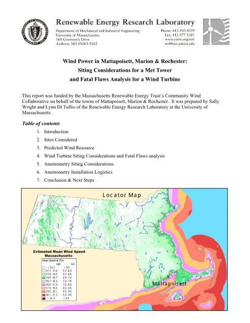
Locator Map<br />
X<br />
Mattapoisett
1. Introduction<br />
At the request of the Massachusetts Technology Collaborative’s Renewable Energy Trust, Sally Wright<br />
and Lynn Di Tullio of the UMass Renewable Energy Research Laboratory (RERL) visited potential<br />
wind turbine and/or wind monitoring sites in Mattapoisett, Marion, and Rochester, along with<br />
representatives of the towns. This report focuses on the siting considerations for wind-monitoring towers<br />
(“met towers”) as well as some of the logistics for met tower installation. Additionally, it takes into<br />
consideration logistical considerations in a broad “fatal flaw” analysis for potential wind turbine<br />
installations. This report is not intended as and should not be considered a wind turbine siting study.<br />
Section 2 begins by describing the sites that are under consideration for a met tower and/or wind turbine,<br />
and subsequent sections look for positive and negative indicators of their suitability.<br />
Section 3 describes the predicted wind resources for these sites. If a site weren’t expected to have good<br />
wind, it would not be considered further.<br />
Section 4 then looks for fatal flaws for wind turbines at the sites.<br />
Sections 5 and 6 look at the possibility of installing a met tower at these sites.<br />
Section 7 summarizes major concerns and suggests next steps.<br />
For more background information<br />
This document assumes some familiarity with wind resource assessment, wind power siting, and other<br />
issues that arise with wind power technology on a community scale. For an introduction to these areas,<br />
please refer to RERL’s Community Wind Fact Sheets, which are available on the web at:<br />
http://www.ceere.org/rerl/about_wind/. These sheets include information on the following subjects:<br />
• Wind Technology Today<br />
• Performance, Integration, & Economics<br />
• Capacity Factor, Intermittency, and what happens when the wind doesn't blow?<br />
• Impacts & Issues<br />
• Siting in Communities<br />
• Resource Assessment<br />
• Interpreting Your Wind Resource Data<br />
• Permitting in Your Community<br />
Use of this report<br />
This engineering report is intended to be used in consultation with MTC as the town explores its options<br />
for participation in MTC’s Community Wind Collaborative.
2. <strong>Site</strong>s considered<br />
<strong>Town</strong> representatives suggested eight locations for consideration. They are listed in the table below.<br />
Several sites were eliminated from consideration for a met tower for technical reasons: lack of access,<br />
proximity to residences, or firm ground.<br />
# <strong>Site</strong> Notes Consider further?<br />
1 Brandt Island Road <strong>Town</strong> Land Flat, forested land on Buzzard’s Bay Yes<br />
2 Old Rochester Regional (<strong>ORR</strong>)<br />
High School, Marion &<br />
Rochester<br />
3 Marion Wastewater Treatment<br />
Plant<br />
Flat, forested land off playing fields Yes<br />
Inland, lower predicted wind speeds Yes<br />
4 Mattapoisett Neck Rd. Marshy; residential area No<br />
5 Ned’s Point Close to a residence No<br />
6 Angelica Point No road access to end of point;<br />
unsuitable for standard anchors<br />
7 Strawberry Point No road access No<br />
8 Mattapoisett Landfill Inland – insufficient winds, unstable<br />
base<br />
The town-owned land on Brandt Island Road and Mattapoisett landfill sites were not toured on this site<br />
visit.<br />
Only three sites will be considered further in this report:<br />
A. <strong>Town</strong> Land off Brandt Island Road<br />
B. Old Rochester Regional (<strong>ORR</strong>) High School<br />
C. Marion WWTP<br />
Note that turbines and met towers have different siting requirements; ruling a site out for a met tower<br />
does not necessarily rule it out for a wind turbine.<br />
Following is a listing of site characteristics for these three locations. Also included are maps and<br />
photographs for the sites.<br />
No<br />
No
<strong>Site</strong> characteristics<br />
<strong>Site</strong>: A. Brandt Island<br />
Road <strong>Town</strong> Land<br />
Description Mostly undeveloped,<br />
forested town-owned<br />
land near the coast of<br />
Buzzards Bay.<br />
Address Mattapoisett, MA<br />
02066<br />
B. High School C. WWTP<br />
Flat forested land off<br />
playing fields<br />
135 Marion Road,<br />
Mattapoisett, MA 02066<br />
Owner <strong>Town</strong> of Mattapoisett <strong>Tri</strong> <strong>Town</strong>s: Marion,<br />
Mattapoisett & Rochester<br />
Location (NAD 27 UTM<br />
19)<br />
Location (NAD 83, D-M-S) 41° 37' 51"N, 70° 49'<br />
59"W<br />
Wastewater Treatment<br />
plant. Proposed met tower<br />
site is currently used for<br />
storage of DPW materials<br />
50 Benson Brook Road<br />
Marion, MA 02738<br />
<strong>Town</strong> of Marion<br />
347258E 4610196N 351570E 4615205N 352106E 4618098N<br />
41° 40' 36"N, 70° 46'<br />
57.5"W<br />
GPS Point No.: None 237 238<br />
Power lines or other<br />
obstructions to met tower.<br />
(Met tower must be set at least 1.5<br />
x the tower height away from<br />
power lines.)<br />
Clearing, terrain, obstacles<br />
to wind<br />
Road Access -for met tower<br />
installation<br />
Soil quality-for met tower<br />
anchors<br />
Ok Ok Ok<br />
50-60’ trees.<br />
Will require clearing<br />
None seen, but not far<br />
from the road.<br />
50-60’ trees<br />
Will require clearing<br />
Good Good<br />
OK OK OK<br />
Security: Unknown Possibility of vandalism<br />
related to high school.<br />
Distance to Distribution/<br />
Transmission lines<br />
OK OK OK<br />
41° 42' 10.2"N, 70° 46'<br />
36.9"W<br />
Some trees and other<br />
debris.<br />
Will require clearing<br />
Locked Gate - could<br />
prevent vehicle access at<br />
night<br />
On-site electrical loads None OK Good - WWTP<br />
Public or military airports<br />
within 5 miles<br />
Nearby residential areas: Houses at most 650 feet<br />
away, depending on<br />
siting<br />
None None None<br />
Houses 2040+ feet to east House 1300 feet to east
Maps:<br />
Base map source: Ortho-photograph from MassGIS website, http://www.mass.gov/mgis/dwn-imgs.htm<br />
Brand Island Rd.<br />
Map<br />
1: Ortho-photograph of the Brandt Island Road area. One possible turbine location, away from<br />
Brandt Beach Avenue residences, is marked with an X
Map 2: Orthophotograph of the high school area, with the proposed met tower location marked with an<br />
X
Map 3: Orthophotograph of the wastewater treatment plant
Map 4: Portion of an Assessors Plan of the <strong>Town</strong> of Mattapoisett, showing the town-owned parcel<br />
number 6, to the east of Brandt Island Road, with frontage on Brandt Island Road
Map 4: Estimated annual average wind speed at a height of 70 meters<br />
Approximate locations under discussion are marked with yellow crosses.<br />
<strong>Site</strong>s<br />
of primary interest for wind power have a mean wind speed of 6.5 m/s or over, i.e. shown in dark<br />
green, pink or orange.<br />
For more information, see TrueWind Solutions, truewind.teamcamelot.com/ne/.
Photos<br />
View of site just off playing field at <strong>ORR</strong> High School, looking approximately north:<br />
Above left: view of site near wastewater treatment plant, looking south.<br />
Above right: view of wastewater treatment<br />
plant area, looking about west.<br />
No photographs were taken of the Brandt Island Road town parcel.
3. Predicted<br />
Wind Resource<br />
TrueWind estimates of annual average wind speed<br />
According to the modeled wind speeds in the TrueWind map included on the first section of this report,<br />
predicted annual average wind speeds are as follows:<br />
Estimated<br />
annual average<br />
wind speeds<br />
At a height of<br />
70 m<br />
A. Brandt Island Road<br />
<strong>Town</strong> Land<br />
B. High School C. WWTP<br />
6.7 m/s (14.9 mph) 6.4 m/s (14.3 mph) 6.1 m/s (13.7 mph)<br />
These TrueWind estimates are used for screening and do not eliminate the need for site-specific<br />
anemometry.<br />
The importance of wind speed<br />
The feasibility of wind power depends on many factors. One of the most important factors is wind<br />
speed. The power in wind is related to its speed, and small changes or inaccuracies in wind speed can<br />
mean big changes in annual energy production. The chart below demonstrates the impact of mean wind<br />
speed on wind turbine output at the sites under consideration. Note that both axes of this graph, wind<br />
speeds and the annual energy, are estimates.
Other available wind data<br />
RERL has not maintained any anemometry<br />
in this immediate area. The nearest RERL anemometers are:<br />
Falmouth (~10 miles), Dartmouth (~12 miles), and Bourne<br />
(~12 miles). Data from these anemometers<br />
are available at: http://www.ceere.org/rerl/rerl_resourcedata.htm l.<br />
Obstacles to wind flow<br />
Obstacles<br />
cause both turbulence and slowing of the wind. These are important factors in site selection<br />
for a wind turbine because they affect the power production and the longevity of a wind turbine.<br />
A. Brandt Island Road<br />
<strong>Town</strong> Land<br />
B. <strong>ORR</strong> High School C. WWTP<br />
Obstacles to wind Wooded, 50-60’ tall trees Wooded, 50-60’ tall. The Brush, 40-50’ tall trees;<br />
flow: high school and<br />
surrounding trees will<br />
cause some turbulence.<br />
WWTP building.<br />
The land surrounding all three sites is largely wooded or built-up; this roughness increases turbulence.<br />
Proximity of anemometry & turbine<br />
Note that while wind resource assessment directly on the proposed wind turbine site is preferred, it is not<br />
always possible. If wind data are gathered in one spot, but a site for a wind turbine is later chosen in<br />
another nearby location, then a computer model<br />
that considers the wind data and terrain can be used to<br />
extrapolate the data from one location to the other. However, as the two sites become farther apart, the<br />
level of certainty in the data goes down, and thus the amount of risk in the investment goes up. It is<br />
difficult to predict the rate at which the certainty changes with distance, and can only be estimated on a<br />
site-specific basis.<br />
Although the sites under consideration are in similar landscapes, they are over a mile away from each<br />
other. Measurement at one site would not confidently be used to evaluate the feasibility of a turbine at<br />
the other.<br />
Conclusion: Appropriateness of resource assessment<br />
The <strong>Tri</strong>-town area encompassing Mattapoisett, Marion, and Rochester has estimated wind speeds near<br />
the shoreline that would be acceptable for the use in a megawatt-scale wind project.<br />
If the towns have interest in pursuing a wind energy project, wind resource assessment is recommended.<br />
The remainder of this report will look at preliminary siting logistics for wind turbines and met towers at<br />
and around these sites.
4. Wind Turbine Siting Considerations<br />
Purpose of this section<br />
As mentioned in the previous section, it is important to try to measure the wind as close to a potential<br />
wind turbine site as possible.<br />
Therefore turbine-siting criteria should be taken into consideration when<br />
siting a wind resource monitoring. The purpose of this section is to consider whether there are any “fatal<br />
flaws” to siting a wind turbine in the general areas under discussion.<br />
We<br />
stress that a site for a wind turbine has not yet been considered in any depth and siting of a wind<br />
turbine<br />
is not the intended purpose of this report. Rather, this section is intended to inform the decision<br />
of where to measure the<br />
wind.<br />
Furthermore, a scale of wind turbine has not been chosen. For the purposes of this discussion, it is<br />
assumed that a commercial-scale (660 – 1,800 k W) wind turbine will be chosen.<br />
Transportation accessibility for turbine installation<br />
With blades up to 130 feet long, modern wind turbines require transportation on roads with a fairly large<br />
turning radius and only small changes in slope.<br />
Some of the roads leading to the Brandt Island Road parcel in particular are narrow residential roads.<br />
Careful route planning will be necessary. However, site access does not appear to be a fatal flaw for any<br />
of the sites.<br />
In-site access issues<br />
Note that the Brandt Island Road parcel only has road frontage on the far northern edge. If no access<br />
were possible across private property on the western boundary (example shown below in blue), an<br />
access road of about 1600 feet would need to be built in from the north (example shown in pink).<br />
X<br />
Example<br />
of possible<br />
turbine site
Distance to distribution or transmission lines for power distribution:<br />
Distribution lines come on-site<br />
at the school and at the WWTP. Distribution lines are further away from<br />
the <strong>Town</strong> Land met tower location. A point of interconnection would be determined later in the project.<br />
Noise<br />
Noise considerations generally take two forms, state regulatory compliance and nuisance levels at<br />
nearby residences:<br />
A. Regulatory compliance: Massachusetts state regulations do not allow a rise of 10 dB or<br />
greater above background<br />
levels at a property boundary (Massachusetts Air Pollution Control<br />
Regulations, Regulation 310 CMR 7.10). This sound level is very unlikely to be a reached in any<br />
case at the sites we examined.<br />
B. Human annoyance: Aside from Massachusetts regulations,<br />
residences must also be taken into<br />
consideration. Any eventual turbine would be sited such that it would be inaudible or minimally<br />
audible at the nearest residences. At this stage, to check for “fatal flaws,” a rule of thumb can be<br />
used: to minimize possible noise impacts, site wind turbines at least three times the blade tip<br />
height from residences. Distances from mixed-use areas may be somewhat shorter.<br />
Noise will not be an issue for siting a wind turbine at the <strong>ORR</strong> High School or the Marion WWTP.<br />
However, noise<br />
will be a primary siting constraint for the Brandt Island Road site because much of the<br />
parcel is less than 800 feet<br />
wide, and there are residences to the western side of the parcel. Consideration<br />
of the neighbors will be an important factor in siting a wind turbine on this parcel of town land. Given a<br />
specific size and make of turbine, suggested setbacks from residences can be proposed to eliminate or<br />
minimize the audibility at the neighbors. This would then inform the exact siting of a turbine.<br />
For example, a Vestas V47 on a 50-meter tower has a 241-foot blade-tip, and would need to be sited<br />
on<br />
the far eastern side of the parcel, to be three times the blade-tip height (723 feet) from the neighbors on<br />
the western edge.<br />
Nearby Airports<br />
There are no public or military airports within 5 miles, so airspace will not be an important siting issue.<br />
The nearest airports are:<br />
• New Bedford Regional Airport: ~6 miles<br />
• Acushnet River Seaplane Base, Fairhaven, ~4 miles<br />
• Island Air Service Seaplane Base, Rochester, ~7 miles<br />
• Otis Air National Guard Base, ~12 miles<br />
The FAA requires that any structure over 200’ be lit. Any com mercial-scale turbine will be lit.<br />
A Form 7460-1 (Notice Of Proposed Construction Or Alteration) must be sent<br />
to the FAA for any<br />
proposed wind turbine installation over 200 feet (to blade-tip). Any concerns of airport personnel and<br />
other air safety regulators would be considered as part of the turbine siting process.
Other<br />
environmental or permitting issues<br />
The following items are favorable for this site:<br />
Notes:<br />
Item to check:<br />
A. Brandt<br />
Island Road<br />
<strong>Town</strong> Land<br />
B. <strong>ORR</strong> High<br />
School<br />
Designated by the DEP as Wetlands? No Some wetlands in<br />
this area but they<br />
can be avoided<br />
Designated by the Natural Heritage &<br />
Endangered Species Program as a:<br />
• Core Habitat<br />
• Priority Habitat of Rare Species, or<br />
• Certified Vernal Pool?<br />
No<br />
No<br />
Designated by the Massachusetts<br />
Audubon Society as an Important Bird<br />
Area (IBA)?<br />
For more on Core Habitat C1297 in Marion, see:<br />
http://www.mass.gov/dfwele/dfw/nhesp/twnrpts/marion_core_habitats.pdf<br />
No<br />
No<br />
C. WWTP<br />
No<br />
Core Habitat<br />
(see below)<br />
There are two Mass Audubon IBA’s in the Buzzard’s Bay region: Bird Island and Ram Island, located<br />
just offshore the western shoreline of Buzzards Bay.<br />
The Marion Waste Water Treatment plant is in Core Habitat C1297 as designated by the Natural<br />
Heritage & Endangered Species Program. The Core Habitat includes most of this area between Route 6<br />
and Route 195.<br />
Conclusion: At this preliminary<br />
stage, there is no indication of significant environmentally based<br />
permitting hurdles<br />
for these sites.<br />
No
Conclusion: Wind turbine siting<br />
No fatal flaws to siting a wind turbine in the <strong>Tri</strong>-town<br />
area are apparent. However, at the Brandt Island<br />
Road <strong>Town</strong> parcel, constrained space would limit the number, size and siting of tur bines.<br />
The two inland sites are expected<br />
to have lower wind speeds, making<br />
the Brandt Island Road area more<br />
favorable. A comparison of important characteristics that affect project feasibility is summarized here:<br />
Factor <strong>Site</strong> Brandt Island<br />
characteristic Road <strong>Town</strong><br />
Land<br />
High School WWTP<br />
Wind speed: Predicted wind Good<br />
Lower than<br />
resource<br />
typically desired<br />
for the Community<br />
Wind Collaborative<br />
Number<br />
of<br />
turbines:<br />
Available space Constrained<br />
in size<br />
& location<br />
–<br />
probably space for<br />
only one turbine,<br />
no bigger than<br />
Hull’s V47<br />
Value of power On-site None OK<br />
produced electrical loads<br />
Interconnection Distance to Ok<br />
cost Transmission<br />
/distribution<br />
lines<br />
Conclusion: influence on siting of wind resource monitoring<br />
Sufficient Sufficient<br />
Ok Ok<br />
Lower<br />
than<br />
typically desired<br />
for the Community<br />
Wind Collaborative<br />
Good – WWTP<br />
Since the sites are not close enough together to share monitoring, a decision should be made on a turbine<br />
site before choosing a met tower site. In other words, the met tower should be installed at the preferred<br />
turbine site.
5. Choice of site for wind monitoring<br />
Traditionally, wind is monitored for about a year with a met tower. Some sites may be suitable<br />
for other<br />
types of monitoring in addition to or even instead of a met tower. This section will concentrate on the<br />
siting of a met tower, but will also discuss other monitoring options.<br />
About<br />
met towers<br />
The met towers used by RERL<br />
are temporary structures that<br />
do<br />
not<br />
require a foundation and are supported<br />
by<br />
guy wires in 4<br />
directions. Towers are usually 40 meters (131’) or 50 meters<br />
(164’) tall. In most cases, standard utility anchors are used to<br />
anchor the guy wires. The number and type of anchors required<br />
depends on the particular site. They will be proof-tested at<br />
installation to make sure they can hold enough load.<br />
The tower is raised using a winch; no crane is required. It consists of a set of 6” diameter pipes that stack together; the whole set-up<br />
can be brought in on a pick-up truck.<br />
The pictures on this page give an idea of what this equipment<br />
looks like.<br />
Gin<br />
Pole<br />
Met<br />
Tower<br />
A met tower in the process of being raised.<br />
The “gin pole” gives the winch leverage to lift<br />
the tower.<br />
RERL’s truck loaded with the sections of a 50-meter<br />
met tower<br />
A met tower base-plate<br />
Typical 6-foot-long utility anchor<br />
An anchor, installed, with 2 guy<br />
wires attached
Space required for a met tower in general<br />
Clearing is necessary both for met tower installation<br />
and to reduce ground effect disturbance during data<br />
collection. The cleared area is shaped like a circle for the guy wires, with an additional “wedge” in<br />
which the tower is assembled before raising. The minimum cleared areas for guyed towers are:<br />
Tower Height Minimum D Minimum L Total Envelope<br />
(Guy Diam.)<br />
(Space to lay the<br />
tower down)<br />
40 meter (131’) 160 feet 135 feet 215 x 160 feet<br />
50 meter (164’) 240 feet 165 feet 285 x 240 feet<br />
Dimensions of a football field, for comparison: 300 x 160 feet<br />
In general, a larger cleared area reduces the disturbances seen by the instruments,<br />
and improves data quality. Therefore, a cleared area larger than the minimum size<br />
is preferred.<br />
While it is not necessary to pull stumps, removing as much obstruction<br />
and underbrush as possible will<br />
facilitate the raising of the tower. Guy- wires will be pulled across this field, and any obstacles that<br />
entangle the wires make the job more difficult.<br />
It is also essential that there not be any electric or telephone wires within 1.5 times<br />
the height of the<br />
tower,<br />
i.e. 200 feet of a 40 m tower, or 250 feet of a 50 m tower.<br />
Trees must be cleared at least the height of the trees away from the anchors to eliminate the danger of a<br />
fa lling tree hitting the guys. For<br />
example, a 50-foot-tall tree within less than 50 feet of an anchor must<br />
be cut down.<br />
Note that it is possible to use some<br />
of this cleared area after the met tower has been installed; in other<br />
words,<br />
after installation, the space is left largely open.<br />
Space<br />
availability at the <strong>Tri</strong>-town sites<br />
Tree clearing will be needed in all cases:<br />
Brandt Island Road<br />
<strong>Town</strong> Land<br />
High School WWTP<br />
Space availability There appears to be There appears to be<br />
for met towers sufficient level area for a sufficient level area for a<br />
50-meter met tower. 50-meter met tower.<br />
Accessibility for met tower installation<br />
The sites are easily reachable by RERL’s pick-up truck.<br />
Depending on how<br />
much space can be<br />
cleared, this area may fit<br />
a 40 or 50-meter tower.<br />
The power lines on the<br />
access road to the north<br />
and the wetlands to the<br />
east will be constraints.
Nearby Airports & FAA restrictions for met<br />
towers<br />
RERL’s met towers are shorter than 200 feet and do not require registration with the FAA.<br />
Lighting<br />
T he FAA does not require met tower lighting at these sites. The Renewable Energy Trust recommends<br />
FAA lighting of met towers even if not required by the FAA.<br />
If the town opts for lighting, either a source<br />
of 120 VAC power<br />
or sufficient photovoltaic panels and<br />
batteries will be needed as an energy sourc<br />
e for the light.<br />
Distance to power line s (for met tower lighting if used)<br />
If the town opts for lighting, 120 VAC power is close enough in the case of the High School and the<br />
WWTP, that we recommend wiring be run to the met tower bas e. In the case of the Brandt Island Road<br />
town land, unless the town can provide AC power, RERL will install photovoltaics and batteries.<br />
Soil quality & Anchor requirements<br />
Soil quality &<br />
Anchor<br />
requirements<br />
Brandt Island Road<br />
<strong>Town</strong> Land<br />
Expected to be<br />
acceptable<br />
High School WWTP<br />
Expected to be<br />
acceptable<br />
Expected to be<br />
acceptable<br />
RERL’s standard anchors may be adequate or larger anchors may be required. This will be tested on the<br />
site.<br />
Met tower Size Recommendation:<br />
RERL uses two sizes of met towers, 40-meter and 50-meter,<br />
depending on the site. Because all these<br />
sites are forested, 50-meter towers are recommended:<br />
Brandt Island Road<br />
<strong>Town</strong> Land<br />
High School WWTP<br />
Met Tower Height 50 meter 50 meter<br />
50-meter<br />
is<br />
recommended<br />
but 40-<br />
meter<br />
may be adequate<br />
if there is insufficient<br />
room.
Summary<br />
The relative merits of the sites for met towers are summarized below. All the sites are adequate<br />
for met<br />
tower installation.<br />
Brandt Island Road<br />
<strong>Town</strong> Land<br />
High School WWTP<br />
Ease of installation Level site. Can Level site; can<br />
probably use standard probably use standard<br />
anchors anchors<br />
Clearing Trees will need to be<br />
removed<br />
Trees will need to be<br />
removed<br />
Security Unknown Possibly a danger of<br />
vandalism<br />
Predicted wind<br />
resource<br />
Good Lower than typically<br />
desired for the<br />
Community Wind<br />
Collaborative<br />
Conclusion: met tower siting recommendations<br />
<strong>Site</strong> needs cleanup and<br />
some leveling<br />
Some brush and trees<br />
will need to be<br />
removed, plus debris<br />
Fenced-in site<br />
Lower than typically<br />
desired for the<br />
Community Wind<br />
Collaborative<br />
As pointed<br />
out in the previous section, the met tower should be installed at the preferred turbine site.<br />
To participate in MTC’s Community Wind<br />
Collaborative, the tri-town region should choose the site in<br />
consultation with MTC in order to ensure<br />
the site fits the Collaborative’s criteria.
6. Anemometry Installation Logistics<br />
<strong>Site</strong> Owner Responsibilities<br />
RERL<br />
is pleased to offer wind-monitoring services to the town through the Trust’s Community Wind<br />
Collaborative. If the site is eligible for MTC’s Com munity Wind Collaborative, and the<br />
monitoring<br />
effort moves forward, the town’s in-kind assistance will be needed in several aspects of installing a met<br />
tower. The host town (Mattapoisett or Marion) would be responsible for security, some<br />
minor<br />
maintenance, insurance, and permitting. They are described<br />
as follows:<br />
Security<br />
T he security of the loaned monitoring equipmen t is the responsibility of the town. The town is expected<br />
to protect the site to its satisfaction – e.g. by installing a fence around the tower base if this seems<br />
necessary. If the site manager prefers, RERL can place the logger high enough up the pole that a ladder<br />
is required to reach it. Additionally, if PV panels were needed for FAA lighting, these would be located<br />
near the base of the met tower.<br />
Maintenance<br />
Met towers have data loggers mounted at the base, to collect the wind data. The data loggers require<br />
that a memory card be periodically swapped and mailed back to RERL. Additionally, the person<br />
replacing the card would look at the tower and report anything unusual to RERL. A designated town<br />
representative<br />
(or representatives) will be trained in these simple operations at the time of installation.<br />
Liability and Insurance<br />
The RERL loans industry-standard wind-monitoring equipment under a standard loan agreement. The<br />
form can be found at http://www.ceere.org/rerl/projects/support/weps/agreement.pdf or contact RERL<br />
for a copy.<br />
The Trust requires that the site owner carry liability insurance for the met tower and name the Trust as<br />
an insured party. This requirement is described in the loan agreement.<br />
Permitting: Local approval process<br />
RERL will support the site owner in obtaining any necessary local permits for the temporary monitoring<br />
tower (e.g. building permits or zoning variances.)<br />
In-kind labor<br />
In-kind labor has been discussed above, in this section. Additionally, the town would do any clearing<br />
needed.<br />
If lighting wiring is required (see notes on FAA lighting above), this is provided by the town.<br />
Weather<br />
The met tower cannot be installed in strong winds, rain, or snow. Additionally, the anchors must be<br />
installed before the ground is frozen in order to be properly proof tested.<br />
Note that weather-dependence can make the planning of the project somewhat difficult. Typically RERL<br />
sets aside a one- to two-week period ahead of time, then chooses the exact days within this window, just<br />
a day or two in advance.
Conclusion: Timing & sequence of events<br />
Met tower installation can proceed when:<br />
1. The Trust approves<br />
the town as a candidate for further community wind assistance<br />
2. The town chooses a location that is acceptable to RERL and Trust.<br />
3. The site owner secures required permits, if any,<br />
4. A loan agreement (http://www.ceere.org/rerl/projects/support/weps/agreement.p df)<br />
is<br />
signed and returned to the RERL, and insurance coverage is confirmed,<br />
5. Anchoring systems have been designed, installed and tested, and,<br />
6. The RERL can schedule a work-crew, equipment – and of course good weather!
7. Conclusions and Next Steps<br />
The <strong>Tri</strong>-town area<br />
has a parcel of town-owned land in Mattapoisett that is predicted to have winds<br />
sufficient to install a commercial-scale wind turbine. Other town-owned parcels were examined as well.<br />
If the <strong>Tri</strong>-town area as a group, or the town of Mattapoisett, is interested in pursuing land-based wind<br />
power for municipal use, representatives should confirm their interest<br />
to the Trust.<br />
If project fits within<br />
the Trust’s program, the Trust could then authorize RERL to proceed with wind<br />
resource assessment services. In that case, the following steps are recommended for installation<br />
of a met<br />
tower:<br />
• Consider<br />
a wind turbine site: While a met tower does not have to be at the exact location<br />
of<br />
an eventual<br />
turbine, the choice of turbine site must inform the met tower site.<br />
The Brandt Island Road parcel has better predicted winds, while the High School site has<br />
more space and an electrical load.<br />
• Agree on a met tower site: This should be at or near the wind turbine site under<br />
consideration.<br />
• Met tower size recommendation: a 50-meter tower should be used to better understand the<br />
higher winds and the wind shear in this forested area.<br />
• Permits: determine if any local permits (e.g. building, zoning, etc.) are required for the<br />
temporary met tower. If so, acquire those permits.<br />
• Preparing for the met tower: Sufficient area will need to be cleared at the chosen site. Work<br />
with RERL to mark and clear a site.