NSG Altes Morr - Verwaltungsvorschriften im Internet
NSG Altes Morr - Verwaltungsvorschriften im Internet
NSG Altes Morr - Verwaltungsvorschriften im Internet

Erfolgreiche ePaper selbst erstellen
Machen Sie aus Ihren PDF Publikationen ein blätterbares Flipbook mit unserer einzigartigen Google optimierten e-Paper Software.
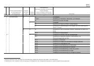
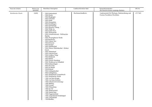
Name des Gebietes Fläche in ha<br />
(gerundet)<br />
Medebacher Bucht 13.872<br />
Betroffenes Schutzgebiet Landkreis/Kreisfreie Stadt Kartendokumentaüon<br />
(für Einsicht in Karten zuständige Behörde)<br />
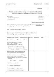
- <strong>NSG</strong> Katmecketal<br />
- <strong>NSG</strong> Hoche<br />
- <strong>NSG</strong> Brughagen<br />
- <strong>NSG</strong> Osterntal<br />
- <strong>NSG</strong> Hardt<br />
- <strong>NSG</strong> Herzgraben<br />
- <strong>NSG</strong> Knickhagen<br />
- <strong>NSG</strong> Kattenkopp<br />
- <strong>NSG</strong> Brueche-Talung '<br />
- <strong>NSG</strong> Wilde Aa<br />
- <strong>NSG</strong> Kahle Poen<br />
- <strong>NSG</strong> Wamecketal<br />
- <strong>NSG</strong> Grundwassertal - Hollrnecker<br />
Bachta<br />
- <strong>NSG</strong> Wissinghauser Heide<br />
- <strong>NSG</strong>Saelbecke<br />
- <strong>NSG</strong> Grüner Stot<br />
- <strong>NSG</strong>Afmecke<br />
- <strong>NSG</strong> Rempel<br />
- <strong>NSG</strong> Hallebachtal<br />
- <strong>NSG</strong> Oberes Dittelsbachtal - Kloken<br />
bruch<br />
- <strong>NSG</strong> Wänterkopf<br />
- <strong>NSG</strong> Osternwiesen<br />
- <strong>NSG</strong> Goldene Tröge<br />
- <strong>NSG</strong> Brühnetal<br />
- <strong>NSG</strong> Bohlen<br />
- <strong>NSG</strong> Grosser Steinberg<br />
- <strong>NSG</strong> Waldreservat Glindfeld<br />
- <strong>NSG</strong> Krämershagen -<br />
- <strong>NSG</strong> Die Erlen<br />
- <strong>NSG</strong> Im Boden<br />
- <strong>NSG</strong>Orketal<br />
- <strong>NSG</strong> Gelängebachtal<br />
- <strong>NSG</strong> Gelängeberg<br />
- <strong>NSG</strong> Medebacher Frauenbruch<br />
- <strong>NSG</strong> Medebacher Heide<br />
- <strong>NSG</strong> Auf dem Knapp<br />
- <strong>NSG</strong> Auf dem Schle<strong>im</strong><br />
- <strong>NSG</strong> Orketal (Erweiterung)<br />
- <strong>NSG</strong> Bärberg<br />
- <strong>NSG</strong> Lieseta!<br />
- <strong>NSG</strong> Hilmesberg<br />
- <strong>NSG</strong> Im Tal<br />
- <strong>NSG</strong> Rüdenscheid<br />
- <strong>NSG</strong> Stemm berg<br />
- <strong>NSG</strong> Figgemecketal<br />
- <strong>NSG</strong> Ziegenhardt-Heideköppel<br />
- <strong>NSG</strong> Zlegenhardt<br />
- <strong>NSG</strong>Bedden<br />
Hochsauerlandkreis Landesanstalt für Ökologie, Bodenordnung und<br />
Forsten Nordrhein-Westfalen<br />
SPA-Nr.<br />
4717401