Coastline Reports 9 (2007) - Küsten Union Deutschland
Coastline Reports 9 (2007) - Küsten Union Deutschland
Coastline Reports 9 (2007) - Küsten Union Deutschland

Sie wollen auch ein ePaper? Erhöhen Sie die Reichweite Ihrer Titel.
YUMPU macht aus Druck-PDFs automatisch weboptimierte ePaper, die Google liebt.
198 Link & Schleupner<br />
conversion process. According to the local farmers union, two thirds of the agricultural land on<br />
Eiderstedt are supposed to be converted to arable farm land within the next couple of decades (NABU<br />
2004). Such a change would not only distinctly alter the appearance of Eiderstedt, but would also<br />
mean the loss of valuable bird habitats and possibly a reduction of the recreational attractiveness of the<br />
landscape to visitors.<br />
This study will look at possible scenarios of land use development on the Eiderstedt peninsula. After a<br />
brief historic overview of past agricultural land use changes in this region, the controversy between<br />
farmers and environmentalists about the future development of the local agriculture is presented.<br />
Using a geographic information system (GIS), scenarios of a future conversion of grassland to arable<br />
farm land on Eiderstedt are developed and described. These scenarios can be used in further<br />
assessments to quantify the ecological impacts of each development path.<br />
2 Historic development of agricultural land use in Eiderstedt<br />
Eiderstedt is a peninsula at the West coast of Schleswig-Holstein that extends into the North Sea. It is<br />
located between the river Eider in the South and the town of Husum in the Northeast. Back in the 11th<br />
century, Eiderstedt consisted of several geest islands, but started to grow together as a consequence of<br />
the first coastal protection measures being erected at that time (Meier 2001). Initially, transportation<br />
was only possible by boat as settlements were exclusively accessible from the North Sea. These<br />
waterways remained in operation for several centuries and its underlying pattern is still recognizable.<br />
Today, almost the entire peninsula is enclosed by dikes built to withstand severe storm floods. This<br />
makes it necessary to artificially drain the land area. Parallel passing drills (in German: Grüppen) have<br />
been constructed that have become a typical feature of the Eiderstedt landscape (Fischer 1997).<br />
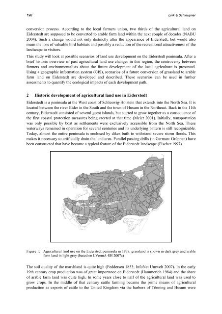
Figure 1: Agricultural land use on the Eiderstedt peninsula in 1878, grassland is shown in dark grey and arable<br />
farm land in light grey (based on LVermA-SH <strong>2007</strong>a)<br />
The soil quality of the marshland is quite high (Feddersen 1853; InfoNet Umwelt <strong>2007</strong>). In the early<br />
19th century crop production was of great importance on Eiderstedt (Hammerich 1984) and the share<br />
of arable farm land was quite high. In some years close to half of the agricultural land was used to<br />
grow crops. In the middle of that century cattle farming became the prime means of agricultural<br />
production as exports of cattle to the United Kingdom via the harbors of Tönning and Husum were