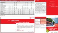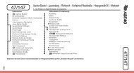
Brand − Gewerbegebiet Eilendorf Süd − Normaluhr − Aachen ... - AVV
Brand − Gewerbegebiet Eilendorf Süd − Normaluhr − Aachen ... - AVV
Brand − Gewerbegebiet Eilendorf Süd − Normaluhr − Aachen ... - AVV

Sie wollen auch ein ePaper? Erhöhen Sie die Reichweite Ihrer Titel.
YUMPU macht aus Druck-PDFs automatisch weboptimierte ePaper, die Google liebt.
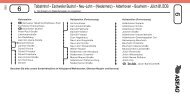
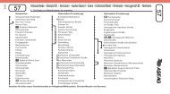
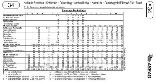
Kerkrade Busstation <strong>−</strong> Kohlscheid <strong>−</strong> Grüner Weg <strong>−</strong> <strong>Aachen</strong> Bushof <strong>−</strong> <strong>Normaluhr</strong> <strong>−</strong> <strong>Gewerbegebiet</strong> <strong>Eilendorf</strong> <strong>Süd</strong> <strong>−</strong> <strong>Brand</strong><br />
34 Der Einsatz von Niederflurbussen ist vorgesehen.<br />
montags bis freitags<br />
34<br />
Kerkrade Busstation Hst. C<br />
Kerkrade Station<br />
Bleijerheide Grens<br />
Pannesheide<br />
Forensberger Straße<br />
Kohlscheid Bf.<br />
Kohlscheid Weststraße<br />
Technologiepark<br />
Gesundheitsamt<br />
Kämpchen<br />
Berensberg<br />
Polizeipräsidium<br />
Lukasstraße<br />
Lombardenstraße<br />
<strong>Aachen</strong> Bushof H.10<br />
Elisenbrunnen H.3<br />
Theater<br />
<strong>Normaluhr</strong> H.6 (Zollernstr.)<br />
Viktoriaallee<br />
Bf. Rothe Erde<br />
Adenauerallee<br />
Meisenweg<br />
Debyestraße<br />
Kellershaustraße<br />
Am Tiergarten<br />
<strong>Brand</strong> Ringstraße<br />
<strong>Brand</strong><br />
a qr w w z z z t z t z t z t F Sz<br />
6.29 7.01 7.31 8.01 8.31<br />
32 04 34 04 34<br />
36 08 38 08 38<br />
38 10 40 10 40<br />
40<br />
__<br />
12<br />
__<br />
42<br />
__<br />
12<br />
__<br />
42<br />
__ 9.17 9.47 10.17 10.47 11.17 11.47 11.47 12.17<br />
5.37 6.09 43 16 46 16 46 18 48 18 48 18 48 48 18<br />
38 10 44 17 47 17 47 19 49 19 49 19 49 49 19<br />
39 12 46 19 49 19 49 21 51 21 51 21 51 51 21<br />
40 14 48 21 51 21 51 23 53 23 53 23 53 53 23<br />
43 17 51 24 54 24 54 26 56 26 56 26 56 56 26<br />
46 20 54 27 57 27 57 29 59 29 59 29 59 59 29<br />
49 24 58 31 8.01 31 9.01 33 10.03 33 11.03 33 12.03 12.03 33<br />
51 26 7.00 33 03 33 03 35 05 35 05 35 05 05 35<br />
5.30 57/00 6.18 33 6.48 07/10 7.25 40 10 40 10 42 12 42 12 42 12 12 42<br />
32 6.02 21 36 51 13 28 43 13 43 13 45 15 45 15 45 15 15 45<br />
33 03 23 38 53 15 30 45 15 45 15 47 17 47 17 47 17 17 47<br />
35 05 26 41 56 18 33 48 18 48 18 50 20 50 20 50 20 20 50<br />
38 08 29 44 59 21 36 51 21 51 21 53 23 53 23 53 23 23 53<br />
5.25 40 10 31 46 7.01 23 40 53 23 53 23 55 25 55 25 55 25 25 55<br />
28 43 13 34 49 04 26 43 56 26 56 26 58 28 58 28 58 28 28 58<br />
31 46 16 37 52 07 29 46 59 29 59 29 10.01 31 11.01 31 12.01 31 31 13.01<br />
34 49 19 41 56 11 33 50 8.03 33 9.03 33 05 35 05 35 05 35 35 05<br />
35 50 20 43 58 13 35 52 05 35 05 35 07 37 07 37 07 37 37 07<br />
39 54 24 47 7.02 17 39 56 09 39 09 39 11 41 11 41 11 41 41 11<br />
41 56/57 26/32 50/52 05 20/25 42/52 59 12/22 42/52 12/22 42/52 14/22 44/52 14/22 44/52 14 44 44/52 14<br />
5.43 5.59 6.34 6.54 7.07 7.27 7.54 8.01 8.24 8.54 9.24 9.54 10.24 10.54 11.24 11.54 12.16 12.46 12.54 13.16<br />
S = nur an Schultagen a = mit Linie 55 bzw. 57 bis Bf.Rothe Erde, dort umsteigen<br />
F = nur in den Ferien q = kommt als Linie 57 aus Richtung Kohlscheid <strong>−</strong> Kämpchen <strong>−</strong> Soers<br />
r = ab <strong>Brand</strong> Ringstr. weiter als Li. 35 in Ri. Breinig t = ab <strong>Brand</strong> Ringstraße weiter als Linie 15 in Richtung Breinig<br />
z = ab <strong>Brand</strong> Ringstr. weiter als Li. 65 in Ri. Walhm. w = ab <strong>Brand</strong> Ringstraße weiter als Linie 55 in Richtung Lichtenbusch<br />
Fortsetzung siehe nächste Seite