Diving
Diving
Diving

Create successful ePaper yourself
Turn your PDF publications into a flip-book with our unique Google optimized e-Paper software.
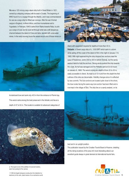
Vis was a 120 m-long cargo steam ship built in Great Britain in 1921,<br />
owned by a shipping company with its seat in Croatia. The beginning of<br />
WW2 found it on a voyage through the Atlantic, and it was commandeered<br />
for use as a cargo ship for Allied war convoys. After the war it ferried<br />
cargos in England, northern Africa, and then humanitarian aid to<br />
Yugoslavia. In February 1946 it sailed from Rijeka towards Raša, to pick<br />
up a cargo of coal, but its route led through what was a still dangerous<br />
channel between the island of Cres and Istria, seeded with underwater<br />
mines. In the early morning hours the vessel struck one of those mines on<br />
Vis<br />
its starboard bow and sank only 400 m from the entrance to Plomin bay.<br />
This wreck ranks among the best preserved in the Adriatic and lies at a<br />
depth of 47 to 63 m. This location is suitable for advanced categories of<br />
∆ The squid is one of the swiftest of nocturnal hunters,<br />
seen here posing for the camera<br />
With its fragile biological construction the Eudendrium is<br />
testimony to the calm, placid nature of our submarine world<br />
∆<br />
Lovran<br />
divers with equipment required for depths of more than 40 m.<br />
Peltastis, a Greek cargo ship of c. 1500 BRT which sank in a storm<br />
while sailing off the coast of the island of Krk in the night of January 7/8,<br />
1968. With night approaching the ship dropped two anchors near the<br />
quay of Pazduhovo, some 200 to 300 m before Dramalj, but the sandy<br />
seabed failed to hold the anchors. Strong winds pushed the ship towards<br />
the coast, its hull was damaged and the Peltastis sank at 03.50 hours<br />
on January 8, 1968. The wreck is lying at a depth of from 20 to 30 m,<br />
easily accessible to divers. Its mast is at 10 m and from this depth the first<br />
outlines of the ship are discernable. Visibility changes since it is affected<br />
by sea currents. The bow anchors are located quite close to the shore,<br />
the bow is also facing the same way (one anchor has been lifted and is<br />
now kept in the village of Šilo). The ship lies on a sandy seabed, on its<br />
Peltastis<br />
keel and in an upright position.<br />
The publication issued by the Croatian Tourist Board of Kvarner, detailing<br />
all the diving locations of the area (40 most interesting sites) is an<br />
excellent guide always in great demand at international tourist fairs.<br />
Croatian National Tourist Board<br />
19