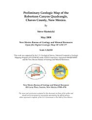
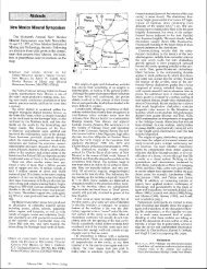
Carbonatite dikes of the Chupadera Mountains, Socorro County
Carbonatite dikes of the Chupadera Mountains, Socorro County
Carbonatite dikes of the Chupadera Mountains, Socorro County

You also want an ePaper? Increase the reach of your titles
YUMPU automatically turns print PDFs into web optimized ePapers that Google loves.
cordingly. Generally, only <strong>the</strong> very best gas<br />
prospects, or those gas prospects required to<br />
hold leases, were drilled in 1985. However,<br />
existing gas pools in <strong>the</strong> San |uan Basin continued<br />
to be developed.<br />
ACKNowLEDGwNTs-Prentiss Childs <strong>of</strong> <strong>the</strong><br />
New Mexico Oil Conservation Division provided<br />
<strong>the</strong> well completion statistics. Richard<br />
Stamets <strong>of</strong> <strong>the</strong> New Mexico Oil Conservation<br />
Division provided data on <strong>the</strong> volume <strong>of</strong> oil<br />
and gas produced. David Donaldson <strong>of</strong> <strong>the</strong><br />
New Mexico Bureau <strong>of</strong> Geology provided <strong>the</strong><br />
reserve statistics. Robert Bieberman, Frank<br />
Kottlowski, and Sam Thompson, III, reviewed<br />
<strong>the</strong> manuscript. Lynne McNeil typed<br />
<strong>the</strong> manuscript and Cherie Pelletier drafted<br />
<strong>the</strong> illustration.<br />
References<br />
lup Sandstone (Upper Cretaceous) <strong>of</strong> northwestem New<br />
Mexico: New Mexico Bureau <strong>of</strong> Mines and Mineral Resources,<br />
Circular 764, 32 pp<br />
Ca<strong>the</strong>r, S. M., and Johnson , B. D., 1,984, Eocene tectonics<br />
and depositional setting <strong>of</strong> west-central New Mexico<br />
and eastem Arizona: New Mexico Bureau <strong>of</strong> Mines and<br />
Mineral Resources, Circular 192,33 pp<br />
Energy Information Administration, 1985, U.S crude oil,<br />
natural gas, and natural gas liquids reserues: U S. Department<br />
<strong>of</strong> Energy, Energy lnforrnation Administration,<br />
1984 annual report, DOE/EIA-0216(84), 98 pp<br />
Foster, R W, 1980, Carbon dioxide sources and use for<br />
enhanced oil recovery: New Mexico Petroleum Recovery<br />
Research Center, Report 80-4, 73 pp<br />
Kelley, V C , 7978, Geology <strong>of</strong> Espafrola Basin, New Mexico:<br />
New Mexico Bureau <strong>of</strong> Mines and Mineral Resources,<br />
Geologic Map 48, scale 1:125,000<br />
Kinney, E E (ed),7967, The oil and gas fields <strong>of</strong> sou<strong>the</strong>astern<br />
New Mexico: Roswell Geological Society,'1.967<br />
Symposium Supplement, 195 pp.<br />
Kottlowski, F. E , and Stewart, W J., 1970, The Wolfcampian<br />
Joyita uplift in cenhal New Mexico: New Mexico<br />
Bureau <strong>of</strong> Mines and Mineral Resources, Memoir<br />
23,pt I, pp 1-31<br />
Oil and Gas Journal, 1985, Selected U.S. and world cmde<br />
prices: Oil and Gas Journal, v. 83, no. 1, p. 120.<br />
Oil and Gas Journ al, 1986a, Selected U S. and world crude<br />
prices: Oil and Gas Journal, v. 84, no 2, p. 85.<br />
Oil and Gas foumal, 1985b, AGA-gas surplus to retain<br />
price rein: Oil and Gas Journal, v. 84, no. 1, pp 52-53<br />
Stamets, R L , Kautz, P, Brooks, L , and Busch, E , 1985,<br />
New Mexico: The Oil and Gas Compact Bulletin, v. tl4,<br />
no 1, pp 31-33<br />
Stone, W J , Lyford, F. P, Frenzel, P F., Mizell, N H ,<br />
and Padgett, E. T.,1983, Hydrogeology and water resources<br />
<strong>of</strong> San Juan Basin, New Mexico: New Mexico<br />
Bureau <strong>of</strong> Mines and Mineral Resources, Hydrologic<br />
Report 6, 70 pp<br />
Thompson, S, III, 1980, Pedregosa Basin's main exploration<br />
target is Pennsylvanian dolostone: Oil and Gas<br />
Journal, v 78, no. 42, pp 202, 207, 21.0, 215.<br />
Thompson, S, III, 1981, Petroleum source rocks in exploration<br />
wells drilled to Paleozoic or Mesozoic units,<br />
Hidalgo and Grant Counties, New Mexico: New Mexico<br />
Energy Institute, Report EMD 2-55-3306,720 pp<br />
Thompson, S, ilI, and Jacka, A. D, 7981, Pennsylvanian<br />
shatigraph, pehography, and petroleum geology <strong>of</strong><br />
<strong>the</strong> Big Hatchet Peak section, Hidalgo <strong>County</strong>, New<br />
American Gas Association, 1984, The gas energy demand Meyer, R F, 1955, Geology <strong>of</strong> Pennsylvanian and Wolf- Mexico: New Mexico Bureau <strong>of</strong> Mines and Mineral Re-<br />
outlook: 1984-2000: American Gas Association, Arlingcampian rocks in sou<strong>the</strong>ast New Mexico: New Mexico sources, Circular 1.76, 1.25 pp.<br />
ton, Virginia, 90 pp<br />
Bureau <strong>of</strong> Mines and Mineral Resources. Memoir 17, Woodward, L A, Callender,J F., Seager,W R, Chapin,<br />
Broadhead, R F, and King, W. E, 1985, Preliminary<br />
report on <strong>the</strong> stratigraphy and structure <strong>of</strong> Pennsylvanian<br />
and lower Permim strata, Tucumcari Basin: New<br />
Mexico Geological Society, Guidebook to 36th Field<br />
123 pp<br />
Molenaar, C M ,9n, Stratigraphy and depositional history<br />
<strong>of</strong> Upper Cretaceous rocks <strong>of</strong> <strong>the</strong> San Juan Basin<br />
area, with a note on economic resources: New Mexico<br />
C E , Gries, J C, Shaffer, W L, and Zilinski, R E ,<br />
1978, Tectonic map <strong>of</strong> Rio Grande rift region in New<br />
Mexico, Chihuahua, and Texas; inHawley, J W (compiler),<br />
Guidebook to Rio Grande rift in New Mexico<br />
Conference, pp 151-155<br />
Geological Society, Guidebook to 28th Field Confer- ind Colorado: New Mexico Bureau <strong>of</strong> Mines and Min-<br />
Campbell, C.V.,1979, Model for beach shoreline in Galence, pp 159-166<br />
eral Resources, Circular 153, sheet 2 tr<br />
continued from page 29<br />
Loring, A K, and Armstrong, D G , 1980, Cambrian-<br />
Ordovician syenites <strong>of</strong> New Mexico, part <strong>of</strong> a regional<br />
alkalic intrusive episode: Geology, v 8, pp 3114-348<br />
Mclemore, V. T , 7982, Geology and geochemistry <strong>of</strong> Ordovician<br />
carbonatite <strong>dikes</strong> in <strong>the</strong> Lemitar <strong>Mountains</strong>,<br />
<strong>Socorro</strong> <strong>County</strong>, New Mexico: New Mexico Bureau <strong>of</strong><br />
Mines and Mineral Resources, Open-file Report 158,<br />
r12 pp<br />
Mclemore, V T, 1983, <strong>Carbonatite</strong>s in <strong>the</strong> Lemitar and<br />
<strong>Chupadera</strong> <strong>Mountains</strong>, Socono <strong>County</strong>, New Mexico:<br />
New Meico Geological Society, Guidebook to 34th Field<br />
Conference, pp 235-240<br />
Mclemore, Y. T , 1984, Preliminary report on <strong>the</strong> geology<br />
md mineral-resource potential <strong>of</strong> Tonance <strong>County</strong>, New<br />
Mexico: New Mexico Bureau <strong>of</strong> Mines and Mineral Resources,<br />
Open-file Report 192,277 pp<br />
Olson, J C, Marrrn, R F, Parker, R L, and Mehnert,<br />
H. H , 1977, Age and tectonic setting <strong>of</strong> lower Paleozoic<br />
alkalic and mafic rocks, carbonatites, and thorium veins<br />
in south-central Colorado: U S Geological Survey,<br />
Journal <strong>of</strong> Research, v. 5, no 6, pp 673:687<br />
Phair, G, and Fisher, F C ,1961. Pbtassic feldspathization<br />
and thorium deposition in <strong>the</strong> Wet <strong>Mountains</strong>,<br />
Colorado: U S Geological Survev, Pr<strong>of</strong>essional Paper<br />
424-D, pp D7-D2<br />
Reim, K M , 1955, Mineral resource survey <strong>of</strong> Pedro Armendaris<br />
Grant, New Mexico: United Geophysical Corporation,<br />
Unpublished report for Kern <strong>County</strong> Land<br />
Company, San Francisco, California, 57 pp<br />
Association for Women Geoscienlists field trip<br />
Staatz, M H, Adams, J W, and Conklin, N M, 1965,<br />
Thorium-bearine microcline-rich rocks in <strong>the</strong> sou<strong>the</strong>rn<br />
Caballo <strong>Mountains</strong>, Sierra Counfy, New Mexico: U S<br />
Geological Survey, Pr<strong>of</strong>essional Paper 525-D, pp. D48-<br />
D51<br />
Wyllie, P J, and Biggar, G M ,1,965, Fractional crystallization<br />
in <strong>the</strong> "carbonatite systems" CaO-MgO-CO5<br />
H2O and CaO-CaF5PrOr-COrHzO; ln International<br />
mineralogical association volume: Mineralogical Society<br />
<strong>of</strong> India, pp 92-105 n<br />
Society <strong>of</strong> Economic Paleontologists and Mineralogists courses<br />
May 30, 1986 SEPM short course "Glacial sedimentary environments," in Champaign, Illinois<br />
June 14-15, 1985 SEPM short course "Structures and sequences in clastic rocks." in Atlanta, Geor-<br />
8ia.<br />
fune 14-15, 1986 SEPM short course "Modern and ancient deep sea fan sedimentation," in Atlanta,<br />
Georgia.<br />
fune 15, 1986 SPEM short course "Paleoclimatology and economic geology," in Atlanta, Georgia<br />
June L5, 1985 SEPM core workshop "Modern and ancient shelf clastics," in Atlanta, Georgia<br />
Kate Johnson <strong>of</strong> <strong>the</strong> USGS, a noted. expert on sand beaches that make some <strong>of</strong> <strong>the</strong> b€st campsites'<br />
<strong>the</strong> Salmon River area <strong>of</strong> west-central Idaho, will<br />
lead a three-day trip on <strong>the</strong> Salmon River on fuly<br />
4*6, 1986. The lower canyons <strong>of</strong> <strong>the</strong> Salmon River<br />
in <strong>the</strong> west. The cost <strong>of</strong> $300 for members and $350<br />
for nonrnembers includes all expenses on <strong>the</strong> river<br />
and round-trip transportation- between Grange-<br />
cut through some <strong>of</strong> <strong>the</strong> mo$t spectacular country ville, Idaho, and <strong>the</strong> river, The trip is limited to<br />
an,'\^rhere in <strong>the</strong> U.S. Johnson will discuss <strong>the</strong> local<br />
outcrops <strong>of</strong>Tertiary and Cretaceou$ rocks expos€d<br />
in <strong>the</strong> canyon dnd <strong>the</strong> regional geology and tectonic<br />
setting <strong>of</strong> <strong>the</strong> area- In addition, we will hav€<br />
24 people. For information call Marcia Knadle at<br />
(206) 593*6510 or Jeanne Haris at (303) 694*6076,<br />
or write tor Association for Wbmen Geoscientists,<br />
National Field Trip, Box 1005, Menlo Park. Cali-<br />
ample time to study <strong>the</strong> modern point-bar deposits<br />
<strong>of</strong> <strong>the</strong> Salmon River, which ar€ exposed as white<br />
fornia 94024.<br />
August 7-2,1986 SEPM field seminar, "Paleozoic and Mesozoic rocks <strong>of</strong> <strong>the</strong> Golden-Boulder area<br />
and Denver Basrn, Colorado," in Golden, Colorado<br />
For more information or to register for any <strong>of</strong> <strong>the</strong> above courses, contact: Joni C. Merkel, Society<br />
<strong>of</strong> Economic Paleontologists and Mineralogists, P.O. Box 4756, Tulsa, Oklahoma 74159-0756, (9181<br />
743-2498.<br />
40 May 1986 Nnt Mexico Ceology<br />
Editor's note: Because several articles in this issue<br />
include both conventional (American and British)<br />
and metric units, I have reprinted below <strong>the</strong><br />
current Dolicv on use <strong>of</strong> measurements in Nezrr<br />
Mexico Geology. Comments are invited.<br />
The general policy is that measurements should<br />
be given in <strong>the</strong> units or,grrnal/y used and conversions<br />
will not be given in paren<strong>the</strong>ses unless specifically<br />
requested by <strong>the</strong> author. This means:<br />
1) Geographic distances or elevations in <strong>the</strong> U.S.<br />
should be given in conventional units (miles,<br />
yards, feet) regardless <strong>of</strong> <strong>the</strong> kind <strong>of</strong> measurements<br />
used elsewhere in <strong>the</strong> paper.<br />
2) Field, section, fossil, or o<strong>the</strong>r measurements<br />
made otiginally in metric units should be reported<br />
that way even if this means that some<br />
measurements in <strong>the</strong> paper are reported in<br />
standard units (. . . <strong>the</strong> study area is 10 miles<br />
north <strong>of</strong> <strong>Socorro</strong> . . .) and some are reported<br />
in metric units (. . . <strong>the</strong> 6-m-thick section...;<br />
...we used a 2-mm mesh screen<br />
to...).<br />
3) Any quoted material must, <strong>of</strong> course, be identical<br />
to <strong>the</strong> original published text. Conversion<br />
<strong>of</strong> meters to feet within a quote (. . . "<strong>the</strong> 6-m-<br />
[1 9.7-ft-] thick section . . .") is unnecessary even<br />
il in <strong>the</strong> rest <strong>of</strong> <strong>the</strong> paper only standard units<br />
are used.<br />
4) An exception is made on figures where we<br />
require one scale bar that has both metric and<br />
conventional units delineated.