Journal Madagascar Conservation - Madagascar Wildlife ...
Journal Madagascar Conservation - Madagascar Wildlife ...
Journal Madagascar Conservation - Madagascar Wildlife ...

You also want an ePaper? Increase the reach of your titles
YUMPU automatically turns print PDFs into web optimized ePapers that Google loves.
MADAGASCAR CONSERVATION & DEVELOPMENT VOLUME 3 | ISSUE 1 — DECEMBER 2008 PAGE 58<br />
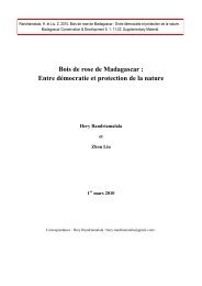
FIGURE 2: Littoral forest at Petriky, southeast of Tolagnaro (Fort Dauphin), where many QMM priority plant species occur, including eight that are shared with<br />
Mandena. The road on the right of the image was opened in the mid - 1980s to provide access for QMM’s exploration work (Photo: J. Rabenantoandro / QMM).<br />
tion. The data obtained through these steps were compiled in<br />
an ‘endemic species data file’, which has been kept up - to - date<br />
as new information has become available.<br />
The list of taxa in the data file was then compared with the<br />
1991 list of priority taxa in order to identify those whose status<br />
had changed as a result of information that had become available<br />
in the intervening years. Taxa that had originally met the<br />
criteria for Priority 1 or Priority 2 status in 1991 but no longer<br />
did were noted, and the reasons for their change in status were<br />
recorded. Examples of such changes in status include broadened<br />
species circumscriptions that encompassed populations from<br />
other parts of <strong>Madagascar</strong> and the discovery of populations at<br />
sites within the Tolagnaro region but outside the mine exploration<br />
zone. Information on taxa belonging to groups currently<br />
being studied was solicited from specialists and was included<br />
in the re - evaluation of species whenever possible.<br />
We then reviewed data on all Malagasy plant species<br />
on the IUCN Red List (IUCN 2008) and noted those recorded<br />
from the Mandena area. Because Red Listed taxa are widely<br />
regarded as of potential conservation concern, all those<br />
present at Mandena were included in the data file, regardless<br />
of whether they were considered to be endemic there or<br />
whether they met the criteria for Priority 1 or Priority 2 status.<br />
Botanists conducting taxonomic research on various Malagasy<br />
plant groups were also consulted to determine whether they<br />
knew of any species that they regarded as potentially endemic<br />
to the Mandena area but had not previously been classified as<br />
priority taxa or included in the endemic species data file. These<br />
taxa were likewise added to the data file.<br />
In order to facilitate fieldwork by QMM staff conducted as<br />
part of a program to locate and identify populations of taxa<br />
in the endemic species data file, a field guide was compiled<br />
containing detailed information on each taxon, including<br />
collection records with geographic coordinates, scanned<br />
images and drawings, species descriptions, and notes provided<br />
by specialists (when available). An intensive campaign<br />
of fieldwork was conducted between July 2000 and February<br />
2001 in areas outside the Mandena zone and beyond the<br />
limits of the proposed mining path to locate populations of<br />
the species listed in the data file from new localities where<br />
their presence had not previously been recorded. Each new<br />
population was documented using the same standard techniques<br />
(Missouri Botanical Garden - b) that had previously<br />
been used for the flora and vegetation environmental impact<br />
assessment study and subsequent fieldwork. The information<br />
obtained was used to update the list of priority species, as<br />
reported by Lowry (2001). Fieldwork has continued since then<br />
and relevant data have systematically been entered into the<br />
endemic species data file.<br />
Finally, the information contained in the endemic species<br />
data file was incorporated into a GIS and was used to map each<br />
taxon in order to conduct a visual evaluation of its geographic<br />
distribution, and to confirm whether any populations had<br />
been recorded within the previous 20 years outside the mine<br />
exploration area or whether the taxon must be regarded as<br />
endemic to Mandena. The results of these analyses were used<br />
to generate a revised list of Priority 1 and Priority 2 taxa using<br />
the criteria indicated above.