SURFICIAL GEOLOGY - Central Saanich
SURFICIAL GEOLOGY - Central Saanich
SURFICIAL GEOLOGY - Central Saanich

Create successful ePaper yourself
Turn your PDF publications into a flip-book with our unique Google optimized e-Paper software.
<strong>SURFICIAL</strong> <strong>GEOLOGY</strong><br />
ameltwater spillway in the Durrance Lake valley indicate astable<br />
recessionalicesurfaceovercentral<strong>Saanich</strong>Peninsulaatabout150masl.<br />
Theorientationofthesefeaturesisconsistentwithsoutheasttransportof<br />
meltwaterandsedimenttowardCordovaChannel.Below80masl,older<br />
units, moraine and bedrock are draped by raised glaciomarine debrisflowdiamictons,sandandgraveloutwash,andmassivetorhythmicallybeddedsilt-clay(FigureG-1,logA).Morainaldepositsarealsoterraced<br />
and winnowed,indicatingreworkingbysurfacerunoffandwaveaction<br />
(Figure G-9). The elevation range of unit 6d and wave-cut terraces<br />
delimits the extent of marine transgression over central <strong>Saanich</strong><br />
Peninsula during deglaciation. Raised glaciomarine deposits are<br />
correlative to the earliest deglacial sediments in ODP cores1033 and<br />
1034,anddatebetween12and15ka(Mathewsetal.1970,Clagueetal.<br />
1982,Bornholdetal.1997and1998,Huntleyetal.inpress).<br />
Figure G-5. Figure G-6.<br />
Holocene(post-glaciation)<br />
Post-glacialsequences,termedSalishSediments(Fyles1963, Halstead<br />
1968), includecolluvial (unit 7a), fluvial (unit 7b), lacustrine (unit 7c)<br />
and marine deposits (unit 7d). On steep slopes, deglacial and older<br />
exposedsedimentsarepartlyreworkedbymass-movement,andlocally<br />
overlainbypostglacialcolluvium(FigureG-4,logD).Glaciomarineand<br />
morainal sediments are incised by streams. Mass-movement in the<br />
vicinityof<strong>Saanich</strong>tonislikelyattributedtoactivestreamincision.West<br />
of Sannichtonand Keating, eroded sediment is deposited along valley<br />
floors, in lakebasins, and in<strong>Saanich</strong> Inlet (Figure G-5 to G-7). Tothe<br />
east,mostsedimentisdepositedinCordovaChannelandHaroStrait.In<br />
situfossiltreestumpsexposedintheintertidalzoneatIslandViewBeach<br />
indicates marine transgression on the east coast of <strong>Saanich</strong> Peninsula<br />
overthelast2ka(Mathewsetal.1970).Sedimenterodedfromseacliffs<br />
at Cowichan Head is transported northward by long-shore drift and<br />
deposited mostly on Island View Beach. The intertidal zone bordering<br />
BrentwoodBayand<strong>Saanich</strong>Inletisdominatedbysteepbedrockslopes,<br />
andismantledbyathincolluvialcover.Theoldestpostglacialsediments<br />
in <strong>Saanich</strong> Inlet are diatomaceous muds and massive clays deposited<br />
undermoderatelyoxygenatedconditionswhensea-levelwaslowerthan<br />
present. The Mazama ash is adistinctive horizon in marine and lake<br />
sequences dating to about 7.6ka. Above the ash layer, varved<br />
diatomaceous muds were deposited under low-energy and anoxic<br />
conditions (Bornhold et al. 1997 and 1998). Interbedded with these<br />
sediments are massive muds, interpreted to be mass-flow deposits<br />
emplacedduringstormsandearthquakes(Blais-Stevensetal.1997).<br />
Figure G-7.<br />
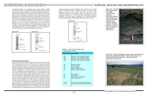
Table G-1. Key tofacies codesused<br />
in stratigraphic columns.<br />
Facies code Description<br />
Dcm Diamicton, clast-supported, massive<br />
Dcs Diamicton, clast-supported, stratified<br />
Dmm Diamicton, matrix-supported, massive<br />
Dms Diamicton, matrix-supported, stratified<br />
Bm Boulders, massive<br />
Gm Gravel, massive<br />
Gs Gravel, stratified<br />
Gf Gravel, foreset-bedded<br />
Gt Gravel, trough cross-bedded<br />
Sm Sand, massive<br />
Sp Sand, planar<br />
St Sand, trough cross-bedded<br />
Sr Sand, ripple-bedded<br />
Fm(d) Silt and clay,massive(with dropstones)<br />
Fl(d) Silt and clay,laminated (withdropstones)<br />
G-2<br />
<strong>SURFICIAL</strong><strong>GEOLOGY</strong>AND GEOMORPHOLOGY<br />
Figure G-8. Vashon<br />
Drift,lodgement till<br />
(5a [sdMb])<br />
unconformably<br />
overlying<br />
drumlinised Quadra<br />
Sand, glaciofluvial<br />
outwash (4b [gsFb])<br />
exposed in the<br />
vicinity of Keating<br />
townsite. Seealso<br />
Figure G-2,log317,<br />
and map legend for<br />
description of<br />
terrain units.<br />
Figure G-9. Capilano Sediments, glaciomarine suspension and<br />
debris flow deposits (6d[zdMw]). Hagan Creekvalley,view<br />
toward Brentwood Baytownsite. See map legendfor<br />
description ofterrain units.<br />
Municipality of <strong>Central</strong> <strong>Saanich</strong> ResourceAtlas