

GALWAY'S HERITAGE OIDHREACHT NA GAILLIMHE GALWAY'S ...
GALWAY'S HERITAGE OIDHREACHT NA GAILLIMHE GALWAY'S ...
GALWAY'S HERITAGE OIDHREACHT NA GAILLIMHE GALWAY'S ...

Create successful ePaper yourself
Turn your PDF publications into a flip-book with our unique Google optimized e-Paper software.
A S T R O L L R O U N D G A L W A Y<br />
As we walk on towards the next bridge we can see a tail<br />
race over to our left hand side which once served one of<br />
Galway’s many flour mills in the 19th century. The restored<br />
limestone building we see is known as the Bridge Mills and<br />
a working mill-wheel can still be seen inside it. Back on our<br />
own side we notice a body of water to our right which is<br />
‘Middle River / An Abhhainn Láir’. This channel once<br />
powered an industrial complex which stands today as a<br />
modern apartment block. We now reach the 19th century<br />
O’Brien’s Bridge, named after another patriot - William<br />
O’Brien. A bridge was, in fact, built across the Corrib in this<br />
area as far back to 1442. We again, cross the road and<br />
continue along Bruach na Coiribe passing the remains of<br />
the 19th century Persse Galway Whiskey Distillery on the<br />
far bank. This distillery operated from 1815 to 1908 and<br />
was once the largest employer in Galway City. A recently<br />
found bottle of its whiskey has been valued at over<br />
€200,000! In the river at this point are the remains of<br />
salmon traps which were once used to catch a percentage<br />
of passing salmon. Fish caught along this stretch of the<br />
river could be found for sale in London’s famous<br />
Billingsgate fish market the very next day. The buildings<br />
which we see on the far bank continue to be associated<br />
with fishing and stock monitoring to this day. Back on our<br />
side we climb a sharp incline at fisherman’s wharf and pass<br />
by the Nora Barnacle Bridge on our right hand side. This<br />
bridge traverses ‘Slaughterhouse River /Abhainn an<br />
tSeamlais’, so called as the city’s first official<br />
slaughterhouse was located in nearby Bowling Green. This<br />
was a popular fishing spot amongst young people up to<br />
the 1950s, as the run-off of blood and offal into this<br />
waterway had the effect of greatly increasing the river’s<br />
brown eel population.<br />
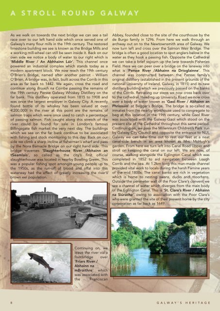
Continuing on, we<br />
leave the river via a<br />
footbridge over<br />
‘Friars River /<br />
Abhainn na<br />
mBráithre’ which<br />
was associated with<br />
the Franciscan<br />
Abbey, founded close to the site of the courthouse by the<br />
de Burgo family in 1296. From here we walk through an<br />
archway out on to the Newtownsmith area of Galway. We<br />
now turn left and cross over the Salmon Weir Bridge. The<br />
bridge is often a good location to spot anglers below in the<br />
water as they hook a passing fish. Opposite the Cathedral<br />
we can take a brief sojourn up the lane towards Fisheries<br />
Field. Here we can peer over a bridge on the laneway into<br />
what is ‘Persse River /Abhainn na Drioglainne’. This<br />
channel was constructed between the Persse family’s<br />
original distillery (established in the present grounds of the<br />
national University of Ireland, Galway, in 1815) and its new<br />
distillery building which we previously passed on the banks<br />
of the Corrib. Retracing our steps we now cross back over<br />
to the cathedral. Heading up University Road we now cross<br />
over a body of water known as ‘Gaol River / Abhainn an<br />
Phríosúin’ at Beggar’s Bridge. The bridge is so-called as<br />
inmates from the nearby workhouse used to congregate to<br />
beg at this location in the 19th century, while Gaol River<br />
was associated with the Galway Gaol which stood on the<br />
present site of the Cathedral throughout this same period.<br />
Continuing on, we pass the Millennium Children’s Park run<br />
by Galway City Council and opposite the entrance to NUI,<br />
Galway we can take time out to rest our feet at a neat<br />
canal-side bench in an area known as Mrs. McHugh’s<br />
garden. From here we turn left into Canal Road Upper and<br />
stroll on keeping the canal on our left. We are now, of<br />
course, walking alongside the Eglington Canal which was<br />
completed in 1852 to aid navigation between Lough<br />
Corrib and the sea. At 1.2km long this man-made channel<br />
provided vital work to locals during the harsh Famine years<br />
of the mid 1800s. The canal banks are rich in vegetation<br />
which is home to nesting swans, ducks and moorhens.<br />
Outside the perimeter wall of the Poor Clare’s convent we<br />
see a channel of water which diverges from the main body<br />
of the Eglington Canal. This is ‘St. Clare’s River / Abhainn<br />
na Siúracha’, owing to association with the Poor Clare’s<br />
who were granted the site of their present home by the city<br />
corporation as far back as 1649.<br />
8 G A L W A Y ’ S H E R I T A G E
![Download Tenant Handbook [English] - Galway City Council](https://img.yumpu.com/8735546/1/184x260/download-tenant-handbook-english-galway-city-council.jpg?quality=85)