VFR AERONAUTICAL CHART SYMBOLS - Flight Training
VFR AERONAUTICAL CHART SYMBOLS - Flight Training
VFR AERONAUTICAL CHART SYMBOLS - Flight Training

You also want an ePaper? Increase the reach of your titles
YUMPU automatically turns print PDFs into web optimized ePapers that Google loves.
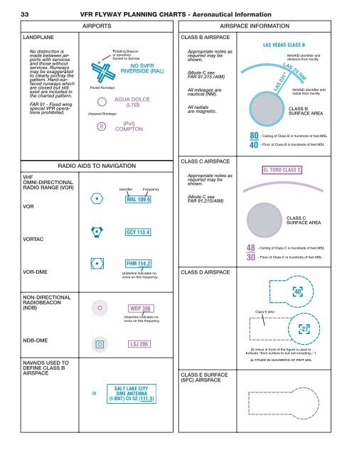
33 <strong>VFR</strong> FLYWAY PLANNING <strong>CHART</strong>S - Aeronautical Information<br />
LANDPLANE<br />
No distinction is<br />
made between airports<br />
with services<br />
and those without<br />
services. Runways<br />
may be exaggerated<br />
to clearly portray the<br />
pattern. Hard-surfaced<br />
runways which<br />
are closed but still<br />
exist are included in<br />
the charted pattern.<br />
FAR 91 - Fixed wing<br />
special <strong>VFR</strong> operations<br />
prohibited.<br />
<strong>VFR</strong> FLYWAY PLAN-<br />
NING <strong>CHART</strong>S<br />
VHF<br />
OMNI-DIRECTIONAL<br />
RADIO RANGE (VOR)<br />
VOR<br />
VORTAC<br />
VOR-DME<br />
NON-DIRECTIONAL<br />
RADIOBEACON<br />
(NDB)<br />
NDB-DME<br />
NAVAIDS USED TO<br />
DEFINE CLASS B<br />
AIRSPACE<br />
AIRPORTS<br />
RADIO AIDS TO NAVIGATION<br />
CLASS B AIRSPACE<br />
Appropriate notes as<br />
required may be<br />
shown.<br />
(Mode C see<br />
FAR 91.215 /AIM)<br />
All mileages are<br />
nautical (NM).<br />
All radials<br />
are magnetic.<br />
CLASS C AIRSPACE<br />
Appropriate notes as<br />
required may be<br />
shown.<br />
(Mode C see<br />
FAR 91.215/AIM)<br />
CLASS D AIRSPACE<br />
CLASS E SURFACE<br />
(SFC) AIRSPACE<br />
AIRSPACE INFORMATION