- Page 1 and 2: Pike County Natural Heritage Invent
- Page 4 and 5: Preface The Pennsylvania Natural He
- Page 6 and 7: ACKNOWLEDGEMENTS We would like to a
- Page 8 and 9: TABLE OF CONTENTS How to use this d
- Page 10 and 11: ¹ LAKEVILLE BUCK HILL FALLS NEWFOU
- Page 12 and 13: Site Name Municipality(ies) Descrip
- Page 14 and 15: Site Name Municipality(ies) Descrip
- Page 16 and 17: Site Name Municipality(ies) Descrip
- Page 18 and 19: Site Name Municipality(ies) Descrip
- Page 20 and 21: habitat in the mid-Atlantic region
- Page 24 and 25: Table 3. Soil associations describe
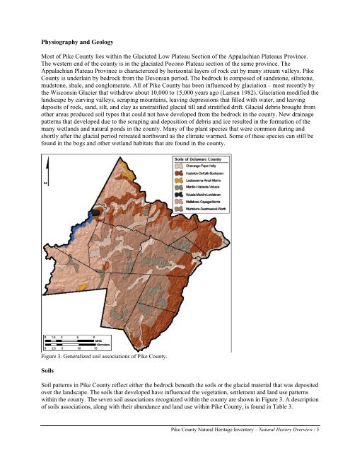
- Page 26 and 27: One of the most striking features o
- Page 28 and 29: Flowing Water and Major Stream Syst
- Page 30 and 31: Figure 5. Major watersheds of Pike
- Page 32 and 33: Human Disturbances Human and natura
- Page 34 and 35: Table 5. Invasive plants commonly e
- Page 36 and 37: along river banks and streams. The
- Page 38 and 39: Cooperative Weed Management Areas (
- Page 40 and 41: ears were harvested in Pike County
- Page 42 and 43: forested areas with dead woody timb
- Page 44 and 45: Pennsylvania’s wetlands with emer
- Page 46 and 47: peeper (Pseudacris crucifer), and g
- Page 48 and 49: elies on forestry practices that ma
- Page 50 and 51: Impoundment Community” with fish
- Page 52 and 53: Freshwater Mussels of Pike County N
- Page 54 and 55: Butterflies and Moths There are an
- Page 56 and 57: Land Snails of Pennsylvania by Timo
- Page 58 and 59: ecological factors (e.g., species c
- Page 60 and 61: Pennsylvania from 1985-2000 (Goodri
- Page 62 and 63: a. Forest and wetland areas in Penn
- Page 64 and 65: Other Landscape Scale Conservation
- Page 66 and 67: Upper Delaware Scenic River IBA The
- Page 68 and 69: this IMA. This protected area provi
- Page 70 and 71: Blooming Grove Township NATURAL HER
- Page 72 and 73:
Creeping snowberry (Gaultheria hisp
- Page 74 and 75:
White Birch Swamp Notable Significa
- Page 76 and 77:
Blooming Grove Township The second
- Page 78 and 79:
heart (Nymphoides cordata) and wate
- Page 80 and 81:
invasive species and aggressively t
- Page 82 and 83:
Threats and Stresses - Long Pond Sw
- Page 84 and 85:
species of concern, not named at th
- Page 86 and 87:
species and the spread of the water
- Page 88 and 89:
Delaware Township NATURAL HERITAGE
- Page 90 and 91:
Big Bear Swamp Wetland Big Bear Swa
- Page 92 and 93:
(Carex collinsii), a plant species
- Page 94 and 95:
Dry Brook Shale Barrens - The steep
- Page 96 and 97:
Long Swamp - This long, narrow wetl
- Page 98 and 99:
Dingman Township NATURAL HERITAGE A
- Page 100 and 101:
Sawkill Pond Notable Significance S
- Page 102 and 103:
Dingman Township Dingman Township c
- Page 104 and 105:
is necessary to maintain these habi
- Page 106 and 107:
Management Recommendations - Mainta
- Page 108 and 109:
Management Recommendations - Perfor
- Page 110 and 111:
Greene Township NATURAL HERITAGE AR
- Page 112 and 113:
Lake Wallenpaupack East Branch Wall
- Page 114 and 115:
harsh conditions. One such species
- Page 116 and 117:
Management Recommendations - Avoid
- Page 118 and 119:
Lackawaxen Township NATURAL HERITAG
- Page 120 and 121:
Wolf Lake High Significance Bayonet
- Page 122 and 123:
Lackawaxen Township The largest of
- Page 124 and 125:
Germantown Swamp - This small patch
- Page 126 and 127:
habitat for a species of concern no
- Page 128 and 129:
Threats and Stresses - Mowing and d
- Page 130 and 131:
Lehman Township NATURAL HERITAGE AR
- Page 132 and 133:
! Bush Kill Resica Falls Red Rock R
- Page 134 and 135:
Management Recommendations - Rerout
- Page 136 and 137:
Management Recommendations - Mainta
- Page 138 and 139:
small population of capitate spike-
- Page 140 and 141:
Sawkill Mud Pond Exceptional Signif
- Page 142 and 143:
Milford Township & Milford Borough
- Page 144 and 145:
Threats and Stresses - Lily Pond Br
- Page 146 and 147:
Palmyra Township NATURAL HERITAGE A
- Page 148 and 149:
! Little Chapel ! Pink ! Avoy ! Arl
- Page 150 and 151:
Egypt Meadow Lake - This lake was c
- Page 152 and 153:
Promised Land Lake - This man-made
- Page 154 and 155:
Painter Swamp Notable Significance
- Page 156 and 157:
Porter Township According to the 20
- Page 158 and 159:
Threats and Stresses - Most of Elbo
- Page 160 and 161:
Threats and Stresses - Being part o
- Page 162 and 163:
Shohola Township NATURAL HERITAGE A
- Page 164 and 165:
UV 590 ! Greeley ! Shohola Falls Sw
- Page 166 and 167:
mistletoe (Arceuthobium pusillum),
- Page 168 and 169:
Shohola Falls Swamp - Most of this
- Page 170 and 171:
Walker Lake - The shoreline of this
- Page 172 and 173:
Pine barrens zanclognatha (Zanclogn
- Page 174 and 175:
Westfall Township & Matamoras Borou
- Page 176 and 177:
jurisdictional agencies overseeing
- Page 178 and 179:
Conclusions and General Recommendat
- Page 180 and 181:
Using the Natural Heritage Inventor
- Page 182 and 183:
eduction in activities that fragmen
- Page 184 and 185:
GLOSSARY Ambystomid: a small to mod
- Page 186 and 187:
LITERATURE CITED Abrams, M.D. 1998.
- Page 188 and 189:
Massachusetts Executive Office of E
- Page 190 and 191:
Strayer, D.L. and K.J. Jirka. 1997.
- Page 192 and 193:
APPENDICES APPENDIX I: Federal and
- Page 194 and 195:
Global and State Ranking Global and
- Page 196 and 197:
APPENDIX II: Pennsylvania Element O
- Page 198 and 199:
Give general description of what yo
- Page 200 and 201:
Celithemis fasciata Banded pennant
- Page 202 and 203:
Prunus pumila var. susquehanae Upla
- Page 204 and 205:
APPENDIX V: Sustainable Forestry In
- Page 206 and 207:
APPENDIX VI: Sustainable Developmen
- Page 208 and 209:
pollution. Mussels require habitats
- Page 210 and 211:
Coldwater Community Typified by: Br
- Page 212 and 213:
Atlantic Coolwater Community 2 Typi
- Page 214 and 215:
River and Impoundment Community Typ
- Page 216 and 217:
Small minnow mayfly Photo Source: w
- Page 218 and 219:
Common Headwater Stream Community T
- Page 220 and 221:
Common Large Stream Community Typif
- Page 222 and 223:
Pike County Natural Heritage Invent
- Page 224 and 225:
Great Blue Heron (Ardea herodias) R
- Page 226 and 227:
Identification The Osprey is a dist
- Page 228 and 229:
Eastern mudminnow (Umbra pygmaea) D
- Page 230 and 231:
Mottled Darner (Aeshna clepsydra) I
- Page 232 and 233:
Identification Mustached Clubtail (
- Page 234 and 235:
Elfin Skimmer (Nannothemis bella) I
- Page 236 and 237:
Small Beggar-ticks Bidens discoidea
- Page 238 and 239:
Soft-leaved Sedge Carex disperma D
- Page 240 and 241:
Mud Sedge Carex limosa Description
- Page 242 and 243:
Bog Sedge Carex paupercula Descrip
- Page 244 and 245:
Umbrella Flatsedge Cyperus diandrus
- Page 246 and 247:
Creeping Snowberry Gaultheria hispi
- Page 248 and 249:
Rock Clubmoss Huperzia porophila D
- Page 250 and 251:
Scirpus-like Rush Juncus scirpoides
- Page 252 and 253:
Labrador-tea Ledum groenlandicum D
- Page 254 and 255:
Water Lobelia Lobelia dortmanna De
- Page 256 and 257:
Appalachian Sandwort Minuartia glab
- Page 258 and 259:
Farwell’s Water-milfoil Myriophyl
- Page 260 and 261:
Small Yellow Cowlily Nuphar microph
- Page 262 and 263:
Prickly-pear Cactus Opuntia humifus
- Page 264 and 265:
Slender Mountain-ricegrass Oryzopsi
- Page 266 and 267:
Three-toothed Cinquefoil Potentilla
- Page 268 and 269:
Upland Sand Cherry Prunus pumila va
- Page 270 and 271:
Water Bulrush Schoenoplectus subter
- Page 272 and 273:
Bur-reed Sparganium angustifolium
- Page 274 and 275:
White Twisted-stalk Streptopus ampl
- Page 276 and 277:
Horned Bladderwort Utricularia corn