

Edna Valley Wineries by Bike Map - San Luis Obispo
Edna Valley Wineries by Bike Map - San Luis Obispo
Edna Valley Wineries by Bike Map - San Luis Obispo

You also want an ePaper? Increase the reach of your titles
YUMPU automatically turns print PDFs into web optimized ePapers that Google loves.
Legend<br />
SLO Amtrak Station<br />
Winery / Tasting<br />
Suggested Routes<br />
<strong>Bike</strong> Paths<br />
Extended Ride<br />
Options<br />
(see route descriptions)<br />
Avila<br />
Beach<br />
0 1 2<br />
Foothill Blvd.<br />
Los Osos <strong>Valley</strong> Rd.<br />
Perbacco<br />
Cellars<br />
Kelsey<br />
101<br />
Salisbury<br />
Vineyards<br />
Buckley Rd.<br />
Pismo<br />
Beach<br />
Pacific<br />
Ocean<br />
101<br />
<strong>San</strong><br />
<strong>Luis</strong><br />
<strong>Obispo</strong><br />
www.oldedna.com<br />
Tolosa<br />
Starting Point for all Rides:<br />
<strong>San</strong> <strong>Luis</strong> <strong>Obispo</strong> Amtrak Station,<br />
1011 Railroad Avenue at <strong>San</strong>ta<br />
Rosa Street. The station is just<br />
south of downtown at the end<br />
of <strong>San</strong>ta Rosa Street. Parking is<br />
available in the station parking<br />
lot.<br />
Arroyo<br />
Grande<br />
<strong>Edna</strong> <strong>Valley</strong><br />
Baileyana<br />
Saucelito Canyon<br />
& Ortman Family<br />
Piedra Creek<br />
Claiborne<br />
& Churchill<br />
101<br />
Wolff<br />
Domaine<br />
Alfred<br />
Kynsi<br />
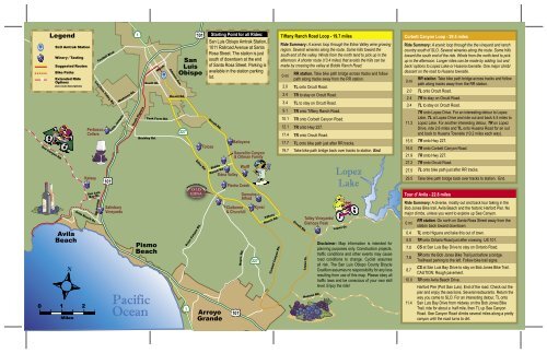
Tiffany Ranch Road Loop - 19.7 miles<br />
Ride Summary: A scenic loop through the <strong>Edna</strong> <strong>Valley</strong> wine growing<br />
region. Several wineries along the route. Some hills toward the<br />
south end of the valley. Winds from the north tend to pick up in the<br />
afternoon. A shorter route (13.4 miles) that avoids the hills can be<br />
made <strong>by</strong> crossing the valley at Biddle Ranch Road.<br />
0 mi<br />
RR station. Take bike path bridge across tracks and follow<br />
path along tracks away from the RR station.<br />
2.0 TL onto Orcutt Road.<br />
2.4 TR to stay on Orcutt Road.<br />
3.4 TL to stay on Orcutt Road.<br />
9.1 TR onto Tiffany Ranch Road.<br />
10.1 TR onto Corbett Canyon Road.<br />
12.1 TR onto Hwy 227.<br />
17.4 TR onto Orcutt Road.<br />
17.7 TL onto bike path just after RR tracks.<br />
19.7 Take bike path bridge back over tracks to station. End.<br />
Talley Vineyards/<br />
Bishops Peak<br />
Lopez<br />
Lake<br />
Disclaimer: <strong>Map</strong> information is intended for<br />
planning purposes only. Construction projects,<br />
traffic conditions and other events may cause<br />
road conditions to change. Cyclist assumes<br />
all risk. The <strong>San</strong> <strong>Luis</strong> <strong>Obispo</strong> County Bicycle<br />
Coalition assumes no responsibility for any loss<br />
resulting from use of this map. Please obey all<br />
traffic laws and be conscious of your own skill<br />
level. Enjoy the ride!<br />
Corbett Canyon Loop - 29.5 miles<br />
Ride Summary: A scenic loop through the the vineyard and ranch<br />
country south of SLO. Several wineries along the route. Some hills<br />
toward the south end of the ride. Winds from the north tend to pick<br />
up in the afternoon. Longer rides can be made <strong>by</strong> adding ‘out and<br />
back’ options to Lopez Lake or Huasna townsite. One major climb/<br />
descent on the road to Huasna townsite.<br />
RR station. Take bike path bridge across tracks and follow<br />
0 mi<br />
path along tracks away from the RR station.<br />
2.0 TL onto Orcutt Road.<br />
2.4 TR to stay on Orcutt Road.<br />
3.4 TL to stay on Orcutt Road.<br />
TR onto Lopez Drive. For an interesting detour to Lopez<br />
Lake, TL at Lopez Drive and ride out and back 4.5 miles to<br />
11.3 Lopez Lake. For another interesting detour, TR on Lopez<br />
Drive, ride 2.6 miles and TL onto Huasna Road for an out<br />
and back to Huasna Townsite (10.2 miles each way).<br />
15.5 TR onto Hwy 227.<br />
16.0 TR onto Corbett Canyon Road.<br />
21.9 TR onto Hwy 227.<br />
27.2 TR onto Orcutt Road.<br />
27.5 TL onto bike path just after RR tracks.<br />
29.5 Take bike path bridge back over tracks to station. End.<br />
Tour d’ Avila - 22.8 miles<br />
Ride Summary: A diverse, mostly out and back tour taking in the<br />
Bob Jones <strong>Bike</strong> trail, Avila Beach and the historic Harford Pier. No<br />
major climbs, unless you want to explore up See Canyon.<br />
RR station. Go north on <strong>San</strong>ta Rosa Street away from the<br />
0 mi<br />
station back toward downtown.<br />
0.4 TL onto Higuera and take this out of town.<br />
5.0 TR onto Ontario Road just after crossing US 101.<br />
7.0 CS at <strong>San</strong> <strong>Luis</strong> Bay Drive to stay on Ontario Road.<br />
TR onto the Bob Jones <strong>Bike</strong> Trail just before a bridge.<br />
7.8<br />
Trailhead parking to the left. Follow bike trail signs.<br />
CS at <strong>San</strong> <strong>Luis</strong> Bay Drive to stay on Bob Jones <strong>Bike</strong> Trail.<br />
8.7<br />
CAUTION: Rough pavement.<br />
10.0 TR onto Avila Beach Drive.<br />
Harford Pier (Port <strong>San</strong> <strong>Luis</strong>). End of the road. Check out the<br />
pier and enjoy the sea lions. Several restaurants. Return the<br />
way you came to SLO. For an interesting detour, TL onto<br />
11.4 <strong>San</strong> <strong>Luis</strong> Bay Drive from midway on the Bob Jones <strong>Bike</strong><br />
Trail, ride for about a half mile, then TL up See Canyon<br />
Road. See Canyon Road climbs several miles along a pretty<br />
canyon until the road turns to dirt.