

Geology of the Shenandoah National Park Region - Csmres Jmu ...
Geology of the Shenandoah National Park Region - Csmres Jmu ...
Geology of the Shenandoah National Park Region - Csmres Jmu ...

You also want an ePaper? Increase the reach of your titles
YUMPU automatically turns print PDFs into web optimized ePapers that Google loves.
39 th Annual Virginia Geological Field Conference<br />
October 2 nd - 3 rd , 2009<br />
<strong>Geology</strong> <strong>of</strong> <strong>the</strong><br />
<strong>Shenandoah</strong> <strong>National</strong> <strong>Park</strong> <strong>Region</strong><br />
Scott Southworth<br />
U. S. Geological Survey<br />
L. Scott Eaton<br />
James Madison University<br />
Meghan H. Lamoreaux<br />
College <strong>of</strong> William & Mary<br />
William C. Burton<br />
U. S. Geological Survey<br />
1<br />
Christopher M. Bailey<br />
College <strong>of</strong> William & Mary<br />
Gregory Hancock<br />
College <strong>of</strong> William & Mary<br />
Ronald J. Litwin<br />
U. S. Geological Survey<br />
Jennifer Whitten<br />
College <strong>of</strong> William & Mary
2009<br />
VGFC<br />
81<br />
38˚ 15’ N<br />
•<br />
Trayfoot<br />
Mtn.<br />
3 •<br />
78˚ 45’ W<br />
Blue<br />
Ridge<br />
Massanutten Mountain<br />
33<br />
South Fork <strong>Shenandoah</strong> River<br />
• 4<br />
Skyline Drive<br />
Pasture Fence Mtn.<br />
Roanoke<br />
Valley & Ridge<br />
340<br />
Rocky<br />
Mtn. •<br />
5 •<br />
•<br />
Big Flat<br />
Mtn.<br />
Washington<br />
VA<br />
Piedmont D.C.<br />
• L<strong>of</strong>t Mtn.<br />
•<br />
Fox Mtn.<br />
New<br />
Market Gap<br />
•<br />
Elkton<br />
340<br />
<strong>Shenandoah</strong><br />
•<br />
Hanse<br />
Mtn.<br />
• Flattop<br />
Mtn.<br />
Swift Run •<br />
Gap<br />
2 •<br />
• 6<br />
Field Trip<br />
Stop<br />
• Hightop<br />
• Brokenback<br />
Mtn.<br />
• 7<br />
•<br />
Grindstone<br />
Mtn.<br />
Stanley<br />
Dean<br />
Mtn. •<br />
78˚ 30’ W<br />
N<br />
211<br />
Long Ridge<br />
• Lewis<br />
Mtn.<br />
Skyline Drive<br />
• Saddleback<br />
Mtn.<br />
Luray<br />
Hershberger<br />
Hill<br />
Big<br />
Meadows<br />
•7<br />
• Hazeltop<br />
Hawksbill •<br />
• 1<br />
Kirtley<br />
Mtn.<br />
Stony Man •<br />
33<br />
230<br />
Stanardsville<br />
Ruckersville<br />
Doubletop Mtn.<br />
Marys Rock •<br />
29<br />
0 5 10<br />
Thornton<br />
Gap<br />
•<br />
Old Rag<br />
Mtn.<br />
38˚ 30’ N<br />
Syria<br />
0<br />
kilometers<br />
5 10<br />
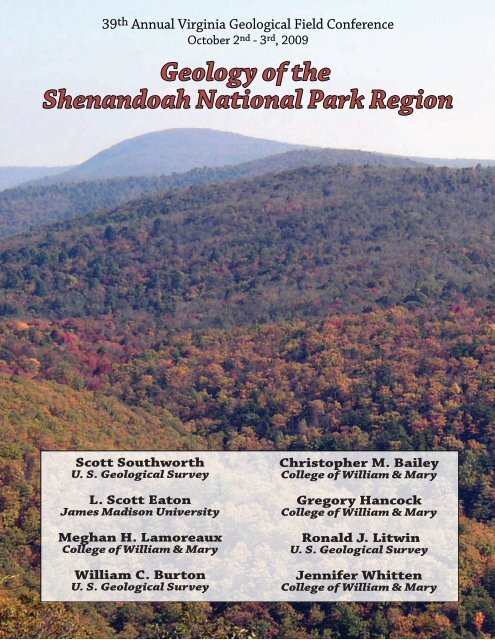
Figure 1. Shaded relief map <strong>of</strong> <strong>the</strong> <strong>Shenandoah</strong> <strong>National</strong> <strong>Park</strong> region and stop locations at <strong>the</strong> 2009 Virginia<br />
Geological Field Conference.<br />
2<br />
miles
Dedication<br />
The 39 th annual Virginia Geological Field Conference is dedicated to Tom Gathright whose work in western Virginia<br />
and <strong>Shenandoah</strong> <strong>National</strong> <strong>Park</strong> has educated and inspired many <strong>of</strong> us.<br />
Tom Gathright joined <strong>the</strong> Division <strong>of</strong> Mineral Resources in 1964. Originally a member <strong>of</strong> <strong>the</strong> Ground water<br />
Section, Tom conducted groundwater investigations in <strong>the</strong> Blue Ridge and Valley & Ridge provinces. During<br />
this time, he helped to locate and develop several major water supplies along <strong>the</strong> west flank <strong>of</strong> <strong>the</strong> Blue Ridge.<br />
Tom’s first project with <strong>the</strong> Geologic Mapping Section was to create a geologic map <strong>of</strong> <strong>Shenandoah</strong> <strong>National</strong><br />
<strong>Park</strong>. This work was published in 1976 as Bulletin 86, “<strong>Geology</strong> <strong>of</strong> <strong>the</strong> <strong>Shenandoah</strong> <strong>National</strong> <strong>Park</strong>, Virginia.”<br />
It remains one <strong>of</strong> <strong>the</strong> most popular reports related to Virginia geology. Tom subsequently completed geologic<br />
maps <strong>of</strong> ten additional 7.5-minute quadrangles and helped to compile three geologic maps <strong>of</strong> three 30- x<br />
60-minute quadrangles. As <strong>the</strong> head <strong>of</strong> <strong>the</strong> geologic mapping section, he oversaw <strong>the</strong> completion <strong>of</strong> geologic<br />
mapping <strong>of</strong> <strong>the</strong> southwest Virginia Coalfields. Tom retired in 1991, but continues to work on an occasional<br />
basis as a geologic consultant and serves as a member <strong>of</strong> Virginia’s geologic mapping advisory committee.<br />
Tom framing a photograph on a crisp morning at Rockfish Gap.<br />
photos courtesy <strong>of</strong> Elizabeth Campbell (top) and Gerry Wilkes (bottom).<br />
3
Introduction<br />
<strong>Shenandoah</strong> <strong>National</strong> <strong>Park</strong> and its magnificent Skyline Drive lie astride <strong>the</strong> Blue Ridge Mountains in northcentral<br />
Virginia. Occupying more than 800 km 2 , <strong>Shenandoah</strong> is a long and narrow park with a highly irregular<br />
boundary. Established during <strong>the</strong> Great Depression, <strong>the</strong> <strong>Park</strong> was intended to serve as a leafy refuge for<br />
urbanites in eastern North America. Created from a patchwork <strong>of</strong> privately owned farms, orchards, and home<br />
sites, <strong>the</strong> <strong>Park</strong> has been reforested in <strong>the</strong> past 80 years with much <strong>of</strong> <strong>the</strong> region returned to a wilderness<br />
state. In modern times, <strong>the</strong> <strong>Park</strong> welcomes over two million visitors per year.<br />
The Blue Ridge Mountains in <strong>Shenandoah</strong> <strong>National</strong> <strong>Park</strong> form a distinctive highland that rises to elevations<br />
above 1,200 meters (~4,000’) with local topographic relief exceeding 900 meters (~3,000’). The crest <strong>of</strong> <strong>the</strong><br />
range forms a drainage divide separating <strong>the</strong> <strong>Shenandoah</strong> (Potomac) River drainage to <strong>the</strong> west, in <strong>the</strong> Great<br />
Valley subprovince <strong>of</strong> <strong>the</strong> Valley & Ridge, from sou<strong>the</strong>ast-flowing streams <strong>of</strong> <strong>the</strong> James and Rappahannock<br />
river systems coursing into <strong>the</strong> foothills region <strong>of</strong> <strong>the</strong> Piedmont physiographic province (Fig. 1).<br />
Although a cloak <strong>of</strong> forest and mantle <strong>of</strong> soil commonly obscures <strong>the</strong> underlying bedrock, <strong>Shenandoah</strong>’s<br />
topography is dictated by its geology. Rocks exposed in <strong>the</strong> Blue Ridge Mountains are among <strong>the</strong> oldest<br />
in Virginia and bear witness to more than a billion years <strong>of</strong> magmatism, sedimentation, sea level oscillation,<br />
climate change, tectonic activity, and erosion. Bedrock includes a suite <strong>of</strong> Grenvillian basement rocks,<br />
metamorphosed Neoproterozoic sedimentary and volcanic rocks, and early Cambrian siliciclastic rocks.<br />
The <strong>Park</strong> is situated along <strong>the</strong> western margin <strong>of</strong> <strong>the</strong> Blue Ridge anticlinorium, a regional-scale Paleozoic<br />
structure developed at <strong>the</strong> hinterland edge <strong>of</strong> <strong>the</strong> Appalachian fold and thrust belt. The Blue Ridge highlands<br />
are <strong>the</strong> product <strong>of</strong> differential erosion in <strong>the</strong> Cenozoic, but post-Paleozoic tectonic activity has influenced<br />
<strong>the</strong> character <strong>of</strong> <strong>the</strong> Blue Ridge landscape in discernible ways. Quaternary surficial deposits are common<br />
throughout <strong>the</strong> <strong>Park</strong>, providing a record <strong>of</strong> past climate regimes as well as active processes shaping <strong>the</strong><br />
modern landscape.<br />
Aspects <strong>of</strong> <strong>the</strong> <strong>Park</strong>’s geology have been studied since <strong>the</strong> 1930’s (Furcron, 1934; Jonas and Stose, 1939;<br />
King, 1950) and many <strong>of</strong> <strong>the</strong> counties that encompass <strong>the</strong> <strong>Park</strong> were mapped after World War II (Rockingham-<br />
Brent, 1960; Albemarle- Nelson, 1962; Greene and Madison- Allen, 1963; Page- Allen, 1967). The first<br />
comprehensive treatment <strong>of</strong> <strong>Shenandoah</strong>’s geology was undertaken by <strong>the</strong> Virginia Division <strong>of</strong> Mineral<br />
Resources in <strong>the</strong> late 1960s and culminated in <strong>the</strong> 1976 publication and geologic map (1:62,500 scale) by<br />
Tom Gathright. Gathright’s seminal work summarized many <strong>of</strong> <strong>the</strong> earlier studies and provided a unifying<br />
framework <strong>of</strong> <strong>the</strong> <strong>Park</strong>’s geology that is still informative in <strong>the</strong> 21 st century. The hydrogeologic setting <strong>of</strong> <strong>the</strong><br />
<strong>Park</strong> is discussed by DeKay (1972).<br />
Robert Badger’s Roadside <strong>Geology</strong> <strong>of</strong> <strong>the</strong> Skyline Drive (1999) is a well-illustrated guide aimed at a broad<br />
audience. Tollo and o<strong>the</strong>rs (2004), Eaton and o<strong>the</strong>rs (2004), and Bailey and o<strong>the</strong>rs (2006) provide technical<br />
field guides with stops in and near <strong>the</strong> <strong>Park</strong>. Web resources illustrating <strong>the</strong> geology <strong>of</strong> <strong>Shenandoah</strong> <strong>National</strong><br />
<strong>Park</strong> include: William & Mary’s <strong>Geology</strong> <strong>of</strong> Virginia/Google Earth site (http://web.wm.edu/geology/virginia/<br />
ge.php), James Madison’s <strong>Geology</strong> <strong>of</strong> Virginia site, (http://csmres.jmu.edu/geollab/vageol/vahist/) and Callan<br />
Bentley’s (Nor<strong>the</strong>rn Virginia Community College) <strong>Geology</strong> <strong>of</strong> <strong>Shenandoah</strong> <strong>National</strong> <strong>Park</strong> site (http://www.<br />
nvcc.edu/home/cbentley/gol_135/shenandoah/index.htm).<br />
In <strong>the</strong> past fifteen years, a multitude <strong>of</strong> studies focusing on <strong>the</strong> geology <strong>of</strong> <strong>Shenandoah</strong> <strong>National</strong> <strong>Park</strong> have<br />
contributed new insights about 1) <strong>the</strong> complexity and chronology <strong>of</strong> <strong>the</strong> basement, 2) <strong>the</strong> structural geometry<br />
and deformation history <strong>of</strong> <strong>the</strong> region, and 3) Quaternary surficial processes and <strong>the</strong>ir efficacy. Nineteen 7.5’<br />
quadrangles in and around <strong>Shenandoah</strong> <strong>National</strong> <strong>Park</strong> have been mapped (or remapped) at 1:24,000 scale<br />
in <strong>the</strong> last decade (Fig. 2). A new 1:100,000 scale geologic map <strong>of</strong> <strong>the</strong> <strong>Shenandoah</strong> <strong>National</strong> <strong>Park</strong> region and<br />
an accompanying report, compiling much <strong>of</strong> this research, was just published by <strong>the</strong> U. S. Geological Survey<br />
(Southworth and o<strong>the</strong>rs, 2009; online at http://pubs.er.usgs.gov/usgspubs/<strong>of</strong>r/<strong>of</strong>r20091153).<br />
4
The 2009 Virginia Geological Field Conference will highlight new research, visiting exposures along and<br />
near <strong>the</strong> Skyline Drive. The trip will be broad, encompassing bedrock and structural geology as well as<br />
surficial geology and rates <strong>of</strong> erosion at local and regional scales. <strong>Shenandoah</strong> <strong>National</strong> <strong>Park</strong> is too vast for<br />
a single day traverse; thus <strong>the</strong> Conference will focus on <strong>the</strong> geology between Big Meadows (milepost 51) and<br />
Blackrock Summit (milepost 85) in <strong>the</strong> central and sou<strong>the</strong>rn part <strong>of</strong> <strong>the</strong> <strong>Park</strong>. In addition to emphasizing new<br />
findings in <strong>Shenandoah</strong> we hope this trip will foster discussion about unanswered aspects about Blue Ridge<br />
geology and encourage future research in <strong>the</strong> <strong>Park</strong>.<br />
Weyers Cave<br />
38˚00’ N<br />
79˚00’ W<br />
Harrisonburg<br />
Gathright<br />
and o<strong>the</strong>rs,<br />
1986<br />
Fort<br />
Defiance<br />
Gathright<br />
and o<strong>the</strong>rs,<br />
1978<br />
Waynesboro<br />
West<br />
Gathright<br />
and o<strong>the</strong>rs,<br />
1977<br />
38˚30’ N<br />
Grottoes<br />
Gathright<br />
and o<strong>the</strong>rs,<br />
1978<br />
Crimora<br />
Gathright<br />
and o<strong>the</strong>rs,<br />
1978<br />
Waynesboro<br />
East<br />
Gathright<br />
and o<strong>the</strong>rs,<br />
1977<br />
Tenth<br />
Legion<br />
Whitmeyer<br />
and Heller<br />
Elkton West<br />
Heller<br />
McGaheysville<br />
Browns<br />
Cove<br />
Lamoreaux<br />
and o<strong>the</strong>rs,<br />
2009<br />
Crozet<br />
Lederer<br />
and o<strong>the</strong>rs,<br />
2009<br />
Edinburg<br />
Hamburg<br />
Stanley<br />
Whitmeyer<br />
and o<strong>the</strong>rs<br />
Elkton East Fletcher<br />
Swift Run<br />
Gap<br />
Bailey<br />
and o<strong>the</strong>rs,<br />
2009<br />
Free<br />
Union<br />
Southworth<br />
and Bailey<br />
Charlottesville<br />
West<br />
Big Meadows<br />
Whitmeyer<br />
and o<strong>the</strong>rs<br />
Tollo and<br />
o<strong>the</strong>rs<br />
Tollo and<br />
o<strong>the</strong>rs, 2004<br />
Stanardsville<br />
Burton<br />
and Bailey,<br />
2009<br />
Earlysville<br />
Figure 2. Index map <strong>of</strong> 7.5 minute quadrangles surrounding <strong>Shenandoah</strong> <strong>National</strong> <strong>Park</strong>. Authors noted inside<br />
quadrangles mapped at 1:24,000 scale. Grey shading indicates recent work.<br />
5<br />
Strasburg<br />
Rader and<br />
Biggs, 1976<br />
Rileyville Bentonville<br />
Southworth<br />
and<br />
Tollo, 2006<br />
Luray Thornton<br />
Gap<br />
Tollo and<br />
o<strong>the</strong>rs, 2004<br />
Old Rag<br />
Mountain<br />
Tollo and<br />
o<strong>the</strong>rs, 2004<br />
Madison<br />
Bailey and<br />
o<strong>the</strong>rs, 2003<br />
Rochelle<br />
Bailey<br />
Front Royal<br />
Rader and<br />
Biggs, 1975<br />
Washington<br />
Tollo and<br />
o<strong>the</strong>rs, 2006<br />
Washington<br />
Tollo and<br />
o<strong>the</strong>rs, 2006<br />
Woodville<br />
Tollo and<br />
Bailey<br />
Brightwood<br />
Explanation<br />
Linden<br />
Lukert and<br />
Nichols,<br />
1976<br />
Flint Hill<br />
Lukert and<br />
Nichols,<br />
1976<br />
Massies<br />
Corner<br />
Lukert and<br />
Halladay,<br />
1980<br />
<strong>Shenandoah</strong> <strong>National</strong> <strong>Park</strong><br />
Boundary<br />
0 1.5 3 6 9 12 Miles<br />
78˚00’ W<br />
39˚00’ N<br />
Castleton<br />
Tollo and Lowe, 1994<br />
Bailey and o<strong>the</strong>rs, 2007
Bedrock <strong>Geology</strong><br />
Stratigraphy<br />
<strong>Shenandoah</strong> <strong>National</strong> <strong>Park</strong> is underlain by three major geologic units: 1) Mesoproterozoic gneisses and<br />
granitoids that comprise <strong>the</strong> basement, 2) Neoproterozoic metasedimentary and metavolcanic rocks <strong>of</strong> <strong>the</strong><br />
Swift Run and Catoctin formations, and 3) siliciclastic rocks <strong>of</strong> <strong>the</strong> Early Cambrian Chilhowee Group (Figs.<br />
3 and 4). Basement rocks crop out in <strong>the</strong> eastern Blue Ridge Mountains and <strong>the</strong> adjoining foothills, but also<br />
underlie peaks such as Old Rag Mountain, Mary’s Rock, and Roundtop. The Catoctin Formation forms much<br />
<strong>of</strong> <strong>the</strong> Blue Ridge’s high crest including Hawksbill, Stony Man, Mount Marshall, and Hightop. The Chilhowee<br />
Group, exposed in <strong>the</strong> western Blue Ridge, underlies steep mountains and ridges mantled with thin soil and<br />
abundant talus such as Grindstone, Rocky, Trayfoot, and Turk mountains.<br />
Basement rocks include granitoid gneisses and granitoids formed during <strong>the</strong> Grenville orogeny between 1.2<br />
and 1.0 Ga (Fig. 3). Prior to <strong>the</strong> 1980s rock units in <strong>the</strong> Blue Ridge basement were commonly mapped as<br />
formations and Gathright (1976) mapped two basement units, <strong>the</strong> Pedlar Formation and <strong>the</strong> Old Rag Granite,<br />
in <strong>the</strong> <strong>Park</strong>. Most technical studies published in <strong>the</strong> past two decades (Rader and Evans, 1993; Southworth<br />
and o<strong>the</strong>rs, 2000; Bailey and o<strong>the</strong>rs, 2003; Tollo and o<strong>the</strong>rs, 2004b; Southworth and o<strong>the</strong>rs, 2009) avoid<br />
using <strong>the</strong> formation terminology; ra<strong>the</strong>r Mesoproterozoic basement units are distinguished based on rock<br />
type, cross cutting relations, geochemistry, and geochronology. Many general interest publications and<br />
websites continue to use <strong>the</strong> formational lexicon, this is unfortunate because <strong>the</strong> rich geologic history <strong>of</strong> <strong>the</strong><br />
basement is diluted (or worse still, misunderstood) using archaic formation names. For instance, recent<br />
mapping and geochronology in <strong>Shenandoah</strong> <strong>National</strong> <strong>Park</strong> demonstrates that <strong>the</strong> Pedlar Formation contains<br />
over 12 different units that that vary in age by ~150 million years (Southworth and o<strong>the</strong>rs, 2009).<br />
Modern U-Pb zircon geochronology reveals that <strong>the</strong> basement complex is comprised <strong>of</strong> three temporally<br />
distinct groups <strong>of</strong> igneous rocks emplaced over a 150 million year interval in <strong>the</strong> Mesoproterozoic (Fig.<br />
3) (Aleinik<strong>of</strong>f and o<strong>the</strong>rs, 2000; Tollo and o<strong>the</strong>rs, 2004b; Southworth and o<strong>the</strong>rs, 2009). The oldest group<br />
crystallized between 1,190 and 1,150 Ma and are granitoid gneisses with a compositional layering that<br />
developed under high-grade conditions. A volumetrically minor group <strong>of</strong> orthopyroxene-bearing granites<br />
crystallized between 1,120 and 1,110 Ma. The youngest group <strong>of</strong> granitoids was emplaced between 1,090<br />
and 1,020 Ma. Both <strong>the</strong> older and younger groups are chemically diverse and include pyroxene-bearing<br />
charnockitic rocks and alkali feldspar leucogranitoids. Tollo and o<strong>the</strong>rs (2004) note that <strong>the</strong> basement suite<br />
was derived from melting <strong>of</strong> lower crustal sources in an intraplate setting.<br />
The Blue Ridge basement is almost entirely <strong>of</strong> igneous origin (orthogneisses), however recent mapping has<br />
identified small (
Recent mapping in <strong>the</strong> nor<strong>the</strong>astern part <strong>of</strong> <strong>the</strong> <strong>Park</strong> reveals thin, discontinuous layers <strong>of</strong> felsic volcanic rock<br />
unconformably overlie <strong>the</strong> Mesoproterozoic basement and beneath <strong>the</strong> Catoctin Formation that yield U-Pb<br />
zircon ages <strong>of</strong> 720 to 710 Ma (Southworth and o<strong>the</strong>rs, 2009).<br />
A late Neoproterozoic cover sequence <strong>of</strong> metasedimentary and metavolcanic rocks unconformably overlie<br />
<strong>the</strong> basement complex in <strong>the</strong> <strong>Shenandoah</strong> <strong>National</strong> <strong>Park</strong> region (Fig. 3). The Swift Run Formation is a<br />
heterogeneous clastic unit <strong>of</strong> highly variable thickness (absent to ~300 m) that crops out below metabasalts<br />
<strong>of</strong> <strong>the</strong> Catoctin Formation and to <strong>the</strong> east <strong>of</strong> <strong>the</strong> <strong>Park</strong> in outliers surrounded by basement (Gattuso and<br />
o<strong>the</strong>rs, 2009). Common rock types include arkosic phyllite, meta-arkose, phyllite, laminated metasiltstone,<br />
and pebble to cobble metaconglomerate. Locally, compositionally mature, cross-bedded, quartz-rich<br />
metasandstone crops out. Gathright (1976) and Schwab (1986) interpret <strong>the</strong> Swift Run Formation to be a<br />
non-marine unit deposited in alluvial fan, floodplain, and lacustrine environments. A number <strong>of</strong> early workers<br />
report tuffaceous rocks from <strong>the</strong> Swift Run Formation, but recent research indicates <strong>the</strong>se are primarily<br />
fine-grained metasedimentary rocks. Contemporaneous normal faulting likely influenced <strong>the</strong> deposition <strong>of</strong><br />
Swift Run sediments in <strong>the</strong> outliers (Forte and o<strong>the</strong>rs, 2005; Gattuso and o<strong>the</strong>rs, 2009). At a number <strong>of</strong><br />
locations clastic rocks are interlayered with metabasaltic greenstone, a geometry consistent with a coeval<br />
relationship between <strong>the</strong> Swift Run Formation and <strong>the</strong> lower Catoctin Formation (King, 1950; Gattuso and<br />
o<strong>the</strong>rs, 2009).<br />
The Catoctin Formation forms an extensive unit in <strong>Shenandoah</strong> <strong>National</strong> <strong>Park</strong> and is characterized by<br />
metabasaltic greenstone with thin layers <strong>of</strong> meta-arkose, phyllite, and epiclastic breccia. Catoctin basalts<br />
were extruded over a large region (>4000 km 2 ) and generated from mantle-derived tholeiitic magmas (Badger<br />
and Sinha, 2004). In <strong>the</strong> <strong>Park</strong>, basalts extruded primarily as subaerial flows, evidenced by abundant columnar<br />
joints and flow-top breccias (Reed, 1955, 1969). In <strong>the</strong> central and nor<strong>the</strong>rn part <strong>of</strong> <strong>the</strong> <strong>Park</strong>, nine to sixteen<br />
individual flows occur (Reed, 1955; Gathright, 1976; Badger, 1992). The Catoctin Formation is upwards<br />
<strong>of</strong> 700 meters thick in <strong>the</strong> <strong>Park</strong> and thins towards <strong>the</strong> west and southwest. Metadiabase dikes <strong>of</strong> similar<br />
composition to Catoctin metabasalts intrude <strong>the</strong> basement complex (as well as older Neoproterozoic rocks)<br />
and are likely feeder dikes for <strong>the</strong> overlying Catoctin lava flows. Dikes range from 0.5 to 5 m in thickness and<br />
are most common in <strong>the</strong> nor<strong>the</strong>rn and central part <strong>of</strong> <strong>the</strong> <strong>Park</strong>.<br />
Badger and Sinha (1988) report a Rb-Sr isochron age <strong>of</strong> 570±36 Ma from exposures just south <strong>of</strong> <strong>Shenandoah</strong><br />
<strong>National</strong> <strong>Park</strong>. Zircons from metarhyolite tuffs and dikes in <strong>the</strong> Catoctin Formation, exposed to <strong>the</strong> north<br />
<strong>of</strong> <strong>the</strong> <strong>Park</strong>, yield U-Pb ages between 570 and 550 Ma (Aleinik<strong>of</strong>f and o<strong>the</strong>rs, 1995). Collectively, <strong>the</strong><br />
geochronologic data suggest that Catoctin volcanism lasted between 15 and 20 million years and occurred<br />
during <strong>the</strong> Ediacaran period in <strong>the</strong> late Neoproterozoic. Paleomagnetic data from <strong>the</strong> Catoctin Formation<br />
are complex, but broadly compatible with a high sou<strong>the</strong>rly latitude (60˚ S) for <strong>the</strong> Virginia Blue Ridge during<br />
extrusion (Meert and o<strong>the</strong>rs, 1994).<br />
The siliciclastic Chilhowee Group overlies <strong>the</strong> Catoctin Formation. In <strong>Shenandoah</strong> <strong>National</strong> <strong>Park</strong>, <strong>the</strong><br />
Chilhowee Group includes <strong>the</strong> Weverton, Harpers, and Antietam formations and ranges from 500 to 800<br />
meters in aggregate thickness (Fig. 3). Gathright’s (1976) nomenclature for <strong>the</strong> Chilhowee Group includes<br />
<strong>the</strong> Weverton, Hampton (Harpers), and Erwin (Antietam) formations. Weverton, Harpers, and Antietam are<br />
units whose type locations occur along <strong>the</strong> Potomac River approximately 125 km to <strong>the</strong> nor<strong>the</strong>ast, whereas<br />
<strong>the</strong> Hampton and Erwin type locations are located nor<strong>the</strong>astern Tennessee. The contact between <strong>the</strong><br />
underlying Catoctin metabasalts and <strong>the</strong> overlying Chilhowee Group has traditionally been interpreted as<br />
an unconformity, but its significance remains uncertain (King, 1950; Gathright, 1976; Southworth and o<strong>the</strong>rs,<br />
2007a).<br />
The Weverton Formation includes quartz metasandstone, granule to pebbly metaconglomerate, laminated<br />
metasiltstone, and quartzose phyllite. The Harpers Formation, in <strong>Shenandoah</strong> <strong>National</strong> <strong>Park</strong>, is dominated<br />
by green to gray phyllite and thinly bedded metasandstone. Less common rock types include well-cemented<br />
quartz arenite and ferrigunous metasandstone. Trace fossils (Skolithos and burrowed beds) are rare, but<br />
7
do occur in <strong>the</strong> upper part <strong>of</strong> <strong>the</strong> Harpers Formation. The Antietam Formation consists <strong>of</strong> distinctive wellcemented<br />
quartz arenite, with abundant Skolithos, and laminated metasiltstone. Collectively, <strong>the</strong> Chilhowee<br />
Group records a fluvial to shallow-marine transgressive sequence (2 nd -supersequence) (Simpson and<br />
Eriksson, 1990; Read and Eriksson, in press). Skolithos is <strong>the</strong> only well documented fossil in <strong>the</strong> Chilhowee<br />
Group from <strong>the</strong> <strong>Shenandoah</strong> <strong>National</strong> <strong>Park</strong> region, but along strike to <strong>the</strong> southwest, Rusophycus occurs<br />
near <strong>the</strong> base and Olenellus trilobites near <strong>the</strong> top, bracketing <strong>the</strong> age <strong>of</strong> <strong>the</strong> Chilhowee Group between <strong>the</strong><br />
earliest Cambrian and early Middle Cambrian (
cover rocks are typically asymmetric northwest-verging structures. Axial planar foliation (cleavage) is well<br />
developed in fine-grained rocks and dips gently to moderately sou<strong>the</strong>ast.<br />
Mylonitic rocks occur in anastomosing zones, up to a kilometer thick, that cut basement rocks along <strong>the</strong> eastern<br />
margin <strong>of</strong> <strong>the</strong> <strong>Park</strong> (Figs. 4 and 5). Mylonite zones in <strong>the</strong> <strong>Park</strong> were first recognized by Gathright (1976) and<br />
aspects <strong>of</strong> <strong>the</strong>se rocks have been discussed by Mitra (1977), Bailey and Simpson (1993), and Bailey and<br />
o<strong>the</strong>rs (2002). Asymmetric structures consistently record a top-to-<strong>the</strong>-northwest sense <strong>of</strong> shear (i.e. hanging<br />
wall up movement). The reverse displacement across Blue Ridge high-strain zones accommodated crustal<br />
contraction enabling <strong>the</strong> relatively stiff basement complex to shorten while cover rocks were folded.<br />
A distinctive coarse foliation or compositional banding is developed in <strong>the</strong> older Mesoproterozoic basement<br />
units (Groups 1 and 2, >1,150 Ma) and defined by aligned feldspars and quartz aggregates that formed at<br />
upper amphibolite- to granulite-facies conditions. Younger Mesoproterozoic basement units (Group 3, 80°). Transverse faults cut previously folded contacts and<br />
<strong>the</strong> apparent strike-slip <strong>of</strong>fset in map view is accomplished by dip-slip movement with maximum displacements<br />
<strong>of</strong> ~100 m. A number <strong>of</strong> transverse faults, including <strong>the</strong> recently recognized Simmons Gap and Sandy Bottom<br />
faults in <strong>Shenandoah</strong> <strong>National</strong> <strong>Park</strong>, correspond to well-developed topographic lineaments (Fig. 4; Bailey<br />
and o<strong>the</strong>rs, 2009).<br />
North-northwest striking transverse faults and extension fractures are subparallel to a regional suite <strong>of</strong> Jurassic<br />
diabase dikes. Bailey and o<strong>the</strong>rs (2006) interpreted many transverse faults in <strong>Shenandoah</strong> <strong>National</strong> <strong>Park</strong><br />
as Jurassic structures noting that <strong>the</strong>se faults record minor east-nor<strong>the</strong>ast directed extension and possibly<br />
developed in a transtensional stress regime. Wieczorek and o<strong>the</strong>rs (2004) used LIDAR imagery to identify a<br />
9
topographic lineament, which <strong>the</strong>y interpret as a north-northwest-striking fault (Harriston fault) near Grottoes<br />
and suggested this structure could have experienced Quaternary slip. Fur<strong>the</strong>r research is required to evaluate<br />
<strong>the</strong> possibility <strong>of</strong> neotectonic activity along transverse faults. Many transverse faults are zones <strong>of</strong> structural<br />
weakness and strongly influenced <strong>the</strong> topographic character <strong>of</strong> <strong>the</strong> Blue Ridge Mountains; Simmons, Powell,<br />
Smith Roach, and Swift Run gaps are all located on transverse faults.<br />
Tectonic History<br />
Rocks and structures exposed in <strong>Shenandoah</strong> <strong>National</strong> <strong>Park</strong> formed in response to tectonic processes<br />
associated with <strong>the</strong> opening <strong>of</strong> ocean basins and <strong>the</strong> collision <strong>of</strong> continents throughout <strong>the</strong> past 1.2 billion<br />
years. Major tectonic events include <strong>the</strong> Mesoproterozoic Grenvillian orogen, Neoproterozoic Iapetan rifting,<br />
multiple episodes <strong>of</strong> Paleozoic collision, and Mesozoic crustal extension (Fig. 6).<br />
Mesoproterozoic granitoids and gneisses formed in <strong>the</strong> middle and lower crust along <strong>the</strong> margin <strong>of</strong> Laurentia<br />
during <strong>the</strong> long-lived Grenvillian orogeny that culminated in <strong>the</strong> amalgamation <strong>of</strong> <strong>the</strong> Rodinian supercontinent<br />
by 1,000 Ma. Older basement granitoids were emplaced during a magmatic interval 30 to 40 My in duration<br />
(1,180 – 1,140 Ma). A high-grade deformation event transformed <strong>the</strong>se rocs into granitoid gneisses prior<br />
to <strong>the</strong> intrusion <strong>of</strong> <strong>the</strong> youngest plutonic suite by 1,080 Ma. The older deformation event is characterized by<br />
many northwest to east-west trending structures, but <strong>the</strong> kinematics <strong>of</strong> this event remain poorly understood.<br />
Lead isotopes in central and sou<strong>the</strong>rn Appalachian basement massifs are distinctly different from o<strong>the</strong>r<br />
Laurentian Grenvillian provinces implying that Blue Ridge basement is not “native crust”, but ra<strong>the</strong>r was<br />
accreted to Laurentia during this long-lived orogeny.<br />
The small exposures <strong>of</strong> post-1,000 Ma paragneiss require uplift and erosion <strong>of</strong> <strong>the</strong> Blue Ridge basement<br />
followed by burial, metamorphism, and exhumation before Rodinia broke apart. From 730 to 700 Ma,<br />
plutonic and metavolcanic rocks <strong>of</strong> <strong>the</strong> Robertson River Igneous Suite were emplaced during an episode <strong>of</strong><br />
crustal extensional. Although this tectonic event did not result in <strong>the</strong> formation <strong>of</strong> an ocean basin, it created<br />
significant accommodation space into which <strong>the</strong> thick sediments <strong>of</strong> <strong>the</strong> Fauquier, Lynchburg, and Mechum<br />
River sequence were deposited. The evidence <strong>of</strong> this first episode <strong>of</strong> Neoproterozoic crustal extension and<br />
rifting is preserved primarily to <strong>the</strong> east <strong>of</strong> <strong>Shenandoah</strong> <strong>National</strong> <strong>Park</strong>.<br />
Deposition <strong>of</strong> Swift Run sediments, emplacement <strong>of</strong> mafic dikes, and extrusion <strong>of</strong> Catoctin volcanics formed<br />
during a rift event that began ~570 Ma. Immediately sou<strong>the</strong>ast <strong>of</strong> <strong>the</strong> <strong>Park</strong> (in Greene and Albemarle<br />
counties), syn-sedimentary normal faults are associated with outliers <strong>of</strong> Swift Run and Catoctin formations.<br />
The regionally extensive Catoctin Formation may have been generated from plume-related processes that<br />
drove rifting along this segment <strong>of</strong> <strong>the</strong> Laurentian margin. The non-marine (Weverton) to nearshore-marine<br />
(Harpers and Antietam) rocks <strong>of</strong> <strong>the</strong> Chilhowee Group record <strong>the</strong> rift-to-drift transition as a passive continental<br />
margin developed along <strong>the</strong> Laurentian margin <strong>of</strong> <strong>the</strong> Iapetus Ocean in <strong>the</strong> Early Cambrian. Rocks in <strong>the</strong><br />
Blue Ridge were progressively buried under a sequence <strong>of</strong> dominantly marine Cambrian and Ordovician<br />
sedimentary rocks (>8 km thick) deposited on <strong>the</strong> Laurentia continental margin.<br />
By <strong>the</strong> middle to late Ordovician, <strong>the</strong> Taconic orogeny had began in <strong>the</strong> Appalachians. Although numerous<br />
workers have argued for significant Taconic deformation in <strong>the</strong> Virginia Blue Ridge, recent geochronological<br />
studies provide little evidence <strong>of</strong> Ordovician activity. A late Ordovician to Silurian clastic wedge was deposited<br />
to <strong>the</strong> northwest <strong>of</strong> <strong>the</strong> modern Blue Ridge and significant subsidence continued into <strong>the</strong> middle Paleozoic<br />
(as preserved in Valley & Ridge sedimentary sequences). New Ar-Ar geochronology indicates that pervasive<br />
deformation in <strong>the</strong> basement and cover sequence occurred between ~360 and 310 Ma (late Devonian to<br />
Pennsylvanian). Deformation and metamorphism <strong>of</strong> this age falls between <strong>the</strong> classic Appalachian Devonian<br />
Acadian and Pennsylvanian-Permian Alleghanian orogenies. Zircon fission track data reveals <strong>the</strong> Blue<br />
Ridge had cooled through ~235˚ C by 300 Ma. The frontal Blue Ridge fault system slipped during <strong>the</strong> late<br />
Alleghanian (300 to 280 Ma) when <strong>the</strong> Blue Ridge massif was relatively cool. Evidence from <strong>the</strong> sou<strong>the</strong>rn and<br />
central Appalachians suggests that middle to late Paleozoic tectonism was protracted and involved dextral<br />
10
PALEOZOIC MESOZOIC<br />
NEOPROTEROZOIC<br />
MESOPROT.<br />
AGE (Ma)<br />
180<br />
200<br />
220<br />
240<br />
260<br />
280<br />
300<br />
320<br />
340<br />
360<br />
380<br />
400<br />
420<br />
440<br />
460<br />
480<br />
500<br />
520<br />
540<br />
560<br />
580<br />
600<br />
change<br />
in scale<br />
650<br />
700<br />
750<br />
800<br />
change<br />
in scale<br />
900<br />
1000<br />
1100<br />
1200<br />
Stenian Tonian Cryogenian<br />
Ediacaran Cambrian Ordovician Silurian Devonian Carboniferous Permian Triassic Jurassic<br />
??<br />
??<br />
continued erosion<br />
Mafic magmatism<br />
Deposition <strong>of</strong> Culpeper Grp.<br />
exhumation and erosion<br />
brittle thrusting and emplacement <strong>of</strong><br />
Blue Ridge sheet on Great Valley sheet<br />
contractional deformation,<br />
greenschist facies metamorphism<br />
high-strain zone movement, and<br />
foliation development in basement<br />
& cover sequence<br />
continued burial <strong>of</strong> Blue Ridge<br />
Continued Deposition<br />
in Valley and Ridge<br />
uplift, exhumation and erosion ??<br />
continued burial <strong>of</strong> Blue Ridge<br />
Deposition <strong>of</strong> carbonates<br />
Deposition <strong>of</strong> Chilhowee Grp.<br />
Extrusion <strong>of</strong> Catoctin basalts<br />
Deposition <strong>of</strong> Swift Run Fm.<br />
exhumation and erosion<br />
Deposition <strong>of</strong> Mechum River Fm.,<br />
Lynchburg Grp./Fauquier Fm.<br />
exhumation and erosion<br />
Intrusion <strong>of</strong> <strong>the</strong> Robertson<br />
River granitoids<br />
exhumation and erosion<br />
granulite facies metamorphism<br />
Intrusion <strong>of</strong> younger plutonic suite<br />
deformation and<br />
granulite facies metamorphism<br />
Intrusion <strong>of</strong> older plutonic suite<br />
11<br />
brittle<br />
normal<br />
faulting<br />
brittle<br />
normal<br />
faulting<br />
brittle/<br />
ductile<br />
normal<br />
faulting<br />
??<br />
Atlantic<br />
Rifting<br />
Alleghanian<br />
Orogeny<br />
Acadian<br />
Orogeny<br />
Taconian<br />
Orogeny<br />
Iapetan<br />
Rifting<br />
Crustal<br />
Extension<br />
Grenvillian<br />
Orogenesis<br />
Figure 6. Generalized geologic and tectonic history <strong>of</strong> <strong>the</strong> Blue Ridge (from Bailey and o<strong>the</strong>rs, 2006).
contraction that transitioned to orthogonal convergence. The Alleghanian orogeny culminated with collision<br />
between North America and Africa, leading to <strong>the</strong> Pangean supercontinent by <strong>the</strong> close <strong>of</strong> <strong>the</strong> Paleozoic.<br />
In <strong>the</strong> early Mesozoic eastern North America and northwestern Africa began to rift apart, initiating a process<br />
that opened <strong>the</strong> Atlantic Ocean. In north-central Virginia, this event created <strong>the</strong> Culpeper basin in <strong>the</strong> eastern<br />
Blue Ridge and western Piedmont. Rifting generated basaltic magmas in <strong>the</strong> early Jurassic, and in <strong>the</strong> Blue<br />
Ridge to west-northwest-striking diabase dikes were intruded during a phase <strong>of</strong> modest east-west extension.<br />
Apatite fission-track ages reveal that rocks in <strong>the</strong> <strong>Shenandoah</strong> <strong>National</strong> <strong>Park</strong> region cooled below ~90˚ C<br />
during <strong>the</strong> Jurassic and Cretaceous indicating that Blue Ridge rocks have been near <strong>the</strong> surface for over 100<br />
million years. The topographic expression <strong>of</strong> <strong>the</strong> Blue Ridge Mountains developed during <strong>the</strong> late Cenozoic<br />
as differential erosion by Atlantic flowing rivers (Potomac, Rappahannock, and James) preferentially removed<br />
less resistant rocks in <strong>the</strong> Valley & Ridge and Piedmont.<br />
Surficial <strong>Geology</strong><br />
Unconsolidated surficial materials and <strong>the</strong>ir resulting landforms cover large areas <strong>of</strong> <strong>the</strong> <strong>Shenandoah</strong> <strong>National</strong><br />
<strong>Park</strong> region. Traditionally, geologists have underappreciated <strong>the</strong>se deposits and <strong>the</strong>ir significance. An array<br />
<strong>of</strong> new studies focused on <strong>the</strong>se deposits and surficial processes have yielded significant insights about<br />
<strong>the</strong> Blue Ridge landscape. Recent surficial investigations in <strong>the</strong> <strong>Shenandoah</strong> <strong>Park</strong> region include studies<br />
by Sherwood and o<strong>the</strong>rs (1987), Whittecar (1992), Morgan and o<strong>the</strong>rs (1999a,b), Litwin and o<strong>the</strong>rs (2001,<br />
2003), Eaton and o<strong>the</strong>rs (2003a,b), Smoot (2004), Morgan and o<strong>the</strong>rs (2004), and Wieczorek and o<strong>the</strong>rs<br />
(2004). Surficial materials contribute to soil character and play a key roll in land use, water resources, and<br />
hazards (sinkhole subsidence, debris flows, and flooding). Landforms and surficial deposits in and near <strong>the</strong><br />
<strong>Park</strong> reflect processes active over a broad time spectrum and were formed under a wide range <strong>of</strong> climate<br />
conditions.<br />
Surficial deposits include those formed by (1) flowing water (alluvium, terrace deposits, alluvial-fan deposits,<br />
and alluvial-plain deposits), (2) gravity and high rainfall events on slopes (debris-flow and debris-fan<br />
deposits), (3) gravity and freeze-thaw processes on slopes (stratified slope deposits, colluvium, and blockfield<br />
deposits), and (4) chemical wea<strong>the</strong>ring (sinkholes and residuum) (Fig. 7). In general, alluvial-fan and<br />
alluvial-plain deposits are located on <strong>the</strong> lower slopes and valleys on <strong>the</strong> west and east sides <strong>of</strong> <strong>the</strong> Blue<br />
Ridge, respectively, and terrace deposits are located along major rivers in <strong>the</strong> valleys. Debris-fan deposits<br />
are concentrated in coves and hollows on <strong>the</strong> upper to lower slopes. Colluvium is concentrated in <strong>the</strong><br />
Great Valley<br />
carbonate<br />
bedrock<br />
western<br />
Blue Ridge<br />
sinkhole<br />
S. Fork<br />
<strong>Shenandoah</strong> River<br />
block fields<br />
& talus<br />
deposits river terraces<br />
& alluvium<br />
alluvial fan<br />
siliciclastics<br />
upland<br />
alluvium<br />
periglacial<br />
deposits<br />
12<br />
Blue Ridge<br />
crest<br />
colluvium<br />
greenstone<br />
granitic<br />
bedrock<br />
Figure 7. Simplified model <strong>of</strong> surficial deposits in <strong>the</strong> <strong>Shenandoah</strong> <strong>National</strong> <strong>Park</strong> region.<br />
eastern<br />
Blue Ridge<br />
debris flow &<br />
debris flow fan<br />
alluvial plain
highlands. Debris-fan deposits are abundant in areas underlain by gneisses and metabasalts, whereas<br />
block-field deposits are most abundant in <strong>the</strong> areas underlain by siliciclastic rocks. Extensive alluvial-fan<br />
deposits cover carbonate bedrock immediately west <strong>of</strong> <strong>the</strong> Blue Ridge. The South Fork <strong>of</strong> <strong>the</strong> <strong>Shenandoah</strong><br />
River has incised <strong>the</strong> alluvial fans to form terraces. In addition, sinkholes occur in <strong>the</strong> carbonate bedrock,<br />
including bedrock buried by alluvial fan deposits. In contrast, <strong>the</strong> lowlands east <strong>of</strong> <strong>the</strong> Blue Ridge are<br />
characterized by broad alluvial aprons along streams and by some terraces mantled with gravel.<br />
The age <strong>of</strong> surficial materials in <strong>the</strong> <strong>Shenandoah</strong> <strong>National</strong> <strong>Park</strong> region ranges from <strong>the</strong> late Pliocene to <strong>the</strong><br />
Recent. Wea<strong>the</strong>ring characteristics <strong>of</strong> deposits in high terraces and fans are similar to late Pliocene deposits<br />
in <strong>the</strong> Fall Zone and Coastal Plain (Howard, 1993; Eaton and o<strong>the</strong>rs, 2001). Debris fans have formed since<br />
at least <strong>the</strong> late Pleistocene, Eaton and o<strong>the</strong>rs (2003a) obtained 14 C ages for organic matter in fans ranging<br />
from about 51,000 to 2,000 yr B.P. These old debris fan deposits were eroded and exposed by debris flows<br />
generated from a high rainfall event in 1995 that deposited much sediment on lower slopes and floodplains.<br />
Measurements <strong>of</strong> summit erosion rates in <strong>Shenandoah</strong> <strong>National</strong> <strong>Park</strong> using 10 Be<br />
Gregory Hancock and Jennifer Whitten, College <strong>of</strong> William & Mary<br />
Understanding <strong>the</strong> change in landscape morphology through time requires knowing erosion rates at various<br />
points within that landscape, particularly valley and summit erosion rates, and rates averaged over differing<br />
timescales. For instance, similar valley and summit erosion rates could suggest a state <strong>of</strong> dynamic equilibrium,<br />
wherein “all elements <strong>of</strong> <strong>the</strong> topography are mutually adjusted so that <strong>the</strong>y are downwasting at <strong>the</strong> same<br />
rate” (Hack, 1960, p. 85). Hack (1960) proposed this concept from observations in <strong>the</strong> central and sou<strong>the</strong>rn<br />
Appalachian landscape, and recent work in <strong>the</strong> Great Smoky Mountains suggests ridge crest, bare-bedrock<br />
erosion rates and longer-term exhumation rates determined from <strong>the</strong>rmochronology are similar to basin<br />
average erosion rates, supporting a state <strong>of</strong> dynamic equilibrium in that landscape (Matmon and o<strong>the</strong>rs,<br />
2003).<br />
While <strong>the</strong> concept <strong>of</strong> dynamic equilibrium is attractive given a lack <strong>of</strong> substantial orogenesis over <strong>the</strong> last<br />
~300 My in <strong>the</strong> Appalachians, disequilibrium may be produced by climatic effects on rates and patterns <strong>of</strong><br />
erosion in mountainous topography. Peizhen and o<strong>the</strong>rs (2001) suggest that <strong>the</strong> late Cenozoic transition to<br />
rapidly changing climate conditions 3–4 My ago led to a widespread acceleration <strong>of</strong> fluvial and glacial erosion<br />
rates, leading to relief changes as valley erosion rates increased relative to summit lowering rates in many<br />
mountainous regions (e.g, Molnar and England, 1990). Increasing relief has been documented in many o<strong>the</strong>r<br />
ranges during <strong>the</strong> late Cenozoic (e.g., Small and Anderson, 1995), which is consistent with disequilibrium<br />
induced by late Cenozoic climate change. Along <strong>the</strong> eastern North American margin, sedimentation rates<br />
doubled between <strong>the</strong> Late Miocene and <strong>the</strong> Quaternary (Poag and Sevon, 1989) and river incision rates<br />
across <strong>the</strong> region appear to have increased since <strong>the</strong> late Miocene (Mills, 2000). Hancock and Kirwan (2007)<br />
documented summit erosion rates on <strong>the</strong> eastern margin <strong>of</strong> <strong>the</strong> Appalachian Plateau in West Virginia that<br />
are well below measured fluvial erosion rates over a comparable period (~200 ky BP). This is consistent<br />
with increasing relief and landscape disequilibrium in at least in some areas <strong>of</strong> <strong>the</strong> central and sou<strong>the</strong>rn<br />
Appalachians. In contrast to this proposed increased relief, o<strong>the</strong>r work in <strong>the</strong> central Appalachians calls<br />
for rapid summit erosion under periglacial climates, leading to an overall decrease in relief. Braun (1989)<br />
hypo<strong>the</strong>sizes that periglaciation is <strong>the</strong> dominant erosional process in <strong>the</strong> central Appalachian uplands, is<br />
most efficient during glacial periods (and, hence, would be made possible as a consequence <strong>of</strong> late Cenozoic<br />
cooling), and occurs at rates greater than fluvial erosion rates. If true, <strong>the</strong> result <strong>of</strong> climate cooling in <strong>the</strong><br />
central Appalachians has been <strong>the</strong> acceleration <strong>of</strong> upland erosion rates and a disequilibrium resulting in a<br />
decrease in relief during <strong>the</strong> Late Cenozoic.<br />
These three contrasting hypo<strong>the</strong>ses pose <strong>the</strong> following question: are <strong>the</strong> central Appalachians in a state <strong>of</strong><br />
dynamic equilibrium or not? We address this question by measuring rates <strong>of</strong> summit erosion at numerous<br />
locations within <strong>the</strong> park, and comparing <strong>the</strong>se rates to previously determined basin-averaged and fluvial<br />
13
erosion rates. To determine erosion rates, we utilize <strong>the</strong> abundance <strong>of</strong> <strong>the</strong> cosmogenic radionuclide 10 Be<br />
accumulated on bare-bedrock summits. We focus on bare-bedrock summits as <strong>the</strong>se are likely to be <strong>the</strong><br />
most slowly eroding parts <strong>of</strong> <strong>the</strong> landscape, and <strong>the</strong>refore limit <strong>the</strong> overall lowering <strong>of</strong> elevation and relief<br />
within <strong>the</strong> range. To date, we have measured a total <strong>of</strong> 23 bare-bedrock erosion rates from nine summit<br />
locations located within four different lithologies in <strong>Shenandoah</strong> <strong>National</strong> <strong>Park</strong> (Fig. 8).<br />
Figure 8. Sampling locations within <strong>Shenandoah</strong> <strong>National</strong> <strong>Park</strong>.<br />
Blackrock Summit (Stop 3) is one <strong>of</strong> <strong>the</strong> sampling locations from which bare-bedrock erosion rates have<br />
been attained. The pale blue to purplish rocks here are well-cemented quartz sandstones and/or quartzites<br />
<strong>of</strong> <strong>the</strong> Lower Cambrian Harpers Formation (Gathright, 1976; Olney and o<strong>the</strong>rs, 2007; Southworth and o<strong>the</strong>rs,<br />
2009). Wea<strong>the</strong>ring <strong>of</strong> this rock produces well-defined fractures oriented along bedding planes. Lowering<br />
<strong>of</strong> this summit likely occurs through removal <strong>of</strong> blocks defined by <strong>the</strong>se wea<strong>the</strong>red sub- horizontal bedding<br />
planes coupled with vertical joints, as well as toppling <strong>of</strong> isolated tors and direct removal by rain and wind <strong>of</strong><br />
granular material produced by wea<strong>the</strong>ring. Block sliding and tor toppling contribute blocks to an extensive<br />
downslope talus field comprised <strong>of</strong> regularly sized blocks (Gathright, 1976). The absence <strong>of</strong> vegetation,<br />
unstable blocks, and preferred block alignment may suggest recent and/or ongoing downslope creep <strong>of</strong><br />
blocks in this talus field (Eaton, pers. comm.).<br />
To sample this site and o<strong>the</strong>rs, we collected rock samples from nearly flat bedrock outcrops, and measured<br />
<strong>the</strong> abundance <strong>of</strong> <strong>the</strong> cosmogenic radionuclide (CRN) 10 Be in quartz extracted from <strong>the</strong> rock (Fig. 9). The<br />
surface area <strong>of</strong> <strong>the</strong> sampled bedrock outcrops range from a few 10’s to 100’s <strong>of</strong> square meters, and ~1-5 cm<br />
thick samples are collected from <strong>the</strong> bedrock surface. The abundance <strong>of</strong> 10 Be in surface samples is interpreted<br />
as a steady-state erosion rate (Bierman, 1994) and calculations <strong>of</strong> surface production rate corrected for<br />
elevation, latitude and horizon blockage are obtained using <strong>the</strong> methods <strong>of</strong> Balco and o<strong>the</strong>rs (2008).<br />
14
A B<br />
Figure 9. Examples <strong>of</strong> sample locations. A) SH-12 on Blackrock Summit. B) SH-28 on Old Rag summit.<br />
The mean erosion rate all sampled summits in <strong>Shenandoah</strong> is 8.67 m/My, and rates varies from 1.56 ± 0.16<br />
m/My to 41.19 ± 8.9 m/My (Fig. 10). The average rate from <strong>the</strong> three surfaces sampled at Blackrock is 17.9<br />
± 5.1 m/My. Because erosion rates here and in o<strong>the</strong>r locations where block removal is important are not,<br />
strictly speaking, eroding steadily, we must consider <strong>the</strong> validity <strong>of</strong> <strong>the</strong> steady state erosion assumption.<br />
Small and o<strong>the</strong>rs (1997) model 10 Be accumulation on bare-bedrock surfaces to determine how much error<br />
is introduced by applying a steady-state assumption to a location where erosion is caused by episodic block<br />
removal. The primary factors influencing <strong>the</strong> error are <strong>the</strong> long-term erosion rate and <strong>the</strong> thickness <strong>of</strong> <strong>the</strong><br />
block removed (Small and o<strong>the</strong>rs, 1997). Following <strong>the</strong> strategy <strong>of</strong> Small and o<strong>the</strong>rs (1997), estimates <strong>of</strong><br />
<strong>the</strong> maximum error introduced by our use <strong>of</strong> <strong>the</strong> steady-state assumption range from ~±1-18% <strong>of</strong> <strong>the</strong> actual<br />
long term erosion rate, with errors generally decreasing as estimated erosion rate increases (Whitten, 2009).<br />
Although this may appear to be a significant error, given that <strong>the</strong> lowest rates are on <strong>the</strong> order <strong>of</strong> a few m/<br />
My, a 20% error does not matter when comparing <strong>the</strong>se results to o<strong>the</strong>r rates <strong>of</strong> landscape erosion, as will be<br />
discussed later. In addition, such errors are nonsystematic, multiple samples should yield average erosion<br />
rates with less overall error relative to <strong>the</strong> actual average erosion rate (Small and o<strong>the</strong>rs, 1997). We consider<br />
<strong>the</strong> erosion rates obtained to reflect maximum erosion rates. Most errors introduced by recent geologic<br />
events that would change production rates on sampled surfaces (e.g., devegetation and soil stripping) would<br />
tend to result in 10 Be abundances that would yield higher than average rates.<br />
Our measurements suggest that summit erosion rates in <strong>Shenandoah</strong> <strong>National</strong> <strong>Park</strong> are generally slow, and<br />
are closely related to rock type (Fig. 10). The Harpers Formation yields <strong>the</strong> highest average rate <strong>of</strong> ~23 m/<br />
My, ~4 to 10 times higher than <strong>the</strong> o<strong>the</strong>r three lithologies sampled. The remaining three lithologies show very<br />
low erosion rates, and are similar to bedrock erosion rates in both periglacial environments and elsewhere in<br />
<strong>the</strong> Appalachians. Small and o<strong>the</strong>rs (1997) found an average bare-bedrock erosion rate <strong>of</strong> 7.9 ± 4.1 m My -1<br />
on summit tors in <strong>the</strong> central Rocky Mountains and Sierra Nevada, USA. Our bare-bedrock summit rates are<br />
similar to non-fluvial erosion rates measured in this region, including on bare granite inselbergs in Georgia<br />
(2–10 m/My, Bierman and o<strong>the</strong>r, 1995); on bare sandstone and conglomerate capped ridges in Kentucky (~2<br />
m/My, Granger and o<strong>the</strong>rs, 2001); on soil mantled hilltops in West Virginia (4–7 m/My, Clifton and Granger,<br />
2005); on bare sandstone summits along <strong>the</strong> margin <strong>of</strong> <strong>the</strong> Appalachian Plateau in West Virginia (2-10 m/<br />
My, Hancock and Kirwan, 2007); and <strong>the</strong> bedrock-to-saprolite conversion rate beneath regolith in <strong>the</strong> Virginia<br />
piedmont (4.5–8 m/My, Pavich, 1989). In addition, our rates are comparable to an average <strong>of</strong> 7.8 m/My<br />
obtained by Duxbury (2009) obtained from five bare-bedrock summit samples collected within <strong>Shenandoah</strong><br />
<strong>National</strong> <strong>Park</strong>.<br />
15
Figure 10. Summit erosion rates measured in <strong>Shenandoah</strong> <strong>National</strong> <strong>Park</strong>. <strong>Geology</strong> from Southworth and<br />
o<strong>the</strong>rs (2009).<br />
These results suggest that bare-bedrock wea<strong>the</strong>ring rates on <strong>Shenandoah</strong> summits developed on lithologies<br />
o<strong>the</strong>r than <strong>the</strong> Harpers Formation are low, and are not significantly different from wea<strong>the</strong>ring rates obtained<br />
from a variety <strong>of</strong> o<strong>the</strong>r non-fluvial settings in <strong>the</strong> region.<br />
Comparison <strong>of</strong> our summit erosion rates to basin-averaged rates obtained by Duxbury (2009) suggests<br />
variation in <strong>the</strong> direction <strong>of</strong> relief change that is dependent on lithology. Overall, <strong>the</strong> average summit erosion<br />
rate (~8.8 m/My) is lower than <strong>the</strong> average <strong>of</strong> <strong>the</strong> basin-averaged rates (~13 m/My) <strong>of</strong> Duxbury (2009). More<br />
importantly, comparison <strong>of</strong> rates on differing lithologies yields evidence for relief change in some locations<br />
within <strong>the</strong> region. There are some difficulties in direct comparison between this study and Duxbury (2009), as<br />
we refer to <strong>the</strong> formations sampled while she refers to specific rock type sampled, but we can make general<br />
comparisons here by assuming <strong>the</strong> formation from which her rock types must have been derived. The basinaveraged<br />
erosion rate for granite-dominated watersheds is 15±4 m/My (Duxbury, 2009), while our summit<br />
erosion rates in similar lithologies are 5.5 m/My (Pedlar granitoids) and 2.4 m/My (Old Rag Granite Suite). The<br />
average for siliciclastic-floored basins is 11±4 m/My (Duxbury, 2009), while summit erosion rates in similar<br />
lithologies are 23±12 m/My (Harpers Formation). The average for quartzite-floored basins is 8.0±2 m/My<br />
(Duxbury, 2009), while summit erosion rates in similar lithologies are 4.5 ± 2.1 m/My (Antietam “quartzites”).<br />
Taken at face value, <strong>the</strong>se comparisons imply a small but positive change in relief in granitic- and quartzitedominated<br />
watersheds, and a decline in relief in <strong>the</strong> siliciclastic-dominated watersheds.<br />
16
Importantly, <strong>the</strong> basin-averaged samples collected by Duxbury (2009) integrate across entire watersheds,<br />
thus including both slowly and rapidly eroding portions <strong>of</strong> <strong>the</strong> watersheds. The fact that <strong>the</strong> basin-averaged<br />
erosion rates in two <strong>of</strong> <strong>the</strong> sampled lithologies are higher than summit erosion rates suggest that sideslopes<br />
and/or channels must be eroding more rapidly than summits. The suggestion that channel erosion rates<br />
may be greater than <strong>the</strong> basin-averaged rates observed by Duxbury (2009) is supported by observations<br />
<strong>of</strong> fluvial incision rates averaged over similar timescales in this region. Fluvial incision rates compiled over<br />
a broad region <strong>of</strong> <strong>the</strong> east-central and sou<strong>the</strong>astern U.S. average ~30–1000 m/My over ~10 4 to 10 6 years<br />
on Piedmont, Blue Ridge/Valley & Ridge, and Appalachian Plateau rivers (Mills, 2000). Incision rates into<br />
bedrock obtained from adjacent basins include ~50–160 m/My obtained from cave magnetostratigraphy and<br />
10 Be dating <strong>of</strong> terraces on <strong>the</strong> James River (Erickson and Harbor, 1998; Hancock and Harbor, 2003), ~20 m/<br />
My from CRN dating <strong>of</strong> fluvial terraces on <strong>the</strong> New River (Ward and o<strong>the</strong>r, 2005), and ~600–800 m/My during<br />
<strong>the</strong> late Pleistocene from CRN dating <strong>of</strong> strath surfaces on <strong>the</strong> Potomac and Susquehanna Rivers (Reusser<br />
and o<strong>the</strong>rs, 2004). If <strong>the</strong>se rates are indicative <strong>of</strong> channel erosion rates within <strong>the</strong> <strong>Shenandoah</strong> <strong>National</strong> <strong>Park</strong><br />
region, <strong>the</strong> difference between our bare-bedrock, summit-lowering rates and <strong>the</strong> fluvial incision rates imply<br />
that at least some parts <strong>of</strong> <strong>the</strong> Blue Ridge may be currently undergoing a period <strong>of</strong> growing relief.<br />
17
Acknowledgements<br />
Putting toge<strong>the</strong>r a field conference with eight leaders (a.k.a.- co-conspirers) is an exciting proposition. We<br />
thank <strong>the</strong> <strong>Park</strong> Service for <strong>the</strong>ir warm welcome (and <strong>the</strong> fee waiver!) to <strong>Shenandoah</strong> as well as <strong>the</strong> use <strong>of</strong><br />
<strong>the</strong> Byrd Visitors Center for <strong>the</strong> Friday evening session. Julena Campbell, Jim Schaberl, and Tim Taglauer<br />
were not only gracious, but extraordinarily helpful with logistics- thanks. VGFC <strong>of</strong>ficers, Amy Gilmer and<br />
Matt Heller, secured transportation and provisions for <strong>the</strong> conference. The U. S. Geological Survey has<br />
funded much <strong>of</strong> <strong>the</strong> research, in particular <strong>the</strong> EDMAP program has been instrumental in supporting <strong>the</strong> new<br />
mapping.<br />
Our colleagues, John Aleinik<strong>of</strong>f, Lorrie Coiner, Jorge Dinis, Amy Gilmer, Matt Heller, Bill Henika, Craig Kochel,<br />
Mick Kunk, Ben Morgan, Cullen Sherwood, Joe Smoot, Dick Tollo, and Steve Whitmeyer have added much<br />
with <strong>the</strong>ir insight. A legion <strong>of</strong> William & Mary students completed senior <strong>the</strong>ses in and around <strong>the</strong> <strong>Park</strong>:<br />
significant contributions (<strong>of</strong> blood, sweat, and intellectual energy) have been pr<strong>of</strong>fered by Adam Forte, Joe<br />
Fuscaldo, Brian Hasty, Adam Gattuso, Colleen Keyser, Graham Lederer, Crystal Lemon, Joe Olney, Owen<br />
Nicholls, and Katie Wooton.<br />
18
ROAD LOG and Stop Descriptions<br />
The field trip road log begins at <strong>the</strong> bus parking area ~100 meters to <strong>the</strong> north <strong>of</strong> <strong>the</strong> Byrd Visitors Center at<br />
Big Meadows, <strong>Shenandoah</strong> <strong>National</strong> <strong>Park</strong> (mp 51). All field trip stops will be in <strong>the</strong> <strong>Park</strong>. Stops 4 and 7 involve<br />
hikes along well-maintained trails. Participants should be mindful <strong>of</strong> field conditions and exercise prudence.<br />
A number <strong>of</strong> stops include exposures along <strong>the</strong> Skyline Drive, although <strong>the</strong>re is an ample shoulder at <strong>the</strong>se<br />
outcrops participants must be cautious. Stay <strong>of</strong>f <strong>the</strong> active road way and always watch for traffic. As<br />
with <strong>the</strong> flora and fauna, rocks in <strong>Shenandoah</strong> <strong>National</strong> <strong>Park</strong> are protected. No hammering or collecting<br />
<strong>of</strong> samples is permitted in <strong>the</strong> <strong>Park</strong>. At a few stops unwea<strong>the</strong>red and fresh rock samples will be provided<br />
for closer inspection, but remember do not hammer on outcrops. Stop locations are given in decimal latitude<br />
and longitude using <strong>the</strong> NAD 27 datum.<br />
Directions and comments<br />
From <strong>the</strong> bus parking area follow leaders (on foot) to vantage<br />
point <strong>of</strong> Big Meadows.<br />
STOP 1<br />
Big Meadows (38.5168˚ N, 78.4363˚ W)<br />
Late Quaternary to Recent sediments, Neoproterozoic Catoctin Formation<br />
Litwin and Eaton<br />
The Big Meadows site (BMS) in <strong>Shenandoah</strong> <strong>National</strong> <strong>Park</strong> comprises Late Quaternary to Recent sediments<br />
that unconformably overlie <strong>the</strong> late Neoproterozoic Catoctin Formation (Allen, 1963; Gathright, 1976). Previous<br />
coring has determined that at least 6 m <strong>of</strong> unconsolidated sediment were deposited in <strong>the</strong> topographically<br />
lowest part <strong>of</strong> <strong>the</strong> BMS (Litwin and o<strong>the</strong>rs, 2004a), although Quaternary deposits in <strong>the</strong> meadow are nonuniform<br />
in thickness and distribution. BMS is located at an elevation <strong>of</strong> 1,070 m (3500 ft) and experiences<br />
a cool microclimate; that in combination with a shallow perched water table within <strong>the</strong> alluvial sediments<br />
enable it to host a refugial cold-tolerant modern flora. The meadow supports small populations <strong>of</strong> balsam<br />
fir (Abies balsamea), red spruce (Picea rubens), Red-osier dogwood (Cornus stolonifera), and Canadian<br />
burnet (Sanguisorba canadensis). Each <strong>of</strong> <strong>the</strong>se plants more typically thrives in environments at least 4-5˚<br />
latitude north <strong>of</strong> this site, in New England and northward. It also hosts a pine species restricted to <strong>the</strong><br />
cooler microclimate along <strong>the</strong> ridge crests <strong>of</strong> <strong>the</strong> Blue Ridge and Appalachians, Table Mountain pine (Pinus<br />
pungens; Little, 1971, 1976; W.B. Cass and R. Engle, NPS (SHEN), pers. comm.). The Virginia Blue Ridge<br />
generally is vegetated by a sou<strong>the</strong>rn extension <strong>of</strong> <strong>the</strong> temperate Appalachian oak forest, and this forest<br />
surrounds <strong>the</strong> BMS (Küchler, 1964, 1975; Litwin and o<strong>the</strong>rs, 2004a). Figure 11 illustrates <strong>the</strong> general forest<br />
structure presently established in eastern North America, and indicates <strong>the</strong> location <strong>of</strong> <strong>Shenandoah</strong> <strong>National</strong><br />
<strong>Park</strong> with respect to it. From south to north, <strong>the</strong>se are: 1) sou<strong>the</strong>rn mixed forest, 2) oak-hickory-pine forest,<br />
3) Appalachian oak forest, 4) nor<strong>the</strong>rn hardwoods forest, 5) nor<strong>the</strong>rn hardwoods-spruce forest, 6) spruce-fir<br />
forest (minor type), 7) boreal forest, and 8) forest-tundra to tundra (Küchler, 1964, 1975). The modern mean<br />
annual temperature (MAT) iso<strong>the</strong>rms for this same geographic area also are shown (Owenby and o<strong>the</strong>rs,<br />
1992; NCDC, 2002: Litwin and o<strong>the</strong>rs, 2004a).<br />
Fossil pollen evidence has been recovered from sparsely distributed, small depositional units across <strong>the</strong><br />
eastern flank <strong>of</strong> <strong>the</strong> Blue Ridge, in and around <strong>Shenandoah</strong> <strong>National</strong> <strong>Park</strong>. Recent debris-flow denudation<br />
in <strong>the</strong> Blue Ridge (Morgan and Wieczorek, 1996; Morgan and o<strong>the</strong>rs, 1999; Eaton, 1999; Wieczorek and<br />
o<strong>the</strong>rs, 2000; Eaton and o<strong>the</strong>rs, 2003) presented an opportunity to identify and collect climate information<br />
from <strong>the</strong>se isolated Late Quaternary deposits. Most <strong>of</strong> <strong>the</strong>se samples were dated directly using AMS 14 C<br />
analyses. These samples indicated that <strong>the</strong> vegetation in <strong>the</strong> Blue Ridge changed repeatedly with changes<br />
in Late Quaternary climate (Litwin and o<strong>the</strong>rs, 2001, 2004a). Figure 12 shows a map <strong>of</strong> <strong>the</strong> Blue Ridge sites<br />
from which fossil pollen samples were collected (Litwin and o<strong>the</strong>rs, 2004a).<br />
19
2<br />
1<br />
3<br />
5<br />
4<br />
70<br />
0<br />
75<br />
65<br />
0<br />
0<br />
Figure 11. Generalized forest zonation <strong>of</strong> eastern North America, showing modern mean annual temperature iso<strong>the</strong>rms<br />
and forest zones. From south to north, <strong>the</strong>se are: 1) sou<strong>the</strong>rn mixed forest, 2) oak-hickory-pine forest, 3)<br />
Appalachian oak forest, 4) nor<strong>the</strong>rn hardwoods forest, 5) nor<strong>the</strong>rn hardwoods-spruce forest, 6) spruce-fir forest (minor<br />
type), 7) boreal forest, and 8) forest-tundra to tundra (Küchler, 1964, 1975).<br />
0<br />
78 30'<br />
0<br />
38 37.5' +<br />
+<br />
N<br />
+<br />
+<br />
+<br />
7<br />
60<br />
55<br />
0<br />
20<br />
0<br />
8<br />
6<br />
50<br />
25<br />
45<br />
0<br />
0<br />
0<br />
35<br />
0<br />
30<br />
Atlantic Ocean<br />
0<br />
40<br />
0<br />
35<br />
(after Kuchler, 1964, 1975)<br />
+ +<br />
+ +<br />
+ +<br />
+<br />
+<br />
0<br />
78 45'<br />
+<br />
+<br />
0<br />
38 22.5' +<br />
0<br />
78 30'<br />
SNP<br />
Moormans<br />
River<br />
0<br />
38 10'<br />
study area<br />
<strong>Shenandoah</strong> <strong>National</strong> <strong>Park</strong><br />
Skyline Drive<br />
+<br />
Pasture<br />
Fence Mt.<br />
0<br />
38 07.5'<br />
+<br />
Big<br />
Meadows<br />
+<br />
0<br />
78 42.5'<br />
+<br />
core<br />
+<br />
Hoover<br />
Camp<br />
Bluff<br />
Mt.<br />
study area+<br />
Rapidan River<br />
Staunton River<br />
Kinsey<br />
Run<br />
Kirtley Mt.<br />
Wilson Run<br />
+ +<br />
Graves<br />
Mill<br />
+<br />
(modified from Litwin et al., 2004a)<br />
+<br />
+<br />
0<br />
38 22.5'<br />
0<br />
78 15'<br />
0-1000' elev. 1000-2000' elev. 2000-3000' elev. 3000'+ elev.<br />
Rapidan River<br />
0<br />
78 15'<br />
+<br />
0<br />
38 37.5'<br />
+<br />
km<br />
+<br />
0 1<br />
+<br />
mi<br />
0 1<br />
Figure 12. Site map <strong>of</strong> study area, <strong>Shenandoah</strong> <strong>National</strong> <strong>Park</strong> and environs, Virginia.<br />
+<br />
0
Figure 13 illustrates a preliminary relative temperature model for <strong>the</strong> pollen samples that were recovered, and<br />
estimates for <strong>the</strong> forest type that each pollen sample most closely resembled (forest types abbreviated). One<br />
<strong>of</strong> <strong>the</strong> first observations noted was that <strong>the</strong> dominant forest type covering <strong>the</strong> Blue Ridge today, Appalachian<br />
oak forest, did not exist in this area for most <strong>of</strong> <strong>the</strong> 45 ky <strong>of</strong> geologic record covered by <strong>the</strong>se samples. The<br />
Appalachian oak forest likely first established itself on <strong>the</strong> Blue Ridge no earlier than ~15 ka, based on <strong>the</strong><br />
calculated paleo-insolation curve (Litwin and o<strong>the</strong>rs, 2001; Berger, 1978).<br />
525<br />
FODs<br />
Liquidambar<br />
? Morus<br />
Magnolia<br />
Decline in<br />
Picea<br />
Platanus<br />
Juglans<br />
Nyssa<br />
Ilex<br />
Liriodendron<br />
Castanea<br />
Carya<br />
Tsuga<br />
HOLOCENE<br />
NH<br />
NHS<br />
SF<br />
B<br />
?<br />
?<br />
PLEISTOCENE<br />
SM<br />
?<br />
OHP<br />
AO<br />
SOLAR (INSOLATION)<br />
TRENDS- 60 0 N LAT<br />
? ? LGM ?<br />
no relative <strong>the</strong>rmal<br />
signal available<br />
14 C calibration limit<br />
0.1<br />
0 10 20 30 40<br />
(modified from Litwin et al., 2004a)<br />
14 C kyr Cal BP<br />
Figure 13. Blue Ridge dataset summary with reconstruction <strong>of</strong> prehistoric forest zones, observed first occurrence<br />
datums (FODs), and sequence and timing <strong>of</strong> climate-driven vegetation change (0- 45 ka)..<br />
This pollen evidence also suggested that during <strong>the</strong> Last Glacial Maximum (LGM, ~21 to 25 ka) <strong>the</strong> valleys<br />
and foothills surrounding <strong>the</strong> Blue Ridge most probably were covered completely with boreal forest. With<br />
<strong>the</strong> additional temperature reduction imposed by adiabatic cooling, <strong>the</strong> ridge crests along <strong>the</strong> Blue Ridge<br />
probably supported only alpine tundra, especially at high elevation sites such as Big Meadows. The modern<br />
boreal forest’s sou<strong>the</strong>rly limit in North America is positioned south <strong>of</strong> <strong>the</strong> sou<strong>the</strong>rly limit <strong>of</strong> permafrost. The<br />
sou<strong>the</strong>rly boreal forest limit occurs at approximately 1.5˚ C MAT (Ecoregions Working Group, 1989; Litwin<br />
and o<strong>the</strong>rs, 2004a). The sou<strong>the</strong>rly limit <strong>of</strong> permafrost occurs at approximately -1.0˚ C MAT (Brown and<br />
o<strong>the</strong>rs, 1997). The vegetation signal from <strong>the</strong> Blue Ridge pollen data suggested a minimum mean annual<br />
temperature shift <strong>of</strong> ~11˚ C (20˚ F), from <strong>the</strong> LGM to <strong>the</strong> present (Litwin and o<strong>the</strong>rs, 2004a). This <strong>the</strong>rmal<br />
difference is bounded between <strong>the</strong> coldest limit <strong>of</strong> <strong>the</strong> present forest in <strong>the</strong> BM area (Appalachian oak forest,<br />
at approximately 12.5˚ C (55˚ F)) and <strong>the</strong> warmest limit <strong>of</strong> <strong>the</strong> coldest forest type suggested by <strong>the</strong> pollen<br />
evidence at Kinsey Run (boreal forest, at approximately 1.5˚ C (35˚ F)).<br />
Evidence <strong>of</strong> LGM-induced cryogenic processes and cryogenic depositional features occurs throughout in<br />
and near <strong>Shenandoah</strong> <strong>National</strong> <strong>Park</strong>. In and around <strong>the</strong> study area stratified slope deposits are exposed<br />
at Hoover Camp (~700 m), and at Kinsey Run (~350’ m), which indicate that solifluction and gelifluction<br />
21<br />
calibrated sample<br />
sample older<br />
18-O<br />
than<br />
calibration limit<br />
Quercus/(Picea+1)<br />
interpolated age- older<br />
Quercus/ than (Picea+Abies)+1<br />
calibration limit<br />
AVERAGE MODERN BASELINE<br />
OF STUDY AREA<br />
1000<br />
100<br />
10<br />
1<br />
RELATIVE TEMPERATURE INDEX<br />
Warmer Colder<br />
(Quercus+ Fraxinus)/(Picea+ Abies+1)
processes previously were dominant depositional processes in this area (Smoot, 2004a,b; J.P. Smoot, pers.<br />
comm.). Dropstone fabrics (i.e., ice-rafted pebbles and cobbles) also are present in <strong>the</strong> Kinsey Run section<br />
(J.P. Smoot, unpub. data). At Big Meadows, <strong>the</strong> shallow surface <strong>of</strong> <strong>the</strong> BMS has been interpreted as relict<br />
sod-bound tundra (J.P. Smoot, pers. comm.). In low-angle light this landform is visible as a series <strong>of</strong> shallow<br />
steps and risers covering <strong>the</strong> bowl-shaped depression at Big Meadows. Cryogenic processes also dominated<br />
<strong>the</strong> deposition along <strong>the</strong> Blue Ridge at Black Rock (Eaton and o<strong>the</strong>rs, 2002). The present landscape in<br />
and around <strong>the</strong> Blue Ridge commonly displays a Holocene-age geomorphic and textural overprinting that<br />
incompletely modifies a relict periglacial landscape. In contrast, <strong>the</strong> fossil pollen evidence suggests that <strong>the</strong><br />
past floras that have grown on <strong>the</strong>se relict surfaces appear to have transformed regularly in near-equilibrium<br />
with past climate shifts over a 45 ky time period (Litwin and o<strong>the</strong>rs., 2001, 2004b).<br />
The fossil pollen evidence suggests that <strong>the</strong> vegetation changes on <strong>the</strong> eastern flank <strong>of</strong> <strong>the</strong> Blue Ridge since<br />
<strong>the</strong> LGM have been frequent, abrupt, and strongly expressed. Forests appear to have shifted approximately<br />
every ~200 years on average over <strong>the</strong> past 45 ky (Litwin and o<strong>the</strong>rs, 2004a). Some <strong>of</strong> <strong>the</strong>se shifts probably<br />
have been quite abrupt. Current analyses <strong>of</strong> new, long (35 m) high-resolution cores taken along <strong>the</strong> Potomac<br />
River drainage are now be used to test <strong>the</strong> findings from <strong>the</strong>se Blue Ridge paleovegetation and paleoclimate<br />
analyses.<br />
Cumulative Point-to-Point<br />
Trip Mileage Mileage Directions and comments<br />
0.0 Load <strong>the</strong> buses, find a seat and sit down. Turn right out <strong>of</strong> bus<br />
parking area onto Big Meadows entrance road.<br />
0.1 0.1 Turn right (south) on Skyline Drive (mp 51.2).<br />
14.7 14.6 Cross U.S. Rt. 33 at Swift Run Gap (mp 65.8).<br />
Swift Run Gap is developed along a steeply dipping transverse<br />
fault.<br />
15.9 1.2 Mass wasting originating in basement rocks exposed<br />
on <strong>the</strong> sou<strong>the</strong>ast side <strong>of</strong> <strong>the</strong> Skyline Drive blocked <strong>the</strong><br />
road in 2003. Although <strong>the</strong> <strong>Park</strong> Service has attempted to<br />
remediate <strong>the</strong> problem, debris commonly wastes <strong>of</strong>f <strong>the</strong> cut.<br />
16.7 1.0 Turn right into Sandy Bottom Overlook (mp 67.8). Unload<br />
buses.<br />
STOP 2<br />
Sandy Bottom Overlook (38.3360˚ N, 78.5657˚ W)<br />
Basement Complex- charnockite<br />
Southworth and Bailey<br />
Sandy Bottom Overlook provides a commanding view <strong>of</strong> <strong>the</strong> Blue Ridge (nor<strong>the</strong>ast), <strong>the</strong> <strong>Shenandoah</strong> Valley<br />
(west), and Massanutten Mountain (west/northwest). Well-cemented quartz arenites <strong>of</strong> Silurian age underlie<br />
<strong>the</strong> long linear ridges <strong>of</strong> <strong>the</strong> Massanutten Mountain complex. The canoe-shaped prow at <strong>the</strong> southwestern<br />
end <strong>of</strong> Massanutten reflects <strong>the</strong> geometry <strong>of</strong> <strong>the</strong> gently plunging syncline. Recent work by Shufeldt and<br />
o<strong>the</strong>rs (2008) demonstrates <strong>the</strong> synclinorium is cut by a number <strong>of</strong> northwest dipping back thrusts. The<br />
mountain front between <strong>the</strong> Elkton area and north to Stanley is quite sinuous (Figs. 1 and 4). In this area<br />
King (1950) recognized <strong>the</strong> Elkton embayment and <strong>Shenandoah</strong> salient, but did not place a fault at <strong>the</strong> foot<br />
<strong>of</strong> <strong>the</strong> range.<br />
South <strong>of</strong> Elkton, early Cambrian rocks <strong>of</strong> <strong>the</strong> Antietam Formation are brecciated and structurally overlie<br />
22
younger carbonate rocks. The sinuous nature <strong>of</strong> <strong>the</strong> mountain front likely reflects <strong>the</strong> low-angle nature <strong>of</strong> <strong>the</strong><br />
Blue Ridge fault and <strong>of</strong>fset associated with younger transverse faults.<br />
Hightop forms <strong>the</strong> mountain immediately to <strong>the</strong> east <strong>of</strong> <strong>the</strong> overlook (Fig. 14). The “great unconformity”<br />
between <strong>the</strong> Mesoproterozoic basement and Neoproterozoic cover sequence occurs just above <strong>the</strong> Skyline<br />
Drive. The basement is overlain by arkosic phyllite <strong>of</strong> <strong>the</strong> Swift Run Formation and at least 250 meters <strong>of</strong><br />
Catoctin metabasalts. On Hightop, individual Catoctin lava flows dip gently to <strong>the</strong> sou<strong>the</strong>ast, such that <strong>the</strong><br />
steep northwest flank <strong>of</strong> <strong>the</strong> mountain forms <strong>the</strong> anti-dip slope. The basement and cover sequence are<br />
folded into a broad open anticline (Roundtop anticline). Sandy Bottom is underlain by a northwest-striking<br />
transverse fault that places basement against <strong>the</strong> Catoctin Formation (Fig. 14).<br />
Figure 14. Inset from <strong>the</strong> Geologic map <strong>of</strong> <strong>the</strong> Swift Run Gap 7.5’ quadrangle with Stops 2 and 6 (from Bailey and<br />
o<strong>the</strong>rs, 2009).<br />
The large roadcut exposes a distinctive orthopyroxene-bearing monzogranite. This charnockite is part <strong>of</strong> a<br />
compound pluton that occurs from south <strong>of</strong> Swift Run Gap to north <strong>of</strong> Skyland. The rock is composed <strong>of</strong> 10-<br />
30% alkali-feldspar, 30-50% plagioclase, 15-25% quartz, 10-15% orthopyroxene with minor amphibole and<br />
clinopyroxene. Rock textures range from porphyritic with alkali-feldspar megacrysts to equigranular. The<br />
unit is commonly massive, but does carry a weak foliation at some locations. A U-Pb zircon age <strong>of</strong> 1,049±9<br />
Ma was obtained from rock at this location and is interpreted as a crystallization age (Southworth and o<strong>the</strong>rs,<br />
2009). Charnockite exposed immediately east <strong>of</strong> Hightop Mountain (4 km to <strong>the</strong> east) yielded a Ar-Ar age<br />
from amphibole <strong>of</strong> 950 Ma indicating that <strong>the</strong> basement complex in <strong>the</strong> western Blue Ridge has not been<br />
heated above <strong>the</strong> amphibole closure temperature (450˚ to 500˚ C) since <strong>the</strong> waning stages <strong>of</strong> <strong>the</strong> Grenvillian<br />
orogeny.<br />
23
Cumulative Point-to-Point<br />
Trip Mileage Mileage Directions and comments<br />
16.7 0.0 Bear right (south) on Skyline Drive.<br />
22.3 5.6 Cross Simmons Gap.<br />
Simmons Gap sits along a 10 km-long, steeply dipping transverse<br />
fault that strikes 350˚ and extends across <strong>the</strong> Blue Ridge into <strong>the</strong><br />
Great Valley.<br />
31.7 9.4 Outcrop on <strong>the</strong> west side <strong>of</strong> road exposes interbedded granule<br />
conglomerate to coarse quartz sandstone and metasiltone/phyllite.<br />
<strong>of</strong> <strong>the</strong> Weverton Formation. Beds are upright and dip gently to <strong>the</strong><br />
northwest. Penetrative foliation is well developed in phyllite.<br />
33.7 2.0 Turn right in Blackrock Summit parking area (mp 84.8). Unload<br />
buses and assemble for hike to Blackrock Summit.<br />
STOP 3<br />
Blackrock Summit (38.2200˚ N, 78.7404˚ W)<br />
Harpers Formation- well-cemented quartz sandstone, Quaternary block field<br />
Eaton, Hancock, and Lamoreaux<br />
Blackrock Summit forms an isolated summit tor with outstanding views <strong>of</strong> <strong>the</strong> Blue Ridge and <strong>Shenandoah</strong><br />
Valley. The bedrock crags are composed <strong>of</strong> a grayish to dusky purple, medium- to coarse-grained, wellcemented<br />
quartz sandstone in <strong>the</strong> Harpers Formation. Well-cemented sandstone (quartzite) is a minor<br />
rock type in <strong>the</strong> silt dominated Harpers Formation (Fig. 15), forming laterally discontinuous lenses up to a<br />
kilometer in length and 5 to 15 meters in thickness.<br />
Figure 15. Inset from <strong>the</strong> Geologic map <strong>of</strong> <strong>the</strong> Browns Cove 7.5’ quadrangle with Stops 3 and 4 (from Lamoreaux<br />
and o<strong>the</strong>rs, 2009).<br />
24
Cross and plane beds are present and <strong>the</strong> sandstone likely represents a shoaling sequence in <strong>the</strong> marine.<br />
Bedding dips 10˚ to 20˚ to <strong>the</strong> northwest and is cut by two sets <strong>of</strong> subvertical fracture sets.<br />
Exposures <strong>of</strong> bedrock and block slopes near <strong>the</strong> summits <strong>of</strong> <strong>the</strong> Blue Ridge Mountains in central Virginia<br />
reveal a variety <strong>of</strong> deposits suggestive <strong>of</strong> periglacial slope processes. The summit <strong>of</strong> Blackrock at an elevation<br />
<strong>of</strong> 933 meters (3,060’), is a shattered tor consisting <strong>of</strong> gently dipping (12°), broken quartzite blocks and minor,<br />
less disturbed bedrock <strong>of</strong> <strong>the</strong> Harpers Formation (Fig. 16). The tor, consisting <strong>of</strong> isolated quartzite columns<br />
(3-8 m high), has undergone dislocation by cambering, leaving openings up to several hundred cm between<br />
prominent orthogonal joint sets (Fig. 17). Below <strong>the</strong> ridge top where <strong>the</strong> slopes gradually increase, some<br />
remaining displaced bedrock columns show rotational movement which probably facilitated toppling collapse<br />
and production <strong>of</strong> large amounts <strong>of</strong> blocky debris. Prominent block slopes extend downward from both <strong>the</strong><br />
east and west sides <strong>of</strong> <strong>the</strong> tor. On <strong>the</strong> west (dip slope) side <strong>the</strong> block slope extends over 500 m downslope<br />
on gradients that vary between 18-35°. The longitudinal pr<strong>of</strong>ile <strong>of</strong> <strong>the</strong> block slope is an undulating surface <strong>of</strong><br />
weakly developed benches and escarpments (Fig. 18).<br />
Detailed measurements <strong>of</strong> clast volume and orientation show four sequences where boulder deposits exhibit<br />
an increase in mean clast volume downslope, consistent with discrete events and landforms. The thickest<br />
accumulations <strong>of</strong> debris are associated with large individual blocks that exceed 4 m in length (Fig. 18). The<br />
fabric <strong>of</strong> <strong>the</strong> deposits is largely open framework, some sites exhibit distinct layers <strong>of</strong> finer materials underlying<br />
coarser materials. The majority <strong>of</strong> <strong>the</strong> sites show a preferential downslope clast orientation <strong>of</strong> <strong>the</strong> long axis<br />
(Fig. 16). The lower half <strong>of</strong> this block slope narrows into a slightly sinuous path for ~150 m, and abruptly<br />
terminates with a distinct snout just above a small first order tributary <strong>of</strong> Paine Run. Additionally, circular<br />
shallow depressions measuring 1-3 m in diameter on <strong>the</strong> block slopes suggest an ice-rock mixture prior to<br />
melting and subsidence <strong>of</strong> <strong>the</strong>se deposits, producing <strong>the</strong> depressions.<br />
These landforms and deposits are similar to solifluction and relict rock glacier deposits documented in <strong>the</strong><br />
literature. Our continuing investigations will focus on <strong>the</strong> mechanisms and chronology <strong>of</strong> <strong>the</strong> slope processes,<br />
and <strong>the</strong>ir association with climatic events.<br />
Lowering <strong>of</strong> Blackrock Summit likely occurs through removal <strong>of</strong> blocks bound by wea<strong>the</strong>red sub- horizontal<br />
bedding planes and vertical joints, as well as toppling <strong>of</strong> isolated tors and direct removal by rain and wind<br />
<strong>of</strong> granular material produced from wea<strong>the</strong>ring. To estimate <strong>the</strong> erosion rate at this site, rock samples were<br />
collected <strong>the</strong> surface <strong>of</strong> bedrock outcrops, and <strong>the</strong> abundance <strong>of</strong> <strong>the</strong> cosmogenic radionuclide (CRN) 10 Be in<br />
quartz (Fig. 9). 10 Be abundance in surface samples is interpreted as a steady-state erosion rate (Bierman,<br />
1994) and calculations <strong>of</strong> surface production rate are corrected for elevation, latitude and horizon blockage.<br />
The average erosion rate from three surfaces sampled at Blackrock is 17.9 ± 5.1 m/My, which is nearly 10m/<br />
My greater than <strong>the</strong> average for eight o<strong>the</strong>r summit sites across <strong>the</strong> <strong>Park</strong>.<br />
25
B.<br />
= 1 m 3<br />
0 50 m<br />
2600<br />
A.<br />
2800<br />
2700<br />
2800<br />
2800<br />
2700<br />
STUDY AREA<br />
ROCKINGHAM COUNTY<br />
ALBEMARLE COUNTY<br />
2700<br />
2900<br />
APPALACHIAN TRAIL<br />
3000<br />
2900<br />
BLACKROCK<br />
SUMMIT<br />
2900<br />
26<br />
3000<br />
3100<br />
2600<br />
2800<br />
2700<br />
3000<br />
N<br />
0 1000 ft<br />
"West Face" Block Slope, Blackrock<br />
Figure 16. A. Base map <strong>of</strong> Blackrock Summit site. B. Detailed measurements <strong>of</strong> clast volume and orientation<br />
show four sequences where boulder deposits exhibit an increase in mean clast volume downslope,<br />
suggesting discrete events and landforms.
A.<br />
C.<br />
D.<br />
s<br />
lope p o<br />
r file<br />
B<br />
B<br />
scale<br />
E<br />
R I DG OW<br />
F U<br />
R<br />
R<br />
B<br />
A<br />
A<br />
A<br />
E.<br />
UNDISTURBED<br />
BLOCK FIELD<br />
SURFACE<br />
27<br />
1<br />
B.<br />
2<br />
25<br />
Figure 17 A. Shattered tor (height ~10 m)<br />
Quartzite blocks break along A) bedding planes<br />
and B) joint planes. B. Quartzite columns<br />
displaced by cambering and toppling. The tilt <strong>of</strong><br />
<strong>the</strong> lines demonstrates <strong>the</strong> toppling <strong>of</strong> <strong>the</strong> nearly<br />
horizontal beds after cambering has opened<br />
and separated <strong>the</strong> blocks along joint planes. C.<br />
Prominent block slopes west <strong>of</strong> Blackrock<br />
summit. D. "Curious" ridge and furrow feature at<br />
<strong>the</strong> toe <strong>of</strong> <strong>the</strong> block slope shown in C. Note <strong>the</strong><br />
geologists for scale. Landform may be a<br />
protalus rampart. E. Excavation pit <strong>of</strong> boulder<br />
front individual numbered boulders are identified<br />
in Figure 18. The line marks <strong>the</strong> upper<br />
boundary <strong>of</strong> <strong>the</strong> excavation.<br />
3<br />
7<br />
4<br />
5<br />
PIT<br />
FACE<br />
6<br />
BASE<br />
OF<br />
PIT
A.<br />
1.6 m<br />
A'<br />
A'<br />
~2 m<br />
B.<br />
PLAN VIEW<br />
Escarpment (knicks face downslope)<br />
Finer grained, sorted talus<br />
CROSS SECTION<br />
BEDROCK<br />
28<br />
2.4 m<br />
A<br />
A<br />
~10 m<br />
Figure 18. A. Plan and cross section views <strong>of</strong> <strong>the</strong> topography depicting weakly-developed benches<br />
and escarpments. B. Longitudinal pr<strong>of</strong>ile <strong>of</strong> boulder front. The fabric <strong>of</strong> this deposit is dominantly<br />
open framework.
Cumulative Point-to-Point<br />
Trip Mileage Mileage Directions and comments<br />
33.7 0.0 Load buses and go north on Skyline Drive (mp 84.8).<br />
34.8 1.1 Turn right into Dundo Picnic area (mp 83.7).<br />
35.1 0.3 <strong>Park</strong> and unload buses.<br />
STOP 4<br />
Dundo Picnic area- Lunch (38.2349˚ N, 78.7180˚ W)<br />
Weverton Formation- well-cemented coarse-grained sandstone<br />
Southworth and Lamoreaux<br />
The Dundo Picnic area will serve as our lunch stop; low outcrops <strong>of</strong> well-cemented coarse-grained sandstone<br />
to granule conglomerate in <strong>the</strong> Weverton Formation occur immediately to <strong>the</strong> northwest <strong>of</strong> <strong>the</strong> picnic area<br />
and along <strong>the</strong> Appalachian Trail to <strong>the</strong> east <strong>of</strong> <strong>the</strong> picnic area (Fig. 15). Coarse-grained sandstones in <strong>the</strong><br />
Weverton Formation underlie much <strong>of</strong> <strong>the</strong> Blue Ridge’s crest in <strong>the</strong> area, although blue-gray quartzose<br />
phyllite makes up a significant part <strong>of</strong> <strong>the</strong> Weverton Formation in <strong>the</strong> sou<strong>the</strong>rn part <strong>of</strong> <strong>Shenandoah</strong> <strong>National</strong><br />
<strong>Park</strong>. Bedding dips gently to <strong>the</strong> northwest and <strong>the</strong> penetrative foliation dips to <strong>the</strong> sou<strong>the</strong>ast.<br />
In <strong>the</strong> 1960s wells were drilled to obtain water for <strong>the</strong> Dundo site. A 190-meter deep test well at <strong>the</strong> picnic<br />
area penetrated 42 meters <strong>of</strong> quartzose phyllite, metasandstone and metaconglomerate interpreted as <strong>the</strong><br />
Weverton Formation, 30 meters <strong>of</strong> chlorite schist, phyllite, and conglomerate underlain by 116 meters <strong>of</strong><br />
metabasaltic greenstone collectively interpreted as <strong>the</strong> Catoctin Formation (DeKay, 1972). The well yielded<br />
25 gallons per minute and <strong>the</strong> static water level was 110 meters below <strong>the</strong> surface.<br />
A purple to maroon spotted phyllite (with <strong>the</strong> spots being sericite and chlorite blebs) is commonly, but not<br />
everywhere present, at <strong>the</strong> top <strong>of</strong> <strong>the</strong> Catoctin Formation. The chemistry and texture <strong>of</strong> <strong>the</strong> spotted phyllite<br />
indicates that this rock originated as a basaltic metatuff. The absence <strong>of</strong> a laterally persistent spotted<br />
phyllite beneath <strong>the</strong> siliciclastic rocks <strong>of</strong> <strong>the</strong> Weverton Formation is consistent with an unconformable contact<br />
between <strong>the</strong> Catoctin Formation and Chilhowee Group. Traditionally, <strong>the</strong> Swift Run/Catoctin sequence<br />
upwards through <strong>the</strong> Chilhowee Group has been interpreted to record <strong>the</strong> rift to drift transition associated<br />
with <strong>the</strong> opening <strong>of</strong> <strong>the</strong> Iapetus Ocean, however <strong>the</strong> Catoctin/Weverton unconformity requires modification<br />
<strong>of</strong> this tectonic model.<br />
Cumulative Point-to-Point<br />
Trip Mileage Mileage Directions and comments<br />
35.1 0.0 Load buses and continue out <strong>of</strong> picnic area<br />
35.5 0.4 Turn right (north) on to Skyline Drive.<br />
38.3 2.8 Outcrop on <strong>the</strong> sou<strong>the</strong>ast side <strong>of</strong> road exposes purple, porphyritic<br />
metabasalt <strong>of</strong> <strong>the</strong> Catoctin Formation.<br />
41.1 2.8 Turn left into Rockytop Overlook (mp 78.1). Unload buses.<br />
STOP 5<br />
Rockytop Overlook (38.2789˚ N, 78.6651˚ W)<br />
Harpers Formation- phyllitic siltstone and thinly bedded metasandstone<br />
Bailey and Hancock<br />
The view <strong>of</strong> <strong>the</strong> Big Run watershed (to <strong>the</strong> south and west) is expansive. Big Run forms <strong>the</strong> largest drainage<br />
29
A.<br />
78˚ 40’ W<br />
B.<br />
1<br />
<strong>Shenandoah</strong> Valley<br />
0 1<br />
kilometers<br />
2<br />
Big<br />
Run<br />
78˚ 42’ W<br />
Patterson Ridge<br />
Figure 19. A. Shaded relief map <strong>of</strong> Big Run drainage basin. B. Hypsometric curves for <strong>the</strong> Big Run (dashed line)<br />
and Doyles River (solid line).<br />
entirely within <strong>the</strong> <strong>Park</strong> (Fig. 19A). Most <strong>of</strong> <strong>the</strong> drainage basin is underlain by Chilhowee siliciclastics (mostly<br />
Harpers Formation metasiltstone), although greenstone <strong>of</strong> <strong>the</strong> Catoctin Formation crops out at <strong>the</strong> base <strong>of</strong><br />
<strong>the</strong> slopes in <strong>the</strong> sou<strong>the</strong>rn part <strong>of</strong> <strong>the</strong> basin. Bedding generally dips to <strong>the</strong> northwest, but a series <strong>of</strong> northnor<strong>the</strong>ast<br />
plunging, asymmetric folds occur in <strong>the</strong> Antietam Formation along Brown and Rocky mountains.<br />
As is typical for drainage basins developed in <strong>the</strong> Chilhowee Group, slopes are steep with ~60% <strong>of</strong> <strong>the</strong> Big<br />
Run basin having slopes in excess <strong>of</strong> 35% (20˚ slope). The elevation/area relationship (hypsometric curve)<br />
for <strong>the</strong> Big Run basin is quite different from <strong>the</strong> neighboring Dolyes River drainage (developed primarily on<br />
<strong>the</strong> Catoctin greenstone and basement complex) (Fig. 19B).<br />
The large roadcut on <strong>the</strong> east side <strong>of</strong> <strong>the</strong> Skyline Drive exposes typical Harpers Formation lithologies. Brown<br />
to grayish phyllitic siltstone is predominant, but thinly bedded sandstone is also present. A penetrative<br />
nor<strong>the</strong>ast-striking foliation (cleavage) is well developed and dips moderately to <strong>the</strong> sou<strong>the</strong>ast, bedding is<br />
A. B.<br />
N=115<br />
Rocky Mountain<br />
Big Flat<br />
Mountain<br />
38˚ 18’ N<br />
ROCKYTOP<br />
OVERLOOK<br />
38˚ 16’ N<br />
N N<br />
Equal Area<br />
C.I. = 1, 3, 6,<br />
12 %/1% area<br />
fractures fracture strikes<br />
30<br />
0<br />
0 0.1 0.2 0.3 0.4 0.5 0.6 0.7 0.8 0.9 1<br />
Circle = 30 %<br />
Figure 20. A. Contoured stereogram <strong>of</strong> poles to fractures in <strong>the</strong> Harpers Formation between<br />
miles 76-79 B. Rose diagram <strong>of</strong> fracture strikes 10˚ bins.<br />
Height above basin outlet/Total relief<br />
0.9<br />
0.8<br />
0.7<br />
0.6<br />
0.5<br />
0.4<br />
0.3<br />
0.2<br />
0.1<br />
Drainage area below height above basin outlet<br />
/Total drainage area
upright and dips gently to <strong>the</strong> northwest at <strong>the</strong> sou<strong>the</strong>rn end <strong>of</strong> <strong>the</strong> roadcut. A set <strong>of</strong> steeply dipping joints cut<br />
<strong>the</strong> rock; <strong>the</strong> dominant set strikes to <strong>the</strong> west-northwest (Fig. 20) and individual fracture surfaces are commonly<br />
ornamented with plumose structures (best viewed when <strong>the</strong> fracture surface is obliquely illuminated). Westnorthwest-striking<br />
extension fractures are common in <strong>the</strong> Chilhowee Group. This fracture set formed after<br />
<strong>the</strong> Blue Ridge cover sequence was folded and developed under a regional stress field with <strong>the</strong> maximum<br />
compressive stress oriented ~290˚±10˚.<br />
Cumulative Point-to-Point<br />
Trip Mileage Mileage Directions and comments<br />
41.1 0.0 Load buses and Turn left (north) on to Skyline Drive.<br />
44.7 3.6 L<strong>of</strong>t Mountain Overlook (mp 74.5)<br />
A diverse array <strong>of</strong> lithologies are exposed in strongly deformed<br />
Catoctin Formation at <strong>the</strong> overlook. Nice view to <strong>the</strong> sou<strong>the</strong>ast<br />
with Simmons Gap fault between overlook and prominent foothills<br />
that are underlain by <strong>the</strong> basement complex.<br />
49.3 4.6 Cross Powell Gap.<br />
Powell Gap sits along a steeply dipping transverse fault bounding<br />
<strong>the</strong> southwest margin <strong>of</strong> <strong>the</strong> Bacon Hollow graben. The gap<br />
is underlain by granitoid gneiss; phyllitic arkosic <strong>of</strong> <strong>the</strong> Swift Run<br />
Formation is exposed in roadcuts 0.2 miles to <strong>the</strong> south.<br />
49.9 0.6 Turn right into Bacon Hollow Overlook (mp 69.3). Unload buses.<br />
STOP 6<br />
Bacon Hollow Overlook (38.3215˚ N, 78.5822˚ W)<br />
Basement complex- granitoid gneiss and low-silica charnockite<br />
Bailey and Southworth<br />
Bacon Hollow Overlook is cut into <strong>the</strong> sou<strong>the</strong>rn slopes <strong>of</strong> Roundtop Mountain and affords views to <strong>the</strong><br />
sou<strong>the</strong>ast. In <strong>the</strong> far distance, approximately 40 km away, <strong>the</strong> Southwestern Mountains form a low linear ridge<br />
underlain by <strong>the</strong> Catoctin Formation on <strong>the</strong> sou<strong>the</strong>astern limb <strong>of</strong> <strong>the</strong> Blue Ridge anticlinorium. Neoproterozoic<br />
metasedimentary rocks <strong>of</strong> <strong>the</strong> Lynchburg Group and <strong>the</strong> basement complex underlie <strong>the</strong> low terrain in <strong>the</strong><br />
middle distance. In <strong>the</strong> foreground, <strong>the</strong> sou<strong>the</strong>rn rampart <strong>of</strong> Hightop is to <strong>the</strong> left, Bacon Hollow in <strong>the</strong> center,<br />
and Flattop Mountain to <strong>the</strong> right (note <strong>the</strong> eclectic array <strong>of</strong> buildings dotting <strong>the</strong> upper slopes <strong>of</strong> Flattop).<br />
Bacon Hollow forms a steep-walled, 500-meter deep valley drained to <strong>the</strong> south by <strong>the</strong> Roach River. The<br />
valley floor and lower slopes are underlain by granitoid gneiss with an east-striking high-grade foliation. The<br />
basement is overlain, on both Hightop and Flattop, by <strong>the</strong> Swift Run and Catoctin formations. A set <strong>of</strong> newly<br />
recognized, north-northwest striking faults bound <strong>the</strong> U-shaped valley and pass beneath Powell and Smith<br />
Roach gaps (Fig. 14) (Bailey and o<strong>the</strong>rs, 2009). Slip on <strong>the</strong>se steeply dipping faults appears to have “down<br />
dropped” rocks in Bacon Hollow (Fig. 14). Bacon Hollow is, in essence, a graben. Total displacement on <strong>the</strong><br />
bounding faults is
Granitic gneiss is exposed at <strong>the</strong> overlook and along <strong>the</strong> large cuts on <strong>the</strong> Skyline Drive. The rock is composed<br />
<strong>of</strong> 30-40% perthite, 30-40% quartz, 5-20% plagioclase and up to 15% biotite. This rock forms an extensive<br />
unit along <strong>the</strong> eastern slopes <strong>of</strong> <strong>the</strong> Blue Ridge in sou<strong>the</strong>rn <strong>Shenandoah</strong> <strong>National</strong> <strong>Park</strong>. The chemical<br />
composition <strong>of</strong> this unit ranges from alkali-feldspar granite to monzogranite and at some locations <strong>the</strong> rock<br />
is leucocratic. A U-Pb zircon age <strong>of</strong> 1,150±23 Ma was obtained from this exposure and <strong>the</strong> granitic gneiss is<br />
part <strong>of</strong> <strong>the</strong> older plutonic suite (Southworth and o<strong>the</strong>rs, 2009). A charnockite dike intrudes <strong>the</strong> granitic gneiss<br />
in <strong>the</strong> cut ~120 meters southwest <strong>of</strong> <strong>the</strong> overlook and <strong>the</strong> summit <strong>of</strong> Roundtop is underlain by charnockite<br />
(observed at Stop 2, Fig. 14)<br />
A medium- to coarse-grained gneissic foliation is evident. This fabric is defined by mm- to cm-scale, elongate<br />
aggregates <strong>of</strong> feldspar and quartz (individual grains are subequant) and aligned biotite that formed under<br />
high-grade (but solid-state) conditions. At this location foliation strikes east-nor<strong>the</strong>ast to east and dips 25˚ to<br />
50˚ to <strong>the</strong> north. In <strong>the</strong> Swift Run Gap quadrangle high-temperature foliation in <strong>the</strong> granitic gneiss is folded<br />
(Fig. 21A); this fabric was formed and folded prior to <strong>the</strong> intrusion <strong>of</strong> <strong>the</strong> ~1,050 Ma charnockitic pluton.<br />
A younger foliation, defined by aligned greenschist minerals, is also developed at many locations in <strong>the</strong><br />
basement complex. In contrast to <strong>the</strong> high-temperature fabric, <strong>the</strong> greenschist-facies foliation consistently<br />
strikes to <strong>the</strong> nor<strong>the</strong>ast and dips moderately sou<strong>the</strong>ast (Fig. 21B).<br />
N<br />
A. B.<br />
N=81<br />
high-temperature<br />
foliation<br />
π-axis<br />
027˚ 40˚<br />
C. I. = 2σ<br />
Equal Area<br />
32<br />
N=160<br />
C. D.<br />
N=144<br />
N<br />
greenschist-facies<br />
foliation<br />
N N<br />
Equal Area<br />
C. I. = 2, 6,<br />
12%/ 1%area<br />
circle =<br />
30% <strong>of</strong> data<br />
fractures fracture strike<br />
mean foliation 023˚ 41˚ SE<br />
C. I. = 2σ<br />
Figure 21. A. Contoured stereogram <strong>of</strong> poles to high-temperature foliation. B. Contoured stereogram<br />
<strong>of</strong> poles to greenschist-facies foliation. C & D. Contoured stereogram <strong>of</strong> poles to fractures in <strong>the</strong> granitic<br />
gneiss
The granitic gneiss is cut by numerous fracture sets and in <strong>the</strong> exposures along <strong>the</strong> Skyline Drive nor<strong>the</strong>aststriking<br />
fractures are common (Fig. 21C, D). These fractures display a wide range <strong>of</strong> dips. A number <strong>of</strong><br />
northwest-striking and nor<strong>the</strong>ast-striking fractures are coated with Fe-oxide slickensides that record hanging<br />
wall down slip. The significance <strong>of</strong> <strong>the</strong>se shear fractures is unclear. <strong>Region</strong>ally, <strong>the</strong> basement complex<br />
displays much greater variably in fracture orientation than <strong>the</strong> cover sequence.<br />
Cumulative Point-to-Point<br />
Trip Mileage Mileage Directions and comments<br />
49.9 0.0 Load buses and turn right (north) on to Skyline Drive.<br />
53.4 3.5 Cross U.S. Rt. 33 at Swift Run Gap (mp 65.8).<br />
54.8 1.4 Hensley Hollow Overlook (mp 64.4).<br />
Outcrop on sou<strong>the</strong>ast side <strong>of</strong> road exposes well-foliated arkosic<br />
Phyllite in <strong>the</strong> Swift Run Formation. Immediately to <strong>the</strong> southwest<br />
<strong>of</strong> <strong>the</strong> overlook, foliated and altered basement charnockite is<br />
exposed. The contact is interpreted to be unconformable at this<br />
location.<br />
56.5 1.7 Turn right into South River picnic area (mp 62.7).<br />
56.9 0.4 <strong>Park</strong> and unload buses.<br />
REST STOP<br />
South River Picnic Area (38.3813˚ N, 78.5173˚ W)<br />
Catoctin Formation- foliated greenstone<br />
Burton<br />
Cumulative Point-to-Point<br />
Trip Mileage Mileage Directions and comments<br />
56.9 0.0 Load buses and continue out <strong>of</strong> picnic area.<br />
57.1 0.2 Turn right (north) on to Skyline Drive.<br />
63.0 5.9 Pull <strong>of</strong>f on right (east) side <strong>of</strong> Skyline Drive across from Meadow<br />
School parking area (mp 56.8). Unload buses and assemble for<br />
hike.<br />
STOP 7<br />
Bearfence Mountain Traverse<br />
Bailey<br />
Stop 7 involves a hike along <strong>the</strong> Appalachian Trail over Bearfence Mountain. The total distance <strong>of</strong> <strong>the</strong><br />
hike, from <strong>the</strong> drop <strong>of</strong>f point to <strong>the</strong> pick up point, is 2 km (1.4 mi.) with a vertical climb <strong>of</strong> ~100 m (300 ft).<br />
The Appalachian Trail is well maintained and <strong>the</strong> hike requires a modest level <strong>of</strong> effort. Those who do not<br />
wish to participate in <strong>the</strong> hike should remain with <strong>the</strong> buses and travel north to <strong>the</strong> pick up point. Figure 22<br />
is a 1:4,000 scale geologic map <strong>of</strong> <strong>the</strong> stop and should be consulted as a guide to locating <strong>the</strong> described<br />
outcrops. The decimal latitude and longitude <strong>of</strong> <strong>the</strong> outcrops is given using <strong>the</strong> NAD 27 datum.<br />
– – – – – – – – – – – – – – – – – – – – – – – – – – – – – – – – – – – – – – – – – – –<br />
Hike north along <strong>the</strong> Appalachian Trail. Prior to <strong>the</strong> first switchback <strong>the</strong>re is abundant float <strong>of</strong> arkosic phyllite<br />
from <strong>the</strong> Swift Run Formation. Beyond <strong>the</strong> first switchback, small outcrops <strong>of</strong> basement granitoid occur.<br />
33
EXPLANATION<br />
Catoctin Formationmetasandstone<br />
Catoctin Formationmetabasalt<br />
Swift Run Formationarkosic<br />
metasandstone<br />
Charnockite and<br />
Granitic Gneiss<br />
drop <strong>of</strong>f<br />
point<br />
0<br />
A T<br />
45<br />
feet<br />
100<br />
Skyline Drive<br />
Zsr<br />
meters<br />
fractional scale 1:4,000<br />
A T<br />
36<br />
15 49<br />
bedding foliation lineation Appalachian<br />
Trail<br />
0 200 400 600<br />
200<br />
49<br />
pickup<br />
point<br />
47<br />
48<br />
39<br />
34<br />
A T<br />
43<br />
Stop 7b<br />
38.4470˚ N, 78.4659˚ W<br />
15<br />
46<br />
45<br />
Figure 22. Geologic map <strong>of</strong> Bearfence Mountain area.<br />
Bearfence Mtn.<br />
parking area<br />
Y<br />
N<br />
49<br />
Zcb<br />
Zcb<br />
53<br />
8<br />
Stop 7d<br />
38.4522˚ N, 78.4654˚ W<br />
Zcs<br />
12<br />
44<br />
65<br />
49<br />
31<br />
21<br />
39<br />
50<br />
65<br />
52<br />
35<br />
39<br />
12<br />
41<br />
29<br />
45<br />
Stop 7a<br />
38.4463˚ N, 78.4655˚ W<br />
Bearfence Mtn. rock scramble<br />
58<br />
Zcb<br />
53<br />
71<br />
41<br />
38<br />
59<br />
71<br />
Stop 7c<br />
38.4474˚ N, 78.4657˚ W<br />
x Bearfence<br />
Mtn.summit<br />
Zsr<br />
52<br />
43<br />
Y
Pass <strong>the</strong> third switchback and continue ~160 m onwards to a large outcrop immediately south (right) and just<br />
below a rock wall on <strong>the</strong> trail (Fig. 22).<br />
STOP 7A<br />
(38.4463˚ N, 78.4655˚ W)<br />
Basement complex- altered granitoid gneiss<br />
The overhanging outcrop <strong>of</strong> granitoid gneiss is strongly epidotized (Fig. 23A). Epidote is a secondary mineral<br />
produced by <strong>the</strong> reaction <strong>of</strong> Fe-bearing minerals and feldspar in <strong>the</strong> presence <strong>of</strong> water. Prior to alteration<br />
<strong>the</strong> basement was a pyroxene-bearing charnockite, but few mafic minerals (o<strong>the</strong>r than epidote) are still<br />
present. The granitoid gneiss is cut by numerous hematite-stained fractures that are cut by white quartz<br />
veins. Foliation strikes to <strong>the</strong> north and dips ~40˚ east. Did <strong>the</strong> foliation develop prior to alteration?<br />
This exposure is less than 20 meters (map distance) from <strong>the</strong> overlying greenstone. One possibility is that<br />
epidote was generated by near-surface hydro<strong>the</strong>rmal alteration when <strong>the</strong> overlying Catoctin lavas were<br />
erupted in <strong>the</strong> Neoproterozoic. Ano<strong>the</strong>r possible scenery involves <strong>the</strong> formation <strong>of</strong> epidote during regional<br />
metamorphism and deformation in <strong>the</strong> Paleozoic. In <strong>Shenandoah</strong> <strong>National</strong> <strong>Park</strong> altered epidote-rich basement<br />
is common near <strong>the</strong> “great unconformity”, but is not confined to <strong>the</strong> contact zone. At a number <strong>of</strong> locations<br />
east <strong>of</strong> <strong>the</strong> <strong>Park</strong> epidote-rich coronas form around leucocratic basement inclusions that are surrounded by<br />
biotite-rich granitoids, and clearly developed during regional metamorphism (Wadman and o<strong>the</strong>rs, 1997).<br />
Continue upwards along <strong>the</strong> Appalachian Trail. Pass low outcrops <strong>of</strong> altered basement along <strong>the</strong> trail, to <strong>the</strong><br />
left (uphill) greenstone float <strong>of</strong> <strong>the</strong> Catoctin Formation is common. At ~140 m (0.1 mi) <strong>the</strong> trail goes through<br />
a switchback and outcrops <strong>of</strong> greenstone occur. At this location <strong>the</strong> Catoctin Formation is directly above <strong>the</strong><br />
basement and siliciclastic rocks <strong>of</strong> <strong>the</strong> Swift Run Formation are not evident. At 60 m beyond <strong>the</strong> switchback<br />
<strong>the</strong> Appalachian Trail is joined on <strong>the</strong> right by a trail to <strong>the</strong> summit <strong>of</strong> Bearfence Mountain. Continue along<br />
A.<br />
qtz-filled<br />
fractures<br />
foliation<br />
<strong>the</strong> Appalachian Trail, <strong>the</strong> trail is nearly flat over this section. 120 m past <strong>the</strong> trail junction flagging denotes<br />
<strong>the</strong> way to outcrops 10 to 20 m southwest (left) <strong>of</strong> <strong>the</strong> Appalachian Trail (Fig. 22).<br />
STOP 7B<br />
(38.4470˚ N, 78.4659˚ W)<br />
Swift Run Formation- arkosic metasandstone<br />
Toppled blocks <strong>of</strong> Catoctin greenstone directly overlie outcrops <strong>of</strong> arkosic metasandstone in <strong>the</strong> Swift Run<br />
Formation. The medium- to coarse-grained Swift Run metasandstone contains abundant feldspar and quartz<br />
with rock fragments and heavy minerals forming a minor component. Cross and plane bedding is common<br />
B.<br />
cross<br />
beds<br />
35<br />
bedding<br />
Figure 23. A Altered granitoid gniess at stop 7a. B Arkosic meta-sandstone at stop 7b.
and graded bedding evident at a few locations (Fig. 23B). These rocks are clast supported, well to moderately<br />
sorted, and contain much less sericitic mica (phyllitic) than most Swift Run lithologies. The provenance is<br />
<strong>the</strong> granitic basement complex and sedimentary structures are consistent with a fluvial to fluvial braidplain<br />
depositional environment.<br />
Although <strong>the</strong> Swift Run Formation is missing to <strong>the</strong> sou<strong>the</strong>ast (near Stop 7A), <strong>the</strong>re is at least 50 meters<br />
<strong>of</strong> metasandstone exposed to <strong>the</strong> west-northwest (down slope) above <strong>the</strong> basement complex. Dramatic<br />
thickness changes over a short distance are a characteristic <strong>of</strong> <strong>the</strong> Swift Run Formation and could reflect<br />
significant local topography at <strong>the</strong> time <strong>of</strong> deposition or later removal <strong>of</strong> an originally more laterally expansive<br />
unit.<br />
Bedding is upright and dips 10˚ to 20˚ to <strong>the</strong> nor<strong>the</strong>ast (Fig 23B). A penetrative foliation dips ~45˚ to <strong>the</strong><br />
sou<strong>the</strong>ast and is refracted across grain-size changes in beds. Ar-Ar ages from syn-tectonic sericite in Swift<br />
Run lithologies exposed to <strong>the</strong> sou<strong>the</strong>ast <strong>of</strong> <strong>the</strong> <strong>Park</strong> range from 350 to 320 Ma (Bailey and o<strong>the</strong>rs, 2007;<br />
Gattuso and o<strong>the</strong>rs, 2009) and demonstrate that <strong>the</strong> penetrative deformation (foliation forming) event in <strong>the</strong><br />
western Blue Ridge occurred prior to or at <strong>the</strong> earliest stage <strong>of</strong> <strong>the</strong> Alleghanian orogeny (325 to 280 Ma).<br />
– – – – – – – – – – – – – – – – – – – – – – – – – – – – – – – – – – – – – – – – – – –<br />
Return to <strong>the</strong> Appalachian Trail and continue north (left), passing <strong>the</strong> base <strong>of</strong> greenstone cliffs on <strong>the</strong> right.<br />
The trail descends gently and 140 m after stop 7B a side trail intersects on <strong>the</strong> right (Fig. 22).<br />
To journey on to Stop 7C (time and spirit permitting) take <strong>the</strong> side trail upwards to <strong>the</strong> right. 50 m on <strong>the</strong> trail<br />
joins <strong>the</strong> Bearfence Mountain summit trail, continue to <strong>the</strong> south for ano<strong>the</strong>r 80 m to <strong>the</strong> rocky promontory<br />
(although great views also occur along <strong>the</strong> rock spine to <strong>the</strong> north).<br />
STOP 7C<br />
(38.4474˚ N, 78.4657˚ W)<br />
Catoctin Formation- foliated greenstone<br />
This location provides quality vistas <strong>of</strong> <strong>the</strong> western Blue Ridge and Massanutten Mountain beyond. The rock<br />
underfoot is Catoctin greenstone. Foliation strikes towards 030˚ and dips 45˚ sou<strong>the</strong>ast. Chlorite blebs,<br />
evident on exposed foliation surfaces, are elongate and define a downdip lineation that likely corresponds<br />
to <strong>the</strong> direction <strong>of</strong> maximum stretching. Among <strong>the</strong> greenstone cliffs on <strong>the</strong> Bearfence crest, foliation dips<br />
vary between 70˚ and 30˚, and in places, well-developed shear bands are present. Badger (1999) reports<br />
columnar joints from a number <strong>of</strong> spots along <strong>the</strong> Bearfence Mountain ridge crest.<br />
– – – – – – – – – – – – – – – – – – – – – – – – – – – – – – – – – – – – – – – – – – –<br />
Retrace steps and return to <strong>the</strong> Appalachian Trail. Bear right and continue north, <strong>the</strong> trail descends and<br />
greenstone cliffs are above and to <strong>the</strong> right <strong>of</strong> <strong>the</strong> trail. After ~440 m <strong>the</strong> Appalachian Trail intersects <strong>the</strong><br />
Bearfence Mountain trail again. Turn left (northwest) onto this trail. After 20 m step <strong>of</strong>f <strong>the</strong> trail to <strong>the</strong> right<br />
(Fig. 22).<br />
36
STOP 7D<br />
(38.4522˚ N, 78.4654˚ W)<br />
Catoctin Formation- arkosic metasandstone<br />
Laminated to thinly bedded quartzose metasandstone and pebble meta-conglomerate are exposed in <strong>the</strong><br />
low outcrop. The rock is quite similar to <strong>the</strong> Swift Run metasandstone at Stop 7B. Bedding is upright and<br />
dips ~15˚ sou<strong>the</strong>ast, whereas foliation dips 45˚ to 50˚ sou<strong>the</strong>ast. Previous workers have interpreted <strong>the</strong>se<br />
metasandstones as part <strong>of</strong> <strong>the</strong> Swift Run Formation exposed in <strong>the</strong> nose <strong>of</strong> a nor<strong>the</strong>ast-plunging overturned<br />
anticline. Field relations indicate that greenstone occurs both above and below <strong>the</strong> metasandstone layer<br />
(Fig. 22). An alternative interpretation, consistent with <strong>the</strong> field data, is that <strong>the</strong> metasandstone forms a layer<br />
within <strong>the</strong> Catoctin Formation.<br />
Metasedimentary rocks in <strong>the</strong> Swift Run and Catoctin formations are comparable and sourced from <strong>the</strong><br />
same protolith; lithologic similarity and geometric relations indicate <strong>the</strong> Swift Run and lower Catoctin are<br />
contemporaneous units. Field relations at Bearfence Mountain serve to highlight <strong>the</strong> difficulty <strong>of</strong> mapping<br />
Blue Ridge formations based solely on lithology.<br />
– – – – – – – – – – – – – – – – – – – – – – – – – – – – – – – – – – – – – – – – – – –<br />
Continue west and gradually downhill for 150 m, emerge from <strong>the</strong> woods to <strong>the</strong> Skyline Drive and <strong>the</strong><br />
Bearfence Mountain parking area.<br />
Cumulative Point-to-Point<br />
Trip Mileage Mileage Directions and comments<br />
63.0 0.0 Buses will continue north on Skyline Drive.<br />
63.4 0.4 Bearfence Mountain parking area (mp 56.4) Load buses and<br />
proceed north on Skyline Drive.<br />
68.5 5.1 Turn left <strong>of</strong>f Skyline Drive into Big Meadows complex.<br />
68.6 0.1 Turn right towards parking area for Byrd Visitors Center.<br />
68.8 0.2 <strong>Park</strong> in bus parking area. Unload buses and say goodbye.<br />
End <strong>of</strong> Road Log<br />
37
References<br />
Aleinik<strong>of</strong>f, J.N., Burton, W.C., Lyttle, P.T., Nelson, A.E., and Southworth, C.S., 2000, U-Pb geochronology <strong>of</strong> zircon and<br />
monazite from Mesoproterozoic granitic gneisses <strong>of</strong> <strong>the</strong> nor<strong>the</strong>rn Blue Ridge, Virginia and Maryland: Precambrian<br />
Research, v. 99, no. 1, p. 113–146.<br />
Allen, R.M., 1963, <strong>Geology</strong> and mineral resources <strong>of</strong> Greene and Madison Counties: Virginia Division <strong>of</strong> Mineral<br />
Resources Bulletin 78, 102 p.<br />
Allen, R.M., 1967, <strong>Geology</strong> and mineral resources <strong>of</strong> Page County: Virginia Division <strong>of</strong> Mineral Resources Bulletin 81,<br />
78 p.<br />
Badger, R.L., 1999, <strong>Geology</strong> along Skyline Drive, <strong>Shenandoah</strong> <strong>National</strong> <strong>Park</strong>, Virginia: Helena, Mont., Falcon Publishing,<br />
100 p.<br />
Badger, R.L., and Sinha, A.K., 2004, Geochemical stratigraphy and petrogenesis <strong>of</strong> <strong>the</strong> Catoctin volcanic province,<br />
central Appalachians, in Tollo, R.P., Corriveau, L., McLelland, J., and Bartholomew, M.J., eds., Proterozoic tectonic<br />
evolution <strong>of</strong>f <strong>the</strong> Grenville orogen in eastern North America: Geological Society <strong>of</strong> America Memoir 197, p. 435–<br />
458.<br />
Badger, R.L., and Sinha, A.K., 1988, Age and Sr isotopic signature <strong>of</strong> <strong>the</strong> Catoctin volcanic province—Implication for<br />
subcrustal mantle evolution: <strong>Geology</strong>, v. 16, p. 692–695.<br />
Bailey, C.M., Peters, S.M., Morton, J., and Shotwell, N.L., 2007a, Structural geometry and tectonic significance <strong>of</strong><br />
<strong>the</strong> Neoproterozoic Mechum River Formation, Virginia Blue Ridge: American Journal <strong>of</strong> Science, v. 307, no. 1, p.<br />
1–22.<br />
Bailey, C.M., Kunk, M.J., Southworth, C.S., and Wooton, K.M., 2007b, Late Paleozoic orogenesis in <strong>the</strong> Virginia Blue<br />
Ridge and Piedmont: a view from <strong>the</strong> south: Geological Society <strong>of</strong> America Abstracts with Programs, v. 39, n. 1, p.<br />
80.<br />
Bailey, C.M., Southworth, S., and Tollo, R.P., 2006a, Tectonic history <strong>of</strong> <strong>the</strong> Blue Ridge in north-central Virginia, in<br />
Pazzaglia, F.A., ed., Excursions in geology and history—Field trips in <strong>the</strong> Middle Atlantic States: Geological Society<br />
<strong>of</strong> America Field Guide 8, p. 113–134.<br />
Bailey, C.M., Hasty, B.A., and Kayser, C., 2006b, Transverse faults in <strong>the</strong> Virginia Blue Ridge: a legacy <strong>of</strong> Mesozoic<br />
tectonics: Geological Society <strong>of</strong> America Abstracts with Programs, Vol. 38, No. 3, p. 67.<br />
Bailey, C.M., Berquist, P.J., Mager, S.M., Knight, B.D., Shotwell, N.D., and Gilmer, A.K., 2003, Bedrock geology <strong>of</strong> <strong>the</strong><br />
Madison 7.5’ quadrangle, Virginia: Virginia Division <strong>of</strong> Mineral Resources Publication 157, 22 p.<br />
Bailey, C. M. and Simpson, C. 1993. Extensional and contractional deformation in <strong>the</strong> Blue Ridge province, Virginia.<br />
Geological Society <strong>of</strong> America Bulletin, v. 105, p. 411-422.<br />
Balco, G., et al., 2008, A complete and easily accessible mean <strong>of</strong> calculating surface exposure ages or erosion rates<br />
from 10Be and 26Al measurements, Quaternary Geochronology, 3, 174-195.<br />
Berger, A.L., 1978, Long-term variations <strong>of</strong> caloric insolation resulting from <strong>the</strong> Earth’s orbital elements. Quaternary<br />
Research, 9:139-167.<br />
Bierman, P.R., 1994, Using in situ produced cosmogenic isotopes to estimate rates <strong>of</strong> landscape evolution: A review<br />
from <strong>the</strong> geomorphic perspective: Journal <strong>of</strong> Geophysical Research, v. 99, p. 13885–13896.<br />
Bierman, P.R., Gillespie, A., Caffee, M.W., and Elmore, D., 1995, Estimating erosion rates and exposure ages with 36 Cl<br />
produced by neutron activation: Geochimica et Cosmochimica Acta, v. 59, p. 3779–3798.<br />
Braun, D.D., 1989, Glacial and periglacial erosion <strong>of</strong> <strong>the</strong> Appalachians: Geomorphology, v. 2 p. 233-256.<br />
Brent, W.B., 1960, <strong>Geology</strong> and mineral resources <strong>of</strong> Rockingham County: Virginia Division <strong>of</strong> Mineral Resources<br />
Bulletin 76, 174 p.<br />
Brown, J., Ferrians, O.J., Heginbottom, J.A., and Melnikov, E.S., 1997, Circum-Arctic map <strong>of</strong> permafrost and ground-ice<br />
conditions. U.S. Geological Survey Circum-Pacific Map Series, Map CP-45.<br />
Burton, W.C., and Southworth, C.S., 1993, Garnet-graphite paragneiss and o<strong>the</strong>rs country rocks in granitic Grenvillian<br />
basement, Blue Ridge anticlinorium, nor<strong>the</strong>rn Virginia and Maryland: Geological Society <strong>of</strong> America Abstracts with<br />
Programs, v. 25, no. 4, p. 6.<br />
Ciolkosz, E.J., Carter, B.J., Hoover, M.T., Cronce, R.C., Waltman, W.J. and Dobos, R.R., 1990, Genesis <strong>of</strong> soils and<br />
landscapes in <strong>the</strong> Ridge and Valley Province <strong>of</strong> central Pennsylvania: Geomorphology, v. 3, p. 245-261.<br />
Clark, G.M. and Ciolkosz, E.J., 1988, Periglacial geomorphology <strong>of</strong> <strong>the</strong> Appalachian Highlands and Interior Highlands<br />
south <strong>of</strong> <strong>the</strong> glacial border - a review: Geomorphology, v. 1, p. 191-220.<br />
Clifton, T., and Granger, D.E., 2005, Erosion rate <strong>of</strong> <strong>the</strong> Appalachian Plateau in <strong>the</strong> vicinity <strong>of</strong> <strong>the</strong> New River Gorge, West<br />
Virginia: Geological Society <strong>of</strong> America Abstracts with Programs, v. 37, p. 18.<br />
Duxbury, J., 2009, Erosion rates in and around <strong>Shenandoah</strong> <strong>National</strong> <strong>Park</strong>, VA, determined using analysis <strong>of</strong> cosmogenic<br />
10Be, M.S. <strong>the</strong>sis, 123 pp, University <strong>of</strong> Vermont, Burlington, VT.<br />
Eaton, L. S., Bailey, C. M., and Gilmer, A. K. 2004. The Debris Flows <strong>of</strong> Madison County, Virginia. 34 th Virginia Geological<br />
38
Field Conference Guidebook. 27 p.<br />
Eaton, L.S., Morgan, B.A., Kochel, R.C., and Howard, A.D., 2003a, Role <strong>of</strong> debris flows in long-term landscape<br />
denudation in <strong>the</strong> central Appalachians <strong>of</strong> Virginia: <strong>Geology</strong>, v. 31, no. 4, p. 339–342.<br />
Eaton, L.S., Morgan, B.A., Kochel, R.C., and Howard, A.D., 2003b, Quaternary deposits and landscape evolution <strong>of</strong> <strong>the</strong><br />
central Blue Ridge <strong>of</strong> Virginia: Geomorphology, v. 56, p. 139–154.<br />
Eaton, L.S., Wieczorek, G., Morgan, B., McNown, A., and Litwin, R.J., 2002, Periglacial slope processes and deposits<br />
in <strong>the</strong> Blue Ridge Mountains <strong>of</strong> central Virginia Abstracts with Programs, Geological<br />
Eaton, L.S., 1999, Debris flows and landscape evolution in <strong>the</strong> Upper Rapidan Basin, Blue Ridge Mountains, central<br />
Virginia. Ph.D. <strong>the</strong>sis, University <strong>of</strong> Virginia, Charlottesville, VA, 154 p.<br />
Ecoregions Working Group, 1989, Ecoclimatic regions <strong>of</strong> Canada, first approximation. Environment Canada, Ecological<br />
Land Classification Series, 23, 118 p.<br />
Erickson, P.A., and Harbor, D.J., 1998, Bringing down Floyd: Incision by <strong>the</strong> James River in <strong>the</strong> Valley and Ridge <strong>of</strong><br />
Virginia: Abstracts with programs - Geological Society <strong>of</strong> America, v. 30, p. 142.<br />
Evans, M.A., 1988, The structural geometry and evolution <strong>of</strong> foreland thrust systems, nor<strong>the</strong>rn Virginia: Geological<br />
Society <strong>of</strong> America Bulletin, v. 101, no. 3, p. 339–354.<br />
Forte, A.M., Wooton, K.M., Hasty, B.A., and Bailey, C.M., 2005, Bedrock geology <strong>of</strong> <strong>the</strong> Swift Run Gap 7.5_ quadrangle,<br />
Blue Ridge province, Virginia [abs.]: Geological Society <strong>of</strong> America Abstracts with Programs, v. 37, no. 2, p. 34.<br />
Furcron, A.S., 1934, Igneous rocks <strong>of</strong> <strong>the</strong> <strong>Shenandoah</strong> <strong>National</strong> <strong>Park</strong> area: Journal <strong>of</strong> <strong>Geology</strong>, v. 42, p. 400–410.<br />
Gardner, T.W., Ritter, J.B., Shuman, C.A., Bell, J.C., Sasowsky, K.C. and Pinter, N., 1991, A periglacial stratified slope<br />
deposit in <strong>the</strong> Valley and Ridge province <strong>of</strong> central Pennsylvania, USA: sedimentology, stratigraphy, and geomorphic<br />
evolution: Permafrost and Periglacial Processes, v. 2, p. 141-162.<br />
Gathright, T.M., II, 1976, <strong>Geology</strong> <strong>of</strong> <strong>the</strong> <strong>Shenandoah</strong> <strong>National</strong> <strong>Park</strong>, Virginia: Virginia Division <strong>of</strong> Mineral Resources<br />
Bulletin 86, 93 p.<br />
Gathright, T.M., II, Henika, W.S., and Sullivan, J.L., III, 1977, <strong>Geology</strong> <strong>of</strong> <strong>the</strong> Waynesboro East and Waynesboro West<br />
quadrangles, Virginia: Virginia Division <strong>of</strong> Mineral Resources, Publication 3, 53 p., scale 1:24,000.<br />
Gathright, T.M., II, Henika, W.S., and Sullivan, J.L., III, 1978a, <strong>Geology</strong> <strong>of</strong> <strong>the</strong> Crimora quadrangle, Virginia: Virginia<br />
Division <strong>of</strong> Mineral Resources Publication 13, scale 1:24,000.<br />
Gathright, T.M., II, Henika, W.S., and Sullivan, J.L., III, 1978b, <strong>Geology</strong> <strong>of</strong> <strong>the</strong> Fort Defiance quadrangle, Virginia:<br />
Virginia Division <strong>of</strong> Mineral Resources Publication 12, scale 1:24,000.<br />
Gathright, T.M., II, Henika, W.S., and Sullivan, J.L., III, 1978c, <strong>Geology</strong> <strong>of</strong> <strong>the</strong> Grottoes quadrangle, Virginia: Virginia<br />
Division <strong>of</strong> Mineral Resources Publication 10, scale 1:24,000.<br />
Gattuso, A.P., Bailey, C.M., and Kunk, M.J., 2009, Stratigraphy, structual geometry, and deformation history fo <strong>the</strong><br />
Neoproterozoic Swift Run Formation , central Virginia Blue Ridge: Geological Society <strong>of</strong> America Abstracts with<br />
Programs, v. 41, n. 1, p. 20.<br />
Granger, D.E., Fabek, D., and Palmer, A.N., 2001, Pliocene-Pleistocene incision <strong>of</strong> <strong>the</strong> Green River, Kentucky,<br />
determined from radioactive decay <strong>of</strong> 26Al and 10Be in Mammoth Cave sediments: Geological Society <strong>of</strong> America<br />
Bulletin, v. 113, p. 825–836.<br />
Hack, J.T., 1960, Interpretation <strong>of</strong> erosional topography in humid temperate regions: American Journal <strong>of</strong> Science,<br />
v. 258-A, p. 80–97.<br />
Hackley, P., 1999, Petrology, geochemistry, field relations <strong>of</strong> <strong>the</strong> Old Rag Granite and associated charnockitic rocks, Old<br />
Rag Mountain 7.5-minute quadrangle, Madison and Rappahannock Counties, Virginia: Washington, D.C., George<br />
Washington University, unpublished M.S. <strong>the</strong>sis, 244 p.<br />
Hancock, G.S., and Harbor, D.J., 2003, Knickpoint retreat and landscape disequilibrium on <strong>the</strong> James River from <strong>the</strong><br />
Piedmont through <strong>the</strong> Valley and Ridge, central Virginia, USA: Eos Trans. AGU, v. 84, p. Abstract H52A–1141.<br />
Hasty, B.A., and Bailey, C.M., 2005, Kinematic and temporal significance <strong>of</strong> fractures in <strong>the</strong> western Blue Ridge province,<br />
north-central Virginia [abs.]: Geological Society <strong>of</strong> America Abstracts with Programs, v. 37, no. 2, p. 35.<br />
Howard, J.L., Arnos, D.F., and Daniels, W.L., 1993, Alluvial soil chronosequences in <strong>the</strong> inner Coastal Plain, central<br />
Virginia: Quaternary Research, v. 39, p. 201–213.<br />
Jonas, A.I., and Stose, G.W., 1939, Age relation <strong>of</strong> <strong>the</strong> Precambrian rocks in <strong>the</strong> Catoctin Mountain-Blue Ridge and<br />
Mount Rogers anticlinoria in Virginia: American Journal <strong>of</strong> Science, v. 237, no. 8, p. 575–593.<br />
Johnsen, S.J., Dahl-Jensen, D., Dansgaard, W., and Gundestrup, N., 1995, Greenland paleotemperatures derived from<br />
GRIP bore hole temperature and ice core isotope pr<strong>of</strong>iles. Tellus, 47B: 624-629.<br />
Jouzel, J., Aller, R.B., Cuffey, K.M., Dansgaard, W., Grootes, P., H<strong>of</strong>fmann, G., Johnsen, S.J., Kostler, R.D., Peep, D.,<br />
Shuman, C.A., Stievenard, M., Stuiver, M., White, J., 1997, Validity <strong>of</strong> <strong>the</strong> temperature reconstruction from water<br />
isotopes on ice cores. Journal <strong>of</strong> Geophysical Research, 102: 26,471-26,487.<br />
King, P.B., 1950, <strong>Geology</strong> <strong>of</strong> <strong>the</strong> Elkton area, Virginia: U.S. Geological Survey Pr<strong>of</strong>essional Paper 230, 82 p.<br />
Kite, J.S., 1992, Geomorphology research in <strong>the</strong> <strong>Shenandoah</strong> Valley—West Virginia University <strong>Geology</strong> Program,<br />
39
in Whittecar, G.R., ed., Alluvial fans and boulder streams <strong>of</strong> <strong>the</strong> Blue Ridge Mountains, west-central Virginia,<br />
Sou<strong>the</strong>astern Friends <strong>of</strong> <strong>the</strong> Pleistocene, 1992 field trip: Morgantown, West Virginia, West Virginia University, p.<br />
113–118.<br />
Küchler, A.W., 1964, Potential natural vegetation <strong>of</strong> <strong>the</strong> conterminous United States. American Geographical Society,<br />
Special Publication 36, 116 p.<br />
Küchler, A.W., 1975, Potential natural vegetation <strong>of</strong> <strong>the</strong> conterminous United States (map). American Geographical<br />
Society.<br />
Kunk, M.J., Froelich, A.J., and Gottfried, D., 1992, Timing <strong>of</strong> emplacement <strong>of</strong> diabase dikes and sheets in <strong>the</strong> Culpeper<br />
basin and vicinity, Virginia and Maryland; 40Ar/39Ar age spectrum<br />
Lederer, G. and Bailey, C.M., <strong>Geology</strong> and structural history <strong>of</strong> <strong>the</strong> Blue Ridge basement complex in Albemarle County,<br />
Virginia: Geological Society <strong>of</strong> America Abstracts with Programs, v. 41, n. 1, p. 56.<br />
Little, E.L., Jr., 1971, Atlas <strong>of</strong> United States trees. Volume 1. Conifers and important hardwoods. U.S. Department <strong>of</strong><br />
Agriculture, Misc. Publ. 1146.<br />
Little, E.L., Jr., 1976, Atlas <strong>of</strong> United States trees. Volume 4. Minor eastern hardwoods. U.S. Department <strong>of</strong> Agriculture,<br />
Misc. Publ. 1342.<br />
Litwin, R.J., 2004, Proxy climate trends in <strong>the</strong> Blue Ridge <strong>of</strong> Virginia, 0-45 ka, and comparison to <strong>the</strong> Greenland ice core<br />
record. Abstracts with Programs, Geological Society <strong>of</strong> America, 36, 2:114.<br />
Litwin, R.J., Morgan, B.A., Eaton, L.S., Wieczorek, G.R., and Smoot, J.P., 2001, Proxy climate evidence from late<br />
Pleistocene deposits in <strong>the</strong> Blue Ridge <strong>of</strong> Virginia, In: Adams, D.B. and o<strong>the</strong>rs, U.S. Geological Survey Appalachian<br />
regional integrated science workshop proceedings. U.S. Geological Survey Open File Report 01-0406, p.78.<br />
Litwin, R.J., Morgan, B.A., Eaton, L.S., and Wieczorek, G.F., 2004a, Assessment <strong>of</strong> Late Pleistocene to Recent climateinduced<br />
vegetation changes in and near <strong>the</strong> <strong>Shenandoah</strong> <strong>National</strong> <strong>Park</strong> (Blue Ridge Province, VA), USGS Open<br />
File Report 2004-1351.<br />
Litwin, R.J., Morgan, B.A., Eaton, L.S., and Wieczorek, G.R., 2004b, Proxy climate trends in <strong>the</strong> Blue Ridge <strong>of</strong> Virginia,<br />
0-45 ka, and comparison to <strong>the</strong> Greenland ice-core record. Geological Society <strong>of</strong> America, 39 th Annual Meeting,<br />
Nor<strong>the</strong>astern Section, Washington, D.C., Final Program (online).<br />
Markewich, H.W., Litwin, R.J., Pavich, M.J., Brook, G.A., 2009, Late Pleistocene eolian features in sou<strong>the</strong>astern<br />
Maryland and Chesapeake Bay region indicate strong WNW–NW winds accompanied growth <strong>of</strong> <strong>the</strong> Laurentide Ice<br />
Sheet. Quaternary Research 71, 409–425.<br />
Matmon, A., Bierman, P.R., Larsen, J., Southworth, S., Pavich, M., Finkel, R., and Caffee, M., 2003, Erosion <strong>of</strong> an<br />
ancient mountain range, <strong>the</strong> Great Smoky Mountains, North Carolina and Tennessee: American Journal <strong>of</strong> Science,<br />
v. 303, p. 817–855.<br />
Mills, H.H., 2000, Apparent increasing rates <strong>of</strong> stream incision in <strong>the</strong> eastern United States during <strong>the</strong> late Cenozoic:<br />
<strong>Geology</strong>, v. 28, p. 955–957.<br />
Mitra, G., and Elliott, D., 1980, Deformation <strong>of</strong> basement in <strong>the</strong> Blue Ridge and <strong>the</strong> development <strong>of</strong> <strong>the</strong> South Mountain<br />
cleavage, in Wones, D.R., ed., Proceedings <strong>of</strong> <strong>the</strong> Caledonides in <strong>the</strong> USA, International Geological Correlation<br />
Programme, Project 27—Caledonide orogen: Blacksburg, Va., Virginia Polytechnic Institute and State University,<br />
Department <strong>of</strong> Geological Sciences Memoir 2, p. 307–311.<br />
Molnar, P., 2004, Late Cenozoic increase in accumulation rates <strong>of</strong> terrestrial sediment; how might climate change have<br />
affected erosion rates?: Annual Review <strong>of</strong> Earth and Planetary Sciences, v. 32, p. 67–89.<br />
Molnar, P., and England, P., 1990, Late Cenozoic uplift <strong>of</strong> mountain ranges and global climatic change: chicken or egg?:<br />
Nature, v. 346, p. 29–34.<br />
Montgomery, D.R., 1994, Valley incision and <strong>the</strong> uplift <strong>of</strong> mountain peaks: Journal <strong>of</strong> Geophysical Research, B, Solid<br />
Earth and Planets, v. 99, p. 13,913–13,921.<br />
Morgan, B.A., Eaton, L.S., and Wieczorek, G.F., 2004, Pleistocene and Holocene colluvial fans and terraces in <strong>the</strong> Blue<br />
Ridge region <strong>of</strong> <strong>Shenandoah</strong> <strong>National</strong> <strong>Park</strong>, Virginia: U.S. Geological Survey Open-File Report 03–410, map scale<br />
1;100,000, 25 p.<br />
Morgan, B.A., Wieczorek, G.R., and Campbell, R.H., 1999, Map <strong>of</strong> rainfall, debris flows and flood effects <strong>of</strong> <strong>the</strong> June 27,<br />
1995, storm in Madison County, Virginia: U.S. Geological Survey Investigations Series I-2623-A.<br />
Morgan, B.A., and Wieczorek, G.R., 1996, Debris flows and landslides resulting from <strong>the</strong> June 27, 1995, storm on <strong>the</strong><br />
North Fork <strong>of</strong> <strong>the</strong> Moormans River, <strong>Shenandoah</strong> <strong>National</strong> <strong>Park</strong>, Virginia: U.S. Geological Survey Open-File Report<br />
96-503.<br />
<strong>National</strong> Climatic Data Center (U.S.), 2002, Annual mean daily average temperature. Climate atlas <strong>of</strong> <strong>the</strong> United<br />
States. Version 2. U.S. Department <strong>of</strong> Commerce, <strong>National</strong> Oceanic and Atmospheric Administration, Asheville,<br />
N.C. (CD-ROM).<br />
Nelson, W.A., 1962, <strong>Geology</strong> and mineral resources <strong>of</strong> Albemarle County, Virginia: Virginia Division <strong>of</strong> Mineral Resources<br />
Bulletin 77, 92 p.<br />
40
Olney, J.G., Lamoreaux, M.H., Tadlock, J.E., Nicholls, O.G., and Bailey, C.M., 2007, Bedrock <strong>Geology</strong> <strong>of</strong> <strong>the</strong> Browns<br />
Cove 7.5’ quadrangle, Blue Ridge province, Virginia: Geological Society <strong>of</strong> America Abstracts with Programs, v. 39,<br />
n. 2, p. 98.<br />
Owenby, J., Heim, R., Jr., Burgin, M., and Ezell, D., 1992, Climatography <strong>of</strong> <strong>the</strong> U.S. no. 81- supplement #3: maps <strong>of</strong><br />
annual 1961-1990 normal temperature, precipitation and degree days. (www.ncdc.noaa.gov/oa/documentlibrary/<br />
clim81supp3/clim81.html.)<br />
Pavich, M.J., 1989, Regolith residence time and <strong>the</strong> concept <strong>of</strong> surface age <strong>of</strong> <strong>the</strong> Piedmont “peneplain”, in Gardner,<br />
T.W., and Sevon, W.D., eds., Appalachian geomorphology., Volume 2: Geomorphology: Amsterdam, Ne<strong>the</strong>rlands,<br />
Elsevier, p. 181–196.<br />
Peizhen, Z., Molnar, P., and Downs, W.R., 2001, Increased sedimentation rates and grain sizes 2–4 Myr ago due to <strong>the</strong><br />
influence <strong>of</strong> climate change on erosion rates: Nature, v. 410, p. 891–897, doi: 10.1038/35073504<br />
Poag, C.W., and Sevon, W.D., 1989, A record <strong>of</strong> Appalachian denudation in postrift Mesozoic and Cenozoic sedimentary<br />
deposits <strong>of</strong> <strong>the</strong> U.S. Middle Atlantic continental margin: Geomorphology, v. 2, p. 119–157.<br />
Rader, E.K., and Evans, N.H., eds., 1993, Geologic map <strong>of</strong> Virginia—Expanded explanation: Charlottesville, Va., Virginia<br />
Division <strong>of</strong> Mineral Resources, 80 p.<br />
Rader, E.K., and Biggs, T.H., 1975, <strong>Geology</strong> <strong>of</strong> <strong>the</strong> Front Royal quadrangle, Virginia: Virginia Division <strong>of</strong> Mineral<br />
Resources Report <strong>of</strong> Investigations 40, 91 p.<br />
Rader E.K., and Biggs, T.H., 1976, Geologic map <strong>of</strong> <strong>the</strong> Strasburg and Toms Brook quadrangles, Virginia: Virginia<br />
Division <strong>of</strong> Mineral Resources Report <strong>of</strong> Investigations 45, 104 p.<br />
Reed, J.C., Jr., 1955, Catoctin Formation near Luray, Virginia: Geological Society <strong>of</strong> America Bulletin, v. 66, p. 871–<br />
896.<br />
Reed, J.C., Jr., 1969, Ancient lavas in <strong>Shenandoah</strong> <strong>National</strong> <strong>Park</strong> near Luray, Virginia: U.S. Geological Survey Bulletin<br />
1265, 43 p.<br />
Reusser, L.J., Bierman, P.R., Pavich, M.J., and Zen, E., a., Larsen, J., and Finkel, R., 2004, Rapid late Pleistocene<br />
incision <strong>of</strong> Atlantic passive-margin river gorges: Science, v. 305, p. 499–502.<br />
Ritter, D.F., Kochel, R.C. and Miller, J.R., 1995, Process Geomorphology: McGraw-Hill Publishers, New York, 560 pp.<br />
Schwab, F.L., 1986, Latest Precambrian-earliest Paleozoic sedimentation, Appalachian Blue Ridge and adjacent areas—<br />
Review and speculation, in McDowell, R.C., and Glover, L., eds., The Lowry volume—Studies in Appalachian<br />
geology: Virginia Polytechnic Institute and State University, Department <strong>of</strong> Geological Sciences Memoir 3, p. 115–<br />
137.<br />
Sherwood, W.C., Campbell, F.W., Kite, J.S., and Bell, A., 1987, Surficial geology <strong>of</strong> <strong>the</strong> Central <strong>Shenandoah</strong> Valley;<br />
Virginia <strong>Geology</strong> Field Conference guidebook: Harrisonburg, Va., James Madison University, 43 p.<br />
Schufeldt, O., Kirby, J.B., and Whitmeyer, S.J., 2008, Structural complexities and deformational history <strong>of</strong> <strong>the</strong> Blue<br />
Ridge and Valley and Ridge boundary region, Page valley, Virginia: Geological Society <strong>of</strong> America Abstracts with<br />
Programs, v. 40, n. 24, p. 27.<br />
Small, E.E., and Anderson, R.S., 1995, Geomorphically driven late Cenozoic rock uplift in <strong>the</strong> Sierra Nevada, California:<br />
Science, v. 270, p. 277–280.<br />
Small, E.E., Anderson, R.S., Repka, J.L., and Finkel, R., 1997, Erosion rates <strong>of</strong> alpine bedrock summit surfaces deduced<br />
from in situ 10Be and 26Al: Earth and Planetary Science Letters, v. 150, p. 413–425.<br />
Smoot, J., 2004a, Sedimentary characteristics <strong>of</strong> Late Pleistocene periglacial stratified-slope deposits in <strong>the</strong> Blue Ridge<br />
<strong>of</strong> central Virginia. Geological Society <strong>of</strong> America, 39 th Annual Meeting, Nor<strong>the</strong>astern Section, Washington, D.C<br />
Smoot, J., 2004b, Sedimentary fabrics <strong>of</strong> stratified slope deposits at a site near Hoover’s camp, <strong>Shenandoah</strong> <strong>National</strong><br />
<strong>Park</strong>, Virginia. U.S. Geological Survey Open-File Report 2004-1059. 52 p.<br />
Southworth, Scott, Aleinik<strong>of</strong>f, J.N., Bailey, C.M., Burton, W.C., Crider, E.A., Hackley, P.C., Smoot, J.P., and Tollo, R.P.,<br />
2009, Geologic map <strong>of</strong> <strong>the</strong> <strong>Shenandoah</strong> <strong>National</strong> <strong>Park</strong> region Virginia: U.S. Geological Survey Open-File Report<br />
2009–1153, 96 p., 1 plate, scale 1:100,000.<br />
Southworth, S., Aleinik<strong>of</strong>f, J.N., Burton, W.C., and Bailey, C.M., 2008, SHRIMP U-Pb ages <strong>of</strong> detrital zircons from<br />
paragneiss in <strong>the</strong> Virginia Blue Ridge—Evidence for post-Grenvillian deposition: Geological Society <strong>of</strong> America<br />
Abstracts with Programs, v. 40, no. 4, p. 18.<br />
Southworth, S., and Aleinik<strong>of</strong>f, J.N., 2007a, Time versus tectonic significance—The disconformity at <strong>the</strong> base <strong>of</strong> <strong>the</strong><br />
Chilhowee Group and <strong>the</strong> Neoproterozoic-Cambrian boundary [abs.]: Geological Society <strong>of</strong> America Abstracts with<br />
Program, v. 39, no. 2, p. 9.<br />
Southworth, S., Aleinik<strong>of</strong>f, J., Bailey, C., Rankin, D., and Tollo, R., 2007b, Neoproterozoic to Cambrian rift architecture<br />
<strong>of</strong> Eastern Laurentia—A prolonged record <strong>of</strong> extension before and after development <strong>of</strong> <strong>the</strong> Iapetus Ocean [abs.]:<br />
Geological Society <strong>of</strong> America Abstracts with Programs, v. 39, no. 2, p. 614.<br />
Tollo, R., Bailey, C.M., Borduas, E., and Aleinik<strong>of</strong>f, J., 2004a, Mesoproterozoic geology <strong>of</strong> <strong>the</strong> Blue Ridge province<br />
in north-central Virginia—Petrologic and structural perspectives on Grenvillian orogenesis and Paleozoic tectonic<br />
41
processes, in Southworth, S., and Burton, W., eds., <strong>Geology</strong> <strong>of</strong> <strong>the</strong> <strong>National</strong> Capital <strong>Region</strong>—Field trip guidebook.<br />
U.S. Geological Survey Circular 1264, p. 17–75.<br />
Tollo, R., Aleinik<strong>of</strong>f, J., Borduas, E., and Hackley, P., 2004b, Petrologic and geochronologic evolution <strong>of</strong> <strong>the</strong> Grenville<br />
orogen, nor<strong>the</strong>rn Blue Ridge province, Virginia, in Tollo, R.P., Corriveau, L., McLelland, J., and Bartholomew, M.J.,<br />
eds., Proterozoic tectonic evolution <strong>of</strong>f <strong>the</strong> Grenville orogen in eastern North America: Geological Society <strong>of</strong> America<br />
Memoir 197, p. 647–695.<br />
Tollo, R.P., Aleinik<strong>of</strong>f, J.N., Bartholomew, M.J., and Rankin, D.W., 2004c, Neoproterozoic A-type granitoids <strong>of</strong> <strong>the</strong> central<br />
and sou<strong>the</strong>rn Appalachians—intraplate magmatism associated with episodic rifting <strong>of</strong> <strong>the</strong> Rodinian supercontinent:<br />
Precambrian Research, v. 128, p. 3–38.<br />
Tollo, R.P., and Aleinik<strong>of</strong>f, J.N., 1996, Petrology and U-Pb geochronology <strong>of</strong> <strong>the</strong> Robertson River Igneous Suite, Blue<br />
Ridge province, Virginia; evidence for multistage magmatism associated with an early episode <strong>of</strong> Laurentian rifting:<br />
American Journal <strong>of</strong> Science, v. 296, p. 1045–1090.<br />
Wadman, H.M., Owens, B.E., and Bailey, C.M., 1998, Petrological analysis <strong>of</strong> <strong>the</strong> White Oak Dam exposure, Blue Ridge<br />
province, Virginia: Geological Society <strong>of</strong> America Abstracts with Programs, v. 30, no. 4, p. 64.<br />
Ward, D.J., Spotila, J.A., Hancock, G.S., and Galbraith, J.M., 2005, New constraints on <strong>the</strong> late Cenozoic incision<br />
history <strong>of</strong> <strong>the</strong> New River, Virginia: Geomorphology, v. 72, p. 54–72.<br />
Whittecar, G.R., 1992, Alluvial fans and boulder streams <strong>of</strong> <strong>the</strong> Blue Ridge Mountains, west-central Virginia, Sou<strong>the</strong>astern<br />
Friends <strong>of</strong> <strong>the</strong> Pleistocene, 1992 field trip: Norfolk, Virginia, Old Dominion University, 128 p.<br />
Whitten, J., 2009, Bare bedrock erosion rates in <strong>the</strong> central Appalachians, Virginia, B.S. <strong>the</strong>sis, College <strong>of</strong> William &<br />
Mary, 80 p.<br />
Wickham, J.S., 1972, Structural history <strong>of</strong> a portion <strong>of</strong> <strong>the</strong> Blue Ridge, nor<strong>the</strong>rn Virginia: Geological Society <strong>of</strong> America<br />
Bulletin, v. 83, p. 723–760.<br />
Wieczorek, G.F., Mossa, G.S., and Morgan, B.A., 2004a, <strong>Region</strong>al debris-flow distribution and preliminary risk<br />
assessment from severe-storm events in <strong>the</strong> Appalachian Blue Ridge Province, USA: Landslides, v. 1, p. 53–59.<br />
Wieczorek, G.F.., Harrison, R. W., Morgan, B., Weems, R. E.,, and Obermeier, S. F., 2004b, Detection <strong>of</strong> faults and<br />
fault traces in <strong>the</strong> <strong>Shenandoah</strong> Valley, Virginia using LIDAR imagery: Geological Society <strong>of</strong> America Abstracts with<br />
Programs, v. 36, n. 2, p. 120.<br />
Wieczorek, G.R., Morgan, B.A., and Campbell, R.H., 2000, Debris-flow hazards in <strong>the</strong> Blue Ridge <strong>of</strong> central Virginia.<br />
Environmental and Engineering Geoscience, 6(1):3-23.<br />
42
v<br />
Jd<br />
v<br />
v<br />
Y1<br />
Zd<br />
limestone<br />
and dolomite<br />
metasiltstone<br />
and phyllite<br />
metasandstone<br />
and “quartzite”<br />
Ca<br />
metasandstone<br />
and conglomerate<br />
? ?<br />
Zp<br />
Y1<br />
v<br />
v<br />
43<br />
Tomstown Fm.<br />
Antietam Fm.<br />
Harpers Fm.<br />
Weverton Fm.<br />
Catoctin Fm.<br />
Swift Run Fm.<br />
Basement<br />
Complex<br />
PRINCIPAL ROCK TYPES CONTACTS<br />
v<br />
v<br />
v<br />
v<br />
v<br />
Ch<br />
Zsr<br />
Zc<br />
Y3<br />
phyllitic<br />
metatuff<br />
arkosic<br />
phyllite<br />
metabasalt/<br />
greenstone<br />
metadiabase<br />
dike<br />
diabase<br />
dike<br />
granite,<br />
leucogranite,<br />
charnockite<br />
charnockitic<br />
granitoid<br />
granitoid gneiss<br />
charnockitic<br />
gneiss<br />
Figure 3. Generalized stratigraphic section <strong>of</strong> rock formations in <strong>the</strong> <strong>Shenandoah</strong> <strong>National</strong> <strong>Park</strong> region, Virginia.<br />
Based in part on Figure 6 from Gathright (1976). Zp- Neoproterozoic garnet-graphite paragneiss.<br />
Zd<br />
Ct<br />
Cw<br />
Y2<br />
Chilhowee Group<br />
MESOPROTEROZOIC NEOPROTEROZOIC CAMBRIAN<br />
stratigraphic<br />
or igneous<br />
significant<br />
unconformity<br />
fault
2009<br />
VGFC<br />
COc<br />
38˚ 15’ N<br />
Cc<br />
transverse<br />
fault<br />
reverse fault<br />
high-strain<br />
zone<br />
COc<br />
SD<br />
3 •<br />
Zsc<br />
78˚ 45’ W<br />
Blue<br />
Ridge<br />
Q<br />
• 4<br />
Roanoke<br />
Valley & Ridge<br />
Om<br />
N<br />
5 •<br />
Zsc<br />
Y<br />
Washington<br />
VA<br />
Piedmont D.C.<br />
Q<br />
SD<br />
<strong>Shenandoah</strong><br />
Elkton<br />
Cc<br />
•<br />
6<br />
Zsc<br />
2 •<br />
Zsc<br />
Field Trip<br />
Stop<br />
• 7<br />
Y<br />
Y<br />
Y<br />
78˚ 30’ W<br />
Q<br />
Stanley<br />
Zsc<br />
Y<br />
Cc<br />
Y<br />
Cc<br />
Cc<br />
Luray<br />
COc<br />
Zsc<br />
Y<br />
Y<br />
Explanation<br />
Q<br />
Y<br />
Big<br />
Meadows<br />
SD<br />
Om<br />
COc<br />
Cc<br />
Zsc<br />
Zsm<br />
Zsc<br />
Syria<br />
Quaternary sediments<br />
Silurian-Devonian<br />
sedimentary rocks<br />
Ordovician Martinsburg<br />
Formation<br />
Cambrian-Ordovician<br />
carbonates<br />
Cc<br />
Early Cambrian<br />
Chilhowee Group<br />
Zsc<br />
Neoproterozoic Catoctin/<br />
Swift Run formations<br />
Zsm<br />
Neoproterozoic Mechum<br />
River Formation<br />
Y<br />
Mesoproterozoic<br />
basement complex<br />
Figure 4. Simplified geologic map <strong>of</strong> <strong>the</strong> <strong>Shenandoah</strong> <strong>National</strong> <strong>Park</strong> region and stop locations at <strong>the</strong> 2009 Virginia<br />
Geological Field Conference.<br />
44<br />
• 7<br />
• 1<br />
0 5 10<br />
38˚ 30’ N<br />
0<br />
kilometers<br />
5 10<br />
miles<br />
Y