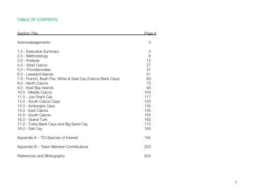
- Page 1: Turks and Caicos Islands National V
- Page 5 and 6: The following report is intended to
- Page 7 and 8: Figure 2.1.1 - Equipment for Data C
- Page 9 and 10: 2.3 Geographic Information Systems
- Page 12 and 13: 3.0 ANALYSIS 3.1 Habitat Relative D
- Page 14 and 15: The following table lists TCI terre
- Page 16 and 17: Palustrine Habitats # TCINVC Habita
- Page 18 and 19: Caves As the Turks and Caicos Islan
- Page 20 and 21: Acrostichum danaeifolium Giant Leat
- Page 22 and 23: Fauna Faunal species and population
- Page 24: Eurema chamberlaini Chamberlain’s
- Page 28 and 29: Figure 4.1 - Coccothrinax inaguensi
- Page 30 and 31: Figure 4.1.1 - 442 Coastal Habitat
- Page 32 and 33: 9Sterna dougallii Roseate Tern Regi
- Page 34 and 35: The following table outlines critic
- Page 37 and 38: 5.0 PROVIDENCIALES 1 Many of the ha
- Page 39 and 40: Table 5.1.1 - Providenciales Habita
- Page 41 and 42: 5.2 Rare, Threatened, Endangered an
- Page 43 and 44: Species, IUCN LC 20Sterna dougallii
- Page 45 and 46: Figure 5.2.2 - Guaiacum sanctum CIT
- Page 47 and 48: 5.3 Critical Habitats The island of
- Page 49: Figure 5.3.1 - Chalk Sound National
- Page 52 and 53:
Figure 6.1 - Pinus caribaea Conifer
- Page 54 and 55:
In spite of scattered development a
- Page 56 and 57:
3Anous stolidus Brown Noddy Globall
- Page 58 and 59:
6.3 Critical Habitats Figure 6.2.2-
- Page 60:
, Figure 6.3.1 - Lacustrine Freshwa
- Page 64 and 65:
Figure 7.1 - Brown Pelicans and Nod
- Page 66 and 67:
7.2 Species of Interest The followi
- Page 68 and 69:
Figure 7.2.1 - Globally Significant
- Page 70:
The cays provide habitat for severa
- Page 74 and 75:
Figure 8.1 - 131 Forest Habitat on
- Page 76 and 77:
29 633 Estuarine Mixed Algal Nonvas
- Page 79 and 80:
8.2 Species of Interest Figure 8.2.
- Page 81 and 82:
1 Pienkowski (2002) 2 Ibid 31Opunti
- Page 83 and 84:
Figure 8.2.2 - Encyclia caicensis,
- Page 85 and 86:
Figure 8.2.4 - Antillean Nighthawk,
- Page 87 and 88:
The forest habitats of North Caicos
- Page 89 and 90:
Area Significance North Caicos RAMS
- Page 91:
Figure 8.3.3 - Pinus caribaea var.
- Page 94 and 95:
Figure 9.1 - Shoreline on East Bay
- Page 96 and 97:
Figure 9.1.2 - 413 and 633 Habitats
- Page 98 and 99:
7Pandion haliaetus Osprey IUCN Near
- Page 100 and 101:
9.3 Critical Habitats Figure 9.3.1
- Page 102 and 103:
102
- Page 104 and 105:
Figure 10.1 - Middle Caicos Cave 10
- Page 106 and 107:
26Mammillaria nivosa Woolly Nipple
- Page 108 and 109:
The vast and diverse unspoiled land
- Page 110 and 111:
The Conch Bar Caves National Park i
- Page 112 and 113:
Table 10.3.1 - Middle Caicos Critic
- Page 114 and 115:
Figure 10.3.3 - 442, Coastal Rock B
- Page 116 and 117:
116
- Page 118 and 119:
Figure 11.1 - Joe Grant Cay 118
- Page 120 and 121:
Joe Grant cay does not have any cur
- Page 122 and 123:
Figure 11.2.1 - Joe Grant Cay 122
- Page 124 and 125:
124
- Page 126 and 127:
Spatial analysis identified 14 habi
- Page 128 and 129:
Figure 12.1.1 - Long Cay Habitats,
- Page 130 and 131:
Figure 12.2.1 - Endemic Species Bor
- Page 132 and 133:
The following table lists known cri
- Page 134 and 135:
134
- Page 136 and 137:
Figure 13.1 - Ambergris Cay 136
- Page 138 and 139:
For islands occupying a small land
- Page 140 and 141:
25Mimosa bahamensis Bahama Mimosa E
- Page 142 and 143:
Figure 13.2.1 - Bahamas Endemic Eup
- Page 144 and 145:
144
- Page 146 and 147:
Figure 14.1 - East Caicos 146
- Page 148 and 149:
East Caicos enjoys a relatively uni
- Page 150 and 151:
40Wedelia bahamensis Rong Bush, Bah
- Page 152 and 153:
Figure 14.2.1 - Opuntia lucayana, E
- Page 154 and 155:
154
- Page 156 and 157:
Figure 15.1 - South Caicos 156
- Page 158 and 159:
A significant proportion of the lan
- Page 160 and 161:
AVES Birds 1Calliphlox evelynae Bah
- Page 162 and 163:
Figure 15.2.3 - Unusual West Indian
- Page 164 and 165:
164
- Page 166 and 167:
Figure 16.1 - Grand Turk 166
- Page 168 and 169:
Grand Turk has the highest relative
- Page 170 and 171:
5Charadrius melodus Piping Plover I
- Page 172 and 173:
Grand Turk boasts a wide variety of
- Page 174 and 175:
174
- Page 176 and 177:
Figure 17.1 - Turks Bank Cays, Big
- Page 178 and 179:
17.2 Species of Interest The follow
- Page 180 and 181:
Figure 17.2.1 - View of Gibbs Cay 1
- Page 182 and 183:
Most, if not all of the cays provid
- Page 184 and 185:
184
- Page 186 and 187:
Figure 18.1 - Salt Cay 186
- Page 188 and 189:
Human altered landscapes account fo
- Page 190 and 191:
6Columba leucocephala White-Crowned
- Page 192 and 193:
18.3 Critical Habitats Salt Cay has
- Page 194 and 195:
Appendix A Species of Interest, Tur
- Page 196 and 197:
Cassia inaguensis Endemic C Cassia
- Page 198 and 199:
Opuntia lucayana Turk's Island Pric
- Page 200 and 201:
Egretta rufescens Reddish Egret IUC
- Page 202 and 203:
Sphaerodactylus caicosensis Dwarf G
- Page 204 and 205:
ATM and Wood, K. (2003). Amanyara R
- Page 206:
Wood, Kathleen, 2002/03. Grand Turk