

Tumut River Canoe and Kayak Trail - Land
Tumut River Canoe and Kayak Trail - Land
Tumut River Canoe and Kayak Trail - Land

You also want an ePaper? Increase the reach of your titles
YUMPU automatically turns print PDFs into web optimized ePapers that Google loves.
WELCOME<br />
Welcome to the <strong>Tumut</strong> <strong>River</strong> <strong>Canoe</strong> <strong>and</strong> <strong>Kayak</strong> <strong>Trail</strong>.<br />
This is a canoe or kayak trip down one of Australia’s inl<strong>and</strong> rivers which<br />
enables you to enjoy the true beauty of our rural countryside <strong>and</strong> vast<br />
river systems.<br />
There are many Crown l<strong>and</strong> reserves along the trail where you can<br />
camp overnight, or stop for a well earned break.<br />
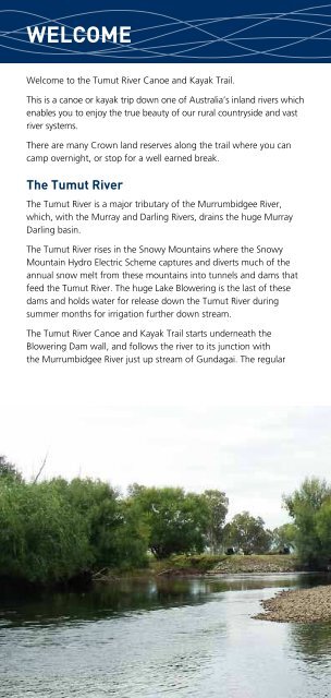
The <strong>Tumut</strong> <strong>River</strong><br />
The <strong>Tumut</strong> <strong>River</strong> is a major tributary of the Murrumbidgee <strong>River</strong>,<br />
which, with the Murray <strong>and</strong> Darling <strong>River</strong>s, drains the huge Murray<br />
Darling basin.<br />
The <strong>Tumut</strong> <strong>River</strong> rises in the Snowy Mountains where the Snowy<br />
Mountain Hydro Electric Scheme captures <strong>and</strong> diverts much of the<br />
annual snow melt from these mountains into tunnels <strong>and</strong> dams that<br />
feed the <strong>Tumut</strong> <strong>River</strong>. The huge Lake Blowering is the last of these<br />
dams <strong>and</strong> holds water for release down the <strong>Tumut</strong> <strong>River</strong> during<br />
summer months for irrigation further down stream.<br />
The <strong>Tumut</strong> <strong>River</strong> <strong>Canoe</strong> <strong>and</strong> <strong>Kayak</strong> <strong>Trail</strong> starts underneath the<br />
Blowering Dam wall, <strong>and</strong> follows the river to its junction with<br />
the Murrumbidgee <strong>River</strong> just up stream of Gundagai. The regular<br />
flow out of the Blowering Dam during summer months <strong>and</strong> the<br />
picturesque rural l<strong>and</strong>scape in this area makes the <strong>Tumut</strong> <strong>River</strong> one of<br />
the very best canoeing trips available.<br />
Degree of difficulty<br />
The <strong>Tumut</strong> <strong>River</strong> with normal summer flows is not a beginners’ river.<br />
The moving water is classified as Grade 1 rapid. The water is deep<br />
<strong>and</strong> cold. <strong>Canoe</strong>ists should wear a helmet, avoid trees <strong>and</strong> fixed<br />
objects that can trap your canoe <strong>and</strong> be aware of hypothermia if you<br />
capsize. <strong>Canoe</strong>ing skills <strong>and</strong> some experience is needed to h<strong>and</strong>le this<br />
moving water. Some sections are quite long <strong>and</strong> depending on flow<br />
may take greater than five hours of paddling. A reasonable level of<br />
fitness is required.<br />
<strong>Canoe</strong> & kayak maps <strong>and</strong> notes<br />
These canoe <strong>and</strong> kayak trail maps have been prepared by the NSW L<strong>and</strong><br />
<strong>and</strong> Property Management Authority to help you plan your trip down<br />
the <strong>Tumut</strong> <strong>River</strong>. The distance to Gundagai by the river is some 95 kms.<br />
Once at Gundagai you can continue your trip down stream using the<br />
Murrumbidgee <strong>Canoe</strong> <strong>Trail</strong> Maps.<br />
Access to the river is via Crown l<strong>and</strong> reserves which are shown on<br />
the maps, together with a suggested route for support vehicles<br />
following canoeists.<br />
Snowy Mountains


