Wind Energy Resource Atlas of the Philippines - NREL
Wind Energy Resource Atlas of the Philippines - NREL
Wind Energy Resource Atlas of the Philippines - NREL

You also want an ePaper? Increase the reach of your titles
YUMPU automatically turns print PDFs into web optimized ePapers that Google loves.
Station<br />
WMO No.<br />
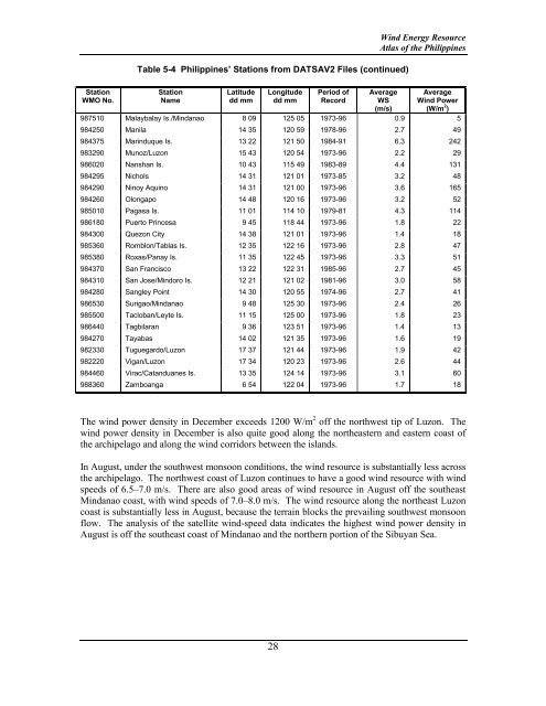
Table 5-4 <strong>Philippines</strong>’ Stations from DATSAV2 Files (continued)<br />
Station<br />
Name<br />
Latitude<br />
dd mm<br />
Longitude<br />
dd mm<br />
28<br />
Period <strong>of</strong><br />
Record<br />
<strong>Wind</strong> <strong>Energy</strong> <strong>Resource</strong><br />
<strong>Atlas</strong> <strong>of</strong> <strong>the</strong> <strong>Philippines</strong><br />
Average<br />
WS<br />
(m/s)<br />
Average<br />
<strong>Wind</strong> Power<br />
(W/m 2 )<br />
987510 Malaybalay Is./Mindanao 8 09 125 05 1973-96 0.9 5<br />
984250 Manila 14 35 120 59 1978-96 2.7 49<br />
984375 Marinduque Is. 13 22 121 50 1984-91 6.3 242<br />
983290 Munoz/Luzon 15 43 120 54 1973-96 2.2 29<br />
986020 Nanshan Is. 10 43 115 49 1983-89 4.4 131<br />
984295 Nichols 14 31 121 01 1973-85 3.2 48<br />
984290 Ninoy Aquino 14 31 121 00 1973-96 3.6 165<br />
984260 Olongapo 14 48 120 16 1973-96 3.2 52<br />
985010 Pagasa Is. 11 01 114 10 1979-81 4.3 114<br />
986180 Puerto Princesa 9 45 118 44 1973-96 1.8 22<br />
984300 Quezon City 14 38 121 01 1973-96 1.4 18<br />
985360 Romblon/Tablas Is. 12 35 122 16 1973-96 2.8 47<br />
985380 Roxas/Panay Is. 11 35 122 45 1973-96 3.3 51<br />
984370 San Francisco 13 22 122 31 1985-96 2.7 45<br />
984310 San Jose/Mindoro Is. 12 21 121 02 1981-96 3.0 58<br />
984280 Sangley Point 14 30 120 55 1974-96 2.7 41<br />
986530 Surigao/Mindanao 9 48 125 30 1973-96 2.4 26<br />
985500 Tacloban/Leyte Is. 11 15 125 00 1973-96 1.8 23<br />
986440 Tagbilaran 9 36 123 51 1973-96 1.4 13<br />
984270 Tayabas 14 02 121 35 1973-96 1.6 19<br />
982330 Tuguegardo/Luzon 17 37 121 44 1973-96 1.9 42<br />
982220 Vigan/Luzon 17 34 120 23 1973-96 2.6 44<br />
984460 Virac/Catanduanes Is. 13 35 124 14 1973-96 3.1 60<br />
988360 Zamboanga 6 54 122 04 1973-96 1.7 18<br />
The wind power density in December exceeds 1200 W/m 2 <strong>of</strong>f <strong>the</strong> northwest tip <strong>of</strong> Luzon. The<br />
wind power density in December is also quite good along <strong>the</strong> nor<strong>the</strong>astern and eastern coast <strong>of</strong><br />
<strong>the</strong> archipelago and along <strong>the</strong> wind corridors between <strong>the</strong> islands.<br />
In August, under <strong>the</strong> southwest monsoon conditions, <strong>the</strong> wind resource is substantially less across<br />
<strong>the</strong> archipelago. The northwest coast <strong>of</strong> Luzon continues to have a good wind resource with wind<br />
speeds <strong>of</strong> 6.5–7.0 m/s. There are also good areas <strong>of</strong> wind resource in August <strong>of</strong>f <strong>the</strong> sou<strong>the</strong>ast<br />
Mindanao coast, with wind speeds <strong>of</strong> 7.0–8.0 m/s. The wind resource along <strong>the</strong> nor<strong>the</strong>ast Luzon<br />
coast is substantially less in August, because <strong>the</strong> terrain blocks <strong>the</strong> prevailing southwest monsoon<br />
flow. The analysis <strong>of</strong> <strong>the</strong> satellite wind-speed data indicates <strong>the</strong> highest wind power density in<br />
August is <strong>of</strong>f <strong>the</strong> sou<strong>the</strong>ast coast <strong>of</strong> Mindanao and <strong>the</strong> nor<strong>the</strong>rn portion <strong>of</strong> <strong>the</strong> Sibuyan Sea.