INFORMATION DOCUMENT - DWA Home Page
INFORMATION DOCUMENT - DWA Home Page
INFORMATION DOCUMENT - DWA Home Page

You also want an ePaper? Increase the reach of your titles
YUMPU automatically turns print PDFs into web optimized ePapers that Google loves.
This document is intended as a<br />
means for sharing information<br />
about the process adopted by the<br />
Lesotho Highlands Development<br />
Authority (LHDA) for developing<br />
a policy for the release of water<br />
into downstream river courses<br />
(referred to as instream flow<br />
requirements (IFR)) for the Phase<br />
1 dams of the Lesotho Highlands<br />
Water Project in Lesotho.<br />
It also informs readers as to how<br />
they may participate in the public<br />
consultation process for the<br />
development of the policy.<br />
This document:<br />
❏ Explains the context for and<br />
need for an IFR policy<br />
❏ Gives a brief introduction to the<br />
theory behind IFR and the way in<br />
which scientists go about instream<br />
flow assessments (IFA) and<br />
❏ Indicates where readers may<br />
obtain further information and how<br />
they may participate in the<br />
process.<br />
LESOTHO HIGHLANDS WATER PROJECT<br />
Development of a Policy for Instream Flow Requirements<br />
PURPOSE OF THIS<br />
<strong>DOCUMENT</strong><br />
Senqunyane<br />
<strong>INFORMATION</strong> <strong>DOCUMENT</strong><br />
Republic of South Africa<br />
Republic of South Africa<br />
Senqu<br />
KINGDOM OF LESOTHO<br />
Senqu<br />
Malibamatso<br />
MASERU<br />
Mohale's Hoek<br />
IFR 6 @ Seaka Bridge<br />
IFR 7 @ Marakabei<br />
IFR 8 @ u/s Senqu confluence<br />
Quthing<br />
Matsoku<br />
Butha Butha<br />
IFR 2 @ Katse<br />
Thaba Tseka<br />
IFR 1 @ Seshote<br />
IFR 5 @ Whitehills<br />
IFR 3 @ Paray<br />
IFR 4 @ Sehonghong<br />
Qacha's Nek<br />
IFR Sites<br />
IFR "Super Sites"<br />
North<br />
0 20 40<br />
Kilometres<br />
Republic of South Africa<br />
KEY<br />
LHWP Dams (extant and planned)<br />
Border with RSA<br />
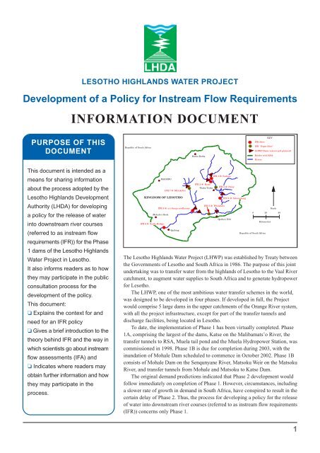
The Lesotho Highlands Water Project (LHWP) was established by Treaty between<br />
the Governments of Lesotho and South Africa in 1986. The purpose of this joint<br />
undertaking was to transfer water from the highlands of Lesotho to the Vaal River<br />
catchment, to augment water supplies to South Africa and to generate hydropower<br />
for Lesotho.<br />
The LHWP, one of the most ambitious water transfer schemes in the world,<br />
was designed to be developed in four phases. If developed in full, the Project<br />
would comprise 5 large dams in the upper catchments of the Orange River system,<br />
with all the project infrastructure, except for part of the transfer tunnels and<br />
discharge facilities, being located in Lesotho.<br />
To date, the implementation of Phase 1 has been virtually completed. Phase<br />
1A, comprising the largest of the dams, Katse on the Malibamats’o River, the<br />
transfer tunnels to RSA, Muela tail pond and the Muela Hydropower Station, was<br />
commissioned in 1998. Phase 1B is due for completion during 2003, with the<br />
inundation of Mohale Dam scheduled to commence in October 2002. Phase 1B<br />
consists of Mohale Dam on the Senqunyane River, Matsoku Weir on the Matsoku<br />
River, and transfer tunnels from Mohale and Matsoku to Katse Dam.<br />
The original demand predictions indicated that Phase 2 development would<br />
follow immediately on completion of Phase 1. However, circumstances, including<br />
a slower rate of growth in demand in South Africa, have conspired to result in the<br />
certain delay of Phase 2. Thus, the process for developing a policy for the release<br />
of water into downstream river courses (referred to as instream flow requirements<br />
(IFR)) concerns only Phase 1.<br />
Rivers<br />
1
❏ Treaty commitments to<br />
environmental management,<br />
maintaining livelihoods and<br />
compensating for losses<br />
❏ The need for a scientific<br />
approach to and policy for<br />
managing releases and<br />
downstream impacts<br />
❏ Lesotho seeks to comply with<br />
the Treaty and protect the interests<br />
of its people<br />
❏ South Africa seeks to comply<br />
with the Treaty and South African<br />
water law<br />
❏ An IFR policy will ensure some<br />
water is reserved for ecosystems<br />
and communities downstream of<br />
control structures<br />
❏ The IFR policy will ensure that<br />
reserved water is made available<br />
to the ecosystem and communities<br />
at appropriate times<br />
❏ The IFR policy will outline<br />
standards or indicators for the<br />
management of the target river<br />
health.<br />
MOTIVATING<br />
FACTORS<br />
Why Do We Need an IFR Policy?<br />
Water Releases: Design and Practice<br />
When the LHWP was designed in the 1970s and 1980s, awareness of environmental<br />
issues in general, and downstream environmental and social impacts of large dams<br />
in particular, was much lower than it is today. Nevertheless, environmental issues<br />
were embedded in the Treaty (see Box below) and the relevant Treaty articles were<br />
given effect through the implementation of Environmental Action Plans (EAPs)<br />
for both Phases 1A and 1B. The difference between 1A and 1B was that Phase 1B<br />
environmental and socio-economic baseline studies were done in advance of<br />
construction/implementation in the case of Mohale Dam, whereas the Phase 1A<br />
baseline studies were being conducted while construction of the Project was already<br />
underway. Thus, the Phase 1B EAP benefited from lessons learnt in implementing<br />
Phase 1A.<br />
The Phase 1 EAPs have, to date, applied only to the dam basins and upstream<br />
catchment areas. It was the Phase 1B environmental impact assessment report in<br />
1994 that identified the need for an instream flow assessment, to investigate<br />
environmental and social impacts downstream of both dams and to design measures<br />
to mitigate them or compensate for them.<br />
As far as management of the downstream environment goes, operation of dam<br />
releases under the Treaty articles (see box below) is the only operational mode<br />
currently approved by Project authorities. The Treaty specified compensation flows<br />
amounting to between 2% and 3% of Mean Annual Runoff (MAR). The Project<br />
was designed and, for the most part, constructed, on the basis of the intended<br />
transfer of approximately 93% of the water yield (MAR) from the rivers above<br />
the LHWP structures. From 1996-2001, releases or flows from Katse were<br />
substantially in excess of these parameters—averaging 32% of MAR, with a low<br />
of 4,2% MAR in 1999 and a high of 61,6% MAR in 2001 (see box below).<br />
Currently, to protect the river until an IFR Policy is in place, Katse Dam and<br />
the Matsoku weir are being operated to release 750 litres per second (l/s) and 600<br />
l/s, respectively.<br />
Other than control of releases, to date no downstream management or mitigation<br />
measures have been undertaken, except for the regular monitoring of water quality<br />
in downstream rivers.<br />
1996 64.0%<br />
1997 30.5%<br />
Katse Releases (% MAR)<br />
1998 27.4%<br />
1999 4.2%<br />
LHWP TREATY ENVIRONMENTAL AND SOCIAL COMMITMENTS<br />
2000 6.5%<br />
2001 61.6%<br />
Environmental considerations were incorporated into the Project from the beginning, notably as legally binding articles in<br />
the Treaty. The main provision for environmental matters in the Treaty (embodied in Article 15) states:<br />
“The Parties agree to take all reasonable measures to ensure that the implementation, operation and maintenance of<br />
the Project are compatible with the protection of the existing quality of the environment and, in particular, shall pay due<br />
regard to the maintenance of the welfare of persons and communities immediately affected by the project”.<br />
Furthermore, Article 7(18) of the Treaty enjoins the Lesotho Highlands Development Authority (LHDA, the body set up<br />
to implement the Project and be responsible for its operation and maintenance), to:<br />
“effect all measures to ensure that members of the local communities in the Kingdom of Lesotho, who will be affected<br />
by flooding, construction works or similar project-related causes, will be able to maintain a standard of living not inferior to<br />
that obtaining at the time of first disturbance, provided that such Authority shall effect compensation for any loss to such<br />
member as a result of such project-related causes not adequately met by such measures”.<br />
The Treaty, in recognition of downstream needs, specified Phase 1 downstream flows (the “Treaty Minimum Releases”)<br />
of not less than 500 l/s and 300 l/s from Katse and Mohale dams, respectively. It made no mention of the Matsoku weir.<br />
2
PUBLIC DISCLOSURE<br />
AND INVOLVEMENT<br />
Public disclosure and input into<br />
policy development is the policy<br />
of the LHDA and a World Bank<br />
requirement. It involves the use of<br />
two-way communication:<br />
❏ May-June 2002: a pilot<br />
consultation process was<br />
conducted, in 16 potentially<br />
affected villages downstream of<br />
Phase 1 structures in a 5 km wide<br />
corridor each side of the river<br />
❏ May-August: meetings with the<br />
Principal Chiefs of Lesotho are an<br />
important matter of protocol<br />
❏ June-August: extension of this<br />
process to all downstream villages<br />
in potentially significantly affected<br />
river reaches in a 5 km wide<br />
corridor each side of the river (IFR<br />
Sites 1, 2, 3 and 7)<br />
❏ Public disclosure: this document<br />
represents the first step in a<br />
process which will inform the<br />
broader interested and/or affected<br />
community about the IFR policy<br />
❏ Public consultation: the posting<br />
of the Draft IFR Policy on websites<br />
and in libraries, in early August<br />
2002 for 30 days, for the purposes<br />
of public comment<br />
❏ Public notification: the posting<br />
of the final IFR Policy and a<br />
Response Report, to notify<br />
stakeholders of the final Policy and<br />
to explain how LHDA has<br />
responded to concerns.<br />
What is an Instream Flow<br />
Requirements Policy?<br />
Instream flow requirements (IFR) refer to the amount, quality and timing of water<br />
released through or over dams and associated structures to meet riverine ecosystem<br />
and social needs in the reaches downstream of dams. The objective is to mitigate<br />
the impacts of such structures on the downstream environment and people.<br />
Downstream affected people have to be consulted about the potential impacts of<br />
the project on their livelihoods and compensated for any losses, in such a way as<br />
to restore those livelihoods.<br />
The approach adopted by LHDA, and endorsed by the Lesotho Highlands<br />
Water Commission and the World Bank, was to focus on the obligations contained<br />
in the Treaty and in the World Bank Loan Agreement to mitigate the adverse effects<br />
of the dam on the downstream environment and people.<br />
The IFR Policy will emphasize the establishment of a pattern of target water<br />
releases—base flows and floods, in wet, average and dry years—that will ensure<br />
that adverse impacts on the downstream environment do not exceed agreed levels<br />
of river health conditions.<br />
In contrast to the impact evaluations undertaken for areas upstream of the<br />
LHWP dams, which typically dealt with largely significant impacts on a relatively<br />
small number of people (a few hundred), downstream evaluation has had to deal<br />
with relatively small impacts on a large number of people (tens of thousands) in<br />
an area that had not previously been studied.<br />
This approach - managing the river rather than managing the dam – makes the<br />
ecological health of the river and the welfare of downstream communities key<br />
elements in decisions regarding the allocation and use of water. It also paves the<br />
way for establishing a firm basis for determining losses of and compensation for<br />
downstream aquatic and riparian resources.<br />
It will lead to an IFR policy that covers the geographic scope of the policy’s<br />
interventions, a monthly release schedule that specifies base flows and flood<br />
releases for wet, normal and dry years, dam operating procedures, monitoring, the<br />
principles of the social mitigation and compensation process, record keeping,<br />
audits, disclosure and consultation and the budget commitments required to operate<br />
the policy.<br />
Senqunyane River. (Photo: George van der Merwe)<br />
3
It is important to note that, given the<br />
scientific state of the art regarding<br />
environmental flow requirement studies<br />
and the forecasting of potential impacts,<br />
the results of the studies should be<br />
interpreted as providing guidance to<br />
inform the formulation of a policy and<br />
not as exact predictions of what may<br />
happen.<br />
Uncertain future rainfall patterns, the<br />
specific way in which the river ecology<br />
may respond to changed hydrological<br />
and hydraulic conditions, and the<br />
adaptation strategies of the downstream<br />
riparian plants and animals, will all<br />
interact to create a new ecology and,<br />
potentially, new socio-economic<br />
patterns.<br />
This is why it is important to design a<br />
policy that is adaptable to the emerging<br />
reality on the ground and to monitor<br />
the environmental and social conditions<br />
as they evolve, in order to do the<br />
maximum to ensure river health and the<br />
livelihoods of the affected people.<br />
The Outcome<br />
The culmination of all these studies<br />
will be the formulation and approval<br />
by the Project Authorities of an IFR<br />
Policy, which will<br />
❏ commit the LHDA to a target<br />
release regime from each of Phase<br />
1’s dams, namely, Katse and Mohale<br />
Dams and Matsoku Weir;<br />
❏ commit the LHDA to specified<br />
principles of mitigation of impacts<br />
and compensation for losses;<br />
❏ establish the basis for the<br />
assessment of environmental and<br />
social losses and procedures for<br />
claiming compensation;<br />
❏ set out the details of a monitoring<br />
program which will support the<br />
release regime, compensation and<br />
mitigation policy; and<br />
❏ establish a regular program to<br />
review the policy in the light of the<br />
results of the monitoring studies.<br />
IFR STUDIES undertaken<br />
by LHDA<br />
Contracts 648 and 678<br />
The decision to appoint a consultant to undertake a thorough assessment of<br />
downstream impacts was taken during 1996. Metsi Consultants, a joint venture<br />
of SMEC International of Australia and Southern Waters Ecological Research and<br />
Consulting of South Africa, was contracted to undertake IFR studies of the Project<br />
under LHDA.<br />
Contract 648, conducted between 1997 and 2000, produced 22 separate reports.<br />
The terms of reference for the study required consideration of the combined effects<br />
of Phases 1 and 2. The study area included the Malibamats’o River downstream<br />
of Katse, the Matsoku River (tributary of the Malibamats’o) downstream of Matsoku<br />
Weir, the Senqunyane River downstream of Mohale, to their respective confluences<br />
with the Senqu River, and the middle and lower reaches of the Senqu River, to the<br />
border with South Africa. The study involved a wide range of specialists, from<br />
physical and biological scientists to human and animal health and socio-economic<br />
specialists.<br />
When it became clear that a significant delay in the implementation of Phase<br />
2 was probable, Metsi Consultants was asked to assess the situation without the<br />
effects of Phase 2. This exercise was undertaken as LHDA Contract 678, the final<br />
reports of which have recently been completed. These studies have analyzed the<br />
downstream rivers’ responses to reduced flows and have predicted a range of<br />
impacts, the overall trends of which are shown in boxes on succeeding pages.<br />
Upstream of Katse Dam. (Photo: George van der Merwe)<br />
4
Instream Flow Requirements: Theory and Practice<br />
The analysis of environmental flow requirements is based on the premise that river flow is the primary determinant of a number<br />
of physical and biological parameters in aquatic and riparian ecosystems. A crucial relationship exists between river flow or<br />
discharge (analyzed as a number of components, notably base flows and floods), hydraulics and geomorphology. The volume<br />
of flow determines the depth and size of the river and a number of ecological processes are linked to this.<br />
An IFR is a description of a modified flow regime, invariably due to the presence of a control structure in the river, such as a<br />
dam or weir, that is linked to a description of the condition or health of the river that this flow might be expected to produce.<br />
Furthermore, because the characteristics of a river change as one moves downstream, flow-ecology relationships change too.<br />
One must, therefore, establish different relationships for each affected river reach. Thus, IFR studies focus their analyses on<br />
carefully selected IFR Sites, representative of particular river reaches (the LHWP IFR Phase 1 Sites are shown in the map on<br />
<strong>Page</strong> 1).<br />
In Southern Africa, the Building Block Methodology (BBM) has been developed and used for the assessment of IFRs. The BBM<br />
requires that a desired future state of the river be identified first; then the scientists<br />
construct the seasonal flow regime, comprising base flows, small and large floods,<br />
required to maintain that desired state. In the case of the LHWP, the in-stream<br />
flow assessment (IFA) was needed to assist in determining a desired future state,<br />
not the other way round, so a different approach was developed. This Downstream<br />
Response to Imposed Flow Transformations (DRIFT) methodology allows the<br />
biophysical and socio-economic consequences of flow changes to be determined<br />
for a number of potential future flow regimes. That is, it is a scenario-based approach.<br />
A Caveat. It is important to bear this in mind when reading the findings of these<br />
studies, that the findings are based on a specific set of conditions defined as<br />
the scenario and not on actual conditions. The findings are, thus, all predictions<br />
and are only as good as the primary information or databases that support them.<br />
For instance, the assessment of changes in riparian vegetation patterns requires<br />
a detailed knowledge of the auto-ecology of individual species, but such data<br />
are not available for the Highlands environment and species specifically, although<br />
experience in other systems will be applicable to some extent. The results of<br />
these studies must, therefore, be interpreted with caution; they must not be viewed<br />
as fact, but rather as the best predictions currently available. Careful monitoring<br />
of the system, after implementation of the IFR Policy, will be essential to establish<br />
the actual system responses, to establish actual losses to resource users and to<br />
permit adaptation as necessary.<br />
The LHWP IFR analysis proceeded on the basis of eight IFR sites in the four rivers<br />
of interest (see Map). Detailed, holistic field characterizations of each site field<br />
were undertaken over a 12-month period to establish a baseline, although a preproject<br />
baseline for the Malibamats’o River could not be established, due to the<br />
presence of Katse Dam. The DRIFT methodology was then used to predict the<br />
effects on different biophysical system components. Four modified flow regimes<br />
were hypothesized, based on design and operational constraints and the nature of<br />
the rivers. Finally, the consequences of the predicted biophysical changes on the<br />
human Population at Risk were analyzed and the costs of potential resource losses<br />
were calculated.<br />
Bringing all the<br />
elements together<br />
The final phase of policy development<br />
will be to assess the trade-offs between<br />
river health, communities and the<br />
implications of different release options<br />
in terms of lost benefits to the two<br />
countries – all within the context of the<br />
Treaty requirement that the project<br />
should “pay due regard to the<br />
maintenance of the welfare of persons<br />
and communities”, and “take all<br />
reasonable measures to ensure…the<br />
protection of the existing quality of the<br />
environment”. If a purely financial<br />
approach were to be taken, the project<br />
would maximize revenue at the expense<br />
of the downstream environment and<br />
communities; if a purely environmental<br />
approach were to be taken, the project<br />
would release as much water as was<br />
necessary to protect the environment<br />
and communities at a high cost in terms<br />
of lost revenue. The policy development<br />
process seeks an intermediate position<br />
that will represent a fair and reasonable<br />
balance between the two extreme<br />
positions.<br />
5
YOUR INVOLVEMENT<br />
Your involvement is very important<br />
to us. While at this stage we seek<br />
to inform, not to solicit comment,<br />
we urge you to submit comments<br />
on the Draft IFR Policy when it is<br />
released.<br />
Details about the venues where<br />
documentation is available, and<br />
where the Draft IFR Policy will<br />
be posted are provided on the<br />
next page.<br />
WHO TO CONTACT<br />
ABOUT THIS PROJECT<br />
Should you wish to submit<br />
comments, please do so to the<br />
following email address<br />
lhwp@lhda.org.ls<br />
Or by fax to +266 325775,<br />
for the attention of<br />
Mr R Maphetla<br />
Chief Executive Officer<br />
LHDA<br />
PO Box 7332<br />
Maseru 100<br />
Lesotho<br />
Should you wish to discuss<br />
anything relating to the IFR policy<br />
process, or to obtain further<br />
information, do not hesitate to<br />
contact the following persons at<br />
LHDA:<br />
Ms. M. Mothepu<br />
Deputy General Manager ESSG<br />
Phone:<br />
+266 835 0825<br />
+266 85 0679 (Cell phone)<br />
Mr. Taole Tesele<br />
IFR Co-ordinator<br />
Phone:<br />
+266 835 0731<br />
+266 85 2143 (Cell phone)<br />
Description of the<br />
Lesotho Highlands<br />
Lesotho is a land-locked country 30 355km 2 in extent. The eastern two-thirds,<br />
called the Highlands, are formed by the rugged Drakensberg and Maloti ranges,<br />
which form a high, dissected plateau with an average elevation of about 2 500<br />
metres above sea level (masl). The narrow river valleys are steep-sided; the<br />
landscape is one of deeply incised valleys and peaks. The Senqu (Orange) River<br />
drains the eastern and southern sectors and has several large tributaries, including<br />
the Malibamats’o, Senqunyane and Matsoku rivers, which are the locations for<br />
LHWP structures (see map).<br />
Highland catchments are characterised by high rainfall, temperate summers<br />
and long, cold winters, and they have high water yields due to rapid runoff from<br />
the steep slopes. Rainfall occurs predominantly as thunderstorms of high intensity<br />
and short duration. The nature of the rainfall and the rapid movement of water off<br />
the steep slopes and thin soil results in a quick drainage reaction time. Highly<br />
variable, but distinct wet, dry and transitional seasons are identifiable from<br />
hydrological records. The wet/rainy season extends from December to March,<br />
while the dry season usually extends from June through September.<br />
Grasslands and shrublands dominate highland vegetation; wetlands occur in<br />
all drainage lines. Vegetation zones along rivers typically have a higher biodiversity<br />
than elsewhere and a higher proportion of woody vegetation, both indigenous and<br />
exotic species. The wild animal communities of Lesotho are distinctive, with<br />
several endemic species, but wildlife densities are very low due to heavy, uncontrolled<br />
exploitation.<br />
The human population along the rivers downstream of the LHWP structures<br />
within Lesotho live in small villages, with a small proportion living in larger<br />
settlements such as Marakabei. It has been estimated that some 8 300 households<br />
in a 5km corridor on each side of the downstream rivers may be significantly<br />
affected by Phase 1 of the LHWP. While foreign employment in South Africa<br />
represents an important, although declining, source of income, rural people are<br />
heavily dependent on local resources for their livelihood. Agriculture is an important<br />
source of livelihood, but agricultural plots are constrained in size by topography<br />
and soil depths. Relatively more and better land is available along the Matsoku<br />
and upper Senqunyane Rivers than along the deeply incised Malibamats’o and<br />
upper Senqu rivers. The nutrition status of local people, especially children, is low,<br />
even by Lesotho rural standards, and there is a high incidence of childhood<br />
infectious diseases as well as water-related diseases. Livestock are abundant in<br />
the area (estimated populations of 68 000 catttle, 78 000 sheep, 131 000 goats and<br />
24 000 horses and donkeys).<br />
IFR Study Scenarios<br />
Minimum Degradation Scenario<br />
This scenario was developed as a hypothetical condition, in which maintenance<br />
of the rivers in a state of minimal degradation from their current condition was the<br />
main objective and only thereafter would water delivery needs be catered for (ie<br />
transferred to SA). It assumed that 60-65% of Mean Annual Runoff would be<br />
released to downstream ecosystems. This scenario allowed specialists to consider<br />
interactively baseline conditions relative to flow levels and to establish the flows<br />
below which significant ecological and physical changes could be anticipated. It<br />
should be noted that this scenario is not technically achievable due to design<br />
constraints on the structures<br />
6
WHERE TO GET<br />
MORE <strong>INFORMATION</strong><br />
The 3 key reports:<br />
❏ Metsi Consultants (2002) Report<br />
678-F-001, Summary of Main<br />
Findings for Phase 1 Development<br />
❏ Metsi Consultants (2002) Report<br />
678-F-002, Additional Scenarios and<br />
Production of a New Final Report<br />
(Vol. II)<br />
❏ S. Klasen (2002) The Costs and<br />
Benefits of Changing Instream Flow<br />
Requirements<br />
are available on the following<br />
websites:<br />
❏ www.lhwp.org.ls.<br />
❏ www.lesotho.gov.ls<br />
❏ www.dwaf.gov.za<br />
❏ www.sametsi.com<br />
Hard copies of these reports are<br />
lodged for public inspection at<br />
the following venues:<br />
❏ LHDA Library, 3rd Floor, Post<br />
Office Building, Kingsway, Maseru,<br />
Lesotho<br />
❏ National Environmental<br />
Secretariat Library, Post Office<br />
Building, Maseru<br />
❏ National University of Lesotho<br />
Library, Roma, Lesotho<br />
❏ <strong>DWA</strong>F Library, 3rd Floor Sedibeng<br />
Bldg, Schoeman St, Pretoria<br />
❏ World Bank office, Pro-Equity<br />
Court, 1250 Pretorius Street,<br />
Pretoria<br />
❏ University of Cape Town Library,<br />
Rondebosch, Cape Town<br />
❏ Public Information Center, World<br />
Bank, 1818 H Street NW,<br />
Washington, DC<br />
Should you wish to read further,<br />
a full set of Metsi Consultants<br />
Contract 648 reports are lodged<br />
at:<br />
❏ LHDA Library, 3rd Floor, Post<br />
Office Building, Kingsway, Maseru,<br />
Lesotho<br />
❏ <strong>DWA</strong>F Library, 3rd Floor,<br />
Sedibeng Bldg, Schoeman St,<br />
Pretoria, South Africa<br />
❏ National University of Lesotho<br />
Library, Roma, Lesotho<br />
Treaty Minimum Release Scenario<br />
This is the scenario generated by application of the minimum release conditions<br />
specified in the Treaty and is at the opposite end of the range from Minimum<br />
Degradation in terms of water requirements. Conceptually, the scenario differs<br />
from that above in that the volumes of delivery water are first specified and<br />
consequential river conditions then assessed.<br />
Design Limitation Scenario<br />
This is a scenario based on the practical limitations of flow releases imposed by<br />
the designs of the Phase 1 structures. In terms of volumes of water releases, it is<br />
between the above two scenarios.<br />
Fourth (Intermediate) Scenario<br />
This scenario was selected to fall between the Treaty Minimum and Design<br />
Limitation scenarios and to provide a reference point between the former (legally<br />
defined and highest water delivery, but most severe environmental and socioeconomic<br />
impacts) and the latter (possible within engineering constraints, but<br />
likely to have high impacts on water and revenues).<br />
Summary of Findings<br />
Hydrological changes<br />
The Table below gives a global picture of the hydrological changes that are predicted<br />
to occur under each of the four scenarios. It is from the changes in the river<br />
hydrology or flow regime that all other predicted changes are derived. This overview<br />
presents the overall amount of water available to downstream ecosystems on an<br />
annual basis, as a proportion of mean annual runoff (MAR), this being an estimate<br />
of the average amount of water draining from the catchment in a year.<br />
Table 1: Historical MAR, the annual volume allocated to the river and the percentage of<br />
historical MAR that this represents, under each of the four scenarios at each IFR site for<br />
LHWP Phase 1 development. Shaded sites represent reaches immediately downstream of<br />
the dams in Phase 1a and 1b<br />
IFR<br />
Site<br />
Historical<br />
MAR<br />
Minimum<br />
Degradation<br />
Scenario<br />
MCM a -l MCM a -l %MAR MCM a -l %MAR MCM a -l %MAR MCM a -l %MAR<br />
1 87 51 59 35 40 35 40 31 36<br />
2 554 366 66 22 4 184 33 97 18<br />
3 774 436 56 128 17 315 41 227 29<br />
4 1572 866 55 831 53 831 53 831 53<br />
5 1924 1194 62<br />
6 3330 2171 65<br />
Treaty<br />
Minimum<br />
Scenario<br />
Design<br />
Limitation<br />
Scenario<br />
Fourth<br />
Scenario<br />
Flows sufficient for Minimum Degradation<br />
7 355 231 65 48 13 126 35 77 22<br />
8 592 397 67 158 27 254 43 195 33<br />
Site 1 = Matsoku R, immediately downstream of Matsoku Weir (30km)<br />
Site 2 = Malibamats’o R, immediately downstream of Katse Dam (20km)<br />
Site 7 = Senqunyane R immediately downstream of Mohale Dam (90km)<br />
Site 3 = Malibamats’o R at Paray, downstream of confluence with Matsoku R (35km)<br />
Site 4 = Senqu R at Sehonghong, representing Senqu between confluences of Malibamats’o and<br />
Tsoelike rivers (125km)<br />
Site 5 = Senqu R at Whitehills, between confluences of Tsoelike and Senqunyane rivers (85km)<br />
Site 6 = Senqu R at Seaka Bridge, from confluence with Senqunyane to South African border (140km)<br />
Site 8 = Senqunyane R upstream of the confluence with the Senqu R, from confluence with Lesobeng<br />
R to the confluence with the Senqu R (40km).<br />
7
PREDICTED IMPACTS<br />
Vegetation (See also Resource Impacts)<br />
❏ Narrower vegetation zones along<br />
rivers<br />
❏ Many riparian species will be less<br />
abundant<br />
❏ Algal blooms will be more frequent<br />
❏ Some species will increase<br />
Aquatic animals<br />
❏ Increases in algal feeding invertebrate<br />
community<br />
❏ Increases in tolerant filter feeding<br />
invertebrate communities; decreases in<br />
sensitive species<br />
❏ Increases in some Simulium,<br />
(significant as stock disease vectors)<br />
❏ Increases in midges<br />
❏ Possible introduction of disease<br />
carrying snails, Planorbidae and<br />
Physidea<br />
❏ Decline of some fish species: trout,<br />
yellowfish<br />
❏ Likely extinction of the Maloti<br />
minnow in some river reaches<br />
Resource impacts<br />
❏ Decreases in shrubs and trees used<br />
for fuel and construction<br />
❏ Decrease in some medicinal plant<br />
species<br />
❏ Decrease in availability and size of<br />
fish<br />
❏ Decrease in availability of river sand<br />
❏ Decreases in availability of wild<br />
edible vegetation<br />
❏ Increase in the availability of reeds<br />
and thatching grass<br />
Socio-economic impacts<br />
❏ Immediately downstream of Katse<br />
and Mohale dams, social impacts may<br />
be critically severe under the Treaty<br />
scenario, due to resource depletion<br />
❏ Social impacts are low, however, for<br />
all sites located two or more reaches<br />
away from the structures<br />
❏ The baseline health status of the<br />
population at risk is relatively poor ;<br />
the Treaty and Fourth scenarios increase<br />
the risks of infection from moderate to<br />
severe for diarrhoeal and skin and eye<br />
diseases.<br />
Summary of findings (continued)<br />
The main significance of hydrological changes will be as follows:<br />
Low flows will be lower, both wet and dry season low flows. Low flows are<br />
important for creating different conditions in different seasons, dictating the<br />
occurrence or emergence and population densities of various species at different<br />
times of the year.<br />
Small floods will be smaller and less frequent in occurrence. They stimulate<br />
spawning in fish, flush out poor quality water, cleanse the riverbed and sort river<br />
stones by size, thereby creating different habitats. They trigger and synchronize<br />
activities as varied as upstream migrations of fish and germination of seedlings<br />
on river banks.<br />
Large floods will be almost eliminated, except for very wet periods when the dams<br />
may overtop. Large floods provide scouring flows that shape the river channel;<br />
they also trigger some of the same responses as small floods. They move and<br />
cleanse cobbles and boulders on the riverbed and deposit silt, nutrients, eggs and<br />
seeds on floodplains; they inundate backwaters, secondary channels and floodplains,<br />
recharge soil moisture levels in the banks and trigger bursts of growth in many<br />
species.<br />
Flow variability will be reduced, in daily, seasonal and annual cycles. Variability<br />
acts as a form of natural disturbance, which effectively creates temporal and spatial<br />
habitat mosaics, of areas inundated and exposed for different periods of time. The<br />
greater the habitat diversity, the greater the species diversity and the greater is<br />
ecosystem stability and resilience against unnatural perturbations.<br />
Overall Impact Rating<br />
The overall significance of the potential biophysical changes flowing from these<br />
hydrological changes was rated by Metsi for each IFR site, under each scenario,<br />
as shown in Table 2.<br />
Table 2: Reach-specific summary of the predicted combined biophysical consequences for<br />
each scenario with Phase 1 dams in place. The levels of impacts are coded as follows:<br />
white – negligible; green – low; yellow – moderate; blue – severe; red – critically severe.<br />
1<br />
2<br />
7<br />
3<br />
4<br />
5<br />
6<br />
8<br />
Reach<br />
Proximal to<br />
dam or weir<br />
Distant from<br />
dam or weir<br />
Minimum<br />
Degrradation<br />
M<br />
M<br />
L<br />
L<br />
L<br />
N<br />
N<br />
N<br />
Design<br />
Limitation<br />
** Site 1 is below Matsoku Weir, and attracts Severe and Critically Severe ratings, despite the relatively<br />
high proportion of MAR (40%) still flowing down the river, due to the extinction in the Matsoku River<br />
of the Maloti minnow. LHDA is establishing a program to protect the minnow in other Lesotho rivers.<br />
Summary Findings<br />
❏ Sites proximal to dam structures have the potential to be severely impacted<br />
under all realistic scenarios (the exception is the Minimum Degradation scenario),<br />
largely on the basis of physical in-stream habitat changes and losses of aquatic<br />
biota.<br />
❏ Consequential changes in riparian biota and resources are much less certain<br />
(see Predicted Impacts), as are changes in human and animal health vectors and<br />
agents.<br />
S**<br />
S<br />
S<br />
M<br />
L<br />
L<br />
N<br />
L<br />
Fourth<br />
S**<br />
S<br />
S<br />
M<br />
L<br />
L<br />
L<br />
L<br />
Treaty<br />
S**<br />
CS<br />
S<br />
S<br />
M<br />
L<br />
L<br />
M<br />
8
RECORDED IMPACTS<br />
Metsi Consultants did their baseline study<br />
field work during 1999, when Katse Dam<br />
was being operated at close to Treaty<br />
minimum releases, so the results gave a<br />
good indication of the kinds of conditions<br />
which might prevail under the Treaty<br />
scenario:<br />
❏ The state of both the instream and<br />
riparian habitat (“habitat integrity”) at site<br />
2 (below Katse) was rated to be less than<br />
50% (of the ‘pristine’ condition). Other<br />
sites – not affected by a dam – got scores<br />
of between 80% and 95%.<br />
❏ Water quality at site 2 was poor, there<br />
were abundant algae in the water<br />
(mountain rivers usually flow clean) and<br />
very few fish.<br />
Monitoring downstream of Katse Dam<br />
(IFR sites 2 and 3) in summer 2000/01<br />
and summer 2001/02 has shown<br />
❏ A reduction in instream river health<br />
indicators at site 2, much less so at site 3,<br />
largely due to the absence at site 2 of<br />
sensitive groups of macro- invertebrates<br />
(only tolerant groups were recorded)<br />
❏ A lack of clear geomorphologic trends<br />
(an important prediction of the IFR studies<br />
was major changes in river<br />
geomorphology), although sedimentation<br />
in some pools was observed;<br />
❏ Woody plant species have increased in<br />
number and distribution, having colonised<br />
boulder beds and sandbars, which would<br />
previously have been often covered with<br />
water. This appears to contradict the study<br />
findings, but it does not mean that the<br />
pattern will not change in the long term.<br />
❏ During summer 2002, however, river<br />
flow was very high and fish were reported<br />
to be abundant below Katse Dam.<br />
Metsi’s pilot community surveys,<br />
conducted in April and May 2002, show<br />
some communities already suffering fuel<br />
wood shortages that are not due to the<br />
project, that is, fuel wood resources are<br />
already depleted in some areas.<br />
They also report on the experience of<br />
communities regarding both reduced flows<br />
and flood conditions. Reduced flows allow<br />
their stock to cross the river, where<br />
previously they couldn’t, and encroach<br />
into other villages’ grazing lands. High<br />
flows, on the other hand, wash away trees<br />
planted by individuals.<br />
The Economics of IFRS<br />
Losses To Downstream Communities<br />
❏ The IFR study finds sizeable economic losses (in terms of use values and<br />
necessary compensation costs) to downstream communities ranging from a total<br />
of M2,9 million to M8 million annually depending on the IFR scenario chosen.<br />
It should be kept in mind, however, that the figures are estimates only, based on<br />
certain biophysical predictions, and are primarily for the purposes of scenario<br />
comparison.<br />
❏ The IFR study also finds that small increases in releases will only have a modest<br />
impact on these losses, although there are differences between the various resources<br />
and sites. Only considerable increases in IFR releases will succeed in sharply<br />
reducing the losses to downstream communities. Even in the Minimum Degradation<br />
Scenario, downstream communities do face losses for which, according to Treaty<br />
rules, they should be entitled to compensation of some form.<br />
❏ A recent pilot consultation process amongst downstream communities revealed<br />
very realistic and clear preferences for mitigation and compensation amongst<br />
potentially affected communities, from programs of assistance to replace lost<br />
resources, to flow releases, to assistance with broader development needs as<br />
mitigation for losses which would be difficult to replace directly.<br />
Revenue and Other Losses<br />
❏ While increasing IFR releases for Lesotho would reduce downstream losses,<br />
Lesotho would also lose variable water royalties and hydropower revenues, which<br />
would have a negative impact on Lesotho’s economy as a whole. For example, if<br />
the Fourth Scenario were to be adopted, the loss to the Lesotho economy would<br />
be some M17,5 million per annum at 1999 prices, or about 6% of the total revenues<br />
from the LHWP. In addition the original objective that Muela HEP would make<br />
Lesotho self sufficient in electricity, would be compromised.<br />
❏ The Klasen study of the economic impacts of the different IFR release scenarios<br />
shows that, from an economic point of view, the economic costs to Lesotho and<br />
South Africa of increasing downstream releases beyond the Treaty minimum level<br />
always outweigh the benefits for downstream communities (and, thus, the costs<br />
of compensation for losses). This is the case from the point of view of the project,<br />
of RSA and of Lesotho.<br />
❏ In other words, the lost royalty and hydropower revenues would always be<br />
greater than the economic losses to downstream communities.<br />
❏ Notwithstanding this, the overall project benefits, over the life of this project,<br />
are so large that the viability of the project is not affected by including these<br />
downstream losses, that previously had not been considered in the economic<br />
assessment of the project.<br />
❏ While the water transfer benefits of the project would be sharply reduced under<br />
the three scenarios with releases in excess of the Treaty Minimum, as would the<br />
already low rate of return of the hydropower component, they remain sizeable<br />
enough that LHWP as a whole remains viable even if IFR releases were increased.<br />
❏ Therefore in setting the IFR policy some difficult decisions and trade-offs have<br />
to be considered, and public consultation is an essential element in this process.<br />
9
PROVISIONAL LIST<br />
OF AUTHORITIES<br />
AND IAPS<br />
NATIONAL AUTHORITIES<br />
❏ Government of Lesotho<br />
❏ Ministry of Natural Resources<br />
❏ National Environmental<br />
Secretariat<br />
❏ Ministry of Finance<br />
❏ South Africa<br />
❏ Department of Water Affairs &<br />
Forestry<br />
TRADITIONAL AUTHORITIES<br />
❏ Principal Chiefs of Lesotho (24)<br />
and their community development<br />
representatives<br />
AFFECTED COMMUNITIES<br />
❏ Some 8,300 households in 338<br />
villages in a 5-km wide corridor on<br />
either side of the affected river<br />
reaches, incorporating IFR Sites 1,<br />
2, 3 and 7.<br />
LENDERS/ DONORS<br />
❏ World Bank<br />
❏ European Investment Bank<br />
❏ Development Bank of South Africa<br />
OTHER INTERESTED PARTIES<br />
❏ Lesotho Council of NGOs<br />
❏ NGOs/civic organizations/<br />
individuals in Lesotho and South<br />
Africa<br />
❏ International NGOs<br />
Should you feel strongly that any<br />
particular organizations should be<br />
made aware of this project, please<br />
do not hesitate to contact us and<br />
give us their contact details (without<br />
their contact details we will not be<br />
able to involve them, due to the tight<br />
program).<br />
Implications for IFR Policy<br />
Mitigation by flow releases: Overall<br />
❏ The Minimum Degradation scenario was always a hypothetical option, since<br />
design limitations in the dams prevent the releases being made which might achieve<br />
it. It is not, therefore, an option that can be considered for operational purposes.<br />
It has, however, been useful as a scenario against which to compare the other<br />
scenarios.<br />
Katse Releases<br />
❏ The IFR studies show that the design limitations on Katse do not allow much<br />
flexibility of release regime and that all three possible scenarios are predicted to<br />
result in “Severe” overall ecological impacts in reaches immediately downstream<br />
of the dam (Site 2).<br />
❏ The Matsoku rating of “Severe” overall impact under all three scenarios is<br />
heavily skewed by the probable extinction of one species from this river, namely<br />
the Maloti minnow. If the Maloti minnow is taken out of the equation, then<br />
Matsoku’s 600 l/s release regime will allow the downstream ecosystem to be<br />
maintained in a reasonable condition, since it will have 40% of MAR available<br />
to it. Recognizing the importance of the species, LHDA will implement a program<br />
to establish the Maloti minnow in other Lesotho rivers.<br />
Mohale Releases<br />
❏ Because of its more flexible release structures and mechanisms, Mohale Dam<br />
holds the greater potential for manipulating releases to meet river health targets<br />
in the Senqunyane River.<br />
❏ Because there is a considerable population living downstream of the Mohale<br />
Dam, important gains in water quality and maintaining riparian vegetation - an<br />
important resource - would result from even moderately increased flows. The<br />
Mohale impacts are predicted to reduce rapidly downstream due to inflows from<br />
tributaries.<br />
Compensation<br />
❏ The degree of uncertainty in predictions/ estimates of potential losses to<br />
communities means that monitoring of socio-economic status and biophysical<br />
status of riverine ecosystems will be of paramount importance in an adaptive<br />
management system.<br />
❏ The geographic extent of measurable impacts on the Population at Risk can be<br />
limited to river reaches represented by IFR Sites 1, 2, 3 and 7. This is the area to<br />
which, it is proposed, the IFR Policy’s compensation programs will apply. Monitoring<br />
will nonetheless extend to reaches 4, 5, 6 and 8 in order to confirm the moderate<br />
or negligable levels of impact predicted for these reaches.<br />
❏ Different principles of compensation and/or mitigation are required for downstream<br />
rivers (compared with upstream of the structures) because of the different nature<br />
of the impacts. The following principles are proposed:<br />
❏ Taking account of national socio-economic trends, communities will not be<br />
worse off after Policy implementation<br />
❏ Compensation will be based on resources affected or lost, not on resources used,<br />
and will generally be directed at communities, not at individuals;<br />
❏ Compensation will be for demonstrated losses, and both direct compensation<br />
(based on replacement of lost resources) and indirect compensation/ mitigation<br />
(other programs) will be considered.<br />
10