s - Latin American Journal of Aquatic Research
s - Latin American Journal of Aquatic Research
s - Latin American Journal of Aquatic Research

Create successful ePaper yourself
Turn your PDF publications into a flip-book with our unique Google optimized e-Paper software.
Reproduction and population structure <strong>of</strong> Aristeus antillensis<br />
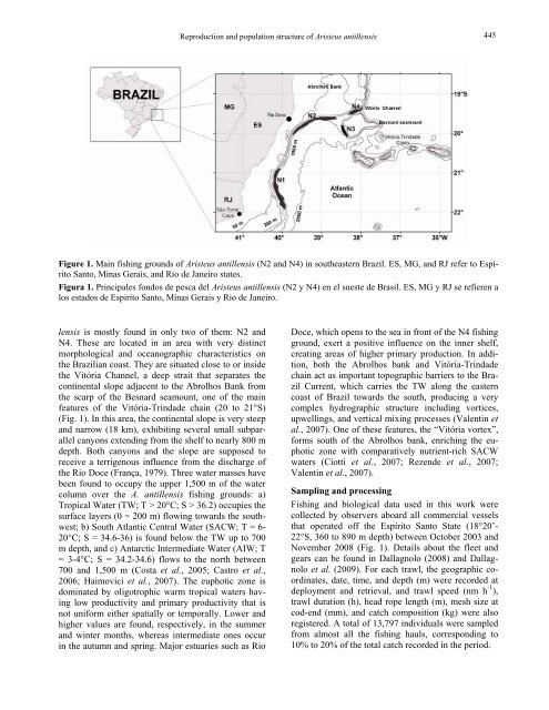
Figure 1. Main fishing grounds <strong>of</strong> Aristeus antillensis (N2 and N4) in southeastern Brazil. ES, MG, and RJ refer to Espírito<br />
Santo, Minas Gerais, and Rio de Janeiro states.<br />
Figura 1. Principales fondos de pesca del Aristeus antillensis (N2 y N4) en el sueste de Brasil. ES, MG y RJ se refieren a<br />
los estados de Espirito Santo, Minas Gerais y Rio de Janeiro.<br />
lensis is mostly found in only two <strong>of</strong> them: N2 and<br />
N4. These are located in an area with very distinct<br />
morphological and oceanographic characteristics on<br />
the Brazilian coast. They are situated close to or inside<br />
the Vitória Channel, a deep strait that separates the<br />
continental slope adjacent to the Abrolhos Bank from<br />
the scarp <strong>of</strong> the Besnard seamount, one <strong>of</strong> the main<br />
features <strong>of</strong> the Vitória-Trindade chain (20 to 21°S)<br />
(Fig. 1). In this area, the continental slope is very steep<br />
and narrow (18 km), exhibiting several small subparallel<br />
canyons extending from the shelf to nearly 800 m<br />
depth. Both canyons and the slope are supposed to<br />
receive a terrigenous influence from the discharge <strong>of</strong><br />
the Rio Doce (França, 1979). Three water masses have<br />
been found to occupy the upper 1,500 m <strong>of</strong> the water<br />
column over the A. antillensis fishing grounds: a)<br />
Tropical Water (TW; T > 20°C; S > 36.2) occupies the<br />
surface layers (0 ~ 200 m) flowing towards the southwest;<br />
b) South Atlantic Central Water (SACW; T = 6-<br />
20°C; S = 34.6-36) is found below the TW up to 700<br />
m depth, and c) Antarctic Intermediate Water (AIW; T<br />
= 3-4°C; S = 34.2-34.6) flows to the north between<br />
700 and 1,500 m (Costa et al., 2005; Castro et al.,<br />
2006; Haimovici et al., 2007). The euphotic zone is<br />
dominated by oligotrophic warm tropical waters having<br />
low productivity and primary productivity that is<br />
not uniform either spatially or temporally. Lower and<br />
higher values are found, respectively, in the summer<br />
and winter months, whereas intermediate ones occur<br />
in the autumn and spring. Major estuaries such as Rio<br />
445<br />
Doce, which opens to the sea in front <strong>of</strong> the N4 fishing<br />
ground, exert a positive influence on the inner shelf,<br />
creating areas <strong>of</strong> higher primary production. In addition,<br />
both the Abrolhos bank and Vitória-Trindade<br />
chain act as important topographic barriers to the Brazil<br />
Current, which carries the TW along the eastern<br />
coast <strong>of</strong> Brazil towards the south, producing a very<br />
complex hydrographic structure including vortices,<br />
upwellings, and vertical mixing processes (Valentin et<br />
al., 2007). One <strong>of</strong> these features, the “Vitória vortex”,<br />
forms south <strong>of</strong> the Abrolhos bank, enriching the euphotic<br />
zone with comparatively nutrient-rich SACW<br />
waters (Ciotti et al., 2007; Rezende et al., 2007;<br />
Valentin et al., 2007).<br />
Sampling and processing<br />
Fishing and biological data used in this work were<br />
collected by observers aboard all commercial vessels<br />
that operated <strong>of</strong>f the Espírito Santo State (18°20’-<br />
22°S, 360 to 890 m depth) between October 2003 and<br />
November 2008 (Fig. 1). Details about the fleet and<br />
gears can be found in Dallagnolo (2008) and Dallagnolo<br />
et al. (2009). For each trawl, the geographic coordinates,<br />
date, time, and depth (m) were recorded at<br />
deployment and retrieval, and trawl speed (nm h -1 ),<br />
trawl duration (h), head rope length (m), mesh size at<br />
cod-end (mm), and catch composition (kg) were also<br />
registered. A total <strong>of</strong> 13,797 individuals were sampled<br />
from almost all the fishing hauls, corresponding to<br />
10% to 20% <strong>of</strong> the total catch recorded in the period.