No. 7/2008 - Tfbc.frim.gov.my - frim
No. 7/2008 - Tfbc.frim.gov.my - frim
No. 7/2008 - Tfbc.frim.gov.my - frim

Create successful ePaper yourself
Turn your PDF publications into a flip-book with our unique Google optimized e-Paper software.
By: Chew, M.Y. (chew@<strong>frim</strong>.<strong>gov</strong>.<strong>my</strong>),<br />
Kamarudin, S. & Yao, T.L., Kiew, R.<br />
Gunung Tera (5º21’N 101º54’E; 1556 m above sea<br />
level) is located at the northern boundary of the<br />
Gunung Stong State Park north-east of the Main Range<br />
of Peninsular Malaysia. Together with its sister granite<br />
peaks – Gunung Saji, Gunung Ayam and Gunung Stong-it<br />
forms a U-shaped ridge which gives rise to the headwaters<br />
of Sungai Semuliang. Only Gunung Stong and Gunung<br />
Ayam have been explored botanically, while the flora on Gunung Tera and Gunung<br />
Saji remain unknown.<br />
Our first botanical expedition for the year 2007 was scaling Gunung<br />
Tera following the “inner route” that is little affected by the tourist traffic to Gunung<br />
Stong and Gunung Ayam. To overcome logistic difficulties, we engaged<br />
nine local guides from the resident Baha’s Adventure Team, with Mr. Pauzi<br />
Husin as the lead guide. The burden on the team members’ shoulders for the<br />
next nine days was more than 200 kg of equipment and food, with a daily increment<br />
of an estimated 10–20 kg of plant specimens.<br />
The nine days we spent scaling steep slopes, traversing ravines,<br />
scrambling along elephant tracks and busily collecting a total of 360 numbers<br />
of specimens and 55 vouchers, resulted in a record collection of 315 species of<br />
plants. Close to 45% of the species turned out to be new records for Kelantan<br />
and represented a considerable extension of the species range in Peninsular<br />
Malaysia.<br />
Page 3<br />
Snapshots of the flora of<br />
Gunung Tera,<br />
Stong State Park, Kelantan<br />
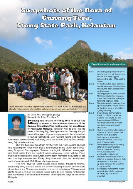
Team members included experienced botanists, Dr. Ruth Kiew, S. Kamarudin and<br />
cheerful nature-guides who doubled as heavy-duty porters and superb chefs.<br />
Photo credit Yao T.L<br />
Expedition route and campsites<br />
Day 1 The old logging track traverses<br />
the lowland and hill dipterocarp<br />
forests that were logged<br />
between the late 1970s and the<br />
1980s.<br />
Day 2 At this transition zone between<br />
the hill and upper hill dipterocarp<br />
forests, the track passes many<br />
pristine rivers.<br />
Day 3 The logging track ends at about<br />
1000 m altitude then onwards<br />
it was mostly bushwhacking or<br />
following elephant trails.<br />
Day 4 The plateau with “padang” type<br />
open vegetation, clearly visible<br />
on the topo map, is a highland<br />
Sphagnum bog.<br />
Day 5 Cobra Camp to Permatang<br />
Katak (1176 m), onward to<br />
Padang Tera (1248 m) and<br />
Begonia Camp (1299m).<br />
The ridges covered in lower<br />
montane forest are largely<br />
unexplored.<br />
Day 6 This is essentially wild elephant<br />
country; in certain places the<br />
heavily worn elephant<br />
tracks were a few metres<br />
deep and formed a maze of<br />
criss-crossing trails.<br />
Day 7 The ridge encompasses many<br />
different types of habitats.<br />
Descending from Gunung<br />
Ayam, we followed a<br />
well-trodden hiking trail.<br />
Day 8 The main tourist trails, with a<br />
side trip to ascend Gunung Kob,<br />
descended to a simple builtup<br />
base camp at the top of the<br />
Stong waterfall.<br />
Day 9 Specialized hunt for the hyper-<br />
endemic Henckelia calcarea<br />
on the rocky cliffs of the<br />
waterfall.<br />
Continue on page 6