AN EVALUATION OF STONE MARTEN (MARTES ... - ResearchGate
AN EVALUATION OF STONE MARTEN (MARTES ... - ResearchGate
AN EVALUATION OF STONE MARTEN (MARTES ... - ResearchGate

You also want an ePaper? Increase the reach of your titles
YUMPU automatically turns print PDFs into web optimized ePapers that Google loves.
202 TÓTH, M., BÁRÁNY, A. & KIS, R.<br />
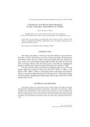
Table 1. Basic data for the evaluation of stone marten records in Budapest (1996–2008). C: Code of districts, TR: No. of topographic records included<br />
the GIS database (n = 214), AR: No. of all records between 1996–2008 (n = 303), A: Area of the districts (km2 )<br />
C 1 2 3 4 5 6 7 8 9 10 11 12 13 14 15 16 17 18 19 20 21 22 23<br />
TR 6 55 20 5 1 0 4 6 16 0 25 28 11 10 2 1 4 5 3 1 1 9 1<br />
AR 11 65 31 7 2 3 4 7 21 2 34 42 14 17 4 5 4 12 4 3 1 9 1<br />
A 3.4 36.3 39.7 18.8 2.6 2.4 2.1 6.8 12.5 32.5 33.5 26.7 13.4 18.1 26.9 33.5 54.8 38.6 9.4 12.2 25.8 34.3 40.8<br />
Acta zool. hung. 55, 2009<br />
The topographical records were marked on a map using a Geographical<br />
Information System (ArcView GIS 3.2). Following conversion<br />
from WGS-84 to EOV (Standard National Projection Grid of Hungary),<br />
the maximum coordinate error was 0.17 m. The following additional data<br />
was recorded for each report: year of sighting, district code, type of damages<br />
caused by the animals, and presence of progeny. The latest investigations<br />
have indicated that urban stone martens use relatively small home<br />
ranges of between 4 to 122 ha in size (BISSONETTE &BROEKHUIZEN 1995,<br />
ESKREYS-WÓJCIK et al. 2008, HERR et al. 2009a), depending on sex, age<br />
and density. Based on the findings it was decided to use a 25 ha square<br />
(hereafter also referred to as ‘patch’) as a possible, average “urban” home<br />
range (SZENCZI 2005, BÁRÁNY 2006, TÓTH et al. 2007a). The GPS records<br />
of stone martens were marked on a map in Google Earth and overlaid<br />
with a 500 m × 500 m (25 ha) grid. The ratio of the green areas (e.g.,<br />
gardens, parks, cemeteries, sports grounds, etc.) to built-up environment<br />
(buildings, railways, roads, etc.) within a patch was expressed as the ratio<br />
of the different coloured pixels (Adobe Photoshop CS2). Each 25<br />
ha-quadrate was characterised based on the ratio of green areas and the<br />
main type of buildings that were located within it.<br />
Two greenness categories defined as GREEN (> 50%) and<br />
DESERT (≤ 50%) on the basis of the proportion of green pixels. Based on<br />
visual analysis of Google Earth aerial photos on field work, three building<br />
categories were defined: AB = predominantly family houses with gardens;<br />
BB = predominantly multi-storey, old houses with a quadrangle, often<br />
with a circular gallery; CB = all the other built-up environments, such<br />
as modern buildings, panels (blocks of multi-storey houses), roads, railways<br />
and industrial areas.<br />
Due to the data not being normally distributed, the Spearman’s<br />
Rank correlation (Statistica 6.0) was used to assess the correlation between<br />
the density of stone marten records and greenness of patches.<br />
An evaluation was carried out of the completed online questionnaires<br />
(n = 42). Source data for this pilot project included a wide range of<br />
information regarding the stone marten’s occurrence (date, place), habitat,<br />
behaviour, potential food sources, progeny and conflict with human<br />
interest.<br />
RESULTS<br />
Over the course of the 13-year monitoring program,<br />
415 reports of stone marten presence were received. Of<br />
those, 303 topographical records contained all background<br />
data. There was an overall trend for the yearly number of records<br />
increasing over the study period (Fig. 2). Due to the<br />
observers’ request only 214 records were represented as<br />
habitat patches in the GIS database (Table 1). A further 112