VisionMap A3 - Host Ireland
VisionMap A3 - Host Ireland
VisionMap A3 - Host Ireland

You also want an ePaper? Increase the reach of your titles
YUMPU automatically turns print PDFs into web optimized ePapers that Google loves.
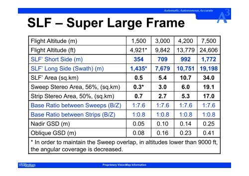
SLF – Super Large Frame<br />
Flight Altitude (m)<br />
Flight Altitude (ft)<br />
SLF’ Short Side (m)<br />
SLF’ Long Side (Swath) (m)<br />
SLF’ Area (sq.km)<br />
Sweep Stereo Area, 56%, (sq.km)<br />
Strip Stereo Area, 50%, (sq.km)<br />
Base Ratio between Sweeps (B/Z)<br />
Base Ratio between Strips (B/Z)<br />
Nadir GSD (m)<br />
Oblique GSD (m)<br />
1,500<br />
4,921*<br />
354<br />
1,435*<br />
0.5<br />
0.3*<br />
1:7.6<br />
1:0.8<br />
0.05<br />
0.08<br />
Proprietary <strong>VisionMap</strong> Information<br />
5.4<br />
1:7.6<br />
1:0.8<br />
0.10<br />
0.16<br />
10.7<br />
1:7.6<br />
1:0.8<br />
0.14<br />
0.23<br />
34.0<br />
17.0<br />
1:7.6<br />
1:0.8<br />
0.25<br />
0.41<br />
* In order to maintain the Sweep overlap, in altitudes lower than 9000 ft,<br />
the angular coverage is decreased.<br />
0.7<br />
3,000<br />
9,842<br />
709<br />
7,679<br />
3.0<br />
2.7<br />
4,200<br />
13,779<br />
992<br />
10,751<br />
6.0<br />
5.3<br />
7,500<br />
24,606<br />
1,772<br />
19,198<br />
19.1