Airborne Laser Scanning: Remote Sensing with LiDAR
Airborne Laser Scanning: Remote Sensing with LiDAR
Airborne Laser Scanning: Remote Sensing with LiDAR

Create successful ePaper yourself
Turn your PDF publications into a flip-book with our unique Google optimized e-Paper software.
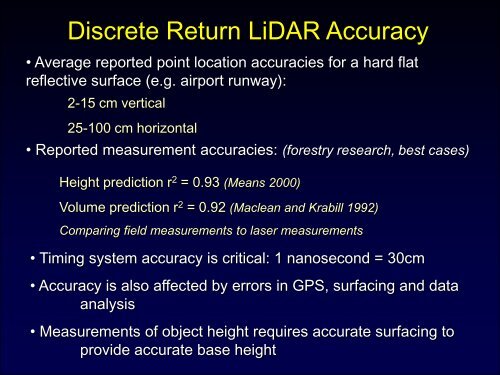
Discrete Return <strong>LiDAR</strong> Accuracy<br />
• Average reported point location accuracies for a hard flat<br />
reflective surface (e.g. airport runway):<br />
2-15 cm vertical<br />
25-100 cm horizontal<br />
• Reported measurement accuracies: (forestry research, best cases)<br />
Height prediction r 2 = 0.93 (Means 2000)<br />
Volume prediction r 2 = 0.92 (Maclean and Krabill 1992)<br />
Comparing field measurements to laser measurements<br />
• Timing system accuracy is critical: 1 nanosecond = 30cm<br />
• Accuracy is also affected by errors in GPS, surfacing and data<br />
analysis<br />
• Measurements of object height requires accurate surfacing to<br />
provide accurate base height