Land Use Policy Pastoralism within land administration ... - Land Portal
Land Use Policy Pastoralism within land administration ... - Land Portal
Land Use Policy Pastoralism within land administration ... - Land Portal

You also want an ePaper? Increase the reach of your titles
YUMPU automatically turns print PDFs into web optimized ePapers that Google loves.
582 M. Lengoiboni et al. / <strong>Land</strong> <strong>Use</strong> <strong>Policy</strong> 27 (2010) 579–588<br />
sampling method (n = 5 from 72 participants) in a non-random<br />
manner, based on factors such as location and accessibility. Information<br />
was obtained through focus groups composed of from 8 to<br />
20 men of various age groups. Besides answering the questions,<br />
the focus groups discussed seasonal migrations for the earlyyear<br />
drought (usually January–March) and the late-year drought<br />
(usually around July–September/October) and formulated general<br />
patterns of movements. The participatory mapping approach was<br />
used to record pastoralists indigenous knowledge on the timing<br />
and routes of seasonal migrations by translating the information<br />
onto a map. Indigenous knowledge is a unique, traditional local<br />
knowledge that has developed <strong>within</strong> the specific conditions of<br />
people indigenous to a particular geographical area (Grenier, 1998).<br />
To facilitate the mapping exercise for pastoralists, GIS layers with<br />
information on administrative boundaries, areas of private ranches,<br />
towns, wildlife parks, forests and roads were overlaid on a <strong>Land</strong>sat<br />
TM at 30 m resolution. This was printed on A0 size paper, on which<br />
pastoralists drew their migratory routes. The migratory route maps<br />
were later geo-referenced, digitized and visualized in GIS.<br />
For the non-pastoralist <strong>land</strong> use actors, farmers were identified<br />
using quota sampling (n = 21, from 71 farmers), and both individual<br />
and group interviews were held. The quota sampling used a<br />
non-random approach based on factors such as location and accessibility.<br />
Questionnaires were sent by email to 26 private ranchers<br />
whose contact details could be found. Of these, 6 responded (n = 6).<br />
Urban residents were identified using quota sampling in the three<br />
urban centres (n = 25, from 40 urban residents—approx. 10 interviewees<br />
per urban centre). A condition for selecting urban residents<br />
was that they practiced some form of farming, such as kitchen gardening.<br />
Both individual and group interviews were held. Individual<br />
interviews were held with wildlife park wardens (n = 4) and forest<br />
officers (n = 8).<br />
In total, this resulted in 72 completed questionnaires, of which<br />
5 were from pastoralist communities and 67 from non-pastoralists<br />
<strong>land</strong> use actors.<br />
Analysis<br />
Due to the unequal sample sizes, cross-tabulations are used to<br />
represent the frequencies of distribution of the responses from<br />
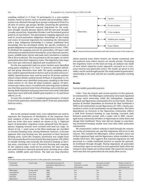
each category of <strong>land</strong> use actors. The interactions between the<br />
<strong>land</strong> use actors that were studied are shown in Fig. 2. Digitized<br />
layers of pastoralists’ migratory routes obtained from the participatory<br />
mapping sessions were overlaid with <strong>land</strong> use maps. As<br />
shown in Fig. 1, some areas in the Meru <strong>land</strong>scape are classified<br />
as livestock keeping areas. During fieldwork, however, it became<br />
apparent that crop farming was also practised in these livestock<br />
keeping areas. Given this situation, permission was sought from<br />
the Community Based Livestock Early Warning Systems (CB-LEWS)<br />
to include farming and reclassify the livestock keeping as farming<br />
areas, consisting of a mix of livestock farming and cropping.<br />
As the cadastral maps could not be accessed, the <strong>land</strong> use map<br />
was used instead to represent pastoral areas, farming areas, urban<br />
centres, wildlife parks and forests. The <strong>land</strong> use map therefore<br />
Table 1<br />
Pastoralist tenures and current practices in five pastoralist communities.<br />
Pastoralist<br />
community<br />
Tenure type Estimated proportion of<br />
population dependent on<br />
livestock<br />
Fig. 2. Interaction between pastoralists and other <strong>land</strong> use actors in the study area.<br />
shows pastoral areas where tenures are mostly communal, and<br />
non-pastoral areas where tenures are mostly private. Overlaying<br />
the migratory routes on the <strong>land</strong> use map, an analysis was made<br />
of areas where migration routes approach, encroach on or crossareas<br />
used by non-pastoralist actors. The results are given in two<br />
tables, one for each drought period. The study looked at pastoralists’<br />
relationship to the <strong>land</strong>, and did not consider pastoralist stocking<br />
rates.<br />
Results<br />
Current mobile pastoralist practices<br />
Table 1 lists the tenures and current practices in five pastoralist<br />
communities. The Mbaringon community owns <strong>land</strong> registered<br />
as group ranch ownership, while the Lodungokwe, Longopito,<br />
Namelok and Ngaremara communities live on trust <strong>land</strong>s. The proportion<br />
of families dependent on livestock for their livelihood is<br />
100% in all communities except Ngaremara (25–50%). Clearly, pastoralism<br />
is active in all communities except Ngaremara. The lower<br />
dependency on livestock in the Ngaremara community reflects<br />
a shift from livestock keeping to crop farming. Livestock raids<br />
between pastoralist groups, with a major raid in 2001, encouraged<br />
many community members in Ngaremara to settle down and<br />
change their livelihood. Those who did not change to crop farming<br />
mentioned keeping smaller herd sizes than other pastoralist<br />
communities.<br />
All communities confirm relating to <strong>land</strong> through the customary<br />
norms of communal use, and that migrations still occur in dry<br />
seasons. This includes the Mbaringon, whose members move out<br />
of their registered <strong>land</strong>, and the Ngaremara, whose members have<br />
smaller herd sizes. This suggests that seasonal migrations are still<br />
perceived as a viable traditional practice to sustain the pastoralist<br />
livelihood through drought. During migrations all pastoralist<br />
communities agree to encroach on non-pastoralist <strong>land</strong>s when the<br />
resources they require are on those <strong>land</strong>s. The reason for encroachment<br />
was that non-pastoralists do not easily allow access.<br />
Livestock<br />
migrations in both<br />
dry seasons<br />
Encroach on other<br />
peoples’ <strong>land</strong>s in<br />
droughts<br />
Mbaringon Group ranch 100% Yes Yes Yes<br />
Lodungokwe Trust <strong>land</strong> 100% Yes Yes Yes<br />
Longopito Trust <strong>land</strong> 100% Yes Yes Yes<br />
Namelok Trust <strong>land</strong> 100% Yes Yes Yes<br />
Ngaremara Trust <strong>land</strong> 25–50% Yes Yes Yes<br />
Relate to <strong>land</strong> via<br />
traditional norms of<br />
communal use