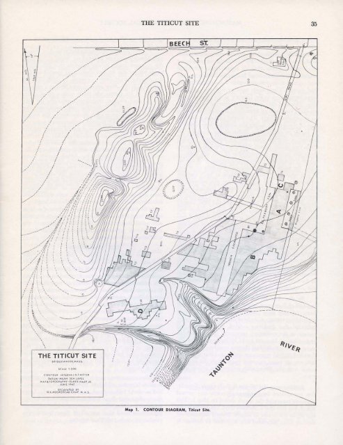
34 MASSACHUSETTS ARCHAEOLOGICAL SOCIETY THE SITE Relative to other New England sites, the area excavated at <strong>Titicut</strong> was extensive. However, it is evident from surface collecting, that less than onequarter of the area which was occupied by aboriginal people, was available to us. The remaining area was under cultivation and could not be disturbed. The western boundary of the area of occupation was at the base of the esker (Map 1), which rises to a height of approximately seven meters (22 ft.) above the eastward sloping plain which extends to the river bank. This plain, bordered by the river and Vernon Street, and extending slightly north of Beech Street, was the site of successive and probably overlapping ancient villages from Early Archaic to Historic times. The Taunton River, which at this point is the boundary between the towns of Bridgewater and Middleboro, flows a bit north of west until it meets with the northerly trending esker, where it makes a sharp bend and flows in a southerly direction. There is no indication of Indian occupation on the esker itself. The banks of the river, as it passes the site, are steep, rising some six meters (18 ft.) in less than twenty. The occupied area on the gentle easterly slope is of very low relief. Three slight depressions were evident prior to excavation along the front of, and parallel to the axis of the 'esker. Eastward of the southernmost depression a tongue of land approximately one and a half meters (5 feet) in height extends eastward. The surface is broken by two rather deep ravines extending westward from the river. The southern ravine is of natural origin, and in it, flows a small brook fed by a spring at the base of the esker. The northerly ravine appears to be an artificial one having been dug some time prior to 1812 in order to build a shipway in which several small vessels are said to have been constructed. During the more recent past, the entire area had been under cultivation. In some of the excavations, evidence of old furrows could still be noted. A peach orchard and later a strawberry bed are said to have occupied the area in which the burials were discovered. At the corner of Beech street and the entrance road to the site, an old foundation, probably the house of a previous owner, still exists (Map 1). About the shipway, nails, bits of iron, and slag, were found in the humus layer, mute evidence of this colonial industry. Aboriginal stone tools, chips, fragments of calcined bone, burned and broken stone and infrequent sherds of Indian clay vessels found in the humus throughout the occupied area were obviously redistributed by the frequent cultivation and other modern use of the land. METHODS OF EXCAVATION It was decided to start excavation along the property line at the eastern bound of the area open to us. Using an engineer's level, a north-south base line was established along which stakes were driven at two meter intervals. These stakes were lettered from A to Z in a northerly direction. Additional lines were next laid out at right angles to the base line maintaining a two meter interval. Stakes at the intersection of the north-south and east-west lines identified by a number and a letter, formed a grid composed of two meter squares bounded at each corner by an identified stake. It was arbitrarily decided that each individual square would be known by the designation of the stake at its southeastern corner. As the excavation proceeded, and it became necessary to expand the original grid, it was called Section A; the grid to its immediate south became Section B, and that to the north of Section A was called Section C (Map 1). In addition, several small exploratory areas called "Tests" were laid out from time to time. With the exception of Test 10 these were projected from the original base line and could have been absorbed into the original system. In fact several tests were incorporated into the various sections and will not be found on the map. The exception, Test 10, was laid out with a base line parallel to the south ravine and would have been designated as Section D, if the original plan had been carried out. However, as the records of features and artifacts from these Tests were credited to tests rather than to sections, I have shown both the Test numbers and Section letters on Map.l rather than alter the original record. The trench excavated by the R. S. Peabody Foundation extends from the northern bound of Section C, across the entire width of Section A, to the southern bound of Section B. A small exploratory trench also excavated by the Foundation extends westward from Section A to Test 18. The original grid system was not extended into the burial area as there were a number of large trees within that area which the owner did not wish us to disturb. Individual graves were located by a series of bearings and measurements made from stakes within the grid.
, , I ..__ 01 ---- -- I I , I , , ", ,',,,,,,, / ,,,,,,.,,- SRIDGEWATER,MI>.SS. SCALE I: 500 CONTOUR INTERVAt·O.5MElfR DATUM· MfAN SEA lEvEL MAP&TQPOGRAPHY-ElMfR HARP,JR. JUNE 19