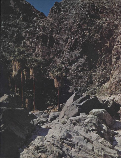
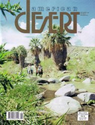
NO. 6 IN A SERIES ON CALIFORNIA PALM OASES F ROM FERN CANYON our oasis trail runs sou<strong>the</strong>asterly several miles to <strong>the</strong> sunrise side <strong>of</strong> <strong>the</strong> Santa Rosa Range. Dead Indian Creek — in reality a dry, bouldery canyon — rises between Asbestos and Haystack mountains in <strong>the</strong> Santa Rosas, pouring its occasional storm torrents into <strong>the</strong> Coachella Valley near Palm <strong>Desert</strong>. The scenic Palmsto-Pines Highway (Route 74) spans this watercourse just before beginning its twisting climb <strong>of</strong> Seven Level Hill, yet <strong>the</strong> palms — though less than a mile away — cannot be seen from <strong>the</strong> pavement, and <strong>the</strong>ir very existence is un- by DICK BLOOMQUIST suspected by most motorists. The highway bridge over Dead Indian is three and three-quarter miles south <strong>of</strong> Palm <strong>Desert</strong> at a point where <strong>the</strong> road curves left at <strong>the</strong> foot <strong>of</strong> <strong>the</strong> mountains. One-tenth <strong>of</strong> a mile fur<strong>the</strong>r on <strong>the</strong>re is a second bridge, this one over Carrizo Creek. Dos Palmas, which we shall visit on our next field trip, stands at <strong>the</strong> headwaters <strong>of</strong> Carrizo. Beyond <strong>the</strong> first bridge an unimproved dirt road branches to <strong>the</strong> right. Passenger cars should park near <strong>the</strong> start <strong>of</strong> this road or on <strong>the</strong> highway shoulder nearby, but four-wheel-drives can continue upstream for three-quarters <strong>of</strong> a mile to within a few hundred feet <strong>of</strong> <strong>the</strong> oasis. Stands <strong>of</strong> desert willow, cheesebush, smoke tree, palo verde, chuparosa, and desert lavender formerly mottled <strong>the</strong> sandy floor <strong>of</strong> lower Dead Indian Creek, but <strong>the</strong> great storm late in <strong>the</strong> summer <strong>of</strong> '76 carried away most <strong>of</strong> this growth. Half a mile up <strong>the</strong> wash <strong>the</strong> palms come into view for <strong>the</strong> first time — a tight little grove hard by a cliff on <strong>the</strong> right side <strong>of</strong> <strong>the</strong> canyon. The Jeep trail ends a short distance below <strong>the</strong> palm cluster, halted by narrowing walls and monumental boulders. A shallow tunnel, evidently a relic <strong>of</strong> early mining activity, pierces <strong>the</strong> canyon's left slope at this point. Craggy Grapevine Creek empties into Dead Indian from <strong>the</strong> left near here, also, but its many Washingtonias are difficult to reach because <strong>of</strong> <strong>the</strong> dry waterfalls near its mouth. Scenic Dead Indian Canyon. Photo by George Service, Palm <strong>Desert</strong>, California. From road's end no trail leads to <strong>the</strong> palms in Dead Indian Creek. For several hundred feet each visitor just picks his own route over and around <strong>the</strong> megaliths choking <strong>the</strong> creek bed, which in one place have created a "cave" large enough to stand upright in. The palms form a compact colony in <strong>the</strong> shadow <strong>of</strong> sheer canyon walls. I counted 17 living trees (<strong>the</strong>re were 24 a few years before <strong>the</strong> flash flood <strong>of</strong> 1976), only one <strong>of</strong> which grows apart from <strong>the</strong> cluster. Most <strong>of</strong> <strong>the</strong> older ones have charred, partially denuded trunks, yet all appear to be in good health. Water sometimes surfaces in <strong>the</strong> form <strong>of</strong> a tiny seep. In <strong>the</strong> center <strong>of</strong> <strong>the</strong> oasis <strong>the</strong>re is a delightful palm-circled "pocket" filled, at <strong>the</strong> time <strong>of</strong> my visit at least, with <strong>the</strong> music <strong>of</strong> house finches in <strong>the</strong> treetops. The tallest palms rise perhaps 35 or 40 feet. Dead Indian Creek continues beyond <strong>the</strong> grove, with more palms strung along its course, but <strong>the</strong> hiking is difficult. A Mileage Log 0.0 Junction <strong>of</strong> State Highways 111 and 74 in Palm <strong>Desert</strong>. Drive south toward Hemet on Highway 74 (<strong>the</strong> Palms-to-Pines highway). 3.7 Bridge #56-187 over Dead Indian Creek, <strong>the</strong> first <strong>of</strong> two bridges crossed just before <strong>the</strong> highway begins its ascent <strong>of</strong> <strong>the</strong> Santa Rosa Mountains. Park near here; <strong>the</strong> oasis is less than a mile to <strong>the</strong> right. Four-wheel-drives can go threequarters <strong>of</strong> a mile up <strong>the</strong> canyon on a road that begins on <strong>the</strong> far side <strong>of</strong> <strong>the</strong> bridge. Elevation at palms about 1320 feet. few feet upstream Ebbens Creek comes in from <strong>the</strong> right, its entrance blocked by a water-stained dry fall. I do not know <strong>the</strong> origin <strong>of</strong> <strong>the</strong> name "Dead Indian," but Ebbens Creek commemorates Theodore Ebbens, a burro prospector <strong>of</strong> <strong>the</strong> Santa Rosa Country around <strong>the</strong> turn <strong>of</strong> <strong>the</strong> century. Like Grapevine, this tributary contains wild palms accessible only to dedicated rock climbers. The unspoiled little oasis in lower Dead Indian Creek is easily reached by <strong>the</strong> casual hiker, however. It also provides a jumping-<strong>of</strong>f point for those who wish to explore some <strong>of</strong> <strong>the</strong> more sequestered palm groups <strong>of</strong> <strong>the</strong> Santa Rosa Mountains. • <strong>Desert</strong>/Mav 1977
J. s , -