- Page 1 and 2:
MARINE CORPS COMMON SKILLS HANDBOOK
- Page 3 and 4:
MARINE CORPS COMMON SKILLS (MCCS) H
- Page 5 and 6:
DUTY AREA 12 - CREW-SERVED WEAPONS
- Page 7 and 8:
MCCS.21.07 EVACUATE A CASUALTY 1-21
- Page 9 and 10:
a. Filling the magazine with loose
- Page 11 and 12:
(2) Place the buttstock in the shou
- Page 13 and 14:
10. Place the rifle in Condition 4.
- Page 15 and 16:
TASK: MCCS.11.02 (CORE) MAINTAIN TH
- Page 17 and 18:
d. Push the receiver pivot pin (fig
- Page 19 and 20:
j. Place the bolt assembly in the l
- Page 21 and 22:
o. Remove the extractor and spring
- Page 23 and 24:
(4) Point the muzzle down. Hold the
- Page 25 and 26:
c. Clean the following parts of the
- Page 27 and 28:
(2) Inspect the firing pin to ensur
- Page 29 and 30:
(1) Always shake the bottle well be
- Page 31 and 32:
(2) Generously lube takedown and pi
- Page 33 and 34:
. Insert the extractor and spring (
- Page 35 and 36:
f. Drop in and seat the firing pin
- Page 37 and 38:
k. Push the charging handle and the
- Page 39 and 40:
TASK: MCCS.11.03 (CORE) ENGAGE TARG
- Page 41 and 42:
h. Slide the arm up through the sli
- Page 43 and 44:
e. Position the M-buckle on the out
- Page 45 and 46:
6. Fire well aimed shots. - Apply t
- Page 47 and 48:
TASK: MCCS.11.04 (CORE) ZERO THE M1
- Page 49 and 50:
c. Windage Knob. To set the windage
- Page 51 and 52:
i. With the left hand, grasp the ha
- Page 53 and 54:
e. Position the M-buckle on the out
- Page 55 and 56:
(2) Figure 15 shows the different c
- Page 57 and 58:
(1) Sight Alignment. Sight alignmen
- Page 59 and 60:
TASK: MCCS.11.05 (CORE) ENGAGE STAT
- Page 61 and 62:
. To be proficient, a Marine riflem
- Page 63 and 64:
TASK: MCCS.11.06 (CORE) ENGAGE TARG
- Page 65 and 66:
(2) Sight Picture. Sight picture is
- Page 67 and 68:
(7) As the sights become level with
- Page 69 and 70:
(4) Rotate the rifle counterclockwi
- Page 71 and 72:
(2) Place the trigger finger straig
- Page 73 and 74:
(1) Obtaining Night Vision. There a
- Page 75 and 76:
(2) Sight Picture. Sight picture is
- Page 77 and 78:
(5) As the sights become level with
- Page 79 and 80:
(4) Rotate the rifle counterclockwi
- Page 81 and 82:
c. The Marine moves only as fast as
- Page 83 and 84:
d. Remove the headgear and place it
- Page 85 and 86:
(5) Make sure that straps lie flat
- Page 87 and 88:
h. Check the sights to ensure prope
- Page 89 and 90:
(2) Simultaneously, place the rifle
- Page 91 and 92:
(4) Continue pulling the rifle forw
- Page 93 and 94:
8. Assume the “ready.” a. Ready
- Page 95 and 96:
TASK: MCCS.11.09 (CORE) ENGAGE MULT
- Page 97 and 98:
(2) Sight Picture. Sight picture is
- Page 99 and 100:
(7) As the sights become level with
- Page 101 and 102:
(5) Continue extending the rifle to
- Page 103 and 104:
(2) Place the buttstock in the shou
- Page 105 and 106:
TASK: MCCS.11.10 (CORE) ENGAGE MOVI
- Page 107 and 108:
(2) Sight Picture. Sight picture is
- Page 109 and 110:
(4) Level the rifle while pulling i
- Page 111 and 112:
(5) Continue extending the rifle to
- Page 113 and 114:
(f) Continue to track in case a sec
- Page 115 and 116:
(1) Place the left hand on the hand
- Page 117 and 118:
TASK: MCCS.11.11 (CORE) ENGAGE MOVI
- Page 119 and 120:
(2) Sight Picture. Sight picture is
- Page 121 and 122:
(c) At 400 yards/meters, the body o
- Page 123 and 124:
(6) Level the rifle while pulling i
- Page 125 and 126:
(4) Rotate the rifle counterclockwi
- Page 127 and 128:
(2) The Marine places the trigger f
- Page 129 and 130:
e. Pull the barrel to the rear unti
- Page 131 and 132:
. Kneeling position. (1) Kneel on y
- Page 133 and 134:
11. Apply remedial action. a. Remed
- Page 135 and 136:
3. Clear the M203 grenade launcher.
- Page 137 and 138:
d. Press the barrel stop to release
- Page 139 and 140:
g. Observe the weapon for component
- Page 141 and 142:
9. Perform the function check. WARN
- Page 143 and 144:
TASK: MCCS.11.14 (CORE) ZERO THE M2
- Page 145 and 146:
(e) Lower into position by dropping
- Page 147 and 148:
- Apply the fundamentals of marksma
- Page 149 and 150:
TASK: MCCS.11.15 (CORE) ENGAGE TARG
- Page 151 and 152:
(d) Spread feet approximately shoul
- Page 153 and 154:
c. Aim and squeeze the trigger to f
- Page 155 and 156:
5. Execute the six firing commands.
- Page 157 and 158:
(2) Execute UNLOAD using the magazi
- Page 159 and 160:
d. Hot Weapon Procedures. If the st
- Page 161 and 162:
(h) Take the weapon off SAFE. (i) W
- Page 163 and 164:
d. Pull the cocking handle rearward
- Page 165 and 166:
i. Push the handguard retaining pin
- Page 167 and 168:
n. Remove the trigger mechanism rea
- Page 169 and 170:
c. Clean and check bipod legs for o
- Page 171 and 172:
i. Clean the three grooves on the p
- Page 173 and 174:
f. Check the slide assembly, bolt a
- Page 175 and 176:
c. Position the recess in the cylin
- Page 177 and 178:
Figure 36 h. Depress the locking le
- Page 179 and 180:
NOTE: Ensure that the headed end of
- Page 181 and 182:
TASK: MCCS.11.18 (CORE) ZERO THE M2
- Page 183 and 184:
3. Assume the bipod firing position
- Page 185 and 186:
(1) To move the group to the right,
- Page 187 and 188:
(2) Clear the weapon using the maga
- Page 189 and 190:
Figure 2 b. Windage. Adjustments fo
- Page 191 and 192:
f. Adjusted Aiming Point Method. In
- Page 193 and 194:
TASK: MCCS.12.01 (CORE) IDENTIFY TH
- Page 195 and 196:
(2) Ammunition: Caliber 50 caliber
- Page 197 and 198:
c. MK19 40MM heavy machinegun chara
- Page 199 and 200:
4. Search field of view using the s
- Page 201 and 202:
TASK: MCCS.13.02 (CORE) IDENTIFY TY
- Page 203 and 204:
- Characteristics of the RPK 74 5.4
- Page 205 and 206:
Figure 7 - Characteristics of rocke
- Page 207 and 208:
TASK: MCCS.13.03 (CORE) REPORT INFO
- Page 209 and 210:
3. Prepare a panoramic sketch. - Th
- Page 211 and 212:
TASK: MCCS.13.04 (CORE) PREPARE FOR
- Page 213 and 214:
4. Eliminate unnecessary equipment
- Page 215 and 216:
TASK: MCCS 13.05 (CORE) PASS THROUG
- Page 217 and 218:
4. Travel though the gaps or lanes
- Page 219 and 220:
(3) Be easily recognized and known
- Page 221 and 222:
(4) Listen. (5) Maintain contact wi
- Page 223 and 224:
(2) The patrol leader initiates the
- Page 225 and 226:
6. Demonstrate “Cease fire” as
- Page 227 and 228:
16. Demonstrate “Fireteam” as d
- Page 229 and 230:
28.Demonstrate “Disregard” as d
- Page 231 and 232:
TASK: MCCS.14.02 (CORE) EXECUTE IND
- Page 233 and 234:
3. Demonstrate squad Vee. - When th
- Page 235 and 236:
5. Demonstrate squad echelon. - The
- Page 237 and 238:
Figure 3 Figure 4 Figure 5 Figure 6
- Page 239 and 240:
Figure 11 Figure 12 Figure 13 Figur
- Page 241 and 242:
Figure 19 Figure 20 Figure 21 1-14-
- Page 243 and 244:
(c) Speed is not essential. (2) To
- Page 245 and 246:
(4) Expose nothing that reflects li
- Page 247 and 248:
(a) Grazing fires. Grazing fires do
- Page 249 and 250:
2. Emplace direction, deflection, r
- Page 251 and 252:
7. Prepare elbow rest. - Leave enou
- Page 253 and 254:
TASK: MCCS.15.02 (CORE) PREPARE A F
- Page 255 and 256:
(6) Assistant Automatic Rifleman. -
- Page 257 and 258:
4. Depict Magnetic North. a. The ma
- Page 259 and 260:
Figure 8 9. Depict primary, alterna
- Page 261 and 262:
TASK: MCCS.15.03 (CORE) DEFEND A PO
- Page 263 and 264:
(2) Direction. The direction elemen
- Page 265 and 266:
6. Repel the enemy assault. a. If t
- Page 267 and 268:
3. Estimate the range to the target
- Page 269 and 270:
TASK: MCCS.16.02 (CORE) ENGAGE TARG
- Page 271 and 272:
k. Place the launcher on your right
- Page 273 and 274:
3. Estimate range to target. a. The
- Page 275 and 276:
. The squad leader issues the follo
- Page 277 and 278:
TASK: MCCS.16.03 (CORE) EMPLOY THE
- Page 279 and 280:
j. Return the bail to the SAFE posi
- Page 281 and 282:
NOTE: The groove of the sight shoul
- Page 283 and 284:
REERENCE(S): FM 23-23, Antipersonne
- Page 285 and 286:
2. Arm the pyrotechnic. - Please re
- Page 287 and 288:
TASK: MCCS.17.01 (CORE) MARCH UNDER
- Page 289 and 290:
(1) Time-Distance Relationship: Rel
- Page 291 and 292:
NOTE: A time distance table is a va
- Page 293 and 294:
2. Complete a 10-kilometer march. -
- Page 295 and 296:
(2) Clean the flak jacket. (a) Brus
- Page 297 and 298:
NOTE: Ensure the slide keepers are
- Page 299 and 300:
(b) Make the headband larger than y
- Page 301 and 302:
TASK: MCCS.17.03 (CORE) CAMOUFLAGE
- Page 303 and 304:
2. Camouflage the helmet. a. Insert
- Page 305 and 306:
. Snap the two halves together usin
- Page 307 and 308:
(2) Reposition both poles to ensure
- Page 309 and 310: 4. Erect a poncho tent. NOTE: To ma
- Page 311 and 312: . Use iodine tables. (1) Remove the
- Page 313 and 314: d. Use dental floss or toothpicks t
- Page 315 and 316: TASK: MCCS.17.06 (CORE) PERFORM IND
- Page 317 and 318: 6. Perform the creeping technique.
- Page 319 and 320: (d) The final position will expose
- Page 321 and 322: 6. Cross a danger area. a. Open are
- Page 323 and 324: (4) Date of birth (5) Date of captu
- Page 325 and 326: c. Take advantage of your available
- Page 327 and 328: (d) The thumb loop is attached to t
- Page 329 and 330: 1-18-4 Figure 1 (c) Turn the bezel
- Page 331 and 332: 4. Perform a deliberate offset, as
- Page 333 and 334: . Bar scale. These are located in t
- Page 335 and 336: c. Valley. A valley is a stretched
- Page 337 and 338: h. Cliff. A cliff is a vertical or
- Page 339 and 340: . Grid coordinate scales. The prima
- Page 341 and 342: . Locate points within a grid squar
- Page 343 and 344: (7) By combining the RIGHT reading
- Page 345 and 346: . Back Azimuth. A back azimuth is t
- Page 347 and 348: d. Application. Remember that there
- Page 349 and 350: (e) If the magnetic north is to the
- Page 351 and 352: (c) If the declination is westerly
- Page 353 and 354: 2. Perform basic map reading. a. Th
- Page 355 and 356: (c) Keep the horizontal line of the
- Page 357 and 358: Figure 8 (c) Slide the protractor t
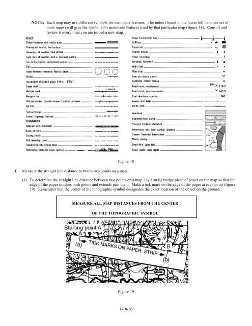
- Page 359: Figure 13 NOTE: Look at point (A) o
- Page 363 and 364: (4) You know that from point (b) to
- Page 365 and 366: 3. Follow an azimuth using the cent
- Page 367 and 368: (2) Bypassing an unexpected obstacl
- Page 369 and 370: 1. Install batteries as appropriate
- Page 371 and 372: . To communicate a message using a
- Page 373 and 374: (4) Observe the battery life condit
- Page 375 and 376: d. Establish a communication check.
- Page 377 and 378: PROBLEM POSSIBILITY ACTION SIG mark
- Page 379 and 380: d. Encrypt and transmit a plain tex
- Page 381 and 382: 11. Use phonetic alphabet and numer
- Page 383 and 384: PROCEDURAL WORD MEANING RADIO CHECK
- Page 385 and 386: TASK: MCCS.20.01 (CORE) IDENTIFY NA
- Page 387 and 388: 4. Identify the sign for chemical m
- Page 389 and 390: TASK: MCCS.20.02 (CORE) MAINTAIN TH
- Page 391 and 392: (2) Starting with either eyelens, s
- Page 393 and 394: . Remove eyelens outserts (figure 7
- Page 395 and 396: d. Check the facepiece assembly (fi
- Page 397 and 398: (4) Check the drinking system to en
- Page 399 and 400: . Inspect the voicemitters (figure
- Page 401 and 402: (5) If, after removing facepiece, y
- Page 403 and 404: TASK: MCCS.20.03 (CORE) DON THE M40
- Page 405 and 406: (1) Open the carrier with your left
- Page 407 and 408: CAUTION: The mask must be donned, c
- Page 409 and 410: 6. Stow the mask with hood. a. Chec
- Page 411 and 412:
e. Remove the mask from its carrier
- Page 413 and 414:
(3) Run your finger around the edge
- Page 415 and 416:
3. Don the overboots. NOTE: There a
- Page 417 and 418:
e. Push the quick disconnect couple
- Page 419 and 420:
3. Change filter canister on order.
- Page 421 and 422:
TASK: MCCS.20.06 (CORE) PERFORM NBC
- Page 423 and 424:
(1) Ready the kit. (a) Put the shou
- Page 425 and 426:
(4) Mark the lewisite-rubbing tab.
- Page 427 and 428:
Figure 12 WARNING: Avoid hot vapors
- Page 429 and 430:
(19) Rerub the lewisite-detecting t
- Page 431 and 432:
TASK: MCCS.20.07 (CORE) DECONTAMINA
- Page 433 and 434:
(b) Remove your helmet. Figure 2 (c
- Page 435 and 436:
(10) Scrub up and down across your
- Page 437 and 438:
(17) If liquid contamination is sti
- Page 439 and 440:
PERFORMANCE STEPS: 1. Decontaminate
- Page 441 and 442:
(4) The boot nearest the jacket wil
- Page 443 and 444:
TASK: MCCS.20.09 (CORE) REACT TO A
- Page 445 and 446:
Figure 2 d. Once in your fighting h
- Page 447 and 448:
TASK: MCCS.20.10 (CORE) REACT TO A
- Page 449 and 450:
i. Adjust the M40 mask. (1) Grasp t
- Page 451 and 452:
c. Remain in this position until al
- Page 453 and 454:
2. Treating a nerve agent casualty.
- Page 455 and 456:
(13) Grasp the tab as shown in figu
- Page 457 and 458:
Figure 7 (3) With your free hand, c
- Page 459 and 460:
j. Secure used injectors. (1) Push
- Page 461 and 462:
(7) Reddening of the skin (8) Immed
- Page 463 and 464:
TASK: MCCS.20.12 (CORE) COMPLY WITH
- Page 465 and 466:
(3) Feel chest for signs of breathi
- Page 467 and 468:
Figure 6 CAUTION: The jaw-thrust te
- Page 469 and 470:
4. After giving four quick breaths
- Page 471 and 472:
2. Stop the bleeding. a. Check the
- Page 473 and 474:
(2) Use a tourniquet. CAUTION: The
- Page 475 and 476:
Do Don’t Act promptly but calmly.
- Page 477 and 478:
5. Seek medical aid, as required. a
- Page 479 and 480:
(e) Check for wet appearance on the
- Page 481 and 482:
TASK: MCCS.21.03 (CORE) APPLY A PRE
- Page 483 and 484:
TASK: MCCS.21.04 (CORE) APPLY A SPL
- Page 485 and 486:
(2) If it is an open fracture, stop
- Page 487 and 488:
f. Check for burns. (1) Look carefu
- Page 489 and 490:
4. Mark the casualty with the lette
- Page 491 and 492:
urticating caterpillars, bees, wasp
- Page 493 and 494:
TASK: MCCS.21.07 (CORE) EVACUATE A
- Page 495 and 496:
(4) Continue to move backward, thus
- Page 497 and 498:
3. Perform the alternate fireman’
- Page 499 and 500:
7. Perform the pack strap carry. a.
- Page 501 and 502:
Figure 16 h. Place one hand on your
- Page 503 and 504:
(2) Pass the poles through the slee
- Page 505 and 506:
2. Identify symptoms of climatic in
- Page 507 and 508:
TASK: MCCS .22.01 (CORE) MAINTAIN P
- Page 509 and 510:
(c) Procedures for determining perc
- Page 511 and 512:
Point System. The table below will
- Page 513 and 514:
. Take the bent-knee crunch test (i
- Page 515 and 516:
Point System. The table below will
- Page 517 and 518:
. Take the bent-knee crunch test (i
- Page 519 and 520:
TASK: MCCS.23.01 (CORE) APPLY THE F
- Page 521 and 522:
TASK: MCCS.23.02 (CORE) EXECUTE PUN
- Page 523 and 524:
4. Execute a hook . a. Assume the b
- Page 525 and 526:
TASK: MCCS.23.03 (CORE) EXECUTE FAL
- Page 527 and 528:
3. Execute a right side break-fall.
- Page 529 and 530:
5. Execute a forward shoulder roll.
- Page 531 and 532:
TASK: MCCS.23.04 (CORE) EXECUTE BAY
- Page 533 and 534:
4. Execute a smash. a. Begin with y
- Page 535 and 536:
TASK: MCCS.23.05 (CORE) EXECUTE PUG
- Page 537 and 538:
3. Execute a smash. a. Begin with y
- Page 539 and 540:
d. To execute a low block against a
- Page 541 and 542:
TASK: MCCS.23.06 (CORE) EXECUTE UPP
- Page 543 and 544:
3. Execute a forward elbow strike.
- Page 545 and 546:
5. Execute an eye gouge. a. Extend
- Page 547 and 548:
2. Execute a front kick. a. Raise y
- Page 549 and 550:
TASK: MCCS.23.08 (CORE) EXECUTE CHO
- Page 551 and 552:
TASK: MCCS.23.09 (CORE) EXECUTE THR
- Page 553 and 554:
2. Execute a turning throw. a. Stan
- Page 555 and 556:
TASK: MCCS.23.10 (CORE) EXECUTE COU
- Page 557 and 558:
TASK: MCCS.23.11 (CORE) EXECUTE COU
- Page 559 and 560:
. With your left arm, reach over th
- Page 561 and 562:
c. Grabbing you opponent’s pants
- Page 563 and 564:
2. Execute a reverse wristlock. a.
- Page 565 and 566:
d. Applying downward pressure on th
- Page 567 and 568:
2. Execute a counter to underhand g
- Page 569 and 570:
. Slash downward with the muzzle to
- Page 571 and 572:
2. Execute a vertical thrust. a. Fa
- Page 573 and 574:
(2) Tent Pole and Pins. Tent poles
- Page 575 and 576:
TASK: MCCS.23.16 (CORE) EXPLAIN THE
- Page 577 and 578:
(c) Take a deep breath and bend for
- Page 579 and 580:
4. Button or zip the fly closed. 5.
- Page 581 and 582:
4. Drop 2 feet below the water's su
- Page 583 and 584:
5. Survive with a pack. a. You may