Luminescence chronologies for coastal and marine sediments
Luminescence chronologies for coastal and marine sediments
Luminescence chronologies for coastal and marine sediments

Create successful ePaper yourself
Turn your PDF publications into a flip-book with our unique Google optimized e-Paper software.
BOREAS <strong>Luminescence</strong> <strong>chronologies</strong> <strong>for</strong> <strong>coastal</strong> <strong>and</strong> <strong>marine</strong> <strong>sediments</strong> 517<br />
2007) <strong>and</strong> MIS 6 at 160 kyr <strong>and</strong> 175–180 kyr. As a<br />
first pass comparison with the mean global sea-level<br />
curve of Waelbroeck et al. (2002), it is interesting to<br />
note that many of these dune pulses are associated with<br />
smaller-scale fluctuations in relative sea level. The continental<br />
shelf around the southern Cape coast is gently<br />
sloping <strong>and</strong> shallow, so any changes in sea level, wind<br />
direction <strong>and</strong> increased windiness may result in massive<br />
entrainment of large quantities of s<strong>and</strong>, resulting in<br />
dune <strong>for</strong>mation.<br />
The southern Cape coast of South Africa is also an<br />
important region archaeologically, where cave deposits<br />
dated using luminescence dating techniques, contain<br />
evidence of the presence of Homo sapiens (e.g. Feathers<br />
& Bush 2000; Feathers 2002) <strong>and</strong> their ability to behave<br />
in a symbolic fashion (e.g. Henshilwood et al. 2002,<br />
2004; Jacobs et al. 2006; Tribolo et al. 2006; Marean<br />
et al. 2007). The presence of Homo sapiens <strong>and</strong> other<br />
animals, such as elephants, is also known from footprints<br />
preserved in some of the aeolianite units (Roberts<br />
& Berger 1997; Roberts et al. 2008; Jacobs & Roberts in<br />
press). Underst<strong>and</strong>ing the interplay between dune <strong>for</strong>mation,<br />
fluctuating sea levels <strong>and</strong> human populations<br />
living in the <strong>coastal</strong> environment provides insights into<br />
when these cave sites would have been occupied <strong>and</strong><br />
why archaeological materials have been preserved. For<br />
example, at both Blombos Cave <strong>and</strong> Pinnacle Point<br />
Cave 13B, dunes sealed the caves at different times <strong>for</strong><br />
considerable durations (many tens of thous<strong>and</strong>s of<br />
years), making the sites unavailable as living spaces <strong>for</strong><br />
humans (Jacobs et al. 2003a, b; Marean et al. 2007).<br />
This, to some extent, explains the considerable occupational<br />
hiatuses that can be observed in the archaeological<br />
record <strong>and</strong>, at the same time, provides reasons<br />
<strong>for</strong> its good preservation.<br />
Australia<br />
The vast majority of luminescence studies that involve<br />
Australian <strong>coastal</strong> <strong>and</strong> <strong>marine</strong> <strong>sediments</strong> have used TL<br />
dating to derive the <strong>chronologies</strong>. There are 33 TL studies<br />
(see Table 1), 1 IRSL (Huntley et al. 1993b) <strong>and</strong> 10<br />
OSL studies (e.g. Huntley et al. 1985b, 1994b, 1996;<br />
Yoshida et al. 2000; Murray-Wallace et al. 2002a; Olley<br />
et al. 2004a, b; Brooke et al. 2006; Switzer et al. 2006;<br />
Bostock et al. 2007). These studies primarily address<br />
two broad themes: Pleistocene <strong>and</strong> Holocene dune <strong>for</strong>mation<br />
<strong>and</strong> their relation to glacial–interglacial cycles,<br />
<strong>and</strong> the timing <strong>and</strong> frequency of tsunami events.<br />
The geographic area that has received most attention<br />
with regard to investigation of the broader chronological<br />
history of Pleistocene <strong>and</strong> Holocene dune <strong>for</strong>mation<br />
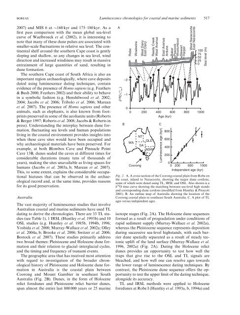
in Australia is the <strong>coastal</strong> plain between<br />
Coorong <strong>and</strong> Mount Gambier in southeast South<br />
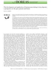
Australia (Fig. 2B). Dunes, in the <strong>for</strong>m of Holocene<br />
relict <strong>for</strong>edunes <strong>and</strong> Pleistocene relict barrier dunes,<br />
span almost the entire last 800 000 years or 25 <strong>marine</strong><br />
A<br />
δ 18 O ( )<br />
B<br />
–2<br />
–1<br />
0<br />
Robe<br />
Woakwine<br />
West Dairy<br />
East Dairy<br />
Reedy Creek<br />
West Avenue<br />
East Avenue<br />
Ardune<br />
Baker<br />
Peacock<br />
Woolumbool<br />
Stewart<br />
Harper<br />
West Naracoorte<br />
East Naracoorte<br />
100<br />
75<br />
50<br />
25<br />
0<br />
0 200 400 600 800 1000<br />
Age (kyr)<br />
WA<br />
NT<br />
Coorong<br />
SA<br />
QLD<br />
NSW<br />
V<br />
C<br />
<strong>Luminescence</strong> age (kyr)<br />
800<br />
600<br />
400<br />
200<br />
isotope stages (Fig. 2A). The Holocene dune sequences<br />
<strong>for</strong>med as a result of progradation under conditions of<br />
rapid sediment supply (Murray-Wallace et al. 2002a),<br />
whereas the Pleistocene sequence represents deposition<br />
during successive sea-level highst<strong>and</strong>s, with each barrier<br />
dune spatially separated as a result of steady tectonic<br />
uplift of the l<strong>and</strong> surface (Murray-Wallace et al.<br />
1996, 2002a) (Fig. 2A). Dating the Holocene relict<br />
dunes provides an opportunity to test how well the<br />
traps that give rise to the OSL <strong>and</strong> TL signals are<br />
bleached, <strong>and</strong> how well one can resolve ages towards<br />
the lower range of luminescence dating techniques. By<br />
contrast, the Pleistocene dune sequence offers the opportunity<br />
to test the upper limit of the dating technique,<br />
alongside its accuracy.<br />
TL <strong>and</strong> IRSL methods were applied to Holocene<br />
<strong>for</strong>edunes at Robe I (Huntley et al. 1993a, b, 1994a) <strong>and</strong><br />
Sea level (m)<br />
0<br />
0 200 600 1000<br />
Independent age (kyr)<br />
Fig. 2. A. A cross-section of the Coorong <strong>coastal</strong> plain from Robe on<br />
the coast, inl<strong>and</strong> to Naracoorte, showing the major dune cordons,<br />
some of which were dated using TL, IRSL <strong>and</strong> OSL. Also shown is a<br />
d 18 O time curve showing the matching between sea-level high st<strong>and</strong>s<br />
<strong>and</strong> corresponding dune cordons (modified from Huntley & Prescott<br />
2001). B. An outline map of Australia showing the location of the<br />
Coorong <strong>coastal</strong> plain in southeast South Australia. C. A plot of TL<br />
ages versus independent ages.