Guadalupe Generating Station Final Cultural Resourse Report - US ...
Guadalupe Generating Station Final Cultural Resourse Report - US ...
Guadalupe Generating Station Final Cultural Resourse Report - US ...
You also want an ePaper? Increase the reach of your titles
YUMPU automatically turns print PDFs into web optimized ePapers that Google loves.
Proposed <strong>Guadalupe</strong> <strong>Generating</strong> <strong>Station</strong><br />
Expansion Project, Marion, <strong>Guadalupe</strong> County, Texas<br />
2.0 ENVIRONMENTAL SETTING<br />
2.1 PHYSIOGRAPHY AND HYDROLOGY<br />
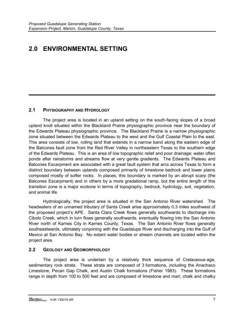
The project area is located in an upland setting on the south-facing slopes of a broad<br />
upland knoll situated within the Blackland Prairie physiographic province near the boundary of<br />
the Edwards Plateau physiographic province. The Blackland Prairie is a narrow physiographic<br />
zone situated between the Edwards Plateau to the west and the Gulf Coastal Plain to the east.<br />
This area consists of low, rolling land that extends in a narrow band along the eastern edge of<br />
the Balcones fault zone from the Red River Valley in northeastern Texas to the southern edge<br />
of the Edwards Plateau. This is an area of low topographic relief and poor drainage; water often<br />
ponds after rainstorms and streams flow at very gentle gradients. The Edwards Plateau and<br />
Balcones Escarpment are associated with a great fault system that arcs across Texas to form a<br />
distinct boundary between uplands composed primarily of limestone bedrock and lower plains<br />
composed mostly of softer rocks. In places, this boundary is marked by an abrupt scarp (the<br />
Balcones Escarpment) and in others by a more gradational ramp, but the entire length of this<br />
transition zone is a major ecotone in terms of topography, bedrock, hydrology, soil, vegetation,<br />
and animal life.<br />
Hydrologically, the project area is situated in the San Antonio River watershed. The<br />
headwaters of an unnamed tributary of Santa Creek arise approximately 0.3 miles southwest of<br />
the proposed project’s APE. Santa Clara Creek flows generally southwards to discharge into<br />
Cibolo Creek, which in turn flows generally southwards, eventually flowing into the San Antonio<br />
River north of Karnes City in Karnes County, Texas. The San Antonio River flows generally<br />
southeastwards, ultimately conjoining with the <strong>Guadalupe</strong> River and discharging into the Gulf of<br />
Mexico at San Antonio Bay. No extant water bodies or stream channels are located within the<br />
project area.<br />
2.2 GEOLOGY AND GEOMORPHOLOGY<br />
The project area is underlain by a relatively thick sequence of Cretaceous-age,<br />
sedimentary rock strata. These strata are composed of 3 formations, including the Anachaco<br />
Limestone, Pecan Gap Chalk, and Austin Chalk formations (Fisher 1983). These formations<br />
range in depth from 100 to 500 feet and are composed of limestone and marl, chalk and chalky<br />
HJN 130016 AR 7


