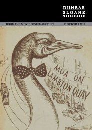
DAY 2 • TUES 20 Nov • 5 pm - Dunbar Sloane
DAY 2 • TUES 20 Nov • 5 pm - Dunbar Sloane
DAY 2 • TUES 20 Nov • 5 pm - Dunbar Sloane

You also want an ePaper? Increase the reach of your titles
YUMPU automatically turns print PDFs into web optimized ePapers that Google loves.
MAPS<br />
574 ‘The Road from London<br />
to Dover’ Strip Map<br />
By John Ogilby. From the Brittania series.<br />
Originally published in 1675.<br />
33 x 44.5cm.<br />
Est. $500–800<br />
575 ‘The Countye Palatine of<br />
Chester with that most<br />
ancient citie described’<br />
With arms of the Earles of Chestersine,<br />
the Norman’s conquest. Hand coloured.<br />
‘Sold by Thomas Bassett in Fleet Street.’<br />
40 x 52cm.<br />
Est. $400–600<br />
576 ‘Principaute de Galles’<br />
By Sanson 1658. ‘…ou sont les<br />
Comtes, ou Shiries de Anglesey,<br />
I Carnavan, Denbigh, Flint…’ Par<br />
Sanson d’Abbeyville.<br />
Fully hand coloured.<br />
37 x 44cm.<br />
Est. $850–1000<br />
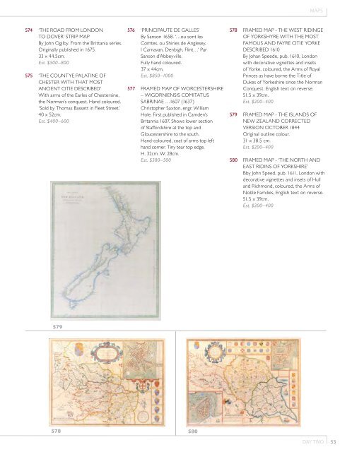
577 Framed Map of Worcestershire<br />
– Wigorniensis Comitatus<br />
Sabrinae …1607 (1637)<br />
Christopher Saxton, engr. William<br />
Hole. First published in Camden’s<br />
Britannia 1607. Shows lower section<br />
of Staffordshire at the top and<br />
Gloucestershire to the south.<br />
Hand-coloured, coat of arms top left<br />
hand corner. Tiny tear top edge.<br />
H. 32cm. W. 28cm.<br />
Est. $380–500<br />
578 Framed Map - The West Ridinge<br />
of Yorkshyre with the most<br />
famous and fayre Citie Yorke<br />
described 1610<br />
By Johan Speede, pub. 1610, London<br />
with decorative vignettes and insets<br />
of Yorke, coloured, the Arms of Royal<br />
Princes as have borne the Title of<br />
Dukes of Yorkeshire since the Norman<br />
Conquest. English text on reverse.<br />
51.5 x 39cm.<br />
Est. $<strong>20</strong>0–400<br />
579 Framed Map - The Islands of<br />
New Zealand corrected<br />
version October 1844<br />
Original outline colour.<br />
31 x 38.5 cm.<br />
Est. $<strong>20</strong>0–400<br />
580 Framed Map - ‘The North and<br />
East Ridins of Yorkshire’<br />
Bby John Speed, pub. 1611, London with<br />
decorative vignettes and insets of Hull<br />
and Richmond, coloured, the Arms of<br />
Noble Families, English text on reverse.<br />
51.5 x 39cm.<br />
Est. $<strong>20</strong>0–400<br />
579<br />
578<br />
580<br />
<strong>DAY</strong> TWO<br />
53