

Bantry Bay (Garigal National Park) - Department of Environment and ...
Bantry Bay (Garigal National Park) - Department of Environment and ...
Bantry Bay (Garigal National Park) - Department of Environment and ...

You also want an ePaper? Increase the reach of your titles
YUMPU automatically turns print PDFs into web optimized ePapers that Google loves.
BANTRY BAY CONSERVATION MANAGEMENT PLAN<br />
DRAFT<br />
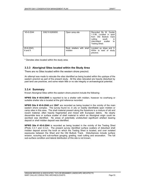
*45-6-2044 336210 6260650 Open camp site Recorded By M. Guider<br />
1.3.90. Located in spoil<br />
from Old Bullock track<br />
cutting south in<br />
intermittent scatter to<br />
Testing Shed.<br />
45-6-2043,<br />
8 <strong>and</strong> 9<br />
Rock shelters with shell<br />
midden<br />
Located up slope <strong>and</strong> 3-<br />
400m to east <strong>of</strong> study<br />
precinct.<br />
* Denotes sites located within the study area.<br />
3.3.3 Aboriginal Sites located within the Study Area<br />
There are no Sites located within the western shore precinct.<br />
An attempt was made to relocate the sites identified as being located within the upslope <strong>of</strong> the<br />
eastern precinct as part <strong>of</strong> the present study. All the sites relocated are heavily disturbed by<br />
past l<strong>and</strong> use practices, <strong>and</strong> some retain little or no site integrity or archaeological potential.<br />
3.3.4 Summary<br />
Known Aboriginal Sites within the eastern shore precinct include the following:<br />
NPWS Site # 45-6-2045 is reported to be a shelter with midden, however no overhang or<br />
suitable shelter site is located at the grid reference recorded.<br />
NPWS Site # 45-6-2046 <strong>and</strong> 2047 are recorded as being located in the vicinity <strong>of</strong> the main<br />
eastern shore complex. The survey found no in situ or readily identifiable open midden or<br />
camp sites in this area. The shell material present along the foreshore is a mixture <strong>of</strong> old <strong>and</strong><br />
recent material, <strong>of</strong>ten heavily fragmented <strong>and</strong> mixed with European debris. No clearly<br />
discernible lens or surface scatter <strong>of</strong> shell material to which an Aboriginal origin could be<br />
ascribed was identified. No areas <strong>of</strong> potentially undisturbed significant artefact bearing<br />
deposit or shell midden deposit was identified.<br />
NPWS Site # 45-6-2044 is recorded as being located in the vicinity <strong>of</strong> the Testing Shed<br />
(Photo 3.3.1 <strong>and</strong> 3.3.2). The present survey identified surface scatters <strong>of</strong> disturbed shell<br />
midden deposit across the knoll on which the Testing Shed is located, <strong>and</strong> over isolated<br />
exposures between the Shed <strong>and</strong> the Old Bullock Track. Disturbances include surface<br />
erosion, scouring <strong>and</strong> sub-surface gouging, grading, road cutting <strong>and</strong> excavation. The full<br />
sub-surface condition <strong>and</strong> lateral distribution <strong>of</strong> this site is not known.<br />
GRAHAM BROOKS & ASSOCIATES, TAYLOR BRAMMER LANDSCAPE ARCHITECTS<br />
MARY DALLAS CONSULTING ARCHAEOLOGISTS Page 53


