

Download the 2006 Annual Report - IRIS
Download the 2006 Annual Report - IRIS
Download the 2006 Annual Report - IRIS

You also want an ePaper? Increase the reach of your titles
YUMPU automatically turns print PDFs into web optimized ePapers that Google loves.
Installing <strong>the</strong> EarthScope Reference Network Seismic Stations<br />
John S. Derr, Kyle E. Persefield, Stephen C. Roberts, Jared D. Anderson, Alena L. Leeds, Douglas G. Ford, Gary S. Gyure, Charles R. Hutt, Lind<br />
S. Gee, Kent R. Anderson<br />
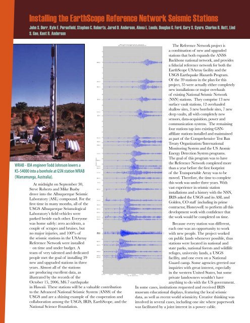
WRAB - IDA engineer Todd Johnson lowers a<br />
KS-54000 into a borehole at GSN station WRAB<br />
(Warramunga, Australia).<br />
At midnight on September 30,<br />
Steve Roberts and Mike Busby<br />
drove into <strong>the</strong> Albuquerque Seismic<br />
Laboratory (ASL) compound. For <strong>the</strong><br />
first time in many months, all of <strong>the</strong><br />
USGS Albuquerque Seismological<br />
Laboratory’s field vehicles were<br />
parked beside each o<strong>the</strong>r. Everyone<br />
was home safely: zero accidents, a<br />
couple of scrapes and bruises, but<br />
no major injuries, and 100% of<br />
<strong>the</strong> seismic stations in <strong>the</strong> USArray<br />
Reference Network were installed<br />
– on time and under budget. A<br />
team of very talented and dedicated<br />
people met <strong>the</strong> goal of installing 39<br />
new and upgraded stations in three<br />
years. Almost all of <strong>the</strong> stations<br />
are producing excellent data, as<br />
illustrated by <strong>the</strong> records of <strong>the</strong><br />
October 15, <strong>2006</strong>, M6.7 earthquake<br />
in Hawaii. These stations will be a valuable contribution<br />
to <strong>the</strong> Advanced National Seismic System (ANSS) of <strong>the</strong><br />
USGS and are a shining example of <strong>the</strong> cooperation and<br />
collaboration among <strong>the</strong> USGS, <strong>IRIS</strong>, EarthScope, and <strong>the</strong><br />
National Science Foundation.<br />
The Reference Network project is<br />
a combination of new and upgraded<br />
stations that both expands <strong>the</strong> ANSS<br />
Backbone national network, and provides<br />
a fiducial reference network for both <strong>the</strong><br />
EarthScope USArray facility and <strong>the</strong><br />
USGS Earthquake Hazards Program.<br />
Of <strong>the</strong> 39 stations in <strong>the</strong> plan for this<br />
project, 35 were actually ei<strong>the</strong>r completely<br />
new installations or major overhauls<br />
of existing National Seismic Network<br />
(NSN) stations. They comprise 13 new<br />
surface vault stations, 12 overhauled<br />
shallow sites, 3 new borehole sites, 7 new<br />
deep vaults, all with completely new<br />
sensors, data-acquisition, power and<br />
communication systems. The remaining<br />
four stations tap into existing GSNaffiliate<br />
stations installed and maintained<br />
as part of <strong>the</strong> Comprehensive Test Ban<br />
Treaty Organization/International<br />
Monitoring System and <strong>the</strong> US Atomic<br />
Energy Detection System programs.<br />
The goal of this program was to have<br />
<strong>the</strong> Reference Network completed more<br />
than a year before <strong>the</strong> first footprint<br />
of <strong>the</strong> Transportable Array was to be<br />
moved. Therefore, <strong>the</strong> time to complete<br />
this work was under three years. With<br />
vast experience in seismic station<br />
installations and a history with <strong>the</strong> NSN,<br />
<strong>IRIS</strong> asked <strong>the</strong> USGS and its ASL and<br />
Golden, CO staff (including its prime<br />
contractor, Honeywell) to perform all this<br />
development work with confidence that<br />
<strong>the</strong> work would be completed on time.<br />
Because every station was different,<br />
each one was an opportunity to work<br />
with new people. The project worked<br />
on public lands whenever possible, thus<br />
stations were located in national and<br />
state parks, national forests and wildlife<br />
refuges, university lands, a USGS<br />
facility, and one even on a National<br />
Guard camp. Some agencies greeted our<br />
inquiries with great interest, especially<br />
in <strong>the</strong> western United States, but some<br />
private landowners wouldn’t have<br />
anything to do with <strong>the</strong> US government.<br />
In some cases, institutions requested and received <strong>IRIS</strong><br />
museum educational displays, featuring <strong>the</strong> local seismic<br />
data, as well as recent world seismicity. Creative thinking was<br />
involved in several cases, including one site where paperwork<br />
was facilitated by a joint interest in a power cable.


