Chapter 1 - Introduction - South East Natural Resources ...
Chapter 1 - Introduction - South East Natural Resources ...
Chapter 1 - Introduction - South East Natural Resources ...

You also want an ePaper? Increase the reach of your titles
YUMPU automatically turns print PDFs into web optimized ePapers that Google loves.
<strong>Introduction</strong><br />
1 <strong>Introduction</strong><br />
1.1 Purpose of the Study<br />
The goal of this study is to understand and facilitate the conservation, protection and<br />
management of the Coorong and Limestone Coast natural coastal resources and to establish<br />
conservation priorities for places and areas within the region. The report includes suggested<br />
actions to address threatening processes for specific locations within the defined coastal region,<br />
as well as actions to address broad threats across the coastal area. The study also establishes a<br />
coastal database in map and table form, both for the whole coastal region and sequentially for<br />
sections of the coast, or ‘cells’, as a tool for ongoing adaptive management.<br />
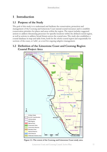
1.2 Definition of the Limestone Coast and Coorong Region<br />
Coastal Project Area<br />
Figure 1.1. The extent of the Coorong and Limestone Coast study area.<br />
Limestone Coast and Coorong Coastal Action Plan 13
<strong>Introduction</strong><br />
The coastline under study extends from the Murray Mouth to the Victorian state border. It is a<br />
coastline of approximately 427 kilometres, or 10% in length of the coastline of the state. The<br />
map above (Figure 1.1) shows that this region comprises the sea coast of 5 councils: DC Grant,<br />
Wattle Range Council, DC Robe, DC Kingston and DC Coorong.<br />
The coast is defined for this study to include land above mean low water mark that, because of its<br />
vegetation, its landforms or because of its interaction with coastal processes can be described as<br />
coastal in nature. Elsewhere the boundary has been taken as 500 metres from low water. As a<br />
result, in the example at Figure 3 below, the coastal zone encloses coastal lakes, beach ridge<br />
systems, areas with distinctive coastal vegetation, and transgressive dune systems.<br />
Figure 1.2. An example of the Definition of the Coastal Boundary in this Study.<br />
The project area for the <strong>South</strong> <strong>East</strong> of the State comprises 124,568 hectares, of which 35% is<br />
native vegetation and 0.4% is urbanised. A considerable portion of the Limestone Coast and<br />
Coorong has reserve status: NPW Act reserve or heritage agreement 51%; Crown Land Act<br />
reserve 1.3%. Two Marine Parks have been proclaimed for the region: the boundary of these<br />
includes all estuaries and all tidal lands, and hence overlaps with the coastal boundary of this<br />
study. A significant part of the coastal region is unallotted Crown land – 19.9% of the total area.<br />
The <strong>South</strong> <strong>East</strong> coastal region comprises a variety of coastal environments, including large coastal<br />
barrier dune systems, beach ridge plains, exposed calcarenite and limestone cliffs, low coastal<br />
plains, sheltered embayments and extensive coastal wetlands. There is a wide range of beach<br />
types and vegetation communities that support a diversity of plants and animals. A unique<br />
character of the <strong>South</strong> <strong>East</strong> region of the State are the extensive wetlands where the abundant<br />
shallow water and lake edge environments provide habitat and refuge for many bird species,<br />
including seasonal migrants, amphibians and small mammals. The dependence of the regions<br />
flora and fauna on the wetlands, lakes and ephemeral systems is discussed further in <strong>Chapter</strong> 3,<br />
Conservation Themes.<br />
Limestone Coast and Coorong Coastal Action Plan 14
<strong>Introduction</strong><br />
1.3 The Definition of Coastal Cells<br />
Seventeen coastal cells have been defined for the region on the basis of physical parameters:<br />
landform, coastal wind and wave energy levels, shown in the Base Maps included in Appendix 1.<br />
The cells define relatively small sub-regional scale landform units along the coast: for example a<br />
bay between headlands, a sand dune mass, or an area of low cliffs of common orientation, may<br />
be coastal cells. In Figure 1.2 above the boundary of cell SE11 with SE10 and SE12 is shown.<br />
The size of individual cells varies, but the average length of coastline of a cell is approximately 25<br />
kilometres. The cells provide units of workable scale, in terms of bringing together a large<br />
amount of data for an area small enough to discuss local management issues.<br />
These cells are used in the report for mapping and descriptive units, i.e. as the geographical units<br />
for which conservation priority, threats and actions are to be established. The cells are numbered<br />
SE1 Piccaninnie Ponds then sequentially north- west to SE17, Coorong - Murray Mouth.<br />
1.4 Methods Used<br />
The core of the methods used involves the assembly of data on conservation (32 sets) and threats<br />
(20 sets) within the defined coastal area. Within each set of data, values (from 0 to 9) are ascribed,<br />
with expert help, for presence or absence, frequency, or rareness. These values are placed on<br />
digital maps (or layers): each layer showing values from 0 to 9 for each pixel on the map; any one<br />
layer consisting of millions of such values set out on a fixed grid. Geographic Information<br />
Systems software was used to obtain statistics and summaries for the cell and the region;<br />
conservation or threat values can be summarised for each point on the map. For example, in<br />
Figure 1.3 below the conservation values are summarised for the Robe area. When this is<br />
compared with the threat values, spatial correlation is visually apparent.<br />
These methods depend on spatial layout and their value is most visually apparent at the local (or<br />
cell) scale. However statistics for the whole region can be derived from the analysis and used to<br />
focus on features of the whole regional map.<br />
The data is presented as a snapshot in time (although the most recent survey data is used, the<br />
dates vary); however, the most significant thing about many sets of data is change and the<br />
direction of change. Notably change in extent of habitat is critical for fauna. If there is repetition<br />
at a later date of this methodology for the region, then this will become apparent with each future<br />
iteration of the process. In this project, the local ‘cell descriptions’ are used to note local changes,<br />
where these can be identified and where they are a concern to the conservation of the natural<br />
assets of the region.<br />
Limestone Coast and Coorong Coastal Action Plan 15
<strong>Introduction</strong><br />
Figure 1.3. Summarised conservation values for Cell SE10. (red shows highest totals, blue lowest).<br />
Figure 1.4. Total threat values for SE10 (again red shows the largest totals).<br />
Limestone Coast and Coorong Coastal Action Plan 16
<strong>Introduction</strong><br />
1.5 Management Context<br />
This project sits within, or is related to, a number of on-going processes within the region; the<br />
diagram below attempts to indicate the principal elements of these processes.<br />
Commonwealth processes and State NRM Plan<br />
SE Biodiversity Plan<br />
SE NRM Plan<br />
Goals, Objectives, Values<br />
Coastal Conservation Assessment: Coastal data inventory; conservation<br />
and threat hotspots.<br />
Coastal Action Plan: Local and regional actions and priority.<br />
Targets<br />
Evaluation & review<br />
The SE coastal project aims to establish conservation priority of areas and places to support and<br />
inform the work of the SE NRM Board. This has been undertaken in two steps in defining<br />
priority:<br />
• the first step assembles data relating to biota, geology and heritage distributed throughout the<br />
region;<br />
• the second step looks at threatening processes impacting these features.<br />
The combination (see <strong>Chapter</strong> 5) gives a statement, in mapped form, which allows discussion of<br />
priority actions to achieve the goals of the NRM Board for its coastal regions: it is a decision<br />
support system.<br />
The whole of the process outlined in the flow diagram above may be said to encompass the<br />
elements of an ecosystem based management system 1 . This process has been described by Smyth<br />
et al 2003, and has been summarised below, with minor changes:<br />
1. Holistic Integrated Science<br />
Recognition that systems are open, complex and inter-active. Change in one system may<br />
impact others. Achieving management objectives involves considering cumulative impacts.<br />
The best available science must be used throughout the management process. Scientists<br />
must view impacts as cumulative and consider the ecosystem as a whole.<br />
2. Adaptive Management<br />
Sparse and incomplete knowledge requires management that can respond to change, in<br />
societal needs, and change in ecosystems some of which may have resulted from previous<br />
management actions. Management plans are a work in progress, and are able to respond to<br />
the results of monitoring key indicators. This is not a ‘try it and see’ approach, but a<br />
1<br />
See Smyth, et al 2003; Grumbine 1994.<br />
Limestone Coast and Coorong Coastal Action Plan 17
<strong>Introduction</strong><br />
management style that recognises constant change in the environment, and, in responding,<br />
acknowledges the precautionary principle.<br />
3. Collaborative Decision Making<br />
When management is based on ecosystem features rather than political boundaries a range<br />
of political, ecological, generational and cultural expertise - is necessary for decisionmaking.<br />
4. Socially Defined Goals and Perspectives<br />
“Management should become a reflection of societal values rather than narrow scientific<br />
concepts that focus on single issues. However, management goals and objectives must be<br />
tempered by an understanding that ecosystem processes must be protected above all other<br />
values” (Smyth et al, 2003, p.15.)<br />
The Limestone Coast and Coorong Coastal Action Plan project is seen as contributing strongly<br />
to points 1 and 2 above. Particularly, the spatially based process for defining conservation priority<br />
for particular places and areas addresses the issue of cumulative impact.<br />
The data used in this study is a summation of the best available expert work in biodiversity,<br />
assembled through a spatial information system (GIS). The work may be seen as establishing<br />
base line data from which monitored change may be put in perspective and serves as the<br />
foundation of an adaptive management approach.<br />
The management actions proposed in this project have been based on the need to remediate<br />
identified threats, primarily from the GIS analysis. This has been supplemented by local<br />
knowledge, ongoing existing plans and consultation with NRM and Council officers. The priority<br />
of these actions depends mainly on the conservation priority, but also the pressure of the threat.<br />
Many parts of the on-going work of the NRM Boards, including the NRM regional plans are<br />
essential components of elements 3 and 4 above.<br />
1.6 Product<br />
This project is a data assemblage and decision support system to assist in addressing the<br />
responsibilities of the NRM Regional Board. It is also useful for other managers, such as<br />
community groups, councils and state agencies. It provides a baseline statement against which<br />
future managers can evaluate management outcomes, as well as the impact of climate change.<br />
This document is produced on DVD and in hardcopy; the DVD allows detailed interrogation of<br />
the digital maps and data.<br />
Limestone Coast and Coorong Coastal Action Plan 18