


You also want an ePaper? Increase the reach of your titles
YUMPU automatically turns print PDFs into web optimized ePapers that Google loves.
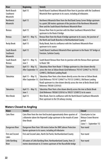
River Beginning Stretch<br />
North Branch<br />
Southwest<br />
Miramichi<br />
April 15<br />
North Branch Southwest Miramichi River from its junction with the Southwest<br />
Miramichi River upstream to its source, including all tributaries<br />
Northwest<br />
Miramichi<br />
April 15<br />
Northwest Miramichi River from the Red Bank/Sunny Corner Bridge upstream<br />
to a point 200 metres upstream of the junction of the Northwest Miramichi<br />
River and the South Branch Northwest Miramichi River<br />
Renous April 15 Renous River from its junction with the Main Southwest Miramichi River<br />
upstream to the Route 8 bridge<br />
Renous April 15 – May 15,<br />
June 1<br />
Renous River from the Route 8 bridge upstream to its source, the junction of<br />
the North and South Branches in Northumberland County<br />
Rocky Brook April 15 Rocky Brook, from its confluence with the Southwest Miramichi River<br />
upstream to its source<br />
South Branch<br />
Southwest<br />
Miramichi<br />
South Branch<br />
Renous<br />
April 15<br />
April 15 – May 15,<br />
June 1<br />
Tabusintac April 15 – May 15,<br />
After September 15<br />
Tabusintac April 15 – May 15,<br />
After September 15<br />
Tabusintac April 15 – May 15,<br />
June 1<br />
South Branch Southwest Miramichi River upstream to the Route 107 bridge at<br />
Foreston, Carleton County.<br />
South Branch Renous River from its junction with the Renous River upstream<br />
to Route 108<br />
Tabusintac River from Route 11 Bridge upstream to a line drawn directly<br />
across the river at Stilson Brook (Grid Reference 793147 5249677 to 793133<br />
5249812, Old Boom Landing Road)<br />
Tabusintac River from a line drawn directly across the river at Stilson Brook<br />
(Grid Reference 793147 5249677 to 793133 5249812, Old Boom Landing<br />
Road) upstream to a line drawn directly across the river at Becks Brook (Grid<br />
Reference 789260 5250163)<br />
Tabusintac River from a line drawn directly across the river at Becks Brook<br />
(Grid Reference 789260 5250163 to 789257 5250072) to its source<br />
West Brook April 15 West Brook, from its confluence with the North Branch Southwest Miramichi<br />
River upstream to the CN railway crossing<br />
Waters Closed to Angling<br />
Water Stretch Closed<br />
Cains River<br />
Cains River from the river ford located approximately three-quarters of<br />
a kilometer above the Hopewell Lodge upstream to the mouth of Lower<br />
Otter Brook<br />
Closed prior to Live<br />
Release Crown Reserve<br />
period<br />
(June 1 – September 15)<br />
Dungarvon River Dungarvon River from 100 meters below the DNR Salmon Protection Year round<br />
Barrier upstream to its source, including all tributaries<br />
First and Second<br />
Lakes<br />
First and Second Lakes, North Esk Parish, Northumberland County Year round<br />
Little Bartibog<br />
River<br />
All waters of Little Bartibog River, Northumberland County, from 25<br />
metres downstream to 25 metres upstream of the Russellville bridge<br />
Year round<br />
22