TILO: Capability Areas of Interest - PEO STRI
TILO: Capability Areas of Interest - PEO STRI
TILO: Capability Areas of Interest - PEO STRI

Create successful ePaper yourself
Turn your PDF publications into a flip-book with our unique Google optimized e-Paper software.
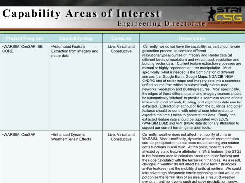
<strong>Capability</strong> <strong>Areas</strong> <strong>of</strong> <strong>Interest</strong><br />
E n g i n e e r i n g D i r e c t o r a t e<br />
Project/Program <strong>Capability</strong> Gap Domains Description<br />
•WARSIM, OneSAF, SE<br />
CORE<br />
•Automated Feature<br />
Extraction from imagery and<br />
raster data<br />
Live, Virtual and<br />
Constructive<br />
Currently, we do not have the capability, as part <strong>of</strong> our terrain<br />
generation process, to combine different<br />
resolutions/types/sources <strong>of</strong> Imagery and Raster data (at<br />
different levels <strong>of</strong> resolution) and extract road, vegetation and<br />
building vector data. Current feature extraction processes are<br />
manual or highly dependent on user manipulation. Most<br />
specifically, what is needed is the Combination <strong>of</strong> different<br />
sources (i.e. Google Earth, Google Maps, NGA CIB, NGA<br />
CADRG etc) <strong>of</strong> raster maps and imagery data into a seamless<br />
unified source from which to automatically extract road<br />
networks, vegetation and Building features. Most specifically,<br />
the edges <strong>of</strong> these different raster and imagery sources should<br />
be automatically ‘stitched’ to provide a seamless source <strong>of</strong> data<br />
from which road network, Building, and vegetation data can be<br />
extracted. Extraction <strong>of</strong> attribution from the buildings and other<br />
features should be done with minimal user intervention to<br />
expedite the time it takes to generate this data. Finally, the<br />
extracted feature data should be populated with EDCS<br />
(WARSIM EDM) and VPF (NGA) data dictionary attribution to<br />
support our current terrain generation tools.<br />
•WARSIM, OneSAF<br />
•Enhanced Dynamic<br />
Weather/Terrain Effects<br />
Live, Virtual and<br />
Constructive<br />
Currently, weather does not affect the mobility <strong>of</strong> units in<br />
WARSIM. Most specifically, dynamic weather characteristics<br />
such as precipitation, do not affect route planning and related<br />
costs functions in WARSIM. At this point, mobility is only<br />
affected by static feature attribution in SNE features (the STGJ<br />
in the features used to calculate speed reduction factors) and<br />
the slope calculated with the terrain skin triangles. As a result,<br />
changes in weather do not affect the static terrain (triangles<br />
and/or features) and the mobility <strong>of</strong> units at runtime. We could<br />
take advantage <strong>of</strong> dynamic terrain technologies that would repoligonize<br />
the terrain skin <strong>of</strong> an area as a result <strong>of</strong> weather<br />
10<br />
events at runtime (events such as heavy precipitation, snow,