

Portinscale - Excluded Site Assessments (PDF) - Lake District ...
Portinscale - Excluded Site Assessments (PDF) - Lake District ...
Portinscale - Excluded Site Assessments (PDF) - Lake District ...

You also want an ePaper? Increase the reach of your titles
YUMPU automatically turns print PDFs into web optimized ePapers that Google loves.
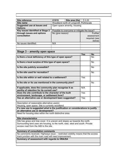
<strong>Site</strong> reference X1019 <strong>Site</strong> area (Ha) 0.25<br />
<strong>Site</strong> name<br />
Woodland north of Longcroft, <strong>Portinscale</strong><br />
Suggested use at Issues and Open space amenity, housing<br />
Options<br />
Key issues identified at Stage 2 Possible to overcome or mitigate the issue?<br />
through issues and options<br />
consultation<br />
No (give reason)<br />
Further<br />
assessment<br />
required (see<br />
below)<br />
No issues identified.<br />
N/A<br />
Stage 3 – amenity open space<br />
Is there a local deficiency of this type of open space?<br />
Is there a local surplus of this type of open space?<br />
Is the site publicly accessible?<br />
Is the site used for recreation?<br />
Is the site within or well related to a settlement?<br />
Is the site or its use mentioned in the community plan?<br />
If applicable, does the community plan recognise it as<br />
worthy of retention for its current use?<br />
Does the site contribute to the character of the built<br />
environment, landscape, or settlement form?<br />
Has an alternative use or development been suggested?<br />
Yes<br />
Yes<br />
N/A<br />
Yes<br />
Yes<br />
No<br />
No<br />
No<br />
No<br />
No<br />
No<br />
Description of reasonable alternative use(s):<br />
Housing, open space. <strong>Site</strong> is currently woodland.<br />
If a new use is suggested what is the justification or considerations to justify<br />
an alternative use or development?<br />
Need for housing sites within the north distinctive area.<br />
<strong>Site</strong> characteristics<br />
<strong>Site</strong> has grass and tree cover. It is uneven and slopes up towards the north.<br />
Surrounding land uses are housing, to the north, east, west and south. Private<br />
access road from the A66 to the site.<br />
Summary of consultation comments<br />
No comments received. Highways issue – restricted visibility means that the access<br />
track junction with the main road will need improvement.<br />
Summary of assessment with regards to HRA/SA


