LandWorks Ex 4 Downeast Lakes Canoe Trip Journal.pdf - Maine.gov
LandWorks Ex 4 Downeast Lakes Canoe Trip Journal.pdf - Maine.gov
LandWorks Ex 4 Downeast Lakes Canoe Trip Journal.pdf - Maine.gov

Create successful ePaper yourself
Turn your PDF publications into a flip-book with our unique Google optimized e-Paper software.
<strong>Ex</strong>hibit 4: <strong>Downeast</strong> <strong>Lakes</strong> <strong>Canoe</strong> <strong>Trip</strong> <strong>Journal</strong><br />
http://www.downeastlakes.org/wp-content/uploads/2013/02/<strong>Downeast</strong>-<strong>Lakes</strong>-<strong>Canoe</strong>-<strong>Trip</strong>-<strong>Journal</strong>-2012.<strong>pdf</strong><br />
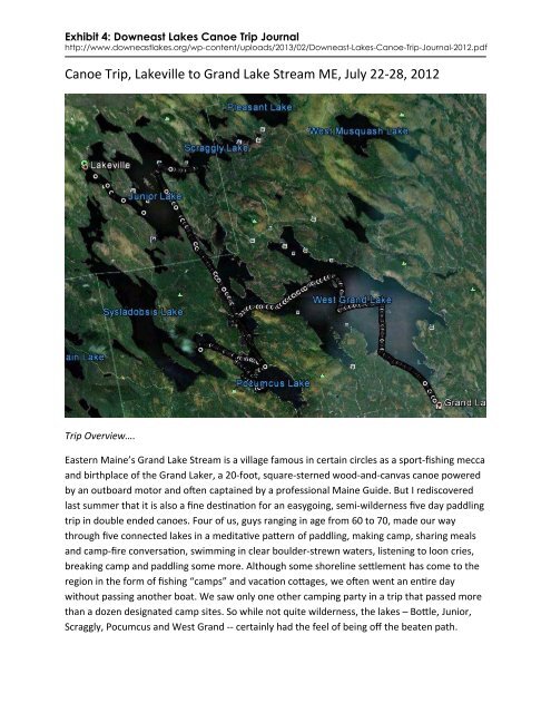
<strong>Canoe</strong> <strong>Trip</strong>, Lakeville to Grand Lake Stream ME, July 22-28, 2012<br />
<strong>Trip</strong> Overview….<br />
Eastern <strong>Maine</strong>’s Grand Lake Stream is a village famous in certain circles as a sport-fishing mecca<br />
and birthplace of the Grand Laker, a 20-foot, square-sterned wood-and-canvas canoe powered<br />
by an outboard motor and often captained by a professional <strong>Maine</strong> Guide. But I rediscovered<br />
last summer that it is also a fine destination for an easygoing, semi-wilderness five day paddling<br />
trip in double ended canoes. Four of us, guys ranging in age from 60 to 70, made our way<br />
through five connected lakes in a meditative pattern of paddling, making camp, sharing meals<br />
and camp-fire conversation, swimming in clear boulder-strewn waters, listening to loon cries,<br />
breaking camp and paddling some more. Although some shoreline settlement has come to the<br />
region in the form of fishing “camps” and vacation cottages, we often went an entire day<br />
without passing another boat. We saw only one other camping party in a trip that passed more<br />
than a dozen designated camp sites. So while not quite wilderness, the lakes – Bottle, Junior,<br />
Scraggly, Pocumcus and West Grand -- certainly had the feel of being off the beaten path.
Two of us on the trip, Carl Parris and I, had spent summers on the same lakes nearly 50 years<br />
ago in the mid‐1960s at a still‐in‐business camp now called Darrow Wilderness <strong>Trip</strong> Camp. We<br />
picked the location for that reason and made a point of putting the Darrow base camp on our<br />
route and stopping for a visit. It was a highlight of the trip. Joining Carl and me were Phil<br />
Schloop, a former international union official and still a community activist in Detroit, Mich.,<br />
and Bob Hausman, a psychologist from Woodstock, N.Y.<br />
Carl is a mainframe computer strategist for IBM in New York’s Hudson Valley, and I’m a former<br />
newspaper reporter who has earned pocket money during retirement playing bass in a variety<br />
of bands in and around Williamsburg, VA. I’m also an avid sea kayaker and surf ski paddler, but<br />
I hadn’t canoed or camped out much for decades.<br />
A little navel gazing…<br />
The idea of driving 18 hours north to <strong>Maine</strong> and abandoning my double‐bladed carbon wing<br />
paddle to make a traditional canoe trip would never have occurred to me if Carl hadn’t<br />
suggested it. Although we’re old friends in the sense that we met in 1966, our relationship is<br />
largely based on two adventures that we shared as teenagers. One was the summer that we<br />
spent at Darrow Camp, and the other was a trip in the summer of 1968 hitch‐hiking together<br />
through England, Norway, Sweden, Denmark, Switzerland, Germany, France and Spain. Both<br />
trips were profound adventures that have remained important in my memory and in some<br />
ways shaped who I am.<br />
When Carl and I reconnected decades later, Carl raised the idea of making a trip back to Grand<br />
Lake Stream. He’d actually been back several times over the years, once leading a canoe trip as<br />
a counselor at a camp based in Cape Cod, MA, and later on a family camping trip when his two<br />
children were teenagers. He had an ongoing relationship with the chain of lakes. I did not, but<br />
last summer’s invitation to go back there came as kayaking had rekindled my interest in backcountry<br />
camping. Also I wanted to nurture my relationship with an interesting guy who has<br />
remained an important character in my life even though we’ve pretty much traveled separate<br />
roads.<br />
Planning the trip…<br />
At first, I figured I’d have a pretty passive role in planning. Carl had a canoe, knew the territory,<br />
and had made similar trips with his family, friends and alone throughout most of his adult life.<br />
He’d also invited two old friends who were both experienced canoe campers. Then Carl<br />
mentioned that he’d be travelling out of the country on business for more than a week ending<br />
the day before we were scheduled to meet at his house, and would have little time to think<br />
about <strong>Maine</strong> until then. He suggested that I take charge of planning the route. Suddenly I faced<br />
the challenge of figuring out five days of campsite‐to‐campsite travel in a region I hadn’t visited
for 46 years using boats in which I’d had no tripping experience for the same amount of time.<br />
So I got on the Internet and telephone and tried to enlist some local from Grand Lake Stream<br />
folks. Lake‐hopping canoe trips are rare enough in the area these days that there were no<br />
websites containing suggested routes or itineraries. Some great information was available<br />
online about lakeside campsites thanks to an organization, <strong>Downeast</strong> <strong>Lakes</strong> Land Trust, that has<br />
acquired and manages thousands of acres of forest around West Grand and Pocumcus lakes.<br />
After mining the Internet, I sent emails to Mark Berry, the land trust executive director, to<br />
Darrow executive director Andy Buckman, and to Al LaPlante, a canoe trip outfitter who runs<br />
businesses in Grand Lake Stream and nearby Princeton <strong>Maine</strong>. All of them responded sooner or<br />
later, but La Plante called me the evening of the day I sent my e‐mail, and spent 45 minutes on<br />
the phone answering all sorts of questions and suggesting a few possible routes. He also<br />
suggested I get a copy of the DeLorme <strong>Maine</strong> Atlas and Gazetteer, which had detailed maps of<br />
the area and showed the locations of all public camp sites along the lakes.<br />
We considered the possibility of a hard‐driving trip involving lots of miles per day, portages and<br />
forays between lakes that could involve dragging canoes through shallows, but we settled on<br />
simpler plan. There would be no portages, and a mixture of paddling efforts with only one or<br />
two days reaching 10 miles. We would leave time for spending a couple of nights at a pretty<br />
campsite to fish, hike, read, swim and explore at a leisurely pace. We also decided to launch our<br />
canoes at Lakeville, an hour’s drive closer to Rhinebeck than Grand Lake Stream and find<br />
someone to shuttle us from GLS to the launch site at trip’s end.<br />
I got back on the phone with Al LaPlante, discussed routes some more and arranged for him to<br />
provide the shuttle service. By this time I was in touch by email and phone with Buckman at<br />
Darrow, who also provided valuable information on possible routes and camp sites.<br />
With an eight‐hour drive to Lakeville from our meet‐up at Carl’s house in Rhinebeck, NY, we<br />
pickeda first‐night campsite an hour’s paddle from our launching point. From there, we decided<br />
to be flexible about our routes and stopping places for the next five days. Since we’d never be<br />
more than 20 miles from our ultimate destination, there was no urgency to be anywhere on a<br />
certain day. We told Buckman we intended to stop and visit Darrow on Wednesday or<br />
Thursday.<br />
It turned out that Carl had been most of the places we’d travel enough times to practically have<br />
routes in his head, but having been given the job of route planning, I spent lots of time getting<br />
familiar enough with the territory to get around it on my own if need be. I studied the <strong>Maine</strong><br />
Atlas, looked at Google satellite views and ordered USGS topo maps. Meanwhile I started<br />
reading library books on canoe camping and navigating by map, compass and GPS. I put all the<br />
camp sites and other key features as waypoints in the mapping GPS that I use for kayaking. The<br />
Land Trust map had exact latitude and longitude positions for each of its campsites. I
guesstimated the positions for other sites in the <strong>Maine</strong> Atlas. Then I started getting into the<br />
subtleties of using UTC, the grid on the USGS maps, for position‐finding as opposed to the lat<br />
and longitude used in the DeLorme maps. I figured out how to set my GPS unit to show each<br />
grid system. I pored over explanations of declination—the differences between true north,<br />
magnetic north and grid north – in using a compass with the various maps for navigation. I even<br />
ordered an inexpensive base plate compass since the hand bearing compass I had used in my<br />
sailing days would not be the right tool for topo map work.<br />
Phil, who’d agreed to plan our menu, must have been engaged in a similarly consuming<br />
planning process, because he supplied the group with a varied, interesting and tasty menu with<br />
very little input from the rest of us.<br />
Getting clean enough for <strong>Maine</strong>…<br />
Before we packed out gear and put the canoes on Phil’s truck for the ride north, Carl insisted<br />
we scrub down his fiberglass canoe with bleach and detergent to remove any invasive weeds<br />
that might have been attached to it from the small lake in his neighborhood. The lake has been<br />
invaded by Eurasian Water Milfoil, a weed that can do terrible ecological damage, and is often<br />
spread by boats and fishing tackle. Carl, a lifelong activist, has worked to prevent its spread in<br />
his region.<br />
Andy’s <strong>Journal</strong>…..<br />
Sunday July 22<br />
In my tent on Bottle Island ready for first night of 5‐day camping trip. Warm evening, bright<br />
stars, nice camp site. Bug‐free here in tent.<br />
Woke up in Rhinebeck NYY this morning at 4:45 a.m. Carl and Phil and I were at Carl’s. Bob<br />
arrived 5:45 a.m. from his home in Woodstock.<br />
Got to Lakeville ME about 4 p.m. Loaded two canoes and paddled just over 3 miles out of Bottle<br />
Lake to B. Island in Junior Lake. I paddled bow in Phil’s canoe. <strong>Maine</strong> is as I remembered – clear<br />
water, lily pads, loon calls. But Bottle Lake surrounded by “camps” and lots of people. Not<br />
wilderness.<br />
The campsite has picnic table and is in sight of some boat docks. I can hear people talking<br />
across the water. Can also hear bugs bumping into my tent walls, attracted by my head lamp.<br />
We swam around the island. Ate Subway subs bought along the way. After dinner, looked at<br />
maps and planned week. Guys not up for strenuous paddling.Will go a few miles tomorrow and<br />
camp early. Then will explore possibility of climbing up Penobscot Bald. Then may swim.
Monday July 23<br />
Woke up 7:30ish. Big breakfast of freeze‐dry eggs scrambled with bacon, sundried tomatoes,<br />
instant coffee, hash brown potatoes.<br />
Took down camp and left 10, 10:30. Paddled a mile and stopped at an island campsite where<br />
Carl’s family had stopped years before. In the earlier trip it was raining and his daughter said<br />
she’d go no farther. They decided to go back and then went car camping instead. Carl claims he<br />
lost his temper, spazzed out and now thinks of the island as Tantrum Island.<br />
We paddled a total of about five miles to campsite on island at the mouth of Scraggly Lake.<br />
Went another mile to check out a second site, but returned to first because it was prettier and<br />
breezier – so promised fewer bugs.<br />
On way back we scouted trail head to Penobscot Bald for a possible hike. Shoreline lined by a<br />
few Passamaquoddy Indian weekend “camps” but we found a trail. Very buggy, so we never<br />
came back to explore.<br />
Set up camp. I boorishly insisted on rigging tarp using truckers’ hitches. I had a learning curve<br />
but finally figured it out. The guys put up with me. I was happy to see the tarp rigged with taut<br />
quick‐release knots.<br />
We had lovely lunch of spicy veg‐pasta soup and pbj sandwiches.<br />
After lunch, Carl took a swim, napped and read. Bob and Phil fished – caught lots of small<br />
yellow perch and one decent‐size small‐mouth bass.<br />
I borrowed Carl’s canoe and set off alone to explore. Very windy and hard to control the canoe<br />
solo without weight in the bow. I spent an hour or so bashing into wind, getting blown across<br />
the lake, and finally gave up going upwind and returned to our island camp. I swam and took<br />
some photos of Carl reading and Phil and Bob fishing.<br />
Elaborate dinner now in the works: Chicken korma on rice and various other freeze‐dried<br />
delicacies.<br />
10‐milish paddle scheduled tomorrow south past Darrow to Sysladobsis. Hope the wind, now<br />
sw, doesn’t blow hard south tomorrow. Our only fallback campsite is Farm Cove, across from<br />
Darrow and still 7, 8 miles away.<br />
Wind very gusty this evening, maybe up to 20 mph. Good test of tents and tarp. It should keep<br />
bugs at bay.
On Bottle Island last night, we had a big predator bird, possibly an osprey, nesting above us.<br />
Heard loon calls at night. Saw a few loons on the water while paddling. They’re cormorant‐like<br />
in size and behavior, but prettier and blessed with vocal skills that range from wolf calls to<br />
looney crazy laughing‐songs.<br />
Last night after dinner on Scraggly Lake, had fire and very mellow time.Bob entertained us by<br />
singing an obscure sea shanty that must have had 70 verses. Also, someone from a “camp”<br />
nearby came by in a motor boat – guy, son (?) and dog, and then later while we were having<br />
dinner in the evening, came by again and waved.<br />
Windy evening and overnight a misty rain blew in and lot of lightning. Not a real soaker, though.<br />
Tuesday, July 24<br />
After big breakfast, eaten after most of packing done, we loaded canoes and set off for longish<br />
paddle down Junior Lake, through Junior Stream, into Junior Bay and down past Darrow.<br />
Sky was overcast and moderate wind from southwest. I paddled stern of Carl’s canoe with Bob<br />
in the bow. We made good time and navigation was straightforward with topos and GPS.<br />
Scenery beautiful with big boulders on shore and sticking up in herds at various places in the<br />
lakes.<br />
Junior stream especially beautiful. Saw loons. As we got to the end of Junior Stream, two loons<br />
swam by making their incredible looney cry, which echoed like crazy. Almost seemed like they<br />
were enjoying the echo.<br />
Saw camps along Junior Steam and Junior Bay at top of W. Grand Lake. Some were very nice<br />
houses with lawns. But no boats or people in evidence. Had some rain but it stopped after we<br />
donned rain gear.<br />
We stopped at the end of where Junior Stream widened into Junior Bay just northeast of where<br />
the main part of W. Grand Lake intersects. Carl took out cell phone to call Darrow, but we<br />
couldn’t get a signal.<br />
Paddled down to The Birches – rush of nostalgia – but place seemed deserted. We went on by.<br />
Original plan was to paddle into Pocumcus and then up into Sysladobsis to camp there. But we<br />
decided to check out Pocumcus East campsite, which was closer. We reached site about 2 p.m.<br />
after paddling about 11 miles. Our new plan was to make camp there and leave in place<br />
tomorrow, while exploring Sysladobsis in unloaded canoes.
Near campsite we saw small flock of ducks (3?) with red heads and backs that had black and<br />
silver. Carl said definitely not wood ducks maybe in merganser family. (Later research in bird<br />
guide leads me to think probably red heads or canvasbacks, although <strong>Maine</strong> is a bit out of their<br />
range)<br />
Had lunch, 3ish, pbj on pita with Gatorade and also Boursin cheese on pita. Also oranges and<br />
apples.<br />
The overcast sky had brightened, but it looked like storms might roll in. Carl and I decided to<br />
paddle south on Pocumcus to look at a beach. Phil and Bob took other canoe to look for fishing<br />
spots.<br />
We could see storm brewing and stayed close to shore. At beach, we found a camouflaged<br />
canoe in woods, but no people. Now we could see dramatic storm rolling in – clear air with<br />
clouds roiling and rain in distance. Carl and I paddled like crazy the 2 ¼ miles back, and the<br />
dramatic changing sky made it exciting. 10 minutes after we got back, it poured a deluge.<br />
We were cooking dinner the whole while under my tarp. The camp site had a frame over the<br />
picnic table to rig the tarp lean‐to style, and it was great. Only after a bit the brand new tarp<br />
began leaking from one seam. Dang!<br />
Dinner: Spanish rice with chicken on tortilla with peas on the side. Mocha mousse with graham<br />
cracker crumbs for dessert.<br />
Since I was kind of soggy and cold, I decided to swim after dinner. Got shivering cold and<br />
returned up hill to my tent. Wet stuff is a bit of a problem from rain and water in canoes, but<br />
tent is snug and dry. I have on clean long johns and socks and the world is good.<br />
Wed. July 25<br />
Morning cold enough to be cozy in sleeping bag.Brisk wind from the north or northeast.<br />
Another big breakfast – blueberry pancakes. Looked out on Pocumcus to see whitecaps rolling<br />
right to left. As we ate, waves built to real rollers.<br />
We left camp set up and set off in unloaded canoes on a day trip whose goal was to reach the<br />
dam at Sysladobsis, and maybe carry the canoes over and paddle up to around Big Island.<br />
<strong>Ex</strong>citing paddling with Phil and Bob in Phil’s canoe, and Carl and me in Carl’s. Carl in stern. The<br />
waves made paddling hard work and exciting, with much crashing into the waves some water<br />
splashing into the bow. We decided to start by exploring Deer Brook Cove directly across<br />
Pocumcus. In the cove, much calmer waves, but still breezy. We first paddled to north end of<br />
cove, then downwind to look on the left bank for signs of a Down East <strong>Lakes</strong> Land Trust trail for
which we had downloaded a map. While at north end of the cover, a loon nearby called its twonote<br />
yodel – lo‐higgghhh, lo‐higghhhh, lo‐higgghhh. I tried to imitate it, and the loon<br />
responded, or happened by chance to call again. Heading south down the cove, we didn’t see<br />
an obvious entry to the trail, so we brought the canoes ashore where we thought the trail<br />
should be. Then, marking the boats as a GPS waypoint, we headed inland. Found the trail, with<br />
yellow blazes, and marked our spot with some branches. Then we followed loop around<br />
peninsula between cove and Pocumcus. Seven tenths of a mile. At one point from trail, we saw<br />
a woman and possible a second person on the shore, but we did not meet them. When we<br />
found our entry spot on the trail, we used GPS and compass to get back to our canoes.<br />
The trip out of the cove and up Pocumcus Narrows was an all‐out hard charge into wind and<br />
waves. I was now in stern of Carl’s canoe. Bob and Phil set the stage for rests ashore every 15‐<br />
20 minutes. Bob is in good shape, but he is 70.<br />
We got to the dam about 4:15 p.m. The GPS said we had covered about 7 miles, including our<br />
hike. We had seen one boat all day, a canoe with 2 people using a double‐bladed kayak paddle.<br />
At Dobsy dam we saw a small tent pitched by the dam outflow, and a pickup truck parked on<br />
the far side of the dam, a small structure flanked by a fish ladder.<br />
Beautiful camp ground with a lawn‐like field flanking Dobsy. Lunch at a lovely picnic table set<br />
near an elaborate stone fireplace. Lunch was pita, salami, Laughing Cow cream cheese and<br />
oranges.<br />
Our paddle back to camp was 3 ½ miles in 40 minutes. Diminishing wind and waves. Back at<br />
camp, everyone swam. A couple of people washed clothes. Bob fished after his swim.<br />
Dinner: Tuna steaks seared over wood fire, Indian dish of highly spiced chick peas and spinach,<br />
plus garlic mashed potatoes. Phil was inspired when he shopped for this trip.<br />
Tried to call Andy Buckman at Darrow, but no cell service.<br />
Sky got hazy as we sat looking at the sky and lake and listening to loons. Carl says it’s an omen<br />
of crappy, possibly drizzly weather.<br />
Thursday, July 26<br />
Up early on Pocumcus. Had eggs and potatoes for leisurely breakfast. We relaxed and enjoyed<br />
yakking for quite a while. Everyone has lots of interesting stories. Carl’s been everywhere for<br />
IBM—he spent this summer solstice nude in a sauna with Finnish clients. Bob and Phil equally<br />
interesting. After 2 days camping in spot, it took a while to get packed and on the water. We<br />
hadn’t reached Darrow by phone, so our plan was just to paddle up there and see who was at
home. As we paddled up, the whole staff came down the porch steps to welcome us. Andy<br />
Buckman, Margie and her husband Bill and another guy—Tim.<br />
Lots of wood and canvas canoes on racks, 2 motor boats at dock and two Grand Laker squareback<br />
canoes on wood rails.<br />
Buckman et al very welcoming. Turns out he’d been a camper at Darrow in 1966, when Carl and<br />
I were there. We were invited to lunch and then shown to a rack of photos, hinged like pages of<br />
a book, with year‐by‐year photos of campers. There in photos of trip groups were the muchyounger<br />
me, Carl and Buckman.<br />
We held hands and had a moment of silence before lunch. Then—stories of Darrow. B said he,<br />
in consultation with other traditional canoe camps and programs, had introduced a lot of<br />
traditional techniques that hadn’t been used in our Darrow days.<br />
Everything was now portaged using “tumps” or leather head straps. After lunch we went out to<br />
admire the wood and canvas canoes – and we all single‐carried an 85‐pound canoe using a<br />
tumpline and paddle lashed to the thwarts. Andy demonstrated tying a long tump line on a<br />
wannigan, and we tried it out. Seems he’s a real guardian of the tradition, part of a group that<br />
considers itselfmetaphoric “keepers of the trail.”<br />
Andy showed us a half a dozen books canoeing and canoe‐building, and then gave us a Darrow<br />
bibliography for further reading. Even in his office he had loads of authentic canoe‐life gear.<br />
One was a metal pole tip for poling a canoe. Another was a “bug shirt” with integrated head<br />
net. He even put one on to model it. One the porch was rack of amazing fishing gear, rods reels<br />
and a laminated wood landing net. Andy then reeled off a list of places where fish were biting,<br />
including info about what time of day and what depth to catch them. I asked if any outfitters<br />
sent out adult trips in wood and canvas canoes with tump lines etc. He said one of his favorite<br />
authors had, but stopped for lack of business. Then he said if we contacted him early, he would<br />
outfit and lead a group on the St. Croix or Allagash. Said it would be great to form a group of<br />
Darrow alums.<br />
We left Darrow and headed over to W. Grand Lake. First we stopped at McClellan Point with<br />
the idea of climbing nearby Whitney Cove Mountain. The camp site was not appetizing, so we<br />
made a quick downwind run to Marks Island. Nice big rolling waves coming from behind made<br />
it great fun. The camp site was a bit hard to find – farther out on the tip of the Island than my<br />
GPS waypoint indicated. (It was one I had estimated from a <strong>Maine</strong> Atlas; it wasn’t one of the<br />
Down East <strong>Lakes</strong> Land Trust sites, which are marked on the trust’s map with exact latitude and<br />
longitude.) Nice open site on the lee side of the island. After dinner – rice with chicken etc., and<br />
before the banana cream pie dessert, we walked to the windward side of the island. Much<br />
wilder lake there. Finished dinner 9 p.m. Sat in camp chairs around fire. Carl played harmonica.
Carl brought Crazy Creek camp chairs for the other three. I brought a three‐legged camp stool,<br />
which is far less comfortable. It’s thanks to that discomfort that I pulled myself away to finish<br />
this journal entry.<br />
I’m realizing the sound of waves lapping the rocky lake shore is just as mesmerizing as ocean<br />
surf. I’m listening to the waves now as I write this in my tent, but also to the sound of a jet<br />
which Carl says is probably New York to London. From our island we can see only a single<br />
electric light on the far‐distant shore.<br />
July 27<br />
Today was island hopping in West Grand Lake. From Marks Island we headed a mile south to<br />
Columbus Island, a high, rock isle where Carl and I both remember camping. Two Grand Laker<br />
guide canoes were pulling away just as we approached. After some friendly waving, we had the<br />
island to ourselves. Columbus is a spectacular place of massive glacial rocks offering great<br />
swimming and views. Not farfrom our landing place was a busy eagle nest, with a young bird<br />
learning to fly. Phil found a large fresh eagle feather, and Bob later found another. They<br />
wandered off watching the eagles and Carl and I headed west to the end of the island. There, a<br />
tractor‐trailer‐size slab of rock formed a natural ramp down into clear water, with sides<br />
dropping straight down 15 or 20 feet. The water was clear enough to see all the way to the<br />
bottom. I took off my clothes, waded down the ramp to hip‐deep, and then dove into deeper<br />
water off the side. Carl followed, chasing barefoot down the rock ramp and then launching<br />
himself out into deeper water. We briefly rejoined Bob and Phil, but Carl and I headed east to<br />
explore the other end of the small evergreen‐covered rock island. There we found a trove of<br />
small, wild blueberries. It was all you can eat. Carl bragged that he grabbed a cluster of 7<br />
berries at once. I reached out and got 9. There contest was on, but we decided to leave it when<br />
we were tied at 11, and pretty sated on blueberries.<br />
Now we shoved off and headed northeast just under 2 miles to Hardwood Island and another<br />
campsite. We found the site, but it was a bit depressing with clumps of toilet paper scattered<br />
around everywhere.<br />
From there it was almost straight south to Kole Kill Island, where Carl had camped with a group<br />
of kids he brought from a Cape Cod camp in 1970. Kole Kill is a tall lump of a tiny island just off<br />
the southern shore between Big Mayberry Cove and Little Mayberry Cove. It’s private now, and<br />
on top was a big platform‐deck of Trex boards. Killer view. Carl told a story of how he scared his<br />
campers with a prank and then we pushed on to the camp ground at Little Mayberry Cove.<br />
Big camp site, with openings in woods but very uneven ground.Hard to find a tent site, so tents<br />
far apart. With tarp over picnic table, we had lunch of freeze dried tuna salad and tortillas,<br />
apple, orange, Gator Aid, salami and peanut butter at 5 p.m. Carl suggested we could paddle
into GLS and get a drink. I suggested we eat dinner there, too. But then we decided to stay put.<br />
Everyone extremely beat. We had a soap swim and looked at maps. I started this entry and<br />
moved from picnic table to Carl’s canoe so others could tell stories. The lake was dead calm and<br />
the air was warm and hazy – almost Virginia‐like. Our first evening with no breeze. But sky was<br />
clear and sunset was making distant hills pink and purple. I yelled to the others to come look.<br />
We decided to paddle the canoes out into the calm lake to gaze at the sunset and scenery. Carl<br />
suggested we shut up and look and listen. Very nice – fish jumped, a loon or two called, a dog<br />
barked. And snatches of conversation came from various “camps” along the shore. A pontoon<br />
boat passed towing a tuber. Phil and I headed in first. Phil lit the campfire. I went to my bugnetted<br />
tent to finish this. Outside my tent screen, I can see the fire blazing and hear it crackling.<br />
I’m going to check it out.<br />
Saturday, July 28