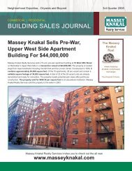
950 Hart Street, Brooklyn NY - Massey Knakal Realty Services
950 Hart Street, Brooklyn NY - Massey Knakal Realty Services
950 Hart Street, Brooklyn NY - Massey Knakal Realty Services

You also want an ePaper? Increase the reach of your titles
YUMPU automatically turns print PDFs into web optimized ePapers that Google loves.
BUSHWICK TOWNSHIP<br />
Four Villages<br />
From Wikipedia, the free encyclopedia<br />
In 1638, the Dutch West India Company secured a deed from the local Lenape people for the Bushwick area, and Peter Stuyvesant, chartered the area<br />
in 1661, naming it "Boswijck," meaning "little town in the woods" or "Heavy Woods" in 17th Century Dutch[1]. [1] Its area included the modern day<br />
communities of Bushwick, Williamsburg, and Greenpoint. Bushwick was the last of the original six Dutch towns of <strong>Brooklyn</strong> to be established within New<br />
Netherland.<br />
The community was settled, though unchartered, on February 16, 1660 on a plot of land between the Bushwick and Newtown Creeks[1] by fourteen<br />
French and Huguenot settlers, a Dutch translator named Peter Jan De Witt[4], and Franciscus the Negro, one of the original eleven slaves brought to<br />
New Netherland who had worked his way to freedom.[5][6]. The group centered their settlement around a church located near today's Bushwick and<br />
Metropolitan Avenues. The major thoroughfare was Woodpoint road, which allowed farmers to bring their goods to the town dock. [2] This original<br />
settlement came to be known as Het Dorp by the Dutch, and, later, Bushwick Green by the British.<br />
At the turn of the 19th century, Bushwick consisted of four villages, Green Point, Bushwick Shore[7], later to be known as Williamsburg, Bushwick<br />
Green, and Bushwick Crossroads, at the spot today's Bushwick Avenue turns southeast at Flushing Avenue.[8]. The English would take over the six<br />
towns three years later and unite the towns under Kings County in 1683.<br />
Bushwick's first major expansion occurred after it annexed The New Lots of Bushwick, a hilly upland originally claimed by the Native Americans in the<br />
first treaties they signed with European colonists providing the settlers rights to the lowland on the water. After the second war between the natives and<br />
the settlers broke out, the natives fled, leaving the area to be divided among the six towns in Kings County. Bushwick had the prime location to absorb<br />
their new tract of land in a contiguous fashion. New Bushwick Lane (Evergreen Ave), a former native American trail, was a key thoroughfare to access<br />
this new tract suitable mostly for potato and cabbage agriculture. [3] This area is bound roughly by Flushing Avenue to the north, and Evergreen<br />
Cemetery to the south.<br />
In the 1850s, the New Lots of Bushwick area began to develop. References to the town of Bowronville, a new neighborhood contained within the area<br />
south of Lafayette Ave and Stanhope <strong>Street</strong> begin to appear dating to the 1850's.<br />
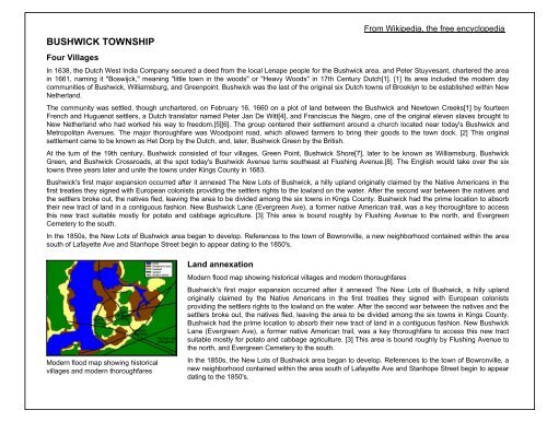
Modern flood map showing historical<br />
villages and modern thoroughfares<br />
Land annexation<br />
Modern flood map showing historical villages and modern thoroughfares<br />
Bushwick's first major expansion occurred after it annexed The New Lots of Bushwick, a hilly upland<br />
originally claimed by the Native Americans in the first treaties they signed with European colonists<br />
providing the settlers rights to the lowland on the water. After the second war between the natives and the<br />
settlers broke out, the natives fled, leaving the area to be divided among the six towns in Kings County.<br />
Bushwick had the prime location to absorb their new tract of land in a contiguous fashion. New Bushwick<br />
Lane (Evergreen Ave), a former native American trail, was a key thoroughfare to access this new tract<br />
suitable mostly for potato and cabbage agriculture. [3] This area is bound roughly by Flushing Avenue to<br />
the north, and Evergreen Cemetery to the south.<br />
In the 1850s, the New Lots of Bushwick area began to develop. References to the town of Bowronville, a<br />
new neighborhood contained within the area south of Lafayette Ave and Stanhope <strong>Street</strong> begin to appear<br />
dating to the 1850's.