4-1 CHAPTER 4 NATIONAL WEATHER SERVICE PRODUCTS FOR ...
4-1 CHAPTER 4 NATIONAL WEATHER SERVICE PRODUCTS FOR ...
4-1 CHAPTER 4 NATIONAL WEATHER SERVICE PRODUCTS FOR ...
Create successful ePaper yourself
Turn your PDF publications into a flip-book with our unique Google optimized e-Paper software.
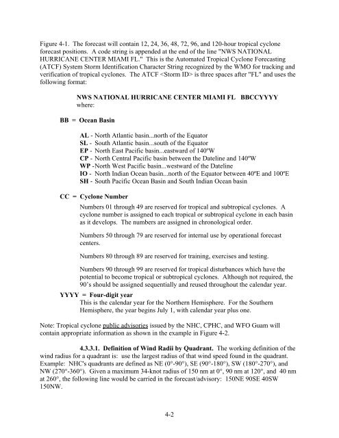
Figure 4-1. The forecast will contain 12, 24, 36, 48, 72, 96, and 120-hour tropical cyclone<br />
forecast positions. A code string is appended at the end of the line "NWS <strong>NATIONAL</strong><br />
HURRICANE CENTER MIAMI FL." This is the Automated Tropical Cyclone Forecasting<br />
(ATCF) System Storm Identification Character String recognized by the WMO for tracking and<br />
verification of tropical cyclones. The ATCF is three spaces after "FL" and uses the<br />
following format:<br />
NWS <strong>NATIONAL</strong> HURRICANE CENTER MIAMI FL BBCCYYYY<br />
where:<br />
BB = Ocean Basin<br />
AL - North Atlantic basin...north of the Equator<br />
SL - South Atlantic basin...south of the Equator<br />
EP - North East Pacific basin...eastward of 140ºW<br />
CP - North Central Pacific basin between the Dateline and 140ºW<br />
WP - North West Pacific basin...westward of the Dateline<br />
IO - North Indian Ocean basin...north of the Equator between 40ºE and 100ºE<br />
SH - South Pacific Ocean Basin and South Indian Ocean basin<br />
CC = Cyclone Number<br />
Numbers 01 through 49 are reserved for tropical and subtropical cyclones. A<br />
cyclone number is assigned to each tropical or subtropical cyclone in each basin<br />
as it develops. The numbers are assigned in chronological order.<br />
Numbers 50 through 79 are reserved for internal use by operational forecast<br />
centers.<br />
Numbers 80 through 89 are reserved for training, exercises and testing.<br />
Numbers 90 through 99 are reserved for tropical disturbances which have the<br />
potential to become tropical or subtropical cyclones. Although not required, the<br />
90’s should be assigned sequentially and reused throughout the calendar year.<br />
YYYY = Four-digit year<br />
This is the calendar year for the Northern Hemisphere. For the Southern<br />
Hemisphere, the year begins July 1, with calendar year plus one.<br />
Note: Tropical cyclone public advisories issued by the NHC, CPHC, and WFO Guam will<br />
contain appropriate information as shown in the example in Figure 4-2.<br />
4.3.3.1. Definition of Wind Radii by Quadrant. The working definition of the<br />
wind radius for a quadrant is: use the largest radius of that wind speed found in the quadrant.<br />
Example: NHC's quadrants are defined as NE (0°-90°), SE (90°-180°), SW (180°-270°), and<br />
NW (270°-360°). Given a maximum 34-knot radius of 150 nm at 0°, 90 nm at 120°, and 40 nm<br />
at 260°, the following line would be carried in the forecast/advisory: 150NE 90SE 40SW<br />
150NW.<br />
4-2


