Protecting Western Australia's Big Blue Backyard - The Pew ...
Protecting Western Australia's Big Blue Backyard - The Pew ...
Protecting Western Australia's Big Blue Backyard - The Pew ...

You also want an ePaper? Increase the reach of your titles
YUMPU automatically turns print PDFs into web optimized ePapers that Google loves.
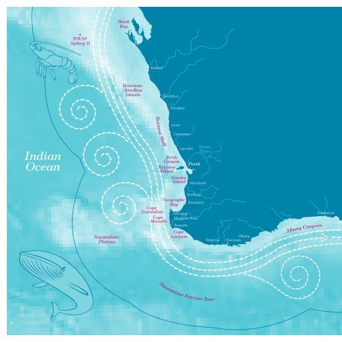
HMAS<br />
Sydney II<br />
Shark<br />
Bay<br />
Houtman-<br />
Abrolhos<br />
Islands<br />
Kalbarri<br />
Geraldton<br />
Dongara<br />
Jurien<br />
<strong>Western</strong><br />
Australia’s<br />
big blue<br />
backyard<br />
WHAT’S MISSING FROM THE MAP OF<br />
MARINE PROTECTION IN AUSTRALIA?<br />
<strong>The</strong> marine environment of Australia’s Exclusive<br />
Economic Zone (EEZ) is unique but just four per<br />
cent of it has been given sufficient protection<br />
from extractive activities.<br />
<strong>The</strong> map below shows the location of marine<br />
protection in our EEZ. <strong>The</strong> shaded areas (nine<br />
per cent of EEZ) include marine protected<br />
areas that prohibit extractive activities and<br />
others where these are allowed to continue.<br />
Most of Australia’s marine protection is on<br />
the Great Barrier Reef and around Tasmania<br />
and the sub-Antarctica Heard, McDonald and<br />
Macquarie islands.<br />
Compared with other states, the waters off<br />
<strong>Western</strong> Australia are clearly the least protected,<br />
with not even one per cent covered by no-take<br />
protection. And within that area, the waters<br />
between Kalbarri and Eucla have next to no<br />
protection of any kind despite being home to so<br />
many globally unique and threatened species.<br />
A CAR network of large no-take marine reserves<br />
as proposed here in <strong>Protecting</strong> <strong>Western</strong><br />
Australia’s big blue backyard will contribute<br />
significantly to meeting Australia’s international<br />
obligations to establish comprehensive,<br />
adequate and representative marine protection.<br />
Cervantes<br />
Indian<br />
Ocean<br />
Rottnest Shelf<br />
Perth<br />
Canyon<br />
Rottnest<br />
Island<br />
Lancelin<br />
Garden<br />
Island<br />
Perth<br />
Swan<br />
River<br />
Mandurah<br />
Eucla<br />
Exclusive<br />
Economic Zone<br />
(EEZ) Limit<br />
Naturaliste<br />
Plateau<br />
Cape<br />
Naturaliste<br />
Cape<br />
Mentelle<br />
Geographe<br />
Bay<br />
Cape<br />
Leeuwin<br />
Bunbury<br />
Busselton<br />
Yallingup<br />
Margaret River<br />
Augusta<br />
Walpole<br />
Albany<br />
Denmark<br />
Albany Canyons<br />
Esperance<br />
Recherche Archipelago<br />
Antarctica<br />
Existing marine<br />
protected area<br />
Diamantina Fracture Zone<br />
Southern<br />
Ocean<br />
Exclusive<br />
Economic Zone<br />
Eddies<br />
Key<br />
Leeuwin Current<br />
Scale<br />
0 100 200 300 400 500 600 700 800 Km<br />
8<br />
0 100 200 300 400 500 Mi<br />
Source of bathymetric image: Geoscience Australia