Additions to the ichthyofauna of Nepal, with a redescription of ...
Additions to the ichthyofauna of Nepal, with a redescription of ...
Additions to the ichthyofauna of Nepal, with a redescription of ...

You also want an ePaper? Increase the reach of your titles
YUMPU automatically turns print PDFs into web optimized ePapers that Google loves.
Sun Kosi<br />
126<br />
30°N<br />
Seti<br />
Mahakali<br />
Karnali<br />
Karnali<br />
Bheri<br />
28°N<br />
Rapti<br />
Kali Gandaki<br />
Narayani<br />
Trisuli<br />
Trisuli<br />
Arun<br />
Arun<br />
Kosi<br />
Kosi<br />
Tamur<br />
26°N<br />
0<br />
100 200 kilometers<br />
80°E 82°E 84°E 86°E 88°E<br />
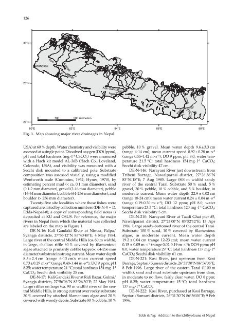
Fig. 1. Map showing major river drainages in <strong>Nepal</strong>.<br />
USA) at 60 % depth. Water chemistry and visibility were<br />
assessed at a single point. Dissolved oxygen (DO) (ppm),<br />
pH and <strong>to</strong>tal hardness (mg · l –1 CaCO 3 ) were measured<br />
<strong>with</strong> a Hach kit model AL-36B (Hach Co., Loveland,<br />
Colorado, USA), and visibility was measured <strong>with</strong> a<br />
Secchi disk mounted <strong>to</strong> a calibrated pole. Substrate<br />
composition was assessed visually, using a modified<br />
Wentworth scale (Cummins, 1962; Hynes, 1970), by<br />
estimating percent mud (< ca. 0.1 mm diameter), sand<br />
(0.1-2 mm diameter), gravel (2-16 mm diameter), pebble<br />
(16-64 mm diameter), cobble (64-256 mm diameter), and<br />
boulder (> 256 mm diameter).<br />
Twenty-five site localities where <strong>the</strong>se fishes were<br />
captured are listed by collection numbers (DE-N-# = D.<br />
Edds-<strong>Nepal</strong>-#); a copy <strong>of</strong> corresponding field notes is<br />
deposited at KU and OSUS. For reference, <strong>the</strong> major<br />
rivers in <strong>Nepal</strong> from which <strong>the</strong> material was collected<br />
are labeled on <strong>the</strong> map in Figure 1.<br />
DE-N-16: Kali Gandaki River at Nimaa, Palpa/<br />
Syangja districts, 27°55'12"N 83°40'48"E; 4 May 1984.<br />
Large river <strong>of</strong> <strong>the</strong> central Middle Hills (ca. 60 m width),<br />
in large, shallow riffle 60 % covered by filamen<strong>to</strong>us<br />
algae attached <strong>to</strong> primarily cobble (approx. 64-256 mm<br />
diameter) substrate in strong current. Mean water depth<br />
8.5 ± 2.4 cm (range 6-13 cm); mean current speed<br />
0.73 ± 0.29 m · s –1 (range 0.48-1.44 m · s –1 ); DO 9 ppm; pH<br />
8.25; water temperature 24 °C; <strong>to</strong>tal hardness 154 mg · l –1<br />
CaCO 3 ; Secchi disk visibility 25 cm.<br />
DE-N-17: Kali Gandaki River at Ridi Bazar, Gulmi/<br />
Syangja districts, 27°56'06"N 83°26'30"E; 22 May 1984.<br />
Large riffles on large (ca. 90 m width) river <strong>of</strong> <strong>the</strong> central<br />
Middle Hills, in strong current over rocky substrate<br />
30 % covered by attached filamen<strong>to</strong>us algae and 20 %<br />
covered <strong>with</strong> woody debris. Substrate 80 % cobble, 10 %<br />
pebble, 10 % gravel. Mean water depth 9.6 ± 3.3 cm<br />
(range 4-14 cm); mean current speed 0.92 ± 0.28 m · s –1<br />
(range 0.55-1.42 m · s –1 ); DO 9 ppm; pH 8.0; water temperature<br />
21.5 °C; <strong>to</strong>tal hardness 154 mg · l –1 CaCO 3 ;<br />
Secchi disk visibility 47 cm.<br />
DE-N-146: Narayani River just downstream from<br />
Tribeni Barrage, Nawalparasi district, 27°26'36"N<br />
83°54'18"E; 7 Aug 1985. Large (800 m width) sandy<br />
river <strong>of</strong> <strong>the</strong> central Tarai. Substrate 50 % sand, 5 %<br />
gravel, 30 % pebble, 10 % cobble, and 5 % boulder, in<br />
moderate current. Mean water depth 22.9 ± 0.02 cm<br />
(range 18-24 cm); mean water current 0.24 ± 0.04 m · s –1<br />
(range 0.19-0.30 m · s –1 ); DO 12 ppm; pH 8.0; water<br />
temperature 23.5 °C; <strong>to</strong>tal hardness 120 mg · l –1 CaCO 3 ;<br />
Secchi disk visibility 5 cm.<br />
DE-N-210: Narayani River at Taadi Ghat pier #5,<br />
Nawalparasi district, 27°24'00"N 83°52'12"E; 13 Apr<br />
1986. Large sandy-bot<strong>to</strong>med river <strong>of</strong> <strong>the</strong> central Tarai.<br />
Substrate 100 % sand, 10 % covered by filamen<strong>to</strong>us<br />
algae, in moderate current. Mean water depth<br />
19.2 ± 0.04 cm (range 12-23 cm); mean water current<br />
0.15 ± 0.05 m · s –1 (range 0.02-0.19 m · s –1 ); DO 9 ppm; pH<br />
8.0; water temperature 29 °C; <strong>to</strong>tal hardness 137 mg · l –1<br />
CaCO 3 ; Secchi disk visibility 61 cm.<br />
DE-N-221: Kosi River, just upstream from Kosi<br />
Barrage, Saptari/Sunsari districts, 26°31' 30"N 86°56'06"E;<br />
8 Feb 1996. Large river <strong>of</strong> <strong>the</strong> eastern Tarai (1100 m<br />
width), sand and mud substrate upstream from dam,<br />
in moderate <strong>to</strong> no flow, fairly clear water. DO 8 ppm;<br />
pH 8.25; water temperature 15 °C; <strong>to</strong>tal hardness<br />
137 mg · l –1 CaCO 3 .<br />
DE-N-222: Kosi River, purchased at Kosi Barrage,<br />
Saptari/Sunsari districts, 26°31'30"N 86°56'00"E; 9 Feb<br />
1996.<br />
Edds & Ng: Addition <strong>to</strong> <strong>the</strong> <strong>ichthy<strong>of</strong>auna</strong> <strong>of</strong> <strong>Nepal</strong>