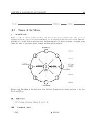
Lab Manual - Radford University
Lab Manual - Radford University
Lab Manual - Radford University

You also want an ePaper? Increase the reach of your titles
YUMPU automatically turns print PDFs into web optimized ePapers that Google loves.
4 CHAPTER A. LABORATORY EXPERIMENTS<br />
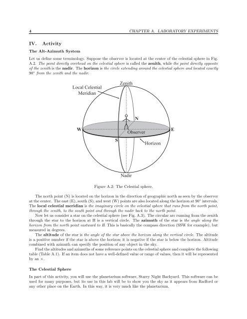
IV. Activity<br />
The Alt-Azimuth System<br />
Let us define some terminology. Suppose the observer is located at the center of the celestial sphere in Fig.<br />
A.2. The point directly overhead on the celestial sphere is called the zenith, while the point directly opposite<br />
of the zenith is the nadir. The horizon is the circle extending around the celestial sphere and located exactly<br />
90 ◦ from the zenith and the nadir.<br />
Local Celestial<br />
Meridian<br />
Zenith<br />
W<br />
S<br />
N<br />
Observer<br />
Horizon<br />
E<br />
Nadir<br />
Figure A.2: The Celestial sphere.<br />
The north point (N) is located on the horizon in the direction of geographic north as seen by the observer<br />
at the center. The east (E), south (S), and west (W) points are also located along the horizon at 90 ◦ intervals.<br />
The local celestial meridian is the imaginary circle on the celestial sphere that runs from the north point,<br />
through the zenith, to the south point and through the nadir back to the north point.<br />
Now let us consider a star on the celestial sphere (see Fig. A.3). The circular arc running from the zenith<br />
through the star to the horizon at H is a vertical circle. The azimuth of the star is the angle along the<br />
horizon from the north point eastward to H. This is basically the compass direction (SSW for example), but<br />
measured in degrees.<br />
The altitude of the star is the angle of the star above the horizon along the vertical circle. The altitude<br />
is a positive number if the star is above the horizon; it is negative if the star is below the horizon. Altitude<br />
combined with azimuth can specify the position of any object in the sky.<br />
Find the altitudes and azimuths of some reference points on the celestial sphere and complete the following<br />
table (Table A.1). If an item does not have a well-defined value or range of values, then it will be represented<br />
by an ×.<br />
The Celestial Sphere<br />
In part of this activity, you will use the planetarium software, Starry Night Backyard. This software can be<br />
used for many purposes, but its use in this lab will be to show you the sky as it appears from <strong>Radford</strong> or<br />
any other place on the Earth. In this way, it is very much like the planetarium.