Wayne County - The QTI Group
Wayne County - The QTI Group
Wayne County - The QTI Group

Create successful ePaper yourself
Turn your PDF publications into a flip-book with our unique Google optimized e-Paper software.
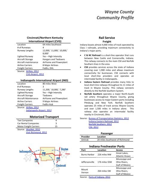
<strong>Wayne</strong> <strong>County</strong><br />
Community Profile<br />
Cincinnati/Northern Kentucky<br />
International Airport (CVG)<br />
Location<br />
64 miles Southeast<br />
# of Runways 4<br />
Runway Lengths 12,000,’ 11,000,’ 10,000,’<br />
8,000’<br />
Lighted Runway Yes – High Intensity<br />
Aircraft Storage Hangars and Tiedowns<br />
Aircraft maintenance Airframe and Powerplant<br />
Airline Carriers 8 Major Airlines<br />
Freight Carriers FedEx, DHL<br />
Source: AirNav, 2012<br />
CVG Airport, 2012<br />
Indianapolis International Airport (IND)<br />
Location<br />
80 miles West<br />
# of Runways 3<br />
Runway Lengths 11,200,’ 10,000,’ 7,280’<br />
Lighted Runway Yes – High Intensity<br />
Aircraft Storage Tiedowns<br />
Aircraft Maintenance Airframe and Powerplant<br />
Airline Carriers 9 Major Airlines<br />
Freight Carriers FedEx Hub<br />
Source: AirNav, 2012<br />
Indianapolis Airport, 2012<br />
Motorized Transport<br />
Taxi Companies 4<br />
Car Rental Companies 3<br />
Motor Freight Carriers 15<br />
Source: WayNet, 2012<br />
Visit Richmond, 2012<br />
Rail Service<br />
Freight<br />
Indiana boasts almost 4,000 miles of track operated by<br />
Class I railroads, providing maximum connectivity to<br />
Indiana’s major ports.<br />
• C & NC Railroad is a short-line operator that runs<br />
between New Castle and Connersville, Indiana.<br />
This railway connects to the main CSX and Norfolk<br />
Southern lines in the area.<br />
• CSX provides services across the state of Indiana<br />
covering over 1,900 miles and allows maximum<br />
connectivity for businesses. CSX connects with<br />
local short-line providers and operates an<br />
intermodal facility in Indianapolis.<br />
• Indiana Eastern Railroad provides many links to<br />
local short-line railways throughout its 11 miles of<br />
track in <strong>Wayne</strong> <strong>County</strong>. This railway connects<br />
directly to the Norfolk Southern System.<br />
• Norfolk Southern operates a major North-South<br />
rail artery throughout <strong>Wayne</strong> <strong>County</strong>, giving<br />
businesses access to major Eastern ports including<br />
Pittsburg and New York. Norfolk Southern<br />
operates 25 miles of track across <strong>Wayne</strong> <strong>County</strong><br />
and over 1,500 miles in Indiana alone. This<br />
railway also operates an intermodal facility<br />
nearby in Cincinnati, Ohio.<br />
Source: Bureau of Transportation Statistics, 2012<br />
Indiana Eastern Railroad, 2012<br />
Norfolk Southern, 2012<br />
CSX, 2012<br />
Provider<br />
Amtrak<br />
Passenger<br />
Location<br />
20 miles Southwest of Richmond<br />
Indiana Freshwater Ports<br />
Port Location Access<br />
Burns Harbor 226 miles NW<br />
Great Lakes,<br />
Atlantic Ocean<br />
Jeffersonville 176 miles SSW<br />
Mississippi and<br />
Ohio Rivers,<br />
Gulf of Mexico<br />
Mississippi and<br />
Mount<br />
264 miles SW Ohio Rivers,<br />
Vernon<br />
Gulf of Mexico<br />
Source: Ports of Indiana, 2012