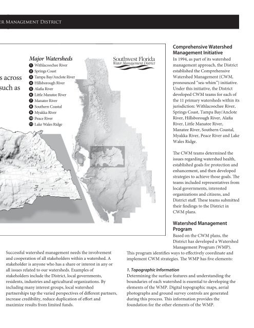
<strong>Southwest</strong> <strong>Florida</strong> <strong>Water</strong> <strong>Management</strong> District What Is a <strong><strong>Water</strong>shed</strong> <strong>Management</strong> Approach? A watershed management approach is one that considers the watershed as a whole, rather than separate parts of the watershed in isolation. Managing the water and other natural resources is an effective and efficient way to sustain the local economy and environmental health. Scientists and leaders now recognize the best way to protect the vital natural resources is to understand and manage them on a watershed basis. Almost every activity on the land has the potential to affect the quality and quantity of water in our waterways. <strong><strong>Water</strong>shed</strong> management helps reduce flood damage, decrease the loss of green space, reduce soil erosion and improve water quality. <strong><strong>Water</strong>shed</strong> planning brings together the people within the watershed, regardless of political boundaries, to address a wide array of resource management issues. At the heart of watershed management is the underlying philosophy that “everything is connected to everything else.” Like the links of a chain or the spokes of a wheel, watershed components are interconnected and mutually supporting. The health of upstream components directly determines the health and function of areas downstream. Our actions affect our neighbors as well as neighboring communities. higher Land Surface Elevation lower Coast <strong><strong>Water</strong>shed</strong>s in West-Central <strong>Florida</strong> The <strong>Southwest</strong> <strong>Florida</strong> <strong>Water</strong> <strong>Management</strong> District, also referred to as the District, encompasses 10,000 square miles within 16 counties in west-central <strong>Florida</strong>. This includes 13 major rivers, 1,800 lakes that are 10 or more acres in size, 3 major estuaries, 1.1 million acres of wetlands, 3 aquifers and numerous smaller rivers, creeks and streams. Within the boundaries of the District, there are approximately 250 recognized watersheds that have been consolidated into 11 primary watersheds. Typical <strong><strong>Water</strong>shed</strong> A watershed is an area of land that water flows across as it moves toward a common body of water, such as a stream, lake or coast. Lowlands River or Stream The District’s Approach to <strong><strong>Water</strong>shed</strong> <strong>Management</strong> The District takes a watershed approach to managing water and water-related resources within its boundaries. By doing so, the District can evaluate all the characteristics of each watershed to reflect the real, interconnected nature of <strong>Florida</strong>’s water resources. This increases the District’s ability to clearly identify, prioritize and address issues related to the area’s water resources. Uplands Uplands Major <strong><strong>Water</strong>shed</strong>s 1 2 3 4 5 6 7 8 9 10 11 Withlacoochee River Springs Coast Tampa Bay/Anclote River Hillsborough River Alafia River Little Manatee River Manatee River Southern Coastal Myakka River Peace River Lake Wales Ridge Uplands Uplands Successful watershed management needs the involvement and cooperation of all stakeholders within a watershed. A stakeholder is anyone who has a share or interest in any or all issues related to our watersheds. Examples of stakeholders include the District, local governments, residents, industries and agricultural organizations. By including many interest groups, local watershed partnerships tap the varied perspectives of different partners, increase credibility, reduce duplication of effort and maximize results from limited funds. 3 2 8 7 6 4 1 9 5 10 11 Comprehensive <strong><strong>Water</strong>shed</strong> <strong>Management</strong> Initiative In 1994, as part of its watershed management approach, the District established the Comprehensive <strong><strong>Water</strong>shed</strong> <strong>Management</strong> (CWM, pronounced “sea-whim”) initiative. Under this initiative, the District developed CWM teams for each of the 11 primary watersheds within its jurisdiction: Withlacoochee River, Springs Coast, Tampa Bay/Anclote River, Hillsborough River, Alafia River, Little Manatee River, Manatee River, Southern Coastal, Myakka River, Peace River and Lake Wales Ridge. The CWM teams determined the issues regarding watershed health, established goals for protection and enhancement, and then developed strategies to achieve those goals. The teams included representatives from local governments, interested organizations and citizens, and District staff. These teams submitted their findings to the District in CWM plans. <strong><strong>Water</strong>shed</strong> <strong>Management</strong> Program Based on the CWM plans, the District has developed a <strong><strong>Water</strong>shed</strong> <strong>Management</strong> Program (WMP). This program identifies ways to effectively coordinate and implement CWM strategies. The WMP has five elements: 1. Topographic Information Determining the surface features and understanding the boundaries of each watershed is essential to developing the elements of the WMP. Digital topographic maps, aerial photographs and ground survey controls are generated during this process. This information provides the foundation for the other elements of the WMP.