ECDIS part 2 - UK P&I
ECDIS part 2 - UK P&I
ECDIS part 2 - UK P&I

Create successful ePaper yourself
Turn your PDF publications into a flip-book with our unique Google optimized e-Paper software.
developed a centre of learning excellence providing<br />
generic training course utilising many different types of<br />
<strong>ECDIS</strong> system in a single training location. This<br />
provides increased system knowledge of <strong>ECDIS</strong><br />
system operation, as well as complying with <strong>UK</strong><br />
regulations and issuing MCA / STCW <strong>ECDIS</strong><br />
certification.<br />
Passage planning<br />
Effective passage planning completed by paper chart<br />
or by electronic systems is essentially the process of<br />
defining the safest navigational route in conjunction<br />
with established safety margins under which the voyage<br />
will be executed.<br />
The passage plan should be comprehensive, detailed<br />
and easy to interpret and effectively reduce navigational<br />
risks and aid the ship and its officers to safely navigating<br />
from berth to berth. Electronic navigational planning<br />
consists of three stages namely Appraisal, Planning<br />
and Control. Although this section does not attempt to<br />
offer a guide to electronic planning the key elements will<br />
be discussed.<br />
During the cuts, the planning officer will move through a<br />
quality control process from a general plan to the<br />
refined final track which will be used for navigation and<br />
approved by the master.<br />
It is essential that the built in automatic check function is<br />
used throughout the planning stages however it must<br />
be remembered that the effectiveness of the automatic<br />
check system relies on the accuracy of the safety<br />
parameters set by the user.<br />
The final track is then often displayed with associated<br />
waypoint information and navigational notes at the<br />
central conning station or chart table for reference by<br />
the navigational officer during the Control stage of the<br />
passage planning process.<br />
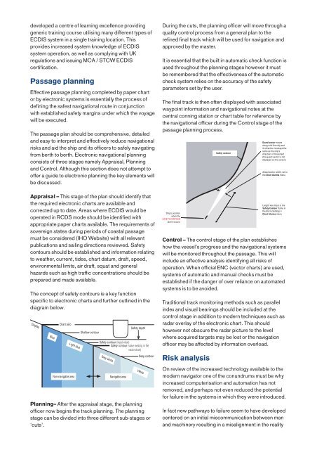
Safety Safety contour contour<br />
Guard sector moves<br />
along with the ship and<br />
its direction is always the<br />
same as the ship’s<br />
direction of movement<br />
(the guard sector is not<br />
displayed on the screen)<br />
Ahead sector width, set in<br />
the Char t Alarms menu<br />
Appraisal – This stage of the plan should identify that<br />
the required electronic charts are available and<br />
corrected up to date. Areas where <strong>ECDIS</strong> would be<br />
operated in RCDS mode should be identified with<br />
appropriate paper charts available. The requirements of<br />
sovereign states during periods of coastal passage<br />
must be considered (IHO Website) with all relevant<br />
publications and sailing directions reviewed. Safety<br />
contours should be established and information relating<br />
to weather, current, tides, chart datum, draft, speed,<br />
environmental limits, air draft, squat and general<br />
hazards such as high traffic concentrations should be<br />
prepared and made available.<br />
The concept of safety contours is a key function<br />
specific to electronic charts and further outlined in the<br />
diagram below.<br />
Display<br />
Chart zero<br />
Shallow contour<br />
Blue Light blue Grey-white White<br />
Non-navigable area<br />
Safety contour (input value)<br />
Safety contour (value existing in the<br />
vector chart)<br />
Navigable area<br />
Safety depth<br />
Deep contour<br />
Planning– After the appraisal stage, the planning<br />
officer now begins the track planning. The planning<br />
stage can be divided into three different sub-stages or<br />
‘cuts’.<br />
Ship’s position<br />
when the<br />
SAFETY CONTOUR<br />
alarm occurs<br />
Control – The control stage of the plan establishes<br />
how the vessel’s progress and the navigational systems<br />
will be monitored throughout the passage. This will<br />
include an effective analysis identifying all risks of<br />
operation. When official ENC (vector charts) are used,<br />
systems of automatic and manual checks must be<br />
established if the danger of over reliance on automated<br />
systems is to be avoided.<br />
Traditional track monitoring methods such as parallel<br />
index and visual bearings should be included at the<br />
control stage in addition to modern techniques such as<br />
radar overlay of the electronic chart. This should<br />
however not obscure the radar picture to the level<br />
where acquired targets may be lost or the navigation<br />
officer may be affected by information overload.<br />
Risk analysis<br />
Length was input in the<br />
Safety Contour frame in<br />
the Alarm Settings ><br />
Chart Alarms menu<br />
On review of the increased technology available to the<br />
modern navigator one of the conundrums must be why<br />
increased computerisation and automation has not<br />
removed, and perhaps not even reduced the potential<br />
for failure in the systems in which they were introduced.<br />
In fact new pathways to failure seem to have developed<br />
centered on an initial miscommunication between man<br />
and machinery resulting in a misalignment in the reality