

Research News Issue 19: Spring 2013 | PDF - English Heritage
Research News Issue 19: Spring 2013 | PDF - English Heritage
Research News Issue 19: Spring 2013 | PDF - English Heritage

Create successful ePaper yourself
Turn your PDF publications into a flip-book with our unique Google optimized e-Paper software.
NEW DISCOVERIES AND INTERPRETATIONS<br />
Chalk Lowlands and the<br />
Hull Valley; a story of<br />
levelling and survival<br />
Using aerial investigation & mapping to assess<br />
archaeological landscapes in the East Riding of Yorkshire.<br />
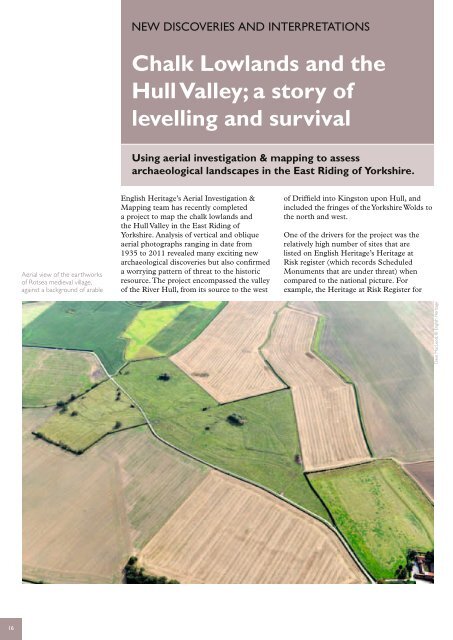
Aerial view of the earthworks<br />
of Rotsea medieval village,<br />
against a background of arable<br />
<strong>English</strong> <strong>Heritage</strong>’s Aerial Investigation &<br />
Mapping team has recently completed<br />
a project to map the chalk lowlands and<br />
the Hull Valley in the East Riding of<br />
Yorkshire. Analysis of vertical and oblique<br />
aerial photographs ranging in date from<br />
<strong>19</strong>35 to 2011 revealed many exciting new<br />
archaeological discoveries but also confirmed<br />
a worrying pattern of threat to the historic<br />
resource. The project encompassed the valley<br />
of the River Hull, from its source to the west<br />
of Driffield into Kingston upon Hull, and<br />
included the fringes of the Yorkshire Wolds to<br />
the north and west.<br />
One of the drivers for the project was the<br />
relatively high number of sites that are<br />
listed on <strong>English</strong> <strong>Heritage</strong>’s <strong>Heritage</strong> at<br />
Risk register (which records Scheduled<br />
Monuments that are under threat) when<br />
compared to the national picture. For<br />
example, the <strong>Heritage</strong> at Risk Register for<br />
Dave MacLeod, © <strong>English</strong> <strong>Heritage</strong><br />
16


