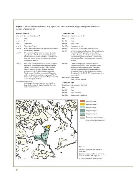
Figure 3. Hierarchy information as a map legend for a small number of polygons (Brigalow Belt North bioregion, Queensland). Vegetation type 1 Entry level: Sub-association (Level VI) Mix: Pure Level I: Tree Level II: Open forests Level III: Acacia open forests Level IV: Acacia open forests/mixed tall open shrubland/grassy sparse tussock grassland Level V: ;U+ Acacia harpophylla, Casuarina cristata, Eucalyptus orgadophila/tree/7/c; M Eremophila mitchellii, Geijera parviflora, Capparis lasiantha/shrub/4/i; G Ancistrachne uncinulata, Aristida ramosa, Paspalidium caespitosum/ tussock grass, forb/2/r Level VI: ;U1+ Acacia harpophylla, Casuarina cristata, Eucalyptus orgadophila, Eucalyptus populnea, Atalaya hemiglauca/ tree/7/c; M1 Eremophila mitchellii, Geijera parviflora, Capparis lasiantha, Canthium oleifolium, Santalum lanceolatum/shrub/4/i; G2 Ancistrachne uncinulata, Aristida ramosa, Paspalidium caespitosum, Paspalidium criniforme, Sporobolus caroli/tussock grass,forb/2/r; G1 Carissa ovata, Enchylaena tomentosa, Myoporum deserti/ shrub, chenopod shrub/2/r Environmental description: Undulating lowlands and plains, predominantly on deep, alkaline, strongly gilgaied cracking clays with acidic mottled horizons Vegetation type 2 Entry level: Association (Level V) Mix: Pure Level I: Tree Level II: Open forests Level III: Acacia open forests Level IV: Acacia open forests/mixed open shrubland Level V: ;U+ Acacia harpophylla, Terminalia oblongata, Casuarina cristata/tree/7/c; M Lysiphyllum carronii, Geijera parviflora, Ventilago viminalis, Eremophila mitchellii, Terminalia oblongata/tree,shrub/6/i; G Carissa ovata, Alectryon diversifolius, Croton insularis/shrub,tussock grass/3/i Level VI: ;U1+ Acacia harpophylla, Terminalia oblongata, Casuarina cristata/tree/7/c; M1 Lysiphyllum carronii, Geijera parviflora, Ventilago viminalis, Eremophila mitchellii, Terminalia oblongata/tree,shrub/6/i; G1 Carissa ovata, Alectryon diversifolius, Croton insularis, Citrus glauca/shrub /3/i; G2 -9999/tussock grass, forb, fern, sedge/1/r Environmental description: Plains, clay; and lowlands Vegetation type 3 Entry level: Sub-association (Level VI) Mix: Pure Level I: Tree Level II: Open woodlands Level III: Eucalypt open woodlands Vegetation type 1 Vegetation type 2 Vegetation type 3 Vegetation type 4 Vegetation type 5 Other remnant <strong>vegetation</strong> Cleared/disturbed <strong>vegetation</strong> Source: <strong>National</strong> Land and Water Resources Audit <strong>2001</strong>. Data used are assumed to be correct as received from the data suppliers. © Commonwealth of Australia <strong>2001</strong> 14
Level IV: Eucalypt open woodlands/mixed sparse shrubland/ spinifex sparse tussock grassland Level V: ;U+ Eucalyptus melanophloia, Eucalyptus crebra, Acacia longispicata/tree/7/r; M Acacia macradenia, Alphitonia excelsa, Capparis lasiantha/shrub/3/r; G Aristida jerichoensis, Eragrostis elongata, Eragrostis lacunaria/ tussock grass,chenopod shrubs/2/r Level VI: ;U1+ Eucalyptus melanophloia, Eucalyptus crebra, Acacia longispicata, Corymbia terminalis, Eremophila mitchellii/ tree/7/r; M1 Acacia macradenia, Alphitonia excelsa, Capparis lasiantha, Carissa ovata, Santalum lanceolatum/ shrub/3/r; G1 Aristida jerichoensis var. subspinulifera, Eragrostis elongata, Eragrostis lacunaria, Eragrostis speciosa, Sclerolaena birchii/tussock grass,chenopod shrub/2/r Environmental description: Hills on quartz sandstone Vegetation type 4 Entry level: Association (Level V) Mix: Mosaic Number of <strong>vegetation</strong> descriptions: 4 Level I: Tree Level II: Woodland Level III: Eucalypt woodlands Level IV: Eucalypt woodlands/mixed low tussock grassland Level V: ;U+ Eucalyptus populnea/tree/7/i; M Eremophila mitchellii, Geijera parviflora/tree/4/bi; G Aristida ramosa, Dichanthium sericeum, Themeda triandra/tussock grass, forb/1/c Level VI: ;U1+ Eucalyptus populnea/tree/7/i; M1 Eremophila mitchellii, Geijera parviflora/tree/4/bi; G1 Aristida ramosa, Dichanthium sericeum, Themeda triandra, Bothriochloa ewartiana/tussock grass, forb/1/c Environmental description: Mainly alluvial soils, sometimes basalt or shales Vegetation type 5 Entry level: Sub-association (Level VI) Mix: Dominant mosaic Number of <strong>vegetation</strong> descriptions: 2 Level I: Tree Level II: Woodland Level III: Eucalypt woodlands Level IV: Eucalypt woodlands/mixed isolated shrubs/grassy open tussock grassland Level V: ;U+ Eucalyptus thozetiana, Acacia harpophylla, Eremophila mitchellii/tree/7/i; M Capparis lasiantha, Carissa ovata, Eremophila oppositifolia/shrub/3/bi; G Enteropogon acicularis, Eragrostis lacunaria, Paspalidium caespitosum/tussock grass/2/i Level VI: ;U1+ Eucalyptus thozetiana, Acacia harpophylla, Eremophila mitchellii, Geijera parviflora, Capparis loranthifolia/tree/7/i; M1 Capparis lasiantha, Carissa ovata, Eremophila oppositifolia subsp. rubra, Myoporum deserti/shrub/3/bi; G1 Enteropogon acicularis, Eragrostis lacunaria, Paspalidium caespitosum, Paspalidium constrictum, Sporobolus actinocladus/tussock grass/2/i Environmental description: Scarps, residuals and tops on exposed shales under eroding Tertiary sediments Explanation of codes in map legend U upper stratum M mid-stratum G lower, ground stratum + indicates the dominant stratum -9999 unknown Growth forms Code T M S Y Z C U G H D V Description Tree Tree mallee Shrub Mallee shrub Heath shrub Chenopod shrub Samphire shrub Tussock grass Hummock grass Sod grass Sedge Height classes Code R F E O N W L P X A J UNK Description Rush Forb Fern Moss Lichen Liverwort Vine Palm Xanthorrhea Cycad Seagrass Unknown Code Description 8 Height range > 30 m trees, vines, palms 7 Height range 10 – 30 m trees, vines, palms, mallee, mallee shrub 6 Height range < 10 m trees, vines, palms; height range 3 – 10 m mallee, mallee shrub 5 Height range < 3 m mallee, mallee shrub 4 Height range > 2 m cycads, xanthorrhoea, shrubs, heath shrub, chenopod shrub, ferns, samphire, tussock and hummock grasses, sedges, rushes, forbs 3 Height range 1 – 2 m cycads, xanthorrhoea, shrubs, heath shrub, chenopod shrub, ferns, samphire, tussock and hummock grasses, sedges, rushes, forbs 2 Height range 0.5 – 1 m cycads, xanthorrhoea, shrubs, heath shrub, chenopod shrub, ferns, samphire, tussock and hummock grasses, sedges, rushes, forbs, sod grass, liverwort, lichen, moss, seagrasses 1 Height range < 0.5 m cycads, xanthorrhoea, shrubs, heath shrub, chenopod shrub, ferns, samphire, Tussock and Hummock grasses, Sedges, Rushes, Forbs, Sod grass, Liverwort, Lichen, Moss, seagrasses Unknown Unknown Cover code Code d c i r Description Foliage cover 70–100%, crown cover 80–100%, ground cover 70–100% Foliage cover 30–70%, crown cover 50–80%, ground cover 30–70% Foliage cover 10–30%, crown cover 20–50%, ground cover 10–30% Foliage cover < 10%, crown cover 0.25–20%, ground cover < 10% bi Foliage cover ~ 0% (scattered), crown cover 0–0.25%, ground cover ~ 0% (scattered) bc Foliage cover ~ 0% (clumped), crown cover 0–0.25%, ground cover ~ 0% (clumped) UNK Unknown See Glossary for additional terms in legend 15
- Page 1 and 2: AUSTRALIAN NATIVE VEGETATION ASSESS
- Page 3 and 4: AUSTRALIAN NATIVE VEGETATION ASSESS
- Page 5 and 6: National Land & Water Resources Aud
- Page 7 and 8: SUMMARY About the Australian Native
- Page 9 and 10: Rainforest communities: most lowlan
- Page 11 and 12: Vegetation change and condition. In
- Page 13 and 14: Pedder Impoundment Road, Tasmania C
- Page 15 and 16: 26. Number of subregions in each fr
- Page 17 and 18: 31. Number of vegetation patches in
- Page 19 and 20: Eucalypts in riparian zone affected
- Page 21 and 22: Wilpena Pound, South Australia Info
- Page 23 and 24: NATIVE VEGETATION MANAGEMENT AND TH
- Page 25 and 26: Australian Natural Resources Atlas:
- Page 27 and 28: The Environmental Indicators report
- Page 29 and 30: NATIONAL VEGETATION INFORMATION SYS
- Page 31 and 32: Table 1. National Vegetation Inform
- Page 33: Figure 2. Data set and vegetation d
- Page 37 and 38: Helipterum albicans, Tetratheca spp
- Page 39 and 40: Reporting on Australia’s native v
- Page 41 and 42: MAJOR VEGETATION GROUPS The large n
- Page 43 and 44: Low open eucalypt forest (Eucalyptu
- Page 45 and 46: Casuarina cristata ssp. pauper wood
- Page 47 and 48: Eucalyptus tetrodonta woodland, ann
- Page 49 and 50: Acacia ligulata, South Australia Ac
- Page 51 and 52: Eucalytpus terminalis, Triodia base
- Page 53 and 54: East of Lake King, Western Australi
- Page 55 and 56: Figure 5. Pre-European major vegeta
- Page 57 and 58: Limitations The variety of methods
- Page 59 and 60: Extent of the National Vegetation I
- Page 61 and 62: Table 4. Area (km 2 ) of major vege
- Page 63 and 64: Figure 11. Extent of native vegetat
- Page 65 and 66: Table 7. Subregions with less than
- Page 67 and 68: Continental landscape stress The in
- Page 69 and 70: Table 8. Area of pre-European and p
- Page 71 and 72: Methods This analysis is based on a
- Page 73 and 74: Fine scale detail on vegetation cha
- Page 75 and 76: Figure 19. Cleared major vegetation
- Page 77 and 78: Logging south of Coffs Harbour, New
- Page 79 and 80: Figure 20. Percentage native vegeta
- Page 81 and 82: Dust storm, ploughed mallee, Mildur
- Page 83 and 84: Bioregions contain distinctive geom
- Page 85 and 86:
Figure 22. Present major vegetation
- Page 87 and 88:
Mulga Lands Most of this bioregion
- Page 89 and 90:
Cattle grazing, north-west New Sout
- Page 91 and 92:
Figure 23. Present major vegetation
- Page 93 and 94:
Wheat harvest, Narromine, New South
- Page 95 and 96:
Darwin Coastal This bioregion has g
- Page 97 and 98:
Near Adelaide River, Northern Terri
- Page 99 and 100:
Figure 24. Present major vegetation
- Page 101 and 102:
QUEENSLAND Major vegetation groups
- Page 103 and 104:
Mitchell Grass Downs Extending into
- Page 105 and 106:
Brigalow forest, near Tambo, Queens
- Page 107 and 108:
The majority of remnant vegetation
- Page 109 and 110:
Stony Plains The majority of the bi
- Page 111 and 112:
Heath woodland, near Keith, South A
- Page 113 and 114:
Vegetation change In South Australi
- Page 115 and 116:
Ben Lomond This bioregion is charac
- Page 117 and 118:
Figure 27. Present major vegetation
- Page 119 and 120:
VICTORIA Major vegetation groups an
- Page 121 and 122:
Mountain Ash (Eucalyptus regnans) f
- Page 123 and 124:
Figure 28. Present major vegetation
- Page 125 and 126:
Eucalyptus papuana, Red Rock Creek,
- Page 127 and 128:
Warren This bioregion consists of d
- Page 129 and 130:
Mixed mallee, Ravensthorpe, Western
- Page 131 and 132:
Figure 29. Present major vegetation
- Page 133 and 134:
Dryland rural landscape between Gun
- Page 135 and 136:
Methods The analysis used one of ma
- Page 137 and 138:
Tailings dams at Weipa, Queensland
- Page 139 and 140:
Figure 35. Pre-European major veget
- Page 141 and 142:
Examples of nature conservation mec
- Page 143 and 144:
Rainbow Valley Conservation Reserve
- Page 145 and 146:
Barringtonia acutangula, Cooinda, K
- Page 147 and 148:
Table 38. Area (km 2 ) of major veg
- Page 149 and 150:
Divide between temperate rainforest
- Page 151 and 152:
1988 1997 2000 Applications 131
- Page 153 and 154:
Caladenia fuscata near Braidwood, N
- Page 155 and 156:
Methods The data incorporated into
- Page 157 and 158:
The spatial extent of the vegetatio
- Page 159 and 160:
Continuous improvement The National
- Page 161 and 162:
Spiranthes australis near Braidwood
- Page 163 and 164:
There is no Australia-wide approach
- Page 165 and 166:
Irrigated citrus, Griffith, New Sou
- Page 167 and 168:
Figure 41. National Vegetation Info
- Page 169 and 170:
Figure 43. Scale gaps: present vege
- Page 171 and 172:
Currency of spatial boundaries M
- Page 173 and 174:
Figure 45. Gaps in the National Veg
- Page 175 and 176:
Figure 47. Present National Vegetat
- Page 177 and 178:
Figure 48. Present classes in the i
- Page 179 and 180:
Figure 50. Pre-European data ranked
- Page 181 and 182:
VEGETATION MANAGEMENT IN AUSTRALIA
- Page 183 and 184:
Native Vegetation Information: cont
- Page 185 and 186:
data coordination to monitor and re
- Page 187 and 188:
STATE AND TERRITORY VEGETATION MAPP
- Page 189 and 190:
Low open forest. Eucalyptus paucifl
- Page 191 and 192:
Open forest (Eucalyptus obliqua) in
- Page 193 and 194:
THE NEXT PRIORITY Managing native v
- Page 195 and 196:
Keep River National Park, Northern
- Page 197 and 198:
As part of the National Action Plan
- Page 199 and 200:
Acacia Callitris Casuarina Melaleuc
- Page 201 and 202:
Macrozamia communis, Eucalyptus mac
- Page 203 and 204:
Acacia Callitris Casuarina Melaleuc
- Page 205 and 206:
Hummock Grassland Chenopod Mangrove
- Page 207 and 208:
TIW1 APPENDIX 3. IBRA 5 SUBREGIONS
- Page 209 and 210:
APPENDIX 4. RIVER BASINS OF AUSTRAL
- Page 211 and 212:
Livistona sp. in eucalypt open fore
- Page 213 and 214:
STR13Height type derivation method
- Page 215 and 216:
Reference 1 RF 02. CITATION Regiona
- Page 217 and 218:
Vegetation 1: summary description V
- Page 219 and 220:
Vegetation 1: stratum 1: taxon info
- Page 221 and 222:
Vegetation 1: stratum 2: taxon info
- Page 223 and 224:
Vegetation 1: stratum 3: taxon info
- Page 225 and 226:
Vegetation 1: stratum 3: taxon info
- Page 227 and 228:
10-30 30 tall n/a n/a n/a n/a n/a
- Page 229 and 230:
Data set name Data set Pre-European
- Page 231 and 232:
Figure A1 Pre-European major vegeta
- Page 233 and 234:
Australian Capital Territory 102 Di
- Page 235 and 236:
Vegetation data audit The Bureau of
- Page 237 and 238:
APPENDIX 10. METHODS TO DERIVE MAJO
- Page 239 and 240:
The geographic stratification under
- Page 241 and 242:
Table A1 Proposed categorisation of
- Page 243 and 244:
Implementation issues Data custodia
- Page 245 and 246:
Classification system The systemati
- Page 247 and 248:
Stags, near Hartz Mountains, Tasman
- Page 249 and 250:
National coordinator A body that is
- Page 251 and 252:
Subregion A subdivision of a bioreg
- Page 253 and 254:
Calvert M., Simpson J. & Adsett K.
- Page 255 and 256:
Specht R.L. 1970, ‘Vegetation’,
- Page 257 and 258:
Weddin Mountains State Forest, New
- Page 259 and 260:
Metadata, National Vegetation Infor
- Page 261:
PHOTO ACKNOWLEDGMENTS Natural Herit
- Page 264 and 265:
Version 1 The information contained
- Page 266 and 267:
Geography l Mostly confined to the
- Page 268 and 269:
Key values l Biodiversity of some o
- Page 270 and 271:
Additional species l l l l l l Euca
- Page 272 and 273:
Management considerations l l l l l
- Page 274 and 275:
Species Tropical eucalypt open fore
- Page 276 and 277:
Change l l l l Approximately 30% of
- Page 278 and 279:
VEGETATION profiles EUCALYPT LOW OP
- Page 280 and 281:
Change l l l Approximately 14% of p
- Page 282 and 283:
Major groupings Several major group
- Page 284 and 285:
Geography l Found across a wide ran
- Page 286 and 287:
Tenure Eucalypt woodlands mainly oc
- Page 288 and 289:
Species distribution Co-dominants i
- Page 290 and 291:
Change l l l l l l Approximately 15
- Page 292 and 293:
VEGETATION profiles CALLITRIS FORES
- Page 294 and 295:
Change l l l l l l l l Approximatel
- Page 296 and 297:
VEGETATION profiles CASUARINA FORES
- Page 298 and 299:
Change l l l l l l l l l Approximat
- Page 300 and 301:
VEGETATION profiles MELALEUCA FORES
- Page 302 and 303:
Change l l l l l l Approximately 3%
- Page 304 and 305:
VEGETATION profiles OTHER FORESTS A
- Page 306 and 307:
Change l l l l l Approximately 5% o
- Page 308 and 309:
VEGETATION profiles EUCALYPT OPEN W
- Page 310 and 311:
Change l l l l l l l Approximately
- Page 312 and 313:
VEGETATION profiles TROPICAL EUCALY
- Page 314 and 315:
Tenure Tropical eucalypt woodlands
- Page 316 and 317:
Geography l Occur mainly throughout
- Page 318 and 319:
VEGETATION profiles MALLEE WOODLAND
- Page 320 and 321:
Change l l l l l l l l Approximatel
- Page 322 and 323:
VEGETATION profiles LOW CLOSED FORE
- Page 324 and 325:
Tenure Low closed forests and close
- Page 326 and 327:
Geography l Dominates large areas o
- Page 328 and 329:
VEGETATION profiles OTHER SHRUBLAND
- Page 330 and 331:
Change l l l l Approximately 15% of
- Page 332 and 333:
Geography l Located on either infer
- Page 334 and 335:
Key values l Biodiversity including
- Page 336 and 337:
Geography l Extend from tropical to
- Page 338 and 339:
Management considerations l l l l F
- Page 340 and 341:
Geography l l l l l Occur in Wester
- Page 342 and 343:
VEGETATION profiles OTHER GRASSLAND
- Page 344 and 345:
Change l Approximately 2% of pre-Eu
- Page 346 and 347:
Geography l Widespread across Austr
- Page 348 and 349:
Key values l Rangeland production l
- Page 350 and 351:
Species distribution Mangroves are
- Page 352 and 353:
Change l l l l l Many of these comm
- Page 354:
National Land and Water Resources A