Itinerary 5 - Philmont Document Archives
Itinerary 5 - Philmont Document Archives
Itinerary 5 - Philmont Document Archives

You also want an ePaper? Increase the reach of your titles
YUMPU automatically turns print PDFs into web optimized ePapers that Google loves.
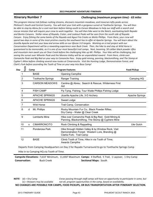
<strong>Itinerary</strong> Number 7<br />
2013 PHILMONT ADVENTURE ITINERARY<br />
Challenging (maximum program time) - 63 miles<br />
This program intense trek follows rushing streams, discovers mountain meadows, and traverses lofty peaks across<br />
<strong>Philmont</strong>’s South and Central Country. You will start your trek with a gorgeous sunset at Toothache Springs. You will then<br />
be able to stop by Abreu for a cool root beer before hiking south to Carson Meadows to help our staff with a search and<br />
rescue mission that will require your crew to work together. You will then hike west to the Notch, overlooking both Rayado<br />
and Bonito Canyons. Stellar views of Rayado, Crater, and Lookout Peaks will be seen from the south side of Rayado<br />
Canyon. Enjoy fishing the same banks of the Rayado and Agua Fria Creeks as Waite Phillips. From there, your crew will<br />
spend two days in some of the most pristine country the southwest has to offer at Apache Springs. You will learn about the<br />
Jicarilla Apache and test your bow and arrow skills on our lifesize 3-D targets. Working on a trail project with our<br />
Conservation Department will be a rewarding experience near Buck Creek. Then, the hike to and stay at Wild Horse is<br />
guaranteed to be memorable, as it is one of our most beautiful trail camps. Next, booming .50 caliber black powder rifles<br />
and mountain men await you at Clear Creek before the challenging hike up Mt. Phillips. Your hike will be challenging, but<br />
seeing the sunset over Wheeler Peak and the Moreno Valley will be an unparalleled reward. From there, climb over<br />
Comanche Peak and Big Red on your way to Comanche Pass. Enjoy gold mining, panning, blacksmithing, and The Stomp at<br />
Cypher’s Mine before climbing several new routes at Cimarroncito. Visit the Hunting Lodge, Demonstration Forest, and<br />
Clark’s Fork before ascending the Tooth of Time on your way into Base Camp!<br />
Day Camp Program Features Food Pickup<br />
1 BASE<br />
Opening Campfire<br />
2 Toothache Springs Ranger Training Camping HQ<br />
3 CARSON MEADOWS Cantina @ Abreu; Search & Rescue, Wilderness First<br />
Aid<br />
4 FISH CAMP<br />
Fly Tying, Fishing, Tour Waite Phillips Fishing Lodge<br />
5 APACHE SPRINGS Jicarilla Apache Life, 3-D Archery Apache Springs<br />
6 APACHE SPRINGS Sweat Lodge<br />
7 Wild Horse<br />
Trail Camp, Conservation<br />
8 d Mt. Phillips<br />
Rocky Mountain Fur Co., Black Powder Rifles;<br />
Dry Camp - Water @ Clear Creek<br />
9 Lamberts Mine Hike over Comanche Peak & Big Red; Gold Mining &<br />
Panning, Blacksmithing, The Stomp @ Cyphers Mine<br />
10 s CIMARRONCITO Rock Climbing & Rappelling Ute Gulch<br />
11 Ponderosa Park Hike through Hidden Valley & by Window Rock, Visit<br />
Demonstration Forest; Western Lore, Branding @<br />
Clarks Fork; Trail Camp<br />
12 BASE<br />
Climb Tooth of Time, Hike in via Tooth of Time;<br />
Awards Campfire<br />
Departs from Camping Headquarters on Day 2 for Rayado Turnaround to go to Toothache Springs Camp<br />
Hike in to Camping HQ via Tooth of Time.<br />
Campsite Elevations: 7,610' Minimum, 11,650' Maximum<br />
Conservation: Buck Creek<br />
Camps: 4 Staffed, 5 Trail, 1 Layover, 1 Dry Camp<br />
Sectional Maps: South<br />
NOTE: (d) = Dry Camp<br />
(s) = Showers may be available<br />
Crews passing through staff camps will have an opportunity to participate in some, but<br />
not all, program opportunities in the camp, based on availability.<br />
NO CHANGES ARE POSSIBLE FOR CAMPS, FOOD PICKUPS, OR BUS TRANSPORTATION AFTER ITINERARY SELECTION.<br />
2013 ITINERARY GUIDE Page 43 PHILMONT SCOUT RANCH, BSA