Small Farm News - Oregon Small Farms - Oregon State University
Small Farm News - Oregon Small Farms - Oregon State University
Small Farm News - Oregon Small Farms - Oregon State University

Create successful ePaper yourself
Turn your PDF publications into a flip-book with our unique Google optimized e-Paper software.
It Is All In the Soil Survey<br />
By: Sam Angima<br />
The small farm’s basic and fundamental resource is<br />
soil. Understanding what type of soil you have and<br />
its limitations can help you decide on what and where to<br />
invest and what outputs to anticipate. The best source to<br />
get this information is in the county soil surveys. The<br />
most recent soil survey is now available on the web at<br />
http://websoilsurvey.nrcs.usda.gov/app/<br />
Soil surveys contain a lot of information for nearly<br />
every one that uses soil for agriculture, forestry,<br />
municipal and even recreation purposes just to name a<br />
few. The survey also highlights limitations and hazards<br />
inherent in the soil, improvements needed to overcome<br />
the limitations, and the impact of selected land uses on<br />
the environment. In this article I will provide steps to<br />
follow to find out how<br />
suitable your soil is for<br />
agriculture.<br />
you started to complete drawing the polygon and select<br />
the shape. At this point the program zooms in maximum<br />
to just show the area you have selected. On the left<br />
column you will see total acreage selected and you will<br />
be notified too if soil data and soil maps are available. If<br />
you are not able to successfully complete this step with<br />
this procedure, use your address to locate the area of<br />
interest. Just click on address under quick navigation tab<br />
and type in your address, city, state and zip code.<br />
Next you want to select the middle tab at the top of the<br />
map called “soil map”. This will show all different<br />
types of soil on your selected area, the percentage each<br />
occupies in your property, and the county. To most<br />
people this is the most important step in this exercise. For<br />
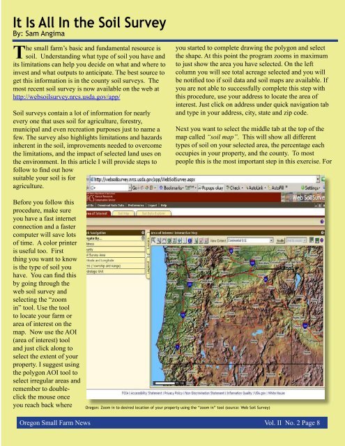
Before you follow this<br />
procedure, make sure<br />
you have a fast internet<br />
connection and a faster<br />
computer will save lots<br />
of time. A color printer<br />
is useful too. First<br />
thing you want to know<br />
is the type of soil you<br />
have. You can find this<br />
by going through the<br />
web soil survey and<br />
selecting the “zoom<br />
in” tool. Use the tool<br />
to locate your farm or<br />
area of interest on the<br />
map. Now use the AOI<br />
(area of interest) tool<br />
and just click along to<br />
select the extent of your<br />
property. I suggest using<br />
the polygon AOI tool to<br />
select irregular areas and<br />
remember to doubleclick<br />
the mouse once<br />
you reach back where<br />
<strong>Oregon</strong>: Zoom in to desired location of your property using the “zoom in” tool (source: Web Soil Survey)<br />
<strong>Oregon</strong> <strong>Small</strong> <strong>Farm</strong> <strong>News</strong> Vol. II No. 2 Page 8