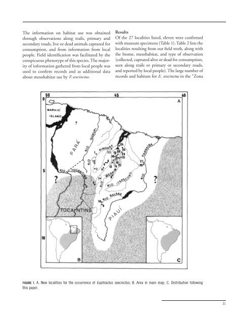
left bank of the Rio Balsas (07º31’S, 46º02’W); 11. Reserva Indígena Araribóia (about 04º57’S, 45º47’W); 12. near to Buriticupu (04º14’S, 46º32’W); 13. Lago dos Rodrigues, municipality of Lago da Pedra (04º19’S, 45º08’W); 14. near to Lago da Pedra (04º19’S, 45º08’W); 15. Rio Estiva, left tributary of the Rio Mearim, municipality of Bacabal (about 04º12’S, 44º47’W); 16. Rio Bambu, left tributary of the Rio Mearim, municipality of Bacabal (about 04º12’S, 44º50’W); 17. Alto Alegre, municipality of Bacabal (about 04º06’S, 44º57’W); 18. Fazenda Lagoa Nova, municipality of Bacabal (about 04º04’S, 44º58’W); 19. São José das Verdades, municipal- ity of Bacabal (about 04º57’S, 44º28’W); 20. near to Lago Verde (04º04’S, 44º45’W); 21. Piratininga, left bank of the Rio Piratininga, right tributary of the Rio Mearim, municipality of Bacabal (04º12’S, 44º35’W); 22. Praia do Açúcar, right bank of the Rio Pindaré, municipality of Santa Inês (about 03º39’S, 45º22’W); 23. near to São Mateus (around 04º01’S, 44º27’W); 24. near to Arari (03º28’S, 44º47’W); 25. Palmeiral, municipality of Matões (about 03º40’S, 44º27’W); 26. Brejinho, municipality of Caxias (about 04º47’S, 42º50’W); 27. São Miguel, left bank of the Rio Parnaíba (opposite to União, Piauí), municipality of Caxias (04º39’S, 43º36’W). TABLE 2: Field data on Euphractus sexcinctus in the state of Maranhao. Locality Biome Mesohabitat Observation Types Palmeiral ZC 3, 4, 5 col, cap, tri Arari ZC 2 cap, rel São Mateus ZC 2, 3, 4 cap, rel Praia do Açúcar AM/ZC 4 tri, rel Alto Alegre ZC 2, 3, 4 col, cap, tri, rel Fazenda Lagoa Nova ZC 1, 2, 4, 5 cap, tri, rel São José das Verdades ZC 3, 5 col, tri, rel Lago Verde ZC 2, 3, 4 rod, rel Rio Bambu ZC 2, 3, 4 cap, tri, rel Rio Estiva ZC 2, 3, 4 cap, tri, rod, rel Piratininga ZC 2, 3, 4 col, cap, rod, rel Lago da Pedra AM/ZC 5 Rod Lago dos Rodrigues AM/ZC 4 Rod Buriticupu AM 6 col, tri, rod R. I. Araribóia AM 6 Cap Arame AM 6 cap, rel Grajaú AM 6 Rod Rio Matão CE 8, 9 tri, rel Balsas CE 8 col, cap, rel Brejinho TR 7 Rel São Miguel TR 7 cap, rel Biomes: AM= “Amazônia Maranhense”; ZC= “Zona dos Cocais”; CE= “Cerrado”; TR= transitional area from the eastern side of the State. Mesohabitat: 1= old orchard near to secondary forest associated with “babaçual”; 2= “babaçual” associated with pasture; 3= “babaçual” associated with plantation; 4= “babaçual” associated with forest patches; 5= “babaçual” associated with secondary forest; 6= unflooded primary/ secondary forest; 7= “cerradão”; 8= “cerrado” sensu stricto with gallery forest; 9= plantation continuous with “babaçual” and gallery forest. Type of observation: col= collected; cap= captured live or dead for consumption tri= observations along trails; rod= observations along primary or secondary roads; rel= reports of local informants. 20 <strong>Edentata</strong> • June 2001
The information on habitat use was obtained through observations along trails, primary and secondary roads, live or dead animals captured for consumption, and from information from local people. Field identification was facilitated by the conspicuous phenotype of this species. The majority of information gathered from local people was used to confirm records and as additional data about mesohabitat use by E.sexcinctus. Results Of the 27 localities listed, eleven were confirmed with museum specimens (Table 1). Table 2 lists the localities resulting from our field work, along with the biome, mesohabitat, and type of observation (collected, captured alive or dead for consumption, seen along trails or primary or secondary roads, and reported by local people). The large number of records and habitats for E. sexcinctus in the “Zona FIGURE 1. A. New localities for the occurrence of Euphractus sexcinctus; B. Area in main map; C. Distribution following this paper. 21